
Wilmington City Zoning Code
ARTICLE 5
- ZONING DISTRICT REGULATIONS
Sec. 18-164. - Zoning districts established.
In order to regulate the height and size of buildings; to regulate the intensity of land usage; to regulate areas for open space; to regulate the location of land uses; to provide for the improved environment; and to promote the health, safety and general welfare of its citizens, the City of Wilmington is hereby divided into the following zoning districts:
(Ord. No. O-2008-25, 4-8-08)
Sec. 18-165. - Official zoning map.
(a)
The boundaries of the zoning districts established herein are shown on the series of maps entitled "Official Zoning Map, City of Wilmington, North Carolina," dated November 1983, which are hereby adopted by reference, together with all explanatory notations thereon, and made a part of this chapter.
(b)
The official zoning maps and ordinance shall be properly attested and copies shall be on file in the offices of the city clerk, the secretary to the planning commission, and the city engineer. Regardless of the existence of any purported copy of the official zoning maps, the zoning maps located in the office of the secretary to the planning commission shall be the final authority.
(c)
If, in accordance with the provisions of this chapter, changes are made in district boundaries or other references on the official zoning maps, such changes shall be entered on the official zoning maps within seven (7) working days after the amendment has been approved by the city council. No changes of any nature shall be made on an official zoning map except in conformity with the procedures set forth in Article 3, Division VI of this chapter. Any unauthorized change of whatever kind by any person shall be considered a violation of this chapter.
Sec. 18-166. - Rules for interpretation of district boundaries.
The city manager shall determine the exact location of any zoning district boundary lines whenever uncertainty exists about the boundary lines shown on the official zoning maps, subject to appeal to the board of adjustment provided for in Article 2. The determination of the exact location of a zoning district boundary shall be based upon the following rules:
(a)
Boundaries indicated as approximately following or within a street, alley or railroad right-of-way, or utilities (electrical, gas, water main, etc.) easement, the boundary shall be construed to be in the center of such right-of-way easement;
(b)
Boundaries indicated as following shore lines shall be construed to follow such shore lines, and in the event of change in the shore lines, shall be construed as moving with the actual shore line; boundaries indicated as approximately following the centerlines of streams, rivers, creeks, or other bodies of water shall be construed as following such centerlines;
(c)
Boundaries indicated as approximately following plotted lot lines shall be construed as following such lot lines;
(d)
Boundaries indicated as approximately following city limits shall be construed as following city limits; and
(e)
Boundaries indicated as parallel to or extension of features indicated in subsections (a), (b), (c) and (d) above shall be so construed. Distances not specifically indicated on the official zoning map shall be determined by the scale of the map.
Sec. 18-173. - Introduction.
This division contains the specific use and area regulations for each zoning district found in the city. The material has been divided into the following sections:
(a)
Purpose. The intended application for each district guiding its placement in relation to either existing or proposed development.
(b)
Uses permitted by right. The listing of land uses permitted by right in each district.
(c)
Uses permitted under prescribed conditions. Those uses allowed in a district when meeting the criteria set forth in the appropriate prescribed conditions and all other applicable requirements established in these regulations.
(d)
Permitted by special use permit. Uses permitted in a district subject to the issuance of a special use permit as set forth in Article 3, Division IV herein.
(e)
Permitted accessory uses and structures. Accessory uses and structures clearly incidental and subordinate to the principal use and structures including the following uses, are permitted provided that they meet all requirements of this section, the requirements of Article 6 of this chapter and all other applicable requirements established in these regulations.
(f)
Development standards. The dimensional standards, buffering requirements and other design standards for each district. The use of separate sections to describe the various provisions for each district does not relieve any person from complying with all the requirements for the same district.
(g)
Interpretation of permitted uses. Because the list of permissible uses set forth in this article cannot be all inclusive, those uses that are listed shall be interpreted liberally to include other uses that have similar impacts to the listed uses. Notwithstanding the foregoing sentence, all uses that are not listed in this article, even given the liberal interpretation mandated by this subsection, are prohibited. This article shall not be interpreted to allow a use in one (1) zoning district when the use in question is more closely related to another specified use that is permissible in other zoning districts. If a specific use is listed in one (1) of the base zoning districts listed in section 18-164 (excluding the MX District), it shall be excluded from the general use categories of business services, personal services, professional services, residential, and retail sales establishments.
Sec. 18-174. - Exceptions to area and height standards.
(a)
In general. The following requirements or regulations qualify or supplement, as the case may be, the district regulations or requirements appearing elsewhere in this chapter.
(1)
Hospitals, schools, and religious institutions (excluding accessory uses) where permitted in a district, may be erected to a height not exceeding one hundred fifty (150) feet, except for the Central Business District.
(2)
The following structures and features shall be exempt from the height requirements of this chapter:
a.
Radio and television receiving antennas and support structures, provided that they shall not be erected to a height greater than twenty (20) feet above the roof line.
b.
Utility poles, water towers and support structures.
c.
Monuments and ornamental towers.
d.
Chimneys, smokestacks and flues attached to a building or projections from buildings provided that they shall not be erected to a height greater than five (5) feet above the roof line or as required by state and/or federal air quality laws and regulations.
e.
Communications towers, subject to section 18-259.
f.
Belfries, spires, and steeples.
g.
Cupolas.
h.
Ornamental railings.
i.
Parapet walls, provided they shall not extend to a height greater than six (6) feet above the allowable height of the district in which they are located.
j.
Trees, shrubs, or other vegetation functioning as part of a Leadership in Energy and Environmental Design (LEED) or similar approved certifying program green roof.
(3)
Every part of a required yard shall be open from its lowest ground point to the sky unobstructed, except for the ordinary projection of sills, belt courses, cornices, buttresses, ornamental features and eaves; provided, however, that none of the above projections shall project into a minimum yard more than twenty-four (24) inches.
(4)
Open or enclosed fire escapes, outside stairways, balconies and other necessary unenclosed projections may extend into a minimum yard not more than three and one-half (3½) feet and the ordinary projections of chimneys and flues may be permitted by the city manager where same are placed so as to not obstruct the light and ventilation.
(5)
Unenclosed porches, landings, terraces, patios or platforms may project into any required front or rear yard not exceeding eight (8) feet.
(6)
For properties which are located within the city's 1945 corporate limits, if fifty (50) percent or more of the structures within the same block face on the same side of the street are located inside the generally required minimum front, rear, or side yard setbacks, then the minimum required front, rear, or side yard setbacks shall be the most typically occurring front, rear or side yard setback respectively for that block face on the same side of the street, so long as the requirements of section 18-556 are observed. If no typical yard setback exists in this situation, then setbacks shall equal the average front, rear or side yard setbacks respectively for that block face on the same side of the street so long as the requirements of section 18-556 are observed.
(7)
No structure in any district shall be erected that exceeds the maximum height permissible under the New Hanover County airport height zoning ordinance and the Federal Air Regulations of the Federal Aviation Administration.
(b)
Zero lot line development. For properties in R-5, R-3, Multifamily Residential, O&I-1, O&I-2, CB, RB, and CS Districts, zero (0) lot line development shall be permitted in accordance with the following standards.
(1)
Zero lot line development is permitted when a windowless wall of a structure is placed either on:
a.
A side property line; or
b.
Encroaches into a side yard and the remaining footage required for the lot to meet the total side yard requirement is provided on the opposite side.
(2)
Provided further:
a.
In residential districts, zero (0) lot line development of single-family detached structures shall be allowed only on tracts consisting of two (2) acres or more. This provision is not applicable to the O&I and Commercial Districts.
b.
Lots located on the outside perimeter of a development shall provide the standard side yard of the adjacent zoning district.
c.
When this technique is applied to corner lots, the structure shall not encroach upon or be placed on the side yard property line adjacent to a street.
d.
If two (2) residential structures on two (2) lots must be located on the same side property line, then they shall have a common windowless wall conforming to the construction standards of Section 403.3 in Volume 1 of the North Carolina State Building Code. All nonresidential structures must conform to Section 601 in Volume 1 of the North Carolina State Building Code.
e.
Whenever a structure is located within four (4) feet of a side property line, a perpetual easement for wall and roof maintenance shall be provided on the adjacent lot. The minimum width of this maintenance access (side yard plus easement area) shall be four (4) feet. The easement shall be incorporated into each deed.
(c)
Properties on thoroughfares. For properties located in the Multifamily, O&I-1, O&I-2, CB, RB, and CBD Districts having frontage on major thoroughfares (as defined in the City of Wilmington Technical Standards and Specifications Manual), the minimum lot width requirement for all new lots shall be as follows:
The lot widths may be reduced if no access or shared access provisions are included in the recorded plats and/or deeds for new lots to be created and upon the granting of a variance by the board of adjustment containing such access conditions.
(d)
Buildings located along interior streets within a cohesive development project may be constructed within a required front or side yard setback, subject to compliance with section 18-556 of this chapter and the following design standards:
a.
Buildings must have an entrance from the sidewalk; and
b.
Architectural features, including fenestration, material changes or other design features must be provided along the street such that blank wall space does not exceed fifteen (15) feet in length; and
c.
On-street parking shall be provided along all interior streets and will count towards required parking for the project; and
d.
Landscaping and streetyard requirements may be reduced as determined necessary by the technical review committee to improve pedestrian safety and circulation within a cohesive development project.
(e)
Lot coverage requirements. Projects utilizing exceptional design criteria may increase lot coverage and density pursuant to allowances set forth in section 18-544 of this chapter.
(f)
Structured parking shall not be counted towards maximum lot coverage in the regional business, office and institutional-1, and multi-family zoning districts.
(Ord. No. O-2008-25, 4-8-08; Ord. No. O-2010-91, § 11, 12-7-10; Ord. No. O-2014-20, § 4, 4-15-14; Ord. No. O-2018-17, § 1, 3-6-18)
Sec. 18-175. - Zoning affects use of land and structures.
The regulations established herein for each district shall be minimum regulations unless specified otherwise and shall apply uniformly to each class or kind of land or structure, except as hereinafter provided.
(a)
No land or structure shall be used or occupied, and no structure or parts shall be constructed, erected, altered, or moved unless in conformity with all of the regulations herein specified for the district within which it is located.
(b)
The minimum yards, and other open spaces, including the intensity of use provisions contained in this article, for every building hereafter erected or structurally altered, shall not be encroached upon or considered as yard, open space requirements, or intensity of use requirements for any other building unless specifically permitted.
(c)
Rights-of-way, public or private, for streets and roads shall not be considered a part of a lot or open space, or front, side, or rear yard for the purpose of meeting yard requirements.
(d)
Every building hereafter erected or structurally altered shall be located on a lot meeting the requirements of the district in which it is located.
(e)
A use or building not expressly permitted by right or granted by a special use permit shall not be allowed in a zoning district unless such use is permitted in accordance with subsections 18-143(b) and (c) herein.
(f)
No person shall keep or maintain homing pigeons within the city limits. Any existing pigeon-keeping uses shall register with the city zoning office as a grandfathered non-conforming use within six (6) months of the adoption of this section.
(Ord. No. O-2016-25, § 1, 4-19-16)
Sec. 18-176. - Number of principal buildings on a lot.
(a)
In residential districts, except for condominium or townhouse developments, there shall be no more than one (1) single-family residence on a single lot and any customary accessory building. In any nonresidential district, multiple buildings or structures are permitted on a single lot. However, all the site plans for such buildings or structures shall be subject to the same standards and procedures as for a site plan review as set forth in Article 3.
(b)
Uses otherwise permitted within a zoning district, excluding uses which require special use permits, may be combined on a single lot or tract of land. However, all the site plans for such uses shall be subject to the same standards and procedures as for a site plan review as set forth in Article 3.
Sec. 18-177. - R-20, Residential District.
(a)
Purpose. The R-20, Residential District is established as a residential district in which the principal use of land is for low density residential and recreational purposes. The regulations of this district are intended to discourage any use which because of its character would substantially interfere with the development of residences and which would be detrimental to the quiet residential nature of the areas included within the district.
(b)
Uses permitted by right. The following uses are permitted by right in the R-20 District, provided that they meet all requirements of this section, Article 6, and all other applicable requirements established in these regulations:
(1)
Single-family, detached.
(2)
Reserved.
(3)
Golf courses, private or public, with related services, including pro-shop.
(4)
Parks and recreation areas, municipal.
(5)
Recreation facility, neighborhood.
(c)
Uses permitted under prescribed conditions. The following uses are permitted provided that they meet all requirements of this section and all other applicable requirements established in these regulations:
(1)
Community boating facility.
(2)
Group home supportive small.
(3)
Group home supportive medium.
(4)
Governmental uses outside public rights-of way, except offices.
(5)
Libraries.
(6)
Religious institutions.
(7)
Telecommunication facility, unattended.
(8)
Utility stations and plants outside public rights-of-way (public and private) including lift stations.
(9)
Family care home.
(10)
Property-restricted real estate sales office.
(11)
Homestay lodging.
(12)
Whole-house lodging.
(13)
Domestic violence shelter.
(d)
Permitted by special use permit. The following uses are permitted subject to the issuance of a special use permit and provided that they meet all requirements of this section, Article 6, and all other applicable requirements established in these regulations.
(1)
Community center.
(2)
Daycare, adult or child.
(3)
Recreation facility, private.
(4)
Schools, colleges and universities.
(5)
Schools, primary and secondary.
(6)
Single-family courtyard developments.
(e)
Permitted accessory uses and structures. Accessory uses and structures clearly incidental and subordinate to the principal use and structures including the following uses, are permitted provided that they meet all requirements of this section, the requirements of Article 6 and all other applicable requirements established in these regulations:
(1)
Accessory apartment, attached.
(2)
Accessory apartment, detached.
(3)
Kennel, private.
(4)
Home occupation.
(5)
Swimming pool.
(f)
Development standards. All uses and structures permitted in the R-20 District shall meet the applicable development standards established in this section and all other applicable requirements of these regulations:
(1)
Dimensional requirements:
a.
Minimum lot area (square feet): 20,000.
b.
Reserved.
c.
Minimum lot width (feet): 80.
d.
Maximum lot coverage (%): 50%.
e.
Minimum front setback (feet): 30.
f.
Minimum rear setback (feet): 25.
g.
Minimum interior side setback per side (feet): 15.
h.
Minimum corner lot side setback (feet): 20.
i.
Height (feet): 35 (a) .
Notes:
(a)
The maximum allowable height for piling supported primary structures which are located in "Coastal High Hazard Areas, V-Zones, and/or Ocean Hazard Areas" as defined by the coastal resources commission shall be forty-four (44) feet.
(Ord. No. O-2006-2, § 1, 1-3-06; Ord. No. O-2008-25, 4-8-08; Ord. No. O-2010-75, §§ 1, 2, 10-5-10; Ord. No. O-2015-69, § 1, 9-1-15; Ord. No. O-2018-47, § 1, 6-19-18, eff. 3-1-2019; Ord. No. O-2019-6, § 1, 2-5-19; Ord. No. O-2020-62, § 1, 10-20-20)
Sec. 18-178. - R-15, Residential District.
(a)
Purpose. This district is established for low density residential development and other compatible uses. Recognition of the existing residential development pattern located within the city and on its fringes creates a need for this district to preserve the character of these established neighborhoods and protect their associated property values. Land uses considered harmful to the health, safety and welfare of district residents shall be prohibited from infringing upon the livability of the residential areas within the district.
(b)
Uses permitted by right. The following uses are permitted by right in the R-15 District, provided that they meet all requirements of this section and all other applicable requirements established in these regulations:
(1)
Single-family, detached.
(2)
Reserved.
(3)
Golf courses, private or public, with related services, including pro shop.
(4)
Municipal parks and recreation areas.
(5)
Recreation facilities, neighborhood.
(c)
Uses permitted under prescribed conditions. The following uses are permitted provided that they meet all requirements of this section, Article 6, and all other applicable requirements established in these regulations:
(1)
Government uses outside public rights-of-way, except offices.
(2)
Group home supportive, small.
(3)
Group home supportive, medium.
(4)
Libraries.
(5)
Religious institutions.
(6)
Telecommunication facility, unattended.
(7)
Utility stations and plants outside public rights-of-way (public and private) including lift stations, substations, pump stations.
(8)
Homestay lodging.
(9)
Property-restricted real estate sales office.
(10)
Family care home.
(11)
Whole-house lodging.
(12)
Domestic violence shelter.
(d)
Permitted by special use permit. The following uses are permitted subject to the issuance of a special use permit and provided that they meet all requirements of this section, Article 6, and all other applicable requirements established in these regulations.
(1)
Community center.
(2)
Daycare, adult or child.
(3)
Recreation facilities, private.
(4)
Planned unit development residential.
(5)
Schools, primary and secondary.
(6)
Single-family courtyard developments.
(e)
Permitted accessory uses and structures. Accessory uses and structures clearly incidental and subordinate to the principal use and structures including the following uses, are permitted provided that they meet all requirements of this section, the requirements of Article 6 and all other applicable requirements established in these regulations:
(1)
Accessory apartment, attached.
(2)
Accessory apartment, detached.
(3)
Community boating facility.
(4)
Home occupation.
(5)
Kennel, private.
(6)
Swimming pool.
(f)
Development standards. All uses and structures permitted in the district shall meet the applicable development standards established in this section and all other applicable requirements of these regulations.
(1)
Dimensional requirements:
a.
Minimum lot area (square feet): 15,000 (a) .
b.
Reserved.
c.
Minimum lot width (feet): 80.
d.
Maximum lot coverage (%): 50%.
e.
Minimum front setback (feet): 30.
f.
Minimum rear setback (feet): 25.
g.
Minimum interior side setback (feet): 10.
h.
Minimum corner lot side setback (feet): 15.
i.
Maximum height (feet): 35.
Notes:
(a)
Minimum lot area per housing unit.
(Ord. No. O-2006-2, § 2, 1-3-06; Ord. No. O-2008-25, 4-8-08; Ord. No. O-2010-75, §§ 3, 4, 10-5-10; Ord. No. O-2015-69, § 2, 9-1-15; Ord. No. O-2018-47, § 2, 6-19-18, eff. 3-1-2019; Ord. No. O-2019-6, § 2, 2-5-19; Ord. No. O-2020-62, § 2, 10-20-20)
Sec. 18-179. - R-10, Residential District.
(a)
Purpose. This district is established for moderate and low density residential development and other compatible uses. It may act as a transition between higher density urban development located on the edges of the 1945 corporate limits and lower density suburban residential development located elsewhere within the city limits. Land uses considered harmful to the health, safety and welfare of district residents shall be prohibited from infringing upon the livability of residential areas within the district.
(b)
Uses permitted by right. The following uses are permitted by right in the R-10 District, provided that they meet all requirements of this section and all other applicable requirements established in these regulations:
(1)
Single-family, detached.
(2)
Reserved.
(3)
Golf courses, private or public, with related services, including pro shop.
(4)
Municipal parks and recreation areas.
(5)
Recreation facilities, neighborhood.
(c)
Uses permitted under prescribed conditions. The following uses are permitted provided that they meet all requirements of this section, Article 6, and all other applicable requirements established in these regulations.
(1)
Government uses outside public rights-of-way, except offices.
(2)
Libraries.
(3)
Community boating facility.
(4)
Group home supportive, medium.
(5)
Group home supportive, small.
(6)
Religious institutions.
(7)
Telecommunication facility, unattended.
(8)
Utility stations and plants outside public rights-of-way (public and private) including lift stations, substations, pump stations, etc.
(9)
Family care home.
(10)
Single-family courtyard developments.
(11)
Homestay lodging.
(12)
Whole-house lodging.
(13)
Domestic violence shelter.
(d)
Permitted by special use permit. The following uses are permitted subject to the issuance of a special use permit and provided that they meet all requirements of this section, Article 6, and all other applicable requirements established in these regulations:
(1)
Community center.
(2)
Day care, adult or child.
(3)
Recreational facilities, private.
(4)
Planned unit development residential.
(5)
Schools, primary and secondary.
(e)
Permitted accessory uses and structure. Accessory uses and structures clearly incidental and subordinate to the principal use and structures including the following uses, are permitted provided that they meet all requirements of this section, the requirements of Article 6 and all other applicable requirements established in these regulations.
(1)
Accessory apartment, attached.
(2)
Accessory apartment, detached.
(3)
Home occupation.
(4)
Kennel, private.
(5)
Swimming pool.
(f)
Development standards. All uses and structures permitted in the R-10 District shall meet the applicable development standards established in this section and all other applicable requirements of these regulations.
(1)
Dimensional requirements:
a.
Minimum lot area (square feet): 10,000 (a) .
b.
Reserved.
c.
Minimum lot width (feet): 70.
d.
Maximum lot coverage (%): 50%.
e.
Minimum front setback (feet): 30.
f.
Minimum rear setback (feet): 25.
g.
Minimum interior side setback per side (feet): 10.
h.
Minimum corner lot side setback per side (feet): 15.
i.
Maximum height (feet): 35.
Notes:
(a)
Minimum lot area per housing unit.
(Ord. No. O-2008-25, 4-8-08; Ord. No. O-2010-75, §§ 5, 6, 10-5-10; Ord. No. O-2015-69, § 3, 9-1-15; Ord. No. O-2018-47, § 3, 6-19-18, eff. 3-1-2019; Ord. No. O-2019-6, § 3, 2-5-19; Ord. No. O-2020-62, § 3, 10-20-20)
Sec. 18-180. - R-7, Residential District.
(a)
Purpose. This district is established for moderate density residential development and other compatible uses. It is intended to recognize areas of moderate residential density located outside the 1945 corporate limits. The protection and rehabilitation of viable neighborhoods within this district shall be encouraged to ensure the continued existence as a major housing resource.
(b)
Uses permitted by right. The following uses are permitted by right in the R-7 District, provided that they meet all requirements of this section and all other applicable requirements established in these regulations:
(1)
Single-family, detached.
(2)
Reserved.
(3)
Golf courses, private or public, with related services, including pro shop.
(4)
Recreation facility, neighborhood.
(5)
Parks and recreation areas, municipal.
(c)
Uses permitted under prescribed conditions. The following uses are permitted provided that they meet all requirements of this section, Article 6, and all other applicable requirements established in these regulations.
(1)
Group home supportive, small.
(2)
Group home supportive, medium.
(3)
Government uses outside public rights-of-way, except offices.
(4)
Libraries.
(5)
Religious institutions.
(6)
Telecommunication facility, unattended.
(7)
Utility stations and plants outside public rights-of-way (public and private) including lift stations, substations, pump stations, etc.
(8)
University administrative offices.
(9)
Family care home.
(10)
Single-family courtyard developments.
(11)
Homestay lodging.
(12)
Whole-house lodging.
(13)
Domestic violence shelter.
(d)
Permitted by special use permit. The following uses are permitted subject to the issuance of a special use permit and provided that they meet all requirements of this section, Article 6, and all other applicable requirements established in these regulations:
(1)
Community center.
(2)
Day care, adult or child.
(3)
Recreation facility, private.
(4)
Planned unit development.
(5)
Schools, primary and secondary.
(e)
Permitted accessory uses and structures. Accessory uses and structures clearly incidental and subordinate to the principal use and structures including the following uses, are permitted provided that they meet all requirements of this section, the requirements of Article 6 and all other applicable requirements established in these regulations.
(1)
Accessory apartment, attached.
(2)
Accessory apartment, detached.
(3)
Bed and breakfast in Historic District Overlay-Residential.
(4)
Community boating facility.
(5)
Home occupation.
(6)
Kennel, private.
(7)
Swimming pool.
(f)
Development standards. All uses and structures permitted in the R-7 District shall meet the applicable development standards established in this section and all other applicable requirements of these regulations.
(1)
Dimensional requirements:
a.
Minimum lot area (square feet): 7,000 (a) .
b.
Reserved.
c.
Minimum lot width (feet): 50.
d.
Maximum lot coverage (%): 50%.
e.
Minimum front setback (feet): 30.
f.
Minimum rear setback (feet): 20.
g.
Minimum interior side setback (feet): 8.5.
h.
Minimum corner lot side setback (feet): 12.5.
i.
Maximum height (feet): 35.
Notes:
(a)
Minimum lot area per housing unit.
(Ord. No. O-2008-25, 4-8-08; Ord. No. O-2010-75, §§ 7, 8, 10-5-10; Ord. No. O-2015-69, § 4, 9-1-15; Ord. No. O-2018-47, § 4, 6-19-18, eff. 3-1-2019; Ord. No. O-2019-6, § 4, 2-5-19; Ord. No. O-2020-62, § 4, 10-20-20)
Sec. 18-181. - R-5, Residential District.
(a)
Purpose. This district is established for moderate to high density residential development and other compatible uses located in and near the 1945 corporate limits. Maintenance and improvement of areas of moderate to high density urban residential development is encouraged to protect the property values of the existing housing stock and to provide a suitable living environment for people who live in or near the 1945 corporate limits. Protection and rehabilitation of viable neighborhoods within this district shall be encouraged to ensure their continued existence as a major housing resource.
(b)
Uses permitted by right. The following uses are permitted by right in the R-5 District, provided that they meet all requirements of this section and all other applicable requirements established in these regulations:
(1)
Single-family, detached.
(2)
Duplex, triplex, quadraplex.
(3)
Reserved.
(4)
Golf courses, private or public, with related services, including pro shop.
(5)
Parks and recreation areas, municipal.
(6)
Recreation, neighborhood.
(c)
Uses permitted under prescribed conditions. The following uses are permitted provided that they meet all requirements of this section and all other applicable requirements established in these regulations.
(1)
Bed and breakfast—in the Hemenway Residential Area only.
(2)
Government uses outside public rights-of-way, except offices.
(3)
Group home supportive, medium.
(4)
Group home supportive, small.
(5)
Libraries.
(6)
Religious institutions.
(7)
Telecommunication facility, unattended.
(8)
Single-family courtyard developments.
(9)
Utility stations and plants outside public rights-of-way (public and private) including lift stations, substations, pump stations, etc.
(10)
Family care home.
(11)
Homestay lodging.
(12)
Whole-house lodging.
(13)
Domestic violence shelter.
(d)
Permitted by special use permit. The following uses are permitted subject to the issuance of a special use permit and provided that they meet all requirements of this section, Article 6, and all other applicable requirements established in these regulations:
(1)
Community center.
(2)
Day care, adult or child.
(3)
Historic mixed-use buildings.
(4)
Recreation facility, private.
(5)
Planned unit development.
(6)
Schools, primary and secondary.
(e)
Permitted accessory uses and structures. Accessory uses and structures clearly incidental and subordinate to the principal use and structures including the following uses, are permitted provided that they meet all requirements of this section, the requirements of Article 6 and all other applicable requirements established in these regulations:
(1)
Accessory apartment, detached.
(2)
Community boating facility.
(3)
Home occupation.
(4)
Kennel, private.
(5)
Swimming pool.
(f)
Development standards. All uses and structures permitted in the R-5 District shall meet the applicable development standards established in this section and all other applicable requirements of these regulations.
(1)
Dimensional requirements:
a.
Minimum lot area (square feet): (b)
Detached: 5,000.
Duplex: 7,500.
Triplex: 12,500.
Quadraplex: 17,500.
b.
Reserved.
c.
Minimum lot width (feet): 50.
d.
Maximum lot coverage (%): 50%.
e.
Minimum front setback (feet): 20.
f.
Minimum rear setback (feet): 15.
g.
Minimum interior side setback (feet): 7 (a) .
h.
Minimum corner side setback (feet): 10.5.
i.
Maximum height (feet): 35.
Notes:
(a)
For a lot of record existing at the adoption of this chapter, the minimum interior side yard requirement shall be equal to ten (10) percent of the average width of the lot, or the otherwise noted minimum interior side yard required, whichever is less.
(b)
New construction must meet minimum lot area requirements. Conversion of a structure existing at the adoption of this chapter is allowed without additional land area required per unit, except when needed to comply with off-street parking requirements.
(Ord. No. O-2008-25, 4-8-08; Ord. No. O-2010-75, §§ 9, 10, 10-5-10; Ord. No. O-2012-85, Exh. A, § 2, 12-4-12; Ord. No. O-2015-69, § 5, 9-1-15; Ord. No. O-2016-41, § 1, 6-7-2016; Ord. No. O-2018-47, § 5, 6-19-18, eff. 3-1-2019; Ord. No. O-2019-6, § 5, 2-5-19; Ord. No. O-2020-62, § 5, 10-20-20)
Sec. 18-182. - R-3, Central City Residential District.
(a)
Purpose. This district is established for high density residential development and other compatible uses. It is intended to recognize areas of high urban residential development in the 1945 corporate limits and encourage the protection, rehabilitation and maintenance of the housing stock within the district. Recognition of the 1945 corporate limits residential district serves as a positive force in efforts to preserve the character of established neighborhoods within it and thereby safeguard the property values of the inner city's housing resources.
(b)
Uses permitted by right. The following uses are permitted by right in the R-3 District, provided that they meet all requirements of this section and all other applicable requirements established in these regulations:
(1)
Single-family, detached.
(2)
Reserved.
(3)
Duplex, triplex, quadraplex.
(4)
Golf courses, private or public, with related services, including pro shop.
(5)
Recreation facility, neighborhood.
(6)
Parks and recreation areas, municipal.
(c)
Uses permitted under prescribed conditions. The following uses are permitted provided that they meet all requirements of this section, Article 6, and all other applicable requirements established in these regulations.
(1)
Group home supportive, small.
(2)
Group home supportive, medium.
(3)
Government uses outside public rights-of-way, except offices.
(4)
Libraries.
(5)
Religious institutions.
(6)
Telecommunication facility, unattended.
(7)
Utility stations and plants outside public rights-of-way (public and private) including lift stations, substations, pump stations, etc.
(8)
Family care home.
(9)
Single-family courtyard developments.
(10)
Homestay lodging.
(11)
Whole-house lodging.
(12)
Domestic violence shelter.
(d)
Permitted by special use permit. The following uses are permitted subject to the issuance of a special use permit and provided that they meet all requirements of this section, Article 6, and all other applicable requirements established in these regulations:
(1)
Community center.
(2)
Day care, adult or child.
(3)
Recreation facility, private.
(4)
Historic mixed-use buildings.
(5)
Planned unit development.
(6)
Schools, primary and secondary.
(e)
Permitted accessory uses and structures. Accessory uses and structures clearly incidental and subordinate to the principal use and structures including the following uses, are permitted provided that they meet all requirements of this section, the requirements of Article 6 and all other applicable requirements established in these regulations.
(1)
Accessory apartment, detached.
(2)
Community boating facility.
(3)
Home occupation.
(4)
Kennel, private.
(5)
Swimming pool.
(f)
Development standards. All uses and structures permitted in the R-3 District shall meet the applicable development standards established in this section and all other applicable requirements of these regulations.
(1)
Dimensional requirements:
a.
Minimum lot area (square feet): (a), (c)
Detached: 0.
Duplex: 4,500.
Triplex: 7,500.
Quadraplex: 10,500.
b.
Reserved.
c.
Minimum lot width (feet): 33.
d.
Maximum lot coverage (%): 50.
e.
Minimum front setback (feet): 15.
f.
Minimum rear setback (feet): 15.
g.
Minimum interior side setback (feet): 5 (b) .
h.
Minimum corner side setback (feet): 5.
i.
Maximum height (feet): 35.
Notes:
(a)
The minimum lot area required to construct an "accessory apartment, detached" on a parcel containing one (1) single-family detached structure shall be four thousand, five hundred (4,500) square feet.
(b)
For properties that are located within the city's 1945 corporate limits, the minimum interior side yard requirement shall be equal to ten (10) percent of the average width of the lot, or the otherwise noted minimum interior side yard required, whichever is less (also see Section 18-174(a)(6)).
(c)
New construction must meet minimum lot area requirements. Conversion of a structure existing at the adoption of this chapter is allowed without additional land area required per unit, except when needed to comply with off-street parking requirements.
(Ord. No. O-2006-95, § 1, 10-3-06; Ord. No. O-2008-25, 4-8-08; Ord. No. O-2009-60, § 1, 7-7-2009; Ord. No. O-2010-75, §§ 11, 12, 10-5-10; Ord. No. O-2012-85, Exh. A, § 3, 12-4-12; Ord. No. O-2015-69, § 6, 9-1-15; Ord. No. O-2018-47, § 6, 6-19-18, eff. 3-1-2019; Ord. No. O-2019-6, § 6, 2-5-19; Ord. No. O-2020-62, § 6, 10-20-20)
Sec. 18-183. - MHP, Manufactured Housing Park District.
(a)
Purpose. This district is established to accommodate planned manufactured housing park development. It affords city residents an alternate housing type and thereby promotes the health, safety and general welfare of the community.
(b)
Density.
(1)
Four thousand (4,000) square foot minimum lot size per dwelling unit.
(2)
Ten and nine-tenths (10.9) mobile homes per acre.
(c)
Regulations. Manufactured housing parks shall conform to the provisions of the Mobile Home and Travel Trailer Park Ordinance of New Hanover County to the extent said provisions are not in conflict with any provisions or requirements of the City Code.
(d)
Uses permitted by right. The following uses are permitted by right in the MHP District, provided that they meet all requirements of this section, Article 6, and all other applicable requirements established in these regulations:
(1)
Reserved.
(2)
Golf courses, private or public, with related services, including pro-shop.
(3)
Manufactured housing.
(4)
Parks and recreation facility, municipal.
(5)
Recreational facility, neighborhood.
(e)
Uses permitted under prescribed conditions. The following uses are permitted provided that they meet all requirements of this section and all other applicable requirements established in these regulations:
(1)
Government uses outside public rights-of-way.
(2)
Group home supportive, medium.
(3)
Group home supportive, small.
(4)
Manufactured housing and travel trailer parks.
(5)
Telecommunication facility, unattended.
(6)
Utility stations and plants outside public rights-of-way (public and private) including lift stations, substations, pump stations, etc.
(7)
Family care home.
(f)
Permitted by special use permit. The following uses are permitted subject to the issuance of a special use permit and provided that they meet all requirements of this section, Article 6, and all other applicable requirements established in these regulations:
(1)
Community center.
(2)
Day care, adult or child.
(3)
Libraries.
(4)
Religious institutions.
(5)
Recreation facility, private.
(g)
Permitted accessory uses and structures. Accessory uses and structures clearly incidental and subordinate to the principal use and structures including the following uses, are permitted provided that they meet all requirements of this section, the requirements of Article 6, and all other applicable requirements established in these regulations:
(1)
Home occupation.
(Ord. No. O-2008-25, 4-8-08; Ord. No. O-2010-75, §§ 13, 14, 10-5-10)
Sec. 18-184. - Multifamily Residential Districts (MF-L, MF-M, MF-MH, MF-H).
(a)
Purpose.
(1)
MF-L, Multiple-Family Residential District—Low density (ten (10) du/ac maximum density): This district is established for moderate density single-family and low density multiple-family development of varying types and designs. It functions as an alternative housing type near or in direct relationship to single-family detached housing.
(2)
MF-M, Multiple-Family Residential District—Medium density (seventeen (17) du/ac maximum density): This district is established for moderate density single-family and multiple-family developments of varying types and designs. It functions as a transitional land use between intensive nonresidential uses or higher density residential areas and lower density residential areas. The district is designed to respond to the varying housing needs of the community while affording a reasonable range of choice, type and location of housing units within the city.
(3)
MF-MH, Multiple-Family Residential District—Medium-high (twenty-five (25) du/ac maximum density): This district is established for medium-high density residential development of varying types and designs, with emphasis on midrise structures. It functions as a transitional land use between intensive nonresidential uses and lower density residential areas. The district is designed to be located between low-density suburban areas and major population centers such as the downtown, suburban shopping centers and medical services areas while providing a reasonable range of choice, type and location of housing units within the city.
(4)
MF-H, Multiple-Family Residential District—High density (thirty-six (36) du/ac maximum density). This district is established for high-density residential development of varying types and designs, with emphasis on midrise and highrise structures. It functions as a transitional land use between intensive nonresidential uses and lower density residential areas. The district is designed to be located in close proximity to major population centers such as the downtown, suburban shopping centers and medical services areas.
(b)
Uses permitted by right. The following uses are permitted by right in the MF-L, MF-M, MF-MH, MF-H Districts, provided that they meet all requirements of this section and all other applicable requirements established in these regulations:
(1)
Dwellings, attached (including townhouses).
(2)
Dwellings, duplex, triplex and quadraplex.
(3)
Dwellings, multifamily.
(4)
Dwellings, single-family, detached.
(5)
Reserved.
(6)
Golf course, public or private, with related services, including pro shop.
(7)
Parks and recreation areas, municipal.
(8)
Recreation facility, neighborhood.
(9)
Quad-unit apartment.
(c)
Uses permitted under prescribed conditions. The following uses are permitted provided that they meet all requirements of this section, Article 6, and all other applicable requirements established in these regulations:
(1)
Governmental uses outside public rights-of-way, except office uses, but including buildings occupied or operated by federal, state, county and/or municipal government on land owned or leased by a government body.
(2)
Group home supportive, small.
(3)
Group home supportive, medium.
(4)
Group home supportive, large.
(5)
Libraries.
(6)
Multifamily mixed use within the MF-M, MF-MH, and MF-H Districts.
(7)
Religious institutions.
(8)
Telecommunication facility, unattended.
(9)
Utility stations and plants outside public rights-of-way, such as sewage lift stations, pump stations, etc. that do not create excessive noise, odor, smoke, dust, and that do not possess other objectionable characteristics, which might be detrimental to surrounding neighbors or to other uses permitted in the district, may be allowed. The use shall be screened with security fencing or other structures, and a landscape buffer as required in Article 8, Division VII.
(10)
Property restricted real estate sales office.
(11)
Family care home.
(12)
Homestay lodging.
(13)
Whole-house lodging.
(14)
Domestic violence shelter.
(d)
Permitted by special use permit. The following uses are permitted subject to the issuance of a special use permit and provided that they meet all requirements of this section, Article 6, and all other applicable requirements established in these regulations:
(1)
Community center.
(2)
Day care, adult or child.
(3)
Dormitory, private.
(4)
Fraternity and sorority houses.
(5)
Group day facility.
(6)
Group home residential.
(7)
Planned unit development.
(8)
Schools, primary and secondary.
(9)
Recreation facility, private.
(10)
Assisted living residence.
(e)
Permitted accessory uses and structures. Accessory uses and structures clearly incidental and subordinate to the principal use and structures including the following uses, are permitted provided that they meet all requirements of this section, the requirements of Article 6 and all other applicable requirements established in these regulations:
(1)
Accessory apartment, detached.
(2)
Home occupation.
(3)
Kennels, private.
(4)
Swimming pool.
(f)
Development standards. All uses and structures permitted in the MF-L, MF-M, MF-MH, MF-H Districts shall meet the applicable development standards established in this section and all other applicable requirements of these regulations. All setback requirements for multiple-family development shall apply to the initial project boundary only and not to the individual structures of the project.
(1)
Dimensional requirements.
(2)
Building height. The maximum height of any building shall be ninety-six (96) feet. Building heights above thirty-five (35) feet must provide additional side and rear yards in accordance with the following standards:
(g)
Special regulations. Design standards for multifamily complexes with multiple buildings or a single building with more than eight (8) units. Multifamily and attached developments, must be designed in accordance with the following standards:
(1)
The site design must give adequate consideration to:
a.
The size and shape of the tract.
b.
The topography.
c.
Reasonable preservation of natural features.
d.
The size and relationship of the buildings.
e.
The character of or the relationship to adjoining properties.
f.
The building arrangement. It should discourage the creation of long alleyways between the rears of buildings and should discourage the orientation of the front entrance of a residential building toward the rear entrance of another residential building.
g.
The location and arrangement of recreation and parking areas, the nature and extent of screening.
h.
The design and utilization of streets and open spaces.
i.
Every residential building on the site will be separated on every side from any other building by at least sixteen (16) feet.
j.
All portions of every residential building will be located within five hundred (500) feet of a public street, private streets, or private driveway, which provides direct access to a residential building. Determination of whether interior roads will be a public street, private street, or private driveway, or a combination of public streets, private streets, or private driveway will be made by the subdivision review board in consultation with other appropriate city/county departments. In reaching that decision, consideration should be given to the following:
i.
Adopted thoroughfare plan.
ii.
Existing and proposed neighborhood streets and circulation needs.
iii.
The relationship of the site to adjoining lands.
iv.
The size and shape of the tract to be developed.
v.
The number of dwelling units to ultimately be constructed on the tract and on adjoining lands.
vi.
Anticipated traffic volumes.
vii.
Emergency vehicle access.
(2)
The determination of whether interior roads will be public or private will consider only the minimum needs of the public for public streets and will recognize the privacy, security and safety advantages of private streets.
(3)
Private streets are interior circulation roads designed and constructed to carry vehicular traffic from public streets within or adjoining the site to parking and service areas. The design and arrangement of private streets will be subject to review and approval by the subdivision review board in consultation with the appropriate city departments.
(4)
Construction standards for private streets regarding paving, cross sections, curb and gutter and storm drainage shall be as specified in the City of Wilmington Technical Standards and Specifications Manual. No specific minimum standards related to radii, vertical curves and longitudinal grades will be stated except that such designs will ensure safe, convenient access and circulation for emergency and service vehicles. It will be an objective in the design and review of private streets and parking areas to provide for a residential environment where access and circulation ways are configured for slow speeds and to do minimum disturbance to topography and tree cover.
(5)
Angled parking areas directly adjoining private streets will be permitted on one (1) side of the street. Such parking areas may be alternated from one (1) side of the street to the other. The combined length of such parking areas may not exceed fifty (50) percent of the length of the adjoining roadway. All other angled parking areas must be clearly separated from the private street by at least a barrier island.
(6)
Permanent street names approved by the city manager or designee will be assigned to each private street. Street name signs approved by the appropriate city department must be posted. The assignment of building identification numbers will utilize the approved private street names.
(7)
Private streets and surface parking areas on the site will be no closer than fifteen (15) feet to any side of a residential building used for entry into the building and will be no closer than five (5) feet to any other face of a building. Architectural features such as stairs, chimneys, bay windows, and roof overhangs may extend into this fifteen-foot area, but in no case may they be closer than five (5) feet to the private street and surface parking area.
(8)
Building wall areas over two hundred (200) square feet and facing the public right-of way shall require a minimum of one (1) large maturing tree per thirty (30) feet of linear wall or one (1) small maturing tree per twenty (20) feet of linear wall no closer than fifteen (15) feet to the wall.
(9)
All locations for recycling containers, solid waste handling areas, dumpsters and/or compactors and their serviced entrances as required shall be shown on site plans for their review and approval.
(10)
No building permit for construction of a multifamily or attached development that meets the definition of a subdivision as provided under this chapter will be issued until a preliminary plan has been approved in accordance with the subdivision regulations. After the subdivision review board has approved the preliminary plan, the multifamily or attached development must proceed through the normal approval process to obtain a building permit. Developments that meet the definition of a minor subdivision as provided under this chapter may be approved as minor plans and may not require review by the subdivision review board.
(11)
All new multifamily developments shall provide open space that is equivalent to a minimum of thirty-five (35) percent of the size of the tract. In calculating the required amount of open space for the proposed multifamily development, the area of the property associated with natural ponds, stormwater ponds, lakes, ponds, rivers, streams and marshes shall first be subtracted from the gross area of land to be committed to the development. Half (17.5%) of the overall open space shall be either active or passive recreation areas. The remaining half (17.5%) may be active or passive recreation areas, or open space. The required open space and recreation space shall meet the standards as defined in Article 7 of this chapter.
(12)
Front and corner side setbacks for new construction shall not apply to existing public or private streets so long as the following criteria are met:
a.
The street is not zoned R-20, R-15, R-10, R-7, R-5 or R-3;
b.
Buildings must have an entrance from the sidewalk; and
c.
HVAC equipment, air conditioning window units, electrical equipment, fire escapes, solid waste facilities and other utility equipment shall not be located along facades with street frontage; and
d.
Architectural features, including fenestration, material changes or other design features must be provided along the street such that blank wall space does not exceed fifteen (15) feet in length.
(Ord. No. O-2006-2, § 3, 1-3-06; Ord. No. O-2006-46, § 1, 5-16-06; Ord. No. O-2008-25, 4-8-08; Ord. No. O-2010-75, §§ 15—17, 10-5-10; Ord. No. O-2010-91, § 12, 12-7-10; Ord. No. O-2012-85, Exh. A, § 4, 12-4-12; Ord. No. O-2013-77, § 1, 11-6-13; Ord. No. O-2014-20, § 5, 4-15-14; Ord. No. O-2016-64, § 1, 8-16-16; Ord. No. O-2018-47, § 7, 6-19-18, eff. 3-1-2019; Ord. No. O-2019-6, § 7, 2-5-19; Ord. No. O-2020-62, § 7, 10-20-20)
Sec. 18-185. - MX, Mixed Use District.
(a)
Purpose. The Mixed Use District (MX) is established, consistent with the policies of the comprehensive plan, to provide innovative opportunities for integrating diverse but compatible uses into a single development that is unified by distinguishable design features. The Mixed Use District is intended to provide an alternative to the predominant development pattern in Wilmington characterized by unconnected, uncoordinated commercial development along thoroughfares and limited access residential developments isolated from places to work and shop. MX may also be used to replicate the historic urban development pattern in redevelopment areas. In addition to a mixture of compatible uses, developments in this district shall provide amenities and walkways to increase pedestrian activity, decrease reliance on individual vehicles, foster transit usage, enhance the environmental quality and attractiveness of Wilmington and New Hanover County, improve the overall quality of life, and provide for the welfare of the citizens. In the event of conflict between regulations for mixed use developments and those in other sections of the City Code, the mixed use regulations shall supersede unless specifically stated otherwise.
(b)
Mixture of uses.
(1)
Uses may be mixed within a building or within the development.
(2)
Mixed use developments on sites greater than fifteen (15) acres shall contain a minimum twenty (20) percent residential use.
(3)
No more than seventy-five (75) percent of the required residential component may be located in a single-family detached residential development.
(4)
The mixed use development must always contain at least three (3) of the following use categories:
a.
Residential.
b.
Office.
c.
Commercial.
d.
Institutional, quasi-public, public.
e.
Entertainment and lodging.
(5)
For mixed-use developments containing three (3) use categories, each use shall occupy a minimum of twenty (20) percent of the floor area or gross acreage of the project. The developer may choose the use mix measurement but each project shall only use one (1) of the use mix measurements (floor area or gross acreage). For projects with four (4) or more use categories, the twenty (20) percent minimum is waived for all categories except residential, however, no use may occupy more than sixty (60) percent and no two (2) uses combined shall occupy more than eighty (80) percent of the floor area or gross acreage. For phased projects, during construction of any phase prior to project completion or six (6) years from the initial foundation inspection, whichever is first, no single use shall exceed sixty (60) percent and no two (2) uses shall exceed ninety (90) percent. Residential uses may occupy as much as seventy-five (75) percent floor area or gross acreage, if that which is over sixty (60) percent is located in a mixed-use building and located over first floor commercial use.
(6)
For MX projects developed in phases (as defined in this chpater), each phase shall be able to function as a stand alone development and the project shall contain the required common space/open space at all times during the phases of construction. All MX projects shall meet the minimum mix of uses requirements according to the following schedule:
If the mix of uses is not provided in this time, no certificates of occupancy will be issued for any part of the project other than single-family detached residential developments and townhouse residential developments, not exceeding four (4) units per building until the mix is provided. All structures with a certificate of occupancy or at least foundations and footings may be considered part of the mix. Single-family detached residential developments and townhouse residential developments not exceeding four (4) units per building in MX projects of one hundred (100) acres or more may have up to four (4) years from the first foundation inspection approval before certificates of occupancy will be withheld for failure to provide the required mix of uses. The city council may grant a one-year extension for a total of five (5) years if the property owner can provide evidence that a mix will be provided by the end of the additional year. The evidence may include but is not limited to tenant contracts, leases or other legal construction agreements with specific deadlines.
Notwithstanding the foregoing provisions regarding the initial 60-30-10 mix and the 60-20-20 mix for phased projects, in the event that the developer has provided either the city or the North Carolina Department of Transportation, whichever is applicable, with financial guarantees in a form suitable to the relevant entity to cover all off-site improvements related to uses other than residential and twenty (20) percent of the project's common space/open space has been fully constructed and is accessible, then the developer's failure to provide the nonresidential component of the initial 60-30-10 mix, or the 60-20-20 mix for phased projects, within the applicable time periods set forth in the schedules above shall not preclude the issuance of certificates of occupancy for the residential portions of the project, provided all other conditions for obtaining the certificates have been met.
(7)
Notwithstanding the foregoing and in lieu thereof, MX projects subject to an approved development agreement shall be subject to the phasing requirements as provided in such development agreement.
(c)
Permitted uses.
(1)
Principal uses. All uses in this list shall be considered permitted uses in a MX District. All adult establishments are prohibited. The uses are arranged in categories to provide an appropriate mix of uses. Uses are placed in categories based on similar impacts and to ensure diversity of uses. The categories are not intended to follow standard classification of uses. The list of uses for MX Districts is independent from the table of uses for other zoning districts. At least three (3) categories out of the five (5) listed below must be represented in the mixed-use project.
a.
Residential category:
i.
Dwellings, single-family.
ii.
Duplex, triplex, quadraplex.
iii.
Family care homes.
iv.
Group home supportive, medium, under prescribed conditions.
v.
Group home supportive, large, under prescribed conditions.
vi.
Multifamily and townhouses.
b.
Office category:
i.
Banking services.
ii.
Offices, medical.
iii.
Offices (without outdoor operations or storage).
iv.
Offices with limited wholesale distribution (no assembly and storage permitted).
v.
Radio and television broadcasting studios.
vi.
Veterinary services with enclosed pens.
c.
Commercial category:
i.
Convenience food stores (with or without gasoline sales).
ii.
Lawn and garden stores.
iii.
Spas and health clubs.
iv.
Nightclubs (nightclubs shall not locate adjacent to an existing place of worship or within one thousand five hundred (1,500) feet of existing residential uses or districts).
v.
The following personal service establishments:
a.
Beauty salons.
b.
Barber shops.
c.
Licensed professional therapists.
d.
Clothing alterations.
e.
Shoe repair shops.
f.
Laundry, dry cleaning, and laundromat services.
vi.
Photography studios.
vii.
Marinas.
viii.
Recreation facilities, private.
ix.
Repair shops (without outdoor operations or storage).
x.
Restaurants with or without drive-up windows but such drive-up windows shall not be located within one thousand five hundred (1,500) feet of existing residential uses or districts; provided, however, if there is a freeway or thoroughfare roadway as shown on the Wilmington Urban Area Thoroughfare Plan which separates the drive up window from residential uses or districts, the distance requirement shall not apply.
xi.
Retail sales establishments.
xii.
Automobile service shops (without outside storage or operations).
xiii.
Corporate park uses limited to educational, scientific and industrial research facilities, research laboratories and medical or dental laboratories.
xiv.
Farmer's markets.
xv.
Breweries, microbreweries.
xvi.
Artisan food and beverage producers, provided the requirements of article 6 are met.
d.
Institutional, quasi-public use, or public use category:
i.
Clubs, lodges and recreation facilities for use by nonprofit organizations.
ii.
Colleges and universities.
iii.
Nursing homes.
iv.
Day care, adult or child.
v.
Government facilities, not to include correctional facilities.
vi.
Hospitals.
vii.
Religious institutions.
viii.
Retirement centers and life care communities.
ix.
Schools, primary or secondary.
x.
Group home supportive, large, under prescribed conditions.
xi.
Group home residential, by special use permit.
xii.
Assisted living residence.
xiii.
Domestic violence shelter.
e.
Entertainment and lodging category:
i.
Amphitheater.
ii.
Art galleries and studios.
iii.
Cultural arts centers including theaters.
iv.
Hotels and motels.
v.
Meeting and events centers.
vi.
Movie theaters except drive-in.
vii.
Museums.
viii.
Homestay lodging by prescribed conditions.
ix.
Whole-house lodging by prescribed conditions.
(2)
Supporting uses. The uses listed below are considered supporting uses to the required categories. While the following uses are allowed by right, they shall not count towards the minimum required mixed-use categories. Even though the project may contain one (1) or more of the following uses, it must still include at least three (3) of the five (5) categories (residential, office, commercial, institutional/quasi-public/public, or entertainment and lodging) listed above to qualify as a mixed-use project.
a.
Accessory buildings.
b.
Accessory apartment, detached.
c.
Accessory uses.
d.
Caretakers' dwellings.
e.
Golf driving range.
f.
Helistops.
g.
Commercial parking facilities.
h.
Public parks, playgrounds and facilities.
i.
Public and private transportation facilities.
j.
Public utility facilities, with or without outside storage.
k.
Home occupations.
l.
Recreation facilities, neighborhood.
(d)
General regulations.
(1)
Minimum site size: The minimum gross tract size for initial zoning shall be five (5) contiguous acres. Contiguous additions may be made in increments of any size. Additions, when combined with any existing MX area, shall meet all ordinance requirements as a unified development. When the total MX site area exceeds fifteen (15) acres, the requirements for sites greater than fifteen (15) acres shall apply to the total MX site.
(2)
Building height: No buildings shall exceed six (6) floors in height, including mezzanine levels. Floors for parking facilities shall not be included in the maximum height calculation. Additional height, up to ten (10) floors may be approved by the technical review committee if the project is granted density bonuses for low impact development. Buildings with height greater than six (6) floors should be located in the center of the site but may be permitted on site perimeters if the adjacent property has a building six (6) floors or greater.
(3)
Thoroughfare requirements: All mixed-use developments on sites larger than fifteen (15) acres shall have at least one (1) direct access to and from an existing major or minor thoroughfare as indicated in the thoroughfare plan. Interconnection to other road classifications may be required. The city council may approve mixed-use developments without direct access to a thoroughfare if a traffic impact analysis, performed and approved according to the City Code, demonstrates:
a.
The impact of the project will not cause surrounding roadways to operate above capacity. The city council shall consider the impact of undeveloped land in the area when approving mixed-use developments without access to thoroughfares;
OR
b.
The impact of the project will be less than or equal to the impact of a typical project developed under existing zoning. The typical project shall be determined by reviewing at least three (3) recent comparable projects developed within five (5) years of the project in the same zoning designation and shall not be a best case or worst case scenario. The list of comparable projects must be approved by city staff.
(4)
Fringe use areas: To insure compatibility with adjoining land uses a fringe use area two hundred (200) feet in width, shall be established along the exterior property lines of the MX District where the exterior property lines of the MX District are adjacent to single-family residential uses or platted single-family residential lots.
a.
If the exterior property line of the MX District is not adjacent to residential uses or platted residential lots, then no fringe use area will be required.
b.
If a fringe use area is required, only residential uses or open space shall be permitted within that fringe area.
c.
The maximum building height within the fringe use area shall be three (3) stories.
d.
The required building setback in the fringe use area shall be calculated as follows: (building height) × (2.75). In no case shall the minimum setback be less than twenty-five (25) feet.
e.
There shall be no accessory structures or parking located within the part of the setback adjacent to residential districts.
f.
In all instances, lighting shall be directed away from the adjacent residential use.
(5)
Building setbacks and separations: Buildings located on the periphery of the MX District shall be set back a minimum of twenty (20) feet from the MX District boundary. All buildings shall be set back at least fifty (50) feet from U.S. and North Carolina numbered highways and major thoroughfares. No building shall encroach upon the right-of-way of a proposed thoroughfare as designated by the Wilmington Area Thoroughfare Plan. There shall be no minimum interior setbacks and separation requirements. All internal nonresidential buildings are encouraged to be located within ten (10) feet of street rights-of-way to enhance the pedestrian orientation of the development. Buildings set back large distances from roads and pedestrian trails are strongly discouraged. However, all structures shall meet state building code requirements and all other requirements to protect the health, safety and welfare of occupants.
(6)
Unified control/ownership of the site: Mixed-used developments shall be under single ownership or unified control or under the management and supervision of a central authority or otherwise subject to such supervisory lease or ownership control as may be necessary to carry out the provisions of this ordinance. The entire MX site, including all phases and subdivided lots, shall be fully integrated through common design themes and pedestrian and vehicular connections. A unified mixed-use development is required regardless of whether the development is phased or subdivided.
(7)
Community property owner's association: A community property owner's association shall be established in accordance with the subdivision ordinance.
(8)
Underground utilities: All electric, cable television and telephone facilities, fire alarm conduits, street lighting wiring, and other wiring conduits and similar facilities shall be placed underground by the developer or the appropriate utility company.
(9)
Minimum landscaping: All areas designated Mixed Use shall be subject to the landscaping regulations for the Office and Institutional (O&I) zoning district. Any individual, large retail buildings with a footprint of forty thousand (40,000) square feet or more shall be subject to the landscaping requirements for large-scale retail. Street trees are required along all streets and shall be a minimum three-inch caliper and shall be located at a minimum fifty (50) feet on center. The technical review committee (TRC) may permit alternatives to strict conformance with the required landscaping under the following conditions. In all cases, however, mixed-use developments shall provide at least the minimum square feet of landscaped area and number of trees required by this chapter. Only the location of required landscaping may vary.
a.
Preservation of natural stands of trees and native vegetation. Preservation of natural stands of trees may be substituted for interior landscaping requirements when the square footage of the preserved area is at least equal to the minimum square footage required. Natural stands should be dispersed throughout the project if possible and shall not be permitted to replace all landscaping in a parking area. However, in no case shall perimeter landscaping be less than eight (8) feet in width.
b.
Additional landscaping in key areas. Provision of at least ten (10) percent greater amount (square feet) than minimum landscaping area on the project perimeter, at project entrances and in common spaces may be substituted for strict conformance to internal landscaping requirements.
c.
Provision of low impact developments. Landscaping necessary to accommodate the provision of low impact developments as described in the density bonus section may be substituted for strict conformance with minimum requirements.
(10)
Signs: The following sign requirements shall apply to mixed-use developments:
a.
All internal signs in areas designated mixed-use shall be required to meet the requirements for signs in the Central Business District (CBD) zoning district.
b.
Project entry signs shall be integrated into site entry features and meet the following standards:
i.
The sign area shall not exceed seventy-five (75) square feet and its vertical dimension shall not exceed four (4) feet.
ii.
The maximum height of the overall entry structure shall not exceed six (6) feet.
iii.
The sign and any structures shall be so located as to not obstruct the view of persons entering or leaving the development consistent with the sight triangle requirements in the city's Technical Standards and Specifications Manual.
iv.
The main and secondary entrances shall be designated on the site plan. Two (2) signs are allowed at the main entryway, one (1) on each side of the road or driveway with a combined total area not to exceed one hundred fifty (150) square feet and with a maximum vertical dimension of four (4) feet. Secondary entranceways shall be restricted to one (1) ground sign, not to exceed eighteen (18) square feet in area and with a vertical dimension of four (4) feet. However, if secondary entry signs are incorporated with an entry wall or similar type feature, two (2) signs are allowed, one (1) on each side of the access road, not to exceed a combined total area of twenty-seven (27) square feet and a vertical dimension of four (4) feet.
v.
Main entryway sign text is limited to the development name and the name of one (1) tenant. Sign area devoted to a tenant name is limited to twenty-five (25) percent of any sign area. Secondary entryway text is limited to the development name only.
vi.
Internal illumination is prohibited except for kinetic signs in accordance with subsection 18-185(10)f.
c.
Pole signs and outdoor advertising signs shall not be permitted in mixed-use developments.
d.
Signs in areas designated as exclusively single-family residential shall comply with the regulations for signs permitted in residential districts.
e.
Wayfinding signs are permitted within mixed-use developments. A wayfinding sign is a sign whose message is exclusively limited to guiding the circulation of motorists or pedestrians on the site. Wayfinding signs include signs that provide information and direction to areas and businesses including, but not limited to, town centers, office parks, recreation areas, and specific business names subject to the following standards:
i.
The materials used for directional signs or wayfinding signs shall coordinate with the overall character and design of the mixed-use development.
ii.
The maximum height of each sign pole or post is twelve (12) feet.
iii.
The minimum clearance beneath wayfinding signs shall be seven (7) feet if the sign is located within a pedestrian area or bike path area. There is no minimum clearance if the sign is not located in a pedestrian area or bike path area.
iv.
The maximum square footage per individual sign on the sign pole or post is four (4) square feet. The maximum total square footage on a pole or post is twenty (20) square feet.
v.
The maximum number of individual signs per sign pole or post is five (5).
vi.
No more than two (2) sign poles or posts per block face are permitted.
vii.
External illumination of wayfinding signs is permitted. Internal illumination of wayfinding signs shall be prohibited.
viii.
Wayfinding signs shall not be visible from roadways outside the development.
ix.
A sign plan must be approved by staff prior to installation. The sign plan must include all proposed sign dimensions, square footage, location, materials, and colors.
f.
Kinetic signs may be allowed on buildings housing amphitheaters, cultural arts centers including theaters, meeting and event centers, museums, and movie theaters except drive-ins provided that:
i.
The kinetic sign shall be displayed on only one (1) wall of the building;
ii.
The wall on which the kinetic sign is displayed shall not front any city thoroughfare or arterial road;
iii.
The kinetic sign shall not strobe or flash, or utilize graphics, letters, or text;
iv.
The area of the kinetic sign shall not exceed one thousand two hundred (1,200) square feet or ten (10) percent of the area of the building facade on which it is installed, whichever is less;
v.
Between the hours of 11:00 p.m. and 7:00 a.m., the kinetic sign color shall be stationary and restricted to one (1) color; and
vi.
The kinetic sign shall be approved by the mixed-use development property owners' association and shall be consistent with the architectural guidelines of the development.
(11)
Street and parking design:
a.
A general grid street system with multiple external road connections is encouraged. Multiple internal road connections are required.
b.
Road connections to adjacent roads and developments:
i.
Connections to existing stubbed roads are required unless the connection would result in substantial degradation of an existing wetland or water body to the point that required permits cannot be obtained from the appropriate regulating bodies.
ii.
Multiple connections are encouraged to limit the impact on any one (1) street.
iii.
Each MX project shall have sufficient external connections so that no one (1) site entrance will carry more than fifty (50) percent of the average daily trips to or from the site. This requirement may be waived if a site has insufficient frontage to be granted multiple driveway permits from the North Carolina Department of Transportation or the city and adjacent site conditions prevent connections on other perimeters.
iv.
A traffic impact analysis and street design plan shall be required to make the determination of adequate connectivity. The traffic impact analysis is required at the time of site plan submittal. The interconnectivity requirements of this section shall be met for each phase of a mixed-use development.
v.
Connections to existing local roads shall not be direct through street access from collectors or arterials. Connections to local roads shall include landscaped islands, roundabouts or other features designed to calm traffic as it enters the existing neighborhood.
vi.
Public amenities are encouraged to be located next to adjacent neighborhood connection points.
c.
Pedestrian scale, tree lined streets with on street parking are encouraged.
d.
Parking lots shall be located behind or to the side of buildings. Clearly defined rear building entrances are encouraged where parking is located behind buildings. The majority of parking is encouraged to be on street parking to reduce large parking lots.
e.
Parking garages are discouraged on primary activity or collector streets. If a parking garage is located on a primary activity or collector street, the majority of the facade shall have a nonparking use.
f.
Alleys are encouraged.
g.
The maximum block perimeter in areas designated Mixed Use, shall be no more than one thousand eight hundred (1,800) feet. Alternatives to this standard may be considered through the mixed-use development process, provided that pedestrian access is maintained at least every four hundred fifty (450) feet. Access may be provided through buildings or service alleys.
h.
Mixed-use developments may be required to provide street or driveway stubs and reciprocal access easements to promote efficient circulation between uses and properties, and promote connectivity and dispersal of traffic.
i.
The technical review committee may permit alternatives to the city's Technical Standards for Street and Parking Design under any one (1) of the following conditions:
a.
Safe and adequate access to and within the site is provided. All interior drives shall be designed so as to provide adequate access for emergency service vehicles, mass transit and solid waste pick up.
b.
Low impact development as described in the density bonus section, is provided.
c.
Greater than fifty (50) percent of the total parking is on-street parking.
d.
Angled parking may be permitted on streets with speed limits of twenty (20) miles per hour or less.
e.
The eight hundred-foot rule for cul-de-sac and private driveways may be waived in areas with a grid street pattern where multiple access points exist. Safe and adequate access for emergency service vehicles and solid waste pick up shall be provided.
(12)
Parking requirements: The following parking requirements shall apply to mixed-use developments:
a.
Maximum parking requirements shall be consistent with the parking requirements of the City Code. Mixed-use developments shall be eligible for additional parking spaces above the maximum when utilizing the pervious parking requirements of the City Code. Any parking located above ground level in a parking facility shall not be counted towards the maximum. There shall be no minimum parking requirement.
b.
A maximum twenty-five (25) percent of parking may be for small vehicles/compact cars subject to the standards of the City Code.
(13)
General site design: The following characteristics are essential for a quality mixed-use development. Each of these components shall be included in mixed-use developments. Each component in this section includes both required and optional site design elements and is intended to allow for flexibility. The site plan shall include a narrative describing how the project will incorporate these characteristics. All mixed-use developments shall contain a minimum fifty (50) percent of the encouraged optional elements of this section.
a.
Pedestrian accessibility/concentration of development (critical mass) in a compact, walkable area.
i.
Uses are encouraged to be sufficiently concentrated to promote convenient pedestrian access. Larger projects are encouraged to concentrate uses in multiple nodes. Concentration within a one thousand five hundred (1,500) foot perimeter is preferred.
ii.
Pedestrian circulation shall be clearly defined and shall connect all uses.
iii.
Bicycle and pedestrian access to adjacent developments is strongly encouraged in areas where vehicular access is not provided.
iv.
Sidewalks are required on each side of rights-of-way or private streets throughout the development and are encouraged to be located in front of businesses and houses and not concentrated in parking areas.
v.
With the exception of exclusively single-family areas, separated, single use pods are prohibited. Strip commercial development characterized by single story uncoordinated, unconnected buildings with large street frontage parking lots is specifically prohibited. Strip malls with uncoordinated, unconnected out parcels are prohibited. All structures shall be fully integrated into the mixed-use project through common design themes (including, but not limited to, lighting, benches, landscaping, other decorative features but not necessarily building design), integration with a variety of uses, nonlinear arrangement, common spaces, pedestrian walkways, vehicular access connections and other features.
b.
Clearly defined common spaces for gathering/interaction and fostering a sense of community. Plazas, courtyards and other areas are necessary to provide for public gathering and interaction. Amenities, such as benches, planters, lighting, fountains, art and landscaping that further the design theme of the project and encourage interaction are required. Specific requirements are described in the common space and open space section of this article.
c.
Integrated design of the project. Common architectural theme: Mixed-use projects require special attention to building design because of the intermixing of land uses in close proximity. Functional integration of residential and commercial uses shall be considered during design of mixed-use projects. The following standards are intended to guide development of mixed-use projects:
i.
Physical integration of uses: All mixed-use developments shall be designed and developed to provide an appropriate interrelationship between the various uses and structures within the development.
ii.
Residential and commercial uses may be located within the same or adjoining structures providing appropriate health and safety regulations are followed.
iii.
Design: Structures should provide architectural relief and interest, with emphasis at building entrances and along sidewalks, to promote and enhance a comfortable pedestrian scale and orientation. Structures shall have consistent scale and massing to create a unified project. Compatibility with the immediate context is required. However, gradual transitions in scale and massing are permitted.
a.
Blank walls shall be avoided by including ground floor windows, recesses, extensions and breaks in roof elevation.
b.
Design should provide differentiation between groundlevel spaces and upper stories. For example, bays or balconies for upper levels, and awnings, canopies or other similar treatments for lower levels can provide differentiation. Variation in building materials, trim, paint, ornamentation, windows, or other features such as public art, may also be used.
c.
Design shall ensure privacy in residential developments through effective window placement, soundproofing, landscape screening or orientation of outdoor living areas (e.g., balconies, porches, patios and etc.). Opposite facing windows at close distances should be offset vertically or horizontally, or employ appropriate materials (e.g., glazed, tinted and etc.) to protect privacy.
d.
Housing diversity (size, type and cost).
i.
Mixed-use projects should include attached and detached residential components with a range of prices and sizes.
ii.
Single-family lot sizes shall be varied to provide a mixture of lot sizes.
e.
Preservation of natural features and open space. Permitted flexibility in lot sizes, setbacks, street widths and landscaping shall be utilized to preserve natural features and provide open space consistent with the policies of the comprehensive plan. Specific requirements are described in the common space and open space section of the mixed-use ordinance.
f.
Connection to the surrounding community. Mixed-use developments shall not be gated and shall be interconnected to surrounding developments. Mixed-use projects shall be designed as an integral part of the surrounding community and not as an isolated development.
g.
Phasing. Mixed-use projects may be phased. Site plan submittals meeting all requirements of this chapter and the Wilmington City Code shall be considered a phase. The first phase shall meet all requirements of this chaptere. Additional phases shall become part of the existing development. The entire project, including the first phase and all subsequent phases, shall meet all ordinance requirements as a unified development at all times. The technical review committee may require all external street interconnections, stormwater systems, utilities and other public improvements to be constructed in the first phase to ensure the phase can function as a stand alone mixed-use development.
(e)
Density.
(1)
Mixed-use density.
a.
The base density permitted for areas designated Mixed Use within the Developed and Urban Transition Land classification categories shall be 0.20 floor area ratio.
b.
The base density permitted for areas designated Mixed Use within the Limited Transition, Community and Rural Land classification categories shall be 0.15 floor area ratio. However, in no case shall the amount of impervious surface exceed fifty (50) percent of the entire site area.
c.
The base density permitted for areas designated Mixed Use in the Watershed Resource Protection and Conservation Land classification categories shall be 0.10 floor area ratio. However, in no case shall the amount of impervious surface exceed twenty-five (25) percent of the entire site area unless the standards for Article 10, Exceptionally Designed Projects, are met.
d.
Maximum density for areas designated Mixed Use shall be determined by adding the base density to any density bonuses. Density bonuses shall be determined by application of performance measures described in this chapter. In order to be eligible for bonuses in the resource protection category, the applicant shall utilize at least one (1) of the Categories A, B or C environmental bonus items. No density bonuses shall be permitted for portions of the project in the Conservation Land Classification category.
e.
Floor area ratio (FAR) equals the gross floor area of all buildings in areas designated Mixed Use divided by the mixed-use area (FAR = gross floor area/mixed-use area).
(2)
Residential density.
a.
The base density permitted for areas designated Residential in the Developed and Urban Transition Land classification categories shall be eight (8) dwelling units per acre.
b.
The base density permitted for areas designated Residential in the Resource Protection, Limited Transition, Community, Rural and Conservation Land classification categories shall be two and one-half (2.5) dwelling units per acre. However, in no case shall the amount of impervious surface exceed twenty-five (25) percent of the site area in the Watershed Resource Protection and Conservation Land classification categories and fifty (50) percent in the other land classification categories unless the standards for Article 10, Exceptionally Designed Projects, are met.
c.
Maximum density for areas designated Residential shall be determined by adding base density to density bonuses. Density bonuses shall be determined by application of performance measures described in this chapter. In order to be eligible for any bonus in the Resource Protection category, the applicant shall utilize at least one (1) of the Category A, B or C environmental bonus items. No density bonuses shall be permitted in the Conservation Land classification category.
(3)
Density calculations. Density shall be calculated using land use categories (Mixed Use or exclusively Residential).
a.
Mixed-use density shall be calculated using only the gross area identified as Mixed Use (including streets, parking, common space/open space and other features in the mixed-use area).
b.
Residential density shall be calculated using only the gross area identified as Residential (including streets, parking, common space/open space and other features in the residential area).
c.
Maximum density shall be calculated for each land classification area within the project. Development in that area shall not exceed the density permitted in the underlying land classification category except for bonuses permitted in this chapter. Density shall not be aggregated over the entire site except through the procedures defined in subsection d., below.
d.
If the applicant designates areas classified Resource Protection or Conservation as not to be developed, the density calculation for the more intense land classification category may be applied to the entire Mixed Use or Residential area.
e.
Land preserved for the purpose described in subsection d., above, shall only be eligible for full credit towards the minimum open space requirement if it is an integral part of the development. If the entire preserved area is located on the periphery of the development, the area shall only be credited for a maximum fifty (50) percent of the required open space. The purpose of this limit is to ensure open space is not isolated but is an integral part of the development.
(4)
Density bonuses. In reviewing a final plan/site plan for a mixed-use development, the technical review committee (TRC) shall determine if the applicant meets the requirements for receiving bonuses. Density bonuses are grouped into four (4) categories from highest bonus to lowest bonus. Greater bonuses are awarded for items with more significant benefits to the community. Each item in the categories is eligible for a bonus. The increases in density shall be subject to the following procedures:
a.
Category A: The density bonus for providing any individual item in Category A shall be 0.20 floor area ratio or eight (8) dwelling units per acre. The bonus shall not be split between floor area ratio and dwelling units per acre. The following performance measures are included in Category A:
Environmental. Bonus item: Use of the following low impact development approach in site design to mimic the predevelopment site hydrology for the ten-year storm. This approach has several steps that shall be integrated into the site design process. These steps are:
i.
Define site constraints. Locate wetlands, floodplains, stream buffers, significant trees, well drained soils, etc.; define the development envelope; minimize disturbance; plan for lengthening of flow paths and disconnecting impervious surfaces.
ii.
Hydrologic analysis for pre and post development conditions. Use hydrologic modeling to analyze the site; evaluate time of concentration benefits from planning techniques (from step 1); evaluate integrated management practices and supplemental needs.
iii.
Develop the storm water management plan. Using bioretention areas, infiltration, filter strips, vegetated swales, rain barrels, etc., evaluate the site for appropriate locations and measures through an iterative process; design supplemental controls as needed for meeting predevelopment runoff volume.
iv.
Long term maintenance. Provide for long term maintenance of techniques and ensure the continuation thereof.
b.
Category B: The density bonus for providing any individual item in Category B shall be 0.125 floor area ratio or four (4) dwelling units per acre. The bonus shall not be split between floor area ratio and dwelling units per acre. The following performance measures are included in Category B:
i.
Community design standards. Bonus item: The applicant shall develop architectural design standards for the entire development consistent with the general site design requirements in this ordinance. The standards shall be maintained by the community property owners' association, be filed in the development services department and any changes must be approved by the development services department. If design review is at the sole discretion of the developer, the community property owners' association shall be permitted to comment on development. Development review shall be required to determine consistency with established standards for the life of the project.
ii.
Transportation enhancements.
a.
Bonus item: Provision of a multistory parking garage (minimum one hundred (100) parking spaces).
b.
Bonus item: Provision of private transit service. Service shall be provided to the airport, beaches and downtown Wilmington at a minimum. Service to major employment centers and shopping centers is encouraged. A minimum two-year contract is required.
iii.
Environmental.
a.
Reducing the amount of impervious surface in the development.
1.
Bonus item: A maximum fifty (50) percent impervious area for development in the developed and urban transition land classification category. When granted this bonus, the project is not eligible for the bonus for sixty (60) percent impervious surface permitted in Category C.
2.
Bonus item: A maximum thirty (30) percent impervious area for development in the resource protection, limited transition and rural land classification categories. When granted this bonus, the project is not eligible for the bonus for forty (40) percent impervious surface permitted in Category C.
b.
Bonus item. Maintaining the predevelopment time of concentration for the ten-year storm. MX developments shall demonstrate the replication of predevelopment time to peak by use of the following techniques:
1.
Grassed swale conveyance of runoff.
2.
Disconnecting impervious surfaces.
3.
Lengthening of flow path.
4.
Maximize sheet flow.
5.
Increase flow over pervious soils to increase infiltration.
6.
Flattening grades.
7.
Several iterations using different combinations of techniques may be necessary depending on the homogeneity of the site design and the distribution of the different techniques across the site.
8.
In addition to these techniques, the development shall meet all city and state requirements and any necessary supplemental measures.
iv.
Mixed-use buildings.
a.
Bonus item: Inclusion of at least one (1) building that is designated for commercial use on at least the first floor and with at least one (1) floor of residential units above. Residential square feet shall be greater than the commercial square feet in the building.
b.
Bonus item: Inclusion of at least two (2) buildings that are designated for retail use on at least the first floor and with at least one (1) floor of offices above.
v.
Affordable housing. Bonus item: At least fifteen (15) percent and no more than thirty (30) percent of the residential units are affordable housing subject to the following criteria:
a.
Affordable housing units are available to households earning eighty (80) percent or less of the county median income adjusted for family size, that can be purchased or rented without spending more than thirty (30) percent of their income. Income figures shall be obtained from the Regional Office, U.S. Dept. of Housing and Urban Development, Greensboro, North Carolina.
b.
Affordable units shall have a comparable unit distribution to other units in the project. For example, affordable units should not be all multifamily rentals and the mix of affordable one (1), two (2) and three (3) bedroom units should be the same as other units.
c.
In order to qualify for the bonus, the following is required: an agreement with the city or deed restrictions specifying:
1.
The number of affordable units provided;
2.
The income limits;
3.
Maximum purchase price/rent limits subject to annual change; and
4.
The period of time that these units must remain affordable (minimum five (5) years for home ownership units and ten (10) years for rental units).
d.
In the event that homes or rental units cease to be affordable before the expiration of the minimum period of affordability, the city shall be entitled to capture the increase in value over the original purchase price or value of the rental unit that makes it no longer affordable as defined above.
c.
Category C: The density bonus for providing any individual item in Category C shall be 0.025 floor area ratio or one and one-half (1.5) dwelling units per acre. The bonus shall not be split between floor area ratio and dwelling units per acre. The following performance measures are included in Category C:
i.
Transportation enhancements. Bonus item: Provision of a regional park and ride facility (minimum twenty-five (25) parking spaces). The park and ride facility shall be appropriately located for van pool or other services and shall be capable of serving on-site and off-site users.
ii.
Environmental.
a.
Bonus item: Provision of a minimum one hundred (100) foot naturally vegetated buffer in areas where the conservation resource regulations or other regulatory agency requires a setback from environmental features. The buffer shall be entirely located on the mixed use site to qualify for a bonus.
b.
Bonus item: Increasing the amount of open space provided by a minimum of five (5) percent over the minimum required amount. The additional five (5) percent shall be integral to the development and located in a central area. Sites shall be a minimum fifty (50) acres to qualify for the bonus.
c.
Reducing the amount of impervious surface in the development.
1.
Bonus item: A maximum sixty (60) percent impervious area for development in the developed and urban transition land classification category.
2.
Bonus item: A maximum forty (40) percent impervious area for development in the resource protection, limited transition and rural land classification categories.
d.
Category D: The density bonus for providing any individual item in Category D shall be 0.0125 floor area ratio or one (1) dwelling units per acre. The bonus shall not be split between floor area ratio and dwelling units per acre. The following performance measures are included in Category D:
i.
Preservation of existing historic resources.
a.
Bonus item: Utilization of the Secretary of the Interior's Standards for Rehabilitation, to restore, rehabilitate or preserve properties over fifty (50) years of age, properties considered contributing resources to a National Register Historic District, properties that are individually listed in the National Register Historic District, properties that have been study listed by the state historic preservation office or properties, buildings, structures, sites, landmarks or objects that have been officially determined eligible by the state historic preservation office.
b.
Bonus item: Utilization of the historic rehabilitation tax credits for buildings or structures located on site.
c.
Bonus item: Entering into preservation agreements for historic properties with the Historic Wilmington Foundation (or any other nonprofit organization whose mission includes the preservation of historic properties) for buildings or structures located on site.
d.
Bonus item: Donation of historic properties to a nonprofit organization, whose intention is the adaptive reuse of the building, preservation or successful relocation of buildings, structures, sites, landmarks or objects fifty (50) years of age or older, that are individually listed in the National Register of Historic Places, located in a locally designated Historic District or National Register Historic District, study listed by the state historic preservation office or determined eligible by the state historic preservation office.
e.
Definitions:
Buildings and structures means houses, commercial buildings, fences and bridges.
Landmarks means buildings, features or structures that have special significance in terms of historical, prehistorical, architectural, or cultural importance, and possess integrity of design, setting, workmanship, materials, feeling or association.
Objects means large moveable properties, such as fountains and monuments.
Sites means battlefields, parks and archeological sites.
ii.
Pedestrian facilities. Bonus item: Provision of an internal network of sidewalks in addition to those located along streets and buildings. These facilities shall be in addition to minimum requirements and shall be at least one thousand five hundred (1,500) linear feet. These additional facilities shall be walking trails in residential areas, trails connecting residential areas to open space and mixed-use areas or noninvasive trails through environmental preserve areas.
iii.
Transit facilities.
a.
Bonus item: Provision of bus shelters internal to the development spaced according to Cape Fear Public Transportation Authority specifications to utilize existing public transit service. Bus turnarounds and pull outs shall be included as necessary.
b.
Bonus item: Provide funding to the Cape Fear Public Transportation Authority for two (2) years of expanded public transit service to the development.
iv.
Miscellaneous transportation enhancements. Bonus item: Implementation of a transportation demand management program including varied work times and van pool and car pool coordination.
v.
Environmental.
a.
Bonus item: Provide a vegetated buffer, as described in the conservation resource regulations, with a width of one hundred (100) feet as measured from the surveyed top-of-bank for a U.S.G.S. topographic map blue line stream.
b.
Bonus item: Preserve at least one-half (0.5) acre of wetlands or unique habitats as defined by the North Carolina Heritage Program that are not required to be protected by any provisions of the city or other regulatory agencies.
(f)
Common space and open space.
(1)
Purpose: It is intended that MX developments be identifiable by functional common spaces and open space, including but not limited to: natural wetlands, forested areas, atriums, parks, internal courtyards, plazas, or other undisturbed or improved spaces.
Common spaces shall shape the design and character of the project through a connecting system of pedestrian areas that create a relationship among the various components of the built environment. The pedestrian spaces may include artwork, sculpture and water features to improve their appeal. These spaces shall be designed to create interaction among workers, residents and shoppers. The spaces shall also attempt to provide a pleasant gathering place for transit usage.
Open spaces can be natural or recreational. Natural open spaces are intended to protect the natural environment, protect water quality and provide habitat for wildlife. Recreation open spaces are intended to provide outdoor active recreation facilities and other activity areas for residents, shoppers and employees.
Overlap between spaces considered common space and open space is possible. The definitions are not mutually exclusive. Each MX project shall contain a minimum ten (10) percent common space and a minimum twenty-five (25) percent open space. The developer can propose the allocation of land to these categories. However, common space shall be primarily area for social interaction and have more impervious surface. Open space shall be essentially unimproved pervious area with limited modifications.
a.
Common space: At least ten (10) percent of the acreage of the site shall be devoted to common spaces.
i.
Common space includes areas where the public is directly or indirectly invited to gather, browse, sit, interact or congregate. Common spaces do not have to be publicly owned. Common areas may include walking paths, bicycle paths, courtyards, plazas and other similar areas. Unimproved natural areas shall not be counted as common space.
ii.
Common spaces shall be arranged as community spaces with open areas, landscaping, seating facilities and lighting fixtures which provide for safety and visual effects.
iii.
Common spaces are intended to be places for social interaction and may include impervious surfaces.
a.
Common space amenities shall include at least three (3) of the following:
1.
Sidewalks with substantial ornamental treatments (e.g. brick pavers; change in materials, color or texture; use of pervious materials when consistent with Americans with Disabilities Act).
2.
Sidewalk planters. Planters may be constructed to provide seating around the perimeter.
3.
Public art (e.g., sculpture, fountain, clock, mural, etc.).
4.
Street trees of a caliper fifty (50) percent wider than required by this chapter (may include preservation of healthy mature trees adjacent to sidewalks).
b.
Amenities should be visible and accessible to the general public from an improved street. Access to pocket parks, plazas and sidewalks shall be provided via a right-of-way or a public access easement.
c.
The size or capacity of pedestrian amenities should be proportional to their expected use, including use by employees, customers, residents, and other visitors.
d.
Amenities should be consistent with the character and scale of surrounding developments. For example, similarity in awning height, bench style, planter materials, street trees and pavers is recommended to foster continuity in the design of pedestrian areas. Materials should be suitable for outdoor use, easily maintained and have a reasonably long life cycle (e.g., ten (10) years before replacement).
e.
When provided at or near a bus stop, amenities should conform to standards of the Cape Fear Public Transportation Authority system.
iv.
The walking areas of common spaces shall be surfaced with concrete, brick, tile or another material approved by the technical review committee. The type of surfacing material shall be identified on the site plan.
v.
Construction of bus shelters along project perimeters, shall be mandatory wherever the project includes or is adjacent to an existing or previously identified transit line extension proposed in adopted documents by the Cape Fear Public Transportation Authority, or another public transit provider.
vi.
Parking area landscaping and buffer areas shall not be counted toward meeting this requirement.
b.
Open space: A minimum twenty-five (25) percent open space shall be provided.
i.
Open space is any area of land or water essentially unimproved and set aside, dedicated, designated, or reserved for public or private use or enjoyment. Open space may include active recreational facilities such as swimming pools, tot lots, ball fields and picnic tables (recreation open space). However, improved recreational facilities, including golf courses, shall not exceed twenty-five (25) percent of the minimum required open space.
ii.
Parking area landscaping and buffer areas shall be excluded from this calculation.
iii.
No more than fifty (50) percent of the open space shall be covered by water unless approved by the technical review committee as part of an active recreation area or regional stormwater facility. Standard stormwater retention facilities that meet only minimum city requirements shall not be counted as open space.
iv.
The city council may reduce the open space requirement to as low as twenty (20) percent when equivalent land area or property value for community facilities is provided to the city. Community facilities dedicated to the city including, but not limited to, parks, recreation buildings or restoration of historic sites shall be eligible for open space credit.
v.
Construction of greenways shall be mandatory whenever the project includes or is adjacent to trails identified on a previously adopted greenway plan.
vi.
All open space shall remain undivided and no lot or unit owner or any other person shall bring any action for partition or division of any part thereof except as provided in G.S. Ch. 47A (Unit Ownership Act). Active recreational facilities such as pools and tennis courts may be controlled by subassociations for the residential components of the project. Each lot or unit owner's undivided interest in the use of reasonably maintained open space shall be preserved through covenants running with the land. Title to such areas shall be encumbered for the perpetual benefit of the public generally or the private properties in the development, and all future use shall be consistent with the open space requirements. Improvements clearly incidental to the purpose of these provisions may be made within the open space.
vii.
Access to open space: All residential lots or units created within the development shall have direct access to all open space and recreational facilities, as provided, by means of public streets or dedicated walkways or by the fact of physical contiguity to other public land or lands in common ownership of all residents. The developer shall not place age, race, creed, sex or economic restrictions (other than maintenance assessments) upon lot or unit owners for the use of said open space. Land which is restricted in any way so as to be for the use, benefit or enjoyment of a select group within the development shall not qualify as open space.
viii.
Open space provisions: The developer shall file a declaration of covenants and restrictions running with the land that will govern the open space. This declaration shall be submitted prior to final plat approval. When a property owners' association or other such nonprofit ownership is established, the declaration shall include but not be limited to the following:
a.
The homeowners' association or the nonprofit organization shall be established before any lots are sold;
b.
Membership shall be mandatory for each lot buyer and successive buyer;
c.
The association shall provide for liability insurance, any taxes and the maintenance of all grounds and facilities;
d.
Any sums levied by the association that remain unpaid shall become a lien upon the lot owner's property.
(g)
Procedural requirements for the establishment of an MX District. Proposals for an MX District shall be processed in three (3) stages: 1) conceptual review, 2) rezoning application/preliminary site assessment; and 3) final plan/site plan. The conceptual plan shall represent the applicant's general sketch and impression of the anticipated pattern of development planned for the MX District. The preliminary site assessment shall specify existing site conditions and the appropriateness of the site for mixed-use zoning. The final plan shall be the document on which building permits and other applicable city approvals are issued. Each stage shall be processed in the following order:
(1)
Conceptual review:
a.
This is a scheduled preapplication conference held with the city development services department to discuss requirements, standards and policies prior to the submission of a formal MX District rezoning petition.
b.
The general outline of the proposed MX (evidenced schematically by sketch plans or drawings showing the proposed location of the MX District, adjacent land uses, major external streets, site conditions, land characteristics, available community facilities and utilities and other applicable information) shall be submitted by the applicant for conceptual review at the preapplication conference.
c.
After holding the required conference, the city development services department shall notify the appropriate representatives of various city agencies (such as the police and fire departments) to obtain preliminary comments regarding the proposed MX [District]. Upon receipt of these comments, the city development services department shall furnish the participants with comments, including appropriate recommendations to inform and assist the applicant prior to preparing a formal MX District rezoning petition.
d.
The applicant is strongly encouraged to meet with neighboring property owners to discuss the conceptual plan. A general summary of the meeting shall be provided to development services staff.
(2)
Rezoning application/preliminary site assessment:
a.
Application for a MX District shall be filed with the city development services department. The city development services department shall review the preliminary site assessment and MX District rezoning petition in the nature of a legislative amendment to the city's official zoning map. Such an amendment shall be processed pursuant to the general requirements of Article 3, Division VI of this chapter. Upon receipt of all necessary application materials and a determination of completeness, development services department staff shall schedule the petition before the city planning commission within sixty (60) days.
b.
The city council, following receipt of the planning commission's recommendation will review the MX District rezoning petition and preliminary site assessment.
c.
Approval of the preliminary site assessment as part of the MX District requirements shall not constitute final plan approval, rather it shall be deemed an approval of the rezoning request. The preliminary site assessment shall be filed in the city development services department.
(3)
Final plan/site plan:
a.
Application for final plan approval or phases thereof shall be made with the city development services department.
b.
The final plan shall be in compliance with the master plan and no construction, excavation or clearing shall be commenced or any building permit issued until the final plan has been approved and signed by development services department staff.
c.
Site plan/final plan approval shall constitute the equivalent of preliminary plan approval under the City of Wilmington Subdivision Ordinance. The applicant shall not be required to submit a separate subdivision application. Final plats for subdivision developments, however, shall be submitted in accordance with the subdivision regulation requirements.
(h)
Submittal requirements.
(1)
A preliminary site assessment and necessary documents shall be submitted along with the rezoning petition.
(2)
The preliminary site assessment shall be prepared by a multi-disciplinary team consisting of qualified practitioners in architecture, landscape architecture, planning and engineering.
(3)
The preliminary site assessment shall be a series of drawings and written statements that provide information about existing conditions and the appropriateness of the site for mixed-use zoning. At a minimum the contents of the preliminary site assessment shall include the following:
a.
Scale not less than one (1) inch to four hundred (400) feet.
b.
North arrow.
c.
Vicinity or location map.
d.
Development name.
e.
Owner's name and address.
f.
Developer (if other than owner).
g.
Names of design team.
h.
Date.
i.
Boundary line of the proposed MX District.
j.
Existing topographic information with two-foot contour intervals.
k.
All water courses, special flood hazard area (100-year floodplain), mean high water lines, preliminary wetlands delineation (does not require Army Corps of Engineers approval) and unique natural features.
l.
Generalized locations of existing trees or a color spot vertical aerial photograph flown in winter months (November to February).
m.
Adjacent external street pattern and proposed vehicular, bicycle and pedestrian interconnection points.
n.
A chart listing the base residential density permitted for any areas that will be designated specifically residential. The city council shall consider the maximum densities permitted in the MX District in considering the rezoning request. To qualify for bonuses, the project must meet criteria at the time of site plan review.
o.
A chart listing the base mixed-use density. The city council shall consider the maximum densities permitted in the MX District in considering the rezoning request. To qualify for bonuses, the project must meet criteria at the time of site plan review.
p.
All adjoining land uses and zoning districts.
q.
Fringe use areas.
r.
Total gross acres.
s.
Areas to be left undisturbed.
t.
Minimum area of open space.
u.
Boundaries of all land classification categories.
(4)
The preliminary site assessment shall be accompanied by the following:
a.
The names and addresses of each property owner within the proposed MX District.
b.
A legal description of the proposed MX District.
c.
A preliminary drainage plan showing the conceptual stormwater management system. This plan is intended to show the general nature of the stormwater management system including information such as the natural direction of flow, a statement about the use of pipes, open ditches or use of natural water features and creation of water features. This plan is not intended to be the final engineering plan required for construction release. The plan shall address in general terms how stormwater will be managed for the entire site and any off-site areas draining through the MX site.
d.
A preliminary utility plan showing general location of connections to existing and proposed municipal and nonmunicipal utility systems and infrastructure. This plan is not intended to be a utility plan showing on-site infrastructure but shall indicate the general location and type of municipal and nonmunicipal utility systems located adjacent to the site that are intended to serve the site.
e.
A general traffic impact report. The city recognizes that traffic impacts cannot be estimated in detail without specific uses and building sizes. This report shall provide estimates of minimum, maximum and expected vehicles generated by the project. The report shall also include a general allocation of this traffic to external roadways. This report shall not be considered the traffic impact analysis required at the site plan stage.
f.
A statement of planning objectives including:
i.
Justification statements that define how the proposed MX zoning has greater public benefit than the existing zoning, how the proposed zoning is consistent with adjacent zoning and land uses, the adequacy of infrastructure to serve the proposed zoning, consistency with the purpose of the MX District and consistency with the comprehensive plan and other city policy documents; and
ii.
Other necessary information and evidence to support the creation of a MX District in the city.
g.
The following items described above shall be provided on a schematic drawing or series of drawings at a scale not less than one (1) inch equals four hundred (400) feet (1:400) and provided in both hard copy and digital format:
i.
All adjoining land uses and zoning districts.
ii.
Boundaries of land classification categories.
iii.
Fringe use areas (if any).
iv.
Natural direction of drainage flow.
v.
General location and size (if applicable) of all adjacent municipal and nonmunicipal utilities.
vi.
Adjacent public and private street rights-of-way including the most current volume and capacity figures.
vii.
Any possible street interconnection points.
viii.
Adjacent bus stops and bicycle paths.
ix.
All water courses, special flood hazard area (100-year floodplain), preliminary wetlands delineation and unique natural features.
x.
Boundaries of the proposed MX District.
(5)
Final plans/site plans required to be submitted for mixed-use (MX) developments shall show the following (other items may be required by the technical review committee):
a.
Scale no smaller than one (1) inch to two hundred (200) feet.
b.
Vicinity or location map.
c.
Name of designer, engineer or surveyor.
d.
North arrow.
e.
Owner's name and address.
f.
Developer (if other than owner).
g.
Development name.
h.
Date.
i.
Boundary line of tract to be developed drawn accurately to scale with linear and angular dimensions.
j.
A site data table that includes the following information:
i.
Zoning of the site.
ii.
Tract size.
iii.
Existing building square feet.
iv.
Proposed building square feet in areas designated mixed-use.
v.
Acres to be developed.
vi.
Total acres occupied by structures (buildings, street right-of-way and parking).
vii.
Total acres and boundaries of land lying within the 100-year floodplain and below mean high water mark.
viii.
Total acres within wetlands.
ix.
Required open space.
x.
Proposed open space.
xi.
Required common space.
xii.
Proposed common space.
xiii.
Maximum parking allowed.
xiv.
Proposed parking.
xv.
Required internal landscaping.
xvi.
Proposed internal landscaping.
xvii.
Tree survey including the number of existing regulated trees.
xviii.
Trees per acre existing.
xix.
Preserved trees per acre proposed.
xx.
Proposed trees per acre to be planted.
k.
Community property owners' association proposed covenants.
l.
Boundaries of all open space areas.
m.
Location of all existing and proposed structures.
n.
Total number of dwelling units to be constructed with number of bedrooms per unit.
o.
Location and right-of-way widths of all streets and easements (and other areas to be dedicated to the public use).
p.
Location and width of all private streets.
q.
Street names and street designations (public or private).
r.
Location and description of all recreation areas and facilities.
s.
Location of natural features including topographical information (contour interval two (2) feet), water courses and approximate natural wooded areas.
t.
Location and description of all common areas.
u.
Final drainage and utility plans including, but not limited to, location, size and materials of all proposed utility and drainage systems and facilities.
v.
Total acres of submerged land.
w.
If the development is subject to the conservation resource regulations, then types, boundaries, areas and required setbacks shall be included for all conservation resources.
x.
The approximate delineation of Corps of Engineers (Clean Water Act) Section 404 and Section 10 Wetlands.
y.
Any required buffers.
z.
Driveway locations and dimensions.
aa.
Parking lot locations.
bb.
A narrative description of how the project will incorporate the general site design characteristics defined in this chapter including any deed restrictions that will enforce design standards.
cc.
All projects developed in phases shall provide a narrative describing the plan for providing infrastructure including, but not limited to, stormwater management systems, public utilities and internal and external roadway interconnections. This narrative shall describe how infrastructure will be provided during each phase to ensure consistency with the requirements and intent of the MX District.
(i)
Modifications to plans. All amendments to the MX District shall be processed pursuant to the general requirements of Article 3, Division VI of this chapter. All amendments to the final plan/site plan shall be consistent with the preliminary site assessment and shall be approved by the technical review committee.
(Ord. No. O-2008-25, 4-8-08; Ord. No. O-2008-40, § 1, 6-3-08; Ord. No. O-2009-22, §§ 2—4, 3-24-09; Ord. No. O-2010-75, §§ 18—21, 10-5-10; Ord. No. O-2010-91, § 13, 12-7-10; Ord. No. O-2014-68, § 1, 9-2-14; Ord. No. O-2015-31, § 1, 5-5-15; Ord. No. O-2017-22, § 1, 4-4-17; Ord. No. O-2017-36, § 1, 6-6-17; Ord. No. O-2018-47, § 8, 6-19-18, eff. 3-1-2019; Ord. No. O-2020-62, § 8, 10-20-20)
Sec. 18-186. - PD, Planned Development District.
The Planned Development District regulations established in the South 17th Street/Independence Boulevard Corridor Overlay District are hereby adopted for the PD, Planned Development District. (See Sec. 18-213. CO, Corridor Overlay Districts.) In applying such regulations specific references to the South 17th Street Study Area Plan shall be disregarded.
Sec. 18-187. - HD, Historic District.
The Historic District (HD) is hereby established pursuant to G.S. Ch. 160A, Art. 19.
(a)
Purpose. The purpose of the Historic District (HD) (known as the "Theater Historic District") is to protect and conserve the heritage of the city, county, and state; to safeguard the character and heritage of the city by preserving the district as a whole and individual property therein that embodies important elements of its social, economic, political or architectural history; to promote the conservation of such district for the education, pleasure and cultural enrichment of residents of the district and the city, county, and state as a whole; and to stabilize and enhance the property values throughout the Historic District as a whole, thus contributing to the improvement of the general health and welfare of the City of Wilmington and the residents of the Historic District.
(b)
Uses permitted by right. The following uses are permitted by right in the Historic District, provided that they meet all requirements of this section and all other applicable requirements established in these regulations:
(1)
Duplex.
(2)
Reserved.
(3)
Offices for use by historic foundation controlling or owning a historic structure.
(4)
Single-family, detached.
(5)
Triplex.
(6)
Quadraplex.
(c)
Uses permitted under prescribed conditions. The following uses are permitted provided that they meet all requirements of this section, Article 6, and all other applicable requirements established in these regulations.
(1)
Group home supportive, medium.
(2)
Group home supportive, small.
(3)
Family care home.
(4)
Homestay lodging.
(5)
Whole-house lodging.
(6)
Domestic violence shelter.
(d)
Permitted by special use permit. The following uses are permitted subject to the issuance of a special use permit and provided that they meet all requirements of this section, Article 6, and all other applicable requirements established in these regulations.
(1)
Day care, adult or child.
(2)
Reserved.
(3)
Cultural arts center, including theaters, offices, classrooms.
(4)
Commercial parking lots.
(5)
Group home residential.
(6)
Group home supportive, large.
(7)
Reserved.
(8)
Government use outside public rights-of-way, except offices.
(9)
Libraries.
(10)
Meeting and events center.
(11)
Mixed-use buildings.
(12)
Multiple-family, including townhouses.
(13)
Museum, art galleries.
(14)
Offices, medical.
(15)
Offices, professional.
(16)
Religious institutions.
(17)
Schools, colleges and universities.
(18)
Schools, primary and secondary.
(19)
Uses established prior to 1900 that can be documented to be a historic use of the structure and in continuous operation on the same site.
(e)
Permitted accessory uses and structures. Accessory uses and structures clearly incidental and subordinate to the principal use and structures including the following uses, are permitted provided that they meet all requirements of this section, the requirements of Article 6 and all other applicable requirements established in these regulations.
(1)
Accessory apartment, detached.
(2)
Bed and breakfast.
(3)
Kennel, private.
(4)
Home occupation.
(5)
Swimming pool.
(f)
Development standards. All uses and structures permitted in the HD district shall meet the applicable development standards established in this section and all other applicable requirements of these regulations:
(1)
Dimensional requirements:
a.
Minimum lot area (square feet): 2,100 (a)
Duplex: 6,008
Triplex: 9,012
Quadraplex: 12,016
b.
Minimum lot width (feet): 33
Notes:
(a)
The minimum lot area required to construct an "accessory apartment, detached" on a parcel containing one (1) single-family detached structure shall be four thousand five hundred (4,500) square feet.
(Ord. No. O-2008-25, 4-8-08; Ord. No. O-2010-75, §§ 22, 23, 10-5-10; Ord. No. O-2016-83, § 1, 10-18-16; Ord. No. O-2018-47, §§ 9, 10, 6-19-18, eff. 3-1-2019; Ord. No. O-2019-6, § 8, 2-5-19; Ord. No. O-2020-62, § 9, 10-20-20; Ord. No. O-2021-26, § 9, 6-1-21)
Sec. 18-188. - HD-MU, Historic District-Mixed Use.
(a)
Purpose. The purpose of the Historic District-Mixed Use (HD-MU) zoning district is to protect and conserve the heritage of the city, county, and state; to safeguard the character and heritage of the city by preserving the district as a whole and individual property therein that embodies important elements of its social, economic, political, or architectural history; to promote the conservation of such district for the education, pleasure and cultural enrichment of residents of the district and the city, county, and state as a whole; to support a mixture of uses on a neighborhood scale; and to stabilize and enhance the property values throughout the Historic District, thus contributing to the improvement of the general health and welfare of the City of Wilmington and the residents of the Historic District.
The HD-MU in particular also provides the opportunity for a compatible mix of urban uses, including residential to occupy existing and infill buildings, as well as provides design guidance for renovation and new construction to ensure design compatibility. The intent is to allow early existing business districts located outside of the Central Business District to flourish by continuing the urban development pattern.
(b)
District provisions. The Historic District-Mixed Use is established as a separate use district. The extent and boundaries shall be indicated on the official zoning map of the City of Wilmington. The land use provisions for the HD-MU shall prevail in the development of any property within such district; provided, however, that before work is begun, including any construction, alteration, demolition, moving or any other activity that would substantially alter the appearance or character of any appurtenant feature, a certificate of appropriateness in accordance with section 18-96 and section 18-97 herein shall be secured from the historic preservation commission prior to the issuance of any building or any other permit required by the City of Wilmington.
(c)
Uses permitted by right. The following uses are permitted by right in the HD-MU district, provided that they meet all requirements of this section and all other applicable requirements established in these regulations.
(1)
Artists, commercial including silk screening.
(2)
Assembly hall (limited to five thousand (5,000) square feet).
(3)
Banking, with no drive-through windows.
(4)
Business services.
(5)
Duplex.
(6)
Reserved.
(7)
Farmer's market, seasonal only.
(8)
Fruit and vegetable market, wholesale with incidental retail.
(9)
Funeral home and crematory.
(10)
Internal services facilities incidental to permitted uses, including cafeterias, day care facilities, snack bars, and similar retail activities, conducted solely for the convenience of employees, or occasional visitors, provided any signage for such facilities is not visible beyond the premises.
(11)
Libraries.
(12)
Offices, medical.
(13)
Office, professional.
(14)
Parks and recreation areas, municipal.
(15)
Personal services.
(16)
Post office.
(17)
Retail sales establishments.
(18)
Schools, trade, correspondence and vocational.
(19)
Single-family, detached.
(20)
Triplex.
(d)
Uses permitted under prescribed conditions. The following uses are permitted provided they meet all requirements of this section, Article 6, and all other applicable requirements established in these regulations:
(1)
Reserved.
(2)
Group home supportive, small.
(3)
Group home supportive, medium.
(4)
Mixed-use buildings.
(5)
Family care home.
(6)
Homestay lodging.
(7)
Whole-house lodging.
(8)
Domestic violence shelter.
(e)
Permitted by special use permit. The following uses are permitted subject to the issuance of a special use permit and provided that they meet all requirements of this section, Article 6, and all other applicable requirements established in these regulations.
(1)
Day care, adult or child.
(2)
Reserved.
(3)
Commercial parking lots.
(4)
Convenience food stores.
(5)
Government use outside public rights-of-way, except offices.
(6)
Grocery stores, under five thousand (5,000) square feet.
(7)
Group home residential.
(8)
Group home supportive, large.
(9)
Reserved.
(10)
Multifamily, including townhouses.
(11)
Quadraplex.
(12)
Religious institutions.
(13)
Restaurant, fast-food carry-out, no drive-through.
(14)
Restaurant, standard.
(15)
Spas and health clubs.
(16)
Uses established prior to 1900 that can be documented to be a historic use of the structure and in continuous operation on the same site.
(f)
Permitted accessory uses and structures. Accessory uses and structures clearly incidental and subordinate to the principal use and structures including the following uses, are permitted provided that they meet all requirements of this section, the requirements of Article 6 and all other applicable requirements established in these regulations.
(1)
Accessory apartment, detached.
(2)
Kennel, private.
(3)
Home occupations.
(4)
Swimming pool, private.
(5)
Bed and breakfast.
(g)
Development standards. All uses and structures permitted in the HD district shall meet the applicable development standards established in this section and all other applicable requirements of these regulations:
(1)
Dimensional requirements:
a.
Minimum lot area (square feet): 2,100 (a)
Duplex: 6,008
Triplex: 9,012
Quadraplex: 12,016
b.
Minimum lot width (feet): 33
Notes:
(a) The minimum lot area required to construct an "accessory apartment, detached" on a parcel containing one (1) single-family detached structure shall be four thousand, five hundred (4,500) square feet.
(Ord. No. O-2008-25, 4-8-08; Ord. No. O-2010-75, §§ 24, 25, 10-5-10; Ord. No. O-2012-85, Exh. A, § 5, 12-4-12; Ord. No. O-2016-83, § 2, 10-18-16; Ord. No. O-2018-47, §§ 11, 12, 6-19-18, eff. 3-1-2019; Ord. No. O-2019-6, § 9, 2-5-19; Ord. No. O-2020-62, § 10, 10-20-20)
Sec. 18-189. - HD-R, Historic District-Residential.
(a)
Purpose. This district is established to provide within specified areas of the city, including any previously zoned Historic District, sufficient land area for single-family residences and other residences specified for the purposes as stated in section 18-187.
(b)
District provisions. This Historic District-Residential is established as a separate use district which contains portions of the Historic District previously established by this chapter. The extent and boundaries of the Historic District-Residential shall be indicated on the official zoning map of the City of Wilmington. The land use provisions as described in the list of uses for the HD-R shall prevail in the development of any property within such district; provided, however, that before work is begun on any construction, alteration, demolition, moving or any other activity that would substantially alter the appearance or character of any appurtenant feature within the Historic District-Residential, a certificate of appropriateness in accordance with section 18-96 and section 18-97 herein shall be secured from the historic district commission prior to the issuance of any building or any other permit required by the City of Wilmington.
(c)
Uses permitted by right. The following uses are permitted by right in the HD-R District, provided that they meet all requirements of this section and all other applicable requirements established in these regulations:
(1)
Reserved.
(2)
Offices for use by historic foundation controlling or owning a historic structure.
(3)
Recreational facilities, neighborhood.
(4)
Single-family, detached.
(5)
Duplex.
(d)
Uses permitted under prescribed conditions. The following uses are permitted provided that they meet all requirements of this section, Article 6, and all other applicable requirements established in these regulations.
(1)
Group home supportive, small.
(2)
Group home supportive, medium.
(3)
Family care home.
(4)
Homestay lodging.
(5)
Whole-house lodging.
(6)
Domestic violence shelter.
(e)
Permitted by special use permit. The following uses are permitted subject to the issuance of a special use permit and provided that they meet all requirements of this section, Article 6, and all other applicable requirements established in these regulations.
(1)
Community center.
(2)
Day care, adult or child.
(3)
Cultural arts center, including theaters, offices, classrooms, etc.
(4)
Government use outside public rights-of-way, except offices.
(5)
Libraries.
(6)
Multifamily, including townhouses.
(7)
Museum, art gallery.
(8)
Parks and recreation areas, municipal.
(9)
Religious institutions.
(10)
Schools, primary and secondary.
(11)
Triplex and quadraplex.
(12)
Uses established prior to 1900 that can be documented to be a historic use of the structure and in continuous operation on the same site.
(13)
Recreation facility, private.
(f)
Permitted accessory uses and structures. Accessory uses and structures clearly incidental and subordinate to the principal use and structures including the following uses, are permitted provided that they meet all requirements of this section, the requirements of Article 6 and all other applicable requirements established in these regulations.
(1)
Accessory apartment, detached.
(2)
Bed and breakfast.
(3)
Kennel, private.
(4)
Home occupation.
(5)
Swimming pools.
(g)
Development standards. All uses and structures permitted in the HD district shall meet the applicable development standards established in this section and all other applicable requirements of these regulations:
(1)
Dimensional requirements:
a.
Minimum lot area (square feet): 2,100 (a)
Duplex: 6,008
Triplex: 9,012
Quadraplex: 12,016
b.
Minimum lot width (feet): 33
Notes:
(a)
The minimum lot area required to construct an "accessory apartment, detached" on a parcel containing one (1) single-family detached structure shall be four thousand five hundred (4,500) square feet.
(Ord. No. O-2008-25, 4-8-08; Ord. No. O-2010-75, §§ 26, 27, 10-5-10; Ord. No. O-2016-83, § 3, 10-18-16; Ord. No. O-2018-47, § 13, 6-19-18, eff. 3-1-2019; Ord. No. O-2019-6, § 10, 2-5-19; Ord. No. O-2020-62, § 11, 10-20-20; Ord. No. O-2021-26, § 10, 6-1-21)
Sec. 18-190. - O&I-1, Office and Institutional District 1.
(a)
Purpose. The purpose of the Office and Institutional Districts shall be to provide areas that are conducive to the establishment and operation of institutional, office and limited commercial activities not involving the sale of merchandise, except as provided herein. Standards are designed so that these districts, in some instances, may serve as transitions between residential districts and other commercial districts. The principal means of ingress and egress for uses in the districts shall be along collector roads, minor arterials, and/or major arterials as designated on the city's Thoroughfare Plans.
(b)
Uses permitted by right. The following uses are permitted provided that they meet all requirements of this section and all other applicable requirements established in these regulations.
(1)
Artists, commercial including silk screening.
(2)
Assembly hall.
(3)
Banking services.
(4)
Business services.
(5)
Funeral home and crematory.
(6)
Golf course, public or private.
(7)
Hospitals, except animal hospitals.
(8)
Medical supply stores, retail.
(9)
Offices, medical.
(10)
Offices, professional.
(11)
Parks and recreation areas, municipal.
(12)
Personal services.
(13)
Post office.
(14)
Recreation facility, private.
(15)
Restaurants: standard and fast-food.
(16)
Social services, including employment offices or contractors
(17)
Spas and health clubs.
(18)
Veterinary services with enclosed pens.
(19)
Schools, college and universities.
(20)
Schools, primary and secondary.
(21)
Schools, trade, correspondence, and vocational.
(22)
Community center.
(23)
Within CDMU development, neighborhood-scale retail establishments as defined in 18-322(a).
(24)
Domestic violence shelter.
(c)
Uses permitted under prescribed conditions. The following uses are permitted provided that they meet all requirements of this section, Article 6, and all other applicable requirements established in these regulations.
(1)
Day care, adult or child.
(2)
Reserved.
(3)
Cultural arts center, including theaters, offices, classrooms, etc.
(4)
Governmental uses outside public rights-of-way, except offices.
(5)
Group home supportive, medium.
(6)
Group home supportive, large.
(7)
Libraries.
(8)
Historic mixed-use building.
(9)
Motels and hotels.
(10)
Religious institutions.
(11)
Residential hotels.
(12)
Residential uses as allowed in Commercial District Mixed Use.
(13)
Telecommunication facility, unattended.
(14)
Utility stations and plants outside public rights-of-way (public and private) including lift stations, substations, pump stations, etc.
(15)
Assisted living residence.
(16)
Nursing homes.
(17)
Freestanding parking structures.
(18)
Homestay lodging.
(19)
Whole-house lodging.
(d)
Permitted by special use permit. The following uses are permitted subject to the issuance of a special use permit and provided that they meet all requirements of this section, Article 6, and all other applicable requirements established in this chapter.
(1)
Commercial parking lots.
(2)
Reserved.
(3)
Group day facility.
(4)
Group home residential.
(5)
Group home supportive, small.
(6)
Communication facilities.
(e)
Permitted accessory uses. Accessory uses clearly incidental and subordinate to the principal use and structures including the following uses, are permitted provided that they meet all requirements of this section, the requirements of Article 6 and all other applicable requirements established in these regulations.
(1)
Internal services facilities incidental to permitted uses, including cafeterias, day care facilities, snack bars, and similar retail activities, conducted solely for the convenience of employees, or occasional visitors, provided any signage for such facilities is not visible beyond the premises.
(f)
Development standards.
(1)
Dimensional requirements.
Minimum lot area (square feet): 15,000.
Maximum lot coverage: 40%.
Minimum lot width (feet): 80.
Minimum front setback (feet): 20.
Minimum rear setback (feet): 20 (b), (d) .
Minimum interior side setback (feet): 10 (c), (d) .
Minimum corner lot side setback (feet): 20.
Height (feet): 45 (a) .
Notes:
(a)
See subsection (f)(2) below for requirements for increased height up to 75 feet for structures.
(b)
When abutting a residential district, the minimum rear setback shall be twenty-five (25) feet.
(c)
When abutting a residential district, the minimum interior side setback shall be twenty (20) feet.
(d)
For every foot of increased height of structures over twenty (20) feet, the developer shall provide additional interior side and rear yard setbacks at a 1:1 ratio where abutting a residential district.
(2)
Height. Structures within the O&I-1 District shall be limited to a maximum of forty-five (45) feet by right. Structures up to a maximum of seventy-five (75) feet in height may be permitted upon the issuance of a special use permit and if the following conditions are met:
a.
Maximum lot coverage. Thirty-five (35) percent.
b.
Setback requirements. The following setback requirements must be met along any property line which is adjacent to a residentially used or zoned parcel:
i.
Up to sixty (60) feet in height: Eighty (80) feet (minimum) building setback.
ii.
Up to seventy-five (75) feet in height: One hundred forty-three (143) feet (minimum) building setback.
(3)
Exposed exterior building materials. Exterior building materials for new construction shall be limited to the following:
a.
Wood;
b.
Stucco, including synthetic stucco material;
c.
Brick;
d.
Shingles, including both siding and roof shingles;
e.
Vinyl or fiber cement board designed to resemble wooden lap siding or shingles;
f.
Glass and glass framing materials;
g.
Architectural concrete and concrete products;
h.
Natural or manufactured stone products;
i.
Ceramic products;
j.
Metal roof material;
k.
Tile roof material; or
l.
A combination of the above-listed materials.
(4)
Trash receptacles. Trash receptacles and mechanical equipment must be screened from public view by an opaque fence.
(5)
Site lighting. Exterior lighting must be installed so as not to shine onto adjacent residentially used or zoned property.
(Ord. No. O-2006-116, §§ 1, 2, 12-12-06; Ord. No. O-2008-25, 4-8-08; Ord. No. O-2010-75, §§ 28, 29, 10-5-10; Ord. No. O-2011-67, § 1, 8-16-11; Ord. No. O-2016-65, § 1, 8-16-16; Ord. No. O-2018-14, §§ 1, 2, 2-20-18; Ord. No. O-2018-47, §§ 14, 15, 6-19-18, eff. 3-1-2019; Ord. No. O-2020-62, § 12, 10-20-20)
Sec. 18-191. - O&I-2, Office and Institutional District 2.
(a)
Purpose. The purpose of the Office and Institutional District 2 shall be to provide business centers that are attractive institutional and office uses at increased intensities to promote economic development. The district allows sufficient height to make parking decks a more feasible option and it is hoped the use of height for density will facilitate greater preservation of open space and natural features on these sites. The principal means of ingress and egress for uses in the districts shall be along collector roads, minor arterials, and/or major arterials as designated on the city's thoroughfare plans.
(b)
Uses permitted by right. The following uses are permitted provided that they meet all requirements of this section and all other applicable requirements established in these regulations.
(1)
Assembly hall.
(2)
Banking services.
(3)
Business services.
(4)
Funeral home and crematory.
(5)
Hospitals, except animal hospitals.
(6)
Medical supply stores, retail.
(7)
Offices, medical.
(8)
Offices, professional.
(9)
Parks and recreation areas, municipal.
(10)
Personal services.
(11)
Post office.
(12)
Social services, including employment offices or contractors.
(13)
Spas and health clubs.
(14)
Community center.
(15)
Recreation facility, private.
(16)
Artists, commercial including silk screening.
(c)
Uses permitted under prescribed conditions. The following uses are permitted provided that they meet all requirements of this section, Article 6, and all other applicable requirements established in these regulations.
(1)
Day care, adult or child.
(2)
Reserved.
(3)
Cultural arts center, including theaters, offices, classrooms, etc.
(4)
Governmental uses outside public rights-of-way, except offices.
(5)
Group home supportive, large.
(6)
Group home supportive, medium.
(7)
Libraries.
(8)
Historic mixed-use buildings.
(9)
Motels and hotels.
(10)
Religious institutions.
(11)
Residential hotels.
(12)
Schools, colleges and universities.
(13)
Schools, primary and secondary.
(14)
Schools, trade, correspondence and vocational.
(15)
Telecommunication facility, unattended.
(16)
Utility stations and plants outside public rights-of-way (public and private) including lift stations, substations, pump stations, etc.
(17)
Assisted living residence.
(18)
Nursing homes.
(19)
Homestay lodging.
(20)
Whole-house lodging.
(d)
Permitted by special use permit. The following uses are permitted subject to the issuance of a special use permit and provided that they meet all requirements of this section, Article 6, and all other applicable requirements established in the City Code.
(1)
Commercial parking lots.
(2)
Group day facility.
(3)
Group home residential.
(4)
Group home supportive, small.
(5)
Reserved.
(6)
Communication facilities.
(e)
Permitted accessory uses. Accessory uses clearly incidental and subordinate to the principal use and structures including the following uses, are permitted provided that they meet all requirements of this section, the requirements of Article 6, and all other applicable requirements established in these regulations.
(1)
Internal services facilities incidental to permitted uses, including cafeterias, day care facilities, snack bars, and similar retail activities, conducted solely for the convenience of employees, or occasional visitors, provided any signage for such facilities is not visible beyond the premises.
(f)
Development standards.
(1)
Dimensional requirements.
Minimum lot area (square feet): 6,000.
Maximum lot coverage: 35%.
Minimum lot width (feet): 50.
Minimum front setback (feet): 20.
Minimum rear setback (feet): 20 (b), (d) .
Minimum interior side setback (feet): 5 (c), (d) .
Minimum corner lot side setback (feet): 20.
Height (feet): 120 (a) .
Notes:
(a)
Levels for parking facilities shall not be included in the maximum height calculation, up to a maximum of (3) levels.
(b)
When abutting a residential district, the minimum rear setback shall be twenty-five (25) feet.
(c)
When abutting a residential district, the minimum interior side setback shall be twenty (20) feet.
(d)
For every foot of increased height of structures over twenty (20) feet, the developer shall provide additional interior side and rear yard setbacks at a 1:1 ratio where abutting a residential district.
(g)
Exposed exterior building materials. Exterior building materials for new construction shall be limited to the following:
(1)
Wood;
(2)
Stucco, including synthetic stucco material;
(3)
Brick;
(4)
Shingles, including both siding and roof shingles;
(5)
Vinyl or fiber cement board designed to resemble wooden lap siding or shingles;
(6)
Glass and glass framing materials;
(7)
Architectural concrete and concrete products;
(8)
Natural or manufactured stone products;
(9)
Ceramic products;
(10)
Metal roof material;
(11)
Tile roof material; or
(12)
A combination of the above-listed materials.
(h)
Trash receptacles. Trash receptacles and mechanical equipment must be screened from public view by an opaque fence.
(i)
Site lighting. Exterior lighting must be installed so as not to shine onto adjacent residentially used or zoned property.
(Ord. No. O-2008-25, 4-8-08; Ord. No. O-2010-75, §§ 30, 31, 10-5-10; Ord. No. O-2011-67, § 2, 8-16-11; Ord. No. O-2012-85, Exh. A, § 6, 12-4-12; Ord. No. O-2016-35, § 7, 5-3-16; Ord. No. O-2018-47, §§ 16, 17, 6-19-18, eff. 3-1-2019)
Sec. 18-192. - NB, Neighborhood Business District.
(a)
Purpose. This district is primarily intended to accommodate low-intensity office, retail, and personal service uses at the edges or periphery of residential areas without disrupting the character of nearby residential neighborhoods. The district is established to provide convenient locations for businesses that serve the day-to-day needs of surrounding residents and reduce the need to utilize major road corridors to reach these destinations, thereby reducing traffic congestion. The district is intended to help ease congestion on major roads by providing an acceptable option to place small-scale convenience commercial services closer to where people live. It is not intended to accommodate retail uses that primarily attract passing motorists. Compatibility with any nearby residential neighborhoods is reflected in design standards for both site layout and buildings.
(b)
Uses permitted by right. The following uses are permitted by right provided that they meet all requirements of this section and all other applicable requirements established in these regulations:
(1)
Artists, commercial including silk screening.
(2)
Banking, no drive-up window.
(3)
Business services.
(4)
Dry cleaner, no drive-up window.
(5)
Fruit and vegetable market, wholesale with incidental retail.
(6)
Laundromat, no drive-up window.
(7)
Lawn and garden stores, no outside storage of materials.
(8)
Libraries.
(9)
Offices, medical.
(10)
Offices, professional.
(11)
Parks and recreation areas, municipal.
(12)
Personal services.
(13)
Post office, no drive-up window.
(14)
Restaurant, no drive-up window.
(15)
Retail sales establishments.
(16)
Spas and health clubs.
(c)
Uses permitted under prescribed conditions. The following uses are permitted provided that they meet all requirements of this section, Article 6, and all other applicable requirements established in these regulations:
(1)
Convenience food stores.
(2)
Religious institutions.
(3)
Service stations, no car washes.
(d)
Permitted accessory uses. Accessory uses clearly incidental and subordinate to the principal use and structures including the following uses, are permitted provided that they meet all requirements of this section, the requirements of Article 6 and all other applicable requirements established in these regulations.
(1)
Internal services facilities incidental to permitted uses, including cafeterias, day care facilities, snack bars, and similar retail activities, conducted solely for the convenience of employees, or occasional visitors, provided any signage for such facilities is not visible beyond the premises.
(e)
Development standards. All uses and structures permitted in the NB District shall meet the applicable development standards established in this section and all other applicable requirements of these regulations:
(1)
Dimensional requirements.
a.
Maximum district size: 2 acres (excluding right-of-way).
b.
Maximum lot size: 9,000 square feet.
c.
Minimum lot width: 50 feet.
d.
Maximum square feet per use: 5,000 square feet.
e.
Street setbacks (minimum/maximum):
Local and collector streets: 15/30 feet.
Minor thoroughfares: 20/45 feet.
Major thoroughfares: 35/60 feet.
f.
Side and rear setbacks (minimum):
Adjacent to nonresidential: 0 or not less than 5 feet.
Adjacent to residential zoning: 20 feet.
g.
Maximum building height: 35 feet.
(2)
Site design standards.
a.
Parking. For all construction on corner or double frontage lots, curb cuts to parking lots shall be placed on side streets, and/or to the rear of buildings, except where no other access is available. Parking shall be screened from all street frontages by shrubbery, hedges, or masonry walls. Opaque fencing may not be used for screening parking lots. Plantings which screen parking lots should achieve one hundred (100) percent opacity within one (1) year. Landscaped islands that are a minimum of two hundred sixteen (216) square feet in size shall be interspersed throughout the lot, so that a tree will be located within fifty (50) feet of any parking space. No more than thirty (30) percent of the parking may be located between the building and any street frontage and no more than two (2) rows of parking spaces with one (1) drive aisle are permitted on sides of the building with street frontage. The remainder of the required parking must be located to the rear of the building.
b.
Access and circulation. Provide connections to adjacent commercially-zoned parcels, or if adjacent parcels are undeveloped, stub-outs must be provided. Shared driveways are required between commercially-zoned parcels.
c.
Utility and equipment screening. HVAC equipment, air conditioning window units, and other electrical equipment, and fire escapes shall not be located on facades with street frontage. All such equipment shall be placed in the interior yards or inset into the roof pitch of the building and screened from the right-of-way. Through-wall mechanical units are permitted on any facade if they are incorporated into the design of the building, flush with the facade on which they are located, concealed by a vent cover and have an internal drip system for condensation. Utility meters, transformers and fixed trash disposal receptacles which cannot be located out of sight shall be screened from the public right-of-way by plantings or fencing with the exception of chain link.
d.
Drive-up facilities and service islands. Prohibited.
e.
Outdoor storage of materials. Prohibited.
f.
Site lighting. Site lighting shall be limited to that needed for safety. All site lighting shall be located, angled, shielded, and/or limited in intensity so as to cast no direct light upon adjacent streets or properties.
i.
Unrestricted lighting—Maximum of ten (10) feet above ground or pavement.
ii.
Ninety (90) degree cut-off lighting—Maximum of fifteen (15) feet above ground or pavement.
(3)
Building design standards.
a.
Building facades. No building facade facing the public street right-of-way shall be devoid of architectural enhancements or interest. For street corner buildings, both street elevations shall be architecturally enhanced as a front facade. Building facades shall incorporate periodic transitions spaced at intervals no greater than two-thirds (⅔) of the building height. Such transitions may be achieved by methods such as a change in fenestration (windows and doors), emphasis of structural lines or members, building offsets or change in materials.
b.
Roof pitch. Roof pitch shall be a minimum of 4:12. Mansard roofs are prohibited.
c.
Facade materials. Vinyl, aluminum, and vertical siding, fieldstone, unparged concrete block, masonite, and corrugated metal are prohibited.
Sec. 18-193. - MSMU, Main Street Mixed Use.
(a)
Purpose. The purpose of the Main Street Mixed Use zoning district is to enhance and retain the urban development pattern and context where intact commercial or mixed use areas exist outside of the Central Business District (CBD); to ensure that infill development and redevelopment do not adversely affect the physical character and context of such intact areas; and to encourage private investment to improve and stimulate the economic vitality and social character of these areas.
(b)
Uses permitted by right. The following nonresidential uses are permitted by right in the MSMU district, provided that they meet all requirements of this section and all other applicable requirements established in these regulations:
(1)
Artists, commercial including silk screening.
(2)
Banking, no drive-up windows.
(3)
Business services.
(4)
Fruit and vegetable market, wholesale with incidental retail.
(5)
Janitor services, commercial.
(6)
Libraries.
(7)
Offices, medical.
(8)
Offices, professional.
(9)
Personal services.
(10)
Post office, no drive-up windows.
(11)
Restaurants, no drive-up windows.
(12)
Retail sales establishments.
(13)
Schools: trade, correspondence, and vocational.
(14)
Spas and health clubs.
(15)
Domestic violence shelter.
(c)
Uses permitted under prescribed conditions. The following uses are permitted provided that they meet all requirements of this section, Article 6, and all other applicable requirements established in these regulations.
(1)
Residential:
a.
Reserved.
b.
Reserved.
c.
Group home supportive, small.
d.
Group home supportive, medium.
e.
Group home supportive, large.
f.
Multifamily (except may not be permitted on ground level fronting any street).
(2)
Nonresidential:
a.
Assembly halls.
b.
Day care, adult or child.
c.
Convenience food stores.
d.
Cultural arts centers.
e.
Governmental uses outside public rights-of-way, except offices.
f.
Historic mixed-use buildings.
g.
Motion picture production and distribution.
h.
Parks and recreation areas, municipal.
i.
Religious institutions.
j.
Reserved.
k.
Upholstery and furniture repair.
l.
Homestay lodging.
m.
Whole-house lodging.
(d)
Permitted by special use permit.
(1)
Group home residential.
(2)
Reserved.
(3)
Nursing homes.
(4)
Assisted living residence.
(e)
Development standards. All uses and structures permitted in the MSMU district shall meet the applicable development standards established in this section and all other applicable requirements of these regulations:
(1)
Dimensional requirements.
a.
Maximum residential density: 6 units per lot.
b.
Maximum commercial density: None.
c.
Lot coverage: None.
d.
Minimum lot area: None.
e.
Minimum lot width: None.
f.
Maximum lot width: 66 feet.
g.
Front setbacks: New construction shall be constructed to align with the predominant existing setback of the block face, or if no predominant setback exists, then construction shall align with the street right-of-way.
h.
Side and rear setbacks: None, except where adjacent to residential zoning, in which case the setback shall be five (5) feet.
i.
Maximum building height: 40 feet.
(2)
Site design standards.
a.
Buffer yards. See Article 8, Division VII, section 18-503.
b.
Parking and access. Off-street parking for nonresidential uses is not required in the MSMU district. One (1) off-street parking space per unit is required for new residential uses. For developments with a gross total of four (4) or fewer residential units, off-street parking is not required.
c.
Off-street parking design. For all construction on corner or double frontage lots, curb cuts to parking lots shall be placed on side streets, and/or to the rear of buildings, except where no other access is available. New parking lots shall be located to the interior sides or rear of buildings. Parking shall be screened from any adjacent street frontage by either masonry walls, shrubbery or hedges no more than forty-two (42) inches in height. Chain link fences are not permitted. Landscaped islands with trees shall be interspersed throughout the lots, so that a tree will be located within fifty (50) feet of any space. Through-lots may have access from residential streets at the rear of the development.
d.
Street trees. For new commercial development, street tree-plantings in below-grade planters on the public right-of-way shall be included at the rate of one (1) tree for each thirty (30) feet of frontage. If the city manager determines there is no plaza or other space available for tree-plantings in the right-of-way, then a payment in lieu, equal to the cost for required trees, shall be paid by the developer into the City of Wilmington Tree Improvement Fund. All plans for street tree plantings must be reviewed and approved by the city manager and must be a minimum of three (3) inches in caliper.
e.
Drive-up facilities and service islands. Prohibited.
f.
Outdoor storage of materials. Prohibited.
g.
Site lighting. All site lighting shall be located, angled, shielded, and limited in intensity so as to cast no direct light upon adjacent streets or properties. All new lighting shall be restricted to the following heights:
i.
Unrestricted lighting—Maximum of ten (10) feet above ground or pavement
ii.
Ninety (90) degree cut-off lighting—Maximum of fifteen (15) feet above ground or pavement.
h.
Additional treatments. HVAC equipment, air conditioning window units, and other electrical equipment shall not be located on facades with street frontage. All such equipment shall be placed in the interior yards or on the roof of the building and screened from the right-of-way. Through-wall mechanical units are permitted on any facade if they are incorporated into the design of the building, flush with the facade on which they are located, concealed by a vent cover and have an internal drip system for condensation. Utility meters, transformers and fixed trash disposal receptacles which cannot be located out of sight shall be screened by fencing and/or landscaping. Chain link fences are prohibited in any capacity.
(3)
Building design standards.
a.
Building orientation. All buildings shall be oriented towards primary streets. For new buildings on corner properties, both street elevations are considered to be front facades and must be designed to address the street at least by incorporating windows and, if desired, doors. For new buildings on corner lots, a transitional facade, in accordance with subsection 18-193(e)(3)f. below, is permitted.
b.
Massing and development scale. Facades shall be designed to eliminate blank walls and create compatible massing and scale with the block face. For buildings greater than thirty-three (33) feet in width, facades shall incorporate periodic transitions no further apart than two-thirds (⅔) of the building height in order to create a vertical orientation. This transition may be achieved by utilizing methods including but not limited to: facade offsets, pilasters or change in materials. For buildings greater than fifty (50) feet in width, facades shall be expressed as two (2) separate building facades utilizing methods including, but not limited to, the aforementioned methods. The predominant orientation of fenestration (window arrangement) within the facade shall also be vertical.
c.
Roofs. All roofs for new construction shall be a flat roof (with slight slope for drainage) with a parapet walls or utilize a pitch matching that of the majority of the block face on the subject side of the street. Prefabricated standing seam metal roofs are prohibited on new or existing construction.
d.
Height relationships. The exterior expression of any building facade that is twenty (20) feet or more in height must be distinguished at a point not less than thirteen (13) feet, four (4) inches above the ground level at the front facade. This distinction may be accomplished by incorporating features that include but are not limited to a horizontal architectural member such as molding or a change in materials or fenestration.
e.
Building entries and pedestrian-scale design. Facades fronting rights-of-way shall be detailed to create a pedestrian scale. Methods to create pedestrian scale include, but are not limited to: transition of facade materials, definition of entryways with architectural elements such as transoms, moldings, offsets, or recesses. Entrances shall be recessed from the property line allowing a pedestrian space between the sidewalk and the front door. For buildings located on street corners, a corner entrance is permissible.
f.
Street-level facades. Window glazing shall be the predominant material in the street-level facade. Such glazing shall be transparent under all lighting conditions; however, spandrel or colored glass may be used above the height of the door head. Glazing shall extend from a base of contrasting material to at least the height of the door head. For new buildings on corner lots adjacent to single-family residential zoning, glazing area may be reduced. Glazing shall extend from the corner of the front facade for a depth equal to at least fifty (50) percent of the length of building along the side street building facade. Exterior burglar bars, fixed riot shutters, or similar visible security devices shall not be installed in any new or existing commercial storefront. Residential uses are not permitted on the ground level fronting any facade.
g.
Facade materials. Vinyl or aluminum siding, fieldstone, unparged concrete block, masonite, and corrugated metal are not permitted.
(4)
Signage. See section 18-573 and section 18-575; however, that freestanding signs are not permitted in the MSMU District. Additionally, section 18-576 does not apply to the MSMU District.
(Ord. No. O-2006-49, 6-6-06; Ord. No. O-2007-57, §§ 1—3, 7-10-07; Ord. No. O-2008-25, 4-8-08; Ord. No. O-2010-75, § 32, 10-5-10; Ord. No. O-2016-1, § 1, 1-5-16; Ord. No. O-2018-47, §§ 18, 19, 6-19-18, eff. 3-1-2019; Ord. No. O-2020-62, § 13, 10-20-20)
Sec. 18-194. - CB, Community Business District.
(a)
Purpose. The Community Business District is created to accommodate a broader range of commercial services to meet the daily needs of the surrounding neighborhoods. Development in the CB District will reflect both pedestrian and automobile-oriented types and will be located as directed by adopted plans and policies, and typically accommodate larger scale retail and commercial service uses than the Neighborhood Business (NB) District.
(b)
Uses permitted by right. The following uses are permitted provided that they meet all requirements of this section and all other applicable requirements established in these regulations.
(1)
Amusement and recreation services, indoor.
(2)
Assembly hall.
(3)
Banking services.
(4)
Business services.
(5)
Contractor, general or special trade, with no outdoor storage.
(6)
Convenience food stores.
(7)
Funeral home and crematory.
(8)
Gun sales, including repair.
(9)
Laboratories, testing.
(10)
Limited price variety stores less than ten thousand (10,000) square feet.
(11)
Liquor stores.
(12)
Marinas.
(13)
Motels and hotels.
(14)
Movie theaters.
(15)
Offices, medical.
(16)
Offices, professional.
(17)
Parks and recreation areas, municipal.
(18)
Personal services.
(19)
Post office.
(20)
Residential hotels.
(21)
Restaurants, standard.
(22)
Restaurants, fast-food carry-out.
(23)
Retail sales establishments.
(24)
Schools, trade, correspondence, and vocational.
(25)
Spas and health clubs.
(26)
Upholstery and furniture repair.
(27)
Veterinary services with enclosed pens.
(28)
Community center.
(29)
Recreation facility, private.
(30)
Artists, commercial including silk screening.
(31)
Furniture stores.
(32)
Automobile parts and supply store.
(33)
Laundromats, with no drive-up windows.
(34)
Domestic violence shelter.
(c)
Uses permitted under prescribed conditions. The following uses are permitted provided that they meet all requirements of this section, Article 6, and all other applicable requirements established in these regulations.
(1)
Automotive services, except repair and towing service.
(2)
Automobile renting and leasing.
(3)
Auxiliary uses and wares.
(4)
Bowling alleys and pool halls.
(5)
Commercial parking lots.
(6)
Governmental uses outside public right-of-way, except offices.
(7)
Group home supportive, medium.
(8)
Group home supportive, large.
(9)
Libraries.
(10)
Mini-warehousing.
(11)
Historic mixed-use buildings.
(12)
Motion pictures production and distribution.
(13)
Religious institutions.
(14)
Residential uses as allowed in Commercial District Mixed Use.
(15)
Residential unit contained within principal use.
(16)
Service stations.
(17)
Shopping centers.
(18)
Skating rink, ice or roller.
(19)
Telecommunication facilities, unattended.
(20)
Tire dealers and service.
(21)
Utility stations and plants outside public rights-of-way (public and private) including lift stations, substations, pump stations, etc.
(22)
Kennels, commercial boarders and breeders.
(23)
Electronic gaming establishments.
(24)
Day care, adult or child.
(25)
Breweries, microbreweries.
(26)
Artisan food and beverage producers.
(27)
Homestay lodging.
(28)
Whole-house lodging.
(d)
Permitted by special use permit. The following uses are permitted subject to the issuance of a special use permit and provided that they meet all requirements of this section, Article 6, and all other applicable requirements established in the City Code.
(1)
Assisted living residence.
(2)
Reserved.
(3)
Group day facility.
(4)
Group home supportive, small.
(5)
Group home residential.
(6)
Reserved.
(7)
Nursing homes.
(8)
Communication facilities.
(e)
Permitted accessory uses. Accessory uses clearly incidental and subordinate to the principal use including the following are permitted provided that they meet all requirements of this section, the requirements of Article 6 and all other applicable requirements established in these regulations.
(1)
Internal services facilities incidental to permitted uses, including cafeterias, day care facilities, snack bars, and similar retail activities, conducted solely for the convenience of employees, or occasional visitors, provided any signage for such facilities is not visible beyond the premises.
(2)
Reserved.
(3)
Shipping containers, permanent off-chassis.
(f)
Reserved.
(g)
Development standards. In addition to meeting the general development standards set forth in this chapter, all development within the CB District shall meet all applicable development standards established in this section and other requirements of these regulations.
(1)
Dimensional requirements.
a.
Minimum lot area: ½ acre (a) .
b.
Minimum lot width (feet): 80.
c.
Maximum lot coverage (%): 30.
d.
Minimum front setback (feet): 20.
e.
Minimum rear setback (feet): 10 (b), (d) .
f.
Minimum side setback (feet): 0 (c), (d) .
g.
Minimum corner lot side setback (feet): 20.
h.
Maximum height (feet): 45.
i.
Maximum number of stories: 3.
Notes:
(a)
Maximum floor area per development site: One hundred thousand (100,000) square feet.
(b)
When abutting a residential district, the minimum rear setback shall be twenty-five (25) feet.
(c)
When abutting a residential district, the minimum interior side setback shall be twenty (20) feet.
(d)
For every foot of increased height of structures over twenty (20) feet, the developer shall provide additional interior side and rear yard setbacks at a 1:1 ratio where abutting a residential district.
(Ord. No. O-2006-31, § 1, 4-4-06; Ord. No. O-2008-25, 4-8-08; Ord. No. O-2010-62, § 1, 8-3-10; Ord. No. O-2010-75, §§ 33, 34, 10-5-10; Ord. No. O-2011-67, § 3, 8-16-11; Ord. No. O-2012-85, Exh. A, § 7, 12-4-12; Ord. No. O-2014-56, § 1, 8-5-14; Ord. No. O-2014-68, § 2, 9-2-14; Ord. No. O-2015-13, § 1, 2-3-15; Ord. No. O-2015-31, § 2, 5-5-15; Ord. No. O-2016-91, § 1, 11-1-16; Ord. No. O-2018-47, §§ 20, 21, 6-19-18, eff. 3-1-2019; Ord. No. O-2020-27, § 1, 6-9-20; Ord. No. O-2020-62, § 14, 10-20-20)
Sec. 18-195. - RB, Regional Business District.
(a)
Purpose. This district is established to accommodate large commercial facilities offering goods and services meeting the needs of the city, county and regional residents. It is designed to locate at the intersections of major thoroughfares and occur in clustered patterns. The district is intended to encourage one-stop shopping at convenient and safely accessible locations.
(b)
Uses permitted by right. The following uses are permitted provided that they meet all requirements of this section and all other applicable requirements established in these regulations.
(1)
Amusement and recreation services, indoor.
(2)
Artists, commercial including silk screening.
(3)
Assembly hall.
(4)
Automobile and truck dealers, new and used.
(5)
Automobile care center.
(6)
Automobile parts and supply store.
(7)
Automobile renting and leasing.
(8)
Banking services.
(9)
Building material dealers.
(10)
Bus and taxi service.
(11)
Business services.
(12)
Carpet and upholstery cleaners.
(13)
Chimney and furnace cleaning.
(14)
Contractors office, general or special trade, with no outdoor storage.
(15)
Contractors' equipment and supply dealers and service, with no storage.
(16)
Convenience food stores.
(17)
Divers, commercial.
(18)
Drive-in theater.
(19)
Exterminating services, dwellings and other buildings.
(20)
Fuel and ice dealers.
(21)
Funeral home and crematory.
(22)
Furniture stores.
(23)
Gun sales, including repair.
(24)
Hospitals, except animal hospitals.
(25)
Janitor services.
(26)
Laboratories, testing.
(27)
Liquor stores.
(28)
Manufactured housing dealers.
(29)
Marina.
(30)
Motels and hotels.
(31)
Motorcycle dealers.
(32)
Movers, van lines and storage.
(33)
Movie theaters, excepts drive-in.
(34)
Nightclubs.
(35)
Offices, medical.
(36)
Offices, professional.
(37)
Parks and recreation areas, municipal.
(38)
Personal services.
(39)
Photography studios.
(40)
Post office.
(41)
Recreational vehicles and utility trailer dealers.
(42)
Research and development laboratories.
(43)
Residential hotels.
(44)
Restaurant, fast-food carry-out.
(45)
Restaurant, standard (sit-down).
(46)
Retail sales establishments.
(47)
Reserved.
(48)
Ship chandler.
(49)
Small engine repair, except automotive.
(50)
Social services.
(51)
Spas and health clubs.
(52)
Upholstery and furniture repair.
(53)
Veterinary service with enclosed pens.
(54)
Community center.
(55)
Recreation facility, private.
(56)
Laundromats, with no drive-up windows.
(57)
Domestic violence shelter.
(c)
Uses permitted under prescribed conditions. The following uses are permitted provided that they meet all requirements of this section, Article 6, and all other applicable requirements established in these regulations.
(1)
Automotive services, except repair and towing services.
(2)
Auxiliary uses and wares.
(3)
Bowling alleys and pool halls.
(4)
Communication facilities.
(5)
Commercial parking lots.
(6)
Governmental uses outside public rights-of-way, except offices.
(7)
Group home supportive, large.
(8)
Group home supportive, medium.
(9)
Libraries.
(10)
Kennels, commercial boarders and breeders.
(11)
Religious institutions.
(12)
Residential unit contained within principal use.
(13)
Residential uses as allowed in Commercial District Mixed Use.
(14)
Schools, college and universities.
(15)
Schools, trade, correspondence and vocational schools.
(16)
Shopping center.
(17)
Skating rink, roller and ice.
(18)
Telecommunication facility, unattended.
(19)
Tire dealers and service.
(20)
Service station.
(21)
Utility stations and plants outside public rights-of-way (public and private) including lift stations, substations, pump stations, etc.
(22)
Electronic gaming establishments.
(23)
Day care, adult or child.
(24)
Breweries, small regional and microbreweries.
(25)
Artisan food and beverage producers.
(26)
Mini-warehousing, multi-story.
(27)
Homestay lodging.
(28)
Whole-house lodging.
(d)
Permitted by special use permit. The following uses are permitted subject to the issuance of a special use permit and provided that they meet all requirements of this section, Article 6, and all other applicable requirements established in these regulations.
(1)
Assisted living residence.
(2)
Reserved.
(3)
Group day facility.
(4)
Group home residential.
(5)
Group home supportive, small.
(6)
Reserved.
(7)
Nursing homes.
(e)
Permitted accessory uses. Accessory uses clearly incidental and subordinate to the principal use and structures including the following uses are permitted provided that they meet all requirements of this section, the requirements of Article 6 and all other applicable requirements established in these regulations.
(1)
Internal services facilities incidental to permitted uses, including cafeterias, day care facilities, snack bars, and similar retail activities, conducted solely for the convenience of employees, or occasional visitors, provided any signage for such facilities is not visible beyond the premises.
(2)
Shipping containers, permanent off-chassis.
(f)
Development standards. In addition to meeting the general development standards set forth in this chapter, all development within the RB District shall meet all applicable development standards established in this section and other requirements of these regulations.
(1)
Dimensional requirements.
a.
Minimum lot area: 1 acre.
b.
Minimum lot width (feet): 100.
c.
Maximum lot coverage (%): 40.
d.
Minimum front setback (feet): 25.
e.
Minimum rear setback (feet): 15 (b), (d) .
f.
Minimum interior side setback (feet): 0 (c), (d) .
g.
Minimum corner lot side setback (feet): 25.
h.
Maximum height (feet): 35+ (a) .
Notes:
(a)
See subsection (f)(2) below for increased building height allowances to a maximum of ninety-six (96) feet.
(b)
When abutting a residential district, the minimum rear setback shall be twenty-five (25) feet.
(c)
When abutting a residential district, the minimum interior side setback shall be twenty (20) feet.
(d)
For every foot of increased height for structures over twenty (20) feet, the developer shall provide additional interior side and rear yard setbacks at a 1:1 ratio where abutting a residential district.
(2)
Building height. Building height may be increased when additional side and rear yards are provided in accordance with the following standards. The maximum height of any building shall be ninety-six (96) feet. The formulas for increases are as follows:
(Ord. No. O-2008-25, 4-8-08; Ord. No. O-2010-62, § 2, 8-3-10; Ord. No. O-2010-75, §§ 35, 36, 10-5-10; Ord. No. O-2014-68, § 3, 9-2-14; Ord. No. O-2015-31, § 3, 5-5-15; Ord. No. O-2017-1, § 1, 1-3-17; Ord. No. O-2018-47, §§ 22, 23, 6-19-18, eff. 3-1-2019; Ord. No. O-2020-27, § 2, 6-9-20; Ord. No. O-2020-62, § 15, 10-20-20)
Sec. 18-196. - CBD, Central Business District.
(a)
Purpose. This district is established to create and maintain a high density commercial, office, service and residential area meeting city, county and regional needs. It encourages the full utilization of public services and contributes to the economic base of the city. According the Wilmington Vision 2020: A Waterfront Downtown plan, the CBD is envisioned to be a living, working, learning and mixed use community. The intent of the design standards is to recognize and respect historic resources; to preserve and respect existing historic buildings; to preserve the cohesive character of the downtown area by compatible, sympathetic development and to provide an enhanced pedestrian experience. This district is not intended to accommodate basic industries and other uses that produce noise, odor, smoke, dust, airborne debris, and other impacts that might be detrimental to the health, safety, and welfare of the surrounding neighborhoods, the viability of surrounding uses, or industries with small physical plants and high land-to-worker ratios.
(b)
Uses permitted by right. Notwithstanding the provisions of section 18-173, any use is permitted in the CBD provided it meets all other provisions of this chapter, except for the following:
(1)
Adult establishments.
(2)
Contractor's equipment or supply dealers and service.
(3)
Contractor's storage lots.
(4)
Crematoria.
(5)
Fuel and ice dealers.
(6)
Garbage collection, private.
(7)
Gas companies.
(8)
Ground floor residential, fronting Water and Front Streets north of Orange Street and the riverwalk.
(9)
Industrial and manufacturing uses as set forth in this chapter.
(10)
Motor freight companies.
(11)
Motor vehicle dealers, including automobiles, boat dealers, manufactured homes, motorcycles, recreational vehicles and utility trailers.
(12)
Movers, van lines and storage.
(13)
Tire dealers.
(14)
Welding, repair.
(c)
Uses permitted under prescribed conditions. The following uses are permitted provided that they meet all requirements of this section, Article 6, and all other applicable requirements established in these regulations.
(1)
Automobile rental.
(2)
Automobile services and towing services.
(3)
Auxiliary uses and wares.
(4)
Communications towers, attached.
(5)
Day care, child or adult.
(6)
Freestanding parking structures.
(7)
Group home supportive, large.
(8)
Group home supportive, medium.
(9)
Tour operators.
(10)
Utility stations and plants outside public rights-of way (public and private) including lift stations, substations, pump stations, etc.
(11)
Electronic gaming establishments.
(12)
Breweries, small regional and microbreweries.
(13)
Artisan food and beverage producers.
(14)
Mini warehousing.
(15)
Homestay lodging.
(16)
Whole-house lodging.
(d)
Permitted by special use permit. The following uses are permitted subject to the issuance of a special use permit and provided that they meet all requirements of this section, Article 6, and all other applicable requirements established in these regulations.
(1)
Communication facilities, including radio and TV stations, cellular telephone facilities, towers, etc.
(2)
Dormitory, private.
(3)
Group day facility.
(4)
Group home residential.
(5)
Group home supportive, small.
(6)
Reserved.
(7)
Nursing homes.
(8)
Single-family, detached.
(9)
Assisted living residence.
(e)
Development standards. All uses and structures permitted within the CBD shall meet the applicable development standards established in this section and all other applicable requirements of these regulations. Within the Historic District Overlay (HDO), building design is subject to Historic Preservation Commission (HPC) review. Approvals for projects within the HDO may necessitate the meeting of a more restrictive standard than required by this section. The HPC does not have the authority to waive the requirements of this section.
(1)
Setbacks. No setbacks are required except where abutting a residential district, excluding street and alley rights-of-way. For every foot of increased height of structures over thirty-five (35) feet, additional interior side and rear yard setbacks shall be provided at a one to one (1:1) ratio.
(2)
[Setbacks along all public rights-of-way.] Along all public rights-of-way, at least fifty (50) percent of the building wall shall be set back within five (5) feet from the property line. For the remaining fifty (50) percent of the building wall, setbacks may be voluntarily increased to a depth no greater than fifteen (15) percent of the building height, provided that the following criteria are met:
a.
The non-planter areas of the setback shall be hardscaped, i.e. paved. Sixty (60) percent of the proposed hardscaped, non-planter setback areas shall be covered with pavers approved by the city engineer. Forty (40) percent of the proposed hardscaped, non-planter setback area may be paved with light-colored (not white) concrete in lieu of pavers.
b.
At least forty (40) percent of the edge of the public right-of-way shall be defined by a vertical element not greater than three (3) feet in height. No physical barrier shall entirely prevent the pedestrian public from entering the private property setback.
c.
Planters, raised, recessed, or contained shall be installed in the front setback area to accommodate canopy or understory trees at a minimum of one (1) tree per one thousand two hundred (1,200) square feet of increased front setback area between the outermost side facades of the building. The area used for the calculation of increased front setback shall not include the square footage beneath building overhangs and fountains or sculptures larger than three (3) square feet.
d.
Trees and any additional vegetation in the setback area shall meet the general landscaping requirements of section 18-448 of this chapter except subsections (c), (d), and (e) and opacity is not required.
e.
Trees and shrubs in the setback area shall be maintained by the owner to ensure that the material remains living and prospers.
Figure 1
Figure 2
(3)
Sidewalks. North of Red Cross Street, where no sidewalks currently exist, sidewalks shall be installed within the right-of-way at a minimum width of twelve (12) feet between the property line and the back of the curb.
Figure 3
(4)
Building heights. The maximum permitted height of structures shall be as depicted on the Central Business District height map (Figure 4, below). Height increases above the by-right permitted height may be allowed in instances where additional public benefits or features are provided as outlined in section 18-196(g), Public benefits matrix.
a.
Building height shall be measured from the average grade of the adjacent right(s)-of-way to the underside of the highest structural member.
b.
The volume of the portion of the building above the by-right height shall be reduced by no less than ten (10) percent of the volume occurring above the by-right height, except for that of those buildings located in certain areas identified on the Central Business District height map (Figure 4). In these areas the portion of the building above the by-right height shall be set back a minimum of eight (8) feet from any facade fronting a right-of-way.
Figure 4
(f)
General regulations.
(1)
Density. There is no maximum density requirement for new residential construction on a site equal to or less than one-half (½) acre. The density for new residential construction on all parcels exceeding one-half (½) acre in size shall be one hundred (100) dwelling units per acre. Density increases above one hundred (100) units per acre may be allowed in instances where additional public benefits or features are provided as outlined in section 18-196(g) Public benefits matrix.
(2)
Parking. All off-street parking shall adhere to the following requirements:
a.
Structured parking. Structured parking facilities contained within new buildings shall adhere to the building design standards of section 18-196(h), except that glazing is not required, and the following regulations:
i.
Whenever possible, vehicular access shall not be located on North or South Front, North or South Water, Market or North 3rd Streets.
ii.
On street-fronting facades, vehicles shall be concealed from view with decorative screening, such as louvers, and/or vegetation.
iii.
Parking provided under the building footprint is excluded from meeting the parking design standards of the city's Technical Standards and Specifications Manual.
b.
Surface parking. All surface parking lots shall adhere to the following requirements:
i.
Surface parking shall be located in the side or rear yards and shall be set back a minimum of ten (10) feet from the front plane of all street-facing facades. One-way drives shall be incorporated where possible.
ii.
Surface parking shall not be located in front of any building. Surface parking shall be located to the interior of the block and/or behind buildings fronting rights-of-way, where possible, so as to not interrupt the continuity of the block face.
iii.
Surface parking lots shall be screened from public streets by permanent walls, shrubbery or hedges at least three (3) feet but not more than five (5) feet in height.
iv.
Surface parking shall be accessed via public or private alleyways where possible.
v.
All surface lots shall meet the shading requirements of section 18-481 of this chapter.
c.
Bicycle parking. Where automobile spaces are provided, bicycle parking shall be provided in accordance with section 18-528 of this chapter.
(3)
Street trees. For new commercial development, street tree plantings in below-grade planters shall be included in the public right-of-way at the rate of one (1) tree per thirty (30) feet of frontage. If the city manager determines there is no plaza or other space available for tree plantings in the right-of-way, or determines that the planting is problematic for the site, then a payment-in-lieu of tree plantings, equal to the cost for the required trees, shall be paid by the developer into the City of Wilmington tree improvement fund. All plans for street tree plantings must be approved by the city manager and must be planted according to section 18-448 of this chapter, unless otherwise noted in this section. The following tree species are recommended for use in the CBD (tree species not listed require site-specific approval by the technical review committee):
a.
Street trees, full canopy:
i.
Green ash (Fraxinus pennsylvanica)
ii.
Ginko biloba, male (Ginko biloba and/or G. fastigiata)
iii.
Tulip poplar, 'Arnold' variety (Liriodendron tulipifera 'Arnold')
iv.
Willow oak (Quercus phellos)
v.
Live oak (Quercus virginiana)
vi.
Bald cypress (Taxodium distichum)
vii.
Japanese zelkova (Zelkova serrata)
viii.
Silver linden (Tilia tomentosa)
ix.
Black locust (Robinia pseudoacacia and/or R. fastigiata)
x.
Honeylocust (Gleditsia tricanthos) thornless varieties
b.
Street trees, under power lines:
i.
Trident maple (Acer buergerianum)
ii.
Florida red maple (Acer rubrum var. barbatum)
iii.
'Highrise' live oak (Quercus virginiana 'QVTIA')
iv.
Chinese evergreen oak (Quercus myrsinifolia)
v.
Japanese evergreen oak (Quercus acuta)
vi.
Foster's holly (males only) (Ilex attenuate 'Fosteri')
vii.
American holly (males only) (Ilex opaca)
viii.
Yaupon holly (males only) (Ilex vomitoria) tree forms only
ix.
Cherry laurel (Prunus caroliniana)
x.
Pastiche (Pistachia chinensis)
xi.
Lace bark elm, 'Drake' (Ulmus parvifolia 'Drake')
xii.
Yoshino cherry (Prunus x yedoensis)
xiii.
Kwanza cherry (Prunus serrulata 'Kwansan')
xiv.
Purple-leaf plum (Prunus cerasifera)
xv.
Crape myrtle (tree form only) (Lagerstroemia indica or L. fuariei)
c.
Parking and interior shade trees:
i.
Silver linden (Tilia tomentosa)
ii.
Black locust (Robinia pseudoacacia and/or R. fastigiata)
iii.
Lace bark elm, 'Drake' (Ulmus parvifolia 'Drake')
iv.
Live oak (Quercus virginiana)
v.
Green ash (Fraxinus pennsylvanica)
vi.
Cherry laurel (Prunus caroliniana)
vii.
Parsley hawthorne (Crataegus marshalli)
viii.
Sweet bay (Magnolia virginiana)
ix.
Purple-leaf plum (Prunus cerasifera)
x.
Yoshino cherry (Prunus x yedoensis)
xi.
Kwanza cherry (Prunus serrulata 'Kwansan')
d.
Interior landscape/accent trees:
i.
Italian cypress (Cupressus sempervirens)
ii.
Magnolia (Magnolia grandiflora 'Little Gem')
iii.
American holly (male only) (Ilex opaca)
iv.
Foster's holly (male only) (Ilex attenuate 'Fosteri')
v.
Yaupon holly (male only) (Ilex vomitoria) tree forms only
vi.
Redbud (Cercis canadansis or C. chinensis)
vii.
Silver bell (Halsia diptera var. magniflora)
viii.
Flowering crabapple (southern or Japanese) (Malus angustifolia or M. floribunda)
ix.
Japanese maple (Acer palmatum)
x.
Palmetto palm (Sabal palmetto)
xi.
Yoshino cherry (Prunus x yedoensis)
xii.
Kwanza cherry (Prunus serrulata 'Kwansan')
xiii.
Purple-leaf plum (Prunus cerasifera)
e.
The following tree species shall not satisfy street tree requirements:
i.
Sycamore (any Platanus)
ii.
Cottonwood (Populus deltoids)
iii.
Chinese tallow (Sapium sebiferum)
iv.
Water oak (Quercus nigra)
v.
Laurel oak (Quercus laurifolia)
vi.
Crape myrtle, non tree form
vii.
Bradford pears (Pyrus calleryana 'Bradford')
viii.
Holly (female only) (any berry-bearing species)
ix.
Palm trees (all varieties)
(4)
View corridors. All developments shall provide and protect view corridors of the Cape Fear River along all existing or proposed streets that terminate at the river. Such view corridors shall remain fully unobstructed by buildings or structures from the ground to the sky. Any new public or private street that terminates within fifty (50) feet of the riverwalk shall provide public access that is a clearly defined entry point to the riverwalk.
(5)
Trash containment screening. All developments within the CBD are exempt from section 18-504 of this chapter and are subject to the following screening requirements:
a.
Trash containment areas shall be located within a building where possible.
b.
If trash containment cannot be accommodated within a building, it shall be placed on the rear or side of the building and screened from view from the right-of-way.
c.
All trash-handling and related equipment, and all areas for holding materials for recycling, shall be completely enclosed and screened with an opaque fence or wall. The enclosure shall be at least one (1) foot taller than the highest point of the trash receptacle. Chain link and exposed concrete blocks are prohibited.
(6)
Underground utilities. All new utilities shall be installed underground, except where such placement is prohibited or deemed impractical by the utility provider. Underground terminal facilities for street lighting along all public streets abutting the subject site shall be installed by the developer.
(7)
Encroachment agreements. An encroachment agreement shall be required for any projection into the right-of-way, such as balconies and door swings. The encroachment agreement must be approved prior to construction release or issuance of a building permit. Application for any encroachment must be made to the city engineer for review and the format of the encroachment agreement shall be determined and approved by the city attorney. Official approval of such agreement shall be by resolution of the city council. De minimus encroachments including gutters, fabric awnings, door swings, architectural elements less than twelve (12) inches in depth, signs, and subgrade structural elements may be approved by the city engineer.
(g)
Public benefits matrix. Development projects within the CBD may incorporate public benefits, in any combination, into the development to obtain additional building height or residential density based upon the public benefits matrix (Table 1 below).
Table 1. Public Benefits Matrix
(1)
Covenants. To assure continuation of amenities and other public benefits proven to qualify the project for bonus height and/or density allowances, the property owner must execute a covenant with the city. The covenant is required in consideration of the city's issuance of a building permit allowing height and/or density above that permitted by right in the zoning for the area.
(2)
Requirements. The covenant must run with the land and be attached to the land. It must provide that in the event of the property owner's failure to abide by the covenant, the city is empowered to terminate occupancy of the structure and to obtain, in the name of the city, injunctive relief in a court of competent jurisdiction enjoining future occupancy of the structure while violation of the covenant exists. All covenants must be approved as to form by the city attorney and be recorded in the appropriate records of the county in which the property is located. Covenants must be recorded prior to issuance of any building permit and must specify that the owner will comply with all approved conditions listed for approval of the applicable bonus provision and the provisions of this section.
(3)
Replacement of public benefit features. An existing approved public benefit feature may only be diminished or discontinued if the feature is replaced by another approved benefit feature of at least equivalent size, value or function. Approval of the replacement feature and the timeframe within which it is to be implemented shall be by the city manager or designee.
(4)
Maintenance. The building owner, lessee, management entity or authorized agent are jointly and severally responsible for the maintenance of any public parks, parking facilities or other public facilities for which a height and/or density bonus has been granted. These maintenance responsibilities include, but are not limited to, litter control and care and replacement of trees, shrubs and street furniture. Any person violating the provisions of this ordinance shall be subject to the penalties set forth in Article 3 of this chapter.
(h)
Building design. All new construction in the CBD shall comply with the following design standards, where applicable. Within the Historic District Overlay, building design is subject to historic preservation commission review.
(1)
Building entrances. Primary building entrances shall be clearly defined and shall be recessed at least five (5) feet or framed by an architectural element. Primary entrances should be clearly distinctive from other entrances. Secondary outside building entrances to upper floors on the primary facade shall align with the outermost window on the front facade.
(2)
Massing and scale. Large expanses of flat, unadorned walls are prohibited. Facades shall incorporate architectural details, particularly at the pedestrian level. Building facades shall incorporate periodic transitions across the facade as stated below. The following design element standards shall apply to all new construction where applicable:
a.
Building facades shall be divided into distinct massing elements utilizing methods including, but not limited to, facade offsets, pilasters, change in materials, or fenestration (window arrangement). Transitions shall be no further apart than two-thirds (⅔) of the height of the facade. The predominant orientation of fenestration within the facade shall be vertical.
b.
The exterior expression of the height at the street-level facade shall be no less than thirteen (13) feet, which may be delineated by methods including, but not limited to incorporation of a distinct horizontal architectural member, facade offsets, or a change in materials (not solely color) or fenestration.
c.
Roofs shall be flat (low slope) with parapet walls, of barrel construction, or have a minimum pitch of four to twelve (4:12).
Figure 5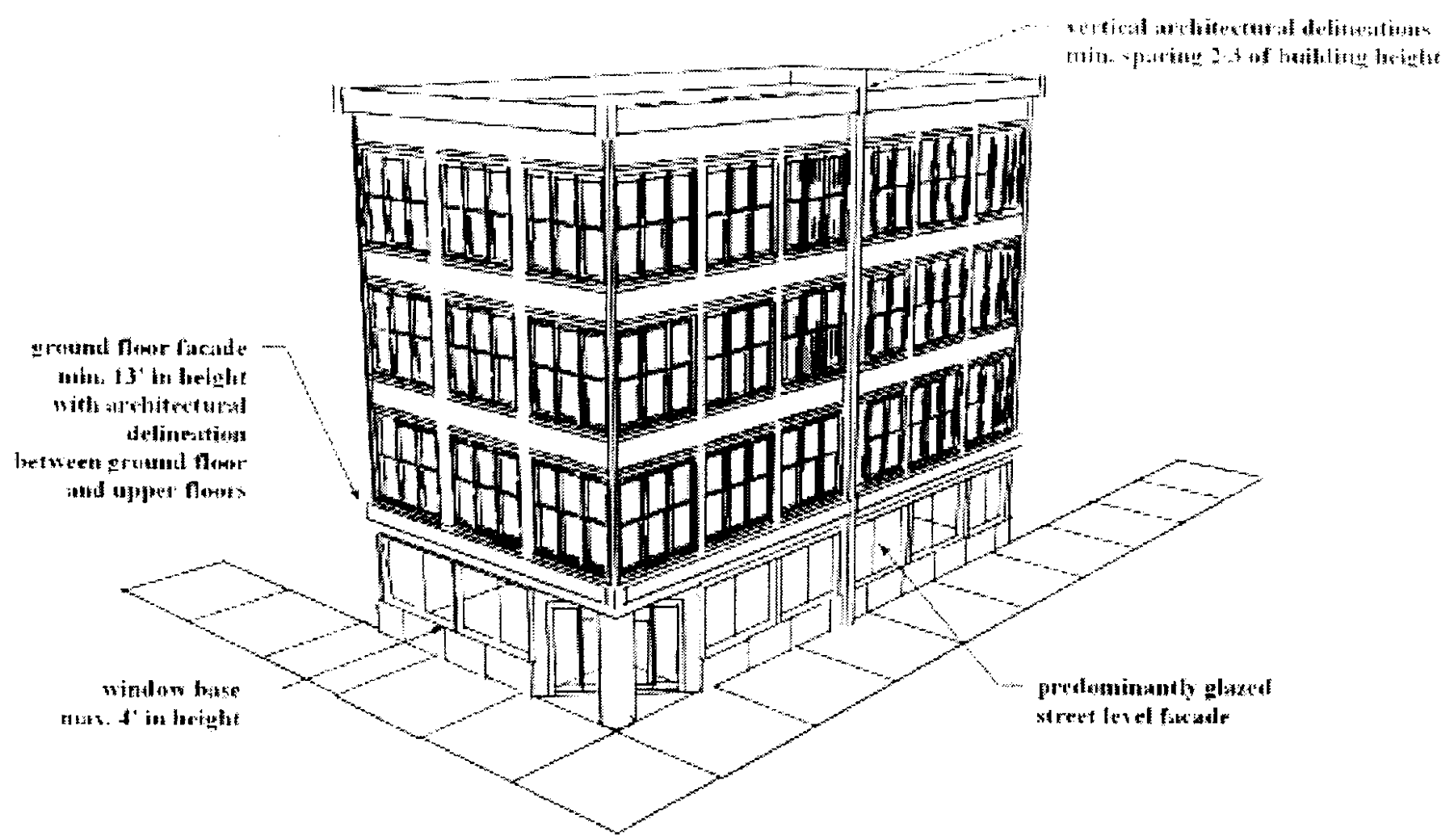
(3)
Street-level facades. New buildings shall front onto public sidewalks to reinforce pedestrian activity along public streets and pedestrian ways. A street-level facade that faces a public street, riverwalk, or sidewalk shall be predominately glazed by incorporating windows or doors of clear or lightly tinted glass that allow views into and out of the building. Windows shall extend from a sill or base not to exceed four (4) feet in height above the adjacent grade. Darkly tinted windows or window signs (interior or exterior) that block two-way visibility are prohibited along street-level facades; however, spandrel or colored glass may be used in the transom area above the door header. Exterior burglar bars, fixed "riot shutters," or similar security devices shall not be visible from the public right-of-way.
(4)
Exterior building materials. Materials shall be highly durable and easily maintained, especially at the pedestrian level. The following materials are prohibited.
a.
Vinyl siding.
b.
Shingle siding.
c.
Faux wood-grained materials.
d.
Full metal facades.
e.
Exposed or unfinished concrete block.
(5)
Alterations to historic facades. Alterations or additions to buildings and/or structures that are designated as contributing resources to the Wilmington National Register Historic District or are more than fifty (50) years old, should apply the Secretary of the Interior's Standards for Rehabilitation. These standards are included in the Wilmington Historic District Design Guidelines.
(6)
Drive-through windows and service islands. Drive-through windows shall be located in the side or rear yards and shall be set back a minimum of ten (10) feet from the front plane of all street-facing facades. Driveways shall be one-way where possible.
(7)
Additional treatments. HVAC equipment, air conditioning window units, and other electrical equipment shall not be located on street frontages. All such equipment shall be placed in the interior yards or on the roof of the building and screened from the right-of-way. Through-wall mechanical units are permitted on any facade if they are incorporated into the design of the building, flush with the facade on which they are located, concealed by a vent cover and have an internal drip system for condensation. Utility meters, transformers and fixed trash disposal receptacles that cannot be concealed from the public right-of-way shall be screened with an opaque fence or wall.
(i)
Height restriction for demolition of buildings with "contributing historic structure" status. If the owner of a contributing historic structure as identified by the National Register Historic District inventory (on file with the city clerk) elects to demolish it without approval to remove the "contributing historic structure" status purposes of this section and in accordance with the process described in subsection 18-196(k) below, any new building or portion thereof within the footprint of the demolished contributing historic structure shall be subject to the following additional restrictions:
(1)
The height of any new building shall be restricted to the height of the previously existing building plus one-half (½) of the difference between the height of the previously existing building and the by-right height prescribed on the Central Business District height map (Figure 4).
(2)
For the purposes of this subsection, the height of the existing structure shall be measured from the average sidewalk elevation to the highest point of the parapet, or, in the case of a building with a sloped roof, to the average roof height.
(3)
Properties located within the Central Business District, Historic District Overlay [CBD(HDO)] are subject to division V in articles 2 and 3 of this chapter.
(j)
Incentive for development of undeveloped parcels south of Red Cross Street. Height increases above the by-right height may be allowed as conditioned below on any site in the portion of the Central Business District located south of Red Cross Street for which no site plan has been approved and is undeveloped as of January 1, 2011.
(1)
New construction, as described in (j) above, shall be entitled to twelve (12) feet of height increase above the by-right height or fifteen (15) percent increase above the by-right height, whichever is greater. This provision does not waive or supersede the design review authority granted to the historic preservation commission which may require a lower height based on the surrounding context.
(2)
Additional density of one (1) unit per one (1) foot of height increase shall be allowed.
(3)
A site that is being utilized as a parking lot as of January 1, 2011, shall be considered as "undeveloped" for purposes of this section.
(4)
Properties located within the Central Business District, Historic District Overlay [CBD(HDO)] are subject to division V in articles 2 and 3 of this chapter.
(k)
Removal of "contributing historic structure" status. In order to retain all allowable building height, a property owner who intends to demolish a contributing historic structure within the CBD may make application to remove the "contributing historic structure" status according to the following procedures:
(1)
For a contributing historic structure located within the Historic District Overlay (HDO), a property owner may apply to the historic preservation commission to remove the "contributing historic structure" status for purposes of this section. The application requirements and procedures identified in section 18-96 of this chapter shall apply.
(2)
For a contributing historic structure located outside of the HDO, a property owner may apply to the city council to remove the "contributing historic structure" status for the purpose of this section, following a review and recommendation by the planning commission. The planning commission shall not review the request until the historic preservation commission has provided an advisory recommendation. The procedures identified in sections 18-118, 18-119, and 18-120 of this chapter shall apply.
(3)
The application to remove the "contributing historic structure" status for the purpose of this section shall demonstrate that it has little or no significance in the following four (4) categories and, when scored in each category, has a total combined score of less than six (6) points. Individual structures on recombined properties shall be scored individually:
a.
Cultural significance. Zero (0) to three (3) points (one-half-point increments):
i.
The structure is associated with events or the lives of persons that have made a significant contribution to local, state or national history.
ii.
The structure represents the work of a well known or highly regarded builder, architect or other person who was involved in the concept, planning, construction or use of the building.
b.
Architectural integrity. Zero (0) to three (3) points (one-half-point increments):
i.
The structure has maintained the integrity of its original architectural form.
ii.
Changes made to the structure over fifty (50) years ago have since acquired architectural significance.
c.
Architectural style. Zero (0) to three (3) points (one-half-point increments):
i.
The structure has a distinctive defined architectural style.
ii.
The structure has superior craftsmanship of a degree uncommon for the period in which it was constructed.
iii.
The structure is the last or the oldest example of a certain building type or method of construction.
iv.
The structure is one of a group of structures that represent a stylistic type or have distinctive characteristics that are significant by their commonality during a period of history.
d.
Structural integrity. Zero (0) to three (3) points (one-quarter-point increments):
i.
The structure will be given a score of three (3) points for structural integrity unless the applicant has provided a report of structural inadequacy prepared and sealed by a structural engineer licensed in the State of North Carolina.
ii.
The report of structural inadequacy shall be based on the requirements of the most current version of the North Carolina Rehab Code, North Carolina Existing Buildings Code or Chapter 34 of the North Carolina Building Code rather than the North Carolina Building Code for New Construction.
iii.
The structural components shall be assigned the following possible values if they are found to be deficient:
Walls and supporting elements: -1¾ points
Roof and supporting elements: -1¼ points
(4)
Appeals from applications to the historic preservation commission shall be to the board of adjustment consistent with section 18-96(c)(9) of this chapter. Applications that receive an unfavorable recommendation from the planning commission may be appealed within ten (10) days of the date of such adverse decision to the city council by filing with the city clerk a notice in writing stating therein the action of the planning commission and the reasons for the appeal.
(5)
If the city adopts a condemnation ordinance for the structure under articles V, VI, and VII of chapter 16, Buildings and building regulations, of the city's Code of Ordinances, the "contributing historic structure" status shall be removed for the purpose of this section upon adoption of the ordinance.
(6)
Properties located within the Central Business District, Historic District Overlay [CBD(HDO)] are subject to division V in articles 2 and 3 of this chapter.
(l)
Redevelopment with height increase for preservation of historic building facades. In order to retain all allowable development height, any redevelopment of a site containing a contributing historic structure as identified by the National Register Historic District inventory on file with the city clerk must preserve facade(s) fronting on any public right-of-way greater than twenty-four (24) feet in width and meet the conditions outlined below. For purposes of this section, a facade includes the building's exterior finish materials and veneer, fenestration, exterior embellishment, and the wall structure that serves as the substrate for the aforementioned items.
(1)
When a height increase with approved facade preservation is requested under the provisions of this subsection for redevelopment of properties within the Central Business District, Historic District Overlay [CBD(HDO)], the partial demolition, the height increase, and the new building design must be approved by the historic preservation commission and are subject to division V in articles 2 and 3 of this chapter.
(2)
The height of any new construction above and behind the preserved facade(s) shall be allowed up to the maximum height increase shown on the Central Business District height map (Figure 4). Preservation of the existing historic facade(s) shall be regarded as a public benefit (see Table 1 of this section) that allows the height increase to the applicable maximum height (see Figures 6 and 7).
(3)
For purposes of this section, new construction that is higher than the preserved historic facade(s) must be set back a minimum of eight (8) feet from the face of the facade(s) which must remain unchanged in appearance. If the depth of the property is greater than eighty (80) feet, the new construction that is higher than the preserved facade must be set back a distance equal to ten (10) percent of the depth of the property up to a maximum setback distance of twenty (20) feet (see Figures 6 and 7).
(4)
If more than one facade of a building fronts on a right-of-way, the ten (10) percent setback [with twenty-foot maximum] shall apply to new construction behind the facade fronting the greater property depth and only an eight-foot setback shall apply to construction behind any other facade fronting a right-of-way (see Figures 6 and 7).
(5)
In the case of recombined lots of varying depth, an average depth measurement may be utilized in determining the setback, or alternatively, the new construction above the preserved facade may have varying setbacks relative to the property depths.
(6)
Additional density of one (1) unit per acre per each one (1) foot of height-increase granted above the by-right height is permitted.
(7)
Balconies and other architectural elements may encroach into the required new construction setback up to a distance equal to twenty-five (25) percent of the setback depth, but in no case may these elements encroach into the eight-foot minimum setback area.
(8)
The roof over the setback area may be utilized as the substrate of an open air, aboveground plaza and occupied/utilized for permitted uses unless historic features of the structure would be obscured by any physical elements necessitated by the use.
(9)
If the site to be redeveloped contains a contributing historic structure that is a one-story or two-story wood frame dwelling, the dwelling may be relocated in lieu of preserving the facade in order to take advantage of the additional height increase as indicated in Table 1, Public benefits matrix.
(10)
The height increase permitted by this subsection cannot be combined with height increases allowable with the provision of other public benefits listed in Table 1, Public benefits matrix.
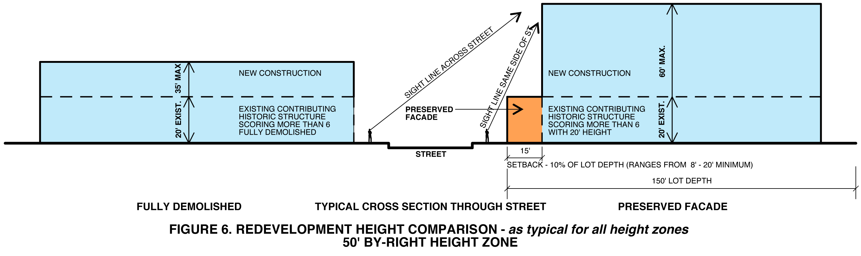
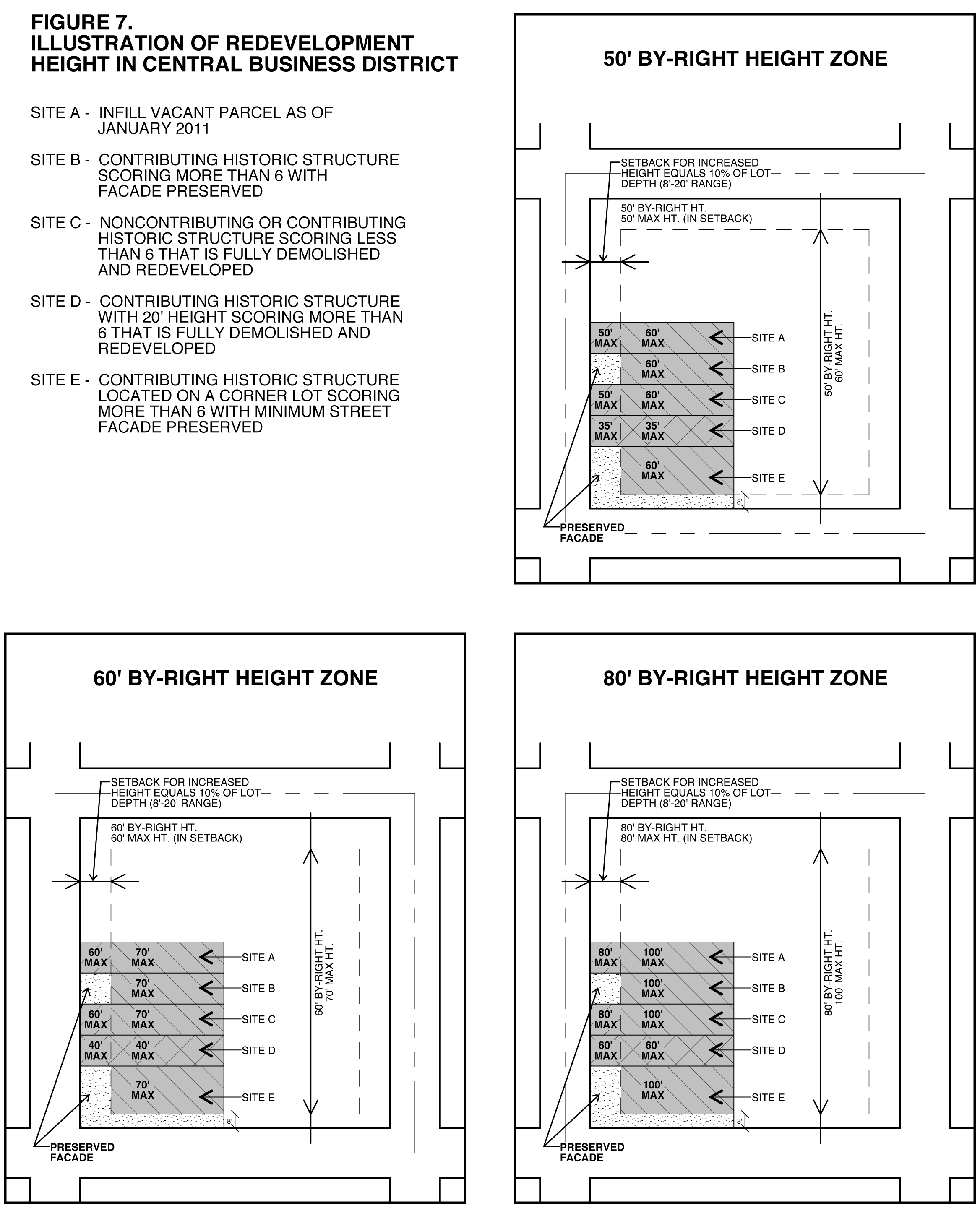
(m)
Demolition requirements and procedures.
(1)
For demolition of all or a portion of a contributing historic structure that scores six (6) or greater according to the evaluation system in subsection 18-196(k), the following requirements and procedures shall apply:
a.
Prior to city sign-off of a demolition permit, the following submittals are required:
i.
A site plan that complies with the provisions of section 18-60 and all other applicable provisions of this chapter, and the City of Wilmington's Standards and Specifications Manual must be submitted by the owner and approved by the city's technical review committee prior to city approval of the demolition permit issued by the county; and
ii.
A financial guarantee or surety in an amount satisfactory to replace sidewalks and curbing and install erosion control features and grass and maintain the site as a green space for a period of two (2) years from submittal of the financial guarantee to the city. The financial guarantee or surety shall be in a form approved by the city attorney.
b.
Subsequent to demolition, the following procedures are required for the site:
i.
The owner shall remove all slabs and foundations during building demolition unless they are to be incorporated into the new construction or unless a report of structural inadequacy prepared and sealed by a structural engineer licensed in the State of North Carolina demonstrates that removal would create a public safety hazard;
ii.
The owner shall immediately install silt fencing sufficient to prevent silt from washing into the public right-of-way until permanent seeding is established;
iii.
The owner shall grade the site level to within one-tenth ( 1/10 ) of a foot and install other erosion control measures, including temporary seeding of grass of a type approved by the city manager, within thirty (30) days following completion of demolition;
iv.
The owner shall begin construction on the new development within one hundred eighty (180) days of completion of demolition, with one (1) thirty-day extension allowed for circumstances beyond the control of the owner as determined by the city manager [for purposes of subsection (m), a parking lot as approved by the city is considered new development, but in no case shall the unimproved site be used for vehicle parking or storage];
v.
The owner shall maintain the site in a well-kept manner so as not to create a public nuisance as set forth in chapter 10 of the City Code. Maintenance of the site includes, but is not limited to, removal of debris and trimming and upkeep of grass; and
vi.
If after one hundred eighty (180) days and the expiration of any approved extensions no construction has begun, the owner shall replace any sidewalks that were removed or damaged, as well as remove chain link or other construction fencing and replace with a railing or fencing type approved by the city, within thirty (30) days.
(2)
For demolition of all or a portion of a noncontributing structure or a contributing historic structure that scores less than six (6) according to the evaluation system in subsection 18-196(k), the following requirements and procedures shall apply if no site plan has been approved by the city's technical review committee:
a.
Prior to city sign-off of a demolition permit, the following submittals are required:
i.
An approved semipermanent green space plan which indicates permanent seeding or sod over a majority of the site, grading to prevent significant ponding of water, and retaining existing sidewalks or replacing if damaged or removed; and
ii.
A financial guarantee or surety in an amount satisfactory to replace sidewalks and curbing and install erosion control features and grass and maintain the site as a semipermanent green space for a period of two (2) years from submittal of the financial guarantee to the city. The financial guarantee or surety shall be in a form approved by the city attorney.
b.
Subsequent to demolition, the following procedures are required for the site:
i.
The owner shall remove all slabs and foundations during building demolition unless they are to be incorporated into the new construction or unless a report of structural inadequacy prepared and sealed by a structural engineer licensed in the State of North Carolina demonstrates that removal would create a public safety hazard;
ii.
The owner shall immediately install silt fencing sufficient to prevent silt from washing into the public right-of-way until permanent seeding is established;
iii.
The owner shall complete implementation of the semipermanent green space plan within sixty (60) days including planting and maintaining permanent seeding or sod over a majority of the site, grading to prevent significant ponding of water, and replacing sidewalks if removed or damaged; and
iv.
The owner shall cordon steep slopes or drop offs on the site that would present a hazard to the public utilizing a railing type approved by the city and meeting state building code requirements. Where fencing is needed for screening or security, the fence shall be of a type approved by the city. Exposed chain link fencing shall not be utilized for these purposes.
(3)
Properties located within the Central Business District, Historic District Overlay [CBD(HDO)] are subject to division V in articles 2 and 3 of this chapter.
(n)
Credit for undeveloped height and density to preserve contributing historic structures. To promote the preservation of contributing historic structures in the Central Business District ("CBD"), a property owner may elect to maintain such a structure in its preserved or improved condition forgoing any improvement that would have allowed for additional height or density on the site in accordance with this section. In such event, any additional height or density allocation may be transferred as credits to another site in a designated target area of the CBD as follows:
(1)
The property owner of a contributing historic structure ("transferring property") seeking to transfer additional height and density allocation as credits and the property owner seeking to receive such credits ("receiving property") shall provide evidence of a legally binding agreement, that runs with the land of the transferring property, to preserve the historic contributing structure for a period of at least thirty (30) years. Evidence of such legally binding commitment may be in the form of an easement, covenants, or restrictive deed that is recorded in the New Hanover County Registry.
(2)
Receiving properties shall include any site located in the CBD, North of Princess Street, including those with frontage along the northern right-of-way, for which no site plan has been approved and is undeveloped as of January 1, 2011.
(3)
Additional height and density shall be calculated on a floor-to-area ratio of the transferring property. Provided, the height of structures constructed on receiving properties shall not exceed the maximum height requirements as prescribed in Figure 4, Central Business District height map.
(4)
To receive height and density credits, the property owner of a receiving property shall submit an application to certify the transferred height and density credits. The application shall be submitted along with plans submitted for review and approval in accordance with section 18-60 and include:
a.
Documentation recorded in the New Hanover County Registry that is evidence of the legally binding agreement and commitment to preserve a contributing historic structure as described herein above.
b.
A legal description of the transferring and receiving properties respectively.
c.
The names of all owners of and security interests in the transferring and receiving properties respectively.
d.
A description of undeveloped height and density transferred to the receiving property, including calculations used to determine those benefits.
e.
A current endorsement by a title insurance company as evidence of the respective ownership and title of transferring and receiving property owners, or other acceptable evidence of title in a form acceptable to the city attorney.
f.
Such other information as determined to be necessary by the city manager to determine the sufficiency of the application.
(5)
If an application to certify transferred height and density is determined sufficient, the city manager shall endorse the site plan for the receiving property inclusive of the height and density credits.
(6)
After permits are issued for a receiving property, a transferring property owner, including all successors-in-interest, shall not alter a historic contributing structure for which height and density credits have been transferred, inconsistent with the intent and purpose of this subsection (n).
(7)
Transferred height and density credits may be utilized only to the benefit of one receiving property.
(8)
The city manager shall maintain an index of properties that have transferred height and density credits to a receiving property.
(Ord. No. O-2008-25, 4-8-08; Ord. No. O-2008-72, § 1, 8-19-08; Ord. No. O-2010-62, § 3, 8-3-10; Ord. No. O-2010-75, § 37, 10-5-10; Ord. No. O-2010-91, §§ 14, 15, 12-7-10; Ord. No. O-2011-35, §§ 1—3, 5-17-11; Ord. No. O-2011-39, § 1, 6-7-11; Ord. No. O-2012-85, Exh. A, §§ 8—10, 12-4-12; Ord. No. O-2013-79, § 1, 11-6-13; Ord. No. O-2014-68, § 4, 9-2-14; Ord. No. O-2015-31, § 4, 5-5-15; Ord. No. O-2016-36, § 1, 5-3-16; Ord. No. O-2018-47, § 24, 6-19-18, eff. 3-1-2019)
Sec. 18-197. - CS, Commercial Services District.
(a)
Purpose. This district is established to accommodate a mixture of light manufacturing, wholesale, storage, commercial service and repair, and distributive business type uses. It functions as a supportive district to surrounding intensive industrial and commercial uses. The district is designed to locate near major transportation facilities (road, rail, air and port) and act as a transitional land use between intensive industrial and commercial development and office and residential areas.
(b)
Site lighting. All new construction where exterior site lighting is provided shall observe the following limitations as to height:
(1)
Unrestricted lighting: Ten (10) feet.
(2)
Ninety-degree cutoff lighting: Fifteen (15) feet.
In no case shall site lighting for new construction be located or installed so as to shine directly onto residential premises.
(c)
Uses permitted by right. The following uses are permitted by right in the Commercial Services District, provided that they meet all requirements of this section and all other applicable requirements established in these regulations:
(1)
Amusement and recreation services, indoor.
(2)
Artists, commercial including silk screening.
(3)
Assembly hall.
(4)
Automobile and truck dealers, new and used.
(5)
Automobile care center.
(6)
Automobile parts and supply store.
(7)
Automobile renting and leasing.
(8)
Automobile repair shops.
(9)
Automotive services, except repair and towing.
(10)
Banking services.
(11)
Building materials dealers.
(12)
Bus and taxi service.
(13)
Business services.
(14)
Carpet and upholstery cleaners (on customer's premises).
(15)
Chimney and furnace cleaning.
(16)
Clothing and other finished fabric products.
(17)
Contractors, general or special trade, with no outdoor storage.
(18)
Community center.
(19)
Contractor's equipment and supply dealers and service, with no outdoor storage.
(20)
Convenience food stores.
(21)
Divers, commercial.
(22)
Drive-in theater.
(23)
Electric motor repair shop.
(24)
Electrical and electronic machinery, equipment and supplies.
(25)
Exterminating services, dwellings and other buildings.
(26)
Fabricated metal products, except boiler shops; machinery and transportation products; metal coating; engraving and allied services; metal forgings screw machine products; steel, wire, and pipe structural metal products; and ordnance.
(27)
Fishing, commercial.
(28)
Funeral home and crematory.
(29)
Furniture and other home furnishings stores.
(30)
Gun sales, including repair.
(31)
Janitor services.
(32)
Launders, industrial.
(33)
Leather and leather products, excluding tanning.
(34)
Liquor stores.
(35)
Lumber and wood products, except furniture.
(36)
Manufactured housing dealers.
(37)
Marinas.
(38)
Measuring, analyzing and controlling instruments; photographic, medical and optical goods; watches and clocks.
(39)
Motion pictures production and distribution.
(40)
Motorcycle dealers.
(41)
Movers, van lines and storage.
(42)
Movie theaters, except drive-in.
(43)
Nightclubs.
(44)
Offices, medical.
(45)
Offices, professional.
(46)
Package delivery services, commercial.
(47)
Parks and recreation areas, municipal.
(48)
Personal services.
(49)
Post office.
(50)
Railroad facilities, including passenger and freight stations outside of railroad rights-of-way.
(51)
Recreational vehicles and utility trailer dealers.
(52)
Repair shops.
(53)
Research and development laboratories.
(54)
Restaurant, fast-food carry-out.
(55)
Restaurant, standard (sit-down).
(56)
Retail sales establishments.
(57)
Sales office, off premises, not retail.
(58)
Schools, trade, correspondence and vocational.
(59)
Ship chandlers.
(60)
Shipping brokers, freight and cargo, without storage.
(61)
Small engine repair, except automotive.
(62)
Upholstery and furniture repair.
(63)
Used merchandise store, except automotive goods.
(64)
Veterinary services with enclosed pens.
(65)
Veterinary services with open pens.
(66)
Water transportation.
(67)
Welding, repair.
(68)
Recreational facility, private.
(69)
Candy and other confectionery products, manufacturing and warehousing.
(70)
Laundromats, with no drive-up windows.
(71)
Domestic violence shelter.
(d)
Uses permitted under prescribed conditions. The following uses are permitted provided that they meet all requirements of this section, Article 6, and all other applicable requirements established in these regulations.
(1)
Auxiliary uses and wares.
(2)
Bowling alleys and pool halls.
(3)
Commercial parking lots.
(4)
Communication facilities.
(5)
Contractor's storage yard.
(6)
Contractors, general or special trade with outdoor storage.
(7)
Governmental uses outside public rights-of-way.
(8)
Group home supportive, large.
(9)
Group home supportive, medium.
(10)
Kennel, commercial boarders and breeders.
(11)
Mini-warehousing.
(12)
Historic mixed-use buildings.
(13)
Religious institutions.
(14)
Residential unit contained within a primary use.
(15)
Service stations.
(16)
Shopping center.
(17)
Skating rink, roller and ice.
(18)
Telecommunication facility, unattended.
(19)
Tire dealers and service.
(20)
Utility stations and plants outside public rights-of-way (public and private) including lift stations, substations, pump stations, etc.
(21)
Warehousing, general.
(22)
Wholesale trade.
(23)
Electronic gaming establishments.
(24)
Breweries, small regional and microbreweries.
(25)
Artisan food and beverage producers.
(e)
Permitted by special use permit. The following uses are permitted subject to the issuance of a special use permit and provided that they meet all requirements of this section, Article 6, and all other applicable requirements established in these regulations.
(1)
Group day facility.
(2)
Group home residential.
(3)
Group home supportive, small.
(f)
Permitted accessory uses. Accessory uses clearly incidental and subordinate to the principal use and structures including the following uses, are permitted provided that they meet all requirements of this section, the requirements of Article 6 and all other applicable requirements established in these regulations.
(1)
Internal services facilities incidental to permitted uses, including cafeterias, day care facilities, snack bars, and similar retail activities, conducted solely for the convenience of employees, or occasional visitors, provided any signage for such facilities is not visible beyond the premises.
(2)
Shipping containers, permanent off-chassis.
(g)
Development standards.
(1)
Dimensional requirements.
a.
Minimum lot area (square feet): 7,500.
b.
Minimum lot width (feet): 65.
c.
Maximum lot coverage: NA.
d.
Minimum front setback (feet): 35.
e.
Minimum rear setback (feet): 15 (b), (d) .
f.
Minimum interior side setback: 7 (c), (d) .
g.
Minimum corner lot side setback: 35.
h.
Height (feet): 35+ (a) .
Notes:
(a)
See subsection (g)(2) below for increased building height allowances to a maximum of ninety-six (96) feet.
(b)
When abutting a residential district, the minimum rear setback shall be twenty-five (25) feet.
(c)
When abutting a residential district, the minimum interior side setback shall be twenty (20) feet.
(d)
For every foot of increased height of structures over twenty (20) feet, the developer shall provide additional interior side and rear yard setbacks at a 1:1 ratio where abutting a residential district.
(2)
Building height. Building height may be increased when additional side and rear yards are provided in accordance with the following standards. The maximum height of any building shall be ninety-six (96) feet. The formulas for increases are as follows:
(Ord. No. O-2008-25, 4-8-08; Ord. No. O-2010-62, § 4, 8-3-10; Ord. No. O-2014-68, § 5, 9-2-14; Ord. No. O-2015-31, § 5, 5-5-15; Ord. No. O-2020-27, § 3, 6-9-20; Ord. No. O-2020-62, § 16, 10-20-20)
Sec. 18-198. - LI, Light Industrial District.
(a)
Purpose. The Light Industrial District is established to provide areas for office, distribution, warehousing, storage, and light industrial uses in accordance with adopted plans and policies. Light industries are generally characterized as industries with small physical plants and high worker-to-land ratios. Retail uses intended to serve the development are also permitted. The district is designed to be located in areas adequately served by public or private utilities, and near major transportation facilities (road, rail, air, and/or port) to ensure adequate access to its uses which, in turn, will discourage additional traffic generation on nearby residential streets. It should be located for satisfactory integration of the district into the surrounding area, not in a manner that adversely impacts existing or planned nonindustrial uses.
(b)
Uses permitted by right. The following uses are permitted by right in the Light Industrial District, provided that they meet all requirements of this section and all other applicable requirements established in these regulations:
(1)
Airport services.
(2)
Automobile care center.
(3)
Automotive services, except repair and towing.
(4)
Boat building and repair.
(5)
Building materials dealers.
(6)
Bus and taxi service.
(7)
Business services.
(8)
Contractors, general or special trade, with no outdoor storage.
(9)
Reserved.
(10)
Contractor's equipment and supply dealers and service, with no outdoor storage.
(11)
Divers, commercial.
(12)
Electric motor repair.
(13)
Electrical and electronic machinery, equipment and supplies.
(14)
Fabricated metal products except boiler shops; machinery and transportation products; metal coating; engraving and allied services; metal forgings screw machine products; steel, wire, and pipe structural metal products; and ordnance.
(15)
Fiber optics.
(16)
Fishing, commercial.
(17)
Fuel and ice dealers.
(18)
Funeral home and crematory.
(19)
Garbage collection, private.
(20)
Gas companies.
(21)
Launders, industrial.
(22)
Manufactured housing dealers.
(23)
Manufacturing and distributing industries except boiler shops; chemical; creosote; fats and oils; machinery; meat products (slaughterhouses); ordnance, paper; petroleum; primary metals; steel, wire, pipe structural metal products; stone and cement products; tires; and tobacco products.
(24)
Marina.
(25)
Measuring, analyzing and controlling instruments; photographic, medical and optical goods; watches and clocks.
(26)
Metal coating, engraving and allied services.
(27)
Motor freight companies.
(28)
Movers, van lines and storage.
(29)
Offices, professional.
(30)
Package delivery services, commercial.
(31)
Parks and recreation areas, municipal.
(32)
Pipe lines, except natural gas.
(33)
Post office.
(34)
Railroad facilities, including passenger and freight stations outside of railroad rights-of-way.
(35)
Refrigeration, heating and air conditioning machinery.
(36)
Research and development laboratories.
(37)
Restaurant, fast-food carry-out.
(38)
Restaurant, standard.
(39)
Ship chandlers.
(40)
Shipping brokers, freight and cargo.
(41)
Small engine repair.
(42)
Transportation equipment manufacturing.
(43)
Veterinary services with enclosed pens.
(44)
Veterinary services with open pens.
(45)
Water transportation.
(46)
Welding, repair.
(47)
Amusement and recreation services, indoor.
(48)
Schools, trade, correspondence, and vocational.
(49)
Breweries, small regional and microbreweries.
(50)
Artisan food and beverage producers.
(c)
Uses permitted under prescribed conditions. The following uses are permitted provided that they meet all requirements of this section, Article 6, and all other applicable requirements established in these regulations.
(1)
Adult establishments.
(2)
Automobile repair shops.
(3)
Auxiliary uses and wares.
(4)
Commercial parking lots.
(5)
Communication facilities.
(6)
Contractor's storage yard.
(7)
Contractors, general or special trade with open storage.
(8)
Governmental uses outside public rights-of-way, except offices.
(9)
Kennel, commercial boarders and breeders.
(10)
Mini-warehousing.
(11)
Motion pictures production and distribution.
(12)
Residential unit contained within a principal use.
(13)
Service stations.
(14)
Telecommunication facility, unattended.
(15)
Tire dealers and service.
(16)
Towing services, automobile and truck.
(17)
Utility stations and plants outside public rights-of-way (public and private) including lift stations, substations, pump stations, etc.
(18)
Warehousing, general.
(19)
Wholesale trade.
(20)
Automobile and truck dealers, new and used.
(21)
Contractor's equipment or supply dealers and service, with outdoor storage.
(22)
Nightclubs.
(23)
Spas and health clubs.
(24)
Religious institutions.
(d)
Permitted accessory uses. Accessory uses clearly incidental and subordinate to the principal use are permitted provided that they meet all requirements of this section, the requirements of Article 6 and all other applicable requirements established in these regulations.
(1)
Internal services facilities incidental to permitted uses, including cafeterias, day care facilities, snack bars, and similar retail activities, conducted solely for the convenience of employees, or occasional visitors, provided any signage for such facilities is not visible beyond the premises.
(e)
Development standards.
(1)
Dimensional requirements.
a.
Minimum lot area (square feet): None.
b.
Minimum lot width (feet): None.
c.
Maximum lot coverage: NA.
d.
Minimum front setback (feet): 50.
e.
Minimum rear setback (feet): 0 or 35 (b), (d) .
f.
Minimum interior side setback (feet): 0 or 20 (c), (d) .
g.
Minimum corner lot side setback (feet): 50.
h.
Height (feet): 35+ (a) .
Notes:
(a)
See subsection (e)(2) below for increased building height allowances to a maximum of ninety-six (96) feet.
(b)
When abutting a street or residential use, the minimum rear setback shall be thirty-five (35) feet.
(c)
When abutting a residential use, the minimum interior side setback shall be twenty (20) feet.
(d)
For every foot of increased height of structures over twenty (20) feet, the developer shall provide additional interior side and rear yard setbacks at a 1:1 ratio where abutting a residential district.
(2)
Building height. Building height may be increased when additional side and rear yards are provided in accordance with the following standards. The maximum height of any building, shall be ninety-six (96) feet. The formulas for increases are as follows:
(Ord. No. O-2007-17, § 1, 3-20-07; Ord. No. O-2008-20, § 1, 3-4-08; Ord. No. O-2008-25, 4-8-08; Ord. No. O-2011-90, § 1, 11-1-11; Ord. No. O-2012-40, §§ 1, 2, 7-10-12; Ord. No. O-2014-68, § 6, 9-2-14; Ord. No. O-2015-31, § 6, 5-5-15)
Sec. 18-199. - IND, Industrial District.
(a)
Purpose. The Industrial District is established to accommodate basic industries and other uses that produce noise, odor, smoke, dust, airborne debris, and other impacts that might be detrimental to the health, safety, and welfare of surrounding uses and neighborhoods in accordance with adopted plans and policies. The district is designed to be located near major transportation facilities (road, rail, air and/or port) and in areas adequately served by public or private utilities. It should not be located in a manner that adversely affects existing or planned nonindustrial uses.
(b)
Uses permitted by right. The following uses are permitted by right in the Industrial District (IND), provided that they meet all requirements of this section and all other applicable requirements established in these regulations:
(1)
Airport services.
(2)
Automobile care center.
(3)
Automobile repair shops.
(4)
Automotive services, except repair and towing service.
(5)
Boat building and repair.
(6)
Boiler shops.
(7)
Building material dealers.
(8)
Bus and taxi service.
(9)
Business services.
(10)
Chemicals and allied products except acids, gases, and glues.
(11)
Coal transfer facility.
(12)
Contractors, general or special trade.
(13)
Marinas.
(14)
Contractors' equipment and supply dealers and service, with no outdoor storage.
(15)
Creosote treatment.
(16)
Divers, commercial.
(17)
Electric motor repair shop.
(18)
Electrical and electronic machinery, equipment and supplies.
(19)
Fabricated metal products, except boiler shops; machinery and transportation products; metal coating; engraving and allied services; metal forgings screw machine products; steel, wire, and pipe structural metal products; and ordnance.
(20)
Fats and oils.
(21)
Fiber optics.
(22)
Fishing, commercial.
(23)
Fuel and ice dealers.
(24)
Funeral home and crematory.
(25)
Garbage collection, private.
(26)
Gas companies.
(27)
Launders, industrial.
(28)
Manufactured housing.
(29)
Manufacturing industries, except petroleum, natural gas, electrical machinery, pulp and paper products and ordnance.
(30)
Measuring, analyzing and controlling instruments; photographic, medical and optical goods; watches and clocks.
(31)
Meat products, processing, except stockyards or slaughterhouses.
(32)
Metal coating, engraving and allied services.
(33)
Metal forgings and stampings.
(34)
Mini-warehousing.
(35)
Motion pictures production and distribution.
(36)
Motor freight companies.
(37)
Movers, van lines and storage.
(38)
Offices, professional.
(39)
Package delivery services, commercial.
(40)
Parks and recreation areas, municipal.
(41)
Pipe lines, except natural gas.
(42)
Post office.
(43)
Railroad facilities, including passenger and freight stations outside of railroad rights-of-way.
(44)
Refrigeration, heating and air conditioning machinery.
(45)
Research and development laboratories.
(46)
Restaurant, standard and fast food carry-out.
(47)
Saw mills and planning mills.
(48)
Ship chandler.
(49)
Shipping brokers, freight and cargo, including loadout towers.
(50)
Small engine repair.
(51)
Stone, clay, glass and concrete products, except cement, lime, gypsum and plaster of paris.
(52)
Tobacco products.
(53)
Transportation equipment manufacturing.
(54)
Veterinary services with enclosed pens.
(55)
Veterinary services with open pens.
(56)
Water transportation.
(57)
Welding, repair.
(58)
Breweries, small regional and microbreweries.
(59)
Artisan food and beverage producers.
(c)
Uses permitted under prescribed conditions. The following uses are permitted provided that they meet all requirements of this section, Article 6, and all other applicable requirements established in these regulations.
(1)
Adult establishments.
(2)
Auxiliary uses and wares.
(3)
Commercial parking lots.
(4)
Communication facilities.
(5)
Contractors, general or special trade, with open storage of materials.
(6)
Contractor's storage yard.
(7)
Governmental uses outside public rights-of-way, except offices.
(8)
Kennel, commercial boarders and breeders.
(9)
Residential unit contained within a principal use.
(10)
Service stations.
(11)
Telecommunication facility, unattended.
(12)
Tire dealers and service.
(13)
Towing services, automobile and truck.
(14)
Utility stations and plants outside public rights-of-way (public and private) including lift stations, substations, pump stations, etc.
(15)
Warehousing, general.
(16)
Wholesale trade.
(17)
Contractor's equipment or supply dealers and service, with open storage.
(18)
Nightclubs.
(d)
Permitted by special use permit. The following uses are permitted subject to the issuance of a special use permit and provided that they meet all requirements of this section, Article 6, and all other applicable requirements established in these regulations.
(1)
Ordnance uses.
(e)
Permitted accessory uses. Accessory uses clearly incidental and subordinate to the principal use are permitted provided that they meet all requirements of this section, the requirements of Article 6 and all other applicable requirements established in these regulations.
(1)
Internal services facilities incidental to permitted uses, including cafeterias, day care facilities, snack bars, and similar retail activities, conducted solely for the convenience of employees, or occasional visitors, provided any signage for such facilities is not visible beyond the premises.
(2)
Petroleum refining and related industries.
(3)
Petroleum storage, accessory to a permitted principal use or building.
(4)
Petroleum storage, underground, accessory to permitted automotive stations.
(f)
Industrial development standards.
(1)
Dimensional requirements.
a.
Minimum lot area (square feet): None.
b.
Minimum lot width (feet): None.
c.
Maximum lot coverage: NA.
d.
Minimum front setback (feet): 50.
e.
Minimum rear setback (feet): 0 (b), (d) .
f.
Minimum interior side setback (feet): 0 (c), (d) .
g.
Minimum corner lot side setback (feet): 50.
h.
Height (feet): 35+ (a) .
Notes:
(a)
See subsection (f)(2) below for building height allowances to a maximum of ninety-six (96) feet.
(b)
When abutting a street or residential use, the minimum rear setback shall be fifty (50) feet.
(c)
When abutting a residential use, the minimum interior side setback shall be twenty (20) feet.
(d)
For every foot of increased height of structures over twenty (20) feet, the developer shall provide additional interior side and rear yard setbacks at a 1:1 ratio where abutting a residential district.
(2)
Building height. Building height may be increased when additional side and rear yards are provided in accordance with the following standards. The maximum height of any building shall be ninety-six (96) feet. The formulas for increases are as follows:
(3)
Bulk storage and handling facilities.
(a)
Bulk storage and handling facilities are not to exceed one hundred fifty (150) feet in height.
(b)
Where abutting an IND-zoned property, rear and interior side setback requirements for bulk storage and handling facilities may be measured horizontally for each specified increment in building height. Such facilities may be configured with sloping roofs, stair steps, or other configurations to remain within the following limits:
(Ord. No. O-2007-63, § 1, 8-7-07; Ord. No. O-2008-20, § 1, 3-4-08; Ord. No. O-2008-25, 4-8-08; Ord. No. O-2014-68, §§ 7, 8, 9-2-14; Ord. No. O-2015-31, § 7, 5-5-15)
Sec. 18-200. - AI, Airport Industrial District.
(a)
Purpose. This district is established as a restricted industrial district in which the principal use of land is for intensive and extensive commercial and/or industrial operations that are compatible with airport facilities. It is designed to provide sites adjacent to railroads and/or major thoroughfares, as well as sites with airport access. The district is intended to protect and promote the public utility of the airport by encouraging compatible land uses to locate proximate to it. It is also intended to promote the health, safety and welfare of area residents by preventing the creation of hazards to the airport, thereby protecting the lives and property of the users of the airport and occupants in the vicinity. The restriction of uses also serves to prevent the destruction or impairment of the utility of the airport and the public investment therein.
(b)
Lot size. One (1) acre minimum lot size.
(c)
Access. To protect and promote existing or future residential development, any means of direct access to or from any permitted or special use in the AI, Airport Industrial District shall not be through any residentially zoned or developed area or along any street or road in any residential subdivision. If it can be demonstrated that undue hardship will exist if this provision is strictly enforced, the zoning board of adjustment may grant a variance in accordance with Article 2 of this chapter.
(d)
Special requirements. The table below presents the requirements which shall be met for specified hazards generated.
(e)
Uses permitted by right. The following uses are permitted by right in the Airport Industrial District (AI), provided that they meet all requirements of this section and all other applicable requirements established in these regulations:
(1)
Airport services.
(2)
Automobile and truck dealers, new and used.
(3)
Automobile parts and supply store.
(4)
Automobile renting and leasing.
(5)
Boat dealers, including repairs.
(6)
Building materials dealers.
(7)
Bus and taxi service.
(8)
Business services.
(9)
Reserved.
(10)
Contractors' equipment and supply dealers and service, with no outdoor storage.
(11)
Convenience food stores.
(12)
Divers, commercial.
(13)
Electric motor repair shop.
(14)
Electrical and electronic machinery, equipment and supplies.
(15)
Fabricated metal products, except boiler shops; machinery and transportation products; metal coating; engraving and allied services; metal forgings; screw machine products; steel, wire, and pipe structural metal products; and ordnance.
(16)
Fishing, commercial.
(17)
Food, except stockyards or slaughterhouses.
(18)
Fruit and vegetable market, wholesale with incidental retail.
(19)
Garbage collection, private.
(20)
Launders, industrial.
(21)
Manufactured housing.
(22)
Manufactured housing dealers.
(23)
Manufacturing industries, except boiler shops; chemical; creosote; fats and oils; machinery; meat products (slaughterhouses); ordnance; paper and pulp products; petroleum; primary metals; steel, wire and pipe structural metal products; stone and cement products; tires; tobacco products; and furniture.
(24)
Measuring, analyzing and controlling instruments; photographic, medical, and optical goods; watches and clocks.
(25)
Motels and hotels.
(26)
Motion pictures production and distribution.
(27)
Motor freight companies.
(28)
Motorcycle dealers.
(29)
Movers, van lines and storage.
(30)
Offices, professional.
(31)
Parks and recreation areas, municipal.
(32)
Pipelines, except natural gas.
(33)
Post office.
(34)
Railroad facilities, including passenger and freight stations outside of railroad rights-of-way.
(35)
Recreational vehicles and utility trailer dealers.
(36)
Refrigeration, heating and air conditioning machinery.
(37)
Research and development laboratories.
(38)
Restaurant, standard and fast food carry-out.
(39)
Shipping brokers, freight and cargo.
(40)
Small engine repairs, except automotive.
(41)
Veterinary services with enclosed pens.
(42)
Veterinary services with open pens.
(43)
Water transportation.
(44)
Welding, repair.
(45)
Transportation equipment manufacturing.
(46)
Breweries, small regional and microbreweries.
(47)
Artisan food and beverage producers.
(48)
Amusement and recreation services, indoor. [3]
(f)
Uses permitted under prescribed conditions. The following uses are permitted provided that they meet all requirements of this section, Article 6, and all other applicable requirements established in these regulations.
(1)
Automobile repair shops, including towing.
(2)
Automotive services.
(3)
Auxiliary uses and wares.
(4)
Commercial parking lots.
(5)
Communication facilities.
(6)
Contractors, general or special trade with outdoor storage.
(7)
Contractors equipment or supply dealers and service with outdoor storage.
(8)
Governmental uses outside public rights-of-way, except offices.
(9)
Kennel, commercial boarders and breeders.
(10)
Mini-warehousing.
(11)
Residential unit contained within a primary use.
(12)
Schools, trade, correspondence, and vocational.
(13)
Service stations.
(14)
Telecommunication facility, unattended.
(15)
Tire dealers and service.
(16)
Utility stations and plants outside public rights-of-way (public and private) including lift stations, substations, pump stations, etc.
(17)
Warehousing, general.
(18)
Wholesale trade.
(19)
Contractor's storage yard.
(20)
Religious institutions.
(21)
Daycare, adult or child.
(22)
Homestay lodging.
(23)
Whole-house lodging.
(g)
Permitted accessory uses. Accessory uses clearly incidental and subordinate to the principal use including the following uses are permitted provided that they meet all requirements of this section, the requirements of Article 6 and all other applicable requirements established in these regulations.
(1)
Internal services facilities incidental to permitted uses, including cafeterias, day care facilities, snack bars, and similar retail activities, conducted solely for the convenience of employees, or occasional visitors, provided any signage for such facilities is not visible beyond the premises.
(h)
Development standards.
(1)
Dimensional requirements.
a.
Minimum lot area (square feet): 43,560.
b.
Minimum lot width (feet): None.
c.
Maximum lot coverage: None.
d.
Minimum front setback (feet): 50.
e.
Minimum rear setback (feet): 20 (a) .
f.
Minimum side setback (feet): 20 (a) .
g.
Minimum corner lot side setback (feet): 50.
h.
Height (feet): Airport Zoning Ordinance.
Notes:
(a)
For every foot of increased height of structures over twenty (20) feet, the developer shall provide additional interior side and rear yard setbacks at a 1:1 ratio where abutting a residential district.
(Ord. No. O-2008-25, 4-8-08; Ord. No. O-2014-68, §§ 9, 10, 9-2-14; Ord. No. O-2015-31, § 8, 5-5-15; Ord. No. O-2015-65, § 1, 8-4-15; Ord. No. O-2017-11, § 1, 3-7-17; Ord. No. O-2018-15, § 1, 2-20-18; Ord. No. O-2018-47, § 25, 6-19-18, eff. 3-1-2019)
Editor's note— Ord. No. O-2015-65, § 1, adopted Aug. 4, 2015, set out provisions intended for use as subsection 18-200(e)(47). Inasmuch as there were already provisions so designated, Ord. No. O-2015-65 has been codified herein as subsection (48) at the discretion of the editor.
Sec. 18-201. - CEM, Cemetery District.
(a)
Purpose. This district allows more control over the placement of cemetery activities within the city and ensures the compatibility of the cemetery with the surrounding land uses, thereby protecting the health, safety and general welfare of the city residents.
(b)
Density. None.
(c)
Uses. Any building and land may be used for the permanent internment of one (1) or more dead human bodies or cremated remains, in addition to any accessory buildings and uses customarily incidental to the operation and maintenance of a cemetery.
(d)
Development standards.
(1)
Dimensional requirements.
a.
Minimum lot area (square feet): None.
b.
Minimum lot width (feet): None.
c.
Maximum lot coverage: None.
d.
Minimum front setback (feet): 30 (a) .
e.
Minimum rear setback (feet): 25 (a) .
f.
Minimum side setback (feet): 10 (a) .
g.
Minimum side setback (corner lot) (feet): 30 (a) .
h.
Height (feet): 35.
Notes:
(a)
Applies to a building fronting a street.
Sec. 18-202. - RFMU, Riverfront Mixed Use District.
(a)
Purpose. The Cape Fear River is one of the region's most valuable natural resources and is the focal point of downtown activity. Therefore, the Riverfront Mixed Use District is established to assure quality development along the river through six (6) main objectives: to enhance and preserve environmentally sensitive areas along the river; to protect public access to the river; to provide quality public spaces; to effect quality design and a variety of built forms that result in a pedestrian scale as well as a compelling skyline; to promote and enhance transit options, particularly those that are pedestrian and water-oriented; and to encourage a mix of uses that foster a sense of community. The RFMU District is not intended to be applied in the historic downtown core of the city generally between Castle and Red Cross Streets. Because of the importance of considering the potential impacts of RFMU Districts on the Cape Fear River and the downtown, it is the intention of the city council to only consider applications for the rezoning of property to the RFMU District through conditional zoning applications pursuant to Division IV of Article 5 of the Land Development Code. In the event of conflict between regulations for riverfront mixed use developments and those in other sections of the City Code, the Riverfront Mixed Use regulations shall supersede unless specifically stated otherwise.
(b)
Mix of uses.
(1)
All RFMU developments must contain uses from at least two (2) of the following categories:
a.
Residential.
b.
Office.
c.
Commercial.
d.
Institutional, quasi-public, public.
e.
Entertainment and lodging.
(2)
The total floor area of any RFMU development shall be comprised of no less than five (5) percent of nonresidential uses.
(3)
Single-story structures shall not exceed twenty-five (25) percent of the gross building footprint of all buildings within any RFMU development.
(4)
All buildings greater than thirty-five (35) feet in height shall incorporate more than one (1) use.
(5)
All buildings with riverfront or right-of-way facing facades shall incorporate nonresidential uses on no less than fifty (50) percent of the ground floor area. Structured parking shall not satisfy the nonresidential use requirement.
(c)
Permitted uses.
(1)
Principal uses: All uses in this list shall be permitted within the RFMU District. Uses from the category of "adult establishments" are prohibited. Uses are categorized based on similar impacts and to ensure diversity of uses.
a.
Residential category.
i.
Family care homes.
ii.
Group home supportive.
iii.
Multifamily.
b.
Office category.
i.
Banking services, without drive-through.
ii.
Offices, medical.
iii.
Offices, professional.
c.
Commercial category.
i.
Convenience food store, without gasoline sales.
ii.
Farmers' market.
iii.
Grocery store, less than forty thousand (40,000) square feet.
iv.
Marina, with or without fueling facilities.
v.
Nightclub (nightclubs shall not locate adjacent to an existing place of worship).
vi.
Personal service establishments:
a.
Beauty salon.
b.
Barber shop.
c.
Clothing alteration.
d.
Laundry, laundromat services, and drop-off dry cleaning only.
e.
Masseuse/masseur.
f.
Tanning salon.
vii.
Photography studio.
viii.
Recreation facility, private indoor or outdoor.
ix.
Restaurant, without drive-through windows.
x.
Retail sales establishment, large-scale retail prohibited.
xi.
Ship chandler.
xii.
Spas and health club.
xiii.
Breweries, microbrewery provided the requirements of article 6 are met.
xiv.
Artisan food and beverage producers, provided the requirements of article 6 are met.
d.
Institutional, quasi-public use, or public use category.
i.
Day care, adult or child.
ii.
Clubs, lodges and recreation facilities.
iii.
Government facility, not to include correctional or operational facilities.
iv.
Nursing homes.
v.
Religious institution.
vi.
Retirement center and life care community.
vii.
Assisted living residence.
e.
Entertainment and lodging category.
i.
Amphitheater, located within one thousand three hundred twenty (1,320) feet of a facility with the capacity to accommodate one hundred (100) percent of required parking.
ii.
Aquarium, located within one thousand three hundred twenty (1,320) feet of a facility with the capacity to accommodate one hundred (100) percent of required parking.
iii.
Art gallery/studio.
iv.
Cultural arts center including theaters (for performing arts).
v.
Hotel and motel, except that hotels and motels do not satisfy the "mix of uses" requirement.
vi.
Meeting and events center.
vii.
Movie theater.
viii.
Museum.
ix.
Homestay lodging, provided the requirements of section 18-329 are met.
x.
Whole-house lodging, provided the requirements of section 18-329 are met.
(2)
Supporting uses: The uses listed below are considered supporting uses to the required categories. While the following uses are allowed by right, they shall not count towards the minimum required mix of uses. Even though the development may contain any number of the following uses, it must still include at least two (2) of the five (5) categories (residential, office, commercial, institutional/quasi-public/public, entertainment and lodging) listed in RFMU permitted uses.
a.
Accessory building.
b.
Accessory and auxiliary uses.
c.
Commercial parking facility, provided the parking requirements of this section are met.
d.
Helipad, rooftop only.
e.
Public park, playground and associated facilities.
f.
Recreation facility, neighborhood.
(d)
General regulations. The prevalence of environmentally-sensitive areas located along the riverfront requires that flexible development standards be established to realize land development potential while maximizing natural resource protection. The RFMU District is not intended to be applied to the historic core of the city, including the Central Business District (CBD) and the Historic District-Residential (HD-R) areas. Applying the RFMU guidelines to these areas is inappropriate as it would significantly disrupt the historic character and integrity of downtown.
(1)
Riverfront access: All RFMU developments shall have frontage along the Cape Fear River. A minimum of one (1) pedestrian access shall be provided to the riverfront and shall occur in intervals of no more than two hundred (200) linear feet of shoreline.
(2)
Lot coverage: Maximum lot coverage, including building footprints and impervious paving materials, shall not exceed fifty (50) percent.
(3)
Building base: Delineation of the building base is required for buildings exceeding building base height (see Article 15, Definitions).
(4)
Maximum building height: Building height in the RFMU District shall not exceed fifteen (15) stories, not including levels utilized for structured parking. Additional height up to a maximum of twenty (20) stories may be permitted based on compliance with either of the following performance options:
a.
Dedication of private land area for public use greater than the required minimum of ten (10) percent. For every five (5) percent of additional permanently designated public space, building height may be increased by one (1) story.
b.
Reduction of building mass greater than the required minimum of twenty-five (25) percent. For every additional five (5) percent of building mass reduction above the "building base," building height may be increased by one (1) story.
(5)
Building envelope: All buildings exceeding the building base elevation shall reduce building mass by no less than twenty-five (25) percent of the total mass occurring above the building base, as measured from the building base to the overall height of the building, multiplied by the total area of the building footprint using the following equation:
(Proposed Height—Building Base) × (Footprint) × (0.25) = Minimum Building Mass Reduction (Above building base)
(6)
Building setbacks and separations: All buildings shall be set back a minimum of sixteen (16) feet from the riverfront, public rights-of-way and private streets. All buildings greater than thirty-five (35) feet in height shall be set back a minimum of seventy-five (75) feet from the river's edge. All buildings less than fifty (50) feet in height adjacent to single-family uses or zoning districts, excluding those separated by public rights-of-way, shall have a minimum setback from adjacent single-family residential property lines equal to the height of the building. Buildings over fifty (50) feet in height, excluding those separated by public rights-of-way, shall have a minimum setback of fifty (50) feet from adjacent single-family residential property lines.
(7)
Underground utilities: All electric, cable television and telephone utilities, fire alarm conduits, streetlight wiring and other wiring conduits and similar utilities shall be placed underground by the developer or the appropriate utility company for all new RFMU developments.
(8)
Minimum landscaping:
a.
Shade trees are required along all public and private streets. Canopy trees, as identified in the city's Technical Standards Manual, shall be a minimum caliper of three (3) inches DBH, shall be located at a minimum fifty (50) feet on center, and must be single-stem canopy trees.
b.
Public spaces and common areas shall be planted with a minimum of two (2) single stem canopy trees per every one thousand (1,000) square feet. Canopy trees shall be a minimum caliper of three (3) inches DBH. Three (3) understory trees may be substituted for two (2) canopy trees per one thousand (1,000) square feet of public space or common area where overhead obstructions or other site limitations make canopy trees impractical.
The TRC may permit alternatives to strict conformance with the required location of landscaping under the following conditions. In all cases, RFMU developments shall provide at least the minimum square footage of landscaped area and number of trees required by the city's landscaping regulations.
i.
Preservation of natural stands of trees and existing vegetation. Preservation of natural stands of trees may be substituted for landscaping requirements if the total square footage of interior landscaping meets the minimum required quality and quantity of trees.
ii.
Additional landscaping in key areas. Provision of at least ten (10) percent greater than the minimum landscaping area required in each of the following areas: along the riverfront, at project entrances, and in public spaces.
iii.
Provision of low impact development. Landscaping necessary to achieve low-impact development standards as defined by the exceptionally designed projects regulations.
(9)
Signs: The following sign requirements shall apply to all RFMU developments:
a.
All internal signs in areas designated RFMU shall meet the requirements of the section 18-575, signs permitted in the Central Business District (CBD) and the Main Street Mixed Use (MSMU) District.
b.
Pole signs and outdoor advertising signs are prohibited.
c.
Project entrance signs shall be integrated into site entry, structural, and landscape features and must meet the following standards:
i.
The sign area shall not exceed seventy-five (75) square feet and its vertical dimension shall not exceed four (4) feet.
ii.
The maximum height of any entry structure shall not exceed six (6) feet.
iii.
The sign and any appurtenant structures shall be located so as to not obstruct the view of persons entering or leaving the development consistent with the sight distance requirements in the city's Technical Standards and Specifications Manual.
iv.
The main and any secondary entrances shall be designated on the site plan. Two (2) monument signs are allowed at the main entranceway, one (1) on each side of the road or driveway with a combined total area not to exceed one hundred fifty (150) square feet and with a maximum vertical dimension of four (4) feet. Secondary entranceways shall be restricted to one (1) monument sign, not to exceed eighteen (18) square feet in area and a vertical dimension of four (4) feet. However, if incorporated within an entry wall or other entry feature, two (2) secondary entranceway signs are allowed, one (1) on each side of the access road, not to exceed a combined total surface area of twenty-seven (27) square feet and a vertical dimension of four (4) feet.
v.
The main entranceway sign text is limited to the development name and the name of one (1) tenant. Sign area devoted to a tenant name is limited to twenty-five (25) percent of any sign area. Secondary entranceway text is limited to the development name only.
vi.
Internal illumination is prohibited except for kinetic signs in accordance with Mixed Use (MX) standards.
(10)
Parking requirements:
a.
Surface parking may not exceed five (5) percent of the total number of parking spaces provided or fifty (50) spaces, whichever is less, for each RFMU development. A parking structure is considered part of the building footprint when a common wall is shared between the parking structure and the building.
b.
Surface parking shall be located to the side or rear of buildings or in the interior of a block. Surface parking shall not be located on the riverfront side of buildings. Surface parking shall be reserved for nonresidential uses, including loading areas and emergency vehicle access, and must be clearly designated as such.
c.
There is no minimum or maximum parking requirement for residential uses.
d.
On-street parking is permitted, but shall not be counted toward required parking for commercial uses.
e.
The design of all above-grade parking structures shall relate to the context of the area. Exterior walls of parking structures shall be designed with materials, colors, and architectural articulation in a manner that provides a visual compatibility with adjacent buildings and environment. All parking structures shall be visually obscured from the river. Structured parking shall not satisfy the nonresidential use requirement.
f.
Pervious pavement materials, vegetated bio-infiltration parking lot islands, or infiltration systems shall be used wherever practical to minimize pollutant run-off from surface parking areas.
g.
Parking structure design and elevations shall be included for review as part of the concept plan.
(11)
General site design: Each of the following components shall be included in RFMU developments. The site plan submitted for city review shall include a narrative describing how the project will incorporate each of these components:
a.
Clearly defined common spaces. Plazas, courtyards, riverwalks and other areas are necessary to provide for public gathering and interaction. Amenities such as benches, planters, lighting, fountains, art and landscaping that further the design theme of the project and encourage interaction are required.
b.
View corridors. Views of the Cape Fear River shall not be significantly obstructed by buildings or other structures. All developments shall provide view corridors along all east/west streets that traditionally terminated at the river, as depicted on the 1945 Corporate Limit Map. Such view corridors shall remain unobstructed by buildings or structures from the ground to the sky. Any new street that terminates within fifty (50) feet of the riverwalk shall provide a public access area that is a clearly defined entry point to the required riverwalk.
c.
Multi-modal transportation opportunities. Public boating, walking, bicycling, or water taxi services and the facilities necessary for such uses.
i.
Pedestrian accessibility and concentration of development (critical mass) within a compact, walkable area. Pedestrian circulation shall be clearly defined with paving materials and/or landscaping and shall connect all uses.
ii.
Bicycle and/or pedestrian connectivity to adjacent or nearby developments is required in areas where vehicular access is not provided.
iii.
Sidewalks are required on each side of rights-of-way and private streets throughout the development and are to be installed along all building frontages. Sidewalks shall maintain a minimum width of sixteen (16) feet. Sidewalk width may be reduced on internal private streets with TRC approval. Sidewalks may be limited to a single side of rights-of-way or private streets or sidewalk width may be reduced when right-of-way or private street abuts streams, ponds, or wetlands or when contextual design constraints dictate, as determined by the TRC.
d.
Integrated design of the project. Projects require special attention to building design due to the intermixing of land uses. Functional integration of residential and commercial uses shall be considered during design of RFMU projects. The following standards are intended to guide development of such projects:
i.
[Orientation of primary building entrances:] Primary building entrances shall be oriented toward public sidewalks along primary street or riverwalk frontages. Development along new or existing public streets shall have pedestrian-friendly facades achieved through appropriate scale and quality materials.
ii.
Massing and development scale: No visible facade shall be "blank" or without features or detail. Facades shall incorporate periodic transitions no farther apart than two-thirds (⅔) of the building height in order to create a vertical orientation. This transition may be achieved by utilizing at least two (2) methods including, but not limited to the use of facade offsets, recesses, pilasters or change in materials. For buildings exceeding four (4) stories or fifty (50) feet, whichever is less, facades shall incorporate a visual transition to distinguish the building base from the upper floors of the building. This transition may be achieved by utilizing at least two (2) methods including, but not limited to the use of building facade offsets, cornices, belt courses, moldings or other linear motifs.
For buildings greater than eighty (80) feet in width, facades shall be expressed as at least two (2) or more separate facades utilizing the aforementioned methods in this subsection. The predominant orientation of fenestration within the facade shall be vertical. Horizontal bands or "ribbons" of windows shall not be permitted within the first four (4) stories or fifty (50) feet of building height, whichever is less. At least sixty (60) percent of the ground-level facade shall be constructed of transparent materials or otherwise designed to allow pedestrian view of inside activities.
iii.
Height relationships: The exterior expression of the first level of any building facade must be distinguished at a point not less than thirteen (13) feet, six (6) inches above the ground level at the front facade. This distinction may be accomplished by methods including, but not limited to, the use of moldings, belt courses, a change in materials or fenestration, or building facade offsets.
iv.
Screening: All dumpsters, loading docks, outside storage areas, utility structures, and ground-level mechanical equipment shall be screened on all sides. Screening shall be a minimum of six (6) feet in height and shall consist of living and nonliving material as specified in the city landscaping code. Chain link fencing shall not be permitted.
e.
Dwelling unit size. Minimum residential unit size shall be seven hundred fifty (750) square feet.
(e)
Public space.
(1)
Purpose: RFMU developments shall incorporate public spaces that may be provided in the form of natural areas, atriums, parks, courtyards, plazas, or other undisturbed or improved spaces.
Each RFMU project shall contain a minimum ten (10) percent functional public space, in addition to a riverwalk as defined in this section. "Functional" public spaces are intended to provide opportunities to interface with landscaped, natural or cultural public amenities. Rights-of-way, other than sidewalks along streets, may be included within public space calculations only if the right-of-way serves to provide pedestrian access to these public amenities.
Public spaces shall be pedestrian-oriented and shall shape the design and character of the project through a connecting system of pedestrian areas that create a relationship among the various components of the built environment. The pedestrian areas shall be integrated with features such as landscaping, gardens, benches, artwork, sculpture and water features to improve their appeal. Public space areas shall provide adequate amenities for comfort and convenience such as seating, lighting, directional signage, bicycle racks, drinking fountains, shelters, trash receptacles, and public restrooms.
Public spaces shall be visible, easily accessible, and barrier-free with multiple points of entry from public areas (streets, sidewalks, walkways, the riverwalk, and bike paths). Public spaces shall be oriented to maximize exposure to the river and scenic views. Streets that connect to the river shoreline shall be designed as landscaped corridors that terminate with pedestrian access to the river.
Plants used in landscaping areas shall be native species, of the highest quality, and of sufficient quantity and scale to make a visual impact. Plantings shall be selected and located so that their functional and aesthetic qualities can be maximized. Public space shall provide areas shaded by trees and/or structures. Small-scale stormwater treatment shall be integrated into the landscaping wherever possible, including recessed landscaped areas with curb openings or sloped curbs to serve as rain gardens or bioinfiltration areas. Restoration of wetland vegetation and natural habitat is encouraged along the riverfront.
Where sites providing an opportunity and context for historical interpretation exist along the riverfront, they shall be incorporated into public space areas and appropriately commemorated and marked with interpretive signage.
Artwork is strongly encouraged to be integrated into public space settings wherever possible. Artwork may consist of freestanding pieces (e.g., sculptures and fountains) or may be integrated with surroundings (e.g., relief sculpture embedded into pavement or wall, mosaics, murals, decorative fixtures, etc.) to create a strong visual interest. Artwork should be custom-made in order to be context-appropriate, reinforcing and complementing the character of the riverfront. Public spaces designed to accommodate live performing arts and public gatherings should be integrated into the development whenever feasible.
(2)
Riverwalk: Riverfront properties provide the unique opportunity for public space in the form of a riverwalk along the Cape Fear River corridor. A riverwalk not only provides access to the river but also accents this significant community asset and draws activity to the river corridor. All RFMU developments shall construct a continuous and contiguous public riverwalk to meet city-approved standards along the river's edge for a length as defined by the development's property boundaries.
a.
Easement and access: Public access across the property, between the river's edge and the public right-of-way, private street, or structure running parallel with the river's edge, shall be provided at a minimum width of ten (10) feet. This access shall be granted through an easement or other property interest as approved by the city attorney. The access shall meet ADA design standards.
Developments shall provide public access connections to a riverwalk at intervals of no more than two hundred (200) feet. These walkways should be landscaped and designed with a series of public spaces to accentuate the pedestrian experience. This access shall be granted through an easement or other property interest as approved by the city attorney. The access shall meet ADA design standards.
The "river's edge" shall be defined as the "normal high water" (NHW) level measured from the river's edge to the proposed building elevation closest to and facing the river. "Normal high water" is established by a field representative from the division of coastal management or by the New Hanover County Local Permit Officer when an application for a CAMA permit has been submitted.
b.
Construction plans for a riverwalk shall be approved by the city manager or designee, in consultation with the city engineer, and shall be designed to accommodate future connections to adjacent parcels.
(3)
Dock space: Private dock space shall not restrict public access to the riverwalk.
(f)
Procedural requirements for the establishment of a RFMU District. Proposals for a RFMU District shall be processed in three (3) stages:
(1)
Conceptual review;
(2)
Rezoning application/preliminary site assessment; and
(3)
Final plan/site plan. All stages shall be processed subject to the procedural requirements of the Mixed Use (MX) District. The conceptual plan shall be a sketch that represents the applicant's general impression of the anticipated pattern of development. The preliminary site assessment shall specify existing site conditions and indicate the appropriateness of the site for RFMU zoning. The final plan shall provide the documentation for which building permits and all applicable city, state, and federal approvals are issued.
(Ord. No. O-2007-2, § 1, 1-9-07; Ord. No. O-2008-25, 4-8-08; Ord. No. O-2010-75, §§ 38, 39, 10-5-10; Ord. No. O-2014-68, § 11, 9-2-14; Ord. No. O-2015-31, § 9, 5-5-15; Ord. No. O-2018-47, § 26, 6-19-18, eff. 3-1-2019)
Sec. 18-203. - RO, Residential Office District.
(a)
Purpose. The purpose of the Residential Office District is to allow for the conversion of existing single-family homes to offices and other compatible low-intensity uses. This district is intended to facilitate redevelopment options that will retain and enhance area character, minimize impacts on adjacent residential uses, encourage the adaptive reuse of existing residential structures, encourage new development to be of a residential scale and proportion, ensure compatibility of building and site design in the district, protect trees, require interconnectivity, including bicycle and pedestrian connections, and control access to minimize the impacts of redevelopment on Oleander Drive. This zoning district is only intended for parcels fronting Oleander Drive generally between Pine Grove Drive and 51st Street. Where these regulations conflict with the other sections of this chapter or the city's Technical Standards and Specifications Manual, these regulations shall apply.
(b)
Uses permitted by right. The following uses are permitted in the RO district, provided that they meet all of the requirements of this section and all other applicable requirements established in this chapter:
(1)
Artists, commercial including silk screening.
(2)
Consulting services.
(3)
Dwellings, duplex, triplex, and quadraplex.
(4)
Dwellings, single-family detached.
(5)
Offices, professional.
(6)
Personal services.
(7)
Residential unit contained within principal commercial use.
(8)
Domestic violence shelter.
(c)
Uses permitted under prescribed conditions. The following uses are permitted provided that they meet all requirements of this section, article 6, and all other applicable requirements of this chapter:
(1)
Dry cleaner.
(2)
Group home supportive, small.
(3)
Group home supportive, medium.
(4)
Group home supportive, large.
(5)
Retail sales establishment.
(d)
Permitted by special use permit. The following uses are permitted subject to the issuance of a special use permit and provided that they meet all requirements of this section, article 6, and all other applicable requirements established in this chapter:
(1)
Additions or expansions to existing structures where the gross building footprint of the entire structure would be greater than two thousand one hundred (2,100) square feet.
(2)
Construction of a new primary structure.
(3)
Recombination of lots to a lot width greater than one hundred (100) linear feet.
(4)
Day care, adult or child.
(5)
Group home residential.
(6)
Reserved.
(e)
Permitted accessory uses and structures. The following accessory uses and structures, clearly incidental and subordinate to the principal use and structure, are permitted provided only one accessory building is permitted per lot and that they meet all requirements of this section, article 6, and all other applicable requirements established in this chapter:
(1)
Accessory building.
(2)
Accessory apartment, attached.
(3)
Accessory apartment, detached.
(f)
Development standards. All uses and structures permitted in the district shall meet the applicable development standards established in this section and all other applicable requirements of this chapter:
(1)
Dimensional requirements.
a.
Minimum lot area (square feet): 15,000.
b.
Maximum residential density (u/a): 6.
c.
Minimum lot width (feet): 80 (200 max with SUP).
d.
Maximum lot coverage (%): 50.
e.
Minimum front setback (feet): equal to the predominant front setback for that block face on the same side of the street.
f.
Minimum rear setback (feet): 25.
g.
Minimum interior side setback (feet): 10.
h.
Minimum corner lot side setback (feet): 15.
i.
Maximum building height: 2 stories or 35 feet, whichever is less.
j.
Minimum setback for parking areas: 5 feet from all property lines.
(2)
Site design standards.
a.
Nonresidential uses or conversion to uses other than single-family detached shall not be permitted by the conversion of any structure or premises originally designed for a residential use unless the existing residential character of the building is retained.
b.
Buildings, driveways, parking areas, loading areas, outdoor activity areas, light sources, trash areas, and other potential nuisances shall be located and designed to minimize adverse impacts on abutting residential properties. In order to limit potential adverse impacts, the technical review committee (TRC) may require alternative site layouts, including increased setbacks from residential property lines, different locations of buildings, parking areas, and driveways, and increased screening for light sources and activity areas.
c.
The overall character of the site in terms of existing topography and vegetation shall be retained. Grading to modify the topography is not permitted except to correct drainage problems, as approved by the TRC.
d.
Additions to existing structures. No additions to or extensions of existing structures shall be made to the front or side(s) of the structure.
1.
Any addition or extension that increases the gross building footprint of the entire structure to more than two thousand one hundred (2,100) square feet shall require a special use permit.
2.
Additions and extensions shall maintain the character of the existing structure in terms of massing, scale, roof pitch, setback, building materials, orientation, and fenestration.
e.
Exterior building materials. Predominant exterior building materials for all new structures and additions to existing structures shall be limited to one or more of the following:
1.
Wood siding or shingles.
2.
Brick.
3.
Stacked stone.
4.
Fiber cement siding or shingles.
f.
Driveway access controls. The intent of this section is to provide for cross-access and shared driveways between compatible land uses to reduce conflict points and minimize traffic flow interruptions on Oleander Drive. Cross-access easements create a service drive providing vehicular access between two (2) or more contiguous parcels so that motorists and/or pedestrians do not need to reenter Oleander Drive to gain access to adjacent uses. Cross access between adjacent properties reduces vehicular conflict points between motorists on the main street and motorists entering and leaving driveways. Reduced traffic conflicts result in fewer accidents and improved traffic flow on Oleander Drive. When driveway easements and cross-access easements are created to serve more than one (1) lot, an owners' association or binding contract for the purpose of maintenance is encouraged.
1.
No more than one (1) driveway access shall be permitted per street frontage.
2.
Along Oleander Drive, all uses other than single-family detached uses shall be required to share access with the adjacent RO-zoned property whenever the duplex, triplex, quadraplex, or nonresidential use has proposed access to Oleander Drive through the provision of an easement to the adjacent RO-zoned property. When driveway access is available on an abutting property, the proposed nonresidential use, duplex, triplex, or quadraplex shall utilize this access. If shared access cannot be provided via an existing driveway on an abutting property, access shall be provided in such a way that maximizes the potential for shared access in the future, as outlined below.
a.
Shared access via existing driveways.
i.
When the nearest edge of an existing driveway on an adjacent RO-zoned nonresidential, duplex, triplex, or quadraplex used property with frontage on Oleander Drive is within fifty (50) feet of the proposed duplex, triplex, quadraplex, or nonresidential use, the proposed use shall utilize the driveway on the adjacent tract as a shared access, provided an easement granting access has been recorded.
ii.
The shared driveway shall be the sole access to the site from Oleander Drive and any existing driveway(s) accessing Oleander Drive shall be eliminated.
iii.
Shared access shall not be required when all possible interconnections between two abutting properties would cross twenty (20) linear feet or more of wetlands, and/or floodplains.
b.
Shared access via new or existing driveway on a property.
i.
When shared access cannot be provided via an existing driveway consistent with the requirements of this section (above), a maximum of one (1) driveway to Oleander Drive shall be permitted on the property.
ii.
The driveway shall be located to maximize interconnectivity, as approved by the TRC. In order to accommodate required sight distances or preserve environmental features, this driveway shall not be set back from the side lot line more than forty (40) feet. Shared access shall not be required when all possible interconnections between two abutting lots would cross twenty (20) linear feet or more of wetlands and/or floodplains.
iii.
Each use other than single-family detached shall provide a cross-access easement to this driveway guaranteeing access to all abutting lots zoned RO. An accessway may not be blocked off, parked in, or otherwise obstructed. The access easement shall provide access from the closest adjacent property line to the driveway. The easement between the driveway and the closest adjacent lot shall be in a logical location for connection to the adjacent lot, shall be located behind the primary structure, and shall be a minimum of twelve (12) feet wide. The TRC may waive the cross-access requirement if it would cause five (5) or more contiguous lots to be interconnected.
iv.
Existing driveways not meeting the requirements in this section shall be eliminated during the redevelopment/conversion of the property.
v.
The location of the driveway intersection with Oleander Drive and with the easement connection to the adjacent lot shall be subject to approval by the TRC based on the potential to minimize the need for future driveways, preserve existing buildings and trees, and/or maximize the distance from the existing street and driveway intersection, including consideration of safe sight distances.
vi.
Parking shall not be permitted along shared driveways between Oleander Drive and the rear edge of the easement granting access to the abutting lot.
3.
For properties located on the north side of Oleander Drive that are developed with uses other than single-family detached, vehicular access to the alley is not permitted.
4.
Each use other than single-family detached shall provide access easements for its parking aisles and driveways guaranteeing access and use to all abutting lots within the RO district, unless all possible interconnections would cross twenty (20) linear feet or more of wetlands, and/or floodplains. Parking areas on abutting lots shall be directly connected by a driveway. These interconnections shall be constructed during the initial conversion/redevelopment, or if an interconnection is not currently feasible, escrow funds for future construction while also providing an easement to the abutting lot allowing future construction when the abutting lot converts/redevelops as an RO use.
g.
Parking. Parking is not permitted in front yards or between the primary structure and Oleander Drive. This regulation may be waived by the TRC for existing structures converted to a duplex, triplex, quadraplex or nonresidential use where site constraints prohibit access to the rear or side yard.
1.
Off-street parking surfaces shall be of pervious materials, where soils are suitable.
2.
The minimum required number of off-street parking spaces may be reduced by up to twenty-five (25) percent, as approved by the TRC.
3.
All parking areas shall be screened from adjacent non-RO-zoned residential uses and along the alley north of Oleander Drive with a minimum ten-foot wide vegetative buffer and solid six-foot to ten-foot tall wood fence. A minimum of one (1) row of planted materials consisting of a combination of trees and shrubs shall be provided at a minimum height of three (3) feet at planting and give at least fifty (50) percent opacity of the fence at planting. To provide a variety of height and depth, at least one (1) tree on average will be planted for every thirty (30) linear feet of screen.
h.
Screening. Any ground-level mechanical equipment (such as HVAC, electrical panels, and similar mechanical equipment), shall be screened from view from any right-of-way with a vegetative screen tall enough to shield the equipment.
1.
Dumpsters shall be prohibited. Trash should be kept inside a principal building until collection, where possible.
2.
Outdoor storage of equipment and/or materials shall be prohibited.
i.
Signage. Signage shall be limited to mounted monument-style signs, either freestanding or ground mounted. Other sign types shall be prohibited. All other pertinent sign regulations shall apply.
1.
Signs shall be compatible with the architecture and materials of the principal structure.
2.
Signs shall not exceed six (6) feet in height.
3.
The total sign area shall be limited to thirty-two (32) square feet.
4.
Signs shall be set back a minimum of five (5) feet and a maximum of fifteen (15) feet.
5.
Internal illumination and changeable copy, electronic or otherwise, are prohibited.
6.
Landscaping shall be provided around the base of the sign on all sides. A minimum of forty (40) square feet of ground cover, not including nonornamental grasses, shall be provided.
j.
Site lighting. Any exterior lighting shall be limited to cut-off or shielded type luminaries and shall be directed toward the center of the property. In no case shall site lighting be located or installed so as to shine directly onto neighboring properties or the public right-of-way. The height of any exterior lighting shall not exceed ten (10) feet in height and shall maintain a clearance of at least eight (8) feet above any pedestrian area. A lighting plan shall be submitted as part of any TRC application.
k.
Landscaping and buffers. All new construction or conversion of structures to a duplex, triplex, quadraplex, or nonresidential use shall be subject to the parking lot landscaping and O&I-1 street yard requirements of article 8 of this chapter. Preservation of natural stands of trees and native vegetation may be substituted for interior landscaping requirements when the square footage of the preserved area is at least equal to the minimum square footage required for new landscaping.
1.
A buffer consisting of a minimum ten (10) feet of vegetation and solid six-foot to ten-foot tall wood fence shall be provided adjacent to non-RO-zoned residential uses and along the alley north of Oleander Drive. A minimum of one (1) row of planted materials consisting of a combination of trees and shrubs shall be provided at a minimum height of three (3) feet at planting and be at least fifty (50) percent opaque at planting. To provide a variety of height and depth, at least one (1) tree on average will be planted for every thirty (30) linear feet of screen.
l.
Drive-through windows shall be prohibited.
(Ord. No. O-2010-76, § 1, 10-5-10; Ord. No. O-2011-41, § 1, 6-7-11; Ord. No. O-2018-47, § 27, 6-19-18, eff. 3-1-2019; Ord. No. O-2020-62, § 17, 10-20-20)
Sec. 18-204. - UMX, Urban Mixed Use District.
(a)
Purpose. The urban core of the city, primarily that area within the 1945 corporate limits, contributes to the unique character of the City of Wilmington. The UMX is established to assure an appropriate development pattern is maintained within the 1945 corporate limits through five (5) main objectives: to enhance and preserve existing urban development patterns by encouraging compatible infill and redevelopment; to affect quality design and a variety of built forms of lasting value that result in a pedestrian scale; to provide a mix of housing options; to promote and enhance transit options, particularly those that are pedestrian-oriented, while reducing demand for automobile trips; and to encourage a mix of uses that fosters a sense of community. The district regulations include design elements intended to enhance the urban form, increase neighborhood safety, add flexibility for small, urban lots, and complement the historic built environment. Integrated mixes of uses on development sites and within individual buildings is encouraged. UMX zoning inside the 1945 corporate limits is intended to reinforce and restore traditional mixed-use patterns in the older parts of Wilmington. UMX zoning outside the 1945 corporate limits is intended to promote mixed-use developments on sites large enough to create a mix of uses within the existing suburban environment. Typically these developments will include creative development and redevelopment solutions such as integrated, vertical mixed use and structured parking. This district is not intended to be applied to the Central Business District (CBD), nor any of the historic districts.
(b)
Uses.
(1)
Notwithstanding the provisions of section 18-173, any use is permitted in the UMX provided it meets all other provisions of this chapter, except for the following:
a.
Adult establishments.
b.
Electronic gaming.
c.
Garbage collection, private.
d.
Gas companies.
e.
Manufactured homes sales.
f.
Motor freight companies.
g.
Movers, van lines, and storage.
h.
Nightclubs.
(2)
Uses permitted under prescribed conditions. The following uses are permitted provided that they meet all requirements of this section, Article 6, and all other applicable requirements established in these regulations.
a.
Auxiliary uses and wares.
b.
Communications facilities.
c.
Freestanding structured parking decks.
d.
Group home supportive, small, medium, large.
e.
Reserved.
f.
Industrial uses greater than ten thousand (10,000) square feet, provided they are housed within a building existing at the time of adoption of this ordinance.
g.
Utility stations and plants outside public rights-of-way (public and private), including lift stations, substations, pump stations, etc.
h.
Breweries, small regional and microbreweries.
i.
Artisan food and beverage producers.
j.
Homestay lodging.
k.
Whole-house lodging.
(3)
Permitted by special use permit. The following uses are permitted subject to the issuance of a special use permit and provided that they meet all requirements of this section, Article 6, and all other applicable requirements established in these regulations.
a.
Automobile renting and leasing.
b.
Automotive services and towing service.
c.
Communication facilities, including radio and television stations, cellular telephone facilities, towers, etc.
d.
Contractor equipment or supply dealers and service.
e.
Contractor storage yard.
f.
Dormitories, private.
g.
Drive-through services.
h.
Group day facility.
i.
Industrial and manufacturing uses greater than ten thousand (10,000) square feet.
j.
Motor vehicle dealers, including automobiles, boat dealers, motorcycles, recreational vehicles, and utility trailers.
k.
Tire dealers and service.
l.
Group home residential.
(4)
All UMX sites outside the 1945 corporate limits shall include a mix of both residential and nonresidential uses.
(c)
General regulations. The historic urban development pattern inside the 1945 corporate limits frequently includes a fine-grain mix of uses on multiple parcels within close proximity to one another. The mix of uses is achieved through many smaller, independent parcels working together in a greater context. Parcels outside the 1945 corporate limits shall have a minimum lot area of five (5) acres, so as to be able to accommodate a mix of uses on a single site.
(1)
Maximum building height: Along arterial streets, building height shall not exceed four (4) stories or forty-five (45) feet. Building height along arterial streets may be increased to seventy-five (75) feet with the issuance of a special use permit or entry into a development agreement in accordance with G.S. §§160A-400.20 through 160A-400.32 that provides for such increase. Along residential and collector streets, building height shall not exceed thirty-five (35) feet or two (2) stories. Outside the 1945 corporate limits, for parcels fronting arterials or internal collector streets, building height may be increased to five (5) stories or fifty-five (55) feet if structured parking is provided within the project. Roadway classifications are according to the Wilmington Metropolitan Planning Organization Functional Classification Map.
(2)
Building setbacks:
a.
Inside the 1945 corporate limits, no setbacks are required except where abutting a single-family residential district, excluding street and alley rights-of-way. When abutting a single-family residential zoning district, that side of the building abutting the single-family zoning district, shall be set back as follows:
Front: At least five (5) feet or the average setback of existing buildings within the block or block face, but not more than ten (10) feet
Side: At least five (5) feet
Rear: At least five (5) feet
b.
Outside the 1945 corporate limits, where buildings abut single-family zoning districts, building heights shall be limited within certain setbacks, according to the following table:
* Only applicable to properties outside of the 1945 corporate limits along arterial or internal collector streets and when structured parking is provided.
** Requires special use permit or applicable terms of an approved development agreement in accordance with G.S. §§160A-400.20 through 160A-400.32.
c.
In no case shall front setbacks adjacent to the primary street(s) or internal street exceed ten (10) feet. Front setbacks are not required along alleyways. Strict adherence to the ten-foot building to line may be waived by the technical review committee where an existing easement or significant natural feature exists.
(3)
Density:
(4)
Utility and equipment screening: HVAC equipment, air conditioning window units, and other electrical equipment, and fire escapes shall not be located on facades with street frontage. All such equipment shall be placed in the interior yards or inset into the roof pitch, or behind a parapet wall in the case of a flat roof, of the building and screened from the right-of-way. Through-wall mechanical units are permitted on any facade if they are incorporated into the design of the building, flush with the facade on which they are located, concealed by a vent cover and have an internal drip system for condensation. Utility meters, transformers and fixed trash disposal receptacles that cannot be located out of sight shall be screened from the public right-of-way by plantings or opaque fencing. The technical review committee may approve alternations to these standards, if necessary.
(5)
Site lighting: All site lighting shall be located, angled, shielded, and/or limited in intensity so as to cast no direct light upon adjacent properties, shall minimize off-site backlighting glare, and up-lighting. Light posts shall be no taller than twelve (12) feet.
(6)
Parking and driveway requirements:
a.
There are no minimum parking requirements. Parking shall not exceed the maximum parking requirements established for any use in Article 9 of this chapter.
b.
Bicycle parking shall be provided as follows. Where two (2) standards are listed, the greater number applies.
c.
Surface parking shall be located to the side or rear of buildings or in the interior of a block and shall be prohibited in front of buildings. Surface parking shall not be located along rights-of-way except for alleys.
d.
Surface parking lots visible from the public right-of-way shall be screened by permanent walls, shrubbery or hedges at least three (3) feet in height. If hedges or shrubbery are used, they shall be at three (3) feet in height at the time of planting and shall be maintained at three (3) to five (5) feet in height at all times.
e.
Parking shall be accessed via alleyways wherever possible.
f.
The design of all above-grade parking structures shall relate to the context of the area. Exterior walls of parking structures shall be designed with materials, colors, and architectural articulation in a manner that provides a visual compatibility with adjacent buildings and environment.
g.
Pervious pavement materials, vegetated bio-infiltration parking lot islands, or infiltration systems shall be used to minimize pollutant run-off from surface parking areas to the extent that soil permeability, depth to groundwater, or site constraints allow.
h.
Driveway and parking lot design shall be consistent with an urban form and may be exempt from the requirements of the Technical Standards and Specifications Manual, as approved by the technical review committee.
(7)
General site design: Each of the following components shall be included in UMX developments.
a.
Outside the 1945 corporate limits, any UMX development shall either be a conditional district zoning or a general zoning subject to a conceptual site plan review and approval by city council. Regardless of the form of the zoning action, a specific site plan shall be reviewed and approved by the technical review committee, in accordance with all applicable standards. Major changes, as identified in section 18-89 of this chapter, to approved conceptual site plans shall be authorized by the city council. The following shall be included in the conceptual site plan:
1.
Boundary survey and vicinity map showing total acreage, general location in relation to major streets, railroads, and/or waterways, the date and a north arrow on the top.
2.
Conceptual plan showing the location of all major land uses and proposed maximum square footage for each use - may be a bubble format showing the general location and relative arrangement of different land uses.
3.
Maximum building heights.
4.
All external access points and conceptual internal traffic circulation plan.
5.
Proposed buffers and landscaping.
b.
Multi-modal transportation opportunities. Public transit, walking, bicycling, and/or water-oriented transit and the facilities necessary for such uses.
1.
Pedestrian circulation shall be clearly defined with paving materials and/or landscaping and shall connect all uses. Sidewalks and crosswalks shall be provided within new developments as necessary.
2.
Bicycle and/or pedestrian connectivity to adjacent or nearby developments is required.
3.
Sidewalks. Where no sidewalks currently exist, sidewalks shall be installed within the right-of-way between the property line and the back of the curb. Sidewalk width shall be a minimum of twelve (12) feet along arterial streets and eight (8) feet along residential/collector streets and may be reduced on internal private streets with technical review committee approval. Sidewalks may be limited to a single side of rights-of-way or private streets, or sidewalk width may be reduced, when right-of-way or private street abuts streams, ponds, or wetlands or when contextual design constraints dictate, as determined by the technical review committee.
4.
For UMX sites outside the 1945 corporate limits, an internal grid street pattern is required. Block faces within the grid pattern shall not exceed four hundred (400) feet in length. The grid pattern may be supplemented with alleys. The technical review committee may waive strict adherence to the grid pattern when sites are constrained by topography, including wetlands, ponds, or other natural features, and where connections to arterial streets and connections and relationships to adjacent sites require flexibility.
c.
Street trees. Within the 1945 corporate limits, street tree plantings in below-grade planters shall be included in the public right-of-way at the rate of one (1) tree per thirty (30) feet of frontage. If the city manager determines there is no plaza or other space available for tree plantings in the right-of-way, or determines that the planting is problematic for the site, a payment-in-lieu of tree plantings, equal to the cost for the required trees, including materials and installation, shall be paid by the developer into the City of Wilmington tree improvement fund.
Outside of the 1945 corporate limits, street tree plantings in below-grade planters or planting strips shall be included in the public and private rights-of-way at the rate of one (1) tree per thirty (30) feet of frontage. The technical review committee may waive strict adherence to this requirement if an allee is utilized along all or portions of the street frontage.
All plans for street tree plantings must be approved by the city manager and must be planted according to section 18-448 of this chapter, unless otherwise noted in this section. Tree species shall comply with subsection 18-196(f)(3) of this chapter.
d.
Buffers and streetyards. All development within the UMX District may be exempted from required buffers and streetyard requirements, as approved by the technical review committee. Outside of the 1945 corporate limits, a minimum buffer of at least twenty (20) feet in width is required adjacent to single-family residential zoning districts.
e.
Trash containment screening. All developments within the UMX are exempt from section 18-504 of this chapter and are subject to the following screening requirements:
1.
Trash containment areas shall be located within a building where possible.
2.
If trash containment, including areas for holding recycling, cannot be accommodated within a building, it shall be placed on the rear or side of the building and shall be completely enclosed and screened from view of public rights-of-way with an opaque fence or wall and/or plant materials, as approved by the technical review committee. The enclosure shall be at least one (1) foot taller than the highest point of the trash receptacle. Chain link and exposed concrete blocks are prohibited.
f.
Encroachment agreements. An encroachment agreement shall be required for any projection into the right-of-way, such as balconies and door swings. The encroachment agreement must be approved prior to construction release or issuance of a building permit. Application for any encroachment must be made to the city engineer for review and the format of the encroachment agreement shall be determined and approved by the city attorney. Official approval of such agreement shall be by resolution of the city council. De minimus encroachments including gutters, fabric awnings, door swings, architectural elements less than twelve (12) inches in depth, signs, and sub-grade structural elements are approved or denied by the city engineer.
g.
Fences and walls. Open wire fencing, including chain link, hurricane fencing, and barbed wire, is prohibited. Within front yards, fence heights may not exceed four (4) feet.
(d)
Building design. All new construction in the UMX shall comply with the following design standards, where applicable.
(1)
Building entrances. Primary entrances should be clearly distinctive from other entrances. Primary building entrances shall be oriented toward public sidewalks along primary street frontages.
(2)
Massing and scale. Large expanses of flat, unadorned walls are prohibited. Facades shall incorporate architectural details, particularly at the pedestrian level. Building facades along rights-of-way shall incorporate periodic transitions across the facade. Building facades along rights-of-way exceeding thirty (30) feet in width shall be divided into distinct areas utilizing methods including, but not limited to, facade offsets, pilasters, change in materials, or fenestration (window arrangement). Transitions shall be no further apart than two-thirds (⅔) of the height of the facade.
(3)
Street-level facades. New buildings shall front onto public sidewalks to reinforce pedestrian activity along public streets and pedestrian ways. Exterior burglar bars, fixed "riot shutters," or similar security devices shall not be visible from the public right-of-way.
(4)
Exterior building materials. Exterior building materials for all new nonresidential or multifamily structures in the UMX District shall be similar to the materials already being used in the neighborhood, or, if dissimilar materials are used, characteristics such as scale, proportion, form, architectural detailing, and texture shall be used to ensure that enough similarity exists for the building to relate to the surrounding block. Quality finish materials shall be utilized. The following materials shall be prohibited on facades visible from the public right-of-way:
a.
Structural metal panels.
b.
Unparged or nonarchitectural, nondecorative concrete block.
(5)
Alterations to historic facades. Alterations or additions to buildings and/or structures that are designated as contributing resources to the Wilmington National Register Historic District or are more than fifty (50) years old, may apply the Secretary of the Interior's Standards for Rehabilitation. These standards are included in the Wilmington Historic District Design Guidelines.
(Ord. No. O-2013-16, § 1, 3-19-13; Ord. No. O-2014-67, §§ 1—7, 9-2-14; Ord. No. O-2014-68, § 12, 9-2-14; Ord. No. O-2015-31, § 10, 5-5-15; Ord. No. O-2017-36, § 2, 6-6-17; Ord. No. O-2018-24, § 1, 4-3-18; Ord. No. O-2018-47, § 28, 6-19-18, eff. 3-1-2019)
Sec. 18-211. - FP, Floodplain Overlay District.
(a)
Purpose. The purpose for identifying this area on the zoning map is to alert all persons concerned to the fact that development within designated floodplains must conform to the adopted ordinance entitled "The Floodplain Management Regulations of the City of Wilmington," as amended. It is the intent of the council of the City of Wilmington to promote the public health, safety and general welfare with measures designed to minimize private and public losses of life, property, commerce and services from the hazards of floods through the enforcement of the above-referenced ordinance.
(b)
District provisions. The Floodplain Overlay is established as a district which overlaps other zoning districts established by this chapter. The extent and boundaries of the Floodplain Overlay District shall be delineated on the official zoning map of the City of Wilmington, but final determination shall be identified from the flood hazard boundary maps (FPBM), No. 370171-0001A and No. 370171-0002A, dated April 17, 1978, and any subsequent revisions thereto; or from "The Flood Insurance Study for the City of Wilmington, North Carolina," dated April 17, 1978, with accompanying flood insurance rate maps, and flood boundary and special flood hazard maps and any subsequent revisions thereto. While the Floodplain Overlay District may overlap any zoning district classification, or any portion thereof, established by this chapter, the land use provisions of the underlying district shall prevail in the development of any property within such district; provided, the provisions of the above-referenced "Floodplain Management Regulations of the City of Wilmington" are adhered to in any construction, reconstruction and alteration to the land and/or structures within this district.
Sec. 18-212. - SHOD, Special Highway Overlay District.
(a)
Purpose. The purpose of the Special Highway Overlay District (SHOD) is to protect the natural beauty and scenic vista that exists along interstate highways and other specifically designated roadways that serve as major accesses and gateways into the City of Wilmington. Protection of these roadways is important and necessary to maintain and preserve the undisturbed roadsides that are characterized by their natural woodlands and open spaces. The continued protection of these scenic highways is also a valuable asset to the tourism economy and enhances the attractiveness of the area for trade and investment.
The Special Highway Overlay District shall be in addition to any other zoning districts where applied so that any parcel of land lying in a SHOD may also lie in one (1) or more of the zoning districts provided for by this chapter. The development of all uses permitted by right or by special use permit in the underlying district, if any, shall be subject to the requirements of both the SHOD and the underlying zoning district. In the event the SHOD requirements conflict with the underlying district requirements, the requirements of the SHOD shall take precedence. If specified by the underlying district, the requirements of the underlying district shall be followed.
(b)
Applicability. It is hereby required that all nonresidential structures, buildings and improvements to property located within the SHOD comply with the following regulations. Access roads, utility (communications, gas, electrical, sanitary services) structures and governmental structures are exempt from the requirements. The procedures for establishing a SHOD district zoning shall be the same as those for establishing or amending any other zoning district. For the purposes of this section, the SHOD is defined as all property fronting on the portions of the following streets, roads or highways as shown on the city's official zoning maps:
Eastwood Road
Military Cutoff Road
The SHOD regulations applicable to the following roadway shall be limited to section 18-212, SHOD, Special Highway Overlay District, (h) Signs.:
Martin Luther King Jr. Parkway
(c)
Setback requirements. All nonresidential buildings and accessory uses shall be set back no less than one hundred (100) feet from the right-of-way of the designated highway. No building shall be located less than twenty-five (25) feet from any property line. However, the setback may be reduced for those buildings, accessory uses and off-street parking by a maximum of twenty-five (25) percent if the project provides additional plantings along the right-of-way. At a minimum, these plantings shall consist of one (1) deciduous or evergreen tree of at least three-inch caliper for every forty (40) feet of road frontage. These streetscape trees must be selected and planted in accordance with Article 8 of this chapter. Plantings must be located in the first ten (10) feet of land adjacent to and parallel to the right-of-way except that plantings may be moved outside this area if it is determined that overhead power lines would interfere with the tree's natural growth.
(d)
Enclosed facilities. All manufacturing, offices, wholesaling, retail sales, and related storage shall be conducted within an enclosed building, except that the display of automobiles and/or boats in the front, side or rear yard areas may be permitted provided the minimum setback applicable to parking lots is met and all other side and rear setbacks are met. If the storage and/or display of boats and autos are adjacent to residentially zoned property occupied by a residential use or a platted residential lot, then storage or display shall be screened from view of the residential use on lot.
(e)
Outside storage. Outside storage can be permitted if it is located directly to the rear of the principal building and is not visible from any location along the designated highway. The outside storage area shall not occupy an area wider than the principal building or larger than one-half (½) the area of the principal building. The outside storage area must be screened with a buffer strip in accordance with Article 8, Division VII. No storage shall be permitted above the height of the screen. Junkyards and scrap processors shall not be permitted.
(f)
Parking and loading.
(1)
Parking and loading shall be provided in accordance with the provisions set forth in Article 9. All loading shall be from the side or rear of the principal structure as viewed from the designated highway. If loading is performed on the side of the building, as viewed from the designated highway, a planted buffer strip in accordance with Article 8, Division VII of this chapter shall be provided.
(2)
No vehicular or equipment parking except automobile parking shall be permitted in the yard area adjacent to the designated highway. All automobile parking shall be set back at least one hundred (100) feet from the right-of-way of the designated highway if such highway is an interstate or thoroughfare with controlled access. Other U.S. and North Carolina numbered highways shall require a fifty-foot setback for automobile parking.
(g)
Lot coverage. The total ground area covered by principal buildings and all accessory buildings shall not exceed fifty (50) percent of the site.
(h)
Signs. Signs shall be in accordance with the sign ordinance except that only one (1) freestanding sign not to exceed six (6) feet in height and a maximum surface area of one hundred fifty (150) square feet may be permitted within the one hundred (100) foot setback. Signs for properties zoned MX, Mixed Use within the SHOD shall be regulated by subsection 18-185(d)(10). No outdoor advertising signs shall be permitted.
(Ord. No. O-2008-25, 4-8-08)
Sec. 18-213. - CO, Corridor Overlay Districts.
(a)
Purpose. The Corridor Overlay Districts are established to provide a series of overlapping regulations for particular roadway corridor areas in addition to those provided by the other zoning districts established by this article. The purpose for establishing these Corridor Overlay Districts is first, to recognize the importance that different roadway corridor areas play in defining the city's character as city entryways and/or significant cultural or historic thoroughfares; second, to protect and preserve both the aesthetics of these important roadways and their traffic handling capabilities through the application of site-specific land use planning principles and procedures; and third, to satisfy the policies and objectives of the South 17th Street and Land Use Plan Update, thereby contributing to the general welfare of the City of Wilmington.
Sec. 18-213.1. - Dawson-Wooster Corridor regulations.
In addition to the general and specific regulations imposed by this chapter on the use of nonresidentially zoned land within the Dawson-Wooster Corridor (defined herein as all property located between Queen Street to the north, Ninth Street to the east, Wright Street to the south, and Front Street to the west), the following regulations shall apply:
(a)
For new commercial development which abuts residentially zoned property, the following buffering standards are required:
(1)
The minimum buffer shall consist of a seven-foot wide buffer strip, containing a six-foot tall solid fence as one (1) row of the required two-row buffer.
(2)
Where the size of the commercial development warrants additional buffering under the provisions of the zoning ordinance the added buffering shall be provided in a buffer strip of at least ten (10) feet in width (or larger if specified in the zoning ordinance or so determined by the city manager); one (1) row of this buffer shall be a six-foot tall solid fence.
(b)
For all new commercial development in the corridor, the following lighting standards shall be observed:
(1)
No site-lighting poles or structures shall exceed ten (10) feet in height.
(2)
All lighting fixtures shall be designed to avoid direct or indirect lighting of any area off the site on which the lighting fixture is located.
(c)
In the CB District portions of the corridor:
(1)
The following land uses permitted shall be prohibited in the Corridor Overlay:
a.
Automotive services.
b.
Flea markets.
c.
Bowling alleys and pool halls.
(d)
In the CS District portions of the corridor:
(1)
The following uses shall be permitted only through the issuance of a special use permit:
a.
Automobile and truck dealers.
b.
Automobile renting and leasing.
c.
Automobile repair shops.
d.
Automotive services.
e.
Boat dealers, including repair.
f.
Building materials dealers.
g.
Contractor's equipment dealers.
h.
Fuel and ice dealers.
i.
Motor freight companies.
j.
Movers, van lines and storage.
k.
Package delivery services.
l.
Recreational vehicles dealers.
m.
Shipping brokers, freight and cargo.
n.
Warehousing, general.
o.
Wholesale trade of durable and nondurable goods.
(2)
The following uses shall be prohibited:
a.
Bowling alleys and pool halls.
b.
Bus and taxi services.
c.
Communications facilities.
d.
All contractors (residential, special trades, etc.) with open storage of materials.
e.
Drive-in theater.
f.
Electric motor repair.
g.
Fruit and vegetable market, wholesale.
h.
Garbage collection, private.
i.
Launders, industrial.
j.
All manufacturing uses.
k.
Marina.
l.
Mini-warehousing, single-story.
m.
Manufactured housing dealers.
n.
Railroad facilities.
o.
Ship chandlers.
p.
Small engine repairs.
q.
Veterinary services with open pens.
r.
Water transportation.
s.
Welding, repair.
(e)
In the LI District portions of the corridor, all nonmanufacturing uses shall be prohibited, except the uses listed below:
(1)
Accessory uses in accordance with Article 6 of this chapter.
(2)
Contractors uses, except no outdoor storage of materials.
(3)
Governmental uses.
(4)
Internal service facilities.
(5)
Offices, professional.
(6)
Parks and recreation areas, municipal.
(7)
Utility stations and plants outside public rights-of-way (public and private) including lift stations, substations, pump stations, etc.
[(f), (g)
Reserved.]
(h)
New residential and commercial development on Dawson and Wooster Streets shall be encouraged to utilize shared driveways where possible so as to limit the total number of driveway connections to the thoroughfares.
(i)
All street yard landscaping required under Article 8, Division IV of these regulations shall conform to the requirements of the entryway landscaping plan with regard to appropriate spacing and types of plant materials.
(Ord. No. O-2017-1, § 2, 1-3-17)
Sec. 18-213.2. - Wrightsville Avenue Corridor regulations.
In addition to the general and specific regulations imposed by this chapter on the use of property in the Wrightsville Avenue Corridor (defined herein as all property fronting on or utilizing for its primary ingress and egress the portion of Wrightsville Avenue between North 17th Street and Oleander Drive/Military Cutoff Road), the following regulations shall apply.
(a)
For new nonresidential and multiple-family developments within the Wrightsville Avenue Corridor, the following design standards shall apply:
(1)
Building scale. New nonresidential or multifamily structures in the Wrightsville Avenue Corridor Overlay shall not exceed three thousand (3,000) square feet or twenty-five (25) percent of the lot coverage of the site, whichever is less. Proposed structures exceeding these dimensions would be available only with a special use permit subject to the prerequisite design standards outlined in Appendix C of the Wrightsville Avenue Land Use Plan that was adopted by city council on February 20, 1990. A special use permit shall not be required for expansions to existing buildings when the proposed expansion does not exceed five (5) percent of the size of the existing structure. For consecutive expansions within a two-year period, the amount of the expansions shall be summed.
(2)
Exterior building materials. Exterior building materials for all new nonresidential or multifamily structures in the Wrightsville Avenue Corridor Overlay shall be limited to the following:
a.
Wood frame.
b.
Stucco.
c.
Brick.
d.
Shingles.
e.
Vinyl, masonite or aluminum siding designed to resemble wooden lap siding or shingles.
f.
A combination of the listed materials.
(3)
Roof pitch. All new nonresidential or multifamily structures in the prescribed Wrightsville Avenue Corridor Overlay shall be limited to a 4:12 or higher pitch roof.
(4)
Facade orientation. The orientation of all new nonresidential or multifamily structures in the Wrightsville Avenue Corridor Overlay shall follow the dominant orientation of structures along the block face in which the structure is located.
(5)
Location of off-street parking. All new nonresidential or multifamily structures in the Wrightsville Avenue Corridor Overlay shall locate the required off-street parking in the interior side or rear yard of the sites. No off-street parking shall be located in the front or corner side yard of the site.
(6)
Front setback of proposed new construction. All new nonresidential or multifamily structures in the Wrightsville Avenue Corridor Overlay shall be set back a minimum of twenty (20) feet from the Wrightsville Avenue street right-of-way. In those instances in which adjoining properties have a setback less than the specified twenty (20) feet, new nonresidential construction may be placed in alignment with the average setback of existing structures along the block face in which the new structure is located.
(7)
Building height. All new nonresidential or multifamily structures in the Wrightsville Avenue Corridor Overlay shall be built to a height no greater than two (2) stories or twenty-five (25) feet in height, whichever is greater.
(8)
Site lighting. All new nonresidential or multifamily developments in the Wrightsville Avenue Corridor Overlay shall be restricted to site lighting of the following height:
a.
Unrestricted lighting: Ten (10) feet.
b.
Ninety-degree cutoff lighting: Fifteen (15) feet.
(9)
Signage. All nonresidential property in the Wrightsville Avenue Corridor Overlay shall be subject to the sign size and setback standards for the Office and Institutional District with regard to freestanding signs. In addition, freestanding signs shall be a maximum height of twelve (12) feet. No internally illuminated freestanding signs shall be permitted. Existing signage shall be subject to amortization within eight (8) years of adoption of this corridor overlay.
(10)
Streetscape architectural components. All new nonresidential or multifamily structures in the Wrightsville Avenue Corridor shall contain door and window openings consistent with those found in the adjacent streetscape. Blank facades shall not be permitted on the Wrightsville Avenue frontage of the structure.
(b)
For all conversions or additions to any existing structure that was originally built as a single-family residence, but is currently used for nonresidential or multifamily purposes, the following design standards shall apply:
(1)
The construction of an addition to existing structures in the corridor shall be placed in the rear of the structure where site dimensions and orientation permit. The size and scale of the addition shall be limited in size so that the addition shall contain no more than fifty (50) percent of the square footage of the original building.
(2)
The attached addition shall be designed in a manner that is compatible with the new use to which the structure will be placed, and shall also be designed for compatibility with the structure itself, and with buildings in the adjacent neighborhood or immediate streetscape. The design may be contemporary in nature, but should reference design features from the original structure including building materials, building openings and height. The addition shall not be constructed of materials not found in the existing streetscape, shall not feature blank facades, and shall not be out of scale with the original building.
(3)
The urban design standards for new construction (see Sec. 18-213. CO, Corridor Overlay Districts.) shall be observed for building scale, off-street parking, front setback, building height, site lighting and signage.
(c)
For all new construction, conversions and/or additions involving nonresidential uses on corner or double frontage lots, driveway access to Wrightsville Avenue shall be prohibited, except where such access would conflict with the provisions of subsection 18-551(d) or except where the lot is located at a signalized intersection of Wrightsville Avenue with a U.S. or North Carolina numbered highway, as designated on the Wilmington Area Thoroughfare Plan, and where said lot's primary frontage is on the thoroughfare street.
(d)
In the O&I, Office and Institutional District portions of the corridor:
(1)
The following uses shall be permitted only with a special use permit:
a.
Business services.
b.
Day care, child.
c.
Religious institutions.
d.
Libraries.
e.
Post office.
f.
Restaurant, standard.
g.
Spas and health clubs.
h.
Telephone communication facilities.
i.
Veterinary services with enclosed pens.
(2)
The following uses shall be prohibited:
a.
Banking services.
b.
Convenience food stores.
c.
Funeral homes and crematories.
d.
Furniture stores.
e.
Golf course, private or public with related services, including pro shops.
f.
Labor unions.
g.
Motels and hotels.
h.
Restaurant, fast-food carry-out.
i.
Service stations.
j.
Social services, not elsewhere classified.
(e)
In the CB, Community Business District portions of the corridor:
(1)
The following uses shall be permitted only with a special use permit:
a.
Associations or organizations: civic, social or fraternal.
b.
Auxiliary uses and wares.
c.
Business services.
d.
Day care, child.
e.
Contractors office, general or special trade, with no open storage.
f.
Launders, no drive-up windows.
g.
Libraries.
h.
Post office.
i.
Restaurant, standard.
j.
Spas and health clubs.
k.
Telephone communication facilities.
l.
Veterinary services with enclosed pens.
(2)
The following uses shall be prohibited:
a.
Arcades.
b.
Automotive services, except repairs.
c.
Bowling alleys and pool halls.
d.
Commercial divers.
e.
Convenience food stores.
f.
Grocery stores.
g.
Flea markets.
h.
Funeral homes and crematories.
i.
Furniture stores.
j.
Gun sales, including repair.
k.
Liquor stores.
l.
Mini-warehousing, single-story.
m.
Motels and hotels.
n.
Motion pictures production.
o.
Movie theaters.
p.
Outdoor advertising signs.
q.
Restaurants, fast-food carry-out.
r.
Service stations.
s.
Skating rink, roller or ice.
t.
Tire dealers and service.
u.
Breweries, small regional and microbreweries.
v.
Artisan food and beverage producers.
(f)
In the CS, Commercial Services District portion of the corridor:
(1)
The following uses shall be permitted only with a special use permit:
a.
Auto care centers.
b.
Automobile and truck dealers.
c.
Automobile renting and leasing.
d.
Automobile repair shops.
e.
Auxiliary uses and wares.
f.
Boat dealers.
g.
Building materials dealers.
h.
Business services not elsewhere classified.
i.
Contractors' equipment dealers.
j.
Fuel and ice dealers.
k.
Launders, no drive-up windows.
l.
Motor freight companies.
m.
Movers, van lines and storage.
n.
Package delivery services.
o.
Recreational vehicles dealers.
p.
Restaurant, standard.
q.
Shipping brokers, freight and cargo.
r.
Spas and health clubs.
s.
Warehousing, general.
t.
Wholesale trade of durable and nondurable goods.
(2)
The following uses shall be prohibited:
a.
Arcades.
b.
Associations or organizations: civic, social and fraternal.
c.
Automotive services.
d.
Bowling alleys and pool halls.
e.
Bus and taxi services.
f.
Commercial divers.
g.
Communications facilities.
h.
Convenience food stores.
i.
All contractors (residential, special trades, etc.) with open storage of materials.
j.
Drive-in theater.
k.
Electric motor repair.
l.
Fruit and vegetable market, wholesale.
m.
Furniture stores.
n.
Garbage collection, private.
o.
Grocery stores.
p.
Gun sales, including repair.
q.
Launders, industrial.
r.
Liquor stores.
s.
Manufacturing (all types).
t.
Marinas.
u.
Mini-warehousing, single-story.
v.
Manufactured housing dealers.
w.
Nightclubs.
x.
Outdoor advertising signs.
y.
Railroad facilities.
z.
Restaurants, fast-food carry-out.
aa.
Service stations.
bb.
Ship chandlers.
cc.
Small engine repairs.
dd.
Veterinary services with open pens.
ee.
Water transportation.
ff.
Welding, repair.
gg.
Breweries, small regional and microbreweries.
hh.
Artisan food and beverage producers.
(Ord. No. O-2008-25, 4-8-08; Ord. No. O-2014-68, §§ 13, 14, 9-2-14; Ord. No. O-2015-31, §§ 11, 12, 5-5-15; Ord. No. O-2017-1, §§ 3, 4, 1-3-17)
Sec. 18-213.3. - South 17th Street/Independence Boulevard Corridor regulations.
In addition to the general and specific regulations imposed by this chapter on the use of property in the South 17th Street Study Area (the boundaries are shown, Map 1. Study Area Boundary, in the South 17th Street Land Use Plan Update) approved by the Wilmington City Council on June 3, 1997 (hereinafter "Land Use Plan Update"); generally the area is bounded by Shipyard Boulevard, South 17th Street Extension, Independence Boulevard, George Anderson Drive, and Carolina Beach Road (hereinafter the "study area"), the following regulations shall apply.
(a)
For all new residential and nonresidential construction within the study area, the following standards shall apply:
(1)
Administrative.
a.
No use which requires a special use permit based on the underlying zoning district regulations shall be allowed within the study area except for planned unit developments (PUDs).
b.
The inspection and maintenance plans or agreement(s) required under section 14-797 herein for regional retention ponds shall specify the percent of impervious surface permitted for the undeveloped areas.
c.
Traffic impact studies shall be required for all use or zoning changes which increase density or change residential use or zoning to nonresidential use or zoning. The cost of such studies shall be paid by the applicant for the use or zoning change.
d.
Based on the above traffic impact study, any development proposal which requires improvements to be made to the existing roadway system in the study area to accommodate the development shall be made by the owner, or a payment in-lieu of such improvement based on the cost of the required improvements, shall be made to the City of Wilmington to cover the cost of the improvements.
e.
The owners or developers shall construct acceleration/deceleration lanes to all driveways along Independence Boulevard and South 17th Street where deemed necessary by the city.
f.
The owners or developers shall provide pedestrian access as an interconnected network of sidewalks throughout the study area.
(2)
Character/design.
a.
The owners or developers of property in the study area shall provide for underground utilities.
b.
Signs shall comply with the underlying zoning district regulations.
c.
All developments shall be in compliance with the greenway plan presented to the city council on March 3, 1992.
d.
The dedication of a network of bikeways and open space in compliance with section 18-383 herein is the minimum required to comply with the greenway plan.
e.
There shall be a variety of housing types and price ranges throughout the study area including:
i.
Apartments.
ii.
Condominiums.
iii.
Duplexes.
iv.
Accessory apartment, detached.
v.
Quadraplexes.
vi.
Residential above retail stores or offices.
vii.
Single-family detached.
viii.
Townhouses.
ix.
Triplexes.
Affordable housing shall be interspersed throughout the development. Affordable housing is defined as such housing which can reasonably be expected to [be] purchased or rented by persons having income between eighty (80) percent and one hundred ten (110) percent of the median income, based on local income levels and prevailing interest rates as provided by the U.S. Department of Housing and Urban Development.
(3)
Districts and uses.
a.
Regional business and community business. In the Regional Business District and Community Business District, off-street parking must be located away from street frontage and in the interior of the lot unless the city's planning staff, in the course of site approval, makes a finding that parking between the building and the front set back line will serve the use more effectively than an interior location.
b.
Multiple-family residential low density. In the multiple-family residential low density use portion of the study area, no structure shall exceed thirty-five (35) feet in height. The required off-street parking may be located below the buildings and shall be buffered so as not to be visible from the roadways.
c.
Single-family residential low density. In the low density single-family residential use portion of the study area, golf courses, and any related shops shall not be allowed. No garages, carports or parking slabs shall be allowed within the front yard of any single-family lot. A garage, carport or parking slab placed in an interior side yard shall be even with the front elevation of the principal structure or located behind or adjacent to the rear elevation of the principal structure.
d.
Minimum buffer. In the study area, a minimum fifty-foot buffer shall be provided along Carolina Beach Road in the multifamily, NC and O&I uses or districts and along South 17th Street in the multifamily uses or districts and surrounding the retention/detention ponds on Independence Boulevard and near Carolina Beach Road.
e.
Planned Development District (PD) regulations. The Planned Development District (PD) is established within the study area as a zoning district. In addition to the other study area regulations and standards, an owner/applicant shall develop a tract in the PD District in accordance with the following regulations:
i.
Purpose. The Planned Development District is established within the study area as a zoning district to foster the mixture of residential, business, retail, office and institutional uses, which will provide living, working and shopping in close proximity and a sense of community. It is designed to promote economical and efficient patterns of land use which are sensitive to natural features and site amenities and which decrease automobile travel time and trip length and increase other modes of travel such as walking and bicycling. The PD District is intended to provide flexibility for innovative design and quality planning by permitting planned development in accordance with the land use plan update.
ii.
Minimum Planned Development District (PD) size. The minimum planned development size shall be a contiguous gross land area of one hundred (100) acres or more under common ownership or control of the applicant. Land areas greater than two hundred fifty (250) acres may be developed as multiple PDs, each individually subject to all of the standards. The PD is a major subdivision as defined in Article 15 herein. A PD may be developed in phases.
iii.
Land use mixture. The PD should be compact with a variety of building types to accommodate a mixture of uses and to conserve open land. Ranges of land use mixtures are allowed in the PD as follows:
The mixture of these land uses shall be consistent with the land use plan update. However, the location of each land use may change from what is shown on the adopted land use map (Map 6. Zoning and Recommended Land Use). Similar land uses should face across streets. Dissimilar uses should abut to rear lot lines.
iv.
Office and Institutional. In the Office and Institutional use portion of the study area adjacent to Carolina Beach Road and in the Office and Institutional use portion of the study area located south of the intersection of Independence Boulevard and South 17th Street only the following uses shall be allowed:
a.
Accessory uses in accordance with Article 6 of this chapter.
b.
Apartment above office or institution.
c.
Assisted living residence.
d.
Banking services.
e.
Business services.
f.
Religious institutions.
g.
Cultural arts center, including theaters, offices, classrooms.
h.
Day care facilities: child, adult.
i.
Libraries.
j.
Offices, medical.
k.
Offices, professional.
l.
Personal services, not elsewhere classified.
m.
Post office.
n.
Social services.
o.
More than (1) one principal use is allowed on a lot.
p.
Access to the O&I uses south of the intersection of Independence Boulevard and South 17th Street shall be limited to the collector street of Independence Boulevard except for vested access points.
v.
Density and accessory apartments, detached. Density in the PD is determined by the underlying land use. The maximum density allowed for the traditional neighborhood Planned Development District (PD), which is located south of George Anderson Drive, shall be eleven and nine-tenths (11.9) units per acre. Accessory apartments, detached are permitted, subject to current regulations for accessory apartments, detached. The style and architecture of a garage apartment shall be similar to the principal dwelling. There shall only be one (1) accessory apartment, detached per lot.
vi.
Maximum building height. The maximum building height within the PD is two (2) to three (3) stories with a maximum height of thirty-five (35) feet, whichever is less.
vii.
Pedestrians and bicyclists. A comprehensive pedestrian and bicycle network of sidewalks and paths shall link uses to each other to minimize walking distances and reduce dependence on the automobile for travel within the PD and adjoining areas to the extent feasible. Street furniture such as trash containers and benches shall be permanently secured.
viii.
Streets. All streets, except alleys, within the PD shall follow a pattern of intersecting streets that provide alternative routes. All streets, alleys, and sidewalks shall connect to existing and projected streets outside the PD. The average perimeter of blocks created by the intersection of streets within the PD shall not exceed one hundred thirty (130) feet. Such a block face shall not have a length greater than four hundred (400) feet without an alley, sidewalk or bikeway providing through access to another street or alley. Culs-de-sac are allowed only where interconnection would result in an adverse environmental impact. Street pavement widths within the PD may be less than that required by the city's Technical Standards and Specifications Manual if such streets are determined by the RC and SRB to be adequate to provide public services such as garbage collection and fire protection. A two-way collector street with parallel parking on both sides shall be no less than thirty-six (36) feet in width from curb to curb. A two-way neighborhood street with parallel parking on one (1) side shall be no less than twenty-six (26) feet in width from curb to curb.
ix.
Alleys. There shall generally be a continuous network of alleys to the rear of lots within the PD. Alleys shall be combined with utility easements. Where possible, utilities shall be located in rear easements. Water and sewer lines should be located in the street rights-of-way or alleys. Parks, squares or greenways shall not be bounded by alleys. Alleys in the Neighborhood Retail Use shall provide sufficient access for loading, parking and refuse collection.
x.
Street lighting. Street lighting shall be restricted to site lighting of the following height:
a.
Unrestricted lighting: Ten (10) feet.
b.
Ninety (90) degree cut-off lighting: Fifteen (15) feet.
xi.
Landscaping. In addition to other landscaping requirements, trees shall be planted within rights-of-way or residential front yards parallel to the street along all streets, except alleys. Tree spacing shall be determined by species type.
xii.
Parking. Off-street parking lots shall be located at the rear or at the side of buildings. Adjacent parking lots shall be connected by an alley. Off-street parking requirements may be reduced by using shared parking where possible.
xiii.
Signs. Sign regulations for the underlying use in the PD District, other than Neighborhood Retail use, shall be the same as the sign regulations for the zoning district of the same name.
xiv.
Greenspace. In the PD a minimum of twenty (20) percent of the land shall be dedicated for the purpose of providing park, recreation and open space areas to serve the PD community in accordance with section 18-383 of this chapter.
xv.
Preapplication. Prior to an applicant submitting an application and a detailed preliminary plan for review and approval, the applicant shall arrange a preapplication conference with the city's planning staff and technical review committee (TRC) to review the applicant's sketch plan.
xvi.
Application plan and approval. The applicant for a PD shall submit an application and a detailed, unified preliminary master plan for the planned development to the city's planning staff, SRB and TRC for review and approval in accordance with the provisions of Article 7 and section 18-60 of this chapter. In addition to these requirements, the applicant shall include in the preliminary plan the following:
a.
Access.
b.
Architectural features of structures.
c.
Bikeways.
d.
Circulation.
e.
Design guidelines for the development.
f.
Environmental analysis.
g.
Historic features, i.e., Civil War battleground signs.
h.
Landscaping, including tree species, size and extent of tree cover.
i.
Location, use, types, massing, scale and dimensions of structures.
j.
Open space.
k.
Recreational areas and parks.
l.
Stormwater plans and calculations.
m.
Traffic impact study.
Following the city's planning staff, TRC and SRB review and approval, the applicant shall prepare and submit the final plat for approval in accordance with Article 3, Division III of this chapter. The final plat shall contain the following notation: "This plat has been approved as part of a planned development in accordance with section 18-213. of this chapter."
xvii.
Minor changes to approved PD. Minor changes to the approved final plat and master plan for the PD are changes proposed by the applicant that do not change the basic design and development concepts of the PD. Minor changes to approved preliminary plans are allowed on final plats if the changes are in substantial compliance with the preliminary plan. Denial classifies such changes as major changes in plans and a new preliminary plan must be submitted or the major change reworked so as to be classified as a minor change. Minor changes to final plats and master plans require the review and approval of TRC and the city's planning director.
xviii.
Major changes to approved PD. Major changes to the approved final plat and master plan for the PD are changes that require resubmission of the plat and plan for review and approval as set forth in section 18-213.
xix.
Variances. Variances may be sought from the board of adjustment for dimensional requirements within the PD such as minimum street right-of-way width and pavement width.
xx.
In the PD District, a Neighborhood Commercial use is established.
a.
Neighborhood Commercial (NC) use purpose: The Neighborhood Commercial use is established to provide commercial opportunities for small-scale pedestrian-oriented commercial centers. These commercial centers shall be designed to provide goods and services primarily to the immediate surrounding neighborhood. Primary access for these commercial centers shall not be from a major thoroughfare. The size of each unit in a building in the NC use shall not exceed six thousand (6,000) square feet, except that grocery stores may be up to fifteen thousand (15,000) square feet. The building footprint shall not exceed twenty-five thousand (25,000) square feet. Each site within the Neighborhood Commercial District shall provide a minimum of ten (10) percent of the land area of the site as usable open space.
b.
Neighborhood Commercial (NC) use regulation: The orientation of the buildings within the NC use shall be away from any major thoroughfare and towards the neighborhood. The rear elevation of these buildings shall be similar to the front elevation of the building. The design of the buildings shall conform to the residential character of the surrounding neighborhood. Apartments may be located above all businesses and offices. The maximum building height in the NC use shall be two (2) to three (3) stories not to exceed thirty-five (35) feet. Spires and towers may exceed such maximum height limits.
c.
Neighborhood Commercial (NC) use permitted uses:
1.
Residential housing types:
a.
Residential above retail or office use.
b.
Multiple-family, including townhouses (see section 18-551).
2.
Related residential uses: Accessory structures or uses in accordance with Article 6 of this chapter.
3.
Nonresidential:
a.
Accessory uses in accordance with Article 6 of this chapter.
b.
Accounting offices.
c.
Banking services.
d.
Bicycle shops, including repairs.
e.
Business services.
f.
Day care, child.
g.
Convenience food stores.
h.
Cultural arts center, including theaters, offices, classrooms, etc.
i.
Grocery stores.
j.
Laundry, and dry cleaning services.
k.
Lawn and garden stores.
l.
Libraries.
m.
Museums, art galleries.
n.
Parks and recreational areas, municipal.
o.
Photography studios.
p.
Personal services.
q.
Post office.
r.
Radio and television repair.
s.
Retail sales establishments.
t.
Religious institutions.
u.
Restaurants: standard.
v.
Shoe repair shops.
w.
Tailors or dressmakers, custom.
x.
Watch, clock and jewelry repairs.
d.
Neighborhood Commercial (NC) use parking: In conjunction with the Neighborhood Commercial use, some off-street parking requirements may be met by on-street angular or parallel parking. If on-street parking directly fronts a lot, it shall count towards fulfilling the parking requirement of that use. One (1) parking space credit shall be given for every space in front of a use. Street trees shall be planted within the parallel and angular parking lanes. There shall be no more than fifteen (15) parallel or angular parking spaces without a landscaped peninsula separating such spaces. The landscaped peninsula shall be the size and configuration of one (1) parking space.
e.
Neighborhood Commercial (NC) use parking facilities landscaping: Site development shall include the following parking facilities landscaping requirements reflecting the amount of impervious surface which is proposed:
Parking facilities landscape peninsulas shall be at least ten (10) feet in width, measured from the back of curb/barrier to back of curb/barrier.
f.
Neighborhood Commercial (NC) use signs: Signs permitted in the Neighborhood Commercial Use are as follows:
1.
External illumination: External illumination, if used, shall not be blinking, fluctuating or moving.
2.
Freestanding signs:
a.
Only two (2) freestanding signs shall be allowed, one (1) at the access from the arterial street and one (1) at the access from the collector street.
b.
Height: Maximum five (5) feet.
c.
Area of sign: Maximum thirty-five (35) square feet.
d.
Material: Material shall be compatible with the surrounding neighborhood structures.
3.
Wall signs:
a.
These signs shall only be externally illuminated.
b.
Number of signs: Two (2) wall signs are allowed per occupancy one (1) on the front elevation and (1) one on the rear elevation of the structure.
Additionally, an awning shall be allowed with lettering no larger than twelve (12) inches in height.
c.
Materials: Materials shall be compatible with the surrounding neighborhood structures.
d.
Area of signs:
1.
Front elevation: Any business shall be permitted one (1) square foot of sign surface area for each linear foot of building frontage.
2.
Rear elevation: Any business shall be permitted one-half (½) square foot of sign surface area for each linear foot of building frontage.
3.
Awning and under-canopy signs shall have a minimum clearing of nine (9) feet over any pedestrian area.
4.
All internal signage and/or street signage shall be consistent with the character of the neighborhood.
5.
Signage within the Neighborhood Commercial use shall be reviewed by the City of Wilmington planning staff for compliance with these regulations.
(4)
Yard requirement:
a.
Front yard requirement. The minimum depth of any front yard shall be no less than the average front yard depth created by existing structures in the block fronting the same street. If there are no structures located in the block fronting the same street, the front yard shall be no less than fifteen (15) feet measured from the property line.
b.
Rear yard required. The rear yard shall have depth of no less than twenty (20) feet.
c.
Side yard required. There shall be no side yard requirements except where the side yard is adjacent to residential structures, in which case the side yard shall be no less than twelve and one-half (12.5) feet for a corner lot and eight and one-half (8.5) feet for an interior lot.
d.
Building setback and separation. Buildings located on the edge or periphery of the PD shall be set back a minimum of twenty (20) feet from the PD boundary. All buildings shall be set back at least ten (10) feet from all pedestrian and bicycle paths, twenty-five (25) feet from all public and private streets, and fifty (50) feet from any major thoroughfares. No building shall encroach upon the right-of-way of a proposed thoroughfare as designated by the Wilmington Area Thoroughfare Plan. In no case shall any part of a detached single-family dwelling unit be located closer than ten (10) feet to any part of any other detached single-family dwelling; and in no case shall any part of a multiple-family dwelling unit be located closer than twenty (20) feet to any part of another dwelling unit, or nonresidential buildings.
(5)
Other regulations:
a.
Fringe use area. To ensure compatibility with adjoining land uses, a fringe use area, two hundred (200) feet in width, shall be established along the exterior property lines of the PD where the exterior property liens of the PD are adjacent to residential districts. If a fringe use area is required, only residential uses or open space shall be permitted within that fringe area. The maximum building height within the fringe use area shall be two (2) stories with a maximum height of thirty-five (35) feet. If the exterior property line of the PD is not adjacent to residential districts, then no fringe use area will be required.
b.
Varied housing types. Varied housing types allowed within the PD include detached houses, assisted living care facilities, townhouses, patio houses, cluster houses, accessory apartments, detached, and apartments above the following uses: neighborhood retail, office and institutional.
c.
Barnard's Creek. A fifty-foot buffer beginning from the mid-point of Barnard's Creek in the PD area shall be designated as nonbuildable. Any required retention/detention facility serving development adjacent to Barnard's Creek will not infringe on the fifty-foot buffer or any 404 Wetland area.
(Ord. No. O-2008-25, 4-8-08; Ord. No. O-2010-75, § 40, 10-5-10)
Sec. 18-214. - Historic District-Overlay (HD-O).
This Historic District-Overlay is hereby established pursuant to G.S. Ch. 160A, Art. 19.
(a)
Purpose. A Historic District-Overlay is established for the purpose of protecting and preserving areas which, as a result of their architectural significance, historic importance, or their overall aesthetic qualities, are important elements of the character and heritage of the city, county, and state; safeguarding the qualities of a Historic District-Overlay as a whole and individual property therein which embodies important elements of the Historic District-Overlay's social, economic, cultural or architectural traditions; promoting the conservation of the city's neighborhood resources for the continued use, education, pleasure and enrichment of the residents of a Historic District-Overlay, and the city, county, and state as a whole; and stabilizing property values within a Historic District-Overlay as a whole, and thereby contributing to the improvement of the general welfare of the City of Wilmington.
(b)
District provisions. A Historic District-Overlay is established as a district which overlaps other zoning districts established by this chapter. The extent and boundaries of a Historic District-Overlay shall be indicated on the official zoning map for the City of Wilmington. While a Historic District-Overlay may overlap any zoning district classification or portion thereof established by this chapter, the existing land use provisions of the underlying district shall prevail in the development of any property within such district; provided, however, that before work is begun on any construction, alteration, demolition, relocation or any other activity commenced that would substantially alter the appearance or character of any appurtenant feature within a Historic District-Overlay, a certificate of appropriateness shall be issued by the historic preservation commission prior to the issuance of any building or other permit required by the City of Wilmington.
(c)
Design exceptions in a Historic District-Overlay. Only alterations, restorations, reconstructions, new constructions, relocations or demolitions that are visible from public rights-of-way, except that which is visible only from residentially zoned public alleys, shall be required to obtain a certificate of appropriateness. Any principal structure used as a residence shall not require a certificate of appropriateness for the color of paint.
Sec. 18-215. - Reserved.
Editor's note— Section 5 of Ord. No. O-2009-22, adopted March 24, 2009, repealed § 18-215, Conservation Overlay District (COD), which derived from Ord. No. O-2007-32, adopted May 1, 2007; and Ord. No. O-2008-25, adopted April 8, 2008.
Sec. 18-226. - Purpose.
A conditional zoning district allows particular uses to be established only in accordance with specific standards and conditions pertaining to each individual development project. Some land uses are of such a nature or scale that they have significant impacts on both the immediately surrounding area and on the entire community which cannot be predetermined and controlled by general district standards. There are also circumstances in which a general district designation allowing such a use by right would not be appropriate for a particular property even though the use itself could, if properly planned, be appropriate for the property consistent with the objectives of these regulations, the adopted land use plan, adopted area plans and other long range plans. The review process established in this division provides for the accommodation of such uses by a reclassification of property into a conditional zoning district, subject to specific conditions which ensure compatibility of the use with the use and enjoyment of neighboring properties. A conditional zoning district is generally not intended for securing early zoning for a proposal, except when that proposal is consistent with an approved district or area plan or the proposal can demonstrate that public infrastructure needed to serve the development will be made available within a reasonable time period. A separate master plan approval process as described in this division may be utilized only when a proposal is (i) a component of a development project that is the subject of a development agreement between the City of Wilmington and a developer pursuant to G.S. § 160A-400.20 et seq. ("Development Agreement") or (ii) located within a high intensity area of opportunity in the comprehensive plan.
(Ord. No. O-2009-3, § 1, 1-6-09; Ord. No. O-2016-35, § 8, 5-3-16)
Sec. 18-227. - Plans and other information to accompany petition.
(a)
Property may be rezoned to a conditional zoning district only in response to and consistent with a petition submitted by the owners of all of the property to be included in the district. A petition for conditional zoning must include a site plan, drawn to scale, and supporting information and text that specifies the actual use or uses intended for the property and any rules, regulations, and conditions that, in addition to all predetermined ordinance requirements, will govern the development and use of the property. The following information must be provided:
(1)
A boundary survey and vicinity map showing the property's total acreage, its zoning classification(s), the general location in relation to major streets, railroads, and/or waterways, the date, and north arrow;
(2)
All existing easements, reservations, and rights-of-way;
(3)
Approximate location on the site of proposed buildings, structures and other improvements;
(4)
Approximate dimensions, including height of proposed buildings and other structures;
(5)
Proposed use of all land and structures, including the number of residential units and the total square footage of any nonresidential development;
(6)
All yards, buffers, screening, and landscaping required by this chapter or proposed by the petitioner;
(7)
All existing and proposed points of access to public streets;
(8)
Delineation of areas within the regulatory floodplain as shown on the official flood hazard boundary maps for the City of Wilmington;
(9)
Proposed phasing, if any;
(10)
The location of existing and proposed storm drainage patterns and facilities intended to serve the proposed development;
(11)
Approximate location of all existing and proposed infrastructure on the site, including water, sewer, roads and pedestrian walkways;
(12)
Generalized traffic, parking, and circulation plans;
(13)
Tree survey, if required by this chapter; and
(14)
Site inventory as required by this chapter.
(b)
Exception to site plan submittal for (i) proposed conditional zoning districts that are components of development projects that are subject to development agreement, and (ii) high intensity areas of opportunity.
(1)
For a proposed conditional zoning district constituting a component of a development project that is the subject of a development agreement, or within a high intensity area of opportunity, the applicant shall submit a master land use conceptual area plan in lieu of a detailed site plan. City council approval of the master plan shall be required. Conditions from any adopted district, corridor, or area plan, including the comprehensive plan shall be adopted as part of the approval where appropriate. The site plan shall be approved by the technical review committee.
(2)
Submittal requirements—master plan. The master plan shall consist of the following:
a.
A boundary survey and vicinity map showing the property's total acreage, its zoning classification(s), the general location in relation to major streets, railroads, and/or waterways, the date, and north arrow.
b.
A conceptual land area plan showing the location of all major land use types and the proposed maximum square footage for each use. This may be done in a bubble format showing the general location and relative arrangement of different land uses.
c.
Maximum building heights shall be delineated on the conceptual land area plan.
d.
The plan shall indicate all external access points.
e.
Conceptual internal traffic circulation plan.
f.
The plan shall indicate proposed buffers.
g.
Generalized open space areas and stormwater facilities shall be indicated.
h.
The applicant shall submit a text narrative indicating how the proposed plan conforms to conditions of any adopted area plan, corridor plan, or other long-range plan, including the comprehensive plan.
i.
A traffic impact analysis shall be submitted based on the generalized land uses proposed. Maximum trip generation impacts shall be established as part of the plan.
(c)
The city manager has the authority to waive any application requirement where the type of use or scale of proposal makes providing that information unnecessary or impractical.
(d)
In the course of evaluating the application, the city manager, planning commission or city council may request additional information from the petitioner. This information may include the following:
(1)
Proposed screening, buffers and landscaping over and above that required by these regulations, as well as proposed treatment of any existing natural features;
(2)
Existing and general proposed topography, at four-foot contour intervals or less;
(3)
The location of significant trees on the subject property;
(4)
Scale of buildings relative to abutting property;
(5)
Building elevations and exterior features of proposed development;
(6)
Any other information needed to demonstrate compliance with this chapter; and
(7)
Proposed number and location of signs.
(e)
The site plan and any supporting text shall constitute part of the petition for all purposes under this division.
(Ord. No. O-2009-3, § 2, 1-6-09; Ord. No. O-2016-35, § 9, 5-3-16)
Sec. 18-228. - Required community meeting before public hearing.
Before a public hearing may be held on a petition for a conditional zoning district, the petitioner must file in the office of the city clerk a written report of at least one (1) community meeting held by the petitioner. The community meeting shall be held prior to the planning commission's consideration of the petition. Written notice of such a meeting shall be given to the property owners and organizations entitled to notice as determined by policies approved by the city council. The report shall include, among other things, a listing of those persons and organizations contacted about the meeting and the manner and date of contact, the date, time and location of the meeting, a roster of the persons in attendance at the meeting, a summary of issues discussed at the meeting, and a description of any changes to the rezoning petition made by the petitioner as a result of the meeting. In the event the petitioner has not held at least one (1) meeting pursuant to this subsection, the petitioner shall file a report documenting efforts that were made to arrange such a meeting and stating the reasons such a meeting was not held. The adequacy of a meeting held or report filed pursuant to this section shall be considered by the city council but shall not be subject to judicial review.
Sec. 18-229. - Approval of conditional zoning district.
Conditional zoning district decisions are a legislative process subject to judicial review using the same procedures and standard of review applicable to general use district zoning decisions. In considering any petition for a conditional zoning district, the council shall act in accordance with section 18-120, action by city council. Conditional zoning district decisions shall be made in consideration of identified relevant adopted land use plans for the area, including, but not limited to, comprehensive plans, strategic plans, district plans, area plans, neighborhood plans, corridor plans, and other land use policy documents.
The city council may not vote to rezone property to a conditional zoning district during the time period beginning on the date of a municipal general election and concluding on the date immediately following the date on which the city council holds its organizational meeting following a municipal general election unless no person spoke against the rezoning at the public hearing and no valid protest petition under G.S. § 160A-386 was filed. If a valid protest petition under G.S. § 160A-386 has been filed against a zoning petition which would otherwise have been scheduled for a public hearing during the period beginning on the first day of October prior to a municipal general election, but prior to the new city council taking office, then the public hearing on such petition and any decision on such petition shall both be postponed until after the new city council takes office.
Sec. 18-230. - Conditions to approval of petition.
In approving a petition for the reclassification of property to a conditional zoning district, the planning commission may recommend, and the city council request, that reasonable and appropriate conditions be attached to approval of the petition. Any such conditions should relate to the relationship of the proposed use to surrounding property, proposed support facilities such as parking areas and driveways, pedestrian and vehicular circulation systems, screening and buffer areas, the timing of development, street and right-of-way improvements, water and sewer improvements, stormwater drainage, the provision of open space, and other matters that the city council may find appropriate or the petitioner may propose. Such conditions to approval of the petition may include dedication to the city, Cape Fear Public Utility Authority, county or state, as appropriate, of any rights-of-way or easements for streets, water, sewer, or other public utilities necessary to serve the proposed development. The petitioner shall have a reasonable opportunity to consider and respond to any such conditions prior to final action by the city council. If for any reason any condition for approval is found to be illegal or invalid or if the applicant should fail to accept any condition following approval, the approval of the site plan for the district shall be null and void and of no effect and proceedings shall be instituted to rezone the property to its previous zoning classification.
(Ord. No. O-2008-41, § 4, 6-3-08)
Sec. 18-231. - Effect of approval.
(a)
If a petition for conditional zoning is approved, the development and use of the property shall be governed by the predetermined ordinance requirements applicable to the district's classification, the approved site plan or master plan for the district, and any additional approved rules, regulations, and conditions, all of which shall constitute the zoning regulations for the approved district and are binding on the property as an amendment to these regulations and to the zoning maps.
(b)
If a petition is approved, only those uses and structures indicated in the approved petition and site plan or land use area indicated on the master plan shall be allowed on the subject property. A change of location of the structures may be authorized pursuant to section 18-232, alterations to approval. The changes to the site plan layout will not increase the number of structures.
(c)
Following the approval of the petition for a conditional zoning district, the subject property shall be identified on the zoning maps by the appropriate district designation. A parallel conditional zoning shall be identified by the same designation as the underlying general district followed by the letters "CD" (for example "RB (CD)").
(d)
No permit shall be issued for any development activity within a conditional zoning district except in accordance with the approved petition and site plan for the district.
(e)
Any violation of the approved site plan or any rules, regulations and conditions for the district shall be treated the same as any other violation of this chapter and shall be subject to the same remedies and penalties as any such violation.
Sec. 18-232. - Alterations to approval.
Except as provided in subsection (b) below, changes to an approved petition or to the conditions attached to the approved petition shall be treated the same as amendments to these regulations or to the zoning maps and shall be processed in accordance with the procedures in this chapter. Any changes that would be considered major changes under section 18-89 herein shall be subject to this subsection.
(a)
The city manager shall have the delegated authority to approve an administrative amendment to an approved site plan. The city manager shall have no authority to amend the conditions of approval of a petition. The standard for approving or denying such a requested change shall be that the change does not significantly alter the site plan and that the change does not have a significant impact upon abutting properties. An administrative amendment shall not be subject to a protest petition pursuant to section 18-121. Any decision must be in writing stating the grounds for approval or denial.
(b)
The city manager, however, shall always have the discretion to decline to exercise the delegated authority either because he is uncertain about approval of the change pursuant to the standard or because a rezoning petition for a public hearing and city council consideration is deemed appropriate under the circumstances. If the city manager declines to exercise this authority, then the applicant can only file a rezoning petition for a public hearing and council decision.
(c)
Any request for an administrative amendment shall be pursuant to a written letter, signed by the property owner, detailing the requested change. Upon request, the applicant must provide any additional information that is requested. Upon an approval of an administrative amendment, the applicant must file a sufficient number of copies of a revised site plan as deemed necessary by the city manager.
Sec. 18-233. - Review of approval of a conditional zoning district.
It is intended that property shall be reclassified to a conditional zoning district only in the event of firm plans to develop the property. Therefore, no sooner than three (3) years after the date of approval of the petition, the planning commission may examine the progress made toward developing the property in accordance with the approved petition and any conditions attached to the approval. If the planning commission determines that progress has not been made in accordance with the approved petition and conditions, the planning commission shall forward to the city council a report which may recommend that the property be rezoned to its previous zoning classification or to another district.