
Wilsonville City Zoning Code
ZONING
Section 4.100.- Zoning—Purpose.
Sections 4.100 to 4.199 of this Code are enacted for the purpose of promoting public health, safety, comfort and general welfare; to encourage the most appropriate use of land; to provide adequate light and air; to prevent overcrowding of land; to avoid undue concentration of population; to provide proper drainage; to facilitate adequate and economical provision of public improvements and services, and to conserve, stabilize, and protect property values; all in accordance with the Statewide Planning Goals and the City's Comprehensive Plan. The purpose is further to provide a method of administration and to prescribe penalties for violations of provisions hereafter described—all as authorized by the provisions of Oregon Revised Statues.
Section 4.101. - Zoning—Interpretation.
The provisions of Sections 4.100 to 4.199, shall be construed as the minimum requirements for the promotion of the public safety, health and general welfare. These Sections are not intended to interfere with or abrogate or annul any easements, covenants, or other agreements between parties; provided, however, that where these Sections impose a greater restriction upon the use of buildings or premises or upon the height of buildings, or require larger space than is imposed or required by other Code Sections, rules or regulation, or by easement, covenants or agreements, the provisions of these Sections shall govern.
Section 4.102. - Zoning—Official Zoning Map.
(.01)
The City is hereby divided into base zones or zoning districts, and overlay zones, as shown on the Official Zoning Map which, together with all explanatory matter thereon, is hereby adopted by reference and declared to be a part of this Code.
(.02)
The Official Zoning Map shall be identified by the signature of the Mayor, attested by the City Recorder, together with the date of the adoption of this Code.
(.03)
No changes of any nature shall be made in the Official Zoning Map or matter shown thereon except in conformity with the procedures set forth in this Code. Any unauthorized change of whatever kind by any person or persons shall be considered a violation of this Code and punishable as provided by law.
(.04)
Regardless of the existence of purported copies of the Official Zoning Map which may, from time to time, be made or published, the Official Zoning Map, which shall be located in the Office of the Planning Director, shall be the final authority as to the current zoning status of land and water areas, building, and other structures in the City.
(.05)
The perimeter boundaries of the Official Zoning Map and the City are intended to be identical to each other at all times, except when properties have been annexed to the City and not yet zoned by the City. New developments in such areas shall require completion of the zone change process before proceeding.
Section 4.110. - Zoning—Zones.
(.01)
The following Base Zones are established by this Code:
A.
Residential Agricultural H Holding, which shall be designated "RA-H".
B.
Residential, which shall be designated "R".
C.
Planned Development Residential, which shall be designated "PDR," and further divided into:
PDR-1
PDR-2
PDR-3
PDR-4
PDR-5
PDR-6
PDR-7
D.
Planned Development Commercial, which shall be designated "PDC."
E.
Planned Development Industrial, which shall be designated "PDI."
F.
Public Facility, which shall be designated "PF."
G.
Public Facility - Corrections, which shall be designated "PF-C."
H.
Village, which shall be designated "V".
I.
Residential Neighborhood, which shall be designated "RN". The RN zone is a Planned Development Residential zone.
J.
Town Center, which shall be designated "TC". The TC zone is a Planned Development zone.
(.02)
The following Overlay Zones, to be used in combination with the underlying base zones, are established by this Code.
A.
Solar-Friendly (S) overlay zone;
B.
Screening and Buffering (SB) overlay zone;
C.
Old Town (O) overlay zone; and
D.
Coffee Creek Industrial Design Overlay District (CCDOD).
(.03)
The use of any building or premises or the construction of any development shall be in conformity with the regulations set forth in this Code for each Zoning District in which it is located, except as provided in Sections 4.189 through 4.192.
(.04)
The General Regulations listed in Sections 4.150 through 4.199 shall apply to all zones unless the text indicates otherwise.
(Ord. No. 557, 9-5-2003; Ord. No. 806, 7-17-2017; Ord. No. 812, 2-22-2018; Ord. No. 835, 6-5-2019)
Section 4.111. - Zoning—Zone Boundary Lines.
(.01)
Except where reference is made on said map to a street line, political boundary, section line, legal description, or other designated line by dimensions shown on said map or maps, the zone boundary lines are intended to follow property lines, lot lines, or centerlines of streets, private drives, alleys, streams, or railroads or the extension of such lines as they existed at the time of the adoption of this Code.
(.02)
Questions concerning the exact location of zone boundary lines shall be determined by the Planning Director, who may seek the advice of the City Attorney and/or Planning Commission in making the determination.
(.03)
Whenever any public way is vacated by official action as provided by law, the zone adjoining the side of such public way shall be automatically extended, depending on the side or sides to which such lands revert, to include the right-of-way thus vacated, which shall thenceforth be subject to all regulations of the extended zone or zones.
(Ord. No. 682, 9-9-2010)
Section 4.113. - Standards Applying to Residential Developments in any Zone.
(.01)
Open Space:
A.
Purpose. The purposes of the following standards for open space are to provide adequate light, air, open space and usable recreational facilities to occupants of each residential development.
B.
Applicability and Review.
1.
The open space standards of this subsection shall apply to all residential development with the following exceptions:
a.
Partitions for non-Multi-family development. However, serial or adjacent partitions shall not be used to avoid the open space requirements.
b.
Development within a previously approved Stage II Planned Development area so long as the Gross Development Area of the Stage II Planned Development area does not increase, the land being developed was previously designated for residential development, and there is no decrease in area of the previously approved required open space.
2.
The amount and location of open space required in this subsection is determined at the time of Stage II Final Plan review.
3.
The design of required open space is reviewed through Site Design Review.
C.
Area Required. The minimum open space area required in a development is an area equal to 25 percent of the size of the Gross Development Area except if reduced for shared parking pursuant to Subsection 4.155(.03)S.
D.
Required Open Space Characteristics:
1.
Size of Individual Open Spaces. For developments with ten or more lots buildable with dwelling units (or ten or more multi-family units) an open space area must be at least 2,000 square feet to be counted towards the 25 percent open space requirement. For developments with less than ten lots buildable with dwelling units (or less than ten multi-family units) an open space area must be at least 1,000 square feet to be counted towards the 25 percent open space requirement.
2.
Types of Open Space and Ownership. The following types of areas count towards the minimum open space requirement if they are or will be owned by the City, a homeowners' association or similar joint ownership entity, or the property owner for Multi-family Development.
a.
Preserved wetlands and their buffers, natural and/or treed areas, including those within the SROZ
b.
New natural/wildlife habitat areas
c.
Non-fenced vegetated stormwater features outside the public right-of-way
d.
Play areas and play structures
e.
Open grass area for recreational play
f.
Swimming and wading areas
g.
Other areas similar to a. through f. that are [publicly] accessible
h.
Walking paths besides required sidewalks in the public right-of-way or along a private drive.
3.
Usable open space requirements. Half of the minimum open space area, an area equal to 12.5 percent of the size of the Gross Development Area, shall be located outside the SROZ and be usable open space programmed for active recreational use. Any open space considered usable open space programmed for active recreation use shall meet the following requirements.
a.
Be designed by a registered professional landscape architect with experience designing residential park areas. An affidavit of such professional's credentials shall be included in the development application material.
b.
Be designed and programmed for a variety of age groups or other user groups.
4.
Enhancing Existing Wildlife Habitat through Design of Open Space:
a.
Open space designed, as wildlife habitat shall be placed adjacent to and connect to existing, preserved wildlife habitat to the extent feasible.
b.
To the extent feasible, open space shall create or enhance connections between existing wildlife habitat.
E.
Any dedication of land as public park land must meet City parks standards. The square footage of any open space land outside the SROZ and BPA easements, whether dedicated to the public or not, shall be considered part of the Gross Development Area.
F.
Approval of open space must ensure the long-term protection and maintenance of open space and/or recreational areas. Where such protection or maintenance are the responsibility of a private party or homeowners' association, the City Attorney shall review any pertinent bylaws, covenants, or agreements prior to recordation.
G.
The open space requirements of this subjection are subject to adjustments in PDR zones pursuant to Subsection 4.124(.08).
(.02)
Building Setbacks (for Fence Setbacks, see subsection .08). The following provisions apply unless otherwise provided for by the Code or a legislative master plan.
A.
For lots over 10,000 square feet:
1.
Minimum front yard setback: 20 feet.
2.
Minimum side yard setback: Ten feet. In the case of a corner lot less than 100 feet in width, abutting more than one street or tract with a private drive, the side yard on the street or private drive side of such lot shall be not less than 20 percent of the width of the lot, but not less than ten feet.
3.
In the case of a key lot, the front setback shall equal one-half the sum of depth of the required yard on the adjacent corner lot along the street or tract with a private drive upon which the key lot faces and the setback required on the adjacent interior lot.
4.
No structure shall be erected within the required setback for any future street shown within the City's adopted Transportation Master Plan or Transportation Systems Plan.
5.
Minimum setback to garage door or carport entry: 20 feet. Except, however, in the case of an alley where garages or carports may be located no less than four feet from the property line adjoining the alley.
6.
Minimum rear yard setback: 20 feet. Accessory buildings on corner lots must observe the same rear setbacks as the required side yard of the abutting lot.
7.
Cottage Cluster and ADU Setbacks: Setbacks in 1.—3. and 6. above do not apply to cottage clusters and ADUs. For cottage clusters and ADUs, minimum front, rear, and side setbacks are ten feet. Where an ADU is adjacent to an alley, it may meet the same setback as a garage taking alley access as established in 5. above. Garage setbacks in 5. above continue to apply regardless of relationship to a Cottage Cluster or ADU.
8.
Townhouse Setbacks: No setback is required along property lines where townhouses are attached.
B.
For lots not exceeding 10,000 square feet:
1.
Minimum front yard setback: 15 feet, with open porches allowed to extend to within ten feet of the property line.
2.
Minimum side yard setback: One story: five feet; Two or more stories: seven feet. In the case of a corner lot, abutting more than one street or tract with a private drive, the side yard on the street side of such lot shall be not less than ten feet.
3.
In the case of a key lot, the front setback shall equal one-half the sum of depth of the required yard on the adjacent corner lot along the street or tract with a private drive upon which the key lot faces and the setback required on the adjacent interior lot.
4.
No structure shall be erected within the required setback for any future street shown within the City's adopted Transportation Master Plan or Transportation Systems Plan.
5.
Minimum setback to garage door or carport entry: 20 feet. Wall above the garage door may project to within 15 feet of property line, provided that clearance to garage door is maintained. Where access is taken from an alley, garages or carports may be located no less than four feet from the property line adjoining the alley.
6.
Minimum rear yard setback: One story: 15 feet. Two or more stories: 20 feet. Accessory buildings on corner lots must observe the same rear setbacks as the required side yard of the abutting lot.
7.
Cottage Cluster and ADU Setbacks: Any minimum setback in 1.—3. or 6. above that would exceed ten feet for a cottage cluster or ADU shall be ten feet. Where an ADU is adjacent to an alley, it may meet the same setback as a garage taking alley access as established in 5. above. Garage setbacks in 5. above continue to apply regardless of relationship to a Cottage Cluster or ADU.
8.
Townhouse Setbacks: No setback is required along property lines where townhouses are attached.
(.03)
Height Guidelines. The Development Review Board may regulate heights as follows:
A.
Restrict or regulate the height or building design consistent with adequate provision of fire protection and fire-fighting apparatus height limitations.
B.
To provide buffering of low density developments by requiring the placement of buildings more than two stories in height away from the property lines abutting a low density zone.
C.
To regulate building height or design to protect scenic vistas of Mt. Hood or the Willamette River from greater encroachments than would occur if developed conventionally.
(.04)
Residential uses for treatment or training:
A.
Residential Homes, as defined in Section 4.001, shall be permitted in any location where a single-family dwelling is permitted.
B.
Residential Facilities, as defined in Section 4.001, shall be permitted in any location where multiple-family dwelling units are permitted.
(.05)
Residential Stormwater Design Standards:
A.
Purpose. The purpose of these standards is to protect the public health and welfare by appropriate management of stormwater to prevent flooding and property damage, and the pollution of streams, groundwater, wetlands, and other natural water features through the use of low impact development design and decentralized stormwater treatment and flow control as required by the City's National Pollutant Discharge Elimination System (NPDES) Municipal Separate Storm Sewer System (MS4) permit. The purpose of these standards, further, is to thoughtfully integrate the design of stormwater management facilities into the overall design of neighborhoods in a manner that mimics the predevelopment hydrology by treating and controlling the stormwater as close to the source as practicable. These standards work in concert with related Public Works Standards and intend to better integrate the Public Works Standards requirements with land use planning and site layout.
B.
Low Impact Development. All stormwater management facilities for treatment and flow control related to residential development shall follow low impact development design standards as described herein and in the City's Public Works Standards.
C.
Ownership and Maintenance. All stormwater management facilities shall be owned and maintained by a homeowners association or similar entity and are subject to ownership and maintenance agreements with the City.
D.
Sizing. Stormwater management facility sizing requirements shall be determined in accordance with the City's Public Works Standards. Use of impervious area reduction strategies in the Public Works Standards, including pervious hard surfaces and green roofs and tree credits, is encouraged.
E.
Locating. Stormwater management facilities are required to be dispersed and integrated with development in order for stormwater to be managed and treated close to the source mimicking predevelopment hydrology. Stormwater management facilities shall be located pursuant to 1. and 2. below while considering conflicting uses pursuant to 3. below. See also Subsection (.01) D. for the extent stormwater management facilities can be counted as required open space. No stormwater management facilities shall be counted as required usable open space in (.01) D. 3 unless a waiver is granted pursuant to Subsection G.
1.
High Priority Locations. Stormwater management facilities at locations listed a. through g. in no particular order shall, at minimum, have a combined surface area equal to the required sizing pursuant to Subsection D or ten percent of new and redeveloped impervious surface in the development, whichever is less.
a.
Street medians;
b.
Planter strips;
c.
Curb extensions or bulb outs on streets;
d.
Shoulder/planter areas up to 12 feet wide, as measured from the top of the facility, along midblock bike and pedestrian connections, and along other off-street trails;
e.
Facilities up to 12 feet wide, as measured from the top of the facility, around the edges of or within parks and open space;
f.
Separate tracts for stormwater management facilities that are either:
i.
No more than 12 feet in width, as measured from the top of the facility; or
ii.
Sized to serve an area no larger than four acres.
g.
Private yard areas on lots so long as all the following criteria are met:
i.
A stormwater management facility is not more than 12 feet wide, as measured from the top of the facility;
ii.
Foundations of habitable structures are not within five feet of a stormwater management facility; and
iii.
The yard area with the stormwater management facility is unfenced is visible and accessible from the street.
2.
Low priority. If additional stormwater management facilities are needed after meeting the minimum surface area requirement in 1. above, the following locations can also be used:
a.
Landscaped areas within five feet of multi-family residential and commercial building foundations; and
b.
Separate tracts for stormwater facilities besides those considered high priority under 1.f. above.
3.
Conflicting Uses To Be Located Prior to Stormwater Facilities. When locating stormwater facilities, particularly in locations 1.a., b. above, the locating of the following uses, according to established standards, shall occur prior to locating stormwater facilities on land not occupied by one of these uses.
a.
Street lights and other required lighting, including a buffer around the base of the light as required by Portland General Electric;
b.
Street trees and other required landscape trees, including associated mounds as established in the Public Works standards;
c.
Driveways and associated curb cuts; and
d.
Pedestrian walkways and bicycle paths.
4.
While not required to be located prior to stormwater facilities, the applicant is encouraged to plan for locating other potential conflicting uses when locating stormwater facilities to avoid later design changes to stormwater facilities. Such potential conflicting uses include but are not limited to: fire hydrants and fire department connections (FDCs); mailboxes; utility access structures, clean outs, pedestals, and vaults for public and franchise utilities; and public utility easements for gas, electricity, and communication.
F.
Prohibited Design Elements. To support the integration of stormwater facilities into site design, the following design elements are prohibited unless they are approved by the City Engineer, or designee, as part of a waiver request;
1.
Fences
2.
Retaining walls over two feet in height as measured from the bottom of the footing to the top of the wall.
G.
Waivers to the Standards of this Subsection. Waivers to the Residential Stormwater Design Standards in this Subsection shall be processed by the City Engineer, or designee, pursuant to Wilsonville Code Section 8.130 and are not subject to waiver review by the Development Review Board as established in Sections 4.118.
(.06)
Signs. Signs shall be governed by the provisions of Sections 4.156.01—4.156.11.
(.07)
Fences:
A.
The maximum height of a sight-obscuring fence located in the required front yard of a residential development shall not exceed four feet.
B.
The maximum height of a sight-obscuring fence located in the side yard of a residential lot shall not exceed four feet forward of the building line and shall not exceed six feet in height in the rear yard, except as approved by the Development Review Board. Except, however, that a fence in the side yard of residential corner lot may be up to six feet in height, unless a greater restriction is imposed by the Development Review Board acting on an application. A fence of up to six feet in height may be constructed with no setback along the side, the rear, and in the front yard of a residential lot adjoining the rear of a corner lot as shown in the attached Figure.
C.
Notwithstanding the provisions of Section 4.122(10)(a) and (b), the Development Review Board may require such fencing as shall be deemed necessary to promote and provide traffic safety, noise mitigation, and nuisance abatement, and the compatibility of different uses permitted on adjacent lots of the same zone and on adjacent lots of different zones.
D.
Fences in residential zones shall not include barbed wire, razor wire, electrically charged wire, or be constructed of sheathing material such as plywood or flakeboard.
E.
When fences create an enclosed side yard area five feet or less in width, gates or other openings shall be provided creating a through connection to either a rear yard or alley.
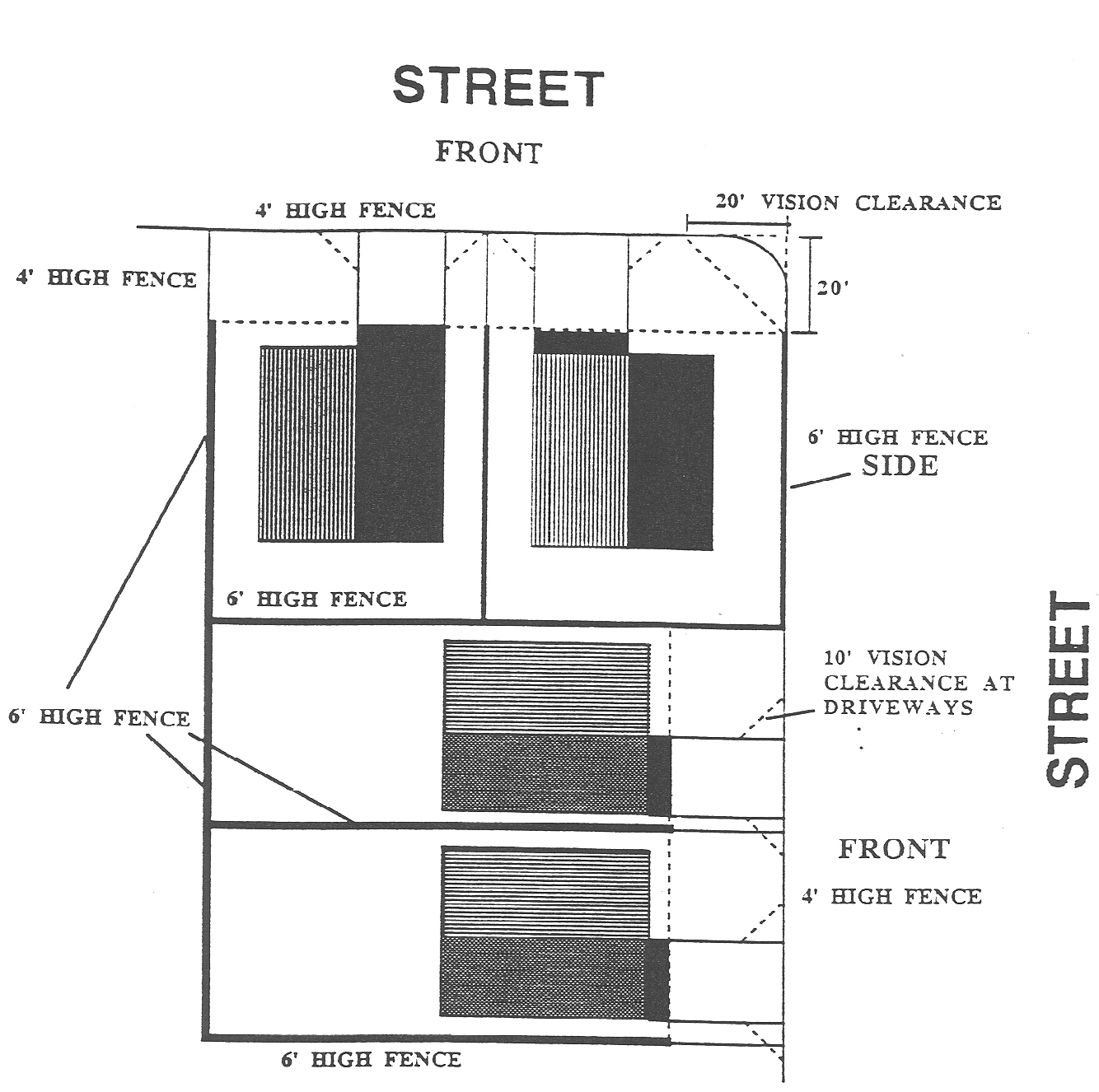
Figure 1 Fence Standards for Residential Development
(.08)
Corner Vision. Vision clearance shall be provided as specified in Section 4.177, or such additional requirements as specified by the City Engineer.
(.09)
Prohibited Uses:
A.
Uses of structures and land not specifically permitted in the applicable zoning districts.
B.
The use of a trailer, travel trailer or mobile coach as a residence, except as specifically permitted in an approved RV park.
C.
Outdoor advertising displays, advertising signs, or advertising structures except as provided in Sections 4.156.05, 4.156.07, 4.156.09, and 4.156.10.
(.10)
Accessory Dwelling Units:
A.
Accessory Dwelling Units, are permitted subject to standards and requirements of this Subsection.
B.
Standards:
1.
Number Allowed.
a.
For detached single-family dwelling units and for townhouses: One per dwelling unit.
b.
For all other dwelling units: None.
2.
Maximum Floor Area: per definition in Section 4.001, 800 square feet of habitable floor area. Per Subsection 4.138(.04)C.1., in the Old Town Overlay Zone the maximum is 600 square feet of habitable floor area. Larger units shall be subject to standards applied to duplex housing.
3.
Accessory dwelling units shall be on the same lot as the dwelling unit to which they are subordinate.
4.
Accessory Dwelling Units may be either attached or detached, but are subject to standards for the underlying zone except that ADUs are exempt from lot coverage maximums.
5.
Design Standards:
a.
Roof pitch shall be 4:12 to 12:12. No flat roofs allowed.
i.
Where the primary dwelling unit has a roof pitch of less than 4:12 the minimum roof pitch does not apply.
b.
Roof and siding materials shall match the respective material of one or more of the following: (1) the primary dwelling unit on the same lot, (2) a primary dwelling unit on an immediately adjacent lot, or (3) a primary dwelling unit within the same subdivision.
i.
For the purpose of the requirement to match material, fiber cement siding made to appear like wood, stucco, or masonry may be used to match wood, stucco, or masonry respectively.
c.
Where design standards established for a zone or overlay zone are more restrictive and/or extensive than a. and b. above the more restrictive and/or extensive design standards shall apply. This includes design standards for the Village (V) Zone, the Residential Neighborhood (RN) Zone, and the Old Town Overlay Zone.
6.
Authorization to develop Accessory Dwelling Units does not waive Building Code requirements. Increased firewalls or building separation may be required as a means of assuring adequate fire separation from one unit to the next. Applicants are encouraged to contact, and work closely with, the Building Division of the City's Community Development Department to assure that Building Code requirements are adequately addressed.
7.
Each accessory dwelling unit shall provide complete, independent permanent facilities for living, sleeping, eating, cooking, bathing and sanitation purposes, and shall have its own separate secure entrance.
8.
Accessory dwelling units may be short-term rentals, but the owner/local operator must be in compliance with Chapter 7 of Wilsonville Code, which may include an active business license with the City of Wilsonville for a short-term rental business and payment of all applicable lodging and other taxes.
(.11)
Reduced Setback Agreements. The following procedure has been created to allow the owners of contiguous residential properties to reduce the building setbacks that would typically be required between those properties, or to allow for neighbors to voluntary waive the solar access provisions of Section 4.137. Setbacks can be reduced to zero through the procedures outlined in this subsection.
A.
Examples:
1.
First example: the owner of one house is allowed to build to the sideyard property line, with no setback, provided that the owner of the neighboring property agrees and that the agreements of both owners are recorded with the deed records for those properties.
2.
Second example: the owner of one property is allowed to build a structure, or grow trees that are not solar friendly, shading an adjoining property beyond the amount that is permitted in Section 4.137.
B.
Standards:
1.
The use of the Reduced Setback Agreement procedure does not waive Building Code requirements. The Building Code may require increased firewall standards or increased setbacks on one property as a means of assuring adequate fire separation from the adjoining property. Applicants are advised to work with the Building Division of the Community Development Department prior to filing for approval of a Reduced Setback Agreement.
2.
Property owners using the Reduced Setback Agreement procedure have responsibility for notifying lien holders of the changes, for meeting all requirements of utility providers, and for avoiding conflicts with established easements.
3.
The Reduced Setback Agreement procedure shall require the approval of a Class I Administrative Review permit.
4.
Owners must provide accurate metes and bounds descriptions of all areas to be covered by non-construction easements.
5.
Nothing in this Section shall abrogate any easements or utility locations existing on the subject properties. The property owners are responsible for assuring that easements and utilities are not adversely affected by any construction that is anticipated.
(.12)
Bed and Breakfasts:
A.
Purpose. The purpose of this subsection is to provide standards for the establishment of bed and breakfast facilities. These regulations are intended to allow for a more efficient use of large, older houses in residential areas where the neighborhood character is preserved to maintain both the residential neighborhood experience and the bed and breakfast experience. These regulations enable owners to maintain large residential structures in a manner that keeps them primarily in residential use. The proprietor can take advantage of the scale and often the architectural and historical significance of a residence. The regulations also provide an alternative form of lodging for visitors who prefer a residential setting.
B.
Description:
1.
Bed and Breakfast Home. An operation conducted by the owner-occupant of a dwelling in an RA-H, R, or PDR zone, or of a one- or other district permitting residential uses, that provides not more than five rooms for paying guests on an overnight basis. Guest occupancy periods shall not exceed 14 consecutive days. The occupancy of such a bed and breakfast home is limited to two persons or one family per lodging unit or guest room.
2.
Operations that would otherwise meet the standards listed above for Bed and Breakfast Homes, but which exceed either the number of rooms available or the length of stay allowed, shall be subject to the same standards as hotels or motels, listed elsewhere in this Code.
C.
Where These Regulations Apply. The regulations of Section 4.113(.12) apply to bed and breakfast facilities in PDR, R, and RA-H zones.
D.
Conditional Use Review. Bed and breakfast facilities require a conditional use review, as specified in Section 4.184.
E.
Use-Related Regulations:
1.
Accessory Use. A bed and breakfast facility must be accessory to a household living use on the site. This means that the individual or family who operate the facility must occupy the house as their primary residence.
2.
Maximum size. Bed and Breakfast facilities are limited to a maximum of five bedrooms for guests and a maximum of six guests per night. In PDR-1, PDR-2, PDR-3, AND PDR-4 zones, bed and breakfast facilities over these size limits are prohibited.
3.
Services to guests:
a.
Food services may only be provided to overnight guests of a bed and breakfast facility.
b.
Serving alcohol to overnight guests is allowed. The proprietor may need Oregon Liquor Control Commission approval to serve alcohol at a bed and breakfast facility.
4.
Meetings and Social Gatherings:
a.
Commercial meetings. Activities including luncheons, banquets, parties, weddings, meetings, charitable fund raising, commercial or advertising activities, or other gatherings for direct or indirect compensation, are prohibited at a bed and breakfast facility.
b.
Private social gatherings. The residents of bed and breakfast facilities are allowed to have only four private social gatherings, parties, or meetings per year, for more than four guests. The private social gatherings must be hosted by and for the enjoyment of the residents. The bed and breakfast operator must log the dates these social gatherings are held. Private social gatherings for four or fewer guests are allowed without limit as part of a normal household living use at the site. All participants in the social gathering are counted as guests except for residents.
F.
Site-Related Standards:
1.
Development Standards. Bed and breakfast facilities must comply with the development standards of the base zone, overlay zones, and plan districts, if applicable.
2.
Appearance. Bed and breakfast homes or inns in residential zones must be compatible with the surrounding residential neighborhood. No alterations to the exterior of the house shall be for the purpose of establishing a more commercial building appearance shall be permitted except for routine maintenance, alterations not requiring a building permit, restoration or requirements related to safety or handicapped accessibility. There shall be no exterior indication of a business except for the one permitted sign.
3.
No cooking facilities are permitted in the individual guest rooms.
4.
Food service shall only be provided to guests taking lodging in the bed and breakfast home or inn.
5.
In PDR-1, PDR-2, PDR-3 or PDR-4 zones, no bed and breakfast home may be located on a lot closer than 500 feet from any other lot containing a bed and breakfast home, with only one such establishment permitted per block face.
6.
There shall be no more than one sign. Such sign shall not be self-illuminated and shall not exceed six square feet in area. Additional sign requirements described in Sections 4.156.02 through 4.156.10 of this Code shall be met.
7.
Each such use must obtain a Certificate of Occupancy from the Building Official before it commences.
8.
Bed and Breakfast facilities must comply with the off-street parking standards for commercial development found in Section 4.155.
9.
Bed and Breakfast facilities must comply with the landscaping standards for commercial development found in Section 4.176.
(.13)
The Planning Director and Development Review Board shall, in making their determination of compliance in attaching conditions, consider the effects of this action on the availability and cost of needed housing. The provisions of this section shall not be used in such a manner that additional conditions, either singularly or cumulatively, have the effect of unnecessarily increasing the cost of housing or effectively excluding a needed housing type. However, consideration of these factors shall not prevent the Board or Planning Director from imposing conditions of approval necessary to meet the minimum requirements of the Comprehensive Plan and Code.
(.14)
Design Standards for Detached Single-family and Middle Housing.
A.
The standards in this subsection apply in all zones, except as indicated in 1.— 3. below:
1.
The Façade Variety standards in Subsection C.1. do not apply in the Village Zone or the area regulated by the Frog Pond West Master Plan zoned Residential Neighborhood, as these zones/areas have their own variety standards, except that the variety standards do apply to middle housing development with multiple detached units on a single lot for which the variety standards of these zones/areas do not address.
2.
The entry orientation for triplexes, quadplexes, and townhouses in Subsections D.1-2. and E. 2-3. do not apply in the Village Zone or Residential Neighborhood Zone as these zones have their own related standards applicable to all single-family and middle housing.
3.
The window standards for triplexes, quadplexes, and townhouses in Subsection D. 2. And E. 3. do not apply in the Village Zone or the Frog Pond West neighborhood in the Residential Neighborhood Zone as these zones/areas have their own related standards applicable to all single-family and middle housing.
B.
For the purpose of this subsection the term "residential structure" is inclusive of a series of structures that are attached to one another such as a grouping of townhouses.
C.
Standards applicable to all residential structures except as noted in I. below.
1.
Façade Variety:
a.
Each public-facing façade of a residential structure shall differ from the public-facing façades of directly adjacent residential structures in at least one of the three ways listed in Subsection d. below.
b.
Where public-facing façades repeat on the same block, at least two residential structures with different public-facing façades shall intervene between residential structures with the same public-facing façades, with sameness defined by not differing in at least one of the three ways listed in Subsection d. below.
c.
For façades of residential structures facing a public street, the façade of any residential structures directly across the street shall differ in at least one of the three ways listed in Subsection d. below. Directly across means any residential structure façade intersected by imaginary lines extending the shortest distance across the street from the mid-point of a façade and from the edges of a façade. See Figure 1 below.
d.
A façade shall be considered different if it differs from another façade in at least one of the following ways:
i.
Variation in type, placement, or width of architectural projections (such as porches, dormers, or gables) or other features that are used to meet the Articulation standards in Subsection (.14)C.2.b or Subsection (.14)E.4. If adjacent or opposite façades feature the same projection type, the projections on adjacent/opposite façades must differ in at least one of the following ways:
•
At least 20 percent difference in width; or
•
Horizontally offset by at least five feet. For the purposes of this standard, "offset" means a measurable difference of at least five feet from the left edge of the projection to the left edge of the front façade or at least five feet from the right edge of the projection to the right edge of the front façade.
ii.
At least 20 percent of the façade (excluding glazing) is covered by different exterior finish materials. The use of the same material in different types of siding (e.g., cedar shingles vs. cedar lap siding) shall be considered different materials for the purpose of this standard.
iii.
Variation in primary paint color as determined by a LRVR (Light Reflectance Value) difference of at least 15 percent.
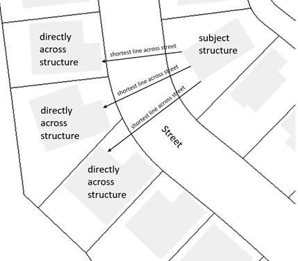
Figure 1. Determining If A Residential Structure is Directly Across the Street from
Another
2.
Architectural Consistency and Interest.
a.
Architectural styles shall not be mixed within the same residential structure (a series of attached structures is one structure for the purpose of these standards). Architectural style consistency is defined by adherence to all of the following:
i.
Use of the same primary and supporting façade materials throughout the structure.
ii.
Use of no more than two roof pitch angles.
iii.
Use of the same door size for each primary entrance in the structure.
b.
Articulation. All public-facing façades of residential structures, other than townhouses, shall incorporate the following design elements at a minimum interval of every 30 feet, except as noted in 2.c. below. The minimum number of design elements is determined by dividing the façade length by 30 and rounding up to the nearest whole number. For townhouse articulation standards, see subsection (.14)E.4.
i.
varying rooflines.
ii.
offsets of at least 12 inches.
iii.
balconies.
iv.
projections of at least 12 inches and width of at least three feet.
v.
porches.
vi.
entrances that are recessed at least 24 inches or covered.
vii.
dormers at least three feet wide.
c.
For structures with two or more dwelling units, a single design element that spans at least 50 percent of the façade of two adjacent units can count as two articulation elements to meet the standard in subsection b. and can meet the standard for 60 feet of façade width (two adjacent 30 foot intervals). Such elements may overlap horizontally with other required design elements on the façade.
d.
Articulation Element Variety: Different articulation elements shall be used as provided below. For the purpose of this standard, a "different element" is defined as one of the following: a completely different element from the list in subsection 2.b above; the same type of element but at least 50 percent larger; or for varying rooflines, vertically offset by at least three feet.
i.
Where two to four elements are required on a façade, at least two different elements shall be used.
ii.
Where more than four elements are required on a façade, at least three different elements shall be used.
e.
Reductions to required windows percentage: The required percent of façade of a residential structure in the public-facing façade covered by windows or entry doors for single-family or middle housing in any zone may be reduced to the percentages that follows:
i.
For of 1.5 or 2-story façades facing the front or rear lot line:
•
12.5 percent if six of the design features in Subsection e.v. below are used.
•
Ten percent if seven or more of the design features in Subsection e.v. below are used.
ii.
For 1-story façades facing the front or rear lot line;
•
12.5 percent if less than six design features in Subsection e.v. are used
•
ten percent if six or more design features in Subsection e.v. are used
iii.
For façades facing a side lot line:
•
Five percent regardless of the number of design features
iv.
Glass block does not count towards meeting window and entry percentage
v.
Window reduction design features:
•
Dormers at least three feet wide.
•
Covered porch entry—minimum 48 square foot covered front porch, minimum six feet deep and minimum of a six foot deep cover. A covered front stoop with minimum 24 square foot area, four foot depth and hand rails meets this standard.
•
Front porch railing around at least two sides of the porch.
•
Second story balcony—projecting from the wall of the building a minimum of four feet and enclosed by a railing or parapet wall.
•
Roof overhang of eight inches or greater.
•
Columns, pillars or posts at least four inches wide and containing larger base materials.
•
Decorative gables—cross or diagonal bracing, shingles, trim, corbels, exposed rafter ends or brackets (does not include a garage gable if garage projects beyond dwelling unit portion of street façade).
•
Decorative molding above windows and doors.
•
Decorative pilaster or chimneys.
•
Bay or bow windows—extending a minimum of 12 inches outward from the main wall of a building and forming a bay or alcove in a room within the building.
•
Sidelight and/or transom windows associated with the front door or windows in the front door.
•
Window grids on all façade windows visible from behind fences (excluding any windows in the garage door or front door).
•
Maximum nine foot wide garage doors or a garage door designed to resemble two smaller garage doors and/or windows in the garage door (only applicable to street facing garages).
•
Decorative base materials such as natural stone, cultured stone or brick extending at least 36 inches above adjacent finished grade occupying a minimum of ten percent of the overall primary street facing façade. This design element does not count if behind a site-obscuring fence.
•
Entry courtyards which are visible from, and connected directly to, the street. Courtyards shall have a minimum depth of ten feet and minimum width of 80 percent of the non-garage/driveway building width to be counted as a design element.
D.
Standards applicable to Triplexes and Quadplexes except as noted in i. below.
1.
Entry Orientation.
a.
At least one main entrance for each triplex or quadplex must meet the standards in subsections b. and c. below.
b.
The entrance must be within eight feet of the longest street-facing exterior wall of the dwelling unit or if no exterior wall faces a street the front of the dwelling unit facing a common drive or open space as designated by the applicant; and
c.
The entrance must either:
i.
Face the street (see Figure 2. Main Entrance Facing the Street);
ii.
Be at an angle of up to 45 degrees from the street (see Figure 3. Main Entrance at 45 degree angle from the street); or
iii.
Open onto a porch (see Figure 4. Main Entrance Opening onto a Porch). The porch must:
•
Be at least 25 square feet in area; and
•
Have at least one entrance facing the street or have a roof.
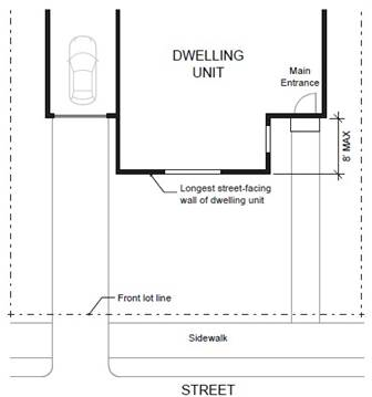
Figure 2. Main Entrance Facing the Street
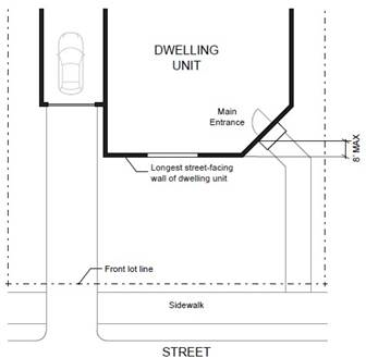
Figure 3. Main Entrance at 45° Angle from the Street
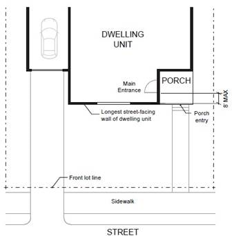
Figure 4. Main Entrance Opening onto a Porch
2.
Windows. A minimum of 15 percent of the area of all street-facing façades must include windows or entrance doors. Façades separated from the street property line by a dwelling are exempt from meeting this standard. See Figure 5. Window Coverage.
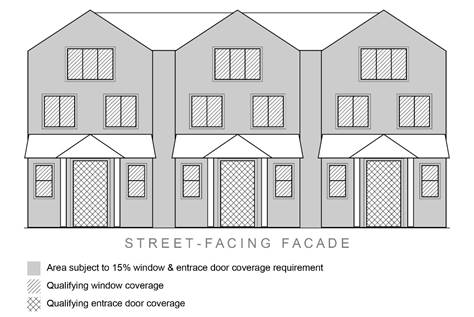
Figure 5. Window Coverage
3.
Garages and Off-Street Parking Areas. The combined width of all garages (measured from the interior of the garage door frame) and outdoor on-site parking and maneuvering areas shall not exceed a total of 50 percent of any street frontage (other than an alley) (see Figure 6. Width of Garages and Parking Areas).
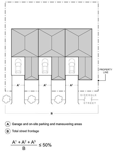
Figure 6. Width of Garages and Parking Areas
4.
Driveway Approach. Driveway approaches must comply with all of the following:
a.
The total width of all driveway approaches must not exceed 32 feet per frontage, as measured at the property line (see Figure 7. Driveway Approach Width and Separation on Local Street). For lots or parcels with more than one frontage, see subsection c.
b.
Driveway approaches may be separated when located on a local street.
c.
In addition, lots or parcels with more than one frontage must comply with the following:
i.
Lots or parcels must access the street with the lowest transportation classification for vehicle traffic. For lots or parcels abutting an alley that is improved with a paved surface, access must be taken from the alley (see Figure 8. Alley Access).
ii.
Lots or parcels with frontages only on collectors and/or arterial streets must meet the access standards in the Wilsonville Public Works Standards.
iii.
Lots or parcels with frontages only on local streets may have either:
•
Two driveway approaches not exceeding 32 feet in total width on one frontage; or
•
One maximum 16-foot-wide driveway approach per frontage (see Figure 9. Driveway Approach Options for Multiple Local Street Frontages).
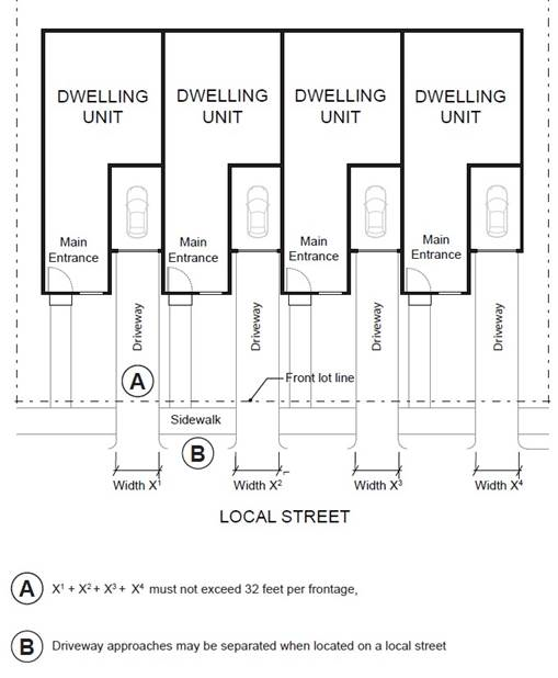
Figure 7. Driveway Approach Width and Separation on Local Street
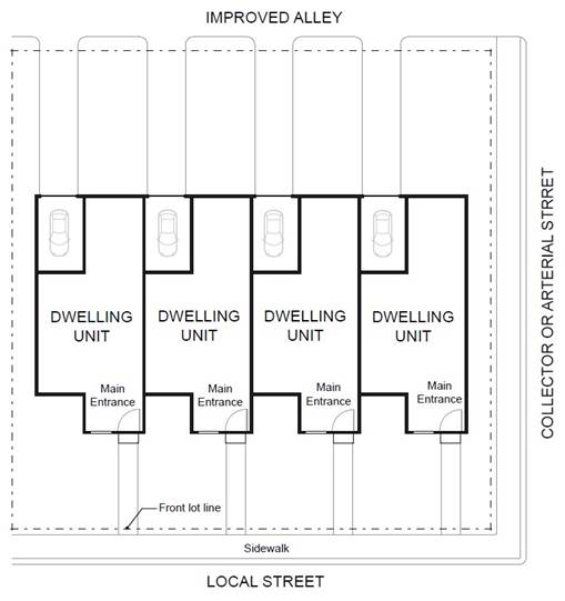
Figure 8. Alley Access
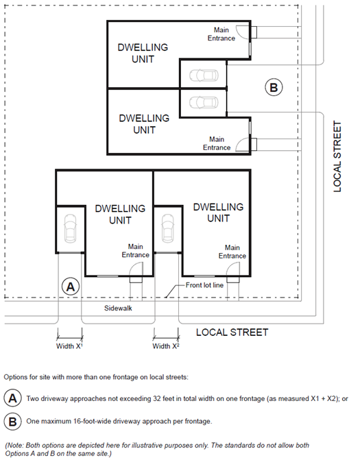
Figure 9. Driveway Approach Options for Multiple Local Street Frontages
E.
Standards applicable to Townhouses.
1.
Number of Attached Dwelling Units.
a.
Minimum. A townhouse project must contain at least two attached units.
b.
Maximum. The maximum number of townhouse units that may be attached together to form a group is specified below.
•
R, OTR, PDR-1—PDR-3 Zones: maximum four attached units per group
•
RN, V, PDR-4—PDR-7 Zones: maximum eight attached units per group, except for initial development in Frog Pond West per Section 4.124.
2.
Entry Orientation. The main entrance of each townhouse unit must:
a.
Be within eight feet of the longest wall of the dwelling unit facing a street or private drive; and
b.
Either:
i.
Face the street or private drive (see Figure 2. Main Entrance Facing the Street);
ii.
Be at an angle of up to 45 degrees from the street or private drive (see Figure 3. Main Entrance at 45° Angle from the Street);
iii.
Face a common open space or private access or driveway that is abutted by dwellings on at least two sides; or
iv.
Open onto a porch (see Figure 4. Main Entrance Opening onto a Porch). The porch must:
A.
Be at least 25 square feet in area; and
B.
Have at least one entrance facing the street or private drive or have a roof.
3.
Windows. A minimum of 15 percent of the area of all public-facing façades on each individual unit must include windows or entrance doors. Half of the window area in the door of an attached garage may count toward meeting this standard. See Figure 5. Window Coverage.
4.
Unit definition. Each townhouse unit must include at least one of the items listed in a. through g. below on at least one public-facing façade (see Figure 10. Townhouse Unit Definition). Alternatively, if a single item from the list below spans across at least 50 percent of two adjacent townhouse units, it can meet the standard for two units.
a.
A roof dormer a minimum of four feet in width, or
b.
A balcony a minimum of two feet in depth and four feet in width and accessible from an interior room, or
c.
A bay window that extends from the façade a minimum of two feet, or
d.
An offset of the façade of a minimum of two feet in depth, either from the neighboring townhouse or within the façade of a single townhouse, or
e.
An entryway that is recessed a minimum of three feet, or
f.
A covered entryway with a minimum depth of four feet, or
g.
A porch meeting the standards of subsection (.14)E.2.b.iv.
Balconies and bay windows may encroach into a required setback area, pursuant to Section 4.180.
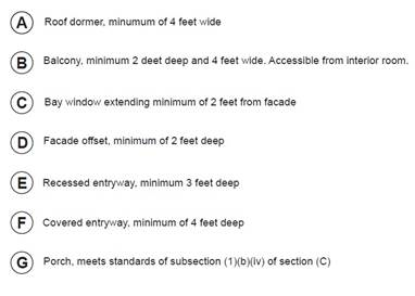
Figure 10. Townhouse Unit Definition
5.
Driveway Access and Parking. Townhouses with frontage on a street or private drive shall meet the following standards:
a.
Alley Access. Townhouse project sites abutting an alley that is improved with pavement shall take access to the rear of townhouse units from the alley rather than the public street.
b.
Front Access. Garages on the front façade of a townhouse, off-street parking areas in the front yard, and driveways in front of a townhouse are allowed if they meet the following standards (see Figure 11. Townhouses with Parking in Front Yard).
i.
Each townhouse lot has a street frontage of at least 20 feet on a local street.
ii.
A maximum of one driveway approach is allowed for every townhouse. Driveway approaches and/or driveways may be shared.
iii.
Outdoor on-site parking and maneuvering areas do not exceed 12 feet wide on any lot.
iv.
The garage width does not exceed 12 feet, as measured from the inside of the garage door frame.
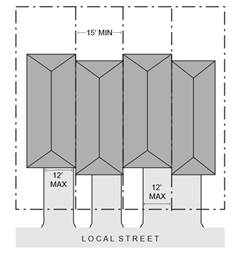
Figure 11. Townhouses with Parking in Front Yard
c.
Shared Access. The following standards apply to driveways and parking areas for townhouse projects that do not meet all of the standards in subsections a. or b.
i.
Off-street parking areas shall be accessed on the back façade or located in the rear yard. No off-street parking shall be allowed in the front yard or side yard of a townhouse.
ii.
A townhouse project that includes a corner lot shall take access from a single driveway approach on the side of the corner lot. See Figure 12. Townhouses on Corner Lot with Shared Access.
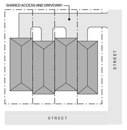
Figure 12. Townhouses on Corner Lot with Shared Access
iii.
Townhouse projects that do not include a corner lot shall consolidate access for all lots into a single driveway. The driveway and approach are not allowed in the area directly between the front façade and front lot line of any of the townhouses. See Figure 13. Townhouses with Consolidated Access.
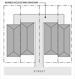
Figure 13. Townhouses with Consolidated Access
iv.
A townhouse project that includes consolidated access or shared driveways shall grant access easements to allow normal vehicular access and emergency access.
F.
Standards applicable to Cottage Clusters.
1.
Courtyard Required. All cottages within a single cottage cluster must share a common courtyard. A cottage cluster project may include more than one cluster and more than one common courtyard.
2.
Number of Dwellings.
a.
A single cottage cluster shall contain a minimum of four and a maximum of eight cottages.
3.
Setbacks.
a.
Building Separation. Cottages shall be separated by a minimum distance of six feet. The minimum distance between all other structures, including accessory structures, shall be in accordance with building code requirements.
b.
All other setbacks are provided in section (.02) or in the applicable base zone.
4.
Building Height. The maximum building height for all structures is 25 feet.
5.
Footprint. The maximum building footprint for each cottage is 900 square feet. Individual attached garages up to 200 square feet shall be exempted from the calculation of maximum building footprint.
6.
Maximum Habitable Floor Area. The maximum habitable floor area of each cottage is 1,400 square feet.
7.
Cottage Orientation. Cottages must be clustered around a common courtyard and must meet the following standards (see Figure 14. Cottage Cluster Orientation and Common Courtyard Standards:
a.
Each cottage within a cluster must either abut the common courtyard or must be directly connected to it by a pedestrian path.
b.
A minimum of 50 percent of cottages within a cluster must be oriented to the common courtyard and must:
i.
Have a main entrance facing the common courtyard;
ii.
Be within ten feet from the common courtyard, measured from the façade of the cottage to the nearest edge of the common courtyard; and
iii.
Be connected to the common courtyard by a pedestrian path.
c.
Cottages within 20 feet of a street property line may have their entrances facing the street.
d.
Cottages not facing the common courtyard or the street must have their main entrances facing a pedestrian path that is directly connected to the common courtyard.
8.
Common Courtyard Design Standards. Each cottage cluster must share a common courtyard in order to provide a sense of openness and community of residents. Common courtyards must meet the following standards (see Figure 14. Cottage Cluster Orientation and Common Courtyard Standards):
a.
The common courtyard must be a single, contiguous piece.
b.
Cottages must abut the common courtyard on at least two sides of the courtyard.
c.
The common courtyard must contain a minimum of 150 square feet per cottage within the associated cluster.
d.
The common courtyard must be a minimum of 15 feet wide at its narrowest dimension.
e.
The common courtyard shall be developed with a mix of landscaping, lawn area, pedestrian paths, and/or paved courtyard area, and may also include recreational amenities. Impervious elements of the common courtyard shall not exceed 75 percent of the total common courtyard area.
f.
Pedestrian paths must be included in a common courtyard. Paths that are contiguous to a courtyard shall count toward the courtyard's minimum dimension and area. Parking areas, required setbacks, and driveways do not qualify as part of a common courtyard.
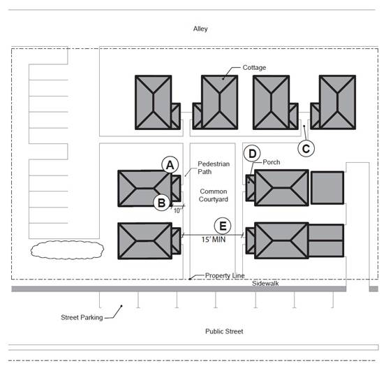
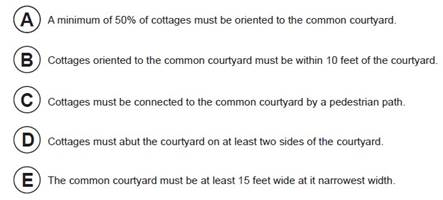
Figure 14. Cottage Cluster Orientation and Common Courtyard Standards
9.
Community Buildings. Cottage cluster projects may include community buildings for the shared use of residents that provide space for accessory uses such as community meeting rooms, guest housing, exercise rooms, day care, or community eating areas. Community buildings must meet the following standards:
a.
Each cottage cluster is permitted one community building.
b.
The community building shall have a maximum floor area of 1,400 sf.
c.
A community building that meets the definition of a dwelling unit must meet the maximum 900 square foot footprint limitation that applies to cottages (pursuant to subsection (.14)(F.5.), unless a covenant is recorded against the property stating that the structure is not a legal dwelling unit and will not be used as a primary dwelling.
10.
Pedestrian Access.
a.
An accessible pedestrian path must be provided that connects the main entrance of each cottage to the following:
i.
The common courtyard;
ii.
Shared parking areas;
iii.
Community buildings; and
iv.
Sidewalks in public rights-of-way abutting the site or rights-of-way if there are no sidewalks.
b.
The pedestrian path must be hard-surfaced and a minimum of four feet wide.
11.
Windows. Cottages within 20 feet of a street property line must meet any window coverage requirements of the applicable base zone.
12.
Parking Design (see Figure 15. Cottage Cluster Parking Design Standards).
a.
Clustered parking. Off-street parking may be arranged in clusters, subject to the following standards:
i.
A parking cluster must not exceed five contiguous spaces.
ii.
Parking clusters must be separated from other spaces by at least four feet of landscaping.
iii.
Clustered parking areas may be covered.
iv.
Parking areas must also meet the standards in Subsections 4.155(.02)—(.03), except where they conflict with these standards.
b.
Parking location and access.
i.
Off-street parking spaces and vehicle maneuvering areas shall not be located between a street property line and the front façade of cottages located closest to the street property line. This standard does not apply to alleys.
ii.
Off-street parking spaces shall not be located within ten feet of any property line, except alley property lines.
iii.
Driveways and drive aisles are permitted within ten feet of property lines.
c.
Screening. Landscaping, fencing, or walls at least three feet tall shall separate clustered parking areas and parking structures from common courtyards and public streets.
d.
Garages and carports.
i.
Garages and carports (whether shared or individual) must not abut common courtyards.
ii.
Individual attached garages up to 200 square feet shall be exempted from the calculation of maximum building footprint for cottages.
iii.
Individual detached garages must not exceed 400 square feet in floor area.
iv.
Garage doors for attached and detached individual garages must not exceed 20 feet in width as measured from the interior of the garage door frame.
13.
Accessory Buildings. Accessory buildings must not exceed 400 square feet in floor area.
14.
Existing Structures. On a lot or parcel to be used for a cottage cluster project, an existing detached single-family detached dwelling on the same lot at the time of proposed development of the cottage cluster may remain within the cottage cluster project area under the following conditions:
a.
The existing dwelling may be nonconforming with respect to the requirements of this subsection (.14)F.
b.
The existing dwelling may be expanded up to a maximum height of 25 feet or a maximum building footprint of 900 square feet; however, existing dwellings that exceed these maximum height and/or footprint standards may not be expanded.
c.
The existing dwelling shall be excluded from the calculation of orientation toward the common courtyard, per subsection (.14)F.7.b.
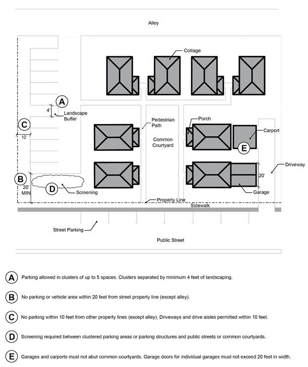
Figure 15. Cottage Cluster Parking Design Standards
G.
Standards applicable to Cluster Housing besides Cottage Clusters.
1.
Architectural Consistency. Architecture shall be consistent within the same two-unit, three-unit, or four-unit cluster. However, facade variety standards in Subsection (.14)C.1. shall continue to apply. Architectural consistency is defined by adherence to all of the following:
a.
Use of the same primary and supporting façade materials throughout the cluster.
b.
Use of no more than two roof pitch angles.
c.
Use of the same door size for each primary entrance in the structures.
2.
Entry Orientation.
a.
The entry orientation standards apply as follows:
i.
At least one main entrance for each cluster home must meet the standards in subsections b and c below.
b.
The entrance must be within eight feet of the longest street-facing exterior wall of the dwelling unit or if no exterior wall faces a street the front of the dwelling unit, facing a common drive or open space as designated by the applicant; and
c.
The entrance must either:
i.
Face the street (see Figure 2. Main Entrance Facing the Street);
ii.
Be at an angle of up to 45 degrees from the street (see Figure 3. Main Entrance at 45° Angle from the Street); or
iii.
Open onto a porch (see Figure 4. Main Entrance Opening onto a Porch). The porch must:
•
Be at least 25 square feet in area; and
•
Have at least one entrance facing the street or have a roof.
3.
Windows. A minimum of 15 percent of the area of all street-facing facades must include windows or entrance doors. Facades separated from the street property line by a dwelling are exempt from meeting this standard. See Figure 5. Window Coverage.
4.
Garages and Off-Street Parking Areas. The combined width of all garages (measured from the interior of the garage door frame) and outdoor on-site parking and maneuvering areas shall not exceed a total of 50 percent of any street frontage (other than an alley). Garages and off-street parking areas that are separated from the street property line by a dwelling are not subject to this standard. (See Figure 6. Width of Garages and Parking Areas).
5.
Driveway Approach. Driveway approaches must comply with all of the following:
a.
The total width of all driveway approaches must not exceed 32 feet per frontage, as measured at the property line (see Figure 7. Driveway Approach Width and Separation on Local Street). For lots or parcels with more than one frontage, see subsection c.
b.
Driveway approaches may be separated when located on a local street.
c.
In addition, lots or parcels with more than one frontage must comply with the following:
i.
Lots or parcels must access the street with the lowest transportation classification for vehicle traffic. For lots or parcels abutting an alley that is improved with pavement access must be taken from the alley (see Figure 8. Alley Access).
ii.
Lots or parcels with frontages only on collectors and/or arterial streets must meet the access standards in the Wilsonville Public Works Standards.
iii.
Lots or parcels with frontages only on local streets may have either:
•
Two driveway approaches not exceeding 32 feet in total width on one frontage; or
•
One maximum 16-foot-wide driveway approach per frontage (see Figure 9. Driveway Approach Options for Multiple Local Street Frontages).
6.
Setbacks.
a.
Building Separation. Cluster housing structures shall be separated by a minimum distance of six feet. The minimum distance between all other structures, including accessory structures, shall be in accordance with building code requirements.
b.
All other setbacks are provided in the applicable base zone.
7.
Pedestrian Access.
a.
An accessible pedestrian path must be provided that connects the main entrance of each unit to the following:
i.
Shared open space;
ii.
Shared parking areas; and
iv.
Sidewalks in public rights-of-way abutting the site or rights-of-way if there are no sidewalks.
b.
The pedestrian path must be hard-surfaced and a minimum of four feet wide.
H.
Combining Unit Types in One Development.
1.
If a project proposes a mix of middle housing types which creates a conflict with various standards, the more restrictive standards shall apply.
I.
Existing Structures and Conversions:
1.
Where a residential structure is converted from one type of dwelling unit to another without any additions, the design standards in C.—H. do not apply.
2.
Where a residential structure is added on to, the design standards in C.—H. only apply if the footprint is expanded by 25 percent or more.
J.
Alternative Discretionary Review: As an alternative to meeting one or more design standards of this subsection an applicant may request a waiver as part of Site Design Review by the Development Review Board of a proposed design. In addition to the waiver criteria in Sections 4.118 and 4.140 and applicable Site Design Review Standards, affirmative findings shall be made that the following standards are met:
1.
The request is compatible with existing surrounding development in terms of placement of buildings, scale of buildings, and architectural design;
2.
The request is due to special conditions or circumstances that make it difficult to comply with the applicable Design Standards, or the request would achieve a design that is superior to the design that could be achieved by complying with the applicable Design Standards;
3.
The request continues to comply with and be consistent with State statute and rules related to Middle Housing, including being consistent with State definitions of different Middle Housing types; and
4.
The request remains substantially consistent with any legislative master plan the property is included within.
(.15)
Design Standards for Multi-Family Housing:
A.
Purpose and Intent. The purpose of the multi-family design standards is to create and maintain street frontages that are varied and attractive, create an environment that is conducive to walking, and provide natural surveillance of public spaces. The standards will also promote building details in multi-family development that provide visual interest, contribute to a high-quality living environment for residents, give a sense of quality and permanence, and enhance compatibility with the surrounding community. The design standards also aim to create consistency with design standards for other residential unit types that multi-family housing may be built adjacent to.
B.
Applicability. These standards apply to all multi-family development except for the following:
1.
Mixed-use buildings that include ground floor non-residential uses or live-work units and multi-family residential above.
2.
Multi-family buildings in the Village and Town Center Zones which are subject to zone-specific standards in Section 4.125 or 4.132, respectively.
C.
Entrance Orientation.
1.
At least one main entrance for each multi-family structure must either meet the standards in subsections a. and b. below, or must meet the alternative standard in subsection C.2.
a.
The entrance must be within eight feet of the longest street-facing exterior wall of the structure; and
b.
The entrance must either:
i.
Face the street;
ii.
Be at an angle of up to 45 degrees from the street; or
iii.
Open onto a porch. The porch must:
a.
Be at least 25 square feet in area; and
b.
Have at least one entrance facing the street or have a roof.
2.
Alternative standard. As an alternative to subsection 1., a main entrance to a multi-family structure may face a courtyard if the courtyard-facing entrance is located within 60 feet of a street and the courtyard meets the following standards:
a.
The courtyard must be at least 15 feet in width;
b.
The courtyard must abut a street; and
c.
The courtyard must be landscaped or hard-surfaced for use by pedestrians.
D.
Windows. A minimum of 15 percent of the area of all public-facing façades must consist of windows or entrance doors, including associated frames and trim. Façades separated from the street or public space by a dwelling are exempt from meeting this standard. Required windows shall be clear glass and not mirrored or frosted, except for bathrooms.
E.
Articulation.
1.
Minimum Articulation. All public-facing façades shall incorporate a selection of the following design elements at a minimum interval of every 30 feet. The minimum number of design elements from this list that will be required is determined by dividing the façade length (in feet) by 30 and rounding up to the nearest whole number.
a.
Varying rooflines.
b.
Offsets of at least 12 inches.
c.
Balconies.
d.
Projections of at least 12 inches and width of at least three feet.
e.
Porches.
f.
Entrances that are recessed at least 24 inches or covered.
g.
Dormers at least three feet wide.
2.
Articulation Element Variety. Different articulation design elements shall be used as provided below, based on the length of the facade. For the purpose of this standard, a "different element" is defined as one of the following: a completely different element from the list in subsection E.1. above; the same element but at least 50 percent larger; or varying rooflines that are vertically offset by at least three feet.
a.
Where two to four elements are required on a façade by E.1., at least two different elements shall be used.
b.
Where more than four elements are required on a façade by E.1., at least three different elements shall be used.
F.
Pedestrian Access and Circulation. The following standards are intended to ensure safe and efficient circulation for pedestrians within multi-family development.
1.
Each multi-family development shall contain an internal pedestrian circulation system that makes connections between individual units and parking areas, green focal points and other common open space areas, children's play areas, and public rights-of-way. All pedestrian connections (walkways) shall meet the following standards:
a.
Except as required for crosswalks, per subsection 3., where a walkway abuts a vehicle circulation area, it shall be physically separated by a curb that is raised at least six inches or by bollards.
b.
Walkways shall be constructed of concrete, asphalt, brick or masonry pavers, or other hard surface, and not less than five feet wide.
2.
All walkways shall comply with the requirements of the Americans with Disabilities Act.
3.
In order to provide safe crossings of driveways and parking areas, crossings shall be clearly marked with either contrasting paving materials (such as pavers, light-color concrete inlay between asphalt, or similar contrasting material) or reflective striping that emphasizes the crossing under low light and inclement weather conditions.
4.
Pedestrian connections shall be provided between buildings within the development, and between the development and adjacent rights-of-way, transit stops, parks, schools, and commercial developments. At least one connection shall be made to each adjacent street and sidewalk for every 200 linear feet of street frontage. Sites with less than 200 linear feet of street frontage shall provide at least one connection to the street and/or sidewalk.
G.
Off-Street Parking Location and Design. The following standards are intended to support a pedestrian-friendly street environment and to minimize the visual impacts of parking areas and garages.
1.
Off-street parking spaces and drive aisles shall not be located in the Front Yard.
2.
Off-street parking areas shall not occupy more than 50 percent of the total length of each street frontage as measured 20 feet from the street property line. Drive aisles are only counted as parking areas if:
a.
parking spaces adjacent to the drive aisle are provided; and
b.
the drive aisle is between a building and street.
3.
Off-street parking spaces shall not be located within ten feet of any property line, except alley property lines. Driveways and drive aisles necessary to connect to the street are permitted within ten feet of property lines.
4.
Landscaping, fencing, or walls at least three feet tall shall separate parking areas from useable open space, green focal points, and public streets (except alleys).
5.
If garages are attached to a street-facing facade, they may not be located closer to the street property line than the building facade.
6.
Driveways associated with attached garages that take direct individual access from a public or private street must meet the townhouse driveway and access standards in Subsection 4.113(.14)E.5. For the purpose of those standards, each individual multi-family garage shall meet the standards applicable to a townhouse or townhouse lot.
(Ord. No. 677, 3-1-2010; Ord. No. 682, 9-9-2010; Ord. No. 704, 6-18-2012; Ord. No. 806, 7-17-2017; Ord. No. 825, 10-15-2018; Ord. No. 841, eff. 6-4-2020; Ord. No. 892, § 2(Exh. A), 12-2-2024)
Section 4.115. - Standards Applying to Manufactured Housing in all Zones Where Manufactured Housing is Permitted.
(Ord. No. 538, 2-21-2002)
Section 4.116. - Standards Applying to Commercial Developments in any Zone.
Any commercial use shall be subject to the applicable provisions of this Code and to the following, unless otherwise provided for by a specific zone, overlay zone or a legislative master plan:
(.01)
Commercial developments shall be planned in the form of centers or complexes as provided in the City's Comprehensive Plan. As noted in the Comprehensive Plan, Wilsonville's focus on centers or complexes is intended to limit strip commercial development.(.02) Where the land use map of Wilsonville's Comprehensive Plan calls for "Office Commercial" development, not less than 60 percent of the total square footage of the ground floors of buildings within the development shall be in office use. Total floor area dedicated to retail use shall not exceed 30 percent. On-site parking may be limited in order to control traffic generation.
(.03)
Where the land use map of Wilsonville's Comprehensive Plan calls for "Commercial/Industrial mixed use" development, not more than 50 percent of the total floor area of the development shall consist of retail space.
(.04)
Where the land use map of Wilsonville's Comprehensive Plan calls for "Residential/Commercial mixed use" development, not less than 50 percent of the total floor area of the development shall consist of residential units.
(.05)
All businesses, service or processing, shall be conducted wholly within a completely enclosed building; except for:
A.
The sale of automotive fuel, lubricants, and fluids at service stations.
B.
Car washes and car vacuum bays.
C.
Off-street parking for customers and employees and off-street loading.
D.
Outdoor seating areas associated with food and drink establishments on private property, or on public easements, provided the area and activities conform to ADA standards and do not interfere with public uses, safety, access or circulation.
E.
Temporary staging of inventory, as shall be authorized through a site development permit, complying with the following additional minimum development and performance standards:
1.
The staging area shall be screened by a fully sight obscuring fence or planting, high wall, high berm or high screen landscape standard as specified in Section 4.176—Landscaping Screening and Buffering;
2.
All parts of the staged inventory shall be completely concealed on all sides from public view at the right-of-way line; and
3.
The staged inventory shall be relocated into a completely enclosed structure of the primary retail operation within 48 hours of placement.
F.
Exterior sales that are specifically authorized through temporary use permit approval, subject to conditions of approval. Exterior sales that may be permitted are those that are limited in time duration, such as sidewalk sales, grand openings, or farmers' markets.
G.
Exterior sales areas, complying with the following minimum development and performance standards:
1.
The sales area shall be accessory to, and shall not exceed five percent of the floor area of the primary retail operation.
2.
The sales area shall be completely covered by a permanent structure of a design, construction and architecture compatible with that of the structure of the primary retail operation.
3.
All required ADA and pedestrian access ways and circulation aisles shall remain clear at all times.
4.
For new development, the Development Review Board may grant a waiver to allow exterior sales area of up to ten percent of the floor area of the primary retail operation, provided that findings can be made that:
a.
The expanded covered area has received approval through a Stage II/Site Design Review process.
b.
The expanded area does not detract from the overall character of the development or the surrounding neighborhood.
c.
Partial walls are required for screening large or bulky items.
5.
For Development existing on December 21, 2005, the Planning Director, pursuant to a Class II Administrative Review Process, may grant a waiver to allow exterior sales areas of up to ten percent of the floor area of the primary retail operation, provided that findings can be made that:
a.
The expanded area does not detract from the overall character of the area,
b.
Partial walls are required for screening large or bulky items.
(.06)
In any Commercial Development directly across the street from any Residential District, the loading facilities shall be at least 20 feet from the street, shall be sited whenever practicable at the rear or side, and if facing a residential area, shall be properly screened. Screening shall be provided in a manner that is compatible with the adjacent residential development in terms of quality of materials and design. Such screening shall effectively minimize light glare and noise levels to those of adjacent residential areas.
(.07)
Uses shall be limited to those which will meet the performance standards specified in Section 4.135(.05), with the exception of 4.135(.05)(M.)(3.).
(.08)
Corner lots shall conform to the vision clearance standards set forth in Section 4.177.
(.09)
Trailer, trailer houses, mobile coaches, or any altered variation thereof shall not be used for the purpose of conducting a trade or calling or for storage of material unless approved for such purpose as a temporary use.
(.10)
Commercial developments generally:
A.
[Right-of-way line.] No structure shall be erected closer than the right-of-way line then existing or the officially planned right-of-way of any public, county, or state road.
B.
Minimum Front Yard Setback. None required except when front yard abuts a more restrictive district. When front yard abuts a more restrictive district, setbacks shall be the same as the abutting district.
C.
Minimum Rear Yard Setback. None required except when rear yard abuts a more restrictive district. When rear yard abuts a more restrictive district, setbacks shall be the same as for the abutting district.
D.
Minimum Side Yard Setback. None required except when side yard abuts a more restrictive district. When side yard abuts a more restrictive district, setbacks shall be one and one-half times the setback required for the abutting district.
E.
Maximum Building Height. 35 feet, unless taller buildings are specifically allowed in the zone.
F.
Minimum Lot Size. No limitation, save and except as may otherwise be affected by other provisions of this Code.
G.
Maximum Lot Coverage. No limitation, save and except as may otherwise be affected by other provisions of this Code.
H.
Minimum Street Frontage. No limitation, save and except as may be necessary to provide minimum access requirements.
(.11)
Hotels or Motels:
A.
Minimum Lot Size. 1,000 square feet for each unit.
B.
Minimum Street Frontage. 100 feet.
C.
Front Yard Setback. 30 feet, unless located in the Old Town overlay zone, in which case the standards of the overlay zone shall apply. Structures on corner lots shall observe the minimum setback on both streets or tracts with a private drive.
D.
Minimum Rear Yard Setback. 30 feet.
E.
Minimum Side Yard Setback. 24 feet.
(.12)
Off-Street Parking is to be as specified in Section 4.155.
(.13)
Signs are subject to the standards of Sections 4.156.01 through 4.156.11.
(.14)
Prohibited Uses:
A.
The use of a trailer, trailer house, or mobile coach as a residence is prohibited except where approved within an RV park or approved as a temporary use during construction.
B.
Any use that violates the performance standards of Section 4.135(.05), other than 4.135(.05)(M.)(3.) is prohibited within commercial developments.
(Ord. No. 580, 4-4-2005; Ord. No. 601, 11-21-2005; Ord. No. 682, 9-9-2010; Ord. No. 704, 6-18-2012; Ord. No. 835, 6-5-2019)
Section 4.117. - Standards Applying to Industrial Developments in any Zone.
(.01)
All industrial developments, uses, or activities are subject to performance standards. If not otherwise specified in the Planning and Development Code, industrial developments, uses, and activities shall be subject to the performance standards specified in Section 4. 135 (.05) (PDI Zone).
Section 4.118. - Standards Applying to all Planned Development Zones.
(.01)
Height Guidelines. In "S" overlay zones, the solar access provisions of Section 4.137 shall be used to determine maximum building heights. In cases that are subject to review by the Development Review Board, the Board may further regulate heights as follows:
A.
Restrict or regulate the height or building design consistent with adequate provision of fire protection and fire-fighting apparatus height limitations.
B.
To provide buffering of low density developments by requiring the placement of three or more story buildings away from the property lines abutting a low density zone.
C.
To regulate building height or design to protect scenic vistas of Mt. Hood or the Willamette River.
D.
In no case shall the height of duplexes, triplexes, fourplexes, or townhouses be limited to less than the maximum height allowed for detached single-family dwellings in the same zone. In addition, in no case shall the height of triplexes, fourplexes, or townhouses be limited to less than 25 feet.
(.02)
Underground Utilities shall be governed by Sections 4.300 to 4.320. All utilities above ground shall be located so as to minimize adverse impacts on the site and neighboring properties.
(.03)
Notwithstanding the provisions of Section 4.140 to the contrary, the Development Review Board, in order to implement the purposes and objectives of Section 4.140, and based on findings of fact supported by the record may:
A.
Waive the following typical development standards:
1.
Minimum lot area;
2.
Lot width and frontage;
3.
Height and yard requirements;
4.
Lot coverage;
5.
Lot depth;
6.
Street widths;
7.
Sidewalk requirements;
8.
Height of buildings other than signs;
9.
Parking space configuration and drive aisle design;
10.
Minimum number of loading spaces;
11.
Shade tree islands in parking lots, provided that alternative shading is provided;
12.
Fence height;
13.
Architectural design standards, including residential design standards;
14.
Transit facilities;
15.
On-site pedestrian access and circulation standards;
16.
Solar access standards, as provided in section 4.137;
17.
Open space in the Frog Pond West Neighborhood in the Residential Neighborhood zone; and;
18.
Lot orientation.
B.
The following shall not be waived by the Board, unless there is substantial evidence in the whole record to support a finding that the intent and purpose of the standards will be met in alternative ways:
1.
Open space requirements in residential areas, except that the Board may waive or reduce open space requirements in the Frog Pond West Neighborhood in the Residential Neighborhood zone. Waivers in compliance with [Section] 4.127(.09)(B)(2)(d);
2.
Minimum density standards and housing variety standards in residential zones. The required minimum density may be reduced by the Board in the Residential Neighborhood zone in compliance with [Section] 4.127(.06) B; and
3.
Minimum landscape, buffering, and screening standards.
C.
The following shall not be waived by the Board, unless there is substantial evidence in the whole record to support a finding that the intent and purpose of the standards will be met in alternative ways, and the action taken will not violate any applicable federal, state, or regional standards:
1.
Maximum number of parking spaces;
2.
Standards for mitigation of trees that are removed;
3.
Standards for mitigation of wetlands that are filled or damaged; and
4.
Trails or pathways shown in the Parks and Recreation Master Plan.
D.
Locate individual building, accessory buildings, off-street parking and loading facilities, open space and landscaping and screening without reference to lot lines; and
E.
Adopt other requirements or restrictions, inclusive of, but not limited to, the following, except that no additional requirements or restrictions can conflict with established clear and objective standards for residential development or be grounds for denying a residential development proposal when the applicant has selected the clear and objective path for approval:
1.
Percent coverage of land by buildings and structures in relationship to property boundaries to provide stepped increases in densities away from low-density development.
2.
Parking ratios and areas expressed in relation to use of various portions of the property and/or building floor area.
3.
The locations, width and improvement of vehicular and pedestrian access to various portions of the property, including portions within abutting street or private drive.
4.
Arrangement and spacing of buildings and structures to provide appropriate open spaces around buildings.
5.
Location and size of off-street loading areas and docks.
6.
Uses of buildings and structures by general classification, and by specific designation when there are unusual requirements for parking, or when the use involves noise, dust, odor, fumes, smoke, vibration, glare or radiation incompatible with present or potential development of surrounding property. Such incompatible uses may be excluded in the amendment approving the zone change or the approval of requested permits.
7.
Measures designed to minimize or eliminate noise, dust, odor, fumes, smoke, vibration, glare, or radiation which would have an adverse effect on the present or potential development on surrounding properties.
8.
Schedule of time for construction of the proposed buildings and structures and any stage of development thereof to insure consistency with the City's adopted Capital Improvements Plan and other applicable regulations.
9.
A waiver of the right of remonstrance by the applicant to the formation of a Local Improvement District (LID) for streets, utilities and/or other public purposes.
10.
Modify the proposed development in order to prevent congestion of streets and/or to facilitate transportation.
11.
Condition the issuance of an occupancy permit upon the installation of landscaping or upon a reasonable scheduling for completion of the installation of landscaping. In the latter event, a posting of a bond or other security in an amount equal to 110 percent of the cost of the landscaping and installation may be required.
12.
A dedication of property for streets, pathways, and bicycle paths in accordance with adopted Facilities Master Plans or such other streets necessary to provide proper development of adjacent properties.
(.04)
The Planning Director and Development Review Board shall, in making their determination of compliance in attaching conditions, consider the effects of this action on availability and cost. The provisions of this section shall not be used in such a manner that additional conditions, either singularly or cumulatively, have the effect of unnecessarily increasing the cost of development. However, consideration of these factors shall not prevent the Board from imposing conditions of approval necessary to meet the minimum requirements of the Comprehensive Plan and Code.
(.05)
The Planning Director, Development Review Board, or on appeal, the City Council, may as a condition of approval for any development for which an application is submitted, require that portions of the tract or tracts under consideration be set aside, improved, conveyed or dedicated for the following uses:
A.
Recreational Facilities: The Director, Board, or Council, as the case may be, may require that suitable area for parks or playgrounds be set aside, improved or permanently reserved for the owners, residents, employees or patrons of the development consistent with adopted Park standards and Parks and Recreation Master Plan.
B.
Open Space Area: Whenever private and/or common open space area is provided, the City shall require that an association of owners or tenants be established which shall adopt such Articles of Incorporation, By-Laws or other appropriate agreement, and shall adopt and impose such Declaration of Covenants and Restrictions on such open space areas and/or common areas that are acceptable to the Development Review Board. Said association shall be formed and continued for the purpose of maintaining such open space area. Such an association, if required, may undertake other functions. It shall be created in such a manner that owners of property shall automatically be members and shall be subject to assessments levied to maintain said open space area for the purposes intended. The period of existence of such association shall be not less than 20 years and it shall continue thereafter and until a majority vote of the members shall terminate it, and the City Council formally votes to accept such termination.
C.
Easements: Easements necessary to the orderly extension of public utilities, and the protection of open space, may be required as a condition of approval. When required, such easements must meet the requirements of the City Attorney prior to recordation.
(.06)
Nothing in this Code shall prevent the owner of a site that is less than two acres in size from filing an application to rezone and develop the site as a Planned Development. Smaller properties may or may not be suitable for such development, depending upon their particular sizes, shapes, locations, and the nature of the proposed development, but Planned Developments shall be encouraged at any appropriate location.
(.07)
Density Transfers. In order to protect significant open space or resource areas, the Development Review Board may authorize the transfer of development densities from one portion of a proposed development to another. Such transfers may go to adjoining properties, provided that those properties are considered to be part of the total development under consideration as a unit.
(.08)
Wetland Mitigation and other mitigation for lost or damaged resources. The Development Review Board may, after considering the testimony of experts in the field, allow for the replacement of resource areas with newly created or enhanced resource areas. The Board may specify the ratio of lost to created and/or enhanced areas after making findings based on information in the record. As much as possible, mitigation areas shall replicate the beneficial values of the lost or damaged resource areas.
(.09)
Habitat-Friendly Development Practices. To the extent practicable, development and construction activities of any lot shall consider the use of habitat-friendly development practices, which include:
A.
Minimizing grading, removal of native vegetation, disturbance and removal of native soils, and impervious area;
B.
Minimizing adverse hydrological impacts on water resources, such as using the practices described in Part (a) of Table NR-2 in Section 4.139.03, unless their use is prohibited by an applicable and required state or federal permit, such as a permit required under the federal Clean Water Act, 33 U.S.C. §§ 1251 et seq., or the federal Safe Drinking Water Act, 42 U.S.C. §§ 300f et seq., and including conditions or plans required by such permit;
C.
Minimizing impacts on wildlife corridors and fish passage, such as by using the practices described in Part (b) of Table NR-2 in Section 4.139.03; and
D.
Using the practices described in Part (c) of Table NR-2 in Section 4.139.03.
(Ord. No. 674, 11-16-2009; Ord. No. 682, 9-9-2010; Ord. No. 719, 6-17-2013; Ord. No. 806, 7-17-2017; Ord. No. 892, § 2(Exh. A), 12-2-2024; Ord. No. 899, § 2(Exh. A), 8-4-2025)
Section 4.120. - Zones. FDA-H Future Development Agricultural—Holding Zone.
(.01)
Purpose. It is the purpose of this zone to serve as a holding zone to preserve the future urban level development potential as undeveloped or underdeveloped property designated for more intensive development. This zone has been applied to all urbanizable properties within the City which are planned for development and which have not previously received development approval in accordance with the Comprehensive Plan.
(.02)
Where zone can be applied. No land zoned one of the other zoning designations in Wilsonville's Development Code can be rezoned to FDA-H.
(.03)
Uses Permitted Outright:
A.
One single-family dwelling, per lot and accessory dwelling units subject to the standards of Section 4.113(.10). Where the Comprehensive Plan calls for future non-residential zoning of the site, the building permit for any proposed residential development shall not be granted until a statement has been recorded applying to the title of the subject property, notifying any potential buyer that future development in the area is expected to be non-residential.
B.
Except for existing lots of record of less than two acres, recorded prior to the effective date of this Code, partitioning or subdivision of properties designated for development shall only be considered in conjunction with or following a zone change in conformance with the Comprehensive Plan. Said zoning shall confirm the adequate provision of public facilities and the protection of future urban development potentials.
C.
If the proposed development is for a less intensive interim density consisting of large lots, a pre-plat and Site Plan review shall be required that provides for future development of the property in accordance with the uses and densities shown in the Comprehensive Plan. Said plat shall be filed on the City's Lien Docket as an obligation toward the property, together with an agreement of non-remonstrance towards the formation of any local improvement district which may serve the subject site.
D.
For properties designated in the City's Comprehensive Plan for nonresidential use, the intensity of use shall be restricted to activities which do not require construction of a permanent structure and which will not tend to restrict, obstruct, or adversely affect the future development of the property for its designated use. Except, however, that the development of a single-family dwelling shall be permitted as specified in subsection (.03)A., above.
E.
Temporary structures or uses, subject to the procedures for temporary uses set forth in Section 4.163.
F.
Agriculture, horticulture, greenhouses, nurseries (provided that any commercial sales of products shall require the approval of a conditional use permit), timber growing, grazing, and the small scale raising of livestock and animals.
G.
Public parks, playgrounds, recreational and community buildings and grounds, public golf courses, tennis courts, and similar recreational uses, all of a non-commercial nature. Any principal building or public swimming pool shall be located not less than 45 feet from any other lot in a residential or RA-H district.
H.
Accessory Uses Permitted:
1.
Accessory uses, buildings and structures customarily incidental to any of the aforesaid principal uses permitted located on the same lot therewith.
2.
Home occupations.
3.
Signs, subject to the provisions of Sections 4.156.01 through 4.156.11.
(.04)
Uses Permitted Subject to receiving approval of a Conditional Use Permit:
A.
Private parks, municipal and government buildings, public utilities, public information centers, semi-public buildings of a non-commercial nature, churches, public, private, and parochial schools as provided in Section 4.184 when approved by the Development Review Board at a Public Hearing as provided in Section 4.013.
B.
Roadside stands when located on the same property as the principal uses, selling only those products that are produced on the same property on which the stand is located, or on adjacent property.
(.05)
Dimensional Standards:
A.
Minimum Lot Size: 30,000 square feet.
B.
Minimum Front and Rear Yard Setbacks: 30 feet.
Minimum Side Yard Setback: Ten feet.
1.
Minimum setback for residential garage or carport: At least five feet behind the front of the nearest residential unit on the property. In no case shall the front of a garage or carport be located less than twenty (20) feet behind a sidewalk or a public right-of-way providing access to that garage or carport. Except, however, in the case of an alley where garages or carports are located within five feet of the property line adjoining the alley.
C.
Minimum Street Frontage: 75 feet. A reduced street frontage may be approved, based on a finding that the proposed lot frontage will not hinder the future development of the site to densities proposed in the Comprehensive Plan.
D.
Maximum Height: 35 feet.
E.
Accessory buildings and uses shall conform to front and side yard setback requirements. If the accessory buildings and uses do not exceed 120 square feet or ten feet in height, and they are detached and located behind the rear-most line of the main buildings, the side and rear yard setbacks may be reduced to three feet. Minimum front and rear setback for ADUs is ten feet. Where an ADU is adjacent to an alley, it may meet the same setback as a garage taking alley access in B.1. above. Garage setbacks in B.1. above continue to apply regardless of relationship to an ADU.
(.06)
Off-Street Parking Requirements. As provided in Section 4.155.
(.07)
Signs. As provided in Sections 4.156.01 through 4.156.11.
(.08)
Corner Vision. As provided in Section 4.177.
(.09)
Prohibited Uses:
A.
Uses of structures and land not specifically listed as permitted or conditionally permitted in the zone, or substantially similar to those uses, are prohibited in all FDA-H Zones.
B.
The use of a trailer, travel trailer, or mobile coach as a residence.
C.
Service stations for petroleum products.
(.10)
Block and access standards:
1.
Maximum block perimeter: 1,800 feet.
2.
Maximum spacing between streets or private drives for local access: 530 feet, unless waived by the Development Review Board upon finding that barriers such as railroads, freeways, existing buildings, topographic variations, or designated Significant Resource Overlay Zone areas will prevent street extensions meeting this standard.
3.
Maximum block length without pedestrian and bicycle crossing: 330 feet, unless waived by the Development Review Board upon finding that barriers such as railroads, freeways, existing buildings, topographic variations, or designated Significant Resource Overlay Zone areas will prevent pedestrian and bicycle facility extensions meeting this standard.
(Ord. No. 538, 2-21-2002; Ord. No. 682, 9-9-2010; Ord. No. 704, 6-18-2012; Ord. No. 825, 10-15-2018; Ord. No. 892, § 2(Exh. A), 12-2-2024)
Section 4.122. - Residential Zone.
(.01)
Purpose. The purpose of this zone is to provide for standards and a simplified review process for small-scale urban low and medium density residential development. Developments in the 'R' zone are not intended to be Planned Developments.
(.02)
Residential Densities. Residential densities shall be determined using Table 1 of this section based on the Comprehensive Plan Map Density Range District.
Table 1. R. Zone Density Calculations
a. Accessory Dwelling Units are not included in density calculations.
b. Middle housing units, except townhouses, are not included in calculating maximum density beyond 1 unit per lot or parcel.
c. For Townhouses, the maximum density is the less of: (1) four times the maximum net density listed in Table 1; or (2) net density of 25 units per acre. If applying a maximum density for townhouses of four times the density listed in Table 1, the minimum density remains 80 percent of the maximum density listed in Table 1.
d. For Cottage Clusters, the minimum net density shall be no less than four units per acre.
(.03)
Lot Size Qualifications:
A.
The owner or the owner's authorized agent shall not hold or cause to be held any interest in any adjacent property with the intent to avoid PDR regulations.
B.
The lot or any part thereof shall not be an identified area of special concern as defined in the Comprehensive Plan.
C.
The development area must be two acres or less in size. Development of larger properties shall be reviewed through planned development procedures.
(.04)
Principal Uses Permitted:
A.
Single-Family Dwelling Units.
B.
Middle Housing.
C.
Multiple-Family Dwelling Units.
D.
Public parks, playgrounds, recreational and community buildings and grounds, tennis courts, and similar recreational uses, all of a non-commercial nature. Any principal building or public swimming pool shall be located not less than 45 feet from any other lot in a residential or RA-H zone.
E.
Manufactured homes. [Note: Section 4.115 Standards Applying to Manufactured Housing in All Zones Where Manufactured Housing is Permitted deleted per by Ord. No. 538, 2-21-2002.]
(.05)
Accessory Uses Permitted:
A.
Accessory uses, buildings and structures customarily incidental to any of the aforesaid principal permitted uses, including accessory dwelling units allowed pursuant to Subsection 4.113(.10), located on the same lot therewith.
B.
Home occupations.
C.
A private garage or parking area.
D.
Temporary real estate signs, small announcement or professional signs, and subdivision signs, as provided in Sections 4.156.05, 4.156.07, 4.156.09, and 4.156.10.
E.
Temporary buildings for uses incidental to construction work, which buildings shall be removed immediately upon completion or abandonment of the construction work. In no case shall such buildings remain on the premises longer than ten days after the receipt of a Certificate of Occupancy or the expiration of construction permits.
F.
Accessory buildings and uses shall conform to front and side yard setback requirements. If the accessory buildings and uses are detached and located behind the rear most line of the main buildings, at least one-half of the side yard setback is required. In no case shall a setback less than three feet be permitted unless a Reduced Setback Agreement has been approved and properly recorded, as provided in Section 4.113.
G.
Livestock and farm animals shall be permitted subject to the provisions of Section 4.162.
(.06)
Other Standards:
A.
Minimum lot width at building line:
1.
For Townhouses: 20 feet.
2.
For all other housing types: 60 feet.
B.
Minimum street frontage of lot:
1.
For Townhouses: 20 feet, except as provided in 3. below.
2.
For all other housing types: 30 feet, except as provided in 3. below.
3.
No street frontage is required when the lot fronts on an approved, platted private drive.
C.
Minimum lot size:
1.
For single-family dwelling units, duplexes, and triplexes and two or three unit cluster housing: 5,000 square feet.
2.
For quadplexes, four-unit cluster housing, and cottage clusters: 7000 square feet.
3.
For development with multi-family dwelling units: 10,000 square feet.
4.
For townhouses: 1,250 square feet.
D.
Minimum lot depth: 70 feet.
E.
Maximum building or structure height: 35 feet.
F.
Maximum lot coverage:
A.
A building must be completely detached from the largest building to be considered a separate building for the purpose of lot coverage calculations.
B.
Cottage clusters are exempt from maximum lot coverage standards.
G.
Block and access standards:
1.
Maximum block perimeter in new land divisions: 1,800 feet.
2.
Maximum spacing between streets or private drives for local access: 530 feet, unless waived by the Development Review Board upon finding that barriers such as railroads, freeways, existing buildings, topographic variations, or designated Significant Resource Overlay Zone areas will prevent street extensions meeting this standard.
3.
Maximum block length without pedestrian and bicycle crossing: 330 feet, unless waived by the Development Review Board upon finding that barriers such as railroads, freeways, existing buildings, topographic variations, or designated Significant Resource Overlay Zone areas will prevent pedestrian and bicycle facility extensions meeting this standard.
(Ord. No. 538, 2-21-2002; Ord No. 682, 9-9-2010; Ord. No. 704, 6-18-2012; Ord. No. 825, 10-15-2018; Ord. No. 841, eff. 6-4-2020)
Section 4.123. - Old Town Residential (OTR) Zone.
(.01)
Purpose: The purpose of this zone is to provide for standards and a simplified review process for small-scale residential development in the Old Town Neighborhood. Developments in the 'OTR' zone are not intended to be Planned Developments.
(.02)
Residential Densities: This zone falls within the six to seven units per acre Comprehensive Plan Density Range district thus allowing a maximum of 7.5 units per acre of Gross Development Area and requiring a minimum of six units per acre of Gross Development Area. Accessory Dwelling Units are not included in density calculations. Middle Housing, besides townhouses, is not included in maximum density calculation beyond one unit per lot. For Townhouses, the maximum net density is 25 units per acre.
(.03)
Principal Uses Permitted:
A.
Single-Family Dwelling Units.
B.
Middle Housing.
(.04)
Accessory Uses Permitted to Single-Family Dwelling Units and Middle Housing:
A.
Accessory uses, buildings and structures customarily incidental to any of the aforesaid principal permitted uses, including accessory dwelling units subject to the standards of Subsection 4.113(.10).
B.
Home occupations.
C.
A private garage or parking area.
D.
Accessory buildings and uses shall conform to front and side yard setback requirements. If a non-dwelling unit accessory building ais detached and located behind the rear most line of the main buildings, the side-yard setback may be reduced by half. In no case shall a setback less than three feet.
(.05)
Lot Standards:
A.
Minimum lot width at building line: 35 feet, except as provided in 1. below.
1.
There is no minimum lot width for individual townhouse lots. The total cumulative lot width for townhouses attached to each other must be at least 35 feet.
B.
Minimum street frontage of lot:
1.
For townhouses: 20 feet.
2.
For all other housing types: 35 feet.
C.
Minimum lot size:
1.
For single-family dwelling units, duplexes, and two-unit cluster housing: 3,000 square feet.
2.
For triplexes and three-unit cluster housing: 5,000 square feet.
3.
For quadplexes, four-unit cluster housing, and cottage clusters: 7,000 square feet.
4.
For individual townhouse lots: 1,500 square feet; however, the cumulative area of lots for all townhouses attached to each other shall be as follows:
a.
For two attached units: minimum 3,000 square feet
b.
For three attached units: minimum 5,000 square feet
c.
For four attached units: minimum 7,000 square feet.
(.06)
Design and Siting Standards:
A.
Development shall comply (except as noted in 1. and 2. below) with the standards of the Old Town Residential Design Standards Book including but not limited to architectural design, height, setbacks, and lot coverage.
1.
An applicant for a remodel of and/or addition to structures existing prior to December 1, 2017 may elect to match the existing design of the structure rather than comply with the architectural design standards of the Old Town Residential Design Standards Book if all of the following are met:
a.
The height of the structure remains the same and any additions do not exceed the height of the existing structure;
b.
The roof pitch on the existing portion of the structure remains the same and is matched for additions involving facades facing a street or public open space;
c.
All exterior materials are substantially similar in style and texture to the existing materials on the structure;
d.
For facades of the structure facing a street or public open space (does not include alleys) all architectural elements, such as windows, doors, porches, dormers, details, etc. are kept the same, or in the case of extending out a wall during an addition, reproduced; and
e.
Setbacks and lot coverage set in the Old Town Residential Design Standards are met or maintain current legal non-conforming status.
2.
Accessory structures less than 120 square feet and ten feet in height are not subject to the Old Town Residential Design Standards but rather the standards of the underlying zone.
B.
The following standards shall apply to Accessory Dwelling Units (ADU's) within the "OTR" Zone to ensure smaller bulk of residential buildings consistent with the historic character of the neighborhood. Where these standards differ from those of Subsection 4.113(.10), including size and design, these standards take precedence. All other standards of Subsection 4.113(.10), including but not limited to number of ADU's and review process, continue to apply.
1.
Size: ADU's shall not exceed 600 square feet of living space.
2.
Design: ADU's shall be substantially the same exterior design and architecture (i.e. siding, windows, color, roof pitch, doors and roofing materials) as the primary dwelling unit on the property. ADU's shall be either:
a.
Detached single-story structures; or
b.
Over a detached garage meeting the following requirements:
i.
The garage/ADU structure is a maximum one and one-half stories tall, not exceeding a height of 20 feet; and
ii.
The primary dwelling unit on the property is one and one-half or two stories tall.
C.
Rather than meet the standards prescribed above, applicants may elect to go through a Site Design review process before the Development Review Board for any housing type which include requirements to meet standards in Subsection 4.138(.05).
Section 4.124. - Standards Applying to all Planned Development Residential Zones.
(.01)
Permitted Uses:
A.
Open Space.
B.
Single-Family Dwelling Units.
C.
Duplexes, triplexes, quadplexes, townhouses.
D.
Cluster housing, including cottage clusters.
E.
Multiple-Family Dwelling Units.
F.
Public parks, playgrounds, recreational and community buildings and grounds, tennis courts, and similar recreational uses, all of a non-commercial nature, provided that any principal building or public swimming pool shall be located not less than 45 feet from any other lot.
G.
Manufactured homes.
(.02)
Permitted accessory uses to single family and middle housing:
A.
Accessory uses, buildings and structures customarily incidental to any of the principal permitted uses listed above, and located on the same lot.
B.
Living quarters without kitchen facilities for persons employed on the premises or for guests. Such facilities shall not be rented or otherwise used as a separate dwelling unless approved as an accessory dwelling unit or duplex.
C.
Accessory dwelling units, subject to the standards of Section 4.113 (.10).
D.
Home occupations.
E.
A private garage or parking area.
G.
Temporary real estate signs, small announcement or professional signs, and subdivision signs, as provided in the provisions of Sections 4.156.05, 4.156.07, 4.156.09, and 4.156.10.
H.
Temporary buildings for uses incidental to construction work, which buildings shall be removed upon completion or abandonment of the construction work.
I.
Accessory buildings and uses shall conform to front and side yard setback requirements. If the accessory buildings and uses do not exceed 120 square feet or ten feet in height, and they are detached and located behind the rear-most line of the main buildings, the side and rear yard setbacks may be reduced to three feet.
J.
Livestock and farm animals, subject to the provisions of Section 4.162.
(.03)
Permitted accessory uses for multiple-family dwelling units:
A.
Accessory uses, buildings, and structures customarily incidental to any of the aforesaid principal permitted uses, located on the same lot therewith.
B.
Home occupations.
C.
A private garage or parking area.
D.
Temporary buildings for uses incidental to construction work, which buildings shall be removed upon completion or abandonment of the construction work.
E.
Accessory buildings and uses shall conform to front and side yard setback requirements. If the accessory buildings and uses do not exceed 120 square feet or ten feet in height, and they are detached and located behind the rear-most line of the main buildings, the side and rear yard setbacks may be reduced to three feet.
F.
Livestock and farm animals, subject to the provisions of Section 4.162.
(.04)
Uses permitted subject to Conditional Use Permit requirements:
A.
Public and semi-public buildings and/or structures essential to the physical and economic welfare of an area, such as fire stations, sub-stations and pump stations.
B.
Public or private clubs, lodges or meeting halls. Public or private parks, playground, golf courses, driving ranges, tennis clubs, community centers and similar recreational uses.
C.
Churches, public, private and parochial schools, public libraries and public museums.
D.
Neighborhood Commercial Centers limited to the provisions of goods and services primarily for the convenience of and supported by local residents, and not requiring a zone change to a commercial designation:
1.
The site of a Neighborhood Commercial Center was proposed at the time of the original application.
2.
Such centers are of a scale compatible with the surrounding residential structures.
3.
Such centers shall be compatible with the surrounding residential uses.
4.
The site of a Neighborhood Commercial Center shall be at least one-quarter mile from any other sites zoned for commercial uses.
5.
The site of a Neighborhood Commercial Center shall not exceed five percent of the total area or one acre, whichever is less.
6.
The site of a Neighborhood Commercial Center shall have direct access to a street of a collector classification and shall have direct pedestrian access to the residential areas.
7.
The site of a Neighborhood Commercial Center shall not include more than one quadrant of an intersection and shall not result in traffic of a nature which causes a substantial adverse impact on the residential character of the planned development.
E.
Commercial Recreation which is compatible with the surrounding residential uses and promotes the creation of an attractive, healthful, efficient and stable environment for living, shopping or working. All such uses except golf courses and tennis courts shall conform to the requirements of subsection "D" (Neighborhood Commercial Centers), above.
F.
Home businesses.
(.05)
Appropriate PDR Zoning Designation and Maximum and Minimum Density based on Comprehensive Plan Density Range District:
Table 1: PDR Zoning Designation and Maximum and Minimum Density based on
Comprehensive Plan Density Range District
a. Accessory Dwelling Units are not included for calculating density.
b. Middle Housing, besides, townhouses, is not included in calculating maximum density beyond one unit per lot or parcel.
c. For townhouses, the maximum density is the less of: (1) four times the maximum net density listed in Table 1; or (2) net density of 25 units per acre. If applying a maximum density for townhouses of four times the density listed in Table 1, the minimum density remains 80 percent of the maximum density listed in Table 1.
d. For Cottage Clusters, the minimum net density shall be no less than four units per acre.
(.06)
Unit Count Limitations. Unit count limitations are calculated as follows:
A.
Maximum Unit Count. Maximum unit count at build out of Stage I Master Plan area: is calculated by taking the Gross Development Area multiplied by Maximum Density per Acre stated in Table 1 of this Code section, plus any density transferred from SROZ areas pursuant to Subsection 4.139.11(.02). For example, any number greater than four and less than five shall be rounded down to four.
B.
Minimum Unit Count. Minimum unit count at build out of Stage I Master Plan area: 80 percent of maximum unit count described in A. above.
C.
If the Stage I Master Plan area is subject to more than one Comprehensive Plan Map Density Range District and Zoning Designation, calculations for areas of differing densities shall be done separately and then summed together, and the final summed number rounded down to the nearest whole number.
(.07)
Lot Standards:
A. For townhouses the minimum lot size in PDR-1 through PDR-5 zones is 1,500 square feet.
B. For the PDR 3 through PDR 7 zones, the minimum lot size for triplexes and three-unit cluster housing is 5,000 square feet; the minimum lot size for quadplexes, four-unit cluster housing, and cottage clusters is 7,000 square feet.
C. A building must be completely detached from the largest building to be considered a separate building for the purpose of lot coverage calculations. Cottage clusters are exempt from maximum lot coverage standards.
D. Lot frontage may be on a public street or approved, platted private drive.
E. For townhouses the minimum lot width at building line and minimum street frontage is 20 feet in all PDR zones.
F. Lot frontage may be reduced to 24 feet when the lot fronts a cul-de-sac.
(.08)
Adjustments to Ensure Minimum Density is Met. In development not involving Multi-Family Dwelling Units, if demonstrated by the applicant that it is not physically possible to accommodate the minimum number of units at the required minimum lot size and the minimum open space, the following adjustments, A.—B., shall be made to the minimum extent necessary to enable minimum density to be met. To prioritize the provision of required open space, adjustments to minimum lot size, width, and depth shall be used to the extent allowed, as described in A. below, prior to any adjustment to open space requirements as described in B. below.
A.
Adjustments to Minimum Lot Size, Width, and Depth: Reduce minimum lot size of up to 20 percent of the residential lots, rounded consistent with Subsection (.06) above or one lot for a four-lot subdivision, by up to 20 percent. For example, the potential adjustment, if determined necessary, for a 100- lot subdivision in the PDR-4 zone would be to reduce 20 lots to as low as 2,400 square feet (a 20 percent reduction of the 3,000 square foot minimum lot size). Also reduce the minimum lot width and minimum lot depth by up to 20 percent as necessary to allow the reduction of lot size.
B.
Adjustment to Open Space Area. Reduce the amount of open space area required pursuant to Subsection 4.113(.01). Reduce non-usable open space to the extent possible prior to usable open space required by Subsection 4.113(.01)C.3. After any adjustment to open space, all subdivisions with ten or more units must still include a minimum of one usable, programmed open space of at least 2,000 square feet meeting the requirements of Subsection 4.113(.01)C.3. Subdivisions less than ten units shall require one usable open space of at least 1,000 square feet meeting the same requirements.
(.09)
Block and access standards:
1.
Maximum block perimeter in new land divisions: 1,800 feet.
2.
Maximum spacing between streets or private drives for local access: 530 feet, unless waived by the Development Review Board upon finding that barriers such as railroads, freeways, existing buildings, topographic variations, or designated Significant Resource Overlay Zone areas will prevent street extensions meeting this standard.
3.
Maximum block length without pedestrian and bicycle crossing: 330 feet, unless waived by the Development Review Board upon finding that barriers such as railroads, freeways, existing buildings, topographic variations, or designated Significant Resource Overlay Zone areas will prevent pedestrian and bicycle facility extensions meeting this standard.
(.10)
Signs. Per the requirements of Sections 4.156.01 through 4.156.11.
(.11)
Parking. Per the requirements of Section 4.155.
(.12)
Corner Vision Clearance. Per the requirements of Section 4.177.
(Ord. No. 538, 2-21-2002; Ord. No. 682, 9-9-2010; Ord. No. 704, 6-18-2012; Ord. No. 825, 10-15-2018; Ord. No. 841, eff. 6-4-2020)
Section 4.125. - V—Village Zone.
(.01)
Purpose. The Village (V) zone is applied to lands within the Residential Village Comprehensive Plan Map designation. The Village zone is the principal implementing tool for the Residential Village Comprehensive Plan designation. It is applied in accordance with the Villebois Village Master Plan and the Residential Village Comprehensive Plan Map designation as described in the Comprehensive Plan.
A.
The Village zone provides for a range of intensive land uses and assures the most efficient use of land.
B.
The Village zone is intended to assure the development of bicycle and pedestrian-sensitive, yet auto-accommodating, communities containing a range of residential housing types and densities, mixed-use buildings, commercial uses in the Village Center and Neighborhood Centers, and employment opportunities.
C.
The Village zone, together with the Architectural Pattern Book and Community Elements Book, is intended to provide quantitative and objective review guidelines.
(.02)
Permitted Uses. Examples of principle uses that are typically permitted:
A.
Single Family Dwellings.
B.
Accessory Dwelling Units, subject to the standards of Section 4.113(.10)
C.
Duplexes, Triplexes, and Quadplexes.
D.
Row Houses.
E.
Multi-Family Dwellings.
F.
Cluster Housing, including Cottage Clusters.
G.
Residential Facilities, Residential Homes, and Community Housing developed to implement ORS 426.508.
H.
Non-commercial parks, plazas, playgrounds, recreational facilities, community buildings and grounds, tennis courts, and other similar recreational and community uses owned and operated either publicly or by an owners association.
I.
Commercial uses within the Village Center, subject to the standards of [Section 4.125](.06) Standards Applying to Commercial Uses and similar to the following:
1.
Sales and servicing of consumer goods:
Bicycle shop.
Bookstore.
Clothing store.
Electronics and appliances store.
Florist.
Furniture store.
Jeweler.
Pet shop.
2.
Food and sundries:
Bakery.
Butcher shop.
Convenience store.
Delicatessen.
Drugstore.
Gifts Store.
Hardware store.
3.
Lifestyle and recreation:
Art gallery.
Barbershop or hair salon.
Boutique shops and other specialty retail.
Coffee shops including outdoor eating areas.
Health club or gymnasium.
Restaurants and pubs including outdoor eating areas.
Dance or martial arts studio.
4.
Service Commercial:
Banking and investment services.
Child day care.
Custom tailoring.
Dry cleaners.
Photo processing.
Postal service.
Reproduction services.
Laundromat.
Locksmith.
Telecommunications services.
Upholstery shop.
5.
General Office:
Computer and technology companies.
Governmental services.
Health services.
Insurance agencies.
Nonprofit organizations.
Professional-type services.
Real estate offices.
Secretarial services.
Travel agencies.
J.
Commercial uses within a Neighborhood Center, subject to the standards of [Section 4.125](.06) Standards Applying to Commercial Uses, and similar to the following:
Bakery.
Barbershop and/or hair salon.
Bookstore.
Coffee shop including outdoor eating areas.
Convenience store.
Dry cleaners.
Florist.
Newsstand.
Postal services.
Service oriented offices.
Wine bar.
K.
Group Living Facility.
(.03)
Permitted Accessory Uses.
A.
Uses, buildings and structures customarily incidental to any of the principal permitted uses and located on the same lot.
B.
Home Occupations.
C.
Structured parking, garages, and parking areas.
D.
Temporary Uses per Section 4.163.
E.
Signs subject to the standards of [Section 4.125](.12) Signage and Wayfinding.
F.
Temporary buildings for uses incidental to construction work, which buildings shall be removed immediately upon completion or abandonment of the construction work. In no case shall such buildings remain on the premises longer than ten days after the receipt of a Certificate of Occupancy or the expiration of construction permits.
(.04)
Conditional Uses. Applications for the following conditional uses shall be processed in accordance with the procedures listed in Section 4.512:
A.
Public and semi-public buildings and/or structures essential to the physical and economic welfare of an area, such as fire stations, utility sub-stations and pump stations.
B.
Public or private clubs, lodges or meeting halls.
C.
Public or private libraries and museums.
D.
Religious institutions.
E.
Transit Stations.
F.
Community Centers.
G.
Conference Centers.
H.
Non-commercial community buildings and grounds, and other similar community uses, owned and operated either publicly or by an owners association.
I.
Commercial parks, plazas, playgrounds, recreational facilities, community buildings and grounds, tennis courts, and other similar recreational and community uses owned and operated privately.
J.
Schools (public, private, or commercial).
K.
Theaters.
L.
Home Business.
M.
Commercial Parking Facility.
N.
Light Manufacturing/Research and Development located within the Village Center.
O.
Overnight Lodging Facility.
P.
Grocery Store or Specialty Grocery Store.
(.05)
Development Standards Applying to All Developments in the Village Zone. In addition to other applicable provisions of the Wilsonville Planning and Land Development Ordinance, all development in the Village zone shall be subject to Tables V-1 through V-4, and to the following. If there is a conflict between the provisions of the Village zone and other portions of the Code, then the provisions of this section shall apply.
A.
Block, Alley, Pedestrian and Bicycle Standards:
1.
Maximum Block Perimeter: 1,800 feet, unless the Development Review Board makes a finding that barriers such as existing buildings, topographic variations, or designated Significant Resource Overlay Zone areas will prevent a block perimeter from meeting this standard.
2.
Maximum spacing between streets or private drive for local access: 530 feet, unless the Development Review Board makes a finding that barriers such as existing buildings, topographic variations, or designated Significant Resource Overlay Zone areas will prevent street extensions from meeting this standard. Under such circumstances, intervening pedestrian and bicycle access shall be provided, with a maximum spacing of 330 feet from those local streets or private drives, unless the Development Review Board makes a finding that barriers such as existing buildings, topographic variations, or designated Significant Resource Overlay Zone areas will prevent pedestrian and bicycle facility extensions from meeting this standard.
B.
Access: All lots with access to a public street, and an alley, shall take vehicular access from the alley to a garage or parking area, except as determined by the City Engineer.
C.
Trailers, travel trailers, mobile coaches, or any altered variation thereof shall not be used for the purpose of conducting a trade or calling, or for storage of material, unless approved for such purpose as a temporary use.
D.
Fences:
1.
General Provisions:
a.
Fencing in the Village Zone shall be in compliance with the Master Fencing Program in the adopted Architectural Pattern Book for the appropriate SAP.
b.
When two or more properties with different setbacks abut, the property with the largest front yard setback requirement shall be used to determine the length and height of the shared side yard fence, as required by Section 4.125(.05)(D)(1)(a), above.
Example: Building 'A' has 20' front yard setback and Building 'B' has zero front yard setback. Since Building 'A' has the larger front yard setback, it shall be used to determine the height and length of the shared side yard fence. It is six feet tall, but is reduced to three feet in front of Building 'A's building line.
c.
The Development Review Board may, in their discretion, require such fencing as deemed necessary to promote and provide traffic safety, noise mitigation, and nuisance abatement, and the compatibility of different uses permitted on adjacent lots of the same zone and on adjacent lots of different zones.
2.
Residential:
a.
The maximum height of any fence located in the required front yard of a residential development shall not exceed three feet.
b.
Fences on residential lots shall not include chain link, barbed wire, razor wire, electrically charged wire, or be constructed of sheathing material such as plywood or flake board. Fences in residential areas that protect wetlands, or other sensitive areas, may be chain link.
E.
Recreational Area in Multi-family Residential and Mixed Use Developments.
1.
The Recreational Area requirement is intended to provide adequate recreational amenities for occupants of multiple family developments and mixed use developments where the majority of the developed square footage is to be in residential use.
2.
Recreational Area is defined as the common area of all lawns, community gardens, play lots, plazas, court yards, interior and exterior swimming pools, ball courts, tennis courts, exercise rooms, health and exercise facilities, libraries, internet/electronic media rooms, decks and other similar areas for common recreational uses. Recreational Area may include Parks required under the Villebois Village Master Plan, and any usable park areas not shown in such plan. Private areas under this definition, defined as those areas that are accessible only by a single owner or tenant, or commercial or retail recreation facilities serving the general public, shall not constitute or contribute to the measurement of Recreational Area.
3.
A variety of age appropriate facilities shall be included in the mix of Recreational Area facilities.
4.
Recreational Area shall be calculated at the following ratios:
a.
At the SAP Level—195 square feet per residential unit.
b.
At the PDP level—an additional 30 square feet per residential unit
3.
Outdoor Living Area shall be considered to be part of the Open Space requirement in Section 4.125(.08).
F.
Fire Protection:
1.
All structures shall include a rated fire suppression system (i.e., sprinklers), as approved by the Fire Marshal.
(.06)
Standards Applying To Commercial Uses:
A.
All commercial uses shall be subject to the following:
1.
A Neighborhood Center shall only be located at a Neighborhood Commons.
2.
The total area of all commercial uses in a Neighborhood Center shall not exceed 3,500 sq. ft. (excluding residential uses, home occupations, or home businesses).
3.
Commercial use shall not include "drive-through" facilities.
4.
A commercial use shall be adjacent to a street.
5.
All businesses, service or processing, shall be conducted wholly within a completely enclosed building; except for off-street parking and off-street loading. Except, however, that exterior displays, outdoor dining areas, or exterior sales may be specifically authorized through temporary use permit or development permit approval, subject to conditions of approval. Exterior sales that may be permitted are those that are limited in time duration, such as sidewalk sales, grand openings, or farmers' markets. Said areas must maintain the minimum required clear space accessible to pedestrian movement on pathways and/or sidewalks. See the following figure:
Figure V-1: Exterior Displays/Outdoor Dining
6.
Except as may be approved through the processes noted in Section [4.125](.07)(A)(5), above, all commercial uses shall meet the performance standards specified in Section 4.135(.05).
(.07)
General Regulations—Off-Street Parking, Loading and Bicycle Parking. Except as required by Subsections (A) through (D), below, the requirements of Section 4.155 shall apply within the Village zone.
A.
General Provisions:
1.
The provision and maintenance of off-street parking spaces is a continuing obligation of the property owner. The standards set forth herein shall be considered by the Development Review Board as minimum criteria.
2.
The Board shall have the authority to grant variances or refinements to these standards in keeping with the purposes and objectives set forth in this zone.
B.
Off-Street Parking Requirements:
1.
Table V-2, Off-Street Parking Requirements, below, shall be used to determine the maximum parking standards and bicycle parking standards for noted land uses. The maximum number of required parking spaces shown in Table V-2 shall be determined by rounding to the nearest whole parking space.
C.
Minimum Off-Street Loading Requirements:
1.
Loading facilities shall be sited at the rear or side whenever practicable, and if adjacent to a residential use, shall be screened. Screening shall match the adjacent residential development in terms of quality of materials and design. Such screening shall minimize light glare and noise levels affecting adjacent residential uses. See also Section 4.155(.03)(B).
D.
Bicycle Parking Requirements:
1.
Purpose: Bicycle parking is required for most use categories to encourage the use of bicycles by providing safe and convenient places to park bicycles for short and long stays.
a.
Short-term bicycle parking is intended to encourage shoppers, customers, messengers, and other visitors to use bicycles by providing a convenient and readily accessible place to park bicycles.
b.
Long-term bicycle parking is intended to provide employees, students, residents, commuters and others who generally stay at a site for several hours, a secure and weather-protected place to park bicycles. The intent of the long-term standards is to provide bicycle parking within a reasonable distance in order to encourage bicycle use.
2.
General Provisions:
a.
Required Bicycle Parking:
i.
The required minimum number of bicycle parking spaces for each use category is shown in Table V-2, Parking Requirements, below. Bicycle parking is not required for uses not listed.
ii.
Bicycle parking spaces are not required for accessory uses. If a primary use is listed in Table V-2, bicycle parking is not required for the accessory use.
iii.
When there are two or more primary uses on a site, the required bicycle parking for the site is the sum of the required bicycle parking for the individual primary uses.
3.
Bicycle Parking Standards:
a.
Short-term bicycle parking. Required short-term bicycle parking shall meet the following standards:
i.
Short-term bicycle parking shall be provided in lockers or racks that meet the standards of this section.
ii.
Short-term bicycle parking shall be located either within 30 feet of the main entrance to the building; or inside a building, in a location that is easily accessible for bicycles.
iii.
If 10 or more short-term bicycle spaces are required, then at least 50 percent of the required short-term bicycle spaces shall be covered and meet the standards of this section.
b.
Long-term bicycle parking. Required long-term bicycle parking shall meet the following standards:
i.
Long-term bicycle parking shall be provided in racks or lockers that meet the standards of this section.
ii.
Long-term bicycle parking shall be located on the site or in an area where the closest point is within 300 feet of the site.
iii.
At least 50 percent of required long-term bicycle parking shall be covered in compliance with the standards of this section.
iv.
To provide security, long-term bicycle parking shall be in at least one of the following locations;
•
In a locked room or locker
•
In an area that is enclosed by a fence with a locked gate. The fence shall be either eight feet high, or be floor-to-ceiling, subject to review and approval of a building permit;
•
In an area that is visible from employee work areas or within view of an attendant or security guard;
•
In a dwelling unit or dormitory unit. If long-term bicycle parking is provided in a dwelling unit or dormitory unit, neither racks nor lockers shall be required.
c.
Bicycle Lockers, Racks and Cover (Weather Protection):
i.
Where required bicycle parking is provided in lockers, the lockers shall be securely anchored.
ii.
Covered bicycle parking, as required by this section, shall be provided inside buildings, under roof overhangs or awnings, in bicycle lockers, or within or under other structures. Where required covered bicycle parking is not within a building or locker, the cover must be permanent, designed to protect the bicycle from rainfall and provide seven foot minimum overhead clearance.
Notes:
1 1/1,000 sf min. for court facilities
2 No additional off-street parking is required for middle housing created through the addition to, or conversion of, an existing single-family detached dwelling.
NR No requirement
(.08)
Open Space. Open space shall be provided as follows:
A.
In all residential developments and in mixed-use developments where the majority of the developed square footage is to be in residential use, at least 25 percent of the area shall be open space, excluding street pavement and surface parking. In multi-phased developments, individual phases are not required to meet the 25 percent standard as long as an approved Specific Area Plan demonstrates that the overall development shall provide a minimum of 25 percent open space. Required yard areas shall not be counted towards the required open space area.
B.
Open space area required by this Section may, at the discretion of the Development Review Board, be protected by a conservation easement or dedicated to the City, either rights in fee or easement, without altering the density or other development standards of the proposed development. Provided that, if the dedication is for public park purposes, the size and amount of the proposed dedication shall meet the criteria of the City of Wilsonville standards. The square footage of any land, whether dedicated or not, which is used for open space shall be deemed a part of the development site for the purpose of computing density or allowable lot coverage. See SROZ provisions, Section 4.139.10.
C.
The Development Review Board may specify the method of assuring the long-term protection and maintenance of open space and/or recreational areas. Where such protection or maintenance are the responsibility of a private party or homeowners' association, the City Attorney shall review and approve any pertinent bylaws, covenants, or agreements prior to recordation.
(.09)
Street and Access Improvement Standards:
A.
Except as noted below, the provisions of Section 4.177 shall apply within the Village zone:
1.
General Provisions:
a.
All street alignment and access improvements shall conform to Figures 7, 8, 9A, and 9B of the Villebois Village Master Plan, or as refined in an approved Specific Area Plan, Preliminary Development Plan, or Final Development Plan, and the following standards:
i.
All street improvements shall conform to the Public Works Standards and the Transportation Systems Plan, and shall provide for the continuation of streets through proposed developments to adjoining properties or subdivisions, according to the Master Plan.
ii.
All streets shall be developed according to the Master Plan.
2.
Intersections of streets:
a.
Angles: Streets shall intersect one another at angles not less than 90 degrees, unless existing development or topography makes it impractical.
b.
Intersections: If the intersection cannot be designed to form a right angle, then the right-of-way and paving within the acute angle shall have a minimum of a 30 foot centerline radius and said angle shall not be less than 60 degrees. Any angle less than 90 degrees shall require approval by the City Engineer after consultation with the Fire District.
c.
Offsets: Opposing intersections shall be designed so that no offset dangerous to the traveling public is created. Intersections shall be separated by at least:
i.
1,000 ft. for major arterials
ii.
600 ft. for minor arterials
iii.
100 ft. for collectors
iv.
50 ft. for local streets
d.
Curb Extensions:
i.
Curb extensions at intersections shall be shown on the Specific Area Plans required in Subsection 4.125(.18)(C) through (F), below, and shall:
•
Not obstruct bicycle lanes on collector streets.
•
Provide a minimum 20 foot wide clear distance between curb extensions at all local residential street intersections, meet minimum turning radius requirements of the Public Works Standards, and shall facilitate fire truck turning movements as required by the Fire District.
3.
Street Grades: Street grades shall be a maximum of six percent on arterials and eight percent for collector and local streets. Where topographic conditions dictate, grades in excess of eight percent, but not more than 12 percent, may be permitted for short distances, as approved by the City Engineer, where topographic conditions or existing improvements warrant modification of these standards.
4.
Centerline Radius Street Curves: The minimum centerline radius street curves shall be as follows:
a.
Arterial streets: 600 feet, but may be reduced to 400 feet in commercial areas, as approved by the City Engineer.
b.
Collector streets: 600 feet, but may be reduced to conform with the Public Works Standards, as approved by the City Engineer.
c.
Local streets: 75 feet
5.
Rights-of-way:
a.
See Section 4.125(.09)(A), above.
6.
Access drives:
a.
See Section 4.125(.09)(A), above.
b.
16 feet for two-way traffic.
7.
Clear Vision Areas:
a.
See Section 4.125(.09)(A), above.
8.
Vertical Clearance:
a.
See Section 4.125(.09)(A), above.
9.
Interim Improvement Standard:
a.
See Section 4.125(.09)(A), above.
(.10)
Sidewalk and Pathway Improvement Standards:
A.
The provisions of Section 4.154 and 4.177(.03) shall apply within the Village zone.
(.11)
Landscaping, Screening and Buffering:
A.
Except as noted below, the provisions of Section 4.176 shall apply in the Village zone:
1.
Streets in the Village zone shall be developed with street trees as described in the Community Elements Book.
(.12)
Master Signage and Wayfinding:
A.
All signage and wayfinding elements within the Village Zone shall be in compliance with the adopted Signage and wayfinding Master Plan for the appropriate SAP.
B.
Provisions of Sections 4.156.01 through 4.156.11 shall apply in the Village Zone except Sections 4.156.07 and 4.156.08. Portions of Section 4.156.08 pertaining to Town Center may be used for comparison purposes to assess conceptually whether signage is allowed in an equitable manner throughout the City. Sections 4.156.01 through 4.156.11 are not to be used for direct comparison of sign standards.
C.
The Master Signage and Wayfinding Plan is the Master Sign Plan for the applicable SAP.
D.
In the event of conflict between the applicable standards of Sections 4.156.01 through 4.156.11 and this subsection or the applicable Master Signage and Wayfinding Plan, this subsection and the Master Signage and Wayfinding Plan shall take precedence.
E.
The following signs may be permitted in the Village Zone, subject to the conditions in this Section.
1.
Site Signs:
a.
Signs that capture attention establishing a sense of arrival to Villebois and to areas within Villebois.
2.
Site Directional:
a.
Permanent mounted signs informing and directing the public to major destinations within Villebois.
3.
Retail Signs:
a.
Signs which identify the retail uses, including bulkhead signs, blade signs, temporary window signs and permanent window signs designed to identify storefronts an provide information regarding the retail uses.
4.
Informational Signs:
a.
Permanent mounted signs located along and adjacent to travel ways providing information to residents and visitors traveling within Villebois.
5.
Flags and Banners:
a.
Permanent and temporary pole mounted signage intended to identify the graphic identity of Villebois and to identify seasonal events taking place within the Villebois Community.
F.
Dimensions and square footage of signs are defined in the Master Signage and Wayfinding Plan for the appropriate SAP.
G.
Signage locations are specified in the Master Signage and Wayfinding Plan for the appropriate SAP.
H.
The number of signs permitted is specified in the Master Signage and wayfinding Plan for the appropriate SAP.
(.13)
Design Principles Applying to the Village Zone:
A.
The following design principles reflect the fundamental concepts, and support the objectives of the Villebois Village Master Plan, and guide the fundamental qualities of the built environment within the Village zone.
1.
The design of landscape, streets, public places and buildings shall create a place of distinct character.
2.
The landscape, streets, public places and buildings within individual development projects shall be considered related and connected components of the Villebois Village Master Plan.
3.
The design of buildings shall functionally relate to adjacent open space, gateways, street orientation, and other features as shown in the Villebois Village Master Plan.
4.
The design of buildings and landscape shall functionally relate to sunlight, climate, and topography in a way that acknowledges these conditions as particular to the Willamette Valley.
5.
The design of buildings shall incorporate regional architectural character and regional building practices.
6.
The design of buildings shall include architectural diversity and variety in its built form.
7.
The design of buildings shall contribute to the vitality of the street environment through incorporation of storefronts, windows, and entrances facing the sidewalk.
8.
The design of streets and public spaces shall provide for and promote pedestrian safety, connectivity and activity.
9.
The design of buildings and landscape shall minimize the visual impact of, and screen views of off-street parking from streets.
10.
The design of exterior lighting shall minimize off-site impacts, yet enable functionality.
(.14)
Design Standards Applying to the Village Zone:
A.
The following Design Standards implement the Design Principles found in Section 4.125(.13), above, and enumerate the architectural details and design requirements applicable to buildings and other features within the Village (V) zone. The Design Standards are based primarily on the features, types, and details of the residential traditions in the Northwest, but are not intended to mandate a particular style or fashion. All development within the Village zone shall incorporate the following:.
1.
General Provisions:
a.
Flag lots are not permitted.
b.
The minimum lot depth for a single-family dwelling with an accessory dwelling unit shall be 70 feet.
c.
Village Center lots may have multiple front lot lines.
d.
For Village Center lots facing two or more streets, two of the facades shall be subject to the minimum building frontage width requirement. Where multiple buildings are located on one lot, the facades of all buildings shall be used to calculate the Minimum Building Frontage Width.
e.
Neighborhood Centers shall only be located within a Neighborhood Commons.
f.
Commercial Recreation facilities shall be compatible with surrounding residential uses.
g.
Convenience Stores within the Village zone shall not exceed 4,999 sq. ft., and shall provide pedestrian access.
h.
Specialty Grocery Stores within the Village zone shall not be more 19,999 square feet in size.
i.
A Grocery Store shall not be more than 40,000 square feet in size.
2.
Building and site design shall include:
a.
Proportions and massing of architectural elements consistent with those established in an approved Architectural Pattern Book or Village Center Architectural Standards.
b.
Materials, colors and architectural details executed in a manner consistent with the methods included in an approved Architectural Pattern Book, Community Elements Book or approved Village Center Architectural Standards.
c.
Protective overhangs or recesses at windows and doors.
d.
Raised stoops, terraces or porches at single-family dwellings.
e.
Exposed gutters, scuppers, and downspouts, or approved equivalent.
f.
The protection of existing significant trees as identified in an approved Community Elements Book.
g.
A landscape plan in compliance with Sections 4.125(.07) and (.11), above.
h.
Building elevations of block complexes shall not repeat an elevation found on an adjacent block.
i.
Building elevations of detached buildings shall not repeat an elevation found on buildings on adjacent lots.
j.
A porch shall have no more than three walls.
k.
A garage shall provide enclosure for the storage of no more than three motor vehicles, as described in the definition of Parking Space, except that a single garage for a quadplex may provide enclosure for up to four motor vehicles.
3.
Lighting and site furnishings shall be in compliance with the approved Architectural Pattern Book, Community Elements Book, or approved Village Center Architectural Standards.
4.
Building systems, as noted in Tables V-3 and V-4 (Permitted Materials and Configurations), below, shall comply with the materials, applications and configurations required therein. Design creativity is encouraged. The LEED Building Certification Program of the U.S. Green Building Council may be used as a guide in this regard.
*Note: See Figure 2 of the Villebois Village Master Plan for boundaries of Village Center
(.15)
Village Center Design Principles:
A.
In addition to the design principles found in Section 4.125(.13), above, the following principles reflect the fundamental concepts, support the objectives of the Villebois Village Master Plan, and guide the fundamental qualities within the Village Center:
1.
The buildings, streets and open spaces of the Village Center are intended to relate in such a way as to create an identifiable and related series of public and private spaces.
(.16)
Village Center Design Standards:
A.
In addition to the design standards found in Section 4.125(.14), above, the following Design Standards are applicable to the Village Center, exclusive of single-family detached dwellings and middle housing:
1.
Off-street parking areas shall not be located between buildings and the street.
2.
The design of off-street parking areas shall include pedestrian connections to the buildings they serve, sidewalks, and adjacent parking areas.
3.
The design of buildings and public spaces shall include interior (through-buildings) and exterior public pedestrian accessways, as required, to facilitate pedestrian connections.
4.
The design of buildings shall include rear and side entrances in addition to primary street front entrances when necessary to facilitate pedestrian connections.
5.
Building facades shall be broken into multiple vertical elements.
6.
Canopies and awnings should be provided as specified in the Village Center Architectural Standards.
7.
The design of buildings and landscapes shall provide opportunities for public art at a minimum of one location per block.
(.17)
Village Center Plaza Design Standards:
A.
In addition to the design standards found in Section 4.125(.16), above, the following Design Standards are specific to the design of the Village Center Plaza:
1.
The Village Center Plaza shall be measured as all space enclosed by the surrounding buildings.
2.
The Village Center Plaza landscape shall consist of textured paving differentiated from typical street pavement. Vehicular movement and on-street parking within the Village Center Plaza is encouraged to have similar paving treatments and occur at the same elevation as the sidewalk and the Village Center Plaza.
3.
The Village Center Plaza shall include the following:
a.
Incorporation of existing significant trees, street furniture, bollards or similar elements, and exterior lighting.
b.
One vertical tower element facing the Village Center Plaza with proportions, massing, and architectural elements consistent with the Village Center Architectural Standards.
(.18)
Village Zone Development Permit Process. Except as noted below, the provision of Sections 4.140(.02) through (.06) shall apply to development in the Village zone.
A.
Purpose and Intent. It is the purpose of this subsection to describe the process by which development plans are proposed, reviewed and adopted and to provide the procedures and criteria for development permit application, review and approval.
B.
Unique Features and Processes of the Village (V) Zone. To be developed, there are three phases of project approval. Some of these phases may be combined, but generally the approvals move from the conceptual stage through to detailed architectural, landscape and site plan review in stages. All development within the Village zone shall be subject to the following processes:
1.
Specific Area Plan (SAP) approval by the Development Review Board, as set forth in Sections 4.125(.18)(C) through (F), below (Stage I equivalent). To be developed, a site must be included in an approved SAP.
2.
Preliminary Development Plan (PDP) approval by the Development Review Board, as set forth in Sections 4.125(.18)(G) through (K) (Stage II equivalent), below. Following SAP approval, an applicant may file applications for Preliminary Development Plan approval (Stage II equivalent) for an approved phase in accordance with the approved SAP, and any conditions attached thereto. Land divisions may also be preliminarily approved at this stage. Except for land within the Central SAP or multi-family dwellings outside the Central SAP, application for a Zone Change and Final Development Plan (FDP) shall be made concurrently with an application for PDP approval. The SAP and PDP/FDP may be reviewed simultaneously when a common ownership exists.
Final Development Plan (FDP) approval by the Development Review Board or the Planning Director, as set forth in Sections 4.125(.18)(L) through (P) (Site Design Review equivalent), below, may occur as a separate phase for lands in the Central SAP or multi-family dwellings outside the Central SAP.
3.
Administrative Review approvals, by the Planning Director, as set forth in Section 4.030. Prior to commencement of development, final approval for land divisions, tree removal permits, grading permits, and compliance with prior approvals must be received. Development permit issuance follows completion of the foregoing stages.
C.
Specific Area Plan (SAP) Application Procedures:
1.
Purpose—A SAP is intended to advance the design of the Villebois Village Master Plan.
2.
If not initiated by the City Council, Planning Commission or Development Review Board, an application for SAP approval shall be submitted by the Master Planner, or by landowners pursuant to subsection C.3 below. The application shall be accompanied by payment of a fee established in accordance with the City's fee schedule.
3.
The owners of property representing at least 80 percent of a SAP area may request in writing that the Master Planner submit a SAP application. The Master Planner must provide a written response within thirty days. If the Master Planner agrees to submit a request, the Master Planner shall have 180 days to submit the SAP application. If the Master Planner denies the request, fails to respond within 30 days, or fails as determined by the Planning Director to diligently pursue the application after agreeing to submit it, by providing drafts of a pattern book and all other SAP elements within 60 days and thereafter pursuing approval in good faith, the property owners may submit a SAP application for review and approval. A copy of a SAP application submitted by property owners must be provided to the Master Planner. Once the application has been deemed complete by the City, the Master Planner shall have 30 days to review and comment in writing before the proposed SAP is scheduled for public hearing by the DRB.
D.
SAP Application Submittal Requirements:
1.
Existing Conditions—An application for SAP approval shall specifically and clearly show the following features and information on maps, drawings, application form or attachments. The SAP shall be drawn at a scale of 1" = 100' (unless otherwise indicated) and may include multiple sheets depicting the entire SAP area, as follows:
a.
Date, north arrow and scale of drawing.
b.
The boundaries of the Specific Area Plan as may be refined and in keeping with the intent of the Villebois Village Master Plan's conceptual location of SAPs. (See Figure 3 "Conceptual Specific Area Plan Boundaries" of the Villebois Village Master Plan.)
c.
A vicinity map showing the location of the SAP sufficient to define its location and boundaries and Clackamas County Tax Assessor's map numbers of the tract boundaries. The vicinity map shall clearly identify the nearest cross streets.
d.
An aerial photograph (at 1" = 500') of the proposed site and properties within 50 feet of the SAP boundary.
e.
The size, dimensions, and zoning of each lot or parcel tax lot and Tax Assessor's map designations for the SAP and properties within 50 feet of the SAP boundary.
f.
The location, dimensions and names, as appropriate, of existing and platted streets and alleys on and within 50 feet of the perimeter of the SAP, together with the location of existing and planned easements, sidewalks, bike routes and bikeways, trails and the location of other important features such as section lines, section corners, and City boundary lines. The plan shall also identify all trees 6 inches and greater d.b.h. on the project site only in that SAP.
g.
Contour lines shall relate to North American Vertical Datum of 1988 and be at minimum intervals as follows:
i.
One foot contours for slopes of up to five percent;
ii.
Two foot contours for slopes of from six percent to 12 percent;
iii.
Five foot contours for slopes of from 12 percent to 20 percent. These slopes shall be clearly identified, and
iv.
Ten foot contours for slopes exceeding 20 percent.
h.
The location of areas designated Significant Resource Overlay Zone (SROZ), and associated 25-foot Impact Areas, within the SAP and within 50 feet of the SAP boundary, as required by Section 4.139.
2.
SAP Development Information—The following information shall also be shown at a scale of 1" = 100' and may include multiple sheets depicting the entire SAP area:
a.
A site circulation plan showing the approximate location of proposed vehicular, bicycle and pedestrian access points and circulation patterns, and parking and loading areas.
b.
The approximate location of all proposed streets, alleys, other public ways, curb extensions, sidewalks, bicycle and pedestrian accessways, neighborhood commons, and easements. The map shall identify existing subdivisions and development and un-subdivided land ownerships adjacent to the proposed SAP site.
c.
The approximate project location, acreage, type, preliminary lot lines and density of the proposed development. For the residential portions of the SAP, the master planner shall identify: 1) the overall minimum and maximum number of housing units to be provided; and 2) the overall minimum and maximum number of housing units to be provided, by housing type.
d.
The approximate locations of proposed parks, playgrounds or other outdoor play areas, outdoor common areas, usable open spaces, and natural resource areas or features proposed for preservation. This information shall include identification of areas proposed to be dedicated or otherwise preserved for public use and those open areas to be maintained and controlled by the owners of the property and their successors in interest for private use. This information shall be provided in tabular form, and shall reconcile all such areas as may have been adjusted through prior approvals.
e.
A composite utility plan illustrating existing and proposed water, sanitary sewer, and storm drainage facilities necessary to serve the SAP.
f.
A grading plan illustrating existing and proposed contours as prescribed previously in this section.
g.
A development sequencing plan.
h.
A utilities sequencing plan.
i.
A bicycle and pedestrian circulation plan.
j.
A tree removal, preservation and protection plan.
k.
A property ownership list, as required by Section 4.035(.04)(A)(6)(j).
l.
At the applicant's expense, the City shall have a Traffic Impact Analysis prepared, as required by Section 4.030(.02)(B), to review the anticipated traffic impacts of the proposed development. This traffic report shall include an analysis of the impact of the SAP on the local street and road network, and shall specify the maximum projected average daily trips and maximum parking demand associated with buildout of the entire SAP, and it shall meet Subsection 4.140(.09)(J)(2).
m.
A master signage and wayfinding plan.
n.
A rainwater management program.
3.
Architectural Pattern Book—An Architectural Pattern Book shall be submitted with a SAP application. The Architectural Pattern Book shall apply to all development outside of the Village Center Boundary, as shown on Figure 1 of the currently adopted Villebois Village Master Plan. An Architectural Pattern Book shall address the following:
a.
Illustrate areas within the Specific Area Plan covered by the Architectural Pattern Book.
b.
An explanation of how the Architectural Pattern Book is organized, and how it is to be used.
c.
Define specific standards for architecture, color, texture, materials, and other design elements.
d.
Include a measurement or checklist system to facilitate review of development conformity with the Architectural Pattern Book.
e.
Include the following information for all middle housing, and single-family detached housing inside and outside of the Village Center, and for all other buildings outside of the Village Center, including Neighborhood Center(s) within the SAP:
i.
Illustrate and describe the Regional and Climatic conditions affecting the SAP, and the proposed building types including:
•
Relationship of indoor and outdoor spaces.
•
Design for rainwater paths including roof forms, gutters, scuppers and downspouts.
•
Design for natural day-lighting.
•
Massing and materials.
f.
Illustrate and describe examples of appropriate architectural styles and how they would be applied to specific land use types, including the definitions (i.e., specifications) of the elements, massing, and facade composition for each style including:
i.
Architectural precedent and/or historic relevance of each style.
ii.
Massing, proportions, and roof forms, including details.
iii.
Doors, windows and entrances showing trim types and details.
iv.
Porches, chimneys and unique features and details.
v.
Materials, colors, light fixtures and accents.
vi.
Downspouts and gutters.
g.
Illustrate and describe examples of appropriate exterior lighting types, and how their design:
i.
Minimizes glare.
ii.
Minimizes emission of light beyond the boundaries of a development site.
iii.
Conserves energy.
iv.
Maintains nighttime safety, utility, security, and productivity.
v.
Minimizes the unnatural brightening of the night sky.
h.
A Master Fencing Program illustrating and describing the specifications and materials for fencing within the SAP.
4.
Community Elements Book—A Community Elements Book shall be submitted, including the following:
a.
Lighting Master Plan and Specifications, which address the requirements of Section 4.125(.18)(D)(3)(g), above.
b.
Lighting Master Plan and Specifications.
c.
Site Furnishings Master Plan and Specifications.
d.
Curb Extensions Master Plan and Specifications.
e.
Street Tree Master Plan and Specifications.
f.
Post Box Specifications.
g.
Bollard Specifications.
h.
Trash Receptacle Specifications.
i.
Recycling Receptacle Specifications.
j.
Bench Specifications.
k.
Bicycle Rack and Locker Specifications.
l.
Playground Equipment Specifications.
m.
Master Plant List and Specifications.
n.
For SAP Central, provide additional information regarding the elements within the Address Overlay Areas.
5.
Rainwater Management Program—A Rainwater Management Program shall be submitted, addressing the following:
a.
Provision for opportunities to integrate water quality, detention, and infiltration into the SAP's natural features and proposed development areas;
b.
Provision of methods reducing the increase in runoff from the 90 th percentile of all rain events and meet pre-development hydrology to the greatest extent practicable;
c.
Identification of guidelines and standards for the design of all Rainwater Management Systems within the SAP, that:
i.
Manage the ¼-inch, 24-hour rainfall event at pre-development levels.
ii.
Mitigate 100 percent of impervious area from private areas within public areas and/or private areas (i.e., parks and open space areas, public street rights-of-way).
iii.
Mitigate 100 percent of impervious area from all public areas within public areas (i.e., parks and open space areas, public street rights-of-way).
iv.
Remove 70 percent of Total Suspended Solids (TSS) for ¼-inch, 24-hour storm event for all development areas.
v.
Remove 65 percent of Phosphorous for ¼-inch, 24-hour storm event for all development areas.
vi.
Integrate compost-amended topsoil in all areas to be landscaped to help detain runoff, reduce irrigation and fertilizer needs, and create a sustainable, low-maintenance landscape.
vii.
Treatment associated with stormwater runoff will be considered in meeting Total Suspended Solids (TSS) and Phosphorus removal requirements.
6.
Master Signage and Wayfinding—A Master Signage and Wayfinding Plan shall be submitted with an SAP application and shall address the following:
a.
Illustrate the boundaries of the SAP covered by the Master Signage and Wayfinding Plan.
b.
An explanation of how the Master Signage and Wayfinding Plan is organized and how it is to be used.
c.
Define specific standards for signage and wayfinding elements within the subject SAP.
d.
Define specifications for logo, typography, symbols and color palette.
e.
Narrative shall be submitted as part of the application to adopt the Master Signage and Wayfinding Plan showing how the proposed Master Signage and Wayfinding Plan meets the Purpose statement of W.C. Section 4.156.01 and how the proposed Plan is consistent with site signs, sited directional signs and information signs in other Villebois SAPs. Narrative shall also be provided describing how the proposed Master Signage and Wayfinding Plan compares conceptually with the signage allowed in the Wilsonville Town Center, as described in Section 4.156.08, to ensure that signage is allowed in a[n] equitable manner throughout the City. Section 4.156.08 is not to be used for a direct comparison of sign standards.
7.
Village Center Architectural Standards—Village Center Architectural Standards shall be submitted with an application for the Central SAP. The Village Center Architectural Standards shall apply to the portion of SAP Central within the Village Center boundary. This area is shown on Figure 1 of the currently adopted Master Plan. The Village Center Architectural Standards shall address the following:
a.
Provide an explanation of how the Village Center Architectural Standards is organized, and how it is to be used.
b.
Include a measurement or checklist system to facilitate review of development conformity with the Village Center Architectural Standards.
c.
The Village Center Architectural Standards shall address Village Center Design Standards required by Sections 4.125(.16) and (.17), above.
d.
Illustrate the boundaries of all Address Overlay Areas.
e.
For each Address Overlay Area, the Village Center Architectural Standards shall include a narrative describing the intended characteristics.
f.
The Village Center Architectural Standards shall include standards for all buildings regarding the following elements:
i.
Building massing and proportions.
ii.
Roof forms, including typical components.
iii.
Building components, including but not limited to:
•
Doors and primary entrances.
•
Canopies and awnings.
•
Windows.
•
Porches, balconies, bay windows.
iv.
Exterior materials and color palette
g.
The Village Center Architectural Standards shall work in coordination with the following SAP documents:
i.
The Parks and Open Space Plan.
ii.
The Site Circulation Plan.
iii.
Composite Utility Plan.
iv.
The Master Signage and Wayfinding Plan.
v.
The Community Elements Book.
vi.
The Rainwater Management Program.
8.
SAP Narrative Statement—A narrative statement shall be submitted, addressing the following:
a.
A description, approximate location and timing of each proposed phase of development within the SAP.
b.
An explanation of how the proposed development complies with the applicable standards of this section.
c.
A statement describing the impacts of the proposed development on natural resources within the SAP and how the proposed development complies with the applicable requirements of Chapter 4.
d.
Includes a description of the goals and objectives of the Villebois Village Master Plan and the Design Principles of the V-Zone, and how they will be met for the specified land use area.
e.
Includes information demonstrating how the Architectural Pattern Book satisfies the goals and concepts of the Villebois Village Master Plan, the Design Principles and Design Standards of the Village zone.
f.
Where applicable, a written description of the proposal's conformance with the Village Center Design Principles and Standards.
E.
SAP Approval Process and Review Criteria:
1.
An application for SAP approval shall be reviewed using the following procedures:
a.
Notice of a public hearing before the Development Review Board regarding a proposed SAP shall be made in accordance with the procedures contained in Section 4.012.
b.
The Development Review Board may approve an application for SAP approval only upon finding the following approval criteria are met:
i.
That the proposed SAP:
•
Is consistent with the standards identified in this section.
•
Complies with the applicable standards of the Planning and Land Development Ordinance, and
•
Is consistent with the Villebois Village Master Plan. Those elements of the Village Master Plan with which the SAP must be consistent are the Plan's Goals, Policies, and Implementation Measures, and, except as the text otherwise provides, Figures 1, 5, 6A, 7, 8, 9A, and 9B.
ii.
If the SAP is to be phased, as enabled by Sections 4.125(.18)(D)(2)(g) and (h), that the phasing sequence is reasonable.
iii.
The Development Review Board may require modifications to the SAP, or otherwise impose such conditions, as it may deem necessary to ensure conformance with the Villebois Village Master Plan, and compliance with applicable requirements and standards of the Planning and Land Development Ordinance, and the standards of this section.
F.
Refinements to Approved Villebois Village Master Plan:
1.
In the process of reviewing a SAP for consistency with the Villebois Village Master Plan, the Development Review Board may approve refinements, but not amendments, to the Master Plan. Refinements to the Villebois Village Master Plan may be approved by the Development Review Board, upon the applicant's detailed graphic demonstration of compliance with the criteria set forth in Section 4.125(.18)(F)(2), below. Amendments to the Villebois Village Master Plan may be approved by the Planning Commission as set forth in Section 4.032(.01)(B).
a.
Refinements to the Master Plan are defined as:
i.
Changes to the street network or functional classification of streets that do not significantly reduce circulation system function or connectivity for vehicles, bicycles or pedestrians.
ii.
Changes to the nature or location of park type, trails, or open space that do not significantly reduce function, usability, connectivity, or overall distribution or availability of these uses in the Specific Area Plan.
iii.
Changes to the nature or location of utilities or storm water facilities that do not significantly reduce the service or function of the utility or facility.
iv.
Changes to the location or mix of land uses that do not significantly alter the overall distribution or availability of uses in the affected SAP. For purposes of this subsection, "land uses" or "uses" are defined in the aggregate, with specialty condos, mixed use condos, urban apartments, condos, village apartments, neighborhood apartments, row houses and small detached uses comprising a land use group and medium detached, standard detached, large and estate uses comprising another.
v.
A change in density that does not exceed ten percent, provided such density change does not result in fewer than 2,300 dwelling units in the Village.
vi.
Changes that are significant under the above definitions, but necessary to protect an important community resource or substantially improve the function of collector or minor arterial streets.
b.
As used herein, "significant" means:
i.
More than ten percent of any quantifiable matter, requirement, or performance measure, as specified in [Section 4.125](.18)(F)(1)(a), above, or,
ii.
That which negatively affects an important, qualitative feature of the subject, as specified in [Section 4.125](.18)(F)(1)(a), above.
2.
Refinements meeting the above definition may be approved by the DRB upon the demonstration and finding that:
a.
The refinements will equally or better meet the Goals, Policies and Implementation Measures of the Villebois Village Master Plan.
b.
The refinement will not result in significant detrimental impacts to the environment or natural or scenic resources of the SAP and Village area, and
c.
The refinement will not preclude an adjoining or subsequent SAP area from development consistent with the Master Plan.
3.
Amendments are defined as changes to elements of the Master Plan not constituting a refinement. Amendments to the Master Plan must follow the same procedures applicable to adoption of the Master Plan itself.
G.
Preliminary Development Plan Approval Process (Equivalent to Stage II):
1.
An application for approval of a Preliminary Development Plan for a development in an approved SAP shall:
a.
Be filed with the City Planning Division for the entire SAP, or when submission of the SAP in phases has been authorized by the Development Review Board, for a phase in the approved sequence.
b.
Be made by the owner of all affected property or the owner's authorized agent; and
c.
Be filed on a form prescribed by the City Planning Division and filed with said division and accompanied by such fee as the City Council may prescribe by resolution; and
d.
Set forth the professional coordinator and professional design team for the project; and
e.
State whether the development will include mixed land uses, and if so, what uses and in what proportions and locations.
f.
Include a preliminary land division (concurrently) per Section 4.200, as applicable.
g.
Include a concurrent application for a Zone Map Amendment (i.e., Zone Change) for the subject phase.
2.
The application for Preliminary Development Plan approval shall include conceptual and quantitatively accurate representations of the entire development sufficient to demonstrate conformance with the approved SAP and to judge the scope, size and impact of the development on the community and shall be accompanied by the following information:
a.
A boundary survey or a certified boundary description by a surveyor licensed in the State of Oregon.
b.
Topographic information sufficient to determine direction and percentage of slopes, drainage patterns, and in environmentally sensitive areas, (e.g., flood plain, wetlands, forested areas, steep slopes or adjacent to stream banks). Contour lines shall relate to North American Vertical Datum of 1988 and be at minimum intervals as follows:
i.
One foot contours for slopes of up to five percent;
ii.
Two foot contours for slopes of from six percent to 12 percent;
iii.
Five foot contours for slopes of from 12 percent to 20 percent. These slopes shall be clearly identified, and
iv.
Ten foot contours for slopes exceeding 20 percent.
c.
The location of areas designated Significant Resource Overlay Zone (SROZ), and associated 25-foot Impact Areas, within the PDP and within 50 feet of the PDP boundary, as required by Section 4.139.
d.
A tabulation of the land area to be devoted to various uses, and a calculation of the average residential density per net acre.
e.
The location, dimensions and names, as appropriate, of existing and platted streets and alleys on and within 50 feet of the perimeter of the SAP, together with the location of existing and planned easements, sidewalks, bike routes and bikeways, trails, and the location of other important features such as section lines, section corners, and City boundary lines. The plan shall also identify all trees six inches and greater d.b.h. on the project site only.
f.
Conceptual drawings, illustrations and building elevations for each of the listed housing products and typical non-residential and mixed-use buildings to be constructed within the Preliminary Development Plan boundary, as identified in the approved SAP and where required, the approved Village Center Architectural Standards.
g.
A composite utility plan illustrating existing and proposed water, sanitary sewer, and storm drainage facilities necessary to serve the SAP.
h.
If it is proposed that the Preliminary Development Plan will be executed in phases, the sequence thereof shall be provided.
i.
A commitment by the applicant to provide a performance bond or other acceptable security for the capital improvements required by the project.
j.
At the applicant's expense, the City shall have a Traffic Impact Analysis prepared, as required by Section 4.030(.02)(B), to review the anticipated traffic impacts of the proposed development. This traffic report shall include an analysis of the impact of the SAP on the local street and road network, and shall specify the maximum projected average daily trips and maximum parking demand associated with buildout of the entire SAP, and it shall meet Subsection 4.140(.09)(J)(2).
H.
PDP Application Submittal Requirements:
1.
The Preliminary Development Plan shall conform with the approved Specific Area Plan, and shall include all information required by Sections 4.125(.18)(D)(1) and (2), plus the following:
a.
The location of water, sewerage and drainage facilities;
b.
Conceptual building and landscape plans and elevations, sufficient to indicate the general character of the development;
c.
The general type and location of signs;
d.
Topographic information as set forth in Section 4.035;
e.
A map indicating the types and locations of all proposed uses; and
f.
A grading and erosion control plan illustrating existing and proposed contours as prescribed previously in this section.
2.
In addition to this information, and unless waived by the City's Community Development Director as enabled by Section 4.008(.02)(B), at the applicant's expense, the City shall have a Traffic Impact Analysis prepared, as required by Section 4.030(.02)(B), to review the anticipated traffic impacts of the proposed development. This traffic report shall include an analysis of the impact of the PDP on the local street and road network, and shall specify the maximum projected average daily trips and maximum parking demand associated with buildout of the entire PDP, and it shall meet Subsection 4.140(.09)(J)(2) for the full development of all five SAPs.
3.
The Preliminary Development Plan shall be sufficiently detailed to indicate fully the ultimate operation and appearance of the phase of development. However, approval of a Final Development Plan is a separate and more detailed review of proposed design features, subject to the standards of Section 4.125(.18)(L) through (P), and Section 4.400 through Section 4.450.
4.
Copies of legal documents required by the Development Review Board for dedication or reservation of public facilities, or for the creation of a non-profit homeowner's association, shall also be submitted.
I.
PDP Approval Procedures:
1.
An application for PDP approval shall be reviewed using the following procedures:
a.
Notice of a public hearing before the Development Review Board regarding a proposed PDP shall be made in accordance with the procedures contained in Section 4.012.
b.
A public hearing shall be held on each such application as provided in Section 4.013.
c.
After such hearing, the Development Review Board shall determine whether the proposal conforms to the permit criteria set forth in this Code, and shall approve, conditionally approve, or disapprove the application.
J.
PDP Refinements to an Approved Specific Area Plan:
1.
In the process of reviewing a PDP for consistency with the approved Specific Area Plan, the DRB may approve refinements, but not amendments, to the SAP. Refinements to the SAP may be approved by the Development Review Board, upon the applicant's detailed graphic demonstration of compliance with the criteria set forth in Section [4.125](.18)(J)(2), below.
a.
Refinements to the SAP are defined as:
i.
Changes to the street network or functional classification of streets that do not significantly reduce circulation system function or connectivity for vehicles, bicycles or pedestrians.
ii.
Changes to the nature or location of park type, trails, or open space that do not significantly reduce function, usability, connectivity, or overall distribution or availability of these uses in the Preliminary Development Plan.
iii.
Changes to the nature or location of utilities or storm water facilities that do not significantly reduce the service or function of the utility or facility.
iv.
Changes to the location or mix of land uses that do not significantly alter the overall distribution or availability of uses in the Preliminary Development Plan. For purposes of this subsection, "land uses" or "uses" are defined in the aggregate, with specialty condos, mixed use condos, urban apartments, condos, village apartments, neighborhood apartments, row houses and small detached uses comprising a land use group and medium detached, standard detached, large and estate uses comprising another.
v.
A change in density that does not exceed ten percent, provided such density change has not already been approved as a refinement to the underlying SAP or PDP, and does not result in fewer than 2,300 dwelling units in the Village.
vi.
Changes that are significant under the above definitions, but necessary to protect an important community resource or substantially improve the functioning of collector or minor arterial streets.
b.
As used herein, "significant" means:
i.
More than ten percent of any quantifiable matter, requirement, or performance measure, as specified in [Section 4.125](.18)(J)(1)(a), above, or,
ii.
That which negatively affects an important, qualitative feature of the subject, as specified in [Section 4.125](.18)(J)(1)(a), above.
2.
Refinements meeting the above definition may be approved by the DRB upon the demonstration and finding that:
a.
The refinements will equally or better meet the conditions of the approved SAP, and the Goals, Policies and Implementation Measures of the Villebois Village Master Plan.
b.
The refinement will not result in significant detrimental impacts to the environment or natural or scenic resources of the PDP and Village area, and
c.
The refinement will not preclude an adjoining or subsequent PDP or SAP areas from development consistent with the approved SAP or the Master Plan.
3.
Amendments to the SAP, not including SAP amendments for phasing, must follow the same procedures applicable to adoption of the SAP itself. Amendments are defined as changes to elements of the SAP not constituting a refinement.
4.
Amendments to the SAP for phasing will be processed as a Class II administrative review proposal.
K.
PDP Approval Criteria. The Development Review Board may approve an application for a PDP only upon finding that the following approval criteria are met:
1.
That the proposed PDP:
a.
Is consistent with the standards identified in this section.
b.
Complies with the applicable standards of the Planning and Land Development Ordinance, including Sections 4.140(.09)(J)(1)—(3).
c.
Is consistent with the approved Specific Area Plan in which it is located.
d.
Is consistent with the approved Architectural Pattern Book and, where required, the approved Village Center Architectural Standards.
2.
If the PDP is to be phased, that the phasing schedule is reasonable and does not exceed two years between commencement of development of the first, and completion of the last phase, unless otherwise authorized by the Development Review Board.
3.
Parks within each PDP or PDP phase shall be constructed prior to occupancy of 50 percent of the dwelling units in the PDP or PDP phase, unless weather or other special circumstances prohibit completion, in which case bonding for the improvements shall be permitted.
4.
In the Central SAP, parks shall be constructed within each PDP as provided above, and that pro rata portion of the estimated cost of Central SAP parks not within the PDP, calculated on a dwelling unit basis, shall be bonded or otherwise secured to the satisfaction of the City.
5.
The Development Review Board may require modifications to the PDP, or otherwise impose such conditions as it may deem necessary to ensure conformance with the approved SAP, the Villebois Village Master Plan, and compliance with applicable requirements and standards of the Planning and Land Development Ordinance, and the standards of this section.
L.
Final Development Plan Approval Procedures (Equivalent to Site Design Review):
1.
Unless an extension has been granted by the Development Review Board as enabled by Section 4.023, an application for FDP approval on lands within the Central SAP or multi-family dwellings outside of the Central SAP shall be filed within two years after the approval of a PDP. All applications for approval of a FDP shall:
a.
Be filed with the City Planning Division for the entire FDP, or when submission of the PDP in phases has been authorized by the Development Review Board, for a phase in the approved sequence.
b.
Be made by the owner of all affected property or the owner's authorized agent.
c.
Be filed on a form prescribed by the City Planning Division and filed with said division and accompanied by such fee as the City Council may prescribe by resolution.
d.
Set forth the professional coordinator and professional design team for the project.
M.
FDP Application Submittal Requirements:
1.
An application for approval of a FDP shall be subject to the provisions of Section 4.034.
N.
FDP Approval Procedures:
1.
An application for approval of a FDP shall be subject to the provisions of Section 4.421
O.
FDP Refinements to an Approved Preliminary Development Plan:
1.
In the process of reviewing a FDP for consistency with the underlying Preliminary Development Plan, the DRB may approve refinements, but not amendments, to the PDP. Refinements to the PDP may be approved by the Development Review Board, upon the applicant's detailed graphic demonstration of compliance with the criteria set forth in Section 4.125(.18)(O)(2), below.
a.
Refinements to the PDP are defined as:
i.
Changes to the street network or functional classification of streets that do not significantly reduce circulation system function or connectivity for vehicles, bicycles or pedestrians.
ii.
Changes to the nature or location of park type, trails, or open space that do not significantly reduce function, usability, connectivity, or overall distribution or availability of these uses in the PDP.
iii.
Changes to the nature or location of utilities or storm water facilities that do not significantly reduce the service or function of the utility or facility.
iv.
Changes to the location or mix of land uses that do not significantly alter the overall distribution or availability of uses in the affected PDP. For purposes of this subsection, "land uses" or "uses" are defined in the aggregate, with specialty condos, mixed use condos, urban apartments, condos, village apartments, neighborhood apartments, row houses and small detached uses comprising a land use group and medium detached, standard detached, large and estate uses comprising another.
v.
Changes that are significant under the above definitions, but necessary to protect an important community resource or substantially improve the functioning of collector or minor arterial streets.
b.
As used herein, "significant" means:
i.
More than ten percent of any quantifiable matter, requirement, or performance measure, as specified in [Section 4.125](.18)(O)(1)(a), above, or,
ii.
That which negatively affects an important, qualitative feature of the subject, as specified in [Section 4.125](.18)(F)(1)(a), above.
2.
Refinements meeting the above definition may be approved by the DRB upon the demonstration and finding that:
a.
The refinements will equally or better meet the approved conditions of approval of the PDP.
b.
The refinement will not result in significant detrimental impacts to the environment or natural or scenic resources of the PDP, the associated SAP, and
c.
The refinement will not preclude adjoining or subsequent PDPs, associated or adjoining SAPs from development consistent with an approved SAP or the Villebois Village Master Plan.
3.
Amendments to the PDP must follow the same procedures applicable to adoption of the PDP itself. Amendments are defined as changes to elements of the PDP not constituting a refinement.
P.
FDP Approval Criteria:
1.
An application for approval of a FDP shall be subject to the provisions of Section 4.421.
2.
An application for an FDP shall demonstrate that the proposal conforms to the applicable Architectural Pattern Book, Community Elements Book, Village Center Architectural Standards and any conditions of a previously approved PDP.
(.19)
Expiration of SAP, PDP and FDP Approvals. A SAP approval shall not expire. A PDP or FDP approval shall expire two years after its approval date, if substantial development has not occurred on the property prior to that time. Provided, however, that the Development Review Board may extend these expiration times for up to three additional periods of not more than one year each. Applicants seeking time extensions shall make their requests in writing at least 30 days in advance of the expiration date. Requests for time extensions shall only be granted upon a showing that the applicant has in good faith attempted to develop or market the property in the preceding year or that development can be expected to occur within the next year. For purposes of this section, "substantial development" is deemed to have occurred if the subsequently-required development approval, building permit or public works permit has been submitted for the development, and the development has been diligently pursued, including the completion of all conditions of approval established for the permit.
(.20)
Adherence to Approved Plan and Modification Thereof: The applicant shall agree in writing to be bound, for her/himself and her/his successors in interest, by the conditions prescribed for approval of a FDP. The approved FDP and phase development sequence shall control the issuance of all building permits and shall restrict the nature, location and design of all uses. Minor changes in an approved FDP may be approved by the Planning Director if such changes are consistent with the purposes and general character of the approved development plan. All other modifications, excluding revision of the phase development sequence, shall be processed in the same manner as the original application and shall be subject to the same procedural requirements.
(.21)
In the event of a failure to comply with the approved FDP, or any prescribed condition of approval, including failure to comply with the phase development schedule, the Development Review Board may, after notice and hearing, revoke a FDP. General economic conditions that affect all in a similar manner may be considered as a basis for an extension of a development schedule.
(.22)
In the Village Zone approved SAPs, PDPs, and FDPs, are considered "approved plans" and are the basis of legal conforming status of development consistent with Subsection 4.140(.10)C. SAPs, PDPs, and FDPs can become legal non-conforming in the same manner as other planned developments in the City as described in Subsection 4.140(.10)C.
(.23)
Redevelopment to Add Middle Housing Units: For lots previously developed with at least one residential unit in the Village Zone, the following standards apply for adding additional residential units. This includes replacement of residential structures, adding new residential structures, expanding existing residential structures, or adding units within a residential structure without expanding the structure.
A.
Residential Density Calculation:
1.
Middle housing units other than townhouses shall be exempt from maximum density requirements beyond one unit per lot. The maximum density for townhouses shall be the less of: (1) four times the density permitted for single-family detached dwellings, or (2) 25 dwelling units per net acre.
B.
Lot and Development Standards: The standards of Table V-1 for single-family dwellings apply with the following exceptions:
1.
The minimum lot size for duplexes and two-unit cluster housing is the same as single-family homes.
2.
The minimum lot size for triplexes and three-unit cluster housing is 5,000 square feet.
3.
The minimum lot size for quadplexes, four-unit cluster housing, and cottage clusters is 7,000 square feet
4.
If front, rear, or side setbacks would otherwise exceed ten feet for cottage clusters they shall be reduced to ten feet.
5.
Cottage clusters are exempt from maximum lot coverage standards.
6.
Cottage clusters must be developed at a minimum density of four units per acre.
C.
Compliance with Architectural Pattern Book: Where the size of the residential structure and lot is the same as shown for one of the unit types in the Architectural Pattern Book for the PDP, all standards for that unit type shall be adhered to. If the residential structure or lot size does not match at least one of the unit types in the Architectural Pattern Book, only the Architectural Styles, Architectural Patterns (can comply with the unit type of choice but must follow variety rules such as rules of adjacency), and Fencing must be complied with.
D.
Parking: Any parking provided shall be consistent with Table V-2 and other related provisions of Section 4.125.
(.24)
The Village Zone zoning designation shall not be applied to any land not within the boundaries of the Villebois Village Master Plan as of December 31, 2021.
(Ord. No. 557, 9-5-2003; Ord. No. 565, 6-21-2004; Ord. No. 579, 3-7-2005; Ord. No. 587, 5-16-2005; Ord. No. 595, 9-19-2005; Ord. No. 596, 10-3-2005; Ord. No. 595, 12-5-2005; Ord. No. 607, 4-3-2006; Ord. No. 667, 8-17-2009; Ord. No. 677, 3-1-2010; Ord. No. 682, 9-9-2010; Ord. No. 704, 6-18-2012; Ord. No. 719, 6-17-2013; Ord. No. 899, § 2(Exh. A), 8-4-2025)
Section 4.127. - Residential Neighborhood (RN) Zone.
(.01)
Purpose. The Residential Neighborhood (RN) zone applies to lands within Residential Neighborhood Comprehensive Plan Map designation. The RN zone is a Planned Development zone, subject to applicable Planned Development regulations, except as superseded by this section or in legislative master plans. The purposes of the RN Zone are to:
A.
Implement the Residential Neighborhood policies and implementation measures of the Comprehensive Plan.
B.
Implement legislative master plans for areas within the Residential Neighborhood Comprehensive Plan Map designation.
C.
Create attractive and connected neighborhoods in Wilsonville.
D.
Regulate and coordinate development to result in cohesive neighborhoods that include: walkable and active streets; a variety of housing appropriate to each neighborhood; connected paths and open spaces; parks and other non-residential uses that are focal points for the community; and, connections to and integration with the larger Wilsonville community.
E.
Encourage and require quality architectural and community design as defined by the Comprehensive Plan and applicable legislative master plans.
F.
Provide transportation choices, including active transportation options.
G.
Preserve and enhance natural resources so that they are an asset to the neighborhoods, and there is visual and physical access to nature.
H.
Create housing opportunities for a variety of households, including housing types that implement the Wilsonville Equitable Housing Strategic Plan and housing affordability provisions of legislative master plans.
(.02)
Permitted uses:
A.
Open Space.
B.
Residential dwelling units with the following limitations:
1.
Frog Pond West Neighborhood:
a.
During initial development:
i.
a maximum of two townhouses may be attached, except on corner lots, a maximum of three townhouses may be attached.
ii.
triplexes are permitted only on corner lots, and quadplexes are not permitted.
iii.
only two-unit cluster housing is permitted except on corner lots where three-unit cluster housing is permitted.
b.
Multi-family dwelling units are not permitted within the Frog Pond West Neighborhood, consistent with the Frog Pond West Master Plan.
2.
In the Frog Pond East and South Neighborhoods, the extent and mix of different types of dwelling units is limited and controlled by the variety standards in Subsection (.06) C.—E. and related standards.
3.
Multi-family dwelling units are only allowed in the Commercial Main Street Area in the Frog Pond East Neighborhood if contained within a mixed-use development. The Commercial Main Street Area is as described in Subsection (.07) A. 1. and shown in Figure A-7.
C.
Public or private parks, playgrounds, recreational and community buildings and grounds, tennis courts, and similar recreational uses, all of a non-commercial nature, provided that any principal building or public swimming pool shall be located not less than 45 feet from any other lot.
D.
For the Commercial Main Street area described in Subsection (.07) A. 1. and shown in Figure A-7, the ground floor allows commercial uses listed under 1.—9. below. Drive-through commercial uses are prohibited. A minimum of 50 percent of the building frontage along SW Brisband Street must be occupied by these uses with the remainder of the frontage allowed to be Live-Work Dwelling Units.
1.
Retail sales and service of retail products, under a footprint of 30,000 square feet per tenant.
2.
Office, including medical facilities.
3.
Personal and professional services.
4.
Child and/or day care.
5.
Food or Beverage service (e.g., restaurants, cafes, brewpubs, bars).
6.
Community services and community centers.
7.
Commercial recreation.
8.
Religious institutions.
9.
Business-Integrated Dwelling Units accessory to uses listed 1.—9. above.
(.03)
Permitted accessory uses:
A.
Accessory uses, buildings and structures customarily incidental to any of the principal permitted uses listed above, and located on the same lot.
B.
Living quarters without kitchen facilities for persons employed on the premises or for guests. Such facilities shall not be rented or otherwise used as a separate dwelling unless approved as an accessory dwelling unit or duplex.
C.
Accessory Dwelling Units, subject to the standards of Section 4.113 (.10).
D.
Home occupations.
E.
A private garage or parking area.
F.
Keeping of not more than two roomers or boarders by a resident household.
G.
Temporary buildings for uses incidental to construction work, which buildings shall be removed upon completion or abandonment of the construction work.
H.
Accessory buildings and uses shall conform to front and side yard setback requirements. If the accessory buildings and uses do not exceed 120 square feet or ten feet in height, and they are detached and located behind the rear-most line of the main buildings, the side and rear yard setbacks may be reduced to three feet.
I.
Livestock and farm animals, subject to the provisions of Section 4.162.
(.04)
Uses permitted subject to Conditional Use Permit requirements:
A.
Public and semi-public buildings and/or structures essential to the physical and economic welfare of an area, such as fire stations, sub-stations and pump stations.
B.
Commercial Recreation, including public or private clubs, lodges or meeting halls, golf courses, driving ranges, tennis clubs, community centers and similar commercial recreational uses. Commercial Recreation will be permitted upon a finding that it is compatible with the surrounding residential uses and promotes the creation of an attractive, healthful, efficient and stable environment for living, shopping or working. All such uses except golf courses and tennis courts shall conform to the requirements of Section 4.124(.04)(D) (Neighborhood Commercial Centers).
C.
Churches; public, private and parochial schools; public libraries and public museums.
D.
Neighborhood Commercial Centers limited to the provisions of goods and services primarily for the convenience of and supported by local residents. Neighborhood Commercial Centers are only permitted where designated on an approved legislative master plan.
(.05)
Residential Neighborhood Zone Sub-districts:
A.
RN Zone sub-districts may be established to provide area-specific regulations that implement legislative master plans.
1.
For the Frog Pond West Neighborhood, the sub-districts are listed in Table 1 of this Code and mapped on Figure 6 of the Frog Pond West Master Plan. The Frog Pond West Master Plan Sub-District Map serves as the official sub-district map for the Frog Pond West Neighborhood.
2.
The area of the Frog Pond East and South Master Plan is divided into subdistricts described below, as shown for reference in Figure A-5:
a. Subdistrict E1. The area south of SW Kahle Road and the BPA Easement, east of SW Stafford Road, and north of an existing east-west property line approximately 1,232 feet north of SW Advance Road and 1,315 south of SW Kahle Road.
b. Sudistrict E2. The area outside the SROZ south of SW Kahle Road, north of the BPA Easement, and west of a creek intersecting SW Kahle Road approximately 1,580 feet east of SW Stafford Road.
c. Subdistrict E3. The area outside the SROZ south of SW Kahle Road, north of the BPA Easement, east of Subdistrict E2, and west of and abutting the eastern edge of the Master Plan area.
d. Subdistrict E4. The area south of Subdistrict E1, east of SW Stafford Road, north of SW Advance Road, and west of future 63 rd Avenue extension from the intersection of SW Advance Road and SW 63 rd Avenue north to Subdistrict 1.
e. Subdistrict E5. The area south of Subdistrict E1 and the BPA Easement, east of Subdistrict E4, north of SW Advance Road, and west of future 60 th Avenue extension from the intersection of SW Advance Road and SW 60 th Avenue north to the BPA Easement.
f. Subdistrict E6. The area south of the BPA Easement, east of Subdistrict E5, north of SW Advance Road, and west of and abutting the eastern edge of the Master Plan area.
g. Subdistrict S1. The area south of SW Advance Road, east of and abutting the western edge of the Master Plan area, north of the Meridian Creek Middle School property, and west of SW 63 rd Avenue.
h. Subdistrict S2. The area south of SW Advance Road, east of SW 60 th Avenue, and north of an existing property line approximately 956 feet south of SW Advance Road, and west of and abutting the eastern edge of the Master Plan area.
i. Subdistrict S3. The area south of Subdistrict S2, east of SW 60 th Avenue, north of SW Kruse Road, and west of and abutting the eastern edge of the Master Plan area.
j. Subdistrict S4. The area south of the Meridian Creek Middle School property, east of and abutting the western edge of the Master Plan area, north of and abutting the southern edge of the Master Plan area, and west of SW 60 th Avenue.
Figure A-5. Frog Pond East and South Land Uses and Subdistrict Boundaries
(.06)
Development Allowances:
A.
The minimum and maximum number of residential lots approved shall be consistent with this Code and applicable provisions of an approved legislative master plan.
1.
For initial development of the Frog Pond West Neighborhood, Table 6A in this Code and Frog Pond West Master Plan Table 1 establish the minimum and maximum number of residential lots for the sub-districts.
2.
For areas that are a portion of a sub-district in the Frog Pond West Neighborhood, the minimum and maximum number of residential lots are established by determining the proportional gross acreage outside of the SROZ and applying that proportion to the minimums and maximums listed in Table 1. The maximum density of the area may be increased, up to a maximum of ten percent of what would otherwise be permitted, based on an adjustment to an SROZ boundary that is consistent with 4.139.06.
B.
The City may allow a reduction in the minimum density for a sub-district in the Frog Pond West Neighborhood when it is demonstrated that the reduction is necessary due to topography, protection of trees, wetlands and other natural resources, constraints posed by existing development, infrastructure needs, provision of non-residential uses and similar physical conditions.
a. Each lot must contain at least one dwelling unit but may contain additional units consistent with the allowance for ADUs and middle housing.
b. For townhouses, the combined lots of the townhouse project shall be considered a single lot for the purposes of the minimum and maximum of this table. In no case shall the density of a townhouse project exceed 25 dwelling units per net acre.
c. These metrics apply to infill housing within the Community of Hope Church property, should they choose to develop housing on the site. Housing in the Civic sub-district is subject to the R-7 Medium Lot Single Family regulations.
C.
Table 6B establishes the minimum number of housing units that must be developed within each subdistrict and tax lot in the Frog Pond East and South neighborhoods. This includes the minimum number of units of various housing types needed to ensure a variety of housing options throughout the neighborhoods consistent with the Frog Pond East and South Master Plan. Housing unit types are defined in Section 4.001 and the footnotes to Table 6B.
Notes:
A. Cluster Housing is among the housing types defined as Middle Housing in Section 4.001, but only Cluster Housing meeting at least one of the criteria in this footnote shall be counted as Middle Housing for the purpose of meeting the minimum number of Middle Housing units in Table 6B. The purpose of this requirement is to prevent Cluster Housing that is substantially the same as Single-family Dwelling Units from being counted.
Criteria to Determine if Cluster Housing can be counted towards the minimum number of Middle Housing units in Table 6B:
Criterion 1: No Middle Housing Land Division is dividing the lot on which the Cluster Housing is placed. A future land division is not considered if it occurs at least three years after occupancy is granted for the last dwelling unit on the lot.
Criterion 2: A Middle Housing Land Division is proposed but at least half of the resulting Middle Housing Land Division Units do not front on a street, tract with a private drive, or open space tract.
Criterion 3: A Middle Housing Land Division is proposed, but more than half of the dwelling units on the lot on which the Cluster Housing unit or units are placed are attached Middle Housing units or Cottage Cluster units.
B. A single dwelling unit may be counted to meet the minimum requirement in multiple categories. For example, a 900 square foot cottage in a cottage cluster could be counted as a middle housing unit, a small unit, and a mobility-ready unit.
C. Small dwelling units must be 1,200 square feet or less of Habitable Floor Area, as defined in Section 4.001.
D. Only required if the Net Development Area for the Stage I Master Plan area is greater than two acres.
E. Only required if the Net Development Area for the Stage I Master Plan area is greater than five acres.
F. Up to 33 percent of the minimum number of mobility-ready units, or up to one unit where only one or two units are required, may have portions of the habitable floor area accessible by stairs so long as the dwelling unit would still otherwise meet the definition of mobility-ready unit without the habitable floor area accessed by stairs.
G. Where a Stage I Master Plan area covers portions of multiple subdistricts, one of either the middle housing OR small dwelling unit requirement for a subdistrict may be partially or fully met by excess dwelling units meeting the requirement[s] from a neighboring subdistrict within the same Stage I Master Plan so long as the following eligibility requirements are met:
1. the dwelling unit category variety in Subsection (.06)E. will continue to be met for each Subdistrict or portion thereof.
2. the minimum for the requirement in the subdistrict from which the excess is credited is exceeded by at least the same amount as is being counted in the receiving subdistrict so as to ensure no dwelling unit is counted towards meeting the minimum in both subdistricts.
3. the number and type of dwelling units equal to the amount credited are adjacent to the receiving subdistrict determined by being across a proposed shared property line at a subdistrict boundary or across and fronting the street where a street forms the subdistrict boundary.
H. Where a Stage I Master Plan area covers portions of multiple subdistricts, the mobility-ready requirement for a subdistrict may be partially or fully met by counting excess mobility-ready dwelling units from a neighboring subdistrict within the same Stage I Master Plan so long as the following eligibility requirements are met:
1. the minimum for the requirement in the subdistrict from which the excess is credited is exceeded by at least the same amount as is being counted in the receiving subdistrict so as to ensure no dwelling unit is counted towards meeting the minimum in both subdistricts.
2. the number of mobility-ready dwelling units equal to the amount credited are near the receiving subdistrict determined by being within a block of the subdistrict boundary.
I. Where an application includes two or more adjacent tax lots within the same subdistrict, the minimum does not need to be met on each individual tax lot so long as the total number of units proposed for all the included tax lots within the same subdistrict is equal to or greater than the sum of the minimums in this table for the included tax lots.
J. Only required if a tax lot is combined with another tax lot in a Stage I Master Plan. Multiple Stage I Master Plans for adjacent tax lots with the same owner or related owners (i.e. LLCs with the same ownership interest) shall not be allowed concurrently or within 12 months.
1.
As an alternative to Table 6B when the Net Development Area is less than 70 percent of the Gross Development Area, the applicant may adjust the minimum requirements in Table 6B using the following steps:
Step 1. Determine the Reduction Ratio. Divide the Net Development Area by a number equal to 70 percent of the Gross Development Area, round to the nearest 100 th . This is the Reduction Ratio.
Step 2. Multiply each applicable minimum in Table 6B by the Reduction Ratio determined in Step 1. Round each result up to the nearest whole number. These are the new alternative minimum requirements.
D.
Housing Unit Types for Frog Pond East and South Neighborhoods
1.
Purpose: As further expressed in the Frog Pond East and South Master Plan, the variety requirements create opportunities for a variety of housing choices in each neighborhood and subdistrict focusing on mixing and integrating different housing choices throughout the Frog Pond East and South Neighborhoods rather than having separate areas for separate housing unit categories.
2.
Housing Unit Types and Categories for Housing Variety Standards are in Table 6C.
Table 6C Housing Unit Categories and Types
Notes:
A For the purpose of this table and related variety requirements, when a lot with cluster housing is divided using a Middle Housing Land Division and a resulting Land Division Unit has frontage on a street, tract with a private drive, or open space tract, the housing unit on the resulting land division unit shall be classified the same as a detached dwelling unit on its own lot. To qualify as a Middle Housing Unit, there must not be a Middle Housing Land Division or the resulting land division unit is a configuration dissimilar to a lot for a detached single-family home, determined by the resulting land division unit not having frontage on a street, tract with a private drive, or open space tract. A future middle housing land division would not alter the housing unit type as long as such middle housing land division is applied for at least 24 months after occupancy is granted for the dwelling unit.
E.
Unit Type Variety for East and South Neighborhoods:
1.
Required Number of Unit Types in a Development. To ensure variety throughout the Master Plan area, while accommodating efficient site planning for smaller developments, the following is the number of Unit Types, listed in Table 6C, required based on the Net Development Area in the smaller of a Stage I Master Plan Area or Subdistrict. To be counted towards the minimum Unit Type requirement, the applicable dwelling units must represent, at a minimum, either five percent of the Net Development Area or ten percent of the planned units within the development.
Two acres or less—One Unit Type Required
More than two acres up to five acres—Two Unit Types Required
More than five acres—Three Unit Types Required
2.
Maximum Net Area for A Single Unit Type. These standards help ensure no single housing unit type dominates any Subdistrict or large portion thereof. Except for small developments requiring only one Unit Type under E.1. above, no more than 60 percent of the Net Development Area of the smaller of a Stage I Master Plan Area or Subdistrict shall be planned for the development a single Unit Type listed in Table 6C.
a.
Where an individual lot in a development has multiple unit types (e.g. ADU on same lot as Detached Unit Type), the Net Development Area shall be assigned by dividing the net area of the lot and adjacent area (i.e. alleys) proportionally based on number of each unit type. For example, for an ADU on a detached home lot, 50 percent of the net area would be assigned to the ADU and 50 percent of the net area would be assigned to the detached home regardless of the relative percent of the lot they each occupy.
3.
In Subdistrict E4, Net Development Area (parking, drive aisles, landscaping) associated with the Commercial Main Street does not count towards Net Development Area for the purpose of these standards, but the building footprint of the mixed-use buildings does.
F.
Pursuant to State of Oregon middle housing statute and administrative rules, any lot identified for single-family development in the Stage I or II Master Plan can also be developed or redeveloped as middle housing even if the maximum percentage of a Middle Housing Unit Type, as listed in Table 6C, is exceeded. However, this does not allow the maximum for a single Middle Housing Unit Type to be exceeded in initial planning or compliance verification. This would only apply at the time of future building permit issuance or replat of individual lots.
(.07)
Frog Pond East and South Urban Form Types:
A.
The Frog Pond East and South Neighborhoods are divided into different Urban Form Type designations whose boundaries are described by Subdistrict in B. below and illustrated for reference in Figure A-7 below. Applicability of development standards are based on these designations. The designations and their purpose are as follows:
1.
Commercial Main Street: This urban form is for a limited area along SW Brisband Street between SW Stafford Road and the extension of SW 63 rd Avenue. Its purpose is to create a pedestrian-oriented, mixed-use commercial street feel.
2.
Urban Form Type 1: The purpose of this Urban Form Type is to create the most compact and urban of the three residential forms. This is primarily represented by larger buildings, including full block width, with less setbacks than other residential Urban Form Types.
3.
Urban Form Type 2: The purpose of this Urban Form Type is to create a moderately compact and urban look and feel between Urban Form Type 1 and Type 3. This is primarily represented by allowing moderate building widths, including not allowing buildings to be block length as allowed in Urban Form Type 1, and requiring moderate setbacks.
4.
Urban Form Type 3: The purpose of this Urban Form is to create a less compact and urban look and feel. This is primarily represented by limiting the width of buildings, encouraging shorter building height, and providing for larger setbacks.
B.
Urban Form area boundary descriptions:
1.
Subdistrict E1:
a.
Urban Form Type 1: The area of the Subdistrict east of the framework street that is an extension of SW 63 rd Avenue and connecting to the framework street crossing the BPA easement.
b.
Urban Form Type 2: The area of the Subdistrict west and south of the framework street(s) that are an extension of SW 63 rd Avenue and SW Frog Pond Lane.
c.
Urban Form Type 3: The area of the Subdistrict west of the framework street connecting across the BPA easement and north of the framework street that is an extension of SW Frog Pond Lane, except for the Frog Pond Grange area described in Subsection (.24) A. below.
2.
Subdistrict E2:
a.
Urban Form Type 2: A contiguous area of between 6 and 6.5 gross development acres, as proposed by the developer based on the location of non-framework local streets, extending the south to north extent of the Subdistrict from the BPA easement to SW Kahle Road, and located immediately to the east of and adjacent to the framework street connecting across the BPA easement.
b.
Urban Form Type 3: The far west and east area of the Subdistrict that is not Urban Form Type 2.
3.
Subdistrict E3:
a.
Urban Form Type 2: A contiguous area of between 8 and 8.5 gross development acres, as proposed by the developer based on the location of non-framework local streets, centered in the Subdistrict immediately south of and adjacent to SW Kahle Road, and not being within 125 feet of the eastern edge of the Subdistrict or the SROZ.
b.
Urban Form Type 3: The surrounding area of the Subdistrict that is not Urban Form Type 2.
4.
Subdistrict E4:
a.
Commercial Main Street: The area of existing Tax Lot 1101 centered on SW Brisband Street extending east to west across the Subdistrict and extending between 125 feet and 160 feet both north and south of SW Brisband Street. The exact boundary north and south of SW Brisband Street will be proposed by the developer.
b.
Urban Form Type 1:
i.
The eastern half of the Subdistrict area north of the Commercial Main Street area.
ii.
The eastern half of the Subdistrict area (east of the SROZ) south of the Commercial Main Street area extending south to within approximately 250 feet of SW Advance Road. The exact southern limit will be proposed by the developer based on the location of any local streets, and if no local street, based on proposed property lines. The southern limits must be between 235 feet and 265 feet north of SW Advance Road. If at time of development of this area a local street is established in Subdistrict E5 serving as a boundary between Urban Form Type 1 and Urban Form Type 2 in that Subdistrict, then the boundary for this area shall be the closest street or property line to the centerline of that street measured at the intersection of SW 63 rd Avenue.
c.
Urban Form Type 2:
i.
The western half of the Subdistrict area north of the Commercial Main Street area.
ii.
The western half of the Subdistrict area south of the Commercial Main Street area and west of the SROZ.
iii.
The eastern half of the Subdistrict area south of the Commercial Main Street area, east of the SROZ, and south of the Urban Form Type 1 area that is south of the Commercial Main Street area.
5.
Subdistrict E5:
a.
Urban Form Type 1: the northern portion of the Subdistrict extending south to within approximately 250 feet of SW Advance Road and extending east to west across the entire Subdistrict. The exact southern limit will be proposed by the developer based on the location of an east-west local street which would be the boundary between Urban Form Type Areas. The centerline of this boundary street must be between 230 feet and 270 feet north of SW Advance Road and is encouraged to be as close as possible to 250 feet north.
b.
Urban Form Type 2: The southern portion of the Subdistrict south of the Urban Form Type 1 area and north of SW Advance Road.
6.
Subdistrict E6:
a.
Urban Form Type 2: the western portion of the Subdistrict extending east approximately 680 feet east from SW 60 th Avenue. The exact eastern limit will be proposed by the developer based on the location of a local street or property lines which would be the boundary between Urban Form Type Areas. The boundary must be between 660 feet and 700 [feet] east of SW 60 th Avenue and is encouraged to be a[as] close as possible to 680 feet.
b.
Urban Form Type 3: The eastern portion of the Subdistrict east of the Urban Form Type 2 area, north of SW Advance Road and south of the BPA Easement.
7.
Subdistrict S1:
a.
Urban Form Type 2: The entire Subdistrict is Urban Form Type 2.
8.
Subdistrict S2:
a.
Urban Form Type 2: The western portion of the Subdistrict, extending east of SW 60 th Avenue approximately 360 feet east from the northern boundary of SW Advance Road to a point 340 feet south of SW Advance Road and approximately 500 feet east of SW 60 th Avenue from that point to the southern boundary of the Subdistrict. The exact limits will be proposed by the developer based on the location of a local streets or property lines which would be the boundary between Urban Form Type areas. The east boundary must be, respectively, between 480 feet and 520 feet east of SW 60 th Avenue and is encouraged to be as close as possible to 500 feet in the southern portion, and between 320 and 360 feet east of SW 60 th Avenue and is encouraged to be as close as possible to 340 feet in the northern portion of the Subdistrict.
b.
Urban Form Type 3: The eastern portion of the Subdistrict, east of the Urban Form Type 2 area.
9.
Subdistrict S3:
a.
Urban Form Type 1: a west central portion of the Subdistrict extending approximately 220 feet east of SW 60 th Avenue between a point directly east of the northern boundary of Subdistrict S4 (the southern property line of the Meridian Creek Middle School property) and a point approximately 320 feet north of SW Kruse Road. The exact limits will be proposed by the developer based on the location of local streets or property lines which would be the boundary between Urban Form Type areas. The east boundary must be between 200 feet and 240 feet east of SW 60 th Avenue and is encouraged to be as close as possible to 220 feet. The north boundary must be within 20 feet of the northern boundary of Subdistrict S4 and is encourage to be as close as possible to that boundary. The south boundary must be between 300 feet and 340 feet north of SW Kruse Road and is encouraged to be as close as possible to 320 feet.
b.
Urban Form Type 2: The description is broken into a northern and southern area, with the boundary between northern and southern area being a line extending east from the northern boundary of Subdistrict S4 (the southern property line of the Meridian Creek Middle School property).
i.
For the northern area of the Subdistrict: The western portion of the Subdistrict extending from SW 60 th Avenue to the east approximately 500 feet. The exact limits will be proposed by the developer based on the location of a local streets or property lines which would be the boundary between Urban Form Type areas. The east boundary must be, respectively, between 480 feet and 520 [feet] east of SW 60 th Avenue and is encouraged to be a[s] close as possible to 500 feet.
ii.
For the southern area of the Subdistrict: The western portion of the Subdistrict, excluding the Urban Form Type 1 area, extending from SW 60 th Avenue to the east approximately 340 feet. The exact limits will be proposed by the developer based on the location of a local streets or property lines which would be the boundary between Urban Form Type areas. The east boundary must be between 320 [feet] and 360 feet east of SW 60 th Avenue and is encouraged to be as close as possible to 340 feet.
c.
Urban Form Type 3: The eastern portion of the Subdistrict, east of the Urban Form Type 2 areas.
10.
Subdistrict S4:
a.
Urban Form Type 1: The northeastern portion of the Subdistrict extending west of SW 60 th Avenue approximately 380 feet and south to approximately 320 feet north of SW Kruse Road. The exact western and southern limit will be proposed by the developer based on the location of local streets or property lines which would be the boundary between Urban Form Type areas. The west boundary must be between 360 feet and 400 feet west of SW 60 th Avenue and is encouraged to be as close as possible to 380 feet. The south boundary must be between 300 feet and 340 feet north of SW Kruse Road and is encouraged to be as close as possible to 320 feet.
b.
Urban Form Type 2: The northeastern portion of the Subdistrict west and south of the Urban Form Type 1 area, extending west from the Urban Form Type 1 boundary to approximately 570 feet west of SW 60 th Avenue and south to a future local street extension of SW Kruse Road. The exact western limit will be proposed by the developer based on the location of a local streets or property lines which would be the boundary between Urban Form Type areas. The west boundary must be between 550 feet and 590 feet west of SW 60 th Avenue and is encouraged to be as close as possible to 570 feet.
c.
Urban Form Type 3: The western and southern portions of the Subdistrict, west and south of the Urban Form Type 2 area.
Figure A-7 Urban Form Type Land Use Designation Boundaries
(.08)
Development Standards:
A.
Unless otherwise specified by the regulations in this Residential Neighborhood (RN) Zone section, all development must comply with Section 4.113, Standards Applying to Residential Development in Any Zone.
B.
Development shall be consistent with this Code and applicable provisions of an approved legislative master plan.
C.
Unless superseded or supplemented by other provisions of the Development Code the lot and development standards for the Frog Pond West Neighborhood are established by Table 8A and lot and development standards for the Frog Pond East and South Neighborhoods are established by Table 8B.
D.
Lot Standards for Small Lot Sub-districts in the Frog Pond West Neighborhood. The purpose of these standards is to ensure that development in the Small Lot Sub-districts includes varied design that avoids homogenous street frontages, creates active pedestrian street frontages and has open space that is integrated into the development pattern.
Standards. Planned developments in the Small Lot Sub-districts shall include one or more of the following elements on each block:
1.
Alleys.
2.
Residential main entries grouped around a common green or entry courtyard (e.g. cluster housing).
3.
Four or more residential main entries facing a pedestrian connection allowed by an applicable legislative master plan.
4.
Garages recessed at least four feet from the front façade or six feet from the front of a front porch.
Notes:
A. Minimum lot size may be reduced to 80% of minimum lot size for any of the following three reasons: (1) where necessary to preserve natural resources (e.g. trees, wetlands) and/or provide active open space, (2) lots designated for cluster housing (Frog Pond West Master Plan), (3) to increase the number of lots up to the maximum number allowed so long as for each lot reduced in size a lot meeting the minimum lot size is designated for development of a duplex or triplex.
B. For townhouses the minimum lot size in all sub-districts is 1,500 square feet.
C. In R-5 and R-7 sub-districts the minimum lot size for quadplexes and cottage clusters is 7,000 square feet.
D. In R-5 sub-districts the minimum lot size for triplexes is 5,000 square feet.
E. On lots where multiple buildings are built, maximum lot coverage may be increased by 10%. Cottage clusters are exempt from maximum lot coverage standards.
F. Front porches may extend 5 feet into the front setback.
G. The garage setback from alley shall be minimum of 18 feet to a garage door facing the alley in order to provide a parking apron. Otherwise, the rear or side setback shall be between 3 and 5 feet.
H. Vertical encroachments are allowed up to ten additional feet, for up to 10% of the building footprint; vertical encroachments shall not be habitable space.
I. For townhouses in all sub-districts minimum lot width is 20 feet.
J. May be reduced to 24' when the lot fronts a cul-de-sac. No street frontage is required when the lot fronts on an approved, platted private drive or a public pedestrian access in a cluster housing (Frog Pond West Master Plan) development.
K. Front Setback is measured as the offset of the front lot line or a vehicular or pedestrian access easement line. On lots with alleys, Rear Setback shall be measured from the rear lot line abutting the alley.
L. For cottage clusters and ADUs all setbacks otherwise greater than 10 feet for other housing types are reduced to 10 feet
M. On lots greater than 10,000 SF with frontage 70 ft. or wider, the minimum combined side yard setbacks shall total 20 ft. with a minimum of 10 ft. On other lots, minimum side setback shall be 5 ft. On a corner lot, minimum side setbacks are 10 feet.
N. For cluster housing (Frog Pond West Master Plan) with lots arranged on a courtyard, frontage shall be measured at the front door face of the building adjacent to a public right-of-way or a public pedestrian access easement linking the courtyard with the Public Way.
O. All lots with front-loaded garages are limited to one shared standard-sized driveway/apron per street regardless of the number of units on the lot.
P. The garage shall be setback a minimum of 18 feet from any sidewalk easements that parallels the street.
Notes:
A.
On corner lots, minimum side setbacks facing the street are the same as minimum front setback. Maximum setbacks equivalent to front maximums also apply. See Table 8C.
B.
Side setbacks do not apply to shared walls at property lines between townhouse units.
C.
Cottage clusters and ADUs are exempt from maximum lot coverage standards.
D.
For townhouses maximum lot coverage is calculated for the combined lots on which a single townhouse building sits rather than for each townhouse lot.
E.
Setbacks for residential garages are as follows:
1.
Front (street loaded): minimum 20 feet.
2.
Alley loaded with exterior driveway: minimum 18 feet or as necessary to create a[an] 18 foot deep parking space not including alley curb.
3.
Alley loaded without exterior driveway: minimum 3 feet and maximum 5 feet.
F.
For Urban Form Type 1 and 2, side setbacks may be reduced to either: (1) down to a minimum of 3.5 feet for residential structures less than 70 feet wide, or (2) down to a minimum of five percent of the building width at the front building line for buildings greater than 70 feet and less than 100 feet wide.
G.
For Urban Form Type 2, in lieu of meeting the maximum building width, an applicant may elect to articulate the facade and roof in a manner to create architectural separation of building masses. Such articulation shall include a minimum 2-foot setback of the wall from the primary façade as well as interruption of the roof plane. The setback articulation shall, at a minimum, be equal in width to the building separation required. The depth and width of articulation is not adjustable or subject to waiver or administrative relief under local or state law as it is an optional compliance method in lieu of meeting the standard maximum building width and separation standards. For the purpose of applying other articulation standards in Section 4.113, the portions of a building on either side of the articulation in lieu of building separation shall be considered separate buildings.
H.
The minimum rear setback for a cottage cluster and Accessory Dwelling Unit (ADU) is 10 feet.
I.
For lots 4,000 square feet in area or more with only units classified as "Other Detached Units" in Table 6C, the following lot coverage standards from Table 8A shall apply: 4,000 square feet or more but less than 6,000 square feet: standards of R-5 Small Lot; 6,000 square feet or more but less than 8,000 square feet: standards for R-7 Medium Lot; 8,000 square feet or more, standards for R-10 Large Lot.
Notes:
A.
Where a front (street) loaded garage exists, the minimum garage setback in Table 8B takes precedence over the minimums in this table.
B.
Where the minimum front setback is 6 feet it is intended to accommodate a public utility easement (PUE) for franchise utilities. If the City requires a wider PUE the minimum setback shall increase to accommodate the PUE. If a finding can be made that no PUE is necessary and access stairs or ramps can be accommodated without impeding on the public right of way, no setback is required.
C.
Where a maximum setback exists, and the property line it is measured from is either curvilinear or intersects with a connecting property line at anything besides a right angle, the maximum setback need only be met at one point along the property line.
D.
This maximum assumes no front (street loaded) garage, which is anticipated to be the typical condition in Urban Form Type 1. However, if a front facing garage is proposed, the front maximum may be exceeded to accommodate the minimum garage setback of 20 feet from Table 8B.
E.
In Urban Form 3, buildings or portions thereof greater than either 2 stories or 25 feet in height shall have a minimum front setback of 20 feet.
E.
Development Standards Specific to Relationships with Collectors and Arterial Streets.
1.
Frog Pond West Neighborhood:
a.
Lots adjacent to SW Boeckman Road and SW Stafford Road shall meet the following standards:
i.
Rear or side yards adjacent to SW Boeckman Road and SW Stafford Road shall provide a wall and landscaping consistent with the standards in Figure 10 of the Frog Pond West Master Plan.
b.
Lots adjacent to the collector-designated portions of SW Willow Creek Drive and SW Frog Pond Lane shall not have driveways accessing lots from these streets, unless no practical alternative exists for access. Lots in Large Lot Sub-districts are exempt from this standard.
2.
Frog Pond East and South Neighborhoods:
a.
Special Design Standards for east side of SW Stafford Road as well as the north side of SW Advance Road from SW Stafford Road to the wetland approximately 250 feet east of SW Stafford Road:
i.
Courtyard Walls and Pedestrian Access Points:
1.
Except for pedestrian access points, the frontage of each lot or tract (not counting any landscape tract running parallel with the road) shall have a wall/fence matching Figure A-8. below.
Figure A-8. Wall/Fence Along SW Stafford Road
2.
Except for corner lots at the intersection of SW Stafford Road and SW Brisband Street, each lot shall have at least one paved walkway extending from the lot to the Stafford Road sidewalk providing a pedestrian access point. Any gates at pedestrian access points shall have a black "iron style" gate matching the style shown in Figure B-8. below.
Figure B-8. Gate for Pedestrian Access Points along SW Stafford Road
ii.
Structure and Entry Orientation: Except for corner lots at the intersection of SW Stafford Road and SW Brisband Street, the facades of structures facing SW Stafford Road shall meet all design standards for front facades. Generally this will be the front façade of the structure, but if it is the side or rear façade, the façade must still meet front façade standards including having at least one building entrance oriented towards SW Stafford Road.
b.
Special Design Standards for SW Advance Road, except for the portion on the north side included in the SW Stafford Road special design standards in a. above:
i.
Only front yards shall be oriented towards SW Advance Road with front entrances facing the street, except for corner lots at intersecting streets where side yards and side facades may front SW Advance Road, as necessary.
ii.
Lots shall have courtyard fencing matching Figure C-8. including any side yards for lots oriented on intersecting streets.
Figure C-8.
iii.
No motor vehicle access is allowed directly to a lot or tract from SW Advance Road except for emergency access requested by the Fire District and approved by the City Engineer.
iv.
Lots directly adjacent to SW Advance Road shall be considered to front SW Advance Road even if a landscape tract exists between the lot and the SW Advance Road right-of-way.
F.
Public Realm Requirements for Frog Pond East and South Master Plan area
1.
Development in Frog Pond East and South shall conform with the public realm element in Chapter 7 of the Frog Pond East and South Master Plan in the following ways with the referenced figures, tables, and text from the Frog Pond East and South Master Plan incorporated into this Subsection by reference as if fully stated herein:
a.
Active transportation connections shall be provided as shown in Figure 20.
b.
Street trees shall be provided consistent with Figure 26 and the text on pages 91 through 94.
c.
Public lighting shall be provided consistent with Figure 27 and the text on pages 95 through 99.
d.
Gateway treatment and monument signs shall be provided consistent with and limited to what is shown and described in Figure 28, Table 6, and the text on page 102.
e.
Sign toppers or "sign caps" shall be provided on street signs as described on page 102 and shown in Figure D-8 below consistent with the City's Public Works Standards.
Figure D-8. Frog Pond Street Sign Topper
f.
Consistent with Figure 18 and the text on page 77, the East Neighborhood Park shall be a minimum of three acres in size, not including the BPA easement area, and located directly adjacent to the BPA easement in Subdistricts E5 and/or E6. The park shall also have frontage on SW Brisband Street. Park location shall provide a terminal vista on the north end of SW 60 th Avenue and may provide a terminal vista on the east end of SW Brisband Street. Park features and amenities shall be consistent with the description on Page 78.
g.
A "Main Street Gateway" feature shall be provided on SW Brisband Street at SW Stafford Road. The feature shall:
i.
be at least 20 feet in height so as to be visible from a distance, the Development Review Board may approve height shorter than 20 feet upon the finding that the gateway feature remains clearly and prominently visible from 1,000 feet away;
ii.
be at least three feet in width and length, on average;
iii.
incorporate both sides of SW Brisband Street or be centered within the round-a-bout;
iv.
include materials and other design elements representative of Frog Pond East and South as outlined and depicted in the Frog Pond East and South Master Plan; and
v.
be professionally designed by a professional(s) with experience designing such gateway features. An affidavit of such professional's credentials shall be included in the development application material.
vi.
The "Main Street Gateway" design is subject to Site Design Review. Additionally, the design is encouraged, but not required, to be coordinated with and reviewed by the Arts, Cultural, and Heritage Commission. Any review comments by the Arts, Cultural, and Heritage Commission shall be forwarded to the Development Review Board as part of the record for Site Design Review.
(.09)
Open Space:
A.
Purpose. The purposes of these standards for the Residential Neighborhood Zone are to:
1.
Provide light, air, open space, and useable recreation facilities to occupants of each residential development.
2.
Retain and incorporate natural resources and trees as part of developments.
3.
Provide access and connections to trails and adjacent open space areas.
For Neighborhood Zones which are subject to adopted legislative master plans, the standards work in combination with, and as a supplement to, the park and open space recommendations of those legislative master plans. These standards supersede the Open Space requirements in WC Section 4.113(.01).
B.
Within the Frog Pond West Neighborhood, the following standards apply:
1.
Properties within the R-10 Large Lot sub-districts and R-7 Medium Lot sub-districts are exempt from the requirements of this section. If the Development Review Board finds, based upon substantial evidence in the record, that there is a need for open space, they may waive this exemption and require open space proportional to the need.
2.
For properties within the R-5 Small Lot sub-districts, Open Space Area shall be provided in the following manner:
a.
Ten percent of the net developable area shall be in open space. Net developable area does not include land for non-residential uses, SROZ-regulated lands, streets and private drives, alleys and pedestrian connections. Open space must include at least 50 percent usable open space as defined by this Code and other like space that the Development Review Board finds will meet the purpose of this section.
b.
Natural resource areas such as tree groves and/or wetlands, and unfenced low impact development storm water management facilities, may be counted toward the ten percent requirement at the discretion of the Development Review Board. Fenced storm water detention facilities do not count toward the open space requirement. Pedestrian connections may also be counted toward the ten percent requirement.
c.
The minimum land area for an individual open space is 2,000 square feet, unless the Development Review Board finds, based on substantial evidence in the record, that a smaller minimum area adequately fulfills the purpose of this Open Space standard.
d.
The Development Review Board may reduce or waive the usable open space requirement in accordance with Section 4.118(.03). The Board shall consider substantial evidence regarding the following factors: the walking distance to usable open space adjacent to the subject property or within 500 feet of it; the amount and type of open space available adjacent or within 500 feet of the subject property, including facilities which support creative play.
e.
The Development Review Board may specify the method of assuring the long-term protection and maintenance of open space and/or recreational areas. Where such protection or maintenance are the responsibility of a private party or homeowners' association, the City Attorney shall review any pertinent bylaws, covenants or agreements prior to recordation.
C.
Within the Frog Pond East and South Master Plans open space shall be provided consistent with the requirements in Subsection 4.113(.01)C.—F., and designed and located according to the following criteria:
1.
Green Focal Points. For the East and South Neighborhoods, Green Focal Points are intended to serve as central neighborhood destinations or gathering places that contribute to neighborhood character and identity. Green Focal Points can take a variety of forms, including community garden plots, small playgrounds or splash pads, nature play areas, pocket parks or plazas, and central green courtyards within housing developments. As part of meeting the open space requirements in Subsection 4.113(.01)C.—F. for a Stage I Master Plan Area, each Subdistrict in Frog Pond East and South shall have at least one Green Focal Point meeting the 2,000 square foot size requirement in Subsection 4.113(.01)D.1. Even if the usable open space requirement is otherwise met, each subdistrict shall still have the minimum 2,000 square foot Green Focal Point. In addition to the standards in Subsection 4.113(.01)C.—F., the following requirements apply:
a.
Location requirements by Subdistrict:
• Subdistrict
E1: Green Focal Point to be located north of the Frog Pond Grange building or in the tree grove near the existing home at 27480 SW Stafford Road.
•
Subdistrict E3: A Green Focal Point to be located at trailhead adjacent to SROZ leading to the south.
•
Subdistrict E4: A plaza space to be integrated with the Brisband Street Main Street mixed-use development.
•
Subdistrict S2: A Green Focal Point to be located and aligned with terminus of future extension of SW Hazel Street.
•
Subdistrict S3: A Green Focal Point to be located near northern end of Kruse Creek.
•
If Subdistrict is not listed above, a Green Focal Point is still required, but there is no special locational requirement.
b.
Direct access to one or more Green Focal Points shall be provided from each residential lot in the neighborhood. Direct access, for the purpose of this requirement, means: a pedestrian would need to travel on no more than two different streets to reach a green focal point from the lot frontage of the home to an open space frontage.
2.
East Neighborhood Park. See Subsection 4.127(.08)F.1.f. above.
(.10)
Block, access and connectivity standards:
A.
Purpose. These standards are intended to regulate and guide development to create: a cohesive and connected pattern of streets, pedestrian connections and bicycle routes; safe, direct and convenient routes to schools and other community destinations; and, neighborhoods that support active transportation and Safe Routes to Schools.
B.
Blocks, access and connectivity shall comply with adopted legislative master plans:
1.
Within the Frog Pond West Neighborhood, streets shall be consistent with Figure 18, Street Demonstration Plan, in the Frog Pond West Master Plan. The Street Demonstration Plan is intended to be guiding, not binding. Variations from the Street Demonstration Plan may be approved by the Development Review Board, upon finding that one or more of the following justify the variation: barriers such as existing buildings and topography; designated Significant Resource Overlay Zone areas; tree groves, wetlands or other natural resources; existing or planned parks and other active open space that will serve as pedestrian connections for the public; alignment with property lines and ownerships that result in efficient use of land while providing substantially equivalent connectivity for the public; and/or site design that provides substantially equivalent connectivity for the public.
2.
In the Frog Pond East and South Neighborhoods, or if a legislative master plan does not provide sufficient guidance for a specific development or situation, the block and access standards in Section 4.124(.09) apply.
(.11)
Signs. Per the requirements of Sections 4.156.01 through 4.156.11 and applicable provisions from adopted legislative master plans.
(.12)
Parking. Per the requirements of Section 4.155 and applicable provisions from adopted legislative master plans.
(.13)
Corner Vision Clearance. Per the requirements of Section 4.177.
(.14)
Main Entrance Standards:
A.
Purpose. These standards:
1.
Support a physical and visual connection between the living area of the residence and the street;
2.
Enhance public safety for residents and visitors and provide opportunities for community interaction;
3.
Ensure that the pedestrian entrance is visible or clearly identifiable from the street by its orientation or articulation; and
4.
Ensure a connection to the public realm for development on lots fronting both private and public streets by making the pedestrian entrance visible or clearly identifiable from the public street.
B.
Location. At least one main entrance for each structure must:
1.
Be within 12 feet of the longest street-facing front wall of the dwelling unit; and
2.
Either;
a.
Face the street;
b.
Be at an angle of up to 45 degrees from the street; or
c.
Open onto a porch. The porch must:
(i)
Be at least six feet deep;
(ii)
Have at least one entrance facing the street; and
(iii)
Be covered with a roof or trellis.
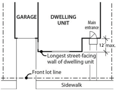
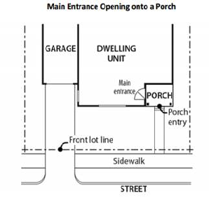
(.15)
Garage Standards:
A.
Purpose. These standards:
1.
Ensure that there is a physical and visual connection between the living area of the residences and the street;
2.
Ensure that the location and amount of the living area of the residence, as seen from the street, is more prominent than garages;
3.
Prevent garages from obscuring the main entrance from the street and ensure that the main entrance for pedestrians, rather than automobiles, is the prominent entrance;
4.
Provide for a pleasant pedestrian environment by preventing garages and vehicle areas from dominating the views of the neighborhood from the sidewalk; and
5.
Enhance public safety by preventing garages from blocking views of the street from inside the residence.
B.
Street-Facing Garage Walls:
1.
Where these regulations apply. Unless exempted, the regulations of this subsection apply to garages accessory to residential units.
2.
Exemptions:
a.
Garages on flag lots.
b.
Development on lots which slope up or down from the street with an average slope of 20 percent or more.
3.
Standards:
a.
The width of the garage door may be up to 50 percent of the length of the street-facing façade as measured from the interior of the frame surrounding the garage door.
b.
The garage door must be recessed at least four feet from the front façade or six feet from the front of a front porch.
c.
The maximum driveway width is 18 feet.
d.
Where a dwelling abuts a rear or side alley or a shared driveway, the garage shall orient to the alley or shared drive.
e.
Where three or more contiguous garage parking bays are proposed facing the same street, the garage opening closest to a side property line shall be recessed at least two feet behind the adjacent opening(s) to break up the street facing elevation and diminish the appearance of the garage from the street. Side-loaded garages, i.e., where the garage openings are turned away from the street, are exempt from this requirement.
f.
A garage entry that faces a street may be no closer to the street than the longest street facing wall of the dwelling unit. There must be at least 20 feet between the garage door and the sidewalk. This standard does not apply to garage entries that do not face the street.
(.16)
Residential Design Standards:
A.
Purpose. These standards:
1.
Support consistent quality standards so that each home contributes to the quality and cohesion of the larger neighborhood and community.
2.
Support the creation of architecturally varied structures, blocks and neighborhoods, whether a neighborhood develops all at once or one lot at a time, avoiding homogeneous street frontages that detract from the community's appearance.
B.
Applicability. In the Frog Pond West Neighborhood standards C. through G. apply to all façades facing streets, pedestrian connections, parks, open space tracts, the Boeckman Trail, or elsewhere as required by this Code or the Development Review Board. Exemptions from these standards include: (1) Additions or alterations adding less than 50 percent to the existing floor area of the structure; and, (2) Additions or alterations not facing a street, pedestrian connection, park, or open space tract. In the Frog Pond East and South Neighborhoods, the standards in C. through G. do not apply. Rather, design standards in 4.113(.14) apply to all public-facing facades in the Frog Pond East and South Neighborhoods.
C.
Windows. The standards for minimum percentage of façade surface area in windows are below. These standards apply only to facades facing streets, pedestrian connections, parks, and open space tracts.
1.
For two-story structures:
a.
15 percent front facades.
b.
12.5 percent—front facades if a minimum of six design elements are provided per Section 4.127(0.15)E., Design Menu.
c.
Ten percent—front facades facing streets if a minimum of seven design elements are provided per Section 4.127(0.15)E., Design Menu.
2.
For one-story structures:
a.
12.5 percent—front facades.
b.
Ten percent—front facades if a minimum of six design elements are provided per Section 4.127(0.15)E., Design Menu.
3.
For all structures: Five percent for street-side facades.
4.
Windows used to meet this standard must provide views from the building to the street. Glass block does not meet this standard. Windows in garage doors and other doors count toward this standard.
5.
Street-facing facades along Boeckman Road and Stafford Road must meet the standards for front facades.
D.
Articulation. Plans for residential buildings shall incorporate design features such as varying rooflines, offsets, balconies, projections (e.g., overhangs, porches, or similar features), recessed or covered entrances, window reveals, or similar elements that break up otherwise long, uninterrupted elevations. Such elements shall occur at a minimum interval of 30 feet on façades facing streets, pedestrian connections, parks, open space tracts, or elsewhere as required by this Code or the Development Review Board. Where a façade governed by this standard is less than 30 feet in length, at least one of the above-cited features shall be provided.
E.
Residential Design Menu. Residential structures shall provide a minimum of five of the design elements listed below for front façades and façades facing Boeckman Road and Stafford Road, unless otherwise specified by the code. For side façades facing streets, pedestrian connections, parks, open space tracts, a minimum of three of the design elements must be provided. Where a design feature includes more than one element, it is counted as only one of the five required elements.
1.
Dormers at least three feet wide.
2.
Covered porch entry—minimum 48 square foot covered front porch, minimum six feet deep and minimum of a six foot deep cover. A covered front stoop with minimum 24 square foot area, four foot depth and hand rails meets this standard.
3.
Front porch railing around at least two sides of the porch.
4.
Front facing second story balcony - projecting from the wall of the building a minimum of four feet and enclosed by a railing or parapet wall.
5.
Roof overhang of 16 inches or greater.
6.
Columns, pillars or posts at least four inches wide and containing larger base materials.
7.
Decorative gables - cross or diagonal bracing, shingles, trim, corbels, exposed rafter ends or brackets (does not include a garage gable if garage projects beyond dwelling unit portion of street façade).
8.
Decorative molding above windows and doors.
9.
Decorative pilaster or chimneys.
10.
Shakes, shingles, brick, stone or other similar decorative materials occupying at least 60 square feet of the street façade.
11.
Bay or bow windows - extending a minimum of 12 inches outward from the main wall of a building and forming a bay or alcove in a room within the building.
12.
Sidelight and/or transom windows associated with the front door or windows in the front door.
13.
Window grids on all façade windows (excluding any windows in the garage door or front door).
14.
Maximum nine foot wide garage doors or a garage door designed to resemble two smaller garage doors and/or windows in the garage door (only applicable to street facing garages).
15.
Decorative base materials such as natural stone, cultured stone or brick extending at least 36 inches above adjacent finished grade occupying a minimum of ten percent of the overall primary street facing façade.
16.
Entry courtyards which are visible from, and connected directly to, the street. Courtyards shall have a minimum depth of ten feet and minimum width of 80 percent of the non-garage/driveway building width to be counted as a design element.
F.
House Plan Variety. No two directly adjacent or opposite residential structures may possess the same front or street-facing elevation. A structure containing multiple middle housing units shall be considered a single residential structure for the purpose of house plan variety. This standard is met when front or street-facing elevations differ from one another due to different materials, articulation, roof type, inclusion of a porch, fenestration, and/or number of stories. Where façades repeat on the same block face, they must have at least three intervening residential structures between them that meet the above standard. Small Lot developments over ten acres shall include duplexes and/or two-unit townhouses comprising ten percent of the homes—corner locations are preferred.
G.
Prohibited Building Materials. The following construction materials may not be used as an exterior finish:
1.
Vinyl siding.
2.
Wood fiber hardboard siding.
3.
Oriented strand board siding.
4.
Corrugated or ribbed metal.
5.
Fiberglass panels.
(.17)
Fences:
A.
Fences shall comply with standards in 4.113(.07) except as follows:
1.
Columns for the brick wall along Boeckman Road and Stafford Road shall be placed at lot corners where possible.
2.
A solid fence taller than four feet in height is not permitted within eight feet of the brick wall along Boeckman Road and Stafford Road, except for fences placed on the side lot line that are perpendicular to the brick wall and end at a column of the brick wall.
3.
Height transitions for fences shall occur at fence posts.
(.18)
Residential Structures Adjacent to Schools, Parks and Public Open Spaces.
A.
Purpose. The purpose of these standards is to ensure that development adjacent to schools and parks is designed to enhance those public spaces with quality design that emphasizes active and safe use by people and is not dominated by driveways, fences, garages, and parking.
B.
Applicability. These standards apply to development that is adjacent to or faces schools and parks. As used here, the term adjacent includes development that is across a street or pedestrian connection from a school or park.
C.
Development must utilize one or more of the following design elements:
1.
Alley loaded garage access.
2.
On corner lots, placement of the garage and driveway on the side street that does not face the school, park, or public open space.
3.
Recess of the garage a minimum of four feet from the front façade of the home. A second story above the garage, with windows, is encouraged for this option.
D.
Development must be oriented so that the fronts or sides of residential structures face adjacent schools or parks. Rear yards and rear fences may generally not face the schools or parks, unless approved through the waiver process of 4.118 upon a finding that there is no practicable alternative due to the size, shape or other physical constraint of the subject property.
(.19)—(.21)
Reserved.
(.22)
Consideration of Waivers in the Frog Pond East and South Neighborhoods.
A.
Applicants for development in the Frog Pond East and South Neighborhoods may request waivers to applicable development and design standards in Section 4.127 pursuant to Section 4.118(.03), provided the criteria in subsection B. are met. Waivers are typically applied for with a Stage II final plan. However, when a Stage I approval is requested prior to submission of a Stage II final plan in the Frog Pond East and South Neighborhoods, the applicant may elect to request a waiver or waivers related to standards impacting lot size or dimension, housing variety, the size or location of parks or open space, or the location of streets or pathways in conjunction with the Stage I approval, if the applicant can demonstrate each requested waiver would directly impact site layout. In such case, a Stage II final plan for the same development area may not be applied for until there is a final decision on the Stage I and associated waivers. Each approved Stage I waiver shall expire unless a Stage II final plan consistent with the approved Stage I waiver is submitted within two years.
B.
In addition to the waiver criteria in Sections 4.118 and 4.140 and applicable Site Design Review standards, when reviewing a waiver for development within the Frog Pond East and South Neighborhoods the Development Review Board's decision shall be based on the following criteria, which reflects guidance in the Frog Pond East and South Master Plan:
1.
The development enabled by the waiver is complementary and compatible with development that would typically be built within the subject Urban Form Type as described in Chapter 6 of the Frog Pond East and South Master Plan including structures that match the relevant urban form descriptions on pages 57-59 of the Master Plan and maintaining the transect of urban form shown in Figure 15. Land Use and Urban Form Plan.
a.
In making findings regarding the waiver criteria in Section 4.140, further direction from Chapter 6 of the Master Plan to be considered includes, but is not limited to, increasing opportunities for affordable housing choices with a focus on exceeding minimum requirements for middle housing, mobility-ready units, and small units as established in Table 6B; improving transitions between different urban forms; and maximizing amenities available to residents and visitors (e.g., additional plazas, active recreation spaces, green focal points, and other gathering opportunities).
2.
The waiver continues to support a wide variety of housing throughout the Frog Pond East and South Neighborhoods including not reducing the Minimum Number of Units of any requirement in Table 6B by the greater of five units or 20 percent.
a.
Except as indicated in b. and c. below, the number on which the greater of five units or 20 percent is calculated shall be the number as written in Table 6B and shall not include any modification, combination, or summation of the number.
b.
Where an application includes two or more adjacent tax lots within the same subdistrict, the number on which the greater of five units or 20 percent is calculated shall be the sum of the requirements for those tax lots, as allowed in Footnote I. of Table 6B.
c.
Where a requirement in Table 6B is adjusted pursuant to Subsection, 4.127 (.06) C. 1., the number on which the greater of five units or 20 percent is calculated shall be the adjusted number.
(.23)
Residential Neighborhood Zone—Commercial Main Street Development.
A.
Applicability. These standards apply to the Commercial Main Street area described in Subsection (.07)A.1. and shown in Figure A-7.
B.
Allowed Uses. See Subsection (.02) above.
C.
Development Standards. The following development standards apply to all development within the Commercial Main Street area of Frog Pond East.
A
Second stories or higher in buildings must be usable. No false front buildings are permitted.
B
To meet the minimum building frontage requirement, the ground level street-facing façade must meet the maximum setback standard for a minimum of 70% of the lot length on SW Brisband Street.
D.
Design Standards:
1.
Purpose and Intent. The purpose of the design standards is to provide high quality design within the Commercial Main Street area that creates a place of distinct character. The design of buildings and other site features shall functionally relate to adjacent streets and open spaces; shall include architectural diversity and variety in their built form; shall contribute to the vitality of the street environment through incorporation of storefronts, windows, and entrances facing the sidewalk; and shall minimize the visual impact of off-street parking from streets.
2.
Building and Entry Placement. Buildings shall meet the following standards:
a.
Development shall meet the minimum building frontage standards in Table 23A.
b.
At least one entrance door is required for each business, including live-work units, with a ground floor frontage.
c.
All primary ground-floor common entrances shall be oriented to the street or a public space directly facing the street, or placed at an angle up to 45 degrees from an adjacent street. Primary ground-floor common entrances shall not be oriented to the interior or to a parking lot.
d.
The primary entrance shall orient to SW Brisband Street or SW Stafford Road.
f.
Each entrance shall be covered, recessed, or treated with a permanent architectural feature in such a way that weather protection is provided.
3.
Building Setbacks. Development shall meet the minimum and maximum setback standards in subsection Table 23A. No off-street vehicle parking, loading, delivery, or collection service is permitted within the setback. Bicycle parking is permitted within the setback.
4.
Front Yard Setback Design. If front yard setbacks are provided, they shall be designed to encourage pedestrian activity and active ground floor uses. Landscaping, water quality treatment, seating areas, an arcade, or a hard-surfaced expansion of the pedestrian path must be provided between a structure and a public street or accessway. If a building abuts more than one street, the required improvements shall be provided on all streets. Hard-surfaced areas shall be constructed with scored concrete or modular paving materials. Benches and other street furnishings are encouraged.
5.
Walkway Connection to Building Entrances. A walkway connection is required between a building's primary entrance and a public street or accessway. This walkway must be at least six feet wide and be paved with concrete or modular paving materials.
6.
Parking Location and Landscape Design:
a.
Parking must be located to the rear of buildings.
7.
Building Design Standards:
a.
General Provisions:
i.
The first-floor façade of all buildings shall be designed to encourage and complement pedestrian-scale interest and activity through the use of elements such as windows, awnings, and other similar features.
ii.
Building entrances shall be clearly marked, provide weather covering, and incorporate architectural features of the building.
iii.
Architectural features and treatments shall not be limited to a single façade. All public-facing facades shall display a similar level of quality and architectural interest, with elements such as windows, awnings, murals, a variety of exterior materials, reveals, and other similar features.
b.
Design Standards. All buildings shall comply with the following design standards:
i.
Windows:
• Building facade windows are required on all facades facing SW Brisband Street or SW Stafford Road (see Figure A-23), as follows:
• Window area is the aggregate area of the glass within each window, including any interior grids, mullions, or transoms. Facade area is the aggregate area of each street-facing vertical wall plane.
• Required windows shall be clear glass and not mirrored or frosted, except for bathrooms. Clear glass within doors may be counted toward meeting the window coverage standard.
• Ground floor windows. For facades facing SW Brisband Street, SW Stafford Road, and SW 63rd Avenue elevations within the building setback shall include a minimum percentage of the ground floor wall area with windows, display areas or doorway openings. The ground floor wall area shall be measured from two feet above grade to ten feet above grade for the entire width of the street-facing elevation. The ground floor window requirement shall be met within the ground floor wall area; glass doorway openings to ground level may be counted toward meeting the requirement.
Figure A-23. Window Placement and Percentage of Facade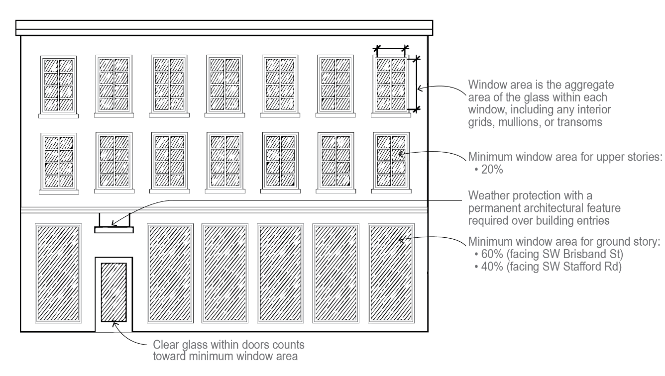
ii.
Building Facades: Public-facing facades shall extend no more than 50 feet without providing at least one of the following features: (a) a variation in building materials; (b) a building off-set of at least one foot; (c) a wall area that is entirely separated from other wall areas by a projection, such as an arcade; or (d) by other design features that reflect the building's structural system (See Figure B-23). No building façade shall extend for more than 300 feet without a pedestrian connection between or through the building.
Figure B-23. Building Facade Articulation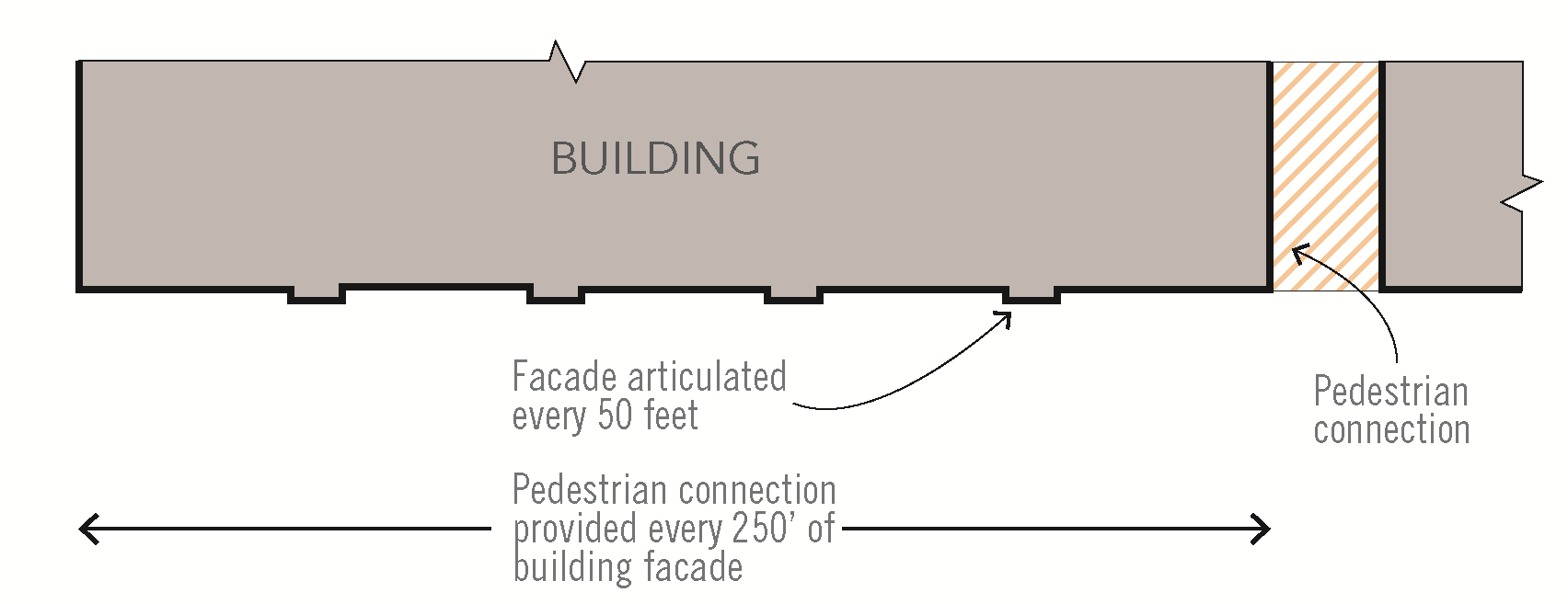
iii.
Weather Protection: Building facades facing SW Brisband Street shall provide weather protection as follows:
• A projecting facade element (awning, canopy, arcade, or marquee) must be provided along at least 50 percent of the façade.
• All weather protection must comply with the Oregon Structural Specialty Code in effect at the time of application for projections or encroachments into the public right-of-way.
• Weather protection shall be maintained and in good condition.
• Weather protection features shall project at least five feet from the building façade.
• Marquees shall have a minimum ten-foot clearance from the bottom of the marquee to the sidewalk. Canopies and awnings shall have a minimum eight-foot clearance from the bottom of the awning or canopy to the sidewalk.
• The projecting façade element shall not conflict with street lights. If the projecting façade element blocks light shed from adjacent street lights, exterior lighting shall be located on the building.
• Awnings shall match the width of storefronts or window openings.
• Internally lit awnings are not permitted.
• Awnings shall be made of glass, metal, or a combination of these materials. Fabric awnings are not permitted.
iv.
Building Materials. Plain concrete block, plain concrete, T-111 or similar sheet materials, corrugated metal, plywood, sheet press board or vinyl siding may not be used as exterior finish materials. Foundation material may be plain concrete or plain concrete block where the foundation material is not revealed for more than two feet. Use of brick and natural materials (wood) is encouraged.
v.
Roofs and roof lines. Except in the case of a building entrance feature, roofs shall be designed as an extension of the primary materials used for the building and should respect the building's structural system and architectural style. False fronts and false roofs are not permitted.
vi.
Rooftop features/equipment screening:
• The following rooftop equipment does not require screening:
• Solar panels, wind generators, and green roof features;
• Equipment under two feet in height.
• Elevator mechanical equipment may extend above the height limit a maximum of 16 feet provided that the mechanical shaft is designed to match or be complementary to the architecture of the building.
• Satellite dishes and other communications equipment shall be limited to ten feet in height from the roof, shall be set back a minimum of five feet from the roof edge and screened from public view to the extent possible.
• All other roof-mounted mechanical equipment shall be limited to ten feet in height, shall be set back a minimum of five feet from the roof edge and screened from ground-level public view and from views from adjacent buildings.
• On all structures exceeding 35 feet in height, roofs shall have drainage systems that are designed to match or be complementary to the architecture of the building.
• Any external stairwells, corridors and circulation components of a building shall be architecturally compatible with the overall structure, through the use of similar materials, colors, and other building elements.
• Required screening shall not be included in the building's maximum height calculation.
vii.
General Screening. Utility meters shall be located on the back or side of a building, screened from view from a public street to the greatest extent possible, and shall be painted a color to blend with the building façade.
viii.
Building projections. Building projections are allowed as follows (see Figure C-23):
• Architectural elements such as eaves and cornices may project up to one foot from the face of the building.
• Bay windows and balconies may project up to four feet from the face of the building. Balconies that project into the right-of-way shall have a minimum vertical clearance of ten feet from sidewalk grade or be mounted at the floor elevation, whichever is greater.
Figure C-23. Building Projections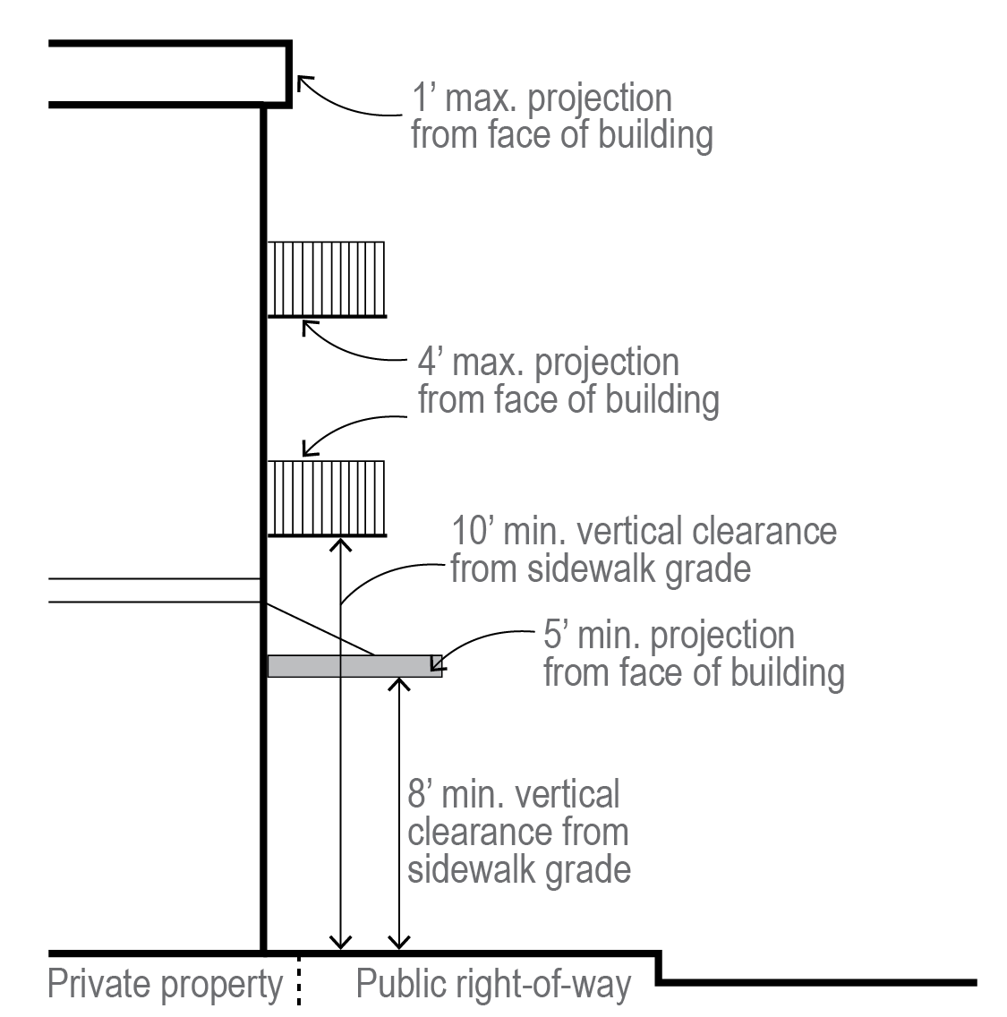
(.24)
Special, Specific Land Use Considerations.
A.
Frog Pond Grange Property. This special consideration pertains to an area described as: the western half of the area of Subdistrict E1 north of the framework street that is an extension of SW Frog Pond Lane and west of the framework street extending across the BPA easement. See Figure A-24 for locational reference. The community supports preservation, reuse, and adjacent uses supportive of the current Frog Pond Grange building. The Frog Pond East and South Master Plan identifies the long-term use of the subject area as maintaining the existing civic/meeting/event space use or substantially similar use with surrounding open space. Any substantial change of use shall require an amendment to the Frog Pond East and South Master Plan. Preservation of the existing building, substantially similar in design to that existing as of the 2022 adoption of the Frog Pond East and South Master Plan, is required on the site unless approved by the Development Review Board with findings providing substantial evidence that preservation is not feasible due to structural issues with the building that are not feasible, either economically or technically, to repair.
Figure A-24
B.
Treed area on south side of SW Kahle Road. This special consideration pertains to an area described as a treed area south of SW Kahle Road between Subdistricts E2 and E3 and bounded on both side by creeks. See Figure B-24 for locational reference. An applicant may request the subject area not be included in the SROZ based on findings made, as part of a SROZ Map Verification pursuant to Section 4.139.05, that the area does not meet the standard to be included in the SROZ. If it is found the area is not to be in the SROZ the Urban Form Type 3 shall apply. There is no minimum unit count and the area would not be considered part of a subdistrict. There would be no housing variety requirement applied.
Figure B-24
(Ord. No. 806, 7-17-2017; Ord. No. 892, § 2(Exhs. A, B), 12-2-2024)
Section 4.131. - PDC—Planned Development Commercial Zone.
The requirements of a PDC Zone shall be governed by Section 4.140, Planned Development Regulations, and as otherwise set forth in this Code.
(.01)
The following shall apply to any PDC zone:
A.
Uses that are typically permitted:
1.
Retail business, goods and sales.
2.
Wholesale showrooms.
3.
Offices and clinics.
4.
Service establishments.
5.
Any use allowed in a PDR Zone or PDI Zone, provided the majority of the total ground floor area is commercial, or any other commercial uses provided that any such use is compatible with the surrounding uses and is planned and developed in a manner consistent with the purposes and objectives of Section 4.140. However, the uses listed as prohibited below shall not be permitted.
6.
Accessory uses, buildings, and structures customarily incidental to any of the aforesaid principal permitted uses.
7.
Temporary buildings or structures for uses incidental to construction work, which buildings or structures shall be removed upon completion or abandonment of the construction work.
8.
Churches.
9.
Those uses that are listed as typically permitted in Section 4.131.05(.03), as well as the following additional uses when conducted entirely within enclosed buildings:
a.
Automotive machine shops
b.
Automotive detail shops
c.
Repair shops for:
i.
electronics;
ii.
boats;
iii.
appliances;
iv.
light equipment;
v.
yard equipment;
vi.
other related types of repair shops.
d.
Fabrication shops including:
i.
cabinets;
ii.
sheet metal;
iii.
counter tops;
iv.
closet systems;
v.
other related types of work.
e.
Marine equipment—supply and repair
(.02)
Prohibited uses:
A.
No body/fender repair shops shall be permitted unless all operations are conducted entirely within enclosed buildings and meet the performance standards of Section 4.135(.05). The storage and parking of damaged vehicles shall be screened to assure that they are not visible off-site.
B.
No used car sales shall be permitted, except in conjunction with new car dealerships within enclosed buildings.
C.
No wrecking yards shall be permitted.
D.
Retail operations south of Boeckman Road and having more than 50,000 square feet of ground floor building area shall only be permitted where it is demonstrated to the satisfaction of the Development Review Board that the following standards will be met. For purposes of these standards, service activities, offices, and other non-retail commercial ventures shall not be considered to be "retail operations."
1.
That the majority of the customers for the proposed use can reasonably be expected to come from no further than five miles from the proposed development site; and
2.
That the site design, architecture, landscaping, and pedestrian amenities are compatible with the surrounding neighborhood.
E.
Any use that violates the performance standards of Section 4.135(.05), other than 4.135(.05)(M.)(3.).
(.03)
Block and access standards:
1.
The Development Review Board shall determine appropriate conditions of approval to assure that adequate connectivity results for pedestrians, bicyclists, and motor vehicle drivers. Consideration shall be given to the use of public transit as a means of meeting access needs.
2.
Where a residential development, or mixed-use development including residential development, is proposed in a PDC zone, the Development Review Board shall assure that adequate connectivity is provided meeting the standards of Metro's Urban Growth Management Functional Plan.
3.
Where a residential development, or mixed-use development including residential development, is proposed in a PDC zone, and the application includes a land division, the following standards shall be applied:
a.
Maximum spacing between streets for local access: 530 feet, unless waived by the Development Review Board upon finding that barriers such as railroads, freeways, existing buildings, topographic variations, or designated Significant Resource Overlay Zone areas will prevent street extensions meeting this standard.
b.
Maximum block length without pedestrian and bicycle crossing: 330 feet, unless waived by the Development Review Board upon finding that barriers such as railroads, freeways, existing buildings, topographic variations, or designated Significant Resource Overlay Zone areas will prevent pedestrian and bicycle facility extensions meeting this standard.
(Ord. No. 538, 2-21-2002; Ord. No. 835, 5-6-2019)
Section 4.132. - Town Center Zone.
(.01)
The Town Center (TC) Zone applies to lands within the Town Center Comprehensive Plan Map designation. The TC Zone is a Planned Development Zone, subject to applicable Planned Development regulations (see Section 4.140 and 4.118). Where conflicts occur between these standards and other Development Code regulations or other ordinances, the provisions of this Chapter shall apply.
The purposes of the TC Zone are to:
A.
Implement the Town Center policies and implementation measures of the Comprehensive Plan.
B.
Implement the Wilsonville Town Center Plan recommendations for the Town Center Comprehensive Plan Map designation.
C.
Create a vibrant, walkable destination that inspires people to socialize, shop, live, and work.
D.
Support future development that transforms Town Center into the heart of Wilsonville.
E.
Foster active parks, civic spaces, and amenities that provide year-round, compelling experiences.
F.
Create a development pattern where Wilsonville residents and visitors come for shopping, dining, culture, and entertainment.
Sub-districts. The TC Zone includes four sub-districts (Figure 1):
a.
Main Street. A walkable and lively main street with a mix of active uses and three- to four-story buildings through the heart of Town Center along Parkway Avenue, which would extend south past Town Center Park to Wilsonville Road.
b.
Neighborhood-Mixed Use. Development would be primarily small-scale mixed-use, two- to three-story development, with neighborhood-serving commercial businesses or townhomes adjacent to Town Center Loop East and the existing residential neighborhoods. Neighborhood-mixed use provides a transition from single-family neighborhoods east of Town Center Loop East to the central portions of Town Center.
c.
Mixed Use. A variety of two- to four-story buildings throughout Town Center would provide the mix of residential, commercial and office uses the community is looking to have in Town Center. Moderate activity near Wilsonville Road would be commercially focused while the areas near Town Center Park would include more residential and mixed-use buildings.
d.
Commercial-Mixed Use. Allowing taller buildings, up to five stories, along I-5 and near the future bike/pedestrian bridge landing, would improve Town Center's visibility, help create a sense of place, and support the increased level of activity and economic vibrancy desired by community members, including additional employment opportunities, entertainment, and hospitality services. As proposed, residential uses in this area would be required to be buffered from I-5 by non-residential buildings.
If a development site includes more than one sub-district, and the development of different portions of the parcel under different sub-districts is not feasible due to site size or other site constraints not related to proposed uses, the applicant may follow the standards for either sub-district within 50 feet of the sub-district boundary. The selection and application of the sub-district standards must provide for compatibility with any existing or approved development designed pursuant to the TC Zone standards and result in building orientation consistent with the building and street frontage requirements in Subsection 4.132(.06)B.
(.02)
Uses permitted anywhere in the TC Zone:
A.
Open space.
B.
Multiple-family Dwelling Units, except in areas immediately adjacent to I-5 as noted in Subsection [4.132](.03)A. below within the Commercial-Mixed Use District.
C.
Public or private parks, playgrounds, recreational and community buildings and uses.
D.
Commercial recreation.
E.
Religious institutions.
F.
Retail sales and service of retail products, under a footprint of 30,000 square feet per use.
G.
Office, including medical facilities.
H.
Personal and professional services.
I.
Child and/or day care.
J.
Food service (e.g. restaurants, food carts, food cart pods).
K.
Beverage service (e.g. cafes, brewpubs, bars).
L.
Any of the above in mixed-use buildings.
Figure 1. Town Center Sub-Districts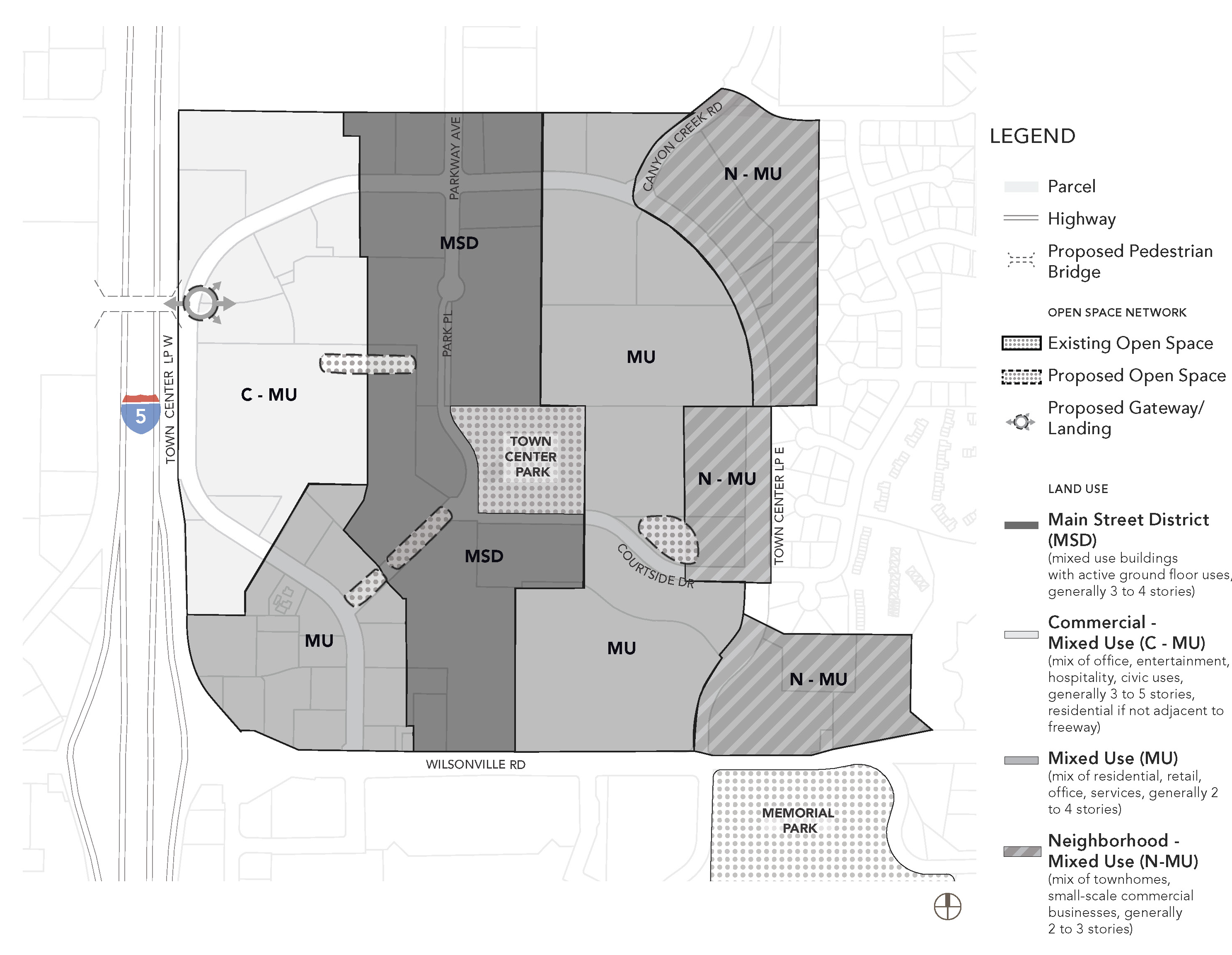
(.03)
Permitted and Prohibited uses in specific sub-districts. Figure 1, Land Use Sub-Districts, illustrates subareas of the Town Center where certain regulations apply. Below are use-related regulations for the sub-districts.
A.
Commercial-Mixed Use (C-MU):
1.
Additional permitted uses—Commercial recreation with outdoor facilities (e.g. cart track); single-user commercial or retail (e.g. grocery store or retail establishment) may exceed 30,000 square feet if located on more than one story of a multi-story building; cinemas.
2.
Multiple-family dwelling units are prohibited immediately adjacent to I-5. Multiple-family development must be buffered from I-5 by non-residential building(s).
3.
Uses with drive-through facilities—New uses with drive-through facilities (e.g. fast food, banks, car wash) are permitted in the C-MU sub-district, provided that they meet design and development standards for the TC Zone. Existing drive-through uses and facilities may be continued consistent with Section 4.189.
B.
Main Street (MS):
1.
Uses with drive-through facilities - New uses with drive-through facilities (e.g. fast food, banks, car wash) are prohibited. Existing drive-through uses and facilities may be continued consistent with Section 4.189. In the MS sub-district, a change in use is prohibited for new drive-through uses.
C.
Mixed Use (MU):
1.
Additional permitted uses—Single-user commercial or retail (e.g. grocery store or retail establishment) may exceed 30,000 square feet if located on more than one story of a multi-story building.
2.
Uses with drive-through facilities—New uses with drive-through facilities (e.g. fast food, banks, car wash) are permitted in the MU sub-district, provided that they meet design and development standards for the TC Zone. Existing drive-through uses and facilities may be continued consistent with Section 4.189.
D.
Neighborhood Mixed Use (N-MU):
1.
Uses with drive-through facilities—New uses with drive-through facilities (e.g. fast food, banks, car wash), are prohibited. Existing drive-through uses and facilities may be continued consistent with Section 4.189. In the N-MU sub-district, a change in use is permitted if redeveloping an existing drive-through use with another drive-through use, consistent with the other standards of Section 4.189.
(.04)
Consistency with Street Network and Multi-modal Network:
A.
All development will be consistent with the Street Network and Multi-modal Network, shown in Figures 2 and 3. Street and multi-modal facility locations are approximate and will be finalized as part of the development review process. The purpose of these plans are to support the creation of a highly connected and walkable Town Center where there are options for travel. The Development Review Board (DRB) may approve variations from Figures 2 and/or 3, if:
1.
Existing development restricts the connection from being developed;
2.
Existing natural resources and/or open space would be adversely affected by construction of the facility and mitigation of those impacts is not feasible.
B.
If a street or other multimodal connection varies from Figures 2 and/or 3, equivalent connectivity and multi-modal travel options shall be provided as determined in a Transportation Impact Analysis prepared per Section 4.140 and approved by the City Engineer.
C.
All development shall provide transportation facilities consistent with the cross-sections in the Wilsonville Town Center Plan and applicable provisions of the Wilsonville Transportation System Plan subject to variations approved by the City Engineer.
D.
All franchise utilities shall be located underground within the public sidewalk.
Figure 2. Street Network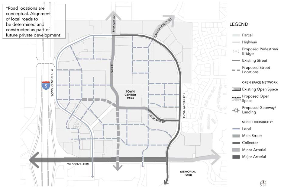
Figure 3. Multimodal Network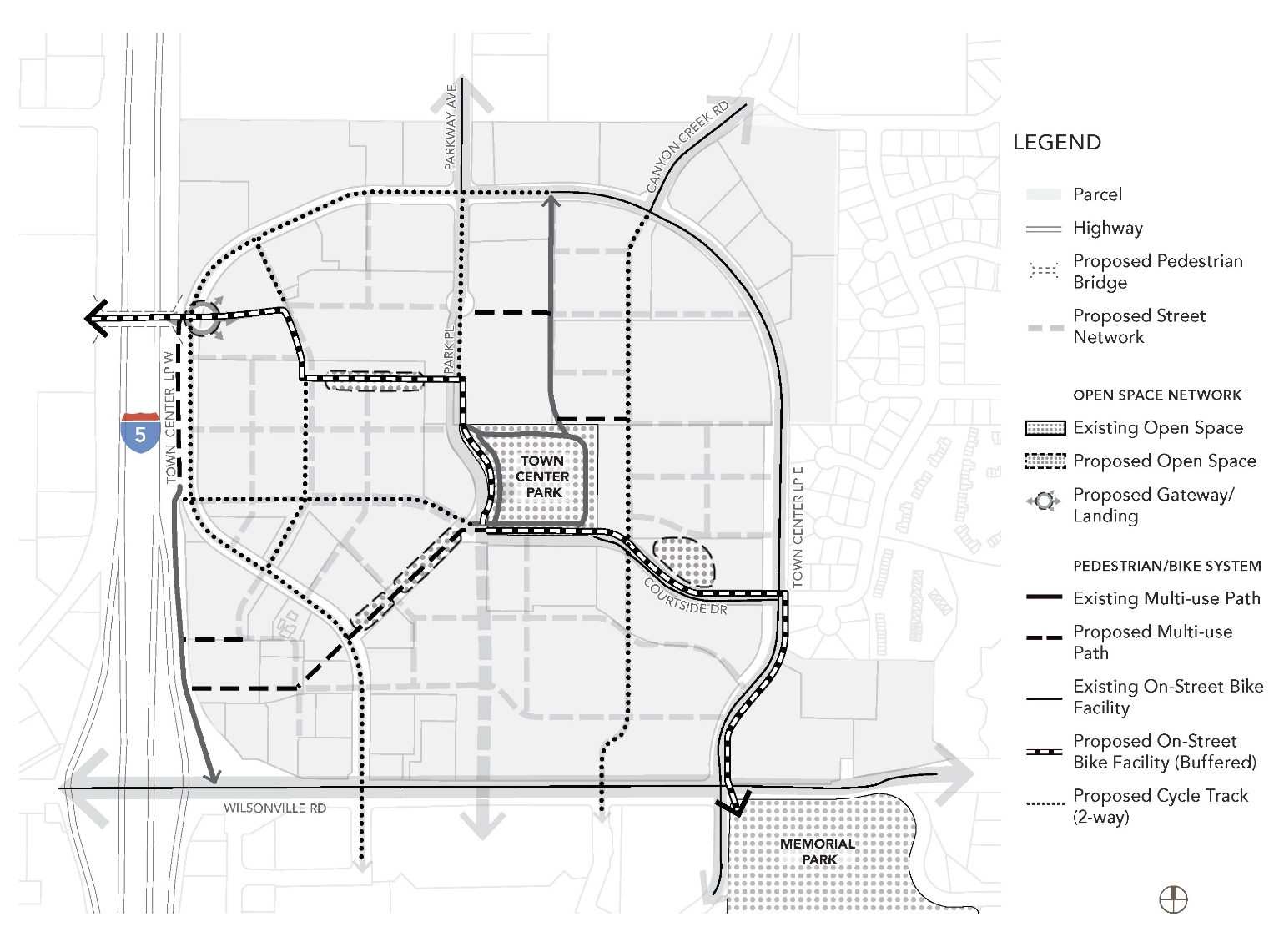
(.05)
Consistency with Open Space Network:
A.
All development will be consistent with the Open Space Network, shown in Figure 4. The open space sizes and locations on Figure 4 are approximate and will be finalized as part of the development review process. The purpose of the plan is to create open spaces that are linked and serve as attractive amenities for Town Center. The Development Review Board may approve variations from Figure 4 if needed to accommodate existing development or physical constraints, and/or, preserve natural resources and open space. If an open space is varied, equivalent open space and open space linkage shall be provided.
B.
The Development Review Board may specify the method of assuring the long-term protection and maintenance of open space and/or recreational areas. Where such protection or maintenance are the responsibility of a private party or homeowners' association, the City Attorney shall review any pertinent bylaws, covenants or agreements prior to recordation.
Figure 4. Open Space Network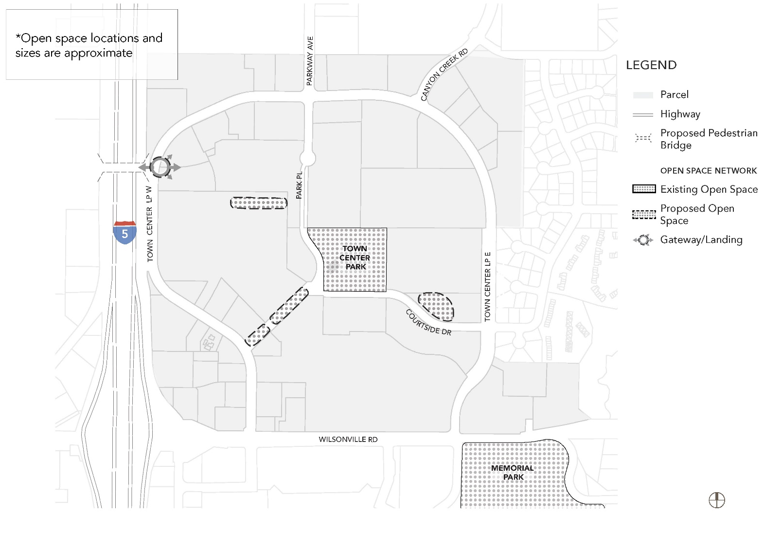
(.06)
Design and Development Standards:
A.
Purpose and Intent. The purpose of the design standards is to:
1.
Provide high quality design in new development and redevelopment that promotes a sense of community identity and implements the Wilsonville Town Center Vision.
2.
Provide a well-defined pedestrian, bicycle and vehicular network, good connections to adjacent land uses and direct connections to transit stops.
3.
Provide quality and usable open space, increase street tree canopy, and create transitions between land uses.
4.
Provide sustainable development through the adaptive reuse of existing buildings and increase the use of low-impact development best practices.
5.
All development shall follow these standards except as permitted in Subsection 4.132(.06) D.
B.
Building/Street Frontage Requirements. Building and street frontage requirements in this section are intended to create an active pedestrian environment through sidewalk-facing ground floors and entryways with protection from the elements for pedestrians.
[1]
Sidewalk width includes landscaping area. Tree wells shall include root barriers, the use of structural soils, soil cells, or other means to minimize impacts to sidewalks or roadway from root intrusion.
[2]
A maximum of two parklets are permitted per block, per side of street.
Figure 5.A. Building Placement and Location of Parking, Main Street Intersection (typical)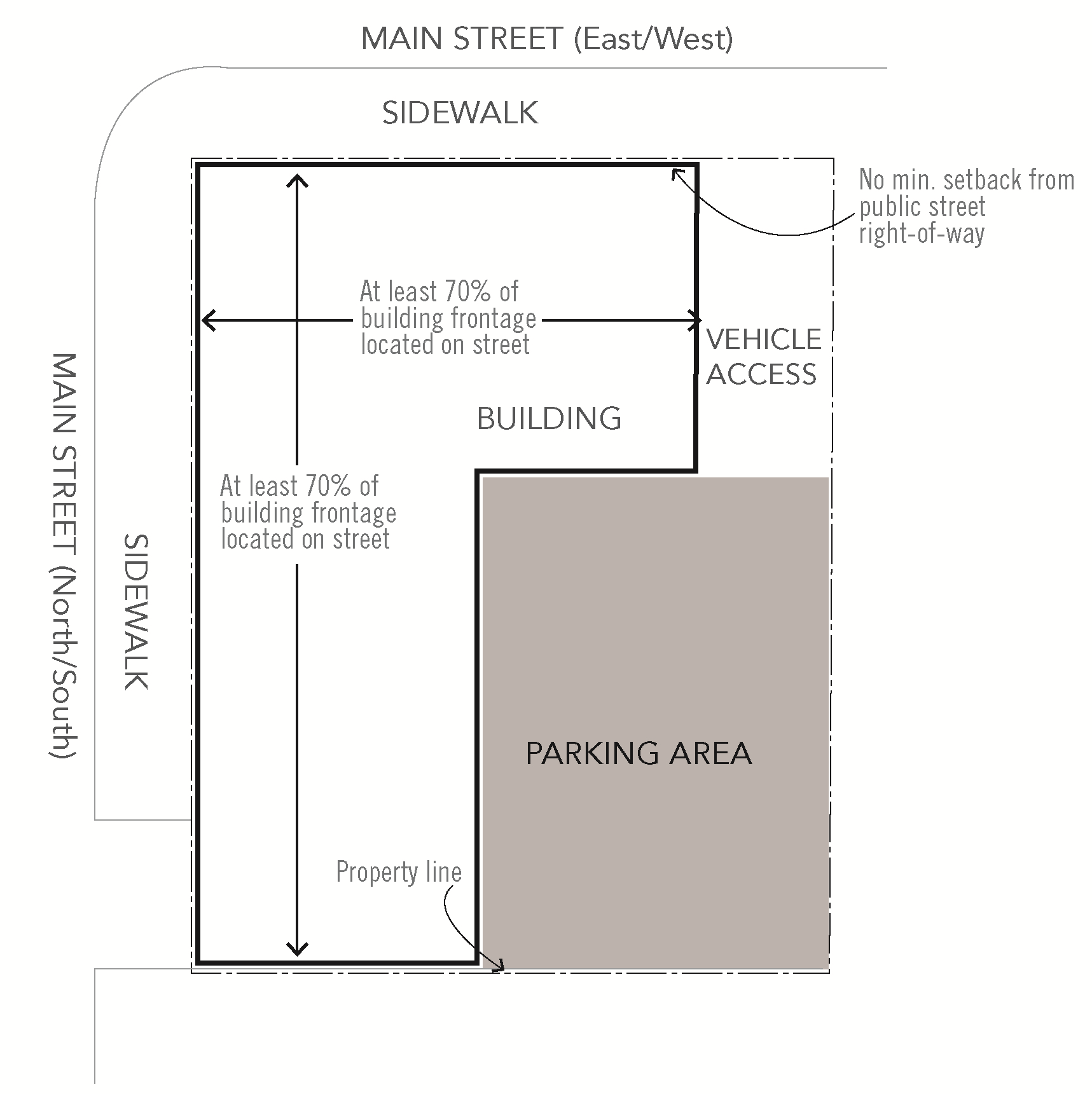
Figure 5.B. Building Placement and Location of Parking, Main Street/Local Street Intersection
(typical)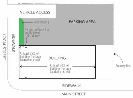
Figure 5.C. Building Placement and Location of Parking, Local Street/Local Street
Intersection (typical)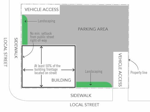
Figure 5.D. Building Placement and Location of Parking, Arterial/Collector/Local Street
frontage (typical)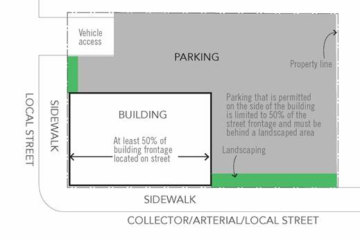
C.
Development Standards. Development standards apply to all new development within the Town Center boundary.
[1]
This table does not apply to existing development. All new buildings in the district must meet these development standards.
[2]
For commercial development, the maximum front and street side yard setback is ten feet. For mixed-use and residential only development, the maximum front setback is 20 feet. Front setbacks are permitted provided they are used for seating or other uses that encourage pedestrian activity and active ground floor uses. A variety of building setbacks are encouraged.
[3]
Second stories or higher in buildings must be useable. No false front buildings are permitted.
[4]
Within the MSD, MU and C-MU sub-districts, the maximum number of building stories may be increased by one story if a minimum of 25 percent of the units of the bonus floor area are affordable, with rental rates /mortgage restrictions for a minimum of ten years, to households earning at or below 80 percent of median family income of Wilsonville.
[5]
This standard does not apply to residential only buildings.
[6]
Minimum residential density applies to residential-only development. There is no minimum residential density for mixed-use development.
D.
Waivers to Development Standards. Development standards apply to all new development within the Town Center boundary.
The Development Review Board (DRB) may approve waivers to the size of the ground floor of a building floorplate and/or the number of stories of a building within the MU and C-MU sub-districts, consistent with the provisions of Section 4.118 (.03) if one item from each of the two following menus are met in a manner to clearly go substantially above and beyond Code requirements and typical building and site design to create a sense of place and mitigate negative impacts of the project related to the reason for the waiver. Items chosen from the menus shall account for need based on adjacent sites or the surrounding area:
Menu One:
1.
Public amenities, such as a plaza or other community gathering space, incorporated into the building design. Public plaza or other gathering spaces located in a prominent, visible location adjacent to a public street and include movable furniture that is functional and visually interesting.
2.
Public community meeting space provided within the building.
3.
Provision of ground floor facades that include additional supporting storefronts. The primary entrance of all businesses shall be located on the primary street frontage.
4.
Provision of incubator space on site, either within or adjacent to the development that provides below market lease rates for small businesses.
5.
Provision of affordable housing on the development site, consistent with the provisions of Table 2, footnote 4.
Menu Two:
1.
Innovative building techniques, such as rainwater harvesting, graywater systems, green roofs, or other environmental systems, shall be incorporated into the building design to significantly reduce impact to the environment.
2.
Building architecture that creates a distinctive community landmark exemplifying the preferred materials and form for Town Center described in Subsection 4.132(.06)M. and discussed in the Town Center Plan.
3.
Pedestrian-oriented and creative lighting incorporated into landscape features and plazas and/or interior window retail displays that are lit at night.
4.
Achievement of LEED certification, Earth Advantage, or another recognized environmental certification.
5.
Installation of public art, consistent with the provisions of Subsection 4.132(.06)K. for art within plaza areas.
E.
Building Placement. Buildings shall meet the following standards:
1.
Main Streets and Local Streets. Where parcels are bounded by a main street and perpendicular street, buildings shall be located at the street intersection. For parcels with frontage only on one street or if a building is already located at the street intersection, the new building shall be located immediately adjacent to existing building to create a continuous building façade with adjacent buildings. Street frontage requirements for main street are a minimum of 70 percent of the lot frontage. Off-street parking shall be located behind buildings fronting main street, either on surface or tuck under lot, parking structure, or at a central off-site parking facility located within the TC boundary.
2.
If a parcel fronts two or more different street design classifications, the primary building entrance shall front the following in order of priority: main street, local street, collector street.
3.
Minimum building frontage requirements for a local street shall be 25 percent if the development also fronts main street.
4.
Minimum building frontage requirements for a local street shall be 50 percent if the development fronts another local street.
5.
For parcels that do not front a main street or a local street, the minimum building frontage shall occupy a minimum 50 percent of the lot frontage.
6.
The Development Review Board may approve variations from building placement standards if existing development, physical constraints, or site circulation and access are infeasible. If the Development Review Board determines that a variation from building placement standards is required, building placement should be prioritized as follows:
a.
If the development is adjacent to main street, the primary frontage of the building shall remain on main street with variation from this standard occurring on a side street.
b.
If the development is adjacent to the main streets (e.g. Park Place and Courtside Drive) the primary frontage shall be on Park Place with the variation occurring on Courtside Drive.
c.
If the development is adjacent to two local streets, the primary frontage shall be on the north/south local street with the variation occurring on east/west local street.
F.
Building Setbacks. The minimum building setback from public street rights-of-way shall be zero feet; the maximum building setback shall be 20 feet for MSD and N-MU districts. The maximum setback shall be ten feet for all other districts. No off-street vehicle parking or loading is permitted within the setback. Bicycle parking is permitted with in the setback.
G.
Front Yard Setback Design. Landscaping, water quality treatment, seating areas, an arcade, or a hard-surfaced expansion of the pedestrian path must be provided between a structure and a public street or accessway. If a building abuts more than one street, the required improvements shall be provided on all streets. Hard-surfaced areas shall be constructed with scored concrete or modular paving materials. Benches and other street furnishings are encouraged.
H.
Walkway Connection to Building Entrances. A walkway connection is required between a building's entrance and a public street or accessway. This walkway must be at least six feet wide and be paved with concrete or modular paving materials. Building entrances at a corner adjacent to a public street intersection are encouraged.
I.
Parking Location and Landscape Design:
1.
Parking for buildings adjacent to public street rights-of-way must be located to the side or rear of newly constructed buildings, except for buildings fronting main street, where parking must be located behind the building, either surface, tuck under or structured (above or below grade). For locations where parking may be located to the side of the building, parking is limited to 50 percent of the street frontage and must be behind a landscaped area per Section 4.176.
2.
Within off-street parking lots, all parking spaces, except for those designated for ADA accessible space or deliveries, shall be shared spaces. Designation for individual uses is not permitted.
3.
Within off-street parking lots, time limitations may be placed on parking spaces to encourage parking turnover. This includes time limitations to pickup and drop off of goods from area businesses (e.g. drycleaner, bank ATM etc.).
J.
Parking Garages and Off-street Parking Access. Parking garages must meet all building standards identified within this section. Off street access to a parking lot or garage should be located to minimize conflicts with pedestrians and must be provided from an alley or local street.
K.
Plaza Areas. The following plaza design standards are intended to enhance the overall site layout and ensure that plaza areas are designed as an accessible amenity.
1.
Plaza space shall be required when a mixed-use or commercial development or redevelopment involves a gross site area greater than two acres. When a plaza is required as a percentage of the overall required open space the plaza space shall incorporate at least three of the following elements:
a.
One seating space is provided for every 250 square feet of plaza area and/or public space. The seating space requirement may be met by providing benches, chairs, and/or seat-walls. Areas actively used for public outdoor cafes are exempted from the calculation in the seating area requirement. Remaining plaza areas must meet the seating requirement.
b.
Structures such as pergolas, canopies, awnings, arcades, or other similar elements to provide shade and rain coverage. Structures should provide coverage for year-round use of the plaza.
c.
Notwithstanding trees required to satisfy the open space requirement, additional trees are provided at a rate of one tree per 800 square feet of plaza or public space area.
d.
Water features.
e.
Public art. Public art that is proposed or provided must satisfy all of the following requirements:
i.
The art must be designed and produced by a professional artist;
ii.
The art must relate in terms of scale, material, form and content to immediate and adjacent buildings and architecture, landscaping or other settings so as to complement the site and its surroundings;
iii.
The art must demonstrate excellence in craftsmanship, originality in conception, and integrity of materials. Interactive art is encouraged;
iv.
Minimal maintenance must be adequate for preserving the long-term integrity and enjoyment of the art, as evidenced by a maintenance plan submitted with the public art proposal;
v.
Art in private construction projects must be maintained by the property owner in a manner acceptable to the City in accordance with a maintenance plan submitted with the art proposal;
vi.
The art must meet all applicable building code requirements.
vii.
The art must be accompanied by an identifying plaque that features the artist's name, artwork title and date of completion. This plaque must be made of a durable material and be installed permanently near the art.
f.
Activity areas including but not limited to outdoor cafes, retail spaces, and/or programmed spaces that accommodate entertainment, meetings, educational activities, and play areas.
g.
Pedestrian-scale wayfinding.
2.
Plaza areas shall be visible and accessible from adjacent streets or pedestrian areas. A minimum of 75 percent of the plaza frontage shall provide direct unobstructed access from adjacent streets.
3.
Stormwater management facilities shall be integrated into the plaza design and used as an amenity to the greatest extent possible.
4.
No less than 20 percent or more than 60 percent of the plaza area shall be utilized for planted landscaping, including stormwater detention areas. All other areas shall be composed of hardscaping.
5.
The minimum size of a plaza shall be 2,000 square feet.
6.
Litter receptacles shall be provided at a minimum of four cubic feet of capacity per 800 square feet of open plaza space.
L.
Drive Through Facilities. A drive-through facility shall be subject to the following standards:
1.
Shall only be permitted if the building also includes indoor seating.
2.
Shall not be permitted on parcels with frontage on a main street.
3.
All traffic queuing using the drive through facilities shall be accommodated on site and shall not conflict with bicycle and pedestrian mobility adjacent to the site.
4.
A drive-through lane shall not be located in the area between a building and a public street and the drive-through windows shall not face a public street.
5.
In addition to standards for drive throughs, buildings with drive-through facilities shall also meet standards for primary building access (Subsection 4.132(.06)M.2.h.).
6.
Drive-through facilities shall be clearly marked with signage to avoid conflict with on site and adjacent pedestrian and bicycle facilities.
Figure 6. Drive Through Facilities in Town Center, if not enclosed in a structure
(typical)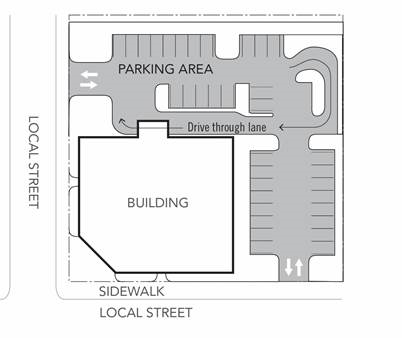
M.
Building Design Standards:
1.
General Provisions:
a.
The first-floor façade of all buildings, including structured parking facilities, shall be designed to encourage and complement pedestrian-scale interest and activity through the use of elements such as windows, awnings, and other similar features.
b.
Building entrances shall be clearly marked, provide weather covering, and incorporate architectural features of the building.
c.
Architectural features and treatments shall not be limited to a single façade. All visible sides of a building from the street, whether viewed from public or private property, shall display a similar level of quality and architectural interest, with elements such as windows, awnings, murals, a variety of exterior materials, reveals, and other similar features.
d.
Green building techniques are encouraged, which could include the use of green roofs, gray water and water harvesting, and/or LEED certification of buildings.
2.
Design Standards:
[a.]
All buildings, including parking garages, shall comply with the following design standards. Building facade windows are required on all street-facing facades (see Figure 7), as follows:
i.
Window area is the aggregate area of the glass within each window, including any interior grids, mullions, or transoms. Facade area is the aggregate area of each street-facing vertical wall plane.
ii.
Required windows shall be clear glass and not mirrored or frosted, except for bathrooms. Clear glass within doors may be counted toward meeting the window coverage standard.
iii.
Ground floor windows. All street-facing elevations within the building setback (zero to 20 feet) along public streets shall include a minimum of 60 percent of the ground floor wall area with windows, display areas or doorway openings. The ground floor wall area shall be measured from two feet above grade to ten feet above grade for the entire width of the street-facing elevation. The ground floor window requirement shall be met within the ground floor wall area and for glass doorway openings to ground level. Up to 50 percent of the ground floor window requirement may be met on an adjoining elevation as long as the entire requirement is located at a building corner.
iv.
Street-facing facades that contain vehicle parking, such as a parking structure, do not have to provide windows but shall provide facade openings that meet the minimum required window area. If required facade openings do not contain glass, they may contain architectural elements that are no more than 30 percent sight-obscuring.
b.
Building Facades:
i.
Facades that face a public street shall extend no more than 50 feet without providing at least one of the following features: (a) a variation in building materials; (b) a building off-set of at least one foot; (c) a wall area that is entirely separated from other wall areas by a projection, such as an arcade; or (d) by other design features that reflect the building's structural system (See Figure 8). No building façade shall extend for more than 250 feet without a pedestrian connection between or through the building (see Figure 11).
ii.
Buildings more than three stories are required to step back six feet from the building facade at the beginning of the fourth story.
Figure 7. Window Placement and Percentage of Facade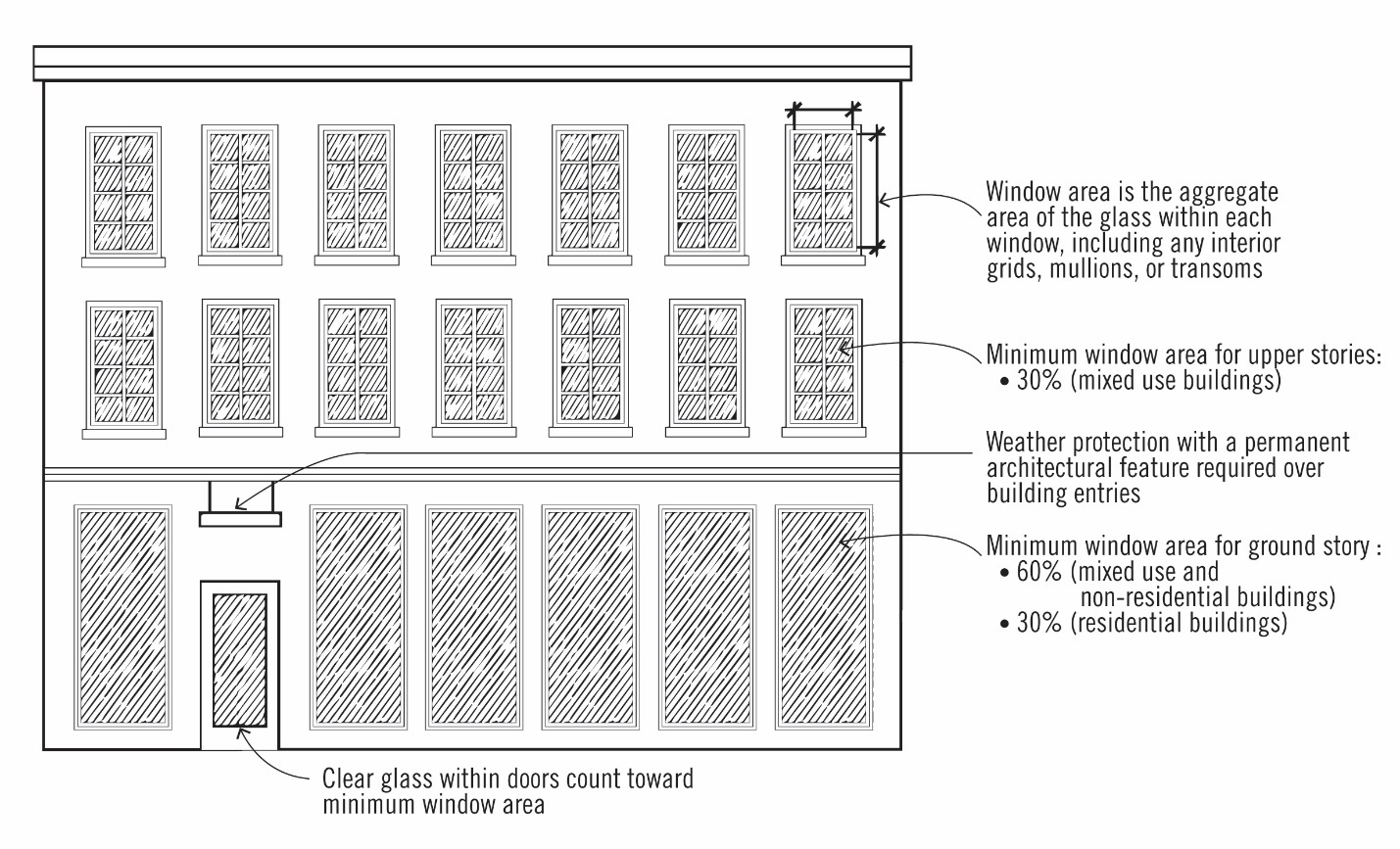
Figure 8. Building Facade Articulation and Stepbacks


c.
Weather Protection (for non-residential and mixed-use buildings):
i.
A projecting facade element (awning, canopy, arcade, or marquee) is required on the street-facing façade. Within the MSD sub-district, weather protection shall be provided across the entire length of the building frontage.
ii.
All weather protection must comply with the Oregon Structural Specialty Code in effect at the time of application for projections or encroachments into the public right-of-way.
iii.
Weather protection shall be maintained and in good condition.
iv.
Marquees shall have a minimum ten-foot clearance from the bottom of the marquee to the sidewalk. Canopies and awnings shall have a minimum eight-foot clearance from the bottom of the awning or canopy to the sidewalk.
v.
The projecting façade element shall not extend into amenity zone or conflict with street lights. If the projecting façade element blocks light shed from adjacent street lights, exterior lighting shall be located on the building.
vi.
Awnings shall match the width of storefronts or window openings.
vii.
Internally lit awnings are not permitted.
viii.
Awnings shall be made of glass, metal, or a combination of these materials. Fabric awnings are not permitted.
d.
Building Materials. Plane concrete block, plain concrete, T-111 or similar sheet materials, corrugated metal, plywood, sheet press board or vinyl siding may not be used as exterior finish materials. Foundation material may be plain concrete or plain concrete block where the foundation material is not revealed for more than two feet. Use of brick and natural materials (wood) is encouraged.
e.
Roofs and roof lines. Except in the case of a building entrance feature, roofs shall be designed as an extension of the primary materials used for the building and should respect the building's structural system and architectural style. False fronts and false roofs are not permitted.
f.
Rooftop features/equipment screening:
i.
The following rooftop equipment does not require screening:
•
Solar panels, wind generators, and green roof features;
•
Equipment under two feet in height.
ii.
Elevator mechanical equipment may extend above the height limit a maximum of 16 feet provided that the mechanical shaft is incorporated into the architecture of the building.
iii.
Satellite dishes and other communications equipment shall be limited to ten feet in height from the roof, shall be set back a minimum of five feet from the roof edge and screened from public view to the extent possible.
iv.
All other roof-mounted mechanical equipment shall be limited to ten feet in height, shall be set back a minimum of five feet from the roof edge and screened from public view and from views from adjacent buildings.
v.
On all structures exceeding 35 feet in height, roofs shall have drainage systems that are architecturally integrated into the building design.
vi.
Any external stairwells, corridors and circulation components of a building shall be architecturally compatible with the overall structure, through the use of similar materials, colors, and other building elements.
vii.
Required screening shall not be included in the building's maximum height calculation.
g.
General Screening. Utility meters shall be located on the back or side of a building, screened from view from a public street to the greatest extent possible, and shall be painted a color to blend with the building façade.
h.
Primary Entry.
i.
For commercial/institutional/mixed-use buildings:
•
At least one entry door is required for each business with a ground floor frontage.
•
Each entrance shall be covered, recessed, or treated with a permanent architectural feature in such a way that weather protection is provided.
•
All primary ground-floor common entries shall be oriented to the street or a public space directly facing the street, or placed at an angle up to 45 degrees from an adjacent street. Primary ground-floor common entries shall not be oriented to the interior or to a parking lot.
•
Courtyards, plazas and similar entry features may be utilized to satisfy the building entrance requirement when these features are designed to connect the adjacent street edge to the main building entrance.
ii.
For residential buildings:
•
Entry door. The primary public entrance to each building unit shall be covered, recessed, or treated with a permanent architectural feature in such a way that weather protection is provided.
•
All primary ground-floor common entries of multifamily buildings or individual unit entries of attached residential units that front the street shall be oriented to the street or public right-of-way, not to the interior or to a parking lot.
i.
Building projections. Building projections are allowed as follows (see Figure 9):
i.
Architectural elements such as eaves, cornices and cornices may project up to one foot from the face of the building.
ii.
Bay windows and balconies may project up to four feet from the face of the building. Balconies that project into the right-of-way shall have a minimum vertical clearance of 12 feet from sidewalk grade or be mounted at the floor elevation, whichever is greater.
iii.
See also Subsection 4.132(.06)M.2.C. for standards related to weather protection.
Figure 9. Building Projections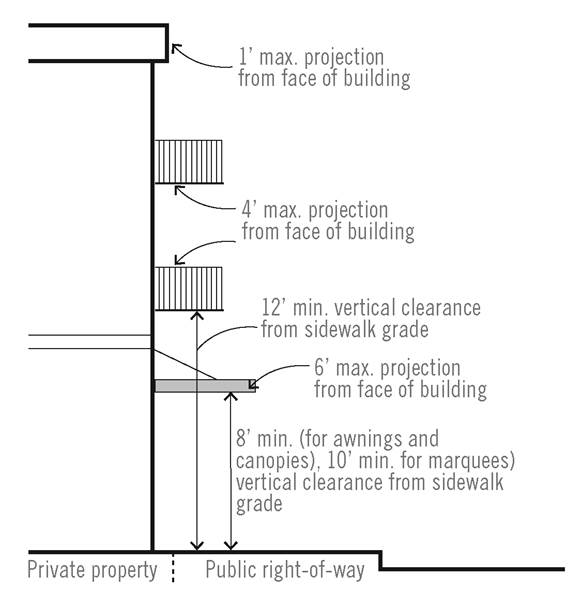
N.
Off Street Parking and Loading. Parking standards are identified in Section 4.155.
O.
Parking within a Building or Structure:
1.
Parking structures shall be designed to allow reuse of the building for non-parking uses, such as office or residential uses.
2.
The ground floor façade of a structured parking facility that abuts a public sidewalk, street, or open space and that is not occupied by entrances, exits, or waiting areas shall be designed and constructed with a minimum unfinished floor to ceiling height of 15 feet in order to allow occupancy by uses other than parking that are permitted in the underlying district (see Figure 10).
3.
Parking structures located in the MSD and adjacent to a public street shall contain retail or office uses on the first floor fronting the street or be wrapped with development of equal or greater height than the parking structure. At least 50 percent of a street-level floor facing a public sidewalk, street, or open space area shall contain retail or office uses to a minimum depth of 60 feet.
4.
Facade openings that face a public street or open space shall be vertically and horizontally aligned and all floors fronting on those facades shall be level, not inclined.
5.
The first floor facade of a parking structure located adjacent to a public street shall include at least three architectural elements such as arcades, windows, awnings, overhangs, screens, grills, louvers or other similar non-opaque features.
6.
Parking structures shall be designed so that motorized vehicles parked on all levels of the structure are screened to a minimum height of 42 inches.
7.
Where the upper floors of above-ground parking structures are visible from a public street, such surfaces shall include architectural or vegetative finishes.
8.
Within a surface parking lot or structure, the bicycle spaces, carpool, vanpool, shared car, or electric vehicle charging spaces should be placed in preferred locations relative to the street, the building entrances, and the primary pedestrian routes within and around the project site.
Figure 10. Parking Structure-Ground Floor Design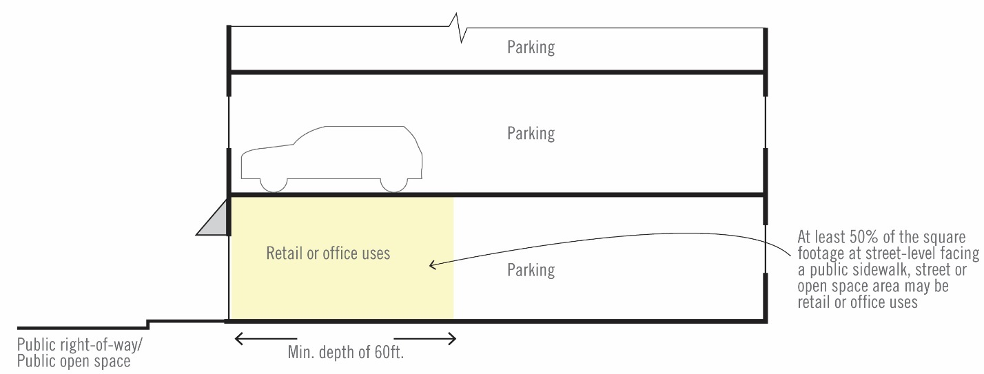
P.
Street Connectivity:
1.
Purpose. The purpose of these standards and procedures is to create safe, comfortable, and attractive streetscapes for pedestrians, improve connectivity for all modes of travel, and remove barriers for small-scale incremental development.
2.
General Provisions. This section contains the standards and procedures for improvements to public transportation facilities for all property located in the Wilsonville Town Center Boundary, including specific standards for vehicle, pedestrian, bicycle, and transit facilities. The terms "transportation facilities" and "transportation improvements" generally include those facilities, or improvements to those facilities, that accommodate all modes of travel that are usually located in public rights-of-way, also commonly referred to as streets. "Frontage improvements" are transportation improvements immediately adjacent to a proposed development's street frontage. "Off-site improvements" are transportation improvements not adjacent to a proposed development's street frontage.
3.
Transportation Facility Standards:
a.
Intersection design and spacing:
i.
Transportation facilities shall be designed and constructed in conformance to the applicable section of the City Development Code and to the City's Public Works Standards.
ii.
Street intersections shall have curb extensions to reduce pedestrian crossing distances unless there are other standards that apply, such as areas with flush curbs.
iii.
New street intersections, including alleys, are subject to approval by the City Engineer.
b.
Transportation network connectivity:
i.
Minimum required transportation improvements are identified in the Wilsonville Town Center Plan. Alleys are encouraged but not required. Private streets are prohibited.
ii.
Bicycle and pedestrian connections are required where the addition of a connection would link the end of a permanent turnaround to an adjacent street or provide a midblock connection through a long block. A mid-block connection is required where at least one block face is 400 feet or more in length (see Figure 11). A required connection must go through the interior of the block and connect the block face to its opposite block face. The mid-block crossing shall be demarcated with paving, signage, or design that clearly demarcates the crossing is designated for pedestrian and bicycle crossings.
Figure 11. Mid-Block Pedestrian and Bicycle Connections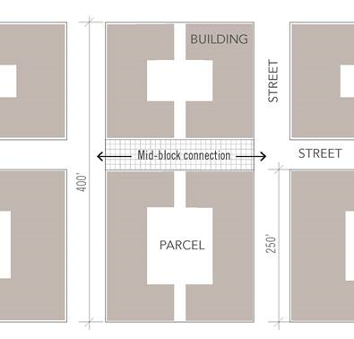
iii.
Streets shall be extended to the boundary lines of the proposed development where necessary to give access to or allow for future development of adjoining properties.
•
Any required or proposed new streets through or along the boundary of the proposed development shall be accompanied by a future street plan. The future street plan shall show that it is feasible to extend all required or proposed new streets onto adjoining properties to the satisfaction of the City Engineer.
•
Temporary turnarounds shall be constructed for street stubs in excess of 150 feet in length. Drainage facilities shall be constructed to properly manage stormwater runoff from temporary turnarounds.
•
Street stubs to adjoining properties shall not be considered permanent turnarounds, unless required and designed as permanent turnarounds, since they are intended to continue as through streets when adjoining properties develop.
•
Reserve strips may be required in order to ensure the eventual continuation or completion of a street.
iv.
Permanent dead end streets are not allowed except where no opportunity exists for creating a through street connection. Dead end streets shall meet all fire code access requirements and shall only be used where topographical constraints, protected natural resource areas, existing development patterns, or strict adherence to other City requirements precludes a future street connection. The lack of present ownership or control over abutting property shall not be grounds for a dead end street.
v.
Street design. All streets are subject to the standards illustrated in the Wilsonville Town Center Plan.
vi.
Street trees shall be required along all street frontages. The minimum number of required street trees shall be determined by dividing the length (in feet) of the proposed development's street frontage by 30 feet. When the result is a fraction, the number of street trees required shall be the nearest whole number.
x.
Sidewalks shall have a minimum unobstructed width of six feet for pedestrian through travel. Permanent structures or utilities within the required pedestrian through-travel area are restricted unless approved by the City Engineer. Sidewalk area outside of the required through-travel area may be used for landscaping, pedestrian amenities such as permanent street furniture, bicycle parking, trash cans, and drinking fountains.
xi.
Temporary placement of customer seating, merchandise display, temporary A-frame signs or other uses by businesses adjacent to the street shall be placed within the amenity or building zone in front of the business (see Figure 12). The building zone may be extended into the pedestrian zone in front of the building if a minimum of four feet is provided for the pedestrian through area. Placement of any temporary uses requires a temporary right-of-way use permit and approval by the City Engineer.
xii.
Temporary signs, such as A-Frames, are permitted within Town Center provided the temporary sign meets the following standards:
•
One temporary sign is allowed per public entrance to buildings.
•
Temporary signs may be up to 12 square feet in area. Only one side of a portable sign will be counted. The vertical dimension of the sign including support structure may be no greater than 42 inches.
•
Signs may be placed in front of the building only during business hours.
•
Electrical signs and changing image sign features are prohibited.
xi.
Off street paths shall meet the City's path standards identified in the Transportation system plan, unless noted otherwise in the Wilsonville Town Center Plan. The location and type of facility shall be consistent the trail and open space, and street cross section illustrated in the Wilsonville Town Center Plan. Trail widths may be reduced where constrained by existing development, protected natural resource areas, or topography as determined by the City Engineer.
Figure 12. Sidewalk Furnishing and Pedestrian Through Zones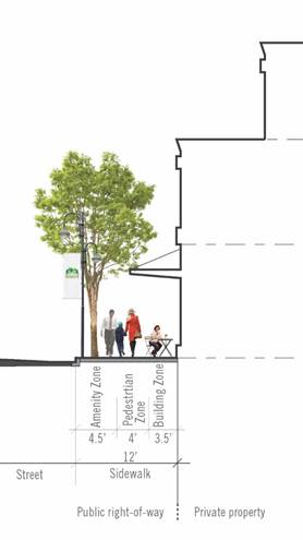
(Ord. No. 835, 6-5-2019)
Section 4.133.01. - Purpose.
The purpose of the IAMP Overlay Zone is the long-range preservation of operational efficiency and safety of the Wilsonville Road Interchange, which provides access from and to Interstate 5 for residents and businesses in south Wilsonville. The Wilsonville Road Interchange is a vital transportation link for regional travel and freight movement and provides connectivity between the east and west side of the community. Preserving capacity and ensuring safety of this interchange and the transportation system in its vicinity is essential to existing businesses and residents in the southern parts of the City and to the continued economic and community growth and development in the vicinity of Wilsonville Road and the interchange.
Section 4.133.02. - Where these Regulations Apply.
The provisions of this Section shall apply to land use applications subject to Section 4.004, Development Permit Required, for parcels wholly or partially within the IAMP Overlay Zone, as shown on Figure I-1. Any conflict between the standards of the IAMP Overlay Zone and those contained within other chapters of the Development Code shall be resolved in favor of the Overlay Zone.
Figure I-1: Wilsonville Road Interchange Area Management Plan (IAMP) Overlay District
Map
Section 4.133.03. - Permitted Land Uses.
Uses allowed in the underlying zoning districts are allowed subject to other applicable provisions in the Code and this Section.
Section 4.133.04. - Access Management.
In addition to the standards and requirements of Section 4.237 for land divisions and Street Improvement Standards in Section 4.177, parcels wholly or partially within the IAMP Overlay Zone are governed by the Access Management Plan in the Wilsonville Road Interchange Area Management Plan. The following applies to land use and development applications subject to Sections 4.133.02 Applicability. The provisions of Section 4.133.04 apply to:
(.01)
Development or redevelopment proposals for parcels two acres or less that are subject to the requirements of Section 4.004 Development Permit.
(.02)
Planned Development applications, pursuant to Section 4.140, as part of Preliminary Approval (Stage One).
(.03)
Final Approval (Stage Two) Planned Development applications, pursuant to Section 4.140, to the extent that subsequent phases of development differ from the approved preliminary development plan, or where one or more of the following elements are not identified for subsequent phases:
A.
Land uses.
B.
Building location.
C.
Building size.
D.
Internal circulation.
(.04)
Access Approval:
A.
Access to public streets within the IAMP Overlay Zone shall be reviewed for consistency with the IAMP Access Management Plan.
B.
Approval of access to City streets within the IAMP Overlay Zone shall be granted only after joint review by the City and the Oregon Department of Transportation (ODOT). Coordination of this review will occur pursuant to Section 4.133.05(.02).
C.
Access approval is a Class II decision, pursuant to Section 4.030, and is based on the standards contained in this Section, the provisions in Section 4.177 and Section 4.237 of this Code, and the Access Management Plan in the Wilsonville Road Interchange Area Management Plan.
1.
Where the recommendations of the Access Management Plan conflict with other access and spacing requirements in Section 4.177 of this Code, the IAMP Access Management Plan shall govern.
2.
Where development proposals are inconsistent with the Access Management Plan, modifications to the Access Management Plan are required pursuant to (.03) in this Section.
(.05)
Cross-access easements:
A.
Prior to approving access for tax lots that are identified in the Access Management Plan (see Table 3 and Figure 5 in the Wilsonville Road Interchange Area Management Plan), the City shall require that:
1.
The applicant demonstrate how cross access can be accomplished for sites contiguous to the subject property or properties, consistent with the circulation and planned local street network shown in the Interchange Area Management Plan;
2.
If access across an adjacent parcel or parcels is necessary for the development of the subject site, a signed cross-access agreement is submitted with the application; and,
3.
For applications reviewed as part of a subdivision approval process, necessary cross-access easements are shown and recorded on the final plat. Access widths shall consistent with City Public Works standards unless based on a Transportation Impact Analysis, developed pursuant to Section 4.133.05(.01) and approved by the City Engineer.
(.06)
Access Management Plan Modifications:
A.
Recommended actions in the Access Management Plan are based on property configurations development application approvals and ownership existing at the time of the Wilsonville Road Interchange Area Management Plan's adoption. Lot consolidation and other land use actions may necessitate an amendment to the Access Management Plan. Modifications to the Access Management Plan:
1.
May occur through agreement by the City of Wilsonville and ODOT and require an amendment to the Wilsonville Road Interchange Area Management Plan; and
2.
Will only be allowed if the proposed modifications meet, or move in the direction of meeting, the adopted access management spacing requirements in the Wilsonville Road Interchange Area Management Plan.
Section 4.133.05. - Administration.
Section 4.133.05 delineates the responsibilities of the City, in coordination with ODOT, to monitor and evaluate vehicle trip generation impacts on the Wilsonville Road Interchange from development approved under this Section.
(.01)
Traffic Impact Analysis:
A.
Purpose. The purpose of this section of the Code is to implement Section 660-012-0045 (2) (e) of the State Transportation Planning Rule that requires the City to adopt a process to apply conditions to development proposals in order to minimize adverse impacts to and protect transportation facilities. This section establishes the standards for when a proposal in the IAMP Overlay Zone must be reviewed for potential traffic impacts; when a Traffic Impact Analysis must be submitted with a development application in order to determine whether conditions are needed to minimize impacts to and protect transportation facilities; what must be in a Traffic Impact Study; and who is qualified to prepare the Study.
B.
Typical Average Daily Trips. The latest edition of the Trip Generation Manual, published by the Institute of Transportation Engineers (ITE) shall be used as standards by which to gauge average daily vehicle trips, unless a specific trip generation study is approved by the City Engineer. A trip generation study could be used to determine trip generation for a specific land use which is not well represented in the ITE Trip Generation Manual and for which a similar facility is available to count.
C.
When required, a Traffic Impact Analysis shall be required to be submitted to the City with a land use application, when the following conditions apply:
1.
The development application involves one or more of the following actions:
a.
A change in zoning or a plan amendment designation; or
b.
The development requires a Development Permit pursuant to Section 4.004; or
c.
The development may cause one or more of the following effects to access or circulation, which can be determined by site observation, traffic impact analysis or study, field measurements, and information and studies provided by the local reviewing jurisdiction and/or ODOT:
i.
The location of the access driveway does not meet minimum intersection sight distance requirements, or is located where vehicles entering or leaving the property are restricted, or such vehicles queue or hesitate, creating a safety hazard; or
ii.
The location of the access driveway does not meet the access spacing standard of the roadway on which the driveway is located; or
iii.
The location of the access driveway is inconsistent with the Wilsonville Road Interchange Area Management Plan Access Management Plan.
iv.
A change in internal traffic patterns that may cause safety problems, such as back up onto the highway or traffic crashes in the approach area.
D.
Traffic Impact Analysis Requirements:
1.
Preparation. A Traffic Impact Analysis shall be prepared by a professional engineer under retainer to the City. The traffic analysis will be paid for by the applicant.
2.
Transportation Planning Rule Compliance. The traffic impact analysis shall be sufficient in detail to determine compliance with Oregon Administrative Rule (OAR) 660-012-0060.
3.
Traffic Impact Analysis Scoping. The applicant will coordinate with the Wilsonville City Engineer prior to submitting an application that requires a Traffic Impact Analysis. The City has the discretion to determine the required elements of the TIA and the level of analysis expected. Coordination with ODOT is advisable and is at the City's discretion.
E.
Approval Criteria:
1.
Criteria. When a Traffic Impact Analysis is required, approval of the development proposal requires satisfaction of the following criteria:
a.
The Traffic Impact Analysis was prepared by a professional engineer selected by the City; and
b.
If the proposed development meets the criteria in Section C, above, or other traffic hazard or negative impact to a transportation facility, the Traffic Impact Analysis shall include mitigation measures that meet the City's performance standards (i.e. Level-of-Service and/or Volume/Capacity ratio) and are satisfactory to the City Engineer and ODOT; and
c.
The proposed site design and traffic and circulation design and facilities, for all transportation modes, including any mitigation measures, are designed to:
i.
Have the least negative impact on all applicable transportation facilities; and
ii.
Accommodate and encourage non-motor vehicular modes of transportation to the extent practicable; and
iii.
Make the most efficient use of land and public facilities as practicable; and
iv.
Provide the most direct, safe and convenient routes practicable between on-site destinations, and between on-site and off-site destinations; and
v.
Otherwise comply with applicable requirements of the City of Wilsonville's Development Code.
F.
Conditions of Approval. The City may deny, approve, or approve a development proposal with appropriate conditions.
1.
Where the existing transportation system will be impacted by the proposed development, dedication of land for streets, transit facilities, sidewalks, bikeways, paths, or access ways may be required to ensure that the transportation system is adequate to handle the additional burden caused by the proposed use.
2.
Where the existing transportation system is shown to be burdened by the proposed use, improvements such as paving, curbing, installation or contribution to traffic signals, construction of sidewalks, bikeways, access ways, paths, or streets that serve the proposed use may be required.
3.
Where planned local street connectivity is required to improve local circulation for the betterment of interchange function, local street system improvements will be required.
(.02)
Land Use Review Coordination:
A.
The City shall not deem the land use application complete unless it includes a Traffic Impact Analysis prepared in accordance with the requirements of this Section.
B.
The City shall provide written notification to ODOT when the application within ten calendar days of receiving a complete Class II Permit application.
C.
ODOT shall have at least 20 calendar days, measured from the date completion notice was mailed, to provide written comments to the City. If ODOT does not provide written comments during this 20-day period, the City staff report will be issued without consideration of ODOT comments.
Section 4.133.06. - Comprehensive Plan and Zoning Map Amendments.
This Section applies to all Comprehensive Plan Map and Zoning Map amendments to parcels wholly or partially within the IAMP Overlay Zone.
(.01)
IAMP Amendment. If the proposed land use is inconsistent with the current Comprehensive Plan Map or Zoning Map land use designation the applicant will be required to undertake a legislative process to amend and update the Wilsonville Road Interchange Area Management Plan in order to demonstrate that the proposed amendment will be consistent with the planned improvements in the Overlay Zone.
(.02)
Transportation Planning Rule Requirements:
A.
Review of Applications for Effect on Transportation Facilities. A proposed comprehensive plan amendment, zone change or land use regulation change pertaining development within the IAMP Overlay Zone, whether initiated by the City or by a private interest, shall be reviewed to determine whether it significantly affects a transportation facility, in accordance with Oregon Administrative Rule (OAR) 660-012-0060 (the Transportation Planning Rule—"TPR"). "Significant" means the proposal would:
1.
Change the functional classification of an existing or planned transportation facility (exclusive of correction of map errors in an adopted plan);
2.
Change standards implementing a functional classification system; or
3.
As measured at the end of the planning period identified in the adopted transportation system plan:
a.
Allow land uses or levels of development that would result in types or levels of travel or access that are inconsistent with the functional classification of an existing or planned transportation facility;
b.
Reduce the performance of an existing or planned transportation facility below the minimum acceptable performance standard identified in the TSP; or
c.
Worsen the performance of an existing or planned transportation facility that is otherwise projected to perform below the minimum acceptable performance standard identified in the TSP or comprehensive plan.
B.
Amendments That Affect Transportation Facilities. Amendments to the comprehensive plan and land use regulations that significantly affect a transportation facility shall ensure that allowed land uses are consistent with the function, capacity, and level of service of the facility identified in the TSP. This shall be accomplished by one or a combination of the following:
1.
Adopting measures that demonstrate allowed land uses are consistent with the planned function, capacity, and performance standards of the transportation facility.
2.
Amending the TSP or comprehensive plan to provide transportation facilities, improvements or services adequate to support the proposed land uses consistent with the requirements of Section -0060 of the TPR.
3.
Altering land use designations, densities, or design requirements to reduce demand for vehicle travel and meet travel needs through other modes of transportation.
4.
Amending the TSP to modify the planned function, capacity or performance standards of the transportation facility.
C.
Traffic Impact Analysis. A Traffic Impact Analysis shall be submitted with a plan amendment or zone change application. [See Section 4.133.05(.01) Traffic Impact Analysis].
(Ord. No. 672, 11-16-2009)
Section 4.134. - Coffee Creek Industrial Design Overlay District.
(.01)
Purpose. The Coffee Creek Industrial Design Overlay District (Coffee Creek DOD) is an overlay district within the Planned Development Industrial - Regionally Significant Industrial Area (RSIA) Zone Section 4.135.5. The purpose of this Coffee Creek DOD is to implement the Coffee Creek Industrial Area Master Plan (2007) by establishing standards for street design and connectivity, site design and circulation, building form, and building architecture and landscape for all development located within the master plan area. These standards are intended to result in:
A.
An industrial district featuring cohesive and high-quality site, landscape, and building design that is well integrated with adjacent streetscapes and other public spaces.
B.
A multi-modal transportation network accommodating pedestrians, bicyclists, transit riders, motorists, and freight in the context of a modern light industrial district.
C.
Preservation of trees and natural features.
D.
Minimization of adverse impacts to adjacent properties from development that detracts from the character and appearance of the area.
E.
Minimization of the off-site visibility of vehicular parking, circulation and loading areas.
F.
Creation of a pleasant and functional industrial district for employees and visitors.
G.
A predictable and timely process for reviewing light industrial development applications.
(.02)
Applicability. The Coffee Creek DOD shall apply to all properties within the Coffee Creek Industrial Area Master Plan as shown in the Regulating Plan (Figure CC-1). The provisions of this section shall apply to:
A.
All new building construction.
B.
Any exterior modifications to existing, non-residential buildings, subject to Section 4.134(.03).
C.
All development of site improvements including but not limited to new paved parking lots, outdoor storage, display areas, signs, and landscaping.
D.
All building expansions greater than 1,250 square feet.
(.03)
Exceptions. This section does not apply to the following:
A.
Maintenance of the exterior of an existing industrial/employment structure, such as painting to the approved color palette, reroofing, or residing with the same or similar materials.
B.
Interior remodeling.
C.
Maintenance of existing dwellings and accessory buildings.
D.
Maintenance of agricultural buildings.
(.04)
Uses that Are Typically Permitted. The uses permitted shall be governed by Section 4.135.5(.03).
(.05)
Prohibited Uses: The uses prohibited shall be governed by Section 4.135.5(.04).
(.06)
Overview of Coffee Creek DOD Standards:
A.
Section 4.134(.09) Regulating Plan. The Regulating Plan organizes all existing and future streets, drives, and shared-use paths within the Coffee Creek Industrial Area into a hierarchy of Addressing Streets, Supporting Streets and Through Connections.
B.
Section 4.134(.10) Connectivity Standards:
1.
New Supporting Streets and Through Connections are required within the Coffee Creek DOD to meet Connectivity Requirements as shown on Figure CC-4.
2.
The Street Types specify the cross sections for each of the street and shared-use path types within the Regulating Plan. These cross section specifications apply to both existing and proposed new streets. A range of cross sections for Supporting Streets and Through Connections is permitted and detailed in Figures CC-2 and CC-3.
C.
Section 4.134(.11) Development Standards Table:
1.
The Development Standards Table provides an overview of all applicable development standards. The development standards for any given parcel are determined by the existing or future street or shared-use path type on which the parcel fronts, as detailed in Table CC-1.
2.
Areas bounded by new Supporting Streets and Through Connections are designated as Parcels and are required to comply with Development Standards governing site design, building orientation and frontage. The development standards for site design, building façade and landscape design are intended to work in tandem with the street types to create a cohesive and unified public realm.
3.
Adjustments to Development Standards may be granted by the Planning Director for quantifiable provisions, as noted in Tables CC-1 though CC-4, if the Planning Director finds that the adjusted Development Standard will perform as well as the Development Standard.
D.
Coffee Creek DOD Pattern Book. The Coffee Creek DOD Pattern Book provides supplemental design guidelines, which are intended to allow more flexibility in design than the Development Standards while satisfying the purpose of the Coffee Creek DOD.
(.07)
Review Process. Development applications shall follow the application review process described in:
A.
Section 4.197 Zone Changes and Amendments.
B.
Section 4.198 Comprehensive Plan Changes.
C.
Section 4.700 Annexation and Urban Growth Boundary Amendments.
D.
Section 4.140 Planned Development Regulations.
(.08)
Waivers. The Development Review Board may waive standards as listed in Section 4.134(.11), consistent with the provisions of Section 4.118(.03).
A.
The following standards shall not be waived, unless there is substantial evidence in the whole record to support a finding that the intent and purpose of the standards will be met in alternative ways:
1.
Required minimum building height as provided in Section 4.134(.11) Table CC-4;
2.
Parking location and design along addressing streets in Section 4.134(.11) Table CC-3; and
3.
Parcel pedestrian access as listed in Section 4.134(.11) Table CC-3.
B.
In addition to meeting the purposes and objectives of Section 4.140, any waivers granted in the Coffee Creek DOD must be found to be consistent with the intent of the Coffee Creek DOD Pattern Book.
(.09)
Coffee Creek DOD Regulating Plan, Figure CC-1:
A.
Components of the Regulating Plan Map:
1.
Addressing Streets. Existing and planned streets within the Regulating Plan Area are called Addressing Streets and include Cahalin Road, Day Road, Clutter Street, Grahams Ferry Road, Garden Acres Road, and "Future" Street.
2.
Overlay District. Land area identified within the Coffee Creek DOD on Figure CC-1 is subject to additional Connectivity Standards as detailed in Figure CC-4 and Table CC-1.
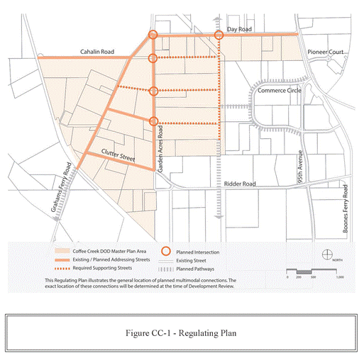
(.10)
Coffee Creek Connectivity Standards:
A.
Street Types, Figure CC-1. Within the land area bounded by Addressing Streets, connectivity shall be provided through new streets or private drives and shared use paths. The location, alignment, and cross-section of required streets or private drives and shared-use paths is flexible, as long as they comply with spacing and minimum cross section standards. New connections may be one of the following types:
1.
Supporting Streets. Supporting Streets are new public streets or public easements. They shall meet the development standards set out in Figure CC-2.
a.
A Required Supporting Street is one that intersects with an Addressing Street as shown on Figure CC-1. The exact location and design of these connections will be determined at the time of development review.
b.
Planned Intersections are locations where Existing and Planned Addressing Streets intersect with required Supporting Streets, and Planned Pathways, as generally shown in Figure CC-1.
2.
Through Connections. Through Connections are new public streets or public easements with multi-use paths, or streets or public easements that combine characteristics of streets and multi-use paths. They shall meet the Development Standards set out in Figure CC-3.
B.
Planned Pathways are multi-use paths or pedestrian connections that are planned in the Transportation Systems Plan to occur in the location generally shown in Figure CC-1. A Planned Pathway may be employed to meet required connectivity, if it complies with Through Connection Standards for Connection Spacing and Connection Type, see Figure CC-6.
C.
Maximum Connection Spacing:
1.
Addressing Streets. When intersecting with an Addressing Street, new Supporting Streets and Through Connections shall meet maximum spacing standards as set out in Table CC-1.
2.
Internal Supporting Streets and Through Connections. See Figure CC-4 and Table CC-1.
D.
Required Connectivity Master Plan. Connectivity Master Plans are required for all development within the Coffee Creek DOD. Development proposals shall show conceptually how the Connectivity Requirements will be met. In addition, the Connectivity Master Plan should generally indicate how parking, driveways, walkways, waysides, etc., will relate or connect to adjacent parcels.
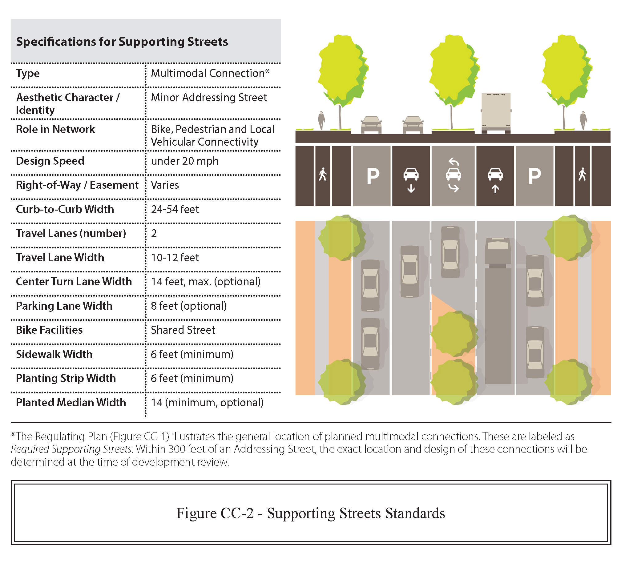
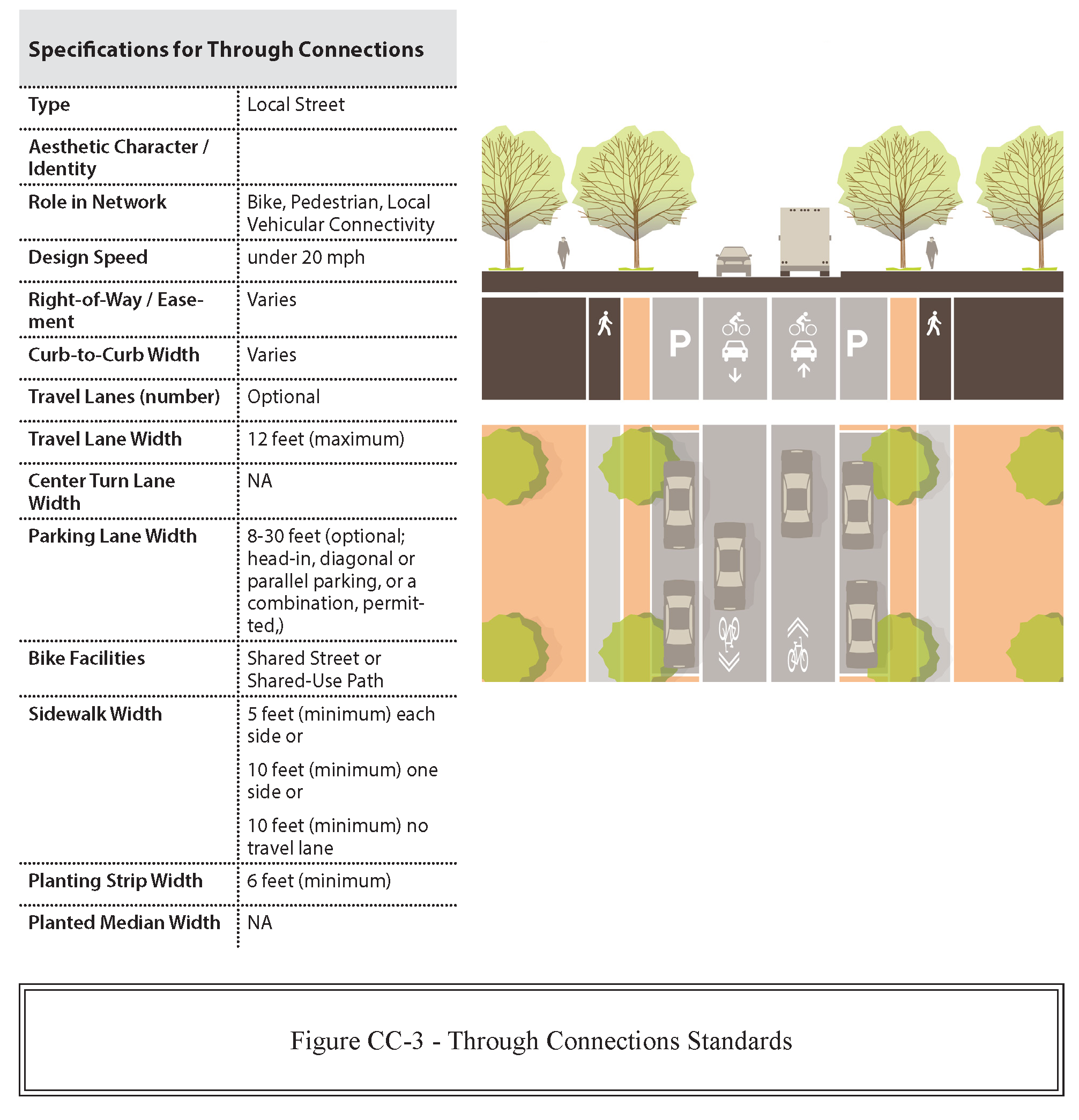
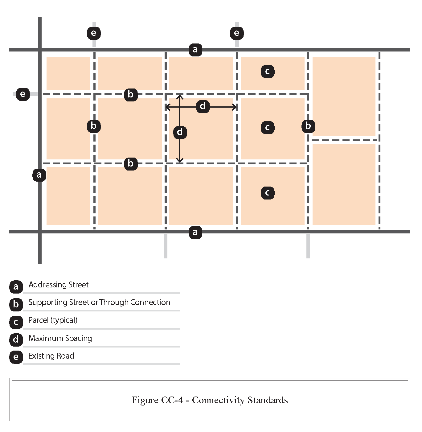
(.11)
Development Standards Table. Areas bounded by Addressing Streets, Supporting Streets and Through Connections shall be designated as a Parcel and subject to the Development Standards in Tables CC-1 through CC-4.
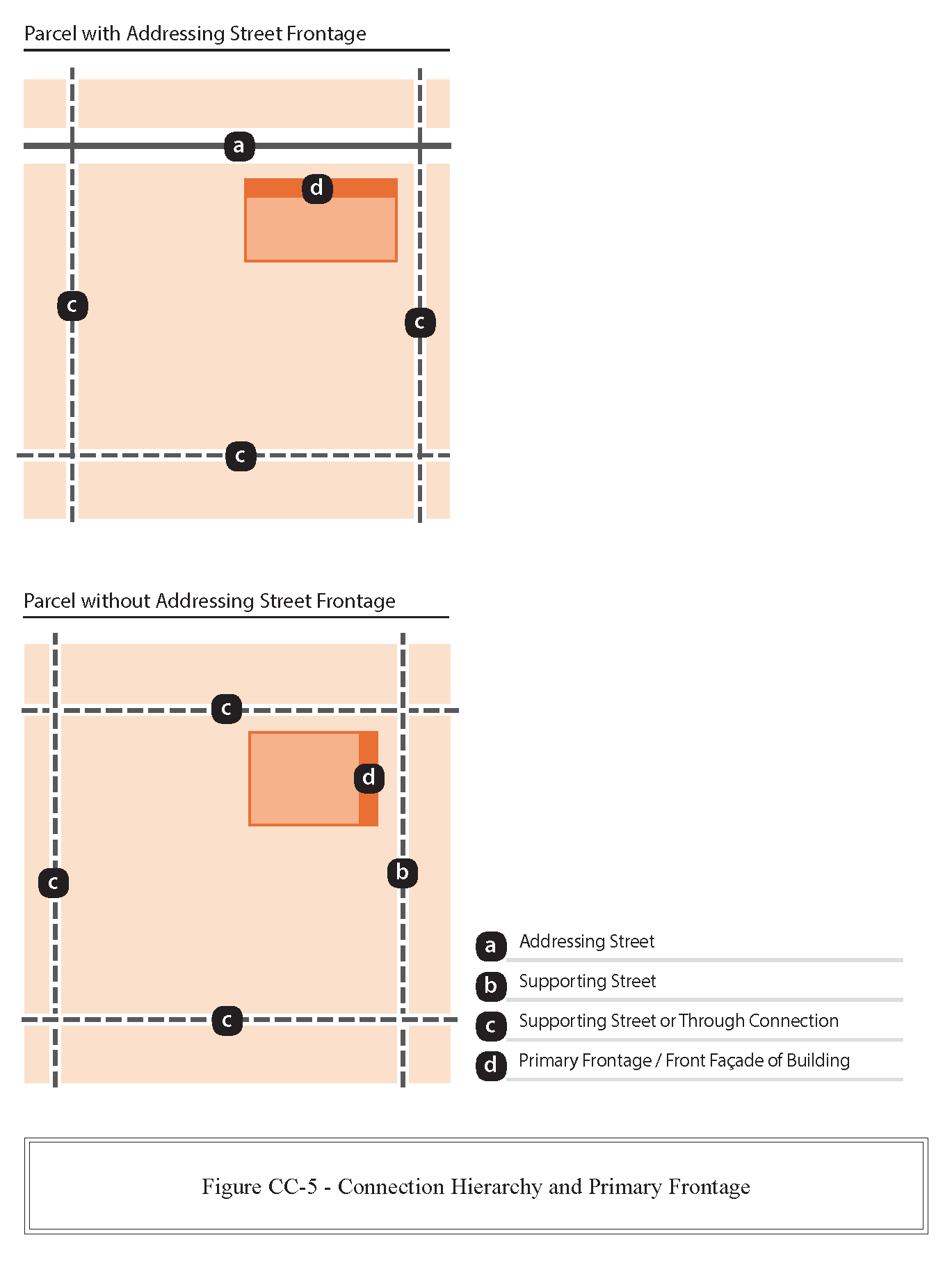
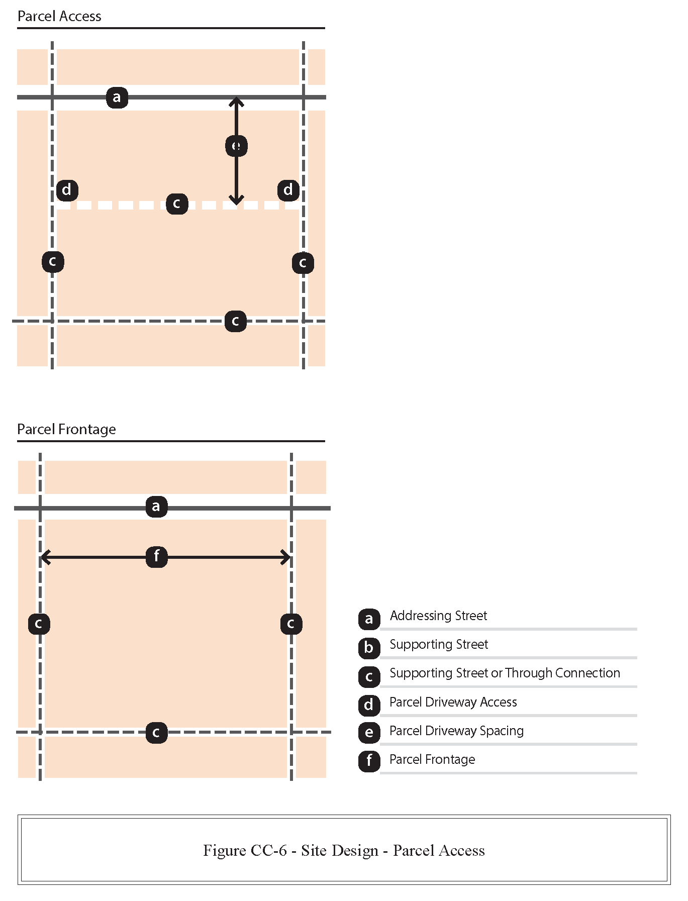
* When an applicant elects to use the allowed adjustment to reduce Required Canopy height to less than 15 feet, corresponding reduction in minimum height is allowed for Accessible Entrance, Allowance of Primary Building Entrance, and Ground Floor Height.
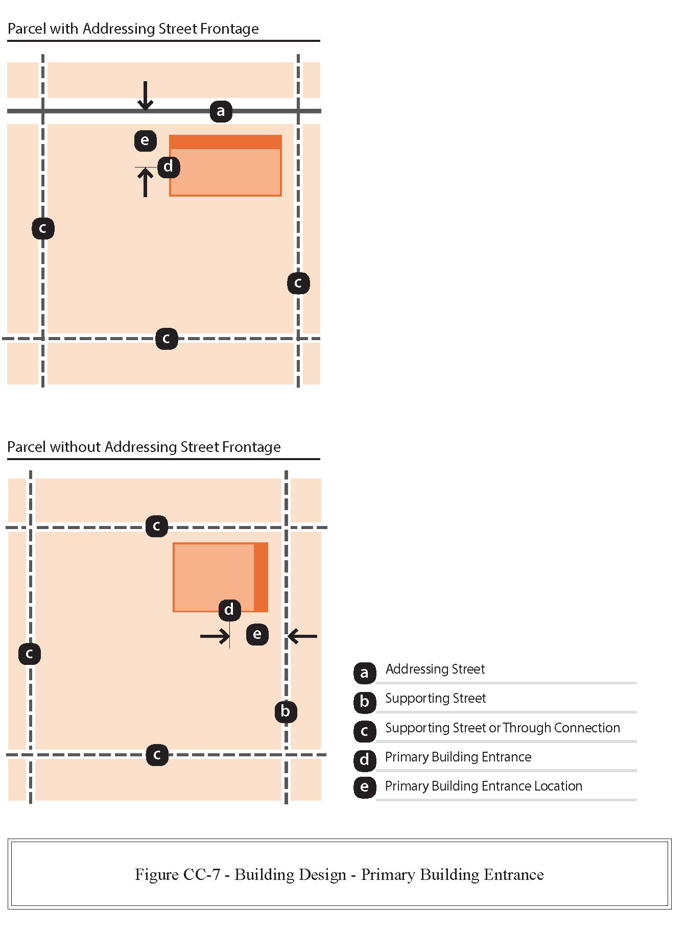
(.12)
Waysides:
A.
Purpose. This section consists of standards and regulations for use throughout the Coffee Creek Design Overlay District. The regulations address materials, placement, layout, installation, and maintenance of Industrial Waysides. The City recognizes the need to:
1.
Provide multiple, distributed destinations for passive and active recreation for the public and employees along a network of streets and trails;
2.
Be convenient, usable and accessible. Industrial Waysides should be physically and visually accessible from the adjacent Addressing Street, Supporting Street or Through Connection;
3.
Connect Industrial Waysides to transit;
4.
Be inviting. Inviting open spaces feature designs that encourage users to explore the Industrial Wayside and design elements that support a sense of the human scale. These elements include landscaping, benches and other seating areas, and pedestrian-scaled lighting;
5.
Provide access. Provide access to the employees and the public between the hours of 6:00 a.m. and 8:00 p.m.;
6.
Be safe. Safe open spaces incorporate principles of natural surveillance, lighting, and prominent entrances;
7.
Provide facilities appropriate for the scale of the proposed development; and
8.
Be easy to maintain. Industrial Waysides should be constructed of commercial grade materials that will endure and are readily maintainable.
B.
Applicability. All projects in the Coffee Creek Master Plan Area shall provide waysides according to the standards in Table CC-5.
C.
General. The following development standards apply to all Waysides:
1.
Required Wayside Area is exclusive of required landscape screening.
2.
Required Minimum Dimension of 20 feet (either width or depth).
D.
Criteria. Waysides shall meet the following criteria:
1.
Perimeter Landscaping. In addition to the minimum size and dimensions, landscape three sides of the Industrial Wayside to a depth of 20 feet, minimum according to Section 4.176(.02). Permitted screening includes: Section 4.176(.02)D. Low Screen Landscaping Standard; Section 4.176(.02)E. Low Berm Standard; or Section 4.176(.02)F. High Screen Landscaping Standard. Perimeter landscaping shall not obscure visual access to the Industrial Wayside. Unscreened surface parking lots, chain link fencing, or service yards are prohibited adjacent to Industrial Waysides.
2.
Visibility. Industrial Waysides shall be visible from and accessible to Addressing Streets.
3.
Accessible Pathway. A paved walking surface, width: Five feet, minimum, meeting ADA standards is required to connect Industrial Wayside with Addressing Street.
4.
Accessible Surface. Industrial Waysides shall have an accessible surface, 100 square feet, minimum; dimensions ten feet, minimum meeting ADA standards.
5.
Required Amenities:
a.
Seating. Outdoor seating shall be provided. Publicly accessible plazas, courtyards, and pocket parks shall include at least one linear foot of seating per each 40 square feet of plaza, courtyard or pocket park space on site. Outdoor seating shall be in the form of:
i.
Free standing outdoor benches consistent with the standards; or
ii.
Seating incorporated into low walls, berms, or raised planters.
b.
Landscaping. The landscaping must be planted and maintained according to Section 4.176(.02)C.
c.
Lighting.
d.
Recycling/ Waste Receptacle. Locate waste and recycling stations nearest to the accessible path and away from stormwater facilities.
6.
Installation and Maintenance. Industrial Waysides shall be programmed, planned, constructed, and maintained at the expense of the applicant. The landscaping must be planted and maintained according to Section 4.176(.07). Recycling, waste receptacles, and pet waste stations shall be serviced at an acceptable professional interval to prevent being over filled or creating unsanitary or visually messy appearances.
7.
Solar Access. Exposure to sunlight. Southern exposure is encouraged. Design facilities to permit direct sunlight to enter the Industrial Wayside and strike the required accessible surface between the hours of 10:00 a.m. and 2:00 p.m. local time.
8.
Lighting. Lighting for Industrial Waysides is required to permit reasonable use, utility, security, and nighttime safety. Lighting installed in Industrial Waysides shall conform to the requirements of Section 4.199. All outside lighting shall be so arranged and shielded so as not to shine into adjacent areas and to prevent any undue glare or reflection and any nuisance, inconvenience, and hazardous interference of any kind on adjoining streets or property.
E.
Optional Amenities include the following:
1.
Picnic tables and benches. Locate picnic tables and benches on the Accessible Surface;
2.
Arbors or trellises;
3.
Drinking Fountains. Locate drinking fountains and benches on the Accessible Surface;
4.
Sculpture and other works of art;
5.
Bicycle repair stations;
6.
Exercise stations; or
7.
Pet waste stations. Locate pet waste stations nearest to the accessible path and away from stormwater facilities.
‡ In the future when SMART serves Coffee Creek, Industrial Waysides may comply with the standards for Enhanced Transit Plazas, as follows:
*Up to 400 square feet of the space requirement for Industrial Waysides may be satisfied by installation of an enhanced transit stop. An enhanced transit stop must provide weather protection, paved surface, and seating, as approved by SMART Transit.
**Up to 800 square feet of the space requirement for Industrial Waysides may be satisfied by installation of an enhanced transit stop, provided parcel fronts on two or more Addressing Streets. An enhanced transit stop must provide weather protection, paved surface, and seating, as approved by SMART Transit.
***For Parcel Frontage greater than 1,500 feet, and area greater than 51.0 acres, up to 50 percent of the space requirement for Industrial Waysides may be satisfied by restoration of wetlands, riparian zones, or other habitat because of the significant passive recreation opportunities provided.
(.13)
Signs:
A.
Applicability. PDI Zone requirements of Section 4.156.01 through 4.156.11 apply to the Coffee Creek DOD with the following modifications and adjustments.
B.
General:
1.
Site Frontage as described in Section 4.156.08 is the Primary Frontage.
2.
Monument-style signs are required. Pole-style freestanding signs are not permitted.
3.
Maximum area for signs on buildings is based on linear length (in feet) of the façade adjacent to the Primary Frontage.
4.
Directional and Wayfinding Signs shall be placed at the intersection of Supporting Streets and Through Connections.
(Ord. No. 812, 2-22-2018; Ord. No. 889, § 2(Exh. A), 3-18-2024; Ord. No. 899, § 2(Exh. A), 8-4-2025)
Section 4.135. - PDI—Planned Development Industrial Zone.
(.01)
Purpose. The purpose of the PDI zone is to provide opportunities for a variety of industrial operations and associated uses.
(.02)
The PDI Zone shall be governed by Section 4.140, Planned Development Regulations, and as otherwise set forth in this Code.
(.03)
Uses that are typically permitted:
A.
Warehouses and other buildings for storage of wholesale goods, including cold storage plants.
B.
Storage and wholesale distribution of agricultural and other bulk products, provided that dust and odors are effectively contained within the site.
C.
Assembly and packing of products for wholesale shipment.
D.
Manufacturing and processing.
E.
Motor vehicle services, or other services complementary or incidental to primary uses, and which support the primary uses by allowing more efficient or cost-effective operations.
F.
Manufacturing and processing of electronics, technical instrumentation components and health care equipment.
G.
Fabrication.
H.
Office complexes—Technology.
I.
Corporate headquarters.
J.
Call centers.
K.
Research and development.
L.
Laboratories.
M.
Repair, finishing and testing of product types manufactured or fabricated within the zone.
N.
Industrial services.
O.
Any use allowed in a PDC Zone, subject to the following limitations:
1.
Service Commercial uses (defined as professional services that cater to daily customers such as financial, insurance, real estate, legal, medical or dental offices) not to exceed 5,000 square feet of floor area in a single building, or 20,000 square feet of combined floor area within a multi-building development.
2.
Office Complex Use (as defined in Section 4.001) shall not exceed 30 percent of total floor area within a project site.
3.
Retail uses, not to exceed 5,000 square feet of indoor and outdoor sales, service or inventory storage area for a single building and 20,000 square feet of indoor and outdoor sales, service or inventory storage area for multiple buildings.
4.
Combined uses under Subsections 4.135(.03)(O.)(1.) and (3.) shall not exceed a total of 5,000 square feet of floor area in a single building or 20,000 square feet of combined floor area within a multi-building development.
P.
Training facilities whose primary purpose is to provide training to meet industrial needs.
Q.
Public facilities.
R.
Accessory uses, buildings and structures customarily incidental to any permitted uses.
S.
Temporary buildings or structures for uses incidental to construction work. Such structures to be removed within 30 days of completion or abandonment of the construction work.
T.
Other similar uses, which in the judgment of the Planning Director, are consistent with the purpose of the PDI Zone.
(.04)
Block and access standards. The PDI zone shall be subject to the same block and access standards as the PDC zone, Section 4.131(.02) and (.03).
(.05)
Performance Standards. The following performance standards apply to all industrial properties and sites within the PDI Zone, and are intended to minimize the potential adverse impacts of industrial activities on the general public and on other land uses or activities. They are not intended to prevent conflicts between different uses or activities that may occur on the same property.
A.
All uses and operations except storage, off-street parking, loading and unloading shall be confined, contained, and conducted wholly within completely enclosed buildings, unless outdoor activities have been approved as part of Stage II, Site Design or Administrative Review.
B.
Vibration. Every use shall be so operated that the ground vibration inherently and recurrently generated from equipment other than vehicles is not perceptible without instruments at any boundary line of the property on which the use is located.
C.
Emission of odorous gases or other odorous matter in quantities as detectable at any point on any boundary line of the property on which the use is located shall be prohibited.
D.
Any open storage shall comply with the provisions of Section 4.176, and this Section.
E.
No building customarily used for night operation, such as a baker or bottling and distribution station, shall have any opening, other than stationary windows or required fire exits, within 100 feet of any residential district and any space used for loading or unloading commercial vehicles in connection with such an operation shall not be within 100 feet of any residential district.
F.
Heat and Glare:
1.
Operations producing heat or glare shall be conducted entirely within an enclosed building.
2.
Exterior lighting on private property shall be screened, baffled, or directed away from adjacent residential properties. This is not intended to apply to street lighting.
G.
Dangerous Substances. Any use which involves the presence, storage or handling of any explosive, nuclear waste product, or any other substance in a manner which would cause a health or safety hazard for any adjacent land use or site shall be prohibited.
H.
Liquid and Solid Wastes:
1.
Any storage of wastes which would attract insects or rodents or otherwise create a health hazard shall be prohibited.
2.
Waste products which are stored outside shall be concealed from view from any property line by a sight-obscuring fence or planting as required in Section 4.176.
3.
No connection with any public sewer shall be made or maintained in violation of applicable City or State standards.
4.
No wastes conveyed shall be allowed to or permitted, caused to enter, or allowed to flow into any public sewer in violation of applicable City or State standards.
5.
All drainage permitted to discharge into a street gutter, caused to enter or allowed to flow into any pond, lake, stream, or other natural water course shall be limited to surface waters or waters having similar characteristics as determined by the City, County, and State Department of Environmental Quality.
6.
All operations shall be conducted in conformance with the City's standards and ordinances applying to sanitary and storm sewer discharges.
I.
Noise. Noise generated by the use, with the exception of traffic noises from automobiles, trucks, and trains, shall not violate any applicable standards adopted by the Oregon Department of Environmental Quality and W.C. 6.204 governing noise control in the same or similar locations.
J.
Electrical Disturbances. Except for electrical facilities wherein the City is preempted by other governmental entities, electrical disturbances generated by uses within the PDI zone which interfere with the normal operation of equipment or instruments within the PDI Zone are prohibited. Electrical disturbances which routinely cause interference with normal activity in abutting residential use areas are also prohibited.
K.
Discharge Standards. There shall be no emission of smoke, fallout, fly ash, dust, vapor, gases, or other forms of air pollution that may cause a nuisance or injury to human, plant, or animal life, or to property. Plans of construction and operation shall be subject to the recommendations and regulations of the State Department of Environmental Quality. All measurements of air pollution shall be by the procedures and with equipment approved by the State Department of Environmental Quality or equivalent and acceptable methods of measurement approved by the City. Persons responsible for a suspected source of air pollution upon the request of the City shall provide quantitative and qualitative information regarding the discharge that will adequately and accurately describe operation conditions.
L.
Open burning is prohibited.
M.
Storage:
1.
Outdoor storage must be maintained in an orderly manner at all times.
2.
Outdoor storage area shall be gravel surface or better and shall be suitable for the materials being handled and stored. If a gravel surface is not sufficient to meet the performance standards for the use, the area shall be suitably paved.
3.
Any open storage that would otherwise be visible at the property line shall be concealed from view at the abutting property line by a sight obscuring fence or planting not less than six feet in height.
N.
Landscaping:
1.
Unused property, or property designated for expansion or other future use, shall be landscaped and maintained as approved by the Development Review Board. Landscaping for unused property disturbed during construction shall include such things as plantings of ornamental shrubs, lawns, native plants, and mowed, seeded fieldgrass.
2.
Contiguous unused areas of undisturbed fieldgrass may be maintained in their existing state. Large stands of invasive weeds such as Himalayan blackberries, English ivy, cherry Laurel, reed canary grass or other identified invasive plants shall be removed and/or mowed at least annually to reduce fire hazard. These unused areas, located within a phased development project or a future expansion cannot be included in the area calculated to meet the landscape requirements for the initial phase(s) of the development.
3.
Unused property shall not be left with disturbed soils that are subject to siltation and erosion. Any disturbed soil shall be seeded for complete erosion cover germination and shall be subject to applicable erosion control standards.
(.06)
Other Standards:
A.
Minimum Individual Lot Size. No limit save and except as shall be consistent with the other provisions of this Code (e.g., landscaping, parking, etc.).
B.
Maximum Lot Coverage. No limit save and except as shall be consistent with the other provisions of this Code (e.g., landscaping, parking, etc.).
C.
Front Yard Setback. Thirty (30) feet. Structures on corner or through lots shall observe the minimum front yard setback on both streets. Setbacks shall also be maintained from the planned rights-of-way shown on any adopted City street plan.
D.
Rear and Side Yard Setback. Thirty (30) feet. Structures on corner or through lots shall observe the minimum rear and side yard setbacks on both streets. Setbacks shall also be maintained from the planned rights-of-way shown on any adopted City street plan.
E.
No setback is required when side or rear yards abut on a railroad siding.
F.
Corner Vision: Corner lots shall have no sight obstruction to exceed the vision clearance standards of Section 4.177.
G.
Off-Street Parking and Loading: As provided in Section 4.155.
H.
Signs: As provided in Sections 4.156.01 through 4.156.11.
(Ord. No. 631, 7-16-2007; Ord. No. 704, 6-18-2012; Ord. No. 812, 2-22-2018)
Section 4.135.5. - Planned Development Industrial—Regionally Significant Industrial Area.
(.01)
Purpose. The purpose of the PDI-RSIA Zone is to provide opportunities for regionally significant industrial operations along with a limited and appropriate range of related and compatible uses; to provide the flexibility to accommodate the changing nature of industrial employment centers, to protect industrially zoned lands for industrial uses, primarily in those areas near significant transportation facilities for the movement of freight and to facilitate the redevelopment of under-utilized industrial sites.
(.02)
The PDI-RSIA Zone shall be governed by Section 4.140, Planned Development Regulations, and as otherwise set forth in this Code.
(.03)
Uses that are typically permitted:
A.
Wholesale houses, storage units, and warehouses.
B.
Laboratories, storage buildings, warehouses, and cold storage plants.
C.
Assembly of electrical equipment, including the manufacture of small parts.
D.
The light manufacturing, simple compounding or processing packaging, assembling and/or treatment of products, cosmetics, drugs, and food products, unless such use is inconsistent with air pollution, excess noise, or water pollution standards.
E.
Office Complexes-Technology (as defined in Section 4.001).
F.
Experimental, film or testing laboratories.
G.
Storage and distribution of grain, livestock feed, provided dust and smell is effectively controlled.
H.
Motor vehicle service facilities complementary or incidental to permitted uses.
I.
Any use allowed in a PDC Zone or any other light industrial uses provided that any such use is compatible with industrial use and is planned and developed in a manner consistent with the purposes and objectives of Sections 4.130 to 4.140 and is subject to the following criteria:
1.
Service Commercial (defined as professional services that cater to daily customers such as financial, insurance, real estate, legal, medical or dental offices) shall not exceed 3,000 square feet of floor space in a single building or 20,000 square feet of combined floor area within a multiple building development.
2.
Office Use (as defined in Section 4.001) shall not exceed 20 percent of total floor area within a project site.
3.
Retail uses not to exceed 3,000 square feet of indoor and outdoor sales, service, or inventory storage area for a single building or 20,000 square feet of indoor and outdoor sales, service or inventory storage area for multiple buildings.
4.
Combined uses under I.1 and 3. above shall not exceed a total of 3,000 square feet of floor area in a single building or 20,000 square feet of combined floor area within a multi-building development.
J.
Residential uses shall not exceed ten percent of total floor area.
K.
Accessory uses, buildings and structures customarily incidental to any of the aforesaid principal permitted uses.
L.
Temporary buildings or structures for uses incidental to construction work, which buildings or structures shall be removed upon completion or abandonment of the construction work.
M.
Expansion of a building, structure or use approved prior to October 25, 2004 of up to 20 percent additional floor area and/or ten percent additional land area.
N.
Other similar uses which in the judgment of the Planning Director are consistent with the purpose of the PDI-RSIA Zone.
(.04)
Prohibited uses:
A.
Retail operations exceeding 3,000 square feet of area for sales, service area or storage area for retail inventory in a single building, or 20,000 square feet of sales, service or storage area for multiple buildings, except training facilities whose primary purpose is to provide training to meet industrial needs.
B.
Any use or activity that violates the performance standards specified in Subsection 4.135.5(.06), below.
(.05)
Block and Access Standards. The PDI-RSIA Zone shall be subject to:
A.
The same block and access standards as the PDC Zone [Section 4.131(.02) and (.03)] for properties located outside of the Coffee Creek Industrial Design Overlay District; or
B.
The access and block size standards in Section 4.134 for those properties located within the Coffee Creek Industrial Design Overlay District.
(.06)
Performance Standards. The following performance standards apply to all industrial properties and sites within the PDI-RSIA Zone, and are intended to minimize the potential adverse impacts of industrial activities on the general public and on other land uses or activities. They are not intended to prevent conflicts between different uses or activities that may occur on the same property or site.
A.
All uses and operations except storage, off-street parking, loading and unloading shall be confined, contained and conducted wholly within completely enclosed buildings, unless outdoor activities have been approved as part of Stage II, Site Design or Administrative Review.
B.
Vibration: Every use shall be so operated that the ground vibration inherently and recurrently generated from equipment other than vehicles is not perceptible without instruments at any boundary line of the property or site on which the use is located.
C.
Emission of odorous gases or other odorous matter in quantities detectable at any time and at any point on any boundary line of the property or site on which the use is located are prohibited.
D.
Any open storage shall comply with the provisions of Section 4.176 and this Section.
E.
No building customarily used for night operation, such as a bakery, bottling and distribution plant or other similar use, shall have any opening, other than stationary windows or required fire exits, within 100 feet of any residential district and any space used for loading or unloading commercial vehicles in connection with such an operation shall not be within 100 feet of any residential district.
F.
Heat and Glare:
1.
Operations producing heat or glare shall be conducted entirely within an enclosed building.
2.
Exterior lighting on private property shall be screened, baffled, or otherwise directed away from adjacent residential properties. This is not intended to apply to street lighting.
G.
Dangerous Substances: Any use which involves the presence, storage or handling of any explosive, nuclear waste product or any other substance in a manner which would cause a health or safety hazard on any adjacent land use or site shall be prohibited.
H.
Liquid and Solid Wastes:
1.
Any storage of wastes which would attract rodents or insects or otherwise create a health hazard shall be prohibited.
2.
Waste products which are stored outside shall be concealed from view from any property line by a sight-obscuring fence or planting as required by Section 4.176.
3.
No connection with any public sewer shall be made or maintained in violation of applicable City or State standards.
4.
No wastes conveyed shall be allowed to or permitted, caused to enter, or allowed to flow into any public sewer in violation of applicable City or State standards.
5.
All drainage permitted to discharge into a street gutter, caused to enter or allowed to flow into any pond, lake, stream or other natural water course shall be limited to surface waters or waters having similar characteristics as determined by the City, County, and State Department of Environmental Quality.
6.
All operations shall be conducted in conformance with the City's standards and ordinances applying to sanitary and storm sewer discharges.
I.
Noise: Noise generated by the use, with the exception of traffic uses from automobiles, trucks and trains, shall not violate any applicable standards adopted by the Oregon Department of Environmental Quality and W.C. 6.204 governing noise control in the same or similar locations. [Amended by Ord. 631, 7-16-2007]
J.
Electrical Disturbances. Except for electrical facilities wherein the City is pre-empted by other governmental entities, electrical disturbances generated by uses within the PDI-RSIA Zone which interfere with the normal operation of equipment or instruments within the PDI-RSIA Zone are prohibited. Electrical disturbances which routinely cause interference with normal activity in abutting residential uses are also prohibited.
K.
Discharge Standards. There shall be no emission of smoke, fallout, fly ash, dust, vapors, gases or other forms of air pollution that may cause a nuisance or injury to human, plant or animal life or to property. Plans for construction and operation shall be subject to the recommendations and regulations of the State Department of Environmental Quality. All measurements of air pollution shall be by the procedures and with equipment approved by the State Department of Environmental Quality or equivalent and acceptable methods of measurement approved by the City. Persons responsible for a suspected source of air pollution upon request of the City shall provide quantitative and qualitative information regarding the discharge that will adequately and accurately describe operation conditions.
L.
Open burning is prohibited.
M.
Storage.
1.
Outdoor storage must be maintained in an orderly manner at all times.
2.
Outdoor storage areas shall be gravel surfaced or better and shall be sufficient for the materials being handled and stored. If a gravel surface is not sufficient to meet the performance standards for the use, the area shall be suitably paved.
3.
Any open storage that would otherwise be visible at the property line shall be concealed from view at the abutting property line by a sight obscuring fence or planting not less than six feet in height.
N.
Landscaping.
1.
Unused property, or property designated for expansion or other future use shall be landscaped and maintained as approved by the Development Review Board. Landscaping for unused property disturbed during construction shall include such materials as plantings of ornamental shrubs, lawns, native plants, and mowed, seeded fieldgrass.
2.
Contiguous unused areas of undisturbed fieldgrass may be maintained in their existing state. Large stands of invasive weeds such as Himalayan blackberry, English ivy, cherry laurel, reed canary grass or other identified invasive species shall be removed and/or mowed at least annually to reduce fire hazard. These unused areas, located with a phased development project or a future expansion cannot be included in the area calculated to meet the landscape requirements for the initial phase(s) of the development.
3.
Unused property shall not be left with disturbed soils that are subject to siltation and erosion. Any disturbed soil shall be seeded for complete erosion cover germination and shall be subject to applicable erosion control standards.
(.07)
Other Standards:
A.
Lot Size:
1.
Parcels less than 50 acres in size at the time of adoption of this amended Section: Land divisions may occur in conformance with an approved Master Plan consistent with the requirements of this section. No lot size limit, save and except as shall be consistent with the other provisions of this Code.
2.
Parcels 50 acres or greater in size existing on October 25, 2004 may be divided into any number of parcels or lots pursuant to an approved Master Plan provided that at least one lot or parcel of at least 50 acres in size remains. Provided further however, at least 40 percent of the lot or parcel so created has been developed or planned for industrial uses and associated accessory uses and no portion has been developed or planned for the uses listed in Section 4.135.5(03)(I.)(1.) through (3).
3.
Uses not subject to the foregoing lot size provisions:
a.
Public facilities and services
b.
Separation of a lot or parcel in order to protect a natural resource, to provide a public amenity, or to implement a remediation plan for a site identified by DEQ pursuant to ORS 465.225.
c.
Separation of a lot or parcel containing a nonconforming use from the remainder of the site in order to improve the utility of the remainder site for the intended industrial uses
d.
Separation for the purposes of financing when the new lot or parcel is consistent with the approved Master Plan.
e.
Division of lots or parcels consistent with a Master Plan approved by the City prior to July 1, 2004.
B.
Maximum Lot Coverage. No limit save and except as shall be consistent with the other provisions of this Code.
C.
Front Yard Setback. Thirty feet. Except as otherwise provided for properties within the Coffee Creek Industrial Design Overlay District, structures on corner or through lots shall observe the minimum front yard setback on both streets. Setbacks shall also be maintained from the planned rights-of-way shown on any adopted City street plan.
D.
Rear and Side Yard Setback. Thirty feet. Except as otherwise provided for properties within the Coffee Creek Industrial Design Overlay District, structures on corner or through lots shall observe the minimum rear and side yard setback on both streets. Setbacks shall also be maintained from the planned rights-of-way shown on any adopted City street plan.
E.
No setback is required when rear or side yards abut a railroad siding.
F.
Corner Vision. Corner lots shall have no lot obstruction to exceed the vision clearance standards of Section 4.177.
G.
Off-street Parking and Loading. As required in Section 4.155.
H.
Signs. As required in Sections 4.156.01 through 4.156.11.
(Ord. No. 704, 6-18-2012; Ord. No. 812, 2-22-2018)
Section 4.136. - PF—Public Facility Zone.
(.01)
Purpose. The PF zone is intended to be applied to existing public lands and facilities; including quasi-public lands and facilities which serve and benefit the community and its citizens. Typical uses permitted in the PF Zone are schools, churches, public buildings, hospitals, parks and public utilities. Not all of the uses permitted in this zone are expected to be publicly owned.
(.02)
Uses Permitted Outright:
A.
Municipal or Governmental Service Building.
B.
Churches.
C.
Hospital.
D.
Marina, public.
E.
Recreational and community buildings and grounds, playgrounds, swimming pools, tennis courts and similar recreational uses.
F.
Parking facilities.
G.
Public utilities and buildings.
H.
Library.
I.
Trails and pathways.
J.
Parks.
K.
Public Schools.
L.
Kindergartens or day care centers.
M.
Accessory uses.
(.03)
Uses subject to a Conditional Use:
A.
Picnic grounds.
B.
Sewerage Treatment Plant.
C.
Water treatment plant and storage reservoir.
D.
Storage yard, stockpiles and materials.
E.
Zoo.
F.
Cemetery.
G.
Private or Parochial School, College or University.
H.
Military bases or offices, including armories.
(.04)
Dimensional Standards:
A.
Minimum Lot Size: One (l) Acre The minimum lot area may be reduced upon a finding that the resulting parcel is compatible with the adjoining property in that it does not impair the development of any adjoining property, does not adversely affect the value of adjoining property, and does not adversely affect the public health, safety, or welfare.
B.
Minimum front and rear yard setbacks: Thirty feet. Minimum sideyard setback: Ten feet.
C.
Minimum street frontage: Seventy-five feet.
D.
Maximum height: Thirty five feet.
(.05)
Off-Street Parking Requirements: As provided in Section 4.155.
(.06)
Signs: As provided in Sections 4.156.01 through 4.156.11.
(.07)
Corner Vision: As provided in Section 4.176.
(.08)
Special Regulations:
A.
All principal and conditional uses shall be subject to Section 4.400 through 4.450 (Site Design Review) of the Wilsonville Code.
B.
As part of either a permitted or conditional use, the Planning Commission may review and approve a Master Plan for an entire development or area subject to Section 4.140 (Planned Development Regulations) of the Wilsonville Code. Approval of a Master Plan would allow all uses provided in the Master Plan without further review. Minor changes which do not have off-site impact or increase visitor capacity may be reviewed by the Planning Director.
C.
Prisons, other than minimum-security mental institutions, are hereby prohibited.
D.
Development within Public Facility zones shall comply with applicable provisions of adopted legislative master plans.
(.09)
Block and access standards: The PF zone shall be subject to the same block and access standards as the PDC zone, Section 4.131(.03).
(Ord. No. 538, 2-21-2002; Ord. No. 704, 6-18-2012; Ord. No. 806, 7-17-2017)
Section 4.136.5. - PF-C—Public Facility—Corrections Zone.
(.01)
Purpose. The PF-C zone is intended to be applied to lands that have been, or are being, acquired for use and development of corrections facilities and related accessory uses and facilities.
(.02)
Uses Permitted Outright:
A.
Municipal or Governmental Service Building, subject to the site design review standards of Section 4.400.
B.
Prisons and other correctional facilities, subject to the site design review standards of Section 4.400.
(.03)
Uses subject to a the granting of a Conditional Use Permit:
A.
Public parks, trails, or pathways.
B.
Water treatment plant and storage reservoir.
C.
Military bases or offices, including armories.
(.04)
Dimensional Standards:
A.
Minimum Lot Size: One Acre. The minimum lot area may be reduced upon a finding that the resulting parcel is compatible with the adjoining property in that it does not impair the development of any adjoining property, does not adversely affect the value of adjoining property, and does not adversely affect the public health, safety, or welfare.
B.
Minimum building setbacks, all sides: One hundred feet.
C.
Maximum height: Forty-five feet.
(.05)
Off-Street Parking Requirements. As provided in Section 4.155.
(.06)
Signs. As provided in Sections 4.156.01 through 4.156.11.
(.07)
Corner Vision As provided in Section 4.177.
(.08)
Special Regulations:
A.
All principal and conditional uses shall be subject to Section 4.400 through 4.450 (Site Design Review) of the Wilsonville Code.
B.
As part of either a permitted or conditional use, the Development Review Board may review and approve a Master Plan for an entire development or area subject to Section 4.140 (Planned Development Regulations) of the Wilsonville Code. Approval of a Master Plan would allow all uses provided in the Master Plan without further review. Minor changes which do not have off-site impact or increase visitor capacity may be reviewed by the Planning Director.
(.09)
Block standards: None required.
(Ord. No. 704, 6-18-2012)
Section 4.137. - Solar Access for New Residential Development.
(.01)
Solar Access (S) Overlay Zone:
A.
An "S" (solar access) Overlay Zone is hereby created. It may be used in conjunction with any underlying residential base zone (e.g., PDR-S, R-S, etc.) to further refine land-use regulations in the interest of protecting solar access.
B.
The City Council may, through the zone change process, apply the "S" Overlay Zone to any area or development where protecting long-term solar access is of particular concern, and is specifically requested by the developer or owner of the site.
C.
The Solar Access (S) Overlay Zone shall not be applied to existing development unless substantial redevelopment is anticipated in the near future.
(.02)
Purpose. The purposes of Section 4.137 are to ensure that land is divided or developed so that structures can be oriented to maximize solar access and to minimize shade on adjoining properties from structures and trees. The intent of applying the "S" overlay zone is not to create a loop-hole which will allow a developer to clear-cut a site.
(.03)
Applicability. The solar design standard in Section 4.137(.05) shall apply to applications for a development to create lots or building sites in those base zones that have an "S" (solar access) Overlay Zone.
(.04)
Exemptions or Adjustments. An applicant may adjust or be exempt from the provisions of this section to the extent the Development Review Board finds that the applicant has shown one or more of the conditions listed in Sections 4.137(.06) and (.07) exist, and exemptions or adjustments provided for therein are warranted.
(.05)
Design Standard. At least 80 percent of the lots or building sites in a development subject to the "S" overlay zone shall comply with one or more of the options is this section provided, however, that a development may, but is not required to, use the options in subsections 4.137(.05)(B) or 4.137(.05)(C) to comply with Section 4.137(.05).
A.
Basic Requirement (see Figure 10: Solar Lot Option 1: Basic Requirements). A lot complies with Section 4.137(.05) if it:
1.
Has a north-south dimension of 90 feet or more; and
2.
Has a front lot line that is oriented within 30 degrees of a true east-west axis.
B.
Protected Solar Building Line Option (see Figure 11: Solar Lot Option 2: Protected Solar Building Line). In the alternative, a lot complies with Section 4.137(.05) if a solar building line is used to protect solar access as follows:
1.
A protected solar building line is designated on the subdivision or partition plat or in documents recorded with the plat; and
2.
The protected solar building line is oriented within 30 degrees of a true east-west axis; and
3.
There is at least 70 feet between the protected solar building line and the middle of the north-south dimension of the lot to the south, measured along a line perpendicular to the protected solar building line; and
4.
There is at least 45 feet between the protected solar building line and the northern edge of the buildable area of the lot, or habitable structures are situated so that at least 80 percent of their south-facing wall will not be shaded by structures or vegetation.
C.
Performance Option. In the alternative, a lot complies with Section 4.137(.05) if:
1.
Habitable structures built on that lot will have their long axis oriented within 30 degrees of a true east-west axis, and at least 80 percent of their ground floor south wall will be protected from shade by structures and trees using appropriate deed restrictions; or
2.
Habitable structures built on that lot will have at least 32 percent of their glazing and at least 500 square feet of their roof area within 30 degrees east or west of true south, and that glazing and roof areas are protected from shade by structures and trees using appropriate deed restrictions.
(.06)
Exemptions from Design Standard. A development is exempt or partially exempt from Section 4.137(.05) if the Development Review Board finds that the applicant has shown that one or more of the following conditions apply to the site. If a partial exemption is granted for a portion of a given development, the remainder of the development shall comply with Section 4.137(.05).
A.
Slopes. The site, or a portion of the site for which the exemption is sought, is sloped 20 percent or more in a direction greater than 45 degrees east or west of true south, based on a topographic survey by a licensed professional land surveyor, USGS data, or other officially recognized topographic information.
B.
Off-site shade. The site, or a portion of the site for which the exemption is sought, is within the shadow pattern of off-site features, such as but not limited to structures, topography, or vegetation, which will remain after development occurs on the site from which the shade is originating.
1.
Shade from an existing or approved off-site dwelling in a residential zone, and from topographic features, is assumed to remain after development of the site.
2.
Shade from an off-site structure in a zone other than a residential zone is assumed to be the shadow pattern of the existing or approved development thereon or the shadow pattern that would result from the largest structure allowed at the closest setback on adjoining land, whether or not that structure now exists.
3.
Shade from off-site vegetation is assumed to remain after development of the site if: the trees that cause shade are situated in a required setback or they are part of a developed area, public park, or are a part of an approved development or Significant Resource Overlay Zone; or they are in or separated from the developable remainder of a parcel by an undevelopable area or feature; or they are part of landscaping required pursuant to the Wilsonville Code.
4.
Shade from other off-site sources is assumed to be shade that exists or that will be cast by development for which applicable local permits have been approved on the date a complete application for the development is filed.
C.
On-site shade. The site, or a portion of the site for which the exemption is requested, is:
1.
Within the shadow pattern of on-site features such as, but not limited to structures and topography which will remain after the development occurs; or
2.
Contains trees at least 30 feet tall and more than six inches in diameter measured four feet above the ground which have a crown cover over at least 80 percent of the site, or the relevant portion of the site. The applicant can show such crown cover exists using a scaled survey or an aerial photograph. If granted, the exemption shall be approved subject to the condition that the applicant preserve at least 50 percent of the crown cover that causes the shade that warrants the exemption. The applicant shall file a note on the plat or other documents in the Office of the County Recorder binding the applicant to comply with this requirement.
D.
Completion of phased subdivision. The site is part of a phased subdivision, none of which was subject to Section 4.137, and the site and the remainder of the unplatted portion of the phased subdivision contain no more than 20 percent of the lots in all phases of the subdivision.
(.07)
Adjustments to Design Standard. The Development Review Board shall reduce the percentage of lots that must comply with Section 4.137(.05) to the minimum extent necessary if it finds the applicant has shown it would cause or is subject to one or more of the following conditions.
A.
Adverse impacts on density, cost, or amenities:
1.
If the design standard in Section 4.137(.05)(A) is applied, either the resulting density is less than that proposed, or on-site development costs (e.g., grading, water, storm drainage and sanitary systems, and road) and solar related off-site development costs are at least five percent more per lot than if the standard is not applied. The following conditions, among others, could constrain the design of a development in such a way that compliance with Section 4.137(.05)(A) would reduce density or increase per lot costs in this manner. The applicant shall show which, if any, of these or other similar site characteristics apply in an application for a development.
a.
The portion of the site for which the adjustment is sought has a natural grade that is sloped ten percent or more and is oriented greater than 45 degrees east or west of true south based on a topographic survey of the site by a professional land surveyor, USGS data, or other officially recognized topographic information.
b.
There is a significant natural feature on the site, identified as such in the comprehensive plan or development code, that prevents given streets, private drives, or lots from being oriented for solar access, and it will exist after the site is developed.
c.
Existing road patterns must be continued throughout the site or must terminate on-site to comply with applicable road standards or public road plans in a way that prevents given streets, private drives, or lots in the development from being oriented for solar access.
d.
An existing public easement or right-of-way prevents given streets, private drives, or lots in the development from being oriented for solar access.
2.
If the design standard in Section 4.137(.05)(A) applies to given lot(s), significant development amenities that would otherwise benefit the lot(s) will be lost or impaired. Evidence that a significant diminution in the market value of the lot(s) would result from having the lot(s) comply with Section 4.137(.05)(A) is relevant to whether a significant development amenity is lost or impaired.
B.
Impacts of existing shade. The shadow pattern from trees cover at least 80 percent of the lot and at least 50 percent of the shadow pattern will remain after development of the lot. The applicant shall show the shadow pattern using a scaled survey of trees on the site or using an aerial photograph.
1.
Shade from trees is assumed to remain if: the trees are situated in a required setback or they are part of an existing or proposed park, open space, or recreational amenity; or they are separated from the developable remainder of their parcel by an undevelopable area or feature; or they are part of landscaping required pursuant to Wilsonville Code; and they do not need to be removed for a driveway or other development.
2.
Also, to the extent the shade is caused by on-site trees or off-site trees on land owned by the applicant, such shade is assumed to remain if a written description of the retained trees causing the shade of the affected lots is titled with the pertinent land partition or subdivision plat.
(.08)
Protection from future shade. Structures and vegetation must comply with the Solar Balance Point Standards [WC section 4.137.2] on all lots in a development subject to the Solar Overlay Zone for New Development, including lots for which exemptions or adjustments to Section 4.137 have been granted. The applicant shall file a note on the plat or other documents in the office of the County Recorder binding the applicant and subsequent purchasers to comply with the future shade protection standards in Section 4.137(.08).
(.09)
Application. An application for approval of a development subject to this section shall include:
A.
Maps and text sufficient to show that the development complies with the solar design standard of Section 4.137(.05), except for lots for which an exemption or adjustment from Section 4.137(.05) is requested, including at least:
1.
The north-south lot dimension and front lot line orientation of each proposed lot.
2.
Protected solar building lines and relevant building site restrictions, if applicable.
3.
For the purpose of identifying trees exempt from Section 4.137(.08), a map showing existing trees at least 30 feet tall and over six inches diameter at a point four feet above grade, indicating their height, diameter and species, and stating that they are to be retained and are exempt.
4.
Copies of all private restrictions relating to solar access.
B.
If an exemption or adjustment to Section 4.137(.05) is requested, maps and text sufficient to show that given lots or areas in the development comply with the standards for such an exemption or adjustment in Sections 4.137(.06) or (.07), respectively.
(.10)
Process. The general application procedures listed in Sections 4.008 through 4.024 apply to this section.
(Ord. No. 682, 9-9-2010)
Section 4.137.2. - Solar Balance Point Standards.
(.01)
Purpose. The purposes of these standards are to promote the use of solar energy, to minimize shading of structures by other structures, and, where applicable, to minimize shading of structures by trees. Decisions related to these standards are intended to be ministerial.
(.02)
Applicability. This section applies to an application for a building permit for all structures in an "S" (solar access) Overlay Zone. In addition, vegetation planted or growing on lots subject to the provisions of Section 4.137(.08)(Protection from future shade) shall comply with the shade point height standards as provided in Sections 4.137.2(.05) and (.06).
(.03)
Exemptions or Adjustments. An applicant may adjust or be exempt from the provisions of Section 4.137.2 to the extent the Development Review Board finds the applicant has shown that one or more of the conditions listed in sections 4.137.2(.06) or (.07) exists, and exemptions or adjustments provided for there are warranted.
(.04)
Solar Site Plan required. An applicant for a building permit for a structure subject to this section shall submit a site plan that shows:
A.
The maximum shade point height allowed under Section 4.137.2(.05);
B.
If the maximum shade point height is adjusted pursuant to Section 4.137.2(.05)(A)(2), the average elevation of the rear property line;
C.
The location of the shade point, its height relative to the average elevation of the front lot line or the elevation at the midpoint of the front lot line, and its orientation relative to true south; and, if applicable,
D.
The solar balance point for the structure as provided in Section 4.137.2(.09).
(.05)
Maximum Shade Point Height Standard. The height of the shade point shall comply with either subsection A or B, below.
A.
Basic Requirement:
1.
The height of the shade point shall be less than or equal to the height specified in Table 2 or computed using the following formula. The height of the shade point shall be measured from the shade point to either the average elevation at the front lot line or the elevation at the midpoint of the front lot line. If necessary, interpolate between the five-foot dimensions listed in Table 2.
H = (2 × SRL) - N + 150
5
Where:
H = the maximum allowed height of the shade point (see Figures 5: Height of the Shade Point of the Structure and Figure 6: Shade Point Height);
SRL = shade reduction line (the distance between the shade point and the northern lot line, (see Figure 7 Shade Reduction Line); and
N = The north-south lot dimension, provided that a north-south lot dimension more than 90 feet shall use a value of 90 feet for this section.
2.
Provided, the maximum allowed height of the shade point may be increased one foot above the amount calculated using the formula or Table 2 for each foot that the average grade at the rear property line exceeds the average grade at the front property line.
B.
Performance Option. The proposed structure, or applicable vegetation, will shade not more than 20 percent of the south-facing glazing of existing habitable structure(s), or, where applicable, the proposed structure or vegetation comply with Section 4.137(.05)(B) or (C) of Section 4.137. If Section 4.137(.05)(B), Protected Solar Building Line, is used, trees and the shade point of structures shall be set back from the protected solar building line two and one-half feet for every one foot of height of the structure or of the mature height of vegetation over two feet.
(.06)
Exemption from the Maximum Shade Point Height Standard. The Development Review Board shall exempt a proposed structure or vegetation from Sections 4.137.2(.04) and (.05) if the applicant shows that one or more of the conditions in this section exist, based on plot plans or plats, corner elevations or other topographical data, shadow patterns, suncharts or photographs, or other substantial evidence submitted by the applicant.
A.
Exempt Lot. When created, the lot was subject to Section 4.137 (Solar Access for New Development) and was not subject to the provisions of Section 4.137(.08).
B.
Pre-existing shade. The structure or applicable vegetation will shade an area that is already shaded by one or more of the following:
1.
An existing or approved building or structure;
2.
A topographic feature; or
3.
A tree that will remain after development of the site. It is assumed a tree will remain after development if it: is situated in a building setback required by Wilsonville Code; is part of a developed area or landscaping required by Wilsonville Code; a public park or landscape strip, or are a part of an approved development or Significant Resource Overlay Zone; is in or separated from the developable remainder of a parcel by an undevelopable area or feature; or is on the applicant's property and not affected by the development. A duly executed covenant also can be used to preserve trees causing such shade.
C.
Slope. The site has an average slope that exceeds 20 percent in a direction greater than 45 degrees east or west of true south based on a topographic survey by a licensed professional land surveyor, USGS data, or other officially recognized topographic information.
D.
Insignificant benefit. The proposed structure or vegetation shades on or more of the following:
1.
An undevelopable area;
2.
The wall of an unheated space, such as a typical garage;
3.
Less than 20 square feet of south-facing glazing; or
4.
An undeveloped lot, other than a lot that was subject to the Section 4.137, where:
a.
There are at least four single family detached or attached homes within 250 feet of the lot within the same subdivision or a phase of the subdivision; and
b.
A majority of the homes identified in subsection 4.a., above, have an average of less than 20 square feet of south-facing glazing.
E.
Public involvement. The proposed structure is a publicly owned improvement.
(.07)
Adjustments to the Maximum Shade Point Height Standard. The Development Review Board shall increase the maximum permitted height of the shade point determined using section 4.137.2(.05) to the extent it finds the applicant has shown one or more of the following conditions exist, based on plot plans or plats, corner elevations or other topographical data, shadow patterns, suncharts or photographs, or other substantial evidence submitted by the applicant.
A.
Physical conditions. Physical conditions preclude development of the site in a manner that complies with section 4.137.2(.05), due to such things as a lot size less than 3,000 square feet, unstable or wet soils, or a drainage way, public or private easement, or right-of-way.
B.
Conflict between the Maximum Shade Point Height and Allowed Shade on the Solar Feature Standards. A proposed structure may be sited to meet the solar balance point standard described in Section 4.137.2(.09) or be sited as near to the solar balance point as allowed by Section 4.137.2(.09), if:
1.
When the proposed structure is sited to meet the maximum shade point height standard determined using Section 4.137.2(.05), its solar feature will potentially be shaded as determined using Section 4.137.2(.08); and
2.
The application includes a form provided for that purpose by the City that:
a.
Releases the applicant from complying with Section 4.137.2(.05) and agrees that the proposed structure may shade an area otherwise protected by section 4.137.2(.05).
b.
Releases the City from liability for damages resulting from the adjustment; and
c.
Is signed by the owner(s) of the properties that would be shaded by the proposed structure more than allowed by the provisions of Section 4.137.2(.05).
3.
Before the City issues a permit for a proposed structure for which an adjustment has been granted pursuant to Section 4.137.2(.07)(B), the applicant shall file the form provided for in subsection 4.137.2(.07)(B)(2) above in the office of the County Recorder with the deeds to the affected properties.
(.08)
Analysis of Allowed Shade on Solar Feature:
A.
An applicant may, but is not required to, perform the calculations in or comply with the standards of Section 4.137.2(.08).
B.
Applicants are encouraged to design and site a proposed habitable structure so that the lowest point of any solar feature(s) will not be shaded by building or trees on lot(s) to the south. The applicant will need to complete the following calculation procedure to determine if solar feature(s) of the proposed structure will be shaded. To start, the applicant should choose which of the following sources of shade originating from adjacent lot(s) to the south to use to calculate the maximum shade height at the north property line:
1.
Existing structure(s) or trees; or
2.
The maximum shade that can be cast from future buildings or trees, based on Table 4. If the lot(s) to the south can be further divided, then the north-south dimension is assumed to be the minimum lot width required for a new lot in that zone.
C.
The height of the lowest point of any solar feature of the proposed structure is calculated with respect to either the average elevation or the elevation at the midpoint of the front lot line of the lot to the south.
D.
The applicant can determine the height of the shadow that may be cast upon the applicant's solar feature by the source of shade selected in subsection B by using the following formula or Table 3.
SFSH = SH - (SGL/2.5)
Where:
SFSH = the allowed shadow height on the solar feature (see Figure 9: Solar Balance Point Standard).
SH = the height of the shade at the northern lot line of lot(s) to the south as determined in Section 4.137.2(.08)(B)
SGL = the solar gain line (the distance from the solar feature to the northern lot line of adjacent lot(s) to the south (see Figure 8: Solar Gain Line).
Table 4 may be used to determine (SH) in the above formula.
E.
If the allowed shade height on the solar feature calculated in Subsection D is higher than the lowest point of the solar feature calculated in Subsection C, the applicant shall be encouraged to consider changes to the house design or location which would make it practical to locate the solar feature so that it will not be shaded in the future.
(.09)
Solar Balance Point. If a structure does not comply with maximum shade point height standard in Section 4.137.2(.05) and the allowed shade on a solar feature standard in Section 4.137.2(.08), then the solar balance point of the lot shall be calculated (see Figure 9: Solar Balance Point Standard). The solar balance location on the lot is where a structure would be an equal distance between the locations required by the maximum shade point height standard and the allowed shade on a solar feature standard.
(.10)
Yard Setback Adjustment. The City shall grant an adjustment to the side, front and/or rear yard setback requirement(s) by up to 50 percent if necessary to build a proposed structure so it complies with either the shade point height standard in Section 4.137.2(.05), the allowed shade on a solar feature standard in Section 4.137.2(.08), or the solar balance point standard in section 4.137.2(.09) as provided herein (see Figure 9: Solar Balance Point Standard). This adjustment is not intended to encourage reductions in available solar access or unnecessary modification of setback requirements, and shall apply only if necessary for a structure to comply with the applicable provisions of this chapter. [The following list illustrates yard adjustments permitted under this Section:]
A.
PDR-7-S Zone(s):
1.
A front yard setback may be reduced to not less than 12.5 feet.
2.
A rear yard setback may be reduced to not less than 7.5 to 12.5 feet, depending on building height.
3.
A side yard setback may be reduced to not less than 2.5 to 5.5 feet, depending on building height.
B.
PDR-4-S Zone(s):
1.
A front yard setback may be reduced to not less than 7.5 feet.
2.
A rear yard setback may be reduced to not less than 7.5 feet.
3.
A side yard setback may be reduced to not less than 2.5 or 3.5 feet, depending on building height.
C.
PDR-1-S Zone(s):
1.
A front yard setback may be reduced to not less than 15 feet.
2.
A rear yard setback may be reduced to not less than 15 feet.
3.
A side yard setback may be reduced to not less than 5 feet.
(.11)
Review process. The general application procedures listed in Sections 4.008 through 4.024 apply to this section.
Note: Worksheets to calculate the solar balance point standards are available from the City Planning Department.
Section 4.137.3. - Solar Access Permit Standards.
(.01)
Purpose. The purpose of these standards is to protect solar access to solar features on lots designated or used for a single-family detached dwelling under some circumstances. It authorizes owners of such lots to apply for a permit that, if granted, prohibits solar features from being shaded by certain future vegetation on and off the permittee's site.
(.02)
Applicability. An owner or contract purchaser of property may apply for and/or be subject to a solar access permit for a solar feature if that property is in any residential zone that is or will be developed with a single-family dwelling. The City's decision whether or not to grant a solar access permit is intended to be ministerial.
(.03)
Approval standards for a solar access permit. The Planning Director shall approve an application for a solar access permit if the record shows:
A.
The application is complete;
B.
The information it contains is accurate;
C.
Vegetation on the applicant's property does not shade the solar feature;
D.
No objection has been raised by an affected property owner;
E.
That the permit, if issued, does not conflict with other sections of the Wilsonville Code; and
F.
That the permit, if issued, would not restrict any lot which has an average slope of 15 percent in the northerly direction.
(.04)
Duties created by solar access permit.
A.
A party to whom the City grants a solar access permit shall:
1.
Record the permit, legal descriptions of the properties affected by the permit, the solar access height limit, and the site plan required in Section 4.137.3(.05)(C) with such modifications as required by the responsible official in the office of the county recorder with the deeds to the properties affected by it, indexed by the names of the owners of the affected properties, and pay the fees for such filing;
2.
Install the solar feature in a timely manner as provided in Section 4.137.3(.08); and
3.
Maintain vegetation on the site so it does not shade the solar feature.
B.
An owner of property burdened by a solar access permit shall be responsible and pay all costs for keeping vegetation from exceeding the solar access height limit. However, vegetation identified as exempt on the site plan required in Section 4.137.3(.05)(C), vegetation an owner shows was in the ground on the date an application for a solar access permit is filed, and solar friendly vegetation are exempt from the solar access permit.
(.05)
Application contents. In addition to the application requirements pursuant to Section 4.035(.05), an application for a solar access permit shall contain the following information:
A.
A legal description of the applicant's lot and legal description, owners' names, and owners' addresses for lots all or a portion of which are within 250 feet of the applicant's lot and 54 degrees east and west of true south measured from the east and west corners of the applicant's south lot line. The services of a title company shall be used to determine who owns property for purposes of an application. The failure of a property owner to receive notice shall not invalidate the action if a good faith attempt was made to notify all persons who may be affected.
B.
A scaled plan of the applicant's property showing:
1.
Vegetation in the ground [as] of the date of the application, if when mature, that vegetation could shade the solar feature.
2.
The approximate height above the grade of the soar [solar] feature, its location, and its orientation relative to true south.
C.
A scaled plan of the properties on the list required in subsection A, above, showing:
1.
Their approximate dimensions; and
2.
The approximate location of all existing vegetation on each property that could shade the solar feature(s) on the applicant's property.
D.
For each affected lot, the requested solar access height limit. The solar access height limit is a series of contour lines establishing the maximum permitted height for vegetation on lots affected by a Solar Access Permit (see Figure 12: Solar Access Height Limit). The contour lines begin at the bottom edge of a solar feature for which a permit is requested and rise in five foot increments at an angle to the south not less than 21.3 degrees from the horizon and extend not more [than] 54 degrees east and west of true south. Notwithstanding the preceding, the solar access height limit at the northern lot line of any lot burdened by a solar access permit shall allow vegetation on that lot whose height causes not more shade on the benefited property than could be caused by a structure that complies with Section 4.137.2 for existing lots.
E.
A fee, as required for Class II Administrative Review.
F.
If available, a statement signed by the owner(s) of some or all of the property(ies) to which the permit will apply if granted verifying that the vegetation shown on the plan submitted pursuant to Section 4.137.3(.05)(C) above accurately represents vegetation in the ground on the date of the application. The signed statements provided for herein are permitted but not required for a complete application.
(.06)
Application review process. Application for a solar access permit shall be reviewed under Section 4.035 Class II - Administrative Review.
A.
A Pre-Application Conference may be held in accordance with Section 4.010(.02).
B.
After the pre-application meeting is held or waived, the applicant may file an application containing the information required in Section 4.137.3(.05) above.
C.
After filing the application in accordance with Section 4.011(.01) the Planning Director or his or her designate shall determine whether the application is complete in accordance with Section 4.011(.02).
D.
Within ten calendar days of receiving a complete application, the Planning Director shall mail notice of the proposed application, pursuant to Section 4.035(.03)A. The notice shall invite persons to submit information within ten calendar day, relevant to the standards pertinent to the proposal and giving reasons why the application should or should not be approved or proposing conditions the person believes are necessary for approval according to the standards.
1.
The notice shall include the plot plans required in Sections 4.137.3(.05)(B) and (C) above, the proposed solar access height limits, and duties created by the permit.
2.
The notice shall request recipients to verify that the plot plan shows all vegetation on the recipient's property, and to send the Planning Director comments in writing within 10 calendar days after the notice is mailed if the recipient believes the applicant's plot plan is inaccurate.
E.
Within ten calendar days of the final response date, the Planning Director shall consider responses received from affected parties and/or an inspection of the site, modify the plot plan and the permit to be consistent with the accurate information, and make a final decision pursuant to Section 4.035(.03)(C.)
1.
If the final decision is to deny the permit, the Planning Director shall mail a copy of the decision to the applicant.
2.
If the final decision is to approve the permit, and the owners of all affected properties did verify the accuracy of the plot plan as permitted under Section 4.137.3(.05)(F), the Planning Director shall mail a copy of the decision to the applicant and affected parties. The notice to affected parties shall include information that the solar access permit exists and that it may affect the ability of the property owner to grow vegetation, and that it imposes certain obligations the property owner to trim vegetation.
3.
If the final decision is to approve the permit, and the owners of all affected properties did not verify the accuracy of the plot plan as permitted under Section 4.137.3(.05)(F), the Planning Director shall send a copy of the final decision to the applicant and to the owners of affected properties (including those who did not sign the verification statement pursuant to Section 4.137.3(.05)(F)). The notice to affected parties shall include information that the solar access permit exists and that it may affect the ability of the property owner to grow vegetation, and that it imposes certain obligations the property owner to trim vegetation.
F.
If the application is approved, the permit is not effective until the applicant records the permit, associated solar access height limits, legal descriptions for the affected properties (including the property where the solar feature is to be located), any special exceptions or exemptions from the usual affects of a solar access permit, and the site plan required in section 4.137.3(.05)(C) (with such modifications as required by the responsible official in the office of the county recorder) with the deeds to the properties affected by the permit.
(.07)
Permit enforcement process:
A.
Enforcement request. A solar access permittee may request the City to enforce the solar access permit by providing the following information to the Planning Director:
1.
A copy of the solar access permit and the plot plans submitted with the permit; and
2.
The legal description of the lot(s) on which alleged vegetation is situated, the address of the owner(s) of that property, and a scaled site plan of the lot(s) showing the vegetation; and
3.
Evidence the vegetation violates the solar access permit, such as sunchart photograph, shadow pattern, and/or photographs.
B.
Enforcement process. If the Planning Director determines the request for enforcement is complete, he or she shall initiate an enforcement action pursuant to WC section 4.025 and 4.026. Provided the Planning Director shall not enforce the permit against vegetation the owner of which shows was in the ground on the date the permit application was filed with the City.
(.08)
Expiration and extension of a solar access permit:
A.
Expiration. Every permit issued by the Planning Director under the provisions of this section shall expire if the construction of the solar feature protected by such permit is not commenced within 180 days from the date of such permit; if the construction of the solar feature protected by such permit is suspended or abandoned at any time after the work is commenced for a period of 180 days; or the use of the solar feature is discontinued for more than twelve consecutive months. The applicant may reapply for a solar access permit in accordance with Section 4.137.3. The fee shall be one-half the amount required for a new permit for such work, provided no changes have been made or will be made in the original plans and specifications for such work; and provided further that such suspension or abandonment has not exceeded one year. If the permittee does not show construction of the solar feature will be started within 180 days of the date of the permit or the extension, or if the solar feature is removed, the Planning Director shall terminate the permit by recording a notice of expiration in the office of the county recorder with the deeds to the affected properties.
B.
Extensions. Any permittee holding an unexpired permit may apply for an extension of the time within which he or she may commence work under that permit when he or she is unable to commence work within the time required by this section for good and satisfactory reasons. The Planning Director may extend the time for action by the permittee for a period not exceeding 180 days upon written request by the permittee showing that circumstances beyond the control of the permittee have prevented action from being taken. No permit shall be extended more than once.
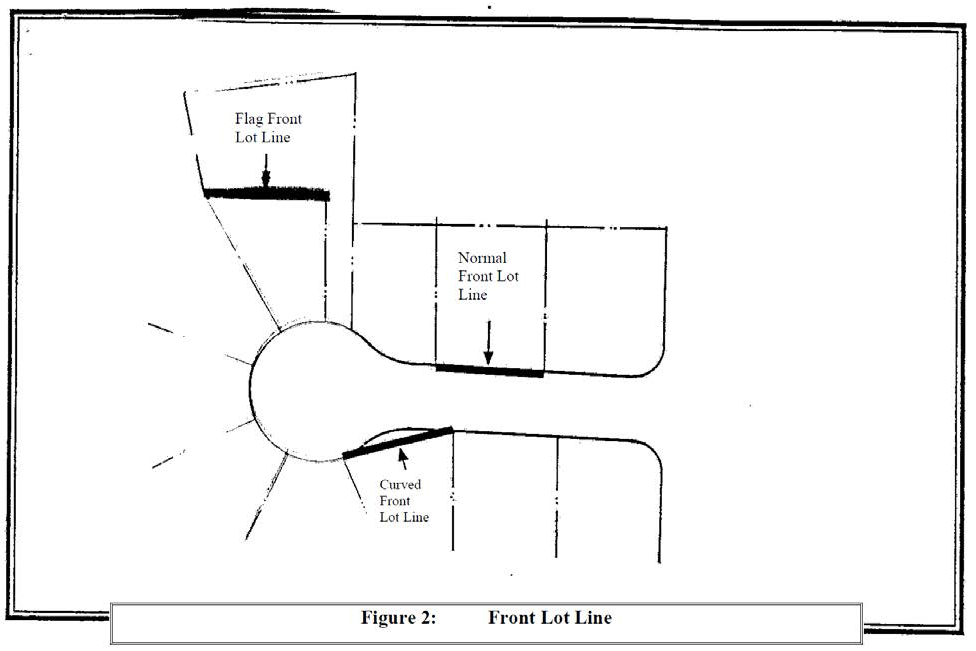
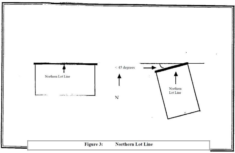
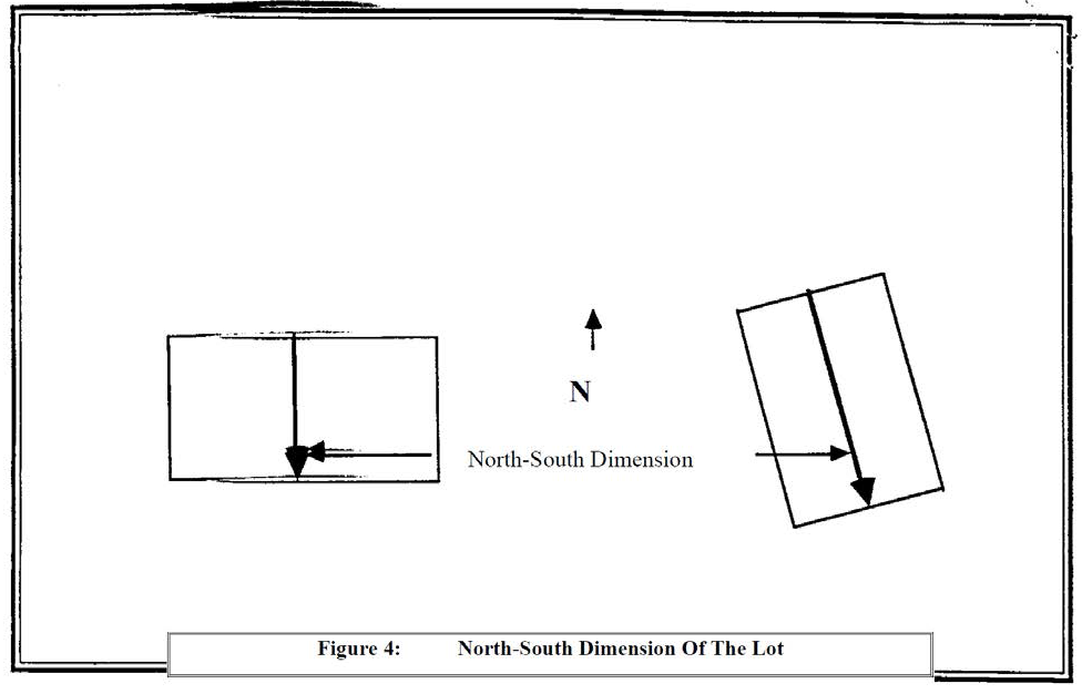
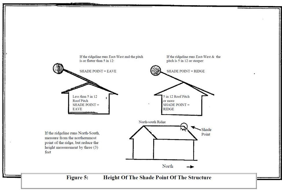
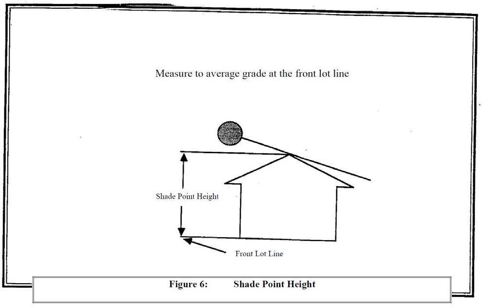
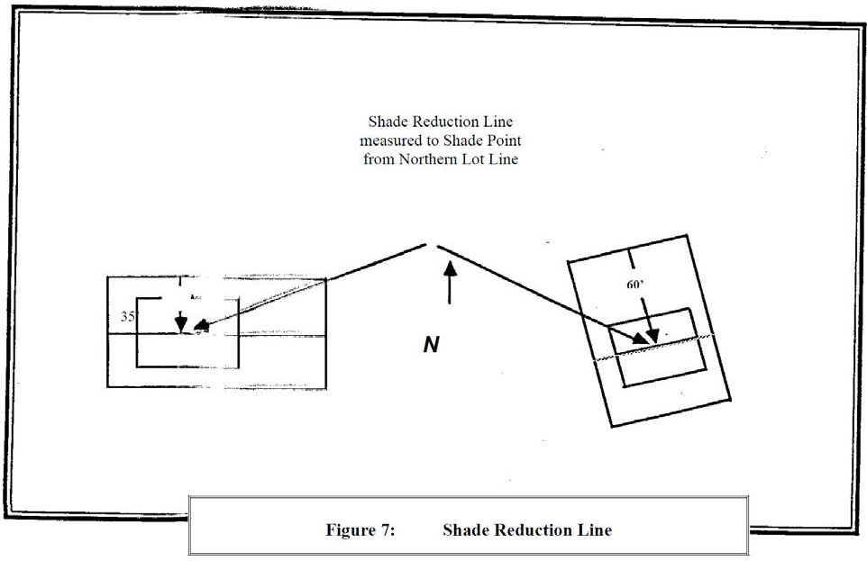
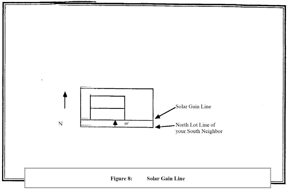
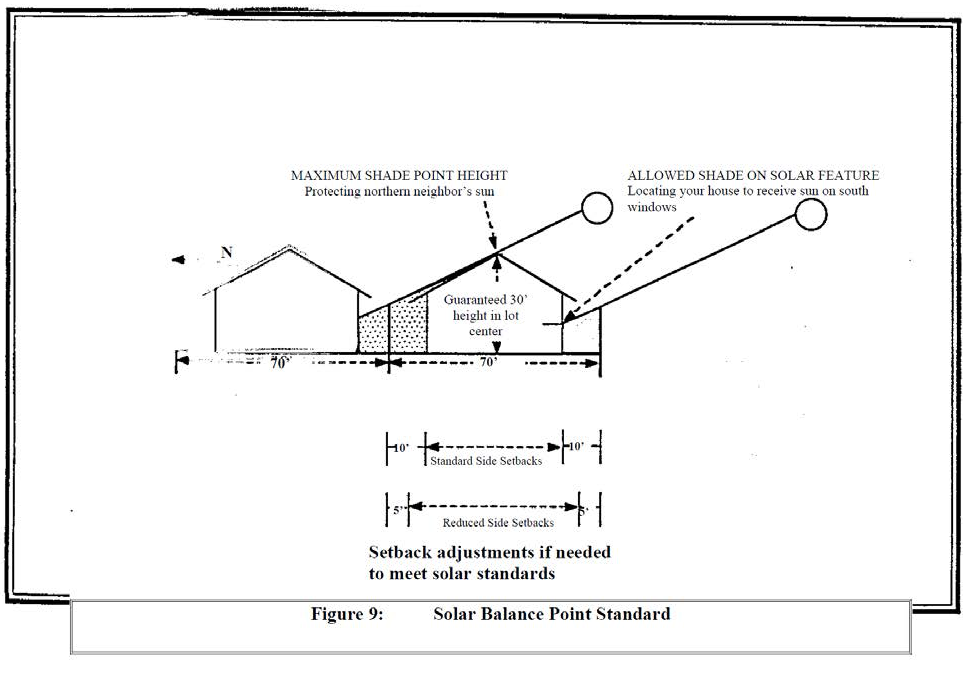
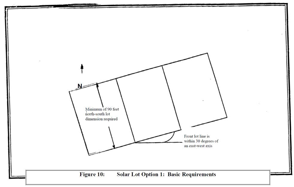
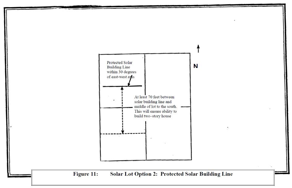
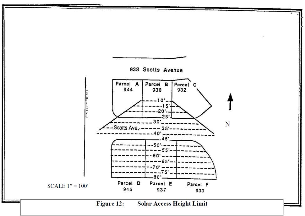
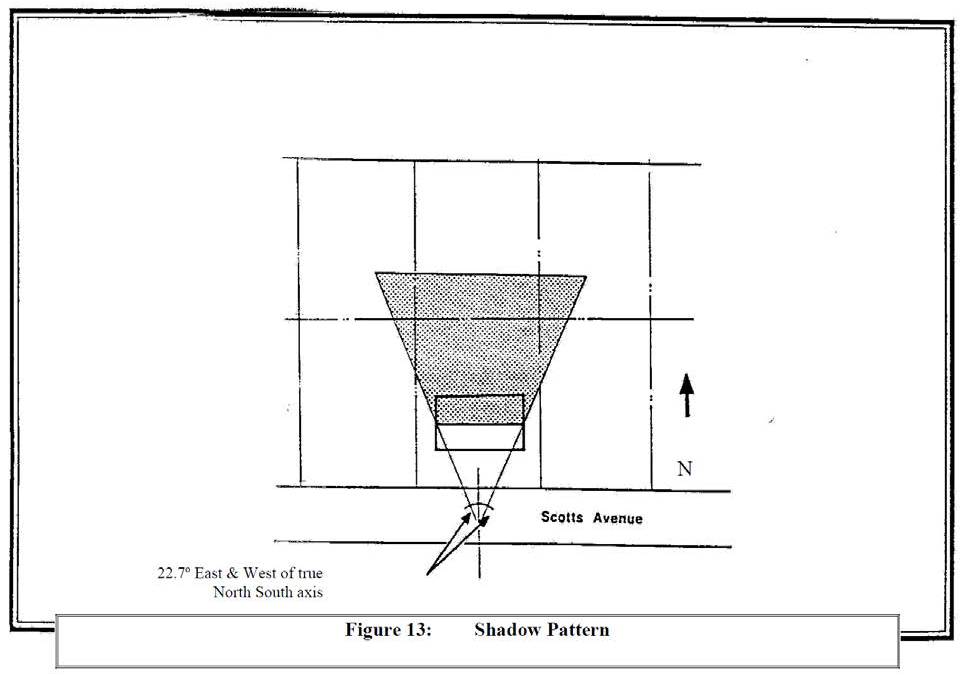
Section 4.137.5. - Screening and Buffering (SB) Overlay Zone.
(.01)
Purpose. The Screening and Buffering Overlay Zone is intended to be used with any underlying base zone to specify appropriate screening and buffering standards for areas where residential and nonresidential uses abut. The "SB" Overlay Zone is used to assure that there is adequate separation and screening between potentially conflicting land uses. The buffering is achieved by restricting access, increasing setbacks, requiring additional landscaping, restricting signs, and, in some cases, by requiring additional information and proof of mitigation for uses that may otherwise cause off-site impacts or nuisances.
(.02)
Where the "SB" Overlay Zone is to be Applied. The Screening and Buffering Overlay Zone is to be applied primarily along the edge of nonresidential zones abutting, or located directly across the street from, residential zones. As with any zoning, the "SB" Overlay Zone is only applied where established by action of the City Council.
(.03)
Landscaped Areas. The following landscape requirements apply to the "SB" Overlay Zone. Structures, exterior storage and exterior display of merchandise are prohibited in these landscaped areas.
A.
Commercial Properties. For land zoned PDC, a ten (10) foot deep area landscaped to at least the L-3 standard, specified in Section 4.176, must be provided along all street frontages across from properties zoned or designated in the Comprehensive Plan for residential use. (See Figure 23: High Screen Landscaping.) A ten foot deep landscaped area shall also be provided at any point where the property adjoins a property that is planned or zoned for residential use.
B.
Industrial Properties. For land zoned PDI, a 20 foot deep area landscaped to at least the L-3 standard, or a ten) foot deep area landscaped to at least the L-4 standard, shall be provided along all property lines where the "SB" Overlay Zone is applied. (See Figures 23: High Screen Landscaping and Figure 24: High Wall Landscaping.)
(.04)
Ingress and Egress. Motor vehicle access shall be limited through any landscaped area required in the "SB" Overlay Zone. The Development Review Board may impose additional landscape requirements to minimize the visual impacts of any vehicle access points that are approved.
(.05)
Exterior Work. No exterior manufacturing, storage, sales, or other similar work shall be performed within the "SB" Overlay Zone.
(.06)
Signs. No signs, other than approved monument signs, shall be permitted within the "SB" Overlay Zone.
(.07)
Performance Standards and Off-Site Impacts. Many of Wilsonville's base zones contain performance standards to limit impacts on surrounding properties and the overall community. Developers shall be encouraged to utilize the standards of the "SB" Overlay Zone to help assure compliance with the performance standards.
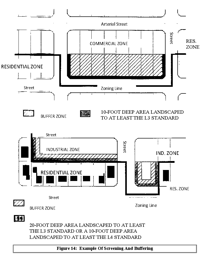
Section 4.138. - Old Town (O) Overlay Zone.
(.01)
Purpose. The purpose of this overlay zone is to establish the design standards that will be applied to developments within the Old Town neighborhood, mapped as the Boones Ferry District in the City's West Side Master Plan. The following purpose statement is not intended as a set of additional permit criteria. Rather, it is a description of the desired outcome as development occurs incrementally, over time. This overlay district is intended to create a modern interpretation of a traditional old town Main Street and mixed use neighborhood. It is recognized that the Old Town neighborhood is of unique significance because of its existing pattern of mixed uses, its access to the Willamette River and because it was the original center of housing and commerce for the community.
A.
The standards of the "O" overlay zone are intended to assure that, through the appropriate use of architectural details, windows, building orientation, facades, and construction materials, new structures, and major alterations of existing structures, create a pleasing and pedestrian-friendly environment.
B.
It is the desire of the City to have commercial, industrial, multi-family, and mixed use buildings in the "O" overlay zone reflect a range of architectural types and styles that were popular in the Willamette Valley from approximately 1880 to 1930 and for single-family homes and middle housing to be consistent with and enhance the historic small town residential character of the neighborhood. The following design standards are intended to further define those characteristics that will convey the desired architecture.
C.
These standards are intended to encourage quality design, to enhance public safety, and to provide a comfortable and attractive street environment by providing features and amenities of value to pedestrians. Quality design will result in an arrangement of buildings that are in visual harmony with one-another, leading to a neighborhood that is vital, interesting, attractive, and safe. These qualities contribute to the health and vitality of the overall community.
D.
These standards shall be used by the City's Planning Division and Development Review Board in reviewing development applications within the Old Town neighborhood.
(.02)
The "O" Overlay zone shall be applied in conjunction with the underlying base zones in the Old Town neighborhood.
(.03)
Review Process in the "O" Overlay zone:
A.
The following shall be reviewed using the Site Design Review process for conformance with the standards in Subsection (.05) as well the Site Design Review standards (Sections 4.421) and other applicable standards:
1.
New commercial, industrial, public facility, multi-family residential, and mixed use building construction and the substantial redevelopment of existing buildings, ; and
2.
Exterior remodeling of commercial, industrial, public facility, multi-family residential, or mixed use building that requires a building permit, when that remodeling is visible from a public street (other than an alley) and changes the existing design of the building; and
3.
Upon the request of an applicant, in order to pursue a design not in conformance with the Old Town Residential Design Standards Book, new single-family homes, middle housing, and accessory buildings, or remodeling thereof. Standards for ADU's in Subsection (.04)C. below shall apply.
B.
The following (except as noted in A.3. above) shall be reviewed through the Class I administrative review process for conformance with the Development Standards of Subsection (.04) concurrently with building plan review:
1.
New single-family homes and middle housing, single-family home or middle housing additions, remodels, accessory dwelling units, garages, and other buildings accessory to a single-family or middle housing use.
(.04)
Single-Family and Middle Housing Development Standards (including accessory buildings):
A.
The standards of this subsection shall take precedence over setback, lot coverage, height, and accessory dwelling unit standards otherwise established in the Development Code except that ten foot front and rear setbacks for cottage clusters and zero setbacks for attached townhouses shall continue to apply. All other standards of the base zone and/or approved planned developments shall apply.
B.
Development shall comply (except as noted in 1. and 2. below) with the standards of the Old Town Residential Design Standards Book including but not limited to architectural design, height, setbacks, and lot coverage.
1.
An applicant for a remodel of and/or addition to structures existing prior to December 1, 2017, including the creation of middle housing through conversion of or addition to an existing single-family home, may elect to match the existing design of the structure rather than comply with the Old Town Residential Design Standards Book if all of the following are met:
a.
The height of the structure remains the same and any additions do not exceed the height of the existing structure;
b.
The roof pitch on the existing portion of the structure remains the same and is matched for additions involving facades facing a street or public open space;
c.
All exterior materials are substantially similar in style and texture to the existing materials on the structure;
d.
For facades of the structure facing a street or public open space (does not include alleys) all architectural elements, such as windows, doors, porches, dormers, details, etc. are kept the same, or in the case of extending out a wall during an addition, reproduced; and
e.
Setbacks and lot coverage requirements of the underlying zone are met.
2.
Accessory structures less than 120 square feet and ten feet in height are not subject to the Old Town Residential Design Standards but rather the standards of the underlying zone.
C.
The following standards shall apply to Accessory Dwelling Units (ADU's) within the "O" Overlay Zone to ensure smaller bulk of residential buildings and minimal use of on-street parking consistent with the historic character of the neighborhood. Where these standards differ from those of Subsection 4.113(.10), including size design and parking, these standards take precedence. All other standards of Subsection 4.113(.10), including but not limited to number of ADU's and review process, continue to apply.
1.
Size: ADU's shall not exceed 600 square feet of living space.
2.
Design: ADU's shall be substantially the same exterior design and architecture (i.e. siding, windows, color, roof pitch, doors and roofing materials) as the primary dwelling unit on the property. ADU's shall be either:
a.
Detached single-story structures; or
b.
Over a detached garage meeting the following requirements:
i.
The garage/ADU structure is a maximum one and one-half stories tall, not exceeding a height of 20 feet; and
ii.
The primary dwelling unit on the property is one and one-half or two stories tall.
(.05)
Standards for Development Subject to Site Design Review:
A.
Building Setbacks. Buildings fronting Boones Ferry Road shall abut the public sidewalk except where public plazas, courtyards, approved landscaping, or other public pedestrian amenities are approved. Except, however, that residential garages or carports shall be set back a minimum of 20 feet from any sidewalk or traveled portion of a street across which access to the garage or carport is taken. The Development Review Board may approve other setbacks to accommodate sidewalks, landscaping, or other streetscape features located between the street right-of-way and the building.
B.
Landscaping. Not less than 15 percent of the development site shall be landscaped. In the event that a building is set back from a street side property line, along Boones Ferry Road, Bailey Street, or 5 th Street, the intervening area shall be landscaped. In reviewing proposals for parking lots in locations between buildings and streets, the Development Review Board may require special landscaping treatments or designs to screen the view of the parking lot from the public right-of-way.
C.
Building height. As specified in the underlying base zone.
D.
Street access to Boones Ferry Road. Ingress and egress points along Boones Ferry Road shall be designed and constructed such that access points on one side of the road shall be consistent with the Public Works Standards. New developments along Boones Ferry Road and north of Bailey Street will have access points designed and constructed in a pattern that replicates the shape of Main Street blocks.
E.
Pedestrian environment. In order to enhance the pedestrian scale of the neighborhood:
1.
Special attention shall be given to the primary building entrances, assuring that they are both attractive and functional.
2.
The pedestrian environment shall be enhanced by amenities such as street furniture, landscaping, awnings, and movable planters with flowers, as required by the Development Review Board.
3.
Sidewalk width may vary from block to block, depending upon the nature of adjacent land uses and the setbacks of existing buildings. Provided, however, that a continuity of streetscape design is maintained along Boones Ferry Road, generally following the pattern that has been started with the 1996 approval for Old Town Village on the west side of Boones Ferry Road from Fourth Street to Fifth Street.
a.
North of Bailey Street, where the most intense commercial development is anticipated, the widest sidewalks and most mature landscaping are required.
b.
In situations where existing buildings are located at the right-of-way line, special sidewalk designs may be necessary to assure pedestrian access.
F.
When practicable, buildings along Boones Ferry Road shall occupy 100 percent of the street frontage between block segments. Up to 25 percent of street frontage may be in public plazas, courtyards, and similar landscape or streetscape features that provide public spaces adjacent to the sidewalk. For smaller lots, which may not have functional alternatives for parking, up to 40 percent of lot frontage may be used for parking, provided that appropriate screening and visual enhancement is created between the parking area and the sidewalk. Appropriate pedestrian connections shall be constructed between such parking lots and sidewalks.
G.
Building compatibility:
1.
The design and materials of proposed buildings shall reflect the architectural styles of the Willamette Valley during the period from 1880 to 1930.
2.
Commercial and manufacturing buildings shall be designed to reflect the types of masonry or wood storefront buildings that were typical in the period from 1880 to 1930. Larger modern buildings shall be designed with facades that are divided to give the appearance of a series of smaller buildings or distinctive store fronts, and/or multi-storied structures with, at least, the appearance of second stories.
3.
Residential buildings shall be designed to reflect the size and shape of traditional dwellings from the period from 1880 to 1930. Where larger multi-family residential buildings are proposed, their building facades shall be divided into units that give the appearance of a series of smaller dwellings.
4.
Manufactured housing units and mobile homes, if located outside of approved manufactured or mobile home parks, shall meet the design standards applied to other single family dwellings in the area.
H.
Building materials:
1.
Facades shall be varied and articulated to provide visual interest to pedestrians. Within larger developments, variations in facades, floor levels, architectural features, and/or exterior finishes shall be used to create the appearance of a series of smaller buildings.
2.
Exterior building materials shall be durable, and shall convey a visual impression of durability. Materials such as masonry, stone, stucco, and wood will generally provide such an appearance. Other materials that replicate the appearance of those durable materials may also be used.
3.
Where masonry is to be used for exterior finish, varied patterns are to be incorporated to break up the appearance of larger surfaces.
4.
Wood siding is to be bevel, shingle siding or channel siding or the equivalent. T-111 and similar sheathed siding shall not be used unless it is incorporated with batten treatment to give the appearance of boards.
5.
Exterior materials and colors are to match the architecture of the period.
I.
Roof materials, roof design and parapets:
1.
Pitched roof structures shall have a minimum pitch of 4:12.
2.
Roofs with a pitch of less than 4:12 are permitted, provided that they have detailed, stepped parapets or detailed masonry coursing.
3.
Parapet corners are to be stepped. Parapets are to be designed to emphasize the center entrance or primary entrance(s).
4.
Sloped roofs that will be visible from the adjoining street right-of-way shall be of a dark, non-ornamental color.
5.
Preferred roofing materials that are visible from a public street include wood or architectural grade composition shingle, tile, or metal with standing or batten seams. Metal roofs without raised seams shall not be used in visible locations.
6.
All roof and wall-mounted mechanical, electrical, communications, and service equipment, including satellite dishes, wireless communication equipment, and vent pipes are to be completely screened from public view by parapets, walls or other approved means; or, alternatively, may be effectively camouflaged to match the exterior of the building.
a.
"Public view" is intended to mean the view from the sidewalk directly across the street from the site.
b.
Roof and wall-mounted mechanical, electrical, communications, and service equipment, including satellite dishes, wireless communication equipment, and vent pipes that are visible from Interstate-5 shall be effectively camouflaged to match the exterior of the building.
J.
Building entrances. If visible from the street, entrances to commercial, industrial, or multi-family residential buildings are to be architecturally emphasized, with coverings as noted in subsection (.09), below.
1.
The Development Review Board may establish conditions concerning any or all building entrances, especially where such entrances are adjacent to parking lots. For buildings fronting on Boones Ferry Road, at least one entrance shall be from the sidewalk.
2.
Secondary building entrances may have lesser architectural standards than primary entrances.
K.
Building facades:
1.
Ornamental devices, such as moldings, entablature, and friezes, are encouraged at building roof lines. Where such ornamentation is to be in the form of a linear molding or board, it shall match or complement the architecture of the building.
2.
Buildings are to incorporate amenities such as alcoves, awnings, roof overhangs, porches, porticoes, and/or arcades to protect pedestrians from the rain and sun. Awnings and entrances may be designed to be shared between two adjoining structures. (See subsection (.08), above.)
3.
Commercial and manufacturing buildings with frontage on Boones Ferry Road shall incorporate the following traditional storefront elements:
a.
Building fronts to be located at the right-of-way line for streets, except in cases where an approved sidewalk or other streetscape features are located between the street right-of-way and the building. Intervening areas are to be attractively landscaped.
b.
Upper and lower facades are to be clearly delineated.
c.
Lower facades shall include large windows, as specified in subsection "(L.)," below, and recessed entries.
d.
Tops of facades shall have decorative cornices.
4.
Buildings are to have variations in relief, including such things as cornices, bases, fenestration, fluted masonry, and other aesthetic treatments to enhance pedestrian interest.
L.
Windows in buildings adjacent to Boones Ferry Road:
1.
Windows shall include amenities such as bottom sills, pediments, or awnings. Glass curtain walls, highly reflective glass, and painted or darkly tinted glass are not permitted other than stained or leaded glass.
2.
Ground-floor windows on commercial or industrial buildings shall include the following features:
a.
Windows shall be designed to allow views into interior activity areas and display areas along street frontages.
b.
Sills shall be no more than four feet above grade, unless a different design is necessitated by unusual interior floor levels.
c.
At least 20 percent, of ground floor wall area along Boones Ferry Road, Bailey Street, or 5 th Street shall be in windows or entries. No blank walls shall be permitted abutting any street other than an alley.
3.
Upper-floor windows on commercial, industrial, or multi-family residential buildings shall include the following features:
a.
Glass dimensions shall not exceed five feet wide by seven feet high.
b.
Windows shall be fully trimmed with molding that is at least two inches wide.
c.
Multiple-light windows or windows with grid patterns may be required by the Development Review Board when architecturally consistent with the building.
M.
Landscapes and streetscapes:
1.
The street lights to be used in the area shall be of a standardized design throughout the Old Town Overlay District.
2.
Benches, outdoor seating, and trash receptacles are to be designed to match the architecture in the area.
3.
Benches and other streetscape items placed within the public right-of-way must not block the free movement of pedestrians, including people with disabilities. A minimum pedestrian walkway of five feet shall be maintained at all times. Standards of the Americans with Disabilities Act (ADA) shall be observed.
N.
Lighting:
1.
All building entrances and exits shall be well-lit. The minimum lighting level for commercial, industrial, or multi-family residential building entrances is to be four foot-candles. The maximum standard is to be ten foot-candles. A lighting plan shall be submitted for review by the Development Review Board.
2.
Exterior lighting is to be an integral part of the architectural design and must complement the street lighting of the area, unless it is located at the side or rear of buildings in locations that are not facing a public street that is not an alley.
3.
In no case is lighting to produce glare on neighboring properties or public rights-of-way such that a nuisance or safety hazard results.
O.
Exterior storage:
1.
Exterior storage of merchandise or materials shall be subject to the fencing or screening standards of Section 4.176 of the Wilsonville Code. The Development Review Board may prescribe special standards for landscaping or other screening of walls or fences.
2.
Temporary outdoor displays of merchandise shall be permitted, subject to the conditions of the development permit or temporary use permit for the purpose. Where pedestrian access is provided, a minimum walkway width of five feet shall be maintained at all times.
P.
Storage of Trash and Recyclables. Storage areas for trash and recyclables shall meet the applicable City requirements of Sections 4.179 and 4.430 of the Wilsonville Code.
Q.
Signs. Signs shall match the architecture of buildings in the area, and shall be subject to the provisions of Sections 4.156.01 through 4.156.11 of the Wilsonville Code.
(Ord. No. 538, 2-21-2002; Ord. No. 810, 11-20-2017)
Section 4.139.00. - Significant Resource Overlay Zone (SROZ) Ordinance.
Definitions:
1.
Area of Limited Conflicting Uses. An Area of Limited Conflicting Uses is either:
a.
An area located between the riparian corridor boundary, riparian impact area or the Urban Growth Management Functional Plan (UGMFP) Metro Title 3 Water Quality Resource Area boundary, whichever is furthest away from the wetland or stream, and the outside edge of the SROZ; or
b.
An isolated significant wildlife habitat (upland forest) resource site.
2.
Bankful Stage. The stage or elevation at which water overflows the natural banks of streams or other waters of the state and begins to inundate upland areas. In the absence of physical evidence, the two-year recurrence interval flood elevation may be used to approximate the bankful stage.
3.
Emergency. Any human-caused or natural event or circumstances causing or threatening loss of life, injury to person or property, and includes, but is not limited to fire, explosion, flood, severe weather, drought, earthquake, volcanic activity, spills or releases of hazardous material, contamination, utility or transportation disruptions, and disease.
4.
Encroachment Area. An area within the Area of Limited Conflicting Uses where development may be permitted.
5.
Impact Area. The area adjacent to the outer boundary of a Significant Resource within which development or other alteration activities may be permitted through the review of a Significant Resource Impact Report (SRIR) or where an SRIR has been waived in accordance with this ordinance. The impact area is 25 feet wide unless otherwise specified in this ordinance or by the decision making body.
6.
Riparian Corridor. Is a Goal 5 resource that includes the water areas, fish habitat, adjacent riparian areas, and wetlands within the riparian area boundary. The "riparian area" is the area adjacent to a river, lake, stream, consisting of lands that include the area of transition from aquatic ecosystem to a terrestrial ecosystem. The Riparian Corridor is diagrammatically defined in Section 4.139.00.
7.
Riparian Corridor Cross Sections. Riparian corridor significance for the City of Wilsonville is based on assessment of several factors:
a.
The presence of habitat used by species listed as threatened or endangered by the Endangered Species Act. The resource is considered significant if ESA-listed salmonid fish species utilize portions of the resource area.
b.
The protection of ESA listed species habitat both on - or off-site. The resource is considered significant if it provides functions that protect the habitat of ESA-listed species, either on- or off-site. Riparian corridors can protect water quality parameters such as temperature, suspended sediment and contaminants of downstream waters that are ESA-listed species habitat.
c.
The inclusion of other significant Goal 5 resource areas. Riparian corridor resources that contain significant wetlands and/or wildlife habitat are considered significant.
d.
The provision of habitat continuity for wildlife. Riparian corridor resources that provide a link or continuity for wildlife movement between significant wildlife habitat areas are considered significant.
e.
Headwater areas, including intermittent streams, can be important for fish and wildlife resources. These areas can provide good quality water, protection of water quality, insect and organic materials, and other factors for habitat areas downstream.
Generalized riparian corridor types are shown on the following pages.
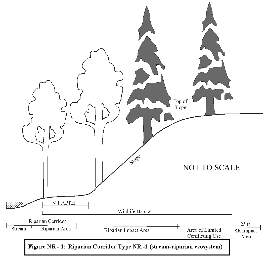
Riparian area adjacent to the stream is less than one APTH wide, and has an adjacent slope. The adjacent slope is designated as riparian impact area, based on the potential for activities on the slope to have direct impacts on riparian area functions.
Notes for all riparian figures: (1) The "area of limited conflicting use" and "SR Impact Area" are regulatory areas defined in the proposed City of Wilsonville Significant Resource Overlay Zone (4.139.00). The SR Impact Area is always 25 feet wide from the edge of the significant resource (SR).
Riparian area adjacent to the stream is less than the width of the streamside terrace or bench, and the base of the adjacent slope is a distance greater than one APTH from the stream bank. If the riparian area is less wide than the distance of one APTH, then the remaining APTH distance is the riparian impact area.
Riparian area adjacent to the stream is upland, forested wetland, or a mosaic of upland and wetland, and does not have adjacent steep slopes within 200 ft. If the riparian area, including wetlands adjacent to the stream, is less wide than one APTH, the riparian impact area extends to a distance of one APTH from the top of the stream bank.
Riparian area is emergent or emergent/shrub wetland, and does not have adjacent steep slopes within 200 ft. The wetland is the riparian corridor. The potential impacts of human activities adjacent to the wetland/riparian area do not warrant placing a riparian impact area on this corridor type.
Riparian area is confined to a portion of the river bank where the adjacent land is not inundated annually (i.e. not an operational floodplain). The riparian impact area is a minimum 75 feet wide from the top of the stream bank.
For any areas along the Willamette River that have an operational floodplain (i.e. flooded annually), the riparian area is the extent of the operational floodplain.
8.
Riparian Impact Area. An area within which human activities could have adverse impacts on functions of adjacent riparian corridor resources.
9.
Significant Resource Impact Report (SRIR). A report that delineates specific resource boundaries and analyzes the impacts of development on significant natural resources. It outlines measures to prevent negative impacts, and also provides mitigation and enhancement plans.
10.
Significant Resource Overlay Zone (SROZ): The delineated outer boundary of a significant natural resource that includes: a significant Goal 5 natural resource, lands protected under Metro's Urban Growth Management Functional Plan Title 3 (Water Quality Resource Areas), riparian corridors, and significant wildlife habitat.
11.
Starting Point for Measurement: Is the edge of the defined channel (bankful stage) for streams/rivers, delineated wetland boundary, delineated spring boundary, and/or average high water for lakes or ponds, whichever offers greatest resource protection. Intermittent springs located more than 15 feet from streams/rivers or wetlands shall not serve as a starting point for measurement.
Table NR-1: Metro Water Quality Resource Area Slope Calculations
1 Primary Protected Water Features include: all perennial streams and streams draining greater than 100 acres, Title 3 wetlands, natural lakes and spring.
2 Secondary Protected Water Features include intermittent streams draining 50—100 acres.
3 Where the protected Water Feature is confined by a ravine or gully, the top of ravine is the break in the >25 percent slope
4 A maximum reduction of 25 feet may be permitted in the width of vegetated corridor beyond the slope break if a geotechnical report demonstrates that slope is stable. To establish the width of the vegetated corridor, slope should be measured in 25-foot increments away from the water feature until slope is less than 25 percent (top of ravine).
5 Vegetated corridors in excess of 50-feet from primary protected features, or in excess of 15-feet from secondary protected features, apply on steep slopes only in the uphill direction from the protected water feature.
(Ord. No. 674, 11-16-2009)
Section 4.139.01. - SROZ—Purpose.
The Significant Resource Overlay Zone (SROZ) is intended to be used with any underlying base zone as shown on the City of Wilsonville Zoning Map. The purpose of the Significant Resource Overlay Zone is to implement the goals and policies of the Comprehensive Plan relating to natural resources, open space, environment, flood hazard, and the Willamette River Greenway. In addition, the purposes of these regulations are to achieve compliance with the requirements of the Metro Urban Growth Management Functional Plan (UGMFP) relating to Title 3 Water Quality Resource Areas, and Title 13 Habitat Conservation Areas, and that portion of Statewide Planning Goal 5 relating to significant natural resources. It is not the intent of this ordinance to prevent development where the impacts to significant resources can be minimized or mitigated.
(Ord. No. 674, 11-16-2009)
Section 4.139.02. - Where these Regulations Apply.
The regulations of this Section apply to the portion of any lot or development site, which is within a Significant Resource Overlay Zone and its associated "Impact Areas". The text provisions of the Significant Resource Overlay Zone ordinance take precedence over the Significant Resource Overlay Zone maps. The Significant Resource Overlay Zone is described by boundary lines shown on the City of Wilsonville Significant Resource Overlay Zone Map. For the purpose of implementing the provisions of this Section, the Wilsonville Significant Resource Overlay Zone Map is used to determine whether a Significant Resource Impact Report (SRIR) is required. Through the development of an SRIR, a more specific determination can be made of possible impacts on the significant resources.
Unless otherwise exempted by these regulations, any development proposed to be located within the Significant Resource Overlay Zone and/or Impact Area must comply with these regulations. Where the provisions of this Section conflict with other provisions of the City of Wilsonville Planning and Land Development Ordinance, the more restrictive shall apply.
The SROZ represents the area within the outer boundary of all inventoried significant natural resources. The Significant Resource Overlay Zone includes all land identified and protected under Metro's UGMFP Title 3 Water Quality Resource Areas and Title 13 Habitat Conservation Areas, as currently configured, significant wetlands, riparian corridors, and significant wildlife habitat that is inventoried and mapped on the Wilsonville Significant Resource Overlay Zone Map.
(Ord. No. 674, 11-16-2009)
Section 4.139.03. - Administration.
(.01)
Resources. The text provisions of this section shall be used to determine whether applications may be approved within the Significant Resource Overlay Zone. The following maps and documents may be used as references for identifying areas subject to the requirements of this Section:
A.
Metro's UGMFP Title 3 Water Quality Resource Area maps.
B.
The Federal Emergency Management Agency (FEMA) Flood Insurance Rate Maps (FIRM).
C.
The Wilsonville Local Wetland Inventory (LWI) (1998).
D.
The Wilsonville Riparian Corridor Inventory (RCI) (1998).
E.
Locally adopted studies or maps.
F.
City of Wilsonville slope analysis maps.
G.
Clackamas and Washington County soils surveys.
H.
Metro's UGMFP Title 13 Habitat Conservation Area Map.
(.02)
Impact Area. The "Impact Area" is the area adjacent to the outer boundary of a Significant Resource within which development or other alteration activities may be permitted through the review of an SRIR (Significant Resource Impact Report). Where it can be clearly determined by the Planning Director that development is only in the Impact Area and there is no impact to the Significant Resource, development may be permitted without SRIR review. The impact area is 25 feet wide unless otherwise specified in this ordinance or by the decision making body. Designation of an Impact Area is required by Statewide Planning Goal 5. The primary purpose of the Impact Area is to ensure that development does not encroach into the SROZ.
(.03)
Significant Resource Impact Report (SRIR). For proposed non-exempt development within the SROZ, the applicant shall submit a Significant Resource Impact Report (SRIR) as part of any application for a development permit.
(.04)
Prohibited Activities. New structures, development and construction activities shall not be permitted within the SROZ if they will negatively impact significant natural resources. Gardens, lawns, application of chemicals, uncontained areas of hazardous materials as defined by DEQ, domestic animal waste, dumping of materials of any kind, or other activities shall not be permitted within the SROZ if they will negatively impact water quality.
Unauthorized land clearing or grading of a site to alter site conditions is not allowed, and may result in the maximum requirement of mitigation/enhancement regardless of pre-existing conditions.
(.05)
Habitat-Friendly Development Practices. To the extent practicable, development and construction activities that encroach within the Significant Resource Overlay Zone and/or Impact Area shall be designed, located and constructed to:
A.
Minimize grading, removal of native vegetation, disturbance and removal of native soils, and impervious area;
B.
Minimize adverse hydrological impacts on water resources, such as using the practices described in Part (a) of Table NR-2, unless their use is prohibited by an applicable and required state or federal permit, such as a permit required under the federal Clean Water Act, 33 U.S.C. §§ 1251 et seq., or the federal Safe Drinking Water Act, 42 U.S.C. §§ 300f et seq., and including conditions or plans required by such permit;
C.
Minimize impacts on wildlife corridors and fish passage, such as by using the practices described in Part (b) of Table NR-2; and
D.
Consider using the practices described in Part (C) of Table NR-2.
(Ord. No. 674, 11-16-2009)
Section 4.139.04. - Uses and Activities Exempt from These Regulations.
A request for exemption shall be consistent with the submittal requirements listed under Section 4.139.06(.01)(B—I), as applicable to the exempt use and activity.
(.01)
Emergency procedures or emergency activities undertaken which are necessary for the protection of public health, safety, and welfare. Measures to remove or abate hazards and nuisances. Areas within the SROZ that are disturbed because of emergency procedures or activities should be repaired and mitigated.
(.02)
Maintenance and repair of buildings, structures, yards, gardens or other activities or uses that were in existence prior to the effective date of these regulations.
(.03)
Alterations of buildings or accessory structures which do not increase building coverage.
(.04)
The following agricultural activities lawfully in existence as of the effective date of this ordinance:
A.
Mowing of hay, grass or grain crops.
B.
Tilling, disking, planting, seeding, harvesting and related activities for pasture, tree crops, commercial woodlots, food crops or business crops, provided that no additional lands within the SROZ are converted to these uses after the effective date of this ordinance.
(.05)
Operation, maintenance, and repair of irrigation and drainage ditches, constructed ponds, wastewater facilities, stormwater detention or retention facilities, and water facilities consistent with the Stormwater Master Plan or the Comprehensive Plan.
(.06)
Maintenance and repair of streets and utility services within rights-of way, easements, access drives or other previously improved areas.
(.07)
Normal and routine maintenance and repair of any public improvement or public recreational area regardless of its location.
(.08)
The construction of new roads, pedestrian or bike paths into the SROZ in order to provide access to the sensitive area or across the sensitive area, provided the location of the crossing is consistent with the intent of the Wilsonville Comprehensive Plan. Roads and paths shall be constructed so as to minimize and repair disturbance to existing vegetation and slope stability.
(.09)
Maintenance and repair of existing railroad tracks and related improvements.
(.10)
The removal of invasive vegetation such as Himalayan Blackberry, English Ivy, Poison Oak, Scots (Scotch) Broom or as defined as invasive in the Metro Native Plant List.
(.11)
The planting or propagation of any plant identified as native on the Metro Native Plant List. See Wilsonville Planning Division to obtain a copy of this list.
(.12)
Grading for the purpose of enhancing the Significant Resource as approved by the City.
(.13)
Enhancement of the riparian corridor or wetlands for water quality or quantity benefits, fish, or wildlife habitat as approved by the City and other appropriate regulatory authorities.
(.14)
Flood control activities pursuant to the Stormwater Master Plan, save and except those stormwater facilities subject to Class II Administrative Review, as determined by the Planning Director, to ensure such facilities meet applicable standards under federal, state and local laws, rules and regulations.
(.15)
Developments that propose a minor encroachment into the Significant Resource Overlay Zone. The purpose of this adjustment would be to allow for minor encroachments of impervious surfaces such as accessory buildings, eave overhangs, building appurtenances, building access and exiting requirements or other similar feature. The total adjustment shall not exceed 120 square feet in cumulative area.
(.16)
The expansion of an existing single family dwelling or duplex not exceeding 600 square feet in area. The expansion of an existing single family dwelling or duplex or structures that are accessory to a single family dwelling or duplex inside the SROZ, provided that the following criteria have been satisfied. An SRIR is not required to evaluate and reach a decision on the issuance of a permit to expand a single-family residence under this paragraph.
A.
The expansion of a single family or duplex structure or improvement (including decks and patios) shall not be located any closer to the stream or wetland area than the existing structure or improvement; and
B.
The coverage of all structures within the SROZ on the subject parcel shall not be increased by more than 600 square feet, based on the coverage in existence prior to the effective date of this ordinance; and,
C.
The applicant must obtain the approval of an erosion and sediment control plan from the City's Building and Environmental Services Divisions; and,
D.
No part of the expansion is located within the Metro UGMFP Title 3 Water Quality Area.
(.17)
New Single-Family Dwelling or Duplex. The construction of a new single family dwelling or duplex, including a duplex created through conversion of an existing detached single-family dwelling, is exempt unless the building encroaches into the Impact Area and/or the SROZ.
A.
If the proposed building encroaches only into the Impact Area then an abbreviated SRIR may be required as specified in Section 4.139.05, unless it can be clearly determined by the Planning Director that the development proposal will have no impact on the Significant Resource. The primary purpose of the Impact Area is to insure that development does not encroach into the SROZ. Development otherwise in compliance with the Planning and Land Development Ordinance may be authorized within the Impact Area.
B.
If the proposed building encroaches into the SROZ, then a complete or abbreviated SRIR report is required.
(.18)
Private or public service connection laterals and service utility extensions.
(.19)
A Stage II development permit or other development permits issued by the City and approved prior to the effective date of this ordinance.
(.20)
The installation of public streets and utilities specifically mapped within a municipal utility master plan, the Transportation Systems Plan or a capital improvement plan.
(.21)
Structures which are non-conforming to the standards of this Section may be re-built in the event of damage due to fire or other natural hazard subject to Sections 4.189—4.192 of the Planning and Land Development Ordinance, provided that the structure is placed within the same foundation lines (See Figure NR-6.). An SRIR is not required to evaluate and reach a decision on the issuance of a permit to replace a structure subject to this paragraph.
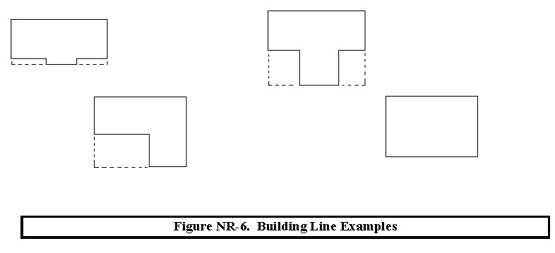
(.22)
Any impacts to resource functions from the above excepted activities, such as gravel construction pads, erosion/sediment control materials or damaged vegetation, shall be mitigated using appropriate repair or restoration/enhancement techniques.
(Ord. No. 674, 11-16-2009; Ord. No. 682, 9-9-2010)
Section 4.139.05. - Significant Resource Overlay Zone Map Verification.
The map verification requirements described in this Section shall be met at the time an applicant requests a building permit, grading permit, tree removal permit, land division approval, or other land use decision. Map verification shall not be used to dispute whether the mapped Significant Resource Overlay Zone boundary is a significant natural resource. Map refinements are subject to the requirements of Section 4.139.10(.01)(D).
(.01)
In order to confirm the location of the Significant Resource Overlay Zone, map verification shall be required or allowed as follows:
A.
Development that is proposed to be either in the Significant Resource Overlay Zone or less than 100 feet outside of the boundary of the Significant Resource Overlay Zone, as shown on the Significant Resource Overlay Zone Map.
B.
A lot or parcel that:
1.
Either contains the Significant Resource Overlay Zone, or any part of which is less than 100 feet outside the boundary of the Significant Resource Overlay Zone, as shown on the Significant Resource Overlay Zone Map; and
2.
Is the subject of a land use application for a partition, subdivision, or any land use application that the approval of which would authorize new development on the subject lot or parcel.
(.02)
An application for Significant Resource Overlay Zone Map Verification may be submitted even if one is not required pursuant to Section 4.139.05(.01).
(.03)
If a lot or parcel or parcel is subject to Section 4.139.05(.01), an application for Significant Resource Overlay Zone Map Verification shall be filed concurrently with the other land use applications referenced in Section 4.139.05(.01)(B)(2) unless a previously approved Significant Resource Overlay Zone Map Verification for the subject property remains valid.
(.04)
An applicant for Significant Resource Overlay Zone Map Verification shall use one or more of the following methods to verify the Significant Resource Overlay Zone boundary:
A.
The applicant may concur with the accuracy of the Significant Resource Overlay Zone Map of the subject property;
B.
The applicant may demonstrate a mapping error was made in the creation of the Significant Resource Overlay Zone Map; and
C.
The applicant may demonstrate that the subject property was developed lawfully prior to June 7, 2001.
(.05)
The Planning Director shall determine the location of any Significant Resource Overlay Zone on the subject property by considering information submitted by the applicant, information collected during any site visit that may be made to the subject property, information generated by Significant Resource Overlay Zone Map Verification that has occurred on adjacent properties, and any other relevant information that has been provided.
(.06)
For applications filed pursuant to Section 4.139.05(.04)(A) and (C), a Significant Resource Overlay Zone Map Verification shall be consistent with the submittal requirements listed under Section 4.139.06(.01)(B-H).
(.07)
For applications filed pursuant to Section 4.139.05(.04)(B), a Significant Resource Overlay Zone Map Verification shall be consistent with the submittal requirements listed under Section 4.139.06(.02)(D)(1).
(Ord. No. 674, 11-16-2009)
Section 4.139.06. - Significant Resource Impact Report (SRIR) and Review Criteria.
A Significant Resource Impact Report (SRIR) is a report that delineates specific resource boundaries and analyzes the impacts of development within mapped significant resource areas based upon the requirements of this Section. An SRIR is only required for non-exempt development that is located within the Significant Resource Overlay Zone and/or its associated 25 foot Impact Area.
The Significant Resource Overlay Zone Map identifies areas that have been classified as significant natural resources. The preparation of the Significant Resource Overlay Zone Map did not include specific field observations of every individual property. These maps are designed to be specific enough to determine whether further environmental review of a development proposal is necessary. If any portion of the development or alteration of the land (except those exempted by this Section) is located within the Significant Resource Overlay Zone boundary or the identified Impact Area, then an SRIR is required before any development permit can be issued. Where it can be clearly determined by the Planning Director that development is only in the Impact Area and there is no impact to the Significant Resource, development may be permitted without SRIR review.
The Planning Director may consult with a professional with appropriate expertise to evaluate an applicant's SRIR prepared under this Section or may rely on appropriate staff expertise, in order to properly evaluate the report's conclusions.
(.01)
Abbreviated SRIR Requirements. It is the intent of this subsection to provide a user-friendly process for the applicant. Only the materials necessary for the application review are required. At the discretion of the Planning Director, an abbreviated SRIR may be submitted for certain small-scale developments such as single family dwellings, additions to single family dwellings, minor additions and accessory structures. The following requirements shall be prepared and submitted as part of the abbreviated SRIR evaluation:
A.
A Site Development Permit Application must be submitted in compliance with the Planning and Land Development Ordinance;
B.
Outline of any existing features including, but not limited to, structures, decks, areas previously disturbed and existing utility locations*;
C.
Location of any wetlands or water bodies on the site and the location of the stream centerline and top-of-bank;
D.
Within the area proposed to be disturbed, the location, size and species of all trees that are more than six inches in diameter at breast height (DBH). Trees outside the area proposed to be disturbed may be individually shown or shown as drip line with an indication of species type or types;
E.
The location of the SROZ and Impact Area boundaries*;
F.
A minimum of three slope cross-section measurements transecting the site, equally spaced at no more than 100-foot increments. The measurements should be made perpendicular to the stream*;
G.
A map that delineates the Metro UGMFP Title 3 Water Quality Resource Area boundary (using Metro Title 3 field observed standards)*;
H.
Current photos of site conditions shall be provided to supplement the above information*; and
I.
A narrative describing the possible and probable impacts to natural resources and a plan to mitigate for such impacts*.
*Indicates information that City Staff may have readily available to assist an applicant.
(.02)
Application Requirements for a Standard SRIR. The following requirements must be prepared and submitted as part of the SRIR evaluation for any development not included in paragraph A above:
A.
A Site Development Permit Application must be submitted in compliance with the Planning and Land Development Ordinance.
B.
The SRIR shall be conducted and prepared by a natural resource professional knowledgeable and qualified to complete such a report.
C.
The qualifications of the person or persons preparing each element of the analysis shall be included with the SRIR.
D.
The SRIR shall include the following:
1.
Physical Analysis. The analysis shall include, at a minimum:
a.
Soil types;
b.
Geology;
c.
Hydrology of the site;
d.
Outline of any existing features including, but not limited to, structures, decks, areas previously disturbed, and existing utility locations;
e.
Location of any wetlands or water bodies on the site and the location of the stream centerline and top-of-bank;
f.
Within the area proposed to be disturbed, the location, size and species of all trees that are more than six inches DBH. Trees outside the area proposed to be disturbed may be individually shown or shown as drip line with an indication of species type or types;
g.
A property survey together with topography shown by contour lines prepared at two-foot vertical intervals. Five-foot vertical intervals may be allowed for steep sloped areas. The survey shall be prepared by an Oregon Registered Land Surveyor or Civil Engineer;
h.
The location of the SROZ and Impact Area boundaries;
i.
A minimum of three slope cross-section measurements transecting the site, equally spaced at no more than 100-foot increments. The measurements should be made perpendicular to the stream;
j.
A map that delineates the Metro UGMFP Title 3 Water Quality Resource Area boundary (using Metro Title 3 field observed standards);
k.
A map that delineates the Goal 5 safe harbor boundary (using the standards found within the Oregon Administrative Rule OAR 660-23(1996));
l.
The existing site significant resource conditions shall be determined and identified by a natural resource professional; and
m.
Current photos of site conditions shall be provided to supplement the above information.
2.
The analysis shall include development recommendations including grading procedures, soil erosion control measures, slope stabilization measures, and methods of mitigating hydrologic impacts. For projects that affect possible wetlands, a copy of the Local Wetland Inventory (LWI) map pertaining to the site shall be provided. Notice of the proposal shall be given to the Oregon Division of State Lands and the Army Corp of Engineers.
3.
Ecological Analysis. The Ecological Analysis shall include a map, using the Physical Analysis map as a base, showing the delineated boundaries and coverage of wetlands, riparian corridors, and wildlife habitat resources identified on the site.
a.
Wetland boundaries shall be delineated using the method currently accepted by the Oregon Division of State Lands and the US Army Corps of Engineers. Riparian boundaries shall be delineated using the riparian corridor descriptions in this ordinance. Boundaries of mapped Goal 5 wildlife habitat shall be verified by field observation.
b.
The analysis shall include an inventory that lists and describes the native and ornamental dominant and sub-dominant groundcover, shrub and tree species occurring on the site and wildlife observed during at least one site visit (specify date). The report shall also include recommended measures for minimizing the adverse impacts of the proposed development on unique and/or significant features of the ecosystem. The analysis shall include a report that discusses the ecological functions and values of the SROZ area, discussing each parameter listed below. The discussion shall be based on actual field observations and data obtained by a natural resource professional.
c.
Wetlands (based on evaluation criteria in the Oregon Freshwater Wetlands Assessment Methodology (OFWAM), Oregon Division of State Lands):
i.
Wildlife habitat diversity
ii.
Fish habitat
iii.
Water quality protection
iv.
Hydrologic control
d.
Wildlife Habitat (includes riparian corridors and upland forested areas) 1 : [1]
i.
Wildlife habitat diversity
ii.
Water quality protection
iii.
Ecological integrity
iv.
Connectivity
v.
Uniqueness
e.
Riparian Corridors 1. Stream-riparian ecosystems:
i.
Presence and abundance of Large Woody Debris (LWD) in and adjacent to stream.
ii.
Tree/shrub canopy stream shade production (water temperature and aquatic plant growth control).
iii.
Erosion and sediment control by riparian vegetation.
iv.
Water quality protection by riparian vegetation.
v.
River-floodplain ecosystem (Willamette River).
vi.
Presence of functional floodplain (inundated annually).
vii.
Type and condition of functional floodplain vegetation.
viii.
Use of river-floodplain by ESA-listed species.
ix.
Role as wildlife corridor connecting significant wildlife habitat areas.
4.
Mitigation and Enhancement Proposal. The applicant must propose a Significant Resource mitigation and enhancement plan as part of the SRIR. The mitigation and enhancement shall increase the natural values and quality of the remaining Significant Resource lands located on the site or other location as approved by the City. The mitigation and enhancement proposal shall conform to the mitigation standards identified in this Section.
5.
Waiver of Documentation: The Planning Director may waive the requirement that an SRIR be prepared where the required information has already been made available to the City, or may waive certain provisions where the Director determines that the information is not necessary to review the application. Such waivers may be appropriate for small-scale developments and shall be processed under Administrative Review. Where such waivers are granted by the Planning Director, the Director shall clearly indicate the reasons for doing so in the record, citing the relevant information relied upon in reaching the decision.
(.03)
SRIR Review Criteria. In addition to the normal Site Development Permit Application requirements as stated in the Planning and Land Development Ordinance, the following standards shall apply to the issuance of permits requiring an SRIR. The SRIR must demonstrate how these standards are met in a manner that meets the purposes of this Section.
A.
Except as specifically authorized by this Code, development shall be permitted only within the Area of Limited Conflicting Use (see definition) found within the SROZ;
B.
Except as specifically authorized by this Code, no development is permitted within Metro's Urban Growth Management Functional Plan Title 3 Water Quality Resource Areas boundary;
C.
No more than five percent of the Area of Limited Conflicting Use (see definition) located on a property may be impacted by a development proposal. On properties that are large enough to include Areas of Limited Conflicting Use on both sides of a waterway, no more than five percent of the Area of Limited Conflicting Use on each side of the riparian corridor may be impacted by a development proposal. This condition is cumulative to any successive development proposals on the subject property such that the total impact on the property shall not exceed five percent;
D.
Mitigation of the area to be impacted shall be consistent with Section 4.139.06 of this Code and shall occur in accordance with the provisions of this Section;
E.
The impact on the Significant Resource is minimized by limiting the degree or magnitude of the action, by using appropriate technology or by taking affirmative steps to avoid, reduce or mitigate impacts;
F.
The impacts to the Significant Resources will be rectified by restoring, rehabilitating, or creating enhanced resource values within the "replacement area" (see definitions) on the site or, where mitigation is not practical on-site, mitigation may occur in another location approved by the City;
G.
Non-structural fill used within the SROZ area shall primarily consist of natural materials similar to the soil types found on the site;
H.
The amount of fill used shall be the minimum required to practically achieve the project purpose;
I.
Other than measures taken to minimize turbidity during construction, stream turbidity shall not be significantly increased by any proposed development or alteration of the site; and
J.
Appropriate federal and state permits shall be obtained prior to the initiation of any activities regulated by the U.S. Army Corps of Engineers and the Oregon Division of State Lands in any jurisdictional wetlands or water of the United States or State of Oregon, respectively.
Based on criteria developed for the City of Wilsonville by Fisherman Environmental Services, in the Natural Resources Inventory and Goal 5/Title 3/ESA Compliance and Protection Plan: Inventory Update, 1999-2000
Section 4.139.07. - Mitigation Standards.
The following mitigation standards apply to significant wildlife habitat resource areas for encroachments within the Area of Limited Conflicting Uses, and shall be followed by those proposing such encroachments. Wetland mitigation shall be conducted as per permit conditions from the US Army Corps of Engineers and Oregon Division of State Lands. While impacts are generally not allowed in the riparian corridor resource area, permitted impacts shall be mitigated by: using these mitigation standards if the impacts are to wildlife habitat values; and using state and federal processes if the impacts are to wetland resources in the riparian corridor. Mitigation is not required for trees lost to a natural event such as wind or floods.
(.01)
The applicant shall review the appropriate Goal 5 Inventory Summary Sheets for wildlife habitat (i.e. upland) contained in the City of Wilsonville Natural Resource Inventory and Goal 5/Title 3/ESA Compliance and Protection Plan ("Compliance and Protection Plan" - May 2000) to determine the resource function ratings at the time the inventory was conducted.
(.02)
The applicant shall prepare a Mitigation Plan document containing the following elements:
A.
The Mitigation Plan shall contain an assessment of the existing natural resource function ratings at the time of the proposed encroachment for the site compared to the function ratings recorded in the Compliance and Protection Plan.
B.
The Mitigation Plan shall contain an assessment of the anticipated adverse impacts to significant wildlife habitat resources. The impact assessment shall discuss impacts by resource functions (as listed in the Compliance and Protection Plan, May 2000) for each resource type, and shall map the area of impact (square feet or acres) for each function.
C.
The Mitigation Plan shall present a proposed mitigation action designed to replace the lost or impacted resource functions described in Subsection B, above. The mitigation plan shall be designed to replace lost or impacted functions by enhancement of existing resources on, or off the impact site, or creation of new resource areas.
D.
For mitigation projects based on resource function enhancement, the area ratios presented in Table NR-2 shall be applied. These ratios are based on the resource function ratings at the time of the proposed action, as described in Subsection A, above. The mitigation action shall be conducted on the appropriate size area as determined by the ratios in Table NR-2.
E.
The Mitigation Plan shall include a planting plan containing the following elements:
1.
Required Plants and Plant Densities. All trees, shrubs and ground cover shall be native vegetation. An applicant shall comply with Section 4.139.06(.02)(E)(1)(a) or (b), whichever results in more tree plantings, except where the disturbance area is one acre or more, the applicant shall comply with Section 4.139.06(.02)(E)(1)(b).
a.
The mitigation requirement shall be calculated based on the number and size of trees that are removed from the site. Trees that are removed from the site shall be replaced as shown in Table NR-3. Conifers shall be replaced with conifers. Bare ground shall be planted or seeded with native grasses or herbs.
b.
The mitigation requirement shall be calculated based on the size of the disturbance within the Significant Resource Overlay Zone. Native trees and shrubs shall be planted at a rate of five trees and 25 shrubs per every 500 square feet of disturbance area (calculated by dividing the number of square feet of disturbance area by 500, and then multiplying that result times five trees and 25 shrubs, and rounding all fractions to the nearest whole number of trees and shrubs; for example, if there will be 330 square feet of disturbance area, then 330 divided by 500 equals 0.66, and 0.66 times five equals 3.3, so three trees shall be planted, and 0.66 times 25 equals 16.5, so 17 shrubs shall be planted). Bare ground shall be planted or seeded with native grasses or herbs.
2.
Plant Size. Replacement trees and shrubs shall be at least one-gallon in size and shall be at least 12 inches in height.
3.
Plant Spacing. Trees shall be planted between eight and 12 feet on center, and shrubs shall be planted between four and five feet on center, or clustered in single species groups of no more than four plants, with each cluster planted between eight and ten feet on center. When planting near existing trees, the drip line of the existing tree shall be the starting point for plant spacing measurements.
4.
Plant Diversity. Shrubs shall consist of at least two different species. If five trees or more are planted, then no more than 50 percent of the trees may be of the same genus.
5.
Invasive Vegetation. Invasive non-native or noxious vegetation shall be removed within the mitigation area prior to planting, and shall be removed or controlled for five years following the date that the mitigation planting is completed.
6.
Mulching and Browse Protection. Mulch shall be applied around new plantings at a minimum of three inches in depth and 18 inches in diameter. Browse protection shall be installed on trees and shrubs. Mulching and browse protection shall be maintained during the two-year plant establishment period.
7.
Tree and Shrub Survival. Trees and shrubs that die shall be replaced in kind to the extent necessary to ensure that a minimum of 80 percent of the trees and shrubs initially required shall remain alive on the fifth anniversary of the date that the mitigation planting is completed.
(.03)
Proposals for mitigation action where new natural resource functions and values are created (i.e. creating wetland or wildlife habitat where it does not presently exist) will be reviewed and may be approved by the Development Review Board or Planning Director if it is determined that the proposed action will create natural resource functions and values that are equal to or greater than those lost by the proposed impact activity.
(.04)
Mitigation actions shall be implemented prior to or at the same time as the impact activity is conducted.
(.05)
Mitigation plans shall have clearly stated goals and measurable performance standards.
(.06)
All mitigation plans shall contain a monitoring and maintenance plan to be conducted for a period of five years following mitigation implementation. The applicant shall be responsible for ongoing maintenance and management activities, and shall submit an annual report to the Planning Director documenting such activities, and reporting progress towards the mitigation goals. The report shall contain, at a minimum, photographs from established photo points, quantitative measure of success criteria, including plant survival and vigor if these are appropriate data. The Year 1 annual report shall be submitted one year following mitigation action implementation. The final annual report (Year 5 report) shall document successful satisfaction of mitigation goals, as per the stated performance standards. If the ownership of the mitigation site property changes, the new owners will have the continued responsibilities established by this section.
(.07)
The Mitigation Plan document shall be prepared by a natural resource professional.
(.08)
Prior to any site clearing, grading or construction, the SROZ area shall be staked, and fenced per approved plan. During construction, the SROZ area shall remain fenced and undisturbed except as allowed by an approved development permit.
(.09)
For any development which creates multiple parcels intended for separate ownership, the City shall require that the SROZ areas on the site be encumbered with a conservation easement or tract.
(.10)
The City may require a conservation easement over the SROZ that would prevent the owner from activities and uses inconsistent with the purpose of this Section and any easements therein. The purpose of the conservation easement is to conserve and protect resources as well as to prohibit certain activities that are inconsistent with the purposes of this section. Such conservation easements do not exclude the installation of utilities.
(.11)
At the Planning Directors discretion, mitigation requirements may be modified based on minimization of impacts at the impact activity site. Where such modifications are granted by the Planning Director, the Director shall clearly indicate the reasons for doing so in the record, citing the relevant information relied upon in reaching the decision.
(.12)
The Director may study the possibility of a payment-in-lieu-of system for natural resource impact mitigation. This process would involve the public acquisition and management of natural resource properties partially funded by these payments.
TABLE NR-4: NATURAL RESOURCE ENHANCEMENT MITIGATION RATIOS
* mitigation function (i.e. water quality, ecological integrity) shall be the same as impacted function
+ improve on a H rating
NOTE: These mitigation ratios were created by specifically for the Natural Resources Plan by Fishman Environmental Services.
Examples for using Table NR-4—The Doe Property
The Doe property (fictitious) was rated as a significant wildlife habitat site in the 2000 Compliance and Protection Plan report with the following function ratings: wildlife habitat, L (low plant diversity); water quality protection, M (adjacent to the Willamette River); ecological integrity, L (a planted woodland); connectivity, M (adjacent to larger forest unit); and uniqueness, L (no sensitive species or unique natural features). In 2015, the function ratings were determined to be the same, except for wildlife habitat, which increased to M and ecological integrity, which rated M, both due to an increase in native plant species diversity and a reduction in Himalayan blackberry resulting from good stewardship practices by the Doe family. A project proposed by the Does would remove 0.2 acre of trees, shrubs and ground cover plants in the Area of Limited Conflicting Uses having an impact on wildlife habitat function. The Does propose to mitigate for the impact by enhancing another area of their property that has continuing invasive plant problems. By removing blackberry, instituting a five-year blackberry control program, and planting/maintaining native shrubs, they will improve the mitigation site ratings for wildlife habitat and ecological integrity from L to M. Using Table NR-2, they determine that a 3:1 ratio will be required, and they plan to enhance 0.6 acres of the mitigation site.
Calculation summary: existing function rating at impact site = M
existing function rating at mitigation site = L
proposed function rating at mitigation site = M
Table NR-4 required ration = 3:1
Impact area × 3 = 0.2 acre × 3 = 0.6 acre.
Note: both impacted functions are mitigated by the same action.
Calculation summary:
Wildlife Habitat function:
existing function rating at impact site = H
existing rating at mitigation site = H
proposed function rating at mitigation site = H+
Table NR-4 required ratio = 5:1
Impact area × 5 = 0.04 acre × 5 = 0.2 acre
Water Quality Protection function:
existing function rating at impact site = H
existing rating at mitigation site = M
proposed function rating at mitigation site = H
Table NR-4 required ratio = 2½:1
Impact area × 2½ = 0.04 acre × 2½ = 0.1 acre
(Ord. No. 674, 11-16-2009)
Section 4.139.08. - Activities Requiring a Class I Administrative Review Process.
(.01)
Class I Procedure for Amending the Significant Resource Overlay Zone Boundary. The Director may authorize an adjustment to the SROZ by a maximum of two percent of the Area of Limited Conflicting Use. On properties that are large enough to include Areas of Limited Conflicting Use on both sides of a waterway or wetland, no more than two percent of the Area of Limited Conflicting Use on each side of the riparian corridor may be adjusted, provided the applicant demonstrates that the following standards are met:
A.
The proposed adjustment is located in an Area of Limited Conflicting Use as determined through a site assessment and SRIR;
B.
The area within the Significant Resource Overlay Zone is not reduced to less than the requirements of Metro's UGMFP Title 3 Water Quality Resource Areas for the site;
C.
The adjustment shall be located in the outermost ten percent of the significant resource area as it runs near or parallel to a riparian corridor. Where no riparian corridor exists on the site, the adjustment shall be made in a manner which protects the highest resource values on the site;
D.
The conclusions of the SRIR confirm that the area where the project is proposed does not significantly contribute to the protection of the remaining Significant Resource for water quality, storm water control and wildlife habitat;
E.
The line to be adjusted has not been previously adjusted from the boundary location originally adopted as part of this Section; and
F.
The land proposed to be removed through the use of this adjustment process do not contain more than three healthy trees, as determined by an arborist, that are greater than six inches DBH.
G.
Any change to the SROZ boundary authorized through this Section shall be noted on the official zoning map of the City.
(.02)
Applications that do not meet all of the above criteria shall be processed as a Class II Administrative Review.
Section 4.139.09. - Activities Requiring a Class II Administrative Review Process.
(.01)
The review of any action requiring an SRIR except:
A.
Activities and uses exempt under this Section;
B.
Adjustments permitted as a Class I Administrative Review.
C.
Adjustments permitted as part of a Development Review Board public hearing process.
(.02)
Single family dwelling or duplex or the expansion of a single family dwelling on lots with limited buildable land. Single family dwelling or duplex or the expansion of a single family dwelling which meet all of the following requirements:
A.
The lot was legally created and has less than 5,000 square feet of buildable land located outside the SROZ; and
B.
No more than one single family house or duplex is permitted on the property and no more than 3,000 square feet of land is to be developed by impervious improvements within the SROZ; and
C.
The single-family or duplex structure shall be sited in a location, which reduces the impacts to the Significant Resources.
D.
An Abbreviated SRIR is required to be submitted.
(.03)
The expansion of an existing single family dwelling or duplex or structures that are accessory to a single-family dwelling or duplex located inside Metro's UGMFP Title 3 Water Quality Resource Areas.
A.
The expansion of a single family structure or improvement is located no closer to the stream or wetland area than the existing structures, roadways, driveways or accessory uses and development; and
B.
The coverage of all structures shall not be increased by more than 600 square feet, based on the coverage in existence as of the effective date of this ordinance; and
C.
The applicant must obtain the approval of an erosion and sediment control plan from the City's Building and Environmental Services Divisions.
D.
In determining appropriate conditions of approval, the applicant shall:
1.
Demonstrate that no reasonably feasible alternative design or method of development exists that would have a lesser impact on the Water Quality Resource Area than the one proposed; and
2.
If no such reasonably feasible alternative design or method of development exists, the project shall be conditioned to limit its disturbance and impact on the Water Quality Resource to the minimum extent necessary to achieve the proposed addition, alteration, restoration, replacement or rehabilitation; and
3.
Provide mitigation consistent with Section 4.139.06 to ensure that impacts to the functions and values of the Water Quality Resource Area will be mitigated or restored to the extent practicable.
Section 4.139.10. - Development Review Board (DRB) Process.
The following actions require review through a Development Review Board quasi-judicial process. Nothing contained herein shall be deemed to require a hearing body to approve a request for a permit under this Section.
(.01)
Exceptions. The following exceptions may be authorized through a Development Review Board quasi-judicial review procedure.
A.
Unbuildable Lot. For existing non-developed lots that are demonstrated to be unbuildable by the provisions of this Section, the SROZ shall be reduced or removed to assure the lot will be buildable by allowing up to 3,000 square feet of land to be developed by impervious improvements for residential use, or 5,000 square feet of impervious improvements for non-residential uses, while still providing for the maximum protection of the significant resources, if not in conflict with any other requirements of the Planning and Land Development Ordinance. This section shall not apply to lots created after the effective date of this ordinance.
B.
Large Lot Exception. An exception under this paragraph is authorized and may allow impact into wetlands, riparian corridors and wildlife habitat areas, and shall not be limited to locations solely within the Area of Limited Conflicting Use. Mitigation is required, and for wetland impacts, state and federal permit requirements shall be followed. An exception to the standards of this Section may be authorized where the following conditions apply:
1.
The lot is greater than one acre in size; and
2.
At least 85 percent of the lot is located within the SROZ based on surveyed resource and property line boundaries; and
3.
No more than ten percent of the area located within the SROZ on the property may be excepted and used for development purposes; and
4.
Through the review of an SRIR, it is determined that a reduction of the SROZ does not reduce the values listed on the City of Wilsonville Natural Resource Function Rating Matrix for the resource site; and
5.
The proposal is sited in a location that avoids or minimizes impacts to the significant resource to the greatest extent possible.
6.
For purposes of this subsection, "lot" refers to an existing legally created lot of record as of the date of the adoption of the SROZ.
7.
Where a lot is proposed to be divided for middle housing, the area of the lot prior to the land division shall be that used for the purpose of this subsection.
C.
Public. If the application of this Section would prohibit a development proposal by a public agency or public utility, the agency or utility may apply for an exception pursuant to this Section. The hearing body shall use the SRIR review criteria identified within this section.
D.
Map Refinement process. The applicant may propose to amend the SROZ boundary through a Development Review Board quasi-judicial zone change where more detailed information is provided, such as a state approved wetland delineation. The criteria for amending the SROZ are as follows:
1.
Any map refinement must be evaluated by considering the riparian corridor types contained in this ordinance.
2.
Other supporting documents to be considered in evaluating a proposal to refine a map include, but are not limited to:
a.
Natural Resources Inventories (LWI/RCI);
b.
The Economic, Social, Environmental and Energy (ESEE) Analysis;
c.
Metro Functional Plans;
d.
Wilsonville Comprehensive Plan;
e.
State approved wetland delineations; and
f.
Detailed slope analysis.
3.
An SRIR must be prepared by the applicant in conformance with the provisions of this Section.
4.
The Hearing Body (including City Council) may amend the Significant Resource Overlay Zone (in or out) upon making a determination that the land area in question is or is not a significant resource. The criteria for determining that land is significant shall be based on finding that the site area has at least one rating of "high" using the function criteria listed in the Natural Resource Function Rating Matrices.
(.02)
Adding Wetlands. Except for water quality or storm water detention facilities, the City shall initiate amendments to the Significant Resource Overlay Zone maps to add wetlands when the City receives significant evidence that a wetland meets any one of the following criteria:
A.
The wetland is fed by surface flows, sheet flows or precipitation, and has evidence of flooding during the growing season, and has 60 percent or greater vegetated cover, and is over one-half acre in size; or the wetland qualifies as having intact water quality function under the 1996 Oregon Freshwater Wetland Assessment Methodology; or
B.
The wetland is in the Metro Title 3 Flood Management Area as corrected by the most current FEMA Flood Insurance Rate Maps, and has evidence of flooding during the growing season, and is five acres or more in size, and has a restricted outlet or no outlet; or the wetland qualifies as having intact hydrologic control function under the 1996 Oregon Freshwater Wetland Assessment Methodology; or
C.
The wetland or a portion of the wetland is within a horizontal distance of less than one-fourth mile from a water body which meets the Department of Environmental Quality definition of water quality limited water body in OAR Chapter 340, Division 41 (1996).
D.
Created or restored wetlands that meet the requirements of Section 4.139.10(.02) shall be added to the Significant Resource Overlay Zone.
(.03)
Development of structures, additions and improvements that relate to uses other than single family residential.
(.04)
Variances. A variance may be taken to any of the provisions of this Section per the standards of Section 4.196 of the Planning and Land Development Ordinance.
(Ord. No. 674, 11-16-2009)
Section 4.139.11. - Special Provisions.
(.01)
Reduced front, rear and side yard setback. Applications on properties containing the SROZ may reduce the front, rear and side yard setback for developments or additions to protect the significant resource, as approved by the Development Review Board.
(.02)
Density Transfer. For residential development proposals on lands zoned Planned Development Residential (PDR) which contain land within the SROZ, a transfer of density shall be permitted within the Stage I Master Plan area. Density can only be transferred to land outside the SROZ and within the Stage I Master Plan area. The formula in A. through B. below shall be used to calculate the density that may be transferred.
A.
Step 1. Calculate Expected Maximum Density. The Expected Maximum Density (EMD) is calculated by multiplying the gross acreage of the Stage I Master Plan area within the SROZ but outside any BPA easements by the maximum density for the Zoning Designation as shown in Table 1 of Section 4.124.
B.
Step 2. Reduce the EMD obtained in Step 1 by 50 percent and then round down to the nearest whole number. This is the density (number of units) able to be transferred from the SROZ area to elsewhere in the Stage I Master Plan area provided applicable standards for the zone are still met including, but not limited to, allowed uses, setbacks, standards for outdoor living area, landscaping, building height and parking.
(.03)
Alteration of constructed drainageways. Alteration of constructed drainageways may be allowed provided that such alterations do not adversely impact stream flows, flood storage capacity and in stream water quality and provide more efficient use of the land as well as provide improved habitat value through mitigation, enhancement and/or restoration. Such alterations must be evaluated through an SRIR and approved by the City Engineer and Development Review Board.
(Ord. No. 841, 6-4-2020)
Section 4.140. - Planned Development Regulations.
(.01)
Purpose:
A.
The provisions of Section 4.140 shall be known as the Planned Development Regulations. The purposes of these regulations are to encourage the development of tracts of land sufficiently large to allow for comprehensive master planning, and to provide flexibility in the application of certain regulations in a manner consistent with the intent of the Comprehensive Plan and general provisions of the zoning regulations and to encourage a harmonious variety of uses through mixed use design within specific developments thereby promoting the economy of shared public services and facilities and a variety of complimentary activities consistent with the land use designation on the Comprehensive Plan and the creation of an attractive, healthful, efficient and stable environment for living, shopping or working.
B.
It is the further purpose of the following Section:
1.
To take advantage of advances in technology, architectural design, and functional land use design;
2.
To recognize the problems of population density, distribution and circulation and to allow a deviation from rigid established patterns of land uses, but controlled by defined policies and objectives detailed in the comprehensive plan;
3.
To produce a comprehensive development equal to or better than that resulting from traditional lot land use development.
4.
To permit flexibility of design in the placement and uses of buildings and open spaces, circulation facilities and off-street parking areas, and to more efficiently utilize potentials of sites characterized by special features of geography, topography, size or shape or characterized by problems of flood hazard, severe soil limitations, or other hazards;
5.
To permit flexibility in the height of buildings while maintaining a ratio of site area to dwelling units that is consistent with the densities established by the Comprehensive Plan and the intent of the Plan to provide open space, outdoor living area and buffering of low-density development.
6.
To allow development only where necessary and adequate services and facilities are available or provisions have been made to provide these services and facilities.
7.
To permit mixed uses where it can clearly be demonstrated to be of benefit to the users and can be shown to be consistent with the intent of the Comprehensive Plan.
8.
To allow flexibility and innovation in adapting to changes in the economic and technological climate.
(.02)
Lot Qualification:
A.
Planned Development may be established on lots which are suitable for and of a size to be planned and developed in a manner consistent with the purposes and objectives of Section 4.140.
B.
Any site designated for development in the Comprehensive Plan may be developed as a Planned Development, provided that it is zoned "PD" or specifically defined as a PD zone by this Code. All sites which are greater than two acres in size, and designated in the Comprehensive Plan for commercial, residential, or industrial use shall be developed as Planned Developments, unless approved for other uses permitted by the Development Code. Smaller sites may also be developed through the City's PD procedures, provided that the location, size, lot configuration, topography, open space and natural vegetation of the site warrant such development.
(.03)
Ownership:
A.
The tract or tracts of land included in a proposed Planned Development must be in one (1) ownership or control or the subject of a joint application by the owners of all the property included. The holder of a written option to purchase, with written authorization by the owner to make applications, shall be deemed the owner of such land for the purposes of Section 4.140.
B.
Unless otherwise provided as a condition for approval of a Planned Development permit, the permittee may divide and transfer units or parcels of any development. The transferee shall use and maintain each such unit or parcel in strict conformance with the approval permit and development plan.
(.04)
Professional Design:
A.
The applicant for all proposed Planned Developments shall certify that the professional services of the appropriate professionals have been utilized in the planning process for development.
B.
Appropriate professionals shall include, but not be limited to the following to provide the elements of the planning process set out in Section 4.139:
1.
An architect licensed by the State of Oregon;
2.
A landscape architect registered by the State of Oregon;
3.
An urban planner holding full membership in the American Institute of Certified Planners, or a professional planner with prior experience representing clients before the Development Review Board, Planning Commission, or City Council; or
4.
A registered engineer or a land surveyor licensed by the State of Oregon.
C.
One of the professional consultants chosen by the applicant from either 1, 2, or 3, above, shall be designated to be responsible for conferring with the planning staff with respect to the concept and details of the plan.
D.
The selection of the professional coordinator of the design team will not limit the owner or the developer in consulting with the planning staff.
(.05)
Planned Development Permit Process:
A.
All parcels of land exceeding two acres in size that are to be used for residential, commercial or industrial development, shall, prior to the issuance of any building permit:
1.
Be zoned for planned development;
2.
Obtain a planned development permit; and
3.
Obtain Planning Director, Development Review Board, or, on appeal, City Council approval.
B.
Zone change and amendment to the zoning map are governed by the applicable provisions of the Zoning Sections, inclusive of Section 4.197.
C.
Development Review Board and Planning Director approval is governed by Sections 4.400 to 4.450.
D.
All planned developments require a planned development permit. The planned development permit review and approval process consists of the following multiple stages, the last two or three of which can be combined at the request of the applicant:
1.
Pre-application conference with Planning Department;
2.
Preliminary (Stage I) review by the Development Review Board or the Planning Director for properties within the Coffee Creek Industrial Design Overlay District. When a zone change is necessary, application for such change shall be made simultaneously with an application for preliminary approval; and
3.
Final (Stage II) review by the Development Review Board or the Planning Director for properties within the Coffee Creek Industrial Design Overlay District.
4.
In the case of a zone change and zone boundary amendment, City Council approval is required to authorize a Stage I preliminary plan except for properties within the Coffee Creek Industrial Design Overlay District, which may receive separate zone map amendment approvals.
(.06)
Staff Report:
A.
The planning staff shall prepare a report of its findings and conclusions as to whether the use contemplated is consistent with the land use designated on the Comprehensive Plan. If there is a disagreement as to whether the use contemplated is consistent, the applicant, by request, or the staff, may take the preliminary information provided to the Development Review Board for a use interpretation.
B.
The applicant may proceed to apply for Stage I—Preliminary Approval - upon determination by either staff or the Development Review Board that the use contemplated is consistent with the Comprehensive Plan.
(.07)
Preliminary Approval (Stage One):
A.
Applications for preliminary approval for planned developments shall:
1.
Be made by the owner of all affected property or the owner's authorized agent; and
2.
Be filed on a form prescribed by the City Planning Department and filed with said Department.
3.
Set forth the professional coordinator and professional design team as provided in subsection (.04), above.
4.
State whether the development will include mixed land uses, and if so, what uses and in what proportions and locations.
B.
The application shall include conceptual and quantitatively accurate representations of the entire development sufficient to judge the scope, size, and impact of the development on the community; and, in addition to the requirements set forth in Section 4.035, shall be accompanied by the following information:
1.
A boundary survey or a certified boundary description by a registered engineer or licensed surveyor.
2.
Topographic information as set forth in Section 4.035.
3.
A tabulation of the land area to be devoted to various uses, and a calculation of the average residential density per net acre. Developments within the RN zone shall show how the proposed number of units complies with the applicable maximum and minimum provisions of the RN zone.
4.
A stage development schedule demonstrating that the developer intends receive Stage II approval within two years of receiving Stage I approval, and to commence construction within two years after the approval of the final development plan, and will proceed diligently to completion; unless a phased development schedule has been approved; in which case adherence to that schedule shall be considered to constitute diligent pursuit of project completion.
5.
A commitment by the applicant to provide in the Final Approval (Stage II) a performance bond or other acceptable security for the capital improvements required by the project.
6.
If it is proposed that the final development plan will be executed in stages, a schedule thereof shall be provided.
7.
Statement of anticipated waivers from any of the applicable site development standards.
C.
An application for a Stage I approval shall be considered by the Development Review Board as follows:
1.
A public hearing as provided in Section 4.013.
2.
After such hearing, the Board shall determine whether the proposal conforms to the permit criteria set forth in this Code, and may approve or disapprove the application and the accompanying preliminary development plan or require such changes therein or impose such conditions of approval as are in its judgment, necessary to ensure conformity to said criteria and regulations. In so doing, the Board may, in its discretion, authorize submission of the final development plan in stages, corresponding to different units or elements of the development. It shall do so only upon evidence assuring completion of the entire development in accordance with the preliminary development plan and stage development schedule.
3.
A final decision on a complete application and preliminary plan shall be rendered within 120 days after the application is deemed complete unless a continuance is agreed upon by the applicant and the appropriate City decision-making body.
4.
The determination of the Development Review Board shall become final at the end of the appeal period for the decision, unless appealed to the City Council in accordance with Section 4.022 of this Code.
D.
As provided in Section 4.134, an application for a Stage I approval within the Coffee Creek Industrial Design Overlay District may be considered by the Planning Director as follows:
1.
A Class II—Administrative Review as provided in Section 4.035(.03).
2.
After considering available information, the Planning Director shall determine whether the proposal conforms to the permit criteria set forth in this Code and may approve or disapprove the application and the accompanying preliminary development plan or require such changes therein or impose such conditions of approval as are in his or her judgment, necessary to ensure conformity to said criteria and regulations. In so doing, the Planning Director may, in his or her discretion, authorize submission of the final development plan in stages, corresponding to different units or elements of the development. The Planning Director shall do so only upon receiving evidence assuring completion of the entire development in accordance with the preliminary development plan and stage development schedule.
3.
A final decision on a complete application and preliminary plan shall be rendered within 120 days after the application is deemed complete unless a continuance is agreed upon by the applicant and the Planning Director.
4.
The determination of the Planning Director shall become final at the end of the appeal period for the decision, unless appealed to the Development Review Board in accordance with Section 4.022 of this Code.
(.09)
Final Approval (Stage Two):
A.
Unless an extension has been granted by the Planning Director, within two years after the approval or modified approval of a preliminary development plan (Stage I), the applicant shall file with the City Planning Department a final plan for the entire development or when submission in stages has been authorized pursuant to Section 4.035 for the first unit of the development, a public hearing shall be held on each such application as provided in Section 4.013. As provided in Section 4.134, an application for a Stage II approval within the Coffee Creek Industrial Design Overlay District may be considered by the Planning Director without a public hearing as a Class II Administrative Review as provided in Section 4.035(.03).
B.
The Development Review Board or Planning Director, as applicable, shall determine whether the proposal conforms to the permit criteria set forth in this Code, and shall approve, conditionally approve, or disapprove the application.
C.
The final plan shall conform in all major respects with the approved preliminary development plan, and shall include all information included in the preliminary plan plus the following:
1.
The location of water, sewerage and drainage facilities;
2.
Preliminary building and landscaping plans and elevations, sufficient to indicate the general character of the development;
3.
The general type and location of signs;
4.
Topographic information as set forth in Section 4.035;
5.
A map indicating the types and locations of all proposed uses; and
6.
A grading plan.
D.
The final plan shall be sufficiently detailed to indicate fully the ultimate operation and appearance of the development or phase of development. However, Site Design Review is a separate and more detailed review of proposed design features, subject to the standards of Section 4.400.
E.
Copies of legal documents required by the Development Review Board or Planning Director, as applicable, for dedication or reservation of public facilities, or for the creation of a non-profit homeowner's association, shall also be submitted.
F.
Within 30 days after the filing of the final development plan, the Planning staff shall forward such development plan and the original application to the Tualatin Valley Fire and Rescue District, if applicable, and other agencies involved for review of public improvements, including streets, sewers and drainage. The Development Review Board or Planning Director, as applicable, shall not act on a final development plan until it has first received a report from the agencies or until more than 30 days have elapsed since the plan and application were sent to the agencies, whichever is the shorter period.
G.
Upon receipt of the final development plan, the Development Review Board or Planning Director, as applicable shall examine such plan and determine:
1.
Whether it conforms to all applicable criteria and standards; and
2.
Whether it conforms in all substantial respects to the preliminary approval; or
3.
Require such changes in the proposed development or impose such conditions of approval as are in its judgment necessary to insure conformity to the applicable criteria and standards.
H.
If the Development Review Board or Planning Director, as applicable, permits the applicant to revise the plan, it shall be resubmitted as a final development plan within 60 days. If the Board or Planning Director approves, disapproves or grants such permission to resubmit, the decision of the Board shall become final at the end of the appeal period for the decision, unless appealed to the City Council, in accordance with Sections 4.022 of this Code.
I.
All Stage II Site Development plan approvals shall expire two years after their approval date, if substantial development has not occurred on the property prior to that time. Provided, however, that the Planning Director may extend these expiration times for up to three additional periods of not more than one year each. Applicants seeking time extensions shall make their requests in writing at least one days in advance of the expiration date. A development approval shall not expire prior to a decision on the granting of this time extension if the request was submitted in accordance with this subsection. Requests for time extensions shall only be granted upon (1) a showing that the applicant has in good faith attempted to develop or market the property in the preceding year or that development can be expected to occur within the next year, and (2) payment of any and all Supplemental Street SDCs applicable to the development. Upon such payment, the development shall have vested traffic generation rights under [section] 4.140(.10), provided however, that if the Stage II approval should expire, the vested right to use trips is terminated upon City repayment, without interest, of Supplemental Street SDCs. For purposes of this Ordinance, "substantial development" is deemed to have occurred if the required building permits or public works permits have been issued for the development, and the development has been diligently pursued, including the completion of all conditions of approval established for the permit.
J.
A planned development permit may be granted by the Development Review Board or Planning Director, as applicable, only if it is found that the development conforms to all the following criteria, as well as to the Planned Development Regulations in Section 4.140:
1.
The location, design, size and uses, both separately and as a whole, are consistent with the Comprehensive Plan, and with any other applicable plan, development map or Ordinance adopted by the City Council.
2.
That the location, design, size and uses are such that traffic generated by the development at the most probable used intersection(s) can be accommodated safely and without congestion in excess of Level of Service D, as defined in the Highway Capacity Manual published by the National Highway Research Board, on existing or immediately planned arterial or collector streets and will, in the case of commercial or industrial developments, avoid traversing local streets. Immediately planned arterial and collector streets are those listed in the City's adopted Capital Improvement Program, for which funding has been approved or committed, and that are scheduled for completion within two years of occupancy of the development or four year if they are an associated crossing, interchange, or approach street improvement to Interstate 5.
a.
In determining levels of Service D, the City shall hire a traffic engineer at the applicant's expense who shall prepare a written report containing the following minimum information for consideration by the Development Review Board:
i.
An estimate of the amount of traffic generated by the proposed development, the likely routes of travel of the estimated generated traffic, and the source(s) of information of the estimate of the traffic generated and the likely routes of travel;
ii.
What impact the estimate generated traffic will have on existing level of service including traffic generated by (1) the development itself, (2) all existing developments, (3) Stage II developments approved but not yet built, and (4) all developments that have vested traffic generation rights under section 4.140(.10), through the most probable used intersection(s), including state and county intersections, at the time of peak level of traffic. This analysis shall be conducted for each direction of travel if backup from other intersections will interfere with intersection operations.
b.
The following are exempt from meeting the Level of Service D criteria standard:
i.
A planned development or expansion thereof which generates three new p.m. peak hour traffic trips or less;
ii.
A planned development or expansion thereof which provides an essential governmental service.
c.
Traffic generated by development exempted under this subsection on or after Ordinance No. 463 was enacted shall not be counted in determining levels of service for any future applicant.
d.
Exemptions under 'b' of this subsection shall not exempt the development or expansion from payment of system development charges or other applicable regulations.
e.
In no case will development be permitted that creates an aggregate level of traffic at LOS "F".
3.
That the location, design, size and uses are such that the residents or establishments to be accommodated will be adequately served by existing or immediately planned facilities and services.
K.
Mapping: Whenever a Planned Development permit has been granted, and so long as the permit is in effect, the boundary of the Planned Development shall be indicated on the Zoning Map of the City of Wilsonville as the appropriate "PD" Zone.
(.10)
Adherence to Approved Plans, Modification.
A.
Adherence to Approved Plan and Modification Thereof: The applicant shall agree in writing to be bound, for her/himself and her/his successors in interest, by the conditions prescribed for approval of a development. The approved final plan and stage development schedule shall control the issuance of all building permits and shall restrict the nature, location and design of all uses. Minor changes in an approved preliminary or final development plan may be approved by the Director of Planning if such changes are consistent with the purposes and general character of the development plan. All other modifications, including extension or revision of the stage development schedule, shall be processed in the same manner as the original application and shall be subject to the same procedural requirements.
B.
In the event of a failure to comply with the approved plan or any prescribed condition of approval, including failure to comply with the stage development schedule, the Development Review Board may, after notice and hearing, revoke a Planned Development permit. General economic conditions that affect all in a similar manner may be considered as a basis for an extension of a development schedule. The determination of the Board shall become final 30 days after the date of decision unless appealed to the City Council.
C.
Approved plans and non-conforming status with updated zoning and development standards.
1.
Approved plans are the basis of legal conforming status of development except where one of the following occurs, at which point, the approved planned development becomes legally non-conforming:
a.
the zoning of land within the plan area has been changed since adoption of the plan; or
b.
the zoning standards for the zone under which it was approved have been substantially modified (50 percent or more of the regulatory standards have been modified as determined by the Planning Director); or
c.
the City Council declared all planned developments in a certain zone or zones to be legal non-conforming as part of an ordinance to update or replace zoning standards; or
d.
the City Council declared, by a stand-alone ordinance, planned developments in a certain zone not complying with current standards to be legal non-conforming. The City Council may, in an ordinance establishing non-conforming status of a planned development, declare the entire planned development to be non-conforming or declare certain standards established in the planned development to be non-conforming (i.e., lot coverage, setbacks, stormwater standards).
2.
If one of the conditions of subsection 1. is met, development that is consistent with the approved plan, but not complying with current zoning standards, shall be considered legal non-conforming and subject to the standards of Sections 4.189 thru 4.192.
3.
In no case shall a planned development approved within the previous 24 months, or under a time-extension under WC Section 4.023, be considered non-conforming; but automatically will become non-conforming after 24-months, and the end of any extensions, if it otherwise would qualify as legally non-conforming or is so declared pursuant to this subsection.
D.
The following are exempt from established residential density requirements beyond one unit per lot.
1.
Accessory Dwelling Units.
2.
Duplexes.
3.
Triplexes.
4.
Quadplexes.
5.
Cluster housing.
E.
For new townhouses in existing residential planned developments in residential zones, the allowed density shall be the lesser of: (1) Four times the maximum net density for the lot(s) or parcel(s) established in the approved plan, or (2) 25 units per acre.
F.
Notwithstanding Subsection C. above, single-family residential development built consistent with an approved master plan in the Planned Development Commercial or Planned Development Industrial zones prior to November 18, 2021 shall continue to be legal conforming uses. However, all lots within these master plans that allow for detached single-family must also allow all middle housing types with density exemptions and allowances consistent with D. and E. above. In addition, any lot coverage maximums established in the master plans less than those listed in Table 2 of Subsection 4.124(.07) are superseded by lot coverage standards in that table.
(.11)
Early Vesting of Traffic Generation. Applicants with Stage I or Master Plan approvals occurring after June 2, 2003 may apply to vest the right to use available transportation capacity at the intersections of Wilsonville Road with Boone's Ferry Road and with Town Center Loop West, and/or the I-5 interchange. Vesting for properties with such approvals shall occur upon execution of a vesting agreement satisfactory to the City, which agreement shall include a proposed development schedule or phasing plan and either provide for the payment of any and all Supplemental Street SDCs or provide other means of financing public improvements. Vesting for properties pending such approvals shall occur upon such agreement and the date the approvals are final.
The number of trips vested is subject to modification based upon updated traffic analysis associated with subsequent development approvals for the property. A reduction in vested trips shall attend repayment of vesting fees by the City. An increase in available vested trips shall occur upon payment of necessary vesting fees.
Vesting shall remain valid and run with the property, unless an approval that is necessary for vesting to occur is terminated or a vesting agreement is terminated. If the vested right to use certain trips is lost or terminated, as determined by the Community Development Director with the concurrence of City Council, such trips shall be made available to other development upon City repayment, without interest, of associated vesting fees.
(Ord. No. 561, 12-15-2003; Ord. No. 812, 2-22-2018; Ord. No. 882, § 2(Exh. A), 10-2-2023)
Section 4.141. - Special Regulations—Changes of Use.
(.01)
Except as otherwise specified in this Code, an approved land-use or existing non-conforming use may be changed to another use, subject to the standards of this Section.
A.
Conversion to a use that is listed as permitted outright in the zone shall be permitted without discretionary review, provided that the existing use was not specifically approved through a Planned Development review process. If the existing use is a non-conforming use, is within a non-conforming structure, or is non-conforming as to site conditions, the conversion shall be subject to the applicable standards and procedures of Sections 4.189 through 4.191.
B.
Conversion to a use that is listed as typically permitted in the zone, where the existing use was approved through a Planned Development review process, or conversion to a use that is found by the Planning Director to be substantially similar to a typically permitted use, shall be approved by the Planning Director, unless the Director determines that the proposed use will result in adverse impacts on neighboring properties that exceed those that would typically be permitted in the zone, in which case the Director shall require that the request be reviewed through the Class II Administrative Review process specified in Section 4.035.
C.
Conversion to a use that is listed as conditional in the zone, or conversion to a use that is found by the Planning Director to be substantially similar to a listed conditional use, may be approved through the Conditional Use Permit process specified in Section 4.184. In reviewing the proposed Conditional Use Permit, the Development Review Board may approve the application only if the Board agrees with the Director's determination that the proposed use is substantially similar to one or more of the listed conditional uses of the zone.
D.
If a change of use is proposed in a situation where "A" through "C," above, do not apply, the use may be changed only after the site has been zoned in conformance with the Comprehensive Plan and the applicant completes the PD approval or other development permit process specified in this Code.
(.02)
The conversion of apartments or other rental units to condominiums shall be subject to the standards and procedures for land divisions specified in Section 4.200, et seq.
(.03)
The conversion of any building into a dwelling, or the conversion of a dwelling so as to accommodate an increased number of dwelling units or families, shall be permitted only within a zone in which a new building of similar occupancy would be permitted under this Code, and only when the resulting occupancy will comply with the requirements governing new construction and use in such zone.