
Wilsonville City Zoning Code
GENERAL DEVELOPMENT
REGULATIONS
Section 4.154.- On-site Pedestrian Access and Circulation.
(.01)
On-site Pedestrian Access and Circulation:
A.
The purpose of this section is to implement the pedestrian access and connectivity policies of the Transportation System Plan. It is intended to provide for safe, reasonably direct, and convenient pedestrian access and circulation.
B.
Standards. Development shall conform to all of the following standards:
1.
Continuous Pathway System. A pedestrian pathway system shall extend throughout the development site and connect to adjacent sidewalks, and to all future phases of the development, as applicable.
2.
Safe, Direct, and Convenient. Pathways within developments shall provide safe, reasonably direct, and convenient connections between primary building entrances and all adjacent parking areas, recreational areas/playgrounds, and public rights-of-way and crosswalks based on all of the following criteria:
a.
Pedestrian pathways are designed primarily for pedestrian safety and convenience, meaning they are free from hazards and provide a reasonably smooth and consistent surface.
b.
The pathway is reasonably direct. A pathway is reasonably direct when it follows a route between destinations that does not involve a significant amount of unnecessary out-of-direction travel.
c.
The pathway connects to all primary building entrances and is consistent with the Americans with Disabilities Act (ADA) requirements.
d.
All parking lots larger than three acres in size shall provide an internal bicycle and pedestrian pathway pursuant to Section 4.155(.03)B.3.d.
3.
Vehicle/Pathway Separation. Except as required for crosswalks, per subsection 4, below, where a pathway abuts a driveway or street it shall be vertically or horizontally separated from the vehicular lane. For example, a pathway may be vertically raised six inches above the abutting travel lane, or horizontally separated by a row of bollards.
4.
Crosswalks. Where a pathway crosses a parking area or driveway, it shall be clearly marked with contrasting paint or paving materials (e.g., pavers, light-color concrete inlay between asphalt, or similar contrast).
5.
Pathway Width and Surface. Primary pathways shall be constructed of concrete, asphalt, brick/masonry pavers, or other durable surface, and not less than five feet wide. Secondary pathways and pedestrian trails may have an alternative surface except as otherwise required by the ADA.
6.
All pathways shall be clearly marked with appropriate standard signs.
(Ord. No. 719, 6-17-2013)
Section 4.155. - General Regulations—Parking, Loading and Bicycle Parking.
(.01)
Purpose:
A.
The design of parking areas is intended to enhance the use of the parking area as it relates to the site development as a whole, while providing efficient parking, vehicle circulation and attractive, safe pedestrian access.
B.
As much as possible, site design of impervious surface parking and loading areas shall address the environmental impacts of air and water pollution, as well as climate change from heat islands.
C.
The view from the public right-of-way and adjoining properties is critical to meet the aesthetic concerns of the community and to ensure that private property rights are met. Where developments are located in key locations such as near or adjacent to the I-5 interchanges, or involve large expanses of asphalt, they deserve community concern and attention.
(.02)
General Provisions:
A.
When off-street parking is provided, the provision and maintenance of the off-street parking spaces is a continuing obligation of the property owner. The standards set forth herein shall be considered by the Development Review Board as minimum criteria.
B.
No area shall be considered a parking space unless it can be shown that the area is accessible and usable for that purpose, and has maneuvering area for the vehicles, as determined by the Planning Director.
C.
When calculating vehicle parking maximums or bicycle parking requirements in Table 5 for a development with multiple uses, the requirement shall be the sum of the requirements of the several uses computed separately.
D.
To minimize land dedicated to parking, owners of two or more uses, structures, or lots may and are encouraged to utilize jointly the same parking area..
E.
The conducting of any business activity shall not be permitted in parking areas, unless a temporary use permit is approved pursuant to Section 4.163.
F.
Redevelopment of existing parking areas to other uses is allowed. Redevelopment is encouraged. When reviewing redevelopment of existing parking areas, the Planning Director or Development Review Board shall not deny an application based on the subject area's previous designation to meet minimum vehicle parking requirements, or that a use previously approved subject to minimum parking requirements would fall below those previously applied minimum parking requirements with the redevelopment.
G.
Where the boundary of a parking lot adjoins or is within a residential district, such parking lot shall be screened by a sight-obscuring fence or planting. The screening shall be continuous along that boundary and shall be at least six feet in height.
H.
Parking spaces along the boundaries of a parking lot over 650 square feet in area, excluding access areas, shall be provided with a sturdy bumper guard or curb at least six inches high and located far enough within the boundary to prevent any portion of a car within the lot from extending over the property line or interfering with required screening or sidewalks.
I.
All areas used for parking and maneuvering of cars shall be surfaced with asphalt, concrete, or other surface, such as pervious materials (i. e. pavers, concrete, asphalt) that is found by the City's authorized representative to be suitable for the purpose. In all cases, suitable drainage, meeting standards set by the City's authorized representative shall be provided.
J.
Artificial lighting which may be provided shall be so limited or deflected as not to shine into adjoining structures or into the eyes of passers-by.
K.
Up to 40 percent of the off-street spaces may be compact car spaces as identified in Section 4.001 - "Definitions" shall be appropriately identified.
L.
Where off-street parking areas are designed for motor vehicles to overhang beyond curbs, planting areas adjacent to said curbs shall be increased to a minimum of seven feet in depth. This standard shall apply to a double row of parking, the net effect of which shall be to create a planted area that is a minimum of seven feet in depth.
M.
Parklets are permitted within the TC Zone on up to two parking spaces per block and shall be placed in front of the business. Placement of parklet requires a temporary right-of-way use permit and approval by the City Engineer.
N.
Residential garages shall meet all of the following criteria:
1.
The garage contains an area, clear of any obstructions, equal to a standard size parking space (nine feet by 18 feet) for each parking space within the garage;
2.
Nine square feet is provided either in the garage or in a screened area of the lot per container provided by the franchise hauler (solid waste, recycling, yard debris, etc.) to ensure they are not placed in the parking spaces unless garbage and recycling is provided in an approved enclosure approved pursuant to Wilsonville Development Code;
N.
Public sidewalks, public sidewalk easements or other public non-vehicle pedestrian easement areas shall not be counted towards the area of parking spaces or used for parking.
O.
Shared visitor parking in certain residential areas:
1.
In order to provide visitor parking in non-multi-family residential areas with limited parking, lot size and/or required open space may be reduced equal to the area of standard-sized parking spaces as described in 2. below if all the following criteria are met:
a.
Ten percent or more of lots in the development do not have at least one adjacent on-street parking space that is at least 22 feet long.
b.
Shared parking spaces are within 250 feet of a lot without an on-street parking space.
c.
Shared parking spaces will be owned by an HOA and have enforceable covenants in place to ensure spaces are managed for visitor parking and not storage of extra vehicles or overflow parking of residents. This may include time limits on parking, limits on overnight parking, or other similar limits.
2.
When shared visitor parking is provided that meets the standards of 1. above, lot size or open space area for the development may be reduced as provided below. The same visitor parking spaces cannot be used to reduce both lot size and open space area. To achieve both reductions, adequate visitor parking space must be provided to offset both lot size and open space area reductions.
a.
Individual lot size may be reduced by up to 2.5 percent of the minimum lot size for the zone to allow an equal area to be developed as shared parking, as long as the shared parking space is within 250 feet of the reduced lot.
b.
Open space required under Subsection 4.113(.01) may be reduced by up to 2.5 percent of gross development area (from 25 percent down to as low as 22.5 percent) to allow an area equal to the reduced open space as shared parking. No more than 50 percent of the reduced open space area may be from the required usable open space. In the RN zone, the ten percent Open Space requirement for Small-Lot Subdistrict may be reduced to eight percent.
c.
In order to reduce stormwater runoff and the need for stormwater facilities, shared visitor parking areas are encouraged to be constructed of pervious surfaces.
(.03)
Off-Street Parking Requirements:
A.
Parking and loading or delivery areas shall be designed with access and maneuvering area adequate to serve the functional needs of the site and shall:
1.
Separate loading and delivery areas and circulation from customer and/or employee parking and pedestrian areas. Circulation patterns shall be clearly marked.
2.
To the greatest extent possible, separate vehicle and pedestrian traffic.
B.
Parking areas over 650 square feet, excluding access areas, and loading or delivery areas shall be landscaped to minimize the visual dominance of the parking or loading area, as follows:
1.
General Landscaping Requirements:
•
At least 10% of each parking area shall be landscaped to ensure it is screened from view from the public right-of-way and adjacent properties.
•
This landscaping shall count towards the 15 percent total landscaping required in Section 4.176.03 for the site development.
2.
Tree Planting Requirements:
a.
Ratios:
•
For parking areas with fewer than 40 spaces, one tree shall be planted for every eight parking spaces.
•
For parking areas with 40 or more spaces, one tree shall be planted for every six parking spaces, except as reduced under the Solar Panel Installation Option described in d. below.
b.
Calculation:
•
When calculating the required number of trees based on the ratios in a., any non-whole number shall be rounded up to the nearest whole number.
c.
Landscape Tree Planting Areas:
i.
Each landscape tree planting area shall have a minimum dimension of eight feet in both width and length, or provide an equivalent soil volume within the top 36 inches.
1.
Root barriers must be installed for any hard surfaces located within eight feet of the center of the tree trunk.
ii.
Planting areas shall be evenly spaced throughout the planting area (e.g., every 6 or 8 parking spaces depending on the ratio in a.). Planting areas are considered spaced evenly when:
•
90 percent of parking spaces are within five parking spaces of a tree; and
•
the parking area has one 64 square-foot or greater planting area for every 6 or 8 parking spaces, depending on the ratio in a.
d.
Solar Panel Installation Option:
•
For parking areas with 40 spaces or more, a developer may choose to exempt up to 25 percent of the parking spaces from the calculation of the ratio in a. by installing a prescribed amount of on-site solar panels as follows:
i.
For each 0.5 kilowatt of generation capacity of on-site solar panels, one parking space may be exempted from the calculation of the ratio in a.
e.
Tree Planting Location and Shading Requirements:
i.
Required trees may be planted within the parking area or the perimeter, provided that a minimum percentage of the canopy dripline of mature perimeter trees can be expected to shade or overlap the parking area, as follows:
•
For parking areas with less than 40 spaces, 30 percent.
•
For parking areas with 40 spaces or more not utilizing the Solar Panel Installation Option in d. above, 40 percent.
•
For parking areas with 40 spaces utilizing the Solar Panel Installation Option in d. above, 40 percent minus 0.4 percent for each percent of parking spaces exempted from the tree-to-parking-space ratio due to solar panel installation (e.g., if a 150-space parking area has 15 parking spaces exempted, which is 10 percent of the parking spaces, the shading requirement percentage would be 36 percent).
f.
Clearance for Parking Trees:
•
Except for trees planted for screening, all deciduous interior parking area trees must be suitably sized, located, and maintained to provide a branching minimum of seven feet clearance at maturity.
g.
Stormwater Integration:
•
While integration of stormwater facilities into the parking area landscaping is encouraged, required parking lot trees shall not be placed in stormwater facilities designed for future soil media replacement.
3.
Coordination of Landscaping with Sign Plans:
•
Where view of signs is pertinent to landscape design, any approved or planned sign plan shall accompany the application for landscape design approval.
4.
Additional Design Standards for Large Parking Areas:
•
Due to their large amount of impervious surface, new development with parking areas of more than 200 spaces that are located in any zone, and that may be viewed from the public right-of-way, shall meet the following additional standards:
a.
Internal Pedestrian Walkways:
•
Parking lots shall provide an internal pedestrian walkway for every six parking aisles.
•
Minimum walkway clearance shall be at least five feet in width.
•
Walkways shall be designed to provide pedestrian access to parking areas in order to minimize pedestrian travel among vehicles.
•
Walkways shall be designed to channel pedestrians to the main entrance of the building.
b.
Street-like Features Along Drive Aisles:
•
Parking lots more than three acres in size shall provide street-like features along principal drive aisles, including curbs, sidewalks, street trees or planting strips, and bicycle routes.
c.
Increased Landscape Buffer:
•
All parking lots viewed from the public right-of-way shall have a minimum 12 foot landscaped buffer extending from the edge of the property line at the right-of-way to the edge of the parking area.
•
Buffer landscaping shall meet the low screen standard of 4.176(.02)D except that trees, groundcovers and shrubs shall be grouped to provide visual interest and to create view openings no more than ten feet in length and provided every 40 feet.
•
Notwithstanding this requirement, view of parking area that is unscreened from the right-of-way due to slope or topography shall require an increased landscaping standard under 4.176(.02) in order to buffer and soften the view of vehicles as much as possible.
•
For purposes of this section, "view from the public right-of-way" is intended to mean the view from the sidewalk directly across the street from the site, or if no sidewalk, from the opposite side of the adjacent street or road.
d.
Reserved.
e.
Tree Planting Location:
•
At least 25 percent of the required trees shall be planted in the interior of the parking area.
C.
Off-Street Parking shall be designed for safe and convenient access that meets ADA and ODOT standards. All parking areas which contain ten (10) or more parking spaces, shall for every 50 standard spaces., provide one ADA-accessible parking space that is constructed to building code standards, Wilsonville Code 9.000.
D.
Where possible, parking areas shall be designed to connect with parking areas on adjacent sites so as to eliminate the necessity for any mode of travel of utilizing the public street for multiple accesses or cross movements. In addition, on-site parking shall be designed for efficient on-site circulation and parking.
E.
In all multi-family dwelling developments, bicycle parking is required as indicated in section 4.155(.04). Additionally, areas to provide for parking and storage of mopeds or motorcycles are encouraged. Such areas shall be clearly defined and reserved for the exclusive use of these vehicles.
F.
Table 5 shall be used to determine the parking requirements and allowances for various land uses. The number of parking spaces related to the requirements and allowances shown on Table 5 shall be determined by rounding to the nearest whole parking space. Structured parking and on-street parking are exempted from the parking maximums in Table 5.
G.
Electrical Vehicle (EV) Charging Infrastructure Requirements:
1.
Applicability:
•
The requirements apply equally whether Charging Stations are installed with the initial development of the parking area or at a later date. As such, the requirements focus on readiness for, not installation of, Charging Stations.
•
The requirements apply to all new off-street parking areas for the multi-family and non-residential land uses indicated in this section.
2.
Residential and Mixed-Use Development:
•
For any residential or mixed-use development with five or more dwelling units on a single lot, at least 40 percent of all off-street vehicle parking spaces must be EV Ready, meeting the requirements in 4. below. No waivers, administrative relief, or variance requests are permitted.
3.
Other Uses:
•
Private commercial and industrial parking areas must comply with minimum EV infrastructure standards set by the Building Code. EV infrastructure required by the Building Code shall also meet the Standards in Subsections 4. c. and f. below.
4.
EV Ready Requirements:
•
For a vehicle parking space to be considered EV Ready, and thus count towards the minimum in 3. above and meeting the requirements of 3. above, the following requirements shall be met:
a.
Designation of Charging Station Locations:
•
A location is designated for a device or multi-component facility to deliver electricity to a vehicle parked in the space.
b.
Sizing of Electrical Service to Site:
•
Electrical service to the site is sized for the cumulative number of Charging Stations and supporting electrical equipment.
c.
Space for On-site Electrical Equipment to Support Capacity:
•
Space shall be designated within a building, or elsewhere at the site where screening standards in Section 4.176 can be met, for on-site electrical equipment, including overcurrent devices, with the capacity to serve the Charging Stations.
d.
Conduit:
•
Conduit shall be installed between the Charging Stations Locations and supporting electrical service and equipment;
•
Conduit shall support electrical wiring for a Level 2 EV Charging Station;
•
Unless connected to Charging Stations during initial development, the conduit shall have labels on both ends to mark the conduit as provided for future Charging Stations.
f.
Coordination of Charging Stations with Other Site Elements:
•
The location of Charging Stations and supporting equipment shall be coordinated and placed to avoid conflicts with other site elements during site planning including landscaping, screening, stormwater facilities, and pedestrian facilities.
6.
Modification of existing parking spaces to accommodate EV Charging Stations is allowed outright.
H.
Reserved.
I.
Motorcycle parking:
1.
Motorcycle parking spaces must be at least four feet wide and eight feet deep. Existing parking may be converted to take advantage of this provision.
(.04)
Bicycle Parking:
A.
Required Bicycle Parking—General Provisions:
1.
The required minimum number of bicycle parking spaces for each use category is shown in Table 5, Parking Standards.
2.
Bicycle parking spaces are not required for accessory buildings. If a primary use is listed in Table 5, bicycle parking is not required for the accessory use.
3.
When there are two or more primary uses on a site, the required bicycle parking for the site is the sum of the required bicycle parking for the individual primary uses.
4.
Bicycle parking space requirements may be waived by the Development Review Board per Section 4.118(.03)A.9. and 10.
B.
Standards for Required Bicycle Parking:
1.
Each space must be at least two feet by six feet in area and be accessible without moving another bicycle.
2.
An aisle at least five feet wide shall be maintained behind all required bicycle parking to allow room for bicycle maneuvering. Where the bicycle parking is adjacent to a sidewalk, the maneuvering area may extend into the right-of-way.
3.
When bicycle parking is provided in racks, there must be enough space between the rack and any obstructions to use the space properly.
4.
Bicycle lockers or racks, when provided, shall be securely anchored. Unless within a lockable space only available to authorized users, racks shall allow ways to lock at least two points on a bicycle.
5.
Bicycle parking shall be located within 30 feet of the main entrance to the building or inside a building, in a location that is well-lit and easily accessible for bicycles. For multi-tenant developments, with multiple business entrances, bicycle parking may be distributed on-site among more than one main entrance.
6.
Bicycle parking areas shall include parking spaces to accommodate large bicycles, including family and cargo bicycles.
7.
With Planning Director approval, on street vehicle parking can also be used for bicycle parking.
C.
Long-term Bicycle Parking:
1.
Long-term bicycle parking provides employees, students, residents, commuters, and others who generally stay at a site for several hours a weather-protected place to park bicycles.
2.
For a proposed multi-family residential, retail, office, or institutional development, or for a park and ride or transit center, where six or more bicycle parking spaces are required pursuant to Table 5, 50 percent of the bicycle parking shall be developed as long-term, secure spaces. Required long-term bicycle parking shall meet the following standards:
a.
All required spaces shall meet the standards in subsection (B.) above, and must be covered in one of the following ways: inside buildings, under roof overhangs or permanent awnings, in bicycle lockers, or within or under other structures.
b.
All spaces must be located in areas that are secure or monitored (e.g., visible to employees, monitored by security guards, or in public view).
c.
Spaces are not subject to the locational criterion of [subsection] B.5.
Note: In considering proposed waivers to the following standards, the City will consider the potential uses of the site and not just the uses that are currently proposed. For waivers to exceed the maximum standards, applicants shall bear the burden of proving that Metro, State, and federal clean air standards will not be violated.
NOTES:
1 For land uses with more than 65,000 square feet of floor area, surface parking may not consist of more area than the floor area of the building.
2 Non-surface-level parking, such as tuck-under parking, underground and subsurface parking, and parking structures are exempt from maximum requirements.
(.05)
Minimum Off-Street Loading Requirements:
A.
Every building that is erected or structurally altered to increase the floor area, and which will require the receipt or distribution of materials or merchandise by truck or similar vehicle, shall provide off-street loading berths on the basis of minimum requirements as follows:
1.
Commercial, industrial, and public utility uses which have a gross floor area of 5,000 square feet or more, shall provide truck loading or unloading berths in accordance with the following tables:
2.
Restaurants, office buildings, hotels, motels, hospitals and institutions, schools and colleges, public buildings, recreation or entertainment facilities, and any similar use which has a gross floor area of 30,000 square feet or more, shall provide off-street truck loading or unloading berths in accordance with the following table:
3.
A loading berth shall contain space 12 feet wide, 35 feet long, and have a height clearance of 14 feet. Where the vehicles generally used for loading and unloading exceed these dimensions, the required length of these berths shall be increased to accommodate the larger vehicles.
4.
If loading space has been provided in connection with an existing use or is added to an existing use, the loading space shall not be eliminated if elimination would result in less space than is required to adequately handle the needs of the particular use.
B.
Exceptions and Adjustments:
1.
The Planning Director or Development Review Board may approve a loading area adjacent to or within a street right-of-way where it finds that loading and unloading operations:
a.
Are short in duration (i.e., less than one hour);
b.
Are infrequent (less than three operations daily);
c.
Do not obstruct traffic during peak traffic hours;
d.
Do not interfere with emergency response services or bicycle and pedestrian facilities; and
e.
Are acceptable to the applicable roadway authority.
(.06)
Carpool and Vanpool Parking Requirements:
A.
Carpool and vanpool parking spaces shall be identified for the following uses:
1.
Designated employee parking areas in all new developments with more than 50 parking spaces,
2.
New commercial and industrial developments with 75 or more parking spaces,
3.
New institutional or public assembly uses, and
4.
Transit park-and-ride facilities with 50 or more parking spaces.
B.
Of the total spaces available for employee, student, and commuter parking, at least five percent, but not fewer than two, shall be designated for exclusive carpool and vanpool parking.
C.
Carpool and vanpool parking spaces shall be located closer to the main employee, student or commuter entrance than all other parking spaces with the exception of ADA parking spaces.
D.
Required carpool/vanpool spaces shall be clearly marked "Reserved - Carpool/Vanpool Only."
(Ord. No. 536, 1-7-2002; Ord. No. 538, 2-21-2002; Ord. No. 548, 10-9-2002; Ord. No. 674 11-16-2009; Ord. No. 719, 6-17-2013; Ord. No. 825, 10-15-2018; Ord. No. 835, 6-5-2019; Ord. No. 899, § 2(Exh. A), 8-4-2025)
Section 4.156.01. - Sign Regulations Purpose and Objectives.
(.01)
Purpose. The general purpose of the sign regulations are to provide one of the principal means of implementing the Wilsonville Comprehensive Plan by fostering an aesthetically pleasing, functional, and economically vital community, as well as promoting public health, safety, and well-being. The sign regulations strive to accomplish the above general purpose by meeting the needs of sign owners while maintaining consistency with the development and design standards elsewhere in Chapter 4. This Code regulates the design, variety, number, size, location, and type of signs, as well as the processes required to permit various types of signs. Sign regulations have one or more of the following specific objectives:
A.
Well-designed and aesthetically pleasing signs sufficiently visible and comprehensible from streets and rights-of-way that abut a site as to aid in wayfinding, identification and provide other needed information.
B.
Sign design and placement that is compatible with and complementary to the overall design and architecture of a site, along with adjoining properties, surrounding areas, and the zoning district.
C.
A consistent and streamlined sign review process that maintains the quality of sign development and ensures due process.
D.
Consistent and equitable application and enforcement of sign regulations.
E.
All signs are designed, constructed, installed, and maintained so that public safety, particularly traffic safety, are not compromised.
F.
Sign regulations are content neutral.
Section 4.156.02. - Sign Review Process and General Requirements.
(.01)
Permit Required. Unless exempt under Section 4.156.05, no sign, permanent or temporary, shall be displayed or installed in the City without first obtaining a sign permit.
(.02)
Sign Permits and Master Sign Plans. Many properties in the City have signs pre-approved through a Master Sign Plan. For the majority of applications where a Master Sign Plan has been approved the applicant need not consult the sign requirements for the zone, but rather the Master Sign Plan, copies of which are available from the Planning Division. Signs conforming to a Master Sign Plan require only a Class I Sign Permit.
(.03)
Classes of Sign Permits, Master Sign Plans, and Review Process. The City has three classes of sign permits for permanent signs: Class I, Class II, and Class III. In addition, non-residential developments with three or more tenants require a Master Sign Plan. Class I sign permits are reviewed through the Class I Administrative Review Process as outlined in Subsection 4.030(.01)A. Class II sign permits are reviewed through the Class II Administrative Review Process as outlined in Subsection 4.030 (.01)B. Class III Sign Permits and Master Sign Plans are reviewed by the Development Review Board (DRB) as outlined in Section 4.031.
(.04)
Class I Sign Permit. Sign permit requests shall be processed as a Class I Sign Permit when the requested sign or signs conform to a Master Sign Plan or other previous sign approval. In addition, a Minor Adjustment to a Master Sign Plan or other previous sign approval may be approved in connection with a Class I Sign Permit.
A.
Class I Sign Permit Submission Requirements. Application for a Class I Sign Permit shall include two copies of the following along with all required application fees:
1.
Completed application form prescribed by the City and signed by the property owner or the property owner's representative,
2.
Sign drawings showing all materials, the sign area and dimensions used to calculate sign areas, and other details sufficient to judge the full scale of the associated sign or signs and related improvements,
3.
Information showing how the proposed sign or signs conform with all applicable Code requirements, Master Sign Plans, or other previous sign approvals for the property, and
4.
Information supporting any minor adjustment requests.
B.
Class I Sign Permit Review Criteria. The sign or signs conform with the applicable master sign plan or other previous sign approvals, and applicable Code requirements.
C.
Minor Adjustments. Notwithstanding approved Master Sign Plans or other previous sign approvals, as part of a Class I Sign Permit Minor Adjustments may be approved as described in 1. and 2. below. Minor Adjustments are valid only for the Sign Permit with which they are associated and do not carry over to future sign permits or copy changes.
1.
Adjustment to Sign Height or Length. Adjustment of not more than ten percent from the sign height (not height from ground) and/or length may be approved for the reasons listed in a. through d. below, unless otherwise specifically prohibited in the Master Sign Plan. Minor adjustments to sign height and length shall not cause the sign to cross the edge of any fascia, architectural element or area of a building facade identified as a sign band. The area of the sign exceeding the height or length as part of a minor adjustment shall not count against the sign area indicated in a Master Sign Plan or other previous sign approval.
a.
To accommodate the descender on the lower case letters "q, y, p g, or j", not otherwise accommodated by the measurement method used, where the letter matches the font of other letters in the sign, the descender is no more than ½ the cap height of the font, and the descender is no wider than the main body of the letter;
b.
To accommodate stylized fonts where bowls, shoulders, or serifs of the stylized letters extend beyond the cap height;
c.
To accommodate an arching or other non-straight baseline; or
d.
To accommodate a federally registered trademark logo where compliance with the defined maximum sign height would result in the cap height of the text in the logo being 90 percent or less of the cap height for letters otherwise allowed. (i.e. if a Master Sign Plan allowed 24" letters and 24" total sign height, and a 24" logo would result in the cap height of the text within the logo being less than 21.6", the total height of the logo could be increased to 26.4")
2.
Lateral Adjustment of Building Sign Location. Lateral adjustment of a building sign location identified in drawings or plans for a Master Sign Plan or other sign approval when all of the following are met:
a.
The lateral distance being moved does not exceed 50 percent of the sign length or ten feet, whichever is greater;
b.
The exact location is not specifically supported or required by written findings or a condition of approval;
c.
The sign remains within the same architectural feature and sign band, except if the location is on a pillar, column, or similar narrow architectural support feature, the sign may be moved to a sign band on the architecture feature which it supports if no other sign is already placed in that sign band for the tenant space; and
d.
The placement maintains any spacing from the edge of an architectural feature, building, or tenant space specifically identified in the Master Sign plan or other sign approval or if no spacing is identified, maintains a definable space between the sign and the edge of architectural features, the tenant space, and building.
(.05)
Class II Sign Permit. Sign permit requests for meeting one or more of the descriptions listed in A. through C. below shall be processed as a Class II Sign Permit when the request does not conform with a Master Sign Plan or other previous sign approval but meets the requirements of the applicable sign regulations, unless the request would modify a condition of approval specifically imposed by the DRB or City Council:
A.
Existing residential development;
B.
Existing non-residential development with less than three tenants unless the request involves a freestanding or ground mounted sign greater than eight feet in height in a new location;
C.
New development or redevelopment in the Coffee Creek Industrial Design Overlay District subject to a Class II administrative review process;
D.
Major Adjustments to a Master Sign Plan when all of the following criteria are met:
1.
The request is compatible with the pattern of signage established in the sign plan in terms of locations, placement on buildings, proportionality to fascia and building facade, architectural design, and materials used;
2.
The request is due to special conditions or circumstances that make it difficult to comply with the established Master Sign Plan;
3.
The request involves signs for a single tenant, a single multi-tenant freestanding or ground mounted sign, or a series of similar related multi-tenant freestanding or ground mounted signs in the same development; and
4.
The request does not involve a freestanding or ground mounted sign greater than eight feet in height at a new location.
E.
Class II Sign Permit Submission Requirements: Application for a Class II Sign Permit shall include two paper copies and one electronic copy of the following in addition to all required fees:
1.
Completed application form prescribed by the City and signed by the property owner or their authorized representative;
2.
Sign drawings or descriptions of all materials, sign area and dimensions used to calculate areas, lighting methods, and other details sufficient to judge the full scale of the signs and related improvements;
3.
Documentation of the lengths of building or tenant space facades used in calculating maximum allowed sign area;
4.
Drawings of all building facades on which signs are proposed indicating the areas of the facades on which signs will be allowed; and
5.
Narrative describing the scope of the project, including written findings addressing all applicable review criteria, along with any other information showing how the proposed signage conforms with requirements for the applicable zone.
F.
Class II Sign Permit Review Criteria. Class II Sign Permits shall satisfy the sign regulations for the applicable zoning district and the Site Design Review Criteria in Sections 4.400 through 4.421, as well as the following criteria:
1.
The proposed signage is compatible with developments or uses permitted in the zone in terms of design, materials used, color schemes, proportionality, and location, so that it does not interfere with or detract from the visual appearance of surrounding development;
2.
The proposed signage will not create a nuisance or result in a significant reduction in the value or usefulness of surrounding development; and
3.
Special attention is paid to the interface between signs and other site elements including building architecture and landscaping, including trees.
(.06)
Class III Sign Permit. Sign permit requests shall be processed as a Class III Sign Permit when associated with new development, except as noted in Subsection 4.156.02(.05)C., or redevelopment requiring DRB review, and not requiring a Master Sign Plan; when a sign permit request is associated with a waiver or non-administrative variance; or when the sign permit request involves one or more freestanding or ground mounted signs greater than eight feet in height in a new location.
A.
Class III Sign Permit Submission Requirements. Ten paper and electronic copies of the submission requirements for Class II Sign Permits plus information on any requested waivers or variances in addition to all required fees.
B.
Class III Sign Permit Review Criteria: The review criteria for Class II Sign Permits plus waiver or variance criteria when applicable.
(.07)
Master Sign Plans. A Master Sign Plan is required for non-residential developments with three or more tenants. In creating a Master Sign Plan thought should be given to needs of initial tenants as well as the potential needs of future tenants.
A.
Master Sign Plan Submission Requirements. Applications for Master Sign Plans shall include ten paper and electronic copies of all the submission requirements for Class II and III Sign Permits and the following in addition to all required fees:
1.
A written explanation of the flexibility of the Master Sign Plan for different potential tenant space configurations over time;
2.
A written explanation of the extent to which different sign designs, including those incorporating logos, stylized letters, multiple lines of text, non-straight baselines, or different materials and illumination will be allowed and if allowed how the flexibility of the master sign plan will allow these different sign designs over time;
3.
A written explanation of how the sign plan provides for a consistent and compatible sign design throughout the subject development.
B.
Master Sign Plan Review Criteria. In addition to the review criteria for Class II and Class III Sign Permits, Master Sign Plans shall meet the following criteria:
1.
The Master Sign Plan provides for consistent and compatible design of signs throughout the development; and
2.
The Master Sign Plan considers future needs, including potential different configurations of tenant spaces and different sign designs, if allowed.
C.
Modifications of a Master Sign Plan. Modifications of a Master Sign Plan, other than Minor and Major Adjustments, shall be reviewed the same as a new Master Sign Plan.
(.08)
Waivers and Variances. Waivers and variances are similar in that they allow deviation from requirements such as area, and height from ground. They differ in that waivers are granted by the DRB as part of a comprehensive review of the design and function of an entire site to bring about an improved design and variances are granted by either the Planning Director or DRB to relieve a specific hardship caused by the regulations.
A.
Waivers. The DRB may grant waivers for sign area, sign height from ground (no waiver shall be granted to allow signs to exceed 35 feet in height), number of signs, or use of electronic changeable copy signs in order to better implement the purpose and objectives of the sign regulations as determined by making findings that all of the following criteria are met:
1.
The waiver will result in improved sign design, in regards to both aesthetics and functionality.
2.
The waiver will result in a sign or signs more compatible with and complementary to the overall design and architecture of a site, along with adjoining properties, surrounding areas, and the zoning district than signs allowed without the waiver.
3.
The waiver will result in a sign or signs that improve, or at least do not negatively impact, public safety, especially traffic safety.
4.
Sign content is not being considered when determining whether or not to grant a waiver.
B.
Variances:
1.
Administrative Variance. In reviewing a Sign Permit the Planning Director may grant or deny a variance to relieve a hardship through the Class II Administrative Review process. Such a variance shall only be approved where the variance does not exceed 20 percent of area, height, or setback requirements. The Planning Director shall approve such a variance only upon finding that the application complies with all of the required variance criteria listed in Section 4.196.
2.
Other Variances. In addition to the authority of the Planning Director to issue administrative variances as noted above, the Development Review Board may authorize variances from sign requirements of the Code, subject to the standards and criteria listed in Section 4.196.
(.09)
Temporary Sign Permits. Temporary sign permits shall be reviewed as follows:
A.
30 days and less—Class I Administrative Review.
B.
31 days up to 120 days—Class II Administrative Review.
C.
Submission Requirements. Applications for a temporary sign permit shall include the following in addition to the required application fee:
1.
Completed application form prescribed by the City and signed by the property owner or their authorized representative,
2.
Two copies of sign drawings or descriptions showing all materials, sign area and dimensions used to calculate areas, number of signs, location and placement of signs, and other details sufficient to judge the full scale of the sign or signs,
3.
Information showing the proposed sign or signs conform with all applicable Code requirements.
D.
Review Criteria. Temporary Sign Regulations in Section 4.156.09.
E.
When a temporary sign permit request is submitted as part of the broader temporary use permit request of the same duration, the sign request shall not require an additional fee.
(.10)
Waiver of Documentation. The Planning Director may, in his or her discretion, waive an application document for Class I, Class II, and temporary sign permits where the required information has already been made available to the City, or where the Planning Director determines the information contained in an otherwise required document is not necessary to review the application.
(Ord. No. 812, 2-22-2018)
Section 4.156.03. - Sign Measurement.
(.01)
Sign Area:
A.
Cabinet Signs and Similar: The area for signs enclosed by cabinet, frame, or other background (including lighted surface) not otherwise part of the architecture of a building or structure shall be the area of a shape drawn around the outer dimension of the cabinet, frame, or background.
1.
If the cabinet, frame, or background is an irregular shape the signs perimeter shall be measured the same as an individual element sign under B. below.
2.
The sign area does not include:
a.
Foundations, supports, and other essential structures that are not designed to serve as a backdrop or border to the sign;
b.
Architectural elements of a freestanding or ground mounted sign designed to match or complement the architectural design of buildings on the site not and otherwise meeting the definition of a sign;
c.
A pole or other structural support, unless such pole or structural support is internally illuminated or otherwise so designed to constitute a display device.
Figure S-1. Measurement of Cabinet or Similar Signs
B.
Individual Element Signs: The area for signs constructed of individual elements (letters, figures, etc.) attached to a building wall or similar surface or structure shall be the summed area of up to three squares, rectangles, circles, or triangles drawn around all sign elements.
1.
The descender on the lower case letters "q, y, p g, or j." shall not be included in sign area when the letter otherwise matches the font of other letters in the sign, the descender is no more than ½ the cap height of the font, and the descender is no wider than the main body of the letter.
Figure S-2. Measurement of Individual Element Signs
C.
Round or Three-Dimensional Signs. The area of a round or three-dimensional sign shall be the maximum surface area visible from any one location on the ground measured the same as A. above except if the maximum surface area is an irregular shape the signs perimeter shall be measured the same as an individual element sign under B. above.
D.
Awning or Marquee Signs. The area of signs incorporated into awnings or marquees shall be the area of the entire panel containing the sign measured the same as A. above unless it is clear that part of the panel contains no sign-related display or decoration, other than the background color of the awning.
E.
Painted Wall Signs. The area of painted wall signs shall be determined as follows:
1.
If individual elements are painted without a background it shall be calculated in the manner indicated in B. above.
2.
If a background is painted it shall be calculated in the manner indicated in A. above.
F.
Temporary Signs. The area of temporary signs including banners, lawn signs, and rigid signs shall be calculated in the manner indicated in A. above.
G.
Unless otherwise specified, the sign area of a two-sided sign, with two matching sides, shall be considered to be the area of one side. For example, the sign area of a two-sided sign having 32 square feet per sign face shall be considered to be 32 square feet, unless this Code specifies otherwise.
(.02)
Sign Height above Ground:
A.
The height above ground of a freestanding or ground-mounted sign is measured from the average grade directly below the sign to the highest point of the sign or sign structure except as follows:
1.
A freestanding or ground mounted sign on a man-made base, including a graded earth mound, shall be measured from the grade of the nearest pavement or top of any pavement curb to the highest point of the sign or sign structure. In all cases signs on a berm shall be allowed to be eight feet in height from the top of the berm.
2.
A freestanding or ground mounted sign placed below the elevation of the right-of-way it fronts shall be measured from the lowest point in the right-of-way along the frontage to the highest point of the sign.
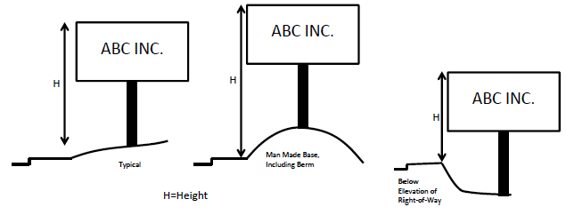
Figure S-3. How to Measure Height of a Freestanding or Ground Mounted Sign
(.03)
Sign Height and Length:
A.
Height of a sign is the vertical distance between the lowest and highest points of the sign.
B.
Length of a sign is the horizontal distance between the furthest left and right points of the sign.
(.04)
Final Determination of Sign Measurement. The Planning Director shall be responsible for determining the area, height above ground and height and length of a sign, subject to appeal as specified in Section 4.022. Applicants for sign plans and permits shall provide the dimensions needed to calculate the area, height above ground, height, and length.
Section 4.156.04. - Non-Conforming Signs.
(.01)
Non-Conforming Signs. Non-conforming signs, which may be non-conforming structures or non-conforming uses, are subject to the standards for non-conforming uses and non-conforming structures delineated in Sections 4.189 through 4.190. Except, however, that a non-conforming sign that is damaged beyond 50 percent of its value, as determined by the City Building Official, may only be reconstructed if the reconstructed sign meets all applicable zoning, structural, and electrical standards applicable at the time of reconstruction. Nothing in this Section is intended to impair any previously approved sign permit that has been issued by the City of Wilsonville, subject to state or federal law, or to require the removal of any sign that was legally erected or installed prior to the effective date of these regulations. In the event that a previously erected or installed sign no longer meets applicable City zoning standards it may remain in place, subject to the standards for non-conforming uses or nonconforming structures noted above. However, a sign that is required to be moved solely because of a public taking may be replaced on the site, and maintain its non-conforming status, subject to a Class II Sign Permit, provided the replacement sign is found to not increase in non-conformity to current Code standards other than required setbacks.
Section 4.156.05. - Signs Exempt from Sign Permit Requirements.
(.01)
The following signs are exempt from the permit requirements of this Code and do not require sign permits. Unless otherwise specified, the area of the exempted signs shall not be included in the calculations of sign area permitted on a given site:
A.
Traffic or other governmental or directional signs, as may be authorized by the City or other units of government having jurisdiction within the City.
B.
Signs installed by public utility companies indicating danger, or which serve as an aid to public safety, or which show the location of utilities or public facilities, including underground utilities.
C.
Flags displayed from permanently-located freestanding or wall-mounted flagpoles that are designed to allow raising and lowering of flags. One site may have up to two exempt flags; no exempt flag may be more than 30 feet in height.
(.02)
Other Signs. No sign permit is necessary before placing, constructing or erecting the following signs. However, in all other particulars such signs shall conform to the requirements of applicable Building and Electrical Codes, as well as this Code.
A.
Signs inside a building except for prohibited signs listed in Section 4.156.06.
B.
Name Plates and Announcements:
1.
A sign identifying the name, street address, occupation and/or profession of the occupant of the premises in the aid of public health and safety. One name plate, not exceeding a total of three square feet shall be allowed for each occupant. The name plate shall be affixed to the building.
2.
Announcements posted on a given property (e.g., no smoking, no parking, rules of conduct, etc.) and not intended to be read from off-site, are permitted to be located as needed. Such announcements shall not be considered to be part of the sign allotment for the property.
C.
Directional Signs. Designed for non-changing messages, directional signs facilitate the safe movement of the traveling public. Such signs are subject to the following standards and conditions:
1.
The sign area does not exceed three (square feet per sign face,
2.
The sign location is not within public rights-of-way and meets City vision clearance requirements;
3.
No sign lighting;
4.
No logo or a logo that does not exceed one square foot in size; and
5.
No more than one directional sign is located on the same tax lot.
D.
Changes of Copy Only, where the graphics contained on an existing sign are changed, but the sign itself is not structurally altered, and no building or electrical permit is required.
E.
Signs not visible from any off-site location.
F.
Holiday lights and decorations, in place between November 15 and January 15.
G.
Signs on scoreboards or ballfields located on public property.
H.
One small decorative banner per dwelling unit placed on site, in residential zones.
I.
Lawn Signs meeting the standards of Table S-1 and the following conditions:
1.
Such signs shall not be intentionally illuminated and shall not display movement.
2.
Such signs shall not obscure sight lines of the motoring public, obscure traffic or other government signs, or create a nuisance to the use or occupancy of any property.
3.
Lawn signs associated with temporary events may be posted no longer than 60 days before the beginning of an event and must be removed at the event's completion.
4.
Lawn signs not associated with temporary events may be posted for one period of up to 60 days in a calendar year.
5.
Such signs may be up to six feet in height.
6.
Such signs may be one or two sided.
J.
Rigid Signs meeting the standards of Table S-1 and the following conditions:
1.
Such signs shall not be intentionally illuminated and shall not display movement.
2.
Such signs shall not obscure sight lines of the motoring public, obscure traffic or other government signs, or create a nuisance to the use or occupancy of any property.
3.
Such signs may be up to six feet in height, except signs on lots with an active construction project (active building permit), which may be up to ten feet in height. (Note that signs exceeding six feet in height typically require building permits.)
4.
Such signs may be one, two, or three sided.
5.
On Residential and Agriculture zoned lots:
a.
A rigid sign not associated with an ongoing temporary event may be displayed for no more than 60 days each calendar year.
b.
A rigid sign associated with an ongoing temporary event may be displayed for the duration of that event. Note: Section 4.156.06(.01)Q. of this Code prohibits signs associated with temporary events to remain posted after the completion of the event.
6.
On Commercial, Industrial, or Public Facility zoned lots:
a.
A rigid sign not associated with an ongoing temporary event may be displayed for no more than 90 days each calendar year.
b.
A rigid sign associated with an ongoing temporary event may be displayed for the duration of that temporary event. Note: Section 4.156.06(.01)Q. of this Code prohibits signs associated with temporary events to remain posted after the completion of the event.
c.
A temporary event must have an end, marked by the occurrence of a specifically anticipated date or happening. A temporary event may not be a part of a broader, continuing event or of related, serial events. Temporary events shall not be defined by content, but may include isolated merchandise sales or discounts, or availability of real estate for sale or lease.
K.
Signs allowed in Subsections 6.150(1) and (2) Wilsonville Code for special events.
Section 4.156.06. - Prohibited Signs.
(.01)
Prohibited Signs. The following signs are prohibited and shall not be placed within the City:
A.
Search lights, strobe lights, and signs containing strobe lights or other flashing lights, unless specifically approved in a sign permit.
B.
Obstructing signs, a sign or sign structure such that any portion of its surface or supports will interfere in any way with the free use of any fire escape, exit, hydrant, standpipe, or the exterior of any window; any sign projecting more than 12 inches from a wall, except projecting signs that are specifically permitted through the provisions of this Code.
C.
Changing image signs, including those within windows.
D.
Changeable copy signs that use lighting changed digitally, unless specifically approved through a waiver process connected with a Class III Sign Permit or Master Sign Plan. In granting a waiver for a digital changeable copy signs the DRB shall ensure the following criteria will be met:
1.
The sign shall be equipped with automatic dimming technology which automatically adjusts the sign's brightness in direct correlation with ambient light conditions and the sign owner shall ensure appropriate functioning of the dimming technology for the life of the sign.
2.
The luminance of the sign shall not exceed 5,000 candelas per square meter between sunrise and sunset, and 500 candelas per square meter between sunset and sunrise.
E.
Roof signs - signs placed on the top of a building or attached to the building and projecting above the top of that building, unless specifically approved through the temporary sign permit procedures or the architectural design of a building makes the slope of the roof below the peak a practicable location of signs on a building and the general location of signs on the roof is approved by the DRB during Stage II Approval, as applicable, and Site Design Review.
F.
Signs obstructing vision clearance areas.
G.
Pennants, streamers, festoon lights, balloons, and other similar devices intended to be moved by the wind, unless specifically authorized in an approved sign permit.
H.
Signs attached to trees, public sign posts, or public utility poles, other than those placed by appropriate government agencies or public utilities.
I.
Signs using bare-bulb illumination or signs lighted so that the immediate source of illumination is visible, unless specifically authorized by the Development Review Board or City Council such as Digital Changeable Copy Signs. This is not intended to prohibit the use of neon or LED's as a source of illumination.
J.
Signs that use flame as a source of light or that emit smoke or odors.
K.
Any sign, including a window sign, which is an imitation of or resembles an official traffic sign or signal; and which may include display of words or graphics that are likely to cause confusion for the public, such as "STOP," "GO," "SLOW," "CAUTION," "DANGER," "WARNING," etc.
L.
Any sign, including a window sign, which by reason of its size, location, movements, content, coloring or manner of illumination may be confused with, or construed as, a traffic control device, or which hides from view any traffic sign, signal, or device.
M.
Portable signs, exceeding six square feet of sign area per side, other than those on vehicles or trailers. The display of signs on a vehicle or trailer is prohibited where the vehicle or trailer is not fully operational for use on public roads or where the primary function of the vehicle or trailer is advertising. Examples where the primary function of the vehicle or trailer is advertising include mobile billboards such as those on which advertising space is rented, sold, or leased.
N.
Signs located on public property in violation of Section 4.156.10.
O.
Signs placed on private property without the property owner's permission.
P.
Signs erected or installed in violation of standards prescribed by the City of Wilsonville, State of Oregon or the U.S. government.
Q.
Signs associated with temporary events, after the temporary event is completed.
R.
Any private signs, including window signs, with a luminance greater than 5,000 candelas per square meter between sunrise and sunset and 500 candelas per square meter between sunset and sunrise.
S.
Video Signs.
Section 4.156.07. - Sign Regulations in Residential Zones.
(.01)
Ground Mounted Signs for Residential Developments. One ground mounted sign, not exceeding 18 square feet in area and six feet in height above ground, shall be permitted for each residential subdivision or for any multi-family development.
A.
Additional ground mounted signs of 18 square feet or less shall be permitted for additional entrances to the subdivision or development located on a separate street frontage or on the same street frontage located at least 200 feet apart.
B.
For one entrance on a street frontage, an additional ground mounted sign may be placed on opposite side of the street or private drive at the intersection.
(.02)
Ground Mounted Signs for Outdoor Recreational Areas on Separate Lots. Public or private parks or other similar outdoor recreational areas on separate lots than dwelling units are allowed one ground mounted sign of 18 square feet or less in area and six feet or less in height above ground.
(.03)
Non-Residential Uses. Uses, other than residential and outdoor recreation, shall be subject to the sign regulations for PDC, TC, TPDI, and Public Facility zones.
(Ord. No. 835, 6-5-2019)
Section 4.156.08. - Sign Regulations in the PDC, TC, PDI, and PF Zones.
(.01)
Freestanding and Ground Mounted Signs:
A.
One freestanding or ground mounted sign is allowed for the first 200 linear feet of site frontage. One additional freestanding or ground mounted sign may be added for through and corner lots having at least 200 feet of frontage on one street or right-of-way and 100 feet on the other street or right-of-way.
B.
The allowed height above ground of a freestanding or ground mounted sign is 20 feet except as noted in 1-2 below.
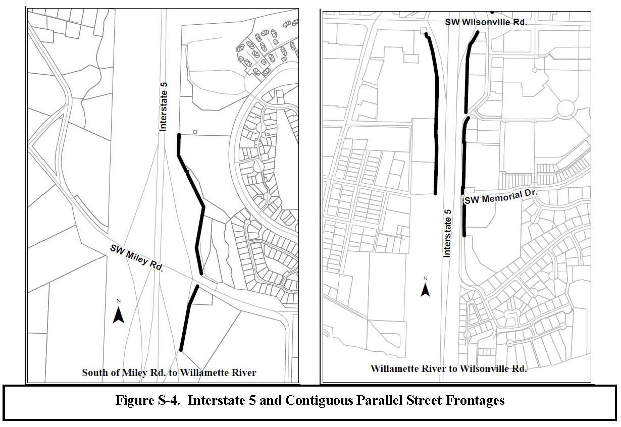
1.
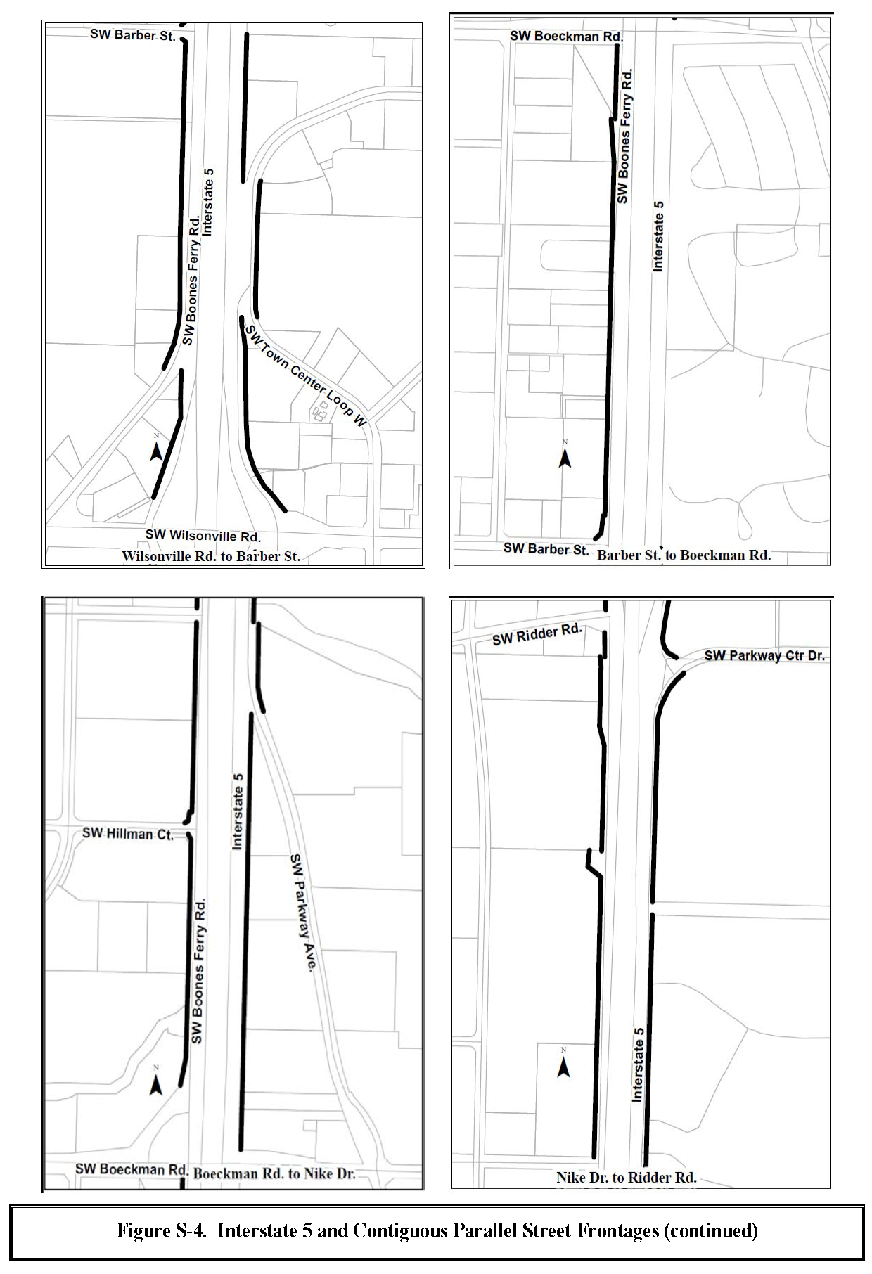
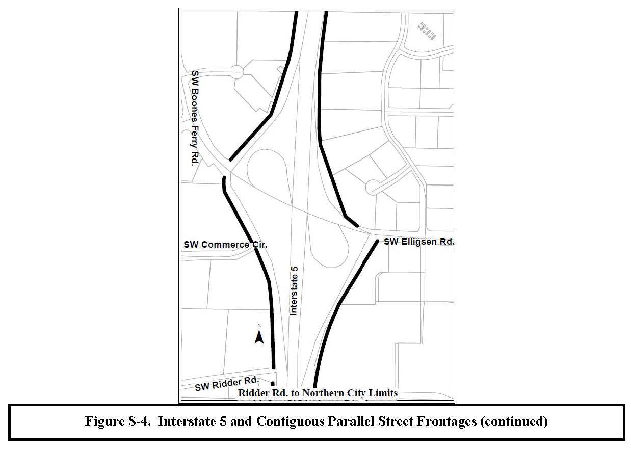
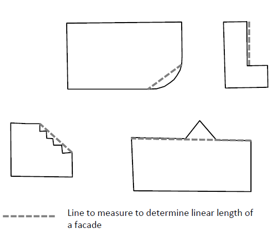
The maximum allowed height above ground for signs along the frontage of Interstate 5, and parallel contiguous portions of streets, as identified in Figure S-4, associated with multiple tenants or businesses may be increased by three feet for each tenant space of 10,00 square feet or more of gross floor area up to a maximum of 35 feet.
2.
The allowed height above ground for signs in the TC Zone, Old Town Overlay Zone, and PDI Zone is eight feet, except those signs along the frontage of Interstate 5 and parallel contiguous portions of streets identified in Figure S-4.
C.
The maximum allowed area for each freestanding or ground-mounted sign is determined based on gross floor area and number of tenant spaces:
1.
For frontages along streets other than those indicated in two below sign area allowed is calculated as follows:
a.
The sign area allowed for signs pertaining to a single tenant:
i.
For PF (Public Facility) zoned properties adjacent to residential zoned land the maximum allowed area is 32 square feet.
b.
The maximum allowed sign area for signs pertaining to multiple tenants or businesses is 32 square feet plus the following for each tenant space:
i.
The total sign area shall not exceed 200 square feet, except in the TC Zone, Old Town Overlay Zone, and PDI Zone the total sign area shall not exceed 80 square feet.
ii.
Though the maximum allowed sign area is calculated based on number of tenant spaces and their size, the content of the sign and area used for different content is at the discretion of the sign owner, except for required addressing.
2.
Signs fronting Interstate 5 and parallel contiguous street sections, as identified in Figure S-4.
a.
For signs on properties or within developments with a single tenant or business the sign area allowed is 64 square feet.
b.
For signs on properties or within developments with multiple tenants or businesses the maximum allowed area is 64 square feet plus an additional 32 square feet for each tenant space of 10,000 square feet or more of gross floor area up to a maximum total sign area of 300 square feet.
i.
Though the sign area allowed is calculated based on number of large tenant spaces, the content of the sign and area used for different content is at the discretion of the sign owner, except for any required addressing.
D.
Pole or sign support placement shall be installed in a full vertical position.
E.
Freestanding and ground mounted signs shall not extend into or above public rights-of-way, parking areas, or vehicle maneuvering areas.
F.
The location of free standing or ground mounted signs located adjacent to or near the Public Right-of-Way shall be in compliance with the City's Public Works Standards for sight distance clearance. Prior to construction, the location of the sign shall be approved by the City of Wilsonville Engineering Division.
G.
Freestanding and ground mounted signs shall be designed to match or complement the architectural design of buildings on the site.
H.
For freestanding and ground mounted signs greater than eight feet in height, the width of the sign shall not exceed the height.
I.
Along street frontages in the TC Zone and Old Town Overlay Zone monument style signs are required.
J.
Freestanding and ground mounted signs shall be no further than 15 feet from the property line and no closer than two feet from a sidewalk or other hard surface in the public right-of-way.
K.
Except for those signs fronting Interstate 5, freestanding and ground mounted signs shall include the address number of associated buildings unless otherwise approved in writing by the City and the Fire District.
L.
When a sign is designed based on the number of planned tenant spaces it shall remain a legal, conforming sign regardless of the change in the number of tenants or configuration of tenant spaces.
(.02)
Signs on Buildings:
A.
Sign Eligible Facades. Building signs are allowed on a facade of a tenant space or single tenant building when one or more of the following criteria are met:
1.
The facade has one or more entrances open to the general public;
2.
The facade faces a lot line with frontage on a street or private drive with a cross section similar to a public street, and no other buildings on the same lot obstruct the view of the building facade from the street or private drive; or
3.
The facade is adjacent to the primary parking area for the building or tenant.
B.
Sign Area Allowed:
1.
The sign area allowed for all building signs on a sign eligible façade is shown in the table below:
* Except as noted in 2. through 5. below
2.
The sign area allowed for facades with a primary public entrance or with a frontage along a public street dominated by windows or glazing may be increased by transferring to the façade up to one-half the sign area allowed for adjacent facades up to 50 square feet. In no case shall the allowed sign area exceed an area equal to the linear length of the façade.
3.
The sign area allowed is increased as follows for signs at separate building entrances:
a.
For building entrances open to the general public located at least 50 feet apart on the same facade, the sign area allowed is increased by 50 percent up to 50 square feet.
b.
For building entrances located less than 50 feet apart on the same facades, the sign area allowed is increased by 20 percent up to 20 square feet.
4.
For businesses occupying multiple buildings in a campus setting, sign area shall be limited to that allowed for the largest building. which may then be distributed throughout the campus.
5.
If a façade otherwise not sign eligible faces a lot line with frontage on Interstate 5, the applicant can transfer sign area allowed from one of the locations described in a. and b. below. In no case shall the allowed sign area exceed an area equal to the allowed sign area for a sign eligible façade of the same linear length.
a.
The freestanding sign along the Interstate 5 frontage. This generally involves placing building signs on the subject façade in lieu of installing a freestanding sign.
b.
Adjacent façade up to 50 square feet, when a majority of the adjacent façade from which the sign area is being transferred is visible from Interstate 5.
6.
Calculating linear length of a façade for the purpose of determining maximum sign area allowed. For facades of a single tenant building the length the facade measured at the building line, except as noted in a. and b. below. For multi-tenant buildings the width of the façade of the tenant space shall be measured from the centerline of the party walls or the outer extent of the exterior wall at the building line, as applicable, except as noted in a. and b. below. Applicants shall provide the dimensions needed to calculate the length. Each tenant space or single occupant building shall not be considered to have more than five total facades.
a.
If a façade is curvilinear, stepped, or otherwise not a straight line, the façade shall be measured by drawing a straight line between the edges of the façade as shown in the figure below.
b.
For an "L" shaped tenant space or single tenant building the longest leg of the interior of the "L" shall be basis for measuring the length of the L-shaped facade. Sign area allowed based on the longest leg can be distributed between legs.
C.
The length of individual tenant signs shall not exceed 75 percent of the length of the facade of the tenant space.
D.
The height of building signs shall be within a definable sign band, fascia, or architectural feature and allow a definable space between the sign and the top and bottom of the sign band, fascia, or architectural feature.
E.
Types of signs permitted on buildings include wall flat, fascia, projecting, blade, marquee and awning signs. Roof-top signs are prohibited.
(.03)
Additional signs. Notwithstanding the signs allowed based on the site in (.01) and (.02) above, the following signs may be permitted, subject to standards and conditions in this Code:
A.
Directional Signs. In addition to exempt directional signs allowed under Subsection 4.156.05(.02)C. freestanding or ground mounted directional signs six square feet or less in area and four feet or less in height:
1.
The signs shall be designed to match or complement the architectural design of buildings on the site;
2.
The signs shall only be placed at the intersection of internal circulation drives; and
3.
No more than one sign shall be placed per intersection corner with no more than two signs per intersection.
B.
Planned Development Signs. Up to 32 square feet of the allowed sign area for freestanding signs in a planned development may be used for a separate on-site monument sign or off-site monument sign on an adjacent parcel identifying the Planned Development project.
C.
Blade Signs. To aid in pedestrian wayfinding, one blade sign, not to exceed six square feet, per facade eligible for building signs. Blade signs over pedestrian accessible areas shall provide a minimum of eight feet of clearance from the ground.
D.
Fuel or Service Station Price Signs. In addition to the freestanding or ground mounted signs allowed, changeable copy signs shall be allowed for the purpose of advertising fuel prices, subject to the following standards and conditions:
1.
The signs shall have a maximum of 11 square feet in area per face per type of fuel sold and shall be permanently affixed to the building or a freestanding sign.
2.
The signs shall not be considered in calculating the sign area or number of signs allowed.
3.
Signs on fuel pumps shall be permitted, providing that they do not project beyond the outer edge of the pump in any direction.
(Ord. No. 835, 6-5-2019)
Section 4.156.09. - Temporary Signs in all Zones.
In addition to the permanent signs allowed in different zones and exempt temporary signs, unless specifically prohibited in a master sign plan or other sign approval, the following temporary signs may be permitted through a temporary sign permit:
(.01)
General Allowance. Except as noted in subsection (.02) below up to two temporary signs not exceeding a combined total of 24 square feet may be permitted per lot or non-residential tenant. Such signs may be banners, rigid signs, lawn signs, portable signs, or other signs of similar construction.
(.02)
Opening Banner for a New Business or Housing Development. A banner corresponding with the opening of a new business or housing development may be permitted, subject to the following standards and conditions:
A.
One such banner shall be allowed either from the date of issuance of Building Permits until four weeks after issuance of Certificates of Occupancy, or if no Building Permit is issued, for four weeks after occupancy of a new business.
B.
Such banner may be two-sided but shall not exceed 32 square feet per face.
C.
Such signs shall not be permitted at the same time as general allowance signs in (.01) above.
(.03)
Annual Event Signs. Up to ten lawn signs may be permitted to be located in the public right-of-way for up to 14 days if all of the following are met:
A.
Signs will not be located in the areas listed in Subsection 4.156.10(.01)A.4.
B.
The applicant or event has not been issued a permit for and placed signs in the public right-of-way in the previous six months;
C.
Not more than one other permit has been issued for lawn signs in the right-of-way during the time period the applicant is requesting;
D.
The event to which the signs pertain is expected to attract 250 or more people;
E.
The request is not in addition to exempt lawn signs for large special events allowed for in Section 6.150; and
F.
The applicant has indicated on a map the exact locations the signs will be placed and has submitted an application along with the required fee.
(.04)
Inflatable Signs. Inflatable signs may be permitted for a maximum of 15 days of display use in any calendar year subject to the following standards and conditions:
A.
Does not exceed ten feet in overall height; and
B.
If attached to a building in any manner, it meets applicable building Code requirements including consideration of wind loads.
(Ord. No. 882, § 2(Exh. A), 10-2-2023)
Section 4.156.10. - Signs on City and ODOT Right-of-Way.
(.01)
Signs on City Property. For the purposes of this section, City property is defined as physical sites, City rights-of-way, and rights-of-way over which the City has jurisdiction. City property includes, but is not limited to, the following: City Hall, the Community Center, the Library, parks and open space, Transit and Fleet Building, SMART Central, and the City's reservoir, pump station, and treatment plant properties.
A.
Allowed Signs. The following signs may be placed on City property and/or City rights-of-way and rights-of-way over which the City has jurisdiction under the following conditions:
1.
Such signs as are necessary to locate and direct the public to City premises, or other governmental premises.
2.
Such signs as are necessary for the public's health, safety and welfare authorized under law, regulation, ordinance, or order including but not limited to traffic signs. This shall include signs authorized to conform with the State's Tourism Information program and any similar local government program.
3.
Signs and their placement as authorized in subsections 1 and 2, above, shall meet all other applicable standards and criteria under law, regulation, ordinance, or order.
4.
Lawn signs may be placed, subject to the standards in subsection 4.156.10(.01)A.5., below, on City rights-of-way and rights-of-way over which the City has jurisdiction except 1) those rights-of-way adjoining City properties defined in subsection 4.156.10(.01) above, and 2) in the following locations where the placement of signs could damage landscaping or interfere with the maintenance of the rights-of-way:
a.
In any median or landscaped strip inside the City limits as identified below in Sections 4.156.10(.01)A.4.b. through p.
b.
Either side of French Prairie Road.
c.
Either side of Canyon Creek Road North, from Boeckman Road to Elligsen Road.
d.
Either side of Wilsonville Road between Town Center Loop East and the Portland & Western (previously Burlington Northern) Railroad property.
e.
Either side of Town Center Loop West and East.
f.
Both sides of former S.W. Parkway frontage between Town Center Loop West and Wilsonville Road.
g.
Wilsonville Road between Willamette Way West and Willamette Way East.
h.
The north side of Wilsonville Road from Town Center Loop East to Boeckman Creek.
i.
Either side of Wilsonville Road between Boeckman Road and the southern boundary of the Wilsonville High School property.
j.
Either side of Parkway Center Avenue.
k.
The south side of Elligsen Road from the eastern City limits to a point directly across from the west side of the Tualatin Valley Fire District fire station.
l.
Either side of Boeckman Road and all islands, from the railroad tracks west to 110 th .
m.
Either side of 110 th between Barber Street and Boeckman Road.
n.
The eastern side of Grahams Ferry Road from Tooze Road to the City limits.
o.
Either side of Barber Street between 110 th and Brown Road, including islands and roundabouts.
p.
Such other areas as the City may designate as requiring protection from landscape damage.
5.
Lawn signs shall meet the following standards and conditions:
a.
Allowed only between the hours of 6:00 a.m. Friday and 8:00 p.m. Sunday, and the hours of 9:00 a.m. and 4:00 p.m. Tuesdays;
b.
Not greater than 30 inches in height. A-frame signs may be 24" by 36" provided that they are designed to meet vision clearance requirements (typically not over 30 inches in height when standing);
c.
Not placed on street surfaces, sidewalks, paths, median strips, or bicycle ways;
d.
Located within 40 feet of an intersection;
e.
No more than three signs per person; and
f.
Placed no more than one every 50 feet and at least ten feet away from any other temporary sign.
6.
Banners on public light and other poles identified in a plan maintained or adopted by the City and installed by or under arrangement with the Public Works Department.
(.02)
Signs within ODOT Right-of-Way. Consistent with the Laws and Administrative Rules of the State of Oregon, all signs of any kind are prohibited within right-of-way of the Oregon Department of Transportation (ODOT), except those signs that are specifically determined by ODOT to be necessary for the public's health, safety, or welfare. The City may assist the State in the removal of signs that are illegally placed within ODOT right-of-way, as provided above for signs in City right-of-way. City assistance is justified in view of the substantial public investment that has recently been made to improve and beautify both freeway interchange areas north of the Willamette River.
Section 4.156.11. - Sign Enforcement.
(.01)
General. Any person who places a sign that requires a permit under this section, and who fails to obtain a permit before installing the sign, shall be subject to penalties and fines as established in Wilsonville Code 4.025.
(.02)
Removal of Signs. Any sign placed on public property in violation of the provisions of this Code shall be immediately removed by the City. As soon thereafter as reasonable, the City shall notify the owner or the owner's representative that the sign has been removed, and that if the sign is not claimed within ten days, the sign will be deemed abandoned and subject to disposal by the City. The City shall have no responsibility to contact the owner of the sign if the owner's name, address, and telephone number are not clearly indicated on the sign and shall dispose of the sign ten days after its removal by the City. The City Council may establish fees to be collected at the time of releasing impounded signs in order to cover the City's costs in collecting, storing, and returning these signs and administering the sign removal program.
(.03)
Civil Enforcement. Any sign which is intentionally placed in violation of the provisions of this Code after the owner of the sign has been notified of the initial sign removal and reason for its removal, shall subject the owner to a civil violation not to exceed $100.00 as and for a civil fine for each day that a violation continues to exist.
(.04)
Additional enforcement. The remedies described herein are not exclusive and may be used in addition to those prescribed elsewhere in the Wilsonville Code, including Sections 1.012 and 1.013, Violations, and 6.200 through 6.620, Nuisances. The City Attorney may use any enforcement process available at law or equity, including but not limited to, seeking injunctive relief, equitable relief, damages, or fines for violations.
(Ord. No. 675, 3-1-2010; Ord. No. 704, 6-18-2012)
Section 4.162. - General Regulations—Livestock and Farm Animals.
(.01)
Under no circumstances shall any livestock animals, farm animals, poultry or fowl be kept for commercial purposes in a Residential or Planned Development Zone, except where such animal keeping is a legal non-conforming use. The animals listed below shall not be kept on lots having an area of less than one acre. The total number of such animals (other than their young under the age of six months) allowed on a lot shall be limited to the square footage of the lot divided by the total minimum areas required for each animal as listed below.
A.
One horse or cow: 20,000 square feet.
B.
One goat, llama or sheep: 10,000 square feet.
C.
One swine: 2,000 square feet. (Maximum two swine per individual lot or contiguous lots under individual ownership).
D.
One ostrich: 4,000 square feet.
E.
One emu: 2,000 square feet.
(.02)
Animal runs or barns, chicken or fowl pens shall be located no closer than 100 feet from any residence other than the residence of the owner. Swine pens shall be located a minimum of 200 feet from any residence other than that of the resident owner.
(.03)
Animals, chickens and/or fowl shall be properly caged or housed, and proper sanitation shall be maintained at all times. All animal or poultry food shall be stored in metal or other rodent-proof receptacles.
(.04)
Upon a receipt of a formal complaint by adjacent property owners alleging improper or unsanitary maintenance of animal runs, pens or barn, the Development Review Board shall hold a public hearing and adopt findings as to the validity of said complaint. Based on the adopted findings, the Board may impose conditions or restrictions as determined necessary to insure proper maintenance and sanitation, including prohibition of raising livestock and farm animals on the subject site.
(.05)
"Pot-bellied" pigs may be considered to be either livestock or household pets, depending upon the accommodations provided for them. If such pigs are kept primarily within a dwelling unit, they shall be considered to be household pets, subject to the same rules as the keeping of dogs. If they are kept primarily outside of a dwelling unit, they shall be considered to be livestock, and subject to the provisions listed above.
Section 4.163. - General Regulations—Temporary Structures and Uses.
(.01)
The Development Review Board, after hearing as set forth in Section 4.012, may permit the temporary use of a structure or premises in any zone for a purpose or use that does not conform to the regulations prescribed elsewhere in this Code for the zone in which it is located, provided that such use be of a temporary nature and does not involve the erection of a substantial structure. A permit for such use may be granted in the form of a temporary and revocable permit, up to a five year period, subject to a showing of good cause and such conditions as will safeguard the public health, safety, convenience and general welfare. Such permits may be renewable upon re-application to the Development Review Board, provided that the Board finds that the renewal is not likely to result in a permanent situation.
(.02)
Applications for Temporary Use Permits shall provide:
A.
A clear description of the proposed temporary structure/use and the reasons why a temporary structure/use is necessary at this location for the requested time period.
B.
A statement of the expected duration of the temporary use/structure, together with documentation supporting the proposed date for termination of the temporary use/structure
C.
A site plan showing the location of the proposed use/structure, access, associated parking, pedestrian connections to the greater site if appropriate, lighting, signage and landscaping.
D.
A plan for removal of the temporary use/structure and restoration of the site to pre-TUP conditions or development of the site for approved permanent structures/uses.
(.03)
Factors and considerations for "good cause" include, but are not limited to:
A.
Availability of appropriately zoned land for the proposed use in the City.
B.
Availability of and need for the subject property for allowed uses.
C.
Market conditions, construction costs and other obstructions to the location of the use on appropriately zoned land.
D.
Due diligence of the applicant to site the use on appropriately zoned land,
E.
Circumstances of the applicant bearing on the need for the temporary use permit.
(.04)
The Planning Director of the City and the Director's staff shall be authorized to issue, without public hearing and upon application for Administrative Review pursuant to Section 4.035, a temporary permit for a use of less than two weeks duration which does not involve the erection of a substantial structure. Examples of such uses are farmer's market sales, Fourth of July fireworks stands, Christmas tree sales and Boones Ferry Days. For the purposes of this provision, those structures and signs commonly associated with these special events are not "substantial structures."
(Ord. No. 659, 3-16-2009)
Section 4.164. - General Regulations—Uses Not Listed.
(.01)
The Planning Director may determine that a proposed use is sufficiently similar to other uses permitted in the zone to allow that use without special review. Such determinations may be made through the Class II Administrative Review procedure listed in Section 4.035, or may be at the initiation of the Director. In either case, written notification of the decision, including opportunity for appeal, shall be provided to the public as well as to the members of the Development Review Board and Planning Commission.
Section 4.166. - General Regulations—Unsafe Buildings.
(.01)
Nothing in this Code shall prevent the strengthening or restoring to a safe condition of any building or structure declared unsafe by Building Official or City Engineer.
Section 4.167. - General Regulations—Access, Ingress and Egress.
(.01)
Each access onto streets or private drives shall be at defined points as approved by the City and shall be consistent with the public's health, safety and general welfare. Such defined points of access shall be approved at the time of issuance of a building permit if not previously determined in the development permit.
(Ord. No. 682, 9-9-2010)
Section 4.169. - General Regulations—Double-Frontage Lots.
(.01)
Buildings on double frontage lots (i.e., through lots) and corner lots must meet the front yard setback for principal buildings on both streets or tracts with a private drive.
(.02)
Given that double-frontage lots tend to have one end that is regarded as a rear yard by the owner, the Development Review Board may establish special maintenance conditions to apply to such areas. Such conditions may include the requirement that the subject homeowners association, if any, be responsible for the on-going maintenance of the street frontage areas of double-frontage lots.
(Ord. No. 682, 9-9-2010)
Section 4.171. - General Regulations—Protection of Natural Features and Other Resources.
(.01)
Purpose. It is the purpose of this Section to prescribe standards and procedures for the use and development of land to assure the protection of valued natural features and cultural resources. The requirements of this Section are intended to be used in conjunction with those of the Comprehensive Plan and other zoning standards. It is further the purpose of this Section:
A.
To protect the natural environmental and scenic features of the City of Wilsonville.
B.
To encourage site planning and development practices which protect and enhance natural features such as riparian corridors, streams, wetlands, swales, ridges, rock outcroppings, views, large trees and wooded areas.
C.
To provide ample open space and to create a constructed environment capable and harmonious with the natural environment.
(.02)
General Terrain Preparation:
A.
All developments shall be planned, designed, constructed and maintained with maximum regard to natural terrain features and topography, especially hillside areas, floodplains, and other significant landforms.
B.
All grading, filling and excavating done in connection with any development shall be in accordance with the Uniform Building Code.
C.
In addition to any permits required under the Uniform Building Code, all developments shall be planned, designed, constructed and maintained so as to:
1.
Limit the extent of disturbance of soils and site by grading, excavation and other land alterations.
2.
Avoid substantial probabilities of: (l) accelerated erosion; (2) pollution, contamination, or siltation of lakes, rivers, streams and wetlands; (3) damage to vegetation; (4) injury to wildlife and fish habitats.
3.
Minimize the removal of trees and other native vegetation that stabilize hillsides, retain moisture, reduce erosion, siltation and nutrient runoff, and preserve the natural scenic character.
(.03)
Hillsides. All developments proposed on slopes greater than 25 percent shall be limited to the extent that:
A.
An engineering geologic study approved by the City, establishes that the site is stable for the proposed development, and any conditions and recommendations based on the study are incorporated into the plans and construction of the development. The study shall include items specified under subsection 4.171(.07)A.2.a—j:
B.
Slope stabilization and re-vegetation plans shall be included as part of the applicant's landscape plans.
C.
Buildings shall be clustered to reduce alteration of terrain and provide for preservation of natural features.
D.
Creation of building sites through mass pad grading and successive padding or terracing of building sites shall be avoided where feasible.
E.
Roads shall be of minimum width, with grades consistent with the City's Public Works Standards.
F.
Maintenance, including re-vegetation, of all grading areas is the responsibility of the developer, and shall occur through October 1 of the second growing season following receipt of Certificates of Occupancy unless a longer period is approved by the Development Review Board.
G.
The applicant shall obtain an erosion and sediment control permit from the City's Building and Environmental Services Division's.
(.04)
Trees and Wooded Areas:
A.
All developments shall be planned, designed, constructed and maintained so that:
1.
Existing vegetation is not disturbed, injured, or removed prior to site development and prior to an approved plan for circulation, parking and structure location.
2.
Existing wooded areas, significant clumps/groves of trees and vegetation, and all trees with a diameter at breast height of six inches or greater shall be incorporated into the development plan and protected wherever feasible.
3.
Existing trees are preserved within any right-of-way when such trees are suitably located, healthy, and when approved grading allows.
B.
Trees and woodland areas to be retained shall be protected during site preparation and construction according to City Public Works design specifications, by:
1.
Avoiding disturbance of the roots by grading and/or compacting activity.
2.
Providing for drainage and water and air filtration to the roots of trees which will be covered with impermeable surfaces.
3.
Requiring, if necessary, the advisory expertise of a registered arborist/horticulturist both during and after site preparation.
4.
Requiring, if necessary, a special maintenance, Management program to insure survival of specific woodland areas of specimen trees or individual heritage status trees.
(.05)
High Voltage Powerline Easements and Right-of-Way and Petroleum Pipeline Easements:
A.
Due to the restrictions placed on these lands, no residential structures shall be allowed within high voltage powerline easements and rights-of-way and petroleum pipeline easements, and any development, particularly residential, adjacent to high voltage powerline easements and rights-of-way and petroleum pipeline easements shall be carefully reviewed.
B.
Any proposed non-residential development within high voltage powerline easements and rights-of-way and petroleum pipeline easements shall be coordinated with and approved by the Bonneville Power Administration, Portland General Electric Company or other appropriate utility, depending on the easement or right-of-way ownership.
(.06)
Hazards to Safety: Purpose.
A.
To protect lives and property from natural or human-induced geologic or hydrologic hazards and disasters.
B.
To protect lives and property from damage due to soil hazards.
C.
To protect lives and property from forest and brush fires.
D.
To avoid financial loss resulting from development in hazard areas.
(.07)
Standards for Earth Movement Hazard Areas:
A.
No development or grading shall be allowed in areas of land movement, slump or earth flow, and mud or debris flow, except under one of the following conditions:
1.
Stabilization of the identified hazardous condition based on established and proven engineering techniques which ensure protection of public and private property. Appropriate conditions of approval may be attached by the City.
2.
An engineering geologic study approved by the City establishing that the site is stable for the proposed use and development. The study shall include the following:
a.
Index map.
b.
Project description, to include: location; topography, drainage, vegetation; discussion of previous work; and discussion of field exploration methods.
c.
Site geology, to include: site geologic map; description of bedrock and superficial materials including artificial fill; location of any faults, folds, etc.; and structural data including bedding, jointing, and shear zones.
d.
Discussion and analysis of any slope stability problems.
e.
Discussion of any off-site geologic conditions that may pose a potential hazard to the site or that may be affected by on-site development.
f.
Suitability of site for proposed development from geologic standpoint.
g.
Specific recommendations for cut slope stability, seepage and drainage control, or other design criteria to mitigate geologic hazards.
h.
Supportive data, to include: cross sections showing subsurface structure; graphic logs of subsurface explorations; results of laboratory tests; and references.
i.
Signature and certification number of engineering geologist registered in the State of Oregon.
j.
Additional information or analyses as necessary to evaluate the site.
B.
Vegetative cover shall be maintained or established for stability and erosion control purposes.
C.
Diversion of storm water into these areas shall be prohibited.
D.
The principal source of information for determining earth movement hazards is the State Department of Geology and Mineral Industries (DOGAMI) Bulletin 99 and any subsequent bulletins and accompanying maps. Approved site specific engineering geologic studies shall be used to identify the extent and severity of the hazardous conditions on the site, and to update the earth movement hazards database.
(.08)
Standards for Soil Hazard Areas:
A.
Appropriate siting and design safeguards shall insure structural stability and proper drainage of foundation and crawl space areas for development on land with any of the following soil conditions: wet or high water table; high shrink-swell capability; compressible or organic; and shallow depth-to-bedrock.
B.
The principal source of information for determining soil hazards is the State DOGAMI Bulletin 99 and any subsequent bulletins and accompanying maps. Approved site-specific soil studies shall be used to identify the extent and severity of the hazardous conditions on the site, and to update the soil hazards database accordingly.
(.09)
Historic Protection: Purpose.
A.
To preserve structures, sites, objects, and areas within the City of Wilsonville having historic, cultural, or archaeological significance.
B.
Standards:
1.
All developments shall be planned, designed, constructed, and maintained to assure protection of any designated historic or cultural resource on or near the site. Restrictions on development may include:
a.
Clustering of buildings and incorporation of historic and/or cultural resources into site design in a manner compatible with the character of such resource.
b.
Limitations on site preparation and grading to avoid disturbance of areas within any historic or archaeological sites, monuments or objects of antiquity.
c.
Provision of adequate setbacks and buffers between the proposed development and the designated resources.
2.
The City may attach additional conditions with respect to the following design factors in protecting the unique character of historic/cultural resources:
a.
Architectural compatibility;
b.
Proposed intensity of development;
c.
Relationship to designated open space;
d.
Vehicular and pedestrian access; and
e.
Proposed building or structural mass in relation to the designated resource.
C.
Review Process:
1.
The Development Review Board shall be the review body for:
a.
All development which proposes to alter a designated historic, or cultural resource or resource site; and
b.
All development which proposes to use property adjacent to a designated cultural resource; and
c.
All applications requesting designation of a cultural or historic resource.
2.
The application shall include the following:
a.
A complete list of exterior materials, including color of these materials.
b.
Drawings:
i.
Side elevation for each side of any affected structure.
ii.
Drawings shall show dimensions or be to scale.
iii.
Photographs may be used as a substitute for small projects.
c.
Plot plans shall be submitted for new structures, fences, additions exceeding 50`1 square feet, or any building relocation.
3.
Any improvement proposed for property adjacent to a designated, cultural or historic resource site, shall be subject to the following provisions:
a.
All uses and structures which are incompatible with the character of the cultural or historic resource are prohibited. The criteria used to determine incompatibility shall include the following:
i.
The intensity and type of use when compared with the historic use patterns of the areas.
ii.
The orientation, setback, alignment, spacing and placement of buildings.
iii.
The scale, proportions, roof forms, and various architectural features of building design.
b.
Setbacks may be required which are over and above those required in the base zone in order to protect the resource. Setbacks should be appropriate to the scale and function of the resource, but allow reasonable use of the adjacent property.
c.
An appropriate buffer or screen may be required between the new or converting use on the adjacent property and the resource.
4.
Nothing in this chapter shall be construed to prevent the ordinary maintenance or repair of any exterior architectural feature in or on any property covered by this chapter that does not involve a change in design, material or external reconstruction thereof, nor does this Code prevent the construction, reconstruction, alteration, restoration, demolition or removal of any such feature when the Building Official certifies to the Development Review Board that such action is required for the public safety due to an unsafe or dangerous condition which cannot be rectified through the use of acceptable building practices.
5.
The owner, occupant or other person in actual charge of a cultural resource, or an improvement, building or structure in an historic district shall keep in good repair all of the exterior portions of such improvement, building or structure, all of the interior portions thereof when subject to control as specified in the designating ordinance or permit, and all interior portions thereof whose maintenance is necessary to prevent deterioration and decay or any exterior architectural feature.
(.10)
Alteration and Development Criteria.
A.
Demolition or alteration of any structure, or any change in any site or object which has been designated as a cultural resource, is prohibited unless it is determined:
1.
In the case of a designated cultural resource, the proposed work would not detrimentally alter, destroy or adversely affect any exterior architectural or other identified feature; or
2.
In the case of any property located within a historic district, the proposed construction, removal, rehabilitation, alteration, remodeling, excavation or exterior alteration conforms to any prescriptive standards as adopted by the City, and does not adversely affect the character of the district; or
3.
In the case of construction of a new improvement, building or structure upon a cultural resource site, the exterior of such improvements will not adversely affect and will be compatible with the external appearance of existing designated improvements, buildings and structures on said site; or
4.
That no reasonable use can be made of the property without such approval.
(.11)
Cultural Resource Designation Criteria. A cultural resource may be designated and placed on the Cultural Resources Inventory if it meets the following criteria:
A.
It exemplifies or reflects special elements of the City's cultural, social, economic, political, aesthetic, engineering or architectural history; or
B.
It is identified with persons or events significant in local, state, or national history; or
C.
It embodies distinctive characteristics of a style, type, period, or method of construction, or it is a valuable example of the use of indigenous materials or craftsmanship; or
D.
It is representative of the notable work of a builder, designer, or architect.
Section 4.172. - Flood Plain Regulations.
(.01)
Purpose:
A.
To minimize public and private losses due to flood conditions in flood-prone areas.
B.
To regulate uses and alteration of land which would otherwise cause erosion, decreased storm water storage capability, increased flood heights or velocities.
C.
To require that uses vulnerable to floods, including facilities which serve such uses, be protected against flood damage at the time of initial construction, alteration or remodeling.
D.
To restrict filling, grading, dredging, and other development which would increase flood damage.
E.
To prevent construction of flood barriers which would unnaturally divert flood waters or increase flood hazards in other areas.
F.
To properly regulate the 100-year flood plain identified by the Federal Insurance Administration (FIA) in the "Flood Insurance Study for Clackamas County and Incorporated Areas dated effective June 17, 2008l, and displayed on FIA Floodway and Flood Insurance Rate Maps dated effective June 17, 2008, which are on file with the City's Community Development Department.
G.
To implement the policies of the Comprehensive Plan and to provide standards consistent with Wilsonville's adopted Storm Drainage Master Plan.
H.
To insure the City and its residents and businesses, continued eligibility in the National Flood Insurance Program by complying with the requirements of the National Flood Insurance Act of l968 and the Flood Disaster Protection Act of l973.
(.02)
General Provisions Affecting Flood Plains:
A.
This section shall apply to all flood plain areas in the City of Wilsonville identified by the Flood Insurance Rate Map. No Building Permits, Construction Permits, or Development Permits for development within the flood plain shall be issued except in compliance with the provisions of the Section.
B.
Basis for Establishing the Areas of Special Flood Hazard. The areas of special flood hazard identified by the Federal Insurance Administration in a scientific and engineering report entitled "Flood Insurance Study - Clackamas County, Oregon and Incorporated Areas, effective June 17, 2008," with accompanying Flood Insurance Rate Maps (effective date June 17, 2008) is hereby adopted by reference and declared part of this ordinance. The Flood Insurance Study is on file at the City of Wilsonville Community Development Department.
C.
The City of Wilsonville Community Development Director shall review all Building and Grading Permit applications for new construction or substantial improvement to determine whether proposed building or grading sites will be located in a flood plain. If a proposed building or grading site is located within a flood plain, any proposed new construction, grading, or substantial improvement (including prefabricated and manufactured housing) must:
1.
Be designed (or modified) and anchored to prevent flotation, collapse or lateral movement of the structure.
2.
Use construction materials and utility equipment that are resistant to flood damage,
3.
Use construction methods and practices that will minimize flood damage, and
4.
Limit the addition of any fill material such that the total volume of fill within the flood plain does not exceed the volume of material removed from the flood plain in the same area.
D.
That the City of Wilsonville Planning Director shall review subdivision proposals and other proposed new developments within the flood plain to assure that:
1.
All such proposals are consistent with the need to minimize flood damage,
2.
All public utilities and facilities, such as sewer, gas, electrical and water systems are located, elevated and constructed to minimize or eliminate flood damage,
3.
Adequate drainage is provided so as to reduce exposure to flood hazards, and
4.
No new lots or parcels shall be created for the purpose of increasing the development of buildings for human occupancy within the flood plain.
E.
That the City of Wilsonville Community Development Director shall require new or replacement water supply systems and/or sanitary sewage systems to be designed to minimize or eliminate infiltration of flood waters into the systems and discharges from the systems into flood waters and require on-site waste disposal systems to be located so as to avoid impairment of them or contamination from them during flooding.
(.03)
Development Permit Required:
A.
A Development Permit shall be obtained before construction or development, including grading, begins within any area of special flood hazard. The Permit shall be for all structures including manufactured homes and for all development including fill and other activities.
B.
Outright Permitted Uses in the 100-year Flood Plain:
1.
Agricultural use that is conducted without a structure other than a boundary fence.
2.
Recreational uses which would require only minor structures such as picnic tables and barbecues.
3.
Residential uses that do not contain buildings.
4.
Underground utility facilities.
5.
Repair, reconstruction or improvement of an existing structure, the cost of which is less than 50 percent of the market value of the structure, as determined by the City's Building Official, prior to the improvement or the damage requiring reconstruction, provided no development occurs in the floodway.
(.04)
Uses within the 100-year Flood Plain requiring a Flood Plain Permit:
A.
Any development except as specified in subsection (.03), above, that is otherwise permitted within the Zoning District provided such development is consistent with the Flood Plain Standards.
B.
All subdivisions and land partitions.
C.
Installation of dikes to provide buildable or usable property, provided that said dikes do not conflict with the policies of the Comprehensive Plan and this Section.
(.05)
Prohibited Uses in the 100-year Flood Plain:
A.
Any use or building which stores or otherwise maintains hazardous materials, chemicals, explosives or any other similar materials.
B.
Storage of any materials that are not properly anchored, enclosed or protected to prevent movement or flotation beyond the property lines.
C.
Critical Facility. Construction of new critical facilities shall be, to the extent possible, located outside the limits of the Special Flood Hazard Area (SFHA) (100-year floodplain). Construction of new critical facilities shall be permissible within the SFHA if no feasible alternative site is available. Critical facilities constructed within the SFHA shall have the lowest floor elevated three feet or to the height of the 500-year flood, whichever is higher. Access to and from the critical facility should also be protected to the height utilized above. Flood-proofing and sealing measures must be taken to ensure that toxic substances will not be displaced by or released into floodwaters. Access routes elevated to or above the level of the base flood elevation shall be provided to all critical facilities to the extent possible.
(.06)
Flood Plain Permit Review Process:
A.
The Community Development Director the local flood plain administrator and is hereby appointed to administer and implement this Section by granting or denying Development Permit applications in accordance with its provisions.
B.
Duties and Responsibilities of the Community Development Director:
1.
Duties of the Community Development Director shall include, but not be limited to:
a.
Review all Development Permits to determine that the permit requirements of this ordinance have been satisfied.
b.
Review all Development Permits to determine that all necessary permits have been obtained from those Federal, State or local government agencies from which prior approval is required. Notify the State Department of Land Conservation and Development and FEMA of final permit decision.
c.
Review all Development Permits to determine if the proposed development is located in the floodway. If located in the floodway, assure that the encroachment limitations of subsection (.07)(H) are met.
C.
The Permit process for developments not regulated by Section 4.l40 shall be as follows:
l.
Pre-application conference with the Planning Department in accordance with the procedures set forth in Section 4.008.
2.
A complete application in accordance with this Section shall be submitted to the Community Development Director.
3.
Within 30 days of complete application, the Community Development Director shall approve or deny the application based on the following Findings:
a.
Reports from the City Engineer and Planning Director as to the applicant's submittal documents' compliance with this Section, including recommendations.
b.
The proposed development's compliance with other provisions of the Comprehensive Plan and Zoning Regulations.
D.
The decision of the Community Development Director may be appealed to the Development Review Board, upon written notice to the City Recorder within ten calendar days of the date of final decision. Upon appeal, the Board shall hear the matter in accordance with Section 4.022
E.
Any flood plain development proposed for property regulated under Section 4.l40 shall be considered by the Development Review Board and the Community Development Director as part of the Planned Development Permit process.
F.
Submittal requirement:.
1.
A field survey in relation to mean sea level by a licensed surveyor or civil engineer of the actual location of the 100-year flood plain, fringe, floodway and the lowest habitable finished floor elevations, including basements, of all existing structures.
2.
A Site Plan map showing all existing and proposed contours and development and supplemented by a soils and hydrologic report sufficient to determine the net effect of the proposed development on the flood plain elevations on the subject site and adjacent properties. Proposed areas of cut or fill shall be clearly indicated.
3.
A soils stabilization plan for all cuts, fills and graded areas.
G.
Use and Interpretation of Base Flood Data and maps:
1.
When specific 100-year flood plain elevation data has not been provided in as required in this Section, the Community Development Director shall obtain, review and reasonably utilize any base flood elevation data available from Federal, State or other sources, in order to determine compliance with this Section.
2.
The Community Development Director shall make the final interpretation of the exact 100-year flood plain boundaries on the FIRM and the Floodway Map. Appeals shall be granted consistent with the Standards of the rules and regulations of the National Flood Insurance Program and pursuant to WC 4.172(.08) Appeal Board.
H.
Monumentation and Recordation:
1.
Prior to issuance of a Flood Plain Permit, the Community Development Director shall cause the placement of an elevation marker, set at two feet above the 100-year flood elevation, on the subject property. The marker shall be properly identified and permanently monumented in concrete.
2.
A Site Plan or map showing the location and elevation of the monument shall be submitted to and maintained on file by the Community Development Director.
3.
Prior to issuance of an Occupancy Permit, for any structure within the 100-year flood plain, the Community Development Director shall insure by signature of a licensed surveyor or civil engineer (elevation certificate) that the finished floor elevation of commercial, industrial and public buildings are one and one-half feet above the 100-year flood elevation and that residential uses are two feet above the 100-year flood elevation. The finished floor elevation shall be in relation to mean sea level, of the lowest floor (including basement) of all structures. A copy of the finished construction elevation certificate for all new and substantially improved structures shall be provided to and maintained on file by the Community Development Director.
4.
For all new or substantially improved flood proofed structures where base flood elevation data is provided through the Flood Insurance Study, FIRM, or as required in Section 4.172(.06)(G):
a.
Verify and record the actual elevation (in relation to mean sea level) to which the structure was flood proofed, and
b.
Maintain the flood proofing certifications required in Section 4.172(.07)(F)(1)(c).
5.
Maintain for public inspection all records pertaining to the provisions of this ordinance.
(.07)
General Standards:
A.
Anchoring requirements:
1.
All new construction and substantial improvements shall be anchored to prevent flotation, collapse or lateral movement of the structure.
2.
All manufactured homes must likewise be anchored to prevent flotation, collapse or lateral movement, and shall be installed using methods and practices that minimize flood damage. Anchoring methods may include, but are not limited to, use of over-the-top of frame ties to ground anchors (Reference FEMA's "Manufactured Home Installation in Flood Hazard Areas" guidebook for additional techniques).
3.
All recreational vehicles must either be elevated two feet or more above the 100-year flood elevation and anchored in accordance with paragraph 2, above, or be on the site for less than 180 consecutive days and be fully licensed and highway ready. A recreational vehicle is ready for highway use if its wheels are in place and it is attached to the site only by quick disconnect type utilities and security devices and has no permanently attached additions.
B.
Construction materials and methods:
1.
All new construction and substantial improvements shall be constructed with materials and utility equipment resistant to flood damage.
2.
All new construction and substantial improvements shall be constructed using methods and practices that minimize flood damage.
3.
Electrical, heating, ventilation, plumbing, and air-conditioning equipment and other service facilities shall be designed and/or otherwise elevated or located so as to prevent water from entering or accumulating within the components during conditions of flooding.
4.
Below-grade crawl spaces:
a.
Below-grade crawlspaces are allowed subject to the following standards as found in FEMA Technical Bulletin 11-01, Crawlspace Construction for Buildings Located in Special Flood Hazard Areas:
i.
The building must be designed and adequately anchored to resist flotation, collapse, and lateral movement of the structure resulting from hydrodynamic and hydrostatic loads, including the effects of buoyancy. Hydrostatic loads and the effects of buoyancy can usually be addressed through the required openings stated in Section B below. Because of hydrodynamic loads, crawlspace construction is not allowed in areas with flood velocities greater than five feet per second unless the design is reviewed by a qualified design professional, such as a registered architect or professional engineer. Other types of foundations are recommended for these areas.
ii.
The crawlspace is an enclosed area below the base flood elevation (BFE) and, as such, must have openings that equalize hydrostatic pressures by allowing the automatic entry and exit of floodwaters. The bottom of each flood vent opening can be no more than one foot above the lowest adjacent exterior grade.
iii.
Portions of the building below the BFE must be constructed with materials resistant to flood damage. This includes not only the foundation walls of the crawlspace used to elevate the building, but also any joists, insulation, or other materials that extend below the BFE. The recommended construction practice is to elevate the bottom of joists and all insulation above BFE.
iv.
Any building utility systems within the crawlspace must be elevated above BFE or designed so that floodwaters cannot enter or accumulate within the system components during flood conditions. Ductwork, in particular, must either be placed above the BFE or sealed from floodwaters.
v.
The interior grade of a crawlspace below the BFE must not be more than two feet below the lowest adjacent exterior grade.
vi.
The height of the below-grade crawlspace, measured from the interior grade of the crawlspace to the top of the crawlspace foundation wall must not exceed four feet at any point. The height limitation is the maximum allowable unsupported wall height according to the engineering analyses and building code requirements for flood hazard areas.
vii.
There must be an adequate drainage system that removes floodwaters from the interior area of the crawlspace. The enclosed area should be drained within a reasonable time after a flood event. The type of drainage system will vary because of the site gradient and other drainage characteristics, such as soil types. Possible options include natural drainage through porous, well-drained soils and drainage systems such as perforated pipes, drainage tiles or gravel or crushed stone drainage by gravity or mechanical means.
viii.
The velocity of floodwaters at the site should not exceed five feet per second for any crawlspace. For velocities in excess of five feet per second, other foundation types should be used.
For more detailed information refer to FEMA Technical Bulletin 11-01.
C.
Utilities:
1.
All new replacement water supply systems shall be designed to minimize or eliminate infiltration of flood waters into the system.
2.
New and replacement sanitary sewage systems shall be designed to minimize or eliminate infiltration of flood waters into the systems and discharge from the systems into flood waters.
3.
On-site waste disposal systems shall be located to avoid impairment to them or contamination from them during flooding.
D.
Alteration of Watercourses:
1.
Provide description of the extent to which a watercourse will be altered or relocated as a result of proposed development.
2.
Notify adjacent communities and the Federal Emergency Management Agency, Army Corps of Engineers, Department of Land Conservation and Development and Department of State Lands prior to any alteration or relocation of a watercourse, and submit evidence of such notification to the Federal Insurance Administration.
3.
Require that maintenance is provided within the altered or relocated portion of said watercourse so that the flood carrying capacity is not diminished.
E.
Residential Construction:
1.
New construction and substantial improvement of any residential structure shall have the lowest finished floor, including basement, elevated two feet above the 100-year flood elevation.
2.
Fully enclosed areas below the lowest floor that are subject to flooding are prohibited, or shall be designed to automatically equalize hydrostatic flood forces on exterior walls by allowing for the entry and exit of floodwaters. Designs for meeting this requirement must either be certified by a registered professional engineer or architect or must meet or exceed the following minimum criteria:
a.
A minimum of two openings having a total net area of not less than one square inch for every square foot of enclosed area subject to flooding shall be provided.
b.
The bottom of all openings shall be no higher than one foot above grade.
c.
Openings may be equipped with screens, louvers, or other coverings or devices provided that they permit the automatic entry and exit of flood-waters.
3.
Manufactured homes or mobile homes to be placed or substantially improved shall be elevated on a permanent foundation such that the lowest floor of the manufactured home is elevated two feet or more above the base flood elevation and be securely anchored to an adequately designed foundation system to resist flotation, collapse and lateral movement in accordance with the provisions of Section 4.172(.07)(A.(2.).
F.
Nonresidential Construction:
1.
New construction and substantial improvement of any commercial, industrial or other nonresidential structure shall either have the lowest finished floor, including basement, elevated one and one-half feet above the 100-year flood elevation; or, together with attendant utility and sanitary facilities, shall:
a.
Be floodproofed so that below the base flood level the structure is water-tight with walls substantially impermeable to the passage of water.
b.
Have structural components capable of resisting hydrostatic and hydrodynamic loads and effects of buoyancy.
c.
Be certified by a registered professional engineer or architect that the standards of this subsection are satisfied. Floodproofing certifications are required to be provided to the Community Development Director.
d.
Nonresidential structures that are elevated, not flood-proofed, must meet the same standards for space below the lowest floor as prescribed for residential construction, above.
e.
Applicants floodproofing nonresidential buildings shall be notified that flood insurance premiums will be based on rates that are one foot below the flood-proofed level (e.g., a building constructed to the base flood level will be rated as one foot below that level).
2.
Manufacture homes shall meet the requirements of Section 4.172(.07)(E)(3).
G.
Before Regulatory Floodway. In areas where a regulatory floodway has not been designated, no new construction, substantial improvements, or other development (including fill) shall be permitted within Zone AE on the community's FIRM, unless it is demonstrated that the cumulative effect of the proposed development, when combined with all other existing and anticipated development, will not increase the water surface elevation of the base flood more than one foot at any point within the community.
H.
Floodways:
1.
Located within the flood plain are areas designated as floodways. Since the floodway is an extremely hazardous area due to the velocity of flood waters which carry debris, potential projectiles, and erosion potential, the following provisions apply:
a.
Encroachments, including fill, new construction, or substantial improvements, and other development shall be prohibited unless certification by a registered professional civil engineer is provided, demonstrating through hydrologic and hydraulic analyses performed in accordance with standard engineering practice that encroachments shall not result in any increase flood levels during the occurrence of the base flood discharge.
b.
All development shall comply with all applicable flood plain standards of Section 4.172.
c.
All buildings designed for human habitation and/or occupancy shall be prohibited within the floodway.
I.
Parking Lots and Storage Areas:
1.
All parking lots and storage areas below the flood plain elevation shall be paved.
2.
A minimum of 25 percent of the provided parking spaces must be provided above the 100-year flood plain elevation for all non-residential uses.
3.
Residential uses providing one or more parking spaces per unit shall provide at least one parking space per unit above the 100-year flood plain elevation.
J.
Subdivision Proposals:
1.
All subdivision proposals shall be consistent with the need to minimize flood damage.
2.
All subdivision proposals shall have public utilities and facilities such as sewer, gas, electrical, and water systems located and constructed to minimize or eliminate flood damage.
3.
All subdivision proposals shall have adequate drainage provided to reduce exposure to flood damage, and
4.
Where base flood elevation data has not been provided or is not available from another authoritative source, it shall be generated for subdivision proposals and other proposed developments which contain at least 50 lots or five acres (whichever is less).
K.
Review of Building Permits. Where elevation data is not available either through the Flood Insurance Study or from another authoritative source, applications for Building Permits shall be reviewed to assure that proposed construction will be reasonably safe from flooding. The test of reasonableness is a local judgment and includes use of historical data, high water marks, photographs of past flooding, etc., where available. Failure to elevate at least two feet above grade in these zones may result in higher insurance rates.
(.08)
Appeal Board:
A.
The Development Review Board as established by the City of Wilsonville shall hear and decide appeals and requests for variances from the requirements of this ordinance.
B.
The Development Review Board shall hear and decide appeals when it is alleged there is an error in any requirement, decision or determination made by the Community Development Director in the enforcement or administration of this ordinance.
C.
Those aggrieved by the decision of the Development Review Board may appeal such decision to the City Council.
D.
In acting upon such applications, the Development Review Board shall consider all technical evaluations, all relevant factors, standards specified in other sections of this ordinance, and
1.
the danger that materials may be swept onto other lands to the injury of others;
2.
the danger to life and property due to flooding or erosion damage;
3.
the susceptibility of the proposed facility and its contents to flood damage and the effect of such damage on the individual owner;
4.
the importance of the services provided by the proposed facility to the community;
5.
the necessity to the facility of a waterfront location, where applicable;
6.
the availability of alternative locations for the proposed use which are not subject to flooding or erosion damage;
7.
the compatibility of the proposed use with existing and anticipated development;
8.
the relationship of the proposed use to the Comprehensive Plan and flood plain management program for that area;
9.
the safety of access to the property in times of flood for ordinary and emergency vehicles;
10.
the expected heights, velocity, duration, rate of rise and sediment transport of the flood waters and the effects of wave action, if applicable, expected at the site; and
11.
the costs of providing governmental services during and after flood conditions, including maintenance and repair of public utilities and facilities such as sewer, gas electrical and water systems, and streets and bridges.
E.
Upon consideration of the factors of Sections 4.035, 4.184, and 4.196 and the purposes of this ordinance, the Development Review Board may attach such conditions to the granting of permits as it deems necessary to further the purposes of this ordinance and to protect lives or property.
F.
The Community Development Director shall maintain the records of all appeal actions and report any variances to the Federal Insurance Administration upon request.
(.09)
Conflicts. If any provisions of Section 4.172 conflict with any other Sections of this Code, the most restrictive shall apply.
(Ord. No. 3l6, 7-6-1987; Ord. No. 647, 4-21-2008; Ord. No. 686, 11-1-2010; Ord. No. 899, § 2(Exh. A), 8-4-2025)
Section 4.175. - Public Safety and Crime Prevention.
(.01)
All developments shall be designed to deter crime and insure public safety.
(.02)
Addressing and directional signing shall be designed to assure identification of all buildings and structures by emergency response personnel, as well as the general public.
(.03)
Areas vulnerable to crime shall be designed to allow surveillance. Parking and loading areas shall be designed for access by police in the course of routine patrol duties.
(.04)
Exterior lighting shall be designed and oriented to discourage crime.
Section 4.176. - Landscaping, Screening, and Buffering.
Note: The reader is encouraged to see Section 4.179, applying to screening and buffering of storage areas for solid waste and recyclables.
(.01)
Purpose. This Section consists of landscaping and screening standards and regulations for use throughout the City. The regulations address materials, placement, layout, and timing of installation. The City recognizes the ecological and economic value of landscaping and requires the use of landscaping and other screening or buffering to:
A.
Promote the re-establishment of vegetation for aesthetic, health, erosion control, flood control and wildlife habitat reasons;
B.
Restore native plant communities and conserve irrigation water through establishment, or re-establishment, of native, drought-tolerant plants;
C.
Mitigate for loss of native vegetation;
D.
Establish and enhance a pleasant visual character which recognizes aesthetics and safety issues;
E.
Promote compatibility between land uses by reducing the visual, noise, and lighting impacts of specific development on users of the site and abutting sites or uses;
F.
Unify development and enhance and define public and private spaces;
G.
Promote the retention and use of existing topsoil and vegetation. Amended soils benefit stormwater retention and promote infiltration;
H.
Aid in energy conservation by providing shade from the sun and shelter from the wind; and
I.
Screen from public view the storage of materials that would otherwise be considered unsightly.
J.
Support crime prevention, create proper sight distance clearance, and establish other safety factors by effective landscaping and screening.
K.
Provide landscaping materials that minimize the need for excessive use of fertilizers, herbicides and pesticides, irrigation, pruning, and mowing to conserve and protect natural resources, wildlife habitats, and watersheds.
(.02)
Landscaping and Screening Standards:
A.
Subsections "C" through "I," below, state the different landscaping and screening standards to be applied throughout the City. The locations where the landscaping and screening are required and the depth of the landscaping and screening is stated in various places in the Code.
B.
All landscaping and screening required by this Code must comply with all of the provisions of this Section, unless specifically waived or granted a Variance as otherwise provided in the Code. The landscaping standards are minimum requirements; higher standards can be substituted as long as fence and vegetation-height limitations are met. Where the standards set a minimum based on square footage or linear footage, they shall be interpreted as applying to each complete or partial increment of area or length (e.g., a landscaped area of between 800 and 1,600 square feet shall have two trees if the standard calls for one tree per 800 square feet.
C.
General Landscaping Standard:
1.
Intent. The General Landscaping Standard is a landscape treatment for areas that are generally open. It is intended to be applied in situations where distance is used as the principal means of separating uses or developments and landscaping is required to enhance the intervening space. Landscaping may include a mixture of ground cover, evergreen and deciduous shrubs, and coniferous and deciduous trees.
2.
Required materials. Shrubs and trees, other than street trees, may be grouped. Ground cover plants must fully cover the remainder of the landscaped area (see Figure 21: General Landscaping). The General Landscaping Standard has two different requirements for trees and shrubs:
a.
Where the landscaped area is less than 30 feet deep, one tree is required for every 30 linear feet.
b.
Where the landscaped area is 30 feet deep or greater, one tree is required for every 800 square feet and two high shrubs or three low shrubs are required for every 400 square feet.
D.
Low Screen Landscaping Standard:
1.
Intent. The Low Screen Landscaping Standard is a landscape treatment that uses a combination of distance and low screening to separate uses or developments. It is intended to be applied in situations where low screening is adequate to soften the impact of one use or development on another, or where visibility between areas is more important than a total visual screen. The Low Screen Landscaping Standard is usually applied along street lot lines or in the area separating parking lots from street rights-of-way.
2.
Required materials. The Low Screen Landscaping Standard requires sufficient low shrubs to form a continuous screen three feet high and 95 percent opaque, year-round. In addition, one tree is required for every 30 linear feet of landscaped area, or as otherwise required to provide a tree canopy over the landscaped area. Ground cover plants must fully cover the remainder of the landscaped area. A three foot high masonry wall or a berm may be substituted for the shrubs, but the trees and ground cover plants are still required. When applied along street lot lines, the screen or wall is to be placed along the interior side of the landscaped area. (See Figure 22: Low Screen Landscaping).
E.
Low Berm Landscaping Standard:
1.
Intent. The Low Berm Standard is intended to be applied in situations where moderate screening to reduce both visual and noise impacts is needed to protect abutting uses or developments from one-another, and where it is desirable and practical to provide separation by both distance and sight-obscuring materials. This screening is most important where either, or both, of the abutting uses or developments can be expected to be particularly sensitive to noise or visual impacts.
2.
Required materials. The Low Berm Standard requires a berm at least two feet six inches high along the interior side of the landscaped area (see Figure 23: Low Berm Landscaping). If the berm is less than three feet high, low shrubs meeting the Low Screen Landscaping Standard, above, are to be planted along the top of the berm, assuring that the screen is at least three feet in height. In addition, one tree is required for every 30 linear feet of berm, or as otherwise required to provide a tree canopy over the landscaped area. Ground cover plants must fully cover the remainder of the landscaped area.
F.
High Screen Landscaping Standard:
1.
Intent. The High Screen Landscaping Standard is a landscape treatment that relies primarily on screening to separate uses or developments. It is intended to be applied in situations where visual separation is required.
2.
Required materials. The High Screen Landscaping Standard requires sufficient high shrubs to form a continuous screen at least six feet high and 95 percent opaque, year-round. In addition, one tree is required for every 30 linear feet of landscaped area, or as otherwise required to provide a tree canopy over the landscaped area. Ground cover plants must fully cover the remainder of the landscaped area. A six foot high masonry wall or a berm may be substituted for the shrubs, but the trees and ground cover plants are still required. When applied along street lot lines, the screen or wall is to be placed along the interior side of the landscaped area. (See Figure 24: High Screen Landscaping).
G.
High Wall Standard:
1.
Intent. The High Wall Standard is intended to be applied in situations where extensive screening to reduce both visual and noise impacts is needed to protect abutting uses or developments from one-another. This screening is most important where either, or both, of the abutting uses or developments can be expected to be particularly sensitive to noise or visual impacts, or where there is little space for physical separation.
2.
Required materials. The High Wall Standard requires a masonry wall at least six feet high along the interior side of the landscaped area (see Figure 25: High Wall Landscaping). In addition, one tree is required for every 30 linear feet of wall, or as otherwise required to provide a tree canopy over the landscaped area. Ground cover plants must fully cover the remainder of the landscaped area.
H.
High Berm Standard:
1.
Intent. The High Berm Standard is intended to be applied in situations where extensive screening to reduce both visual and noise impacts is needed to protect abutting uses or developments from one-another, and where it is desirable and practical to provide separation by both distance and sight-obscuring materials. This screening is most important where either, or both, of the abutting uses or developments can be expected to be particularly sensitive to noise or visual impacts.
2.
Required materials. The High Berm Standard requires a berm at least four feet high along the interior side of the landscaped area (see Figure 26: High Berm Landscaping). If the berm is less than six feet high, low shrubs meeting the Low Screen Landscaping Standard, above, are to be planted along the top of the berm, assuring that the screen is at least six feet in height In addition, one tree is required for every 30 linear feet of berm, or as otherwise required to provide a tree canopy over the landscaped area. Ground cover plants must fully cover the remainder of the landscaped area.
I.
Partially Sight-Obscuring Fence Standard:
1.
Intent. The Partially Sight-Obscuring Fence Standard is intended to provide a tall, but not totally blocked, visual separation. The standard is applied where a low level of screening is adequate to soften the impact of one use or development on another, and where some visibility between abutting areas is preferred over a total visual screen. It can be applied in conjunction with landscape plantings or applied in areas where landscape plantings are not necessary and where nonresidential uses are involved.
2.
Required materials. Partially Sight-Obscuring Fence Standard are to be at least six feet high and at least 50 percent sight-obscuring. Fences may be made of wood (other than plywood or particle-board), metal, bricks, masonry or other permanent materials (see Figure 27: Partially Sight-Obscuring Fence).
J.
Fully Sight-Obscuring Fence Standard:
1.
Intent. The Fully Sight-Obscuring Fence Standard is intended to provide a totally blocked visual separation. The standard is applied where full visual screening is needed to reduce the impact of one use or development on another. It can be applied in conjunction with landscape plantings or applied in areas where landscape plantings are not necessary.
2.
Required materials. Fully sight-obscuring fences are to be at least six feet high and 100 percent sight-obscuring. Fences may be made of wood (other than plywood or particle-board), metal, bricks, masonry or other permanent materials (see Figure 28: Totally Sight-Obscuring Fence).
(.03)
Landscape Area. Not less than 15 percent) of the total lot area, shall be landscaped with vegetative plant materials. The ten percent parking area landscaping required by section 4.155.03(B)(1) is included in the 15 percent total lot landscaping requirement. Landscaping shall be located in at least three separate and distinct areas of the lot, one of which must be in the contiguous frontage area. Planting areas shall be encouraged adjacent to structures. Landscaping shall be used to define, soften or screen the appearance of buildings and off-street parking areas. Materials to be installed shall achieve a balance between various plant forms, textures, and heights. The installation of native plant materials shall be used whenever practicable. (For recommendations refer to the Native Plant List maintained by the City of Wilsonville).
(.04)
Buffering and Screening. Additional to the standards of this subsection, the requirements of the Section 4.137.5 (Screening and Buffering Overlay Zone) shall also be applied, where applicable.
A.
All intensive or higher density developments shall be screened and buffered from less intense or lower density developments.
B.
Activity areas on commercial and industrial sites shall be buffered and screened from adjacent residential areas.
C.
All exterior, roof and ground mounted, mechanical and utility equipment shall be screened from ground level off-site view from adjacent streets or properties.
D.
All outdoor storage areas shall be screened from public view, unless visible storage has been approved for the site by the Development Review Board or Planning Director acting on a development permit.
E.
In all cases other than for industrial uses in industrial zones, landscaping shall be designed to screen loading areas and docks, and truck parking.
F.
In any zone any fence over six feet high measured from soil surface at the outside of fenceline shall require Development Review Board approval.
(.05)
Sight-Obscuring Fence or Planting. The use for which a sight-obscuring fence or planting is required shall not begin operation until the fence or planting is erected or in place and approved by the City. A temporary occupancy permit may be issued upon a posting of a bond or other security equal to 110 percent of the cost of such fence or planting and its installation. (See Sections 4.400 to 4.470 for additional requirements.)
(.06)
Plant Materials:
A.
Shrubs and Ground Cover. All required ground cover plants and shrubs must be of sufficient size and number to meet these standards within three years of planting. Non-horticultural plastic sheeting or other impermeable surface shall not be placed under mulch. Native topsoil shall be preserved and reused to the extent feasible. Surface mulch or bark dust are to be fully raked into soil of appropriate depth, sufficient to control erosion, and are confined to areas around plantings. Areas exhibiting only surface mulch, compost or barkdust are not to be used as substitutes for plant areas.
1.
Shrubs. All shrubs shall be well branched and typical of their type as described in current AAN Standards and shall be equal to or better than 2-gallon containers and ten inches to 12 inches spread.
2.
Ground cover. Shall be equal to or better than the following depending on the type of plant materials used: gallon containers spaced at four feet on center minimum, four inch pot spaced two feet on center minimum, two one-fourth inch pots spaced at 18 inch on center minimum. No bare root planting shall be permitted. Ground cover shall be sufficient to cover at least 80 percent of the bare soil in required landscape areas within three years of planting. Where wildflower seeds are designated for use as a ground cover, the City may require annual re-seeding as necessary.
3.
Turf or lawn in non-residential developments. Shall not be used to cover more than ten percent of the landscaped area, unless specifically approved based on a finding that, due to site conditions and availability of water, a larger percentage of turf or lawn area is appropriate. Use of lawn fertilizer shall be discouraged. Irrigation drainage runoff from lawns shall be retained within lawn areas.
4.
Plant materials under trees or large shrubs. Appropriate plant materials shall be installed beneath the canopies of trees and large shrubs to avoid the appearance of bare ground in those locations.
5.
Integrate compost-amended topsoil in all areas to be landscaped, including lawns, to help detain runoff, reduce irrigation and fertilizer needs, and create a sustainable, low-maintenance landscape.
B.
Trees. All trees shall be well-branched and typical of their type as described in current American Association of Nurserymen (AAN) Standards and shall be balled and burlapped. The trees shall be grouped as follows:
1.
Primary trees which define, outline or enclose major spaces, such as Oak, Maple, Linden, and Seedless Ash, shall be a minimum of two inch caliper.
2.
Secondary trees which define, outline or enclose interior areas, such as Columnar Red Maple, Flowering Pear, Flame Ash, and Honeylocust, shall be a minimum of 1¾ inch to 2 inch caliper.
3.
Accent trees which, are used to add color, variation and accent to architectural features, such as Flowering Pear and Kousa Dogwood, shall be 1¾ inch minimum caliper.
4.
Large conifer trees such as Douglas Fir or Deodar Cedar shall be installed at a minimum height of eight feet.
5.
Medium-sized conifers such as Shore Pine, Western Red Cedar or Mountain Hemlock shall be installed at a minimum height of five to six feet.
C.
Where a proposed development includes buildings larger than 24 feet in height or greater than 50,000 square feet in footprint area, the Planning Director or the Development Review Board, as applicable, may require larger or more mature plant materials.
1.
At maturity, proposed trees shall be at least one-half the height of the building to which they are closest, and building walls longer than 50 feet shall require tree groups located no more than 50 feet on center, to break up the length and height of the façade.
2.
Either fully branched deciduous or evergreen trees may be specified depending upon the desired results. Where solar access is to be preserved, only solar-friendly deciduous trees are to be used. Where year-round sight obscuring is the highest priority, evergreen trees are to be used.
3.
The following standards are to be applied:
a.
Deciduous trees:
i.
Minimum height of ten feet; and
ii.
Minimum trunk diameter (caliper) of two inches (measured at four and one-half feet above grade).
b.
Evergreen trees: Minimum height of 12 feet.
D.
Street Trees. In order to provide a diversity of species, the Development Review Board may require a mix of street trees throughout a development. Unless the Board waives the requirement for reasons supported by a finding in the record, different types of street trees shall be required for adjoining blocks in a development.
1.
All trees shall be standard base grafted, well branched and typical of their type as described in current AAN Standards and shall be balled and burlapped (b&b). Street trees shall be planted at sizes in accordance with the following standards:
a.
Arterial streets—Three inches minimum caliper
b.
Collector streets—Two inches minimum caliper.
c.
Local streets or residential private access drives—1¾ inches minimum caliper.
d.
Accent or median tree—1¾ inches minimum caliper.
2.
The following trees and varieties thereof are considered satisfactory street trees in most circumstances; however, other varieties and species are encouraged and will be considered:
a.
Trees over 50 feet mature height: Quercus garryana (Native Oregon White Oak), Quercus rubra borealis (Red Oak), Acer Macrophylum (Native Big Leaf Maple), Acer nigrum (Green Column Black Maple), Fraxinus americanus (White Ash), Fraxinus pennsylvannica 'Marshall' (Marshall Seedless Green Ash), Quercus coccinea (Scarlet Oak), Quercus pulustris (PinOak), Tilia americana (American Linden).
b.
Trees under 50 feet mature height: Acer rubrum (Red Sunset Maple), Cornus nuttallii (NativePacific Dogwood), Gleditsia triacanthos (Honey Locust), Pyrus calleryana 'Bradford' (Bradford Pear), Tilia cordata (Little Leaf Linden), Fraxinus oxycarpa (Flame Ash).
c.
Other street tree species. Other species may be specified for use in certain situations. For instance, evergreen species may be specified where year-round color is desirable and no adverse effect on solar access is anticipated. Water-loving species may be specified in low locations where wet soil conditions are anticipated.
E.
Types of Plant Species:
1.
Existing landscaping or native vegetation may be used to meet these standards, if protected and maintained during the construction phase of the development and if the plant species do not include any that have been listed by the City as prohibited. The existing native and non-native vegetation to be incorporated into the landscaping shall be identified.
2.
Selection of plant materials. Landscape materials shall be selected and sited to produce hardy and drought-tolerant landscaping. Selection shall be based on soil characteristics, maintenance requirements, exposure to sun and wind, slope and contours of the site, and compatibility with other vegetation that will remain on the site. Suggested species lists for street trees, shrubs and groundcovers shall be provided by the City of Wilsonville.
3.
Prohibited plant materials. The City may establish a list of plants that are prohibited in landscaped areas. Plants may be prohibited because they are potentially damaging to sidewalks, roads, underground utilities, drainage improvements, or foundations, or because they are known to be invasive to native vegetation.
F.
Tree Credit. Existing trees that are in good health as certified by an arborist and are not disturbed during construction may count for landscaping tree credit as follows (measured at four and one-half feet above grade and rounded to the nearest inch):
1.
It shall be the responsibility of the owner to use reasonable care to maintain preserved trees. Trees preserved under this section may only be removed if an application for removal permit under Section 4.610.10(01)(H) has been approved. Required mitigation for removal shall be replacement with the number of trees credited to the preserved and removed tree.
2.
Within five years of occupancy and upon notice from the City, the property owner shall replace any preserved tree that cannot be maintained due to disease or damage, or hazard or nuisance as defined in Chapter 6 of this Code. The notice shall be based on complete information provided by an arborist Replacement with the number of trees credited shall occur within one growing season of notice.
G.
Exceeding Standards. Landscape materials that exceed the minimum standards of this Section are encouraged, provided that height and vision clearance requirements are met.
H.
Compliance with Standards. The burden of proof is on the applicant to show that proposed landscaping materials will comply with the purposes and standards of this Section.
(.07)
Installation and Maintenance:
A.
Installation. Plant materials shall be installed to current industry standards and shall be properly staked to assure survival. Support devices (guy wires, etc.) shall not be allowed to interfere with normal pedestrian or vehicular movement.
B.
Maintenance. Maintenance of landscaped areas is the on-going responsibility of the property owner. Any landscaping installed to meet the requirements of this Code, or any condition of approval established by a City decision-making body acting on an application, shall be continuously maintained in a healthy, vital and acceptable manner. Plants that die are to be replaced in kind, within one growing season, unless appropriate substitute species are approved by the City. Failure to maintain landscaping as required in this Section shall constitute a violation of this Code for which appropriate legal remedies, including the revocation of any applicable land development permits, may result.
C.
Irrigation. The intent of this standard is to assure that plants will survive the critical establishment period when they are most vulnerable due to a lack of watering and also to assure that water is not wasted through unnecessary or inefficient irrigation. Approved irrigation system plans shall specify one of the following:
1.
A permanent, built-in, irrigation system with an automatic controller. Either a spray or drip irrigation system, or a combination of the two, may be specified.
2.
A permanent or temporary system designed by a landscape architect licensed to practice in the State of Oregon, sufficient to assure that the plants will become established and drought-tolerant.
3.
Other irrigation system specified by a licensed professional in the field of landscape architecture or irrigation system design.
4.
A temporary permit issued for a period of one year, after which an inspection shall be conducted to assure that the plants have become established. Any plants that have died, or that appear to the Planning Director to not be thriving, shall be appropriately replaced within one growing season. An inspection fee and a maintenance bond or other security sufficient to cover all costs of replacing the plant materials shall be provided, to the satisfaction of the Community Development Director. Additionally, the applicant shall provide the City with a written license or easement to enter the property and cause any failing plant materials to be replaced.
D.
Protection. All required landscape areas, including all trees and shrubs, shall be protected from potential damage by conflicting uses or activities including vehicle parking and the storage of materials.
(.08)
Landscaping on Corner Lots. All landscaping on corner lots shall meet the vision clearance standards of Section 4.177. If high screening would ordinarily be required by this Code, low screening shall be substituted within vision clearance areas. Taller screening may be required outside of the vision clearance area to mitigate for the reduced height within it.
(.09)
Landscape Plans. Landscape plans shall be submitted showing all existing and proposed landscape areas. Plans must be drawn to scale and show the type, installation size, number and placement of materials. Plans shall include a plant material list. Plants are to be identified by both their scientific and common names. The condition of any existing plants and the proposed method of irrigation are also to be indicated. Landscape plans shall divide all landscape areas into the following categories based on projected water consumption for irrigation:
A.
High water usage areas (± two inches per week): small convoluted lawns, lawns under existing trees, annual and perennial flower beds, and temperamental shrubs;
B.
Moderate water usage areas (± one inch per week): large lawn areas, average water-using shrubs, and trees;
C.
Low water usage areas (Less than one inch per week, or gallons per hour): seeded fieldgrass, swales, native plantings, drought-tolerant shrubs, and ornamental grasses or drip irrigated areas.
D.
Interim or unique water usage areas: areas with temporary seeding, aquatic plants, erosion control areas, areas with temporary irrigation systems, and areas with special water-saving features or water harvesting irrigation capabilities.
These categories shall be noted in general on the plan and on the plant material list.
(.10)
Completion of Landscaping. The installation of plant materials may be deferred for a period of time specified by the Board or Planning Director acting on an application, in order to avoid hot summer or cold winter periods, or in response to water shortages. In these cases, a temporary permit shall be issued, following the same procedures specified in subsection (.07)(C)(3), above, regarding temporary irrigation systems. No final Certificate of Occupancy shall be granted until an adequate bond or other security is posted for the completion of the landscaping, and the City is given written authorization to enter the property and install the required landscaping, in the event that the required landscaping has not been installed. The form of such written authorization shall be submitted to the City Attorney for review.
(.11)
Street Trees Not Typically Part of Site Landscaping. Street trees are not subject to the requirements of this Section and are not counted toward the required standards of this Section. Except, however, that the Development Review Board may, by granting a waiver or variance, allow for special landscaping within the right-of-way to compensate for a lack of appropriate on-site locations for landscaping. See subsection (.06), above, regarding street trees.
(.12)
Mitigation and Restoration Plantings. A mitigation plan is to be approved by the City's Development Review Board before the destruction, damage, or removal of any existing native plants. Plantings intended to mitigate the loss of native vegetation are subject to the following standards. Where these standards conflict with other requirements of this Code, the standards of this Section shall take precedence. The desired effect of this section is to preserve existing native vegetation.
A.
Plant Sources. Plant materials are to be native and are subject to approval by the City. They are to be non-clonal in origin; seed source is to be as local as possible, and plants must be nursery propagated or taken from a pre-approved transplantation area. All of these requirements are to be addressed in any proposed mitigation plan.
B.
Plant Materials. The mitigation plan shall specify the types and installation sizes of plant materials to be used for restoration. Practices such as the use of pesticides, fungicides, and fertilizers shall not be employed in mitigation areas unless specifically authorized and approved.
C.
Installation. Install native plants in suitable soil conditions. Plant materials are to be supported only when necessary because of extreme winds at the site. Where support is necessary, all stakes, guy wires or other measures are to be removed as soon as the plants can support themselves. Protect from animal and fowl predation and foraging until establishment.
D.
Irrigation. Permanent irrigation systems are generally not appropriate in restoration situations, and manual or temporary watering of new plantings is often necessary. The mitigation plan shall specify the method and frequency of manual watering, including any that may be necessary after the first growing season.
E.
Monitoring and Reporting. Monitoring of native landscape areas is the on-going responsibility of the property owner. Plants that die are to be replaced in kind and quantity within one year. Written proof of the survival of all plants shall be required to be submitted to the City's Planning Department one year after the planting is completed.
Figure 21: General Landscaping
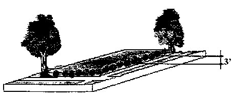
Figure 22: Low Screen Landscaping
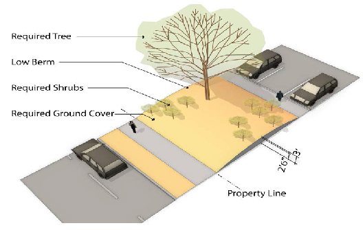
Figure 23: Low Berm Landscaping
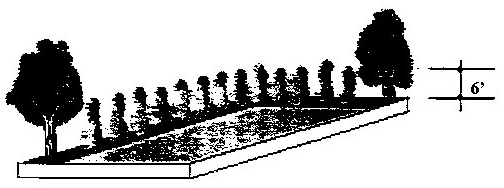
Figure 24: High Screen Landscaping
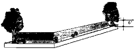
Figure 25: High Wall Landscaping
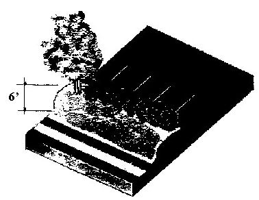
Figure 26: High Berm Landscaping
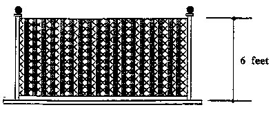
Figure 27: Partially Sight-Obscuring Fence
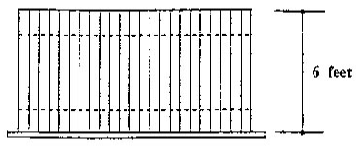
Figure 28: Totally Sight-Obscuring Fence
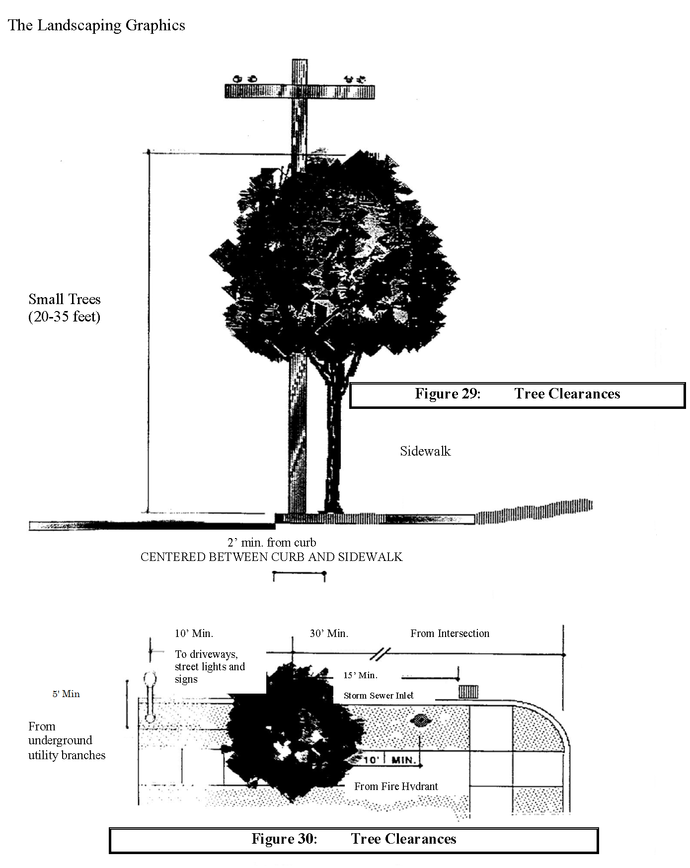
[Figure C-7 General Landscaping
Figure C-8 Low Screen Landscaping are not shown here and can be obtained by contacting
Linda Straessle, Planning Secretary at (503) 682-4960 or e-mail your request to straessle@ci.wilsonville.or.us.]
(Ord. No. 538, 2-21-2002; Ord. No. 674, 11-16-2009; Ord. No. 682, 9-9-2010; Ord. No. 812, 2-22-2018; Ord. No. 892, § 2(Exh. A), 12-2-2024)
Section 4.177. - Street Improvement Standards.
This section contains the City's requirements and standards for pedestrian, bicycle, and transit facility improvements to public streets, or within public easements. The purpose of this section is to ensure that development, including redevelopment, provides transportation facilities that are safe, convenient, and adequate in rough proportion to their impacts.
(.01)
Development and related public facility improvements shall comply with the standards in this section, the Wilsonville Public Works Standards, and the Transportation System Plan, in rough proportion to the potential impacts of the development. Such improvements shall be constructed at the time of development or as provided by Section 4.140, except as modified or waived by the City Engineer for reasons of safety or traffic operations.
(.02)
Street Design Standards:
A.
All street improvements and intersections shall provide for the continuation of streets through specific developments to adjoining properties or subdivisions.
1.
Development shall be required to provide existing or future connections to adjacent sites through the use of access easements where applicable. Such easements shall be required in addition to required public street dedications as required in Section 4.236(.04).
B.
The City Engineer shall make the final determination regarding right-of-way and street element widths using the ranges provided in Chapter 3 of the Transportation System Plan and the additional street design standards in the Public Works Standards.
C.
Rights-of-way:
1.
Prior to issuance of a Certificate of Occupancy Building permits or as a part of the recordation of a final plat, the City shall require dedication of rights-of-way in accordance with the Transportation System Plan. All dedications shall be recorded with the County Assessor's Office.
2.
The City shall also require a waiver of remonstrance against formation of a local improvement district, and all non-remonstrances shall be recorded in the County Recorder's Office as well as the City's Lien Docket, prior to issuance of a Certificate of Occupancy Building Permit or as a part of the recordation of a final plat.
3.
In order to allow for potential future widening, a special setback requirement shall be maintained adjacent to all arterial streets. The minimum setback shall be 55 feet from the centerline or 25 feet from the right-of-way designated on the Master Plan, whichever is greater.
D.
Dead-end Streets. New dead-end streets or culs-de-sac shall not exceed 200 feet in length, unless the adjoining land contains barriers such as existing buildings, railroads or freeways, or environmental constraints such as steep slopes, or major streams or rivers, that prevent future street extension and connection. A central landscaped island with rainwater management and infiltration are encouraged in cul-de-sac design. No more than 25 dwelling units shall take access to a new dead-end or cul-de-sac street unless it is determined that the traffic impacts on adjacent streets will not exceed those from a development of 25 or fewer units. All other dimensional standards of dead-end streets shall be governed by the Public Works Standards. Notification that the street is planned for future extension shall be posted on the dead-end street.
E.
Corner or clear vision area:
1.
A clear vision area which meets the Public Works Standards shall be maintained on each corner of property at the intersection of any two streets, a street and a railroad or a street and a driveway. However, the following items shall be exempt from meeting this requirement:
a.
Light and utility poles with a diameter less than 12 inches.
b.
Trees less than six inch d.b.h., approved as a part of the Stage II Site Design, or administrative review.
c.
Except as allowed by b., above, an existing tree, trimmed to the trunk, ten feet above the curb.
d.
Official warning or street sign.
e.
Natural contours where the natural elevations are such that there can be no cross-visibility at the intersection and necessary excavation would result in an unreasonable hardship on the property owner or deteriorate the quality of the site.
F.
Vertical clearance. A minimum clearance of 12 feet above the pavement surface shall be maintained over all streets and access drives.
G.
Interim improvement standard. It is anticipated that all existing streets, except those in new subdivisions, will require complete reconstruction to support urban level traffic volumes. However, in most cases, existing and short-term projected traffic volumes do not warrant improvements to full Master Plan standards. Therefore, unless otherwise specified by the Development Review Board, the following interim standards shall apply.
1.
Arterials 24 foot paved, with standard sub-base. Asphalt overlays are generally considered unacceptable, but may be considered as an interim improvement based on the recommendations of the City Engineer, regarding adequate structural quality to support an overlay.
2.
Half-streets are generally considered unacceptable. However, where the Development Review Board finds it essential to allow for reasonable development, a half-street may be approved. Whenever a half-street improvement is approved, it shall conform to the requirements in the Public Works Standards:
3.
When considered appropriate in conjunction with other anticipated or scheduled street improvements, the City Engineer may approve street improvements with a single asphalt lift. However, adequate provision must be made for interim storm drainage, pavement transitions at seams and the scheduling of the second lift through the Capital Improvements Plan.
(.03)
Sidewalks. Sidewalks shall be provided on the public street frontage of all development. Sidewalks shall generally be constructed within the dedicated public right-of-way, but may be located outside of the right-of-way within a public easement with the approval of the City Engineer.
A.
Sidewalk widths shall include a minimum through zone of at least five feet. The through zone may be reduced pursuant to variance procedures in Section 4.196, a waiver pursuant to Section 4.118, or by authority of the City Engineer for reasons of traffic operations, efficiency, or safety.
B.
Within a Planned Development, the Development Review Board may approve a sidewalk on only one side. If the sidewalk is permitted on just one side of the street, the owners will be required to sign an agreement to an assessment in the future to construct the other sidewalk if the City Council decides it is necessary.
(.04)
Bicycle Facilities. Bicycle facilities shall be provided to implement the Transportation System Plan, and may include on-street and off-street bike lanes, shared lanes, bike boulevards, and cycle tracks. The design of on-street bicycle facilities will vary according to the functional classification and the average daily traffic of the facility.
(.05)
Multiuse Pathways. Pathways may be in addition to, or in lieu of, a public street. Paths that are in addition to a public street shall generally run parallel to that street, and shall be designed in accordance with the Public Works Standards or as specified by the City Engineer. Paths that are in lieu of a public street shall be considered in areas only where no other public street connection options are feasible, and are subject to the following standards.
A.
Paths shall be located to provide a reasonably direct connection between likely pedestrian and bicyclist destinations. Additional standards relating to entry points, maximum length, visibility, and path lighting are provided in the Public Works Standards.
B.
To ensure ongoing access to and maintenance of pedestrian/bicycle paths, the City Engineer will require dedication of the path to the public and acceptance of the path by the City as public right-of-way; or creation of a public access easement over the path.
(.06)
Transit Improvements. Development on sites that are adjacent to or incorporate major transit streets shall provide improvements as described in this section to any bus stop located along the site's frontage, unless waived by the City Engineer for reasons of safety or traffic operations. Transit facilities include bus stops, shelters, and related facilities. Required transit facility improvements may include the dedication of land or the provision of a public easement.
A.
Development shall at a minimum provide:
1.
Reasonably direct pedestrian connections, as defined by Section 4.154, between building entrances and the transit facility and between buildings on the site and streets adjoining transit stops.
2.
Improvements at major transit stops. Improvements may include intersection or mid-block traffic management improvements to allow for pedestrian crossings at major transit stops.
B.
Developments generating an average of 49 or more pm peak hour trips shall provide bus stop improvements per the Public Works Standards. Required improvements may include provision of benches, shelters, pedestrian lighting; or provision of an easement or dedication of land for transit facilities.
C.
In addition to the requirements of 4.177(.06)(A.)(2.), development generating more than 199 pm peak hour trips on major transit streets shall provide a bus pullout, curb extension, and intersection or mid-block traffic management improvements to allow for pedestrian crossings at major transit stops.
D.
In addition to the requirements of 4.177(.06)(A.) and (B.), development generating more than 500 pm peak-hour trips on major transit streets shall provide on-site circulation to accommodate transit service.
(.07)
Residential Private Access Drives. Residential Private Access Drives shall meet the following standards:
A.
Residential Private Access Drives shall provide primary vehicular access to no more than four residential lots.
B.
The design and construction of a Residential Private Access Drive shall ensure a useful lifespan and structural maintenance schedule comparable, as determined by the City Engineer or City's Authorized Representative, to a local street constructed in conformance to current public works standards.
1.
The design of residential private access drives shall be stamped by a professional engineer registered in the state of Oregon and shall be approved by the City Engineer or City's Authorized Representative to ensure the above requirement is met.
2.
Prior to issuing a certificate of occupancy for any residential dwelling unit whose primary vehicular access is from a Residential Private Access Drive the City Engineer or City's Authorized Representative shall certify construction of the Residential Private Access Drive substantially conforms the design approved by the City Engineer or City's Authorized Representative.
C.
Residential Private Access Drives shall be named for addressing purposes. All Residential Private Access Drives shall use the suffix "Lane", i.e. SW Oakview Lane.
D.
Residential Private Access Drives shall meet or exceed the standards for access drives and travel lanes established in Subsection (.08) of this Section.
(.08)
Access Drive and Driveway Approach Development Standards:
A.
An access drive to any proposed development shall be designed to provide a clear travel lane free from any obstructions.
B.
Access drive travel lanes shall be constructed with a hard surface capable of carrying a 23-ton load.
C.
Where emergency vehicle access is required, approaches and driveways shall be designed and constructed to accommodate emergency vehicle apparatus and shall conform to applicable fire protection requirements. The City may restrict parking, require signage, or require other public safety improvements pursuant to the recommendations of an emergency service provider.
D.
Secondary or emergency access lanes may be improved to a minimum 12 feet with an all-weather surface as approved by the Fire District. All fire lanes shall be dedicated easements.
E.
Minimum access requirements shall be adjusted commensurate with the intended function of the site based on vehicle types and traffic generation.
F.
The number of approaches on higher classification streets (e.g., collector and arterial streets) shall be minimized; where practicable, access shall be taken first from a lower classification street.
G.
The City may limit the number or location of connections to a street, or impose access restrictions where the roadway authority requires mitigation to alleviate safety or traffic operations concerns.
H.
The City may require a driveway to extend to one or more edges of a lot and be designed to allow for future extension and inter-lot circulation as adjacent properties develop. The City may also require the owner(s) of the subject site to record an access easement for future joint use of the approach and driveway as the adjacent property(ies) develop(s).
I.
Driveways shall accommodate all projected vehicular traffic on-site without vehicles stacking or backing up onto a street.
J.
Driveways shall be designed so that vehicle areas, including but not limited to drive-up and drive-through facilities and vehicle storage and service areas, do not obstruct any public right-of-way.
K.
Approaches and driveways shall not be wider than necessary to safely accommodate projected peak hour trips and turning movements, and shall be designed to minimize crossing distances for pedestrians.
L.
As it deems necessary for pedestrian safety, the City, in consultation with the roadway authority, may require traffic-calming features, such as speed tables, textured driveway surfaces, curb extensions, signage or traffic control devices, or other features, be installed on or in the vicinity of a site.
M.
Approaches and driveways shall be located and designed to allow for safe maneuvering in and around loading areas, while avoiding conflicts with pedestrians, parking, landscaping, and buildings.
N.
Where a proposed driveway crosses a culvert or drainage ditch, the City may require the developer to install a culvert extending under and beyond the edges of the driveway on both sides of it, pursuant applicable Public Works standards.
O.
Except as otherwise required by the applicable roadway authority or waived by the City Engineer, temporary driveways providing access to a construction site or staging area shall be paved or graveled to prevent tracking of mud onto adjacent paved streets.
P.
Unless constrained by topography, natural resources, rail lines, freeways, existing or planned or approved development, or easements or covenants, driveways proposed as part of a residential or mixed-use development shall meet local street spacing standards and shall be constructed to align with existing or planned streets, if the driveway.
1.
Intersects with a public street that is controlled, or is to be controlled in the planning period, by a traffic signal;
2.
Intersects with an existing or planned arterial or collector street; or
3.
Would be an extension of an existing or planned local street, or of another major driveway.
(.09)
Minimum street intersection spacing standards:
A.
New streets shall intersect at existing street intersections so that centerlines are not offset. Where existing streets adjacent to a proposed development do not align properly, conditions shall be imposed on the development to provide for proper alignment.
B.
Minimum intersection spacing standards are provided in Transportation System Plan Table 3-2.
(.10)
Exceptions and Adjustments. The City may approve adjustments to the spacing standards of subsections (.08) and (.09) above through a Class II process, or as a waiver per Section 4.118(.03)(A.), where an existing connection to a City street does not meet the standards of the roadway authority, the proposed development moves in the direction of Code compliance, and mitigation measures alleviate all traffic operations and safety concerns. Mitigation measures may include consolidated access (removal of one access), joint use driveways (more than one property uses same access), directional limitations (e.g., one-way), turning restrictions (e.g., right in/out only), or other mitigation.
(Ord. No. 610, 5-1-2006; Ord. No. 674, 11-16-2009; Ord. No. 682, 9-1-2010; Ord. No. 719, 6-17-2013)
Section 4.178. - Sidewalk and Pathway Standards.
[Deleted by Ord. No. 719, 6-17-2013, see Section 4.177.]
Section 4.179. - Mixed Solid Waste and Recyclables Storage in New Multi-Family Residential and Non-Residential Buildings.
(.01)
All site plans for multi-family residential and non-residential buildings submitted to the Wilsonville Development Review Board for approval shall include adequate storage space for mixed solid waste and source separated recyclables.
(.02)
The floor area of an interior or exterior storage area shall be excluded from the calculation of building floor area for purposes of determining minimum storage requirements.
(.03)
The storage area requirement shall be based on the predominant use(s) of the building. If a building has more than one of the uses listed herein and that use occupies 20 percent or less of the floor area of the building, the floor area occupied by that use shall be counted toward the floor area of the predominant use(s). If a building has more than one of the uses listed herein and that use occupies more than 20 percent of the floor area of the building, then the storage area requirement for the whole building shall be the sum of the requirement for the area of each use.
(.04)
Storage areas for multiple uses on a single site may be combined and shared.
(.05)
The specific requirements are based on an assumed storage height of four feet for solid waste/recyclables. Vertical storage higher than four feet but no higher than seven feet may be used to accommodate the same volume of storage in a reduced floor space. Where vertical or stacked storage is proposed, the site plan shall include drawings to illustrate the layout of the storage area and dimensions for the containers.
(.06)
The specific requirements for storage area are as follows:
A.
multi-family residential buildings containing five-ten units shall provide a minimum storage area of 50 square feet. Buildings containing more than ten residential units shall provide an additional five square feet per unit for each unit above ten.
B.
Non-residential buildings shall provide a minimum storage area of ten square feet, plus:
1.
Office: Four square feet per 1,000 square feet gross floor area (GFA);
2.
Retail: Ten square feet per 1,000 square feet GFA;
3.
Wholesale/Warehouse/Manufacturing: Six square feet per 1,000 square feet GFA; and
4.
Other: Four square feet per 1,000 square feet GFA.
(.07)
The applicant shall work with the City's franchised garbage hauler to ensure that site plans provide adequate access for the hauler's equipment and that storage area is adequate for the anticipated volumes, level of service and any other special circumstances which may result in the storage area exceeding its capacity. The hauler shall notify the City by letter of their review of site plans and make recommendations for changes in those plans pursuant to the other provisions of this section.
(.08)
Existing multi-family residential and non-residential developments wishing to retrofit their structures to include storage areas for mixed solid waste and recycling may have their site plans reviewed and approved through the Class I Administrative Review process, according to the provisions of Section 4.035. Site plans for retrofitting existing developments must conform to all requirements of this Section, "Mixed Solid Waste and Recyclables Storage In New Multi-Family Residential and Non-Residential Buildings," and 4.430, "Location, Design and Access Standards for Mixed Solid Waste and Recycling Areas," of the Wilsonville City Code.
(.09)
When applicable, the applicant must comply with Wilsonville Code Section 8.010.
(Ord. No. 426, 4-4-1994; Ord. No. 538, 2-21-2002; Ord. No. 837, 8-5-20)
Section 4.180. - Exceptions and Modifications - Projections into Required Yards.
(.01)
Certain non-structural architectural features are permitted to project into required yards or courts, without requiring the approval of a Variance or Reduced Setback Agreement, as follows:
A.
Into any required yard:
1.
Architectural features may project into the required yard not more than two inches for each foot of required setback.
2.
Architectural features on buildings within the Coffee Creek Industrial Design Overlay District shall be subject to the applicable requirements in Section 4.134.
3.
Open, unenclosed fire escapes may project a distance not exceeding 48 inches.
B.
Into any required yard, adjoining a street or tract with a private drive:
1.
Architectural features may project a distance not exceeding 40 inches.
2.
An uncovered porch, terrace, or patio extending no more than two and one-half feet above the finished elevation may extend within three feet of an interior side lot line, or within ten feet of a front lot line or of an exterior side lot line.
(Ord. No. 682, 9-9-2010; Ord. No. 812, 2-22-2018)
Section 4.181. - Exceptions and Modifications—Height Limits.
Except as stipulated in Sections 4.800 through 4.804, height limitations specified elsewhere in this Code shall not apply to barns, silos or other farm buildings or structures on farms; to church spires, belfries, cupolas; and domes; monuments; water towers; windmills; chimneys; smokestacks; fire and hose towers; above-ground electric transmission, distribution, communication and signal lines, towers and poles; and properly screened mechanical and elevator structures.
(Ord. No. 856, 2-7-2022)
Section 4.182. - Exceptions and Modifications—Setback Modifications.
In any residential zone where the average depth of at least two existing front yards on adjoining lots or within 150 feet of the lot in question and within the same block front is less or greater than the minimum or maximum front yard depth prescribed elsewhere in this Code, the required depth of the front yard on such lot shall be modified. In such case, the front yard depth shall not be less than the average depth, nor more than the greater depth, of existing front yards on at least two adjoining lots within 150 feet. In the case of a corner lot, the depth of the front yard may be reduced to that of the lot immediately adjoining, provided, however, that the depth of a front yard on any corner lot shall be at least ten feet.
Section 4.184. - Conditional Use Permits—Authorization.
(.01)
Conditional Use of property may be granted by the Development Review Board after concluding a public hearing as provided in Section 4.013. A land use that is "conditional" is one that is generally not compatible with surrounding uses unless mitigating conditions of approval are established. In acting on applications for Conditional Use Permits, the DRB may establish conditions of approval that are found to be necessary to implement the Comprehensive Plan or to assure compliance with the standards of this Code, based on information in the record.
A.
Authorization to Grant or Deny Conditional Uses: A conditional use listed in this ordinance shall be permitted, altered, or denied in accordance with the standards and procedures of this Section. In judging whether a conditional use permit shall be approved, or determining appropriate conditions of approval, the Development Review Board shall weigh the proposal's positive and negative features that would result from authorizing the particular development at a location proposed, and to approve such use, shall find that the following criteria are either met, can be met by observance of conditions, or are not applicable:
1.
The proposal will be consistent with the provisions of the Comprehensive Plan and the requirements of Chapter 4 of the Wilsonville Code and other applicable policies of the City.
2.
The characteristics of the site are suitable for the proposed use considering size, shape, design, location, topography, existence of improvements and natural features.
3.
All required public facilities and services exist, or will be provided, to adequately meet the needs of the proposed development.
4.
The proposed use will not alter the character of the surrounding area in a manner which substantially limits, or precludes the use of surrounding properties for the uses listed as permitted in the zone.
(.02)
Private parks shall be reviewed in accordance with the Park Standards set forth in the Comprehensive Plan and the Open Space and Recreation Standards set forth in Section 4.113.
(.03)
Municipal and government buildings shall be developed in accordance with the Planned Development Commercial Standards and Sections 4.178.
(.04)
Conditional Use Regulations—Churches.
A.
Zone In Which Conditionally Permitted: All Residential Zones.
B.
Condition Standards:
1.
Minimum Lot Area: 10,000 square feet.
2.
Minimum Street Frontage: 100 feet.
3.
Maximum Coverage: 50 percent for all buildings.
4.
Maximum Building Height: 50 feet.
5.
Minimum Depth: 125 feet.
(.05)
Conditional Use Regulations—Public, Private and Parochial Schools.
A.
Zone In Which Conditionally Permitted: Any. (Public schools are permitted outright in any Public Facility zone.)
B.
Dimensional Standards:
1.
Minimum Land Area: Five acres, unless the Development Review Board finds a lesser area is appropriate to the use and the location.
2.
Front, Rear and Side Yard Setbacks: A minimum of 50 feet.
C.
Off-Street Parking: As required in Section 4.155.
(.06)
Conditional Use Regulations—Public Utility Structures.
A.
Except as provided in this Section and Section 4.800, all transmission and public utility structures, including, but not limited to, distribution lines and poles, sub-transmission structures, lines and poles, double poles and steel towers for transmission lines, substations, automatic telephone exchanges, relay stations, microwave towers, satellite antennas, pumping stations and treatment plants shall be regulated as conditional uses in all zones.
B.
Underground pipes and conduits as provided in Sections 4.300 to 4.320 and any existing above ground electric distribution, sub-transmission and transmission, communication and signal lines and poles of a single pole system and existing above ground transformers which are not in violation of Sections 4.300 to 4.320 and any current or future applicable franchise agreement shall be a permitted use in any zone. This section shall not be construed as permitting any substantial intensification of use.
(.07)
Conditional Use Regulations—Service Stations.
A.
The Development Review Board shall approve Conditional Use Permit applications for new service stations only where the design, location and use are compatible with and do not adversely impact the surrounding uses.
B.
No gasoline station shall be located closer than 200 feet from any school, public playground, church, or hospital. Where the subject property is less than five acres in area, the required separation shall be measured to the property line.
C.
Dimensional Standards:
1.
Minimum Front Yard Setback:
a.
Building or Structures: 30 feet from property line.
b.
Signs, gasoline pumps, pump islands, and enclosed buildings, excluding attached or detached canopies: 15 feet from property line.
c.
Attached or Detached Canopies: Two feet from property line.
2.
Minimum Rear Yard Setback: As required in the particular district.
3.
Minimum Side Yard Setback: As required in the particular district.
4.
Minimum Street Frontage: 100 feet.
5.
Minimum Lot Depth: 60 feet.
6.
Minimum Lot Size: 12,000 square feet.
7.
All other dimensional standards as required in the particular district.
D.
Vehicles. All vehicles for service, parked or under the control of any employee shall be on private property and shall not be on any required landscaped area.
E.
Permitted Services. Sales and services shall be limited to the sale of motor fuels and supplying goods and service generally required in the operation and maintenance of automotive vehicles and fulfilling a motorist's needs. Those may include sale of petroleum products; sale and servicing of tires, batteries, automotive accessories and replacement items; washing and lubricating services; the performance of minor automotive maintenance and repair, and the supplying of other incidental customer services and products. Major automotive repairs, painting, and body and fender work are excluded.
F.
Access, Parking and Circulation Requirements:
1.
Each developed site shall not have more than two accessways to any one street.
2.
No vehicles subject to the control of the operator of the premises may temporarily be parked on sidewalks, parkways, driveways, alleys or other public ways.
G.
Site Screening. Where a service station abuts property in a residential district, a six foot high, solid masonry wall, site-screening decorative fence, or dense evergreen hedge shall be constructed and maintained on such abutting lines. When the wall, fence, or screening reaches the required front yard setback, it shall decrease to a height of three feet. See landscape standards, Section 4.176.
H.
Lighting. All outside lighting shall be so arranged and shielded so as not to shine into adjacent residential areas and to prevent any undue glare or reflection and any nuisance, inconvenience, and hazardous interference of any kind on adjoining streets or property. All lighting used shall be erected only on the same premises with the use. The Certificate of Occupancy shall not be issued until compliance with this standard has been verified.
I.
All proposed service stations may be subject to design review by the City depending upon the particular site to be utilized in the establishment thereof.
J.
Service stations shall, in addition to the above, meet the following requirements:
1.
No vehicle may be parked on the premises and offered for sale, lease or rent.
2.
Automotive repair and lubricating operations and all sales other than petroleum products shall be conducted within the service station building.
3.
Signs shall not cause any glare or reflection of light on other property or building.
4.
No banner or pennants shall be permitted except by Temporary Permit.
5.
Landscaping:
a.
A minimum of 100 square feet of raised planting area shall be installed and maintained at the intersection of the property lines at a street corner.
b.
A minimum of 20 square feet of raised planting area shall be installed and maintained along the building facades fronting on a street.
c.
Entrances of all restrooms shall be screened from view of adjacent properties or street right-of-way.
d.
All outside recycling, trash, garbage, and refuse areas shall be enclosed on at least four sides, and each side shall be at least six feet in height.
(.08)
Conditional Use Regulations—Willamette River Greenway Development.
A.
The Development Review Board shall approve Conditional Use Permit applications for new development in the Willamette River Greenway only as specified in Section 4.500 and this Section.
(Ord. No. 538, 2-21-2002; Ord. No. 899, § 2(Exh. A), 8-4-2025)
Section 4.189. - Non-Conforming Uses.
(.01)
Continuation of Use:
A.
A non-conforming use may be continued subject to the requirements of this Section.
B.
A manufactured or mobile home placed on a lot, parcel or tract of land and certified to be a non-conforming use shall be allowed to continue in that status. A non-conforming mobile home may be replaced by a newer Manufactured Home as defined herein.
C.
A pre-existing use that is listed as "conditional" in the zone shall be considered to be non-conforming until such time as a conditional use permit is issued for it. In reviewing an application for a conditional use permit for a use that already legally exists, the Development Review Board shall establish conditions of approval that are proportional in scope to the changes proposed in the application and shall not establish conditions that prevent the continued operation of the use.
(.02)
Change of Use:
A.
A non-conforming use may not be changed unless the change or replacement is to a use that is determined by the Planning Director to be no less conforming to the regulations for the zone district in which the use is located than the existing use.
B.
In any zone where single-family dwellings are permitted, a non-conforming mobile or manufactured home may be replaced provided that the Planning Director determines that the replacement unit meets the requirements for manufactured housing units on individual lots specified in Section 4.115.
(.03)
Abandoned Use. If a non-conforming use is abandoned for a period of 18 consecutive months, the use shall not be re-established without fully complying with the use requirements of the zone. Mere vacancy of a site or building while it is being marketed or other plans for its use are being readied, does not constitute abandonment. In order to be considered abandoned, a site must not be receiving City utilities and must not actively be marketed for rent, lease, or sale. These standards concerning abandonment do not in any way affect the City's processes for the abatement of nuisances as delineated in Chapter 6 of the Wilsonville Code.
(.04)
Damage and Destruction. When a structure that is a non-conforming use or a building containing a non-conforming use is damaged by any cause, exceeding 75 percent of its replacement cost, as determined by the Building Official, the structure shall not be re-established unless the owners of that structure promptly and diligently pursue its repair or replacement. If all required building permits have not been received within 18 months of the damage or destruction, the non-conforming use shall not be re-established without meeting all of the requirements of Chapter 4. City staff will use the address listed in County Assessor records to contact the owners of properties that have been damaged to alert them to the time limitations for receiving a building permit for repair or replacement. The property owner's failure to receive such notification does not alter or extend the time limit specified in this subsection.
(.05)
Enlargements and Moving. A non-conforming use, may be permitted to enlarge up to 20 percent in floor area on approval of a conditional use permit by the Development Review Board.
(.06)
Repairs.
A.
Normal maintenance of a structure containing a non-conforming use is permitted provided that any exterior additions meet the requirements of this Section.
(Ord. No. 538, 2-21-2002)
Section 4.190. - Non-Conforming Structures.
(.01)
A non-conforming structure that is in use may continue to be used.
(.02)
If a non-conforming structure is abandoned, as defined herein, for a period of 18 months, it may not again be used unless brought into conformity with the requirements of this ordinance. Except, however, that an abandoned non-conforming structure may be re-occupied if a Variance is approved per the requirements of Section 4.196.
(.03)
When a non-conforming structure is damaged by any cause exceeding 75 percent of its replacement cost, as determined by the Building Official, the non-conforming structure shall not be re-established unless all required building permits for the repair or replacement are received within 18 months of the damage. City staff will endeavor to contact the owners of properties that have been damaged to alert them to the time limitations for receiving a building permit for repair or replacement. The property owner's failure to receive such notification does not alter or extend the time limit specified in this subsection.
(.04)
Normal maintenance of a non-conforming structure is permitted, provided that any exterior additions meet the requirements of this Section.
(.05)
A non-conforming structure may be expanded or enlarged, provided that the portion of the structure being enlarged meets zoning requirements in terms of setbacks, height, and lot coverage.
Section 4.191. - Non-Conforming Site Conditions.
(.01)
A property with non-conforming site conditions that is in use may continue to be used.
(.02)
If a property with non-conforming site conditions is abandoned, as defined herein, for a period of 18 months, it may not again be used unless brought into conformity with the requirements of this ordinance. Except, however, that an abandoned property with non-conforming site conditions may be re-occupied if a Variance is approved per the requirements of Section 4.196.
(.03)
Normal maintenance of a property with non-conforming site conditions is permitted, provided that the site conditions do not become even less conforming as a result.
(.04)
Any application for a change of occupancy, as determined by the City's Building Official, or any application for discretionary review by the City shall justify conditions of approval that will bring the site into conformity with site improvement standards.
(.05)
A structure with non-conforming site conditions may be expanded or enlarged, provided that there is a proportional decrease in the non-conforming site conditions. For example, an application to expand the floor area of a building by 10%, on a site that has 20% shortage of required bicycle parking, will be permitted, provided that at least a 10% increase in bicycle parking is also provided.
(Ord. No. 899, § 2(Exh. A), 8-4-2025)
Section 4.192. - Non-Conforming Lots.
(.01)
Except as provided in subsection (.02), a non-conforming lot may be used for any purpose allowed by zoning, provided that any structure built or located upon a non-conforming lot must meet all of the lot development standards of the zone, or be approved through the Variance procedures of Section 4.196. Except, however, if the non-conforming lot is contiguous to other property under legal control of the same owner or owners, no variance shall be granted for a structure or use that could be accommodated on that contiguous lot, or combination of lots, without a Variance.
(.02)
In the R, OTR, PDR, V, and RN zones, all middle housing types except duplexes must meet applicable minimum lot size requirements for that zoning district.
(.03)
A lot line adjustment between nonconforming lots may be approved where either:
A.
Both lots involved in the adjustment will be conforming to zoning standards as a result of the adjustment; or
B.
The Planning Director or Development Review Board finds, based on information in the record, that each of the lots involved in the adjustment will be suitable for development as allowed in the zone, as a result of the adjustment.
Section 4.196. - Variances.
(.01)
Where difficulties exist rendering compliance with Chapter 4 impractical and such compliance would create unnecessary hardship to the owner or user of land or buildings, the Development Review Board may grant a variance from the provisions of this Code after the prescribed public hearing as set forth in Section 4.013, and after an investigation; provided all of the following conditions exist:
A.
The difficulty would apply to the particular land or building regardless of the owner.
B.
The request for a variance is not the result of an illegal act on the part of the applicant or the applicant's agent.
C.
The plight of the owner is due to unique circumstances, such as lot size or shape, topography, and size or shape of building, which are not typical of the general conditions of the surrounding area.
D.
The practical difficulty or unnecessary hardship asserted as a ground for a variance must relate to the premises for which the variance is sought and not to other premises or personal conditions of the applicant.
E.
The variance does not allow the property to be used for purposes not authorized within the zone involved.
F.
The variance is the minimum necessary to relieve the hardship.
G.
Where the variance is sought to allow development within a flood zone, the following additional standards shall apply:
l.
Generally, the only condition under which a variance from the flood hazard elevation standard may be issued is for new construction and substantial improvements to be erected on a lot of one-half acre or less in size, contiguous to and surrounded by lots with existing structures constructed below the base flood level, providing items a-k in Section 4.172 have been fully considered. As the lot size increases, the technical justification required for issuing the variance increases.
2.
Variances may be issued for the reconstruction, rehabilitation or restoration of structures listed on the National Register of Historic Places or the State Inventory of Historic Places, without regard to the procedures set forth in this subsection.
3.
Variances shall not be issued within a designated floodway if any increase in flood levels during the base flood discharge would result.
4.
Variances shall only be issued upon a determination that the variance is the minimum necessary, considering the flood hazard, to afford relief.
5.
Variances shall only be issued upon:
a.
a showing of good and sufficient cause;
b.
a determination that failure to grant the variance would result in exceptional hardship to the applicant; and
c.
a determination that the granting of a variance will not result in increased flood heights, additional threats to public safety, extraordinary public expense, create nuisances, or conflict with other existing local laws or ordinances.
6.
Variances as interpreted in the National Flood Insurance Program are based on the general zoning law principle that they pertain to a physical piece of property; they are not personal in nature and do not pertain to the structure, its inhabitants, economic or financial circumstances. They primarily address small lots in densely populated residential neighborhoods. As such, variances from the flood elevations will rarely be granted.
7.
Variances may be issued for nonresidential buildings in very limited circumstances to allow a lesser degree of flood proofing than watertight or dry-floodproofing, where it can be determined that such action will have low damage potential, and complies with all other variance criteria except Section 4.172.
8.
Any applicant to whom a variance is granted shall be given written notice that the structure will be permitted to be built with a lowest floor elevation below the base flood elevation and that the cost of flood insurance will be commensurate with the increased risk resulting from the reduced lowest floor elevation.
Section 4.197. - Zone Changes and Amendments to This Code—Procedures.
(.01)
The following procedure shall be followed in applying for an amendment to the text of this Chapter:
A.
The Planning Commission shall conduct a public hearing on the proposed amendment at its earliest practicable meeting after it is proposed and shall, within 40 days after concluding the hearing, provide a report and recommendation to the City Council regarding the proposed amendment. The findings and recommendations of the Commission shall be adopted by resolution and shall be signed by the Chair of the Commission.
B.
In recommending approval of a proposed text amendment, the Planning Commission shall, at a minimum, adopt findings relative to the following:
1.
That the application was submitted in compliance with the procedures set forth in Section 4.008; and
2.
The amendment substantially complies with all applicable goals, policies and objectives set forth in the Comprehensive Plan; and
3.
The amendment does not materially conflict with, nor endanger, other provisions of the text of the Code; and
4.
If applicable, the amendment is in compliance with Statewide Land Use Planning Goals and related administrative rules; and
5.
If applicable, the amendment is necessary to ensure that the City's Land Use and Development Ordinance complies with mandated requirements of State or Federal laws and/or statutes.
(.02)
The following procedures shall be followed for zone map amendments.
A.
When a requested quasi-judicial zone map amendment within the Coffee Creek Industrial Design Overlay District is consistent with the adopted or concurrently proposed Comprehensive Plan Map designation and only one option exists for a zone map amendment consistent with the Comprehensive Plan Map the amendment shall be reviewed by the City Council without prior review or recommendation by the Development Review Board or Planning Commission.
1.
The Zoning Order adopting such zone map amendments shall state the zone map amendment expires 120 days from Council adoption unless a Stage II Final Plan receives final local approval for the area subject to the zone map amendment. In the event of a LUBA appeal of the final local approval, the 120-day expiration period will be tolled pending completion of the appeal process.
2.
Notwithstanding the process described above an applicant may elect to have the zone map amendment reviewed by the Development Review Board for a recommendation to City Council concurrently with other land use applications for the subject property.
3.
If the Planning Director anticipates that individuals other than the applicant can be expected to question the requested zone map amendment's compliance with the Comprehensive Plan the Planning Director may require the zone map amendment be first reviewed by the Development Review Board to make a recommendation to City Council.
B.
All other quasi-judicial zone map amendments shall be reviewed by the Development Review Board to make a recommendation to City Council and all legislative zone map amendments shall be reviewed by the Planning Commission to make a recommendation to City Council.
C.
In recommending approval or denial of a proposed zone map amendment, the Planning Commission or Development Review Board shall at a minimum, adopt findings addressing the following criteria:
1.
That the application before the Commission or Board was submitted in accordance with the procedures set forth in Section 4.008, Section 4.125 (.18)(B)(2) or, in the case of a Planned Development, Section 4.140; and
2.
That the proposed amendment is consistent with the Comprehensive Plan map designation and substantially complies with the applicable goals, policies and objectives, set forth in the Comprehensive Plan text; and
3.
In the event that the subject property, or any portion thereof, is designated as "Residential" on the City's Comprehensive Plan Map; specific findings shall be made addressing substantial compliance with Implementation Measures 4.1.4.b, d, e, q, and x of Wilsonville's Comprehensive Plan text; and
4.
That the existing primary public facilities, i.e., roads and sidewalks, water, sewer and storm sewer are available and are of adequate size to serve the proposed development; or, that adequate facilities can be provided in conjunction with project development. The Planning Commission and Development Review Board shall utilize any and all means to insure that all primary facilities are available and are adequately sized; and
5.
That the proposed development does not have a significant adverse effect upon Significant Resource Overlay Zone areas, an identified natural hazard, or an identified geologic hazard. When Significant Resource Overlay Zone areas or natural hazard, and/or geologic hazard are located on or abut the proposed development, the Planning Commission or Development Review Board shall use appropriate measures to mitigate and significantly reduce conflicts between the development and identified hazard or Significant Resource Overlay Zone; and
6.
That the applicant is committed to a development schedule demonstrating that development of the property is reasonably expected to commence within two years of the initial approval of the zone change; and
7.
That the proposed development and use(s) can be developed in compliance with the applicable development standards or appropriate conditions are attached that insure that the project development substantially conforms to the applicable development standards; and
8.
Adequate public facilities, services, and transportation networks are in place, or are planned to be provided concurrently with the development of the property. The applicant shall demonstrate compliance with the Transportation Planning Rule, specifically by addressing whether the proposed amendment has a significant effect on the transportation system pursuant to OAR 660-012-0060. A Traffic Impact Analysis (TIA) shall be prepared pursuant to the requirements in Section 4.133.05.(01).
(.03)
If affirmative findings cannot be made for all applicable criteria listed above the proposed text or map amendment, as the case may be, shall be denied.
(.04)
City Council action approving a change in zoning shall be in the form of a Zoning Order.
(.05)
In cases where a property owner or other applicant has requested a change in zoning and the City Council has approved the change subject to conditions, the owner or applicant shall sign a statement accepting, and agreeing to complete the conditions of approval before the zoning shall be changed.
The above-entitled matter is before the Council to consider the application of for a zone change and an order amending the official Zoning Map as incorporated in Section 4.102 of the Wilsonville Code, and
It appearing to the Council that the property which is the subject of this application is described as follows:
(Legal Description)
and such property has heretofore appeared on the official Zoning Map zoned as follows:
and the Council having heard and considered all matters relevant to the application, including the Planning Commission and/or Development Review Board resolution and minutes, finds that the application should be (approved/denied), and it is therefore,
(Incorporated Conditions)
ORDERED that the property above-described is hereby rezoned as follows:
and such rezoning be and the same is hereby declared an amendment to the Wilsonville Zoning Map (Section 4.102 WC) and shall appear as such from and after entry of this Order.
The property subject to this Zoning Order is also subject to the Order of the City Council in respect thereto made.
DATED: This_____day of_____, 19___.
Mayor
Approved as to form:
ATTEST:
City Recorder
City of Wilsonville, Oregon
by:
City Recorder
(Ord. No. 812, 2-22-2018)
Section 4.198. - Comprehensive Plan Changes—Adoption by the City Council.
(.01)
Proposals to amend the Comprehensive Plan, or to adopt new elements or sub-elements of the Plan, shall be subject to the procedures and criteria contained in the Comprehensive Plan. Each such amendment shall include findings in support of the following:
A.
That the proposed amendment meets a public need that has been identified;
B.
That the proposed amendment meets the identified public need at least as well as any other amendment or change that could reasonably be made;
C.
That the proposed amendment supports applicable Statewide Planning Goals, or a Goal exception has been found to be appropriate; and
D.
That the proposed change will not result in conflicts with any portion of the Comprehensive Plan that is not being amended.
(.02)
When a requested quasi-judicial Comprehensive Plan Map amendment within the Coffee Creek Industrial Design Overlay District is consistent with an adopted master plan that is a sub-element of the Comprehensive Plan and only one option exists for a Comprehensive Plan Map amendment consistent with the adopted area plan the amendment shall be reviewed by the City Council without prior review or recommendation by the Development Review Board or Planning Commission.
A.
The ordinance adopting such Comprehensive Plan Map amendments shall state the Comprehensive Plan Map amendment expires 120 days from Council adoption unless a Stage II Final Plan receives final local approval for the area subject to the Comprehensive Plan Map amendment. In the event of a LUBA appeal of the final local approval, the 120-day expiration period will be tolled pending completion of the appeal process.
B.
Notwithstanding the process described above an applicant may elect to have the Comprehensive Plan Map amendment reviewed by the Development Review Board for a recommendation to City Council concurrently with other land use applications for the subject property.
C.
If the Planning Director anticipates that individuals other than the applicant can be expected to question the requested Comprehensive Plan Map amendment's compliance with the adopted master plan the Planning Director may require the Comprehensive Plan Map amendment be first reviewed by the Development Review Board to make a recommendation to City Council.
(.03)
All other quasi-judicial Comprehensive Plan Map Amendments shall be reviewed by the Development Review Board to make a recommendation to City Council and all legislative Comprehensive Plan Map Amendments shall be reviewed by the Planning Commission to make a recommendation to City Council.
(.04)
As applicable following the adoption and signature of the Resolution by the Development Review Board or Planning Commission, together with minutes of public hearings on the proposed Amendment, the matter shall be shall be scheduled for public hearing before the City Council.
(.05)
Notice of the Council's consideration of the matter shall be provided as set forth in Section 4.012.
(.06)
Upon conclusion of its public hearing on the matter, the Council shall adopt its decision by ordinance, authorizing the Planning Director to amend the official zoning map, Comprehensive Plan Map or the text of Chapter 4 as set forth in Section 4.102.
(.07)
In cases where a property owner or other applicant has requested an amendment to the Comprehensive Plan map and the City Council has approved the change subject to conditions, the owner or applicant shall sign a statement accepting, and agreeing to complete the conditions of approval before the Comprehensive Plan map shall be changed.
(Ord. No. 812, 2-22-2018)
Section 4.199.10. - Outdoor Lighting In General.
(.01)
Purpose. The purpose of this Code is to provide regulations for outdoor lighting that will:
A.
Permit reasonable uses of outdoor lighting for nighttime safety, utility, security, productivity, enjoyment and commerce.
B.
Conserve energy and resources to the greatest extent possible.
C.
Minimize glare, particularly in and around public rights-of-way; and reduce visual discomfort and improve visual acuity over large areas by avoiding "light islands" and "spotlighting" that result in reduced visual perception in areas adjacent to either the source of the glare or the area illuminated by the glare.
D.
Minimize light trespass, so that each owner of property does not cause unreasonable light spillover to other property.
E.
Curtail the degradation of the nighttime environment and the night sky.
F.
Preserve the dark night sky for astronomy and enjoyment.
G.
Protect the natural environment, including wildlife, from the damaging effects of night lighting from human sources.
(.02)
Purpose Statement as Guidelines: Declaration of purpose statements are guidelines and not approval criteria in the application of WC Section 4.199.
Section 4.199.20. - Applicability.
(.01)
This Ordinance is applicable to:
A.
Installation of new exterior lighting systems in public facility, commercial, industrial and multi-family housing projects with common areas.
B.
Major additions or modifications (as defined in this Section) to existing exterior lighting systems in public facility, commercial, industrial and multi-family housing projects with common areas.
(.02)
Exemption. The following luminaires and lighting systems are EXEMPT from these requirements:
A.
Interior lighting.
B.
Internally illuminated signs.
C.
Externally illuminated signs.
D.
Temporary lighting for theatrical, television, and performance areas.
E.
Lighting in swimming pools and other water features governed by Article 680 of the National Electrical Code.
F.
Building Code required exit path lighting.
G.
Lighting specifically for stairs and ramps.
H.
Temporary and seasonal lighting provided that individual lamps are 10 watts or less.
I.
Lighting required and/or regulated by the City (i.e. construction related activities), Federal Aviation Administration, U.S. Coast Guard or other Federal or State agency.
J.
Single-family residential lighting.
K.
Code Required Signs.
L.
American flag.
M.
Landscape lighting.
N.
Lights approved by the City through an Administrative Review Temporary Use Permit process.
O.
Public street lights.
P.
ATM security lighting.
Q.
Those "Exceptions" listed in the "Exterior Lighting Power Allowance" provisions of the Oregon Energy Efficiency Specialty Code.
(Ord. No. 688, 11-15-2010)
Section 4.199.30. - Lighting Overlay Zones.
(.01)
The designated Lighting Zone as indicated on the Lighting Overlay Zone Map for a commercial, industrial, multi-family or public facility parcel or project shall determine the limitations for lighting systems and fixtures as specified in this Ordinance.
A.
Property may contain more than one lighting zone depending on site conditions and natural resource characteristics.
(.02)
The Lighting Zones shall be:
A.
LZ 1. Developed areas in City and State parks, recreation areas, SROZ wetland and wildlife habitat areas; developed areas in natural settings; sensitive night environments; and rural areas. This zone is intended to be the default condition for rural areas within the City.
B.
LZ 2. Low-density suburban neighborhoods and suburban commercial districts, industrial parks and districts. This zone is intended to be the default condition for the majority of the City.
C.
LZ 3. Medium to high-density suburban neighborhoods and districts, major shopping and commercial districts as depicted on the Lighting Overlay Zone Map.
D.
LZ 4. Reserved for limited applications with special lighting requirements. This zone is appropriate for users who have unique site or operating circumstances that warrant additional light. This zone shall not be applied to residential or agricultural areas.
(.03)
Modification of Lighting Zones.
A.
The City Council may modify the designated Lighting Zones of one or more parcels if the City Council finds that the original Lighting Zone was in error, a change in circumstances has occurred warranting the change since the designation was established or the purposes of this section are better served.
B.
The Development Review Board (DRB) may modify the designated Lighting Zones as part of the Stage II, Site Design Review Process if the DRB finds that the original Lighting Zone was in error, or a change in circumstances has occurred warranting the change since the designation was established or the purposes of this section are better served.
C.
This ordinance establishes a Lighting Overlay Zone Map. The Planning Division shall maintain the current Lighting Overlay Zone Map. Section 4.199.40. Lighting Systems Standards for Approval.
(Ord. No. 688, 11-15-2010)
Section 4.199.40. - Lighting Systems Standards for Approval.
(.01)
Non-Residential Uses and Common Residential Areas.
A.
All outdoor lighting shall comply with either the Prescriptive Option or the Performance Option below.
B.
Prescriptive Option. If the lighting is to comply with this Prescriptive Option, the installed lighting shall meet all of the following requirements according to the designated Lighting Zone.
1.
The maximum luminaire lamp wattage and shielding shall comply with Table 7.
2.
Except for those exemptions listed in Section 4.199.20(.02), the exterior lighting for the site shall comply with the Oregon Energy Efficiency Specialty Code, Exterior Lighting.
3.
The maximum pole or mounting height shall be consistent with Table 8.
4.
Each luminaire shall be set back from all property lines at least three times the mounting height of the luminaire:
a.
Exception 1: If the subject property abuts a property with the same base and lighting zone, no setback from the common lot lines is required.
b.
Exception 2: If the subject property abuts a property which is zoned (base and lighting) other than the subject parcel, the luminaire shall be setback three times the mounting height of the luminaire, measured from the abutting parcel's setback line. (Any variance or waiver to the abutting property's setback shall not be considered in the distance calculation).
c.
Exception 3: If the luminaire is used for the purpose of street, parking lot or public utility easement illumination and is located less than three mounting heights from the property line, the luminaire shall include a house side shield to protect adjoining property.
d.
Exception 4: If the subject property includes an exterior column, wall or abutment within 25 feet of the property line, a luminaire partly shielded or better and not exceeding 60 lamp watts may be mounted onto the exterior column, wall or abutment or under or within an overhang or canopy attached thereto.
e.
Exception 5: Lighting adjacent to SROZ areas shall be set back three times the mounting height of the luminaire, or shall employ a house side shield to protect the natural resource area.
C.
Performance Option. If the lighting is to comply with the Performance Option, the proposed lighting design shall be submitted by the applicant for approval by the City meeting all of the following:
1.
The weighted average percentage of direct uplight lumens shall be less than the allowed amount per Table 9.
2.
The maximum light level at any property line shall be less than the values in Table 9, as evidenced by a complete photometric analysis including horizontal illuminance of the site and vertical illuminance on the plane facing the site up to the mounting height of the luminaire mounted highest above grade. The Building Official or designee may accept a photometric test report, demonstration or sample, or other satisfactory confirmation that the luminaire meets the shielding requirements of Table 7. Luminaires shall not be mounted so as to permit aiming or use in any way other than the manner maintaining the shielding classification required herein:
a.
Exception 1. If the property line abuts a public right-of-way, including a sidewalk or street, the analysis may be performed across the street at the adjacent property line to the right-of-way.
b.
Exception 2. If, in the opinion of the Building Official or designee, compliance is impractical due to unique site circumstances such as lot size or shape, topography, or size or shape of building, which are circumstances not typical of the general conditions of the surrounding area. The Building Official may impose conditions of approval to avoid light trespass to the maximum extent possible and minimize any additional negative impacts resulting to abutting and adjacent parcels, as well as public rights-of-way, based on best lighting practices and available lighting technology.
3.
The maximum pole or mounting height shall comply with Table 8.
D.
Curfew. All prescriptive or performance based exterior lighting systems shall be controlled by automatic device(s) or system(s) that:
1.
Initiate operation at dusk and either extinguish lighting one hour after close or at the curfew times according to Table 10; or
2.
Reduce lighting intensity one hour after close or at the curfew time to not more than 50 percent of the requirements set forth in the Oregon Energy Efficiency Specialty Code unless waived by the DRB due to special circumstances; and
3.
Extinguish or reduce lighting consistent with 1. and 2. above on Holidays.
The following are exceptions to curfew:
a.
Exception 1: Building Code required lighting.
b.
Exception 2: Lighting for pedestrian ramps, steps and stairs.
c.
Exception 3: Businesses that operate continuously or periodically after curfew.
(.02)
Special Permit for Specific Lighting Fixtures and Systems and When Exceeding Lighting Requirements.
A.
This section is intended to apply to situations where more than normal foot candles are required due to a unique circumstance or use or where it is absolutely essential to perform the proposed activities after dark. All special permits shall be reviewed by the DRB.
B.
Upon issuance of a special permit by the Development Review Board (DRB), lighting systems not complying with the technical requirements of this Ordinance may be installed, maintained, and replaced for lighting that exceeds the maximums permitted by this Ordinance. This section is intended to be applied to uses such as sports lighting systems including but not limited to, sport fields and stadiums, such as baseball and football field lighting, tennis court lighting, swimming pool area lighting and prisons; other very intense lighting defined as having a light source exceeding 200,000 lumens or an intensity in any direction of more than 2,000,000 candelas; building façade lighting of portions of buildings over two stories high; and public monuments.
C.
To obtain such a permit, applicants shall demonstrate that the proposed lighting installation:
1.
Is within Lighting Zone 3 or above.
2.
Has been designed to minimize obtrusive light and artificial sky glow, supported by a signed statement from a registered civil or electrical engineer describing the mitigation measures. Such statement shall be accompanied by calculations indicating the light trespass levels (horizontal and vertical at ground level) at the property line.
3.
Will not create excessive glare, sky glow, or light trespass beyond that which can be reasonably expected by application of best lighting practices, and available technology.
4.
Provides appropriate lighting curfew hours based on the use and the surrounding areas.
D.
The DRB may impose conditions of approval to mitigate any negative impacts resulting to the abutting parcel, based on best lighting practices and available lighting technology.
E.
The City may charge a review fee and may, at the Building Official's option, employ the services of a qualified professional civil or electrical engineer to review such submittals and the cost thereof shall be an additional fee charged to the applicant.
(Ord. No. 688, 11-15-2010)
Section 4.199.50. - Submittal Requirements.
(.01)
Applicants shall submit the following information as part of DRB review or administrative review of new commercial, industrial, multi-family or public facility projects:
A.
A statement regarding which of the lighting methods will be utilized, prescriptive or performance, and a map depicting the lighting zone(s) for the property.
B.
A site lighting plan that clearly indicates intended lighting by type and location. For adjustable luminaires, the aiming angles or coordinates shall be shown.
C.
For each luminaire type, drawings, cut sheets or other documents containing specifications for the intended lighting including but not limited to, luminaire description, mounting, mounting height, lamp type and manufacturer, lamp watts, ballast, optical system/distribution, and accessories such as shields.
D.
Calculations demonstrating compliance with Oregon Energy Efficiency Specialty Code, Exterior Lighting, as modified by Section 4.199.40(.01)(B.)(2.)
E.
Lighting plans shall be coordinated with landscaping plans so that pole lights and trees are not placed in conflict with one another. The location of lights shall be shown on the landscape plan. Generally, pole lights should not be placed within one pole length of landscape and parking lot trees.
F.
Applicants shall identify the hours of lighting curfew.
(.02)
In addition to the above submittal requirements, Applicants using the Prescriptive Method shall submit the following information as part of the permit set plan review:
A.
A site lighting plan (items 1.A—F, above) which indicates for each luminaire the three mounting height line to demonstrate compliance with the setback requirements. For luminaires mounted within three mounting heights of the property line the compliance exception or special shielding requirements shall be clearly indicated.
(.03)
In addition to the above submittal requirements, Applicants using the Performance Method shall submit the following information as part of the permit set plan review:
A.
Site plan showing horizontal isocandle lines, or the output of a point-by-point computer calculation of the horizontal illumination of the site, showing property lines and light levels immediately off of the subject property.
B.
For each side of the property, the output of a point-by-point vertical footcandle calculation showing illumination in the vertical plane at the property line from grade to at least ten feet higher than the height of the tallest pole.
C.
Lighting plans shall be prepared by a qualified licensed engineer.
(.04)
In addition to the above applicable submittal requirements, Applicants for Special Permits shall submit the following to the DRB for review:
A.
Tabulation of International Engineering Society of North America (IESNA) lighting recommendations for each task including area illuminated, recommended illumination level, actual maintained illumination level, and luminaires used specifically to achieve the indicated criteria.
B.
Lighting plans shall be prepared by a qualified licensed engineer.
(.05)
For all calculations, the following light loss factors shall be used unless an alternative is specifically approved by the City:
(Ord. No. 688, 11-15-2010)
Section 4.199.60. - Major Additions or Modifications to Pre-Existing Sites.
(01.)
Major Additions. If a major addition occurs on a property, all of the luminaires on the site shall comply with the requirements of this Section. For purposes of this sub-section, the following are considered to be major additions:
A.
Additions of 50 percent or more in terms of additional dwelling units, gross floor area, seating capacity, or parking spaces, either with a single addition or with cumulative additions after July 2, 2008.
B.
Modification or replacement of 50 percent or more of the outdoor lighting luminaries' within a five-year timeframe existing as of July 2, 2008.
Lighting mounted onto buildings or other structures shall not exceed a mounting height greater than four feet higher than the tallest part of the building or structure at the place where the lighting is installed, nor higher than 33.33 percent of the horizontal distance of the light from the nearest property line, whichever is less.
Figure 30: Lighting Overlay Zone Map
(Ord. No. 649, 6-2-2008; Ord. No. 682, 9-9-2010; Ord. No. 688, 11-15-2010; Ord. No. 821, 7-2-2018)