
Winterville City Zoning Code
DIVISION 6
DISTRICT REGULATIONS
Sec. 38-356.- Purpose.
This division is established to ensure that each district is reserved primarily for its intended use, including public and semi-public uses which are necessary to serve the needs of the most desirable use of land in accordance with the city master plan.
(Ord. of 5-2016(2), art. VII, intro. ¶)
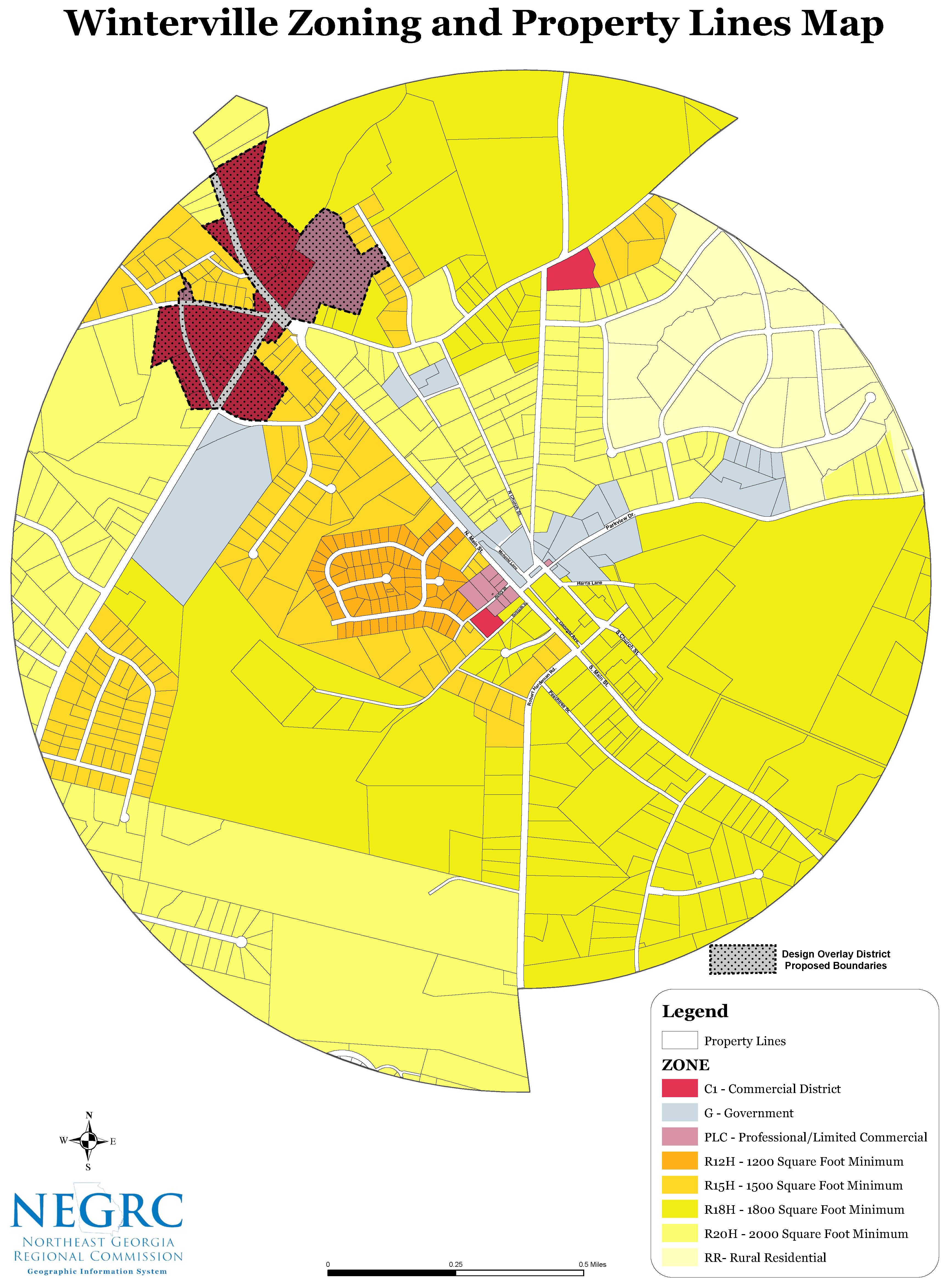
Sec. 38-357. - RR Rural Residential District.
One unit per five acres, 2,000 square feet minimum house size.
(Ord. of 5-2016(2), § 7.1)
Sec. 38-358. - Residential districts.
(a)
R12H—1,200 square feet minimum house size.
(b)
R15H—1,500 square feet minimum house size.
(c)
R18H—1,800 square feet minimum house size.
(d)
R20H—2,000 square feet minimum house size.
(Ord. of 5-2016(2), § 7.2)
Sec. 38-359. - C General Business Commercial District.
(Ord. of 5-2016(2), § 7.3)
Sec. 38-360. - PLC Professional Limited Commercial District.
(Ord. of 5-2016(2), § 7.4)
Sec. 38-361. - G Government District.
(Ord. of 5-2016(2), § 7.5)
Sec. 38-362. - Planned development (pd) district.
(a)
Intent.
It is the intent of this district to encourage development of compatible land uses on a scale larger than that of individual small parcels. This district is designed to be an overlay appended to a residential, commercial, or industrial district to provide greater latitude with regard to the internal site planning considerations of a planned development. Uses and structures in a planned development should be considered on a case-by case basis and be evaluated for approval based on consistency with the comprehensive plan and the underlying zoning district or districts. Deviation from building location, height, type, area, lot size, and other dimensional criteria of the underlying district standards are permitted as part of a PD.
(b)
General provisions.
Any area may be rezoned as a planned development district if any one of the following conditions are met:
(1)
More than one principal land use is proposed for development on a single or multiple ownership.
(2)
Separate land uses, which would not otherwise be permitted to locate within the same zoning district, are proposed for development on one or more adjacent parcels under single or separate ownership.
(3)
Exceptions or variations to the size, dimensional changes in standards required, or other requirements of the zoning ordinance or are being sought to provide design flexibility.
(c)
"PD" approval procedures.
(1)
The application for the planned development shall be executed by all property owners as recorded in the official records of the superior court of Athens-Clarke County, or their authorized agents.
(2)
Any request pertaining to the establishment of a "PD" zoning district shall be considered an amendment to the official zoning map and shall be administered and processed as an application to amend the official zoning map.
(3)
Development plan and application.
a.
A petition for "PD" zoning must be accompanied by a site plan and written report of the project. The application shall include a report addressing the approval criteria of this section, and a development plan prepared and sealed by a licensed surveyor, architect, landscape architect, or engineer, and including the following information:
1.
Vicinity map.
2.
North arrow.
3.
Depiction and names of all streets within and abutting the subject property, including right-of-way and pavement widths.
4.
Depiction of the subject property, based on the most recent recorded plat or provided by a professional land surveyor.
5.
Location and use of all buildings existing and proposed on the subject property.
6.
Location of all parking areas, parking spaces, and ingress, egress, and traffic circulation for the subject property.
7.
Schematic landscaping plan showing area and type of landscaping proposed.
8.
For any proposed structural or site improvement, a topographic map of the site showing contour intervals of two feet or less.
9.
Approximate location of all existing natural site features including, but not limited to, all existing vegetation, any natural drainage ways, streams, ponds or wetlands, any substantial outcroppings of rocks or boulders, and protected environmental areas and applicable buffer zones.
10.
Project name and designation of the plan.
11.
Scale (plan must be drawn to a standardized engineering scale).
12.
Date of plan origination and latest revision.
13.
Tax parcel identification numbers, zoning, historic district, or other district boundaries established by the city of the subject property and adjacent properties.
14.
Existing and proposed public water, sanitary sewer, and access easements, and stormwater management facilities.
15.
Total acreage, the area and percentage of lot coverage, the total number of parking spaces, sufficient information for required parking determination for each non-residential use, and the total number of dwelling units.
In addition to the development plan, a planned development application may include the following:
16.
Traffic impact analysis for projects that may be expected to generate 500 average daily vehicle trips per day, per the specifications of the city traffic engineer, or agent. Anticipated vehicle trips may be based upon the latest edition of Trip generation published by the Institute Of Transportation Engineers.
17.
Water and sanitary sewer demand per specifications of the Athens-Clarke County public utilities department if the development is proposed to be served by public water and/or public sewer.
18.
Schematic architectural elevations of proposed structures (including proposed signage) and/or photographs of existing structures, as applicable, with the existing or proposed maximum height denoted.
19.
Written description of proposed stormwater management, or statement of intent to comply with all local, state, and federal regulations for stormwater management.
(4)
Compliance. In any event where it is determined by the mayor and city council, after referral and/or receipt of a recommendation from the planning commission, that the development of an approved planned development project is not in accordance with this section, the mayor and city council, after holding a public hearing, may amend the zoning ordinance to place parts or all of the property in the planned development district in its prior zoning classification or any other appropriate classification.
(5)
Application of regulations:
a.
If any exceptions or variations to the requirements of the zoning ordinance are being sought in connection with the planned development, then the application must contain the applicant's requests for such exceptions or variations for hearing, consideration, and decision by the mayor and city council in conjunction with the planned development.
b.
Uses permitted in any "PD" district are limited to those identified as permitted an existing district. In the case of an underlying residential district if a commercial use is not permitted the PD process can be used to incorporate retail and service uses as a component of the project.
c.
Gross residential density shall be equivalent the underlying residential district.
d.
Adequate guarantee shall be provided for the permanent retention as "open space" for all of the residual open land area resulting from the planned development approval. The guarantee shall be in the form of private reservation for the use of project residents through covenants, deed restrictions, or similar documents, or through dedication as common open space, or as land held in a common undivided interest dedicated to a recognized land trust, or dedicated to the City of Winterville. The care and maintenance of such private open space areas shall be similarly provided for.
e.
To ensure adequate and proper construction of the following facilities listed below in "a" through "e," the mayor and city council may require that a performance bond or other financial guarantee be submitted by the owner. Such guarantee, if required, shall be in an amount set by the mayor and city council and sufficient to allow the City of Winterville or Athens-Clarke County to construct the stipulated facilities. In addition, the owner shall be required to grant right-of-entry to the City of Winterville or Athens-Clarke County to construct such improvements where a bond is required.
1.
Recreation lands and appurtenances;
2.
Streets and sidewalks;
3.
Drainage facilities;
4.
Grading improvements;
5.
Sewer, water, and other utilities.
(6)
The violation of any provision of the approved development plan shall constitute a violation of this title.
(7)
If the development plan is approved by the governing body, the planned development regulations shall become the zoning for the property. The approved development plan constitutes a binding site plan and shall include all conditions of zoning approval adopted by mayor and council.
Sec. 38-363 - Downtown Winterville special district overlay.
(a)
Purpose and intent. The special district overlay described in this title is established to protect and enhance the area within and around downtown Winterville. The area is distinct by virtue of the development pattern present and the buildings' age, scale, form, and character compared to areas outside of the district boundaries. Through the application of the design guidelines established in this title, new development within the special district boundaries will maintain consistency and complement the existing and established character. This district is intended to be a design overlay and apply to the elements described herein. As an overlay the regulations are to be appended to an underlying residential, commercial, or other established zoning district. Development in this district should be considered on a case-by-case basis and be evaluated for approval based on consistency with the comprehensive plan and the underlying zoning district or districts. Deviation from building location, height, type, area, lot size, and other dimensional criteria of the underlying district standards are permitted in cases where the subject property is within the boundaries of the downtown design district, and the underlying zoning district's regulations are less restrictive.
(b)
General provisions.
The downtown design overlay district is hereby created within and around downtown Winterville, and the boundaries of the downtown design overlay district are depicted on the map attached hereto and incorporated by reference herein. The downtown design district overlay established in this section is a design overlay district intended to promote the purpose and intent of the district.
Land lying within the downtown design district overlay shall remain part of the underlying zoning designation established by other provisions of the zoning ordinance and may, in addition, lie within one or more overlay districts in accordance with the designation of each. In the event of a conflict between the underlying zoning designation and the special district overlay, the provisions of the special district overlay shall apply.
(c)
Downtown design district overlay procedures.
(1)
Development plans for any proposed project within a special district overlay require review and approval by the mayor and council. Following the submission of a complete application, the planning commission will review the submitted materials at the next regular meeting. The planning commission shall first review the application in consultation with other departments or state agencies to ensure compliance of the application with all applicable regulations, ordinances, and laws, and make a recommendation to the mayor and council for approval, approval with conditions or denial. The mayor and council will then consider the application at its next regular meeting. Before taking action on an application, the mayor and council shall hold a public hearing. At the public hearing, the mayor and council shall review the application submitted and the recommendation prepared by the planning and zoning commission. The applicant and any proponents in support of the application, and any opponents to the application will be allowed a minimum time period of ten minutes per side to present data, evidence, and opinions to the mayor and council. Following the hearing, the mayor and council will consider whether the application complies with the design guidelines and then may approve the application, approve with conditions, or deny the application.
(2)
Application contents.
a.
All applications and materials for review of development plans must be submitted to the city clerk. To be considered three copies of a complete application and three copies of a binding development plan for proposed construction must be approved. The binding development plan must contain the following:
1.
Project name.
2.
Project owner. All corporate owners shall also list the names of the officers of the corporation. All partnerships, limited partnerships, or limited liability companies shall list the names of the partners and managers of the business entity.
3.
Project owners' address.
4.
Date, scale, and north arrow on all submitted plans and drawings.
5.
Property lines and dimensions and bearings.
6.
Required setbacks.
7.
Location of all existing and proposed buildings.
8.
Elevation drawings for all proposed alterations to existing buildings, including drawings of architectural details and materials.
9.
Location, name, and width of all existing or proposed streets.
10.
Topography at five-foot contour intervals.
11.
Location of all driveways and off-street parking serving the project.
12.
Location and plans for all proposed buffers, screening materials, or other landscape features.
13.
Location of creeks, streams, ponds, lakes, and other waterways.
14.
Dumpster locations.
15.
Location, height fixture type and wattage of site lighting.
16.
Heights of existing and proposed buildings.
17.
Any other information or data identified in the specific special overlay district to understand and evaluate the project.
(d)
Relationship to historic preservation ordinance. Projects located within a district or area designated under the historic preservation ordinance shall be reviewed by the historic preservation commission and be subject to their approval as well as meeting the criteria established by the special overlay district. In the event of a conflict between special overlay district regulations and the decision of the historic preservation commission, the historic preservation ordinance shall apply.
(e)
Uses. This district is intended to promote and reinforce the established character within the established boundaries. Uses within the district are permitted according to the underlying zoning district, and any approval of an application or development plans may not amend the uses of the underlying zoning district or grant conditional use approval. Any person desiring to change zoning within the downtown design district should file an application to rezone or for conditional use approval concurrently with an application for approval under the downtown design district guidelines.
(f)
Design guidelines. To promote the purposes of the special district the following design guidelines shall be applicable to structures within the boundaries of the downtown design district.
(1)
New construction.
a.
New non-residential construction.
1.
May not have a height greater than two stories or 35-feet.
2.
Should conform to the existing setback established by non-residential buildings on adjacent lots.
3.
Should face the major street.
4.
Should have similar facade width adjacent buildings.
5.
The roof of the new construction should be flat or gabled.
6.
The proportion of the façade that has windows and the window size should be consistent with adjacent non-residential buildings if they are within the downtown district overlay.
7.
The visual separation by belt-course between the first and second story of any new non-residential building.
8.
Any new construction that consists of more than one lot with no side yard setback should have vertical divisions apparent by a change in materials. These divisions should match the building widths established by non-residential buildings on an adjacent lot.
b.
New residential construction:
1.
New houses should have a height limit of two stories or 35-feet.
2.
New buildings should have a foundation height of at least one-foot above grade.
3.
New foundations of concrete block should be faced with brick or stone or masked with a stucco or paint application.
4.
The setback established by existing homes along the block, or adjacent lots should be maintained.
5.
New buildings should follow the block's placement pattern by maintaining side yard setbacks present on existing residences on adjacent lots.
6.
The main entrance of the new building should be located facing the street façade.
7.
A one-story porch should be located on the front façade, either an entry porch or a full-width porch.
8.
New buildings should be of frame, brick, or stone construction. Frame buildings should be sided with wood or smooth cementitious siding, commonly known as hardie board, clapboard widths should be between four- and six-inches. Brick buildings should have mortar joints.
9.
The placement and rhythm of door and window openings should be compatible with those on the front facades of adjacent buildings.
10.
Window and door openings should not exceed the height to width ratios of adjacent buildings by more than ten percent.
11.
New houses should have a similar orientation to adjacent buildings, as well as a similar roof form and slope.
12.
New houses should not have attached garages with front-facing access.
(Ord. No. 2024-0002, 5-14-2024)