Wiscasset City Zoning Code
DEFINITION OF
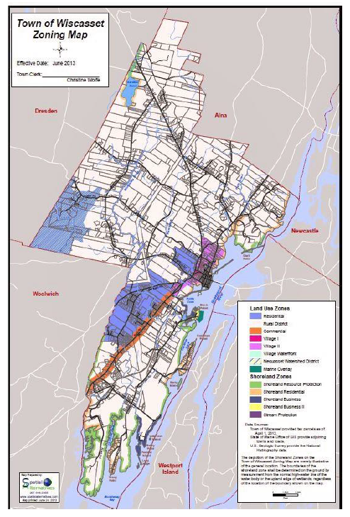
DISTRICTS AND ZONING MAP
The following text defining Districts and Zones are included herein for assistance only. The official Zoning Map is the definitive document delineating Districts and Zones and is incorporated into these Town Ordinances. Where boundaries are shown following property lines, it is intended that the official Zoning Map delineate Districts and Zones precisely along these property lines. However, it is probable that in various instances a property line as depicted on the Zoning Map will not precisely correspond to the property line as determined by a survey or by deed research. Therefore, any inconsistency between the Zoning Map and a property line in effect at the time the Zoning Map was adopted or is amended shall be resolved in favor of the actual property line. In the following definitions of Districts, lots are referred to by Tax Map and Lot number, or by owner. (6-90, 3-92)
PROCEDURE FOR CONTROL OF THE OFFICIAL ZONING MAP.
The Town Clerk shall maintain a record of changes to the official Zoning Map as voted by the Town starting with town meetings after 1 June 1992; Maps presented to the Town and adopted by the Town shall be attested to by the Town Clerk. A composite map shall be maintained in the Town Office to sum up the display of the latest definitions of districts. A small-scale composite shall be in the Town ordinances. A working copy shall be maintained by the Town Clerk to show the latest zoning changes. (6-92)
AA.
SHORELAND RESOURCE PROTECTION DISTRICT
AA.1
From the northerly Crandall property limit along the Sheepscot River, southerly and westerly along Clark's Point to the southerly property of Kahl.
AA.2
From the northeasterly line of Stetson, White and Scaife to the end of their property where it meets the Lord property.
AA.3
From the northern property line of Maine Yankee and the Sheepscot River to 30 feet north of the northern side of Old Ferry Road on the property of Maine Yankee.
AA.4
From a line drawn from the cove where Maine Yankee property abuts that of King to the easterly shore of that point of land (Ready Point) owned by Maine Yankee and thence to the property of said King.
AA.5
From the intersection of King and U.S. Gypsum land, northerly along Chewonki Creek and thence southerly to the intersection of the Chewonki and Gould property on said creek.
AA.6
From the southerly property line of Chewonki and Gould, northerly to the property line of Brackett.
AA.7
From a line 130 feet north of the property line of Sewall with Maine Yankee to the southerly center of Gorham Road.
AA.8
One hundred (100) feet around the entire shore of Gardiner Pond, as a possible future source of town water.
AA.9
All islands and ledges lying within the Town of Wiscasset except Foxbird Island and the Town property on Cow Island are Shoreland Resource Protection District.
AA.10
Stream resource protection areas. The following subparagraphs relate to activities in these areas.
A.2.1
Agricultural activities;
A.2.2
Roads and Driveways;
A.2.8
Filling and earth-moving activities;
A.3.2
Structures;
A.3.3
Clearing of vegetation;
A.4.1
Campsites;
B.2.2
Campgrounds;
B.5
Structures.
AA.10.1
Polly Creek Stream Protection. From the point of confluence of two perennial streams located within lot R-5-74, presently owned or previously owned by Brun and lot R-5-76 presently owned or previously owned by J. Sutter thence flowing through the following properties to the point where it joins the existing Shoreland zone at its outlet into the Sheepscot River.
AA.10.2
Montsweag Brook Stream Protection. From the point of confluence of two perennial streams located within lot R-2-42C presently owned or previously owned by Webber; the westerly branch of Montsweag Brook flows easterly and southerly through the following properties to its point of confluence with the easterly branch in lots R-2-15A and R-2-15B.
From the point of confluence of two perennial streams located within lot R-3-23 presently owned or previously owned by Dauplaise; the easterly branch of Montsweag Brook flows southerly through the following properties to its point of confluence with the westerly branch in lot R-2-15A and R-2-15B.
From the point of confluence of its East and West branches located within lots R-2-15A presently owned or previously owned by McConnell and R-2-15B presently owned or previously owned by Soule; Montsweag Brook flows southerly through the following properties to Gorham Road where it joins the previously established Shoreland Zoning.
AA.10.3
Nequasset Lake Watershed. All streams and ponds, regardless of size, within the Watershed District.
BB.
SHORELAND RESIDENTIAL DISTRICT
BB.1
From the Alna town line to the southeast to the property of Crandall.
BB.2
Beginning at the easterly boundary of Kahl property following the shore around Clark's Cove, northerly and southerly, to the southerly boundary of the Ancient Cemetery, being land of the Town of Wiscasset.
BB.3
From the northwestern boundary of Map U1 Lot 148 where it intersects the continuation of Fore Street (known as Front Street),thence north to the middle of Lee Street and the end of the 250-foot Shoreland Zone; thence westerly and southwesterly following the shore of the Sheepscot River to the property of Central Maine Power Company.
BB.4
From the westerly boundary of Eastern Realty Sales, Inc. (Lord) around Cushman Point following the shore of the Sheepscot River to the northern boundary of Maine Yankee.
BB.5
From the westerly boundary of Maine Yankee to the northerly boundary of King.
BB.6
From the southerly boundary of Brackett by the shore of Montsweag Creek to the southern property line of Sewall.
BB.7
Along Gardiner Pond from the 100 feet of Shoreland Resource Protection District to the end of the Shoreland Zone.
CC.
SHORELAND BUSINESS DISTRICT
CC.1
From the point of land of Maine Central Railroad and the Town of Wiscasset Sewage Disposal Plant westerly along the cove to the northwesterly extension of the center line of Water Street; thence southwesterly along the center of Water Street to the extension of the Hammond property; thence westerly along the Hammond property to the Ancient Cemetery and the end of the Shoreland Zone; thence southwesterly along the Shoreland Zone to the center line of Big Foot Alley; thence easterly along the center of Big Foot Alley to its intersection with the center of Water Street; thence southwesterly to the end of Water Street at the edge of the Sheepscot River; thence in a northeasterly direction along the shore to the point of beginning.
CC.2
The property of Central Maine at Mason Station from the property of Lewis south and ending at the Stetson-White-Scaife line excepting the property described in Article VI, Section KK and LL.
CC.3
From the beginning of the property of Maine Yankee below the Bailey property along the shores of Bailey's Point; thence along the westerly shore of Ready Point to the line described in Shoreland Resource Protection District. (This section from the brook at the head of the cove is to be treated by Maine Yankee as Shoreland Resource Protection District.)
CC.4
All land lying within 250' of normal high-water mark of any pond, river or saltwater body and not part of the Shoreland Resource Protection District or the Shoreland Residential District.
DD.
RESIDENTIAL DISTRICT
Beginning at the intersection of Willow Lane and Churchill Street westerly along the centerline of Willow Lane to the eastern boundary of parcel R6 lot 36; thence southwesterly along the western boundary of parcel R6 lot 49 and U5 lot 9 to Rocky Ridge Drive; thence south along Rocky Ridge Drive to the Bradford Road, thence south along the western boundary of parcel U7 lot 1; thence southeasterly following the southern boundary of parcels abutting Bradford Road (and including U6 lot 3 and U6 lot 4A) to US Route 1.
Parcels U6 lot 19, U6 lot 20, U6 lot 21 and U6 lot 22 in their entirety at the time of this Ordinance.
Contained within a line beginning at the intersection of the center line of the northerly end of the Old Bath Road and the westerly line of Haggat Road R/W, thence southerly along the westerly line of Haggat Road R/W and Parcel U9 lot 8-1 following a line 500 feet from the centerline of US Route 1 south through parcel U9 lot 6; thence southerly along the western boundary of parcel U9 lot 5 to the northerly boundary of CMP transmission line property, R7 lot 58, thence southerly along a line 500 feet from the center line of U.S. Route One following the northern boundary of the Route 1 Commercial District to the Old Bath Road; thence westerly along the center line of the Old Bath Road to its intersection with the southerly line of Aponte (R-8-1-2), extended, thence westerly to the southern property line, extended, of Fogg (R-8-1A), thence westerly to the center line of Montsweag Brook (Town Line), thence northerly along the center line of the Brook to the northern boundary, extended, of R. Clarke (R-7-90-3), thence easterly along the northerly property lines of Dentico (R-7-90-4), and Ames (R-7-91) to its intersection with the Central Maine Power Company northerly property line, extended, thence northerly along the Central Maine Power Company property line to its intersection with the southerly line of M. Rafter(U-9-14), thence easterly along the M. Rafter property line, extended, to its intersection with the center line of the Old Bath Road, thence easterly along the center line of the Old Bath Road to the point of beginning. (6-91, 6-12)
EE.
VILLAGE I DISTRICT
Commencing on the northerly tip of parcel formerly identified as Map U2 lot 56; continuing southerly to Lincoln Street then southerly to the intersection of Water Street and southerly to Fore Street; thence along the southern boundary of parcel U1 lot 74; thence north along the eastern side of Middle Street to Bradbury Street; continuing along the southern edge of parcels U1 lot 100 and U1 lot 101; thence northerly along Fort Hill Road to the southern boundary of parcels U1 lot 121, U1 lot 122, U1 lot 131, U1 lot 132, U1 lot 133, U1 lot 134; thence along the northern boundary of parcels U1 lot 142 and U1 lot 143; thence across High Street to the northern boundary of parcel U1 lot 164; thence north along the easterly boundary of U1 lot 165 A and U1 lot 65; thence southwesterly along the southern boundary of the Lincoln County Courthouse, parcel U1 lot 166; thence south along the easterly edge of U1 lot 168 and U1 lot 169; and thence westerly along the parcel U1 lot 170 to the Bath Road.
From the Bath Road at the southwesterly corner of parcel U1 lot 170; continuing northerly to include the entire parcel of the Municipal building on U5 lot 1; thence easterly along the northerly edge of US Route 1 to Washington Street. Continuing easterly along the southern edge of Washington Street to Federal Street; thence north along the easterly side of Federal Street to the northwest corner of parcel U1 lot 36; thence easterly along the northern boundary of parcel U1 lot 36 to its northeast corner; thence north along the western boundary of town parcel U2 lot 50 to the point of the beginning.
Beginning at the center line of Hooper Street at its intersection with Gardiner Road; thence easterly by Hooper Street to the northerly extension of the easterly property line of Benedix; thence southerly by Benedix to land of Shorey; thence easterly by Shorey to land of the Town of Wiscasset; thence southerly, easterly and southerly by Shorey's easterly bounds to land of Tims; thence easterly by Tims and land of First National Bank of Damariscotta to the northeast corner of the land of First National Bank of Damariscotta; thence southerly by First National Bank of Damariscotta and land of Petrie to Petrie's southeast corner and land of Doering; thence westerly by Petrie, to the corner of Gardiner Road; thence northerly by the center of Gardiner Road to the point of the beginning. (6-12)
FF.
VILLAGE II DISTRICT
Commencing from the northeast corner of parcel U3 lot 20 along the Sheepscot River to the north easterly corner of the Ancient Burying Ground; thence along the southern boundaries of the Ancient Burying Grounds to Federal Street; thence south along the western side of Federal Street to Washington Street; thence westerly along Washington Street to Hodge Street; thence westerly along the northern edge of US Route 1 to the southeastern corner of parcel U1 lot 1; thence north along parcel U 1 lot 1; thence east along the northern boundary of parcel U1 lot 1; thence northeast along the eastern boundaries of U5 lot 22, U5 lot 22A, U5 lot 21, U5 lot 20, U5 lot 19A' thence westerly along the north boundary of U5 lot 19A to the southeasterly corner of parcel U5 lot 19B; thence northeasterly along the eastern boundary of U5 lot 19B; thence westerly along the boundary of U5 lot 19B to the southeastern corner of U4 lot 23; thence northeasterly to Hooper Street; thence north westerly along Hooper Street to Gardiner Road; thence along the north along the eastern edge of Gardiner Road to the northwest corner of parcel R6 lot 28C; thence southeast along the northwest boundary of parcels R6 lot 28 C, R6 lot 28, U4 lot 16, R6 lot 28A, R6 lot 28B, U3 lot 10A, U3 lot 10, U3 lot 18, U3 lot 20A, and U3 lot 20 to the point of the beginning.
All land between Churchill Street, Gardiner Road and Washington Street (U4 lot 1, U4 lot 5, U5 lot 23, U5 lot 24, U5 lot 25, U5 lot 25A; U5 lot 26, U5 lot 26A, U5 lot 26B, U5 lot 27, U5 lot 28, U5 lot 29).
Beginning from the intersection of Fore Street and Middle Street traveling westerly along Fore Street to the southern corner of U1 lot 128; thence along the western boundary of U1 lot 128 to the northeastern corner of U1 lot 148; thence south along U1 lot 148 to the Sheepscot River; thence southerly along the Sheepscot River to the southern corner of parcel U8 lot 4; thence following the southern boundary of parcel U8 lot 4 for to a distance of 500' from US Route 1; thence southwesterly 500' south of US Route 1 to the northern boundary of the CMP Transmission Line Parcel, U10 Lot 5; thence northwesterly to US Route 1. Continuing northwesterly across Route 1 along the northern boundary of CMP Transmission Line Parcel, R7 Lot 58, thence along the western boundary of parcel U9 lot 5 to parcel U9 lot 6; thence westerly along the southern boundary of parcel U9 lot 6 to a distance of 500' from the centerline of Route 1; thence northeasterly at a distance of 500' from US Route 1 to the western boundary of parcel U9 lot 8-1; thence northeasterly along the western boundary of parcel U9 lot 8-1 and along the western boundary of the Haggat Road R/W to Old Bath Rd; thence rom the Old Bath Rd easterly to the corner of U9 lot 16; thence north along the western boundary of parcel U9 lot 16 to the northwestern corner of parcel U9 lot 15; thence easterly to the western boundary of parcel U6 lot 19; thence northeasterly along the southern boundary of parcel U6 lot 19 to US Route 1; thence traveling northeasterly to Lee Street; thence following the southern boundary of the Village 1 District to the intersection of Fore Street and Middle Street. (6-12)
GG.
VILLAGE WATERFRONT DISTRICT
Beginning at the shore of a cove which is part of the Sheepscot River at the easterly most corner of the Ancient Burying Ground as shown on Tax Map U-2;
Thence generally northeasterly, easterly, southerly, southeasterly and southwesterly along the shore to the southeasterly corner of the property referred to as Castle Tucker, being Lot 148 on Tax Map U-1;
Thence northerly along the easterly boundary of the Castle Tucker property and on a continuation thereof to the centerline of Bradbury Street;
Thence southerly and easterly along the centerline of Fore Street (a.k.a. Front Street) to its intersection with the centerline of Water Street;
Thence northerly along the centerline of Water Street and crossing Main Street, to its intersection with the centerline of Lincoln Street;
Thence westerly along the centerline of Lincoln Street to its intersection with the southerly projection of the westerly line of the property shown as Lot 53 on Tax Map U-2;
Thence northeasterly along said projection and along the westerly line of the property shown as Lot 53 on Tax Map U-2 and along the westerly line of the property shown as Lot 54 on Tax Map U-2 to the southerly line of land shown as Lot 55 on Tax Map U-2;
Thence westerly along the southerly line of land shown as Lot 55 on Tax Map U-2 to the Ancient Burying Ground;
Thence easterly along the southerly line of land known as the Ancient Burying Ground to shore of the cove at the point of beginning.
Said district is to include the adjacent area between the shore and the low water mark from the northeasterly most corner of the land of the State of Maine, being Lot 57 on Tax Map U-2 near the Wiscasset Sewer District treatment plant to a southeasterly projection of the easterly boundary of the property shown on Tax Map U-1 as Lot 1 and commonly referred to as Castle Tucker, said district to include White's Island, so called.
All references to municipal tax maps and lots refer to the maps as revised in 2009.
HH.
COMMERCIAL DISTRICT
From the Woolwich town line to northerly edge of the CMP Transmission lines, U10 Lot 5, R7 Lot 58, all land abutting Route 1, and within approximately 500' of Route 1, measured from the center line of Route 1 as depicted on the Maine Department of Transportation Right of Way Maps. (6-91, 11-00, 9-03, 6-12)
II.
NEQUASSET WATERSHED DISTRICT
All land in the Nequasset Lake Watershed.
JJ.
RURAL DISTRICT
All land not listed in one of the above Districts (AA-HH, KK and LL).
KK.
SHORELAND BUSINESS II DISTRICT
A tract of land at Birch Point in the Town of Wiscasset, being a part of the former Mason Station Property shown on a plan entitled "Shoreland Business District II & Marine Overlay Districts Zoning Map" dated February 28, 2005 bounded and described as follows: Beginning at an iron rod set at the assumed southerly sideline of a town way leading easterly from Birch Point Road to the former Mason Station property at the northeast corner of the land now or formerly of the Chewonki Foundation, Inc. and Thomas B. Stetson, Anne Tierney Stetson & Ethan F. Stetson; thence N 02º40'15" W along the end of the Town Way 13.35' to an iron rod set; thence N 09º25'15" W along the end of the Town Way 54.76' to an iron rod set; thence continuing N 09º25'15" W along the land now or formerly of Central Maine Power Company 64.16' to an unmonumented point at the high water mark of Hilton Pond labeled "M" on said Zoning Map; thence northeasterly and northwesterly along the high water mark of Hilton Pond and a concrete dam to a point at an old earth dam on the boundary of the land now or formerly of Central Maine Power Company; thence N 20º04'45" E along the land now or formerly of Central Maine Power through the old earth dam to the high water mark of Hilton Cove; thence northwesterly, easterly, southerly, and easterly along the high water mark of Hilton Cove to the land now or formerly of Central Maine Power Company at an unmonumented point at the high water mark of Hilton Cove labeled "L" on the above mentioned Zoning Map; thence S 51º24'15" E along the land now or formerly of Central Maine Power Company 172.82' to an unmonumented point; thence S 05º57'43" E along the land now or formerly of Central Maine Power Company 101.26' to an unmonumented point on the northerly side of the access road; thence N 84º02'17" E partly along the northerly edge of the access road 398.71' to an unmonumented point; thence N 05 57'43" W along the land now or formerly of Central Maine Power Company 97.21' to an unmonumented point; thence N 24 º 23'29" E along the land now or formerly of Central Maine Power Company 200.41' to an unmonumented point; thence N 65 º 16'49" W along the land now or formerly of Central Maine Power Company 31.33' to an unmonumented point; thence N 11 º 18'11" E along the land now or formerly of Central Maine Power Company 36.34' to an unmonumented point; thence N 32º23'50" W along the land now or formerly of Central Maine Power Company 110.13' to an unmonumented point; thence N 23 º 54'42" E along the land now or formerly of Central Maine Power Company 33.76' to an unmonumented point; thence N 65 º 49'25" W along the land now or formerly of Central Maine Power Company 58.04' to an unmonumented point; thence N 51 º 24'15" W along the land now or formerly of Central Maine Power Company 332.50' to an iron rod set labeled "F" as shown on the above mentioned Zoning Map; thence continuing N 51 º 24'15" W along the land now or formerly of Central Power Company 51.79' to an unmonumented point at the high water mark of Hilton Cove labeled "A" on the above mentioned Zoning Map; thence northeasterly, easterly, and southeasterly by the high water mark of Hilton Cove and Sheepscot River to an unmonumented point that lies S 86 º 04'44" W 13.94'from a drill hole in ledge set labeled "H" on the above mentioned Zoning Map; thence S 86 º 04'44" W along the northerly boundary of the Marine Overlay District 25.00' to an unmonumented point; thence southerly along the westerly boundary of the Marine Overlay District by a line that is 25' from (on the landward side) and parallel to the high water mark of Sheepscot River to a point that lies N 64 º 11'45" W from an unmonumented point labeled "J" as shown on the above mentioned Zoning Map; thence S 64 º 11'45" E along the southerly boundary of the Marine Overlay District 25.00' to an unmonumented point at the high water mark of Sheepscot River labeled "J" on the above mentioned Zoning Map; thence southwesterly by the high water mark of the Sheepscot River to the center of the old dam at the outlet of the ice pond; thence southwesterly along the high water mark of the ice pond to the land now or formerly of the Chewonki Foundation, Inc. et.als. At an unmonumented point labeled "N" on said Zoning Map; thence N 02º40'15" W along the land now or formerly of the Chewonki Foundation, Inc. et.als. 168.61' to the point of beginning. Bearings mentioned above are oriented towards Grid North (NAD 83) as shown on the above-mentioned Zoning Map.
LL.
MARINE OVERLAY DISTRICT
A tract of land at Birch Point in the Town of Wiscasset, being a part of the former Mason Station Property shown on a plan entitled "Shoreland Business District II & Marine Overlay Districts Zoning Map" dated February 28, 2005 bounded and described as follows: Beginning at a drill hole set in ledge below the high water mark of Sheepscot River lying about 420' northerly of the northeast corner of the brick building known as Mason Station; said drill hole being labeled "H" on the above mentioned Zoning Map; thence N 86 º 04'44" E into Sheepscot River 600.00' to an unmonumented point; thence S 01 º 50'59" W 886.03' to an unmonumented point; thence S 34 19'32" W 681.78' to an unmonumented point; thence N 64 º 11'45" W 600.00' to an unmonumented point at the high water mark of Sheepscot River; said point being labeled "J" on the above mentioned Zoning Map; thence continuing N 64 º 11'45" W along the boundary of Shoreland Business II District 25.00' to an unmonumented point; thence northerly along the easterly boundary of the Shoreland Business II District by a line that is 25' from (on the landward side) and parallel to the high water mark of Sheepscot River to a point that lies S 86 º 04'44" W, a distance of 38.94' from the point of beginning; thence N 86 º 04'44" E 25.00' to the high water mark of Sheepscot River; thence continuing N 86 º 04'44" E 13.94' to the point of beginning. Bearings mentioned above are oriented towards Grid North (NAD 83) as shown on the above-mentioned Zoning Map.
MM.
HISTORIC OVERLAY DISTRICT
The Wiscasset Historic District is defined by the boundaries of the zoning districts of Village I, Village II, and Village Waterfront, as explained above. (6-15)
(See zoning map on next page)