
Woodstock City Zoning Code
ARTICLE III
- DISTRICT REGULATIONS
DIVISION 9. - FLOODPLAIN DISTRICTS[3]
Cross reference— Building code, § 14-31 et seq.; erosion and sediment control, § 26-26 et seq.; general subdivision and review procedures, § 70-36; general design standards for subdivisions, § 70-111; floodplain regulations in subdivisions, § 70-122.
DIVISION 10. - TRADITIONAL NEIGHBORHOOD DEVELOPMENT (TND) DISTRICT[4]
Editor's note—
DIVISION 11. - COMMUNITY INSTITUTION OVERLAY DISTRICT[5]
Editor's note— Ord. of 09-04-2018(1), adopted Sept. 4, 2018, set out provisions intended for use as Div. 11, 90-359.01—90-359.06, 90-359.08—90-359.12. To preserve the style of the section numbers of this Code, and at the editor's discretion, these provisions have been included as 90-359—90-359.12.
Sec. 90-86.- Statement of intent.
The R-1 low density residential district is composed of certain quiet, single-family residential areas plus certain open areas where similar residential development appears likely to occur. The regulations for this district are designed to stabilize and protect the essential characteristics of the district, to promote and encourage a suitable environment for family life where there are children and to prohibit all activities of a commercial nature. To these ends, development is limited to relatively low concentration, and permitted uses are limited basically to single-unit dwellings providing homes for the residents, plus certain additional uses, such as schools, parks and certain public facilities that serve the residents of the district.
(Code 1968, § 29-9)
Sec. 90-87. - Permitted uses.
Structures to be erected or land to be used in the R-1 district shall be for one of the following uses; provided, that only one main building and its accessory buildings may be erected on any lot or parcel of land in this district:
(1)
Single-family detached dwellings.
(2)
Police, fire and rescue squad stations.
(3)
Public utilities, such as poles, lines, distribution transformers, meters, water and sewer lines, booster or relay stations and transformer substations.
(Code 1968, § 29-10)
Sec. 90-88. - Permitted accessory uses.
The following accessory uses, to be located on the same lot with the principal use, shall be permitted in the R-1 low density residential district:
(1)
Home occupations, pursuant to section 90-377.
(2)
Private garages or private parking areas, pursuant to section 90-462.
(3)
Signs, pursuant to section 90-383.
(4)
Other customary accessory uses and buildings, provided they are clearly incidental to the principal use, pursuant to section 90-378.
(Code 1968, § 29-11)
Sec. 90-89. - Minimum lot size.
The following minimum lot size standards shall apply in the R-1 low density residential district:
Lots with public water and public sewer .....17,500
Lots with public sewer only .....20,000
Lots with public water only .....30,000
Lots with on-lot water and sewer .....40,000
(Code 1968, § 29-13)
Sec. 90-90. - Setback.
No structures in the R-1 low density residential district shall be located closer than 35 feet to any street right-of-way which is 50 feet or greater in width, or closer than 60 feet to the centerline of any street right-of-way less than 50 feet in width.
(Code 1968, § 29-14)
Sec. 90-91. - Minimum lot width—Generally.
The minimum width of any lot in the R-1 low density residential district at the setback line shall not be less than 100 feet; except, that any corner lot will not be less than 120 feet at the setback line.
(Code 1968, § 29-15)
Sec. 90-92. - Same—Lots fronting on culs-de-sac in R-1, R-2 and R-3 districts.
The minimum width of any lot in the R-1, R-2 or R-3 district that fronts on a cul-de-sac, as defined in section 70-1, shall not be more than a 40-percent reduction at the setback line as set forth in section 90-91.
(Code 1968, § 29-15.1)
Sec. 90-93. - Yards.
The following yard regulations shall apply in the R-1 low density residential district:
(1)
Side yards. The minimum side yard shall be ten feet, and the total minimum of the two required side yards shall be 25 feet.
(2)
Rear yard. The minimum rear yard shall be 35 feet.
In this district, parking is not permitted in the yard areas (see section 90-387, subsection (f)).
(Code 1968, § 29-16)
Sec. 90-94. - Maximum building coverage and height.
In the R-1 low density residential district, maximum building coverage shall be 25 percent, and maximum height from average grade shall be 35 feet or 2½ stories.
(Code 1968, § 29-17; Ord. of 4-4-95(1))
Sec. 90-95. - Sidewalk requirements.
In the R-1 low density residential district, five-foot sidewalks will be required on both sides of the street on new street construction.
(Ord. of 5-2-2000; Ord. of 2-7-2006)
Sec. 90-111.- Statement of intent.
The R-2 district is intended as a residential area with medium population density. The regulations of this district are designed to stabilize and protect the essential characteristics of the district and to promote and encourage a suitable environment for family life where there are children. To these ends, development is limited to a medium concentration, and permitted uses are limited basically to providing homes for the residents plus certain additional uses, such as schools, parks, churches and certain public facilities that serve the residents of the district. This type of district is located near the more developed areas of the town.
(Code 1968, § 29-18)
Sec. 90-112. - Permitted uses.
Structures to be erected or land to be used in the R-2 medium density residential district shall be for one of the following uses; provided, that only one main building and its accessory buildings may be erected on any lot or parcel of land in this district:
(1)
Single-family detached dwellings.
(2)
Two-family dwellings.
(3)
Police, fire and rescue squad stations.
(4)
Public utilities, such as poles, lines, distribution transformers, meters, water and sewer lines, booster or relay stations and transformer substations.
(5)
Courtyard homes.
(Code 1968, § 29-19; Ord. of 1-4-2005)
Sec. 90-113. - Permitted accessory uses.
The following accessory uses, to be located on the same lot with the principal use, shall be permitted in the R-2 medium density residential district:
(1)
Home occupations, pursuant to section 90-377.
(2)
Private garages or private parking areas, pursuant to section 90-387.
(3)
Signs, pursuant to section 90-383.
(4)
Other customary accessory uses and buildings, provided they are clearly incidental to the principal use, pursuant to section 90-378.
(Code 1968, § 29-20)
Sec. 90-114. - Uses permitted by special permit.
The following uses shall be permitted by special permit in the R-2 medium density residential district:
(1)
Hospitals, orphanages and convalescent homes for the care of the sick, aged or crippled, meeting all federal, state and county requirements, and pursuant to section 90-390, subsection (3), but excluding institutions for the insane, feebleminded or drug or liquor patients.
(2)
Churches; schools.
(3)
Bed and breakfast establishments.
(4)
Two-family (duplex) dwellings, each unit of which may be sold separately.
(5)
Wind turbines on parcels with institutional uses per section 90-1, Institutional use.
(Code 1968, § 29-21; Ord. of 4-2-91(13), § 29-21; Ord. of 5-1-2012)
Sec. 90-115. - Minimum lot size.
(a)
Except as provided in subsections (b) and (c), the following minimum lot size standards shall apply in the R-2 medium residential district:
Lots with public water and public sewer .....12,000
Lots with public sewer only .....15,000
Lots with public water only .....30,000
The minimum lot size for two-family dwellings and single-family semidetached dwellings shall be 20,000 square feet, provided the lots are served by public water and public sewer.
(b)
The minimum lot size of each unit of a two-family (duplex) unit shall be 6,000 square feet.
(c)
The minimum lot size of each unit of a courtyard home shall be 6,000 square feet.
(Code 1968, § 29-22; Ord. of 4-2-91(11), § 29-22; Ord. of 1-4-2005)
Sec. 90-116. - Setback.
No structures in the R-2 medium density residential district shall be located closer than 30 feet to any street right-of-way which is 50 feet or greater in width, or closer than 55 feet to the centerline of any street right-of-way less than 50 feet in width.
(Code 1968, § 29-23)
Sec. 90-117. - Minimum lot width.
(a)
Except as provided in subsection (b) and (c), the minimum width of any lot in the R-2 medium density residential district at the setback line should be not less than 90 feet.
(b)
Lots of each unit of two-family (duplex) units shall have a minimum width of 45 feet at the setback line except that corner lots shall have a minimum width of 55 feet at the setback line.
(c)
Lots of each unit of a courtyard home shall have a minimum width of 45 feet at the setback line except that corner lots shall have a minimum width of 55 feet at the setback line.
(Code 1968, § 29-24; Ord. of 4-2-91(10), § 29-24; Ord. of 1-4-2005)
Sec. 90-118. - Yards.
(a)
Except as provided in subsection (b) and (c), the following yard regulations shall apply in the R-2 medium density residential district:
(1)
Side yards. The minimum side yard shall be ten feet, and the total minimum width of the two required side yards shall be 25 feet.
(2)
Rear yard. The minimum rear yard shall be 35 feet.
In this district, parking is permitted in the yard areas.
(b)
Lots of each unit of two-family (duplex) units shall have a minimum side yard of eight feet and minimum rear yard of 35 feet except corner lots which shall have a minimum side yard of 20 feet.
(c)
Lots of each courtyard home unit may have a minimum side yard of zero feet on one side of the lot only. The minimum side yard for the side of the lot opposite the zero feet side yard shall be ten feet. Dwellings shall not be configured to allow the zero feet side yards of adjoining lots to be on the common line between the lots. Lots of each courtyard home unit shall have a minimum rear yard of 35 feet except corner lots which shall have a minimum side yard of 20 feet.
(Code 1968, § 29-25; Ord. of 4-2-91(9), § 29-25; Ord. of 1-4-2005)
Sec. 90-119. - Parking for lots of each unit of two-family (duplex) and courtyard home units.
Parking shall be allowed in the front, side and rear yards. At least two parking spaces are required for each of such units.
(Ord. of 4-2-91(8), § 29-25.1; Ord. of 1-4-2005)
Sec. 90-120. - Maximum building coverage and height.
In the R-2 medium density residential district, maximum building coverage shall be 40 percent, and maximum height from average grade shall be 35 feet or 2½ stories.
(Code 1968, § 29-26; Ord. of 4-4-95(1))
Sec. 90-121. - Sidewalk requirements.
In the R-2 medium density residential district, five-foot sidewalks will be required on both sides of the street on new street construction.
(Ord. of 5-2-2000; Ord. of 2-7-2006)
Sec. 90-151.- Statement of intent.
The R-3 high density residential district is intended to provide the highest population density in the town. The regulations for this district are designed to maintain those predominant characteristics of the high density district and to promote and encourage a suitable environment for dwellings, insofar as it is compatible with the intensity of the land use. Various types of housing units are permitted. Other related residential uses may be allowed as long as the character of the district is not substantially altered.
(Code 1968, § 29-27)
Sec. 90-152. - Permitted uses.
Structures to be erected or land to be used in the R-3 high density residential district shall be for one of the following uses; provided, that only one main building and its accessory buildings may be erected on any lot or parcel of land in this district:
(1)
Single-family detached dwellings.
(2)
Two-family dwellings.
(3)
Multifamily dwellings, not including townhouses or garden apartments.
(4)
Boarding and lodging houses.
(5)
Police, fire and rescue squad stations and other public uses.
(6)
Public utilities, such as poles, lines, distribution transformers, meters, water and sewer lines, booster or relay stations and transformer substations.
(7)
Courtyard homes.
(8)
Cottage apartment or condominium (CAC), pursuant to section 90-393.
(Code 1968, § 29-28; Ord. of 1-4-2005; Ord. of 1-3-2023(1))
Sec. 90-153. - Permitted accessory uses.
The following accessory uses, to be located on the same lot with the permitted principal use, shall be permitted in the R-3 high density residential district:
(1)
Home occupations, pursuant to section 90-377.
(2)
Private garages or private parking areas pursuant to section 90-387.
(3)
Signs, pursuant to section 90-383.
(4)
Customary accessory uses and buildings, provided they are clearly incidental to the principal use, pursuant to section 90-378.
(Code 1968, § 29-29)
Sec. 90-154. - Uses permitted by special permit.
The following uses shall be permitted by special permit in the R-3 high density residential district:
(1)
Townhouses and multi-family stacked (MFST), pursuant to section 90-380.
(2)
Garden apartments, pursuant to section 90-379.
(3)
Hospitals, orphanages and convalescent homes for the care of the sick, aged or crippled, meeting all federal, state and county requirements, and pursuant to section 90-390, subsection (3) and section 90-387, but excluding institutions for the insane, feebleminded or drug or liquor patients.
(4)
Churches; schools.
(5)
Bed and breakfast establishments.
(6)
Two-family (duplex) dwellings, each unit of which may be sold separately.
(7)
Professional offices (only within the town historic district).
(8)
Fine art studios (only within the town historic district).
(9)
Halfway house.
(Code 1968, § 29-30; Ord. of 4-2-91(7), § 29-30; Ord. of 9-3-2013; Ord. of 06-05-2018(4); Ord. of 10-01-2019(2))
Sec. 90-155. - Minimum lot sizes.
(a)
Except as provided in subsection (b) and (c), the following minimum lot size standards shall apply in the R-3 high density residential district:
(b)
The minimum lot size of each unit of two-family (duplex) units shall be 6,000 square feet.
(c)
The minimum lot size of each unit of a courtyard home shall be 6,000 square feet.
(Code 1968, § 29-31; Ord. of 4-2-91(6), § 29-31; Ord. of 1-4-2005)
Sec. 90-156. - Setback.
No structure in the R-3 high density residential district shall be located closer than 30 feet to any street right-of-way which is 50 feet or greater in width, or closer than 50 feet to the centerline of any street right-of-way less than 50 feet in width.
(Code 1968, § 29-32)
Sec. 90-157. - Minimum lot width.
(a)
Except as provided in subsection (b) and (c), the minimum width of any lot in the R-3 high density residential district at the setback line shall not be less than 75 feet.
(b)
Lots of each unit of two-family (duplex) units shall have a minimum width of 37½ feet at the setback line except that corner lots shall have a minimum width of 47½ feet at the setback line.
(c)
Lots of each unit of a courtyard home shall have a minimum width of 37½ feet at the setback line except that corner lots shall have a minimum width of 47½ feet at the setback line.
(Code 1968, § 29-33; Ord. of 4-2-91(5), § 29-33; Ord. of 1-4-2005)
Sec. 90-158. - Yards.
(a)
Except as provided in subsection (b) and (c), the following yard regulations shall apply in the R-3 high density residential district:
(1)
Side yards. The minimum side yard shall be six feet, and the total minimum width of the two required side yards shall be 15 feet.
(2)
Rear yard. The minimum rear yard shall be 35 feet.
In this district, parking is permitted in the yard areas (see section 90-387, subsection (f)).
(b)
Lots of each unit of two-family (duplex) units shall have a minimum side yard of eight feet and a minimum rear yard of 35 feet except corner lots which shall have a minimum side yard of 20 feet.
(c)
Lots of each courtyard home unit may have a minimum side yard of zero feet on one side of the lot only. The minimum side yard for the side of the lot opposite the zero feet side yard shall be ten feet. Dwellings shall not be configured to allow the zero feet side yards of adjoining lots to be on the common line between the lots. Lots of each courtyard home unit shall have a minimum rear yard of 35 feet except corner lots which shall have a minimum side yard of 20 feet.
(Code 1968, § 29-34; Ord. of 4-2-91(4), § 29-34; Ord. of 1-4-2005)
Sec. 90-159. - Parking for lots of each unit of two-family (duplex) and courtyard home units.
Parking shall be allowed in the front, side and rear yards. At least two parking spaces are required for each of such units.
(Ord. of 4-2-91(3), § 29-34.1; Ord. of 1-4-2005)
Sec. 90-160. - Maximum building coverage and height.
In the R-3 high density residential district, maximum building coverage shall be 40 percent, and maximum building height from average grade shall be 35 feet or 2½ stories, unless otherwise provided for within article IV of this chapter.
(Code 1968, § 29-35; Ord. of 4-4-95(1); Ord. of 5-2-2006)
Sec. 90-160.1. - Sidewalk requirements.
In the R-3 high density residential district, five-foot sidewalks will be required on both sides of the street on new street construction.
(Ord. of 5-2-2000; Ord. of 2-7-2006)
Sec. 90-161.- Statement of intent.
The MC-1 medical-hospital center district is intended to permit the development, location and growth of a general hospital to serve as a nucleus of a master planned medical center complex, and to permit the location around the general hospital of closely related medical uses, such as medical offices, diagnostic laboratories, pharmaceutical centers, special patient care units, and housing units and other uses in support of the hospital. In addition, other areas located away from the central medical center may be zoned MC-1 provided that the minimum district size is met and that the character of the surrounding area is not substantially altered.
(Ord. of 5-2-95(1))
Sec. 90-162. - Permitted uses.
Structures to be erected or land to be used in the MC-1 medical-hospital center district may be used for one or more of the following uses:
(1)
General hospitals and specialty hospitals or centers, including but not limited to pediatrics, obstetrics, comprehensive medical rehabilitation, hospices, psychiatric, and other specialty hospitals serving the medical profession.
(2)
Emergency care and critical facility.
(3)
Nonemergency care facility.
(4)
Medical and dental offices and clinics (including health department).
(5)
Professional and business offices (closely related to health care).
(6)
Diagnostic laboratories and services serving the medical or dental profession.
(7)
Dialysis center.
(8)
Out-patient treatment centers including day surgery centers.
(9)
Medical training facilities.
(10)
Pharmaceutical centers.
(11)
Housing, including:
a.
Dormitories for medical and dental interns, nurses, and allied health personnel;
b.
Housing for the elderly and physically handicapped;
c.
Adult homes;
d.
Nursing homes and rest homes;
e.
Retirement housing.
(12)
Helipad and heliport to service the main hospital structure.
(13)
Accessory uses to include automatic bank teller machines, hospital laundry, hospital service buildings, warehousing, maintenance and materials management buildings for medical center use.
(14)
Day nursery and day care center.
(15)
Durable medical equipment facilities, services, and sales; intended for retail sales and wholesale distribution, repair and servicing and storage of medical, dental, optical and surgical supplies and medical related merchandise (inclusive of home oxygen services), provided that there shall be no outdoor storage or display.
(16)
Recreational facilities (indoor and outdoor), health clubs and sports medicine clinics intended for the use of doctors, hospital staff, in-patient and out-patients to the district and families and guests and the public-at-large.
(17)
Restaurants or cafeterias located within the confines of the main hospital, a specialty hospital, housing building or office building, serving primarily persons or families of persons using the services or conducting business within the facilities of the district. No outdoor signage will be permitted for this use.
(18)
Conference facilities, primarily related to health care services.
(19)
Personal service and retail establishments (inclusive of banks and branch banks) serving the district when located either within the main hospital structure or in an physically contiguous structure to the main hospital.
(20)
Public utilities such as poles, lines, distribution transformers, meters, water and sewer lines, pump stations, booster or relay stations, transformer stations, cable television facilities, telephone facilities, natural gas utility facilities. Appurtenances to these systems must be effectively screened.
(21)
On-site, freestanding utility system substations (such as heating and cooling plants, pump stations, and related electromechanical systems), provided that such shall be sited no closer than 100 feet from any R district.
(Ord. of 5-2-95(1))
Sec. 90-163. - Permitted accessory uses.
[The following permitted accessory uses shall apply to the MC-1 medical-hospital center district:]
(1)
Off-street parking and loading areas, pursuant to the provisions of section 90-387.
(2)
Parking garages.
(3)
Signs pursuant to section 90-384.
(4)
Customary accessory uses and buildings provided such are clearly incidental to the principal use, pursuant to section 90-378.
(Ord. of 5-2-95(1))
Sec. 90-164. - Minimum district size.
The minimum district size shall be two acres.
(Ord. of 5-2-95(1))
Sec. 90-165. - Minimum lot width.
The minimum lot width in the MC-1 medical-hospital center district shall be 75 feet.
(Ord. of 5-2-95(1))
Sec. 90-166. - Maximum building coverage and height.
In the MC-1 medical-hospital center district, maximum combined building coverage and paved parking area shall be 80 percent and the maximum building height from average grade shall be 45 feet.
(Ord. of 5-2-95(1); Ord. of 5-2-2006)
Sec. 90-167. - Yard requirements.
The following yard requirements shall apply to the MC-1 medical-hospital center district:
(1)
Front yard setback. The minimum front yard setback shall be 40 feet.
(2)
Side yards. There shall be a side yard with a minimum of 15 feet on each side of the lot, except where the yard is adjacent to a residential district the minimum side yard shall be 25 feet. For buildings in excess of 35 feet in height, the side yard shall be 20 feet, except where the yard is adjacent to a residential district the minimum side yard shall be 30 feet.
(3)
Rear yards. Minimum rear yards shall be 20 feet, except where the yard is adjacent to a residential district the minimum rear yard shall be 30 feet.
(Ord. of 5-2-95(1))
Sec. 90-168. - Principal structures.
In the medical-hospital center district, more than one main building may be permitted on a parcel or lot provided that setback and yard requirements are met as if the property were to be subdivided.
(Ord. of 5-2-95(1))
Sec. 90-169. - Application.
Rezoning applications to the district shall be established as an amendment to the official zoning map of the town, provided that any established or approved land uses within an existing district prior to the date of the adoption of this division shall be exempt from these regulations.
In addition to the requirements for rezonings, the following shall be required:
(1)
A master plan depicting the generalized location, heights, density, coverage and arrangement of all known and proposed land uses to be located within the district, as well as open spaces and the approximate location of proposed and existing utility systems for sanitary sewer, storm sewer, water and stormwater management, provided that where specific future land uses within the district have not been determined there shall be no requirement to establish specific building locations, building uses and building heights.
(2)
A phasing plan of development.
(Ord. of 5-2-95(1))
Sec. 90-170. - Buffer area.
All property lines in the medical-hospital center district abutting a residential district shall be appropriately screened, fenced, walled or enclosed with a suitable enclosure of a minimum height of four feet, unless natural vegetation of wooded areas are used as buffer strips. All buffer strips must be at least four feet in height.
(Ord. of 5-2-95(1))
Sec. 90-171. - Waivers.
Uses requiring waivers of height, width, setback, area, yard, minimum district size, parking or loading regulations may be granted in such instances where the town council deems such waiver would be in furtherance of the site planning objectives and overall intent of the district.
(Ord. of 5-2-95(1))
Sec. 90-186.- Statement of intent.
The B-1 central business district is intended to encompass the major downtown retail and service center and to provide for the orderly expansion of the central business district and for the conduct of business to which the public requires direct and frequent access. It is not characterized either by constant heavy trucking, other than stocking and delivery of light retail goods, or by any other nuisance factors other than occasioned by incidental light and noise of congregations of people and passenger vehicles. Commercial district B-1 should provide a framework for a strong nucleus of business where all the amenities and services of downtown can be provided. A site plan may be required by the zoning administrator.
(Code 1968, § 29-36)
Sec. 90-187. - Permitted uses.
Structures to be erected or land to be used in the B-1 central business district may be used for one or more of the following uses; provided, that only one main building and its accessory buildings may be erected on any lot or parcel of land in this district:
(1)
Multifamily dwellings where minimum lot size and space requirements are met.
(2)
Drugstores.
(3)
Retail foodstores.
(4)
Wearing apparel shops.
(5)
Auto parts stores, but not servicing.
(6)
Barber and beauty shops.
(7)
Hotels, motels, tourist homes, boardinghouses and roominghouses.
(8)
Department stores.
(9)
Furniture stores or home appliance stores.
(10)
Hardware stores.
(11)
Florist shops.
(12)
Laundries, laundromats and dry cleaners.
(13)
Radio and television broadcasting stations, studios and offices.
(14)
Indoor theaters.
(15)
Bakeries.
(16)
Clubs, lodges and fraternal organizations.
(17)
Undertaking establishments and funeral homes.
(18)
Billiard parlors and poolrooms.
(19)
Business and professional offices.
(20)
Financial institutions.
(21)
Newspaper and other printing establishments.
(22)
Restaurants, taverns, bars and inns, or other places serving food.
(23)
Churches, schools, police, fire and rescue stations and other public uses.
(24)
Public utilities, such as poles, lines, distribution transformers, meters, water and sewer lines, booster or relay stations and transformer substations.
(Code 1968, § 29-37; Ord. of 12-2-2003; Ord. of 1-5-2021(1))
Sec. 90-188. - Permitted accessory uses.
The following accessory uses, to be located on the same lot with the permitted principal use, shall be permitted in the B-1 central business district:
(1)
Off-street parking areas, pursuant to the provisions of section 90-387.
(2)
Signs, pursuant to section 90-384.
(3)
Customary accessory uses and buildings, provided such are clearly incidental to the principal use, pursuant to section 90-378.
(Code 1968, § 29-38)
Sec. 90-189. - Uses permitted by special permit.
The following use shall be permitted by special permit in the B-1 central business district:
(1)
Commercial parking facilities, pursuant to section 90-391.
(2)
Halfway house.
(3)
Single-family detached dwellings; at no time shall the percentage of Single-family detached dwellings in the district exceed 25 percent of the total main buildings, without the prior approval of the town council.
(4)
Multifamily dwellings where minimum lot size and space requirements are not met.
(Code 1968, § 29-39; Ord. of 8-1-89, § 29-39; Ord. of 06-05-2018(5); Ord. of 09-03-2019(1); Ord. of 1-5-2021(1))
Sec. 90-190. - Minimum lot size.
There shall be no minimum lot size in the B-1 central business district, except where a residential use is to be established or expanded in excess of four units; then there shall be a minimum area of 6,000 square feet, plus an additional 1,500 square feet for each dwelling unit above four.
(Code 1968, § 29-40; Ord. of 1-5-2021(1))
Sec. 90-191. - Setback.
There shall be no setback regulations in the B-1 central business district; except, that any residential use in this district shall be located 20 feet from any street line; however, no residential use shall be required to set back more than the average of the two buildings on either side of such use.
(Code 1968, § 29-41)
Sec. 90-192. - Minimum lot width.
There shall be no frontage regulations in the B-1 central business district.
(Code 1968, § 29-42)
Sec. 90-193. - Yards.
The following yard regulations shall apply in the B-1 central business district:
(1)
Side yards. There shall be no side yard regulations; except, that where a side yard is adjacent to a residential district, the minimum side yard shall be 20 feet, or should the use being started be residential, each side yard shall be a minimum of six feet.
(2)
Rear yard. There shall be no rear yard regulations; except, that where a rear yard is adjacent to a residential district, the minimum rear yard shall be 20 feet, or should the use being started be residential, each rear yard shall be a minimum of 25 feet.
(Code 1968, § 29-43)
Sec. 90-194. - Maximum building coverage and height.
In the B-1 central business district, maximum building coverage, not including and paved area, shall be 80 percent, and maximum building height from average grade shall be 45 feet.
(Code 1968, § 29-44; Ord. of 5-2-2006)
Sec. 90-195. - Buffer area.
All property lines in the B-1 central business district abutting a residential district shall be appropriately screened, fenced, walled or enclosed with a suitable enclosure of a minimum height of four feet, unless natural vegetation or wooded areas are used as buffer strips. All buffer strips must be at least four feet in height.
(Code 1968, § 29-45)
Sec. 90-196. - Sidewalk requirements.
In the B-1 central business district, five-foot sidewalks will be required if a grass strip is to be provided or six-foot sidewalks will be required if no grass strip is to be provided, on both sides of the street on new street construction.
(Ord. of 2-7-2006)
Sec. 90-221.- Statement of intent.
The B-2 highway commercial district is intended to provide sufficient space in appropriate locations for a wide variety of commercial and miscellaneous service activities, generally serving a wide area and located particularly along certain existing major thoroughfares where a general mixture of commercial and service activity now exists, but which uses are not characterized by extensive warehousing, frequent heavy trucking activity, open storage of materials or the nuisance factors of dust, odor and noise associated with manufacturing. A site plan may be required by the zoning administrator.
(Code 1968, § 29-46)
Sec. 90-222. - Permitted uses.
Only one main building and its accessory buildings may be erected on any lot or parcel of land in the B-2 highway commercial district and may be used only for one or more of the following uses:
(1)
Motels, tourist homes and boardinghouses.
(2)
Restaurants, taverns, inns, bars, cafes or other places serving food and beverages.
(3)
Nursing homes; rest and convalescent homes.
(4)
Business and professional offices.
(5)
Furniture stores.
(6)
Bowling alleys; skating rinks.
(7)
Fraternal organizations.
(8)
Lumber and building supplies, with storage under cover and screened.
(9)
Plumbing and electrical supply, with storage under cover and screened.
(10)
Undertaking establishments and funeral homes.
(11)
Animal hospitals.
(12)
Pet shops, but excluding boarding kennels.
(13)
Radio or television broadcasting stations, studios or offices.
(14)
Financial institutions and branches.
(15)
Automobile sales and service; provided, that servicing is conducted in buildings.
(16)
Farm machinery sales and service; provided, that servicing is conducted in buildings.
(17)
Farm supplies, with storage under cover.
(18)
Commercial greenhouses; nurseries.
(19)
Churches, schools, police, fire and rescue squad stations and other public uses.
(20)
Public utilities, such as poles, lines, distribution transformers, meters, water and sewer lines, booster or relay stations and transformer substations.
(21)
Any use permitted in the B-1 central business district, except those uses provided in subsection 90-187(1).
(22)
Businesses for the rental of equipment of all sizes and designs and rental of supplies or any other items, except that no equipment or other items for rental shall be stored outside, not under cover, unless such equipment or other items for rental are appropriately screened, fenced, walled, or enclosed with a suitable enclosure of a minimum of four feet.
(Code 1968, § 29-47; Ord. of 8-2-2006)
Sec. 90-223. - Permitted accessory uses.
The following accessory uses, to be located on the same lot with the permitted principal use, shall be permitted in the B-2 highway commercial district:
(1)
Off-street parking areas, pursuant to the provisions of section 90-387.
(2)
Signs, pursuant to sections 90-384 and 90-385.
(3)
Customary accessory uses and buildings, provided they are clearly incidental to the principal use, pursuant to section 90-378.
(Code 1968, § 29-48)
Sec. 90-224. - Uses permitted by special permit.
The following uses shall be permitted by special permit in the B-2 highway commercial district:
(1)
Retail establishments exceeding 50,000 square feet.
(2)
Carwashes, pursuant to section 90-390, subsection (2).
(3)
Wayside stands for display and sale of farm products, pursuant to section 90-390, subsection (5).
(4)
Dancehalls, pursuant to section 90-391.
(5)
Drive-in restaurants, pursuant to section 90-391.
(6)
Apartments.
(7)
Gasoline service stations, pursuant to section 90-390, subsection (1).
(8)
Exceptions for height up to 55 feet for non-livable space for lots located outside the area designated as the Town of Woodstock Historic District, subject to special permit approval.
(9)
Cottage apartment or condominium (CAC), pursuant to section 90-393.
(Code 1968, § 29-49; Ord. of 8-1-89, § 29-49; Ord. of 8-1-2006; Ord. of 5-3-2022(1); Ord. of 1-3-2023(1))
Sec. 90-225. - Minimum lot size.
There shall be a minimum lot size of 10,000 square feet in the B-2 highway commercial district.
(Code 1968, § 29-50)
Sec. 90-226. - Setback.
The minimum setback in the B-2 highway commercial district shall be 40 feet from any street right-of-way which is 50 feet or greater in width, or 55 feet from the centerline of any street right-of-way less than 50 feet in width.
(Code 1968, § 29-51)
Sec. 90-227. - Minimum lot width.
The minimum width of any lot in the B-2 highway commercial district at the setback line shall not be less than 75 feet.
(Code 1968, § 29-52)
Sec. 90-228. - Yards.
The following yard regulations shall apply in the B-2 highway commercial district:
(1)
Side yards. Each side yard shall be a minimum of 15 feet.
(2)
Rear yard. The rear yard shall be a minimum of 20 feet.
In this district, parking is permitted in the yard areas (see section 90-387(b)).
(Code 1968, § 29-53)
Sec. 90-229. - Maximum building coverage and height.
In the B-2 highway commercial district, maximum combined building and paved area shall be 80 percent, and maximum building height from average grade shall be 45 feet except height deviations as can be considered under section 90-224 (8).
(Code 1968, § 29-54; Ord. of 5-2-2006; Ord. of 5-3-2022(1))
Sec. 90-230. - Buffer area.
All property lines in the B-2 highway commercial district abutting a residential district shall be appropriately screened, fenced, walled or enclosed with a suitable enclosure of a minimum height of four feet, unless natural vegetation of wooded areas are used as buffer strips. All buffer strips must be at least four feet in height.
(Code 1968, § 29-55)
Sec. 90-231. - Sidewalk requirements.
In the B-2 highway commercial district, five-foot sidewalks will be required if a grass strip is to be provided or six-foot sidewalks will be required if no grass strip is to be provided, on both sides of the street on new street construction.
(Ord. of 2-7-2006)
Sec. 90-251.- Statement of intent.
The primary purpose of the I-1 district is to permit certain industries to locate in an area which will not detract from residential or commercial desirability. The limitations on or provisions relating to height of building, flammable liquids or explosives, controlling emission of fumes, odors or noise, landscaping and the number of persons employed are imposed to protect and foster residential desirability, where possible, while permitting industries to locate near a labor supply. These uses should be concentrated near available facilities. A site plan is required for all uses.
(Code 1968, § 29-56)
Sec. 90-252. - Permitted uses.
Structures to be erected or land to be used in the I-1 industrial district may be for one or more of the following uses; provided, that only one main building and its accessory buildings may be erected on any lot or parcel of land in this district:
(1)
Assembly of electrical appliances, electronic instruments and devices, radios and phonographs; manufacture of small parts, such as coils, condensers, transformers and crystal holders.
(2)
Automobile assembly lines, painting, upholstering, repairing, rebuilding, reconditioning, body and fender work, truck repairing or overhauling, tire treading or recapping or battery manufacture.
(3)
Blacksmith shops; welding or machine shops.
(4)
Pharmaceutical or medical laboratories.
(5)
Manufacture, compounding, processing, packaging or treatment of such products as bakery goods, candy, cosmetics, dairy products, poultry and poultry products, drugs, perfumes, pharmaceuticals, perfumed toilet soap, toiletries, food and seafood products.
(6)
Manufacture, compounding, assembling or treatment of articles of merchandise from the following previously prepared materials: bond, cellophane, canvas, cloth, cork, feathers, felt, fiber, fur, glass, hair, horn, leather, paper, plastic, precious or semiprecious stones or metals, shell, straw, textiles, tobacco, wood, yarn, paint and fiberglass.
(7)
Manufacture of pottery and figurines or other similar ceramic products, using only previously pulverized clay and kilns fired only by electricity or gas.
(8)
Manufacture of musical instruments, toys, novelties and rubber and metal stamps.
(9)
Building material sales yards; plumbing and electrical supplies storage.
(10)
Coal and wood yards; lumberyards; feed and seed stores.
(11)
Contractors' equipment storage yards or plants, or rental of equipment commonly used by contractors.
(12)
Cabinet, furniture and upholstery shops.
(13)
Stone monument works.
(14)
Boatbuilding.
(15)
Wholesale businesses; storage warehouses.
(16)
Veterinary hospitals and boarding kennels.
(17)
Packing plants.
(18)
Any use permitted in the B-2 highway commercial district.
(19)
Business for the rental of equipment of all sizes and designs and rental of supplies or any other items, except that no equipment or other items for rental shall be stored outside, not under cover, unless such equipment or other items for rental be appropriately screened, fenced, walled, or enclosed with a suitable enclosure of a minimum of four feet.
(20)
Retail establishments exceeding 50,000 square feet, per the provisions of Section 90-381, of the Code of the Town of Woodstock, Virginia.
(Code 1968, § 29-57; Ord. of 10-2-2012(3))
Sec. 90-253. - Permitted accessory uses.
The following accessory uses, to be located on the same lot with the permitted principal use, shall be permitted in the I-1 industrial district:
(1)
Off-street parking and loading areas, pursuant to sections 90-387 and 90-389.
(2)
Signs, pursuant to sections 90-385 and 90-386.
(3)
Customary accessory uses and buildings, provided such are clearly incidental to the principal use, pursuant to section 90-378.
(Code 1968, § 29-58)
Sec. 90-254. - Minimum lot size.
The minimum lot size in the I-1 industrial district shall be 20,000 square feet.
(Code 1968, § 29-60)
Sec. 90-255. - Setback.
In the I-1 industrial district, no structure shall be located closer than 50 feet to any street right-of-way which is 50 feet or greater in width, or closer than 75 feet to the outer line of any street right-of-way less than 50 feet in width.
(Code 1968, § 29-61)
Sec. 90-256. - Minimum lot width.
The minimum width of any lot in the I-1 industrial district at the setback line shall not be less than 75 feet.
(Code 1968, § 29-62)
Sec. 90-257. - Yards.
The following yard regulations shall apply in the I-1 industrial district:
(1)
Side yards. Each side yard shall be a minimum of 20 feet.
(2)
Rear yard. The rear yard shall be a minimum of 20 feet.
In this district, parking is permitted in the yard areas (see section 90-387).
(Code 1968, § 29-63)
Sec. 90-258. - Maximum building coverage and height.
In the I-1 industrial district, maximum building coverage, including any paved areas, shall be 80 percent, and maximum building height from average grade shall be 60 feet.
(Code 1968, § 29-64; Ord. of 5-2-2006)
Sec. 90-259. - Buffer area.
All property lines in the I-1 industrial district abutting a residential district shall be appropriately screened, fenced, walled or enclosed with a suitable enclosure of a minimum height of four feet, unless natural vegetation or wooded areas are used as buffer strips. All buffer strips must be at least four feet in height.
(Code 1968, § 29-65)
Sec. 90-260. - Performance standards.
In the I-1 industrial district, performance standards shall be adhered to in accordance with the state air pollution control law (Code of Virginia, § 10.1-1300 et seq.) and the Environmental Protection Agency.
(Code 1968, § 29-66)
Secs. 90-261—90-275. - Reserved.
Editor's note— Ord. of October 2, 2012(3), repealed § 90-261, entitled "Uses permitted by special permit" and derived from Ord. of 8-1-2006.
Sec. 90-276.- Statement of intent.
The primary purpose of the I-2 heavy industrial district is to establish an area where the principal use of the land is for heavy commercial and industrial operations which may create some nuisance, and which are not properly associated with nor particularly compatible with residential, institutional and neighborhood commercial service establishments.
(Code 1968, § 29-66.1)
Sec. 90-277. - Permitted uses.
Any use permitted in the I-1 light industrial district shall be permitted in the I-2 heavy industrial district, except those uses provided in section 90-252(18).
(Code 1968, § 29-66.2)
Sec. 90-278. - Permitted accessory uses.
The following accessory uses, to be located on the same lot with the permitted principal use, shall be permitted in the I-2 industrial district:
(1)
Off-street parking and loading areas, pursuant to sections 90-387 and 90-389.
(2)
Signs, pursuant to sections 90-385 and 90-386.
(3)
Customary accessory uses and buildings, provided such are clearly incidental to the principal use, pursuant to section 90-378.
(Code 1968, § 29-66.3)
Sec. 90-279. - Minimum lot size.
The minimum lot size in the I-2 industrial district shall be one acre.
(Code 1968, § 29-66.5)
Sec. 90-280. - Setback.
In the I-2 industrial district, no structure shall be located closer than 50 feet to any street right-of-way which is 50 feet or greater in width, or closer than 75 feet to the outer line of any street right-of-way less than 50 feet in width.
(Code 1968, § 29-66.6)
Sec. 90-281. - Minimum lot width.
The minimum width of any lot in the I-2 industrial district at the setback line shall not be less than 150 feet.
(Code 1968, § 29-66.7)
Sec. 90-282. - Yards.
The following yard regulations shall apply in the I-2 industrial district:
(1)
Side yards. Each side yard shall be a minimum of 25 feet.
(2)
Rear yard. The rear yard shall be a minimum of 50 feet.
In this district, parking is permitted in the yard areas (see section 90-387).
(Code 1968, § 29-66.8)
Sec. 90-283. - Maximum building coverage and height.
In the I-2 industrial district, maximum building coverage, including any paved areas, shall be 75 percent, and maximum building height from average grade shall be 60 feet.
(Code 1968, § 29-66.9)
Sec. 90-284. - Buffer area.
All property lines in the I-2 industrial district abutting a residential district shall be appropriately screened, fenced, walled or enclosed with a suitable enclosure of a minimum height of six feet, unless natural vegetation or wooded areas are used as buffer strips. All buffer strips must be at least four feet in height.
(Code 1968, § 29-66.10)
Sec. 90-285. - Performance standards.
In the I-2 industrial district, performance standards shall be adhered to in accordance with the state air pollution control law (Code of Virginia, § 10.1-1300 et seq.) and the Environmental Protection Agency.
(Code 1968, § 29-66.11)
Sec. 90-286. - Uses permitted by special permit.
The following uses shall be permitted by special permit in the I-2 heavy industrial district:
(1)
Retail establishments exceeding 50,000 square feet.
(Ord. of 8-1-2006)
Sec. 90-359.- Purpose and intent.
The community institution overlay district is intended to provide community institutional uses such as colleges, schools, universities, and county fairs with multiple buildings contained in a campus setting. The purpose of the overlay districts is to protect and enhance certain specific lands and structures which, by virtue of their type or location, have characteristics that are distinct from lands and structures outside such overlay districts. It is the intent of the Town of Woodstock to permit, insofar as possible, those uses and structures which would otherwise be permitted, provided that reasonable and necessary conditions are met which ensure the protection and enhancement of surrounding lands and structures. Uses in this district are in addition to any use permitted by right in the underlying zoning classification. Dimensional and density regulations provided herein are intended to supplement those permitted in the underlying zoning classification, not to be more restrictive than those of the underlying zoning classification. Notwithstanding the foregoing, the zoning administrator shall have the authority to grant reasonable requests consistent with the purposes of the community institution overlay district.
(Ord. of 09-04-2018(1))
Sec. 90-359.01. - Establishment of community institution overlay district.
(a)
A community institution overlay district may be established by the Town of Woodstock on properties, collectively grouped as a 'campus', of a minimum size of 20 acres that are zoned low density R-1, medium density residential R-2, and medical-hospital center MC-1.
(b)
A community institution overlay district shall be created and amended by ordinance in accordance with Town Code section 90-38 as amended. The boundaries shall be set using a map. Such map shall display the properties contained in the district and its boundaries shall follow property lines.
(c)
Said district shall overlay the existing zoning district. The regulations and requirements of the underlying zoning district and the community institution overlay district shall both apply, provided however, that when the regulations applicable to the community institution overlay district conflict with the regulations of underlying zoning district, the community institution overlay district regulations shall apply. At no point should residential uses not explicitly permitted herein be allowed.
(Ord. of 09-04-2018(1))
Sec. 90-359.02. - Permitted uses.
Structures and uses existing on the land to be used in the community institution overlay district shall be for one of the following uses:
(1)
Civic, educational, athletic, charitable, scientific, healthcare, religious, philanthropic, and agricultural uses.
(2)
Once per year county fair events. The annual event may last up to 21 days in length and must occur on consecutive calendar days.
(3)
Horse racing events in accordance with Code of Virginia § 59.1-364, as amended.
(4)
Halls or theaters or existing grandstands for music, drama, lectures, or other professional or amateur presentation of the arts.
(5)
Disaster or emergency response staging areas (see section 359.8).
(6)
Accessory buildings and uses, including parking, clearly incidental to the allowed uses.
(7)
Eating and drinking establishments, mercantile establishments, and personal service establishments which are a part of and supportive of an otherwise permitted use in the community institutional overlay district.
(8)
Temporary establishment of sales lots for construction and farm equipment and similar machinery, limited to a maximum of four days in length, excluding setup and breakdown within a reasonable time.
(9)
Auctions, limited to a maximum of four consecutive days in length.
(10)
Camping, see definition 90-1 camping (a).
(11)
Any use identified in the base zoning classification.
A zoning permit, at minimum, shall be required for new construction or additions.
(Ord. of 09-04-2018(1))
Sec. 90-359.03. - Permitted uses by special permit.
Structures to be erected or land to be used in the community institution overlay district may be used after site plan and special use permit approval for one or several of the following uses:
(1)
Arenas, auditoriums, or stadiums.
(2)
Camping, see definition 90-1 camping (b).
(3)
Campgrounds associated with an event on property not to exceed ten calendar days.
(Ord. of 09-04-2018(1))
Sec. 90-359.04. - Setback.
Structures in this overlay district must adhere to the setbacks set forth in the base zoning of the parcel. Notwithstanding the foregoing, the zoning administrator shall have the authority to grant reasonable requests for variances from the setbacks, consistent with the purposes of the community institution overlay district.
(Ord. of 09-04-2018(1))
Sec. 90-359.05. - Yards.
Structures in this overlay district must adhere to the yard requirements in the base zoning of the parcel. Notwithstanding the foregoing, the zoning administrator shall have the authority to grant reasonable requests for variances from the setbacks, consistent with the purposes of the community institution overlay district.
(Ord. of 09-04-2018(1))
Sec. 90-359.06. - Principal structures.
In the community institution overlay district, more than one building may be permitted on a parcel or lot, provided that setback and yard requirements are met from the right-of-way as if the property were subdivided.
(Ord. of 09-04-2018(1))
Sec. 90-359.07. - Proximity to fire hydrants.
No structure shall be erected in this district more than 1,000 feet from a functional, maintained fire hydrant. The calculation for this requirement is defined as the distance between the fire hydrant and any side of the structure on a path passable for standard structural firefighting vehicles. All publically or privately-owned hydrants are subject to town inspection for operation.
(Ord. of 09-04-2018(1))
Sec. 90-359.08. - Supplemental use standards.
Where applicable, the following supplemental use standards shall apply to applications within the community institutions overlay district:
(1)
Uses permitted by special permit are limited to ten consecutive calendar days per event, all vehicles camping must be registered with their applicable state's department of motor vehicles. No registered vehicle or trailer may remain longer than one event in a row.
(2)
Food and beverage service uses must be associated with an event sponsored by an approved use.
(3)
Human health and welfare services are limited to those conducted by a public agency.
(4)
Live entertainment events not associated with fair are permitted only with a Town of Woodstock special event permit and may be conditioned with respect to lighting, hours of operation, noise levels, site policing or other event activities.
(5)
Temporary warehousing, storage and distribution uses shall be limited to less than two months of consecutive duration and must be associated with an event at that location.
(6)
Disaster or emergency response staging uses may include such temporary activities such as public address system, heliport, communication equipment, command center and temporary housing.
(7)
Applications for special uses must specify the location, duration and scale of the proposed use.
(8)
All uses within the community institution overlay district that would otherwise generate Virginia State sales tax or Town of Woodstock meals tax must apply for a town business license and report all applicable taxable sales.
(9)
Each use must comply with applicable building and fire codes as they apply to building or grounds in which the use is located. The building official must approve all occupancies.
(10)
Commercial sales, product testing and/or demonstration shall be limited to 20 such events per year and five days per event.
(Ord. of 09-04-2018(1))
Sec. 90-359.09. - Site plan requirements.
(a)
Site Plans are required if one of the following is met:
(1)
Over $200,000.00 value of improvements are made on site, or
(2)
If at least three new facilities are built in a three year span a Site Plan is required on all new facilities after the first two are built.
(3)
Any improvements effecting or utilizing public infrastructure.
(b)
Site plan will adhere to requirements found in sections 90-391 and 90-392.
(Ord. of 09-04-2018(1))
Sec. 90-359.10. - Signage.
Where applicable, the following signage standards shall apply to applications within the community institutions overlay district:
Temporary signs. Temporary signs not over 50 square feet are permitted. Signs for temporary events, sales or special promotions may not be erected more than one month before the event or activity and shall be removed within 48 hours of its conclusion. In no case shall any establishment display temporary signs for a cumulative period of time longer than two months in any calendar year. There shall be no more than two temporary signs per event at any time. Vehicle mounted signs are not permitted.
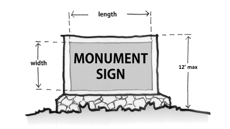
Monument signs.
(1)
All monument signs shall be located in a landscaped bed.
(2)
The sign area of a monument sign shall be measured as the entire surface area containing information, excluding the supporting structure.
(3)
The size of the structure shall be incidental to the size of the sign itself.
(4)
Unless otherwise provided within this article no monument sign shall exceed a height of 12 feet.
(5)
No monument sign shall exceed an area of 48 square feet.
(6)
All signs shall be located in a landscaped base.
(7)
Unless otherwise provided within this article only frontage on I-81 may invoke the interstate corridor overlay district for signage.
(8)
Only one sign per parcel as designated in the real property tax maps may be freestanding or projecting.
Signage internal to the property, not reasonably seen from the town right-of-way, is not counted towards the overall signage allowance.
(Ord. of 09-04-2018(1))
Sec. 90-359.11. - Illumination.
(a)
Newly installed illuminated signs, shall be equipped with gooseneck reflectors or other devices arranged so as to concentrate the illumination down upon the area of the sign and to prevent glare. Special attention shall be given to illumination so as to avoid glare upon adjoining residential properties.
(b)
Each outside lighting installation and each illuminated sign shall be controlled by a time switch or externally operable switch which will open all underground conductors and shall be suitable for conditions of installation, such as exposure to the weather. In no case shall the illumination for any sign be directed toward any residential district or toward any adjacent street.
(Ord. of 09-04-2018(1))
Sec. 90-359.12. - Maintenance.
(a)
The owner of a sign shall be required to keep such sign properly maintained at all times, in accordance with the following standards:
(1)
All materials used in the sign shall be kept in good condition, free of holes, rotting, peeling paint and other forms of decay.
(2)
If the sign is illuminated, all lighting shall be maintained in working order.
(3)
The zoning administrator shall have the authority to order the removal, without compensation, of any sign or sign structure that due to neglect or damage poses a clear danger to the health, safety and welfare of the public.
(4)
In lieu of removal, the zoning administrator may require the immediate repair of any sign or sign structure which has been damaged or which has deteriorated so as to become a public hazard.
(Ord. of 09-04-2018(1))
Sec. 90-360.- Purpose and intent.
This district provides for the reasonable and orderly interim regulation of use and development of land annexed or brought into Town through a boundary line adjustment, and for which the district is considered a holding zone until a development proposal application is submitted by an applicant.
(Ord. of 03-04-2025(1))
Sec. 90-360.01. - Permitted uses.
Structures and uses existing on the land to be used in the transitional zoning district shall be for one of the following uses:
(1)
Single-family detached dwellings.
(2)
General agricultural uses, specifically the tilling of the soil, raising of crops, horticulture, forestry, gardening, and grazing of livestock and fowl.
(3)
Public utilities, such as poles, lines, distribution transformers, meters, water and sewer lines, booster or relay stations and transformer substations.
(Ord. of 03-04-2025(1))
Sec. 90-360.02. - Permitted accessory uses.
The following accessory uses, to be located on the same lot with the principal use, shall be permitted in the transitional zoning district:
(1)
Home occupations, pursuant to section 90-377.
(2)
Other customary accessory uses and buildings, provided they are clearly incidental to the principal use, pursuant to section 90-378.
(Ord. of 03-04-2025(1))
Sec. 90-360.03. - Minimum lot size.
The following minimum lot size for all uses shall be 30,000 square feet.
(Ord. of 03-04-2025(1))
Sec. 90-360.04. - Setback.
No structure in the district shall be located closer than 35 feet to any street right-of-way.
(Ord. of 03-04-2025(1))
Sec. 90-360.05. - Minimum lot width.
The minimum width of any lot in the district at the setback line shall not be less than 125 feet.
(Ord. of 03-04-2025(1))
Sec. 90-360.06. - Yards.
The following yard regulations shall apply in the transitional district:
(1)
Side yards. The minimum side yard shall be 15 feet.
(2)
Rear yard. The minimum rear yard shall be 30 feet.
(3)
Corner side yard. The minimum corner side yard shall be 35 feet.
(Ord. of 03-04-2025(1))
Sec. 90-360.07. - Maximum building coverage and height.
In the transitional district, maximum building coverage shall be 25 percent, and maximum height from average grade shall be 35 feet or two and one-half stories.
(Ord. of 03-04-2025(1))
Sec. 90-296. - Definitions.
Base flood/100-year flood means a flood that, on the average, is likely to occur once every 100 years (i.e., that has a one percent chance of occurring each year, although the flood may occur in any year).
Base flood elevation (BFE) means the Federal Emergency Management Agency designated 100-year water surface elevation.
Basement means any area of the building having its floor subgrade (below ground level) on all sides.
Board of zoning appeals means the board appointed to review appeals made by individuals with regard to decisions of the zoning administrator in the interpretation of this division.
Development means any manmade change to improved or unimproved real estate, including, but not limited to, buildings or other structures, mining, dredging, filling, grading, paving, excavation or drilling operations or storage of equipment or materials.
Floodplain means any land area susceptible to being inundated by water from any source.
Floodway means the channel of a river or other watercourse and the adjacent land areas that must be reserved in order to discharge the base flood without cumulatively increasing the water surface elevation more than a designated height.
Freeboard means a factor of safety usually expressed in feet above a flood level for purposes of floodplain management.
Lowest floor means the lowest floor of the lowest enclosed area (including basement).
Recreational vehicle means a vehicle which is:
(1)
Built on a single chassis;
(2)
Four hundred square feet or less when measured at the largest horizontal projection;
(3)
Designed to be self-propelled or permanently towable by a light duty truck; and
(4)
Designed primarily not for use as a permanent dwelling but as temporary living quarters for recreational camping, travel, or seasonal use.
Substantial damage means damage of any origin sustained by a structure whereby the cost of restoring the structure to its before damaged condition would equal or exceed 50 percent of the market value of the structure before the damage occurred.
Substantial improvement means any reconstruction, rehabilitation, addition, or other improvement of a structure, the cost of which equals or exceeds 50 percent of the market value of the structure before the "start of construction" of the improvement. This term includes structures which have incurred "substantial damage" regardless of the actual repair work performed. The term does not, however, include either: (1) any project for improvement of a structure to correct existing violations of state or local health, sanitary, or safety code specifications which have been identified by the local code enforcement official and which are the minimum necessary to assure safe living conditions or (2) any alteration of a "historic structure", provided that the alteration will not preclude the structures continued designation as a "historic structure".
(Ord. No. 446, art. II, 1-7-92; Ord. of 7-1-2003, art. II)
Sec. 90-297. - Purpose.
The purpose of these provisions is to prevent the loss of life and property, the creation of health and safety hazards, the disruption of commerce and governmental services, the extraordinary and unnecessary expenditure of public funds for flood protection and relief, and the impairment of the tax base by:
(1)
Regulating uses, activities, and development which, alone or in combination with other existing or future uses, activities, and development, will cause unacceptable increases in flood heights, velocities, and frequencies.
(2)
Restricting or prohibiting certain uses, activities, and development from locating within districts subject to flooding.
(3)
Requiring all those uses, activities, and developments that do occur in flood-prone districts to be protected and/or flood-proofed against flooding and flood damage.
(4)
Protecting individuals from buying land and structures which are unsuited for intended purposes because of flood hazards.
(Ord. No. 446, § 1.1, 1-7-92; Ord. of 7-1-2003, § 1.1)
Sec. 90-298. - Applicability.
These provisions shall apply to all lands within the jurisdiction of the town and identified as being in the 100-year floodplain by the Federal Insurance Administration.
(Ord. No. 446, § 1.2, 1-7-92; Ord. of 7-1-2003, § 1.2)
Sec. 90-299. - Compliance and liability.
(a)
No land shall hereafter be developed and no structure shall be located, relocated, constructed, reconstructed, enlarged, or structurally altered except in full compliance with the terms and provisions of this division and any other applicable ordinances and regulations which apply to uses within the jurisdiction of this division.
(b)
The degree of flood protection sought by the provisions of this division is considered reasonable for regulatory purposes and is based on acceptable engineering methods of study. Larger floods may occur on rare occasions. Flood heights may be increased by manmade or natural causes, such as ice jams and bridge openings restricted by debris. This division does not imply that districts outside the floodplain district, or that land uses permitted within such district will be free from flooding or flood damages.
(c)
This division shall not create liability on the part of the town or any officer or employee thereof for any flood damages that result from reliance on this division or any administrative decision lawfully made thereunder.
(Ord. No. 446, § 1.3, 1-7-92; Ord. of 7-1-2003, § 1.3)
Sec. 90-300. - Abrogation and greater restrictions.
This division supersedes any ordinance currently in effect in flood-prone districts. However, any underlying ordinance shall remain in full force and effect to the extent that its provisions are more restrictive than this division.
(Ord. No. 446, § 1.4, 1-7-92; Ord. of 7-1-2003, § 1.3)
Sec. 90-301. - Variances; factors to be considered.
In passing upon applications for variances, the board of zoning appeals shall satisfy all relevant factors and procedures specified in other sections of the zoning ordinance and consider the following additional factors:
(1)
The danger to life and property due to increased flood heights or velocities caused by encroachments. No variance shall be granted for any proposed use, development, or activity within any floodway district that will cause any increase in the 100-year flood elevation.
(2)
The danger that materials may be swept on to other lands or downstream to the injury of others.
(3)
The proposed water supply and sanitation systems and the ability of these systems to prevent disease, contamination, and unsanitary conditions.
(4)
The susceptibility of the proposed facility and its contents to flood damage and the effect of such damage on the individual owners.
(5)
The importance of the services provided by the proposed facility to the community.
(6)
The requirements of the facility for a waterfront location.
(7)
The availability of alternative locations not subject to flooding for the proposed use.
(8)
The compatibility of the proposed use with existing development and development anticipated in the foreseeable future.
(9)
The relationship of the proposed use to the comprehensive plan and floodplain management program for the area.
(10)
The safety of access by ordinary and emergency vehicles to the property in time of flood.
(11)
The expected heights, velocity, duration, rate of rise, and sediment transport of the flood waters expected at the site.
(12)
The repair or rehabilitation of historic structures upon a determination that the proposed repair or rehabilitation will not preclude the structure's continued designation as a historic structure and the variance is the minimum necessary to preserve the historic character and design of the structure.
(13)
Such other factors which are relevant to the purposes of this division.
The board of zoning appeals may refer any application and accompanying documentation pertaining to any request for a variance to any engineer or other qualified person or agency for technical assistance in evaluating the proposed project in relation to flood heights and velocities, and the adequacy of the plans for flood protection and other related matters.
Variances shall be issued only after the board of zoning appeals has determined that the granting of such will not result in (a) unacceptable or prohibited increases in flood heights, (b) additional threats to public safety, (c) extraordinary public expense; and will not (d) create nuisances, (e) cause fraud or victimization of the public, or (f) conflict with local laws or ordinances.
Variances shall be issued only after the board of zoning appeals has determined that variance will be the minimum required to provide relief from any hardship to the applicant.
The board of zoning appeals shall notify the applicant for a variance, in writing, that the issuance of a variance to construct a structure below the one hundred 100-year flood elevation (a) increases the risks to life and property and (b) will result in increased premium rates for flood insurance.
A record shall be maintained of the above notification as well as all variance actions, including justification for the issuance of the variances. Any variances which are issued shall be noted in the annual or biennial report submitted to the federal insurance administrator.
(Ord. No. 446, art. V, 1-7-92; Ord. of 7-1-2003, art. V)
Sec. 90-302. - Existing structures in floodplain districts.
A structure or use of a structure or premises which lawfully existed before the enactment of these provisions, but which is not in conformity with these provisions, may be continued subject to the following conditions:
(1)
Existing structures in the floodway district shall not be expanded or enlarged unless it has been demonstrated through hydrologic and hydraulic analyses performed in accordance with standard engineering practice that the proposed expansion would not result in any increase in the 100-year flood elevation.
(2)
Any modifications, alteration, repair, reconstruction, or improvement of any kind to a structure and/or use located in any floodplain area to an extent or amount of less than 50 percent of its market value, elevation and/or flood-proofing should be considered to the greatest extent possible.
(3)
The modification, alteration, repair, reconstruction, or improvement of any kind to a structure and/or use, regardless of its locations in a floodplain area, to an extent or amount of 50 percent or more of its market value shall be undertaken only in full compliance with the provisions of this ordinance and the Virginia Uniform Statewide Building Code.
(Ord. No. 446, art. VI, 1-7-92; Ord. of 7-1-2003, art. VI)
Cross reference— Building code, § 14-31 et seq.
Secs. 90-303—90-320. - Reserved.
Editor's note— At the city's instruction, § 90-303 was deleted, these provisions pertained to penalties and derived from Ord. No. 446, § 1.6, adopted Jan. 7, 1992.
Sec. 90-321. - Description of district.
(a)
Basis of districts. The various floodplain districts shall include areas subject to inundation by waters of the 100-year flood. The basis for the delineation of these districts shall be the flood insurance study (FIS) for the Town of Woodstock, Virginia, prepared by the Federal Emergency Management Agency, Federal Insurance Administration, dated July 16, 2003, as amended.
(1)
The floodway district is delineated, for purposes of this division, using the criterion that certain areas within the floodplain must be capable of carrying the waters of the 100-year flood without increasing the water surface elevation of that flood more than one foot at any point. The areas included in this district are specifically defined in Table 3 of the above-referenced flood insurance study and shown on the accompanying flood boundary and floodway map or flood insurance rate map.
(2)
The flood-fringe district shall be that area of the 100-year floodplain not included in the floodway district. The basis for the outermost boundary of the district shall be the 100-year flood elevations contained in the flood profiles of the above-referenced flood insurance study and as shown on the accompanying flood boundary and floodway map or flood insurance rate map.
(3)
The approximated floodplain district shall be that floodplain area for which no detailed flood profiles or elevations are provided, but where a 100-year floodplain boundary has been approximated. Such areas are shown as Zone A on the maps accompanying the flood insurance study. For these areas, the 100-year flood elevations and floodway information from federal, state, and other acceptable sources shall be used, when available. Where the specific 100-year flood elevation cannot be determined for this area using other sources of data, such as the U. S. Army Corps of Engineers Floodplain Information Reports, U. S. Geological Survey Flood-Prone Quadrangles, etc., then the applicant for the proposed use, development and/or activity shall determine this elevation in accordance with hydrologic and hydraulic engineering techniques. Hydrologic and hydraulic analyses shall be undertaken only by professional engineers or others of demonstrated qualifications, who shall certify that the technical methods used correctly reflect currently-accepted technical concepts. Studies, analyses, computations, etc., shall be submitted in sufficient detail to allow a thorough review by the town.
(b)
Overlay concept.
(1)
The floodplain districts described above shall be overlays to the existing underlying districts as shown on the official zoning ordinance map, and as such, the provisions for the floodplain districts shall serve as a supplement to the underlying district provisions.
(2)
Any conflict between the provisions or requirements of the floodplain districts and those of any underlying district, the more restrictive provisions and/or those pertaining to the floodplain districts shall apply.
(3)
In the event any provision concerning a floodplain district is declared inapplicable as a result of any legislative or administrative actions or judicial decision, the basic underlying provisions shall remain applicable.
(Ord. No. 446, § 3.1, 1-7-92; Ord. of 7-1-2003, § 3.1)
Sec. 90-322. - Official zoning map.
The boundaries of the floodplain districts are established as shown on the flood boundary and floodway map and/or flood insurance rate map which is declared to be a part of this division and which shall be kept on file at the town offices.
(Ord. No. 446, § 3.2, 1-7-92; Ord. of 7-1-2003, § 3.2)
Sec. 90-323. - District boundary changes.
The delineation of any of the floodplain districts may be revised by the town council of the Town of Woodstock, Virginia, where natural or manmade changes have occurred and/or where more detailed studies have been conducted or undertaken by the U.S. Army Corps of Engineers or other qualified agency, or an individual documents the need for such change. However, prior to any such change, approval must be obtained from the Federal Insurance Administration.
(Ord. No. 446, § 3.3, 1-7-92; Ord. of 7-1-2003, § 3.3)
Sec. 90-324. - Interpretation of district boundaries.
Initial interpretations of the boundaries of the floodplain districts shall be made by the zoning officer. Should a dispute arise concerning the boundaries of any of the districts, the board of zoning appeals shall make the necessary determination. The person questioning or contesting the location of the district boundary shall be given a reasonable opportunity to present his case to the board and to submit his own technical evidence if he so desires.
(Ord. No. 446, § 3.4, 1-7-92; Ord. of 7-1-2003, § 3.4)
Sec. 90-336. - General provisions.
(a)
Permit requirement. All uses, activities, and development occurring within any floodplain district shall be undertaken only upon the issuance of a zoning permit. Such development shall be undertaken only in strict compliance with the provisions of the division and with all other applicable codes and ordinances, such as the Virginia Uniform Statewide Building Code and the Town of Woodstock, Virginia, Subdivision Regulations. Prior to the issuance of any such permit, the zoning officer shall require all applications to include compliance with all applicable state and federal laws. Under no circumstances shall any use, activity, and/or development adversely affect the capacity of the channels or floodway of any watercourse, drainage ditch, or any other drainage facility or system.
(b)
Alteration or relocation of watercourse. Prior to any proposed alteration or relocation of any channels or of any watercourse, stream, etc., within this jurisdiction a permit shall be obtained from the U.S. Corps of Engineers, the Virginia Department of Environmental Quality, and the Virginia Marine Resources Commission (a joint permit application is available from any of these organizations). Furthermore, notification of the proposal shall be given by the applicant to all affected adjacent jurisdictions, the department of conservation and recreation (division of soil and water conservation) and the Federal Insurance Administration.
(c)
Drainage facilities. Storm drainage facilities shall be designed to convey the flow of stormwater runoff in a safe and efficient manner. The system shall insure proper drainage along streets, and provide positive drainage away from buildings. The system shall also be designed to prevent the discharge of excess runoff onto adjacent properties.
(d)
Site plans and permit applications. All applications for development in the floodplain district and all building permits issued for the floodplain shall incorporate the following information:
(1)
For structures to be elevated, the elevation of the lowest floor (including basement).
(2
For structures to be floodproofed (nonresidential only), the elevation to which the structure will be floodproofed.
(3)
The elevation of the 100-year flood.
(4)
Topographic information showing existing and proposed ground elevations.
(e)
Recreational vehicles. Recreational vehicles placed on sites either:
(1)
Be on the site for fewer than 180 consecutive days, be fully licensed and ready for highway use, or
(2)
Meet the permit requirements for placement and the elevation and anchoring requirements for manufactured homes as contained in the Uniform Statewide Building Code.
A recreational vehicle is ready for highway use if it is on its wheels or jacking system, is attached to the site only by quick disconnect type utilities and security devices, and has no permanently attached additions.
(Ord. No. 446, § 4.1, 1-7-92; Ord. of 7-1-2003, § 4.1)
Cross reference— Subdivisions, ch. 70.
Sec. 90-337. - Floodway district.
In the floodway district no encroachments, including fill, new construction, substantial improvements, or other development shall be permitted unless it has been demonstrated through hydrologic and hydraulic analyses performed in accordance with standard engineering practice that the proposed encroachment would not result in any increase in the 100-year flood elevation.
(Ord. No. 446, § 4.2, 1-7-92; Ord. of 7-1-2003, § 4.2)
Sec. 90-338. - Permitted uses in the floodway district.
The following uses and activities are permitted provided that they are in compliance with the provisions of the underlying area and are not prohibited by any other ordinance and provided that they do not require structures, fill, or storage of materials and equipment:
(1)
Agricultural uses, such as general farming, pasture, grazing, outdoor plant nurseries, horticulture, truck farming, forestry, sod farming, and wild crop harvesting.
(2)
Public and private recreational uses and activities, such as parks, day camps, picnic grounds, golf courses, boat launching and swimming areas, horseback.
(3)
Riding and hiking trails, wildlife and nature preserves, game farms, fish hatcheries, trap and skeet game ranges, and hunting and fishing areas.
(4)
Accessory residential uses, such as yard areas, gardens, play areas, and pervious loading areas.
(5)
Accessory industrial and commercial uses, such as yard areas, pervious parking and loading areas, airport landing strips, etc.
(Ord. No. 446, § 4.3, 1-7-92; Ord. of 7-1-2003, § 4.3)
Cross reference— Utilities, ch. 82.
Sec. 90-339. - Flood-fringe and approximated floodplain districts.
In the flood-fringe and approximated floodplain districts, the development and/or use of land shall be permitted in accordance with the regulations of the underlying area provided that all such uses, activities, and/or development shall be undertaken in strict compliance with the floodproofing and related provisions contained in the Virginia Uniform Statewide Building Code and all other applicable codes and ordinances.
Within the approximated floodplain district, all new subdivision proposals and other purposed developments (including proposals for manufactured home parks and subdivisions) greater than 50 lots or five acres, whichever is the lesser, include within such proposals base flood elevation data. The applicant shall also delineate a floodway area based on the requirement that all existing and future development not increase the 100-year flood elevation more than one foot at any one point. The engineering principle—equal reduction of conveyance—shall be used to make the determination of increased flood heights.
Within the floodway area delineated by the applicant, the provisions of section 90-337 shall apply.
(Ord. No. 446, § 4.4, 1-7-92; Ord. of 7-1-2003, § 4.4)
Secs. 90-340—90-347. - Reserved.
Editor's note— At the city's instruction, § 90-340 was deleted, these provisions pertained to uses permitted by special permit and derived from Ord. No. 446, § 4.5, adopted Jan. 7, 1992.
Sec. 90-348. - Purpose and intent.
The TND district provides the regulatory framework upon which the town may consider zoning district amendment applications for traditional neighborhood developments (TND) or other mixed-use forms of land use. TND district zoning map amendments shall be initiated by the applicant. Regulated by an applicant's code of development (see section 90-355 herein below), the TND district may be applied to locations in the (1) two urban development areas (UDAs) and (2) other established locations in Town of Woodstock with adequate public facilities or where adequate public facilities either exist or can be provided by the applicant. The TND district should be employed where the town has determined that a more flexible approach to zoning is needed to implement its comprehensive plan.
The principles, goals and strategies for traditional neighborhood development in the comprehensive plan shall guide the review and approval of a TND district. The zoning map amendment process establishes the plans, regulations, guidelines and conditions for an applicant's TND project. This approach is intended to better define the mix, scale, character, form and intensity of any given development proposal than that which could be otherwise governed by the application of the town's other zoning districts. The TND district encourages design flexibility to avoid the one size fits all configuration of conventional zoning districts and places an emphasis on the physical form of the built environment. Creating a mix of uses with flexible and creative approaches to organizing streets, places, buildings, and density is a principal TND objective. Each TND project shall have a mix of uses that reflect its geographical location, parcel size, terrain features, environmental challenges, marketability, and architectural design character. The TND district recognizes that certain waivers and modifications to other sections of the town's zoning ordinance as well as its subdivision ordinance and site development standards may be required for effective TND implementation.
The TND master plan and development code shall demonstrate a strong physical interrelationship among its internal neighborhoods, individual buildings, civic spaces, infrastructure, and landscaping that creates a sense of place and community. Individual buildings should be defined by varying scale and architectural stylings, while commercial and residential buildings should also employ complementary massing, colors, materials and proportions. Vertically integrated uses (e.g. the placement of residential or other uses above office and retail uses) are encouraged in the mixed-use components of a TND project. The TND district promotes higher densities with buildings fronting public streets. The zoning process will establish both minimum and maximum development densities for uses within a proposed project while providing flexibility to the applicant in mixing and matching densities.
Three primary TND sub-districts—Village center, transitional, and residential sub-districts—are structured to differentiate the geographical location of internal land uses, mix of uses, densities and other design parameters within the TND project. A fourth sub-district—Economic development—allows for specialized and conditional accommodation of certain large-scale retail, office parks, manufacturing, warehousing, and other employment uses that are not commonly located within traditional neighborhood developments. The zoning amendment application for a TND district may propose one or more of these sub-districts within the planned development. While it may not be required by the town in every instance, each application for a TND district zoning map amendment should incorporate two or more sub-districts. However, based on the existing land uses, infrastructure capacity, and marketplace characteristics common to each of the designated urban development areas, the town shall have approval of the final number and mix of sub-districts to be included in the TND zoning map amendment application.
Zoning map amendment applications shall address the purpose and intent of traditional neighborhood development and, further, the application should demonstrate compatibility with the following TND principles:
(1)
Appropriate location and TND densities: Establish viable areas for residential and commercial land uses at a compact scale, with densities appropriate for TND growth, that are located either within or close to existing developed areas and community facilities.
(2)
Mix of uses: Establish a blended mix of residential and non-residential land uses within the UDA that reflect TND planning objectives, enhance the quality of life of those who live there, and best serve the town's demographic demands.
(3)
Variety of housing: Create a variety of housing types to meet the range of projected family income distributions of both existing residents and future residential growth.
(4)
TND lot types and geometry: Encourage better spatial organization through the reduction of front and side yard building setbacks and smaller lot sizes.
(5)
Pedestrian and vehicle compatibility: Incorporate a network of pedestrian-friendly road and street designs.
(6)
Design standards and criteria for TND streets: Reduce subdivision street widths and turning radii at street intersections, and provide contemporary standards for street landscaping, pedestrian improvements, and pavement design.
(7)
Neighborhood connectivity: Establish interconnectivity between streets and pedestrian networks within the TND project.
(8)
Local and regional transportation connectivity: Promote the interconnection of new local streets with existing local streets and regional thoroughfares.
(9)
Environmental preservation: Ensure the preservation of natural areas and open space in conjunction with the TND master planning process.
(10)
Adequate public infrastructure: Demonstrate (a) the availability and adequacy of public water and sewer systems and other requisite public infrastructure, or (b) the ability to concurrently provide for these systems and infrastructure.
(11)
Phasing of development: Plan for the phasing of TND development within the UDA that is consistent with anticipated population and employment growth as well as public facilities and infrastructure capacity.
Zoning map amendments for a TND district shall be initiated by the property owner(s) or its bona fide agent. In geographical areas other than the two designated urban development areas, the town may require that a TND zoning map amendment application be either preceded or accompanied by an amendment to the comprehensive plan.
(Ord. of 4-3-2012(1), § [A.])
Sec. 90-349. - TND sub-districts.
(a)
Village center sub-district: The village center sub-district is intended to be the primary location and activity center for non-residential uses within the TND district. The village center shall be sized for a mix of uses that establishes its location as a dominant destination point for civic life within the TND project. However, the village center should not be designed and sized to compete with or cannibalize commercial and employment uses in the town's existing downtown core area.
With a focus on a compact "main street" form of development, the village center may accommodate a range of retail, services, restaurant, office, lodging, institutional, and civic uses that are scaled to the neighborhood demands of the TND project and nearby properties. The village center sub-district is not intended as appropriate for the location of big box commercial, industrial, or other large-footprint commercial buildings that may be better suited for the economic development sub-district.
More compact residential dwellings (multifamily, townhouse, and live-work) as well as mixed commercial/residential land uses are recommended for the village center, incorporating a mix of lot groups 1 and 3 dwelling types. It should be master planned as a pedestrian-friendly, mixed-use area with a grid-styled street system that provides vehicular and pedestrian interconnectivity with the adjoining residential and transitional neighborhoods. Building frontages should define the public streetscape, with on-street parking, utilities, and landscaping located within the public right of way.
The amount and location of commercial uses in the village center sub-district should complement Woodstock's existing commercial base. Thus, in planning for TND projects in the town, TND residential and transitional uses may better serve the Woodstock's goals than creating additional commercial centers. Therefore, subject to review and approval of the town council, a village center sub-district may not be required in each TND district application. TND development proposals for the village center sub-district shall be reviewed for consistency with the adopted traditional neighborhood development goals for the UDA, the objectives for Downtown Woodstock, and other relevant policies of the comprehensive plan.
(b)
Transitional sub-district: This sub-district is intended to accommodate a transitional mix of lower intensity of uses in areas that separate the village center sub-district from the lower density residential sub-district. A mix of lot groups 1, 2, and 3 should be provided. Light commercial uses and shops are permitted in the sub-district but should be complementary to those in both the village center and Downtown Woodstock. A variety of residential uses and lot types are permitted in this sub-district along with community centers, churches, live-work residential, restaurants, and neighborhood-scaled shops.
Transitional sub-district uses should be within walking-distance proximity to the community's village center. As with the village center sub-district, a mix of reduced lots sizes, frontages, setbacks and building formats should be scaled to complement neighborhood streetscapes. Public right of way improvements should include sidewalks, landscaping, streetlights and on-street parking. To preserve the capacity of on-street parking, public street access to front loaded parking pads and garages is discouraged in residential neighborhoods while off-street parking should be relegated to the rear of individual residential lots. Single-family and attached residential off-street parking and garages should be accessed by alleys, where feasible.
Subject to approval of the town council, a transitional sub-district may not be a required component of every TND district application. Development proposals for the transitional sub-district shall be reviewed for consistency with the adopted traditional neighborhood development goals, objectives for Downtown Woodstock, and the overall policies of the comprehensive plan.
(c)
Residential sub-district: This sub-district is intended to accommodate lower density residential uses than those found in the village center and transitional areas. Neighborhoods of mixed housing types, sizes, and lot types are strongly recommended, with guidelines for the mix established with each TND district application. A mix of lot groups 1 and 2 should accommodate the majority of the residential dwellings, with the option for a smaller percentage of lot group 3 residences to be interspersed at lower densities. Also, the applicant may propose other residential lot types to be included with the code of development.
To optimally serve the marketplace, the residential sub-district should feature blocks that accommodate a mix of lot sizes, frontages, setbacks, and housing types that are complemented by attractive streetscapes. Playgrounds, greens, and parks should be internally located within and central to sub-district neighborhoods.
Interconnected neighborhood street patterns with pedestrian improvements are a priority, and culs-de-sac should be avoided except in cases where severe terrain limitations restrict their use. Community streets should be designed to VDOT standards and dedicated for public use. Rear alleys that access off-street parking for individual lots are encouraged but not required. Where public street access to private, off-street parking is provided, frontage driveways should be shared between adjoining lots, and private garages should be located to the rear of the principal structure.
Subject to approval by the town council, a residential sub-district may not be required component of every TND district application. Development proposals for the residential sub-district shall be reviewed for consistency with the adopted traditional neighborhood development goals and policies of the comprehensive plan.
(d)
Economic development sub-district: This sub-district recognizes that certain uses of a higher density and community impact may be appropriate for inclusion in a TND district zoning application. Rather than require the applicant to request a separate zoning district amendment for these uses, the economic development sub-district provides the flexibility for the town to conditionally approve certain large-scale commercial and industrial uses of a scale, orientation, and impact not typically found in either Downtown Woodstock or new traditional neighborhood developments, but which, otherwise, can be shaped to fulfill the town's economic development objectives.
Big box, power center, industrial, or large-footprint non-retail employment uses that complement the balance and marketplace attractiveness of the TND district may be approved by special permit. However, the town, at its sole discretion, may determine that the economic development sub-district is not appropriate for inclusion in a given TND district application. Development proposals for the economic development sub-district shall be reviewed for consistency with both the UDA traditional neighborhood development goals, the objectives for Downtown Woodstock, and the overall economic development policies of the comprehensive plan.
(Ord. of 4-3-2012(1), § [B.])
Sec. 90-350. - TND district area requirements.
(a)
TND district size: There is no minimum or maximum TND district size stipulated by ordinance. The town council, at its sole discretion, shall establish the appropriate size for the TND district upon review of an applicant's zoning map amendment package. The proposed size and configuration of the TND district shall be described by a current boundary plat prepared by the applicant that establishes the metes and bounds and acreage for the property or properties subject to the zoning map amendment application.
(b)
TND sub-district size: The size and configuration of the village center, transitional, residential, and economic development sub-districts interior to the TND district shall be depicted on an exhibit accompanying the TND master plan that establishes the approximate boundary and acreage for the properties to be configured as sub-districts.
(c)
Requests for modification to the size and location of an approved TND district shall require a separate zoning map amendment application.
(d)
Modifications to the size and location of internal sub-districts within an approved TND district may be administratively approved by the planning director. The planning director shall determine whether a modification is deemed "minor".
(e)
Other modifications to the size and location of internal sub-districts within an approved TND district shall require an amendment to the original zoning map amendment.
(Ord. of 4-3-2012(1), § [C.])
Sec. 90-351. - Permitted land uses, special permit uses, and land use categories.
(a)
Permitted uses to be included in the TND district shall be defined by the applicant's code of development, provided that the town, at its sole discretion, may establish certain prohibited or restricted uses.
(b)
The town council, at its discretion, may impose additional limitations and restrictions as may be related to residential density and unit yield, ground floor area footprint, total building floor area, and lot types for individual uses and establishments within the sub-district in which the use is to be located.
(c)
The code of development shall identify permitted uses and special permit uses within each sub-district. The permitted uses shall be defined in terms of the category and specific uses as outlined in Table 1 hereinafter.
(Ord. of 4-3-2012(1), § [D.])
Sec. 90-352. - Development density and yields.
(a)
The TND district regulates both minimum and maximum development densities. The total minimum and maximum development yields for individual land uses within a TND district project and its individual sub-districts shall be established by proffer to the town upon consideration of the applicant's code of development and other requirements of the zoning application. Density regulations shall apply to both new development and redevelopment uses.
(b)
Minimum density: Development densities for the land uses proposed for each sub-district shall achieve a minimum density of at least the levels for the individual land uses as indicated in Table 2 hereinafter or as shall otherwise be established by the code of development.
(c)
Maximum density: Development densities for the land uses proposed for each sub-district shall not exceed the levels for the individual land uses as indicated in Table 2 hereinafter or as shall otherwise be established by the code of development.
(d)
The applicant shall demonstrate in the code of development the appropriateness of the level of minimum and maximum densities proposed for each land use.
(e)
Upon request of the applicant, the town council, at its sole discretion, may reduce the minimum required density for individual uses within the TND district or within any of the TND sub-districts contained therein, provided that the revised minimum density shall be established for each land use or lot within the sub-district and incorporated into the code of development. It shall be the responsibility of the applicant to demonstrate the justification for the reduction in density.
(f)
Upon request of the applicant, the town council, at its sole discretion, may increase the maximum required density for individual uses within the TND district or within any of the TND sub-districts contained therein, provided that the revised maximum density shall be established for each land use or lot within the sub-district and incorporated into the code of development. It shall be the responsibility of the applicant to demonstrate the justification for the increase in density.
(g)
The allowable range of land use yields within the sub-districts shall be calculated based on the qualifying area (or net acreage of the individual sub-district). The calculation of minimum and maximum yield for individual uses to be located in the sub-districts shall be based on the application of the minimum and maximum density for each use (see Tables 2 and 3 herein) to an adjusted qualifying area that reduces the gross area of the TND by the total of the non-qualifying land components within the sub-district.
The Qualify Area (or Net Acreage) = Gross Acreage − Non-Qualifying Area (or acreage of the sum of the non-qualifying land components.)
The land components that comprise the non-qualifying land area include:
(1)
Existing rights of way and easements,
(2)
Existing land uses,
(3)
Areas deemed unbuildable due to geological, soils, or other environmental deficiencies,
(4)
Wetlands and floodplains (FEMA 100-year floodplain),
(5)
Existing ponds, stormwater management facilities and water features that are not defined by wetlands or floodplains, and
(6)
Terrain with slopes in excess of 30 percent.
See Appendix A: TND density calculation worksheet and sample calculation of density and yield.
(Ord. of 4-3-2012(1), § [E.])
Sec. 90-353. - Lot and yard types—Size, lot dimensions, and height regulations.
(a)
Lot types: Table 3: Lot Types and Lot Development Standards provides a matrix of lot types permitted in the TND district.
(1)
Lots for small-detached residential dwellings:
a.
Cottage lot.
b.
Village lot.
(2)
Lots for medium detached residential dwellings:
a.
Neighborhood lot #1.
b.
Neighborhood lot #2.
(3)
Lots for attached and multifamily residential dwellings:
a.
Townhouse lot #1.
b.
Townhouse lot #2.
c.
Multifamily lot.
(4)
Lots for commercial and live-work commercial buildings:
a.
Commercial lot.
b.
Live-work lot.
(5)
Lots for economic development and special permit buildings: established by code of development.
(b)
Lot development standards: Table 3 establishes the regulations and guidelines for the size and dimensions of individual lot types as permitted within the individual TND sub-districts. Table 4: TND District Residential Lot Mix Work Sheet establishes the mix of lot types within each sub-district. Appendix B provides illustrations of representative lot types and building configurations.
(1)
Lot dimensions.
(2)
Lot area.
(3)
Yard and setback regulations.
(4)
Lot coverage.
(5)
Lot frontage percentage.
(c)
Supplemental notes for lot types and lot development standards: In (1)—(9) below, the notes refer to footnotes (1)—(9) as cited in Table 3.
(1)
This table is regulatory except where noted by asterisk (*) as guidelines. Guidelines for variations to the indicated dimensions and percentages shall be approved by the planning director.
(2)
For corner lots, lot width and side yards shall be increased by five feet in addition to the prescribed dimensions.
(3)
For attached dwellings, town homes and multifamily buildings, the indicated side yard regulations apply only to end units.
(4)
Rear setback applies to principal structure only. Garages and/or accessory units may have a zero setback when an alley is present.
(5)
Lot frontage percentage represents the ratio between the building width and corresponding width of the lot on which the building is located.
(6)
Lot coverage ratio guideline applies to maximum percentage of building coverage. Lot areas for townhouses and multifamily units exclude areas for required off-street parking. Ratio for townhouses applied to internal units; end unit ratios not governed.
(7)
The code of development shall include a lot mix matrix for maximum and minimum distribution of lot types that are permitted within any given sub-district. (See Appendix A for illustrative example and application work sheet.)
(8)
The lot dimensions, lot area, yard and setback regulations, and lot frontage regulations shall be established with the code of development.
(9)
The applicant shall submit a supplement to the lot types and lot development standards matrix to identify, define, and regulate additional land uses and lot types that are to be incorporated into the code of development.
(d)
Building heights for individual uses:
Building heights shall be identified and established by the code of development for each land use or combination of land uses within each of the sub-districts (village center, transition, residential, economic development) of the TND district and, further, shall be subject to the following minimum and maximum height limits. (See Table 5).
(e)
Upon request of the applicant, the town council, at its sole discretion, may either increase or decrease the regulations for building heights, yards, and lots for individual uses within the TND district and its sub-districts, provided that the revised regulations shall be established for each land use or lot within the sub-district and incorporated into the code of development. It shall be the responsibility of the applicant to demonstrate the justification for the adjustments to these regulations.
(Ord. of 4-3-2012(1), § [F.])
Sec. 90-354. - Civic space, parks, open space, and recreation areas.
(a)
TND district projects with a gross area of 15 acres or greater shall provide usable and centrally located civic space, parks, common open space, or recreation areas that are accessible to residents, visitors, and workers within the TND district. Civic space, public parks, common open space, or recreation areas shall be strategically located and designed to provide recreational opportunities for the neighborhood as well as relate to the physiographic character and accessibility to the entire TND.
(b)
For TND district projects with a gross area of 15 acres or greater, these areas shall be sized, located, and improved to a level that satisfies the needs of the residents of the project, provided that a minimum of 15 percent of the total qualifying area of the TND shall be allocated to these areas. (See subsection 90-352(g) for definition of qualifying area.) The application plan and code of development shall establish the type, mix, arrangement, and quality of the planned on-site improvements for civic space, parks, common open space, recreation areas, buffer areas, and protected natural areas.
(c)
For TND district projects with a gross area of 15 acres or greater, the location, mix, type, quality and phasing of civic space, parks, common open space, recreation areas, buffer areas, and protected natural areas shall be consistent with the comprehensive plan or other criteria established by the town. These areas shall be delineated on the application plan and may include greens, squares, plazas, community centers, clubhouses, trails, pocket parks, or community gardens.
(d)
For TND district projects with a gross area of 15 acres or greater, the areas of property designated for civic space, parks, common open space, recreation areas, buffer areas, and protected natural areas shall be (a) subject to approval of the planning commission, and (b) permanently set aside for the sole benefit, use, and enjoyment of occupants of the TND district through covenant, deed restriction, or similar legal instrument; or, if agreed to by the planning commission, the civic space, parks, common open space, recreation areas, buffer areas, or protected natural areas may be conveyed to a governmental agency for the use of the general public.
(e)
Land within the TND that is designated to remain private for any of these areas and improvements shall be owned and maintained by a property owners' association or homeowners association.
(f)
Upon request of the applicant, the planning commission, at its sole discretion, (a) may decrease or eliminate certain requirements for open space and recreation land and improvements in a TND district project, provided that the revised regulations shall be established and conditioned by the code of development, or (b) elect for the applicant to contribute to a pro-rata share fund, provided that the town has established and adopted a parks and recreation master plan and pro-rata sharing funding policy.
(g)
The town's parks and recreation master plan shall address the specific regional needs, specific improvements, and funding policy for the development of civic space, parks, open space, and recreation areas that inure to the benefit of all citizens within the TND district. The amount of the pro-rata share contribution shall be updated and recalculated on an annual basis by the town.
(h)
For projects that are less than 15 acres in gross area, the applicant shall contribute to a pro-rata share fund as may be established by the town in its parks and recreation master plan. In the absence of an adopted parks and recreation master plan and pro-rata share funding policy, there shall be no contribution requirement on an applicant for projects less than 15 acres.
(i)
The amount of the pro-rata share contribution shall be updated and recalculated on an annual basis by the town.
(Ord. of 4-3-2012(1), [G.])
Sec. 90-355. - Code of development—Application requirements.
(a)
TND master plan: The master plan establishes the size, location, and configuration for the TND district, its sub-districts, and other internal planning areas (parks, open space, dedicated areas, etc.). It provides a graphic representation of the project's transportation network and key components of development of the property, including but not limited to the requirements of sections 90-350—90-353 hereinabove and the following:
(1)
Existing conditions plan depicting existing land uses, existing road and utilities, dedicated rights-of-way and easements, transportation alignments or infrastructure locations designated by an official map, historic and cultural features, tree coverage, and sensitive environmental areas of the property, including 100-year floodplain, wetlands, slopes greater than 30 percent, unbuildable areas, and other features as may be required by the planning director.
(2)
Certified boundary plat, deed description, tax map reference and zoning district designation of the property (or properties) subject to the TND district zoning application, zoning district designations and ownership of adjoining properties, and topographic mapping (minimum 1 inch = 100 feet horizontal scale and 2 feet contour intervals, or at a scale and interval as otherwise approved by the planning director).
(3)
Graphic plan exhibit depicting the internal layout and organization of sub-districts; to include the number, size, location, and boundary for each of the sub-districts (to be prepared at a minimum 1 inch = 100 feet horizontal scale or at a scale as otherwise approved by the planning director).
(4)
Graphic plan depicting the proposed open spaces, buffer areas, public parks, environmental preservation areas, and recreation areas.
(5)
Overlay plan exhibit depicting the projected development phasing plan.
(6)
Illustrative master plan exhibit depicting the general location of planned mix of uses and lot types for uses to be allocated within each sub-district (to be prepared at a minimum 1 inch = 100 feet horizontal scale or at a scale as otherwise approved by the planning director).
(b)
Development code: A narrative report and graphic exhibits that codifies the key components of the project proposed for the TND district and establishes the land use regulations, criteria, and guidelines for each TND sub-district, to address the following:
(1)
The applicant shall prepare a statement of compatibility of the proposed project with the town's TND zoning district and comprehensive plan land use policies, including justification for the number of the proposed sub-districts to be included in the zoning amendment application.
(2)
Lot types and lot development standards matrix (Table 4), to incorporate supplemental standards as may be required by additional proposed land uses and lot types.
(3)
Table of proposed by-right land uses, special permit uses, and specific land use exclusions applicable to each sub-district,
(4)
Graphic representation of proposed generalized building forms, types and densities,
(5)
Residential lot mix work sheet (Table 4), to address proposed mix of residential lot types within each sub-district, to include documentation for proposed lot variations and special conditions.
(6)
Narrative and graphic exhibits to support justification, qualifications, and conditions related to special permit uses.
(7)
Statement of minimum and maximum density, to include submission of density calculation worksheet for the sub-districts (see Appendix A).
(8)
Parking impact study to assess parking area and loading requirements, including locational guidelines within each sub-district and for the overall project.
(9)
Documentation and plan demonstrating compliance with VDOT state secondary street acceptance requirements.
(10)
A signage plan is required for the entire TND district which establishes a uniform sign theme with graphic representation of the design character, style, number, size, height, and number of signs to be permitted within the individual sub-districts. Signs shall share a common style, as to size, shape, and material. With the exception of the economic development sub-district, all TND district signs shall be either wall signs or cantilever signs. No billboards shall be allowed within the TND. Cantilever signs shall be mounted perpendicular to the building face and shall not exceed ten square feet. Where signs otherwise vary in requirements with the existing town sign ordinance, the applicant shall provide justification for the proposed variation. Signs that are to be specifically exempted shall be defined. Upon approval of the zoning amendment application, the signage plan will regulate all signs within the TND district in lieu of the town's sign ordinance.
(11)
A projection of planned project's infrastructure demands on public water and sewer and an assessment of the adequacy of existing public infrastructure and facilities for the proposed project.
(c)
Street classification plan: A regulating street classification plan shall graphically address and depict the street system, street types, and streetscape design criteria for the types of vehicular and pedestrian access improvements within the project:
(1)
Regulating plan for the alignment and classification of the project's street system, identifying interior and frontage streets, and including designation of street types, block lengths and geometry, alley locations, and pedestrian improvements within each sub-district.
(2)
Graphic standards to illustrate plan and street cross sectional views, including right-of-way or easements specifications, for individual streets types (including alleys and pedestrian improvements).
(3)
Design guidelines for public hardscape, landscaping, street lighting, and placement of utility, storm drainage, and related infrastructure, including easement requirements and regulations.
(d)
Building form and landscape design guidelines: Documentation and graphics to describe the proposed characteristics of building design and landscape architectural improvements for each sub-district within the TND project:
(1)
Graphic representation of proposed architectural themes.
(2)
Building form and styles, to address building scale, architectural proportions, and heights for uses within each sub-district.
(3)
Landscape design guidelines to depict proposed landscape treatment of streets, neighborhoods, civic spaces, open areas, parking areas, and other activity centers within the project.
(e)
Schematic infrastructure plans: The schematic infrastructure plans shall provide sufficient documentation and graphic support to ensure the feasibility and functionality of the master plan to the satisfaction of the town to address the following:
(1)
Storm drainage, stormwater management facilities, and best management practices.
(2)
Sanitary sewer.
(3)
Domestic water.
(4)
Site grading (proposed finished grades at minimum five feet contour intervals); to depict the extent of land disturbing activities that (1) will impact slopes that are greater than 30 percent and (2) require clear-cutting of existing tree cover.
(5)
Easement specifications and requirements for each public utility and facility, to include coordination requirements and agreements that may be needed by and between utility providers, VDOT, and the town.
(f)
Traffic impact analysis:
(1)
The town and applicant shall determine whether or not the subject TND district project shall require a traffic impact statement to be prepared consistent with VDOT 527 regulations.
(2)
If a 527 traffic impact analysis is required, the applicant shall prepare and submit a pre-scope of work meeting form to the town on or before the date of formal submission of the zoning district amendment application. The pre-scope form shall be processed, reviewed by and between the town, VDOT and the applicant in accord with adopted regulations and procedures.
(3)
If a 527 traffic impact analysis is not required, the applicant shall meet with the planning director to determine the required scope for a traffic analysis for the TND project the planning director shall approve the elements to be addressed in the study scope. The traffic analysis shall be submitted with the zoning amendment application. Minimum requirements may include the following:
a.
Existing traffic counts (a.m. and p.m. peak hours) at intersections to be identified by the town.
b.
Trip generation estimates for the planned land uses within the proposed development, employing ITE methodologies.
c.
Trip distribution and assignments to the existing road network of traffic projected for the development at full-buildout.
d.
Estimates of background traffic growth on impacted streets and highways.
e.
Analysis of future conditions, to include level of service calculations for impacted intersections.
f.
Signal warrants analysis.
g.
Statement of recommended transportation improvements to provide adequate levels of service for the traffic generated by the proposed project.
(Ord. of 4-3-2012(1), § [H.])
Sec. 90-356. - Additional application requirements and agreements.
(a)
The applicant shall submit a statement of zoning proffers and conditions.
(b)
The applicant shall identify and establish standards for TND utility and infrastructure design and easement requirements. The applicant shall also identify and establish procedures to pursue any required waivers and modification of existing town zoning, subdivision, and design standards related thereto, as applicable to implement the proposed project.
(c)
The applicant shall establish criteria and agreements for internal street ownership (public or private) and maintenance responsibility.
(d)
The applicant shall establish agreements for public ownership, management, and maintenance of properties within the project to be dedicated to public use, where applicable, and establish rules for common property ownership and maintenance, if applicable.
(e)
The applicant shall provide an assessment of cash and in-kind improvements that may qualify for proffers associated with the specific project.
(f)
The applicant shall submit a fiscal impact statement with the zoning map amendment application that assesses the impact of the proposed project on the town's capital facilities and infrastructure. The fiscal impact assessment shall evaluate the relative cost-benefits of the project and shall provide projections for both the tax revenues and governmental expenditures for public services, infrastructure and facilities.
(g)
The applicant, in conjunction with the town, shall establish design criteria and use conditions for each land use subject to special use permit approval.
(h)
The applicant shall provide written request and documentation in support of any amendment, waiver or modification to town codes, ordinances, and development standards relevant to the TND application.
(i)
If all or any portion of the property is to have land or improvements that are to be dedicated to a property owner(s) association, the applicant shall identify the property or improvements subject to dedication and shall submit draft articles of incorporation, by laws, and related operating documents for town review.
(Ord. of 4-3-2012(1), § [I.])
Sec. 90-357. - TND application and review process.
(a)
Pre-application meeting: The applicant shall schedule a meeting with the planning director for an introductory work session to discuss the key elements and impacts of the proposed project. The planning director and other town agency representatives shall provide guidance on (a) application requirements, (b) timeframe for processing of the zoning map amendment application, (c) comprehensive plan considerations, (d) identification issues related to public infrastructure and facilities, and (e) other matters as may be uniquely related to the applicant's property.
At this meeting, the applicant shall present a sketch plan that depicts the following: (a) general boundary and location of property subject to rezoning application, (b) land area to be contained within the TND district, (c) graphic representation of the arrangement of interior sub-districts, (d) planned mix of land uses and densities, and (e) general approach to addressing transportation, infrastructure and community facilities.
(b)
TND application package submission meeting: The applicant shall schedule a meeting with the planning director to submit and initially review the contents of the TND district zoning map amendment package for completeness. Within five working days of the completion of the meeting, the planning director shall notify the applicant in writing if the application package meets the town's expectations for completeness.
If the application package does not meet expectations, the planning director shall provide written notification to the applicant of the additional requirements necessary to establish a complete application. Once an application has been deemed a formal "complete application" by the planning director, the application package shall be distributed for formal review in accord with town policy. An incomplete application will not be reviewed.
(c)
Staff review meeting #1: The planning director shall notify the applicant upon completion by town staff and relevant agencies of the first review of the TND district application package. Written comments shall be provided to the applicant at the first staff review meeting. The applicant shall revise and resubmit materials as necessary to satisfy town comments.
(d)
Staff review meeting #2: The planning director shall notify the applicant upon completion of the second review by town staff and relevant agencies of the TND district application package. Written comments shall be provided to the applicant at the first staff review meeting. The applicant shall revise and resubmit materials as necessary to satisfy town comments.
(e)
Planning commission work session: A work session with the planning commission may be requested by either the applicant or the planning director at any time subsequent to staff review meeting #1.
(f)
Planning commission public hearing: One or more public hearings may be conducted by the planning commission to review and make recommendations on the applicant's TND district zoning map amendment application.
(g)
Town council work session: A work session with the town council may be requested by either the applicant or the planning director at any time subsequent to the planning commission public hearing.
(h)
Town council public hearing: One or more public hearings may be conducted by the town council to take action on the applicant's TND district zoning map amendment application.
(i)
Public notifications and work sessions: The town may determine it is in the public interest to schedule a work session at any time during the zoning map amendment review process.
(j)
Status of TND district approval: Given that each TND project will have a range unique characteristics (as defined by the code of development) and location within the town, an approved TND shall be established as separate zoning district. An approval of a traditional neighborhood development shall be considered an amendment to the zoning ordinance.
The TND district approval by the town establishes the restrictions and regulations according to which the TND shall occur. The TND district approval shall define and may depart from the normal procedures, standards, and other requirements of the other sections of the zoning ordinance and subdivision ordinance regulations to the extent approved by the town council (see Section 90-358, herein below).
(k)
Changes and modifications to an approved TND district: Any subsequent changes and modifications to the approved TND district, the code of development, or other elements related to the original conditions for approval of the zoning map amendment shall be submitted by the applicant to the planning director.
The planning director shall determine whether the requested change is a major or minor change. Major changes shall require approval by the town council employing the zoning map amendment process. Minor changes shall require approval by the planning director, who, at its discretion, may obtain recommendations from the planning commission. The town, at its discretion, may establish policies for major and minor changes.
(Ord. of 4-3-2012(1), § [J.])
Sec. 90-358. - Waivers, variances and modifications for TND.
(a)
The applicant shall clearly identify and document all waivers, variances and modifications to existing town codes, ordinances, and development standards that may be required to implement the proposed TND project.
(b)
Documentation to be submitted with the TND district zoning map amendment application shall (a) address the justification for each requested waiver, modification, or development standard, and (b) recommend alternative substitute proposals, including design and construction standards, where applicable. Graphic exhibits shall clearly depict areas and locations where the waiver, variance, or modifications impacts the proposed project.
(c)
The town council, upon its consideration of the recommendation of the planning director and the planning commission, may, at is sole discretion, act to approve, modify, or deny each requested waiver, variance, or modification.
(d)
No approval or modification shall be granted by the town council for any waiver, variance, or modification in the absence of an adequate and sufficient substitute, including design and construction details and standards, where applicable. Where a waiver, variance, or modification is approved by the town council, the accepted substitute shall become a condition of the TND district zoning map amendment approval.
(e)
The town council, at its option, may recognize an approved code of development as having fulfilled its requirements for a preliminary subdivision plan or preliminary site plan. Upon such recognition, the applicant may proceed with the preparation of final plats and plans in accord with the provisions of the code of development and other conditions and proffers that were subject to the TND zoning map amendment approval.
(Ord. of 4-3-2012(1), § [K.])