
Zephyrhills City Zoning Code
ARTICLE II
ZONING DISTRICTS AND ALLOWED USES
PART 2.02.00. - LAND USES ALLOWED WITHIN ZONING DISTRICTS
The following sections describe the categories of uses which apply within the city.
Sec. 2.01.01. - Purpose and intent.
(A)
The purpose of this article is to describe use restrictions which apply to specific land use categories. All lands within the city have been designated for a dominant land use type and are those indicated on the future land use map of the city's Comprehensive Plan. The specified zoning may vary within each designated area, based upon (but not limited to) such things as the character of the district, the need for protection of resources or the availability of facilities and services to serve the district.
(B)
These broad land use designations are intended to permit development and use of property in compliance with the goals, objectives and policies of the city as expressed in the city's Comprehensive Plan.
Sec. 2.01.02. - Land use and zoning districts.
Land use designations for the city are established in the city's Comprehensive Plan, future land use element and indicated on MAP LU-3 Future Land Use-2010. The land use classifications defined in the future land use element of the city's Comprehensive Plan and delineated on the future land use map shall be the determinants of permissible dominant land use on any parcel within the city. This section contains definitions of the various zoning districts compatible with land use classifications. Following is a table of allowable dominant land uses correlated with zoning districts.
(Ord. 966-07, passed 2-26-2007)
Sec. 2.01.03. - Establishment of zoning districts and official zoning map.
The incorporated area of Zephyrhills shall be divided by this code into zoning districts. The official boundaries of the districts shall be shown upon a city map which shall be maintained and kept in the possession of the Zephyrhills Building Department. All districts shall be shown on the map, which shall be known as the City of Zephyrhills Official Zoning Map. All district amendments or alterations to this code shall be shown on the map, when applicable and dated. The map and all notations, references and other data shown thereon are hereby incorporated by reference into this code as if all were fully described herein.
Sec. 2.01.03.01. - Estate residential (ER).
This category is established to provide for a very low density residential development within delineated flood hazard or other environmentally sensitive areas, and/or areas which cannot be economically served by public water, sewer or other urban services at the time of adoption of this code.
Sec. 2.01.03.02. - Low density residential (R-1).
This category is established to identify areas of the city appropriate for low density single-family residential development. The maximum density of development shall be four dwelling units per gross acre with a maximum of 50 percent impervious area.
Sec. 2.01.03.03. - Single-family residential (R-2).
This category is established to identify areas of the city appropriate for medium density single-family development. The maximum density of development shall be five dwelling units per gross acre with a maximum of 60 percent impervious area.
Sec. 2.01.03.04. - Traditional neighborhood residential (TNR).
Reserved.
Sec. 2.01.03.05. - Medium density residential (R-3).
This category is established to identify areas of the city appropriate for medium density mixed single-family and duplex development. The maximum density shall be seven single-family detached or 10.5 duplex dwelling units per gross acre with a maximum of 60 percent impervious area.
Sec. 2.01.03.06. - Multi-family residential (R-4).
This category is established to identify areas of the city appropriate for higher density mixed duplex and multi-family residential development. The maximum density of development shall be 14 units per gross acre with a maximum of 75 percent impervious area.
(Ord. 1394-20, passed 2-24-2020; Am. Ord. 1475-24, § 3, passed 2-12-2024)
Sec. 2.01.03.06.01. - Townhouses.
(A)
Application requirements. Seven copies of a site development plan depicting the proposed development upon the entire lot or tract of land and including all proposed buildings, parking and service areas, recreational and landscaped areas, access roads and drives, accessory buildings and services, proposed buffers, architectural renderings, existing and proposed easements (public and private), a landscaping plan, land uses on all abutting properties including public rights-of-way and the conditions of roadways contained therein, as well as the location of public utilities and their availability, shall be submitted to the planning department together with a letter of transmittal or any application form as may be prepared by the city, for review by the Site Plan Review Committee (SPRC) in accordance with this subdivision prior to the issuance of a building permit.
(B)
Subdivision plat. Before the Building Inspector shall be authorized to issue a building permit for construction, a subdivision plat complying with all applicable requirements of this section and all appropriate requirements of the city's Land Development Code pertaining to subdivisions, except as modified in this section, shall have been approved by the City Council and recorded within the records of the Clerk of the Circuit Court of Pasco County.
(C)
Mandatory property association. A mandatory property association shall be created and deed covenants shall be developed to ensure the maintenance and upkeep of areas and facilities retained in common ownership including, but not limited to, open space, recreation, exterior buildings, fencing, common drives, private streets, parking areas and trash collection areas and containers, front, rear and side yards, including landscaping and exterior lighting in order to provide a safe, healthful and attractive living environment within townhouse projects and to prevent the occurrence of blight and deterioration of the individual townhouse units. The homeowners association will be encouraged through prescriptive easement or ownership to maintain the exterior of the units including landscaping and the front and side yards of the building site. The lot size can be reduced to building pads as long as the homeowners association takes title of the property in the standard setback areas maintaining the setbacks through common land. The required deed restrictions and homeowner association documents shall be submitted to the city prior to final plat approval.
(D)
Compliance with approved plans.
(1)
Upon approval of the proposed site plan by the SPRC and approval of a subdivision plat by the City Council and recorded within the records of the Clerk of the Circuit Court of Pasco County, building permits shall be issued only for the arrangement and construction of buildings and improvements in accordance with the plan as approved and variances from the plan shall require resubmittal of the townhouse project plan for review and approval by the Board of Adjustment.
(2)
An appeal may be taken to the City Council within 30 days from the Planning Board's decision in granting or denying approval of the proposed site plan or from the Board of Adjustment's decision in granting or denying a variance. The City Council shall conduct a new hearing on the appeal and may hear additional testimony or other evidence and may affirm, reverse or modify the decision of the Planning Board or the Board of Adjustment. The decision by the Planning Board or the Board of Adjustment shall be stayed pending the decision of the City Council.
(3)
Minor changes needing to be accomplished because of the normal evolution of site details which become apparent because of the greater detail of construction plans, such as relocating dumpsters, reconfiguring storm water management features or a change in specific landscape plants and materials, may be approved by the Director of Development upon the advice of other city staff.
(E)
Recommendation; variance. Following a recommendation by the Director of Development, the Board of Adjustment may allow a variance to these requirements and the recreational amenity requirements of the city's Land Development Code where compliance would be a practical impossibility or would cause unnecessary hardship and/or where the owner proposes an alternative which conforms to the general intent and spirit of the required standards. Variance requests shall be made in writing at time of special approval application.
(F)
Minimum townhouse project area. The minimum gross area for a townhouse development shall be 9,000 square feet with a minimum 90-foot frontage.
(G)
Townhouse unit grouping. No less than two townhouse dwellings and no more than eight townhouse dwellings shall be contiguous. No more than two contiguous townhouse dwellings shall be built in a row with a common front building line and the minimum difference in building line setback to provide variation shall be two feet. No contiguous group of dwellings shall exceed 185 feet in building width.
Townhouse Unit Grouping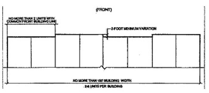
(H)
Supporting infrastructure and access.
(1)
All public roadways abutting the site providing points of ingress and egress shall be paved, on-site and off-site drainage shall be provided and all public utilities required to serve the proposed development area shall be available to the site, all in accordance with the requirements and specifications of the city.
(2)
Internal roadways may be public or private. All public roadways shall be constructed in accordance with all other regulations applicable to public roadways. All private roadways shall be constructed in accordance with the minimum requirements pertaining to drive, aisle and parking width standards and shall be maintained by a homeowners association (HOA).
(3)
All townhouse lots shall have frontage on and vehicular access to, a public roadway, a private roadway meeting at least the minimum city construction standards for drive aisles or a private parking lot meeting the city's parking lot standards; provided the parking lot has direct access to a public roadway or a private roadway meeting public roadway construction standards.
(4)
Required parking and additional guest parking may be provided on private roadways, provided the parking spaces are accomplished via "inset" parking spaces.
(5)
All public roadways shall be constructed with concrete vertical "F" curbs along all perimeters. Miami curbs may be considered on private roadways and common private parking areas. Rear alleys and rear parking areas are not required to have vertical curbs.
(I)
Lot and building standards.
Typical Townhouse Unit Grouping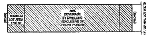
(J)
Exterior front garage facade walls. Exterior garage facade walls along the frontage of a dwelling unit shall not occupy more than 70 percent of the entire front building facade width of the dwelling unit. Furthermore, same exterior front garage facade walls shall be designed and architecturally treated in such a way as to diminish the overall presence of the garage door.
(K)
Building setback requirements.
(1)
Exterior walls of all buildings/ structures:
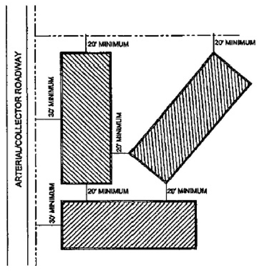
(2)
Townhouse buildings with common front parking areas and inset parking along private roadways:
Setbacks for Townhouse Buildings with Common Front Parking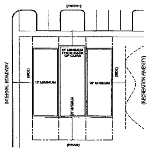
(3)
Townhouse buildings with front garages:
Setbacks for Townhouse Buildings with Front Garages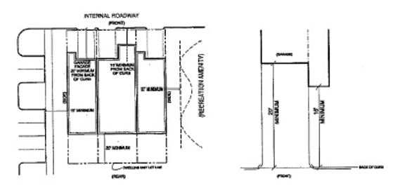
(4)
Townhouse buildings with rear loaded/accessed garages:
Setbacks for Townhouse Buildings with Rear Garages/Parking
* The front setback distance shall consist of a minimum four-foot wide common sidewalk within the front yard setback area.
** No portion of the front facade wall shall be located closer than 15 feet in distance as measured from the back of curb. The front facade of the garage wall shall be a minimum of 20 feet in distance as measured from the back of curb.
(L)
Projections into required yards.
(1)
Porches, balconies and decorative facade elements such as bay windows and pilasters may project no more than three feet into the required front yard setback area of townhouse buildings.
(2)
Porches, decks and balconies may project no more than five feet into the required rear yard setback area of townhouse buildings without rear loaded/accessed garages.
(3)
Porches, balconies and decorative facade elements such as bay windows and pilasters may project no more than two feet into the required side yard setback area of townhouse buildings for end dwelling units.
(M)
Landscaping. Unless otherwise provided for by this section, landscaping shall be subject to the city's Land Development Code.
(1)
The front of each individual townhouse building shall have shade trees planted and spaced every 20 to 40 feet depending on tree species.
(2)
Ornamental landscaping shall be provided along the entire front and side facades of all townhouse buildings, exclusive of front porches, private sidewalks and private driveways. The front-facade landscaped areas shall average no less than three feet in width, but shall not have any areas narrower than two feet in width. These landscaped areas shall contain coordinated shrubbery, groundcover plants and mulch, so as to present a coordinated landscaped appearance for each townhouse building and for the entire townhouse project. A landscaping plan shall be included with the townhouse application and considered an integral part of any approved townhouse plan.
Ornamental Landscaping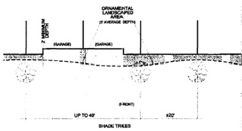
(N)
Sidewalks required.
(1)
(a)
On the side of all new development project roadways that provide direct access to townhouse dwelling units and recreational amenities;
(b)
On both sides of all arterial and collector roadways;
(c)
On both sides of local roadways leading to schools, parks, shopping centers, churches and other public service facilities; and
(d)
From common parking areas to townhouse dwelling units.
(2)
Sidewalk widths shall be not less than four feet. Sidewalk design and installation, when required, shall be approved by the Public Works Director and Planning Director prior to the issuance of a certificate of occupancy for any dwelling units within a given development.
(O)
Parking requirements.
(1)
A minimum of two parking spaces shall be provided for each townhouse dwelling containing two or more bedrooms. A minimum of one and one-half parking spaces shall be provided for each townhouse dwelling containing one bedroom. Parking may be provided by a front or rear accessed garage, within common private on-site parking areas or via "inset" parking spaces located on a private roadway. Public on-street parking shall not count towards meeting the minimum parking space requirements. If the garage is located at the front of the unit, the lot frontage should allow a landscaped front yard and enough space between driveways for on-street short-term parking where permitted. Alleys and rear accessed garages shall be designed to prohibit parking within the alleyways.
(2)
Common parking areas shall be located and arranged to be associated with the dwelling units served. Additional guest parking shall be required to be provided at a ratio of one parking space per five dwelling units. In addition, parking lot landscaping shall be required pursuant to the city's Land Development Code.
Common Parking Areas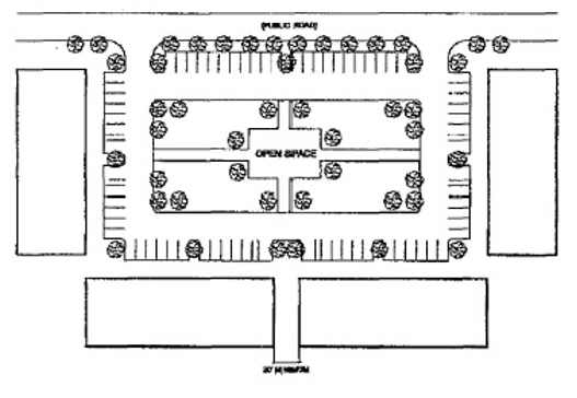
(3)
A townhouse project shall be designed so that parking on driveways can occur without a typical passenger vehicle blocking a sidewalk.
(P)
Building design standards.
(1)
Roof line variation.
(a)
Roofs with a pitch less than 6:12 (rise:run), including flat roofs, shall require decorative architectural elements near the roof edge at the front facade (i.e. cornice, dentils, design insets and the like).
(b)
The roof of each dwelling unit shall be distinct from the roof of adjacent dwelling units either through: separation of roof pitches; varying the direction of roof pitches; inclusion of dormers; or other variation in roof design.
Roof Line Variation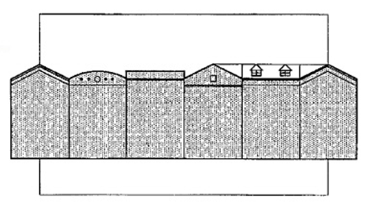
(2)
Front facades shall be comprised of the following design elements (divisions (a) or (b) below). The developer may choose to combine the elements for a mixture of facade styles within the development.
(a)
All brick, stone or stucco veneer shall be supplemented with use of at least one architectural element (e.g., quoins, pilasters, soldier courses, friezes, cornices, dentils, bay windows, decorative windows and the like); or
(b)
Multiple building materials with the primary building material being brick, fieldstone, limestone, stone, marble, granite and comprised of:
1.
85 percent of the area of each elevation for a one-story elevation;
2.
100 percent of the area of the first floor of each elevation for a two-story elevation; (Note: elevation wall area is exclusive of window or door areas. In the case of multiple building materials, secondary building materials shall comprise a minimum of ten percent of the elevation area. Secondary materials shall include textured block, architectural precast concrete, concrete composite siding, wood/vinyl clapboard siding, wood beaded siding or stucco.)
Facade Design Standards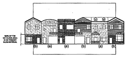
3.
The use of multiple colors and surface textures on exterior wall surfaces shall be required. Side and rear facades shall be compatible with front facade in material color;
4.
Roof shall be covered with "architectural" laminated, dimensioned, shadowed or shaped shingles. Tile, slate and metal roofing material may also be utilized. Standard three tab shingles are prohibited; and
5.
All sides of buildings, where adjacent to public or private right-of-way, shall include design characteristics and materials consistent with those on the front primary facade of the building.
(Q)
Recreation, open space and environmentally sensitive areas. The following buffering and landscaping requirements for recreation, open space and environmentally sensitive areas shall apply to townhouse developments.
(1)
Any common recreation area located within a townhouse development shall be buffered in accordance with the city's Land Development Code.
(2)
Townhouse developments shall provide open space equivalent to at least 30 percent of the gross project area.
(a)
Recreational amenities shall be included as described below in division (3) and shall be located on the site in such a manner as to be usable for active or passive recreation and easily accessible to all dwelling units within the development.
(b)
The remaining open space area provided exclusive of required recreational amenities shall be landscaped with shrubs and trees, storm water retention ponds and storm water detention ponds. Wetlands and other environmentally sensitive areas may also be included within the landscaped area.
Required Open Space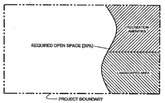
(3)
Townhouse developments shall provide recreational amenities within the development for the primary use of the residents of the development. At a minimum the development shall include a playground facility plus recreational amenities per the table below, Recreational amenities shall include, but not be limited to swimming pools, club houses or community centers, picnic shelters/barbecue areas, court game facilities (tennis, volleyball, basketball, shuffleboard) or a trail system not otherwise required as a substitute for sidewalks. In developments larger than 200 units, amenities may be repeated upon approval by SPRC. Recreational amenities shall be provided according to the following schedule:
(4)
Outdoor recreation areas shall be located in areas where topography, soils, hydrology and other physical characteristics are of such quality as to create a flat, dry, obstacle-free space in a configuration which allows for passive and active recreation.
(5)
Recreation amenities shall be centrally located near a majority of units, accessible and usable to residents and visible from surrounding units.
(6)
Playground equipment shall be certified by International Play Equipment Manufacturers Association (IPEMA) utilizing current American Society for Testing and Materials (ASTM) Standard F1487. Playground surface shall meet current ASTM (F1292) standards.
(7)
Storm water retention areas and storm water detention areas may be used to fulfill the open space requirements of divisions (Q)(1) through (6) of this section. The areas shall provide landscaped banks from the mean high water line to the top of the bank.
(8)
Any conservation or preservation area shall not be altered before, during or after construction activities.
(Ord. 933-05, passed 7-11-2005)
Sec. 2.01.03.07. - Mobile home subdivision (M-L).
This category is established to identify areas of the city appropriate for subdivision and sale of individual lots for the placement of mobile homes. The maximum density of development shall be seven dwelling units per gross acre with a maximum of 60 percent impervious area.
Sec. 2.01.03.08. - Mobile home park (M-2).
(A)
This category is established to identify areas of the city appropriate for medium density mobile home parks in which spaces are rented.
(B)
The maximum density of development shall be eight spaces per gross acre with a maximum of 60 percent impervious area.
Sec. 2.01.03.09. - Recreational vehicle park (M-3).
This category is established to identify areas of the city appropriate for higher density recreational vehicle parks in which spaces are generally rented and occupied on a seasonal or short-term basis. The maximum density of development shall be 14 spaces per gross acre with a maximum of 75 percent impervious area.
Sec. 2.01.03.10. - Recreational vehicle park/campground (M-4).
This category is established to identify areas of the city appropriate for transient occupancy. The maximum density of development shall be 18 spaces per gross acre with a maximum of 75 percent impervious area.
Sec. 2.01.03.11. - Traditional neighborhood center (TNC).
Reserved.
Sec. 2.01.03.12. - Office/professional (OP).
This category is established to identify areas of the city appropriate for professional services and related commercial activities, which produce minimal conflict with a residential environment. The gross floor area of a nonresidential building(s) shall not exceed 50 percent of the land area of the site upon which the building(s) is/are erected. Multi-family residential development in an OP district permitted as a conditional use shall comply with all requirements of the R-4 district.
(Ord. 974-07, passed 3-12-2007)
Sec. 2.01.03.13. - Neighborhood commercial district (C-1).
This category is established to identify areas of the city appropriate for clustering of commercial activities which provide efficient, safe and convenient shopping and personal services to serve neighborhood needs. The gross floor area of building(s) shall not exceed 50 percent of the land area of the site upon which the building(s) is/are erected.
Sec. 2.01.03.14. - Traditional village center (TVC).
Reserved.
Sec. 2.01.03.15. - Community commercial (C-2).
This category is established to identify areas of the city appropriate for location of commercial activities which serve the entire community and surrounding trade area, thereby generating volumes of vehicular traffic requiring direct access to arterial roadways. Uses in the C-2 district are primarily retail sales of goods and services directly to the ultimate consumer. The gross floor area of building(s) shall not exceed 50 percent of the land area of the site upon which the building(s) is/are erected.
Sec. 2.01.03.16. - Traditional town center (TTC).
Reserved.
Sec. 2.01.03.17. - General commercial (C-3).
This category is established to identify areas of the city appropriate for location of commercial activities with potential land use conflicts resulting from truck traffic, materials storage, emission of noise, odor or air pollutants or other environmental and public safety considerations. The total gross floor area of building(s) shall not exceed 50 percent of the land area of the site upon which the building(s) is/are erected.
Sec. 2.01.03.18. - Light industrial (LI).
Indoor storage/mini-warehouses are defined as a building or group of buildings in a controlled access and/or fenced compound that contain individual, compartmentalized or controlled access stalls or lockers for the dead storage of goods or wares belonging to individual lessees of the stalls and accessible to the lessees at all times through individual doors.
(Ord. 1499-25, § 2, passed 4-14-25)
Sec. 2.01.03.19. - Airport (AP-1).
This category is established to control that portion of the Zephyrhills Municipal Airport directly related to aircraft takeoff and landing.
Sec. 2.01.03.20. - Airport related (AP-2).
This category is established to control use of lands within the Zephyrhills Municipal Airport which are not directly related aircraft takeoff and landing.
Sec. 2.01.03.21. - Recreation/conservation (RC).
This category is established to identify areas of the city which have been legally committed to be retained for open space, whether by public ownership, lease hold interest or as a condition of the city's approval of a site-specific development.
Sec. 2.01.03.22. - Traditional central business district (TCBD).
This district is established to maintain the character and function of the city's traditional downtown and central business district and to accommodate the renovation, revitalization and planned expansion of the city's core. The district encourages mixed use, the maintenance of a "main street" character, walk ability, public spaces and the sharing of parking and other public infrastructure.
(Ord. 966-07, passed 2-26-2007)
Sec. 2.01.03.23. - Traditional central business district-historic (TCBD-H).
This district includes those areas within the city's traditional downtown that are also within the boundaries of the historic district. The district places emphasis on and the preservation of historic resources and the character of the historic district as a part of a vibrant central business district.
(Ord. 966-07, passed 2-26-2007)
Sec. 2.01.03.24. - Traditional mixed use (TMU).
This district includes those areas adjoining the city's traditional central business district and provides transition of intensity and uses to the surrounding residential areas. Uses and use intensity within the district are intended to complement the traditional downtown.
(Ord. 966-07, passed 2-26-2007)
Sec. 2.01.03.25. - Traditional mixed use-historic (TMU-H).
This district includes those areas adjoining the city's traditional downtown that are also within the boundaries of the historic district. This district places emphasis on and the preservation of historic resources and the character of the historic district as a part of a healthy city center.
(Ord. 966-07, passed 2-26-2007)
Sec. 2.01.04. - Residential density standards.
Residential development of various types and density may be permitted in the land category "residential" as shown in this section. Density of development and allowable housing types vary by zoning district. A site-specific planned unit development may be approved for mixed use, including incidental nonresidential uses, within an area designated "residential" on the future land use map. The overall density within a residentially designated area should be no greater than three and one-third du/gross acre.
Sec. 2.01.05. - District boundaries.
Where uncertainty exists as to the boundaries of any district shown on the Zoning Map, the following rules shall apply:
(A)
Where the district boundaries are indicated as approximately following center lines of streets and alleys, lot line or property lines, the lines shall be considered to be the boundaries;
(B)
In unsubdivided property or where a district boundary divides a lot, the location of the boundary, unless the same is indicated by dimensions shown on the map, shall be determined by the use of the scale appearing on the Zoning Map;
(C)
Where physical or cultural features existing on the ground are at variance with those shown on the Zoning Map or in other circumstances not covered by the preceding rules, the Board of Zoning Adjustment shall interpret the district boundaries;
(D)
Where the boundary of a district follows a stream, lake or other body of water, the boundary line shall be deemed to be at the limit of the jurisdiction of the city, unless otherwise indicated; and
(E)
In the case of any uncertainty, the Board of Adjustment shall interpret the intent of the map as to the location of the district boundaries.
(Ord. 979-07, passed 7-23-2007)
Sec. 2.02.01. - Permitted uses.
Permitted uses are allowed as a matter of right in each district as prescribed by Table 2.02.01 and in accordance with the standards and procedures set forth in this code. Permitted uses are designated by the letter "P" in Table 2.02.01.
Sec. 2.02.02. - Provisional uses.
Provisional uses are allowed as a matter of right in each district as prescribed in Table 2.02.01 provided that the use adheres to the standards prescribed for the zoning district and is in accordance with supplemental standards and regulations as prescribed by part 7.09.00. Provisional uses are designated by the letter "S" in Table 2.02.01.
Sec. 2.02.03. - Special exceptions.
Special exceptions are not allowed as a matter of right in a zoning district, but which is allowed only upon a determination by the Planning Commission that the use is in accordance with the standards specifically prescribed by part 7.09.00 and otherwise set forth in this code. Special exceptions are designated by the letters "SE" in Table 2.02.01.
Sec. 2.02.04. - Conditional uses.
Conditional uses are not allowed as a matter of right in a zoning district, but which is allowed only upon a determination by the City Council that the use is in accordance with the standards specifically prescribed by Part 7.09.00 and otherwise set forth in this code. Conditional uses are designated by the letter "C" in Table 2.02.01.
Sec. 2.02.05. - Accessory uses and structures.
(A)
An accessory use or structure is clearly incidental and ancillary to the principal use or structure on a parcel. The procedure for review of an accessory use or structure shall be the same as is required for the principal use or structure.
(B)
Accessory use and structures shall adhere to the standards prescribed in section 7.09.01.
(C)
All required accessory uses for any principal use, including, but not limited to, off-street parking and loading areas, retention or drainage areas and private sewer or water systems shall be located on the same parcel as the principal use and shall have the same zoning district designation as the principal use, except in accordance with part 6.03.00 and/or except as expressly permitted elsewhere in this code. In no case shall the principal or accessory use be located in a zoning district where that use is not either a permitted use or a permissible provisional, special or conditional use.
(D)
Each of the following uses is considered to be a customary accessory use and as such, may be situated on the same lot with, but detached from, the principal use with which it is associated:
(1)
Residential, accessory uses and structures.
(a)
Private garages.
(b)
Utility and storage buildings.
(c)
Swimming pools, hot tubs and similar installations as prescribed in section 7.09.22.
(d)
Home occupations as prescribed in section 7.09.15.
(2)
Office, commercial, industrial and airport-related districts. Automated teller machines.
(3)
All zoning districts.
(a)
Off-street parking.
(b)
Radio-TV antenna or earth station antennas (dish) as prescribed in section 7.09.11.
Sec. 2.02.06. - Temporary uses.
The following temporary uses are allowable within the city:
(A)
Residential zoning districts.
(1)
Garage sales as prescribed in section 7.09.14.
(2)
Temporary parking of recreational vehicles as prescribed in section 7.09.20.
(3)
Temporary buildings for construction purposes as prescribed in section 7.09.24.
(B)
Nonresidential zoning districts. Temporary buildings for construction purposes as prescribed in section 7.09.24.
Table 2.02.01 Allowable Uses in Zoning Districts
(Ord. 1153-12, passed 7-23-2012; Ord. 1200-13, passed 4-8-2013; Ord. 1375-19, passed 1-14-2019; Ord. 1377-19, passed 9-9-2019; Ord. 1431-21, passed 12-13-2021; Ord. 1499-25, § 2, passed 4-14-25)
Sec. 2.02.07. - Retail pharmacies and medical marijuana treatment center dispensing facilities.
Medical marijuana dispensing facilities shall be located, at a minimum, 500 feet from any existing public or private elementary school, middle school, or secondary school. Measurements shall be made from the nearest property line of the school to the nearest property line of the medical marijuana dispensing facility. If the medical marijuana dispensing facility is located in a multi-tenant building, the distance shall be measured from the nearest property line of the school to the nearest area of the leasehold or other space actually controlled or occupied by the medical marijuana dispensing facility.
(Ord. 1367-18, passed 6-11-2018)
Sec. 2.02.08. - Municipal airport zoning ordinance.
This section shall be known and may be cited as the "Zephyrhills Municipal Airport Zoning Ordinance."
(Ord. 1358-18, passed 4-23-2018)
Sec. 2.02.08.01. - Definitions.
The following words, terms, and phrases, when used in this section, shall have the meanings ascribed to them in this subsection, except where the context clearly indicates a different meaning.
Aeronautical study. A Federal Aviation Administration study, conducted in accordance with the standards of 14 C.F.R. Part 77, Subpart C, and Federal Aviation Administration policy and guidance, on the effect of proposed construction or alteration upon the operation of air navigation facilities and the safe and efficient use of navigable airspace.
Airport. Any area of land or water designed and set aside for the landing and taking off of aircraft and used or to be used in the interest of the public for such purpose. For the purpose of this section "airport" refers to the Zephyrhills Municipal Airport.
Airport elevation or height. The highest point of an airport's usable landing area measured in feet above mean sea level.
Airport hazard. An obstruction to air navigation which affects the safe and efficient use of navigable airspace or the operation of planned or existing air navigation and communication facilities.
Airport hazard area. Any area of land or water upon which an airport hazard might be established.
Airport land use compatibility zoning. Airport zoning regulations governing the use of land on, adjacent to, or in the immediate vicinity of airports.
Airport protection zoning regulations. Airport zoning regulations governing airport hazards.
Airport reference point. The point established as the approximate geographic center of the airport landing area and so designated.
Airspace hazard. Any structure or object of natural growth or use of land, which protrudes above or into the navigable airspace.
Airspace height. The height limits in all zones set forth in this section. The datum shall be mean sea level elevation (AMSL) unless otherwise specified.
Avigation easement. A covenant running with the land in which the property owner grants to the county the right to use the airspace above the owner's property and to create noise normally associated with aircraft operation without liability. The avigation easement shall be drafted by the City Attorney's Office and executed by both the city and the property owner.
CFR. The Code of Federal Regulations.
Clearance determination. A determination based upon the standards herein, made by the Airport Manager or designee in conjunction with development review services prior to the issuance of any development or use authorization, that the proposed development or use would not intrude into any airport zone as defined within this section.
Educational facility. Any structure, land, or use that includes a public or private kindergarten through twelfth grade school, charter school, magnet school, college campus, or university campus. The term does not include space used for educational purposes within a multi-tenant building.
FAA. The Federal Aviation Administration, a division of the U.S. Department of Transportation.
FAR. The Federal Aviation Regulations, Title 14 of the Code of Federal Regulations. FAR Part 77 is entitled "Safe, Efficient Use, and Preservation of the Navigable Airspace".
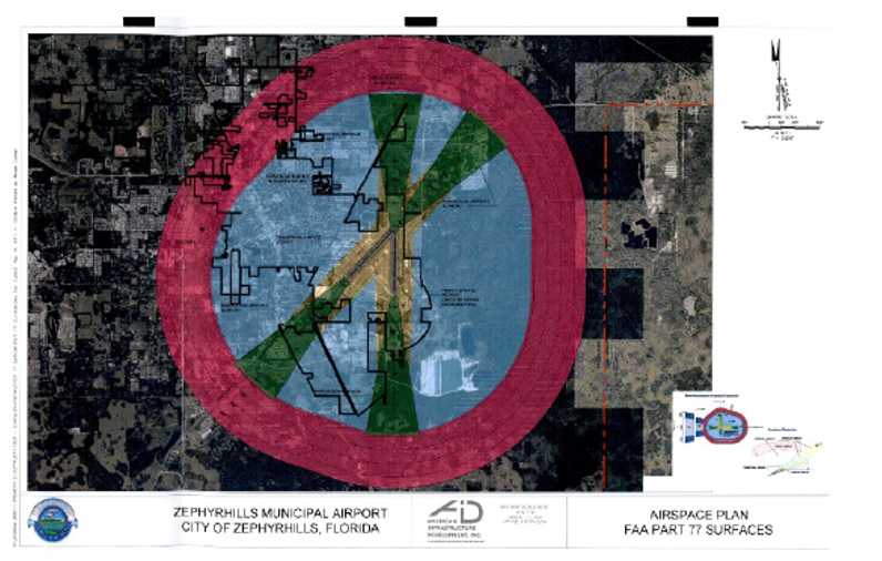
Height limitation zone map. The aerial photograph in section 2.02.08.14 and made a part hereof, with the imaginary or hazard zoning surfaces drawn thereon, the layout of the runways, the airport zoning reference point, the airport elevation and the topography of the area. The aerial also depicts the various zones with the applicable height limitations for each, and identifies topographic features such as major streams, rivers, railroads, roads and streets.
Landfill. As defined in F.S. § 403.703.
Landing area. The area of the airport used for the landing, takeoff, or taxiing of aircraft.
Minimum descent altitude. The lowest altitude, expressed in feet above mean sea level, to which descent is authorized on final approach or during circling-to-land maneuvering in execution of a standard instrument approach procedure where no electronic glide slope is provided.
Minimum en-route altitude. The altitude in effect between radio fixes, which assures acceptable navigational signal coverage and meets obstruction clearance requirements between those fixes.
Minimum obstruction clearance altitude. The specified altitude in effect between radio fixes on VOR airways, off-airway routes, or route segments which meets obstruction clearance requirements for the entire route segment and which assures acceptable navigational signal coverage only within 22 miles of a VOR (very high omnirange) station.
Nonconforming use. Any preexisting structure or use of land which lawfully exists at a specific height at the time of adoption of this section, and which existence or height is inconsistent with the provisions of this section or an amendment thereto.
Non-precision instrument runway. A runway having a non-precision-instrument approach procedure utilizing air navigation facilities with only horizontal guidance, or area type navigation equipment, for which a straight-in non-precision- instrument approach procedure has been approved or planned, and for which no precision approach facilities are planned or indicated on an FAA planning document or military service's military airport planning document.
Object of natural growth. Any organism of the plant kingdom, including a tree.
Obstruction. Any existing or proposed object, terrain, or structure construction or alteration that exceeds the federal obstruction standards contained in 14 C.F.R. Part 77, Subpart C. The term includes:
(1)
Any object of natural growth or terrain;
(2)
Permanent or temporary construction or alteration, including equipment or materials used and any permanent or temporary apparatus; or
(3)
Alteration of any permanent or temporary existing structure by a change in the structure's height, including appurtenances, lateral dimensions, and equipment or materials used in the structure.
Person. Any individual, firm, copartnership, corporation, company, association, joint-stock association, or body politic, and includes any trustee, receiver, assignee, or other similar representative thereof.
Political subdivision. The local government of any county, municipality, town, village, or other subdivision or agency thereof, or any district or special district, port commission, port authority, or other such agency authorized to establish or operate airports in the state.
Precision instrument runway. A runway having an existing instrument approach procedure utilizing an instrument landing system (ILS), or a precision approach radar (PAR). It also means a runway for which a precision approach system is planned and so indicated by an FAA approved airport layout plan or any other FAA planning document.
Public-use airport. An airport, publicly or privately owned, licensed by the state, which is open for use by the public.
Runway. A defined area on an airport prepared for landing and takeoff of aircraft along its length.
Runway protection zone (RPZ). An area at ground level beyond the runway end to enhance the safety and protection of people and property on the ground.
Structure. Any object, constructed, erected, altered or installed, including, but not limited to, buildings, towers, smoke stacks, utility poles, power generation equipment, and overhead transmission lines.
Substantial modification. Any repair, reconstruction, rehabilitation, or improvement of a structure when the actual cost of the repair, reconstruction, rehabilitation, or improvement of the structure equals or exceeds 50 percent of the market value of the structure.
Utility runway. A runway that is constructed for and intended to be used by propeller-driven aircraft of 12,500 pounds maximum gross weight and less.
Visual runway. A runway intended solely for the operation of aircraft using visual approach procedures with no straight-in instrument approach procedure and no instrument designation indicated on a FAA approved airport layout plan, a military service's approved military airport layout plan, or by any planning document submitted to the FAA by competent authority.
(Ord. 1358-18, passed 4-23-2018)
Sec. 2.02.08.02. - Purpose.
The purpose of this section is to implement airport protection zoning regulations which provide airspace and land use protection for the existing and expected future operations of the Municipal Airport in order to promote the public interest in safety, health, and general welfare. Also, to provide efficient use of the airport lands, to provide protection for adjacent land uses and the residents of the city and surrounding areas. The City Council, as the adopting political subdivision, finds that:
(A)
The creation or establishment of an airport hazard and incompatible land use reduces the navigable airspace available in the region served by the airport;
(B)
It is necessary in the interest of the public health, public safety, and general welfare that the creation or establishment of airport hazards and land incompatible with airport operations;
(C)
The prevention of these airport hazards and incompatible land uses should be accomplished, to the extent legally possible, without compensation; and
(D)
Preventing the creation or establishment of airport hazards, and the elimination, removal, alteration, mitigation, or marking and lighting of existing airport hazards are public purposes for which the City Council may raise and expend public funds and acquire land or property interests therein, or air rights thereover.
(Ord. 1358-18, passed 4-23-2018)
Sec. 2.02.08.03. - Application process.
To prevent the construction of structures deemed to be hazardous to air navigation, each person proposing to construct any structure which will fall within one or more of the categories detailed under sections 2.02.08.04 and 2.02.08.05 of this section shall submit a development permit application to the City Building Department.
(A)
Any person proposing to construct any structure within ten nautical miles of the airport reference point, shall utilize the FAA notice criteria tool (https://oeaaa.faa.gov) to determine if the FAA will require the filing of a Form 7460-1, Notice of Proposed Construction or Alteration. This shall be completed prior to submitting an application for development permit to the Building Department for review. The Form 7460-1 will allow the FAA to conduct a full aeronautical study in conformance with C.F.R. Part 77, Subparts B and C. The aeronautical study shall determine if the proposed structure is an obstruction and/or an airport hazard. Coordination with the FAA typically can take up to 90 days to process. The FAA issued determination letter shall be provided to the Airport Manager at the pre-application meeting and submitted to the Building Department along with the application form.
(B)
Pre-application meeting. Prior to applying for a development permit under section 11.01.00, applicants must coordinate with the Airport Manager to ensure that the proposed development is in compliance with the provisions of this section.
(1)
Processing development permit application. An application for a development permit must contain a copy of the final FAA determination letter indicating no hazard to air navigation, if applicable; elevation drawings; and proposed plans for the structure. The Airport Manager will indicate compliance with the height and land use limitations prescribed by this section by annotating signature approval on the development permit application. The Building Department shall consider F.S. § 333.07(2) during the determination process. Where the FAA has issued a notice of presumed hazard, the Building Department shall deny the development permit.
(2)
A copy of the complete permit application shall be provided to the Florida Department of Transportation Aviation and Space Ports Office via certified mail or email for a 15-day review.
(3)
In the event the Airport Manager denies an application for violating the provisions of this section, the proposed construction shall not be permitted by the Building Department. The applicant may appeal the decision of the Building Department to the Board of Adjustment pursuant to F.S. § 333.
(Ord. 1358-18, passed 4-23-2018)
Sec. 2.02.08.04. - Airport hazard zones and airspace height limitations.
(A)
To implement the provisions of this section, there are hereby created and established certain zones, based upon airport imaginary surfaces identified in 14 C.F.R. § 77.19, which include all of the land lying beneath the approach, transitional, horizontal, and conical surfaces (zones) as they apply to the Municipal Airport. Such zones are shown on the Municipal Airport Zoning Map located in section 2.02.08.14.
(B)
Except as otherwise provided in this section, no structure or object of natural growth shall be constructed, erected, altered, or allowed to grow beyond the height of any imaginary surface or zone created by this section in accordance with 14 C.F.R. Part 77, Subparts B and C, without the FAA aeronautical evaluation determination of no hazard to air navigation obtained through the aeronautical study process which is initiated by the submittal of the FAA Form 7460-1. The FAA notice criteria tool shall be utilized by the permit applicant, to determine if a structure requires a Form 7460-1 submittal. Where an area is covered by more than one height limitation under this section, the more restrictive limitation shall prevail. The imaginary surfaces are established and defined as follows.
(1)
Primary surface (zone).
(a)
An area longitudinally centered on a runway, extending 200 feet beyond each end of that runway. The width of the primary surface is for the most precise approach existing or planned for either end of that runway as follows:
1.
Runways 5 and 23: 500 feet for non-precision-instrument runways having visibility minimums greater than three-fourths statute mile; and
2.
Runways 1 and 19: 1,000 feet for precision-instrument runways having visibility minimums less than three-fourths statute mile;
(b)
No structure or obstruction will be permitted within the primary surface (zone) that is not a critical part of the airfield and is of a greater height than the nearest point on the runway centerline.
(2)
Horizontal surface (zone).
(a)
A horizontal plan 150 feet above the established airport elevation, the perimeter of which is constructed by swinging arcs of specified radii from the center of each end of the primary surface of each runway and connecting the adjacent arcs by lines tangent to those arcs. The radius of each arc is runways 5, 23, 1, and 19: 10,000 feet for all runways not designated as visual or utility.
(b)
The radius of the arc specified for each end of a runway will have the same arithmetical value. That value will be the highest composite value determined for either end of the runway. When a 5,000-foot arc is encompassed by tangents connecting two adjacent 10,000-foot arcs, the 5,000-foot arc shall be disregarded on the construction of the perimeter of the horizontal zone.
(3)
Conical surface (zone). The area extending outward and upward from the periphery of the horizontal surface slope of 20 to 1 for a horizontal surface for a distance of 4,000 feet. Height limitations for structures in the conical surface are 150 feet above airport elevation at the inner boundary with permitted height increasing one foot vertically for every 20 feet of horizontal distance measured outward from the inner boundary to a height of 350 feet above airport height at the outer boundary.
(4)
Approach surface (zone).
(a)
An area longitudinally centered on the extended runway centerline and extending outward from each end of the primary surface. An approach surface is designated for each runway based upon the type of approach available or planned for that runway end. The inner edge of the approach surface is the same width as the primary surface and it expands uniformly to a width of:
1.
Runways 1 and 19 (precision instrument runways): 16,000 feet.
2.
Runways 5 and 23: 3,500 feet for that end of a non-precision-instrument runway other than utility, having visibility minimums greater than three-fourths of a statute mile.
(b)
The approach surface extends for a horizontal distance of:
1.
Runways 1 and 19 (precision instrument runways): 50,000 feet. The height increases one foot vertically for every 50 feet of horizontal distance for the first 10,000 feet, and then increases one foot vertically for every 40 feet horizontal distance for an additional 40,000 feet.
2.
Runways 5 and 23: 10,000 feet with a height increasing one foot vertically for every 34 feet of horizontal distance for all non-precision-instrument runways other than utility.
(c)
The outer width of an approach zone to an end of a runway will be that width prescribed in this subsection for the most precise approach existing or planned for that runway end.
(5)
Transitional surface (zone). The area extending outward and upward at right angles to the runway centerline and the runway centerline extended at a slope of seven to one from the sides of the primary surface and from the sides of the approach surfaces. Transitional surfaces for those portions of the precision approach surface which project through and beyond the limits of the conical surface, extend a distance of 5,000 feet measured horizontally from the edge of the approach surface and at right angles to the runway centerline.
(6)
Other areas. In addition to the height limitations imposed in divisions (B)(1) through (5) of this subsection, no structure or obstruction will be permitted within the limits of the city that would cause a minimum obstruction clearance altitude, a minimum descent altitude, or a decision height to be raised.
(C)
Nothing in this section shall be construed as prohibiting the growth, construction, or maintenance of any object of natural growth (tree) or structure to a height up to 25 feet above the surface of the land.
(Ord. 1358-18, passed 4-23-2018)
Sec. 2.02.08.05. - Airport land use restrictions.
Use restrictions. Notwithstanding any other provision of this section, no use may be made of land within any zones established by this section in such a manner as to create a hazard to the safe operation of an airborne aircraft. The following special requirements shall apply to each permitted use.
(A)
All lights or illumination used in conjunction with streets, parking, signs, or use of land and structures shall be arranged and operated in such a manner that it is not misleading or dangerous to aircraft operating from a public airport or in the vicinity thereof.
(B)
No operations of any type shall produce smoke, glare, or other visual hazards within three statute miles of any usable runway of the Municipal Airport.
(C)
No operations of any type shall produce electronic interference with navigation signals or radio communications between the Municipal Airport and aircraft.
(D)
Zone establishment. There is hereby created and established as an overlay zone on the adopted Municipal Boundary Map a runway protection zone for areas at each end of every active runway at the Municipal Airport. Within a runway protection zone, certain uses are restricted or prohibited to reduce incompatibilities with normal airport operations and danger to public health. The following types of uses shall be prohibited within the runway protection zone:
(1)
Educational facilities;
(2)
Hospitals, medical inpatient treatment facilities, and nursing/convalescent home facilities;
(3)
Places of worship;
(4)
Hazardous materials or fuel storage;
(5)
Recreational (including place of public assembly); and
(6)
Residential.
(E)
(1)
Solid waste disposal sites shall be reviewed in accordance with the State Department of Environmental Protection (DEP) Rule Chapter 17-701, which requires the following:
(a)
No solid waste disposal sites shall be permitted to be located within 10,000 feet of any publicly licensed airport active runway used or planned to be used by turbine powered aircraft; or
(b)
Within 5,000 feet of any publicly licensed airport active runway used only by piston type aircraft; or
(c)
Locations outside the above locations but still within the limits of any airport imaginary surface as defined in 14 C.F.R. § 77.19 and determined by the FAA to pose a hazard.
(2)
Where any landfill is located and constructed in a manner that attracts or sustains hazardous bird movements from feeding, water, or roosting areas into, or across, the runways or approach and departure patterns of aircraft, the landfill operator must, at their own expense, incorporate bird management techniques or other practices to minimize bird hazards to airborne aircraft.
(F)
Lighting. The FAA aeronautical study determination will specify requirements for obstruction lighting. The owner of the obstruction must install, operate, and maintain obstruction lighting at his/her own expense. Obstruction lighting shall conform with the FAA Advisory Circular 70/7460-1, Obstruction Marking and Lighting.
(G)
No educational facility, with the exception of aviation school facilities, shall be permitted within an area extending along the centerline of any runway and measured from the end of the runway and extending for a distance of five miles and having a width equal to one-half of the runway length. Exceptions approving construction of an educational facility within the delineated area shall only be granted when the City Council makes specific findings detailing how the public policy reasons for allowing the construction outweigh health and safety concerns prohibiting such a location.
(Ord. 1358-18, passed 4-23-2018)
Sec. 2.02.08.06. - Restrictions in airport noise impact area.
(A)
Construction of any new educational facility, with the exception of aviation school facilities, or residential construction, shall not be permitted within an airport noise impact area until such time as the city amends this section. The provisions of this subsection do not apply to existing residential or new residential construction within platted residential areas established on or before September 1, 2007.
(B)
Construction of any educational facility within an area extending five miles along the runway centerline of the airport and which has a width measuring one-half the length of the runway shall be prohibited. The continued use or adjacent expansion of existing structures or new structures for which a site has been determined as provided in F.S. § 235.19 as of July 1, 1993 are excluded.
(Ord. 1358-18, passed 4-23-2018)
Sec. 2.02.08.07. - Nonconforming uses.
(A)
Regulations not retroactive. The regulations prescribed by this section shall not be construed to require the removal, lowering, or other changes or alteration of any structure not conforming to the regulations as of January 1, 2008, or otherwise interfere with the continuance of any nonconforming use. Nothing contained in this section shall require any change in the construction, alteration, or intended use of any structure, the construction or alteration of which was begun prior to January 1, 2008, and has not been abandoned.
(B)
Abandoned or deteriorated existing nonconforming use. In the event the Building Department determines that a nonconforming obstruction has been abandoned or is more than 80 percent torn down, destroyed, deteriorated, or decayed, a permit may not be granted if it would allow the obstruction to exceed the applicable height limit or otherwise deviate from this airport protection zoning regulation. The owner of the nonconforming obstruction may be required, at his or her own expense, to lower, remove, reconstruct, alter, or equip such obstruction as may be necessary to conform to the current airport protection zoning regulations. Should the owner neglect or refuse to comply within ten days of notice, the Building Department may proceed to have the obstruction lowered, removed, reconstructed, altered, or equipped, and assess the cost and expense thereof upon the owner of the obstruction or the land whereon it is or was located.
(C)
Marking and lighting. Notwithstanding the provision of division (A), the owner of any obstruction is hereby required to permit the installation, operation, and maintenance thereof of such markers and lights as deemed necessary by the FAA through the aeronautical study. The FAA's determination of no hazard will identify the type of obstruction lighting and marking required in accordance with Advisory Circular 70/7460-1, Obstruction Marking and Lighting, to indicate the presence of an obstruction to aircraft operators in the vicinity. Such markers and lights shall be installed, operated, and maintained at the expense of the property owner.
(D)
Acquisition of air rights (avigation easement). In the event the Building Department determines a nonconforming obstruction is an airport hazard and the owner will not remove, lower, or otherwise eliminate it, the necessary approach protection may be provided by acquisition of property rights rather than by airport zoning regulations. The Board of Adjustment, with recommendations by the airport authority, may acquire an avigation easement. The Board of Adjustment shall, in addition to the damages for the taking, injury, or destruction of property, also pay the cost of the removal and relocation of any structure or any public utility that is required to be moved to a new location.
(Ord. 1358-18, passed 4-23-2018)
Sec. 2.02.08.08. - Enforcement of section.
It shall be the duty of the Building Department, with recommendations from the Airport Manager, to administer and enforce the regulations prescribed in this section. Applications for clearance determinations and permits shall be required to be made to the Building Department upon a form furnished by it. Applications required by this section to be submitted to the Building Department shall be promptly considered and granted or denied. Applications for action by the City Council shall be forthwith transmitted by the Planning Department.
(Ord. 1358-18, passed 4-23-2018)
Sec. 2.02.08.09. - Board of adjustment, code enforcement, and appeals.
(A)
The Board of Adjustment, Code Enforcement, and Appeals established in section 30.080 et seq. of the City Code of Ordinances shall hear and decide appeals from any order, requirement, decision or determination made by the Building Department in the enforcement of this section.
(B)
The Board of Adjustment, Code Enforcement, and Appeals shall consist of the members appointed in accordance with the terms of section 30.080 et seq. of the City Code of Ordinances.
(C)
Board of Adjustment, Code Enforcement, and Appeals review criteria. The following criteria shall be considered by the Board of Adjustment, Code Enforcement, and Appeals in making a determination on any appeal to a decision made by the Building Department in its administration of this section:
(1)
The nature of the terrain and height of existing structures;
(2)
Public and private interests and investments;
(3)
The character of flying operations and planned developments of airports;
(4)
Federal airways as designated by the Federal Aviation Administration;
(5)
Whether the construction of the proposed structure would cause an increase in the minimum descent altitude or the descent height at the affected airport;
(6)
Technological advances;
(7)
The safety of persons on the ground and in the air;
(8)
Land use density;
(9)
The safe and efficient use of navigable airspace;
(10)
The cumulative effects on navigable airspace of all existing structures, proposed structures identified in the applicable jurisdictions' comprehensive plans, and all other known proposed structures in the area;
(11)
The need for the establishment of an avigation easement;
(12)
The recommendation from the Airport Authority; and
(13)
Federal Aviation Administration aeronautical study determination.
(Ord. 1358-18, passed 4-23-2018)
Sec. 2.02.08.10. - Appeals.
(A)
Any person aggrieved by any decision of the Building Department made in its administration of this section, if of the opinion that a decision of the Building Department, or the Airport Manager or designee is an improper application of these regulations, may appeal to the Board of Adjustment, Code Enforcement, and Appeals.
(B)
All appeals must be taken within 14 days by filing with the agency from which the appeal is taken and the Board of Adjustment, Code Enforcement, and Appeals a notice of appeal specifying the grounds thereof. The agency from which the appeal is taken shall forthwith transmit to the Board of Adjustment, Code Enforcement, and Appeals all the papers constituting the record upon which the action appealed from was taken or properly certified copies thereof in lieu of originals as the agency involved may elect.
(C)
An appeal shall stay all proceedings in furtherance of the action appealed from unless the agency from which the appeal is taken certifies to the Board of Adjustment, Code Enforcement, and Appeals after notice of appeal has been filed with it, that by reason of the facts stated in the certificate a stay would, in its opinion, cause imminent peril of life or property. In such cases, proceedings shall not be stayed otherwise than by an order of the Board of Adjustment, Code Enforcement, and Appeals on notice to the agency from which the appeal is taken and on due cause shown.
(D)
The Board of Adjustment, Code Enforcement, and Appeals shall hold a public hearing prior to making a determination on any appeal. The Board or Adjustment, Code Enforcement, and Appeals shall issue a notice, via certified mail, of the time and place of such public hearing to the petitioner no later than 14 days prior to the hear date. Such notice will contain the name of the petitioner; date and time of the hearing; and a brief statement of the error alleged by the petitioner. The Board of Adjustment, Code Enforcement, and Appeals will publish an advertisement of the public hearing in the local newspaper at least 14 days prior to the date of the public hearing.
(E)
The Board of Adjustment, Code Enforcement, and Appeals may, in conformity with the provisions of this section, reverse or affirm, wholly or partly, or modify, the order, requirement, decision, or determination appealed from, and may make such order, requirement, decision, or determination as ought to be made, and to that end shall have all the powers of the administrative agency from which the appeal is taken.
(Ord. 1358-18, passed 4-23-2018)
Sec. 2.02.08.11. - Judicial review.
(A)
Any person or political subdivision affected by any decision of the Board of Adjustment, Code Enforcement, and Appeals may apply for judicial relief to the Circuit Court within 30 days after rendition of the decision. Review shall be by petition for writ of certiorari, which shall be governed by the Florida Rules of Appellate Procedure. The court has exclusive jurisdiction to affirm, reverse, or modify the decision on the permit or other determination from which the appeal is taken, and, if appropriate, to order further proceedings by the political subdivision or its administrative agency.
(B)
The findings of fact by the Board of Adjustment, Code Enforcement, and Appeals, if supported by substantial evidence, shall be accepted by the court as conclusive, and an objection to a decision of the political subdivision or its administrative agency may not be considered by the court unless such objection was raised in the underlying proceeding.
(C)
Should this section be held by a court to interfere with the use and enjoyment of a particular structure or parcel of land, or to be so onerous in their application to such a structure or parcel of land, as to constitute a taking or deprivation of that property in violation of the State Constitution or the Constitution of the United States, such holding shall not affect the application of such regulations to other structures and parcels of land, or such regulations as are not involved in the particular decision.
(D)
A judicial appeal to any court may not be permitted until the appellant has exhausted all its remedies through application for local government permits, exceptions, and appeals.
(Ord. 1358-18, passed 4-23-2018)
State Law reference— Judicial review, F.S. § 333.11.
Sec. 2.02.08.12. - Penalty for violation of this section.
(A)
Any person violating any regulations, orders, or rulings adopted by the provisions of this section, upon conviction in the County Court, shall be charged with a misdemeanor of the second degree punishable as provided in F.S. §§ 775.083 or 775.085. Each day a violation continues to exist shall constitute a separate offense.
(B)
In addition to the provisions of division (A), the city may institute in any court of competent jurisdiction an action to prevent, restrain, correct, or abate any violations of this section or of any airport zoning regulation adopted under this section, or of any order or ruling made in connection with the administration or enforcement thereof, seeking such relief, by way of injunction or otherwise, as may be proper under the facts and circumstances of the case.
(Ord. 1358-18, passed 4-23-2018)
State Law reference— Penalties for violation of airport zoning ordinances, F.S. §§ 333.13(1) and (2).
Sec. 2.02.08.13. - Conflicting regulations.
(A)
Incorporation. In the event that a political subdivision has adopted, or hereafter adopts, a comprehensive zoning ordinance regulating, among other things, the height of buildings, structures and natural objects, and uses of property, any airport zoning regulations applicable to the same area or portion thereof may be incorporated in and made a part of such comprehensive zoning regulations for that political subdivision, and be administered and enforced in connection therewith.
(B)
Conflict. In the event of any conflict between the airport zoning regulations adopted under this section and any other regulations applicable to the same area, whether the conflict is with respect to the height of structures or trees, the use of land, or any other matter, and whether such regulations were adopted by the political subdivision which adopted the airport zoning regulations or by some other political subdivision, the more stringent limitation or requirement shall govern and prevail.
(Ord. 1358-18, passed 4-23-2018)
State Law reference— Similar state law provisions, F.S. § 333.04.
Sec. 2.02.08.14. - Municipal airport airspace plan.
Please note that maps in the Airport Zoning Ordinance are representational only. Locational requirements can be verified by the Municipal Airport. Hard copy, scaled maps are available upon request from the airport.
(Ord. 1358-18, passed 4-23-2018)
Sec. 2.05.01.01. - Purpose and intent.
(A)
Purpose. The purpose of this form-based code is to implement the regulating plan for the U.S. 301/Gall Boulevard corridor through the establishment of certain regulations, procedures, and standards for reviewing and approving all development orders, permits, and use of land within the area depicted in regulating plan district map.
(B)
Intent. The intent of the form-based code is to contribute to the orderly and controlled growth and development of the city in accordance with the comprehensive plan and smart growth principles. Smart growth encourages:
(1)
Community development that results in well-designed, compact and walkable neighborhoods;
(2)
Buildings and landscaping that contribute to the physical definition of thoroughfares as civic places;
(3)
Development that adequately accommodate automobiles while respecting the pedestrian and the spatial form of public areas;
(4)
Design of streets and buildings that reinforce safe environments, but not at the expense of accessibility.
(5)
Civic buildings and public gathering places provided as locations that reinforce community identity and support self-government.
(6)
Civic buildings that are distinctive and appropriate to a role more important than the other buildings that constitute the fabric of the city.
(7)
Neighborhood units with a mixture of dwellings, retail, business, civic and recreational opportunities as the basic increment of settlement;
(8)
Neighborhood size determined by a pedestrian shed that is small enough for most residents to walk to its center;
(9)
Retail for ordinary household needs within the neighborhood and workplaces, including those integrated with dwellings, available within or near the neighborhood;
(10)
Integration of housing types, suitable for younger and older persons, single households and families;
(11)
A fine-grained network of thoroughfares dispersing traffic and connecting to the regional system;
(12)
Thoroughfares designed to target speeds that are safe and comfortable for pedestrians and bicyclists;
(13)
Buildings provide their inhabitants with a clear sense of geography and climate through energy-efficient methods;
(14)
Architecture and landscape design that grow from local climate, topography, history, and building practice; and
(15)
Preservation and renewal of historic buildings to affirm the continuity and evolution of society.
(16)
The harmonious and orderly evolution of urban areas.
Sec. 2.05.01.02. - Applicability.
(A)
General applicability. No building, structure or land shall be used or occupied and no building or structure, or part thereof, shall be erected, constructed, reconstructed, moved or structurally altered, added to or changed in use, except in conformity with the form-based code, including certain exceptions.
(B)
Conflict. Provisions of the form-based code when in conflict shall take precedence over those of other codes, ordinances, regulations, and standards. Other requirements of the land development code or other applicable ordinances continue to be applicable only to issues not covered by the form-based code, except where those would contradict the intent of form-based code. Numerical metrics within the form-based code shall take precedence over graphic metrics where in conflict.
(C)
Exemptions. Items (1) through (5) below shall be exempt from the form-based code requirements and shall instead be reviewed for compliance with other requirements of the city code, as applicable:
(1)
Interior remodeling only.
(2)
Restoration of materials and structures in accordance with land development code section 12.01.04.01(E)(1)(b).
(3)
Routine maintenance and repair in accordance with land development code section 12.01.04.02(J).
(4)
Historic rehabilitation or restoration in compliance with the land development code section 3.03.07.
(5)
Change in occupancy from one permitted use to another where no additional square footage is proposed.
(D)
Superseding regulations. The provisions of the following codes and ordinances shall take precedence over the provisions of the form-based code:
(1)
Adult entertainment regulations.
(2)
Alcoholic beverage regulations.
(3)
Noise regulations.
(4)
Tree removal regulations.
(5)
Flood damage prevention regulations.
(6)
Historic preservation regulations.
(7)
Accessibility standards per the Americans with Disabilities Act.
(8)
Florida Building Code.
(9)
Florida Fire Prevention Codes.
(E)
Activation. Provisions of the form-based code are activated by "shall" when required; "should" when recommended; and "may" when optional.
(F)
Diagrams and illustrations. The diagrams and illustrations provided herein should be treated as guidance with the exception of the diagrams and illustrations in Tables 14A—14E, which shall be legally binding.
(G)
Density, intensity and mix of uses. The metrics for areawide density, intensity and mix of uses in Tables 13 and Table 14 herein are intended as guidance for development planning and programming.
Sec. 2.05.01.03. - Development review processes.
(A)
Development review processes. The development review processes applicable to parcels encompassed by the form-based code districts shall include:
(1)
Approvals requiring review by the form-based code review committee pursuant to the site plan review process;
(2)
Approval requiring review by the form-based code review committee pursuant to the site plan review process and warrant or adjustment review process; and
(3)
Approval requiring review by the form-based code review committee pursuant to the land use change process.
(B)
Pre-application. An applicant for development approval within a form-based code district shall file a request with the planning department for an informal conference prior to filing an application for development approval. The purpose of the pre-application conference shall be to discuss the proposals, views and concerns of the applicant, and need for additional information to support the application. After a pre-application conference, the planning director shall provide a copy of the meeting notes to the applicant.
(C)
Application. Any application for development of a lot or building located in a form-based code district shall include a site plan in accordance with this section. The planning department shall initiate review of a site plan application upon receipt of a complete application.
(1)
The application shall include a site plan prepared by a licensed architect, engineer or landscape architect or certified planner. Information furnished in the site plan shall be to scale and shall include the following information, unless waived in writing by the director:
(a)
Information specified in section 11.04.02.01 of the land development code;
(b)
Proposed land use, with indication of size, location and height of structures with approximate dimensions, setbacks, and landscaped yards;
(c)
Square footage of ground covered by buildings or structures and percentage of site;
(d)
Number of dwelling units for residential uses only;
(e)
Adjacent area information, including setbacks, existing land use and other pertinent information.
(f)
Lighting plan for the development site;
(g)
Location and type of all signage proposed.
(h)
Location of all paved drives and parking areas, including centerlines, dimensions, radii, and elevations, traffic signage and striping;
(i)
Location of trash and garbage disposal system and provisions for accessibility to garbage trucks.
(j)
Location of loading areas and provisions for accessibility to vehicles of the required type and clearances;
(k)
Location and width of any proposed permanent utility easements;
(l)
All adjacent rights-of-way, with indication of centerline and width, paved width, existing median cuts and intersections, street light poles and utility company facilities;
(m)
Areas for emergency vehicles and fire engines and provisions for fire lane accessibility for vehicles of the required type.
(2)
The application shall include additional information as specified below, unless waived in writing by the director:
(a)
Schematic elevations of buildings showing concealment of all mechanical or accessory equipment located on the roof;
(b)
Building floor plans and proposed building materials. Front, side and rear elevations (with any wall signs) showing height to peak of roof;
(c)
Architectural screening of all trash and garbage disposal systems;
(d)
Schematic elevations of entrance features, walls, buffers, and ground signs;
(e)
The proposed treatment of the perimeter of the site, including the material and techniques used, such as screens, landscaping buffers, fences and walls;
(f)
The location and size, in acres or square feet, of all areas to be conveyed, dedicated or reserved as open space, public park, recreational area and similar public or semi-public use; and
(g)
Trip generation from the uses proposed.
(h)
Any additional information as may be reasonably required by the planning director.
(D)
Determination. The planning director shall request a review of a completed site plan application by the form-based code review committee, which shall consist of members of the site plan review committee plus one architect. The form-based code review committee shall have the authority to approve, approve with conditions or deny a site plan application.
(E)
Appeal. An appeal of the determination described in section 1.3.2 shall follow the procedure outlined in section 11.17.00 of the land development code.
(F)
Modifications. Minor modifications may be made to an approved site plan upon written approval of the planning director. The applicant shall submit a written request stating the need for corrections and payment of any applicable fee. Minor modifications include, but are not limited to: a change in sign location, minor modifications to parking areas, relocation of terminal islands to accommodate trees or utility lines, reduction in building footprint size, addition of small canopies, minor revisions to lot lines to be consistent with a recorded plat, temporary sales and construction trailers, and satellite dish location. Except for minor modifications, the site plan may be amended only pursuant to the procedures and standards established for its original approval.
Sec. 2.05.01.04. - Warrants and adjustments.
(A)
Purpose. To expedite the development review and approval process and provide incentives for promoting smart growth, there shall be two types of deviation from the requirements of the form-based code: Warrants and Adjustments.
(B)
Warrant. A warrant is a ruling that would permit a practice that is not consistent with a specific provision of the form-based code but is justified by the intent of the form-based code as described in section 2.05.01.01(B).
(C)
Adjustment. An adjustment is a ruling that would permit deviation from the form-based code regulations if the development proposal continues to meet the intent of the form-based code as described in section 2.05.01.01(B) and if the development proposal meets all of the adjustment criteria in section 2.05.01.04(E). Adjustment may also be used when strict application of the form-based code would preclude reasonable development or to relieve a property owner who, because of property characteristics beyond the property owner's control, is unable to meet a dimensional requirement of the form-based code. Each adjustment shall be considered unique and shall not set precedent for others. The following form-based code standards and requirements shall not be available for adjustment:
(1)
Maximum dimensions of traffic lanes;
(2)
Required rear alleys and rear lanes;
(3)
Permission to build accessory buildings;
(4)
Addition or change of uses permitted within a form-based code district that is not possible through the warrant process;
(5)
Maximum building height; and
(6)
Signs prohibited under section 8.05.00 of the land development code.
(D)
Deviation applicability. Whether a deviation requires a warrant or an adjustment shall be determined by the form-based code review committee.
(E)
Criteria. A request for Warrant or Adjustment shall be accompanied by documentation establishing how the development proposal continues to meet the intent of the form-based code. A request for Adjustment shall also include documentation demonstrating that the Adjustment:
(1)
Is applicable to special conditions and circumstances that exist and are peculiar to the land, structure, or building involved and which are not generally applicable to other lands, structures, or buildings in the same district;
(2)
Will be consistent with the intent of the form-based code and the overarching land development code, where applicable; and
(3)
Will promote the same general level of land use compatibility as the otherwise applicable standards;
(4)
Will not materially affect adjacent land uses and the physical character of uses in the immediate vicinity of the proposed development because of inadequate buffering, screening, setback, and other land use considerations;
(5)
Is in the best interest of the public and promotes the general health, safety, and welfare of the neighborhood to be affected by the warrant.
(F)
Review and decision-making process. Warrants and Adjustments may be granted administratively by the form-based code review committee. The form-based code review committee is hereby authorized to administratively approve, approve with modifications or disapprove a request for a Warrant or Adjustment pursuant to this section. In granting any Warrant or Adjustment, the approving body shall prescribe appropriate conditions and safeguards in conformity with the form-based code. Violation of such conditions and safeguards, when made a part of the terms under which the Warrant or Adjustment is granted, shall be deemed a violation of the form-based code.
(G)
Appeal. An appeal of the determination described in section I.4.6 shall follow the procedure outlined in section 11.17.00 of the land development code. The appeal shall not subject the entire application for development approval to a public hearing unless otherwise required by these regulations, but only that portion necessary to rule on the issue under consideration.
(H)
Expiration and amendment. Any Warrant or Adjustment shall expire upon the expiration of the site plan into which the Warrant or Adjustment has been incorporated. A Warrant or an Adjustment may be amended only by following the procedures outlined in this section.
Sec. 2.05.01.05. - Incentives.
Reserved.
Sec. 2.05.01.06. - Succession.
Twenty years after the approval of a Regulating Plan, each form-based code district shall be automatically rezoned to the successional (next higher) form-based code district, unless denied in public hearing by city council.
(Ord. 1286-16, passed 1-25-2016)
Sec. 2.05.02.01. - Instructions.
(A)
The US 301/Gall Boulevard Regulating Plan shall guide further development in the corridor. The Regulating Plan have been prepared in a process of public consultation subject to approval by the City Council.
(B)
The Regulating Plan shall regulate, at minimum, an area the size of the study corridor commensurate with its Community Unit type as listed in section 2.05.02.02. The Planning Department shall determine a Community Unit type based on existing conditions and intended evolution in the plan area.
(C)
The Regulating Plan consists of one or more maps showing the following:
(1)
The outline(s) of the district(s) and the boundaries of the Community Unit(s);
(2)
Transect Zones and any Civic Spaces within each District, assigned according to an analysis of existing conditions and future needs;
(3)
The Thoroughfare network, existing or planned (Table 3A, Table 3B, and Table 4);
(4)
Any Special Districts; and/or
(5)
A record of any Warrants or Adjustments.
(D)
Within any area subject to an approved Infill Regulating Plan, this Code becomes the exclusive and mandatory regulation. Property owners within the plan area may submit Building Scale Plans under section 2.05.04 in accordance with the provisions of this code.
(E)
The owner of a parcel, or abutting parcels, consisting of ten acres or more of contiguous lots within an area subject to the Regulating Plan may apply to prepare a Special Area Plan. In consultation with the Planning Department, a Special Area Plan may assign new Transect Zones, Civic Zones, Thoroughfares, Special Districts and/or Special Requirements as provided in this code, with appropriate transitions to abutting areas.
(F)
The owner of a parcel, or abutting parcels, consisting of 30 acres or more of contiguous lots, whether inside or outside an area already subject to the Regulating Plan, may initiate the preparation of a New Community Plan. New Community Plans for areas designated as Infill by the Planning Department, shall regulate, at minimum, an area the size of the district commensurate with its Community Unit type as listed in section 2.05.02.02, even if it overlaps adjacent parcels. Both the site and plan area should connect and blend with surrounding urbanism.
Sec. 2.05.02.02. - Community unit types.
Infill Regulating Plans shall encompass one or more of the following Community Unit types:
(A)
Infill TND (traditional neighborhood development).
(1)
An Infill TND should be assigned to neighborhood areas that are predominantly residential with one or more Mixed Use Corridors or centers. An Infill TND shall be mapped as at least one complete District oriented around one or more existing or planned Common Destinations.
(2)
The edges of an Infill TND should blend into adjacent neighborhoods and/or a downtown without buffers.
(B)
Infill RCD (regional center development).
(1)
An Infill RCD should be assigned to downtown areas that include significant Office and Retail uses as well as government and other Civic institutions of regional importance. An Infill RCD shall be mapped as at least one complete Long or Linear corridor oriented around an important Mixed Use Corridor or center.
(2)
The edges of an Infill RCD should blend into adjacent neighborhoods without buffers.
Sec. 2.05.02.03. - Transect zones.
(A)
Transect Zone standards for the Regulating Plans have been calibrated by means of a survey of exemplary existing and intended conditions, as identified in a process of public consultation and subject to the approval of the city council. Metrics shall be recorded on Table 13 and Table 14.
(B)
A Transect Zone shall include elements indicated by sections 2.05.03 and 2.05.04.
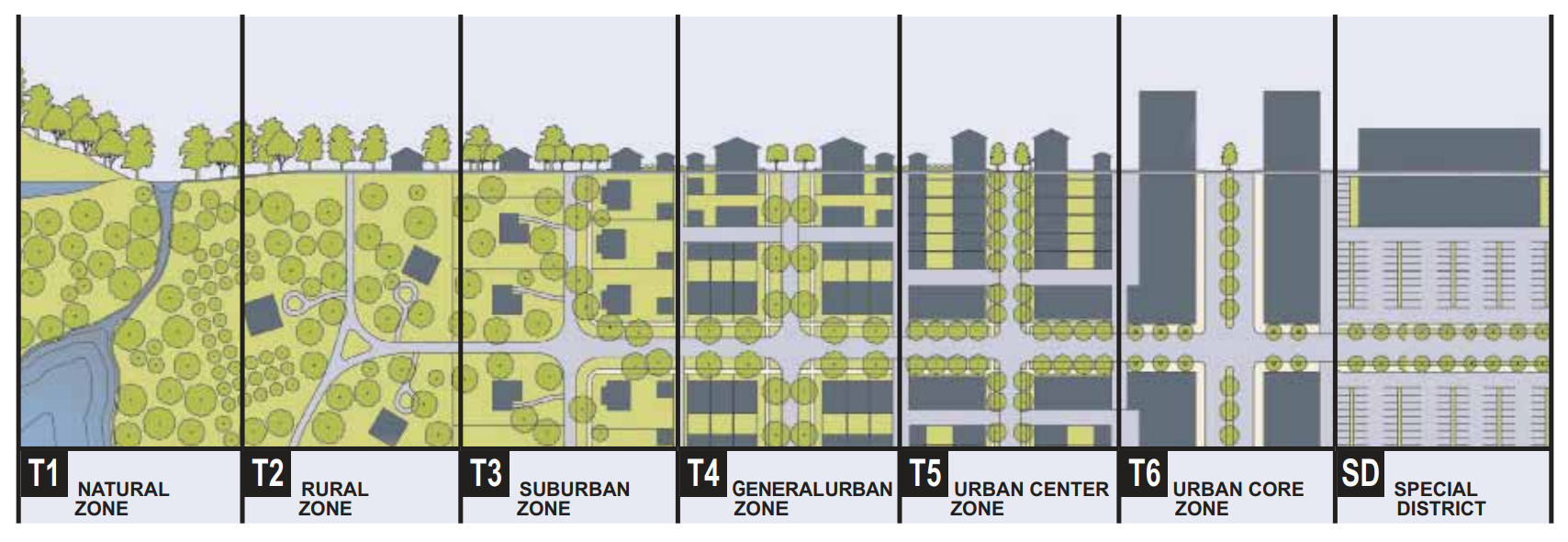
Sec. 2.05.02.04. - Civic zones.
(A)
General.
(1)
Infill Plans should designate Civic Spaces (CS) and Civic Buildings (CB).
(2)
A Civic Space may be permitted by Warrant if it does not occupy more than five percent of a District, otherwise it is subject to the creation of a Special District. See section 2.05.02.05.
(3)
Parking provisions for Civic Zones shall be determined by Warrant.
(B)
Civic Space (CS).
(1)
Civic Spaces shall be generally designed as described in Table 13, their type determined by the surrounding or adjacent Transect Zone in a process of public consultation subject to the approval of the city council.
(C)
Civic Building Zones (CB).
(1)
Civic Buildings shall be permitted by Adjustment in any Transect Zone or by Warrant on Civic Zones reserved in the Infill Regulating Plan.
(2)
Civic Buildings shall not be subject to the Requirements of section 2.05.04. The particulars of their design shall be determined by Warrant.
Sec. 2.05.02.05. - Special districts.
(A)
Special Districts shall be designated by the Planning Department in the process of preparing an Infill Plan.
(B)
Special District designations shall be assigned to areas that, by their intrinsic size, function, or form, cannot conform to the requirements of any Transect Zone or combination of zones.
Table 1: Transect Zone Descriptions
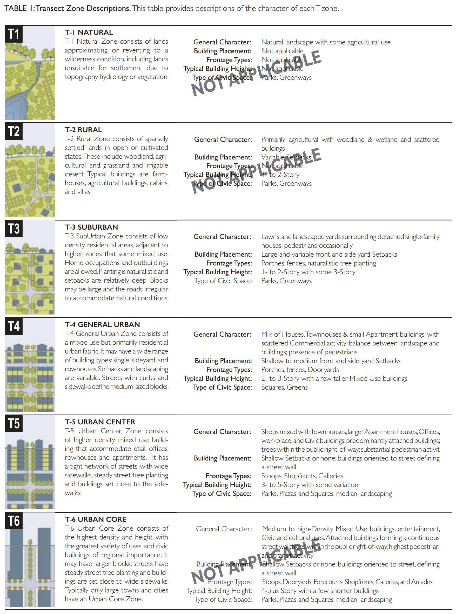
(Ord. 1286-16, passed 12-25-2016)
Sec. 2.05.03.01. - Instructions.
(A)
Thoroughfares are intended for use by vehicular, bicycle and pedestrian traffic and to provide access to lots and Civic Spaces. Thoroughfares shall generally consist of Vehicular Lanes and Public Frontages.
(B)
Civic Spaces are intended primarily for use by pedestrians and bicyclists.
(C)
Thoroughfares and Civic Spaces shall be designed in context with the physical form of their Transect Zones. Thoroughfares shall be designed for the target speed of the Transect Zones through which they pass.
(D)
Pedestrian comfort shall be a primary consideration of the Thoroughfare. Design conflict between vehicular and pedestrian movement generally shall be decided in favor of the pedestrian.
(E)
All Thoroughfares shall terminate at other Thoroughfares, forming a network. Cul-de-sacs shall be subject to approval by Warrant to accommodate specific site conditions only.
(F)
Each lot shall enfront a vehicular Thoroughfare or Civic Space, except that 20 percent of the lots within each Transect Zone may enfront a Passage/Alley.
(G)
Standards for Paths and Bikeways shall be approved by Warrant.
(H)
Standards for Thoroughfares and Civic Spaces within Special Districts shall be determined by Warrant.
(I)
Rear Alleys should be paved from property line to property line or building face to building face if an accessory structure is located in the rear, with drainage by inverted crown at the center or with roll curbs at the edges.
(J)
Rear Alleys may be paved lightly to driveway standards. Their streetscapes shall consist of gravel or landscaped edges, have no raised curb, and be drained by percolation.
Sec. 2.05.03.02. - Thoroughfares—Vehicular lanes.
(A)
General to all zones.
(1)
Thoroughfares may include vehicular lanes in a variety of widths for parked and for moving vehicles, including bicycles. The standards for vehicular lanes shall be as shown in Tables 4A through 4L.
(2)
A Bikeway network consisting of shared use Bicycle Trails, shared use Bicycle Paths, Bicycle Routes, and/ or Bicycle Lanes shall be provided throughout the area, as defined in section 2.05.05 Definitions of Terms and allocated according to Table 4A—4L.
(3)
All Thoroughfares shall permit bicycling.
(4)
All Bikeway and Countermeasure pavement markings and safety and wayfinding signing shall adhere to the same standards as automobile Vehicular Lane markings and signing.
(5)
Bicycle Trails and Bicycle Paths shall be physically separated from motor vehicle Thoroughfares, except for intersection crossings.
(6)
Retrofit of existing lanes may be accomplished by restriping, changing one way thoroughfares to two-way, reducing curb radii, adding onstreet parking, changing parallel parking to diagonal, and/or removing pavement width by adding bioretention areas.
(7)
All Thoroughfares shall permit bicycling.
(8)
All Bikeway and Countermeasure pavement markings and safety and wayfinding signing shall adhere to the same standards as automobile Vehicular Lane markings and signing.
Sec. 2.05.03.03. - Thoroughfares—Public frontages.
(A)
General to all zones.
(1)
Landscape Plans shall be prepared for existing and proposed landscape elements in conjunction with the design development and construction documents for Thoroughfares.
(2)
Within the Public Frontages, the prescribed types of Public Planting shall be as shown in section 2.05.04.08 Section 4.8. The spacing may be adjusted by Warrant to accommodate specific site conditions.
(3)
Proposed Street Tree height and type shall be appropriate for the Frontage conditions.
(4)
Trees with existing or potential canopy covering sidewalks, driveways, Paths, Plazas, Alleys, Lanes, parking space or Street pavements shall be of a type that, at maturity or with minor pruning at installation, provide a clear height of eight feet for sidewalks and paths, 12 feet for driveways, parking spaces and Streets, and 15 feet for loading areas, exclusive of Tree grates or planting areas with gravel, mulch or groundcover. Evergreen trees shall be 18"—24" minimum clear of any sidewalk or pavement edge at the Lot line.
(B)
Specific to Zones T3 and T4.
(1)
The Public Frontage shall include trees planted in a regularly-spaced Allee pattern of single or alternated species.
(C)
Specific to Zones T5.
(1)
The Public Frontage shall include trees planted in a regularly-spaced Allee pattern of single species. At Retail Frontages, the spacing of the trees may be irregular, to avoid visually obscuring the shopfronts.
Sec. 2.05.03.04. - Civic spaces.
(A)
General to all zones.
(1)
Each District shall assign at least five percent of its urbanized area to Civic Space, including existing Civic Space.
(2)
Any new Civic Spaces shall be designed as generally described in Table 7.
(3)
Each District should contain at least one Main Civic Space. The Main Civic Space should be within 800 feet of the geographic center of each District, unless topographic conditions, pre-existing Thoroughfare alignments or other circumstances prevent such location. A Main Civic Space shall conform to one of the types specified in Table 7.
(4)
Each Civic Space should have a minimum of 50 percent of its perimeter enfronting a Thoroughfare, except for playgrounds.
Sec. 2.05.03.05. - Public lighting.
This section is held in reserve. Should the city of Zephyrhills choose to establish special landscape standards for the form-based code zone districts, this section would establish minimum standards outdoor artificial illuminating devices for Public Frontages and Private Frontages, lots, buildings, Civic Spaces, Thoroughfares and Special Requirements. Until this article is adopted, the lighting standards in Part 7.11.00 Traditional Development Standards, Zephyrhills Land Development Code, shall apply to the Corridor Area.
Sec. 2.05.03.06. - Public planting.
This section is held in reserve. Should the city of Zephyrhills choose to establish special landscape standards for the form-based code zone districts, this section would establish minimum standards for landscape improvements for Public Frontages and Private Frontages, lots, buildings, Civic Spaces, Thoroughfares and Special Requirements. Until such standards in this article are adopted, the requirements of Part 7.06.00 Landscaping, Zephyrhills Land Development Code, shall apply to the Corridor Area.
Table 2A: Vehicular Lane Dimensions
This table assigns lane widths to Transect zones. The Design ADT (Average Daily Traffic) is the determinant for each of these sections. The most typical assemblies are shown in Table 2B. Specific requirements for truck and transit bus routes and truck loading shall be decided by Warrant.
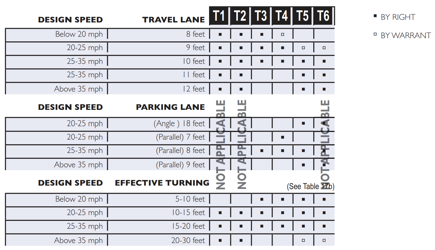
Table 3A: Public Frontages—General
The Public Frontage is the area between the private Lot line and the edge of the vehicular lanes. Dimensions are given in Table 4B.
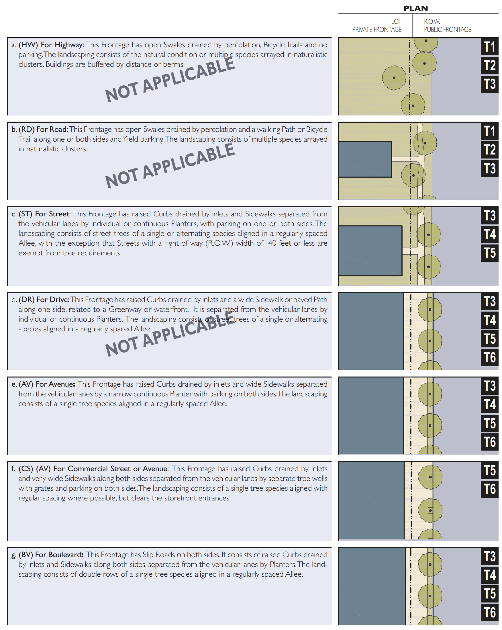
Table 3B: Public Frontages—Specific
This table assembles prescriptions and dimensions for the Public Frontage elements - Curbs, walkways and Planters - relative to specific Thoroughfare types within Transect Zones. Table 4B-a assembles all of the elements for the various street types. Locally appropriate planting species should be filled in to the calibrated code.
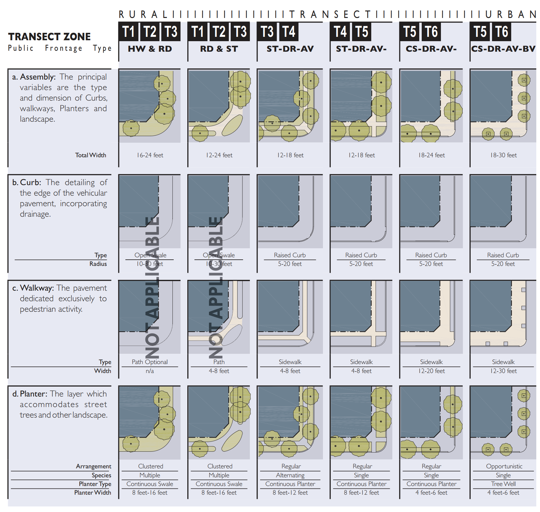
Table 3C: Bicycle Parking Requirements.
This table prescribes minimum parking ratios within each Transect Zone and assumes a bicycle mode share of five percent or less. Requirements may be met within the building, Private Frontage, Public Frontage, or a combination thereof.
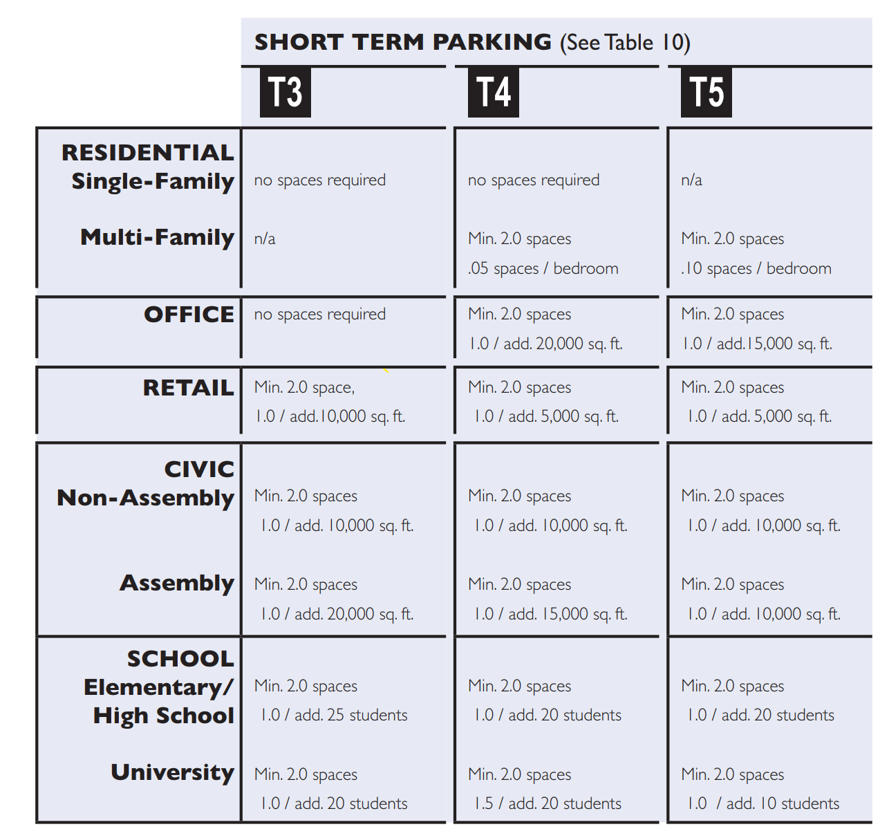
Table 4A: Thoroughfare Assemblies
These Thoroughfares are assembles from the elements that appear in Tables 3A and 3B. The key gives the Thoroughfare type followed by the right-of-way width, followed by the pavement width, and in some instances followed by specialized transportation capability.
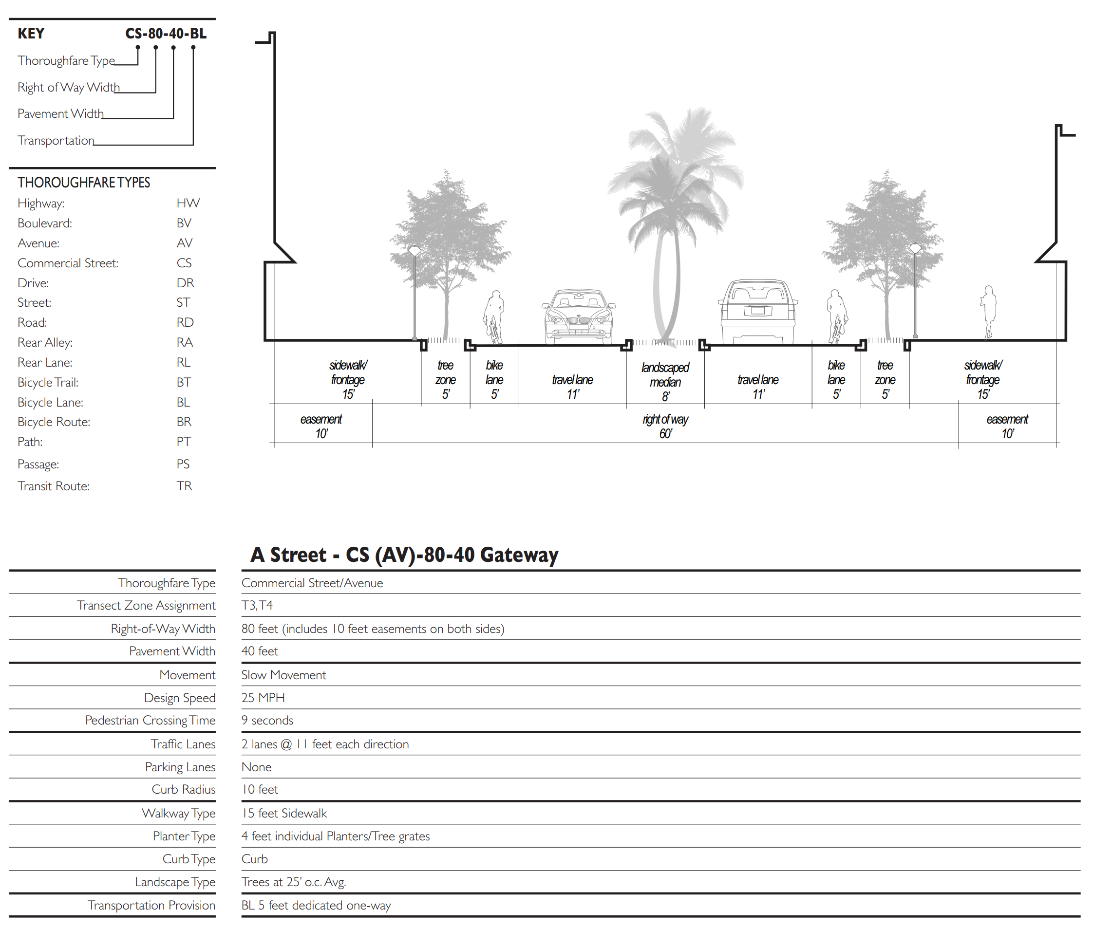
Table 4B: Thoroughfare Assemblies
These Thoroughfares are assembled from the elements that appear in Tables 3A and 3B. The key gives the Thoroughfare type followed by the right-of-way width, followed by the pavement width, and in some instances followed by specialized transportation capability.
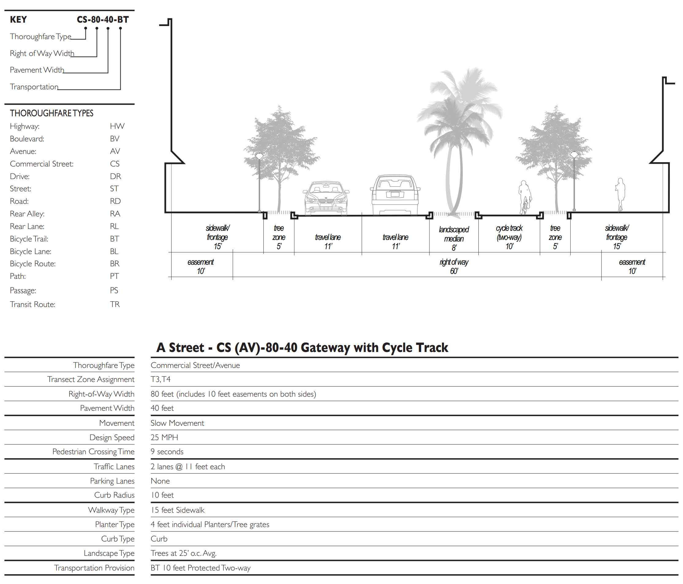
Table 4C: Thoroughfare Assemblies
These Thoroughfares are assembled from the elements that appear in Tables 3A and 3B. The key gives the Thoroughfare type followed by the right-of-way width, followed by the pavement width, and in some instances followed by specialized transportation capability.
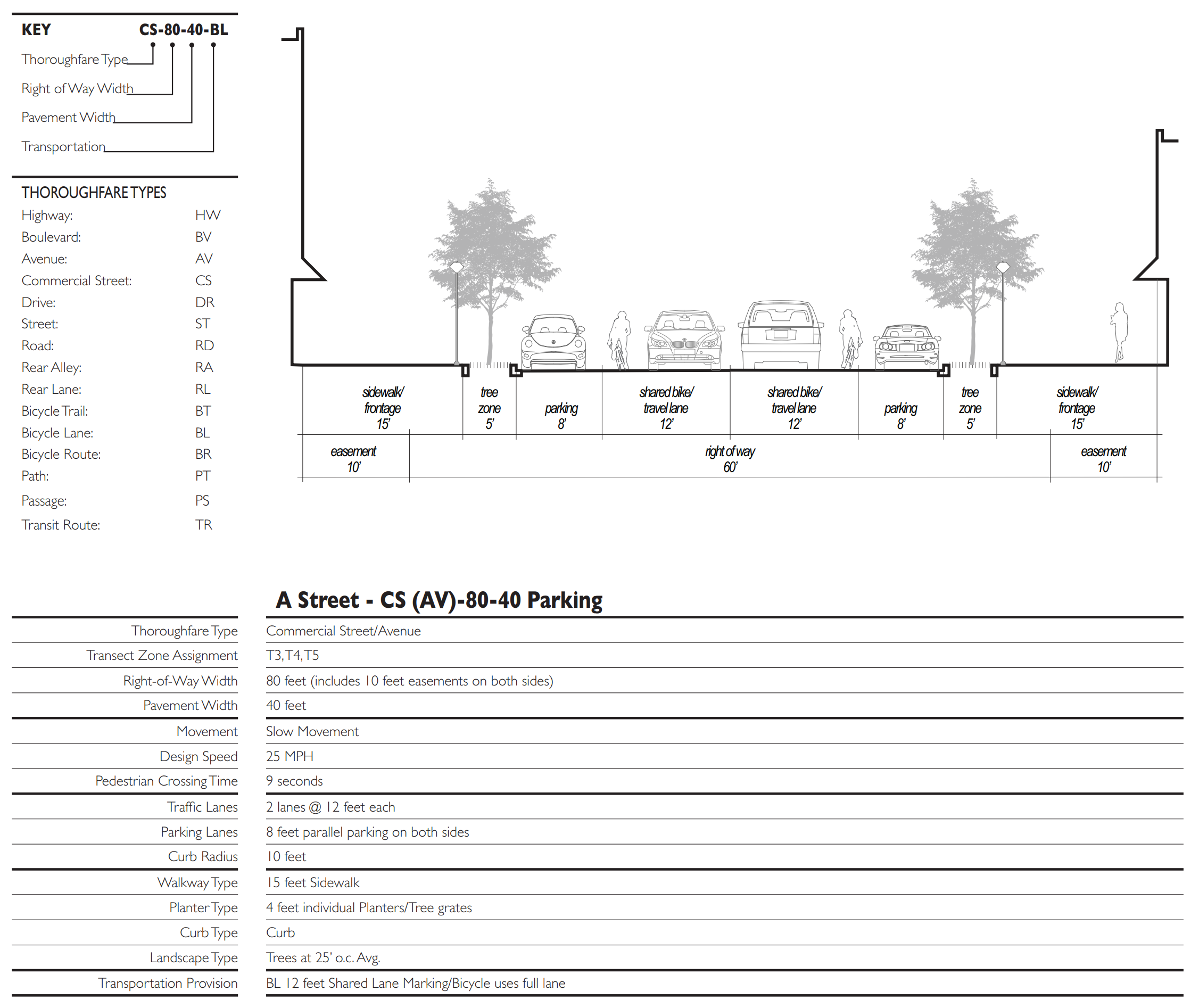
Table 4D: Thoroughfare Assemblies
These Thoroughfares are assembled from the elements that appear in Tables 3A and 3B. The key gives the Thoroughfare type followed by the right-of-way width, followed by the pavement width, and in some instances followed by specialized transportation capability.
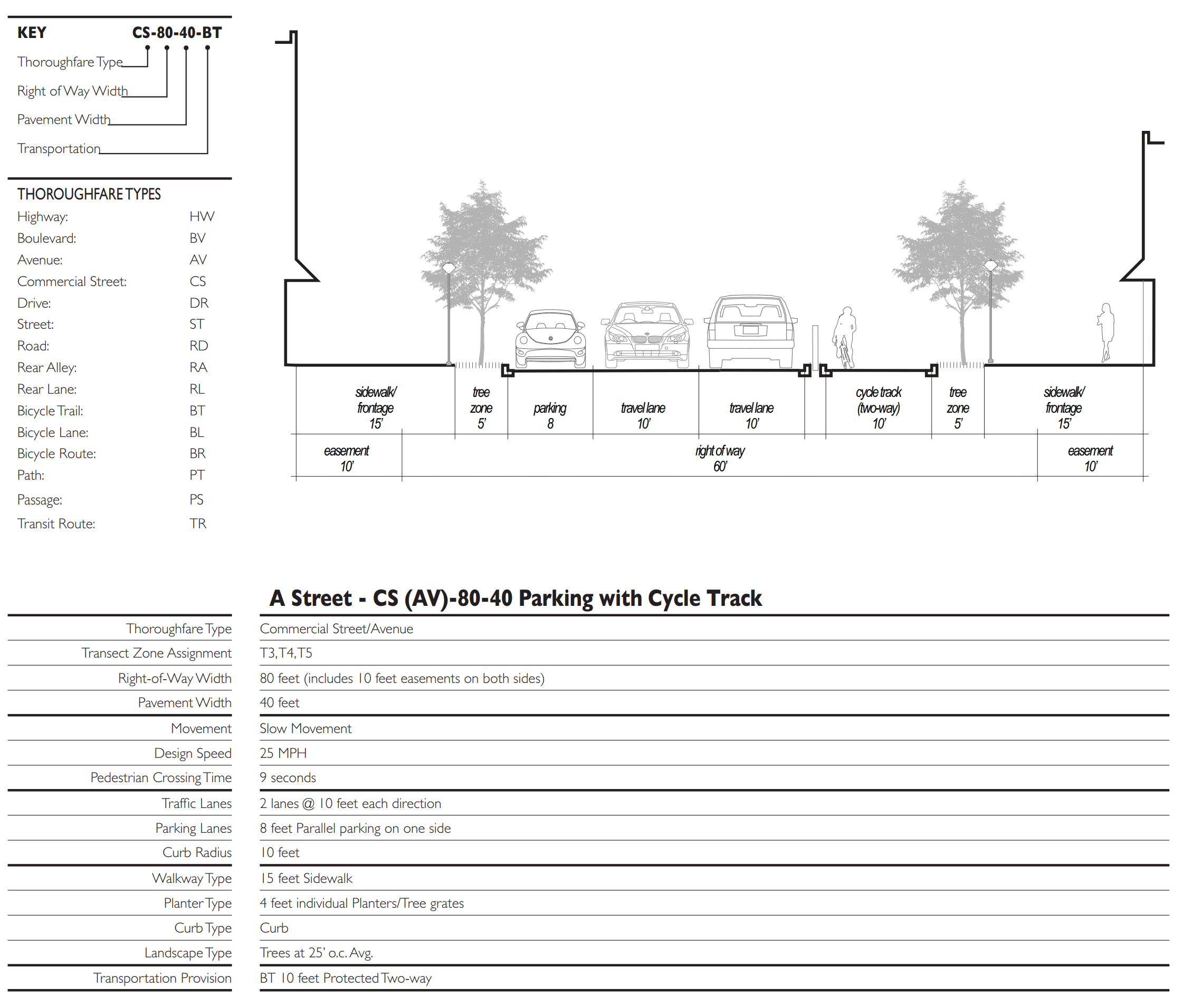
Table 4E: Thoroughfare Assemblies
These Thoroughfares are assembled from the elements that appear in Tables 3A and 3B. The key gives the Thoroughfare type followed by the right-of-way width, followed by the pavement width, and in some instances followed by specialized transportation capability.
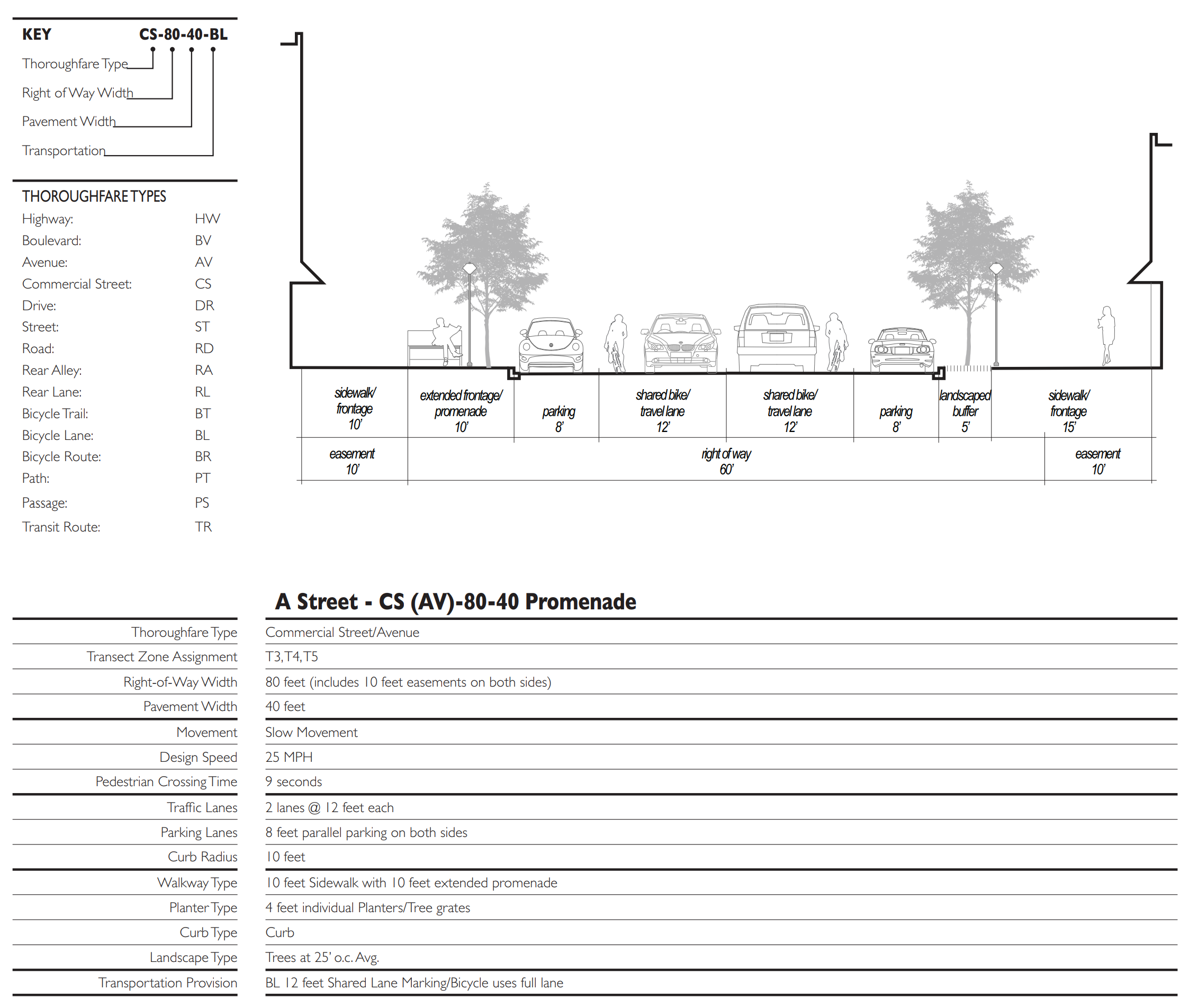
Table 4F: Thoroughfare Assemblies
These Thoroughfares are assembled from the elements that appear in Tables 3A and 3B. The key gives the Thoroughfare type followed by the right-of-way width, followed by the pavement width, and in some instances followed by specialized transportation capability.
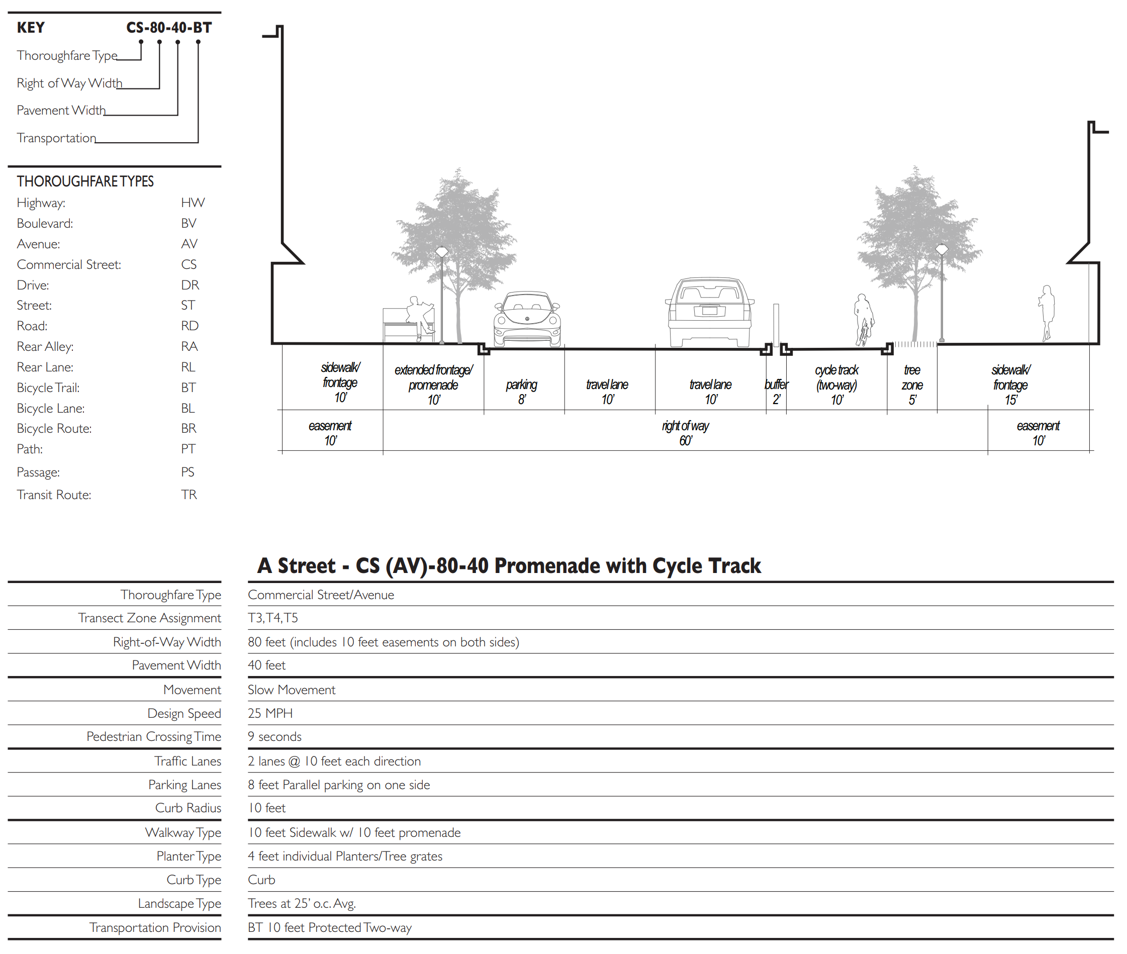
Table 4G: Thoroughfare Assemblies
These Thoroughfares are assembled from the elements that appear in Tables 3A and 3B. The key gives the Thoroughfare type followed by the right-of-way width, followed by the pavement width, and in some instances followed by specialized transportation capability.
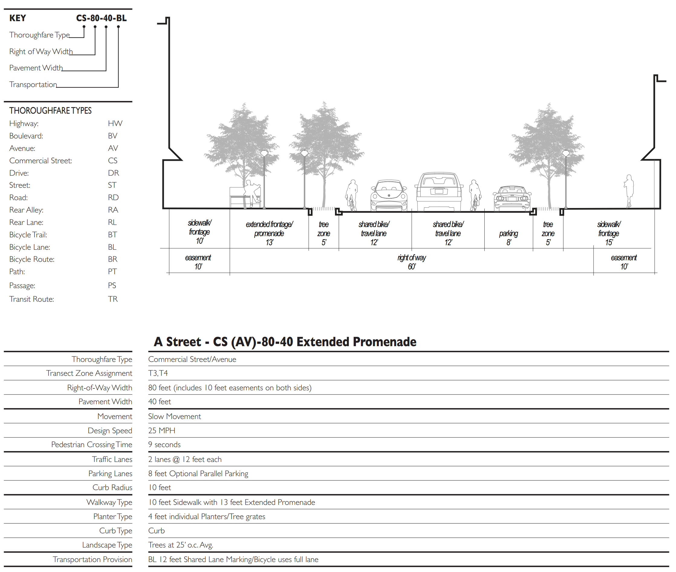
Table 4H: Thoroughfare Assemblies
These Thoroughfares are assembled from the elements that appear in Tables 3A and 3B. The key gives the Thoroughfare type followed by the right-of-way width, followed by the pavement width, and in some instances followed by specialized transportation capability.
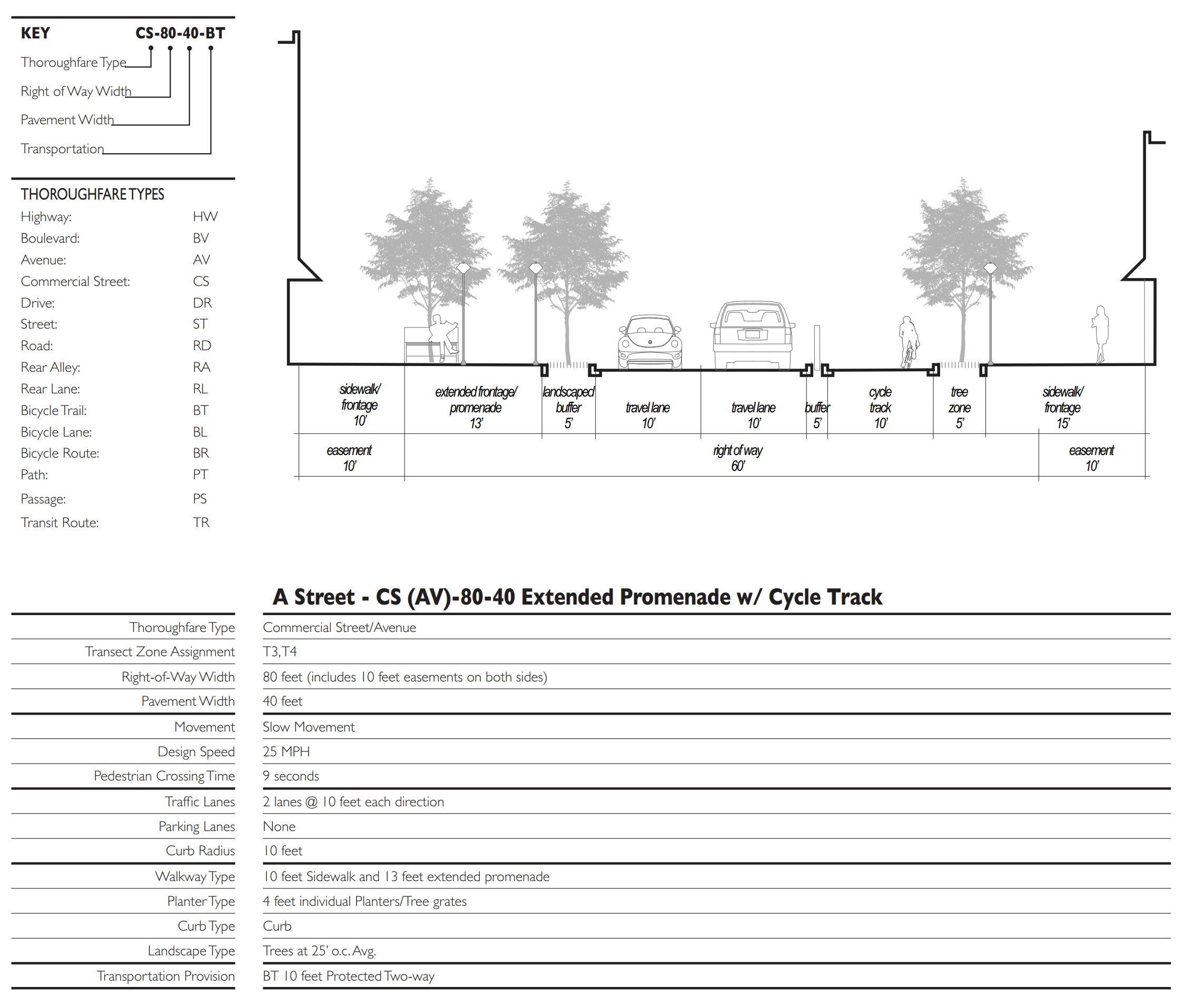
Table 4I: Thoroughfare Assemblies
These Thoroughfares are assembled from the elements that appear in Tables 3A and 3B. The key gives the Thoroughfare type followed by the right-of-way width, followed by the pavement width, and in some instances followed by specialized transportation capability.
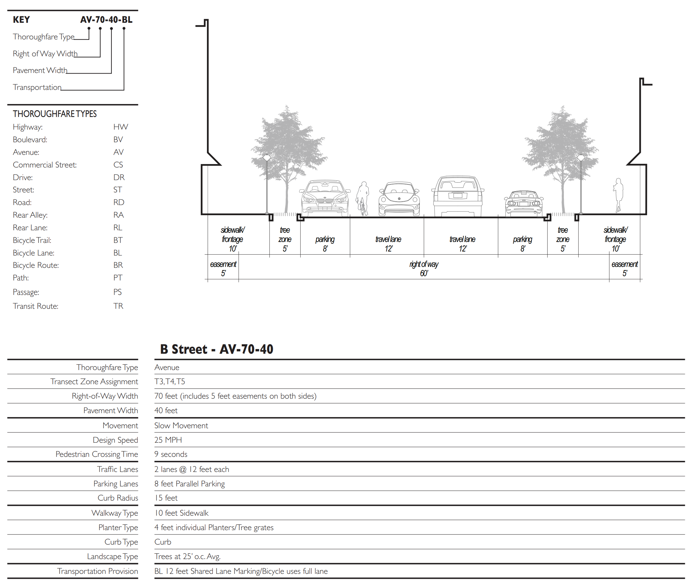
Table 4J: Thoroughfare Assemblies
These Thoroughfares are assembled from the elements that appear in Tables 3A and 3B. The key gives the Thoroughfare type followed by the right-of-way width, followed by the pavement width, and in some instances followed by specialized transportation capability.
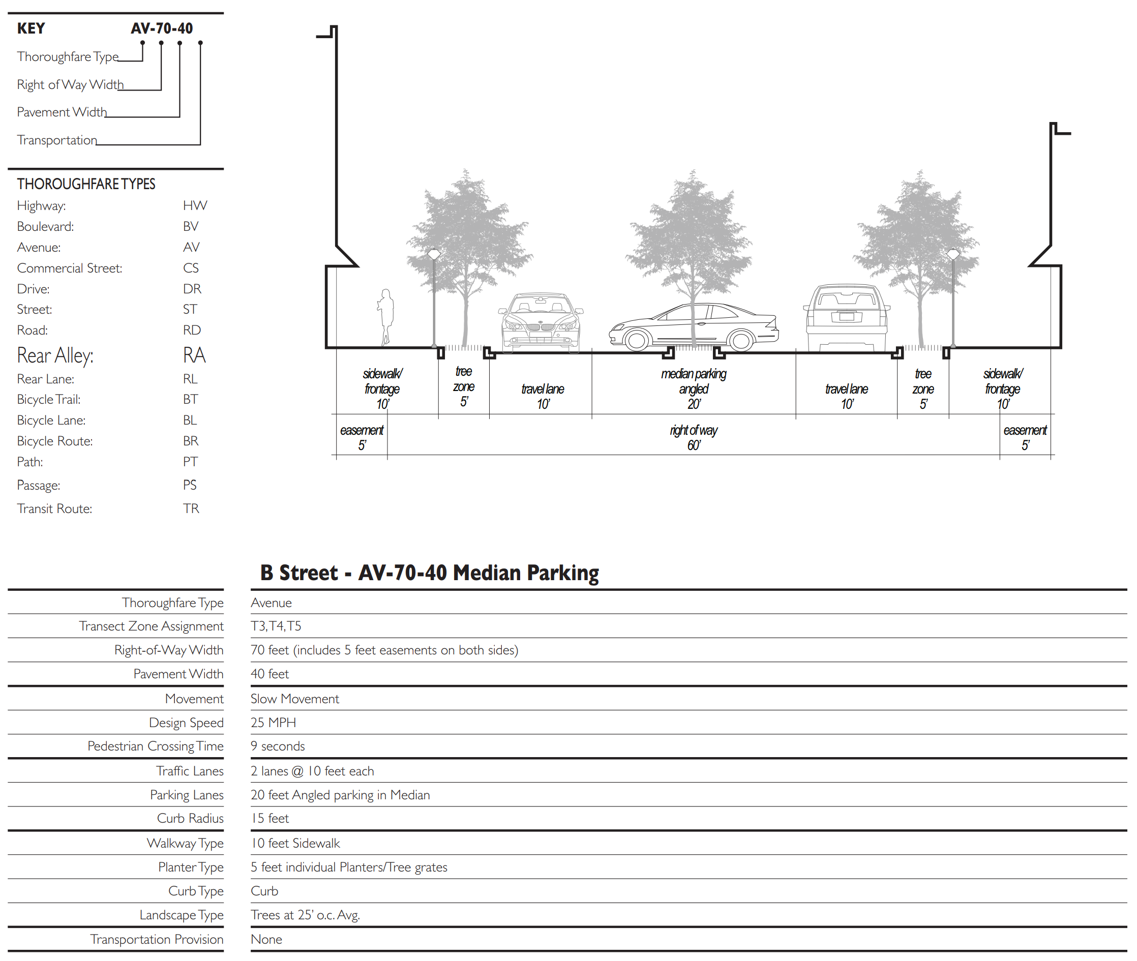
Table 4K: Thoroughfare Assemblies
These Thoroughfares are assembled from the elements that appear in Tables 3A and 3B. The key gives the Thoroughfare type followed by the right-of-way width, followed by the pavement width, and in some instances followed by specialized transportation capability.
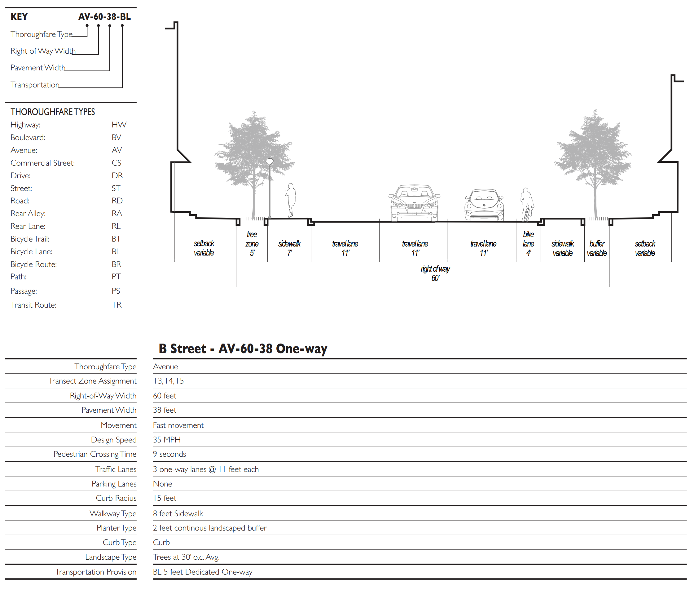
Table 4L: Thoroughfare Assemblies
These Thoroughfares are assembled from the elements that appear in Tables 3A and 3B. The key gives the Thoroughfare type followed by the right-of-way width, followed by the pavement width, and in some instances followed by specialized transportation capability.
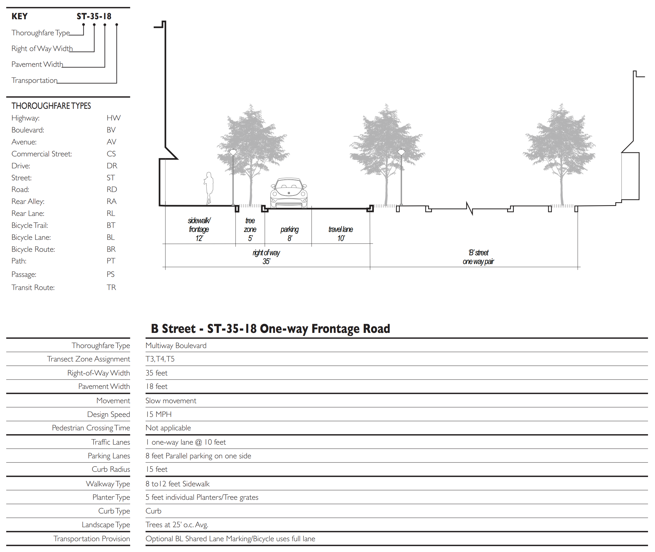
Table 4M: Thoroughfare Assemblies
These Thoroughfares are assembled from the elements that appear in Tables 3A and 3B. The key gives the Thoroughfare type followed by the right-of-way width, followed by the pavement width, and in some instances followed by specialized transportation capability.
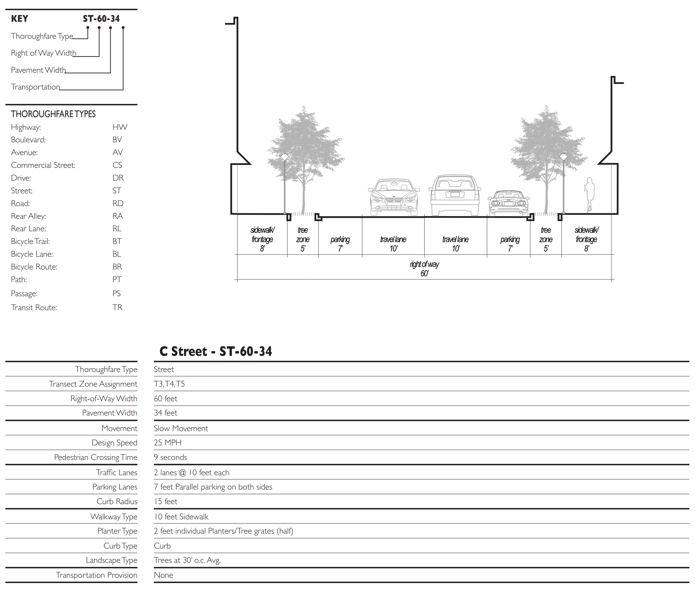
Table 4N: Thoroughfare Assemblies
These Thoroughfares are assembled from the elements that appear in Tables 3A and 3B. The key gives the Thoroughfare type followed by the right-of-way width, followed by the pavement width, and in some instances followed by specialized transportation capability.
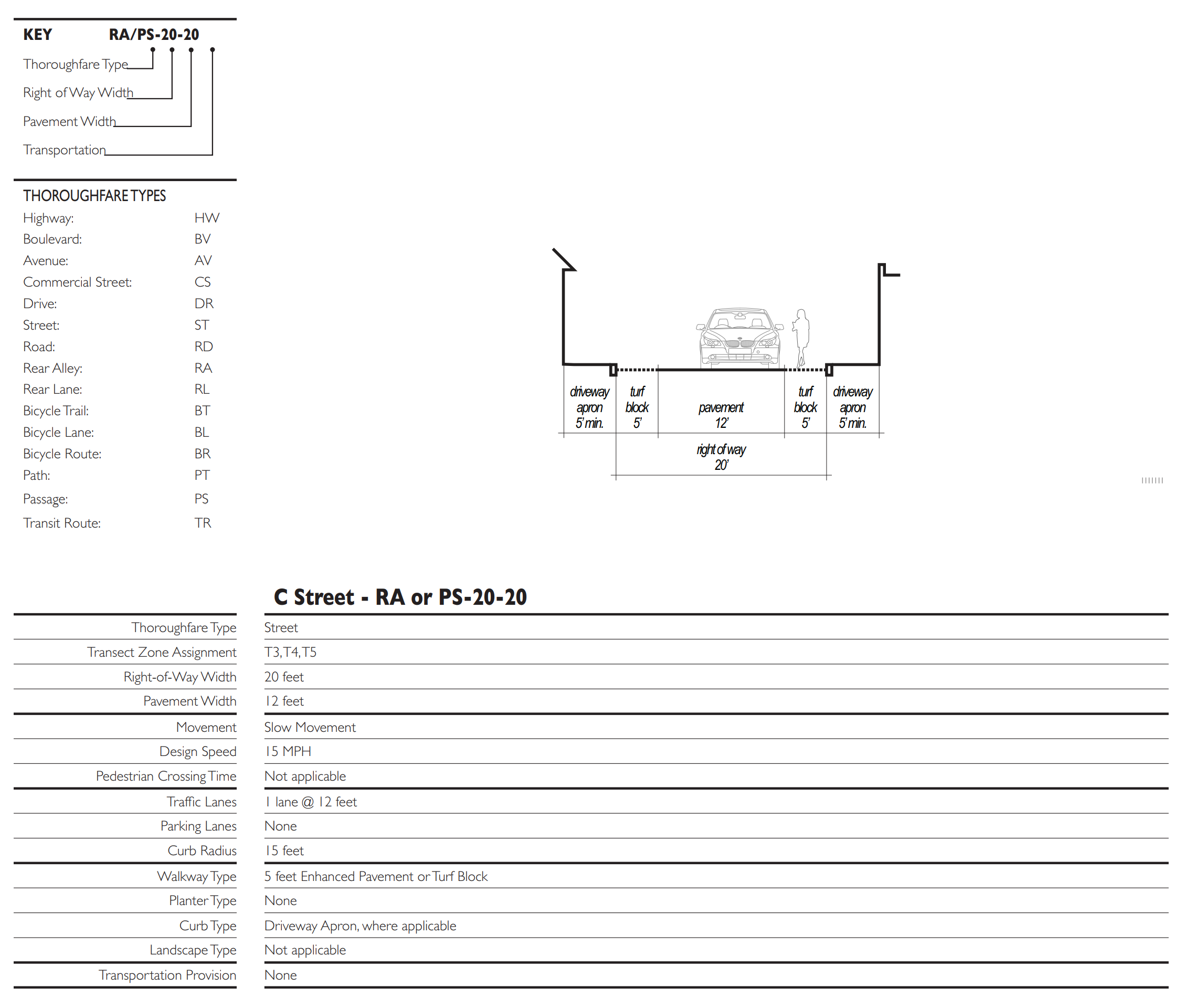
Table 5: Public Lighting
Lighting varies in brightness and also in the character of the fixture according to the Transect. The table shows five common types. A listed set of streetlights corresponding to these types would be approved by the utility company and listed on the page.
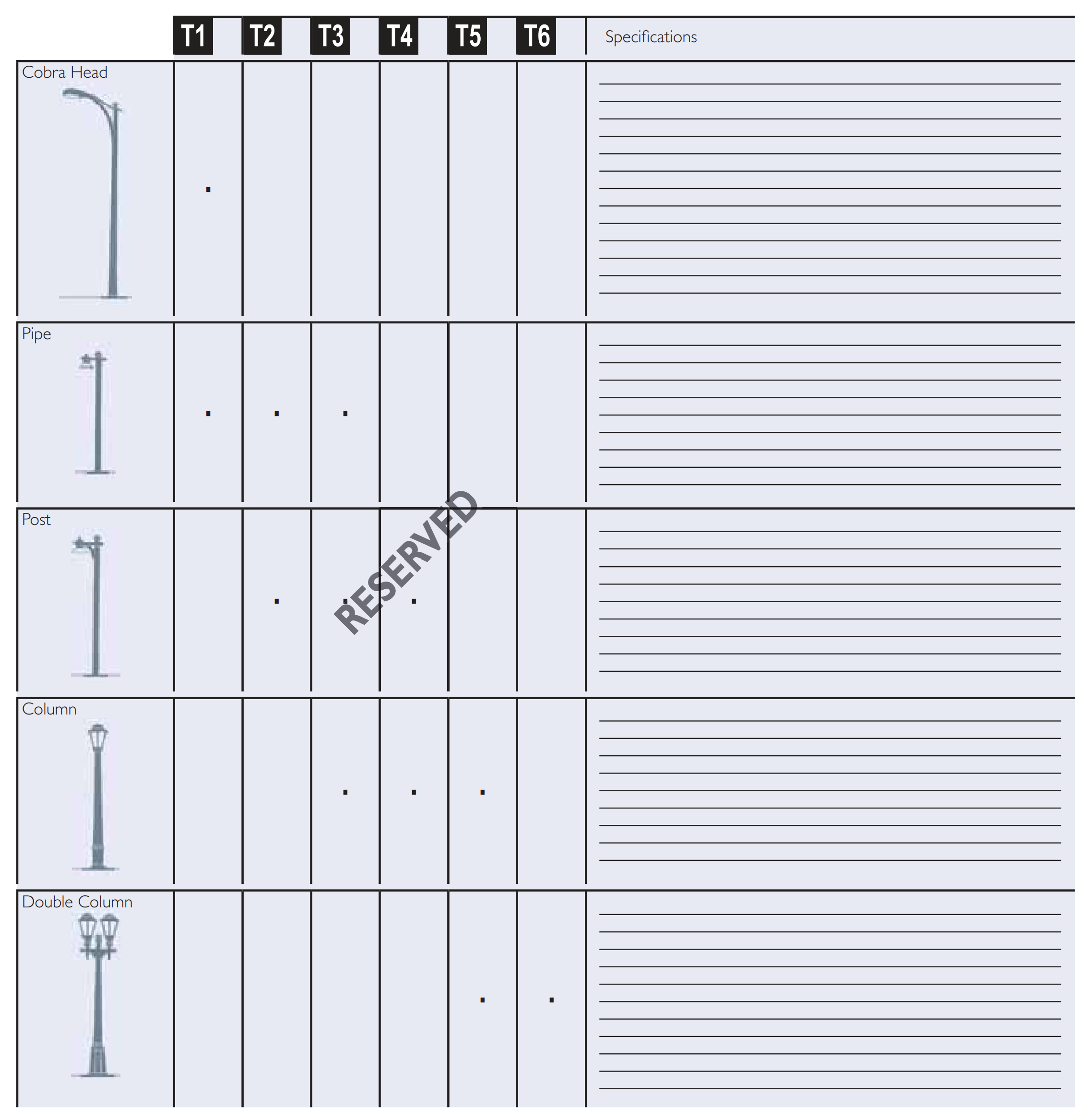
Table 6: Public Planting
This table shows six common types of street tree shapes and their appropriateness within the Transect Zones. The local planning office selects species appropriate for the bioregion.
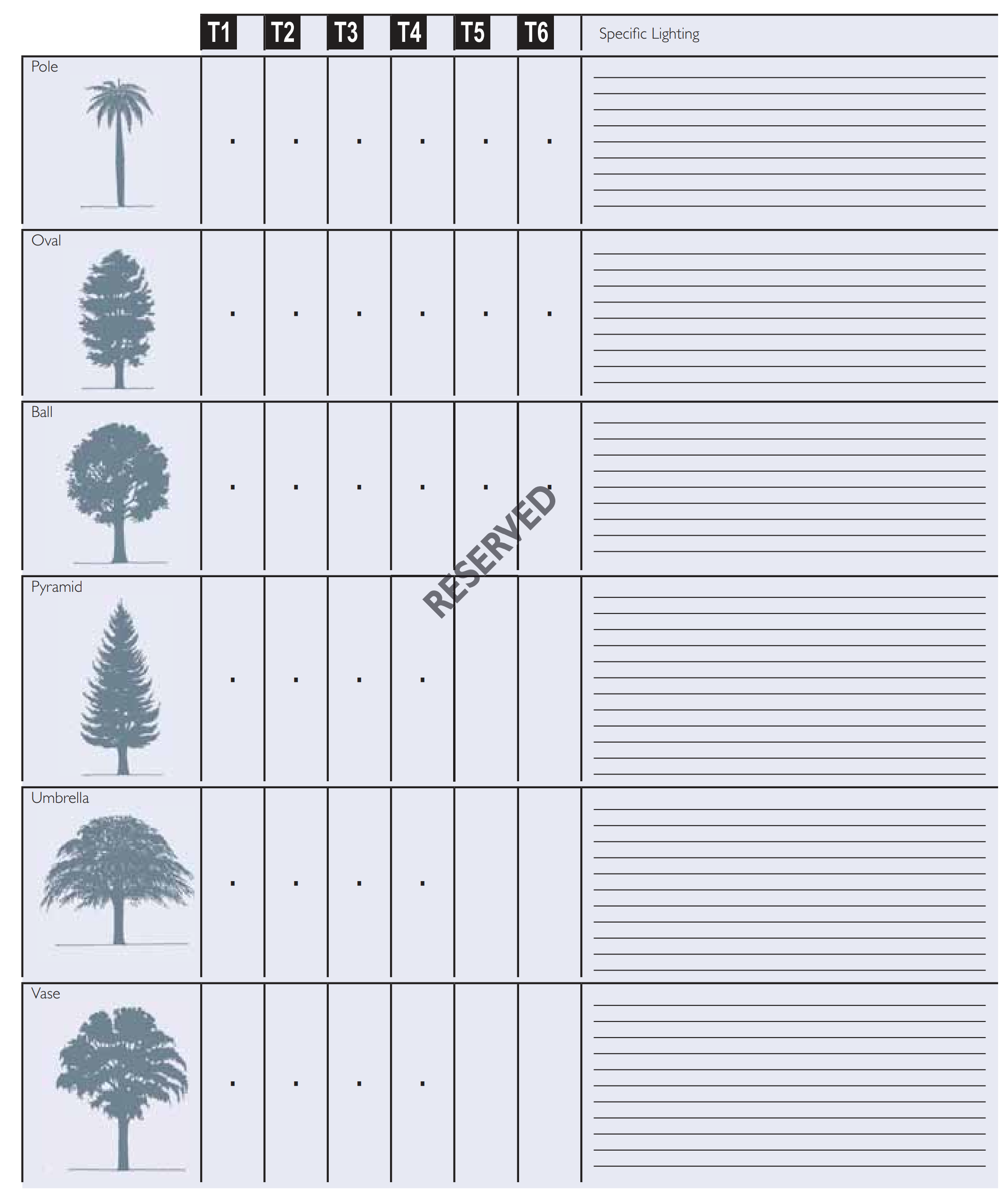
Table 7: Civic Space
This table indicates the general character of public open space appropriate for each Transect Zone and some basic standards.
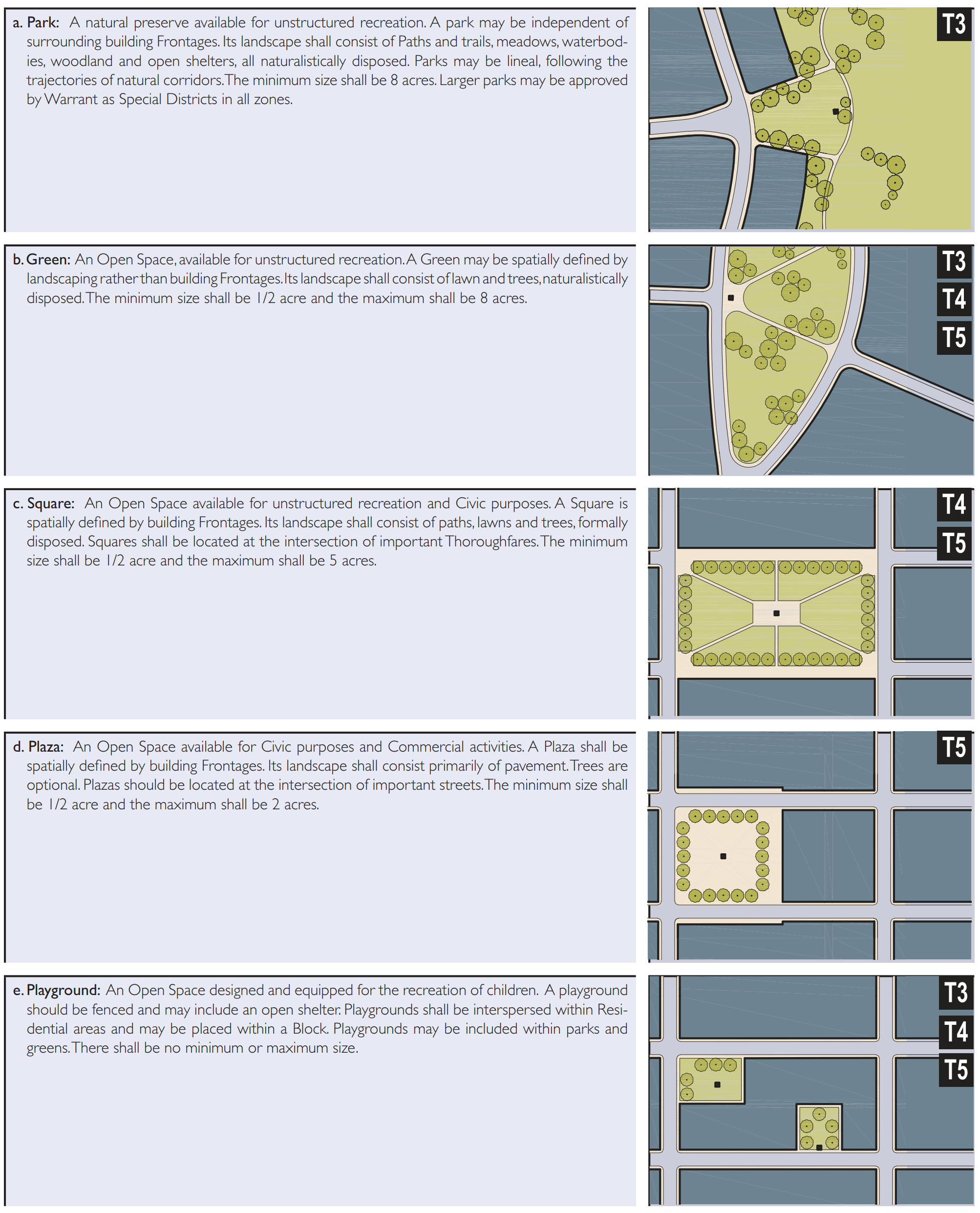
(Ord. 1286-16, passed 1-25-2016)
Sec. 2.05.04.01. - Instructions.
(A)
Lots and buildings located within a New Community Plan or Infill Community Plan governed by this Code and previously approved by the city council shall be subject to the requirements of this section 2.05.04.
(B)
Owners and developers may have the design plans required under this section 2.05.04 prepared on their behalf. Such plans require administrative approval by the form based code review committee.
(C)
Building and site plans submitted under this section 2.05.04 shall show the following, in compliance with the standards described in this section 2.05.04:
(1)
For preliminary site and building approval:
(a)
Building Disposition;
(b)
Building Configuration;
(c)
Building Function; and
(d)
Parking Location Standards.
(2)
For final approval, in addition to the above:
(a)
Landscape Standards;
(b)
Signage Standards; and
(c)
Special Requirements, if any.
(D)
Parcels located within Special Districts shall be governed by the standards of the pre-existing zoning or the standards of the adjacent form based code district sharing generally the same street frontage.
Sec. 2.05.04.02. - Pre-existing conditions.
(A)
Existing buildings and appurtenances that do not conform to the provisions of this code may continue in the same use and form until a Substantial Modification occurs or is requested, at which time the form based code review committee shall determine the provisions of this Section that shall apply.
(B)
Existing buildings that have at any time received a certificate of occupancy shall not require upgrade to the current Building Code and when renovated may meet the standards of the code under which they were originally permitted.
(C)
The modification of existing buildings is permitted By Right if such changes result in greater conformance with the specifications of this code.
(D)
Where buildings exist on adjacent Lots, the form based code review committee may require that a proposed building match one or the other of the adjacent Setbacks and heights rather than the provisions of this code.
(E)
Any addition to or modification of a Building of Value that has been designated as such by the Local Preservation Organization or to a building actually or potentially eligible for inclusion on a state, local or national historic register, shall be subject to approval by the Local Preservation Organization.
(F)
The restoration or rehabilitation of an existing building shall not require the provision of (a) parking in addition to that existing or (b) on-site stormwater retention/detention in addition to that existing. Existing parking requirements that exceed those for this code may be reduced as provided by Tables 10 and 11.
Sec. 2.05.04.03. - Special requirements.
(A)
The Regulating Plan designates the following Special Requirements:
(1)
A differentiation of the Thoroughfares as A, B and C Streets. Buildings along the A Streets shall be held to the highest standard of this code in support of pedestrian activity. Buildings along the B Streets may be more readily considered for Warrants allowing automobile-oriented standards. The Frontages assigned to the B Streets shall not exceed 30 percent of the total length of Frontages within the district.
(2)
Designations for Mandatory and/or Recommended Retail Frontage requiring or advising that a building provide a Shopfront at Sidewalk level along the entire length of its Private Frontage. The Shopfront shall be no less than 70 percent glazed in clear glass and shaded by an awning, gallery or arcade overlapping the Sidewalk as generally illustrated in Table 8 and specified in section 2.05.04. The first floor shall be confined to Retail use through the depth of the second Layer (Table 14).
(3)
Designations for Mandatory and/or Recommended Gallery Frontage, requiring or advising that a building provide a permanent cover over the Sidewalk, either cantilevered or supported by columns. The Gallery Frontage designation may be combined with a Retail Frontage designation.
(4)
Designations for Mandatory and/or Recommended Arcade Frontage, requiring or advising that a building overlap the Sidewalk such that the first floor Facade is a colonnade. The Arcade Frontage designation may be combined with a Retail Frontage designation.
Sec. 2.05.04.04. - Building disposition.
(A)
Specific to Zones T3, T4, T5.
(1)
Newly platted Lots shall be dimensioned according to Table 13 and Table 14.
(2)
Building Disposition types shall be as shown in Table 9 and Table 14.
(3)
Buildings shall be disposed in relation to the boundaries of their Lots and required easements according to Table 14 and Table 15.
(4)
Lot coverage by building shall not exceed that recorded in Table 13 and Table 14.
(5)
Facades shall be built parallel to a rectilinear Principal Frontage Line or to the tangent of a curved Principal Frontage Line, and along a minimum percentage of the Frontage width at the Setback, as specified as Frontage Buildout on Table 13 and Table 14.
(6)
Setbacks for Principal Buildings shall be as shown in Table 13 and Table 14. In the case of an Infill Lot, Setbacks shall match one of the existing adjacent Setbacks. Setbacks may otherwise be adjusted by Warrant.
(7)
To accommodate slopes over ten percent, relief from front Setback requirements is available by Warrant.
(B)
Specific to Zone T5.
(1)
The Principal Entrance shall be on a Primary Frontage Line.
Sec. 2.05.04.05. - Building configuration.
(A)
General to Zones T3, T4, T5.
(1)
The Private Frontage of buildings shall conform to and be allocated in accordance with Table 8, Table 13 and Tables 14.
(2)
Buildings on corner Lots shall have two Private Frontages as shown in Table 16. Prescriptions for the second and third Layers pertain only to the Principal Frontage. Prescriptions for the first Layer pertain to both Frontages.
(3)
Buildings on mid-block Lots shall have only one Private Frontages. Prescriptions for the second and third Layers pertain only to the Principal Frontage. Prescriptions for the first Layer pertain to both Frontages.
(4)
Buildings on lots with three or more frontages shall have only two Private Frontages. Prescriptions for the second and third Layers pertain only to the Principal Frontage. Prescriptions for the first Layer pertain to all three Frontages.
(5)
All Facades shall be glazed with clear glass no less than 30 percent of the first Story.
(6)
Building heights, Stepbacks, and Extension Lines shall conform to Table 9 and Table 14.
(7)
Stories may not exceed 12 feet in height from finished floor to finished ceiling, except for a first floor Commercial Function, which shall be a minimum of 12 feet with a maximum of 25 feet. A single floor level exceeding 12 feet, or 25 feet at ground level, shall be counted as two stories. Mezzanines extending beyond 33 percent of the floor area shall be counted as an additional Story.
(8)
In a Parking Structure or garage, each above-ground level counts as a single Story regardless of its relationship to habitable Stories.
(9)
Height limits do not apply to Attics or raised basements, masts, belfries, clock towers, chimney flues, water tanks, or elevator bulkheads. Attics shall not exceed 12 feet in height.
(B)
Specific to Zone T3.
(1)
No portion of the Private Frontage may encroach the Sidewalk.
(2)
Open porches may Encroach the first Layer 50 percent of its depth. (Table 14)
(3)
Balconies and bay windows may Encroach the first Layer 25 percent of its depth except that balconies on porch roofs may Encroach as does the porch.
(C)
Specific to Zone T4.
(1)
Balconies, open porches and bay windows may Encroach the first Layer 50 percent of its depth. (Table 16)
(D)
Specific to Zones T5.
(1)
Awnings, Arcades, and Galleries may Encroach the Sidewalk to within two feet of the Curb but must clear the Sidewalk vertically by at least eight feet.
(2)
Maximum Encroachment heights (Extension Lines) for Arcades shall be as shown on Table 8.
(3)
Stoops, Lightwells, balconies, bay windows, and terraces may Encroach the first Layer 100 percent of its depth. (Table 16)
(4)
Loading docks and service areas shall be permitted on Frontages only by Warrant.
(5)
In the absence of a building Facade along any part of a Frontage Line, a Streetscreen shall be built co-planar with the Facade.
(6)
Streetscreens should be between 3.5 and eight feet in height. The Streetscreen may be replaced by a hedge or fence by Warrant. Streetscreens shall have openings no larger than necessary to allow automobile and pedestrian access.
(7)
A first level Residential or Lodging Function shall be raised a minimum of two feet from average Sidewalk grade.
Sec. 2.05.04.06. - Building function.
(A)
General to Zones T3, T4, T5.
(1)
Buildings in each Transect Zone shall conform to the Functions on Table 10, Table 12 and Table 13. Functions that do not conform shall require approval by Warrant or Adjustment as specified on Table 12.
(B)
Specific to Zones T3.
(1)
Accessory Functions of Restricted Lodging or Restricted Office shall be permitted within an Accessory Building. See Table 10.
(C)
Specific to Zones T4, T5.
(1)
Accessory Functions of Limited Lodging or Limited Office shall be permitted within an Accessory Building. See Table 10.
(D)
Specific to Zones T5.
(1)
First Story Commercial Functions shall be permitted.
(2)
Manufacturing Functions within the first Story may be permitted by Adjustment.
Sec. 2.05.04.07. - Parking and density calculations.
(A)
Specific to Zones T3.
(1)
Buildable Density on a Lot shall be determined by the actual parking provided within the Lot as applied to the Functions permitted in Table 10 and Table 11.
(B)
Specific to Zones T4, T5.
(1)
Buildable Density on a Lot shall be determined by the sum of the actual parking calculated as that provided (1) within the Lot (2) along the parking lane corresponding to the Lot Frontage, and (3) by purchase or lease from a Civic Parking Reserve within the Pedestrian Shed, if available.
(2)
The actual parking may be adjusted upward according to the Shared Parking Factor of Table 11 to determine the Effective Parking. The Shared Parking Factor is available for any two Functions within any pair of adjacent Blocks.
(3)
Based on the Effective Parking available, the Density of the projected Function may be determined according to Table 10.
(4)
Within the overlay area of a Transit Oriented Development (TOD) the Effective Parking may be further adjusted upward by 30 percent.
(5)
The total Density within each Transect Zone shall not exceed that specified by an approved Regulating Plan based on section 2.05.03 or section 2.05.04.
(6)
Accessory Units do not count toward Density calculations.
(7)
Liner Buildings less than 30 feet deep and no more than two Stories shall be exempt from parking requirements.
Sec. 2.05.04.08. - Parking location standards.
(A)
General to Zones T3, T4, T5.
(1)
Parking shall be accessed by Rear Alleys or Rear Lanes, when such are available on the Regulating Plan.
(2)
Open parking areas shall be masked from the Frontage by trees or a streetscreen.
(3)
c. For buildings on B Streets, open parking areas may be allowed on the Frontage by Warrant, except for corner lots at intersections with the A Streets.
(B)
Specific to Zones T3.
(1)
Open parking areas shall be located at the second and third Lot Layers, except that Driveways, drop-offs and unpaved parking areas may be located at the first Lot Layer. (Table(s) 14)
(2)
Garages shall be located at the third Layer except that side- or rear-entry types may be allowed in the first or second Layer by Warrant.
(C)
Specific to Zones T3, T4.
(1)
Driveways at Frontages shall be no wider than ten feet in the first Layer. (Table 13)
(D)
Specific to zone T4.
(1)
All parking areas and garages shall be located at the second or third Layer. (Table(s) 14)
(E)
Specific to Zones T5.
(1)
All parking lots, garages, and Parking Structures shall be located at the second or third Layer. (Table(s) 14)
(2)
Vehicular entrances to parking lots, garages, and Parking Structures shall be no wider than 24 feet at the Frontage. (Table 13)
(3)
Pedestrian exits from all parking lots, garages, and Parking Structures shall be directly to a Frontage Line (i.e., not directly into a building) except underground levels which may be exited by pedestrians directly into a building.
(4)
Parking Structures on the A-Streets shall have Liner Buildings lining the first Stories.
(5)
A minimum of one bicycle rack place shall be provided within the Public or Private Frontage for every ten vehicular parking spaces.
Sec. 2.05.04.09. - Landscape standards.
(A)
General to Zones T3, T4, T5.
(1)
Impermeable surface shall be confined to the ratio of Lot coverage specified in Table 13.
(B)
Specific to Zone T3.
(1)
A minimum of two trees shall be planted within the first Layer for each 30 feet of Frontage Line or portion thereof. (Table(s) 14)
(2)
Trees may be of single or multiple species as shown on Table 6 (Reserved).
(3)
Trees shall be naturalistically clustered.
(4)
Lawn shall be permitted by Warrant.
(C)
Specific to Zone T4.
(1)
A minimum of one tree shall be planted within the first Layer for each 30 feet of Frontage Line or portion thereof.
(2)
Trees shall be a single species to match the species of Street Trees on the Public Frontage, or as shown on Table 6 (reserved).
(3)
Lawn shall be permitted By Warrant.
(D)
Specific to Zones T5.
(1)
Trees shall not be required in the first Layer.
(2)
The first Layer may be paved to match the pavement of the Public Frontage.
Sec. 2.05.04.10. - Signage standards.
(A)
General to Zones T3, T4, T5.
(1)
There shall be no signage permitted additional to that specified in this section.
(2)
The address number, no more than six inches measured vertically, shall be attached to the building in proximity to the Principal Entrance or at a mailbox.
(B)
Specific to Zones T3.
(1)
Signage shall not be illuminated.
(C)
Specific to Zones T4, T5.
(1)
Signage shall be externally illuminated, except that signage within the Shopfront glazing may be neon lit.
(D)
Specific to zones T3, T4.
(1)
One blade sign for each business may be permanently installed perpendicular to the Facade within the first Layer. Such a sign shall not exceed a total of four square feet and shall clear eight feet above the Sidewalk.
(E)
Specific to Zones T5.
(1)
Blade signs, not to exceed six square feet for each separate business entrance, may be attached to and should be perpendicular to the Facade, and shall clear eight feet above the Sidewalk.
(2)
A single external permanent sign band may be applied to the Facade of each building, providing that such sign not exceed three feet in height by any length.
Sec. 2.05.04.11. - Architectural standards.
(A)
Awnings.
(1)
Minimum Awning Depth shall be five feet (measured perpendicular to the wall face)
(2)
Minimum Underside Clearance shall be nine feet.
(3)
The top of awnings shall be at the same height as the top of the openings below.
(4)
Awnings shall be continuous above openings below. Breaks in awnings shall coincide with breaks in shopfront openings below.
(5)
Awnings may encroach within the right-of-way with special easement permission, but shall not extend closer than five feet to the curb line.
(B)
Windows.
(1)
On upper floors, a minimum of 25 percent of glazed window area per floor must be operable and openable, in order to allow for natural ventilation.
Buildings that have more than one facade with windows shall distribute the operable windows amongst the facades so that cross-ventilation is possible. Ground-floor shopfront windows may be fixed.
(2)
Operable windows may be casement, single-hung, double-hung, sliding or transom.
(3)
All glass shall be clear and nonreflective. If glass incorporates tinting, it should be transparent enough for those outside the building to see building occupants.
(4)
Tinting should not be the primary strategy to provide privacy or reduce solar transmittance, but rather these should be accomplished through the articulation of building facades with awnings, wall thickness, shutters, eyebrows, or other architectural features.
(5)
Windows may not be flush with wall plane but shall be recessed.
(6)
Windows shall be located no closer to the corner of a building than a dimension equal to the width of the window.
(7)
All windows shall be vertically proportioned; the height of the window must be greater than its width. Window openings may be horizontally proportioned, but only if composed of vertically proportioned windows. Horizontally proportioned clerestory and transom windows are permitted if part of an overall vertical composition.
(C)
Marquees.
(1)
Minimum Marquee Depth shall be five feet (measured perpendicular to the wall face).
(2)
Minimum Underside Clearance shall be nine feet.
(3)
Marquees may either be cantilevered (with structure hidden internally) or supported from above by suspension cables or chains spaced at regular intervals.
(4)
Marquees may encroach within the right-of-way, but shall not extend closer than five feet from the curb.
(D)
Arcades.
(1)
Minimum Arcade Depth shall be ten feet (measured from the face of the building to the outside column face).
(2)
Minimum vertical underside clearance shall be nine feet.
(3)
Arcades shall only be constructed where the minimum depth can be achieved.
(4)
Arcades may encroach within the right-of-way, but shall not extend closer than two feet from the curb.
(5)
Arcades shall be supported by columns, piers, or arches.
(6)
Enclosed usable space shall be permitted above the arcade, and within the right-of-way with special easement permission.
(7)
On corners, arcades are permitted to wrap around the side of the building facing the adjacent street.
(E)
Galleries.
(1)
Minimum Gallery Depth shall be ten feet (measured from the face of the building to the outside column face).
(2)
Minimum vertical underside clearance shall be nine feet.
(3)
Galleries shall only be constructed where the minimum depth can be achieved.
(4)
Galleries shall be supported by regularly spaces columns.
(5)
Galleries may encroach within the right-of-way, but shall not extend closer than five feet from the curb.
(6)
Galleries shall only be one story in height and may have flat or pitched roofs, up to 8:12.
(7)
Open balconies are permitted on galleries above the sidewalk level.
(F)
Columns.
(1)
Columns shall be arranged such that they appear to support the weight of the structure above.
(2)
Openings created between columns shall always be vertically proportioned.
(3)
Columns shall always support a visible structural spanning element, such as a beam or arch.
(4)
The outside edge of the beam or arch shall align with the neck of the column, not the edge of the column capital.
(G)
Balconies.
(1)
Maximum Projecting Balcony Depth shall be six feet (measured perpendicular to the wall face). Multistory porches are exempt.
(2)
Minimum vertical underside clearance shall be nine feet.
(3)
Balconies may extend into the right-of-way with special easement permission, but shall not extend closer than two feet from the curb below.
(4)
Balconies are permitted to have roofs, but are required to be open, non-air conditioned parts of a building. Balconies in the rear of the building may have screens.
(5)
Balconies must be visually supported from below by brackets, or from above by suspension cables or chains. Contemporary cantilevered balconies are exempt from this requirement.
(6)
Balconies shall match the architectural language of the building, using similar details and materials.
(H)
Porches.
(1)
Minimum Porch Depth shall be eight feet (measured from face of building to outside of column face).
(2)
Minimum Underside Clearance shall be eight feet.
(3)
Minimum Finished Porch Floor Height shall be no more than eight inches below the first interior finished floor level of the building.
(4)
Porches shall match the architectural language of the building, using similar details and materials.
(5)
Porches may not extend into the public right-of-way.
(6)
Multi-story porches are permitted.
(I)
Stoops.
(1)
Minimum Stoop Depth shall be four feet (measured perpendicular to the wall face).
(2)
Minimum Underside Clearance shall be eight feet.
(3)
Minimum Finished Stoop Floor Height shall be no more than eight inches below the first interior finished floor level of the building.
(4)
Stoops shall be covered, either with a roof (supported by columns or bracketed) or area inset into the main body of the building.
(5)
Stoops shall match the architectural language of the building, using similar details and materials.
(J)
Shutters.
(1)
All shutters shall be appropriately sized to cover the window opening, constructed of wood (or equal composite) or metal, and should be fully operable.
(K)
Towers.
(1)
Towers or steeples are permitted on all Civic Buildings and have no height limit or dimensional restrictions.
(2)
Towers are permitted on any building which is located on a corner lot and shall have a footprint of not more than 30 feet x 30 feet, and may extend up to one story above the designated height limit.
(L)
Parapets.
(1)
Parapets are required around the perimeter of all flat roofs and shall extend up a minimum of two feet above the top of the adjacent roof.
(M)
Shopfronts.
(1)
The top of shopfront window sills shall be between one and three feet above the adjacent sidewalk.
(2)
Shopfront windows shall extend uninterrupted at least eight feet above the adjacent sidewalk.
(3)
Shopfronts shall have a cornice or expression line above, between the first and second floor.
(N)
Brick and masonry detailing.
(1)
Header: The horizontal member spanning the top of an opening.
(a)
All openings in brick construction shall be spanned by a header.
(b)
Acceptable header forms are the lintel, arch, and jack arch.
(c)
Headers may be comprised of a variety of materials including; brick, stone, cast stone, and metal.
(d)
The header should visually appear able to carry the wall load above.
(e)
Headers shall be a minimum of four inches in height and slightly wider than the opening they span.
(2)
Sill: The horizontal member at the base of a window opening.
(a)
All window openings in brick construction shall have a sill at their base.
(b)
Sills are generally rectangular in form, and are sloped slightly away from the window opening to shed water.
(c)
Sills may be comprised of a variety of materials including: brick, stone, cast stone, and terra cotta.
(d)
Sills should be a minimum of two inches in height and should project from the wall surface a minimum of one inch.
(e)
Sills should be slightly wider than the window opening.
(3)
Cornice: A horizontal molded projection that crowns or completes a brick building wall.
(a)
A cornice shall be composed of brick, stone, cast stone, or wood.
(b)
A cornice may be a simple corbel to provide a shadow line, or may be more ornate in construction.
(4)
Materials.
(a)
Scored stucco imitation brick is prohibited. EIFS, Styrofoam, and other foam-based products are prohibited on building exteriors. Precast concrete, genuine stone, and true brick are allowed and encouraged.
Table 8: Private Frontages
The Private Frontage is the area between the building Facades and the Lot lines.
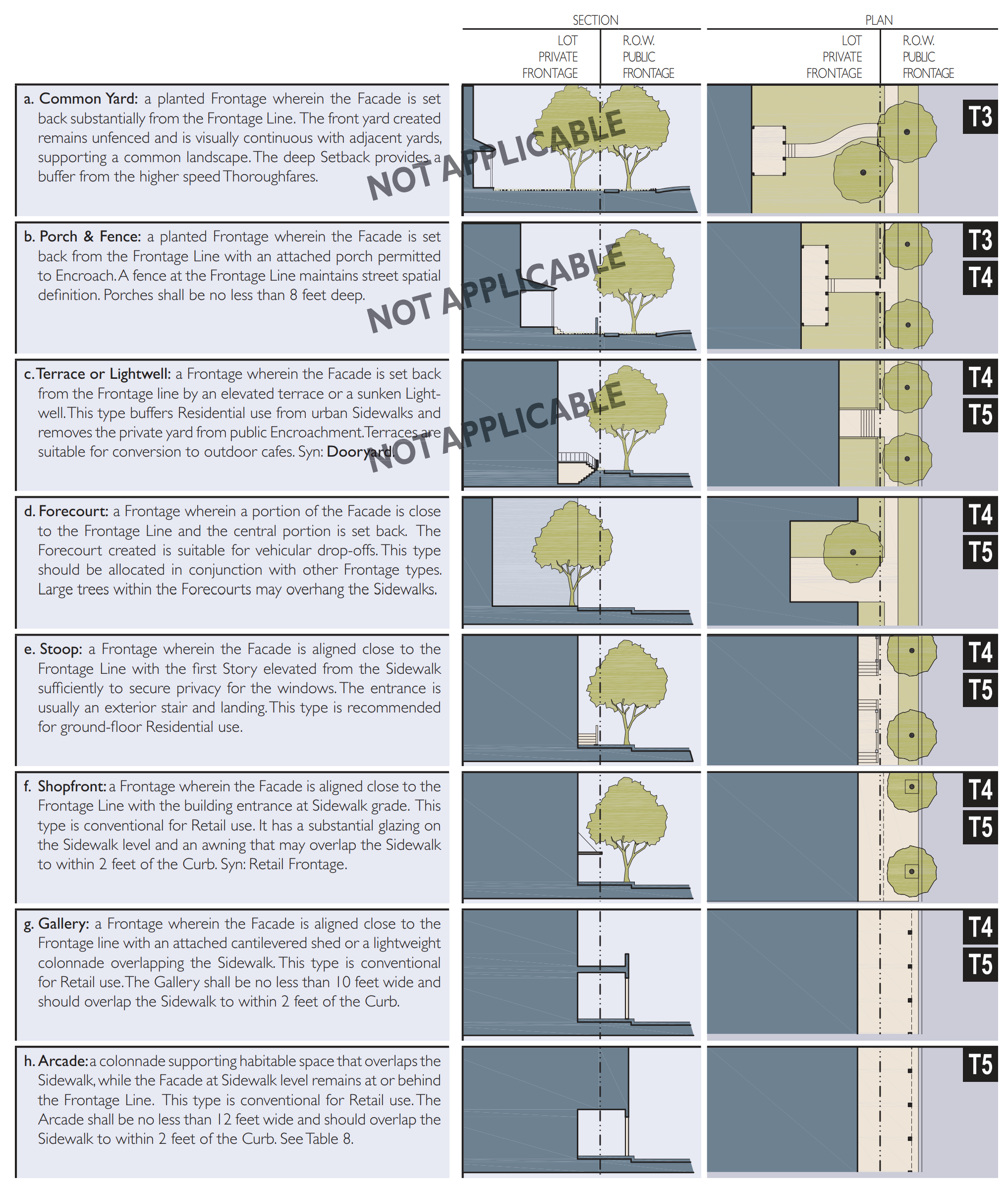
Table 9: Building Configuration
This table shows the Configurations for different building heights for each district/transect zone. It must be modified to show actual calibrated heights for local conditions. Recess Lines and Expression Lines shall occur on higher buildings as
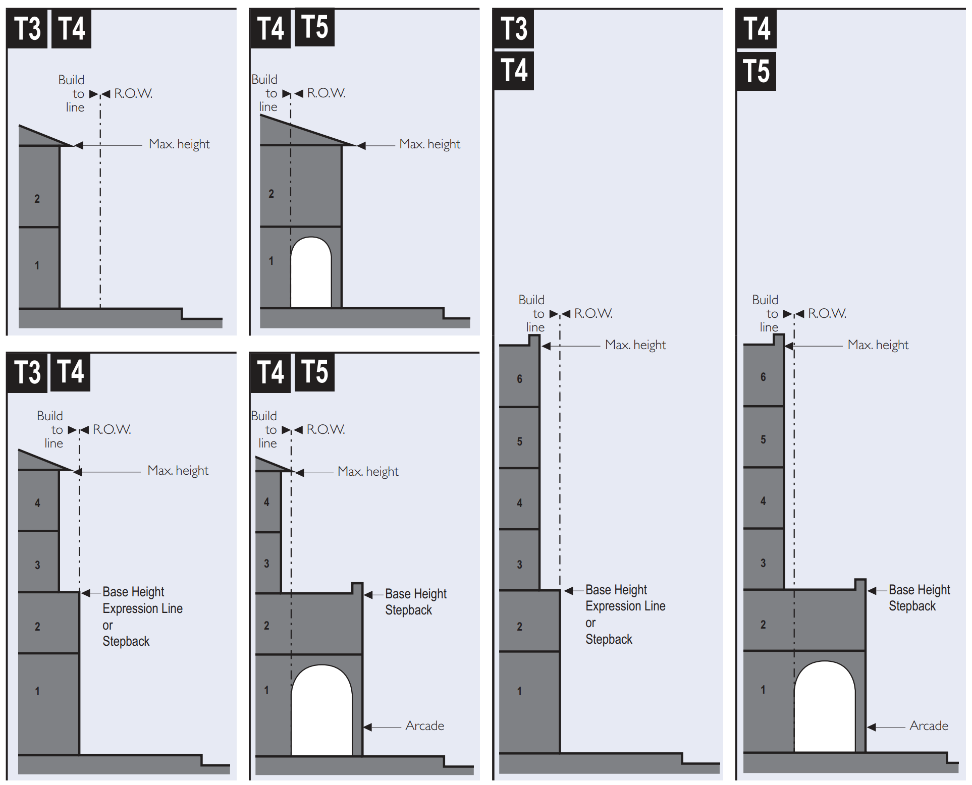
Table 10: Building Function
This table categorizes Building Functions within Transect Zones. Parking Requirements are correlated to functional intensity. For Specific Function and Use permitted By Right or by Warrant, see Table 12
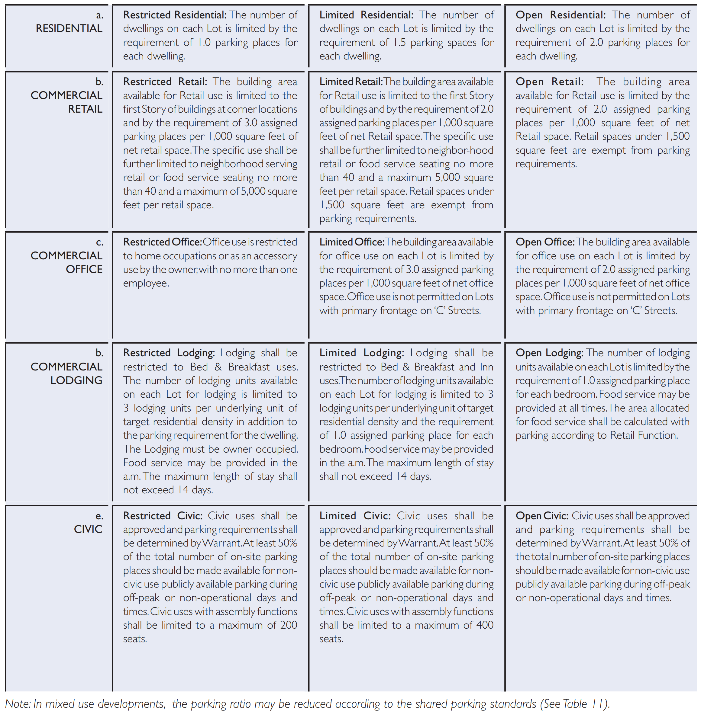
Table 11: Parking Calculations
The Shared Parking Factor for two Functions, when divided into the sum of the two amounts as listed on the Required Parking table below, produces the Effect Parking needed for each site involved in sharing. Conversely, if the Sharing Factor is used as a multiplier, it indicates the amount of building allowed on each site given the parking available.
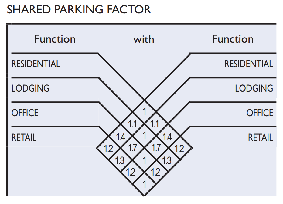
Table 12: Specific Function & Use
This table expands the categories of Table 10 to delegate specific Functions and uses within Transect Zones. Table 12 should be customized for local character and requirements.
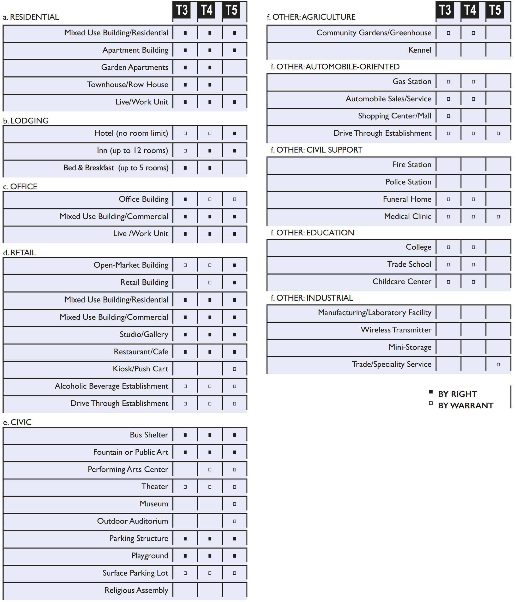
Table 13: Smart Code Summary
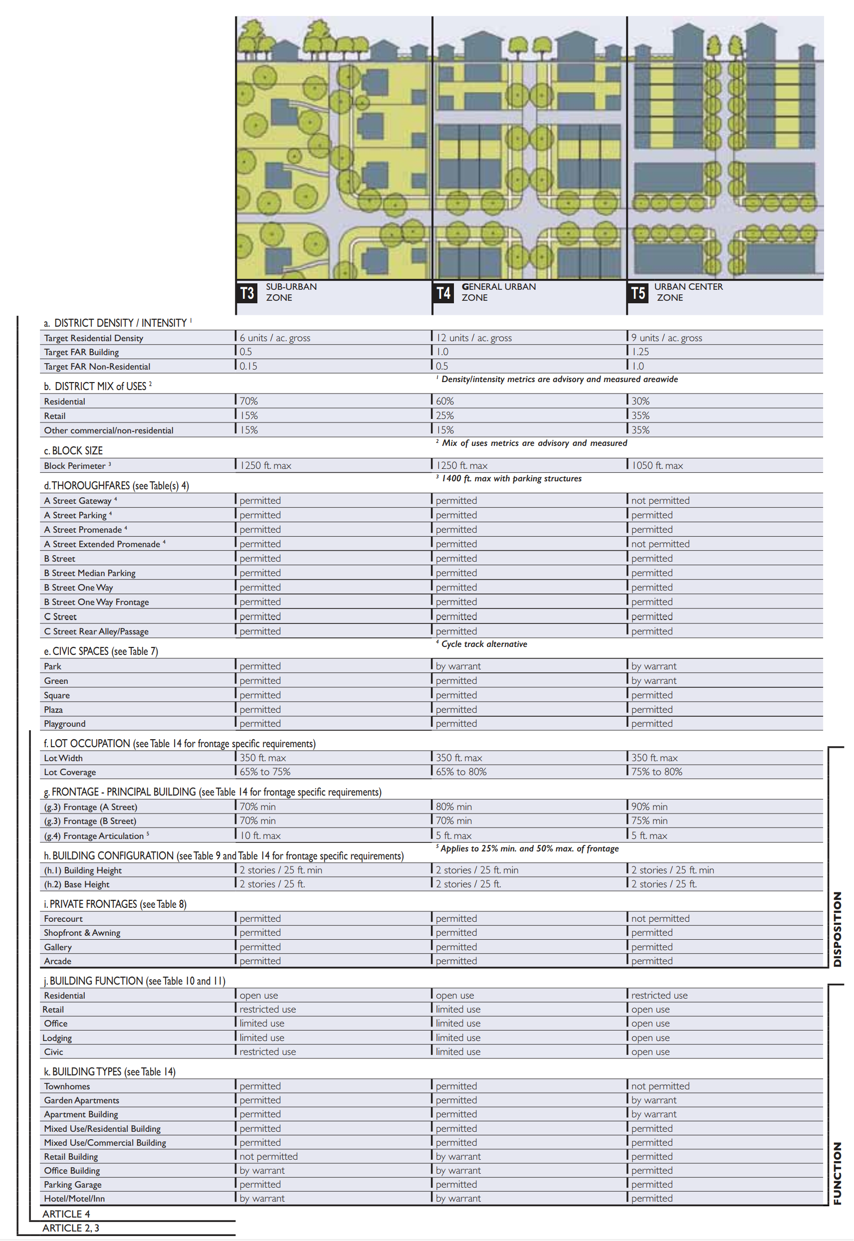
Table 14A: Form-Based Code Graphics—Residential
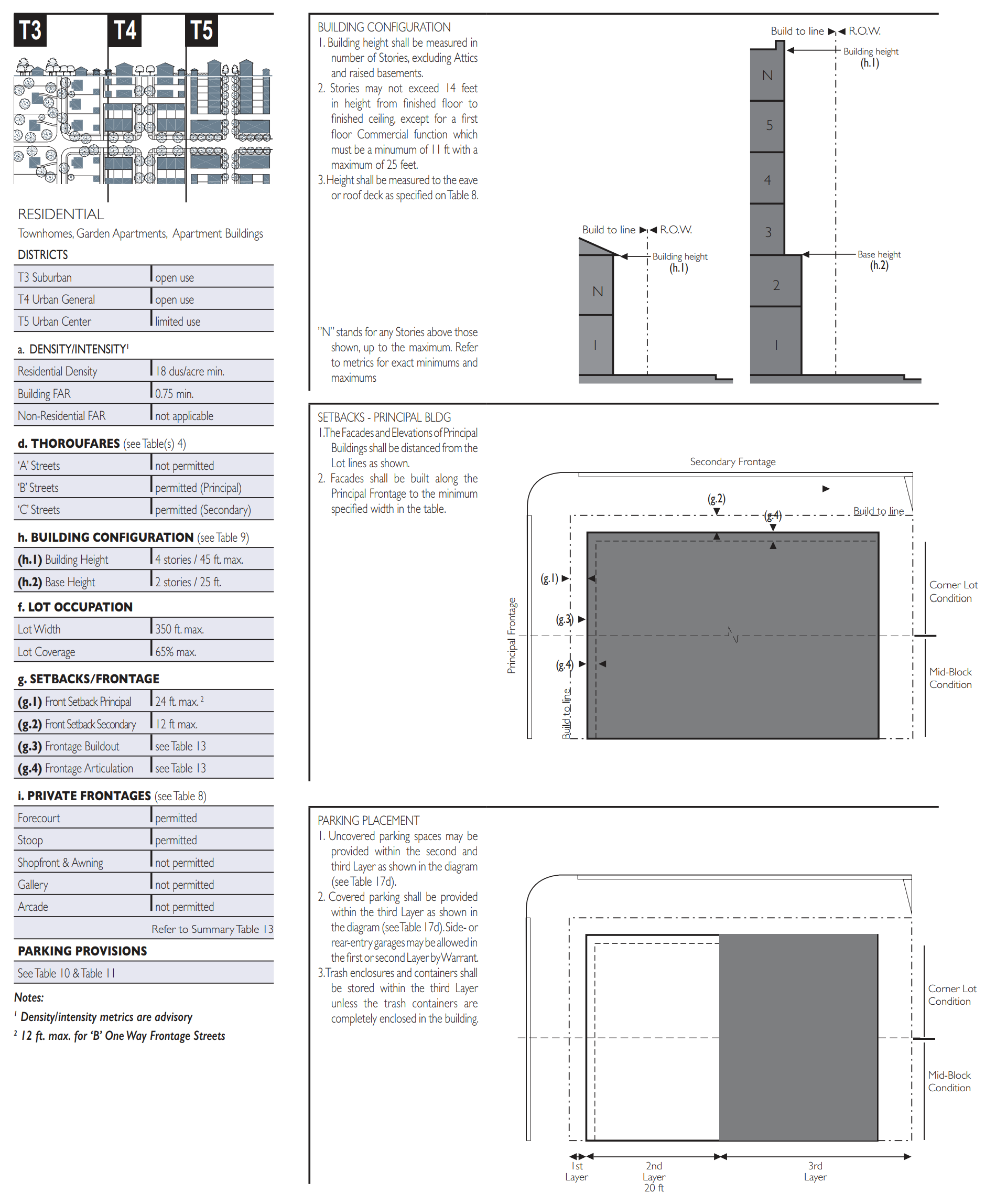
Table 14B: Form-Based Code Graphics—Retail
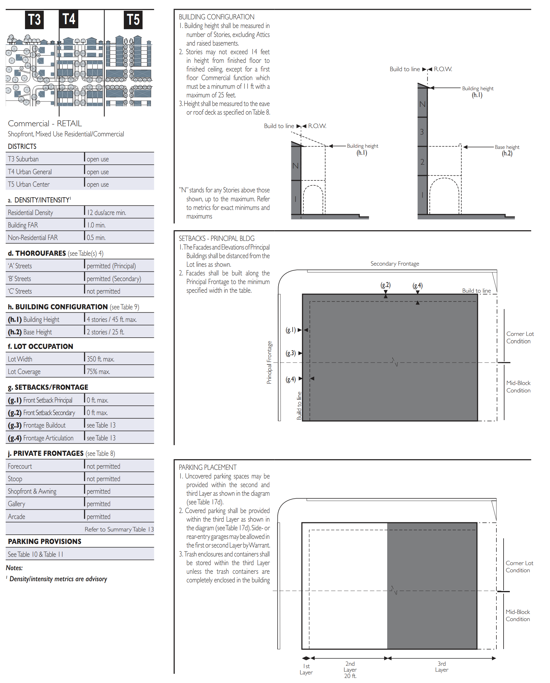
Table 14C: Form-Based Code Graphics—Office
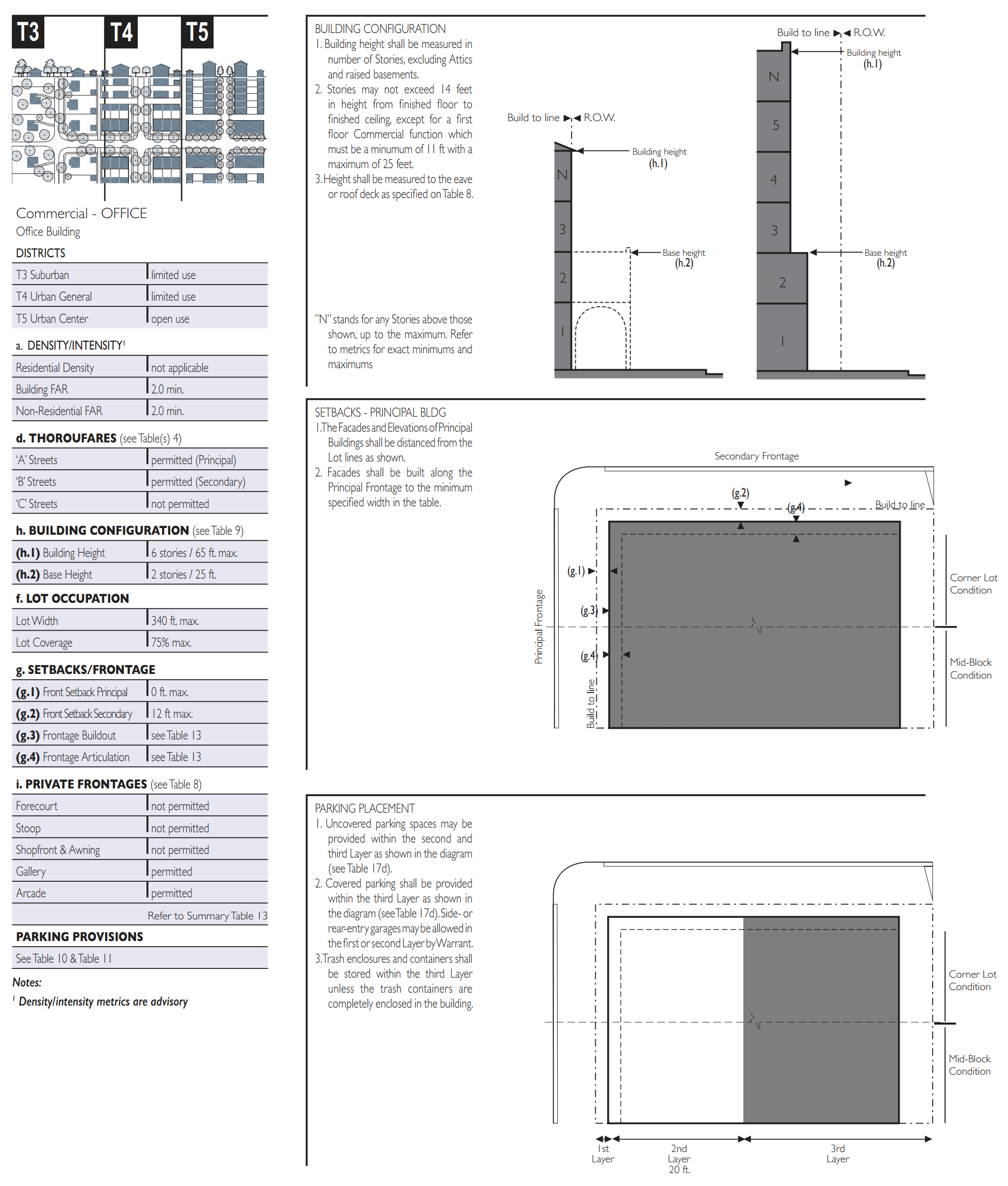
Table 14D: Form-Based Code Graphics—Lodging
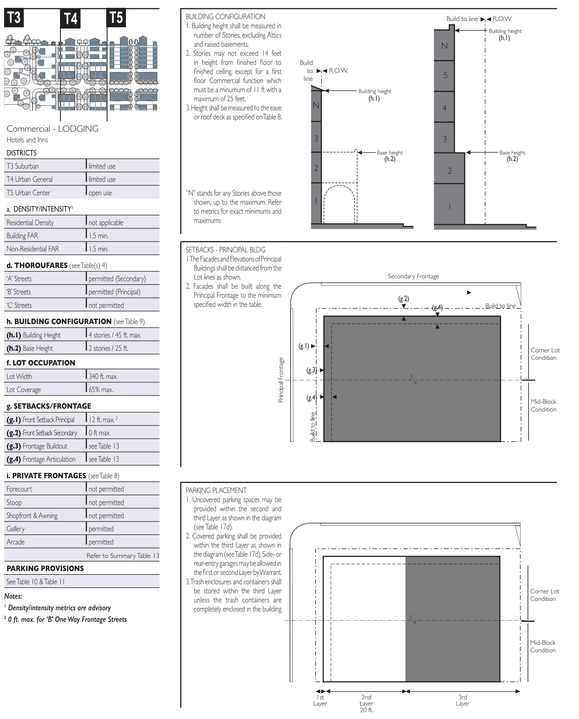
Table 14E: Form-Based Code Graphics—Civic
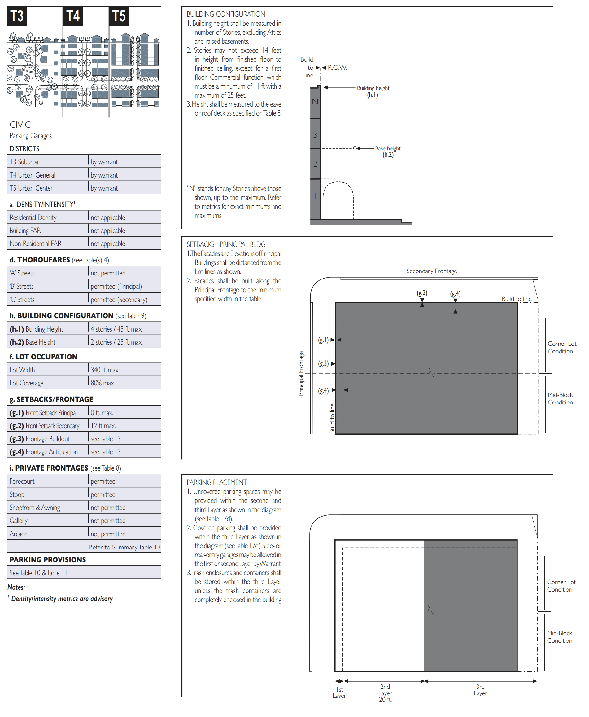
Table 15: Lot and Building Retrofit
This table provides descriptions of the necessary tools to change sprawl building types into neighborhood building types that comport with this Code.
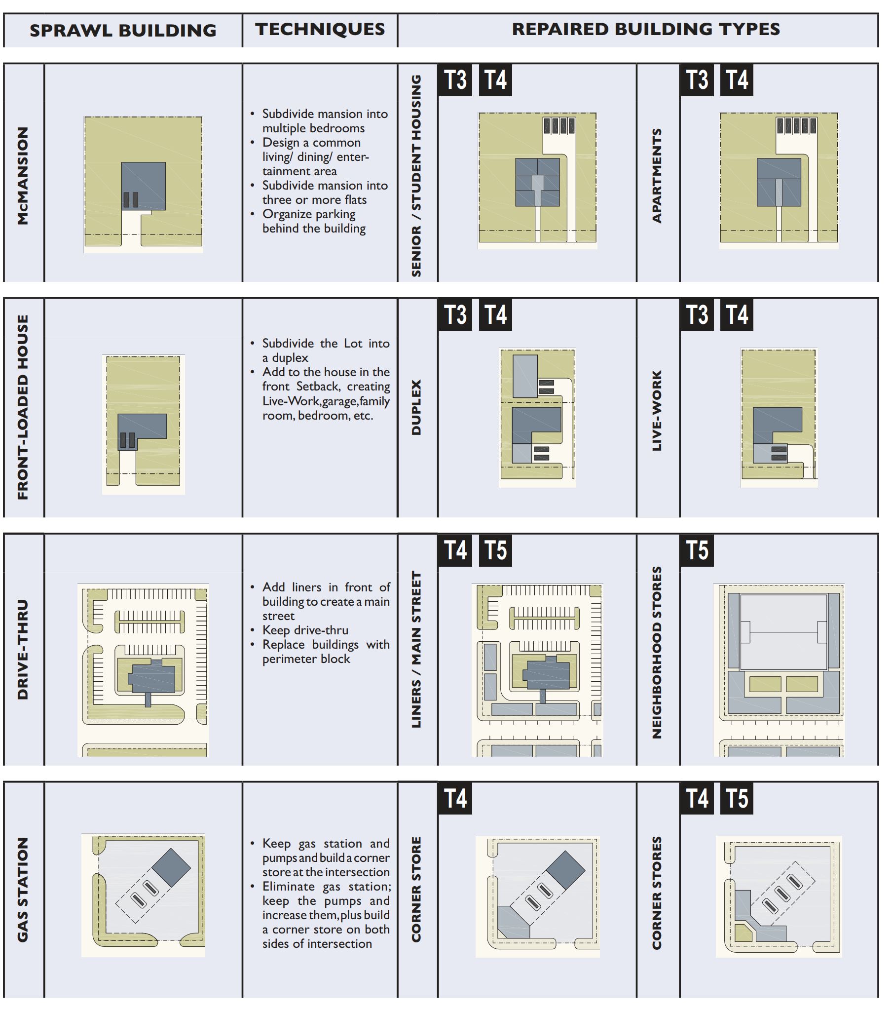
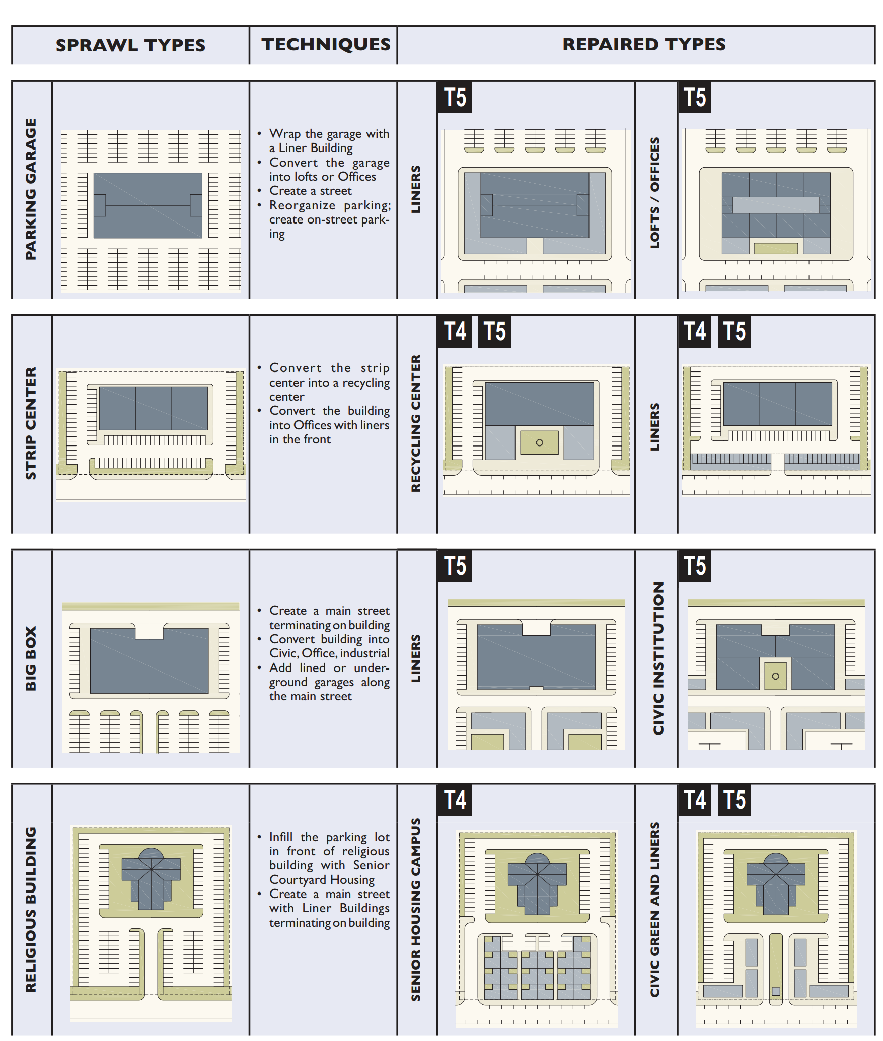
Table 16. Definitions Illustrated
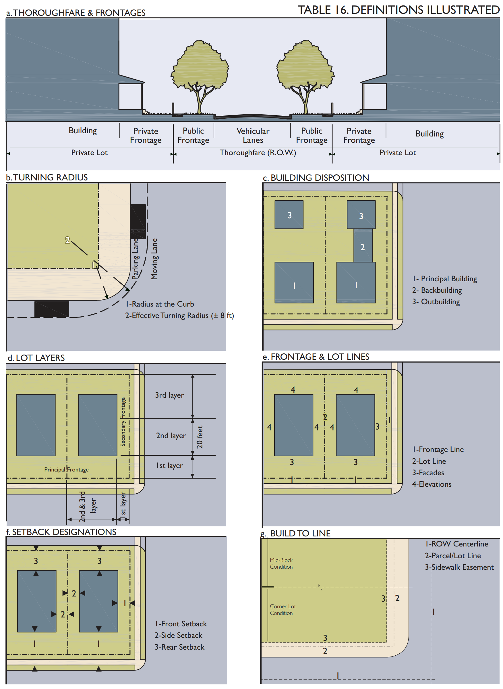
Sec. 2.05.05. - Definitions of terms.
This section provides definitions for terms in this code that are technical in nature or that otherwise may not reflect a common usage of the term. If a term is not defined in this article, then the CRC shall determine the correct definition. Items in italics refer to articles, sections, or tables in this code.
A-street. cumulatively, those Thoroughfares that by virtue of their pre-existing pedestrian-supportive qualities, or their future importance to pedestrian connectivity, are held to the highest standards prescribed by this code.
Accessory building. an Outbuilding with an Accessory Unit.
Accessory unit. an Apartment not greater than 440 square feet sharing ownership and utility connections with a Principal Building; it may or may not be within an Outbuilding. (Syn: ancillary unit).
Adjustment. A ruling that would permit a practice that is not consistent with either a specific provision or the Intent of this Code.
Allee. A regularly spaced and aligned row of trees usually planted along a Thoroughfare or Path.
Apartment. a Residential unit sharing a building and a Lot with other units and/or uses; may be for rent, or for sale as a condominium.
Arcade. A Private Frontage conventional for Retail use wherein the Facade is a colonnade supporting habitable space that overlaps the Sidewalk, while the Facade at Sidewalk level remains at the Frontage Line.
Architectural features. Exterior building elements intended to provide ornamentation to the building massing, including, but not limited to: eaves, cornices, bay windows, window and door surrounds, light fixtures, canopies, and balconies.
Attic. the interior part of a building contained within a pitched roof structure.
Avenue (AV). A Thoroughfare of high vehicular capacity and low to moderate speed, acting as a short distance connector between urban centers, and usually equipped with a landscaped median.
Awning. A roof or cover which projects from a wall of a building over a window or door, made of canvas, aluminum or similar material, which may be fixed in place or be retractable.
B-street. Cumulatively, those Thoroughfares that by virtue of their use, location or absence of pre-existing pedestrian-supportive qualities, may meet a standard lower than that of the A-Street.
Backbuilding. a single-Story structure connecting a Principal Building to an Outbuilding.
Bed and breakfast. an owner-occupied Lodging type offering one to five bedrooms, permitted to serve breakfast in the mornings to guests.
Bicycle lane (BL). A dedicated lane for cycling within a moderate-speed vehicular Thoroughfare, demarcated by striping.
Bicycle route (BR). A Thoroughfare suitable for the shared use of bicycles and automobiles moving at low speeds.
Bicycle trail (BT). A bicycle way running independently of a vehicular Thoroughfare.
Block. The aggregate of private Lots, Passages, Rear Alleys and Rear Lanes, circumscribed by Thoroughfares.
Block face. The aggregate of all the building Facades on one side of a Block.
Boulevard (BV). A Thoroughfare designed for high vehicular capacity and moderate speed, traversing an Urbanized area. Boulevards are usually equipped with Slip Roads buffering Sidewalks and buildings.
Buildable area. the area in which a building is permitted to be constructed which is the lot area excluding the sidewalk easements where applicable.
Build-to line (BTL). A line parallel to a lot line or right-of-way where a building facade must be placed.
By right. characterizing a proposal or component of a proposal for a Community Plan or Building Scale Plan that complies with this code and is permitted and processed administratively, without public hearing. See Warrant and Adjustment.
Civic. The term defining not-for-profit organizations dedicated to arts, culture, education, recreation, government, transit and municipal parking.
Civic building. A building operated by not-for-profit organizations dedicated to arts, culture, education, recreation, government, transit and municipal parking, or for use approved by the legislative body.
Civic parking reserve. Parking Structure or parking lot within a one-quarter-mile of the site that it serves.
Civic space. An outdoor area dedicated for public use. Civic space types are defined by the combination of certain physical constants including the relationships among their intended use, their size, their landscaping and their Enfronting buildings.
Civic zone. Designation for public sites dedicated for Civic Buildings and Civic Space.
Commercial. The term collectively defining workplace, Office, Retail and Lodging Functions.
Common destination. An area of focused community activity, usually defining the approximate center of a Pedestrian Shed. It may include without limitation one or more of the following: a Civic Space, a Civic Building, a Commercial center or a transit station, and may act as the social center of a neighborhood.
Common yard. A planted Private Frontage wherein the Facade is set back from the Frontage line. It is visually continuous with adjacent yards.
Community unit. A regulatory category defining the physical form, Density, and extent of a settlement. The three community unit types addressed in this code are CLD, TND, and RCD. Variants of TND and RCD for Infill are called Infill TND and Infill RCD. The TOD Community Unit type may be created by an overlay on TND or RCD.
Configuration. The form of a building, based on its massing, Private Frontage and height.
Corridor. A lineal geographic system incorporating transportation and/or Greenway trajectories.
Cottage. An Edgeyard building type. A single-family dwelling, on a regular Lot, often shared with an Accessory Building in the back yard.
Courtyard building. A building that occupies the boundaries of its Lot while internally defining one or more private patios.
Curb. The edge of the vehicular pavement that may be raised or flush to a Swale. It usually incorporates the drainage system.
Density. The number of dwelling units within a standard measure of land area.
Design speed. The velocity at which a Thoroughfare tends to be driven without the constraints of signage or enforcement. There are four ranges of speed: Very Low: (below 20 MPH); Low: (20—25 MPH); Moderate: (25—35 MPH); High: (above 35 MPH). Lane width is determined by desired Design Speed. Disposition: the placement of a building on its Lot.
Dooryard. A Private Frontage type with a shallow Setback and front garden or patio, usually with a low wall at the Frontage Line. (Variant: lightwell, light court.)
Drive. A Thoroughfare along the boundary between an Urbanized and a natural condition, usually along a waterfront, Park or promontory. One side has the urban character of a Thoroughfare, with Sidewalk and building, while the other has the qualities of a Road or parkway, with naturalistic planting and rural details.
Driveway. A vehicular lane within a Lot, often leading to a garage.
Edgeyard building. A building that occupies the center of its Lot with Setbacks on all sides.
Effective parking. The amount of parking required for Mixed Use after adjustment by the Shared Parking Factor.
Effective turning radius. The measurement of the inside Turning Radius taking parked cars into account.
Elevation. An exterior wall of a building not along a Frontage Line. See Facade.
Encroachment. Any structural element that breaks the plane of a vertical or horizontal regulatory limit, extending into a Setback, into the Public Frontage, or above a height limit.
Enfront. To place an element along a Frontage, as in "porches Enfront the street."
Expression line. A line prescribed at a certain level of a building for the major part of the width of a Facade, expressed by a variation in material or by a limited projection such as a molding or balcony. (Syn: transition line.)
Extension line. A line prescribed at a certain level of a building for the major part of the width of a Facade, regulating the maximum height for an Encroachment by an Arcade Frontage.
Facade. The exterior wall of a building that is set along a Frontage Line. See Elevation.
Forecourt. A Private Frontage wherein a portion of the Facade is close to the Frontage Line and the central portion is set back.
Frontage. The area between a building Facade and the vehicular lanes, inclusive of its built and planted components. Frontage is divided into Private Frontage and Public Frontage.
Frontage line. A Lot line bordering a Public Frontage. Facades facing Frontage Lines define the public realm and are therefore more regulated than the Elevations facing other Lot Lines.
Function. The use or uses accommodated by a building and its Lot, categorized as Restricted, Limited, or Open, according to the intensity of the use.
Gallery. A Private Frontage conventional for Retail use wherein the Facade is aligned close to the Frontage Line with an attached cantilevered shed or lightweight colonnade overlapping the Sidewalk. See Table 7.
Green. A Civic Space type for unstructured recreation, spatially defined by landscaping rather than building Frontages.
Greenway. an Open Space Corridor in largely natural conditions which may include trails for bicycles and pedestrians.
Highway. A rural and suburban Thoroughfare of high vehicular speed and capacity. This type is allocated to the more rural Transect Zones (T-1, T-2, and T-3).
Home occupation. Non-Retail Commercial enterprises. The work quarters should be invisible from the Frontage, located either within the house or in an Outbuilding. Permitted activities are defined by the Restricted Office category.
House. An Edgeyard building type, usually a single-family dwelling on a large Lot, often shared with an Accessory Building in the back yard. (Syn: single.)
Infill. Noun - new development on land that had been previously developed and cleared land within Urbanized areas. Verb- to develop such areas.
Inn. A Lodging type, owner-occupied, offering six to 12 bedrooms, permitted to serve breakfast in the mornings to guests.
Layer. A range of depth of a Lot within which certain elements are permitted.
Lightwell. A Private Frontage type that is a below-grade entrance or recess designed to allow light into basements. (Syn: light court.)
Linear pedestrian shed. A Pedestrian Shed that is elongated along an important Mixed Use Corridor such as a main street. A Linear pedestrian shed extends approximately one-quarter mile from each side of the Corridor for the length of its Mixed Use portion. It may be used to structure a TND, RCD, Infill TND or Infill RCD.
Liner building. A building specifically designed to mask a parking lot or a Parking Structure from a Frontage.
Live-work. A Mixed Use unit consisting of a Commercial and Residential Function. The Commercial Function may be anywhere in the unit. It is intended to be occupied by a business operator who lives in the same structure that contains the Commercial activity or industry. See WORK-LIVE. (Syn.: flexhouse.)
Lodging. Premises available for daily and weekly renting of bedrooms.
Lot. A parcel of land accommodating a building or buildings of unified design. The size of a LOT is controlled by its width in order to determine the grain (i.e., fine grain or coarse grain) of the urban fabric.
Lot area. The total square footage or acreage of horizontal area included within the lot lines.
Lot coverage. The portion of the lot expressed as a percentage that is covered in buildings or other structures.
Lot line. The boundary that legally and geometrically demarcates a Lot.
Lot width. The length of the Principal Frontage Line of a Lot.
Main civic space. The primary outdoor gathering place for a community. The main civic space is often, but not always, associated with an important Civic Building.
Manufacturing. Premises available for the creation, assemblage and/or repair of artifacts, using table-mounted electrical machinery or artisanal equipment, and including their Retail sale.
Medical marijuana treatment center dispensing facility. The retail sales component of a medical marijuana treatment center that has been licensed by the Florida Department of Health Office of Medical Marijuana Use pursuant to F.S. § 381.986, and is authorized by the state to dispense marijuana, but does not include the cultivation, processing, or distribution facilities of the medical marijuana treatment center.
Mixed use. Multiple Functions within the same building through superimposition or adjacency, or in multiple buildings by adjacency, or at a proximity determined by Warrant.
Net site area all developable land within a site including thoroughfares but excluding land allocated as civic zones.
Office. Premises available for the transaction of general business but excluding Retail, artisanal and Manufacturing uses.
Open space. Land intended to remain undeveloped; it may be for Civic Space.
Outbuilding. An Accessory Building, usually located toward the rear of the same Lot as a Principal Building, and sometimes connected to the Principal Building by a Backbuilding.
Park. A Civic Space type that is a natural preserve available for unstructured recreation.
Parking structure. A building containing one or more Stories of parking above grade.
Passage (PS). A pedestrian connector, open or roofed, that passes between buildings to provide shortcuts through long Blocks and connect rear parking areas to Frontages.
Path (PT). A pedestrian way traversing a Park or rural area, with landscape matching the contiguous Open Space, ideally connecting directly with the urban Sidewalk network.
Pedestrian shed. An area that is centered on a Common Destination. Its size is related to average walking distances for the applicable Community Unit type. Pedestrian sheds are applied to structure Communities. (Syn: walkshed, walkable catchment.)
Planter. The element of the Public Frontage which accommodates street trees, whether continuous or individual.
Plaza. A Civic Space type designed for Civic purposes and Commercial activities in the more urban Transect Zones, generally paved and spatially defined by building Frontages.
Principal building. The main building on a Lot, usually located toward the Frontage.
Principal entrance. The main point of access for pedestrians into a building.
Principal frontage. On corner Lots, the Private Frontage designated to bear the address and Principal Entrance to the building, and the measure of minimum Lot width. Prescriptions for the parking Layers pertain only to the principal frontage. Prescriptions for the first Layer pertain to both Frontages of a corner Lot. See Frontage.
Private frontage. The privately held Layer between the Frontage Line and the Principal Building Facade.
Public frontage. The area between the Curb of the vehicular lanes and the Frontage Line.
Rear alley (RA). A vehicular way located to the rear of Lots providing access to service areas, parking, and Outbuildings and containing utility easements. Rear alleys should be paved from building face to building face, with drainage by inverted crown at the center or with roll Curbs at the edges.
Rear lane (RL). A vehicular way located to the rear of Lots providing access to service areas, parking, and Outbuildings and containing utility easements. Rear lanes may be paved lightly to Driveway standards. The streetscape consists of gravel or landscaped edges, has no raised Curb, and is drained by percolation.
Rearyard building. A building that occupies the full Frontage Line, leaving the rear of the Lot as the sole yard. See Table 9. (Var: Rowhouse, Townhouse, Apartment House)
Recess line. A line prescribed for the full width of a Facade, above which there is a Stepback of a minimum distance, such that the height to this line (not the overall building height) effectively defines the enclosure of the Enfronting public space. (Var: Extension Line)
Regional center development (RCD). A Community Unit type structured by a Long Pedestrian Shed or Linear Pedestrian Shed, which may be adjoined without buffers by one or several Standard Pedestrian Sheds, each with the individual Transect Zone requirements of a TND. RCD takes the form of a high-Density Mixed Use center connected to other centers by transit. See INFILL RCD, Table 2 and Table 14A. (Var: town center, downtown. Syn: Regional Center)
Regulating plan. A Zoning Map or set of maps that shows the Transect Zones, Civic Zones, Special Districts if any, and Special Requirements if any, of areas subject to, or potentially subject to, regulation by this code. Residential: characterizing premises available for long-term human dwelling.
Retail. Characterizing premises available for the sale of merchandise and food service. See Table 10 and Table 12.
Retail frontage. Frontage designated on a Regulating Plan that requires or recommends the provision of a Shopfront, encouraging the ground level to be available for Retail use. See special requirements.
Road (RD). A local, rural and suburban Thoroughfare of low-to-moderate vehicular speed and capacity. This type is allocated to the more rural Transect Zones (T1—T3).
Rowhouse. A single-family dwelling that shares a party wall with another of the same type and occupies the full Frontage Line. See Rearyard Building. (Syn: Townhouse)
Secondary frontage. On corner Lots, the Private Frontage that is not the Principal Frontage. As it affects the public realm, its First Layer is regulated.
Setback. The area of a Lot measured from the Lot line to a building Facade or Elevation that is maintained clear of permanent structures, with the exception of Encroachments. (Var: build-to-line.)
Shared parking factor. An accounting for parking spaces that are available to more than one Function.
Shopfront. A Private Frontage conventional for Retail use, with substantial glazing and an awning, wherein the Facade is aligned close to the Frontage Line with the building entrance at Sidewalk grade.
Sidewalk. The paved section of the Public Frontage dedicated exclusively to pedestrian activity.
Sideyard building. A building that occupies one side of the Lot with a Setback on the other side. This type can be a Single or Twin depending on whether it abuts the neighboring House.
Slip road. An outer vehicular lane or lanes of a Thoroughfare, designed for slow speeds while inner lanes carry higher speed traffic, and separated from them by a planted median. (Syn: access lane, service lane)
Special district (SD). An area that, by its intrinsic Function, Disposition, or Configuration, cannot or should not conform to one or more of the normative Community Unit types or Transect Zones specified by this code.
Specialized building. A building that is not subject to Residential, Commercial, or Lodging classification.
Square. A Civic Space type designed for unstructured recreation and Civic purposes, spatially defined by building Frontages and consisting of Paths, lawns and trees, formally disposed.
Standard pedestrian shed. A Pedestrian Shed that is an average 1/4 mile radius or 1320 feet, about the distance of a five-minute walk at a leisurely pace. See Pedestrian Shed.
Stepback. A building Setback of a specified distance that occurs at a prescribed number of Stories above the ground.
Stoop. A Private Frontage wherein the Facade is aligned close to the Frontage Line with the first Story elevated from the Sidewalk for privacy, with an exterior stair and landing at the entrance.
Story. A habitable level within a building, excluding an Attic or raised basement.
Street (ST). A local urban Thoroughfare of low speed and capacity.
Streetscreen. A freestanding wall built along the Frontage Line, or coplanar with the Facade. It may mask a parking lot from the Thoroughfare, provide privacy to a side yard, and/or strengthen the spatial definition of the public realm. (Syn: streetwall.)
Substantial modification. Alteration to a building that is valued at more than 50 percent of the replacement cost of the entire building, if new.
Swale. A low or slightly depressed natural area for drainage.
T-zone. Transect Zone.
Thoroughfare. A way for use by vehicular and pedestrian traffic and to provide access to Lots and Open Spaces, consisting of Vehicular Lanes and the Public Frontage.
TND. Traditional Neighborhood Development, a Community Unit type structured by a Standard Pedestrian Shed oriented toward a Common Destination consisting of a Mixed Use center or Corridor, and in the form of a medium-sized settlement near a transportation route. (Syn: village. Variant: Infill TND, neighborhood.)
TOD. Transit Oriented Development. TOD is created by an overlay on all or part of a TND or RCD, or by designation on a Regional Plan, permitting increased Density to support rail or Bus Rapid Transit (BRT).
Townhouse. See Rearyard Building. (Syn: Rowhouse)
Transect. A cross-section of the environment showing a range of different habitats. The rural-urban Transect of the human environment is divided into six Transect Zones. These zones describe the physical form and character of a place, according to the Density and intensity of its land use and Urbanism.
Transect zone (T-zone). One of several areas on a Zoning Map regulated by this code. Transect zones are administratively similar to the land use zones in conventional codes, except that in addition to the usual building use, Density, height, and Setback requirements, other elements of the intended habitat are integrated, including those of the private Lot and building and Public Frontage. See Table 1.
Turning radius. The curved edge of a Thoroughfare at an intersection, measured at the inside edge of the vehicular tracking. The smaller the turning radius, the smaller the pedestrian crossing distance and the more slowly the vehicle is forced to make the turn.
Urbanism. Collective term for the condition of a compact, Mixed Use settlement, including the physical form of its development and its environmental, functional, economic, and sociocultural aspects.
Urbanized. Generally, developed. Specific to this code, developed at T-3 (Sub-Urban) Density or higher.
Warrant. A ruling that would permit a practice that is not consistent with a specific provision of this Code, but that is justified by its intent. Warrants are usually granted administratively by the FBCRC.
Work-live. a Mixed Use unit consisting of a Commercial and Residential Function. It typically has a substantial Commercial component that may accommodate employees and walk-in trade. The unit is intended to function predominantly as work space with incidental Residential accommodations that meet basic habitability requirements. See Live-Work. (Syn: Live-With.)
Yield. Characterizing a Thoroughfare that has two-way traffic but only one effective travel lane because of parked cars, necessitating slow movement and driver negotiation. Also, characterizing parking on such a Thoroughfare.
Zoning map. The official map or maps that are part of the zoning ordinance and delineate the boundaries of individual zones and districts. See Regulating Plan.
(Ord. 1286-16, passed 1-25-2016; Ord. 1367-18, passed 6-11-2018)
Sec. 2.05.06. - Regulating plan maps.
District Types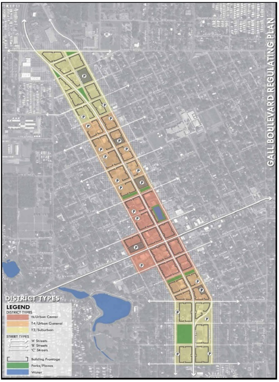
Street Types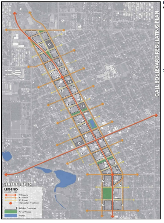
Frontage Types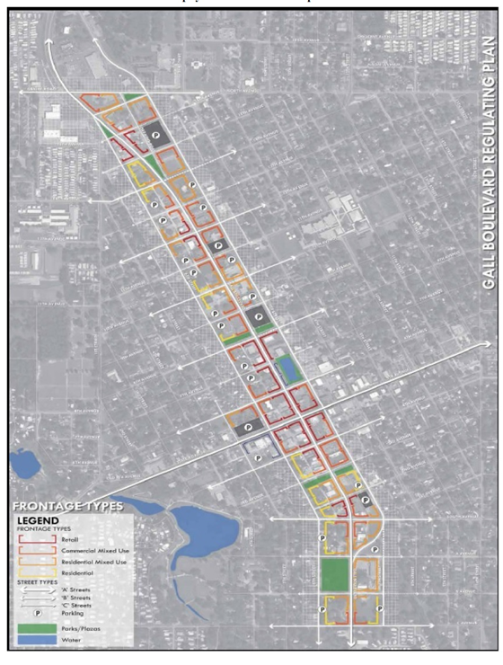
(Ord. 1286-16, passed 1-25-2016)