
Zephyrhills City Zoning Code
ARTICLE VII
DESIGN STANDARDS AND IMPROVEMENT REQUIREMENTS
PART 7.00.00. - PURPOSE AND INTENT
(A)
The purpose of this chapter is to ensure that future growth, development and redevelopment in the city conforms to certain minimum criteria. These criteria are provided for the express purpose of achieving the objectives of the city as stated in its Comprehensive Plan as well as implementing the policies adopted to ensure fulfillment of those objectives. The design standards and criteria contained in this chapter are provided to protect the general health, safety and welfare of the city and its citizens; to guard against the negative impacts of growth; and to protect the general public from potential adverse impacts from a proposed use.
(B)
The standards and criteria provided in this chapter are mandatory and apply to all properties in the city. These standards describe the minimum acceptable design and development standards which must be met in order to receive approval for a proposed development.
(C)
The approval of standards of this code shall not be construed to invalidate deed restrictions or restrictive covenants, nor does the city enforce such private contractual agreements.
PART 7.01.00. - ZONING DISTRICT PERFORMANCE AND DIMENSIONAL STANDARDS
The purpose of the following sections is to describe those site design standards which apply to specific zoning districts. These standards regulate lot area, building placement, dwelling unit type, density and intensity of development.
Table 7.01.01: Density, Area, Height and Bulk Requirements
(Ord. 974-07, passed 4-9-2007; Ord. 1368-18, passed 8-27-2018; Ord. 1394-20, passed 2-24-2020; Ord. 1403-20, passed 7-27-2020; Ord. 1475-24, § 3, 2-12-2024)
PART 7.02.00. - SUBDIVISION DESIGN AND IMPROVEMENT STANDARDS
All lands included within the subdivision shall be suitable for the various purposes proposed in the application for subdivision approval. Further, no subdivision plan shall be approved unless the city determines after full consideration of all pertinent data that the proposed subdivision conforms to all the provisions of these regulations.
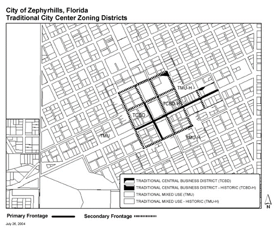
Table 7.02. Development Standards for Traditional City Center
(Ord. 966-07, passed 2-26-2007)
PART 7.03.00. - TRANSPORTATION SYSTEM STANDARDS
(A)
The purpose of this part is to describe regulations which apply to the transportation system, including bikeways, pedestrian access, parking and loading. This part shall be construed and implemented to create an efficient, safe and balanced system of traffic circulation accommodating vehicles, bicycles and pedestrians and providing for adequate parking and loading.
(B)
All roadway construction or repair activities performed by or under the supervision of the Public Works Department shall be conducted in accordance with the standards set forth in the Florida Department of Transportation Standards Specifications for Road and Bridge Constriction, § 104 (Erosion Control).
PART 7.09.00. - SUPPLEMENTAL STANDARDS FOR SPECIAL USES
The purpose of the supplemental standards is to set forth general rules and regulations for uses, buildings, and structures applying to all zoning districts, including properties that are a contributing structure; as well as to provide for additional regulations for restricted uses applying to specific zoning districts as enumerated herein. Expansion of nonconforming uses by the construction or addition of accessory structures shall not be permitted.
(Ord. 1359-18, passed 6-25-2018)
Sec. 7.01.01. - General development standards.
(A)
All development shall be served by the city's central water and central sewer system.
(B)
All development shall provide on-site storm water retention area and facilities as determined by the SWFWMD. Land to be dedicated for storm water retention may include land required to meet buffer standards, wetlands protection or habitat protection.
(C)
All development shall have a total land area sufficient to meet all site design standards in this code including, but not limited to, land required to provide setbacks from abutting rights-of-way, buffers, storm water management, off-street parking and circulation, protection of wetlands or other provisions which may require land area to be set aside. Minimum lot sizes (area) are detailed for each zoning district. Density requirements also are established per each zoning district.
(D)
An impervious surface ratio is specified for each zoning district to provide a control of the intensity of development of land. Impervious surface is that portion of the land which is covered by buildings, pavements or other cover through which water cannot penetrate. Porous concrete, asphalt, porous turf block or similar materials may be used, subject to the specifications in the Appendices and shall be calculated based on the portion of the material which is impervious.
Sec. 7.01.01.01. - Lot requirements.
(A)
All lots of record or combination of lots of record under single ownership, which have width, depth and area which constitute sufficient size to construct or erect a structure thereon, as of the date of recording of a deed or other legal instrument shall continue to be vested with the same rights to construct or erect a structure thereon, provided:
(1)
The proposed use of the lot or combination of lots, meets all other current provisions of city regulations; and
(2)
The lot(s) contain a minimum of 6,000 square feet.
(B)
No lot area, lot width or lot depth shall be reduced or diminished so that the yards or other open space shall be smaller than prescribed by this code except as expressly approved by the Board of Adjustment.
(C)
No space which has been counted as part of a yard or other open space required by this code, may, by reason of change in ownership or otherwise, be counted or calculated to satisfy or comply with a yard or other open space requirement of or for any other building.
Sec. 7.01.01.02. - Required frontage of lots and required orientation of primary buildings.
(A)
All lots of record that are to used for buildings shall have frontage on a public right-of-way. All primary buildings (residential, commercial or industrial) shall have primary access from a public right-of-way. In no case shall primary access be from an alley, crosswalk or pedestrian way. All single-family and duplex dwelling units shall have a primary entrance facing a public right-of-way and be on a lot which has street frontage.
(B)
(1)
All lots of record that are to be used for buildings shall have adequate access to a public street by direct frontage or via a public right-of-way. Adequacy of access shall be determined by the Site Plan Review Committee if not by direct street frontage.
(2)
Specific criteria for adequacy of access shall be approved by City Council.
Sec. 7.01.01.03. - Building setbacks.
Minimum setbacks are established to provide open space and ventilation between structures and to comply with fire codes for specific types of construction. Any variance granted by the Board of Adjustment may subject the construction to more stringent requirements of the Fire Code. All setbacks shall be measured horizontally from the foundation.
Sec. 7.01.01.04. - Height regulations.
(A)
All height limitations are the maximum permitted within a district. Height shall be measured from the centerline street grade opposite the center of the front wall of the building to the highest projection of the building. Building heights in excess of that permitted within a district may be granted only as a conditional use by the City Council.
(B)
No building shall be erected, reconstructed or structurally altered to exceed the height established for the district in which the building is located, subject to the following:
(1)
Mid-rise structures, defined for the purpose of this code as buildings of three to five stories inclusive, may be permitted if all applicable conditional requirements of Resolution #147 are met.
(2)
Mid-rise structures, when permitted, may be erected to a height not exceeding 75 feet if the building is set back from each setback line at lease one additional foot for each additional two feet of building height above 30 feet.
(3)
Special industrial structures such as cooling towers, elevators bulkheads, fire towers, tanks, water towers, which require a greater height than provided in the district, may be erected to a greater height than permitted provided:
(a)
The structure shall occupy more than 25 percent of the lot area; and
(b)
All setback requirements of the district in which the structure is erected shall be increased by one foot for each foot of height above 30 ft.
(4)
The height limitations of this code shall not apply to flagpoles, church spires, chimneys and antenna towers.
(5)
Notwithstanding the foregoing provisions and the height limitations as set forth in each zoning district, in no case shall a structure exceed in height the limitations determined to protect the approach and clear air zones established for the Zephyrhills Municipal Airport, as currently adopted or subsequently amended.
Sec. 7.01.02. - Density, area, height and bulk requirements.
All development shall adhere to the specific density, area, height and bulk requirements for the zoning district in which it is located as prescribed in Table 7.01.01.
Sec. 7.02.01.01. - Use of natural features.
The arrangement of lots and street system should make the most advantageous use of topography and preserve mature trees and other natural features wherever possible.
Sec. 7.02.01.02. - Consideration of soil conditions, flood hazard and water resources.
A subdivision plan shall not be approved unless all land intended for use as building sites can be used safely for building purposes, without the danger of flooding and adverse soil conditions affecting structural stability and human health, safety and welfare. Further, no subdivision plan shall be approved unless design measures to minimize the adverse impact on the quality and quantity of the natural hydrological system are included as components of the subdivision. In particular, this shall apply to all subdivision affecting lakes, ponds, swamps, water courses (creeks, streams and rivers) and the subsurface aquifer system. The Site Plan Review Committee shall take into consideration the essential usages of water (i.e. domestic supplies and sewage effluent), for each plan submitted.
Sec. 7.02.01.03. - Lots and blocks.
(A)
Generally. Minimum area requirements in relation to the sewage disposal method provided in the subdivision are stated in § 5068. All lots shall provide satisfactory building sites. Lots for industrial and commercial purposes shall be adequate to provide off-street parking, loading, service facilities, storm water retention and landscaping as specified in current zoning regulations.
(B)
Access. Each lot shall abut a public street for a minimum distance of 25 feet. This requirement shall not be construed to prohibit private streets within development where there is a legal entity acceptable to City Council which is responsible for street maintenance. In determining the adequacy of access for new buildings not fronting on a dedicated street, the Site Plan Review Committee will utilize the following criteria.
(1)
Single-family and duplex units.
(a)
Access to five or fewer dwelling units must provide a minimum of 20 feet recorded unobstructed right-of-way with a 14-foot vertical clearance and sufficient area for turnaround of city sanitation and emergency vehicles (32-foot turning radius on a continuous street or 45-foot radius on a dead-end). No pavement is required.
(b)
Access to six or more dwelling units must provide a minimum of a 20-foot recorded unobstructed right-of-way with a 14-foot vertical clearance and sufficient area for turnaround of city sanitation and emergency vehicles (32-foot turning radius on a continuous street or 45-foot radius on a dead-end). the minimum pavement width will be 20 feet and constructed to city standards for a local street.
(2)
Multi-family, commercial, Industrial.
(a)
Access to multi-family or commercial development anticipated to generate fewer than 100 trips per day (using ITE trip generation rates) must provide a minimum of a 20-foot recorded unobstructed right-of-way with a 14-foot vertical clearance and sufficient area for turnaround of city sanitation and emergency vehicles (32-foot turning radius on a continuous street or 45-foot radius on a dead-end). The minimum pavement width will be 20 feet and constructed to city standards for a local street.
(b)
Access to multi-family or commercial development anticipated to generate more than 100 and fewer than 500 trips per day (using ITE trip generation rates) must provide a minimum of a 30-foot recorded unobstructed right-of-way with a 14-foot vertical clearance and sufficient area for turnaround of city sanitation and emergency vehicles (32-foot turning radius on a continuous street or 45-foot radius on a dead-end). The minimum pavement width will be 24 feet and constructed to city standards for a local street.
(c)
Access to multi-family or commercial development anticipated to generate 500 or more trips per day (using ITE trip generation rates) and all industrial development, must provide a minimum of a 60-foot recorded unobstructed right-of-way with a 14-foot vertical clearance and sufficient area for turnaround of trailer trucks (60-foot turning radius). The minimum pavement width will be 26 feet and constructed to city standards for a collector street.
(C)
Lot lines. Side lot lines shall be, as nearly as practical at right angles to straight street lines and radial to curved street lines. In subdivisions which overlap municipal, county, tax district boundaries or other district boundaries, lot lines shall follow the boundary lines.
(D)
Double frontage lots. Double frontage lots shall be permitted only where necessary to separate a development from collector or arterials or to overcome disadvantages of topography and orientation. Where double frontage lots are created they shall all front in the same direction, the rear of the lots shall be screened from the abutting roadway and access rights shall be dedicated to the city. A note stating "Vehicular access rights dedicated to City of Zephyrhills" shall be lettered along the right-of-way line of the plat adjacent to the lots affected.
(E)
Block lengths. The length of blocks should not exceed 1,320 feet.
(F)
Block crosswalks. When deemed necessary by the Site Plan Review Committee, rights-of-way for pedestrian crosswalks shall be provided to give pedestrian access to schools, local shopping centers and parks. The right-of-way shall be a minimum of five feet in width and shall be improved in accordance with plans as approved by the Site Plan Review Committee.
Sec. 7.02.01.04. - Streets.
(A)
Generally. Streets shall be designed and constructed to comply with the Florida Department of Transportation Manual of Uniform Minimum Standards for Design, Construction and Maintenance for Streets and Highways (August, 1986).
Table 7.02.01. Minimum Street Right-of-Way
(B)
Cul-de-sacs. Cul-de-sacs shall be provided on all dead end streets, with a minimum paved radius of 45 feet and a minimum right-of-way of 50-foot radius. Dead end streets should have a maximum length of 660 feet, however, City Council may approve a longer length to serve odd-shaped parcels of land which cannot be developed in any other manner.
(C)
Continuation of existing street pattern. The proposed street layout shall be coordinated with the street system of the surrounding area. Streets in the proposed subdivision shall be connected to platted streets in adjacent areas. The developer shall be responsible for providing paved egress from all entrances of the subdivision to the nearest paved roadway. All new pavement will be 24 feet wide unless the roadway is a designated arterial, in which case the pavement will be 26 feet wide. If the projected traffic impact at buildout exceeds five percent of the two land collector roadway capacity at level of service C (i.e. 485 trip ends/day), the developer may be required to contribute a portion of costs incurred to upgrade the effected roadway capacity. The developer contribution will be in direct proportion to the percent of post improvement roadway capacity attributable to the subject development. Developer contributions may include value of donated right-of-way if required.
(D)
Street access to adjoining property. Street stubs or rights-of-ways to adjoining unplatted areas shall be provided to give access to the areas or to provide for proper traffic circulation. The developer of the adjoining area shall pay the cost of extending or paving adjoining street stubs upon development of his or her property.
(E)
Intersection design. Streets shall be laid out on intersect as nearly as possible at right angles.
(F)
Intersection separation. Where feasible intersections on streets or roads designated as principle arterials shall not be less than 1,320 feet apart and intersections on streets or roads designated as minor arterials shall not be less than 600 feet apart, centerline measurement. On local and collector streets, where feasible, intersections with centerline offsets shall be not less than 150 feet.
(G)
Alleys. When provided, alleys shall have a minimum right-of-way width of 20 feet.
(H)
Street names. Street names shall not be used which will duplicate or be confused with the names of existing streets, except that new streets which are an extension of or in alignment with existing streets. All street names and numbers shall have written approval by the Building Official with concurrence of the Postmaster.
(I)
Subdivision on arterial streets. Where a subdivision abuts or contains an existing or proposed arterial street, the Site Plan Review Committee may required marginal access streets, double frontage lots with screening walls or landscaping, access rights to be arterial dedicated to the city or such other treatment as may be necessary for adequate protection of residential properties and to separate through and local traffic. The buffer screens shall not be located on public right-of-way.
(J)
Half streets. Half streets shall be prohibited.
(K)
Local streets. Local streets shall be designed to discourage excessive speed and through traffic.
(L)
Additional right-of-way. A proposed subdivision that includes a platted street which does not conform to the minimum right-of-way requirements shall provide for the dedication of additional right-of-way along either one or both sides of the street so that a minimum required right-of-way can be established. If the proposed subdivision abuts only one side of the street, then a minimum of one-half of the required extra right-of-way shall be dedicated by each subdivision.
(M)
Obstructions within right-of-way. No obstruction shall be placed within any public right-of-way which would result in less than 14 feet of vertical clearance. No obstruction shall be placed within any public right-of-way less than ten feet from the edge of pavement to a height of 14 feet. Existing trees of eight inches or greater in diameter (measured at three feet above existing grade) will be permitted to remain if they are at least six feet from the edge of pavement and protected by a vertical curb and/or other means of deflecting accidental vehicular impact.
Sec. 7.02.01.05. - Easements.
The use of all easements shall be clearly shown and shall conform to the following.
(A)
Utilities. Utility easement on side or rear lot lines shall be provided where deemed necessary by the Site Plan Review Committee. Easements on rear lot lines shall be at least five feet in width on each side of lot line, but those on side lot lines may be narrower as long as the width is adequate for the intended purpose. Additional width may be required for sewer or drainage easements. In addition, utility easements may be required along the periphery of the development as deemed necessary by the Site Plan Review Committee to meet future requirements.
(B)
Drainage. Where a proposed subdivision is traversed by or abuts a water course, drainage way or stream, there shall be provided a storm water easement or drainage right-of-way which shall conform substantially with the aforementioned hydrological features; and/or water course boundary as designated by the Southwest Florida Water Management District. Where a drainage way or canal is required an easement approved as adequate by the Building Official shall be provided for maintenance purposes. Open drainage ways shall be designed so that the side slopes thereof are not less than four feet horizontal to one foot vertical.
Sec. 7.02.01.06. - Recreational sites and open spaces.
(A)
Open space where possible shall be designed as a contiguous area easily accessible to the residents and preserving natural features.
(B)
Developers that include private recreational facilities in subdivisions shall be required to maintain and pay taxes on the facilities until the facilities are legally transferred to the city or to a homeowner's association with concurrence of City Council.
(C)
If a homeowner's association fails to accept or maintain the property, it shall revert to the city as public open space. If a homeowner's association is formed, it shall be governed according to the following:
(1)
The organization is organized by the developer and operating with financial subsidization by the developer, if necessary, before the sale of any lots within the development;
(2)
Membership in the organization is mandatory for all purchases of homes therein and their successors;
(3)
The organization shall be responsible for maintenance of insurance and payment of taxes on common open space;
(4)
The members of the organization shall share equitably the costs of maintaining the developing common open space in accordance with procedures established by them;
(5)
The organization shall have or hire adequate staff to administer common facilities and maintain the common open space; and
(6)
In the event that the organization established to own and maintain common open space or any successor organization shall, at any time after establishment, fail to maintain the common open space in reasonable order and condition in accordance with the development plan, the city may serve written notice upon the organization or upon the residents and owners of the development setting forth the manner in which the organization has failed to maintain the common space in reasonable condition and the notice shall include a demand that the deficiencies of maintenance be cured within 30 days thereof and shall state the date and place of a hearing thereon which shall be held within 15 days of the notice.
(a)
At the hearing, the city may modify the terms of the original notice as to the deficiencies and may give an extension of time within which they shall be cured.
(b)
If the deficiencies set forth in the original notice or in the modifications thereof shall not be cured within the 30 days or any extension thereof, the city, in order to preserve the taxable values of the properties within the development and to prevent the common open space from becoming a public nuisance, may enter upon the common open space and maintain the same for a period of one year. The entry and maintenance shall vest in the public rights to use of the common open space.
(c)
Before the expiration of the year, the city shall, upon its initiative or upon the request of the organization theretofore responsible for the maintenance of the common open space, call a public hearing upon notice to the organization or to the residents and owners of the development, to be held by the city, at which hearing the organization or the residents and owners of the development shall show cause why the maintenance by the city shall not, at the election of the city, continue for a succeeding year.
(d)
If City Council determines that the organization is ready and able to maintain the common open space in reasonable condition, the city shall cease to maintain the common open space. If City Council determines that the organization is not ready and able to maintain the common open space in a reasonable condition, the city may, in its discretion, continue to maintain the common open space.
(e)
The decision of City Council in any such case shall constitute a final administration decision subject only to judicial review.
Sec. 7.02.02. - Improvement standards.
A Florida-registered professional engineer shall be employed to design and inspect the installation of all required improvements such as streets, drainage structures, bridges, bulkheads and water and sewerage facilities. All plans for improvements shall be prepared by the engineer and approved by the Building Official prior to construction.
Sec. 7.02.02.01. - Monuments.
The use of all monuments shall conform to the following.
(A)
Permanent referenced monuments. Permanent reference monuments shall be placed as required by F.S. Ch. 177. Monuments shall be set in the ground so that the tip is flush or no more than one foot above the finish grade.
(B)
Permanent control points. Permanent control points shall be set along the street rights-of-way or block lines at "PCs" or "PTs" and other changes in direction excluding those points located by "PRMs".
Sec. 7.02.02.02. - Streets.
(A)
Street improvements shall be provided consistent with FDOT Manual of Uniform Minimum Standards for Design, Construction and Maintenance for Streets and Highways (August, 1986).
(B)
Streets designed as arterials or collectors in the Comprehensive Plan for the city will be constructed with a minimum of 24 feet of pavement. All other streets will be constructed with a minimum of 20 feet of pavement. Where the proposed subdivision includes or abuts an existing street, the street shall also be improved as required for new streets.
Sec. 7.02.02.03. - Sidewalks and block crosswalks.
(A)
Paved sidewalks at least three feet in width shall be provided on both sides of streets and at least six feet for block crosswalks. Location of sidewalks will be consistent with FDOT design standards when within arterial or collector streets. Double frontage lots shall have sidewalks on both frontages. The Site Plan Review Committee may waive sidewalks on local streets, inside industrial areas and in residential areas where the lots are 20,000 square feet or larger in size. Sidewalks shall be constructed at least 3,000 P.S.I. or natural or colored concrete with a minimum thickness of four inches or of brick or stone paving laid on a three-inch thick concrete slab base, except at driveway approaches. Complete expansion joints must be provided for four times the sidewalk width. No black topping will be acceptable. Driveway approaches shall be 3,000 P.S.I. concrete at least six inches thick with wire mesh reinforcement.
(B)
Block sidewalks shall have a chain link fence four feet high or equal effective fencing on both sides. Installation of block crosswalks including fencing shall be the responsibility of the developer and shall be installed prior to acceptance of subdivision streets by the city for maintenance.
(C)
Longitudinal sidewalks slope shall conform to the slope of the adjacent street and curb if present.
(D)
Ramps to accommodate physically handicapped persons will be provided at all street crosswalks.
Sec. 7.02.02.04. - Storm water management.
(A)
Generally. A complete storm water management system shall be provided in all areas of the subdivision for handling storm water runoff that flows onto or across the subdivision without causing undesired additional flooding of any other lands. Soil types shall be considered and ultimate land usage assumed for selection of proper runoff coefficients. If other approved disposition is not available, retention ponds shall be provided sufficient to hold the storm water runoff to be expected from the site following developments. Where drainage runoff from outside the area passes over or through the subdivision via a defined channel, the runoff shall be included in the drainage system design. The minimum retention system shall be designed for a "design flood" of 25-year rainfall interval with an expected intensity of 3.6 inches per hour. Watershed for less than 200 acres (Rational Method). Watershed of greater than 200 acres will require a more detailed analysis be made by the Engineer of Record. The drainage system shall be designed for long life and shall be suitable for low cost maintenance by normal maintenance methods.
(B)
Roadside swales. Roadside swales within street rights-of-way shall have side slopes and back slopes no steeper than six feet horizontal to one foot vertical. The minimum shoulder width shall be eight feet on both sides. Ditches shall be located within the right-of-way where roadside swale drainage is to be employed.
(1)
Runoff may be accumulated and carried in swales within the right-of-way up to but not above the point where flooding of the shoulders or roadside property would occur. Water in excess of this quantity shall be diverted from the roadside swales and carried away by storm sewers, ditches or other approved means.
(2)
The maximum ditch velocity allowed, without erosion protection, shall be governed by the following table:
Table 7.02.02
Table 7.02.03
(C)
Disposition of storm water runoff. Those areas having "excessively drained" or somewhat excessively drained to moderately well drained soils compromise the prime aquifer recharge area of Pasco County. Subdivisions located predominately on the soils shall provide for percolation of rain water back into the ground as nearly as possible to the same extent as when the land was in its undisturbed state. This shall be accomplished through methods approved by the Site Plan Review Committee prior to construction. Typical methods include the use of grading to retard runoff, artificial seepage basins and utilization of natural percolation areas. Specific guidelines are as follows:
(1)
Treatment of storm water runoff. All drainage facilities shall include design features which encourage the removal of oils, suspended solids and other objectionable material in storm water runoff.
(2)
Drainage. Subdivisions shall be developed to maximize the amount of natural rainfall which is percolated into the soil and to minimize direct overland runoff into adjoining streets and water courses. Storm water runoff from roofs, streets and other impervious surfaces shall be diverted into natural or artificial percolation areas, terraces or swales, within the subdivision whenever possible. Street drainage by grassed ditches may be used except where slopes exceed two percent. Drainage shall be provided to maximize retention for aquifer recharge. Whenever any land adjacent to any lake, stream or river is developed, acceptable means as determined by the Site Plan Review Committee shall be provided to minimize direct storm water runoff into the water feature to avoid degradation of water quality from runoff.
(3)
Inlet spacing. Inlets shall be spaced in such a manner as to accept 100 percent of the design runoff. Inlets shall be spaced in accordance with good engineering practices so that the accumulation of water above the point where flooding of the shoulders or roadside property will not occur.
Sec. 7.02.02.05. - Street name signs.
(A)
Street name signs shall be placed at each street intersection on metal posts erected in concrete, by the subdivider. Top of sign shall be seven feet above the centerline grade of road. Sign shall be located ten feet from edge of pavement.
(B)
All signs shall be uniform to conform to the following specifications:
(1)
Green reflectorized background, baked on six-inch white aluminum blanks. Name letter shall be four-inch silver reflectorized letters, abbreviations are permissible as follows:
(2)
Street name signs shall be installed prior to request for final inspection and release of security. If no security is posted, street name signs shall be installed as prerequisite for final plat approval.
Sec. 7.02.02.06. - Street lights.
(A)
Street lighting shall be required as per plans approved by the appropriate utility company and the Building Official.
(B)
(1)
At any time after 75 percent of the lots are occupied, the property owners may petition the city to assume ownership and transfer all contracts required for operation and maintenance.
(2)
Minimum requirements are one street light at each intersection.
(3)
Maximum lighting for which the city will assume operating and maintenance costs is one street light per 300 linear feet of street centerline.
Sec. 7.02.02.07. - Potable water supply.
(A)
A central water system shall be provided in all subdivisions. Costs of distribution systems and fire hydrants shall be paid by the developer and included in the performance bond for improvements.
(B)
Central water systems shall be designed and constructed for an economic life of not less than 100 years.
(C)
The system shall be designed and constructed to meet water quality requirements established by the Florida Department of Environment Regulation, American Water Works Association (AWWA) standards utilized by the city and fire flow requirements based on minimum standards established by the Insurance Service Office (ISO).
Table 7.02.04. Fire Flows
Table 7.02.05. Hydrant Spacing
(D)
No fire hydrant shall be installed on a main smaller than eight inches in diameter. Mains larger than eight inches shall be required for long mains not properly gridded to supply the required fire flow or when the fire flow demand exceeds the normal gridding of eight inch mains.
(E)
Fire hydrants shall be double 2½ nipple with a 4½ pumper connection. All threads shall be NST. The lowest outlet shall be a minimum of 18 inches above the finished grade and the turning nut shall not be over four feet above the finished grade. The pumper connection shall face the street or a direction practical for a fire truck to hook up to the hydrant. No obstructions or plantings will be placed that would hide the hydrant from plain view or pose a safety hazard to personnel or restrict the use of the hydrant.
(F)
Valves shall be installed so that no break or repair would necessitate shutting down a length of pipe greater than 1,000 feet in single and duplex residential and 500 feet in other areas.
(G)
The location of laterals to each lot shall be marked by a painted mark on the edge of the pavement or curb.
Sec. 7.02.02.08. - Sanitary sewer system.
The requirements for the use of sanitary sewer systems are as follows.
(A)
Generally. Individual sewage disposal system may be permitted, if approval by the City Health Department, where a central sewerage system is not otherwise required. Individual sewage disposal systems shall be located to provide a convenient and economical connection to a future central sewerage system. Furthermore, no part of any individual sewerage system shall be located below an established base flood elevation.
(B)
Central sewer system. Central sewerage systems shall be designed by a Florida registered engineer in accordance with the regulation of the Florida Department of Environmental Regulations. A central sewer system shall be provided in all nonresidential subdivisions and in residential subdivisions when minimum lot size is less than 43,560 square feet (one acre). A central sewerage system shall be provided for all site where soil and water table conditions are not satisfactory for the installation of drain fields pursuant to the regulation of the Florida Department of Environmental Regulations.
(1)
When City Council determines that use of individual sewerage systems would hinder or obstruct the orderly and economic extension or development of a municipal sewerage system, a central sewer system shall be provided.
(2)
Sewerage systems shall be designed, constructed and maintained in such a manner as not to adversely affect the water quality of any existing stream, lake or underground aquifer.
(3)
The location of laterals to each lot shall be marked by a painted mark on the edge of pavement or curb.
(C)
Privately owned system. Privately owned and operated wastewater collection and treatment facilities may be approved by City Council where timely extension of the municipal system is not feasible. In all such instances the private developer must negotiate specific terms for Council approval.
Sec. 7.02.02.09. - Screening walls and landscaping.
Screens separating residential lots from abutting arterial streets shall be in the form of maintenance-free walls, landscaping or planted earth mounds. The screens shall be at least six feet in height and at least 75 percent opaque. When landscaping is used for screening, the height and opacity requirements shall be attained within one year after the issuance of the first letter of acceptance. The walls, landscaping or planted earth mounds shall be located on the abutting lots no nearer to the arterial's right-of-way than one foot.
Sec. 7.02.03.01. - When appropriate.
(A)
A developer shall be required to dedicate or convey as a prerequisite or incident to record plat, land; access rights, improvements; water and sewer systems, including lines, wells, pumping stations and other appurtenances; interests in real property or other real or personal property where:
(1)
The review of a record plat, submitted by the developer indicates that such a dedication, transfer or conveyance is necessary to assure adequate traffic flow to and through the land; adequate drainage; and to otherwise assure the suitability of the site for the proposed use;
(2)
The dedication, transfer, deed or conveyance is necessary to insure consistency with the goals, objectives, policies and recommendation of adopted Comprehensive Plans or elements which project the anticipated needs of the community with regard to roads, drainage or other public facilities;
(3)
The dedication, transfer, deed or conveyance is necessary to meet needs for public facilities which are solely or substantially attributable to the proposed development;
(4)
The dedication, transfer, deed or conveyance is necessary in order to expand existing public facilities so as to meet the increased demand or burden placed upon the facilities as a result of the impact of the proposed use or of new users generated by the proposed use; or
(5)
The dedication, transfer, deed or conveyance is necessary to promote, expand, unify or preserve and acceptable or approved existing pattern of development or existing system of public improvements.
(B)
Mandatory dedication of water and sewer facilities shall be limited to those developers seeking to connect into or utilize the City's utility system.
Sec. 7.02.03.02. - Form and conditions of dedication.
Dedication by plat shall be required for all subdivisions as follows:
(A)
The owners of land to be developed shall show on the plat, all roads; streets and alleys; drainage easements; land and easements upon which utility facilities and improvements, including vehicular access rights, where required. The record plat shall contain a narrative note granting utility easements to the city which reads substantially as follows:
"Know all men by these presents, that Grantors hereby convey to the City of Zephyrhills, a Municipal corporation, duly organized and existing under and by virtue of the constitution of the State of Florida; and the laws of this state, those easements identified on this plat at "public" in perpetuity and right-of-way to survey, construct, operate, maintain, test, inspect, repair, remove, replace or abandon in place and control, utility facilities, together with all necessary appurtenances thereto in, over, upon, across, through and under the above described real property situated in the City of Zephyrhills, State of Florida. Reserving, however, to the owner, their heirs and assigns the right to utilize and enjoy the above described premises providing the same shall not interfere with the construction, maintenance, repairing, inspection and operation of the utilities and providing further that the grantor shall not erect or place any building or tree on the above-described right-of-way and easement and the City shall not be liable for their removal if they are so placed."
(B)
No liens, mortgages, bonds or other financial encumbrances shall exist against the improvements at the time of the dedication and the lack of the encumbrances shall be certified on the plat by all necessary parties. If the property is encumbered by a mortgage, the owner and mortgagee shall join in the dedication or in some other manner subordinate the mortgagee's interest to the dedication of public right-of-way.
(C)
Areas specified for particular purposes or uses on a plat or other instrument of dedication or conveyance, shall be deemed dedicated for such uses and may not be used by any person in a manner inconsistent with the uses or purposes unless vacated or conveyed away by the City Council in the manner provided by law.
(D)
Nothing herein shall be construed as creating an obligation on the city to perform any act of construction, maintenance on or operation of dedicated property, improvements or facilities except when the obligation is voluntarily assumed by the city.
(E)
Developers utilizing dedicated right-of-way or other dedicated or public property for the installation of improvements shall be required to dedicate or convey the improvements to the use and benefit of the public.
Sec. 7.02.04. - Phased development.
(A)
In the case of development completed in phases, the developer may meet the dedication or conveyance requirements of this code by initially dedicating or conveying property sufficient to meet the total requirements for all phases, provided that the areas so dedicated must be designed to serve all the phases of the of the development and such a dedication is approved by Council.
(B)
Where a developer chooses to dedicate property as each phase of a project is developed, he or she may be initially required to provide an assurance document, agreement, lien or other instrument which guarantees the dedication of property or improvements sufficient to serve any or all subsequent phases. The intent is that each phase of development will function adequately in the event that subsequent scheduled phases of the development are not built.
(C)
An approved master plan for subsequent phases of development may be voided by City Council if the developer fails to meet the dedication requirements of the preceding paragraph.
Sec. 7.03.01. - Traffic study requirements.
(A)
Proposed development projects are required to provide plans of their development projects to the Site Plan Review Committee, including a traffic study in accordance with § 5.04.01 to determine the impact on the transportation system.
(B)
Projects required to do a Traffic Impact Statement (TIS), are required to provide, at a minimum, the following information:
(1)
A determination of need and length of turn lanes at project driveways consistent with the city's Land Development Code.
(C)
For projects where a Traffic Impact Analysis (TIA) is required, the TIA shall be prepared by the developer or his or her designee in accordance with § 7.03.01 - Table 1: Traffic Study Requirements/Guidelines and Table 2: Traffic Study Assumptions and provide the following information:
(1)
Methodology statement;
(2)
Study area;
(3)
Analysis period;
(4)
Project traffic;
(5)
Existing conditions;
(6)
Background conditions;
(7)
Vested improvements;
(8)
Capacity analysis; and
(9)
Transportation mitigation.
(D)
For projects within the city that front a county/state road, a pre-application meeting with Pasco County is required to determine Pasco County traffic study and review process requirements. Traffic study requirements should be sufficient to address both the city traffic study requirements and the county/state substandard road and access management requirements.
(E)
All traffic analysis shall be conducted using generally accepted traffic analysis standards and guidelines.
§ 7.03.01 - Table 1: Traffic Study Requirements/Guidelines
(Ord. 998-08, passed 2-11-2008; Ord. No. 1474-24, § 3, 4-8-24)
§ 703.01 - Table 2. Traffic Study Assumptions (Detailed)
(Ord. 998-08, passed 2-11-2008; Ord. No. 1474-24, § 3, 4-8-24)
Sec. 7.03.01.01. - Turn lane criteria.
(A)
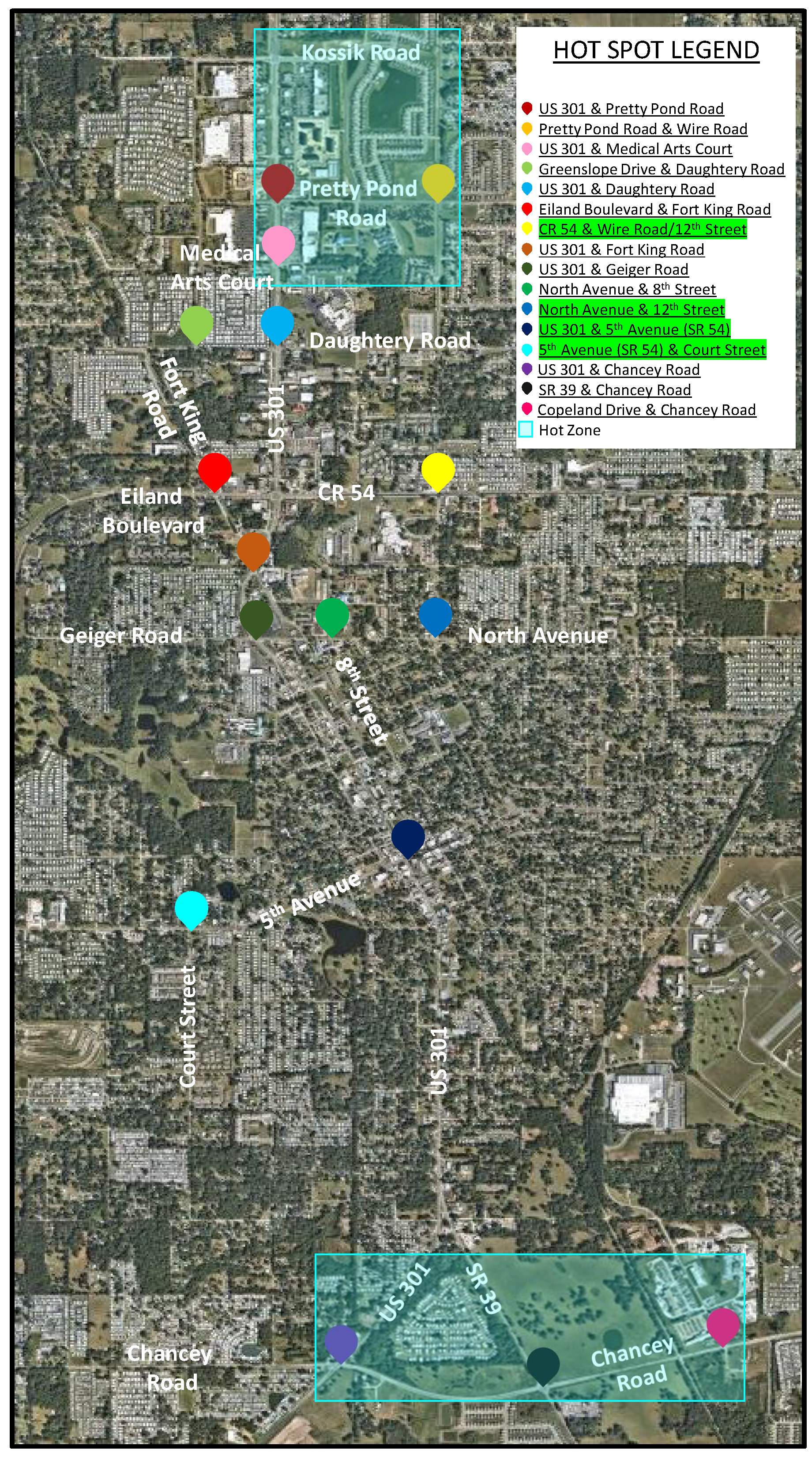
For mitigation measures, the primary concern involves consideration of turn lane criteria at project driveway intersections with the public roadway system and at off-site "hot spot" intersections located within the vicinity (within one mile) of the project site. The turn lane criteria were developed to address situations where the project site driveways are expected to connect directly with either City, County, and/or state (FDOT) roadways as well as previously identified "hot spot" intersections located within one mile of the project site.
(B)
Turn Lane Criteria on City of Zephyrhills Roadways (Within the City Limits):
a.
If more than 20 left-turning vehicles per hour on a two-lane arterial or collector roadway, then left-turn lanes are warranted.
b.
On multi-lane roadways, left-turn lanes shall be constructed when there are more than 20 left-turning vehicles.
c.
If more than 50 right-turning vehicles per hour on a two-lane arterial or collector roadway, then right-turn lanes are warranted.
d.
If more than 40 right-turning vehicles per hour on a four-lane rural roadway, then a right-turn lane is warranted.
e.
If more than 80 right-turning vehicles per hour on a four-lane urban roadway, then a right-turn lane is warranted.
f.
If more than 60 right-turning vehicles per hour on a six-lane rural roadway, then a right-turn lane is warranted.
g.
If more than 100 right-turning vehicles per hour on a six-lane urban roadway, then a right-turn lane is warranted.
(C)
Turn Lane Criteria on Pasco County Roadways (Within the City Limits):
a.
Pasco County will determine the need for turn lanes pursuant to Section 901.3.0 of the Pasco County, Florida Land Development Code.
b.
Additionally, subject to approval by the Pasco County Engineer, the City of Zephyrhills may require construction of turn lane(s) as follows:
i.
Left-turn lanes on arterial and collector roadways regardless of posted speed limit or turning volume.
ii.
Right-turn lanes on roadways with a posted speed limit of 45 mph or higher, regardless of turning volume.
(D)
Turn Lane Criteria on FDOT Roadways (Within the City Limits).
a.
For FDOT roadways within the City of Zephyrhills, the FDOT will determine the need for turn lanes based on their current standards.
b.
Current FDOT Standards are based on Chapter 6 of the FDOT Multimodal Access Management Guidebook (October 2023).
(Ord. No. 1474-24, § 3, 4-8-24)
§ 7.03.01 Map 1: Hot Spot Location Map
Sec. 7.03.02.01. - Right-of-way widths.
(A)
Right-of-way requirements for road construction shall be as follows:
Table 7.03.01
(B)
Future right-of-way requirements are identified in the traffic circulation element of the city's Comprehensive Plan. Where roadway construction, improvements or reconstruction is not required to serve the needs of the proposed development project, future rights-of-way shall nevertheless be reserved for future acquisition. No part of the reserved area shall be used to satisfy minimum requirements of this code.
Sec. 7.03.02.02. - Protection and use of rights-of-way.
(A)
No encroachment shall be permitted into existing rights-of-way, except for temporary use authorized by the City Council.
(B)
Use of the right-of-way for public or private utilities, including, but not limited to, sanitary sewer, potable water, telephone wires, cable television wires, gas lines or electricity transmission, shall be allowed. A right-of-way utilization permit shall be required from the Public Works Director.
(C)
Sidewalks and bicycle ways shall be placed within the right-of-way. Proposed sidewalks and bicycle ways shall be approved as an element of the specific site plan.
Sec. 7.03.02.03. - Vacation of rights-of-ways.
Applications to vacate a right-of-way shall be approved upon a finding that all of the following requirements are met:
(A)
The requested vacation is consistent with the traffic circulation element of the city's Comprehensive Plan;
(B)
The right-of-way does not provide the sole access to any property. (Remaining access shall not be by easement.);
(C)
The vacation would not jeopardize the current or future location of any utility;
(D)
The proposed vacation is not detrimental to the public interest and provides a positive benefit to the city; and
(E)
Requests shall be reviewed by the Site Plan Review Committee and the Planning Commission and approved by City Council.
Sec. 7.03.03.01. - Access and circulation plan required.
All proposed development projects required to submit a preliminary site plan shall provide an access and circulation plan with the application for development approval. The plan shall demonstrate that the following standards for vehicular access and circulation are met by the proposed development:
(A)
All projects shall have access to a public right-of-way.
(1)
A nonresidential development on a corner lot may be allowed two points of access, provided that the center line of neither point of access onto a principal arterial or collector roadway shall be less than 150 feet from the intersection of the center lines of the rights-of-way.
(2)
Schools may have one additional access, provided that the additional access drive is limited to school busses only;
(B)
All streets proposed in a new development shall be designed and constructed to comply with FDOT Manual of Minimum Standards for Design Construction and Maintenance for Streets and Highways, whether they are to be dedicated to the city or to remain private;
(C)
Proposed development shall not degrade the level of service adopted by the city for affected roadways;
(D)
Projects proposed on arterials should include frontage or service roads and have access from the frontage road rather than the arterial. This criteria may be met through interconnecting parking lots which abut the arterial. Where natural features or property ownerships cause this requirement to be physically infeasible, alternate access may be approved;
(E)
Access points on arterial roadways shall be separated a minimum of 60 feet. However, two adjacent projects may share a common driveway, provided that appropriate access easements are granted between or among property owners;
(F)
All proposed rights-of-way shall be located and sized in compliance with the traffic circulation element of the city's Comprehensive Plan;
(G)
The street layout in all new development shall be coordinated with and interconnected to the street system of the surrounding area. Streets in proposed subdivisions shall be connected to rights-of-way in adjacent areas to allow for proper inter-neighborhood traffic flow. If adjacent lands are unplatted, stub outs in the new development shall be provided for future connection to the adjacent unplatted land;
(H)
Access to nonresidential uses shall not be through an area designed, approved or developed for residential use other than multi-family;
(I)
A minimum distance of 150 feet shall separate each driveway or parking lot entrance or exit from any adjacent driveway or parking lot entrance or exit and any street intersection if feasible;
(J)
No parking lot or driveway shall be designed to permit vehicles to back into or onto any street designated as a collector or arterial street; and
(K)
Acceleration, deceleration and storage lanes shall be required for all access/egress where the number of vehicles turning during the peak hour is projected to exceed 300 per hour.
Sec. 7.03.03.02. - Pedestrian access standards.
(A)
Projects abutting roadways designated on MAP TRA-4 of the city's Comprehensive Plan shall provide sidewalks adjacent to the roadway. Location of sidewalks shall be consistent with planned roadway improvements.
(B)
Where a proposed development includes improvements or new construction of collector or arterial facilities, facility designs shall include provision for sidewalks and bikeways within the right-of-way.
(C)
Residential projects adjacent to an activity center comprised of commercial, office, service or recreation activities shall provide pedestrian and bicycle access from the development to the activity center.
(D)
Design and construction of sidewalks, bikeways or other footpaths shall conform to the requirements of this code.
(E)
Escrow deposit. The city may elect to require an escrow deposit as a substitute for sidewalk construction as a condition of the development order or development permit. The amount of the escrow deposit will be determined by the city planner based upon the standards published by the city planner for sidewalk construction, the width and length of the required sidewalk, and current estimated costs of construction to city standards. No certificate of occupancy shall be issued until sidewalks are either built and accepted by the city, or an escrow deposit is provided in accordance with this section.
(Ord. 1249-15, passed 3-9-15)
Sec. 7.03.03.03. - Standards for drive-up facilities.
All facilities providing drive-up or drive-through service shall provide on-site stacking lanes in accordance with the following standards:
(A)
Drive-in facilities and stacking lanes shall be located and designed to minimize turning movements in relation to the driveway access to streets and intersection.
(B)
Drive-in facilities and stacking lanes shall be located and designed to minimize or avoid competing conflicts between vehicular traffic and pedestrians.
(C)
A bypass lane shall be provided.
(D)
Stacking lane distance shall be measured from the service window to the property line bordering the furthest street providing access to the facility.
(E)
Minimum stacking lane distance shall be as follows:
(1)
Financial institutions shall have a minimum of four stacking spaces for each window; and
(2)
For purposes of this item, a stacking space shall be defined as an area ten feet wide by 20 feet long in size, located so as to not impede the flow of traffic along any adjacent right-of-way or within the parking area serving the financial institution.
(F)
Alleys may be used for circulation of traffic for drive-up facilities provided the development provides proper signage to eliminate standing vehicles and otherwise control traffic.
(G)
Where turns are required in the exit lane, the minimum distance from any drive-up station to the beginning point of the curve shall be 34 feet. The minimum inside turning radius shall be 25 feet.
Sec. 7.03.03.04. - Clear site triangle.
(A)
In order to provide a clear view of intersecting streets to the motorist, there shall be a triangular area of clear visibility formed by two intersecting streets or the intersection of a driveway and a street. Nothing in excess of 3½ feet in height including, but not limited to, fences, buildings, walls and vegetation, shall be erected, placed, parked, planted or allowed to grow in such a manner as to materially impede vision within the clear site triangle area. The following standards shall be met:
(1)
On the intersection of local streets with speed limits not exceeding 30 mph with stop sign control on all approaches, the clear site triangle shall be determined as beginning at the intersection of street rights-of-way (edge of pavement), projected where rounded, then in each direction along adjoining property for a distance of 15 feet and then in a straight line across the property. For approaches at intersections without stop sign control on all approaches, the minimum required site distance is 200 feet; and
(2)
On the intersection of streets with speed limits exceeding 30 mph, the site distance requirement established in the Florida Department of Transportation's (FDOT) Manual of Minimum Standards for Design, Construction and Maintenance for Streets and Highways (2002), as amended.
(B)
The above provisions shall not apply to the intersection of an alley and a street. At each intersection of an alley and street, each landowner must maintain a setback of no less than ten feet from right-of-way of streets and alleys. The setback area must be maintained free from sight obstruction by vehicles, walls, fences, plants, landscaping materials or other opaque objects in excess of 3½ feet above the abutting roadway.
(Ord. 866-04, passed 2-23-2004)
Sec. 7.03.03.05. - Street naming procedures.
Any person seeking to change the name of a city street shall follow the requirements of the ordinance codified in this section, as amended and also adhere to the following policies and procedures, if applicable.
(A)
Application for street name changes (procedures for citizen initiative).
(1)
Applications by citizens for naming or renaming public and private streets shall be made in writing to the City Planner. The application should include the proposed name, the specific street location and brief but complete background information on the proposed name. For new street names proposed within new developments applications shall be considered a regular review of the Site Plan Review Committee.
(2)
In the case of a request for a public street name change on a presently named street, the application shall include a listing with name and address of the persons who reside on or own property that fronts on or is adjacent to the subject street. The city shall make contact through certified mail advising all property owners of the submittal of a request for a proposed name change. The application shall also contain a signed petition approving the street renaming by at least 75 percent of the listed property owners facing or adjoining the street. The signatures shall be verified by city staff at the cost of the petitioner.
(3)
The City Planner shall circulate proposed names to the appropriate city departments, heritage or historic groups or homeowner's association, if known, local architectural review board (if any) and Site Plan Review Committee and Planning Commission. Once the comments have been obtained, the suitability of the proposed names will be reported on to City Council for approval.
(4)
Should proposed names of new streets be acceptable to all departments, interested parties and approved by City Council following public hearing, the City Manager shall authorize incorporation of the names and forward the change to the Pasco County Street Naming Department and United States Postal Service.
(B)
Application for street name changes (procedures for City Council initiative).
(1)
Applications for a street renaming may be submitted by a member of Council or the City Council in its entirety. The application should include the proposed name, the specific street location and brief but complete background information on the proposed name. Council may direct staff to provide a listing of all property owners fronting or adjoining the street in question. City Council initiatives shall comply with Ordinance No. 944-05, as amended. The renaming of a specific street may be considered when renaming would generally improve the city's administration of essential services and would be in the public's best interest; and
(2)
Once all property owners have been notified, a public hearing on the proposed name change shall be scheduled with compliance to all public notice requirements and advertising.
(C)
Street type designations. When naming private or public streets within the city, the following street designations shall be utilized:
(1)
Street type designations, depending on roadway function, length and configuration/direction exist to define the character of a street. The following designations should be consulted:
(a)
By length and function, the following designations shall be applied:
1.
Street, avenue, road, boulevard, drive, trail, way, crescent and circle shall be the ending designations for major thoroughfares or streets of several blocks in length;
2.
Terrace, lane and path shall be the ending designations for minor or short streets;
3.
Court shall be the ending designation for cul-de-sacs that do not have any other streets or cul-de-sacs branching off of them;
4.
Place shall be the ending designation for cul-de-sacs that have other streets or cul-de-sacs branching off of them;
5.
Gate may be the ending designation for a short (one block or less in length) roadways, which provides for the entrance to a subdivision; and
6.
Square may be the ending designation for streets which form all or part of a central square within a subdivision;
(b)
By direction, the following designations shall be applied:
1.
Streets running generally north/south shall have the ending designation of "street," "road," "lane" or "way";
2.
Streets running generally east/west shall have the ending designation of "avenue," "terrace" or "path";
3.
Streets running generally diagonally (northwest/southeast or northeast/southwest), shall have the ending designation of "boulevard" or "trail";
4.
Streets which generally are winding shall have the ending designation of "drive";
5.
Streets which generally curve in only one direction shall have the ending designation of "crescent";
6.
Streets which form a circle shall have the ending designation of "circle"; and
7.
Nothing herein shall be interpreted to include existing roadways within the grid area between and including CR 54 and South Avenues and 1st through 24th Streets (most of which are on a diagonal grid) or current or future extensions of those existing roadways beyond these boundaries.
(2)
Whenever possible, whenever a new street is constructed that effectively creates an extension of an existing street, it is preferred that the new street will carry the same name or number and designation as the existing street.
(3)
Qualifying words may be used when a newly created street is in actuality an extension of an existing street which cannot be renumbered or for which no municipal numbers are available. North, south, east, west and upper or lower are appropriate qualifying words.
(4)
In instances of the renumbering of addresses, if initiated by the city, the City Manager and/or his or her designee shall notify by mail the affected property owners and coordinate any changes with Pasco County and the United States Postal Service; and
(5)
The guidelines and criteria for name selection, as set out in the ordinance codified herein, shall also apply to private streets.
(Ord. 945-05, passed 11-28-2005)
Sec. 7.03.04.01. - Intent.
It is the intent of these standards to ensure the appropriate location and quantity of off-street parking and to ensure that all developments provide for adequate and safe storage and movement of vehicles consistent with good site design principles.
Sec. 7.03.04.02. - Applicability.
The provisions of this section shall apply to all development approved commencing with the effective date of this code. The provisions of this section shall apply to redevelopment or amendments to existing development approvals, as follows:
(A)
All parking lot development shall be done in accordance with this section.
(B)
For those uses not specifically mentioned herein, off-street parking shall be provided on the basis of the parking requirements of comparable uses, in the judgment of the Building Official.
(C)
Where a building has a change in use which requires additional parking, the use shall not be licensed until requirements for the additional parking have been met.
(D)
As a result of change in use or expansion of a business, when an existing unpaved parking lot is:
(1)
Increased in size by 50 percent; or
(2)
The number of required parking spaces is increased by 25 percent, both the new portion and remaining unpaved portion shall be improved to the paving standard stated herein.
(E)
Parking spaces may be located on a lot other than that containing the principal use only with the approval of City Council.
(F)
Any off-street parking area shall be graded for proper drainage and shall be surfaced so as to provide a durable and dustless surface, such as turf block, concrete or bituminous concrete surface and shall be so arranged as to provide for orderly and safe parking storage of vehicles. Areas for occasional parking only (i.e. less than twice/week) may be grassed, but must have specifically delineated parking spaces defined by fixed curb stops.
(G)
Any lighting used to illuminate any off-street parking shall be so arranged as to reflect the light away from adjoining residential premises and public rights-of-way.
(H)
The minimum dimensions of all spaces and parking lots shall be shown in a drawing titled "Parking Lot Design Standards". All spaces must be arranged to permit easy entry and exit. An appropriate turn radius into each space should make each space usable. The referenced drawing shows the minimum acceptable dimensions for different parking lot arrangements for passenger cars. These minimums shall be increased to accommodate larger vehicles where appropriate and shall in every case be designed to accommodate sanitation trucks, fire trucks and other service vehicles.
(I)
The curb line of any space or parking lot shall be set back at least three feet from any lot line, building, sidewalk or pedestrian walkway or any other structure. In addition, no parking space shall be permitted within any exit, walkway or emergency access lane; within ten feet of any fire hydrant; or within five feet of a designated fire lane.
(J)
Where appropriate, parking lots shall be designed to include fire lanes required by the Fire Code.
(K)
Parking lots serving businesses open to the public shall be lighted.
Sec. 7.03.04.03. - Parking standards.
(A)
Automobile, mobile home, boat, recreational vehicle and similar rental or sales area. One off-street parking space for each 100 square feet of sales/rental gross area, plus two off-street parking spaces for each service bay, plus one street parking space for each employee on the largest shift.
(B)
Automobile service station or repair facility. Three off-street parking spaces for each service bay, plus parking for any retail sales at the rate of one off-street parking space for each 200 square feet of gross floor area.
(C)
Bar and lounge. One off-street parking for each 15 square feet denoted to public usage, plus one off-street parking space for each employee on the largest working shift.
(D)
Carpet and flooring sales. One off-street parking space for each 500 square feet of gross floor area or five off-street parking spaces, whichever is greater.
(E)
Church, chapel, temple, synagogue or place of worship. One off-street parking space for each three seats in the congregation area or one off-street parking space for each 150 square feet of congregational seating area including, aisles, meeting rooms and Sunday Schools, whichever is larger. (For calculating seating, 18 inches of pew area equals one seat.)
(F)
Commercial (general) and retail sales. General commercial and retail sales establishments shall provide one off-street parking space for each 200 square feet of gross floor area.
(G)
Congregate living facility. One off-street parking space for each four adults housed plus one parking space for each two employees on the combined largest and second largest working shifts.
(H)
Day care center, nursery school, kindergarten (public or private). Five off-street parking spaces, plus one off-street parking space for each employee, plus a loading/unloading area of sufficient size to preclude the need to park on any adjacent right-of-way.
(I)
Financial institution. One off-street parking space for each 200 square feet of gross floor area. In addition, if the institution is equipped with a drive-in window, sufficient area for four stacking spaces for each window shall be provided. For purposes of this item, a stacking space shall be defined as an area ten feet wide by 20 feet long in size, located so as to not impede the flow of traffic along any adjacent right-of-way or within the parking area serving the financial institution.
(J)
Funeral chapel, funeral home, mortuary. One off-street parking space for each three seats of each chapel, plus one off-street parking space for each two employees on the largest work shift, plus one off-street parking space for each vehicle used in connection with the business.
(K)
Government office and service facility. One off-street parking space for each 200 square feet of gross floor area, plus one off-street parking space for each vehicle normally parked or stored at that facility.
(L)
Hospital. One off-street parking space for each two patient beds, plus one off-street parking space for each staff doctor, plus one off-street parking space for each employee on the largest working shift. Emergency rooms shall require an additional one off-street parking space for each 150 square feet of gross floor space.
(M)
Hotel, motel. One off-street parking space per guest room or suite, plus one off-street parking space for each two employees on the largest work shift. Additional off-street parking spaces shall be required for accessory uses, such as lounges, restaurants and the like.
(N)
Indoor and outdoor commercial recreational facility. One off-street parking space for each three patrons, based on maximum capacity of the facility. Additional off-street parking spaces shall be required for accessory uses, such as lounges, restaurants and the like.
(O)
Library. One off-street parking space for each 200 square feet of gross floor area.
(P)
Lumber and building materials. One off-street parking space for every 200 square feet of enclosed retail sales area, plus one off-street parking space for every 1,000 square feet of outside retail sales space, plus sufficient open area for loading and unloading.
(Q)
Medical office, dentist, veterinarian and other health related professional offices and clinics. One off-street parking space for each 150 square feet of gross floor area.
(R)
Office. One off-street parking space for each 200 square feet of gross floor area.
(S)
Personal services. One space for each employee plus one space for each work station.
(T)
Plant nursery. One off-street parking space for every 200 square feet of enclosed retail sales area, plus one off-street parking space for every 1,000 square feet of outside retail sales area, but in not case less that five off-street parking spaces.
(U)
Private, civic, fraternal club or lodge. One off-street parking space for each 100 square feet of floor space or one off-street parking space for each three seats of the rated seating capacity in total.
(V)
Recreational vehicle park. One and one-half parking spaces for each recreational vehicles.
(W)
Residential. Two parking spaces for each dwelling unit.
(X)
Restaurant, cafeteria, fast food establishment. One off-street parking space for each two employees on the largest working shift or one off-street parking space for each 150 square feet of floor area, whichever is greater.
(Y)
School (elementary and junior high). Two off-street parking spaces per classroom or office, plus one off-street parking space for each 150 square feet of any auditorium or place of assemble, plus adequate additional area for bus parking, loading and unloading.
(Z)
School (senior high). Five off-street parking spaces per classroom or office, plus one off-street parking space for each 150 square feet of any auditorium or place of assembly, plus adequate additional area for bus parking, loading and unloading.
(AA)
Shopping center. Shall provide one off-street parking space for each 200 square feet of gross floor area.
(BB)
Taxi service. One off-street parking space for each employee on the largest working shift, plus one off-street parking space for each vehicle used in connection with the business.
(CC)
Theatre, auditorium, performing arts center. One off-street parking space for each three seats.
(DD)
Vocational, technical, trade school. Ten off-street parking spaces for each classroom, plus one off-street parking space for each 150 square feet of any office or clerical area.
(EE)
Wholesale, warehouse, industrial. One off-street parking space for each two employees on the combined largest and second largest working shift.
Sec. 7.03.04.04. - Maintenance.
All off-street parking areas shall be well maintained, free of potholes, debris, weeds, broken curbs and broken wheel stops, clearly striped and with all lighting in working condition. Facilities shall be maintained as soon as the use exists which the facilities were designed to serve.
Sec. 7.03.04.05. - Design of parking lots.
Parking lot design, including by not limited to, arrangement of spaces, width of aisles and access drives, width, length and angle of spaces, installation of curbs and the like, shall be specified in the illustration below.
Sec. 7.03.04.06. - Adjustments to requirements.
(A)
Parking deferral. To avoid requiring more parking spaces than actually needed to serve a proposed development, the Site Plan Review Committee may defer the provision of some portion of the off-street parking spaces required by this section if the conditions and requirements of this section are satisfied.
(B)
The Site Plan Review Committee may authorize a reduction in the total number of required parking spaces for two or more uses jointly providing off-street parking when their respective hours of need of maximum parking do not normally overlap. Reduction of parking requirements because of joint use shall be approved if the following conditions are met:
(1)
The developer submits a parking study with sufficient data to demonstrate that hours of maximum demand for parking at the respective uses do not normally overlap; and
(2)
The developer submits a legal agreement approved by the City Attorney guaranteeing the joint use of the off-street parking spaces as long as the uses requiring parking are in existence or until the required parking is provided elsewhere in accordance with the provision of this code.
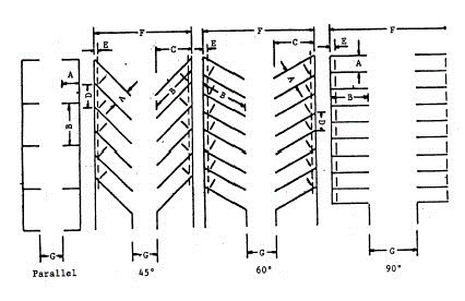
Table 7.03.02. Off Street Parking Dimensional Table
Sec. 7.03.05. - Handicapped access.
(A)
Level parking spaces shall be reserved for physically handicapped persons according to the following requirements.
Table 7.03.02
(B)
Parking spaces reserved for physically handicapped persons shall meet the following design and location requirements:
(1)
All spaces shall be accessible to curb ramp or curb cut, when necessary to allow access to building, structure or use served and shall be so located that users are not compelled to wheel behind parked vehicles;
(2)
Diagonal or perpendicular parking spaces shall be a minimum of 12 feet wide by 20 feet in length;
(3)
Parallel parking spaces shall be located either at the beginning or end of a block or adjacent to an alley entrance. Curbs adjacent to such premises shall be of a height which will not interfere with the opening and closing of motor vehicle doors; and
(4)
Each such parking space shall be prominently outlined with blue paint and posted with a nonmoveable, above grade, fixed sign of a color and design approved by the Florida Department of Transportation, bearing the internationally accepted wheelchair symbol and the caption "PARKING BY DISABLED PERMIT ONLY".
Sec. 7.03.06. - Loading areas.
(A)
The off-street loading requirements of this section are intended to provide minimum standards necessary for the loading and unloading of goods for the various commercial and industrial uses permitted by this chapter, to protect the capacity of the street system, avoid undue congestion resulting from loading and unloading activities and to lessen unnecessary conflicts between trucks and other vehicles.
(B)
The requirements of this section shall apply to all commercial and industrial development, whether new structures or alterations to existing structures. Off-street loading shall be available for use prior to the issuance of any certificate of occupancy or occupational license and its continued maintenance shall be the obligation of the property owner and occupant as long as the use requiring loading facilities continues. No off-street loading shall be altered or discontinued except in accordance with this article.
(C)
Loading spaces shall not be used for the storage of vehicles and/or materials. Loading spaces shall not be used to meet off-street parking requirements.
(D)
The following loading space requirements shall be met:
(1)
Each off-street loading space shall have minimum dimensions of 14 feet in height, 12 feet in width and 55 feet in length. However, upon sufficient demonstration that a particular loading space will be used exclusively by shorter vehicles, the Site Plan Review Committee may reduce the minimum length to as little as 35 feet or height to eight feet;
(2)
Each required off-street loading space shall have direct access to a street or have a driveway which offers satisfactory ingress and egress for trucks;
(3)
There shall be provided for each institution, hotel/motel, commercial or industrial building or complex requiring the receipt or distribution of materials or merchandise by truck and having a gross floor area of 10,000 square feet or more, at least one off-street loading space for each 10,000 square feet of floor area or fraction thereof. The loading space shall be located as not to hinder the free movement of pedestrians and vehicles over a sidewalk, street or alley;
(4)
There shall be provided for each institution, hotel/motel, commercial or industrial building or complex requiring the receipt or distribution of materials or merchandise by truck and having a gross floor area of less than 10,000 square feet, sufficient off-street loading space located to not hinder the free movement of pedestrians and vehicles over a sidewalk, street or alley-sharing between adjacent establishments is encouraged;
(5)
There shall be provided sufficient space to accommodate the maximum number of buses or trucks to be stored or to be loaded at the terminal at any one time; and
(6)
Areas reserved for off-street loading in accordance with the requirements of this section shall not be reduced in area or changed to any other use unless the permitted use which is served is discontinued or modified so that the space is provided elsewhere in accordance with these regulations and as approved by the Building Official.
Sec. 7.06.01. - Content and purpose.
(A)
Generally. This partis intended to protect trees and their canopies, wetlands and natural resources by regulating the removing of trees, site clearing, landscaping, tree planting and irrigation in the city. This part is also designed to promote the maintenance of native plant species and the removal of exotic and nuisance species.
(B)
Applicability. The provisions of this part shall apply to all buildings, development, improvements and land within the limits of the city, (both new residential and commercial development) unless expressly exempted by law. For existing projects, improvements made that are over 51 percent of the existing cost of the appraised property, shall also trigger the use of these guidelines. Note: Under no circumstances are these provisions to be used for the development (new or the improvement) of single or double residential lots.
(C)
Administrative authority. The provisions of this part shall be administered and enforced by the official. For purposes of administration of the provisions of this part, the official's designee shall be the Building Official.
(D)
Conflicts. If the provisions of this part conflict with other ordinances or regulations, the more stringent limitation or requirement shall govern.
(Ord. 922-05, passed 6-13-2005)
Sec. 7.06.02. - Characteristics of protected trees and grand trees.
(A)
Protected trees. Protected trees have the following characteristics:
(1)
Twenty-four inches or greater diameter (d.b.h.); and
(2)
All cypress trees.
(a)
For protected trees that are six to 23 inches in caliper, the replacement rate shall be one tree for every two protected trees removed.
(b)
For protected trees that are 24 inches in caliper or greater, the replacement rate shall be two trees for every one protected tree removed (on an inch per inch basis).
(c)
A certified arborist will be used on projects to determine the health and designation of a tree as protected or grand. When a tree is determined not to be a grand tree, it shall be considered a protected tree if it otherwise meets the requirements of this chapter.
(B)
Grand trees. Grand trees have the characteristics set forth in Schedule A.
(1)
Replacement rate for a grand tree shall be double the size, on a caliper inch by caliper inch removed. While more than one tree may be used to replace the necessary number of caliper inches equal to the removed grand tree, the minimum replacement tree size that shall be used for each tree is at least four inches in caliper.
Schedule A. Species and Circumference
(2)
The Director may include additional species by providing standards similar to those in Schedule A above. In determining whether a tree has the requisite circumference to be a grand tree, tree circumference shall be measured at 4½ feet above grade (d.b.h.) and all measurements shall be to the nearest whole inch (round up). The Director shall determine and verify all measurements on trees for grand tree designation.
(Ord. 922-05, passed 6-13-2005)
Sec. 7.06.02.01. - Exemptions for certain trees.
Exempt trees include the following:
(A)
Broussonetia papyrifera (male Mulberry);
(B)
Casuarinas sp. (Australian Pine);
(C)
Citrus spp.;
(D)
Camphor spp.;
(E)
Enterolobium contortisiliquum (Ear Tree);
(F)
Eucalyptus spp. (Eucalyptus Tree);
(G)
Melaleuca quinquenervia (punk tree);
(H)
Melia azedarach (China berry);
(I)
Prunus caroliniana (Cherry Laurel);
(J)
Schinus terebinthifolius (Brazilian Pepper);
(K)
Auracaria wrightii (Monkey Puzzle);
(L)
Grevillea robusta (Silk Oak Tree);
(M)
Albizia spp. (Mimosa, Woman's Tongue);
(N)
Syagres romanzoffiana (Queen Palm);
(O)
Prunus serotina (Wild Cherry); and
(P)
Sapium sebiferum (Chinese Tallow).
(Ord. 922-05, passed 6-13-2005)
Sec. 7.06.03. - Landscape plan.
(A)
General. Prior to the approval of any site plan, "landscape plans" for the entire parcel and as specified below, shall be submitted, reviewed, revised and approved by the SPR Committee.
(B)
Nature of required plan. A landscape plan shall be prepared and/or approved by a registered landscape architect as authorized by F.S. Ch. 481, as amended. The landscape plan shall include sufficient information to determine whether the proposed landscaping is in compliance with the standards and other requirements of this part. The landscape plans shall be submitted as a part of the site plans. Submitted landscape plans shall be drawn at a readable scale and shall include the following:
(1)
The name, address and telephone number of the owner of the property for which the landscape plan is required;
(2)
The name, address and telephone number of the landscape architect preparing the landscape plan;
(3)
The location of the property including the legal description, section, township, range and street address, if known;
(4)
The location of all existing and proposed structures, all landscape improvements (i.e.: berms, walls, fences, screens, sculptures, fountains, street furnishings, lights, paved areas) parking areas, vehicular use areas and other site improvements;
(5)
The location of all in-ground, above ground and overhead utilities and irrigation, including structures, sizing, height and types. Use Appendix D for any trees proposed under power lines;
(6)
General notes and specifications including mulching requirements, instructions for the installation, fertilization and maintenance of all plant materials;
(7)
A separate tree survey sheet depicting all existing trees on site including those to be removed and trees to be protected and methodology for protection. The tree survey should delineate the following, at a minimum, the location of all existing trees including a palm, pine or oak designation, caliper in inches of each tree six inches d.b.h. or greater, the location of the trunk of the tree and the width of the drip line (canopy). Note: To depict the dripline of the tree one additional spot other than the trunk shot shall be required and an assumed even circumference for the tree will be inferred for that additional spot. Wooded or conservation areas can have the trees on the outer edge of the area surveyed only utilizing two spots for each to avoid mapping of interior trees;
(8)
A copy of the county soils map depicting the proposed development site and the existing soils will be required and is to be submitted to the city with the landscape plans. If the soils are found to be of poor quality for vegetative growth per the soils map, the soils are to be tested (see division (B)(12) of this section) and amended per the recommendations of the report. Poor drainage condition details shall be included in the landscape plans (See Appendix F for a typical tree planting detail);
(9)
While it is not required, utilize to the extent possible environmentally sustainable principles and practices, which include "Xeriscape" principles (See § 22);
(10)
A plant list that provides the scientific and common names, sizes (i.e.: caliper), quantity, special requirements and location of all plant materials existing and proposed and proposed turf grass type that will be utilized to meet the minimum landscaping requirements;
(11)
Planting and installation details, as needed, to ensure conformance with all required standards, including tree protection and erosion control.
(12)
If the soils are found to be of poor quality for vegetative growth according to the county soil map, a soils testing report for the existing soil of the proposed site will be required and is to be submitted to the city with the landscape plans. The applicant is to work with the local extension agency or independent testing lab to have the existing soil tested and to acquire the report from the testing agency. The following soil information will be requested of the testing agency and included in the report: pH, soluble salts and percentage of sand, silt, clay and organic matter. Soil should be adjusted to meet a pH range of 6.0 to 7.0. Topsoil should fall within the following ranges: sand, 25 percent—53 percent, silt 28 percent—50 percent, clay eight percent—27 percent. Organic matter shall not be less than five percent (Note: as determined by loss on ignition of moisture-free samples dried at 65°C). Per request, the city will provide the contact information for soils testing agencies as a part of the pre-application meeting. The applicant is to amend the existing soil per the recommendations of the soils report to provide for the viability and long-term health of the vegetation being proposed in the landscape plans;
(13)
Information necessary to evaluate compliance with provisions of this part;
(14)
Prior to submitting the landscape plan set for review, the applicant will be required to meet with staff to discuss the proposed project and the applicable landscape requirements in a pre-submittal application meeting;
(15)
A landscape maintenance plan and schedule will be submitted as a part of the landscape plans. As a minimum this information will include scheduling and information on watering, fertilizing, herbicide/pesticide applications, trimming/edging, maintenance and mowing cycle;
(16)
Each landscape plan shall provide that the requested development shall commence within six months from the date of issuance of the permit. Applicant is required to submit in writing for review and approval by the Director should an extension to this time limit be warranted. It is the responsibility of the applicant to apply for the extension and the city is not responsible for notification of an expired permit; and
(17)
In addition to the owner's contact information, the applicant must supply the city with the selected landscape contractor's contact name, phone number and fax number so the city will know who to contact regarding any issues that may arise. Contact information is to be supplied to the city as soon as he or she is hired. A separate application for the landscape plans is not required.
(Ord. 922-05, passed 6-13-2005)
Sec. 7.06.03.01. - Landscape installation.
(A)
All plant material shall be grade Florida No. 1 or better pursuant to the Florida Department of Agriculture Grades and Standards for Nursery Plants, which is incorporated herein as reference.
(B)
Installed trees and plants shall be grouped together into landscape plant zones according to water and cultural (soil, climate and light) requirements.
(C)
In accordance with the irrigation standards set forth in this part in § 14, a maximum of 50 percent of the plant material used, other than trees, may be drought tolerant. Native species, suitable for growth in the city, should be encouraged. Appendix B of this part, "A Partial List of Native Plant Materials", which references additional sources, may be used for native plant identification.
(D)
The use of plant species listed in Appendix C, "Florida Exotic Pest Plant Council's List of Invasive Species", is prohibited.
(E)
All landscaping shall be installed in accordance with industry accepted landscape practices.
(F)
Existing plant material may be used to meet the buffering and landscaping requirements of this section provided there is no reduction in the required percentage of landscaped area or reduction in the number of required trees or shrubs. If existing plant materials are retained, the following standards shall apply:
(1)
All new development shall retain existing plant materials to the maximum extent possible unless storm water management design, necessary grade changes, required infrastructure or approved construction footprints necessitate their removal. Areas of retained plant materials may be preserved in their entirety with all trees, understory and groundcover left intact and undisturbed provided that prohibited plant materials as identified in Appendix D, which may be amended from time to time by the city, are removed; and
(2)
The protection of existing plant materials shall conform to the tree protection detail found in Appendix E of the ordinance codified herein.
(G)
All height requirements shall be based on the finished grade of the landscaped area.
(H)
New plant material shall meet the following criteria:
(1)
All shade trees used to satisfy landscaping requirements shall have a three-inch caliper trunk, shall be containerized or shall be a transplant using a tree spade and shall be a minimum of ten feet in height at the time of installation. All required shade trees shall be a species having an average mature spread of greater than 20 feet when grown in the city. Where interference with overhead utility lines is probable, understory trees shall be planted with a maximum spacing of 20 feet on center (see Appendix D for trees to be planted under power lines);
(2)
All proposed multi-trunk trees shall have no less than three trunks and no less than one inch caliper size per trunk and shall be a minimum of six feet in height at the time of installation;
(3)
Palm trees may be substituted for shade trees at a rate of three palm trees, grouped together, per one shade tree. Palm trees may be substituted for up to 30 percent of the required shade trees. Palms must have a minimum of ten feet of clear trunk at the time of installation;
(4)
When used as a hedge, shrubs, grown in two-gallon containers, shall be a minimum of 18 inches in height at the time of installation. Shrubs shall be spaced a maximum of 36 inches on center. Where required to visually screen, evergreen shrubs shall be planted in staggered double rows and maintained so as to form a continuous, unbroken, solid visual screen within one year from the time of planting;
(5)
Ground cover shall be installed to provide a finished appearance and adequate coverage within 90 days, so as to suppress fugitive dust; and
(6)
Sod shall be used in lieu of seeding for grassed areas. The acceptable sod types are Bahia for retention areas and St. Augustine (i.e. Flortam, Seville and the like) for all other grassed areas.
(I)
Mulch shall be used in conjunction with living plant materials so as to cover exposed soil. Mulch shall be installed to a minimum depth of three inches. Mulch type should be specified on the plans. The mulch should not be placed directly against the plant stem or tree trunk. Mulch shall not be required for annual beds. Stone or gravel may be used to cover a maximum of 20 percent of the landscaped area.
(J)
All required landscape materials shall be installed using planting soil of a type appropriate to the individual plant material and the soil conditions in which the planting is occurring. Soil amendments based upon the recommendation of the soil analysis report are required prior to installation of any landscape materials. Proof of soil amendments necessary to provide adequate soil growing medium shall be provided in booklet format as a part of the submitted plans.
(K)
No one plant species of trees, shrubs or groundcover, excluding turf grass, shall constitute more than 50 percent of any landscape plan.
(L)
All portions of a parcel upon which development has commenced, but not continued for a period of 30 days shall be planted with a temporary grass species or ground cover to prevent erosion and enhance soil stabilization. Adequate coverage to suppress fugitive dust shall be achieved within 45 days.
(M)
Any disturbances made during construction to the existing city's right-of-way will require the contractor to provide such amendments to return the right-of-way to its preconstruction condition. This may include, but is not limited to, repairing and regrading site and replacement of damaged vegetation including sod.
(N)
The project landscape architect shall conduct a final field inspection of the landscape. A certificate of compliance with the requirements of this section shall be provided to the city and the property owner and an "as built" drawing of the landscape shall be provided to the property owner prior to obtaining the certificate of occupancy.
(Ord. 922-05, passed 6-13-2005)
Sec. 7.06.03.02. - Failure to obtain a permit.
(A)
Whenever a violation(s) of this part occurs or exists or has occurred or existed, any person individual, entity or otherwise, who has legal, beneficial or equitable interest in the facility or instrumentality causing or contributing to the violation(s) and any person individual, entity or otherwise, who has legal, beneficial or equitable interest in the real property upon which the violation(s) occurs or exists or has occurred or exited, shall be liable for the violation(s).
(B)
Any person who shall commence any work without first obtaining a permit therefor shall, if subsequently permitted to obtain a permit, pay triple the permit fee prescribed for the work. The payment of a triple fee shall not preclude nor be deemed a substitute for prosecution for commencing work without first obtaining a permit.
(C)
The removal of a grand tree or protected tree without a permit is deemed to be an irreparable and irreversible violation. A fine of $5,000.00 will be imposed for the removal of a grand tree or protected tree without a permit. Fines collected will go to the Parks Department Tree Trust Fund.
(D)
In addition, any person removing a grand tree or protected tree without a permit shall be required to replace the grand tree or protected tree with one or more recommended tree(s) on the same parcel (or on adjacent right-of-way). The number and size of the replacement tree(s) required to be planted shall be double the size, on an inch-by-inch basis, the size (dbh) of the grand tree or protected tree(s) that were removed without a permit. If it is not possible to relocate or replace a grand tree or protected tree with recommended tree(s) on the same (or in adjacent right(s)-of-way), then a contribution shall be made to the Parks Department Tree Trust Fund.
(E)
In lieu of tree replacement on the subject property, the applicant, at the city's option, may replant approved trees on city-owned property or contribute a per tree monetary fee as follows. Fees collected in lieu of replacement shall be placed by the city into the Parks Department Tree Trust Fund for use of tree replacement, use of a trained horticulturalist or arborist, educational purposes regarding trees and/or the enforcement or for the advancement of this part. The fees are hereby established as follows:
(F)
It shall be unlawful for any person, during the development of any project or during the construction of any structures or the improvement of any property, to place solvents, material, machinery or temporary soil deposits within the dripline of any tree. During construction, improvement or development of the property, the owner or his or her agent(s), shall be required to place visible, physical barriers around all trees designated for retention and these protective structures, where required, shall remain until such time as they are authorized to be removed by the Director or issuance of final certificate of occupancy. Protective structures shall be provided as detailed in Appendix E of this document.
(G)
Exceptions.
(1)
Where extenuating circumstances justify, the Director may allow an extension of time for the permit to be obtained in excess of three business days.
(2)
For just cause and in cases involving extreme circumstances and unusual hardship, the Director may waive the triple permit fee (three times the permit fee).
(Ord. 922-05, passed 6-13-2005)
Sec. 7.06.04. - Tree removal guidelines.
In conjunction with any development, building or land clearing, a percentage of trees as defined herein, may be removed in accordance with the following table. Removal of any trees over these guideline percentages may require replacement at a rate of double the inch-per-inch basis or financial contribution to the Parks Department Tree Trust Fund. The waiving of the percentages detailed in these guidelines is at the discretion of the Director.
Sec. 7.06.04.01. - Landscape buffering and screening.
(A)
The buffering and screening requirements of this section shall apply to all new development except single and two family lots not part of an approved overall development plan.
(B)
All portions of each site, which are not devoted to buildings, sidewalks, paving or special landscape features shall be grassed.
(C)
Buffer types.
(1)
Type A buffer. A ten-foot wide buffer with a single row of shade trees spaced a maximum of 50 feet on center and a continuous row of evergreen shrubs with a minimum height of 18 inches at installation with a maximum spacing of 36 inches on center.
Type A Buffer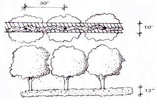
(2)
Type B buffer.
(a)
A 15-foot wide buffer planted with a single row of shade trees having a maximum spacing of 50 feet on center. A visual screen designed to be 80 percent opaque within one year and a minimum of six feet in height at installation shall also be provided with this buffer. The screen may include an opaque fence, wall, hedge, berm or any combination thereof. Wooden fences shall be prohibited. Walls and fences shall not exceed eight feet in height. Shrubs that are used to provide a visual screen shall be spaced a maximum of five feet on center.
(b)
For interior lots within a platted industrial park, the minimal type B landscape buffer may be reduced to five feet to fit within the minimum ten-foot wide setbacks. All planning and screening requirements of this section shall remain the same.
Type B Buffer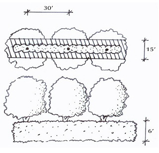
(3)
Type C buffer. A 20-foot wide buffer planted with two staggered rows of shade trees with a maximum spacing of 50 feet on center (Note: See the drawing below. There is to be 100 feet between trees in the same row, but the two rows are to be staggered such that the second row of trees is to be placed halfway (50 feet) between the trees of the top row). A visual screen designed to be 80 percent opaque within one year and a minimum of six feet in height at installation shall also be provided within the buffer. The screen may include an opaque fence, wall, hedge, berm or any combination thereof. Wooden fences shall be prohibited. Walls and fences shall not exceed eight feet in height. Shrubs that are used to provide a visual screen shall be placed a maximum of five feet on center.
Type C Buffer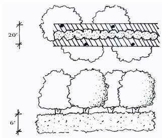
(4)
Type D buffer (right-of-way buffer). This landscape buffer shall be required adjacent to any road right-of-way external to the development project and adjacent to any access roads internal to a commercial development.
(a)
The minimum width of the right-of-way buffer shall vary according to the ultimate width of the abutting right-of-way as indicated below:
1.
A right-of-way width from zer to 99 feet wide requires a minimum ten-foot wide buffer:
2.
A right-of-way width of 100 feet or more requires a minimum 15-foot wide buffer; and
3.
Developments of 15 acres or more require a minimum 20-foot wide buffer regardless of the width of the right-of-way.
(b)
Shade trees shall be planted with a maximum spacing of 50 feet on center. Palms may be substituted for up to 30 percent of the required shade trees and shall be planted in clusters with a minimum of three palms per cluster with a maximum spacing of eight feet on center. A maximum distance of 50 feet shall be maintained between all types of tree plantings. The remainder of the buffer shall be landscaped with shrubs, at a minimum rate of five shrubs per tree or palms, ground cover and sod.
(c)
No more than 50 percent of the required landscape area may be grassed, with the balance shall be landscaped in shrubs and ground covers. Note: This requirement will be reviewed on a case by case basis and a special exception can be submitted for those sites that cannot meet this requirement.
(d)
A masonry wall, not to exceed eight feet in height, may be located within a required Type D buffer (right-of-way buffer) to separate a residential development from an arterial or collector road. Landscaping shall be provided along the right-of-way side closest to the wall. Shrubs shall be planted at a minimum rate of 40 shrubs for every 100 lineal feet of wall or fraction thereof. The shrubs may be planted in groupings or in a row. Where possible, sidewalks located adjacent to the masonry wall shall be separated from the masonry wall by a single row of trees, spaced 50 feet on center. The trees shall be planted to provide shade along the sidewalk. Palms may be substituted for trees at a rate of three palm trees, grouped together, per one tree. Palms may be substituted for up to 30 percent of the required trees. Vines and groundcover may also be incorporated into the landscaping. It is not the intent of this requirement to obscure from view decorative elements such as emblems, tile molding and wrought iron.
(5)
Automotive service stations and convenience stores with gas pumps buffer. Automotive service stations and convenience stores with gas pumps shall be buffered from surrounding uses.
(a)
Right-of-way buffer landscaping:
1.
A landscape buffer, a minimum of 15 feet in width, shall be required between the public right-of-way and the development project.
2.
Shade trees shall be planted in a single row with a maximum spacing of 50 feet on center. Palms may be substituted for up to 30 percent of the required shade trees and shall be planted in clusters with a minimum of three palms per cluster with a maximum spacing of eight feet on center. A maximum of 50 feet shall be maintained between all types of tree clusters.
3.
All portions of each site, which are not devoted to buildings, sidewalks, paving or special landscape features, shall be sodded. However, no more than 50 percent of the required landscape area may be sodded, the balance shall be landscaped in shrubs and ground covers.
4.
Refer to division (C) of this section for all buffering requirements from adjacent property.
(6)
Vehicular use area (VUA). A minimum of ten percent of the VUA is to be landscaped with one shade tree per 200 square feet of VUA. The landscape requirements for the VUA consist of one landscaped island per a maximum of ten parking spaces. Each island is to be eight feet wide by 20 feet long and will contain one shade tree with either shrubs or ground cover beneath the tree.
(7)
Foundation planting. Foundation plantings are to include one understory tree per 20 feet of building lineal feet and shrubs and ground cover to fill in the remaining foundation planting area.
(8)
Sidewalks and the like. Sidewalks and other impervious areas shall not occupy any part of a required A, B, C or D buffer, except when:
(a)
Driveways and sidewalks are constructed perpendicular to the buffer and provide direct access to the parcel or adjacent parcels; and/or
(b)
A meandering sidewalk, bike trail or nature trail is provided within the buffer and the buffer width is increased by the equivalent sidewalk or trail width.
(9)
Service function areas. Areas of nonresidential development that are utilized as loading areas or docks, outdoor storage, trash collection, mechanical equipment, trash compaction, recycling or other service functions shall be screened and out of view from adjacent properties at ground level and from public rights-of-way by a masonry wall a minimum of six feet in height. Industrial parks shall be exempt from the requirements of this section.
(10)
Retention areas.
(a)
All human-made dry and wet retention areas that are within 20 feet of the public right-of-way or located within a required buffer shall be landscaped. If the retention area is within 20 feet of a public right-of-way and runs parallel to the public right-of-way, then a Type D buffer will be used and a Type A buffer will be used on the remaining sides of the retention area. Retention ponds may contain special site features, such as fountains and reflecting pools. Existing natural vegetation may be used in lieu of new plantings.
(b)
Retention/detention ponds and swales shall be permitted within a required buffer provided they are consistent with the following criteria:
1.
Retention/detention ponds and swales shall not exceed 50 percent of the square footage of any required side, rear or front yard landscape buffer except where existing native vegetation is retained at natural grade;
2.
Retention/detention ponds and swales shall not exceed, at any location within the required buffer, 70 percent of the required buffer width;
3.
To reduce soil erosion and visually soften the edge of the water, trees shall be planted along the banks of the pond/retention area at a minimum rate of one tree per 50 lineal feet of pond bank; and
4.
The banks of dry retention areas shall be sodded to the pond bottom. Wet retention areas shall be sodded to the high water line. Bahia grass may be used or planted in retention/detention areas, drainage areas and wetland setback and mitigation areas.
(c)
Storm water retention/detention areas with slopes that require fencing by Southwest Florida Water Management District requirements shall be enclosed with a transparent six-foot decorative metal or vinyl coated chain link fence. Unfinished, galvanized chain link fencing shall not be permitted.
(d)
All retention ponds that require fencing will also require a Type A buffer on the outside of the fence.
(11)
Clear site triangles. Where a driveway/accessway intersects a road right-of-way or where two public road rights-of-way intersect, vegetation, structures and non-vegetative visual screens shall not be located as to interfere with the clear site triangle, as defined in the city's Land Development Code.
(Ord. 922-05, passed 6-13-2005)
Sec. 7.06.04.02. - Plant substitutions.
(A)
Due to occasional plant availability problems, approved landscape plans may require minor revisions. Minor revisions to planting plans can be submitted for staff-level review if there is no reduction in the quality of plant material or no significant change in size or location of plant materials and if the revised plant material are of the same general category (i.e. shade, ornamental or evergreen trees) and have the same general design characteristics (i.e. mature height, crown spread) as the materials being replaced. Revised plant material must also be compatible with the area to ensure healthy tree growth.
(B)
If these criteria are not fulfilled, changes to the approved plans must be resubmitted and reviewed again.
(C)
A revised landscape plan that depicts the proposed plant substitutions with supporting text explaining the need for the change in plant material and a list of the original plant material and the proposed plant substitutions will be submitted for review by staff. While a special exception will not be required for minor revisions, staff reserves the right to require a special exception should they determines the proposed changes warrant it.
(Ord. 922-05, passed 6-13-2005; Ord. 1368-18, passed 8-27-2018)
Sec. 7.06.04.03. - Irrigation design standards.
The following irrigation standards shall apply to all new development, including residential (single-family, two-family and multi-family), commercial, institutional and industrial development; and where significant rehabilitation (50% or greater) of an existing landscape irrigation system will be conducted. In addition to the standards of this subsection, the requirements of Section 156.30—156.36, Florida Water Smart Certification Required, of the Code of Ordinances shall be applicable to all residential, commercial and institutional development. Where in conflict, the more restrictive shall apply. The following irrigation standards shall apply to all new development, including residential, commercial, institutional and industrial development, and where significant rehabilitation (50% or greater) of an existing landscape irrigation system will be conducted. In addition to these:
(A)
In-ground irrigation systems shall be utilized for new development including commercial development and single- and multi-family lots. Irrigation shall be provided for all proposed landscape material.
(B)
The Florida Irrigation Society (FIS) standards, which are incorporated herein by reference, should be used for all irrigation design and installation procedures, except where the requirements of this part supersede the FIS standards.
(C)
An irrigation site plan, drawn at a readable scale, shall be submitted illustrating the proposed irrigation zones, delineating micro-irrigation zones and areas utilizing all other irrigation techniques. The plan should indicate the irrigation water source. Existing development with newly irrigated landscape and turf areas shall not be required to submit an irrigation plan.
(D)
Where available, reclaimed wastewater shall be used for landscape irrigation and shall comply with the requirements of this section.
(E)
The irrigation system shall be designed to accommodate separate landscape plant zones based on differing water requirements. Turf areas shall be on separate irrigation zones from other landscape plant zones.
(F)
Sprinkler spacing shall not exceed 55 percent of the sprinklers' diameter of coverage.
(G)
Sprays and rotors shall have matching application rates within each irrigation zone. Sprays and rotors shall not be combined on the same irrigation zone.
(H)
All irrigation systems shall be designed to avoid overspray, runoff or other similar conditions where water flows onto or over adjacent property, non-irrigated areas, walkways, roadways, structures or water features. Narrow areas (four feet wide or less) shall be irrigated with micro-irrigation only.
(I)
Irrigation control equipment shall include an operable and functioning automatic irrigation controller having program flexibility such as repeat cycles and multiple program capabilities. Automatic irrigation controller(s) shall have a battery back-up to retain the irrigation programs. Automatic control systems shall be equipped with operable and functioning rain and wind sensor devices. These devices shall be placed in areas where they can be exposed to natural rainfall and winds. As the technology improves, moisture sensing devices to cut-off irrigation when ground conditions do not warrant watering are encouraged.
(J)
The irrigation system shall be maintained and managed to ensure efficient water use and to prevent wasteful practices. These include, but are not limited to, resetting the automatic controller according to season, cleaning irrigation filters, testing the rain and wind sensors, monitoring, adjusting and repairing the irrigation equipment to ensure the efficiency of the system is maintained, replenishing mulch, utilizing turf and landscape best management practices, including plant pruning and cutting grass around sprinkler heads.
(K)
A registered landscape architect or irrigation contractor shall conduct a final field inspection of the irrigation system. A certificate of compliance with the requirements of this article shall be provided to the city and the property owner and an "as built" drawing of the irrigation system shall be provided to the property owner and city prior to obtaining the certificate of occupancy.
(Ord. 922-05, passed 6-13-2005; Ord. No. 1457-23, § 4, 4-24-23)
Sec. 7.06.04.04. - Approval process.
Landscape plans will be required in conjunction with a site plan. Approval of the landscape plan will be governed by the procedures established for a site plan in the city's Land Development Plan. The city reserves the right to hold-up the certificate of occupancy until such time as the site plan meets the city's approval.
(Ord. 922-05, passed 6-13-2005)
Sec. 7.06.04.05. - Reserved.
(Ord. 922-05, passed 6-13-2005)
Sec. 7.06.04.06. - Enforcement.
(A)
The contractor is responsible for overseeing the installation and maintenance of required plants per the approved landscape plan and for a one year guarantee on all required plant material; if any required plant material dies within the first year, the contractor must replace it/them.
(B)
The city and the contractor must meet on site upon completion of the landscape installation for an inspection. The contractor must contact the city to establish the inspection time.
(C)
The City Inspector has the right to reject the plant material if it does not meet this part and to hold the certificate of occupancy until all required plants are properly installed to the Inspector's satisfaction.
(D)
Failure to replace dead and diseased plants will be a violation of this part.
(Ord. 922-05, passed 6-13-2005)
Sec. 7.06.05. - Landscape maintenance.
(A)
All landscaping, including those areas located in the public right-of-way as approved through the applicable development review process, shall be maintained by an entity other than the city.
(B)
The landscape maintenance plan and schedule submitted as a part of the ordinance will be utilized to direct the on-going maintenance of the landscaping and irrigation.
(C)
All required landscaping shall be maintained in a healthy condition in perpetuity as per the approved landscape plan.
(D)
All installed landscaping shall be neat and orderly in appearance and kept free of refuse, debris, disease, pests and weeds and shall be fertilized and irrigated to maintain plants in a healthy condition.
(E)
On-going maintenance to prevent the establishment of prohibited exotic species is required.
(F)
Any plant materials of any type and kind required by these regulations shall be replaced within 30 days of their demise and/or removal.
(G)
Paving, treating or covering a required landscaped area in any way that renders it impervious is prohibited.
(H)
Parking of vehicles shall not be permitted in required landscaped areas.
(I)
It shall be the responsibility of the owner to remove any dead, diseased or dangerous trees or shrubs or parts thereof, which overhang or interfere with traffic control devices or public sidewalks.
(J)
All pruning should be accomplished according to horticultural standards. Trees should be pruned only as necessary to promote good health. Trees may be periodically pruned or thinned in order to reduce leaf mass in preparation for tropical storms. All pruning shall be accomplished by a certified arborist in accordance with National Arborists Standards.
(Ord. 922-05, passed 6-13-2005)
Sec. 7.06.05.01. - Reserved.
(Ord. 922-05, passed 6-13-2005)
Sec. 7.06.05.02. - Reserved.
(Ord. 922-05, passed 6-13-2005)
Sec. 7.06.05.03. - Reserved.
(Ord. 922-05, passed 6-13-2005)
Sec. 7.06.05.04. - Xeriscape principles.
It is the intent of this part to assist the town in achieving water conservation through proper plant selection, installation and maintenance practices. The following xeriscape principles will serve as the primary means of achieving water conservation:
(A)
Appropriate planning and design;
(B)
Limiting turf to locations where it provides functional benefits;
(C)
Efficient in-ground irrigation systems;
(D)
Use of soil amendments to increase the water holding capacity of the soil;
(E)
Use of mulches where appropriate;
(F)
Use of drought-tolerant plants; and
(G)
Appropriate and timely maintenance.
(Ord. 922-05, passed 6-13-2005)
Sec. 7.06.05.05. - Special exception.
(A)
A special exception to the landscape ordinance can be filed when one or more of the following conditions apply:
(1)
The site(s) involve space limitations or unusually shaped parcels;
(2)
Topography, soil, vegetation or other site conditions are such that full compliance is impossible or impractical;
(3)
Due to a change of use of an existing site, the required buffer is larger than can be provided; and/or
(4)
Safety considerations are involved.
(B)
A "justification statement" must be submitted as a part of the special exception request. In this statement the applicant must describe which of the requirements set forth in the ordinance codified hererin will be met with modifications, which project conditions justify the use of alternatives and how the proposed measures equal or exceed normal compliance.
(C)
The city staff will review the special exception and can recommend approval, approval with conditions or denial of the petition to the Planning Director. Based upon the recommendation and additional review, the Planning Director will make the final decision on the special exception petition.
(Ord. 922-05, passed 6-13-2005)
Sec. 7.06.05.06. - Appeals process.
Appeals shall be provided by part 11.17.00 of the city's Land Development Code.
Appendix A. Recommended Tree List
Note: A * denotes genera containing some species native to Central Florida
*Ash (Fraxinus spp.)
*Bay Tree (Persea spp.)
Bottlebrush (Callistemon spp.)
Chinese Fan Palm (Livistona chinensis)
Crepe Myrtle (Lagerstoemia indica)
*Cypress (Taxodium spp.)
Date Palm (Phoenix spp.)
*Dogwood (Cornus spp.)
*Elm (Ulmus spp.)
European Fan Palm (Chamoerops humilis)
*Holly (Ilex spp.)
*Hornbeam (Carpinus spp.)
Jerusalem Thorn (Parkinsonia aculeate)
*Loblolly Bay (Gorgonia lasianthus)
*Magnolia (Magnolia spp.)
*Maple (Acer spp.)
*Needle Palm (Rhapidophyllum hystrix)
*Oak (Quercus ssp.)
*Pine, except Austrian Pine (Pinus spp.)
Podocarpus (Podocarpus spp.)
*Redbud (Cercis canadensis)
*Red Cedar (Juniperus spp.)
*River Birch (Betula nigra)
*Sabal/Cabbage Palm (Sabal palmetto)
*Sweet Gum (Liquidambar styraciflua)
*Washington Palm (Washingtonia robusta)
*Wax Myrtle (Myrica cerifera)
*Willow (Salix spp.)
(Ord. 922-05, passed 6-13-2005)
Appendix B. Pasco County - Native Plant Materials
(information provided from the Florida Native Plant Society - County Search-Webpage)
Key:
FN - fern, TS - small tree, TL - large tree, WF - wildfiower, GC - groundcover, GR - grass, SH - shrub, VN - vine, AQ - aquatic
w - does well in moist places, W - requires moist places, naturally a wetland species
A - aquatic, good for planting in an area that is typically flooded such as a pond
d - relatively drought tolerant, may need supplemental moisture during very dry periods, D - very drought tolerant
s - some salt tolerance, S - high salt tolerance
B - butterfly plant (larval food or nectar source)
L - provides food or good cover for wildlife <BR
(Ord. 922-05, passed 6-13-2005)
Appendix C. Florida Exotic Pest Plant Council's List of Invasive Species for Central
Florida
(Prohibited Plants for Landscape Plan)
(Ord. 922-05, passed 6-13-2005)
Appendix D. Recommended Trees for Power Line Planting
Crepe Myrtle (Lagerstroemia indica)
Bottlebrush (Callistemon spp.)
Jerusalem Thorn (Parkinsonia aculeata)
Wax Myrtle (Myrica cerifera)
Chickasaw Plum (Prunus angustifolia)
Redbud (Cercis canadensis)
Yaupon Holly (Ilex vomitoria)
(Ord. 922-05, passed 6-13-2005)
Appendix E: Tree Protection Detail
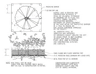
(Ord. 922-05, passed 6-13-2005)
Appendix F: Poor Drainage Condition Detail
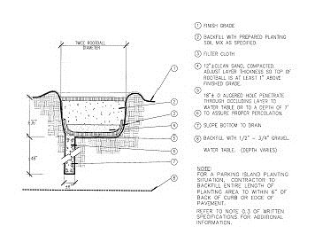
(Ord. 922-05, passed 6-13-2005)
Sec. 7.07.01. - Purpose.
(A)
The purpose of this part is to promote the health, safety, and welfare of residents; to minimize the adverse impacts upon adjacent property owners; and to increase the aesthetic appeal of the community by establishing minimum standards for the installation and maintenance of all human-made barriers and hedges within the city.
(B)
This part implements the policies of the adopted comprehensive plan. Compliance is a statutory precondition for the issuance of a development order, development permit, building permit, and certificate of occupancy. The provisions of this part shall be administered and enforced by the Planning Director, the Building Official, or their designees.
(Ord. 1393-19, passed 11-18-2019)
Sec. 7.07.02. - Applicability.
The requirements of this part shall apply to all human-made barriers and hedges erected within the city for the purpose of enclosure, exclusion, protection, privacy, security, retainment, buffering, or aesthetics. In addition, if a business has been closed for a minimum of 180 days or when a property changes ownership and/or any property owner requesting a change or expansion of use would be required to meet the minimum fences, walls, and hedges requirements of this part, to the maximum extent feasible.
(Ord. 1393-19, passed 11-18-2019)
Sec. 7.07.03. - Standards within the city's special areas (SAS).
(A)
SAs defined. The city's SAs consist of the U.S. Highway 301/Gall Boulevard Corridor vision areas (includes North 301, Form-Based Code district, and South 301), Zephyrhills Industrial Corridor, Community Redevelopment Agency (CRA) area(s), Historic district(s), and any other future SAs. For the purposes of the application of this Land Development Code (LDC), the geographic area of SAs are further defined as all properties within each SA.
(B)
Where master plans or design standards and regulations have been adopted for an SA, the standards of that SA shall apply. In cases of conflict between LDC standards and standards of an SA, the more stringent standard shall apply.
(Ord. 1393-19, passed 11-18-2019)
Sec. 7.07.04. - General standards.
(A)
Fences, walls, or hedges are prohibited within any city, county, or state rights-of-way. Fences, walls, or hedges shall not be permitted within an easement granted to the city except by approval of City Council. Any fence or wall erected or hedge planted in violation of this section are subject to removal by the city and in no case shall the city be liable for removal, restoration, or compensation costs. Any damage to a city-owned utility caused by erected fences or walls or planted hedges shall be repaired by the city at the expense of the property owner, including any sodding that may be necessary.
(B)
All fences or walls to be built shall comply with Chapters 95 and 156 of the City of Zephyrhills Code of Ordinances, and hedges to be planted shall comply with Chapter 95 of the City of Zephyrhills Code of Ordinances and Part 7.06.00 of this Land Development Code (LDC). The posts of each fence shall be resistant to decay, corrosion, and termite infestation. Wooden posts shall be pressure-treated for strength and endurance. Each fence or wall erected pursuant to this section shall be of uniform construction and properly maintained and in no case shall a fence or wall either be erected or maintained in such a manner as to degrade neighborhood amenities or reduce surrounding property values or maintained in such a state of disrepair so as to pose a hazard.
(C)
All fences and walls shall be constructed of new, structurally safe, and durable materials. Acceptable fence and wall materials include wrought iron, aluminum, PVC/vinyl, brick, masonry, stone, concrete aggregate, stucco finish (either colored or painted), glass block, or other approved decorative materials. Concrete masonry shall be permitted only if split face design or stucco covered. Fences and walls shall be designed to complement the primary building style in materials and colors. Fences and walls shall not contain substances such as broken glass, spikes, exposed nails, or similar items designed to inflict injury or pain. Chain link (including chain link with slats) fences are prohibited in R3, R4, OP, C1, C2, RC, and PUD zoning districts. All chain link fences and associated posts shall be black, brown, or green vinyl-coated to blend into surroundings. Wood fences shall only be permitted on individual residential lots, but are not permitted as subdivision perimeter fencing. Barbed wire is prohibited in all zoning districts except C3, LI, HI, AP1, and AP2. Fences with electrical elements are prohibited on all properties within the City. Agricultural gates of any kind are prohibited on all properties within the city. Applicants (excluding single-family and duplex lots as well as mobile homes, manufactured homes, and alternative housing on individually platted lots) shall provide visual relief from long expanses of fences and walls that are visible from roadways (excluding alleyways) and are greater than 30 feet in length through the use of meandering, staggering, capping, recessing, or providing inlays, columns, pilasters, texture, or similar treatments at minimum every ten feet.
(D)
Fences, walls, and hedges may be located in all front, side, and rear yard setback areas. The installation of athletic fences to protect against errant balls or other objects may be approved due to unusual site or course layout. Athletic fences shall not exceed 25 feet unless approved by the Planning Director or his or her designee. Athletic fences in a city public park shall be at the discretion of the Public Works Director or his or her designee. A fence or wall required for safety and protection of hazard by the city's departments; the county, state, and federal governments (and any of their respective agencies, departments, or bureaus); and utility providers is not subject to height limitations. Approval to exceed height limitations may be given by the Planning Director or his or her designee upon receipt of satisfactory evidence of the need to exceed height limitations.
(E)
In areas where the property faces two roadways or is located in any other area construed to be a corner lot, no fence, wall, or hedge shall be located in the clear sight triangle. A clear sight triangle is required to maintain a minimum of 200 feet sight distance for motorists at all intersections of roadways or roadways and railroads. The minimum clear sight triangle area is formed by the centerlines of intersecting roadways and a diagonal line connecting points on the centerlines, which are 90 feet from the intersection of centerlines. The clear sight triangle shall be free from obstructions such as fences, walls, hedges, landscape materials, or parked vehicles in excess of three feet above grade.
(F)
The finished side of any fence or wall shall face the adjoining lot or right-of-way.
(G)
No fence, wall, or hedge shall be construed or installed in such a manner as to interfere with stormwater drainage on the site.
(H)
Any fence, wall, or hedge, which becomes dilapidated or unsafe or is damaged in excess of 30 percent of its total shall be ordered removed by the Building Official or his or her designee.
(I)
Any nonconforming fence, wall, or hedge which becomes dilapidated or unsafe or is damaged shall be removed in its entirety. If rebuilt or replanted, the reconstruction or replanting shall place the entire fence, wall, or hedge in conformance with this LDC.
(Ord. 1393-19, passed 11-18-2019)
Sec. 7.07.05. - Additional standards in residential districts.
(A)
In residential zoning districts, fences and walls may be erected to a height not exceeding six feet in the side and rear yards, except that portion of the fence or wall within the front yard setback shall not exceed four feet.
(B)
In residential zoning districts, hedges may be planted to a height not exceeding eight feet in the side and rear yards, except that portion of the hedge within the front yard setback shall not exceed six feet.
(C)
For double frontage lots (not including corner lots) and multi-frontage lots located in residential zoning districts, a fence, wall, or hedge of a height not exceeding six feet may be permitted on the property line of the non-primary front yard provided the clear sight triangle is maintained. The primary front yard shall be associated with the street name within the lot's physical address.
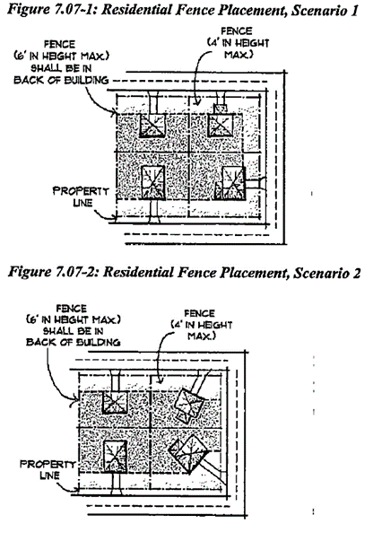
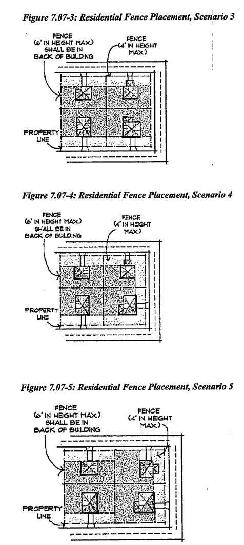
(Ord. 1393-19, passed 11-18-2019)
Sec. 7.07.06. - Additional standards in non-residential districts.
(A)
In office/professional zoning districts, a fence or wall of a height not exceeding six feet may be permitted provided the clear sight triangle is maintained.
(B)
In office/professional zoning districts, hedges may be planted to a height not exceeding eight feet in the side and rear yards, except that portion of the hedge within the front yard setback shall not exceed six feet.
(C)
In non-residential zoning districts (excluding office/professional zoning districts) a fence, wall, or hedge of a height not exceeding eight feet may be permitted provided the clear sight triangle is maintained.
(D)
For security purposes, fences in C3, LI, HI, AP1, and AP2 zoning districts may be topped with barbed wire of not more than three strands, provided the lowest strand is not less than 6½ feet above grade. The wire shall not overhang adjacent property.
(E)
Wood fences are prohibited in non-residential zoning districts.
(Ord. 1393-19, passed 11-18-2019)
Sec. 7.07.07. - Permit required.
(A)
All persons; the city's departments; the county, state, and federal governments (and any of their respective agencies, departments, or bureaus); and utility providers desiring to construct any fence or wall shall first obtain a permit from the Building Department. All applications shall include a survey showing the location of all existing roadways; existing easements; existing property lines; existing structures (buildings, fences, walls, etc.); existing trees (six inches diameter breast height or greater); and a plot plan, drawn to scale, showing the location of all the existing features previously mentioned and proposed structures, fences, walls, and the like. Permit fees shall be based on the value of construction with a minimum fee to be determined by the Building Official or his or her designee. However, the city's departments and the county, state, and federal governments (and any of their respective agencies, departments, or bureaus) shall not require a permit fee.
(B)
The property owner, prior to construction of any fence or wall and planting of any hedge, shall assume the responsibility for determining, by survey, the correct boundaries of the property to be fenced and the existence of any easement or rights-of-way that exist. Failure to provide the Building Department with complete and accurate information when applying for a permit shall be sufficient cause for the Building Official or his or her designee to order the removal of any construction not in compliance with this Land Development Code (LDC). The procedures for issuance of a permit under this section are prescribed in Article XI of this LDC.
(Ord. 1393-19, passed 11-18-2019)
Sec. 7.08.01. - Purpose and intent.
This part is intended and shall be interpreted to protect, maintain and enhance both the immediate and the long-term health, safety and general welfare of the citizens of Zephyrhills through the following:
(A)
Protecting and maintaining the chemical, physical and biological integrity of ground and surface waters;
(B)
Preventing activities which adversely affect ground and surface waters;
(C)
Encouraging the construction of storm water management systems that aesthetically and functionally approximate natural systems, consistent with regulatory agency requirements;
(D)
Protecting natural drainage systems;
(E)
Minimizing runoff pollution to ground and surface waters; and
(F)
Minimizing erosion and sedimentation of receiving waters.
Sec. 7.08.02. - Applicability.
(A)
In addition to meeting the requirements of this part, the design and performance of all storm water management systems shall comply with applicable state regulation (Chapter 17-25 Florida Administrative Code), requirements of the Southwest Florida Water Management District (SWFWMD) Chapter 40D-4 and 40D-40 Florida Administrative Code.
(B)
All construction activities shall comply with the Storm water Management Standards of Chapter 62-25 Florida Administrative Code, Environmental Resource Permitting requirements of the Southwest Florida Water Management District (SWFWMD) Chapter 40D-4, 40D-40 and 40D-400, Florida Administrative Code and with local environmental codes.
(C)
This part shall apply to all incorporated land within the city.
Sec. 7.08.02.01. - Exemptions.
(A)
The following development activities are exempt from the requirements of this article. Developments which are exempt under this part shall nevertheless be constructed in such a manner as to prevent flooding from storm water entering the site from adjacent property, including roadways.
(B)
Sites shall be graded in such a manner as to provide on-site retention of the first one inch of runoff.
(1)
The construction of a single-family or duplex residential dwelling unit and accessory structures on a lot of record.
(2)
Any development within a subdivision if each of the following conditions have been met:
(a)
Storm water management provisions for the subdivision were previously approved and remain valid as part of a final plat or development plan; and
(b)
The development is conducted in accordance with the storm water management provisions submitted with the final plat or development plan.
(3)
Bona fide agricultural activity.
(4)
Maintenance activity that does not change or affect the quality, rate, volume or location of storm water flows on the site or runoff from the site.
(5)
Action taken under emergency conditions to prevent imminent harm or danger to persons or to protect property from imminent fire, violent storms, hurricanes or other hazards. A report of the emergency action shall be made to the City Manager as soon as practicable.
Sec. 7.08.03. - Standards.
(A)
The proposed development activity shall not violate the water quality standards as set forth in Chapter 17-3, Florida Administrative Code.
(B)
The design and construction of the proposed storm water management system shall be certified as meeting the requirements of this code by a professional engineer registered in the state.
(C)
No surface water shall be channeled or directed into a sanitary sewer.
(D)
The proposed storm water management system shall be compatible with the drainage systems or drainage ways on surrounding properties or streets.
(E)
In phased developments the storm water management system for each integrated stage of completion shall be capable of functioning independently.
(F)
All detention and retention basins, except natural water bodies used for this purpose, shall be freely accessible for maintenance from streets or public easements.
(G)
The characteristics of storm water conveyed from the site should approximate the rate, volume, quality and timing that occurred on the site under conditions preceding the proposed development.
Sec. 7.08.04. - Surface water quality protection.
(A)
Development in Zephyrhills has frequently occurred near surface water and related watersheds. Development near surface waters and watersheds contribute varying amounts of untreated storm water runoff to the water bodies. The purpose of this section is to describe requirements for the protection of surface water quality to ensure both the safety and aesthetic appeal of water bodies in the Zephyrhills area for existing and future residents and visitors.
(B)
All structures shall be a minimum of 30 feet from the mean high water line except existing structures on lots of record.
(C)
Site preparation and/or land clearing shall not be permitted prior to final development approval pursuant to the provisions in chapter 2.
(D)
The development proposal shall include adequate evidence and assurances that the following requirement shall be met during construction.
(1)
A minimum 15-foot buffer measured from mean high water shall be established adjacent to the water body in order to protect the water body from adverse impacts of construction activity, including but not limited to, erosion and siltation. The proposal shall document that a 15-foot buffer is adequate for such protection or shall indicate a wider buffer deemed to be adequate which shall be provided to meet this requirement.
(2)
No alteration of the buffer shall be permitted, including destruction of existing vegetation or alteration of the natural topography. (However, maintenance, such as trimming, shall be allowed.)
(3)
After construction, natural vegetation shall be retained or replaced on the site in order to minimize and stabilize erosion and decrease pollution of the water body.
(4)
For lots or parcels which are cleared, silt screens shall be placed between the construction site and the water body to prevent erosion and siltation.
(E)
All development shall control storm water runoff for the purpose of preventing flooding in adjacent areas or pollution of water bodies.
(F)
Canals shall not be permitted in proposed development or redevelopment, unless clear and specific proof of public benefit is provided. The public benefit shall be based upon the irrefutable need for canal(s) for flood control, water quality management, and/or resource management. Development proposals containing proposed canals shall supply written conceptual approval from SWFWMD, FDER, DNR, and/or ACOE along with the application for development proposal.
(G)
Where a development proposal includes provisions for deposition of fill, shores resulting from the deposition shall not exceed a slope of 6:1.
(H)
Shorelines with existing slopes steeper than 10:1 shall be protected by shallow filter or spreader berms.
Sec. 7.09.01.01. - Accessory uses and structures, except garages and garages with accessory dwelling units.
The following regulations shall apply to all accessory uses and structures incidental to any permitted or conditional use (for garages and garages with accessory suites see section 7.09.01.02).
(A)
Zoning of accessory structures. All accessory uses to a principal use shall be located in a zoning district that permits the principal use. Structures up to 15 percent of the total square footage of the principal structure, up to 300 square feet and no more than 16 feet in height (or maximum height of principal structure), at a maximum point of roof pitch, from the grade, shall be permitted in residential and office professional districts. Structures up to 300 square feet can advance directly to the Building Department for payment of proper permitting fee. Structures between 301 and 625 square feet, or in excess of 16 feet to the peak of the roof, as measured from the grade (or higher than the maximum height of the primary residence) in residential and office professional districts shall be reviewed and approved by the Planning Department prior to the issuance of building permit by the Building Department. Information submitted to the Planning Department shall include, but may not be limited to, information pertaining to height, design elements, increased setbacks, and landscaping plans around the perimeter of the accessory structure. In the event the Planning Department denies the request, the applicant can appeal the denial to the City Council. Structures larger than 625 square feet require a conditional use permit.
(B)
Construction timing. No accessory building shall be constructed upon a lot or parcel or contiguous lot or parcel except in conjunction with or after construction of the primary building.
(C)
Location of accessory structures. Structures shall be located on the same lot or parcel as the primary building to which it is accessory; or on a contiguous lot and shall meet all district setbacks unless otherwise stated. Further, accessory structures shall not be permitted in any required front or secondary front setback. A five-foot side and rear yard setback shall be observed. For all zoning districts, the minimum separation between the accessory and principal structures shall be five feet, as measured from the dripline of both structures. Any type of enclosed passageway or room addition shall not connect principal and accessory structures unless all structures meet principal structure setbacks.
(D)
Limitation on use. Only the owner, employees of the owner, lessee or tenant of the premises shall use nonresidential accessory buildings.
(E)
Accessory structures in multi-family developments. Accessory structures in multi-family developments may include, but shall not be limited to, private laundry facilities and clubhouse/recreational facilities for the convenience of the residents. Construction style and material shall match the residential units for which the structures are accessory.
(F)
Portable utility structures and work sheds (for example, pre-manufactured structures such as Rubbermaid vinyl and Arrow metal sheds) in residential districts. As defined by this standard, includes any roofed structure designed to shelter vehicles, goods, merchandise, equipment, materials, or property of any kind that is capable of being carried or moved and which does not require a building permit for installation. Any portable shelter shall be placed in the rear yard. Rear yard, as defined by this standard as that portion of the lot located behind the principal use structure. Existing nonconforming structures are grandfathered as of the date of passage of this section. Within residential districts and accessory to residential uses, portable utility sheds shall be permitted within the five-foot side and rear yard setbacks if the following regulations are adhered to:
(1)
Shall be no larger than 15 percent of the square footage of the principal structure, or 300 square feet, whichever is smaller;
(2)
No more than two accessory structures as defined in division (F)(1) above (provided both structures combined do not exceed 15 percent of the square footage of the principal structure or 300 square feet, whichever is smaller) shall be permitted on any single residential lot;
(3)
Shall not be located on any easement;
(4)
Approved portable accessory structures shall be anchored in a method approved by the Building Department; and
(5)
An accessory structure shall not be separately metered for electricity or water.
(G)
Design Standards for accessory buildings and structures in office professional and residential zoning districts. Accessory buildings and structures located in office professional and residential zoning districts that exceed 150 square feet shall be constructed of masonry, wood frame, aluminum, or vinyl. If the principal structure is a contributing structure to the Historic District, accessory structures shall be finished with similar materials and design as the principal structure. In addition, properties shall adhere to Historic District design standards as well as CRA design standards. Metal fabricated type structures that are designed and intended for industrial/commercial use are prohibited in the residential and office professional zoning districts.
(H)
Cargo and cargo-like containers of any size (conex containers).
(1)
Except for commercially zoned (C1, C2, and C3) and industrially zoned (LI and AP2) properties, all cargo containers and cargo-like (conex) containers of any size designed to attach to trucking equipment and/or cargo ships are prohibited. Owners of commercially zoned properties may obtain, with fee, through the Building Department, a temporary permit to place said container on subject property for a period not to exceed 90 days per year. Owners of industrially zoned properties can place said containers year-round with proper permit and fee through the Building Department. Refer to the city's fee schedule for said fees.
(2)
Within commercially zoned areas of the city, owners/tenants of properties with a building consisting of floor space in excess of 150,000 square feet (base living area as indicated on the Pasco County Property Appraiser website) may apply for long-term permits. The permits shall be issued for three years per term and subsequently renewable for three years thereafter at the sole discretion of the Planning Director. The permits will allow said containers to be located on contiguously owned properties (as said building) for 90-day periods per year. Petitioner shall submit buffering/landscaping and lighting plans to ensure the continued health and safety of the general community, continuity of traffic and pedestrian flow to, through and exiting the property as well visual buffering from said containers. Area utilized for placement of said containers shall not exceed five percent of gross floor area (GFA) of the primary building on said properly. Under no circumstances shall conex containers be stacked on top of each other. Petition is subject to Planning Director's approval, approval with additional requirements, or denial. Renewal petitions shall demonstrate the continued need for such said containers. Once site plan application is approved by the Planning Director, petitioner shall advance to the Building Department for fee(s) associated with said containers.
(3)
Cargo and cargo-like containers (conex containers) of any size are expressly forbidden within all transect zones of the form-based code areas within the city with one exception: said conex container (a number not exceeding one) placed on a property located entirely within the form-based code area of the city at the date of passage of this section is grandfathered if said container is completely screened from view from the closest public right- of-way with a city-approved method (including, but not limited to, solid PVC fencing). Property owners shall, within 30 days prior to or preceding passage of this section, notify the city in writing and receive a confirmation letter from the city indicating grandfather status.
(4)
Cargo and cargo-like (conex) containers located on properties within zoning districts expressly prohibited above in divisions (H)(1) and (H)(2) shall be removed from said property within 60 days of passage of this section. Failure to comply will result in code enforcement action against the property owner of said property.
(5)
Where permissible, as detailed in divisions (H)(1) and (H)(2) above, under no such circumstances shall cargo or cargo-like (conex) containers be placed in, around, or adjacent to designated vehicular parking space(s) in a manner that renders said parking space(s) unusable for its intended purpose.
(I)
Prohibition of certain structures. Trailers, storage containers, mobile homes, and recreational vehicles (except for zoning districts in which mobile homes and RVs are allowed), and tractor-trailers shall not be used as permanent or portable accessory structures. Portable carports/carport-like and car canopy structures (as defined in this section of the code as an open-sided automobile shelter by the side of a building) are expressly prohibited. A commercial storage container (such as PODs or other similar moving container that is left at subject property, packed and subsequently removed to a congregate storage facility) may be used while renovation is occurring on the building(s) located on said property with an active building permit. If building permit is not required or if said container is utilized for moving of contents of said property, a maximum time period of 30 days shall be allowed. The time period may be adjusted at the discretion of the Building Official.
(Ord. 1359-18, passed 6-25-2018)
Sec. 7.09.02. - Adult entertainment establishment.
(A)
No such use shall be located within 1,000 feet of a pre-existing adult entertainment establishment; 500 feet of a pre-existing religious institution; 500 feet of a pre-existing educational institution; 500 feet of an area zoned within the city for residential use; 500 feet of a pre-existing park; or 500 feet of a pre-existing commercial establishment that in any manner sells or dispenses alcohol for on-premises consumption.
(B)
An area zoned for residential use, shall be measured by drawing a straight line between the closest property lines of the proposed or existing adult entertainment establishment and the pre-existing adult entertainment establishment, pre-existing religious institution, pre-existing educational institution, area zoned for residential use, pre-existing park or pre-existing commercial establishment that sells or dispenses alcohol for on-premises consumption.
Sec. 7.09.03. - Alcoholic beverage sales.
(A)
Alcoholic beverage sales are controlled by all appropriate city, state and federal regulations.
(B)
No sale of alcoholic beverages may occur within 300 feet of any school, church or other religious institution as measured from the vendor's principal structure to the nearest principal structure or outdoor active use area (excluding parking) of the school, church or other religious institution.
(C)
The sale of alcoholic beverages for on-premise consumption only, is permitted within 300 feet of a school, church or other religious institution, provided that the seating capacity of the establishment is not less than 25 and wherein the combined gross sales of the business operation is more than 51 percent attributed to the sale of food and non-alcoholic beverages.
(D)
The city may, during the establishment's normal business hours at the official location of the establishment's books and records, audit the records of the establishment for the purpose of ascertaining whether not less than 25 and wherein the combined gross sales of the business operation is more than 51 percent attributed to the sale of food and non-alcoholic beverages.
(E)
No sale of alcoholic beverages may occur within 500 feet of an adult entertainment establishment.
(F)
The sale of beer and wine shall be permitted in the Downtown area with no setback restrictions along 5th Avenue within the following boundaries: 9th Street to U.S. Hwy. 301 and 4th Avenue to 6th Avenue.
(Ord. 1005-08, passed 3-24-2008; Am. Ord. 1284-15, passed 1-11-2016)
Sec. 7.09.04. - Auto service stations, repair garages and car washes.
(A)
No structure, principal or accessory, may be located closer than 30 feet to a residential district.
(B)
No street entrance or exit for vehicles of the service station shall be located:
(1)
Within 200 feet of a street entrance or exit of any school, park or playground;
(2)
Within 100 feet of any hospital, church or library entrance; or
(3)
Within 75 feet of a residential lot.
(C)
Site plan approval required.
Sec. 7.09.05. - Churches.
(A)
This use includes temples and similar religious institutions.
(B)
A minimum contiguous land area of 20,000 square feet shall be required. Lots may be separated by public R.O.W.
(C)
A minimum lot width of 120 feet shall be required.
(D)
The maximum lot coverage by all impervious surfaces shall not exceed 50 percent of the lot area.
(E)
No principal structure or outdoor active use area (excluding parking) shall be located within 300 feet of a prior existing business licensed to sell alcoholic beverages.
(F)
Any accessory residential use or private school upon the premises shall provide additional lot area. Accessory uses include convents, rectories or church halls.
(G)
Site plan approval required.
Sec. 7.09.06. - Congregate care and group homes.
(A)
It is the purpose of this section to provide for the provision of special living facilities for other than the traditional nuclear family.
(B)
Group home and congregate living facilities for seven or more persons shall be permitted only in R-4, OP and C-3 zoning districts. Categories of group or congregate care facilities which fall within this section include youth shelter, youth crisis, youth attention, spouse abuse, displaced youth and adult, mental health, substance and alcohol abuse, offender halfway or facilities serving persons adjudged delinquent or criminal.
(C)
Any group or congregate care facility required to be licensed by the Florida State Department of Health and Rehabilitative Services may be authorized by the city with respect to any approval of a special exception, conditional use or building permit subject to obtaining the state license as may be required and to the continuing validation of the same.
(D)
Group and congregate facilities shall meet all applicable building, fire, safety and health code requirements of the state, Pasco County and the city. All permits or licensures issued by the city will be subject to initial and continuing compliance with all applicable requirements.
(E)
No group or congregate care facilities shall be located within a radius of 1,500 feet of another congregate or group care facility, as measured from property line to property line at the closest point.
(F)
A group home facility which treats less than seven persons shall be treated as a one-family dwelling for the purposes of determining lot area, lot width, building setback, building height, parking, sign, fence and other miscellaneous requirements of the respective zoning district in which the facility is located; however, the owner of the facility must operate and reside there on a full-time basis. In addition, no such facility shall be designed to house more individuals per or within, one bedroom than permitted by the state licensing authority.
(G)
Expansion of the capacity of a given group or congregate facility by more than 10 percent from the originally approved capacity shall require reapplication and all attendant procedures.
(H)
The building for a group or congregate living facility must provide a minimum of 1,200 square feet of living floor area for the first four residents and 120 additional square feet of living area for each additional resident. Twenty percent of the site must be landscaped and not covered with an impervious surface.
(I)
The maximum number of residents at any group/congregate care facility is limited to three times the dwelling unit density per acre as established within this code. The maximum resident capacity of a facility to be use for density calculations will be the maximum number approved by the Florida Department of Health and Rehabilitative Services or other regulatory agency.
(J)
Kitchen facilities, for purposes of this section defined as a cooking area (oven and/or stove burners), shall not be permitted within bedrooms or a group or congregate living facility. Individual dwelling units may contain bar sinks, refrigerators and cooking facilities within an area specifically designed as a kitchen area.
(K)
Site Plan Review Committee approval required.
Sec. 7.09.07. - Dance studios.
(A)
No alcoholic beverages of any type may be served.
(B)
Shall not be located within 300 feet of any residential district unless the building is so constructed as to prevent discernible sound or vibration at any property line of dance studio or dance hall.
Sec. 7.09.08. - Day care facilities.
(A)
All day care facilities must be permitted by the Florida Department of Health and Rehabilitative Services.
(B)
In the ER, R-1 or R-2 zoning districts, the location of day care facilities shall be limited to and established only upon the same premises with, a school, church, temple or similar facility.
(C)
In any district the minimum open play space shall be no less than that required by the Florida Department of Health and Rehabilitative Services regulations in effect at the time of the application. The play area shall be completely enclosed by a fence six feet in height.
(D)
The ratio per child of usable floor space excluding kitchen, storage and toilet facilities shall conform to Florida Department of Health and Rehabilitative Services regulations at the time of application.
(E)
A fence or wall six feet in height shall be constructed along any rear or side property line adjoining any residential district.
(F)
No building shall cover more than 50 percent of the lot area.
(G)
Site plan approval required.
Sec. 7.09.09. - Drive-in businesses: other than restaurants, financial institutions and theatres.
(A)
Site plan review required.
(B)
Specific approval of access plans by the Site Plan Review Committee.
(C)
The operation of any drive-in business abutting a residential district shall be limited to the hours between 7:00 a.m. and 11:00 p.m.
(D)
A minimum of 20 percent of the lot shall be landscaped.
Sec. 7.09.10. - Duplex or multi-family developments in commercial districts.
(A)
Buffers may be required.
(B)
Adequate site amenities to assure a residential environment.
(C)
Site Plan approval required.
Sec. 7.09.11.01. - Purpose.
Whereas, the City Council of the City of Zephyrhills is charged with the public safety of its citizenry; and
Whereas, public safety is enhanced by requiring well defined engineering installation of earth station antennas; and
Whereas, local regulations must give consideration to property values and neighborhood quality of life; and
Whereas, large, round, disc-like antennas detract from the neighborhood appearance in a manner in which dipole antennas do not; and
Whereas, receiving discs and support structures should not be located in front yards for the same aesthetic reasons which neighborhood ordinances are enacted to control signs, vehicles parking and fencing; and
Whereas, by requiring satellite receiving antenna to be located in rear yards and by relaxing height restrictions, the municipal objectives of safety and aesthetics reach a compromise with the federal objectives of establishing the satellite communications industry.
Sec. 7.09.11.02. - General standards, all zoning districts.
(A)
All satellite dish antenna installations beginning with the enactment of this code shall meet the following requirements and includes parabolic or spherical antennas which receive television or other signals from orbiting satellites or other devices. Satellite dish antennas shall be considered as an accessory structure unless part of a public utility.
(B)
Regulations for all zoning districts.
(1)
No owner, occupant or tenant of any property located within any zoning classification shall erect, construct or install any earth station antenna or satellite dish antenna without first obtaining all necessary permits from the city's Building Official.
(2)
Prior to the issuance of any permit for the erection, construction or installation of any earth satellite antenna, the city's Building Official shall require an approved design placement drawing and engineering specifications, signed and sealed by an engineer licensed in the state, to meet all city and state laws and ordinances.
(3)
All materials that make up this installation of the antennas and supporting structures shall be of a non-corrosive material or coated with a corrosive resistant material to prevent metal fatigue from maintenance neglect.
(4)
All earth station antennas shall be non-reflective in color.
(5)
All earth station antennas shall meet all manufacturer specifications.
(6)
All electrical installations for the purpose of erection of antennas shall be in accordance with the National Electrical Code and all applicable city ordinances.
(7)
All parts of the earth station antenna shall have vertical and horizontal clearance from any electric lines.
Sec. 7.09.11.03. - Additional standards for residential zoning districts.
(A)
No earth station antenna shall be mounted onto the top or side of any single-family building, duplex or triplex in R-1, R-2, R-3, ER, R-4, M-1, M-2, M-3 and M-4 zoning designations.
(B)
Earth station antennas are permitted on the roof of a common facility, provided the earth station antenna shall be erected at the minimum height which allows satellite reception not to exceed seven feet, including base above the highest roof elevation. The measurement shall be calculated from the highest roof elevation to the dish center. There shall be no more than one earth station antenna on a common facility, per multi-family development.
(C)
The maximum outside diameter allowed for a dish receiver shall be ten feet.
(D)
Earth station antennas shall be allowed only in the rear or side yard in all residential zoning districts. Placement shall not be allowed in the front yard of any lot or parcel in any residential zoning district. Compliance with side and rear setback is required.
(E)
Ground mounted earth station antennas shall be erected at a minimum height which allows satellite reception, not to exceed ten feet. The measurement shall be calculated from the established grade to the dish center.
(F)
Only one antenna shall be allowed on any lot or parcel of land.
(G)
No advertising or signage of any type is permitted on a satellite antenna.
Sec. 7.09.11.04. - Additional standards for commercial zoning districts.
The following restrictions apply to earth station antenna installation in zoning districts C-l, C-2, C-3, OP and LI.
(A)
Satellite dish antennas are subject to all district setback requirements.
(B)
Satellite antennas are permitted on the roof, but shall be erected at the minimum height which allows satellite reception, not to exceed seven feet above the highest roof elevation measured to the dish center.
(C)
There shall be no more than one earth station antenna per licensed business or occupation within any structure.
(D)
The maximum outside diameter allowed for a dish receiver shall be ten feet.
Sec. 7.09.11.05. - Regulatory exceptions.
The following regulations shall not apply to earth station antennas with a diameter of two feet or less and a wind load which does not constitute a danger to a structure upon which it is to be attached.
Sec. 7.09.12. - Flea markets and outdoor amusements.
(A)
No buildings used for open sales or amusement purposes shall be located nearer than 150 feet from any residential district.
(B)
All vehicles, trailers, structures, mobile homes, vehicles, tents, mechanical devices or animal enclosures associated with such use shall be set back not less than 50 feet from any property line.
(C)
The minimum lot frontage shall be 300 feet.
(D)
Sounds emanating from the use shall not adversely affect surrounding residential property.
(E)
Residential accommodations shall be limited to temporary quarters.
(F)
Sufficient lighting is required to illuminate the use and parking areas.
(G)
Outdoor sales are permitted.
Sec. 7.09.13. - Funeral homes and mortuaries.
(A)
All such uses shall be located on and have access to an arterial or collector road.
(B)
20 percent of subject parcel shall be landscaped.
(C)
Site plan approval required.
Sec. 7.09.14. - Garage sales.
(A)
Generally. The following regulations shall include all general sales open to the public from or on residential premises or any residentially zoned site for the purpose of disposing of personal property, including, but not limited to: all sales entitled garage, lawn, attic, yard, porch, room, backyard, patio or rummage sales, and sales of surplus produces and plants grown in an approved community garden. This section shall not include a situation where no more than five specific items are held out for sale and advertisement of the sale specifically names those items to be sold. For purposes of this section, personal property shall mean property which is owned, utilized and maintained by an individual or members of his or her household and acquired in the normal course of living in or maintaining a residence. It does not include merchandise which was purchased for resale or obtained on consignment.
(B)
Exemptions. The provisions of this section shall not apply to or affect the following:
(1)
Persons selling good pursuant to an order or process of a court of competent jurisdiction;
(2)
Persons acting in accordance with their powers and duties as public officials;
(3)
Any sale conducted by any merchant or mercantile or other business establishment from or at a place of business wherein the sale would be permitted under the protection of the nonconforming use section thereof or any other sale conducted by a manufacturer, dealer or vendor which sale would be conducted from properly zoned premises and not otherwise prohibited in other ordinances; and/or
(4)
Any bona fide charitable, educational, cultural or governmental institution or organization, when the proceeds from the sale are used directly for charitable purposes of the institution or organization and the goods or articles are not sold on a consignment basis.
(C)
Permit required. No garage sale shall be conducted unless and until the individuals designated to conduct the sale shall obtain a permit from the Building Department. Members of more than one residence may join in obtaining a permit for a garage sale to be conducted at the residence of one of them. This permit shall be posted to be visible from the street.
(D)
Parking of vehicles. All parking of vehicles shall be conducted in compliance with all applicable laws and ordinances. Further, the Police Department may enforce such temporary controls as required to alleviate any special hazards and/or congestion created by any garage sale.
(E)
Posting of signs. Only the following specified signs may be displayed in relation to a pending garage sale:
(1)
Two signs of not more than four square feet shall be permitted to be displayed on the property of the residence where the garage sale is being conducted;
(2)
Signs must be removed at the close of the garage sale activity; and
(3)
No sign will be affixed to utility poles, trees or posts within the city rights-of-way or placed on public property.
(F)
Duration of sales. Garage sales lasting more than one day shall be held on consecutive days and not sale shall exceed three days.
(G)
Garage sales limited to daylight hours. All garage sales shall be limited to the daylight hours.
(H)
Number of sales allowed per year. All garage sales shall be restricted to not more than three per address during any one calendar year.
(Ord. 1200-13, passed 4-8-2013)
Sec. 7.09.15. - Home occupations.
A home occupation shall be allowed in a bona fide dwelling unit, subject to the following requirements:
(A)
No persons other than members of the family residing on the premises shall be engaged in the occupation;
(B)
The use of the dwelling unit for the home occupation shall be clearly incidental and subordinate to its use for residential purposes by its occupants and shall under no circumstances change the residential character of the structure;
(C)
There shall be no change in the outside appearance of the building or premises or other visible evidence of the conduct of the home occupation, other than one sign not exceeding two square foot in area, non-illuminated, mounted flat against the wall of the principal building at a position not more than two feet from the main entrance of the residence;
(D)
No home occupation shall occupy more than 25 percent of the floor area of the dwelling unit. No accessory building shall be used for a home occupation;
(E)
No traffic shall be generated by the occupation in greater volumes than would normally be expected in a residential neighborhood and any need for parking generated by the conduct of the home occupation shall be met off the street and other than in a front yard required pursuant to this code;
(F)
No equipment, tools or process shall be used in such a home occupation which creates interference to neighboring properties due to noise, vibration, glare, fumes, odors or electrical interference. In the case of electrical interference, no equipment or process shall be used which creates visual or audible interference in any radio, telephone or television receivers off the premises or causes fluctuations in line voltage off the premises;
(G)
Fabrication of articles commonly classified under the terms arts and handicrafts may be deemed a home occupation, subject to the other terms and conditions of this definition and providing no retail sales are made at the home;
(H)
Outdoor storage of materials shall not be permitted;
(I)
The following shall not be considered home occupations: beauty shops, barber shops, band instrument or dance instructors, swimming instructor, studio for group instruction, public dining facility or tearoom, antique or gift shop, photographic studio, fortune telling or similar activity, outdoor repair, food processing, retail sales, nursery school or kindergarten;
(J)
The giving of individual instruction to one person at a time such as an art or piano teacher, shall be deemed a home occupation;
(K)
A home occupation shall be subject to all applicable city occupational licensing requirements, fees and other business taxes; and
(L)
Permits shall be issued to the person and not the dwelling; as such they may not be passed on with the land.
Sec. 7.09.16. - Indoor storage, mini-warehousing/storage units, outdoor storage and recreation vehicle storage.
(A)
Indoor storage/mini-warehouses are defined as a building or group of buildings in a controlled access and/or fenced compound that contain individual, compartmentalized or controlled access stalls or lockers for the dead storage of goods or wares belonging to individual lessees of the stalls and accessible to the lessees at all times through individual doors.
(1)
Indoor storage/mini-warehouses shall not be allowed on individual lots/parcels and may be allowed as part of a mixed use development and oriented in the rear and not abutting public rights-of-way or be vertically integrated into a mixed use building. Projects integrated into a mixed-use building may be allowed on an individual lot/parcel.
(B)
Dead storage is defined as the storage of goods, wares and physical objects only with no sales, conferences, repairs or other activity other than placement, removal and sorting of goods. One office space for a manager shall be permitted.
(C)
The applicant shall provide a site plan with information on the property lines, street lines, curb cuts, type of buffer/landscaping, location of structures including signs, parking spaces, travel lanes and enhanced perimeter screening (enhanced fence/wall).
(D)
Building coverage shall not exceed 50 percent.
(E)
Height of buildings shall not exceed one story with a maximum height of 15 feet in the CRA and Form-Based Code (FBC). A conditional use petition may be submitted for projects located outside the CRA & FBC for review/consideration that exceed one story—15 feet.
(F)
Signs shall be limited to one per adjacent street frontage and shall not exceed the maximum height of ten feet or exceed 50 square feet in area. No sign shall be permitted on the building other than on building frontage walls.
(G)
All lights shall be shielded to direct light onto the uses established and away from adjacent property or streets.
(H)
All equipment and materials of any type shall be stored within a building.
(I)
Storage shall be as follows:
(1)
No business activity other than rental of storage units shall be conducted on the premises and the units shall be used for dead storage only;
(2)
All equipment and materials of any type shall be stored within a building; and
(3)
Storage of explosive or highly flammable material shall be prohibited.
(J)
Fencing shall be required to shield adjoining properties, as well as the protection of the lessees. The decorative wall/fence shall be of new material with a maximum of six feet in height. Fencing/walls that adjoin residential districts or residential uses shall be a decorative solid masonry, or aluminum with solid pillars at equal intervals. Maintenance of the fence/wall shall be the responsibility of the owner.
(K)
Access and parking shall be as follows:
(1)
All one-way drives shall provide for one parking lane 12 feet in width and one travel lane 12 feet in width. All two-way driveways shall provide for one parking lane 12 feet in width and two travel lanes each 12 feet in width. Traffic direction and parking areas shall be designated by signs or painted lines. Parking lanes may be eliminated from driveways not serving any storage areas;
(2)
Vehicular ingress-egress shall be limited to 150 feet apart, centerline to centerline; and
(3)
A minimum of two parking spaces for the manager and office personnel shall be located near the manager's office.
(L)
Buildings shall conform to Section 7.10.02 (additional design standards for large retail buildings).
(M)
Indoor storage may consider vehicle storage (boats, RV's, campers) of side/rear setbacks with limited visibility from public rights-of-ways and require an impervious surface.
(N)
Outdoor storage:
(1)
Storage for more than three consecutive days of any product, materials, equipment, appliances, personal property of any kind and materials that are a byproduct of a permitted use on an unenclosed and/or uncovered area including laydown areas.
(2)
Outdoor storage may only be considered as an accessory/ancillary use to a primary use.
(3)
Outdoor storage may not be allowed as a primary/stand-alone use.
(4)
Outdoor storage/laydown areas shall require improved access from the right(s)-of-way, screening/buffer/irrigation.
(O)
Recreational vehicle storage:
(1)
Recreational vehicle storage: motorhomes, boats, camping trailers, truck trailers and other equipment.
(2)
All stored vehicles must be in proper working order.
(3)
Perimeter landscape buffer/irrigation with screening is required.
(4)
RV storage areas shall require improved access from the right(s)-of-way, screening/buffer/irrigation.
(5)
A minimum percentage of 25 percent of the RV storage spaces shall be covered with a permanent cover.
(Ord. 1439-22, § 1, passed 6-27-2022; Ord. 1499-25, § 2, passed 4-14-25)
Sec. 7.09.17. - Nursing homes.
(A)
The maximum number of persons for which beds or other overnight accommodations are provided shall not exceed 2½ times the maximum number of dwelling units per gross acre permitted by the zoning district.
(B)
The minimum lot area and minimum width shall not be less than one acre/150 feet in width.
(C)
The setback regulations shall be the same as required by the district where the nursing home is to be located; in addition, where adjoining a R-3 district, no building shall be located closer than 50 feet to the R-3 district line.
(D)
The maximum lot coverage by all buildings shall not exceed 40 percent of the lot area.
(E)
Not less than 30 percent of the lot shall be landscaped and retained as usable open space for occupants with adequate accommodations for wheelchair use.
Sec. 7.09.18. - Private club in a commercial district.
(A)
Fraternal lodges, social and recreational clubs permitted as conditions uses in a C-1 district must:
(1)
Have a contiguous land area of at least 20,000 square feet. Lots may be separated by public R.O.W.;
(2)
Have a minimum lot width of 150 feet;
(3)
Be a one-story construction;
(4)
Have 50 feet minimum building setback from all property lines;
(5)
Have a minimum ten feet wide buffer area consisting of either walls, landscaping or fences. Landscaping shall be a minimum of six feet in height and 75 percent opaque within one year; and
(6)
Have a site and development plan review by the Site Plan Review Committee.
(B)
On-site consumption of alcoholic beverages by members and guests shall be permitted in a fraternal, social or recreational club or lodge which is approved as a conditional use; provided the use is located more than 300 feet from a school, church or place of worship as measured from the structure in which alcoholic beverages are being served to the nearest principal structure or outdoor active use area (excluding parking) of the school, church or place of worship.
Sec. 7.09.19. - Recreational vehicles including travel trailers, motor homes/camping trailers, auto campers, park trailers.
The following regulations shall govern.
(A)
No permanent structures attached. No owner of travel trailer site, travel trailer lot, campground or recreational vehicle park shall permit to be constructed on the site or sites any type of utility building screen room glass room, carport or other type of other permanent structure other than a concrete slab. All accessory appurtenances must be erected in a manner which facilitates disassembly and removal within 24 hours.
(B)
Attachment of collapsible structures. No owner of a travel trailer, camping trailer, truck camper, motor home or park trailer shall construct or allow to be constructed on his or her travel trailer, camping trailer, truck camper, motor home or park trailer any structure other than a collapsible nature which may be folded compactly and drawn away with the travel trailer, camping trailer, truck camper, motor home or park trailer.
(C)
Smaller mobile home classified as park trailers. In mobile home or recreational vehicle parks existing at the time of adoption of this code, permanent structures commonly attached to mobile homes are permitted to be attached to small mobile homes now classified as park trailers under the State of Florida's size classification providing these units are permanently established and the required separation between permanent structures, as required by the N.F.P.A. is met.
(D)
Number of occupants. No owner of a mobile home or recreational vehicle park shall permit the number of occupants of any form of recreational vehicle to exceed two persons in less than 280 square feet of gross floor area; three persons in less than 400 square feet of gross floor area; four persons in less than 500 square feet of gross floor area and in no situation can the number of occupants exceed five.
(E)
General regulations for all mobile homes pursuant to N.F.P.A.
(1)
An awning or carport may be erected, constructed or maintained on a mobile home lot only as an accessory to a mobile home located on the same lot. An awning shall not be enclosed with rigid materials or walls or converted for use as a habitable room.
(2)
An awning or carport may be erected on a lot line provided the awning or carport is constructed of material which does not support combustion and is not less than three feet from a mobile home or mobile home accessory building or structure on an adjacent lot.
(3)
An awning or carport supported in part by a mobile home shall not have a slab that exceeds 12 feet in width (projection) as measured from the wall of the mobile home to the outer edge of the awning or carport slab.
(4)
Clearance for mobile homes to other structures.
(a)
In mobile home parks in existence at the time of adoption of this code, mobile homes shall not be located closer than ten feet from any other mobile home or permanent building within or adjacent to the mobile home park except that structures grandfathered in need not be moved. A mobile home accessory building or structure shall not be closer than three feet from any adjacent mobile home or structure except that structures grandfathered in need not be moved.
(b)
In the development of new mobile home parks or new land additions to existing parks or in any other mobile home situations other than as described in a. above, the separation between mobile homes and permanent structures on an adjacent space or lot shall be a minimum of 15 feet.
Sec. 7.09.20. - Recreational vehicles, temporary parking.
Any recreational vehicle, boat, boat trailer or utility trailer may be parked or stored in any residential zoning district, subject to the following conditions.
(A)
Occupied in excess of three days prohibited. At no time shall parked or stored recreational vehicles or equipment be occupied or used for living, sleeping or housekeeping purposed for a period in excess of three consecutive days unless parked in a licensed motor home or recreational vehicle park.
(B)
Prohibition. Recreational vehicles shall not be parked within setback area; no more than two such vehicles allowed on one lot. Recreational vehicles may be parked within the buildable area of a lot provided the following conditions are met:
(1)
Recreational vehicles shall not be permitted within any required front, side or rear yard setback. Where double frontage lots exist, the required setbacks shall be maintained on both streets; and
(2)
No more than two such vehicles (including boats) shall be stored on any residential lot.
(C)
Exceptions from this section. Automobiles, bicycles and motorcycles are specifically excluded from this section.
Sec. 7.09.21. - Recycling centers.
(A)
All recycling operations must comply with applicable federal and Florida statutes.
(B)
All recycling operations must be totally within an enclosed structure or shall have a fence at least eight feet high from ground level constructed of new materials which may be concrete block, galvanized metal, aluminum or wood. Wood fencing shall, as a minimum, be constructed of wood one inch in thickness. Required fence shall have a minimum life of ten years, with the finished side of the fence facing adjoining properties. Maintenance of the fence is the responsibility of the owner. All fencing shall be of solid type with only such openings as will permit ingress and egress for normal business purposes.
(C)
All recycling centers shall be arranged and storage contained so as to permit access by firefighting equipment and to prevent the accumulation of water.
(D)
Signs shall be limited to one per adjacent street frontage and shall not exceed the maximum permitted height of 25 feet. No signs shall be placed on any roof or required fence.
(E)
All recycling centers shall be maintained in such a manner as to cause no public or private nuisance, nor to cause any offensive or noxious sounds or odors, nor to cause the harboring of snakes, rates, flies or other disease vectors.
(G)
Minimum acreage of ten acres is required.
(H)
A site plan review is required.
Sec. 7.09.22.01. - Purpose.
The purpose of this section is to set forth those standards necessary to protect the safety of the general public. Swimming pools may be considered an attractive nuisance; therefor, standards for location are necessary.
Sec. 7.09.22.02. - General standards.
(A)
Swimming pools (private) shall not encroach into any required building setback.
(B)
The following regulations shall apply to swimming pools owned and operated by an individual and used exclusively by the owner, family and guests or a pool owned an operated by an association, club or other nonprofit agency and used exclusively by members and guests.
(1)
Accessory use. A private swimming pool is an accessory use, is intended and is to be used solely for the enjoyment of the occupants of the principal use of the property on which it is located.
(2)
Setbacks required. No private swimming pool shall be constructed, within any building setback area as established for that district. Where double frontage lots exist, the required front yard shall be on both streets.
(3)
Fence required. The swimming pool area shall be so walled or fenced as to prevent uncontrolled access by children from the street or from adjacent properties. The barrier shall not be less the four feet in height and maintained in good conditions.
(4)
Screen enclosures. Pools surrounded by screen enclosures shall not require fencing. No screen enclosure is permitted within any building setback area as established for that district; and
(5)
Excavations. Excavations for pools to be installed for existing dwellings shall not exceed a 2:1 slope from the foundation of the house, unless a trench wall is provided.
Sec. 7.09.23. - Telecommunication antennas and towers.
(A)
Generally. This section establishes general guidelines for the siting of telecommunication towers and antennas within the limits of the city and shall:
(1)
Encourage the location of towers in areas which protect land uses from potential adverse impacts of towers, antennas and associated facilities;
(2)
Minimize adviser visual impacts of towers, antennas and associated facilities through careful design, siting, landscape screening and innovative camouflaging techniques;
(3)
Accommodate the growing need for towers, antennas and associated facilities;
(4)
Promote and encourage shared use/co-location of existing and new towers, antennas and associated facilities as a primary goal rather than construction of additional single-use towers;
(5)
Avoid potential damage to adjacent properties from a tower's failure through engineering and careful siting of the structures;
(6)
Regulate the construction and installation of amateur and residential radio antennas and towers; and
(7)
Follow regulations consistent with the city's Comprehensive Plan.
(B)
General regulation antenna or tower facilities applicability.
(1)
All new towers in incorporated Zephyrhills shall be subject to these regulations. For the purpose of measurement, tower setbacks and separation distances shall be calculated and applied to facilities located in the city irrespective of municipal and county jurisdictional boundaries.
(2)
All towers and associated facilities existing on the effective date of this section shall be allowed to continue their usage as they presently exist but must comply with all applicable FAA and/or FCC rules and regulations. Routine maintenance shall be permitted on the existing towers.
(3)
Towers and antennas shall be regulated and permitted pursuant to this section only.
(4)
For purposes of implementing this section, a tower that has received city approval in the form of either a special exception or building permit, but has not yet been constructed, shall be considered an existing structure for purposes of setback and separation distance, so long as the approval is current and has not expired.
(5)
Towers and associated facilities shall be permitted use in LI, AP-2 and AP-1 districts. Towers and associated facilities shall be a conditional use in C-3, C-2, C-1 and RC districts. Applications to place towers in public rights-of-way shall be allowed subject to agreement with the city and compliance with this and other applicable ordinances.
(6)
Before construction of any towers or associated facilities, the contractor or owner must apply and obtain a permit.
(7)
This section shall not apply to amateur and residential radio antennas and/or towers or earth station antennas controlled by § 4420 and § 4424 of the city's Land Development Code.
(8)
All new construction of towers, antennas and/or associated facilities shall comply with current FCC and/or FAA regulations, whichever is applicable.
(C)
Height, setbacks and separation distances.
(1)
Towers for personal wireless services or other telecommunication purposes shall not exceed 200 feet in height from ground level (including antenna) or 40 percent over the building height when placed on buildings.
(2)
Setbacks. Setbacks for freestanding structures shall be measured from base of the tower to the property or lease line, whichever is applicable. Except for structures in industrial districts, setbacks shall equal one-third of the total height of the tower including antennas. Setbacks in an industrial district or L1 shall be to that of a principle structure in the same district. All tower supports and peripheral anchors shall be located entirely within the boundaries of the development site and shall be set back from the development site perimeter a minimum distance of five feet.
(3)
Separation. Separation distance shall be measured by drawing or following a straight line between the base of the existing tower and the proposed base, pursuant to a site plan, of this tower. There shall be no existing tower within a 2,000-foot radius of the proposed structure regardless of type.
(D)
Co-location of communication antennas.
(1)
No new towers shall be permitted unless the applicant demonstrates to the city that no existing tower or structure can accommodate the applicant's proposed antenna, evidence submitted to demonstrate that no existing tower or structure can accommodate the applicant's proposed antenna may consist of any of the following:
(a)
No existing towers or structures are located within the geographic area required to meet applicant's engineering requirements;
(b)
Existing towers or structures are not of sufficient height to meet applicant's engineering requirements;
(c)
Existing towers or structures are not sufficient structural strength to support applicant's proposed antenna and related equipment;
(d)
The applicant's proposed antenna would cause electromagnetic interference with the antenna on existing towers or structures or the antenna on the existing towers or structures would cause interference with the applicant's proposed antenna;
(e)
The fees, costs or contractual provisions required by the owner in order to share an existing tower or structure or to adapt an existing tower or structure for sharing are unreasonable; and/or
(f)
The applicant demonstrates that there are other limiting factors that render existing towers and/or structures suitable.
(2)
All towers are over 75 feet in height shall be designed for co-location.
(3)
A tower which is modified or reconstructed to accommodate the co-location of additional communication antennas shall be of the same or less obtrusive structural type as the existing tower.
(4)
Proposed communication structures may and are encouraged to co-locate on electrical substation sites as a permitted use. A single communication antenna array co-located with an existing or replacement electric structure that carriers electrical lines of 69 kV or greater, that does not add more than 40 feet to the height or is less than 100 feet in height shall be permitted in any of the following zoning districts for the purpose of co-location: LI, AP-1, AP-2, RC, C-1, C-2, C-3 and OP.
(E)
Miscellaneous.
(1)
Illumination. Towers shall not be artificially lighted except to assure human safety or as required by the FAA and/or FCC, whichever is applicable.
(2)
Finished color. Towers not requiring FAA painting/marking shall have either a galvanized finish or shall be painted a non-glare finish.
(3)
Structural design. Towers shall be constructed to the EIT-TIA 222-E standards, as published by the Electronic Industries Association, which may be amended from time to time and all applicable city construction/building codes. Towers shall require submission of tower structural drawings sealed and verified by a professional engineer which demonstrate compliance with the EIT-TIA 222-E standards in effect at the time of the tower construction. The drawings shall be submitted and reviewed for approval at the time of building permit application. Utility poles and electric transmission towers shall be considered existing towers or buildings upon which antennas and/or towers are permitted to be located without conditional use application approval.
(4)
Fencing. Except for previously enclosed site where the tower/structure is located, a chain link fence or wall not less than eight feet in height from finished grade shall be provided around each tower, including support structures and/or facilities. Access to the structure shall be though a locked gate.
(5)
Landscaping. The visual impacts of a tower and associated facilities shall be mitigated for nearby viewers through requirement of landscaping and other screening materials at the base of the tower and ancillary structures pursuant to § 4300 of the city's Land Development Code. The standards may be waived, however, by the City Council at the time of conditional use approval, if applicable or if a permitted use by applicant. Landscaping shall be installed on the outside of required fencing. Further, the use of existing vegetation shall be preserved to the maximum extent practicable and may be used as a substitute for or as a supplement towards meeting landscaping requirements.
(6)
Signs and advertising. The use of any portion of a tower for signage or advertising purposes including, without limitation, company name, however or streamer is prohibited.
(7)
Osprey nesting. New towers are encouraged, but not required, to incorporate a design that provides an integral nesting platform to direct the most likely site for osprey nesting to a location on the tower which will reduce the risk of interference with tower equipment and maintenance.
(8)
Development criteria. Towers or freestanding antennas shall comply with the minimum development criteria of the district in which they are located.
(9)
(a)
Abandonment. In the event the use of any tower shall be discontinued for a period of 180 consecutive days, the structure shall be deemed to be abandoned. Determination of the date of abandonment shall be made by the Building Official who shall have the right to request documentation and/or affidavits from the structure owner/operator regarding the issue of usage. Upon the abandonment, the owner/operator of the structure shall have an additional 180 days within which to:
1.
Reactivate the use of the tower or transfer the structure to another owner/operator who makes actual use of the structure; or
2.
Dismantle and removed the structure.
(b)
At the earlier, on 181 days from the date of abandonment without reactivation or upon completion of dismantling and removal, any conditional use and/or variance approval for the tower shall automatically expire.
(10)
Antennas. Any communication antenna which is not attached to a tower and which exceeds 15 feet over the building height shall be approved as a conditional use ancillary to any commercial, industrial, professional, institutional or multi-family structure provided:
(a)
The communication antenna does not exceed more than 40 percent over the building height;
(b)
The communication antenna complies with all applicable FAA and FCC regulations; and
(c)
The communication antenna complies with all applicable building codes. Antennas measuring less than 15 feet over the building height shall not require a conditional use.
(11)
Replacement structures. Upon approval by the Building Official, an existing tower may be replaced for purposes of accommodating co-location or otherwise without additional conditional use, rezoning or variance action provided that:
(a)
An existing tower may be modified, rebuilt or replaced to a taller height, not to exceed 20 feet over the structure's existing height, to accommodate the co-location of additional communication antennas. The additional height shall not require an additional setback or distance separation. Otherwise, the height of a tower may be increased to the maximum height allowed under division (C)(1) herein if required setbacks can be met;
(b)
The replacement facility is located within the same parcel or leased area as to the existing facility and is located so as to maximize compliance with existing setbacks;
(c)
The existing facility is removed within 90 days of the completion of the replacement tower and the relocation of the antenna; and
(d)
If the location of the replacement facility is such that the existing facility must be removed before the replacement facility is constructed, any temporary portable antenna support facilities used must be removed within 30 days of the completion of the replacement tower and the relocation of the antenna.
(F)
General regulation of amateur and residential radio antennas or towers. This division shall apply to amateur and residential radio antennas or towers.
(1)
Towers shall be considered an accessory structure and must meet all required setbacks and/or location limitations set forth in this code. Antennas and/or towers shall be located only in side or rear yard areas on any residential lot less than 20,000 square feet in size. Restrictions regarding the height and number of antennas shall be only as set forth in the code. However, certain types of towers requiring guys or guy wires shall be allowed to project into and onto the setback areas. Towers, when attached to the primary building of the lot, shall be deemed in compliance with setbacks when so fixed.
(2)
Temporary antennas must be securely anchored. Use of the temporary antennas shall be limited to a 30-day period during any one calendar year.
(3)
All parts of the antenna and/or tower shall have vertical and horizontal clearance from any electrical lines in accordance with the National Electrical Safety Code.
(4)
Construction, installation, repair or maintenance of antennas and/or towers shall not require a building permit; however, the activity shall be performed in accordance with all manufacturer's specifications.
(5)
Antennas and/or towers shall not be mirror-like and shall contain no advertising or signage of any type except for owner identification, manufacturer, sales, repair logos or signage required by state and/or federal regulations.
(6)
All antennas and/or towers shall be subject to appropriate FCC and/or FAA requirements.
(7)
This section shall not apply to earth station antennas as defined and regulated by section 7.09.11.
Sec. 7.09.24. - Temporary buildings for construction purposes.
Temporary buildings erected or placed in conjunction with construction is permitted provided certificates of occupancy shall not be issued until temporary buildings removed. Temporary buildings for construction purposes are permitted for a period not to exceed the duration of the construction. A certificate of occupancy shall not be issued until all temporary buildings are removed.
Sec. 7.09.25. - Tents (commercial only).
(A)
This section applies to nonresidential types of tents; for purposes of this code defined as tents used for public assembly or commercial purposes, but not camping or sleeping and which must meet minimum standards as set forth in the Standard Building Code and the N.F.P.A.
(B)
Prohibited in residential districts unless approved by the Fire Chief and Building Official. Commercial tent use is expressly prohibited in residential areas without the express approval of the Board of Adjustment. The Board shall also determine the placement of the structure and length of time it will be permitted.
(C)
Permitted in commercial and industrial districts. Commercial tents shall be permitted in commercial and industrial zoning districts on a temporary basis. Location and length of time shall be determined by the Building Official or his or her designee. Permits for temporary tents, other than those utilized as part of a remodeling effort, may be granted for a period not to exceed seven days, with one extension of seven days allowed upon re-application to the Building Department. Tents utilized as part of a remodeling effort may be issued permits of up to 30 days.
(D)
Tents must comply with standard Building Code and N.F.P.A. All tents permitted under this sections shall meet the requirements of the Standard Building Code and shall be approved by the Fire Chief for the city.
Sec. 7.09.26. - Veterinarian/animal hospital.
(A)
All activities shall be conducted wholly within a completely enclosed building except for fenced kennel areas.
(B)
No such use shall be located within a radius of 500 feet of an existing residential use or a residential zone.
Sec. 7.09.27. - Model homes.
Model homes are permitted provided:
(A)
Construction plans shall identify the location and number of proposed model centers and/or model homes per phase, not to exceed five;
(B)
All required infrastructure for subject phase where model centers and/or model homes are proposed shall be in place prior to construction of the proposed model centers and/or model homes;
(C)
A maximum number of five model homes are permitted per phase;
(D)
A plot plan shall be submitted to the Building Department for issuance of a permit for each model center or model home; and
(E)
Proposed model centers shall provide an area designated for temporary parking.
(Ord. 974-07, passed 4-9-2007)
Sec. 7.09.28. - Community gardens.
Community gardens shall be allowed in all zoning districts except Airport (AP-1) and Airport Related (AP-2) and shall comply with the development standards of the zoning district, the general development standards, and this section. If a provision of this section conflicts with another provision of this Code, the more restrictive shall apply.
(A)
Sustainable garden practices including water conservation, composting and non-polluting, integrated pest and pathogen management practices are strongly encouraged.
(B)
Hours of activity. No gardening activities may take place before sunrise or after sunset.
(C)
Property maintenance. The property owner shall be responsible for maintaining the property in an orderly and neat condition in accordance with property maintenance standards in this Code. Plots may not be consistently weedy, untended or filled with debris. No trash or debris shall be stored or allowed to remain on the property. Tools and supplies shall be stored indoors or removed from the property daily. Vegetative material (e.g., compost), soil for garden use and other bulk supplies shall be stored to the rear or center of the property and shall not create a visual blight or offensive odors. The community garden shall be designed, managed and maintained to prevent any chemical pesticide, fertilizer or other garden waste from draining off of the property.
(D)
Chemical use and storage. Organic gardening is strongly encouraged. Fertilizer, pesticide, insecticide, herbicide or agricultural chemical use must be consistent with label instructions and must be in compliance with applicable ordinances and laws. Pesticides and fertilizers may only be stored on the property in a locked structure and must comply with all applicable requirements for hazardous material use and handling.
(E)
Sale of surplus produce and plants. Community gardens are not intended to be commercial enterprises; however, there may be occasions of surplus. Produce and plants grown in community garden shall not be sold wholesale nor offered for sale on the premises except at garage sales as permitted under section 7.09.14 of the Code.
(F)
Permitted structures. Only the following structures will be permitted in a community garden:
(1)
Greenhouses, hoophouses, storage sheds, shade pavilions, and planting preparation houses.
(2)
Fences. Fencing will be subject to the regulations in Part 7.07.00 Fences, walls and hedges.
(3)
Compost bins and rain barrel systems must set back from property lines consistent with the minimum principal building setback of the underlying zoning district.
(G)
Parking. Off-street parking is allowed in designated areas consistent with zoning district standards.
(H)
Screening. Community gardening activities located within ten feet of a residential structure may require screening as determined by the Planning Director.
(I)
Restoration. If operation of a community garden has been discontinued for six months or more, the property owner must level and clean the property, including removal of plant materials, planting structures and materials, and debris.
(J)
Application. An application for administrative approval must be submitted to the Planning Department along with the following documentation:
(1)
Notarized letter signed by the property owner giving permission for use of property.
(2)
A site plan (may be hand-drawn), generally drawn to scale, showing the property size with dimensions, location of all existing structures on the property, easements or land reservations within the site, and any proposed fencing and screening.
(Ord. 1200-13, passed 4-8-2013)
Sec. 7.09.29.01. - Applicability.
This section applies to accessory dwelling units (ADUs), accessory living spaces, and accessory apartments as defined in Part 13.02.00 of this code. Garages without an accessory dwelling use are not subject to this section. The general geographic area subject to this section is generally located between C Avenue to the south and North Avenue to the north, and from 1st Street to the west and 20th Street to the east. Properties outside this general geographic area can be reviewed on a case-by-case basis by the Planning Director.
(Ord. 1374-18, passed 12-10-2018)
Sec. 7.09.29.02. - Generally.
Common names for accessory dwelling units and accessory living spaces include garage apartment, ancillary apartment, mother-in-law unit, guest house, carriage house, or granny flat. For the purposes of these regulations, all of said building forms shall be referred to as an ACCESSORY DWELLING UNIT or ADU unless otherwise specified in this section. An ADU consists of a separate kitchen, bathroom, and sleeping area, and exists either within the same structure or within the same lot as the primary dwelling unit.
(Ord. 1374-18, passed 12-10-2018)
Sec. 7.09.29.03. - Purpose and intent.
Neighborhoods in the United States originally had provisions for ADU when the city was first developed. With the advent of Euclidian zoning beginning in America in the 1920's, the ADU became virtually illegal by the 1970's and 1980's. Reintroducing the accessory dwelling unit as a pennitted use in these areas is intended to guide reinvestment and redevelopment in a manner that reinforces and protects the traditional development pattern. Further, the proper implementation of ADUs can assist homeowners by utilizing an income producing unit on their property to help defray the cost of mortgage payments; and provide for safe, adequate, and integrated living opportunities for renters who may be a homeowner in the future. This section is intended to address the establishment of accessory living in the form of an ADU or an accessory space, protecting that pattern requires strict and complete compliance with all of the applicable development standards.
(A)
Strict compliance with standards for a new accessory dwelling use. The development standards in this section have been crafted within the context of an urban environment. The accessory dwelling use will be constructed either at the same time as a new house is built or as an addition where a principal dwelling unit already exists.
(B)
Amnesty of an accessory dwelling use or unit. The development standards of this section shall also be used to evaluate the merits of an application to activate the grandfathered status of an accessory dwelling unit. Some relief from the standards of this section may be necessary in the context of an activation because the principal and accessory structures already existed prior to the passage of this section. Said building inspections will ensure the health, safety, and wellbeing of persons residing in ADUs. See section 7.09.29.04(E) below.
(Ord. 1374-18, passed 12-10-2018)
Sec. 7.09.29.04. - Establishment.
Establishment or expansion of a lawful accessory dwelling use shall be subject to the following requirements.
(A)
Not more than one accessory dwelling use shall be permitted for each single-family dwelling in the residential districts where allowed (see Table 2.02.01, "Allowable Uses in Zoning Districts").
(B)
An accessory dwelling unit shall not be permitted before construction of the principal building has commenced or a lawful principal use is established.
(C)
An accessory dwelling unit shall be subordinate to the principal use as to location, height, square footage, and building coverage. Exceptions to this requirement can be reviewed and approved by the Planning Department.
(D)
An accessory dwelling unit shall not be utilized as a fee-based transient accommodation. For purposes of this chapter, transient accommodation is a use (by someone other than the owner) for less than seven months.
(E)
Owners of property with an existing ADU shall have a one-year amnesty period (from date of passage of this section) to schedule and complete all necessary building inspection requirements with the Building Department to activate the grandfathered status of an existing ADU.
(F)
Applicable permit fees, including transportation impact fees, shall be paid in accordance with the city's schedule of fees.
(Ord. 1374-18, passed 12-10-2018)
Sec. 7.09.29.05.01. - Lot requirements.
(A)
Establishment of a new accessory dwelling use shall only be allowed if the lot complies with the current minimum lot area requirements for the zoning district and remains under common ownership.
(B)
A lot containing an accessory dwelling use shall not be subdivided to separate the accessory dwelling use from the principal use.
(C)
ADUs shall be consistent with the architectural style, materials, and color of the principal structure.
(Ord. 1374-18, passed 12-10-2018)
Sec. 7.09.29.05.02. - Building requirements.
Site plans for the establishment of any new accessory dwelling use shall be subject to the following design standards for buildings.
(A)
The floor area of any accessory dwelling use shall be no less than 375 square feet of living area and shall not exceed 575 square feet of living area.
(B)
If the entire area used for the accessory dwelling unit is on the second floor of the building (not including the stairs) then the accessory dwelling unit may measure up to 50 percent of the gross floor area of the building. The remaining floor area shall be used only as garage, utility (washer and dryer, gym, or workroom), or storage space. For a one-story, accessory building, the accessory dwelling use may use 100 percent of the gross floor area.
(C)
ADUs shall be separate from the principal structure, regardless of location, built above a garage/carriage house or constructed at ground level.
(D)
The building containing an accessory dwelling unit shall comply with the architectural standards for the zoning district, the CRA and Historic District standards (if applicable), and be compatible with the style of the building containing the principal use, including paint scheme.
(Ord. 1374-18, passed 12-10-2018)
Sec. 7.09.29.05.03. - Visual buffering.
The intent is to prioritize privacy for adjacent properties over the privacy between the principal and accessory use on the lot. Buildings for a new accessory dwelling unit shall comply with the following requirements.
(A)
Where an accessory dwelling use is proposed at a second story level, all exterior doorways and outdoor living areas such as porches or balconies should be oriented toward the interior of the property. If said doorways, living areas, and porches/balconies are oriented toward the exterior of the property, additional screening (through landscaping and fencing) shall be implemented to adequately buffer adjacent properties.
(B)
The property shall be landscaped in accordance with the provisions in section 7.06.00.
(Ord. 1374-18, passed 12-10-2018)
Sec. 7.09.29.05.04. - Parking and accessibility.
New or redeveloped ADUs shall be subject to the following design standards.
(A)
One paved off-street parking space shall be provided for the ADU. For purposes of this section, paved shall be defined as concrete, pavers, or asphalt.
(B)
The off-street parking space shall be provided in the rear yard for the ADU where the rear yard is adjacent to an alley. If no alley access exists then driveway access from the primary street shall be permitted and shall be no larger than a single lane wide.
(C)
Parking a vehicle on the street in front of the principal structure is permitted at locations where street parking is lawful.
(D)
Driveways for off-street parking areas shall comply with the design and location restrictions for the zoning district. Nonconforming driveways shall be modified to comply with code.
(E)
A five-foot wide storage area shall be reserved along the property line adjacent to the alley (where one exists) to provide storage of solid waste collection containers.
(Ord. 1374-18, passed 12-10-2018)
Sec. 7.09.29.05.05. - Accessory living spaces; additional provisions.
In addition to the provisions applicable to accessory dwelling units, new accessory living spaces shall be subject to the following provisions.
(A)
An ADU shall operate as a fully functional residence, complete with kitchen, bathroom, and living and/or bedroom quarters.
(B)
The homeowner shall utilize the property (or portion thereof) as a primary residence and receive a Homestead Exemption from the Pasco County Property Appraiser.
(C)
A mailing addresses shall be assigned by the Pasco County Addressing Department in order to comply with E911 and National Emergency Number Association (NENA) standards. Property owners are responsible for coordinating with and receiving an address for the ADU from the Addressing Department.
(Ord. 1374-18, passed 12-10-2018)
Sec. 7.10.01. - General design guidelines.
(A)
All new buildings within the designated historic district of the city shall conform with regulations outlined in Ordinance No. 774-01. A certificate of appropriateness must be obtained prior to the issuance of a building permit for any new building or modification of an existing building within the historic district.
(B)
All new buildings, renovations or add-on construction shall be designed to have an exterior appearance of conventionally built structures on walls facing public roads and alleys. Other exterior walls shall have a minimum of 50 percent of the conventional treatment. Exterior surfaces must include either stucco, plaster, glass, stone, brick, wood or decorative masonry to be considered as conventional treatment. Exterior walls abutting rear alleys are not required to have conventional treatment.
(C)
The use of trim bands, wing walls, parapets, fascias, entry recess design elements, pop-outs, reveals, copings, covered entries and window walls are examples of design features that are encouraged to enhance the appearance of new construction or renovated buildings.
(D)
Any exposed walls along portions of any building that will be used for vehicular uses such as loading/unloading or drive-through or walk-up windows, shall be treated with design features appropriate to the overall design of the building.
(E)
Large wall or roof areas exposed to view from the street or right-of-way shall be designed with architectural relief through the use of various materials, varying setbacks, accent colors and landscaping.
(F)
All new construction, renovations or add-on construction shall comply with existing landscaping regulations.
Sec. 7.10.02. - Additional design standards for large retail projects.
(A)
Purpose. These standards are intended to provide developers of large retail building development with guidelines for creating safer, efficient, pedestrian-friendly projects with human-scale orientation, while discouraging large, nondescript buildings and "unfriendly" pedestrian design, limited landscaping and vast non-shaded parking lots. As a basis for developing the guidelines, the citizens of the city and visitors alike will benefit from enhanced large retail project design, which accomplishes the following activities:
(1)
To encourage large, single building construction with definition that has the appearance of multiple buildings rather than enormous warehouses with unbroken, blank walls. Good design encourages clearly defined entryways, articulated roof lines to prevent monotony, pedestrian amenity areas and concealment of unsightly mechanical structures from public view;
(2)
To encourage efficient, pedestrian- oriented design which effectively resolves the incompatibility between pedestrians and motorists, while providing interconnectivity between buildings, parking areas and other internal/external components;
(3)
To encourage parking lot design that meets vehicular needs, while providing a safer, efficient comfortable pedestrian flow;
(4)
To encourage adequate landscaping that allows large buildings and their components to blend with their surroundings, while providing screening and shade for the public benefit; and
(5)
To encourage enhanced lighting and signage design, to avoid forms of nuisance and intrusiveness into adjacent areas, while enhancing public safety.
(B)
Definition. Any new commercial retail building, whose total gross leasable area equals or exceeds 25,000 square feet, specifically, mercantile uses, and/or shopping center uses.
(C)
Additional development standards. The following additional standards shall be required for all large retail projects:
(1)
Facades/detail features. No uninterrupted and/or unadorned length of any portion of the facade shall exceed 100 linear feet (this measurement shall not apply to the backs of buildings that are not visible to the public). Interruptions of the continuous lengths of the facade shall include wall plane projections and/or recesses of not less than five feet in off-set and a minimum of 20 feet in length and one or more of the following: Architectural features such as pilasters; columns; canopies/porticos; arcades, colonnades, and/or parapets (see Figure 7.10.02(a)). All facades shall include repeating patterns at intervals of no more than 30 feet, horizontally or vertically. The repeating patterns shall include windows, color changes, texture changes, material module changes, and/or surface modeling changes such as offsets, reveals or ribs of no less than 12 inches in width (see Figure 7.10.02(b)).
Figure 7.10.02(a)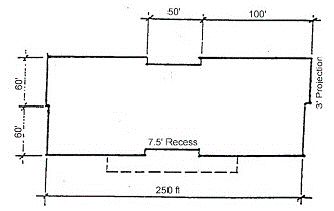
Figure 7.10.02(b)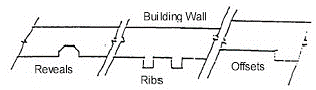
(a)
Multiple stores within a single building. Where a large retail project contains individual stores that are less than 25,000 square feet of gross floor area each, with separate, exterior customer entrances, the street level facade of each store shall provide the design and/or placement such as windows between the height of three feet and eight feet above the walkway grade, for no less than 60 percent of the horizontal length of the building facade of each store.
(2)
Materials. Unfinished tilt-up concrete panels, prefabricated steel panels or similar non-glass, smooth faced panels shall not be exposed.
(3)
Entryways. Each business facade without an entrance shall include at least one customer entrance or be screened from public view with no less than 20 foot wide buffer. (This criteria is intended to improve aesthetics of buildings whose entrance may not be along the front facade and to improve appearance of an otherwise blank wall.) Customer entrances shall be clearly defined and include at least two of the following features: canopies/porticos, overhangs, recesses/projections, arcades, raised above-the-doorway cornice parapets, peaked roof forms, arches, outdoor patios, display windows, integrated architectural details such as tile work, moldings, planters or wing walls, and/or landscaped sitting areas. The non-customer/ loading areas shall be screened from public view with a landscaped buffer to be installed and approved by the Site Plan Review Committee.
(4)
Roofs. Flat unarticulated roof lengths, longer than 100 feet in length shall be concealed or addressed by utilizing at least two of the following options (see Figure 4-18.c):
Figure 7.10.02(c)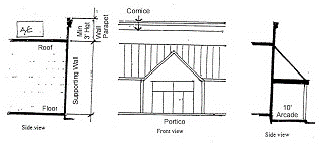
(a)
Effective concealment of flat roof lines, rooftop equipment and heating, ventilating and air conditioning (HVAC) units from any facade view by adjacent land uses of lesser intensity and public right-of-way. The parapet design shall be a minimum of three feet in height and shall incorporate a three dimensional cornice treatment. Alternative designs such as varying the parapet height for a minimum linear distance of 100 feet and a minimum vertical height of two feet shall be subject to approval by the Site Plan Review Committee.
(b)
Overhanging eaves that extend no less than three feet past the supporting walls.
(c)
Two or more sloping roof planes.
(5)
Pedestrian circulation. Large retail projects shall be pedestrian oriented through design features that enhance pedestrian safety, efficiency and connectivity with a clear definition between vehicular areas and pedestrian walkways.
(a)
Sidewalks. Pedestrian connectivity between the project building entrances and parking areas, public sidewalks, out parcel buildings and transit stops shall be clearly indicated through the use of landscaped areas and sidewalks which are made of materials such as scored concrete, pavers or bricks. All projects building sides with customer entrances shall include such a sidewalk along the full length of each facade.
(b)
Pedestrian amenity area. Large retail projects shall include design features such as pedestrian amenity areas, which include well landscaped sitting areas with design components such as seating elements and/or other amenities in shaded areas. A minimum of four benches or other similar amenity, shall be provided at each customer entrance/pedestrian amenity area.
(6)
Parking areas. Parking lots and access aisleways shall be designed utilizing the following standards:
(a)
Parking lot design. Vast, unbroken parking lots are prohibited. Parking areas shall be designed so that no more than 100 spaces of the total required spaces are part of a clearly defined grouping of spaces. The groups shall be broken into individual lots and/or clearly separated by well landscaped or weather-protected pedestrian walkways, significant landscape or geographic features, and/or by design components of the proposed building(s). Separations shall be no less than eight feet in width at any point. No required parking space shall be located further than 500 feet from the nearest customer entrance. At least 20 percent of the required parking spaces shall be placed in the rear or side areas of the proposed development, if feasible, as determined by the Site Plan Review Committee. Alternative designs that incorporate existing natural resources are encouraged, subject to approval by the Site Plan Review Committee; and/or
(b)
Parking spaces. The number of parking spaces shall be determined in accordance with the Land Development Code standards. Each parking space in excess of the minimum shall require an additional landscaped area of ten square feet to be placed within the internal parking area, frontage road, and/or right-of-way buffer. The use of pervious parking areas, including turf block may be considered for no more than 20 percent of the total constructed required parking spaces, subject to approval by the Site Plan Review Committee.
(7)
Landscaping. The following landscaping standards shall be incorporated into the design of all large retail projects:
(a)
Foundation. Foundation landscaping shall be required for at least 50 percent of each facade length located along a public right-of-way, parking area or which includes a customer entrance (see Figure 7.10.02(d)). The landscaping shall be incorporated into a minimum of a five-foot wide landscaped bedding area located between and in addition to the required building sidewalk and the first vertical wall of the building facade. Large commercial planters or alternative designs may be used to meet these criteria (see Figure 7.10.02(e)).
Figure 7.10.02(d)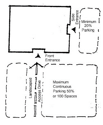
Figure 7.10.02(e)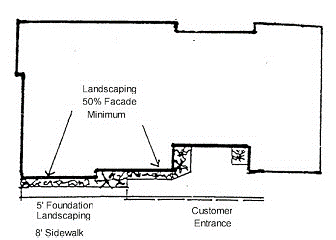
(b)
Bufferyards. Bufferyards, rather than setbacks, shall be required along all collector and arterial roadways, which include an unbroken (except for required driveways, sidewalks and other public safety elements), landscaping area no less than 30 feet in width and planted according to Buffer standards. If existing vegetation is to be preserved, a varying buffer design may be utilized where the average width is 20 feet. Alternative designs are subject to approval by the Site Plan Review Committee.
(c)
Parking areas. Every ten spaces shall be designed with 400 square feet of landscaping to be placed in medians or islands and shall include at least one over-story tree, one under-story tree and six shrubs. No median shall be less than five feet in width and no more than ten spaces shall be continuous without landscaping (see Figure 7.10.02(f)). Grouping of landscaped islands is encouraged to promote the healthy growth of larger trees. Alternative designs are subject to approval by the Site Plan Review Committee, but in no case shall the total required landscaping area be decreased.
Figure 7.10.02(f)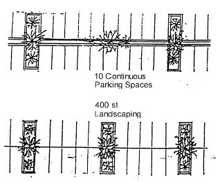
(d)
Access driveway. Main access driveways from the public right-of-way into the proposed development shall be completely separated from any parking area and/or pedestrian walkway by a landscaped island, not including intersection and walkways. At least one, four-inch (dbh), over-story tree shall be planted or preserved at 40 feet on-center spacing.
(e)
Frontage roads. Frontage roads need not be landscaped; however, when parking area landscaping cannot be met, the Site Plan Review Committee may approve no more than 20 percent of the required parking area landscaping for placement along frontage roads.
(f)
Drainage retention areas (DRA). In addition to all land development requirements, a landscaped buffer shall be planted adjacent to public right-of-way and/or access drives, in coordination with an approved DRA. Alternative DRA design is encouraged, subject to approval by the Site Plan Review Committee.
(g)
Tree preservation. All large retail projects shall comply with tree preservation standards and the requirements shall be in addition to divisions (C)(7)(a), (b) and (c) of this section.
(8)
Exterior lighting. Exterior lighting design shall enhance security of pedestrians and motorists alike. All pedestrian walkways and parking spaces shall be adequately lighted through the use of individual or combination lighting features such as standard luminaire, street lamp, and/or bollard types of fixtures. Alternative designs are subject to approval by the Site Plan Review Committee (see Figure 7.10.02(g)). Lighting shall be designed according to the following standards:
Figure 7.10.02(g)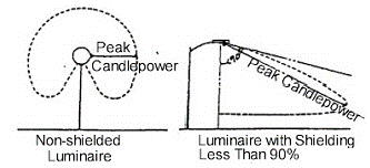
(a)
Maximum height. Exterior light sources such as luminaries or lampposts shall not exceed 20 feet in height. Shielded light sources may not exceed 35 feet in height.
(b)
Illumination. All lighting shall be designed to minimize the spillage onto adjacent noncompatible land uses. Non-shielded fixtures are permitted and maximum illumination factor of five foot candles. Shielded fixtures are permitted a maximum illumination factor of 12 foot candles.
(c)
Location design. Lighting sources (interior or exterior) shall be shielded from vehicular travel lanes so that glare to motorists is minimized. Areas located on waterways, such as docks and nature trails and other regulated areas shall utilize shielded light fixtures so that the light source is adequately shielded from view on the waterway or regulated area. Lighting and other improvements, such as cart returns, shall be incorporated into the landscape design.
(d)
Exterior illumination. Exterior illumination shall be engineered for public safety and not impact adjacent properties to an extent greater than is necessary to address the safety issue. Lighting plans may be required by the Site Plan Review Committee and extensive lighting systems justified by appropriate study at the applicant's expense.
(9)
Signage. Signage shall be designed as part of a complete system and may be approved as part of the overall site plan, without acquiring a separate permit.
(10)
Outdoor storage and sales. Outdoor storage (including seasonal storage trailers) and sales shall be permitted in designated areas only, as approved during development site plan review and shall be screened from view from residential land districts and uses through landscaping and/or other design features.
(11)
Compliance. In addition to the application requirements of the LDC, a colored facade rendering shall be submitted to the Director of Development at time of application submission to ensure that the development standards required herein are adhered to.
(12)
Conflict. In the case of any conflicts between these requirements and requirements contained in the city's Building Code, and/or Florida Building Code, the more stringent code shall prevail.
Sec. 7.11.01. - General provisions for traditional development districts.
Traditional development, as presented in the Comprehensive Plan revision, encompasses the following types of land uses. These are illustrated conceptually in Figure 7.11.01.
(Ord. 881-04, passed 5-24-2004)
Sec. 7.11.01.01. - Purpose and intent.
The purpose and intent of the traditional development districts is to implement the traditional town development (TTD), the traditional marketplace development (TMD) and the traditional neighborhood development (TND) provisions of the Comprehensive Plan and to:
(A)
Encourage mixed-use, compact development that is pedestrian in scale and sensitive to environmental characteristics of the land and facilitates the efficient use of services within the county;
(B)
Have residences, shopping, employment and recreational uses located within close proximity with each other and efficiently organized to provide for the daily needs of the residents;
(C)
Provide for a range of housing types within pedestrian-oriented, human-scale neighborhoods;
(D)
Provide efficient circulation systems for pedestrians, non-motorized vehicles and motorists that serve to functionally and physically integrate the various land use activities; and
(E)
Allow for a strong neighborhood identity and focus.
(Ord. 881-04, passed 5-24-2004)
Sec. 7.11.01.02. - Organization of traditional development standards.
(A)
These regulations reflect a 'building block' approach to traditional development, with traditional neighborhoods (TNDs) and traditional marketplaces (TMDs) as the base districts. The traditional town (TTD) functions as an umbrella district, composed of TNDs, TMDs and additional land uses needed to support a larger population, such as a traditional employment center (TEC). A portion of a TTD also may be used for planned development district.
(B)
Separate regulations are provided for TNDs and TMDs, in order to allow these districts to be developed independently of a TTD.
(C)
Provisions for civic and open space/recreation areas are included in the TND provisions. A "neighborhood center" commercial area in a TND is also included to allow for small-scale commercial uses intended to serve local residents.
(D)
To avoid duplication, standards that apply to all traditional development districts, including provisions for street and sidewalk design, landscaping, parking and signage, have been grouped together as "general standards for all traditional development districts".
(E)
The overall organization has been structured to follow logically, with general provisions and standards for all traditional development districts (e.g. uses allowed, street, alley and sidewalk standards by, parking, lighting, landscaping, fencing and walls and signage) listed first, followed by specific provisions for TNDs and TMDs - the building blocks of traditional development - and then the provisions for TECs and for the development of larger TTDs.
(F)
Development standards for traditional development building types, setbacks, frontage requirements, location of parking and building design are presented within individual district regulations.
(Ord. 881-04, passed 5-24-2004)
Sec. 7.11.01.03. - Review and approval process.
All development within traditional development districts are subject to the review and approval procedures that apply to planned developments; see Article XI, PART 11.11.00, Planned Development.
(Ord. 881-04, passed 5-24-2004)
Sec. 7.11.01.04. - Types of traditional development districts.
Traditional development districts include the following:
(A)
Traditional neighborhoods (TND) are intended to accommodate a mix of housing types, civic and neighborhood-oriented commercial uses, integrated with a recreation and pedestrian-oriented open space system and a system of streets, alleys and sidewalks. A neighborhood center with an adjacent neighborhood square is a community focal point within easy walking distance of residents.
(B)
Traditional marketplaces (TMD) have a concentrated area for shopping, entertainment, business services, cultural and housing opportunities in a pedestrian-oriented environment. Large-format retail stores ("big boxes") are not allowed. Floors above shops and offices may be used for housing, offices or live/work units.
(C)
Traditional towns (TTD) provide an opportunity for community planning at a large scale, integrating traditional neighborhoods and traditional marketplaces with an inter-connected system of streets, alleys, sidewalks, squares, parks and open space. A compact development pattern is promoted by not requiring buffers between uses within the town.
(D)
Traditional employment centers (TEC) provide for professional office and supporting commercial services within a TTD or integrated with a TMD.
(Ord. 881-04, passed 5-24-2004)
Figure 7.11.01 Traditional Development Prototypes; Marketplace, Neighborhoods and
Street Network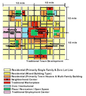
Sec. 7.11.01.05. - Residential density and comprehensive plan land uses categories.
(A)
The minimum density, the maximum density and the Comprehensive Plan land use categories which correspond to the various traditional development districts shall be determined by Table 7.11.01: Traditional Development District Intensities and Corresponding Land Use Categories.
(B)
TND density bonus. TNDs may qualify for a density bonus of up to two additional units per acre above the maximum density allowed for the underlying zoning district as prescribed in Table 7.11.01, provided that the TND is consistent with the standards and requirements of this article.
Table 7.11.01. Traditional Development District Densities and Corresponding Land Use Categories
(Ord. 881-04, passed 5-24-2004)
Sec. 7.11.01.06. - Uses allowed.
(A)
Land uses allowed within a TND, TMD, TTD or TEC are governed by Table 7.11.02, Traditional Development Permitted Use Schedule.
(B)
The permitted use schedule in Table 7.11.02 includes four designations: "P" permitted use, "C" conditional use, "SPRC" Site Plan Review Committee and "Blank" prohibited.
Table 7.11.02. Traditional Development Permitted Use Schedule
(Ord. 881-04, passed 5-24-2004)
Sec. 7.11.01.07. - Design objectives.
Traditional development districts must be planned to comply with the following design guidelines.
(A)
Neighborhoods.
(1)
A mix of residential uses to provide housing opportunities for residents of different incomes, ages, family sizes and lifestyles, including:
(a)
Single-family dwellings;
(b)
Zero Lot line dwellings;
(c)
Town houses;
(d)
Multi-family dwellings;
(e)
Accessory dwellings; and
(f)
Congregate living facilities;
(2)
Centrally-located community focal points for the formal and informal interaction of neighborhood residents, such as a neighborhood square, community meeting hall and a neighborhood commercial center. These uses are within walking distance (approximately one-fourth mile or a five-minute walk) of all residents.
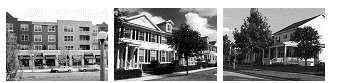
Residential neighborhoods include a mixture of housing types from multi-family buildings
integrated with commercial and office uses, to single-family detached houses.
(3)
A variety of open spaces and recreation areas to allow for both passive and active recreation. Small neighborhood parks and playgrounds should be located throughout the neighborhood, so all residents are closely located to a neighborhood park. Large outdoor recreation areas should be located at the periphery of neighborhoods rather than in central locations.
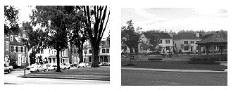
Centrally located focal points and parks located throughout neighborhoods provide
formal and informal gathering spaces for local residents.
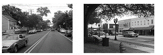
An interconnected street grid disperses traffic throughout the neighborhood, removing
the need for high-capacity thoroughfares, and allowing streets to be designed with
narrower widths for slower speeds and greater pedestrian convenience and safety.
(4)
An interconnected network of streets, bike lanes and sidewalks throughout the neighborhood, providing multiple routes for vehicle, bicycle and pedestrian travel, diffusing traffic and shortening walking distances. Streets are designed for slower speeds to encourage pedestrian safety. Alleys and lanes provide vehicular access to garages and open spaces in the rear of buildings.
(5)
A safe and attractive pedestrian environment enhanced by the design of buildings which provide windows and entrances to reduce the amount of blank walls and street-level uses. Sidewalks include pedestrian amenities such as shade trees and street furniture.
(B)
Commercial districts (traditional marketplaces).
(1)
Public spaces, such as plazas and squares, integrated within commercial development providing places for people to gather or rest. Walkways provide pedestrian connections throughout TMDs. Lighting and landscaping accent public spaces and provide for security and shading.
(2)
Parking is provided on-street, behind buildings and in shared parking lots. Parking lots are not allowed in front of buildings, creating barriers between pedestrians and storefronts.
(3)
Buildings are human-scaled in design with a variety of architectural features which create an attractive and textured streetscape. Building frontages are set near the sidewalk and building sizes are consistent, providing a sense of enclosure for the street. Architectural detailing and applied decoration enliven facades and break down building sizes to human proportions. Building entrances and windows are located along street frontages to break up blank walls and improve the pedestrian experience.
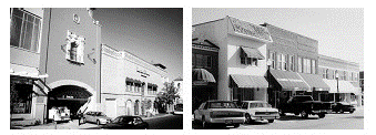
Parking is provided on-street and behind buildings. Parking lots in front of buildings,
which create barriers to pedestrians and distract from an attractive streetscape,
are not allowed.
(Ord. 881-04, passed 5-24-2004)
Sec. 7.11.01.08. - Development standards.
All TNDs, TMDs, TECs and TTDs are subject to the standards and requirements of section 7.11.03, Traditional Neighborhood Development, section 7.11.04, Traditional Marketplace Development, section 7.11.05, Traditional Employment Center Development and section 7.11.06, Traditional Town Development, respectively, in addition to the applicable standards of section 7.11.02, Standards Applicable to all Traditional Development Districts. All traditional development districts are further subject to the standards and requirements prescribed in Article VII of this code and all other applicable standards.
(Ord. 881-04, passed 5-24-2004)
Sec. 7.11.01.09. - Development phasing.
Phasing of TDD developments shall be limited to a maximum of four phases of up to five years each. The first phase of the project shall include a minimum of 25 percent of the total project, unless otherwise approved by the City Commission.
(Ord. 881-04, passed 5-24-2004)
Sec. 7.11.02.01. - Applicability.
The following standards apply to all traditional development districts.
(Ord. 881-04, passed 5-24-2004)
Sec. 7.11.02.02. - Streets, sidewalks, and alleys.
The circulation system within a traditional development shall allow for different modes of travel within and between individual traditional development districts, based upon a hierarchy of transportation methods. The street and sidewalk network shall provide visual and functional links within and between residential, commercial, office, civic and open space areas and shall be connected to existing and proposed external development.
(A)
Definition. For the purposes of the section, streets shall include private accessways and driveways.
(B)
Block structure. To ensure compact, contiguous development and to facilitate connectivity and pedestrian accessibility, the layout of streets and alleys shall conform to the following standards:
(1)
Minimum length of a block, 160 feet;
(2)
Maximum length of a block:
(a)
Residential: 500 feet;
(b)
Single-family residential: 660 feet. Up to 750 feet is allowed if a mid-block alley or pedestrian pathway is provided;
(c)
Nonresidential: 500 feet;
(3)
Maximum ratio of block length to width for neighborhood centers and TMDs, 2:1;
(4)
Maximum number of alley curb cuts: four per block and one per side.
(5)
Minimum spacing between alley curb cuts: 80 feet.
Figure 7.11.02 Block Structure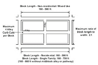
(C)
Streets.
(1)
Street design. Public streets shall conform to the standards in Table 7.11.03, Street Design Standards.
Table 7.11.03. Traditional Development Street Design Standards
Figure 7.11.03 Collector Without On-Street Parking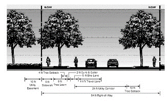
Figure 7.11.04 Collector With On-Street Parking
Figure 7.11.05 Commercial Street
Figure 7.11.06 Local Residential Streets
(2)
Connectivity. All street and alleys shall connect to other streets and alleys to form a continuous vehicular and pedestrian network within the district and to adjacent development.
(a)
The use of gates or other preventative barriers shall not be permitted on collector streets.
(b)
Dead-end streets. No more than 10 percent of all streets may be dead-end streets, such as cul-de-sacs, T-turnarounds and closes. The maximum length for dead-end streets shall be 500 feet.
Figure 7.11.07 Dead-End Streets
(D)
Sidewalks and pathways. Sidewalks and/or pedestrian pathways shall connect to one another to form a continuous pedestrian network within and between all traditional development districts. Unless otherwise indicated, sidewalks shall be provided along both sides of the street and shall conform to the standards in Table 7.11.04, Sidewalk/Pathway Design Standards.
(1)
Master pedestrian circulation plan. A master pedestrian circulation plan shall be submitted with the regulating plan.
(2)
Accessibility. Sidewalks at street intersections or pedestrian crossings shall be sloped, with the use of curbcuts and/or ramps.
Table 7.11.04. Sidewalk/Pathway Design Standards
Figure 7.11.08 Sidewalk/Pathway Design Standards
(E)
Alleys.
(1)
Alleys shall conform to the design standards in Table 7.11.05. Alleys providing access to residential buildings shall be built to residential alley standards. Alleys providing access to commercial or office buildings shall be built to commercial alley standards.
(2)
Where an alley provides access to a block with both residential and commercial uses, the alley shall be built to the commercial alley standards.
Table 7.11.05. Alley Design Standards
Figure 7.11.09 Alley Design Standards
(F)
Utilities and lighting.
(1)
Utilities. Public utilities and lighting shall be installed in accordance with the standards established by this code and other applicable standards.
(2)
Street lighting. Street lighting shall be provided along all streets and alleys, subject to the standards prescribed in Table 7.11.06, Street lighting standards. Light fixtures shall be located at every crosswalk.
Table 7.11.06. Street Lighting Standards
Figure 7.11.10 Street Lighting Standards
(3)
Parking lot lighting. Lighting shall be provided for all parking lots, subject the following standards. All parking lot lighting shall be fully shielded and all lighting fixtures shall be a maximum of 25 feet in height.
(Ord. 881-04, passed 5-24-2004)
Sec. 7.11.02.03. - Parking requirements and access.
Parking requirements are intended to balance compact, pedestrian-oriented development and necessary car storage.
(A)
Number of parking spaces. Parking spaces shall be provided, as follows. On-street spaces may be used to meet these parking requirements.
(1)
Residential. Parking shall be provided in accordance with the standards in section 7.03.04, Off-street parking and loading.
(2)
Nonresidential.
(a)
Minimum number of parking spaces. One parking space per 400 square feet of gross floor area.
(b)
Maximum number of parking spaces. One space per 250 square feet of gross nonresidential floor area.
(B)
Reduction in parking requirement. The number of required spaces may be reduced by either of the following methods:
(1)
The shared parking requirements of section 7.03.04; or
(2)
A parking demand study prepared by a traffic engineer licensed by the state demonstrating that the parking demand for the project will be less than the requirements of this section.
(C)
Location of parking. Off-street parking is prohibited in required front or corner side setbacks. The maximum walking distance to a pedestrian entrance to an off-street parking facility, including shared parking facilities, shall be 1,000 lineal feet from the principal building entrance served by the parking.
(D)
Parking structures. Structured parking is required for any spaces in excess of one space per 250 gross square feet of nonresidential floor area.
(E)
Minimum pervious surface. Twenty percent of the project site.
(F)
Bicycle parking. One parking space shall be provided for every five units in multi-family housing and for every 20 vehicle parking spaces serving nonresidential uses. Bicycle parking spaces shall be indicated on the site plan in visible, well-illuminated areas. For each bicycle parking space required, a stationary object shall be provided to which a user can secure the frame of the bicycle with a six-foot cable and lock. The stationary object may either be a freestanding bicycle rack or a SPRC-approved alternative.
(Ord. 881-04, passed 5-24-2004)
Sec. 7.11.02.04. - Landscaping and buffering.
In addition to the requirements in part 7.06.00, Landscaping, the following standards shall apply.
(A)
Buffer around districts. No buffers are required where one traditional development district abuts another traditional development district.
(B)
Compatibility and incompatibility buffers. Buffers are not required within traditional development districts except that a solid six-foot high wall or five-foot wide landscape planting area that provides a visual screen at least six feet in height is required along an interior property line where a nonresidential use abuts a residential use. The height of the wall or landscape screen shall not exceed three feet within required front setback areas.
(C)
Off-street parking areas.
(1)
Trees. One canopy tree shall be planted for every six parking spaces. In a neighborhood center, one canopy tree shall be planted for every eight parking spaces. Trees shall not be spaced more than 80 feet apart.
(2)
Terminal islands. Terminal landscape islands, subject to the requirements of section 7.06.00 Terminal and interior landscape islands, shall be provided on both sides of all vehicular access points.
Figure 7.11.11 Off-street Parking Landscaping Standards
(D)
Street trees. Street trees shall be provided along all sidewalks, subject to the following standards
(1)
Number. One canopy tree shall be planted for every 30 lineal feet of street frontage. Palm trees may be substituted for a canopy tree on a 1:1 basis along a frontage with a covered walkway.
(2)
Minimum height. Fourteen feet.
(3)
Minimum diameter. Two and one-half inches, measured 4½ feet above grade.
(4)
Spacing. Trees shall be spaced between 25 to 35 feet on center.
Figure 7.11.12 Street Tree Standards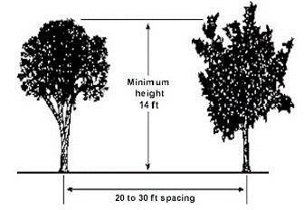
(Ord. 881-04, passed 5-24-2004)
Sec. 7.11.02.05. - Fencing and walls.
Fences and walls shall be subject to the standards of Part 7.07.00 of this LDC.
(Ord. 1393-19, passed 11-18-2019)
Sec. 7.11.02.06. - Signage.
In addition to the regulations set forth in Article VIII, the following sign regulations apply:
(A)
Building-mounted signs. Building-mounted signs, including wall signs, awning and canopy signs and projecting signs are allowed, subject to the standards of Article VIII and the following additional requirements.
(1)
Maximum size. 0.75 square foot for every linear foot of tenant frontage is permitted, up to a maximum of 64 square feet.
(2)
Maximum height. Fifteen feet high. Signs on an exterior frontage an arterial or collector street are not subject to the height limit.
(3)
Maximum projection. Thirty inches from any building face.
(B)
Freestanding signs. Unless otherwise provided herein, all freestanding signs shall be prohibited.
(1)
Exceptions. Temporary freestanding A-type frame signs are allowed in arcades and covered walkways.
(C)
Entrance wall signs. Entrance signs are permitted for traditional developments for the purpose of identifying the development, subject to the standards in Article VIII, Signs. Entrance wall signs shall be permitted on an entrance wall to the development only. Sign copy and graphics shall identify only the name of the development and the address and must be attached to the face of the wall.
(Ord. 881-04, passed 5-24-2004)
Sec. 7.11.03.01. - Specific purpose.
The specific purpose of the traditional neighborhood district is to:
(A)
Establish a specific neighborhood identity and focus with a pedestrian-oriented design consistent with the tier where the development is located;
(B)
Provide a range of residential, commercial, civic and open space land uses in close proximity to one another within the neighborhood;
(C)
Lessen existing imbalances in land uses within a specified planning area;
(D)
Encourage walking and bicycling to reduce the use of the automobile for local trips;
(E)
Offer a range of housing opportunities;
(F)
Preserve natural features and scenic areas;
(G)
Provide a safe and efficient circulation system for pedestrians, non-motorized vehicles and automobiles and emphasize connectivity within and to adjacent uses; and
(H)
Utilize perimeter landscape and edge areas to connect the various land uses and land use zones within neighborhoods and the surrounding communities.
(Ord. 881-04, passed 5-24-2004)
Sec. 7.11.03.02. - Minimum size.
A TND must contain a minimum of 40 contiguous acres. Within the urban/suburban tier, the minimum size may be reduced to 25 acres for infill projects that are adjacent to existing residential, civic or commercial development on at least two sides.
(Ord. 881-04, passed 5-24-2004)
Sec. 7.11.03.03. - Uses.
Uses allowed in a TND district are listed in Table 7.11.02.
(Ord. 881-04, passed 5-24-2004)
Sec. 7.11.03.04. - Neighborhoods.
The basic component of a TND is the neighborhood, organized around a neighborhood center. Each neighborhood within a TND shall not exceed 40 acres and no TND shall include more than four neighborhoods unless the TND is included within a TTD.
(Ord. 881-04, passed 5-24-2004)
Sec. 7.11.03.05. - Land use mix.
TNDs shall provide residential, recreational, civic and neighborhood commercial land uses, as provided in Table 7.11.07, TND Land Use Allocations. A TND developed as part of a TTD is subject to the minimum land use allocations provided in Table 7.11.10, TTD Land Use Allocations.
Table 7.11.07. TND Land Use Allocations
(Ord. 881-04, passed 5-24-2004)
Sec. 7.11.03.06. - Connections.
(A)
All uses in a TND shall be connected by sidewalks or pedestrian paths, bicycle paths or bicycle lanes and local streets. A minimum of 90 percent of all streets shall connect to other streets at an intersection.
(B)
All paths or trails, including bicycle paths or lanes, shall interconnect to form a continuous network throughout the TND and to paths or trails in adjacent neighborhoods.
(C)
Vehicular gates are prohibited on all roads and alleys.
(Ord. 881-04, passed 5-24-2004)
Sec. 7.11.03.07. - Neighborhood center.
The neighborhood center designation is intended to accommodate neighborhood-oriented retail and commercial services. It may include professional offices, community facilities, daycare centers and compatible civic uses, to serve the population of the TND.
(Ord. 881-04, passed 5-24-2004)
Sec. 7.11.03.07.01. - General standards.
(A)
Location. The neighborhood center shall be located within a five-minute walking distance of at least 80 percent of the housing units within the neighborhood and shall be adjacent to a minimum of one side of a neighborhood square.
(B)
Maximum and minimum size. The neighborhood center shall be a minimum of one acre and a maximum of three acres in size.
(C)
Parking. Parking shall be provided in accordance with section 7.03.04. Parking lots shall not abut plazas, squares or parks.
(Ord. 881-04, passed 5-24-2004)
Sec. 7.11.03.07.02. - Building standards.
(A)
Maximum floor area ratio: 0.35.
(B)
Maximum floor area: 40,000 square feet of gross floor area.
(C)
Maximum floor area per establishment: 5,000 square feet.
(D)
Exception: 10,000 square feet is allowed for a food store.
Figure 7.11.13 Neighborhood Center Standards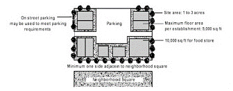
(Ord. 881-04, passed 5-24-2004)
Sec. 7.11.03.08. - Civic/institutional.
The civic designation is intended to accommodate publicly and privately-owned institutional land uses intended to serve the neighborhood.
(Ord. 881-04, passed 5-24-2004)
Sec. 7.11.03.08.01. - Location.
Civic lots used for community buildings shall be located adjacent to a neighborhood square or park or on a lot terminating a street vista.
(Ord. 881-04, passed 5-24-2004)
Sec. 7.11.03.08.02. - Public land dedication.
(A)
Based on the proportional impacts of development on the demand for public services and facilities, a portion of a TND may be required to be conveyed or voluntarily committed in simple fee title to the City Commission for civic purposes.
(B)
These conveyances shall be in a form approved by the City Attorney or by a development agreement.
(Ord. 881-04, passed 5-24-2004)
Sec. 7.11.03.09. - Open space/recreation.
Areas designated for open space/recreation include parks, neighborhood squares and active or passive recreation areas.
(Ord. 881-04, passed 5-24-2004)
Sec. 7.11.03.09.01. - Neighborhood parks.
(A)
Minimum area.
(1)
A minimum of 5 percent of the open space/recreation area must be common open space dedicated to the public for parkland.
(2)
Each neighborhood park shall have a minimum area of 20,000 square feet.
(B)
Location. Neighborhood parks shall be distributed within the TND so that 95 percent of all dwelling units are located within 1,320 feet from a park or other recreation area.
(C)
Minimum pervious area. The minimum required area of a park that must be pervious surface is 50 percent.
(D)
Sidewalk access. A minimum of 50 percent of a park's perimeter shall abut a sidewalk.
(Ord. 881-04, passed 5-24-2004)
Sec. 7.11.03.09.02. - Neighborhood square.
Each TND shall include a neighborhood square. The square and abutting neighborhood commercial uses and community facilities will serve as a focal point for the surrounding residential neighborhoods.
(A)
Required amenities. Neighborhood squares shall include street furniture and other amenities such as gazebos, fountains, kiosks and benches.
(B)
Size. The square shall have a minimum lot size of 25,000 square feet and a maximum size of 140,000 square feet.
(C)
Street access. A minimum of 50 percent of a square's perimeter shall abut a street right-of-way.
(D)
Sidewalk access. A minimum of 50 percent of a square's perimeter shall abut a sidewalk.
(E)
Minimum pervious area. 40 percent of the square's lot area.
Figure 7.11.14 Neighborhood Park and Square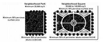
(Ord. 881-04, passed 5-24-2004)
Sec. 7.11.03.09.03. - Active recreation areas.
Recreation uses, including playing fields and swimming pools that tend to generate impacts such as noise and bright lights, shall be buffered by a perimeter landscape area that complies with the compatibility buffers described in section 7.11.02.04 Landscaping and Buffering. Neighborhood squares with active recreation areas are exempt from this buffering requirement.
(Ord. 881-04, passed 5-24-2004)
Sec. 7.11.03.10. - Development standards.
(A)
The following development standards apply to a TND.
(B)
These standards, in addition to the architectural guidelines of § 6.6.E, control the form, placement, scale and massing of blocks and buildings within a TND.
(Ord. 881-04, passed 5-24-2004)
Sec. 7.11.03.10.01. - Residential land uses.
(A)
Block structure. To ensure compact, contiguous development and to facilitate pedestrian accessibility and connections with adjacent land uses, the layout of streets and alleys in a TND shall conform to the following requirements:
(1)
Maximum length of a block.
(a)
Single-family residential: 660 feet (exception: up to 750 feet is allowed if a mid-block alley or pedestrian pathway is provided);
(b)
All other residential types: 500 feet;
(2)
Minimum length of a block: 160 feet;
(3)
Maximum number of alley curb cuts: 4 per block.
Figure 7.11.15 Block Structure - Residential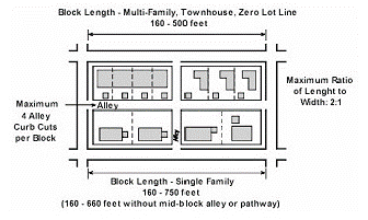
(B)
Lot size and setbacks. Minimum and maximum lot sizes and building setbacks shall conform to the standards in Table 7.11.08, Residential Lot Size and Setback Regulations.
Table 7.11.08. Residential Lot Size and Setback Regulations 1
(C)
Maximum building height. Thirty-five feet. (Exception: one foot of additional height may be allowed for multi-family residential buildings for each additional foot of front and side setback provided beyond the minimum setback required, up to a maximum of an additional ten feet and a total building height of 45 feet).
(D)
Building orientation. Residential buildings shall front a street, neighborhood square or small park and be directly accessible from a street.
(E)
Building types.
(1)
The TND is intended to accommodate a range of housing types that would be interspersed throughout the TND; separate zones with assigned densities are not required.
(2)
Figure 7.11.05 illustrates residential building types appropriate within a TND.
(F)
Accessory buildings. Accessory buildings shall not exceed 25 feet in height. These buildings may be used as a garage or accessory dwelling.
(1)
Calculation of density. Accessory dwellings are not considered "dwelling units" for the purposes of calculating the maximum allowable density in a TND if the principal building is occupied year-round.
(2)
Maximum number. Up to one accessory dwelling unit per principal dwelling unit is permitted.
(3)
Required parking. One additional parking space per accessory dwelling.
(G)
Garages. Garages are permitted if they are located in the rear half of the lot.
(1)
Garages accessible from an alley shall be setback a minimum of five feet from the rear property lot line.
(2)
Single-family houses.
(a)
Garages may be attached to a single-family house if recessed a minimum of 20 feet from the front facade of the house.
(b)
Attached garages shall occupy a maximum of 30 percent of the total frontage of the house, as defined by the total length between the two main exterior walls nearest to the interior property lines, including the garage but excluding any attached structures, such as a porch, deck or patio.
Figure 7.11.16 Residential Building Types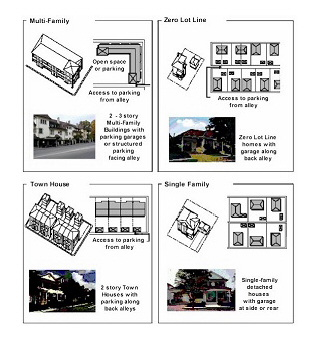
Figure 7.11.17 Garages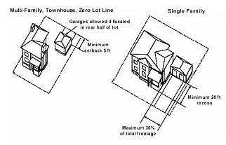
(H)
Main entrances. All principal buildings shall have their main entrance fronting a street. Corner entries at street intersections are preferred for multi-family structures.
(I)
Porches. All single-family dwellings shall have a front porch, raised a minimum of two feet from the finished grade.
(1)
Size. Porches shall have a minimum depth of six feet and a minimum width of 12 feet.
(2)
Enclosure. Porches may be covered or open; however, the front and open sides of a porch shall not be enclosed between three feet and seven feet from the finished floor of the porch.
(J)
Balconies and patios. A minimum of 20 percent of the total number of dwelling units on each floor in a multi-family structure shall have individual balconies and/or patios.
(1)
Setback encroachment. A balcony may encroach a maximum of six feet into a front or street side setback.
(Ord. 881-04, passed 5-24-2004)
Sec. 7.11.03.10.02. - Nonresidential land uses.
(A)
Block structure.
(1)
Maximum length of a block. 500 feet.
(2)
Minimum length of a block. 160 feet.
Figure 7.11.18 Block Structure - Nonresidential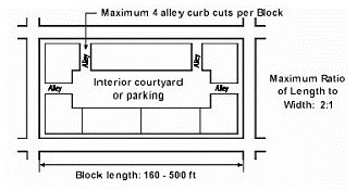
(B)
Setbacks. Minimum and maximum building setbacks shall conform to the standards in Table 7.11.09, Nonresidential Lot Size and Setback Regulations.
Table 7.11.09. Nonresidential Lot Size and Setback Regulations
(C)
Maximum building height. Thirty-five feet. An additional height of five feet is allowed where the roof pitch is greater than 5:12.
(D)
Building orientation. Buildings shall front a street rather than a parking area or alley. All principal buildings shall have their main pedestrian entrance facing the street.
(E)
Build-to lines. A minimum of 40 percent of commercial buildings shall abut the front property line.
(F)
Covered walkways. A minimum of 60 percent of all first floor building frontages shall be constructed as storefronts with covered walkways, with features such as awnings, colonnades or arcades. Colonnades and arcades shall be at least eight feet in width, including any support column intrusions and all covered walkways shall have a minimum interior height clearance of nine feet from finished grade.
Sec. 7.11.04.01. - Specific purpose.
The specific purpose of the TMD district is to:
(A)
Provide a concentrated area for shopping, entertainment, business, services and cultural opportunities by allowing a mix of commercial and institutional uses and establishing physical development and design standards that create pedestrian-oriented development;
(B)
Provide housing opportunities through vertically integrated residential uses;
(C)
Promote a mix of uses in a manner that creates a stronger pedestrian orientation through design, placement and organization of buildings, plazas, common public space and dispersed parking;
(D)
Make traditional marketplaces compatible with the overall design objectives of the Comprehensive Plan and it's managed growth tier system; and
(E)
Respect and contribute to the character of the surrounding area.
(Ord. 881-04, passed 5-24-2004)
Sec. 7.11.04.02. - Uses allowed.
Uses allowed in a TMD are listed in Table 7.11.02.
(Ord. 881-04, passed 5-24-2004)
Sec. 7.11.04.03.01. - General standards.
The following standards apply to all TMD's regardless of location.
(A)
Minimum site area. Ten acres.
(B)
Permitted Locations. A TMD must have at least 200 feet of frontage along an arterial or collector street.
(C)
Minimum total floor area. 150,000 square feet is required, with a minimum of 50,000 square feet in the first phase.
(D)
Minimum floor area ratio. 0.3.
(E)
Maximum floor area per establishment. No single tenant may occupy more than 50,000 square feet unless approved as a requested use. Single tenants occupying more than 100,000 square feet are prohibited.
(1)
Maximum ground floor area per establishment. No single tenant may occupy more than 40 percent of the total ground floor of a commercial or a mixed use building.
(2)
Exceptions for civic/institutional uses. Civic and institutional uses are not subject to these floor area limitations.
(3)
Maximum frontage per establishment. No single tenant may occupy more than 120 linear feet of frontage to a depth of 40 feet, measured from the store front.
Figure 7.11.19 Maximum Floor Area and Frontage Per Establishment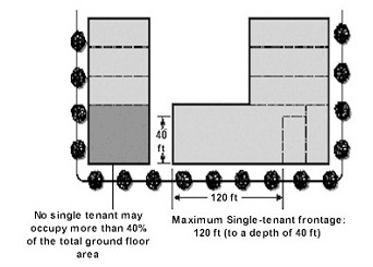
(F)
Residential density/intensity. Residential density is established by the underlying land use and the amount of horizontal or vertical integration allowed in a mixed-use center. Residential uses may be allowed to utilize up to 100 percent of the combination of a site's residential density and its commercial intensity equivalent.
(Ord. 881-04, passed 5-24-2004)
Sec. 7.11.04.03.02. - Street designations and configurations.
(A)
Main streets. At least one two-way north-south street and one two-way east-west street shall be designated as a main street. Main streets shall cross through the entire length and width of the TMD.
(B)
Sidewalks. Sidewalks are required on both sides of all streets, except alleys and the side of a street abutting a preserve area of a TMD. All sidewalks shall conform to the requirements of section 7.11.02.02(D).
(C)
Alley access. Alley access is not allowed from a Main Street.
(D)
Prohibition of vehicular gates. Vehicular gates are not allowed.
(Ord. 881-04, passed 5-24-2004)
Sec. 7.11.04.03.03. - Building form.
(A)
Maximum building height. 35 feet and two stories.
(B)
Maximum number of stories. Two stories. If residential uses are on upper floors, then the maximum number of stories is three and the maximum height is 45 feet.
Figure 7.11.20 Building Form
(C)
Frontages. Individual block frontages shall be designated on the master plan as either primary or secondary frontages and shall conform to the following requirements:
(1)
Standards for primary frontages.
(a)
A minimum of 60 percent of the length of a main street shall be designated as a primary frontage.
(b)
Continuity. Primary frontages shall be continuous, except as follows:
i.
A central plaza or square may be located at the end of a block;
ii.
One separation between buildings is allowed for each 120 linear feet of frontage, provided it is located a minimum of 120 feet from the end of a block. The width of this separation shall not exceed:
a.
20 feet for pedestrian access to internal parking areas, for off-street loading or refuse collection; and
b.
60 feet for a mid-block plaza, other than the central plaza.
(c)
Arcaded sidewalks. At least 50 percent of contiguous primary frontages shall have arcaded sidewalks. Arcades shall be at least ten feet in width, including any support column intrusions and have a minimum height clearance of 12 feet from ground to ceiling. Building floor area is allowed above an arcade. An encroachment permit is required if the arcade extends into a public R.O.W.
(d)
Build-to lines. All building/structures along a primary frontage shall abut the required utility and pedestrian easements.
Figure 7.11.21 Frontage Designations and Standards
Figure 7.11.22 Traditional Marketplace Development
Figure 7.11.23 Primary Frontage Standards
(2)
Standards for secondary frontages.
(a)
A maximum of 40 percent of the length of a main street may be designated as secondary frontage.
(b)
Separations. Secondary frontages may include physical separations between buildings, as follows:
1.
One separation between buildings for each 80 linear feet of frontage, provided it is located a minimum of 80 feet from the end of a block or from the edge of a plaza;
2.
The width of this physical separation shall not exceed:
a.
20 feet for pedestrian access to internal parking areas;
b.
30 feet for an alley or vehicular access to internal parking (not allowed along main streets); and
c.
60 feet for a mid-block plaza.
Figure 7.11.24 Secondary Frontage Standards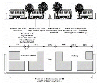
(c)
Build-to lines. All of the building frontage along a designated as secondary frontage shall be located within ten feet of the required utility and pedestrian easements.
Figure 7.11.25 Build To Lines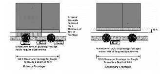
(3)
Standards for perimeter frontages. Exterior frontages on the perimeter of a TMD shall be designed to provide physical orientation for residents and visitors to the TMD and identification for businesses. Views of building entrances, display windows, plazas and squares shall be provided from adjacent arterial and collector streets.
(E)
Pedestrian circulation. In addition to the sidewalk requirements of section 7.11.02.02(D), all internal sidewalks shall provide a minimum clear width of six feet.
(F)
Foundation planting. No foundation planting is required where buildings are located along sidewalks.
(G)
Parking. On-street parking is required on both sides of two-way streets and on at least one-side of one-way streets, except within 25 feet of a street intersection or an alley or ten feet of a fire hydrant or along arterials and planned collectors.
(H)
Plazas and squares. Plazas or squares are required in TMDs to provide a focal point for pedestrians, subject to the following standards:
(1)
Minimum total area. 20,000 square feet or 5 percent of the gross land area within a TMD, whichever is greater, shall be used for public plazas or squares;
(2)
Minimum size.
(a)
Central plaza or square. 20,000 square feet.
(b)
Other plazas or squares. 10,000 square feet.
Figure 7.11.26 Plazas and Squares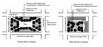
(3)
Required location. All central plazas and squares must be bounded by streets on at least three sides and shall front on a main street; other plazas or squares shall be bounded by a street on at least one side.
(4)
Required dimensions.
(a)
Minimum length.
i.
Central plaza. 200 feet.
ii.
Other plazas or squares. 100 feet.
(b)
Minimum depth.
i.
Central plaza. 100 feet.
ii.
Other plazas or squares. 50 feet.
(5)
Required landscaping and pedestrian amenities. At least 50 percent of the plaza or square area shall be shaded by landscaping or shade structures.
(6)
Corner and mid-block plazas and squares abutting buildings. Wherever a plaza or square is bounded by buildings, the building frontages shall conform to the standards for a Primary Frontage, including requirements for arcaded walkways and building.
(I)
Building design.
(1)
Transparency. A minimum of 75 percent of all commercial ground floor facades on primary frontages, 50 percent of commercial ground floor facades on secondary frontages and 25 percent of the facade on commercial buildings on perimeter frontages, shall be transparent glass, providing views into a commercial use or window display. Windows shall be designed with details such as frames, sills, shutters, planters, relief trim or lintels. Exceptions may be made for uses where alternative fenestration or details are provided, such as architectural treatments, murals, artwork or stained glass, subject to SPRC approval.
Figure 7.11.27 Building Design Standards
(2)
Balconies. Balconies may project beyond the build-to line, subject to the following standards:
(a)
Maximum projection. Three feet.
(b)
Minimum size. Twenty-four square feet.
(J)
Residential uses. Residential uses may be allowed in a TMD, up to a maximum of 25 units. Residential units, except second-floor units, shall be located a minimum of 500 feet from a commercial use.
Sec. 7.11.05.01. - Specific purpose.
A TEC is intended to provide for professional office and supporting commercial services within the TTD:
(A)
Provide employment opportunities within close proximity to local residents and within buildings that are pedestrian-oriented and well- integrated into the overall traditional town design;
(B)
Encourage office development that is interconnected with other traditional development districts through a continuous street and pedestrian circulation network; and
(C)
Allow for larger office uses compatible the larger populations of a traditional town development district.
(Ord. 881-04, passed 5-24-2004)
Sec. 7.11.05.02. - Uses allowed.
Uses allowed in the TEC district are listed in Table 7.11.02. A minimum of 10 percent of the total TEC land area shall be designated for recreation and open space uses.
(Ord. 881-04, passed 5-24-2004)
Sec. 7.11.05.03. - Development standards.
(A)
Block structure.
(1)
Maximum block length: 500 feet.
(2)
Minimum block length: 160 feet (including alleys).
(3)
Maximum ratio of block length to width: 2:1.
(4)
Maximum number of alley curbcuts: 4 per block.
(B)
Maximum floor area ratio: 0.5.
(C)
Maximum floor area per story: 20,000 square feet.
(D)
Building land use allocation requirements: A maximum of 10 percent of the total ground floor area of all buildings on a block may be designated for supporting commercial services (such as a convenience store or a specialty restaurant).
(E)
Minimum building height: Two stories.
(F)
Maximum building height: 40 feet.
(G)
Building setbacks. Buildings may be setback a maximum of 15 feet from the required utility and pedestrian easements.
(H)
Build-to-lines. A minimum of 50 percent of building frontages shall abut the required utility and pedestrian easements.
(I)
Transparency. A minimum of 50 percent of the ground floor building frontages must be transparent glass. Windows shall be designed with details such as frames, sills, shutters, planters, relief trim or lintels.
(J)
Parking. Off-street parking shall be located behind buildings or on one side of the block. Off-street parking may be located adjacent to street intersections or common use area such as plazas, squares or parks.
(Ord. 881-04, passed 5-24-2004)
Sec. 7.11.06.01. - Specific purpose.
The specific purpose of the traditional town development district is to:
(A)
Provide a framework for the coordinated development of compact, walkable neighborhoods with a well-developed traditional marketplace center and a mixture of office, open space and recreation and civic uses serving local residents;
(B)
Ensure an interconnected street and pedestrian circulation network that serves the needs of pedestrian, vehicles and other non-motorized forms of transportation and that functionally and physically integrates the various land use activities;
(C)
Provide for larger-scale community development that retains a strong neighborhood identity through a compatible scale of development, an identifiable center and edge and well-defined public spaces for recreation and civic activities;
(D)
Accommodate optional development districts to provide additional employment opportunities and housing choices interconnected with traditional neighborhoods and within close proximity to the commercial, civic and recreation and open space amenities of the traditional town; and
(E)
Make traditional towns compatible with the overall design objectives of the Comprehensive Plan.
(Ord. 881-04, passed 5-24-2004)
Sec. 7.11.06.02. - Organization and applicability.
The requirements of this section, section 7.11.01, General Provisions for Traditional Development Districts and section 7.11.02, Standards Applicable to all Traditional Development Districts, shall apply to all TTDs. In addition, the components of a TTD shall be subject to the following requirements:
(A)
Traditional neighborhood. The requirements of section 7.11.03, Traditional Neighborhood Development, shall apply to residential land use zones of a TTD.
(B)
Traditional marketplace. The requirements of section 7.11.04, Traditional Marketplace Development, shall apply to the traditional marketplace land use zone in a TTD.
(Ord. 881-04, passed 5-24-2004)
Sec. 7.11.06.03. - Uses allowed.
The uses allowed in the TTD are listed in Table 7.11.02.
(Ord. 881-04, passed 5-24-2004)
Sec. 7.11.06.04. - General requirements.
(A)
Minimum site area. 200 acres.
(B)
Minimum development threshold. Any TND or group of TNDs with more than 320 acres shall be developed as a TTD.
(C)
Land use mix. TTDs shall consist of a balanced mix of land uses, including TNDs and TMDs, subject to the minimum land use allocations in Table 7.11.10.
Table 7.11.10. Traditional Town Development Land Use Allocations
(1)
Regional-serving civic and institutional uses may be located outside a TND but may not be used to fulfill the Civic/Institutional requirements of a TND as established by Table 7.11.02.
(D)
Connectivity. A interconnected network of streets and sidewalks or pathways shall be provided that connects all districts within the TTD and to any adjacent thoroughfare roads. All neighborhood centers and the central plaza of a TMD shall be directly connected by a non-gated street network.
(Ord. 881-04, passed 5-24-2004)