
Abilene City Zoning Code
CHAPTER 2
- ZONING REGULATIONS
Section 2.1.1.1 - Rules for Determining Consistency
(a)
Comprehensive Plan & Amendments. Development applications shall be consistent with the City's adopted Comprehensive Plan, as amended and updated.
(b)
Legislative Application Consistency.
(1)
A legislative development application is consistent with the City's adopted Comprehensive Plan if the application is consistent with applicable policies in the Comprehensive Plan and applicable Comprehensive Plan maps;
(2)
In determining whether a legislative development application is consistent with a Comprehensive Plan map, the City shall take into consideration the policies that govern interpretation of the map, as well as location or property specific designations on the map;
(3)
The Future Land Use and Development Plan map incorporated into the City's adopted Comprehensive Plan is not a zoning district map and shall not be construed as defining zoning district boundaries, but will be used as a guide in making decisions regarding zoning;
(c)
Quasi-Judicial or Administrative Application Consistency. A quasi-judicial or administrative development application is consistent with the City's adopted Comprehensive Plan if the application conforms with regulations in this Land Development Code that implement the applicable policies of the Comprehensive Plan.
(Ord. No. 8-2010, pt. 1(Exh. A), 4-22-10)
Section 2.1.2.1 - Rules for Determining Consistency
(a)
Policies & Maps. The following Comprehensive Plan elements, adopted City plans and adopted City maps apply to legislative development applications:
(1)
Southwest Area Land Use Plan I (1993)
(2)
Southwest Area Land Use Plan II (1994)
(3)
Buffalo Gap Road Corridor Study (1994)
(4)
Carver Neighborhood Revitalization Plan (1998)
(5)
Downtown Streetscape Master Plan (1998)
(6)
Sears Neighborhood Plan (2001)
(7)
Thoroughfare Plan (2005)
(8)
Sidewalk Master Plan (2006)
(9)
Annexation Plan (2006)
(10)
Safe Routes Abilene Plan (2008)
(11)
The Abilene Parks, Recreation & Senior Facilities Master Plan (2008)
(12)
Lake Fort Phantom Hill Plan (2009)
(13)
Highway 351 Development Plan (2012)
(14)
Cobb Park Area Revitalization Plan (2014)
(Ord. No. 8-2010, pt. 1(Exh. A), 4-22-10; Ord. No. 13-2012, pt. 1, 2-23-12; Ord. No. 12-2014, pt. 1, 2-27-14)
Section 2.2.1.1 - Purpose of Regulations and Districts
(a)
Accordance with the Texas Local Government Code (TLGC).
(1)
The zoning regulations and districts contained in this Chapter are established in accordance with an adopted comprehensive plan (and related updates), as authorized by V.T.C.A., Local Government Code Ch. 211, for the purpose of promoting the public health, safety, morals and general welfare, and protecting and preserving places and areas of historical, cultural and/or architectural importance and significance within the City limits.
(2)
The zoning regulations and districts contained in this Chapter have been designed to achieve objectives which include the following:
a.
Lessen the congestion in the streets,
b.
Secure safety from fire, panic and other dangers,
c.
Ensure adequate light and air,
d.
Prevent the overcrowding of land and thus avoid undue concentration of population,
e.
Facilitate the adequate provision of transportation, water supply, wastewater treatment, schools, parks and other public requirements, and
f.
Guide and limit the use of areas subject to periodic flooding.
(3)
They are established with reasonable consideration for, among other things, the character of each zoning district and its peculiar suitability for the particular uses specified, conserving the value of buildings and environmentally sensitive features, and encouraging the most appropriate use of land throughout the City.
(Ord. No. 8-2010, pt. 1(Exh. A), 4-22-10)
Section 2.2.2.1 - Division of the City into Districts and Related Map
(a)
Division. The City is hereby divided into zones, or districts, and the boundaries of zoning districts set out herein are delineated upon the Zoning Map of the City, which is adopted as a part of this Code as fully as if the same were set forth herein in detail.
(Ord. No. 8-2010, pt. 1(Exh. A), 4-22-10)
Section 2.2.2.2 - The Official Zoning District Map
(a)
Official Map. The Zoning Map shall be maintained as an electronic file in the office of the Planning Director and labeled the "Official Zoning Map of the City of Abilene, Texas." In case of any question, this version of the map shall be controlling.
(b)
Maintenance of Official Map. The official Zoning Map shall be maintained in the office of the Planning Director. The map shall be used for reference and shall be maintained up-to-date by incorporating all subsequent amendments enacted by official action of the City Council. The Planning Director will use all reasonable means to protect the official Zoning Map from damage, and to ensure the accurate restoration of the map file if damage or destruction of the original file occurs.
(c)
Changes or Amendments Reflected on the Map. Any changes or amendments made to the zoning district boundaries shall be incorporated into the Zoning Map file promptly after the amendment has been approved by the City Council. The Planning Director shall maintain a descriptive log of amendments to the map. The Planning Director will use all reasonable means to ensure that no changes are made to the official Zoning Map without authorization by official action of the City Council.
(d)
Replacement of the Official Zoning District Map. In the event that the official Zoning Map file becomes damaged, destroyed, lost or difficult to interpret for any reason, the City Council may adopt, by ordinance following a public hearing, a new official Zoning Map which shall replace and supersede the prior Zoning Map, but which shall not, in effect, amend or otherwise change the original official Zoning Map or any subsequent amendment thereto.
(Ord. No. 8-2010, pt. 1(Exh. A), 4-22-10)
Section 2.2.2.3 - Zoning District Boundaries
(a)
Rules of Interpretation. The zoning district boundary lines shown on the Zoning Map are usually along streets, alleys, property lines, or extensions thereof. Where uncertainty exists as to the boundaries of districts as shown on the Zoning Map, the following rules shall apply:
(1)
Boundaries shown as approximately following the centerlines of streets, highways or alleys shall be construed to follow the centerlines.
(2)
Boundaries shown as approximately following platted lot lines shall be construed as following such lot lines.
(3)
Boundaries shown as approximately following City limits shall be construed as following the City limits.
(4)
Boundaries shown as following railroad lines shall be construed to be located along the centerline of the railroad right-of-way lines.
(5)
Boundaries shown as following shorelines shall be construed to follow the shorelines, and in the event of change in the shoreline, shall be construed as moving with the actual shoreline.
(6)
Boundaries shown as approximately following the centerlines of streams, rivers, creeks, canals, bodies of water, or drainageways shall be construed to follow the centerlines, and in the event of change in any such centerlines shall be construed to move with the centerlines. (The centerline shall be interpreted as being midway between the shorelines.)
(7)
Boundaries shown as parallel to, or extensions of, features described in subsections (a)(1) through (a)(6) above shall be so construed. Distances not specifically indicated on the Zoning Map shall be determined by the scale of the Zoning Map.
(8)
The zoning classification applied to a tract of land adjacent to a street shall extend to the centerline of the street unless, as a condition of zoning approval, it is stated that the zoning classification shall not apply to the street.
(9)
Boundaries indicated as dividing a lot shall be construed as being located as shown on the Zoning District Map. Distances not specifically indicated on the Zoning Map shall be determined by the scale of the Zoning Map.
(10)
Where physical features on the ground are at variance with information shown on the Zoning Map, or if there arises a question as to how or whether a parcel of property is zoned and such question cannot be resolved by the application of subsections (a)(1) through (a)(8) above, then the Board of Adjustment shall interpret the zoning district boundaries.
(11)
If the zoning of property is invalidated by a judgment of a court of competent jurisdiction, the property shall be considered classified as AO, Agricultural Open Space, in the same manner as provided for newly annexed territory.
(b)
Zoning changes which are still valid and which were made between the effective date of the previous Zoning Ordinance, adopted on March 26, 1984, and the effective date of this Code are indicated in approximate locations on the Zoning Map. For exact legal descriptions, refer to the adopting ordinances for each particular zoning change.
(Ord. No. 8-2010, pt. 1(Exh. A), 4-22-10)
Section 2.2.3.1 - Compliance and Application of Zoning Regulations
(a)
Compliance Hereafter. All land, buildings, structures or appurtenances thereon located within the City of Abilene, Texas which are occupied, used, constructed, erected, removed, placed, demolished, or converted after the effective date of this LDC shall be occupied, used, erected, altered, removed, placed, demolished or converted in conformance with the zoning regulations prescribed for the zoning district in which such land or building is located, as hereinafter provided, or such shall be subject to penalties provided in Chapter 1, Article 2, Division 8 of this Code. This shall be deemed to include only the portion of the building, structure or land which is actually newly occupied, newly used, erected, constructed, reconstructed, moved or structurally altered after the effective date of this Code. All of the standards and regulations prescribed by this Code shall be considered as the minimum requirement unless explicitly stated otherwise. No building shall hereafter be erected or altered:
(1)
To have more narrow or smaller front, side or rear yards than those required by this Code;
(2)
To exceed the maximum height allowed by this Code;
(3)
To occupy a greater percentage of lot area than allowed by this Code; or
(4)
To accommodate or house a greater number of families than is specified within this Code for the zoning district in which such building is located.
(b)
Lot Area Deficiency. If a lot was legally platted prior to the effective date of these zoning regulations within this LDC, was held in separate ownership from any adjacent property at such time, and contains less area, width or depth than is required under these regulations, such lot may be used for any use lawful within the district, notwithstanding such lot area deficiency, provided, however, such lot shall be subject to all other district regulations.
(c)
Use Conflicting With Other Regulations. No use(s) shall be allowed that is prohibited by State or Federal law or that operates in excess of State or Federal environmental, pollution or performance standards as determined by any State or Federal agency.
(d)
Setbacks, Yards, & Open Spaces. No lot upon which a building has been erected shall later be so reduced in area that the setbacks, yards and/or open spaces shall be smaller than those required by this Code, nor shall a part of a yard or other open space required by this Code for any building or lot be included as a part of a yard or other open space similarly required for another building or lot.
(e)
Grades, Open Spaces, Off-Street Parking or Loading Spaces. No part of a yard or other open space, or off-street parking or loading space required about or in connection with any building or use for the purpose of complying with these zoning regulations, shall be included as part of a yard, open space, or off-street parking or loading space similarly required for any other building or use unless such inclusion is officially applied for and approved by the City.
(f)
Requirements on Same Lot. All the lot area, required yards and other open spaces provided in connection with any structure or use, in order to comply with these regulations, shall be located on the same lot as such structure or use unless otherwise specifically exempted.
(g)
Completion of Buildings. Nothing herein contained shall be deemed to require any change in the plans, construction, or use of a building for which a currently valid building permit has been obtained at the time of passage of this Land Development Code, so long as the entire building is completed within one (1) year from the effective date of this LDC. The Board of Adjustment, upon application, may grant a one (1) year extension of the time of completion upon showing of reasonable progress of construction. Any building permit in effect at the passage of this LDC shall become void if construction is not begun within one hundred eighty (180) days thereof.
(h)
Applications in Relation to Zoning. No plat applicable to land that is located within the City limits shall be submitted for approval until the area contained within the plat has been zoned for the proposed use of the property.
(i)
Existing Uses. All existing uses that may be nonconforming after the effective date of this LDC shall comply with Chapter 2, Article 7 [Article 6] of this LDC.
(j)
Characteristic of the Land. Zoning is considered to be a characteristic of the land rather than a characteristic of the landowner. Zoning itself cannot be bought or sold.
(k)
Airport Zoning. The Airport Zoning regulations shall apply to areas inside the City Limits as well as outside the City Limits as authorized by V.T.C.A., Local Government Code Ch. 241, as amended.
(Ord. No. 8-2010, pt. 1(Exh. A), 4-22-10)
Section 2.2.4.1 - Zoning Regulations and Annexation
(a)
Establishment of Zoning. As soon as practical following annexation, the Planning Director shall, on the Director's own or upon application by property owners of the annexed area, initiate proceedings to establish appropriate zoning on the newly annexed territory. The Planning Director shall commence public notification and other standard procedures for zoning amendments as set forth in Chapter 1 of this Land Development Code.
(b)
Timing of Zoning. The proceedings to establish zoning may be undertaken concurrently with annexation procedures (i.e., notices and public hearings). However, the zoning approval and formal adoption of the ordinance establishing zoning shall occur after annexation takes effect as a former [formal] action by the City Council, and the zoning approval and formal adoption of the ordinance establishing zoning shall occur as a separate and distinct action by the City Council.
(c)
Initial Zoning. From the time an annexation takes effect until action is completed to zone the land, the initial uses permitted on the annexed property shall be consistent with uses permitted within the AO, Agricultural Open Space, District.
(d)
Proper Notification. The initial zoning of annexed land shall meet the requirements for notification and public hearings as set forth in Chapter 1, Article 2, Divisions 2 and 3 of this Code and all applicable State laws.
(e)
Simultaneous Petition for Annexation & Zoning by a Landowner. The owner of land to be annexed may submit an application for zoning the property simultaneously with submission of a petition for annexation, but an annexation petition may not be conditioned upon the approval of any particular zoning classification.
(f)
Building Permit Required. No person shall erect, excavate, construct, proceed, or continue with the erection or construction of any building or structure or add to, enlarge, move, improve, alter, repair, convert, or demolish any building or structure or cause the same to be done in any area of the City or in any newly annexed territory to the City without first applying for and obtaining a building permit therefor from the Enforcing Officer as may be required in applicable City ordinances.
(Ord. No. 8-2010, pt. 1(Exh. A), 4-22-10)
Section 2.3.1.1 - Uniformity
(a)
Minimum Regulations. The regulations set by this LDC for each zoning district shall be minimum regulations and shall apply uniformly to each class or kind of structure or land, except as may be otherwise provided.
(Ord. No. 8-2010, pt. 1(Exh. A), 4-22-10)
Section 2.3.1.2 - Division Into Zoning Districts
(a)
Purpose of Each District. Each zoning district herein established is provided a specific purpose, in accordance with the Comprehensive Plan, as amended, for the location of various activities throughout the City.
(b)
Specific Zoning Districts. The City of Abilene, Taylor County, Texas, is hereby divided into distinct zoning districts, upon which one or a number of overlay zones may be superimposed. These districts and overlay zones herein established shall be known and cited as listed in Table 2-1.
TABLE 2-1: ZONING DISTRICT LISTING
(Ord. No. 8-2010, pt. 1(Exh. A), 4-22-10)
Section 2.3.2.1 - Agricultural Open Space (AO) District
(a)
Purpose. The Agricultural Open Space (AO) District is composed mainly of unsubdivided lands within the corporate limits of the City that are vacant or in agricultural use, with some dwellings and some accessory uses (structures). The applicable regulations are designed to preserve valuable agricultural lands and to preserve, in a more permanent manner, open space located within the corporate limits of the City. This district is also used as a "holding zone" for land annexed to the City of Abilene, until a request for a more intensive category of land use is approved.
(b)
Authorized Uses. The following are authorized uses under the regulations established in this chapter:
(1)
Permitted and conditional uses as authorized in the Land Use Matrix in Article 5 [Article 4], Division 2 of this Chapter 2;
(2)
Accessory uses as authorized in Article 5, Division 3 [Article 4, Division 4] of this Chapter 2.
(c)
Site Layout and Building Requirements. All development within this district shall meet the minimum site layout and building requirements outlined in Table 2-2 of this LDC.
(d)
Number of Dwelling Units per Lot. There shall be a maximum of one (1) dwelling unit per lot, with the exception of accessory dwelling units which may otherwise be permitted by this LDC.
(Ord. No. 8-2010, pt. 1(Exh. A), 4-22-10)
Section 2.3.2.2 - Rural Residential (RR-1 and RR-5) Districts
(a)
Purpose. The RR-1 and RR-5 districts are designed to:
(1)
Protect the residential character of the included areas by excluding most commercial and other incompatible activities, as appropriate.
(2)
Encourage a suitable environment for family life by permitting certain appropriate institutions and facilities to be located in residential neighborhoods.
(3)
Preserve open space and avoid overcrowding by requiring certain minimum yards, open spaces, and lot areas.
(4)
Make available a variety of dwelling types and densities to serve a wide range of individual requirements.
(5)
RR districts are designed to limit the concentration of development in areas that are not considered suitable for development at a higher density. RR districts encourage single-family residences on large lots with appropriate accessory activities to preserve open space and provide opportunities for residential uses that exhibit a rural character within the limits of the City of Abilene. RR districts are appropriate in areas where extension of facilities may be unfeasible or to provide a buffer and prevent encroachment in areas identified in the City's Comprehensive Plan. This zoning should not be applied in areas where future development is expected at urban and suburban densities. In addition to the general purposes applying to all residential districts, regulations of RR districts are designed to encourage the provision of very low density single-family, detached residences under two (2) permitted densities.
(b)
Authorized Uses. The following are authorized uses under the regulations established in this chapter:
(1)
Permitted and conditional uses as authorized in the Land Use Matrix in Article 5 [Article 4], Division 2 of this Chapter 2;
(2)
Accessory uses as authorized in Article 5, Division 3 [Article 4, Division 4] of this Chapter 2.
(c)
Site Layout and Building Requirements. All development within this district shall meet the minimum site layout and building requirements outlined in Table 2-2 of this LDC.
(d)
Number of Dwelling Units per Lot. There shall be a maximum of one (1) dwelling unit per lot, with the exception of accessory dwelling units which may otherwise be permitted by this LDC.
(Ord. No. 8-2010, pt. 1(Exh. A), 4-22-10)
Section 2.3.2.3 - Residential Single-Family (RS-12) District-12
(a)
Purpose. The Residential Single-Family (RS-12) District-12 is intended to permit the low density residential development of detached single-family dwelling units, permitted accessory structures, and appropriate desirable open space on lots of not less than 12,000 square feet in area. As one of the single-family zoning districts provided for development in Abilene, this district is also designed to achieve the following:
(1)
Protect the residential character of the included areas by excluding most commercial and other incompatible activities, as appropriate.
(2)
Encourage a suitable environment for family life by permitting certain appropriate institutions and facilities to be located in residential neighborhoods.
(3)
Preserve open space and avoid overcrowding by requiring certain minimum yards, open spaces, and lot areas.
(4)
Provide an option for low-density lots to serve a range of individual requirements represented by the citizenry of Abilene.
(b)
Authorized Uses. The following are authorized uses under the regulations established in this chapter:
(1)
Permitted and conditional uses as authorized in the Land Use Matrix in Article 5 [Article 4], Division 2 of this Chapter 2;
(2)
Accessory uses as authorized in Article 5 [Article 4], Division 4 of this Chapter 2.
(c)
Site Layout and Building Requirements. All development within this district shall meet the minimum site layout and building requirements outlined in Table 2-2 of this LDC.
(d)
Number of Dwelling Units per Lot. There shall be a maximum of one (1) dwelling unit per lot, with the exception of accessory dwelling units which may otherwise be permitted by this LDC.
(e)
Common Areas—Management & Maintenance. For any land and/or facilities to be used in common by residents of the development, there shall be provisions made for the establishment of a property owners' association to manage and maintain such common land and/or facilities.
(Ord. No. 8-2010, pt. 1(Exh. A), 4-22-10)
Section 2.3.2.4 - Residential Single-Family (RS-8) District-8
(a)
Purpose. The Residential Single-Family (RS-8) District-8 is intended to permit the residential development of detached single-family dwelling units, permitted accessory structures, and appropriate desirable open space on lots of not less than 8,000 square feet in area. As one of the single-family zoning districts provided for development in Abilene, this district is also designed to achieve the following:
(1)
Protect the residential character of the included areas by excluding most commercial and other incompatible activities, as appropriate.
(2)
Encourage a suitable environment for family life by permitting certain appropriate institutions and facilities to be located in residential neighborhoods.
(3)
Preserve open space and avoid overcrowding by requiring certain minimum yards, open spaces, and lot areas.
(4)
Provide an option for mid-sized lots to serve a range of individual requirements represented by the citizenry of Abilene.
(b)
Authorized Uses. The following are authorized uses under the regulations established in this chapter:
(1)
Permitted and conditional uses as authorized in the Land Use Matrix in Article 5 [Article 4], Division 2 of this Chapter 2;
(2)
Accessory uses as authorized in Article 5 [Article 4], Division 4 of this Chapter 2.
(c)
Site Layout and Building Requirements. All development within this district shall meet the minimum site layout and building requirements outlined in Table 2-2 of this LDC.
(d)
Number of Dwelling Units per Lot. There shall be a maximum of one (1) dwelling unit per lot, with the exception of accessory dwelling units which may otherwise be permitted by this LDC.
(e)
Common Areas—Management & Maintenance. For any land and/or facilities to be used in common by residents of the development, there shall be provisions made for the establishment of a property owners' association to manage and maintain such common land and/or facilities.
(Ord. No. 8-2010, pt. 1(Exh. A), 4-22-10)
Section 2.3.2.5 - Residential Single-Family (RS-6) District-6
(a)
Purpose. The Residential Single-Family (RS-6) District-6 is intended to permit the residential development of detached single-family dwelling units, permitted accessory structures, and appropriate desirable open space on lots of not less than 6,000 square feet in area. As one of the single-family zoning districts provided for development in Abilene, this district is also designed to achieve the following:
(1)
Protect the residential character of the included areas by excluding most commercial and other incompatible activities, as appropriate.
(2)
Encourage a suitable environment for family life by permitting certain appropriate institutions and facilities to be located in residential neighborhoods.
(3)
Preserve open space and avoid overcrowding by requiring certain minimum yards, open spaces, and lot areas.
(4)
Provide an option for more dense single-family lots than the other single-family zoning districts in order to serve a range of individual requirements represented by the citizenry of Abilene.
(b)
Authorized Uses. The following are authorized uses under the regulations established in this chapter:
(1)
Permitted and conditional uses as authorized in the Land Use Matrix in Article 5 [Article 4], Division 2 of this Chapter 2;
(2)
Accessory uses as authorized in Article 5, Division 3 [Article 4, Division 4] of this Chapter 2.
(c)
Site Layout and Building Requirements. All development within this district shall meet the minimum site layout and building requirements outlined in Table 2-2 of this LDC.
(d)
Number of Dwelling Units per Lot. There shall be a maximum of one (1) dwelling unit per lot, with the exception of accessory dwelling units which may otherwise be permitted by this LDC.
(e)
Common Areas—Management & Maintenance. For any land and/or facilities to be used in common by residents of the development, there shall be provisions made for the establishment of a property owners' association to manage and maintain such common land and/or facilities.
(Ord. No. 8-2010, pt. 1(Exh. A), 4-22-10)
Section 2.3.2.6 - Residential Single-Family Patio Home (PH) District
(a)
Purpose. The Residential Single-Family Patio Home (PH) District is designed to provide for development of detached single-family residences on compact lots having one side yard reduced to zero feet (i.e., "zero-lot-line").
(b)
Authorized Uses. The following are authorized uses under the regulations established in this chapter:
(1)
Permitted and conditional uses as authorized in the Land Use Matrix in Article 5 [Article 4], Division 2 of this Chapter 2;
(2)
Accessory uses as authorized in Article 5 [Article 4], Division 4 of this Chapter 2.
(c)
Project Size. The term project size shall mean the overall sum of acreage to be used for patio home development and shall include all patio home lots.
(d)
Site Layout and Building Requirements. All development within this district shall meet the minimum site layout and building requirements outlined in Table 2-2 of this LDC.
(e)
Number of Dwelling Units per Lot. There shall be a maximum of one (1) dwelling unit per lot, with the exception of accessory dwelling units which may otherwise be permitted by this LDC.
(f)
Common Areas—Management & Maintenance. For any land and/or facilities to be used in common by residents of the development, there shall be provisions made for the establishment of a property owners' association to manage and maintain such common land and/or facilities.
(g)
Maintenance Easements, Overhangs. Patio home developments shall be developed as zero-lot-line homes. A minimum five-foot (5') wide maintenance easement shall be placed on the other side of the property line of the zero-lot-line side yard to enable the property owner to maintain that portion of his/her house which is on the zero-lot-line. Side yards and maintenance easements shall be shown on the subdivision plat. A minimum separation between patio homes of ten feet (10') shall be provided. Roof overhangs will be allowed to project into the maintenance easement a maximum of twenty-four inches (24"), but the maintenance easement shall remain reasonably accessible to the adjacent homeowner to perform maintenance and repairs to all portions of the exterior of his/her home. No accessory building, pool (except decking), or stored materials (e.g., firewood, garden or construction materials, etc.) shall be located or stored within the maintenance easement.
(h)
Concept Plan Required. A concept plan is required at the time of any change of zoning to PH.
(Ord. No. 8-2010, pt. 1(Exh. A), 4-22-10)
Section 2.3.2.7 - Residential Townhome (TH) District
(a)
Purpose. The Residential Townhome (TH) District is intended to promote stable, quality, attached-occupancy residential development on individual lots at higher residential densities. This district may be included within certain areas of neighborhoods or, when in accordance with the intent of the Comprehensive Plan, may provide a medium density "buffer" or transition district between lower density residential areas and multifamily, nonresidential areas, or major thoroughfares. This district is also intended:
(1)
To permit a greater intensity of land use while at the same time providing areas of open space and degrees of privacy comparable to those qualities inherent in conventional, single-family detached housing.
(2)
To make available a variety of dwelling types and densities in a variety of locations to serve a wide range of individual requirements. Townhouse developments provide for groupings making efficient, economical, comfortable and convenient arrangements of yards and structures.
(b)
Authorized Uses. The following are authorized uses under the regulations established in this chapter:
(1)
Permitted and conditional uses as authorized in the Land Use Matrix in Article 5 [Article 4], Division 2 of this Chapter 2;
(2)
Accessory uses as authorized in Article 5, Division 3 [Article 4, Division 4] of this Chapter 2.
(c)
Project Size. The term project size shall mean the overall sum of acreage to be used for townhome development and shall include all townhome lots. The maximum project size shall be twenty (20) acres.
(d)
Site Layout and Building Requirements.
(1)
All development within this district shall meet the minimum site layout and building requirements outlined in Table 2-2.
(2)
The ends of any two adjacent building complexes or rows of buildings shall be at least fifteen feet (15') apart.
(3)
Buildings shall each have a separate lot with dimensions meeting regulations for the district.
(4)
A contiguous row of attached townhome dwellings shall have a minimum length of three (3) dwelling units and a maximum length of twelve (12) dwelling units. There shall be no more than six (6) contiguous townhouse units with the same or approximately the same front building line where such units front onto a minor street or subcollector. More than six (6) contiguous units shall have variable front building lines as set forth herein this subsection.
(e)
Building Lines. The minimum building setback from lot boundaries shall be as set forth in Table 2-2 for all principal buildings adjacent to streets. Where private streets are installed over lot boundaries, measurement of building lines shall be from the edge of pavement or face of curb.
(1)
Front Building Line. Townhouse units shall be set back from the front property line a minimum of twenty feet (20').
(2)
Exterior Side Building Line. Townhouse units that have lot frontage separated from a side street by at least ten feet (10') of parkway, as defined herein this LDC, shall be set back from the exterior side boundary by at least ten feet (10'). Townhouse units having lot frontage separated from the side street by less than ten feet (10') of parkway, or where fronting onto a private street, shall be set back from the exterior side boundary by at least twenty feet (20').
(3)
Interior Side Building Line. If not contiguous to another townhouse unit, all townhouse units shall be set back from any interior side boundary a minimum of five feet (5').
(4)
Rear Building Line. The minimum setback line from rear lot boundaries, for all townhouse units, shall be ten feet (10').
(f)
Number of Dwelling Units per Lot. There shall be a maximum of one (1) dwelling unit per lot, with each townhouse unit located on an individual lot.
(g)
Common Areas—Management & Maintenance. For any land and/or facilities to be used in common by residents of the development, including private streets, there shall be provisions made for the establishment of a property owners' association to manage and maintain such common land and/or facilities.
(h)
Garage Setback. The garage for each townhouse unit shall be set back no less than twenty feet (20') from the most proximate parallel property line.
(i)
Separate Utilities. All utilities shall be provided separately to each lot within the TH district so that each unit is individually metered.
(j)
Site Plan Required. A Site Plan in accordance with Chapter 4, Article 1, Division 1 [Division 2] shall be required for all development, except single-family and two-family, within this TH District.
(k)
Concept Plan Required. A concept plan is required at the time of a zoning change to a TH zoning district.
(Ord. No. 8-2010, pt. 1(Exh. A), 4-22-10)
Section 2.3.2.8 - Residential Medium Density (MD) District
(a)
Purpose. The Residential Medium Density (MD) District is designed to encourage the provision of conveniently located, centrally maintained accommodations, with a combination of single-family, two-family (duplex), triplex, quadraplex, and townhouse housing units. This district provides for a combination of these housing types at a density maximum of twelve (12) dwelling units per acre. This district may provide a medium density "buffer" or transition district between lower density residential areas and multifamily, nonresidential areas, or major thoroughfares. This district is also designed to achieve the following:
(1)
Protect the residential character of the included areas by excluding most commercial and other incompatible activities, as appropriate.
(2)
Encourage a suitable environment by permitting certain appropriate institutions and facilities to be located in residential neighborhoods.
(3)
Preserve open space and avoid overcrowding by requiring certain minimum yards, open spaces, and lot areas.
(4)
Provide an option for housing unit diversity to serve a range of individual requirements represented by the citizenry of Abilene.
(b)
Authorized Uses. The following are authorized uses under the regulations established in this chapter:
(1)
Permitted and conditional uses as authorized in the Land Use Matrix in Article 5 [Article 4], Division 2 of this Chapter 2;
(2)
Accessory uses as authorized in Article 5, Division 3 [Article 4, Division 4] of this Chapter 2.
(c)
Site Layout and Building Requirements.
(1)
All development within this district shall meet the minimum site layout and building requirements outlined in Table 2-2.
(2)
The maximum number of units permitted on any one (1) individual lot shall be four (4).
(d)
Common Areas—Management & Maintenance. For any land and/or facilities to be used in common by residents of the development, there shall be provisions made for the establishment of a property owners' association to manage and maintain such common land and/or facilities.
(e)
Site Plan Required. A Site Plan in accordance with Chapter 4, Article 1, Division 1 [Division 2] shall be required for all development, except single-family and two-family, within this MD District.
(Ord. No. 8-2010, pt. 1(Exh. A), 4-22-10)
Section 2.3.2.9 - Residential Multiple-Family (MF) District
(a)
Purpose. The Residential Multiple-Family (MF) District is designed to encourage the provision of conveniently located, centrally maintained rental accommodations with traditional apartment units. This district provides for a maximum of twenty-four (24) dwelling units per acre. As one of the multiple-family zoning districts provided for development in Abilene, this district is also designed to achieve the following:
(1)
Protect the residential character of the included areas by excluding most commercial and other incompatible activities, as appropriate. Allow for Residential Multiple-Family (MF) within other nonresidential zoning districts with a Conditional Use Permit (C), per section 2.4.2.1 the Land Use Matrix.
(2)
Encourage a suitable environment by permitting certain appropriate institutions and facilities to be located in residential neighborhoods.
(3)
Preserve open space and avoid overcrowding by requiring certain minimum yards, open spaces, and lot areas.
(4)
Provide an option for apartment housing to serve a range of individual requirements represented by the citizenry of Abilene.
(b)
Authorized Uses. The following are authorized uses under the regulations established in this chapter:
(1)
Permitted and conditional uses as authorized in the Land Use Matrix in Article 5 [Article 4], Division 2 of this Chapter 2;
(2)
Accessory uses as authorized in Article 5, Division 3 [Article 4, Division 4] of this Chapter 2.
(c)
Site Layout and Building Requirements.
(1)
All development within this district shall meet the minimum site layout and building requirements outlined in Table 2-2 of this LDC.
(2)
The minimum distance between principal multiple-family structures shall be fifteen feet (15').
(3)
The minimum building line on any interior side shall be ten feet (10'), except where a building is erected or altered to exceed thirty feet (30') in height, excluding architectural exceptions, on a lot adjoining an RS or MD district. In this case, the adjacent side building line shall be equal to at least twice the total height of the building.
(d)
Common Areas—Management & Maintenance. For any land and/or facilities to be used in common by residents of the development, there shall be provisions made for the establishment of a property owners' association to manage and maintain such common land and/or facilities.
(e)
Walkways. A four-foot (4') wide paved walkway shall connect the front door of each ground floor unit to a parking area. The minimum width of any sidewalk adjacent to head-in parking spaces shall be six feet (6') to accommodate a two-foot (2') bumper overhang for vehicles.
(f)
Building Length. Buildings shall not exceed two hundred feet (200') in length.
(g)
Oversized Parking Areas. Boats, campers, trailers and other recreational vehicles shall be prohibited unless oversize parking areas are provided and are approved by the City. This parking area shall not be used to meet the minimum parking requirements and shall not be visible from a public street.
(h)
Signage Address Numbers. All buildings containing residential units shall provide signage which clearly identifies the numbers (i.e., addresses) of the units within each building. Signage shall be visible from entrances into the complex and/or from vehicular drive aisles within the complex such that each individual unit is easy to locate by visitors, delivery persons, and/or emergency personnel.
(i)
Safety Lighting. All parking areas shall have appropriate lighting and shall be positioned such that no light adversely impacts adjacent residential areas.
(j)
Site Plan Required. A Site Plan in accordance with Chapter 4, Article 1, Division 1 [Division 2] shall be required for all development, except single-family and two-family, within this MF District.
(Ord. No. 8-2010, pt. 1(Exh. A), 4-22-10; Ord. No. 35-2017, pt. 1(Exh. A), 9-12-17)
Section 2.3.2.10 - Manufactured/Mobile Home (MH) District
(a)
Purpose. The Manufactured/Mobile Home (MH) District is intended to regulate those areas now occupied by manufactured/mobile homes, manufactured/mobile home parks and open areas where manufactured/mobile home development appears desirable. This district is designed to permit and encourage the development of properly planned and improved manufactured/mobile home parks and subdivisions at appropriate locations within a residential environment.
(b)
Authorized Uses. The following are authorized uses under the regulations established in this chapter:
(1)
Permitted and conditional uses as authorized in the Land Use Matrix in Article 5 [Article 4], Division 2 of this Chapter 2;
(2)
Accessory uses as authorized in Article 5, Division 3 [Article 4, Division 4] of this Chapter 2.
(c)
Site Layout and Building Requirements. All development within this district shall meet the minimum site layout and building requirements outlined in Table 2-2 of this LDC.
(d)
Common Areas—Management & Maintenance. For any land and/or facilities to be used in common by residents of the development, there shall be provisions made for the establishment of a property owners' association to manage and maintain such common land and/or facilities.
(e)
Anchorage of Manufactured/Mobile Homes. To insure against natural hazards such as tornados, high winds and electrical storms, anchorage for each manufactured/mobile home shall be provided according to the Building Code and State law.
(f)
Skirting.
(1)
All manufactured/mobile home units not attached to a permanent foundation shall provide skirting from the top of the unit's frame to grade. Skirting shall totally enclose and secure from view the unit's axles and all required anchors, footings, and piers.
(2)
All required skirting shall be of an opaque, noncombustible material, and shall be of a color similar to the materials used in the construction of the manufactured/mobile home unit such that it blends with the overall appearance of the unit.
(g)
Site Plan Required. A Site Plan in accordance with Chapter 4, Article 1, Division 1 [Division 2] shall be required for all development, except single-family and two-family, within this MH District. The establishment of any new manufactured home shall also require a Site Plan in accordance with Chapter 4, Article 1, Division 1 [Division 2].
(h)
Mobile Home Replacement. A mobile home as defined herein is one that was constructed before July 1st, 1976. A manufactured home as defined herein is one that has been constructed on or after July 1st, 1976. Any mobile home that is deemed a legal, conforming use and that is in need of replacement shall only be replaced with a manufactured home constructed on or after July 1st, 1976.
TABLE 2-2: SITE LAYOUT AND BUILDING REQUIREMENTS FOR RESIDENTIAL ZONING DISTRICTS
n/a - not applicable
1
A minimum width of 100 feet is required along arterial streets (2.6.1.1(e)(3) [2.5.1.1(e)(3)])
* This applies to one side only. A 10-foot separation between homes is required.
(Ord. No. 8-2010, pt. 1(Exh. A), 4-22-10)
Section 2.3.3.1 - College and University (CU) District
(a)
Purpose. The College and University (CU) District is composed of lands which are primarily located within boundaries of the main campuses of Abilene's colleges or land which has been designated for use by a college or university. The district is designed to promote the orderly, interrelated development of college and university related facilities and to prevent the encroachment of incompatible use into the areas of high building concentration and pedestrian activity. This district also provides a means for advance consideration by the City of Abilene of any development which might impact parking, additional traffic generation or compatibility with adjacent areas, as well as any additional demands which may be placed upon the City's administrative or service functions.
(b)
Authorized Uses. The following are authorized uses under the regulations established in this chapter:
(1)
Permitted and conditional uses as authorized in the Land Use Matrix in Article 5 [Article 4], Division 2 of this Chapter 2;
(2)
Accessory uses as authorized in Article 5, Division 3 [Article 4, Division 4] of this Chapter 2.
(c)
Site Layout and Building Requirements. All development within this district shall meet the minimum site layout and building requirements outlined in Table 2-4 of this LDC.
(d)
Site Plan Required. A Site Plan in accordance with Chapter 4, Article 1, Division 1 [Division 2] shall be required for all development, except single-family and two-family, within this CU District.
(Ord. No. 8-2010, pt. 1(Exh. A), 4-22-10)
Section 2.3.3.2 - Neighborhood Office (NO) District
(a)
Purpose. The Neighborhood Office (NO) District is established to create a flexible District for low intensity office and professional uses. The District can be used as a transition district between more intense uses and residential uses. Permitted uses should be compatible with adjacent residential areas utilizing buffers and landscape requirements established by Chapter 4, Article 2, Division 2. Buildings in this District should be compatible and in similar scale with residential uses and adjacent property.
(b)
Authorized Uses. The following are authorized uses under the regulations established in this chapter:
(1)
Permitted and conditional uses as authorized in the Land Use Matrix in Article 5 [Article 4], Division 2 of this Chapter 2;
(2)
Accessory uses as authorized in Article 5, Division 3 [Article 4, Division 4] of this Chapter 2.
(c)
Site Layout and Building Requirements. All development within this district shall meet the minimum site layout and building requirements outlined in Table 2-4.
(d)
Maximum Building Size. The maximum building coverage of a structure or structures on a single lot shall not exceed 15,000 square feet. Sites zoned NO may be built in excess of 15,000 square feet if not adjacent to any properties zoned for single-family residential.
(e)
Hours of Operation. Except for uses permitted within a residential zoning district, no use shall operate before 6:00 a.m. nor after 11:00 p.m. on any day of the week.
(f)
Outside Display and Storage. Refer to Chapter 4, Article 2, Division 5 of this LDC for outside display and outside storage requirements.
(g)
Screening Required. Refer to Chapter 4, Article 2, Division 4 of this LDC for screening requirements.
(h)
Site Plan Required. A Site Plan in accordance with Chapter 4, Article 1, Division 1 [Division 2] shall be required for all development, except single-family and two-family, within this NO District.
(Ord. No. 8-2010, pt. 1(Exh. A), 4-22-10)
Section 2.3.3.3 - Office (O) District
(a)
Purpose. The Office (O) District is intended to encourage office development of high quality in a generally noncommercial environment. The selected business and/or professional offices allowed in the O District have relatively low traffic generation characteristics, handle no products, and require limited identification by signs or other such devices.
(b)
Authorized Uses. The following are authorized uses under the regulations established in this chapter:
(1)
Permitted and conditional uses as authorized in the Land Use Matrix in Article 5 [Article 4], Division 2 of this Chapter 2;
(2)
Accessory uses as authorized in Article 5, Division 3 [Article 4, Division 4] of this Chapter 2.
(c)
Site Layout and Building Requirements. All development within this district shall meet the minimum site layout and building requirements outlined in Table 2-4.
(d)
Site Plan Required. A Site Plan in accordance with Chapter 4, Article 1, Division 1 [Division 2] shall be required for all development, except single-family and two-family, within this O District.
(Ord. No. 8-2010, pt. 1(Exh. A), 4-22-10)
Section 2.3.3.4 - Neighborhood Retail (NR) District
(a)
Purpose. The Neighborhood Retail (NR) District is intended to accommodate a limited range of retail trade, services and office activities that are needed to serve a neighborhood area. The level of intensity and scale of development permissible within the NR District are designed for compatibility with nearby residential uses. Many permitted uses within the NR District are, in fact, aimed toward meeting the day-to-day retail needs of nearby residents for food, pharmaceuticals, personal services, etc. The NR District development should occur at the intersections of collector streets with more major thoroughfares and other collector streets.
(b)
Authorized Uses. The following are authorized uses under the regulations established in this chapter:
(1)
Permitted and conditional uses as authorized in the Land Use Matrix in Article 5 [Article 4], Division 2 of this Chapter 2;
(2)
Accessory uses as authorized in Article 5, Division 3 [Article 4, Division 4] of this Chapter 2.
(c)
Site Layout and Building Requirements. All development within this district shall meet the minimum site layout and building requirements outlined in Table 2-4.
(d)
Maximum Building Size. The maximum building coverage of a structure or structures on a single lot shall not exceed 15,000 square feet.
(e)
Hours of Operation. Except for uses permitted within a residential zoning district, no use shall operate before 6:00 a.m. nor after 11:00 p.m. on any day of the week.
(f)
Outside Display and Storage. Refer to Chapter 4, Article 2, Division 5 of this LDC for outside display and outside storage requirements.
(g)
Screening Required. Refer to Chapter 4, Article 2, Division 4 of this LDC for screening requirements.
(h)
Site Plan Required. A Site Plan in accordance with Chapter 4, Article 1, Division 1 [Division 2] shall be required for all development, except single-family and two-family, within this NR District.
(Ord. No. 8-2010, pt. 1(Exh. A), 4-22-10)
Section 2.3.3.5 - General Retail (GR) District
(a)
Purpose. The General Retail (GR) District is intended to accommodate a wide range of retail trade, services and office activities that are needed to serve the community. Development within this district should provide for efficient retailing opportunities, and facilities should have an integrated design. It is intended that developments within this district be laid out and developed as a cohesive unit, according to an approved Site Plan so that the purpose of the district may be accomplished. The GR District development should generally occur in nodes at the intersections of major thoroughfares.
(b)
Authorized Uses. The following are authorized uses under the regulations established in this chapter:
(1)
Permitted and conditional uses as authorized in the Land Use Matrix in Article 5 [Article 4], Division 2 of this Chapter 2;
(2)
Accessory uses as authorized in Article 5, Division 3 [Article 4, Division 4] of this Chapter 2.
(c)
Site Layout and Building Requirements.
(1)
All development within this district shall meet the minimum site layout and building requirements outlined in Table 2-4.
(d)
Outside Display and Storage. Refer to Chapter 4, Article 2, Division 5 of this LDC for outside display and outside storage requirements.
(e)
Screening Required. Refer to Chapter 4, Article 2, Division 4 of this LDC for screening requirements.
(f)
Site Plan Required. A Site Plan in accordance with Chapter 4, Article 1, Division 1 [Division 2] shall be required for all development, except single-family and two-family, within this GR District.
(Ord. No. 8-2010, pt. 1(Exh. A), 4-22-10)
Section 2.3.3.6 - Medical Use (MU) District
(a)
Purpose. The Medical Use (MU) District is intended to provide high quality medical-related development and to ensure compatibility between medical and adjacent uses through proper planning and design. In addition to listing appropriate uses within the Land Use Matrix (Article 5 [Article 4], Division 2), regulations of the MU District prescribe standards for access, noise, air, sufficient developable area, and other external effects that a medical district may produce. Further consideration and flexibility are then given to development of individual sites to maximize the desirable effects. Furthermore, the purpose of the Medical Use district is to protect the public health, safety and general welfare by increasing the efficiency of a district designated for medical use while minimizing detrimental impacts on neighboring properties and the overall environment. The ultimate goal is to provide modern facilities for the public and to enhance the City as a medical center.
(b)
Authorized Uses. The following are authorized uses under the regulations established in this chapter:
(1)
Permitted and conditional uses as authorized in the Land Use Matrix in Article 5 [Article 4], Division 2 of this Chapter 2;
(2)
Accessory uses as authorized in Article 5, Division 3 [Article 4, Division 4] of this Chapter 2.
(c)
Site Layout and Building Requirements. All development within this district shall meet the minimum site layout and building requirements outlined in Table 2-4.
(d)
Accessibility. Medical-related facilities exceeding one hundred thousand (100,000) square feet in floor area should be easily accessible to the entire City and to service vehicles, such as fire protection apparatus, through the roadway network. Due to its potential as a major traffic generator and a regionally significant land use, each such medical-related facility shall therefore be adjacent to at least one (1) arterial street leading to high-speed, high-volume highway traffic.
(e)
Site Plan Required. A Site Plan in accordance with Chapter 4, Article 1, Division 1 [Division 2] shall be required for all development, except single-family and two-family, within this MU District.
(Ord. No. 8-2010, pt. 1(Exh. A), 4-22-10)
Section 2.3.3.7 - Central Business (CB) District
(a)
Purpose. The Central Business (CB) District is intended to provide a wide range of retail goods and consumer services to residents of the metropolitan area and trade area. This district is located in the central City area of Abilene and is intended to provide space and facilities for financial, administrative, commercial, residential and business services, as well as limited light manufacturing activities, but is designed to discourage warehousing and manufacturing and other uses which tend to generate heavy traffic or require open storage of materials. The district regulations are designed to further development of the district for the purposes stated, subject to limitations to prevent congestion and assure provision of adequate light and air to buildings in the district. This district consists, primarily, of older business structures which predate modern retailing concepts. Special provisions are made for off-street parking, height and area regulations in order to accommodate use of existing structures. New development/redevelopment within this district should further the objective of encouraging a walkable, pedestrian-friendly district. The CB district is also intended to promote multiple types of development, resulting in a central area of Abilene that will attract a variety and diversity of people.
(b)
Authorized Uses. The following are authorized uses under the regulations established in this chapter:
(1)
Permitted and conditional uses as authorized in the Land Use Matrix in Article 5 [Article 4], Division 2 of this Chapter 2;
(2)
Accessory uses as authorized in Article 5, Division 3 [Article 4, Division 4] of this Chapter 2.
(c)
Site Layout and Building Requirements.
(1)
All development within this district shall meet the minimum site layout and building requirements outlined in Table 2-4.
(2)
There shall be no minimum building lines, except where lot boundaries lie adjacent to AO or RS districts. See Table 2-4 for building line requirements adjacent to AO and RS districts.
(d)
Site Plan Required. A Site Plan in accordance with Chapter 4, Article 1, Division 1 [Division 2] shall be required for all development, except single-family and two-family, within this CB District.
(Ord. No. 8-2010, pt. 1(Exh. A), 4-22-10)
Section 2.3.3.8 - Mixed Use (MX) District
(a)
Purpose. Regulations pertinent to the Mixed Use (MX) District are designed to permit establishment of integrated nonresidential and residential activities where appropriate and desirable, under conditions that assure an acceptable level of harmony among land uses. Application of MX District zoning shall be considered appropriate when in accordance with at least one of the following objectives:
(1)
Protect residential neighborhoods from encroachment of incompatible commercial, office, and industrial activities;
(2)
Promote development of vacant, bypassed lots in harmony with adjacent land use and the surrounding environment;
(3)
Encourage rehabilitation of older residential structures that are no longer economically attractive for single-family residential use;
(4)
Create land use patterns that promote energy and fiscal efficiency, and that increase the accessibility of daily activities; and
(5)
Create a mechanism for furthering adopted policies within the Comprehensive Plan for various centers of activity.
The MX District allows for more flexible locations for a variety of land use activities. Unlike more traditional zoning districts, compatible land use patterns in MX zones should generally not be achieved through the separation of different uses, but through more sensitive building and site design.
(b)
Authorized Uses. The following are authorized uses under the regulations established in this chapter:
(1)
Permitted and conditional uses as authorized in the Land Use Matrix in Article 5 [Article 4], Division 2 of this Chapter 2;
(2)
Accessory uses as authorized in Article 5, Division 3 [Article 4, Division 4] of this Chapter 2.
(c)
Site Layout and Building Requirements. All development within this district shall meet the minimum site layout and building requirements outlined in Table 2-4.
(d)
Outside Display and Storage. Refer to Chapter 4, Article 2, Division 5 of this LDC for outside display and outside storage requirements.
(e)
Use Integration.
(1)
In predominately residential areas (greater than 50%) nonresidential uses shall be developed in a manner that is compatible with the character and appearance of the residential area.
(2)
Screening walls between varying types of uses shall not be required. If visual screening is needed, landscaping elements and earthen berms shall be used, in order to allow pedestrians to easily access every area of the development.
(f)
Off-Street Parking. Provision of off-street parking shall be in conformance with requirements of Article 2, Division 1 of Chapter 4, except as follows:
(1)
Off-street parking areas with more than ten (10) parking spaces shall not be permitted in front of any structure which faces the major thoroughfare. When such parking is provided, it shall be screened by a perimeter landscaping strip, earthen berm, or other landscaped plant material, with a minimum width of five feet (5'). All other parking areas shall be located to the side or rear of the primary on-site buildings.
(2)
Shared Parking. A reduction in parking of a maximum of fifty percent (50%) for each use may be permitted provided that:
(a)
It can be established that two or more uses within the Mixed Use District, applying jointly and concurrently for Site Plan approval, will be sharing a parking area that may be on property that is not under the same ownership as one or more of the uses to be served by the parking, where the shared parking area has a capacity of at least the minimum number of spaces for the use having the greatest minimum requirement, where all uses have their primary need for parking during offsetting periods so that the parking area will be utilized by only one (1) principal use at a time, and where the arrangement is documented through a long-term lease or other written agreement.
(b)
Proper pedestrian access is provided such that pedestrians can access both uses within an acceptable distance and that such access is provided safely and conveniently to both uses.
(g)
Access.
(1)
Adequate access from different areas within a development shall be provided such that vehicles are not required to enter onto a perimeter street to move from one area to another with the same development.
(2)
Adequate access between nonresidential uses shall be provided such that vehicles are not required to enter onto a perimeter street to move from [one] nonresidential use to another; cross-access shall be required.
(h)
Landscaping. All unpaved areas and areas not covered by buildings shall be landscaped with grass, plantings, shrubs, or other natural groundcover. Also refer to Chapter 4, Article 2, Division 2 for other landscaping requirements.
(i)
Signage. Signs within one development shall conform to a unified design, where materials, colors, etc., of each sign are similar and complementary. Signs shall also be unobtrusive to the character of residential areas within or adjacent to the MX District.
(1)
Either one of the following type signs shall be permitted for "business" or "identification" purposes:
(a)
One wall sign per structure, limited in size to ten percent (10%) of the total area of the wall on which it is located, but in no instance exceeding fifty (50) square feet in area.
(b)
One ground or pole sign, limited in size to six (6) square feet and limited in height to six feet (6').
(2)
Classifications of signs for other purposes (e.g., real estate, construction, nameplate) shall be provided according to standards specified within Chapter 4.
(j)
Building Design.
(1)
Exterior construction and finishing materials shall be compatible with adjacent structures.
(2)
Harmony with adjacent buildings shall further be assured through the architectural design of structures by means of appropriate scale, materials, and color.
(3)
In areas of significant architecture, such as areas deemed to be historically important or representing a unique and significant architectural style, new construction, expansion, and renovation shall not conflict with surrounding buildings.
(k)
Refuse Screening. Refer to Chapter 4, Article 2, Division 4 of this LDC for screening requirements.
(l)
Accessory Buildings. Setbacks applicable to unattached accessory buildings for service or retail trade activities within an MX District shall be as set forth for nonresidential districts in Article 5 [Article 4], Division 4 of this Chapter 2.
(m)
Site Plan Required. A Site Plan in accordance with Chapter 4, Article 1, Division 1 [Division 2] shall be required for all development, except single- and two-family dwellings, within this MX District. In addition to the criteria set forth therein for determining whether a Site Plan should be approved or denied, the following criteria shall also be used for any Site Plan for development within the MX District:
(1)
The site shall be developed in a manner which protects amenities and natural features. As such, views, vistas, public spaces, pedestrian ways, and important signs shall be maintained.
(2)
The building design in terms of scale, materials, color, and architectural style.
(3)
The appropriateness of landscaping in terms of buffering capability, harmony with adjacent uses, and preservation of existing trees.
(4)
Screening mechanisms.
(5)
The appropriateness and cohesiveness of the signage, including the design, materials, motion, illumination, and location.
(6)
The provision of parking, specifically the layout of parking areas and whether shared parking is being proposed.
(n)
Conditional use permit required. Any nonresidential use over 5,000 square feet in floor area, any residential use over four dwelling units per acre or any use with activity outside an enclosed building shall require a conditional use permit.
(o)
All nonresidential uses shall conform to the landscape, outdoor storage and other development standards set forth in the Neighborhood Retail District.
(Ord. No. 8-2010, pt. 1(Exh. A), 4-22-10)
Section 2.3.3.9 - General Commercial (GC) District
(a)
Purpose. The General Commercial (GC) District is intended to provide a wide range of retailing activities, personal and business services, and other commercial activities. Good automobile accessibility to and pedestrian accessibility within this district are essential. The GC district regulations are designed to permit development of commercial activities which are generally not appropriate within other commercial districts, such as the NR district and the CB District.
(b)
Authorized Uses. The following are authorized uses under the regulations established in this chapter:
(1)
Permitted and conditional uses as authorized in the Land Use Matrix in Article 5 [Article 4], Division 2 of this Chapter 2;
(2)
Accessory uses as authorized in Article 5, Division 3 [Article 4, Division 4] of this Chapter 2.
(c)
Site Layout and Building Requirements. All development within this district shall meet the minimum site layout and building requirements outlined in Table 2-4.
(d)
Outside Display. In conjunction with any permitted or conditional use (unless specifically prohibited as part of the CUP), outside display, as defined by this LDC, shall be permitted subject to the following:
(1)
Such display shall be confined to a pedestrian walkway (e.g., sidewalk area) immediately adjacent to the building containing the primary use, shall not extend from such building a distance of more than ten feet (10'), and shall be located wholly under a permanent part of a main business building such as an overhang. Such display shall not in any case be permitted within parking areas.
(2)
Such display shall not be kept outside after the business closes or for an overnight period.
(3)
Adherence to requirements within Chapter 4, Article 2, Division 5 of this LDC.
(e)
Outside Storage.
(1)
In conjunction with any permitted or conditional use (unless specifically prohibited as part of the CUP), outside storage, as defined by this LDC, shall be permitted, but shall be screened by an opaque wall or fence, so as to block the outdoor storage area from view outside the boundaries of the subject property wherever such boundaries abut more restrictive zoning districts (e.g., Neighborhood Commercial, Mixed Use, etc.).
(2)
Refer to Chapter 4, Article 2, Division 5 of this LDC for outside storage requirements.
(f)
Refuse Areas/Containers. Refer to Chapter 4, Article 2, Division 4 of this LDC for screening requirements.
(g)
Site Plan Required. A Site Plan in accordance with Chapter 4, Article 1, Division 1 [Division 2] shall be required for all development, except single-family and two-family, within this GC District.
(Ord. No. 8-2010, pt. 1(Exh. A), 4-22-10)
Section 2.3.3.10 - Heavy Commercial (HC) District
(a)
Purpose. The Heavy Commercial (HC) District is intended to accommodate the sale, service, display, and storage of certain commodities which by their nature may not be compatible with many other sales and display operations. Building material yards, contractor yards, open storage and warehousing are examples of such heavy use.
(b)
Authorized Uses. The following are authorized uses under the regulations established in this chapter:
(1)
Permitted and conditional uses as authorized in the Land Use Matrix in Article 5 [Article 4], Division 2 of this Chapter 2;
(2)
Accessory uses as authorized in Article 5, Division 3 [Article 4, Division 4] of this Chapter 2.
(c)
Site Layout and Building Requirements. All development within this district shall meet the minimum site layout and building requirements outlined in Table 2-4.
(d)
Outside Display. In conjunction with any permitted or conditional use (unless specifically prohibited as part of the CUP), outside display, as defined by this LDC, shall be permitted subject to the following:
(1)
Such display shall be confined to a pedestrian walkway (e.g., sidewalk area) immediately adjacent to the building containing the primary use, shall not extend from such building a distance of more than ten feet (10'), and shall be located wholly under a permanent part of a main business building such as an overhang. Such display shall not in any case be permitted within parking areas.
(2)
Such display shall not be kept outside after the business closes or for an overnight period.
(3)
Adherence to requirements within Chapter 4, Article 2, Division 5 of this LDC.
(e)
Outside Storage.
(1)
In conjunction with any permitted or conditional use (unless specifically prohibited as part of the CUP), outside storage, as defined by this LDC, shall be permitted, but shall be screened by an opaque wall or fence, so as to block the outdoor storage area from view outside the boundaries of the subject property wherever such boundaries abut more restrictive zoning districts (e.g., General Commercial, Neighborhood Commercial, Mixed Use, etc.).
(2)
Refer to Chapter 4, Article 2, Division 5 of this LDC for outside storage requirements.
(f)
Refuse Areas/Containers. Refer to Chapter 4, Article 2, Division 4 of this LDC for screening requirements.
(g)
Site Plan Required. A Site Plan in accordance with Chapter 4, Article 1, Division 1 [Division 2] shall be required for all development, except single-family and two-family, within this HC District.
(Ord. No. 8-2010, pt. 1(Exh. A), 4-22-10)
Section 2.3.3.11 - Light Industrial (LI) District
(a)
Purpose. The Light Industrial (LI) District is intended to provide areas for a wide range of manufacturing, wholesale and medium intensity activities, all of a non-nuisance type. The LI District regulations are designed to permit such activities, subject to limitations intended to protect nearby residential and commercial districts, and to protect the permitted uses from one another. Residential uses are not compatible with the environment created in the LI District, due to the character and high level of activity characterized by permitted use.
(b)
Authorized Uses. The following are authorized uses under the regulations established in this chapter:
(1)
Permitted and conditional uses as authorized in the Land Use Matrix in Article 5 [Article 4], Division 2 of this Chapter 2;
(2)
Accessory uses as authorized in Article 5, Division 3 [Article 4, Division 4] of this Chapter 2.
(c)
Site Layout and Building Requirements. All development within this district shall meet the minimum site layout and building requirements outlined in Table 2-4.
(d)
Outside Storage.
(1)
In conjunction with any permitted or conditional use (unless specifically prohibited as part of the CUP), outside storage, as defined by this LDC, shall be permitted, but shall be screened by an opaque wall or fence, so as to block the outdoor storage area from view outside the boundaries of the subject property wherever such boundaries abut more restrictive zoning districts (e.g., General Commercial, Neighborhood Commercial, Mixed Use, etc.).
(2)
Refer to Chapter 4, Article 2, Division 5 of this LDC for outside storage requirements.
(e)
Refuse Areas/Containers. Refer to Chapter 4, Article 2, Division 4 of this LDC for screening requirements.
(f)
Site Plan Required. A Site Plan in accordance with Chapter 4, Article 1, Division 1 [Division 2] shall be required for all development, except single-family and two-family, within this LI District.
(Ord. No. 8-2010, pt. 1(Exh. A), 4-22-10)
Section 2.3.3.12 - Heavy Industrial (HI) District
(a)
Purpose. The Heavy Industrial (HI) District is intended to provide areas mainly for manufacturing and industrial activities whose generation of nuisance effects is ordinarily greater than that of other industries. The HI district regulations are designed to encourage such industries, subject to the minimum regulations necessary for mutual protection of permitted uses authorized herein. Residential uses are not compatible with the environment created in the HI District, due to the character and high level of activity characterized by permitted use.
(b)
Authorized Uses. The following are authorized uses under the regulations established in this chapter:
(1)
Permitted and conditional uses as authorized in the Land Use Matrix in Article 5 [Article 4], Division 2 of this Chapter 2;
(2)
Accessory uses as authorized in Article 5, Division 3 [Article 4, Division 4] of this Chapter 2.
(c)
Site Layout and Building Requirements. All development within this district shall meet the minimum site layout and building requirements outlined in Table 2-4.
(d)
Outside Storage.
(1)
In conjunction with any permitted or conditional use (unless specifically prohibited as part of the CUP), outside storage, as defined by this LDC, shall be permitted, but shall be screened by an opaque wall or fence, so as to block the outdoor storage area from view outside the boundaries of the subject property wherever such boundaries abut more restrictive zoning districts (e.g., General Commercial, Neighborhood Commercial, Mixed Use, etc.).
(2)
Refer to Chapter 4, Article 2, Division 5 of this LDC for outside storage requirements.
(e)
Refuse Areas/Containers. Refer to Chapter 4, Article 2, Division 4 of this LDC for screening requirements.
(f)
Site Plan Required. A Site Plan in accordance with Chapter 4, Article 1, Division 1 [Division 2] shall be required for all development, except single-family and two-family, within this HI District.
(Ord. No. 8-2010, pt. 1(Exh. A), 4-22-10)
TABLE 2-4: SITE LAYOUT AND BUILDING REQUIREMENTS FOR NONRESIDENTIAL ZONING DISTRICTS
* The setback may be reduced to fifteen feet (15') if only landscaping is provided
between the building and the property line.
1
A minimum width of 100 feet is required along arterial streets (2.6.1.1(e)(3) [2.5.1.1(e)(3)])
2
Drainage must be mitigated so as not to shed onto adjacent properties
(Ord. No. 8-2010, pt. 1(Exh. A), 4-22-10; Ord. No. 55-2012, pt. 1(Exh. A), 11-1-12; Ord. No. 54-2020, pt. 1(Exh. A), 12-3-2020)
Section 2.3.4.1 - Corridor Overlay (COR) District
(a)
Purpose. The City of Abilene recognizes the benefits of attractive and aesthetically pleasing corridors that serve as approach routes and major thoroughfares of the City. The Corridor Overlay (COR) District is designed to ensure that standards of aesthetics are guaranteed with any new nonresidential development that occurs along the designated corridor. These standards relate to signage, landscaping, screening, and driveway separation.
Use of the COR District generally is to be directed toward Abilene's newly developing areas typically at or near the City's periphery. It is not directed toward the established older parts of the City where development is already in place. The COR District is designed for corridors with a mix of residential and commercial land uses. It is not designed for corridors of an industrial/manufacturing character. The COR District is intended for land uses along appropriate major arterial routes and not the Interstate highway, freeway, or expressway corridors.
Application of the COR District shall be considered appropriate when in accordance with at least one of the following objectives:
(1)
Promote quality development of lots along the major corridor in harmony with adjacent land uses and the surrounding environment.
(2)
Ensure that residential neighborhoods are protected from encroachment of incompatible commercial activities that occur along the corridor.
(3)
Establish that the corridor is developed with special and specific standards and design that provide a pleasing and positive image.
(b)
Applicability. As an overlay zoning district, the COR District is limited to specified areas encompassing land that has already been assigned conventional zoning district classifications. It supplements the standards of the underlying conventional districts with new or different standards which are more restrictive. In the event of a conflict between the standards of the COR District and the regulations of the underlying zoning district, the standards described herein will prevail. Regulations of the underlying zoning district not augmented or otherwise supplemented by the COR District shall continue to apply.
(c)
Length and Width. The Corridor Overlay District shall be at least one (1) mile in length, and shall apply to all lots with frontage along the designated major thoroughfare.
(d)
Landscaping and Screening Requirements. Landscaping and screening shall be required on any nonresidential site requiring a Site Plan, prior to the issuance of a Certificate of Occupancy. Unless otherwise specified landscaping and screening shall be in compliance with other sections of this LDC and shall include trees, shrubs, grass and other vegetation. Existing trees on-site determined to be in healthy condition by the City of Abilene Parks Division shall be preserved to the greatest possible extent. All trees, shrubs, and vegetation shall be of natural material.
(1)
Landscaping of the Site.
a.
The total landscaping must account for at least ten percent (10%) of the developed site area. There shall be a minimum of two (2) trees and six (6) shrubs per 500 square feet of required landscape area. The developed site area shall include the main structure(s), any accessory structure(s), parking lots, equipment lots, and outdoor storage lots.
b.
The size of the landscaped section, excluding parking lot islands, shall have an area of at least fifty (50) square feet and a minimum width of ten feet (10') from the edge of the property line, to provide for the normal growth of planted landscaping materials.
c.
Fifty percent (50%) of the required landscaping must be located along the major thoroughfare.
d.
If an exterior side yard exists or the business fronts along a side street, at least twenty-five percent (25%) of the remaining landscaping shall be along the side street. If the business is not adjacent to the major thoroughfare, then fifty percent (50%) of the landscaping must be in the front yard with at least twenty-five percent (25%) of the remaining landscaping along the exterior side yard.
e.
All site area planted with turf shall be one hundred percent (100%) covered within one (1) year of the issuance of the Certificate of Occupancy.
f.
At no time may landscaping or screening interfere with vision clearance at rights-of-way or at the intersections. Screening and fencing must be located at least ten feet (10') from the curb or edge of the pavement of all streets or on private property, whichever is greater.
(2)
Landscaping of Parking Lots.
a.
Off-street parking areas with more than ten (10) parking spaces shall not be permitted in front of any structure which faces the major thoroughfare, unless such parking areas are partially screened by a perimeter landscaping strip, earthen berm, or other landscaped plant material, with a minimum width of ten feet (10').
b.
The size of any landscaped section within the parking area shall have an area of at least twenty-five (25) square feet and a minimum width of five feet (5') to provide for normal growth of planted landscaping materials.
c.
All landscaped areas shall be protected from vehicular traffic by use of concrete curbs, wheel stops, or permanently anchored railroad ties, at least six inches (6") in height.
(3)
Screening Adjacent to Residential Areas. All commercial areas must provide a twenty-foot (20') buffer area adjacent to any residential developments and/or residential zoning with a minimum of the following elements:
a.
A solid wall or fence of materials having a natural earth-tone color and a height of between six (6') and seven feet (7'), and
b.
A landscaped area at least twenty feet (20') in width. The area may be covered entirely with groundcover or turf, and
c.
The view of all parked vehicles shall be screened from the residential district.
(e)
Signage Requirements.
(1)
Advertising Side Limitation. No more than two sides of a sign structure may be used for display.
(2)
Location. Freestanding signs shall be placed a minimum distance equal to one-fourth the total lot frontage from any side property line with a minimum of twenty-five feet (25') between any freestanding signs. No sign shall inhibit the view of the motoring public or obstruct the vision clearance triangle as specified by the City of Abilene Traffic Engineer.
(3)
On-Site Signage.
a.
All on-site signs shall follow the requirements as specified in Tables 2-10 and 2-11 of this LDC.
b.
One wall sign per business shall be permitted with the following restrictions:
1.
The wall sign shall have a maximum area of twenty percent (20%) of the area of the wall, and
2.
Illumination is permitted but shall not project light or glare on adjacent property and roadways, and
3.
Motion shall not be permitted, and
4.
All wall signs shall be connected to the wall in a permanent manner, and
5.
No wall sign shall protrude from the surface of the wall at a distance greater than eighteen inches (18").
c.
When more than one business is present on a site, grouped signage shall be used with the following requirements:
1.
For sites zoned commercial or industrial, with an area of twenty thousand (20,000) square feet or greater, the maximum height of grouped signage shall be forty feet (40').
2.
For sites zoned commercial or industrial, with an area less than twenty thousand (20,000) square feet, the maximum height of grouped signage shall be twenty feet (20').
3.
When a group sign is used, a maximum area equal to two (2) square feet of signage per lineal foot of street frontage of the lot shall be permitted. The total group sign shall have an area not in excess of four hundred and fifty (450) square feet.
4.
Only one group sign shall be permitted on a site.
5.
No other freestanding advertising signs shall be permitted per business for which grouped signage is used.
d.
If the property is a corner lot, the maximum area for all freestanding signs shall not exceed three hundred (300) square feet in total area, with the exception of group signs which shall not exceed four hundred and fifty (450) square feet in area.
TABLE 2-10: BUSINESS AND/OR IDENTIFICATION SIGNS
TABLE 2-11: INSTRUCTIONAL/PRIVATE SIGNS
* Note—The only signs permitted in RS, MD and MF zoning districts are for commercial properties granted Special Exception or CUP approval. Signs for home occupations shall comply with Article 5 [Article 4], Division 5 of this Chapter 2.
(4)
Prohibited Signs.
a.
No new portable or wheeled signs or ground anchored banners shall be permitted within the overlay district.
b.
No new off-site signs shall be permitted within the boundaries of the overlay district with the exception of:
*
off-site group signs;
*
digital conversion of an existing billboard.
c.
Signs with flashing or blinking lights, regardless of wattage, shall be prohibited within the overlay district.
(5)
Maintenance Requirements.
a.
All signs, or sign structure, including wall signs shall be maintained in good repair at all times.
b.
Any sign found to be in disrepair shall be repaired as soon as possible, but no later than forty-five (45) days after notification.
(6)
Electrical Signs. All electrical signs shall comply with the current National Electric Code (N.E.C.).
(f)
Driveway Access. Driveways shall conform to access management regulations of the Texas Department of Transportation, the City of Abilene, or this section, whichever is most restrictive.
(1)
Applicability. Driveway access requirements shall pertain to all land uses except for single-family and two-family residential.
(2)
Location & Measurement. Driveways shall be located as set forth below. Measurements shall be made from the edge of the driveway and from the edge of the pavement or curb of public or private streets.
a.
Driveways shall be separated from adjacent driveways by a minimum of fifty feet (50') for driveways on different parcels and by a minimum of one hundred feet (100') for driveways on the same parcel.
b.
Driveways shall be located [separated] from interior side and rear property lines by a minimum of twenty-five feet (25'). The minimum separation requirement from the adjacent property lines does not apply to a shared drive.
c.
Driveways shall be separated from adjacent street intersections as follows:
1.
For driveways onto an arterial street:
i.
One hundred feet (100') from intersecting streets classified as arterial, freeway, frontage road, or collector.
ii.
Fifty feet (50') from all other intersecting streets.
2.
The Traffic Engineer may grant exceptions to these location requirements if existing driveways and site development preclude compliance.
(g)
Site Plan Required. A Site Plan shall be required for all development, except single-family and two-family, within this COR District. In addition to the Site Plan requirements outlined in Chapter 4, Article 1, Division 1 [Division 2], a Site Plan for development within the COR District shall also be in accordance with the following:
(1)
A Site Plan shall be required for any change of use from residential to commercial.
(2)
The Site Plan shall include the following items:
a.
All proposed trees must be labeled.
b.
The location, species, and diameter of existing trees having a trunk diameter of two inches (2") or larger, if the tree is in a healthy condition, must be shown.
c.
The barricade and its dimensions, if one is to be included for all existing trees being saved, must be shown.
d.
The location, size, height, materials, motion, illumination, and content of each sign shall be indicated.
(Ord. No. 8-2010, pt. 1(Exh. A), 4-22-10; Ord. No. 04-2013, pt. 1(Exh. A), 1-10-13)
Section 2.3.4.2 - Pine Street Corridor (PINE-COR) Overlay Zone
Activities within this overlay district shall be governed by all regulations of the underlying zoning district, including regulations for site development, landscaping, signs, performance standards, etc., except where modified by the provisions of this Section.
(a)
Purpose. The primary purpose of this overlay district is to encourage high quality redevelopment within the district that meets the goals of the Pine Street Corridor Plan. In general, this district is intended to cover the areas approximately one (1) block on either side if [of] Pine Street from North 6th Street to Interstate 20.
In general, development and redevelopment within this district should serve as a connection between the downtown to the south, the hospital/medical uses and university along the corridor, and on the Interstate Corridor on the north. Uses are intended to include retail, restaurants, services, medical, office, research, educational, and related uses. Development in the area should be of high quality with well-designed buildings and attractive landscaping in a pedestrian-friendly setting.
(b)
Land Use. Allowable uses within the overlay district shall be per the underlying zoning district, except as modified below.
(1)
Auto-related businesses (auto sales, auto repair, truck repair, etc.) are allowed only with a Special Exception, which shall only be granted for such uses that are compatible with the development goals of the corridor, including incorporating appropriate conditions to address elements such as building design, landscaping, screening, limitations or prohibitions on outdoor activities, and the like.
(c)
Buildings and Architectural Standards. Standards for building design and materials shall be per the underlying zoning district, in addition to the following:
(1)
Building materials: Building walls visible from Pine Street shall be constructed of masonry material, such as stone or brick, stucco or stucco-like materials, such as EIFS, textured concrete, split-face block, or similar materials. Standard concrete block or metal siding is not permitted.
(2)
Building articulation: In order to break up the apparent size of large facades, one or more of the flowing design elements shall be incorporated into the building design:
a.
Vertical elements of different materials or colors every fifty (50) feet
b.
Changes in building materials[,] design, and/or color to avoid large blank walls
(d)
Setbacks.
(1)
Front Building Setback: no setback required. The intent of this setback is to ensure that urban style buildings are allowed to be built at or near the property line for a consistent urban streetscape for those buildings similar to downtown development and consistent with the historic development pattern along Pine Street.
(2)
Side Setbacks: per underlying zoning.
(3)
Rear Setbacks: per underlying zoning, but may be reduced to zero if there are no windows, or open doors, other than required emergency doors facing the rear property line.
(e)
Landscaping Requirements. Landscaping and screening shall be provided, consistent with the City's landscaping standards, except as modified by this section.
(1)
Landscaping along Pine Street Frontage: Required landscaping may occur in the public right-of-way either through a landscaped parkway with street trees, per the City's landscaping standards, or through an urban-style wide sidewalk from building to curb with street trees in planters and/or tree wells.
(f)
Signage Requirements. The City of Abilene Sign Regulations (See Chapter 4, [Article 2,] Division 8) shall apply within its overlay district, except as modified below:
(1)
Freestanding signs are limited to one per street frontage and shall be a monument style sign with a maximum height of eight (8) feet and a maximum area of 100 square feet.
(2)
Portable signs are prohibited.
(3)
No new off-premises advertising signs (billboards) shall be permitted within the boundaries of the overlay district except to allow for digital conversion of an existing billboard.
(g)
Driveway Access. Driveways shall conform to applicable access management regulations of the Texas Department of Transportation, the City of Abilene, or this section, whichever is most restrictive.
(1)
Driveway access requirements shall pertain to all land uses except for single-family and two-family residential.
(2)
Measurements shall be made from the edge of the driveway and from the edge of the pavement or curb of public or private streets.
(3)
Driveways shall be separated from adjacent driveways by a minimum of fifty (50) feet for driveways on different parcels.
(4)
Driveways shall be located [separated] from interior side and rear property lines by a minimum of twenty-five (25) feet. The minimum separation requirement from the adjacent property lines does not apply to a shared drive.
(5)
Driveways shall be separated from adjacent street intersections as follows:
a.
Seventy-five (75) feet separation from intersecting streets classified as arterial, freeway, frontage road, or collector.
b.
Fifty (50) feet separation from local streets.
(6)
The City Engineer may grant exceptions to these location requirements if site limitations preclude compliance.
(Ord. No. 8-2010, pt. 1(Exh. A), 4-22-10; Ord. No. 12-2013, pt. 1(Exh. A), 4-11-13)
Section 2.3.4.3 - Rebuild Abilene Infill Overlay (RAI) District
(a)
Purpose. The purpose of the Rebuild ABI Infill Overlay (RAI) District is to provide reasonable opportunities for affordable single-family detached residential infill development, and redevelopment, in targeted established single-family residential neighborhoods without the need for variances. This district is also designed to achieve the following:
(1)
Protect the residential character of existing single-family detached residences and neighborhoods;
(2)
Maintain the historic context of established single-family neighborhoods in terms of lot area, width, depth, and building placement;
(3)
Encourage reinvestment in targeted neighborhoods that have vacant lots and cannot be developed without one or more variances;
(4)
Provide additional affordable single-family detached residential housing opportunities for all socio-economic populations of Abilene; and
(5)
Fully utilize existing utility and transportation assets to improve the functionality and efficiency of Abilene.
(b)
General Applicability.
(1)
The requirements of this section shall only apply if the following criteria are satisfied:
A.
The subject property shall be a lawfully platted lot;
B.
The subject property shall be located within the boundaries of the RAI District;
C.
The subject property shall be zoned RS-6 or MD, on which one single-family residence is proposed; and
D.
The subject lot shall be legally non-conforming in terms of lot width, depth, area, and any other applicable development standard(s), relative to the development requirements of the RS-6 zoning district, which would require one or more variances.
(2)
The development standards set out in this district shall not apply to any accessory buildings or structures, unless expressly stated in this Section.
(c)
Infill Overlay Location.
(1)
The locations and boundaries of the Rebuild ABI Infill Overlay District (RAI) shall be shown on the Official Zoning Map of the City of Abilene.
(2)
The boundaries of the RAI may be modified as necessary to satisfy the purposes of the RAI in accordance with the Zoning Map Amendment procedures set out in Chapter 1, Article 4, Division 1 of the Land Development Code (LDC).
(d)
Conforming Lots.
(1)
All legally platted lots located in the Rebuild ABI Infill Overlay District that lawfully existed on the effective date of this Section are "conforming" with respect to lot width and lot areas.
(2)
The lot width and lot area requirements set out in in Table 2-12, Rebuild ABI Infill Overlay Development Standards apply only to the subdivision of existing lots or parcels in this district after the effective date of this Section.
(e)
Relationship to Variances.
(1)
Compliance with the standards of this Section shall not be considered to be variances.
(2)
Variances from the alternative standards set out in Section 2.3.4.3 of the Land Development Code shall not be permitted.
(3)
Compliance with the standards set out in Section 2.3.4.3 shall not constitute grounds for a variance or deviation from the requirements of the Abilene Building Code.
(f)
Relationship to Easements, Rights-of-Way, Sight Visibility Triangles, and the Environment. The standards of this Section shall not be construed to authorize construction of buildings, or portions of buildings, in any utility or drainage easement, public right-of-way, within a required sight visibility triangle, or within environmental hazards, such as floodways.
(g)
Development Standards.
(1)
Development in this district shall satisfy the minimum Infill Overlay Development Standards set out in Table 2-12.
Table 2-12: Rebuild ABI Infill Overlay Development Standards
(h)
Alternative Street Setbacks.
(1)
Unenclosed Front Porches. Unenclosed front porches and patio covers may not be located closer than ten feet (10') from the front property line, as measured from the front wall of the porch.
(2)
Street Setback Averaging. When infill development is proposed in an existing neighborhood, homes should be located in a manner that is consistent with the context of the surrounding residential development. Street Setback Averaging shall be used to determine the appropriate street setback, using the following criteria:
A.
Front setbacks may be reduced to the average front setback of the existing homes on the same side of the street within the same block as a proposed new home.
B.
If there are no existing residences in the same block and same side of the street as the proposed new home, lot averaging shall be based on the front setbacks of existing homes on the same side of the street of each adjoining block or the blocks on the opposing side of the street in order to maintain and protect the character of the existing neighborhood.
C.
If all previous criteria are not applicable, the front setback shall be subject to the standards set out in Table 2-12.
(3)
Garage Behind Principal Building. Front setbacks may be reduced to ten feet (10') if:
A.
The garage is detached and located at least twenty-five feet (25') behind the front property line and located behind the front façade of the principal building; or
B.
The garage is attached, but the garage door is set back at least twenty feet (20') behind the front property line of the principal building.
(i)
Alternative Interior Side Setbacks. The following standards may be applied to interior side setbacks as an alternative to the interior side setback standards in Table 2-12, Rebuild ABI Infill Overlay Development Standards:
(1)
Interior side setbacks may be reduced on any lot if it is demonstrated that the proposed interior side setback is within ten percent (10%) of the average actual setback of the existing homes on the same side of the same street, measured for a distance of up to five-hundred feet (500') or up to five (5) lots in either direction, whichever is less, subject to compliance with the City of Abilene's Building Code.
(2)
Interior side setbacks may be reduced to three feet (3') along a side property line that abuts an adjoining property that is designated as permanent open space or that has as an easement that precludes development, provided that the said adjoining open space or easement on the adjoining lot has a minimum width of ten feet (10') wide along the entire length of the affected side property line.
(j)
Alternative Rear Setbacks. The following standards may be applied to rear setbacks as an alternative to the rear setback standards as set out in Table 2-12, Rebuild ABI Infill Overlay Development Standards:
(1)
Abutting Permanent Open Space. Rear yard setbacks that abut an adjoining property that is designated as permanent open space or as an easement that precludes development and has a minimum width of at least ten feet (10') along the entire distance of the rear property line may be reduced to ten feet (10'), unless rear setback averaging determines that the average rear setback of homes in the same block, or on adjoining blocks is more than ten feet (10'), in which case required rear setback would be the greater distance.
(2)
Double Frontage Lots. On a double frontage lot, the street frontage that is assigned an address shall be designated as street setback (front yard), with the opposite street frontage to be designated as a rear yard with a setback that may be reduced to an average of existing residential development within five-hundred feet (500') on the same side of the proposed development.
(3)
Adjoining an Alley. The rear setback on a lot that adjoins an alley may be reduced to an average of existing residential development within 500 feet on the same side of the proposed development.
(k)
Alternative Setback Limitations. The application of alternative setback standards shall not be permitted if the proposed construction would result in:
(1)
The lack of required off-street parking spaces or the ability to provide code compliant driveways to the said off-street parking spaces;
(2)
A conflict with a planned expansion of right-of-way of a scheduled project on the City of Abilene Capital Improvements Schedule, or as designated by the City of Abilene Thoroughfare Plan;
(3)
Additional non-sheet flow drainage on any surrounding property;
(4)
Any nonconformity with respect to the City of Abilene Building Code on either the lot where construction is proposed or any surrounding property; and
(5)
The inability of an adjoining undeveloped lot zoned RS-6 to be able to be built to same setback and building code requirements as the lot on which construction is proposed.
(l)
Carports.
(1)
The minimum street side setback for carports shall be determined by applying the criteria set out in Subsection (h)(2), Street Setback Averaging. If the criteria set out in Subsection (h)(2) cannot be satisfied, the LDC regulations for carports shall be applicable.
(2)
The minimum corner street yard setback for carports shall be determined by applying the criteria set out in Subsection (h)(2), Street Setback Averaging. If the criteria set out in Subsection (h)(2) cannot be satisfied, the LDC regulations for carports shall be applicable.
(Ord. No. 10-2024, pt. 1(Exh. A), 2-8-24)
Editor's note— Ord. No. Ord. No. 10-2024, pt. 1(Exh. A), adopted Feb. 8, 2024, repealed the former § 2.3.4.3, and enacted a new § 2.3.4.3 as set out herein. The former § 2.3.4.3 was entitled "Neighborhood Conservation Overlay (NCO) District," and derived from Ord. No. 8-2010, pt. 1(Exh. A), adopted Apr. 22, 2010.
Section 2.3.4.4 - Historic Overlay (HO) District
(a)
Purpose. The City of Abilene, Texas, recognizes the importance of historically, architecturally and culturally significant sites and structures to the community. Regulations of the Historic Overlay (HO) District are intended for the enhancement, perpetuation and use of areas, sites, structures, buildings, properties, and objects which typify the community's past through recognizable characteristics. The City of Abilene further declares that as a matter of public policy the protection, enhancement, and perpetuation of landmarks or districts of historical and cultural importance and significance is necessary to promote the economic, cultural, educational, and general welfare of the public.
It is recognized that the City of Abilene represents the unique confluence of time and place that shaped the identity of generations of citizens, collectively and individually, and produced significant historic, architectural, and cultural resources that constitute their heritage. It is further recognized that the unapproved demolition of historic resources could constitute a public nuisance. Regulations applicable to the Historic overlay zone are designed to achieve the following:
(1)
Safeguard the City's heritage as reflected in such districts, areas, sites, structures, buildings, properties, and objects.
(2)
Encourage neighborhood conservation.
(3)
Foster civic pride in the beauty and accomplishments of the past.
(4)
Promote the use of individual landmarks and districts for the education, enjoyment, and welfare of residents of the region.
(5)
Prevent the deterioration of districts, areas, sites, structures, buildings, properties, and objects found to be of historical, architectural, or cultural value and, where appropriate, encourage the reuse of such structures and buildings.
(6)
Protect and enhance Abilene's attractiveness to visitors and the support and stimulus to the economy thereby provided.
(7)
Ensure the harmonious, orderly, and efficient growth and development of the City.
(8)
Promote economic prosperity and welfare of the community by encouraging the most appropriate use of such property within the City.
(9)
Encourage stabilization, restoration, and improvements of such properties and their values.
(b)
Applicability.
(1)
As an overlay zoning district, Historic Overlay Districts shall be applicable in all zoning districts, or portions thereof.
(2)
Provisions of the HO District apply specifically to exterior alterations, demolition, construction, moving in or removal of buildings, structures or objects within the boundaries of said overlay zone. Such activity proposed to be undertaken within an HO District shall be subject to approval of a Certificate of Appropriateness and all conditions set forth therein, except as otherwise specified in Section 2.3.4.4(f) of this LDC.
(3)
Procedures for review and approval of Certificates of Appropriateness, in addition to procedures for establishment of HO Districts, shall be as set forth within Section 2.3.4.4(f).
(4)
Boundaries of an HO District for individual sites shall be aligned with recorded property lines, where feasible. Boundaries for districts shall be aligned with right-of-way lines, property lines, or other identifiable natural or manmade divisions.
(5)
Permitted use of all property included in an HO District shall continue to be governed by the base zoning district and all regulations pertaining thereto, except as otherwise noted in this section.
(c)
Criteria for Designation. Historic Overlay Districts shall be established only if principal districts, conservation districts, areas, sites, structures, buildings, properties, or objects within the boundaries of a proposed zone exhibit any one or more of the following characteristics:
(1)
Possesses significance with respect to history, culture, architecture, archeology, paleontology, or as a natural site with a demonstrable cultural association;
(2)
Is associated with events that have made a significant contribution to the broad patterns of local, regional, state, national, or international history;
(3)
Embodies characteristics distinct to a type, period, or method of construction or architecture;
(4)
Is associated with the lives of persons significant in local, regional, state, national, or international history;
(5)
Represents a distinctive and familiar visual feature of a neighborhood or of the city;
(6)
Represents the works of a master designer, architect, builder, or craftsman.
A Historic Overlay (HO) District shall constitute a distinct section of the City, united historically or aesthetically by plan or physical development whose properties and environmental setting meet one or more of the above criteria.
(d)
Appointment of Historic Preservation Officer. The Planning Director or a qualified designee shall serve as historic preservation officer. This officer shall help administer this Section 2.4.4.4 [2.3.4.4] and advise the Landmarks Commission on matters submitted to it. In addition to serving as representative of the Commission, the officer is responsible for coordinating the City's preservation activities with those of state and federal agencies and with local, state, and national nonprofit preservation organizations.
(e)
Procedure for Designation of Historic Overlay District. An application for Historic Overlay Zoning shall be initiated by the owner(s) of the subject property or properties, his or her agent, or the Landmarks Commission.
(1)
Application by Owner/Agent.
a.
In a district, any one owner may initiate the application. However, at least 50% of the primary buildings, sites, properties, or structures must be contributing to the district. If not, then the request will be processed as a Neighborhood Conservation Overlay District.
b.
Application shall be made on forms provided by the Planning Director or his representative. All information prescribed by the form shall be furnished and the form delivered to the Planning Director or his representative.
c.
Said application shall be received by the Planning Director or his representative at least twenty (20) days prior to a public hearing by the Landmarks Commission for individual properties and forty-five (45) days for districts.
d.
An applicant for district zoning must attach a map to designate where the Historic Overlay District is proposed. Contributing and noncontributing properties, as defined in Chapter 5, Definitions, and district boundaries must be shown on the map.
(2)
Initiation by Landmarks Commission. The Landmarks Commission may initiate a Historic Overlay District application if the Commission, after holding a public hearing and reviewing all available information, makes a finding pursuant to the criteria for designation contained in Section 2.3.4.4(c) that the structure should be given Historic Overlay District zoning.
a.
Should the Planning and Zoning Commission deny the request, the Landmarks Commission may appeal to the City Council within 45 days.
(3)
Fees. Upon filing of an application for Historic Overlay District by the owner(s) of the land, the applicant shall pay the same filing fee required for a zoning amendment. No additional fees shall be required upon recommendation of approval or disapproval by the Landmarks Commission. Application fees shall only be returned if the applicant withdraws the request before public notice has been made.
(4)
Report. The Planning Director or his representatives shall prepare a report for Landmarks Commission members delineating the contents of the application and other materials deemed useful by the Commission in performing its duties.
(5)
Notice and Hearing.
a.
The Landmarks Commission shall hold a public hearing on all proposed Historic Overlay District designations. Notice of said hearing to consider this additional zoning classification shall be in conformance with Chapter 1, Article 2, Division 2. Said hearing shall not be scheduled until the completed application form is submitted and all fees have been paid.
(6)
Action by the Landmarks Commission.
a.
At the public hearing, the Landmarks Commission shall make findings regarding the designation of the Historic Overlay District. Such findings, conclusions and dedications shall be based on the criteria for designation contained in Section 2.4.4.3(c) [2.3.4.4(c)].
b.
Upon recommendation for approval or disapproval, said recommendation shall be forwarded by the Planning Director to the Planning and Zoning Commission for consideration at its next regularly scheduled meeting or a special meeting called for such purpose. Where application for Historic Overlay District designation is made by the Landmarks Commission, the chairman of such Commission shall appoint a member thereof to, or shall himself, present that body's findings and recommendations to the Planning and Zoning Commission.
(7)
Action by the District Standards Committee.
a.
A District Standards document is to be considered and approved by the District Standards Committee, by a simple majority vote, and is then to be forwarded to the Landmarks Commission for approval. This document shall, at a minimum, include any development standards or protections to apply specifically within the district. This document may be prepared prior to the adoption of the district or after the adoption of the district.
(f)
Procedure for Certificate of Appropriateness. No person or entity shall construct, reconstruct, alter, change, restore, remove, or demolish any exterior architectural feature of a site, structure, building, sign, or object included within a Historic Overlay District unless an application for Certificate of Appropriateness is approved in accordance with requirements included in this subsection or as outlined in the District Standards for the district. Furthermore, a Certificate of Appropriateness shall not be issued until a decision regarding the application is final as stated in Section 2.4.4.3(e)(7) [2.3.4.4(e)(7)]. The work described in each application shall have a deadline of six (6) months for commencement. If the work has not been started, a new application must be submitted.
(1)
Certificate Not Required: A Certificate of Appropriateness is not required in the following instances:
(a)
Ordinary repair or maintenance of a building, structure, or site within a Historic overlay zone where no building permit is required under the City of Abilene Building Code; In-kind replacement or repair is included in this definition of ordinary maintenance.
(b)
Questions concerning whether or not the work requires a Certificate of Appropriateness may be determined by the City's Historic Preservation Officer.
(2)
Application: The owner of the structure and/or site for which a Certificate of Appropriateness is requested, or his agent, shall complete the application form provided by the Planning Director or his representative.
(a)
The applicant shall submit this form and three (3) copies of all plans, elevations, specifications, and documents pertinent to changes proposed to the structure(s) or site(s) or districts within a Historic Overlay District.
(b)
Historic photographs or copies are requested if available.
(c)
If the proposal includes signs or lettering, a scale drawing is required showing the type of lettering to be used, all dimensions and colors, a description of materials to be used, method of illumination (if any), and a plan showing the sign's location on the property.
(d)
Any other information which the Landmarks Commission or the Planning Director may deem necessary in order to visualize the proposed work should also be submitted upon request.
(e)
Said forms and pertinent attachments shall be submitted to the Planning Director or his designee no less than twenty (20) calendar days prior to public hearing by the Landmarks Commission.
(f)
The Planning Director or his representative shall determine when an application and all pertinent forms have been properly completed, at which time the Planning Director or his representative shall forward all completed forms and attachments to the Landmarks Commission. Accompanying plans and drawings shall be clearly defined, dimensioned, and drawn to scale.
(3)
Public Hearing: The Landmarks Commission shall hold a public hearing on all pending applications for Certificate of Appropriateness.
(4)
Failure of the Landmarks Commission to Take Any Action on a Completed Certificate of Appropriateness: If no action is taken by the Landmarks Commission within sixty (60) days of a public hearing at which a complete application is considered, a Certificate of Appropriateness shall be deemed issued by the Landmarks Commission.
(5)
Action by the Landmarks Commission on a Certificate of Appropriateness:
a.
The Landmarks Commission shall determine, from the data submitted and other pertinent information made available at the public hearing, the appropriateness of all undertakings for which a Certificate of Appropriateness is required. The Landmarks Commission shall have the power to approve or deny an application for Certificate of Appropriateness, or to approve a request with such conditions as the Landmarks Commission deems necessary to carry out the purposes of the Historic Overlay District.
b.
In considering an application for a Certificate of Appropriateness, the Landmarks Commission shall be guided by the Secretary of the Interior's "Standards for the Rehabilitation of Historic Buildings," as well as District Standards, and any adopted design guidelines. A copy of the District Standards, any adopted design guidelines, and the Secretary of the Interior's Standards shall be made available to the property owner(s) of historic landmarks or within an Historic Overlay District upon request.
c.
Building Demolition or Removal.
1.
In reviewing a Certificate of Appropriateness application regarding building demolition or removal, the Landmarks Commission shall consider the state of repair of the building, the cost of restoration or repair, the existing or potential usefulness, the purpose behind preserving the landmark, the character of the neighborhood, and all other factors it finds appropriate. If the Landmarks Commission determines that the interest of preserving historical, architectural or cultural values will not be adversely affected by demolition or removal, it shall approve the Certificate of Appropriateness.
2.
If the Landmarks Commission determines that the interest of preserving historical, architectural or cultural values will be adversely affected by such demolition or removal, it shall deny the Certificate of Appropriateness.
(6)
Issuance of Certificate of Appropriateness: The Planning Director shall issue a Certificate of Appropriateness upon approval of the Landmarks Commission. The Landmarks Commission shall return the application and all pertinent documents, together with a written list of conditions for approval, to the Planning Director. The applicant shall record with the Planning Director one (1) copy of all required documents with all conditions and modifications shown thereon. Before the certificate is issued, the Planning Director shall review these documents to ensure compliance with all conditions and modifications approved by the Landmarks Commission. One (1) copy of the application and all accompanying documents shall then be dated and approved for recording by both the Planning Director and the Building Official.
(g)
Minimum Maintenance Standards.
(1)
No owner or person with an interest in real property on the Abilene Register of Historic Properties or a property located within an Historic Overlay District shall permit the property to fall into a serious state of disrepair so as to result in the significant deterioration of any exterior architectural feature which would, create a detrimental effect upon the historic character of the landmark or district.
(2)
Serious disrepair or significant deterioration shall include but is not limited to the following:
a.
Deterioration of exterior walls, foundations, or other vertical support that causes leaning, sagging, splitting, listing, or buckling.
b.
Deterioration of external chimneys that causes leaning, sagging, splitting, listing, or buckling.
c.
Deterioration or crumbling of exterior plaster finishes, surfaces or mortars.
d.
Ineffective waterproofing of exterior walls, roofs, and foundations, including broken windows or doors.
e.
Defective protection or lack of weather protection for exterior wall and roof coverings, including lack of paint, or weathering due to lack of paint or other protective covering.
f.
Rotting, holes, and other forms of material decay.
g.
Deterioration of exterior stairs, porches, handrails, window and door frames, cornices, entablatures, wall facings, and architectural details that causes delamination, instability, loss of shape and form, or crumbling.
h.
Deterioration that has a detrimental effect upon the special character of the district as a whole or the unique attributes and character of the contributing structure.
i.
Deterioration of any exterior feature so as to create or permit the creation of any hazardous or unsafe conditions to life, health, or other property.
(h)
No Building, Sign, or Demolition Permit Shall Be Issued Pending Consideration of Historic Overlay District Designation.
(1)
No sign, building, or demolition permit, shall be issued where:
a.
A property or district has been placed on an agenda of the Landmarks Commission, Planning and Zoning Commission, or City Council to consider whether same should be included within a Historic Overlay District, or
b.
An area, district, site, structure, building, property, or object is listed in an official survey or register of historical sites, or listed on the Abilene Register of Historic Properties, until a final decision regarding inclusion within a Historic Overlay District has been made.
c.
The Landmarks Commission has the authority to apply a sixty (60) day stay on the demolition of buildings that are listed on the Abilene Register of Historic Properties.
(i)
Compliance. It shall be incumbent upon the Planning Director, Building Official and/or their respective representatives to make all inspections and certifications necessary to ensure that all construction, additions, exterior alterations, and changes to a designated area, district, site, structure, building, or object are made in accordance with the Certificate of Appropriateness as approved by the Landmarks Commission. Construction, additions, exterior alterations, and changes completed in a manner not authorized by an approved Certificate of Appropriateness shall be considered a public nuisance and a violation of this LDC and be subject to penalties specified in Chapter 1, Article 2, Division 8 of this LDC.
(j)
Appeals: Final Decision.
(1)
Appeals from any decision of the Landmarks Commission on an application for Certificate of Appropriateness shall be made to the Planning & Zoning Commission upon a written request. Such request shall be filed with the Planning Director or his duly authorized representative within fifteen (15) days of the decision of the Landmarks Commission from which appeal is taken. If such an appeal is not filed within fifteen (15) days, the denial by the Landmarks Commission shall be final.
(2)
All applications for a Historic Overlay District zoning designation, whether approved or disapproved, shall be forwarded to the Planning and Zoning Commission in accordance with Section 2.4.4.4(e)(7) [2.3.4.4(e)(6)]. If the Planning and Zoning Commission approves the designation, the application shall be forwarded to the City Council. If the Planning and Zoning Commission denies the designation, the application may be appealed to the City Council in accordance with Section 2.2.1.3(f) [sic] of this Chapter 2.
(k)
Reapplication by Proponent. When an application for Certificate of Appropriateness has been denied by the Landmarks Commission and such denial has become final, a similar application shall not be considered by the Landmarks Commission for a period of twelve (12) months from the date of decision by the Landmarks Commission denying said application. The decision as to similarity of applications shall be made by the Planning Director, whose decision can be appealed to the Landmarks Commission at the time of the proposed public hearing for consideration of said application.
(l)
Removal of Historic Overlay District Zoning Designation. Any removal of Historic Overlay District zoning designation is considered a zoning change and can only be removed by the public hearing process as set forth in Section 2.2.1.3 [sic].
(Ord. No. 8-2010, pt. 1(Exh. A), 4-22-10; Ord. No. 45-2018, pt. 1(Exh. A), 8-9-18; Ord. No. 17-2019, pt. 1(Exh. A), 3-14-19)
Section 2.3.4.5 - Planned Development (PD) District
(a)
Purpose. The purpose of an overlay planned development zoning district ("PD District") is to provide for the development of land as an integral unit for single or mixed use in accordance with a PD Concept Plan that may include uses, regulations and other requirements that vary from the provisions of other zoning districts.
(1)
PD Districts are intended to implement generally the goals and objectives of the City's Comprehensive Plan.
(2)
PD Districts are also intended to encourage flexible and creative planning, to ensure the compatibility of land uses, incorporate new planning techniques (such as New Urbanism or vertical mixed use) into a development, to allow for the adjustment of changing demands to meet the current needs of the community, and to result in a higher quality development for the community than would result from the use of conventional zoning districts.
(b)
Applicability. A PD district may only be established in one or more of the following circumstances:
(1)
The land is located in close proximity to established residential neighborhoods where conventional zoning classifications may not adequately address neighborhood concerns regarding the quality or compatibility of the adjacent development, and where it may be desirable to the neighborhood, the developer or the City to develop and implement mutually-agreed, enforceable development standards;
(2)
The land, or adjacent property that would be impacted by the development of the land, has sensitive or unique environmental features requiring a more flexible approach to zoning and clustering of uses, or special design standards, in order to afford the best possible protection of the unique qualities of the site or the adjacent property;
(3)
The land is proposed for development as a mixed-use development or a traditional neighborhood development requiring more flexible and innovative design standards;
(4)
The land consists of older sections of Abilene that are proposed for redevelopment or infill development, and special design considerations are deemed desirable;
(5)
The land serves as transition between different and seemingly incompatible land uses;
(6)
The land is proposed for development as a major office, retail, commercial or industrial employment center, and special design standards may be warranted;
(7)
The land is of such a character that it is in the community's best interest to encourage high-quality development through flexible development standards to further the goals and objectives of the City's Comprehensive Plan;
(8)
The land consists of unusually configured parcels that cannot be developed efficiently under the base district standards.
(c)
Approval Procedures. Approval procedures for a PD District are within Chapter 1, Article 4, Division 2 of this LDC.
(d)
Nature of the District. Each PD District shall be established as an overlay zoning district that combines with one or more base zoning districts. Development in a PD district must be consistent with a Concept Plan that is incorporated as part of the district by the adopting ordinance for the PD, except as provided in Section 2.2.2.7 [1.4.2.3].
(e)
Base Zoning District Uses. Any use permitted by right or conditionally in the base district shall be permitted in the PD district, unless the use is prohibited or otherwise conditioned in the regulations adopted for the PD district. Uses designated as conditional uses in the Land Use Matrix in Article 5 [Article 4], Division 2, Chapter 2 of this Code may be authorized in the PD district only if designated on the Concept Plan adopted as part of the PD district, in which case the use does not require a separate Conditional Use Permit under Article 2, Division 3, of this Chapter 2 [sic].
(f)
Overlay Zoning District Uses.
(1)
The PD district may provide for uses not allowed in the base zoning district, provided that the uses are compatible with the stated purposes of the district and do not conflict with policies in the Comprehensive Plan, considering the arrangement, combination and design features of the uses within the PD district, as depicted on the Concept Plan.
(2)
Uses that are not allowed in the base zoning district but are permitted within any specific PD shall be reflected in the PD application, approved as part of the Concept Plan, and enumerated in the Ordinance establishing the district.
(g)
Location and Arrangement of Uses. The location and arrangement of all authorized uses in the PD district shall be consistent with the Concept Plan approved with the district.
(h)
Deviations from the Concept Plan. Refer to Section 2.2.2.7 [1.4.2.4] for regulations related to deviations from the Concept Plan.
(i)
Base District and Supplemental Standards. In a PD district, uses shall conform to the standards in the base zoning district governing area, building and height requirements in this LDC, and any applicable supplemental standards, unless specifically excepted in the ordinance establishing the PD district.
(j)
Overlay Zoning District Standards.
(1)
In a PD district, standards otherwise applicable to authorized uses in the base zoning district or pursuant to this LDC may be varied, and thereafter shall be applied to the uses established in the PD district, only if approved in the ordinance establishing the PD district.
(2)
Standards that may be varied include but not limited to the following:
a.
Residential density,
b.
Lot area,
c.
Lot width,
d.
Lot depth,
e.
Yard depths and widths,
f.
Building height and size,
g.
Building exterior construction,
h.
Lot coverage,
i.
Floor area ratio,
j.
Parking,
k.
Access,
l.
Screening,
m.
Landscaping,
n.
Accessory buildings,
o.
Signage,
p.
Sidewalks,
q.
Hours of operation,
r.
Lighting, and
s.
Outdoor storage and display.
(3)
Varied standards may increase or decrease the requirements otherwise applicable to particular uses.
(4)
Any graphic depictions used to illustrate such standards, unless otherwise provided in the PD district regulations, shall be considered standards that apply to subsequent development applications.
(k)
Public Facilities.
(1)
All facilities or improvements within public rights-of-way shall be provided in accordance with design standards set forth within City of Abilene Subdivision Regulations.
(2)
All facilities or improvements within private rights-of-way or easements must meet City material standards and construction specifications.
(3)
Rights-of-way or easements for private streets shall comply with classification standards as set forth within the City of Abilene Subdivision Regulations. Paving and curb and gutter shall be provided according to the standards as set forth within the Subdivision Regulations.
(4)
In order to justify variations from public facilities standards pertaining to provision of roadway and drainage facilities and to demonstrate compliance with the adequate public facilities policies in this LDC, a traffic impact study, drainage study, or other type of applicable engineering study may be required as a prerequisite for approving a petition for a PD district.
(Ord. No. 8-2010, pt. 1(Exh. A), 4-22-10)
Section 2.3.4.6 - Ambler Avenue Corridor (AMB-COR) Overlay Zone
Activities within this overlay district shall be governed by all regulations of the underlying zoning district, including regulations for site development, landscaping, signs, performance standards, etc., except where modified by the provisions of this Section.
(a)
Purpose. The primary purpose of this overlay district is to encourage high quality development and redevelopment within the district. In general, this district is intended to cover the areas adjacent to Ambler Avenue from Grape Street to Interstate 20.
In general, development and redevelopment within this district should serve as a corridor of high quality attractive development representing the first impression of Abilene for visitors to Abilene Christian University, Hardin-Simmons University, and Hendrick Medical Center, and other destinations within the corridor. Uses are intended to include retail, restaurants, services, medical, office, research, educational, and related uses. Development in the area should be of high quality with well-designed buildings and attractive landscaping in a pedestrian friendly setting.
(b)
Land Use. Allowable uses within the overlay district shall be per the underlying zoning district, except as modified below.
(1)
Auto related businesses (auto sales, auto repair, truck repair, etc.) are allowed only with a Special Exception, which shall only be granted for such uses that are compatible with the development goals of the corridor, including incorporating appropriate conditions to address elements such as building design, landscaping, screening, limitations or prohibitions on outdoor activities, and the like.
(2)
Outdoor storage on a property within the district, where allowed by the underlying zoning district, shall require a Special Exception by the Board of Adjustment and shall be based on the following criteria:
a.
The Board may deny a Special Exception for any proposed outdoor storage use that is deemed incompatible with the use characteristics and aesthetic goals of the overlay district.
b.
The storage is accessory to a permitted use and is not the primary use of the property.
c.
The storage is limited to the most appropriate locations on the site, which would typically be behind or to the side of a principal building. Only in exceptional circumstances should outdoor storage be allowed within a front yard and/or between a principal building and a street.
d.
The area of the site devoted to outdoor storage should be limited to only that which is necessary for the use and in no case shall exceed 50% of the lot.
e.
Appropriate screening is provided based on the materials being stored. Such required screening may include an opaque wall or fence, landscape screening such as hedges, shrubs, trees or a combination, or any other screening approved by the Board that meets the aesthetic intent of the overlay district.
f.
Appropriate buffering from adjacent uses. In addition to any required buffering, the Board may require additional buffering when the proposed use is adjacent to a less intensive zoning district.
g.
The Board may place limits on the surface of the storage area (concrete, asphalt, etc.) and may limit the amount or types of items stored.
h.
Any other criteria deemed by the Board to be relevant to achieving the land use and aesthetic goals of the overlay district.
(c)
Buildings and Architectural Standards. Standards for building design and materials shall be per the underlying zoning district, in addition to the following:
(1)
Building materials: Building walls visible from Ambler Avenue shall be constructed of masonry material, such as stone or brick, stucco or stucco-like materials, such as EIFS, textured concrete, split-face block, or similar materials. Standard concrete block or metal siding is not permitted.
(2)
Building articulation: In order to break up the apparent size of large facades, one or more of the flowing design elements shall be incorporated into the building design:
a.
Vertical elements of different materials or colors every fifty (50) feet.
b.
Changes in building materials design, and/or color to avoid large blank walls.
(3)
Single-family and duplex residential uses shall be exempt from these requirements.
(d)
Setbacks. The setbacks of the underlying zoning district shall apply within this district, except as modified below:
(1)
Front Building Setback: Front building setbacks may be reduced to the required 10-foot landscaping strip where no parking, driving aisles, or other pavement is located between the building and the property line, with the exception of sidewalks and perpendicular access drives connecting to parking to the side or rear of the building.
(2)
Side Setbacks: per underlying zoning.
(3)
Rear Setbacks: per underlying zoning.
(e)
Landscaping Requirements. Landscaping and screening shall be provided, consistent with the City's landscaping standards, except as modified by this section.
(1)
Where a parking lot is located between a principal building and the street, such parking lot shall include additional landscaping or screening between the parking lot and the street in the form of a decorative masonry wall, evergreen hedge, or other comparable evergreen plantings, providing a screen of 30 to 42 inches in height. The required wall or screening shall be designed to allow for free access to the site and sidewalk by pedestrians.
(f)
Signage Requirements. The City of Abilene Sign Regulations (See Chapter 4, [Article 2], Division 8) shall apply within its overlay district, except as modified below for signs oriented to Ambler Avenue:
(1)
Properties located between Grape Street and Treadaway Boulevard: Freestanding signs are limited to one per 100 feet of frontage per street frontage and shall be a monument style sign with a maximum height of eight (8) feet and a maximum area of 100 square feet.
(2)
Properties located between Treadaway Boulevard and Interstate 20: Freestanding signs are subject to the requirements of the underlying zoning district.
(3)
Off-site advertising signs are prohibited, except signs permitted on and oriented to Interstate 20.
(4)
Size exception for institutional signs. Institutional monument signs for College/University and Hospital uses may not exceed a maximum height of eight (8) feet and a maximum area of 400 square feet. In order to qualify for this provision, such sign shall be constructed of brick, masonry, or other similar materials.
(Ord. No. 10-2013, pt. 1(Exh. A), 4-11-13)
Section 2.3.5.1 - Airport Zoning
(a)
Purpose. It is the purpose of this Section to protect health, safety, and general welfare of the public, where it is recognized that obstructions, aircraft accidents, and excessive noise have the potential for endangering or harming the lives and/or property of users or occupants of land in the vicinity of Abilene Regional Airport and Dyess Air Force Base (Dyess AFB). It is further the purpose of this Section to regulate airport zoning hazard areas and compatible land uses surrounding airports in the City of Abilene, pursuant to V.T.C.A., Local Government Code Ch. 241, as amended, and to preserve and maintain existing and future operational capabilities of Abilene Regional Airport and Dyess AFB.
(b)
Applicability. This Section establishes regulations applicable to all land located within the boundary of the Airport Zoning for operational areas around Abilene Regional Airport and Dyess AFB, as adopted and depicted on the official Zoning Map for the City of Abilene. All airport zoning regulations shall be in accordance with V.T.C.A., Local Government Code § 241.001 et seq., as amended, and shall apply within the corporate limits and unincorporated areas within the extraterritorial jurisdiction of the City of Abilene, as well as the Airport Hazard Areas in and surrounding Abilene Regional Airport and Dyess AFB. The use of all land and any natural growth, structures, or any other obstructions upon the land, and the height, construction, reconstruction, alteration, expansion, or relocation of any natural growth, structures, or any other obstructions upon the land, shall conform to all regulations contained in and applicable to this Section. No land, natural growth, structure, or other obstruction shall be erected, constructed, used, replaced, altered, and/or maintained for any purpose or in any manner other than permitted by this section.
(c)
Background. The Dyess AFB Joint Land Use Study (JLUS) was completed in January 2018. The JLUS was developed through a collaborative process among the City of Abilene, the City of Tye, Taylor County, property owners and residents including within the View/Caps Community, the Abilene Chamber of Commerce, and Dyess AFB. Through the JLUS process, stakeholders collaborated to identify and assess existing, perceived, and potential compatible and incompatible/not recommended activities between Dyess AFB and the surrounding communities. The outcome of the JLUS was a series of recommendations to assist in promoting and guiding sustainable growth for Dyess AFB and the surrounding community. Among the recommendations were several to amend the existing Abilene Airport Zoning regulations, without limiting property owner and development rights related to safety concerns and noise generated by activities at Dyess AFB.
It is important to note that throughout the Dyess AFB JLUS process, property owners in the unincorporated View/Caps Community to the south and west of Dyess AFB were very involved and invested in the JLUS process and development of the study. As property owners in the areas affected by safety (clear zones and accident potential zones) and noise generated by aircraft operating at Dyess AFB, these citizens were influential in the assessment of the JLUS compatibility issues, particularly regarding safety and noise. While it is part of the JLUS process to identify and assess existing conditions (e.g., safety and noise zones from aircraft operations that goes outside of the boundaries of Dyess AFB), many of the current View/Caps property owners have publicly stated that they do not have any concerns with safety or noise, and they accept the levels of safety concerns and noise generated by aircraft at Dyess AFB. These property owners are proud to have Dyess AFB as their neighbor and have voiced their continued support for Dyess AFB's missions.
The development and establishment of the Airport Zoning ordinance was a collaborative process involving the City of Abilene, City of Tye, Taylor County, Dyess AFB, and property owners within the affected area. While the Dyess AFB Air Installation Compatible Use Zone Study (AICUZ) Study recommendations were used as a starting point in the process, the ultimate decisions made by the City of Abilene took some of the AICUZ recommendations into consideration, but intentionally does not contain all of them. These decisions were made to accommodate local preferences, quality of life, and desired lifestyle of the community. Land use regulations are also established by the ordinance, which are similar to the recommendations outlined in the AICUZ; however, there are some differences which were agreed upon by all parties that participated in the development of the ordinance. Noise regulations within the Dyess AFB noise contours were considered for inclusion in the Airport Zoning ordinance, but were omitted through a public process in which many of the property owners within the noise contours publicly stated that they accept the risks and potential impacts associated with noise generated by Dyess AFB aircraft operations and requested that noise regulations be removed from the ordinance, which it was.
In lieu of regulating land use and development within the Dyess AFB noise contours through this Airport Zoning ordinance, the City of Abilene and other JLUS stakeholders agreed to utilize educational materials such as brochures and maps to inform existing and future property owners about the boundaries of the noise contours and potential implications of developing within them.
(d)
Definitions. The following words and phrases, whenever used in this Section, shall be defined as follows:
(1)
"Accident Potential Zone" ("APZ") means a land use control area beyond the clear zones of a military runway that possesses a significant potential for accidents.
(2)
"Air Installation Compatible Use Zone (AICUZ) Study" means a study developed by Dyess AFB to provide information about aircraft operations at Dyess AFB that cause noise and safety hazards and to provide recommendations for local communities to inform land use planning around Dyess AFB.
(3)
"Air Operations Area" means any area of an airport used or intended to be used for landing, takeoff, or surface maneuvering of aircraft. An air operations area includes such paved areas or unpaved areas that are used or intended to be used for the unobstructed movement of aircraft in addition to its associated runway, taxiways, or apron.
(4)
"Airport" means the Abilene Regional Airport and/or Dyess AFB.
(5)
"Airport Elevation" means the established elevation of the highest point on the usable landing area.
(6)
"Airport Hazard" means any natural growth, structure, any other potential obstruction, or use of land which obstructs the airspace required for, or is otherwise potentially hazardous to, the flight of aircraft in landing or taking off at an airport or that interferes with visual, radar, radio, or other systems for tracking, acquiring data relating to, monitoring, or controlling aircraft.
(7)
"Airport Hazard Area" means an area of land or water on which an airport hazard could exist.
(8)
"Bird/Wildlife Aircraft Strike Hazard (BASH)" means the likely occurrence for a collision between an airborne animal or an animal on the ground and an aircraft on or near a runway. The BASH Relevancy Area is a five-statute mile area around Airports where risk is highly associated with BASH.
(9)
"Board of Adjustment" means the City of Abilene Board of Adjustment, as created by the City's Charter and defined in this Code of the City of Abilene and by State law.
(10)
"Centerline" means a line extending through the midpoint of each end of a runway.
(11)
"Compatible Land Use" means a use of land adjacent to or in the vicinity of an airport that does not have the potential to endanger the health, safety, or welfare of the owners, occupants, or users of the land because of levels of noise or vibrations or the risk of personal injury or property damage created by the operations of the airport including the taking off and landing of aircraft.
(12)
"Day Night Average Noise Level" ("DNL") means a 24-hour time-averaged sound exposure level, adjusted for average-day sound source operations. In the case of aircraft noise, a single operation is equivalent to a single aircraft departure, approach.
(13)
"Decibel (dB)" means a unit of measure based on a logarithmic scale. A 10 dB increase in noise level corresponds to a 100 percent increase (doubling) in perceived loudness.
(14)
"FAA" means the Federal Aviation Administration.
(15)
"Hazard to Air Navigation" means an obstruction determined to have an adverse effect on the safe and efficient utilization of the navigable airspace.
(16)
"Height" is determined by mean sea level elevation, unless otherwise specified.
(17)
"Imaginary Surfaces Map" refers to the current map for the Abilene Regional Airport, as amended, created pursuant to 14 Code of Federal Regulations (C.F.R.) Part 77, a true and correct copy of which is maintained at the Abilene Regional Airport Administrative Office and the City of Abilene Planning Department.
(18)
"Instrument Runway" means a runway equipped or to be equipped with electronic or visual air navigation aids adequate to permit the landing of aircraft under restricted visibility conditions. It also means a runway for which a precision approach system is planned, as so indicated on an approved airport layout plan or any other airport planning document or map.
(19)
"Joint Land Use Study (JLUS)" means a planning tool developed through the collaborative efforts of a comprehensive set of stakeholders in a defined study area in order to identify compatibility/recommended land use guidelines within, and adjacent to, active military installations.
(20)
"Landing Area" means the area of the airport used for the landing, take off, or taxiing of aircraft.
(21)
"Landing Zone" ("LZ") means a landing zone consisting of a runway, a runway and taxiway, or other aircraft operational surfaces (e.g., aprons, turnarounds). An LZ is a prepared or semi-prepared (unpaved) airfield used to conduct military operations in an airfield environment similar to forward operating locations. LZ runways are typically shorter and narrower than standard runways.
(22)
"Larger than Utility Runway" means a runway that is constructed for and intended to be used by propeller-driven aircraft of greater than 12,500 pounds maximum gross weight and jet-powered aircraft.
(23)
"Mean Sea Level (MSL)" means the average height of water in the sea used as the datum plane to measure land elevation.
(24)
"Military Imaginary Surfaces Map" refers to the most recent map indicating zones in and surrounding Dyess AFB, a true and correct copy of which is maintained in the City of Abilene Planning Department.
(25)
"Natural Growth" means any tree, shrub, grass, or other item found in nature that is flora.
(26)
"Noise Contour" means a geographical representation of DNL noise levels.
(27)
"Noise Contours Map" refers to the most recent map and attachments, as amended, developed by Abilene Regional Airport and Dyess AFB, respectively, pursuant to 14 C.F.R. Part 150, indicating estimated noise levels and compatible land uses for zones surrounding the Abilene Regional Airport and Dyess AFB, a true and correct copy of which is maintained at the Abilene Regional Airport Administrative Office and the City of Abilene Planning Department, and Dyess, respectively, as well as online at www.abilenetx.gov https://storymaps.arcgis.com/stories/83da8ff08d4c4528ab046cb50368cf2c).
(28)
"Noise Level Reduction" means the voluntary incorporation of sound attenuation measures (outdoor to indoor) into the design and construction of a Structure.
(29)
"Nonconforming/Not recommended Structure" means any Structure, existing on land which does not conform to the regulations, relative to its size, height, or location, within the district in which it is located. Nonconforming/Not recommended Structures may not be improved or enlarged, except as provided for in this Section, or pursuant to a Variance or Special Exception granted by the Board of Adjustment.
(30)
"Nonconforming/Not recommended Use" means any activity or use of land which was approved prior to the enactment of this Section, but does not conform to the regulations of the district in which it is located pursuant to this Section or is not recommended for use. Any nonconforming/not recommended use existing at the time of the enactment of this Section may be continued, except as provided in this Section.
(31)
"Obstruction" means any structure, tree, plant, or other object of natural growth that penetrates an imaginary surface or is determined by the Federal Aviation Administration to interfere with the established aviation traffic pattern.
(32)
"Planning Department" means the City of Abilene department responsible for the City's planning and zoning activities, currently referred to as the Planning and Development Services Department.
(33)
"Planning Director" means the City of Abilene Director of Planning and Development Services or designee.
(34)
"Precision Instrument Runway" means a runway having an existing instrument approach procedure utilizing an Instrument Landing System (ILS) or a Precision Approach Radar (PAR). It also means a runway for which a precision approach system is planned and is so indicated on an approved airport layout plan or any other planning document.
(35)
"Primary Surface" means a surface longitudinally centered on a runway. When the runway has a specifically prepared hard surface, the primary surface extends 200 feet beyond each end of that runway; for military runways or when the runway has no specifically prepared hard surface, the primary surface ends at each end of that runway. The width of the primary surfaces for Abilene Regional Airport and Dyess AFB are more particularly described in subsection (e).
(36)
"Runway" means a defined area on an airport prepared for landing and take-off of aircraft along its length.
(37)
"Structure" means any object, including a mobile object, constructed or installed by man, including without limitation, any building, physical improvement, tower, smokestack, earth formation, and overhead transmission lines.
(38)
"Utility Runway" means a runway that is constructed for and intended to be used by propeller-driven aircraft of 12,500 pounds maximum gross weight and less.
(39)
"Visual Runway" means a runway intended solely for the operation of aircraft using visual approach procedures.
(e)
Surfaces; Zones; Height Limitations; and Noise Zones.
(1)
Abilene Regional Airport.
a.
Imaginary Surfaces. There are hereby established and designated certain surfaces, as shown on the Imaginary Surfaces Map for Abilene Regional Airport. The surfaces are more particularly described and defined as follows:
1.
"Approach Surface" means a surface longitudinally centered on the extended runway centerline, extending outward and upward from the end of the primary surface and at the same slope as the approach zone height limitation slope, as described in this Section. The perimeter of the approach surface coincides with the perimeter of the approach zone.
2.
"Conical Surface" means a surface extending outward and upward from the periphery of the horizontal surface at a slope of 20 to 1 for a horizontal distance of 4,000 feet.
3.
"Horizontal Surface" means a horizontal plane 150 feet above the established airport elevation, the perimeter of which is constructed by swinging arcs of specified radii from the center of each end of the primary surface of each runway of the airport and connecting the adjacent arcs by lines tangent to those arcs. For all visual runways designated as utility or visual, the radius of each arc is 5,000 feet; for all other runways, the radius of each arc is 10,000 feet. The radius of the arc specified for each end of a runway will have the same arithmetical value. That value will be the highest determined for either end of the runway. When a 5,000-foot arc is encompassed by tangents connecting two adjacent 10,000-foot arcs, the 5,000-foot arc shall be disregarded on the construction of the perimeter of the horizontal surface.
4.
"Transitional Surfaces" means the surfaces extending outward at 90-degree angles to the runway centerline and the runway centerline extended at a slope of 7 feet horizontally for each foot vertically from the sides of the primary and approach surfaces to where they intersect the horizontal and conical surfaces. Transitional surfaces, for those portions of the precision approach surfaces which project through and beyond the limits of the conical surfaces, extend a distance of 5,000 feet, measured horizontally from the edge of the approach surface and at 90-degree angles to the extended runway centerline.
b.
Height Limitations; Zones. There are hereby created and established certain zones which include all of the land lying beneath the approach surfaces, transitional surfaces, horizontal surfaces, and conical surfaces as they apply to Abilene Regional Airport. Such zones are shown on the Imaginary Surfaces Map, and more particularly described as follows. Except as otherwise provided in this Section, no structure, natural growth, or other obstruction shall be erected, altered, allowed to grow, or maintained in any zone contained in this Section to a height level above the applicable surfaces on the outer or upper edge of the below-described zones. An area located in more than one of the following zones is considered to be only in the zone with the more restrictive height limitation:
1.
Utility Runway Visual Approach Zone: The inner edge of this approach zone coincides with the width of the primary surface and is 250 feet wide. The approach zone expands outward uniformly to a width of 1,250 feet at a horizontal distance of 5,000 feet from the primary surface. Its centerline is the continuation of the centerline of the runway.
2.
Runway Larger than Utility With a Visibility Minimum as Low as ¾-Mile Non-Precision Instrument Approach Zone: the inner edge of this approach zone coincides with the width of the primary surface and is 1,000 feet wide. The approach zone expands outward uniformly to a width of 4,000 feet at a horizontal distance of 10,000 feet from the primary surface. Its centerline is the continuation of the centerline of the runway.
3.
Precision Instrument Runway Approach Zone: The inner edge of this approach zone coincides with the width of the primary surface and is 1,000 feet wide. The approach zone expands outward uniformly to a width of 16,000 feet at a horizontal distance of 50,000 feet from the primary surface. Its centerline is the continuation of the runway.
4.
Transitional Zones: The transitional zones are the areas beneath the transitional surfaces.
5.
Horizontal Zone: A horizontal zone is hereby established by swinging arcs of 5,000 feet radii for all runways designated utility or visual and 10,000 feet for all others from the center of each end of the primary surface of each runway and connecting the adjacent arcs by drawing lines tangent to those arcs. The horizontal zone does not include the approach and transitional zones.
6.
Conical Zone: A Conical Zone is hereby established as the area that commences at the periphery of the Horizontal Zone and extends outward there from a horizontal distance of 4,000 feet. The Conical Zone does not include the Approach Zones and Horizontal Zones.
c.
Noise Zones. For the purpose of regulating the development areas which possess a noise hazard for certain land uses, so as to promote compatibility between the airport and the surrounding land uses, protect the airport from incompatible/not recommended use encroachment, and promote and protect the health, safety, and general welfare of property users, noise zones are hereby established within and surrounding the areas of the Abilene Regional Airport, as follows:
1.
Zone Boundaries. The boundaries of said zones are established as shown on the most recent Noise Contours Map, as amended.
2.
Compatible Land Uses. Compatible land uses within the noise zones are established as shown on the most recent Noise Contours Map, as amended.
3.
A copy of the most recent Noise Contours Map, as amended, is on file in the Administrative Office of the Abilene Regional Airport and the City of Abilene Planning Department.
(2)
Dyess Air Force Base.
a.
Imaginary Surfaces. There are hereby established and designated certain surfaces, as shown on the Military Imaginary Surfaces Map. The surfaces are described as follows:
1.
"Approach Clearance Surface" means an inclined plane, symmetrical about the runway centerline extended, beginning 200 feet beyond each end of the primary surface at the centerline elevation of the runway end and extending for 50,000 feet. The slope of the Approach Clearance Surface is 50 to 1 along the runway centerline extended until it reaches an elevation of 500 feet above the established airport elevation, which is 1789 feet above mean sea level for Dyess AFB. It then continues horizontally at this elevation to a point 50,000 feet from the point of beginning. The width of this surface at the runway end is the same as the primary surface, it flares uniformly, and the width at 50,000 feet is 16,000 feet.
2.
"Conical Surface" means a surface extending outward and upward from the periphery of the inner horizontal surface at a slope of 20 to 1 for a horizontal distance of 7,000 feet to a height of 500 feet above the established airfield elevation.
3.
"Inner Horizontal Surface" means a plane that is oval in shape at a height of 150 feet above the established airfield elevation. The plane is constructed by scribing an arc with a radius of 7,500 feet about the centerline at the end of each runway and interconnecting these arcs with tangents.
4.
"LZ Approach-Departure Clearance Surface" means an imaginary surface that is an inclined plane arranged symmetrically about the runway centerline extended, beginning at the end of the clear zone, 500 feet beyond each end of the runway threshold, and extending 10,500 feet. The slope of the surface is 35 to 1 along the runway centerline extended until it reaches an elevation of 300 feet above the runway end elevation. The width of this surface at the clear zone end is 500 feet flaring uniformly until it reaches a width of 2,500 feet at 10,500 feet.
5.
"Outer Horizontal Surface" means a plane, located 500 feet above the established airfield elevation, extending outward from the outer periphery of the conical surface for a horizontal distance of 30,000 feet.
6.
"Primary Surface" means a surface located on the ground or water longitudinally centered on each runway with the same length as the runway. The width of the primary surface for runways is 2,000 feet.
7.
"Transitional Surfaces" means the surfaces that connect the primary surfaces, the first 200 feet of the clear zone surfaces, and the approach clearance surfaces to the inner horizontal surface, conical surface, outer horizontal surface or other transitional surfaces. The slope of the transitional surface is 7 to 1 outward and upward at right angles to the runway centerline.
b.
Height Limitations: Zones. There are hereby created and established certain zones which include all of the land beneath the Approach Clearance Surface, Conical Surface, Inner Horizontal Surface, LZ Approach-Departure Clearance Surface, Outer Horizontal Surface, Primary Surface, and Transitional Surface as they apply to Dyess AFB. Such zones are shown on the Military Imaginary Surfaces Map, and more particularly described in subsection a above. Except as otherwise provided in this Section, no structure, natural growth, or other obstruction shall be erected, altered, allowed to grow, or maintained in any zone contained in this Section to a height level above the surfaces established and described in subsection (2) above. An area located in more than one of these zones is considered to be only in the zone with the more restrictive height limitation. A property owner wishing to erect or maintain a structure or natural growth that exceeds the height limitations of this subsection may apply for a variance, as described in Section 2.3.5.1(j)(7).
c.
Clear Zones. Clear Zones are areas on the ground, located at the end of each runway. They possess a high potential for accidents and their use is restricted to be compatible with aircraft operations in accordance with Table 1 below. Clear Zones are 3,000 feet long measured along the extended runway centerline beginning at the runway end. They are 3,000 feet wide centered on and measured at right angles to the extended runway centerline.
d.
Accident Potential Zones (APZs). APZs are areas on the ground located beyond the Clear Zone of each runway. They possess a potential for accidents and their use is restricted in accordance with Table 1.
1.
APZ I. APZ I begins at the end of the Clear Zone, and is centered and measured on the extended centerline. It is 3,000 feet wide and 5,000 feet long.
2.
APZ II. APZ II begins at the end of APZ I, and is centered and measured on the extended runway centerline. It is 3,000 feet wide and 7,000 feet long.
3.
LZ APZs. LZ APZs begin at the end of the LZ Clear Zone, and are centered and measured on the extended runway centerline. They are 500 feet wide and 2,500 feet long.
e.
Land Use Restrictions.
1.
An individual single-family residential structure, including manufactured housing, shall be permitted on a lot of 1 acre or larger, except within the Clear Zone associated with Dyess AFB. This does not eliminate the need for an Airport Zone Development Permit.
2.
An individual single-family residential structure, including manufactured housing or allowable accessory structure, meaning any object, including a mobile object, constructed or installed by man, including without limitation, any building or structure, physical improvement, tower, smokestack, earth formation, overhead transmission lines, garages, carports, shops, barns, storage buildings, etc. or similar uses used in conjunction or not in conjunction with residential or similar uses, shall be permitted on an existing legally platted lot, or a lot subdivided prior to 1984, even if the area of the lot is less than 1 acre, except within the Clear Zone associated with Dyess AFB. This does not preclude the acceptance of utility services water, electrical, sewer, or any other utility.
3.
An individual single-family residential structure, including manufactured housing and any other type of building/structure, shall not exceed a height greater than thirty-five (35) feet if the structure penetrates an established Military Imaginary Surface.
4.
Future development within the APZ I and APZ II shall conform to Table 1 Dyess Air Force Base Land Use Restrictions. A property owner wishing to erect a structure in APZs I or II that is not allowed in Table 1 may apply for a Special Exception as described in Section 2.3.5.1(j)(8).
5.
Except as otherwise stated in this ordinance, previously approved nonconforming/not recommended uses in the APZs I and II that do not conform to Table 1 Dyess Air Force Base Land Use Restrictions may be replaced, but not expanded in square footage unless a Special Exception is approved. Such replacement may not expand square footage or increase the density and intensity of the original nonconforming/not recommended use unless a Special Exception is approved.
Table 1
Dyess Air Force Base
Land Use Restrictions
Notes:
•
Any nonconforming/not recommended use approved prior to or at the time of the enactment of this Airport Zoning regulation may be continued.
•
Any land use not listed in Table 1 will be evaluated based on a similar use from the table. If such similar use is allowed within APZ I or APZ II, the not-listed use will be allowed without the need for a Special Exception approved by the Board of Adjustment.
•
Yes = The use is allowed.
•
Yes (with superscript number) = The use is allowed, but may have stipulations.
•
No = The use is not allowed; however, any proposed use identified as "No" may be submitted through a Special Exception process for consideration for approval by the Board of Adjustment after being reviewed by Dyess AFB.
•
SE = A Special Exception approved by the Board of Adjustment after being reviewed by Dyess AFB is required.
1
Existing lots of less than 1 acre that were legally platted, or that were subdivided prior to 1984, are allowed one residence.
2
The maximum density is one (1) dwelling unit per acre.
3
Activities that attract concentrations of birds creating a hazard to aircraft operations should be excluded.
4
Except for chemicals and allied products; precision equipment; apparel and other finished products; products made from fabrics, leather and similar materials; petroleum refining and related industries; Rubber and miscellaneous plastic products; professional, scientific, and controlling instruments; photographic and optical goods; watches and clocks; or other hazardous or noise/vibration-sensitive uses. No activity which produces smoke, glare, or involves explosives.
5
Facilities such as playgrounds, club houses, meeting places, auditoriums, large classes, etc., are not permitted.
6
No chapels or houses of worship are allowed within APZ I or APZ II.
7
Big box home improvement stores are not included as part of this category.
8
No above ground passenger terminals and no above ground power transmission or distribution lines at a height greater than 50 feet above Dyess AFB airport elevation. Prohibited power lines include high-voltage transmission lines and distribution lines that provide power to cities, towns, or regional power for unincorporated areas.
9
Surface mining operations that could create retention ponds that may attract waterfowl and present bird/wildlife aircraft strike hazards (BASH), or operations that produce dust or light emissions that could affect pilot vision are not compatible. No activity which produces smoke, glare, or involves explosives.
In addition to the above listed restrictions, no use shall have hazardous materials stored on-site other than minimal, incidental storage of small quantities.
f.
Noise Zones. Residential developments and other land uses within Noise Zones may be recommended to consider sound attenuation measures to reduce potential interior noise impacts and achieve a maximum interior noise level of 45 dB DNL. While regulated sound attenuation measures may not be necessary in the Noise Zones due to personal preferences of property owners, the City of Abilene maintains educational materials for interested property owners or developers who want to learn more information about how to reduce interior noise levels inside their residential or other structure. This will alert buyers on the potential for noise impacts in areas close to Dyess AFB. The materials would be educational and not mandatory requirements.
For the purpose of guiding the development of areas which possess a noise hazard to certain land uses, so as to promote compatibility between Dyess AFB and the surrounding land uses and protect the airport from incompatible/not recommended encroachment, noise zones are hereby established within and surrounding the areas of Dyess AFB as follows:
1.
Noise Zone Boundaries. The boundaries of said noise zones are established as shown on the most recent Dyess AFB Noise Contours Map, as amended.
2.
A copy of the most recent Noise Contours Map, as amended, is on file in the Administrative Office of the Abilene Regional Airport and the City of Abilene Planning Department and online at www.abilenetx.gov https://storymaps.arcgis.com/stories/83da8ff08d4c4528ab046cb50368cf2c).
3.
New development within the Noise Zones is subject to the following regulations:
i.
No new mobile and/or manufactured home parks or zones shall be established within any Noise Zone.
(f)
Bird/Wildlife Aircraft Strike Hazard (BASH). All development within a five (5) statute mile radius of the Air Operations Area at Abilene Regional Airport or Dyess AFB shall adhere to the following use standards:
(1)
Solid Waste Landfills. New solid waste landfills are prohibited. Solid waste landfills are defined as any discrete area of land or an excavation that receives household waste, and that is not a land application unit, surface impoundment, injection well, or waste pile.
(2)
Solid Waste Landfill Transfer Stations. All new landfill transfer stations shall meet the following criteria:
a.
Shall be fully-enclosed and receive garbage behind closed doors;
b.
Process received garbage via compaction, incineration, or similar manner; and
c.
Remove all residue by enclosed vehicles;
d.
Solid Waste Landfill Transfer Stations are prohibited if they:
1.
Handle or store putrescible waste outside or in a partially enclosed structure accessible to wildlife.
2.
Are open on one or more sides.
3.
Store uncovered quantities of municipal solid waste outside, even if only for a short time.
4.
Use semi-trailers that leak or have trash clinging to the outside.
5.
Do not control odors by ventilation and filtration systems (odor masking is not acceptable).
(3)
Water Management Facilities. Water management facilities include drinking water intake and treatment facilities, storm water and wastewater treatment facilities, associated retention and settling ponds, and ponds that result from mining activities. For the purpose of this section, ponds refer to stagnant bodies of water that may be natural or constructed and exclude residential and public swimming pools and other constructed facilities where water is circulated for filtration and chemical treatment. All new water management facilities shall meet the following criteria:
a.
Designed and operated so as not to create above ground standing water.
b.
Stormwater detention ponds shall be designed, engineered, constructed, and maintained for a maximum 48-hour detention period after the design storm and remain completely dry between storms. To facilitate the control of hazardous wildlife, steep-sided, rip-rap lined, narrow, linearly shaped water detention basins shall be used.
c.
The following Water Management Facilities are prohibited:
1.
New wastewater management facilities or associated settling ponds.
2.
Artificial marshes.
(4)
Aquaculture. All new aquaculture activities shall be within fully enclosed buildings. Aquaculture activities outside fully enclosed buildings are prohibited.
(g)
Solar Energy Development and Solar Panels. The requirements of this Section shall apply to any application for municipal approval for the erection and maintenance of solar energy development or solar panels within five statute miles around Abilene Regional Airport or Dyess AFB, or as otherwise described below, excluding solar panels for use on a private residence or business to be used exclusively for that residence or business.
(1)
Applications for solar energy development projects within five miles of Dyess AFB only shall include a mission compatibility evaluation from the DoD Military Aviation and Installation Assurance Siting Clearinghouse, if deemed necessary by consultation with Dyess AFB.
(2)
Applications for solar energy development projects shall include details related to the siting of facilities and distance from Abilene Regional Airport or Dyess AFB, energy capacity output, height of structures and facilities, and construction technology.
(3)
Applications for solar energy development projects shall include a glare analysis that satisfies the requirements of the 2013 FAA Interim Policy 78 FR 63276 regarding yellow glare, glare at Air Traffic Control Towers and analysis and observer characteristics.
(h)
Use Restrictions; Interference.
(1)
Notwithstanding any other provision of this Section, no use may be made of land within any zone established by this Section in such manner as to create electrical interference with navigational signals or radio communication between the airports and aircraft, and aircraft, make it difficult for flyers to distinguish between airport lights and others, result in glare in the eyes of pilots or air traffic controllers using the airport, impair visibility in the vicinity of the airports, create bird strike hazards, or otherwise in any way endanger or interfere with the landing, taking off, or maneuvering of aircraft intending to use the airport.
(2)
No structure, natural growth, or other obstruction, except for those allowed as identified in Section 2.3.5.1(e)(2)e., shall be placed, erected, or allowed to grow to a height that would penetrate a 100-to-one slope from any point on a runway to the outer limits of the extraterritorial jurisdiction and/or Airport Hazard Area, without a determination as to the impact of such use. The City, and Dyess AFB shall be responsible for evaluating the impacts of the structure, natural growth or other obstruction, and findings shall be reported to the Planning Director for evaluation and determination of the potential impact. The Board of Adjustment shall be responsible for approving, conditionally approving, or denying the placement of a structure, natural growth, or other obstruction exceeding this slope, except as stated in Section 2.3.5.1(j)(1)a.
(i)
Nonconforming/Not Recommended Uses and Structures; Abandonment; Replacement.
(1)
Regulation not retroactive. The regulations prescribed in this Section shall not be construed to require the removal, lowering, or other changes or alteration of any structure, natural growth, or other obstruction not conforming to the regulations as of the effective date of this Section, or otherwise interfere with the continuance of any nonconforming/not recommended use. Nothing herein contained shall require any change in the construction, alteration, or intended use of any Structure, if the construction, alteration, or use began prior to the effective date of this Section and is diligently prosecuted or completed.
(2)
Nonconforming/Not Recommended Use. Any nonconforming/not recommended use under this Section is subject to the conditions and procedures set forth in this Code.
(3)
Replacement of Nonconforming/Not Recommended Objects of natural growth. A person may not replace a nonconforming/not recommended object of natural growth that has been removed or destroyed.
(4)
A person may renovate a nonconforming/not recommended Structure. The portion of a structure that is renovated must comply with the regulations contained herein, where applicable.
(5)
Replacement/Expansion of Nonconforming/Not Recommended Single-Family Residential Structure. An existing nonconforming/not recommended single-family residential structure, including manufactured housing, may be replaced and/or enlarged even if not otherwise allowed. There shall be no size restrictions other than required by zoning, where applicable.
(6)
Replacement of a Structure on the Site of a Nonconforming/Not Recommended Nonresidential Use. An existing structure on the site of a nonconforming/not recommended nonresidential use that has been damaged or destroyed may be replaced or restored even if not otherwise allowed. However, the replaced or restored structure shall not exceed the size of the damaged or destroyed structure and shall not exceed any height limitations imposed by this ordinance. A property owner replacing a damaged or destroyed nonconforming/not recommended structure who wishes to exceed the size of the damaged or destroyed structure or exceed height limitations imposed by this ordinance may submit a request for a Special Exception. In addition, no such structure shall be permitted if deemed a hazard by the FAA. This provision does not waive the requirement for obtaining an Airport Zone Development Permit, where applicable.
(7)
Any legal, nonconforming/not recommended industrial uses in the APZ I or APZ II area of Dyess AFB may be expanded to the limits of their property as of the effective date of this ordinance, with no limitation on number of employees, but maintaining restrictions on manufacturing or storage of chemical and hazardous materials.
(8)
Marking and Lighting. Notwithstanding the preceding provisions in this Section, the owner of any existing nonconforming/not recommended structure, natural growth, or other obstruction is hereby required to permit the installation, operation, and maintenance thereon of such markers and lights as shall be deemed necessary by the Planning Director to indicate to the operators of aircraft in the vicinity of the airport the presence of such airport obstruction. Such markers and lights shall be installed, operated, and maintained at the expense of the City of Abilene.
(j)
Permits.
(1)
In General.
a.
Airport Zone Development Permit. Any development, construction, modification, remodeling, or change in use within an area regulated by this Section shall require an Airport Zone Development Permit, with the following exception associated with Dyess AFB:
Any allowable home or other primary structure, addition to an existing home or other primary structure, allowable accessory structure, natural growth, or other object less than 50 feet in height in the APZ I and less than 150 feet in height in the APZ II and beyond shall be exempt from obtaining an Airport Zone Development Permit. This exception does not apply within the Clear Zone associated with Dyess AFB.
b.
This section shall not be interpreted to allow any permit that would:
1.
Establish an airport hazard, except as otherwise stated in this ordinance as allowed;
2.
Establish a nonconforming/not recommended use, except as otherwise stated in this ordinance as allowed;
3.
Allow a nonconforming/not recommended structure, object of natural growth, or other obstruction to become higher than it was on the date this Section was adopted, except as otherwise stated in this ordinance as allowed;
4.
Allow a nonconforming/not recommended structure, object of natural growth, other obstruction, or use to become a greater hazard to air navigation than it was on the date this Section was adopted, except as otherwise stated in this ordinance as allowed.
c.
No permit shall be granted to construct, modify, reconstruct, or remodel any Structure or other obstruction to a height of 150 feet or greater, unless an FAA Determination of No Hazard to Air Navigation has been obtained and provided to the Planning Director. Construction must comply with all applicable limitations and/or requirements contained herein and FAA guidelines.
d.
A permit issued for a particular land use on a site is intended to allow multiple and recurring activities identified in the permit without the need for a separate permit for each.
e.
There shall be no separate permit fee for an Airport Zone Development Permit.
(2)
Except as provided in subsection (j)(1)b. above, an application for permit shall be granted.
(3)
New Construction. No material change shall be made in the use of land and no structure, natural growth, or other obstruction, unless exempted above, shall be erected, altered, planted, or otherwise established in any zone hereby created, unless an Airport Zone Development Permit therefor shall have been applied for and granted. Each application for a permit shall indicate the purpose for which the permit is desired with sufficient particularity to permit a determination as to whether the resulting use, structure, natural growth, or other obstruction, would conform to the regulations herein prescribed.
(4)
New Use. No material change shall be made in the use of a structure or property, unless an Airport Zone Development Permit therefor shall have been applied for and granted. Each application for a permit shall indicate the purpose for which the permit is desired with sufficient particularity to permit a determination as to whether the resulting use would conform to the regulations herein prescribed.
(5)
Noise. Noise regulations are hereby established for new construction and rehabilitation, rebuilding, or remodeling, of existing construction within Abilene Regional Airport Noise Zones, as follows:
a.
Abilene Regional Airport. In the area within 65 DNL or greater noise contour, as shown in the latest Noise Contours Map for the Abilene Regional Airport, as amended, a permit shall be required for any use or structure as identified by the FAA as requiring Noise Level Reduction (NLR). Such permits shall be issued when the Planning Director has approved noise attenuation measures consistent with FAA requirements and approval is obtained from the FAA.
b.
Certificate of Occupancy or Final Building Approval. For those properties identified by the Noise Contours Map as requiring NLR measures within the incorporated city limits of the City of Abilene, no Certificate of Occupancy or Final Building Approval shall be issued, until the appropriate general contractor or subcontractor of a property provides a copy of the FAA requirements for NLR and verifies that such noise attenuation measures have been properly taken with regard to the property.
c.
Airport Zone Development Permit. For those properties identified by the Noise Contours Map, as amended, as requiring NLR measures within the extraterritorial jurisdiction of the City of Abilene, an Airport Zone Development Permit is required prior to the construction of a structure. No Airport Zone Development Permit shall be issued until the appropriate general [contractor] or subcontractor of a property provides a copy of the FAA requirements for NLR and verifies that such noise attenuation measures will be taken with regard to the property.
d.
Routine maintenance of a nonconforming/not recommended structure does not invoke the requirements of this subsection.
(6)
Nonconforming/Not Recommended Uses Abandoned or Destroyed. Whenever the Planning Director determines that a nonconforming/not recommended structure or natural growth has been abandoned or more than 50 percent torn down, damaged, destroyed, physically deteriorated, or decayed, no permit shall be granted that would allow such structure or natural growth to exceed the height limit for that zone or otherwise deviate from the regulations contained in this Section or this Chapter.
(7)
Variances.
a.
Any person desiring to erect or increase the height of any structure or permit the growth of any natural growth or use his/her property in any manner inconsistent with the regulations prescribed in this Section may apply to the Board of Adjustment for a variance from such regulation(s). Procedural rules regarding variances contained in Code of the City of Abilene apply to this Section.
b.
For all zones established in this Section, the application for variance may be required to be accompanied by a determination from the Federal Aviation Administration (FAA) as to the effect of the proposal on the operation of air navigation facilities and the safe, efficient use of navigable airspace. Such variances may be allowed. In reaching its decision to grant a variance, the Board of Adjustment shall determine that all of the following conditions are present: a literal application or enforcement of the regulations in this Section will result in unnecessary hardship, and relief, if granted, will not be contrary to the public interest, will not create a hazard to air navigation, will do substantial justice, and will be in accordance with the spirit of this Section.
c.
In addition, no application for a variance to the requirements of this Section may be considered by the Board of Adjustment unless a copy of the application has been furnished to the Airport Development Board (regarding Abilene Regional Airport Zones) or the Dyess AFB Base Civil Engineer (regarding Dyess AFB Zones) for a recommendation as to the aeronautical effects of the requested variance, as more particularly set forth in subsection (l).
(8)
Special Exceptions.
a.
Any person desiring to erect, rebuild, or remodel any structure within an Abilene Regional Airport noise zone may apply to the Board of Adjustment for a Special Exception, for a determination as to what noise abatement measures must be included in such construction or remodeling. Procedural rules and standards for granting or denying Special Exceptions contained in this Code of the City of Abilene apply to this Section. In addition, no application for a Special Exception to the requirements of this Section may be considered by the Board of Adjustment unless a copy of the application has been furnished to the Airport Development Board (regarding Abilene Regional Airport Zones) for a recommendation as to the aeronautical or sound effects of the requested variance.
b.
Unless otherwise exempted within this ordinance, any person desiring to erect, rebuild, or remodel any structure, or change land use in a non-recommended manner within a Dyess AFB accident potential zone, as defined in this ordinance, may apply to the Board of Adjustment for a Special Exception of density or intensity stipulations. Procedural rules and standards for granting or denying Special Exceptions contained in this Code of the City of Abilene apply to this Section. In addition, no application for a Special Exception to the requirements of this Section may be considered by the Board of Adjustment unless a copy of the application has been furnished to the Dyess AFB Base Civil Engineer for review of density/intensity.
(9)
Hazard marking and lighting. Any permit or variance granted may, if such action is deemed advisable to effectuate the purpose of this Section and be reasonable under the circumstances, be so conditioned as to require the owner of the structure, natural growth, or other obstruction in question, at his/her own expense, to install, operate, and maintain thereon, such markers and lights as may be necessary to indicate to flyers the presence of a potential airport hazard.
(10)
Subdivision Plat Acknowledgement of Abilene Regional Airport or Dyess AFB Operations. Applicants for plat approval of land subject to regulations within this Section shall be required to sign an acknowledgement statement and include a note on the plat documentation indicating they understand that the land subject of the plat is within an area that may experience potential impacts or effects associated with aircraft operations at Abilene Regional Airport or military operations at Dyess AFB.
(11)
Other Conditions. The Board of Adjustment may place reasonable conditions upon the granting of any variance or special exception.
(k)
Enforcement. It shall be the duty of the Planning Director to administer and enforce the regulations prescribed herein. Applications for permits and variances shall be made to the Planning Director upon a form furnished by the Planning Department. Applications required by this Section to be submitted to the Planning Director shall be promptly considered and granted or denied by said Planning Director. Applications for action by the Board of Adjustment shall be forthwith transmitted by the Planning Director.
(l)
Board of Adjustment.
(1)
The Board of Adjustment is hereby granted the authority, in addition to its other duties and powers, to have and exercise the following powers:
a.
To hear and decide appeals from any order, requirement, decision, or determination made by the Planning Director, in the enforcement of this Section;
b.
To hear and decide special exceptions to the terms of this Section;
c.
To hear and decide requests for variances of the requirements of this Section.
(2)
Decisions made by the Board of Adjustment, appeals, and judicial review related to this Section shall be in accordance with this Code.
(3)
Recommendation to the Board.
a.
Abilene Regional Airport. The Abilene Regional Airport Development Board may make a recommendation, in writing or by representative, to the Board of Adjustment, regarding any matter before the Board that may have an effect on the Abilene Regional Airport. The Planning Director shall promptly forward any application for a variance or special exception, including any relevant material, to the Airport Development Board for consideration at its next available regular meeting. The Airport Development Board shall thereafter notify the Planning Director of its determination regarding the matter, at any time after the regular meeting, and no later than the date necessary to include the matter on the agenda for the next available regular Board of Adjustment meeting.
b.
Dyess Air Force Base. The Dyess AFB Base Civil Engineer may make a recommendation, in writing or by representative, to the Board of Adjustment, regarding any matter before the Board that may have an effect on Dyess AFB. The Planning Director shall promptly forward any application for a variance or special exception, including any relevant material, to the Dyess AFB Base Civil Engineer for consideration. A representative of the Dyess AFB Base Civil Engineer shall thereafter promptly notify the Planning Director of its determination regarding the matter, at any time after receiving the application from the City of Abilene, and not later than 15 days after receipt. Promptly and within a reasonable time after the 15 days has elapsed or a response has been received from the Dyess AFB Base Civil Engineer (whichever is earlier), the Planning Director shall include the matter on the agenda for the next available regular Board of Adjustment meeting.
(m)
Violations and Penalties.
(1)
It shall be unlawful for any person to violate any regulation, order, or ruling promulgated under this Section.
(2)
Each day a violation occurs shall constitute a separate offense. The daily Penalties will be suspended upon application for Special Exception or request for Variance.
(3)
Any person who violates any provision of this Section shall be guilty of a misdemeanor, punishable by a fine as set forth in Chapter 1, Sec. 1-9 of the Code of the City of Abilene.
(n)
Civil Remedies.
(1)
The City Attorney may enforce this Section by injunction, declaratory relief, or other action at law or in equity.
(2)
Any structure erected or used, or any work done, contrary to any of the provisions of this Section or to any of the details contained in the final site plan or Airport Zone Development Permit approved by the City is hereby declared to be unlawful and shall constitute a violation of this Section. The Council may direct the City Attorney to initiate injunction, mandamus, abatement, or any other action available in law or equity to prevent, enjoin, abate, correct or remove the unlawful structure, use or work.
(3)
In addition to any other remedies which may be available at law or in equity, the City may sue in the appropriate district court for an injunction to prohibit the violation of, or to enforce compliance with, any regulation contained in this Section.
(o)
Amendments.
(1)
As part of the development of an amendment to this Section, a committee shall be appointed to participate in the development of the amendment language. This committee shall include the County Commissioner whose precinct is within the affected area around Dyess AFB and at least three (3) property owners whose property is located within an area affected by the Section, to include the current Dyess AFB accident potential zones or noise contours, who shall be appointed by said County Commissioner.
(2)
Prior to approval of an amendment to this Section, this committee shall have a minimum of 60 days to review and comment on any proposed amendment.
(p)
Exemptions. The following uses are exempt from the Airport Zoning regulations, unless otherwise regulated through other sections:
(1)
Agricultural Use. This regulation shall not be used to regulate any operational aspect of an existing agricultural use, including the cultivation and harvesting of crops, land management activities (prescribed burning, clearing, spraying and trimming), livestock management, hunting, use and application of water, or ponds/tanks used for watering of livestock or recreational use. Expansion of existing structures and construction of new structures that are accessory for agricultural uses are subject to these regulations to the extent permitted by state law.
(2)
Existing Structures. This regulation shall not restrict or limit the use of legally established, existing land uses and structures as of the effective date of these regulations.
(Ord. No. 8-2010, pt. 1(Exh. A), 4-22-10; Ord. No. 12-2010, pt. A(Exh. A), 6-10-10; Ord. No. 61-2024, § 1(Exh. A), 12-5-24)
Section 2.4.1.1 - Use and Organization
(a)
Use of Land and/or Buildings. The use of land and/or buildings shall be in accordance with those listed in the Land Use Matrix, Section 2.4.2.1. No land or building shall hereafter be used and no building or structure shall be erected, altered, or converted other than for those uses specified in the zoning district in which it is located. The legend for interpreting the permitted uses in the Land Use Matrix (Article 5 [Article 4], Division 2 of this Chapter 2) is as follows:
(1)
Many of the land uses have been defined within Chapter 5 of this LDC.
(2)
For any definition not listed in Chapter 5 of this LDC, the definition found within the latest edition of Webster's Dictionary shall be used.
(b)
Unlisted Use. If a use is not listed (or blank) in the Land Use Matrix, it is not allowed in any zoning district (see subsection (d) below).
(c)
Land Use Categories. The following use categories are listed in the Land Use Matrix:
(1)
Residential Uses
(2)
Accessory & Incidental Uses
(3)
Cultural & Recreation Uses
(4)
Government, Health, Safety, and Welfare Uses
(5)
Educational & Religious Uses
(6)
Office-Type Uses
(7)
Service
(8)
Trade Retail Uses
(9)
Trade Wholesale Uses
(10)
Transportation, Communication, & Utilities
(11)
Resource Production & Extraction
(12)
Manufacturing Uses
(d)
Classification of New & Unlisted Uses. It is recognized that new types of land use will arise in the future, and forms of land use not presently anticipated may seek to locate in the City of Abilene. In order to provide for such changes and contingencies, a determination as to the appropriate classification of any new or unlisted form of land use in the Land Use Matrix (Article 5 [Article 4], Division 2, Section 2.4.2.1 of this Chapter 2) shall be made as follows.
(1)
A new and unlisted use may be interpreted by the Planning Director as similar to a listed use.
a.
The unlisted use shall be deemed to possess a majority of characteristics of the listed use, and therefore shall be deemed substantially similar to the listed use, based on the following:
1.
The nature of the use and whether the use involves dwelling activity, sales, services, or processing;
2.
The type of product sold or produced under the use;
3.
Whether the use has enclosed or open storage and the amount and nature of the storage;
4.
Anticipated employment typical in relation to the use;
5.
Transportation requirements, including approximate mileage, turning radius, or driving time of the expected client or patron base;
6.
The nature and time of occupancy and operation of the premises;
7.
The off-street parking and loading requirements;
8.
The amount of noise, odor, fumes, dust, toxic materials and vibration likely to be generated;
9.
The requirements for public utilities such as sanitary sewer and water and any special public services that may be required; and
10.
Impervious surface coverage or anticipated size of building.
b.
If the unlisted use is deemed similar to a listed use, no amendment of the Land Use Matrix is required.
c.
If the use is not found to be substantially similar to a listed use, it must be considered unlisted.
d.
If the use is not found by the Planning Director to be substantially similar to a listed use, such decision may be appealed to the Board of Adjustment.
(Ord. No. 8-2010, pt. 1(Exh. A), 4-22-10)
Section 2.4.2.1 - The Land Use Matrix
(a)
The Land Use Matrix begins on the following page.
(Ord. No. 8-2010, pt. 1(Exh. A), 4-22-10; Ord. No. 12-2010, pt. A (Exh. A), 6-10-10; Ord. No. 24-2010, pt. 1(Exh. A), 9-9-10; Ord. No. 33-2010, pt. 1(Exh. A), 11-4-10; Ord. No. 29-2011, pt. 1(Exh. A), 8-25-11; Ord. No. 8-2012, pt. 1(Exh. A), 1-12-12; Ord. No. 49-2012, pt. 1(Exh. A), 10-11-12; Ord. No. 55-2012, pt. 1(Exh. A), 11-1-12; Ord. No. 02-2013, pt. 1(Exh. A), 1-10-13; Ord. No. 03-2013, pt. 1(Exh. A), 1-10-13; Ord. No. 23-2013, pt. 1 (Ex. A), 6-13-13; Ord. No. 25-2014, pt. 1(Exh. A), 3-27-14; Ord. No. 35-2017, pt. 1(Exh. A), 9-12-17; Ord. No. 62-2018, pt. 3, 10-9-18; Ord. No. 22-2019, pt. 1(Exh. A), 4-11-19)
Section 2.4.3.1 - Industrialized Housing
(a)
Requirements for Industrialized Housing. Industrialized homes in any residential zoning district shall meet all of the requirements of the district in which the industrialized home is located, and shall:
(1)
Have a value equal to or greater than the median taxable value for each single-family dwelling located within five hundred feet (500') of the lot on which the industrialized housing is proposed to be located as determined by the most recent certified tax appraisal roll for Taylor County or Jones County, as appropriate;
(2)
Have exterior siding, roofing, roofing pitch, foundation fascia, and fenestration compatible with any single-family dwelling located within five hundred feet (500') of the lot on which the industrialized housing is proposed to be located;
(3)
Comply with aesthetic standards, building setbacks, side and rear yard offsets, subdivision standards, architectural landscaping, square footage, and other site requirements applicable to single-family dwellings in the zoning district in which the industrialized home is located; and
(4)
Be securely affixed to a permanent foundation.
(b)
The Meaning of "Value". For the purposes of subsection (a) above, "value" means the taxable value of the industrialized home and the lot after the installation of the industrialized home.
(Ord. No. 8-2010, pt. 1(Exh. A), 4-22-10; Ord. No. 12-2010, pt. A (Exh. A), 6-10-10)
Section 2.4.3.2 - Nonresidential Uses in Residential Zoning Districts
(a)
Nonresidential Use Regulations Within Residential Zoning Districts. Standards for nonresidential uses located within residential districts are set forth to minimize conflicts between land uses within residential areas. Any nonresidential use located within a residential zoning district and/or permitted by the Land Use Matrix to locate within a residential zoning district shall comply with the regulations prescribed for the Neighborhood Retail (NR) District, unless otherwise specified within this LDC.
(Ord. No. 8-2010, pt. 1(Exh. A), 4-22-10)
Section 2.4.3.3 - All Other Uses With Specific Requirements
(a)
Specific Requirements. The City has established standards for certain land uses that shall apply to such uses regardless of the zoning district in which they are developed, unless otherwise stated within the standards.
(1)
ACCESSORY STRUCTURE: See Division 4 of this Article 5 [Article 4].
(2)
ADULT ENTERTAINMENT ENTERPRISE: See Section 2.4.3.4.
(3)
AIRPORT, HELIPORT AND FLYING FIELD TERMINALS - COMMERCIAL (passenger and freight):
a.
Location. Airports, aircraft landing strips, or heliports shall be located no nearer than six hundred feet (600') to any property in a residential district.
b.
Measures to be Taken. Proponent shall also show that adequate measures will be taken to prevent offensive dust, noise, vibration, and bright lights; and that the field in question meets the standards of the Federal Aviation Agency (FAA) for the particular class of field in use or proposed to be developed.
c.
Any other applicable regulations, such as airport zoning or other FAA regulations, shall also apply.
(4)
ANIMAL LOT:
a.
Site Size. The site shall contain a minimum of one-half (1/2) acre for each animal quartered.
b.
Setback. If the site contains a building in which the animals are sheltered and/or fed, the building must be set back from all adjacent property lines at least one hundred (100) feet.
c.
Drainage. Standings under roofed stables shall be made of a material which provides for proper drainage so as not to create offensive odors, fly breeding or other nuisances.
d.
Manure Collection. Manure shall be collected at least once a day and placed in concrete or metal fly-proof containers, and shall be removed from the premises at least once a week.
e.
Fences. Fences for pens, corral fences, or similar enclosures must be of sufficient height and strength to retain animals.
(5)
ANTENNA, NONCOMMERCIAL/AMATEUR: See Division 6 of this Article 5 [Article 4].
(6)
ANTENNA TOWER—COMMERCIAL (radio, television, microwave, or cellular): See Division 6 of this Article 5 [Article 4].
(7)
ATM, SELF-SERVE KIOSK AND SIMILAR FACILITIES: When such facilities are accessible from an automobile, they shall be considered "Drive-through Facilities" as regulated by this Code.
(8)
AUTOMOBILE WASH IN A GR, GC, HC OR LI DISTRICT: If within 200 feet of property zoned for single-family residential, a Conditional Use Permit shall be required.
(9)
BED & BREAKFAST: When permitted in residential district, allowable signage for bed-and-breakfast establishments shall be limited to non-illuminated signs with a maximum area of twelve (12) square feet.
(10)
CEMETERY, CREMATORIUM, AND MAUSOLEUM:
a.
Access. Such use shall have the principal entrance or entrances on an arterial street.
b.
Screening. Such use shall provide screening on all property lines abutting any residential district or residential street.
(11)
CHURCH OR PLACE OF WORSHIP: Churches or other places of worship shall meet the zoning district standards for the district in which they are located. Any such use in a residential zoning district shall meet the standards of the Office (O) zoning district. Any accessory use, such as a day-care, school, or recreation center, shall meet all the requirements, such as parking, ingress and egress, etc., of this Code.
(12)
CORRECTION, DETENTION OR PENAL FACILITIES:
a.
Minimum Lot Size. Such uses shall have a minimum lot size (area) of five (5) acres.
b.
Minimum Setbacks. Such uses shall have a minimum setback of forty feet (40') for each side yard and forty feet (40') for the rear yard.
c.
Access. Such uses shall have the primary ingress and egress on a major thoroughfare.
(13)
DAY-CARE OPERATION—CENTER-BASED: Child day-care operations for more than six (6) children shall adhere to the following requirements:
a.
Recreation. Any outside recreation or play area shall be surrounded by a wall or fence at least six (6) feet in height. Openings shall not allow passage of a 4-inch (102 mm) sphere.
b.
Location in MD and MF Zoning Districts. Located on a collector or arterial street.
c.
Minimum Lot Size in MD and MF Zoning Districts. Minimum lot size shall be fifteen thousand (15,000) square feet.
d.
State Standards. All such uses meet State minimum standards for day-care centers.
(14)
DAY-CARE OPERATION—HOME-BASED: Child day-care operations that are accessory and incidental to a residence shall be allowed as home occupations, so long as care for no more than 6 children (other than the caregiver's own children) is provided at such residence.
Child day-care operations for more than 6 children (other than the caregiver's own children) may be conducted as an accessory to a residence, but only with approval of a Conditional Use Permit according to procedures outlined in Division 3 of Article 4 (Zoning Procedures) in Chapter 1 (General Provisions) of Abilene's Land Development Code. In no circumstance, however, shall child day-care operations permitted as accessory to a residence exceed limitations of required registration or licensing with the Texas Department of Family and Protective Services or other applicable state agency, including restrictions on the number and age of children for whom care is provided. Such day-care operations permitted as accessory to a residence shall furthermore be subject to: (a) all other standards relevant to required registration or licensing by the State of Texas, as well as (b) all limitations applicable to home occupations and stipulated in Section 2.4.5.2 of Abilene's Land Development Code.
(15)
DRIVE-IN THEATER: This use must be located at least two hundred feet (200') from a residential district and shall be screened by an opaque wall or fence at least six feet (6') in height.
(16)
DRIVE-THROUGH FACILITY: In any zoning district, the use shall adhere to the following requirements:
a.
Queuing.
1.
There shall be no less than six (6) queuing (stacking) spaces provided for each drive-through window. Said spaces shall be located entirely on the development site and shall in no way encroach into public right-of-way nor shall said spaces block any designated principal access aisle. The dimensions of a stacking space shall be no less than ten feet (10') wide by twenty feet (20') long.
2.
The queuing (stacking) aisle shall be clearly marked with standard pavement markings and, where necessary, physical barriers for the aisle shall be provided. Determination of the requirement for physical barriers shall be made by the Director of Traffic and Transportation.
b.
Access. No proposed drive entrance on a designated arterial or collector street shall be allowed closer than one hundred feet (100') from any intersecting arterial or collector street. Furthermore, where possible, an existing drive entrance shall be used.
c.
Site Plan. In addition to the specifications of this ordinance requiring a Site Plan, a new Site Plan shall be submitted for review by the Development Review Committee under one or both of the following conditions:
1.
An increase of the occupant load of the structure by ten percent (10%) or more as defined by the Building Code adopted by the City of Abilene.
2.
Any change of occupancy as defined by the Building Code adopted by the City of Abilene.
(17)
DWELLING ACCESSORY: See Division 4 of this Article 5 [Article 4].
(18)
DWELLING INDUSTRIALIZED HOUSING UNIT: See Section 2.5.3.1 [2.4.3.1] of this Division 3.
(19)
DWELLING INSTITUTIONAL: In all zoning districts where such use is permitted by right, the following criteria shall be met:
a.
A license, if required, must be obtained from the appropriate Federal, State, or other governmental agency.
b.
Professional staff must be in residence at all times. (Professional staff is defined as an individual who has, either by experience or training, knowledge in the appropriate rehabilitative field.)
(19.5)
DWELLING MULTIPLE-FAMILY:
a.
In MX and NR zoning districts where allowed with approval of a Conditional Use Permit, multiple-family dwellings shall be subject to limitations on overall residential density, building height and lot coverage, as well as standards for minimum lot size and building setback, the same as if such dwellings were located in a Residential Medium Density (MD) District. The maximum number of dwelling units allowed on any one (1) individual lot in an MX zoning district shall be four (4).
b.
In CU and CB zoning districts, and in NO, O, GR and MU zoning districts where allowed with approval of a Conditional Use Permit, multiple-family dwellings shall be subject to limitations on overall residential density, and building setback, the same as if such dwellings were located in a Residential Multiple-Family (MF) District.
(20)
DWELLING PATIO HOME: Any such use permitted in any zoning district shall meet all the requirements of the Residential Single-Family Patio Home (PH) District.
(21)
DWELLING TOWNHOME: Any such use permitted in any zoning district shall meet all the requirements of the Residential Townhome (TH) District.
(22)
FAIRGROUNDS/RODEO:
a.
Location.
1.
The pens, corral fences, stables, or similar enclosures shall be located no nearer than two hundred feet (200') to a residential district and no closer than one hundred feet (100') to adjacent lot lines.
2.
Rodeo grounds shall be located at least five hundred feet (500') from any residential district and shall be enclosed by a fence or wall at least six feet (6') high.
3.
The width of alleys, streets rights-of-way, or other public rights-of-way may be used in establishing the one hundred feet (100') distance to adjacent lot lines.
b.
Drainage. Provisions shall be made in stables to provide for proper drainage so as not to create offensive odors, fly breeding, or other nuisances.
c.
Fences and Screening.
1.
Fences for pens, corral fences, or similar enclosures must be of sufficient height and strength to retain animals.
2.
Such use shall be enclosed by a fence or wall at least six feet (6') in height.
d.
Ingress and Egress. Ingress and egress shall be from an arterial street.
(23)
FARMING, RANCHING & LIVESTOCK, HATCHERY:
a.
Odors and Hazards. Such use shall be designed and operated in such a manner as to minimize offensive odors and hazards to health, and in compliance with any State or Federal related standards and with the performance regulations as set forth in Chapter 4, Article 2, Division 9 of this LDC.
(24)
FIELD OFFICE OR CONSTRUCTION OFFICE (temporary):
a.
Permit. A temporary permit may be granted by the Planning Director for one or more mobile homes or temporary facilities to be located on any tract of land, to be used as a construction office for a period of one (1) year with extensions of six (6) months if the builder maintains active, continuous construction within the tract where the facilities are located. However, in no case shall more than two (2) such extensions be granted.
b.
No Living Quarters. Issuance of a permit under this provision prohibits the use of a mobile home for living quarters.
(25)
FREIGHT CONTAINER:
a.
Screening.
1.
Freight Containers in Agricultural Open Space districts and Commercial districts shall be screened from public right-of-way, except alleys.
2.
Freight containers in any district shall be screened from adjacent properties with zoning designations other than HI, LI, HC, and GC.
3.
Screening, as required in subsections a.1 and a.2 above, shall be accomplished through the use of landscaping as indicated below:
i.
A continuous hedge with a mature height of at least five feet achieved within one year, and
ii.
Trees with a mature height of at least ten feet spaced at twenty-foot intervals.
iii.
Alternative screening of a minimum seven feet height of an opaque material consisting of wood fencing and/or masonry walls may be approved by the Development Review Committee (DRC) where landscaping would not be practical or appropriate.
b.
Location and Appearance in Certain Zoning Districts. In HC or GC districts, freight containers shall be located in the rear of the main structure and shall be a solid color to match the dominant color of the principal structure. In AO districts, freight containers shall be located a minimum of 200 feet from property lines.
c.
Signage. Freight containers shall not have signs, logos, or other markings, other than small, incidental labeling, visible from the right-of-way or visible from adjacent properties with zoning designations other than HI, LI, HC, and GC.
d.
Building Permit Required. A building permit shall be obtained for each container and each shall meet all building and development regulations, with the exception that building separation requirements shall apply to separation from freight containers to other structures, not between multiple freight containers.
e.
Storage Freight Containers. Freight containers used only for storage shall meet the building requirements as a "temporary structure," regardless of the length of time it is in use on the property, with the exception that any ventilation requirements that would apply to a permanent structure also apply to a permanently placed freight container.
f.
Stacking Prohibited. Freight containers shall not be stacked.
g.
Number of Freight Containers and Distance to Property Lines in AO Zoning. Only 1 freight container is permitted by right in the AO zoning district. A Conditional Use Permit is required if more than 1 freight container is proposed or if a freight container is proposed to be less than 200 feet from a property line.
(26)
FUEL SALES: In any zoning district, this use (as a principal or accessory use) shall adhere to the following requirements:
a.
Location Gas Pump Islands. Gas pump islands shall be located or set back at least fifteen feet (15') from any property line.
1.
Gasoline service station pump islands (and their canopy structures) that are parallel [to] a public street shall be located a minimum of eighteen feet (18') from the property line adjacent to a public street.
2.
For pump islands (and canopies) that are perpendicular or diagonal to a public street, the setback shall be thirty feet (30') (in order to prevent vehicles stacking into the street).
b.
Location Attached Overhangs. Attached overhangs covering said pumps and all appurtenances thereof shall meet the primary structure setback requirements within this LDC (refer to Table 2-2 and 2-4).
c.
Location Detached Overhangs. Detached overhangs covering said pumps and all appurtenances thereof shall be located at least ten feet from any property line. When the adjacent property is of the same or less restrictive zoning district classification, a minimum of one foot (1') setback for detached canopies shall apply for interior sides only.
(27)
GARAGE SALE: Garage sales shall be permitted in residential districts, subject to the following conditions:
a.
Personal Property Only. It shall be unlawful for any individual to sell or offer for sale, at a garage sale, property other than personal property.
b.
Number Permitted and Timeframe. No more than one (1) garage sale shall be allowed on the same lot during any three (3) month period. The duration of the garage sale shall be limited in time to no more than the daylight hours of three (3) consecutive days.
c.
Display Location. Personal property offered for sale may be displayed within the residence, in an accessory building and/or in a rear yard or in a driveway, but only in such areas. No personal property shall be displayed in any public right-of-way.
d.
Maintenance of Order. The individual(s) holding a garage sale and the owner or tenant of the premises on which such sale or activity is conducted, shall be jointly and severally responsible for the maintenance of good order and decorum on the premises during all hours of such sale or activity. No such individual shall permit any loud or boisterous conduct on said premises or permit vehicles to impede the passage of traffic on any roads or streets in the area of such premises. All such individuals shall obey the orders of any member of the Police or Fire Department of the City, in order to maintain public health, safety and welfare.
e.
No Outside Storage. There shall be no continuous outdoor storage, as defined by this LDC, or storage of supplies, equipment, or stock-in-trade on the premises.
f.
Signage. Erection of signs for identification of garage sales is permitted in any zoning district, provided they do not exceed two (2) square feet in surface area. There shall be no more than one (1) per street frontage, and they shall be located only on the property on which the garage sale is being conducted. Garage sale signs shall be temporary only.
(28)
HEAD SHOP:
(a)
All structures housing a head shop (as defined in Chapter 5 of this LDC) shall be located as follows:
(1)
At least six hundred feet (600') from the property boundary line of any lot in a College University zoning district;
(2)
At least six hundred feet (600') from the property boundary line of any residentially zoned lot or any lot used for church, park, or hospital purposes;
(3)
At least one thousand feet (1,000') of another structure housing a head shop; and
(4)
At least two thousand five hundred feet (2,500') from any lot used for school purposes.
Measurements are to be in a straight line in all directions from the structure housing the head shop to the nearest property line on any lot in the College-University zoning district, any residentially zoned district, any lot used for church, school, or hospital purposes, any park, or any structure housing a head shop.
(b)
The measurements for a structure shall be taken from the furthest point that a structure extends in any direction, including overhanging roofs and all other projections or portions of said structure.
(c)
Should a head shop be located in conjunction with other buildings in a manner where the head shop is clearly separated from other portions of the structure, (for example, a head shop store in a shopping center) the head shop's measurements shall be taken from the boundaries of the space in which the store is housed or confined (not the entire shopping center, motel, or structure).
(d)
Should a head shop be located in conjunction with other buildings in a manner where the store is situated above the ground level of a multi-story structure and is clearly separate from other activities within the structure (for example, an head shop store on an upper level of an office tower or hotel), the head shop's measurements shall be taken from the entry to that portion of the structure housing the store, thence to the nearest point of egress (elevator or stairs), thence to the nearest ground floor exit, thence in a straight line to the nearest point on any lot in a residential district or a College University district, or any lot or tract used for church, school, hospital or park purposes, and any structure housing a head shop.
(e)
Each applicant for a head shop must submit a Site Plan setting out the dimension and locations for such store. The applicant shall sign a certified and notarized statement attached to the Site Plan that the proposed head shop store complies with the requirements set forth herein above. It shall be the duty of the applicant to prepare the Site Plan and to assure compliance with the distance requirements.
(f)
Amortization: A head shop in operation prior to the effective date of this ordinance which does not conform to the regulations pertaining to head shops shall be considered to be a nonconforming use that may continue for four (4) months from the effective date of this ordinance.
(29)
HOME OCCUPATION: See Division 5 of this Article 5 [Article 4].
(30)
ITINERANT BUSINESS: Any itinerant business must meet all of the following conditions:
a.
Location. The itinerant business must be located on property that is zoned to allow the activity as identified in the Land Use Matrix (Section 2.5.2.1 [2.4.2.1]) of this LDC.
b.
Permission. The itinerant business must have the written permission of the property owner.
c.
Permit, Number, and Timeframe. A Temporary Permit issued by the Building Official must be obtained, with exceptions listed in (4) [d.] below. No more than one (1) itinerant business may be on a property at one time. No parcel may have an itinerant business on-site for more than thirty-six (36) days in a calendar year. The thirty-six (36) days may be used at one time or may be divided in any way. A permit for an itinerant business does not take the place of other approvals or permits that may be required by other City departments or governmental agencies, e.g., Fire Department, Health Department, etc. The permit must include all of the following information:
1.
Written proof of the property owner's permission.
2.
Address of the property where the activity will take place.
3.
Dates and hours of operation.
4.
Complete description of the business activity.
5.
Responsible party's name, address and telephone number.
6.
Parkway width.
7.
Health Department approval if applicable.
8.
Applicable fee: The fees and charges for services furnished by the City shall be determined from time to time and placed on file in the Office of the City Secretary.
d.
Exemption. A permit is not required for nonprofit entities that possess a current City of Abilene Solicitation Permit.
e.
Permit Available for Inspection. The approved permit must be available for inspection at the business premises at all times that the business is operating.
f.
Setback. Any tent, trailer or other structure housing the itinerant business must be set back a minimum of ten feet (10') from all property lines.
g.
Limitations on Area. Nothing related to the itinerant business (including but not limited to signs, inventory, parking, storage, tents) may occur in or be placed in any of the following areas:
1.
The vision clearance triangle.
2.
Fire lane.
3.
Drainage easement.
4.
Any area deemed a hazard to the general public health, safety, or welfare by any official of the City of Abilene or any other governmental agency.
h.
Businesses Prohibited. The following businesses shall be prohibited from obtaining an itinerant business permit:
1.
Sales of knives, firearms or other weapons.
2.
Sales of live animals.
3.
Sales of alcoholic beverages.
4.
Adult Entertainment as defined by this LDC or any other City ordinance.
i.
Businesses with Food Items. Businesses with food items must have written approval of the Health Department. This approval shall appear on the Itinerant Business permit.
(31)
KENNEL (with outdoor pens):
a.
Location. Kennels shall be located no closer to a residential district than three hundred feet (300').
b.
Refuse. No incineration of animal refuse shall be permitted.
(32)
LIQUOR STORE (off-premises consumption): All structures housing a liquor store off-premise consumption use shall meet all of the requirements prescribed for a liquor store on-premise consumption use, except that it need not be separated from a lot in a residential district or a lot used primarily for hospital purposes. Further, liquor stores for off-premises consumption (beer and wine only) need not be separated from lots in a College-University district.
(33)
LIQUOR STORE (on-premises consumption):
a.
Distances Required. All structures housing a liquor store on-premises consumption use must be located at least three hundred feet (300') from any lot in a residential district or in a College-University district, or any lot used primarily for church, school, or hospital purposes. Except as provided in subsections (b), (c) and (e) of this Subsection (33), said distance between the liquor store and:
(i)
A residential district or a College-University district shall be measured in a straight line in all directions from the structure housing the liquor store to the nearest point of any lot described above, and measurements shall be taken from the furthest point that a structure extends in any direction, including overhanging roofs and all other projections for portions of said structure; and
(ii)
A church or public hospital shall be measured along the property lines of the street fronts and from front door to front door, and in direct lines across intersections; and
(iii)
A public or private school shall be measured in a direct line from the property line of the public or private school to the property line of the liquor store, and in a direct line across intersections.
b.
Located in Conjunction With Other Buildings, Clearly Separated. Should the liquor store be located in conjunction with other buildings in a manner where said liquor store is clearly separated from other portions of the structure (for example, a liquor store in a shopping center or motel) the measurement shall be taken from the boundaries of the space in which the liquor store is housed or confined (not the entire shopping center, motel, or structure).
c.
Located in Conjunction With Other Buildings, Above the Ground Level. Should the liquor store be located in conjunction with other buildings in a manner where said liquor store is situated above the ground level of a multi-story structure and is clearly separate from other activities within the structure (for example, a liquor store on an upper level of an office tower or hotel), the measurement shall be taken from the nearest entry of the liquor store, thence to the nearest point of egress (elevator or stairs), thence to the nearest ground floor exit, thence in a straight line to the nearest point of any lot described above.
d.
Site Plan. Each applicant for a liquor store must submit a Site Plan setting out the dimensions and locations for such liquor store. The applicant shall sign a certified and notarized statement attached to the Site Plan that the proposed liquor store complies with the requirements set forth hereinabove. It shall be the duty of the applicant to prepare the Site Plan and to assure compliance with the distance requirements.
e.
Use in Conjunction with a Standard or Brewpub Restaurant. A liquor store on-premises consumption use that, but for the sale of alcohol, may be classified as a standard restaurant or a brewpub restaurant shall not be subject to separation requirements ordinarily required thereof and pertaining to residential or College-University districts, churches, or hospitals, if such restaurant meets the following requirements:
1.
Valid Food and Beverage Certificate. The restaurant shall hold a valid Food and Beverage Certificate from the Texas Alcoholic Beverage Commission and said certificate is prominently displayed. If a requirement for obtaining said certificate shall differ from any other condition of this subsection e, then the more restrictive requirement or condition shall apply;
2.
Alcohol Sales Percentage. Alcohol sales constitute no more than fifty percent (50%) of the gross receipts of the premises;
3.
Kitchen and Entrees. The restaurant shall include a full-service kitchen offering a minimum of eight entrees;
4.
Entrees and Alcohol for Sale. The restaurant shall offer the entrees for sale at all times that alcohol is offered for sale;
5.
Performance Standards. The restaurant shall meet the performance standards enumerated in Chapter 4, Article 2, Division 9; and
6.
Other Provisions. The restaurant meets all other provisions of this LDC.
f.
A liquor store shall be allowed within the AO zoning district accessory to the following uses only:
1.
Amusement Facility (Temporary);
2.
Drag Strip or Commercial Racing;
3.
Fairgrounds;
4.
Motorcycle Track;
5.
Rodeo Grounds;
6.
Stadium;
7.
Golf Course; and
8.
Zoo, limited to events permitted under City of Abilene Code of Ordinances Chapter 22, Section 22-2(a).
TABLE 2-12: LIQUOR STORES: SEPARATION REQUIREMENTS
* This separation is not required for beer and wine sales only.
(34)
LIQUOR WHOLESALE/DISTRIBUTION:
a.
Location. If located within three hundred feet (300') of any lot used primarily for church or school purposes, the facility shall not display in a manner visible from outside a structure any signage depicting the name of any alcohol beverage manufacturer or brand name, nor any reference to a type of alcoholic beverage, including beer, wine, spirits, alcohol, liquor and whiskey.
b.
On-Premises Consumption. No on-premises consumption shall be permitted unless the facility meets all separation requirements for liquor store on-premises consumption (refer to use #35 [#33] above).
(35)
LIVESTOCK WHOLESALE OR AUCTION: This use shall meet all the same requirements as outlined for FARMING, RANCHING & LIVESTOCK, HATCHERY.
(36)
MINING: The City Council shall have the power to grant a CUP, revocable and valid for specified periods of time, to permit mining or extractions from, or deposits on the earth of rock, stone, gravel, sand, earth, minerals, or building or construction materials, as set forth in Article 2, Division 3 of this Chapter 2 [Article 4, Division 3 of Chapter 1]. The following conditions shall apply to any CUP, in addition to any other requirements the City Council deems necessary for a specific CUP.
a.
Insurance Required. Insurance against liability arising from production or operations incidental thereto shall be required, in such form and amount satisfactory to the City Attorney.
b.
Bond Required. The posting a good and sufficient bond, in the opinion of the City Attorney, shall be required to assure compliance with all other conditions required for approval of said CUP.
c.
Other. Additional conditions under which approval of said CUP is granted may include any requirements deemed necessary to provide:
1.
Protection of the public health, safety, comfort, convenience, or general welfare, including environmental considerations,
2.
Completion of the work, and cleaning up and planting in accordance with approved plans,
3.
Designation of the area in which work may be done,
4.
Designation of the slope to which excavation may be made and/or controlling the dust,
5.
Limited hours during which operations may proceed,
6.
Precautions which must be taken to guide traffic movements safely in, around, and by said operations,
7.
Enclosure by fences of the property to be used, and any other conditions deemed necessary by the City Council.
8.
Any conditions recommended by the City Engineer, necessitated by or based upon standard engineering practices.
d.
Inspections. The City Engineer shall make such inspections as are required by the City Council to ensure that all work is performed in accordance with the special exception. The actual cost to the City of all inspection services shall be paid by the applicant.
e.
A CUP shall not be granted on land owned by the City of Abilene and used for park purposes at Lake Fort Phantom Hill.
f.
Exemptions. The following activities are exempted from the provisions of these mining requirements:
1.
Exploration and production of oil and gas.
2.
Excavations for the foundation or basement of any building or for a swimming pool for which a building permit has been issued, or deposits on the earth of any building or construction materials to be used in a structure for which a building permit has been issued.
3.
Grading of any parcel of land for a permitted use where no bank is left standing and exposed of more than ten feet (10') in vertical height, or when less than one thousand (1,000) cubic yards of earth is removed from the premises.
4.
Grading in a subdivision which has been approved by the City in accordance with this LDC and any amendments thereto.
(37)
MANUFACTURED HOME (office for sales and service):
a.
Number. Not more than one (1) manufactured home may be used as accessory office for mobile home sales on any lot in any GC (General Commercial), HC (Heavy Commercial), and LI (Light Industrial) district.
b.
Conditions. Such use shall also be subject to the following conditions:
1.
The manufactured home shall be located not less than ten feet (10') from any property line.
2.
The manufactured home shall not be used for living or storage purposes.
(38)
MANUFACTURED HOME (security residence): A permanent residence to ensure greater security from theft for equipment and materials stored out-of-doors, the City Council may authorize the placement of a mobile home in certain districts by Conditional Use Permit where not otherwise permitted, as long as conditions specified herein are met. The applicant must show a clear and direct relationship between the presence of such outdoor storage and the need for a mobile security residence. Should the materials be removed from the site or the facilities vacated, the Conditional Use Permit may be revoked, causing the security residence's right of use to become invalid and the dwelling will have to be removed immediately. The following conditions shall apply to this type of use:
a.
Such residence may be used as an accessory residence on any tract of land where permitted by the Land Use Matrix (Section 2.5.2.1 [2.4.2.1]) as long as the principal use of such tract shall be commercial, industrial, or mineral extraction.
b.
Such residence shall either have self-contained facilities for water supply and waste disposal, or shall be connected to underground water and sewage systems (approved by Texas Department of Health) in conformance with City of Abilene Plumbing Code.
c.
Such residence shall either have self-contained facilities for power generation, or shall be connected via its own meter to public or private electric utility in conformance with City of Abilene Electrical Code.
d.
Only one (1) residence shall be permitted on any one or more contiguous lots in common ownership.
e.
Such residence shall be separated by no less than ten feet (10') from any existing structure, and shall be set back from the property boundary by ten feet (10') or by the zoning district requirements, whichever is more restrictive.
f.
Such residence shall not be located within regulatory 100-year flood hazard area.
g.
There may be other requirements as the City Council may deem necessary.
h.
Such residence shall require a special "Security Residence Permit," certifying compliance with each above-mentioned condition. Such permit shall include a site plan with the following information:
1.
Include a diagram showing placement of residence on lot, connection to utilities, and location of such equipment or materials to be protected. An unencumbered view between such materials and the mobile homes shall be evident.
2.
Be necessary for continual occupancy or placement of such dwelling on any lot where permitted.
3.
Be subject to immediate revocation if Planning Director or his designee certifies that such dwelling no longer complies with conditions set forth in this section.
4.
Be maintained on display in full view of the occupant.
i.
An annual inspection shall be undertaken by the Planning Director or his representative, to review the above conditions and determine if the Conditional Use Permit is valid.
(39)
MANUFACTURED HOME (temporary security residence) TEMPORARY:
a.
Permit and Timeframe. To maintain greater security from theft of materials stored at construction sites, the Planning and Zoning Commission may grant a temporary permit for a mobile home or vacation travel trailer to be located on any tract of land for a period not to exceed one (1) year with no more than two (2) extensions of six (6) months each, if the permit holder maintains active, continuous construction within the tract where such dwelling is located.
b.
Temporary Issuance by Planning Director. Pending Planning and Zoning Commission approval, the Planning Director or his designee may grant a temporary permit for placement of such mobile security residences.
c.
Conditions. The following conditions shall also apply to this type of use:
1.
Such residence may be used as an accessory residence only at a site where active construction is in progress.
2.
Such residence shall have self-contained facilities for water supply and waste disposal, or shall be connected to underground water and sewerage systems (approved by Texas Department of Health) in conformance with City of Abilene Plumbing Code.
3.
Such residence shall have self-contained facilities for power generation, or shall be connected via its own meter to public or private electric utility in conformance with City of Abilene Electrical Code.
4.
Only one (1) such residence shall be permitted on any one or more contiguous parcels in common ownership.
5.
Such mobile home shall be separated by no less than ten feet (10') from any structure, and shall be set back from the property boundary by ten feet (10') or by the zoning district requirements, whichever is more restrictive.
6.
Such residence shall not be located within 100-year flood hazard area.
7.
There may be other requirements as the Planning and Zoning Commission may deem necessary.
(40)
MOTORIZED RACING:
a.
Location and Screening. These uses shall be located at least six hundred (600) feet from any residential district, and shall be enclosed by a fence or wall at least six (6) feet high.
b.
Access. These uses shall have ingress and egress from a major arterial.
(41)
PERSONAL SERVICES: In O (Office) and MU (Medical Use) districts, a Personal Service shall not be the principal use of the lot upon which it is located. The Personal Service must be located within a larger building housing the primary use of the lot, shall not exceed ten percent (10%) of the floor area of the larger building, and may only be accessed from the interior of the larger building.
(42)
PETROLEUM OR GAS WELL: No oil or gas well may be drilled within the City limits of the City of Abilene without first obtaining a permit from the City Council in accordance with Article II, Chapter 21, of the Abilene Municipal Code, as amended.
(43)
PRESSURE CONTROL STATION: Where adjacent to a residential zoning district, these facilities must be screened by a solid wall or fence with a minimum height of six (6) feet.
(44)
PUBLIC UTILITY FACILITY: Where adjacent to a residential zoning district, these facilities must be screened by a solid wall or fence with a minimum height of six (6) feet.
(45)
RECREATION BUILDING, MULTIPURPOSE: In residential zoning districts, these facilities must meet the following:
a.
Setback. Must meet the minimum setback requirements of the district in which they are located. However, in no case shall this use be set back less than ten (10) feet from any property line.
b.
Parking. Off-street parking spaces equaling one (1) per one hundred (100) square feet of floor area of the recreation building, excluding locker rooms and bathrooms.
(46)
RECREATION EQUIPMENT, MOBILE (STORAGE AND PARKING):
a.
Mobile recreation equipment may be parked or stored on developed residential property in compliance with applicable fire codes and no closer than ten (10) feet to any building on adjoining properties. Mobile recreation equipment shall not be parked or stored on a public street, alley or other public right-of-way or parkway. Mobile recreation equipment shall be placed at least fifteen (15) feet from the edge of pavement on all arterial streets and at least ten (10) feet from the edge of pavement on all other streets.
b.
Mobile recreation equipment shall not be used for sleeping, housekeeping or office space when parked or stored on property in an AO or residential zoning district or in any other location not approved for such a use, with the exception that not more than one (1) trailer, semi-trailer or self-propelled motor vehicle owned by a nonresident visitor to Abilene that is designed, constructed and equipped for human habitation may be occupied by the said nonresident visitor and his family on a developed residential lot with the permission of the owner or person in control of such lot for not more than fourteen (14) days during any sixty (60) day period.
(47)
RECREATION OUTDOORS (active):
a.
Swimming Pool Location. Swimming pools that are not accessory to an individual residential dwelling unit shall be located at least twenty-five feet (25') from the nearest residential lot line.
b.
Tennis Court Location. Tennis courts that are not accessory to an individual residential dwelling unit shall be located at least ten feet (10') from the nearest residential lot line.
(48)
RECYCLING COLLECTION POINT: These facilities must be placed on and accessible via an all-weather driving surface.
(49)
RECYCLING COLLECTION AND PROCESSING CENTER: Such uses in the GC and HC districts shall meet the following requirements:
a.
Enclosed Area. All processing (collection, storage, flattening, crushing or bundling) must be conducted inside of a structure or within an area enclosed on all sides by a seven foot (7') high opaque fence and must be a distance of fifty feet (50') from any residential district.
b.
Skirting. The structure must be skirted with matching weatherized material if any space is exposed between the structure and the slab or ground.
c.
Refuse Removal. Trash and debris must be removed daily and must be sprayed for pests and odor weekly.
(50)
REPAIR AND MAINTENANCE SERVICES—AUTOMOBILE/SMALL TRUCK (major): Parking of disabled vehicles awaiting service must be screened from the public right-of-way and any residential zoning district. Long-term storage of disabled vehicles is prohibited unless in compliance with all requirements for the use SCRAP AND WASTE MATERIAL.
(51)
REPAIR AND MAINTENANCE SERVICES (truck and other large motor vehicles): Parking of disabled vehicles awaiting service must be screened from the public right-of-way and any residential zoning district. Screening must be in compliance with Section 4.2.4 of this LDC. Long-term storage of disabled vehicles is prohibited unless in compliance with all requirements for the use SCRAP AND WASTE MATERIAL.
(52)
RESTAURANT (fast-food):
a.
In an CU, O or MU District. This use shall be permitted in the College & University (CU), Office (O) and Medical Use (MU) zoning districts with the following requirements:
1.
Restaurants shall only be located within a structure.
2.
Direct customer access shall only be provided from within the structure containing it.
3.
A restaurant shall not be the principal use of the lot upon which it is located and shall occupy no more than ten percent (10%) of the total floor area of the structure.
b.
Restaurants not meeting the above conditions shall require a Conditional Use Permit.
(53)
RESTAURANT (standard):
a.
In an CU, O or MU District. This shall be permitted in the College & University (CU), Office (O) and Medical Use zoning districts with the following requirements:
1.
Restaurants shall only be located within a structure.
2.
Direct customer access shall only be provided from within the structure containing it.
3.
A restaurant shall not be the principal use of the lot upon which it is located and shall occupy no more than ten percent (10%) of the total floor area of the structure.
b.
Restaurants not meeting the above conditions shall require a Conditional Use Permit.
(54)
RETAIL SALES/RENTAL (trucks and other large vehicles and equipment):
a.
Buildings and Premises. A truck rental and leasing business may include buildings and premises for the rental and ancillary minor servicing of trucks, utility trailers and related items generally used by persons to move their personal and household belongings.
b.
In the GC District. This use shall be permitted in the General Commercial (GC) zoning district with the following requirements:
1.
Such trucks and trailers shall be limited to those vehicles which have only two (2) axles, which have a maximum box length of twenty-six feet (26'), are no more than twelve feet (12') in height and which do not require a commercial driver's license to operate. Rental and leasing of trucks and trailers exceeding these dimensions is prohibited in the GC zoning district.
2.
If areas of the property abut a Single-Family (RS) Zoning District, such areas shall be screened from the RS District. The following landscaping and screening conditions shall be required in addition to those contained within Chapter 4, Article 2, Division 2 and Division 4, respectively.
i.
All property lines that abut an RS zoning district shall be screened by a solid wooden fence, masonry wall, or landscaping, of at least seven feet (7') in height. Landscaping shall mean the planting of living material such as grass, shrubs, or trees. Landscaping shall provide a screening effect closely resembling that of a wall or fence at least seven feet (7') in height within two (2) years of issuance of a Certificate of Occupancy. Chain-link fencing shall not constitute screening.
ii.
Landscaping must be indicated on the Site Plan and shall be required on developed sites no later than one hundred and eighty (180) days after first occupancy or completion of buildings, whichever shall occur first.
iii.
Plant material shall be maintained in good and healthy condition. Dead plants shall be replaced as quickly as possible, but in no case longer than time for the next planting period.
(55)
SANITARY LANDFILL:
a.
Location. Sanitary landfills shall be located at least one thousand feet (1,000') from any property line.
b.
Design and Operation. Sanitary landfills shall be designed and operated in such a manner as to minimize offensive odors and hazards to health.
(56)
SCRAP AND WASTE MATERIAL: In any zoning district, all scrap and salvage yards with open storage of wrecked or salvaged automobiles, machinery, appliances, or other used commodities and equipment shall surround such open storage with a screening wall or fence at least six feet (6') in height.
(57)
STORAGE SELF-SERVICE UNITS: In the CB district, the facade of self-service storage facilities shall have a maximum of five percent (5%) metal visible on any wall surface.
(58)
SUBDIVISION SALES OFFICE (temporary):
a.
Permit and Timeframe. Any such office shall be permitted for a period of one (1) year with a Temporary Permit from the Planning and Zoning Commission; however, extension of one (1) year may be granted upon application to the Planning and Zoning Commission. Not more than four (4) one-year extensions may be granted by the Planning and Zoning Commission.
b.
Limited to On-Site Sales. The subdivision sales office shall only be used to facilitate sales of land or property on the same site, within the same subdivision or development. No subdivision sales office may be used to facilitate sales in any other subdivision.
(59)
SWIMMING POOL, PRIVATE (accessory to residential use):
a.
Accessory to a Single-Family Residence. Such swimming pools shall be located at least three (3) feet from the nearest property line. Fencing shall be provided as required by the Building Code.
b.
Accessory to a Multiple-Family Residence/Development. Such swimming pools shall be located at least twenty-five feet (25') from the nearest property line, and shall be screened by a fence or masonry wall at least four feet (4') high.
(60)
TENNIS COURT, PRIVATE (accessory to residential use): Such tennis court which shall be located at least three feet (3') from the nearest property line, shall meet performance standards regulating exterior illumination within Chapter 4, Article 2, Division 9, and shall be located within a fenced yard or be enclosed by a fence at least six feet (6') in height.
(61)
RESERVED.
(62)
TRAVEL TRAILERS (accessory to hospitals):
a.
Location. Such trailers must be located in a space with minimum dimensions of twenty feet (20') by thirty-five feet (35').
b.
Parking Area. Such trailers must be parked on an all-weather, durable and dustless surface, composed of asphaltic or Portland cement bind pavement or a penetration surface.
c.
Building Line.
1.
The travel trailer space(s) shall have the same building line requirements as are required for the Medical Use (MU) district.
2.
In no case shall the travel trailer spaces extend beyond the front building line of the principal structures.
d.
Screening. Spaces for more then five (5) travel trailers, on any boundary adjacent to or within fifty feet (50') of a residential district, shall be effectively screened by a solid, opaque wall or fence at least six feet (6') in height.
e.
Occupancy. The travel trailer must be occupied by a nonresident visitor to Abilene with family members under the care of the hospital.
f.
Number Permitted. There shall be no more than ten (10) travel trailers in use as accessory uses to any hospital at any given time.
(63)
URBAN GARDEN: In all zoning districts where such use is permitted by right, the following criteria shall be met:
a.
A water meter will be allowed for the cultivation and growing of plant material even when a primary structure does not exist.
b.
No on-site sales of plant material shall be permitted.
c.
No building shall be allowed that requires a building permit, electricity or plumbing. Only one such building shall be allowed on any lot or tract.
d.
Only mechanical equipment designed for household use may be stored on an urban garden.
(64)
VACATION TRAVEL TRAILER PARK: Vacation travel trailers for residential purposes shall be allowed in the GC and HC zoning districts, only where in the confines of a vacation travel trailer park, as defined within this LDC. Refer to Chapter 4, Article 2, Division 11 for other requirements.
(65)
VETERINARY SERVICE (small animals):
a.
Building and Operation. Veterinary services shall be performed within completely enclosed buildings and operated in such a way as to produce no objectionable odors or noise outside its walls.
b.
Boarding. Sheltering and boarding of small animals shall be incidental and secondary to the clinic.
c.
The treatment of large animals such as swine, sheep, goats, horses, cattle, and other livestock shall be prohibited in small animal clinics except in extreme emergency cases.
(66)
VETERINARY SERVICE (all size animals):
a.
Building and Operation. The proponent shall furnish evidence that adequate measures will be taken to prevent odor, noise, or drainage from becoming a nuisance to uses on adjacent properties.
b.
Boarding. Sheltering and boarding of small animals shall be incidental and secondary to the clinic.
c.
Location. Such uses shall be located no nearer to a residential district than three hundred (300) feet.
d.
Refuse. No incineration of animal refuse shall be permitted.
(Ord. No. 8-2010, pt. 1(Exh. A), 4-22-10; Ord. No. 12-2010, pt. A (Exh. A), 6-10-10; Ord. No. 24-2010, pt. 1(Exh. A), 9-9-10; Ord. No. 33-2010, pt. 1(Exh. A), 11-4-10; Ord. No. 49-2012, pt. 1(Exh. A), 10-11-12; Ord. No. 55-2012, pt. 1(Exh. A), 11-1-12; Ord. No. 03-2013, pt. 1(Exh. A), 1-10-13; Ord. No. 23-2013, pt. 1 (Ex. A), 6-13-13; Ord. No. 25-2014, pt. 1(Exh. A), 3-27-14; Ord. No. 35-2017, pt. 1(Exh. A), 9-12-17; Ord. No. 45-2017, pt. 1(Exh. A), 11-16-17; Ord. No. 62-2018, pt. 4, 10-9-18; Ord. No. 54-2020, pt. 1(Exh. A), 12-3-20)
Section 2.4.3.4 - Adult Entertainment Enterprises
(a)
All structures housing adult entertainment enterprises (as defined in Chapter 5 of this LDC) shall be located as follows:
(1)
At least six hundred feet (600') from the property boundary line of any lot in a College-University zoning district;
(2)
At least six hundred feet (600') from the property boundary line of any residentially zoned lot or any lot used for church, park, or hospital purposes;
(3)
At least six hundred feet (600') north of North 1st Street and at least six hundred feet (600') south of South 1st Street and cannot be located on or between North 1st Street and South 1st Street;
(4)
At least one thousand feet (1,000') of another structure housing an adult entertainment enterprise; and
(5)
At least two thousand feet (2,000') from any lot used for school purposes.
Said measurements are to be in a straight line in all directions from the structure housing the adult entertainment enterprise to the nearest property line on any lot in the College-University zoning district, any residentially zoned district, or any lot used for church, school, or hospital purposes, or any park, North and South 1st Streets, and any structure housing an adult entertainment enterprise.
(b)
The measurements for a structure shall be taken from the furthest point that a structure extends in any direction, including overhanging roofs and all other projections or portions of said structure.
(c)
Should said adult entertainment enterprise be located in conjunction with other buildings in a manner where said adult entertainment enterprise is clearly separated from other portions of the structure, (for example, an adult bookstore in a shopping center) the adult entertainment enterprise structure's measurements shall be taken from the boundaries of the space in which the adult bookstore is housed or confined (not the entire shopping center, motel, or structure).
(d)
Should said adult entertainment enterprise be located in conjunction with other buildings in a manner where said adult entertainment enterprise is situated above the ground level of a multi-story structure and is clearly separate from other activities within the structure (for example, an adult bookstore on an upper level of an office tower or hotel), the adult entertainment enterprise measurements shall be taken from the entry to that portion of the structure housing the adult bookstore, thence to the nearest point of egress (elevator or stairs), thence to the nearest ground floor exit, thence in a straight line to the nearest point on any lot in a residential district or a College-University district, or any lot or tract used for church, school, hospital or park purposes, North and South 1st Streets and any structure housing an adult entertainment enterprise.
(e)
Each applicant for an adult entertainment enterprise must submit a Site Plan setting out the dimension and locations for such adult entertainment enterprise. The applicant shall sign a certified and notarized statement attached to the Site Plan that the proposed adult entertainment enterprise complies with the requirements set forth hereinabove. It shall be the duty of the applicant to prepare the Site Plan and to assure compliance with the distance requirements.
(f)
Adult Viewing Booth Design.
(1)
Adult viewing booths and arcades [shall] be constructed according to this section. The interior of an adult arcade and/or viewing booth shall be configured in such a manner that there is an unobstructed view of every interior area of the adult arcade and/or viewing booth to which any patron is permitted access for any purpose. This unobstructed view shall be from the manager's station directly into the viewing booth. In the event there is more than one manager's station, then at any of the manager's stations there shall be at least one unobstructed view to any interior area of the viewing booth or arcade. The view required in this section must be in direct line of sight from the manager's station.
(2)
It shall be the duty of the owner and operator of such arcade or viewing booth, and it shall also be the duty of any agents and employees present in an arcade or viewing booth to ensure that the view area specified in this Subsection (a) [Subsection (1)] above remains unobstructed by any merchandise, display racks, or other materials at all times that any patron is present in the adult arcade and to ensure that no patron is permitted access to any area of the adult arcade which has been designated as an area in which patrons will not be permitted in the plan filed pursuant to this section.
(g)
Lighting.
(1)
Each adult arcade and viewing booth shall be equipped with overhead lighting fixtures of sufficient intensity to illuminate every place to which patrons are permitted access at an illumination so that any patron may be observed from the manager's station.
(2)
It shall be the duty of the owners and operators, and it shall also be the duty of any agents and employees present in an adult arcade and viewing booth to ensure that the illumination described above is maintained at all times that any patron is present in the adult arcade and viewing booths.
(Ord. No. 8-2010, pt. 1(Exh. A), 4-22-10)
Section 2.4.4.1 - Description and Regulations by District Type
(a)
All Districts.
(1)
Accessory buildings and dwellings shall be permitted only in side and rear yards.
a.
Carports and patio covers shall be exempted from this requirement and shall meet the requirements within Section 2.5.4.2 [2.4.4.2].
b.
Barns and related structures necessary for farming and ranching purposes shall be exempt from this requirement on parcels or tracts of land that are ten (10) acres or greater in size.
c.
Accessory dwellings shall be exempt from this requirement on parcels or tracts of land that are two (2) acres or greater in size.
(2)
Accessory buildings and dwellings shall conform to applicable provisions of the Building Code.
(3)
Accessory buildings shall not extend beyond the front building line. No wall of an accessory building shall be placed within six feet (6') of the wall of any other structure existing or under construction on the same lot. In no case shall any portion of an accessory building be placed within six feet (6') of any portion of any structure existing or under construction on an adjacent lot. (Also see separation requirements for accessory dwellings within Subsection (b)(4) below.)
(4)
Accessory buildings that are two hundred (200) square feet or less in size do not require a building permit, but must meet all applicable requirements.
(5)
All accessory buildings shall require a Site Plan if they are to be located within zoning district in which a Site Plan is required. Accessory buildings that are four hundred (400) square feet or less in size are exempt from this requirement.
(6)
The total area of building coverage on a lot, encompassing principal as well as accessory buildings and dwellings, shall not exceed maximum lot coverage and/or density requirements specified within Table 2-2 and Table 2-4, which outline the site layout and building requirements of each zoning district.
(b)
Residential Districts. In a residential zoning district, an accessory building is a subordinate or incidental building, attached to or detached from the main building, which is not used for commercial purposes. Also see Chapter 5, Definitions, for further information.
(1)
A residence must exist on the same lot on which an accessory building or dwelling is located.
(2)
Accessory buildings and dwellings may be permitted in specified residential zoning districts (see the Land Use Matrix, Section 2.5.2.2 [2.4.2.1], and the related regulations for the specific district), and shall conform to the height limitations of the zoning district.
(3)
Setbacks.
a.
Detached accessory buildings (other than open carports or patio covers) with a maximum height of 10 feet shall be set back a minimum of 3 feet from an interior side or rear property line.
b.
Detached accessory buildings (other than open carports or patio covers) over 10 feet in height shall be set back from an interior side or rear property line, where no public alley exists, at least 1 additional foot in depth for every 1 foot in height over 10 feet.
c.
Detached accessory buildings (other than open carports or patio covers) over 10 feet in height shall be set back from an interior side or rear property line adjacent to a public alley at least 1 additional foot in depth for every 2 feet in height over 10 feet.
d.
In no circumstance shall a detached accessory building be required to be set back from a property line any more than is required of a principal building constructed on that same property.
e.
Standards for minimum setback required (and maximum height allowed) of open carports and patio covers shall be as prescribed in the following Section 2.4.4.2 on Carports and Patio Covers.
(4)
Accessory Dwelling Units.
a.
Except for properties 2 acres or larger, an accessory dwelling unit shall not be larger than fifty percent (50%) of the primary structure. For properties 2 acres or larger, an accessory dwelling unit shall not be larger than fifty percent (50%) of the primary structure or 2.5% of the total lot size, which ever is larger.
b.
No accessory dwelling unit shall be sold separately from the primary structure.
c.
An accessory building or dwelling unit may have a maximum of one (1) bathroom.
d.
An accessory dwelling unit shall be constructed in a manner in keeping with the general architecture and building material of the main or primary dwelling.
e.
No accessory dwelling unit shall have a front facing door unless located to the rear of the primary dwelling.
f.
An accessory dwelling unit shall be constructed only with the issuance of a building permit and with the same minimum building standards as the primary dwelling.
g.
Any required additional parking for the accessory dwelling unit shall be provided with the required parking for the primary dwelling.
h.
If detached, any wall of the secondary dwelling must be placed no closer than six feet (6') from the primary dwelling and/or any other structure existing or under construction on the same lot.
i.
For properties 2 acres or larger, accessory dwellings shall be exempt from items (4)c, d, and e.
j.
A Special Exception may be approved by the Board of Adjustment for accessory dwellings larger than permitted by this Land Development Code. As part of the Special Exception, only items (4)a, c, d, and e above may be modified in addition to the size of the accessory dwelling.
(5)
The maximum square footage for accessory buildings and dwellings shall be as follows in Table 2-13:
TABLE 2-13: MAX SQUARE FOOTAGE FOR ACCESSORY BUILDINGS/DWELLINGS IN RESIDENTIAL DISTRICTS
(c)
Nonresidential Districts. In a nonresidential zoning district, an accessory building is a subordinate building, or incidental building, attached to or detached from the main building, the use of which is secondary to and supportive of the main building. Also see Chapter 5, Definitions, for further information.
(1)
A business must exist on the same lot on which an accessory building is located.
(2)
Accessory dwellings shall be permitted in nonresidential zoning districts where multiple-family dwellings are permitted by right.
(3)
Side setback requirements shall be the same as for the main building. The rear setback shall be no less than five feet (5') from the rear property line.
(4)
Accessory buildings in nonresidential zoning districts shall not be required to be screened when constructed with the same building materials and architectural quality as the primary structure. All other accessory buildings shall be screened from public view by a solid masonry wall or fence at least six feet (6') in height.
(5)
The square footage of all accessory buildings in the NO, O, NR, GR, MU, and MX zoning districts shall not exceed fifty percent (50%) of the square footage of the primary on-site building, or ten percent (10%) of the entire lot area, whichever is smaller.
(Ord. No. 8-2010, pt. 1(Exh. A), 4-22-10; Ord. No. 5-2011, pt. 1(Exh. A), 2-10-11; Ord. No. 55-2012, pt. 1(Exh. A), 11-1-12)
Section 2.4.4.2 - Carports and Patio Covers
(a)
General. Carports and patio covers that are not attached to or abutting the principal building, or by breezeway, as defined in Chapter 5, shall not be considered part of the principal building and shall instead be considered an accessory structure. It is the continuing obligation of the owner or occupant to ensure the area underneath that structure continues to comply with the described standards for openness. Use of the structure for storage of non-motor vehicles is prohibited. Neither the roof nor any vertical support (posts, columns or piers) on a carport or patio cover shall encroach into any right-of-way or easement reserved for any purpose.
(b)
Permits. Construction or installation of any carport or patio cover shall require a building permit.
(c)
Methods and materials of construction. Construction or installation of carports and patio covers shall be in compliance with City of Abilene Code of Ordinances Chapter 8, Construction Regulations.
(d)
Size. Carports and patio covers shall count in the maximum square footage allowed for accessory buildings in residential zoning districts, where detached from a principal residence. Carports and patio covers attached to or abutting a principal residence shall not count toward allowable accessory building square footage.
(e)
Measurement. When measuring setbacks of carports and patio covers, measurement shall be from the leading edge or face of the roof.
(f)
Setbacks. Carports and patio covers shall adhere to all minimum building setbacks ordinarily required in the applicable zoning district, except as follows:
(1)
Street building setback. For carports and patio covers as described below, the leading edge or face of the roof may extend no closer than five feet (5') from any lot boundary adjacent to a public or private street, provided that all the following conditions are met.
a.
The leading edge or face of the roof shall be separated at least 15 feet from the back of street curb or, if a curb does not exist there, from the edge of any street surface.
b.
Carports or patio covers extending in front of the minimum building setback otherwise required (from a lot boundary on a public or private street) shall be open-sided. A minimum 7 vertical feet from the finished floor level of any carport or patio cover shall be open and unencumbered by any structure, walls, screening or ornamental components of any kind except for posts, columns or piers supporting the roof and which are no greater than 24 inches in width or diameter. Portions of a carport or patio cover situated behind the minimum required setback of the principal building may be partially enclosed.
c.
On a lot or tract of land occupied exclusively (save and except for accessory buildings) by dwellings categorized as either single-family detached, duplex, patio home, townhome, mobile or manufactured home, a carport or patio cover extending in front of the minimum setback required for the principal residence must be attached to or abutting the principal residence. In no circumstance shall such open carport or patio cover project more than 22 feet from the structure to which it is attached or abuts. Such carports and patio covers must furthermore be architecturally compatible with the principal residential building on that same lot or tract of land. Compliance with at least two of the following three architectural standards is required:
(i)
Pitch or slope of the roofline must be physically integrated or otherwise visually consistent with the appearance of the roofline on the principal residence (including attached garage) to which the carport or patio cover is attached or abuts;
(ii)
Roof covering on the carport or patio cover must be similar in color and material composition to roof covering on the principal residential building; and/or
(iii)
Beams or rafters supporting the roof covering must be made of wood or, if made of metal, covered from exterior view by wood (or cementitious fiber) fascia board.
d.
For the purpose of enforcing above-stated standards for architectural compatibility, an applicant for permit to build a carport or patio cover shall submit one or more elevation drawings which show exterior side and front views as well as materials planned to be used in constructing the proposed carport or patio cover. Drawings must illustrate how the proposed improvement will relate architecturally with the residential building to which that carport or patio cover is attached or abuts. Drawings and specifications shall be submitted to the Building Official or his/her designee, in addition to whatever information is ordinarily required with application for permit to build a carport or patio cover.
(2)
Interior side building setback. The following minimum building setbacks from interior side lot boundaries (not adjacent to a street) shall apply to carports and patio covers:
a.
In all nonresidential, Residential Townhome (TH), and Residential Single-Family Patio Home (PH) zoning districts, carports and patio covers attached to or abutting an enclosed structure may extend as close to an interior side lot boundary as allowed for the principal building from that same side lot boundary. Within these same zoning districts, carports and patio covers that are detached by more than six inches from an enclosed building shall extend no closer than 3 feet from an interior side lot boundary. In the absence of a solid wall, this measurement shall be made from the leading edge or face of the roof on that carport or patio cover.
b.
In all other residential zoning districts, carports and patio covers which extend closer to an interior side lot boundary than the minimum setback otherwise required of the principal building shall be open-sided on at least 2-½ of 3 sides projecting therein. A minimum 7 vertical feet from the finished floor level of any such carport, patio cover or portion thereof shall be open and unobstructed by any structure, walls, screening or ornamental components of any kind except for posts, columns or piers supporting the roof and which are no greater than 24 inches in width or diameter. Such open-sided carports and patio covers which extend closer to an interior side lot boundary than the minimum setback (otherwise required of the principal building) shall extend no closer than 3 feet from that interior side lot boundary unless said boundary is adjacent to an alley, in which case only a minimum 1-foot setback is required. In the absence of a solid wall, these measurements shall be made from the leading edge or face of the roof on that carport or patio cover.
(3)
Rear building setback. The following minimum building setbacks from rear lot boundaries shall apply to carports and patio covers:
a.
In all nonresidential zoning districts, carports and patio covers attached to or abutting an enclosed building may extend as close to the rear lot boundary as allowed by the minimum rear setback required (in that zoning district) for the enclosed building to which that carport or patio cover is attached or abutting. Carports and patio covers that are detached by more than six inches from an enclosed building shall extend no closer than 5 feet from a rear lot boundary, as measured from the leading edge or face of the roof.
b.
In all residential zoning districts, carports and patio covers attached to or abutting the principal building and which extend closer to a rear lot boundary than the minimum rear setback otherwise required of the principal building shall be open-sided on at least 2-½ of 3 sides. A minimum 7 vertical feet from the finished floor (platform) level of any such carport, patio cover or portion thereof shall be open and unobstructed by any structure, walls, screening or ornamental components of any kind except for posts, columns or piers supporting the roof and which are no greater than 24 inches in width or diameter. Open-sided carports and patio covers that are detached by more than six inches from an enclosed building shall extend no closer than 3 feet from a rear lot boundary unless said rear boundary adjoins an alley, in which case only a minimum 1-foot building setback is required. In the absence of a solid wall, these measurements shall be made from the leading edge or face of the roof on that carport or patio cover.
(f)
Maximum height. In all residential, Office, Neighborhood Office, Neighborhood Retail and Mixed Use Districts, the total height of a carport or patio cover (open on at least 2-½ sides) shall not exceed 12 feet, with the following architectural exceptions allowed in all zoning districts where this 12-foot height limit is otherwise applicable:
(1)
Where built into the roofline of the principal building and with the same roofing materials thereof, in which case the height shall not exceed the height of that principal building; or
(2)
Where detached from the principal building and built with a pitched roof utilizing similar materials and colors to that of the roof covering the principal building, and the lowest horizontal feature (beam) of the roof structure does not exceed 12 feet in height above the finished floor (platform) level.
(Ord. No. 8-2010, pt. 1(Exh. A), 4-22-10; Ord. No. 55-2012, pt. 1(Exh. A), 11-1-12; Ord. No. 12-2020, pt. 1(Exh. A), 3-12-20)
Section 2.4.5.1 - Purpose
(a)
Purpose. Standards for managing home occupations are set forth to minimize annoyance and inconvenience to neighboring property owners within residential areas. These standards are intended to allow reasonable and comfortable enjoyment of adjacent and nearby property by their owners and by occupants of neighboring residential dwellings, while providing opportunities for the pursuit of home-based businesses.
(Ord. No. 8-2010, pt. 1(Exh. A), 4-22-10)
Section 2.4.5.2 - Criteria for Home Occupations
(a)
Criteria for Allowed Home Occupation Uses. The allowed uses under a customary Home Occupation shall comply with the following criteria:
(1)
Home occupation must be shown as a permitted or conditional use in the Land Use Matrix, Section 2.5.2.1 [2.4.2.1].
(2)
The home occupation shall be conducted by members of the family residing on the premises, and shall have no more than one (1) employee who does not reside on the premises.
(3)
The home occupation may be conducted in the home or a detached accessory structure. The following conditions shall apply:
a.
When Operated Within the Home: The use of the dwelling unit for the home occupation shall be clearly incidental and subordinate to its use for residential purposes by its occupants, and not more than twenty-five percent (25%) of the floor area of the dwelling unit shall be used in the conduct of the Home Occupation.
b.
When Operated Within a Detached Accessory Building:
(i)
The accessory building used for home occupation must be located to the side or rear of the home or dwelling unit.
(ii)
The area of an accessory building used for a home occupation shall not be more than twenty-five percent (25%) of the floor area of the home or dwelling unit.
(iii)
A Special Exception is required for any home occupation when conducted in a detached accessory building.
(4)
There shall be no change in the outside appearance of the building or premises, or other visible evidence of the conduct of such home occupation, except that for each street front of the lot on which the building is located, there may be one (1) unanimated, non-illuminated, accessory identification sign having an area of not over two (2) square feet. Such sign or signs shall be placed flat against a wall or door or displayed in a window.
(5)
There shall be no on-premises sales in connection with such home occupation.
(6)
No traffic shall be generated by such home occupation in greater volumes than would normally be expected in a residential neighborhood, and any need for parking generated by the conduct of such home occupation shall be met off the street and not in a required front yard.
(7)
No equipment or process shall be used in such home occupation which creates noise, vibration, glare, fumes, odors, or electrical interference detectable to the normal senses off the lot, if the occupation is conducted in a single-family residence. In the case of electrical interference, no equipment or process shall be used which creates visual or audible interference in any radio or television receivers, or similar electronic devices, off the premises, or causes fluctuations in line voltage off the premises.
(Ord. No. 8-2010, pt. 1(Exh. A), 4-22-10; Ord. No. 56-2014, pt. 1(Exh. A), 8-14-14)
Section 2.4.5.3 - Prohibited and Permitted Home Occupations
(a)
Prohibited Home Occupation Uses. The following uses are specifically prohibited from operating as a home occupation:
(1)
Animal clinic;
(2)
Automobile Repair;
(3)
Clinic (of any type, including);
(4)
Commercial stable;
(5)
Cooking, catering or other food preparation businesses;
(6)
Dress shop;
(7)
Health studio;
(8)
Hospital;
(9)
Kennel;
(10)
Medical or dental clinic or office;
(11)
Radio and television sales, repair and/or service;
(12)
Real estate office;
(13)
Palm reading;
(14)
Printing establishment; and
(15)
Tea room.
(Ord. No. 8-2010, pt. 1(Exh. A), 4-22-10)
Section 2.4.6.1 - Purpose, Applicability, and Definitions
(a)
Purpose. These regulations are primarily intended to maximize the use of new and existing towers to prevent the proliferation of unnecessary towers and to minimize the adverse visual impacts of towers and antennas through design, location, landscape and screening requirements.
(b)
Applicability.
(1)
This article applies to towers and antennas located in any zoning district.
(2)
This article does not apply to the following:
a.
A receive-only television antenna or satellite dish less than six feet (6') in diameter;
b.
Satellite dish antenna that is a permitted accessory use as provided in this chapter; or
c.
A tower less than fifty feet (50') in height that is used as an amateur radio antenna or station. The Planning Department, however, may require the applicant to submit information on the height, location, and the manufacturer's drawings and specifications for the tower, or any other any information as necessary to determine whether a Conditional Use Permit (CUP) should be granted as required by this article.
(3)
Any regulations relating to the height of a tower, alternate tower structure, or antenna contained in this division of this LDC controls over any conflicting provision of any other regulations not contained in this article.
(c)
Definitions. See Chapter 5 for specific definitions.
(Ord. No. 8-2010, pt. 1(Exh. A), 4-22-10)
Section 2.4.6.2 - Conditional Use Permit Required
(a)
Requirement & Procedures. Except as otherwise provided in this section, a person may not construct, erect, or maintain a tower or antenna on any land located within the City without first receiving a Conditional Use Permit. The procedures of this article relating to the application, processing, and determination of whether to grant a Conditional Use Permit, are in addition to any other provisions and requirements contained in other articles of these zoning regulations relating to Conditional Use Permits.
(b)
Exemptions.
(1)
Rooftop mounted towers and antennas may be located on any buildings serving a nonresidential use and on an alternative tower structure without obtaining a Conditional Use Permit, if:
a.
The structure, other than a tower on which the tower or antenna will be placed, exceeds fifty feet (50') in height;
b.
The tower and antenna will add no more than thirty-five feet (35') total to the height of the existing structure;
c.
The tower or antenna does not contain advertising; and
d.
It complies with the lighting regulations for towers as specified in this division.
(2)
Freestanding antennas do not require a CUP in any nonresidential zoning district if it does not exceed the height requirement(s) in the district and it meets all other requirements of the district.
(c)
Procedures. An application for a CUP for a tower, antenna, or use of an alternative tower structure shall meet the procedural requirements set forth for a CUP contained within Article 2, Division 3 of this Chapter 2 [Article 4, Division 3 of Chapter 1].
(d)
Effects Not Considered. The effects of radio frequency emissions on persons or the environment must not be considered in a proceeding involving an application for a Conditional Use Permit.
(e)
Application. An application for a Conditional Use Permit for a tower, antenna, or use of an alternative tower structure must be made to the Planning Department. An application will not be considered until it is complete. A complete application must contain the following:
(1)
An inventory of the applicant's existing towers that are either within the City or within one mile of the corporate limits, specifying the location, height, and design of each tower. The Planning Department may share the information with other applicants for a Conditional Use Permit under this article.
(2)
A Site Plan that, in addition to meeting the requirements set forth for a CUP, also includes information specifying the location of tower(s), transmission building and other accessory uses, street access, parking, fences, landscaped areas, and adjacent land uses.
(3)
Professional structural engineering information:
a.
A report from a professional structural engineer licensed in the State of Texas documenting the following:
1.
Tower height and design, showing a cross-section of the tower structure.
2.
Total anticipated capacity of the tower structure, including the number and types of antennas which can be accommodated.
b.
The applicant shall reimburse the City for the actual cost incurred for the services of a radio or electrical engineer or other qualified consultant should one be required to review the application and provide engineering expertise. However, any information submitted by an applicant that bears the seal of a qualified professional will be presumed to be correct.
(4)
A letter of intent to lease excess space on the tower and to lease additional excess land on the tower site when the shared use potential of the tower is absorbed, if structurally and technically possible.
(5)
No new antenna tower shall be constructed unless the applicant has adequately described the efforts and measures taken to pursue location co-location, and has adequately explained why co-location was not feasible. The supplied documentation should describe the following:
a.
The proposed antennae would cause unacceptable interference with the operation of other existing or planned equipment on an existing or approved antenna tower or alternative tower structure, as documented by a qualified licensed engineer, and that the interference cannot be prevented or eliminated at a reasonable cost as determined by a qualified licensed engineer.
b.
The planned equipment cannot be accommodated on existing or approved antenna towers or alternative tower structures due to structural deficiencies as documented by a qualified licensed engineer and that such deficiencies cannot be eliminated at a reasonable cost as determined by a qualified licensed engineer.
c.
The existing or planned equipment on an existing or approved antenna tower or alternative tower structure would cause unacceptable interference with the equipment proposed by the applicant as documented by a qualified licensed engineer and that the interference cannot be prevented or eliminated at a reasonable cost as determined by a qualified licensed engineer.
d.
The fee costs required to share an existing antenna tower or adapt an existing antenna tower for sharing would exceed the cost of constructing a new antenna tower.
(6)
Antennas, antenna towers and equipment buildings shall be located to minimize their number, height and obtrusiveness to minimize visual impacts on the surrounding area, considering the applicant's economic, technological, legal and regulatory requirements for a specific site, and in accordance with the following City policies:
a.
The applicant shall ensure that the height of antennas and antenna towers are no greater than required to achieve service area requirements and potential co-location.
b.
The applicant shall demonstrate that the selected site for a new antenna or antenna tower provides minimal visual impact on residential areas and the public right-of-way by analyzing and documenting the potential impacts from other vantage points in the area.
c.
The applicant shall make every reasonable effort to design, construct, and locate new antennas or antenna towers to blend into the character and environment of the area in which they are located.
(7)
Any other information which may be requested by the Planning Department to fully evaluate and review the application and the potential impact of a proposed tower or antenna.
(Ord. No. 8-2010, pt. 1(Exh. A), 4-22-10)
Section 2.4.6.3 - General Requirements and Regulations
(a)
Building Permit Required. A building permit shall be required for all proposed antennas attached to alternative tower structures or co-located on existing towers.
(b)
Advertising. No advertising shall be permitted on an antenna or tower.
(c)
Signs or Illumination. No signs or illumination shall be placed on an antenna or tower unless required by the City, FCC, FAA, or other state or federal agency of competent jurisdiction. The Planning Department may review the available lighting alternatives and approve the design that would cause the least disturbance to the surrounding uses and views.
(d)
Location & Height. A tower shall not be located in the required front yard of any zoning district.
(1)
Antennas attached to alternative tower structures may not extend more than twenty feet (20') above the highest point of the structure in residential zoning districts, and not more than thirty-five feet (35') in other allowed zoning districts.
(2)
In residential zoning districts, antennas attached to alternative tower structures are only permissible if on property that is legally developed with a nonresidential use.
(3)
Antenna towers located in the Medical Use zoning district shall not exceed one hundred feet (100') in height, including the antenna and all other appurtenances.
(4)
No new antenna tower exceeding fifty feet (50') in height shall be permitted unless the tower is designed and constructed to accommodate co-location. The owner of the tower and the property on which it is located must provide written documentation to the City that the antenna tower is available for use by another telecommunications provider or user on a reasonable and non-discriminatory basis and cost. If the proposed tower location is to be leased, the applicant shall submit those portions of the lease document that demonstrate compliance with the requirements of this paragraph.
(e)
Tower Separation. All freestanding towers (not mounted on rooftops or alternative tower structures) must conform to the following minimum tower separation requirements contained in Table 2-14.
TABLE 2-14: TOWER SEPARATION REQUIREMENTS
(f)
Other Requirements. All antenna towers shall meet or exceed current standards and regulations of the Federal Aviation Administration (FAA), the Federal Communications Commission (FCC), and any other agency of the Federal or State government with authority to regulate towers or antennas.
(Ord. No. 8-2010, pt. 1(Exh. A), 4-22-10)
Section 2.4.6.4 - Visual Impacts
(a)
Materials & Coloring.
(1)
Towers must either maintain a galvanized steel finish or, subject to any applicable standards of the FAA or other applicable federal or state agency, be painted a neutral color, so as to reduce visual obtrusiveness.
(2)
At a tower site, the design of the building and related structures must use materials, colors, textures, screening, and landscaping that will blend the tower and facilities to the natural setting and built environment.
(3)
If an antenna is installed on a structure other than a tower, the antenna and supporting electrical and mechanical equipment must be of a neutral color that is identical to, or closely compatible with, the color of the supporting structure so as to make the antenna and related equipment as visually unobtrusive as possible.
(b)
Security. Antenna towers shall be secured to protect against trespass or unauthorized use of the property, antenna tower, or related buildings and structures on-site. At minimum, antenna towers shall be equipped with an anti-climbing device and enclosed by security fencing and a locking gate not less than six (6) feet in height.
(Ord. No. 8-2010, pt. 1(Exh. A), 4-22-10)
Section 2.4.6.5 - Principal, Accessory, and Joint Uses
(a)
Structures & Storage. Accessory structures used in direct support of a tower are allowed, but such structures must not be used for offices, vehicle storage, or other outdoor storage. Mobile or immobile equipment not used in direct support of a tower shall not be stored or parked on the site of the tower, unless repairs to the tower are being made.
(b)
Towers in Relation to a Principal Use. Towers may be located on sites containing another principal use in the same buildable area. Towers may occupy a parcel meeting the minimum lot size requirements for the zoning district in which it is located. For a monopole tower, the minimum distance between the tower and any other principal use located on the same lot shall be twenty percent (20%) percent of the tower height or twenty-five feet (25'), whichever is greater.
(c)
More Than One Tower on One Site. Placement of more than one tower on a lot is permitted, provided all setback, design and landscape requirements are met as to each tower. Structures may be located as close to each other as technically feasible, provided tower failure characteristics of the towers on the site will not lead to multiple failures in the event that one fails.
(Ord. No. 8-2010, pt. 1(Exh. A), 4-22-10)
Section 2.4.6.6 - Shared Use
(a)
No Permit Required. To encourage shared use of towers, no building permit or Conditional Use Permit is required for the addition of antennas to an existing tower so long as the height of the tower or structure on which the antenna is placed is not increased and the requirements of this article are met.
(b)
Tower Owner Responsibilities. Any Conditional Use Permit which is granted for a new tower is specifically subject to the condition that the tower owner abides by the following provisions relating to shared use, regardless of whether or not the ordinance granting the permit contains the conditions:
(1)
The tower owner must respond in a timely, comprehensive manner to a request for information from a potential shared use applicant;
(2)
The tower owner must negotiate in good faith for shared use by third parties; and
(3)
The tower owner must allow shared use where the third party seeking the use agrees in writing to pay reasonable, pro-rata charges for sharing, including all charges necessary to make modifications of the tower and transmitters to accommodate the shared use, and to observe whatever technical requirements are necessary to allow shared use without creating interference.
(c)
Compliance Required. The willful failure of an owner whose tower was approved under this article to comply with the requirements of this section is grounds for withholding approval of any application by the owner for a building permit for the approved tower, for revoking the Conditional Use Permit granted for the tower, and for refusing to approve a new Conditional Use Permit for any new tower or antenna.
(Ord. No. 8-2010, pt. 1(Exh. A), 4-22-10)
Section 2.4.6.7 - Satellite Dish Antennae as an Accessory to Residential Use
(a)
Conditions for Use. The following conditions must be met for the placement of satellite dishes which have a diameter greater than two feet (2') and are freestanding:
(1)
Number. Only two (2) antennas greater than two feet (2') in diameter shall be allowed per dwelling unit or structure housing a permitted nonresidential use, and may be either ground- or roof-mounted. An antenna shall be considered ground-mounted whenever it is not entirely supported by the roof.
(2)
Location.
a.
Satellite dish antennas shall not be permitted nearer the front yard of a lot or tract than the plane formed by that portion of the structure most recessed or removed from the front yard. In the case of attached dwellings or permitted nonresidential structures, the front of the unit that is most recessed or removed from the front yard shall form the limiting plane for all units or structures.
b.
Satellite antenna array shall not extend into the front yard.
(b)
Roof-Mounted. Roof-mounted antennas shall not extend beyond the maximum height of structures permitted in the district in which they are located, except that when mounted to a two (2) story structure, no portion of the dish or appurtenances shall extend more than ten feet (10') beyond the roof line.
(c)
Satellite antennas shall, to the extent possible, be compatible in character, color and appearance with the surrounding neighborhood.
(d)
Antennas shall be accessory to the primary use of the lot or tract upon which it is located.
(Ord. No. 8-2010, pt. 1(Exh. A), 4-22-10)
Section 2.4.6.8 - Receive Only or Amateur Radio Antenna
(a)
Height Restrictions.
(1)
Freestanding receive only or amateur radio antennas or antenna structures including antenna may not be higher than twenty feet (20') above the maximum structure height for the zoning district in which the antenna is located, and in no case shall such antenna and/or antenna structure exceed seventy feet (70') in height.
(2)
Roof-mounted antennas may not extend more than twenty feet (20') above the highest point of the structure.
(Ord. No. 8-2010, pt. 1(Exh. A), 4-22-10)
Section 2.4.6.9 - Abandoned Towers
(a)
Not Operated for a Specific Period & Removal. Any antenna or antenna tower that is not operated for a continuous period of more than twelve (12) months shall be removed within ninety (90) days of the end of the twelve (12) month period. The last telecommunications service provider to use an antenna or antenna tower shall notify the Building Official or designee within thirty (30) days of the discontinued use of the antenna or antenna tower.
(b)
Use After Abandonment. If the owner of an abandoned tower or antenna wishes to use the abandoned tower or antenna, the owner first must apply for and receive all applicable permits and meet all of the conditions of this article as if the tower or antenna were a new tower or antenna.
(Ord. No. 8-2010, pt. 1(Exh. A), 4-22-10)
Section 2.4.6.10 - Public Property
(a)
Exempt. Antennas or towers located on property owned, leased or otherwise controlled by a State or Federal entity are exempt from the requirements of this article.
(Ord. No. 8-2010, pt. 1(Exh. A), 4-22-10)
Section 2.4.7.1 - Purpose
It is the purpose of these regulations to foster the development and use of Wind Energy Conversion systems, enhance both energy production and security, as well as enhance the choices for clean, reliable, and affordable energy to the residents of the City of Abilene while providing minimum protective measures to mitigate against negative impacts to nearby residents and properties that might limit the use and enjoyment of same.
(Ord. No. 8-2012, pt. 1(Exh. A), 1-12-12)
Section 2.4.7.2 - Definitions
a.
Wind Energy Conversion System (WEC): A wind energy conversion system consisting of a wind turbine/rotor (blades), a tower (freestanding, engineered, monopole structure only upon which the wind turbine/generator is mounted; no lattice-type or guyed tower structures allowed); and associated control or conversion electronics, that has a rated capacity of not more than 100kW output at any given time, and that is intended for on-site production of electricity in order to reduce consumption of commercial utility power.
b.
Wind Energy Conversion System, Large (LWEC): A wind energy conversion system that has a rated capacity of more than 10kW, but not more than 100kW, output at any given time, and that is intended for on-site production of electricity for a residence, agricultural structure or business.
c.
Wind Energy Conversion System, Small (SWEC): A wind energy conversion system that has a rated capacity of not more than 10kW output at any given time, and that is intended for on-site production of electricity for a residence, agricultural structure, or small business.
d.
Wind Energy Tower Height: The height above grade of the fixed portion of the tower (i.e., to the center of the hub), excluding the wind turbine itself.
e.
Wind Energy Turbine/Generator: The blades and associated mechanical and electrical conversion components mounted on top of the tower.
f.
Fall Radius: The Wind Energy Tower Height (d above) plus the blade length.
(Ord. No. 8-2010, pt. 1(Exh. A), 4-22-10; Ord. No. 8-2012, pt. 1(Exh. A), 1-12-12)
Section 2.4.7.3 - Requirements
a.
WEC Systems Allowed with Building Permit (By Right): One SWEC system per lot shall be allowed with the approval of a building permit as an accessory use when ALL of the following apply:
(1)
When a SWEC system is certified by the Small Wind Certification Council (SWCC) for noise generation of no more than 45 decibels (Db) when the wind energy turbine/generator will be less than 300' from an adjacent property or no more than 50 decibels (Db) if 300' or greater.
(2)
When a SWEC system is setback a minimum of 105% of the fall radius from any habitable structure, right-of-way, overhead utility line or other tower structure.
(3)
When a SWEC system is located outside of any floodplain or drainage way.
b.
Wind energy conversion systems not qualifying under 2.4.7.3.a (above) shall require a Special Exception.
c.
Minimum Lot Size: There shall be no minimum lot size required for a small wind energy conversion system (SWECS). Large wind energy systems (LWECS) shall be located on a lot having a minimum lot size of five (5.0) acres.
d.
Application Requirements: An accurately drawn-to-scale survey/site plan is required with a Special Exception application and shall include the following:
(1)
Applicant, landowner and operator name, address and telephone number,
(2)
Property lines and physical dimensions of the property,
(3)
Location, dimensions, setbacks and types of existing major structures on the property,
(4)
Location of the proposed wind system tower, and setbacks/dimensions from all existing structures on site, from all property lines, and from structures on adjacent properties,
(5)
Locations and dimensions/setbacks from all public rights-of-way that are contiguous with the property,
(6)
Overhead utility lines, and approximate locations/canopy coverage of large existing trees on the property,
(7)
Wind system specifications, including manufacturer and model, rotor diameter, tower height, tower type, rated kW output, noise certifications from SWCC or, an equivalent manufacturer's noise certification detailing the unit's noise performance at various operating speeds,
(8)
Tower foundation blueprints or drawings,
(9)
Tower blueprint or drawing,
(10)
Elevation drawings showing the design and height of the proposed energy system, and any screening that will be provided to screen the system/tower from public view.
e.
Floodplain. Wind towers and generators proposed to be installed within the 100-year floodplain shall also have approval of the City's Engineer and, where applicable, the U.S. Army Corps of Engineers. Such tower sites shall take such measures, as required by the City's Engineer, to protect the sites from damage from potential flooding. The City's Engineer shall require a floodplain permit and a licensed engineer's certification that the tower/generator will not pose a threat or safety hazard due to flood conditions.
f.
Location. No portion of a wind energy system, including the tower, shall be located within any required front, side or rear yard otherwise specified in the Special Exception standards. The tower and all its appurtenances shall be located behind (i.e., not in front of) the main building. No portion of a system may protrude over a property line without acquisition of an easement for the encroachment from the adjacent property owner(s). No portion of a system may protrude over an easement without proper written release from the utility provider or entity that owns or controls such easement.
g.
Accessory Use. A wind energy system may exist only as an accessory use, and it may not be constructed/installed until a primary structure exists on a property. A wind energy system may only supply power to structures on the lot/parcel where the system is located. This provision is not intended to prevent "net metering" or "aggregate billing" whereby a property owner feeds energy back into the grid and receives a credit or compensation for said production.
h.
Height. For property sizes less than or equal to five (5.0) acres in area, the tower height shall be a maximum of sixty-five (65.0) feet. For property sizes greater than five (5.0) acres in area, the tower height shall not exceed one hundred (100.0) feet. Blade clearance shall be a minimum of twenty (20.0) feet above the ground.
i.
Wind energy conversion systems must comply with applicable Federal Aviation Administration (FAA) regulations, including any necessary approvals for installations close to airports, the City's Airport Zoning regulations in Section 2.4.5.1 [2.3.5.1], and must also comply with applicable ASHTO engineering standards.
j.
Controls and Brakes.
(1)
All wind energy conversion systems shall be designed with an automatic over speed control to render the system inoperable when winds are blowing in excess of the speeds for which the machine is designed.
(2)
All wind energy conversions systems shall have a manually operable or electrically dynamic method to render the system inoperable in the event of a structural or mechanical failure of any part of the system including the automatic over speed control.
k.
Safety and Security Measures.
(1)
A clearly visible warning sign that states "Caution, High Voltage" must be placed at the base of all pad-mounted transformers and substations.
(2)
All ground-mounted electrical and control equipment shall be labeled and secured to prevent unauthorized access.
(3)
The tower shall be designed and installed so as to not provide step bolts or a ladder readily accessible to the public for a minimum height of 12 feet from the ground.
(4)
All towers shall be of a monopole design without lattice work or guy wires.
(5)
All access doors to wind energy systems and their appurtenances (e.g., cabinets, junction boxes, etc.) shall be locked or fenced, as appropriate, to prevent entry by non-authorized persons.
(6)
All electrical wires associated with a wind energy system, other than wires necessary to connect the wind generator to the tower wiring, the tower wiring to the disconnect junction box, and the grounding wires shall be located underground.
l.
Noise and Vibration. Except during short term events such as severe storms, power outages and severe wind events, wind energy conversion systems shall be required to comply with Performance Standards and requirements contained within the City's Land Development Code, Chapter 4, Division 9.
m.
Visual Appearance.
(1)
A wind tower and generator shall not be artificially lighted unless such lighting is required by the Federal Aviation Administration.
(2)
The wind tower and generator shall remain painted or finished in the neutral white, light grey or silver non-reflective color applied by the manufacturer. Refurbished blades and parts must meet the manufacturer's specifications as applicable.
(3)
All signs, other than the manufacturer's or installer's identification, appropriate warning signs, or owner identification on a wind generator, tower, building, or other structure associated with a wind energy system, shall be prohibited. Such signs as described above shall be no larger than four (4.0) square feet in size, and shall be located near the base of the tower.
(4)
No flags, pennants, banners or similar materials may be displayed on or attached to any portion of a wind energy system, including its tower.
n.
Nuisance Prevention.
(1)
Shadow Flicker and Blade Glint. Wind energy systems shall be sited, to the greatest extent practical, to minimize the impact of shadow flicker or blade glint upon any inhabited structures (except for the owner's) or public roadways. Systems found to be a nuisance or a traffic hazard shall be shut down until the flicker or glint problem is remedied.
(2)
Signal Interference. Wind energy systems shall comply with all applicable Federal Communications Commission (FCC) rules, and shall not cause static noise interference with other individuals' television reception or with private or public telecommunications (e.g., public safety communications, 911 dispatch, etc.).
o.
Roof-Mounted System. No wind energy system shall be placed or constructed on the roof of any existing structure unless such structure is/was designed and constructed to structurally accommodate and support a roof-mounted wind energy system. Certification by a structural engineer shall be required for any roof-mounted system. No roof-mounted WEC shall exceed a maximum tower height of sixty-five (65.0) feet, as measured from the lowest ground level elevation point of the structure or when applicable, 25' above the building roofline when the building exceeds 40' in height.
(Ord. No. 8-2010, pt. 1(Exh. A), 4-22-10; Ord. No. 12-2010, pt. A (Exh. A), 6-10-10; Ord. No. 8-2012, pt. 1(Exh. A), 1-12-12)
Section 2.4.7.4 - Building Permit Required
a.
A building permit shall be required for the installation of a wind energy system:
(1)
The owner shall submit an application to the Building Official. The application shall be accompanied by standard drawings of the wind turbine structure, a line drawing of the electrical components, and two copies of the site plan for the wind energy system, and any fee the City requires for an accessory use or building.
(2)
No permit for a wind energy system shall be issued until evidence of written approval has been given to the City that the utility company has been informed of the customer's intent to install an interconnected customer-owned generator, and the utility company has expressed written approval for the system. Off-grid systems shall be exempt from this requirement.
(3)
Building permit applications for wind energy systems shall be accompanied by standard drawings of the wind turbine structure, including the tower, base and footings. An engineering analysis of the tower showing compliance with the City's Building Code, and certified by a licensed professional engineer, shall also be submitted. This analysis is frequently supplied by the manufacturer.
(4)
Building permit applications for wind energy systems shall be accompanied by a line drawing of the electrical components in sufficient detail to allow for a determination that the manner of installation conforms to the City's Electrical Code. This information is frequently supplied by the manufacturer.
(5)
A building permit issued for a wind energy system shall expire if the system is not installed, functioning and passed City inspection within six (6) months (i.e., 180 calendar days) following the date the permit is issued.
(Ord. No. 8-2010, pt. 1(Exh. A), 4-22-10; Ord. No. 8-2012, pt. 1(Exh. A), 1-12-12)
Section 2.4.7.5 - Maintenance and Abandonment
a.
Required Maintenance. The owner and operator of a wind energy unit must maintain the unit to manufacturer's standards at all times and ensure the unit complies with City's performance measures for noise, structural integrity and other performance standards. All required periodic maintenance must be performed as recommended by the manufacturer.
b.
Abandonment.
(1)
A wind energy system that is out-of-service for a continuous 6-month (i.e., 180 calendar days) period will be deemed to be abandoned. Nonfunction or lack of operation may be proven by reports from the interconnected utility or other site related information. The owner/operator and successors shall make available to the administrative officer all reports to and from the purchaser of energy from the wind energy conversion system if requested. The Building Official (or designee) shall issue a written notice to the owner(s) of a wind energy system that is deemed to have been abandoned. The owner(s) shall have the right to respond to the notice within 30 calendar days from the date it was mailed to the owner. The Building Official (or designee) shall cease abandonment proceedings if within 30 days the owner provides sufficient information in writing demonstrating the wind energy system has not been abandoned, that it is operational, and that it is in compliance with the City's regulations for WECs.
(2)
If the wind energy system is determined to be abandoned, the owner of the wind energy system shall remove the wind generator and tower structure (including all its appurtenances) from the property at the owner's sole expense within 120 calendar days after the notice of abandonment has been sent to the owner. If the owner fails to completely remove the wind generator, tower and any associated appurtenances, the Building Official (or designee) may pursue a legal action to have the wind generator and tower structure removed at the owner's expense. Failure to remove an abandoned wind energy system shall be a violation of this ordinance with each day being considered a separate offence.
(3)
Right of Entrance: By the acceptance of a special exception or building permit the owner/operator grants permission to the City of Abilene to enter the property to remove the wind energy conversion system pursuant to the terms of the special exception and to assure compliance with the other conditions set forth in the permit.
(Ord. No. 8-2010, pt. 1(Exh. A), 4-22-10; Ord. No. 8-2012, pt. 1(Exh. A), 1-12-12)
Section 2.4.7.6 - Subdivision
a.
Future subdivision of any property upon which a wind energy system is located shall only be allowed if the WEC is a legally conforming use/structure, and if all setback, height and other requirements for WECs (as such exist at the time of such future subdivision) remain in compliance.
(Ord. No. 8-2010, pt. 1(Exh. A), 4-22-10; Ord. No. 8-2012, pt. 1(Exh. A), 1-12-12)
Section 2.5.1.1 - Area and Building Regulations
(a)
General. Every building erected or moved shall be on a lot adjacent to a public street or shall have access to (frontage on) an approved private street. All structures shall be so located on lots as to provide safe and convenient access for servicing, fire protection, and required off-street parking.
(b)
Minimum Lot Size. Except as otherwise provided within this LDC, minimum lot area and dimensional standards are specified in Table 2-2 and Table 2-4 of this Chapter 2.
(1)
Any lot having less area, width or depth than required herein this Ordinance, and which was an official lot of record prior to the adoption of this Ordinance, may be used for activities in any district permitting such use.
(2)
Minimum lot frontage of any keyed lot or other irregularly shaped lot shall be as prescribed within Chapter 3 of this LDC.
(c)
Measuring Setbacks/Building Lines. All setback/building line measurements shall be made in accordance with Figure 2-2.
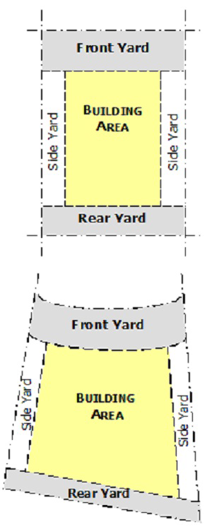
Figure 2-2: Measuring Setbacks/Building Lines
(d)
Building Setbacks.
(1)
All setbacks established on a recorded plat shall be enforced, unless such setbacks exceed the required setbacks in this Code.
(2)
Setbacks established on a recorded plat shall only be changed through replat proceedings.
(3)
In areas with nonconforming building setbacks, the minimum building setback shall be the average for the entire block as determined by measuring the setbacks of the main buildings on one side of the street.
(4)
Where a property is adjacent to an undevelopable property, such as a railroad right-of-way, park, golf course, drainage facility, major utility easement, or similar uses, the Planning Director may authorize a reduction in the required side or rear setback adjacent to such use. However, in no case shall the setback be reduced more than 50% (e.g., a 30' setback may be reduced to 15').
(e)
Configuration of Lots. Figure 2-3 illustrates the various types of lots that are discussed within this LDC.
(1)
Flag lots (i.e., lots with minimal, or panhandle type, frontage) shall not be permitted in residential districts unless otherwise approved by the BOA. Flag lots in nonresidential and mixed use zoning districts shall be permitted upon approval by the Planning & Zoning Commission, however, such lots shall have a minimum width of thirty feet (30').
(2)
Double-frontage lots in residential zoning districts shall only be permitted if access is limited to one street frontage.
(3)
Lots shall have a minimum frontage of 100 feet (100') when located along an arterial street.
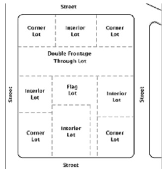
Figure 2-3: Types of Lots
(f)
Front Yards.
(1)
Double-Frontage Lots: Where lots have double frontage, running through from one street to another, the required front yard shall be provided on both streets. See Figure 2-4.
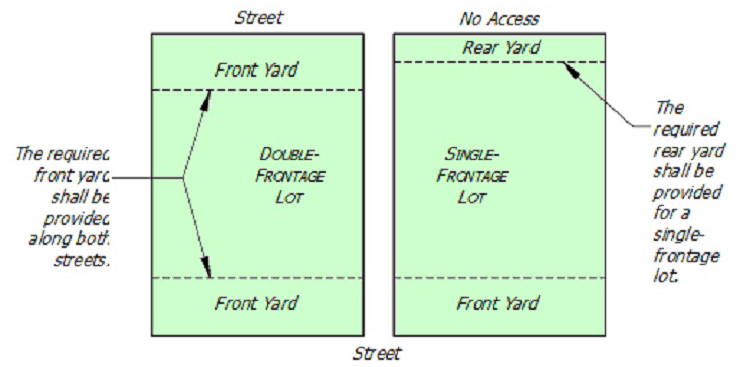
Figure 2-4: Double-Frontage Lots
(2)
Corner Lots:
a.
On all corner lots, the front yard setback shall be observed along the frontage of both intersecting streets, unless approved specifically otherwise on a plat. (Also see (f)(1).)
b.
The side and/or rear yards in the case of single-family and duplex uses shall be identified, and the front of the structure shall not face the side or rear yard (Figure 2-5).
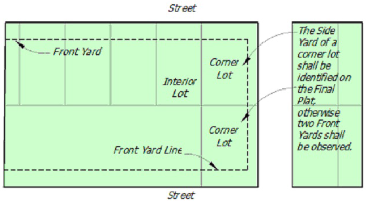
Figure 2-5: Identification of Side and Rear Yards
(3)
Measuring Front Yards and Encroachments: (See Figure 2-6.)
a.
The front yard shall be measured from the property line to the front face of the building, to the nearest supporting member of a covered porch or terrace, or to any attached accessory building.
b.
Subsurface structures, platforms or slabs may not project into the front yard to a distance greater than thirty inches (30").
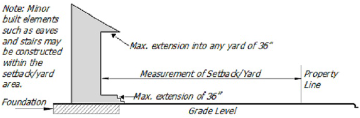
Figure 2-6: Measuring Front Yard Setbacks and Encroachments
(4)
Curved Front Building Line: Minimum lot widths for lots with predominate frontage on the curved radius of a street (e.g., cul-de-sac or "eyebrow" portion of a street) shall be measured as the linear distance of the curved front building line (see Figure 2-7), and shall be shown on the Final Plat. Lot frontage shall not be less than eighty percent (80%) of the lot width, except on cul-de-sac lots. Lot widths for all lots shall be as set forth in the respective zoning district for each lot.
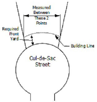
Figure 2-7: Measuring Lot Width of a Curved Lot
(g)
Yards in Relation to Future Rights-of-Way. Where a future right-of-way line has been established for future widening or opening of a street or thoroughfare, upon which a lot abuts, the front, side, and/or rear yard shall be measured from the future right-of-way line.
(h)
Side & Rear Yards.
(1)
On a corner lot used for one- or two-family dwellings, both street exposures shall be treated as front yards on all lots platted after the effective date of this Code, except where one street exposure is designated as a side yard for both adjacent lots or where the two lots are separated by an alley, street right-of-way, creek/floodplain area, or other similar phenomenon. In such case, the building line may be designated as a side yard of fifteen feet (15') or more (as determined by the applicable zoning district standards) on the final plat. On lots which were official lots of record prior to the effective date of this Code, the minimum side yard adjacent to a side street shall comply with the minimum required side yard for the respective district.
(2)
Measuring Side/Rear Yards and Encroachments:
a.
Every part of a required side yard shall be open and unobstructed except for the following:
1.
Accessory buildings, as permitted herein, and
2.
The ordinary projections of window sills, belt courses, cornices and other architectural features. Such projections shall not exceed twelve inches (12") into the required side yard, however roof eaves may project up to thirty-six inches (36") into the required side yard. No projections shall be permitted closer than twelve inches (12") to a common property line.
b.
Air-conditioning compressors and similar accessory equipment are permitted in the side or rear yard.
(i)
Encroachments Permitted in Any Yard.
(1)
Bay windows, balconies, covered porches and chimneys occupying, in the aggregate, less than one-third (⅓) of the length of the building wall on which they are located, may project a distance not exceeding three feet (3') from the required building line.
(2)
Fire escapes may project a distance not exceeding four and one-half feet (4½') from the required building line.
(3)
Cornices, canopies, eaves, and other such architectural features without posts or columns may project a distance not exceeding three feet (3').
(j)
Sight Visibility.
(1)
Visual clearance shall be provided in all zoning districts so that no fence, wall, architectural screen, earth mounding or landscaping thirty inches (30") or higher above the street centerline obstructs the vision of a motor vehicle driver approaching any street, alley, or driveway intersection as follows:
a.
At street intersections within nonresidential and mixed use zoning districts, clear vision must be maintained for a minimum of twenty-five feet (25') across any lot, measured from the corner of the property line in both directions.
b.
At street intersections within residential zoning districts, clear vision must be maintained for a minimum of fifteen feet (15') across any lot, measured from the corner of the property line in both directions.
c.
At an intersection with an alley, clear vision must be maintained for a minimum of five feet (5').
d.
Shrubs and hedges that are typically less than thirty inches (30") in height at maturity, as measured from the centerline of the street, may be located in the visual clearance areas of all districts.
e.
A limited number of single-trunk trees having a clear trunk (branching) height of at least five feet (5') may be located within sight visibility areas provided that they are spaced and positioned such that they will not produce a visibility-inhibiting effect when they attain mature size.
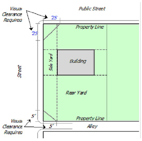
Figure 2-8: Sight Visibility in Nonresidential and Mixed Use Zoning Districts
(Ord. No. 8-2010, pt. 1(Exh. A), 4-22-10; Ord. No. 12-2010, pt. A (Exh. A), 6-10-10)
Section 2.5.1.2 - Height Regulations
(a)
Calculation of Height.
(1)
For the purposes of calculating the overall height of a structure, slope shall be calculated from the highest point of the building at natural grade to the lowest point of the building at natural grade, or the natural grade of an adjoining road, along a line that is, as close as possible, perpendicular to existing contours.
(2)
The height shall be measured from the highest parapet or roof ridge to natural grade or finish grade at the lowest point adjacent to the building exterior, whichever yields the greatest height.
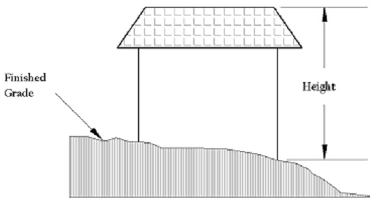
Figure 2-9: Measuring Building Height
(b)
Exceptions to Height Regulations. In districts where the height of buildings is restricted, church spires or steeples, flagpoles, radio or television receiving antennas, amateur radio broadcasting antennas, chimneys, vent stacks, elevator bulkheads, mechanical equipment rooms, cooling towers, tanks, and ornamental cupolas and domes erected on the top of a building may project beyond the maximum height allowed, but in no case except church spires, steeples, flagpoles, radio or television receiving antennas or amateur radio broadcasting antennas, shall such projection exceed twelve feet (12').
(Ord. No. 8-2010, pt. 1(Exh. A), 4-22-10)
Section 2.6.1.1 - Intent and Definition
(a)
Continuance. Within the districts established by this Code or amendments thereto, there may exist lots, structures, uses of land and structures, and characteristics of use which were lawfully in existence and operating before this Code was enacted, amended or otherwise made applicable to such lots, structures or uses, but which do not now conform to the regulations of the district in which they are located. It is the intent of this Code to permit such nonconforming uses to continue, as long as the standards within this article are met.
(b)
Expansions/Enlargements. It is further the intent of this Code that nonconforming uses or structures shall not be enlarged, expanded or extended, and shall not be used as a basis for adding other structures or uses prohibited elsewhere in the same district.
(c)
Incompatibility. Nonconforming uses are hereby declared to be incompatible with the permitted uses in the districts involved.
(d)
Construction Underway. Nothing contained herein shall be construed to require any change in the overall plans, construction or designated use of any structure or part thereof where official approval and the required building permits were granted before the enactment of this LDC or any amendment thereto where the construction thereof, conforming with such plans, shall have been started prior to the effective date of this LDC or such amendment, and where such construction shall have been completed in a normal manner within a six (6) month period following the effective date of this LDC with no interruption except for reasons beyond the builders' control.
(Ord. No. 8-2010, pt. 1(Exh. A), 4-22-10)
Section 2.6.2.1 - Nonconforming Use Criteria
(a)
Criteria. Any use that does not conform to the regulations of this Code on the effective date hereof or any amendment hereto shall be deemed a nonconforming use provided that:
(1)
Such use was in existence under and in compliance with the provisions of the immediately prior Zoning Ordinance; or
(2)
Such use was a lawful, nonconforming use under the immediately prior Zoning Ordinance; or
(3)
Such use was in existence at the time of annexation into the City, and was a legal use of the land at such time, and has been in regular and continuous use since such time.
(b)
Conformance to a Zoning District. Any other use that does not conform with the regulations of the Zoning District in which it is located on the effective date of this Code or any amendment hereto shall be deemed to be in violation of this Code, and the City shall be entitled to enforce fully the terms of this Code with respect to such use.
(c)
Proving a Legal Nonconformity. It shall be the property owner's responsibility to provide information to the City that his/her property represents a legal nonconforming use or structure, granting the property owner rights to use and enjoy his/her property as a legal conformity as outlined within this article.
(Ord. No. 8-2010, pt. 1(Exh. A), 4-22-10)
Section 2.6.2.2 - Nonconforming Structure Criteria
(a)
Criteria. Any structure that does not conform with the regulations of this Code on the effective date hereof or any amendment hereto shall be deemed a nonconforming structure provided that:
(1)
Such structure was in existence under and in compliance with the provisions of the immediately prior zoning regulations; or
(2)
Such structure was a lawful, nonconforming structure under the immediately prior zoning regulations; or
(3)
Such structure was in existence at the time of annexation into the City, and was a legal structure at such time, and has been in regular and continuous use since such time.
(b)
Conformance to a Zoning District. Any other structure that does not conform with the regulations of the Zoning District in which it is located on the effective date of this Code or any amendment hereto shall be deemed to be in violation of this Code, and the City shall be entitled to enforce fully the terms of this Code with respect to such structure.
(c)
Proving a Legal Nonconformity. It shall be the property owner's responsibility to provide information to the City that his/her property represents a legal nonconforming use or structure, granting the property owner rights to use and enjoy his/her property as a legal conformity as outlined within this article.
(Ord. No. 8-2010, pt. 1(Exh. A), 4-22-10)
Section 2.6.2.3 - Nonconforming Lot Criteria
(a)
Criteria. Any platted lot that does not conform with the regulations of this Code on the effective date hereof or any amendment hereto, except as expressly provided in subsection (c) below, shall be deemed a nonconforming platted lot provided that:
(1)
Such platted lot was in existence under and in compliance with the provisions of the immediately prior zoning regulations; or
(2)
Such platted lot was a lawful, nonconforming platted lot under the immediately prior zoning regulations; or
(3)
Such platted lot was in existence at the time of annexation into the City, and was a legally platted subdivision of the land at such time.
(b)
Conformance to a Zoning District. Any other platted lot that does not conform with the regulations of the Zoning District in which it is located on the effective date of this Code or any amendment hereto, and except as provided in subsection (c) below, shall be deemed to be in violation of this Code, and the City shall be entitled to enforce fully the terms of this Code with respect to such platted lot.
(c)
Conforming Platted Lots. The following types of platted lots shall be deemed in conformance with the provisions of this Code and nothing in this Code shall be construed to prohibit the use of such lots, notwithstanding the fact that such lots do not meet the standards of this Code in the district in which it is located:
(1)
Any vacant lot that conformed to the City's zoning district regulations at the time that it was platted; or
(2)
Any lot occupied by a single-family dwelling authorized under the zoning district regulations in which the lot is located.
(Ord. No. 8-2010, pt. 1(Exh. A), 4-22-10)
Section 2.6.2.4 - Application for Change in Nonconforming Status
(a)
Application. A property owner may apply to the Board of Adjustment for a change in the status of a nonconforming use or structure for the following matters:
(1)
Expansion of the land area of a nonconforming use;
(2)
Expansion of the gross floor area of a nonconforming structure;
(3)
Reconstruction of a nonconforming structure that has been destroyed (refer to Section 2.7.3.4 [2.6.3.4]);
(4)
Resumption of a nonconforming use previously abandoned;
(5)
The enlargement or expansion of a nonconforming structure if such enlargement or expansion does not increase the structure's nonconformity; or
(6)
Encroachment on a zoning setback line.
(b)
Effect. If the Board grants the application for a change in nonconforming status, modifications made in the nonconforming use, structure or lot that are consistent with the approved application shall enjoy the same status and shall be subject to the same limitations as the original nonconformity under this Code.
(c)
Decision. The BOA shall process and decide the petition for a change in nonconforming status as a special exception in accordance with Section 1.4.4.1.
(d)
Criteria for Approval. In deciding the application, the Board shall apply the following criteria:
(1)
The proposed change in nonconforming status meets the criteria in Article 7 [Article 6] of Chapter 2;
(2)
Granting the application shall not result in greater harm to adjacent and neighboring land uses than the original nonconformity.
(e)
Application for Termination.
(1)
A City official may petition the Board of Adjustment for termination in nonconforming status of a nonconforming use, nonconforming structure or nonconforming lot.
(2)
If the Board grants the application for termination of nonconforming status, the nonconforming use, nonconforming structure or nonconforming lot shall be deemed in violation of this Land Development Code and shall be subject to any remedy for enforcement, as provided in Article 2, Division 6 of Chapter 1. Thereafter, the property owner may not seek reinstatement of nonconforming status.
(3)
The Planning Director shall be the responsible official for an application seeking termination of nonconforming status.
(4)
The application shall include a concise statement of the reasons why the nonconforming status should be terminated, with specific reference to the rule(s) governing the nonconformity which the petitioner seeks to enforce and a detailed explanation of how granting the petition enforces the standards governing nonconforming status.
(5)
The Board shall process and decide the petition for termination in nonconforming status as a revocation proceeding under Article 2, Division 6 of Chapter 1.
(Ord. No. 8-2010, pt. 1(Exh. A), 4-22-10)
Section 2.6.3.1 - Continuance of Nonconformities
(a)
Criteria.
(1)
The lawful use of any building, structure, or land in accordance with the terms of the zoning regulations by which the use was established, or in the case of annexed property, in accordance with the regulations under which the use was created may be continued.
(2)
Abatement of such use or structure within a given period of time may be required by the City, provided, however, the right to continue such nonconforming use or use of such structure shall be subject to regulations prohibiting nuisances and shall be terminated when such use or structure constitutes a nuisance.
(3)
Such nonconforming use or structure shall be subject to such reasonable regulations as the Board of Adjustment (BOA) may require protecting adjacent property and shall be subject to the specific nonconforming use or structure regulations herein contained.
(4)
A nonconforming structure occupied by a nonconforming use may be re-occupied by a conforming use. Once such change is made, the use shall not thereafter be changed to a nonconforming use.
(5)
No nonconforming use shall be changed to another nonconforming use except as permitted by the Board of Adjustment (BOA).
(Ord. No. 8-2010, pt. 1(Exh. A), 4-22-10)
Section 2.6.3.2 - Expansion of Nonconformities
(a)
Criteria. A nonconforming use may be extended throughout the structure in which it is located, provided that:
(1)
The structure or its premises shall not be enlarged or increased in height, in floor area or in land area to accommodate extension of the nonconforming use;
(2)
No alteration shall be made to the structure occupied by the nonconforming use, except those alterations that are required by law to preserve the integrity of the structure and alterations that would upgrade the quality, safety or aesthetic appeal of the structure; and
(3)
The number of dwelling units occupying the structure shall not exceed the number of dwelling units existing at the time the use became nonconforming.
(b)
Use Expansion Outside of Structure. A nonconforming use occupying a structure shall not be extended to occupy land outside the structure.
(c)
Use or Structure Expansion. A nonconforming use or structure shall not be enlarged, increased or extended to occupy a greater area of land than was occupied at the time the use or structure became nonconforming, except:
(1)
To provide additional off-street parking or loading areas required by this Code.
(2)
Enlargement of a building housing a nonconforming use, for the purpose of storage only, shall not be deemed the extension of a nonconforming use.
(3)
Construction of a detached accessory building for the purpose of storage, on a lot occupied by a nonconforming use, shall not be deemed the extension of a nonconforming use.
(Ord. No. 8-2010, pt. 1(Exh. A), 4-22-10)
Section 2.6.3.3 - Repairs and Alterations
(a)
Moving a Nonconforming Structure. No nonconforming structure or building shall be moved in whole or in part to any other location on the lot, or to any other location or lot, unless every portion of such structure is in compliance with all the regulations of the zoning district wherein the structure is to be relocated.
(b)
Right to Repair Maintained. Nothing in this Ordinance shall be construed to prohibit the normal maintenance or repair of any part of any buildings or structures declared unsafe by the Building Inspection Department of the City of Abilene, unless such repairs or maintenance exceeds fifty percent (50%) of the structure's appraised value, as determined by the applicable county appraisal district. (Refer to Section 2.7.3.4(c) [2.6.3.4(c)] for replacement cost explanation.)
(1)
Structural Alterations Allowed If Changed to Conforming Use: No structural alterations shall be made except those required by law or ordinance, unless the use within the building is changed to a conforming use, and provided that no additional dwelling units shall be added where the nonconforming use results from there being more dwelling units on the lot than is permissible in the district in which the building is located.
(c)
Substandard Nonconforming Structure. The right to operate and maintain any nonconforming structure shall terminate and shall cease to exist whenever the nonconforming structure becomes substandard under any applicable ordinance of the City and the cost of placing such structure in lawful compliance when the applicable ordinance exceeds fifty percent (50%) of the replacement cost of such structure on the date that the Enforcing Officer determines that such structure is substandard. (Refer to Section 2.7.3.4(c) [2.6.3.4(c)] for replacement cost explanation.)
(Ord. No. 8-2010, pt. 1(Exh. A), 4-22-10)
Section 2.6.3.4 - Reconstruction Following Damage or Destruction
(a)
Structure Totally Destroyed. If a nonconforming structure or a structure occupied by a nonconforming use is totally destroyed by fire or the elements, such structure may not be reconstructed or rebuilt except in conformance with provisions herein. Damages from any cause exceeding fifty percent (50%) of the value of such structure at the time of damage shall necessitate the discontinuance of use of such structure and same shall not be restored or reconstructed except in conformity with the current provisions of this Ordinance applicable to such structure.
(b)
Structure Partially Destroyed.
(1)
Nonconforming structures damaged by the forces of nature, war or acts of God may be restored to their former condition if such damages do not exceed fifty percent (50%) of the value of such structure at the time of damage.
(2)
Such restoration or reconstruction shall be completed within twelve (12) months of the damaging event. If reconstruction is delayed by contested insurance claims, litigation, or some other similar cause, then the twelve (12) month reconstruction period may be extended by the Planning Director.
(c)
Replacement Cost. In determining the replacement cost of any nonconforming structure, there shall not be included therein the cost of land or any factors other than the nonconforming structure itself including foundation.
(Ord. No. 8-2010, pt. 1(Exh. A), 4-22-10)
Section 2.6.3.5 - Changing to a Conforming Use
(a)
Changing to a Conforming Use.
(1)
A nonconforming use may be changed to a conforming use provided that, once such change is made, the use shall not be changed back to a nonconforming use.
(2)
A conforming use located in a nonconforming structure may be changed to another conforming use, but shall not be changed to a nonconforming use.
(Ord. No. 8-2010, pt. 1(Exh. A), 4-22-10)
Section 2.6.3.6 - Abandonment
(a)
Considered Abandoned. A nonconforming use of any building or structure which has been abandoned shall not thereafter be returned to any nonconforming use. A nonconforming use shall be considered abandoned when:
(1)
It has been replaced with a conforming use; or
(2)
Such building or structure is or hereafter becomes vacant and remains unoccupied or out of use for a continuous period of six (6) months, or the special equipment and furnishings peculiar to the nonconforming use have been removed from the premises and have not been replaced within such six (6) month period; or
(3)
In the case of a temporary use, the use is moved from the premises for any length of time.
(b)
Future Use After Abandonment. If a nonconforming use or structure is abandoned, any future use of the premises shall be in conformity with the provisions of this Code, as amended, and with any other applicable City codes or ordinances that are in effect at the time the use is resumed or the structure is re-occupied.
(Ord. No. 8-2010, pt. 1(Exh. A), 4-22-10)