Agoura Hills City Zoning Code
CHAPTER 5
OVERLAY DISTRICTS
9501.- Purpose.
The purpose of the combining overlay districts is to allow the city to adequately provide for special environmental constraints which exist in the city and to provide the means by which developmental controls may be exercised to assure that such environmental constraints are adequately considered when development occurs in these areas.
9511.- Purpose.
The D district is intended to be applied to those areas of the city which, under present conditions, are known to be subject to flooding. The objectives of the D district shall be:
A.
To prevent loss of life and property and to minimize economic loss caused by flood flows;
B.
To establish criteria for land management and use in floodprone areas that are consistent with those promulgated by the Federal Insurance Administration for the purpose of providing flood insurance eligibility for property owners;
C.
To promote commercial and residential development and/or improvement which would not encroach or obstruct the natural flow of water within a designated drainageway, floodway, or watercourse;
D.
To regulate and control uses below the elevation of the one-hundred-year flood flow.
It is contemplated that where flood control measures are provided so as the [to] eliminate flood hazards, the D district will be removed from the property.
9512. - Application.
The D overlay district shall be applied to those areas that are known to be subject to flooding as determined by the city council based on recommendations by the flood control district.
9513. - Conditional uses.
The following uses and structures shall be permitted in the D district subject to the issuance of a conditional use permit by the planning commission:
A.
Nonresident accessory structures permitted by the underlaying district regulations provided that such structures comply with all of the conditions listed below:
1.
Floodproofing and/or flood protective measures shall be required to be installed in a manner approved by the chief engineer of the affected flood control district. Examples of floodproofing include, but are not limited to:
a.
Installation of watertight doors, bulkheads, and shutters.
b.
Reinforcement of walls to resist water pressure.
c.
Use of paints, membranes, or mortars to reduce seepage through walls.
d.
Addition of mass or weight to structure to resist flotation.
e.
Armor protection of all fill materials from scour and/or erosion.
f.
Certification by a registered professional engineer or architect.
g.
All new and replacement water supply and sanitary sewage systems shall be designed to minimize or eliminate infiltration of floodwaters into the system and discharge from systems into floodwaters.
h.
On-site waste disposal systems shall be located to avoid impairment to them or contamination from them during flooding.
i.
All subdivision proposals shall have public utilities and facilities such as sewer, gas, electrical, and water systems located and constructed to minimize flood damage.
2.
Building and health code requirements applicable to floodplain districts shall be complied with.
3.
The bottom elevation or first floor of any structure shall be at least one (1) foot above the level of the one-hundred-year flood. Exceptions may be recommended by the building official only for nonresidential structures which are adequately floodproofed, in accordance with the Building Code, up to the level of the one-hundred-year flood.
4.
Prohibit encroachments, including fill, new construction, substantial improvements, and other development unless certification by a registered professional engineer or architect is provided demonstrating that encroachment shall not result in any increase in flood levels during the occurrence of the base flood discharge.
B.
Public utility lines, excluding any buildings or other structures.
C.
Recreation areas, parks, campgrounds, playgrounds, fishing lakes, hunting clubs, riding and hiking trails, golf courses, golf driving ranges, polo fields, athletic fields, parking lots, all of which involve only the open use of land without permanent structures or improvements.
D.
Temporary and readily removable structures accessory to agricultural uses.
9514. - Prohibited uses.
The following uses are specifically prohibited in the D district:
A.
Excavations that will tend to broaden the floodplain or direct flood flows out of the natural floodplain;
B.
Landfills, improvements, developments, or other encroachments that could increase water surface elevations of the one-hundred-year flood more than one (1) foot or that cannot be fully offset by stream improvements as provided in section 9517.2;
C.
Structures designed for human habitation.
9517. - Development standards.
The property development standards of the underlying zone shall apply insofar as they pertain to the uses of this district.
9517.1. - Site plan review.
All development shall be subject to site plan approval as provided by chapter 6.
9517.2. - Special standards.
There are none except as required under the conditional use permit, and as required under section 9513.
9521.- Purpose.
The purpose of the affordable housing overlay district (AH) is to promote the creation of affordable housing units, beyond that which would be accomplished by section 9133 et seq. of part 4 of chapter 1 of this title, to enable the city to meet its housing goals, and be compatible with surrounding land uses through the establishment of special development standards and permitted densities.
(Ord. No. 22-461, § 7, 8-24-2022)
9522. - Definitions.
A.
Affordable unit. "Affordable unit" shall be defined as a dwelling unit rented or sold to a very-low income household or low-income household at an affordable housing cost or affordable rent, as those terms are defined in California Health and Safety Code sections 50052.5 and 50053.
B.
By-right approval. "By right approval" shall be defined as a ministerial approval of a development project involving little or no discretion or judgment by the public official as to the wisdom or manner of carrying out the project, whereby the public official merely ensures that the development project meets all standards set forth in this part.
C.
Market rate unit. "Market rate unit" is a dwelling unit in a development project that is not restricted for a very low-income or low-income household, or for any other affordable housing category.
D.
Mixed-use development. "Mixed-use development" shall be defined as a development project consisting of a vertical (stacked) or horizontal (side by side, attached or detached) combination of multi-family residential dwelling units and a non-residential use as part of a single development application.
E.
Multi-family residential project. "Multi-family residential project" shall mean a project with two (2) or more attached dwelling units.
F.
Recreational group open space. "Recreational group open space" shall be defined as an outdoor area common to the residents of the development project and located on the project site that is dedicated to active recreation, and may include, but not be limited to, picnic, bar-be-que, pool or spa, sport court, or other physical activity.
(Ord. No. 22-461, § 7, 8-24-2022)
9523. - Applicability.
A.
Pursuant to the requirements of this part, the AH overlay district shall apply to the following:
1.
Multi-family residential projects on properties that are: zoned residential medium density - maximum fifteen (15) dwelling units per acre (RM-15); identified in the housing element of the general plan as being eligible for the AH overlay district; and identified with the "AH" notation on the zoning map;
2.
Multi-family residential projects on properties that are: zoned planned development (PD) in the Ladyface Mountain Specific Plan as identified in that specific plan and identified in the housing element of the general plan as being eligible for the AH overlay district; and
3.
New mixed-use residential projects, or new multi-family residential projects that will be added to a site with existing commercial developments that will remain on the site, on properties that are: zoned commercial shopping center - mixed use (CS-MU); identified in the housing element of the general plan as being eligible for the AH overlay district; and identified with the "AH" notation on the zoning map;
4.
Mixed-use development projects, or new multi-family residential projects that will be added to a site with existing commercial developments that will remain on the site, on properties that are: zoned planned development (PD) in the Agoura Village Specific Plan as identified in that specific plan and identified in the housing element of the general plan as being eligible for the AH overlay district.
B.
The AH overlay district shall not be used to develop a mixed-use development on a site in the RM-15 zoning district or the Ladyface Mountain Specific Plan.
C.
The AH overlay district shall not be used to develop a solely multi-family development on a site in the CS-MU zoning district or the Agoura Village Specific Plan.
D.
A property designated within the AH overlay district may be developed either in the manner provided in this part or in the manner provided in the underlying zoning district or applicable specific plan.
(Ord. No. 22-461, § 7, 8-24-2022)
9524. - Uses established.
The limitations in the AH overlay district as to uses and structures shall be as follows.
(Ord. No. 22-461, § 7, 8-24-2022)
9524.1. - Permitted uses.
A.
Subject to the provisions of this part, multi-family residential projects and parking structures that provide parking for the residential units on-site are permitted on AH sites in the RM-15 zoning district.
B.
Subject to the provisions of this part, multi-family residential projects and parking structures that provide parking for the residential units on-site are permitted on AH sites in the Ladyface Mountain Specific Plan.
C.
Subject to the provisions of this part, mixed-use development projects and parking structures that provide parking for on-site uses are permitted on AH sites in the CS-MU zoning district.
D.
Subject to the provisions of this part, mixed-use development projects and parking structures that provide parking for on-site uses are permitted on AH sites in the Agoura Village Specific Plan.
E.
Specific non-residential uses shall be allowed as part of a mixed-use development project as allowed by the applicable specific plan or underlying zoning district.
(Ord. No. 22-461, § 7, 8-24-2022)
9524.2. - Accessory uses.
Subject to the provisions of section 9281 et seq. and chapter 6, the following accessory uses and structures shall be permitted:
A.
Accessory uses, buildings and structures;
B.
Domestic animals;
C.
Home occupation;
D.
Private greenhouses, horticultural collections, flower and vegetable gardens;
E.
One (1) room rental in the principal structure;
F.
Garage sales, not to exceed two (2) in any calendar year;
G.
Accessory dwelling units, subject to the provisions of section 9283 et seq.
(Ord. No. 22-461, § 7, 8-24-2022)
9524.3. - Prohibited uses and structures.
9525. - Development standards.
The development standards that apply to a project seeking approval under the AH overlay district are as follows:
(Ord. No. 22-461, § 7, 8-24-2022)
9525.1. - Density.
A.
A project seeking approval under the AH overlay district shall include at least twenty (20) dwelling units per acre.
B.
A project seeking approval under the AH overlay district shall include no more than twenty-five (25) dwelling units per acre.
C.
Density shall be calculated on the basis of the entire acreage of the parcel, including any portion of the site used, dedicated or required to be used or dedicated as a buffer or easement and any portion of the site that is not developable due to the slope.
(Ord. No. 22-461, § 7, 8-24-2022)
9525.2. - Building height.
A.
The maximum height for any building or structure included in a project seeking approval under the AH overlay district shall be as follows:
1.
A one-story building shall be no taller than twenty-five (25) feet.
2.
A two-story building shall be no taller than thirty-five (35) feet.
3.
A three-story building shall be no taller than forty (40) feet.
B.
The height of buildings and structures shall be measured vertically from the finished grade to the highest point on the roof, including but not limited to, any architectural features.
(Ord. No. 22-461, § 7, 8-24-2022)
9525.3. - Minimum lot specifications.
Minimum lot specifications shall be as provided for by the applicable underlying zoning district or specific plan.
(Ord. No. 22-461, § 7, 8-24-2022)
9525.4. - Building site coverage.
The maximum building site coverage shall not exceed sixty (60) percent.
(Ord. No. 22-461, § 7, 8-24-2022)
9525.5. - Minimum group recreational open space.
The minimum on-site group recreational open space shall be two hundred fifty (250) square feet per dwelling unit.
(Ord. No. 22-461, § 7, 8-24-2022)
9525.6. - Off-street parking requirements.
All requirements of section 9654 et seq. shall apply, except as follows:
A.
Parking allocation for residential uses. The number of off-street parking spaces shall be no less than the following for residential uses.
B.
An applicant may substitute covered parking spaces for uncovered parking spaces to comply with the residential parking requirements in subdivision "A" above.
C.
All covered parking spaces that are provided to comply with the minimum requirements in subdivision "A" above shall be assigned to an individual dwelling unit and cannot be used as guest parking or as part of shared parking.
D.
Parking allocation for nonresidential uses in a mixed-use development. The minimum number of off-street parking spaces for nonresidential uses in a mixed-use development shall be as indicated in section 9654.6. Shared parking shall be allowed only as expressly stated for mixed-use developments in sections 9526.1.F and 9526.2.H.
E.
Parking structures, subterranean parking, and similar parking facilities that are part of a residential or mixed-use development shall be permitted by right.
F.
Parking lot landscaping shade trees shall be provided pursuant to section 9526 et seq.
G.
The percent of landscaping of the total parking area, including driveway areas, shall be provided pursuant to section 9526 et seq.
H.
A minimum eight-foot wide landscaped finger planter shall be located every ten (10) parking spaces in surface parking lots.
(Ord. No. 22-461, § 7, 8-24-2022)
9525.7. - Hillside lots and slopes.
A.
The city's hillside ordinance (section 9652 et seq.) shall not apply to a project seeking approval under the AH overlay district. Instead, the following shall apply:
1.
Structures exceeding thirty-five (35) feet in height must be stepped into the hillside for any portion of the building constructed on a slope of greater than fifteen (15) percent, as follows: after every fifteen (15) feet of vertical height, the building shall be stepped back at least ten (10) feet horizontally.
2.
Structures shall be located with a minimum building setback of thirty (30) feet from the top of a slope on sites with an average slope of ten (10) percent or steeper.
3.
No development shall occur on slopes greater than thirty-five (35) percent.
(Ord. No. 22-461, § 7, 8-24-2022)
9525.9. - Oak Trees.
The city's oak tree ordinance (section 9657 et seq.) shall not apply to a project seeking approval under the AH overlay district, except for the following: section II. definitions of appendix A of article IX of the Agoura Hills Municipal Code, title IV of appendix A; section IV., items D, E, and items 2 and 3 of F of appendix A of title IV; section V. standards for performance of required work of appendix A of title IV; items 3 and 4 of section V. standards for performance of required work of appendix A of title IV; and item E of section 9657.5 oak tree permit. A project seeking approval under the AH overlay district shall comply with the following.
A.
If a project involves the removal of or encroachment greater than twenty-five (25) percent into the root zone or canopy zone of a protected oak tree that is forty-eight (48) inches in diameter or less per the city's oak tree ordinance and guidelines (valley oak, coast live oak), one (1) 24-inch-box minimum size oak tree of the same species shall be planted on the site. For scrub oak species protected per the city's oak tree ordinance and guidelines, on-site replacement for removal shall be equal to the square footage of the area removed, with scrub oaks of the same species planted to a five-foot on center spacing within the replacement area.
B.
If a project involves the removal of up to ten (10) protected oak trees within the project site, not more than twenty-five (25) percent of the total estimated tree canopy or root structure of all protected oak trees on that project site shall be removed. If the project involves the removal of eleven (11) or more protected oak trees within the project site, not more than thirty-five (35) percent of the total estimated tree canopy or root structure of all protected oak trees on the project site shall be removed.
C.
For the purpose of providing natural stabilization of hillsides and preservation of native landscaping, a minimum of seventy-five (75) percent of all native trees on a slope steeper than fifty (50) percent shall be retained.
D.
The removal of or encroachment greater than twenty-five (25) percent into the root zone or canopy zone of a protected "landmark" oak tree (trees whose diameter exceeds forty-eight (48) inches) is prohibited.
(Ord. No. 22-461, § 7, 8-24-2022)
9525.10. - Grading of slopes.
In addition to grading standards in the city building code, the following shall apply to a project seeking approval under the AH overlay district.
A.
Graded slopes shall be no less than a 2:1 ratio.
B.
Grading shall create rounded, non-planar surfaces, and rounded, non-angular intersections between surfaces.
C.
The cut or fill of a slope bank shall not exceed fifteen (15) feet where visible to the public from a parking area, access drive or public right-of-way, and shall not exceed twenty-five (25) feet in areas not visible to the public.
(Ord. No. 22-461, § 7, 8-24-2022)
9526. - Special development standards.
Notwithstanding the provisions of section 9524 et seq. and 9525 et seq., the development standards applicable to a project seeking approval under the AH overlay district shall include the following in the specific underlying zoning districts and specific plans identified below.
(Ord. No. 22-461, § 7, 8-24-2022)
9526.1. - AH properties with an underlying zoning district of CS-MU.
Subject to the provisions of chapter 6, the following development standards shall apply to a project on a site zoned as CS-MU that is seeking approval under the AH overlay district.
A.
Maximum non-residential density.
1.
The maximum floor area ratio (FAR) shall be 0.4 for non-residential uses, excluding above-ground parking structures, underground parking, and full basements.
2.
Non-residential development shall only be allowed as part of a mixed-use development project.
B.
The maximum building height shall be as established in section 9525.2 except that the height of a solely non-residential use building that is a part of a horizontal mixed-use development shall be no more than thirty-five (35) feet and two (2) stories.
C.
Building setbacks. The minimum building setback requirements shall be as follows.
1.
Front yard: twenty (20) feet from any existing or proposed right-of-way.
2.
Side yard: none except:
a.
When adjacent to a residential district or when abutting any street that separates the CS-MU district from a residential district: twenty (20) feet.
b.
The minimum street side setback shall be treated as a front setback.
3.
Rear yard: twenty (20) feet.
D.
Mixed-use development.
1.
New projects containing mixed-use development shall include construction of both the residential and non-residential parts concurrently.
2.
For mixed-use development sites, the residential density shall be in addition to the permitted and minimum required non-residential development density in the underlying district.
E.
Landscaping.
1.
Parking lot landscaping shall include shade trees placed so as to cover forty (40) percent of the total parking area, including drive aisles, with tree canopies established within fifteen (15) years after the issuance of the building permit for the related building, structure or other improvement.
2.
Except for approved access ways, a minimum 15-foot wide landscaped planter shall be provided along all street and highway frontages.
F.
Shared Parking. Table 1 shared parking of section 9654.2.K.5 shall apply to all mixed-use developments where shared parking is proposed. Shared parking may apply to unassigned residential parking spaces and all non-residential parking spaces, but shall not apply to assigned residential parking spaces.
(Ord. No. 22-461, § 7, 8-24-2022)
9526.2. - AH properties with an underlying zoning district of PD in the Agoura Village Specific Plan.
The following shall apply to a project on a site in the Agoura Village Specific Plan that is seeking approval under the AH overlay district, and shall replace the provisions in the specific plan.
A.
Maximum non-residential density.
1.
The maximum floor area ratio (FAR) shall be 0.3 for non-residential uses, excluding above-ground parking structures, underground parking, and full basements.
2.
The minimum commercial density in a residential and commercial mixed-use development project shall be a maximum of thirty-three (33) percent and a minimum of twenty (20) percent of the gross building square footage of the project, including common residential recreational buildings.
3.
Non-residential development shall be allowed only as part of a mixed-use development project.
B.
Maximum building size.
1.
The maximum size of a non-residential building shall be sixty thousand (60,000) square feet.
2.
The maximum size of any single non-residential tenant space in a building shall be thirty thousand (30,000) square feet.
C.
Commercial building height. The maximum building height shall be as established in section 9525.2 except that the height of a solely non-residential use building shall be no more than thirty-five (35) feet and two (2) stories.
D.
Building setbacks.
1.
Setbacks shall be as provided pursuant to the specific plan except that for buildings fronting a public right-of-way, there shall be no minimum or maximum side yard setback.
2.
Setbacks shall be measured from the boundary of existing, or in the case of a proposed parcel map or tract map or lot line adjustment, from the proposed, parcel, unless the parcel borders the public right-of-way, and then the setback is calculated from the right-of-way line. Setbacks shall be measured to the closest structural portion of the building, including from partially or completely covered pedestrian or outdoor dining activity areas.
E.
Buildings fronting a public right-of-way.
1.
Buildings fronting a public right-of-way shall consist of the following:
a.
Either a non-residential development or a vertical mixed-use development.
b.
Ground floor levels shall be non-residential uses, with the exception of offices, which may not occupy ground floor levels.
c.
Upper levels shall be multi-family residential uses or non-residential uses.
F.
New mixed-use development shall include construction of both the residential and non-residential parts concurrently.
G.
Landscaping.
1.
Parking lot landscaping shall include shade trees placed so as to cover thirty-five (35) percent of the total parking area, including drive aisles, with tree canopies established within fifteen (15) years after the issuance of the building permit for the related building, structure or other improvement.
2.
The total number of trees in a parking lot shall be one (1) for every four (4) parking spaces, and shall be located throughout a parking lot.
H.
Shared parking. Table 1 shared parking of section 9654.2.K.5 shall apply to all mixed-use developments where shared parking is proposed. Shared parking may apply to unassigned residential parking spaces and all non-residential parking spaces, but shall not apply to assigned residential parking spaces.
I.
Public space. Notwithstanding section 9525.5, projects shall include a minimum of ten (10) percent of the site area for public spaces accessible to the public from the street or internal site driveway, and shall include one (1) or more of the following: plazas, paseos, courtyards, trails and pedestrian paths, outdoor dining in a commercial use, and view terraces.
J.
Riparian habitat and creek protection program. For project sites adjacent to a riparian area associated with Medea Creek and Lindero Canyon Creek, the owner shall retain a professional biologist to prepare and implement a riparian habitat and creek protection plan, which shall include methods to avoid encroachment into the riparian or creek area from development on the site.
K.
Public use trail along riparian areas. A public use trail shall be provided along the length of the project site adjacent to a riparian area associated with Medea Creek and Lindero Canyon Creek. The public trail shall be the minimum acceptable width pursuant to the Americans with Disabilities Act and shall be constructed of permeable materials, excluding pavement or pavers.
(Ord. No. 22-461, § 7, 8-24-2022)
9526.3. - AH properties with an underlying zoning district of PD in the Ladyface Mountain Specific Plan.
The following shall apply to a project on a site in the Ladyface Mountain Specific Plan that is seeking approval under the AH overlay district, and shall replace the provisions of the specific plan.
A.
Building setbacks.
1.
Setbacks shall be measured from the boundary of existing, or in the case of a proposed parcel map or tract map or lot line adjustment from the proposed, parcel, unless the parcel borders the public right-of-way, and then the setback is calculated from the right-of-way line.
2.
The minimum building setback requirements shall be as follows.
a.
Front yard: fifteen (15) feet.
b.
Side yard: seven (7) feet.
c.
Rear yard: fifteen (15) feet.
B.
Landscaping.
1.
Parking lot landscaping shall include shade trees placed so as to cover thirty-five (35) percent of the total parking area, including drive aisles, with tree canopies established within fifteen (15) years after the issuance of the building permit for the related building, structure or other improvement.
2.
Except for approved access ways, a minimum 15-foot wide landscaped planter shall be provided along all street frontages.
3.
Other development standards.
a.
Development as measured to the highest point on any building including but not limited to architectural features, is prohibited above the 1,100-foot elevation.
(Ord. No. 22-461, § 7, 8-24-2022)
9526.4. - AH properties within the RM zoning district.
Subject to the provisions of chapter 6, the following development standards shall apply to a project seeking approval under the AH overlay district on a site located in the RM zoning district, and replace the provisions of the RM zoning district:
A.
Building setbacks. Setbacks shall be measured from the boundary of existing, or in the case of a proposed parcel map or tract map or lot line adjustment from the proposed, parcel, unless the parcel borders the public right-of-way, and then the setback is calculated from the right-of-way line.
1.
The minimum building setback requirements shall be as follows.
a.
Front yard: fifteen (15) feet.
b.
Side yard: seven (7) feet.
c.
Rear yard: fifteen (15) feet.
B.
Landscaping.
1.
Parking lot landscaping shall include shade trees placed so as to cover thirty-five (35) percent of the total parking area, including drive aisles, with tree canopies established within fifteen (15) years after the issuance of the building permit for the related building, structure or other improvement.
2.
Except for approved access ways, a minimum 15-foot wide landscaped planter shall be provided along all street and highway frontages.
(Ord. No. 22-461, § 7, 8-24-2022)
9527. - Design standards.
Any project seeking approval under the AH overlay district shall comply with the design standards in section 9663 et seq.
(Ord. No. 22-461, § 7, 8-24-2022)
9528. - Other standards.
Any project seeking approval under the AH overlay district shall comply with the following requirements:
A.
The project shall not obstruct the view of a scenic vista from passersby on rights-of-way adjacent to the site by more than twenty-five (25) percent of the length of the project site. Scenic vistas include the following: Ladyface Mountain, strawberry hill, Morrison Ranch Hills, Palo Comado Hills, and Simi Hills, as well as primary and secondary ridgelines per the General Plan. The measurement shall be made from the nearest edge of the nearest vehicle travel line from the site.
B.
No development shall occur on primary and secondary ridgelines that are identified in the General Plan.
C.
All light poles, standards and fixtures shall not exceed a height of sixteen (16) feet measured from finished grade. The maximum sixteen (16) feet in height shall include all elements of the light, such as pole and light fixture combined.
D.
All exterior lighting shall be designed and shielded to face downward. Roof mounted lights are prohibited. Illumination levels shall not exceed one (1) foot-candle at the property lines, measured at ground level.
E.
No mirrored glass and gloss tiles building materials shall be included in the project. Steel, aluminum and metallic finishes may be used provided they have a non-reflective coating or other property of the materials that make them non-reflective.
F.
Unless otherwise authorized by CDFW and/or USFWS, the project shall provide a 50-foot buffer from the edge of any wetland, riparian, or other sensitive natural community identified in a local or regional plan, policy or regulation, or by the California Department of Fish and Wildlife (CDFW) or United States Fish and Wildlife Service (USFWS), to be maintained as natural open space. Only planting of native species and unpaved walking trails shall be allowed within the buffer. As permitted by applicable state and federal regulatory agencies, storm drain outlets into creeks and other riparian drainages are allowed that meet best management practices (BMPs) for stormwater and erosion control.
G.
Unless otherwise authorized by CDFW and/or USFWS, the project shall provide and maintain a minimum 100-foot buffer on-site from any on-site or off-site special status plant species, including those identified as candidate, sensitive or special status by the CDFW or USFWS, and a minimum 50-foot buffer from those special status plant species identified in local or regional plans, policies or regulations. No soil disturbance, landscaping (except that related to restoration of such plant species) or placement of structures, including buildings, driveways, pedestrian paths, or infrastructure are permitted in the buffer.
H.
All recommendations/requirements of the project geotechnical report prepared by a licensed engineering geologist or geotechnical engineer pursuant to the county public works department manual for the preparation of geotechnical reports standards are incorporated into the project design and reflected in the project plans submitted as part of the application for an administrative permit and for a building permit.
I.
If during excavation, paleontological resources are discovered, a qualified professional paleontologist shall evaluate the find and provide recommendations for the treatment of the resource.
J.
The project shall demonstrate that its site specific fire protection plan complies with all applicable requirements set forth in general plan policy s-3.21, and the city's duly adopted standards.
K.
Any necessary upgrades or construction of new stormwater drainage facilities shall be designed in compliance with Los Angeles County Flood Control District (County Public Works Department) objective standards, and in compliance with state and federal law.
L.
The project shall comply with Los Angeles County Fire Department requirements and standards for fire truck access.
M.
The project shall be designed and constructed to full public right-of-way improvements along the project frontages in accordance with the Committee of Public Works Standards, Inc.'s standard plans for public works construction and any applicable specific plans.
N.
The project, including landscape plan, shall comply with the requirements of the Los Angeles County Fire Department Fuel Modification Unit.
O.
The project shall comply with all exterior and interior noise standards in the general plan and section 9656 et seq.
P.
Projects bordering any freeway, Kanan Road, Agoura Road and Thousand Oaks Boulevard shall incorporate air quality filter systems and site design requirements to disperse pollution according to general plan policies NR-7.5 and NR-7.6.
Q.
Unless exempt from the preparation of a level of service analysis according to the city's standards for transportation assessments, the project shall meet the level of service standards in General Plan Policy M-1.3 and in the city's transportation assessment standards.
R.
Unless the project meets any of the screening criteria of the city's standards for transportation assessments, a vehicle miles travelled (VMT) analysis shall be prepared for the project according to the city transportation assessment standards. Transportation demand management measures (TDMs) identified in the standards shall be included, as necessary, in the project to reduce the VMT generated by the project to below the significance thresholds based on the VMT assigned to each TDM in the city transportation assessment standards and VMT model.
S.
The project's vehicle circulation shall meet the minimum site distance standards in the most current version of American Association of State Highway and Transportation Official's Greenbook: Standards for Public Works Construction; Section 3 and meet Los Angeles County Fire Department access requirements.
(Ord. No. 22-461, § 7, 8-24-2022)
9529. - Compliance with state and federal laws.
The project shall comply with all applicable state and federal laws, including but not limited to, the following:
A.
The project shall comply with the objective standards of the South Coast Air Quality Management District (SCAQMD) Rule 403 for fugitive dust control, rule 1113 for architectural coatings, rule 1403 for asbestos containing materials, and regulation XIII for new on-site nitrogen oxide emissions. The project shall comply with tier 4 construction equipment measures of the SCAQMD unless an air quality analysis is completed by the project applicant demonstrating that the level of emissions does not trigger the need for tier 4 construction equipment measures.
B.
The project shall not conflict with state or federal regulations pertaining to special status plant or animal species, or that would have an adverse effect, either directly or through habitat modifications, on any species identified as candidate, sensitive or special status species in local or regional plans, policies or regulations, or by the California Department Of Fish And Wildlife (CDFW) or the united states fish and wildlife service (USFWS) unless the applicant/developer obtains the required permit(s) from the CDFW or USFWS.
C.
The project shall not result in the taking of any migratory bird species protected by the federal migratory bird treaty act (including killing, capturing, selling, trading and transporting) without prior authorization by the USFWS. Nesting bird surveys shall be conducted by a qualified professional biologist no more than seven (7) days prior to the beginning of any project-related physical activity, such as vegetation clearance, use and transport of equipment, mobilization and construction, likely to impact migratory songbirds or raptors that occurs between January 1 and September 15, the bird nesting season. If such project activity ceases for longer than 7 days, additional surveys shall be conducted prior to re-commencing the activity. If such species are identified, a no-disturbance buffer of three hundred (300) feet around active perching birds and songbirds shall be implemented. A no-disturbance buffer of five hundred (500) feet around active non-listed as threatened or endangered raptor nests, and one-half (½) mile around active listed birds shall be implemented. The buffers shall be maintained until the breeding season has ended or until a qualified professional biologist has determined that the birds have fledged and are no longer reliant upon the nest or parental care for survival.
D.
Based on the results of a phase I cultural resource report, all significant cultural resources on a site shall be either preserved in situ, or shall be recovered in a data recovery plan as recommended by a professional archaeologist (Society For California Archaeology's professional qualifications for principal investigator).
E.
If Native American or tribal cultural resources exist on the site, the applicant shall enter into a cultural resources treatment agreement with a local Native American tribe traditionally and culturally affiliated with Agoura Hills that is acknowledged by the Native American Heritage Commission, which shall address the following: (1) treatment and disposition of cultural resources; (2) designation, responsibilities, and participation of professional tribal monitors during grading, excavation and ground disturbing activities; (3) project grading and development scheduling; (4) terms of compensation for the tribal monitors; (5) treatment and final disposition of any cultural resources, sacred sites, and human remains discovered on site; (6) tribal monitor's authority to stop and redirect grading in order to evaluate the significance of any potential resources discovered on the property, and to make recommendations as to treatment; and (7) the applicant's agreement to relinquish ownership of all cultural resources, including all archaeological artifacts that are found on the project area, to the tribe for proper treatment and disposition; and the applicant's agreement that all tribal sacred sites are to be avoided and preserved. In compliance with state law, if human remains are unearthed, the project developer, pursuant to state health and safety code section 7050.5, will contact the county coroner and ensure no further disturbance occurs until the county coroner has made the necessary findings as to origin and disposition pursuant to public resources code section 5097.98. If the remains are determined to be of Native American descent, the coroner within twenty-four (24) hours will notify the Native American Heritage Commission (NAHC). The NAHC shall then identify the person(s) thought to be the most likely descendent (MLD) of the deceased Native American, who will then help determine what course of action should be taken in dealing with the remains.
F.
No historic resource eligible for the state register of historical resources or the national register of historic places shall be removed, or its integrity affected to the extent that it is no longer eligible for listing, unless the resource has been adequately documented and treated pursuant to the requirements of the state register of historical resources or the national register of historic places and the secretary of the interior standards for the treatment of historic properties.
G.
The project shall comply with the state water resources control board (SWRCB)/regional water quality control board (RWQCB) national pollution discharge elimination system (NPDES) construction general permit/MS4 permit, and for which a stormwater pollution prevention plan (SWPPP) and standard urban stormwater mitigation plan (SUSMP) have been prepared, if required per the MS4 permit.
H.
The project shall adhere to the SWPPP and SUSMP, if applicable, and to best management practices (BMPs) and low impact development standards (LIDs) in chapter 5 of title V and in accordance with the county LID standards.
I.
The project site shall not be located within a flood hazard zone or special flood hazard area unless the project is consistent with the standards of title III chapter 7, and without prior approval of a conditional letter of map revision (CLOMAR) or letter of map revision (LOMAR) from Federal Emergency Management Agency (FEMA), as applicable.
(Ord. No. 22-461, § 7, 8-24-2022)
9531. - Application and approval process.
A.
By right approval. Projects that comply with the requirements of this part are permitted by right.
B.
Form of application. An application for a project pursuant to this part shall be completed on a form provided by the community development department for an administrative review. The administrative review application shall be reviewed by the community development director and shall be granted if the community development director finds that the application complies with all of the requirements of this part.
C.
Application submittal requirements. The requirements for submittal of an administrative review application pursuant to this part shall be listed on a form provided by the community development department.
D.
Notice of decision. A notice of decision for an administrative review application shall be mailed to the applicant (as shown on the application).
E.
Expiration of administrative approval. If commencement of construction has not occurred within three (3) years of the approval date for the administrative review application, the approval shall expire and become null and void.
F.
Upon written request by the applicant before the expiration of the administrative approval, a one (1) year extension may be approved by the planning and community development director.
(Ord. No. 22-461, § 7, 8-24-2022)
9532. - Affordable housing and regulatory agreement
Affordable units shall be provided as part of each development project according to this part.
A.
Affordable units shall be provided as follows:
1.
At least ten (10) percent of the dwelling units of a development project on a site developed pursuant to this part shall be reserved for very low-income households; and
2.
At least ten (10) percent of the dwelling units of a development project on a site developed pursuant to this part shall be reserved for low-income households.
3.
In calculating the required total number of units for each affordability level, fractional units of 0.5 or above shall be rounded up to a whole unit.
B.
The affordable units shall be sold or rented at an affordable housing cost or affordable rent, as those terms are defined in California Health and Safety Code sections 50052.5 and 50053. If the units are rental units, the affordable units shall be deed-restricted for a period of not less than fifty-five (55) years. If the units are for-sale units, the units shall be sold in accordance with California Government Code Section 65915.
C.
The affordable units shall be:
1.
Constructed on the project site concurrently with, or prior to, the construction of any market rate units.
2.
Dispersed throughout the development project and integrated with the market rate units so that there is at least one (1) affordable unit and one (1) market rate unit in each building of the development.
3.
Constructed with the same base design, appearance, materials and finished quality of the market rate units.
4.
Provided at the same range of number of bedrooms in different unit plan types as provided in the market rate units.
D.
A housing plan shall be provided with the administrative application for the development project setting forth in detail the manner in which the provisions of this section 9532 will be implemented.
E.
A legally binding agreement, in a form approved by the city attorney, shall be executed and recorded against the property to ensure the property complies with all of the requirements of this part, including, but not limited to, the requirement that affordable units shall be deed-restricted for the periods per section 9532.A.
F.
The property owner shall record the regulatory agreement prior to recording any final map for the property, or prior to the issuance of a building permit for the development project, whichever comes first. The regulatory agreement shall be binding on all future owners and successors of interests of the development project.
G.
The city manager is authorized to execute the regulatory agreement, and any regulatory document(s), on behalf of the city council for development projects approved pursuant to this part.
H.
Except as otherwise provided in this part, section 9133 inclusionary housing shall not apply to this part.
(Ord. No. 22-461, § 7, 8-24-2022)
9533. - Conflict resolution between the AH overlay district and Article IX (Zoning).
The affordable housing standards supplement and are in addition to the development standards for the applicable zoning district in which a proposed project is located. Article IX of the Code of Ordinances establishes the zoning regulations of the City of Agoura Hills. Where conflict between these affordable housing standards and other provisions of article IX exists, the provisions of this section shall govern.
(Ord. No. 22-461, § 7, 8-24-2022)
9541.- Purpose.
The purpose of the freeway corridor overlay district shall be to recognize the importance of the land use, architectural design, and appearance of development within the freeway corridor to the city's image, to establish special design guidelines for all development within said areas, and to establish findings that will ensure that future developments are compatible with the city's historic character.
The areas within the freeway corridor overlay district are "gateways"; they are seen first by visitors and residents as they pass through the city, and as they exit the freeway to enter the city. These areas are of crucial importance in establishing the city's identity and character in the minds of visitors and residents.
(Ord. No. 98-278, § 1, 1-14-98)
9541.1. - Corridor standards.
All development in the FC overlay district shall provide for:
A.
The use of naturalistic and native landscaping, particularly native oaks, throughout the development;
B.
Preservation of key distant vistas, such as the Santa Monica Mountains and the Simi Hills;
C.
Preservation of local landmarks in terms of visibility, including Ladyface Mountain and Strawberry Hill;
D.
Preservation of designated open space corridors and trails;
E.
Installation and maintenance of landscaping, including street trees, center median treatment and parkway treatment;
F.
Use of compatible colors and materials to preserve and enhance the scenic quality of the freeway corridor;
G.
Total screening of all unsightly uses with berms, decorative walls and/or landscaping.
9542. - Permitted uses.
Except for the following, all uses permitted in the underlying district shall be permitted in this district.
9542.1. - Prohibited uses.
In addition to the prohibited uses in the underlying district, the following are prohibited in the FC overlay district:
A.
Cabarets, adult book stores, adult entertainment, adult theater and similar adult uses, outdoor displays except new car franchise dealerships, mini storage facilities and yards, truck and equipment rentals, and the like.
B.
Off-sale alcoholic beverage establishments. This section shall not apply to the wholesale sale of alcoholic beverages or to the sale of alcoholic beverages which are wrapped or otherwise enclosed in a sealed container and sold as part of a gift package or other goods, only where there is no public display of alcoholic beverages where the sale of such items is incidental to the primary business on the premises, and where the sales of such items do not exceed fifteen (15) percent of the gross sales of the business at said location. This section shall also not apply to supermarket/food stores with a floor area greater than ten thousand (10,000) square feet.
(Ord. No. 130, § 1, 7-29-87; Ord. No. 150, § 1, 5-11-88; Ord. No. 09-362, § 4, 7-8-09)
9543. - Distance limitations.
The FC overlay district shall be applied only to six hundred sixty (660) feet north and south of the right-of-way edge of the Ventura (101) Freeway.
9544. - Development standards.
Whichever is greater, the development standards of the underlying district or the following shall apply:
9544.1. - Relation to the freeway.
All development adjacent to the freeway in the FC overlay district shall provide for:
A.
A setback of all structures from the freeway right-of-way of one (1) foot for each two (2) feet of building height, with a minimum of twenty (20) feet, for one (1) story, and two (2) feet of setback per one (1) foot of building height for any building taller than twenty (20) feet.
B.
The installation and maintenance of landscaping and automatic irrigation system in the freeway right-of-way, subject to the approval of the city and California Department of Transportation. If such installation is not possible, then the equivalent landscaping shall be provided on the subject property.
C.
The provision of a six-foot high decorative wall or equivalent berming and planting for the full frontage of the freeway.
9545. - Conditional uses.
The following development shall be subject to the issuance of a conditional use permit pursuant to Agoura Hills Municipal Code Sections 9545.1 and 9673, et seq.:
A.
The development either:
(i)
Includes a freestanding structure with a total building area of sixty thousand (60,000) square feet or more; or
(ii)
Includes structures with a cumulative total building area of one hundred thousand (100,000) square feet or more;
AND
B.
The development is located, in part or in full, in the CS, CR or CRS zones of the FC overlay district.
For the purposes of this section, in order for a structure to be considered "freestanding" it should have sufficient distance from an adjacent structure to provide separate visual identity.
(Ord. No. 98-278, § 2, 1-14-98)
9545.1. - Findings.
In addition to the findings required by Agoura Hills Municipal Code Section 9673.2.E, the planning commission shall make the following findings before granting a conditional use permit:
1.
The project is compatible with the city's semi-rural character and does not overwhelm the city's low-intensity development style.
2.
The project's features and space enhance the site so that the buildings are integral parts of the community fabric. To the maximum extent feasible, taking into consideration more than just economic feasibility, the project is situated on the site to maximize the views of the city's points of natural scenic beauty, such as Medea Creek, Ladyface Mountain or Strawberry Hill.
3.
Parking areas provide safe and convenient access. Parking areas are situated on the site and landscaped to avoid vast expanses of uninterrupted parking spaces. A parking study shall be prepared to determine parking adequacy.
4.
The site design works with the characteristics of the existing terrain and maximizes preservation of open space to the maximum extent feasible, taking into consideration more than just economic feasibility. The existing terrain and natural contours have been incorporated into the site plan design to maximum extent feasible, taking into consideration more than just economic feasibility. Where features of special interest such as hillsides, streams, or oak trees exist on the project site, they have been integrated into the design. The planning commission has the discretion to impose conditions as it may deem to be necessary to minimize and mitigate grading, the use of retaining walls, and the use of large flat pads.
5.
The project design avoids or mitigates significant impacts to sensitive or endangered plants and animals and sensitive plant communities such as oak woodlands or riparian habitat.
6.
The development design conveys the high quality image envisioned in the general plan. Views of the site from the freeway, city gateways, and abutting residential areas compliment and enhance the city's low intensity and semi-rural character. Line of sight studies shall be prepared to determine the visual impacts of the project.
7.
Building facades are articulated on all sides: There are no long, unbroken facades. The building facades are of natural, non-reflective or low-reflective materials such as wood, stone, brick, or textured concrete. The building's predominant colors are subtle, neutral, or earth tone. Variations in roof lines are used to add interest to and reduce the massive scale of large buildings. Roof features compliment the character of adjoining neighborhoods.
8.
Landscaping compliments the natural setting of the region.
9.
Traffic, light, noise, and other environmental impacts shall be mitigated to the maximum extent feasible, taking into consideration more than just economic feasibility. A project shall not be approved if, after implementation of any required traffic mitigation measures, the project's traffic will significantly reduce the existing level of service on any local street in a residential neighborhood. A traffic study shall be prepared to determine impacts and identify mitigation measures.
10.
If any point on any lot line of any parcel on which the development is proposed to be located is within five hundred (500) feet of any point on any lot line of any residentially zoned property (including property in any open space district in which residential uses are permitted or conditionally permitted), the project is compatible with residential uses. This finding is imposed in recognition of the impact of such developments on residential uses, including impacts on local street traffic, noise, light, security, view corridors, and other environmental impacts. The planning commission has the discretion to impose such conditions as it may deem to be necessary to ensure compatibility with residential uses, including but not limited to conditions relating to:
(i)
The size, scale and configuration of the development;
(ii)
Glare on residential properties from outdoor lighting;
(iii)
Noise from loading docks, parking areas, and other outdoor areas of the development;
(iv)
Security in the neighborhood;
(v)
Traffic and circulation in the neighborhood;
(vi)
Landscaping and other design features to buffer the aesthetic impacts on residential properties; and
(vii)
Other environmental impacts.
(Ord. No. 98-278, § 2, 1-14-98)
9551.- Purpose.
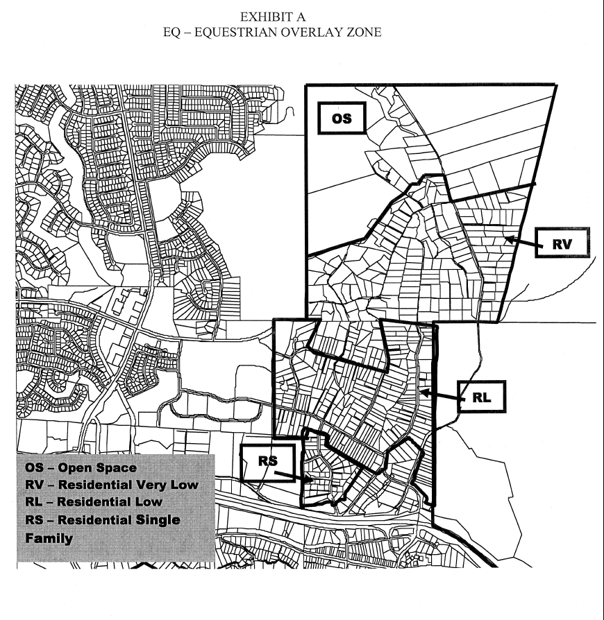
The purpose of the OA overlay district is to preserve the unique character of Old Agoura through the establishment of special public improvement standards and design guidelines, and in specific areas of the district, particular types of smaller-scale and community-serving commercial uses.
(Ord. No. 09-358, § 7, 1-18-2009; Ord. No. 11-388, § 51, 12-14-2011)
9552. - Permitted uses.
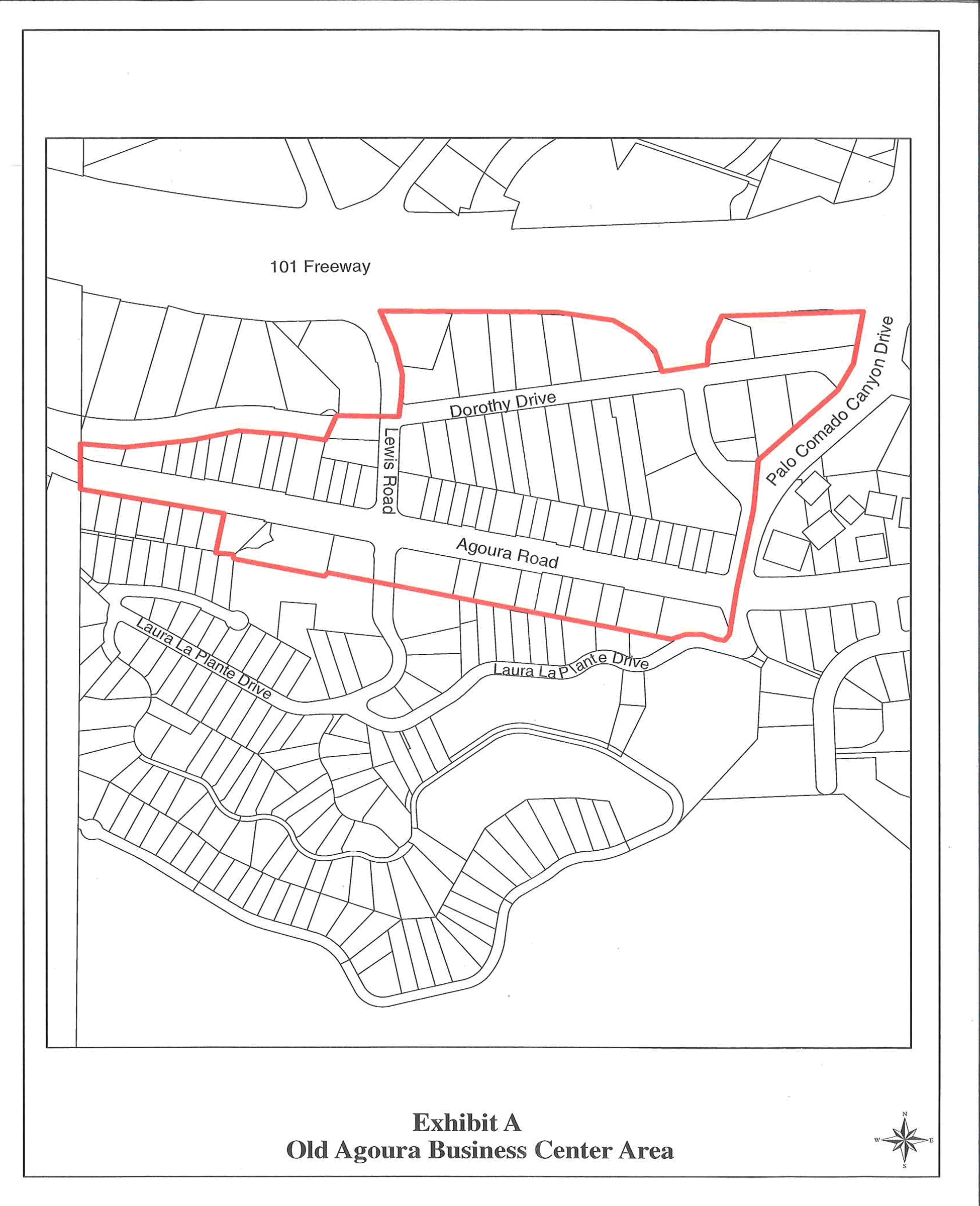
All uses permitted in the underlying district shall be permitted in this district, except subarea 11 of the general plan (Old Agoura Commercial Center Area), consisting of the area south of the Ventura Freeway, west of Chesebro Road, extending south to the parcels along Agoura Road, and just beyond Lewis Road to the west, which is identified in exhibit A of this section, shall be limited to the following uses. Where a specific use is not listed, the director of planning and community development has the discretion to allow it if it is found to be compatible with the intent of section 9551.
(Ord. No. 11-388, § 51, 12-14-2011)
9552.1. - Permitted uses within the buildable area of commercial lots.
1.
Advertising business office;
2.
Amusements/shooting ranges;
3.
Antique store;
4.
Appliance store;
5.
Appliance repair shop;
6.
Art gallery;
7.
Art studio;
8.
Auto service station, primary;
9.
Auto parts and accessory store;
10.
Bakery/pastry shop;
11.
Banks and financial institutions;
12.
Bar/tavern;
13.
Barber shop;
14.
Bicycle sale, rent, service;
15.
Butcher and meat market;
16.
Certified farmer's market;
17.
Candy store;
18.
Child care center;
19.
Church/temple;
20.
Citizens' improvement club/community center;
21.
Clinic, child-family guidance;
22.
Clinic, physical therapy;
23.
Clothing and apparel store;
24.
Coin operated amusement machine, incidental to a permitted use;
25.
Computer programming/software and system design;
26.
Computer sales, rental, lease and service, and training;
27.
Concession, temporary;
28.
Costume shop, sale and rent;
29.
Curio/novelty shop;
30.
Dancing as an incidental use in a bar or restaurant;
30.1
Daytime pet care and overnight boarding;
31.
Delicatessen;
32.
Dressmaker/tailor;
33.
Drugstore;
34.
Electronics store;
35.
Electronic, mechanical or video games, arcade;
36.
Eye glasses and frames and contact lens sales and service;
37.
Floor covering, drapery or upholstery store;
38.
Florist;
39.
Furniture store;
40.
Furniture cleaning, refinishing or reupholstery shop;
41.
Gardening-landscaping service yard and workshop;
42.
Gardening-landscaping supply store;
43.
Gift/card store;
44.
Grooming service, such as dog grooming;
45.
Gun shop/gunsmith;
46.
Hardware store;
47.
Hay, seed and grain store;
48.
Hearing aids sales and service;
49.
Interior decorators office;
50.
Janitor service;
51.
Jewelry store sales, repair;
52.
Laboratory, medical, dental or optical;
53.
Laboratory, research, analysis;
54.
Laboratory, materials testing;
55.
Lapidary shop;
56.
Laundry or cleaning agency, retail (on-site cleaning permitted);
57.
Live entertainment;
58.
Laundry or cleaning pick up station;
59.
Lawnmower engine and garden power tool repair;
60.
Library;
61.
Live theater;
62.
Locksmith, key and lock;
63.
Mail order business;
64.
Messenger service;
65.
Motion picture theater;
66.
Motion picture filming, temporary;
67.
Museum;
68.
Music store, music sales, instrument sales and repair;
69.
Newspaper, magazine stand;
70.
Nursery, plants;
71.
Office, business or professional;
72.
Office, insurance;
73.
Office, medical or dental;
74.
Office, public relations or advertising;
75.
Office, real estate;
76.
Office, accountants, bookkeepers;
77.
Office machines and equipment sales;
78.
Paint and wallpaper store;
79.
Pest control service;
80.
Pet store, no kennel;
81.
Photocopy service;
82.
Photographic supply/camera store;
83.
Photographic studio, including incidental processing;
84.
Picture framing shop;
85.
Prescription pharmacy;
86.
Remote teller, for pedestrian use;
87.
Restaurant/café;
88.
Retail store;
89.
Saddlery/equestrian shop;
90.
School: modeling, acting;
91.
Shoe repair shop;
92.
Shoe store;
93.
Snack shop: ice cream, coffee, juice;
94.
Sporting goods and athletic equipment store;
95.
Stamp/coin store;
96.
Stationery store;
97.
Studio: dance, yoga;
98.
Studio: martial arts, gymnastics;
99.
Studio: radio, television, recording;
100.
Swimming pool, spa sales and service;
101.
Tailor/dressmaker;
102.
Telephone answering service;
103.
Television and radio repair shop;
104.
Ticket agency;
105.
Tobacco shop;
106.
Toy store;
107.
Travel agency;
108.
Veterinarian/animal hospital;
109.
Watches, sale, repair;
110.
Wig sales and service;
111.
Winery and beer sales facility/tasting room, except as prohibited by section 9542.1(B).
(Ord. No. 11-388, § 51, 12-14-2011; Ord. No. 14-405, § 4, 2-26-2014; Ord. No. 14-412, § 4, 1-14-2015)
9552.2. - Conditional uses.
Any modification, alteration or change of the exterior of the following structures shall be subject to a conditional use permit:
"Amazing Kate's"
"Old Post Office"
"Stage Door Theatre"
"Agoura Sign"
9552.3. - Prohibited uses.
Any use or structure not specified in section 9552 and 9552.2 shall be prohibited.
9553. - Special development standards area.
Within the special area described in section 9552, the following standards shall apply;
(Ord. No. 09-358, § 7, 1-18-2009)
9553.1. - Building coverage.
The maximum building coverage shall be as approved as a part of any discretionary review. The maximum building coverage shall not exceed fifty (50) percent of the lot unless the proposed development consists of a commercial use encompassing more than one (1) lot.
(Ord. No. 09-358, § 7, 1-18-2009)
9553.2. - Building height.
With the exception of the provisions contained in section 9233.4, the maximum building height shall be thirty-five (35) feet, or two (2) stories, whichever is less.
(Ord. No. 09-358, § 7, 1-18-2009)
9553.3. - Yards.
With the exception of the provisions contained in section 9233.2., required yards shall be as approved as a part of any discretionary review and may not be required at all.
(Ord. No. 09-358, § 7, 1-18-2009)
9553.4. - Off-street parking and loading requirements.
Off-street parking and loading shall be provided as required by chapter 6, but if approved as a part of any discretionary review, may be located off the subject lot. Joint use provisions for off-street parking and loading shall be utilized wherever feasible.
(Ord. No. 09-358, § 7, 1-18-2009)
9553.5. - Signs.
All signs shall be consistent with the provisions in chapter 6, and shall conform to the following criteria:
A.
Monument and/or directory signs are permitted for parcels with businesses whose signs are not visible from the street with a sign permit subject to design review. All other monument signs are permitted subject to a sign program. Monument signs may only be externally illuminated.
B.
No sign shall be internally illuminated, however; halo illuminated wall signs are permitted, subject to design review.
C.
Signs shall be made of materials such as wood, stone or materials that mimic wood or stone or non-reflective or patinated metals that enhance the rural appearance of the neighborhood. Other sign materials may be considered as part of a sign program.
D.
Signs located in the geographic area shown on the following exhibit shall be turned off at close of business or 9:30 p.m., whichever occurs later. In addition, this provision shall apply to signs oriented towards Dorothy Road on parcels located on the north side of Dorothy Road between Lewis Road and Palo Comado Canyon Road.

(Ord. No. 09-358, § 7, 1-28-2009)
9553.6. - Required architectural style and building materials.
Project design and development shall perpetuate and reinforce the natural character of Old Agoura.
(Ord. No. 09-358, § 7, 1-18-2009)
9553.7. - Required landscaping and walls.
Required landscaping and walls shall be limited to the amount necessary to provide for adequate open space and security. With regard to landscaping, the emphasis shall be to provide appropriate pedestrian areas to encourage retail trade, but in no event shall less than fifteen (15) percent be provided.
(Ord. No. 09-358, § 7, 1-18-2009)
9554. - Commercial and residential development standards.
These standards are designed to promote a natural environment that is country like while allowing architecturally sensitive developments which perpetuate Old Agoura's unique rural character. In addition to all development standards provided for in the underlying district, the following shall be applicable in the OA Overlay District.
(Ord. No. 211, § 5, 5-27-92; Ord. No. 09-358, § 7, 1-18-2009)
9555. - General design standards, commercial/residential.
While encouraging the broadest possible range of individual and creative design, the planning commission or the director, where authorized, may grant site plan approval if the proposed development substantially conforms to all of the following standards:
A.
Commercial.
1.
Proposed signage is an integral architectural feature which does not overwhelm or dominate the structure or object to which it is attached.
2.
Mechanical equipment, storage and trash areas, and utilities are architecturally screened from public view.
3.
The proposed plans provide for adequate and safe on-site vehicular and pedestrian circulation.
4.
The main entrance to any commercial or business building provides for independent access for the physically impaired.
5.
All fences and walls shall be finished on both sides.
6.
No outdoor display or storage shall be permitted except for nurseries.
B.
Residential.
1.
Six-foot-high fences shall be permitted in any required front or street side yard when it can be demonstrated that it will be sufficiently open to preserve adequate visibility of vehicles entering and leaving said property. Solid walls are prohibited in the front yard setback areas.
2.
Residential development in Old Agoura shall embrace an eclectic, rural style that preserves the equestrian nature of the area and shall be consistent with the Old Agoura Design Guidelines found in the City's Architectural Design Standards and Guidelines and the Equestrian Overlay.
3.
Residential development shall not render property untenable for horses and other farm animals.
C.
Commercial/residential.
1.
The proposed design is in character with existing development in the Old Agoura District, in terms of height, materials, colors, roof pitch, roof eaves, and the preservation of privacy.
2.
The proposed plans indicate proper consideration for the relationship between the existing and finished grades of the site to be improved and adjacent properties.
3.
Lighting is stationary and is deflected away from adjacent properties.
4.
All building elevations have been architecturally treated in a compatible manner including the incorporation within the side and rear building elevations of some or all of the design elements used for the primary facades.
5.
Fences or walls constructed of grape stake, plywood, sheet metal, corrugated aluminum, corrugated fiberglass, barbed wire, rubber, PVC (excluding plastic corrals designed for equestrian use), or razor ribbon are prohibited, except where allowed by a temporary use permit for an approved construction project. Rural ranching and farm materials designed consistent with the architecture of the house will be considered as part of a site plan review.
Exterior materials and colors shall harmonize with, and complement the surrounding natural and man-made environment. Where appropriate, dominant exterior colors shall reflect a natural earthtone theme using warm and rich colors. Exterior treatments characterized by an overly bright, shiny, reflective or artificial appearance shall not be permitted.
6.
To the greatest extent possible, the architectural design and location of the building shall discourage grading on a hillside. If grading is required, building shall be integrated into existing terrain such that grading is minimized, taking care to preserve the viewshed, natural ridgelines, and oak trees.
7.
Native, drought resistant plants are recommended for project landscaping. Such plants are required and shall be used extensively on manufactured slopes. Refer to the City of Agoura Hills Plant Guide for lists of appropriate vegetation.
(Ord. No. 211, § 6, 5-27-92; Ord. No. 09-358, § 7, 1-18-2009)
9561.- Purpose.
The purpose of the IH overlay district is to address the natural and development problems of the Indian Hills area by establishing special public improvement standards and development guidelines.
9562. - Permitted uses.
All uses permitted in the underlying district shall be permitted in this district, except as otherwise provided by the following provisions of this section.
9562.1. - Conditional use.
The following uses shall be permitted in the IH overlay district subject to the issuance of a conditional use permit by the planning commission:
A.
Any modification, alteration or exterior change to the Indian statue.
9562.2. - Density limitation.
For all property subject to the provisions of section 9652, the density and development requirements of section 9652.3 A and B shall be applicable.
9562.3. - Off-site improvements.
No property shall be developed without fully improved public street access and full underground utility improvements within the public street right-of-way including, but not limited to, power, water, gas, sewer and storm drain improvements.
9562.4. - Architectural treatment.
In this overlay district any discretionary review shall include the review of the architectural treatment of all buildings, and structures as to:
A.
Compatibility of materials and colors;
B.
Conformance to existing terrain;
C.
Appearance from adjacent street, distant arterials, and the Ventura Freeway.
9562.5. - Private sewer system prohibition.
No property shall be developed with a private sewer system. All systems shall be hooked up to the public sewer system.
9571.- Purpose.
The purpose of the CD overlay district shall be to provide the clustering of development, creative and imaginative design and the development of parcels of land as coordinated projects involving a mixture of residential densities and housing types and open space. The CD overlay district is further intended to provide for the optimum integration of suburban and natural amenities within developments, through the use of clustering of dwelling units and provision of minimum standards in terms of open space amenities. The CD overlay district is established to give the land developer assurance that innovative and unique land development techniques will be given reasonable consideration for approval and to provide the city with assurance that the completed project will adhere to the character of the approved project.
9572. - Applicability.
The CD overlay district may be applied in place of the density designation for the following districts:
A.
Single-family residential RS;
B.
Medium density residential RM;
C.
High density residential RH.
(Ord. No. 11-388, § 52, 12-14-2011)
9573. - Permitted uses.
All the uses permitted in the underlying district shall be permitted in the CD overlay zone. In addition the following shall be permitted uses in the CD overlay district:
A.
Cluster development; townhouses;
B.
Condominiums, both air space and statutory;
C.
Mobile home parks;
D.
Multifamily dwellings;
E.
Residential real estate developments, as defined in the Business and Professional Code;
F.
Single-family dwellings on lots smaller than permitted by the underlying district, as district, as specified under section 9577.5.
9574. - Density limitation.
Whenever the CD overlay district is applied to property, the minimum density limit of the land use element of the general plan shall automatically apply. For example, RS-CD shall mean two (2) dwelling units per acre. As a part of any discretionary review, the minimum density range may be increased to the maximum of the range of the land use element of the general plan through the following series of steps if the indicated increased amenities are offered as a part of any required application and detailed development plans are approved.
9574.1. - Step one increase.
Except as modified by the appropriate authority, to increase the minimum density as specified in the land use element of the general plan by one-third, the following additional amenities shall be provided:
A.
Five (5) times the Quimby Act fee or land dedication requirement, as specified in the city's subdivision regulations, and a contribution covering the cost of development of one-third of a designated city park, or the commission may authorize the utilization of said amount for one (1) of the options specified in section 9574.35.
B.
Active solar and other energy conservation facilities, in excess of the Building Code requirements, in the individual units;
C.
Swimming pools and recreation facilities;
D.
Upgraded paving materials;
E.
Entry features;
F.
At least fifty (50) percent of all trees provided to be specimen plant materials at least twenty-four-inch box in size;
G.
A one-third increase in the required contribution to the city transportation improvement fund, or the commission may authorize the utilization of said amount for one (1) of the options specified in section 9574.35.
9574.2. - Step two increase.
Except as modified by the appropriate authority, to increase the minimum density range as specified in the land use element of the general plan by two-thirds, the following additional amenities shall be provided:
A.
Ten (10) times the Quimby Act fee or land dedication requirement as specified in the city subdivision regulations, and a contribution covering the cost of development of two-thirds of a city park, or the commission may authorize the utilization of said amount for one (1) of the specified options in section 9574.35;
B.
Active solar and other energy conservation facilities, in excess of the Building Code requirements, in the individual units;
C.
Swimming pools and recreation facilities;
D.
Upgraded paving materials;
E.
Entry features;
F.
At least seventy-five (75) percent of all trees provided to be specimen plant materials at least twenty-four-inch box in size;
G.
A two-thirds increase in the required contribution to the city transportation improvement fund, or the commission may authorize the utilization of said amount for one (1) of the options specified in section 9574.35;
H.
Children's play areas of sufficient size to meet the needs of the ultimate number of children expected to reside in the development.
9574.3. - Step three increase.
Except as modified by the appropriate authority, to increase the minimum density, as specified in the land use element of the city's general plan to the maximum, the following amenities shall be provided:
A.
Twenty (20) times the Quimby Act fee or land dedication requirement, as specified in the city's subdivision regulations, a contribution covering the total cost of the development of a city park, or the commission may authorize the utilization of said amount for one (1) of the options specified in section 9574.35;
B.
Active solar and other energy conservation facilities, in excess of the Building Code requirements, in the individual units;
C.
Swimming pools and recreation facilities;
D.
Upgraded paving materials;
E.
Entry features;
F.
All of the trees provided to be specimen plant materials at least twenty-four-inch box in size;
G.
A one hundred (100) percent increase in the required contribution to the city's transportation improvement fund, or the commission may authorize the utilization of said amount for one of the options specified in section 9574.35;
H.
Children's play areas of sufficient size to meet the needs of the ultimate number of children expected to reside in the development.
9574.35. - Permissible options.
In lieu of either subsections A or G in section 9574.1 through 9574.3, the applicant may request and the commission may approve the utilization of the required funds for any one of the following:
A.
A contribution covering the cost of one-third, two-thirds, one hundred (100) percent the cost of the acquisition and the removal of a billboard.
B.
Provision of an increase in the required contribution to the school district by one-third, two-thirds, one hundred (100) percent.
C.
A contribution covering the cost of one-third, two-thirds, one hundred (100) percent the cost of a major element of a community center.
D.
A contribution covering the cost of one-third, two-thirds, one (1) mile of undergrounding of a major transmission line.
E.
A contribution covering the cost of one-third, two thirds, one (1) mile of landscaping of the Ventura Freeway, as approved by the city and Caltrans.
F.
Utilization of density transfer units as a part of the development.
9574.4. - Exclusion.
The provisions of sections 9574 through 9574.3 shall not apply to developments that are exclusively developed for housing for senior citizens.
9575. - Supplemental submittal requirement.
In addition to the submittal requirements of any discretionary application, the following shall be submitted for projects in the CD overlay district:
A.
Written documents.
1.
Legal description of the total site proposed for development, including a statement of present and proposed ownership;
2.
A statement of planning objectives to be achieved by the project through the particular approach proposed by the applicant. This statement shall include a description of the character of the proposed development and the rationale behind the assumptions and choices made by the applicant;
3.
Specific request as to any request for density increase pursuant to section 9574, including an agreement to provide the required amenities;
4.
A preliminary development schedule indicating the proposed phasing program and the approximate date when construction of the project or the stages of the project can be expected to begin and be completed;
5.
A statement of the applicant's intentions with regard to the future selling or leasing of all or portions of the project;
6.
Quantitative data for the following; total number and type of dwelling units; parcel size; proposed lot coverage of buildings and structures; approximate gross and net residential densities; total amount of open space including the precise amount of usage open space; total amount of nonresidential construction including justifications of ancillary character of the construction; written indication of compliance or noncompliance to established standards of this chapter; economic feasibility studies and other studies as required by the city.
B.
Site plan and supporting maps.
1.
The existing site conditions including contours at two-foot intervals, water-course, floodplains, unique natural features and any forest cover;
2.
Proposed lot lines and plot designs;
3.
The location and floor size of all existing and proposed buildings, structures and other improvements including maximum heights, types of dwelling units, density per type and nonresidential structures including preliminary architectural renderings of typical structures;
4.
The location and size in acres or square feet of all to be conveyed, dedicated, or reserved as common open spaces, public parks, recreational areas, schools sites, and similar public and semi-public uses;
5.
The existing and proposed circulation system of arterial, collector, and local streets including off-street parking areas, service areas, loading areas, and major points of access to public rights-of-way. Notations of proposed ownership, public or private;
6.
The existing and proposed circulation system, including its interrelationships with the vehicular circulation system;
7.
The existing and proposed utility systems;
8.
A general landscape plan indicating the treatment of materials for private and common open areas;
9.
Preliminary grading plan;
10.
Information on lands adjacent to the project to indicate the relationships between the proposed development and adjacent areas;
11.
The proposed treatment of the perimeter of the project including materials and techniques used such as mounding, screens, fences and walls;
12.
Photographs of all adjacent parcels;
13.
Any additional information as required by the city necessary to evaluate the character and impact of the proposed development.
C.
The information required by this section shall be submitted for all of the land intended to be included in the application. Where projects are developed in stages, the detail information shall be submitted for those stages to be developed immediately. Sketch plans including the bare essentials, land uses, densities, site design, adjacent uses, circulation, shall be submitted for the remaining lands to be developed in future stages of the project. Subsequent phases shall be evaluated in terms of these plans. If substantial deviation exists, the applicant shall file all the information as required in this section for the subsequent phases as amended development plan or a new development plan as appropriate.
9575.1. - Amendments to development plan.
Subject to the provisions of this title, minor changes in the location, siting, and height of buildings and structures may be authorized by the planning commission, if required by engineering or other circumstances not foreseen at the time the development plan was approved. No change authorized by this section may cause any of the following:
A.
A change in the use of character of the development;
B.
An increase in greater than ten (10) percent in overall coverage of structures;
C.
An increase in the intensity of use;
D.
An increase in the problems of traffic circulation and public utilities;
E.
A reduction of more than ten (10) percent of the area shown as open space;
F.
A reduction of more than ten (10) percent of the approved off-street parking;
G.
A reduction in required pavement width.
9575.2. - Final review of project.
Within one (1) year following the final approval of the development plan, the applicant shall file for the final review of the project by filing the information required in chapter 6. The review process, in addition to its regular findings, shall determine whether the precise construction plans and precise landscape plans are in substantial compliance with the development plan, provided that any modification by the applicant does not involve a change of one (1) or more of the following:
A.
Violate any provision of this article;
B.
Vary the lot area requirements by more than ten (10) percent;
C.
Involve a reduction of more than ten (10) percent of the area reserved for the common open space and/or usable open space;
D.
Increase or decrease the floor area proposed by more than ten (10) percent;
E.
Increase the total ground area covered by buildings more than five (5) percent;
F.
An increase in the number of dwelling units.
If it is determined that the plans are not in substantial compliance, an amendment and/or a new development plan shall be filed and processed, as appropriate.
9576. - Development standards applicable.
All areas on the development plan shall be subject to the following: The standards for development in CD overlay district set forth in this chapter and any supplemental standards for the planned community designated in the development plan. In addition, the development standards of the underlying district, if more restrictive, shall apply.
9576.1. - Trash handling.
Trash handling facilities shall be provided for all developments with the CD overlay district with the exception of single-family detached dwellings. A trash enclosure will be provided for all but excepted uses, unless the proposed location of the trash area is completely enclosed by walls or buildings. The freestanding trash enclosure shall be constructed of masonry block. No trash shall be allowed to extend above or beyond the enclosure.
9577. - Special standards.
In addition to requiring all development plans to comply to the following special standards of section 9577 through 9579, the city council and/or planning commission may impose such other conditions to the development plan as it deems necessary to desirable in carrying out the general purpose and intent of this chapter.
9577.1. - Minimum common open space.
A.
At least fifty (50) percent of all required common open space shall be approximately level, defined as not more than thirteen and one-half (13½) percent grade.
B.
The common open space shall be land within the total development site used for recreational purposes including buildings, used for recreation purposes, parks or environmental purposes for enjoyment by occupants of the development and their guests, or land dedicated to the city for public parks.
C.
Common open space shall not include public or private streets, driveways, private yards, private patios, and parking areas.
9577.3. - Required width of private roads.
With no parking, the private roads shall be thirty (30) feet wide; with parking on one (1) side, thirty-four (34) feet wide; and with parking on two (2) sides, forty (40) feet wide. The roadways shall be a minimum of asphaltic concrete with concrete curbs and gutters as approved by the director of community development. Standards of design and construction of roadways, both public and private, within the project may be modified as is deemed appropriate by the city, especially where it is found that the development plan provides for the separation of vehicular and pedestrian circulation patterns and provides for adequate off-street parking facilities.
9577.4. - Exceptions.
The standards of sections 9577 through 9577.3 shall be required unless modified by the development plan.
9577.5. - Building setbacks from the planned street line.
The minimum setback in all residential developments within the CD district shall be the designated distances from the ultimate right-of-way line of the streets specified in this title unless otherwise provided in this section:
A.
Freeway: Fifty (50) feet;
B.
Arterial: Thirty-two (32) feet;
C.
Secondary: Thirty-two (32) feet;
D.
Collector: Twenty (20) feet;
E.
Local: Twenty (20) feet.
9580.- Purpose.
The purpose of the MXD overlay district is to provide for a limited number of multi-family dwellings allowed conditionally to support the other land uses as part of a mixed-use project.
(Ord. No. 14-409, § 11, 8-13-2014)
9581. - Permitted uses.
All uses permitted in the underlying district shall be permitted in this district, except as otherwise provided by the following provisions of this section.
(Ord. No. 14-409, § 11, 8-13-2014)
9582. - Conditionally permitted uses.
Multi-family residential dwellings may be permitted subject to a conditional use permit. Such residential uses shall be part of a residential mixed-use development with commercial uses. Residential uses shall be permitted provided that resident-serving recreation and other amenities are incorporated into the development; the residential and surrounding non-residential uses are compatible; and the residential and non-residential portions of the development are integrated by architectural design, pedestrian walkways, and landscaping.
(Ord. No. 14-409, § 11, 8-13-2014)
9583. - Development standards.
The development standards of the underlying district shall apply. In addition, the following standards shall apply to residential mixed-use developments:
A.
At least fifty (50) percent of the first floor linear frontage on a roadway shall consist of non-residential uses.
B.
The minimum interior depth of the non-residential spaces in a residential mixed-use development shall be thirty (30) feet.
(Ord. No. 14-409, § 11, 8-13-2014)
9584. - Residential density.
Residential units shall be multi-family with a density of between fifteen (15) and twenty-five (25) dwelling units per acre (15—25 du/acre).
(Ord. No. 14-409, § 11, 8-13-2014)
9585. - Required findings for a residential mixed-use development conditional use permit.
No conditional use permit for a new residential mixed-use development shall be approved unless the findings in section 9673.2 and all of the following findings are made:
A.
Residential uses are part of a balanced, well-unified mixed-use development, with the residential and non-residential uses integrated with each other and the remainder of the site through architectural and design elements.
B.
Resident-serving recreation and other amenities are incorporated into the development.
C.
Residential and non-residential uses are compatible.
D.
Residential and non-residential portions of the development are integrated by architectural design, pedestrian walkways, and landscaping.
E.
All other provisions of this zoning district can be satisfied.
(Ord. No. 14-409, § 11, 8-13-2014)
9586. - Residential design requirements.
Multi-family housing shall be part of a residential mixed-use development on the same lot, or the residential and non-residential components may be proposed on separate but adjacent lots as part of a unified project. Residential and non-residential uses in a mixed-use project shall be implemented in the same phase. Multi-family housing shall comply with the regulatory provisions of chapter 6, and include the following minimum design requirements:
A.
All parking and loading shall comply with the provisions of section 9654 et seq., and include on-site designated residential parking, which shall be separate from the on-site non-residential use parking;
B.
Recreational and other residential-serving amenities provided, including useable outdoor developed open space for the residents pursuant to section 9273.7;
C.
Residential mixed-use buildings shall be designed to assure compatibility among uses, which shall include separate access, fire suppression barriers, separate resident parking, and noise insulation; and
D.
Utilities and signs shall be in compliance with chapter 6.
(Ord. No. 14-409, § 11, 8-13-2014)
9590.- Purpose.
The purpose of the EQ - Equestrian Overlay District is to create, enhance, and protect the equestrian and rural atmosphere within the overlay area.
(Ord. No. 09-358, § 8, 1-18-2009)
9591. - Permitted uses.
All uses permitted and conditionally permitted in the underlying district shall be permitted in this district.
(Ord. No. 09-358, § 8, 1-18-2009)
9592. - Development standards.
In addition to the development standards governing development in the underlying district, the following development standards shall apply:
A.
Minimum horse keeping area. A minimum horse keeping area for the stabling and servicing of horses consisting of one thousand five hundred (1,500) square feet of useable area shall be designated as part of a conditional use permit or site plan review for development of a house on a residential lot within the "EQ" Overlay District. A site plan identifying the location, dimensions, and slope of the one thousand five hundred (1,500) square foot area shall be provided to the city and retained in the city's files. At the discretion of the planning commission, the minimum horse keeping area shall be optional for lots under ten thousand eight hundred ninety (10,890) square feet (¼ acre) or lots with an average slope over twenty-five (25) percent.
B.
Useable area for horse keeping. Useable area for horse keeping areas shall be defined as an area with an average slope no greater than ten (10) percent. Proposed development projects shall demonstrate that the horse keeping area is able to viably site, at a minimum, the following horse facilities:
1.
Stall: Twelve (12) feet by twelve (12) feet or a minimum one hundred forty-four (144) square feet per horse with a minimum ten- foot interior clearance.
2.
Paddock (corral): A twenty-four (24) feet x forty-eight (48) feet (one thousand one hundred fifty-two (1,152) square feet) paddock area with length for running should be provided. Paddocks refer to pens, exercise areas, or pasture often adjacent to horse stalls.
3.
Access for feed delivery, manure management and veterinary access.
4.
A minimum area of one hundred fifty (150) square feet for hay and tack storage.
If it cannot be demonstrated that these facilities can be practically accommodated within one thousand five hundred (1,500) square feet, the planning commission may require additional square footage be dedicated to the horse keeping area.
C.
Uses permitted in horse keeping area. The dedicated horse keeping area, if not actually supporting horses, may be developed to the extent that any activity (such as landscaping) or structures may be easily removed without any loss of value to the entire property. Site improvements consisting of landscaping and irrigation; detached trellises, patio covers or gazebos; above-grade/portable spas; barbeques and fire pits; temporary (as defined by the building code) non-habitable accessory structures that are no more than one hundred twenty (120) square feet in size and private sewage disposal systems shall be permitted within the one thousand five hundred-square-foot area. Orchards, vineyards and specimen trees are not considered landscaping for the purposes of this section and would be prohibited within the horse keeping area. Any improvements in the horse keeping area shall have a permeable foundation.
D.
Setbacks for horse facilities. Barns and other similar roofed structures for stabling or servicing horses shall be permitted to encroach up to thirty (30) percent into the required front yard setback of the underlying district.
E.
Equestrian trails. All lots adjacent to a proposed equestrian trail shall provide public equestrian trails in accordance with city plans and policies.
(Ord. No. 09-358, § 8, 1-18-2009)