
Ardencroft City Zoning Code
ARTICLE 4
- DISTRICT INTENSITY AND BULK STANDARDS
Division 40.04.000.- Purpose.
The purpose of Article 4 is to establish the basic intensity, bulk performance, bufferyard, and landscaping standards for each zoning district. Site specific standards shall require each development to conduct a carrying capacity analysis. This analysis regulates the maximum intensity based on actual site conditions (see Article 5).
(Ord. No. 97-172, § 3(ch. 13, div. 04.000), 12-31-1997)
Division 40.04.100. - District performance standards.
District performance standards are the minimum requirements for each use and shall apply to all districts. Where other more specific standards in this Chapter are applicable to specific uses, those standards shall be applicable and shall override any general standards.
(Ord. No. 97-172, § 3(ch. 13, div. 04.100), 12-31-1997; Ord. No. 98-080, § 1(ch. 13, div. 04.100), 9-22-1998)
Sec. 40.04.110. - District and bulk standards.
This Section contains the basic district standards applicable to all uses. Table 40.04.110 contains intensity, lot, bulk and exterior storage standards. These standards may be modified by the Department pursuant to Article 18 and Article 26.
A.
Minimum open space ratio. For residential subdivisions of five (5) lots or less open space shall not be required. Protected resource land shall be preserved by conservation easements. For major land development plans, all protected resources shall be in open space and none shall be permitted on any residential lots.
B.
Site area. Site area is the area required for any new uses recognized by this Chapter to be permitted in the zoning district. The number identified is the minimum site area unless otherwise specified.
No land shall be rezoned unless the proposed zoning district meets minimum site area requirements. In determining minimum site area requirements for rezoning applications, contiguous parcels of the same zoning shall be considered in the calculation.
C.
Maximum building height. If there are single-family detached or single-family attached dwellings within one hundred (100) feet of a property line of the parcel to be developed with a building over fifty (50) feet, the required front, street, side or rear yards adjacent to those dwellings shall be at a minimum equal to the height of the proposed building.
D.
Minimum lot area. The minimum lot area requirement must be met exclusive of protected resources, and for lots less than one (1) acre, exclusive of required bufferyards.
E.
Exceptions.
1.
Projections into required yards. The following exceptions are permitted for residential dwellings:
a.
Bay windows, oriels or balconies may project not more than three (3) feet into any required yard.
b.
Chimneys, cornices and eaves may project not more than two (2) feet into any required yard.
c.
Sills, leaders, belt courses and similar ornamental or structural features may project not more than six (6) inches into any required yard.
d.
An open fire balcony, a fire escape or a fire tower may project not more than four (4) feet into a required side yard or rear yard.
e.
An uncovered patio at ground level or uncovered driveway (except for shared driveways) may project into any yard, provided it is set back from any lot line a minimum of two (2) feet.
f.
An uncovered porch or deck or any part thereof elevated above ground level may project half the distance of the minimum required yard but no more than fifteen (15) feet. Stairs leading from the deck, with a landing area not greater than fifty (50) square feet, may project an additional two (2) feet.
g.
Covered entrance ways, stairs, and enclosures providing entry directly to a dwelling and including a landing of not more than fifty (50) square feet may project one-half (½) the distance of the minimum required yard but not more than twelve (12) feet.
h.
Uncovered handicapped access structures may project to within three (3) feet of any property line or to within zero (0) feet of any property line if the ground level landing is parallel to the property line. The owner shall be required to provide proof of need and the handicapped access structure shall be removed no later than six (6) months after the need no longer exists.
2.
Exception along a navigable waterway or railroad right-of-way. Where the rear or side of a lot adjoins a navigable waterway or railroad right-of-way in an OR, BP, I, HI District, no rear or side yard shall be required.
3.
Height exceptions. Height limits in this Article shall not apply to the following or similar structures: spires on churches, cupolas, belfries, chimneys, smokestacks, flag poles, water tanks or towers, fire towers, observation towers, lighthouses, transmission towers, windmills, silos, antennae (including amateur radio antennae), manufacturing or mechanical equipment and its necessary supports including but not limited to HVAC equipment, or elevator enclosures.
4.
Side entry garages and side yard setback. Where a side entry garage is proposed as part of a residential dwelling, the minimum required side yard setback for only the garage portion of the dwelling shall be thirty (30) feet.
5.
Former code alternative development options. Lot size, lot width, front yard setback, side yard setback and rear yard setbacks for all existing lots created by former code subdivision and land development plans recorded under any of the former code alternative development options shall continue to be regulated using the former code alternative development option regulations.
6.
Developments recorded pursuant to former R-2 zoning standards. Residential land development plans recorded pursuant to former R-2 zoning bulk and area standards and currently zoned NC40 or NC2a shall comply with the NC21 side, rear and street yard setbacks standards for building construction.
7.
Lot width/street frontage exceptions. The Department may authorize the reduction or elimination of the minimum lot width/street frontage requirements in order to achieve conservation design objectives when the applicant demonstrates that such requirements could be met but the modified design helps reduce impervious cover and surface water runoff and/or provides additional natural resource protection.
F.
Street yard build-to line in ON, CN, ST and CR zoning districts. If required by the Department, the minimum street yard setback shall be established as a build-to line for the principal structure(s) on the lot. The build-to line may be less than the required minimum street yard setback. The Department shall consider the following criteria when determining the location of the build-to line:
1.
Existing buildings and structures with similarly proximate setbacks are located on the same street; particularly, institutional, public assembly or similar uses are nearby or may be accessed by pedestrians.
2.
Standards for building design, site design and amenities follow the Guiding Principles in Appendix 7 and existing or proposed pedestrian facilities or transit stops or on-street parking are nearby on adjacent streets.
3.
The proposed development is in or near existing neighborhoods or development(s) that exhibit pedestrian-scale streetscapes.
4.
The proposed development utilizes concurrent modification of street bufferyard opacity standards pursuant to Article 23.
5.
The proposed development is identified in any area or corridor master plan for land use or transportation.
G.
Residential dwelling density. Unless otherwise specifically permitted, in every single-family residential zoning district, only one (1) single-family dwelling per lot is permitted.
H.
Visibility at corners. On any corner lot there shall be no building, structure, shrubbery or planting such as will obstruct street traffic visibility within the triangular area formed by the intersection of any two (2) street lines and a line joining the respective points on each of these lines distant twenty-five (25) feet from their point of intersection.
I.
Development along a designated byway. For nonresidential buildings within six hundred sixty (660) feet of the right-of-way of a designated byway, the maximum building height is limited to forty-five (45) feet.
(Ord. No. 97-172, § 3(ch. 13, § 04.110), 12-31-1997; Ord. No. 98-062, § 1(ch. 13, § 04.110), 9-22-1998; Ord. No. 98-080, § 1(ch. 13, § 04.110), 9-22-1998; Ord. No. 99-075, § 1, 12-14-1999; Ord. No. 00-011, § 1, 6-13-2000; Ord. No. 00-083, § 1, 9-26-2000; Ord. No. 01-008, § 1, 4-24-2001; Ord. No. 01-112, § 1(Exh. A), 3-12-2002; Ord. No. 02-075, § 1(Exh. A), 10-22-2002; Ord. No. 03-045, § 1(Exh. A), 7-8-2003; Ord. No. 04-059, § 1(Exh. A), 7-13-2004; Ord. No. 06-060, § 1(Exh. A), 9-26-2006; Ord. No. 08-096, § 4, 11-25-2008; Ord. No. 09-037, § 1, 10-13-2009; Ord. No. 09-068, § 1(Exh. A), 11-10-2009; Ord. No. 10-113, § 1(Exh. A), 1-18-2011; Ord. No. 14-126, § 1, 1-13-2015; Ord. No. 16-066, § 3, 1-10-2017; Ord. No. 18-021, § 9, 7-10-2018; Ord. No. 21-065, § 5, 8-31-2021; Ord. No. 22-072, § 3, 10-11-2022; Ord. No. 24-087, § 3, 9-24-2024; Ord. No. 24-137, § 2, 12-10-2024; Ord. No. 24-130, § 5, 3-25-2025)
Sec. 40.04.111. - Landscape and illumination standards.
Bufferyard, landscaping standards and lighting standards are provided in Table 40.04.111.
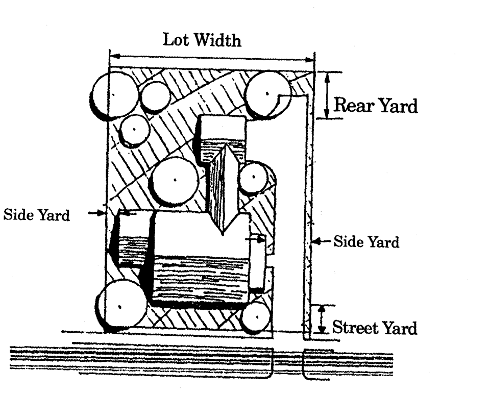
Figure 40.04.111
HOUSING TYPES AND LOT CONFIGURATIONS
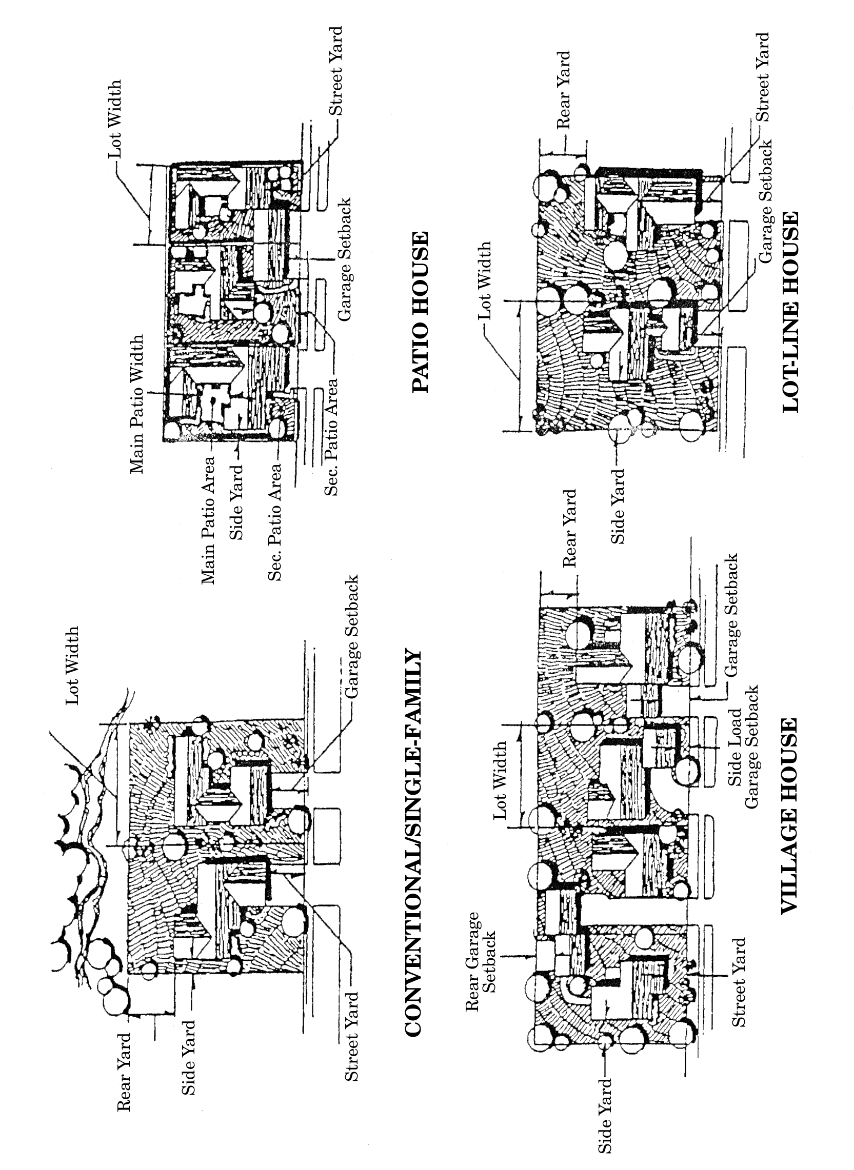
Figure 40.04.111
HOUSING TYPES AND LOT CONFIGURATIONS (Continued)
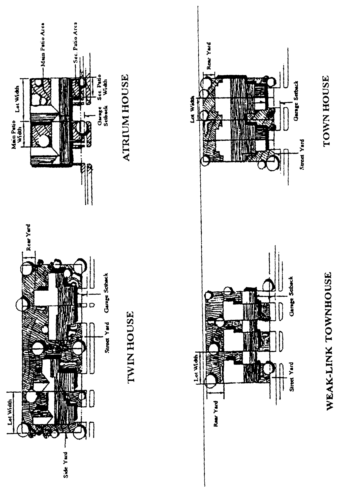
Figure 40.04.111
HOUSING TYPES AND LOT CONFIGURATIONS (Continued)
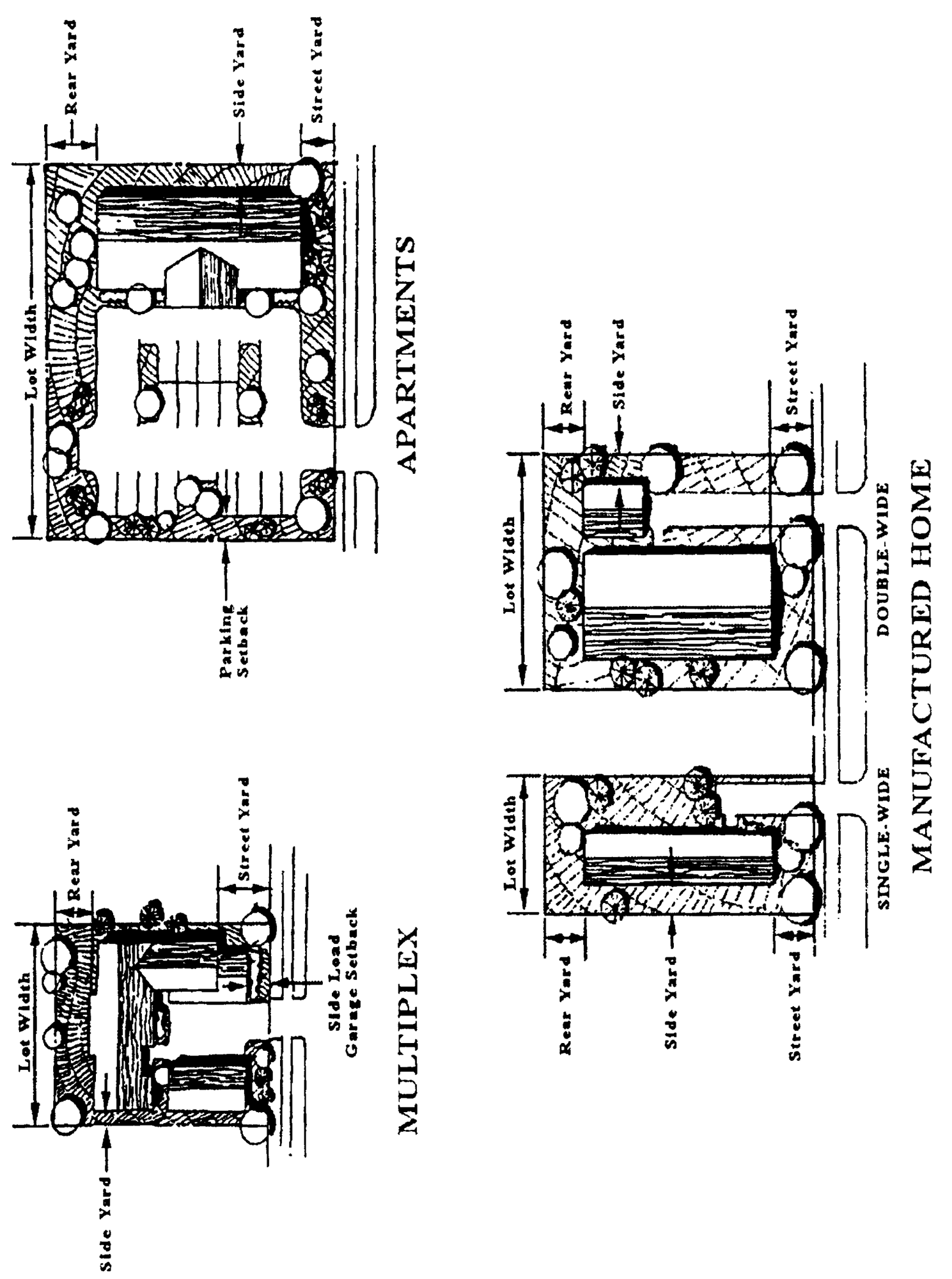
Figure 40.04.111
HOUSING TYPES AND LOT
CONFIGURATIONS
(Continued)
(Ord. No. 97-172, § 3(ch. 13, § 04.111), 12-31-1997; Ord. No. 98-080, § 1(ch. 13, § 04.111), 9-22-1998; Ord. No. 99-075, § 1, 12-14-1999; Ord. No. 99-084, § 3, 4-11-2000; Ord. No. 01-112, § 1(Exh. A), 3-12-2002; Ord. No. 03-045, § 1(Exh. A), 7-8-2003; Ord. No. 18-021, § 10, 7-10-2018; Ord. No. 21-065, § 6, 8-31-2021; Ord. No. 24-137, § 2, 12-10-2024; Ord. No. 24-130, § 6, 3-25-2025)
Sec. 40.04.112. - Lot standards for other housing types.
Housing types used in open space planned developments and for attached or multi-family housing is contained in Table 40.04.112. Housing types and lot configurations are illustrated in Figure 40.04.111.
Table 40.04.112 LOT STANDARDS FOR ATTACHED, POCKET NEIGHBORHOOD, AND OPEN SPACE PLANNED HOUSING TYPES
(Ord. No. 97-172, § 3(ch. 13, § 04.112), 12-31-1997; Ord. No. 98-080, § 1(ch. 13, § 04.112), 9-22-1998; Ord. No. 99-075, § 1, 12-14-2000; Ord. No. 01-112, § 1(Exh. A), 3-12-2002; Ord. No. 02-075, § 1(Exh. A), 10-22-2002; Ord. No. 09-037, § 1, 10-13-2009; Ord. No. 09-068, § 1(Exh. A), 11-10-2009; Ord. No. 24-137, § 2, 12-10-2024)
Sec. 40.04.120. - Reserved.
(Ord. No. 97-172, § 3(ch. 13, § 04.120), 12-31-1997; Ord. No. 04-059, § 1(Exh. A), 7-13-2004; Ord. No. 06-060, § 1(Exh. A), 9-26-2006)
Sec. 40.04.121. - Townhouses.
The townhouse lot area and width standards in Table 40.04.112 are averages. The minimum width shall be eighteen (18) feet with a corresponding area one hundred (100) times the width (i.e., one thousand eight hundred (1,800) square feet for the eighteen (18) foot wide lot). Nothing shall prohibit the developer from selecting the lot area and then calculating the width with a different proportion between lot and depth. (The standards are based on one hundred (100) foot deep lots, thus a two thousand (2,000) square foot lot with a twenty-two (22) foot width would be ninety and nine-tenths (90.9) feet in depth.)
(Ord. No. 97-172, § 3(ch. 13, § 04.121), 12-31-1997)
Sec. 40.04.130. - Dwelling unit mix requirements.
All open space planned developments shall meet the mix requirements (Table 40.04.130) regarding the number of different dwelling unit types that must be provided. The mix provides a variety of housing types to meet all residents' needs. If the development is to be phased, each phase shall contain a share of the largest unit types generally proportional to the percentage of the total dwelling units. Where more unit types are provided than required, the developer may determine the percentage of those types to be provided.
Table 40.04.130. DWELLING UNIT MIX REQUIREMENTS
(Ord. No. 97-172, § 3(ch. 13, § 04.130), 12-31-1997; Ord. No. 09-037, § 1, 10-13-2009)
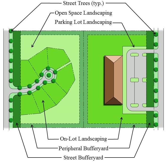
Sec. 40.04.210. - Required landscaping.
A.
Landscaping is required on lots, in parking areas, in open spaces, along roads and streets, in scenic corridors, as a buffer between certain specified uses, and as a buffer between zoning districts.
B.
Figure 40.04.210 shows how a property is divided into planting areas for peripheral bufferyards, street bufferyards, on-lot landscaping, open space landscaping, street trees and parking lot landscaping.
1.
Each planting area must be measured to determine the amount of landscaping required.
2.
Where scenic corridors exist, such scenic corridor standards shall apply instead of the applicable street bufferyards.
3.
On-lot and parking lot planting areas may overlap on parcels one (1) acre or smaller. All other planting areas may not overlap.
C.
Most landscaping standards are in plant units which include a combination of canopy, understory, evergreen trees, and shrubs that provide full coverage from ground to canopy. Alternative plant units, including size and type of plants, are contained in Table 40.23.110.
D.
All landscape material shall be installed and maintained in accordance with Division 40.23.200.
E.
Afforestation landscaping may be required under Table 40.04.241.
Figure 40.04.210
PLANTING AREAS
(Ord. No. 97-172, § 3(ch. 13, § 04.210), 12-31-1997; Ord. No. 18-021, §§ 11, 12, 7-10-2018; Ord. No. 21-009, § 1, 12-14-2021)
Sec. 40.04.220. - Landscaping standards for lots and parking lots.
Table 40.04.111A establishes the required landscaping for the landscaped area of each lot, open space, and in parking lots. The landscaped area standards apply only to those areas of the lot or property not covered by buildings, road rights-of-way, parking, or bufferyards. The parking lot standard applies to the parking area.
A.
Table 40.04.111A lists nonresidential landscaping requirements in plant units per acre. The lot landscaping shall be based on the net area exclusive of required bufferyards and parking lot landscaping. See Figure 40.04.210. Bufferyards excluded from lot landscaping requirements shall not exceed the minimum width needed to achieve zero (0) plant units within the bufferyard. Residential landscaping is provided in plant units per lot or dwelling unit. For further detail, refer to Section 40.23.120 for on-lot landscaping.
B.
Parking lot landscaping shall be one (1) plant unit per number of parking spaces specified in Table 40.04.111. Any lot or site having a parking total that is less than half the number listed in Table 40.04.111 is exempt from the requirement to provide parking lot landscaping. Refer to Section 40.23.130 for parking lot landscaping.
C.
Where more than forty (40) parking spaces are provided, parking lot landscaping must be distributed within parking lot areas so there are no more than twelve (12) consecutive parking spaces in a row between landscaped parking peninsulas or islands.
(Ord. No. 97-172, § 3(ch. 13, § 04.220), 12-31-1997; Ord. No. 98-080, § 1(ch. 13, § 04.220), 9-22-1998; Ord. No. 01-112, § 1(Exh. A), 3-12-2002; Ord. No. 18-021, § 13, 7-10-2018)
Sec. 40.04.230. - Reserved.
Editor's note— Ord. No. 03-045, § 1(Exh. A), adopted July 8, 2003, repealed § 40.04.230 in its entirety. Formerly, said section pertained to required open space as enacted by Ord. No. 97-172, § 3(ch. 13, § 04.230), adopted Dec. 31, 1997; as amended. See the Unified Development Comparative Table.
Sec. 40.04.231. - Landscaping standards for required open space.
All areas of open space shall be landscaped using one (1) of the following landscape treatments:
A.
Areas presently covered with natural vegetation shall be maintained in that natural state.
B.
Open space areas intended to be groomed or serve as a mowed lawn shall be planted with a minimum of four (4) plant units per acre. This provision shall not apply to open space areas that are designed as sports fields or recreational uses that require a paved or specially prepared surface. Golf courses shall provide three (3) plant units per acre.
C.
Areas disturbed, but scheduled to be returned to natural conditions, shall be planted as forest (reforestation or afforestation) or with such other plant material that will return the area to its natural condition. All proposed plant material used must be native.
D.
The design provisions discussed in Article 23 and the condition provisions enumerated in Article 27 shall be satisfied in addition to the above landscaping standards.
(Ord. No. 97-172, § 3(ch. 13, § 04.231), 12-31-1997; Ord. No. 21-009, § 1, 12-14-2021)
Sec. 40.04.240. - Scenic corridors.
Scenic corridors shall be provided as follows, and shall meet the criteria of Table 40.04.240:
A.
Major subdivision plans and major land development plans must provide a scenic corridor in accordance with this section. Scenic corridors shall be established along all arterial and collector roads in the Suburban Reserve (SR) District and in the Suburban (S) District land south of the C&D canal.
B.
Major and minor subdivision and major and minor land development plans for properties within six hundred sixty (660) feet of the right-of-way of a designated byway must provide a minimum 100-foot-wide scenic corridor. Applications that demonstrate compliance with Subsection 40.04.110.F are exempt from this Section.
C.
Scenic corridors for major plans shall be comprised of open space. Scenic corridors for minor plans shall be protected through on-lot conservation easements.
(Ord. No. 97-172, § 3(ch. 13, § 04.240), 12-31-1997; Ord. No. 01-112, § 1(Exh. A), 3-12-2002; Ord. No. 02-075, § 1(Exh. A), 10-22-2002; Ord. No. 22-072, § 4, 10-11-2022)
Sec. 40.04.241. - Afforestation standards.
Major land development plans and minor nonresidential land development plans must provide afforestation. This Section establishes the requirement for forest or tree cover on sites that are not presently forested or where existing forest or tree cover is less than the afforestation ratio required by the associated zoning district.
A.
The afforestation ratio consists of the ratio of the total forest cover area or tree cover area to the entire site. Table 40.04.241 provides the minimum afforestation ratios for development in corresponding zoning districts. Areas of active cultivation may be excluded from the calculation for this requirement.
Table 40.04.241
AFFORESTATION RATIO
B.
Forest cover consists of the area of all existing forest to remain or new forest to be planted. This includes reforestation and afforestation associated with riparian buffers, WRPAs or forest mitigation. Forest cover must be calculated concurrently with a conceptual landscape plan submission.
1.
All protected areas shall be maintained in accordance with this Chapter.
2.
Areas of existing forest to remain shall be delineated in accordance with Articles 10 and 33 and Appendix 1.3 of this Chapter.
3.
Areas proposed to be reforested or afforested shall be delineated as new forest area under Section 40.23.240.
C.
Tree cover consists of the total tree protection area based on the critical root zone (CRZ) of existing trees to remain (outside of forest areas). Tree cover must be calculated concurrently with a conceptual landscape plan submission.
1.
Proposed afforestation may take credit for tree cover associated with new landscaping plantings to achieve the required afforestation ratio.
2.
Tree protection areas shall be measured individually, with areas of overlap (either existing trees or proposed new landscape plantings) excluded from the sum total area.
3.
For new plantings, tree cover is calculated on the afforestation/reforestation requirements under Section 40.23.240.
4.
Green roof plantings may be used to satisfy afforestation requirements.
D.
Afforestation based on existing forest cover or tree cover may be used to satisfy afforestation requirements.
E.
Off-site afforestation may be permitted in the same watershed. A conservation easement must be established to identify maintenance responsibility and prohibit the disturbance of the afforestation area in perpetuity.
F.
The applicant must demonstrate compliance with afforestation standards as part of the final landscape plan and open space certification as applicable.
G.
The maintenance escrow required by Section 40.27.220 must include maintenance funding for five (5) years for the afforestation/reforestation planting requirements.
(Ord. No. 21-009, § 1, 12-14-2021)
Editor's note— Prior to the reenactment of Section 40.04.241 by Ord. No. 21-009, § 1, adopted December 14, 2021, Ord. No. 01-112, § 1(Exh. A), adopted March 12, 2002, repealed Sections 40.04.241—40.04.243 in their entirety. Formerly, said sections pertained to open space scenic corridors, open land scenic corridors and forested scenic corridors as adopted by Ord. No. 97-172, § 3(ch. 13, § 04.241), adopted December 31, 1997. See the Unified Development Code Comparative Table.
Secs. 40.04.242, 40.04.243. - Reserved.
Note— See editor's note at Section 40.04.241.
Division 40.04.300. - Bufferyard performance standards.
This Division provides standards for bufferyards between uses and districts and for special purposes.
(Ord. No. 97-172, § 3(ch. 13, div. 04.300), 12-31-1997)
Sec. 40.04.301. - Purpose.
Bufferyard requirements are designed to ameliorate nuisances between certain adjacent zoning districts or land uses. Bufferyards function to eliminate or minimize large changes in scale and potential nuisances such as dirt, litter, noise, glare of lights, unsightly buildings, parking areas, or signs. Bufferyards serve a similar function between streets and various land uses.
(Ord. No. 97-172, § 3(ch. 13, § 04.301), 12-31-1997)
Sec. 40.04.302. - Bufferyards required.
Where required, bufferyards shall be located along the outer perimeter of a lot or parcel and shall extend to the lot or parcel boundary line. Bufferyards shall not be located on any portion of an existing, dedicated or reserved public or private street or right-of-way. Bufferyards shall not be part of the required lot area for lots less than one (1) acre. They may be part of a lot, but the minimum standards (Table 40.04.110) shall be exclusive of the bufferyard area. Bufferyard requirements are not applicable to minor residential subdivisions. Bufferyards are required under the following conditions (see Table 40.04.111):
A.
Along all arterial or collector streets and some minor streets as specified in Table 40.04.111.
B.
Along a property line where adjoining properties are in different zoning districts (zoning district boundary).
C.
Along a property boundary within the same zoning district for limited and special uses and parking buffers.
(Ord. No. 97-172, § 3(ch. 13, § 04.302), 12-31-1997; Ord. No. 01-112, § 1(Exh. A), 3-12-2002)
Sec. 40.04.310. - Opacity values of required bufferyards.
A.
Table 40.04.111 lists the opacity levels of the peripheral bufferyards required under specified conditions. Opacity levels present the buffering level to be provided by the use. Table 40.23.140 specifies the number of plant units required to achieve a level of opacity. A bufferyard that meets the opacity rating specified in Table 40.04.111 shall be approved as part of the plan or land development approval.
B.
If a bufferyard standard for an adjoining parcel required by this Chapter is not satisfied because the parcel was developed or approved under the provisions of the former Code, the required bufferyard of a new proposed use shall be equal to that of the more restrictive bufferyard of the two (2) uses and the bufferyard shall be provided by the proposed use.
C.
Surety shall be required for the cost of completing the bufferyard. The Department shall require such surety be posted prior to the issuance of any certificates of occupancy. If buildings are completed at a time of the year where planting cannot be accomplished, the Department may issue a temporary permit and hold the surety until the landscaping is completed. Such surety shall become part of the development agreement required by this Chapter.
(Ord. No. 97-172, § 3(ch. 13, § 04.310), 12-31-1997; Ord. No. 98-080, § 1(ch. 13, § 04.310), 9-22-1998; Ord. No. 99-075, § 1, 12-14-2000)
Sec. 40.04.320. - Parking bufferyards required.
A.
Where parking spaces serving a nonresidential or multifamily use are adjacent to an existing residential use or residentially zoned land, the required bufferyard opacity between the parking lot and adjacent parcel shall be increased by 0.10 opacity beyond that which is otherwise required by Table 40.04.111. However, in the event a 0.50 or greater opacity is already required, the additional 0.10 need not be added.
B.
Where a parking structure is adjacent to an existing residential use, residentially zoned land, or street right-of-way, the required bufferyard opacity between the parking structure, the adjacent parcel, or the street right-of-way shall be increased by 0.20 opacity above that required by Table 40.04.111.
(Ord. No. 97-172, § 3(ch. 13, § 04.320), 12-31-1997; Ord. No. 98-062, § 1(ch. 13, § 04.320), 9-22-1998; Ord. No. 01-112, § 1(Exh. A), 3-12-2002; Ord. No. 15-053, § 4, 7-28-2015)
Sec. 40.04.330. - Bufferyard use.
Only the following uses are permitted in required bufferyards:
A.
Sidewalks, shared-use pathways and trails.
1.
Opacity may be reduced within frontage or street bufferyards as provided in Section 40.23.142.
2.
Opacity may not be reduced within side or rear bufferyards.
B.
Passive recreation.
C.
Golf courses. Where a golf course is installed in the bufferyard location, it shall be considered an adequate bufferyard provision. All other active recreation, such as swimming pools, tennis courts, and sports fields, shall be prohibited.
(Ord. No. 97-172, § 3(ch. 13, § 04.330), 12-31-1997; Ord. No. 10-113, § 1(Exh. A), 1-18-2011; Ord. No. 18-021, § 14, 7-10-2018)