
Argyle City Zoning Code
PART 6
- INTERPRETATION; PRESERVING RIGHTS; PENALTY FOR VIOLATIONS; VALIDITY; EFFECTIVE DATE
Sec. 14.3.86. - Effect of Interpretation.
14.3.86-1 In interpreting and applying the provisions of this Ordinance, they shall be held to be the minimum requirements for the promotion of the public safety, health, convenience, comfort, prosperity, or general welfare. It is not intended by this Ordinance to interfere with or abrogate or annul any easements, covenants or other agreements between parties, provided, however, that where this Ordinance imposes a greater restriction upon the use of buildings or premises or upon height of buildings, or requires larger open spaces than are imposed or required by agreements, the provisions of this Ordinance shall govern. This Ordinance is also not intended to abrogate or annul any lawfully obtained permit issued prior to the effective date of this Ordinance.
Sec. 14.3.87. - Preserving Rights in Pending Litigation and Violations Under Existing Ordinances.
14.3.87-1 By the passage of this Ordinance, no presently illegal use shall be deemed to have been legalized unless such use specifically falls within a use district where the actual use is a conforming use. Otherwise, such uses shall remain nonconforming uses where recognized, or an illegal use, as the case may be. It is further the intent and declared purpose of this Ordinance that no offense committed, and no liability, penalty or forfeiture, either civil or criminal, incurred prior to the time the previous Zoning Ordinance was repealed and this Zoning Ordinance adopted, shall be discharged or affected by such repeal and adoption of this Ordinance; but prosecutions and suits for such offenses, liabilities, penalties or forfeitures may be instituted or causes presently pending proceeded with in all respects as if such prior ordinance had not been repealed.
14.3.87-2 Vested Rights Review Procedure.
A.
Vested Rights Request.
1.
Any property owner who believes that he has obtained a vested right under V.T.C.A., Local Government Code ch. 245 shall submit to the Town Secretary a letter explaining the factual and legal bases upon which the property owner relies in his contention that he has a particular vested right and, consequently, is exempt or not subject to a particular Argyle order, regulation, ordinance, rule, expiration date, or other properly adopted requirement (hereinafter referred to collectively as "regulations"). Such written submission shall include, at a minimum, the following:
a.
The name, mailing address, phone number and fax number of the property owner (or the property owner's duly authorized agent);
b.
Identification of the property for which the property owner claims a vested right;
c.
Identification of the "project," as that term is defined in V.T.C.A., Local Government Code § 245.001(3);
d.
Identification of the original application for the first permit in the series of permits required for the project, as described in V.T.C.A., Local Government Code §§ 245.001 and 245.002(a) and (b);
e.
The date that the first permit in the series of permits required for the project was filed with the Town;
f.
A chronology of the history of the project, with special emphasis on facts establishing that the project was in progress on or commenced after September 1, 1997, as required by V.T.C.A., Local Government Code § 245.003;
g.
Identification of all Argyle regulations in effect at the time the original application for the permit was filed that (1) the owner contends are vested and (2) the owner contends controls the approval, disapproval, or conditional approval of an application for a permit, pursuant to V.T.C.A., Local Government Code § 245.002(a) and (b); and
h.
Identification of all Argyle regulations that the property owner contends do not apply to the project due to the vested rights provided the property owner by V.T.C.A., Local Government Code ch. 245.
i.
Identification of all Argyle regulations that the property owner contends would apply to the project that predate the regulations the property owner contends do not apply.
2.
If a property owner contends that certain Argyle regulations do not apply to the project, the property owner is expected to identify, with particularity, all requirements that the property owner contends do not apply. Global references to a particular ordinance, or set of criteria, may be deemed insufficient and the Town may consider the request for a vested rights determination to be incomplete and, hence, not subject to a staff determination at that time.
B.
Vested Rights Determination.
1.
The Town Secretary shall promptly forward the owner's vested rights request pursuant to Section 14.3.87-2.A, along with any supporting information or documentation provided along with the request, to the Town Administrator, Town Attorney and Town Planner for their respective reviews. The Town Administrator, after consultation with the Town Attorney and Town Planner, shall issue a final administrative determination of whether a vested right exists in relation to the project, and shall identify, with particularity, all claims for vested rights that exist in relation to the project, and shall identify, with particularity, all claims for vested rights that have been granted and all claims for vested rights that have been denied. Prior to rendering his final determination, the Town Administrator may request a pre-determination conference with the owner to discuss the owner's vested rights claim and to ensure that the nature of the claim is fully and completely understood by the Town Administrator prior to a final determination being rendered.
C.
Board of Adjustment Appeal. If the property owner and/or the Town Council believes that the Town Administrator's vested rights determination is in error, the property owner and/or the Town Council shall have the right to appeal such determination to the Town's Zoning Board of Adjustment, which will have jurisdiction to hear and decide the appeal pursuant to this ordinance and/or V.T.C.A., Local Government Code ch. 211. The property owner may also request the Board of Adjustment to grant a variance from the regulations at issue under the same standards governing variances for other matters, as set forth in this ordinance and/or V.T.C.A., Local Government Code ch. 211.
D.
Judicial Review. Should the property owner be dissatisfied with the actions of the Zoning Board of Adjustment, the property owner may avail themselves of all legal remedies to review the Zoning Board of Adjustment's decision as set forth in V.T.C.A., Local Government Code § 211.011.
E.
Binding Determination.
1.
The Town Administrator's final determination, if not timely appealed to the Zoning Board of Adjustment, shall be immediately filed in the Town's files related to the project and the determination shall be considered binding upon the Town and the property owner for the duration of the project. Similarly, any decision by the Zoning Board of Adjustment regarding a vested right claim, if not timely appealed pursuant to V.T.C.A., Local Government Code § 211.011, shall be filed in the Town's files related to the project and the determination shall be considered binding upon the Town and the property owner for the duration of the project. Notwithstanding the binding nature of the Town Administrator's final determination and any ruling by the Zoning Board of Adjustment, the Town and the property owner may, at any time, enter into a development agreement that, to the extent authorized by law, modifies the final determination and the applicable development regulations to be applied to the project.
(Ord. No. 2010-01, § 3, 1-12-10; Ord. No. 2010-17, § 2, 10-26-10; Ord. No. 2015-23, § 6, 11-17-15; Ord. No. 2020-06, § 2, 3-24-20)
Sec. 14.3.88. - Penalty for Violations.
14.3.88-1 Any person or corporation violating any of the provisions of this Ordinance shall, upon conviction, be fined any sum not exceeding $2,000.00 and each and every day that the provisions of this Ordinance are violated shall constitute a separate and distinct offense. In addition to the said penalty provided for, the right is hereby conferred and extended upon any property owner owning property in any district, where such property owner may be affected or invaded, by a violation of the terms of the Ordinance, to bring suit in such court or courts having jurisdiction thereof and obtain such remedies as may be available at law and equity in the protection of the rights of such property owners.
14.3.88-2 Nothing contained herein shall prevent the Town of Argyle from taking such other lawful action as is necessary to prevent or remedy any violation.
Sec. 14.3.89. - Validity.
14.3.89-1 If any section, paragraph, subdivision, clause, phrase, or provision of this Ordinance shall be adjudged invalid or held unconstitutional, the same shall not affect the validity of this Ordinance as a whole or any part or provision thereof other than the part so decided to be invalid or unconstitutional.
Sec. 14.3.90. - Effective Date.
14.3.90-1 This Ordinance shall be effective as of the date of its adoption by the Town Council of Argyle, Texas.
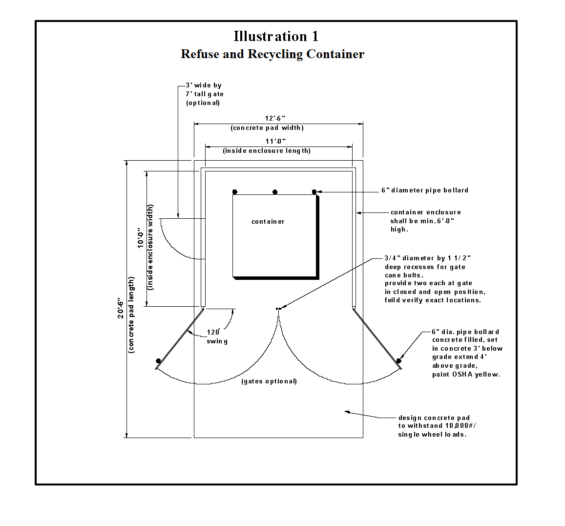
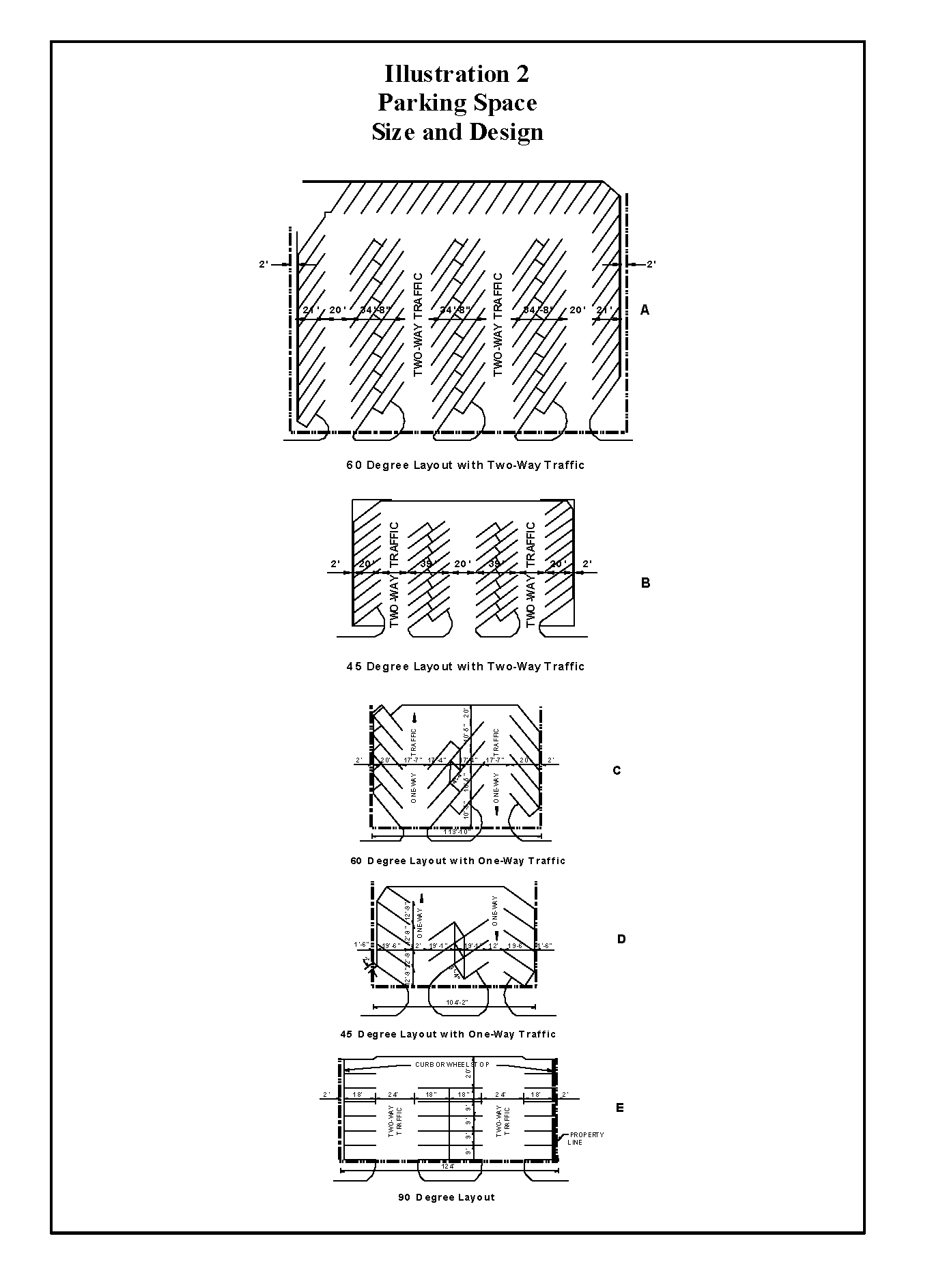
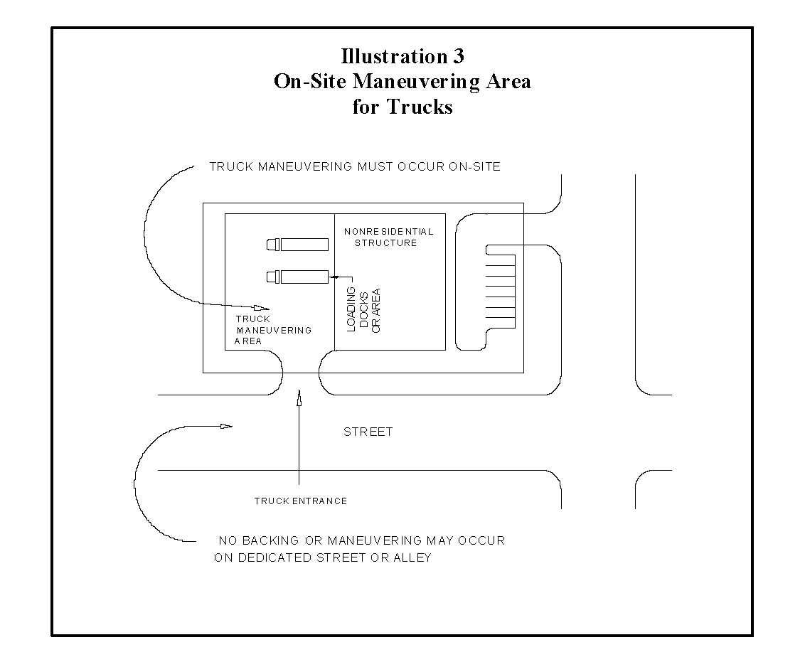
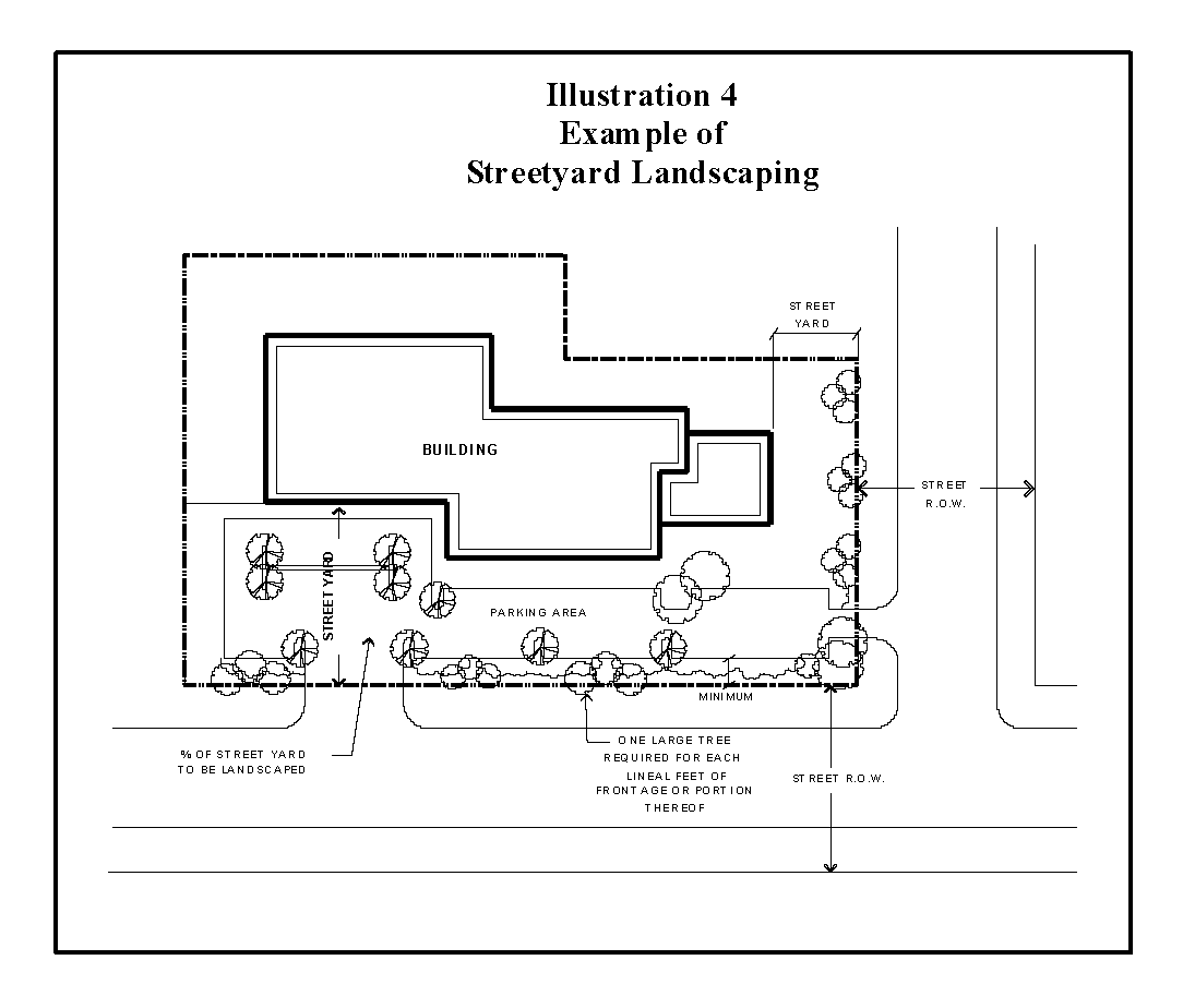
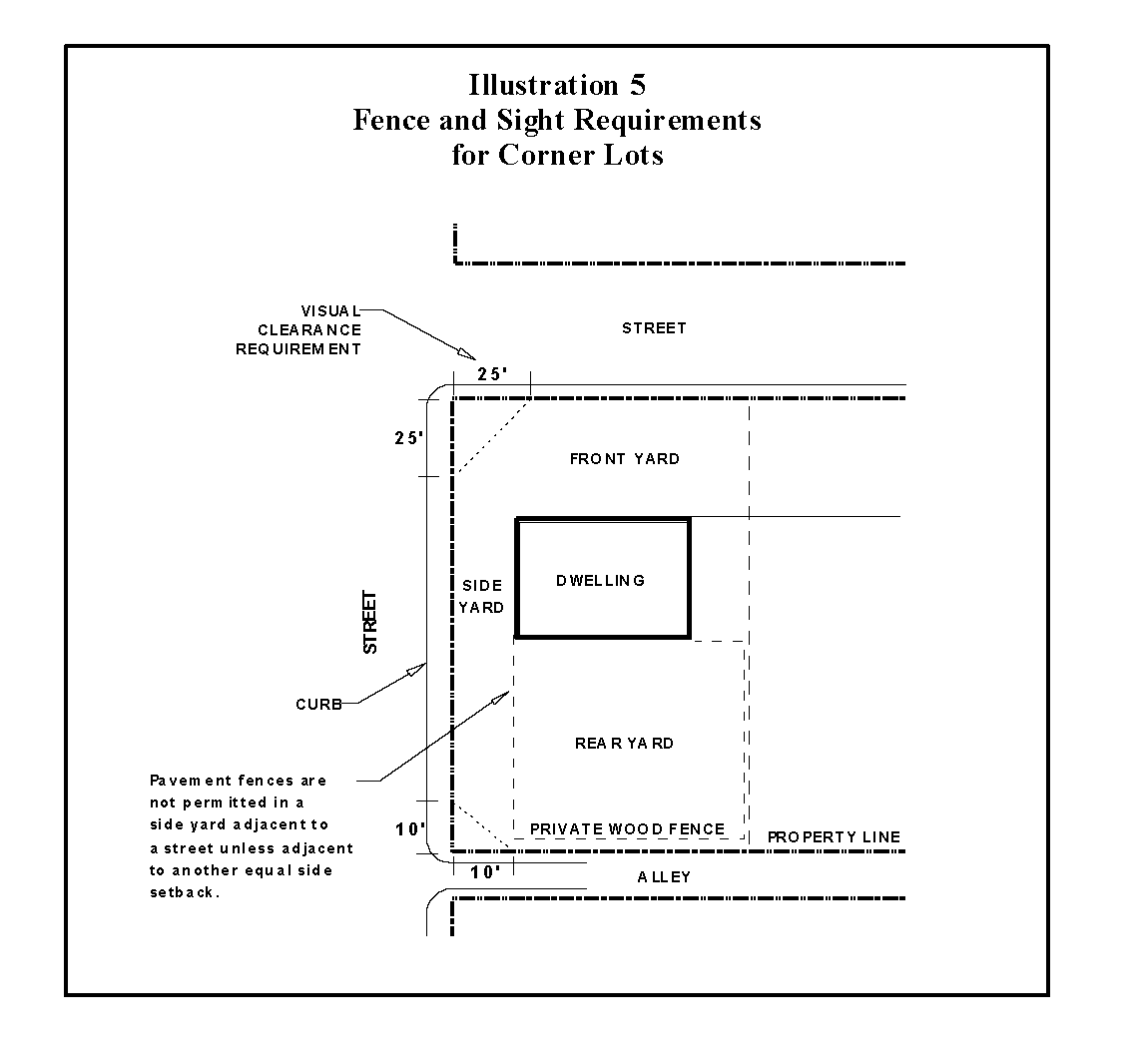
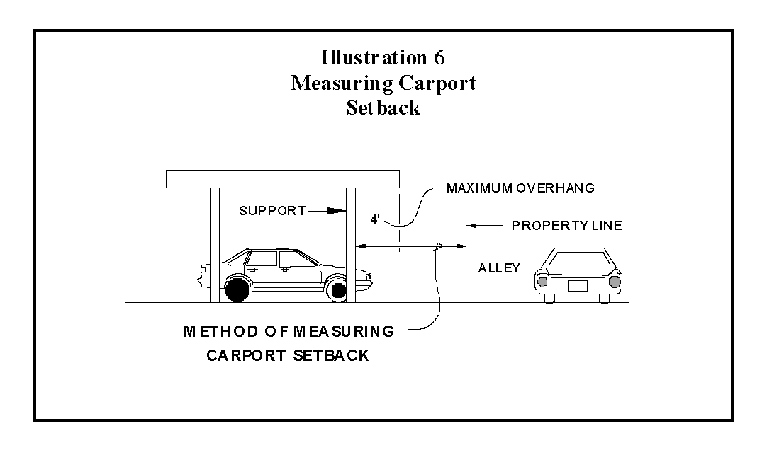
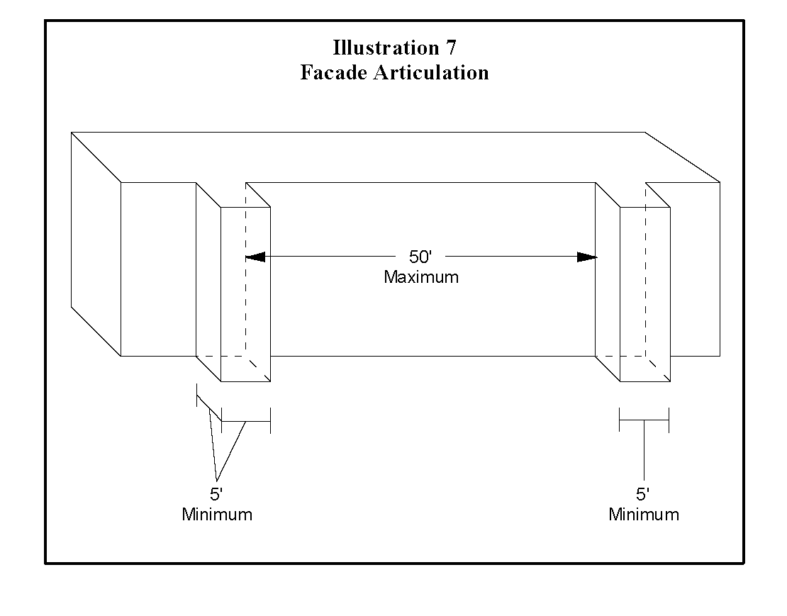
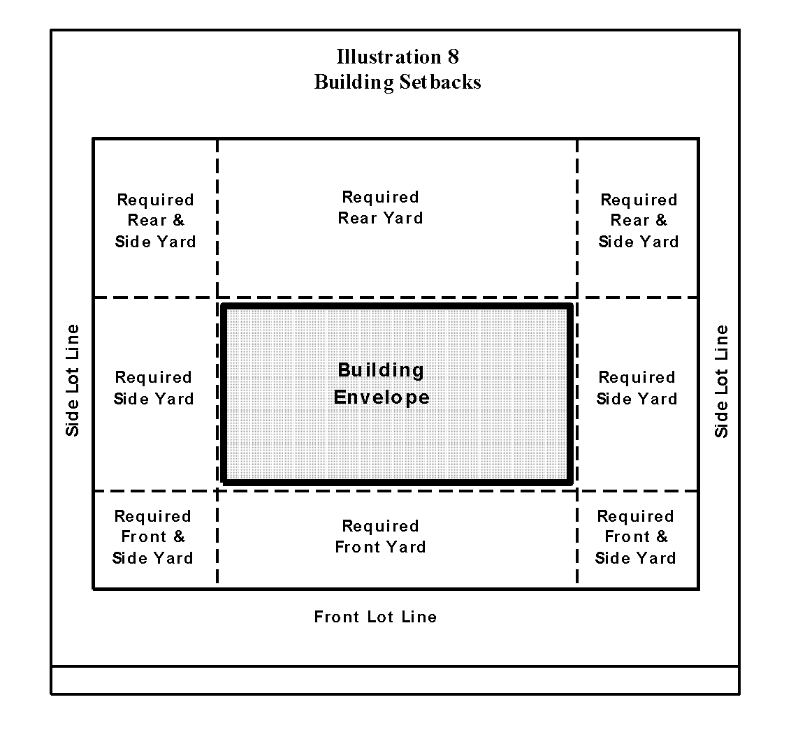
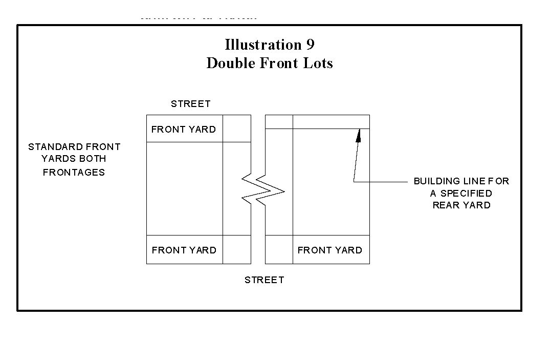
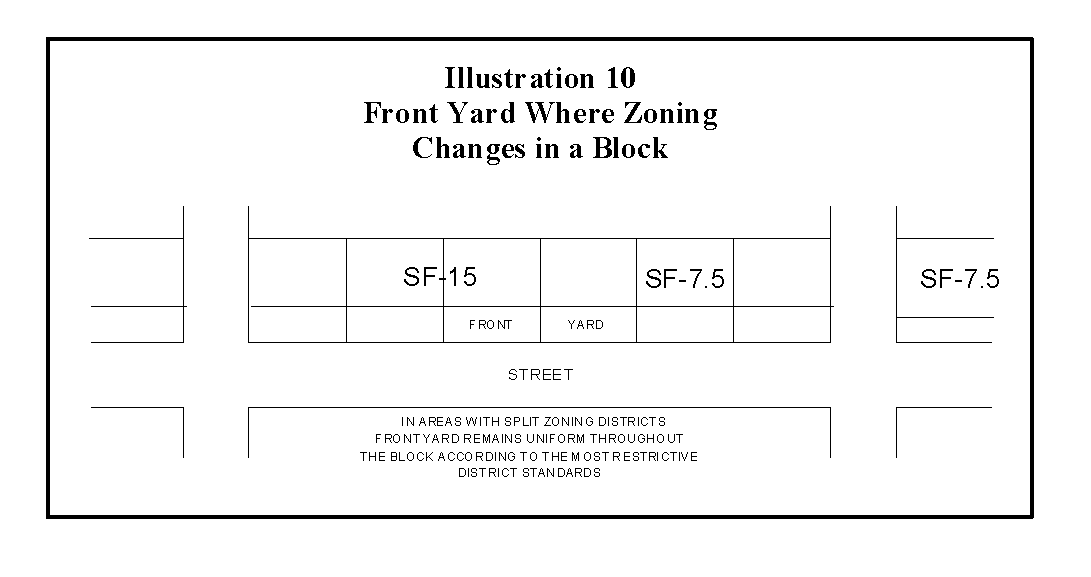
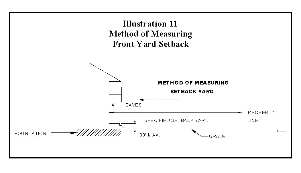
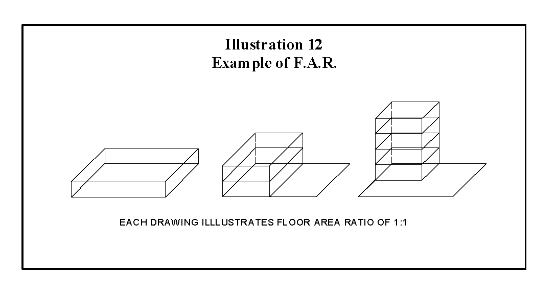
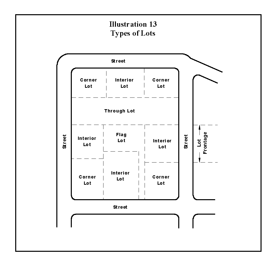
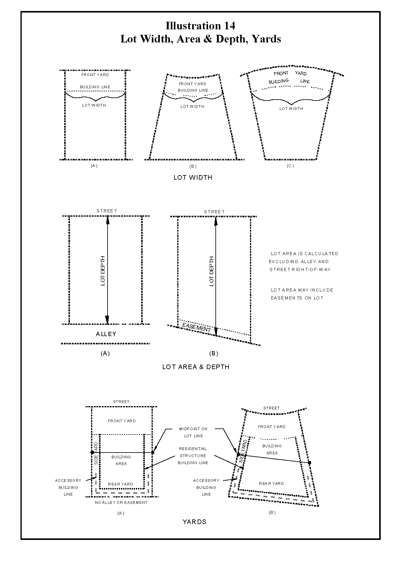
Sec. 14.3.95. - Illustrations.
Sec. 14.3.96. - Schedule of Performance Standards.
The following tables provide a quick reference guide to the basic performance standards for the City's residential and nonresidential districts. For the specific requirements for each district, refer to the appropriate section of Article III, Zoning.
Residential Zoning Districts
Nonresidential Zoning Districts
(Ord. No. 2019-04, § 8 (Exh. H), 3-26-19)
Sec. 14.3.97. - Use Charts.
The use charts that were previously located in each zoning district have been moved to Section 14.3.62, "Use Chart Matrix".
(Ord. No. 2022-14, § 2(Exh. A), 9-6-22)
Sec. 14.3.98. - Existing Planned Development Districts.
Prior to adoption of this Ordinance, the City Council established certain Planned Development districts, some of which are to be continued in full force and effect. The ordinances or parts of ordinances approved prior to this Ordinance and to remain in full force and effect are specified within this Section and shall be carried forth in full force and effect and are the conditions, restrictions, regulations and requirements which apply to the respective Planned Development district shown on the Zoning District Map as of the effective date of this Ordinance. Each prior PD ordinance is hereby assigned a unique identification number (e.g., PD-1, PD-2, PD-3, and so on) as shown within this Section and subsequent PD ordinances adopted after the effective date of this Ordinance shall be similarly numbered for identification purposes.
With respect to any established Planned Development district specified on this Section that uses the SF-2 zoning district regulations for minimum lot area or other requirements concerning lot coverage and setbacks, the SF-2 zoning district standards in existence immediately prior to the adoption of this Ordinance are incorporated herein by reference, are hereby modified to allow a maximum lot coverage of 35 percent, for structures built or permitted prior to March 5, 2008 and to allow a maximum lot coverage of 30 percent for structures built or permitted after March 5, 2008; and are considered to be the exclusive setback requirements applicable to property within such a Planned Development district. Without limiting the generality of the preceding sentence, the garage setback requirement shall be equal to the minimum front yard setback with no separate garage setback.