
Aspen City Zoning Code
PART 400
DEVELOPMENT PERMIT AS OF RIGHT
Sec. 26.404.010. - Development Permitted as of Right.
(a)
Purpose. Permitted uses are those land uses which are consistent with other land uses in the same zone district in which they are located and which have been designated as permitted uses for the applicable zone district established in Chapter 26.710.
(b)
Authority. The Chief Building Official, in accordance with the procedures, standards and limitations of this Chapter, shall approve, approve with conditions or disapprove a development application for a permitted use.
(c)
Application. A development application for a permitted use shall consist of an application for a building permit pursuant to Section 26.304.075, together with a description of the proposed development.
(d)
Action on the application. Upon receipt of a development application for a permitted use, the Chief Building Official shall follow the procedures set forth at Section 26.304.075.
Sec. 26.410.010. - General.
(a)
Intent. The City's Residential Design Standards are intended to ensure a strong connection between residences and streets; ensure buildings provide articulation to break up bulk and mass; and preserve historic neighborhood scale and character. The standards do not prescribe architectural style, but do require that each home, while serving the needs of its owner, contribute positively to the streetscape. The Residential Design Standards are intended to achieve the following objectives:
(1)
Connect to the Street. Establish a visual and/or physical connection between residences and streets and other public areas. The area between the street and the front of a residential building is a transition between the public realm of the neighborhood and the private realm of a dwelling. This transition can strongly impact the human experience of the street. Improve the street experience for pedestrians and vehicles by establishing physical and visual relationships between streets, and residential buildings located along streets. Porches, walkways from front entries to the street, and prominent windows that face the street are examples of elements that connect to the street.
(2)
Respond to Neighboring Properties. Reduce perceived mass and bulk of residential buildings from all sides. Encourage a relationship to adjacent development through similar massing and scale. Create a sense of continuity through building form and setback along the streetscape. Providing offsets or changes of plane in the building facades or reducing the height near side lot lines are examples of responding to neighboring properties.
(3)
Reflect Traditional Building Scale. Retain scale and proportions in building design that are in keeping with Aspen's historic architectural tradition, while also encouraging design flexibility. Reinforce the unique character of Aspen by drawing upon the City's vernacular architecture and neighborhood characteristics in the design of structures. Encourage creative and contemporary architecture, but at a scale that respects historic design traditions. Ensure that residential structures respond to "human-scale" in their design. Ensure that residential structures do not visually overwhelm or overshadow streets. Windows that are similar in size to those seen in historic Aspen architecture or limiting the height of a porch to be in line with the first story of a building are examples of reflecting traditional building scale.
(b)
Applicability. Except as outlined in Section 26.410.010(c), Exemptions, this Chapter applies to all residential development in the City, except for residential development within the R-15B zone district. Specific applicability for each standard is identified within each standard.
(c)
Exemptions. No residential development shall be exempt from the provisions of this Chapter unless the Community Development Director determines that the proposed development:
(1)
Is an addition or remodel to an existing structure that does not change the exterior of the building; or
(2)
Is a remodel of a structure where the alterations proposed change the exterior of the building, but are not addressed by any of the residential design standards; or
(3)
Is a residential unit within a mixed-use building; or
(4)
Is a designated historic resource listed on the Aspen Inventory of Historic Landmark Sites and Structures. New buildings on a historic landmark lot are not exempt.
(d)
Remodels. Where work is proposed on any element of an existing building that is addressed by the Residential Design Standards and that is not in compliance with the Standards, the property owner shall make a reasonable effort to bring that element into compliance. The Community Development Director may grant exceptions for remodels that would require significant additional work above and beyond the scope of the remodel in order to ensure that all features are brought into compliance.
For example, consider a remodel involving modifications to a porch structure that is currently smaller than the minimum square footage required by the Residential Design Standards. If the porch is being replaced with a new porch, the new porch will be required to meet the minimum size requirements in the Residential Design Standards. If only the porch posts are being replaced, the existing porch may remain without needing a variation even though it does not meet the minimum size requirements in the Residential Design Standards.
As a second example, consider a remodel involving modifications to a non-orthogonal window where the maximum number of non-orthogonal windows allowed by the Residential Design Standards is exceeded. If the window is being moved to a new location or the size or shape of the window is being changed, the new window will be required to meet the non-orthogonal window limit in the Residential Design Standards. If the modifications to the window are being made in place and do not expand or change the size or shape, the existing nonconforming non-orthogonal window may remain without needing a variation even though it exceeds the maximum number of non-orthogonal windows allowed by the Residential Design Standards.
(e)
Definitions. Unless otherwise indicated, the definitions of words used in these regulations shall be the same as the definitions used in Chapter 26.104 of the Land Use Code. In addition, the following definitions shall apply:
Curvilinear Lot. A lot in which a curve comprises fifty percent (50%) or more of the total length of the front lot line.
Façade. An exterior face of a building. It can be applied to any side. Projections, such as open porches, are not considered a façade.
Front Façade. The street-facing exterior face of a building that contains the primary building entry. The front façade may include multiple wall planes that make up the front face of the building. See Figure 1.
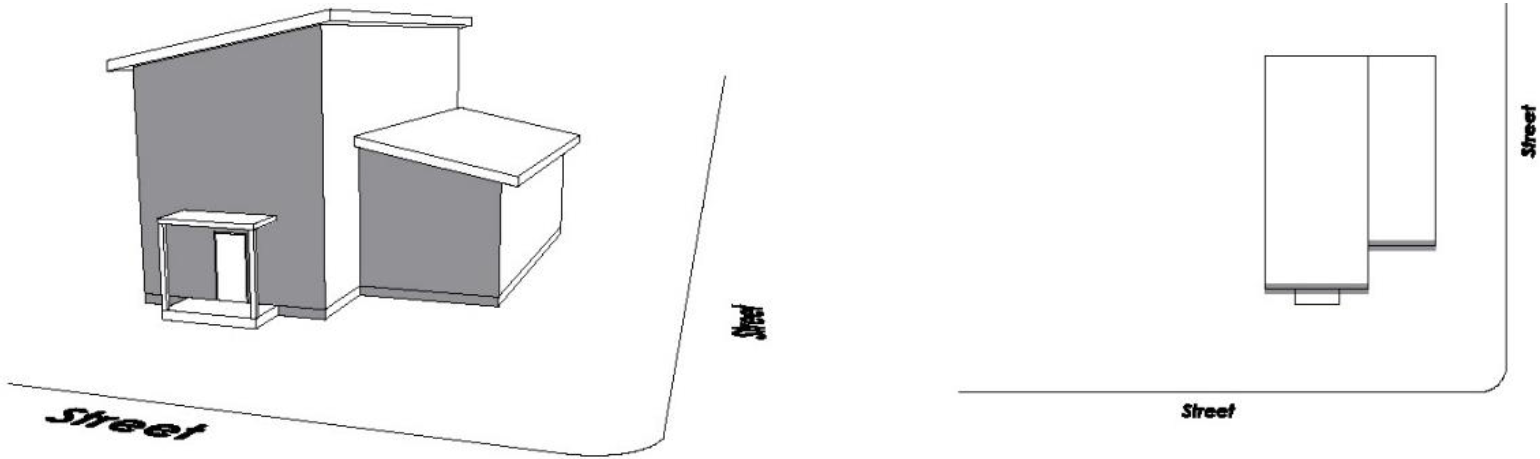
Figure 1
Street-Facing Façade. Any side of a building that faces a street. A street-facing façade may refer to multiple wall planes on a building face that face the street or right-of-way. See Figure 2.
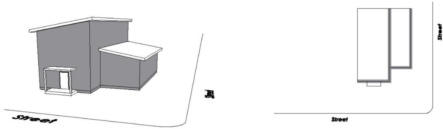
Figure 2
Front-Most Wall. The wall of the front façade of a building that is closest to the street or right-of-way. See Figure 3.
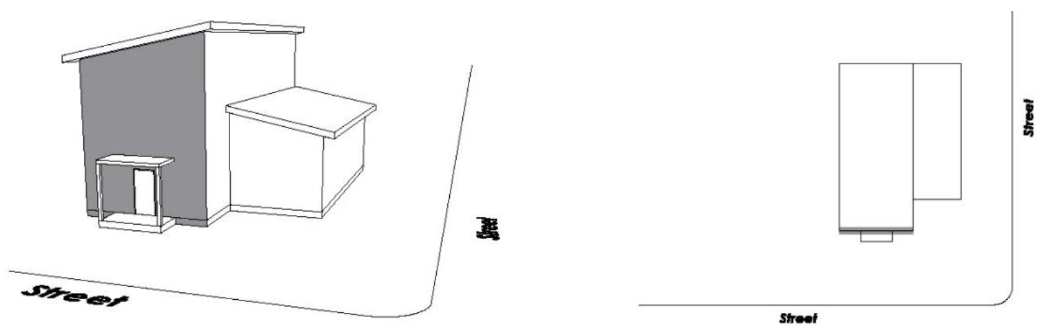
Figure 3
Front-Most Element. The front most building feature associated with a primary building or garage. In many cases, this element may be located forward of the front façade, such as an open front porch or projecting garage overhang. See Figure 4.
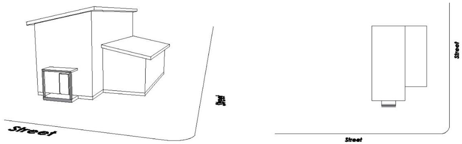
Figure 4
Non-orthogonal Window. A window with an opening that is not rectangular in nature and does not possess right angles at each of its four (4) corners and vertical or horizontal orientation of all edges.
One Story. A portion of a building between the surface of the finished floor and the ceiling immediately above; or the wall plate height where no additional stories are located above. One story shall not exceed 10 feet for purposes of the Residential Design Standards.
Open Front Porch. A porch on the front façade of a building that is open on at least two (2) sides, one of which faces the street. Open shall mean no element of enclosure, except screens.
Street. A way or thoroughfare, other than an alley, containing a public access easement and used or intended for vehicular traffic. The term street shall include the entire area within a right-of-way. For the purpose of Chapter 26.410, street shall also include private streets and vehicular access easements serving more than one (1) parcel. Streets shall not include public or private trails.
Sec. 26.410.020. - Procedures for Review.
(a)
Determination of Applicability. The applicant may request a preliminary Residential Design Standards pre-application conference with Community Development Department staff to determine the applicability of the requirements of this Chapter for the proposed development.
(b)
Administrative Review. Consistency with the Residential Design Standards shall be determined administratively, unless a variation is requested. The Administrative Review process will result in a determination of approval or denial for compliance with the Residential Design Standards.
All projects will be reviewed for compliance with the Flexible and Non-flexible Standards contained within the Residential Design Standards. Flexible and Non-flexible Standards are defined as follows:
(1)
Flexible Standards. Flexible Standards are standards for which additional flexibility around the specific requirements of a standard may be granted administratively. If an application is found to be inconsistent with any of the Flexible Standards, but meets the overall intent of the standard as well as the general intent statements in Section 26.410.010(a)(1)—(3), Alternative Compliance may be granted. The Community Development Director shall approve, approve with conditions, or deny Alternative Compliance. If an application does not meet the overall intent of a Flexible Standard, the applicant may either amend their proposal or seek a variation, pursuant to Section 26.410.020(c), Variations.
(2)
Non-flexible Standards. Non-flexible Standards are those standards that shall be met by all projects subject to the Residential Design Standards, with no Alternative Compliance permitted, unless otherwise stated in this Chapter. If an application is found to be inconsistent with any of the Non-flexible Standards as written, the applicant may either amend their proposal or seek a variation, pursuant to Section 26.410.020(c), Variations.
(c)
Variations. Any application that does not receive Administrative Review approval described above may apply for a variation, pursuant to Section 26.304.030, Common Development Procedures. An applicant may also choose to apply directly for a variation if desired. The Planning & Zoning Commission or Historic Preservation Commission, during a duly noticed public hearing, shall approve, approve with conditions, or deny an application for variation, based on the standards of review in Section 26.410.020(d), Variation Review Standards. A variation from the Residential Design Standards does not grant an approval to vary other standards of this Chapter that may be provided by another decision-making body. The review process is as follows:
Step One - Public Hearing before Planning & Zoning Commission or Historic Preservation Commission.
(1)
Purpose: To determine if the application meets the review standards for Residential Design Standard variation.
(2)
Process: The Community Development Director shall provide the Planning and Zoning Commission or Historic Preservation Commission, as applicable, with a recommendation to approve, approve with conditions, or deny the application, based on the standards of review. The Planning and Zoning Commission, or Historic Preservation Commission if the property is designated or is located within a historic district, shall approve, approve with conditions, or deny the application after considering the recommendation of the Community Development Director and comments and testimony from the public at a duly noticed public hearing.
(3)
Standards of review: The proposal shall comply with the review standards of Section 26.410.020(d), Variation Review Standards.
(4)
Form of decision: The decision shall be by resolution.
(5)
Notice requirements: Posting, Mailing and Publication pursuant to Subparagraph 26.304.060(e)(3)a.—c.
(d)
Variation Review Standards. An application requesting a variation from the Residential Design Standards shall demonstrate and the deciding board shall find that the variation, if granted would:
(1)
Provide an alternative design approach that meets the overall intent of the standard as indicated in the intent statement for that standard, as well as the general intent statements in Section 26.410.010(a)(1)—(3); or
(2)
Be clearly necessary for reasons of fairness related to unusual site-specific constraints.
Sec. 26.410.030. - Single-family & duplex standards.
(a)
Applicability. Unless stated otherwise below, the design standards in this Section shall apply to all single-family and duplex development.
(b)
Location and Massing.
(1)
Articulation of Building Mass (Non-flexible).
a.
Applicability. This standard shall apply to all lots except:
1.
Lots outside of the Aspen Infill Area.
b.
Intent. This standard seeks to reduce the overall perceived mass and bulk of buildings on a property as viewed from all sides. Designs should promote light and air access between adjacent properties. Designs should articulate building walls by utilizing multiple forms to break up large expansive wall planes. Buildings should include massing and articulation that convey forms that are similar in massing to historic Aspen residential buildings. This standard is critical in the Infill Area where small lots, small side and front setbacks, alleys and historic Aspen building forms are prevalent. Designs should change the plane of a building's sidewall, step a primary building's height down to one-story in the rear portion or limit the overall depth of the structure.
c.
Standard. A principal building shall articulate building mass to reduce bulk and mass and create building forms that are similar in scale to those seen in historic Aspen residential buildings.
d.
Options. Fulfilling at least one of the following options shall satisfy this standard:
1.
Maximum Sidewall Depth. A principal building shall be no greater than fifty (50) feet in depth, as measured from the front-most wall of the front façade to the rear wall. An accessory building that is completely separated from the main building is permitted. Garages, sheds and accessory dwelling units are examples of appropriate uses for an accessory building. See Figure 5.
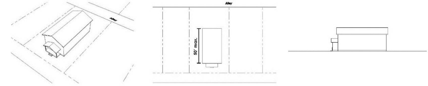
Figure 5
2.
Off-set with One-Story Ground Level Connector. A principal building shall provide a portion of its mass as a subordinate one-story, ground floor connecting element. The connecting element shall be at least ten (10) feet in length and shall be setback at least an additional five (5) feet from the sidewall on both sides of the building. The connecting element shall occur at a maximum of forty-five (45) feet in depth, as measured from the front-most wall of the front façade to the rear wall. Accessible outdoor space over the connecting element (e.g. a deck) is permitted but may not be covered or enclosed. Any railing for an accessible outdoor space over a connecting element must be the minimum reasonably necessary to provide adequate safety and building code compliance and the railing must be fifty percent (50%) or more transparent. See Figure 6.
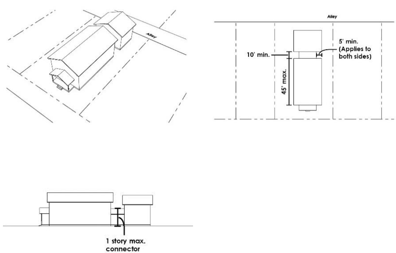
Figure 6
3.
Increased Side Setbacks at Rear and Step Down. A principal building shall provide increased side setbacks at the rear of the building. If the principal building is two (2) stories, it shall step down to one story in the rear. The increased side setbacks and one story step down shall occur at a maximum of forty-five (45) feet, as measured from the front-most wall toward the rear wall. The increased side setbacks shall be at least five (5) feet greater than the side setbacks at the front of the building. See Figure 7.
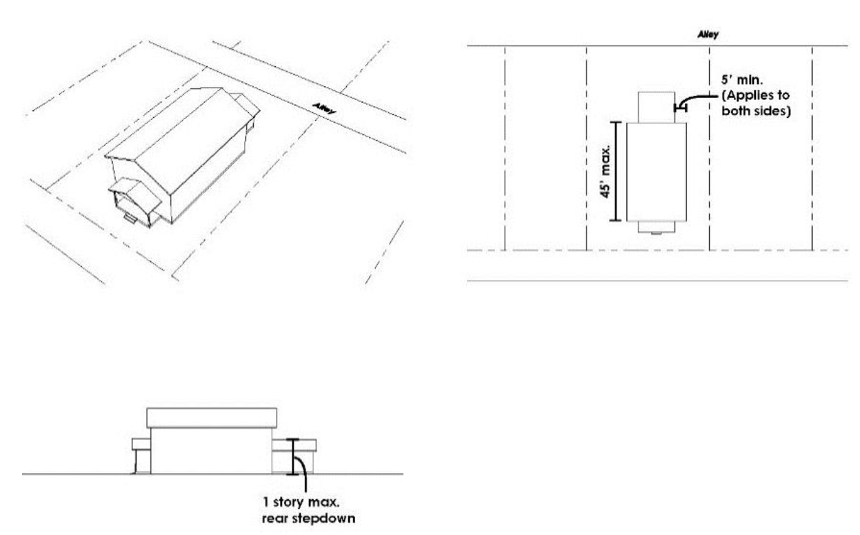
Figure 7
(2)
Building Orientation (Flexible).
a.
Applicability. This standard shall apply to all lots except:
1.
Lots with a required front yard setback of at least ten (10) vertical feet above or below street grade.
b.
Intent. This standard seeks to establish a relationship between buildings and streets to create an engaging streetscape and discourage the isolation of homes from the surrounding neighborhood. The placement of buildings should seek to frame street edges physically or visually. Buildings should be oriented in a manner such that they are a component of the streetscape, which consists of the street itself and the buildings that surround it. Building orientation should provide a sense of interest and promote interaction between buildings and passersby. Building orientation is important in all areas of the city, but is particularly important in the Infill Area where there is a strong pattern of buildings that are parallel to the street. Designs should prioritize the visibility of the front façade from the street by designing the majority of the front façade to be parallel to the street or prominently visible from the street. Front facades, porches, driveways, windows, and doors can all be designed to have a strong and direct relationship to the street.
c.
Standard. The front façade of a building shall be oriented to face the street on which it is located.
d.
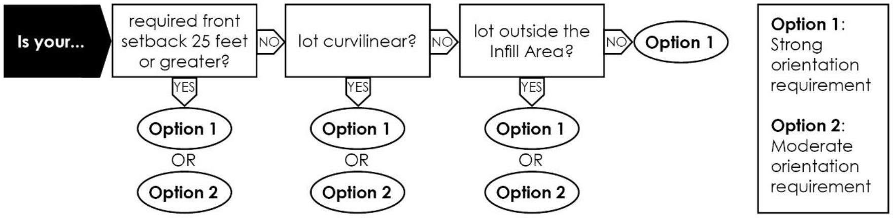
Options. Fulfilling one of the following options shall satisfy this standard:
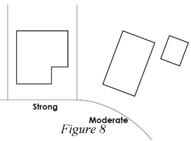
1.
Strong Orientation Requirement. The front façade of a building shall be parallel to the street. On a corner lot, both street-facing façades of a building shall be parallel to each street. See Figure 8.
2.
Moderate Orientation Requirement. The front façade of a building shall face the street. On a corner lot, one street-facing façade shall face each intersecting street. See Figure 8.
The availability of these options shall be determined according to the following lot characteristics:

(3)
Build-to Requirement (Flexible).
a.
Applicability. This standard shall apply to all lots except:
1.
Lots with a required front yard setback of twenty-five (25) feet or greater.
2.
Lots that are curvilinear.
3.
Lots with a required front yard setback of at least ten (10) vertical feet above or below street grade.
b.
Intent. This standard seeks to establish a consistent physical pattern of front façades close to and parallel to streets in order to frame the street. The placement of buildings should respond to the street by framing street edges physically. Buildings should be located to provide a strong physical presence and integration within the streetscape, which consists of the street itself and the buildings that surround it. This standard is most important in the Infill Area where a strong pattern of smaller front setbacks and consistent building orientation exists. Designs should maximize the amount of the front façade that is close to the street while still providing articulation and expressing a human scale. Porches, front façade walls, rooflines and other elements can all contribute to framing the street.
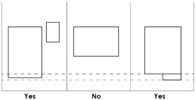
Figure 9
c.
Standard. At least sixty percent (60%) of the front façade of a principal building shall be within five (5) feet of the minimum front yard setback line. On a corner lot, this standard shall be met on at least one (1) of the two (2) intersecting streets. A front porch may be used to meet this requirement. See Figure 9.
(4)
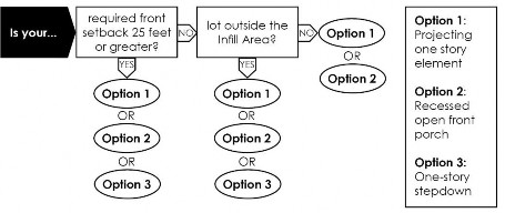
One-story Element (Flexible).
a.
Applicability. This standard shall apply to all lots except:
1.
Lots with a required front yard setback of at least ten (10) vertical feet above or below street grade.
b.
Intent. This standard seeks to establish human scale building features as perceived from the street and express lower and upper floors on front façades to reduce perceived mass. Designs should utilize street-facing architectural elements, such as porches, that imitate those of historic Aspen residential buildings. Buildings should provide visual evidence or demarcation of the stories of a building to relate to pedestrians. This standard is important in all areas of the city. Front porches or portions of the front-most wall of the front façade should clearly express a one-story scale as perceived from the street. Changes in material or color can also be incorporated into these elements to help to strengthen the establishment of a one-story scale.
c.
Standard. A principal building shall incorporate a one-story element on the front façade. Duplexes in a side-by-side configuration are required to have a one-story element per dwelling unit.
d.
Options.
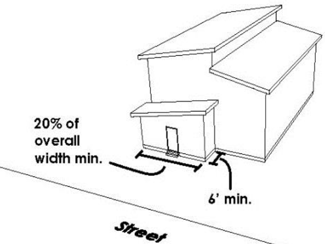
Figure 10
1.
Projecting One-Story Element. The front façade of the principal building shall have a one-story street-facing element that projects at least six (6) feet from the front façade and has a width equivalent to at least twenty percent (20%) of the building's (or unit's) overall width. This one story element may be enclosed living space or a front porch that is open on three (3) sides. This one story element shall be a minimum of 50 square feet in area. Accessible space (whether it is a deck, porch or enclosed area) shall not be allowed over the first story element; however, accessible space over the remaining first story elements on the front façade shall not be precluded. See Figure 10.
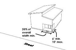
Figure 11
2.
Loggia. The front façade of the principal building shall have an open loggia that is recessed at least six (6) feet but no more than ten (10) feet from the front façade, and has a width equivalent to at least twenty percent (20%) of the building's (or unit's) overall width. The loggia shall be open on at least two (2) sides and face the street. This one story element shall be a minimum of fifty (50) square feet in area. See Figure 11.
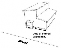
Figure 12
3.
One-Story Stepdown. The principal building shall include a one-story component on one (1) side of the building that remains one (1) story from the front façade to the rear wall. The width of the one-story portion shall be a minimum of twenty percent (20%) of the building's (or unit's) overall width. The one-story portion may be fully enclosed and used as living area. Accessible space (whether it is a deck, porch or enclosed area) shall not be allowed over the first story element; however, accessible space over the remaining first story elements on the front façade shall not be precluded. See Figure 12.
The availability of these options shall be determined according to the following lot characteristics:
(c)
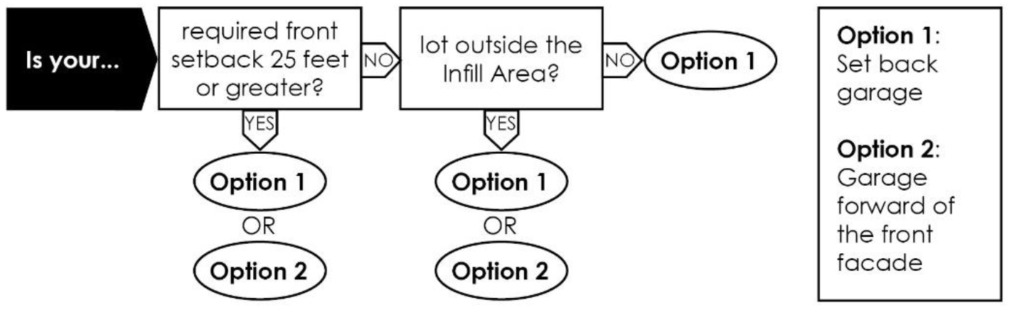
Garages.
(1)
Garage Access (Non-flexible).
a.
Applicability. This standard is required for all lots that have vehicular access from an alley or private street.
b.
Intent. This standard seeks to minimize potential conflicts between pedestrians and vehicles by concentrating parking along alleys and away from the street where pedestrian activity is highest. This standard also seeks to minimize the visibility of opaque and unarticulated garage doors from streets by placing them in alleys wherever possible. Properties with alleys shall utilize the alley as an opportunity to place the garage in a location that is subordinate to the principal building, further highlighting the primary building from the street. This standard is important for any property where an alley is available, which is most common in the Infill Area.
c.
Standard. A lot that has access from an alley or private street shall be required to access parking, garages and carports from the alley or private street. Where alley access is available, no parking or vehicular access shall be allowed forward of the front façade. See Figure 13.
Figure 13
(2)
Garage Placement (Non-flexible).
a.
Applicability. This standard is required for all lots that do not have vehicular access from an alley or private street.
b.
Intent. This standard seeks to prevent large expanses of unarticulated facades close to the street and ensure garages are subordinate to the principal building for properties that feature driveway and garage access directly from the street. Buildings should seek to locate garages behind principal buildings so that the front façade of the principal building is highlighted. Where locating the garage behind the front façade of the principal building is not feasible or required, designs should minimize the presence of garage doors as viewed from the street. This standard is important in all areas of the city where alley access is not an option.
c.
Standard. A garage or carport shall be placed in a way that reduces its prominence as viewed from the street. On a corner lot, this standard shall apply to both street-facing façades.
d.
Options. Fulfilling at least one (1) of the following options shall satisfy this standard:
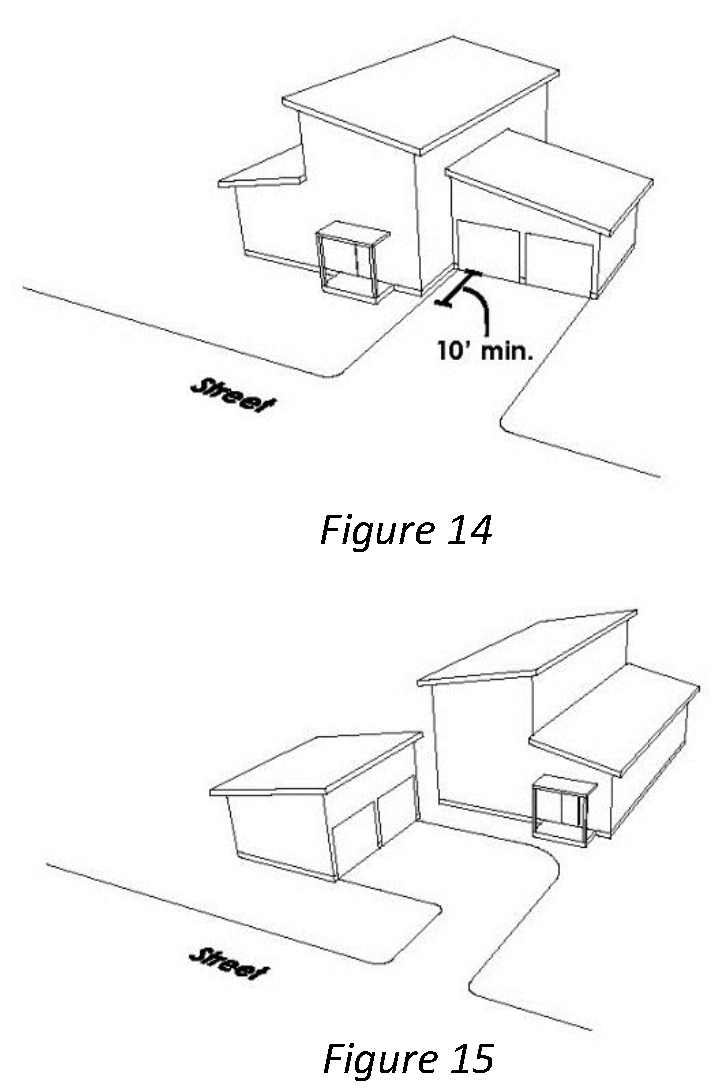
1.
Set Back Garage. The front-most element of the garage or carport shall be set back at least ten (10) feet further from the street than the front-most wall of any street-facing façade of the principal building. See Figure 14.
2.
Side-Loaded Garage Forward of Street-Facing Façade. A garage or carport located forward of a street-facing façade shall be side-loaded. The garage or carport entry shall be perpendicular to the street. For lots on curved streets, the garage door shall not be placed on any street-facing façade of the garage. See Figure 15.
The availability of these options shall be determined according to the following lot characteristics:
(3)
Garage Dimensions (Flexible).
a.
Applicability. This standard applies to all residential development in the city that is subject to the Residential Design Standards.
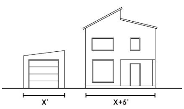
Figure 16
b.
Intent. This standard seeks to minimize the presence of wide garages as perceived from streets and ensure that garages are subordinate to the principal building. Designs should promote an active streetscape that is not dominated by wide expanses of garage doors. Garage doors should either be hidden from public view or their width minimized. This standard is important in all areas of the city. See Figure 16.
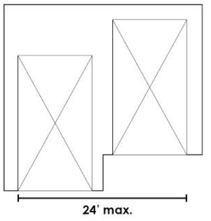
Figure 17
c.
Standards. The width of the living area on the first floor of a street-facing façade on which a garage is located shall be at least five (5) feet greater than the width of the garage or carport.
The total width of all vehicular entrance(s) to garage(s) or carport(s) that are visible from the street, whether on the same plane or offset from one another, shall not exceed twenty-four (24) feet. See Figure 17.
(4)
Garage Door Design (Flexible).
a.
Applicability. This standard applies to all residential development in the city that is subject to the Residential Design Standards.
b.
Intent. This standard seeks to promote a streetscape that maximizes visual interest by minimizing unarticulated expanses of garage doors. Garage doors that utilize increased articulation, changes in façade depth and profile of materials, windows and other features to break up the garage door should be prioritized. This standard is critical for any property where garage doors are visible from the street.
c.
Standard. A garage door that is visible from a street or alley shall utilize an articulation technique to break up its façade.
d.
Options. Fulfilling one of the following options shall satisfy this standard:
1.
Two Separate Doors. A two-car garage door shall be constructed as two separate doors. See Figure 18.
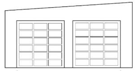
Figure 18
2.
Appearance of Two Separate Doors. A two-car garage door shall be constructed with one (1) door that is designed to appear as two (2) separate doors by incorporating a vertical separating element that is at least one (1) foot in width.
(d)
Entry Features.
(1)
Entry Connection (Non-flexible).
a.
Applicability. This standard shall apply to all lots except:
1.
Lots with a required front yard setback of at least ten (10) vertical feet above or below street grade.
b.
Intent. This standard seeks to promote visual and physical connections between buildings and the street. Buildings should use architectural and site planning features to establish a connection between these two (2) elements. Buildings shall not use features that create barriers or hide the entry features of the house such as fences, hedgerows or walls. Buildings and site planning features should establish a sense that one can directly enter a building from the street through the use of pathways, front porches, front doors that face the street and other similar methods. This standard is critical in all areas of the city.
c.
Standard. A building shall provide a visual and/or physical connection between a primary entry and the street. On a corner lot, an entry connection shall be provided to at least one (1) of the two (2) intersecting streets. Duplexes in a side-by-side configuration shall have one (1) entry connection per dwelling unit.
d.
Options. Fulfilling at least one of the following options shall satisfy this standard:
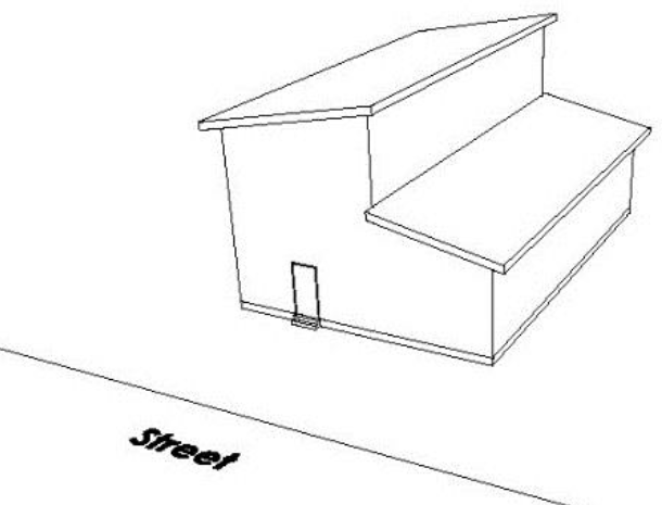
Figure 19
1.
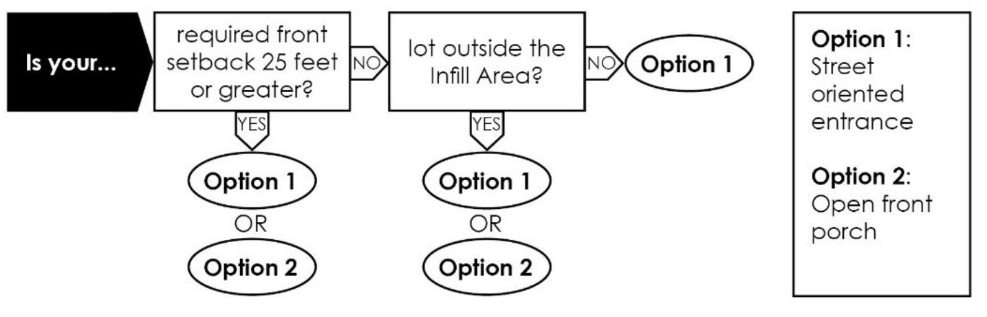
Street Oriented Entrance. At least one (1) entry door shall be provided on the front façade of the principal building. The entry door shall face the street and shall not be set back more than ten (10) feet from the front-most wall of the front façade of the principal building. Fencing, hedgerows, walls or other permitted structures shall not obstruct visibility to the door. See Figure 19.
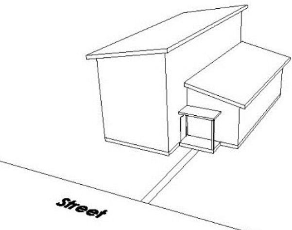
Figure 20
2.
Open Front Porch. The front façade of the principal building shall have a front porch that is open on at least two (2) sides, a minimum of fifty (50) square feet, face the street, and have a demarcated pathway that connects the street to the front porch. The front porch shall contain the primary entrance to the building. Fencing, hedgerows, walls or other permitted structures shall not obstruct visibility to the porch or the demarcated pathway. See Figure 20.
For lots located in the Smuggler Park and Smuggler Run Subdivisions: the front porch is not required on the front façade, but the front-most element of the porch shall be within twenty-five (25) feet of the front-most wall of the building. The porch shall meet all other requirements of this standard.
The availability of these options shall be determined according to the following lot characteristics:
(2)
Door Height (Flexible).
a.
Applicability. This standard shall apply to all lots except:
1.
Lots with a required front yard setback of at least ten (10) vertical feet above or below street grade.
b.
Intent. This standard seeks to retain historic architectural character by ensuring modestly scaled doors that are not out of scale when compared to historic Aspen residential buildings. Large, oversized doors should be avoided so as not to overwhelm front façades and distort the sense of human scale as perceived from the street. This standard is important in all areas of the city.
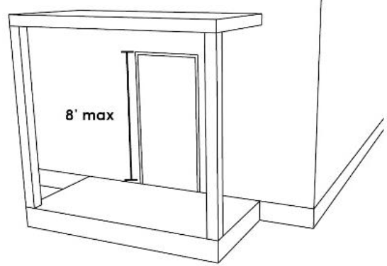
Figure 21
c.
Standard. All doors facing a street shall not be taller than eight (8) feet. A small transom window above a door shall not be considered a part of the door for the purpose of this standard. See Figure 21.
(3)
Entry Porch Height (Flexible).
a.
Applicability. This standard shall apply to all lots except:
1.
Lots with a required front yard setback of at least ten (10) vertical feet above or below street grade.
b.
Intent. This standard promotes porches that are built at a one-story human-scale that are compatible with historic Aspen residential buildings. This standard prevents porches that are out of scale with the street and traditional porches seen in the surrounding neighborhood. Porch designs should reinforce the one-story scale and help reduce perceived mass as viewed from the street. This standard is critical for buildings in the Infill Area.
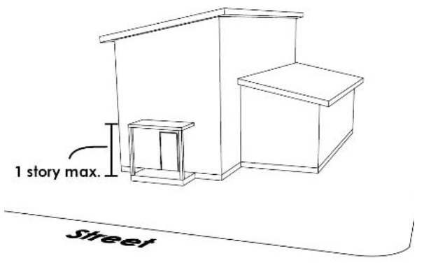
Figure 22
c.
Standard. An entry porch or canopy on the front façade of a principal building shall not be more than one-story in height as defined by this Chapter. See Figure 22.
(e)
Fenestration and Materials.
(1)
Principal Window (Flexible).
a.
Applicability. This standard shall apply to all lots except:
1.
Lots with a required front yard setback of at least ten (10) vertical feet above or below street grade.
b.
Intent. This standard seeks to prevent large expanses of blank walls on the front façades of principal buildings. A building should incorporate a significant sense of transparency on the front façade. Designs should include prominent windows or groups of windows on the front façade to help promote connection between the residence and street. This standard is important in all areas of the city.
c.
Standard. A principal building shall have at least one (1) street-facing principal window or grouping of smaller windows acting as a principal window on the front facade. Duplexes in a side-by-side configuration shall have one (1) principal window per dwelling unit.
d.
Options. Fulfilling at least one (1) of the following options shall satisfy this standard:
1.
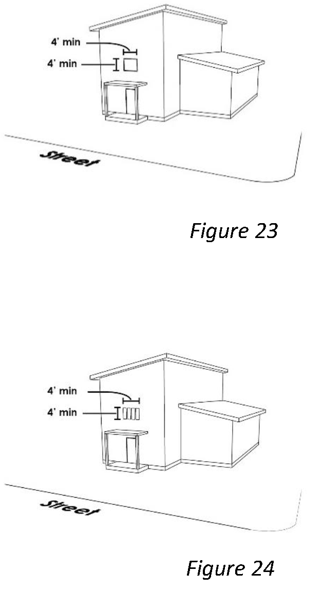
Street-Facing Principal Window. The front façade shall have at least one (1) window with dimensions of four (4) feet by four (4) feet or greater. See Figure 23.
2.
Window Group. The front façade shall have at least one (1) group of windows that when measured as a group has dimensions of four (4) feet by four (4) feet or greater. See Figure 24.
(2)
Window Placement (Flexible).
a.
Applicability. This standard shall apply to all lots except:
1.
Lots with a required front yard setback of at least ten (10) vertical feet above or below street grade.
b.
Intent. This standard seeks to preserve the historic architectural character of Aspen by preventing large expanses of vertical glass windows that dominate street-facing façades. Overly tall expanses of glass on a street-facing façade do not relate well to human scale. Designs should utilize windows that provide a sense of demarcation between stories and pedestrian scale. Where an upper story window is located directly above a lower story window, a gap with no window should be provided between them that is easily recognizable from the street and clearly differentiates lower and upper stories. This standard is important in all areas of the city.
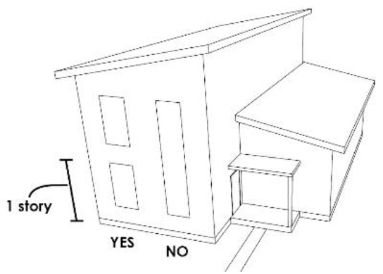
Figure 25
c.
Standard. A street-facing window on a building shall not vertically span more than one (1) story as defined by this Chapter. See Figure 25.
(3)
Non-orthogonal Window Limit (Flexible).
a.
Applicability. This standard shall apply to all lots except:
1.
Lots outside of the Aspen Infill Area.
2.
Lots with a required front yard setback of at least ten (10) vertical feet above or below street grade.
b.
Intent. This standard seeks to encourage rectilinear window shapes seen in Aspen's historic residential architecture and discourages the proliferation or overuse of round or diagonal-oriented windows. Designs should minimize the use of non-orthogonal windows that face the street in order to help preserve the historic character of Aspen. This standard is critical in the Infill Area where many of Aspen's historic residential buildings are located.
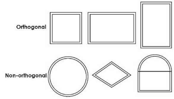
Figure 26
c.
Standard. A building shall have no more than one (1) non-orthogonal window on each façade of the building that faces the street. A single non-orthogonal window in a gable end may be divided with mullions and still be considered one (1) non-orthogonal window. See Figure 26.
(4)
Light well/Stairwell Location (Flexible).
a.
Applicability. This standard shall apply to all lots except:
1.
Lots with a required front yard setback of at least ten (10) vertical feet above or below street grade.
b.
Intent. This standard seeks to minimize negative visual impacts to the street and discourage visual and physical disconnection between buildings and streets. Building designs should avoid placing light wells, areaways, skylights, and stairwells between primary buildings and streets. These features should be located away from the front of buildings. Designs should locate these elements at the sides or rear of a principal building. This standard is most important in all areas of the city with smaller setbacks.
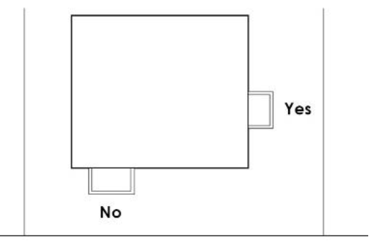
Figure 27
c.
Standard. A light well, areaway, skylight or stairwell shall not be located between the front-most wall of a street-facing façade and any street. See Figure 27.
(5)
Materials (Flexible).
a.
Applicability. This standard applies to all residential development in the city that is subject to the Residential Design Standards.
b.
Intent. This standard seeks to reinforce historic architectural character by preventing the use of materials on single-family and duplex buildings that is in sharp contrast with use of materials seen in historic Aspen residential buildings. Buildings should use materials consistently on all sides of a building instead of simply applying a material on one façade of a building. Buildings should seek to use heavier materials, such as brick or stone, as a base for lighter materials, such as wood or stucco. Buildings should use materials that are similar in profile, texture and durability to those seen in historic residential buildings in the city. This standard is important in all areas of the city.
c.
Standards. The quality of the exterior materials and their application shall be consistent on all sides of the single-family or duplex building. See Figure 28.
Materials shall be used in ways that are true to their characteristics. For instance, stucco, which is a light or nonbearing material, shall not be used below a heavy material, such as stone. See Figure 29.
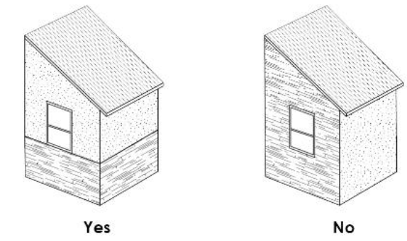
Figure 28
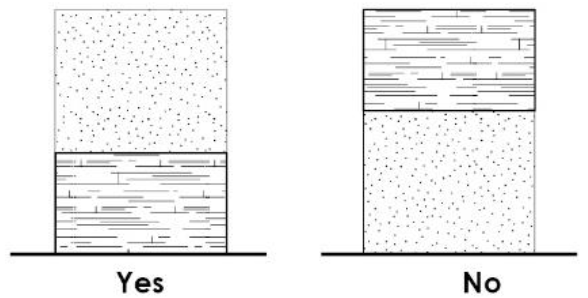
Figure 29
Sec. 26.410.040. - Multi-family standards.
(a)
Applicability. Unless stated otherwise below, the design standards in this Section shall apply to all multi-family development.
(b)
Design standards.
(1)
Building Orientation (Flexible).
a.
Applicability. This standard shall apply to all lots except:
1.
Lots with a required front yard setback of at least ten (10) vertical feet above or below street grade.
b.
Intent. This standard seeks to establish a relationship between buildings and streets to create an engaging streetscape and discourage the isolation of homes from the surrounding neighborhood. The placement of buildings should seek to frame street edges physically or visually. Buildings should be oriented in a manner such that they are a component of the streetscape, which consists of the street itself and the buildings that surround it. Building orientation should provide a sense of interest and promote interaction between buildings and passersby. Building orientation is important in all areas of the city, but is particularly important in the Infill Area where there is a strong pattern of buildings that are parallel to the street. Designs should prioritize the visibility of the front façade from the street by designing the majority of the front façade to be parallel to the street or prominently visible from the street. Front facades, porches, driveways, windows, and doors can all be designed to have a strong and direct relationship to the street.
c.
Standard. The front façade of a building shall be oriented to face the street on which it is located.
d.
Options. Fulfilling one of the following options shall satisfy this standard:
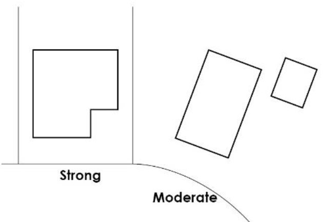
Figure 30
1.
Strong Orientation Requirement. The front façade of a building shall be parallel to the street. On a corner lot, both street-facing façades of a building shall be parallel to each street. See Figure 30.
2.
Moderate Orientation Requirement. The front façade of a building shall face the street. On a corner lot, one street-facing façade shall face each intersecting street.
The availability of these options shall be determined according to the following lot characteristics:
(2)
Garage Access (Non-flexible).
a.
Applicability. This standard is required for all lots that have vehicular access from an alley or private street.
b.
Intent. This standard seeks to minimize potential conflicts between pedestrians and vehicles by concentrating parking along alleys and away from the street where pedestrian activity is highest. This standard also seeks to minimize the visibility of plain, opaque and unarticulated garage doors from streets by placing them in alleys wherever possible. Properties with alleys shall utilize the alley as an opportunity to place the garage in a location that is subordinate to the principal building, further highlighting the primary building from the street. This standard is important for any property where an alley is available, which is most common in the Infill Area.
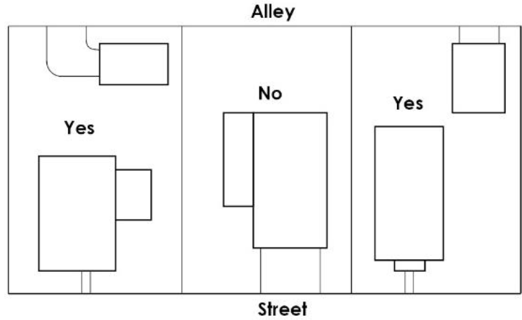
Figure 31
c.
Standard. A multi-family building that has access from an alley or private street shall be required to access parking, garages and carports from the alley or private street. See Figure 31.
(3)
Garage Placement (Non-flexible).
a.
Applicability. This standard is required for all lots that do not have vehicular access from an alley or private street.
b.
Intent. This standard seeks to prevent large expanses of unarticulated facades close to the street and ensure garages are subordinate to the principal building for properties that feature driveway and garage access directly from the street. Buildings should seek to locate garages behind principal buildings so that the front façade of the principal building is highlighted. Where locating the garage behind the front façade of the principal building is not feasible or required, designs should minimize the presence of garage doors as viewed from the street. This standard is important in all areas of the city where alley access is not an option.
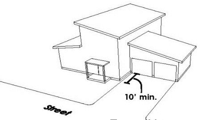
Figure 32
c.
Standard. The front of a garage or the front-most supporting column of a carport shall be set back at least ten (10) feet further from the street than the front façade of the principal building. See Figure 32.
(4)
Entry Connection (Non-flexible).
a.
Applicability. This standard shall apply to all lots except:
1.
Lots with a required front yard setback of at least ten (10) vertical feet above or below street grade.
b.
Intent. This standard seeks to promote visual and physical connections between buildings and the street. Buildings should use architectural and site planning features to establish a connection between these two (2) elements. Buildings shall not use features that create barriers or hide the entry features of the house such as fences, hedgerows or walls. Buildings and site planning features should establish a sense that one can directly enter a building from the street through the use of pathways, front porches, front doors that face the street and other similar methods. This standard is critical in all areas of the city.
c.
Standard. A building shall provide a visual and/or physical connection between a primary entry and the street. On a corner lot, an entry connection shall be provided to at least one (1) of the two (2) intersecting streets.
d.
Options. Fulfilling at least one of the following options shall satisfy this standard:
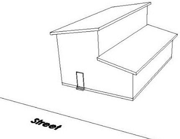
Figure 33
1.
Street Oriented Entrance. There shall be at least one (1) entry door that faces the street for every four (4) street-facing, ground-level units in a row. Fencing, hedgerows, walls or other permitted structures shall not obstruct visibility to the entire door. See Figure 33.
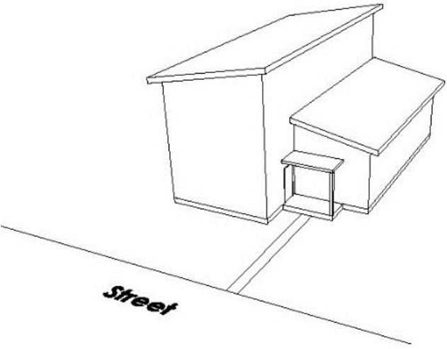
Figure 34
2.
Open Front Porch. There shall be at least one (1) porch or ground-level balcony that faces the street for every street-facing, ground-level unit. Fencing, hedgerows, walls or other permitted structures shall not obstruct visibility to the porch or the demarcated pathway. See Figure 34.
(5)
Principal Window (Flexible).
a.
Applicability. This standard shall apply to all lots except:
1.
Lots with a required front yard setback of at least ten (10) vertical feet above or below street grade.
b.
Intent. This standard seeks to prevent large expanses of blank walls on the front façades of principal buildings. A building should incorporate significant transparency on the front façade. Designs should include prominent windows or groups of windows on the front façade to help promote connection between the residence and street. This standard is important in all areas of the city.
c.
Standard. At least one (1) street-facing principal window or grouping of smaller windows acting as a principal window shall be provided for each unit facing the street. On a corner unit with street frontage on two (2) streets, this standard shall apply to both street-facing façades.
d.
Options. Fulfilling at least one of the following options shall satisfy this standard:
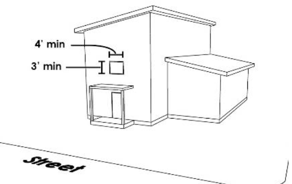
Figure 35
1.
Street-Facing Principal Window. The front façade shall have at least one (1) window with dimensions of three (3) feet by four (4) feet or greater for each dwelling unit. See Figure 35.
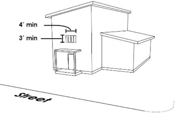
Figure 36
2.
Window Group. The front façade shall have at least one (1) group of windows that when measured as a group has dimensions of three (3) feet by four (4) feet or greater for each dwelling unit. See Figure 36.
Sec. 26.410.050. - Appeals.
(a)
An applicant aggrieved by a decision made by the Community Development Director regarding administration of this Chapter may appeal the decision to the Administrative Hearing Officer, pursuant to Chapter 26.316.
(b)
An applicant aggrieved by a decision made by the Planning and Zoning Commission or the Historic Preservation Commission as applicable, may appeal the decision to the City Council, pursuant to Chapter 26.316. In such circumstances, the Commission's decision shall be considered a recommendation to City Council.
Sec. 26.412.010. - General.
(a)
Purpose. The purpose of Commercial Design Review (CDR) is to foster appropriate building design that creates walkable neighborhoods and supports Aspen's unique heritage. The review standards do not prescribe architectural style, but do require that certain building elements contribute to the streetscape and neighborhood character.
The character of the Aspen's commercial neighborhoods is largely established by the variety of uses and the relationship between buildings and the pedestrian. Strengthening this relationship through thoughtful pedestrian amenity space, ground level storefront design, building mass, and responsive site design contributes to successful commercial neighborhoods.
The City does not intend to limit creativity in the built environment, but to promote architecture and site design that creates cohesive neighborhoods that are walkable, interesting and vibrant. Acknowledgement of existing neighborhood context is integral to preserving and to highlighting Aspen's local architectural vernacular. The adopted Commercial, Lodging and Historic District Design Standards and Guidelines provide specific design concepts and parameters to achieve these goals.
(b)
Adoption of Commercial Design Standards and Guidelines. The City Council hereby adopts design standards and guidelines, hereinafter referred to as the Commercial, Lodging and Historic District Design Standards and Guidelines, which are incorporated by reference and made a part of the Aspen Land Use Code. These Standards and Guidelines set forth the design parameters to ensure cohesive, creative and contextual architecture and site planning for commercial, lodging and mixed use developments. The Standards and Guidelines include a mix of requirements (standards) and recommendations (guidelines) that address exterior features of a building, site design, landscape and improvements within the right-of-way. The Commercial, Lodging and Historic District Design Standards and Guidelines may be amended, updated, and expanded from time to time by City Council Resolution. At least one (1) copy shall be available for public inspection at the Community Development Department.
Sec. 26.412.020. - Applicability.
Except as outlined below, this Section applies to all commercial, lodging and mixed-used development within the City requiring a building permit. All development shall be reviewed pursuant to the Character Area in which it is located. The Community Development Director shall assign an appropriate Character Area to properties subject to Commercial Design Review that are not located within a defined Character Area.
(a)
Essential public facilities. Essential public facilities within the Aspen Infill Area are subject to Commercial Design Review for all development requiring a building permit. An Essential Public Facility located outside the Aspen Infill Area is subject to Commercial Design Review unless the building has no public access.
(b)
Exemptions. No application for a Commercial Design Review Development Order is exempt from this Chapter unless the Community Development Director determines that the proposed development:
(1)
Is an addition or remodel of an existing structure that does not change the exterior of the building; or
(2)
Is a remodel of a structure where proposed alterations change the exterior of the building, but are not addressed by the Commercial, Lodging or Historic District Design Standards and Guidelines or Section 26.412.070, Pedestrian Amenity. (See Section 26.412.020(c) below.)
(c)
Remodels. Where work is proposed on any element of an existing building that is addressed by the Commercial Design Review and that is not in compliance with the Commercial, Lodging or Historic District Design Standards and Guidelines or Section 26.412.070, Pedestrian Amenity, the applicant shall make a reasonable effort to bring that element into compliance. The Community Development Director may grant exceptions for remodels that would require significant additional work above and beyond the scope of the remodel in order to ensure that all features are brought into compliance.
For example, consider an existing commercial building that is entirely stucco. A project to replace the ground level stucco material with high quality stone is proposed. The new proposed material is required to comply with the Commercial, Lodging or Historic District Design Standards and Guidelines. The upper level material that is not proposed to be replaced, and is not part of the limited scope of work of the project, is not required to comply. If the upper level stucco is disturbed during the application of the new ground level material (through enlargement of existing windows for example) then it must be brought into compliance with the Commercial, Lodging or Historic District Design Standards and Guidelines.
Sec. 26.412.030. - Review authority.
(a)
Review by Planning and Zoning Commission. The Planning and Zoning Commission, in accordance with the procedures, standards and limitations of this Chapter and of Common Development Review Procedures in Chapter 26.304, shall approve, approve with conditions or disapprove a land use application for Commercial Design Review pursuant to Section 26.412.040 below, with the exception of development that is located within the Commercial Core Historic District, the Main Street Historic District or on a property that is listed on the Inventory of Historic Landmark Sites and Structures.
(b)
Review by Historic Preservation Commission. When any portion of a development is within the Commercial Core Historic District, the Main Street Historic District or on a property that is or is under consideration to be listed on the Inventory of Historic Landmark Sites and Structures, Commercial Design Review shall be subject to review by the Historic Preservation Commission. The Historic Preservation Commission shall approve, approve with conditions or disapprove the land use application for Commercial Design Review, pursuant to Section 26.412.040 below.
(c)
Referral. Both the Planning and Zoning Commission and the Historic Preservation Commission may from time to time provide referral comments to each other on a specific application. The reviewing Commission shall take the comments into consideration but shall not be required to adhere to the comments in its review of an application.
Sec. 26.412.040. - Procedures for Review.
(a)
General. Commercial Design Review is divided into a two-step process known as Conceptual Design and Final Design. Conceptual design review focuses on site planning, mass, scale, proportions, parking, height and other elements that define the shape and placement of the proposed development. Final design review focuses on materials, window size and placement, landscaping, architectural details, detailed roofscape, operational characteristics, and other elements that finalize the architecture and landscape of the proposed development. Based on the specific proposal, the Community Development Director may amend which features are considered during the conceptual or final review.
(b)
Conceptual Design.
(1)
Conceptual design review. The procedures for the review of conceptual design are as follows:
a.
The Community Development Director shall review the application materials submitted for Conceptual Design approval. If they are determined to be complete, the applicant will be notified in writing, and a public hearing before the Planning and Zoning Commission or Historic Preservation Commission shall be scheduled. Notice of the hearing shall be provided pursuant to Subparagraphs 26.304.060(e)(3)a.—c.
b.
Staff shall review the submittal material and prepare a report that analyzes the project's conformance with the applicable Commercial, Lodging and Historic District Design Standards and Guidelines and other applicable Land Use Code sections. This report will be transmitted to the reviewing Commission with relevant information on the proposed project and a recommendation to approve, disapprove or approve with conditions and the reasons for the recommendation. The Commission will review the application, the staff analysis report and the evidence presented at the hearing to determine the project's conformance with the Commercial, Lodging and Historic District Design Standards and Guidelines.
c.
The Commission may approve, approve with conditions, deny, or continue the application to obtain additional information necessary to make a decision to approve or deny.
d.
A resolution of the Commission action will be forwarded to the City Council in accordance with Subsection 26.412.040(e), (Appeals, notice to City Council and call-up), and no hearing for final design application will be conducted until the "call-up" period by City Council has expired.
(2)
Effect of conceptual design approval. The effect of approval of a conceptual design is as follows:
a.
Approval of a conceptual design shall not constitute final approval of commercial design review unless part of a combined conceptual/final review. Such authorization shall only constitute authorization to proceed with the preparation of an application for a final design.
b.
Approval of a conceptual design shall be binding in regards to the location and form of the envelope of the structures and/or additions as depicted in the conceptual design application, including its height, scale, massing and proportions. No substantial changes will be made to this aspect of the proposed development as part of final design. If the applicant chooses to makes substantial amendments to the conceptual design after it has been approved, a new conceptual design hearing is required.
c.
Unless otherwise specified in the resolution granting conceptual design approval, a development application for a final design shall be submitted within one (1) year of the date of approval of a conceptual design. Failure to file such an application within this time period shall render null and void the approval of the conceptual development plan. The Community Development Director may, at his or her sole discretion and for good cause shown, grant a one-time extension of the expiration date for a conceptual design approval for up to twelve (12) months if a written request for extension is received at least thirty (30) days prior to the expiration date.
(c)
Final Design.
(1)
The procedures for the review of final design are as follows:
a.
The Community Development Director shall review the application materials submitted for final development plan approval. If they are determined to be complete, the applicant will be notified in writing of this, and a public hearing before the Planning and Zoning Commission or Historic Preservation Commission shall be scheduled. Notice of the hearing shall be provided pursuant to Subparagraphs 26.304.060(e)(3)a.—c.
b.
Staff shall review the submittal material and prepare a report that analyzes the project's conformance with the applicable Commercial, Lodging and Historic District Design Objectives and Guidelines and other applicable Land Use Code sections. This report will be transmitted to the Commission with relevant information on the proposed project and a recommendation to approve, disapprove or approve with conditions and the reasons for the recommendation. The Commission will review the application, the staff analysis report and the evidence presented at the hearing to determine the project's conformance with the City's Commercial, Lodging and Historic District Design Objectives and Guidelines.
c.
The Commission may approve, disapprove, approve with conditions or continue the application to obtain additional information necessary to make a decision to approve or deny.
d.
Before an application for a building permit can be submitted, and pursuant to Chapter 26.490, Development Documents, a final set of plans reflecting any or all required changes by the Commission must be on file with the City. Any conditions of approval or outstanding issues which must be addressed in the field or at a later time shall be noted on the plans. The following items, as applicable, shall be required as part of the Development Documents:
1.
Landscaping plan. Prior to issuance of a building permit, the Community Development Director shall require site plans and drawings of any required Pedestrian Amenity space, including an access, landscaping and programming plan, and a bond in a satisfactory form and amount to ensure compliance with any Pedestrian Amenity requirements under this Title.
2.
Maintenance of landscaping. Whenever the landscaping required herein is not maintained, the Chief Building Official, after thirty (30) days' written notice to the owner or occupant of the property, may revoke the certificate of occupancy until said party complies with the landscaping requirements of this Section.
(d)
Variations. An application requesting a variation from the Standards of Commercial, Lodging, and Historic District Design Standards and Guidelines shall be reviewed during either Conceptual Design Review or Final Design Review, as determined by the Community Development Department. The Planning & Zoning Commission or Historic Preservation Commission, during a duly noticed public hearing, shall approve, approve with conditions, or deny an application for variation. The application shall demonstrate and the deciding board shall find that the variation, if granted, would:
(1)
Provide an alternative design approach that meets the overall intent of the standard. The reviewing board shall consider the appropriateness of the design features, building elements, and existing neighborhood context to determine that the exception is appropriate; or
(2)
Be clearly necessary for reasons of fairness related to unusual site-specific constraints.
(e)
Consolidation of applications and combining of reviews. If a development project involves additional City land use approvals, the Community Development Director may consolidate or modify the review process accordingly, pursuant to Subsection 26.304.060(b) of this Title.
If a proposed development, upon determination of the Community Development Director and in consultation with the applicant, is of limited scope, the Director may authorize the application to be subject to a one-step process that combines both conceptual and final design reviews.
When the Historic Preservation Commission has purview over Commercial Design Review, an application for commercial design review shall be consolidated with the appropriate review process as required by Section 26.415.070, Development Involving Designated Property. When an application is considered consolidated and a conflict between this Chapter and Chapter 26.415, Development Involving the Aspen Inventory of Historic Landmark Sites and Structures or Development in an "H," Historic Overlay District, arises, the regulations of Chapter 26.415 shall supersede.
(f)
Appeals, Notice to City Council and Call-up.
(1)
Appeals. An applicant aggrieved by a determination made by the Community Development Director, the Planning and Zoning Commission or the Historic Preservation Commission, as applicable, pursuant to this Chapter, may appeal the decision to the City Council, pursuant to the procedures and standards of Chapter 26.316, Appeals.
(2)
Notice to City Council. Following the adoption of a resolution approving or approving with conditions a development application for Conceptual Commercial Design Review or for Consolidated Commercial Design Review, the City Council shall be promptly notified of the action to allow the City Council an opportunity to avail itself of the call-up procedure set forth below. Notification shall consist of a description in written and graphic form of the project with a copy of the approving document. The notification shall be placed on the agenda of a regular City Council meeting within thirty (30) days of the approval, or as soon thereafter as is practical under the circumstances.
(3)
Call-up. Following the adoption of a resolution approving or approving with conditions a development application for Commercial Design Review, the City Council may order call-up of the action within fifteen (15) days of notification, as outlined in Subsection (b), above. Consequently, applications for Final Design shall not be accepted by the City and no associated permits shall be issued during the notice and call-up period. If City Council exercises this call-up provision, no applications for Final Design shall be accepted by the City and no associated permits shall be issued until the City Council takes action as described in Subsection (4), below. If the City Council does not call up the action within the call-up period, the resolution shall be the final decision on the matter.
(4)
City Council action on call-up. The City Council shall, at a public meeting, consider the application de novo. The City Council may, at its discretion, consider evidence included in the record established by the Historic Preservation Commission or Planning and Zoning Commission, as applicable, or supplement the record with additional evidence or testimony as necessary. The City Council shall conduct its review of the application under the same criteria applicable to the reviewing body. The City Council's action shall be limited to:
a.
Accepting the decision.
b.
Remanding the application to the applicable Commission with direction from City Council for rehearing and reconsideration.
c.
Continuing the meeting to request additional evidence, analysis, or testimony as necessary to conclude the call up review.
(5)
Additional Actions. The rehearing and reconsideration of the application by the applicable Commission shall be duly noticed pursuant to Section 26.304.060(e) Public Notice and shall be limited to the topics listed in the direction from Council. The decision made by the applicable Commission is final and concludes the call up review. Substantive changes, as defined in Section 26.412.090, Amendments, made to the application during the call up review and outside the topics listed in the remand from Council shall be reviewed pursuant to Section 26.412.090 and may require a new call up notice to City Council. The call up review shall be limited only to the changes approved in the Amendment application.
Sec. 26.412.050. - Application Requirements.
(a)
Conceptual design application. An application for a conceptual design shall include the following:
(1)
The general application information required in Section 26.304.030.
(2)
A site plan and survey showing property boundaries, the location and orientation of existing and proposed improvements, proximity to any preserved view planes, and predominant site characteristics.
(3)
Scaled drawings of all proposed structures or additions depicting their form, including their height, massing, scale, proportions and roof plan; and the primary features of all elevations.
(4)
Preliminary selection of primary building materials to be used in construction represented by samples and/or photographs.
(5)
Visual depiction of the proposed building in the context of the overall block.
(6)
Supplemental materials to provide a visual description of the context surrounding the property, including at least two (2) of the following: diagrams, maps, photographs, models or streetscape elevations. Staff may request specific additional materials, including 3-D computer modeling.
(7)
Verification that the proposal complies with applicable sections of the Land Use Code and Commercial, Lodging and Historic District Design Standards and Guidelines.
(b)
Final design application. An application for a final development plan shall include:
(1)
The general application information required in Section 26.304.030 of this Title.
(2)
A site plan and survey showing property boundaries, the location and orientation of existing and proposed improvements, proximity to any preserved view planes, and predominant site characteristics.
(3)
Final scaled and dimensioned drawings of all proposed structures and/or additions included as part of the development.
(4)
An accurate representation of all major building materials to be used in the development, depicted through samples or photographs.
(5)
Visual depiction of the proposed building in the context of the overall block.
(6)
A statement, including narrative text or graphics, indicating how the final design conforms to representations made or stipulations placed as a condition of the approval of the conceptual design. Staff may request specific additional materials, including 3-D computer modeling.
(7)
Final landscape and lighting plans.
Sec. 26.412.060. - Review Criteria.
An application for commercial design review may be approved, approved with conditions or denied based on conformance with the following criteria:
(a)
Guidelines and Standards.
(1)
The Commercial, Lodging and Historic District Design Standards and Guidelines are met as determined by the appropriate Commission. The Standards and Guidelines include design review criteria that are to be used to determine whether the application is appropriate.
(2)
All applicable standards in the Commercial, Lodging and Historic District Design Standards and Guidelines shall be met unless granted a Variation pursuant to Section 26.412.040(d), Variations.
(3)
Not every guideline will apply to each project, and some balancing of the guidelines must occur on a case-by-case basis. The applicable Commission must:
a.
Determine that a sufficient number of the relevant guidelines are adequately met in order to approve a project proposal;
b.
Weigh the applicable guidelines with the practicality of the measure.
(b)
Pedestrian Amenity. The proposed development meets the requirements of Section 26.412.070, Pedestrian Amenity.
Sec. 26.412.070. - Pedestrian Amenity.
Creative, well-designed public places and settings contribute to an attractive, vital, human-scale downtown commercial district and a pleasant pedestrian shopping and entertainment atmosphere. Pedestrian amenity space can take the form of physical or operational improvements to public rights-of-way or private property within commercial areas.
(a)
Applicability and Requirement. The requirements of this Section shall apply to the development of all commercial, lodging and mixed-use development within the CC, C-1, MU, NC, S/C/I, L, CL, LP and LO Zone Districts, as well as any Essential Public Facility pursuant to Section 26.412.020(a). This area represents the City's primary pedestrian-oriented downtown, as well as important mixed-use, service and lodging neighborhoods. Development in these zone districts consisting of entirely residential uses is exempt from these provisions. Remodel and renovation activities that do not trigger demolition, and which maintain one hundred percent (100%) of the existing pedestrian amenity present on the site are exempt from this Section. Changes to pedestrian amenity space as a result of required accessibility or building code compliance are exempt from compliance with the twenty-five percent (25%) requirement if demolition is not triggered.
Twenty-five percent (25%) of the Gross Lot Area of properties within the applicable area shall be provided as pedestrian amenity regardless of existing onsite pedestrian amenity amount. A project that qualifies as demolition, as defined in Section 26.104.100, must meet the requirements of this Section. Vacated rights-of-way do not count toward pedestrian amenity requirements.
Calculation of pedestrian amenity shall include stairs, walkways or other means of accessing pedestrian amenity space from rights-of-way or internal circulation ways counted as non-unit space per Section 26.575.020. Airlocks providing access to internal pedestrian amenity space, and which meet the criteria provided in Section 26.575.020 may be included in the calculation of pedestrian amenity space.
(b)
Provision of pedestrian amenity. Unless specified, the Planning and Zoning Commission or Historic Preservation Commission shall determine the appropriate method or combination of methods for providing this required amenity. One (1) or more of the following methods may be used to meet the requirement.
(1)
On-site pedestrian amenity. On-site pedestrian amenity options are provided within the Commercial, Lodging, and Historic District Design Standards and Guidelines.
a.
For properties located on rights-of-way designated as pedestrian malls including Hyman and Cooper Streets between Galena and Mill Streets, and Mill Street between Hyman Street and Durant Street, new pedestrian amenity is limited to second floor or street level. Existing on-site pedestrian amenity may be maintained, with any difference between the existing amount and the twenty-five percent (25%) required to be provided as cash-in-lieu.
(2)
Off-site pedestrian amenity. These may be improvements to private property, public property or public rights-of-way.
a.
An easement providing public access over an existing Pedestrian Amenity space for which no easement exists may be accepted if the easement provides permanent public access and is acceptable to the City Attorney.
b.
Off-site improvements shall:
1.
equal or exceed the value of an otherwise required cash-in-lieu payment as determined by the City Engineer, and
2.
be consistent with any public infrastructure or capital improvement plan for that area.
(3)
Cash-in-lieu provision. Cash-in-lieu for pedestrian amenity requirements may be provided, subject to the following requirements:
a.
For properties located on rights-of-way designated as pedestrian malls including Hyman and Cooper Streets between Galena and Mill Streets, and Mill Street between Hyman Street and Durant Street, cash-in-lieu of on-site Pedestrian Amenity space is encouraged. Fees collected as cash-in-lieu for Pedestrian Amenity of designated pedestrian malls shall be held in reserve by the City for the maintenance and improvement of the pedestrian malls.
b.
For properties not located adjacent to the pedestrian malls, where on-site Pedestrian Amenity is not appropriate or may not be feasibly provided due to site or development constraints, cash-in-lieu may be accepted as an alternative. Such conditions shall be determined on a case-by-case basis at the discretion of the Planning and Zoning Commission or Historic Preservation Commission.
c.
A cash-in-lieu payment for fifty percent (50%) or more of the required pedestrian amenity for properties not located on a pedestrian mall or less than one hundred percent (100%) for properties located on a pedestrian mall requires City Council approval.
(4)
Alternative method. The Commission may accept any method of providing a pedestrian amenity not otherwise described herein if it finds that the alternative method meets the intent of pedestrian amenity, equals or exceeds the monetary value, or meets the purpose and intent of these regulations to an equivalent extent, of an otherwise required on-site amenity space or cash-in-lieu payment.
(5)
Pedestrian links. If the City has adopted a trail plan incorporating mid-block pedestrian links, any required Pedestrian Amenity space must, if the City shall so choose, be applied and dedicated for that use. The development of mid-block walkways to access second tier commercial spaces located off the primary street frontage, which are not part of an adopted trail plan, may be counted towards Pedestrian Amenity space requirements for a property and must be designed in accordance with the Commercial, Lodging and Historic District Standards and Guidelines.
(c)
Reduction of requirement. The Historic Preservation Commission may reduce the required pedestrian amenity amount, pursuant to the procedures and criteria of Chapter 26.412, Commercial Design Review, for historic landmark properties upon one (1) of the following circumstances:
(1)
When the Historic Preservation Commission approves the on-site relocation of an historic landmark such that the amount of on-site public space is reduced below that required by this Chapter.
(2)
When the manner in which an historic landmark building was originally developed reduces the amount of on-site Pedestrian Amenity required by this Chapter.
(3)
When the redevelopment or expansion of an historic landmark constitutes an exemplary preservation effort deserving of an incentive or reward, as provided in the City of Aspen Historic Preservation Design Guidelines.
(d)
Cash-in-lieu payment. When the method of providing pedestrian amenity includes a cash-in-lieu payment, the following provisions and limitations shall apply:
Land value shall be the lesser of one hundred dollars ($100.00) per square foot multiplied by the number of square feet constituting the parcel, or the appraised value of the unimproved property determined by the submission of a current appraisal performed by a qualified professional real estate appraiser and verified by the Community Development Director.
The payment-in-lieu of pedestrian amenity shall be due and payable at the time of issuance of a building permit. The City Manager, upon request, may allow the required payment-in-lieu to be amortized in equal payments over a period of up to five (5) years, with or without interest.
All funds shall be collected by the Community Development Director and transferred to the Finance Director for deposit in a separate interest-bearing account. Monies in the account shall be used solely for the purchase, development, or capital improvement of land or public rights-of-way for open space, pedestrian or bicycle infrastructure, Pedestrian Amenity, or recreational purposes within or adjacent to the applicable area in which this requirement applies. Funds may be used to acquire public use easements. Fees shall be spent on projects within the Aspen Infill Area and related to pedestrian improvements to rights-of-way or on public property, the acquisition of permanent pedestrian easements through private property where no prior public access easement is provided, or other improvements to pedestrian movement, access or amenity as approved by City Council.
Fees collected pursuant to this Section may be returned to the then-present owner of property for which a fee was paid, including any interest earned, if the fees have not been spent within seven (7) years from the date fees were paid, unless the City Council has earmarked the funds for expenditure on a specific project, in which case the City Council may extend the time period by up to three (3) more years. Payments shall be spent in the order in which they are received. To obtain a refund, the present owner must submit a petition to the Finance Director within one (1) year following the end of the seventh year from the date payment was received. All petitions shall be accompanied by a notarized, sworn statement that the petitioner is the current owner of the property and by a copy of the dated receipt issued for payment of the fee.
Sec. 26.412.080. - Second Tier Commercial Space.
The Aspen Area Community Plan establishes policies to encourage a balanced, diverse and vital commercial use mix that meets the needs of the year-round residents and visitors, and to facilitate the sustainability of essential businesses that provide basic community needs. These design standards ensure "second tier" space in commercial zones are maintained, allows for the redevelopment of commercial properties, maintains a meaningful ratio of commercial space that serves the day to day needs of residents and visitors, and allows for creative designs that add variety and interest to the City's commercial areas.
(a)
Applicability.
(1)
Development or redevelopment. This Section applies to all new development and redevelopment in the CC, C-1, S/C/I, NC, and MU districts. Proposals that are one hundred percent (100%) lodge projects shall be exempted from this requirement. Remodel and renovation activities that do not trigger demolition, and which maintain one hundred percent (100%) of the existing second tier space present on the site are exempt from this Section. Changes to second tier space as a result of required accessibility or building code compliance are exempt from compliance with the section if demolition is not triggered.
(2)
Second Tier Commercial Space. See Section 26.104.100,Definitions.
(3)
Limitations. No portion of Second Tier Commercial Space may be used as storage, office, and the like, for another commercial space. For instance, if a retail shop is located on the ground floor, the basement Second Tier Commercial Space may not be used as the office or storage for that business, and must instead be an entirely separate space.
(b)
Requirement.
(1)
The following minimum and maximum net leasable area shall be designed as second tier commercial space:
Table 26.412.100-1
(2)
The redevelopment of any building that includes existing second tier commercial space shall provide the greater of fifty percent (50%) of the existing space or the minimums outlined in Table 26.412.100-1.
(3)
In order to satisfy the requirements of this Section, issuance of the Certificate of Occupancy or Letter of Completion for ground floor commercial space is contingent upon the issuance of the Certificate of Occupancy or Letter of Completion for all second tier space located within the development. This includes the completion of all utilities, structural assemblies and other building accessibility requirements, and life safety elements necessary for the completion of inspections, to permit occupancy, and facilitate the intended use of the space. This may include the installation of HVAC systems, as well as grease traps, ventilation and fire suppression systems for restaurant, bar, bakery, commercial kitchen and related uses. An agreement, acceptable to the City Attorney, outlining the process for completion and occupancy of ground floor and second tier commercial space, to be signed by the Community Development Director, shall be required as part of the Development Documents, and shall be required prior to issuance of a core and shell or tenant finish building permit.
(4)
Pedestrian amenity is encouraged to provide access to second tier commercial spaces within a development. This access may be provided via a mid-block walkway accessing commercial space off the primary street frontage, a sub-grade courtyard, an internal enclosed courtyard, or access to upper level commercial areas.
(c)
Reduction of requirement. The Planning and Zoning Commission may approve a reduction in the required second tier commercial space pursuant to the procedures and criteria of Chapter 26.304.060 and Section 26.412.040. One of the following criteria shall be met:
(1)
Requirement met on another property.
a.
Property owners or applicants for development approval of at least one other lot or parcel (within the same block or zone district) agree to provide second tier commercial space in an amount that offsets the shortfall in required second tier commercial space on the property subject to the application for development or redevelopment; and
b.
All of the property owners enter into an enforceable development agreement to the satisfaction of the City Attorney. The agreement shall provide assurances that the required second tier commercial space will be developed and ready for occupancy prior to the occupancy of the property that is authorized to have a shortfall and remedies if the space is not ready when the space on the subject property is ready for occupancy.
(2)
Hardship. The applicant demonstrates that a sufficient site-specific hardship is present on the property preventing the provision of some portion of the total required. This requires review as a variance, pursuant to Section 26.314, variances.
(d)
Second Tier Space Auditing. The Community Development Director may require periodic operational audits of Second Tier Commercial Space to ensure compliance with the Land Use Code. This audit may include, but is not limited to, information from the property owner regarding how the space is used; the manner in which the space is marketed and managed; and any additional conditions of approval. The information shall be provided within fifteen (15) calendar days after notification that an audit has been requested, unless the Community Development Director extends this time period for good cause shown. The Community Development Director may request a site inspection as part of the audit. Property owners may request that certain information, such as marketing strategies, be held in confidence by the City.
Sec. 26.412.090. - Amendments.
(a)
Insubstantial amendment.
(1)
Planning and Zoning Commission reviews. An insubstantial amendment to a Commercial Design Review approval originally granted by the Planning and Zoning Commission may be authorized by the Community Development Director if:
a.
The change is in conformance with the Commercial, Lodging and Historic District Design Standards and Guidelines, the change represents a minimal effect on the aesthetics of the proposed development, or the change is consistent with representations made during the original review concerning potential changes of the development proposal considered appropriate by the decision-making body; and
b.
The change requires no other land use action requiring review by the Planning and Zoning Commission.
(2)
Historic Preservation Commission reviews. An insubstantial amendment to a Commercial Design Review approval originally granted by the Historic Preservation Commission shall comply with the standards outlined in Paragraph 26.415.070(e)(1), Insubstantial amendments.
(3)
Administrative review. The Community Development Director may approve a Commercial Design Review if it is determined that the proposed work has no adverse effect on the physical appearance or character defining features of a development. An application for administrative review may be approved if it meets the following requirements:
a.
It is deemed that the activity is an eligible work item and meets the Commercial, Lodging, and Historic District Design Standards and Guidelines; and,
b.
Any modifications to the proposed work requested by the Community Development Director are agreed to by the owner/applicant.
The following work shall be considered an eligible work item for an administrative review approval:
a.
Replacement or repair of architectural features which creates no change to the exterior physical appearance of the building or structure.
b.
Installation of awnings or similar attachments provided no significant feature is damaged, removed, or obscured by the installation and that do not reduce or enclose approved Pedestrian Amenity space.
c.
Mechanical equipment or accessory features that have no impact on the character defining features of the building or structure, and that meet the requirements of Section 26.435.050, if applicable.
d.
Alterations to no more than two (2) elements of a street-facing facades.
Installation of site improvements, such as fences, walkways, patios, or similar features that do not reduce or cover approved Pedestrian Amenity space
(b)
Substantial amendments. Any amendment to an existing approval which does not meet the thresholds for an insubstantial amendment shall be considered a substantial amendment. A substantial amendment to a Commercial Design Review approval shall be reviewed pursuant to the standards and procedures of this Section.
(Ord. No. 13, 2007, § 1; Ord. No. 33, 2016, § 1; Ord. No. 23-2017)
Sec. 26.415.010. - Purpose and intent.
The purpose of this Chapter is to promote the public health, safety and welfare through the protection, enhancement and preservation of those properties, areas and sites, which represent the distinctive elements of Aspen's cultural, educational, social, economic, political and architectural history. Under the authority provided by the Home Rule Charter of the City and C.R.S. § 29-20-104(c), to regulate land use and preserve areas of historical, architectural, archaeological, engineering and cultural importance, this Chapter sets forth the procedures to:
(a)
Recognize, protect and promote the retention and continued utility of the historic buildings and districts in the City;
(b)
Promote awareness and appreciation of Aspen's unique heritage;
(c)
Ensure the preservation of Aspen's character as an historic mining town, early ski resort and cultural center;
(d)
Retain the historic, architectural and cultural resource attractions that support tourism and the economic welfare of the community; and
(e)
Encourage sustainable reuse of historic structures.
(f)
Encourage voluntary efforts to increase public information, interaction or access to historic building interiors.
The City does not intend by the historic preservation program to preserve every old building, but instead to draw a reasonable balance between private property rights and the public interest in preserving the City's cultural, historic, and architectural heritage. This should be accomplished by ensuring that demolition of buildings and structures important to that heritage are carefully weighed with other alternatives. Alterations to historically significant buildings and new construction in historic areas shall respect the character of each such setting, not by imitating surrounding structures, but by being compatible with them as defined in historic preservation guidelines.
(Ord. No. 28-2010, § 1)
Sec. 26.415.015. - Applicability.
This Chapter applies to all properties listed on the Aspen Inventory of Historic Sites and Structures and to all properties located within the boundaries of a Historic District, including rights-of-way within Historic Districts as specified in Section 26.415.060.
(Ord. No. 33-2012, § 1)
Sec. 26.415.020. - Definitions.
The following definitions are specific to the terms as used in this Chapter and in the field of historic preservation:
Alteration. A change to an existing building, structure or feature that modifies its original appearance or construction.
Certificate of appropriateness. An official form issued by the City stating that the proposed work on a designated historic property is compatible with its historic and architectural character and, therefore, the work may be completed as specified in the certificate and the City may issue any permits needed to do the work specified in the certificate.
Certificate of demolition approval. An official form issued by the City authorizing the issuance of a demolition permit for a designated historic property or for a building or structure located in a designated Historic District.
Certificate of economic hardship. An official form issued by the City, in connection with a certificate of demolition approval, that allows the demolition of a designated historic property as the owner has demonstrated that maintaining it will impose an economic hardship.
Certificate of no negative effect. An official form issued by the City stating that the proposed work will have no detrimental effect on the character-defining features of a designated property and, therefore, the work may proceed as specified in the certificate without obtaining further approvals under this Chapter and the City may issue any permits needed to do the work in the specified certificate.
Contributing resource. A building, site, structure or object that adds to the historic associations, historic architectural qualities or archaeological values for which a property is considered significant.
Designated property. An individual property listed on the Aspen Inventory of Historic Landmark Sites and Structures.
Historic context paper.Research papers that define Aspen's architectural and cultural patterns in the context of local and national history. Historic context papers are used to guide staff, the Historic Preservation Commission and City Council in determining the historic significance of structures and properties in the City of Aspen.
Historic District. A collection, concentration, linkage or continuity of buildings, structures, sites or objects united historically or aesthetically by plan or physical development that is listed on the Aspen Inventory of Historic Landmark Sites and Structures including designated properties, contributing resources, and noncontributing resources located within the boundaries of a Historic District pursuant to the Official Zone District Map.
Integrity. The ability of a property to convey its significance relative to the aspects of location, setting, design, materials, workmanship and association.
Monitoring committee. A subcommittee appointed by the Historic Preservation Commission of up to two (2) Commission members and the Historic Preservation Officer to provide oversight in the implementation of rehabilitation.
Noncontributing resource. A building, structure, site or object that does not add to the historic architectural qualities or historic associations for which a property is significant because it was not present during the period of significance or does not relate to the documented significance; or due to alterations, additions, disturbances or other changes, it no longer possesses historic integrity.
Object. A term used to distinguish buildings and structures from those constructions that are primarily artistic in nature or small in scale and simply constructed. It may be by nature or design movable, but it is associated with a specific setting and environment.
Rehabilitation. Making a building or structure sound and usable without attempting to restore it to a particular period appearance, while retaining the character-defining features.
Relocation. Moving a building or structure from its original, historically significant or existing location to another location.
Repair. To restore to a sound or good state after decay, dilapidation or partial destruction.
Restore. The repair or recreation of the original architectural elements or features of an historic property so that it resembles an appearance it had at some previous point in time.
Significance. The documented importance of a property for its contribution to or representation of broad patterns of national, regional or local history, architecture, engineering, archaeology and culture.
Site. The location of a significant event, a prehistoric or historic occupation or activity or a building or structure, whether standing, ruined or vanished, where the location itself possesses historic, cultural or archaeological value regardless of the value of any existing structure.
Structure. A term used to distinguish from buildings those functional constructions made for purposes other than creating human shelter.
(Ord. 1-2002, § 7 [part];Ord. No. 28-2010, § 1; Ord. No. 33-2012, § 2)
Sec. 26.415.025. - Identification of historic properties.
(a)
Surveys, Maps and Historic Context Papers. The Community Development Director shall conduct or cause to be conducted such preliminary surveys, studies or investigations as deemed necessary or advisable to adequately inform City Council and the Historic Preservation Commission of those properties located within the City which represent Aspen's 19 th and 20 th century history. The Community Development Director shall memorialize the results of surveys, studies and investigations in a series of historic inventory forms, maps and historic context papers. Said inventory forms, maps, and context papers shall be maintained by the Community Development Department and shall be made available for public inspection at all reasonable times. New inventory forms, maps and historic context papers shall not be adopted by City Council except for every tenth year, starting in January 2011.
These resources shall be referenced by the Historic Preservation Commission and City Council when reviewing applications for designation.
(b)
Aspen Victorian Properties. Properties associated with Aspen's 19 th century history shall be called Aspen Victorian. The City of Aspen has comprehensively identified examples of Victorian era properties in Aspen since the 1970s. All such properties have been designated by ordinance to the Aspen Inventory of Historic Landmark Sites and Structures. Such properties are subject to the terms of this Chapter. Additional 19 th century properties may be identified and designated in the future if they are determined to meet the criteria of Section 26.415.030(b)(1).
(c)
AspenModern Properties. Properties associated with Aspen's 20 th century history shall be called AspenModern. Properties identified on the AspenModern Map shall be eligible for certain preservation benefits without being designated by City Council and may be awarded preservation incentives above and beyond those identified at Section 26.415.110, as follows. Property owners are encouraged to meet proactively with the historic preservation commission before undertaking development plans to receive preliminary feedback on appropriate development and benefits.
(1)
Ninety-Day Negotiation Period. In the case that the owner of a property on the AspenModern Map submits a land use application which includes voluntary landmark designation, a negotiation period of up to 90 days shall be initiated.
A letter from the property owner indicating an understanding of this 90-day negotiation period shall accompany the land use application. The 90-day negotiation period may be extended an additional thirty (30) days upon a resolution adopted by the Council, or longer if mutually acceptable to both the Council and the property owner. Nothing herein shall prevent the City from reviewing any land use application or building permit affecting the subject property during the 90-day negotiation period.
Within the 90-day negotiation period, the following shall occur:
a.
The Community Development Director shall offer to meet with the property owner to discuss the City's Historic Preservation Program and benefits that the property may be eligible to receive upon designation as a Historic Landmark.
b.
The Community Development Director shall confer with the Historic Preservation Commission, at a public meeting, regarding the proposed land use application or building permit and the nature of the property. The property owner shall be provided notice of this meeting.
The Historic Preservation Commission, using context papers and integrity scoring sheets for the property under consideration, shall provide Council with an assessment of the property's conformance with the designation criteria of Section 26.415.030(c)(1). When any benefits that are not included in Section 26.415.110 are requested by the property owner, HPC shall also evaluate how the designation, and any development that is concurrently proposed, meets the policy objectives for the historic preservation program, as stated at Section 26.415.010, Purpose and Intent. As an additional measure of the appropriateness of designation and benefits, HPC shall determine whether the subject property is a "good, better, or best" example of Aspen's 20 th century historic resources, referencing the scoring sheets and matrix adopted by City Council.
c.
The Community Development Director shall confer with the City Council regarding the proposed land use application or building permit, the nature of the property, and the staff and Historic Preservation Commission's assessment of its historic significance and the effects of the application or building permit. The property owner shall be provided notice of this meeting.
d.
The City Council may negotiate directly with the property owner or may choose to direct the Community Development Director, or other City staff as necessary, to negotiate with the property owner to reach a mutually acceptable agreement for the designation of the property. The City Council may choose to provide this direction in Executive Session, pursuant to State Statute. As part of the mutually acceptable agreement, the City Council may, at its sole discretion, approve any land use entitlement or fee waiver permitted by the Municipal Code and may award any approval that is assigned to another Board or Commission, including variations. Council shall consider the appropriateness of benefits in light of whether the property is identified as a "good, better, or best" example of Aspen's 20 th century history and shall also seek to be equitable in the benefits awarded through the negotiation process. The monetary value of benefits being requested shall be defined, to the extent possible. Council shall seek compatibility with the neighborhood surrounding the subject property.
When benefits are awarded as part of the negotiation, Council shall require that the property be designated as a Historic Landmark, pursuant to the standards and limitations of Section 26.415.030, Designation of Historic Properties. As part of the mutually acceptable agreement, the City Council may choose to require the land use application or building permit that initiated the negotiation to be withdrawn by the property owner if said application or permit would have negatively affected the historic significance of the property.
Once a property identified on the AspenModern Map is designated to the Aspen Inventory of Historic Landmark Sites and Structures, additional negotiation under this Section is not allowed.
e.
If, upon the passage of ninety (90) days or any extension thereof, the City and the property owner have failed to reach a mutually acceptable agreement, affected land use applications shall be issued a Development Order upon compliance with all applicable provisions of the City of Aspen Land Use Code. The City Council, or the property owner, may choose to terminate negotiations at any time.
(2)
Voluntary review/Processing Advantages. Owners of properties included on the AspenModern Map who voluntarily comply with the provisions of this Chapter may proceed with approved work without making application for designation. The Community Development Director shall consider waiver or reduction of permit fees for the subject work. If this is not achievable within the City budget, the Community Development Director shall ensure that the land use application and building permit review proceed ahead of all other applications except those associated with affordable housing and Essential Public Facilities.
(3)
Transferable Development Rights. Properties which are included on the AspenModern Map shall be eligible to create and sell transferable development rights according to the provisions of Chapter 26.535 of this Code, even if they are not designated on the Aspen Inventory of Historic Landmark Sites and Structures.
(4)
Removal from AspenModern Map. Owners of properties included on the AspenModern Map may apply to the Community Development Director to be removed from the AspenModern Map. If the property owner indicates in writing that they have no interest in designation or negotiation, the property shall be removed from the AspenModern Map and the Community Development Director shall issue the owner a certificate documenting the removal from the map. Except upon the written request and consent of the owner(s) of the subject property at the time of the request, the subject property shall not be eligible for historic designation in the City of Aspen for a period of ten (10) years from the date of issuance of this certificate. The certificate shall run with the land and may be recorded in the Office of the Pitkin County Clerk and Recorder.
(5)
Addition to AspenModern Map. Owners of properties not included on the AspenModern Map may apply to the Community Development Director to be added to the map by submitting a written request. The Community Development Director shall determine if the property is eligible, based on the designation criteria.
(Ord. No. 28-2010, § 1)
Sec. 26.415.030. - Designation of historic properties.
The designation of properties to an official list, that is known as the Aspen Inventory of Historic Landmark Sites and Structures which is maintained by the City, is intended to provide a systematic public process to determine what buildings, areas and features of the historic built environment are of value to the community. Designation provides a means of deciding and communicating, in advance of specific issues or conflicts, what properties are in the public interest to protect.
(a)
Establishment of the Aspen Inventory of Historic Landmark Site and Structures. The Aspen Inventory of Historic Landmark Sites and Structures has been established by City Council to formally recognize those districts, buildings, structures, sites and objects located in Aspen that have special significance to the United States, Colorado or Aspen history, architecture, archaeology, engineering or culture. The location of properties listed on the inventory shall be indicated on maps on file in the Community Development Department.
(b)
Aspen Victorian.
(1)
Criteria. To be eligible for designation on the Aspen Inventory of Historic Landmark Sites and Structures as an example of Aspen Victorian, an individual building, site, structure or object or a collection of buildings, sites, structures or objects must have a demonstrated quality of significance. The quality of significance of properties shall be evaluated according to the criteria described below. When designating a historic district, the majority of the contributing resources in the district shall meet the criteria described below:
a.
The property or district is deemed significant for its antiquity, in that it contains structures which can be documented as built during the 19 th century, and
b.
The property or district possesses an appropriate degree of integrity of location, setting, design, materials, workmanship and association, given its age. The City Council shall adopt and make available to the public score sheets and other devices which shall be used by the Council and Historic Preservation Commission to apply this criterion.
(2)
Application. Property owners, the Community Development Director, the Historic Preservation Commission (HPC) or the City Council may file an application for designation of an Aspen Victorian building, district, site, structure or object on the Aspen Inventory of Historic Landmark Sites and Structures. The application for the designation of a property or collection of properties shall include the following:
a.
The applicable information required in Subsections 26.304.030(b)(1), (2), (3) and (4).
b.
Site or historic district boundary map.
c.
Property or district description, including narrative text, photographs and/or other graphic materials that document its physical characteristics.
d.
Written description of how the property meets the criteria for designation.
(c)
AspenModern.
(1)
Criteria. To be eligible for designation on the Aspen Inventory of Historic Landmark Sites and Structures as an example of AspenModern, an individual building, site, structure or object or a collection of buildings, sites, structures or objects must have a demonstrated quality of significance. The quality of significance of properties shall be evaluated according to criteria described below. When designating a historic district, the majority of the contributing resources in the district must meet at least two (2) of the criteria a-d, and criterion e described below:
a.
The property is related to an event, pattern, or trend that has made a contribution to local, state, regional or national history that is deemed important, and the specific event, pattern or trend is identified and documented in an adopted context paper;
b.
The property is related to people who have made a contribution to local, state, regional or national history that is deemed important, and the specific people are identified and documented in an adopted context paper;
c.
The property represents a physical design that embodies the distinctive characteristics of a type, period or method of construction, or represents the technical or aesthetic achievements of a recognized designer, craftsman, or design philosophy that is deemed important and the specific physical design, designer, or philosophy is documented in an adopted context paper;
d.
The property possesses such singular significance to the City, as documented by the opinions of persons educated or experienced in the fields of history, architecture, landscape architecture, archaeology or a related field, that the property's potential demolition or major alteration would substantially diminish the character and sense of place in the city as perceived by members of the community, and
e.
The property or district possesses an appropriate degree of integrity of location, setting, design, materials, workmanship and association, given its age. The City Council shall adopt and make available to the public score sheets and other devices which shall be used by the Council and Historic Preservation Commission to apply this criterion.
(2)
Application. Only the property owner(s) may file an application for designation of an AspenModern building, district, site, structure or object on the Aspen Inventory of Historic Landmark Sites and Structures. The application for the designation of a property or collection of properties shall include the following:
a.
The applicable information required in subsections 26.304.030(b)(1)—(b)(4).
b.
Site or historic district boundary map.
c.
Property or district description, including narrative text, photographs and/or other graphic materials that document its physical characteristics.
d.
Written description of how the property meets the criteria for designation.
e.
Written description of historic preservation benefits which the property owner requests be awarded at the time of designation and relationship to Section 26.415.010, Purpose and Intent of the historic preservation program.
(d)
Review, public hearings and notice.
(1)
An application for designation on the Aspen Inventory of Historic Landmark Sites and Structures shall be transmitted to the Community Development Director to determine if the application is complete. For applications filed with sufficient information, a report will be prepared by City staff for transmittal to the HPC with the relevant information on the proposed historic property or district with a recommendation to approve or disapprove and the reasons for the recommendation.
(2)
A date for a public hearing on a complete application will be scheduled before the HPC. Notice of the hearing shall be provided according to the provisions of Subsections 26.304.060(e)(3)a.—c., except when the Community Development Director, HPC or City Council is the applicant. When the Community Development Director, HPC or City Council is the applicant, notice of the hearing shall be mailed to the property owner(s) within three hundred (300) feet of the property and posted on the subject property for at least thirty (30) days prior to the hearing. Notice to the property owner shall be by registered mail. In the event that there is no evidence that the property owner received actual notice, the HPC may specify that additional measures be taken.
(3)
The HPC shall evaluate the application to determine if the property or district meets the criteria for designation. At the public hearing, the property owner, parties of interest and citizens shall have an opportunity to provide information about the property or district's eligibility for designation. The HPC may recommend approval, disapproval or continuance of the application to request additional information necessary to make a decision to approve or deny. Their recommendation shall be forwarded to City Council.
(4)
Upon receipt of the decision, report and recommendations of the HPC, the City Council shall schedule a hearing on the application in accordance with the notice requirements for adopting an ordinance. The City Council shall evaluate the application to determine if the property or district meets the criteria for designation. At the public hearing, the property owner, parties of interest and citizens shall have an opportunity to provide information about the property or district's eligibility for designation. The City Council may approve, disapprove or continue the application to request additional information necessary to make a decision to approve or deny.
(5)
If an application is denied, the Community Development Director, HPC or City Council may not file a reapplication for designation of the same property or district on the Aspen Inventory of Historic Landmark Sites and Structures for five (5) years from the date of the City Council disapproval.
(Ord. No. 1-2002, § 7 [part];Ord. No. 30, 2007, § 1; Ord. No. 28-2010, § 1)
Sec. 26.415.040. - Recordation of designation.
Upon the effective date of an ordinance by City Council designating a property on the Aspen Inventory of Historic Landmark Sites and Structures, the City Clerk shall record with the real estate records of the Clerk and Recorder of the County, a certified copy of the ordinance including a legal description of the property. The location of properties designated by ordinance also shall be indicated on the official maps of the City that are maintained by the Community Development Department.
(Ord. No. 1-2002, § 7 [part])
Sec. 26.415.050. - Rescinding designation.
(a)
Application and review. An application for the removal of a property from the Aspen Inventory of Historic Landmark Sites and Structures shall follow the same submission requirements and review procedures as for designation described in this Chapter except that with respect to Subsection 26.415.030(c)(4) an explanation shall be provided describing why the property no longer meets the criteria for designation. The HPC and City Council shall determine if sufficient evidence exists that the property no longer meets the criteria for designation and, if so, shall remove the property from the inventory. A parcel created through an historic Landmark lot split cannot be de-listed unless there is a finding that the resource which originally caused the site to be landmarked meets the criteria for removal from the historic inventory.
(b)
Reapplication. If a request for rescinding designation is denied, an application cannot be filed again for a period of two (2) years from the date of the denial by the City Council. The time limitation of this Subsection may be waived by a majority vote of the City Council when such action is deemed necessary to prevent injustice or to facilitate the proper development of the City.
(Ord. No. 1-2002, § 7 [part];Ord. No. 43, 2004, § 1; Ord. No. 28-2010, § 1)
Sec. 26.415.060. - Effect of designation or inclusion within a historic district.
(a)
Approvals required. Any development involving properties designated on the Aspen Inventory of Historic Landmark Sites and Structures, as an individual property or located within the boundaries of a Historic District, unless determined exempt, requires the approval of a development order and either a certificate of no negative effect or a certificate of appropriateness before a building permit or any other work authorization will be issued by the City. HPC shall provide referral comments for major projects to rights-of-way located within the boundaries of a Historic District.
(b)
Design guidelines.
(1)
The HPC has adopted design guidelines, hereinafter referred to as the City of Aspen Historic Preservation Design Guidelines, in accordance with the procedures for notice and public hearings set forth in Section 26.304.06(e)(3) Paragraph (a). These guidelines set forth the standards necessary to preserve and maintain the historic and architectural character of designated properties and districts. The standards apply to the exterior features and/or notable streetscape and landscape elements of the designated historic property and/or district. These guidelines are intended to offer assistance to property owners undertaking construction, rehabilitation, alterations, changes in exterior appearance or any other development involving designated historic properties or districts. The guidelines will be periodically reviewed by the HPC and amended at a public hearing, as needed.
(2)
The "City of Aspen Historic Preservation Design Guidelines," as amended, which are on file with the Community Development Department, will be used in the review of requests of certificates of no negative effect or certificates of appropriateness. Conformance with the applicable guidelines and the common development review procedures set forth in Chapter 26.304 will be necessary for the approval of any proposed work.
(c)
Special consideration.
(1)
To preserve and maintain the historic and architectural character of designated properties, the HPC or City Council may approve variations from the dimensional requirements set forth in the Land Use Code and may make recommendations to the Chief Building Official who has the authority to grant certain exceptions from the International Building Code (UBC) through the provisions of the International Existing Building Code (IEBC). These modifications may not change the applicable safety and permit requirements and must also follow the procedures provided for modifications set forth in the IEBC.
(2)
Designated historic properties are eligible for and have priority to participate in City programs related to financial, developmental or technical assistance that will serve to preserve, maintain or enhance their historic and architectural character.
(3)
All City authorities, including City Council, are authorized to grant economic and developmental benefits to designated historic properties or grant these benefits conditional upon the subsequent designation of the property.
(Ord. No. 1-2002, § 7 [part]; Ord. No. 43, 2004, § 2; Ord. No. 28-2010, § 1; Ord. No. 33-2012, § 3)
Sec. 26.415.070. - Development involving designated historic property or property within a historic district.
No building, structure or landscape shall be erected, constructed, enlarged, altered, repaired, relocated or improved involving a designated historic property or a property located within a Historic District until plans or sufficient information have been submitted to the Community Development Director and approved in accordance with the procedures established for their review. An application for a building permit cannot be submitted without a development order.
(a)
Exempt development.
(1)
Selected activities are exempted from the development review procedures including paint color selection, exterior repainting or replastering similar to the existing finish or routine maintenance such as caulking, replacement of fasteners, repair of window glazing or other such minimally intrusive work.
(2)
Interior remodeling is exempt except that demolition which results in the removal of more than fifty percent (50%) of the floor area within the interior of a historic resource is prohibited. The intent of this provision is to disincentivize the underutilization of the historic resource in order to make a larger addition to it.
If there is any question if a work activity qualifies as exempt, the Community Development Director shall make the determination as to its eligibility.
(b)
Certificate of no negative effect.
(1)
An application for a certificate of no negative effect may be made to the Community Development Director for approval of work that has no adverse effect on the physical appearance or character-defining features of a designated property. An application for a certificate of no effect may be approved by the Community Development Director with no further review if it meets the requirements set forth in the following Subsection 26.415.070(b)(2):
(2)
The Community Development Director shall issue a development order based upon a certificate of no negative effect within fourteen (14) days after receipt of a complete application if:
a.
It is determined that the activity is an eligible work item and meets the City Historic Preservation Design Guidelines; and
b.
Any modifications to the proposed work requested by the Community Development Director are agreed to by the owner/applicant; and
c.
The proposed work will not diminish, eliminate or adversely affect the significant historic and/or architectural character of the subject property or Historic District in which it is located.
(3)
An application for a certificate of no negative effect shall include the following:
a.
The general application information required in Section 26.304.030.
b.
Elevations or drawings of the proposed work.
c.
Photographs, building material samples and other exhibits, as needed, to accurately depict location, extent and design of proposed work.
d.
Verification that the proposal complies with Chapter 26.410, Residential design standards.
(4)
The following work shall be considered for a Certificate of No Negative Effect:
a.
Replacement or repair of architectural features which creates no change to the exterior physical appearance of the building or structure.
b.
Replacement or repair of architectural features that restores the building or structure to its historic appearance.
c.
Installation of awnings or similar attachments provided no significant feature is damaged, removed or obscured by the installation.
d.
Fencing that has no adverse effect on the historic or architectural character of the property.
e.
Mechanical equipment or accessory features that have no impact on the character-defining features of the building or structure.
f.
Signs which have no effect on the character-defining features of the historic property.
g.
Alterations to noncontributing buildings within historic districts that have no adverse effect on its historic or architectural character.
h.
Alterations to no more than two (2) elements of nonprimary façades of a designated building.
i.
Installation of site improvements, such as walkways, patios, pools or hot tubs, or similar significant features.
(5)
The development order and associated certificate of no negative effect shall expire and become null and void after three (3) years from the date of issuance by the Community Development Director unless a building permit is issued within that time.
(6)
In the event that the Community Development Director determines that the issuance of a certificate of no negative effect is not appropriate, the owner may apply for a certificate of appropriateness from the HPC.
(c)
Certificate of appropriateness for a minor development.
(1)
The review and decision on the issuance of a certificate of appropriateness for minor development shall begin with a determination by the Community Development Director that the proposed project constitutes a minor development. Minor development work includes:
a.
Expansion or erection of a structure wherein the increase of the floor area of the structure is two hundred and fifty (250) square feet or less or
b.
Alterations to a building façade, windows, doors, roof planes or material, exterior wall materials, dormer porch, exterior staircase, balcony or ornamental trim when three (3) or fewer elements are affected and the work does not qualify for a certificate of no negative effect or
c.
Erection or installation of a combination or multiples of awning, canopies, mechanical equipment, fencing, signs, accessory features and other attachments to designated properties such that the cumulative impact does not allow for the issuance of a certificate of no negative effect;
d.
Alterations that are made to nonhistoric portions of a designated historic property that do not qualify for a certificate of no negative effect; or
e.
The erection of street furniture, signs, public art and other visible improvements within designated historic districts of a magnitude or in numbers such that the cumulative impact does not allow for the issuance of a certificate of no negative effect.
The Community Development Director may determine that an application for work on a designated historic property involving multiple categories of minor development may result in the cumulative impact such that it is considered a major development. In such cases, the applicant shall apply for a major development review in accordance with Subsection 26.415.07(d).
(2)
An application for minor development shall include the following:
a.
The general application information required in Section 26.304.030.
b.
Scaled elevations and/or drawings of the proposed work and its relationship to the designated historic buildings, structures, sites and features within its vicinity.
c.
An accurate representation of all building materials and finishes to be used in the development.
d.
Photographs and other exhibits, as needed, to accurately depict location, extent and design of proposed work.
e.
Verification that the proposal complies with Chapter 26.410, Residential design standards or a written request for a variance from any standard that is not being met.
(3)
The procedures for the review of minor development projects are as follows:
a.
The Community Development Director will review the application materials and if they are determined to be complete, schedule a public hearing before the HPC. The subject property shall be posted pursuant to Paragraph 26.304.060(e)(3)b.
b.
Staff shall review the submittal material and prepare a report that analyzes the project's conformance with the design guidelines and other applicable Land Use Code sections. This report will be transmitted to the HPC with relevant information on the proposed project and a recommendation to approve, disapprove or approve with conditions and the reasons for the recommendation. The HPC will review the application, the report and the evidence presented at the hearing to determine the project's conformance with the City Historic Preservation Design Guidelines.
c.
The HPC shall approve, disapprove, approve with conditions or continue the application to obtain additional information necessary to make a decision to approve or deny. If the application is approved, the HPC shall issue a certificate of appropriateness and the Community Development Director shall issue a development order.
d.
The HPC decision shall be final unless appealed by the applicant or a landowner within three hundred (300) feet of the subject property in accordance with the procedures set forth in Chapter 26.316.
(d)
Certificate of appropriateness for major development.
(1)
The review and decision on the issuance of a certificate of appropriateness for major development shall begin with a determination by the Community Development Director that the proposed project constitutes a major development. A major development includes one or more of the following activities:
a.
The construction of a new structure within a historic district; and/or
b.
Alterations to more than three (3) elements of a building façade including its windows, doors, roof planes or materials, exterior wall material, dormers, porches, exterior staircase, balcony or ornamental trim; and/or
c.
The expansion of a building increasing the floor area by more than two hundred and fifty (250) square feet; and/or
d.
Any new development that has not been determined to be minor development.
(2)
The procedures for the review of major development projects include a two-step process requiring approval by the HPC of a conceptual development plan and then a final development plan. If a major development project involves additional City Land Use approvals, the Community Development Director may consolidate or modify the review process accordingly, pursuant to Subsection 26.304.060(b).
(3)
Conceptual development plan review.
a.
An application for a conceptual development plan shall include the following:
1.
The general application information required in Section 26.304.030.
2.
A site plan and survey showing property boundaries, the location and orientation of existing and proposed improvements and predominant site characteristics.
3.
Scaled drawings of all proposed structure(s) or addition(s) depicting their form, including their height, massing, scale, proportions and roof plan; and the primary features of all elevations.
4.
Preliminary selection of primary building materials to be used in construction represented by samples and/or photographs.
5.
Supplemental materials to provide a visual description of the context surrounding the designated historic property or historic district including at least one (1) of the following: diagrams, maps, photographs, models or streetscape elevations.
6.
Verification that the proposal complies with Chapter 26.410, Residential design standards or a written request for a variance from any standard that is not being met.
b.
The procedures for the review of conceptual development plans for major development projects are as follows:
1.
The Community Development Director shall review the application materials submitted for conceptual or final development plan approval. If they are determined to be complete, the applicant will be notified in writing of this and a public hearing before the HPC shall be scheduled. Notice of the hearing shall be provided pursuant to Section 26.304.060(e)(3) Paragraphs a, b and c.
2.
Staff shall review the submittal material and prepare a report that analyzes the project's conformance with the design guidelines and other applicable Land Use Code sections. This report will be transmitted to the HPC with relevant information on the proposed project and a recommendation to continue, approve, disapprove or approve with conditions and the reasons for the recommendation. The HPC will review the application, the staff analysis report and the evidence presented at the hearing to determine the project's conformance with the City Historic Preservation Design Guidelines.
3.
The HPC may approve, disapprove, approve with conditions or continue the application to obtain additional information necessary to make a decision to approve or deny.
4.
A resolution of the HPC action shall be forwarded to the City Council in accordance with Section 26.415.120—Appeals, notice to City Council, and call-up. No applications for Final Development Plan shall be accepted by the City and no associated permits shall be issued until the City Council takes action as described in said section.
c.
The effect of approval of a conceptual development plan is as follows:
1.
Approval of a conceptual development plan shall not constitute final approval of a major development project or permission to proceed with the development. Such authorization shall only constitute authorization to proceed with the preparation of an application for a final development plan.
2.
Approval of a conceptual development plan shall be binding upon HPC in regards to the location and form of the envelope of the structure(s) and/or addition(s) as depicted in the conceptual plan application including its height, scale, massing and proportions. No changes will be made to this aspect of the proposed development by the HPC as part of their review of the final development plan unless agreed to by the applicant. If the applicant chooses to make substantial amendments to the conceptual design after it has been approved, a new conceptual development approval hearing shall be required, pursuant to Section 26.415.070.(d)(3).
3.
Unless otherwise specified in the resolution granting conceptual development plan approval, a development application for a final development plan shall be submitted within one (1) year of the date of approval of a conceptual development plan. Failure to file such an application within this time period shall render null and void the approval of the conceptual development plan. The Community Development Director may grant an extension of this limitation if the delay has been caused by the application requiring additional reviews or similar delays that could not have been reasonably predicted by the applicant. The Historic Preservation Commission may, at its sole discretion and for good cause shown, grant a one-time extension of the expiration date for a conceptual development plan approval for up to six (6) months provided a written request for extension is received no less than thirty (30) days prior to the expiration date.
(4)
Final development plan review.
a.
An application for a final development plan shall include:
1.
The general application information required in Section 26.304.030.
2.
Final drawings of all proposed structures(s) and/or addition(s) included as part of the development at 1/4" = 1.0' scale.
3.
An accurate representation of all major building materials to be used in the development, depicted through samples or photographs.
4.
A statement, including narrative text or graphics, indicating how the final development plan conforms to representations made or stipulations placed as a condition of the approval of the conceptual development plan.
b.
The procedures for the review of final development plans for major development projects are as follows:
1.
The Community Development Director shall review the application materials submitted for final development plan approval. If they are determined to be complete, the applicant will be notified in writing of this and a public hearing before the HPC shall be scheduled. Notice of the hearing shall be provided pursuant to Paragraphs 26.304.060(e)(3)a, b and c.
2.
Staff shall review the submittal material and prepare a report that analyzes the project's conformance with the design guidelines and other applicable Land Use Code sections. This report will be transmitted to the HPC with relevant information on the proposed project and a recommendation to continue, approve, disapprove or approve with conditions and the reasons for the recommendation. The HPC will review the application, the staff analysis report and the evidence presented at the hearing to determine the project's conformance with the City Historic Preservation Design Guidelines.
3.
The HPC may approve, disapprove, approve with conditions or continue the application to obtain additional information necessary to make a decision to approve or deny. If the application is approved, the HPC shall issue a certificate of appropriateness and the Community Development Director shall issue a development order.
4.
Before an application for a building permit can be submitted, a final set of plans reflecting any or all required changes by the HPC or City Council must be on file with the City. Any conditions of approval or outstanding issues which must be addressed in the field or at a later time shall be noted on the plans.
(e)
Amendments, insubstantial and substantial. There are two (2) processes for amending plans approved pursuant to a development order and an associated certificate of appropriateness. All requests for amendments, insubstantial or substantial, must be in writing and accompanied by drawing(s) and elevations as specified below.
(1)
Insubstantial amendments.
a.
Insubstantial amendments are minor modifications to HPC approved plans that:
1.
Address circumstances discovered in the course of construction that could not have been reasonably anticipated during the approval process or
2.
Are necessary for conformance with building safety or accessibility codes and do not materially change the approved plans or
3.
Approve specific building materials, finishes, design of ornamental trim and other such detail not provided in the HPC approved plans or
4.
Change the shape, location or material of a building element or feature but maintains the same quality and approximate appearance of that found in the approved plans.
b.
The Community Development Director may authorize insubstantial amendments to approved plans.
c.
Monitoring committees established by the HPC, composed of up to two (2) members of the Commission and the Historic Preservation Officer or assign, may also authorize insubstantial amendments.
d.
Decisions of the Community Development Director or monitoring committee are binding. The Community Development Director or monitoring committee may determine that the proposed changes qualify as a substantial amendment and remand the matter to the HPC.
e.
Disapproval of a request for an insubstantial amendment may be appealed to the HPC to be considered in accordance with the procedures for substantial amendments.
f.
Approval of insubstantial amendments of plans will be reported to the HPC at their regularly scheduled meetings.
(2)
Substantial amendments.
a.
All changes to approved plans that materially modify the location, size, shape, materials, design, detailing or appearance of the building elements as originally depicted must be approved by the HPC as a substantial amendment.
b.
An application for a substantial amendment shall include the following materials, as determined appropriate by the Community Development Director:
1.
A revised site plan.
2.
Revised scaled elevations and drawings.
3.
Representations of building materials and finishes.
4.
Photographs and other exhibits to illustrate the proposed changes.
c.
The Community Development Director shall review the application materials submitted for approval of a substantial amendment and waive any submittals not considered necessary for consideration. If they are determined to be complete, the applicant will be notified in writing of this and a public hearing before the HPC shall be scheduled.
d.
Notice for the review of an application for a substantial amendment will include publication, posting and mailing pursuant to Section 26.304.060(e)(3) Paragraphs a, b and c.
e.
Staff shall review the submittal material and prepare a report that analyzes the extent of the changes relative to the approved plans and how the proposed revisions affect the project's conformance with the design guidelines and other applicable Land Use Codes. This report will be transmitted to the HPC with relevant information on the proposed revisions and a recommendation to continue, approve, disapprove or approve with conditions and the reasons for the recommendation.
f.
The HPC will review the application, the staff analysis report and the evidence presented at the hearing to determine the project's conformance with the City Historic Preservation Design Guidelines. The HPC may approve, disapprove, approve with conditions or continue the application to obtain additional information necessary to make a decision to approve or deny.
(Ord. No. 1-2002, § 7 [part]; Ord. 43, 2004, § 3; Ord. No. 28-2010, § 1; Ord. No. 3-2012, § 22 & 23; Ord. No. 33-2012, § 4; Ord. No. 6-2019, § 2, 3-11-2019)
Sec. 26.415.080. - Demolition of designated historic properties or properties within a historic district.
It is the intent of this Chapter to preserve the historic and architectural resources that have demonstrated significance to the community. Consequently no demolition of properties designated on the Aspen Inventory of Historic Landmark Site and Structures or properties within a Historic District will be allowed unless approved by the HPC in accordance with the standards set forth in this Section.
(a)
Procedures for considering requests for demolition of designated properties or properties within a Historic District.
(1)
An application for a demolition permit for designated properties or properties within a Historic District will be filed with or referred to the Community Development Director by the Chief Building Official. The applicant will be provided a written response within fourteen (14) days of the request for a demolition permit describing the submittal materials needed for consideration.
(2)
An application for demolition approval shall include:
a.
The general application information requested in Section 26.304.030 and written documentation that the Chief Building Official has determined the building an imminent hazard or
b.
Narrative text, graphic illustrations or other exhibits that provide evidence that the building, structure or object is of no historic or architectural value or importance.
(3)
When complete application materials are on file, a public hearing before the HPC shall be scheduled. Notice for the hearing will include publication, mailing and posting pursuant to Section 26.304.060(e)(3) Paragraphs a, b and c. The staff shall review the submittal material and prepare a staff report that analyzes the request relative to the criteria for approval.
(4)
The HPC shall review the application, the staff report and hear evidence presented by the property owners, parties of interest and members of the general public to determine if the standards for demolition approval have been met. Demolition shall be approved if it is demonstrated that the application meets any one of the following criteria:
a.
The property has been determined by the City to be an imminent hazard to public safety and the owner/applicant is unable to make the needed repairs in a timely manner;
b.
The structure is not structurally sound despite evidence of the owner's efforts to properly maintain the structure;
c.
The structure cannot practically be moved to another appropriate location in Aspen; or
d.
No documentation exists to support or demonstrate that the property has historic, architectural, archaeological, engineering or cultural significance; and
Additionally, for approval to demolish, all of the following criteria must be met:
a.
The structure does not contribute to the significance of the parcel or Historic District in which it is located;
b.
The loss of the building, structure or object would not adversely affect the integrity of the Historic District or its historic, architectural or aesthetic relationship to adjacent designated properties; and
c.
Demolition of the structure will be inconsequential to the historic preservation needs of the area.
(5)
The HPC shall approve, disapprove, approve with conditions or continue the application to obtain additional information necessary to consider the demolition request.
(6)
If the HPC approves the demolition request then a resolution of the HPC action will be forwarded to the City Council in accordance with Section 26.415.120 and no demolition permit will be issued until the thirty (30) day "call up" period by City Council has expired.
(7)
If the demolition request is denied because it does not meet the aforementioned standards, the applicant may request demolition approval based upon a finding of "economic hardship," as set forth below.
(8)
Before a demolition permit will be issued, a certificate of appropriateness for the redevelopment or reuse plan, as provided for in Subsection 26.415.070(d), must be approved. When a demolition permit must be issued because the building, structure or object is an imminent hazard or because of the issuance of a certificate of economic hardship, the permit may be received prior to the approval of an acceptable reuse plan.
(b)
Procedures for obtaining a certificate of economic hardship.
(1)
Purpose. It is the policy of the City to respect private property rights. The City recognizes, therefore, that there may be some circumstances in which the operation of this Chapter could create an undue economic hardship. This provision is created to provide property owners with a means of demonstrating that such a hardship may exist and that they should be allowed to demolish a designated historic property because of that hardship. It is the intent of this provision to ensure that no private property is taken without just compensation.
(2)
Standard of review. The standard of review for a determination of economic hardship will be whether refusing to allow the property owner to demolish the property would result in a violation of the prohibitions of the U.S. and Colorado Constitutions against taking of private property for public use without just compensation as those prohibitions are interpreted by the courts of Colorado and the United States. In applying the standards, the economic benefits of financial, developmental and technical assistance from the City and the utilization of any federal and state rehabilitation tax credit programs may be considered.
(3)
Application.
a.
Upon receiving a request for a certificate of economic hardship, the Community Development Director shall provide a written response within fourteen (14) days as to the submittal materials required.
b.
Within five (5) days after receipt of an application for a certificate of economic hardship, the Community Development Director shall determine whether the application is complete. If he or she determines that the application is not complete, the Director shall notify the applicant in writing of the deficiencies. The Director shall take no further steps to process the application until the deficiencies have been remedied.
c.
The application fee shall be set to defray all costs of the review process, including the fees of an independent hearing officer.
(4)
Administrative process.
a.
When the application is complete, the Community Development Director will refer the application to the Historic Preservation Officer and the City Attorney for review. The Historic Preservation Officer and City Attorney shall jointly prepare a report setting forth the City's response.
b.
In the event the City response concludes that the application does not demonstrate a case of economic hardship, the application will be set for a public hearing before a hearing officer.
c.
The hearing officer will be contracted by the City to conduct an impartial quasi-judicial hearing on the question of economic hardship. The Officer shall have sufficient legal and technical experience to conduct a fair hearing in accordance with appropriate standards of due process. The application, all support materials and the City's report shall be provided to the hearing officer in advance of the hearing. At the hearing, the applicant will be provided with an opportunity to present his application and may be represented by counsel. The City position will be presented by the City Attorney.
(5)
Appeal. An applicant may appeal the decision of the hearing officer to District Court pursuant to Rule 106 of the Colorado Rules of Civil Procedure.
(Ord. No. 1-2002, § 7 [part]; Ord. No. 30, 2007, § 4; Ord. No. 28-2010, § 1; Ord. No. 33-2012, § 5)
Sec. 26.415.090. - Relocation of designated historic properties.
The intent of this Chapter is to preserve designated historic properties in their original locations as much of their significance is embodied in their setting and physical relationship to their surroundings as well as their association with events and people with ties to particular site. However, it is recognized that occasionally the relocation of a property may be appropriate as it provides an alternative to demolition or because it only has a limited impact on the attributes that make it significant.
(a)
Application. An application for relocation shall include:
(1)
The general application information required in Section 26.304.030.
(2)
A written description and/or graphic illustrations of the building, structure or object proposed for relocation.
(3)
A written explanation of the type of relocation requested (temporary, on-site or off-site) and justification for the need for relocation.
(4)
A written report from a licensed engineer or architect regarding the soundness of the building, structure or object, its ability to withstand the physical move and its rehabilitation needs, once relocated.
(5)
A conceptual plan for the receiving site providing preliminary information on the property boundaries, existing improvements and site characteristics and the associated planned improvements.
(6)
If the applicant does not own the receiving site, proof from the site's property owner of the willingness to accept the relocated building, structure or object.
(7)
Evidence that the applicant has or is seeking the necessary approvals to place the building on the identified receiving site. If the site is outside of the city limits, verification that the building will be preserved on its new site through a formal action of the other jurisdiction or a preservation easement.
(8)
Evidence of the financial ability to undertake the safe relocation, preservation and repair of the building, structure or object; site preparation and construction of necessary infrastructure through the posting of bonds or other financial measures deemed appropriate.
(9)
Supplementary materials to provide an understanding of the larger context for the relocated property and its impact on adjacent properties, the neighborhood or streetscape.
(b)
Procedures for the review of relocation request.
(1)
The Community Development Director shall review the application materials submitted for relocation approval. If they are determined to be complete, the applicant will be notified in writing of this and a public hearing before the HPC shall be scheduled.
(2)
Notice for the review of the relocation request shall include publication, posting and mailing pursuant to Section 26.304.060(e)(3) Paragraphs a, b and c.
(3)
If the relocation request is part of a major development project, the Community Development Director may consolidate or modify the review process accordingly pursuant to Section 26.304.060(b).
(4)
Staff shall review the submittal material and prepare a report that analyzes the project's conformance with the standards for relocation approval set forth below, the City Historic Preservation Design Guidelines and other applicable Land Use Code sections. This report will be transmitted to the HPC with relevant information on the proposed project and a recommendation to continue, approve, disapprove or approve with conditions and the reasons for the recommendation. The HPC will review the application, the report and the evidence presented at the hearing to determine if the standards for relocation have been met.
(5)
The HPC shall approve, disapprove, approve with conditions or continue the application to obtain additional information necessary to make a decision to approve or deny.
(6)
A resolution of the HPC action will be forwarded to the City Council in accordance with Section 26.415.120 and no relocation will occur until after the thirty (30) day "call up" period of the City Council has expired.
(c)
Standards for the relocation of designated properties. Relocation for a building, structure or object will be approved if it is determined that it meets any one of the following standards:
(1)
It is considered a noncontributing element of a historic district and its relocation will not affect the character of the historic district; or
(2)
It does not contribute to the overall character of the historic district or parcel on which it is located and its relocation will not have an adverse impact on the Historic District or property; or
(3)
The owner has obtained a certificate of economic hardship; or
(4)
The relocation activity is demonstrated to be an acceptable preservation method given the character and integrity of the building, structure or object and its move will not adversely affect the integrity of the Historic District in which it was originally located or diminish the historic, architectural or aesthetic relationships of adjacent designated properties; and
Additionally, for approval to relocate all of the following criteria must be met:
(1)
It has been determined that the building, structure or object is capable of withstanding the physical impacts of relocation;
(2)
An appropriate receiving site has been identified; and
(3)
An acceptable plan has been submitted providing for the safe relocation, repair and preservation of the building, structure or object including the provision of the necessary financial security.
(d)
Procedures for considering request for relocation of properties under consideration for designation. While it is the intent of this Chapter to preserve properties of demonstrated significance, it is also recognized that all buildings and areas of importance to the general welfare, prosperity and civic pride of its citizenry cannot be identified, evaluated, documented and designated at one time. However, it is important to protect properties which potentially qualify for designation against needless loss until review and hearings can be completed.
(1)
No relocation will be permitted for properties under consideration for designation to the Aspen Inventory of Historic Landmark Site and Structures unless relocation approval is issued by the Historic Preservation Commission or City Council.
(2)
All properties under consideration for designation and, therefore, subject to the temporary stay of relocation will be identified on a list maintained by the Chief Building Official. Property owners will be notified by registered mail that their property is under consideration for designation and have an opportunity to review all materials compiled at that time to verify accuracy.
(3)
These procedures shall apply to any building located within an area under preliminary application for designation from the time the application is filed until the time action is taken on the application by the City Council.
(4)
If a public hearing to consider the application for designation is not held by the City Council within six (6) months of the initiation of the stay, the stay will expire. An additional six-month stay period may be approved by City Council in the form of a resolution, at a public hearing, with a showing of good cause.
(Ord. No. 1-2002, § 7 [part]; Ord. No. 28-2010, § 1)
Sec. 26.415.100. - Demolition by neglect.
It is the intent of this Chapter to address the range of circumstances that affect the preservation of the community's significant historic and architectural resources. It is further recognized that many historic buildings and structures are lost because of deterioration from lack of maintenance. Whether this occurs unintentionally or through deliberate decisions, the result is the same: the loss of community assets. Consequently, it is declared that the exterior features of any designated building or structure shall be preserved against decay and deterioration and kept free from structural defects. The designated structures shall receive reasonable care, maintenance and upkeep appropriate for their preservation, protection, perpetuation and use.
(a)
Standards for reasonable care and upkeep.
(1)
The owner or such other person who may have legal possession, custody and control thereof of a designated property shall, upon written request by the City, repair the following exterior features if they are found to be deteriorating or if their condition is contributing to deterioration such that it is likely to compromise the building's structural integrity or as to create or permit the creation of any hazardous or unsafe condition to life, health or other property. These features include, but are not limited to:
a.
Deterioration of exterior walls, foundations or other vertical supports that causes leaning, sagging, splitting, listing or buckling.
b.
Deterioration of flooring or floor supports or other horizontal members that causes leaning, sagging, splitting, listing or buckling.
c.
Deterioration of external chimneys that cause leaning, sagging, splitting, listing or buckling.
d.
Deterioration or crumbling of exterior plasters or mortars.
e.
Ineffective waterproofing of exterior walls, roofs and foundations, including broken windows or doors.
f.
Defective protection or lack of weather protection for exterior wall and roof coverings, including lack of paint or weathering due to lack of paint or other protective covering.
g.
Rotting, holes and other forms of decay.
h.
Deterioration of exterior stairs, porches, handrails, window and door frames, cornices, entablatures, wall facings ornamental trim and other architectural details that cause delamination, instability, loss of shape and form or crumbling.
(b)
Enforcement procedures.
(1)
The HPC may file a petition listing specific defects, in accordance with Subsection 26.415.110(a), with the Chief Building Official, requesting that the official act under the following procedures to require the correction of the defects or repairs to designated properties.
(2)
Whenever a petition is filed, the Chief Building Official shall attempt to make direct personal contact with the owner or other such persons having legal possession or custody and/or his representative. If personal contact cannot reasonably be accomplished, then written notification of the specific defects purported by the HPC and a request to inspect the property within ten (10) days will be mailed to the owner and other such persons having legal possession, custody and control and will be posted at a conspicuous location appropriate to the identified defects. In the written notification the Chief Building Official shall document the nature of the specific defects and the corrective action ordered.
(3)
After receiving agreement from the owner, his representatives or other such persons having legal possession, custody and control of the property for an inspection, the Chief Building Official and the HPC Officer shall within ten (10) working days conduct an investigation and prepare a written report determining whether the property requires work to address conditions set, forth in Subsection 26.415.100(a)(1).
(4)
If the property is found to contain conditions needing correction, the owner, his representative or other such persons having legal possession, custody and control of the property will be served within fourteen (14) days with a complaint identifying the property deficiencies and providing notice that a hearing will be held before a Hearing Officer of the City within forty-five (45) days. The purpose of the hearing is to:
a.
Receive evidence concerning the charge of deterioration and
b.
Develop a plan and schedule for making the needed repairs in a timely fashion, such that the building is stabilized and the deterioration is arrested and
c.
Ascertain whether the owner or other parties intend to make application for financial assistance from the City to correct the building defects.
(5)
Following such notice and hearing, the Hearing Officer will make a determination if there are any corrections required pursuant to Subsection 26.415.110(a)(1) and shall state in writing the findings of fact in support of that determination. If it is determined that the building or structure is undergoing deterioration or if its condition is contributing to deterioration, the owner or other parties of interest will be served an order to repair those defective elements of the structure within a reasonable specified time frame.
(6)
If the owner fails to make the necessary repairs within the identified time frame, the City may undertake the work to correct the deficiencies that create any hazardous and unsafe conditions to life, health and property. The expense of this work will be recorded as a lien on the property.
(c)
Appeal. Within thirty (30) days, the owner may appeal the decision of the Hearing Officer to the Board of Appeals and Examiners pursuant to the process established in Chapter 8.08 of this Municipal Code.
(Ord. No. 1-2002 § 7 [part]; Ord. No. 28-2010, § 1)
Sec. 26.415.110. - Benefits.
The City is committed to providing support to property owners to assist their efforts to maintain, preserve and enhance their historic properties. Recognizing that these properties are valuable community assets is the basic premises underlying the provision of special procedures and programs for designated historic properties and districts.
Benefits to encourage good historic preservation practices by the owners of historic properties are an important aspect of Aspen's historic preservation program. Historic resources are a valuable community asset and their continued protection is the basic premises supporting the creation of an innovative package of preservation tools that are unlike any other in the country.
Aspen's preservation benefits are in response to tight historic preservation controls that have been legislated by the City since 1972. The Community Development Department and historic Preservation Commission (HPC) are dedicated to assisting property owners in renovating and maintaining their property.
Aspen is unique. Its historic resources and spirit of community have not been duplicated anywhere else in the world. It is this basic character that has helped make the City both economically vital and cherished by many.
Only designated properties may be eligible for the following benefits.
(a)
Historic landmark lot split. Properties listed on the Aspen Inventory of Historic Landmark Sites and Structures may receive an exemption from the subdivision and growth management quota system, pursuant to Sections 26.480 and 26.470, allowing owners of designated historic properties to create a second unit in addition to the historic building on their lot through the subdivision of the property. Refer to specific zone district information in Chapter 26.710 for further information. All parcels created through a Historic Landmark lot split shall retain designation on the Aspen Inventory of Historic Sites and Structures.
(b)
Increased density. Two (2) detached single-family dwelling units or a duplex may be allowed on a smaller sized lot than is required for a non-designated property. Refer to specific zone district information in Chapter 26.710 for further information. Where a duplex is proposed on a designated property which contains a historic resource, the common unpierced wall must occur below grade. Locating the common wall below grade shall only be permitted for designated properties.
(c)
Variations. Dimensional variations are allowed for projects involving designated properties to create development that is more consistent with the character of the historic property or district than what would be required by the underlying zoning's dimensional standards.
(1)
The HPC may grant variations of the Land Use Code for designated properties to allow:
a.
Development in the side, rear and front setbacks;
b.
Development that does not meet the minimum distance requirements between buildings;
c.
Up to five percent (5%) additional site coverage;
d.
Less public amenity than required for the on-site relocation of commercial historic properties.
(2)
In granting a variation, the HPC must make a finding that such a variation:
a.
Is similar to the pattern, features and character of the historic property or district; and/or Enhances or mitigates an adverse impact to the historic significance or architectural character of the historic property, an adjoining designated historic property or historic district.
(d)
Parking. On-site parking reductions are permitted for designated historic properties unable to contain the number of parking spaces required by the underlying zoning due to the existence of a historic resource. In these circumstances, alternative mitigation in the form of cash-in-lieu, pursuant to Chapter 26.515, may be accepted by HPC for commercial development. HPC may waive cash-in-lieu for residential development.
In addition to the review criteria listed in Chapter 26.515, the parking reduction and waiver of payment-in-lieu fees may be approved upon a finding by the HPC that it will enhance or mitigate an adverse impact on the historic significance or architectural character of a designated historic property, an adjoining designated property or a historic district.
(e)
Conditional uses. A variety of conditional uses are allowed for designated historic properties. These uses are identified in Chapter 26.710.
(f)
Floor area bonus.
(1)
In selected circumstances, the HPC may grant up to five hundred (500) additional square feet of allowable floor area for projects involving designated historic properties. The potential bonus is determined by net lot area such that a three thousand (3,000)—five thousand nine hundred ninety-nine (5,999) square foot lot is eligible for a maximum of a two hundred fifty (250) square foot floor area bonus, a six thousand (6,000)—eight thousand nine hundred ninety-nine (8,999) square foot lot is eligible for a maximum of a three hundred seventy five (375) square foot floor area bonus and a nine thousand (9,000) square foot or larger lot is eligible for a maximum of a five hundred (500) square foot floor area bonus. Floor area bonuses are cumulative. More than one (1) bonus may be approved up to the maximum amount allowed for the lot. If a property is subdivided, the maximum bonus will be based on the original lot size, though the bonus may be allocated amongst the newly created parcels to the extent permitted.
On any lot where a historic property is permitted a duplex density while a non-historic property is not, the increased allowable floor area that results from the density will be deducted from the maximum bonus that the property may receive.
To be considered for the bonus, it must be demonstrated that the project meets all of the following criteria:
a.
The historic building is the key element of the property, and the primary entry into the structure, and the addition is incorporated in a manner that maintains the visual integrity of the historic building; and
b.
If applicable, historically significant site and landscape features from the period of significance of the historic building are preserved; and the applicant is undertaking multiple significant restoration actions, including but not limited to, re-opening an enclosed porch, re-installing doors and windows in original openings that have been enclosed, removing paint or other non-original finishes, or removing elements which are covering original materials or features; and
c.
The project retains a historic outbuilding, if one is present, as a free standing structure above grade; and
d.
The applicant is electing a preservation outcome that is a high priority for HPC, including but not limited to, creating at least two (2) detached structures on the site, limiting the amount of above grade square footage added directly to a historic resource to no more than twice the above grade square footage of the historic resource, limiting the height of an addition to a historic resource to the height of the resource or lower, or demolishing and replacing a significantly incompatible non-historic addition to a historic resource with an addition that meets current guidelines.
(2)
Granting of additional allowable floor area is not a matter of right but is contingent upon the sole discretion of the HPC and the Commission's assessments of the merits of the proposed project and its ability to demonstrate exemplary historic preservation practices.
(3)
The decision to grant a floor area bonus for major development projects will occur as part of the approval of a Conceptual Development Plan, pursuant to Subsection 26.415.070(d).
(4)
Floor area bonuses are only available for single-family, duplex or one hundred percent (100%) affordable housing development. A property shall receive no more than five hundred (500) square feet total. The award of a bonus is project specific. At such time that more than forty percent (40%) of an addition to a historic resource that was constructed as part of a project which previously received a floor area bonus is demolished, the bonus may be retained only if the proposed redevelopment is found to meet the requirements of this Section.
(5)
Separate from the floor area bonus described above, on a lot that contains a historic resource, HPC may exempt wall exposed by a light well that is larger than the minimum required for egress from the calculation of subgrade floor area only if the light well is internalized such that it is entirely recessed behind the vertical plane established by the portion of the building façade(s) closest to any street(s), the light well is screened from view from the street by building walls or fences, and any addition that is made to the affected resource simultaneous or after the construction of the light well is entirely one (1) story.
(g)
Exemption from growth management quota system requirements. Certain types of development on designated historic properties are exempt from the growth management quota system and have reduced impact mitigation requirements. Refer to Chapter 26.470 for further information. Waiver of impact fees. Designated historic properties may be eligible for waiver of Impact Fees. Refer to Chapter 26.610 for further information.
(h)
Rehabilitation loan fund. City Council may approve a zero interest loan in an amount up to twenty-five thousand dollars ($25,000.00) for any property that is in violation of Section 26.415.100 of the Land Use Code, Demolition by Neglect, or to fund other rehabilitation work which is considered necessary for the preservation or restoration of a designated structure. To be eligible for this benefit, a property owner shall show evidence of financial need. These one-time loans shall be repaid at the time of transfer-of-title or by the end of ten (10) years, whichever comes first.
(i)
Conservation easement program. The City may accept a "Conservation Easement" from a property owner who wishes to forgo any of the allowed square footage on their property in exchange for a federal tax deduction. A deed restriction shall be filed on the site to show that future development is limited. The five hundred (500) square foot floor area bonus provided in Subsection 26.415.110 of the Land Use Code cannot be donated as a conservation easement.
(j)
City-owned building rehabilitation fund. The City shall give priority in the asset management plan to budgeting the funds necessary to adequately maintain, rehabilitate or restore City-owned designated properties.
(k)
Transferable Development Right (TDR). Pursuant to Chapter 26.535 of this Code, owners of properties listed on the Aspen Inventory of Historic Landmark Sites and Structures may sever and convey, as a separate development right, undeveloped floor area to be developed on a different property within the City. Refer to Section 26.710, Zone Districts for further information on landing sites for TDRs.
(l)
Community-initiated development. The City shall consider opportunities to be involved in public-privately funded rehabilitation efforts, building expansion, or infill projects that demonstrate good historic preservation practices.
(m)
Building codes. The City's adopted Building Code provides for flexibility in its application to historic structures.
(n)
Contractor training. The Community Development Department shall provide periodic workshops for contractors on proper preservation techniques, using grants or other sources of funding.
(o)
Cultural heritage tourism. Through grants or other sources of funding, the City may facilitate collaborative partnerships among tourist industry sectors, historic property owners and cultural heritage attractions to create a marketing strategy and marketing products to attract visitors interested in the distinctive historic character of Aspen.
(p)
Preservation honor awards. The Aspen Historic Preservation Commission shall present annual awards to recognize exemplary historic preservation efforts in the City.
(q)
Historic markers. Through grants or other sources of funding, the City may provide a historic marker of a standard design for any owner of a designated historic property who desires a marker to install on their building. The City may also develop a marker or signage program to recognize designated historic districts.
(r)
Work Sessions.
(1)
Projects requesting a Floor Area Bonus pursuant to Section 26.415.110(f), Floor Area Bonus, or projects of significant public interest may request a Work Session with HPC.
(2)
The purpose of the Work Session is to provide an applicant with initial feedback on the project. An application is required, and shall address the overall design intent, site plan, basic massing, and programming.
HPC may not take any formal action at the Work Session, and any feedback provided to the applicant is non-binding. All work sessions shall be noticed pursuant to the requirements for a public hearing in Section 26.304.060(e), Public Noticing, and public comment shall be taken.
(Ord. No. 28-2010, § 1; Ord. No. 33-2012, § 6 & 7; Ord. No. 13-2015, § 1, 2 & 3; Ord. No. 6-2019)
Sec. 26.415.120. - Appeals, notice to City Council and call up.
(a)
Appeal. Any action by the HPC in approving, approving with conditions or disapproving a development order and an associated certificate of appropriateness for major development, demolition approval or relocation approval may be appealed to the City Council by the applicant or a property owner within three hundred (300) feet of the subject property in accordance with the procedures set forth in Chapter 26.316.
(b)
Notice to City Council. Following the adoption of a resolution approving, approving with conditions or disapproving a Conceptual Development Plan application for a certificate of appropriateness for major development, demolition approval or relocation approval of a designated property, the HPC shall promptly notify the City Council of its action to allow the City Council an opportunity to avail itself of the call-up procedure set forth in Subsection 26.415.120(c) and (d) Notification shall consist of a description in written and graphic form of the project with a copy of the approving document. The notification shall be placed on the agenda of a regular City Council meeting within thirty (30) days of the approval, or as soon thereafter as is practical under the circumstances.
(c)
Call-up. The City Council may order call up of any action taken by the HPC as described in Section 26.415.070 within fifteen (15) days of notification, as outlined in [Section] 26.415.120(b). Consequently, applications for Final Development Plan Review shall not be accepted by the City and no associated permits shall be issued during the notice and call-up period. If City Council exercises this call-up provision, no applications for Final Development Plan Review shall be accepted by the City and no associated permits shall be issued until the City Council takes action as described in Subsection 26.415.120(d). If the City Council does not call up the action, the resolution of HPC shall be the final decision on the matter.
(d)
City Council action on call-up. The City Council shall, at a public meeting, consider the application de novo. The City Council may, at its discretion, consider evidence included in the record established by the Historic Preservation Commission or supplement the record with additional evidence or testimony as necessary. The City Council shall conduct its review of the application under the same criteria applicable to the reviewing body. The City Council's action shall be limited to:
(1)
Accepting the decision.
(2)
Remanding the application to the HPC with direction from Council for rehearing and reconsideration.
(3)
Continuing the meeting to request additional evidence, analysis, or testimony as necessary to conclude the call-up review.
(e)
Additional Actions. The rehearing and reconsideration of the application by the HPC shall be duly noticed pursuant to Section 26.304.060(e) Public Notice and shall be limited to the topics listed in the direction from Council. The HPC decision is final and concludes the call up review. Substantive changes, as defined in Section 26.415.070(e)(2) Substantial Amendments, made to the application during the call up review and outside the topics listed in the remand from Council shall be reviewed pursuant to Section 26.415.070(e) and shall require a new call up notice to City Council. The call up review shall be limited only to the changes approved in the Substantial Amendment application.
(Ord. No. 1-2002, § 7 [part]; Ord. No. 52-2003, § 10; Ord. No. 28-2010, § 1; Ord. No. 3, § 20)
Sec. 26.415.130. - Variances by other City review bodies.
If an application for a variance involving a designated property is before the Board of Adjustment or the Planning and Zoning Commission, the HPC will be given the opportunity to make a written recommendation as to its approval. The Board of Adjustment or the Planning and Zoning Commission will not take action on said development application for a variance pursuant to Chapter 26.314, without receiving the written recommendation from the HPC.
(Ord. No. 1-2002 § 7 [part]; Ord. No. 28-2010, § 1)
Sec. 26.415.140. - Penalties.
Any person violating the provisions of Sections 26.415.070 through 26.415.100 will be subject to the general penalty provisions of this Title.
(a)
Additional penalties. Additional penalties for the violation of Sections 26.415.070 through 26.415.100 include:
(1)
Any person who constructs, alters, relocates, changes the appearance or demolishes a designated property in violation of any section may be required to restore the building, structure or setting to its appearance prior to the violation.
(2)
Following notice and public hearing, the HPC shall prohibit the owner, successor or assigns from obtaining a building permit for the subject property for a period of up to ten (10) years from the date of the violation. The City shall initiate proceedings to place a deed restriction on the property to ensure enforcement of this penalty. The property owner shall be required to maintain the property during that period of time in conformance with the Standards for reasonable care and upkeep set forth in Subsection 26.415.100(a).
(3)
Any variances or historic preservation benefits previously granted to the property may be subject to revocation.
(Ord. No. 1-2002, § 7 [part]; Ord. No. 28-2010, § 1)
Sec. 26.425.010. - Purpose.
Conditional uses are those land uses which are generally compatible with the other permitted uses in a Zone District, but which require individual review of their location, design, configuration, intensity and density in order to ensure the appropriateness of the land use in the Zone District.
(Ord. No. 6, 2017, § 10)
Sec. 26.425.020. - Authority.
The Planning and Zoning Commission, in accordance with the procedures, standards and limitations of this Chapter, shall by resolution approve, approve with conditions or disapprove a development application for a conditional use, after recommendation by the Community Development Director.
Sec. 26.425.030. - Authorized conditional uses.
Only those uses which are authorized as a conditional use for each zone district in Chapter 26.710, may be approved as a conditional use. The designation of a land use as a conditional use in a Zone District does not constitute an authorization of such land use or act as an assurance that such land use will be approved as a conditional use; rather, each proposed conditional use shall be evaluated by the Planning and Zoning Commission for compliance with the standards and conditions set forth in this Chapter.
Sec. 26.425.035. - Standards for Boutique Lodge uses.
When considering a development or change of use application to create a Boutique Lodge use, in addition to the standards in Section 26.425.050, the Planning and Zoning Commission shall consider whether all of the following standards are met, as applicable.
(a)
General Requirements. The proposed use meets the requirements of Boutique Lodge as provided in Section 26.100.104; and
(b)
Bed-base diversification. The proposed use will support the lodging sector by contributing to and diversifying the bed base in the City of Aspen; and
(c)
On-site amenities. The development contains a sufficient level of on- or off-site recreational facilities (such as exercise equipment, a pool or spa or similar facilities) and other amenities (such as a lobby, meeting spaces and similar facilities) to serve the lodge occupants. The extent of the facilities provided should be proportional to the size of the development. The types of facilities should be consistent with the planned method and style of operating the development.
(d)
Management plan. A property management plan shall be submitted for any Boutique Lodge that is part of a mixed-use parcel (i.e. there are more uses than the Boutique Lodge use on the parcel).
(e)
Décor. The Boutique Lodge units should use a standard palate of décor that has been established for the property.
(f)
Signage. A Boutique Lodge shall have a wayfinding or other identification sign so the general public can find the Boutique Lodge. A signage plan, meeting the requirements of Chapter 26.510, Signs, shall be included in the application.
(g)
No-residential uses. Based on floor plans and room configurations, the development or individual units therein will not function as a residential use.
(h)
Development Documents. The project shall be required to enter a development agreement, pursuant to Chapter 26.490, Approval Documents, that addresses the ongoing operation as a Boutique Lodge.
(i)
Unit Reduction. For applications which propose to reduce the number of units/keys on the property, the applicant shall demonstrate that the reduction is needed to improve or expand on-site amenities, meet market demand, or otherwise ensure the ongoing successful operation of the lodge.
(Ord. No. 23-2017)
Sec. 26.425.040. - Standards applicable to all conditional uses.
When considering a development application for a conditional use, the Planning and Zoning Commission shall consider whether all of the following standards are met, as applicable.
(a)
The conditional use is consistent with the intent of the Zone District in which it is proposed to be located and complies with all other applicable requirements of this Title; and
(b)
The conditional use is compatible with the mix of development in the immediate vicinity of the parcel in terms of density, height, bulk, architecture, landscaping, and open space, as well as with any applicable adopted regulatory master plan.
(c)
The conditional use is consistent and compatible with the character of the immediate vicinity of the parcel proposed for development and surrounding land uses and enhances the mixture of complimentary uses and activities in the immediate vicinity of the parcel proposed for development; and
(d)
The location, size, design and operating characteristics of the proposed conditional use minimizes adverse effects, including visual impacts, impacts on pedestrian and vehicular circulation, parking, trash, service delivery, noise, vibrations and odor on surrounding properties; and
(e)
There are adequate public facilities and services to serve the conditional use including but not limited to roads, potable water, sewer, solid waste, parks, police, fire protection, emergency medical services, hospital and medical services, drainage systems and schools; and
(f)
The applicant commits to supply affordable housing to meet the incremental need for increased employees generated by the conditional use; and
(g)
The Community Development Director may recommend and the Planning and Zoning Commission may impose such conditions on a conditional use that are necessary to maintain the integrity of the City's Zone Districts and to ensure the conditional use complies this Chapter and this Title; is compatible with surrounding land uses; and is served by adequate public facilities. This includes, but is not limited to, imposing conditions on size, bulk, location, open space, landscaping, buffering, lighting, signage, off-street parking and other similar design features, the construction of public facilities to serve the conditional use and limitations on the operating characteristics, hours of operation and duration of the conditional use.
(Ord. No. 3-2012 § 7)
Sec. 26.425.045. - Standards applicable to formula uses; exemptions; determination of formula uses.
(a)
Purpose. This section provides for the case-by-case review of formula uses, as defined in Section 26.104.110(c), in order to encourage a commercial mix that is balanced, diverse and vital, and meets the needs of year-round residents and visitors, maintain the unique character of Aspen's downtown, and to provide regulatory flexibility that meets the City's evolving and unique market demands.
(b)
Applicability.
(1)
Generally.
a.
No business license shall be issued pursuant to Chapter 14.08 for any formula use subject to this Section unless and until the Planning and Zoning Commission approves a conditional use permit authorizing that use.
b.
The Community Development Director may establish forms to document exemptions, current uses, and other material information reasonably necessary for the effective administration of this Section.
(2)
Exemptions.
a.
Exemptions. This Section shall not apply to commercial and mixed-use buildings and structures within the CC zone district, C-1 zone district, and the Main Street Historic District (MU zone district) that meet any one (1) or more of the following characteristics:
1.
Buildings or structures constructed or under construction prior to the effective date of Ordinance 6, Series 2017.
2.
Buildings or structures which will be constructed pursuant to any approval for development granted prior to the effective date of Ordinance 6, Series 2017.
3.
Buildings or structures which will be constructed pursuant to any development application submitted for approval prior to the effective date of Ordinance 6, Series 2017.
b.
Loss of Exemption. Any building or structure exempted by this Section will become subject to this Section upon the occurrence of one (1) of the following activities, provided that they were not caused by the occurrence of fire, flood, or acts of nature:
1.
demolition, as defined in Title 26; or
2.
renovation or construction of an existing building or structure (i.e. addition to an existing building or structure) that results in an increase of more than five-hundred (500) square feet of net leasable space, and more than two-hundred-fifty (250) square feet of Floor Area, pursuant to Section 26.470.090(c), Minor expansion of a commercial, lodge, or mixed-use development.
c.
Notwithstanding the foregoing, the following activities shall not cause a loss of exemption:
1.
rehabilitation and other construction necessary to comply with the law (e.g. ADA compliance);
2.
reconfiguration of leased areas; or
3.
improvements reasonably necessary for tenant to occupy a leased space.
(c)
Standards. When considering a development application for a formula retail and restaurant use as part of a conditional use review, the Planning and Zoning Commission shall be required to determine that, in addition to the standards set forth in Section 26.425.040, the proposed use complies with at least five (5) of the following thirteen (13) standards, and complies with at least one (1) standard relating to at least three (3) of the following four (4) objectives, as provided below:
(d)
Determination of Formula Use. Any development application determined by the Community Development Director to be for a formula use, as defined in Section 26.104.110(c), that does not identify the use as a formula use is incomplete and cannot be processed until the omission is corrected. Any development approval or determination that is determined by the Community Development Director to have been, at the time of application, for a formula use that did not identify the use as a formula use is subject to revocation at any time. If the Community Development Director determines that a development application or approval is for a formula use, the applicant or holder of the entitlement bears the burden of proving to the Community Development Director that the proposed or existing use is not a formula use.
(Ord. No. 6, 2017, § 11)
Sec. 26.425.050. - Procedure for review.
(a)
General. An application for review of a conditional use shall be processed in accordance with the common development review procedures set forth at Chapter 26.304.
(b)
Steps required. One — A public hearing before the Planning and Zoning Commission. Following the public hearing, the Planning and Zoning Commission shall by resolution (with appropriate findings of fact) approve, approve with conditions or deny the application.
(c)
Notice requirements. Publication, mailing and posting. (See Section 26.304.060(e)(3) Paragraphs a, b and c.)
(Ord. No. 27-2002 § 9)
Sec. 26.425.060. - Application.
The development application for a conditional use shall include the following.
(a)
The general application information required in Section 26.304.030;
(b)
A sketch plan of the site showing existing and proposed features which are relevant to the review of the conditional use application; and
(c)
A written description of the operational characteristics of the proposed conditional use; and
(d)
If the application involves development of a new structure or expansion or exterior remodeling of an existing structure, proposed elevations of the structure.
Sec. 26.425.080. - Amendment of development order.
(a)
Insubstantial amendment. An insubstantial amendment to an approved development order for a conditional use may be authorized by the Community Development Director. An insubstantial amendment shall be limited to changes in the operation of a conditional use which meet all of the following standards:
(1)
The change will not cause negative impacts on pedestrian and vehicular traffic circulation, parking or noise; and
(2)
The change will not substantially affect the tourist or local orientation of the conditional use; and
(3)
The change will not affect the character of the neighborhood in which the use is located; and
(4)
The change will not increase the use's employee base or the retail square footage in the structure; and
(5)
The change will not substantially alter the external visual appearance of the building or its site.
(c)
Other amendments. All other amendments shall be approved by the Planning and Zoning Commission in accordance with the provisions of this Chapter.
Sec. 26.430.010. - Purpose.
The purpose of special review is to ensure site-specific review of certain dimensional requirements, mitigation requirements, encroachments, lighting or subdivision standards, which are specifically authorized to be altered or amended by specific provisions of this Title in order to maintain the integrity of the City's Zone Districts and the compatibility of the proposed development with surrounding land uses.
Sec. 26.430.020. - Authority.
The Planning and Zoning Commission, in accordance with the procedures, standards and limitations of this Chapter, shall by resolution approve, approve with conditions or disapprove a development application for special review, after recommendation by the Community Development Department.
Sec. 26.430.030. - Applicability.
Special review shall apply to all development in the City designated for special review by the following chapters or sections of this Title:
•
Dimensional requirements (Chapter 26.710, Zone Districts)
•
Replacement of nonconforming structures (Chapter 26.312)
•
Reduction of open space requirements in CC Zone District (Section 26.575.030(b))
•
Off-street parking requirements (Section 26.515.040)
•
Reductions in the dimensions of utility and delivery service area provisions
•
Subdivision standards (Section 26.480.050)
•
Accessory Dwelling Unit Design Standards (Chapter 26.520)
•
Wireless telecommunications facilities and/or equipment (Section 26.575.130)
•
Affordable housing unit standards
•
Variations to the Residential Demolition and Redevelopment Standards (Chapter 26.580)
•
Outdoor lighting (Chapter 26.512)
(1)
Outdoor lighting standards. A proj ect may request variations from the requirements of Chapter 26.512 - Outdoor lighting. Whenever a special review is considered by the Planning and Zoning Commission or the Historic Preservation Commission it shall be reviewed in accordance with the following standards:
(1)
The outdoor lighting plan, luminaire, or installation has:
(a)
a demonstrable community benefit; or,
(b)
is for the purpose of public safety and health; and,
(2)
The proposed lighting plan, luminaire, or installation meets the intent and general characteristics of the underlying Lighting Zone.
(Ord. No. 44-1999, § 3; Ord. No. 47-1999, § 4; Ord. No. 5-2000, § 3; Ord. No. 52-2003, § 11; Ord. No. 14-2011, § 1; No. 13-2013, § 5; Ord. No. 13-2022, § 6, 6-28-2022; Ord. No. 12-2023, § 5, 11-14-2023)
Sec. 26.430.040. - Review standards for special review.
No development subject to special review shall be permitted unless the Planning and Zoning Commission makes a determination that the proposed development complies with all standards and requirements set forth below.
(a)
Dimensional requirements. Whenever the dimensional requirements of a proposed development are subject to special review, the development application shall only be approved if the following conditions are met.
(1)
The mass, height, density, configuration, amount of open space, landscaping and setbacks of the proposed development are designed in a manner which is compatible with or enhances the character of surrounding land uses and is consistent with the purposes of the underlying zone district.
(2)
The applicant demonstrates that the proposed development will not have adverse impacts on surrounding uses or will mitigate those impacts, including but not limited to the effects of shading, excess traffic, availability of parking in the neighborhood or blocking of a designated view plane.
(b)
Replacement of nonconforming structures. Whenever a structure or portion thereof, which does not conform to the dimensional requirements of the zone district in which the property is located is proposed to be replaced after Demolition or destruction, the following criteria shall be met:
(1)
The proposed development shall comply with the conditions of Section 26.430.040(a) above;
(2)
There exist special characteristics unique to the property which differentiate the property from other properties located in the same zone district;
(3)
No dimensional variations are increased, and the replacement structure represents the minimum variance that will make possible the reasonable use of the property; and
(4)
Literal enforcement of the dimensional provisions of the zone district would cause unnecessary hardship upon the owner by prohibiting reasonable use of the property.
(c)
Reduction of Pedestrian Amenity. Whenever a special review is conducted to determine whether a reduction of the Pedestrian Amenity requirement is to be granted, it shall be reviewed in accordance with the standards set forth at Section 26.575.030.
(d)
Off-street parking requirements. Whenever a special review is conducted to determine a change in the off-street parking requirements, it shall be considered in accordance with the standards set forth at Chapter 26.515.
(e)
Utility and delivery service area provisions. Whenever a special review is conducted to determine a change in any utility and delivery service area requirements, the following criteria shall be met:
(1)
There is a demonstration that, given the nature of the potential uses of the building and its total square footage, the utility service area and delivery area proposed will be adequate.
(2)
Access to the utility and delivery service area is adequate to accommodate all necessary users.
(3)
The area for public utility placement and maintenance is adequate and safe for the placement of utilities.
(f)
Subdivision design standards. Whenever a special review is for development which does not meet the subdivision design standards of Section 26.480.050, the development shall be approved only when the conditions set forth at Section 26.480.050 have been met.
(g)
Accessory dwelling unit design standards. Whenever a special review is conducted to determine a change in the design standards required for accessory dwelling units, it shall be considered in accordance with the standards set forth at Subsection 26.520.080(d).
(h)
Wireless telecommunications facilities and/or equipment. Whenever a special review is conducted to appeal the decision of the Community Development Director regarding a proposed wireless telecommunications service facility or equipment or to determine a proposed increase in the allowed height of a wireless telecommunications facility and/or equipment, it shall be considered in accordance with the standards set forth in Paragraph 26.575.130(c)(6), Wireless telecommunication services facilities and equipment.
(i)
Affordable housing unit standards. Whenever a Special Review is conducted to reduce the required percentage that the finished floor level of the unit's net livable area is at or above natural or finished grade, whichever is higher, a recommendation from the Housing Board shall be obtained and all of the following criteria shall be met. The criteria below address only the affordable housing units that require a variation from the standard.
(1)
The proposed affordable housing units are designed in a manner that is compatible with the character of the neighborhood.
(2)
The proposed amount that the affordable housing units are below natural or finished grade, whichever is more restrictive, is an appropriate response to unique site constraints, such as topography.
(3)
The proposed affordable housing units are designed in such a manner which exceeds the expectations of the Aspen Pitkin County Housing Authority Guidelines, and promotes the unit's general livability by demonstrating compliance with as many of the following conditions as possible:
a.
Significant storage, such as additional storage outside a unit.
b.
Above average natural light, such as adding more window area than the Building Code requires.
c.
Net livable unit sizes exceed minimum requirement.
d.
Unit amenities, such as access to outdoor space or private patios.
(j)
Whenever a Special Review is conducted to reduce the required percentage of finished floor level of a lodge unit's net livable area that is at or above natural or finished grade, whichever is higher, a recommendation from the Community Development Director shall be obtained and of the following criteria shall be met. The criteria below address only the lodge units that require a variation from the standard.
(1)
The proposed lodge units are designed in a manner that is compatible with the character of the neighborhood.
(2)
The proposed amount that the lodge units are below natural or finished grade, whichever is more restrictive, is an appropriate response to unique site constraints, such as topography.
(3)
The lodge units are designed to be compatible with and support the successful operation of the property as a lodge and the use of the individual units therein as viable lodge units.
(k)
Demolition—Residential demolition and redevelopment standards. A project may request variations from the requirements of the Residential Demolition and Redevelopment Standards adopted as part of Chapter 26.580 if the Planning and Zoning Commission makes a determination the project meets the intent of the requirements through an alternative design. The Planning and Zoning Commission shall consider the following review criteria, and a recommendation from the Community Development Department and any referral agencies in determining if a project is eligible for a variation:
(1)
The project is designed in a manner that meets the intent of the Residential Demolition and Redevelopment Standards.
(2)
Although specifics design elements are not provided that meet the specific items included in the Residential Demolition and Redevelopment Standards, a design alternative is provided that meets or exceeds the minimum thresholds established in the Residential Demolition and Redevelopment Standards.
(Ord. No. 44-1999, § 4; Ord. No. 5-2000, § 4; Ord. No. 1-2002, § 9; Ord. No. 52-2003, § 12; Ord. No. 12, 2007, §§ 20, 21;Ord. No. 14-2011, § 2; Ord. No. 13-2013, § 6; Ord. No. 23-2017; Ord. No. 13-2022, § 6, 6-28-2022)
Sec. 26.430.050. - Procedure for special review approval.
(a)
General. An application for review of a special review shall be processed in accordance with the common development review procedures set forth at Chapter 26.304.
(b)
Steps required. One — Public hearing before Planning and Zoning Commission.
(c)
Notice requirements. Publication, mailing and posting. (See Section 26.304.060(e)(3) Paragraphs a, b and c.)
(Ord. No. 27-2002, § 10)
Sec. 26.430.060. - Application.
The development application for special review shall include the following:
(a)
The general application information required under Section 26.304.030.
(b)
A sketch plan showing the configuration of the development on the lot and those features of the site which are relevant to the special review application.
(c)
An analysis of the characteristics of similarly situated properties in the same Zone District and of neighboring parcels with respect to whether these properties comply with the dimensional, off-street parking or utility and delivery service area requirement which is subject to special review.
(Ord. No. 13-2013, § 7)
Sec. 26.430.070. - Conditions.
The Community Development Department Director may recommend and the Planning and Zoning Commission may impose, such conditions that are necessary to ensure a proposed development subject to special review complies with the purposes of the Aspen Area Community Plan, this Title, including conditions to ensure the integrity of the City's Zone Districts are maintained and the proposed use is compatible with surrounding land uses. This includes but is not limited to imposing conditions on size, bulk, location, open space, landscaping, lighting, signage, off-street parking and other design features.
Sec. 26.430.080. - Modification of requirements.
If the dimensional requirements, off-street parking, signage or reduction in access to utility/trash service areas for a proposed development are expressly modified by a valid conditional use or other valid development permit or approval, the proposed development must comply with such modified requirements.
(Ord. No. 13-2013, § 7)
Sec. 26.430.090. - Amendment of development order.
(a)
Insubstantial amendment. An insubstantial amendment to an approved development order for special review may be authorized by the Community Development Department Director. An insubstantial amendment shall be limited to technical or engineering considerations first discovered during actual development which could not reasonably be anticipated during the approval process. An insubstantial amendment shall include a change to the design of approved off-street parking or to the configuration of a utility or delivery service area. An insubstantial amendment shall not include:
(1)
Any increase in a dimensional requirement established by special review.
(2)
Any decrease in the number of off-street parking spaces established by special review.
(3)
Any decrease in the size of a utility or delivery service area established by special review.
(b)
Other amendment. Any other amendment shall be approved pursuant to the terms and procedures of this Chapter.
(Ord. No. 13-2013, § 9)
Sec. 26.435.010. - Purpose.
Certain land areas within the City are of particular ecological, environmental, architectural or scenic significance and all development within such areas shall be subject to heightened review procedures and standards as set forth in this Chapter. These areas shall be known as Environmentally Sensitive Areas (ESA) and shall include the following:
(a)
8040 Greenline. Areas located at or above eight thousand forty (8,040) feet mean sea level (the 8040 Greenline) and including that area extending one hundred fifty (150) feet below, measured horizontally, the 8040 Greenline. Development in these areas shall be subject to heightened review so as to reduce impacts on the natural watershed and surface runoff, minimize air pollution, reduce the potential for avalanche, unstable slope, rockfall and mudslide and aid in the transition of agricultural and forestry land uses to urban uses. Review shall further ensure the availability of utilities and access to any development and that disturbance to existing terrain and natural land features be kept to a minimum.
(b)
Stream margins. Areas located within one hundred (100) feet, measured horizontally, from the high water line of the Roaring Fork River and its tributary streams or within the one-hundred-year floodplain where it extends one hundred (100) feet from the high water line of the Roaring Fork River and its tributary streams or within a Flood Hazard Area (stream margin). Development in these areas shall be subject to heightened review so as to reduce and prevent property loss by flood while ensuring the natural and unimpeded flow of watercourses. Review shall encourage development and land uses that preserve and protect existing watercourses as important natural features.
(c)
Mountain view planes. Development within designated mountain view planes as set forth in Section 26.435.050 shall be subject to heightened review so as to (a) promote a central theme of the AACP to protect and strengthen Aspen's environmental quality and sense of place, (b) ensure development within designated view planes is designed in a manner consistent with Aspen's historic character, and in a way that does not obscure or diminish the public's view of the mountains from specified public places, (c) ensure development within designated view planes occurs at an appropriate scale to preserve mountain views, (d) provide certainty in the administration of view plane requirements and the protection of private property rights, and (e) balance preservation of public views with historic development patterns and the appropriate use of private property.
(d)
Hallam Lake Bluff. That bluff area running approximately on a north-south axis bordering and/or overlooking the Aspen Center for Environmental Studies Nature Preserve and bounded on the east by the seven thousand eight hundred fifty (7,850)-foot mean sea level elevation line and extending one hundred (100) feet, measured horizontally, up slope and there terminating and bounded on the north by the southeast lot line of Lot 7A of the Aspen Company Subdivision and on the south by the centerline of West Francis Street. Development in this area shall be subject to heightened review so as to reduce noise and visual impacts on the nature preserve, protect against slope erosion and landslide, minimize impacts on surface runoff, maintain views to and from the nature preserve and ensure the aesthetic and historical integrity of Hallam Lake and the nature preserve.
Note: All elevations used in this Section are based on the U.S. Coast and Geologic Survey (USC & GS) benchmark located in the southwesterly corner of the county courthouse foundation at an elevation of 7,906.80 feet above mean sea level.
(Ord. No. 55-2000, § 6)
Sec. 26.435.020. - Authority.
Following the receipt of a recommendation from the Community Development Department, the Planning and Zoning Commission, in accordance with the procedures, standards and limitations of this Chapter, shall by resolution approve, approve with conditions or disapprove a development application for development in an environmentally sensitive area (ESA), with the exception of development within a stream margin of the Roaring Fork River. Development within this stream margin of the Roaring Fork River shall be reviewed by the community development director. The Community Development Director, in accordance with the procedures, standards and limitations of this Chapter, shall approve, approve with conditions or disapprove an application for development in the stream margin.
The Community Development Director, in accordance with the procedures, standards and limitations of this Chapter, shall approve, approve with conditions or disapprove a development application for exempt development in an environmentally sensitive area (ESA).
(Ord. No. 45-2001, § 1)
Sec. 26.435.030. - 8040 Greenline review.
(a)
Applicability. The provisions of 8040 Greenline review shall apply to all development located at or above eight thousand forty (8,040) feet above mean sea level (the 8040 Greenline) in the City and all development within one hundred fifty (150) feet below, as measured horizontally, the 8040 Greenline, unless exempted pursuant to Subsection 26.435.030(b). Development on land located in the R-15B Zone District is not subject to the 8040 Greenline review.
(b)
Exemption. The Community Development Director may exempt the expansion, remodeling or reconstruction of an existing 8040 Greenline development if the following standards are met:
(1)
The development does not add more than ten percent (10%) to the floor area of the existing structure or increase the total amount of square footage of areas of the structure which are exempt from floor area calculations by more than twenty-five percent (25%); and
(2)
The development does not require the removal of any tree for which a permit would be required pursuant to Section 15.04.450 or the applicant receives a permit pursuant to said Section; and
(3)
The development is located such that it is not affected by any geologic hazard and will not result in increased erosion and sedimentation.
(4)
All exemptions are cumulative. Once a development reaches the totals specified in Subsection 26.435.030(b)(1), an 8040 Greenline review must be obtained pursuant to Subsection 26.435.030(c).
(c)
8040 Greenline review standards. No development shall be permitted at, above or one hundred fifty (150) feet below the 8040 Greenline unless the Planning and Zoning Commission makes a determination that the proposed development complies with all requirements set forth below.
(1)
The parcel on which the proposed development is to be located is suitable for development considering its slope, ground stability characteristics, including mine subsidence and the possibility of mudflow, rock falls and avalanche dangers. If the parcel is found to contain hazardous or toxic soils, the applicant shall stabilize and revegetate the soils or, where necessary, cause them to be removed from the site to a location acceptable to the City.
(2)
The proposed development does not have a significant adverse affect on the natural watershed, runoff, drainage, soil erosion or have consequent effects of water pollution.
(3)
The proposed development does not have a significant adverse affect on the air quality in the City.
(4)
The design and location of any proposed development, road or trail is compatible with the terrain on the parcel on which the proposed development is to be located.
(5)
Any grading will minimize, to the extent practicable, disturbance to the terrain, vegetation and natural land features.
(6)
The placement and clustering of structures will minimize the need for roads, limit cutting and grading, maintain open space and preserve the mountain as a scenic resource.
(7)
Building height and bulk will be minimized and the structure will be designed to blend into the open character of the mountain.
(8)
Sufficient water pressure and other utilities are available to service the proposed development.
(9)
Adequate roads are available to serve the proposed development and said roads can be properly maintained.
(10)
Adequate ingress and egress is available to the proposed development so as to ensure adequate access for fire protection and snow removal equipment.
(11)
The adopted regulatory plans of the Open Space and Trails Board are implemented in the proposed development, to the greatest extent practical.
(Ord. No. 55-2000, § 7; Ord. No. 3-2012, § 8)
Sec. 26.435.040. - Stream margin review.
(a)
Applicability. The provisions of the stream margin review shall apply to all development within one hundred (100) feet, measured horizontally, from the high water line of the Roaring Fork River and its tributary streams and to all development within the Flood Hazard Area, also known as the 100-year flood plain.
(b)
Exemptions. The Community Development Director may exempt the following types of development within the stream margin review area:
(1)
Construction of pedestrian or automobile bridges, public trails or structures for irrigation, drainage, flood control or water diversion, bank stabilization, provided plans and specifications are submitted to the City engineer demonstrating that the structure is engineered to prevent blockage of drainage channels during peak flows and the Community Development Director determines the proposed structure complies, to the extent practical, with the stream margin review standards.
(2)
Construction of improvements essential for public health and safety which cannot be reasonably accommodated outside of the "no development area" prescribed by this Section including, but not limited to, potable water systems, sanitary sewer, utilities and fire suppression systems provided the Community Development Director determines the development complies, to the extent practical, with the stream margin review standards.
(3)
The expansion, remodeling or reconstruction of an existing development provided the following standards are met:
a.
The development does not add more than ten percent (10%) to the floor area of the existing structure or increase the amount of building area exempt from floor area calculations by more than twenty-five percent (25%). All stream margin exemptions are cumulative. Once a development reaches these totals, a stream margin review by the Planning and Zoning Commission is required; and
b.
The development does not require the removal of any tree for which a permit would be required pursuant to Chapter 13.20 of this Code.
c.
The development is located such that no portion of the expansion, remodeling or reconstruction will be any closer to the high water line than is the existing development;
d.
The development does not fall outside of an approved building envelope if one has been designated through a prior review; and
e.
The expansion, remodeling or reconstruction will cause no increase to the amount of ground coverage of structures within the 100-year flood plan.
f.
All exterior lighting shall be low and downcast with no light(s) directed toward the river or located down the slope and shall be in compliance with Chapter 26.512 - Outdoor lighting. A lighting plan shall be submitted with all development applications.
(c)
Stream margin review standards. No development shall be permitted within the stream margin of the Roaring Fork River unless the Community Development Director makes a determination that the proposed development complies with all requirements set forth below:
(1)
It can be demonstrated that any proposed development which is in the Special Flood Hazard Area will not increase the base flood elevation on the parcel proposed for development. This shall be demonstrated by an engineering study prepared by a professional engineer registered to practice in the State which shows that the base flood elevation will not be raised, including, but not limited to, proposing mitigation techniques on or off-site which compensate for any base flood elevation increase caused by the development; and
(2)
The adopted regulatory plans of the Open Space and Trails Board and the Roaring Fork River Greenway Plan are implemented in the proposed plan for development, to the greatest extent practicable. Areas of historic public use or access shall be dedicated via a recorded easement for public use. A fisherman's easement granting public fishing access within the high water boundaries of the river course shall be granted via a recorded "Fisherman's Easement;" and
(3)
There is no vegetation removed or damaged or slope grade changes (cut or fill) made outside of a specifically defined building envelope. A building envelope shall be designated by this review and said envelope shall be designated by this review and said envelope shall be recorded on a plat pursuant to Subsection 26.435.040(f)(1); and
(4)
The proposed development does not pollute or interfere with the natural changes of the river, stream or other tributary, including erosion and/or sedimentation during construction. Increased on-site drainage shall be accommodated within the parcel to prevent entry into the river or onto its banks. Pools or hot tubs cannot be drained outside of the designated building envelope; and
(5)
Written notice is given to the Colorado Water Conservation Board prior to any alteration or relocation of a water course and a copy of said notice is submitted to the Federal Emergency Management Agency; and
(6)
A guarantee is provided in the event a water course is altered or relocated, that applies to the developer and his heirs, successors and assigns that ensures that the flood carrying capacity on the parcel is not diminished; and
(7)
Copies are provided of all necessary federal and state permits relating to work within the 100-year flood plain; and
(8)
There is no development other than approved native vegetation planting taking place below the top of slope or within fifteen (15) feet of the top of slope or the high waterline, whichever is most restrictive. This is an effort to protect the existing riparian vegetation and bank stability. New plantings (including trees, shrubs, flowers and grasses) outside of the designated building envelope on the river side shall be native riparian vegetation as approved by the City. A landscape plan will be submitted with all development applications. The top of slope and 100-year flood plain elevation of the Roaring Fork River shall be determined by the Stream Margin Map located in the Community Development Department and filed at the City Engineering Department; and
(9)
All development outside the fifteen (15) foot setback from the top of slope does not exceed a height delineated by a line drawn at a forty-five (45) degree angle from ground level at the top of slope. Height shall be measured and determined by the Community Development Director using the definition for height set forth at Section 26.04.100 and method of calculating height set forth at Section 26.575.020 as shown in Figure "A"; and
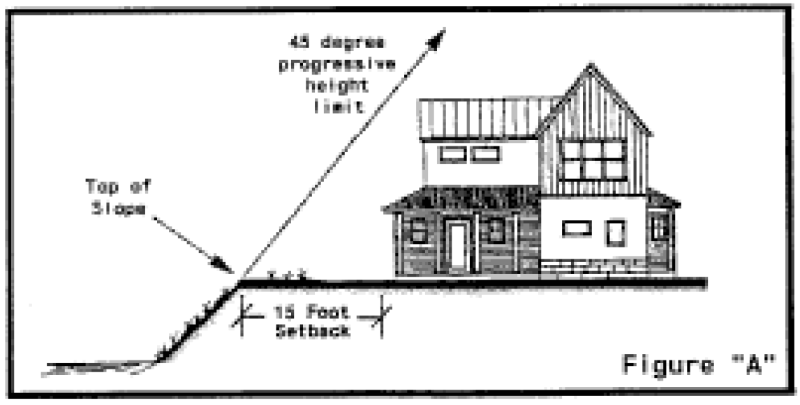
(10)
All exterior lighting is low and downcast with no light(s) directed toward the river or located down the slope and shall be in compliance with Section 26.575.150. A lighting plan will be submitted with all development applications; and
(11)
There has been accurate identification of wetlands and riparian zones.
(d)
Appeal of Director's determination. An appeal of a determination in regards to a stream margin application or in regards to the top of slope determination made by the Community Development Director, shall be reviewed as a special review pursuant to Subsection (e), below. In this case, the Community Development Director's finding shall be forwarded as a recommendation and a new application need not be filed.
(e)
Special review. An application requesting a variance from the stream margin review standards or an appeal of the Stream Margin Map's top of slope determination, shall be processed as a special review in accordance with common development review procedure set forth in Chapter 26.304. The special review shall be considered at a public hearing for which notice has been published, posted and mailed, pursuant to Subsection 26.304.060(e)(3) Paragraphs a, b and c. Review is by the Planning and Zoning Commission.
A special review from the stream margin review determination may be approved, approved with conditions or denied based on conformance with the following review criteria:
(1)
An authorized survey from a Colorado professionally licensed surveyor shows a different determination in regards to the top of slope and 100-year flood plain than the Stream Margin Map located in the Community Development Department and filed in the City Engineering Department; and
(2)
The proposed development meets the stream margin review standard(s) upon which the Community Development Director had based the finding of denial.
(f)
Building permit submittal requirements. Prior to receiving a building permit for a property within the stream margin review area, the following must be submitted:
(1)
The applicant shall record a site improvement plat with topography prepared by a Colorado licensed professional surveyor showing the building envelope determined by the Community Development Director based on the Stream Margin Review Map located in the Community Development Department.
(2)
Site sections drawn by a registered architect, landscape architect or engineer shall be submitted showing all existing and proposed site elements, the top of slope and pertinent elevations above sea level.
(3)
The building envelope shall be barricaded prior to issuance of any demolition, excavation or building permits. The barricades shall remain in place until the issuance of certificates of occupancy.
(Ord. No. 45-2001, § 3; Ord. No. 52-2003, § 13; Ord. No. 3-2012, § 9; Ord. No. 12-2023, § 2, 11-14-2023)
Editor's note— Ord. No. 45-2001, § 2, repealed former § 26.435.040, pertaining to Stream Margin Review and Ord. No. 45-2001, § 3, enacted a new § 26.435.040 as herein set out. Former § 26.435.040 was derived from Ord. No. 47-1999, § 3; Ord. No. 52-2003, § 13.
Sec. 26.435.050. - Mountain view plane review.
(a)
Jurisdiction. Unless subject to Administrative Review as described in Section 26.435.050(d), all applications for development which infringes upon a designated view plane shall be subject to administrative review or review for an exemption in compliance with this Section by the Planning and Zoning Commission or Historic Preservation Commission (collectively, the Review Body). Projects unable to meet the applicable view plane standards shall be required to obtain a variation from the requirements and standards of this Section from the applicable review body and are subject to a public vote as required by Section 13.14 of the City Charter.
(b)
Definitions.
(1)
For purposes of this Section, a development "Infringes" (or creates an "Infringement") on a view plane if the height of the development would be above the height at any point at which the view plane angle cuts across the subject property.
(2)
For the purposes of this Section, "Minimal Impact" to a view plane by development is defined as meeting one of the following review criteria:
a.
The development cannot be seen with the naked eye from the reference point or does not materially alter the observer's ability to see the preserved view from the reference point; or
b.
The development is located behind an historic landmark structure such that no portion of the development can be seen from the reference point; or
c.
The proposed development materially reduces an existing infringement on a designated view plane.
(3)
To receive a determination of minimal impact, the infringement shall involve the lowest building height practicable, taking into consideration the proximity of the view plane, lot size, topography, and the reasonable use of the property. The development shall also comply with the Commercial, Lodging and Historic District Design Standards and Guidelines or theResidential Design Standards, or shall receive a variation from said standards, as applicable.
(4)
For the purposes of this Section, development, in whole or in part, can be "seen with the naked eye" when it is visible, in whole or in part, to an observer without the aid of optical equipment from a view plane reference point and is not blocked by topography or similar obstruction.
(c)
Applicability.
(1)
General. This Section designates seven (7) view planes to regulate the height, mass and design of structures to preserve mountain views, as seen from designated reference points. This Section applies to all development located within the established mountain view planes, unless exempted pursuant to Subsection 26.435.050(d). In addition, the following shall apply:
a.
If a development falls within more than one view plane, the more restrictive of the applicable view planes shall apply.
b.
If at least fifty percent (50%) of the gross lot area of a parcel falls within a view plane and the balance falls outside of a view plane, then the view plane standards apply to development on the entire parcel. If less than fifty percent (50%) of the gross lot area of a parcel falls within a view plane, then only that portion of the lot within the view plane is subject to the standards in this Section.
c.
This Section shall not limit the ability of development to occur below a view plane. If development on a property is within the lateral extent of a view plane but does not infringe into the view plane, then that development is not subject to the requirements of this Section.
(2)
View Plane Components. Each view plane has three (3) components (foreground, midground and background), defined and described as follows:
(3)
Established View Planes. Each view plane, including its components (foreground, midground and background), is described and mapped in Section 26.435.050(h), Maps and Legal Descriptions of View Planes.
(d)
Exemptions. The following development activities on properties located in the mid- and background of a view plane are exempt from the provisions of this Section and may proceed directly to zoning compliance check and building permit review, where the applicant shall demonstrate the improvement meets the following review criteria.
(1)
Structures.
a.
Any addition or remodel of an existing structure that does not change or decreases a building's height at any point or visible mass from the view plane reference point; or
b.
Any of the following structures or structural elements that comply with the standards contained herein or in the applicable code section for those structures or structural elements:
1 Maximum height shall be measured from finished grade.
(2)
Attached Building Features.
a.
Attached building features, including those features listed in Section 26.575.020(f)(4), Allowed Exceptions to Height Limitations, and mechanical equipment or building appurtenances (including but not limited to a satellite dish, HVAC equipment, stairwell enclosure, elevator shaft, ventilation equipment, or skylights) that are added to an existing building are exempt only with the following setbacks and when the height of the feature complies with Section 26.575.020(f)(4), Allowed Exceptions to Height Limitations:
b.
All mechanical and ventilation equipment, including the replacement of existing equipment, located within a view plane shall require a mechanical permit, be installed to the minimum height required per manufacturer standards, and shall not be visible from the reference point and from the street level.
c.
Decorative or recreational features, including rooftop gardens, green roofs, planter boxes, and permanent amenities such as built in grills, are exempt up to two (2) feet into the view plane. The following rooftop fixtures shall be set-back from the façade closest to the view plane reference point by a distance equal to the height of the feature as measured from point of attachment and are not eligible for the two-foot allowance provided above, or other exemptions to the measurement of building height: new or existing rooftop restaurants, hot tubs, bars, railings and similar features.
d.
Parapet walls and ornamental cornices are exempt up to two (2) feet into the view plane and must be constructed in accordance with the height limitations of Chapter 26.710, Zone Districts and the Design Guidelines and Standards in Chapter 26.412, Commercial Design Review.
(e)
Administrative Review. An addition to a structure or an attached building feature that does not meet the criteria in Subsections (1) and (2) above may be approved by the Community Development Director through Administrative Review if:
(1)
The Infringement is erected only to the minimum height needed to accomplish the purpose for which it serves and the height and setbacks comply with the standards of Section 26.575.020, the dimensional requirements of Chapter 26.710, and the Design Guidelines and Standards in Chapter 26.412, Commercial Design Review or 26.415, Historic Preservation, as applicable; or
(2)
The Infringement cannot be seen with the naked eye from the reference point as demonstrated by a visual resource analysis.
(f)
Planning and Zoning Commission and Historic Preservation Commission Review. Applications for development which do not qualify for an Exemption or for Administrative Review which infringes on a view plane may, upon recommendation by the Community Development Director, be approved, approved with conditions or denied by the Planning and Zoning Commission or Historic Preservation Commission (collectively the Review Body) and shall comply with the following standards.
(1)
Foreground mountain view plane standards. The following standards apply to the foreground component of a mountain view plane:
a.
No development in the foreground of a view plane may infringe upon the view plane. Upon recommendation from the Community Development Director, the Review Body may grant a height exemption not to exceed fifteen (15) feet (inclusive of all attached building features) for development which infringes upon a view plane if it determines that the development meets the requirements of minimal impact, as defined in Section 26.435.050(b), and it is demonstrated that the proposed height is required to enable reasonable use of the property. The Review Body may apply exceptions to the measurement of height of structures, as provided in Section 26.575.020(f), if site topography warrants such an exception.
For properties proposed for remodel, the Review Body may grant an exemption to building height to allow for a minimum interior floor to ceiling height of nine (9) feet six (6) inches on the ground floor. This exemption may not be applied to development where the remodel increases the net leasable area or gross floor area of structures of the property in excess of that allowed by code Section 26.470.090(f). Development which qualifies for the exemption must meet the requirements of minimal impact as defined in Section 26.435.050(b).
b.
If the Review Body does not find a development meets the standards list in Subsection (1), above, the application shall be subject to the variation criteria outlined in Section 26.435.050(f), and is subject to a public vote on the variation per Section 13.14 of the City Charter.
(2)
Midground mountain view plane standards. The following standards apply to the midground component of a mountain view plane:
a.
When any proposed development infringes upon a designated view plane, but is located entirely behind (as seen from the reference point) a building designated on the Aspen Inventory of Historic Landmark Sites and Structures, which already blocks the view plane, the Review Body shall determine whether or not the proposed development is consistent with the requirements of this Section; or
b.
The Review Body, after considering a recommendation from the Community Development Director, may make a finding that a development that infringes on the view plane is consistent with the requirements of this Section if it determines that the proposal meets the criteria listed in Section 26.435.050(b)(2); or
c.
If the Review Body does not find a development meets the exemptions listed in Subsection 26.435.050(d)(1)—(2) or 26.435.050(f)(2)(a—b), above, the application shall be subject to the variation criteria outlined in Section 26.435.050(f), and is subject to a public vote on the variation per Section 13.14 of the City Charter.
(3)
Background mountain view plane standards. The following standards apply to the background component of a mountain view plane:
a.
When any proposed development infringes upon a designated view plane, but is located entirely behind (as seen from the reference point) a building designated on the Aspen Inventory of Historic Landmark Sites and Structures, which already blocks the view plane, the Review Body shall determine whether the proposed development will further infringe upon the view plane. If the Review Body determines the proposed development does not further infringe upon the view plane and is not visible from the reference point, the Review Body shall make a finding that the development is consistent with the requirements of this Section; or
b.
The Review Body, after considering a recommendation from the Community Development Director, may make a finding that a development that infringes on the view plane background is consistent with the requirements of this Section if it does not materially alter the observer's ability to see the preserved view from the reference point; or
c.
The infringement shall involve the lowest building height practicable, taking into consideration the proximity of the view plane, lot size, topography, and the reasonable use of the property. The development shall utilize building and roof forms and materials designed to blend into the surrounding landscape, and shall respect the character and massing of adjacent buildings and the mountain landscape. The development shall also comply with the Commercial, Lodging and Historic District Design Standards and Guidelines or theResidential Design Standards, or shall receive a variation from said standards, as applicable.
d.
If the Review Body does not find a development meets the exemptions listed in Subsection 26.435.050(d)(1—2) or the review criteria of Subsection 26.435.050.(f)(3)(a—c), above, the application shall be subject to the variation criteria outlined in Section 26.435.050(d), and is subject to a public vote on the variation per Section 13.14 of the City Charter.
(g)
Variations to mountain view plane review. If the Review Body does not find a development meets the exemptions listed in Subsection 26.435.050(d) or is not consistent with the review criteria of Section 26.435.050(f), above, the application shall be subject to the variation criteria outlined in this Section, and is subject to a public vote on the variation per Section 13.14 of the City Charter. The Review Body, after receiving a recommendation from the Community Development Director, shall not approve a variation unless the applicant demonstrates compliance with the following standards:
(1)
General. The applicant shall demonstrate that the intent to preserve views cannot be met by a strict application of the requirements, and that one of the following conditions applies:
a.
There is no available clear view of the mountains from the reference point; or
b.
The view plane requirement would prohibit reasonable use or access to the property; or
c.
The proposed building or structure does not materially diminish views from the reference point of the view plane to which the property is subject.
(2)
Infringements. In determining whether to allow a variation for an infringement, the Review Body shall consider the following factors:
a.
The direction, extent and quality of predominant mountain views from the property in question;
b.
The extent of existing public views, such as from parks or street ends in the immediate vicinity;
c.
The percent of the lot that would be encumbered by the view plane if the requirements were strictly applied; and
d.
Extreme irregularity or conditions in the shape of the lot or topography that precludes effective application of the requirements.
e.
The applicant shall also demonstrate that measures have been included in the project to reduce its visual impacts as seen from the reference point including lighting which minimize off-site visibility and glare, non-reflective building materials and finishes, modest massing and roof forms, and other factors at the discretion of the Review Body.
(h)
Maps and Legal Descriptions of View Planes.
(1)
Glory Hole Park view plane.
a.
Map of view plane with elevations and 8040 Greenline.
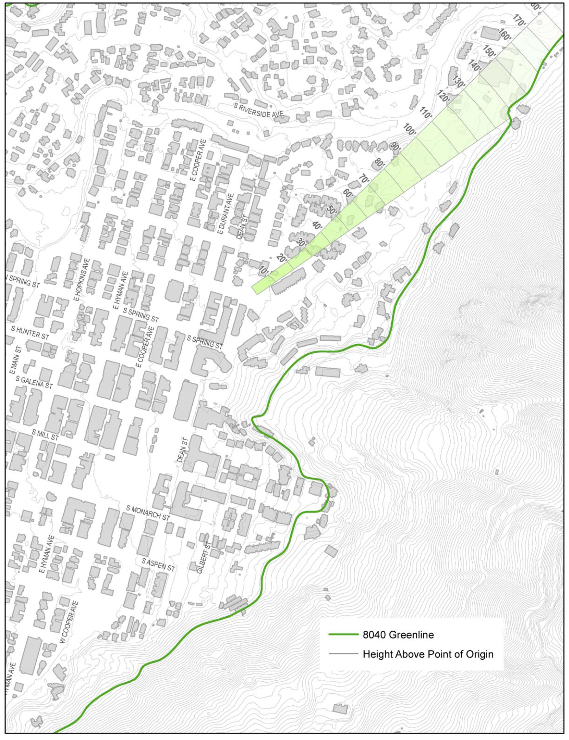
b.
Map of view plane foreground, midground and background areas.
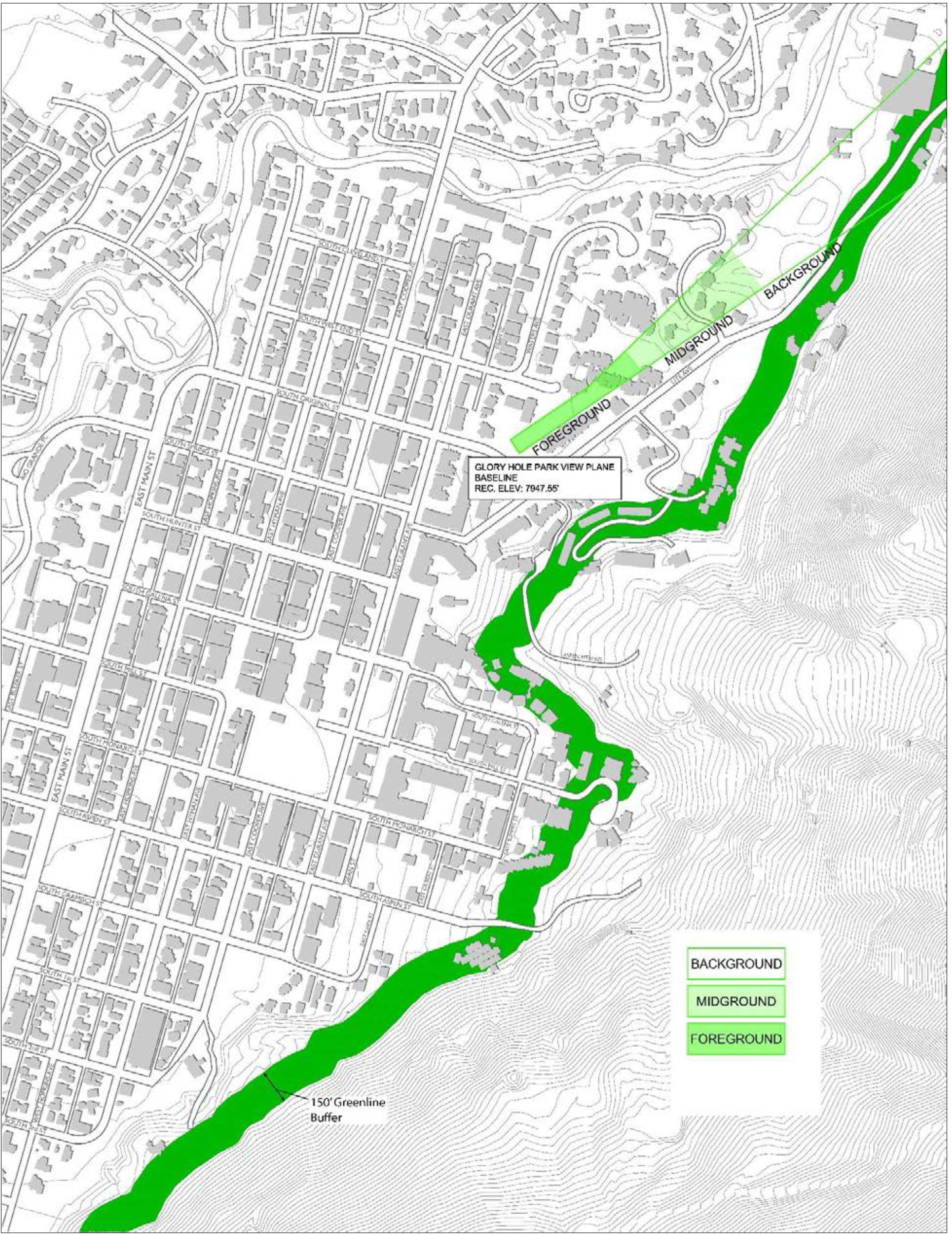
c.
Glory Hole Park: There is hereby established a view plane originating from Glory Hole Park above which plane no land use or building shall project. The Glory Hole Park Reference Point bears S24°37'11"E a distance of 1645.57 feet from GPS-5 of the City of Aspen GPS Control Mounumentation 2009, a Brass Cap found in a Survey Monument Box at the intersection of South Galena Street and East Hopkins Avenue, with all bearings being relative to S74°14'01"E between said GPS-5 and GPS-4 of the City of Aspen GPS Control Mounumentation 2009, a Brass Cap found in a Survey Monument Box at the intersection of South West End Street and East Hopkins Street; the Glory Hole Park Reference Base Line bears N55°51'57"E a distance of 73.00 feet from the Glory Hole Park Reference Point. The elevation of said reference point and baseline is 7,947.55 feet, NAVD88 Datum. The view plane consists of two (2) spatial components more particularly described as follows:
1.
All that space which is within the projection of a sector of 9° 54' 00" described by two (2) radial lines which bears S44°02'03"E and S34°08'03"E respectively from the reference point and which is also above the view plane which passes through the reference base line at the inclination of 3° 30' above horizontal with all projections to terminate at the 8040 Greenline.
All that area within the projection of the following described perimeter and which is also above the view plane which passes through the reference base line at an inclination of 3° 30' above horizontal. The perimeter is more fully described as follows: Beginning at the Glory Hole Park Reference Point, thence N55°51'57"E a distance of 73.00 feet along the reference base line; thence S34°08'03"E a distance of 418.27 feet to a point on the northerly radial line of the view sector; thence N44°02'03" W along said radial line a distance of 424.59 feet to the reference point.
(2)
Wagner Park view plane.
a.
Map of view plane with elevations and 8040 Greenline.
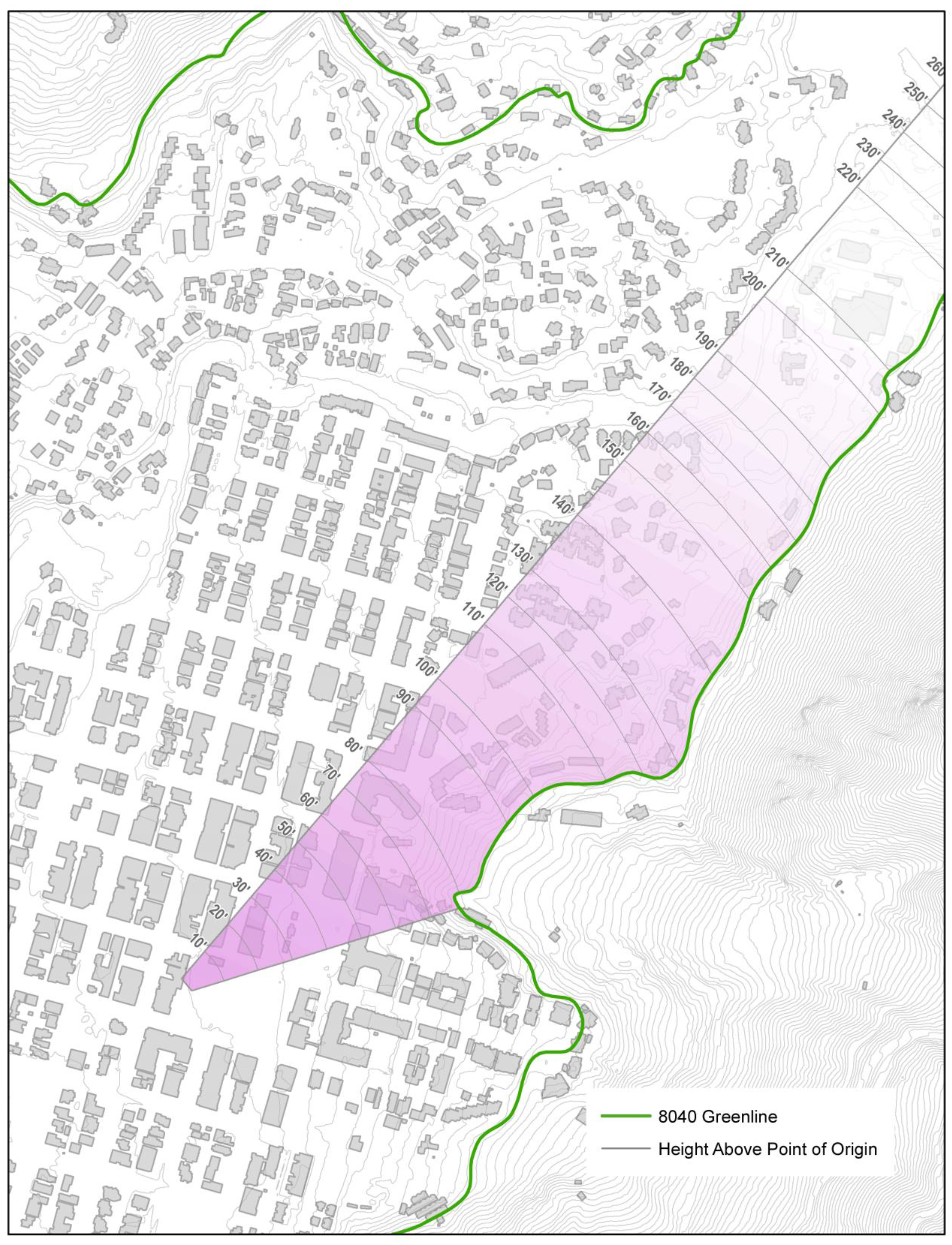
b.
Map of view plane foreground, midground and background areas.
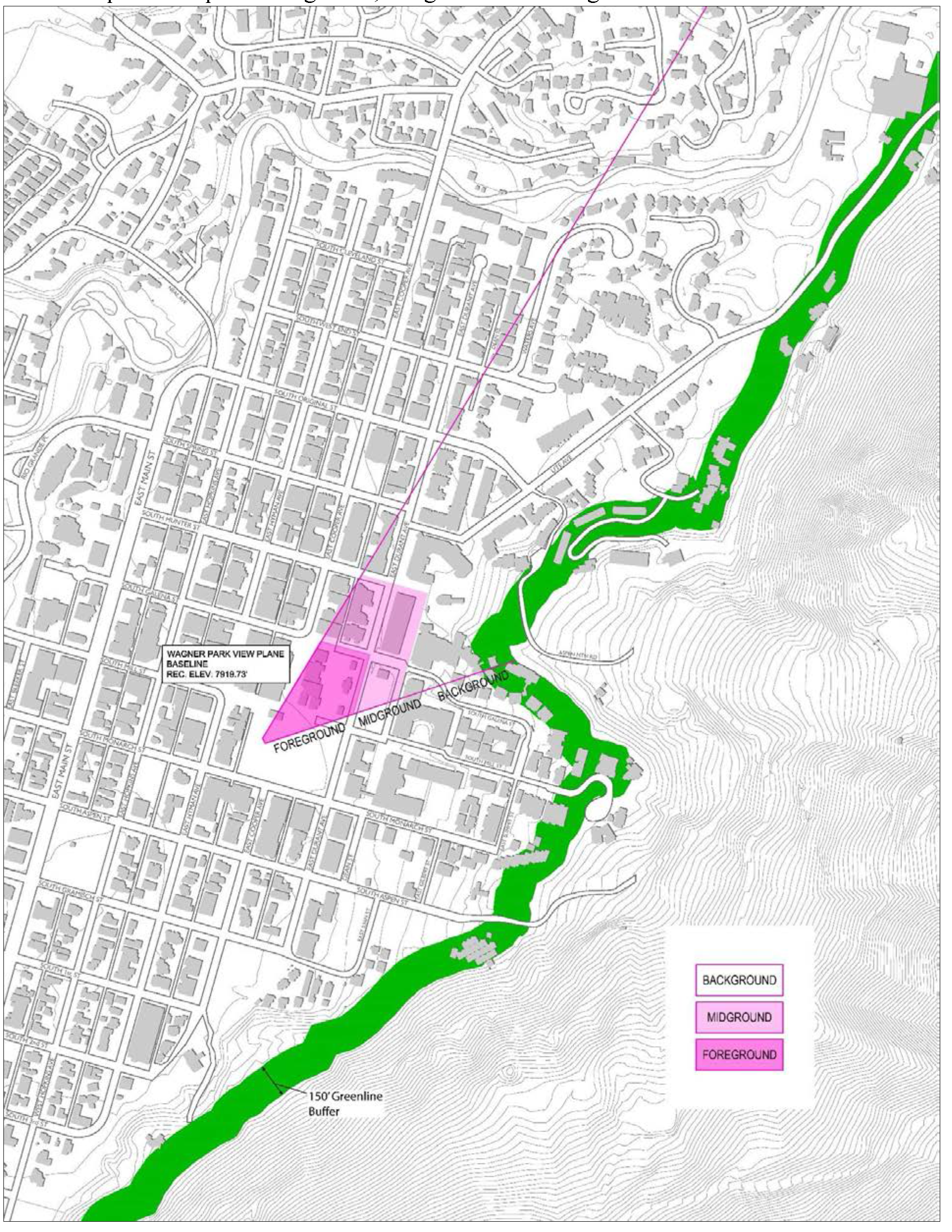
c.
Wagner Park: There is hereby established a view plane originating in the north central part of Wagner Park above which plane no land use or building shall project. The Wagner Park View Plane Reference Point bears S64°02'52"W a distance of 642.35 feet from GPS-5 of the City of Aspen GPS Control Mounumentation 2009, a Brass Cap found in a Survey Monument Box at the intersection of South Galena Street and East Hopkins Avenue, with all bearings being relative to S74°14'01"E between said GPS-5 and GPS-4 of the City of Aspen GPS Control Mounumentation 2009, a Brass Cap found in a Survey Monument Box at the intersection of South West End Street and East Hopkins Street. The reference base line bears S49°48'54"W a distance of 68.87 feet from the reference point. The elevation of the reference point and reference base line is 7,919.73 feet, NAVD88 Datum. The view plane is more particularly described as follows: All that space which is within the projection of two (2) radial lines which bear S50°21'40"E from the reference point and S17°55'36"E from the westerly terminus of the reference base line and which is also above a plane which passes through the reference base line at an angle of inclination of 3° 39' 10" above the horizontal with all projections to terminate at the 8040 Greenline or City Limits.
(3)
Cooper Avenue view plane.
a.
Map of view plane with elevations and 8040 Greenline.
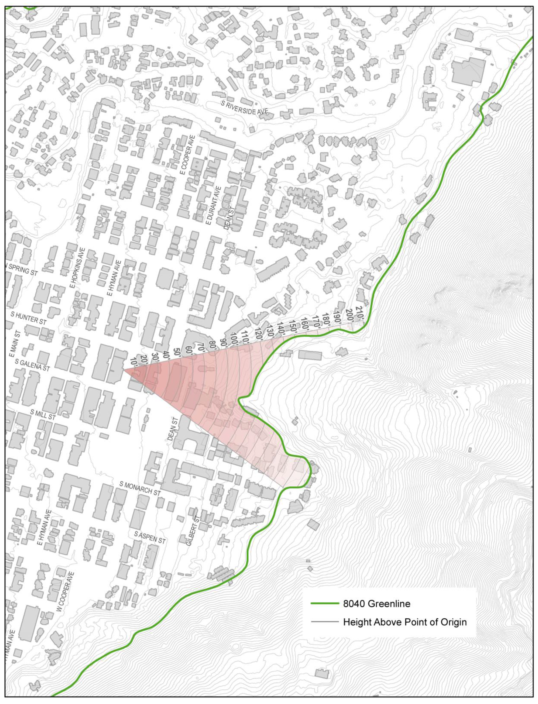
b.
Map of view plane foreground, midground and background areas.
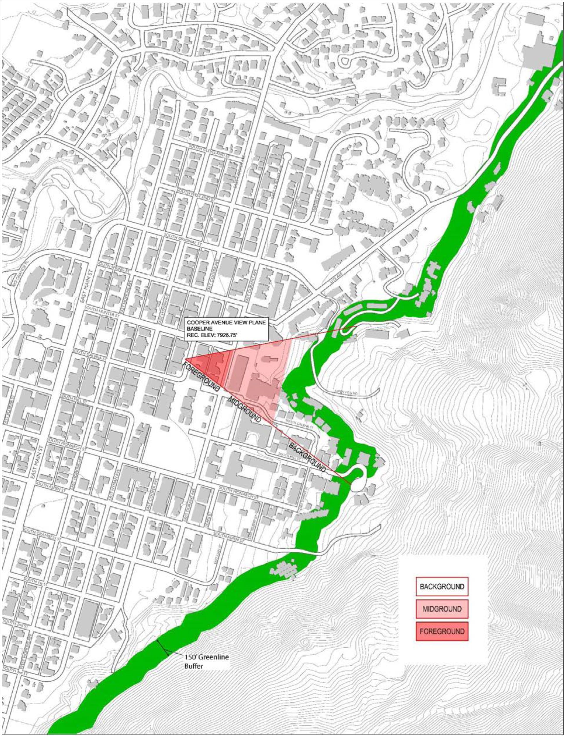
c.
Cooper Avenue: There is hereby established a view plane originating on the northerly side of Cooper Avenue easterly of Galena Street above which plane no land use or building shall project. The Cooper Avenue Reference Point bears S01°09'30"E a distance of 576.72 from GPS-5 of the City of Aspen GPS Control Mounumentation 2009, a Brass Cap found in a Survey Monument Box at the intersection of South Galena Street and East Hopkins Avenue, with all bearings being relative to S74°14'01"E between said GPS-5 and GPS-4 of the City of Aspen GPS Control Mounumentation 2009, a Brass Cap found in a Survey Monument Box at the intersection of South West End Street and East Hopkins Street. The elevation of said reference point is 7,926.75, NAVD88 Datum. The view plane consists of spatial components more particularly described as follows: All that space which is within the projection of a sector of 48°00'00" described by two (2) radial lines which bear S10°53'16"E and S37°06'44"W respectively from the reference point and above a plane which passes through the reference point at an inclination of 6°20'05" above the horizontal with all projections to terminate at the 8040 Greenline.
(4)
Courthouse view planes.
a.
Map of view plane with elevations and 8040 Greenline.
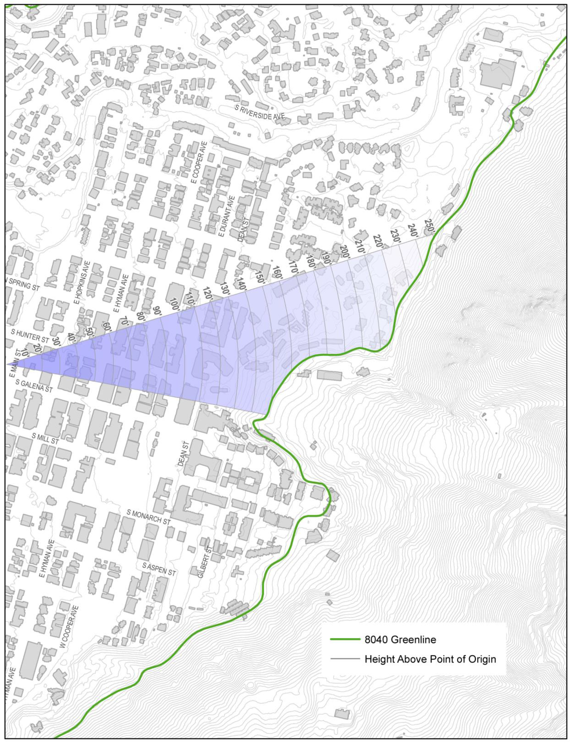
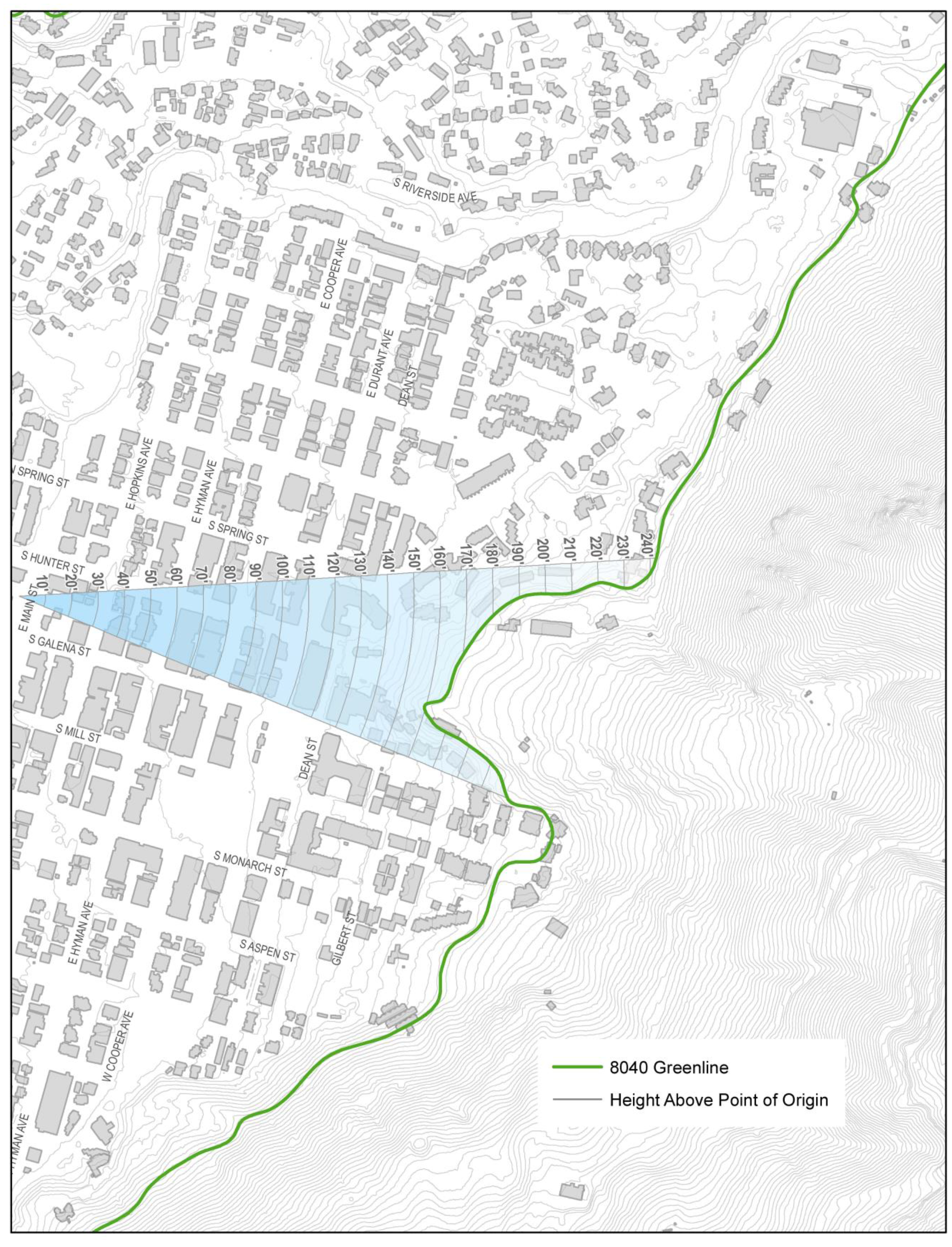
b.
Map of view plane foreground, midground and background areas.
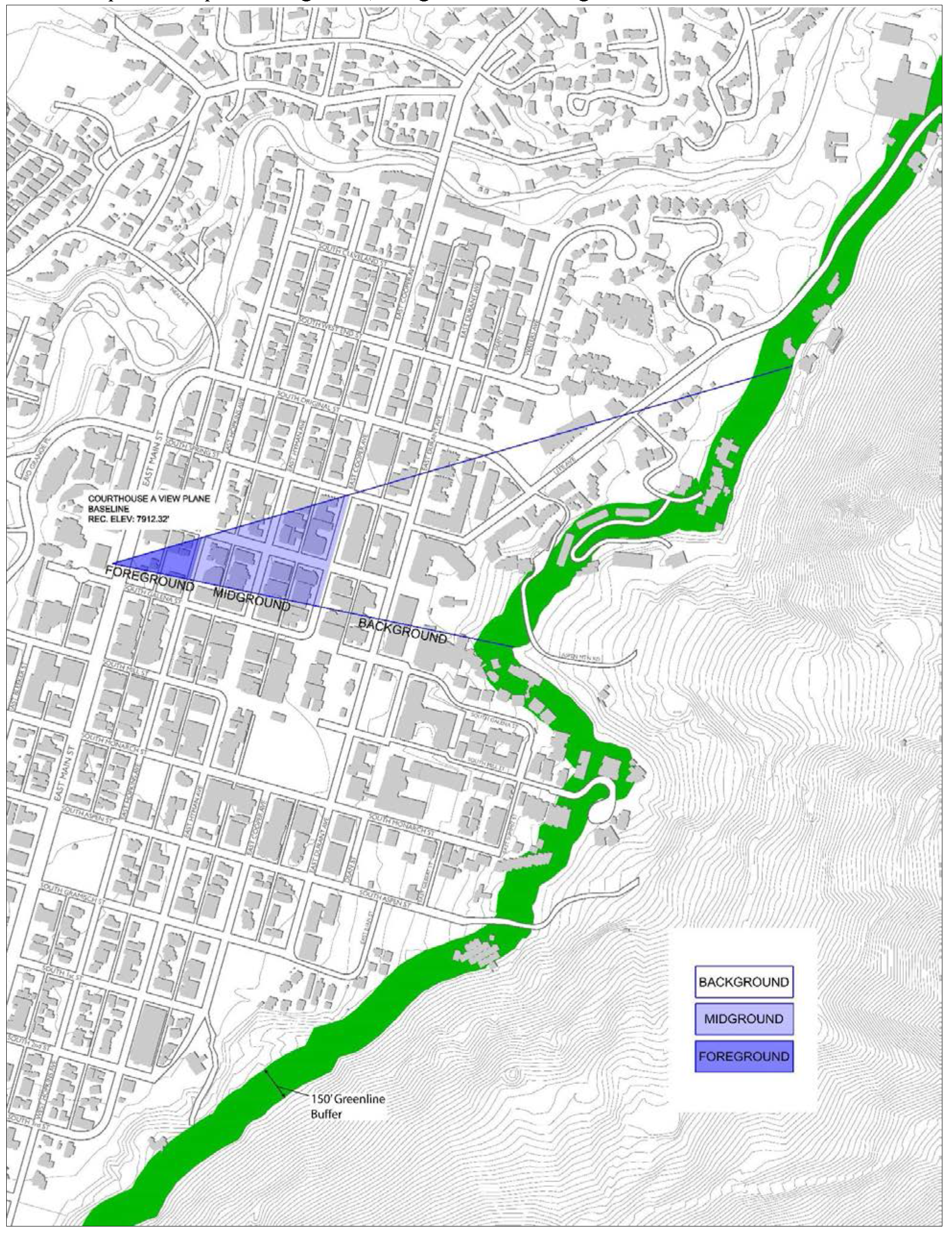
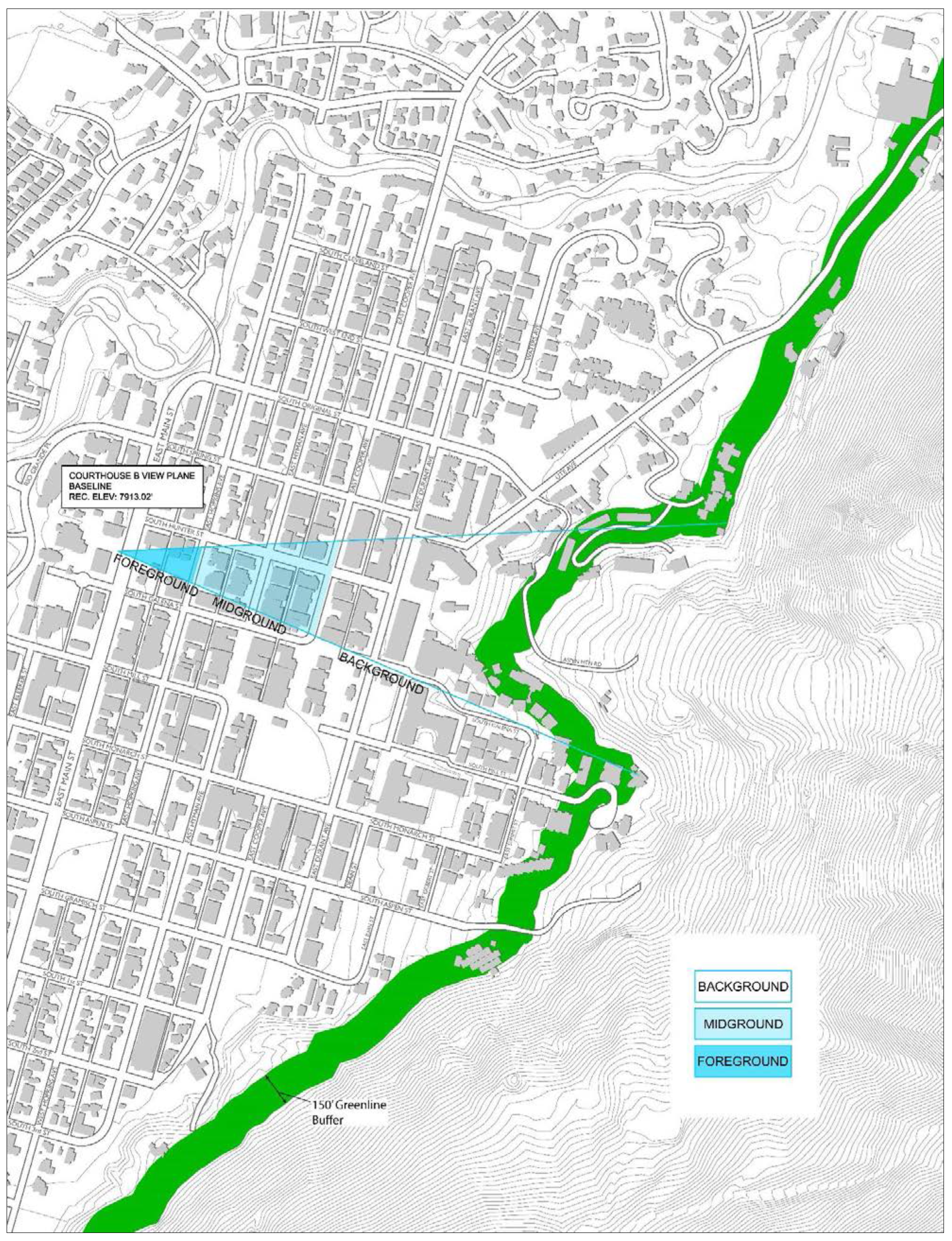
c.
Court House: There are hereby established two (2) view planes originating from the sidewalk on the northerly side of Main Street easterly of Galena Street above which planes no land use or building shall project.
1.
View Plane Number One. The Courthouse View Plane A Reference Point bears N31°49'00"E a distance of 382.15 feet from GPS-5 of the City of Aspen GPS Control Mounumentation 2009, a Brass Cap found in a Survey Monument Box at the intersection of South Galena Street and East Hopkins Avenue, with all bearings being relative to S74°14'01"E between said GPS-5 and GPS-4 of the City of Aspen GPS Control Mounumentation 2009, a Brass Cap found in a Survey Monument Box at the intersection of South West End Street and East Hopkins Street. The elevation of said reference point is 7,912.32, NAVD88 Datum. The view plane consists of spatial components more particularly described as follows: All that space which is within the projection of a sector of 27°58'40" described by two (2) radial lines which bear S16°11'56"E and S11°46'44"W respectively from the reference point and above a plane which passes through the reference point at an inclination of 4° 25' above the horizontal with all projections to terminate at the 8040 Greenline.
2.
View Plane Number Two. The Courthouse View Plane B Reference Point bears N40°50'24"E a distance of 397.22 feet from GPS-5 of the City of Aspen GPS Control Mounumentation 2009, a Brass Cap found in a Survey Monument Box at the intersection of South Galena Street and East Hopkins Avenue, with all bearings being relative to S74°14'01"E between said GPS-5 and GPS-4 of the City of Aspen GPS Control Mounumentation 2009, a Brass Cap found in a Survey Monument Box at the intersection of South West End Street and East Hopkins Street. The elevation of the reference point is 7,913.02 feet, NAVD88 Datum. The view plane consists of spatial components more particularly described as follows: All that space which is within the projection of a sector of 26°04'38" described by two (2) radial lines which bear S02°48'34'E and S23°16'04"W. respectively from the reference point and above a plane which passes through the reference point at an inclination of 4° 58' 20" above the horizontal with all projections to terminate at the 8040 Greenline.
(5)
Wheeler Opera House view plane.
a.
Map of view plane with elevations and 8040 Greenline.
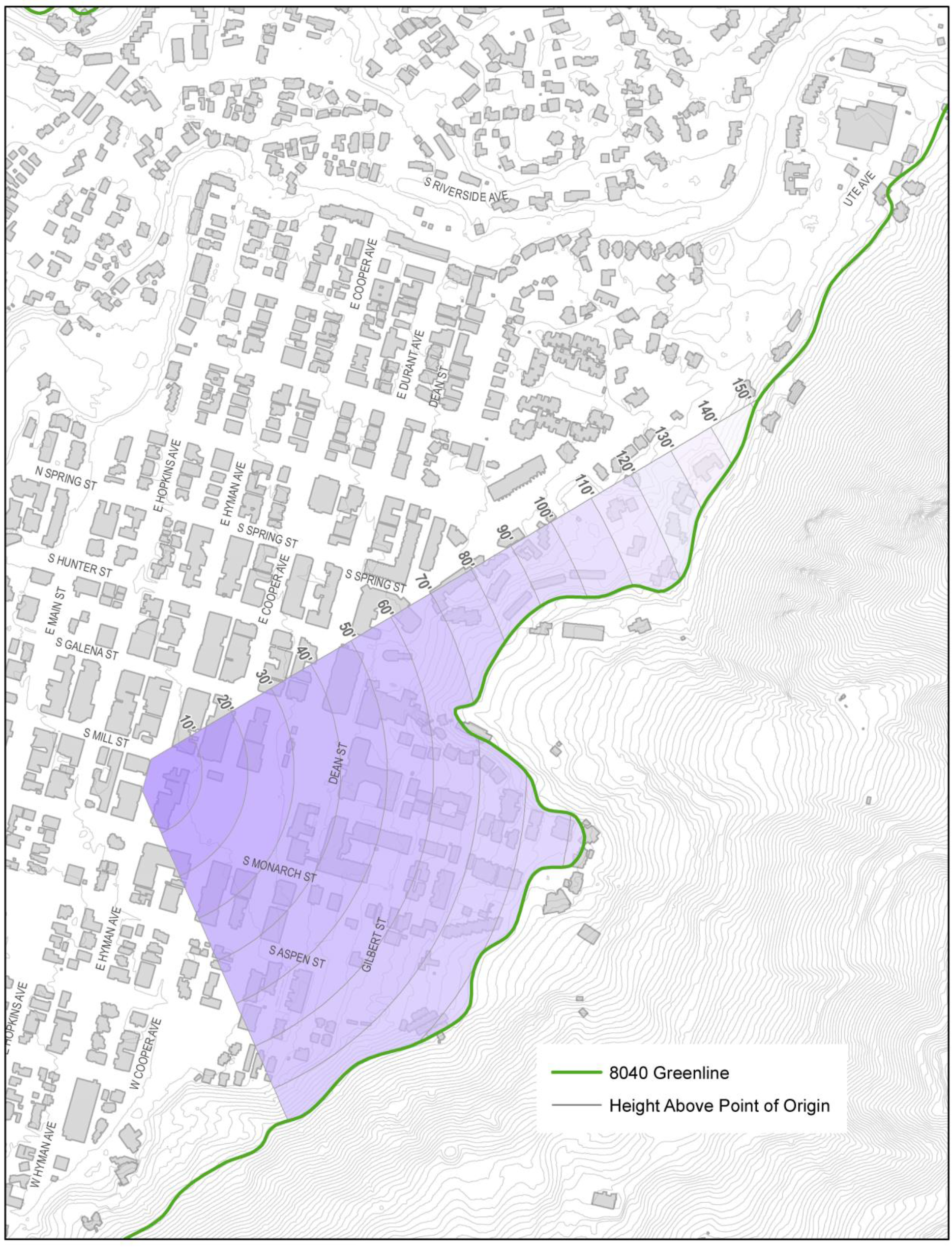
b.
Map of view plane foreground, midground and background areas.
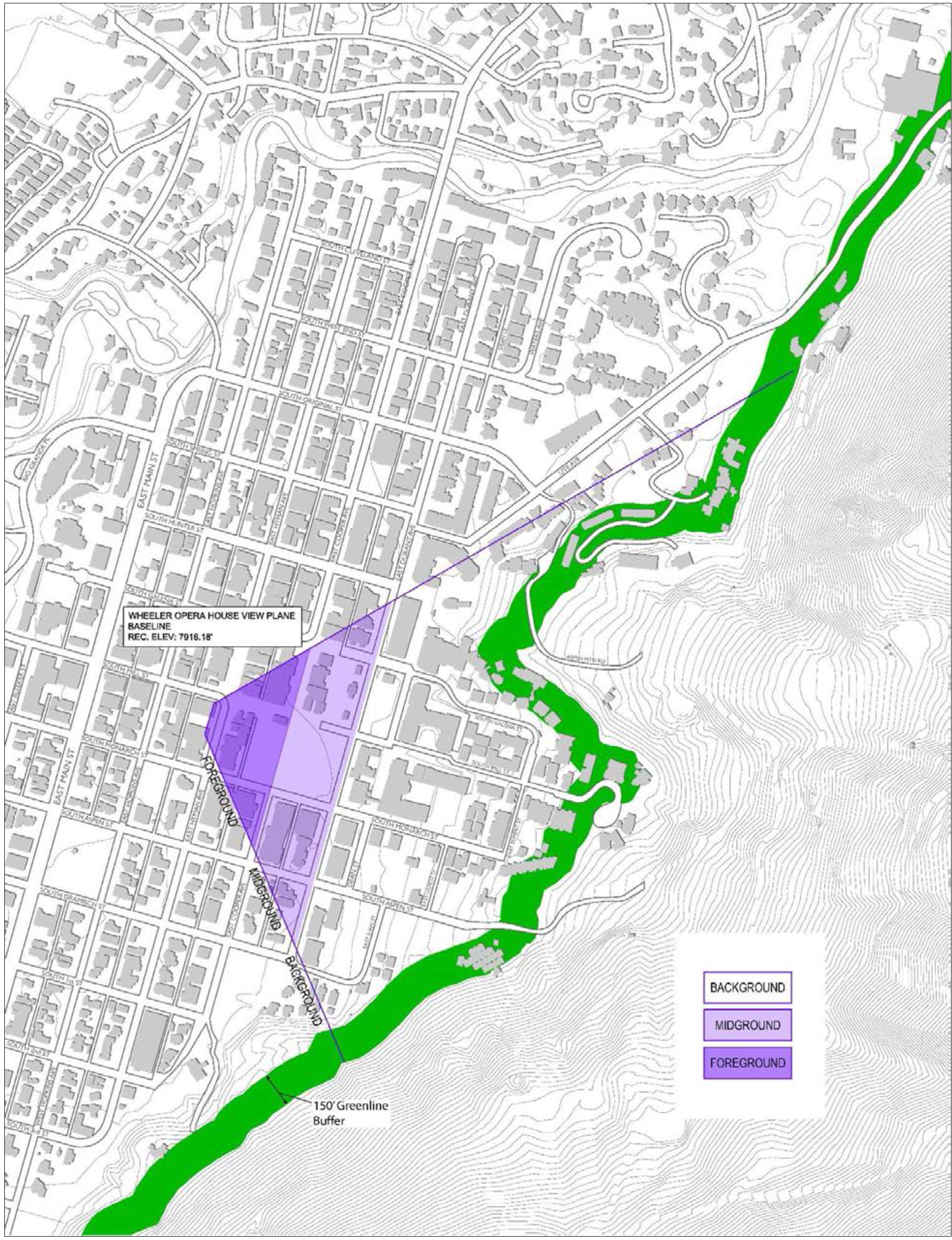
c.
Wheeler Opera House: There is hereby established a view plane originating from the Wheeler Opera House westerly of Mill Street above which plane no land use or building shall project. The easterly end point of the Wheeler Opera House Base Line for the view plane bears S70°50'24"W a distance of 456.04 feet from GPS-5 of the City of Aspen GPS Control Mounumentation 2009, a Brass Cap found in a Survey Monument Box at the intersection of South Galena Street and East Hopkins Avenue, with all bearings being relative to S74°14'01"E between said GPS-5 and GPS-4 of the City of Aspen GPS Control Mounumentation 2009, a Brass Cap found in a Survey Monument Box at the intersection of South West End Street and East Hopkins Street. The reference base line bears N73°42'19"W a distance of 140.45 feet from the easterly end point of the base line for the view plane at an elevation of 7,916.18 feet, NAVD88 Datum. The view plane consists of spatial components more particularly described as follows: All that space which is within the projection of radial lines from the easterly and westerly terminus of the base line which bear S29°53'19"E and S66°56'51"W respectively and which is above a plane which passes through the reference point at an inclination of 2°50'38" above horizontal with all projections to terminate at the 8040 Greenline.
(6)
Main Street view plane.
a.
Map of view plane with elevations and 8040 Greenline.
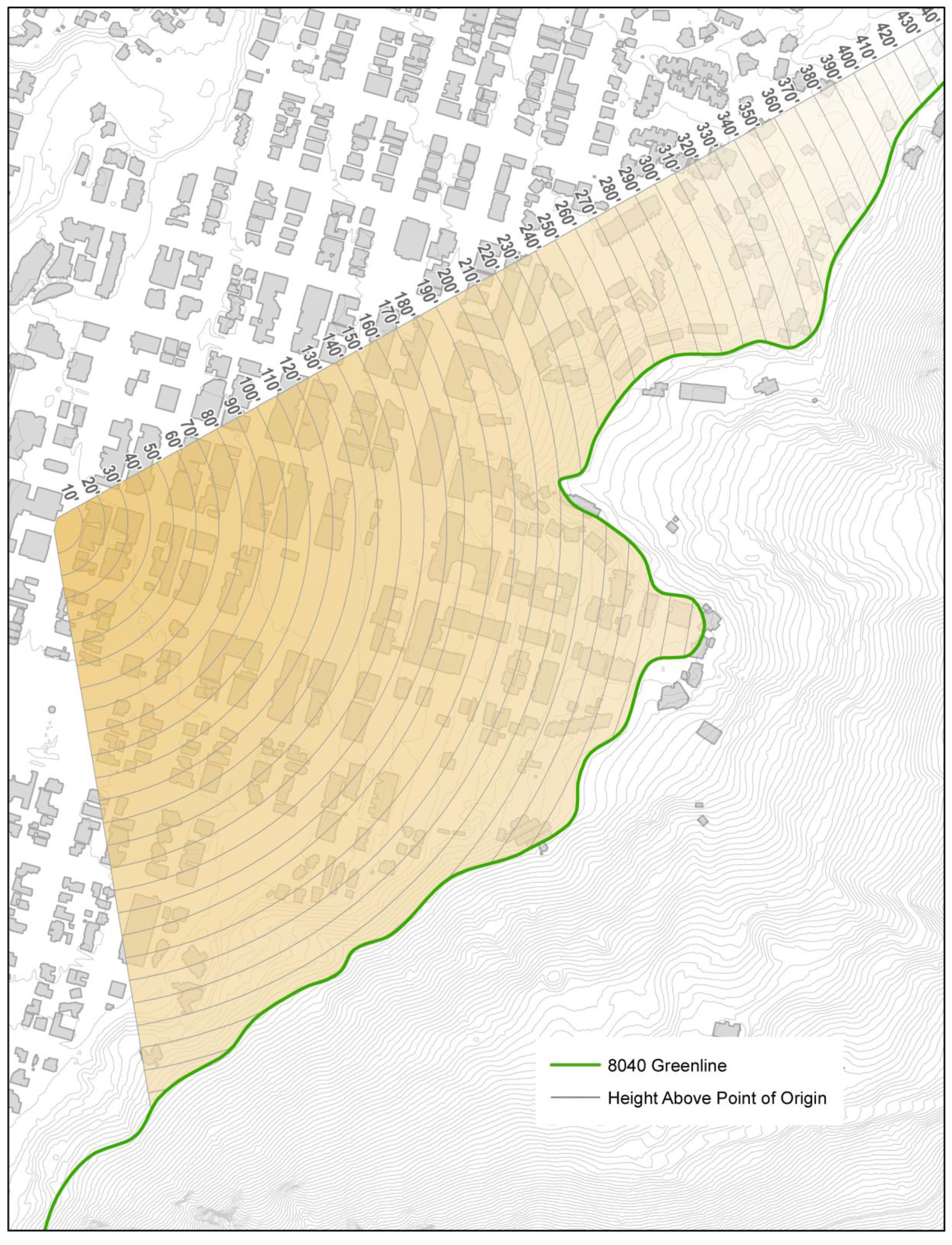
b.
Map of view plane foreground, midground and background areas.
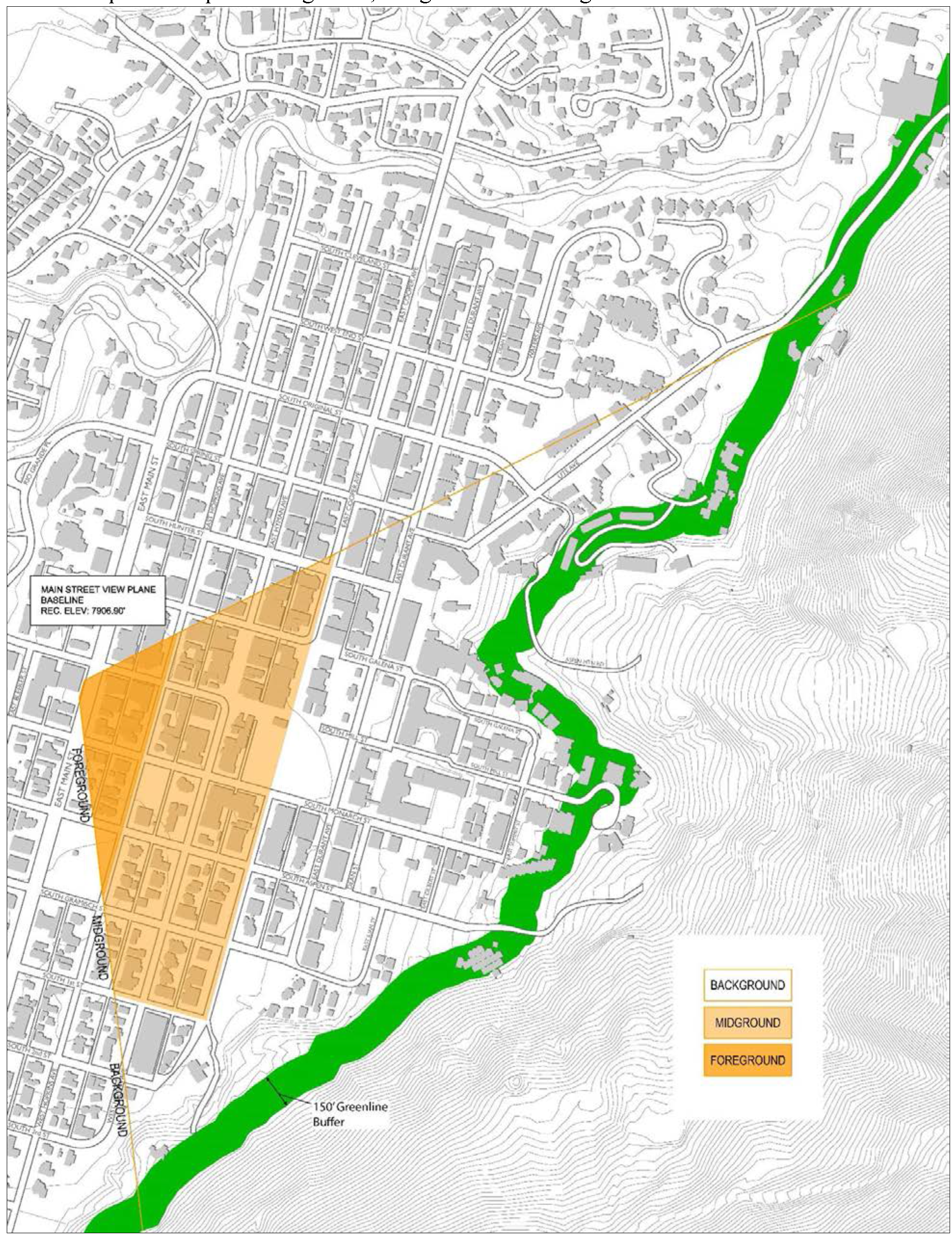
c.
Main Street: There is hereby established a view plane originating from Main Street above which plane no land use or building shall project. The Main Street View Plane Reference Point bears N37°21'55"W a distance of 592.24 feet from GPS-5 of the City of Aspen GPS Control Mounumentation 2009, a Brass Cap found in a Survey Monument Box at the intersection of South Galena Street and East Hopkins Avenue, with all bearings being relative to S74°14'01"E between said GPS-5 and GPS-4 of the City of Aspen GPS Control Mounumentation 2009, a Brass Cap found in a Survey Monument Box at the intersection of South West End Street and East Hopkins Street. The reference base line bears N74°13'18"W a distance of 51.40 feet from the reference point. The elevation of the reference point and reference base line is 7,906.90 feet, NAVD88 Datum. The view plane is more particularly described as follows: All that space which is within the projection of two (2) radial lines which bear S28°22'14"E from the reference point and S81°17'21"W from the westerly terminus of the reference base line and which is also above a plane which passes through the reference base line at an angle of inclination of 6° 29' 20" above horizontal with all projections to terminate at the 8040 Greenline.
(Ord. No. 12, 2007, § 22; Ord. No. 34, 2016, § 2)
Sec. 26.435.060. - Hallam Lake Bluff review.
(a)
Applicability. All development in that bluff area running approximately on a north-south axis bordering and/or overlooking the Aspen Center for Environmental Studies Nature Preserve and bounded on the east by the 7,850-foot mean sea level elevation line and extending one hundred (100) feet, measured horizontally, up slope and there terminating and bounded on the north by the southeast lot line of Lot 7A of the Aspen Company Subdivision and on the south by the centerline of West Francis Street, shall be subject to the review standards as set forth in this Section.
(b)
Exemption. The Community Development Director may exempt the following types of development within the Hallam Lake Bluff review area:
(1)
Construction of public trails or improvements essential for public health and safety which cannot be reasonably accommodated outside of the "no development area" prescribed by this Section including, but not limited to, potable water systems, sanitary sewer, utilities and fire suppression systems provided the Community Development Director determines the development complies, to the extent practical, with the Hallam Lake Bluff review standards.
(2)
The expansion, remodeling or reconstruction of an existing development provided the following standards are met:
The proposed development is thirty (30) feet or further from the top-of-slope and not exceeding the progressive height limit delineated by a line drawn at a forty-five (45) degree angle from ground level at the top-of-slope; or, the development is obscured from the rear slope by other structures as determined by a site section provided pursuant to review standard (c)(7) below.
(c)
Hallam Lake Bluff review standards. No development shall be permitted within the Hallam Lake Bluff ESA unless the Planning and Zoning Commission makes a determination that the proposed development meets all of the following requirements:
(1)
No development, excavation or fill, other than native vegetation planting, shall take place below the top of slope.
(2)
All development within the 15-foot setback from the top of slope shall be at grade. Any proposed development not at grade within the 15-foot setback shall not be approved unless the Planning and Zoning Commission determines that the following conditions can be met:
a.
A unique condition exists on the site where strict adherence to the top-of-slope setback will create an unworkable design problem.
b.
Any intrusion into the top-of-slope setback or height limit is minimized to the greatest extent possible.
c.
Other parts of the structure or development on the site are located outside the top-of-slope setback line or height limit to the greatest extent possible.
d.
Landscape treatment is increased to screen the structure or development in the setback from all adjoining properties.
(3)
All development outside the 15-foot setback from top of slope shall not exceed a height delineated by a line drawn at a 45-degree angle from ground level at the top of slope. Height shall be measured and determined by the Community Development Director using the definition for height set forth at Section 26.104.100 and the method of calculating height set forth at Section 26.575.020.
(4)
A landscape plan shall be submitted with all development applications. Such plan shall include native vegetative screening of no less than fifty percent (50%) of the development as viewed from the rear (slope) of the parcel. All vegetative screening shall be maintained in perpetuity and shall be replaced with the same or comparable material should it die.
(5)
All exterior lighting shall be low and downcast with no light(s) directed toward the nature preserve or located down the slope and shall be in compliance with Chapter 26.512 - Outdoor lighting. A lighting plan shall be submitted with all development applications.
(6)
No fill material or debris shall be placed on the face of the slope. Historic drainage patterns and rates must be maintained. Pools or hot tubs cannot be drained down the slope.
(7)
Site sections drawn by a registered architect, landscape architect or engineer shall be submitted showing all existing and proposed site elements, the top of slope and pertinent elevations above sea level.
(Ord. No. 47-1999, § 3; Ord. No. 12, 2007, § 23; Ord. No. 12-2023, § 3, 11-14-2023)
Sec. 26.435.070. - Procedure for approval of development in ESA.
(a)
General. Unless otherwise stated in this Chapter, an application for review of development in an environmentally sensitive area shall be reviewed pursuant to the following procedures and standards and the Common Development Review Procedures set forth at Chapter 26.304. According to the type of development proposed, the following steps are necessary.
(b)
Administrative Applications and Exemptions. The Community Development Director shall approve, approve with conditions or deny the application, based on the applicable standards of review in this Chapter.
(c)
Planning and Zoning Commission Applications and Exemptions. The Planning and Zoning Commission, during a duly noticed public hearing, shall review a recommendation from the Community Development Director and shall approve, approve with conditions, or deny the application, based on the standards of this Section. This requires a one-step process as follows:
Step One - Public Hearing before the Planning and Zoning Commission.
(1)
Purpose: To determine if the application meets the standards for approval.
(2)
Process: The Planning and Zoning Commission shall approve, approve with conditions, or deny an application after considering the recommendation of the Community Development Director and comments and testimony from the public at a duly noticed public hearing.
(3)
Standards of review: The proposed development shall comply with the applicable review standards of this Chapter.
(4)
Form of decision: The Commission's decision shall be by resolution.
(5)
Notice requirements: Posting, Mailing and Publication pursuant to Subparagraph 26.304.060(e)(3) and the provisions of Section 26.304.035—Neighborhood Outreach as applicable.
(d)
Combined Reviews. An application for development within an ESA may be combined with development applications for other associated land use reviews, pursuant to Section 26.304.060(b)(1), Combined Reviews. For designated properties or properties located in a historic district, any required Planning and Zoning Commission Review shall be completed by the Historic Preservation Commission.
(Ord. No. 34, 2016, § 3)
Sec. 26.435.080. - Application.
The development application for development in an environmentally sensitive area (ESA) shall include the following. Additional information may be required at the request of the Community Development Director.
(a)
The general application information required in Section 26.304.030.
(b)
A plan of the proposed development, which shall depict at a minimum the following information:
(1)
The boundary of the property for which development is requested.
(2)
Existing and proposed improvements.
(3)
Significant natural features, including natural hazards and trees.
(c)
In addition to these minimum plan contents, the development plan submitted for development in each type of ESA shall also include the following:
(1)
For development subject to 8040 Greenline review, the plan shall depict:
a.
Existing and proposed grades at two-foot contours, with five-foot intervals for grades over ten percent (10%).
b.
Proposed elevations of the development.
c.
A description of proposed construction techniques to be used.
(2)
For development subject to stream margin review, the plan shall depict:
a.
The 100-year floodplain line and the high water line.
b.
Existing and proposed grades at two-foot contours, with five-foot intervals for grades over ten percent (10%).
c.
When development is proposed in a special Flood Hazard Area: Accurate elevations (in relation to mean sea level) of the lowest floor, including basement, of all new or substantially improved structures; a verification and recordation of the actual elevation in relation to mean sea level to which any structure is constructed; a demonstration that all new construction or substantial improvements will be anchored to prevent flotation, collapse or lateral movement of any structure to be constructed or improved; a demonstration that the structure will have the lowest floor, including basement, elevated to at least two (2) feet above the base flood elevation, all as certified by a registered professional engineer or architect.
d.
A description of proposed construction techniques to be used.
(3)
For development subject to mountain view plane review, the following information shall be required:
a.
A survey of the property including structures and the location and angle at which the view plane falls, the boundaries of the view plane.
b.
Proposed elevations of the development, including any rooftop equipment and how it will be screened.
c.
Photographs which show the existing improvements which protrude into or are in the vicinity of the view plane. The applicant shall graphically represent on the photographs how the proposed improvements will appear in relation to existing improvements and views.
d.
A visual resource analysis shall demonstrate and document for review the visual impact of the proposed development on surrounding designated view planes. The analysis shall show, in accurate perspective format, what portions of the proposed development are visible from various points within the view plane. Multiple perspectives as requested by the Community Development Director may be required to accurately reflect the appearance of the development as the viewpoint is moved along the corridor. The following information shall be provided to meet this application requirement:
1.
A visual analysis narrative and a photographic simulation or other comparable visual analysis of the proposed development.
2.
The analysis shall demonstrate, in accurate perspective format, the measures proposed to blend the development into the context of the setting. The setting shall include the view frame of the picture when viewing the development from a particular viewpoint and (if applicable) the backdrop of natural topography, existing vegetation as well as surrounding vegetation and structures. Development features which shall be shown to be compatible with the setting include: bulk and scale of buildings, building and roof forms, texture of materials used on the buildings, colors, and proposed plantings for screening.
e.
The visual impacts of alternative site designs, if applicable, shall also be depicted.
(Ord. No. 27-2002, § 11; Ord. No. 34, 2016, § 4 & 5)
Sec. 26.435.090. - Conditions.
The Community Development Director may recommend and the Planning and Zoning Commission may impose conditions to its approval of development in an environmentally sensitive area (ESA), which includes but is not limited to means for:
(a)
Minimizing any adverse impact of the proposed development upon lands, including the use and operation and the type and intensity of activities which may be conducted;
(b)
Controlling the sequence or timing of proposed development, including when it must be commenced and completed;
(c)
Controlling the duration of use of development and the time within which any structures must be removed;
(d)
Assuring that development is maintained properly in the future; or
(e)
Establishing a more detailed record by submission of drawings, maps, plats or specifications.
Sec. 26.435.100. - Amendment of an ESA development order.
(a)
Insubstantial Amendment. An insubstantial amendment to an approved development order for development within an Environmentally Sensitive Area may be authorized by the Community Development Director.
(1)
The development order is valid and there is substantial compliance with the conditions of approval.
(2)
The development order is either remaining in conformance with the review criteria set forth for the specific ESA or it is demonstrated that the development order is in compliance with any amendments to the ESA criteria.
(3)
The change is in conformance with the exemption criteria for the specific ESA, as provided in this Section, considering the Development Order as a completed development for the purposes of evaluating the change.
(4)
The change is in compliance with all other provisions of this Title.
(b)
Other amendments. All other amendments to an approved development order for development within an Environmentally Sensitive Area shall be reviewed pursuant to the terms and procedures of this Section.
Sec. 26.445.010. - Purpose.
The purpose of Planned Development review is to encourage flexibility and innovation in the development of land which:
(a)
Promotes the purposes, goals and objectives of applicable adopted regulatory plans.
(b)
Achieves a more desirable development pattern, a higher quality design and site planning, a greater variety in the type and character of development and a greater compatibility with existing and future surrounding land uses than would be possible through the strict application of the zone district provisions.
(c)
Preserves natural and man-made site features of historic, cultural or scenic value.
(d)
Promotes more efficient use of land, public facilities and governmental services.
(e)
Incorporates an appropriate level of public input to the planning process to ensure sensitivity to neighborhood and community goals and objectives.
(f)
Promotes safe and convenient transit, pedestrian, bicycle and vehicular access and circulation.
(g)
Allows the development of mixed land uses through the encouragement of innovative design practices that warrant variations from the standard permitted zone district land uses and dimensional requirements.
(Ord. No. 36-2013, § 4)
Sec. 26.445.020. - Applicability.
An application for a Planned Development may be submitted on any parcel, or series of adjacent parcels, which is twenty-seven thousand (27,000) square feet or greater in gross lot size or which requires the submission of a Planned Development pursuant to the zoning for the parcel. (See Chapter 26.710. - Zone Districts.) An application for a Planned Development may be submitted on any parcel, or series of adjacent parcels, smaller than twenty-seven thousand (27,000) square feet if the Community Development Director believes there exists an opportunity to advance a significant community goal through the Planned Development procedures.
An application to amend a Planned Development may be submitted for any land granted Planned Development approval, including all land granted approval for a Planned Unit Development or Specially Planned Area prior to the adoption of Ordinance 36, Series 2013, and all land designated Planned Development on the Official Zone District Map. All land within a Planned Development shall continue to be included in a zone district most appropriate for that land.
All development of land subject to an approved Planned Development, including all land subject to a Planned Unit Development or Specially Planned Area approval granted prior to the adoption of Ordinance 36, Series 2013, shall conform to the allowances and limitations of the applicable Development Order for a site specific development plan.
All development of land designated Planned Development on the official zone district map and which does not have an approved site specific development plan approval, must receive amendment approval as set forth in Section 26.445.110, Amendments. However, in the absence of an approved site specific development plan, a single detached, two (2) detached, or a duplex residential dwelling, if listed as a permitted use in the property's zoning, may be developed in conformance with the provisions of the Zone District. This shall not exempt a development from complying with any other applicable Land Use Code requirements.
(Ord. No. 10-1999, § 2 (part); Ord. No. 52-1999, § 1; Ord. No. 3-2012, § 11; Ord. No. 36-2013, § 4)
Sec. 26.445.030. - Scope and Limitations.
(a)
General. Development on any land within a Planned Development may occur only after all land use approvals are received, a Development Order is issued, all requisite documents, agreements, plats, have been filed, and the applicant has received all necessary permits as required by the Municipal Code and any other county, state or federal authority with jurisdiction over the land.
(b)
Scope and Limitations of Project Review. Project Review shall set forth the overall concept and general parameters of a project. The allowed land uses, layout, mass and scale, and dimensions of the project, including all deviations from zone district allowances and limitations, shall be established during Project Review.
(c)
Scope and Limitations of Detailed Review. Detailed Review shall be used to perfect and finalize detail aspects of the project within the parameters established during Project Review. Issues resolved during Project Review shall not be revisited or reconsidered as part of Detailed Review. (Also see amendment procedures - Section 26.445.110.)
The approval of a Project Review and Detailed Review together constitute a Final Planned Development Approval. A Development Order shall be issued after Detailed Review approval and the period of statutory vested rights shall begin, subject to requirements of the Development Order regarding the submission and recording of certain documents, plats, plans, or agreements.
(Ord. No. 27-2002, § 16; Ord. No. 36-2013, § 4; Ord. No. 9-2015, § 2; Ord. No. 20-2015, § 11)
Sec. 26.445.040. - Procedures for Review.
(a)
General. Any development within a Planned Development or on land designated Planned Development on the Official Zone District Map shall be reviewed pursuant to the procedures and standards in this Chapter and the Common Development Review Procedures set forth at Chapter 26.304. Any land previously designated on the Official Zone District Map or granted Planned Unit Development (PUD) or Specially Planned Area (SPA) approval shall be subject to the terms of this Chapter.
(b)
Planned Development Review. All development proposed within a Planned Development shall be subject to a three-step review consisting of the following steps: Public hearings are required at each step.
(1)
Step One — Project Review before the Planning and Zoning Commission (or Historic Preservation Commission, as applicable).
a.
Purpose: To determine if the application meets standards for Project Review Approval. Project Review shall focus on the overall concept and general parameters of a project. The allowed land uses, layout, mass and scale, and dimensions of the project, including all deviations from zone district allowances and limitations, shall be established during Project Review.
b.
Process: The Community Development Director shall provide the Planning and Zoning Commission or Historic Preservation Commission, as applicable, with a recommendation to approve, approve with conditions, or deny and applicant's Project Review, based on the standards of review. The Planning and Zoning Commission or Historic Preservation Commission, as applicable, shall forward a recommendation of approval, approval with conditions or disapproval of an applicant's Project Review to City Council after considering the recommendation of the Community Development Director, and comments and testimony from the public at a duly noticed public hearing.
c.
Standards of review: The proposed development shall comply with Section 26.445.050, Project Review Standards. If use variations are proposed, the proposed development shall also comply with Section 26.445.060, Use Variation Standards.
d.
Form of decision: The recommendation shall be by resolution.
e.
Notice requirements: Publication, mailing and posting pursuant to Section 26.304.060(e)(3)a—c. If use variations are proposed as part of the project, Neighborhood Outreach, pursuant to Section 26.304.035, shall be required and all public notices shall indicate what land uses are proposed that are not otherwise allowed in the underlying zone district by including the following language: "The applicant proposes the development include the following land uses not otherwise allowed in the zone district: [list and description of land uses]."
(2)
Step Two — Project Review before the City Council.
a.
Purpose: To determine if the application meets standards for Project Review Approval. Project Review shall focus on the overall concept and general parameters of a project. The allowed land uses, layout, mass and scale, and dimensions of the project, including all deviations from zone district allowances and limitations, shall be established during Project Review.
b.
Process: The Community Development Director shall provide City Council with a recommendation to approve, approve with conditions, or deny the Project Approval Review, based on the standards of review. City Council shall approve, approve with conditions, or deny the application after considering the recommendation of the Community Development Director, the recommendation from the Planning and Zoning Commission or Historic Preservation Commission, as applicable, and comments and testimony from the public at a duly noticed public hearing.
c.
Standards of review: The proposed development shall comply with Section 26.445.050 for Project Approval Review. If variations in land uses are proposed, the proposed development shall also comply with Section 26.445.060, Use Variation Standards.
d.
Form of decision: City Council action shall be by ordinance approving, approving with conditions or denying Project Review.
e.
Notice requirements: Requisite notice requirements for adoption of an ordinance by City Council and publication, posting and mailing pursuant to Section 26.304.060(e)(3)a—c. In addition, all notices shall include the following language: "City Council's Project Review addresses land uses, mass, scale, height, floor area, site planning and other major aspects of the proposal. City Council's action is by ordinance and is binding."
If use variations are proposed as part of the project, Neighborhood Outreach, pursuant to Section 26.304.035, shall be required and all public notices shall indicate what land uses are proposed that are not otherwise allowed in the underlying zone district by including the following language: "The applicant proposes the development include the following land uses not otherwise allowed in the zone district: [list and description of land uses]."
If use variations are proposed as part of the project, City Council may, at its discretion, temporarily halt the review and require an applicant repeat Neighborhood Outreach, pursuant to Section 26.304.035. After one additional Neighborhood Outreach, City Council shall resume and complete its review.
(3)
Step Three — Detailed Review with Planning and Zoning Commission or Historic Preservation Commission, as applicable.
a.
Purpose: To determine if the application meets the standards for Detailed Review. Detailed Review shall focus on refining a project design and operational characteristics, including final architectural details and materials, landscape details, utility and other infrastructure details. The intent is to perfect and finalize all detail aspects of the project, but not to reconsider previously resolved issues. The Project Review approval shall not be revisited as part of the Detailed Review. Approval of Detailed Review together with the Project Review approval shall constitute approval of a Final Development Plan.
b.
Process: The Community Development Director shall provide the Planning and Zoning Commission or Historic Preservation Commission, as applicable, with a recommendation to approve, approve with conditions, or deny the Detailed Review, based on the standards of review. The Planning and Zoning Commission or Historic Preservation Commission, as applicable, shall approve, approve with conditions or disapprove an Detailed Review after considering the recommendation of the Community Development Director, and comments and testimony from the public at a duly noticed public hearing.
c.
Standards of review: The proposed development shall comply with Section 26.445.070, Detailed Review.
d.
Form of decision: The decision shall be by resolution.
e.
Notice requirements: Publication, posting and mailing pursuant to Section 26.304.060(e)(3)a—c.
(c)
Associated Reviews.
(1)
Project Review Combined with Associated Reviews. Unless waived by the Community Development Director, after consultation with the applicant, an application for Project Review shall be combined with development applications for all other associated land use reviews necessary for the project, including conditional use, special review, ESA review, subdivision review, rezoning, and growth management. All associated reviews shall be combined with Project Review and made part of one decision for the project as a whole, pursuant to Section 26.304.050(b)(1) - Combined Reviews.
All approvals granted during Project Review shall be contingent upon the project receiving Detailed Review approval. Failure to gain Detailed Review approval shall nullify all associated review approvals. If a Combined Review has been permitted, all associated reviews shall be combined, as stated above, to enable one decision for the project as a whole.
The Community Development Director shall inform the applicant during the pre-application stage of a project whether associated reviews combination will be required and if any redundant submission requirements may be waived.
(2)
Project Review Combined with Conceptual Commercial Design Review. Unless waived by the Community Development Director, after consultation with the applicant, an application for Project Review shall be combined with conceptual commercial design review and made part of one decision for the project as a whole, pursuant to Section 26.304.050(b)(1) - Combined Reviews.
Notwithstanding section 26.412.040(b), Commercial Design Review Procedure, Appeals, notice to City Council and call-up, when Project Review is combined with conceptual commercial design review, City Council's Project Review shall constitute the required commercial design review call-up procedure, and no other action shall be required.
The Community Development Director shall inform the applicant during the pre-application stage of a project whether combination will be required and if any redundant submission requirements may be waived.
(3)
Detailed Review Combined with Final Commercial Design Review. Unless waived by the Community Development Director, after consultation with the applicant, an application for Detailed Review shall be combined with final commercial design review and made part of one decision for the project as a whole, pursuant to Section 26.304.050(b)(1)—Combined Reviews.
The Community Development Director shall inform the applicant during the pre-application stage of a project whether combination will be required and if any redundant submission requirements may be waived.
(4)
Project Review or Detailed Review Combined with Historic Preservation Review. An applicant may request and the Community Development Director may determine that an application for Project Review or Detailed Review on a property that is historically designated or located within a Historic District may be combined with applicable Historic Preservation reviews outlined in Chapter 26.415, Historic Preservation, pursuant to Section 26.304.060(b)(1), Combined Reviews. When such combined review occurs, the Project Review, or Detailed Review as applicable, and any other associated reviews shall be completed by the Historic Preservation Commission.
A decision to combine Historic Preservation reviews during Project Review shall not preclude or require combination during Detailed Review. For example, a Detailed Review may be performed by the Historic Preservation Commission even if the HPC did not perform the Project Review.
Notwithstanding Sections 26.415.120(b)—(d) — Historic Preservation, Appeals, notice to City Council and call-up, when Project Review is combined with a Historic Preservation review that is subject to said sections, City Council's Project Review shall constitute the required call-up procedure, and no other action shall be required.
(Ord. No. 25-2001, § 8; Ord. No. 36-2013, § 4; Ord. No. 9-2015, § 5&6)
Sec. 26.445.050. - Project Review Standards.
The Project Review shall focus on the general concept for the development and shall outline any dimensional requirements that vary from those allowed in the underlying zone district. The burden shall rest upon an applicant to show the reasonableness of the development application and its conformity to the standards and procedures of this Chapter and this Title. The underlying zone district designation shall be used as a guide, but not an absolute limitation, to the dimensions which may be considered during the development review process. Any dimensional variations allowed shall be specified in the ordinance granting Project Approval. In the review of a development application for a Project Review, the Planning and Zoning Commission or the Historic Preservation Commission, as applicable, and City Council shall consider the following:
(a)
Compliance with Adopted Regulatory Plans. The proposed development complies with applicable adopted regulatory plans.
(b)
Development Suitability. The proposed Planned Development prohibits development on land unsuitable for development because of natural or man-made hazards affecting the property, including flooding, mudflow, debris flow, fault ruptures, landslides, rock or soil creep, rock falls, rock slides, mining activity including mine waste deposit, avalanche or snow slide areas, slopes in excess of thirty percent (30%), and any other natural or man-made hazard or condition that could harm the health, safety, or welfare of the community. Affected areas may be accepted as suitable for development if adequate mitigation techniques acceptable to the City Engineer are proposed in compliance with Title 29—Engineering Design Standards. Conceptual plans for mitigation techniques may be accepted for this standard. The City Engineer may require specific designs, mitigation techniques, and implementation timelines be defined as part of the Detailed Review and documented within a Development Agreement.
(c)
Site Planning. The site plan is compatible with the context and visual character of the area. In meeting this standard, the following criteria shall be used:
(1)
The site plan responds to the site's natural characteristics and physical constraints such as steep slopes, vegetation, waterways, and any natural or man-made hazards and allows development to blend in with or enhance said features.
(2)
The project preserves important geologic features, mature vegetation, and structures or features of the site that have historic, cultural, visual, or ecological importance or contribute to the identity of the town.
(3)
Buildings are oriented to public streets and are sited to reflect the neighborhood context. Buildings and access ways are arranged to allow effective emergency, maintenance, and service vehicle access.
(d)
Dimensions. All dimensions, including density, mass, and height shall be established during the Project Review. A development application may request variations to any dimensional requirement of this Title. In meeting this standard, consideration shall be given to the following criteria:
(1)
There exists a significant community goal to be achieved through such variations.
(2)
The proposed dimensions represent a character suitable for and indicative of the primary uses of the project.
(3)
The project is compatible with or enhances the cohesiveness or distinctive identity of the neighborhood and surrounding development patterns, including the scale and massing of nearby historical or cultural resources.
(4)
The number of off-street parking spaces shall be established based on the probable number of cars to be operated by those using the proposed development and the nature of the proposed uses. The availability of public transit and other transportation facilities, including those for pedestrian access and/or the commitment to utilize automobile disincentive techniques in the proposed development, and the potential for joint use of common parking may be considered when establishing a parking requirement.
(5)
The Project Review approval, at City Council's discretion, may include specific allowances for dimensional flexibility between Project Review and Detailed Review. Changes shall be subject to the amendment procedures of Section 26.445.110—Amendments.
(e)
Design Standards. The design of the proposed development is compatible with the context and visual character of the area. In meeting this standard, the following criteria shall be used:
(1)
The design complies with applicable design standards, including those outlined in Chapter 26.410, Residential Design Standards, Chapter 26.412, Commercial Design Standards, and Chapter 26.415, Historic Preservation.
(2)
The proposed materials are compatible with those called for in any applicable design standards, as well as those typically seen in the immediate vicinity. Exterior materials are finalized during Detailed Review, but review boards may set forth certain expectations or conditions related to architectural character and exterior materials during Project Review.
(f)
Pedestrian, bicycle & transit facilities. The development improves pedestrian, bicycle, and transit facilities. These facilities and improvements shall be prioritized over vehicular facilities and improvements. Any vehicular access points, or curb cuts, minimize impacts on existing or proposed pedestrian, bicycle, and transit facilities. The City may require specific designs, mitigation techniques, and implementation timelines be defined as part of the Detailed Review and documented within a Development Agreement.
(g)
Engineering Design Standards. There has been accurate identification of engineering design and mitigation techniques necessary for development of the project to comply with the applicable requirements of Municipal Code Title 29—Engineering Design Standards and the City of Aspen Urban Runoff Management Plan (URMP). The City Engineer may require specific designs, mitigation techniques, and implementation timelines be defined as part of the Detailed Review and documented within a Development Agreement.
(h)
Public Infrastructure and Facilities. The proposed Planned Development shall upgrade public infrastructure and facilities necessary to serve the project. Improvements shall be at the sole costs of the developer. The City Engineer may require specific designs, mitigation techniques, and implementation timelines be defined as part of the Detailed Review and documented within a Development Agreement.
(i)
Access and Circulation. The proposed development shall have perpetual unobstructed legal vehicular access to a public way. A proposed Planned Development shall not eliminate or obstruct legal access from a public way to an adjacent property. All streets in a Planned Development retained under private ownership shall be dedicated to public use to ensure adequate public and emergency access. Security/privacy gates across access points and driveways are prohibited.
(Ord. No. 12, 2007, § 24; Ord. No. 3-2012, § 12, 13, 14 & 15; Ord. No. 36-2013, § 4; Ord. No. 9-2015, § 3; Ord. No. 20-2015, § 12)
Sec. 26.445.060. - Use Variation Standards.
A development application may request variations in the allowed uses permitted in the zone district. The burden shall rest upon an applicant to show the reasonableness of the request and its conformity to the standards and procedures of this Chapter and this Title. The permitted and conditional uses allowed on the property according to its zoning shall be used as a guide, but not an absolute limitation, to the land uses which may be considered during the review. Any use variation allowed shall be specified in the ordinance granting Project Review approval. In the review of a development application for a Project Review, the Planning and Zoning Commission or the Historic Preservation Commission, as applicable, and City Council shall consider the following standards related to Use Variations:
(a)
The proposed use variation is compatible with the character of existing and planned land uses in the project and surrounding area. In meeting this standard, consideration shall be given to the existence of similar uses in the immediate vicinity, as well as how the proposed uses may enhance the project or immediate vicinity.
(b)
The proposed use variation is effectively incorporated into the project's overall mix of uses. In meeting this standard, consideration shall be given to how the proposed uses within a project will interact and support one another.
(c)
The location, size, design, and operating characteristics of the proposed use variation minimizes adverse effects on the neighborhood and surrounding properties.
(d)
The proposed use variation complies with applicable adopted regulatory plans.
(Ord. No. 36-2013, § 4)
Sec. 26.445.070. - Detailed Review Standards.
Detailed Review shall focus on the comprehensive evaluation of the specific aspects of the development, including utility placement, and architectural materials. In the review of a development application for Detailed Review, the Planning and Zoning Commission, or the Historic Preservation Commission as applicable, shall consider the following:
(a)
Compliance with Project Review Approval. The proposed development, including all dimensions and uses, is consistent with the Project Review approval and adequately addresses conditions on the approval and direction received during the Project Review.
(b)
Growth Management. The proposed development has received all required GMQS allotments, or is concurrently seeking allotments.
(c)
Site Planning and Landscape Architecture. The site plan is compatible with the context and visual character of the area. In meeting this standard, the following criteria shall be used:
(1)
The landscape plan exhibits a well-designed treatment of exterior spaces, preserves existing significant vegetation, and provides an ample quantity and variety of ornamental plant species suitable for the Aspen area climate. Vegetation removal, protection, and restoration plans shall be acceptable to the Director of Parks and Open Space.
(2)
Buildings and site grading provide simple, at-grade entrances and minimize extensive grade changes along building exteriors. The project meets or exceeds the requirements of the Americans with Disabilities Act and applicable requirements for emergency, maintenance, and service vehicle access. Adequate snow storage is accommodated.
(3)
Energy efficiency or production features are integrated into the landscape in a manner that enhances the site.
(4)
All site lighting is proposed so as to prevent direct glare or hazardous interference of any kind to adjoining streets or lands. All exterior lighting shall comply with the City's outdoor lighting standards.
(5)
Site drainage is accommodated for the proposed development in compliance with Title 29—Engineering Design Standards and shall not negatively impact surrounding properties.
(d)
Design Standards and Architecture. The proposed architectural details emphasize quality construction and design characteristics. In meeting this standard, the following criteria shall be used:
(1)
The project architecture provides for visual interest and incorporates present-day details and use of materials respectful of the community's past without attempting to mimic history.
(2)
Exterior materials are of a high quality, durability, and comply with applicable design standards, including those outlined in Chapter 26.410, Residential Design Standards, Chapter 26.412, Commercial Design Standards, and Chapter 26.415, Historic Preservation.
(3)
Building entrances are sited or designed to minimize icing and snow shedding effects.
(4)
Energy efficiency or production features are integrated into structures in a manner that enhances the architecture.
(5)
All structure lighting is proposed so as to prevent direct glare or hazardous interference of any kind to adjoining streets or lands. All exterior lighting shall comply with the City's outdoor lighting standards.
(e)
Common Parks, Open Space, Recreation Areas, or Facilities. If the proposed development includes common parks, open space, recreation areas, or common facilities, a proportionate, undivided interest is deeded in perpetuity to each lot or dwelling unit owner within the Planned Development. An adequate assurance through a Development Agreement for the permanent care and maintenance of open spaces, recreation areas, and shared facilities together with a prohibition against future development is required.
(f)
Pedestrian, bicycle & transit facilities. The development improves pedestrian, bicycle, and transit facilities. These facilities and improvements shall be prioritized over vehicular facilities and improvements. Any new vehicular access points minimize impacts on existing pedestrian, bicycle and transit facilities.
Any specific designs, mitigation techniques, and implementation timelines as required during Project Review comply with the applicable requirements of the Project Review and as otherwise required in the Land Use Code. These plans shall provide sufficient detail to determine if the design or mitigation concept complies with the intent of the requirements and to determine any required cost estimating for surety requirements, but do not need to be detailed construction documents.
(g)
Engineering Design Standards. There has been accurate identification of engineering design and mitigation techniques necessary for development of the proposed subdivision to comply with the applicable requirements of Municipal Code Title 29—Engineering Design Standards and the City of Aspen Urban Runoff Management Plan (URMP).
Any specific designs, mitigation techniques, and implementation timelines as required during Project Review comply with the applicable requirements of Municipal Code Title 29—Engineering Design Standards and the City of Aspen Urban Runoff Management Plan (URMP). These plans shall provide sufficient detail to determine if the design or mitigation concept complies with the intent of the requirements, but do not need to be detailed construction documents.
(h)
Public Infrastructure and Facilities. The proposed Planned Development shall upgrade public infrastructure and facilities necessary to serve the project. Improvements shall be at the sole costs of the developer.
Any specific designs, mitigation techniques, and implementation timelines as required during Project Review comply with the applicable requirements of Municipal Code Title 29—Engineering Design Standards and the City of Aspen Urban Runoff Management Plan (URMP). These plans shall provide sufficient detail to determine if the design or mitigation concept complies with the intent of the requirements, but do not need to be detailed construction documents.
(i)
Phasing of development plan. If phasing of the development plan is proposed, each phase shall be designed to function as a complete development and shall not be reliant on subsequent phases. Phasing shall insulate, to the extent practical, occupants of initial phases from the construction of later phases. All necessary or proportionate improvements to public facilities, payment of impact fees and fees-in-lieu, construction of any facilities to be used jointly by residents of the Planned Development, construction of any required affordable housing, and any mitigation measures shall be completed concurrent or prior to the respective impacts associated with the phase.
(Ord. No. 9-2002, § 8, 2002; Ord. No. 36-2013, § 4)
Sec. 26.445.080. - Application Contents.
(a)
Project Review Application Contents. The contents of a development application for a Project Review shall include the following:
(1)
The general application information required in Common Development Review Procedures set forth at Section 26.304.030.
(2)
A site improvement survey meeting the requirements of Title 29, Engineering Design Standards.
(3)
A description, and depiction as necessary, of the proposed development including a statement of the objectives to be achieved by the Planned Development and a description of the proposed land uses, densities, natural features, traffic and pedestrian circulation, parking, open space areas, landscaping, and infrastructure improvements. Also see Chapter 26.490—Approval Documents.
(4)
An architectural character plan showing the use, massing, scale and orientation of the proposed buildings, and outlining the suitability of a building for its purposes, legibility of the building's use, the building's proposed massing, proportion, scale, orientation to public spaces and other buildings, and other attributes which may significantly represent the proposed development.
(5)
For Planned Development applications involving the addition of ten (10) or more residential units, twenty (20) or more lodging units, or twenty thousand (20,000) square feet or more of commercial space (or any equivalent combination thereof), "ability-to-serve" letters from public and private utility providers that will service the proposed project with potable water, natural gas, electricity, sanitary sewer, storm sewer, and roads stating they can service the proposed planned development. Ability-to-Serve letters shall be substantially in the following format:
The [utility provider] has reviewed the proposed [planned development name and date of application] and has adequate capacity to serve proposed development, subject to compliance with the following adopted design standards [reference] and subject to the following adopted tap fee or impact mitigation requirements [reference].
For Planned Development applications proposing the addition of fifty (50) or more residences, or that proposes new water use in an amount equal to or exceeding that used by fifty (50) residences, the application must demonstrate compliance with the State Adequate Water Supply Act. (C.R.S. § 29-20-301 et seq.).
(6)
A description, and depiction as needed, of the project's dimensional and use allowances to be varied from the property's zoning allowances. All dimensional and use variation requests shall be considered during Project Review.
(7)
A statement prepared by a Colorado registered Professional Engineer, and depiction or mapping as necessary, regarding the presence of natural or man-made hazards affecting the property, including flooding, mudflow, debris flow, fault ruptures, landslides, rock or soil creep, rock falls, rock slides, mining activity including mine waste deposit, avalanche or snow slide areas, slopes in excess of thirty percent (30%), and any other natural or man-made hazard or condition that could harm the health, safety, or welfare of the community. Areas with slopes in excess of thirty percent (30%) shall require a slope stability study reviewed by the Colorado Geologic Survey. Also see Chapter 29—Engineering Design Standards regarding identification and mitigation of natural hazards.
(8)
A statement prepared by a Colorado registered Professional Engineer, and depiction or mapping as necessary, describing the potential infrastructure upgrades, alignment, design, and mitigation techniques that may be necessary for development of the site to be served by public infrastructure, achieve compliance with Municipal Code Title 29—Engineering Design Standards, and achieve compliance with the City of Aspen Urban Runoff Management Plan (URMP).
The information shall be of sufficient detail to determine the acceptable location(s) and extent of development and to understand the necessary upgrades and the possible alignments, designs, or mitigation techniques that may be required. Specific engineered solutions and design details do not need to be submitted for Project Review.
(9)
A written response to each of the review criteria contained in Sections 26.445.050, and 26.445.060, as applicable.
(10)
The application contents, materials, and written responses as applicable for all associated reviews being combined with Project Review.
(b)
Detailed Review Application Contents. The contents of the development application for a Detailed Review shall include the following:
(1)
The general application information required in Common Procedures, Chapter 26.304.
(2)
A site improvement survey meeting the requirements of Title 29, Engineering Design Standards.
(3)
Description, and depiction as necessary, of how the project complies with the approved Project Review, including requested plans, reports, or other documentation.
(4)
Proposed Planned Development plans and Development Agreement containing the applicable information required by Chapter 26.490, Approval Documents.
(5)
A grading and drainage plan showing all grading and how drainage and stormwater is accommodated, and that meets the Conceptual Drainage Plan and Report requirements in the Urban Runoff Management Plan (URMP).
(6)
A description, and depiction as necessary, for specific pedestrian, bicycle, and transit facility designs, mitigation techniques, and implementation timelines as required during Project Review. These plans shall provide sufficient detail to determine if the design or mitigation concept complies with the intent of the requirements, but do not need to be detailed construction documents.
(7)
A description and depiction as necessary, for specific engineering designs, hazard mitigation techniques, and implementation timelines as required during Project Review. These plans shall provide sufficient detail to determine if the design or mitigation concept complies with the applicable requirements of Municipal Code Title 29—Engineering Design Standards and the City of Aspen Urban Runoff Management Plan (URMP), but do not need to be detailed construction documents.
(8)
A description and depiction as necessary, for specific Public Infrastructure and Facility designs, mitigation techniques, and implementation timelines as required during Project Review. These plans shall provide sufficient detail to determine if the design or mitigation concept complies with the applicable requirements of Municipal Code Title 29—Engineering Design Standards and the City of Aspen Urban Runoff Management Plan (URMP), but do not need to be detailed construction documents.
(9)
A statement specifying the method of maintaining any proposed common areas on the site, including but not limited to common parking areas, walkways, landscaped areas and recreational facilities and what specific assurances will be made to ensure the continual maintenance of said areas.
(10)
A description of any proposed project phasing detailing the specific improvements within each phase.
(11)
A written response to each of the review criteria contained in Section 26.445.070.
(12)
The application contents, materials, and written responses as applicable for all associated reviews being combined with Detailed Review.
(Ord. No. 36-2013, § 4; Ord. No. 9-2015, § 7)
Sec. 26.445.090. - Documents and Deadlines.
(a)
Documenting Project Review Approval. Unless otherwise specified in the ordinance granting Project Review approval, a Project Review approval shall be documented by filing an approved plan set with the Community Development Department, pursuant to Chapter 26.490—Development Documents, within one hundred eighty (180) days following the date of Project Review approval. The approved plan set may be required to contain various plans, diagrams, or narrative to document unique characteristics of the approval. Failure to submit an approved plan set within the time period shall render null and void the Project Review approval. The Community Development Director may extend this deadline by ninety (90) days, pursuant to Subsection (c) below.
Unless otherwise specified in the ordinance granting Project Review approval, a development application for Detail Review shall be submitted within one (1) year of the date of Project Review approval. Failure to file such an application within this time period shall render the Project Review approval null and void. The Community Development Director may extend this deadline by one hundred eighty (180) days, pursuant to Subsection (c) below.
An application for Project Review amendment must be submitted within one (1) year of the previously approved Project Review. Applications for Project Review amendment submitted after this deadline shall be subject to a new Project Review and shall be subject to any changes in zoning and the Land Use Code. The Community Development Director may extend this deadline by one hundred eighty (180) days, pursuant to Subsection (c) below. When an application for a Project Review Amendment is submitted pursuant to Section 26.445.110(a), the requirement that a development application for Detailed Review be submitted within one (1) year shall be stayed for the period of pendency of the amendment. Amendment approval shall create a new one-year application deadline.
(b)
Documenting Final Planned Development Approval. The approval of a Project Review and Detailed Review together constitute a Final Planned Development Approval. A Development Order shall be issued after Detailed Review approval. A Final Planned Development approval shall be documented by filing an approved plan set and all required plats and Development Agreements, pursuant to Chapter 26.490—Approval Documents. Unless otherwise specified in the Resolution granting Detailed Review approval, the approved plan set and all proposed plats and agreements shall be submitted within one hundred eighty (180) days following the date of issuance of the Development Order. The approved plan set may be required to contain various plans, diagrams, or narrative to document unique characteristics of the approval. Failure to submit an approved plan set within the time period shall render null and void the Project Review and Detailed Review approvals. The Community Development Director may extend this deadline by a time period not to exceed the period of statutory vested rights, pursuant to Subsection (c) below.
When an application for a Project Approval Amendment or Detailed Review Amendment is submitted pursuant to Section 26.445.090(a), the filing deadline shall be stayed for the period of pendency of the amendment. Amendment approval shall create a new filing deadline.
(c)
Deadline Extensions. Failure on the part of the applicant to submit required approval documents within the timeframe set forth herein shall render the land use approval invalid. The Community Development Director may extend the applicable submission deadline, by a time period as set forth herein, if the request is made within the statutory vesting period, the applicant demonstrates evidence of preparing the needed documents, and the applicant shows reasonable cause for the delay. A written request for extension must be received no less than thirty (30) days prior to the deadline. The Community Development Director may forward the extension request to the City Council and the City Council may, at its sole discretion and for good cause shown, grant an extension.
(Ord. No. 36-2013, § 4)
Sec. 26.445.100. - Planned Development designation on Official Zone District Map.
Upon adoption of an ordinance granting Project Review approval, the Community Development Director shall be authorized to amend the Official Zone District Map to reflect a Planned Development designation upon issuance of a Development Order and recordation of all required plats, plans, and agreements for the Planned Development.
The designation of a Planned Development on the Official Zone District Map shall not require a Rezoning application under Chapter, 26.310, Amendments to the Land Use Code and Official Zone District Map, as the act of adopting an ordinance approving Project Review shall authorize the designation on the City's Official Zone District Map.
(Ord. No. 36-2013, § 4)
Sec. 26.445.110. - Amendments.
Amendments to an approved Project Review or to an approved Detailed Review shall be reviewed according to the standards and procedures outline below. Amendments to Planned Unit Development and Specially Planned Area approvals (pre-Ordinance 36, 2013, approvals) shall also proceed according to the standards and procedures outline below and the Community Development Director shall determine the type of procedure most-applicable to the requested amendment.
(a)
Insubstantial Amendments. An insubstantial amendment to an approved Project Review or an approved Detailed Review may be authorized by the Community Development Director. An insubstantial amendment shall meet the following criteria:
(1)
The request does not change the use or character of the development.
(2)
The request is consistent with the conditions and representations in the project's original approval, or otherwise represents an insubstantial change.
(3)
The request does not require granting a variation from the project's allowed use(s) and does not request an increase in the allowed height or floor area.
(4)
Any proposed changes to the approved dimensional requirements are limited to a technical nature, respond to a design parameter that could not have been foreseen during the Project Review approval, are within dimensional tolerances stated in the Project Review, or otherwise represents an insubstantial change.
(5)
An applicant may not apply for Detailed Review if an amendment is pending.
(b)
Insubstantial Amendment to a Designated Area. An amendment to the boundaries of a Planned Development designated area may be authorized by the Community Development Director. An insubstantial amendment shall meet the following criteria:
(1)
The request does not change the use or character of the development.
(2)
The request is due to a surveying or technical error that could not have been foreseen during the original approval, or otherwise represents an insubstantial change to the area of designation.
(3)
A boundary adjustment plat, as may be required by Chapter 26.480—Subdivision, has been approved.
(c)
Documenting or Restating Existing Conditions. In the absence of a Final Development Plan for a property designated Planned Development, or in instances where the existing documentation is antiquated or does not adequately guide development, the Community Development Director may authorize the documentation or restatement of existing conditions. The amendment shall meet the following criteria:
(1)
The request does not change the use or character of the development.
(2)
The property was designated as a Planned Development, Planned Unit Development, or Specially Planned Area by ordinance of the City.
(3)
No or limited documentation exists describing the allowances and limitations of the Planned Development, and there exists a community interest in updating the documentation for administrative clarity.
(4)
The request is limited to clarifying existing conditions and modernizing documentation regarding the allowances and limitations of the project, which may include updating and restating antiquated, project-specific zoning measurement methods to conform with present-day methods for measuring dimensional allowances and limitations.
(5)
Any proposed changes to the approved dimensional allowances are limited to a surveying or technical nature, enable structures to come into conformance with current zoning, building, engineering, or fire code parameters, or otherwise represent an insubstantial change.
(d)
Minor Amendment to a Project Review approval. An amendment found by the Community Development Director to be generally consistent with the allowances and limitations of a Project Review approval or which otherwise represents an insubstantial change but which does not meet the established thresholds for an insubstantial amendment, may be approved, approved with conditions or denied by the City Council, pursuant to 26.445.040(b)(2) - Step Two. An applicant may not apply for Detailed Review if an amendment is pending.
(e)
Minor Amendment to a Detailed Review approval. An amendment found by the Community Development Director consistent with a Project Review approval and to be generally consistent with the allowances and limitations of a Detailed Review approval, or which otherwise represents an insubstantial change, but which does not meet the established thresholds for an insubstantial amendment, may be approved, approved with conditions or denied by the Planning and Zoning Commission or the Historic Preservation Commission as applicable, pursuant to 26.445.040(b)(3) - Step Three.
(f)
Major Amendment. An amendment found by the Community Development Director to be inconsistent with the Project Review approval and inconsistent with the Detailed Review approval shall be subject to full review, pursuant to 26.445.040(b) steps one, two, and three.
(g)
Amendment Conditions. During the review of a proposed amendment, the Community Development Director, the Planning and Zoning Commission, the Historic Preservation Commission, and the City Council may require such conditions of approval as are necessary to ensure that the development will be compatible with current community circumstances. Conditions may be applied to portions or aspects of the project which are the subject of the amendment request or other portions or aspects of the project. Conditions may include adherence to any new community policies or regulations which have been implemented since the original approval or that reflect changed or changing community circumstances as they affect the project's entitled allowances and limitations including material representations and commitments. The applicant may withdraw the proposed amendment at any time during the review process.
(h)
Absence of approved final development plan. In the absence of an approved Final Development Plan for a site designated Planned Development on the Official Zone District Map, an accurate improvements survey of existing conditions may be substituted to permit evaluation of whether the proposal is an insubstantial or other amendment. The Community Development Director may require additional documentation of existing conditions including dimensions of existing structures to make the determination.
(i)
Rescinding a Planned Development Designation. The removal of a Planned Development designation from a parcel for cause may be approved by City Council at a duly noticed public hearing. When no cause is shown, removal of a Planned Development designation shall follow the process for a complete review, as outlined in Section 26.445.030(b)(1) - Three Step Review, but shall require demonstration of why the land no longer meets the standards of review.
(Ord. No. 35-1999, § 1; Ord. No. 36-2013, § 4; Ord. No. 9-2015, § 8&9)
Sec. 26.445.120. - Appeals.
An applicant aggrieved by a decision made by the Community Development Director regarding administration of this Chapter may appeal the decision to the City Council, pursuant to Chapter 26.316.
An applicant aggrieved by a Detailed Review decision made a Planning and Zoning Commission or the Historic Preservation Commission as applicable, may appeal the decision to the City Council. In such circumstances, the Commission's decision shall be considered a recommendation to City Council. The City Council shall follow the review process outlined in Section 26.445.040(b)(3) - Step Three, and the decision shall be by City Council resolution.
(Ord. No. 36-2013, § 4)
Sec. 26.450.010. - Purpose.
Temporary uses are those uses or structures that may or may not be permitted in a given zone district, but which may be allowed on a nonpermanent and temporary basis upon individual review of their proposed nature, location, duration, impact and compatibility with surrounding permitted uses and structures, excepting outdoor merchandising or commercial displays which shall not be permitted as temporary uses. Additionally, off-site construction staging and temporary storage shall only be permitted in accordance with the procedures and criteria as set forth in Chapter 26.314.
Sec. 26.450.020. - Authorization for temporary uses.
No temporary use shall be permitted except upon review and approval by either the Community Development Director or by City Council in accordance with the procedures, standards and limitations set forth in this Chapter. A temporary use may be authorized by the City Council. An insubstantial temporary use may be authorized by the Community Development Director. An insubstantial temporary use shall be defined as a temporary use that meets the criteria set forth below in Section 26.450.030, has a minimal impact upon the immediate vicinity and, in the opinion of the Community Development Director, does not require the review and approval of the City Council. Tents and similar enclosures, other than for commercial purposes, which are erected for a period of time which does not exceed seven (7) days, and which are erected on private property, shall be exempt from obtaining a temporary use permit.
(Ord. No. 12, 2007, § 26; Ord. No. 35, 2015, § 7)
Sec. 26.450.030. - Criteria applicable to all temporary uses.
When considering a development application for a temporary use or an insubstantial temporary use, the Community Development Director or City Council shall consider, among other pertinent factors, the following criteria as they or any of them, relate thereto:
(a)
The location, size, design, operating characteristics and visual impacts of the proposed use.
(b)
The compatibility of the proposed temporary use with the character, density and use of structures and uses in the immediate vicinity.
(c)
The impacts of the proposed temporary use on pedestrian and vehicular traffic and traffic patterns, municipal services, noise levels and neighborhood character.
(d)
The duration of the proposed temporary use and whether a temporary use has previously been approved for the structure, parcel, property or location as proposed in the application.
(e)
The purposes and intent of the zone district in which the temporary use is proposed.
(f)
The relation of the temporary use to conditions and character changes which may have occurred in the area and zone district in which the use is proposed.
(g)
How the proposed temporary use will enhance or diminish the general public health, safety or welfare.
Sec. 26.450.040. - Conditions of approval.
Upon review and approval by the Community Development Director or City Council, as set forth at Section 26.450.060 herein, the temporary use approval may be conditioned as deemed necessary to protect the integrity of the zone district and the surrounding uses and structures in the neighborhood in which a temporary use is to be permitted. This may include, but is not limited to, setting requirements for or imposing restrictions upon size, bulk, location, open space, landscaping, buffering, screening, lighting, noise, signage, parking, operations, hours of operation, set-backs, building materials and requiring such financial security as deemed necessary to ensure compliance with any or all conditions of approval and/or to restore the subject property to its original use and condition.
Sec. 26.450.050. - Duration and expiration of a temporary use.
(a)
Duration. Temporary uses may be granted by City Council for a period not to exceed one hundred eighty (180) consecutive days in a 12-month period from the date upon which the City Council approves the temporary use, which may include a delayed start date, unless a shorter period is specified in the approval.
Insubstantial temporary uses may be granted by the Community Development Director for a period not to exceed seven (7) consecutive days in a 12-month period from the date upon which the Community Development Director approves the temporary use, which may include a delayed start date, unless a shorter period of time is specified in the approval.
For seasonal uses, the City Council shall determine the maximum number of annual recurrences, which shall not exceed ten (10) years.
(b)
Extensions. The City Council may grant extension(s) of an approved temporary use. The Community Development Director may grant one extension of an approved insubstantial temporary use. Requests for an extension of a temporary use approved by City Council must be submitted in writing to the Community Development Director no less than fifteen (15) days prior to the expiration of a permitted temporary use. Requests for an extension of an insubstantial temporary use approved by the Community Development Director must be submitted in writing to the Community Development Director no less than three (3) days prior to the expiration of a permitted insubstantial temporary use.
All proposed extensions of a temporary use or insubstantial temporary use shall be evaluated under the same criteria as set forth in Sections 26.450.030 and 26.450.040. Requests for an extension of time approved by the City Council shall be heard and approved or denied at a public hearing. Extension of a temporary use approved by City Council shall not exceed one hundred eighty (180) consecutive days in a 12-month period. Extension of an insubstantial temporary use approved by the Community Development Director shall not exceed seven (7) consecutive days in a 12-month period.
(Ord. No. 12, 2007, § 27; Ord. No. 35, 2015, § 7)
Sec. 26.450.060. - Procedure for temporary use approval.
A development application for temporary use shall be submitted to the Community Development. If the Community Development Director determines that the proposed temporary use is insubstantial in accordance with the criteria set forth at Sections 26.450.020 and 26.450.030, the Community Development Director may grant, or grant with conditions, the insubstantial temporary use. The Community Development Director may, as part of the determination whether the temporary use is insubstantial, require the applicant to provide notice to surrounding property owners with the opportunity to comment by a date certain. The form and method of such notice shall be in the sole discretion of the Community Development Director, taking into account the nature of the temporary use and its potential impacts upon the immediate vicinity. If the Community Development Director determines that the proposed temporary use is not insubstantial, the Community Development Director shall forward the same with comments and recommendations to the City Council. The City Council shall then after a public hearing approve, approve with conditions or deny the application. The hearing before the City Council shall be preceded by timely notice (publication, posting and mailing) as specified in Subparagraphs 26.304.060(e)(3)a—c, and all hearings shall be conducted in accordance with the procedures set forth in Subsection 26.304.060(c) of this Title.
(Ord. No. 27-2002, § 17; Ord. No. 12, 2007, § 28)
Sec. 26.450.070. - Application.
A development application for a temporary use shall include the following information:
(a)
The general application information required in Section 26.304.030 of this Title.
(b)
A sketch plan of the site showing property lines and existing and proposed features relevant to the temporary use and its relationship to uses and structures in the immediate vicinity.
(c)
If the application involves development of a new structure or expansion or remodeling of an existing one, then proposed elevations of the structure must be provided.
(d)
Such other information as deemed necessary by the Community Development Director for purposes of evaluating the application.
(e)
Payment of all necessary fees.
Sec. 26.450.080. - Amendment of development order.
(a)
Insubstantial amendment. An insubstantial amendment to an approved development order for a temporary use may be authorized by the Community Development Director. An insubstantial amendment shall be limited to design, technical or engineering considerations first discovered during actual development of the temporary use which were unknown and could not reasonably have become known prior to or during the approval process or any other minor amendment to the approval which the Community Development Director has determined to have no affect on the nature of or the conditions imposed upon, a temporary use.
(b)
Other amendment. All amendments not constituting an insubstantial amendment must be reviewed and approved by the City Council at a public hearing.
Sec. 26.450.090. - No vesting of temporary uses.
A development application for and an approval of a temporary use and/or structure or development plan, shall not constitute nor be interpreted by any property owner, developer or court as a site Specific Development Plan entitled to vesting under C.R.S. art. 68 of tit. 24, or Chapter 26.308 of this Title. Temporary uses and structures shall be considered transitory variances at all times and shall not vest. The failure of an applicant to adhere to any condition of approval for a temporary use shall result in the immediate forfeiture of the temporary use approval and such use shall immediately cease and may be abated as provided for in the Municipal Code.
Sec. 26.470.010. - Purpose.
The purposes of this Chapter are to: (a) implement the goals and policies for the City and the Aspen Area Community Plan; (b) ensure that growth and development occurs in an orderly and efficient manner in the City; (c) ensure sufficient public facilities are present to accommodate growth and development; (d) ensure that growth and development is designed and constructed to maintain the character and ambiance of the City; (e) ensure the presence of an adequate supply of affordable housing, businesses and events that serve the local, permanent community and the area's tourist base; (f) ensure that growth and development does not overextend the community's ability to provide support services, including employee housing, traffic control and parking; and (g) ensure that the resulting employees generated and impacts created by development and redevelopment are mitigated by said development and redevelopment.
(Ord. No. 13-2022, § 7, 6-28-2022)
Sec. 26.470.020. - Terminology.
(a)
Growth management year. A year period, lasting from January 1 through December 31, which constitutes the time period that each year's development allotments are available.
(b)
Development categories. All development falls into one (1) of four (4) land use categories, which are outlined in Table 1. Table 1 establishes the development categories and units of allocation for each category for purposes of administering this Chapter. Subcategories 1.A—1.B are all considered part of the Residential Uses category, and therefore conversion between these two (2) sub-categories does not require change in use review.
(c)
Table 1, Development Categories.
TABLE 1, Development Categories.
(d)
Annual development allotment. Each growth management year's potential growth within the City, applied to each type of land use. This is a unit of measurement applied to each type of applicable land use that, if granted, allows the specific development proposal to move forward in the review process. The number of development allotments for each land use is established in Table 2 below. See also Section 26.470.040, Allotment Procedure.
(e)
Carry-forward allotment. The number of unused and unclaimed growth management allotments for each type of development that the City Council determines should be brought forward, or rolled-over, into the next growth management year. Procedures for carry-forward are established in Section 26.470.120, Yearly Growth Management Accounting Procedures.
(f)
Full time equivalent (FTE). A unit of measurement standardizing the workloads of employees. In this Chapter, FTEs refer to the number of employees generated or housed by development.
(Ord. No. 13-2022, § 7, 6-28-2022; Ord. No. 14-2024, § 1(Exh. A), 12-17-2024)
Sec. 26.470.030. - Applicability and prohibitions.
This Chapter shall apply to all development in the City unless exempted in Section 26.470.070, Exempt Development.
(a)
Number of development applications. No more than one (1) application for growth management allotments on any one (1) parcel shall be considered concurrently. To submit a new application, any active growth management application for the same property must be vacated.
(b)
Number of growth management allocations. No more than one (1) project shall be entitled to growth management allotments on any one (1) parcel concurrently. In order to entitle a different project on the same parcel, existing growth allotments must be vacated. (Also see Section 26.470.150, Amendment of a Growth Management Development Order.)
(c)
No automatic "resubmission" of growth management applications. Applications shall only be eligible for growth allotments within the growth management session in which they are submitted and shall not automatically become eligible for allotments in future sessions or future years. Applications must be resubmitted in order to be eligible for allotments in the next session or next year, as applicable. Resubmission shall effect a new submission date.
(d)
Subdivision and other required land use reviews. Projects requiring additional land use reviews, including Conceptual Commercial Design Review, pursuant to Chapter 26.412, Commercial Design Standards, Conceptual Review by the Historic Preservation Commission, pursuant to Chapter 26.415, Historic Preservation, Project Review or Detailed Review, pursuant to Chapter 26.445, Planned Development, and Subdivision, pursuant to Chapter 26.480, Subdivision, may be reviewed concurrently with review for growth management, pursuant to Section 26.304.060(b)(1).
(e)
No partial approvals. In order for a project to gain approval, sufficient allotments for every element of the project must be obtained. No partial approvals shall be granted. In circumstances where a proposal requires allotments be granted for various types of uses within the project, the reviewing body shall not grant approval unless allotments for every type of use are available. For example: If a proposal requires that allotments be granted for lodging, affordable housing units and commercial space, and there are no remaining allotments for lodging for the year, the project shall be tabled until such time as allotments are available. In the above example, the project shall be tabled in total and not granted allotments for the affordable housing units or the commercial space. Similarly, a project requiring ten thousand (10,000) square feet of commercial allotments when only five thousand (5,000) square feet of commercial allotments remain shall be tabled until such time as allotments are available. Also see multi-year allotments below.
(f)
Multi-year growth allotments. Projects requiring development allotments in excess of the annual allotment may be granted a multi-year allotment, pursuant to Section 26.470.110(a), or may gain allotments over a multi-year period, provided that the allotment gained in any one (1) year shall not exceed the annual allotment.
(g)
For example, a project requesting fifty thousand (50,000) square feet of commercial space may request either a one-time, multi-year allotment of fifty thousand (50,000) square feet or may request approval in the first year for twenty-five thousand (25,000) square feet and request approval for the remaining twenty-five thousand (25,000) square feet in a subsequent year through a multi-year allotment.
Gaining allotments in any year shall not guarantee that allotments will be granted in later years for the same project. Projects requiring a multi-year allotment shall not be granted a development order until all elements of the project have been granted allotments. If the design of a project changes prior to receiving the full allotment needed for a development order, the reviewing body shall determine if the changes are acceptable or if the change invalidates the previously granted allotment and requires a resubmission for allotments. Applications for each year's allotment need to be submitted, and there shall be no preferential status given to a project granted partial allotment.
Projects that do not require allotments in excess of the annual allotment shall not be eligible to gain partial allotments. See No partial approvals above.
(h)
Non-assignability of growth allotments. Development allotments obtained pursuant to this Chapter shall not be assignable or transferable independent of the conveyance of the real property on which the development allotment has been approved.
(i)
No reduction in mitigation requirements. Notwithstanding Section 26.470.110(d), Essential Public Facilities, an applicant may not request a reduction in the mitigation requirements of this Chapter. Properties requesting historic designation pursuant to Chapter 26.415, Historic Preservation, may be exempt from this provision, provided, however, that any reduction is reviewed and approved by City Council.
(j)
No combination of multiple affordable housing requirements allowed. Whenever multiple affordable housing mitigation requirements are required each housing requirement shall be met. For example: A mixed-use project may require two (2) affordable housing units to mitigate an increase in commercial employee generation and two (2) affordable housing units to mitigate commercial development. In this case, four (4) affordable housing units are required.
(Ord. No. 13-2022, § 7, 6-28-2022; Ord. No. 14-2024, § 1(Exh. A), 12-17-2024)
Sec. 26.470.040. - Allotment procedures.
(a)
General. Aspen area residents have determined that growth and development must be managed to ensure long-term negative consequences associated with development redevelopment and its impacts are minimized. One (1) of the broad themes of the 2012 Aspen Area Community Plan (AACP) is to "manage future development so that it contributes to the long-term viability of a sustainable, demographically diverse visitor based economy and a vital year-round community." To implement these goals, the community has established a two (2) percent growth rate that can be accommodated without compromising community character. The AACP supports a "critical mass of year-round residents" to be housed while maintaining our community character and way of life. Therefore, the Growth Management Quota System does not limit the annual growth rate of affordable housing, while all commercial and lodging development shall be limited to not exceed a two (2) percent annual growth rate. In order to address continued community growth concerns, a growth limit of one-half (0.5) percent has been implemented for the demolition and replacement of existing free-market residential single-family and duplex dwellings.
(b)
Existing development. The following tables describe the existing (as of March 2007) amount of development in each sector used as a "baseline" in establishing annual allotments and development ceilings. 1
1 Source: Pitkin County Assessor, March 7, 2005
2 Lodge unit square footage removed from total. Commercial space within lodge developments estimated through City records.
Annual development allotments. The Growth Management Quota System establishes annual development allotments available for use by projects during each growth management year. The Community Development Director shall calculate the development allotments available for each type of land use as follows:
The following annual allotments are hereby established:
Table 2, Development Allotments
Note, the annual allotment may be reduced if multi-year allotments are granted by the City Council. Upon a denial of the project and the completion of any appeals, where it is found the denial was appropriate, the project's allotments shall not be considered granted and shall be returned to the available allotment pool for the remainder of the year. Allotments shall be considered vacated by a property owner upon written notification from the property owner.
(c)
Allocation procedure. Following approval or approval with conditions, pursuant to the above procedures for review, the Community Development Director shall issue a development order pursuant to Section 26.304.080, Development Orders. Those applicants having received allotments may proceed to apply for any further development approvals required by this Title or any other regulations of the City.
(d)
Expiration of growth management allotments. Growth management allotments granted pursuant to this Chapter shall expire with the expiration of the development order, pursuant to the terms and limitations of Section 26.304.080, Development Orders. Expired allotments shall not be considered valid, and the applicant shall be required to re-apply for growth management approval. Expired allotments may be added to the next year's available allotments at the discretion of the City Council, pursuant to Section 26.470.120.
(Ord. No. 13-2022, § 7, 6-28-2022; Ord. No. 14-2024, § 1(Exh. A), 12-17-2024)
Sec. 26.470.050. - Calculations.
(a)
General. Whenever employee housing or fee-in-lieu is required to mitigate for employees generated by a development, there shall be an employee generation analysis of the proposed development. Unless otherwise specified by this Chapter, the employee mitigation requirement shall be based upon the total employee generation of the proposed development. Except as specifically identified for Commercial Redevelopment, there are no credits granted during redevelopment. Additionally, credits are not given for changes between the land use categories outlined in Table 1. For instance, a change in use from commercial net leasable area to free-market residential units does not generate a credit.
(b)
Employee generation rates.
(1)
Non-residential uses. Table 3 establishes the employee generation rates that are the result of the Employee Generation Study, an analysis sponsored by the City during the fall and winter of 2012 considering the actual employment requirements of over one hundred (100) Aspen businesses. This study is available at the Community Development Department. Employee generation is quantified as full-time equivalents (FTEs) per one thousand (1,000) square feet of net leasable space or per lodge bedroom.
Table 3, Employee Generation Rates
1 For the Public Zone, the study evaluated only office-type public uses, and this number should not be considered typical for other non-office public facilities. Hence, each Essential Public Facility proposal shall be evaluated for actual employee generation.
Each use within a mixed-use building shall require a separate calculation to be added to the total for the project. For commercial net leasable space within basement or upper floors, the rates quoted above shall be reduced by twenty-five (25) percent for the purpose of calculating total employee generation. This reduction shall not apply to lodge units.
For lodging projects with flexible unit configurations, also known as "lock-off units," each separate "key" or rentable division shall constitute a unit for the purposes of this Section, such that employee generation is assessed on the configuration with the most number of rentable units. Timeshare units and exempt timeshare units are considered lodging projects for the purposes of determining employee generation. Free-market residential units included in a lodge development and which may be rented to the general public as a lodge unit, shall be counted as a lodge key in the calculation of employee generation.
(2)
Residential uses. Employee Generation rates for Residential Uses (single-family, duplex and multi-family have been similarly established. Depending on the nature of development, (examples: New construction on an existing lot, creation of a new subdivision, expansion of Floor Area, or Demolition), different methodologies have been established and are identified and defined in Sections 26.470.090 and 26.470.100.
Table 4, Employee Generation Rates for Residential Uses
a.
The residential employee generation rates are based on a study of employment generation of Aspen residences, from both initial construction and ongoing operation, performed by RRC Associates of Boulder, Colorado, dated June 17, 2022.
The following methodology (as depicted in a comprehensive report conducted by RRC in Summer of 2022) was used to determine the above employee generation rate:
i.
The calculation of construction labor required for building and remodeling residential units. Labor was calculated assuming employees have more than one (1) job (as outlined in the Regional Housing Study completed in 2019 by RRC), and divided over a 40-year career. One hundred percent (100%) of the construction employment generation is included in the adopted rate.
ii.
The calculation of operational employment for residential units. The adopted rate included twenty-five percent (25%) of the operational employment generation.
b.
The calculation of Mitigation Floor Area for the purposes of determining employee generation and required mitigation shall be based on the definition of "Mitigation Floor Area" in Section 26.104.100, Definitions, and further discussed in Section 25.575.020(d).
c.
For new construction on a vacant lot, all Mitigation Floor Area shall be included in the calculation of employee generation and required mitigation.
d.
For redevelopment or renovation of an existing single-family, duplex, or multi-family unit that does not meet the requirements of Demolition (Chapter 26.580), only new, additional Mitigation Floor Area shall be calculated towards employee generation and required mitigation, pursuant to Sections 26.470.090(a) and (b).
e.
The calculation of the Employment Generation shall be assessed per dwelling unit. Duplex, triplex, fourplex, or multi-family dwelling units do not combine their Mitigation Floor Area for one (1) calculation.
(c)
Employee generation review. All essential public facilities shall be reviewed by the Planning and Zoning Commission to determine employee generation, pursuant to Section 26.470.110(d). In addition, any applicant who believes the employee generation rate is different than that outlined herein may request an employee generation review with the Planning and Zoning Commission during a duly noticed public hearing, pursuant to Section 26.304.060(e). In establishing employee generation, the Planning and Zoning Commission shall consider the following:
(1)
The expected employee generation of the use considering the employment generation pattern of the use or of a similar use within the City or a similar resort.
(2)
Any unique employment characteristics of the operation.
(3)
The extent to which employees of various uses within a mixed-use building or of a related off-site operation will overlap or serve multiple functions.
(4)
A proposed restriction requiring full employee generation mitigation upon vacation of the type of business acceptable to the Planning and Zoning Commission.
(5)
Any proposed follow-up analyses of the project (e.g., an audit) to confirm actual employee generation. The requirements of any proposed follow-up analysis shall be outlined in a Development Agreement, pursuant to Chapter 26.490.
(6)
For single-family and duplex development and redevelopment, Employee Generation Review shall be only available for projects that can show evidence that mitigation was previously provided using physical units (on-site or off-site) which are currently deed-restricted and house APCHA qualified residents. The Planning and Zoning Commission will compare the mitigation provided at the time of the unit's deed restriction with the mitigation currently required for redevelopment using FTEs (full-time equivalents) as the basis for comparison. P&Z review shall ensure that any previously provided unit remains consistent with the intent of current APCHA regulations and standards and applicable provisions of the Land Use Code.
(d)
Employees housed. Whenever a project provides residential units on- or off-site the schedule in Table 5 shall be used to determine the number of employees housed by such units:
Table 5, FTEs Housed
(e)
Employee housing fee-in-lieu payment. Whenever a project provides employee housing via a fee-in-lieu payment, in part or in total, the amount of the payment shall be based upon the following (fee-in-lieu is only allowed for Categories 1—4, Category 5 is included for any necessary conversions between affordable housing unit types or for the purpose of conversions in the value of Certificates of Affordable Housing Credits):
Payment shall be calculated on a full-time-equivalent employee (FTE) basis according to the Affordable Housing Category designation required by this Title. Unless otherwise stated in this Title or in a Development Order, Fee-in-Lieu payments shall be collected by the City of Aspen Building Department prior to and as a condition of Building Permit issuance.
The Fee-In-Lieu rates shall be updated every five (5) years and adopted by City Council ordinance. This five-year update shall evaluate and include cost analysis of new private and public sector affordable housing projects that have been completed or are otherwise appropriate since the previous update. During the intermediate years, Community Development staff shall propose to City Council an annual update (in January) to the Fee-in-Lieu schedule via Ordinance, utilizing the most recent National Construction Cost Index provided by the Engineering News Record. If the annual increase is approved, updated Fee-in-Lieu figures shall be rounded to the nearest dollar. The annual update proposed in the intermediate years does not require a Policy Resolution prior to First and Second Reading.
The following methodology (as depicted in a comprehensive report conducted by TischlerBise, Affordable Housing Fee-in-Lieu Study, Phase II in Spring of 2021) was used to determine the above Fee-in-Lieu schedule:
(1)
Utilizing recent public sector, private sector, and public private partnership affordable housing projects, staff and the consultant team identified actual land and construction (hard and soft) costs for a number of recent projects and land purchases.
(2)
Costs for both land and construction were analyzed by project to the square foot of net livable development and averaged across the projects. Using the Code determined calculation of four hundred (400) square feet per full-time equivalent (FTE) employee, a total cost of constructing affordable housing per FTE was identified.
(3)
Utilizing the Aspen Pitkin County Housing Authority (APCHA) Guidelines, established sales and rental rates by Category and bedroom count were used in a calculation to identify the revenue per FTE. Two (2) important assumptions were included for the rental revenue stream: a) revenue (rental income) was calculated over a 15-year period with a two percent (2%) annual increase in the rental rate; and b) rental revenue was reduced by fifty percent (50%) to acknowledge common maintenance and operations costs. Sales and Rental Revenue were then averaged per FTE.
(4)
The per FTE revenue amount for each Category (identified in #3 above) was subtracted from the total development cost per FTE (identified in #2 above). The remainder of each calculation subtracting the Category revenue from the total cost per FTE results in the Category Fee-in-Lieu schedule above.
(f)
Employee/square footage conversion. Whenever an affordable housing mitigation requirement is required to be converted between a number-of-employees requirement and a square-footage requirement, regardless of direction, the following conversion factor shall be used: 1 employee = 400 square feet of net livable area.
(g)
Accessory dwelling units as mitigation units. Accessory dwelling units, approved pursuant to Chapter 26.520 and which are deed-restricted as "for sale" category housing and transferred to a qualified purchaser according to the provisions of the Aspen/Pitkin County Housing Authority, shall be considered mitigation units and attributed to a project's affordable housing provision, or may be attributable to the creation of Affordable Housing Certificates, subject to the provisions of Chapters 26.520 and 26.540. ADUs which are not deed-restricted as category units and are not transferred to qualified purchasers shall not be considered mitigation units and shall not be attributed to a project's affordable housing provision.
(Ord. No. 5-2018, § 1, 2-26-2018; Ord. No. 10-2021, § 1, 5-11-2021; Ord. No. 13-2021, § 1, 5-11-2021; Ord. No. 13-2022, § 7, 6-28-2022; Ord. No. 14-2022, § 1, 6-30-2022; Ord. No. 01-2024, § 1, 2-27-2024; Ord. No. 14-2024, § 1(Exh. A), 12-17-2024; Ord. No. 01-2025, § 1, 2-11-2025)
Sec. 26.470.060. - Procedures for review.
A development application for growth management shall be reviewed pursuant to the following procedures and standards and the Common Development Review Procedures set forth at Chapter 26.304. According to the type of development or redevelopment requested, the following steps are necessary. A development proposal may fall into multiple categories and therefore have multiple processes and standards to adhere to and meet. An application for growth management may be submitted to the Community Development Director on any date of the year.
(a)
Administrative applications. The Community Development Director shall approve, approve with conditions or deny the application, based on the applicable standards of review in Section 26.470.090, Administrative Applications.
(b)
Planning and zoning commission applications. The Planning and Zoning Commission, during a duly noticed public hearing, shall review a recommendation from the Community Development Director and shall approve, approve with conditions, or deny the application, based on the standards of review in Section 26.470.100, Planning and Zoning Commission Applications, and Section 26.470.080, General Review Standards. This requires a one-step process as follows:
Step One - Public Hearing before the Planning and Zoning Commission or Historic Preservation Commission.
(1)
Purpose: To determine if the application meets the standards for approval.
(2)
Process: The Planning and Zoning Commission or Historic Preservation Commission shall approve, approve with conditions, or deny an application after considering the recommendation of the Community Development Director and comments and testimony from the public at a duly noticed public hearing. The Historic Preservation Commission shall be the recommending body for historic landmarks, properties requesting landmark designation, and all properties located within a Historic District.
(3)
Standards of review: The proposed development shall comply with the applicable review standards of Section 26.470.100, Planning and Zoning Commission applications and Section 26.470.080, General Review Standards.
(4)
Form of decision: The Commission's decision shall be by resolution.
(5)
Notice requirements: Posting, Mailing and Publication pursuant to Section 26.304.060(e)(3) and the provisions of Section 26.304.035, Neighborhood Outreach, as applicable.
(c)
City council applications. City Council, during a duly noticed public hearing, shall review a recommendation from the Community Development Director, a recommendation from the Planning and Zoning Commission or Historic Preservation Commission, as applicable, and shall approve, approve with conditions, or deny the application, based on the standards of review in Section 26.470.110, City Council Applications, and Section 26.470.080, General Review Standards. This requires a two-step process as follows:
Step One - Public Hearing before the Planning and Zoning Commission or Historic Preservation Commission.
(1)
Purpose: To determine if the application meets the standards for approval.
(2)
Process: The Planning and Zoning Commission or Historic Preservation Commission shall forward a recommendation of approval, approval with conditions, or denial to City Council after considering the recommendation of the Community Development Director and comments and testimony from the public at a duly noticed public hearing. The Historic Preservation Commission shall be the recommending body for historic landmarks, properties requesting landmark designation, and all properties located within a Historic District.
(3)
Standards of review: The proposed development shall comply with the applicable review standards of Section 26.470.110, City Council Applications, and Section 26.470.080, General Review Standards.
(4)
Form of decision: The Commission's recommendation shall be by resolution.
(5)
Notice requirements: Posting, Mailing and Publication pursuant to Section 26.304.060(e)(3) and the provisions of Section 26.304.035, Neighborhood Outreach, as applicable.
Step Two - Public Hearing before City Council.
(1)
Purpose: To determine if the application meets the standards for approval.
(2)
Process: The Community Development Director shall provide City Council with a recommendation to approve, approve with conditions, or deny the application, based on the standards of review. City Council shall approve, approve with conditions, or deny the application after considering the recommendation of the Community Development Director, the recommendation from the Planning and Zoning Commission or Historic Preservation Commission, and comments and testimony from the public at a duly noticed public hearing.
(3)
Standards of review: The proposed development shall comply with the applicable review standards of Section 26.470.110, City Council Applications, and Section 26.470.080, General Review Standards.
(4)
Form of decision: City Council decision shall be by ordinance.
(5)
Notice requirements: Posting, Mailing and Publication pursuant to Section 26.304.060(e)(3), the requirements of Section 26.304.035, Neighborhood Outreach, as applicable, and the requisite notice requirements for adoption of an ordinance by City Council.
(d)
Combined reviews. An application for growth management review may be combined with development applications for other associated land use reviews, pursuant to Section 26.304.060(b)(1), Combined Reviews.
(Ord. No. 13-2022, § 7, 6-28-2022; Ord. No. 14-2024, § 1(Exh. A), 12-17-2024)
Sec. 26.470.070. - Exempt development.
The following types of development shall be exempt from the provisions of this Chapter. Development exempt from growth management shall not be considered exempt from other chapters of the Land Use Code. Where applicable, exemptions are cumulative.
(a)
Remodeling or renovation of existing single-family and duplex residential development. The remodeling or renovation of existing single-family and duplex residential properties, that does not trigger Demolition pursuant to Chapter 26.580, shall be exempt from growth management provided that no additional Mitigation Floor Area is added to the property. When an expansion of Mitigation Floor Area occurs, see Section 26.470.0.090(a).
(b)
Conversion of an existing single-family residence to a duplex residence or two (2) detached residences or vise-versa, when Demolition is not triggered. The conversion of an existing single-family residence to a duplex residence or two (2) detached single-family residences, or vise-versa, shall be exempt from growth management provided that no additional Mitigation Floor Area is added to the property. When an expansion of Mitigation Floor Area occurs, see Section 26.470.090(a).
(c)
Remodeling or expansion of existing multi-family residential development. The remodeling of existing multi-family residential dwellings shall be exempt from growth management provided that no additional Mitigation Floor Area is added to the property and provided demolition of a unit or structure does not occur. When an expansion of Mitigation Floor Area occurs, see Section 26.470.090(b). When demolition occurs, see Section 26.470.100(d), Demolition or redevelopment of multi-family housing. (Also see definition of Demolition, Section 26.104.100, and Chapter 26.580, Demolition.)
(d)
Remodeling or relocation of historic structures. The remodeling or permanent or temporary relocation of a structure listed on the Aspen Inventory of Historic Landmark Sites and Structures, shall be exempt from growth management, provided that all necessary approvals are obtained, pursuant to Chapter 26.415, no Mitigation Floor Area expansion occurs, and Demolition is not triggered. Expansions shall be mitigated pursuant to this Chapter.
(e)
Remodeling of existing commercial development. Remodeling of existing commercial buildings and portions thereof shall be exempt from the provisions of growth management, provided that demolition is not triggered, no additional net leasable square footage is created, and there is no change in use. If redevelopment involves an expansion of net leasable square footage, the replacement of existing net leasable square footage shall not require growth management allotments and shall be exempt from providing affordable housing mitigation only if that space previously mitigated. Existing, prior to demolition, net leasable square footage and lodge units shall be documented by the City Zoning Officer prior to demolition. Also see definitions of demolition and net leasable commercial space, Section 26.104.100.
If Demolition is triggered not due to remodel activity but is determined by the Community Development Director to be required for Normal Maintenance as defined in Title 26 (see definition in Section 26.104.100) or to rectify life safety issues, such as replacing a failing roof or mold removal, the square footage impacted by the work shall be exempt from this Section. This provision shall not be allowed to increase the height, floor area, net livable area or net leasable area of a building beyond what is the minimum necessary required to comply with the Building Code.
(f)
Special events. Special events permitted by the City shall be exempt from this Chapter.
(g)
Accessory dwelling units and carriage houses. The development of accessory dwelling units(ADUs) and carriage houses shall be exempt from the provisions of this Chapter but subject to the provisions of Chapter 26.520, Accessory Dwelling Units and Carriage Houses.
(h)
Retractable canopies and trellis structures. Trellis structures and retractable canopies appended to a commercial or lodging structure shall be exempt from growth management provided that: a) there is no expansion of floor area; and b) the canopy or trellis structure is not enclosed by walls, screens, windows or other enclosures. Awnings shall be exempt from this Chapter.
(i)
Public infrastructure. The development of public infrastructure such as roads, bridges, waterways, utilities and associated poles, wires, conduits, drains, hydrants and similar items considered essential services shall be exempt from growth management. Essential public facilities shall not be exempt and shall be reviewed pursuant to Section 26.470.110(d), Essential Public Facilities. (Also see definition of essential services, Section 26.104.100.)
(Ord. No. 23-2017; Ord. No. 6-2019; Ord. No. 13-2021, § 2, 5-11-2021; Ord. No. 13-2022, § 7, 6-28-2022)
Sec. 26.470.080. - General review standards.
All Planning and Zoning Commission and City Council applications for growth management review shall comply with the following standards.
(a)
Sufficient allotments. Sufficient growth management allotments are available to accommodate the proposed development, pursuant to Section 26.470.040(b). Applications for multi-year development allotment, pursuant to Section 26.470.110(a) shall be required to meet this standard for the growth management years from which the allotments are requested.
(b)
Development conformance. The proposed development conforms to the requirements and limitations of this Title, of the zone district or a site-specific development plan, any adopted regulatory master plan, as well as any previous approvals, including the Conceptual Historic Preservation Commission approval, the Conceptual Commercial Design Review approval and the Planned Development - Project Review approval, as applicable.
(c)
Public infrastructure and facilities. The proposed development shall upgrade public infrastructure and facilities necessary to serve the project. Improvements shall be at the sole costs of the developer. Public infrastructure includes, but is not limited to, water supply, sewage treatment, energy and communication utilities, drainage control, fire and police protection, solid waste disposal, parking and road and transit services.
(d)
Affordable housing mitigation.
(1)
For commercial development, sixty-five percent (65%) of the employees generated by the additional commercial net leasable space, according to Section 26.470.050(b), Employee Generation Rates, shall be mitigated through the provision of affordable housing.
(2)
For lodge development, sixty-five percent (65%) of the employees generated by the additional lodge pillows, according to Section 26.470.050(b), Employee Generation Rates, shall be mitigated through the provision of affordable housing. For the redevelopment or expansion of existing lodge uses, see Section 26.470.100(g).
(3)
For the redevelopment of existing commercial net leasable space that did not previously mitigate (see Section 26.470.100(e)), the mitigation requirements for affordable housing shall be phased at fifteen percent (15%) beginning in 2017, and by three percent (3%) each year thereafter until sixty-five percent (65%) is reached, as follows:
(4)
Unless otherwise exempted in this Chapter, when a change in use between development categories is proposed, the employee mitigation shall be based on the use the development is converting to. For instance, if a commercial space is being converted to lodge units, the mitigation shall be based on the requirements for lodge space, outlined in subsection (2), above. Conversely, if lodge units are being converted to commercial space, the mitigation shall be based on the requirements for commercial space, outlined in subsections (1) and (3), above.
(5)
For new residential subdivisions, see Section 26.470.100(h) and (i).
(6)
For new, redeveloped, or renovated single-family and duplex residential development, the affordable housing mitigation requirements are established by Section 26.470.090(a) and (c).
(7)
For the expansion of existing free-market multi-family units, affordable housing mitigation requirements are established by Section 26.470.090(b).
(8)
For new free-market multi-family units, affordable housing mitigation requirements are established by Section 26.470.090(f).
(9)
For the demolition or redevelopment of existing multi-family residential development, affordable housing mitigation requirements are established by Section 26.470.100(d).
(10)
For essential public facility development, mitigation shall be determined based on Section 26.470.110(d).
(11)
For all affordable housing units that are being provided as mitigation pursuant to this Chapter or for the creation of a Certificate of Affordable Housing Credit pursuant to Chapter 26.540, or for any other reason:
i.
The proposed units comply with the Aspen/Pitkin County Housing Authority Employee Housing Regulations and Affordable Housing Development Policy, as amended.
ii.
Required affordable housing may be provided through a mix of methods outlined in this Chapter, including newly built units, buy down units, certificates of affordable housing credit, or cash-in-lieu.
iii.
Affordable housing that is in the form of newly built units or buy-down units shall be located on the same parcel as the proposed development or located off-site within the City limits. Units outside the City limits may be accepted as mitigation by the City Council, pursuant to Section 26.470.110(b). When off-site units within City limits are proposed, all requisite approvals shall be obtained prior to approval of the growth management application.
iv.
Affordable housing mitigation in the form of a Certificate of Affordable Housing Credit, pursuant to Chapter 26.540, shall be extinguished pursuant to Section 26.540.120, Extinguishment and Re-Issuance of a Certificate, utilizing the calculations in Section 26.470.050(f), Employee/Square Footage Conversion.
v.
If the total mitigation requirement for a project is less than 0.1 FTEs, a cash-in-lieu payment may be made by right. If the total mitigation requirement for a project is 0.1 or more FTEs, a cash-in-lieu payment shall require City Council approval, pursuant to Section 26.470.110(c).
vi.
Affordable housing units shall be approved pursuant to Section 26.470.100(d), Affordable Housing, and be restricted to a Category 4 rate as defined in the Aspen/Pitkin County Housing Authority Guidelines, as amended. An applicant may choose to provide mitigation units at a lower category designation.
vii.
Each unit provided shall be designed such that the finished floor level of fifty percent (50%) or more of the unit's net livable area is at or above natural or finished grade, whichever is higher. This dimensional requirement may be varied through Special Review, Pursuant to Chapter 26.430.
(12)
Affordable housing units that are being provided absent a requirement ("voluntary units") may be deed-restricted at any level of affordability, including residential occupied (RO).
(13)
Residential mitigation deferral agreement.
For property owners qualified as a full-time local working resident, an affordable housing mitigation Deferral Agreement may be accepted by the City of Aspen subject to the Aspen/Pitkin County Housing Authority Employee Housing Regulations. This allows deferral of the mitigation requirement for residential development until such time as the property is no longer owned by a full-time local working resident. Staff of the City of Aspen Community Development Department and Staff of the Aspen/Pitkin County Housing Authority can assist with the procedures and limitations of this option. The City Attorney and Community Development Director shall prescribe the form to be used for a Deferral Agreement. A copy of the Deferral Agreement form is on file with the City of Aspen Community Development Department.
The required mitigation shall be calculated to the FTE and then multiplied by the codified Fee-in-Lieu at the time of building permit submission. This amount will be identified in the Deferral Agreement. Following the establishment of the initial mitigation requirement in the Deferral Agreement, the amount of mitigation initially identified shall increase annually by the CPI for each year that the Deferral Agreement is in effect until such time that the Deferral Agreement is terminated following sale to a non-resident. The term "CPI" shall mean the Consumer Price Index for All Urban Consumers (CPI-U) for the U.S. City Average for All Items, not seasonally adjusted, 1984=100 reference base; published by the United States Department of Labor, Bureau of Labor Statistics. The calculation of the value of the mitigation required at the time of the termination of the Deferral Agreement may be completed using a commonly available calculator that aggregates the CPI over time. The term of the calculation shall be the month of the initial execution of the Deferral Agreement and the most recent index month available at the time of release of the Deferral Agreement. The provision describing this regular annual increase shall be described in the Deferral Agreement. The Deferral Agreement shall be recorded prior to the issuance of a Certificate of Occupancy or Letter of Completion.
Should a property with a Deferral Agreement in place be sold to a qualified resident, a new Deferral Agreement shall be established, identifying the initial mitigation requirement, and an inclusion of the continued annual increases that will continue to accrue from the date of initiation of the original deferral agreement. The initiation date of the original deferral agreement shall be identified in the new deferral agreement.
Deferral Agreements initiated prior to July 28, 2022, shall remain in effect and are not subject to the stipulations described in the paragraphs above. If desired, the parties to a previously established deferral agreement may, at their discretion, enter into a new deferral agreement that that updates the terms to be consistent with the provisions identified above.
(Ord. No. 23-2017; Ord. No. 12-2019; Ord. No. 12-2021, § 2, 5-11-2021; Ord. No. 13-2021, § 3, 5-11-2021; Ord. No. 13-2022, § 7, 6-28-2022; Ord. No. 14-2024, § 1(Exh. A), 12-17-2024)
Sec. 26.470.090. - Administrative applications.
The following types of development shall be approved, approved with conditions or denied by the Community Development Director, pursuant to Section 26.470.060, Procedures for Review, and the criteria described below. Except as noted, all administrative growth management approvals shall not be deducted from the annual development allotments. All approvals apply cumulatively.
(a)
Single-family and duplex residential development or expansion that does not trigger demolition, pursuant to Chapter 26.580. The following types of free-market residential development may proceed to building permit absent the need of any other land use reviews. These types of development shall require the provision of affordable housing mitigation in one (1) of the methods described in subsection (3) below.
(1)
This Section applies to the new development of a single-family, two (2) detached residential units, or a duplex dwelling on a lot in one (1) of the following conditions:
a.
A lot created by a lot split, pursuant to Section 26.480.060(a).
b.
A lot created by a historic lot split, pursuant to Section 26.480.060(b), when the subject lot does not itself contain a historic resource.
c.
A lot that was subdivided or was a legally described parcel prior to November 14, 1977, that complies with the provisions of Section 26.480.020, Subdivision: applicability, prohibitions, and lot merger.
(2)
Mitigation shall be based off the net increase of Mitigation Floor Area of an existing single-family, two (2) detached residential units on a single lot, or a duplex dwelling, during remodeling and renovation scenarios when the definition of Demolition is not met.
(3)
The applicant shall have four (4) options for providing the required affordable housing mitigation:
a.
Recording a resident-occupancy (RO), or lower, deed restriction on the single-family dwelling unit or one (1) of the residences if a duplex or two (2) detached residences are developed on the property. An existing deed restricted unit does not need to re-record a deed restriction.
b.
Providing a deed restricted one-bedroom or larger affordable housing unit within the Aspen Infill Area pursuant to the Aspen/Pitkin County Housing Authority Guidelines (which may require certain improvements) in a size equal to or larger than thirty (30) percent of the Allowable Floor Area increase to the Free-Market unit. The mitigation unit must be deed-restricted as a "for sale" Category 2 (or lower) housing unit and transferred to a qualified purchaser according to the provisions of the Aspen/Pitkin County Housing Authority Guidelines.
c.
Providing a fee-in-lieu payment or extinguishing a Certificate of Affordable Housing Credit in a full-time-equivalent (FTE) amount based on the following schedule:
i.
Affordable housing mitigation must be provided at a Category 2 (or lower) rate. Certificates must be extinguished pursuant to the procedures of Chapter 26.540, Certificates of Affordable Housing Credit. Fee-in-lieu rates shall be those stated in Section 26.470.100 - Calculations; Employee Generation and Mitigation, in effect on the date of application acceptance. Providing a fee-in-lieu payment in excess of .10 FTE shall require City Council approval, pursuant to Section 26.470.110(c).
d.
An affordable housing mitigation Deferral Agreement may be accepted by the City of Aspen pursuant to Section 26.470.080(d)(12).
Example 1: A new home of 3,400 square feet of Mitigation Floor Area on a vacant lot created by a historic lot split. The applicant must provide affordable housing mitigation for .364 FTEs.
3,400 / 1,000 × 0.107 = .36
In this example the applicant may provide a Certificate of Affordable Housing Credit or request City Council accept a fee-in-lieu payment.
Example 2: An existing home of four thousand five hundred (4,500) square feet of Mitigation Floor Area is expanded by two hundred fifty (250) square feet of Mitigation Floor Area. The renovation does not meet the definition of Demolition. The applicant must provide affordable housing mitigation for .03 FTEs.
250 / 1,000 × 0.107 = .03
In this example the applicant may provide a Certificate of Affordable Housing Credit or a fee-in-lieu payment.
(b)
Multi-family residential expansion. The net increase of Mitigation Floor area of an existing free-market multi-family unit or structure, regardless of when the lot was subdivided or legally described shall require the provision of affordable housing mitigation in one (1) of the methods described below. This type of free-market residential development may proceed directly to building permit. (When demolition occurs, see Section 26.470.100(e), Demolition or redevelopment of multi-family housing.)
(1)
Mitigation shall be based off the net increase of Mitigation Floor Area of an existing free-market multi-family unit or structure, and provided Demolition does not occur.
(2)
Affordable housing mitigation requirements for the type of free-market residential development described above shall be as follows. The applicant shall have four (4) options:
a.
Recording a resident-occupancy (RO), or lower, deed restriction on the dwelling unit(s) being expanded. An existing deed restricted unit does not need to re-record a deed restriction.
b.
Providing a deed restricted one-bedroom or larger affordable housing unit within the Aspen Infill Area pursuant to the Aspen/Pitkin County Housing Authority Guidelines (which may require certain improvements) in a size equal to or larger than thirty (30) percent of the Allowable Floor Area increase to the Free-Market unit(s). The mitigation unit(s) must be deed-restricted as a "for sale" Category 2 (or lower) housing unit and transferred to a qualified purchaser according to the provisions of the Aspen/Pitkin County Housing Authority Guidelines.
c.
Providing a fee-in-lieu payment or extinguishing a Certificate of Affordable Housing Credit in a full-time-equivalent (FTE) amount based on the following schedule:
i.
When a unit adds Floor Area, the difference between the generation rates of the existing Mitigation Floor Area and the proposed Mitigation Floor Area shall be the basis for determining the number of employees generated. No refunds shall be provided if Floor Area is reduced.
ii.
Affordable housing mitigation must be provided at a Category 2 (or lower) rate. Certificates must be extinguished pursuant to the procedures of Chapter 26.540, Certificates of Affordable Housing Credit. Fee-in-lieu rates shall be those stated in Section 26.470.050 - Calculations; Employee Generation and Mitigation, in effect on the date of application acceptance. Providing a fee-in-lieu payment in excess of .10 FTE shall require City Council approval, pursuant to Section 26.470.110(c).
d.
An affordable housing mitigation Deferral Agreement may be accepted by the City of Aspen pursuant to Section 26.470.080(d)(12).
Example 1: A multi-family unit of 1,400 square feet of Floor Area is expanded by 400 square feet of Mitigation Floor Area. The applicant must provide affordable housing mitigation for 0.04 FTEs.
400 / 1,000 × 0.107 = 0.04
In this example the applicant may provide a Certificate of Affordable Housing Credit or a fee-in-lieu payment.
Example 2: A multi-family unit of one thousand four hundred (1,400) square feet of Floor Area is expanded by one thousand (1,000) square feet of Mitigation Floor Area. The applicant must provide affordable housing mitigation for 0.11 FTEs, the difference in employee generation of the two (2) unit sizes.
1000 / 1,000 × 0.107 = 0.11
In this example the applicant may provide a Certificate of Affordable Housing Credit or request City Council accept a fee-in-lieu payment.
(c)
Single-family and duplex redevelopment or expansion that does trigger demolition as defined by Chapter 26.580. Demolition and Redevelopment of Single-Family and Duplex properties shall require a land use application pursuant to Chapter 26.304, the allocation of a Growth Management allotment, and shall provide affordable housing mitigation in one (1) of the methods described below.
(1)
Applicability. This review shall apply to all applications for development and redevelopment of single-family and duplex project that triggers Demolition as outlined Chapter 26.580, unless otherwise exempted in Section 26.580.050.
(2)
Procedures for review.
a.
General. An application for a GMQS review of the Demolition and Redevelopment of a single-family or duplex project shall be submitted (subject to the requirements of Chapter 26.304, Chapter 26.580 and Section 26.470.090(c)) and will considered in an Administrative Review by the Community Development Director. Following review, an approval would be granted by a recorded Notice of Approval and the issuance of a Development Order. On a single parcel, the Demolition of a Single-Family, two (2) detached dwellings, or Duplex residential structure shall require one (1) allotment.
b.
Determination of applicability. The applicant may request a preliminary Demolition pre-application conference with Community Development staff to determine the applicability of the Chapter and the application submission requirements. If a project is likely to trigger Demolition, a meeting should be set up with a Zoning Officer to confirm if the project is subject to Chapter 26.580, Demolition. An applicant must request a Pre-application conference summary outlining application requirements when a project triggers Demolition pursuant to Chapter 26.580, Demolition.
c.
Timing. In preparation for submission of an application for a Demolition Allotment, Applicants shall request a Pre-Application Summary from Community Development staff.
Applications for a given year's available Demolition Allotments will be accepted starting on the first business day of January and extending for a 30-day period. (the "Initial Application Period"). An application shall not be considered until determined "Complete" per Chapter 26.304. All applications submitted during the Initial Application Period and deemed Complete and Compliant with the requirements of 26.470 will be entered into a lottery with all other Complete and Compliant applications, if the number of applications exceeds the number of available permits.
Lottery process. Each qualifying application submitted during the Initial Application Period will be assigned a number. Administered by the Community Development Department and witnessed by the City Clerk and the City Attorney, assigned numbers from the Complete and Compliant applications will be placed into a receptacle and drawn by hand. All applications participating in the lottery will be drawn in order and a list will be created identifying the drawn order for all applications. Available allotments will be granted to the projects drawn by this process based on the drawn order. Applicants and their representatives will be notified by email of the time and place of the lottery and are welcome to be present during the lottery selection.
Notices of Approval and Development Orders associated with the applications selected by the lottery will be issued by the last business day in February.
Excess allotments. Should a lottery process not be required or should annual Demolition Allotments remain available following the lottery process, applications may be submitted throughout the year, and following completeness and compliance review, will be approved in the order received, subject to the availability of an allotment.
d.
Residential demolition and redevelopment standards. This document sets the standards under which a redevelopment project will be reviewed and will serve as the basis under which a project will be approved for the issuance of a development allotment. This document, as amended from time to time, is available on Community Development's web page or may be requested from a staff planner.
e.
Combined reviews. An application for growth management review may be combined with development applications for other associated land use reviews, pursuant to Section 26.304.060(b)(1), Combined Reviews.
f.
Variations. An application requesting a Variation of the Residential Demolition and Redevelopment Standards, or the review standards identified below, shall be processed as a Special Review in accordance with the common development review procedures set forth in Chapter 26.304. The Special Review (Section 26.430.040(k)) shall be considered a public hearing for which notice has been provided pursuant to Section 26.304.060(e)(3). Review is by the Planning and Zoning Commission. In this case, the granting of the development allotment would not be granted until Planning and Zoning Commission approves the special review.
g.
Insufficient demolition allotments. Any property owner within the City who is prevented from redeveloping a property because that year's Demolition allotments have been entirely allocated may apply for City Council Review for a Multi-Year Development Allotment subject to Section 26.470.110(a).
(3)
Review standards for projects requesting a demolition allotment.
a.
Adequate growth management allotments are available for the project and the project meets any applicable review criteria in Chapter 26.470, Growth Management Quota System.
b.
The project shall meet the requirements of the Residential Demolition and Redevelopment Standards prior to building permit issuance. The project shall be subject to the Residential Demolition and Redevelopment Standards in effect at the time of building permit submission is deemed complete.
(4)
Application contents. Applications for a Demolition allotment shall include all application requirements outlined in Section 26.470.130 and Chapter 26.304, in addition to the following:
a.
Demolition diagrams depicting total area to be demolished consistent with the methodology outlined in Section 26.580.040.
b.
A written response to all applicable review criteria, including responses to the Residential Demolition and Redevelopment Standards, as amended from time to time pursuant to Chapter 26.580.
(5)
Affordable housing mitigation requirements.
a.
Affordable housing mitigation requirements for free-market residential development that triggers Demolition pursuant to Chapter 26.580 shall be as follows. The applicant shall have four (4) options:
i.
Recording a Resident-Occupancy (RO), or lower, deed restriction on the single-family dwelling unit or one (1) of the residences if a duplex or two (2) detached residences are developed on the property. An existing deed restricted unit does not need to re-record a deed restriction.
ii.
Providing a deed restricted one-bedroom or larger affordable housing unit within the Aspen Infill Area pursuant to the Aspen/Pitkin County Housing Authority Guidelines (which may require certain improvements) in a size equal to or larger than thirty (30) percent of the Allowable Floor Area increase to the Free-Market unit. The mitigation unit must be deed-restricted as a "for sale" Category 2 (or lower) housing unit and transferred to a qualified purchaser according to the provisions of the Aspen/Pitkin County Housing Authority Guidelines.
iii.
Providing a fee-in-lieu payment or extinguishing a Certificate of Affordable Housing Credit in a full-time-equivalent (FTE) amount based on the following schedule:
a.
Employment Generation Rate: 0.107 per 1000 square feet of Mitigation Floor Area.
b.
For redevelopment or renovation of an existing single-family or duplex that meets the definition of Demolition (Section 26.104.100), all Mitigation Floor Area (existing and new) shall be calculated toward employee generation and required mitigation.
c.
Affordable housing mitigation must be provided at a Category 2 (or lower) rate. Certificates must be extinguished pursuant to the procedures of Chapter 26.540, Certificates of Affordable Housing Credit. Fee-in-lieu rates shall be those stated in Section 26.470.100 - Calculations; Employee Generation and Mitigation, in effect on the date of application acceptance. Providing a fee-in-lieu payment in excess of .10 FTE shall require City Council approval, pursuant to Section 26.470.110(c).
iv.
An affordable housing mitigation Deferral Agreement may be accepted by the City of Aspen pursuant to Section 26.470.080(d)(12).
Example: An existing home is redeveloped in a fashion that meets the definition of Demolition. The redeveloped home has a Mitigation Floor Area of five thousand seven hundred (5,700) square feet.
5,700 / 1,000 × 0.107 = 0.61 FTE
In this example the applicant may provide a Certificate of Affordable Housing Credit or request City Council accept a fee-in-lieu payment.
(d)
One hundred (100) percent affordable housing development. All applications for the development of projects that are comprised of one hundred (100) percent affordable housing units, deed-restricted in accordance with the Aspen Pitkin County Housing Authority Regulations, shall be first reviewed administratively for compliance with this Chapter and relevant criteria as described below. Projects found by the Community Development Director to be in full conformance, shall be approved or approved with conditions by recordation of a Notice of Approval and the issuance of a development order. Applications that are not found to be in conformance with this Section, shall be subject to GMQS Review with the Planning and Zoning Commission per Section 26.470.100(c), or the application may be amended to bring the project into conformance for administrative approval.
(1)
To be approved administratively, a project must meet the following criteria:
a.
"For sale" or rental units.
i.
The proposed units shall be deed-restricted as "for sale" units and transferred to qualified purchasers according to the Aspen Pitkin County Housing Authority Regulations. The developer of the project may be entitled to select the first purchasers, subject to the aforementioned qualifications, pursuant to the Aspen Pitkin County Housing Authority Regulations. The deed restriction may authorize the Aspen Pitkin County Housing Authority or the City to own the unit and rent it to qualified renters as defined in the Aspen Pitkin County Housing Authority Regulations, as amended; or
ii.
The proposed units may be rental units, including but not limited to rental units owned by an employer, government or quasi-government institution, or non-profit organization if a legal instrument in a form acceptable to the City Attorney ensures permanent affordability of the units. The City encourages affordable housing associated for lodge development to be rental units associated with the lodge operation and contributing to the long-term viability of the lodge; or
iii.
The proposed units may be a combination of "for sale" and rental units.
b.
The units in the project comply with the Aspen Pitkin County Housing Authority's Regulations and Affordable Housing Development Policy, as amended.
c.
The project meets all dimensional requirements of the underlying Zone District as described in Chapter 26.710 and does not require the approval of a variance of any kind from the provisions of Section 26.575.020. Calculations and Measurements.
d.
The project meets all provisions of Chapter 26.410. Residential Design Standards and is compliant with Commercial Lodging and Historic District Design Standards and Guidelines, as may be applicable.
e.
The project is in conformance with the requirements of Chapter 26.515, Transportation and Parking Management.
f.
If a project is pursuing Certificates of Affordable Housing Credit, the requirements of Chapter 26.540 shall be met.
g.
A project approved under this administrative process may be comprised of Category and/or Resident-Occupied (RO) units.
h.
Each unit provided shall be designed such that the finished floor level of fifty (50) percent or more of each unit's net livable area is at or above natural or finished grade, whichever is higher.
(2)
Review of one hundred (100) percent affordable housing development on designated sites in a historic district but not containing a historic resource; and on designated sites outside of districts and not containing a resource. Development of these properties, when the use is one hundred (100) percent affordable housing, shall be approved or approved with conditions by Administrative Review if compliant with Chapter 26.410, Residential Design Standards; Chapter 26.470, Growth Management; Chapter 26.515, Transportation and Parking Management; Chapter 26.540, Certificates of Affordable Housing Credit, and Chapter 26.710 for the applicable Zone District. In addition, the Historic Preservation Officer and the Chair of the Historic Preservation Commission, or their assign, must jointly determine compliance with the following non-flexible design standards.
a.
Create porosity on the site. To meet this standard, achieve at least one (1) of the following:
i.
Provide a front setback one and one-half (1.5) times the minimum requirement of the zone district; or
ii.
Provide at least two (2) usable private outdoor spaces, such as porches or upper floor decks, which are at least six (6) feet deep and fifty (50) square feet in area on the street-facing façade(s); or
iii.
Provide a shared outdoor gathering area of at least one hundred (100) square feet in area, so that at least fifty (50) square feet in area can be directly viewed from the street.
b.
Ensure proportions of historic resources are incorporated in a new structure. All street-facing façade(s) of the development shall be demonstrated through a diagram to include at least one (1) instance of a width by height modulation that directly reflects a width by height modulation of the nearest historic primary structure on the block face(s).
c.
Design the development to be recognized as a product of its time. Consider these three (3) aspects of the architecture: roof form, materials, and fenestration. The development must relate strongly to at least one (1) specific designated historic resource on the block face and in the same zone district in at least two (2) of these categories. Departing from that historic resource in one (1) of these categories allows for creativity and a contemporary design response.
i.
When choosing to relate to roof form, match a primary roof pitch of the development to at least one (1) primary roof pitch found on the historic resource.
ii.
When choosing to relate to materials, match at least one (1) primary material of the development to that on the historic resource. A change in the finish, dimension or orientation is allowed.
iii.
When choosing to relate to fenestration, match at least one (1) street-facing window on the development to the dimensions of at least one (1) street-facing window on the historic resource. A change in window finish or orientation is allowed.
(3)
Review of one hundred (100) percent affordable housing development on designated sites containing a historic resource where the historic resource is fully detached from all new construction, and all non-historic additions are to be removed, and no new addition will be made to the historic resource, and all new construction taller than one (1) story is distanced at least ten (10) feet from the historic resource on all sides. Development of these properties, when the use is one hundred (100) percent affordable housing, shall be subject to a one-step review by the Historic Preservation Commission, for compliance with Section 26.415.070(c), Certificate of Appropriateness for a Minor Development (demolition of non-historic additions and all work directly affecting the historic resource); and Section 26.415.090, Relocation of Designated Historic Properties. All City of Aspen Historic Preservation Design Guidelines applicable to work affecting the historic resource shall apply in addition to the following criteria:
a.
HPC may not deny Relocation, but shall determine a siting for the historic structure that best meets the City of Aspen Historic Preservation Design Guidelines while accommodating the allowed development rights for the property. A Conceptual site plan representing the full project must be provided to assist in this review.
b.
HPC may grant approval for the historic resource only to be located in the side, rear and front setbacks per Section 26.415.110(c)(1)a., Variations. New construction is not permitted to be located in a setback. HPC may allow the new structure to provide no less than six (6) feet as the minimum distance requirement between buildings per Section 26.415.110(c)(1)b. Where the historic resource is one (1) story in height, this reduction is only permissible if the new construction permitted to be within six (6) feet of the resource is one (1) story in height for at least ten (10) feet in depth.
c.
The application must include a detailed summary, in consultation with the Historic Preservation Officer, of all necessary repairs to historic fabric that will be completed during construction including exterior materials, doors and windows. The summary must also identify all opportunities to restore an element of the historic resource to an earlier condition that can be documented through photographs or physical inspection. HPC will prioritize and require up to three (3) of these to be completed during construction. Examples include: re-opening of an enclosed porch, restoration of the original design of a street facing window, and restoration of missing details such as decorative porch trim.
d.
As applicable, site development shall be designed so that:
i.
A front walkway to the historic resource shall be no wider than the minimum requirement for accessibility, shall run directly from the street to the door unless necessary to avoid a preserved tree, and shall be gray concrete, brick, rectilinear stone or flagstone, to be determined by HPC.
ii.
Stormwater facilities and conveyances shall be demonstrated to fully integrated with the surrounding landscape palette when viewed from the public right-of-way.
iii.
The perimeter of the historic resource shall be entirely bordered by a gravel or small diameter rock planting strip one (1) foot in width to protect from the impacts of landscape planting and watering. No plant material around the historic resource shall have an identified mature height taller than forty-two (42) inches, other than one (1) shrub or tree, placed with the mature size of the species in mind. No hardscape, other than a front walkway, shall be permitted in street-facing yards around the historic resource.
iv.
Perimeter fences which are considered part of the historic significance of a site shall be retained and repaired and cannot be moved, removed, or inappropriately altered.
v.
Any new fence between the historic resource and the street shall be no more than forty-two (42) inches in height and shall have no less than a solid to void ratio of fifty (50) percent.
e.
Following HPC review, Administrative Review will be conducted for determination that the new construction on the site is in compliance with Chapter 26.410, Residential Design Standards; Chapter 26.470, Growth Management; Chapter 26.515, Transportation and Parking Management; Chapter 26.540, Certificates of Affordable Housing Credit, and Chapter 26.710 for the applicable Zone District. In addition, the Historic Preservation Officer and the Chair of the Historic Preservation Commission, or their assign, must jointly determine compliance with the following non-flexible design standards.
i.
Ensure proportions of historic resources are incorporated in a new structure. All street-facing façade(s) of the development shall be demonstrated through a diagram to include at least one (1) instance of a width by height modulation that directly reflects a width by height modulation of the historic resource.
ii.
Design the development to be recognized as a product of its time. Consider these three (3) aspects of the architecture: roof form, materials, and fenestration. The development must relate strongly to the historic resource in at least two (2) of these categories. Departing from the historic resource in one (1) of these categories allows for creativity and a contemporary design response.
1.
When choosing to relate to roof form, match a primary roof pitch of the development to at least one (1) primary roof pitch found on the historic resource.
2.
When choosing to relate to materials, match at least one (1) primary material of the development to that on the historic resource. A change in the finish, dimension or orientation is allowed.
3.
When choosing to relate to fenestration, match at least one (1) street-facing window on the development to the dimensions of at least one street-facing window on the historic resource. A change in window finish or orientation is allowed.
iii.
Allow the resource to be read as the unique architectural highlight of the property. Demonstrate that the historic resource will be distinguished from the new development through its height, ornateness, or primary material.
(4)
Application materials. In addition to the application materials required by Section 26.470.130 and Chapter 26.304, the following shall be included in an application for administrative review of a one hundred (100) percent affordable housing project:
a.
Floor Plans that include detailed drawings of individual units including floor area and net livable area for the entire site and unit by unit breakdown.
b.
Elevations that provide detail on height and fenestration.
c.
Parking Plan that includes detail on access and relationship to the right-of-way.
d.
Residential Design Standards Application.
e.
Narrative that describes the unit types and sizes, proposed categories of units, unit and project amenities and otherwise describes compliance with Section 26.470.090(c)(1)a.—i.
Any necessary submittal items necessary to provide sufficient detail in meeting the review standards identified in Section 26.470.090(d)(1)i. or 26.470.090(d)(2) above. This may include site plans, relocation plans, demolition plans, landscaping plans etc. for projects subject to the identified elements of the Historic Preservation Design Guidelines.
(5)
Review process.
a.
Application is submitted and accepted for review consistent with Chapter 26.304, Common Development Procedures.
b.
APCHA, Engineering, Environmental Health and Parks shall be formal referral agencies on the application to identify any necessary conditions of approval.
c.
While not required, it is highly encouraged that a meeting with the Development Review Committee is scheduled prior to approval to resolve any potential issues at this early stage of the design process to facilitate a more efficient building permit review.
d.
If applicable, an HPC approval, pursuant to Section 26.470.090(d)(2) shall be completed before the completion of the administrative review process.
e.
Approval shall be granted by the Community Development Director in the form of a recorded Notice of Approval. A Development Order shall be subsequently issued.
f.
Public Notice of the Development Order shall be made consistent with the requirements of Chapter 26.304, Common Development Review Procedures.
(e)
Minor expansion of a commercial, lodge or mixed-use development. The minor enlargement of a property, structure or portion of a structure for commercial, lodge or mixed-use development when demolition is not triggered shall be approved, approved with conditions or denied by the Community Development Director based on the following criteria. The additional development of uses identified in Section 26.470.020 shall not be deducted from the respective annual development allotments.
(1)
The expansion involves no more than five hundred (500) square feet of net leasable space, no more than two hundred fifty (250) square feet of Floor Area, and no more than three (3) additional hotel/lodge units. No employee mitigation shall be required.
(2)
The expansion involves no residential units.
(3)
This shall be cumulative and shall include administrative GMQS approvals granted prior to the adoption of Ordinance No. 22, Series of 2013.
(4)
When demolition is triggered, the application shall be reviewed pursuant to Section 25.470.100(f), Expansion or new commercial development.
(f)
Sale of locally-made products in common areas of commercial buildings. Commercial use of common areas within commercial and mixed-use buildings which contain commercial use (a.k.a. "non-unit spaces," "arcades," "hallways," "lobbies," or "malls") shall be approved, approved with conditions or denied by the Community Development Director based on the following criteria.
(1)
Products shall be limited to arts, crafts, or produce designed, manufactured, created, grown, or assembled in the Roaring Fork Valley, defined as the watershed of the Roaring Fork River plus the municipal limits of the City of Glenwood Springs. Exempt from these product and geographic limitations are items sold by a hardware store adjacent to the common area and items incidental to arts, crafts, and produce such as frames and pedestals.
(2)
The area can be used by an existing business within the building or by "stand-alone" businesses. Multiple spaces may be created.
(3)
These areas shall not be considered net leasable space for the purposes of calculating impact fees or redevelopment credits. No employee mitigation shall be required. Compliance with all zoning, building, and fire codes is mandatory.
(g)
Outdoor food/beverage vending license. Outdoor food/beverage vending shall be approved, approved with conditions or denied by the Community Development Director based on the following criteria:
(1)
Location. All outdoor food/beverage vending must be on private property and may be located in the Commercial Core (CC), Commercial (C1), Neighborhood Commercial (NC), or Commercial Lodge (CL) zone districts. Outdoor Food Vending may occur on public property that is subject to an approved mall lease. Additional location criteria:
a.
The operation shall be in a consistent location as is practically reasonable and not intended to move on a daily basis throughout the duration of the permit.
b.
Normal operation, including line queues, shall not inhibit the movement of pedestrian or vehicular traffic along the public right-of-way.
c.
The operation shall not interfere with required emergency egress or pose a threat to public health, safety and welfare. A minimum of six (6) feet ingress/egress shall be maintained for building entrances and exits.
(2)
Size. The area of outdoor food/beverage vending activities shall not exceed fifty (50) square feet per operation. The area of activity shall be defined as a counter area, equipment needed for the food vending activities (e.g. cooler with drinks, snow cone machine, popcorn machine, etc.), and the space needed by employees to work the food vending activity.
(3)
Signage. Signage for outdoor food/beverage vending carts shall be exempt from those requirements found within Land Use Code Chapter 26.510, Signs, but not excluding Prohibited Signs. The total amount of signage shall be the lesser of fifty (50) percent of the surface area of the front of the cart, or six (6) square feet. Sign(s) shall be painted on or affixed to the cart. Any logos, lettering, or signage on umbrellas or canopies counts towards this calculation. Food carts may have a sandwich board sign in accordance with the regulations found within Chapter 26.510.
(4)
Environmental Health Approval. Approval of a food service plan from the Environmental Health Department is required. The area of outdoor food vending activities shall include recycling bins and a waste disposal container that shall be emptied daily and stored inside at night and when the outdoor food vending activities are not in operation. Additionally, no outdoor, open-flame char-broiling shall be permitted pursuant to Municipal Code Section 13.08.100, Restaurant Grills.
(5)
Building and Fire Code Compliance. All outdoor food/beverage vending operations must comply with adopted building and fire codes. Applicants are encouraged to meet with the City's Building Department to discuss the vending cart/stand.
(6)
Application Contents. An application for a food/beverage vending license shall include the standard information required in Section 26.304.030(b), plus the following:
a.
Copy of a lease or approval letter from the property owner.
b.
A description of the operation including days/hours of operation, types of food and beverage to be offered, a picture or drawing of the vending cart/stand, and proposed signage.
c.
The property survey requirement shall be waived if the applicant can demonstrate how the operation will be contained on private property.
(7)
License Duration. Outdoor food/beverage vending licenses shall be valid for a one-year period beginning on the same the date that the Notice of Approval is signed by the Community Development Director. This one-year period may not be separated into non-consecutive periods.
(8)
License Renewal. Outdoor food/beverage vending licenses may be renewed. Upon renewal the Community Development Director shall consider the returning vendor's past performance. This shall include, but shall not be limited to, input from the Environmental Health Department, Chief of Police, special event staff, and feedback from adjacent businesses. Unresolved complaints may result in denial of a renewal request.
(9)
Business License. The vending operator must obtain a business license.
(10)
Affordable Housing and Impact Fees Waived. The Community Development Director shall waive affordable housing mitigation fees and impact fees associated with outdoor food/beverage vending activities.
(11)
Maintenance and public safety. Outdoor food/beverage vending activities shall not diminish the general public health, safety or welfare and shall abide by applicable City regulations, including but not limited to building codes, health safety codes, fire codes, liquor laws, sign and lighting codes, and sales tax license regulations.
(12)
Abandonment. The City of Aspen may remove an abandoned food/beverage vending operation, or components thereof, in order protect public health, safety, and welfare. Costs of such remediation shall be the sole burden of the property owner.
(13)
Temporary Cessation. The Community Development Director may require a temporary cancelation of operations to accommodate special events, holidays, or similar large public gatherings. Such action will be taken if it is determined that the food/beverage cart will create a public safety issue or create an excessive burden on the event activities.
(14)
License Revocation. The Community Development Director may deny renewal or revoke the license and cause removal of the food/beverage vending operation if the vendor fails to operate consistent with these criteria. An outdoor food/beverage vending license shall not constitute nor be interpreted by any property owner, developer, vendor, or court as a site-specific development plan entitled to vesting under Article 68 of Title 24 of the Colorado Revised Statutes or Chapter 26.308 of this Title. Licenses granted in this subsection are subject to revocation by the City Manager or Community Development Director without requiring prior notice.
(h)
Temporary uses and structures. The development of a temporary use or structure shall be exempt from growth management, subject to the provisions of Chapter 26.450, Temporary and Seasonal Uses. Temporary external airlocks shall only be exempt from the provisions of this Chapter if compliant with applicable sections of Commercial Design Review - Chapter 26.412, and approved pursuant to Chapter 26.450, Temporary and Seasonal Uses. Tents, external airlocks, and similar temporary or seasonal enclosures located on commercial properties and supporting commercial use shall only be exempt from the provisions of this Chapter, including affordable housing mitigation requirements, if compliant with applicable sections of Commercial Design Review - Chapter 26.412, if erected for 14 days or less in a twelve-month period, and approved pursuant to Chapter 26.450 - Temporary and Seasonal Uses. Erection of these enclosures for longer than 14 days in a twelve-month period shall require compliance with Commercial Design Review - Chapter 26.412, and compliance with the provisions of this Chapter including affordable housing mitigation. Affordable housing mitigation shall be required only for the days in excess of 14 in a twelve-month period. Cash-in-lieu may be paid by-right. The mitigation calculation shall include the expected lifespan of a building, which is currently thirty (30) years. For instance, a 500 square foot tent proposed to be up for twenty-one (21) days shall only require mitigation for seven (7) days. The calculation would be as follows:
Methodology:
•
500 sq. ft. / 1,000 sq. ft. = .5 sq. ft.
•
0.5 sq. ft. × 4.7 FTEs = 2.35 FTEs generated
•
2.35 FTEs × 65% mitigation rate = 1.5275 FTEs to be mitigated if structures are in use 100% of year
•
1.5275 FTEs / 365 days per year = .004184931 daily rate
•
0.004184931 × 7 days = .029294517 FTEs
•
0.029294517 × $223,072 cash-in-lieu rate = $6,534.78
•
$6,534.78/ 30 years = $217.82 due for mitigation of the structure for a period of 7 days
(Ord. No. 6-2019; Ord. No. 12-2019; Ord. No. 13-2022, § 7, 6-28-2022; Ord. No. 23-2023, § 1, 12-12-2023; Ord. No. 14-2024, § 1(Exh. A), 12-17-2024)
Sec. 26.470.100. - Planning and zoning commission applications.
The following types of development shall be approved, approved with conditions or denied by the Planning and Zoning Commission, pursuant to Section 26.470.060, Procedures for review, and the criteria for each type of development described below. Except as noted, all growth management applications shall comply with the general requirements of Section 26.470.080. Except as noted, the following types of growth management approvals shall be deducted from the annual development allotments, when applicable. Approvals apply cumulatively.
(a)
Change in use. A change in use of an existing property, structure or portions of an existing structure between the development categories identified in Section 26.470.020 (irrespective of direction), for which a certificate of occupancy has been issued and which is intended to be reused, shall be approved, approved with conditions or denied by the Planning and Zoning Commission based on the general requirements outlined in Section 26.470.080. No more than one (1) free-market residential unit may be created through the change-in-use.
(b)
Expansion of free-market residential units within a multi-family or mixed-use project. The net livable area expansion of existing free-market residential units within a mixed-use project shall be approved, approved with conditions or denied by the Planning and Zoning Commission based on the general requirements outlined in Section 26.470.080. The remodeling or expansion of existing multi-family residential dwellings shall be exempt from growth management as long as no demolition occurs, pursuant to Section 26.470.070(c).
(c)
Affordable Housing. The development of affordable housing that does not qualify for administrative review and approval under the criteria established in Section 26.470.090(c), shall be approved, approved with conditions, or denied by the Planning and Zoning Commission based on the general requirements outlined in Section 26.470.080, and all other applicable review criteria of this Title. If the affordable housing project is located in a historic district or on a historically designated property, the Historic Preservation Commission is the review body for this review. Additionally, the following shall apply to all affordable housing development:
(1)
The proposed units shall be deed-restricted as "for sale" units and transferred to qualified purchasers according to the Aspen Pitkin County Housing Authority Regulations. The developer of the project may be entitled to select the first purchasers, subject to the aforementioned qualifications, pursuant to the Aspen Pitkin County Housing Authority Regulations. The deed restriction shall authorize the Aspen Pitkin County Housing Authority or the City to own the unit and rent it to qualified renters as defined in the Aspen Pitkin County Housing Authority Regulations, as amended.
(2)
The proposed units may be rental units, including but not limited to rental units owned by an employer, government or quasi-government institution, or non-profit organization if a legal instrument in a form acceptable to the City Attorney ensures permanent affordability of the units. The City encourages affordable housing associated for lodge development to be rental units associated with the lodge operation and contributing to the long-term viability of the lodge.
(3)
A combination of "for sale" and rental units is permitted.
(d)
Demolition or redevelopment of multi-family housing. The City's neighborhoods have traditionally been comprised of a mix of housing types, including those affordable by its working residents. However, because of Aspen's attractiveness as a resort environment and because of the physical constraints of the upper Roaring Fork Valley, there is constant pressure for the redevelopment of dwellings currently providing resident housing for tourist and second-home use. Such redevelopment results in the displacement of individuals and families who are an integral part of the Aspen work force. Given the extremely high cost of and demand for market-rate housing, resident housing opportunities for displaced working residents, which are now minimal, will continue to decrease.
Preservation of the housing inventory and provision of dispersed housing opportunities in Aspen have been long-standing planning goals of the community. Achievement of these goals will serve to promote a socially and economically balanced community, limit the number of individuals who face a long and sometimes dangerous commute on State Highway 82, reduce the air pollution effects of commuting and prevent exclusion of working residents from the City's neighborhoods.
The Aspen Area Community Plan established a goal that affordable housing for working residents be provided by both the public and private sectors. The City and the Aspen/Pitkin County Housing Authority have provided affordable housing both within and adjacent to the City limits. The private sector has also provided affordable housing. Nevertheless, as a result of the replacement of resident housing with second homes and tourist accommodations and the steady increase in the size of the workforce required to assure the continued viability of Aspen area businesses and the City's tourist-based economy, the City has found it necessary, in concert with other regulations, to adopt limitations on the combining, demolition or conversion of existing multi-family housing in order to minimize the displacement of working residents, to ensure that the private sector maintains its role in the provision of resident housing and to prevent a housing shortfall from occurring.
The combining, demolition (see definition of demolition), conversion, or redevelopment of multi-family housing shall be approved, approved with conditions or denied by the Planning and Zoning Commission based on compliance with the following requirements:
(1)
Requirements for combining, demolishing, converting or redeveloping free-market multi-family housing units. Only one (1) of the following three (3) options is required to be met when combining, demolishing, converting or redeveloping a free-market multi-family residential property. To ensure the continued vitality of the community and a critical mass of local working residents, no net loss of density (total number of units) between the existing development and proposed development shall be allowed.
a.
One hundred (100) percent replacement. In the event of the demolition of free-market multi-family housing, the applicant shall have the option to construct replacement housing consisting of no less than one hundred (100) percent of the number of units, bedrooms and net livable area demolished. The replacement units shall be deed-restricted as resident occupied (RO) affordable housing, pursuant to the Guidelines of the Aspen/Pitkin County Housing Authority. In summary, this option replaces the demolished free-market units with an equal number of units, bedrooms and net livable area of deed-restricted, Resident Occupied (RO) development. An applicant may choose to provide the mitigation units at a lower category designation. Each replacement unit shall be approved pursuant to subsection (c), Affordable Housing, of this Section.
When this one hundred (100) percent standard is accomplished, the remaining development on the site may be free-market residential development with no additional affordable housing mitigation required as long as there is no increase in the number of free-market residential units on the parcel. Free-market units in excess of the total number originally on the parcel shall be reviewed pursuant to Section 26.470.100, subsection (h) or (i), Residential Development - sixty (60) or seventy (70) percent affordable as required.
b.
Fifty (50) percent replacement. In the event of the demolition of free-market multi-family housing and replacement of less than one hundred (100) percent of the number of previous units, bedrooms or net livable area as described above, the applicant shall be required to construct affordable housing consisting of no less than fifty (50) percent of the number of units, bedrooms and the net livable area demolished. The replacement units shall be deed-restricted as Category 4 housing, pursuant to the guidelines of the Aspen/Pitkin County Housing Authority. In summary, this option replaces the free-market units - with fifty (50) percent of the new units, bedrooms and net livable area allowed as free market units and fifty (50) percent of the new units, bedrooms and net livable area required as deed-restricted, Category 4, affordable housing units. An applicant may choose to provide mitigation units at a lower category designation. Each replacement unit shall be approved pursuant to Section 26.470.100(c), Affordable housing.
When this fifty (50) percent standard is accomplished, the remaining development on the site may be free-market residential development as long as additional affordable housing mitigation is provided pursuant to Section 26.470.080, General Requirements, and there is no increase in the number of free-market residential units on the parcel. Free-market units in excess of the total number originally on the parcel shall be reviewed pursuant to Section 26.470.100, subsection (h) or (i), Residential Development - sixty (60) or seventy (70) percent affordable as required.
c.
One hundred (100) percent affordable housing replacement. When one hundred (100) percent of the free-market multi-family housing units are demolished and are solely replaced with deed-restricted affordable housing units on a site that are not required for mitigation purposes, including any net additional dwelling units, pursuant to Section 26.470.190(c) or Section 26.470.100(c), Affordable Housing; all of the units in the redevelopment are eligible for a Certificate of Affordable Housing Credit, pursuant to Chapter 26.540, Certificates of Affordable Housing Credit. Any remaining unused free market residential development rights shall be vacated.
(2)
Requirements for demolishing deed-restricted, affordable multi-family housing units. In the event a project proposes to demolish or replace existing deed-restricted affordable housing units, the redevelopment may increase or decrease the number of units, bedrooms or net livable area such that there is no decrease in the total number of employees housed by the existing units. The overall number of replacement units, unit sizes, bedrooms and category of the units shall comply with the Aspen/Pitkin County Housing Authority Guidelines.
(3)
Location requirement. Multi-family replacement units, both free-market and affordable, shall be developed on the same site on which demolition has occurred, unless the owner shall demonstrate and the Planning and Zoning Commission determines that replacement of the units on site would be in conflict with the parcel's zoning or would be an inappropriate solution due to the site's physical constraints.
When either of the above circumstances result, the owner shall replace the maximum number of units on site which the Planning and Zoning Commission determines that the site can accommodate and may replace the remaining units off site, at a location determined acceptable to the Planning and Zoning Commission, or may replace the units by extinguishing the requisite number of affordable housing credits, pursuant to Chapter 26.540, Certificates of Affordable Housing Credit.
When calculating the number of credits that must be extinguished, the most restrictive replacement measure shall apply. For example, for an applicant proposing to replace one (1) one-thousand-square-foot three-bedroom unit at the fifty (50) percent rate using credits, the following calculations shall be used:
•
Fifty (50) percent of one thousand (1,000) square feet = five hundred (500) square feet to be replaced. At the Code mandated rate of one (1) FTE per four hundred (400) square feet of net livable area, this requires the extinguishments of 1.25 credits; or
•
A three-bedroom unit = three (3.0) FTEs. Fifty (50) percent of three (3.0) FTEs = 1.50 credits to be extinguished.
Therefore, in the most restrictive application, the applicant must extinguish 1.50 credits to replace a three-bedroom unit at the fifty (5) percent rate. The credits to be extinguished would be Category 4 credits.
(4)
Fractional unit requirement. When the affordable housing replacement requirement of this Section involves a fraction of a unit, fee-in-lieu may be provided only upon the review and approval of the City Council, to meet the fractional requirement only, pursuant to Section 26.470.110(c), Provision of required affordable housing via a fee-in-lieu payment.
(5)
Timing requirement. Any replacement units required to be deed-restricted as affordable housing shall be issued a certificate of occupancy, according to the Building Department, and be available for occupancy at the same time as, or prior to, any redeveloped free-market units, regardless of whether the replacement units are built on site or off site.
(6)
Redevelopment agreement. The applicant and the City shall enter into a redevelopment agreement that specifies the manner in which the applicant shall adhere to the approvals granted pursuant to this Section and penalties for noncompliance. The agreement shall be recorded before an application for a demolition permit may be accepted by the City.
(7)
Growth management allotments. The existing number of free-market residential units, prior to demolition, may be replaced exempt from growth management, provided that the units conform to the provisions of this Section. The redevelopment credits shall not be transferable separate from the property unless permitted as described above in subsection (3), Location requirement.
(8)
Exemptions. The Community Development Director shall exempt from the procedures and requirements of this Section the following types of development involving Multi-Family Housing Units. An exemption from these replacement requirements shall not exempt a development from compliance with any other provisions of this Title:
a.
The replacement of Multi-Family Housing Units after non-willful demolition such as a flood, fire, or other natural catastrophe, civil commotion, or similar event not purposefully caused by the landowner. The Community Development Director may require documentation be provided by the landowner to confirm the damage to the building was in-fact non-willful.
To be exempted, the replacement development shall be an exact replacement of the previous number of units, bedrooms, and square footage and in the same configuration. The Community Development Director may approve exceptions to this exact replacement requirement to accommodate changes necessary to meet current building codes; improve accessibility; to conform to zoning, design standards, or other regulatory requirements of the City; or, to provide other architectural or site planning improvements that have no substantial effect on the use or program of the development. (Also see Chapter 26.312, Nonconformities.) Substantive changes to the development shall not be exempted from this Section and shall be reviewed as a willful change pursuant to the procedures and requirements of this Section.
b.
The demolition of Multi-Family Housing Units by order of a public agency including, but not limited to, the City of Aspen for reasons of preserving the life, health, safety, or general welfare of the public.
c.
The demolition, combining, conversion, replacement, or redevelopment of Multi-Family Housing Units which have been used exclusively as tourist accommodations or by non-working residents. The Community Development Director may require occupancy records, leases, affidavits, or other documentation to the satisfaction of the Director to demonstrate that the unit(s) has never housed a working resident. All other requirements of this Title shall still apply including zoning, growth management, and building codes.
d.
The demolition, combining, conversion, replacement, or redevelopment of Multi-Family Housing Units which were illegally created (also known as "Bandit Units"). Any improvements associated with Bandit Units shall be required to conform to current requirements of this Title including zoning, growth management, and building codes. Replaced or redeveloped Bandit Units shall be deed restricted as Resident Occupied affordable housing, pursuant to the Guidelines of the Aspen/Pitkin County Housing Authority.
e.
Any development action involving demising walls or floors/ceilings necessary for the normal upkeep, maintenance, or remodeling of adjacent Multi-Family Housing Units.
f.
A change order to an issued and active building permit that proposes to exceed the limitations of remodeling/demolition to rebuild portions of a structure which, in the opinion of the Community Development Director, should be rebuilt for structural, safety, accessibility, or significant energy efficiency reasons first realized during construction, which were not known and could not have been reasonably predicted prior to construction, and which cause no or minimal changes to the exterior dimensions and character of the building.
(e)
Expansion or new commercial development. The expansion of an existing commercial building or commercial portion of a mixed-use building or the development of a new commercial building or commercial portion of a mixed-use building shall be approved, approved with conditions or denied by the Planning and Zoning Commission based on general requirements outlined in Section 26.470.080.
(f)
New free-market residential units within a multi-family or mixed-use project. The development of new free-market residential units within a multi-family or mixed-use project shall be approved, approved with conditions or denied by the Planning and Zoning Commission based on the general requirements outlined in Section 26.470.080 and the following criteria:
(1)
Affordable housing net livable area shall be provided in an amount equal to at least thirty (30)percent of the new free-market residential net livable area. (Note that for new free-market units that are included as part of a project subject to section 26.470.100(d), Demolition or redevelopment of multi-family housing, the requirements in said section shall prevail.)
(2)
Affordable housing units provided shall be approved pursuant to Section 26.470.100(c), Affordable Housing.
(3)
The mitigation unit(s) must be deed-restricted as a "for sale" Category 2 (or lower) housing unit and transferred to a qualified purchaser according to the provisions of the Aspen/Pitkin County Housing Authority Guidelines.
(g)
Expansion or new lodge development. The expansion of an existing lodge, the redevelopment of existing lodge which meets the definition of demolition, or the development of a new lodge shall be approved, approved with conditions or denied by the Planning and Zoning Commission based on the following criteria:
(1)
Sixty-five (65) percent of the employees generated by the lodge, timeshare lodge, exempt timeshare units, and associated commercial development, according to Section 26.470.050(b), Employee Generation, shall be mitigated through the provision of affordable housing.
(2)
Free-market residential units included in a lodge development and which may be rented to the general public as a lodge unit shall be considered lodge units and mitigated through the provision of affordable housing in accordance with this Section.
(3)
Affordable housing units provided shall be approved pursuant to Section 26.470.100(c), Affordable Housing.
(4)
New or redeveloped Boutique Lodges, or the conversion of lodge, residential or commercial uses to boutique lodge is subject to the mitigation standards for commercial uses as provided for in Section 26.470.080(d)(1) and (3).
Note: A residential project that creates new lots via Subdivision, pursuant to Chapter 26.480, Subdivision, (excepting lot splits) or the replacement of existing multi-family units following Demolition, pursuant to Section 26.470.100(d), shall have the choice of using either Section 26.470.100(h) or 26.470.100(i), as specified below.
(h)
Residential development—Sixty (60) percent affordable. The development of a residential project or an addition of units to an existing residential project, in which a minimum of sixty (60) percent of the additional units and thirty (30) percent of the additional Allowable Floor Area is affordable housing deed-restricted in accordance with the Aspen/Pitkin County Housing Authority Guidelines, shall be approved, approved with conditions or denied by the Planning and Zoning Commission based on the following criteria:
(1)
A minimum of sixty (60) percent of the total additional units and thirty (30) percent of the project's additional Allowable Floor Area shall be affordable housing. Multi-site projects are permitted. Affordable housing units provided shall be approved pursuant to Section 26.470.100(d), Affordable Housing, and shall average Category 4 rates as defined in the Aspen/Pitkin County Housing Authority Guidelines, as amended. An applicant may choose to provide mitigation units at a lower category designation.
(2)
If the project consists of only one (1) free-market residence, then a minimum of one (1) affordable residence representing a minimum of thirty (30) percent of the project's total Allowable Floor Area and deed-restricted as a Category 4 "for sale" unit, according to the provisions of the Aspen/Pitkin County Affordable Housing Guidelines, shall qualify.
(i)
Residential development—Seventy (70) percent affordable. The development of a residential project or an addition to an existing residential project, in which seventy (70) percent of the project's additional units and seventy (70) percent of the project's additional bedrooms are affordable housing deed-restricted in accordance with the Aspen/Pitkin County Housing Authority Guidelines, shall be approved, approved with conditions or denied by the Planning and Zoning Commission based on the following criteria:
(1)
Seventy (70) percent of the total additional units and total additional bedrooms shall be affordable housing. At least forty (40) percent of the units shall average Category 4 rates as defined in the Aspen/Pitkin County Housing Authority Guidelines. The remaining thirty (30) percent affordable housing unit requirement may be provided as Resident Occupied (RO) units as defined in the Aspen/Pitkin County Housing Authority Guidelines. Multi-site projects are permitted. Affordable housing units provided shall be approved pursuant to Section 26.470.070(4), Affordable Housing. An applicant may choose to provide mitigation units at a lower category designation.
(2)
If the project consists of one (1) free-market residence, then the provision of one (1) RO residence and one (1) category residence shall be considered meeting the seventy-percent unit standard. If the project consists of two (2) free-market residences, then the provision of two (2) RO residences and two (2) category residences shall qualify.
(Ord. No. 23-2017; Ord. No. 6-2019; Ord. No. 12-2019; Ord. No. 12-2021, § 1, 5-11-2021; Ord. No. 13-2021, § 4, 5-11-2021; Ord. No. 13-2022, § 7, 6-28-2022; Ord. No. 14-2024, § 1(Exh. A), 12-17-2024)
Sec. 26.470.110. - City council applications.
The following types of development shall be approved, approved with conditions or denied by the City Council, pursuant to Section 26.470.060, Procedures for Review, and the criteria for each type of development described below. Except as noted, all growth management applications shall comply with the general requirements of Section 26.470.080. Except as noted, all City Council growth management approvals shall be deducted from the respective annual development allotments, when applicable.
(a)
Multi-year development allotment. The City Council, upon a recommendation from the Planning and Zoning Commission, shall approve, approve with conditions or deny a multi-year development allotment request based on the following criteria:
(1)
A project is required to meet at least five (5) of the following criteria.
a.
The proposal exceeds the minimum affordable housing required for a standard project.
b.
The proposed project represents an excellent historic preservation accomplishment. A recommendation from the Historic Preservation Commission shall be considered for this standard.
c.
The proposal furthers affordable housing goals by providing units established as priority through the current Aspen/Pitkin County Housing Authority Employee Housing Regulations and Housing Development Policy and provides a desirable mix of affordable unit types, economic levels and lifestyles (e.g., singles, seniors, families, etc.).
d.
The proposal minimizes impacts on public infrastructure by incorporating innovative, energy-saving techniques. Recommendations from relevant departments shall be considered for this standard. For example, if an applicant proposed an innovative design related to the storm sewer system, a recommendation from the Engineering Department shall be considered.
e.
The proposal minimizes construction impacts beyond minimum requirements both during and after construction. A recommendation from the Engineering and Building Departments shall be considered for this standard.
f.
The proposal maximizes potential public transit usage and minimizes reliance on the automobile by exceeding the requirements in Chapter 26.515, Off-Street Parking and Mobility. A recommendation from the Transportation and Engineering Departments shall be considered for this standard.
g.
The proposal exceeds minimum requirements of the Residential Demolition and Redevelopment Standards or for LEED certification, as applicable. A recommendation from the Building Department and/or Engineering Department shall be considered for this standard.
h.
The proposal represents a desirable site plan and an architectural design solution.
i.
The proposal promotes opportunities for local businesses through the provision of Alley stores or second-tier commercial space.
(2)
The project complies with all other provisions of the Land Use Code and has obtained all necessary approvals from the Historic Preservation Commission, the Planning and Zoning Commission and the City Council, as applicable.
(3)
The Community Development Director shall be directed to reduce the applicable annual development allotments, as provided in Section 26.470.120, in subsequent years as determined appropriate by the City Council.
(b)
Provision of required affordable housing units outside City limits. The provision of affordable housing, as required by this Chapter, with units to be located outside the City boundary, upon a recommendation from the Planning and Zoning Commission, shall be approved, approved with conditions or denied by the City Council based on the following criteria:
(1)
The off-site housing is within the Aspen Urban Growth Boundary.
(2)
The proposal furthers affordable housing goals by providing units established as priority through the current Aspen/Pitkin County Housing Authority Guidelines and provides a desirable mix of affordable unit types, economic levels and lifestyles (e.g., singles, seniors and families).
(3)
The applicant has received all necessary approvals from the governing body with jurisdiction of the off-site parcel.
City Council may accept any percentage of a project's total affordable housing mitigation to be provided through units outside the City's jurisdictional limits, including all or none.
(c)
Provision of required affordable housing via a fee-in-lieu payment. The provision of affordable housing in excess of 0.10 Full-Time Equivalents (FTEs) via a fee-in-lieu payment, upon a recommendation from the Planning and Zoning Commission shall be approved, approved with conditions or denied by the City Council based on the following criteria:
(1)
The provision of affordable housing on site (on the same site as the project requiring such affordable housing) is impractical given the physical or legal parameters of the development or site or would be inconsistent with the character of the neighborhood in which the project is being developed.
(2)
The applicant has made a reasonably good-faith effort in pursuit of providing the required affordable housing off site through construction of new dwelling units, the deed restriction of existing dwelling units to affordable housing status, or through the purchase of affordable housing certificates.
(3)
The applicant has made a reasonably good-faith effort in pursuit of providing the required affordable housing through the purchase and extinguishment of Certificates of Affordable Housing Credit.
(4)
The proposal furthers affordable housing goals, and the fee-in-lieu payment will result in the near-term production of affordable housing units.
The City Council may accept any percentage of a project's total affordable housing mitigation to be provided through a fee-in-lieu payment, including all or none.
(d)
Essential public facilities. The development of an essential public facility, upon a recommendation from the Planning and Zoning Commission, shall be approved, approved with conditions or denied by the City Council based on the following criteria:
(1)
The Community Development Director has determined the primary use and/or structure to be an essential public facility (see definition). Accessory uses may also be part of an essential public facility project.
(2)
The Planning and Zoning Commission shall determine the number of employees generated by the essential public facility pursuant to Section 26.470.050(c), Employee Generation Review.
(3)
Upon a recommendation from the Community Development Director and the Planning and Zoning Commission, the City Council may assess, waive or partially waive affordable housing mitigation requirements as is deemed appropriate and warranted for the purpose of promoting civic uses and in consideration of broader community goals.
(e)
Preservation of significant open space parcels. On a project-specific basis and upon a recommendation from the Planning and Zoning Commission, the City Council shall approve, approve with conditions or deny development of one (1) or more residences in exchange for the permanent preservation of one (1) or more parcels considered significant for the preservation of open space. The preservation parcel may lie outside the City jurisdiction. The residential units shall provide affordable housing mitigation, pursuant to the applicable requirements of Chapter 26.470. This exemption shall only apply to the specific residences approved through this provision. Other residences within a project not specifically exempted through this provision shall require growth management approvals pursuant to this Chapter. The criteria for determining the significance of a preservation parcel and the associated development rights to be granted may include:
(1)
The strategic nature of the preservation parcel to facilitate park, trails or open space objectives of the City. This shall include a recommendation from the City of Aspen Open Space Acquisition Board.
(2)
Identification of the preservation parcel as desirable for preservation in any adopted master plans of the City or following a recommendation from the Parks and Open Space Department.
(3)
Proximity and/or visibility of the preservation parcel to the City.
(4)
The development rights of the preservation parcel, including the allowed uses and intensities and impacts associated with those uses if developed to the maximum.
(5)
The proposed location of the parcel being granted growth management approvals and the compatibility of the resulting uses and intensities of development with the surrounding neighborhood, including the impacts from the specified method of providing affordable housing mitigation. The new residences shall be restricted to the underlying zoning restrictions of the property on which they lie unless additional restrictions are necessary in order to meet this criterion.
(6)
The preservation parcel shall be encumbered with a legal instrument, acceptable to the City Attorney, which sterilizes the parcel from further development in perpetuity.
(f)
Reduction in lodge units. The reduction of units in an existing or approved Lodge or Boutique Lodge shall be reviewed pursuant to the standards listed below. Review shall be by City Council pursuant to Section 26.470.060(c), Step Two. Properties ceasing all lodging operations shall not be subject to this review. Physical changes to the property may be required for compliance with zoning limitations.
(1)
The project shall comply with the review standards outlined in Section 26.425.035, Conditional Use - Standards for Boutique Lodge Uses, but shall not be subject to a Conditional Use review unless required by the underlying zone district or overlay zone district.
(2)
The proposed use meets the definition of Boutique Lodge or Lodge in Section 26.104.110, as applicable.
(3)
The proposed reduction will likely result in a product that meets customer demand. The lodge may provide documentation to indicate their targeted consumer's lodging expectations.
(4)
The proposed reduction will not likely result in the property being used as a private residence. The city may request assurances that the lodge is not being converted to a private residence through a development agreement, or the like.
(g)
Additional allotments for local property owners of Single-Family and Duplex Redevelopment or Expansion that does trigger Demolition as defined by Chapter 26.580 and Section 26.470.090(c). Any property owner within the City who applied for an allotment through Section 26.470.090 and was not granted an allotment due to a lack of allotments available for the calendar year can request an allotment from future years. Up to two (2) allotments may be granted through this process and shall not be deducted from a future year's available allotments. This review procedure is available only to property owners who can establish, through such procedures and documentation set forth below, that the property proposed for redevelopment or expansion has been owned and occupied by the applicant or applicant's immediate family members for at least 35 years. All other property owners may request an allotment through the Multi-year development allotment procedures outlined in Section 26.470.110(a). The following review criteria shall apply to the consideration of the award of additional allotments pursuant to this subsection (g):
(1)
The property owner or immediate family members have owned and occupied the property for at least thirty-five (35) years. Documentation evidencing ownership and residency shall be provided, which may include but is not limited to property transactions records, property tax remittance, voter registration records, and the like. Additionally, signed affidavit(s) attesting to ownership and occupancy for all thirty-five (35) years must be submitted.
(2)
The granting of the allotment furthers the goals, objectives and policies of the Aspen Area Community Plan.
(3)
The project meets all review criteria in Section 26.470.090(c)(3), or a variation is approved by the Planning and Zoning Commission.
(Ord. No. 13-2022, § 7, 6-28-2022; Ord. No. 14-2024, § 1(Exh. A), 12-17-2024)
Sec. 26.470.120. - Yearly growth management accounting procedures.
(a)
General. The Community Development Director shall maintain an ongoing account of available, requested and approved growth management allocations for all land uses identified in Table 1 of Section 26.470.020. Allotments shall be considered allocated upon issuance of a development order for the project. Unless specifically not deducted from the annual development allotment, all units of growth shall be included in the accounting. Approved affordable housing units shall be counted regardless of the unit being provided as mitigation or otherwise.
(b)
Yearly Allotment Carry-Forward Procedures. At the conclusion of each growth management year, the Community Development Director shall prepare a summary of growth allocations. The City Council, at its first regular meeting of the growth management year, shall review the prior year's growth summary, consider a recommendation from the Community Development Director, and shall, via adoption of a resolution, establish the number of unused and unclaimed allotments to be carried forward and added to the annual allotment. A public hearing is not required and this action may be completed as part of City Council's consent calendar.
The City Council may carry forward any portion of the previous year's unused allotment, including all or none. The City Council shall consider the following criteria in determining the allotments to be carried forward:
(1)
The community's growth rate over the preceding five-year period.
(2)
The ability of the community to absorb the growth that could result from a proposed development utilizing accumulated allotments, including issues of scale, infrastructure capacity, construction impacts and community character.
(3)
The expected impact from approved developments that have obtained allotments, but that have not yet been built.
There is no limit, other than that implemented by the City Council, on the amount of potential growth that may be carried forward to the next year.
Any allotments awarded to a project which does not proceed and which are considered void shall constitute unused allotments and may be considered for allotment roll-over by the City Council for the year from which they were assigned. If a project decides not to proceed with the development after Council's decision on roll-over allotments for that year, then those allotments shall be considered expired and no longer available. Allotments shall be considered vacated by a property owner upon written notification from the property owner or upon expiration of the development right pursuant to Section 26.470.040(d), Expiration of Growth Management Allotments.
(Ord. No. 13-2022, § 7, 6-28-2022)
Sec. 26.470.130. - Application contents.
Applications for growth management shall include the following:
(1)
The general application information required in Common development review procedures, Chapter 26.304.
(2)
A site-improvement survey meeting the requirements of Title 29, Engineering Design Standards.
(3)
A description of the project and the number and type of the requested growth management allotments.
(4)
A detailed description and site plan of the proposed development, including proposed land uses, densities, natural features, traffic and pedestrian circulation, off-street parking, open space areas, infrastructure improvements, site drainage and any associated off-site improvements.
(5)
A description of the proposed affordable housing and how it provides adequate mitigation for the project and conforms to the Aspen/Pitkin County Housing Authority Guidelines.
(6)
A statement specifying the public facilities that will be needed to accommodate the proposed development, proposed infrastructure improvements and the specific assurances that will be made to ensure that the public facilities will be available to accommodate the proposed development.
(7)
A written response to each of the review criteria for the particular review requested.
(8)
Copies of required approvals from the Planning and Zoning Commission, Historic Preservation Commission and the City Council, as necessary.
(Ord. No. 23-2017; Ord. No. 12-2019; Ord. No. 13-2022, § 7, 6-28-2022)
Sec. 26.470.140. - Reconstruction limitations.
In reconstruction scenarios, growth management allotments and any other reconstruction rights that this Code establishes, may continue, subject to the following limitations.
(a)
An applicant may propose to demolish and then delay the reconstruction of existing development for a period not to exceed one (1) year. To comply with this limitation and maintain the reconstruction right, an applicant must submit a complete building permit application for reconstruction on or before the one-year anniversary of the issuance date of the demolition permit. The City Council may extend this deadline upon demonstration of good cause. The continuation of growth management allotments in a reconstruction scenario for single-family and duplex development are not subject to this time limitation.
(b)
Single-family and duplex development receive no credit for existing Mitigation Floor Area for the purposes of determining affordable housing mitigation in redevelopment scenarios that meet the definition of Demolition, per Chapter 26.580. The exception to this is when a single-family or duplex is demolished by an act of nature or through any manner not purposefully accomplished by the owner.
(c)
Applicants shall verify existing conditions prior to demolition with the City Zoning Officer. An applicant's failure to accurately document existing conditions prior to demolition and verify reconstruction rights with the City Zoning.
(d)
Reconstructed buildings shall comply with applicable requirements of the Land Use Code, including but not limited to Chapter 26.312, Nonconformities, and Chapter 26.710, Zone Districts.
(e)
Any reconstruction rights shall be limited to reconstruction on the same parcel or on an adjacent parcel under the same ownership.
(Ord. No. 13-2022, § 7, 6-28-2022; Ord. No. 14-2024, § 1(Exh. A), 12-17-2024)
Sec. 26.470.150. - Amendment of a growth management development order.
(a)
Insubstantial amendment. An insubstantial amendment to an approved growth management development order may be authorized by the Community Development Director if:
(1)
The change conforms to all other provisions of the Land Use Code and does not exceed approved variations to the residential design standards, require an amendment to the commercial design review approval or such variations or amendments have been approved.
(2)
The change does not alter the number, size, type or deed restriction of the proposed affordable housing units, subject to compliance with the Aspen/Pitkin County Housing Authority Guidelines.
(3)
The change is limited to technical or engineering considerations discovered prior to or during actual development that could not reasonably be anticipated during the review process or any other minor change that the Community Development Director finds has no substantial effect on the conditions and representations made during the original project review.
(b)
Substantial amendment. All other amendments to an approved growth management development order shall be reviewed pursuant to the terms and procedures of this Chapter. Allotments granted shall remain valid and applied to the amended application, provided that the amendment application is submitted prior to the expiration of vested rights. Amendment applications requiring additional allotments or allotments for different uses shall obtain those allotments pursuant to the procedures of this Chapter. Any new allotments shall be deducted from the growth management year in which the amendment is submitted.
(Ord. No. 13-2022, § 7, 6-28-2022)
Sec. 26.470.160. - Appeals.
(a)
Appeal of adverse determination by Community Development Director. An appeal made by an applicant aggrieved by a determination made by the Community Development Director on an application for administrative review shall be to the Planning and Zoning Commission. The appeal procedures set forth at Chapter 26.316 shall apply. The Planning and Zoning Commission may reverse, affirm or modify the decision or determination of the Community Development Director based upon the application submitted to the Community Development Director and the record established by the Director's review. The decision of the Planning and Zoning Commission shall constitute the final administrative action on the matter.
(b)
Appeal of adverse determination by Planning and Zoning Commission. An appeal made by an applicant aggrieved by a determination made by the Planning and Zoning Commission on an application for Planning and Zoning Commission review shall be to the City Council. The appeal procedures set forth at Chapter 26.316 shall apply. The City Council may reverse, affirm or modify the decision or determination of the Planning and Zoning Commission based upon the application submitted to the Planning and Zoning Commission and the record established by the Commission's review. The decision of the City Council shall constitute the final administrative action on the matter.
(c)
Insufficient development allotments. Any property owner within the City who is prevented from developing a property because that year's development allotments have been entirely allocated may appeal to the City Council for development approval. An application requesting allotments must first be denied due to lack of necessary allotments. The appeal procedures set forth at Chapter 26.316 shall apply. The City Council may take any such action determined necessary, including but not limited to making a one-time increase of the annual development allotment sufficient to accommodate the application.
(Ord. No. 14, 2007, §§ 1, 10; Ord. No. 31, 2016, § 1; Ord. No. 12-2019; Ord. No. 13-2022, § 7, 6-28-2022)
Sec. 26.480.010. - Purpose.
The purpose of this Chapter is to: (a) assist in the orderly and efficient development of the City; (b) ensure the proper distribution of development; (c) encourage the well-planned subdivision of land by establishing standards for the design of a subdivision; (d) safeguard the interests of the public and the subdivider and provide consumer protection for the purchaser; (e) provide procedures so that development encourages the preservation of important and unique natural or scenic features, including but not limited to mature trees or indigenous vegetation, bluffs, hillsides or similar geologic features or edges of rivers and other bodies of water; and (f) promote and protect the health, safety and general welfare of the residents of the City of Aspen.
(Ord. No. 37-2013, § 2)
Sec. 26.480.020. - Applicability, prohibitions and lot merger.
(a)
Applicability. This Chapter shall apply to the division or aggregation of real estate into lots, parcels, tracts, or other physical units or legal interests of land, for the purpose of transferring or enabling transfer of deeded interests in real estate including fee simple interest, fractional fee interest, timeshare or time-span estate, condominium interest, interest in a common interest community, or similar forms of real estate interest.
This Chapter shall apply to the creation, alteration, realignment, amendment, vacation, or elimination of any lot line, property boundary, subdivided real estate interest, or other physical or legal definition of real estate, established by or reflected on a plat or deed recorded in the office of the Pitkin County Clerk and Recorder.
This Chapter shall apply to the dedication, boundary alteration, realignment, or any partial or whole vacation of a Street, Alley, or other vehicular right-of-way.
This Chapter shall apply to creating, amending, aggregating, or vacating separate deeded interests in a property including fractional fee interest, timeshare or time-span estate, condominium interest, interest in a common interest community, or similar forms of real estate interest.
Unless undertaken for the purpose of evading the procedures and requirements of Subdivision, this Chapter does not apply to the following activities:
(1)
A division of land created by judicial proceeding or order of a court of competent jurisdiction in this State, or by operation of law, provided that the city is given notice of and an opportunity to participate in the judicial proceeding prior to the entry of any such court order.
(2)
A division of land reflected or created by a lien, mortgage, deed of trust or any other security instrument.
(3)
A division of land created or reflected in a security or unit of interest in any investment trust regulated under the laws of Colorado, or any other interest in an investment entity.
(4)
A division of land to create cemetery plots.
(5)
A division of land creating an interest in oil, gas, minerals or water which is severed from the surface ownership or real property.
(6)
A division of land created by the acquisition of an interest in land by reason of marriage or blood relationship, joint-tenancy, or tenants-in-common. Any such interest is for the purposes of this Title a single interest.
(7)
The creation of an undivided leasehold interest in an entire parcel of land.
(8)
The creation of a leasehold interest in a portion of a parcel for a period of forty (40) years or less.
(9)
The creation of or transfer of a Transferable Development Right, pursuant to Chapter 26.535
(10)
The creation of or transfer of a Certificate of Affordable Housing Credit, pursuant to Chapter 26.540.
(11)
Any development or redevelopment which does not alter the physical boundaries or legal description of a parcel.
(12)
The creation, dedication, alteration, realignment, or vacation of non-vehicular easements such as utility or ditch easements, pedestrian or recreational trail easements, open space or similar use restrictions or easements, or other similar easements unrelated to vehicular access.
(13)
The creation, dedication, alteration, realignment, or vacation of a shared driveway easement when all affected parcels adjoin a public right-of-way.
(b)
Prohibitions.
(1)
It shall be unlawful for any person to develop, lease, or sell any parcel of land, including any separate interest in a parcel of land (including leasehold interest or condominium interest) in the City until it has been subdivided and a plat recorded in the office of the County Clerk and Recorder pursuant to the terms of this Chapter, except as otherwise provided by this Chapter
A written agreement to sell or lease an interest in a parcel of land which is expressly conditioned upon full compliance by the seller with this Chapter within a specified period of time and which expressly recites that seller's failure to satisfy such condition within said period of time shall terminate the agreement and entitle the buyer to the prompt return of all consideration paid by the buyer, shall not constitute a violation of this Chapter.
(2)
Unless otherwise merged by operation of the lot merger provision below, merging or combining lots or parcels into one lot shall require subdivision approval pursuant to this Chapter. Lots shall not be considered merged, or otherwise legally combined, by a structure spanning the property boundary and shall continue to be separate ownership interests unless combined pursuant to this Chapter.
(3)
No interest in a parcel of land shall be transferred, conveyed, sold, subdivided, acquired, separated from or combined with another parcel without subdivision approval pursuant to this Chapter. The lot lines established in a subdivision shall not be altered by conveyance of a part of a lot, nor shall any part of a lot be joined with a part of any other lot without subdivision approval pursuant to this Chapter. Conveyances intended to avoid or circumvent any provision of this Chapter shall be prohibited. A leasehold interest of forty (40) years or less of a portion of a lot or parcel shall not be considered a conveyance.
(c)
Lot Merger. If two (2) or more lots within the Original Aspen Townsite or additions thereto had continuous frontage and were in single ownership (including husband and wife) on October 27, 1975, the lots shall be considered an undivided lot for the purposes of this Title and conveyance of any portion shall require subdivision approval pursuant to this Chapter. Any lot within a subdivision approved by the City of Aspen or Pitkin County is exempt from this merger provision.
For the purposes of this provision, the Aspen Townsite or addition thereto includes all lands depicted on the Official Map of the City of Aspen approved by the Aspen City Council November 16, 1959, (a.k.a. the "Buchanan Map") plus any lands annexed to the City on or before October 27, 1975.
(Ord. No. 44-2001, § 1; Ord. No. 37-2013, § 2)
Sec. 26.480.030. - Procedures for review.
A development application for a subdivision approval shall be reviewed pursuant to the following procedures and standards and the Common Development Review Procedures set forth at Chapter 26.304. According to the type of subdivision requested, the following steps are necessary:
(a)
Administrative Subdivisions. The Community Development Director shall approve, approve with conditions or deny the application, based on the standards of review in Section 26.480.050, Administrative Subdivisions.
(b)
Minor Subdivisions. City Council, during a duly noticed public hearing, shall review a recommendation from the Community Development Director and shall approve, approve with conditions, or deny an application for minor subdivision, based on the standards of review in Section 26.480.060, Minor Subdivision. This requires a one-step process as follows:
Step One - Public Hearing before City Council.
(1)
Purpose: To determine if the application meets the standards for minor subdivision approval.
(2)
Process: City Council shall approve, approve with conditions, or deny the application after considering the recommendation of the Community Development Director and comments and testimony from the public at a duly noticed public hearing.
(3)
Standards of review: The proposed subdivision shall comply with the review standards of Section 26.480.060.
(4)
Form of decision: City Council decision shall be by ordinance. The ordinance shall include a description or diagram of the subdivision and require timely recordation of a subdivision plat.
(5)
Notice requirements: Posting, Mailing and Publication pursuant to Subparagraph 26.304.060(e)(3), the requirements of Section 26.304.035—Neighborhood Outreach as applicable, and the requisite notice requirements for adoption of an ordinance by City Council.
(c)
Major Subdivisions. City Council, during a duly noticed public hearing, shall review a recommendation from the Community Development Director, a recommendation from the Planning and Zoning Commission and shall approve, approve with conditions, or deny an application for major subdivision, based on the standards of review in Section 26.480.070, Major Subdivision. This requires a two-step process as follows:
Step One - Public Hearing before the Planning and Zoning Commission.
(1)
Purpose: To determine if the application meets the standards for major subdivision approval.
(2)
Process: The Planning and Zoning Commission shall forward a recommendation of approval, approval with conditions, or denial to City Council after considering the recommendation of the Community Development Director and comments and testimony from the public at a duly noticed public hearing.
(3)
Standards of review: The proposed subdivision shall comply with the review standards of Section 26.480.070.
(4)
Form of decision: The Planning and Zoning recommendation shall be by resolution.
(5)
Notice requirements: Posting, Mailing and Publication pursuant to Subparagraph 26.304.060(e)(3) and the provisions of Section 26.304.035 - Neighborhood Outreach as applicable.
Step Two - Public Hearing before City Council.
(1)
Purpose: To determine if the application meets the standards for major subdivision approval
(2)
Process: The Community Development Director shall provide City Council with a recommendation to approve, approve with conditions, or deny the application, based on the standards of review. City Council shall approve, approve with conditions, or deny the application after considering the recommendation of the Community Development Director, the recommendation from the Planning and Zoning Commission, and comments and testimony from the public at a duly noticed public hearing.
(3)
Standards of review: The proposed subdivision shall comply with the review standards of Section 26.480.070.
(4)
Form of decision: City Council decision shall be by ordinance. The ordinance shall include a description or diagram of the subdivision and require timely recordation of a final subdivision plat.
(5)
Notice requirements: Posting, Mailing and Publication pursuant to Subparagraph 26.304.060(e)(3), the requirements of Section 26.304.035 - Neighborhood Outreach as applicable, and the requisite notice requirements for adoption of an ordinance by City Council.
(Ord. No. 55-2000, § 11; Ord. No. 1-2002, § 11, 2002; Ord. No. 9-2002, § 9; Ord. No. 21-2002, § 7; Ord. No. 34-2003, § 1; Ord. No. 7-2011, § 1; Ord. No. 37-2013, § 2)
Sec. 26.480.040. - General subdivision review standards.
All subdivisions shall be required to conform to the following general standards and limitations in addition to the specific standards applicable to each type of subdivision:
(a)
Guaranteed Access to a Public Way. All subdivided lots must have perpetual unobstructed legal vehicular access to a public way. A proposed subdivision shall not eliminate or obstruct legal vehicular access from a public way to an adjacent property. All streets in a Subdivision retained under private ownership shall be dedicated to public use to ensure adequate public and emergency access. Security/privacy gates across access points and driveways are prohibited.
(b)
Alignment with Original Townsite Plat. The proposed lot lines shall approximate, to the extent practical, the platting of the Original Aspen Townsite, and additions thereto, as applicable to the subject land. Minor deviations from the original platting lines to accommodate significant features of the site may be approved.
(c)
Zoning Conformance. All new lots shall conform to the requirements of the zone district in which the property is situated, including variations and variances approved pursuant to this Title. A single lot shall not be located in more than one zone district unless unique circumstances dictate. A rezoning application may be considered concurrently with subdivision review.
(d)
Existing Structures, Uses, and Non-Conformities. A subdivision shall not create or increase the non-conformity of a use, structure or parcel. A rezoning application or other mechanism to correct the non-conforming nature of a use, structure, or parcel may be considered concurrently.
In the case where an existing structure or use occupies a site eligible for subdivision, the structure need not be demolished and the use need not be discontinued prior to application for subdivision.
If approval of a subdivision creates a non-conforming structure or use, including a structure spanning a parcel boundary, such structure or use may continue until recordation of the subdivision plat. Alternatively, the City may accept certain assurance that the non-conformities will be remedied after recordation of the subdivision plat. Such assurances shall be reflected in a development agreement or other legal mechanism acceptable to the City Attorney and may be time-bound or secured with a financial surety.
(Ord. No. 21-2002, § 8; Ord. No. 27-2002, §§ 18, 19; Ord. No. 37-2013, § 2)
Sec. 26.480.050. - Administrative subdivisions.
The following types of subdivision shall be approved, approved with conditions, or denied by the Community Development Director, pursuant to Section 26.480.030 - Procedures for Review, and the standards and limitations of each type of subdivision, described below:
(a)
Condominiumization. A subdivision to establish, amend, or vacate separate ownership interests of a single property in a Condominium or Common Ownership Interest Community form of ownership shall be approved, approved with conditions, or denied by the Community Development Director. Condominiumization shall be limited to allocating ownership interests of a single parcel and shall not effect a division of the parcel into multiple lots, an aggregation of the parcel with other lands, a change in use of the property, and shall not operate as an abatement of other applicable regulations affecting the property. The Director shall review the condominiumization plat pursuant to Section 26.480.030, Procedures for Review, and according to the following standards:
(1)
The Condominium Plat is in an acceptable style and format as prescribed in Title 29—Engineering Design Standards, Plats.
(2)
The Condominium Plat shall be reviewed and then recorded in the office of the Pitkin County Clerk and Recorder. No subdivision agreement need be prepared or entered into between the applicant and the City unless the Community Development Director determines such an agreement is necessary.
(b)
Timesharing. A subdivision necessary to establish, amend, or vacate time-span estates that comply with the requirements of Chapter 26.590, Timeshare Development, shall be approved, approved with conditions, or denied by the Community Development Director if the requirements of Chapter 26.590 are met. Any plat shall be in a style and format as prescribed in Title 29—Engineering Design Standards, Plats. This form of subdivision shall not be used to create any additional lots or dwelling units.
(c)
Boundary Adjustment. An adjustment of a lot line between contiguous lots shall be approved, approved with conditions, or denied by the Community Development Director, pursuant to Section 26.480.030, Procedures for Review, according to the following standards:
(1)
The request permits a boundary adjustment between contiguous parcels or corrects an error in a recorded plat.
(2)
The adjustment results in the same number of parcels. Changes in development rights for the individual lots may occur unless specifically prohibited by the original subdivision documents.
(3)
The request complies with the requirements of Section 26.480.040, General Subdivision Review Standards.
(4)
The adjustment does not result in a parcel lying in more than one zone district. For adjustments between parcels located in different zone districts, the adjustment shall be approved only upon an amendment to the Official Zone District Map. (Please see Section 26.304.060(b)(2) and Chapter 26.310.)
(5)
For adjustments between parcels located in a Planned Development, the adjustment shall be approved conditioned upon an amendment to the Planned Development approvals or designated area, as applicable. (Please see Section 26.304.060(b)(2) and Chapter 26.445.)
(6)
The Boundary Adjustment Plat shall be reviewed and recorded in the office of the Pitkin County Clerk and Recorder, pursuant to Chapter 26.490—Approval Documents. No subdivision agreement need be prepared or entered into between the applicant and the City unless the Community Development Director determines such an agreement is necessary.
(Ord. No. 44-2001, § 2; Ord. No. 12, 2007, §§ 29, 30; Ord. No. 3, § 18; Ord. No. 37-2013, § 2; Ord. No. 36-2015, § 4)
Sec. 26.480.060. - Minor subdivisions.
The following types of subdivision may be approved by the City Council, pursuant to the provisions of Section 26.480.030—Procedures for Review, and the standards and limitations of each type of subdivision, described below:
(a)
Lot Split. The subdivision of a lot for the purpose of creating one additional development parcel shall be approved, approved with conditions, or denied by the City Council, pursuant to Section 26.480.030—Procedures for Review, according to the following standards:
(1)
The request complies with the requirements of Section 26.480.040, General Subdivision Review Standards.
(2)
No more than two (2) lots are created by the lot split. No more than one (1) lot split shall occur on any one (1) fathering parcel.
(3)
The Lot Split Plat shall be reviewed and recorded in the office of the Pitkin County Clerk and Recorder, pursuant to Chapter 26.490—Approval Documents. No subdivision agreement need be prepared or entered into between the applicant and the City unless the Community Development Director determines such an agreement is necessary.
(b)
Historic Landmark Lot Split.The split of a lot that is a designated Historic Landmark for the purpose of creating one additional development parcel shall be approved, approved with conditions, or denied by the City Council, pursuant to Section 26.480.030—Procedures for Review, after a recommendation is provided by the Historic Preservation Commission pursuant to Section 26.415.110(a) Historic Landmark Lot Split, and according to the following standards:
(1)
The request complies with the requirements of Section 26.480.040, General Subdivision Review Standards.
(2)
The fathering parcel is listed in the Inventory of Historic Sites and Structures.
(3)
No more than two (2) lots are created by the Historic Landmark Lot Split. No more than one (1) historic landmark lot split shall occur on any one (1) fathering parcel.
(4)
In residential zone districts, the allowable Floor Area for each new residential lot shall be established by allocating the total allowable Floor Area of the fathering parcel to each of the new lots such that no overall increase in Floor Area is achieved and no individual lot allows a Floor Area in excess of that allowed a similarly-sized lot in the same zone district. An equal distribution is not required. The allowable Floor Area for each new lot shall be noted on the Historic Lot Split Plat.
Any Floor Area bonus already granted by the Historic Preservation Commission shall be allocated to each individual parcel and shall also be noted on the plat as a square footage bonus. If the properties remain eligible for a Floor Area bonus from the Historic Preservation Commission, the plat and subdivision agreement shall specify the manner in which this potential bonus shall be allocated to the two (2) properties if received.
In nonresidential zones districts, the Floor Area shall be calculated according to the limitations of the zone district applied to each new lot as permitted for the use. The total Floor Area shall not be stated on the plat because the floor area will be determined by the use established on each parcel.
(5)
The Historic Lot Split Plat shall be reviewed and recorded in the office of the Pitkin County Clerk and Recorder, pursuant to Chapter 26.490—Approval Documents. No subdivision agreement need be prepared or entered into between the applicant and the City unless the Community Development Director determines such an agreement is necessary.
*Note - Historic properties eligible for a standard lot split are not required to proceed through the historic lot split process.
(Ord. No. 37-2013, § 2)
Sec. 26.480.070. - Major subdivisions.
The following subdivisions shall be approved, approved with conditions, or denied by the City Council, after receiving a recommendation from the Planning and Zoning Commission. Major subdivisions are subject to Section 26.480.030—Procedures for Review, the standards and limitations of Section 26.480.040—General Subdivision Review Standards, and the standards and limitations of each type of subdivision, described below. All subdivisions not defined as administrative or minor subdivisions shall be considered major subdivisions.
(a)
Land Subdivision. The division or aggregation of land for the purpose of creating individual lots or parcels shall be approved, approved with conditions, or denied according to the following standards:
(1)
The proposed subdivision complies with the requirements of Section 26.480.040—General Subdivision Review Standards.
(2)
The proposed subdivision enables an efficient pattern of development that optimizes the use of the limited amount of land available for development.
(3)
The proposed subdivision preserves important geologic features, mature vegetation, and structures or features of the site that have historic, cultural, visual, or ecological importance or contribute to the identity of the town.
(4)
The proposed subdivision prohibits development on land unsuitable for development because of natural or man-made hazards affecting the property, including flooding, mudflow, debris flow, fault ruptures, landslides, rock or soil creep, rock falls, rock slides, mining activity including mine waste deposit, avalanche or snow slide areas, slopes in excess of thirty percent (30%), and any other natural or man-made hazard or condition that could harm the health, safety, or welfare of the community. Affected areas may be accepted as suitable for development if adequate mitigation techniques acceptable to the City Engineer are proposed in compliance with Title 29—Engineering Design Standards. Conceptual plans for mitigation techniques may be accepted with specific design details and timing of implementation addressed through a Development Agreement pursuant to Chapter 26.490—Approval Documents.
(5)
There has been accurate identification of engineering design and mitigation techniques necessary for development of the proposed subdivision to comply with the applicable requirements of Municipal Code Title 29 - Engineering Design Standards and the City of Aspen Urban Runoff Management Plan (URMP). The City Engineer may require specific designs, mitigation techniques, and implementation timelines be defined and documented within a Development Agreement.
(6)
The proposed subdivision shall upgrade public infrastructure and facilities necessary to serve the subdivision. Improvements shall be at the sole cost of the developer.
(7)
The proposed subdivision is exempt from or has been granted all growth management approvals pursuant to Chapter 26.470—Growth Management Quota System, including compliance with all affordable housing requirements for new and replacement development as applicable.
(8)
The proposed subdivision meets the School Land Dedication requirements of Chapter 26.620 and any land proposed for dedication meets the criteria for land acceptance pursuant to said Chapter.
(9)
A Subdivision Plat shall be reviewed and recorded in the office of the Pitkin County Clerk and Recorder, pursuant to Chapter 26.490—Approval Documents.
(10)
A Development Agreement shall be reviewed and recorded in the office of the Pitkin County Clerk and Recorder, pursuant to Chapter 26.490—Approval Documents.
(b)
Vehicular Rights-of-Way. The dedication, boundary alteration, realignment, or any partial or whole vacation of a Street, Alley, or other vehicular right-of-way serving more than one (1) parcel, shall be approved, approved with conditions, or denied according to the following standards:
(1)
The proposed change maintains or improves the public health, safety, and welfare of the community and is in the best interests of the City of Aspen.
(2)
The proposed change to the public rights-of-way maintains or improves safe physical and legal access from a public way to all adjacent properties and shall not restrict the ability for a property to develop by eliminating or hindering access. Redundant access, such as a primary street access plus alley access, is preferred.
(3)
The design of the proposed change complies with Municipal Code Title 29—Engineering Design Standards and is consistent with applicable adopted policies, plans, and approved projects for the area (such as a highway access policy, an approved development project, an infrastructure plan, a trails plan, an improvement district plan, and the like).
(4)
The proposed change maintains or improves normal traffic circulation, traffic control capabilities, access by emergency and service vehicles, pedestrian and bike connections, drainage infrastructure, street and infrastructure maintenance needs, and normal operating needs of the City including snow removal.
(5)
For all new rights-of-way and physical changes to existing rights-of-way, the applicant shall design and construct the proposed right-of-way improvements according to the design and construction standards of the City Engineer. Upon completion, the right-of-way improvements shall be subject to inspection and acceptance by the City Engineer. The City may require a performance warranty. The requirements of this criterion shall be reflected in a Development Agreement.
(6)
For partial or full vacation of existing rights-of-way, the applicant shall demonstrate the right-of-way, or portion thereof, has no current or future use to the community as a vehicular way, pedestrian or bike way, utility corridor, drainage corridor, or recreational connection due to dimensions, location, topography, existing or proposed development, or other similar circumstances. The City shall consider whether the interests of the applicant and the City can be achieved through a "closure" of the right-of-way.
(7)
A Right-of-Way Dedication/Vacation Plat shall be reviewed and recorded in the office of the Pitkin County Clerk and Recorder, pursuant to Chapter 26.490—Approval Documents. The plat shall demonstrate how the lands underlying vacated rights-of-way shall accrue to adjacent parcels in compliance with State Statute.
(8)
A Development Agreement shall be reviewed and recorded in the office of the Pitkin County Clerk and Recorder, pursuant to Chapter 26.490—Approval Documents. This requirement may be waived if no right-of-way construction is proposed.
(Ord. No. 9-2002, § 10; Ord. No. 37-2013, § 2)
Sec. 26.480.080. - Subdivision application contents.
An application for a subdivision shall include the following:
(a)
[Reserved.]
(b)
The general application information required in common development review procedures set forth at Section 26.304.030.
(c)
Written responses to the review criteria applicable to the request.
(d)
A Draft Plat meeting the plat requirements of Chapter 26.490—Approval Documents.
(e)
For Major Subdivision applications involving the addition of ten (10) or more residential units, twenty (20) or more lodging units, or twenty thousand (20,000) square feet or more of commercial space (or any equivalent combination thereof), "ability-to-serve" letters from public and private utility providers that will service the proposed subdivision with potable water, natural gas, electricity, sanitary sewer, storm sewer, and roads stating they can service the proposed subdivision. Ability-to-Serve letters shall be substantially in the following format:
The [utility provider] has reviewed the proposed [subdivision name and date of application] subdivision and has adequate capacity to serve proposed development, subject to compliance with the following adopted design standards [reference] and subject to the following adopted tap fee or impact mitigation requirements [reference].
For Major Subdivision applications proposing the addition of fifty (50) or more residences, or that proposes new water use in an amount equal to or exceeding that used by fifty (50) residences, the application must demonstrate compliance with the State Adequate Water Supply Act. (C.R.S. § 29-20-301 et seq.)
(f)
For Major Subdivision applications, a statement prepared by a Colorado registered Professional Engineer, and depiction or mapping as necessary, regarding the presence of natural or man-made hazards affecting the property, including flooding, mudflow, debris flow, fault ruptures, landslides, rock or soil creep, rock falls, rock slides, mining activity including mine waste deposit, avalanche or snow slide areas, slopes in excess of thirty percent (30%), and any other natural or man-made hazard or condition that could harm the health, safety, or welfare of the community. Areas with slopes in excess of thirty percent (30%) shall require a slope stability study reviewed by the Colorado Geologic Survey. Also see Chapter 29—Engineering Design Standards regarding identification and mitigation of natural hazards.
(g)
For Major Subdivision applications, a narrative prepared by a Colorado registered Professional Engineer, and depiction or mapping as necessary, describing the potential infrastructure upgrades, alignment, design, and mitigation techniques that may be necessary for development of the site to be served by public infrastructure, achieve compliance with Municipal Code Title 29—Engineering Design Standards, and achieve compliance with the City of Aspen Urban Runoff Management Plan (URMP).
The information shall be of sufficient detail to determine the acceptable location(s) and extent of development and to understand the necessary upgrades and the possible alignments, designs, or mitigation techniques that may be required. Specific engineered solutions and design details do not need to be submitted for land use review. An applicant may be required to submit specific design solutions prior to or in conjunction with recordation of a subdivision plat and development agreement, pursuant to Chapter 26.490—Approval Documents.
(h)
For Major Subdivision applications, a statement regarding School Land Dedication requirements of Section 26.620.060 and a description of any lands to be dedicated to meet the standard.
(i)
For changes to vehicular rights-of-way, a draft right-of-way vacation/dedication plat meeting the requirements of Chapter 26.490—Approval Documents, describing and depicting the boundary of the vacation/dedication including bearings and dimensions with adequate ties to existing monuments to permit accurate legal definition.
(j)
For changes to vehicular rights-of-way, a statement and depiction on the draft vacation/dedication plat regarding compliance with State Statute showing which portions of vacation areas accrue to which properties.
(k)
For changes to vehicular rights-of-way, a statement by the surveyor that all utility companies have been contacted and a depiction of all existing utility lines in the right(s)-of-way in which the vacation/dedication is requested.
(Ord. No. 37-2013, § 2)
Sec. 26.480.090. - Subdivision amendments.
(a)
Release of minimum-term lease deed restrictions. Upon request by the property owner, deed restrictions prohibiting short-term rentals imposed by the City Council as a condition of condominiumization approval (which was common practice prior to July 1, 1992) shall be voided by the Community Development Director. The Director shall extinguish the City's interest in the restriction by issuance of a written decision notice in a recordable format acceptable to the property owner and the City Attorney.
(b)
Insubstantial amendment. An insubstantial amendment to an approved subdivision or between adjacent subdivisions may be authorized by the Community Development Director. An insubstantial amendment shall be limited to technical or engineering considerations which could not reasonably have been anticipated during the approval process or any other minor change to a subdivision which the Community Development Director finds has no substantial effect upon the subdivision or to the allowances and limitations of the subdivision.
(c)
Minor amendment. An amendment to an approved subdivision found to be generally consistent with the original approval but which does not qualify for an insubstantial amendment may be approved, approved with conditions, or denied by the City Council. The amendment must either respond to issues raised during the original review or must address an issue that could not have been reasonably anticipated during the review. The City Council must find that the change is minor and that it is consistent with or an improvement to the approved subdivision. Notwithstanding the above, the City Council may find that an amendment request is substantial and should require review as a Major Amendment.
(d)
Major Amendment. If the Community Development Director finds that the amendment request is inconsistent with the original approval or represents a substantive change to the allowances and limitations of a subdivision, the amendment shall be subject to review as a new subdivision pursuant to the procedures and requirements of this Chapter.
(e)
Plat Vacation. Vacation of an approved plat or any other document recorded in conjunction with a plat shall be reviewed by the individual or review body established in this Chapter as having jurisdiction for approving the plat or document. The individual or review body shall apply the applicable standards of review established in this Chapter and shall also consider whether the applicant has demonstrated good cause. If no review body has established jurisdiction, the document may be vacated by the City Council if good cause is demonstrated.
(Ord. No. 55-2000, § 12; Ord. No. 37-2013, § 2)
Sec. 26.480.100. - Appeals.
An applicant aggrieved by a decision made by the Community Development Director regarding this Chapter may appeal the decision to the City Council, pursuant to Chapter 26.316.
(Ord. No. 37-2013, § 2)
Sec. 26.490.010. - Purpose.
The purpose of this Chapter is to: a) create certainty and clarity between a developer and the City regarding land use entitlements granted by the City, including certain expectations and obligations of a developer and of the City; b) improve public records regarding the character and nature of development approvals granted by the City; c) improve land records and survey monuments by establishing standards for surveys and plats; d) ensure the timely installation and maintenance of public facilities, landscape improvements, storm water improvements, and other improvements required pursuant to a land use approval; and, e) ensure the public health, safety, and welfare of the community is maintained during the construction process, including unforeseen circumstances of development.
(Ord. No. 41-2013, § 1)
Sec. 26.490.020. - Applicability and Limitations.
This Chapter shall apply to all land use approvals granted by the City of Aspen pursuant to this Title that require submission or recordation of documents to reflect or define an approved site specific development plan. Documents submitted or recorded pursuant to this Chapter shall supersede or preclude the effect of laws and policies of general applicability of the City of Aspen or those of local, State, and Federal agencies with jurisdiction.
(Ord. No. 41-2013, § 1)
Sec. 26.490.030. - Procedures and Standards for Review.
Upon receipt of a complete draft set of approval documents, the Community Development Director shall refer copies to other appropriate City staff and applicable outside agencies for compliance review. The draft set shall be evaluated to determine whether each document:
(a)
Accurately describes/depicts an approval granted by the City of Aspen.
(b)
Is in an acceptable style and format as prescribed herein and as further defined by the City and review agencies.
The Community Development Director shall provide response comments to the applicant specifying requested amendments to the draft documents. The Director shall advise the applicant whether an additional cycle of review is necessary or if the applicant can prepare final documents for signature.
Upon cure of all requested amendments to the development documents, the applicant shall provide final documents, executed by the owner. The Community Development Director shall route the documents for final approval, and signatures as applicable, by the appropriate City or outside agencies.
If the documents are to be recorded, the Community Development Director shall deliver the executed documents to the Pitkin County Clerk and Recorder for recordation. The Director shall coordinate with the applicant as needed for recordation of related documents. Recordation fees apply and shall be the responsibility of the applicant.
(Ord. No. 41-2013, § 1)
Sec. 26.490.040. - Approval Documents Content and Form.
Approval Documents required by this Title shall conform to the following requirements:
(a)
Subdivision Plat. Subdivision plats required by Chapter 26.480—Subdivision plats, including condominium plats and any change to a platted legal description of a parcel, shall contain the information and be in the format required by Title 29—Engineering Design Standards, Plats.
(b)
Right-of-Way Dedication/Vacation Plat. Right-of-Way Dedication/Vacation plats required by Chapter 26.480—Subdivision, including any adjustment to the legal description of a public right-of-way, shall contain the information and be in the format required by Title 29—Engineering Design Standards, Plats.
(c)
Annexation Map. Annexation maps in connection with any annexation or disconnection of land to the City shall contain the information and be in the format required by Title 29—Engineering Design Standards, Plats.
(d)
Approved Plan Set. When required pursuant to this Title, plans shall be submitted to the Community Development Department to document the approved design, layout, and configuration of an approved project. The plans shall reflect approved changes made to the project during the review and provide reference to approval documents and date(s).
The purpose of the Approved Plan Set is for the City and the developer to document a common understanding of the approval granted. The plan should be of sufficient detail to understand the intent of the developer but should not be considered an application for building permit, a thorough review by the City of technical requirements, and should not be considered a construction-level document or a permit to proceed. Plans do not need to show specific details and are not expected to be technical drawings or construction plans.
Plans must be in twenty-four (24) inches by thirty-six (36) inches format and include an approval certificate for the Community Development Director. Smaller plans may be accepted for simple projects. The Director may require certain plans be prepared in a format acceptable for recording. Plans shall also be submitted in a digital format as prescribed by the City. Depending on the nature and complexity of a project and its approvals, some or all of the following plans shall be included in an Approved Plan Set:
(1)
Conceptual Commercial or Historic Design Review Plans. Plan and elevation drawings to reflect a conceptual design review approval granted by the City. The plans should depict the general layout, massing, heights, and setbacks of the approved development. The plans may contain a combination of elevations, axonometric views, narrative, and illustrative renderings. The city may require language on the plans specifying the limits of the conceptual design approval.
(2)
Final Commercial or Historic Design Review Plans. Plan and elevation drawings to reflect a final design review approval granted by the City. The plans may contain a combination of elevations, floor plans, axonometric views, depiction/description of exterior materials, narrative, and illustrative renderings.
(3)
Planned Development - Project Review. Plan and elevation drawings to reflect the Project Review approval for a Planned Development. The plans should depict/describe the uses, site plan, general layout, massing, heights, and all dimensions of the Project Review approval. The plans may contain a combination of floor plans, elevations, axonometric views, narrative, and illustrative renderings. The city may require language on the plans noting the limits of the approval or highlighting aspects of the design expected to be amended prior to Detail review.
(4)
Planned Development - Detail Review. Plan and elevation drawings to reflect a Detail Review approval for a Planned Development. The plans should depict/describe the specific uses, site plan, general layout, massing, heights, dimensions, and conditions of the Detail Review approval. The plans may contain a combination of floor plans, elevations, axonometric views, depiction/description of exterior materials, narrative, and illustrative renderings. The city may require language on the plans noting limitations of the approval. Depending upon the complexity of the project, additional plans as described herein may be required to provide more detail or address certain aspects of the approved project.
(5)
Environmentally Sensitive Area Plan. A plan depicting the general layout of development approved within an environmentally sensitive area. The plan should provide a general depiction of the layout of existing and proposed natural and man-made features and improvements including structures, existing vegetation, landscape improvements, civil improvements, and access ways including accessible routes if relevant. The plan shall describe/depict unique setbacks, building envelopes, no-build zones, height restrictions, and similar unique conditions of the approval. The plan should depict and describe detailed location and types of vegetation protection measures to preserve environmentally sensitive areas. The plan may include draft restoration techniques to be implemented, at a conceptual level, including ecological communities targeted to restore or improve. The plan may contain a combination of plans, elevations, site sections, axonometric views, depiction/description of exterior materials, narrative, and illustrative renderings.
(6)
Hazards Map. A plan prepared by a Colorado registered Professional Engineer depicting, and describing in narrative as necessary, all areas of a property that are affected by the presence of natural or man-made hazard areas including areas of the property affected by flooding, mudflow, debris flow, fault ruptures, landslides, rock or soil creep, rock falls, rock slides, mining activity including mine waste deposit, avalanche or snow slide areas, slopes in excess of thirty percent (30%), and any other natural or man-made hazard or condition that could harm the health, safety, or welfare of the community. Areas with topography in excess of thirty percent (30%) shall require a slope stability study reviewed by the Colorado Geologic Survey.
(7)
Hazards Mitigation Plan. A plan describing/depicting certain required construction or mitigation techniques to ensure public health and safety from known natural and man-made hazards affecting a property. The plan shall be prepared by a Colorado registered Professional Engineer.
(8)
Illustrative Site Plan. A plan depicting the general layout of proposed development. The plan should depict the layout of existing and proposed natural and man-made features and improvements including structures, landscape improvements, civil improvements, and access ways including accessible routes if relevant. The plan may contain a combination of site plans, narrative, and illustrative renderings.
(9)
Accessibility Plan. A plan depicting accessible routes intended to meet the provisions of the International Building Code. The plan should be of sufficient detail to understand the intent of the developer but should not be considered a construction document.
(10)
Transportation Management Plan. A plan describing/depicting the Transportation Impacts associated with the project, as may be required by this Title, and containing proposed special operational practices or demand management techniques to be implemented to reduce the impacts of the project on pedestrian, bicycle, transit, and road systems.
(11)
Historic Preservation Plan. A plan showing the location and condition or existing structures and site features to be protected or restored as approved by the City of Aspen. The plan shall diagram and describe protection techniques to be used to protect historic resources during construction or from demolition by neglect, including structure stabilization, protection from weather or other site or environmental conditions, temporary relocation, protective barriers or fencing, and other techniques to protect an historic resource.
The plan shall describe and depict restoration strategies to recover the structure(s) or resources, including specific conditions of the approval. The plan shall include an approval certificate for the Historic Preservation Officer.
(12)
Architectural Character Plan. A plan depicting the general character of proposed structures. The plan should depict the massing, layout, exterior materials, and fenestration of the proposed buildings. The plan may contain a combination of elevations, floor plans, axonometric views, depiction/description of exterior materials, narrative, and illustrative renderings. The plan does not need to show every aspect of every building, especially if the architectural character is repeated. Interior demising walls between units should be shown, but other interior layouts of individual units, fixture details, furniture, etc. are not necessary to depict.
(13)
Landscape Character Plan. A plan showing location, size and type of proposed landscape features. The plan should depict the layout and character of plant materials, site features, hardscape, fixed furniture, structures, fences, drainage improvements, and other exterior elements. The plan may contain a combination of site plans, site sections, plant type and material specifications, narrative, and illustrative renderings. The plan may contain design details for site features or systems to be installed. The plan does not need to show every detail of every exterior treatment. The plan shall include an approval certificate for the Director of Parks and Open Space.
(14)
Vegetation Removal/Protection Plan. A plan showing the location, size and type of existing vegetation and other natural landscape features within the property limits, including the location of trees with a trunk diameter of four (4) inches or more measured four and one-half (4½) feet above the ground. For native species, the plan shall locate vegetation with a trunk diameter of three (3) inches or more. Where large groves exist, single trees need not be located. The plan shall diagram vegetation proposed for removal along with a list of each tree, species, and measured caliper. The vegetation removal plan shall correlate with excavation and grading plans. The plan shall diagram and describe vegetation protection techniques to be used including protective fencing and areas where materials storage will be prohibited. The plan shall include an approval certificate for the Director of Parks and Open Space.
(15)
Existing and Proposed Site Topography and Drainage. A plan depicting the pre-development conditions and proposed grading of a site including layout of proposed development and depiction of drainage basins. The plan should provide a general description of proposed drainage improvements. The plan should be of sufficient detail to understand the intent of the developer but should not be considered a construction document. The plan may contain a combination of site plans, sections, and narrative.
This may include an interpololated natural grade plan documenting estimated pre-development conditions of the site. A plan estimating pre-development topography must be prepared by a registered land surveyor or civil engineer. The Community Development Director may require additional historical documentation, technical studies, reports, or other information to verify a pre-development topography. The Director may require this plan be prepared in a recordable format.
(16)
Public Easement Plan. A plan depicting and describing the layout and purpose of existing and proposed public easements affecting the property including those dedicated for current or future infrastructure needs; those dedicated for current or future access needs such as roads, trails, open space, fishing, skiing, or similar access or recreational needs; and, those dedicated for current or future use, operational, or maintenance needs. If the plan is intended to dedicate the easements, the plan shall be prepared in a recordable format with appropriate approval and acceptance certificates.
(17)
Public Infrastructure Plan. A plan depicting the layout and design of proposed public improvements to be built by a developer. The plan shall include plans and specifications for all public improvements to be installed with the proposed development including but not limited to water and sewer utilities; electric transformers; streets, sidewalks, and related improvements; trails; bridges; transit facilities; structures; storm drainage improvements; and, similar public infrastructure or facilities. The Community Development Director may require sufficient detail and unit totals for cost estimating and surety requirements in conjunction with a Development Agreement. In the alternative, the Community Development Director may postpone submission of the detailed design and/or specifications necessary for unit totals and costing for inclusion in a supplement to the Development Agreement to be executed prior to issuance of a building permit. The City may require as-built drawings prior to acceptance of the improvements. (Also see Development Agreements, below.)
(Ord. No. 41-2013, § 1)
Sec. 26.490.050. - Development Agreements.
When required pursuant to this Title, the City and the developer shall enter into an agreement documenting the nature, extent, sequencing, and details of a project, including all conditions placed on the development order; the obligations and responsibilities of all parties including successors and assigns; and the procedures to define and cure default or failure to perform during the execution or operation of the project. The agreement shall be binding upon the parties.
The form and content of the agreement shall be acceptable to the City Attorney, the Community Development Director, and other City staff or outside agencies affected by the agreement. The Development Agreement may refer to or contain an approved plan set or similar maps, depictions, or descriptions of improvements or obligations.
The specific contents of a Development Agreement will vary according to the scope and complexity of a project, but shall generally contain the following provisions:
(a)
A section of recitals stating the nature of the agreement, parties, background, and references to related documents.
(b)
A section stating the purpose and effect of the agreement.
(c)
A section stating the effect of prior approvals or agreements.
(d)
A section describing the zoning and regulatory approvals granted and the allowances and restrictions of the approvals with references to approval documents.
(e)
A section describing public improvements and required elements of the project which are subject to performance guarantees, along with referenced or attached plans and specifications.
(f)
A section describing any cost-recovery or pro-rata reimbursement schedule related to over-sizing public infrastructure.
(g)
A section describing any unique construction techniques, sequencing, or timing requirements.
(h)
A section describing any unique operating conditions or requirements of the project during or following completion.
(i)
A section describing the effect and time period of statutory vested rights.
(j)
A section describing process and procedures for dispute resolution.
(k)
A section describing the process for amendments and extensions.
(l)
A section describing general provisions applicable to the agreement.
(m)
A section including or referring to agreements with utility agencies outside the City, as applicable.
(n)
A section describing financial and site protection requirements and performance guarantee requirements.
(o)
A section describing submission requirements for a building permit, including unique submission, permit review, or permit issuance sequencing conditions of a phased project.
Development Agreements shall not supersede the allowances and limitations of an approved Development Order. If during drafting of the development agreement certain amendments are desired by all parties, the amendments shall be subject to the procedures and requirements applicable to such an amendment and the City shall issue an amended Development Order if the amendments are approved.
(Ord. No. 41-2013, § 1)
Sec. 26.490.060. - Financial and Site Protection Requirements.
(a)
Proof of Financing. The City may require, as a condition of issuing a permit allowing an Owner to proceed with any phase of a project, the Owner provide to the City Building Department and the City Attorney for review and approval satisfactory evidence that the Owner has in place sufficient financing to accomplish and complete the construction related to the Building Permit being sought, including all private and public improvements covered by the Building Permit, and all public improvements required under the Development Order or Development Agreement. The requirement for proof of financing shall be defined in the Development Order or Development Agreement for the project.
Supporting cost estimates for all improvements covered by the requested Building Permit shall be prepared by the Owner's General Contractor and shall be reviewed by the City Attorney before the Building Permit is issued.
(b)
Site Protection Guarantee. The City may require, as a condition of issuing a permit allowing an Owner to proceed with any phase of a project, the Owner deposit cash escrow funds with an acceptable Escrow Agent, or other financial security acceptable to the City Attorney, to secure recovery of the property and surrounding grounds to a safe condition in the event of a work stoppage. The requirement for and the amount of a cash escrow shall be defined in the Development Order or Development Agreement for the project. The Owner shall execute an Escrow Agreement and Instructions with the Escrow Agent in a form acceptable to the City Attorney. The agreement shall include instructions in substantially the following form:
"In the event construction work on [the project] shall cease for sixty (60) days or longer ('work stoppage') prior to completion of the work authorized by the Foundation/Structural Frame Permit on [the project], then the City in its discretion may draw upon the Escrow Funds from time to time as needed for purposes of protecting and securing [the project] site, surrounding grounds, and improvements from damage by the elements, from trespass by unauthorized persons, and for purposes of improving [the project] site and surrounding grounds to a safe condition such that it does not become an attractive nuisance or pose a threat to neighbors or other persons."
The City of Aspen shall be named a third party beneficiary of the Escrow Agreement with the express right and authority to enforce the terms of the Agreement. Unless otherwise established in a Development Order or Development Agreement, the Escrow Funds or any remaining balance thereof shall be returned to Applicant upon substantial completion of the project to a "dried-in" condition. The Community Development Director may authorize partial releases, in increments of no less than twenty-five percent (25%) of the original surety, of the Site Protection Guarantee as portions of the project progress and public safety issues are reduced.
(c)
Site Enhancement Guarantee. The City may require, as a condition of issuing a permit allowing an Owner to proceed with any phase of a project, the Owner deposit cash escrow funds with an acceptable Escrow Agent, or other financial security acceptable to the City Attorney, to secure recovery of the site and surrounding grounds to a visually acceptable condition and to install public improvements on or adjacent to the project site to a safe condition in the event of a work stoppage. The requirement for and the amount of a cash escrow shall be defined in the Development Order or Development Agreement for the project. The Owner shall execute an Escrow Agreement and Instructions with the Escrow Agent in a form acceptable to the City Attorney. The agreement shall include instructions in substantially the following form:
"In the event construction work on [the project] shall cease for ninety (90) days or longer ('work stoppage') prior to a final inspection by the City of the work authorized by any permit or phase of permit for [the project], then the City in its discretion may draw upon the Escrow Funds from time to time as needed for purposes of improving the appearance of any construction already completed on or adjacent to the project site and for installing any public improvements on or adjacent to the project site. The City shall have sole discretion with respect to the manner of improving the appearance of construction work in progress as well as determining the public improvements to be installed."
The City of Aspen shall be named a third party beneficiary of the Escrow Agreement with the express right and authority to enforce the terms of the Agreement. Unless otherwise established in a Development Order or Development Agreement, the Escrow Funds or any remaining balance thereof shall be returned to Applicant upon completion by the City of a final inspection or issuance of a Certificate of Occupancy for the project, or upon an earlier date as agreed to by the City. The Community Development Director may authorize partial releases, in increments of no less than twenty-five percent (25%) of the original surety, of the Site Enhancement Guarantee as portions of the project progress and aesthetic and public improvement issues are reduced.
(Ord. No. 41-2013, § 1)
Sec. 26.490.070. - Performance Guarantees.
The City may require, as a condition of issuing a permit allowing an Owner to proceed with any phase of a project, the Owner provide certain performance guarantees to secure successful implementation of public improvements, and private improvements that inure to the benefit of the public, required under the Development Order or Development Agreement. The requirements for performance guarantees shall be defined in the Development Order or Development Agreement for the project.
(a)
Types of Guarantees. Depending upon the nature and complexity of a project, the following types of performance guarantees may be required:
(1)
Landscape Guarantee. In order to ensure successful implementation of a landscape plan, the applicant may be required to provide a guarantee to ensure the successful installation of all landscaping required under a site specific development plan approval and the continued maintenance and replacement of the landscaping for a period of two (2) years after installation.
(2)
Native Landscape Restoration Guarantee. In order to ensure successful restoration of a native landscape, the applicant may be required to provide a guarantee to ensure the successful recovery of a site's native vegetation as required under a site specific development plan approval and the continued maintenance and replacement of the native vegetation for a period of two (2) years after installation.
(3)
Environmentally Sensitive Area Guarantee. In order to ensure successful improvement to or restoration of an environmentally sensitive area, including riparian areas and areas of steep topography, the applicant may be required to provide a guarantee to ensure the successful improvement to or reclamation of a site as required under a site specific development plan approval and the continued maintenance and replacement of vegetation for a period of two (2) years after installation.
(4)
Natural Hazard Mitigation Guarantee. In order to ensure successful installation of natural hazard mitigation techniques, the applicant may be required to provide a guarantee to ensure the successful installation of hazard mitigation as required under a site specific development plan.
(5)
Historic Preservation Guarantee. In order to ensure the successful relocation, stabilization, protection, or restoration of an historic resource as required under a site specific development plan approval, the applicant may be required to provide a guarantee. Unless the amount may be estimated as described herein, the amount of the guarantee shall be established by the Historic Preservation Commission and may include certain sequencing requirements or restrictions in relation to the development and completion of other elements of a project.
(6)
Affordable Housing Guarantee. In order to ensure the successful development and completion of affordable housing as required under a site specific development plan approval, the applicant may be required to complete the required affordable housing prior to completion of other elements of a project. Proportionate requirements may be established for phased projects, including phased completion of a project.
If sequencing strategies cannot adequately secure the successful development and completion of required affordable housing, the applicant may be required to provide a guarantee in a form described below.
(7)
Public Facilities and Public Infrastructure Guarantee. In order to ensure installation of necessary public facilities and public infrastructure planned to accommodate the development and as required under a site specific development plan approval, the applicant may be required to provide a guarantee to ensure the successful installation of all public facilities and infrastructure.
(8)
Storm Water and Drainage Improvements Guarantee. In order to ensure successful implementation of storm water and drainage infrastructure planned to accommodate the development and as required under a site specific development plan approval, the applicant may be required to provide a guarantee to ensure the successful installation of all storm water and drainage infrastructure.
(9)
Miscellaneous. In order to ensure successful performance or completion of a requirement of a Development Order not otherwise contemplated herein, the applicant may be required to provide a guarantee. The amount, form, timing, inspection, and release provisions of the requirement shall be as defined in a Development Agreement.
(b)
Amount of Guarantee. Unless otherwise specified within a Development Order, guarantees shall be in an amount no less than one-hundred-and-fifty percent (150%) of the current estimated cost of the improvements described in the approved plans and specifications. Current estimated costs shall be prepared by the General Contractor with supporting documentation from Colorado licensed professionals, as applicable, for review and acceptance by the City Engineer. The City Engineer may seek confirmation of cost estimates from third party professionals with local construction costing expertise. The City Engineer may require updated costing information if, in the opinion of the City Engineer, the estimates do not reflect current market conditions. The City Engineer may assign the review and acceptance of costs estimates to other City staff as necessary. In such case, all references to the City Engineer in this subsection shall be to that assigned staff position. However, all tracking of the guarantee and releases thereof shall be maintained by the City Engineer.
(c)
Form and Timing of Guarantees. Prior to requiring a monetary guarantee, the City shall pursue every non-monetary performance guarantee option, such as permitting or completion sequencing, in order to minimize the financial impact of performance guarantees on a project.
Guarantees shall be described within a Development Agreement and specify each unit or item, unit costs, and quantities. The Development Agreement shall contain or refer to approved plans and specifications for the required improvements, as necessary. The Development Agreement shall allow unit costs to be adjusted to current market conditions unless a permit is accepted within one year of recordation of the Development Agreement. Guarantees shall be funded prior to issuance of a building permit, or any phase thereof which enables the initiation of construction.
Guarantees shall be in the form of a cash escrow with the City or a bank or savings and loan association or an irrevocable sight draft or letter of commitment from a financially responsible lender, or any other financial security acceptable to the City Attorney. The guarantee shall give the City the unconditional right upon demand to partially or fully complete or pay for any improvements or pay any outstanding bills or to withdraw funds upon demand to partially or fully complete or pay for any improvements or pay for any improvement or pay any outstanding bills for work done thereon by any party.
(d)
Inspection and Release of Guarantee. As portions of the required improvements are completed, the City Engineer (or assigned staff as applicable) shall inspect them for compliance with the approved plans and specifications. The City Engineer shall accept the improvements, or portions thereof, if they conform to the approved plans and specifications. The City Engineer may reject the improvements if they do not conform to the approved plans and specifications, may require specific testing to confirm conformance, may require certain upgrades the achieve conformance, or may postpone the inspection to accommodate seasonal or other conditions. The City Engineer may delay acceptance of improvements until other related improvements, which are part of an overall system, are constructed.
Upon inspection and acceptance, the City Engineer (or assigned staff as applicable) shall authorize the release of one-hundred percent (100%) of the agreed estimated costs of the improvements. As portions of a project progress, the City Engineer may release portions of the agreed estimated costs of the improvements, in increments of no less than twenty-five percent (25%) of the original agreed estimated costs.
The remaining fifty percent (50%) of the estimated costs shall be retained by the City for a period of up to two (2) years from the date of final acceptance to ensure the improvements perform as designed. During this two-year period, the City Engineer (or assigned staff as applicable) may require the applicant, at his or her sole cost, perform certain testing, maintenance, upgrades, or replacement of the improvements to ensure they perform as designed. The City Engineer may draw upon the surety to accomplish the same.
Upon completion of the two-year period and a final inspection and acceptance by the City Engineer (or assigned staff as applicable), the remaining surety shall be released. The City Engineer may extend the final inspection and acceptance period to accommodate seasonal or other conditions that prevent inspection. The City Engineer may authorize release of the remaining surety prior to the two-year period. The City Engineer may authorize release of portions of the remaining surety prior to the two-year period as performance risks diminish. The City Engineer may authorize release of the remaining surety by accepting a contractor's performance warrantee, or guarantee, acceptable to the City Attorney.
A developer may assign, by affidavit, the receiver or beneficiary of surety releases, such as to a contractor, owner, or other agent. The City Engineer may assign the inspection and release responsibilities of this Section to other City staff as necessary. In such case, all references to the City Engineer in this subsection shall be to that assigned staff position. However, all tracking of the guarantee and releases thereof shall be maintained by the City Engineer.
(Ord. No. 41-2013, § 1)
Sec. 26.490.080. - Deadlines and Extensions.
Unless an alternate timeframe is specified by this Title or by the approving body, all approval documents, plats, plans, and agreements shall be submitted to the Community Development Department within one hundred eighty (180) days following issuance of a Development Order.
Failure on the part of the applicant to submit required approval documents within this timeframe shall render the land use approval invalid. The Community Development Director may extend the submission deadline if the request is made within the statutory vesting period, the applicant demonstrates evidence of preparing the needed documents, and the applicant shows reasonable cause for the delay. The Community Development Director may forward the extension request to the City Council.
Unless an alternate timeframe is specified by the Community Development Director, corrected approval documents shall be resubmitted to the Community Development Department within ninety (90) days following the City's issuance of requested corrections to the documents. Failure on the part of the applicant to resubmit corrected documents within this timeframe shall render the land use approval invalid. The Community Development Director may extend the resubmission deadline if the applicant demonstrates good cause. The Community Development Director may forward the request to the City Council.
Sec. 26.490.090. - Appeals.
An applicant aggrieved by a determination made by the Community Development Director, the Director of Parks and Open Space, the City Engineer, or city staff assigned by said parties to administer this Chapter may appeal the decision to the Administrative Hearing Officer, pursuant to the procedures and standards of Chapter 26.316, Appeals.
(Ord. No. 41-2013, § 1)