
Basalt City Zoning Code
ARTICLE II
District Regulations
Sec. 16-21.- Intent of individual districts.
The Town shall be divided into the following zoning districts. The intent of each district shall be as described below:
(1)
R-1 Rural Residential District. It is the intent of the Rural Residential District to provide for those low density residential or agricultural uses on relatively larger lots due to the character of the land, location and desirability for rural density.
(2)
R-2 Low Density Residential District. The Low Density Residential District is intended to provide for those residential uses as a transition between the lower density rural areas and the medium and higher density residential areas.
(3)
R-3 Medium Density Residential District. The Medium Density Residential District is intended to provide for single-family and two-family residential development. Higher density development may be permitted if compatible in scale and adjoining residential areas.
(4)
R-4 High Density Residential District. It is the intent of the High Density Residential District to provide for the creative and efficient development of a density of higher density housing types, such as garden apartments, townhouses and attached dwellings. The scale and character of the higher density housing shall be compatible with the Town as a whole. It is further intended that new high density areas be developed in a manner that is energy efficient and incorporate amenities, such as public and private open space, for the residents.
(5)
C-1 Neighborhood Commercial District. It is the intent of the Neighborhood Commercial District to provide for those low intensity business and commercial services that are required for the convenience of the residents of the adjacent residential neighborhood. Buildings with permitted uses should be compatible in scale to the character of the residential area and generate low traffic volume. Neighborhood commercial centers are intended to be within convenient walking distance from the neighborhood area. Neighborhood commercial uses are not intended to attract traffic from outside the residential neighborhood.
(6)
C-2 Downtown Business District. The intent of the C-2 Downtown Business District is to promote the downtown area as a special activity center by encouraging a mixture of compatible commercial, office, residential, institutional and public uses and interesting street-level activity in buildings. The intent of this district is further described in Section 16-29 of this Article.
(7)
C-3 Community Commercial District. It is the intent of the Community Commercial District to provide for the general retail uses and services for the community as a whole. Community commercial uses generally require larger land areas than neighborhood or downtown business uses and close proximity to major collector or arterial streets.
(8)
P Public. The Public District is intended for areas to be used for a public purpose owned by a governmental or public nonprofit entity as defined in Section 16-4. Only property owned by a governmental or public nonprofit entity as defined in Section 16-4 is eligible for Public District zoning. For purposes hereof, ownership may include a long-term lease or other financing mechanism as reasonably determined by the Town Attorney.
(9)
DR Developing Resource District. The Developing Resource District is intended to provide for the annexation of those areas, tracts or parcels of land that are eligible for annexation and are designated in the Comprehensive Plan as potentially suitable for urban development but not in the immediate future because of lack of utilities or other services.
(10)
R-3 Traditional Neighborhood/Hill District. It is the intent of this zone district to provide a residential zone district that recognizes and allows for existing patterns of traditional neighborhood development with greater flexibility and variety in development standards. This zone district emphasizes the single-family residential character of the traditional neighborhoods.
(11)
Community Serving Commercial Zone District. The intent of the CSC zone District is to combine the social capital objectives of the Town's Master Plan with the vitality objectives of the C-2 zone district to produce tailored zoning controls for four (4) key redevelopment parcels in downtown Basalt in order to implement the results of the Our Town Downtown planning process. The scale and character of development authorized in this zone district may allow buildings that are larger and more multi-faceted than areas zoned C-2 (Downtown Business) or P (Public).
(12)
R-4 Mixed-Density Residential (R-4 MD). It is the intent of this zone district to promote the creation of affordable community housing or attainable housing. This zone district encourages affordable and attainable housing units through the use of small lots, flexible lot configurations, a mix of lot and home sizes and efficient use of land.
(Prior code 70-8; Ord. 16 §2, 1995; Ord. 33 §2, 2001; Ord. 07 §B2, 2009; Ord. 10 §B.2, 2012; Ord. 04 §B.2, 2013; Ord. 21 §B.3, 2016)
Sec. 16-22. - Schedules of uses and requirements.
To facilitate public understanding of this Chapter and for convenient reference and use, the following schedules are provided for the residential districts and commercial districts. These schedules are a part of this Chapter and may be amended as with any other part of the Chapter.
(1)
Schedule of Uses. The Schedule of Uses indicates by district those uses that are permitted by right, permitted by special review or prohibited. Any use that is not specifically permitted shall be deemed to be excluded. If a question arises as to whether a specific use does or does not fall within the expressed use categories, any persons may apply to the Planning and Zoning Commission for a determination as to whether a specific use is permitted.
Schedule of Uses
Residential Districts
P = Permitted S = Permitted by special review
X = Prohibited
NOTES:
1. See supplemental regulations, Section 16-27(a) and Section 16-31.
2. ;hg;Neighborhood commercial centers shall be limited to a total of ten thousand
(10,000) square feet of floor area with no single use greater than two thousand five
hundred (2,500) square feet.
Schedule of Uses
Commercial Districts
6. See Requirements in Section 16-190 and Article V, Chapter 6.
P = Permitted use S = Permitted by special review
X = Prohibited
NOTES:
1. For C-2, see Section 16-29, C-2 Downtown Business District.
Schedule of Uses
Industrial Zone District
P = Permitted use S = Permitted by special review
For the purpose of an application for special review approval of an adult entertainment
establishment in the IN Zone District, the Planning and Zoning Commission and the
Town Council shall, when approving or denying the special review request for approvals,
rely upon all special review criteria set forth in Section 16-44 through 16-47 but for Sections 16-44(e)(1)(c) through (f).
2. ;hg;Structures owned or operated by a utility solely for office purposes, shall
be reviewed as office uses not as a utility facility.
(2)
Schedule of Requirements. The Schedule of Requirements includes basic bulk, setback, density, intensity and open space requirements for each residential and commercial zone. Additional requirements are listed for uses permitted by special review.
Schedule of Requirements
Residential Districts
;sz=8q;NOTES:
Road classifications for the purpose of determining setbacks are set forth in Town
Code Section 8-4, Schedules.
1. ;hg;In the R-3 District, up to six (6) multifamily or attached units may be permitted
by special review. Two (2) family and multi-family uses within the R-3 zone district
may be allowed in detached buildings by special review approval subject to compliance
with the Master Plan typologies and compliance with the Supplemental Requirements
for the R-3 TN zone district set forth in Section 16-27(a)(1)c, (a)(3) and (c), Town Code. The minimum lot areas shall be in accordance with
the schedule below:
;sz=8q;2. ;hg;For 6,000 sq. ft., see supplemental regulations, Section 16-27(b). For a single-family dwelling with an accessory dwelling unit, the minimum lot
size is 8,000 sq. ft.
3. ;hg;In the R-4 District, up to six (6) multifamily or attached units are permitted
by right. By special review, developments with over six (6) units may be considered.
The minimum lot areas shall be in accordance with the schedule below:
When calculating the maximum number of units permissible, fractions shall be rounded
to the nearest whole number with five-tenths (0.5) rounded up to the nearest whole.
See supplemental regulations, Section 16-27(c) and Section 16-27 (j).
5. ;hg;See supplemental regulations, Section 16-27(b).
6. ;hg;See supplemental regulations, Section 16-27(d), (e), (f) for additional setback regulations.
7. ;hg;10 feet, covered porches; 15 feet for living areas; 20 feet for garage areas
8. ;hg;In the R-4 District, the minimum side yard shall be ten (10) feet for the first
twenty-five (25) feet of building height. Buildings in excess of twenty-five (25)
feet shall increase the side yard setback one (1) foot for each two (2) feet of building
height over twenty-five (25) feet.
9. ;hg;See supplemental regulations, Section 16-27(j).
10. ;hg;See Article XXI concerning development in or around rivers, wetlands and environmentally
sensitive areas.
11. ;hg;See supplemental regulations, Section 16-27(e).
12. ;hg;See supplemental regulations, Section 16-31.
Schedule of Requirements
Commercial Districts
;sz=8q;NOTES:
1. ;hg;Residential minimum lot sizes in the C-2 and C-3 Districts shall conform to
the requirements of the R-4 District.
2. ;hg;In the C-3 District, the minimum side yard shall be ten (10) feet for the first
twenty-five (25) feet of building height. Buildings in excess of twenty-five (25)
feet shall increase the side yard setback one (1) foot for each two (2) feet of building
height over twenty-five (25) feet.
3. ;hg;The required ten percent (10%) open space may he provided in the public right-of-way
with credits given for pedestrian improvements, street furniture, etc., subject to
the approval of the Planning and Zoning Commission.
4. ;hg;See Article XXI concerning development in or around rivers, wetlands and environmentally
sensitive areas.
5. ;hg;For C-2, see Section 16-29, C-2 Downtown Business District.
Schedule of Requirements
Industrial Zone District
NOTES:
Variable side and rear yard setbacks may be permitted, that would allow a zero lot
line development, provided that the following conditions are met: that a minimum of
20 feet be maintained between buildings unless common wall construction is proposed,
that the lot line shall not abut a public right-of-way or private access easement,
that all zero lot line developments shall provide a maintenance easement of 3 feet
adjacent to the lot line with a zero setback, and that the variable setback shall
be allowed only where all the lots involved are part of a platted subdivision or PUD
with unified ownership of the lots adjacent to the property line with the reduced
setback.
2. ;hg;See Article XXI concerning development in or around rivers, wetlands and environmentally
sensitive areas.
(Prior code 70-9; Ord. 10 §§13, 14, 15, 1991; Ord. 12 §§1, 2, 1992; Ord. 13 §2, 1993; Ord. 14 §1, 1995; Ord. 16 §1, 1995; Ord. 20 §4, 1996; Ord. 10 §2, 1997; Ord. 30 §8, 1998; Ord. 7 §B, 1999; Ord. 5 §1, 2000; Ord. 32 §3, 2000; Ord. 9 §B, 2002; Ord. 13 §B, 2002; Ord. 28, 2003; Ord. 34 §B1, 2003; Ord. 07 §B3, 2009; Ord. 12 §5, 2009; Ord. 07 §4(Exh. D), 2012; Ord. 04 §B.3(Exh. A), 2013; Ord. 30 §1(Exh. A), 2013; Ord. 14 §1(Exh. A), 2014; Ord. 24 §1(Exh. A), 2016; Ord. 18 §2(Exh. A), 2019; Ord. 26 §6(Exh. E), 2022; Ord. 04, §3(Exh. B), 2024; Ord. 08, §2(Exh. A), 2025)
Sec. 16-22.5. - Maximum size for residential units.
No dwelling unit regardless of zone district shall be in excess of five thousand (5,000) total square feet. No individual property or lot in the R-1 or R-2 Zone Districts shall be allowed in excess of five thousand (5,000) total square feet of floor area unless approved for more floor area through a site-specific development approval. (Note: other individual zone districts may have more restrictive floor area limits than the Town-wide limitation set forth in this section.)
(Ord. 23 §2, 2000; Ord. 08, §4(Exh. C), 2024)
Sec. 16-23. - Developing Resource District.
(a)
Permitted uses. Uses permitted by right in the Developing Resource District include only those existing uses of the land at the time of annexation, limited to the following:
(1)
Single-family residence.
(2)
Raising of crops, grain, except for medical marijuana.
(3)
Ranching.
(4)
Other agricultural uses.
(5)
Small cell facility.
(6)
Eligible facilities request.
(b)
Rezoning required. No uses other than those existing at the time of annexation shall be permitted on property zoned DR Developing Resource unless the property is rezoned to a zoning district that permits the proposed use.
(c)
Uses permitted by special review:
(1)
New dwelling units.
(2)
Alternative tower structure for non-small cell facility.
(3)
Alternative tower structure.
(4)
Base station.
(5)
Base station for non-small cell facility.
(6)
Wall-mounted or roof-mounted wireless facilities.
(7)
Tower.
(d)
Park dedication requirements and water rights. The properties that are annexed and zoned DR Developing Resource shall not be subject to the requirements for park dedication or cash payment in lieu of dedicating parkland or for water rights fees or requirements, except as to secured uses by right or permitted uses by special review, until the property is rezoned, wherein full satisfaction of such ordinance requirements shall then be due.
(e)
Adult entertainment establishments and medical marijuana facilities are prohibited in Developing Resource Districts.
(Prior code 70-10; Ord. 20 §5, 1996; Ord. 12 §4, 2009; Ord. 30 §1(Exh. A), 2013; Ord. 18 §2(Exh. A), 2019)
Sec. 16-24. - Supplemental requirements for Industrial Zone District.
(a)
All loading and unloading of vehicles shall be conducted on private property and not on any street or alley.
(b)
All service operations, repair operations and fabrication and/or storage of materials shall be conducted in the building or within a yard enclosed by a fence at least eight (8) feet high on all sides. Such fences shall visually screen all storage and/or other activities occurring within such area.
(c)
No dust, odor, glare, fumes, hazardous gases or waste shall be projected beyond the lot.
(d)
Radiation hazards and electrical disturbances: No operation shall be conducted unless it conforms to the standards established by the rules and regulations of the State Department of Health pertaining to irradiation control.
(e)
Noise: No noise shall be emitted which exceeds a maximum of seventy (70) decibels per minute (notwithstanding activity at the time of construction of original building or buildings). The noise shall be measured at the property line.
(f)
Landscaping. All landscaping shown on the landscape plan as described in Section 16-25 and 16-26 shall meet the following criteria:
(1)
All disturbed unimproved areas shall be planted with grass, shrubs and/or indigenous trees. Undisturbed areas may be left in their natural condition, except as provided in subparagraphs (2) and (3) below.
(2)
Dense planting of evergreens or other indigenous trees or shrubs averaging approximately four (4) feet or higher shall be used along site boundary lines visible from the State Highway 82 bypass or zone district boundaries for the purpose of screening parking and service yard area.
(3)
Street setback areas shall either be planted with grass and maintained as lawns or be landscaped with "dryland landscaping."
(Prior code 70-11)
Sec. 16-25. - Procedures for permitted uses in Industrial Zone District.
(a)
Prior to obtaining a building permit for any permitted use, at least one (1) copy of a site plan drawn to scale shall be provided to the Town Manager. The site plan shall be drawn in black ink on Mylar.
(b)
The Town Manager or his or her designee shall review the site plan and determine within five (5) working days whether said site plan and application are in conformance with all Code requirements. Upon approval, the applicant may formally apply for a building permit. The building permit may be given concurrently with the above outlined procedure if all required building plans and other documents necessary for a building permit are submitted with the site plan.
(c)
The site plan shall show the following:
(1)
The location of all existing and proposed structures and other improvements on the real property.
(2)
A legal description of the property.
(3)
All off-street parking spaces and loading areas.
(4)
The location of all ways for ingress and egress to a public, dedicated right-of-way and all internal circulation areas.
(5)
Service, refuse collection and outdoor materials storage areas.
(6)
All fencing and screening proposals including types of materials to be used and height of screening.
(7)
A landscape plan shall be submitted. Landscaping can be shown on the site plan if at an adequate scale for review. Landscaping materials shall be indicated in tabular form, showing the type of plant material, minimum size and quantity. The approximate location of landscaping shall be indicated on the plan.
(8)
Where necessary, all service line or utility main extensions shall be shown on the site plan at the request of the Town Manager.
(9)
Other information as needed by the Town, which may include but not be limited to soils or geologic reports or drainage and engineering studies.
(Prior code 70-12; Ord. 33 §B1, 2003)
Sec. 16-26. - Procedures for special review uses in Industrial Zone District.
(a)
Any uses defined as special review uses in the Industrial Zone District shall follow the review procedures specified in Article III of this Chapter.
(b)
In addition to the items listed in the special review site plan contained in Section 16-43, the following information shall also be submitted:
(1)
A landscape plan as specified in Section 16-25(c)(7).
(2)
All plans and documents required to be transmitted by the applicant to county, state or federal agencies for applicable permits.
(3)
Where necessary, all service line or utility main extensions shall be shown on the site plan at the request of the Town Manager.
(Prior code 70-13; Ord. 33 §B1, 2003)
Sec. 16-27. - Supplemental requirements for R-3 Traditional Neighborhood/Hill District.
(a)
The following supplemental regulations shall apply to accessory dwelling units within the R-3 Traditional Neighborhood/Hill District:
(1)
Accessory dwelling units, subject to special review approval, may be located within the principal residence or detached accessory buildings. Special review applications within the R-3 TN zone district, including requests for accessory dwelling units, shall be processed in accordance with standard special review procedures and approval criteria provided at Sections 16-41 through 16-47, subject to the following modifications:
a.
The Town may make findings and recommendations that certain application requirements are not relevant to the circumstances of the particular application and shall be waived.
b.
Only lots eight thousand (8,000) square feet or larger in size shall be eligible to request special review approval for an accessory dwelling unit.
c.
Special review requests within the R-3 TN District shall be subject to the following approval criteria:
1.
Conformance with Master Plan policies and guidelines and any illustrations and graphic guidelines included therein for maintaining traditional neighborhoods;
2.
Preservation of existing structures including sheds and outbuildings;
3.
Treatment of and relationship to public areas including sidewalks, streets and alleys;
4.
Consistency of architectural treatments and building materials;
5.
Consistency of mass and scale of new structures with other existing structures in the R-3 TN Neighborhood;
6.
Conformance with all applicable building and fire code provisions.
(2)
Accessory dwelling units shall be restricted in size in accordance with the schedule of requirements, and in no case shall they exceed one thousand (1,000) square feet in the R-3 Traditional Neighborhood/Hill Zone District unless the unit is documented as being legally approved prior to August 22, 1995 (which is the date of the original R-3 TN ordinance), or is documented as being in existence within the Town prior to the adoption of zoning regulations. In such cases, the maximum size restriction on such previously approved and preexisting uses shall be as in existence at the time of special review approval or adoption of zoning by the Town.
(3)
The Code restriction of one (1) principal building on a property shall not apply in cases involving accessory dwelling units located in detached buildings.
(4)
There shall be no condominiumization on which an accessory dwelling unit is created, except in the following situations:
a.
The accessory dwelling unit is approved through the special review process or is preexisting, and is deed restricted through the Town's Affordable Housing Program; or
b.
The accessory dwelling unit is created through a Town transfer of development rights process and is approved through the special review process.
(5)
Special review approval for accessory dwelling units shall require that a deed restriction be recorded against the property which requires that one (1) of the two (2) dwelling units located on the property shall be resident-occupied unless the property owner obtains an exception from the Town under one (1) of the eligible exceptions. Resident-occupied, for the purpose of this requirement, means that at least one (1) member of a household shall occupy the dwelling unit as his or her primary residence. The determination of residency shall be made by the Town in accordance with the provisions of Section 31-10-201(3), C.R.S. Eligible exceptions are:
a.
The accessory dwelling unit is less than five hundred (500) square feet of floor area and six hundred fifty (650) total square feet, and the unit is fully detached from the primary dwelling unit.
b.
The owner pays a fee in lieu to the Town's affordable housing fund equal to the fee-in-lieu amount for one (1) employee as specified in the then-current Affordable Housing Guidelines. This exception does not apply without prior Town Council approval.
(6)
Accessory dwelling units created on a property on which one (1) of the two (2) dwelling units are deed-restricted as resident-occupied shall have the parkland dedication fees waived for the creation of the accessory dwelling unit. Resident-occupied shall have the meaning as defined in Paragraph (5) above.
(b)
Minimum lot size shall be six thousand (6,000) square feet, and minimum lot width shall be fifty (50) feet for newly subdivided lots. For developed lots the minimum lot size and width shall be as established in the schedule of requirements or as existing on August 22, 1995 at the time of the adoption of the original R-3 TN ordinance codified herein, whichever is least restrictive.
(c)
Building height for accessory buildings located within this zone shall be no higher than the principal building on a lot, or twenty (20) feet with a restriction of twenty-four (24) feet to the highest point of a pitched roof, whichever results in a lower building height.
(d)
Yard requirements. Yard requirements for the R-3 TN zone district shall be calculated as follows: (1) for developed lots, lots that are improved with existing buildings and residences, the setbacks shall be the building envelope which existed on August 22, 1995, at the time of adoption of the original R-3 TN ordinance codified herein or the schedule of requirements, whichever is least restrictive; and (2) for undeveloped lots with no existing structures, or for newly subdivided lots, the setbacks shall be as outlined in the schedule of requirements. Submittal of an improvement location survey as evidence of historical location of structures may be required by the Town in order to determine setbacks based on the above provisions.
(e)
The Town may review the circumstances particular to the property and approve a reduced side yard setback subject to special review approval using the following procedures and criteria:
(1)
The proposal satisfies all of the special review requirements in Section 16-27 (a)(1)c and Section 16-41 et seq.
(2)
The Town Council finds the following:
a.
Concerns raised by the Basalt and Rural Fire Department have been adequately mitigated;
b.
There remains adequate light and air around the development to be allowed through the approval;
c.
There are practical or legal instruments in place that make it possible to conclude that there will be adequate separation between the buildings. Examples include maintenance easements between the applicant and the adjacent property owner or fire wall construction on the building walls built within the seven-and-one-half-foot setback.
(3)
The building code adopted in Chapter 18 of this Code restrictions shall be applicable and may restrict setback proposals for both residential and nonresidential structures.
The purpose of the above provision is to allow flexibility to respond to unique lot sizes and shapes and existing building structures and not merely to allow a larger housing unit.
(f)
Reductions in the front yard setbacks may be granted by special review for porches, and subject to the requirement that the Town Council find that the reduced yard setback for the porch will encourage neighborhood interaction and not have a substantial negative impact on the adjacent properties, and subject to the procedures and approval criteria for special review provided in Sections 16-27 (a)(1)c and 16-41, et seq.
(g)
Reductions in the front yard setback requirements for purposes other than as a porch may be considered in this zone district through special review, which evaluation shall be conducted in accordance with special review procedures and criteria set forth in Sections 16-27 (a)(1)c and 16-41, et seq., and the following:
(1)
The provisions of this district create an unreasonable hardship for the property because of exceptional and unique circumstances including size, shape, topography, location or surroundings;
(2)
Exceptional circumstances exist on the property which are not a general condition within the zone district or surrounding neighborhood; and
(3)
The requested change would be consistent with the spirit and intent of this zone district and the Basalt Zoning Code.
(h)
The maximum floor area ratio in this zone district shall be thirty-five hundredths (0.35) in accordance with the countable square footage in the definition of floor area in Section 16-4 of this Code, except as provided in Subsection 16-27(i). In addition, the following restrictions and clarifications apply:
(1)
Each dwelling unit shall be in compliance with Section 16-22.5 limiting the total square feet of any dwelling unit.
(2)
Each individual lot shall be restricted to a maximum of three thousand five hundred (3,500) square feet of floor area above grade for primary residences and a maximum of four thousand five hundred (4,500) square feet for lots with accessory dwelling units. For the purpose of this additional limitation, floor area that satisfies the definition of below-grade space or basements is not counted in the three-thousand-five hundred-square-foot or four-thousand-five-hundred-square-foot limitation.
(3)
There shall be only one (1) five-hundred-square-foot floor area exemption for the garage for the primary dwelling unit and none for a garage for an accessory dwelling unit.
(i)
Lots less than six thousand (6,000) square feet in existence on August 22, 1995, shall be permitted to seek special review approval for a floor area ratio greater than thirty-five hundredths (0.35) up to a maximum floor area ratio of fifty hundredths (0.50) in accordance with the procedures and approval criteria in Sections 16-27(a)(1)c and 16-41, et seq. However, no lot of less than six thousand (6,000) square feet shall be entitled to construct more than two thousand, one hundred (2,100) square feet of floor area.
(j)
Two and one-half (2½) stories may be permitted by the Town Council by special review in accordance with the special review procedures and approval criteria of Sections 16-27(a)(1)c and 16-41, et. seq. The purpose of permitting two and one-half (2½) stories is to encourage smaller building footprints and more landscaped open space and less development into hillsides. In cases where two and one-half (2½) stories are permitted the maximum lot coverage shall be reduced to twenty-five percent (25%). In addition to any other findings to be made, the Town Council shall also be required to make a finding that the increased height does not negatively affect the value, use, enjoyment of or prevent the proper access of light and air to the adjacent properties any more than a two-story structure. The height shall be no higher than thirty-two (32) feet at the highest point of a pitched roof.
(k)
Whenever under this Section the status of property or existence of facts as of the effective date of the ordinance codified herein is at issue, it shall be the property owner's burden of proof, by a preponderance of evidence, to establish such status or facts.
(l)
Home occupations shall be an allowed use within the R-3 TN zone district and shall be subject to all regulations and provisions of this Code relating to home occupations as amended and supplemented by the following:
(1)
Home occupations may employ one (1) full-time equivalent employee other than residents of the home subject to verification by the Town that there is one (1) additional off-street parking space available to serve the property.
(2)
Traffic generated by the business and the single-family home together, including deliveries and customer visits, shall not exceed that which is typically generated by a single-family home.
(3)
The home occupation may utilize one (1) business identification sign no larger than one hundred forty-four (144) square inches. Lighting of the sign shall be prohibited. Such signs may be located within a front yard setback.
(4)
The home occupation use may be conducted within an accessory building including unattached garages and sheds.
(5)
The total floor area used for the home occupation shall not exceed thirty percent (30%) of the total floor area of buildings on a lot. The square footage of a garage used as a home occupation shall be counted in the FAR calculation.
(6)
Each home occupation use shall be registered with the Town. Such required registration shall occur at the time that the home occupation user seeks a business license from the Town. The Town shall refuse to issue a registration and the business license if the home occupation use does not comply with the provisions of this Section. In addition, the Town shall keep a file of any written complaints received concerning the home occupation use, and based on the nature of said complaints and the actions that have been taken to address the complaints, the Town may exercise zoning enforcement procedures.
(Ord. 16 §3, 1995; Ord. 30 §§2—7, 1998; Ord. 28, 2003; Ord. 13 §2, 2008; Ord. 33 §1, 2011)
Sec. 16-28. - Supplemental regulations for "P" Public Zone District.
The following supplemental regulations shall apply to all development in the "P" Public Zone District.
(1)
Site plan review requirements for "P" Zone District.
a.
No new development shall occur in the "P" Zone District without site plan review approval. The site plan review approval shall comply with the requirements of Section 16-111, et seq., with the exception that a public hearing shall be required before both the Planning and Zoning and the Town Council and the application requirements shall satisfy the application requirements of Section 16-41, et seq., instead of the more detailed application requirements of Section 16-111, et seq., although the Town Planner may require any additional information reasonably required by the Town staff to review the application and to verify compliance with the provisions of this code.
b.
The Town Planner shall have the authority to determine whether to have separate public hearings before the Planning and Zoning Commission and Town Council or to have a combined hearing. Also, the Town Planner shall have the authority to determine whether to require a sketch plan review (either at separate or combined meetings) before more detailed plans are developed for the "P" zoned property. All such meetings shall be duly advertised public hearings unless the requirement for public notice is waived by the Technical Review Committee.
c.
Through the site plan review process, the Town Council may place reasonable restrictions or limitations on any use or activity in the "P" Zone District. The Town Council may also determine that a specific use is not appropriate based on consistency with the Town Master Plan and compatibility with adjoining areas. The Town Council may establish conditions allowing for subsequent review by the Technical Review Committee to avoid unnecessary additional meetings before the Planning and Zoning Commission and Town Council.
d.
The government or public nonprofit entity may seek a site plan review exemption using the process in Section 16-111 for small structures requiring a building permit that are consistent with plans for the site (for example, a bathroom facility).
(2)
Schedule of requirements. Buildings, structures and improvements existing as of December 1, 2001, shall be considered conforming buildings, structures and improvements for a use permitted in the "P" Public Zone District. Requirements for developments after December 1, 2001, shall be established through the site plan process.
a.
Setbacks, height and number of stories shall be established through the site plan review process, provided:
1.
No variance shall be granted to the minimum setbacks required by Article XXI concerning development in and around rivers, wetlands, and environmentally sensitive areas.
2.
In no event shall more than four (4) stories above ground be permitted in a "P" Zone District and height exceed fifty (50) feet unless the Town Council makes the following findings:
a)
The additional height is reasonably necessary in the circumstances for a use allowed in the "P" Zone District; and
b)
The additional height would not injure the value of or use of or prevent the proper access of light and air to adjacent properties, nor be out of harmony with the intent and purpose of the Master Plan and this Chapter.
The provisions of Section 16-182 regarding maximum height requirement exceptions will not apply to areas zoned "P."
b.
Floor Area Ratio. The Floor Area Ratio shall be established through the site plan review process.
c.
Open Space. The Minimum Required Open Space shall be established through the site plan review process.
d.
Parking. The parking requirements shall be determined through the site plan review process following a recommendation from the Planning and Zoning Commission based on the Town's parking requirement for uses outlined in Section 16-91 or for similar uses. However, the Town Council may apply a reduction based on hours of operation, mixed-use, access to on-street parking, transit availability and contribution to the social capital needs of the Town, including other public improvements, necessary infrastructure, basic Town service requirements.
e.
Signage. The sign restrictions of the C-1 district will apply to areas zoned "P" with modifications permitted through the site plan review process. However, nothing shall prevent the Town Council from adding conditions and restrictions on signage to protect adjacent properties and to further the goals for the Town's Master Plan.
f.
Lighting. The lighting requirements shall be established through the site plan review process.
(3)
Uses.
a.
Areas zoned in the "P" Zone District may be used for pubic uses and activities on property owned by a government entity or by a public nonprofit entity that satisfies the requirements of Sections 16-4 and 16-21(8). Said uses include, but are not limited to: administrative offices, transit facility, library, public works shop, museum, community center, churches, synagogues and other religious facilities, cemetery, active and passive recreation, schools, nature education center, water treatment facility, major utility, performing arts center, theater, and restricted housing that satisfies the Town's Community Housing Guidelines.
b.
Uses and activities unanticipated in the site plan approval which are not customarily associated with the primary use and which are one-time or infrequent in the opinion of the Town Manager may be permitted by the Town through motion of the Town Council (e.g., a future "Battle of the Bands" site permitted by Council motion).
c.
Accessory uses and activities which are not normally provided by the governmental entity or public nonprofit entity owning the property as defined herein, such as a for-profit gift shop, may be permitted on the "P" zoned property if approved by the owner of the property and said use or activity is consistent with the site plan approval granted by the Town Council.
(Ord. 33 §6, 2001; Ord. 33 §B1, 2003)
Sec. 16-29. - C-2 Downtown Business District.
(a)
Zone district intent. The intent of the C-2 Downtown Business District is to promote the downtown area as a special activity center by encouraging a mixture of compatible commercial, office, residential, institutional and public uses and interesting street-level activity in buildings. This is accomplished by identifying certain uses and activities that help to create community vitality and ensuring that these uses remain a dominant element of the downtown area. The C-2 zone district also provides for site plan review for certain types of development activities to ensure that the downtown area is developed with special concern for the needs of the pedestrian, that there is continuity in the design and visual appearance of the district and that development furthers the Basalt Master Plan.
(b)
Schedule of uses. The uses that are permitted by right or by special review and the uses that are prohibited in the C-2 zone district are listed in Table 1, which is provided below. Any use that is not specifically listed as permitted by right or by special review shall be deemed to be a prohibited use.
Table 1
Schedule of Uses in the C-2 Zone District
NOTES:
1. See Section 16-29(b) which states that any use that is not specifically listed as permitted by right
or special review shall be deemed to be a prohibited use.
2. A real estate office that exclusively markets a single real estate development
is prohibited to be located in the vitality zone.
3. Total square feet is defined in Section 16-4. For the purposes herein, total square feet also includes any common storage space
that is assigned to an individual unit but excludes any parking space that is assigned
to the unit.
4.Subject to compliance with the requirements set forth in Section 16-190 and the licensing requirements in Article V, Chapter 6.
(c)
Community vitality uses and vitality zone. Table 1 also identifies certain uses permitted by right or permitted by special review that the Town classifies as "community vitality uses." The Town seeks to promote a continuous, pedestrian-friendly frontage of community vitality uses within the downtown core. Therefore, the Town hereby establishes an area to be known as the "vitality zone." Uses within the vitality zone shall be limited to those that are classified in Table 1 as community vitality uses.
(1)
Vitality zone defined. The vitality zone includes the first twenty-five (25) feet in depth of the ground floor space of a property with frontage along the following roads:
a.
Midland Avenue (from Town Hall to Riverside Drive);
b.
Two Rivers Road (from Fire Access Lane in Ute Center to Midland Spur); and
c.
Basalt Center Circle (commonly referred to as the "Clark's Market area").
(2)
Minimum depth may be reduced. The minimum depth of the vitality zone on a property may be reduced from twenty-five (25) feet to eighteen (18) feet if the resulting space within the building provides a minimum of five hundred (500) square feet of leasable area for community vitality uses.
(3)
Existing uses may remain. Existing uses that are located within the vitality zone but are not classified in Table 1 as community vitality uses shall be permitted to remain. Such uses are not considered to be nonconforming uses and are not subject to Article XI of this Chapter. Instead, these uses shall be subject to the following limitations:
a.
The use shall not be permitted to expand into the vitality zone but shall be permitted to expand into other areas of the property, such as a second floor space or a space that is behind the vitality zone.
b.
If the use changes to a different use category in Table 1, the new use shall be a use that is classified in Table 1 as a community vitality use unless the use receives an exception pursuant to use review, as described in Paragraph (5) below.
c.
If the use is discontinued for a period of nine (9) months, or if the portion of the building in which the use is located is destroyed by fire or any other cause, the space shall only be filled with a use that is classified in Table 1 as a community vitality use.
(4)
Exemption for certain uses. The following uses are exempt from the requirement that uses within the vitality zone be devoted to community vitality uses: church or other religious assembly; school; public and nonprofit facilities; community center; and transportation facilities/terminals.
(5)
Exception pursuant to use review. Business offices, professional offices and banking and mortgage lending institutions may obtain an exception from the requirement that spaces within the vitality zone be devoted to community vitality uses. An applicant seeking this exception shall submit an application for use review. The use review process involves the following steps:
a.
The Town hereby establishes the inventory shown in Table 2 below, which represents the total linear frontage of business offices, professional offices and banking and mortgage lending institutions located in the vitality zone as of June 10, 2008. This inventory represents the maximum linear footage of each of these uses that the Town will permit to be established in each of the identified geographic areas in the future.
Table 2
Inventory of Certain Commercial Uses in the Vitality Zone
b.
For an applicant to establish a new business office, professional office or banking or mortgage lending institution in the vitality zone, or to expand any of these existing uses in the vitality zone, the applicant shall demonstrate to the Planning and Zoning Commission that at least an equivalent amount of linear footage of that particular type of use has been removed from the inventory in that particular geographic area and, therefore, the proposed new use would not cause the resulting total linear footage of that use in that geographic area to exceed the amounts listed in Table 2. The applicant shall also demonstrate to the Planning and Zoning Commission that the use satisfies the site plan criteria under Subparagraphs (e)(4)g. and i. of this Section to the extent possible, even if site plan review is not required.
c.
In lieu of submitting an application for use review as described above, an applicant may instead submit a petition to the Town Council for an exemption from the limitation on the total amount of linear footage of each of these uses that is permitted in the vitality zone.
1.
To obtain this exemption, the applicant shall demonstrate to the Council that filling the space with a community vitality use is not economically feasible based on objective factors at the current time as determined by the Town Council. One (1) example of how this demonstration could be made would be by showing that the space had not been able to be rented at market rates for an extended period of time. Applicants may use other methods to demonstrate to the Town Council that filling the space with a community vitality use is not feasible at the current time.
2.
In granting an exemption on this basis, the Town Council may place limitations on the duration of the tenancy of the exempted use and may require that during the permitted tenancy the applicant shall continue to advertise the space for occupancy by community vitality uses.
3.
The Town Council may also consider the location and relative prominence of the particular space along the street; the effect the exemption would have on adjacent uses; the level of pedestrian interest that is proposed to be provided; and the level of pedestrian activity that could be anticipated from the use that is proposed to occupy the space.
4.
At a minimum, applicants for use exemptions will be required to demonstrate to the satisfaction of the Town Council that the use satisfies the site plan criteria under Subparagraphs (e)(4)g. and i. of this Section to the extent possible even if site plan review is not required.
(d)
Schedule of dimensional requirements. The dimensional requirements that are applicable to properties in the C-2 zone district are listed in Table 3, which is located below.
___________
Table 3
Schedule of Dimensional Requirements
in the C-2 Zone District
;sz=8q;NOTES:
1. ;hg;Limitations on maximum height and maximum number of stories may not be varied
via a PUD in the C-2 zone district. See also Subsection 16-63(b).
___________
(e)
Site plan review for development in the C-2 zone district.
(1)
Applicability. In addition to all other approvals required by this Code, site plan review shall be required before issuance of a building permit for all development in the C-2 zone district, provided that interior changes to an existing building that do not alter its exterior appearance shall be exempt from site plan review, even if the interior change would add square footage to the building. However, if the Town staff determines that some aspect of the proposed interior change would have an impact on the site, such as when an interior change would require additional off-street parking or a new or larger trash area to be provided, then site plan review shall be required.
(2)
Review authority. Generally, site plan review shall be accomplished by the Planning and Zoning Commission, based upon a recommendation provided by the Town Planner. However, certain types of minor development activities may be approved by the Town Planner and certain activities shall be approved by the Town Council. The types of activities that may be approved by the Town Planner and those that require review by the Planning and Zoning Commission or the Town Council are summarized below.
a.
The Town Planner is authorized to grant site plan approval to the following types of activities:
1.
Any proposed change to the interior of a building that does not change the exterior appearance of the building but that the Town staff determines would require changes to be made to the site (such as changes to parking or the trash area).
2.
Any proposal that would add no more than five hundred (500) square feet of nonresidential square footage to a lot or parcel, including proposals that alter the exterior appearance of the building or site in a minor manner.
b.
The Planning and Zoning Commission is authorized to grant site plan approval to the following types of activities:
3.
Any proposal that would add more than five hundred (500) square feet of nonresidential square footage to a lot or parcel or would add one (1) or more residential units (provided that such units are not listed as uses allowed by special review, in which case, the site plan would be reviewed by Town Council).
4.
Any proposal to add square footage to a lot or parcel that would substantially alter the exterior appearance of an existing building or site or change the existing site features.
5.
Any proposed addition to an historic landmark building or site.
c.
The Town Council is authorized to grant site plan approval to the following types of activities:
1.
Any development that also includes applications that require Town Council action, such as development that is subject to PUD review or for which the community housing mitigation requires Town Council action or development that involves a use that is permitted by special review in the C-2 zone district.
2.
Any application that includes a proposal to alter or modify the use of Town-owned space, including public streets, alleys and rights-of-way.
3.
Any site plan approval or denial that is appealed to the Town Council.
(3)
Review procedures. The following procedures shall apply to site plan review:
a.
An application for site plan review shall be submitted to the Town Planner. Prior to submission of the application, the applicant shall attend a preapplication meeting with the Town Planner so the applicant can become familiar with the submission contents, procedures and review criteria applicable to the project.
b.
The site plan application shall contain the information listed in Section 16-43 of this Chapter, as applicable to the particular development proposal. If the site plan involves rehabilitation of, or additions to, an historic landmark, then the submission shall include:
1.
A comprehensive graphic (or photographic) documentation of the exterior features of the historic building; and
2.
A preservation plan that describes the preservation or rehabilitation methods to be employed on the site.
c.
The staff will review the site plan application and determine whether the application is complete. If the application is incomplete, the staff will inform the applicant of any deficiencies that need to be rectified and will not take further action on the application until it is complete.
d.
Following a determination that the application is complete, the staff will refer the application to the Technical Review Committee. Staff will assemble the comments of the Technical Review Committee and will prepare a written evaluation of the application, describing its compliance with the review criteria of Paragraph (4) below.
1.
If the Town Planner is authorized to take final action on the application, the Town Planner may approve the application, approve the application with conditions or deny the application. The Town Planner may instead refer the site plan application to the Planning and Zoning Commission based on a determination that the issues involved should be acted upon by the Planning and Zoning Commission rather than by the staff. An applicant may appeal to the Town Council any decision by the Town Planner approving a site plan with conditions or denying the site plan.
2.
If the application requires review by the Planning and Zoning Commission or if the application is referred to the Planning and Zoning Commission by the Town Planner, the Town Planner shall forward the written evaluation to the Planning and Zoning Commission.
e.
For any application that is required to be reviewed by the Planning and Zoning Commission or is referred to the Planning and Zoning Commission by the Town Planner, the Planning and Zoning Commission shall consider the site plan application and the written evaluation prepared by the Town Planner at a duly noticed public hearing. The Planning and Zoning Commission shall approve the application, approve the application with conditions or deny the application. An applicant may appeal to the Town Council any decision by the Planning and Zoning Commission approving a site plan with conditions or denying the site plan.
f.
For any application that is required to be reviewed by the Town Council, the Town Council shall consider the site plan application, the written evaluation prepared by the Town Planner and, when applicable, the recommendations of the Planning and Zoning Commission at a duly noticed public hearing. The Town Council shall approve the application, approve the application with conditions or deny the application.
(4)
Review criteria. The application for site plan review shall be approved by the Town Planner, the Planning and Zoning Commission or Town Council as applicable if it meets all of the following review criteria:
a.
The proposed development shall be consistent with the Basalt Master Plan. This shall include, but not be limited to, a finding that the proposed development in the C-2 zone district is consistent with: (1) Neighborhood Typology 2A from the Basalt Master Plan (Midland Avenue Commercial/Mixed Use) for areas northerly of Two Rivers Road; or (2) Neighborhood Typology 2B from the Master Plan (Town Center Commercial/Mixed Use) and the Riverfront Overlay where it is applicable.
b.
The proposed site plan shall comply with the applicable elements of the Town of Basalt Complete Streets Design Manual. This shall include, but not be limited to, compliance with: (1) the Features and Street Characteristics for Complete Street Design, Town Center; and (2) the Site Design Guidelines Matrix, Town Center column.
c.
The proposed site plan shall not result in an increase in the number of curb cuts on Midland Avenue. If an applicant proposes a new curb cut on Midland Avenue, that proposal must be accompanied by a proposal to eliminate an existing curb cut on Midland Avenue. In order to replace an existing curb cut with a new curb cut, the applicant shall be required to demonstrate that the proposal will enhance or will not cause any harm to the pedestrian experience on Midland Avenue.
d.
Off-street parking and loading areas required for the proposed development shall comply with the applicable provisions of Article V, Off-Street Parking and Loading, provided that landmark properties may be exempted from the requirements pursuant to Section 16-394 of this Chapter. The visual impacts of off-street parking and loading areas shall be minimized. This shall be accomplished by:
1.
Locating such areas, or the access to such areas, along the rear facade of the building whenever feasible (off-street parking shall not be permitted between the front facade of the building and the abutting street); or
2.
Wrapping any structured parking within other permitted uses that have a minimum depth of eighteen (18) feet, designing the access to structured parking with the same attention to detail and materials as the primary building facade and integrating the access into the building's design.
3.
The Midland Avenue loading zone shall be used to provide a loading area for the property wherever feasible.
e.
Proposed signs shall comply with the applicable provisions of Article VII of this Chapter, including but not limited to Section 16-141, which provides a schedule of sign requirements for the C-2 zone district.
f.
Exterior lighting proposed for the property shall comply with the applicable provisions of Article XX of this Chapter.
g.
To the extent possible, the areas between a building and the adjacent street shall be visible space that is usable by customers of on-site business uses or pedestrians. These areas, and the required open space areas on the site, shall: (1) abut and be level with the public sidewalk; (2) be open to the sky (except for awnings, covered walkways, areas under a porch and covered outdoor seating); (3) be directly accessible to the public; and (4) be provided with appropriate ground cover treatment and landscaping. Placement of street furniture and public art in required open space areas is encouraged, as long as minimum pedestrian walkway width is maintained. Items such as street furniture, educational and interpretative displays, small play features and public art that is attractive and appropriate for use by young children is encouraged. The Town may give credits towards minimum open space requirements for pedestrian improvements, street furniture, fountains and similar improvements in a public right-of-way or other public spaces in the downtown.
h.
At least fifty (50) square feet of private usable open space shall be provided for each dwelling unit. Private open space may include balconies above ground and lawn areas and patios behind the building. Private open space areas shall not be located in front of or adjacent to any portion of a building's vitality zone. The Town may reduce or waive a private open space requirement if the Town determines that the private open space area would interfere with the intent of the C-2 Business District.
i.
Buildings within the vitality zone fronting the streets listed in Table 2 above shall incorporate a traditional storefront design, with windows suitable for retail goods display that are designed to attract pedestrian interest at the street level. The storefront windows along the facade of the vitality zone shall be transparent so as to permit the activities within the building to be visible to pedestrians along the adjacent street.
j.
Special review approval is required to permit a third story on a building. Subparagraph k. below addresses the requirements for a three-story signature building at the intersection of Two Rivers Road and Midland Avenue. If a third story is proposed for other buildings, it shall be set back from the front building facade a minimum of twenty-five (25) feet and shall be designed to be simpler in form and more subdued in detail and color than the primary facade and shall be lower in height than the first floor plate height. However, the Town Council may authorize a lesser third story setback if the applicant provides a graphic simulation of the building that shows the effect of the third story from the adjacent streets and from surrounding properties and demonstrates that the design complies with the following criteria:
1.
The traditional two-story main street view of the downtown business district shall be preserved as seen from Midland Avenue, Basalt Center Circle and Two Rivers Road.
2.
The reduced setback shall not result in unacceptable massing or shading impacts on adjacent residential properties or adjacent public streets or public pathways.
The Town Council may require the third story to also step back along the building's other facades to ensure that the third story does not cause such unacceptable impacts.
k.
Special attention shall be given to any new building at the corner of Two Rivers Road and Midland Avenue, not only at the street level but also on its upper floors due to its prominent location at the entryway of the Midland downtown business district. Although it is not the intention of these provisions to require that the building be of a historic or period architecture, it should present a timeless design that makes a statement while maintaining an appropriate scale and mass to the Town. The Town Council may waive the requirement that the third story elements be set back a minimum twenty-five (25) feet from the front of the second floor if the Town Council finds that doing so is necessary for the building to make a design statement such that it will be a signature building at this central intersection.
l.
The ground floor of any new structure in the vitality zone shall be at grade with any adjacent sidewalk or passageway, and there shall be no steps between the sidewalk and the primary building entry. However, in order to satisfy grade issues, steps may be included in the portion of the sidewalk closest to the street if the applicant demonstrates that providing steps is the best way to address grades on the site.
m.
Utility boxes and trash/recycling service areas shall be located outside of the public right-of-way, along the rear or side facade of the building. To the extent possible, these facilities shall be located in a way that avoids or minimizes any negative impact on residential uses on the parcel and on adjacent parcels and does not interfere with pedestrian movement and experience.
n.
Landscaping that is to be installed in the public right-of-way shall comply with the applicable provisions of the Public Works Manual.
o.
If the site includes a historic landmark, the proposed development shall satisfy the requirements of Article XVIII of this Chapter, of this Code and all of the following additional criteria:
1.
The project shall retain the historic character of the landmark building by accomplishing the following:
a)
The proposal shall retain the distinctive materials, features, finishes and construction techniques or examples of craftsmanship on the prominent facades of a landmark building. Demolition or removal of historic materials or features on the remainder of the building is to be minimized to the extent practical. Deteriorated historic features should be repaired rather than replaced to the extent possible. Where the severity of deterioration requires replacement of distinctive features, the new feature should match the old feature in design, texture and, where possible, materials. Any demolition or removal of materials or features that is allowed shall be done in accordance with Article XVIII.
b)
The proposed new construction, addition and/or alteration shall be compatible with the landmark structure in its scale and massing and preserve the essential form of the landmark building along its prominent facades. The new construction shall be clearly distinguished from the historic fabric and shall be compatible with the historic materials and features, as well as the building's size.
c)
The proposal shall respect the historic character of the building by limiting the addition of decorative elements to the historic portion of the building that confuse the authentic history of the building.
d)
New accessory elements (such as awnings, planter boxes and lighting fixtures) proposed to be installed on the historic portion of the building shall be designed and/or selected to be compatible with the historic character of the building and be in character with the applicable elements of Neighborhood Typology 2A from the Basalt Master Plan (Midland Avenue Commercial/Mixed Use).
2.
The project shall preserve, or shall not detract from, the historic character of the site by accomplishing the following:
a)
The proposal shall allow the historic building to retain its prominence on the site, and any proposed alterations and/or additions shall not detract from that prominence. Any new construction that is proposed shall be sited to avoid obscuring the landmark structure or its significant features from the public.
b)
The proposed new construction shall not substantially alter the character of the landmark building site or spatial relationships along the street, unless such changes are approved through special historic landmark review per Article XVIII of this Chapter.
If compliance with Subparagraphs d.2., h., j. or l. of this Paragraph would damage, detract or otherwise diminish the historic character or integrity of the landmarked building, then compliance with that criterion can be waived for the landmark property.
(Ord. 07 §§B4, B5, 2009; Ord. 12 §6, 2009; Ord. 14 §1(Exh. A), 2014; Ord. 24 §1(Exh. A), 2016; Ord. 22 §A(Exh. A), 2017; Ord. 18 §2(Exh. A), 2019; Ord. 26 §4(Exh. C), 2022; Ord. 08, §2(Exh. A), 2025)
Sec. 16-30. - CSC Zone District.
(a)
Intent and applicability.
(1)
Statement of intent. The intent of the CSC Zone District is to combine the social capital objectives of the Town's Master Plan with the vitality objectives of the C-2 Zone District to produce tailored zoning controls for four (4) key redevelopment parcels in downtown Basalt in order to implement the results of the Our Town downtown planning process. The scale and character of development authorized in this zone district may allow buildings that are larger and more multi-faceted than areas zoned C-2 (Downtown Business) or P (Public).
(2)
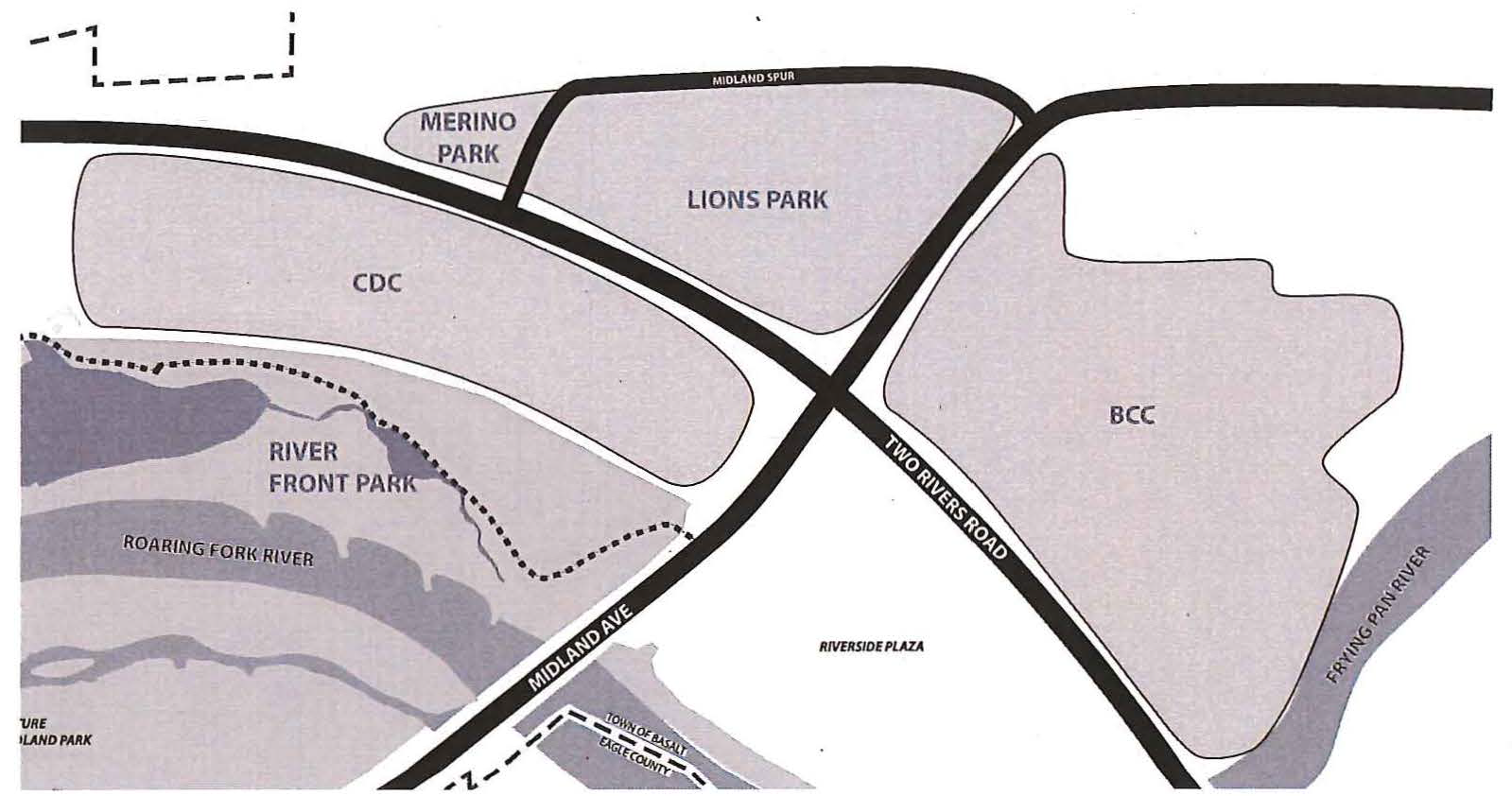
Applicability. This district is intended to apply to four (4) specific parcels of land commonly known as:
a.
The CDC parcel;
b.
The BCC parcel;
c.
The Lions Park parcel; and
d.
The Merino Park parcel.
The general boundaries of these four (4) parcels are shown on the following map. The exact boundaries of each parcel shall be established at the time the CSC Zone District is applied to that parcel.
(b)
Threshold requirements.
(1)
Development must be community serving. Since the intent of the CSC Zone District is to encourage social entrepreneurship in the development of community serving commercial projects, new development shall only be permitted to occur in the CSC Zone District if it is determined to be community serving. New development shall be considered to be community serving if it includes an anchor use or uses listed in Section 16-30(c)(1) below for the specific parcel indicated, and that anchor use or uses meets the applicable minimum size standard for that use in Section 16-30(c)(1) below.
(2)
Qualifying organizations. In order to be eligible for rezoning to the CSC Zone District, the owner of the land to be rezoned must be a non-profit Community Development Organization, a similar non-profit organization where development activities are a stated part of its 501(c)(3) tax status, or a for-profit entity engaged in construction of a building or facility that is a community-serving anchor facility, as listed in Section (c)(1) below. A qualified Community Development Corporation is an entity which satisfies the requirements of Section 16-4 applicable to a "Public non-profit Entity, Community Development Corporation." A for-profit entity may include a group of owners which have agreed to be represented in the entity engaged in constructing the community-serving anchor facility. Notwithstanding the requirements above, after an anchor use has been established on a parcel listed in Section 16-30(a)(2) above, later applications for rezoning a different portion of the same parcel to the CSC Zone District may be filed with any person or entity authorized to file a rezoning application under Chapter 16 of the Basalt Municipal Code.
(3)
Consistency with Master Plan. In reviewing whether a parcel is appropriate for CSC zoning, the Town will consider the future land use designation, neighborhood typology, and goals and objectives of the then current Master Plan, including but not limited to the Our Town Master Plan amendments.
(c)
Permitted uses.
(1)
Permitted anchor uses.
a.
Subject to Subsections (1)b. and (1)c. below, at least one (1) of the following anchor uses must occur on the CSC Zone District parcels indicated in the table below.
| Table 16-30-1: Anchor Use Table | |||||
|---|---|---|---|---|---|
| CDC Parcel (West) | CDC Parcel (East) | BCC Parcel | Lions Park | Merino Park | |
| Arts Center [1] | |||||
| Community Housing [2] | |||||
| Brewpub/Distillery [1] | |||||
| Entertainment [3] | |||||
| Grocery Store [3] | |||||
| Hotel [4] | |||||
| Condominium Hotel [4] | |||||
| Park/Open Space | |||||
| Small Business Incubator [2] | |||||
| Sports/Youth Center [1] | |||||
| Town Hall | |||||
| Community Center [1] | |||||
| Restaurant [5] | |||||
|
[1] Must contain at least 6,500 sq.ft. of total floor area.
[2] Must occupy at least 70% of the occupied total floor area developed on that CSC parcel. [3] Must contain at least 9,000 sq. ft. of total floor area. [4] Must contain at least 30 guest rooms. Guest rooms may include small kitchens. [5] Must contain at least 3,000 sq. ft. of total floor area. | |||||
b.
The Town Council may approve an anchor use designated for one (1) CSC parcel as an acceptable anchor use for a different CSC parcel not indicated in the table above, with the exceptions that no anchor use other than a park or open space shall be designated for the eastern portions of the CDC and Lions Park parcels and a condominium hotel shall not be designated for the CDC parcel.
c.
If an approved anchor use begins operation but later discontinues operation for a period of three (3) months or more, or if the portion of the building in which the anchor use is located is destroyed by fire or any other cause, the property owner may apply to change the approved anchor use to any other anchor use that meets the minimum size requirements listed in the table above. Any change to a substitute anchor use or another use permitted in the CSC zone district shall require review and recommendation by the Planning Commission following a public hearing, and shall require approval by the Town Council.
(2)
Required Community Vitality Uses. On each CSC parcel, land uses in the designated Vitality Zone for that parcel are required to be Community Vitality Uses subject to exceptions included in Section 16-29(c) and the design guidelines for buildings included in Section 16-30(d)(7).
(3)
Permitted secondary uses. The following secondary uses are permitted on each CSC parcel, provided that one (1) or more of the anchor uses designated in the table above (or approved by the Town Council) has already been established on same CSC parcel, or will be established on the same CSC parcel as part of the development containing the permitted secondary use.
a.
An anchor use listed above in Table 16-30-1, regardless of whether it satisfies the minimum size requirements, unless prohibited elsewhere by this Subsection (C)(3) or by Subsection (C)(1)(b) above.
b.
Uses and activities conducted by a government entity or by a public non-profit entity that meets the requirements of Sections 16-4 or 16-21(8) of this Chapter. Such uses include including but not limited to administrative offices and meeting rooms for non-profit and educational oriented organizations, transit facilities, museum, community center, educational facilities, performing arts center, and theater.
c.
A local business chamber.
d.
Community Vitality Uses as shown on Table 1 in Section 16-29 as Community Vitality Uses (in areas of the parcel other than the designated Vitality Zone).
e.
Other commercial, office and retail uses allowed in the C-2 Zone District (but not including a condominium hotel on CDC parcel).
f.
Fully-deed restricted community housing units meeting the requirements of this Chapter.
g.
Free-market multifamily residential uses (only on BCC and Lions Park parcels) where no unit exceeds one thousand four hundred (1,400) total square feet and on the CDC West Parcel where no unit is to exceed two thousand three hundred eighty (2,380) total square feet.
h.
Makerspace/Craft Industry.
i.
Public parking garage (on the BCC parcel only).
j.
Public or private open space and park uses.
k.
Day care that complies with state requirements regulating day care.
l.
Accessory uses approved pursuant to CSC Development Plan Review Process.
m.
Temporary outdoor uses and vendors, subject to the provisions of Chapter 6, Section 6-13 of the Town of Basalt Code.
(4)
Limitations on permitted uses. Through the CSC Development Plan Review process, the Town Council may place reasonable restrictions or limitations on any use or activity in the CSC Zone District. The Town Council may also determine that a specific use is not appropriate based on the intent of the zone district, consistency with the Town Master Plan and compatibility with adjoining areas. The Town Council may establish conditions allowing for subsequent review by the Town Planner or Technical Review Committee to avoid unnecessary additional meetings before the Planning and Zoning Commission and Town Council.
(d)
Dimensional requirements.
(1)
The dimensional requirements applicable to developments within the CSC Zone District shall be established through the CSC Development Plan review process, and shall be subject to the limitations listed in Table 16-30-2, below.
(2)
Town Council can reduce or waive in its entirety the requirement for a full ten-foot third floor setback on the park sides of the CDC parcel after a recommendation of the Planning and Zoning confirming that at least one of the following findings has been made.
a.
An equivalent setback is provided on the first floor to provide a porch or deck that lessens the visual massing of the building by park users;
b.
Requiring the setback would require the first floor of the building to be so large that it would negatively impact views required by Section 16-30(e)(1);
c.
There is sufficient fenestration in the building to reduce the visual mass of the building so that the full top floor setback is not necessary;
d.
The third floor setback is in an area not seen by park users because of vegetation, terrain change, intervening structures, or other factors;
e.
The second floor of the building is set back from the first floor facade at least ten (10) feet or more on those frontages where a third floor setback is required in the table above.
(3)
A land use application must demonstrate to the satisfaction of the Town Council that the height requested is compatible with or complements the adjacent uses and heights of adjacent structures. The Town Council can allow a building height to exceed the maximum height requirements by no more than eight (8) feet after a recommendation of the Planning and Zoning confirming that at least one (1) of the following additional findings has been made.
a.
Permitting the additional height allows for greater views or wider pedestrian-through connections to the river than otherwise would be achieved or the Applicant is willing to grant wider views to the river in exchange for the additional height;
b.
The height is the minimum necessary to hide mechanical equipment that must be on the roof;
c.
The additional height is necessary to allow underground parking. However no more than four (4) feet of underground parking structure height above approved grade may be exempted from the maximum height limitations.
d.
The additional height will permit the addition of a feature improving the architectural interest of the building. However, no more than six (6) feet of additional height to accommodate the feature may be approved.
(4)
The approved grade from which maximum height will be measured and first floor elevation(s) for the buildings within any CSC parcel will be proposed in the sketch plan application and established at Final Plan review based on each building's relationship to any adjacent street, sidewalk, public area or buildings, while factoring in other environmental considerations such as the water table.
(e)
Other Site Development Standards.
(1)
Openings to the river. The following openings shall be preserved for views to Roaring Fork River and for pedestrian passage by employees, occupants, or patrons of adjacent properties, and no new building shall be constructed in the areas designed as a view protection/pedestrian access zone.
a.
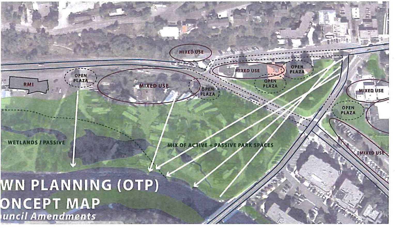
Required View/Pedestrian Opening 1: On the Lions Park parcel and CDC parcel, buildings shall be sited so as to preserve views and pedestrian access from the corner of Midland Avenue and the Midland Spur to the Roaring Fork River as shown on the following map.
b.
Required View Opening 2: On the CDC parcel, a view and pedestrian access from Two Rivers Road to the Roaring Fork River shall be provided along the western edge of the property, as shown on the following map.
c.
Additional View Opening: To the maximum extent practicable, at least one (1) additional view from Two Rivers Road to the Roaring Fork River should be provided somewhere west of the intersection of Two Rivers Road and the Midland Spur. This view opening shall be located so that building frontages along Two Rivers Road comply with the building facade articulation standard in Section 16-30(f)(4) below.
(2)
Pedestrian through-connections. Development on the BCC parcel shall incorporate at least one (1) pedestrian through-connection from the Midland Avenue frontage to the Frying Pan River frontage. The required pedestrian through-connection shall be located internal to the site (at least fifty (50) feet from the Two Rivers Road frontage). The pedestrian through-connection may be provided in phases as different portions of the BCC parcel are redeveloped at the discretion of the Town Council in the case that an individual development applicant does not control property abutting the Midland Avenue frontage or abutting the Frying Pan River frontage to make the full pedestrian-through connection.
(3)
Vitality zone. Each CSC parcel except the Merino Park parcel shall include a designated vitality zone that shall be established by the Town in the sketch plan process. The permitted uses in the vitality zone are shown on Table 1 in Section 16-29 as Community Vitality Uses and the buildings are subject to the building design standards contained in Section 16-30(f) for buildings within the vitality zone. The Town Council will establish the vitality zone considering the following:
a.
The pedestrian and connectivity goals of the area;
b.
The nature of the desired streetscape;
c.
Existing and proposed adjacent uses;
d.
The then current Master Plan, including but not limited to the Our Town Master Plan amendments; and
e.
The goals advocated by any non-profit applicant.
(4)
Parking. Development in the CSC Zone District shall provide parking as follows:
a.
Minimum requirements.
1.
Hotel/Condominium Hotel—One (1) space per hotel room, plus two (2) for management and operations.
2.
Residential—One (1) space per bedroom to a maximum of two (2) spaces per unit, where an efficiency unit is counted as one (1) bedroom.
3.
All other uses—One (1) space per four hundred (400) square feet of floor area. With the exception of handicap spaces and car share spaces, parking spaces may not be reserved for individuals or private businesses.
b.
Additional on-street parking constructed as part of the development will count for nonresidential parking included in the calculation of parking spaces to be provided. The applicant shall be permitted to purchase non-residential parking spaces pursuant to the requirements of Section 16-94.
c.
The Town Council may apply a reduction of the non-residential parking requirements following a recommendation of the Planning and Zoning Commission based on hours of operation, mixed-use, access to on-street parking, availability of local public transit, availability of parking spaces in a public parking lot or garage, expected use of WE-Cycle or other bicycle sharing programs, contribution to or participation in a car share program that serves the community, creation of a Transportation Demand Management (TDM) plan to reduce traffic volumes and parking demands below expected levels, or contribution to other desired public improvements, necessary infrastructure, or other basic Town service requirements. The Town Planner may require a recommendation from a parking consultant as outlined in Section 16-92 in order for the staff and Planning and Zoning Commission to make a recommendation and the Town Council to make a decision on the appropriate parking reduction for the development.
d.
The visual impacts of off-street parking and loading areas shall be minimized. The design of parking and loading areas shall ensure that they support and do not detract from the Town's vitality goals for the CSC Zone District, This shall be accomplished by:
1.
Constructing structured parking primarily underground where such construction is feasible;
2.
Prohibiting surface parking between any building on the CDC, Lions Park, and Merino Park parcels and the right-of-ways of Two Rivers Road, Midland Avenue, or the Midland Spur;
3.
Locating parking and loading areas, or the access to such areas, along the rear facade or side of the building whenever feasible; or
4.
Wrapping the facades of any structured parking within other permitted uses that have a minimum depth of eighteen (18) feet or wrapping the facades with building material, grading or landscaping to break up the view of the parking and parking structure lighting from public open spaces and other activity areas. When this design option is employed the access to the structured parking shall be designed with the same attention to detail and materials as the primary facade and the access shall be integrated into the building's design and wrapping.
5.
Designating one (1) or more loading zones on the site plan and regulations to govern loading.
e.
Except as described in subsections (a) through (d) above, parking areas and structures in the CSC Zone District shall comply with the requirements of Article V, Off-street Parking and Loading.
(5)
Open spaces.
a.
To the extent possible the areas between each building with a ground floor nonresidential primary use and the adjacent street shall be visible space that is useable by customers of on-site business uses or pedestrians. These areas, and the required open space areas on the site shall:
1.
Abut and be level with the public sidewalk;
2.
Be open to the sky (except for awnings, covered walkways, areas under a porch and covered outdoor seating);
3.
Be directly accessible to the public; and
4.
Be provided with appropriate ground cover treatment and landscaping.
b.
Placement of street furniture and public art in required open space is encouraged, as long as a five-foot minimum pedestrian walkway width is maintained. Items such as street furniture, educational and interpretive displays, small play features and public art that are attractive and appropriate for use by young children are encouraged. The Town may give credits towards minimum open space requirements for street furniture, fountains and similar improvements in a public right-of-way or other public spaces in the downtown.
c.
At least fifty (50) square feet of private usable open space shall be provided for each dwelling unit. Private open space may include balconies above ground and lawn areas and patios behind the building. Private open space areas shall not be located in front of or adjacent to any portion of a building's vitality zone. The Town may reduce or waive a private open space requirement if the Town determines that the private open space area would interfere with the intent of the CSC Zone District.
d.
Building design and landscape features for the CSC development must take into consideration adjacent public park uses. CSC development shall complement but not detract from public park activities. Development outside of any designated vitality zone adjacent to a public park shall be designed to minimize the intrusion of the CSC development activities or impacts from private lands onto public parks and trails. Development within any designated vitality zone should be designed to optimize integrated public and private uses and activities.
(6)
Signage. The sign restrictions of the C-2 District will apply to non-residential uses unless modifications to those standards are approved through the CSC Development Plan Review process. However, nothing shall prevent the Town Council from adding conditions and restrictions on signage to protect adjacent properties and to further the goals of the adopted Town's Master Plan, including without limitation the Our Town Master Plan amendments.
(7)
Lighting. The lighting requirements of Section 16-431 shall apply to development within the CSC Zone District unless modified through the Exemption process outlined in Section 16-438 of the Town Code, Article XX, Exterior Lighting.
(8)
Utility and trash facilities. Utility boxes and trash/recycling facilities servicing the building shall be located outside of the public right-of-way, along the rear or side facade of the building. To the extent possible, these facilities shall be located to avoid or minimize any negative impacts on residential uses on the parcel and on adjacent parcels and to avoid interfering with pedestrian movement and experience. This requirement shall not be construed to prohibit the placement of street furniture, such as public trash containers, within the public right-of-way.
(9)
Environmentally sensitive areas. Development within the CSC Zone District shall comply with Article XXI (rivers, wetlands and environmentally sensitive areas), provided that the environmentally sensitive area review shall be conducted simultaneously with the CSC Development Plan Review if the Town Planner makes a finding that the development is within the development line established by the River Master Plan.
(10)
Community Priority Scoring System. Development within the CSC Zone District shall be exempt from the requirements of Article XXII.
(11)
Land dedications. The land and improvements, or fees in lieu, required to be provided under the provisions of Section 17-15 (Parkland Dedication) shall be calculated at one-half (½) the requirement for any deed-restricted community housing units; and the provisions of Section 17-16 (School Land Dedication) shall apply at the same discounted rate for deed restricted community housing units. The Town Council may exempt or further reduce such fees for free- market and community housing during the CSC Development Plan review process pursuant to Section 16-419. Any reduction or elimination of school impact fees will require approval by the school district.
(12)
Development in the CSC Zone District shall meet or exceed the accessibility requirements of the Americans with Disabilities Act.
(13)
Landscaping in the public right-of-way. Landscaping that is to be installed in the public right-of-way shall comply with the applicable provisions of the Public Works Manual.
(14)
Curb Cuts. Development in the CSC Zone must satisfy the design criteria of the C-2 Zone District in Section 16-29(e)(4)c. regarding curb cuts.
(15)
Street and Streetscape Improvements. All street and streetscape improvements shall comply with the Town of Basalt Complete Streets Design Manual.
(16)
Community Housing. Development within the CSC Zone District shall comply with Article XIX (Housing Mitigation).
(f)
Building design. All buildings shall comply with the following requirements, if applicable:
(1)
Building Typologies and Guiding Principles. The typologies from the Our Town amendments to the Town of Basalt Master Plan that the Town determines are most applicable to the type of development proposed in the project, as well as other building design standards and guidelines contained in the Our Town Master Plan amendments. Those guiding principles include:
• Building scale compatible with historic downtown;
• Variety of western roof forms;
• Street level interest; and
• Contemporary reinterpretations.
(2)
Buildings within the portion of the site designated as the vitality zone (as that term is defined in Section 16-29 of this Code) shall incorporate a store-front design at the street level, with windows suitable for retail goods display that are designed to attract pedestrian interest at the street level. The storefront windows along the facade of the vitality zone shall be transparent so as to permit the activities within the building to be visible to pedestrians along the adjacent street. Commercial spaces at street level should have a ceiling height consistent with those within the historic downtown.
(3)
Any new buildings constructed at prominent corners shall contain both ground floor and upper floor elements that reflect timeless design and visually emphasize the importance of the corner through vertical elements, changes in materials or color, changes in articulation patterns, or entryways, or similar features.
(4)
Building facades along streets shall be designed to reflect the general twenty- to thirty-foot width of street facing building facades in older areas of downtown Basalt. Building facades wider than thirty (30) feet shall include vertical projections or insets from grade level to the eave of a pitched roof or the top of a flat roof or parapet at a linear spacing of no less than twenty (20) feet and no greater than thirty (30) feet unless waived or modified by the Town Council after recommendation by the Planning and Zoning Commission. This standard shall not prohibit the extension of an awning across the vertical projection or inset.
(5)
Building facades along pathways that connect buildings to public spaces, and along alleys or other frontages with pedestrian traffic shall contain projections from or insets into the wall plane, windows, doors, or changes in material to ensure that no section of building wall longer than thirty (30) feet is of uniform materials, color, and appearance unless waived or modified by the Town Council after recommendation by the Planning and Zoning Commission.
(6)
The ground floor of any new structure in the vitality zone shall be at grade with adjacent sidewalks or passageways, and there shall be no steps between the sidewalk and the primary building entry. However, in order to satisfy grade issues, steps may be included between the sidewalk and the street if the applicant demonstrates that providing steps is the best way to address grades on the site.
(g)
Zone District review procedures and submission requirements.
(1)
CSC Development Plan review procedures. No new development shall occur in the CSC Zone District without CSC Development Plan review and approval. CSC Development Plan review shall be conducted in two (2) stages, these being Sketch Plan review and Final Plan review.
a.
Sketch Plan review. Sketch Plan review is intended to provide the Town with a general overview of the project including a description of existing conditions, proposed mix of uses, height, floor area and parking, as well as its relationship to neighboring properties and consistency with the Town's Master Plan, the River Master Plan and applicable Code provisions. Sketch Plan review shall involve the following procedural steps:
1.
The initial step in Sketch Plan review shall be a determination of whether the proposed project is community serving and is eligible for rezoning to the CSC Zone District. This determination may be made administratively by the Town. Planner or the Town Planner may refer this matter to the Planning Commission and Town Council. If the determination is referred, then the Planning Commission and Town Council consideration may occur at a jointly held public hearing. Any project that is determined to be community serving and eligible for rezoning to the CSC Zone District may then proceed through Sketch Plan review.
2.
With the exception of proposals for the Merino Park parcel, Sketch Plan review shall
require a review by the Town's Parks, Open Space and Trails Committee. The Committee
shall make recommendations on how the project satisfies Section 16-30(e)(1),(2) and (5) along with the Committee's findings of the project's consistency
with the parks, open space and trails sections of the Town's master plan and the project's
impact on any other adopted park plans.
A Sketch Plan review will then require review by the Planning Commission. The Commission
is authorized to recommend approval, approval with conditions, or denial of the Sketch
Plan application following a duly noticed public hearing. The Planning Commission
review shall be followed by a review by the Town Council at a duly noticed public
hearing. Following the closure of the public hearing, the Town Council may approve,
approve with conditions, or deny the application.
b.
Final Plan review. Final Plan review is intended to provide the Town with a more detailed description of the proposed development program, to respond to issues raised in the sketch plan review and to present additional information required in the Sketch Plan review. With the exception of proposals for the Merino Park Parcel, the initial step in the Final Plan review will be a review by the Parks, Open Space and Trails Committee. The Committee shall make recommendations on how the project satisfies Section 16-30(e)(1), (2) and (5) along with the Committee's findings of the project's consistency with the parks, open space and trails sections of the Town's master plan and the project's impact on any other adopted park plans. Final Plan review shall require a review by the Planning Commission. The Commission is authorized to recommend approval, approval with conditions, or denial of the Final Plan application following a duly noticed public hearing. The Planning Commission review shall be followed by a review by the Town Council at a duly noticed public hearing. Following the closure of the public hearing, the Town Council may approve, approve with conditions, or deny the application. The Town Planner may schedule a joint meeting of the Planning Commission and Town Council prior to. the initial Final Plan review by the Commission.
c.
Community Serving Subdivision. A property which is zoned CSC is eligible to be subdivided as a Community Serving Subdivision pursuant to the provisions of Section 17-84.5 of this Code provided no more than four (4) initial lots are created by the Owner. The Community Serving Subdivision shall be processed concurrently with the CSC Development Plan. However, nothing herein requires the qualifying non-profit organization to use the Community Serving Subdivision process if the owner would rather utilize another eligible subdivision process in the Code at the time of the subdivision.
(2)
Sketch Plan submission contents. The application for the Sketch Plan stage of CSC Development Plan review shall include the following:
a.
Completion of standard application forms and authorization from the owner for the filing and processing of the application and fees.
b.
Description of existing conditions.
c.
A legal description of the property, an ALTA survey and a copy of any easement or recorded document referenced on the ALTA survey.
d.
A list with addresses of all property owners within three hundred (300) feet of the property.
e.
A description of the development program including: major objectives of the development; proposed mix of uses with approximate square footages of each use and number of any free-market and community housing units and allowed locations; parking capacity, location and types; access locations and vehicle and pedestrian circulation; proposed phasing and timing; and plan for satisfying the goals of the development plan. Numbers can be provided in a range.
f.
Schematic development plan (at a scale of at least one (1) inch per one hundred (100) feet) showing horizontal relationships of the proposed development with property boundary, setbacks and proposed uses.
g.
Information and drawings and physical model (at a scale identified by Town Planner) providing a schematic level description and illustration of the height, scale and mass of proposed structures from important perspectives, as well as proposed open spaces narrative and graphic descriptions of the character and style of architecture in context with adjacent development. The Town Planner may allow an applicant to submit a computer model in lieu of the physical model.
h.
Narrative addressing relationship of the project to neighboring properties and consistency with the Town's Master Plan, the River Master Plan; Streetscape Plan and any other long range planning documents as deemed appropriate by the Town.
i.
Narrative description of how utilities are to be provided to and through the site by a licensed professional engineer along with an assessment as to the feasibility of the applicant's proposal. Describe whether any existing utilities or easements will need to be relocated or vacated, and generally the plan for accomplishing this. The engineer's assessment at a minimum must address potable water, sanitary sewer, drainage and storm sewer, electrical power, natural gas power, and flood protection where applicable. Describe whether the power lines will be below ground or overhead. The applicant may include maps depicting the alignment of utilities but it is not required at Sketch Plan. The engineer's assessment shall outline any known engineering and utility issues and generally describe how they will be addressed in the final site plan review.
j.
Proof of ability to apply the CSC Zone District.
k.
General statements describing how the elements of the development will satisfy the criteria required for the CSC Zone and explanation for any reductions in requirements allowed through the site plan process.
l.
Statements addressing how the development intends to satisfy requirements that apply to the development found in other sections of the Code applicable to the type of development being proposed, including but not limited to: any annexation requirements; school and parkland dedication; floodplain development permit and regulations, and community housing, including any need for relocation housing.
m.
Description of how the development addresses the Town's goals toward sustainable building, energy efficiency and waste reduction.
n.
A study of the shading or shadow impacts that the proposed buildings may cause on public or private rights-of-way or other public spaces within or surrounding the project.
o.
Additional information. Any additional information reasonably required by the Town to review the application and to verify compliance with the provisions of this Code.
(3)
Final Plan submission contents. The application for the Final Plan stage of CSC Development Plan review shall include the following:
a.
Same as above along with such additional or refined information and analysis as may be required by the Town Council in order to address issues raised in the Sketch Plan review or to verify compliance with the provisions of this Code.
b.
Off street parking and loading areas, including the location, type and capacity of proposed parking areas, and written justification for any proposed reductions or fee-in-lieu of parking proposals.
c.
The location of all ways for ingress and egress to all buildings and parking areas.
d.
Service and loading areas and refuse and recycling collection areas.
e.
Site/building program.
f.
Development plan which meets the requirements of Section 16-66(3)b. Following Final Plan approval the applicant shall record a development plan containing the elements of the Town Council's approval.
g.
Reserved.
h.
Proposed schedule and phasing.
i.
Identification of potential construction and maintenance easements needed for zero-lot line development and plan for obtaining such easements.
j.
Draft Master Development Agreement which generally describes the public improvements to be constructed in connection with the project, the timing of such construction, the parties responsible for completion of the public improvements and the financial security to be provided.
(4)
Building, engineering and site design review. Building, engineering and site design review is intended to provide the Town with the final architectural, engineering, landscaping and other technical documents that are a precursor to the actual construction of the project. Following approval of the final CSC Development Plan and any other associated land use actions and prior to issuance of a building permit for each lot or development site, the then-owner of a lot or development site shall comply with the following submission requirements and review procedures:
a.
The owner shall prepare and submit architectural drawings, elevations and perspective drawings of all proposed structures and improvements intended to show the relationship of the proposed structures to the surroundings. Such drawings shall depict proposed building materials, fenestration, mechanical equipment (and screening of such equipment) and similar architectural details but need not be the result of final architectural design.
b.
The owner shall submit final engineering documents, including plans and specifications for streets, water, sewer and drainage and the engineers' cost estimates for all public improvements to be installed on the lot or building site within dedicated land areas, rights-of-way or easements.
c.
Following construction, the owner shall provide as-built mapping and diagrams for utility installations in an electronic computerized format of a type approved by the Town Engineer or Public Works Director.
d.
The owner shall describe the character and type of landscaping, lighting and signage to be provided. The landscaping shall be indicated in tabular form, showing the type of plant material, minimum size and quantity. The approximate location of landscaping shall be indicated on a site plan. The lighting description shall describe how the lighting complies with the final site plan approval and any exemptions that will be necessary pursuant to Section 16-438 of the Town Code, Article XX, Exterior Lighting. The signage plan shall provide detailed information sufficient to determine whether the location, size, number and character of the proposed signs comply with the requirements of the Town Code, Article VII, Signs.
e.
The owner shall provide an anticipated time table for completion of development including the anticipated dates for completion of any phase.
f.
The owner shall provide a title insurance policy indicating that the property is free and clear of all ownership disputes, liens or encumbrances which would impair the property to be utilized for the uses approved. The title policy shall provide verification that all owners and lien-holders have approved the final subdivision plat.
g.
The owner shall demonstrate compliance with Article II, Chapter 17, Design Standards and Requirements for Subdivisions.
h.
The owner shall demonstrate compliance with Article V, Chapter 17, Public Improvements Acceptance and Guarantees.
1.
The owner shall provide a Subdivision Improvement Agreement for public or quasi-public improvements to be constructed by the owner and other draft agreements and conveyances that apply to the development as whole or to community housing or other restrictions or requirements.
2.
The owner shall provide a Construction Management Plan and shall submit a request for the use of any of the Town's property for construction or construction management purposes.
3.
The owner shall demonstrate compliance with the Final CSC. Development Plan approval applicable to the application and any other Town approval.
i.
The owner shall submit the information necessary to satisfy the foregoing requirements for review by the Technical Review Committee. TRC review shall take into consideration the project's compliance with the approval documents applicable to the development, relevant standards applicable to buildings, final subdivision plats and other Town code requirements for approval before building permit. The TRC may refer any portion of its review to the Planning Commission or Town Council for final action. In addition, in its final approval the Town Council may require that the Planning Commission or Council review specific items of the approval.
(5)
Amendments to a Sketch Plan or Final CSC Development Plan. Amendments to a Sketch Plan approval or Final Plan shall be processed as follows:
a.
Sketch Plan approval. After Sketch Plan approval an applicant may make insubstantial amendments to the approved sketch plan before submitting a Final CSC Development Plan for review. Substantial amendments shall be processed under the same procedures as used for the original adoption. "Substantial" shall have the same meaning as in Section 16-65(d)(2). The initial determination of whether an amendment is insubstantial or substantial shall be made by the Town Planner.
b.
Final CSC Development Plan approval. After Final Development Plan approval, the TRC may review and approve of minor amendments to the approval documents necessary to effectuate the intent of the Final Plan Approval. The applicant shall have the ability to appeal a TRC decision on a minor amendment to the Town Council at a public meeting in which fifteen (15) days' written notice of the public meeting has been provided to the appellants.
c.
Substantial amendments and amendments which the Town Planner determines are not minor amendments but are consistent with the Sketch Plan approval shall processed pursuant to the Final Plan submission and review procedures. Substantial amendments and any amendments which the Town Planner determines are not minor amendments and are not consistent with the Sketch Plan approval shall be processed pursuant to the Sketch Plan and Final Plan submission and review procedures.
(h)
Wireless communications facilities, subject to the requirements of Section 16-191, small cell facility and eligible facility request uses are permitted uses, alternative tower structure for non-small cell facility, alternative tower structure, base station, and wall-mounted or roof-mounted wireless facility uses are uses permitted by special review, and based station for non-small cell facility and tower uses are prohibited uses in the CSC Zone District.
(Ord. 10 §B.3(Exh. B), 2012; Ord. 21 §B.1(Exh. A), 2016; Ord. 18 §2(Exh. A), 2019; Ord. 05 §A(Exh. A), 2020; Ord. 14 §2(Exhs. B.34, C), 2022; Ord. 15 §2(Exh. A), 2022)
Sec. 16-31. - Supplemental requirements for R-4 Mixed Density Residential District.
(a)
The following supplemental regulations shall apply to development within the R-4 MD District.
(1)
Applicability.
a.
Any property under one (1) ownership at the time of initial zoning of at least twelve thousand (12,000) square feet in size and that is appropriate for mixed density residential may be zoned to the R-4 MD District. Only parcels with few development or environmental constraints and where utilities and services are existing or can be affordably provided are appropriate for this zone district because providing affordable or attainable community housing is the primary objective of this zone district. This zone district is best suited for property that is relatively flat and property where adequate fire protection exists or can be established.
b.
The initial step in Sketch Plan review shall be a determination of whether the proposed project is appropriate to be zoned R-4 MD. This determination will be made administratively by the Town Planner. The Town Planner's determination of eligibility may be appealed to the Town Council.
(2)
Site plan review.
a.
No new development shall occur in the R-4 MD District without site plan review and approval. Site plan review shall be conducted in two stages, these being Sketch Plan review and Final Plan review.
1.
Sketch Plan review. Sketch Plan review is intended to provide the Town with a general overview of the project including a description of existing conditions, proposed mix of uses, height, floor area and parking, as well as its relationship to neighboring properties and consistency with the Town's Master Plan, the River Master Plan and applicable Code provisions. Any project that is determined to be eligible for rezoning to the R-4 MD District pursuant to Section 16-31(a)(1)b, Supplemental Requirements for R-4 Mixed Density Residential District Applicability, may proceed through Sketch Plan review. The application requirements shall satisfy the application requirements of Section 16-41 et seq., Special Review Application Requirements and Procedures. The Town Planner may require any additional information reasonably required by the Town staff to review the application and to verify compliance with the provisions of this Code. Sketch Plan review shall require a review by the Planning and Zoning Commission. The Commission is authorized to recommend approval, approval with conditions, or denial of the Sketch Plan application following a duly noticed public hearing. The Planning and Zoning Commission review shall be followed by a review by the Town Council at a duly noticed public hearing. Following the closure of the public hearing, the Town Council may approve, approve with conditions, or deny the application.
2.
Final Plan review. Final Plan review is intended to provide the Town with a more detailed description of the proposed development program, to respond to issues raised in the Sketch Plan review and to present additional information required in the Sketch Plan review. Final Plan review shall require a review by the Planning and Zoning Commission at a public hearing. The application shall satisfy the requirements of Section 16-111 et seq. the Town Planner may require any additional information reasonably required by the Town Staff to review the application and to verify compliance with the provisions of this Code. The Planning and Zoning Commission is authorized to recommend approval, approval with conditions, or denial of the Final Plan application. The Commission's review shall be followed by a review by the Town Council at a duly noticed public hearing. Following the closure of the public hearing, the Town Council may approve, approve with conditions, or deny the application.
3.
Joint meetings. The Town Planner may schedule a joint meeting of the Planning and Zoning Commission and Town Council at any time during the site plan review.
4.
Findings. As part of its review of the proposed site plan, the Planning and Zoning Commission and the Town Council shall consider the following factors:
i.
Compliance of the application with the Code in general and Section 16-31 in particular.
ii.
The site plan review criteria of Article VI.
iii.
The compatibility of the proposed use with the character of the surrounding area.
iv.
General conformity with the Master Plan.
v.
Ability of the Application to satisfy the intent of the Zone District.
b.
If the applicant for an R-4 MD Project concurrently applies for a subdivision sketch plan approval, the sketch site plan will also be reviewed concurrently with the subdivision if possible. However, it may be more practical to complete the final subdivision after the final site plan approval and the buildings are constructed.
(3)
Dimensional Requirements.
a.
The dimensional requirements applicable to developments within the R-4 MD District will be established through the site plan review process, and shall be subject to the limitations listed in Table 1 below.
Table 1
b.
General. The following general provisions apply to development in the R-4 MD District:
1.
The Code restriction of one (1) principal building on a property shall not apply.
2.
Areas zoned R-4 MD are not subject to the Community Priorities Scoring System as this development is determined to satisfy the objectives of Article XXII, establishing the Community Priorities Scoring System, provided the following:
i.
No more than 50 dwelling units may receive building permits in the area zoned R-4 MD in any one calendar year.
ii.
The units are not permitted to be short-term rental units pursuant to Section 16-203(c), Renting of rooms and housing units: short-term rental of dwelling units.
3.
Areas zoned R-4 MD are subject to the affordable housing mitigation requirements included in Article XIX, Housing Mitigation, of this Chapter.
4.
Private open space. At least fifty (50) square feet of usable private open space shall be provided per dwelling unit. Private open space includes patios, decks, lawn areas, balconies and common areas with usable recreation facilities or community garden areas. The minimum area requirement of private open space may be reduced through the special review process based on a finding by the Town Council that public recreation areas meeting the needs of the residents can be safely accessed by the residents and that providing additional private open space would hinder the goals of the zone district.
5.
The requirements of [Section] 16-185, Side yard requirements for corner lots, shall not apply.
c.
Single family units are subject to the following:
1.
Only lots five thousand (5,000) square feet or larger in size shall be eligible to request special review approval for an accessory dwelling unit. For the purposes of this district, an accessory dwelling unit is owned by the owner of the principle dwelling unit on the lot and an accessory unit is not permitted to be subdivided or condominimized from the principal dwelling unit on the parcel. A duplex may be owned by one (1) or more individuals.
2.
Accessory dwelling units shall be restricted in size in accordance with the schedule of requirements, and in no case shall be less than three hundred (300) square feet or exceed five hundred (500) square feet of total floor area.
d.
Attached duplex units, town home developments and multi-family development is subject to the following:
1.
Residential buildings. The minimum distance between two (2) habitable structures that are not directly attached to each other is fifteen (15) feet. A lessor distance down to a minimum five (5) feet between multi-family buildings that are not directly attached to each other may be permitted in the site plan review process after review by the Fire District to ensure adequate fire safety. The site plan and subdivision plan shall show the building envelopes to establish adequate building separation and ensure compliance with the building and fire codes.
e.
Other development standards.
1.
Building and site design. All development shall comply with the following requirements if applicable.
i.
The Town of Basalt Complete Streets Design Manual and the typologies from the Town of Basalt Master Plan that the Town of Basalt determines are most applicable to the type of development proposed in the project.
ii.
Landscaping that is to be installed in the public right-of-way shall comply with the applicable provisions of the public works manual.
iii.
Standards shall be included in the approvals to provide privacy of residences such special screening, specific design standards limiting window placement, and increasing the separation between the buildings.
iv.
Standards shall be included in the approvals that address whether fences are permitted and where. The Town Code requirement for fencing shall be used as a minimum in developing a plan for fencing.
v.
Standards shall be included in the approvals addressing whether garages and sheds, and other structures are permitted and in what locations.
vi.
Special attention shall be given in the review process to ensure that children will have adequate play areas.
vii.
Special attention shall be given in the review process to ensure that safe and pleasant sidewalks and pathways are provided to allow residents to move to and from areas within the neighborhood and to mass transit and other services outside the neighborhood.
2.
Off-Street parking standards. The off-street parking standards for development in the R-4 MD Zone District shall be as follows:
(Ord. 04 §B.4(Exh. B), 2013; Ord. 04 §1(Exh. A), 2015; Ord. 24 § A(Exh. A), 2017; Ord. 21 §A(Exh. A), 2020)