
Belding City Zoning Code
CHAPTER 16
SITE DEVELOPMENT REQUIREMENTS
Section 16.1.- Site plan review.
A.
Purpose. The purpose of this chapter is to provide for consultation between the applicant and the planning commission or city staff to review an applicant's planned objectives in the utilization of land within the regulations of this zoning ordinance.
B.
Uses subject to site plan and sketch plan review. Uses shall be subject to site plan review or sketch plan review according to table 16.1.
SK = Sketch Plan Review
SP = Site Plan Review
C.
Site plan review. Application and review procedures:
1.
Pre-application conference.
a.
A preliminary meeting with staff is required prior to the submission of a site plan review application.
(1)
The meeting may be scheduled either by the City of Belding or by the Ionia County Drain Commission using the county's requirements for such a meeting.
(2)
Representatives from the following departments and agencies will be invited to the meeting:
(a)
City zoning administration;
(b)
City engineer;
(c)
City department of public works;
(d)
City police and fire departments;
(e)
City manager;
(f)
Ionia County Drain Commission;
(g)
Ionia County Road Commission;
(3)
City of Belding staff will take minutes of the pre-application conference and will distribute minutes to all invited departments and agencies within one (1) week after the meeting date.
2.
Application procedures.
a.
A pre-application conference with the City of Belding Planning Department staff and invited departments and agencies must have been held not more than six (6) months prior to the submittal of an application for either a preliminary or a final (if no preliminary approval was sought) site plan review.
b.
An application for site plan review by the planning commission shall be submitted at least twenty-one (21) days prior to the next scheduled planning commission meeting. Application materials shall be submitted through the zoning administrator, who will review the application materials to ensure that the application and associated materials are complete, then transmit it to the planning commission.
c.
Copies of the site plan shall be forwarded from the zoning administrator to appropriate city departments and consultants, including but not limited to the following:
(1)
Fire;
(2)
Police;
(3)
Building inspections;
(4)
Planning;
(5)
Public works;
(6)
Engineering;
(7)
School district;
d.
Review comments shall be submitted by such departments and consultants to the planning commission for consideration prior to the meeting at which the request is to be considered.
e.
An application for either a preliminary or final site plan review shall consist of the following:
(1)
A completed application form, as provided by the city.
(2)
Fifteen (15) copies of the preliminary site plan or final site plan.
(3)
Payment of a fee, in accordance with a fee schedule, as determined by city council resolution.
(4)
A legal description, including the permanent parcel number, of the subject property and a boundary survey map.
(5)
Other materials as may be required by this section, the city manager, or the Planning Commission.
3.
Site plan review procedures.
a.
Preliminary site plan review option.
(1)
A preliminary site plan may (but is not required to) be submitted to the planning commission for review prior to final site plan review. The purpose of the preliminary site plan review is to allow discussion between the applicant and the planning commission to inform the applicant of the general acceptability of the proposed plans prior to incurring extensive engineering and other costs which may be necessary for the review of the final site plan.
(2)
Preliminary site plans shall include the following. The zoning administrator may waive one (1) or more of the requirements when it is demonstrated that the requirement is not necessary to adequately review the request:
(a)
Small scale sketch of properties, streets and use of land within one-quarter (¼) mile of the subject property.
(b)
Fifteen (15) copies of a site plan at a scale of not more than one (1) inch equals one hundred (100) feet (1" = 100') showing any existing or proposed arrangement of:
i.
Existing adjacent streets and proposed streets and existing curb cuts within one hundred (100) feet of the property.
ii.
All lot lines with dimensions.
iii.
Parking lots and access points.
iv.
Proposed buffer strips or screening.
v.
Significant natural features and other natural characteristics on the property, including but not limited to open space, stands of trees, wetlands, brooks, ponds, floodplains, hills, and similar natural assets; provided that any wetland, brook, pond, or similar water feature within two hundred fifty (250) feet of the property boundary shall also be shown.
vi.
Location of any signs not attached to the building.
vii.
Existing and proposed buildings, including existing buildings or structures within one hundred (100) feet of the boundaries of the property.
viii.
General topographical features including existing contours at intervals no greater than two (2) feet.
ix.
Number of acres allocated to each proposed use and gross area in building, structures, parking, public and/or private streets and drives, and open space.
x.
Dwelling unit densities by type, if applicable.
xi.
Proposed method of providing sewer and water service, as well as other public and private utilities.
xii.
Proposed method of providing storm drainage.
xiii.
Written description of the computation for required parking.
(3)
The planning commission shall review the preliminary site plan, along with any comments submitted by city departments or consultants, and make such recommendations to the applicant that will cause the plan to be in conformance with the review standards of section and this ordinance. To this end, the commission may request from the applicant any additional graphic or written materials, prepared by a qualified person or persons, to assist in determining the appropriateness of the site plan. Such material may include, but need not be limited to, aerial photography, photographs; traffic impacts; impact on significant natural features and drainage; soil tests, and other pertinent information.
b.
Final site plan review.
(1)
Final site plans shall include the following information. The zoning administrator may waive one (1) or more of the requirements when it is demonstrated that the requirement is not necessary to adequately review the request:
(a)
Small scale sketch of properties, streets and use of land within one-quarter (¼) mile of the area.
(b)
Fifteen (15) copies of a site plan at a scale not to exceed one (1) inch equals fifty (50) feet (1" = 50'). The following items shall be shown on the plan:
i.
Date of preparation/revision.
ii.
Name and address of the preparer who shall be a registered engineer, land surveyor, landscape architect, community planner, architect, or related professional.
iii.
The existing and proposed topography of the site at a minimum of two (2) foot contour intervals and its relationship to adjoining land.
iv.
Existing man-made features.
v.
Dimensions of setbacks, locations, heights and size of buildings and structures, including the locations of existing buildings or structures within one hundred (100) feet of the boundaries of the property.
vi.
Street rights-of-ways, indicating proposed access routes, internal circulation, relationship to existing rights-of-ways, and curb cuts within one hundred (100) feet of the property.
vii.
Proposed grading, showing two (2) foot contour intervals.
viii.
Location, sizes, and type of drainage, sanitary sewers, water services, storm sewers, detention or retention, and fire hydrants.
ix.
Location, sizes, and type of fences, landscaping, buffer strips, and screening.
x.
Location, sizes, and type of signs and on-site lighting.
xi.
Proposed parking areas and drives. Parking areas shall be designated by lines showing individual spaces and shall conform with the provisions of this ordinance.
xii.
Easements, if any.
xiii.
Dimensions and number of proposed lots.
xiv.
Significant natural features, and other natural characteristics, including but not limited to open space, stands of trees, wetlands, brooks, ponds, flood plains, hills, and similar natural assets.
(2)
The planning commission may request from the applicant any additional graphic or written materials, prepared by a qualified person or persons, to assist in determining the appropriateness of the site plan. Such material may include, but need not be limited to, aerial photography, photographs; traffic impacts; impact on significant natural features and drainage; soil tests; and other pertinent information.
(3)
The planning commission shall approve, deny, or approve with conditions the final site plan based on the requirements of this ordinance, and specifically, the standards of section 16.1.F.
D.
Approved site plans and amendments.
1.
Upon approval of the final site plan, the chairman of the planning commission shall sign three (3) copies thereof. One (1) signed copy shall be made a part of the city's files; one (1) copy of the final site plan shall be forwarded to the building official for issuance of a building permit; and one (1) copy shall be returned to the applicant.
2.
Each development shall be under construction within one (1) year after the date of approval of the final site plan, except as noted in this section.
a.
The planning commission may grant one (1) extension of up to an additional one (1) year period if the applicant applies for such extension prior to the date of the expiration of the final site plan and provided that:
(1)
The applicant presents reasonable evidence that said development has encountered unforeseen difficulties beyond the control of the applicant; and
(2)
The site plan requirements and standards, including those of the zoning ordinance and master plan, that are reasonably related to said development have not changed.
b.
Should neither of the provisions of section 16.1.E.2.a. be fulfilled, or an extension has expired without construction underway, the final site plan approval shall be null and void.
c.
Amendments to an approved final site plan may occur only under the following circumstances:
(1)
The holder of a valid final site plan approval shall notify the zoning administrator of any proposed amendment to such approved site plan.
(2)
Minor changes, requested by the applicant, may be approved by the zoning administrator upon certification in writing to the planning commission that the proposed revision does not alter the basic design nor any specified conditions of the plan as agreed upon by the planning commission. In considering such a determination, the zoning administrator shall consider the following to be a minor change:
(a)
Reduction of the size of any building and/or sign.
(b)
Movement of buildings and/or signs by no more than ten (10) feet.
(c)
Landscaping approved in the site plan that is replaced by similar landscaping to an equal or greater extent.
(d)
Changes in floor plans, of up to five (5) percent of the total floor area, which do not alter the character of the use or increase the amount of required parking.
(e)
Internal rearrangement of a parking lot which does not affect the number of parking spaces or alter access locations or design.
(f)
Changes required or requested by the city, Ionia County, or other state or Federal regulatory agency in order to conform to other laws or regulations.
(3)
Should the zoning administrator determine that the requested modification to the approved site plan is not minor, a new site plan shall be submitted and reviewed as required by this chapter.
E.
Sketch plan review and administrative approval.
1.
Sketch plan requirements. The applicant shall submit the sketch plan, required application form and fee to the zoning administrator. The zoning administrator may waive one (1) or more of the requirements when it is demonstrated that the requirement is not necessary to adequately review the request.
a.
Cover sheet including:
(1)
Completed application form and fee.
(2)
Name, address and telephone number of the applicant and/or firm or individual who prepared the plans; and date(s) of submission and any revisions (month, day, year).
(3)
Scale and north-point.
(4)
Location map drawn to a separate scale with north-point, showing surrounding land, water features, zoning and streets to establish the location of the property in question.
(5)
Legal and common description of property including net acreage.
(6)
Zoning classification of petitioner's parcel and all abutting parcels.
(7)
A note on each plan sheet stating "Not to Be Used as Construction Drawings."
b.
Buildings and structures.
(1)
Existing and proposed buildings and parking lots with dimensions and setbacks.
(2)
Floor plan indicating existing and proposed uses.
(3)
Building elevations including materials and colors for all sides with proposed changes.
c.
Parking and access.
(1)
Existing and proposed parking calculations.
(2)
Existing and proposed driveways.
d.
Site data.
(1)
Existing and proposed landscaping illustrated on the plan and described in a plant list.
(2)
Proposed changes to grading and other natural features.
(3)
Existing and proposed lighting and screening.
(4)
Proposed changes to utilities.
(5)
Any other items requested by the building official/zoning administrator to assist in the administrative review.
2.
Approval. A sketch plan shall be reviewed for compliance with the requirements of this Ordinance and the review standards as listed in section 16.1.F. A sketch plan found to be in compliance shall be approved. The zoning administrator may impose conditions upon the approved development.
3.
Report. For those sketch plans that are approved administratively, the zoning administrator shall report administrative approvals to the planning commission.
4.
Additional information. The zoning administrator retains the option to require additional information to permit complete review of the sketch plan. For those sketch plans that are reviewed administratively, the zoning administrator may require a complete site plan for review by the planning commission, particularly for sites that do not comply with previously approved site plans, sites with parking deficiencies, sites abutting residential districts or sites experiencing problems with drainage, traffic, noise, aesthetics or other general health, safety and welfare issues. If a full site plan is required, the zoning administrator shall inform the applicant to submit a set of plans in accordance with this section within fourteen (14) days of receipt of the application.
5.
Amendments. Amendments to sketch plans shall be reviewed in the same manner as the original approval.
F.
Site plan and sketch plan review standards.
1.
All site plans and sketch plans shall be approved, approved with conditions, or denied based on the purposes, objectives and requirements of this ordinance, and specifically, the following considerations as applicable:
a.
The relationship of uses proposed will not adversely affect the public health, safety, or welfare. Uses and structures located on the site shall be planned to take into account topography, size of the property, the uses on adjoining property and the relationship and size of buildings to the site. The site shall be developed so as not to impede the normal and orderly development or improvement of surrounding property for uses permitted in this ordinance.
b.
Safe, convenient, un-congested, and well-defined vehicular and pedestrian circulation shall be provided for ingress/egress points and within the site. Drives, streets and other circulation routes shall be designed to promote safe and efficient traffic operations within the site and at ingress/egress points.
c.
The arrangement of public or private vehicular and pedestrian connections to existing or planned streets in the area shall be planned to provide a safe and efficient circulation system for traffic within the City of Belding.
d.
Removal or alteration of significant natural features shall be restricted to those areas which are reasonably necessary to develop the site in accordance with the requirements of this ordinance. The planning commission or zoning administrator may require that landscaping, buffers, and/or greenbelts be preserved and/or provided to ensure that proposed uses will be adequately buffered from one another and from surrounding public and private property.
e.
Satisfactory assurance shall be provided that the requirements of all other applicable ordinances, codes, and requirements of the City of Belding will be met.
f.
The general purposes and spirit of this ordinance and the Master Plan of the City of Belding shall be maintained.
G.
Reapplication. No petition submitted for final site plan review or sketch plan review which has been denied, shall be resubmitted for a period of one (1) year from the date of denial, except as may be permitted by the zoning administrator or planning commission, as applicable, after learning of new and significant facts or conditions which might result in a favorable action upon resubmittal.
(Ord. No. 459, pts. 22, 23, 4-17-01; Ord. No. 471, § 2, 9-21-04; Ord. No. 472, § 1, 10-19-04; Ord. No. 512, § 11, 12-7-10; Ord. No. 518, § 8, 1-18-11)
Section 16.2. - Landscaping and screening.
A.
Intent. It is the intent of this section to require landscaping and screening to buffer the negative impacts between incompatible land uses; to minimize the adverse effects of certain outdoor activities upon their surroundings; and to improve the appearance of parking areas and street frontages within the community. It is further intended to preserve and enhance the aesthetic qualities, character, privacy, and land values of property within the city.
B.
Definitions. For the purposes of this section the following definitions will apply:
1.
Buffer: A strip of land between potentially incompatible uses which provides visual separation and aesthetic relief through some combination of screen and greenbelt.
2.
Screen: A visual barrier which surrounds a potentially offensive activity.
3.
Greenbelt: A landscaped area which provides aesthetic relief.
C.
Buffer zones required.
1.
A buffer zone shall be required on the subject parcel between abutting zoning districts, as indicated on the required buffers table.
2.
A buffer zone shall be required on the subject parcel even if the adjacent parcel is unimproved land.
3.
When any developed parcel changes to a more intense land use or a special land use approval or a site plan review is required, a buffer zone shall be provided in compliance with this ordinance.
4.
If existing conditions on the subject parcel are such that a parcel cannot comply with the buffer zone requirements, the zoning administrator shall determine the character of the buffer based on the following criteria:
a.
Traffic impacts,
b.
Building and parking lot coverage,
c.
Outdoor sales, display, or manufacturing area,
d.
Physical characteristics of the site and surrounding area such as topography, vegetation, etc.,
e.
Views and noise levels,
f.
Health, safety, and welfare of the city,
g.
Proximity or potential proximity of adjacent residential uses.
D.
Buffer zone development standards.
1.
Buffer zone level "A" shall meet the following requirements:
a.
Fifty (50) foot minimum width.
b.
Equivalent of one (1) canopy tree per thirty (30) linear feet or fraction of buffer zone length.
c.
Six (6) foot high continuous sight-obscuring screen composed of evergreen plant material, berming, walls or fences, or any combination approved by the planning commission.
d.
If berming is used for any part of the buffer, all required plant material shall be placed on the top and side slope facing the exterior property line.
e.
If a wall or fence is used for any part of the buffer, a minimum of four (4) shrubs are required per twenty (20) linear feet of wall or fence, with at least fifty (50) percent of all such plant material being at least twenty-four (24) inches high at time of planting.
f.
All areas within the buffer zone which do not contain trees or planting beds shall be covered with grass or other living ground cover.
g.
All other applicable standards of this section shall be met.
h.
All plant material shall meet the minimum requirements of section 16.2 I.
2.
Buffer zone level "B" shall meet the following requirements:
a.
Twenty (20) foot minimum width.
b.
Equivalent of one (1) tree per forty (40) linear feet or fraction of buffer zone length. Sixty (60) percent of all trees shall be evergreens and the balance shall be deciduous.
c.
Three (3) foot high continuous sight-obscuring screen composed of plant material, berming, walls or fences, or any combination approved by the planning commission.
d.
If berming is used for any part of the buffer, it shall contain one (1) shrub for each ten (10) feet of berm length. All required plant material shall be placed on the top and side slope facing the exterior property line.
e.
If a wall or fence is used for any part of the buffer, a minimum of one (1) shrub per ten (10) feet of fence or wall shall be placed along the exterior side. At least fifty (50) percent of all such plant material shall be at least twenty-four (24) inches high at time of planting.
f.
All areas within the buffer zone which do not contain trees or planting beds shall be covered with grass or other living ground cover.
g.
All other applicable standards of this section shall be met.
h.
All plant material shall meet the minimum requirements of section 16.2 I.
3.
Buffer zone level "C" shall meet the following requirements:
a.
Ten (10) foot minimum width;
b.
Equivalent of one (1) tree per fifty (50) linear feet or fraction of buffer zone length. At least fifty (50) percent of the total number of required trees shall be canopy trees.
c.
Three (3) foot high continuous sight-obscuring screen composed of plant material, berming, walls or fences, or any combination approved by the planning commission.
d.
If berming is used for any part of the buffer, it shall contain one (1) shrub for each ten (10) feet of berm length. All required plant material shall be placed on the top and side slope facing the exterior property line.
e.
If a wall or fence is used for any part of the buffer, a minimum of one (1) shrub per ten (10) feet of fence or wall shall be placed along the exterior side. At least fifty (50) percent of all such plant material shall be at least twenty-four (24) inches high at time of planting.
f.
All areas within the buffer zone which do not contain trees or planting beds shall be covered with grass or other living ground cover.
g.
All other applicable standards of this section shall be met.
h.
All plant material shall meet the minimum requirements of section 16.2 I.
E.
Screening required.
1.
Screening shall be required on the subject parcel in the following situations, except as may be provided elsewhere in this section:
a.
Around all trash dumpsters in all districts,
b.
Around designated outdoor storage areas in any commercial or industrial district,
c.
Around any loading/unloading area or hospital emergency area.
2.
Screening shall be required on the subject parcel even if the surrounding area or adjacent parcels are unimproved.
3.
When any developed parcel changes to a more intense land use or a special land use approval or site plan review is required, screening shall be provided in compliance with this ordinance.
4.
If existing conditions on the subject parcel are such that a parcel cannot comply with the screening requirements, the zoning administrator shall determine the character of the screen based on the following criteria:
a.
Traffic access and circulation,
b.
Building and parking lot coverage,
c.
Outdoor sales, display, or manufacturing area,
d.
Physical characteristics of the site and surrounding area such as topography, vegetation, etc.,
e.
Views and noise levels, and
f.
Public health, safety, and welfare.
F.
Screening standards.
1.
All required screens shall meet the following standards:
a.
A solid, sigh-obscuring fence or wall six (6) feet high.
b.
Enclosed on all sides and not containing any openings other than a gate for access to the enclosed area which shall be closed at all times when not in use.
c.
The fence or wall shall be constructed of masonry, treated wood, or other material approved by the planning commission if determined to be durable, weather resistant, rust proof, and easily maintained. Chain link and barb wire fences are not permitted.
d.
The required screen may consist of berms, plant material, walls, fences, or any combination, if approved by the planning commission upon determining that such alternate materials will provide the same degree of screening or better than required by these screening standards.
e.
All other applicable standards of this section shall be met.
G.
Greenbelts required.
1.
Greenbelts, as indicated in the following section shall be required on the subject parcel in the following situations, except as may be provided elsewhere in this section:
a.
Within the front setback area for parking lots in the OS-1, B-1, B-2, P-1, and I-1 districts.
b.
Around any nonresidential parking lot abutting on within one hundred (100) feet of a residential district.
c.
Within any parking lot which contains fifty (50) spaces or more.
H.
Greenbelt standards.
1.
Greenbelts shall meet the following requirements:
a.
Minimum width shall correspond to the setback requirements for parking areas as prescribed in the schedule of regulations, but shall not be less than ten (10) feet.
b.
Equivalent of one (1) tree per twenty (20) linear feet or fraction of street frontage.
c.
At least one-half (½) of the total number of required trees shall be evergreen trees.
d.
A minimum of one (1) shrub at least twenty-four (24) inches high per each ten (10) linear feet or fraction of street frontage.
e.
All areas within the greenbelt which do not contain trees or planting beds shall be covered with grass or other living ground cover.
f.
Clustering of trees and shrubs within the greenbelt is permitted.
g.
All other applicable standards of this section shall be met.
I.
General development standards. All required buffers, screens and greenbelts shall comply with the following standards:
1.
Minimum plant material standards.
a.
All plant materials shall be hardy to Ionia County, be free of disease and insects, and conform to the American Standard for Nursery Stock of the American Association of Nurserymen.
b.
All plant materials shall be installed in such a manner so as not to alter drainage patterns on the site or adjacent properties, or obstruct vision for safety of ingress or egress.
c.
All plant material shall be planted in a manner so as to not cause damage to utility lines (above and below ground) and public roadways.
d.
Minimum plant sizes and spacing at time of installation shall conform to the following requirements:
e.
Existing plant material which complies with the standards and intent of this ordinance, as determined by the planning commission, shall be credited toward meeting the landscape requirements.
f.
The installed plant material shall achieve its horizontal and vertical screening effect within four (4) years of initial installation.
g.
The overall landscape plan shall not contain more than thirty-three (33) percent of any one (1) plant species.
h.
The following trees are not permitted as they split easily; their wood is brittle and breaks easily; their roots clog drains and sewers; and they are unusually susceptible to disease or insect pests:
i.
Plant materials shall not be placed closer than four (4) feet to any fence or property line.
j.
Where plant materials are placed in two (2) or more rows, planting shall be staggered in rows.
2.
Minimum standards for berms.
a.
Where possible, berms shall be constructed so as to maintain a side slope not to exceed a one (1) foot rise to a three (3) foot run ratio. When topography or other site condition prevents construction of berms at this ratio, retaining walls or terracing may be permitted. If a berm is constructed with a retaining wall or by terracing, the earthen slope shall face the exterior of the site.
b.
Berm areas not containing planting beds shall be covered with grass or other living ground cover maintained in a healthy condition.
c.
Berms shall be constructed in such a manner so as not to alter drainage patterns on the site or adjacent properties, or obstruct vision for safety of ingress or egress.
3.
Minimum standards for screen walls and fences.
a.
All screen walls and fences required for screening shall be constructed with new, durable, weather resistant, and easily maintainable materials. Chain link and barbed wire fences are not permitted to serve as screen fencing.
b.
Unless otherwise prohibited, the wall or fence may be constructed with openings that do not exceed twenty (20) percent of the wall or fence surface. The fence openings shall not reduce the intended obscuring effect of the wall or fence.
c.
Screen walls or fences shall not be constructed so as to alter drainage on the site or adjacent properties, or obstruct vision for safety or ingress or egress.
4.
Detention/retention areas shall be permitted within required greenbelts provided they do not hamper the screening intent of the greenbelt or jeopardize the survival of the plant materials.
5.
Installation and maintenance provisions.
a.
The planning commission or zoning administrator may require a financial guarantee, in accordance with the provisions of section 19.3 B., of a sufficient amount to insure the installation of all required landscaping.
b.
All landscaping shall be maintained in a healthy, neat and orderly state free from refuse and debris. Any dead or diseased plants shall be replaced.
c.
All required landscaping shall be completed within six (6) months from the date of occupancy of the buildings, unless a performance bond is submitted in accordance with the provisions of section 19.3 B.
6.
Waiver from landscaping and screening requirements. The planning commission during site plan review may determine, upon inspection, that existing landscaping or screening, or that dimensional conditions unique to the parcel would prevent development of required off-street parking landscaped areas, or greenbelts, these requirements may be waived in whole or in part. Criteria which shall be used when considering a waiver shall include, but shall not be limited to:
a.
Existence of natural vegetation.
b.
Topography.
c.
Existence of areas of poor soils.
d.
Existing and proposed building placement.
e.
Building height.
f.
Adjacent land uses.
g.
Distance between land uses.
h.
Dimensional conditions unique to the parcel.
i.
Traffic, sight distances and traffic operational characteristics on and off the site.
j.
Visual, noise and air pollution levels.
k.
Public health, safety, and welfare.
(Ord. No. 459, pt. 24, 4-17-01; Ord. No. 482, § 1, 9-6-05)
Section 16.3. - Off-street parking and loading.
A.
General requirements.
1.
Except for the B-1 district, off-street parking for all non-residential zone districts and uses shall be either on the same lot or within three hundred (300) feet of the building or use it is intended to serve, measured from the nearest public entrance of the building to the nearest point of the off-street parking lot. In the B-1 district parking shall be provided on the same lot as the use, unless the property adjoins or has access to a community parking lot, or common parking area maintained by participating property owners.
2.
The storage of merchandise or products, motor vehicles displayed for sale, or the repair of vehicles is prohibited in any off-street parking lot.
3.
Residential off-street parking spaces shall consist of parking strip, parking bay, driveway, garage, or combination thereof and shall be located on the premises they are intended to serve. Such parking spaces shall be paved with an asphalt or Portland cement binder so as to provide a permanent, durable and dustless service and shall occupy no greater than thirty-three (33) percent of the required front yard. Driveways for single-family residences are not permitted to be shared by more than one (1) dwelling. [amended 1/3/05]
4.
Residential parking areas for boats, trailers, motor vehicles, and recreation equipment shall not be located in any front yard. This section shall not prohibit direct access drive parking of automobiles on paved, established driveways. [amended 9/6/05]
5.
Minimum required off-street parking spaces shall not be replaced by any other use unless and until equal facilities are provided elsewhere, in compliance with this section.
6.
Off-street parking existing at the effective date of this ordinance, or amendment thereto, in connection with the operation of an existing building or use, shall not be reduced to an amount less than required for a similar new building or new use.
7.
Deferred parking for commercial or industrial districts [amended 1/3/05]:
a.
An applicant may request that a portion of the required parking be deferred from being constructed in cases where the applicant feels the minimum parking required is in excess of what is practical for the use.
b.
Parking may not be deferred below the minimum standard of 0.5 spaces per 1,000 square feet of gross floor area for industrial uses or seventy (70) percent of the required parking for commercial uses.
c.
The applicant shall show that the deferred portion of the parking is possible to construct on the site by showing it on the site plan; and shall guarantee the availability of such area for future parking through a recorded deed restriction on the property, a copy of which shall be provided to the zoning administrator prior to commencing construction on the site.
d.
The city shall retain the right to revoke the deferral at any time if observations of the use indicate that the amount of parking is insufficient. In cases of revocation, the applicant shall construct the deferred portion of the parking within 90 days of being directed to do so by the city.
9.
Maximum parking [amended 1/3/05]:
a.
To minimize excessive areas of pavement which can reduce water quality, increase erosion and detract from community aesthetics, no parking lot shall exceed the minimum number of parking spaces required by section 16.3H by more than ten (10) percent.
b.
In granting any additional spaces as permitted in #8, a above, the zoning administrator or planning commission, as appropriate, shall determine that the parking will be required, based on documented evidence of actual use and demand provided by the applicant or as justified through a specific parking study conducted by a professional qualified in the field.
c.
This provision shall only apply to parking areas containing twenty (20) or more required parking spaces.
10.
The joint use of parking facilities by two (2) or more uses may be allowed whenever it is practical for all of the uses intended to be served, and when all requirements for location, design, and construction for the lot are met.
a.
In computing capacities of any joint use, the total space requirement is the sum of the individual requirements that will occur at the same time each day. If space requirements for individual uses occur at distinctly different times, the total off-street parking spaces required for joint or collective use may be reduced by the planning commission below the same total of the individual space requirements.
b.
A copy of an agreement between joint users shall be provided to the city. The agreement shall include provisions which assure continued long-term use and maintenance of the parking facility by each party, and their successors in interest, including owners and occupants of the premises which are served by the parking facility. The approved agreement shall be registered with the county register of deeds.
11.
Parking of semi-trucks, including the tractor and trailers, and commercial vehicles exceeding one (1) ton shall be prohibited in any residential district or on any residential property.
B.
Parking lot design standards.
1.
Minimum dimensions of parking spaces and maneuvering aisles shall be in accordance with the following requirements:
*Depth of stall on angle parking measured perpendicular (90 degrees) from drive isle to outer edge of parking bay.
2.
Minor adjustments of the dimensions prescribed in this section may be authorized by the zoning administrator or planning commission, depending on which is approving the site plan, if consistent with generally recognized design standards for off-street parking facilities.
3.
All parking lots shall be provided with a pavement having an asphalt or Portland cement binder so as to provide a permanent, durable and dustless surface.
4.
All parking lots shall be constructed so as to permit proper drainage and prevent ponding or storage of water within the lot. Drainage shall be in accordance with the requirements of the City of Belding and the Ionia County Drain Commission.
5.
All parking lots shall be provided with adequate lighting. Parking lot lighting shall be shielded so as to prevent light from spilling onto adjacent residential districts or uses.
6.
No permit will be issued for major changes to an existing parking lot unless the parking lot is made to comply with the requirements of this ordinance. A major change consists of one (1) or more of the following:
a.
Replacement or alteration of existing drainage elevations or structures affecting more than fifty (50) percent of the existing parking lot.
b.
Any expansion or addition of a parking lot equal to or greater than twenty-five (25) percent of the area of the existing parking lot.
c.
Reconstruction of the parking lot, including the removal of existing pavement or drainage structures, which affects more than twenty-five (25) percent of the existing parking lot.
d.
Any other change which, in the opinion of the zoning administrator, constitutes a major change.
C.
Off-street parking requirements.
1.
Required off-street parking spaces are noted in the table below for the uses listed. For those uses not specifically mentioned, the requirements for off-street parking shall be in accordance with a use which the planning commission or zoning administrator considers similar in type.
2.
When units of measurement determining the number of required off-street parking spaces result in the requirement of a fractional space that fraction shall require one (1) parking space.
3.
The minimum number of off-street parking spaces shall be determined in accordance with the following table:
D.
Off-street loading requirements.
1.
On the same premises with every building or structure involving the receipt or distribution of vehicles, materials or merchandise there shall be provided and maintained on the lot adequate space for standing, loading and unloading. This space shall be placed so as to avoid undue interference with public use of dedicated rights-of-way and parking areas.
2.
In the B-1 and B-2 Districts all loading spaces shall be located in the rear yard in the ratio of at least ten (10) square feet per front foot of building and shall be computed separately from off-street parking requirements.
3.
In the OS-1 District and for non-residential uses in residential districts all loading spaces shall be located in the rear yard in the ratio of at least five (5) square feet per front foot of building and shall be computed separately from off-street parking requirements.
4.
I-1 district.
a.
In the I-1 district at least one (1) loading space shall be provided. All loading spaces shall be at least ten feet by fifty feet (10 × 50), or a minimum of five hundred (500) square feet in area. A minimum fourteen (14) foot clearance height shall be provided.
b.
Loading spaces shall only be permitted off-street and in the rear yard or interior side yard.
5.
Where an alley exists in the rear yard, loading requirements may be computed from the center of the alley.
6.
All dedicated loading spaces shall be provided with a pavement having an asphalt or Portland cement binder so as to provide a permanent, durable and dustless service.
(Ord. No. 461, § 1, 2-5-02; Ord. No. 477, § 2, 12-21-04; Ord. No. 478, §§ 1, 2, 12-21-04; Ord. No. 481, §§ 1, 2, 9-6-05; Ord. No. 496, 10-17-06)
Section 16.4. - Signs.
A.
Intent. This section is intended to protect and further the health, safety, and welfare of the residents of the City of Belding; to maintain and improve the appearance of the City of Belding; to conserve community character; to prevent traffic hazards; to provide safer conditions for pedestrians; and to promote economic development by regulating the construction, alteration, repair, maintenance, size, location, and number of signs. These regulations are further intended to provide reasonable identification for businesses and other uses within the community.
B.
Sign definitions.
1.
Awning sign: A sign affixed flat against the surface of an awning.
2.
Balloon sign: A sign composed of a non-porous structure filled with air or supported by air.
3.
Business center sign: A pole or ground sign identifying the name of a business center and/or one (1) or more individual businesses within the center.
4.
Construction sign: A sign that identifies the owners, financiers, contractors, architects, and engineers of a project under construction.
5.
Commercial event sign: A temporary sign advertising a commercial event, such as a grand opening, special sale, or similar event on a commercial property.
6.
Directional sign: A sign which gives directions, instructions, or facility information for the use on the lot on which the sign is located, such as parking or exit and entrance signs.
7.
Electronic display: A sign or portion of a sign with a fixed or changing display/message composed of a series of lights that may be changed through electronic means.
8.
Garage or estate sale sign: A temporary sign erected to advertise the resale of personal property belonging to the resident. This definition includes signs for garage sales, estate sales, rummage sales, yard sales or any similar casual sale of tangible personal property.
9.
Government sign: A temporary or permanent sign erected by the City of Belding, Ionia County, or the state or federal government.
10.
Ground sign: A sign resting directly on the ground or supported by short poles not attached to a building or wall.
11.
Marquee sign: A sign affixed flat against the surface of a marquee.
12.
Mural: A design or representation painted or drawn on a wall which does not advertise an establishment, product, service, or activity.
13.
Occupant frontage: The width of a building, or the width of a tenant space within a multi-tenant building, on the side oriented toward the street, parking lot or access drive.
14.
Off-premise sign: A sign which relates to or advertises an establishment, product, merchandise, good, service or entertainment which is not located, sold, offered, produced, manufactured or furnished at the property on which the sign is located.
15.
On-premise sign: Any sign which pertains solely to the use of the property on which it is located, such as to an establishment, product, merchandise, good, service or entertainment which is located, sold, offered, produced, manufactured or furnished at the property on which the sign is located.
16.
Placard: A sign not exceeding two (2) square feet which provides notices of a public nature, such as "No Trespassing" or "No Hunting" signs.
17.
Pole sign: A sign supported on poles not attached to a building or wall.
18.
Political sign: A temporary sign used in connection with a noncommercial message or an official City of Belding, school district, county, state, or federal election or referendum.
19.
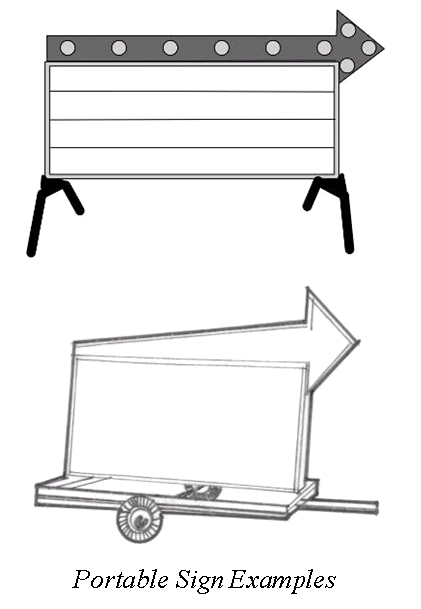
Portable sign: Any sign not permanently attached to the ground or other permanent structure and designed to be transported, including, but not limited to, signs designed to be transported by means of wheels, or signs made as A-frames or T-frames (see examples).
20.
Projecting sign. A double-faced sign attached to a building or wall that extends more than twelve (12) inches but not more than thirty-six (36) inches from the face of the building or wall.
21.
Property development sign: A sign advertising a new subdivision, development or structure, which advertises lots for sale, buildings for sale or lease, etc.
22.
Reader board: A portion of a sign on which copy is changed manually.
23.
Real estate sign: A sign advertising the real estate upon which the sign is located as being for sale, rent, or lease.
24.
Roof sign: A sign erected upon a roof. A sign erected upon a mansard roof or other roof surface with a pitch of greater than forty-five (45) degrees shall be considered to be a wall sign.
25.
Sign: A device, structure, fixture, or placard using graphics, symbols, and/or written copy designed specifically for the purpose of advertising or identifying an establishment, product, service, or activity.
26.
Special event sign: Temporary signs containing public messages concerning special events sponsored by governmental agencies or non-profit organizations.
27.
Temporary sign: A sign, flag, banner, balloon, pennant or valance, usually constructed of cloth, canvas, light fabric, cardboard, wallboard or other light materials, with or without frames, or any other sign, other than a portable sign, that is not permanently secured and is not intended or designed for permanent use.
28.
Vehicle sign: A sign designed to be mounted to a vehicle or trailer and designed to be visible to other motorists or pedestrians while so mounted, with the primary purpose of advertisement while the sign is being transported. A sign painted on a vehicle that identifies the business that owns or uses the vehicle, or a sign depicting the name of the owner of the vehicle, shall not be considered a vehicle sign.
29.
Wall sign: A sign painted on or attached directly to and parallel to the exterior wall of a building extending no greater than twelve (12) inches from the exterior face of the wall to which it is attached.
30.
Window sign: A sign installed inside a window and intended to be viewed from the outside.
C.
Permit required. No person shall erect, alter, place or permit to be placed, or replace any sign without first obtaining a sign permit, except those specifically exempted from permit requirements in Section 16.4.F, below.
D.
General sign provisions.
1.
Signs shall be maintained free of peeling paint or paper, fading, staining, rust, or other condition which impairs legibility or intelligibility or creates a blighting, unsightly or unsafe condition.
2.
Sign supports, braces, guys and anchors shall be maintained in such a manner as not to cause a hazard.
3.
When a sign is allowed to be illuminated, it may be internally illuminated, or if externally illuminated, the source of the light shall be enclosed and directed to prevent the source of light from shining directly onto traffic or residential property.
4.
Sign location. No sign shall be placed in, upon or over any public right-of-way, alley, or other public place, except as may be otherwise permitted by this section and as follows:
a.
In the B-1 district, a projecting sign may extend over the public sidewalk, provided that the bottom of the sign is at least eight (8) feet above the sidewalk. The city may require the owner of the sign to provide insurance and indemnification in the event that the sign may damage public property or cause injury to persons or property within the public right-of-way.
b.
A garage or estate sale sign is permitted within a City of Belding right-of-way, subject to the requirements of table 16.4-3.
5.
No light pole, utility pole, or other supporting member shall be used for the placement of any sign unless specifically designed and approved for such use.
6.
No sign shall be erected in any place where it may, by reason of its position, shape, color, or other characteristic, interfere with, obstruct the view of, or be confused with any authorized traffic sign, signal, or device, or constitute a nuisance per se.
7.
No commercial vehicle, which in the opinion of the zoning administrator has the intended function of acting as a sign, shall be parked in any area abutting the street.
8.
Except for electronic displays as allowed by this section, no sign shall employ any flashing, moving, oscillating, blinking, or variable intensity light, provided variable time-temperature signs may be permitted.
9.
No sign shall contain any moving or animated parts nor have the appearance of having any moving or animated parts.
10.
No wall sign shall extend above or beyond the edge of the wall to which it is affixed.
E.
Prohibited signs. The following signs shall be prohibited within the City of Belding:
1.
Off-premise signs, except special event signs as permitted by this section.
2.
Vehicle signs; however, signs attached to a public transit vehicle or other government-owned vehicle shall be exempt from this section.
3.
Balloon signs, except when allowed as a commercial event sign.
4.
Signs that are held by or supported by a person for commercial advertising purposes.
F.
Exempted signs. The following signs shall be exempt from the permit requirements of this section, except for the provisions of section 16.4.D:
1.
Directional signs, subject to the requirements of section 16.4.J.1, below.
2.
Government signs. A permanent government sign may include an electronic display or reader board
3.
Commercial event signs of four (4) square feet in size or less, except that balloons shall not be allowed. For commercial event signs that exceed four (4) square feet or that utilize balloons, see table 16.4-2.
4.
Historical markers.
5.
Window signs, provided that no more than fifty (50) percent of the window area is covered with signs.
6.
Political signs, subject to the requirements of section 16.4.L, table 16.4-2.
7.
Memorial signs or tablets.
8.
Murals, provided that no portion of the mural contains advertising.
9.
Signs not visible from any street or alley.
10.
Signs for essential services.
11.
Placards not exceeding two (2) square feet.
12.
Signs with address, owner, or occupant name, of up to two (2) square feet in area attached to a mailbox, light fixture or exterior wall.
13.
Flags or insignia of any nation, state, city, community organization, or educational institution.
14.
Commercial signs mounted to a public transit vehicle or government vehicle.
G.
Non-conforming signs, illegal signs, and signs accessory to non-conforming uses.
1.
Every permanent sign which does not conform to the height, size, area, or location requirements of this section as of the date of the adoption of this ordinance, is hereby deemed to be non-conforming.
2.
Non-conforming signs may not be expanded, enlarged, or extended; however, the face of a nonconforming sign may be replaced, so long as the nonconforming nature of the sign is not expanded or increased. Non-conforming signs may be maintained and repaired so as to continue the useful life of the sign.
3.
For purposes of this article, a non-conforming sign may be diminished in size or dimension or the copy of the sign amended or changed without jeopardizing the privilege of non-conforming use. If a sign is nonconforming in its setback, this paragraph shall not apply, and the sign may not be replaced.
4.
Any non-conforming sign destroyed by fire or other casualty loss shall not be restored or rebuilt if reconstruction will constitute more than fifty (50) percent of the value of the sign on the date of loss.
5.
Any sign which for a period of three (3) months or more no longer advertises a bona fide business conducted or product sold shall be removed by the owner of the building, structure, or property upon which such sign is located, within thirty (30) days of receipt of written notice by the zoning administrator. The Zoning Administrator may grant one (1) extension of up to six (6) months, provided that the proprietor of the sign can show due cause for the extension.
6.
A sign accessory to a non-conforming use may be erected in the city in accordance with the sign regulations for the subject zoning district.
H.
Units of measurement.
1.
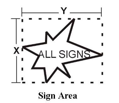
The area of a sign shall be measured as the area within a single, continuous perimeter composed of any rectangular figure which encloses the extreme limits of writing, representation, emblem, logo, or any other figure of similar character, together with any frame or other material or color forming an integral part of the display or used to differentiate the sign from the background against which it is placed, excluding only the structure necessary to support the sign.
2.
The area of a pole, ground or projecting sign that has two (2) or more faces shall be measured by including the area of all sign faces, except if two (2) such faces are placed back-to-back and are of equal size, the area of the two (2) back-to-back faces shall be counted as one (1) face. If the two (2) back-to-back faces are of unequal size, the larger of the two (2) sign faces shall be counted as the one (1) face.
3.
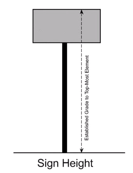
The height of a sign shall be measured as the vertical distance from the highest point of the sign to the grade of the adjacent street or the average grade of the ground immediately beneath the sign, whichever is less. Where the ground is built up or raised (such as a berm), the height of the sign shall be measured from the original grade. Increasing the grade for the purpose of increasing sign height is prohibited.
4.
For buildings with multiple tenants, the sign areas for wall signs and projecting signs shall be determined by taking the occupant frontage applicable to each tenant and computing sign requirements for that portion of the structure. When computing wall area, the entire vertical plane of the wall shall be counted, including windows, doors and other fenestration.
I.
Sign regulations applicable to all zoning districts.
1.
Reader boards. All ground, pole and wall signs as permitted in section 16.4.K, below, may include a reader board. No more than forty (40) percent of the sign area may be a reader board. A reader board is not permitted on a sign that has an electronic display.
2.
Any sign, including awnings and marquees to which signs are affixed or displayed, not resting directly on the ground, shall maintain a minimum clear space of eight (8) feet from the bottom of the sign to the ground.
J.
Specific sign requirements.
1.
Directional signs are permitted for nonresidential uses and multiple family developments in any zone district, subject to the following restrictions:
a.
A directional sign may contain a logo of an on-premise establishment, but no advertising copy.
b.
No such sign shall exceed four (4) square feet in area or three (3) feet in height.
c.
Directional signs shall be limited to traffic control functions only.
d.
Directional signs may only be illuminated from within.
2.
Home occupation signs. A sign for a home occupation shall be limited to one (1) wall sign that is no greater than four (4) square feet in area. A home occupation sign may not be illuminated.
3.
Business center signs.
a.
In the B-2 district, a business center sign is permitted, subject to the following requirements:
(1)
Any property or building designed for more than one (1) business shall require a business center sign. Separate pole or ground signs for individual businesses within a business center shall not be permitted.
(2)
Number. One (1) per street frontage, but not more than two (2) signs, provided that lots with two street frontages shall have a minimum width at each right-of-way line of at least seventy-five (75) feet in order to have a second sign.
(3)
Area. A business center sign in the B-2 District shall not exceed one hundred fifty (150) square feet in area, subject to the following:
(a)
For a business center sign advertising two (2) to four (4) businesses, each business shall be limited to no more than thirty (30) square feet.
(b)
For a business center sign advertising more than four (4) businesses, each business shall be limited to no more than twenty (20) square feet.
(c)
The name and primary street address of the business center shall be displayed on the sign with lettering at least four inches (4") in height.
(4)
A business center pole sign must have a minimum ten (10) foot visual clearance.
(5)
Location. Minimum of ten (10) feet from any property line for ground or pole signs; however, this setback shall be increased to ensure clear vision from any driveway or street; or fifteen (15) feet from any property line for pole signs.
(6)
Height. No higher than six (6) feet for ground signs or thirty five (35) feet for pole signs.
(7)
Illumination. Business center signs may be illuminated according to section 16.4.D.3.
b.
In the B-1 district, one (1) business center sign is permitted for an enclosed shopping center. This sign shall be limited to fifty (50) square feet and thirty (30) feet in height. This sign shall contain the name of the business center and also may be used to advertise city and community events.
4.
Marquee and awning signs. In the B-1 and B-2 districts, a marquee or awning sign is permitted, subject to the following requirements:
a.
Marquee signs.
(1)
One (1) sign is permitted per marquee, located on the front fascia.
(2)
No more than one (1) marquee sign is permitted per street frontage.
(3)
No marquee sign shall be larger than forty (40) percent of the marquee fascia, with a maximum area of twenty-five (25) square feet.
(4)
A marquee sign may be backlit or illuminated by exterior lamps attached to the marquee and directed only upon the sign.
b.
Awning signs.
(1)
No more than one (1) sign is permitted on each awning. There may be no more than one (1) awning sign per street frontage.
(2)
No awning sign shall be larger than twenty (20) percent of the face of the awning to which it is attached, with a maximum area of twenty (20) square feet.
(3)
An awning sign may be illuminated only by means of backlighting behind the awning surface. The light source shall not be visible from outside the awning.
5.
Electronic displays. An electronic display is permitted, subject to the following requirements:
a.
General requirements.
(1)
An electronic display is permitted only on pole or ground signs, except that an electronic display that displays time and temperature only may be allowed as part of a wall sign.
(2)
An electronic display is not permitted on a sign that has a reader board.
(3)
The entire sign face shall only convey a single product or message at any one (1) time.
(4)
Except for the change from one display to the next, which shall be instantaneous, each individual sign display shall be stationary. No elements of the display may move, flash or scroll, except to change from one (1) display to the next.
(5)
Displays may change no less than five (5) seconds apart.
b.
District requirements.
(1)
In residential districts and residential planned unit developments, an electronic display is permitted for an allowed non-residential use only. The electronic display shall consist of no more than sixty (60) percent of the sign area.
(2)
In the OS-1, B-2 and I-1 districts and any commercial or industrial planned unit development, an electronic display is permitted, provided that the electronic display shall consist of no more than fifty (50) percent of the sign area.
(3)
B-1 district.
(a)
For pole and ground signs, an electronic display is permitted, provided that the electronic display shall consist of no more than forty (40) percent of the sign area.
(b)
For the one (1) business center sign permitted in section 16.4.J.3.b, an electronic display is permitted, provided that the electronic display shall consist of no more than fifty (50) percent of the sign area.
6.
Portable signs.
a.
Portable signs existing at the time of adoption. Any portable sign existing on the effective date of this section, regardless of nonconforming or permitted status, shall be allowed to continue, subject to the following requirements:
(1)
All signs existing on the effective date of this section shall be inventoried by the zoning administrator. The requirements of this subparagraph shall apply only to those signs listed on the inventory.
(2)
A portable sign shall not be the primary sign for the property. At least one (1) permanent sign that is not a portable sign, meeting the requirements of this section, must be located on the premises.
(3)
All such signs shall be maintained and repaired in good working condition. All frames, etc. shall be painted and rusted areas shall be rustproofed and repainted.
(4)
Lettering shall be maintained to create complete words and readable messages.
(5)
The portable sign structure shall be correctly oriented horizontally and vertically, and shall not be allowed to bend or sag.
(6)
Illumination may be backlighting from within the sign, or from a shielded light source directed only upon the sign. The light source shall not be visible from the street.
(7)
A portable sign under this subparagraph shall not be mounted on a trailer or other wheeled vehicle.
(8)
All portable signs subject to this subparagraph shall be brought into conformance with the above requirements no less than six (6) months after the effective date of this section. Any sign not in compliance by this deadline shall be removed by the owner of the property on which the sign is located, or if the owner fails to do so, by the city at the expense of the owner. The City may use any authorized means to recover the costs related to such removal.
(9)
All portable signs subject to this subparagraph shall be removed no later than five (5) years after the effective date of this section. Any sign not removed by this deadline may be removed by the city at the expense of the owner of the property on which the sign is located. The city may use any authorized means to recover the costs related to such removal.
b.
Temporary portable signs.
(1)
This subparagraph applies only to any request for a new portable sign after the effective date of this section. Any property subject to subparagraph a., above, shall not be eligible for a temporary portable sign until all existing portable signs on that property have been removed.
(2)
The zoning administrator may issue a permit for a temporary portable sign according to the requirements in table 16.4-2.
c.
Ground, wall and pole sign requirement. Where permitted, ground, wall and pole signs shall be erected according to the requirements of table 16.4-1.
d.
Temporary sign requirements. Requirements for temporary signs shall be according to tables 16.4-2 and 16.4-3. Except as stated within the tables, temporary signs shall not be illuminated.
(1)
Includes the R-1, R-2, R-3, RM-1 and RM-2 zone districts.
(2)
In the B-2 District, either one (1) ground sign or one (1) pole sign is permitted.
(3)
A projecting sign may not project more than thirty-six (36) inches beyond the face of the wall.
(4)
Permitted as part of a special land use for golf courses or country clubs on a commercial structure.
(1)
Includes the R-1, R-2, R-3, RM-1 and RM-2 zone districts.
(Ord. No. 488, § 1, 2-7-06; Ord. No. 509, § 1, 11-17-09; Ord. No. 526, §§ 1, 2, 6-19-12 ; Ord. No. 534, §§ 1, 2, 2-19-13 )

