
Bentonville City Zoning Code
ARTICLE 401
ZONING DISTRICT REGULATIONS
Sec 401.01 Zoning District Boundary Map
- Official zoning map. This chapter consists of a map and text. The City of Bentonville shall maintain the Official Zoning Map in the mayor's office or at a convenient location designated by the mayor. Although copies of the map or portions thereof may be distributed to the public in paper or digital form, the Official Zoning Map consists of the paper copy signed by the mayor or as shown in the official City of Bentonville GIS website and designated as such, as may be amended by ordinance adopted by the city council.
- Boundary of districts. The boundaries of the zoning districts are hereby established as shown on the map entitled "Zoning District Boundary Map" of Bentonville, Arkansas as may be amended by ordinance adopted by the city council, which is part of this chapter and which is on file in the office of the city clerk.
- Interpretation of district boundary. Where due to scale, lack of detail or illegibility of the zoning map, there is uncertainty, contradiction or conflict as to location of any zoning district boundary as shown thereon, the community development director shall make an interpretation of the map upon request of any person. Any person in disagreement with any such interpretation may appeal such interpretation to the board of zoning adjustment. All city commissions, boards or personnel interpreting the zoning map or deciding any appeal, shall apply the following standards:
- Zoning district boundary lines are intended to follow lot lines or along the center lines of alleys, streets, right-of-way or water courses, unless such boundary lines are fixed by dimensions shown on the zoning map.
- Where zoning districts boundary lines are so indicated that they approximately follow lot lines, such lot lines shall be construed to be such boundary lines.
- Where a zoning district boundary line divides a lot, the location of any such zoning district boundary line, unless indicated by dimensions shown on the zoning map, shall be determined by the use of the map scale shown thereon.
- In un-subdivided property, the district boundary lines on the maps accompanying and made part of this chapter shall be determined by use of scale contained on such map.
- Where a zoning district boundary is indicated as approximately following city limits the boundary shall be determined as such.
- Where a zoning district boundary is indicated as approximately following railroad lines, the boundary shall be construed to be midway between the main tracks.
- If, after all of the previously stated rules have been applied, uncertainty shall exist as to exact location of a zoning district boundary line, the boundary line shall be determined in a reasonable manner, considering the history of zoning ordinances and amendments in the city as well as other relevant facts. The board of adjustment, upon motion, shall interpret and determine the location of said boundaries based on the above mentioned guidelines.
(Code 1994; Ord. No. 2003-101, § 1, 6-10-2003; Ord. No. 2012-58, § 2, 7-24-2012; Ord. No. 2018-62, § 6, 3-27-2018)
Sec 401.02 Classification Of Districts
This chapter classifies and regulates the use of land, buildings, and structures within the city limits of Bentonville, Arkansas as hereinafter set forth. For the purpose of promoting the health, safety, and welfare of the inhabitants by dividing the city into zones and regulating therein the use of the land and the use and size of buildings as to height and number of stories, the coverage of land by buildings, the size of yards and open spaces, density of population and location of buildings. Zoning districts shall be designated as follows:
- Agricultural (A) districts.
- A-1, Agricultural
- Residential (R) districts.
- R-E, Residential Estate
- R-1, Low Density Single Family Residential
- R-2, Medium Density Two Family and Townhome Residential
- R-3, Medium-High Density Multifamily Residential
- R-4, High Density Multifamily Residential
- R-MH, Manufactured Home Residential
- R-ZL, Zero Lot Line
- R-O, Residential Office
- R-C2, Central Residential - Moderate Density
- R-C3, Central Residential - High Density
- Downtown Neighborhood (DN) districts.
- DN-1, Downtown Low-Density Residential
- DN-2, Downtown Medium-Density Residential
- DN-3, Downtown High Density Residential
- DN-4, Downtown Mixed-Use Residential
- Commercial (C) districts.
- C-1, Neighborhood Commercial
- C-2, General Commercial
- C-3, Mixed-Use Commercial
- Downtown (D) districts.
- DC, Downtown Core
- DE, Downtown Edge
- Industrial (I) districts.
- I-1, Light Industrial
- I-2, Heavy Industrial
- Planned development districts.
- PUD, Planned Unit Development
- PRD, Planned Residential Development
- Overlay districts.
- Municipal Airport Overlay District
- Northwest Arkansas Regional (XNA) Airport Overlay District
(Code 1994; Ord. No. 99-20, § 1, 2-9-1999; Ord. No. 2003-101, § 1, 6-10-2003; Ord. No. 2006-33, § 1; Ord. No. 2009-50, § 4; Ord. No. 2009-111, § 1; Ord. No. 2012-58, § 2, 7-24-2012; Ord. No. 2016-141, § 2, 10-11-2016; Ord. No. 2018-62, § 6, 3-27-2018)
Amended by Ord. 2021-111 on 5/25/2021
Amended by Ord. Ord. No. 2021-233 on 11/9/2021
Sec 401.03 Calculations And Measurements
- Measuring lot width. Lot width is measured from side lot line to side lot line along the front building setback line.
- Measuring lot depth. The minimum lot depth is measured at its shallowest point measured at right angles or radial to the street right-of-way line.
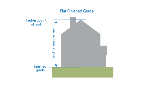
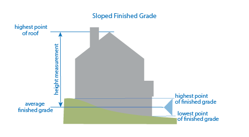
- Measuring building height.
- Measuring height. Building height shall be measured as the vertical distance from the elevation of the finished grade level to the highest point of the roof line or parapet wall. For sloped sites, building height is measured as the vertical distance from the elevation of the average of the highest and lowest finished grade level to the highest point of the roof line or parapet wall.
- Exceptions. Chimneys, elevators, poles, spires, tanks, towers, and other projections not used for human occupancy may extend above the height limit.
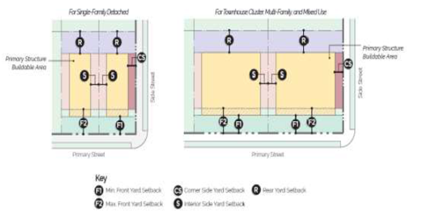
- Measuring setbacks. Setbacks shall be measured as the horizontal distance between the property line and/or right-of-way line and the structure's foundation.
(Ord. No. 2012-58, § 2, 7-24-2012; Ord. No. 2018-62, § 6, 3-27-2018)
Amended by Ord. 2019-160 on 10/22/2019
Amended by Ord. 2020-38 on 2/11/2020
Sec 401.04 Application Of Zoning District Regulations
- Minimum regulations. The regulations set by this chapter within each district shall be minimum regulations and shall apply uniformly to each class or kind of structure or land, except as hereinafter provided.
- Conformity of regulations. No building, structure or land shall hereafter be used or occupied and no building or structure or part thereof shall hereafter be erected, constructed, reconstructed, moved, or structurally altered except in conformity with all the regulations herein specified for the district in which it is located. No building, structure or land shall hereafter be erected or altered:
- To exceed the height or bulk;
- To accommodate or house a greater number of families;
- To occupy a greater percentage of lot area; and
- To have narrower or smaller rear yards, front yards, side yards or other open spaces than herein required or in any other manner contrary to the provisions of this chapter.
- Independent compliance. No part of a yard or other open spaces or off-street parking or loading space required about or in connection with any building for the purpose of complying with this chapter shall be included as part of a yard, open space or off-street parking or loading space similarly required for any other building, unless otherwise stated in the city code.
- Yard and lots to meet minimum requirements. No yard or lot existing at the time of passage of this chapter shall be reduced in dimension or area below the minimum requirements set forth herein. Yards or lots created after the effective date of this chapter shall meet at least the minimum requirements established by this chapter.
- Zoning district for annexations. All territory which may hereafter be annexed to the City of Bentonville, Arkansas shall be considered to be in District A-1 until the territory is rezoned as provided herein or unless provided for in the annexing ordinance.
- Prior to annexation to the city. On any parcel annexed into the city subsequent to the adoption of these regulations, and upon which building construction has proceeded to the point at which the foundation(s) has been completed, construction may continue. If construction continues after the annexation, these regulations shall require no changes in the overall layout, plans, construction, or size of any building unless the planning commission determines that continued construction would pose a threat to the health, welfare, safety, or morals of the citizens of Bentonville. If construction is stopped for a period exceeding one (1) year, the planning commission may require, as a condition of renewing construction thereafter, that the building(s) meet all requirements for new construction.
- Sight distance requirements. No building, structure, sign or part thereof shall be located so as to create an obstruction in the area to be kept clear of all sight obstructions, as set forth in Chapter 15 Subdivision Code, Article 1100.01 General Provisions, unless otherwise approved by the city engineer.
- Setback encroachments. Driveways, walkways, on-grade patios, plants, pergolas, arbors, and other landscape features may be located within any required setback. The following table lists specific features that may be located within any required setback subject to the encroachments standards. Unless otherwise exempted by the city, none of the specific features listed below shall encroach into any right-of-way or easement.
Feature that may encroach into a setback Encroachment Standards Eave, sill, cornice, or ornamental feature May project up to 18 inches into any required setback. Bay windows, chimneys, and similar features projecting from the primary building May encroach up to 2 feet into any required setback for the property, but no closer than 3 feet to the side or rear property line. Open porches, balconies, breezeways, and similar features (may be roofed but not enclosed except with screenwire mesh); raised patios, decks, and similar features (with a finished floor of 30 inches or less above the lowest adjacent grade measured at base) May encroach into a required setback for the property, but no closer than 12 feet to the front property line and no closer than 5 feet to the side or rear property line. Steps (with a finished floor of 30 inches or less above the lowest adjacent grade measured at base) May encroach into a required setback for the property up to 2 feet into any required setback for the property, but no closer than 3 feet to the side or rear property line. Fences, walls May be constructed up to the property line, subject to the provisions of 1100.06 of the Land Development Code regarding fences and walls. Awnings May extend into a required setback up to six (6) feet but shall be no closer than two (2) feet, measured in horizontal distance, from the curb of any street or property line. In ground pools May encroach into setbacks, but shall not be located in an easement. - Clearance. Awnings and canopy structures shall maintain a clearance of seven (7) feet above a public right-of-way, sidewalk or front yard. If located within 10’ of a public utility, minimum clearance shall be 15’.
(Code 1994; Ord. No. 2003-101, § 1, 6-10-2003; Ord. No. 2004-63, § 1; Ord. No. 2009-50, § 6; Ord. No. 2012-58, § 2, 7-24-2012; Ord. No. 2017-205, § 8, 12-12-2017; Ord. No. 2018-62, § 6, 3-27-2018)
Adopted by Ord. 2022-175 on 9/13/2022
Sec 401.05 Table Of Uses For Zoning Districts
- Table of uses. The table below establishes a list of land uses and identifies the zoning districts in which that use is allowed by right, allowed with a conditional use permit, or prohibited. Land uses are listed in the column on the left and zoning districts are listed across the top row. Further clarification of each use is provided in Article 201 Definitions.
- Uses allowed by right. Where a dot (=) appears in the box where the land use row and the district column intersect, the use is allowed by right as a primary and secondary use in that district, subject to the provisions of:
- Article 501, Off-Street Parking and Loading.
- Article 601, Use Regulations.
- Uses allowed with an approved conditional use permit. Where the letter "C" appears in the box where the land use row and the district column intersect, the use is allowed subject to acquiring a conditional use permit as set forth in Article 301.06 Conditional uses.
- Uses allowed as an accessory use. Where the letter "A" appears in the box where the land use row and the district column intersect, the use is allowed only as an accessory use to the primary use and shall not be a primary use and is subject to all development standards.
- Uses prohibited. Where neither "=" nor "C" appears in the box where the land use row and the district column intersect, the use is not allowed in the district.
- Uses not listed. When a use is proposed that is not listed in the table below, the community development director shall recommend the appropriate districts based on land uses that are similar in size, bulk, and traffic generation. If the applicant does not agree with this interpretation, he/she may appeal the interpretation to the board of adjustment. If the director fails to make an interpretation for the use in question, then the application shall be handled as a proposed amendment to the Zoning Ordinance and shall be processed in accordance with Article 301, Administration and Enforcement.
TABLE OF USES
| AGRICULTURE & ANIMALS | Use Regs. | A1 | RE | R1 | R2 | R3 | R4 | R-C2 | R-C3 | R-MH | R-ZL | RO | DN-1 | DN-2 | DN-3 | DN-4 | C1 | C2 | C3 | DC | DE | I1 | I2 |
| Agriculture | = | ||||||||||||||||||||||
| Agricultural Product Processing | = | C | = | C | = | ||||||||||||||||||
| Agriculture-Related Business | = | C | = | C | = | ||||||||||||||||||
| Animal Clinic | 601.03 | = | C | = | C | = | = | = | = | ||||||||||||||
| Animal Kennel or Shelter | 601.03 | = | C | = | = | = | = | ||||||||||||||||
| Animal—Domestic or Household | = | = | = | = | = | = | = | = | = | = | = | = | = | = | = | = | = | = | |||||
| Animal—Exotic | C | ||||||||||||||||||||||
| Animal—Farm | 601.03 | = | C | ||||||||||||||||||||
| Apiculture | 601.04 | = | A | A | |||||||||||||||||||
| Botanical Garden | = | C | C | C | C | C | C | C | C | C | C | = | = | C | = | = | = | = | |||||
| Chicken, Hobby | 601.11 | = | = | A | A | ||||||||||||||||||
| Community Garden | = | = | = | = | = | = | = | = | = | = | = | A | A | A | A | = | |||||||
| Greenhouse | = | = | C | = | C | = | = | = | = | ||||||||||||||
| Livestock Market | = | C | C | ||||||||||||||||||||
| Plant Nursery | = | = | = | = | = | = | |||||||||||||||||
| Slaughterhouse | C | C | C | ||||||||||||||||||||
| Stable, Commercial | = | ||||||||||||||||||||||
| Urban Farm | C | C | C | C | C | C | C | C | C | C | C | C | C | C | = | = | = | = | = | = | = | ||
| RESIDENTIAL | Use Regs. | A1 | RE | R1 | R2 | R3 | R4 | R-C2 | R-C3 | R-MH | R-ZL | RO | DN-1 | DN-2 | DN-3 | DN-4 | C1 | C2 | C3 | DC | DE | I1 | I2 |
| Dwelling—Accessory | 601.02 | A | A | A | A | A | A | A | A | A | A | A | A | A | A | A | A | A | A | A | A | A | A |
| Dwelling—Condominium | = | = | = | = | = | = | = | = | = | = | = | = | |||||||||||
| Dwelling - Cottage Court | 601.35 | C | = | = | = | = | = | = | = | = | |||||||||||||
| Dwelling—Manufactured | = | ||||||||||||||||||||||
| Dwelling—Modular | = | = | = | = | = | = | C | C | = | = | = | = | = | = | = | C | = | ||||||
| Dwelling—Multi-Family | = | = | = | = | = | = | = | = | |||||||||||||||
| Dwelling—Multi-Family - End Block | = | = | = | ||||||||||||||||||||
| Dwelling—Single-Family | = | = | = | = | = | = | = | = | = | = | = | = | = | = | = | ||||||||
| Dwelling—Townhouse or Rowhouse | = | = | = | = | = | = | C | = | = | ||||||||||||||
| Dwelling—Townhouse or Rowhouse - End Block | = | = | = | = | = | ||||||||||||||||||
Dwelling—Two-Family | = | = | = | = | = | = | = | = | = | C | = | ||||||||||||
Group Home | C | C | C | C | C | C | C | C | C | C | C | C | = | = | = | = | = | = | = | = | = | C | C |
| Home Occupation—Type A | 601.12 | A | A | A | A | A | A | A | A | A | A | A | A | A | A | A | A | A | A | ||||
| Home Occupation—Type B | 601.12 | C | C | C | C | C | C | C | C | C | C | ? | C | C | C | C | = | = | C | ||||
| Manufactured Home Park | = | ||||||||||||||||||||||
| Residential Facility—Assisted Living | = | = | = | = | = | = | = | = | = | = | = | ||||||||||||
| Residential Facility—Extended Medical Care | = | = | |||||||||||||||||||||
| Residential Facility—Rehabilitation | = | C | = | ||||||||||||||||||||
| Residential Facility—Temporary Shelter | = | = | = | = | |||||||||||||||||||
| RECREATION, EDUCATION, PUBLIC ASSEMBLY | Use Regs. | A1 | RE | R1 | R2 | R3 | R4 | R-C2 | R-C3 | R-MH | R-ZL | RO | DN-1 | DN-2 | DN-3 | DN-4 | C1 | C2 | C3 | DC | DE | I1 | I2 |
| Aquarium | C | C | C | C | C | C | C | C | C | C | C | = | = | = | = | C | |||||||
| Arena/Auditorium | C | = | C | C | C | = | = | ||||||||||||||||
| Community Center | 601.10 | C | C | C | C | C | C | C | C | C | C | C | = | = | = | = | = | = | = | ||||
| Commercial Recreation Facility—Indoor | C | C | = | = | = | = | C | = | |||||||||||||||
| Commercial Recreation Facility—Outdoor | 601.08 | C | C | C | C | C | C | ||||||||||||||||
| Conference/Convention Center | = | = | C | = | = | ||||||||||||||||||
| Country Club | C | C | C | C | C | C | C | C | C | C | C | ||||||||||||
| Cultural Studio | = | C | C | = | = | = | = | = | |||||||||||||||
| Educational Facility | C | C | C | C | C | C | C | C | C | C | C | C | C | C | C | C | C | C | C | C | C | C | |
| Event Center | C | C | C | = | C | = | C | = | = | ||||||||||||||
| Golf Course | 601.08 | = | C | C | C | C | C | C | C | C | C | C | C | C | C | C | C | ||||||
| Library | = | = | = | = | = | = | = | = | = | = | = | = | = | = | = | ||||||||
| Museum | C | C | C | C | C | C | C | C | C | C | C | C | C | C | C | = | = | = | = | C | = | = | |
| Outdoor Music Venue | C | C | C | C | C | C | |||||||||||||||||
| Park—Mini | = | = | = | = | = | = | = | = | = | = | = | = | = | = | = | = | = | = | = | = | = | = | |
| Park—Neighborhood | = | = | = | = | = | = | = | C | = | = | = | = | = | = | = | = | = | = | |||||
| Park—Community | = | = | C | = | = | = | = | ||||||||||||||||
| Religious Facilities | 601.19 | C | C | C | C | C | C | C | C | C | C | C | C | C | C | C | C | C | C | C | C | C | C |
| Recreational Vehicle Park | 601.17 | = | |||||||||||||||||||||
| SERVICES | Use Regs. | A1 | RE | R1 | R2 | R3 | R4 | R-C2 | R-C3 | R-MH | R-ZL | RO | DN-1 | DN-2 | DN-3 | DN-4 | C1 | C2 | C3 | DC | DE | I1 | I2 |
| ATM Machine | = | = | = | = | = | = | = | = | |||||||||||||||
| Adult Day Care | C | C | C | C | C | C | C | C | C | C | C | C | C | C | C | = | = | = | = | = | = | = | |
| Auction House | C | = | = | = | = | ||||||||||||||||||
| Auto or Equipment Auction | C | = | = | = | |||||||||||||||||||
| Automobile Repair | = | = | = | ||||||||||||||||||||
| Car Wash | 601.06 | C | = | = | = | ||||||||||||||||||
| Cemetery or Mausoleum | = | C | C | C | C | C | C | C | C | C | C | C | C | C | C | = | = | C | = | = | = | ||
| Child Care—Licensed Center | 601.07 | = | C | C | C | C | C | C | C | C | C | = | = | = | = | = | = | C | C | ||||
| Child Care—Registered Family Home (5 children or less) | 601.07 | = | = | = | = | = | = | = | = | = | = | = | = | = | = | = | = | = | = | = | = | = | = |
| Child Care—Licensed Family Home (6-16 children) | 601.07 | C | C | C | C | C | C | C | C | C | C | = | C | C | C | C | = | = | |||||
| Copy Services | C | = | = | = | = | = | = | = | |||||||||||||||
| Correctional Facility or Jail | = | = | = | ||||||||||||||||||||
| Crematory | C | = | = | ||||||||||||||||||||
| Financial Institution | = | = | = | = | = | = | |||||||||||||||||
| Funeral Home | = | = | = | = | = | ||||||||||||||||||
| Governmental Service Facility | = | = | = | = | = | = | = | = | = | ||||||||||||||
| Lodging—Bed & Breakfast | 601.05 | C | C | C | C | C | C | C | C | C | C | C | C | C | C | C | |||||||
| Lodging—Hotel/Motel | = | = | = | C | |||||||||||||||||||
| Maintenance Service | = | = | = | = | = | ||||||||||||||||||
| Medical Services—Hospital | = | C | |||||||||||||||||||||
| Medical Services—Doctor Office | = | C | A | = | = | = | = | = | |||||||||||||||
| Medical Services-Urgent Care Clinic | = | = | = | ||||||||||||||||||||
| Medical Services—Laboratory | = | = | = | = | = | ||||||||||||||||||
| Medical Services—Substance Abuse or Mental Health Treatment Clinic | = | ||||||||||||||||||||||
| Office | = | C | A | = | = | = | = | = | = | = | |||||||||||||
| Office/Warehouse | = | C | C | = | = | ||||||||||||||||||
| Personal Services | C | C | A | = | = | = | = | = | |||||||||||||||
| Public Safety Services | C | C | C | C | C | C | C | C | C | C | C | C | C | C | C | C | C | C | C | C | C | C | |
| Postal Services | = | = | = | = | = | = | = | = | |||||||||||||||
| Repair Services—Household | = | = | = | = | = | = | = | ||||||||||||||||
| Repair Services—Equipment, Large Appliances | = | = | = | ||||||||||||||||||||
| RETAIL | Use Regs. | A1 | RE | R1 | R2 | R3 | R4 | R-C2 | R-C3 | R-MH | R-ZL | RO | DN-1 | DN-2 | DN-3 | DN-4 | C1 | C2 | C3 | DC | DE | I1 | I2 |
| Artisan Shop | C | A | = | = | = | = | = | ||||||||||||||||
| Auto and Vehicle Sales/Rental | = | = | = | ||||||||||||||||||||
| Bakery | = | C | = | = | = | = | = | = | |||||||||||||||
| Bar, Lounge or Tavern | C | = | = | = | = | C | |||||||||||||||||
| Building and Landscape Material Sales | = | = | = | ||||||||||||||||||||
| Construction/Heavy Equipment Sales/Rental | C | = | = | ||||||||||||||||||||
| Packaged sale of beer and/or light wine | 601.29 | C | C | = | = | = | C | ||||||||||||||||
| Packaged sale of beer, light wine and/or spirits | 601.29 | A C | C | = | = | ||||||||||||||||||
| Equipment Rental—Indoor | = | = | = | = | |||||||||||||||||||
| Equipment Rental—Outdoor | = | = | = | ||||||||||||||||||||
| Gas Station | C | = | = | = | |||||||||||||||||||
| Manufactured Home Sales | = | = | |||||||||||||||||||||
| Medical Marijuana Dispensary | 601.31 | = | = | = | = | = | |||||||||||||||||
| Mobile Food Vendor | 601.16 | = | = | = | = | = | = | = | = | = | = | = | = | = | |||||||||
| Outdoor Vending, Private Property | 601.16 | = | = | = | = | = | = | = | |||||||||||||||
| Outdoor Vending, Public Right-of-Way | 601.16 | = | = | ||||||||||||||||||||
| Outdoor Vendor Park | 601.16 | C | C | C | C | ||||||||||||||||||
| Packaged Liquor Store | 601.29 | = | |||||||||||||||||||||
| Parklet | = | = | |||||||||||||||||||||
| Pharmacy | = | = | = | = | = | ||||||||||||||||||
| Recreational Vehicle and Boat Sales/Rental | = | = | = | ||||||||||||||||||||
| Restaurant | C | A | C | = | = | = | C | ||||||||||||||||
| Restaurant, Drive-In | = | ||||||||||||||||||||||
| Restaurant, Drive-Through | C | = | |||||||||||||||||||||
| Restaurant, Microbrewery | 601.29 | A | C | C | C | C | C | ||||||||||||||||
| Retail | 601.29 | C | A | = | = | = | = | = | = | ||||||||||||||
| Sexually Oriented Business | 601.22 | C | |||||||||||||||||||||
| Sidewalk Café in Public Right-of-Way | 601.23 | A | = | = | = | ||||||||||||||||||
| INDUSTRIAL & WAREHOUSING | Use Regs. | A1 | RE | R1 | R2 | R3 | R4 | R-C2 | R-C3 | R-MH | R-ZL | RO | DN-1 | DN-2 | DN-3 | DN-4 | C1 | C2 | C3 | DC | DE | I1 | I2 |
| Artisan/Craft Product Manufacturing | = | = | |||||||||||||||||||||
| Bulk Storage of Highly Flammable Material | C | ||||||||||||||||||||||
| Cold Storage Plant | = | = | |||||||||||||||||||||
| Contractor Maintenance Yard | C | = | = | ||||||||||||||||||||
| Industrial—Intensive | = | ||||||||||||||||||||||
| Industrial—Light | = | = | |||||||||||||||||||||
| Laboratory—Dental or Medical | = | = | = | ||||||||||||||||||||
| Laboratory—Manufacturing | = | = | |||||||||||||||||||||
| Laboratory—Research | = | = | = | ||||||||||||||||||||
| Light Fabrication and Assembly Process | = | = | |||||||||||||||||||||
| Manufacturing and/or distribution plant, alcoholic beverages of every kind and type | 601.29 | C | = | = | |||||||||||||||||||
| Manufacturing and/or distribution plant, alcoholic beverages of every kind and type within 500 ft. of a city owned & maintained park or trail | 601.29 | C | C | C | |||||||||||||||||||
| Medical Marijuana Cultivation Facility | 301.31 | = | = | = | = | = | |||||||||||||||||
| Mining | C | C | C | C | |||||||||||||||||||
| Mini-Warehouse Storage | 601.14 | = | = | = | |||||||||||||||||||
| Taxidermy | ? | = | = | = | |||||||||||||||||||
| Salvage Yard | 601.20 | C | C | ||||||||||||||||||||
| Warehousing or Wholesaling | = | = | |||||||||||||||||||||
| TRANSPORTATION, COMMUNICATION AND UTILITIES | Use Regs. | A1 | RE | R1 | R2 | R3 | R4 | R-C2 | R-C3 | R-MH | R-ZL | RO | DN-1 | DN-2 | DN-3 | DN-4 | C1 | C2 | C3 | DC | DE | I1 | I2 |
| Airport Facilities | C | C | C | C | C | ||||||||||||||||||
| Broadcasting Studio | = | = | = | ||||||||||||||||||||
| Electric Generating Plant | C | ||||||||||||||||||||||
| Parking Facility (as Principal Use) | C | C | = | C | = | C | = | = | |||||||||||||||
| Sewage Treatment Plant | 601.21 | C | C | ||||||||||||||||||||
| Solar Energy System | 601.24 | A | A | A | A | A | A | A | A | A | A | A | A | A | A | A | A | A | A | A | A | A | A |
| Solid Waste Disposal | C | C | |||||||||||||||||||||
| Transportation Facilities Excluding Airports | C | C | C | = | = | ||||||||||||||||||
| Utility Facility | C | C | C | C | C | C | C | C | C | C | C | C | C | C | C | C | C | C | C | C | C | C | |
| Wind Energy System, Small | 601.26 | A | A | A | A | A | A | A | A | A | A | A | A | A | A | A | A | A | A | A | A | A | A |
| Wind Energy System, Large | C | C | |||||||||||||||||||||
| Wireless Communication Facility (Cell Towers) | 601.27 | C | C | C | C | C | C | C | C | C | C | C | C | C | C | C | C | C | C | C | C | C | C |
| OTHER | Use Regs. | A1 | RE | R1 | R2 | R3 | R4 | R-C2 | R-C3 | R-MH | R-ZL | RO | DN-1 | DN-2 | DN-3 | DN-4 | C1 | C2 | C3 | DC | DE | I1 | I2 |
| Building Accessory—Nonresidential | 601.01 | A | A | A | A | A | A | A | A | A | A | A | A | A | A | A | A | A | A | A | A | A | A |
| Donation Box | 601.34 | A | A | A | A | A | A | A | A | A | A | A | A | A | A | A | A | A | A | A | A | A | A |
| Temporary Uses | 601.25 | C | C | C | C | C | C | C | C | C | C | C | C | C | C | C | C | C | C | C | C | C | C |
(Code 1994; Ord. No. 95-81, § 1, 8-22-1995; Ord. No. 98-58, § 1, 6-23-1998; Ord. No. 98-70, § 1, 8-11-1998; Ord. No. 98-83, § 3, 10-13-1998; Ord. No. 99-20, § 1, 2-9-1999; Ord. No. 2003-101, § 1, 6-10-2003; Ord. No. 2004-63, § 6; Ord. No. 2006-24, § 14-15; Ord. No. 2006-33, § 13; Ord. No. 2009-50, § 3; Ord. No. 2009-11, § 2; Ord. No. 2010-5, § 2, 1-12-2010; Ord. No. 2010-72, § 3, 11-23-10; Ord. No. 2009-11, § 2, 11-10-2009; Ord. No. 2013-75, § 3, 8-27-2013; Ord. No. 2016-83, § 4, 6-14-2016; Ord. No. 2016-141, § 4, 10-11-2016; Ord. No. 2018-62, § 6, 03-27-2018)
Amended by Ord. 2019-160 on 10/22/2019
Amended by Ord. 2020-38 on 2/11/2020
Amended by Ord. 2021-111 on 5/25/2021
Amended by Ord. Ord. No. 2021-233 on 11/9/2021
Adopted by Ord. 2021-234 Donation Box Regulations on 11/9/2021
Amended by Ord. 2024-58 on 4/9/2024
Amended by Ord. 2025-73 on 4/8/2025
Sec 401.06 A-1, Agricultural District Regulations
- Description and purpose. The regulations for the A-1 Agricultural District are designed to preserve and protect prime agricultural lands and to protect undeveloped areas from intensive uses until a use pattern is approved.
- Bulk and area regulations.
- Lot and area standards. The table below establishes the lot and area standards for agricultural districts.
AGRICULTURAL (A) DISTRICT
LOT AND AREA STANDARDSDistrict Building type Min. lot area (sq. ft.) Min. land area/ dwelling unit (sq. ft.) Min. lot width Min. lot depth Max. lot coverage Interior lot Exterior/ corner lot A-1 All 217,800 (5 acres) 217,800 (5 acres) 100' 100' 30% 30% - Minimum setback standards. The table below establishes the minimum setback standards for agricultural districts.
AGRICULTURAL (A) DISTRICT
MINIMUM SETBACK STANDARDSDistrict Building Type Front Side Rear Interior Exterior A-1 All 30' 30' 30' 30' - Height standards. The table below establishes the maximum height allowed.
AGRICULTURAL (A) DISTRICT
HEIGHT STANDARDDistrict Maximum height allowed A-1 40' - Exceptions: A building or structure may exceed the maximum height shown provided each of its front, side, and rear setbacks are increased an additional foot for each foot such building exceeds the maximum height.
- Lot and area standards. The table below establishes the lot and area standards for agricultural districts.
(Code 1994; Ord. No. 2003-101, § 1, 6-10-2003; Ord. No. 2012-58, § 2, 7-24-2012; Ord. No. 2018-62, § 6, 3-27-2018)
Amended by Ord. 2020-38 on 2/11/2020
Sec 401.07 Residential (R) Districts Regulations
- ,
- Description and purpose.
- Residential districts generally. The target goal of the residential districts is to provide sound, safe, economical, and innovative housing solutions for all citizens of Bentonville. Specific goals of residential districts include:
- Provisions of adequate space at appropriate locations necessary to create an appropriate mix of housing alternatives for people of all lifestyles;
- Consideration to site selection and variety of choice;
- Prevention of congestion as much as possible by regulating population density, activity intensity and extent of building bulk in relation to area land use;
- Control of structure height to provide light and air access through windows; and
- Promotion of desirable land use and development in order to protect district character and to conserve land and building value.
- R-E, Residential Estate purpose. The R-E district is an extremely low density residential district designed to provide for maximum privacy through the use of open spaces, permit the keeping of animals, specifically approved by the planning commission, promote scenic attraction, expand and promote residential alternatives and encourage the development of residential areas most protective of the environment.
- R-1, Low Density Single-family Residential purpose. The R-1 district serves low density developments in which housing is generally of the highest value and where strict separation of land uses is desired. Since R-1 districts are separated from all commercial and industrial activity, access to connecting traffic arteries is essential.
- R-2, Medium Density Two Family and Townhome Residential purpose. The R-2 district encourages the basic land use restrictions as the R-1 district. It permits slightly higher density than the R-1 district, with residential and related uses separated from commercial and industrial activity.
- Such a district shall encourage and maintain duplex and patio home development at appropriate locations.
- The R-2 district should provide areas for the development of two-family residential structures, attached or detached. The district may be located in developed areas or undeveloped areas of the city where an environment compatible with moderate density residential development can be established. Such a district can also be located in medium density areas where conversion may facilitate their continuation as a desirable area.
- R-3, Medium-High Density Multifamily Residential purpose. The R-3 district is established to provide suitable areas for medium density residential development. Such units would be located in areas where adequate city facilities existed prior to development or would be provided in conjunction with development, and where a suitable environment for medium density residential development would be available. Such districts could be used as buffer or transitional zones between incompatible development districts. Within this district, zero lot line and townhouses are allowed.
- R-4, High Density Multifamily Residential purpose. The R-4 district is established in order to provide high-density residential development. This area could exist in the older sections and newer developed areas of town. Such a district may be developed adjacent to, or in conjunction with neighborhood commercial or shopping center development. Adequate public utilities and services shall exist prior to or be provided in conjunction with development. Such a district may exist as a buffer zone between single-family and non-compatible use districts. Within this district, buildings, structures or uses having commercial characteristics and not planned as a main part of the total development shall be excluded.
- R-MH, Manufactured Home Residential purpose. The R-MH district is established to allow and encourage the development of single-family manufactured home subdivisions, manufactured home parks, or placement of manufactured homes on individual lots in a suitable environment.
- R-ZL, Zero Lot Line Residential purpose. The R-ZL district is a moderate density residential district designed to permit and encourage the development of a variety of dwelling types including "zero lot line" units suitable for a low cost per unit development. To be approved, an R-ZL district must be efficient in the use of land and utilities. It should be considered compatible with other residential uses and may be used to create a transition from purely residential districts to medium and high-density residential zones.
- R-O, Residential Office purpose. The R-O district is designed primarily to provide area for offices without limitation to the nature or size of the office, together with community facilities and compatible residential uses. It is further the intent of this district to establish a transition area where the continuation of residential activity is no longer practical between residential and nonresidential uses.
- R-C2, Central Residential—Moderate Density purpose. The R-C2 district is established to provide moderate density residential development and redevelopment in that area generally referred to as "Downtown", primarily those residential areas beyond the town square and beyond the commercial corridors of SW A Street and S Main Street. The purpose of the district is to stabilize and improve existing residential neighborhoods, encourage infill of available lands, provide a choice of housing types and locations for a variety of lifestyles and economic levels, and encourage traditional urban design. This district is appropriate as a buffer or transitional zone between single-family and higher density residential or commercial districts.
- R-C3, Central Residential—High Density purpose. The R-C3 district is established to provide high density residential development and redevelopment in that area generally referred to as "Downtown", primarily the areas surrounding the town square and along the commercial corridors of SW A Street and S Main Street. The purpose of the district is to stabilize and improve existing residential neighborhoods, encourage infill of available lands, provide a choice of housing types and locations for a variety of lifestyles and economic levels, and encourage traditional urban design.
- Residential districts generally. The target goal of the residential districts is to provide sound, safe, economical, and innovative housing solutions for all citizens of Bentonville. Specific goals of residential districts include:
- Residential (R) districts lot and area standards.
- Standards. The table below establishes minimum residential lot and area standards.
RESIDENTIAL (R) DISTRICTS
LOT AND AREA STANDARDSDistrict Building type Min. Lot area (sq. ft.) Min. Land area/ Dwelling unit (sq. ft.) Minimum lot width Max. lot coverage Interior lot Exterior/corner lot R-E All 87,120 (2 acres) -- 100' 10% 15% R-1 Cottage Court 10,000 2,500 100' 50% 55% All others not listed 6,000 -- 60' 40% 45% R-2 Single-family 5,000 -- 50' 40% 45% Single-family attached – structure 5,000 -- 50' 50% 55% Single- family attached - unit 2,500 -- 25' -- -- Two-family 5,000 -- 50' 50% 55% Cottage Court 8,000 2,000 80' 50% 55% Townhouse - unit 2,000 -- 20' -- -- Townhouse - structure 6,000 2,000 60' 65% 70% All others not listed 6,000 6,000 60' 40% 45% R-3 Single-family 5,000 -- 50' 40% 45% Two-family 5,000 -- 50' 50% 55% Cottage Court 6,000 1,500 60' 50% 55% Townhouse - unit 2,000 -- 20' -- -- Townhouse - structure 6,000 2,000 60' 65% 70% Multi-family 6,000 1,500 60' 65% 70% All others not listed 10,000 -- 100' 50% 55% R-4 Single-family 5,000 -- 50' 40% 45% Two-family 5,000 -- 50' 50% 55% Cottage Court 6,000 1,500 60' 50% 55% Townhouse - unit 2,000 -- 20' -- -- Townhouse - structure 6,000 2,000 60' 65% 70% Multi-family 10,000 800 100' 50% 55% All others not listed 10,000 -- 100' 50% 55% R-MH Manufactured home lots 4,500 4,500 50' 30% 35% Manufactured home parks 11,000 3,500 60' 30% 35% All others not listed 7,000 7,000 65' 40% 45% R-ZL Zero lot line 4,000 -- 40' 60% 65% R-O Single-family 6,000 -- 60' 40% 45% Two-family 7,000 -- 70' 50% 55% All others not listed 6,000 6,000 60' 60% 65% R-C2 Single-family and all others not listed 4,000 -- 35', rear access via alley or private drive; 50', no rear access via alley or private drive -- -- Two-family
Townhome structure - End block-- 2,000 20', rear access via alley or private drive; 25', no rear access via alley or private drive -- -- R-C3 Single-family 3,000 -- 15' 70% 75% Two-family 7,000 -- 15' 70% 75% Townhome structure -- 1,200 15' per unit No max. No max. Multi-family -- 1,200 No minimum No max. No max. All others not listed 4,000 -- 15' 70% 75% - Street frontage. Each lot in R-1, R-2, R-C2 and R-C3 zoning districts shall have a minimum street frontage equal to the minimum lot width required at the building line, except for lots fronting on cul-de-sac turnarounds and on curving street frontages, which must have no less than 20 feet of street frontage with the two side lot lines intersecting the street diverging until they are separated by the minimum required lot width at the building line. Each lot in the remaining residential zoning districts shall have a minimum of 20 feet of street frontage.
- Width of corner lots. The minimum width for corner lots shall be 20% larger than interior lots.
- Setbacks for zero lot line lots. One side yard setback must be no less than 12 feet, and the other side yard setback may be 0 feet.
- Standards. The table below establishes minimum residential lot and area standards.
- Residential (R) districts setback standards.
- Standards: The table below establishes the minimum residential setback standards.
RESIDENTIAL (R) DISTRICTS
MINIMUM SETBACK STANDARDSDistrict Building Type Front Side Rear Interior Exterior R-E All 30' 30' 30' 30' R-1 All 20' 7' 20' 25' R-2 All 20' 7' 20' 25' R-3 All 20' 10' 20' 25' R-4 All 20' 10'; 30' when adjacent to single-family 20' 25' R-MH Manufactured home lots 20' 10' 20' 25' Manufactured home park 25' 15' 25' 25' R-ZL Zero lot line 20' 12'/0' 20' 25' R-O Single-family 20' 7' 20' 25' Two-family 20' 10' 20' 25' Office with parking in front 50' 10' 50' parking; 20' no parking 25' Office w/o parking in front 20' 10' 20' 25' R-C2 Single-family and
all others not listed20' 7' 20' 15' Two-family 20' 7'; 0' where attached 20' 15' Townhome structure —End block 10' 7'; 0' where attached 10' 15' R-C3 Single-family 0' 0' 5' 7' Two-family 0' 0' 5' 7' Townhome structure 10' 0' 10' 10' Multi-family 0' 0' 10' 7' All others not listed 0' 7' 5' 7' - Cottage Courts. The setback requirements for Dwelling, Cottage Court are regulated in Section 601.35 of the Zoning Code.
- Garages.
- Street facing garage. The minimum front setback for street facing garages shall be 30 feet from the property line that the garage faces.
- Side or rear-loading garage. The minimum front setback for side- or rear-loading garages shall be 20 feet from the front property line. The minimum garage setbacks apply to attached and detached garages.
- Garages in R-C2 and R-C3 districts. In the R-C2 and R-C3 districts, when a rear alley or rear private drive exists or is platted, a rear-loading garage is required. When no rear alley or rear private drive exists or is platted, a front-loading garage is allowed, but must be pushed toward the rear lot line and must be recessed a minimum of 6 feet from the front façade of the building.
- Easements. Where a utility easement extends beyond the required setback, the edge of the utility easement shall be the setback.
- Standards: The table below establishes the minimum residential setback standards.
- Residential (R) districts height standards. The table below establishes the maximum height allowed in residential (R) districts.
- Standards.
RESIDENTIAL (R) DISTRICTS
HEIGHT STANDARDSDistrict Maximum
height allowedRE, R-1, R-2, R-MH, R-ZL 36' R-3, R-C2, R-C3, RO 40' R-4 50' - Guidelines. New infill structures should be constructed at a height that is compatible to the adjacent structures. If at all possible, the new dwelling should have a height within an acceptable percentage to the Planning Commission to ensure compatible massing, scale and to prevent the overshadowing of the adjacent structure(s).
- Exceptions. The principal use building or structure may exceed the maximum allowed height when an additional one foot of interior side yard setback is provided for each two feet of additional height. This exception does not apply to zero lot line buildings.
- Standards.
(Code 1994; Ord. No. 99-20, § 1, 2-9-1999; Ord. No. 2003-101, § 1, 6-10-2003; Ord. 2004-63, § 2; Ord. No. 2006-33, § 2-12; Ord. No. 2006-58, §§ 1, 2; Ord. No. 2012-58, § 2, 7-24-2012; Ord. No. 2016-83, § 2, 6-14-2016; Ord. No. 2018-62, § 6, 3-27-2018)
Amended by Ord. 2019-160 on 10/22/2019
Amended by Ord. 2020-38 on 2/11/2020
Amended by Ord. 2021-111 on 5/25/2021
Adopted by Ord. 2022-175 on 9/13/2022
Amended by Ord. 2024-58 on 4/9/2024
Amended by Ord. 2025-084 on 4/22/2025
Sec 401.07-B Downtown Neighborhood (DN) Districts Regulations
- Description and purpose.
- DN-1, Downtown Low Density Residential purpose. The intent of the DN-1 district is to preserve the established development pattern of portions of the downtown neighborhoods that are predominantly single-family with lots generally larger than 60 feet in width.
- DN-2, Downtown Medium Density Residential purpose. The intent of the DN-2 district is to allow for an increased single-family density through small lot widths where alleys and infrastructure support such development, and where small-lot single-family development provides an appropriate transition between large-lot residential areas and those of higher density. In some instances, such as the end of blocks, townhouses may be appropriate in this district.
- DN-3, Downtown High Density Residential purpose. The intent of the DN-3 district is to allow for an increased neighborhood density through the development of small-lot single-family housing and townhouses throughout the district. These areas tend to be adjacent to downtown commercial uses. In some instances, such as at the ends of blocks, multi-family apartment buildings may be an appropriate use in this district.
- DN-4, Downtown Mixed-use Residential purpose. The intent of the DN-4 district is to allow for increased neighborhood density and increased local commerce through the development of multi-family housing and mixed-use structures. These areas tend to be located in areas of unique activity due to the surrounding context and resulting levels of activity and housing demand.
- Design Standards. This Code Section is not inclusive of all development requirements for Downtown Neighborhood (DN) districts. For additional information, reference Section 1100.22 of the Land Development Code.
- DN districts building types allowed.
- Standards. For the purposes of the Downtown Neighborhood districts, all structures must be classified as one of the building types below, as defined in Article 201, Definitions.
DOWNTOWN NEIGHBORHOOD (DN) DISTRICTS
BUILDING TYPES ALLOWEDSingle-family Cottage Court Two-family Townhouse Multi-family Mixed-use Block-end Mid-block Block-end Mid-block DN-1 ● ● DN-2 ● ● ● ● DN-3 ● ● ● ● ● ● DN-4 ● ● ● ● ● ● ● ● - Commercial buildings. Commercial uses allowed in the DN-3 and DN-4 districts shall be located within a mixed-use building unless Planning Commission approves a conditional use permit for a single-use commercial building.
- Integrated Commercial Uses. Ground-floor commercial uses are permitted in multi-family buildings subject to the design criteria outlined in Section 1100.22 of the Land Development Code.
- Standards. For the purposes of the Downtown Neighborhood districts, all structures must be classified as one of the building types below, as defined in Article 201, Definitions.
- DN districts lot and area standards.
- Standards. The table below establishes the lot and area standards for all development in the Downtown Neighborhood districts. Accessory dwelling units (ADUs) are permitted in DN-1 and DN-2 on lots with single-family structures and do not require additional land area per the table below, but are subject to additional standards in Article 601.02 Accessory dwelling units.
- Street frontage. All lots in the DN districts shall have a minimum street frontage of 20’.
DOWNTOWN NEIGHBORHOOD (DN) DISTRICTS
LOT STANDARDS REFERENCE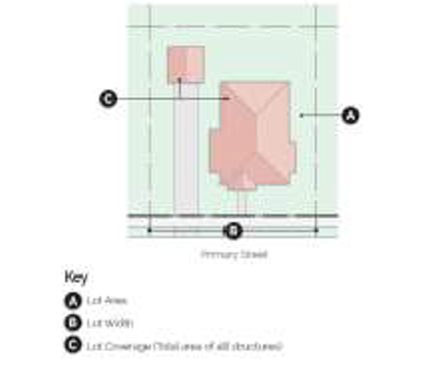
DOWNTOWN NEIGHBORHOOD (DN) DISTRICTS
LOT AND AREA STANDARDSLot Width Max. Lot Coverage Ⓒ District Building Type Min. Lot Area (sq. ft.) Ⓐ Min. Land Area/ Dwelling Unit (sq. ft.) Min. Lot Width Ⓑ Max. Lot Width Interior lot Exterior/ corner lot DN-1 Single-family 5,000 -- 50' -- 40% 45% Cottage Court 10,000 2,500 100' -- 50% 55% DN-2 Single-family, alley access 4,000 -- 40' -- 50% 55% Single-family, no alley access 5,000 -- 50' -- 50% 55% Single- family attached - unit 2,000 -- 20' -- -- -- Single-family attached - structure, alley access 4,000 -- 40' -- 50% 55% Single-family attached - structure, no alley access 5,000 -- 50' -- 50% 55% Cottage Court 8,000 -- 80' -- 50% 55% Two-family, alley access 4,000 -- 40' -- 50% 55% Two-family, no alley access 5,000 -- 50' -- 50% 55% Townhouse unit 2,000 -- 20' -- -- -- Townhouse structure 7,500 2,500 75' -- 60% 65% DN-3 Single-family, alley access 4,000 -- 40' 55' 50% 55% Single-family, no alley access 5,000 -- 50' 65' 50% 55% Single-family attached - unit 2,000 -- 20' -- -- -- Single-family attached – structure, alley access 4,000 -- 40' 55' 50% 55% Single-family attached – structure, no alley access 5,000 -- 50' 65' 50% 55% Cottage Court 6,000 -- 60' -- 50% 55% Two-family, alley access 4,000 -- 40' 55' 50% 55% Two-family, no alley access 5,000 -- 50' 65' 50% 55% Townhouse unit 2,000 -- 20' -- -- -- Townhouse structure 6,000 2,000 60' -- 65% 70% Multi-family, Block-end, Mixed-Use, Commercial and all others not listed 10,000 800 100' -- 65% 70% DN-4 Single-family, alley access 4,000 -- 40' 50' 50% 55% Single-family, no alley access 5,000 -- 50' 60' 50% 55% Single-family attached - unit 2,000 -- 20' -- -- -- Single-family attached – structure, alley access 4,000 -- 40' 50' 50% 55% Single-family attached – structure, no alley access 5,000 -- 50' 60' 50% 55% Cottage Court 6,000 -- 60' -- 50% 55% Two-family, alley access 4,000 -- 40' 50' 50% 55% Two-family, no alley access 5,000 -- 50' 60' 50% 55% Townhouse unit 2,000 -- 20' -- -- -- Townhouse structure 6,000 2,000 60' -- 65% 70% Multi-family 8,000 800 80' -- 75% 80% Mixed-use, Commercial, and all others not listed 10,000 800 80' -- 75% 80% - Standards. The table below establishes the lot and area standards for all development in the Downtown Neighborhood districts. Accessory dwelling units (ADUs) are permitted in DN-1 and DN-2 on lots with single-family structures and do not require additional land area per the table below, but are subject to additional standards in Article 601.02 Accessory dwelling units.
- DN districts setback standards. The table below establishes the setback standards for the Downtown Neighborhood districts.
DOWNTOWN NEIGHBORHOOD (DN) DISTRICTS
MINIMUM SETBACK STANDARDSDistrict Building type Front Yard Side Yard Rear Yard (R) Exterior / Corner Side Yard (CS) Interior Side Yard (S) Min. (F1) Max. (F2) Min. Max. Detached Yard Attached Yard DN-1 All 15' 25' 15' -- 7' 0' 25' DN-2 Single-family and Two-family 12' 25' 12' 25' 7' 0' 25' Townhouse: block-end, and all others not listed 12' 25' 12' 25' 10' 0' 25' DN-3 Single-family and Two-family 10' 20' 10' 20' 7' 0' 25' Townhouse 10' 20' 10' 20' 10' 0' 25' Multi-family: Block-end, Mixed-Use, Commercial and others not listed 10' 20' 10' 20' 10' 0' 15' DN-4 Single-family & two-family 8' 15' 8' 15' 7' 0' 25' Townhouse 8' 15' 8' 15' 10' 0' 25' Multi-family 8' 15' 8' 15' 10' 0' 15' Mixed-use and others not listed 0' 15' 0' 15' 0', 12' if adjacent to a non-mixed-use building 0' 15' - (2) Cottage Courts. The setback requirements for Dwelling, Cottage Court are regulated in Section 601.35 of the Zoning Code.
- DOWNTOWN NEIGHBORHOOD (DN) DISTRICTS
- DN districts height standards. The table below establishes the maximum height allowed in the Downtown Neighborhood districts.
DOWNTOWN NEIGHBORHOOD (DN) DISTRICTS
HEIGHT STANDARDSDistrict Single-family and
Two-familyTownhouse Multi-family Mixed-use and Commercial DN-1 36' -- -- -- DN-2 36' 36' -- -- DN-3 40' 40' 40' -- DN-4 40' 40' 50' 50'
SETBACK STANDARDS REFERENCE
(Ord. No. 2016-141, § 3, 10-11-2016; Ord. No. 2018-62, § 6, 3-27-2018)
Amended by Ord. 2019-160 on 10/22/2019
Amended by Ord. 2020-38 on 2/11/2020
Amended by Ord. Ord. No. 2021-233 on 11/9/2021
Amended by Ord. 2024-58 on 4/9/2024
Sec 401.08 Commercial (C) Districts Regulations
- Description and purpose.
- Commercial districts generally. Regulations for commercial districts are designed to encourage stable and efficient areas to meet the needs for commercial goods and services of both the city's neighborhoods and its trade area. The planning commission will consider, in the administration of commercial districts, the General Plan objective of discouraging urban sprawl. The districts are designed to:
- Minimize any potential incompatibilities between commercial developments and other types of land use;
- Provide opportunities for investment as new residential areas and thoroughfares are built, they are particularly designed to encourage the use of undeveloped lands in existing commercial areas;
- Provide sufficient space, at appropriate locations in close proximity to established residential areas for retail and service trade. Such commercial establishments should provide shopping needs of nearby residential areas; and,
- Provide sufficient and appropriate space to meet anticipated future needs for planned commercial developments in central shopping districts, regional, community and neighborhood shopping centers.
Provision of off-street parking in conjunction with commercial area development shall be fostered through commercial district establishments. Establishments will be encouraged through the districts to congregate in planned developments to the consumer and merchant's advantage.
- C-1, Neighborhood Commercial purpose. The C-1 district is designed primarily to provide convenience goods and personal services for persons living in the surrounding residential areas while maintaining a character in harmony with residential development. To this end, development in the C-1 district should harmonize in terms of form, bulk, height, materials, architecture, and overall design with surrounding residential areas. Signage and lighting should be subdued while landscaping and open space should be maximized. Parking areas should be as inconspicuous as possible as should loading and trash collection areas.
- C-2, General Commercial purpose. The C-2 district represents the least restrictive of the commercial districts and is designed to serve the planning area and highway travelers. This district shall congregate on local arterial streets in such a manner as to minimize disruptions of through traffic and shall be interspersed within the corporate boundaries.
- C-3, Mixed-Use Commercial purpose. The C-3 district is established for areas outside of downtown to provide an opportunity for people to live, work, meet, shop and utilize services within the vicinity of their residences. The C-3 district allows for a mix of neighborhood commercial and personal services, offices and medium density residential uses. Development in this district should be designed with an urban, walkable character that encourages physical activity, alternative transportation and greater social interaction to benefit the health and wellbeing of residents.
- Commercial districts generally. Regulations for commercial districts are designed to encourage stable and efficient areas to meet the needs for commercial goods and services of both the city's neighborhoods and its trade area. The planning commission will consider, in the administration of commercial districts, the General Plan objective of discouraging urban sprawl. The districts are designed to:
- Commercial (C) districts lot and area standards. The table below establishes the lot and area standards for all development in commercial (C) districts.
COMMERCIAL (C) DISTRICTS LOT AND AREA STANDARDSDistrict Building Type Min. lot area
(sq. ft.)Min. land area/ dwelling unit (sq. ft.) Lot width Min.
lot depthMax. lot coverage Min.
lot widthMax.
lot widthInterior
lotExterior/ corner lot C-1 All 7,000 -- 70' -- -- 50% 50% C-2 All 7,000 -- 70' -- -- 60% 60% C-3 All -- -- -- -- -- 100% 100% - Commercial (C) districts setback standards.
- Standards: The table below establishes the minimum setbacks required for all development in commercial (C) districts.
COMMERCIAL (C) DISTRICTS
MINIMUM SETBACK REQUIREMENTSDistrict Front Side Rear Parking
in frontNo parking in front Adjacent to
non-residential districtAdjacent to residential district Adjacent to
non-residential districtAdjacent to residential district C-1 50' 20' 7' 15' 20' 25' C-2 50' 20' 7' 30' 20' 30' C-3 0' 0' 0' 10' 0' 0'
- Standards: The table below establishes the minimum setbacks required for all development in commercial (C) districts.
- Commercial (C) districts height standards.
- Standards. The table below establishes the maximum height standards for all development in commercial (C) districts.
COMMERCIAL (C) DISTRICTS
MAXIMUM HEIGHT STANDARDSDistrict Maximum height C-1 40' C-2 60' C-3 60' - Exceptions: Any structure exceeding the listed maximum height shall be set back an additional one (1) foot for each foot in excess of the maximum height allowed for that district. In the C-3 district, only that portion of the structure above the maximum height shall meet the additional setback requirement.
- Standards. The table below establishes the maximum height standards for all development in commercial (C) districts.
(Code 1994; Ord. No. 2003-101, § 1, 6-10-2003; Ord. No. 2005-82, § 3; Ord. No. 2006-24, § 3; Ord. No. 2012-58, § 2, 7-24-2012; Ord. No. 2018-62, §§ 5, 6, 3-27-2018)
Amended by Ord. 2020-38 on 2/11/2020
Sec 401.8-B Downtown (D) Districts Regulations
(Ord. No. 2009-11, § 1, 11-10-09; Ord. No. 2012-58, § 2, 7-24-2012; Ord. No. 2018-62, § 6, 3-27-2018)
- Description and purpose.
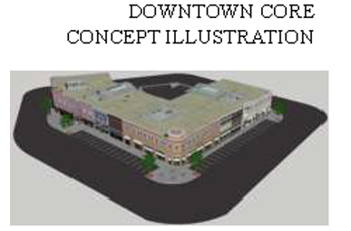
- DC, Downtown Core purpose. The Downtown Core comprises that area of the Bentonville Square and extends those urban characteristics along the primary downtown street of SW A Street to Highway 102/14 th Street. The intent of this zone is to maintain and expand the pedestrian oriented character of the square. The physical form is of an urban character with uses that promote retail and entertainment venues with upper story residential uses permitted. Mixed use is defined as vertical mixed use with commercial and retail on the first floor and office and residential on the upper floors. Buildings are spaced closely or attached.
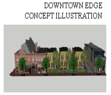
- DE, Downtown Edge purpose. The Downtown Edge creates an area of transition between the Downtown Core with its retail emphasis and the lower density residential neighborhoods on the outskirts of downtown. This is the area of downtown with the greatest potential for infill and redevelopment. The physical form of structures begins to shift from commercial to residential character with flexibility in use, taking on a more service-oriented character for surrounding neighborhoods. The horizontal and vertical mixed use allows retail, commercial, office and residential uses on all floors. Live/work housing, personal services and small offices are strongly evident in this district. Buildings are spaced closely, but are separated by setbacks.
- DC, Downtown Core purpose. The Downtown Core comprises that area of the Bentonville Square and extends those urban characteristics along the primary downtown street of SW A Street to Highway 102/14 th Street. The intent of this zone is to maintain and expand the pedestrian oriented character of the square. The physical form is of an urban character with uses that promote retail and entertainment venues with upper story residential uses permitted. Mixed use is defined as vertical mixed use with commercial and retail on the first floor and office and residential on the upper floors. Buildings are spaced closely or attached.
- Downtown (D) districts lot and area standards.
DOWNTOWN (D) DISTRICTS
LOT AND AREA STANDARDSDistrict Building type Lot area Min. land area/
dwelling unit (sq. ft.)Lot width Min. lot depth Lot coverage Min. Max. Min. lot width Max. lot width Min. Max. DC All None None -- None None -- None 100% DE All None None -- None None -- None 80% - Downtown (D) districts setback requirements. The table below establishes the setbacks from property lines for all development in the downtown (D) districts. Side setbacks are not applicable when a common wall is proposed or present.
DOWNTOWN (D) DISTRICTS
SETBACK REQUIREMENTS
District Building type Front Yard Side Yard Rear Adjacent to Residential Adjacent to Nonresidential Min. Max. Min. Max. Min. Max. Min. Max. DC Residential - 20' 0' - 0' - 0' - Nonresidential - 0' 0' - 0' - 0' - DE Residential - 20' 7' - 12' - 7' -
Nonresidential - - 7' - 12' - 7' - - Downtown (D) districts height standards. The table below establishes the height standards for all development in the downtown (D) districts.
DOWNTOWN (D) DISTRICTS District Height standards Minimum Maximum DC 20' 80' DE None 50'
- Downtown (D) districts encroachment standards. The table below establishes the standards for encroachments such as canopies, awnings and balconies. Height clearance is measured from the pavement to the bottom most portion of the encroachment. The setback is measured from back of curb or, if no curb is present, from the edge of street pavement.
DOWNTOWN (D) DISTRICTS
ENCROACHMENT STANDARDS
District Min. height clearance Min. setback adjacent to an arterial or collector street Min. setback adjacent to a downtown local street DC 8' 2' 2' DE 8' 4' 6'
Amended by Ord. 2020-38 on 2/11/2020
Amended by Ord. 2021-95 on 4/27/2021
Sec 401.09 Industrial (I) Districts Regulations
- Description and purpose.
- Industrial districts generally. The Industrial districts are to provide for development of industrial uses and related facilities. The regulations for the Industrial districts are designed to:
- Make available a range of suitable sites for all types of manufacturing and related activities;
- Protect residences by separating them from manufacturing activities and by limiting the use of each space for new residential development;
- Provide restricted areas for those industries emitting objectionable noises, odors, or which involve danger of fire or explosives;
- To protect industrial activities and related developments against congestion, as appropriate for each area, by limiting building bulk in relation to surrounding land and other industries and providing off-street parking and loading with each development;
- To promote desirable land use and building development direction and to provide stability for industry and related development in an effort to strengthen the city's economic base; and,
- To protect district character and usage and to conserve land and building value.
- I-1, Light Industrial district purpose. The I-1 district is designed primarily to provide for general offices, light manufacturing, assembly and accessory warehousing for products which present low risk of objectionable environmental and aesthetically offensive influences, have low traffic volumes and provide no health or safety hazards.
- I-2, Heavy Industrial district purpose. The I-2 district is designed primarily to minimize the high risk of hazardous and environmentally objectionable uses of general manufacturing processes and storage facilities as well as provide for warehousing, heavy equipment repair and transportation facilities.
- Industrial districts generally. The Industrial districts are to provide for development of industrial uses and related facilities. The regulations for the Industrial districts are designed to:
- Industrial (I) districts lot and area standards. The table below establishes the lot and area standards for all development in the industrial (I) districts.
INDUSTRIAL (I) DISTRICTS LOT AND AREA STANDARDSDistrict Building type Min. lot area (sq. ft.) Min. land area/ dwelling unit (sq. ft.) Lot width Min. lot depth Max. lot coverage Min. street frontage Min. lot width Max. lot width Interior lot Exterior/ corner lot I-1 All 20,000 -- 100' -- 100' 60% 60% 50' I-2 All 20,000 -- 100' -- 100' 50% 50% 50' - Industrial (I) districts setback requirements.
- Standards. The table below establishes the minimum setback standards for all development in the industrial (I) districts.
INDUSTRIAL (I) DISTRICTS MINIMUM SETBACK REQUIREMENTSDistrict Building type Front Side Rear With parking in front Without parking in front Adjacent to nonresidential district and/or ROW Adjacent to residential district Adjacent to ROW Adjacent to nonresidential district Adjacent to residential district I-1 All 75' 30' 30' 75' 30' 50' 75' I-2 All 75' 50' 50' 75' 50' 50' 75' - Railroads. Where property abuts a railroad and loading and unloading facilities are utilized, or second siding or spurs, the loading and unloading portions of the structures may be built up to railroad property line.
- Standards. The table below establishes the minimum setback standards for all development in the industrial (I) districts.
- Industrial (I) districts height standards.
- Standards: The table below establishes the maximum height allowed in industrial (I) districts.
INDUSTRIAL (I) DISTRICTS MAXIMUM HEIGHT STANDARDSDistrict Maximum height allowed I-1 60' I-2 60' - Exceptions: A building or structure may exceed the maximum height allowed provided each of its front, side, and rear yards are increased an additional one foot for each one foot such building exceeds the maximum height allowed.
- Standards: The table below establishes the maximum height allowed in industrial (I) districts.
- Industrial (I) districts development criteria. Unless otherwise specifically provided in this section, the following development criteria shall apply:
- All Industrial (I) districts.
- Nuisance mitigation. Any lighting visible from outside the site shall be designed to reflect away from adjacent residential districts. No noise, odor or vibration shall be emitted so that it constitutes a nuisance which substantially exceeds the general level of noise, odor or vibration emitted by uses adjacent to or immediately surrounding the site. Such comparisons shall be made at the boundaries of the site.
- Trash receptacles. Outdoor storage of trash receptacles shall be at the sides or rear of the site and shall be totally encircled or screened by a sight-proof fence, planting or other suitable visual barrier.
- Screening. A permanent opaque screening fence or wall shall be constructed along any side or rear property line which abuts property zoned for residential purposes. The height of this screen or wall shall be not less than eight (8) feet and shall be constructed of wood, masonry or other durable opaque material, and finished in a manner appropriate to the appearance and use of the property.
- Front yards. No loading or storage of material shall be permitted in the required front yard.
- I-1 Industrial district only. Every use or any part thereof that is not conducted within a building completely enclosed on all sides shall be screened by a permanent opaque screening fence or wall so that it cannot be seen from an adjoining lot. The following screening and display criteria shall apply to uses located in the I-1, Industrial district:
- Screening. The height of any opaque screening fence or wall shall not be less than eight (8) feet.
- Vehicle storage areas. Automobile, bus, truck, tractor, mobile home, boat or motorcycle, and wheeled and/or tracked industrial vehicle storage areas are not required to screen fully assembled merchandise which is ready for sale.
- All Industrial (I) districts.
Code 1994; Ord. No. 2003-101, § 1, 6-10-2003; Ord. No. 2018-62, § 6, 3-27-2018)
Sec 401.10 PUD, Planned Unit Development
- Description and purpose of PUD districts. The purpose of the PUD district is to establish a mechanism for a person to propose a commercial, industrial or residential mixed-use development that is innovative but which does not strictly comply with the provisions of the zone in which the property is located and cannot be achieved through traditional zoning. The intent of the PUD district is to promote high quality developments while allowing greater flexibility in the design of such developments. The PUD should produce:
- A maximum choice in the types of environment and living units available to the public;
- Common open space and recreation areas;
- A pattern of development which preserves natural features and prevents soil erosion;
- A creative approach to the use of land and related physical development;
- An efficient use of land resulting in smaller networks of utilities and streets and thereby lowering costs;
- Internally located commercial uses that serve surrounding residential areas; and
- An environment of stable character in harmony with the surrounding development.
- PUD districts require zoning designation and a master site plan. The PUD is a combination of zoning designation and master site plan. A detailed site plan is required for approval. Once approved, the site plan becomes a zoning district by city ordinance in the same manner as any other zoning parcel and the applicant may proceed with the platting or large scale development process. Development must follow the site plan exactly. Failure in this respect will result in reversion of the property to the original zoning. Although design innovation is encouraged and flexibility is allowed, the PUD may not be used simply as a method of avoiding zoning regulations.
- Allowed uses in PUD districts. The PUD submittal shall include a listing of the proposed land uses and the amount of land devoted to each. This list will constitute part of the zoning component of the PUD. No other land uses will be allowed unless the PUD is revised through a rezoning process.
- Density requirements for PUD districts. The site plan shall clearly depict the proposed density by land use category. For purposes of calculating densities, net residential acres are defined as gross acres of the PUD site minus all public rights-of-way, and less the area of all parcels or lots devoted to commercial, industrial, or institutional uses not of a residential nature. Common open space that is owned and maintained by a property owners' association shall be included in calculating the net residential acres available for all dwelling units that automatically belong to such an association. Where more than one (1) property owners' association is to be created, then each common open space can only be attributed to the lot or dwellings which have automatic membership for that specific common open area.
- PUD districts may modify development standards. The applicant shall provide a written description of the proposed zoning and development standards. This information will become part of the zoning ordinance of the PUD district.
- Modifications permitted. The PUD district may modify the following zoning and development standards:
- Density;
- Building setbacks;
- Height of building or structure;
- Lot size;
- Lot width;
- Lot depth;
- Landscaping;
- Required off-street parking spaces in instances of mixed residential/commercial uses;
- Street widths; and
- Garage setbacks.
- Modifications prohibited. The PUD district shall not modify the following development standards:
- Sign requirements;
- Grading and drainage;
- Access management;
- Outdoor lighting;
- Screening;
- Residential and commercial street light standards; and
- Flood damage protection.
- Modifications permitted. The PUD district may modify the following zoning and development standards:
- Development criteria for PUD districts.
- PUD districts common open space requirements. Common useable open space constitutes an essential ingredient in a planned unit development and is one of the most basic and important design elements.
- Minimum area devoted to open space. A minimum of 20% of the total project area, exclusive of public right-of-way and parking lots, shall be devoted to common open space.
- Equitable distribution. Open space should be distributed more or less equitably throughout the PUD district in relationship to the dwelling units and other use areas that are intended to be served by the common open space.
- Preservation. Adequate guarantees must be provided that the common open space areas as contained in the plan for the PUD district are preserved and maintained for those purposes only. A property owners' association shall be required if other arrangements satisfactory to the planning commission have not been made for improving, operating and maintaining all such common open space areas. At the time the final plan and plat is submitted, the articles of incorporation and bylaws of the property owners' association shall be reviewed and approved by the planning commission. Additionally, the restrictive covenants which run with the land must be submitted and include similar provisions to preserve all open space areas.
- Accessible. Common useable open space shall be open to tenants and customers within the PUD. Access by the general public is desired.
- Common open space options. The required common open space may include:
- Wetlands and water bodies, including the normal water surface area of unfenced retention ponds up to 50% of the required open space area;
- Active detention ponds that include recreational equipment/facilities;
- Vegetated/landscaped area, excluding required parking lot landscaping requirements;
- Pedestrian paths, trails, sidewalks (exclusive of those required by ordinance) and covered walkways;
- Public plazas and hard surfaced recreation areas; and
- Public pools, tennis courts, basketball courts, baseball fields, soccer fields, or similar outdoor recreation facilities that are open to the residents and users of the PUD.
- PUD districts parking and off-street loading requirements. All uses established within a Planned Unit Development district shall comply with the off-street parking and loading requirements as established in Article 501 Off-Street Parking and Loading. However, the requirements for individual structures or lots may be met through either provision of adequate parking on the lot on which such structure is so located or upon adjacent property which is under the control of a property owners' association to which said lot is an automatic participant. In no case, however, shall the cumulative requirements for all parking and off-street loading requirements be less than if said uses were individually established and located in any other zoning district within the city.
- PUD districts perimeter requirements. In order to assure compatibility with surrounding development, the developer shall submit specific information as to the setbacks, building height, coverage factors and other elements necessary for all perimeter lots that are adjacent to the boundary of the PUD district or adjacent to any boundary or perimeter street right-of-way. While no specific setback requirements are herein established, the planning commission and city council shall consider the nature, extent and character of the adjacent development and shall take into consideration the types of area regulations applicable to adjacent properties.
- PUD districts structural design standards. The PUD shall meet the design standards for large scale developments in the subdivision code and the following structural design standards.
- Residential buildings should have their main entrances oriented toward the adjoining street.
- All structures shall have a common architectural theme.
- Avoid unbroken building facades of more than 100 feet.
- Provide human scale features, especially at street level.
- Avoid unarticulated and monotonous building facades and window placement.
- Provide a variety of building heights and varied roofline articulation.
- Aluminum, vinyl or fiberglass siding or roofing materials on the facades or sides of the building shall not be visible from a public right-of-way.
- Rear and side loading residential garages are encouraged and shall be setback a minimum of 20 feet. Front-loading garages shall be recessed a minimum of 10 feet, from the front elevation of the house and shall be setback a minimum of 30 feet from the front property line.
- PUD districts common open space requirements. Common useable open space constitutes an essential ingredient in a planned unit development and is one of the most basic and important design elements.
- PUD expiration. If a PUD expires as set forth in the Subdivision Code, the PUD zoning designation is void and the property reverts to its previous zoning district.
(Code 1994; Ord. No. 2003-101, § 1, 6-10-2003; Ord. No. 2005-51, § 1; Ord. No. 2012-58, § 2, 7-24-2012; Ord. No. 2018-62, § 6, 3-27-2018)
Amended by Ord. Ord. No. 2021-233 on 11/9/2021
Sec 401.11 PRD, Planned Residential Development District Regulations
- Description and purpose of PRD districts. This section establishes standards and criteria for Planned Residential Developments (PRD). The primary purpose of a PRD is to enhance the design of a residential development by allowing for flexibility and variation from the established site requirements and development standards of the zoning and subdivision codes. The PRD is a mechanism by which the city may allow for variation in the design and arrangement of structures as well as provide for the coordination of project characteristics with features of a particular site in a manner that is consistent with the public health, safety, and welfare of the community. A PRD allows for innovations and special features in site development, including the locations and type of structures, the conservation of natural features, the conservation of energy, the efficient use of open space, and allowances for housing serving varying price points.
The intent of the PRD district is to encourage the use of Smart Growth principals and Traditional Neighborhood Design, to provide a variety of housing types and densities available to the general public, and to promote high quality residential developments while allowing greater flexibility in the design of such developments. The PRD shall produce:- A maximum choice in the types of environment and living units available to the public;
- A variety of housing types that effectively meets the varying price points of the community;
- Energy-efficient site design or building features;
- A minimum of fifteen percent (15%) common, useable open space and recreation areas;
- A pattern of development which preserves natural features and prevents soil erosion;
- A creative approach to the use of land and related physical development;
- Efficient use of land resulting in smaller networks of utilities and streets and thereby lowering costs;
- Environment of stable character in harmony with the surrounding development;
- Efficient use of infrastructure, and,
- High quality architectural design, placement, relationship and orientation of structures.
- Smart Growth and Traditional Neighborhood Design (TND). The PRD district shall incorporate Smart Growth principles, including Traditional Neighborhood Design elements into the development by such means as:
- Offer a range of housing opportunities and choices;
- Foster walkable, "close-knit" neighborhoods;
- Promote distinctive, attractive communities with a strong "sense of place";
- Preserve open space, farmland, natural beauty, and critical environmental areas;
- Strengthen and encourage growth in existing communities;
- Provide an interconnected network of narrow streets that are safe and pleasant for pedestrians and which provide a variety of routes for local traffic; and,
- Provide high quality public spaces such as greenbelts, parks, plazas, squares, courtyards, and streets that are an organizing feature and gathering place for the neighborhood.
- PRD districts require zoning designation, a master site plan, and architectural elevation renderings. A PRD is a combination of zoning designation and master site plan, including architectural elevation renderings. A detailed master site plan and architectural elevation renderings are required for approval and must be submitted at the time of application submittal. Elevations may be digitally or hand drawn. Once approved, the site plan becomes a zoning district by ordinance in the same manner as any other zoning parcel and the application may proceed with the preliminary platting or large scale development process. Development must follow the site plan exactly. Failure in this respect will result in reversion of the property to the original zoning. Although design innovation is encouraged and flexibility is allowed, the PRD may not be used simply as a method of avoiding zoning regulations.
- Master site plan. PRD master site plan shall include:
- Residential housing types;
- Building setbacks;
- Location of the central gathering area(s) such as a public plaza or courtyard;
- Open space including, but not limited to, parks, trails, and other recreational facilities (central gathering area(s) are a separate requirement, but may be included as open space);
- Heights of all buildings and other structures;
- Lot size, width, and depth;
- All parking spaces including off-street and on-street;
- Locations of all structures;
- Housing densities by type, expressed in units per acre;
- Traffic circulation pattern;
- Street widths and sidewalks;
- Location of proposed signage;
- Ariel view of all public gathering places depicted on the master site plan;
- Garage setbacks.
- Architectural elevations. PRD district architectural elevation renderings shall include:
- Front, rear, and side elevations and architectural design for each type of residential structure.
- Exterior façade building materials list for each type of residential structure and public gathering places.
- Master site plan. PRD master site plan shall include:
- Allowed uses in PRD districts. The primary use of a PRD shall be residential. Uses that are accessory to the primary residential use are also allowed, as are open space and recreation uses as permitted by this zone. The PRD submittal shall include a listing of the proposed land uses and the amount of land devoted to each type of development. This list will constitute part of the zoning component of the PRD. No other land uses will be allowed unless the PRD is revised through a rezoning process.
- Development standards for PRD districts. The applicant shall provide a written description of the proposed zoning and development standards. This information will become part of the zoning ordinance of the PRD district.
- Modifications allowed. The PRD district master site plan may modify the following zoning and development standards:
- Density;
- Building and garage setbacks;
- Height of buildings or structures;
- Lot size, depth, and width;
- Required off-street parking spaces; and
- Street widths.
- Modifications prohibited. The PRD district shall not modify the following zoning and development standards:
- Sign requirements;
- Grading and drainage;
- Access management;
- Outdoor lighting;
- Landscaping and screening;
- Residential light standards; and
- Flood damage protection.
- Modifications allowed. The PRD district master site plan may modify the following zoning and development standards:
- Phased development for PRD districts. If development is to be completed in phases, the development plan shall coordinate improvement of the open space, the construction of buildings, structures, and improvements in such open space, and the construction of dwelling units in order that each development stage achieves a proportionate share of the total open space and environmental quality of the total PRD.
- Development criteria for PRD districts.
- Common open space and recreation requirements. In addition to adhering to Article 1400 of the Subdivision Code, common usable open space constitutes an essential ingredient in a PRD and is one of the most basic and important design elements.
- Minimum area. A minimum area of fifteen percent (15%) of the total project area, exclusive of public right-of-way and parking lots, shall be devoted to common usable open space.
- Equitable distribution. Open space shall be distributed more or less equitably throughout the PRD district in relationship to the dwelling units or other use areas that are intended to be served by the common open space.
- Preservation. Adequate guarantees must be provided that the common useable open space area as contained in the plan for the PRD district are preserved and maintained for those purposes only. A property owner's association (POA) shall be required if other arrangements satisfactory to the planning commission have not been made for improving, operating, and maintaining all such common open space area. At the time the final plat and plan is submitted, the articles of incorporation and bylaws of the POA shall be reviewed and approved by city staff. Additionally, the restrictive covenants which run with the land must be filed with Benton County, submitted to the planning department and include similar provisions to preserve all open space areas.
- Accessibility. Common open space shall be open to tenants and customers within the PRD, although access by the general public is encouraged and desired.
- Common open space options. The required common open space may include:
- Wetlands and water bodies;
- Lawns—Five percent (5%) maximum of total percentage required;
- Pedestrian paths, trails, sidewalks (exclusive of those required by ordinance) and covered walkways;
- Central gathering spaces such as plazas, parks, or courtyards;
- Vegetated/landscape areas, excluding required parking lot landscaping requirements; and,
- Recreational areas/facilities such as public pools, tennis courts, basketball courts, baseball fields, soccer fields, or similar outdoor recreation facilities that is open to the residents and users of the PRD.
- Parking and off-street loading. All uses established within a PRD shall comply with the off-street parking and loading requirements as established Article 501, Off-street Parking and Loading of the Zoning Code and the following additional requirements.
- Two (2) off-street parking spaces must be provided for each residential unit, such as a driveway, carport, garage, etc.
- Guest parking spaces may be uncovered and shall be so located as to be accessible to visitors and guests.
- The required parking spaces, garages, or carports, or any portions thereof, may be grouped when it is determined by the planning commission that such grouping and the locations thereof will be accessible and useful in connection with the proposed dwelling unit in the development.
- Perimeter requirements. In order to ensure compatibility with surrounding development, the developer shall submit specific information as to the setbacks, building height, lot coverage, and other elements necessary for all perimeter lots that are adjacent to the boundary of the PRD district or adjacent to any boundary or perimeter street right-of-way. While no specific setback requirements are herein established, the planning commission and city council shall consider the nature, extent, and character of the adjacent development and shall take into considerations the types of area regulations applicable to adjacent properties.
- Density. The site plan shall clearly depict the proposed density, expressed in units per acre for each residential type included within the PRD.
- Authorization of housing types. A PRD may authorize a variety of housing types including, but not limited to:
- Detached, single-family;
- Common wall dwellings including multi-family, condominiums, duplex/patio home;
- Townhouses or row-houses (including those on individual lots to be sold and those sharing common lots), and
- Zero lot line homes.
- Structural design standards. The PRD shall meet the following structural design standards.
- Buildings shall be sensitive to the natural environmental conditions and should be oriented around a public gathering space such as a plaza, park, or courtyard, or respond in design to a prominent feature, such as a corner location, or other manmade or natural feature.
- Buildings and site design shall provide inviting entry orientation.
- Main entrances shall be oriented toward the adjoining street.
- All structures shall have a common architectural theme.
- Human scale features shall be provided.
- Provide a variety of building height and varied roofline articulation.
- Aluminum, vinyl, or fiberglass siding materials on the facades or sides of the building shall not constitute over fifty percent (50%) of the structure; soffit and fascia shall not be included within this 50% calculation.
- Rear and side loading garages shall be setback a minimum of 30 ft. for a rear loading garage and twenty feet (20') for a side loading street facing garage. Front loading garages shall be setback a minimum of 30 ft. from the property line.
- Common open space and recreation requirements. In addition to adhering to Article 1400 of the Subdivision Code, common usable open space constitutes an essential ingredient in a PRD and is one of the most basic and important design elements.
- Revocation of PRD districts. Where the master plan is not met, the planning commission shall meet and discuss the revocation of the PRD at any time they feel necessary.
- PRD expiration. If a PRD expires as set forth in the subdivision code, the PRD zoning designation is void and the property reverts to its previous zoning district.
(Ord. No. 2006-176, § 2; Ord. No. 2012-58, § 2, 7-24-2012; Ord. No. 2018-62, § 6, 3-27-2018)
Sec 401.12 Municipal Airport Overlay District
- Description and purpose. The purpose of the Municipal Airport District is to:
- Prevent the creation or establishment of hazards to air navigation;
- Eliminate, remove, alter and mitigate hazards to air navigation; and
- Provide for marking and lighting of obstructions.
- Review and approval. In addition to the standard review and approval procedures, all developments within this district also shall be reviewed and approved by the Federal Aviation Administration (FAA) and the Bentonville Airport Manager or his or her designee.
- Municipal airport district map.
- Official map. The Bentonville Municipal Airport Zoning Ordinance Map is made a part hereof. The map identifies the zones within the municipal airport district. The City of Bentonville shall maintain the Official Municipal Airport Zoning Ordinance Map in the mayor's office or in a convenient location designated by the mayor. Although copies of the map or portions thereof may be distributed to the public in paper or digital form, the Official Municipal Airport Zoning Ordinance Map consists of the paper copy signed by the mayor and designated as such, as may be amended by ordinance adopted by the city council.
- Interpretation of zones. An area located in more than one airport zone is considered to be only in the zone with the more restrictive height limitation.
- Zones within the municipal airport district. There are hereby created and established certain zones which include all of the land lying beneath the approach surfaces, transitional surfaces, horizontal surfaces and conical surfaces as they apply to the Bentonville Municipal Airport. The zones are hereby established and defined as follows:
- Zone A, Runway larger than utility with a visibility minimum greater than 3/4 mile non-precision instrument approach zone. The inner edge of this approach zone coincides with the width of the primary surface and is 500 feet wide. The approach zone expands outward uniformly to a width of 3,500 feet at a horizontal distance of 10,000 feet from the primary surface. Its centerline is the continuation of the centerline of the runway.
- Zone B, Transitional Zone. The transitional zones are the areas beneath the transitional surfaces.
- Zone C, Horizontal Zone. The horizontal zone is established by a swinging arc of 10,000 feet radii from the center of each end of the primary surface of each runway and connecting the adjacent arcs by drawing lines tangent to those arcs. The horizontal zone does not include the approach and transitional zones.
- Zone D, Conical Zone. The conical zone is established as the area that commences at the periphery of the horizontal zone and extends outward there from a horizontal distance of 4,000 feet.
- Height limitations. Except as otherwise provided in this section, no structure shall be erected, altered, or maintained, and no tree shall be allowed to grow in the Municipal Airport District to a height in excess of the applicable height herein established for such zone. Nothing in this section shall be construed as prohibiting the construction or maintenance of any structure, or growth of any tree to a height up to 50 feet above the surface of the land. Applicable height limitations are hereby established for each of the zones as follows:
- Zone A, Runway larger than utility with a visibility minimum greater than 3/4 mile non-precision instrument approach zone. Slopes 34 feet outward for each foot upward beginning at the end of and at the same elevation as the primary surface and extending to a horizontal distance of 10,000 feet along the extended runway centerline.
- Zone B, Transitional Zone. Slope seven feet outward for each foot upward beginning at the sides of and at the same elevation as the primary surface and the approach surface, and extending to a height of 150 feet above the airport elevation, which is 1,296 feet above mean sea level. In addition to the foregoing, there are established height limits sloping seven feet outward for each foot upward beginning at the sides of and at the same elevation as the approach surface, and extending to where they intersect the conical surface. Where the precision instrument runway approach zone projects beyond the conical zone, there are established height limits sloping seven feet outward for each foot upward beginning at the sides of and the same elevation as the approach surface, and extending a horizontal distance of 5,000 feet measured at 90 degree angles to the extended runway centerline.
- Zone C, Horizontal Zone. Established at 150 feet above the airport elevation or at a height of 1,446 feet above mean sea level.
- Zone D, Conical Zone. Slopes twenty (20) feet outward for each foot upward beginning at the periphery of the horizontal zone and at 150 feet above the airport elevation and extending to a height of 350 feet above the airport elevation.
- Use restrictions.
- Not withstanding any other provision of this section, no use may be made of land or water within the municipal airport district in such a manner as to:
- Create electrical interference with navigational signals or radio communication between the airport and aircraft;
- Make it difficult for pilots to distinguish between airport lights and others;
- Result in glare in the eyes of pilots using the airport;
- Impair visibility in the vicinity of the airport;
- Create bird strike hazards; or
- Otherwise in any way endanger or interfere with the landing, takeoff, or maneuvering of aircraft intending to use the airport.
- Marking and lighting. The owner of any existing nonconforming structure or tree is hereby required to permit the installation, operation, and maintenance thereon of such markers and lights as shall be deemed necessary by the Mayor to indicate to the operators of aircraft in the vicinity of the airport the presence of such airport obstruction. Such markers and lights shall be installed, operated, and maintained at the expense of the city.
- Noise sensitive uses. All types of residential uses and uses that promote places of public gathering such as schools, religious facilities, hospitals, etc. are allowed in the Municipal Airport District if sound attenuated to achieve a minimum of 30 decibel noise reduction from outside noise levels to indoor noise levels. The granting of an avigation easement is required prior to issuing a building permit and plat notification is required on all plats.
- Not withstanding any other provision of this section, no use may be made of land or water within the municipal airport district in such a manner as to:
(Ord. No. 2006-23, § 2; Ord. No. 2012-58, § 2, 7-24-2012; Ord. No. 2018-62, § 6, 3-27-2018)
Sec 401.13 Northwest Arkansas Regional (XNA) Airport Overlay District
- Description and purpose. The Northwest Arkansas Regional Airport (XNA) Overlay District is designed to provide protection to people and property on the ground and to protect the airport from the encroachment of non-compatible land uses that may interfere with the safe operation of the airport.
- Northwest Arkansas Regional Airport (XNA) Overlay District Map.
- Official map. The XNA Overlay Zones Map is made a part hereof. The map identifies the zones within the XNA Overlay District. The City of Bentonville shall maintain the official XNA Overlay Zones Map in the mayor's office or in a convenient location designated by the mayor. Although copies of the map or portions thereof may be distributed to the public in paper or digital form, the XNA Overlay Zones Map consists of the paper copy signed by the mayor and designated as such, as may be amended by ordinance adopted by the city council.
- Interpretation of zones. An area located in more than one airport zone is considered to be only in the zone with the more restrictive height limitation and use restriction.
- Zones within the Northwest Arkansas Regional Airport Overlay District.
- Zone 1, Runway Protection Zone (RPZ). The Runway Protection Zone is defined by a trapezoidal shaped area beyond the runway ends. The clearance of all objects within the RPZ is necessary. This area shall remain as open/undeveloped space and shall be contained entirely on airport property.
- Zone 2, Inner Safety/Turning Zone (ISTZ). The ISTZ boundary is defined by a triangular shaped area that is positioned along each side of the Zone 1 (RPZ). For Runway 16/34 at the Northwest Arkansas Regional Airport, Zone 2 (ISTZ) extends approximately 5,000 feet from the inner width of Zone 1 (RPZ), within a 60 degree sector off the extended runway centerlines.
- Zone 3, Outer Safety Zone (OSZ). The OSZ boundary is defined by rectangular area that is centered on the runway. For runway 16/34 at the Northwest Arkansas Regional Airport, the OSZ is 1,000 feet wide overall (extending 500 feet laterally from the runway centerline) and extends approximately 5,000 feet beyond Zone 2, ISTZ.
- Zone 4, Traffic Pattern Zone (TPZ). The TPZ boundary extends approximately 6,000 feet on each side of the runway. Beyond the ends of the runway, this boundary follows the same arc pattern of Zone 2 (ISTZ).
NORTHWEST ARKANSAS REGIONAL AIRPORT (XNA) OVERLAY DISTRICT ZONES
- General provisions.
- Glare. In Zones 1, 2, and 3, no glare-producing material shall be used on the exterior of any building, including any metal building, which would produce glare that would endanger or interfere with the landing, taking off, or maneuvering of aircraft intending to use the airport.
- Lighting. In Zones 1, 2, and 3, no flashing or blinking signs or upward projecting lights shall be used that would interfere with a pilot's ability to identify airport lights.
- Visibility. In Zones 1, 2, and 3, no structure or use shall impair the visibility in the vicinity of the airport so as to endanger or interfere with the landing, taking off, or maneuvering of aircraft intending to use the airport. Such prohibited uses include, but shall not be limited to, the emission or discharge of smoke, steam, or other obscuring phenomena that would interfere with the health and safety of pilots, or that would otherwise be detrimental or injurious to the health, safety and general welfare of the public in the use of the airport.
- Electronic interference. In Zones 1, 2, 3, and 4 no structure or use on land or water shall create electrical or electronic interference with navigational signals, or radio or radar communications between aircraft and a ground station.
- Wildlife hazards. In Zones 1, 2, and 3, in the judgment of the Community Development Director or other authorized agent, a use with the potential to attract wildlife that threatens aviation safety shall be prohibited.
- Sound attenuation. In Zones 1, 2, 3, and 4, all noise sensitive uses shall be sound attenuated to achieve a minimum of 30 db noise reduction from outside noise levels to indoor noise levels. Noise sensitive uses are those defined as including, but not limited to: Day care/childcare centers, school facilities, hospitals, religious facilities, single-family homes, multi-family homes, manufactured homes, convalescent/maternity/nursing homes, or any other type of dwelling.
- Avigation easements. In Zones 1, 2, 3, and 4 the granting of an avigation easement is required prior to issuing a building permit and plat notification is required on all plats.
- Height limitations. All structures must comply with the Height Hazard Zoning Ordinance prepared by the Northwest Arkansas Regional Airport Authority. All development shall supply to the Planning Department a height certificate issued by the FAA.
- Use restrictions. The XNA Airport Overlay District is divided into four zones with specific uses prohibited within each zone.
- Zone 1, Runway Protection Zone (RPZ).
- Uses prohibited in Zone 1. All uses are prohibited.
- Zone 2, Inner Safety/Turning Zone (ISTZ).
- Uses allowed in Zone 2. All uses allowed in the base zoning district are allowed in Zone 2, except as listed below in the Prohibited Uses section. All uses must meet the requirements of Subsection (d), General provisions.
- Uses allowed with conditional use approval in Zone 2. All uses allowed in the base zoning district as conditional uses are allowed as conditional uses in Zone 2, except as listed below in Subsection (c), Uses prohibited in Zone 2. All uses must meet the requirements of subsection (d), General provisions.
- Uses prohibited in Zone 2. The following uses are prohibited in Zone 2:
- Places of public assembly not designed for airport patrons, including, but not limited to: Adult day care, child care, educational facilities, hospitals, religious facilities, theaters (indoor and outdoor), museums, arena/auditoriums; conference/convention centers; and community centers;
- Places of residence including, but not limited to, single-family homes, multi-family homes, manufactured homes, assisted living facilities, or any other type of dwelling;
- Correctional facilities or jails;
- Transmission tower/station;
- Wind turbines;
- Mining;
- Solid waste disposal;
- Above-ground bulk hazardous material storage or bulk storage of highly flammable materials and related facilities which could pose a threat to the public in the event of an aircraft crash;
- Contractor maintenance yards; salvage yards; or storage yards for oxides, coal, stone, concrete mixing supplies or asphalt plants; and
- Wireless communication facility.
- Zone 3, Outer Safety Zone (OSZ).
- Uses allowed in Zone 3. All uses allowed in the base zoning district are allowed in Zone 3, except as listed below in Subsection (c), Uses prohibited in Zone 3. All uses must meet the requirements of Subsection (d), General provisions.
- Uses allowed with conditional use approval. All uses allowed in the base zoning district as conditional uses are allowed as conditional uses in Zone 3, except as listed below in Subsection (c), Uses prohibited in Zone 3. All uses must meet the requirements of Subsection (d), General provisions.
- Uses prohibited in Zone 3. The following uses are prohibited in Zone 3:
- Places of public assembly not designed for airport patrons, including, but not limited to: Adult day care, childcare, educational facilities, hospitals, religious facilities, theaters (indoor and outdoor), museums, arena/auditoriums; conference/convention centers and community centers;
- Places of residence including, but not limited to, single-family homes, multi-family homes, manufactured homes, assisted living facilities, or any other type of dwelling;
- Correctional facilities or jails;
- Transmission tower/station;
- Mining;
- Solid waste disposal;
- Wind turbines;
- Above-ground bulk hazardous material storage or bulk storage of highly flammable materials and related facilities which could pose a threat to the public in the event of an aircraft crash;
- Contractor maintenance yards; salvage yards; or storage yards for oxides, coal, stone, concrete mixing supplies or asphalt plants; and
- Wireless communication facility.
- Zone 4, Traffic Pattern Zone (TPZ).
- Uses allowed in Zone 4. All uses allowed in the base zoning district are allowed in Zone 4, except as listed below in the Prohibited Uses Section. All uses must meet the requirements of Subsection (d), General provisions.
- Uses allowed with conditional use approval in Zone 4. All uses allowed in the base zoning district as conditional uses are allowed as conditional uses in Zone 4, except as listed below in Subsection (c), Uses prohibited in Zone 4. All uses must meet the requirements of Subsection (d), General provisions.
- Uses prohibited in Zone 4. Manufactured homes are prohibited.
- Zone 1, Runway Protection Zone (RPZ).
(Ord. No. 2006-23, § 2; Ord. No. 2006-153, § 1; Ord. No. 2009-23, § 1; Ord. No. 2012-58, § 2, 7-24-2012; Ord. No. 2018-62, § 6, 3-27-2018)