
Berlin Charter Township
City Zoning Code
City Zoning Code
ARTICLE IV
DISTRICT REGULATIONS
Sec. 18-51.- Establishment of districts.
Berlin Charter Township is hereby divided into districts having the following name and symbols:
(Ord. No. 01-20, § 18.51, 2-10-20)
Sec. 18-52. - Official zoning map.
(a)
Official Zoning Map of Berlin Charter Township. The zoning districts are bounded and defined as shown on a map entitled "Official Zoning Map of Berlin Charter Township" and said map, with all explanatory matter thereon, is hereby made a part of this chapter.
(b)
Signature and seal. The official zoning map shall be identified by the signature of the township supervisor, attested by the township clerk and bear the seal of the township under the following words: "This is to certify that this is the official zoning map referred to in the Berlin Charter Township Zoning Ordinance" together with the effective date of this chapter.
(c)
Changes due to the Zoning Enabling Act. If, in accordance with the procedures of this chapter and the Michigan Zoning Enabling Act, as amended, a change is made in a zoning district boundary, such change shall be entered on the official zoning map by the township zoning official promptly after the ordinance authorizing such change shall have been adopted and published. A date shall be affixed to the official zoning map noting revisions to the map. No change in the official zoning map of any other nature shall be made unless authorized by the zoning board of appeals, and then only by the township's zoning official. Any change in corporate boundaries within the township shall be recorded on the official zoning map in conformity with procedures set forth herein.
(d)
Damaged, destroyed, lost, or difficult to interpret. In the event that the official zoning map becomes damaged, destroyed, lost, or difficult to interpret because of the nature or number of changes made thereto, the township board may, by ordinance, adopt a new official zoning map which shall supersede the prior official zoning map. The new official zoning map may correct drafting or other errors or omissions on the prior official zoning map, but no such corrections shall have the effect of amending the zoning ordinance or the prior official zoning map. The new official zoning map shall be identified by the signature of the township supervisor, attested by the township clerk, and bear the seal of the township under the following words: "This is to certify that this is the Official Zoning Map referred to in the Zoning Ordinance of Berlin Charter Township, adopted on February 10, 2020 which replaces and supersedes the Official Zoning Map which as adopted on November 14, 1988."
Unless the prior official zoning map has been lost or totally destroyed, the prior map or any significant parts thereof remaining shall be preserved together with all available records pertaining to its adoption or amendment.
(e)
Location. Regardless of the existence of reported copies of the official zoning map which may from time to time be made or published, the official zoning map, which shall be located in the office of the township's zoning official and open to public inspection, shall be the final authority as to the current zoning status of any land, parcel, lot, district, use, building, or structure in the township.
(Ord. No. 01-20, § 18.52, 2-10-20)
Sec. 18-53. - Rules for interpretation of official zoning map.
Where uncertainty exists as to the boundaries of zoning districts as shown on the official zoning map, the following rules for interpretation shall govern:
(a)
Centerline. A boundary indicated as approximately following the centerline of a highway, street, alley, or easement shall be construed as following such centerline.
(b)
Recorded lot line. A boundary indicated as approximately following a recorded lot line or the line bounding a parcel shall be construed as following such line.
(c)
Corporate boundary. A boundary indicated as approximately following the municipal boundary line of a city, village, or township shall be construed as following such line.
(d)
Railroad. A boundary indicated as following a railroad line shall be construed as following the right-of-way line.
(e)
Shoreline. A boundary indicated as following a shoreline shall be construed as following such shoreline, and in the event of a change in a shoreline, shall be construed as following the actual shoreline.
(f)
Body of water. A boundary indicated as following the centerline of a stream, river, canal, lake, or other body of water shall be construed as following such centerline.
(g)
Parallel or extension. A boundary indicated as parallel to, or an extension of, a feature indicated in this section shall be so construed.
(h)
Inconsistent. Where a natural or manmade feature existing on the ground is inconsistent with that shown on the official zoning map, or in any other circumstances not covered by this section, the zoning board of appeals shall interpret the location of the zoning district boundary.
(i)
Distance. A distance not specifically indicated on the official zoning map shall be determined by the scale of the map to the nearest foot.
(j)
Division through a lot. Where a district boundary line divides a lot which is in single ownership at the time of adoption of the zoning ordinance the regulations for the more restrictive district shall apply for the entire lot or parcel.
(Ord. No. 01-20, § 18.53, 2-10-20)
Sec. 18-54. - Application of regulations.
No structure shall be constructed, erected, placed or maintained and no use shall be commenced or continued within Berlin Charter Township except as specifically, or by necessary implication, authorized by this chapter, in the zoning district in which said structure or use is to be located. Special land uses shall be allowed only if listed as a special use specifically, or by necessary implication, in the zoning district in which the use is to be located, and only after a special land use has been approved. Where a lot is devoted to a principal use, either permitted by right or as a special land use, accessory uses and structures are authorized except as prohibited specifically or by necessary implication, provided such use or structure meets the definition of accessory use, building, or structure in this chapter.
(Ord. No. 01-20, § 18.54, 2-10-20)
Sec. 18-55. - Scope of provisions.
(a)
Effective date. Where a building permit for a building or structure, use of a building or structure, or use of a lot or parcel, has been issued in accordance with the law prior to effective date of this chapter and provided that construction is begun within three hundred sixty-five (365) days of such effective date and diligently pursued to completion, and said building or structure, use of building or structure, or use of lot or parcel, may be completed in accordance with the approved plans on the basis of which the building permit has been used, and may, upon completion, be occupied by the use for which originally designated, subject thereafter to the provisions of article XV, non-conformities.
(b)
Minimum requirements. No yard or lot existing at the time of adoption of this chapter shall be reduced in dimension or area below the minimum requirements set forth herein. Yards or lots created after the effective date of this chapter shall meet at least the minimum requirements established by this chapter.
(Ord. No. 01-20, § 18.55, 2-10-20)
Sec. 18-56. - RC Recreation conservation district.
(a)
Intent. The recreation conservation district is intended to create, preserve, and enhance parkland, open space, and undeveloped natural amenities to meet the active and passive recreation needs of township residents, encourage and protect the conservation of undeveloped areas, promote recreation uses that are compatible with surrounding land uses, and prevent the encroachment of incompatible land uses on undeveloped areas. This district is designed to protect and enhance the natural resources, natural amenities, natural habitats of wildlife, and protect public recreation areas.
(b)
Use regulations. Section 18-68 sets forth permitted, accessory, and special land uses allowed in the RC district.
(c)
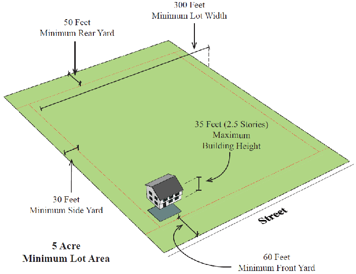
Dimensional requirements. The following dimensional requirements shall apply to development within the RC district:
Figure 18-56-C. RC Recreation Conservation District Dimensional Requirements
(d)
Supplemental district standards.
(1)
In addition to those bulk regulations listed in section 18-56(c), all development shall conform to supplemental bulk regulations as listed in section 18-67.
(2)
Where livestock is raised or kept, no structure, or storage of hay, feed, or manure, shall be located less than fifty (50) feet from a property line.
(Ord. No. 01-20, § 18.56, 2-10-20)
Sec. 18-57. - AG Agricultural district.
(a)
Intent. The agricultural district is intended to protect and preserve agricultural land uses, maintain rural character, minimize population density, and minimize the burden on public facilities and services. It is also the intent of this district to allow only low-density residential use which promotes open space preservation and is compatible with and maintains existing agricultural operations. Accordingly, the AG district allows both agricultural uses and single-family dwellings.
(b)
Use regulations. Section 18-68 sets forth permitted, accessory, and special land uses allowed in the AG district.
(c)
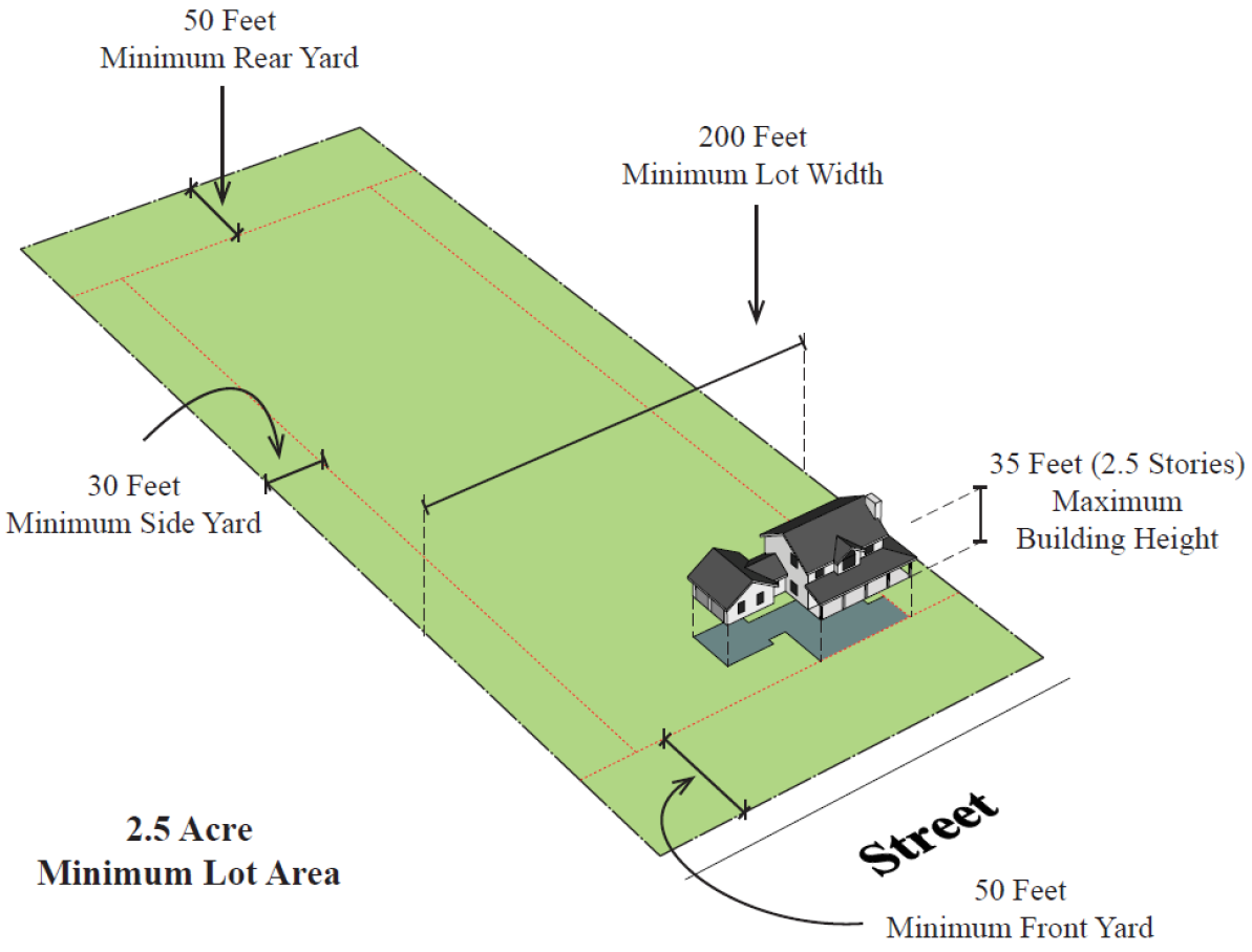
Dimensional requirements. The following dimensional requirements shall apply to development within the AG district:
Figure 18-57-C. AG Agricultural District Dimensional Requirements
(d)
Supplemental district standards.
(1)
In addition to those bulk regulations listed in section 18-57(c), all development shall conform to supplemental bulk regulations as listed in section 18-67.
(2)
Where livestock are raised or kept, no structure, or storage of hay, feed, or manure, shall be located less than fifty (50) feet from a property line.
(Ord. No. 01-20, § 18.57, 2-10-20)
Sec. 18-58. - R-1 Single family rural non-farm residential district.
(a)
Intent. The R-1 single family rural non-farm residential district is intended to accommodate low-density residential development and designed to preserve a predominantly rural character. In addition to the dwellings permitted in this zoning district, certain recreational, institutional, and public uses which have been strictly regulated to make them compatible with the principal use of this district are permitted. These lots are intended to be served by well and septic facilities, in areas where public water and sanitary sewer is not available.
(b)
Use regulations. Section 18-68 sets forth permitted, accessory, and special land uses allowed in the R-1 district.
(c)
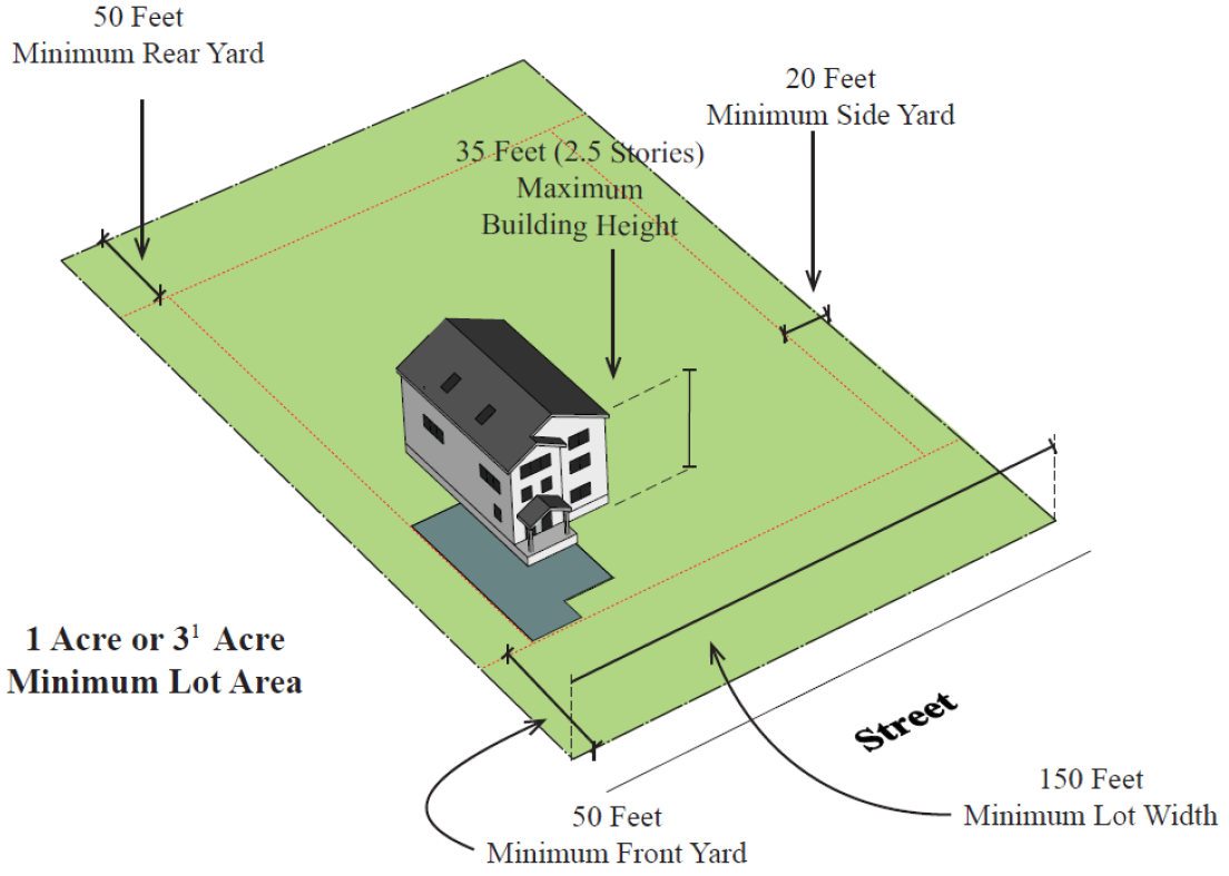
Dimensional requirements. The following dimensional requirements shall apply to development within the R-1 district:
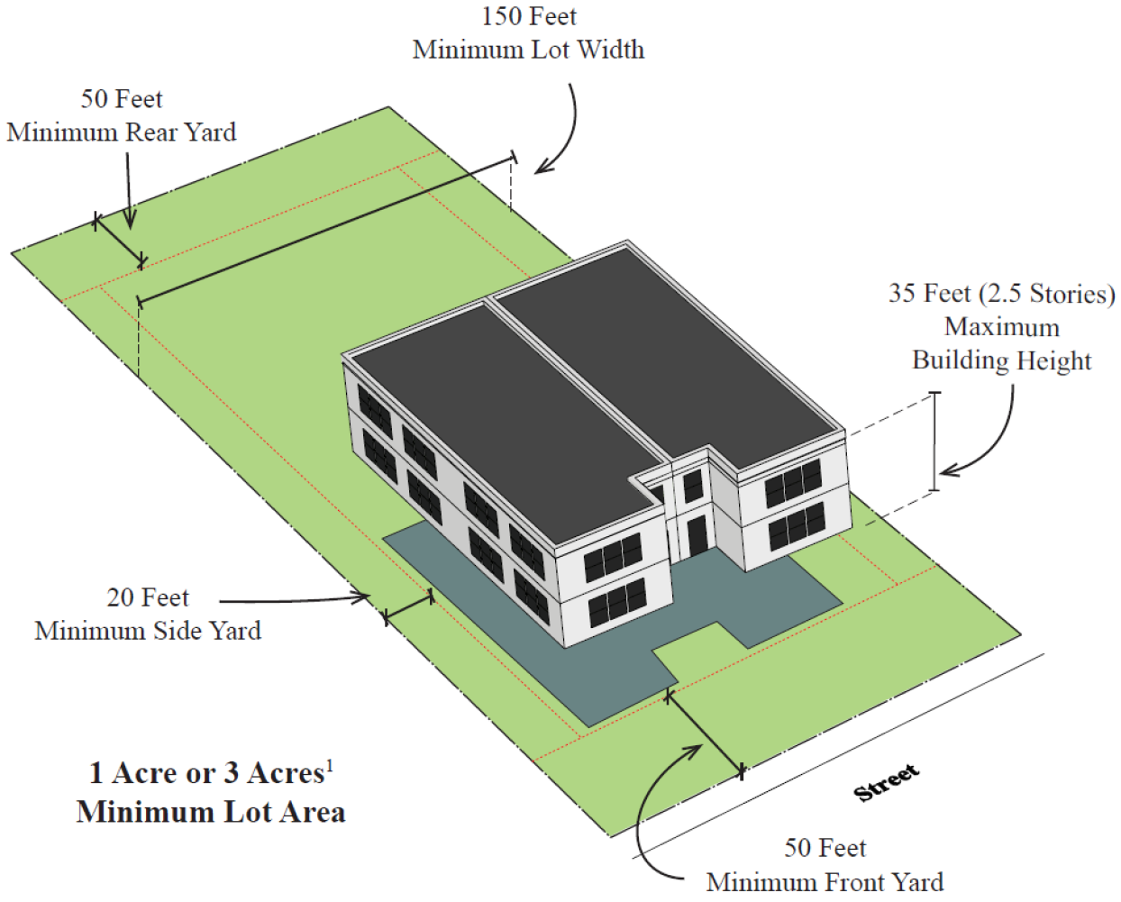
1 Minimum lot area of 1 acre for single family use and 3 acres for other principal uses.
Figure 18-58-C. R-1 Single-Family Rural Non-Farm Residential District Dimensional Requirements
(d)
Supplemental district standards.
(1)
In addition to those bulk regulations listed in section 18-58(c), all development shall conform to supplemental bulk regulations as listed in section 18-67.
(Ord. No. 01-20, § 18.58, 2-10-20)
Sec. 18-59. - R-2 Single family suburban residential district.
(a)
Intent. R-2 single-family suburban residential district is intended for moderate density areas that consist primarily of detached single-family units. The regulations of this district are designed to create predominantly suburban character in those areas which are served by public water supply and sanitary sewage systems. In addition to the dwelling permitted in this zoning district, certain civic and public land uses such as municipal buildings, schools, places of worship, and parks which have been strictly regulated to make them compatible with the principal use of this district are permitted.
(b)
Use regulations. Section 18-68 sets forth permitted, accessory, and special land uses allowed in the R-2 district.
(c)
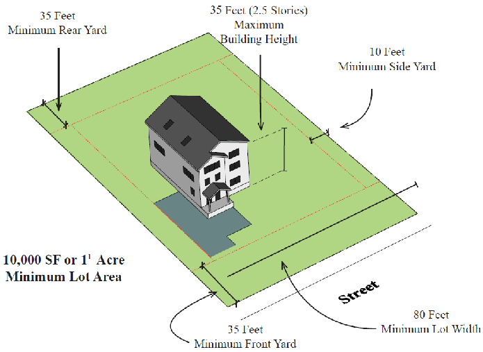
Dimensional requirements. The following dimensional requirements shall apply to development within the R-2 district:
1 Minimum lot area of 10,000 square feet for single-family use and 1 acre for other principal uses.
Figure 18-59-C. R-2 Single-Family Suburban Residential District Dimensional Requirements
(d)
Supplemental district standards.
(1)
In addition to those bulk regulations listed in section 18-59(c), all development shall conform to supplemental bulk regulations as listed in section 18-67.
(Ord. No. 01-20, § 18.59, 2-10-20)
Sec. 18-60. - RM Multiple-family residential district.
(a)
Intent. This district is intended for multiple-family units including attached and apartment-style dwelling units including townhouses, duplexes, row houses, terrace and garden-style apartments, and condominiums. This district is intended for locations that have substantial infrastructure including public utilities and should be in close proximity to mixed-use areas or local commercial areas that provide retail, personal service, entertainment, and employment opportunities. In addition to the dwellings permitted in this zoning district, certain recreational, institutional, and public uses which have been strictly regulated to make them compatible with the principal uses of this district are permitted.
(b)
Use regulations. Section 18-68 sets forth permitted, accessory, and special land uses allowed in the RM district.
(c)
Dimensional requirements. The following dimensional requirements shall apply to development within the RM district:
1 Minimum lot area of 1 acre for single-family use and 3 acres for other principal uses.
Figure 18-60-C. RM Multiple-Family Residential District Dimensional Requirements
(d)
Supplemental district standards.
(1)
In addition to those bulk regulations listed in section 18-60(c), all development shall conform to supplemental bulk regulations as listed in section 18-67.
(2)
Site plan review is required in accordance with article VI.
(3)
Accessory buildings and structures shall be regulated in accordance with the requirements of section 18-204.
(Ord. No. 01-20, § 18.60, 2-10-20)
Sec. 18-61. - MH Manufactured housing district.
(a)
Intent. The purpose of this district is to provide for the development of manufactured housing developments (mobile home parks) and to promote manufactured housing communities with the character of residential neighborhoods. It is the intent of this chapter that manufactured housing communities be located in areas which are served adequately by essential public facilities and services such as access streets, police and fire protection, and public water, sanitary sewer, and storm drainage facilities.
(b)
Use regulations. Section 18-68 sets forth permitted, accessory, and special land uses within the MH district.
(c)
Dimensional requirements. The following dimensional requirements shall apply to the MH district:
(d)
Supplemental district regulations.
(1)
Refer to section 18-164.
(Ord. No. 01-20, § 18.61, 2-10-20)
Sec. 18-62. - C Commercial district.
(a)
Intent. It is the intent of the C commercial district to allow commercial enterprises which provide convenient shopping and services addressing daily needs, as well as, serving the community-wide needs. The regulations are designed to provide compatibility with surrounding land uses and ensure the provision of adequate infrastructure.
(b)
Use regulations. Section 18-68 sets forth permitted, accessory, and special land uses within the C district.
(c)
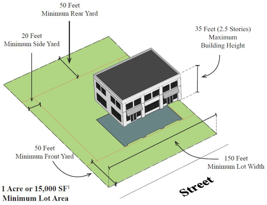
Dimensional requirements. The following dimensional requirements shall apply to development within the C district:
1 Minimum lot area of 15,000 square feet where municipal water and sanitary sewer facilities are available and 1 acre for all other sites.
Figure 18-62-C. C Commercial District Dimensional Requirements
(d)
Supplemental district standards.
(1)
In addition to those bulk regulations listed in section 18-62(c), all development shall conform to supplemental bulk regulations as listed in section 18-67.
(2)
Minimum interior side yards may not be required when two (2) or more buildings are part of a local shopping center or other combined development of local retail and/or service facilities. Side yard requirements shall apply to the perimeter of such developments.
(3)
Site plan review is required in accordance with article VI.
(4)
Accessory buildings and structures shall be regulated in accordance with the requirements of section 18-204.
(Ord. No. 01-20, § 18.62, 2-10-20)
Sec. 18-63. - MU Mixed-use district.
(a)
Intent. It is the intent of the MU mixed use district to promote development of the township's existing unincorporated village areas with a density and combination of land uses (both residential and non-residential) similar to that found in a traditional village settlement. Such districts are intended to be established as close as reasonably possible to the intended core of such village areas, with access to municipal water and sanitary sewer facilities.
(b)
Use regulations. Section 18-68 sets forth permitted, accessory, and special land uses within the MU district.
(c)
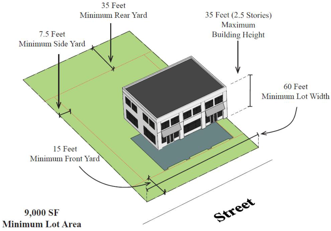
Dimensional requirements. The following dimensional requirements shall apply to development within the MU district:
Figure 18-63-C. MU Mixed Use District Dimensional Requirements
(d)
Supplemental district standards.
(1)
In addition to those bulk regulations listed in section 18-63(c), all development shall conform to supplemental bulk regulations as listed in section 18-67.
(2)
Site plan review is required in accordance with article VI.
(3)
Accessory buildings and structures shall be regulated in accordance with the requirements of section 18-204.
(Ord. No. 01-20, § 18.63, 2-10-20)
Sec. 18-64. - WM Waterfront marina district.
(a)
Intent. It is the intent of the WM waterfront marina district is to provide areas along Lake Erie, Huron River, and Swan Creek specifically for those uses and services which are marine-oriented and for related recreational, entertainment, and retail establishments.
(b)
Use regulations. Section 18-68 sets forth permitted, accessory, and special land uses within the WM district.
(c)
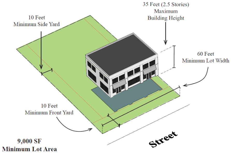
Dimensional requirements. The following dimensional requirements shall apply to development within the WM district:
Figure 18-64-C. WM Waterfront Marina District Dimensional Requirements
(d)
Supplemental district standards.
(1)
In addition to those bulk regulations listed in section 18-64(c), all development shall conform to supplemental bulk regulations as listed in section 18-67.
(2)
Site plan review is required in accordance with article VI.
(3)
Accessory buildings and structures shall be regulated in accordance with the requirements of section 18-204.
(Ord. No. 01-20, § 18.64, 2-10-20)
Sec. 18-65. - I Industrial district.
(a)
Intent. It is the intent of the I industrial district to provide areas suitable for a variety of warehousing, industrial, and manufacturing uses. The regulations for this district are designed to result in industrial areas which will be compatible with one another as well as adjacent land uses.
(b)
Use regulations. Section 18-68 sets forth permitted, accessory, and special land uses within the I district.
(c)
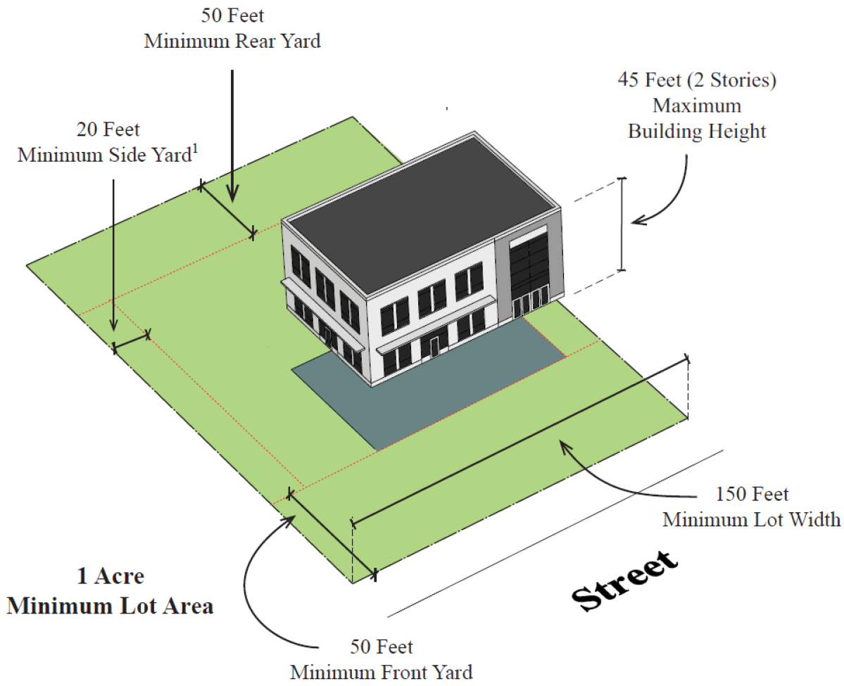
Dimensional requirements. The following dimensional requirements shall apply to development within the I district:
Figure 18-65-C. I Industrial District Dimensional Requirements
(d)
Supplemental district standards.
(1)
In addition to those bulk regulations listed in section 18-65(c), all development shall conform to supplemental bulk regulations as listed in section 18-67.
(2)
Site plan review is required in accordance with article VI.
(3)
Accessory buildings and structures shall be regulated in accordance with the requirements of section 18-204.
(4)
All goods or materials stored outside which are visible from a public road shall be screened by a fully-opaque fence or wall a minimum of six (6) feet in height.
(Ord. No. 01-20, § 18.65, 2-10-20)
Sec. 18-66. - Planned unit development districts.
For intent, location, standards, and submittal requirements for PUD planned unit development district refer to article V.
(Ord. No. 01-20, § 18.66, 2-10-20)
Sec. 18-67. - Supplemental dimensional regulations applicable to all districts.
(a)
Continued conformity with bulk regulations. The maintenance of setback, height, floor area ratio, coverage, open space, manufactured home site, buffer areas, lot area and lot area per dwelling unit required for one (1) use, lot, building, or structure shall be a continuing obligation of the owner of such building, structure, or lot on which such use, building or structure exists. No setback, height, floor area ratio, coverage, open space, manufactured home site, buffer areas, lot area, and lot area per dwelling unit allocated to, or required, or in connection with one (1) lot, use, building or structure may be allocated to any other lot, use, building, or structure.
(b)
Division of a lot or parcel. No one (1) lot or parcel, once designated and improved with a building or structure, shall be reduced in area, or divided into two (2) or more lots, and no portion of one (1) lot, once designated and improved with a building or structure, shall be sold unless each lot resulting from each such reduction, division, or sale, and designated and improved with a building or structure, will conform with all of the bulk and yard regulations of the zoning district in which it is located.
(c)
Setbacks and yard requirements. The setback and yard requirements established by this chapter shall apply to every lot, building, or structure, except for the following structures, so longs as they are located as specified below:
(1)
Unroofed masonry or concrete terraces and patios at the same level as the adjacent grade and may not be located closer than three (3) feet from a side or rear property line.
(2)
Unroofed porches and decks may not occupy a required front setback, nor be located closer than three (3) feet from a side or rear property line.
(d)
Height. The height requirements established by this chapter shall apply to every building and structure with the following exceptions provided their location shall conform to the requirements of Berlin Charter Township, the Federal Communications Commission, the Federal Aviation Administration, and other public authorities having jurisdiction:
(1)
Public utility towers, structures, transmission and distribution lines and related structures; radio and television broadcasting and receiving antennae; and water towers where the aforementioned structures are permitted in the district therein located or are a special land use in said district subject to the provisions of article VII.
(2)
Spires, belfries, and silos provided that the overall height does not exceed one hundred fifty percent (150%) of the maximum permitted building height in the district therein located.
(3)
Chimneys, ventilators, skylights, and other necessary mechanical appurtenances provided that no mechanical enclosure or penthouse shall exceed twelve (12) feet in height above the roof deck.
(4)
Parapets not exceeding three (3) feet in height above the roof deck.
(e)
Lot area/width. Buildings and structures designed to house essential services shall not be required to meet the requirements of this chapter regarding lot area or width provided, however, that such a building or structure shall meet all other regulations for the district in which it is located.
(f)
Dwelling unit minimum floor area. The minimum floor area of any single-family dwelling shall be no less than nine hundred fifty (950) square feet. Where a single-family home is constructed without a basement, an additional one hundred (100) square feet shall be added to the minimum required first floor area requirement to provide space for utilities, such as, but not limited to, furnace, hot water, laundry tubs, incinerator and the like.
(g)
Mixed use district standards. Development within the mixed use (MU) district shall conform to the following:
(1)
Residential density.
a.
The maximum permitted density of multiple-family dwellings in the MU district shall be based on the total number of bedrooms. The maximum number of bedrooms permitted shall be equal to the area of the subject parcel dedicated to multiple-family use (in square feet) divided by one thousand eight hundred (1,800). For the purposes of this calculation, efficiency units shall be considered to have one (1) bedroom.
b.
Land area to be shared between multiple-family dwellings and other uses (e.g., apartments over storefronts), shall be permitted one-half (0.5) the number of bedrooms described above under item a.
c.
Detached single-family dwellings shall occupy individual lots meeting the minimum lot size for the MU district.
(2)
Parking.
a.
Parking shall not be permitted in a required front yard.
b.
Parking areas shall be screened from view from the road through the use of a masonry screen wall at least forty-two (42) inches in height, or a continuous evergreen landscape screen of at least six (6) feet in height.
c.
Parking areas shall be setback at least ten (10) feet from all property that is zoned or used for single-family residential purposes.
d.
Shared or collective parking arrangements, in conformance with section 18-246(b)(7) are encouraged.
(3)
Building design and orientation.
a.
The maximum linear length of an uninterrupted building façade facing public streets shall be thirty (30) feet. Façade articulation or architectural design variations for building walls facing the street are required to ensure that the building is not monotonous in appearance. Building wall offsets (projections and recesses), cornices, varying building materials, or pilasters shall be used to break up the mass of a single building.
b.
Ground floor facades that face public streets shall have arcades, display windows, entry areas, awnings, or other such features along no less than fifty percent (50%) of their horizontal length. Real windows allowing daylight in the building are encouraged.
c.
Roofs.
i.
Flat roofs. Parapets concealing flat roofs and rooftop equipment such as HVAC units from public view are required.
ii.
Pitched roofs.
1.
Overhanging eaves on pitched roofs shall be a minimum of twelve (12)-inches including gutter, with a minimum one (1)-inch rake.
2.
An average slope greater than 4:12 is required.
iii.
Building materials and colors. Predominant exterior building materials shall be high quality materials, including, but not limited to: brick, stone, architectural steel, glass, stone, fiber cement, and split-faced block. Vinyl or aluminum siding shall only be used for accents. Exterior insulation finishing systems (E.I.F.S.) or similar material is not permitted as a primary building material.
iv.
Façade colors and systems shall be reviewed and approved by the planning commission as part of final site plan review.
(4)
Road/pedestrian orientation. Buildings in the MU district shall have at least one (1) entrance facing the road upon which said building fronts. Said entrance shall be connected by a concrete sidewalk of at least five (5) feet in width to any sidewalks located within the adjacent road rights-of-way.
(Ord. No. 01-20, § 18.67, 2-10-20)
Sec. 18-68. - District use table.
(a)
Specified uses. In all districts, no building or land shall be used and no building shall be erected except for one (1) or more of the following specified uses, unless otherwise provided in this article.
(b)
Schedule of uses. The schedule of use regulations identifies uses as follows:
(1)
"P" indicates uses permitted as of right.
(2)
"S" indicates uses requiring special land use approval as outlined in article VII.
(3)
No marking identifies uses not permitted in that particular zoning district.
(Ord. No. 01-20, § 18.68, 2-10-20)

