
Bloomfield Hills City Zoning Code
ARTICLE II
ZONING DISTRICTS AND MAP
DIVISION 10. - P-1 VEHICULAR PARKING DISTRICTS[2]
Cross reference— Traffic and motor vehicles generally, Ch. 20.
DIVISION 13. - PUD PLANNED UNIT DEVELOPMENT OPTION[3]
Editor's note—Ord. No. 400, § 1, adopted Oct. 9, 2012, repealed the former Div. 13, §§ 24-197—24-203, and enacted a new Div. 13 as set out herein. The former Art. X pertained to similar subject matter and derived from Ord. No. 360, § 1, adopted June 12, 2007.
Sec. 24-21. - Districts enumerated.
For the purpose of this chapter, the city is hereby divided into the following districts:
(Ord. No. 188, § 300, 11-8-83)
Sec. 24-22. - Zoning maps.
Each area shall be set forth on maps containing such information as may be acceptable to the city commission and showing by appropriate means the various districts into which the area is divided, which maps shall be entitled, "Zoning District Map of Bloomfield Hills" and shall bear the date adopted or amended and it shall be the duty of the city clerk to authenticate such records by placing his official signature thereon. Such maps with all explanatory matter thereon, are hereby made a part of this chapter and shall be as much a part of this chapter as if the matter and information set forth thereon were all fully described in this chapter.
(Ord. No. 188, § 301, 11-8-83)
Sec. 24-23. - District boundaries.
Where uncertainty exists with respect to the boundaries of any of the districts established in this chapter as shown on the zoning district maps, the following rules shall be applied:
(1)
Where district boundaries are indicated as approximately following the center line of streets or highways, street lines or highway right-of-way lines, such center lines, street lines or highway right-of-way lines shall be construed to be the boundaries.
(2)
Where district boundaries are so indicated that they approximately follow the lot lines, such lot lines shall be construed to be the boundaries.
(3)
Where district boundaries are so indicated that they are approximately parallel to the center lines of streets, or the center lines or right-of-way lines of highways, such district boundaries shall be construed as being parallel thereto and at such distance therefrom as indicated on the zoning map. If no such distance is given, such dimension shall be determined by the use of the scale shown on the zoning map.
(4)
Where the boundary of a district follows a subdivision boundary line, such boundary line shall be construed to be the district boundary line.
(5)
Where, due to the scale, lack of detail, or illegibility of the zoning map accompanying this chapter, there is any uncertainty, contradiction, or confliction as to the intended location of any district boundaries shown thereon, interpretation concerning the exact location of district boundary lines shall be determined upon written application to, or upon its own motion, by the zoning board of appeals.
(Ord. No. 188, § 302, 11-8-83)
Sec. 24-24. - Zoning of vacated areas.
Whenever any street, alley or other public way within the city shall be vacated, such street, alley or other public way or portion thereof shall automatically be classified in the same zone district as the property to which it attaches.
(Ord. No. 188, § 303, 11-8-83)
Sec. 24-25. - Zoning of annexed areas.
Any area annexed to the city shall immediately upon such annexation be automatically classified as an A-1 district until a zoning map for the area has been adopted by the city commission. The planning commission shall recommend appropriate zoning for such area within three (3) months after the matter is referred to it by the city commission.
(Ord. No. 188, § 304, 11-8-83)
Sec. 24-26. - District requirements.
All buildings and uses in any district shall be subject to the provisions of Article III, General Exceptions, and Article IV, General Provisions.
(Ord. No. 188, § 305, 11-8-83)
Sec. 24-41. - Purpose.
One-family residential districts (A-1 through A-4) are designed to provide for one-family dwelling sites and residentially related uses in keeping with the existing low-density character of the city. The preservation of the natural terrain and the standards under which the community has had its development take place is reflected in the controls set forth in this division.
(Ord. No. 188, Art. IV, 11-8-83)
Sec. 24-42. - Principal uses permitted.
In a one-family residential district (A-1 through A-4), no building or land shall be used and no building shall be erected for one (1) or more of the following specified uses unless otherwise provided in this chapter:
(1)
One-family detached dwellings;
(2)
Buildings and uses, and property of the city;
(3)
Golf and country clubs and riding and hunt clubs subject to the review and approval of the zoning board of appeals as to conformity with the following conditions:
a.
On a lot occupied by a building other than a one-family residential unit, in which persons congregate, or which is designed, arranged, remodeled or normally used for the congregation of persons in excess of twenty-five (25) persons, the width of side yards shall be increased four (4) feet for each twenty-five (25) persons or fraction thereof in excess of twenty-five (25) persons for the accommodation of whom the building is designed, arranged, remodeled or normally used.
b.
All ingress and egress from the site shall be directly onto a major or secondary thoroughfare as designated in the major thoroughfare plan.
c.
The off-street parking and general site plan layout and its relationships to all adjacent lot lines shall be reviewed by the zoning board of appeals, which may impose any reasonable restrictions or requirements so as to ensure that contiguous residential areas will be adequately protected in carrying out the intent of the above standards.
(4)
Churches, church houses and parish houses subject to review and approval of the zoning board of appeals as to conformity with the following conditions:
a.
Any facilities normally incident thereto shall be a part of an integrated unit plan upon the same or adjacent property.
b.
The site shall be so located as to provide for ingress and egress from the site directly onto a major or secondary thoroughfare as designated in the major thoroughfare plan.
c.
The provisions of section 24-235 shall apply.
(5)
Accessory uses customarily incident to any of the above permitted uses including not more than one (1) private garage, and including signs pertaining to the sale, lease or use of a lot or building placed thereon. Dwellings for the use of the servants or employees of the owner, lessee or occupant of the principal dwelling on a lot shall be considered accessory buildings. Private garages may or may not have living quarters for servants and may or may not have a contiguous area for parking.
(Ord. No. 188, § 400, 11-8-83)
Sec. 24-43. - Area and bulk requirements.
See section 24-196, the provisions of which limit the height and bulk of buildings, the minimum size of lot as permitted by land use, and maximum density permitted for one-family residential districts (A-1 through A-4).
(Ord. No. 188, § 401, 11-8-83)
Sec. 24-44. - Open space preservation option.
The standards set forth in the Schedule of Regulations [section 24-196] shall be modified, at the option of the landowner, to allow the number of dwelling units that would be permitted in A-1 through A-4 districts on a total development parcel, to be located on eighty (80) percent of the land area (including street right-of-way) being developed, provided that twenty (20) percent of the land area remains in an undeveloped state. Such undeveloped state shall be maintained in perpetuity, and such modifications shall be subject to the following conditions:
(1)
Density calculation. The maximum density of dwelling units shall be determined by the number of lots or sits that could be developed under a conventional layout of the parcel that meets the area and width requirements of the district and that complies with all other applicable laws and ordinances.
a.
A parallel plan shall be submitted to the planning commission in order to establish the maximum permitted density. The parallel plan shall illustrate how a parcel could be developed under the conventional standards of the zoning district in which the property is situated along with the requirements of all other applicable state and municipal regulations and standards. The parallel plan shall result in lots with building envelopes of sufficient size, taking into consideration topography, easements or encumbrances, drainage, retention/detention areas, along with all necessary road and road-related improvements, without impacting natural areas or features required to be preserved under applicable law or ordinance. All unbuildable areas and areas with limitations to development must be accurately identified on the parallel plan including, but not limited to, wetlands, watercourses, drains, floodplains and similar features. It is not the intent of this provision to require detailed engineering in preparation of this plan, however, the plan must realistically take into consideration the natural assets and constraints of the property.
b.
The planning commission shall find that the parallel plan could meet all applicable city ordinance requirements, and then, based on the parallel plan, make a determination as to the number of units that will be permitted.
(2)
Development requirements. The minimum lot width and setback requirements of the district in which the parcel is located, shall be provided for each home site. Attached units shall not be permitted. Setbacks determined by formula shall not be applicable under this option.
(3)
Review by planning commission. The planning commission shall hold a public hearing, review the documents submitted for the open space preservation option and make a determination as to the suitability of the proposal as set forth in section 24-248, Open space preservation.
(Ord. No. 330, § 2, 12-10-02)
Sec. 24-56. - Purpose.
(a)
The A-S one-family detached districts are designed and intended to permit the development of detached one-family residential cluster patterns where transition can be achieved between a more intensive residential use and existing one-family development. This pattern is specifically provided so as to permit the most sound development of oddly shaped parcels, permitting the placement of residential structures on one portion of the parcel so as to recognize the physical limitations of the site.
(b)
It is intended that the detached one-family residential cluster units developed in this division be clearly similar in character to the one-family dwellings permitted in the A-1 through A-4 districts so as to permit a sound physical integration of such cluster developments with the adjacent residential districts.
(Ord. No. 188, Art. V, 11-8-83)
Sec. 24-57. - Principal uses permitted.
In an A-5 one-family detached district no building or land shall be used and no building shall be erected except for one (1) or more of the following specified uses unless otherwise provided in this chapter:
(1)
Any use permitted in an A-4 one-family residential district, as detailed in section 24-42;
(2)
Clustering as one-family detached units when such dwelling units are placed about a court in close proximity to one another but clearly separated with side yards. The maximum number of units so constructed shall not exceed four (4) in cluster.
(Ord. No. 188, § 500, 11-8-83)
Sec. 24-58. - Site considerations.
In reviewing the plans and approving the application of this section to a particular site in an A-5 one-family detached district, the planning commission shall require the following:
(1)
A landscaped greenbelt, fifty (50) feet in width, shall be provided on those sides abutting one-family residential districts so as to serve as a physical transition between the cluster development and abutting one-family districts. Where necessary, a berm shall be erected in this greenbelt area to more effectively effect the visual transition. The greenbelt may be used in area computations in establishing density.
(2)
In those areas where development is planned to abut a major thoroughfare, provision shall be made for a marginal access service drive.
(3)
Plans submitted shall be subject to section 24-236.
(4)
Access roads and service drives within the development area may be developed as private roads. Wherever the planning commission finds that a road through the development area is required as a public thoroughfare so as to afford continuity to the municipality's street system, such road shall be dedicated as a public road to the municipality at the standards set forth in the subdivision chapter. All public roads shall be excluded from the land area used to compute density.
(Ord. No. 188, § 501, 11-8-83)
Sec. 24-59. - Area, bulk and yard requirements.
(a)
See section 24-196, the provisions of which limit the height and bulk of buildings and the minimum size of lot as permitted by land use for A-5 one-family detached districts.
(b)
The following additional yard requirements shall also be provided:
(1)
On that side of a cluster adjacent to a dedicated street or marginal access drive, front yards shall be equal to at least forty (40) feet.
(2)
Spacing between detached units shall be at least twenty (20) feet, measured between the nearest point of each unit.
(3)
Spacing between any unit in a cluster and an abutting existing recorded subdivision zoned as a one-family residential district shall be equal to at least one hundred (100) feet, including the fifty-foot berm or greenbelt when required, measured between the nearest point of an individual unit in a cluster grouping and the property line of the one-family residential district.
(4)
The minimum distance between a boundary line and any point on a cluster unit shall be forty (40) feet.
(Ord No 188, § 502, 11-8-83)
Sec. 24-60. - Open space preservation option.
The standards as set forth in the Schedule of Regulations [section 24-196] shall be modified at the option of the landowner, to allow the number of dwelling units that would be permitted in A-5 district on a total development parcel, to be located on eighty (80) percent of the land area (including street right-of-way) being developed, provided that, twenty (20) percent of the land area remains in an undeveloped state. Such undeveloped state shall be maintained in perpetuity, and such modifications shall be subject to the following conditions:
(1)
Development requirements.
a.
The density of dwelling units shall not exceed one and three-tenths (1.3) units per acre.
b.
The minimum area, bulk and setback requirements of the A-5 district shall be provided for each home site. The attaching of units shall not be permitted. Plans shall include building envelopes that will illustrate the maximum area to be occupied by the buildings. If there are significant natural features that cannot be preserved by adhering to the minimum requirements of the ordinance, the planning commission may alter the minimum requirements, except for minimum standards that are required because the parcel abuts a one-family dwelling district.
(2)
Review by planning commission. The planning commission shall hold a public hearing, review the documents submitted for the open space preservation option and make a determination as to the suitability of the proposal as set forth in section 24-248, Open space preservation.
(Ord. No. 330, § 3, 12-10-02)
Sec. 24-71. - Purpose.
The A-6 one-family attached districts are designed and intended to permit the development of attached one-family residential cluster patterns which, through design innovation, will introduce flexibility so as to provide for the sound physical handling of site plans in situations where the normal subdivision approach would otherwise be restrictive.
(Ord. No. 188, Art. VI, 11-8-83)
Sec. 24-72. - Principal uses permitted.
In an A-6 one-family attached district, no building or land shall be used and no building shall be erected except for one (1) or more of the following specified uses unless otherwise provided in this chapter:
(1)
Any use permitted in an A-5 one-family cluster detached district, as detailed in section 24-57.
(2)
Clustering as one-family attached units subject to the following:
a.
The attaching of units shall be accomplished by means of a common party wall which does not have over thirty (30) percent of its wall area or any floor in common with an abutting dwelling unit wall; by means of an architectural wall detail which does not form an interior room space; or through a common party wall in only the garage portion of adjacent structures, there being no common party wall relationship permitted through any other portion of the residential unit.
b.
The maximum number of attached units shall not exceed four (4) per cluster.
c.
Any courtyard, atrium or similar uncovered area between attached units shall be of sufficient width and area as will, in the judgment of the planning commission, provide for a usable outdoor living area.
(Ord. No. 188, § 600, 11-8-83)
Sec. 24-73. - Site considerations.
In reviewing the plans and approving the application of this section to a particular site in an A-6 one-family attached district, the planning commission shall require the following:
(1)
A landscaped greenbelt, fifty (50) feet in width, shall be provided on those sides abutting one-family residential districts so as to serve as a physical transition between the cluster development and abutting one-family districts. Where necessary, a berm shall be erected in this greenbelt area to effect visual transition. Such greenbelt may be used in area computations in establishing density.
(2)
In those areas where development is planned to abut a major thoroughfare, provision shall be made for a marginal access service drive.
(3)
Plans submitted shall be subject to section 24-236.
(4)
Access roads and service drives within the development area may be developed as private roads. Wherever the planning commission finds that a road through the development area is required as a public thoroughfare so as to afford continuity to the municipality's street system, such road shall be dedicated as a public road to the municipality at the standards set forth in the subdivision chapter. All public roads shall be excluded from the land area used to compute density.
(Ord. No. 188, § 601, 11-8-83)
Sec. 24-74. - Area, bulk and yard requirements.
(a)
See section 24-196, the provisions of which limit the height and bulk of buildings and the minimum size of lot as permitted by land use in A-6 one-family attached districts.
(b)
The following additional yard requirements shall also be provided:
(1)
On that side of a cluster adjacent to a dedicated street or marginal access drive, front yards shall be equal to at least forty (40) feet.
(2)
Spacing between groups of attached units shall be at least thirty (30) feet, measured between the nearest of two (2) or more groupings.
(3)
Spacing between a group of attached units and a detached unit shall be at least thirty (30) feet, measured between the nearest points of the attached group and the detached unit.
(4)
Spacing between detached one-family cluster units shall be at least twenty (20) feet, measured between the nearest point of each unit.
(5)
Spacing between any unit in a cluster and an abutting existing recorded subdivision zoned as a one-family residential district shall be equal to at least one hundred (100) feet, including the fifty-foot berm or greenbelt when required, measured between the nearest point of any individual unit in a cluster grouping and the property line of the one-family residential district.
(6)
The minimum distance between a boundary line and any point on a cluster unit shall be forty (40) feet.
(7)
Units in a cluster grouping shall be varied relative to their minimum front setback so as to create a stepped effect, placing any one (1) unit at least fifteen (15) feet forward or to the rear of the front building line of the immediately adjacent unit.
(8)
So as to accomplish a unified appearance, the units in each cluster grouping shall be constructed of similar materials and shall have one (1) architectural style applied. The building facades, in their overall treatment, shall be so varied as not to give the appearance of repetition. All off-street parking shall be provided within a fully enclosed garage space which shall be attached to the living space which they serve through a common party wall.
(Ord. No. 188, § 602, 11-8-83)
Sec. 24-75. - Open space preservation option.
The standards as set forth in the Schedule of Regulations [section 24-196] shall be modified, at the option of the landowner, to allow the number of dwelling units that would be permitted in A-6 district on a total development parcel, to be located on eighty (80) percent of the land area (including street right-of-way) being developed, provided that, twenty (20) percent of the land area remains in an undeveloped state. Such undeveloped state shall be maintained in perpetuity, and such modifications shall be subject to the following conditions:
(1)
Development requirements.
a.
The density of dwelling units shall not exceed three (3) units per acre.
b.
The minimum area, bulk and setback requirements of the A-6 district shall be provided. Plans shall include building envelopes that will illustrate the maximum area to be occupied by buildings. If there are significant natural features that cannot be preserved by adhering to the minimum requirements of the ordinance, the planning commission may alter the minimum requirements, except for minimum standards that are required because the parcel abuts a one-family dwelling district.
(2)
Review by planning commission. The planning commission shall hold a public hearing, review the documents submitted for the open space preservation option and make a determination as to the suitability of the proposal as set forth in section 24-248, Open space preservation.
(Ord. No. 330, § 4, 12-10-02)
Sec. 24-86. - Purpose.
B-1 multiple-family dwelling districts are designed to provide sites for multiple dwelling structures which will serve as zones of transition between the commercial district and the low-density single-family residential areas. The multiple dwelling districts are further provided to serve the limited needs for the apartment type of unit in an otherwise low-density, single-family community.
(Ord. No. 188, Art. VII, 11-8-83)
Sec. 24-87. - Principal uses permitted.
In a B-1 multiple-family dwelling district no building or land shall be used and no building shall be erected except for one (1) or more of the following specified uses unless otherwise provided in this chapter:
(1)
Any use or accessory use, customarily incidental thereto permitted in an A-4 one-family residential district subject, however, to the minimum restrictions applicable to that district, except that the front yard depth on Woodward Avenue shall be a minimum of seventy-five (75) feet, and except that the minimum lot area for a single dwelling shall be thirty thousand (30,000) square feet;
(2)
Multiple dwellings when such dwelling units are attached through a common party wall which does not have over seventy-five (75) percent of its wall area on any floor in common with an abutting dwelling unit wall;
(3)
Accessory buildings and uses customarily incident to any of the above permitted uses.
(Ord. No. 188, § 700, 11-8-83)
Sec. 24-88. - Uses permitted on special approval.
The following uses shall be permitted in B-1 multiple-family dwelling districts after the zoning board of appeals, upon review of the plans, finds that the plans meet the conditions required by this division:
(1)
Townhouses not to exceed a height of three (3) stories (or thirty-five (35) feet) when the following conditions are met:
a.
All such multiple units shall be permitted only as a part of a planned development occupying a parcel of at least five (5) acres or more and under one (1) ownership at the time of development.
b.
All three-story multiples permitted under this section shall be set back at least one hundred fifty (150) feet from any abutting street and at least one hundred fifty (150) feet from any single dwelling district at such point.
c.
Densities shall not exceed those outlined under footnote (k) of section 24-196.
d.
The site plan shall be so arranged as to provide ingress into and egress from the multiple dwelling area directly onto a major thoroughfare or secondary thoroughfare as designated on the major thoroughfare plan.
(2)
Accessory buildings and uses customarily incidental to any of the above permitted uses.
(Ord. No. 188, § 701, 11-8-83)
Sec. 24-89. - Area, bulk and yard requirements.
(a)
See section 24-196, the provisions of which limit the height and bulk of buildings, the minimum size of lot permitted by land use, and maximum density for those uses permitted under sections 24-87 and 24-88 for B-1 multiple-family dwelling districts.
(b)
A landscaped greenbelt, fifty (50) feet in width, shall be provided on those sides abutting one-family residential or one-family detached or attached districts so as to serve as a physical transition between the multiple-family development and abutting one-family districts. Where necessary, a berm shall be erected in this greenbelt area to effect visual transition. Such greenbelt may be used in area computations in establishing density.
(c)
Spacing between any building in a multiple-family development and an abutting existing recorded subdivision zoned as a one-family residential district shall be equal to at least one hundred (100) feet, including the fifty-foot berm or greenbelt when required, mea-sured between the nearest point of any building in a multiple-family development and the property line of the one-family residential district.
(Ord. No. 188, § 702, 11-8-83; Ord. No. 204, § 1, 2-10-87)
Sec. 24-101. - Purpose.
The C-1 commercial districts are designed to perform a twofold function in the area of the commercial needs of the city. They are designed to cater to the convenience of retail shopping of persons residing in adjacent residential areas and permit such other uses as are necessary to satisfy those specialized service needs of the residents of the city.
(Ord. No. 188, Art. VIII, 11-8-83)
Sec. 24-102. - Principal uses permitted.
In a C-1 commercial district no building or land shall be used and no building shall be erected except for one (1) or more of the following specified uses unless otherwise provided in this chapter:
(1)
Any generally recognized retail business which supplies commodities on the premises within a completely enclosed building, such as but not limited to food, drugs, liquor, dry goods and notions or hardware;
(2)
Any personal service establishment which performs services on the premises within a completely enclosed building for persons residing in the adjacent residential areas, such as but not limited to repair shops (watches, radio, television, shoe, etc.), tailor shops, beauty parlors, barbershops, interior decorators or dry cleaners;
(3)
Restaurants and taverns where the patrons are served while seated within the building occupied by such establishment, and where such establishment does not extend as an integral part of or accessory thereto any service of a drive-in or open front nature;
(4)
Theaters when completely enclosed;
(5)
Offices and office buildings of an executive, administrative or professional nature;
(6)
Banks, including drive-up facilities and automated teller machines as an accessory use only;
(7)
Municipal buildings and post offices;
(8)
Public utility offices, telephone exchanges, and public utility substations when in a completely enclosed building, although not necessarily roofed;
(9)
Hotels;
(10)
Bowling alleys;
(11)
Retail package outlets, including specially designated distributor (SDD) and specially designated merchant (SDM) licensed outlets shall be permitted in a C-1 commercial district subject to the following criteria:
a.
All retail package outlets shall be at least two thousand six hundred forty (2,640) feet from any other licensed outlet.
b.
Only one (1) SDD license shall be issued for every three thousand (3,000) of population or fraction thereof.
(12)
Other uses, which in the determination of the zoning board of appeals, are similar to the above and subject to the following restrictions:
a.
All business establishments shall be retail or service establishments dealing directly with consumers. All goods produced on the premises shall be sold at retail on the premises where produced.
b.
All business, servicing or processing except for off-street parking or loading shall be conducted within completely enclosed buildings.
c.
Outdoor storage of commodities shall be expressly prohibited.
(13)
Accessory buildings and uses customarily incidental to any of the above permitted uses;
(14)
Mechanical amusement devices may be permitted as accessory uses only to establishments which have been issued a Class C liquor license by the state, subject to review and approval by the zoning board of appeals.
(Ord. No. 188, § 800, 11-8-83; Ord. No. 380, §§ 1, 2, 12-8-09)
Sec. 24-103. - Special conditions.
The hours of operation of all retail and service commercial establishments permitted in the C-1 commercial district shall be as set forth in the appropriate ordinance of the city.
(Ord. No. 188, § 801, 11-8-83)
Sec. 24-104. - Area and bulk requirements.
See section 24-196, the provisions of which limit the height and bulk of buildings, and the minimum size of lot as permitted by land use in C-1 commercial districts.
(Ord. No. 188, § 802, 11-8-83)
Sec. 24-116. - Purpose.
The O-1 office districts are designed to accommodate office buildings and uses and basic personal services and are, as a use district, intended to serve the function of land use transition between the commercial districts, major thoroughfares and the adjacent residential districts.
(Ord. No. 188, Art. IX, 11-8-83)
Sec. 24-117. - Principal uses permitted.
In an O-1 office district no building or land shall be used and no building shall be erected except for one (1) or more of the following specified uses unless otherwise provided in this chapter:
(1)
Office buildings for any of the following occupations: executive, administrative and professional;
(2)
Medical and dental offices, including clinics;
(3)
Banks, not including drive-up facilities but permitting a drive-up facility with tellers and/or automated teller machines as an accessory use and only when the automated teller window and/or machines are located within the main building or located on the outside walls of the main building.
(4)
Municipal buildings and public utility offices, but not including storage yards, transformer stations, exchanges or substations;
(5)
Other uses similar to the above and subject to review and approval by the zoning board of appeals;
(6)
Accessory buildings and uses customarily incidental to any of the above permitted uses.
(Ord. No. 188, § 900, 11-8-83; Ord. No. 240, § 1, 11-13-90)
Sec. 24-118. - Area and bulk requirements.
See section 24-196, the provisions of which limit the height and bulk of buildings and the minimum size of lot as permitted by land use in O-1 office districts.
(Ord. No. 188, § 901, 11-8-83)
Sec. 24-131. - Purpose.
The O-2 office districts are designed and intended to accommodate the development of office campuses or larger office buildings and restricted retail and service uses. A major purpose of these districts to provide attractive settings so that these areas of the community will basically create an office environment and permit related uses similar in development to the office uses. These uses are not intended to serve as a transitional space between residential districts and nonresidential districts or major thoroughfares.
(Ord. No. 188, Art. X, 11-8-83)
Sec. 24-132. - Principal uses permitted.
In an O-2 office district no building or land shall be used and no building shall be erected except for one (1) or more of the following specified uses unless otherwise provided in this chapter:
(1)
Any use permitted in an O-1 office district as detailed in section 24-117.
(2)
Additional uses shall be permitted after the planning commission finds that they meet the following standards:
a.
Related and reasonably necessary or convenient for the satisfactory and efficient operation of a complete and integrated office district;
b.
Similar in character to one or more of the uses permitted under subsection (1) of this section;
c.
Of the character of a personal service, administrative service, or limited retail business establishment; located, designed and intended to serve only persons working within the office complex;
d.
Of such character that the vehicular traffic generated by such use is similar to one (1) or more of the above permitted uses and that it does not require frequent short-term stops by vehicles in a pattern similar to a retail establishment serving the general public.
(Ord. No. 188, § 1000, 11-8-83)
Sec. 24-133. - Area and bulk requirements.
See section 24-196, the provisions of which limit the height and bulk of buildings and the minimum size of lot as permitted by land use in O-2 office districts.
(Ord. No. 188, § 1001, 11-8-83)
Sec. 24-146. - Purpose.
The I-1 institutional districts are designed to provide sites for institutional uses serving an area which, in many instances, is larger than the corporate area of the city. It is the specific intent of this district to provide for sites which will service the basic needs of people residing in the immediate geographic area of the city.
(Ord. No. 188, Art. XI, 11-8-83; Ord. No. 205, § 1, 11-10-87)
Sec. 24-147. - Principal uses permitted.
In an I-1 institutional district no building or land shall be used and no building shall be erected except for one (1) or more of the following specified uses unless otherwise provided in this chapter:
(1)
Public, parochial and other private elementary, intermediate and/or high schools offering courses in general education.
(2)
Churches and/or religious retreat facilities. A columbarium park shall be permitted as an accessory use to a church, but not a religious retreat facility, after review and approval by the planning commission of a site plan submitted in accordance with section 24-236, subject to the following conditions:
a.
No part of the columbarium park may be located within a required yard.
b.
All structures located within the columbarium park shall be no more than four (4) feet in height and shall be compatible with the architecture of the church.
c.
Exterior building materials used on any structure shall be comparable to and compatible with those materials used on the principal structure.
d.
The columbarium park shall be located upon and not exceed five (5) percent of the area of the lot upon which the principal use is located.
e.
The columbariums shall be totally obscured from the view of adjacent property by a suitable wall or greenbelt as approved by the planning commission.
f.
The area occupied by the columbarium park shall not be considered as landscaped open space for the purpose of computing the minimum landscaped open space requirement of section 24-196.
(3)
Municipal buildings.
(4)
Museums and libraries.
(5)
Other institutional uses similar to those above and of no more objectionable character and which, in the opinion of the planning commission, will not be injurious or have an adverse affect on the adjacent areas.
(6)
Colleges, universities and other such institutions of higher learning, public and private, offering courses in general education and not operated for profit shall be permitted subject to the review and approval by the planning commission subject to the following conditions:
a.
Any use permitted in this division shall be developed only on sites of at least forty (40) acres in area and shall not be permitted on any portion of a recorded plat.
b.
All ingress and egress from such site shall be directly on a major or secondary thoroughfare as designated in the major thoroughfare plan.
c.
No building shall be closer than one hundred (100) feet from a property line with the exception of a dormitory or residential type structure in which instance the structure shall be set back at least seventy-five (75) feet from any property line.
(7)
Convalescent homes shall be permitted where no adjacent property is within any one-family district. Where such activity is adjacent to any one-family district, it shall be subject to review and approval by the planning commission as having met the following conditions:
a.
The site shall be developed to create a land to building ratio on the lot or parcel whereby for each one (1) bed in the development, there shall be provided not less than three thousand five hundred (3,500) square feet of open land. The three thousand five hundred (3,500) square feet of open land area per bed shall provide for landscape setting, off-street parking, service drives, loading space and yard requirements.
b.
No building shall be closer than one hundred (100) feet from any property line of a one-family district.
c.
All ingress and egress from such site shall be directly onto a major or secondary thoroughfare as designated in the major thoroughfare plan.
(8)
Nonprofit clubs when permitted by the planning commission upon its finding that its chief activity is something other than a service customarily carried on as a business and that its operation would not be a nuisance or injurious to the surrounding neighborhood and not contrary to the spirit and purpose of this chapter.
(9)
Accessory uses customarily incident to any of the above permitted uses.
(Ord. No. 188, § 1100, 11-8-83; Ord. No. 195, § 2, 12-11-84; Ord. No. 355, § 2, 12-12-06)
Sec. 24-148. - Area and bulk requirements.
See section 24-196, the provisions of which limit the height and bulk of buildings, and the minimum size of lot as permitted by land use in I-1 institutional districts.
(Ord. No. 188, § 1101, 11-8-83)
Sec. 24-161. - Purpose.
The P-1 vehicular parking districts are designed to accommodate the off-street parking for those nonresidential uses which are not able to provide adequate space within their own district boundaries.
(Ord. No. 188, Art. XII, 11-8-83)
Sec. 24-162. - Uses permitted.
Premises in P-1 vehicular parking districts shall be used only for an off-street vehicular parking area and shall be developed and maintained subject to such regulations as are provided in this division.
(Ord. No. 188, § 1200, 11-8-83)
Sec. 24-163. - Limitation of use.
(a)
The parking area in a P-1 vehicular parking district shall be accessory to, and for use in connection with one (1) or more business or office establishments, or in connection with one (1) or more existing institutional, office building or business uses.
(b)
The parking area shall be used solely for parking of private passenger vehicles.
(c)
No commercial repair work or service of any kind, or sale or display thereof, shall be conducted in such parking area.
(d)
No signs of any kind, other than signs designating entrances, exits and conditions of use shall be maintained on such parking area.
(e)
No building other than those for shelter of attendants shall be erected upon the premises and they shall not exceed fifteen (15) feet in height.
(f)
Such parking lots shall be situated on premises which have an area of not less than four thousand (4,000) square feet, unless otherwise permitted by the zoning board of appeals.
(Ord. No. 188, § 1201, 11-8-83)
Sec. 24-164. - Entrances and exits.
(a)
Plans for the layout of the parking area in a P-1 vehicular parking district shall be in the manner provided in section 24-231.
(b)
Adequate entrances and exits for vehicles to premises used as a parking area shall be provided and shall be by means of streets or alleys adjacent to or extending through C-1, O-1, O-2 or I-1 districts, or by means of private roadways extending through such districts. All such roadways shall be surfaced in a manner at least equivalent with that which is provided in this division for the parking area.
(c)
Each entrance to and exit from such parking lot shall be at least twenty (20) feet distant from any adjacent property located in any residential district.
(Ord. No. 188, § 1202, 11-8-83)
Sec. 24-165. - Minimum distances and setbacks.
(a)
Side yards. Where the P-1 vehicular parking district is contiguous to side lot lines of premises within a residentially zoned district, the required wall shall be located at least five (5) feet from the side lot line adjacent to the residential unit, or adjacent residential district.
(b)
Front yards. Where the P-1 vehicular parking district is contiguous to a residentially zoned district which has a common frontage on the same block, there shall be a setback equal to the required residential setback for such residential district. The required wall shall be located on this minimum setback line.
(Ord. No. 188, § 1203, 11-8-83)
Sec. 24-166. - Screening and landscaping.
Screening and landscaping in P-1 vehicular parking districts are subject to the provisions of section 24-235.
(Ord. No. 188, § 1204, 11-8-83)
Sec. 24-167. - Surface of parking area.
In P-1 vehicular parking districts the parking area shall be provided with concrete or asphalt pavement having a permanent, durable and dustless surface and shall be graded and drained as to dispose of all surface water accumulated within the area. The parking area shall be surfaced within one (1) year of occupancy of the use it is to serve if it is for a new use, and within six (6) months of the effective date of the rezoning for P-1 vehicular parking use if the parking area is to be served an existing use or uses. Suitable bond shall be provided to ensure completion of paving within the specified time after issuance of the certificate of occupancy or rezoning for parking use.
(Ord. No. 188, § 1205, 11-8-83)
Sec. 24-168. - Lighting.
Lighting in P-1 vehicular parking districts is subject to the provisions of section 24-235.
(Ord. No. 188, § 1206, 11-8-83)
Sec. 24-169. - Approval and modifications.
(a)
Plans for the development of any P-1 vehicular parking area must be approved by the planning commission before construction is started, and prior to the issuance of a permit for parking purposes.
(b)
The planning commission, upon application by the property owner of the parking area, may modify the yard and wall requirements where, in unusual circumstances, no good purpose would be served by compliance with the requirements of this division.
(c)
In all cases where such a wall extends to an alley which is a means of ingress and egress to a parking area, it shall be permissible to end the wall not more than ten (10) feet from such alley line in order to permit a wider means of access to the parking area.
(Ord. No. 188, § 1207, 11-8-83)
Sec. 24-170. - No additional properties to be zoned P-1.
Except for properties that as of December 12, 2023 are zoned P-1 vehicular parking, no additional and/or other properties shall be zoned or rezoned to P-1 vehicular parking after December 12, 2023.
(Ord. No. 458, § 1, 12-12-23)
Sec. 24-181. - Uses permitted.
In an RR railroad district, no structure or premises shall be erected or used except for those facilities required to permit efficient operation of moving railroad equipment, passenger stations, bridges and similar uses. It is specifically the intention of this section not to include uses permitted in other districts nor uses not mentioned in this section which are, in the opinion of the zoning board of appeals, not of a similar nature.
(Ord. No. 188, § 1300, 11-8-83)
Sec. 24-196. - Standards limiting height, bulk, setbacks, density and area by land use.
The following are standards limiting height, bulk, setbacks, density and area by land use:
Standards on this chart are in feet, except where otherwise specified.
Notes to Schedule of Regulations
(a)
On a lot occupied by a building other than a one-family residential unit, in which persons congregate, or which is designed, arranged, remodeled or normally used for the congregation of persons in excess of twenty-five (25) persons, the width of side yards shall be increased four (4) feet for each twenty-five (25) persons or fraction thereof in excess of twenty-five (25) persons for the accommodation of whom the building is designed, arranged, remodeled or normally used.
(b
Buildings on Woodward Avenue shall be provided with a minimum setback of forty-five (45) feet from the right-of-way line.
(c)
Residential buildings having a front or side yard on Long Lake Road shall be provided with a setback of at least one hundred (100) feet from the center line of such road, as now established.
(d)
Buildings on Long Lake Road shall be provided with a setback of at least seventy-five (75) feet from the center line of such road as now established.
(e)
When such districts border a residential district, there shall be provided a minimum building setback of at least twenty (20) feet for any side yard adjacent to such districts.
(f)
For a lot of record in C-1, 0-1 and 0-2 districts, which is less than twenty-five thousand (25,000) square feet in area and which has a rear lot line abutting the side lot line of a P-1 district or of a parcel of any of the same districts, the board may, for cause shown, waive the rear parking setback, and approve in lieu thereof a masonry wall constructed in accordance with the provisions of section 24-235.
(g)
When a parcel is provided with both P-1 parking district and a greenbelt buffer strip with a substantial landscape planting screen, the rear building setback and the rear parking setback shall not be applicable to that portion of the parcel which is zoned C-1 commercial, O-1 office, or O-2 office.
(h)
Off-street parking may be permitted in a front yard provided that the minimum setback is met. Off-street parking abutting Long Lake Road shall be provided with a minimum setback of fifty-five (55) feet from the center line of the road.
(i)
Off-street parking may be permitted in a front yard provided that the minimum setback is met. Off-street parking shall not be permitted in any yard abutting a residential district.
(j)
See requirements under section 24-235.
(k)
The average floor area per dwelling unit shall not be less than one thousand four hundred (1,400) square feet; the minimum floor area for any one (1) unit shall be not less than one thousand two hundred (1,200) square feet. Basement area shall not be included in computing the floor area per dwelling unit. No one (1) building shall contain more than six (6) dwelling units and no more than four (4) dwelling units may have access from a common entrance way. Multiple dwellings shall contain not more than four and one-half (4½) dwelling units per acre of ground in the lot area.
(l)
Front yards shall be provided as follows:
(1)
One-story: A minimum front yard of at least fifty (50) feet.
(2)
Two-story: A minimum front yard of at least sixty (60) feet.
(3)
On Woodward Avenue and Long Lake Road, a minimum setback of at least seventy-five (75) feet shall be provided.
(m)
Side yards, rear yards and the spacing between buildings shall be not less than forty-five (45) feet.
(n)
All side yards abutting residentially zoned land shall be equal to at least two (2) times the height of the structure.
(o)
All those rear yards abutting residentially zoned land shall have a landscape berm provided of a width of at least fifty (50) feet.
(p)
An A-5 development shall not contain more than one and three tenths (1.3) dwelling units per acre on the overall site.
(q)
An A-6 development shall not contain more than three (3) dwellings units per acre on the overall site.
(r)
See section 24-59.
(s)
See section 24-74.
(t)
The maximum height of a building or portion thereof, may be increased to three (3) stories or thirty-five (35) feet when such building, or portion thereof, is set back at least three hundred (300) feet from any residential district.
(u)
P-1 districts used in conjunction with a C-1, O-1 or O-2 district shall be included in lot area calculations provided the P-1 district is under the same ownership and control as the C-1, O-1, or O-2 district. If more than one (1) district is served by the P-1 district, its area shall be pro-rated in proportion to area of the other districts.
(v)
The minimum setbacks indicated shall apply to main buildings unless exceeded by the distance required by the formula L + 2H ° 2, defined as follows:
S—
Is the required setback.
L—
Is the total length of a line when viewed directly from above, which is parallel to the lot line and intersects any part of the building. For purposes of measuring "L", if the depth of a courtyard is greater than its width, the width of the courtyard shall be included in the measurement of "L".
H—
Is the height, as defined in section 24-3 of the building face adjacent to the lot line.
D—
Is a divisor (see diagram).
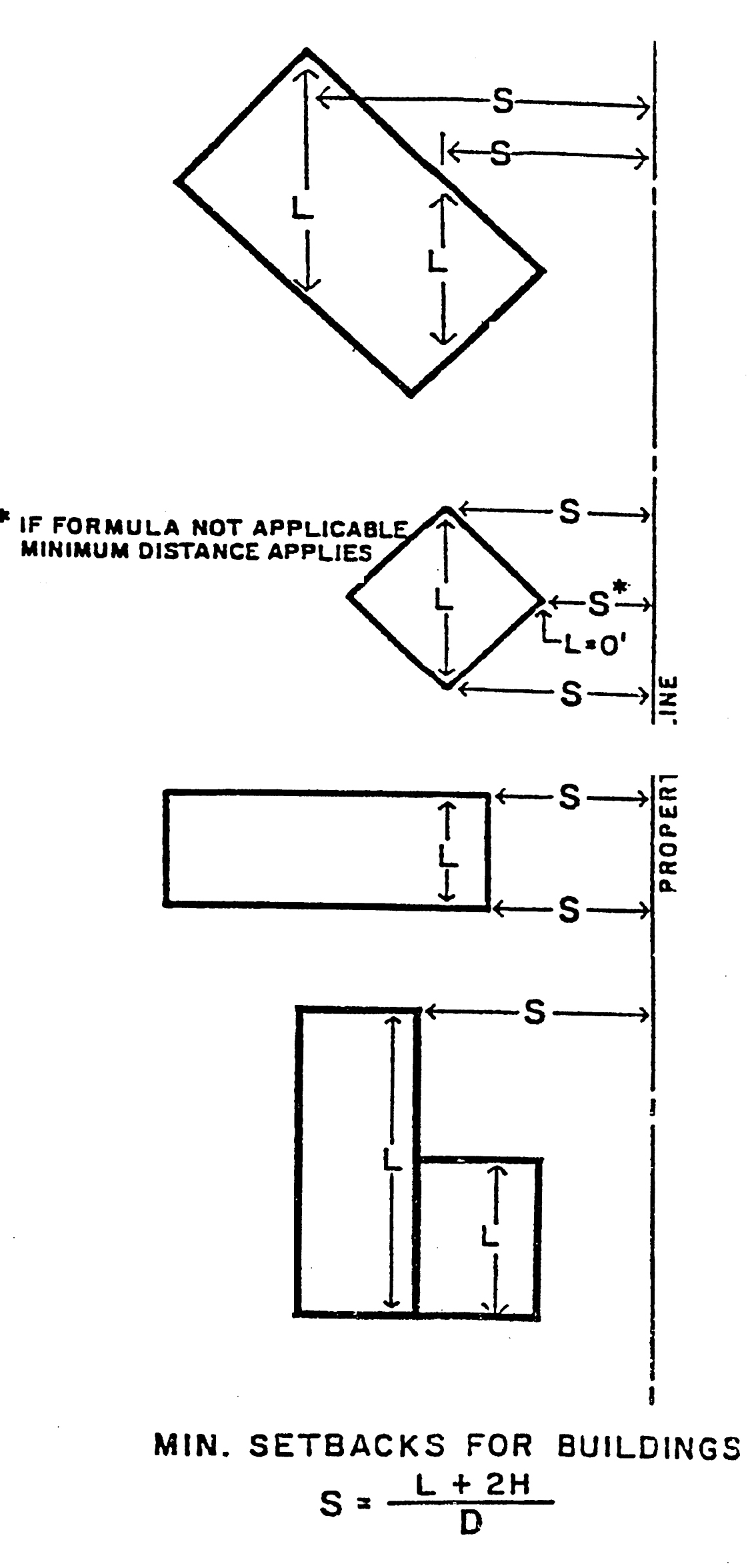
(w)
The minimum setbacks indicated shall apply unless exceeded by the distance required by other applicable footnotes of this section or by the following formulae, as defined in footnote (v) above; whichever is greater.
(1)
Along these lot lines which abut a one-family residential district A-1 through A-4 and which are not separated from the one-family district by a major or secondary thoroughfare or super highway, or the abutting one-family district is not already developed for a permitted use other than one-family residential, the minimum required setback shall be determined by: S = L + 2H ° 2.
(2)
Along those lot lines which abut a public street right-of-way or an A-5, A-6 or B-1 District or an existing use in a one-family residential district other than a single-family dwelling, the minimum required setback shall be determined by: S = L + 2H ° 3.
(3)
In all other instances, the minimum required setback shall be determined by: S = L + 2H ° 4.
(x)
Habitable attics as defined herein are permitted in addition to two (2) stories provided the total building height does not exceed thirty (30) feet.
(y)
For purposes of determining building height, when a new established grade is two (2) or more feet higher than the existing natural ground grade, the measurement shall be taken from the existing natural ground grade. When a new established grade is lower than the existing natural ground grade, the measurement shall be taken from the new established grade. Exceptions from this limitation may be permitted by the planning commission in unusual circumstances provided that the following findings are made:
(1)
The exception would not interfere with an adequate supply of light and air to adjacent surrounding properties.
(2)
The exception would not permit a building which is out of harmony with the property on which it is located as well as the surrounding properties.
(3)
The exception would not result in a building which is elevated significantly higher than those which would be permitted under this subsection on this surrounding properties.
(z)
Refer to section 24-249 of the General Provisions of this chapter regarding natural feature setbacks (all districts).
(aa)
Creation of new buildable lots. Where a new buildable lot or lots are proposed in the A-1 through A-4 Districts via land division, the newly created lots shall comply with the minimum lot width and area requirements listed in the chart above.
In addition such newly created lots shall provide a lot width and area equal to or greater than the average lot width and area of existing properties within a five-hundred-foot radius of the lot lines of the subject parent parcel proposed to be divided. The area within this five-hundred-foot radius shall be defined as the "study area". The study area shall be measured from the perimeter of the subject parent parcel. For the calculation of average lot, only lots along the same road frontage shall be measured. In case of a corner lot or through lot, the study area shall include lots within the five-hundred-foot radius that are along both road frontages.
Furthermore, the study area shall only include only those lots within the City of Bloomfield Hills and within the same residential zoning district as the subject parent parcel and shall exclude properties occupied by nonresidential uses allowed in the district (i.e., golf or riding clubs, schools, and churches).
In a situation where an existing lot in the study area provides at least two (2) times the lot width or area of any other lot within the study area, the planning commission may exclude said larger lot from the calculation of the average lot width and average lot area.
A property map of the study area and table of lot width and area calculations shall be submitted with the lot split application. Such information shall be prepared and sealed by a professional engineer or surveyor licensed by the State of Michigan.
The above provisions shall not apply to a situation where an owner proposed to shift a common line and shall not be deemed to render any existing lot nonconforming. Any such lots approved via land division shall not be given consideration for any future land divisions.
(Ord. No. 188, Art. XIV, 11-8-83; Ord. No. 204, § 1, 2-10-87; Ord. No. 212, §§ 1, 2, 5-10-88; Ord. No. 216, § 1, 1-10-89; Ord. No. 219, §§ 1, 2, 6-13-89; Ord. No. 220, §§ 2, 3, 6-13-89; Ord. No. 246, §§ 1, 2, 6-11-91; Ord. No. 250, § 4, 10-15-91; Ord. No. 304, § 2, 11-13-97; Ord. No. 305, § 1, 12-9-97; Ord. No. 330, § 7, 12-10-02; Ord. No. 342, 9-14-04; Ord. No. 348, § 5, 11-8-05; Ord. No. 405, § 1, 11-13-12; Ord. No. 411, § 1, 8-13-13; Ord. No. 411, § 1, 8-13-13; Ord. No. 422, § 1, 3-15-16)
Sec. 24-197. - Authority and purpose.
PUD planned unit development option is established in accordance with the definitions and provisions established by the Michigan Zoning Enabling Act (Public Act 110 of 2006).
The purpose of the PUD option is as follows:
(1)
Permit flexibility in development and building regulations to respond to unique factors for a particular site where appropriate.
(2)
Provide a design option to encourage innovation in the variety, design, layout and type of structures; conserve significant natural features and open space; ensure new development is consistent with the character of the city and adjacent land uses; promote efficient provision of public services and utilities; minimize adverse traffic impacts; encourage improvement to existing development where site conditions make desired development under conventional zoning difficult.
(3)
Allow appropriate mix of uses, densities or lot sizes that would otherwise not be permitted, provided the PUD standards herein are met. For properties approved as a PUD, these standards provide the developer with flexibility in design and permit limited variation of the specific bulk, and area requirements, subject to the approval of the PUD by the planning commission and city commission in accordance with the requirements set forth herein.
Sec. 24-198. - Eligibility criteria.
The PUD option may be effectuated in any zoning district classification, but is not applicable for the development of a one-family detached dwelling. To qualify for this option, it must be demonstrated that all of the following criteria will be met:
(1)
Any approval for an activity, building or use shall be compatible with the overall goals and recommendations of the City of Bloomfield Hills Master Plan.
(2)
Any approval for an activity, building or use not normally permitted shall result in an improvement to the public health, safety and welfare in the subject area affected or a recognizable public benefit. Such public benefit shall be evaluated in contrast to a project that would otherwise be permitted, on factors such as:
a.
Preservation of unique site design features;
b.
High quality architectural design and building materials;
c.
Extensive landscaping beyond the site plan requirements of the zoning code;
d.
Preservation, enhancement or restoration of natural resources (e.g., trees, slopes, non-regulated wetland areas, waterfront views, etc.);
e.
Incorporation of multiple lots and/or principal buildings;
f.
Preservation or enhancement of historic resources;
g.
Provision of open space or public plazas or features;
h.
Efficient consolidation of poorly dimensioned parcels or property with difficult site conditions (e.g., topography, shape, etc.);
i.
Effective transition between higher and lower density uses, and/or between nonresidential and residential uses; development of incompatible adjacent land uses in a manner that is not possible using a conventional approach;
j.
Shared vehicular access between properties or uses;
k.
A complementary mix of uses or a variety of housing types;
l.
Mitigation to offset impacts on public facilities (such as road improvements);
m.
Use of low impact development (storm water management) and LEED techniques and practices in site and building design.
(3)
The PUD shall not be utilized in situations where the same land use objectives can be accomplished by the application of conventional zoning provisions or standards.
Sec. 24-199. - Height, bulk, density and area standards.
(1)
Height, bulk, density and setback standards of each zoning district shall be applicable within each specific district area designated on the plan, except as specifically modified and noted on the PUD plan and PUD agreement. In no instance can the PUD option be used to increase the density beyond that permitted by the underlying zoning district. The location and distribution of dwellings within the PUD shall be determined through design that meets the eligibility criteria described in section 24-198.
(2)
Where the underlying zoning is one-family residential, the number of dwelling units allowable within a PUD shall be determined through preparation of a plan that illustrates the number of units that could be developed under a conventional plan. This conventional plan shall meet all standards for lot size, lot width and minimum setbacks in accordance with the dimensional requirements for the underlying zoning district, and other applicable city and state standards.
Sec. 24-200. - Submittal requirements.
The following items shall be included along with a completed application requesting approval of the PUD option:
(1)
PUD concept plan. The following information shall be provided:
a.
For residential projects only, a conventional plan showing the development possible based on the current zoning district standards. This plan will be used to determine density and dimensional standards permitted in the PUD;
b.
A conceptual or schematic plan that illustrates the general arrangement of buildings, parking, access and landscaping; alternatives for site arrangement and building architecture;
c.
Documentation indicating how the PUD eligibility criteria of section 24-198 have been met;
d.
A table which details requested modifications from the established zoning district uses, area, height and setback requirements, off-street parking regulations, general provisions or subdivision regulations which would otherwise be applicable to the uses and development proposed in the absence of a PUD; this table shall clearly identify the allowed regulation in comparison to the requested modification; and
e.
Any additional information requested by the planning commission at the pre-application conference to better assist in the determination of PUD qualification. Such information includes, but is not limited to: market studies, fiscal impact analysis, traffic impact studies, environmental impact assessments, and additional drawings, perspectives and cross sections.
f.
If the PUD is to be designed as a subdivision plat, the tentative plat requirements described in chapter 19, subdivision of land, shall be followed and reviewed as part of the PUD concept plan review.
(2)
Final PUD plan. The following information shall be provided with a request for approval of a final PUD plan:
a.
A final site plan including all of the information required by section 24-236 (site plan review);
b.
Information required by subsection (1), PUD concept plan, updated to address revisions from the concept to final PUD plan; and
c.
A PUD agreement, to be executed between the applicant and city commission, including the following information:
1.
A survey of the acreage comprising the proposed development;
2.
The manner of ownership of the developed land;
3.
The manner of the ownership and of dedication or mechanism to protect any areas designated as common areas or open space;
4.
Provision assuring that open space areas shown on the plan for use by the public or residents of the development will be or have been irrevocably committed for that purpose; the city may require conveyances or other documents to be placed in escrow to accomplish this;
5.
Satisfactory provisions have been made to ensure the future financing of any improvements shown on the plan for site improvements, including but not limited to roads, buildings, utilities, open space areas and common areas which are to be included within the development, and that maintenance of such improvements is also assured by a means satisfactory to the planning commission and city commission;
6.
Provisions to ensure adequate protection of natural features;
7.
Provisions to ensure enforcement of city and other regulations, and requirements of the agreement, on all property and property owners or occupants within the PUD, including the ability of the city to enforce corrective actions as necessary; and
8.
The PUD site plan shall be incorporated by reference and attached as an exhibit.
d.
If the PUD is to be designed as a subdivision plat, the preliminary plat requirements described in chapter 19, subdivision of land, shall be followed and reviewed as part of the final PUD plan review.
e.
If the PUD is to be designed as a condominium project developed under Act 50 of the Public Acts of 1978, as amended, the applicable sections of section 24-245, Site Condominium Projects, shall be satisfied as appropriate. The proposed master deed, by-laws, proposed restrictions and any additional documentation to be recorded with the register of deeds shall be provided as part of the final PUD approval.
f.
After final PUD approval and execution of the PUD agreement, a final subdivision plat may be reviewed in accordance with chapter 19, subdivision of land.
Sec. 24-201. - Approval procedure.
(1)
Pre-application conference. A pre-application conference with the planning commission, to discuss the appropriateness of a PUD and the concept plan shall be required of the applicant. This conference will also be used to determine the level of impact analysis that is needed with the formal PUD concept plan submittal.
(2)
PUD concept plan. The planning commission and the city commission shall each conduct separate public hearings on the request. Prior to the planning commission scheduling a public hearing, the applicant shall arrange for one (1) or more informal meetings with representatives of the adjoining properties and neighborhoods, soliciting their comments and providing same to the planning commission. The city shall be advised in advance as to the scheduling and location of all such meetings. The planning commission shall review the request in consideration of public hearing comments, technical reviews from city staff and consultants, correspondence from applicable review agencies and compliance with the standards of this division. The planning commission and city commission shall approve, approve with conditions or deny the PUD request based on the following:
(a)
That the proposal provides the recognizable benefits of the PUD in contrast to development under conventional zoning;
(b)
That the PUD shall not change the essential character of the surrounding area;
(c)
That the PUD conforms to the city master plan;
(d)
That all applicable provisions of this division and the zoning code are met;
(e)
That the eligibility criteria of section 24-198 are met;
(f)
That the PUD shall not place demands on public services, municipal facilities and streets in excess of uses permitted by current zoning and current capacity, unless improvements are made by the petitioner; and
(g)
That the project successfully provides a transition between higher and lower density uses and/or between nonresidential and residential uses.
(3)
Final PUD plan. Following PUD qualification/concept plan approval, a final site plan for the PUD or individual phases of the PUD shall be submitted in accordance with section 24-236, site plan review. The planning commission and the city commission shall review all site plans subsequently submitted for conformance with the PUD concept plan, all conditions attached to PUD concept plan approval and other applicable requirements of this chapter and shall approve, approve with conditions or deny the PUD.
(4)
Approval. The concept PUD plan and final PUD plan shall each require approval by a majority of the members of the planning commission (five (5)) and a majority of the members of the city commission (three (3)).
Sec. 24-202. - Additional PUD provisions.
(1)
Public hearing notification. Notices for all public hearings shall be given as follows:
(a)
Notice of the hearing shall be not less than fifteen (15) days before the date of the public hearing.
(b)
Notice of the hearing shall be published in a newspaper of general circulation.
(c)
Notice shall be sent by mail or personal delivery to the owners of property for which approval is being considered.
(d)
Notice shall also be sent by mail to all persons to whom real property is assessed within five hundred (500) feet of the property and to the occupants of all structures within five hundred (500) feet of the property regardless of whether the property or occupant is located in the zoning jurisdiction. If the name of the occupant is not known, the term "occupant" may be used in making notification under this subsection.
(e)
The city shall also post notice on the city's website.
(f)
A sign shall be posted on the property by the applicant indicating that the property is proposed to be developed with the PUD option in accordance with the city sign ordinance (chapter 16 of the City Code) including the following:
1.
The sign shall be four (4) feet by eight (8) feet in size.
2.
The sign shall be erected in full public view along the road frontage.
3.
If the property to be developed with the PUD option is located at an intersection, a sign for each road frontage must be provided.
4.
The sign shall state 'THIS PROPERTY IS PROPOSED TO BE DEVELOPED AS A PUD".
5.
The sign shall include the current and proposed zoning and uses, area in acres of the property, and a generalized map of the property.
6.
Such sign shall indicate the date, time, and location of the planning commission public hearing where the proposal will be reviewed.
7.
The sign shall be erected fifteen (15) days prior to the scheduled public hearing.
8.
The applicant shall be responsible for erecting, maintaining through the public hearing date and removing the sign. The sign shall be removed three (3) days after the public hearing.
(2)
Appeals. The zoning board of appeals shall have no jurisdiction to hear appeals or make interpretation or any other decisions regarding this division or a proposed PUD concept plan or final PUD plan.
(3)
Fees. Fees and costs incurred by the city for review of PUD plans under this division, including, but not limited to, legal, planning and engineering, shall be paid by the applicant as established by resolution of the city commission.
(4)
Interpretation of approval. Approval of a PUD under this division shall be considered an optional method of development and improvement of property subject to the mutual agreement of the city and the applicant.
(5)
Amendments to PUD plan. Proposed amendments or changes to an approved final PUD plan shall be submitted both to the planning commission and to the city commission. The proposed amendments shall be reviewed in accordance with the provisions and procedures of this division as they relate to approval of a final PUD plan and both a majority of the members of the planning commission (five (5)) and a majority of the members of the city commission (three (3)) shall be required to approve the amendment.
(6)
PUD expiration. Approval of a final PUD plan shall be subject to the time frame established for final site plan approval described in subsection 24-236(e)(2).