
Bradbury City Zoning Code
PART VII
- SUBDIVISION REGULATIONS
CHAPTER 164.- URBAN LOT SPLITS[12]
Editor's note— Ord. No. 398, § 3, adopted July 15, 2025, amended the Code by repealing former Ch. 164, §§ 9.164.010—9.164.060, and adding a new Ch. 164. Former Ch. 164 pertained to similar subject matter, and derived from Ord. No. 380, adopted December 21, 2021; and Ord. No. 383, adopted July 19, 2022.
Sec. 9.130.010.- Title for citation.
This part shall be known as the "Subdivision Ordinance" of the City of Bradbury, and may be referred to as such.
(Ord. No. 297, § 9.07.010.010, 3-20-2007)
Sec. 9.130.020. - Applicability; statutory authority.
Pursuant to the provisions of the Subdivision Map Act, and in addition to any other regulations provided by law, the regulations contained hereinafter in this part shall apply to all subdivisions or parts of subdivisions hereafter made, of land wholly or partially within the territory of the City and to the preparation of subdivision maps thereof, and to other maps provided for by the Subdivision Map Act, for approval; and each such subdivision and each part thereof lying within the territory of the City shall be made and each such map shall be prepared and presented for approval as hereinafter provided for and required in this part.
(Ord. No. 297, § 9.07.010.020, 3-20-2007)
State Law reference— Subdivision Map Act, Government Code § 66410 et seq.
Sec. 9.130.030. - References to amendments and additions included.
Whenever reference is made to any portion of the ordinance codified in this part or any other ordinance or statute, such reference applies to all amendments and additions now or hereafter made.
(Ord. No. 297, § 9.07.010.040, 3-20-2007)
Sec. 9.130.040. - Lease projects, condominiums and community apartment projects; provisions applicable.
Provisions of this part which except or exempt a subdivider from complying with a design, improvement, dedication or fee requirement, or which provide for the waiver of such a requirement because of the size of parcels resulting from a subdivision, shall not be construed to apply to lease projects, condominiums, or community apartment projects.
(Ord. No. 297, § 9.07.010.050, 3-20-2007)
Sec. 9.130.050. - Violation; penalty.
A violation of this part which is not also prohibited by the Subdivision Map Act or by any other State statute is a misdemeanor, punishable by a fine of not more than $1,000.00 or by imprisonment in County jail for not more than six months, or by both such fine and imprisonment.
(Ord. No. 297, § 9.07.010.060, 3-20-2007)
Sec. 9.130.060. - Condition of land use approval.
As a condition of the approval of a subdivision, the subdivider shall agree to reimburse the City for any court and attorney's fees which the City may be required by a court to pay as a result of any claim or action brought against the City because of such approval. Although the subdivider is the real party in interest in such an action, the City may, at its sole discretion, participate at its own expense in the defense of the action, but such participation shall not relieve the subdivider of its obligations under this condition.
(Ord. No. 297, § 9.07.010.080, 3-20-2007)
Sec. 9.133.010.- Definitions; Subdivision Map Act applicable when.
Except as otherwise provided in this chapter, all terms used in this part which are defined in the Subdivision Map Act are used in this part as so defined, unless from the context hereof it clearly appears that a different meaning is intended. To the extent of any inconsistencies between the definitions set forth herein and the Subdivision Map Act, the Subdivision Map Act shall prevail.
(Ord. No. 297, § 9.07.020.010, 3-20-2007)
Sec. 9.133.020. - Advisory agency.
The term "advisory agency" means and refers to the Planning Commission. The Planning Commission shall exercise all of the duties associated with the submission, review and approval or disapproval of maps of reversions to acreage which are delegated to the advisory agency by this part, unless the City Council determines to, and itself exercises, such duties.
(Ord. No. 297, § 9.07.020.020, 3-20-2007)
Sec. 9.133.040. - Building site.
The term "building site" means that portion of the lot or parcel of land upon which the building and appurtenances are to be placed, or are already existing, including adequate areas for sewage disposal, clearances, proper drainage, appropriate easements, and, if applicable, the requirements of other ordinances.
(Ord. No. 297, § 9.07.020.040, 3-20-2007)
Sec. 9.133.050. - CEQA.
The term "CEQA" means the California Environmental Quality Act (Public Resources Code § 21000 et seq.) and the State CEQA Guidelines (14 California Code of Regulations § 15000 et seq.)
(Ord. No. 297, § 9.07.020.050, 3-20-2007)
Sec. 9.133.060. - City Engineer.
The term "City Engineer" means the designated City Engineer of the City of Bradbury or the City Engineer's designee.
(Ord. No. 297, § 9.07.020.060, 3-20-2007)
Sec. 9.133.070. - Cul-de-sac.
The term "cul-de-sac" means a street which is designed to remain permanently closed at one end. For the purposes of this part, the length of a cul-de-sac shall be measured along the centerline of the cul-de-sac from the point where the centerline terminates within the turnaround to the right-of-way line of the street with which the cul-de-sac intersects.
(Ord. No. 297, § 9.07.020.070, 3-20-2007)
Sec. 9.133.080. - Division of land.
The term "division of land" refers to subdivisions unless a more restrictive meaning is clearly determinable from the context.
(Ord. No. 297, § 9.07.020.080, 3-20-2007)
Sec. 9.133.090. - General plan.
The term "General Plan" means the adopted General Plan of the City of Bradbury and all adopted amendments thereto.
(Ord. No. 297, § 9.07.020.090, 3-20-2007)
Sec. 9.133.100. - Lease.
(a)
The term "lease" means and includes an oral as well as a written lease, tenancy at will, month-to-month or similar tenancy.
(b)
This part shall not apply to the leasing of apartments, offices, stores or similar space within an apartment building, industrial building, commercial building, mobile home park or trailer park, except as provided in Section 9.133.090 nor shall this part apply to mineral, oil or gas leases.
(Ord. No. 297, § 9.07.020.100, 3-20-2007)
Sec. 9.133.110. - Lease project.
(a)
The term "lease project" refers to a development wherein two or more residential or commercial buildings are constructed and maintained on a parcel of land and apartments, offices, stores or similar space are leased within one or more of the buildings; overall control of the land and buildings comprising the project being retained by the lessor. The following shall not be included when computing the number of outbuildings within a lease project:
(1)
Accessory or satellite buildings;
(2)
Parking structures;
(3)
Commercial buildings having a floor area of less than 600 square feet.
(b)
The term "lease project" does not refer to a development of a parcel of land having less than twice the required area as designated by this title, or less than 10,000 square feet when this title has no designation.
(Ord. No. 297, § 9.07.020.110, 3-20-2007)
Sec. 9.133.120. - Lot, parcel.
The terms "lot" and "parcel" shall be used synonymously.
(Ord. No. 297, § 9.07.020.120, 3-20-2007)
Sec. 9.133.130. - Minor land division.
The term "minor land division" means a subdivision creating four or less parcels, a condominium project creating four or less condominiums as defined in Civil Code § 783, a community apartment project containing four or less parcels, or a lease project containing four or less building sites.
(Ord. No. 297, § 9.07.020.130, 3-20-2007)
Sec. 9.133.140. - Pad.
The term "pad" means a building site prepared by artificial means, including grading, excavation or filling, or any combination thereof.
(Ord. No. 297, § 9.07.020.130, 3-20-2007)
Sec. 9.133.150. - Section.
The term "section" means a section of this part unless reference is made to some statute or other ordinance.
(Ord. No. 297, § 9.07.020.150, 3-20-2007)
Sec. 9.133.160. - Shall, may.
The term "shall" is mandatory; the term "may" is permissive.
(Ord. No. 297, § 9.07.020.160, 3-20-2007)
Sec. 9.133.170. - Sloping terrain.
The term "sloping terrain" means any ground surface having a grade of ten percent or more. The latest available six and seven and one half minute United States Geological Survey quadrangles or a survey by a registered civil engineer or licensed land surveyor shall be utilized to determine such grade.
(Ord. No. 297, § 9.07.020.170, 3-20-2007)
Sec. 9.133.180. - Street.
The term "street" means a public or private right-of-way whose function is to carry vehicular traffic and/or provide access to abutting property. The term "street" includes avenues, ways, courts, lanes, crossings or intersections.
(1)
A public street is a street that is maintained by the city or other public agency, as set forth in the Streets and Highways Code for public use.
(2)
A private street is a street that is maintained by the underlying property owner for the mutual benefit of all abutting property.
(Ord. No. 297, § 9.07.020.180, 3-20-2007)
Sec. 9.133.190. - Subdivision.
The term "subdivision" means the division by any subdivider of any unit of improved or unimproved land, or any portion thereof, shown on the latest equalized County assessment roll as a unit or as contiguous units, for the purpose of sale, lease, financing or transfer of title, whether immediate or future.
(1)
Property shall be considered as contiguous units even if it is separated by roads, streets, utility easements or drainage or railroad rights-of-way.
(2)
Any conveyance of land to a governmental agency, public entity or public utility shall not be considered a division of land for purposes of computing the number of parcels.
(3)
The qualification contained in Section 66424.1 of the Subdivision Map Act concerning the division of a unit of land before a change in the equalized County assessment roll shall apply to subdivisions as defined in Subsection (1) of this section.
(Ord. No. 297, § 9.07.020.190, 3-20-2007)
Sec. 9.133.200. - Subdivision Map Act.
The term "Subdivision Map Act" means Division 2 of Title 7 of the Government Code, commencing with Government Code § 66410.
(Ord. No. 297, § 9.07.020.200, 3-20-2007)
Sec. 9.133.210. - Vesting tentative map.
The term "vesting tentative map" means a tentative map for a subdivision that when approved or conditionally approved by the advisory agency confers a vested right to proceed with development for a specified period of time after recordation in accordance with applicable ordinances and general and specific plans in effect at a predetermined date.
(Ord. No. 297, § 9.07.020.210, 3-20-2007)
Sec. 9.136.010.- Membership.
The Subdivision Committee is created to act in an advisory capacity to the Planning Commission. It consists of the following members or their duly authorized representatives:
(1)
The City Planner;
(2)
The City Engineer;
(3)
The City Manager;
(4)
The Health Officer;
(5)
The Forester and Fire Warden;
(6)
A representative from the flood control district;
(7)
The City Building Official.
(Ord. No. 297, § 9.07.030.010, 3-20-2007)
Sec. 9.136.020. - Time of meetings.
After a subdivision application is deemed complete, the Subdivision Committee shall schedule meetings to consider tentative maps, final maps, parcel maps and any subdivision of land.
(Ord. No. 297, § 9.07.030.020, 3-20-2007)
Sec. 9.136.030. - Meetings open to public.
Subdivision Committee meetings shall be open to the public, and any person, officer or subdivider interested in a division of land shall have the privilege of attending any such meeting and presenting any appropriate matter thereat. Such meetings shall comply with all City and State requirements for public meetings.
(Ord. No. 297, § 9.07.030.030, 3-20-2007)
Sec. 9.136.040. - Report of recommendations to Planning Commission/City Council.
The Subdivision Committee shall report in writing its recommendations to the Planning Commission/City Council.
(Ord. No. 297, § 9.07.030.040, 3-20-2007)
Sec. 9.139.010.- Building location and access restrictions.
No building shall be constructed, nor shall a permit for construction of a building be issued, for any residential building, or any portion thereof, unless the location of such building and the access thereto is in substantial conformance with that shown on the approved tentative map for such project.
(Ord. No. 297, § 9.07.040.010, 3-20-2007)
Sec. 9.139.020. - Final and parcel maps required; exceptions.
(a)
A tentative and final map is required for all subdivisions creating five or more parcels as provided in Section 66426 of the Subdivision Map Act.
(b)
A parcel map is required for all subdivisions for which a tentative and final map is not required.
(c)
No person shall offer to sell, lease, finance or transfer title to, contract to sell, lease, finance or transfer title to, sell, lease, finance or transfer title to, commence construction of any building other than a model home on, or permit the occupancy other than for model home purposes of any building on any real property for which a final map or parcel map is required, until the required map has been filed for record by the County Recorder. These prohibitions shall not apply in the case of a parcel map requirement where a waiver has been approved, and to a minor lot line adjustment approved pursuant to Section 9.166.120, or in any instance where a certificate of compliance has been issued and any required conditions have been fulfilled as provided in the Subdivision Map Act nor do the provisions of this section apply to any parcel of a subdivision offered for sale, lease, financing or transfer, or sold, leased, financed or transferred in compliance with or exempt from any law, including this part or any other ordinance of the City, regulating the design and improvement of subdivisions in effect at the time the subdivision was established.
(Ord. No. 297, § 9.07.040.020, 3-20-2007)
Sec. 9.139.030. - Exceptions to parcel map requirements.
Parcel maps are not required for subdivisions created by short-term leases (terminable by either party on not more than 30 days' notice in writing) of a portion of the operating right-of-way of a railroad corporation defined as such by Public Utilities Code § 230, or for land conveyed to or from a governmental agency, public entity or public utility, or to a subsidiary of a public utility for conveyance to such public utility for rights-of-way, unless a showing is made in individual cases, upon substantial evidence, and pursuant to Section 9.148.120, that public policy necessitates such a parcel map.
(Ord. No. 297, § 9.07.040.030, 3-20-2007)
Sec. 9.139.040. - Approval of parcel maps; City Engineer authority.
(a)
A parcel map which has been conditionally approved by the City Council shall be submitted to the City Engineer for examination. The City Engineer shall, upon completion of examination of the parcel map and receipt of any reports from City and County officers and departments required pursuant to Section 9.163.040, prepare a recommendation for the City Council to approve the map if it conforms to the tentative map, as approved, and the conditions of approval of the tentative map and all applicable requirements of this part and of the Subdivision Map Act have been complied with.
(b)
The City Council shall, at the time of action on a final parcel map, accept, subject to improvement, or reject dedications and irrevocable offers of dedications that are made by certificate on the map.
(Ord. No. 297, § 9.07.040.040, 3-20-2007)
Sec. 9.139.050. - Tentative map; list of property owners required when.
With each filing of a tentative map of a subdivision, including a minor land division, the subdivider shall file a radius map, mailing list and labels, and affidavit required by Section 9.31.015.
(Ord. No. 297, § 9.07.040.050, 3-20-2007; Ord. No. 375, § 14, 5-18-2021)
Sec. 9.139.060. - Public hearings.
Prior to the approval by the City Council of any tentative or parcel map, including a tentative minor land division map, submitted pursuant to this part, a public hearing shall be held before the Planning Commission for recommendation and City Council for approval. Any interested person may appear at such a hearing and shall be heard.
(Ord. No. 297, § 9.07.040.060, 3-20-2007)
Sec. 9.139.070. - Notice of public hearing.
Notice of public hearings shall be given as provided in Chapter 31.
(Ord. No. 297, § 9.07.040.070, 3-20-2007; Ord. No. 375, § 14, 5-18-2021)
Sec. 9.139.080. - Lot line adjustments.
The adjustment of lot lines between two or more existing adjacent parcels may be accomplished as provided in Section 9.166.120.
(Ord. No. 297, § 9.07.040.090, 3-20-2007)
Sec. 9.139.090. - Findings for approval.
The City Council shall not approve a tentative map, or a parcel map for which a tentative map was not required, unless it makes all of the following findings:
(1)
That the proposed map is consistent with applicable general and specific plans and zoning code.
(2)
That the design or improvement of the proposed subdivision is consistent with applicable general and specific plans and zoning code.
(3)
That the site is physically suitable for the type of development.
(4)
That the site is physically suitable for the proposed density of development.
(5)
That the design of the subdivision or the proposed improvements are not likely to cause substantial environmental damage or will not substantially and avoidably injure fish or wildlife or their habitat.
(6)
That the design of the subdivision or type of improvements is not likely to cause serious public health problems.
(7)
That the design of the subdivision or the type of improvements will not conflict with easements, acquired by the public at large, for access through or use of property within the proposed subdivision.
(8)
That the design of the subdivision provides, to the extent feasible, for future passive or natural heating or cooling opportunities in the subdivision.
(9)
For subdivisions in the City which are located in a very high fire hazard severity zone as shown in the City's General Plan, the following findings must also be made:
a.
That the design and location of each lot in the subdivision, and the subdivision as a whole, are consistent with any applicable regulations adopted by the State Board of Forestry and Fire Protection pursuant to Public Resources Code §§ 4290 and 4291;
b.
That structural fire protection and suppression services will be available for the subdivision by an entity listed in Government Code § 66474.02; and
c.
That to the extent practicable, ingress and egress for the subdivision meets the regulations regarding road standards for fire equipment access adopted pursuant to Public Resources Code § 4290 and any local ordinance of the City.
The findings in Subsections (9)a and b of this section must be supported by substantial evidence.
(Ord. No. 297, § 9.07.040.100, 3-20-2007)
Sec. 9.142.010.- Standards for survey work.
(a)
The procedure and practice of all survey work done on any division of land, whether for preparation of a final map or parcel map, shall conform to the standards and details set forth in Business and Professions Code Chapter 15, Division 3, the Land Surveyor's Act. The allowable error of closure on any portion of a final map or parcel map shall be 1/10,000.
(b)
In the event that the County Engineer, County Road Commissioner, the State Highway Engineer or City Engineer shall have established the centerline of any street or alley in or adjoining a division of land, the final map or parcel map shall show such centerline, together with reference to a field book or map showing such centerline and the monuments which determine its position. If determined by ties, that fact shall be stated upon the final map or parcel map.
(Ord. No. 297, § 9.07.050.010, 3-20-2007)
Sec. 9.142.020. - Boundary monuments; location and materials.
Each final map or parcel map shall show durable monuments, found or set at or near each boundary corner and at intermediate points, approximately 1,000 feet apart, or at such lesser distances as may be made necessary by topography or culture to ensure accuracy in the re-establishment of any point or line without unreasonable difficulty. The precise position and the character of each such monument shall be shown on such map. Such durable monument shall be not less substantial than an iron pipe of a two-inch outside diameter, not less than 2½ feet in length, with plug and tick, and set at least two feet into the ground, or of such other character and stability as may be approved by the County Engineer. For the purpose of this part, a lead and tack set in permanent concrete or masonry shall be considered as a durable monument. The approximate elevation of the top of each such monument with respect to the surface of the ground shall be shown on said map.
(Ord. No. 297, § 9.07.050.020, 3-20-2007)
Sec. 9.142.030. - Street centerline monuments.
(a)
Whenever necessary in the opinion of the City Engineer, centerline monuments shall be set to mark the intersections of streets, intersections of streets with the tract boundary, or to mark either the beginning and end of curves or the points of intersection of tangents thereof, or other intermediate points.
(b)
Each such monument shall be not less durable, and substantial than:
(1)
In asphaltic concrete or cement concrete pavements, a lead and tack;
(2)
In unsurfaced graveled or oiled surfaces, a two-inch iron pipe set not less than 12 inches below the surface, or at such depth as may be approved by the City Engineer;
(3)
In bituminous macadam pavements, a spike not less than six inches long.
(Ord. No. 297, § 9.07.050.030, 3-20-2007)
Sec. 9.142.040. - Centerline intersection monuments; notes to city engineer.
(a)
For each centerline intersection monument set, the engineer or surveyor under whose supervision the survey has been made shall furnish to the City Engineer a set of notes showing clearly the ties between such monument and a sufficient number (normally four) of durable distinctive reference points or monuments.
(b)
Such reference points or monuments may be leads and tacks in sidewalks, or two-inch by two-inch stakes set back of the curbline and below the surface of the ground, or such substitute therefor as appears to be not more likely to be disturbed.
(c)
Such set of notes shall be of such quality, form and completeness, and shall be on paper of such quality and size as may be necessary to conform to the standardized office records of the City Engineer. All such notes shall be indexed and filed by the City Engineer as a part of the permanent public records of this office.
(Ord. No. 297, § 9.07.050.040, 3-20-2007)
Sec. 9.142.050. - Identification marks on monuments.
All monuments found or set as required herein shall be permanently and visibly marked or tagged with the registration or license number of the engineer or surveyor under whose supervision the survey was made.
(Ord. No. 297, § 9.07.050.050, 3-20-2007)
Sec. 9.142.060. - Boundary monuments; time for setting; deferment conditions.
All boundary monuments shall be set prior to filing of the final map or parcel map unless extensive grading operations or improvement work makes it impractical to set monuments. In the event any of the boundary monuments required are to be set subsequent to filing of the parcel map or final map, the engineer or surveyor making the survey shall furnish evidence acceptable to the County Engineer prior to submitting the map to substantiate the engineer's or surveyor's reasons for deferring the setting of permanent monuments until after filing of the map. If the setting of boundary monuments is deferred, field notes showing the boundary survey shall be presented to the County Engineer at the time the map is submitted for checking. Interior street centerline monuments may be set subsequent to filing of the map. The map shall show which monuments are in place and are to be set. Prior to approval of the final map or of a parcel map by the Planning Commission, the subdivider shall submit a written agreement in which the subdivider agrees that the monuments so deferred will be set within a specified time, and that the notes required in Section 9.142.040 will be furnished within a specified time. The City may require security guaranteeing the payment of the cost of setting deferred monuments.
(Ord. No. 297, § 9.07.050.060, 3-20-2007)
Sec. 9.142.070. - Inspection and approval of monuments.
All monuments shall be subject to inspection and approval of the City Engineer in conjunction with the City Engineer's checking of the map.
(Ord. No. 297, § 9.07.050.070, 3-20-2007)
Sec. 9.142.080. - Record of survey checking fee.
Where the County Surveyor is required to check the record of survey maps under the provisions of the Professional Land Surveyors Act, the surveyor shall pay a map checking fee to the City in addition to all other fees and charges required by law. These fees, payable on submission of map for checking to the City Engineer, shall be set by resolution of the City Council.
(Ord. No. 297, § 9.07.050.080, 3-20-2007)
Sec. 9.148.010.- Method.
If dedications or offers of dedication are required for a minor land division, tract map or parcel map, they may be made either by certificate on the map or by separate instrument.
(Ord. No. 297, § 9.07.070.010, 3-20-2007)
Sec. 9.148.020. - Parcel maps—Parties having record title interests.
The signatures of all parties having any record title interest in the real property being subdivided shall not be required on any final parcel map unless dedications or offers of dedication are made by certificate on the parcel map.
(Ord. No. 297, § 9.07.070.020, 3-20-2007)
Sec. 9.148.030. - Same—Evidence of title.
Evidence of title shall be submitted with all final parcel maps. This shall show all fee interest holders, all interest holders whose interest could ripen into a fee, all trust deeds together with the name of the trustee and/or beneficiary, and all easement holders.
(Ord. No. 297, § 9.07.070.030, 3-20-2007)
Sec. 9.148.040. - Easement certificates.
(a)
Any map of a subdivision presented to the City with an offer of easements for public use shall have written thereon, in addition to or as a part of any other certificate required, a certificate, signed by all parties whose signatures are required pursuant to Section 66436 of the Subdivision Map Act, in substantially one of the following forms:
(1)
"We hereby certify that except as shown on a copy of this map on file in the Office of the County Road Commissioner, we know of no easement or structure existing within the easements hereby offered for dedication to the public, other than publicly-owned water lines, sewers or storm drains; that we will grant no right or interest within the boundaries of said easements offered to the public, except where such right-of-way is expressly made subject to the said easements."
(2)
"We hereby certify that we know of no easement or structure existing within the easements hereby offered for dedication to the public, other than publicly-owned water lines, sewers or storm drains; that we will grant no right or interest within the boundaries of said easements offered to the public, except where such right or interest is expressly made subject to the said easement."
(b)
The registered civil engineer or land surveyor who prepares the map shall notify the City Engineer that, as a result of thorough research of records and a field inspection, there either are structures existing within the easements offered or there are no structures existing within the easements offered. The form in Subsection (a)(1) of this section shall be used where there are structures, and the form in Subsection (a)(2) of this section shall be used where there are no structures.
(Ord. No. 297, § 9.07.070.040, 3-20-2007)
Sec. 9.148.050. - Right-of-way under condemnation.
(a)
In the event that an easement for any right-of-way required under the provisions of this part in connection with any proposed division of land is in the process of condemnation by the City at the time of the submission of any final map or parcel map, the subdivider, in lieu of offering such right-of-way for dedication, may show such right-of-way upon the final map or parcel map thereof as a private right-of-way, and, prior to the approval of such final map or certification of such parcel map, shall submit to the City a deed granting such easement to the City on condition that such condemnation proceedings are abandoned, together with a contract and bond as provided by Sections 9.151.020, 9.154.010 and 9.154.040.
(b)
In the event that such condemnation proceedings shall be completed, such deed, contract and bond shall be returned to the subdivider. In the event that such condemnation proceedings are abandoned, the contract and bond shall be accepted by the City Engineer and the deed shall be forwarded to the City Council for acceptance.
(Ord. No. 297, § 9.07.070.050, 3-20-2007)
Sec. 9.148.060. - Private streets.
Except as set out hereinafter, all parcels of land intended for public use in a division of land shown on the final map or parcel map thereof shall be offered for dedication for public use. However, with the approval of the City Council, any road which is intended to be kept physically closed to public travel or posted as a private street at all times may be shown as a private street; but in any such case, the final map or parcel map shall contain a conditional offer of dedication, or the map may be accompanied by a conditional offer of dedication by separate instrument, either of which may be accepted by the City Council. Any such private street shall be shown on such map by heavy dashed lines. Sufficient data shall be shown on each private street to define its boundaries, as is required for a public street, and also sufficient mathematical data to show clearly the portion of each lot within such street. The design and improvement of any such private street shall be subject to all of the requirements prescribed by this part for public streets.
(Ord. No. 297, § 9.07.070.060, 3-20-2007)
Sec. 9.148.070. - Minor land division and parcel map requirements.
Dedications or offers of dedication of real property for streets, highways and other public ways, access rights and abutter's rights, drainage and public utility easements, building restriction rights, and other public easements may be required for a minor land division or parcel map.
(Ord. No. 297, § 9.07.070.080, 3-20-2007)
Sec. 9.148.080. - Sewer and storm drain easements.
If, in the opinion of the Planning Commission and City Council, either sewers or storm drains or both are necessary for the general use of lot owners in the division of land, or the future development of the area, and such sewers or storm drains or both are not to be installed in the public streets of such division, then the subdivider shall show upon the maps and dedicate necessary easements for such sewers or storm drains or both.
(Ord. No. 297, § 9.07.070.090, 3-20-2007)
Sec. 9.148.090. - Drainage facilities.
If an artificial drainage facility is necessary for the general use of lot owners in the division of land and for adequate drainage needs, the subdivider shall dedicate an adequate right-of-way for such drainage channel.
(Ord. No. 297, § 9.07.070.100, 3-20-2007)
Sec. 9.148.100. - Natural watercourses.
In the event that a division of land or any part thereof is traversed by any watercourse, channel, stream or creek, the subdivider shall dedicate an adequate right-of-way for storm drainage purposes if, in the opinion of the Planning Commission, such dedication is necessary. In the event that the natural watercourse does not lie entirely within such dedication, the subdivider may either construct an adequate channel within such dedication and/or delineate the watercourse upon the final map or parcel map to the City's satisfaction.
(Ord. No. 297, § 9.07.070.110, 3-20-2007)
Sec. 9.148.110. - Reversions to acreage.
Dedication of land for public streets, highways, ways or easements may be accepted on a final map submitted for the purpose of reverting to acreage land previously subdivided.
(Ord. No. 297, § 9.07.070.150, 3-20-2007)
Sec. 9.148.120. - Conveyance to governmental agency.
(a)
Owners of property proposing subdivisions created by any conveyance to a governmental agency or public entity shall notify the City Planner in writing of such proposals at least 30 days prior to the conveyance.
(b)
A subdivision map may be required by the City Council for such a conveyance when a showing is made upon substantial evidence, submitted by the City Planner or City Engineer, that the public policy necessitates the map.
(Ord. No. 297, § 9.07.070.170, 3-20-2007)
Sec. 9.151.010.- Requirements generally.
(a)
The subdivider shall improve, or agree to improve, all land dedicated or to be dedicated on a final map or parcel map, or by separate instrument, for roads and easements, and all private roads and private easements laid out on a final map or parcel map, with those improvements, including sanitary sewers, needed for the general use of the lot owners in the division of land and for neighborhood traffic and drainage.
(b)
This section does not require improvements to flood-control channels, which improvements are not solely for the benefit of the division of land.
(Ord. No. 297, § 9.07.080.010, 3-20-2007)
Sec. 9.151.020. - Agreement to guarantee completion; when required.
(a)
If any required improvements will not be completed to the satisfaction of the City Engineer before the final map is filed, the subdivider shall, prior to the approval by the City Council of the final map, enter as contractor into an agreement with the City whereby, in consideration of the acceptance by the City Council of any dedication offered on the final map and the approval of the final map, the subdivider, as such contractor, agrees to furnish all necessary equipment and material and to complete such work within the time specified in such agreement.
(b)
If any improvements are not completed to the satisfaction of the City Engineer before the parcel map is filed with the County Recorder, the subdivider shall enter as a contractor into an agreement with the City whereby, in consideration the acceptance by the City of any dedications offered by the subdivider and the approval of the parcel map by the City Council, the subdivider, as such contractor, agrees to furnish all necessary equipment and material and to complete such work within the time specified in such agreement.
(Ord. No. 297, § 9.07.080.020, 3-20-2007)
Sec. 9.151.030. - Installation and construction costs.
(a)
The cost of installing pipes and other facilities for the transmission of water may be paid for in whole or in part from revenues collected from the customers served at regular, established water rates for the water company pursuant to regulations of the Public Utilities Commission where applicable, or by a public agency, as defined in Government Code § 4401, from the net operating income only, as payment for the sales of water thereto.
(b)
The subdivider may be reimbursed for a portion of the costs as provided in Sections 66486 and 66487 of the Subdivision Map Act, or other reimbursement enabling acts.
(c)
Except for assessments authorized after tentative map approval for the financing and completion of improvements required of the subdivider, all outstanding or remaining assessments on the land of the subdivision established for improvements contracted under special assessment district proceedings shall be paid by the subdivider.
(Ord. No. 297, § 9.07.080.030, 3-20-2007)
Sec. 9.151.040. - Minor land divisions; requirements.
Improvements shall not be required as a condition precedent to filing a parcel map on a minor land division where the advisory agency finds that the existing systems and improvements adequately serve adjacent developed parcels, unless such improvements are necessary for the development of parcels within the division of land or are necessary to be consistent with the General Plan.
(Ord. No. 297, § 9.07.080.050, 3-20-2007)
Sec. 9.151.050. - Road improvements.
(a)
All road improvements, including drainage structures incidental thereto and including two-foot cement concrete gutters wherever cement concrete curb is required, shall be installed to a grade approved by the City Engineer. Plans, profiles and specifications for such improvements shall be furnished to the City Engineer not later than the time of submitting the final map or parcel map to the City Engineer for checking, and such plans, profiles and specifications shall be subject to the approval of the City Engineer before any such map shall be approved or certified. Such plans, profiles and improvements shall be in accordance with the standards of the County as adopted by the City Council.
(b)
The City Council may approve an inverted shoulder in lieu of concrete curbs and gutters, provided that curbs and gutters are not necessary for drainage purposes or to maintain an existing neighborhood pattern.
(Ord. No. 297, § 9.07.080.070, 3-20-2007)
Sec. 9.151.060. - Paving for access strips.
(a)
The City Council may require that single-access strips for flag lots be paved to a width of 15 feet or to full width, whichever is less, and that multiple-access strips be paved to a total width of 20 feet or to the full combined width of the access strips, whichever is less, with asphaltic concrete or Portland cement concrete.
(b)
Such surfacing shall be installed in accordance with the specifications for driveway paving contained in this title.
(c)
The City Council may provide that a subdivider may submit a letter agreeing to the installation of such improvements in lieu of entering into an improvement agreement pursuant to the provisions of Section 9.151.020.
(Ord. No. 297, § 9.07.080.090, 3-20-2007)
Sec. 9.151.070. - Improvements other than highways and street lights.
In the event that fences, walls, water mains, sanitary sewers, other means of sewage disposal, or storm drains (other than structures incidental to road improvement) are installed or are to be installed as a part of the improvement of a division of land, plans, profiles, specifications and all necessary details of the proposed construction shall be submitted to the City Engineer not later than the time of submitting the final map or parcel map for checking, and shall be subject to final approval by the City Engineer before such final map shall be transmitted to the City Council for approval, or before the parcel map shall be transmitted for filing with the County Recorder. Such plans, profiles and specifications shall show full details of the proposed improvement, which shall conform to the standards of the City. Plans for sanitary sewers shall comply with the Sanitary Sewer and Industrial Waste Ordinance, set out in Division 2 of Title 20 of the Los Angeles County Code, adopted by reference. Plans for other methods of sewage disposal shall comply with Title 28 of the Los Angeles County Plumbing Code, adopted by reference. Plans for water mains and fire hydrants shall comply with Section 9.151.080.
(Ord. No. 297, § 9.07.080.100, 3-20-2007)
Sec. 9.151.080. - Water mains, appurtenances and fire hydrants.
(a)
The subdivider shall install, or agree to install, water mains and fire hydrants adequate for the domestic demands and general use of the lot owners and for fire protection to the division of land. This section shall not apply where all lots on the division of land map contain a minimum net area of five acres, and the area is within a single-family residential or agricultural zone.
(b)
The water mains, appurtenances and fire hydrants required by this section shall comply in all respects with all statutes, ordinances, rules and regulations applicable at the time of installation. Such water mains, appurtenances and fire hydrants also shall be designed and constructed to deliver the fire flow and domestic water demands as determined by the County Forester and Fire Warden pursuant to the specifications of service, design and construction set out in Division 1 of Title 20 of the Los Angeles County Code, adopted by reference.
(Ord. No. 297, § 9.07.080.110, 3-20-2007)
Sec. 9.151.090. - Supplemental sewer or drainage improvements.
Sanitary sewer or drainage improvements installed by the subdivider for the benefit of the division of land may be required to contain supplemental size, capacity, length, depth or number, or to be altered in location, for the benefit of property not within the division of land in order to facilitate the orderly development of the surrounding area in a manner consistent with the policies of the General Plan. Such improvements shall be dedicated to the public. The City Council shall enter into an agreement to provide for the payment of reimbursement to the subdivider and the collection of charges from the property benefited by the supplemental improvements, in conformance with applicable State laws.
(Ord. No. 297, § 9.07.080.120, 3-20-2007)
Sec. 9.151.100. - Fences for watercourses or drainage facilities.
If, by reason of the location, shape, slope, width, depth, velocity of water therein, or other characteristics of a watercourse or drainage facility on a dedicated easement, the proposed development of the division of land makes necessary the fencing of such watercourse or drainage facility, and the advisory agency so finds, the subdivider shall improve such watercourse or drainage facility with a chain-link fence or equal, not less than five feet high. Such fence shall be provided with an adequate number of gates to permit access for cleaning and maintenance. There shall be no apertures below the fence large enough to permit a child to crawl under such fence. If any portion of the channel of such watercourse or drainage facility encroaches any portion of the boundary of the division of land, the subdivider shall fence the side of such portion which is within the division of land. All other portions within the division of land shall be fenced on both sides of such watercourse or drainage facility.
(Ord. No. 297, § 9.07.080.130, 3-20-2007)
Sec. 9.151.110. - Street lighting—When required.
Except as otherwise provided in this part, the subdivider shall provide a street-lighting system in each division of land. Plans for street lights shall be submitted to the City Engineer in accordance with the Los Angeles County Highway Permit Ordinance set out in Division 1 of Title 16 of the Los Angeles County Code, adopted by reference.
(Ord. No. 297, § 9.07.080.140, 3-20-2007)
Sec. 9.151.120. - Same—When not required.
The requirement for street lighting systems as provided in Section 9.151.110 may be waived if the City Council finds that street lights will not be in keeping with the neighborhood pattern, or all lots in the division of land contain a net area of not less than 40,000 square feet and street lights are not necessary to serve such lots so as to maintain the continuity of an established neighborhood street-lighting pattern.
(Ord. No. 297, § 9.07.080.150, 3-20-2007)
Sec. 9.151.130. - Street tree planting.
Except as otherwise provided in this section, a subdivider shall plant trees along the frontage of all lots shown on a final map or parcel map. The number, species, and location of such trees shall be as specified in an approved tree preservation and planting plan.
(1)
A tree preservation and planting plan, at a scale of at least one inch equals 100 feet, shall show:
a.
All existing prominent and/or significant trees; and
b.
All prominent and/or significant trees to be planted shall be submitted to the City Council for approval in connection with subdivision or lot-split applications.
The tree preservation plan shall describe the genus and species of all existing prominent and/or significant trees, and shall provide justification for any tree to be removed or relocated during grading or construction of the subdivision or lot split. Mitigation by replanting of any prominent and/or significant trees to be removed requires approval from the City Council, which body shall determine size, quantity and locations of all such trees to be planted.
(2)
The City Council, in considering a tentative tract map, for a subdivision or lot split, shall review the tree preservation and planting plans. The tree preservation and planting plans shall be subject to the approval of the Planning Commission, and are appealable to the City Council. The Planning Commission or the City Council, on review, may impose such conditions, including bonds, as are necessary to ensure that the tree preservation and planting plans are undertaken and completed to the satisfaction of the City.
(Ord. No. 297, § 9.07.080.160, 3-20-2007)
Sec. 9.151.140. - Sidewalks—When required.
Except as otherwise provided in this part, the subdivider shall, as part of the improvement of the street or highway, install sidewalks not less than four feet wide, to the satisfaction of the City Council.
(Ord. No. 297, § 9.07.080.180, 3-20-2007)
Sec. 9.151.150. - Same—When not required.
The construction of sidewalks is not required where any one or more of the following conditions exist and the City Council so finds:
(1)
Where all lots in the division of land contain a net area of not less than 20,000 square feet or have an average width of not less than 100 feet, except where sidewalks are necessary to serve such lots so as to maintain the continuity of the established neighborhood sidewalk pattern;
(2)
The construction of sidewalks would be impractical because of topographical conditions or because of other physical obstacles;
(3)
Sidewalks will not be in keeping with the neighborhood pattern;
(4)
Sidewalks are not needed in, and will not benefit, the area.
(Ord. No. 297, § 9.07.080.190, 3-20-2007)
Sec. 9.151.160. - Fees for drainage facilities.
(a)
A subdivider, as a condition of approval of a final map for property depicted within an adopted drainage plan, shall pay the fee as specified in the plan to defray the cost of constructing local drainage facilities serving the drainage area.
(b)
Definitions. The following words, terms and phrases, when used in this section, shall have the meanings ascribed to them in this subsection, except where the context clearly indicates a different meaning:
Construction includes preliminary studies, design, acquisition of right-of-way, administration of construction contracts, actual construction and incidental costs related thereto.
Drainage plan means a plan adopted by the board of supervisors and incorporated hereinafter for a particular drainage area pursuant to Government Code § 66483.
Local drainage facilities means those facilities, such as, but not limited to, dams, retention basins, detention basins, debris basins, spreading grounds, injection wells, observation wells, pressure-reduction facilities, headworks, drains, tunnels, conduits, culverts, washes, swales, floodways, flow paths and channels, for the removal of surface and stormwaters from local drainage areas which are described in an adopted drainage plan.
Number. The singular number includes the plural, and the plural includes the singular.
(c)
The local drainage facilities shall be in addition to any existing drainage facilities serving the area at the time of the adoption of such a plan for the area.
(d)
Action to establish a drainage plan may be initiated by the City Council upon its own motion or upon the recommendation of the Director of Public Works.
(e)
Fees paid pursuant to this section shall be deposited in a planned local drainage facility fund and interest earned by the deposits shall also be distributed and deposited to the fund. A fund shall be established for each planned local drainage area. Moneys in such fund shall be expended solely for the construction or reimbursement for construction of the facilities serving the area and from which the fees comprising the fund were collected, or to reimburse the county for the costs of constructing the facilities.
(f)
The City Council may approve the acceptance of consideration in lieu of the payment of the fee established herein.
(g)
The City Council may approve the advancement of money from the general fund to pay the costs of constructing the facilities covered herein and may reimburse the general fund for such advances from local drainage facilities funds established pursuant to this section.
(h)
If a subdivider, as a condition of approval of a subdivision, is required or desires to construct a local drainage facility, the City Council may enter into a reimbursement agreement with the subdivider. Such agreement may provide for payments to the subdivider from the fund covering that specific facility to reimburse the subdivider for costs not allocated to the subdivider's property in the resolution establishing area. If the fund covers more than one facility, reimbursements shall be made on a pro-rata basis reflecting the actual or estimated costs of the facilities covered by the fund.
(Ord. No. 297, § 9.07.080.200, 3-20-2007)
Sec. 9.154.010.- Deposits for plan check, inspection and/or review of final clearance documents.
Before commencing any improvement or requesting the issuance of a final clearance, the subdivider shall deposit:
(1)
With the City, a sum estimated by the City Engineer to cover the actual cost of plan checking and inspection of all improvements under the City Engineer's jurisdiction and a sum estimated by the City Engineer to cover the actual cost of reviewing documents for the issuance of a final clearance for compliance with conditions under the City Engineer's jurisdiction. This section shall not affect the requirements for deposits or fees as may be prescribed in any other ordinance. This subsection applies to all tract maps, parcel maps, waivers, or certificates of compliance processed by the City Engineer;
(2)
With the City, a sum estimated by the City Engineer to cover the actual cost of inspection of all highway improvements, including drainage structures incidental thereto.
(Ord. No. 297, § 9.07.090.010, 3-20-2007)
Sec. 9.154.020. - Inspection deposit requirements generally.
In lieu of making the special deposit required for the cost of inspection of improvements by the City Engineer, the subdivider may make and maintain with the City Engineer a general deposit, in an amount not less than $1,000.00, determined by the City Engineer to be sufficient to protect the City's interest. The general deposit shall be held and used for the same purposes as the special deposit for the cost of inspection of improvements by the City Engineer.
(Ord. No. 297, § 9.07.090.020, 3-20-2007)
Sec. 9.154.030. - Plan check and inspection deposits; payment of deficiencies.
If any deposit made pursuant to either Section 9.154.010 or 9.154.020 is less than sufficient to pay all of the costs of plan checking or inspection, the subdivider, upon demand of the City Engineer, shall pay to the City an amount equal to the deficiency. If the subdivider fails or refuses to pay such deficiency upon demand, the City may recover the same by action in any court of competent jurisdiction. Until such deficiency is paid in full, the improvement shall be considered uncompleted.
(Ord. No. 297, § 9.07.090.040, 3-20-2007)
Sec. 9.154.040. - Improvement agreements; bond requirements.
The agreement referred to in Chapter 151 of this title shall be accompanied by both a faithful performance bond guaranteeing the faithful performance of all work and a labor and material bond guaranteeing payment to the contractors, subcontractors and persons furnishing labor, materials, or equipment for the improvement or performance of the required act. The bonds shall be in substantially the same form as set forth in Government Code §§ 66499.2 and 66499.3. The bond shall not include monumentation work.
(Ord. No. 297, § 9.07.090.050, 3-20-2007)
Sec. 9.154.050. - Water main installation; exemptions to bond requirements.
If the subdivider shows to the satisfaction of the City Engineer that the subdivider has entered into a contract with a water utility to construct water mains as required by this part, which contract makes the City a party thereto and provides that such contract may not be modified or rescinded without the consent of the City except as required by the Public Utilities Commission, and has deposited with such water utility security for the payment of such water utility which the City Engineer finds adequate, the subdivider need not accompany the agreement to install such water mains with a faithful performance bond or a labor and materials bond. The City Manager is hereby authorized to execute said contract on behalf of the City.
(Ord. No. 297, § 9.07.090.060, 3-20-2007)
Sec. 9.154.060. - Improvement agreement; amounts.
Improvement security shall be for the following amounts unless otherwise stated in this part:
(1)
Faithful performance bond. An amount estimated by the City Engineer to be equal to 100 percent of the total estimated cost of the improvement or performance of the required act. Faithful performance shall include the guarantee and warranty of the work for a period of one year following completion and acceptance thereof, against any defective work or labor done, or defective materials furnished.
(2)
Labor and material bond. An amount estimated by the City to be equal to 100 percent of the cost of the improvements covered by the security, securing payment to contractors and subcontractors and to all persons renting equipment or furnishing labor or materials to them.
(Ord. No. 297, § 9.07.090.070, 3-20-2007)
Sec. 9.154.070. - Companies authorized to furnish bonds; conditions.
All bonds furnished under authority of the Subdivision Map Act and this part shall be:
(1)
Furnished by a corporate surety company authorized to write the same in the State; and
(2)
Subject to the approval and acceptance by the City Clerk.
(Ord. No. 297, § 9.07.090.080, 3-20-2007)
Sec. 9.154.080. - Security for deferred setting of monuments.
The agreement referred to in Section 9.142.060 shall be accompanied by money, negotiable bonds, or instruments of credit in a penal sum which, in the opinion of the City Engineer, equals the cost of setting such monuments, guaranteeing the faithful performance of all such work of setting monuments and furnishing notes, and in every respect complying with such agreement. A labor and materials security shall not be required.
(Ord. No. 297, § 9.07.090.090, 3-20-2007)
Sec. 9.154.090. - Special assessment security.
The security required for unpaid special assessments by Section 66493 of the Subdivision Map Act shall be money, negotiable bonds, or instruments of credit, and shall comply with Section 9.154.100.
(Ord. No. 297, § 9.07.090.100, 3-20-2007)
Sec. 9.154.100. - Alternatives to bonds.
In lieu of any faithful performance bond or labor and materials bond required by this part, including the bond required by Sections 9.154.080 and 9.154.090, the subdivider may deposit with the City Engineer, on behalf of the City Council, a sum of money, instruments of credit, or negotiable bonds, equal to the required amount of the improvement security for the faithful performance thereof. Instruments of credit, pursuant to Section 66499(a)(3) of the Subdivision Map Act, may also be furnished in lieu of any faithful performance security required by this chapter.
(Ord. No. 297, § 9.07.090.110, 3-20-2007)
Sec. 9.154.110. - Reduction in bond or deposit on portion of work completed.
(a)
When any portion of an improvement has actually been fully completed, the City Engineer may, in the City Engineer's discretion, authorize from time to time a reduction in the bonds or instruments of credit, or a partial withdrawal of funds, which bonds, instruments of credit, or funds were deposited in lieu of a faithful performance bond required by this chapter, equal to the estimated cost of such completed portion.
(b)
This section does not authorize a reduction or withdrawal for partial completion of any or all of such improvement.
(Ord. No. 297, § 9.07.090.120, 3-20-2007)
Sec. 9.154.120. - Refunds.
The City shall refund unused deposits, as provided in this Code, on water and sewers, respectively. In all cases not covered by sections of this Code, if the actual cost of inspection is less than the amount deposited, the City shall refund to the applicant any amount still remaining in the same manner as provided by law for the repayment of trust moneys.
(Ord. No. 297, § 9.07.090.130, 3-20-2007)
Sec. 9.154.130. - Forfeiture on failure to complete.
Upon the failure of a subdivider to complete any improvement within the time specified in an agreement, the City Engineer and/or the City Manager may, upon notice in writing of not less than ten days, served upon the person, firm or corporation signing such contract, or upon notice in writing of not less than 20 days served by certified mail addressed to the last known address of the person, firm or corporation signing such contract, determine that said improvement work or any part thereof is uncompleted, and may cause to be forfeited to the City such portion of said sum of money or bonds given for the faithful performance of said work, in such amount as may be necessary to complete such improvement work. The City Attorney shall take legal action required for the enforcement of subdivision improvement agreements when directed to do so by the City Council.
(Ord. No. 297, § 9.07.090.140, 3-20-2007)
Sec. 9.154.140. - Delegation of authority.
(a)
The City Council hereby delegates to the City Manager the authority to extend the time for completion of the improvement, and accept the completed work and release improvement agreements, and accept, reduce the securities amount, exonerate and forfeit securities posted for the installation of improvements required for tract and parcel maps. The City Council further delegates to the City Manager the authority to declare in default any agreement submitted to guarantee the performance of any act relating to tract and/or parcel maps.
(b)
The City Engineer shall, on behalf of the City, approve work that has been satisfactorily completed in accordance with the appropriate plans and specifications and/or any agreement submitted pursuant to Section 9.151.020. The City Engineer shall also accept for public use, as appropriate, all subdivision improvements constructed as part of said work.
(Ord. No. 297, § 9.07.090.150, 3-20-2007)
Sec. 9.157.010.- Application.
When a provision of this part or this title requires the filing of a tentative tract map or a tentative minor land division map, as defined in this part, the subdivider may instead file a vesting tentative map in accordance with the provisions of this part. The filing of a vesting tentative map is at the exclusive option of the subdivider and shall not be a prerequisite to any proposed subdivision or an application for development.
(Ord. No. 297, § 9.07.100.010, 3-20-2007)
Sec. 9.157.020. - Processing.
A vesting tentative map shall be filed in the same form, possess the same contents and be processed in the same manner as a tentative tract map or a tentative parcel map, whichever is applicable, including, but not limited to, criteria for rejection, dedications and the imposition of conditions, except as hereinafter provided.
(Ord. No. 297, § 9.07.100.020, 3-20-2007)
Sec. 9.157.030. - Fees required.
Upon filing a vesting tentative map, the subdivider shall pay the filing fee required for the filing of a tentative map.
(Ord. No. 297, § 9.07.100.030, 3-20-2007)
Sec. 9.157.040. - Additional contents.
At the time a vesting map is filed, it shall contain on its face in a conspicuous manner the words "Vesting Tentative Map." The subdivider shall provide the information and documents required in Sections 9.160.050, 9.166.030 and 9.166.040.
(Ord. No. 297, § 9.07.100.040, 3-20-2007)
Sec. 9.157.050. - Expiration.
An approved or conditionally approved vesting map shall be effective for the periods of time as provided for in Sections 9.160.150 and 9.166.110, respectively.
(Ord. No. 297, § 9.07.100.050, 3-20-2007)
Sec. 9.157.060. - Vesting on approval of vesting tentative map.
(a)
The approval or conditional approval of a vesting tentative map by the City Council shall establish a vested right to proceed with applicable ordinances and general and specific plans in effect at the date the accompanying application is deemed complete, pursuant to Government Code § 65943 in accordance with Government Code §§ 66474.2 and 66498.1.
(b)
Notwithstanding the above provisions, a permit approval, time extension and/or entitlement may be made conditioned or denied if any of the following are determined by the City Council:
(1)
Failure to do so would place the residents of the subdivision or the immediate community, or both, in a condition dangerous to their health or safety; or
(2)
The condition or denial is required in order to comply with the mandates of either State or Federal law.
(c)
The vested rights created herein by the approval or conditional approval of a vesting tentative map shall lapse, expire and be of no force and effect if the final map, parcel map or grant of waiver is not approved by the City Council prior to the time limits set forth in Section 9.157.050. If a final map, parcel map or grant of waiver is approved in compliance with said section, these vested rights shall be effective for an initial period of not to exceed one year thereafter. Prior to the expiration of the initial one-year period, the subdivider may apply for an additional one-year extension of the period of the vested right to the City Council.
(d)
Where several final maps, parcel maps or grants of waiver are recorded on various phases of a development project covered by a single vesting tentative map, the aforesaid one-year time period shall run for each phase when the final map, parcel map or grant of waiver for that phase is recorded. The subdivider may file for a one-year extension as provided for in Subsection (c) of this section.
(e)
Where a complete application for a building permit is submitted by the subdivider within the time periods set forth above and said permit is properly issued, the vested rights conferred by this chapter shall continue in full force and effect until the expiration of that permit, or any valid extension of the permit which may be granted by the Building and Safety Department.
(f)
The precise amount of fees required to be paid as a condition precedent to recording a map and/or completing a development shall be the amount in effect at the time of payment of the fee.
(Ord. No. 297, § 9.07.100.060, 3-20-2007)
Sec. 9.160.010.- Preparation and processing.
Unless a section in this chapter specifically references both tentative final maps and parcel maps, the preparation and processing of tentative minor land division maps shall be carried out in accordance with the provisions of Chapter 166 of this title and all other tentative maps shall be prepared and processed in accordance with this chapter.
(Ord. No. 297, § 9.07.110.010, 3-20-2007)
Sec. 9.160.020. - When submission for approval required.
A tentative map shall be submitted to the City for review by the Planning Commission and approval by the City Council in accordance with the provisions of the Subdivision Map Act and of this title prior to the submission for approval of a parcel map or final map of a subdivision or of a reversion to acreage of land previously subdivided.
(Ord. No. 297, § 9.07.110.020, 3-20-2007)
Sec. 9.160.030. - County Flood Control District to act as consultant.
(a)
The County Flood Control District may act as a consultant to the City Engineering Department and consider all applications for a subdivision relating to flood control and flood hazard identification, avoidance and mitigation in all areas delineated on maps furnished to the City.
(b)
The District shall provide the City with a series of maps delineating areas subject to flood, mud and debris hazards. The maps shall be prepared by the District, and shall be based upon the best currently available information.
(c)
The Subdivision Committee shall consult with the District with respect to such application affecting property in the hazard areas delineated on the maps.
(d)
The District shall prepare written reports of its examination of each application affecting property in the hazard areas delineated on the maps.
(e)
The reports shall be considered by the Planning Commission and City Council in acting upon the applications. Actions upon the applications shall be supported in writing.
(Ord. No. 297, § 9.07.110.025, 3-20-2007)
Sec. 9.160.040. - Preparation by civil engineer or surveyor.
A tentative map shall be prepared by a registered civil engineer or licensed surveyor.
(Ord. No. 297, § 9.07.110.130, 3-20-2007)
Sec. 9.160.050. - Contents; information and documents required.
(a)
The tentative map shall show and contain, or be accompanied by, the following matters as an aid to the Planning Commission and City Council in its consideration of the design of the division of land:
(1)
The map number;
(2)
Sufficient legal description of the land as to define the boundaries of the proposed division of land;
(3)
Name and address of the subdivider and of the registered civil engineer or licensed surveyor who prepared the tentative map;
(4)
The locations, names and existing widths of all adjoining highways, streets or ways, whether public or private;
(5)
The width and approximate grades of all streets and ways within such proposed division of land and indicate whether such streets or ways are to be public or privately owned and maintained;
(6)
The size, approximate locations, and purpose of all existing and proposed easements, whether public or private, including, but not limited to, those for roads, drainage, sewage disposal, firefighting access and public utility purposes. The subdivider or the subdivider's agent shall certify by an affidavit or by a declaration made under penalty of perjury pursuant to Code of Civil Procedure § 2015.5 that all existing easements of record are shown on the tentative map;
(7)
Approximate radius of all curves;
(8)
The approximate lot layout and the approximate dimensions of each lot;
(9)
Approximate locations of all areas subject to inundation or stormwater overflow, mud and debris hazards, and the locations, widths and directions of flow of all watercourses;
(10)
Source of water supply;
(11)
Proposed method of sewage disposal. Where public sewers are not available and where private sewage disposal systems will be utilized, the results of percolation tests shall be submitted in accordance with the recommendations of the health officer. The location of any existing sewage disposal system which is proposed to remain in the division of land shall be shown on the tentative map;
(12)
The proposed use of the property, including the number and classification of dwelling units to be permitted on each of the lots;
(13)
Proposed public areas, if any;
(14)
Approximate contours at sufficient intervals to determine existing topography and all proposed grading. Proposed grading shall be shown in a manner that feasibility of compliance with grading ordinance requirements of Title 26 of the Los Angeles County Code, adopted by reference, and Chapter 97 of this title can be determined;
(15)
Date, north point and scale;
(16)
Number for each lot;
(17)
A tree preservation and planting plan of sufficient detail and scale to clearly show the proposed subdivision, including all necessary improvements to develop the property to the maximum extent permitted by the entitlements being sought, including, but not limited to, grading, building pad, location, streets and ways, watercourses, drainage channels, excavations, or any other physical improvement will feasibly comply with the hillside development standards specified in Chapter 97 of this title and the tree preservation and landscaping requirements specified in Chapter 118 of this title;
(18)
Approximate location and outline to scale of each existing building or structure. Any structure that will be removed or relocated in the development of the division of land shall be so noted;
(19)
Each street shown by its actual street name or by temporary name or letter for purposes of identification until the proper name of such street is determined;
(20)
A geological report to determine whether the property to be divided is subject to an existing or potential geological hazard, and/or a written report stating how the geological conditions will affect the proposed development shall be submitted whenever required by the City Engineer. The report shall be prepared by an engineering geologist certified by the State Board of Registration for Geologists;
(21)
A written statement by the registered civil engineer or land surveyor as to whether or not said person will set boundary monuments prior to filing with the County Recorder of the final map;
(22)
A statement of the existing zoning and, if a zone change is proposed, the requested zoning for all real property within the division of land;
(23)
A vicinity map showing the location of the division in relating to the nearest existing cross streets;
(24)
Three prints of the most recent Assessor map book pages covering the proposed division of land;
(25)
Existing and proposed fire flow (hydrants) to serve each of the proposed lots;
(26)
Any environmental information or studies required by the California Environmental Quality Act of 1972 (CEQA) as amended. An environmental checklist and evaluation shall be conducted to assess CEQA requirements;
(27)
Such other information deemed necessary by the Subdivision Committee to properly evaluate the application.
(b)
If, in the opinion of City staff, it is impossible or impracticable to place upon the tentative map any matter required by this section, such information shall be submitted with the map.
(Ord. No. 297, § 9.07.110.040, 3-20-2007)
Sec. 9.160.060. - Map number.
The County Engineer shall assign map numbers for tentative, final and parcel maps. Before submitting a tentative map, the registered civil engineer or licensed surveyor shall obtain a map number from the County Engineer.
(Ord. No. 297, § 9.07.110.050, 3-20-2007)
Sec. 9.160.070. - Size and scale.
Each tentative map shall be 18 inches by 26 inches and shall be drawn to such scale as to clearly show the details of the plan thereon. Wherever practicable, such scale shall be a scale of one inch to 100 feet.
(Ord. No. 297, § 9.07.110.060, 3-20-2007)
Sec. 9.160.080. - Identity of subdivider.
When a tentative map is submitted, the subdivider shall show any of the following:
(1)
That the subdivider is the owner of the property shown on the map as proposed for the division of land.
(2)
That the subdivider has an option or contract to purchase the property for that portion of which the subdivider is not the owner.
(3)
That the subdivider is the authorized agent of one who can comply with the requirements of Subsection (1) or (2) of this section.
(Ord. No. 297, § 9.07.110.070, 3-20-2007)
Sec. 9.160.090. - Soils report.
(a)
The subdivider shall submit a preliminary soils report with each tentative map when required by the City Engineer.
(b)
The report shall be prepared by a registered civil engineer and be based upon adequate test borings or excavations.
(Ord. No. 297, § 9.07.110.080, 3-20-2007)
Sec. 9.160.100. - Matters required to complete submittal and filing.
(a)
For a tentative map to be deemed submitted and filed, the following matters must be completed and received:
(1)
All documentation required by the City Planner or City Engineer for the preparation of the environmental assessment and compliance with CEQA requirements;
(2)
The matters required by Sections 9.160.050, 9.166.030 and 9.166.040; and
(3)
An application fee in an amount set by resolution of the City Council.
(b)
The time periods specified in Section 9.166.070 and Section 66452.1 of the Subdivision Map Act shall not commence until the tentative map submission and filing have been deemed complete.
(Ord. No. 297, § 9.07.110.110, 3-20-2007)
Sec. 9.160.110. - Access to property.
The City Council may require as a condition of approval of a tentative map that the subdivider produce evidence that the property as divided will have access to a public or private street.
(Ord. No. 297, § 9.07.110.120, 3-20-2007)
Sec. 9.160.120. - Submission of copies.
The subdivider shall submit to the City as many copies of a tentative map and application documents as are required by the Subdivision Committee.
(Ord. No. 297, § 9.07.110.140, 3-20-2007)
Sec. 9.160.130. - Distribution of copies.
Upon the submission to the City of a tentative map and the requisite number of copies thereof, the City shall transmit copies thereof to members of the Subdivision Committee as listed in Section 9.136.010 and to other agencies having an interest in the proposed division of land.
(Ord. No. 297, § 9.07.110.150, 3-20-2007)
Sec. 9.160.140. - Rejection where use prohibited.
The City Council may reject a tentative map if the only practical use which can be made of the property as proposed to be divided is a use prohibited by any ordinance, statute, law, or other valid regulation.
(Ord. No. 297, § 9.07.110.170, 3-20-2007)
Sec. 9.160.150. - Duration of approval; extensions.
(a)
The approval of a tentative map shall be effective for a period of two years.
(b)
The City Council may grant one or more extensions to the terms of approval of a tentative map. Each extension shall be for no more than one year and the sum of such extensions shall not exceed three years. The subdivider shall submit a written request to the City Council for such extension at least 30 days before expiration of the map.
(Ord. No. 297, § 9.07.110.180, 3-20-2007)
Sec. 9.164.010.- Definitions.
For purposes of this chapter only, the following definitions shall apply:
Unit shall mean a primary dwelling unit, an accessory dwelling unit of any type, a junior accessory dwelling unit, or an SB 9 unit. "Unit" shall not include a guest house or an SRO development.
Urban lot split means a lot split of a single-family residential lot into two parcels that meets the requirements of this chapter.
(Ord. No. 398, § 3, 7-15-2025)
Sec. 9.164.020. - Application processing.
(a)
The City shall approve or deny an application for an urban lot split within 60 days from the date of a complete application.
(b)
If the City fails to approve or deny an application within this time frame, the application shall be deemed approved.
(c)
If the City denies the application, it must provide the applicant with a full set of comments with a list of items that are defective or deficient and a description of how the application can be remedied within 60 days from a complete application.
(Ord. No. 398, § 3, 7-15-2025)
Sec. 9.164.030. - Urban lot split approval.
The City shall ministerially approve a parcel map for a lot split that meets the following requirements:
(1)
The parcel is located within a single-family residential zone.
(2)
The parcel is located at least partially in an urbanized area or urban cluster as designated by the United States Census Bureau.
(3)
The parcel map divides an existing parcel to create no more than two new parcels of approximately equal lot area, provided that one parcel shall not be smaller than 40 percent of the lot area of the original parcel.
(4)
Both newly created parcels are no smaller than 1,200 square feet.
(5)
The parcel is not located in any of the following areas and does not fall within any of the following categories:
a.
A historic district or property included on the State Historic Resources Inventory, as defined in Public Resources Code section 5020.1, or within a site that is designated or listed as a City landmark or historic property or district pursuant to a City ordinance.
b.
Wetlands as defined in the Unites States Fish and Wildlife Service Manual, Part 660 FW 2 (June 21, 1993).
c.
A very high fire hazard severity zone as further defined in California Government Code section 65913.4(a)(6)(D). This does not apply to sites excluded from the specified hazard zones by a local agency, pursuant to subdivision (b) of section 51179, or sites that have adopted fire hazard mitigation measures pursuant to existing building standards or State fire mitigation measures applicable to the development.
d.
A delineated earthquake fault zone as determined by the State Geologist in any official maps published by the State Geologist, unless the development complies with applicable seismic protection building code standards adopted by the California Building Standards Commission under the California Building Standards Law and by the City's Building Department.
e.
A special flood hazard area subject to inundation by the one percent annual chance flood (100-year flood) as determined by the Federal Emergency Management Agency (FEMA) in any official maps published by FEMA. If an applicant is able to satisfy all applicable federal qualifying criteria in order to provide that the site satisfies this subparagraph and is otherwise eligible for streamlined approval under this section, the City shall not deny the application on the basis that the applicant did not comply with any additional permit requirement, standard, or action adopted by the City that is applicable to that site. A development may be located on a site described in this subparagraph if either of the following are met:
1.
The site has been subject to a letter of map revision prepared by FEMA and issued to the City; or
2.
The site meets FEMA requirements necessary to meet minimum flood plain management criteria of the National Flood Insurance Program as further spelled out in California Government Code section 65913.4(a)(6)(G)(ii).
f.
A regulatory floodway as determined by FEMA in any of its official maps, published by FEMA unless the development has received a no-rise certification in accordance with section 60.3(d)(3) of Title 44 of the Code of Federal Regulations. If an applicant is able to satisfy all applicable federal qualifying criteria in order to provide that the site satisfies this subparagraph and is otherwise eligible for streamlined approval under this section, the City shall not deny the application on the basis that the applicant did not comply with any additional permit requirement, standard, or action adopted by the City that is applicable to that site.
g.
Lands identified for conservation in an adopted natural community conservation plan, habitat conservation plan, or other adopted natural resource protection plan as further spelled out in California Government Code section 65913.4(a)(6)(I).
h.
Habitat for protected species identified as candidate, sensitive, or species of special status by State or federal agencies, fully protected species, or species protected by the federal Endangered Species Act of 1973 (16 U.S.C. Sec. 1531 et seq.), the California Endangered Species Act (Chapter 1.5 (commencing with section 2050) of Division 3 of the Fish and Game Code), or the Native Plant Protection Act (Chapter 10 (commencing with section 1900) of Division 2 of the Fish and Game Code).
i.
Lands under a conservation easement.
(6)
The proposed lot split would not require demolition or alteration of any of the following types of housing:
a.
Housing that is subject to a recorded covenant, ordinance or law that restricts rents to levels affordable to persons and families of moderate, low, or very low income;
b.
Housing that has been occupied by a tenant in the last three years.
(7)
The lot split does not create more units or accessory living quarters than allowed under Chapter 9.85.
(Ord. No. 398, § 3, 7-15-2025)
Sec. 9.164.040. - Standards and requirements.
The following requirements shall apply:
(1)
The lot split conforms to all applicable objective requirements of the Subdivision Map Act and Part VII of Title IX of the Bradbury Municipal Code, except as the same are modified by this section.
(2)
No setback shall be required for an existing structure or a structure constructed in the same location and to the same dimensions as an existing structure.
(3)
Except for those circumstances described in subsection (2) above, for any lot resulting from an urban lot split, the setback for side and rear lot lines shall not be less than four feet. The front setback shall be as set forth in the applicable single-family residential zone.
(4)
The applicant shall provide easements for the provision of public services and facilities as required.
(5)
If a lot does not have direct access to a street, appropriate access easements meeting the minimum size of the driveway requirements set forth in Chapter 103 of the Development Code shall be provided on the tentative and parcel map.
(6)
Development of the lots shall be in accordance with Chapter 85 of the Development Code.
(Ord. No. 398, § 3, 7-15-2025)
Sec. 9.164.050. - Denials.
(a)
The City shall not:
(1)
Require dedications of rights-of-way or the construction of offsite improvements for the parcels being created as a condition of issuing a parcel map.
(2)
Impose any objective subdivision standards that would have the effect of physically precluding the construction of two units on either of the resulting parcels or that would result in a unit size of less than 800 square feet.
(3)
Require the correction of nonconforming zoning provisions as a condition for the lot split.
(4)
Deny an application solely because it proposes an adjacent or connected structure provided that all building code safety standards are met and they are sufficient to allow a separate conveyance.
(b)
The City may deny the lot split if the Building Official makes a written finding, based upon a preponderance of the evidence, that the proposed housing development project would have a specific, adverse impact, as defined and determined in California Government Code section 65589.5(d)(2), upon the public health and safety or the physical environment and for which there is no feasible method to satisfactorily mitigate or avoid the specific, adverse impact.
(Ord. No. 398, § 3, 7-15-2025)
Sec. 9.164.060. - Affidavit.
An applicant for an urban lot split shall be required to sign an affidavit in a form approved by the City Attorney to be recorded against the property stating the following:
(1)
That applicant intends to occupy one of the housing units as their principal residence for a minimum of three years from the date of approval. This requirement does not apply when the applicant is a "community land trust" or a "qualified nonprofit corporation" as the same are defined in the Revenue and Taxation Code.
(2)
That the uses shall be limited to residential uses.
(3)
That any rental of any unit created by the lot split shall be for a minimum of 31 consecutive calendar days.
(4)
That the maximum number of primary units, ADUs of any kind, and JADUs to be allowed on each parcel shall not exceed two units. This shall not include the accessory living quarters allowed pursuant to Article III of Chapter 85 of Title IX.
(5)
That the accessory living quarters allowed on the single lot in the A-1, A-2, or A-5 zone may be split as provided for in section 9.85.300.
(Ord. No. 398, § 3, 7-15-2025)
Sec. 9.164.070. - Inapplicability of chapter.
This chapter shall not apply to:
(1)
Any parcel which has previously been established pursuant to a lot split in accordance with the provisions of the chapter; or
(2)
Any parcel where the owner of the parcel being subdivided or any person acting in concert with the owner has previously subdivided an adjacent parcel in accordance with this section. For purposes of this section, "acting in concert" shall include, but not be limited to, where the owner of a property proposed for an urban lot split is the same, related to, affiliated with, or connected by partnership to the owner, buyer or seller if transferred within the previous three years of an adjacent lot.
(Ord. No. 398, § 3, 7-15-2025)
Sec. 9.166.010.- Tentative map required.
A tentative map shall be submitted to the City and approved in accordance with the provisions of this part prior to the submission for approval of a parcel map of a minor land division or the initiation of a request for waiver of a parcel map pursuant to this part.
(Ord. No. 297, § 9.07.130.010, 3-20-2007)
Sec. 9.166.020. - Map number.
The County Engineer shall assign all map numbers for tentative and parcel maps of minor land divisions. The subdivider or the subdivider's agent shall apply to the County Engineer for a map number prior to submission of a tentative minor land division map.
(Ord. No. 297, § 9.07.130.020, 3-20-2007)
Sec. 9.166.030. - Information required; format.
The tentative minor land division map shall be a reproducible print, legibly drawn to a scale of sufficient size to show full detail, including the following information:
(1)
The map number;
(2)
Sufficient legal description of the land as to define the boundaries of the proposed division of land;
(3)
Name and address of the subdivider and of the registered civil engineer or licensed surveyor who prepared the map;
(4)
The locations, names and existing widths of all adjoining highways, streets or ways, whether public or private;
(5)
The width and approximate grades of all streets and ways within such proposed division of land and indicate whether such streets or ways are to be public or privately owned and maintained;
(6)
The size, approximate locations, and purpose of all existing and proposed easements, whether public or private, including, but not limited to, those for roads, drainage, sewage disposal, firefighting access and public utility purposes. The subdivider or the subdivider's agent shall certify by an affidavit or by a declaration made under penalty of perjury pursuant to Code of Civil Procedure § 2015.5 that all existing easements of record are shown on the tentative map;
(7)
Approximate radius of all curves;
(8)
The approximate lot layout and the approximate dimensions of each lot;
(9)
Approximate locations of all areas subject to inundation or stormwater overflow, mud and debris hazards, and the locations, widths and directions of flow of all watercourses;
(10)
Source of water supply;
(11)
Proposed method of sewage disposal. Where public sewers are not available and where private sewage disposal systems will be utilized, the results of percolation tests shall be submitted in accordance with the recommendations of the Health Officer. The location of any existing sewage disposal system which is proposed to remain in the division of land shall be shown on the tentative map;
(12)
The proposed use of the property, including the number and classification of dwelling units to be permitted on each of the lots:
(13)
Proposed public areas, if any;
(14)
Approximate contours at sufficient intervals to determine existing topography and all proposed grading. Proposed grading shall be shown in a manner that feasibility of compliance with grading ordinance requirements of Title 26 of the Los Angeles County Code, adopted by reference, and Chapter 97 of this title can be determined;
(15)
Date, north point and scale;
(16)
Number for each lot;
(17)
A tree preservation and planting plan of sufficient detail and scale to clearly show the proposed subdivision, including all necessary improvements to develop the property to the maximum extent permitted by the entitlements being sought, including, but not limited to, grading, building pad location, streets and ways, watercourses, drainage channels, excavations, or any other physical improvement will comply with the hillside development standards specified in Chapter 97 of this title and the tree preservation and landscaping requirements specified in Chapter 118 of this title;
(18)
Approximate location and outline to scale of each existing building or structure. Any structure that will be removed or relocated in the development of the division of land shall be so noted;
(19)
Each street shown by its actual street name or by temporary name or letter for purposes of identification until the proper name of such street is determined;
(20)
A geological report to determine whether the property to be divided is subject to an existing or potential geological hazard, and/or a written report stating how geological conditions will affect the proposed development, shall be submitted whenever required by the City Engineer. The report shall be prepared by an engineering geologist certified by the State Board of Registration for Geologists;
(21)
A written statement by the registered civil engineer or land surveyor as to whether or not said person will set boundary monuments prior to filing with the County Recorder of the final map;
(22)
A statement of the existing zoning and, if a zone change is proposed, the requested zoning for all real property within the division of land;
(23)
A vicinity map showing the location of the division in relation to the nearest existing cross streets;
(24)
Three prints of the most recent Assessor map book pages covering the proposed division of land;
(25)
Existing and proposed fire flow (hydrants) to serve each of the proposed lots;
(26)
Any environmental information or studies required by the California Environmental Quality Act of 1972 (CEQA) as amended. An environmental checklist and evaluation shall be conducted to assess CEQA requirements. An application submittal shall not be deemed complete and filed until CEQA requirements are satisfied;
(27)
A title report and guarantee for legal description, easements and ownership;
(28)
Such other information deemed necessary by the Subdivision Committee to properly evaluate the application.
(Ord. No. 297, § 9.07.130.040, 3-20-2007)
Sec. 9.166.040. - Written statements required.
(a)
The subdivider shall submit with the tentative minor land division map a written statement containing the following information:
(1)
A legal description of all ownerships comprising any and all parts of the proposed minor land division;
(2)
A statement that the subdivider is the record owner of all real property comprising the proposed minor land division, or that the record owner consents to the submission of the map, and the disclosure of any fee interest that the subdivider has in any property adjacent to the minor land division;
(3)
Where required by the Subdivision Committee, a signed and acknowledged statement disclosing such information as is necessary, in the opinion of the Subdivision Committee, to establish whether the proposed subdivision is a minor land division;
(4)
Such other information as the Planning Commission or City Council may require.
(b)
Any of the information required pursuant to this section may be shown on the face of the tentative minor land division map.
(Ord. No. 297, § 9.07.130.050, 3-20-2007)
Sec. 9.166.050. - Number of copies.
The subdivider shall submit sufficient copies of the tentative minor land division map and application documents as are required by the Planning Commission or City Council.
(Ord. No. 297, § 9.07.130.060, 3-20-2007)
Sec. 9.166.060. - Distribution of copies.
Upon submission of a tentative minor land division map, the City shall transmit copies to the Subdivision Committee and any agency which has an interest in the proposed minor land division.
(Ord. No. 297, § 9.07.130.070, 3-20-2007)
Sec. 9.166.070. - Departmental review procedures.
When a copy of the tentative minor land division map is transmitted to any interested agency, that agency shall, within a period of not more than 20 days after transmittal, file with the Subdivision Committee a report either approving of the tentative map as submitted, or indicating what changes are necessary to make the tentative map conform to the requirements of the Subdivision Map Act and of this part coming under its jurisdiction. Failure of an agency to file a report on a tentative map before the expiration of the specified review period shall be deemed as approval by that agency of the maps as submitted. The City Council shall not approve or conditionally approve a tentative minor land division map until the expiration of the 20-day review period or receipt of all reports, whichever comes first.
(Ord. No. 297, § 9.07.130.080, 3-20-2007)
Sec. 9.166.080. - Action by City Council.
(a)
The Planning Commission shall make a recommendation on and the City Council shall approve, conditionally approve, or disapprove tentative maps of minor land divisions.
(b)
Action on tentative maps of minor land divisions shall be taken at properly noticed public hearings before the Planning Commission and City Council as provided for in Chapter 31. The time limit for acting may be extended by mutual consent of the subdivider and the City.
(Ord. No. 297, § 9.07.130.090, 3-20-2007; Ord. No. 375, § 15, 5-18-2021)
Sec. 9.166.090. - Access to property.
The City Council may require as a condition of approval of a tentative minor land division map that the subdivider produce evidence that the property as divided will have access to a public street.
(Ord. No. 297, § 9.07.130.100, 3-20-2007)
Sec. 9.166.100. - Criteria for rejection.
In addition to other provisions of this Code and the Subdivision Map Act, the City Council may reject a tentative minor land division map if the only practical use which can be made of the division, as proposed, is a use prohibited by any ordinance, statute, law or other valid regulation.
(Ord. No. 297, § 9.07.130.110, 3-20-2007)
Sec. 9.166.110. - Duration of approval; extensions.
(a)
The approval of a tentative minor land division map shall be effective for a period of two years.
(b)
The Planning Commission may grant one or more extensions to the terms of approval of a tentative map. Each extension shall be for no more than one year and the sum of said extensions shall not exceed three years. The subdivider shall submit a written request to the Planning Commission for such extension before expiration of the map.
(c)
If the Planning Commission denies the subdivider's application for an extension, the subdivider may appeal to the City Council within ten days after the action of the Planning Commission.
(Ord. No. 297, § 9.07.130.120, 3-20-2007)
Sec. 9.166.120. - Lot line adjustment.
(a)
The Planning Commission may approve a lot line adjustment between four or fewer existing adjoining parcels where the land taken from one parcel is added to an adjacent parcel and where a greater number of parcels than originally existed is not thereby created.
(b)
A lot line adjustment shall also comply with the following:
(1)
The resulting lots will conform to the City's General Plan and any applicable specific plan;
(2)
The resulting lots, including lot design, frontage, access and similar standards shall be consistent with applicable provisions contained in this title;
(3)
The resulting lots will be consistent with all provisions contained in the City's building codes. If any of the parcels to be adjusted are improved with a structure requiring a building permit, the applicant shall provide an inspection report from the Building and Safety Department certifying that changes in lot lines will not violate any ordinances or regulations. The City shall collect any fees required for this service; and
(4)
Conditions may only be imposed to ensure compliance with the above.
(c)
If the adjustment is approved, the City Engineer shall record a separate certificate of compliance containing the descriptions of the parcels as they will exist after adjustment. If the request is denied, the City Planner shall report this in writing to the applicant, citing the reasons for denial.
(d)
The lot line adjustment shall be reflected in a deed or record of survey which shall be recorded by the applicant. If a certificate of conformance and deed is used to record the lot line adjustment, such instruments shall include a dimensioned diagram approved by the City Planner or City Engineer.
(Ord. No. 297, § 9.07.130.130, 3-20-2007)
Sec. 9.166.130. - Lot line adjustment application.
The application for a lot line adjustment shall contain the information specified in Section 9.166.030 and other information deemed necessary by the City Planner to evaluate and process the applicant's request.
(Ord. No. 297, § 9.07.130.140, 3-20-2007)
Sec. 9.166.140. - Fee.
An application fee, in an amount set by resolution of the City Council, shall be paid when the application is submitted.
(Ord. No. 297, § 9.07.130.150, 3-20-2007)
Sec. 9.169.010.- Modification or waiver of provisions; when authorized.
(a)
Whenever, in the opinion of the City Council, the land involved in a subdivision is of such size or shape, or is subject to such title limitations of record or is affected by such topographical location or conditions, or is to be devoted to such usage, that it is impossible or impractical for the subdivider to conform fully to a regulation contained in this part, the City Council may, at the time of action on the tentative map of the subdivision, modify the regulation, provided that in the case of each modification the City Council shall first find that a special, individual reason makes the strict letter of the regulation impossible or impractical of observance and that the modification is in conformity with the spirit and purpose of the Subdivision Map Act and of this title; and provided, further, that the City Council shall make a report in writing setting forth each modification and the facts relied upon for making the modification.
(b)
The City Council shall waive the provisions of this part and of Section 66473 of the Subdivision Map Act requiring disapproval of maps for failure to meet or perform State or local requirements or conditions, when the failure of a map submitted for approval is the result of a technical and inadvertent error which, in the determination of the City Council, does not materially affect the validity of the map. Such waivers shall not result in the invalidation or negation of any substantive requirement of this part, the Subdivision Map Act, or any other ordinance, statute or regulation.
(Ord. No. 297, § 9.07.140.010, 3-20-2007)
Sec. 9.169.020. - Modifications to recorded maps.
(a)
Purpose. The provisions of this section provide findings, procedures and fees for modifications of the design and conditions of recorded maps where physical problems associated with the development of the site or technical problems occur after recordation, in conformity with Government Code § 66472.1.
(b)
Fees. The fees charged for such modification of a final or parcel map shall be the same as for a revision to an approved tentative map.
(c)
Materials for filing. A proposed change to a final or parcel map shall require submittal of the following:
(1)
The materials indicated by Section 9.160.050 or, in the case of a minor land division, the materials indicated by Section 9.166.030; and
(2)
A detailed written description of the manner in which the proposed modification meets the findings described in Subsection (g) of this section.
(d)
Applicants. An applicant for a revision to a recorded map shall be either:
(1)
The owner of title to the subject property or the owner's authorized representative; or
(2)
The Planning Commission or the City Council.
(e)
Review. The proposed change of design or modification of conditions shall be reviewed by the Subdivision Committee, which shall submit its recommendation to the Planning Commission.
(f)
Public hearings. Any proposed change of design and/or modification to conditions of a final map or parcel map will require public hearings as specified in Chapter 139 of this title. The subject of the hearing must be confined to consideration and action on the proposed modification.
(g)
Findings. The applicant must substantiate the following facts to the Planning Commission/City Council in addition to the findings required by Section 9.139.090:
(1)
That there are changes in circumstances which make any or all of the conditions or the design of such a map no longer appropriate or necessary;
(2)
That the proposed modifications do not impose any additional burdens on the present fee owner of the property;
(3)
That such modifications would not alter any right, title or interest in the real property; and
(4)
That the modifications requested result from either physical problems associated with the development of the site or technical difficulties arising which are not under the control of the property owner and which make it impossible to comply with certain conditions.
(h)
Final action. If the City Council determines that the findings specified by Subsection (g) of this section have been met, the requested modification shall be approved and the applicant shall submit to the City Engineer:
(1)
An amending map; or
(2)
A certificate of correction, as determined by the City Engineer.
(Ord. No. 297, § 9.07.140.030, 3-20-2007)
Sec. 9.172.010.- Procedures; submittal and determination.
A subdivider or any interested person dissatisfied with an action taken by the City Planner, City Engineer, or Planning Commission may appeal such action to the City Council within ten days of the decision. All appeals shall be submitted and acted upon in the manner prescribed in Chapter 16 of this title.
(Ord. No. 297, § 9.07.150.010, 3-20-2007)
Sec. 9.172.020. - Fees.
Upon filing of an appeal with the City Clerk, the appellant shall pay a processing fee in an amount set by resolution of the City Council to be sufficient to cover the cost of a public hearing to be held by the City Council.
(Ord. No. 297, § 9.07.150.020, 3-20-2007; Ord. No. 375, § 16, 5-18-2021)
Sec. 9.175.010.- Purpose of chapter provisions.
This chapter supplements those provisions of Sections 66499.34, 66499.35 and 66499.36 of the Subdivision Map Act pertaining to notices of violation and certificates of compliance.
(Ord. No. 297, § 9.07.160.010, 3-20-2007)
Sec. 9.175.020. - City Engineer authority.
The City Engineer is authorized to make all required determinations on certificates of compliance and notices of violations.
(Ord. No. 297, § 9.07.160.020, 3-20-2007)
Sec. 9.175.030. - Certificate of compliance—Matters required for applications.
Except where a request for waiver has been approved, applications for the issuance of a certificate of compliance shall be submitted to the City Engineer. Application for issuance of a certificate of compliance shall be made in writing on a standardized form provided by the City. The City Engineer may require the submission of such supporting information as the City Engineer deems necessary to determine compliance. All submissions shall be legible and readily reproducible.
(Ord. No. 297, § 9.07.160.025, 3-20-2007)
Sec. 9.175.040. - Same—For undersized parcels.
Where a certificate of compliance has been issued for a parcel of less than required area that was created prior to March 4, 1972, the owner may request:
(1)
A review by the City Engineer, pursuant to the provisions of this title, to determine satisfaction of the following criteria:
a.
The parcel of land has frontage on a road as specified by Chapter 145 of this title, except for flag lots as specified in Section 9.145.290;
b.
The parcel of land is served by public sewer, or it is of sufficient size to provide for satisfactory on-site sewage disposal for the land use intended;
c.
The width of the parcel of land will be as required by Chapter 145 of this title;
d.
The setbacks of the underlying zone will be adhered to, unless a variance has been received;
e.
The parcel of land has adequate fire flow and hydrant spacing as required by the County fire prevention codes; and
f.
The owner of the parcel of land does not own any contiguous lots or parcels of land.
(2)
Approval of a variance pursuant to zoning provisions of this title and all conditions of approval have been satisfied.
(Ord. No. 297, § 9.07.160.030, 3-20-2007)
Sec. 9.175.050. - Appeals.
(a)
A property owner dissatisfied with an action of the City Engineer on a certificate of compliance or notice of violation may appeal to the Planning Commission in accordance with the procedures set forth in Chapter 16 of this title. In the case of certificates of compliance, a vendee of real property pursuant to a contract of sale may also appeal to the Planning Commission.
(b)
Fees. Upon filing an appeal, the appellant shall pay a processing fee as required.
(Ord. No. 297, § 9.07.160.050, 3-20-2007)
Sec. 9.175.060. - Notices of violation.
(a)
Any City official having knowledge of a possible violation of the provisions of the Subdivision Map Act or of this part shall direct such information to the City Engineer or City Clerk.
(b)
If the City Engineer, either on the Engineer's own initiative or upon investigation of information received from another City official or any other interested person, determines that real property has been divided in violation of the Subdivision Map Act or of this part, the City Engineer shall initiate the procedures set forth in Section 66499.36 of the Subdivision Map Act.
(Ord. No. 297, § 9.07.160.160, 3-20-2007)
Sec. 9.145.010. - General requirements; determination of adequacy.
(a)
Each street providing access to lots within a division of land shall connect directly or through one or more other streets to a highway which is shown on the County Highway Plan and which is maintained and open to public travel. Each route of access to a highway which is shown on the County Highway Plan shall be adequate to accommodate the composition and volume of vehicular traffic generated by the land uses which it serves.
(b)
In determining the adequacy of a route of access, the Planning Commission shall consider the potential for blockage of the route by flood, fire or landslide and the effect of such blockage on the safe evacuation of future users and occupants of the division and on the deployment of fire equipment, paramedic, ambulance, police, or other public safety services under every condition.
(Ord. No. 297, § 9.07.060.010, 3-20-2007)
Sec. 9.145.020. - Restricted residential access.
(a)
If a street or street system is restricted to a single route of access to a highway, whether at the point of intersection with the highway or at some point distant from the highway, the street or street system shall serve not more than:
(1)
150 dwelling units where the restriction is designed to be permanent and the street or street system does not traverse a wildland area which is subject to hazard from brush or forest fire;
(2)
75 dwelling units where the restriction is designed to be permanent and the street or street system traverses a wildland area which is subject to hazard from brush or forest fire;
(3)
300 dwelling units, where the restriction is subject to removal through future development.
(b)
If the roadway paving on that portion of the street or street system forming the restriction is less than 36 feet in width and is not to be widened to 36 feet or more as a plan of the development of the division of land, the permitted number of dwelling units shall be reduced by 25 percent if the pavement is 28 feet or more in width, and by 50 percent if the pavement is less than 28 feet in width. If the roadway paving on that portion of the street or street system forming the restriction is 64 feet or more width and the restriction is subject to removal through future development, the permitted number of dwelling units may be increased to 600. In no event shall the pavement width be less than 20 feet.
(Ord. No. 297, § 9.07.060.020, 3-20-2007)
Sec. 9.145.030. - Wildland access.
Notwithstanding the provisions of Sections 9.145.020 and 9.145.160, the City Council may disapprove a design of a division of land which utilizes a cul-de-sac or branching street system or other single-access street or street system as the sole or principal means of access to lots within the division, where the Forester and Fire Warden advises:
(1)
That the street or street system will traverse a wildland area which is subject to extreme hazard from brush or forest fires;
(2)
That the lack of a second route of access would unduly hinder public evacuation and the deployment of firefighting and other emergency equipment in the event of a brush or forest fire.
(Ord. No. 297, § 9.07.060.030, 3-20-2007)
Sec. 9.145.040. - Modifications to access and frontage requirements.
The City Council may modify the requirements of Sections 9.145.010, 9.145.020 and 9.145.260 where it finds that topographic conditions, title limitations, or the pattern of ownership or the state of development of parcels in the immediate vicinity of a division of land make the strict application of the provisions of these sections impossible or impractical and that the public health, safety and general welfare will not be adversely affected thereby.
(Ord. No. 297, § 9.07.060.040, 3-20-2007)
Sec. 9.145.090. - Right-of-way and roadway width requirements; cross section diagrams.
(a)
Each street shall have a width of right-of-way, vehicular pavement and sidewalk, where a sidewalk is required, to conform to the following cross sections. The City Council may modify the requirements of this section as to right-of-way and improvements widths if topographic features, title limitations, the General Plan, community standards districts, the pattern of existing neighborhood development or existing improvements, or safety considerations make such dedication impossible, unnecessary or impractical. The City Council may also modify right-of-way and improvement width requirements in conjunction with a conditional use permit for a residential planned development, density controlled development or hillside development if it finds that the standard street widths are not consistent with the approved design. In no case shall the minimum right-of-way be less than 40 feet.
(b)
Diagrams. See the following Exhibit A for diagrams.
EXHIBIT A
RIGHT-OF-WAY AND ROADWAY WIDTH DIAGRAMS
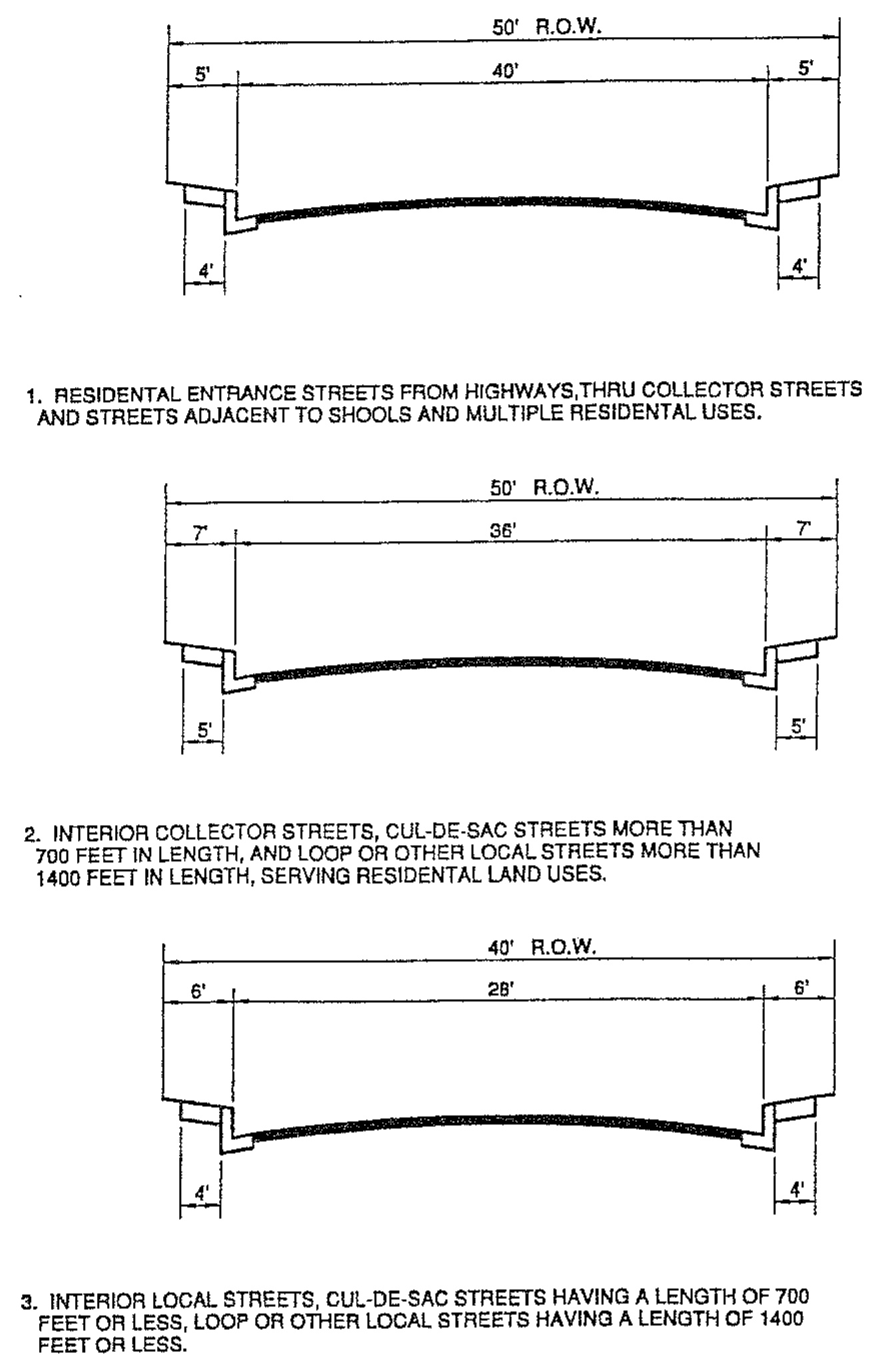
(Ord. No. 297, § 9.07.060.090, 3-20-2007)
Sec. 9.145.100. - Street grades.
No highway or street shall have a grade of more than six percent, except for distances less than 150 feet where the topography makes it impracticable to keep within such grade, and in no event shall the grade exceed ten percent, except where evidence, which is satisfactory to the City Council, is given that a lower grade is not possible.
(Ord. No. 297, § 9.07.060.100, 3-20-2007)
Sec. 9.145.110. - Right-of-way radius.
Intersections of road right-of-way lines, where one or both roads are local residential, shall be rounded with a curve having a radius of 13 feet, unless otherwise determined by the City Engineer.
(Ord. No. 297, § 9.07.060.110, 3-20-2007)
Sec. 9.145.120. - Future streets.
Wherever the City Council determines that a street is necessary for the future division of property as shown on the tentative map, or for adjoining property, but that the present dedication and construction of such street is not warranted, the City Council may require that the location, width and extent of such street shall be shown on the final map or parcel map as a future street. No improvement of such future street shall be required of the subdivider.
(Ord. No. 297, § 9.07.060.120, 3-20-2007)
Sec. 9.145.130. - Centerline curve radius.
On any street, the centerline curve radius shall not be less than 100 feet unless sufficient evidence is offered to the City Council by the subdivider to show that the 100-foot radius is not practicable.
(Ord. No. 297, § 9.07.060.130, 3-20-2007)
Sec. 9.145.140. - Street intersection angle.
Except as may be provided elsewhere, any highway or street intersecting with any other highway or street shall intersect it at an angle as near a right angle as practicable.
(Ord. No. 297, § 9.07.060.140, 3-20-2007)
Sec. 9.145.150. - Turnarounds.
(a)
A turning area shall be provided at the end of cul-de-sac streets. The advisory agency may require turnarounds:
(1)
Upon the recommendation of the Subdivision Committee, at intermediate points on culs-de-sac of more than 700 feet in length, and on other local streets where the distance between intersections exceeds 2,000 feet; and
(2)
At the end of stub or dead-end streets of more than 300 feet in length where the future extension of the street is remote.
(b)
All such turnarounds shall conform to the specifications of the City Engineer.
(Ord. No. 297, § 9.07.060.180, 3-20-2007)
Sec. 9.145.160. - Culs-de-sac; length restrictions.
(a)
Culs-de-sac shall be not more than:
(1)
700 feet in length, when serving land zoned for residential uses having a density of more than four dwelling units per net acre;
(2)
1,000 feet in length, when serving land zoned for residential uses having a density of four or less dwelling units per net acre.
(b)
This section shall not be construed to prohibit the approval of a division of land utilizing frontage on an existing cul-de-sac of more than the maximum permitted length, nor shall it be construed to prohibit the City Council from reducing the length of a proposed cul-de-sac to less than the maximum length permitted by this section or requiring the elimination of a proposed cul-de-sac in order to provide for the efficient circulation of traffic, the future development of the neighborhood street system or the deployment of emergency services.
(Ord. No. 297, § 9.07.060.190, 3-20-2007)
Sec. 9.145.170. - Firefighting access easements.
In areas where, in the opinion of the Forester and Fire Warden, there will be fire hazard to the watershed or any other properties, unobstructed fire-protection access easements, not less than 15 feet wide, shall be dedicated from the public highway or adjoining easement to the boundary of the division of land. Where the design of a division of land will cause an existing fire road or fire break to be severed, and the Forester and Fire Warden advise that this condition will impair the provision of adequate fire protection, the Planning Commission may require that the subdivider either revise the design of the division of land so that the fire road or fire break will not be severed or provide an alternate easement. The Forester and Fire Warden shall recommend to the Planning Commission/City Council regarding the location, design and grading of easements required pursuant to the provisions of this section. Such location, design and grading shall be as found necessary by the City Council.
(Ord. No. 297, § 9.07.060.220, 3-20-2007)
Sec. 9.145.240. - Area and width; requirements generally.
(a)
Each lot in any division of land shall have a net area not less than either the required area or what will be the required area at the time of the submission of the final map or parcel map for approval for the zone in which the lot or any portion thereof is located. Each lot shall have an average width of not less than the required width and a street frontage width of not less than the required width, or what will be the required widths at the time of the submission of the final map or parcel map for approval, or shall contain an area of not less than such required area within a portion which does have an average width of not less than such required width. The required area and the required lot widths shall be the same as those terms are defined, respectively, in the various zones as set forth in this title. Where this title does not establish a minimum required area or a required lot width in a particular zone, the minimum required area shall be 7,500 feet and the required width shall be 80 feet.
(b)
This section does not apply to any lot which the subdivider offers to deed or dedicate to the public.
(c)
Where public sewers are not available and private sewage disposal is to be used, every lot or parcel or building site shall be of sufficient size to provide for satisfactory sewage disposal for the land use intended.
(Ord. No. 297, § 9.07.060.240, 3-20-2007; Ord. No. 366, § 2, 10-15-2019)
Sec. 9.145.250. - City boundary line to be lot line when.
No lot shall be divided by a City boundary line. Each such boundary line shall be made a lot line.
(Ord. No. 297, § 9.07.060.280, 3-20-2007)
Sec. 9.145.260. - Frontage for lots.
The alignment of streets shall be such as to provide frontage for lots in the division of land except as provided in Section 9.145.250. The City Planner shall determine the lot frontage in unusual cases.
(Ord. No. 297, § 9.07.060.290, 3-20-2007)
Sec. 9.145.270. - Reserved.
Editor's note— Ord. No. 366, § 3, adopted Oct. 15, 2019, repealed § 9.145.270, which pertained to variation in minimum frontage and derived from Ord. No. 297, adopted March 20, 2007.
Sec. 9.145.280. - Lot sideline angle.
In all cases where practicable, the side lines of lots shall be at an approximate right angle to the street upon which such lots front.
(Ord. No. 297, § 9.07.060.310, 3-20-2007)
Sec. 9.145.290. - Flag lots.
The City Council may disapprove the platting of flag lots where this design is not justified by topographic conditions or the size and shape of the division of land, or where this design is in conflict with the pattern of neighborhood development. If flag lots are approved, the access strip for each lot shall be at least ten feet in width where the fire access strip is situated contiguous to other such access strips, so as to form a common driveway, and at least 20 feet in width or minimum fire access if greater, where the strip is not situated contiguous to other such access strips, unless the Subdivision Committee recommends the approval of lesser widths because of topographic conditions or the size and shape of a division of land. Each access strip shall be located so that, when improved as a driveway, the finished grade will not exceed 20 percent. The advisory agency may require that easements for ingress and egress be provided over common driveways for the benefit of the lots served.
(Ord. No. 297, § 9.07.060.320, 3-20-2007)
Sec. 9.163.010. - Separated parcels; restrictions.
No land shall be divided on any single map when such land is separated or divided into two or more parcels or portions by any parcel of land other than a street, alley, railroad right-of-way, public utility right-of-way, or flood control right-of-way, and when such land is so separated, each parcel or portion thereof, if divided, shall be divided as a separate parcel and shown on a separate map.
(Ord. No. 297, § 9.07.120.010, 3-20-2007)
Sec. 9.163.020. - Evidence of title.
The evidence of title required by Section 66465 of the Subdivision Map Act shall be a certificate of title or a policy of title insurance issued by a title company authorized by the laws of the State to write the same, showing the names of all persons having any record title interest in the land to be subdivided, together with the nature of their respective interests therein. In the event that any dedication is to be made for public use of any property shown on such final map of land, said certificate of title or policy of title insurance shall be issued for the benefit and protection of the City. Such certificate or policy shall be dated and delivered upon request of the City Engineer when such final map is ready for recordation.
(Ord. No. 297, § 9.07.120.020, 3-20-2007)
Sec. 9.163.030. - Prints; number required; distribution.
Upon the submission of a final map or parcel map to the City Engineer, it shall be accompanied by as many prints thereof as may be required by the City Engineer, who shall transmit them to the members of the Subdivision Committee and affected agency.
(Ord. No. 297, § 9.07.120.030, 3-20-2007)
Sec. 9.163.040. - Reports to City Engineer.
Each officer or agency, within 15 days after the receipt of a print of a final or parcel map, shall report in writing to the City Engineer as to the compliance or noncompliance of such map with law as to the matters coming under such officer's or agency's jurisdiction, together with a statement of the changes necessary thereon to cause such map to comply with the law.
(Ord. No. 297, § 9.07.120.040, 3-20-2007)
Sec. 9.163.050. - Matters required for submittal.
At the time of submittal of the final map or parcel map, or prints thereof, the following matters shall be submitted to the City Engineer as an aid in the processing of the final maps:
(1)
Complete copies of all deeds referenced on the map or required for the interpretation of deeds referenced on the map.
(2)
Complete copies of all field-book pages referenced on the map.
(3)
Complete copies of all other documents and information referenced on the map.
(4)
Mathematical traverses, in a form acceptable to the City Engineer, of the boundary of the division of land, block boundaries, not-a-part areas, centerline loops, and each lot or parcel shown on the map.
(5)
A print of the most recent assessor map book pages covering the proposed division of land.
(Ord. No. 297, § 9.07.120.050, 3-20-2007)
Sec. 9.163.060. - Filing fees; payment, deposit, use and refund conditions.
(a)
Upon the submission of a final map or parcel map, the subdivider shall deposit with the City a sum of money equal to the amount required by law for the filing of such map, which money shall be deposited for that purpose, and upon the filing of such map in the office of the County Recorder, such money shall be used by the City Engineer in payment of the fee for the filing of such map. Such fees shall be set by resolution of the City Council.
(b)
In the event that the subdivider abandons the intention to cause such map to be filed, and so notifies the City Engineer of such fact in writing, any unused portion of such money shall be returned to the subdivider who deposited the same.
(Ord. No. 297, § 9.07.120.060, 3-20-2007)
Sec. 9.163.070. - Street improvement plan checking fees.
Where the City Engineer is required to check street improvement plans for a parcel or final map under the provisions of the Subdivision Map Act, the subdivider shall pay a plan checking fee to the City in addition to all other fees and charges required by law. These fees, payable upon submission or resubmission of the plans for checking by the City Engineer, shall be set by resolution of the City Council.
(Ord. No. 297, § 9.07.120.070, 3-20-2007)
Sec. 9.163.080. - Street lighting plan checking fees.
Where plans for a street lighting system are required to be submitted to the City Engineer for a parcel or tract map under the provisions of the Subdivision Map Act, the subdivider shall pay a plan checking fee to the City in addition to all other fees required by law. These fees, payable upon submission of plans for checking to the City Engineer, shall be set by resolution of the City Council.
(Ord. No. 297, § 9.07.120.075, 3-20-2007)
Sec. 9.163.090. - Parcel or final map processing fees.
Where the City Engineer processes a parcel map, final map, waiver, or certificate of compliance under the provisions of the Subdivision Map Act, the subdivider shall pay a processing fee to the City in addition to all other fees and charges required by law. This fee, payable upon submission of the final map, parcel map, tentative map, waiver or certificate of compliance, or a print thereof, for review by the City Engineer or determination of compliance with Section 66492 of the Subdivision Map Act by the City, shall be set by City Council resolution.
(Ord. No. 297, § 9.07.120.080, 3-20-2007)
Sec. 9.163.160. - Title sheet; contents.
(a)
The title sheet of each map shall contain a title consisting of the words "Tract No." and the number of the division of land on a final map, or the words "Parcel Map No." and the number of division of land on a parcel map; also the words "in the City of Bradbury." Also, except as provided in Section 9.163.170, a subtitle consisting of a description of all the property being divided, by reference to such map of the property shown thereon, as shall have been previously filed or recorded in the Office of the County Recorder or shall have been previously filed with the County Clerk pursuant to a final judgment in any action in partition, or shall have been previously filed in the Office of the County Recorder under authority of Government Code Title 7, Division 3 or by reference to the plat of any United States survey. When necessary for greater clarity or definiteness, supplemental reference may be made to any other map on file in the Office of the County Recorder.
(b)
Each reference in such description to any division of land shall be spelled out and worded identically with the original record thereof and must show a complete reference to the book and page of records of the county.
(c)
Upon such title sheet the certificate of the surveyor or engineer referred to in Section 66449 or 66441 of the Subdivision Map Act shall appear. Also upon such title sheet, or upon at least one map sheet, shall appear the basis of bearings, making reference to a recorded subdivision map, County Surveyors map or other record acceptable to the City Engineer, or to a solar or Polaris observation.
(d)
Pursuant to Sections 66434 and 66445 of the Subdivision Map Act, certificates, affidavits and acknowledgments may be legibly stamped or printed upon the title sheet of the final map or parcel map with opaque ink. All stamped or written matter, including signatures, shall be so made with opaque ink that legible blue-line prints may be obtained therefrom.
(Ord. No. 297, § 9.07.120.100, 3-20-2007)
Sec. 9.163.170. - Reversion to acreage; title sheet information.
(a)
Upon the title sheet of each map filed for the purpose of reverting subdivided land to acreage, the subtitle shall consist of the words "A Reversion to Acreage of _____" (insert a legal description of the land being reverted).
(b)
A parcel map may be used to revert to acreage land previously subdivided and consisting of four or less contiguous parcels under the same ownership.
(Ord. No. 297, § 9.07.120.110, 3-20-2007)
Sec. 9.163.180. - Boundary lines for divisions of land.
The boundary line of a division of land shall be indicated by a distinctive symbol applied on the front side of the tracing and inside such boundary line. Such symbol shall be of such density as to be transferred to a blue-line print of such map and not to obliterate any line, figure or other data appearing on such map.
(Ord. No. 297, § 9.07.120.120, 3-20-2007)
Sec. 9.163.190. - Evidence determining boundaries.
(a)
On each final map shall be fully and clearly shown and identified such stakes, monuments or other evidence determining the boundaries of the subdivision as were found on the ground, together with sufficient corners of adjoining divisions of land, by lot and block number, subdivision name or number and place of filing, or by section, township and range, or other proper designation as may be necessary to locate precisely the limits of the subdivision.
(b)
The City Engineer may require that a field survey be performed in order to establish the boundary of any parcel map and shall examine such survey for compliance with the Subdivision Map Act and the Land Surveyor's Act.
(Ord. No. 297, § 9.07.120.130, 3-20-2007)
Sec. 9.163.200. - Orientation of map and map sheets.
The map on each sheet and the lettering thereon shall be so oriented that, with the north point direction away from the reader, the map may be read most conveniently from the bottom or lower right comer of such sheet, the binding edge to be at the left and lengthwise of the sheet, keeping in mind that the sheets are always on the right page of the map book, the left page being always blank.
(Ord. No. 297, § 9.07.120.140, 3-20-2007)
Sec. 9.163.210. - Title, scale, north point number and cross references.
Each sheet of a final map or parcel map, excepting the title sheet thereof, shall bear the main title of the map, the scale of the map, north point and sheet number, together with a designation of the relation, if any, between each sheet and each other sheet thereof.
(Ord. No. 297, § 9.07.120.150, 3-20-2007)
Sec. 9.163.220. - Block designation.
In the event that the subdivider elects to number or letter the blocks in any division of land, all blocks therein shall be numbered or lettered in numerical or alphabetical order, respectively, commencing with the numeral "1" or the letter "A" and continuing without omission or duplication. Such numbers or letters shall be solid and of sufficient size and thickness as to be conspicuous on the map, and shall be so placed as not to obliterate any figure, dimension or course and shall not be enclosed in any circle or other design. Except where necessitated by a scale sufficiently large to show all details clearly, no block shall be divided between two or more sheets.
(Ord. No. 297, § 9.07.120.160, 3-20-2007)
Sec. 9.163.230. - Lot numbers.
In the event that the blocks of any division of land are numbered or lettered, the lots in each block therein shall be numbered beginning with the numeral "1" and continuing without omission or duplication in any such block. Otherwise, the lots shall be numbered beginning with the numeral "1" and continuing without omission or duplication throughout the entire division of land. No prefix or suffix nor combination of letter and number shall be used. Each lot shall be shown entirely on one sheet.
(Ord. No. 297, § 9.07.120.170, 3-20-2007)
Sec. 9.163.240. - Bearings and lengths of lines.
The bearing and length of each lot line, block line and boundary line shall be shown on the final map or parcel map; provided that, when bearings and lengths of lot lines in any series of lots are the same, either the bearings or lengths may be omitted from each interior parallel lot line of such series. Each required bearing and length shall be shown in full, and no ditto mark or other designation of repetition shall be used. Bearings shall be shown to the nearest second and distances shall be shown to the nearest 1/100 of a foot.
(Ord. No. 297, § 9.07.120.180, 3-20-2007)
Sec. 9.163.250. - Curve data.
The length, radius and total central angle or bearings of terminal radii of each curve and the bearing of each radial line to each lot corner on each curve, or the central angle of each segment within each lot, shall be shown thereon.
(Ord. No. 297, § 9.07.120.190, 3-20-2007)
Sec. 9.163.260. - Area designation.
Upon each lot containing an area of three-fourths of an acre or more shall be designated the acreage of such lot shown to the nearest 1/100 of an acre. Lot area shall be shown in square feet on parcels containing less than three-fourths of an acre.
(Ord. No. 297, § 9.07.120.200, 3-20-2007)
Sec. 9.163.270. - City boundary lines.
Upon the final map or parcel map shall be shown each City boundary line crossing or adjoining the division of land, and such line shall be clearly designated and tied in.
(Ord. No. 297, § 9.07.120.210, 3-20-2007)
Sec. 9.163.280. - Street names.
(a)
Naming; duplication.
(1)
Street names within the boundaries of a division of land shown on a final map or parcel map shall be submitted to the City Engineer for approval and, if duplicated elsewhere in the sub-region or so nearly the same in spelling or pronunciation as to cause confusion, the City Engineer may require some other name.
(2)
Unless a name is so duplicated or confusing it shall be the same as the name of any street of which it is on line of extension, or the name to which said street or highway may be in the process of being changed.
(b)
Streets (except alleys or walks) extending approximately northerly and southerly shall be designated "avenue" and those extending approximately easterly and westerly shall be designated "street."
(c)
Streets which materially change direction shall bear the name and suffix designated by the City Engineer as most closely conforming to a suitable house numbering system.
(d)
The words "avenue," "boulevard," "place" or other designation of any such street shall be spelled out in full.
(e)
The name of each newly dedicated portion of any street shall be shown in or arrowed to such newly dedicated portion.
(Ord. No. 297, § 9.07.120.220, 3-20-2007)
Sec. 9.163.290. - Street widths and centerlines.
(a)
There shall be shown upon each final map or parcel map the centerline of each street or way, the total width thereof, the width of that portion, if any, to be dedicated and, in the case of any existing streets or ways, the width thereof, and the width of each street or way on each side of the centerline thereof. On each such centerline shall be shown the bearing and length of each tangent and radius, central angle, and length of each curve.
(b)
The final map or parcel map shall show the width of each railroad right-of-way, flood control or drainage easement and each other easement appearing on such map, whether previously of record or offered for dedication on such map.
(Ord. No. 297, § 9.07.120.230, 3-20-2007)
Sec. 9.163.300. - Easements—Identification.
Each easement shall be clearly labeled and identified and, if of record, the record reference shall be shown thereon.
(Ord. No. 297, § 9.07.120.240, 3-20-2007)
Sec. 9.163.310. - Same—Designation on map.
Each easement shown for any storm drain or sewer or fire access shall be designated on the final map or parcel map by fine dashed lines.
(Ord. No. 297, § 9.07.120.250, 3-20-2007)
Sec. 9.163.320. - Same—Lines, ties and other evidence.
Upon a final tract map or parcel map shall be shown the centerline or side lines of each easement to be dedicated to the local agency or previously dedicated to the local agency, and those easements required to be shown by the City Council to which the lots in the division of land are subject. In the event that such easement is not definitely located of record, a statement showing the existence of such easement shall be placed on the map. A statement showing the existence and purpose of all easements other than those of the local agency shall be placed on the map to the satisfaction of the City Engineer.
(Ord. No. 297, § 9.07.120.260, 3-20-2007)
Sec. 9.163.330. - Same—Widths and ties.
The width of easements or the lengths and bearings of the lines thereof and sufficient ties thereto to definitely locate such easements with respect to a division of land shall be shown on the final map or parcel map.
(Ord. No. 297, § 9.07.120.270, 3-20-2007)
Sec. 9.163.340. - Same—Bearings on lot lines.
Distances and bearings on the side lines of lots which are cut by easements shall be arrowed or so shown as to indicate clearly the actual length of each lot line.
(Ord. No. 297, § 9.07.120.280, 3-20-2007)
Sec. 9.163.350. - Same—Notes and figures.
All notes or figures pertaining to each easement shall be subordinated in form and appearance to those relating to the division of land itself.
(Ord. No. 297, § 9.07.120.290, 3-20-2007)
Sec. 9.163.360. - Same—Dedication.
If an easement is being dedicated by a final map, it shall be properly set out in the owner's certificate of dedication on the map.
(Ord. No. 297, § 9.07.120.300, 3-20-2007)
Sec. 9.163.370. - Land subject to overflow, ponding or high groundwater.
If any portion of such land is subject to sheet overflow or ponding of local stormwater, or should the depth to groundwater be less than ten feet from the ground surface, such information shall be shown on the final map or parcel map and the City Engineer shall so inform the State Real Estate Commissioner.
(Ord. No. 297, § 9.07.120.310, 3-20-2007)
Sec. 9.163.380. - Land subject to flood hazard, inundation, or geological hazard.
(a)
If any portion of the land within the boundaries shown on a tentative map of a division of land is subject to flood hazard, inundation or geological hazard, and the probable use of the property will require structures thereon, the advisory agency may disapprove the map or that portion of the map so affected and require protective improvements to be constructed as a condition precedent to approval of the map.
(b)
Approvals of land subject to flood hazard shall comply with the current Federal floodplain management regulations.
(c)
If any portion of a lot or parcel of a division of land is subject to flood hazard, inundation or geological hazard, such fact and portion shall be clearly shown on the final map or parcel map by a prominent note on each sheet of such map whereon any such portion is shown. A dedication of building restriction rights over the flood hazard, inundation or geological hazard area may be required.
(d)
The provisions of this section shall not apply to divisions of land in which each resultant parcel has a gross area of 40 acres or more or is a quarter-quarter section of a government plat or larger.
(Ord. No. 297, § 9.07.120.320, 3-20-2007)
Sec. 9.163.390. - Flood hazard area, floodway or natural watercourse designation.
In the event that a dedication of right-of-way for storm drainage purposes is not required, the location of any watercourse, channel, stream or creek, flood hazard area or floodway shall be shown on the final map or parcel map to the satisfaction of the City Council.
(Ord. No. 297, § 9.07.120.330, 3-20-2007)