
Brandon City Zoning Code
ARTICLE 3
- ZONING DISTRICTS AND MAP ESTABLISHED
3.1 - Zoning districts established.
For the purpose of promoting public health, safety, morals, and general welfare, the City of Brandon, Mississippi, is hereby divided into the following zoning districts:
3.2 - Official zoning map.
The aforesaid zoning districts are identified and delineated on a map entitled official zoning map: City of Brandon, Mississippi, and said map, together with all explanatory matter thereon, is hereby adopted by reference and declared to be a part of this ordinance.
3.2.1 Map certified. The official zoning map shall be identified by the signature of the mayor, attested
by the city clerk, and shall bear the seal of the city under the following words:
"This is to certify that this is the Official Zoning Map of the City of Brandon, Mississippi,
as adopted by the Mayor and Board of Aldermen on March 21, 2016."
3.2.2 Location of official zoning map. Regardless of the existence of purported copies of the official zoning map which may from time to time be made or published, the official zoning map located at the Brandon city hall shall be the final authority as to the current zoning status of land and water areas, buildings, and other structures in the city.
3.2.3 Public inspection of map. The official zoning map shall be available for public inspection as provided by law for all matter which is public record.
3.2.4 Map amendment. If, in accordance with the provisions of this ordinance and statutes of the State of Mississippi, changes are made in the zoning boundaries or other matters portrayed on the official zoning map, such changes shall be made on the official zoning map within 30 days after the amendment has been approved by the mayor and board of aldermen. All such amendments shall also be recorded by the zoning administrator in a book known as the log of amendments to the official zoning map, and these entries shall be made in chronological order.
"On _________by official action of the Mayor and Board of Aldermen, the following change(s) were made in the Official Zoning Map: (brief description of the nature of the change)." All entries in the log of amendments to the official zoning map shall be made within 30 days after the amendment has been approved by the mayor and board of aldermen.
Said log of amendments, like the official zoning map, shall be located in the city hall of Brandon and shall be available for public inspection. No amendment to this ordinance which involves matters portrayed on the official zoning map shall become effective until after such changes have been made on said map and recorded in the log of amendments. Furthermore, no changes of any nature on the official zoning map or matters shown thereon shall be made except in conformity with the procedures set forth in this ordinance. An unauthorized change of whatever kind by any person or persons shall be considered a violation of this ordinance and punishable as provided by law.
3.2.5 Replacement of official zoning map. In the event that the official zoning map becomes damaged, destroyed, lost, or difficult to interpret because of the nature or number of changes and additions, the mayor and board of aldermen may, by resolution, adopt a new official zoning map which shall supersede the prior zoning map. The new official zoning map may correct drafting errors or other omissions on the prior official zoning map, but no such correction shall have the effect of amending the original official zoning map or any subsequent amendment thereof. The new official zoning map shall be identified by the signature of the mayor, attested by the city clerk, and shall bear the seal of the city under the following words:
"This is to certify that this Official Zoning Map replaces the Official Zoning Map adopted as part of the Zoning Ordinance of the City of Brandon, Mississippi."
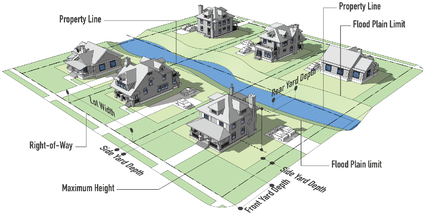
3.3 - Rules for interpretation of district boundaries.
Where uncertainty exists as to the boundaries of districts as shown on the official zoning map, the following shall apply:
3.3.1 Boundaries indicated as approximately following the centerlines of streets, highways, or alleys shall be constructed to follow such centerlines.
3.3.2 Boundaries indicated as approximately following platted lot lines shall be construed as following such lot lines.
3.3.3 Boundaries indicated as approximately following city limits shall be construed as following such city limits.
3.3.4 Where the boundary of a district line follows a railroad right-of-way, such boundary shall be deemed to be located on the right-of-way line to which it is closest, which shall completely include or exclude the railroad easement unless otherwise designated.
3.3.5 Boundaries indicated as approximately following the centerlines of streams, rivers, canals, lakes or other bodies of water shall be construed to follow such centerlines.
3.3.6 Boundaries indicated as parallel to or extensions of features indicated in subsections 3.3.1 through 3.3.5 above shall be so construed.
3.3.7 Where physical or cultural features existing on the ground are at variance with those shown on the official zoning map, or in other circumstances not covered by subsections 3.3.1 through 3.3.6 above, the mayor and board of aldermen shall interpret the district boundaries.
3.3.8 Where a district boundary line divides a lot which was in a single ownership at the time of passage or amendment of this ordinance, the mayor and board of aldermen may permit, as a conditional use, the extension of the use into the remaining portion of the lot.
(Ord. of 4-6-20(1), Exh. A)
3.4 - Transition to new zoning districts.
On the effective date of this ordinance, land zoned with a zoning district classification from the previous zoning regulations shall be translated to one of the zoning district classifications in table 3.4. The table summarizes translation of the zoning districts used in the previous zoning regulations to the zoning districts based on the Brandon Comprehensive Plan.
(Ord. of 4-6-20(1), Exh. A)
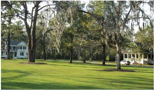
3.5 - Residential districts.
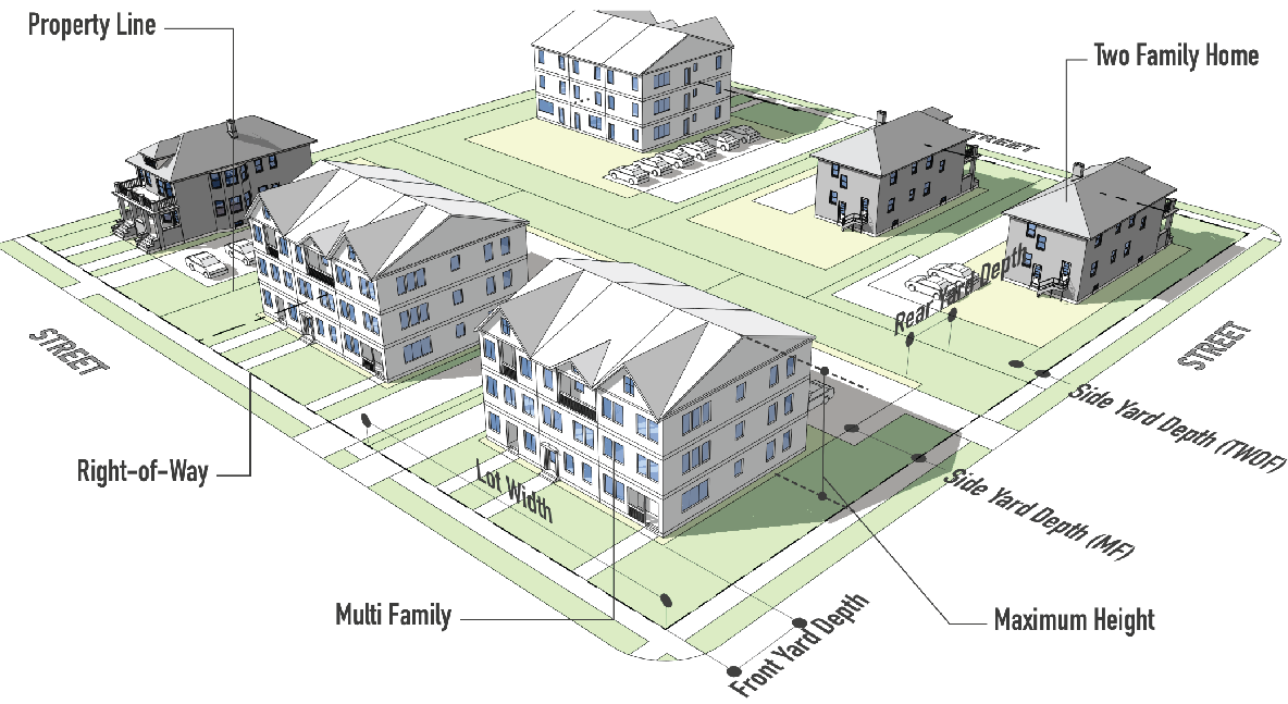
| 3.5.1 RR RURAL NEIGHBORHOOD (RR) | ||
| PURPOSE | TYPICAL BUILDING TYPE | |
|
The purpose of the Rural Neighborhood District is to protect certain areas of rural
development character within the city so they may continue to be used for rural neighborhood
purposes including residential, recreational and agricultural purposes. It is the
intent of this ordinance that these districts be located only in the more rural, undeveloped
areas of the City of Brandon.
|  | |
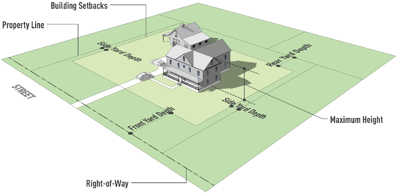
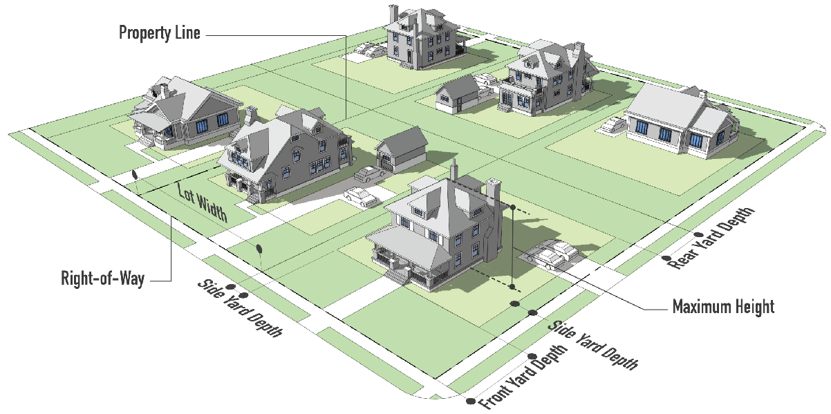
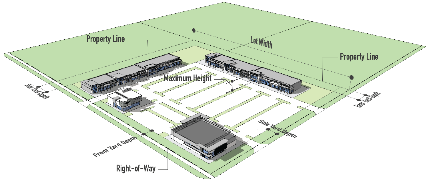
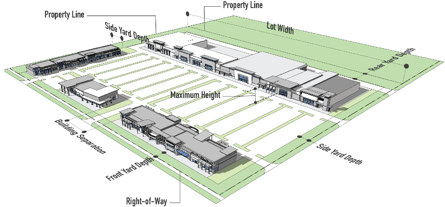
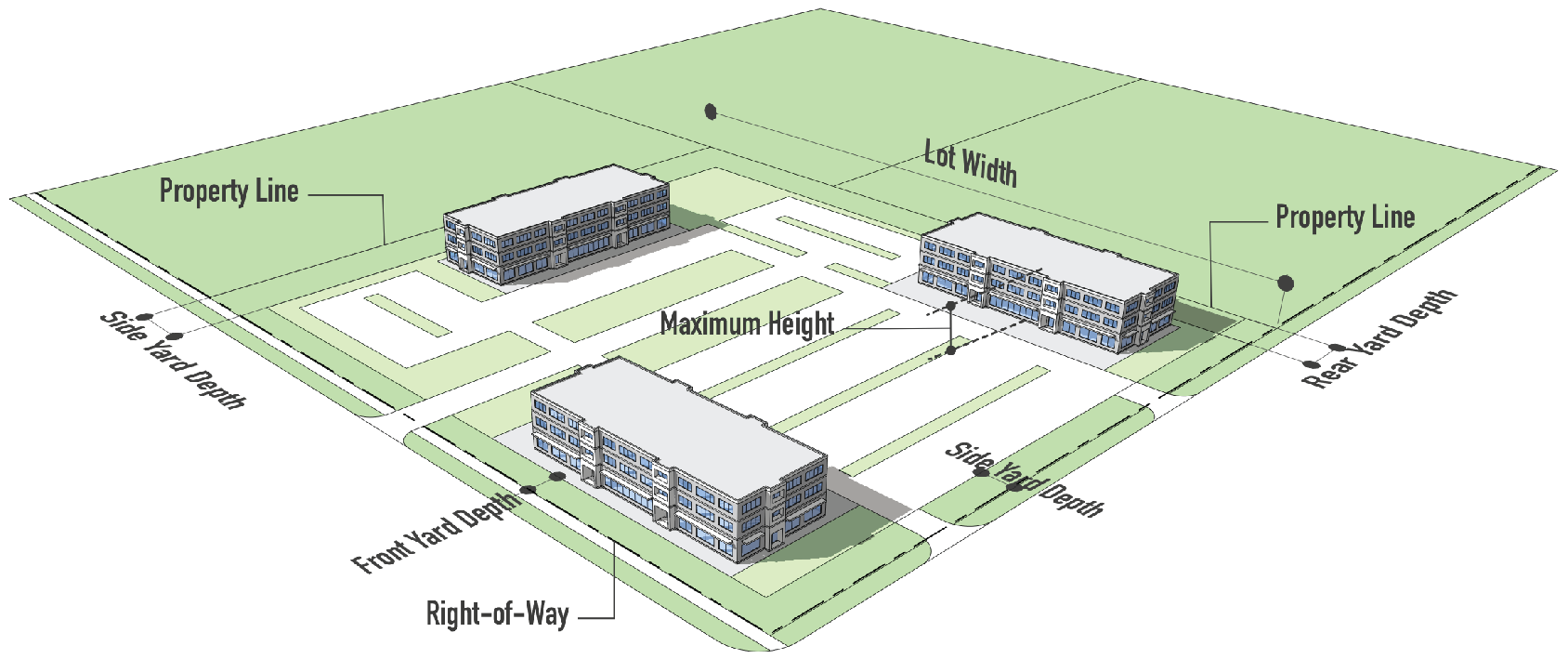
| PRINCIPAL INTENSITY AND DIMENSIONAL STANDARDS | TYPICAL LOT PATTERN | |
| Minimum lot area (sf) | 32,670 | 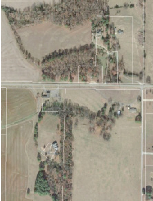 |
| Minimum lot width (ft) | 80 | |
| Minimum floor area per dwelling unit (sf) | 1,500 | |
| Maximum building coverage (% of lot area) | n/a | |
| Maximum height (ft) | 40 | |
| Minimum front yard depth (ft) | 50 | |
| Minimum side yard depth (ft) | 8 | |
| Minimum rear yard depth (ft) | 30 | |
| District land use | See section 4 | |
| Development standards | See section 5 | |
| Mobility standards | See section 6 | |
| Parking requirements | See section 7 | |
|
NOTES: (sf = square feet, ft = feet)
Height limits shall not apply to spires, cupolas, antennas, chimneys, or other mechanical appurtenances usually required to be placed above the roof level and not intended for human occupancy or to be used for any commercial or advertising purposes. | ||
| TYPICAL DEVELOPMENT CONFIGURATION | ||
 | ||
| 3.5.2 R-12 SUBURBAN NEIGHBORHOOD (R-12) | ||
| PURPOSE | TYPICAL BUILDING TYPE | |
| The purpose of the R-12 Suburban Neighborhood District is to provide areas for the development of low density, single-family residential and related uses. It is the intent of this ordinance that existing residential developments be protected from encroachment of undesirable and incompatible uses and that new developments be constructed according to sound, reasonable, and desirable regulations as stated within this ordinance. | 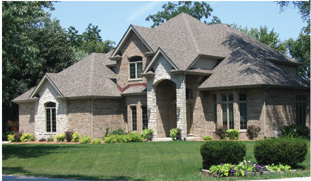 | |
| PRINCIPAL INTENSITY AND DIMENSIONAL STANDARDS | TYPICAL LOT PATTERN | |
| Minimum lot area (sf) | 12,000 |  |
| Minimum lot width (ft) | 90 | |
| Minimum floor area per dwelling unit (sf) | 1,800 | |
| Maximum building coverage (% of lot area) | 30 | |
| Maximum height (ft) | 40 | |
| Minimum front yard depth (ft) | 30 | |
| Minimum side yard depth (ft) | 8 | |
| Minimum rear yard depth (ft) | 25 | |
| District land use | See section 4 | |
| Development standards | See section 5 | |
| Mobility standards | See section 6 | |
| Parking requirements | See section 7 | |
|
NOTES: (sf = square feet, ft = feet)
Height limits shall not apply to spires, cupolas, antennas, chimneys, or other mechanical appurtenances usually required to be placed above the roof level and not intended for human occupancy or to be used for any commercial or advertising purposes. | ||
| TYPICAL DEVELOPMENT CONFIGURATION | ||
 | ||
| 3.5.3 R-8 SUBURBAN MEDIUM DENSITY NEIGHBORHOOD (R-8) | ||
| PURPOSE | TYPICAL BUILDING TYPE | |
| The purpose of the R-8 Medium Density Neighborhood District is to provide areas for the development of medium density, single-family residential and related uses. It is the intent of this ordinance that existing residential developments be protected from encroachment of undesirable and incompatible uses and that new developments be constructed according to sound, reasonable, and desirable regulations as stated within this ordinance. |  | |
| PRINCIPAL INTENSITY AND DIMENSIONAL STANDARDS | TYPICAL LOT PATTERN | |
| Minimum lot area (sf) | 8,000 |  |
| Minimum lot width (ft) | 85 | |
| Minimum floor area per dwelling unit (sf) | 1,600 | |
| Maximum building coverage (% of lot area) | 45% | |
| Maximum height (ft) | 40 | |
| Minimum front yard depth (ft) | 25 | |
| Minimum side yard depth (ft) | 5 | |
| Minimum rear yard depth (ft) | 25 | |
| District land use | See section 4 | |
| Development standards | See section 5 | |
| Mobility standards | See section 6 | |
| Parking requirements | See section 7 | |
|
NOTES: (sf = square feet, ft = feet)
Site plan review is required according to section 9.9. Height limits shall not apply to spires, cupolas, antennas, chimneys, or other mechanical appurtenances usually required to be placed above the roof level and not intended for human occupancy or to be used for any commercial or advertising purposes. | ||
| TYPICAL DEVELOPMENT CONFIGURATION | ||
 | ||
| 3.5.4 RM-8 SUBURBAN MIXED NEIGHBORHOOD (RM-8) | ||
| PURPOSE | TYPICAL BUILDING TYPE | |
| The purpose of the RM-8 Mixed Neighborhood District is to provide areas for the development of moderate density, single-family residential uses in moderately spacious surroundings. It is the intent of this ordinance that these districts be located in suburban and intermediate portions of the city as well as in established moderate density residential areas. It is further the intent of this ordinance that new and existing developments in this district be protected from encroachment of higher density residential uses. | 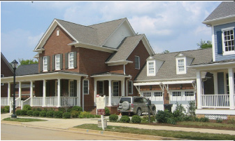 | |
| PRINCIPAL INTENSITY AND DIMENSIONAL STANDARDS | TYPICAL LOT PATTERN | |
| Minimum lot area (sf) | 8,000 |  |
| Minimum lot width (ft) | 85 | |
| Minimum floor area per dwelling unit (sf) | 1,600 | |
| Maximum building coverage (% of lot area) | 45% | |
| Maximum height (ft) | 40 | |
| Minimum front yard depth (ft) | 25 | |
| Minimum side yard depth (ft) | 5 | |
| Minimum rear yard depth (ft) | 20 | |
| District land use | See section 4 | |
| Development standards | See section 5 | |
| Mobility standards | See section 6 | |
| Parking requirements | See section 7 | |
|
NOTES: (sf = square feet, ft = feet)
Site plan review is required according to section 9.9. Height limits shall not apply to spires, cupolas, antennas, chimneys, or other mechanical appurtenances usually required to be placed above the roof level and not intended for human occupancy or to be used for any commercial or advertising purposes. | ||
| TYPICAL DEVELOPMENT CONFIGURATION | ||
 | ||
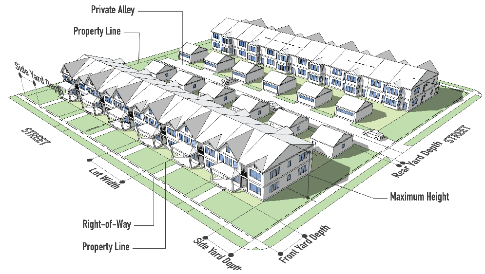
| 3.5.5 RM-4 TOWNHOUSE AND ZERO LOT LINE RESIDENTIAL (RM-4) | ||
| PURPOSE | TYPICAL BUILDING TYPE | |
| The purpose of the RM-4 Town House and Zero Lot Line Residential District is to provide areas for the development of moderate to high density residential uses and structures in moderately spacious surroundings. These districts are intended to be located in suburban and intermediate portions of the city where a protected environment suitable for moderate density residential use can be provided, as well as in established moderate density residential areas. However, the use of this district is appropriate on a smaller scale in the suburban portions of the city as a transitional area between low-density residential districts and commercial districts, industrial districts major transportation arteries, or other uses that are not compatible with low-density residential environment. | 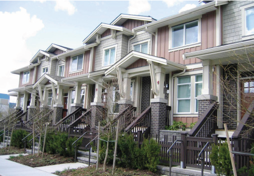 | |
| PRINCIPAL INTENSITY AND DIMENSIONAL STANDARDS | TYPICAL LOT PATTERN | |
| Minimum lot area (sf) |
4,000 (TH)
6,500 (ZLL) | 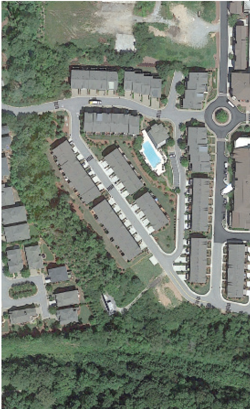 |
| Minimum lot width (ft) |
35 (Per TH Group)
60 (ZLL) | |
| Minimum floor area per dwelling unit (sf) | 1,400 | |
| Maximum building coverage (% of lot area) | 50% | |
| Maximum height (ft) | 40 | |
| Minimum front yard depth (ft) | 20* | |
| Minimum side yard depth (ft) |
20 (TH)
5/10 (ZLL)** | |
| District land use | See section 4 | |
| Development standards | See section 5 | |
| Mobility standards | See section 6 | |
| Parking requirements | See section 7 | |
| Minimum rear yard depth (ft) |
20***
5 for garage | |
|
NOTES: (sf = square feet, ft = feet, TH = Townhome, ZLL = Zero Lot Line
Site plan review required according to section 9.9. *25 feet adjacent to RR, R-12, RM-8, **15 minimum between buildings, ***10 feet adjacent to RR, R-12, RM-8, A maximum of six dwelling units shall be allowed in each row of townhouses. Townhouse and Zero Lot Line Residential developments shall have a minimum of 10% open space. | ||
| TYPICAL DEVELOPMENT CONFIGURATION | ||
 | ||
| 3.5.6 RH SUBURBAN HIGH DENSITY RESIDENTIAL (RH) | ||
| PURPOSE | TYPICAL BUILDING TYPE | |
| The purpose of RH Suburban High Density is to provide areas for the development of higher density of multifamily residential uses. These districts are to be located in or near the central portion of the city and other carefully selected areas where public services are adequate to support high density residential development. However, the use of this district on a smaller scale in the suburban portions of the city is appropriate as a transition area beween low density residential districts and commercial districts, industrial districts, major transportation arteries or other uses not compatible with a low density residential environment. | 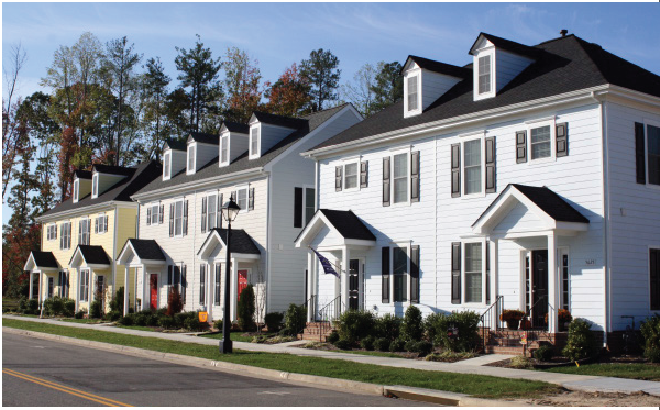 | |
| PRINCIPAL INTENSITY AND DIMENSIONAL STANDARDS | TYPICAL LOT PATTERN | |
| Minimum lot area (sf) |
8,500 (SF or TF)
43,560/5445 per unit (MF) |  |
| Minimum lot width (ft) | 75 | |
| Minimum floor area per dwelling unit (sf) | 1,400 | |
| Maximum building coverage (% of lot area) | 50% | |
| Maximum height (ft) | 40 | |
| Minimum front yard depth (ft) | 25 | |
| Minimum side yard depth (ft) |
8 (SF or TF)
20 (MF)* | |
| Minimum rear yard depth (ft) | 20 | |
| District land use | See section 4 | |
| Development standards | See section 5 | |
| Mobility standards | See section 6 | |
| Parking requirements | See section 7 | |
|
NOTES: (sf = square feet, ft = feet, SF = single-family, TF = two-family, MF = multi-family)
Site plan review is required according to section 9.9. *When abutting a single-family residential district | ||
| TYPICAL DEVELOPMENT CONFIGURATION | ||
 | ||
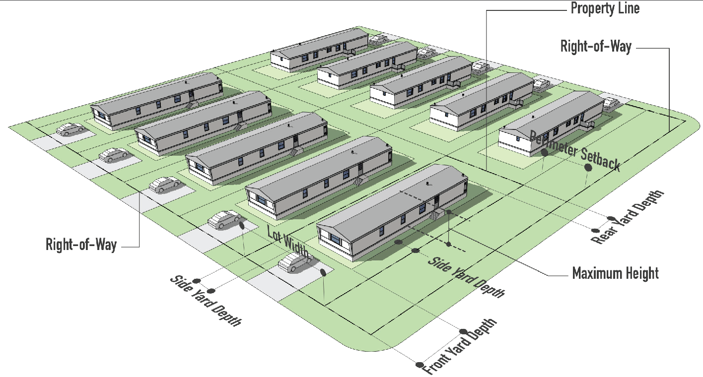
| 3.5.7 MH MANUFACTURED HOME RESIDENTIAL (MH) | ||
| PURPOSE | TYPICAL BUILDING TYPE | |
| The purpose of the MH Manufactured Home Residential District is to provide for needed and properly planned manufactured home parks. It is the intent of this ordinance that these districts may be located only in such areas as to not adversely affect the established residential subdivisions and residential densities in the city. Such locations, however, shall have necessary public services, a healthful living environment and normal amenities associated with residential zones of the city. |  | |
| PRINCIPAL INTENSITY AND DIMENSIONAL STANDARDS | TYPICAL LOT PATTERN | |
| Minimum site area (ac) | 10 |  |
| Minimum lot size (sf) | 5,000 | |
| Minimum lot width (ft) | 50 | |
| Perimeter setback | 25 | |
| Minimum floor area per dwelling unit (sf) | n/a | |
| Maximum building coverage (% of lot area) | 50% | |
| Maximum height (ft) | 20 | |
| Minimum front yard depth (ft) | 25 | |
| Minimum side yard depth (ft) | 10 | |
| Minimum rear yard depth (ft) | 15 | |
| District land use | See section 4 | |
| Development standards | See section 5 | |
| Mobility standards | See section 6 | |
| Parking requirements | See section 7 | |
|
NOTES: (sf = square feet, ft = feet)
Site plan review is required according to section 9.9. Height limits shall not apply to spires, cupolas, antennas, chimneys, or other mechanical appurtenances usually required to be placed above the roof level and not intended for human occupancy or to be used for any commercial or advertising purposes. | ||
| TYPICAL DEVELOPMENT CONFIGURATION | ||
 | ||
(Ord. of 4-6-20(1), Exh. A)
3.6 - Commercial districts.
| 3.6.1 NEIGHBORHOOD CENTER (NC) | ||
| PURPOSE | TYPICAL BUILDING TYPE | |
| Neighborhood Centers contain a variety of commercial activities including groceries, convenience stores, other small retail shops, offices, and personal services. Typically no one use should occupy an area larger than 20,000 square feet to insure there are a variety of commercial uses and that no one use dominates a Neighborhood Center. |  | |
| PRINCIPAL INTENSITY AND DIMENSIONAL STANDARDS | TYPICAL LOT PATTERN | |
| Minimum lot area (sf) | None |  |
| Minimum lot width (ft) | 40 | |
| Minimum floor area per dwelling unit (sf) | n/a | |
| Maximum building coverage (% of lot area) | 50 | |
| Maximum height (ft) | 40 | |
| Minimum front yard depth (ft) | 20 | |
| Minimum side yard depth (ft) | 8/25* | |
| Minimum rear yard depth (ft) | 20/25* | |
| District land use | See section 4 | |
| Development standards | See section 5 | |
| Mobility standards | See section 6 | |
| Parking requirements | See section 7 | |
|
NOTES: (sf = square feet, ft = feet)
Height limits shall not apply to spires, cupolas, antennas, chimneys, or other mechanical appurtenances usually required to be placed above the roof level and not intended for human occupancy or for any commercial or advertising purposes. Site plan review required according to section 9.9. *When abutting a Residential District. Exceptions to maximum setback allowed when the space is to be occupied by public plazas, outdoor dining, community gardens, etc. | ||
| TYPICAL DEVELOPMENT CONFIGURATION | ||
 | ||
| 3.6.2 COMMUNITY CENTER (CC) | ||
| PURPOSE | TYPICAL BUILDING TYPE | |
| Provides for the sale of soft lines (apparel) and hard lines (hardware, appliances, etc.) built around a junior department store, variety store, or discount department store as the major tenant, in addition to a supermarket. It may have a strong specialty store. Typical size is 150,000 square feet and may range in size from 100,000 to 300,000 square feet. |  | |
| PRINCIPAL INTENSITY AND DIMENSIONAL STANDARDS | TYPICAL LOT PATTERN | |
| Minimum lot (site) area (sf) | None |  |
| Minimum lot (site) width (ft) | 75 | |
| Minimum floor area per dwelling unit (sf) | n/a | |
| Maximum building coverage (% of lot area) | 80 | |
| Maximum height (ft) | 40 | |
| Minimum front yard depth (ft) | 20 | |
| Minimum side yard depth (ft) | 8/35* | |
| Minimum rear yard depth (ft) | 20/35* | |
| District land use | See section 4 | |
| Development standards | See section 5 | |
| Mobility standards | See section 6 | |
| Parking requirements | See section 7 | |
|
NOTES: (sf = square feet, ft = feet)
Height limits shall not apply to spires, cupolas, antennas, chimneys, or other mechanical appurtenances usually required to be placed above the roof level and not intended for human occupancy or for any commercial or advertising purposes. Site plan review required according to section 9.9. *When abutting a Residential District. Exceptions to maximum setback allowed when the space is to be occupied by public plazas, outdoor dining, community gardens, etc. | ||
| TYPICAL DEVELOPMENT CONFIGURATION | ||
 | ||
| 3.6.3 REGIONAL CENTER (RC) | ||
| PURPOSE | TYPICAL BUILDING TYPE | |
| Provides shopping goods, general merchandise, apparel, furniture, and home furnishings in full depth and variety. It is built around the full-line department store with a minimum GLA of 100,000 square feet, as the major drawing power. Two, three, or more department stores may be included. A regional center typically has a gross leasable area (GLA) of 300,000 to more than 1,000,000 square feet. Regional Centers in excess of 750,000 square feet GLA with three or more department stores are considered Super Regional. | 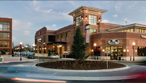 | |
| PRINCIPAL INTENSITY AND DIMENSIONAL STANDARDS | TYPICAL LOT PATTERN | |
| Minimum lot area (ac) | 5 acres | 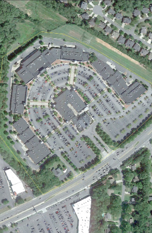 |
| Minimum lot width (ft) | 200 | |
| Minimum floor area per dwelling unit (sf) | n/a | |
| Maximum building coverage (% of lot area) | 50 | |
| Maximum height (ft) | 40 | |
| Minimum front yard depth (ft) | 20 | |
| Minimum side yard depth (ft) | 8/75* | |
| Minimum rear yard depth (ft) | 20/40* | |
| District land use | See section 4 | |
| Development standards | See section 5 | |
| Mobility standards | See section 6 | |
| Parking requirements | See section 7 | |
|
NOTES: (sf = square feet, ft = feet, ac = acre)
Height limits shall not apply to spires, cupolas, antennas, chimneys, or other mechanical appurtenances usually required to be placed above the roof level and not intended for human occupancy or for any commercial or advertising purposes. Site plan review required according to section 9.9. *When abutting a Residential District. Exceptions to maximum setback allowed when the space is to be occupied by public plazas, outdoor dining, community gardens, etc. | ||
| TYPICAL DEVELOPMENT CONFIGURATION | ||
 | ||
(Ord. of 4-6-20(1), Exh. A)
3.7 - Employment districts.
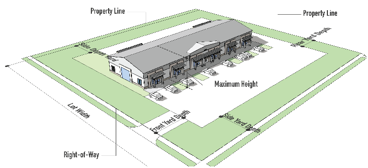
| 3.7.1 OFFICE AND RESEARCH CAMPUS (ORC) | ||
| PURPOSE | TYPICAL BUILDING TYPE | |
| These areas are intended for large-scale, office(greater than 20,000 square foot floorplates and multi stories), research and development, and light manufacturing uses (e.g. warehouses, data centers and data center related facilities such as substations, fuel storage and battery storage, etc.) is also appropriate for these areas. Restaurant, hotel, and business service (e.g. copy shop, computer sales and service uses that support the office/industrial uses may be considered. | 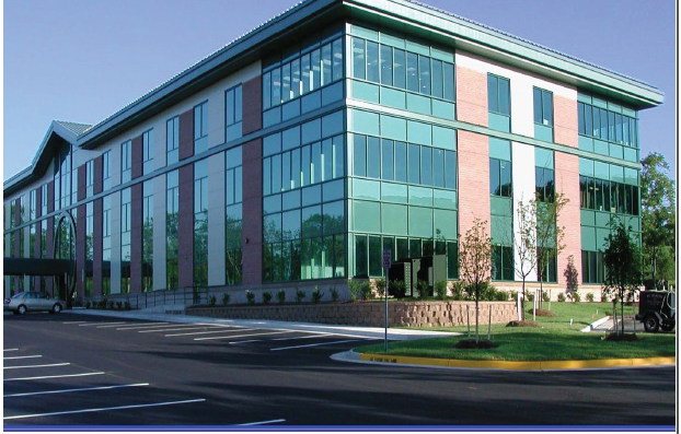 | |
| PRINCIPAL INTENSITY AND DIMENSIONAL STANDARDS | TYPICAL LOT PATTERN | |
| Minimum lot area (sf) | 8,500 | 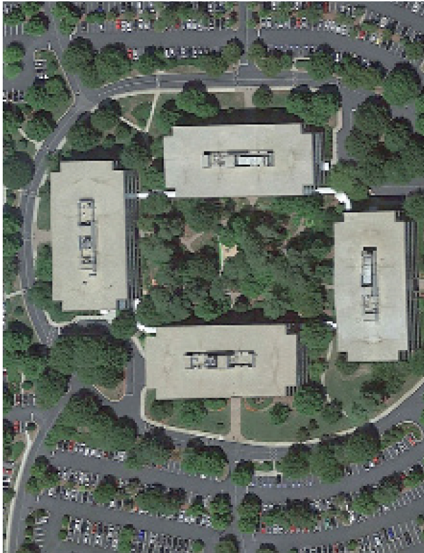 |
| Minimum lot width (ft) | 75 | |
| Minimum floor area per dwelling unit (sf) | n/a | |
| Maximum building coverage (% of lot area) | 50 | |
| Maximum height (ft) | 40 | |
| Minimum front yard depth (ft) | 20 | |
| Minimum side yard depth (ft) | 8/25* | |
| Minimum rear yard depth (ft) | 15/25* | |
| District land use | See section 4 | |
| Development standards | See section 5 | |
| Mobility standards | See section 6 | |
| Parking requirements | See section 7 | |
|
Height shall not apply to industry relevant structures, any parapets, including screening
and rooftop utilities including condensers and air chillers to a maximum of 90 feet.
If relevant structures and appurtenances must exceed 90 feet in height, will be required to increase building buffering or setbacks 1' per 1' of proposed height deviation. This is in addition to the standards provided in section 5. If industry relevant structures and appurtenances must exceed the maximum site coverage, additional buffering may be required by the Director, who shall apply the unit of measurement for a use that the Director deems most similar. Site plan review required according to section 9.9. *When abutting a Residential District. | ||
| TYPICAL DEVELOPMENT CONFIGURATION | ||
 | ||
(Ord. of 9-03-24(2))
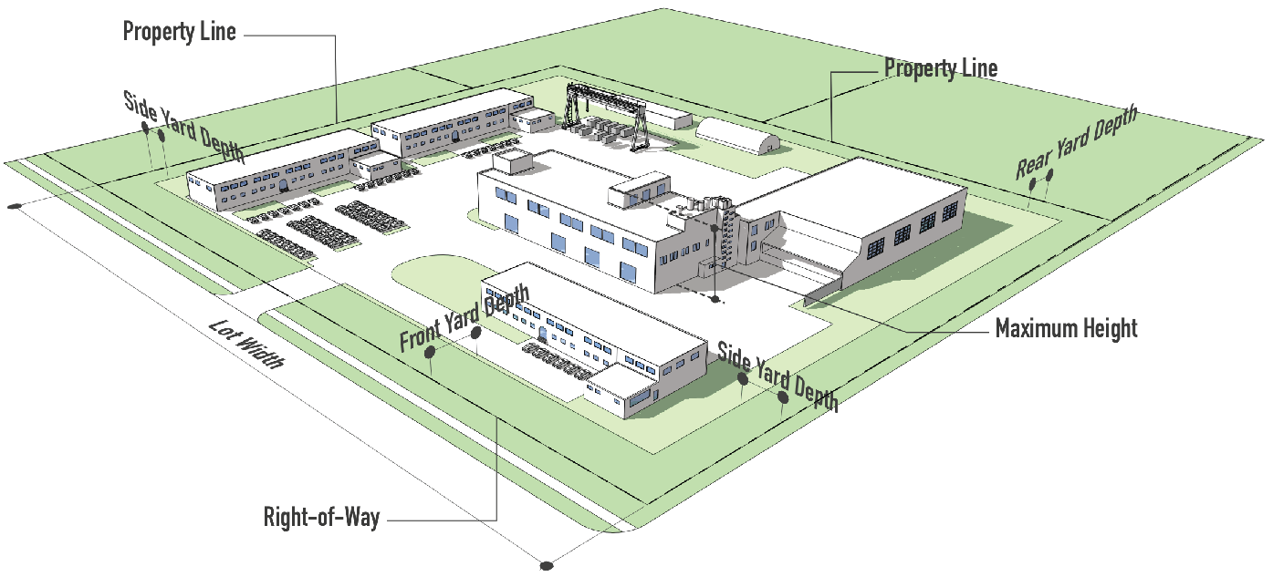
| 3.7.2 LIGHT INDUSTRIAL (I-1) | ||
| PURPOSE | TYPICAL BUILDING TYPE | |
| Light Industrial areas include light manufacturing, assembly, research and development, flex space, and large-scale office uses that do not involve hazardous materials, chemicals or processes that generate offensive levels of noise, odor, vibration or emissions. Selected business service uses are also appropriate when sized and designed to serve the employment area. |  | |
| PRINCIPAL INTENSITY AND DIMENSIONAL STANDARDS | TYPICAL LOT PATTERN | |
| Minimum lot area (sf) | 30,000 | 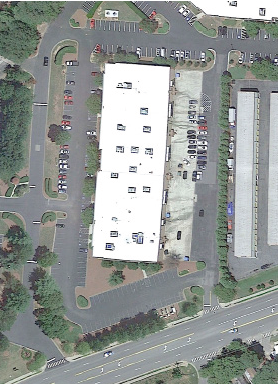 |
| Minimum lot width (ft) | 100 | |
| Minimum floor area per dwelling unit (sf) | n/a | |
| Maximum building coverage (% of lot area) | 90 | |
| Maximum height (ft) | 40 | |
| Minimum front yard depth (ft) | 40 | |
| Minimum side yard depth (ft) | 30/50* | |
| Minimum rear yard depth (ft) | 30/50* | |
| District land use | See section 4 | |
| Development standards | See section 5 | |
| Mobility standards | See section 6 | |
| Parking requirements | See section 7 | |
|
NOTES: (sf = square feet, ft = feet)
Height shall not apply to industry relevant structures and appurtenances to a maximum of 60 feet. Site plan review required according to section 9.9. *When abutting a Residential District. | ||
| TYPICAL DEVELOPMENT CONFIGURATION | ||
 | ||
| 3.7.3 HEAVY INDUSTRIAL (I-2) | ||
| PURPOSE | TYPICAL BUILDING TYPE | |
| Heavy Industrial areas include all manufacturing, research and development, flex space, and may involve hazardous materials, chemicals or processes that generate offensive levels of noise, odor, vibration or emissions. Selected business service uses are also appropriate when sized and designed to serve the employment area. |  | |
| PRINCIPAL INTENSITY AND DIMENSIONAL STANDARDS | TYPICAL LOT PATTERN | |
| Minimum lot area (sf) | 30,000 | 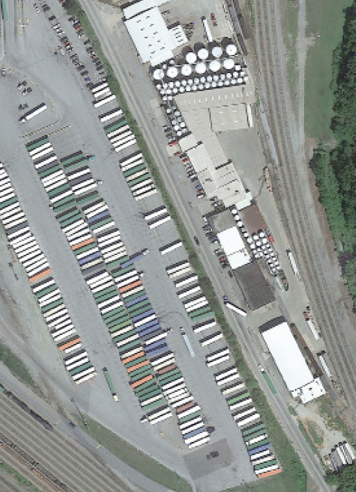 |
| Minimum lot width (ft) | 100 | |
| Minimum floor area per dwelling unit (sf) | n/a | |
| Maximum building coverage (% of lot area) | 90 | |
| Maximum height (ft) | 40 | |
| Minimum front yard depth (ft) | 40 | |
| Minimum side yard depth (ft) | 30/50* | |
| Minimum rear yard depth (ft) | 30/50* | |
| District land use | See section 4 | |
| Development standards | See section 5 | |
| Mobility standards | See section 6 | |
| Parking requirements | See section 7 | |
|
NOTES: (sf = square feet, ft = feet)
Height shall not apply to industry relevant structures and appurtenances to a maximum of 60 feet. Site plan review required according to section 9.9. *When abutting a Residential District. | ||
| TYPICAL DEVELOPMENT CONFIGURATION | ||
 | ||
(Ord. of 4-6-20(1), Exh. A)
3.8 - Planned and overlay districts.
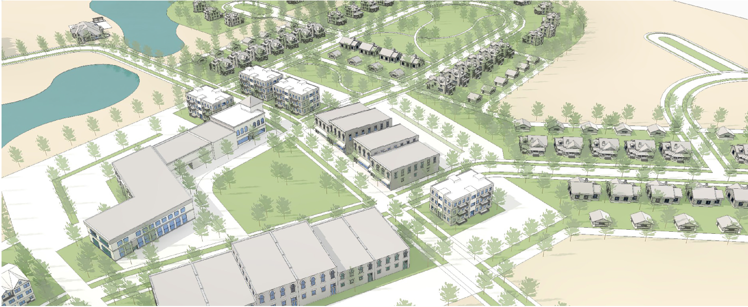
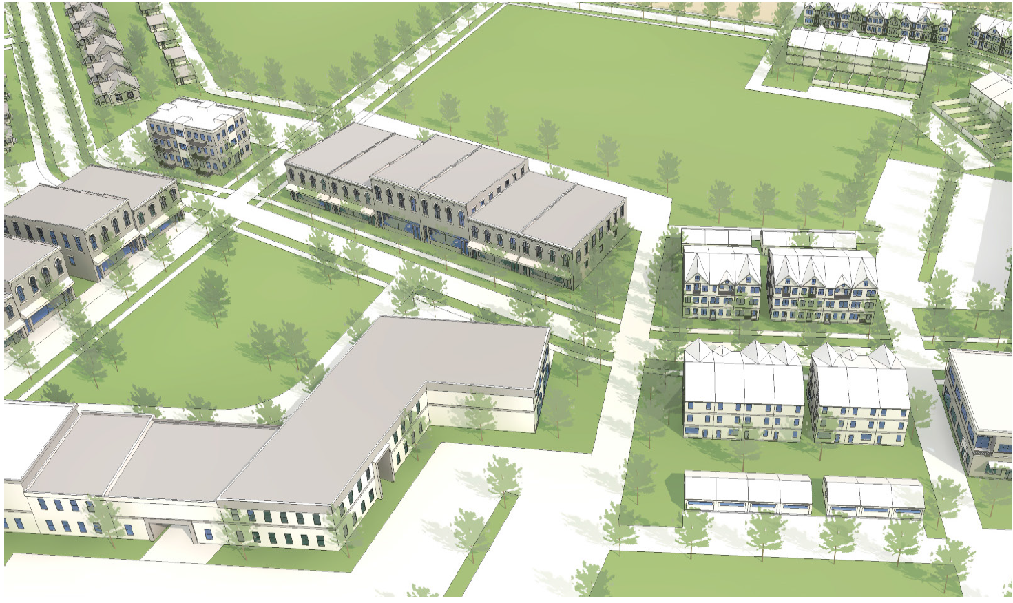
| 3.8.1 VERTICAL MIXED USE (VMU) | ||
| PURPOSE | TYPICAL BUILDING TYPE | |
| Vertical mixed use contains a mix of residential and commercial uses. Typically, commercial uses (i.e. retail shops, restaurants, offices) are located on the ground floor, while residential units are located on upper levels. VMU provides flexibility in the planning and construction by allowing a combination of uses that protects adjacent properties; provides an environment that contributes to a sense of community and coherent living style; encourages the preservation of natural and cultural resources; provides open space and efficient arrangement of land uses, buildings, circulation systems, and infrastructure; encourages infill projects and the development of sites made difficult for conventionally designed development because of shape, size, abutting development, poor accessibility, or topography; | 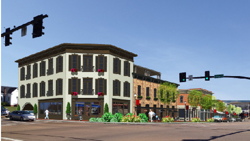 | |
| PRINCIPAL INTENSITY AND DIMENSIONAL STANDARDS | TYPICAL LOT PATTERN | |
| Minimum site or lot area | None |  |
| Minimum lot width (ft) | None | |
| Maximum residential density (units/acres) | 12 | |
| Minimum open space | 20% | |
| Maximum height (ft) | 50 | |
| Minimum/maximum front yard depth (ft) | 0/25** | |
| Minimum side yard depth (ft) | 0/20** | |
| Minimum rear yard depth (ft) | 10/25** | |
| District land use | See section 4* | |
| Development standards | See section 5 | |
| Mobility standards | See section 6 | |
| Parking requirements | See section 7 | |
|
NOTES: (sf = square feet, ft = feet)
*Lots fronting Government Street require commercial uses be located in the first story on the street frontage. A minimum of 50% of Government Street lot frontage shall be occupied by a building façade. Site plan review required according to section 9.9. **When abutting a Residential District. Yard exception—Allowed when the space is to be occupied by public plazas, outdoor dining, community gardens, etc. | ||
| TYPICAL DEVELOPMENT CONFIGURATION | ||
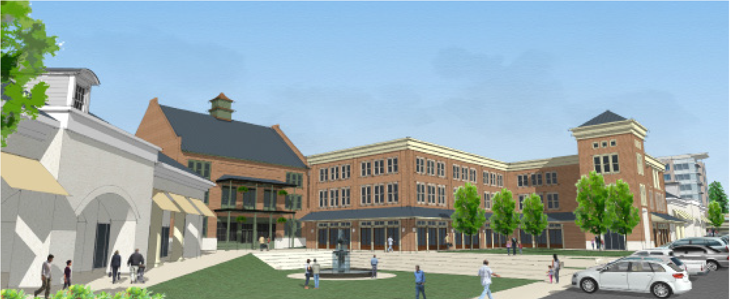 | ||
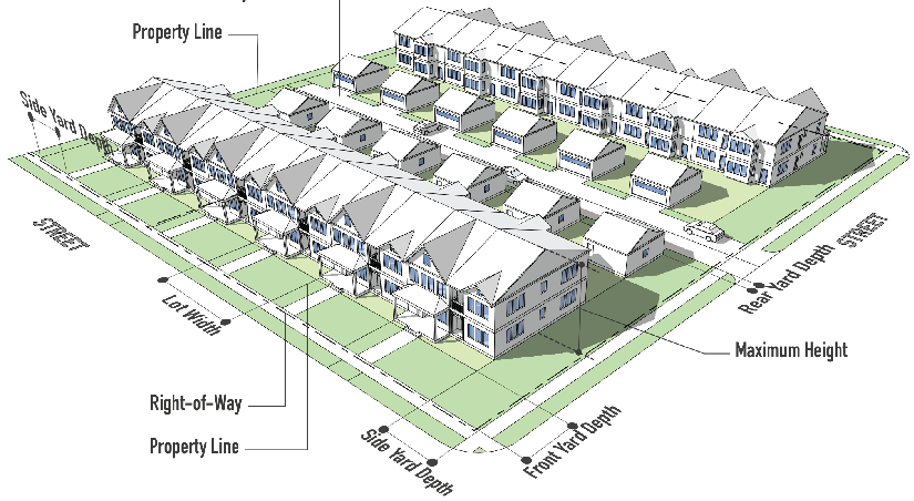
| 3.8.2 TRADITIONAL NEIGHBORHOOD DISTRICT (TND) | ||||
| PURPOSE | TYPICAL BUILDING TYPES | |||
| Traditional neighborhood development replicates historic development patterns found in American towns. Designs include compact, pedestrian friendly development with a mix of land uses in a village-type setting with defined centers and edges, unlike conventional suburban subdivisions. Street networks are connection dense and often built on grid systems and designed to disperse and reduce the length of automobile trips. Traditional neighborhoods reduce land consumption, preserve open space, and are used to develop new communities and to extend or fill-in an existing community. | 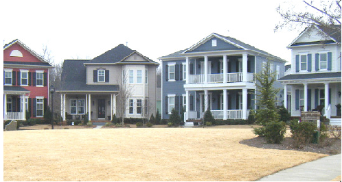 | |||
| PRINCIPAL ELEMENTS AND LOCATION STANDARDS | TYPICAL LOT PATTERN | |||
| Minimum site area | Intended growth areas—3 acres redevelopment and infill areas - None | 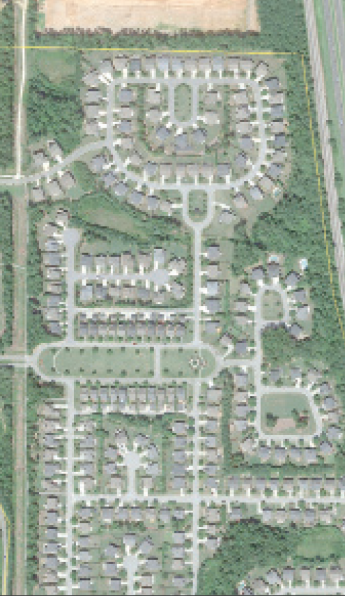 | ||
| TND Structural Elements | General Land Allocations (min/max %) | |||
| Neighborhood core | Reserved for civic, retail or open space or multi-family use | 10/20 | ||
| Neighborhood transition | Single-family attached and detached use | 25/35 | ||
| Neighborhoods edge | Single-family detached use | 45/60 | ||
| Open space | 10 | |||
| Maximum residential densities (unit/acre) | SF | MF | ||
| 8 | 20 | |||
| Specific design dimensional and design standards | See following narrative | |||
| District land use | A list of uses shall be provided in the master plan reflecting the requirements of this section. | |||
| Development standards | See section 5 | |||
| Mobility standards | See section 6 and following narrative | |||
| Parking requirements | See following narrative | |||
|
NOTES: (sf = square feet, ft = feet)
Site plan review required according to section 9.9 to include master plan elements to illustrate the neighborhood design in its entirety. | ||||
| EXAMPLE DEVELOPMENT CONFIGURATION | ||||
 | ||||
3.8.2.1 Access and layout.
a.
If a proposed TND development is located adjacent to a local, collector or higher-classification street, and the street is not designed to conform to the standards of an avenue or main street, street type, the following criteria shall apply:
• The internal streets providing access to the TND shall be aligned perpendicular to the local, collector or higher order street.
• The buildings or structures that take access from the internal streets shall face the internal streets and not the collector or higher-order streets. However, wall transparency (windows and doors) shall address both streets.
• A continuous system of sidewalks shall connect the neighborhood core with streets and lanes that provide access to dwelling units.
b.
Lot arrangement.
• All lots shall include frontage abutting a street, park or plaza. For a proposed TND less than 80 acres in size, at least 90 percent of the dwelling units shall be located within a five-minute walk (1,320 feet) from the perimeter of a plaza or park.
• For a proposed TND that is 80 acres or greater in size, at least 50 percent of the dwelling units shall be located within a five-minute walk (1,320 feet) from the perimeter of a plaza or park.
c.
Variable block lengths.
• Blocks shall have an average length not exceeding 400 feet, with no block exceeding 800 feet in length. No block face should have a length greater than 400 feet without a dedicated alley or pathway providing through access to the opposite side of the block.
3.8.2.2 Neighborhood element standards.
a.
As a tradeoff for increased density and building mass, open space shall be required within the TND, including but not limited to: commons, pocket parks, plazas, courtyards, landscape features, water fountains and features, greenbelts, and trail connections. Of the required open space, at least 25 percent must be usable open space.
b.
The design of the open space provided shall be determined by the size, scale, topography, and market niche of the proposed development. Design shall encourage comfortable and safe pedestrian use including landscaping, seating areas, and lighting, as appropriate.
c.
Ownership and maintenance of public space. Provision shall be made for the ownership and maintenance of streets, squares, parks, open space, and other public spaces in a Traditional Neighborhood Development.
3.8.2.3 Prominent sites and vistas.
a.
Prominent sites shall be reserved for the following building types:
• Civic buildings, including government offices, libraries, museums, schools, or churches;
• Hotels; or office buildings;
• Buildings located on a prominent site shall be at least two stories in height.
b.
A "prominent site" may include a location along a main street, or the termination of a vista running from a main street, boulevard, or avenue and its intersection with an equal or lower order street.
3.8.2.4 Frontage and siting standards.
a.
The location of uses shall be governed by street frontage as shown in Table 2.
b.
Building lines. The setback for principal buildings shall be as set forth in table 3. Setbacks for accessory structures or accessory dwellings shall comply with that for accessory uses and structures.
c.
The frontage and setback requirements shall not apply to parks and open space. In order to allow for variations for unique uses, such as anchor retail tenants or auditoriums, the maximum frontage requirements shall be computed as an average.
_____
3.8.2.5 Building design.
a.
Building design shall reflect a demonstrated relationship to historic architecture in the Brandon Historic Districts and the character precedents in Plan Brandon. The principal entrance of all buildings shall open to a street (excluding outbuildings).
b.
Building orientation. All principal buildings shall be oriented to parks and open space or to a street. Loading areas shall not be oriented to a street. Buildings that abut both a street and parks or open space shall be oriented to both features.
c.
Front porches. Front porches shall be provided on at least 50 percent of all dwelling units within the single-family land-use allocation. Porches shall be constructed of masonry or wood materials. Architectural metal may be used if it is consistent with the exterior or roofing materials of the primary building. The seating area shall have a minimum width of nine feet and a minimum depth of six feet.
d.
Retail and service buildings. Retail and service uses may designate the entire building area above the ground floor or the second floor for residential use. The applicant shall submit floor plans identifying the use of each room.
e.
Abutting uses. Uses may abut at side or rear lot lines, or face across streets or parks. This applies regardless of whether they are in the same or a different land-use category.
f.
Accessory dwelling. Accessory dwellings are permitted on any lot designated for single-family detached dwellings.
3.8.2.6 Landscaping and screening.
a.
The following standards do not apply to a TND:
• Separation buffer standards.
• Building base area standards.
• Entrance standards.
b.
The following standards do apply to a TND:
• Street protective yard standards.
• Interior planting area standards.
c.
In order to provide a continuous pedestrian transition for residential neighborhoods and commercial areas, retail, service, or civic land uses shall not be separated from multifamily or single-family land uses within the TND by berms or buffers unless a trail or sidewalk is established that provides a direct connection between the uses.
3.8.2.7 Parking.
a.
Adequate parking shall be provided to service all site uses. In order to achieve the intent of the TND district, minimum parking space requirements shall serve as a guide to establishing appropriate levels of parking, but are not intended to be strictly applied. The applicant shall demonstrate adequate parking.
b.
Parking lots shall be located at the rear of principal buildings or in mid-block locations. Parking lots and parking garages shall not abut street intersections or civic use lots.
c.
Parking lots shall not be located adjacent to parks or open space.
d.
Parking lots shall not occupy lots that terminate a street vista.
e.
Parking lots shall be located in the interior of a block or shall take access from an alley.
3.8.2.8 Property owners association.
a.
A plan for a traditional neighborhood district shall be accompanied by provisions for a property owners association including the following:
• Projected date of organization.
• Organizational structure.
• Diagram of areas to held in common.
• Estimated fees for the proper functioning of the property owners association.
b.
Prior to the issuance of a building permit for any building in an approved traditional neighborhood, official organization of the property owners association shall have occurred.
3.8.2.9 Master regulating plan requirements and approval process.
a.
When indicated on the zoning map but a traditional neighborhood may be established upon site plan review application procedures where such district is designated but no master regulating plan has been approved. Otherwise, the district shall be established through the requirements and procedures for rezoning land to include the approval of a master regulating plan.
b.
Application for a traditional neighborhood shall be accompanied by a master regulating plan developed in accordance with the intent, principles and standards of traditional neighborhood development. Elements shall include, at a minimum, the following:
• A topographic survey and stormwater drainage plan.
• The layout and location and hierarchy of streets and public open spaces and parking areas.
• The layout and location of residential, commercial, and civic building lots.
• Plan data and statistics to include densities, buildings by type, setbacks, and other explanatory information.
• A list of uses by neighborhood section.
• A master sign plan.
• A phasing plan for the entire development along with projected implementation schedule.
• A series of architectural renderings which convey the overall character of the development.
• Architectural design guidelines for all site elements and buildings.
• An open space plan indicating proposed improvements thereon and the proposed conditions at the project edges.
• An overall landscaping plan for the entire development.
• A stormwater plan that shows integration of stormwater features into the overall project design.
c.
The master regulating plan shall be evaluated by the site plan review committee for compliance with the intent and standards for traditional neighborhoods.
d.
Approval of the master regulating plan shall constitute preliminary subdivision approval.
3.8.2.10 Conflict with other provisions.
• Where the provisions of the traditional neighborhood district conflict with other ordinance provisions, the provisions of this district shall apply.
| 3.8.3 PLANNED UNIT DEVELOPMENT DISTRICT (PUD) | ||
| PURPOSE | TYPICAL BUILDING TYPE | |
| The purpose of the planned unit development district is to provide for the development of planned total communities that provide a full range of residential types as well as curtain commercial, office, or light industrial uses designed to serve the inhabitants of the districts consistent with the comprehensive plan. For purposes of this ordinance, a planned unit development shall be a tract of land at least four acres in area (unless smaller site is approved), under single, corporation, firm, partnership or association ownership, planned and developed as an integrated unit, in a single development operation or a programmed series of development operations and according to an approved master plan. | The planned unit development district is highly customized. A typical building illustration is not applicable. | |
| PRINCIPAL INTENSITY AND DIMENSIONAL STANDARDS | TYPICAL LOT PATTERN | |
| Minimum lot area (sf) | According to master plan | Lotting patterns vary widely in a planned unit development according to the nature and purpose of the development. Lotting pattern may range from those associated with a residential neighborhood to those associated with major commercial or industrial developments. |
| Minimum lot width (ft) | ||
| Minimum floor area per dwelling unit (sf) | ||
| Maximum building coverage (% of lot area) | ||
| Maximum height (ft) | ||
| Minimum front yard depth (ft) | ||
| Minimum side yard depth (ft) | ||
| Minimum rear yard depth (ft) | ||
| District land use | ||
| Development standards | See section 5 | |
| Mobility standards | See section 6 and following narrative | |
| Parking standards | See section 7 | |
|
NOTES: (sf = square feet, ft = feet)
Site plan review required according to section 9.9 to include master plan elements to illustrate the neighborhood design in its entirety. | ||
| EXAMPLE DEVELOPMENT CONFIGURATION | ||
 | ||
3.8.3.1 Master plan required. The "PUD" district shall be established only upon application, after public hearing as specified in the amendatory procedures of this ordinance and shall require an approved master plan and project narrative which, when zoning is granted, will govern the development of the land and all development plans thereof.
3.8.3.2 Minimum planned unit development standards. The master plan must provide for and conform entirely to the following standards and requirements:
a.
In order to encourage ingenuity, imagination, and high quality design, regulations on residential areas will not specify minimum lot area per dwelling unit but will limit density in residential areas to five families per acre in single-family dwelling or 20 families per acre in multi-family dwellings. This will allow clustering of dwellings to provide maximum open space.
b.
Street widths and improvements thereof, as well as off street parking facilities must conform to city standards or in lieu of such standard, to the standard approved in the master plan. While alternate widths may be proposed, in no case shall street construction standards be varied.
c.
Provisions for water supply, sanitary sewers, stormwater drainage, and connections shall be made according to requirements of the City of Brandon and the State of Mississippi.
d.
All improvements are to be installed and maintained by the developer unless other arrangements are approved by the governing authority.
e.
Other special improvements may be required if they are deemed reasonable and essential.
f.
A minimum total area of ten percent of the gross residential area shall be set aside as parks and playgrounds. Of this ten percent, a maximum of one-half may be covered with water. A maximum of five percent of the area designated to be parks and playgrounds may be covered with structures to be used in the recreational use of the area. Parks and playgrounds must be suitably improved for its intended use but parks and playgrounds containing natural features clearly worthy of preservation may be left unimproved.
g.
The developer shall also submit sketches of the plan for the entire project showing the relationship of uses, street patterns, open space and the general character of the proposed development.
3.8.3.3 Master plan requirements and procedures. An application for rezoning to PUD district shall be accompanied by a site plan and project narrative presenting the following:
a.
Proposed land uses and population densities.
b.
Proposed primary circulation pattern.
c.
Proposed parks and playgrounds.
d.
Delineation of the units or phases to be constructed together with a proposed timetable.
e.
Proposed means of dedication of common open space areas and organizational arrangements for the ownership, maintenance and preservation of common open space.
f.
Relationship to the comprehensive plan, land uses in the surrounding area and to the general plan of the PUD. Rezoning procedures shall be in accordance with this ordinance.
g.
Amendments. Following the initial rezoning procedure, the proposed development shall follow all applicable procedures and requirements governing the subdivision of land. No building permits shall be issued until a final plat of the proposed development, or portion thereof, is approved, filed, and recorded.
h.
If construction of the planned unit development is not started within two years of the date of approval, the board of aldermen may consider rezoning the site to its previous classification. The applicant, by showing good cause why he cannot adhere to the proposed timetable described in the master plan may seek an extension of not more than one year at a time. A request for extension shall be submitted in writing to the planning commission.
3.8.3.4 The master plan site plan shall conform to the site plan standards in the appendix.
| 3.8.4 FLOOD OVERLAY (FLO) | ||
| PURPOSE | TYPICAL BUILDING TYPE | |
| The City of Brandon participates in the National Flood Insurance Program (NFIP) and administers the City of Brandon Floodplain Ordinance. Any land within the City of Brandon that lies wholly or partially within the designated 100-year floodplain or floodway is subject to the provisions of the City of Brandon Floodplain Ordinance. The zoning map indicates the approximate location of floodplains. The official NFIP flood maps should be consulted for final determination of lands impacted by this provision. | ||
| PRINCIPAL INTENSITY AND DIMENSIONAL STANDARDS | TYPICAL LOT PATTERN | |
| Minimum lot area (sf) | According to the requirements of the underlying base district. | |
| Minimum lot width (ft) | ||
| Minimum floor area per dwelling unit (sf) | ||
| Maximum building coverage (% of lot area) | ||
| Maximum height (ft) | ||
| Minimum front yard depth (ft) | ||
| Minimum side yard depth (ft) | ||
| Minimum rear yard depth (ft) | ||
| District land use | ||
| Development standards | ||
| Mobility standards | ||
| Parking standards | ||
| NOTES: (sf = square feet, ft = feet) | ||
| TYPICAL DEVELOPMENT CONFIGURATION | ||
 | ||
(Ord. of 4-6-20(1), Exh. A)
3.9 - Nonconformities.
3.9.1 Purpose of this article. A nonconformity is any land, lot, building, structure or parts thereof, existing prior to the enactment of this ordinance, which subsequent to the enactment of this ordinance or amendment thereto, does not conform with the use regulations and/or dimensional regulations of the district in which it is situated, and/or does not comply with any other requirements herein.
It is the intent of this ordinance to permit nonconforming uses to continue until they are removed, but not to permit their expansion or encourage their survival. It is further the intent of this ordinance that nonconforming buildings, structures or parts thereof may be enlarged upon, expanded or extended provided such expansion is in conformance with this ordinance.
Nonconforming uses are declared by this ordinance to be incompatible with permitted land use in the districts involved. Therefore, a nonconforming use of a structure, a nonconforming use of land, or a nonconforming use of structure and land in combination shall not be extended or enlarged after passage of this ordinance by:
• Attachment on a building or premises of additional signs intended to be seen from off the premises; or
• By the addition or other uses of a nature which would be prohibited generally in the district involved.
To avoid undue hardship, nothing in this ordinance shall be deemed to require a change of plans, construction, or designated use of any building on which actual construction was lawfully initiated prior to the effective date of adoption or amendment of this ordinance and upon which actual building construction has been carried on diligently. Actual construction is hereby defined to include the placing of construction materials in permanent position and fastened in a permanent manner. Where excavation or demolition or removal of an existing building has been substantially initiated preparatory to rebuilding, such excavation or demolition or removal shall be deemed to be actual construction, provided that work shall be carried on diligently.
3.9.2 Types of nonconformities. Nonconformities shall be further defined according to one of the types of nonconformities listed below, or combination thereof, for the purpose of regulation.
a.
Nonconforming undeveloped lot of record. This type of nonconformity is an undeveloped lot of record (i.e., part of a subdivision, the map of which has been recorded in the office of the chancery clerk of Rankin County, Mississippi, or a lot described by metes and bounds, the description of which has been recorded in said office) the dimensions of which, subsequent to the passage of this ordinance, do not meet the area or width requirements, or both, of the district wherein such lot is located.
b.
Nonconforming structure. This type of nonconformity includes anything lawfully constructed or erected with a fixed location on the ground (or attached to something having a fixed location on the ground) prior to the passage of this ordinance, but which subsequently does not comply with the bulk, placement and dimensional requirements of the zoning district wherein located.
c.
Nonconforming use. This type of nonconformity includes the uses of any land, lot, building, structure, or parts thereof, which lawfully existed prior to the passage of this ordinance but which subsequently does not comply with all or some part of the use requirements of the zoning district wherein located.
3.9.3 Regulations concerning nonconforming undeveloped lots of record. Erection of one-family dwellings allowed on single nonconforming undeveloped (or vacant) lots of record in separate ownerships: In any district in which one-family dwellings are permitted, a one-family dwelling and customary accessory buildings may be erected on any single nonconforming undeveloped (or vacant) lot of record after the effective date of this ordinance notwithstanding limitations imposed by other provisions of this ordinance. This provision shall apply even though such single lot of record fails to meet the requirements for area or width, or both, that are generally applicable in the district, provided that:
a.
The required yard dimensions and other requirements (than those applying to lot area or width, or both) of the proposed single-family residential use shall conform to the regulations in the district in which such single nonconforming lot of record is located.
b.
Variance of yard requirements shall be obtained only through action of the mayor and board of aldermen.
3.9.4 Regulations concerning nonconforming structures. Where a lawful structure exists before the effective date of adoption or amendment of this ordinance that could not subsequently be built under the terms of this ordinance by reason of restrictions on area, lot coverage, height, yards, its placement on the lot, or other requirements concerning the structure, such structure may be continued so long as it remains otherwise lawful, provided that:
a.
Should such nonconforming structure or nonconforming portions of a structure be destroyed by any means to an extent of more than 50 percent of its replacement cost at the time of destruction, it shall not be reconstructed, except in conformity with the provisions of this ordinance.
b.
Should such structure be moved for any reason for any distance whatever, it shall thereafter conform to the regulations for the district in which it is located after it is moved.
3.9.5 Regulations concerning nonconforming uses of land (or land with minor structures only). Where at the time of passage of this ordinance, lawful use of land exists which would not be permitted by the regulations imposed by this ordinance, and where such use involves no individual structure with a replacement cost exceeding $1,000.00, the use may be continued so long as it remains otherwise lawful, provided:
a.
A nonconforming use shall not be enlarged or increased, nor extended to occupy a greater area of land than was occupied at the effective date of adoption or amendment of this ordinance;
b.
A nonconforming use shall not be moved in whole or in part to any portion of the lot or parcel other than that was occupied by such use at the effective date of adoption or amendment of this ordinance;
c.
If any such nonconforming use of land ceases for any reason for a period of more than 30 days, any subsequent use of such land shall conform to the regulations specified by this ordinance for the district in which such land is located; or
d.
An additional structure not conforming to the requirements of this ordinance shall not be erected in connection with such nonconforming use of land.
3.9.6 Regulations concerning nonconforming uses of major structures or of major structures and land in combination. If lawful use involving individual major structures (i.e., those with a replacement cost of $1,000.00 or more) or of such major structures and land in combination, exists prior to the effective date of adoption or amendment of this ordinance, that would not be allowed in the district under the terms of this ordinance, the lawful use may be continued so long as it remains otherwise lawful, subject to the following provisions:
a.
An existing structure devoted to a use prohibited by this ordinance in the district in which it is located shall not be enlarged, extended, reconstructed, moved, or structurally altered except in changing the use of the structure to a use permitted in the district in which it is located;
b.
Any nonconforming use may be extended throughout any parts of a building which were manifestly arranged or designed for such use at the time of adoption or amendment of this ordinance, but such use shall not be extended to occupy any land outside such building;
c.
If structural alterations are not made, any nonconforming use of a structure, or structure and land, may as a conditional use be changed to another nonconforming use provided that the mayor and board of aldermen, either by general rule or by making findings in the specific case, shall find that the proposed use is equally appropriate or more appropriate to the district than the existing nonconforming use. In permitting such change, the mayor and board of aldermen may require appropriate conditions and safeguards in accord with the provisions of this ordinance;
d.
Any structure, or structure and land in combination, in or on which a nonconforming use is superseded by a permitted use, shall thereafter conform to the regulations for the district, and the nonconforming use may not thereafter be resumed;
e.
When a nonconforming use of a structure, or structure and land in combination, is discontinued or abandoned for six consecutive months or for 18 months during any three-year period (except when government action is impeded access to the premises), the structure, or structure and land in combination, shall not thereafter be used except in conformity with the regulations of the district in which it is located; and
f.
Where nonconforming use status applies to a structure and land in combination, removal or destruction of the structure shall eliminate the nonconforming status of the land. Destruction for the purpose of this subsection is defined as damage to the extent of more than 50 percent of the replacement cost at the time of destruction.
3.9.7 Structures containing a nonconforming use. Nothing in this ordinance shall be deemed to prevent the strengthening or restoring to a safe condition of any building or part thereof declared to be unsafe by any official charged with protecting the public safety, upon order of such official.
(Ord. of 4-6-20(1), Exh. A)