
Bristol City Zoning Code
CHAPTER 2
GENERAL PROVISIONS RELATED TO ZONING
Sec. Z-201.- Short title.
These regulations shall be known as the Zoning Ordinance of the City of Bristol, Tennessee, and the map herein referred to will be identified by the title, "Zoning Map of Bristol, Tennessee." The Zoning Map of Bristol, Tennessee, and all explanatory matter thereon are hereby adopted and made a part of this Ordinance.
Sec. Z-202. - Purpose.
The general purposes of this chapter are to promote the health, safety, and welfare of the City of Bristol, Tennessee. The districts shown on the Zoning Map of Bristol, Tennessee, have been designated after consideration as to the character of each district, its suitability for particular uses, its relation to the general land use plan for the City, and with a view of conserving the value of buildings and encouraging the most appropriate use of land throughout the City to the end that Bristol, Tennessee, may become a better city in which to live.
Sec. Z-203. - Definitions.
Words and terms not herein defined shall have the meanings normally implied by current English usage. Words used in the present tense include the future tense; the singular includes the plural and the plural the singular; and the word "shall" is mandatory. The words "used" or "occupied" as applied to any land or building shall be construed to include the words "intended, arranged, or designed to be used or occupied."
The following words, terms, and phrases are hereby defined as follows and shall be interpreted as such throughout this Ordinance.
ACCESSORY BUILDING - A building, the use of which is subordinate to that of the principal building, and located on the same lot. The term shall also include "accessory structure."
ACCESSORY STRUCTURE - A detached structure located on the same lot or parcel as its principal building and use, and subordinate in size, to the principal building. Accessory structures may include garages, swimming pools, tennis courts, satellite dishes, utility buildings, and other stationary structures.
ACCESSORY USE - A subordinate use, located on the same lot or parcel as the principal use, which is customarily incidental to the principal use.
ACCESSORY USE-RECREATIONAL VEHICLE DEVELOPMENT - This use is subordinate in nature to the RVD, and shall be limited to: community facilities such as clubhouse, community building, laundromat, restrooms, indoor recreational building, community pavilion, community picnic tables, swimming pools, and community Jacuzzi; outdoor recreational facilities such as horseshoes, basketball court, volleyball court, putting green, golf course, outdoor community barbeque grills and similar recreational areas. Accessory uses shall not include: storage sheds, carports or other permanent structures associated with individual recreational vehicle sites or lots. Individual sites may include accessory uses such as patios, decks and individual barbecue grills.
ACCESSWAY - A way of approaching or entering a property.
ACTIVITY - An economic unit designated in the classification system given in the 1997 North American Industry Classification System Manual published by the U.S. Department of Commerce, Office of Federal Statistical Policy and Standards.
ADULT ORIENTED ESTABLISHMENT - This term has the same meaning as "adult oriented establishment" defined in Tennessee Code Annotated Section 7-51-1102(6) which is incorporated by reference and made a part hereof. In construing this term, the definitions set forth in Tennessee Code Annotated Section 7-51-1102(1) through (6) and (9) through (31) are also incorporated by reference and made a part hereof.
ADVERTISING - Includes any writing, printing, painting, display, emblem, drawing, sign, or other device designed, used or intended for advertising, whether placed on the ground, rocks, trees, tree stumps, or other natural structures or on a building, structure, milestone, signboard, billboard, wallboard, roof board, frame, support, fence or other man-made structure; and any such advertising is a structure within the meaning of the word "structure" as used in this Ordinance.
ANIMAL DAY CARE FACILITY - An establishment for the daily care and supervision of animals. Daily care and supervision shall not be construed to mean outdoor kenneling. An animal day care facility may be designed to provide for supervised outdoor exercise and/or recreation.
ANIMATION - Copy or other images that flash or move or otherwise change at intervals of more than once each six (6) seconds.
ANTENNA - An exterior apparatus designed, utilized or intended to be utilized for the sending or receiving of electromagnetic waves for the purposes of radio or television transmissions, commercial mobile wireless services, unlicensed wireless services, cellular phone services, specialized mobile radio communications, common carrier wireless exchange access services, personal communications services, pager services, or other communications services.
ARCHITECTURAL FEATURE - A part, portion, or projection that contributes to the beauty or elegance of a building or structure, exclusive of signs, that is not necessary for the structural integrity of the building or structure or to make said building or structure habitable.
ARCH - A vertical curved structure that spans an elevated space and may or may not support the weight above it.
ARTICULATED CORNICE LINE - Horizontal decorative molding that crowns a building. A qualifying cornice line shall be present through the majority of a subject façade's roofline(s).
ARTISAN/TECHNICAL PRODUCTION - Individual and/or small-scale firms involved in the on-site production of hand-fabricated or hand-manufactured parts and/or custom or craft consumer goods through the use of hand tools or small-scale, light, mechanical equipment. Production includes apparel manufacturing, confectionery, jewelry making, wood and metal working, pottery and glass making, bakeries, printers, breweries, wineries, distilleries, furniture making, small electronics, and equivalents. Showrooms and ancillary sales of goods produced on-premises are allowed. All aspects of the enterprise shall be located and conducted inside of a building.
ASSISTED LIVING FACILITY - This term has the same meaning as "assisted-care living facility" defined in Tennessee Code Annotated Section 68-11-201(4) which is incorporated by reference.
ASSOCIATED MOTOR VEHICLE PARKING SPACE - A specific impermeable surface area adjacent to the recreational vehicle parking pad on a recreational vehicle site or lot that is set aside for off-street automobile parking that is to meet the off-street parking space requirements.
AWNING - A roof-like cover that projects from the wall of a building at a minimum of three (3) feet and is at least eight (8) feet from the ground from its lowest point. Awnings are supported by the building and may have additional support extending to the ground directly under the awning edge.
BALCONY - A platform that projects from the wall of a building and is surrounded by a railing or balustrade.
BERM - A mound of soil or manmade raised area used to obstruct views, decrease noise, and/or otherwise act as a buffer between incompatible land uses.
BLANK WALLS - Any wall or portion of wall which that is without a ground level window, door, façade opening, or qualifying architectural feature for a distance of twenty (20) feet in length or more.
BOARD OF ZONING APPEALS - The Board of Zoning Appeals of the City of Bristol, Tennessee, or its lawful successor.
BOARDING HOUSE (or also Rooming or Tourist House) - A building, other than a hotel or motel, where lodging or rooms, or both are provided for compensation, whether directly or indirectly.
BORDER REGION RETAIL TOURISM DEVELOPMENT DISTRICT (OR BORDER RETAIL DISTRICT) - The area of the city that has been certified pursuant to Tennessee Code Annotated Section 7-40-101 et seq.
BRACKETS - A supporting member of wood, stone, or metal often used for both decorative and structural purposes and generally found under projecting features such as eaves or cornices. Brackets may also be used as supports for a balcony.
BUFFER - An area within a property or site, generally adjacent to and parallel with the property line, either consisting of natural existing vegetation or created by the use of trees, shrubs, fences, walls, and/or berms, designed to limit continuously the view of and sound from the adjacent site or properties.
BUILDING - A structure used or intended for support, shelter, or enclosure. (See "Structure.")
BUILDING, HEIGHT of - The vertical distance as measured from the finished grade at the front line of the building, or the highest adjacent grade to the structure, to the highest point of the structure. The highest point of the structure shall not to include belfries, chimneys, spires, antennae, or other accessory non- occupied space that exceeds the height of the roofline.
BUILDING PERIMETER LANDSCAPING - Permanent, integrated landscaping elements designed to provide visual interest. May include landscaping beds and or planters that are adjacent to the building façade.
BUILDING, PRINCIPAL - A building in which is conducted the main or principal use of the lot on which said building is situated.
BULK - The size and shape of a structure and its relationship to other structures, to the lot area for a structure, and to open spaces and yards.
CERTIFICATE OF OCCUPANCY - A document issued by the proper authority allowing the occupancy or use of a building and which certifies that the structure or use has been constructed or will be used in compliance with all the applicable municipal codes and ordinances.
CHANNEL LETTERS - Three-dimensional individually cut letters or figures, illuminated or un-illuminated, affixed to a structure.
CITY - The City of Bristol, Tennessee.
CITY COUNCIL - The governing body of the City of Bristol, Tennessee
CLUSTER - A single parcel or tract of land on which is located more than one (1) wireless transmission facility.
CODES DIVISION - The Codes Enforcement Division of the City of Bristol, Tennessee, or the lawful successor to such.
CODE OF ORDINANCES, CITY OF BRISTOL, TENNESSEE - The City of Bristol, Tennessee Municipal Code of Ordinances.
CO-LOCATION - The installation of multiple communications arrays or antennas on a single support structure or tower, or the use of a wireless transmission facility by more than one (1) wireless communications provider.
COLUMNS - A free-standing architectural support of definite proportions usually cylindrical in shape, and includes a shaft, capital, and a base or plinth.
COMMON FACILITIES - Land within or related to the development which is not individually owned or dedicated for public use that is designed and intended for the common use or enjoyment of the users and/or owners.
COMMUNITY DEVELOPMENT - The Community Development Department of the City of Bristol, Tennessee, or the lawful successor to such department.
CONCRETE MASONRY UNIT (CMU), ARCHITECTURAL - A pre-cast concrete block that is pigmented and/or utilizes coloration within the manufacturing process to appear different from unfinished CMU block. Architectural CMUs may be manufactured with a variety of finishes including, but not limited to, split-faced, fluted, sand-blasted, and ground-faced.
CONCRETE MASONRY UNIT (CMU), UNFINISHED - Often referred to as a cinder block, this is a pre-cast, unfinished concrete block that is smooth-faced, devoid of pigmentation or coloration, and devoid of finishes such as split-faced, fluted, or sand-blasted.
CONIFEROUS TREES - A tree that remains green year round and does not drop its foliage at one (1) time.
CONVENIENCE STORE - A retail store selling a limited variety of food, beverages, and sundry items; with or without motor fuel facilities; and catering primarily to motorists making quick stops, and/or neighborhood customers.
DAY CARE CENTER, CHILD - Any place or facility operated by a person or entity that provides childcare for three (3) or more hours per day, but less than twenty-four (24) hours per day, for children who are not related to the primary caregiver, as defined, licensed, and regulated by the State of Tennessee as providing child care in "child care centers", "group child care homes", or "family child care homes, as defined in Tennessee Code Annotated Section 71-3-501 or any other relevant section of Tennessee Code Annotated.
DECIDUOUS TREES - Trees that drop their leaves annually and go through a dormant period.
DWELLING UNIT - A single unit providing complete, independent living facilities for one (1) or more persons, including permanent provisions for living sleeping, eating, cooking, and sanitation.
DORMER - A vertical window in a roof or the roofed structure containing such a window. A dormer is considered an alteration to a building, as it stays within the roof line and does not increase the floor area dimensions.
DUPLEX (also known as a Two-Family Residence) - A building, designed as a single structure, containing two (2) separate dwelling units, each of which is designed to be occupied as a separate permanent resident for one (1) family.
EROSION AND SEDIMENT CONTROL PLAN - See the Bristol, Tennessee Code of Ordinances, Article V. Control of Erosion and Sediment into the Stormwater System, Definitions.
FAA - The Federal Aviation Administration or its lawful successor.
FAÇADE - The exterior sides of a building.
FCC - The Federal Communications Commission or its lawful successor.
FAMILY - One (1) or more individuals occupying a dwelling unit, or a group of not more than five (5) persons who are not related by blood or marriage, and living as a single household unit.
FAMILY RECREATION CENTER - This term has the same meaning as "family recreation center" defined in Tennessee Code Annotated Section 7-51-1401 which is incorporated by reference and made a part hereof.
FRONTAGE, STREET - The distance for which a lot adjoins a public or private street from one (1) lot line intersecting said street to the furthest line intersecting said street.
GROUND COVER - Plant material, which reaches a maximum height of not more than twelve (12) inches from grade.
GUEST ROOM -A single unit for temporary use by one (1) person or group of persons with or without meals and not occupied as a single-family unit.
HEIGHT (wireless telecommunication facilities) - The vertical distance measured from the base of the antenna support structure at grade to the highest point of the structure, even if such highest point is an antenna. Measurement of the height of a wireless transmission facility shall include the antenna, base pad and other appurtenances and shall be measured from the finished grade of the facility site. If the support structure is on a sloped grade, then the average between the highest and lowest grades shall be used in calculating the height.
HOME OCCUPATION - Any occupation or profession conducted on the premises of any occupied residence.
HOME OWNERS ASSOCIATION - An incorporated nonprofit organization operating under recorded land agreements through which each property or share owner in a development or other described land area has shared responsibilities for the organization's activities and common interests, such as financial obligation, maintaining green and/or open space, landscaping and/or facilities.
HORIZONTAL OFFSET - A notch or break in the façade of a building of more than five (5) feet wide.
HORIZONTAL PROPERTY REGIME - A division of land on the basis of condominium or horizontal property ownership, in which units or footprints are individually owned and the common areas and facilities are under the ownership of a homeowners' association for the purpose of maintaining, administering and operating of said areas and common facilities. The common elements, both general and limited, shall remain undivided and shall not be the object of an action for partition or division of co-ownership. (Regulated under Tennessee Code Annotated Section 66-27-101 et al.)
IMPERMEABLE - See "Impervious Surface".
IMPERVIOUS SURFACE - Any material (asphalt, concrete, plastic, or other similar material) that reduces or prevents the infiltration of water into previously undeveloped land.
INDOOR STORAGE FACILITY - A building or group of buildings outfitted with central heating and air conditioning, and containing various sized stalls or lockers for the storage of customer goods. All stalls or lockers are located within an enclosed setting and serviced from inside with no exterior access to individual stalls or lockers. Facilities that provide any outdoor storage of property (as opposed to short-term customer vehicle parking), or space for the servicing, repair, or rental of motor vehicles, boats, trailers, lawnmowers or any other similar equipment, are not included in the definition of indoor storage facilities.
ISLAND - A raised, curbed area placed to protect landscaping within a parking lot of a development or site.
LANDSCAPE AREA - A required area that is planted with grass, trees, and shrubs consistent with the planting requirements of this section. The landscaped area may include mulching, ground covers, flowers and other additional features that add to the esthetic appearance of the area, provided that such additional features are consistent with the provisions of this section.
LANDSCAPING MATERIAL - Material such as but not limited to, living trees, shrubs, vines, lawn grass, ground cover, landscape water features, and non-living durable materials commonly used in landscaping including, but not limited to, rocks, pebbles, sands, decorative walls and fences, brick pavers, earthen mounds, but excluding paving for vehicular use.
LANDSCAPING TRELLIS - A trellis attached to the façade of a building that allows vines and plants to cover blank wall areas and provide visual interest. A trellis may work in combination with a planting bed. A qualifying trellis or series of trellises must equal at least ten (10) percent of the subject façade's square footage.
LOCAL TRANSPORTATION TERMINAL - Any premises for the loading and unloading of passengers utilizing a private or public transportation service providing short-distance, flexible-fixed route passenger service, limited to specific destinations and connections within the City of Bristol. Transportation terminals may include ticket purchase facilities and indoor waiting areas. The overnight storage or parking of transportation vehicles must be within an indoor facility.
LOGO - An established identifying symbol or mark associated with a business or business entity.
LONG-DISTANCE TRANSPORTATION TERMINAL - Any premises for the loading and unloading of passengers utilizing private or public transportation services providing transportation between cities for passenger service. Long-distance transportation terminals require an enclosed space with a waiting area and may include ticket purchase facilities and restrooms.
LOT - A piece, parcel, or plot of land which may consist of one (1) or more platted lots in one (1) ownership, occupied or intended to be occupied by one (1) principal building and its accessory buildings including the open space required under this Ordinance.
LOT, DOUBLE FRONTAGE - A lot extending the entire width of the block and having street frontage on both the front and rear lot lines.
LOT OF RECORD - In particular reference to the requirements of the Bristol, Tennessee Zoning Ordinance, any lot which legally existed prior to the adoption of that ordinance (December 5, 1958), per Section Z-215 Supplementary Provisions.
LOT WIDTH - The distance between the side lot lines measured at the building line.
MAJOR ADDITION - An addition onto an existing building that increases the square footage of the existing structure by fifty (50) percent or more.
MANUFACTURED HOME - means a structure, transportable in one (1) or more sections, which is built on a permanent chassis and designed for use with or without a permanent foundation when attached to the required utilities. The term "manufactured home" does not include a "recreational vehicle", unless such transportable structures are placed on a site for one hundred eighty (180) consecutive days or longer.
MANUFACTURED HOME PARK means a parcel (or contiguous parcels) of land divided into two (2) or more manufactured home lots for rent.
MASS - A term used to define the overall volume of a building.
MEDICAL CLINIC - A facility duly licensed in the State of Tennessee for examining, diagnosing and treating patients for medical conditions on an outpatient basis other than a methadone treatment facility or substance abuse treatment facility.
METHADONE TREATMENT FACILITY - A facility duly licensed in the State of Tennessee for the counseling of patients and the distribution of methadone or other similar drugs for outpatient, non-residential purposes only other than a medical clinic, hospital or substance abuse treatment facility.
MINIMUM SETBACKS - A distance of a structure from a property line required to obtain minimum front, side, or rear yards required by this Ordinance.
MULTIFAMILY RESIDENCE - A building containing three (3) or more dwelling units, including units that are located one (1) over another.
NIT - A unit of measurement of luminous intensity or brightness of electronic or digital message boards.
NONCONFORMING BUILDING OR STRUCTURE - A building or structure lawfully constructed prior to the passage of this Ordinance (December 5, 1958) or a subsequent amendment thereto, which does not conform to the requirements for the district in which it is situated.
NONCONFORMING USE - A lawful use of land, building, or structure existing at the time of the passage of this Ordinance (December 5, 1958) or a subsequent amendment thereto, which does not conform to the use regulations for the district in which it is situated.
NURSING HOME - This term has the same meaning as defined in Tennessee Code Annotated Section 68-11-2101(28) which is incorporated by reference.
OCCUPANCY - The use of land, buildings or structures.
OFF-STREET PARKING SPACE - The area required for parking one (1) automobile in a location other than the public right-of-way.
OPEN SPACE - A pervious open space consisting of grassy areas, shrubs and trees or other approved vegetative landscaping materials.
OVERHANG - An extension from a building measuring at least two (2) feet from the subject façade. Overhangs are found at the lower edge of a roof or roof-like structure.
OVERLAY DISTRICT - A district established by ordinance to prescribe special regulations to be applied to a site in combination with the underlying or base zoning district.
PARKING AREA - Those paved areas including driveways, parking spaces, parking lots, circulation aisles, and entrances.
PERIPHERAL BOUNDARY - The required open space along the exterior of the development along property lines. The peripheral boundary may contain walkways and driveways for ingress and egress directly to the premises, and for rights-of-way for utilities and drainage channels, and shall be developed and maintained as open space and may contain landscape area or buffer area as required by the zoning ordinance.
PERSONAL WIRELESS SERVICES - Commercial mobile services, unlicensed wireless services and common carrier wireless exchange access services as now defined in Section 704(a)(7)(C)(i) of the Telecommunications Act of 1996, 47 U.S.C. § 332(a)(7)(C)(i), as the same may be amended from time to time.
PILASTER - An architectural support of definite proportions that is attached to a wall, usually cylindrical in shape, and includes a shaft, capital, and a base or plinth.
PLAN, CONCEPTUAL SITE - A generalized plan that is for overall design purposes and should be used for informal review to discover factors that may have an impact on the proposed development.
PLAN, SPECIAL USE SITE - A generalized plan utilized during the special use approval process.
PLAN, UNIFIED SITE DEVELOPMENT - A site plan showing all aspects of the development and identifies sites or individual lots, travel lanes, major facilities, accessory uses and provisions of open space for recreation and other common uses, including all phases of the development.
PLAN, SITE - A to-scale document which provides a drawn plan used by staff and/or the Planning Commission to review a proposed development for compliance with the Zoning Ordinance and the Code of Ordinances. The document will contain the information required by the particular requirements of the Zoning Ordinance and the Code of Ordinances.
PLANNING COMMISSION - The Bristol, Tennessee Municipal-Regional Planning Commission created and established for the city. See Chapter 1 of this Volume.
PLANTING AREA - Any area designed for landscape material installation having a minimum area of twenty-five (25) square feet, with a minimum of five (5) on the side.
PLANTING AREAS, SIDE AND REAR YARD - An area of land between the property line and any vehicular use areas or building that is intended for the placement or preservation of landscape materials.
PORCH - A covered but unenclosed projection from the main wall of a building that may or may not use columns or other ground supports for structural purposes.
PORTABLE STORAGE UNIT - Any container designed for the storage of personal property which is located outside and enclosed building and is typically rented to owners or occupants of property for their temporary use and delivered and removed by a vehicle.
PREMISES - A parcel or tract of land, including the buildings and improvements thereon, or any portion thereof which is leased or rented, or which is used or intended to be used for a single purpose or activity.
PROTRUSION - A section of a building which projects from the surface of the wall in which it is situated and is enclosed on three (3) sides.
PRIVATE POLE - A privately owned pole on private property, erected in accordance with building code regulations, with the primary purpose of supporting lights for buildings or grounds.
PUBLIC UTILITY FACILITIES - Facilities designed or utilized for the transmission, distribution, delivery or collection of electric, telephone, cable television, natural gas, water or sewer utility services, or for the transportation of the public.
QUADPLEX - A detached residential structure, constructed after the effective date of Ordinance 22-17, containing four (4) dwelling units designed for occupancy by not more than four (4) families living independently of each other.
RECESSED ENTRYWAY - An entryway that is recessed at least twenty-four (24) inches when compared to the surrounding building façade.
RECREATIONAL VEHICLE - See Independent Recreational Vehicle.
RECREATIONAL VEHICLE, INDEPENDENT (or RECREATIONAL VEHICLE) - A self motorized or a towable recreational vehicle (including Class A, Class B, and Fifth Wheel) designed as temporary living quarters which can operate independently of connections to sewer, water and electric systems. It shall contain water flushed toilets, lavatory, shower, and kitchen sinks, all of which are connected to water storage, greywater storage, and sewage holding tanks within the RV. This definition shall not include tent-covered recreational vehicles.
RECREATIONAL VEHICLE DEVELOPMENTS (RVDs) - A planned development on a parcel of land that consists of owner-occupied sites or lots for recreational vehicles that are used for temporary living quarters, accessible by vehicular traffic, and where sites are substantially developed with electrical, sewer and water system connections available for each unit site. Also provided are common and recreational properties and facilities, refuse collection sites, and other accessory uses of recreational vehicle developments.
RECREATIONAL VEHICLE PARKING PAD - A specific dimensioned impermeable or approved permeable surface area for use by a recreational vehicle within a recreational vehicle development that is set aside for use by an independent recreational vehicle.
SCALE, ARCHITECTURAL - How an architectural feature relates to the structure on which it is applied. A feature that is to scale with the structure looks appropriate in usage regarding symmetry, harmony, proportion, and/or size when juxtaposed with the building. In order to achieve scale, one may have to use multiple instances of an architectural feature or expand the size of the feature.
SETBACK - (See Yard definitions).
SIGHT OBSCURING SCREEN - A one hundred (100) percent opaque visual screen with a minimum height of six (6) feet, if non-living material is used. If living material is used, it shall be at least seventy (70) percent sight obscuring and be a minimum of four (4) feet in height immediately after planting and shall consist of plants that reach a minimum of six (6) feet in height at maturity.
SIGHT TRIANGLE - The triangle at either side of an accessway or public right of way with sides of a specific length each along the public right of way and/or accessway.
SPECIAL ADAPTIVE REUSE - A nonresidential use proposed for operation in an eligible commercial or institutional building located in a residential zoning district. The adaptive reuse must be approved by the Planning Commission through the special use permit process.
SPECIAL USE - A use that would not be appropriate generally or without restriction throughout a given zoning district but which, if properly planned and regulated, would not detract from the prosperity or integrity of that district. Such uses may be permitted in a zoning district if specific provision for that special use is made in this Ordinance under the heading "Uses Permitted by Special Use Permit Only."
STORY - That portion of a building included between the upper surface of any floor and the upper surface of the floor next above, or any portion of a building used for human occupancy between the topmost floor and the roof.
STREET LEVEL DISPLAY WINDOWS - Transparent windows comprising at least sixty (60) percent of the street-level façade.
STREET PLANTING AREA - An area of land between the property line and any vehicular use areas or building that is intended for the replacement or preservation of landscape materials.
STRUCTURE - Any constructed or erected material or combination of materials, the use of which requires a location on the ground; including, but not limited to, buildings, stadiums, electronic structures, sheds, storage bins, fences, and signs.
SUBDIVISION - The division, combination or recombination of any lot or parcel of land as defined in the Subdivision Regulations of the Bristol, Tennessee Municipal Regional Planning Commission, Article VII Definitions.
SUBDIVISION PLAT - The document for the approval and official recording of a division, combination or recombination of any lot or parcel of land as required by the Subdivision Regulations of the Bristol, Tennessee Municipal Regional Planning Commission.
SUBSTANCE ABUSE TREATMENT FACILITY - A facility duly licensed in the State of Tennessee for providing outpatient, non-residential treatment, counseling or similar services to persons who are dependent on legal or illegal drugs, opiates, alcohol or other substances other than a medical clinic, hospital or methadone treatment facility.
SYMBOL - A graphic representation or insignia including religious symbols, commemorative plaques of recognized historical agencies.
TEMPORARY WIRELESS TRANSMISSION FACILITY - A wireless transmission facility which is designed or intended for use on a short-term, non-permanent or temporary basis. This includes portable facilities capable of being transported or towed to a site.
TOWER - A structure that is designed and constructed primarily for the purpose of supporting one (1) or more antennas. This term includes radio and television transmission towers, microwave towers, common carrier towers, cellular telephone and wireless communications towers, alternative tower structures and similar structures. Tower types include, but are not limited to, guyed towers, monopoles, lattice towers and wooden poles. This term does not include any structure erected solely for a personal, non-commercial use, such as for television reception antennas, satellite dishes or amateur radio antennas.
TRIPLEX - A detached residential structure, constructed after the effective date of Ordinance 22-17, containing three (3) dwelling units designed for occupancy by not more than three (3) families living independently of each other.
TWO-FAMILY RESIDENCE - See DUPLEX.
VARYING ROOFLINE - Angular and/or structural roof features that differ from the predominant roofline pitch or shape found on the subject plane elevation.
WIRELESS TRANSMISSION FACILITY - A structure, antenna, tower or other device, including structures which may primarily be used for other purposes, designed, utilized or intended to be utilized for the sending or receiving of electromagnetic waves for the purposes of radio or television broadcast transmissions, commercial mobile wireless services, unlicensed wireless services, cellular phone services, specialized mobile radio communications, common carrier wireless exchange access services, personal communications services, pager services or other communications service.
WOOD - Porous, fibrous tissue found in the stems and roots of trees and other woody plants that is commonly used in construction as a structural, exterior, and interior material.
YARD - An open space on the same lot with a principal building; open, unoccupied, and unobstructed by the building from the ground to the sky, unless otherwise provided in this Ordinance.
YARD, FRONT - An open, unoccupied space on the same lot as the principal building, extending the full width of the lot and situated between the front lot line and the nearest part of the principal building or structure.
YARD, REAR - An open, unoccupied space on the same lot as the principal building extending the full width of the lot and situated between the rear lot line and the nearest part of the principal building or structure.
YARD, SIDE - An open, unoccupied space on the same lot as the principal building, extending from the rear line of the front yard to the front line of the rear yard and situated between the side lot line and the nearest part of the principal building or structure.
ZONING ORDINANCE - The Zoning Ordinance of the City of Bristol, Tennessee, as amended from time to time.
ZONING DISTRICT - A specifically delineated area, as shown on the city's official zoning map, within which uniform development standards govern the use, placement, spacing, and size of land and buildings.
(Ord. No. 25-4, § B, 4-1-2025)
Sec. Z-204. - Establishment of districts.
For the purposes of this Ordinance, the City of Bristol, Tennessee shall henceforth be divided into districts designated as follows:
R-M Districts (Mountainous Residential).
R-1A Districts (Low Density Single Family Residential).
R-1B Districts (Medium Density Single Family Residential).
R-2 Districts (Single Family and Duplex).
R-3 Districts (Multifamily).
R-4 Districts (High Density Multifamily).
R-5 Districts (High Density Multifamily).
R-E Districts (Established Residential Neighborhood).
R-O Districts (Residential Office).
O-S Districts (Open Space and Reserved).
B-1A Districts (Limited Business/Institutional).
B-1B Districts (Neighborhood Shopping and Service).
B-2 Districts (Central Business).
B-2E Districts (Central Business Expansion).
B-3 Districts (General Business).
PBD Districts (Planned Business District).
M-1 Districts (Light Industrial/Business).
M-2 Districts (General Industrial).
M-3 Districts (Heavy Industrial).
MH Districts (Mobile Home Park).
F-1 Districts (Flood Plain).
PRD Districts (Planned Residential).
District boundaries are hereby established as shown on the most currently updated edition of the "Zoning Map of Bristol, Tennessee." Where uncertainty exists with respect to the boundaries of any of the aforesaid districts, the following rules shall apply:
A.
Where district boundaries are indicated as approximately following the centerlines of streets, alleys, highways, or railroad rights-of-way; or of such lines extended; such centerlines or their extensions shall be construed to be such boundaries.
B.
Where district boundaries are indicated as approximately following the corporate limits lines of the City of Bristol, Tennessee, such corporate limits lines shall be construed to be such boundaries.
C.
Where district boundaries are indicated as approximately following property lines or such lines extended, such property lines or such lines extended shall be construed to be such boundaries.
D.
Where district boundaries are indicated as approximately following the centerlines of streambeds, such centerlines shall be construed to be such boundaries.
E.
Where district boundary lines appearing on the Zoning Map divide a lot in single ownership at the time of the enactment of this Ordinance, the requirements for the district in which the greater portion of the lot lies shall be extended to the balance of the lot, provided that this provision shall not apply to a double frontage lot. In the case of a double frontage lot, the provisions of the district in which each part of such lot is situated shall apply.
Sec. Z-205. - Applicability of zoning.
No building or land shall hereafter be used and no building or part thereof shall be erected, moved, or altered except in conformity with this Ordinance herein specified for the district in which it is located, except as hereinafter provided.
Sec. Z-206. - Nonconforming uses, buildings and structures.
It is the intent of this Ordinance to recognize that the elimination, as expeditiously as is reasonable, of existing buildings and structures, or of uses that are not in conformity with the provisions of this Ordinance, is as much a subject of health, safety and welfare as is the prevention of the establishment of new uses that would violate the provisions of this Ordinance. It is also the intent of this Ordinance to so administer the elimination of nonconforming uses, buildings and structures as to avoid any unreasonable invasion of established private property rights.
A.
Nonconforming Uses. Lawful nonconforming uses existing at the time of the original passage of this Ordinance (December 5, 1958), or any amendment thereto (whether by annexation, rezoning, or ordinance text revision) may be continued subject to the following provisions:
1.
Change of Use. A nonconforming use shall not be changed to any but a conforming use. When a nonconforming use has been changed to a conforming use, it shall not be changed again to any nonconforming use.
2.
Extension. A nonconforming use of land shall be restricted to the lot occupied by such use as of the effective date of this Ordinance. A nonconforming use of a building or buildings shall not be enlarged or extended to include either additional land or buildings after the effective date of this Ordinance.
3.
Structural Alteration. A building housing a nonconforming use shall not be structurally altered. This provision shall not be construed to prevent normal maintenance and repairs or alterations required for structural safety.
4.
Destruction. A building or structure housing a nonconforming use which is damaged by fire, flood, wind or other act of God or man to more than forty (40) percent of its assessed value for tax purposes shall not be reconstructed, except in conformity with the provisions of this Ordinance. This provision shall not apply to owner-occupied nonconforming residences.
5.
Discontinuance. When a nonconforming use of any land or building has been discontinued for a period of twelve (12) consecutive months, it shall not be reestablished or changed to any use not in conformity with the provisions of the district in which it is located.
B.
Nonconforming Buildings or Structures. Lawful nonconforming buildings and structures existing at the time of the passage of this Ordinance of any amendment thereto shall be allowed to remain subject to the following provisions:
1.
Extension. A nonconforming building or structure shall not be extended unless such extension shall comply with all the requirements of this Ordinance for the district in which it is located.
2.
Destruction. A nonconforming building or structure which is damaged by fire, flood, wind, or other act of God or man to more than forty (40) percent of its assessed value for tax purposes shall not be reconstructed except in conformance with the provisions of this Ordinance. This provision shall not apply to owner-occupied nonconforming residences.
C.
Nonconforming Mobile Homes. Nonconforming mobile homes, defined as a single, self-contained unit and mounted on a single chassis and as further defined in Tennessee Code Annotated Section 68-126-202, shall not be allowed to be replaced upon its removal from its original location. The provisions of this regulation shall not apply to mobile home parks within the City of Bristol by definition.
These provisions shall also apply to any nonconforming mobile homes damaged by fire, flood, wind or other act of God or man to more than forty (40) percent of its assessed value for tax purposes. Such nonconforming mobile home shall not be replaced.
D.
Nonconforming Portable Signs. The foregoing provisions of this Section Z-206 shall not apply to portable signs.
Sec. Z-207. - General lot usage standards.
A.
Principal Buildings on Residential Lots. Only one (1) principal building may be constructed on any residential lot, except in the cases of:
i.
Multifamily complexes and cluster developments.
ii.
Structures in the Open Space and Reserved (O-S) Zoning District.
B.
Street Frontage. No building or structure shall be erected on a lot which does not abut an approved street at least one (1) street for a distance of at least fifty (50) feet, unless an easement for right of access at least twenty (20) feet in width is provided to an approved street.
C.
Manufactured Residential Dwellings. Manufactured residential dwellings, as defined in Tennessee Code Annotated Section 68-126-202, when located within the City of Bristol shall meet the following provisions:
1.
Any manufactured residential dwelling located in the City of Bristol, Tennessee shall conform to all State and Local codes and ordinances.
2.
All manufactured residential dwellings shall be placed on a permanent foundation consisting of piers located on concrete footings and shall have a continuous permanent perimeter wall constructed of mortared masonry, brick, or stone and located on a concrete footing.
3.
All manufactured residential dwellings shall have the same general appearance as required for site built homes. All wheels and towing fixtures shall be removed upon placement of the manufactured residential dwelling upon a permanent foundation.
The provisions of this regulation shall not apply to mobile home parks within the City of Bristol by definition.
D.
Pre-existing, Individual Lot, and Other Uses.
1.
All existing mobile home parks and individual mobile homes in the City of Bristol at the time of adoption of this section of this Chapter (January 5, 1968) are required to comply with the following regulations:
a.
No person shall, within the limits of the City of Bristol, Tennessee park any trailer on any street, alley or highway, or other public place, or on any tract of land owned by any person, occupied or unoccupied, within the City of Bristol, Tennessee except as provided in this Ordinance.
b.
Emergency or temporary stopping or parking is permitted on any street, alley or highway for not longer than one (1) hour subject to any other and further prohibitions, regulations, or limitations imposed by the traffic and parking regulations or ordinances for that street, alley, or highway.
c.
No person shall park or occupy any trailer on the premises of any occupied dwelling, either of which is situated outside an approved trailer park; unless the parking of only one (1) unoccupied trailer is parked in an accessory private garage building; provided no living quarters shall be maintained or any business practiced in said trailer while such trailer is so parked or stored.
d.
Mobile homes and modular units used for temporary or other special nonresidential uses may be permitted upon application and approval thereof by the Planning Commission in locations specifically approved by the Planning Commission under the following conditions:
1.
Businesses, such as automobile sales and mobile home sales where the property is leased.
2.
On owner-occupied property where the intent is to build a permanent structure.
2.
The initial time period for locating a mobile home or modular unit on leased and owner-occupied property shall be determined upon application. Additional periods of time may be ranted by the Planning Commission upon application, but said time shall not exceed five (5) years. Dwelling or sleeping in such mobile homes or modular units shall in no case be permitted. A temporary location permit must be secured from the Building Inspector prior to locating any individual mobile home or modular unit for temporary nonresidential use as stated above.
a.
The commercial or retail sale of mobile homes shall not be allowed, under any circumstances, from any mobile home park.
b.
Any appeal from the enforcement of the provisions of this Ordinance shall be reviewed by the Board of Zoning Appeals.
c.
Existing parks and trailers within the corporate limits of the City of Bristol, Tennessee, shall comply with the following anchorage requirements:
1.
The area of a mobile home lot which has been reserved for the placement of a mobile home shall be provided with adequate support for the placement of the mobile home, thereby securing the superstructure against uplift, sliding, rotation and overturning.
2.
The area of a mobile home lot which has been reserved for the placement of a mobile home shall be provided with anchors and tiedowns such as cast-in-place concrete eyelets embedded in concrete slabs, arrowhead anchors, or other devices that are used to stabilize a mobile home.
3.
Tiedown hardware shall be protected to resist corrosion, and each tiedown shall be designed to resist an allowable working load equal to or exceeding three thousand four hundred (3,400) pounds. The breaking strength shall be equal to or exceed four thousand seven hundred fifty (4,750) pounds.
4.
Tiedowns shall be placed every twelve (12) feet starting from the front of the mobile home lot.
5.
Diagonal cross-bracing (any tiedown which deviates more than thirty (30) degrees from a vertical direction) between ground anchors and the mobile home shall be provided in conjunction with each vertical tiedown.
6.
Existing mobile homes shall conform to this Ordinance within twelve (12) months after its adoption. Proposed parks shall incorporate this ordinance in the overall design of the park.
(Ord. No. 98-117, 11-3-1998)
Sec. Z-208. - Prohibition of lot area reduction.
No lot shall be reduced in size so that lot width, yard requirements, lot area per dwelling unit, or other requirements of this Ordinance are not maintained.
Sec. Z-209. - Prohibition of required yard overlap.
No part of a yard or other open space required about any building for the purpose of complying with the provisions of this Ordinance shall be included as a part of a yard or other open space required by this Ordinance for another building.
Sec. Z-210. - Corner lot side yard requirements.
A.
In residential districts, the minimum setback for the side yard along an intersecting street shall be fifty (50) percent greater than the minimum side yard setback for the district in which the lot is located. All structures, including accessory structures, shall meet the setback from the intersecting street. In all other respects, the minimum setback requirements for the district shall apply.
B.
In nonresidential districts, the minimum setback for the side yard along an intersecting street shall be equal to the front yard setback for the district in which the lot is located. All structures, including accessory structures, shall meet the setback from the intersecting street. In all other respects, the minimum setback requirements for the district shall apply.
Sec. Z-211. - Obstructions to vision at street intersections.
On a corner lot, within the area formed by joining points on the centerlines of intersecting or intercepting streets at distances from their intersection as provided below, there shall be no obstruction to vision between a height of three (3) feet and a height of ten (10) feet, measured above the average elevation of the existing surface of each street at that centerline thereof:
R-M, R-1A, R-1B, R-2, R-3, R-4, and R-5 districts .....100 ft.
B-1A, and B-1B districts .....80 ft.
The requirements of this section shall not be deemed to prohibit any necessary retaining wall.
Sec. Z-212. - Location of accessory structures on residential lots.
A.
It is the intent of this section to allow accessory structures and uses subordinate in size and incidental in use to the principal building in residential districts. All accessory structures, except those in the Open Space and Reserved (O-S) Zoning District, shall comply with the following requirements:
1.
No accessory structure shall be allowed in any required front yard or to extend in front of the plane created by the location of the principal building relative to the front property line.
2.
Accessory structures shall be allowed to be located in the side and rear yards provided the following requirements are complied with:
a.
Accessory structures shall not cover more than twenty-five (25) percent of the affected required side yard and rear yard areas, and provided further that the district "maximum lot coverage" set forth in Section Z-3-08 - Residential Space Requirement Chart is not exceeded.
b.
Accessory structures shall be at least five (5) feet from any side or rear lot lines and from any other building on the same site, including the principal building. Accessory structures that exceed one (1) story or twelve (12) feet in height shall meet the required side and rear yard setbacks for the zoning district.
c.
Accessory structures shall not exceed two (2) stories, but in no event shall any accessory structure exceed a building height of twenty-five (25) feet.
d.
Accessory structures on lots that front on two (2) parallel streets rights-of-way shall meet the front yard setback required by the zoning provisions on each lot frontage.
e.
Accessory structures on lots that front on two (2) intersecting street rights-of-way shall meet the required front yard setback from each intersecting street right-of-way.
3.
Accessory structures shall not be used for human habitation except as an extension of the residential use of the principal building for residential habitation, for clearly residential, non-income producing occupancy by a family member or temporary houseguest. The use of an accessory structure as a continually occupied, income producing, separate dwelling unit for lease, rent, or trade is strictly prohibited.
Sec. Z-213. - Off-street parking.
1.
Whenever the submission of a site plan is required under Chapter 10 there shall be provided minimum off-street parking spaces with adequate provision for ingress and egress by standard-sized automobiles in all zoning districts except B-2 and O-S. Parking shall be required in accordance with the North American Industry Classification System (NAICS) as follows:
The B-2E District shall require parking utilizing the Parking Ratios Chart but shall be reduced by a factor of five-tenths (.5) or fifty (50) percent for all non-residential uses except food services (722). Food services (722) shall be reduced in the B-2E District as follows:
2.
The minimum number of parking spaces for any use shall be two (2) except in the B-2 and O-S Districts, one (1) of which may be a parking space accessible to handicapped persons, if such is required.
3.
Required Parking Space Limited to Parking Use Only.
a)
All required off-street parking spaces and parking lots shall remain as permanent open space, utilized exclusively for parking and ingress and egress. Off-street parking spaces shall not be located in a designated fire lane.
b)
Loading spaces may not be substituted for parking space requirements.
4.
Parking Spaces Predating this Section's Enactment.
a)
Any proposed addition to a main structure shall necessitate the provision of additional parking spaces for such addition as required by the Parking Ratios Chart.
b)
All such requisite new parking spaces shall be in addition to those spaces previously required by the main structure.
5.
Allowance for Parking Off-Site.
a)
Required parking spaces shall be located on the same property with the main structure, except that in the case of structures other than single-family and duplex dwellings, required parking spaces may be placed on a separate parcel within four hundred (400) feet of the subject parcel, should the subject parcel be of inadequate size to entirely contain all the parking spaces for the main structure and additions thereto.
b)
Site plan approval is required. The property on which the off-site parking is located must be owned (or leased) by the owner of the property for which the parking serves. Proof of ownership (a deed or long-term lease) shall be provided for site plan approval. Approved parking spaces at the remote site shall be considered as if they are located on the main site. Leased parking shall require a long-term lease with a minimum term of ten (10) years duration. All proposed long-term parking leases must be reviewed and approved by the City Attorney and upon approval, recorded in the land records of the appropriate jurisdiction as part of the site plan approval process.
6.
Prohibition of the Use of Public Right-of-Way for Off-Street Parking Requirements. Required off-street parking shall not be located on any public right-of-way or public property. Adequate measures shall be taken to prevent the encroachment of parked vehicles onto such public properties by the use of curbs, fences or similar methods.
7.
Surface and Other Improvements.
a)
All driveways, parking spaces, parking lots, circulation aisles and entrances (collectively "parking areas") shall be paved with asphalt, concrete, impermeable or permeable pavers, or similar type material approved by the City, except those serving single and two-family detached dwellings, agricultural uses, campgrounds or temporary parking lots as proved in Subsection (c) below. Each parking space shall be unobstructed and independently accessible from a circulation aisle or driveway that is connected to a public or private street or alley. For industrial uses, all required parking areas shall be paved. This requirement shall apply to all new developments and to the redevelopment or change of use of an existing development requiring the submission of a site plan in accordance with Chapter 10.
b)
The surface of the parking area shall be maintained in such a manner that no dust will result from use nor shall sediment or other debris caused by erosion, tracking or other means be allowed to enter streams or exit the site.
c)
The parking area of single and two-family detached dwellings, agricultural uses, approved campgrounds regulated by Chapter 18, Article VI of the Code of Ordinances, and parking lots used for special event parking for periods of fourteen (14) of fewer consecutive days, are exempt from the requirements of Subsection (a) herein provided the provisions of Subsection (b) are satisfied.
8.
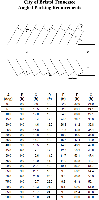
Parking Dimensions. All required parking areas and drive aisles shall be designed in accordance with the City of Bristol, TN Angled Parking Requirements below.
Sec. Z-214. - Off-street loading and unloading space.
Reserved.
Sec. Z-215. - Supplementary provisions.
A.
Lot of Record. Where the owner of a lot of record or his successor in title thereto does not own sufficient land to enable him to conform to the dimensional requirements of this Ordinance at the time of its adoption (December 5, 1958), such lot may be used as a building site for a single-family residence in a district in which residences are permitted; provided the yard space and other requirements shall conform as closely as possible, in the opinion of the Board of Zoning Appeals, to the requirements of this Ordinance for the district in which such lot is located.
B.
Adjoining and Vacant Lots of Record. If two (2) or more adjoining and vacant lots of record are in a single ownership at any time after the adoption of this Ordinance (December 5, 1958) and such lots individually have less frontage or area than the minimum requirements of the district in which such lots are located, such lots shall be considered as a single lot or several lots which meet the minimum requirements of this Ordinance for the district in which such lot is located.
C.
Front Yard Setbacks. The setback requirements of this Ordinance for dwellings shall not apply to any lot where the average setback on developed lots located wholly or in part within one hundred (100) feet on each side of such lot and within the same block and zoning district and fronting on the same street as such lot is less than the minimum required setback. In such cases the setback on such lot may be less than the required setback, but not less than the average of the existing setbacks on the developed lots.
D.
Exceptions on Height Limits. The height limitations of this Ordinance shall not apply to church spires, belfries, cupolas and domes not for human occupancy, monuments, water towers, observation towers, transmission towers, windmills, chimneys, smokestacks, derrick conveyors, flag poles, radio or television towers, masts, or aerials.
E.
Exceptions to Setback Requirements. When minimum setback requirements for a principal structure have been established, the following exceptions shall be allowed:
1.
Driveways, sidewalks, patios, and other similar structures with an elevation no more than eight (8) inches above the surrounding grade are permitted to encroach into the front, side, and rear setbacks to the property line. Steps that are part of a sidewalk may also encroach to the property line.
2.
Steps, porches, decks, and other similar appurtenances of a primary structure at the first floor elevation or lower that are not covered or enclosed may encroach into the front yard setback ten (10) feet and the rear yard setback fifteen (15) feet. In both cases such encroachments must be a minimum of ten (10) feet from the front and rear property lines. Such portions of a primary structure may encroach into the side yard setback no more than six (6) feet and in all cases such side yard encroachments must be a minimum of four (4) feet from the side property line.
3.
Outside stairways and fire escapes above the first floor elevation may encroach into the front, side, and rear yard setbacks four (4) feet.
For the encroachments allowed in subsections 2 and 3 above, in no case will they be allowed to cover more than thirty (30) percent of the required setback area.
Sec. Z-216. - Reserved.
Editor's note— Ord. No. 25-4, § C, adopted April 1, 2025, repealed section Z-216, which pertained to billboard and sign regulations and derived from Ord. No. 08-21, adopted Sep. 2008; Ord. No. 09-19, adopted Aug. 2009; Ord. No. 09-25, adopted Nov. 2009; Ord. No. 10-15, adopted Jan. 2011; Ord. No. 10-2, adopted March 2010; Ord. No. 10-26, adopted June 2010; Ord. No. 11-20, adopted Oct. 2011; Ord. No. 12-10, adopted Sep. 2012; Ord. No. 13-9, adopted Nov. 2013; Ord. No. 17-6, adopted Jan. 2018; Ord. No. 17-7, adopted Jan. 2018; Ord. No. 19-8, adopted Oct. 2019; Ord. No. 20-3, adopted April 2020; and Ord. No. 20-5, adopted April 2020.
Sec. Z-217. - Special use permit and special adaptive reuse permit.
The Planning Commission shall have the power to hear and decide only such special uses as the Planning Commission is specifically authorized to pass on by the terms of this Ordinance; to decide such questions as are involved in determining whether special uses should be granted; and to grant special uses with such conditions and safeguards as are appropriate under this Ordinance, or to deny special uses when not in harmony with the purpose and intent of this Ordinance.
A.
Special Use Permit. A special use shall not be granted by the Planning Commission unless and until:
1.
A written application for a special use is submitted indicating the section of this Ordinance under which the special use is sought and stating the grounds on which it is requested.
2.
A special use site plan is submitted which depicts the following: development name and address; developer name and contact information; property owner name and contact information if different than the developer; property boundary with bearings and distances; area and present zoning of tract; building setbacks, easements and other property restrictions; FEMA flood information including flood zone designation, open floodway, 100-year flood elevation; existing and proposed buildings, structures and facilities. Building, structure and facility information should include square footage, number of stories, number of dwelling units, entrances/exits, and floor elevations; existing and proposed site improvements such as sidewalks, curbing, parking areas including number/layout and handicap spaces/aisles, travel aisles, entrances/exits, loading areas, utilities, retaining walls and site signage; existing and proposed drainage features such as storm sewer systems/structures, sinkholes, ponds, natural and artificial watercourses, channels, streams and other waterbodies; screening and buffering areas; refuse collection location. The special use site plan shall be drawn to a scale of no greater than one (1) inch equals fifty (50) feet.
3.
Public notice shall be given at least fifteen (15) days in advance of the public hearing. The owner of the property for which a special use is sought, or his agent, shall be notified of the hearing. A notice shall be posted on the property for which a Special Use Permit is sought. Required costs associated with advertising the public hearing will be paid by the applicant.
4.
The public hearing shall be held. Any party may appear in person, or by agent or attorney.
5.
The Planning Commission shall make a finding, if indeed empowered under the section of this Ordinance described in the application, to grant or deny the Special Use Permit. The granting of the special use may be done on the determination that the use in question will not adversely affect the public interest.
6.
A Special Use Permit fee established by the City Council shall be submitted with the written application.
7.
Before any Special Use Permit shall be issued, the Planning Commission shall take into consideration the specific rules governing individual special uses and determine that satisfactory provision and arrangement has been made concerning the following, where applicable:
a.
Ingress and egress to property and proposed structures thereon with particular reference to automotive and pedestrian safety and convenience, traffic flow and control, and access in case of fire or catastrophe;
b.
Off-street parking and loading areas where required, with particular attention to the items in (a) above and the economic, noise, glare, or odor effects of the Special Exception on adjoining properties and properties generally in the district;
c.
Refuse and service areas, with particular reference to the items in (a) and (b) above;
d.
Utilities, with reference to locations, availability, and compatibility;
e.
Screening and buffering, with reference to type, dimensions, and character;
f.
Signs, if any, and proposed exterior lighting with reference to glare, traffic safety, economic effect, and compatibility and harmony with properties in the district;
g.
Required yards and other open space;
h.
General compatibility with adjacent properties and other property in the district.
8.
A Special Use Permit issued pursuant to Section Z-301(3)h, for a continuum health care community shall be approved by the Council of the City.
9.
A Special Use Permit request for an adult entertainment establishment must comply with the provisions of Section Z-220.
10.
Unless otherwise specifically provided by Planning Commission in its grant of a Special Use Permit, a Special Use Permit shall be implemented by the applicant or the applicant's successor in interest within twenty-four (24) months of final approval, or the Special Use Permit shall be void. "Implement" shall mean that a building permit has been issued for the project that is the subject of the Special Use Permit, and the building permit, or extensions thereof, has not been allowed to expire.
11.
A Special Use Permit is valid only for the property described in the permit application, and only for the use presented by the applicant to the Planning Commission.
12.
Once a Special Use Permit is granted, the project to which the Special Use Permit applies must be constructed and must operate in conformance to the requirements of the approved Special Use Site Plan. Any modification of the Special Use Site Plan must be approved by the Planning Commission. A request for a modification shall be processed as described in Section Z-217.A.3.
B.
Special Adaptive Reuse Permit. The purpose of the special adaptive reuse section is facilitate the conversion of older, economically distressed, or historically significant buildings to reduce vacant space and encourage the sensitive adaptive reuse of existing buildings. As these projects are located within existing residentially zoned areas, a high degree of examination will be exercised by the Planning Commission as it pertains to general compatibility with adjacent properties.
The special adaptive reuse proposed must be located in an existing commercial or institutional building. For purposes of this section, a commercial building is a building utilized to provide services or retail goods for profit or certain multifamily buildings containing rental units. An institutional building is a facility that provides a public service and is operated by a federal, state, or local government, public or private school, church, public agency, or nonprofit organization. Buildings that are ineligible for a special adaptive reuse permit, include:
a.
Single-family dwelling unit;
b.
Duplex or two-family dwelling unit;
c.
Multifamily building with less than six (6) units;
d.
Multifamily building with six (6) or more units with exterior access to each unit.
A special adaptive reuse shall not be granted by the Planning Commission unless and until:
1.
All provisions of Section Z-217.A Special Use Permits, with the exception of Z-217.A.8 and Z-217.A.9, are applied in consideration of a Special Adaptive Reuse Permit.
2.
In addition to the specific rules for review found in Section Z-217.A.7, the Planning Commission shall take into consideration additional criteria in the approval of a special adaptive reuse permit:
a.
Additional screening and buffering for site-specific functions like outdoor seating, service and delivery entrances, and outdoor sales areas, etc., with reference to type, dimensions, and character;
b.
Allowed hours of business operation including the delivery of goods necessary for business;
c.
Allowance, location, and hours for outdoor dining, drinking, or spaces designed for recreation, or the congregating or gathering of people
d.
Allowance, location, and hours of operation for outdoor sound amplifiers;
e.
Allowance, location, and hours for outdoor performances;
f.
Density of multifamily residential units, not to exceed the allowed units per acre in the parcel's respective zoning district identified in Section Z-312 - Residential Space Requirement Chart.
g.
Allowance, location, and character of any exterior alteration or new construction. Reconstruction of the building is not allowed and proposed additions must comply with Section Z-312 - Residential Space Requirements Chart.
(Ord. No. 21-3, 4-2021; Ord. No. 22-2, 5-2022; Ord. No. 22-5, 6-2022)
Sec. Z-218. - Special exception.
A.
General.
1.
The Board of Zoning Appeals shall have the power to hear and decide on such Special Exceptions specifically authorized to be reviewed by the terms of this Ordinance and to decide such questions as are involved in determining whether certain Special Exceptions should be granted; and to grant Special Exceptions with such conditions and safeguards as are appropriate under this Ordinance, or to deny Special Exceptions when not in harmony with the purpose and intent of this Ordinance. A Special Exception shall not be granted by the Board of Zoning Appeals unless and until:
a.
A written application is submitted for a Special Exception permitted by this Ordinance.
b.
Public notice shall be given at least fifteen (15) days in advance of public hearing. The owner of the property for which Special Exception is sought, or his agent, shall be notified of the hearing. A notice shall be posted on the property for which a Special Exception is sought.
c.
The public hearing shall be held. Any party may appear in person, or by agent or attorney.
d.
The Board of Zoning Appeals shall make a finding empowered under the section of this Ordinance described in the application, to grant or deny the Special Exception. The granting of the Special Exception may be done on the determination that the exception meets all criteria specified under the applicable Special Exception.
e.
A Special Exception fee established by the City Council shall be submitted with the written application.
f.
When staff approval is provided for, the provisions of b, c, and d above shall apply when the conditions for staff approval cannot be met.
B.
Wireless Transmission Facilities. Wireless transmission facilities may be allowed as a Special Exception in the R-M, R-1A, R-1B, R-2, R-3, R-4, and R-5 districts, provided that all provisions of this section and Section Z-221 of the Zoning Ordinance have been met.
(Ord. No. 09-20, 8-2009; Ord. No. 17-7, 1-2018)
Sec. Z-219. - Temporary uses.
A.
Temporary tent sales of items other than described in B. and C. below shall be only permitted when conducted by and on the premises of a business operating out of a permanent structure on said premises and offering for sale similar merchandise.
B.
Temporary seasonal sales of unprocessed agricultural or horticultural products related to the seasonal demand or availability of such product; including but not limited to: fresh fruits and vegetables, Christmas trees and bedding plants may be permitted provided that:
(1)
Horticultural and agricultural products shall exclude nonedible flora which is ordinarily available through established floral outlets without regard to season;
(2)
Temporary seasonal sales operators submit a site plan for review by the appropriate City officials; and
(3)
Such operations are limited to three (3) months of operation.
C.
Temporary long-term sales of agricultural and horticultural products, including but not limited to: fresh fruits and vegetables, Christmas trees, and bedding plants; may be permitted provided that:
(1)
Horticultural and agricultural products shall exclude nonedible flora which is ordinarily available through established businesses;
(2)
Temporary long-term sales operations are subject to site plan review and Planning Commission review; and
(3)
In order to be considered temporary, the operation shall have a period of inactivity during the year of at least one (1) month.
D.
Temporary mobile vending units, including but not limited to trucks, trailers, carts or similar units, may be permitted provided that such units;
(1)
Are located on commercially zoned private property;
(2)
Have written permission from the property owner;
(3)
Obtain all applicable licenses and permits; and
(4)
Are removed from the permitted premises when not in use between the hours of 10:00 p.m. and 6:00 a.m.
This provision does not apply to mobile vending units that are operated in conjunction with community events as authorized by the city manager.
Sec. Z-220. - Adult entertainment establishments.
A.
Purpose. The purpose of this section is to establish reasonable zoning regulations for adult oriented establishments so as minimize the deleterious secondary effects of such businesses, thereby promoting the health, safety, moral and general welfare of the citizens of the City. Nothing in this section is intended, nor shall it be construed so as,
(1)
To impose a limitation or restriction on the content or reasonable access to any communicative materials, including sexually oriented materials;
(2)
To restrict or deny access by adults to sexually oriented materials protected by the First Amendment;
(3)
To deny access by the distributors and exhibitors of sexually oriented entertainment to their intended market; or
(4)
To condone or legitimize the distribution of obscene material.
B.
Permitted Use. Adult oriented establishments shall be permitted only in the B-3 (General Business) and M-2 (General Industrial) zoning districts, provided that the establishment:
1.
Is not located within one thousand (1,000) feet of a child care facility, school (public, private or charter), public park, family recreation center, residence, place of worship, funeral home or mortuary, library, hospital, retail liquor store or residentially zoned property, as measured in a straight line, without regard to intervening structures or objects, from the nearest point on the property line of the parcel containing an adult oriented establishment to the nearest point on the property line of a parcel containing a child care facility, school, public park, family recreation center, residence, place of worship, funeral home or mortuary, library, hospital, retail liquor store or residentially zoned property;
2.
If in a B-3 (General Business) zoning district, is located on and has access to an arterial street as designated on the City's Major Road Map adopted by the Planning Commission;
3.
Is not located in a within the boundaries of a Border Region Retail Tourism Development District as certified under Tennessee Code Annotated Section 7-40-101 et seq.; and
4.
Is not located within one-half (1/2) mile of any other adult oriented establishment, as measured in a straight line, without regard to intervening structures or objects, from the closest exterior wall of the structure in which each establishment is located.
Sec. Z-221. - Wireless transmission facilities.
1.
See Section Z-203 for definitions.
2.
Procedures. The placement, construction and modification of wireless transmission facilities are provided for in this Ordinance through a procedure which generally requires approval by the Board of Zoning Appeals, the Planning Commission or both. Subject to the provisions of this Ordinance:
a.
Wireless transmission facilities are permitted if approved by the Board of Zoning Appeals as a "Special Exception" within the R-M, R-1A, R-1B, R-2, R-3, R-4, and O-S zoning districts and are subject to site plan approval by the Planning Commission.
b.
Wireless transmission facilities are permitted uses, subject to site plan approval by the Planning Commission, within the B-1A, B-1B, B-3, PBD, M-1, M-2 and M-3 districts.
c.
The co-location of wireless transmission facilities on existing structures is permitted in all districts and may be approved by Community Development staff upon a satisfactory showing of compliance with all the requirements of this Ordinance except those set forth in Sections 4B, 4C, 4E, 4F and 4G, for which co-locations shall be exempt.
d.
The failure of Community Development to act on an application which is determined to be complete within thirty (30) days, unless extended by agreement, may be grounds for the applicant to request submission to the appropriate approving authority.
e.
Temporary wireless transmission facilities shall be allowed as follows:
1.
A temporary wireless transmission facility may be established on the site of an existing wireless transmission facility when such existing facility is out of service due to construction or repair, or during the construction of a wireless transmission facility for which a permit has been issued in accordance with this Ordinance. The maximum height of a temporary wireless transmission facility shall be one hundred (100) feet.
An application for a permit for this type of temporary wireless transmission facility shall be considered a "co-location" and subject to approval by city staff. The temporary facility may be used operationally for a maximum of three (3) months and shall be removed no later than three (3) months after the date of issuance of the permit; provided, however, that an extension of three (3) additional months may be granted upon a showing of good cause therefore.
2.
Temporary wireless transmission facilities which are used to accommodate increased wireless telecommunications during special events such as regional festivals, sporting events or significant public gatherings may be permitted within the R-M, R-1A, R-1B, R-2, R-3, R-4, R-5 and O-S zoning districts upon approval by the Board of Zoning Appeals as a "Special Exception."
Temporary wireless transmission facilities used for special events shall be permitted to operate for a period not to exceed seven (7) days. A maximum of two (2) successive permits may be allowed to the same wireless service provider. An applicant may request a "short-term" temporary permit to operate for a period not to exceed three (3) days to allow for usage on successive weekends. There will be no limit on the number of permits that may be issued to the same service provider.
A temporary wireless transmission facility authorized under this subsection shall be removed no later that twenty-four (24) hours after the expiration of the permit. Failure to remove the facility in timely fashion shall be grounds for the refusal of an application for a subsequent permit.
3.
Temporary wireless transmission facilities shall be subject to the provisions of Section 3C6 of this Ordinance.
3.
Tower Placement. Free-standing or guyed towers may be placed within the city subject to the following limitations:
a.
Height Limitations.
1.
Maximum Tower Height.
a.
The maximum height of a tower shall be two hundred fifty (250) feet.
The policy of the City is to minimize the number of wireless transmission facilities while accommodating the need for telecommunication facilities. All towers must be designed to accommodate the maximum number of providers. The City shall require the applicant to submit engineering evidence demonstrating the capacity and capability of the proposed tower to accommodate multiple service providers.
2.
Permitted Height Above Structures.
a.
Towers, antennas and all related facilities mounted on buildings, water tanks or other structures (other than free-standing or guyed towers) must not extend more than thirty (30) feet above the highest part of the structure.
b.
Limitation of Towers by District.
1.
Wireless transmission facilities are permitted if approved by the Board of Zoning Appeals as a "Special Exception" within the R-M, R-1A, R-1B, R-2, R-3, R-4 and R-5 districts and are subject to site plan approval by the Planning Commission.
2.
Wireless transmission facilities are permitted uses, subject to site plan approval by the Planning Commission, within the B-1A, B-1B, B-3, PBD, M-1, M-2 and M-3 districts.
3.
The co-location of wireless transmission facilities is permitted in all districts subject to the provisions of Section 2C.
c.
Tower Location Requirements.
1.
Wireless transmission facilities shall not be located closer than two thousand five hundred (2,500) feet to an existing wireless transmission facility or a cluster site, except as provided in Section 4G. Cluster locations shall not be located closer than two thousand five hundred (2,500) feet to an existing cluster site or an existing wireless transmission facility, except as provided in Section 4G.
2.
No tower or tower related structure shall be erected on a lot which does not abut at least one (1) street for a distance of at least fifty (50) feet, unless an easement for right of access at least twenty (20) feet in width is provided to an approved street.
3.
A tower located in any residential district, or on any parcel that adjoins a residential district, shall have a minimum distance from the base of the tower to the nearest line of any adjacent property or street right-of-way equivalent to or greater than the height of the tower plus twenty-five (25) feet. Except for wireless transmission facilities necessary for the proposed tower, no building or other structure which is designed or intended to be occupied by humans shall be located within this required "clear fall zone." The tower must comply with all other applicable provisions of the Zoning Ordinance.
4.
Towers located in any B-1A, B-1B, B-3, PBD, M-1, M-2 or M-3 district that shall be located on a lot which adjoins a residential district shall be located from the nearest point of such residential district a distance equivalent to or greater than the height of the tower plus twenty-five (25) feet.
5.
Towers located in any B-1A, B-1B, B-3, PBD, M-1, M-2 or M-3 district which shall be located on a lot which does not adjoin a residential district shall have a minimum distance from the base of the tower to the nearest line of any adjacent property or street right-of-way equivalent to or greater than the height of the tower plus twenty-five (25) feet unless a licensed structural engineer registered in the State of Tennessee certifies in writing that the proposed tower is designed to collapse inward into itself in the event of structural failure or other collapse. The designed fall-zone shall be indicated on the site plan.
In such an instance, and unless otherwise required, the setbacks from property lines will become the outer boundary of the identified clear fall-zone. In all situations, the standard setbacks established for each zone in the Zoning Ordinance must be met.
Under no circumstances may the base of a tower be located less than the height of the tower plus twenty-five (25) feet from the nearest property line of any parcel located in a residential district.
6.
No tower shall be placed at such a location, or be constructed or utilized in such a manner, as will:
(a)
Have an adverse impact upon districts, sites, buildings, structures or objects significant in American history, architecture, archaeology, engineering or culture, that are listed, or eligible for listing, in the National Register of Historic Places; or
(b)
Be substantially incompatible with the general character of the surrounding neighborhood; or
(c)
Constitute a detriment or potential danger to the health, safety or welfare of the public or public utility facilities, or to the provision public utilities or governmental services.
D.
General Conditions. The applicant seeking authorization for a wireless transmission facility shall provide written documentation demonstrating that all of the foregoing and the following requirements have been satisfied:
1.
Safety Codes: The proposed facility must comply with all applicable local, state and federal safety, health, nuisance and fire codes.
2.
Paint and Illumination: A tower must be finished in a standard galvanized metal finish or painted in a color so as to minimize visual obtrusiveness and must not be illuminated unless lighting is required by federal, state or local laws or regulations.
3.
Other Zoning Regulations: The proposed facility must comply with all applicable provisions of the Zoning Ordinance, except that a wireless transmission facility shall be exempt from the general landscape and buffer requirements of the Zoning Ordinance upon compliance with the landscape and buffer requirements provided in this Ordinance.
4.
Landscaping:
a.
A minimum twenty-five (25) foot buffer strip shall be required on the outer perimeter of the property if the property is zoned residential or abuts property that is zoned residential. The twenty-five (25) foot buffer strip shall consist of plantings and physical features as listed in the definition of Landscape Area of Section Z-1102 of the Zoning Ordinance.
b.
Towers located in business and manufacturing zones are subject to the landscape and buffer provisions for the zone in which the tower is to be located as listed in Sections Z-1109 and Z-1110 of the Zoning Ordinance.
c.
Other than for ingress or egress, no internal roads or driveways, parking areas, structures or storage of material shall be allowed within the buffer strip. This standard shall not supersede any existing agreements or regulations which may require a larger buffer strip.
d.
The buffer strip shall consist of an opaque coniferous screen or fence located at the site perimeter. The buffer shall be initially installed for the permanent year-round protection of adjacent property by visually shielding internal activities from adjoining property from street level and adjoining residences. Substance, design, width, height, opacity, growing period to maturity, time schedule for installation and responsibility for perpetual maintenance of the buffer strip shall be subject to approval by the Planning Commission. The minimum height of the coniferous screen shall be ten (10) feet, and the minimum height of fence materials shall be eight (8) feet.
e.
The landscaping provisions of this Ordinance may be varied or reduced if the proposed plan provides for unique and innovative landscaping treatment or physical features that, in the opinion of the Planning Commission, meet the intent and purpose of this Ordinance. In instances where significant physical features exist (i.e., railroads, hillsides, preserved wooded areas, utility easements, etc.) which in the opinion of the Planning Commission provide adequate buffering between land uses, the Planning Commission may allow such existing buffers to be utilized.
5.
Security Fencing:
a.
Security fencing is required for all wireless transmission facilities unless specifically waived for a co-location. When any wireless transmission facility is proposed within a residential district or within 500 feet of a residential district, the Planning Commission may require fencing constructed of wood or masonry in addition to a security fence.
b.
When considering a "Special Exception" for a wireless transmission facility, the Board of Zoning Appeals may recommend to the Planning Commission the need for additional buffering and screening or other requirements.
6.
Off-Street Parking: A minimum of one (1) off-street parking space shall be provided for each wireless transmission facility and shall be shown on the site plan. Staffed facilities shall comply with all parking requirement of the Zoning Ordinance.
7.
Lighting: Outside lighting, if proposed or required for safety or security purposes, shall be arranged so as to minimize glare and reflection on adjacent residential properties and public streets. The Planning Commission may require the submission of a lighting plan by a qualified professional engineer to ensure that the illumination of outside lighting does not exceed zero and four tenths (0.4) foot candles measured at the property line of abutting property zoned for residential use or development. Wireless transmission facilities shall not be artificially lighted unless required by the FAA or other governmental authority. The Board of Zoning Appeals may require the submission of a lighting plan in connection with its consideration of a request for a "Special Exception."
8.
Signs: An on-site sign identifying the wireless transmission facility may be allowed provided the sign:
a.
Does not exceed ten (10) square feet in size.
b.
Is not illuminated.
c.
Includes only the name of the owner or other responsible person or entity, contact information and appropriate warnings, to be located on the gate or security fence surrounding the tower base.
d.
Complies with all other signage requirements of the Zoning Ordinance.
Advertising on a tower is prohibited.
9.
Vehicle Access Control. The location and design of driveways or accesses to reach the facility from a public street shall be approved by the Planning Commission. "Special Exceptions" shall be reviewed and approved by the Board of Zoning Appeals.
10.
Noise. The intensity level of sound from a wireless transmission facility, including temporary generators used during power outages, shall not at any time exceed seventy (70) decibels, as measured at the nearest property line of an abutting parcel zoned for residential use.
E.
Emissions Standards. The applicant shall provide certification from an engineer registered in the State of Tennessee, and having at least five (5) years' experience in radio frequency analysis, that the proposed wireless transmission facility meets or exceeds the applicable standards of the American National Standards Institute (ANSI), the Institute of Electrical and Electronics Engineers (IEEE) and the FCC for professionally acceptable radio frequency emissions standards.
F.
Governmental Facilities. The provisions of this Ordinance may be waived for wireless transmission facilities used exclusively by the city, Sullivan County, the State of Tennessee or the United States of America, or their respective agencies, for governmental purposes.
4.
Application Requirements.
A.
An application for a permit for the placement or construction of a tower, or for the placement of an antenna on an existing structure, shall be filed with the Community Development.
1.
The application shall be accompanied by the following documents, as applicable:
a.
Specifications. One (1) copy of typical specifications for the proposed structures and antenna, including descriptions of the design characteristics and materials.
b.
Site Plan. The owner or authorized agent of any property proposed for the location of a wireless transmission facility shall prepare and submit a site plan meeting the requirements of Sections Z-1013—Z-1015 (site plan) and Chapter 11 (landscape and buffering) of the Zoning Ordinance. The site plan shall be drawn to scale showing property boundaries, tower location, tower height, guy wires and anchors, existing structures, elevation drawings depicting typical design of proposed structures, parking, fences, landscape plan and existing uses on adjacent properties. A site plan is not required if the antenna is to be mounted on an approved existing structure.
c.
The required application fee as specified by the City Council from time to time.
B.
The owner or authorized agent shall also submit information showing the relationship of the proposed development to:
1.
The existing street system.
2.
Existing zoning districts within a five hundred (500) foot radius of the center of the base of the wireless transmission facility.
3.
The names and addresses of all property owners within a five hundred (500) foot radius of the center of the base of the wireless transmission facility.
4.
The distance to and the location of the nearest adjacent wireless transmission facility.
C.
Tower Location Map. The applicant shall provide a current map, or update of an existing map on file, showing the locations of the applicant's antennas, facilities, existing towers and proposed towers which are reflected in public records, serving any property within the City. The location map shall indicate the proposed facility and all surrounding wireless transmission facilities within a radial distance of two thousand five hundred (2,500) feet.
D.
Structural Information. The applicant shall provide structural information for the proposed wireless transmission facility, as defined in the latest EIA/TIA 222 STANDARD entitled, Structural Standards for Steel Antenna Towers and Antenna Supporting Structures, including the following:
1.
Antenna Capacity/Wind Load. A report from a structural engineer registered in the State of Tennessee showing the tower antenna capacity by type and number.
2.
A sealed certification from a structural engineer registered in the State of Tennessee that the tower is designed to withstand winds in accordance with ANSI/EIA/TIA 222 (latest revision) standards for Sullivan County, Tennessee. The sealed certification shall also include assurances that additional loading has been provided to allow the placement of temporary public safety transmission equipment in the event of an emergency or natural disaster.
3.
For towers or antennas to be placed on buildings, a sealed certification from a structural engineer registered in the State of Tennessee that the building proposed to house a tower or antenna is structurally capable of supporting the same and all related equipment. The tower or antenna must not affect the structural integrity of the building.
4.
Documentation that the proposed wireless transmission facility has been designed in accordance with accepted standards for Seismic Zone 2.
E.
Listing of Antenna Owners. The site plan and application shall provide identification of the owners of all antennas and equipment to be located at the site as of the date of application. The documentation will include the following:
1.
Owner Authorization. Copy of a written lease, deed, agreement or other authorization from the owner of the property on which the wireless transmission facility is to be constructed, showing that the applicant has a lawful right to construct the facility on the premises.
2.
FCC License. A copy of a valid FCC license authorizing the operation of the proposed wireless transmission facility, or proof that the final issuance of the license is pending. For unlicensed wireless services, the applicant shall include verification that such a license is not required.
F.
Analysis.
1.
Location Analysis. Before a permit may be issued for a new wireless transmission facility a shared use analysis must be performed. The analysis will include the following:
a.
The applicant's proposal for a new wireless transmission facility shall not be approved unless it can be documented by the applicant that the equipment planned for the proposed tower cannot be accommodated on an existing or approved tower due to one (1) or more of the following reasons:
1.
The planned equipment would exceed the structural capacity of existing and approved towers, considering the existing and planned use of those towers, and the tower cannot be reinforced to accommodate such planned or equivalent equipment at a reasonable cost.
2.
An intermodulation study demonstrates that the planned equipment would cause radio frequency interference with other existing or planned equipment for these towers, and the interference cannot be prevented at a reasonable cost.
3.
Existing tower(s) do not have space on which the planned equipment can be placed so it can function effectively and reasonably in parity with other similar equipment in place or approved.
4.
Reasonable radio frequency coverage objectives cannot be met.
b.
Documentation showing that the proposed tower is not located within two thousand five hundred (2,500) feet of an existing tower.
c.
The applicant shall also address the extent to which shared use of the proposed tower will be allowed in the future. The applicant shall provide a letter of intent committing the tower owner and the owner's successors to allow shared use of the tower if an applicant agrees in writing to pay a reasonable fee therefore. The letter of intent shall be filed with Community Development prior to the issuance of a building permit, and shall also include provisions for the shared use by public safety communications systems wishing to co-locate.
d.
The applicant's plans must demonstrate how shared facilities would potentially be situated on proposed sites. New towers and structures shall be designed for use by multiple telecommunications providers.
e.
The applicant shall provide a certification from an engineer registered in the State of Tennessee, and having at least five (5) years' experience in radio frequency analysis, that the proposed antenna and related equipment could not be placed on a pre-existing facility and function under applicable regulatory and design requirements and meet reasonable coverage objectives without unreasonable modification.
f.
The applicant shall demonstrate that a new tower is designed to accommodate the applicant's potential future needs, to the extent those future needs may be determined at the time of application.
2.
Radio Frequency Coverage Analysis. The applicant shall submit a radio frequency coverage analysis which will include a computer generated coverage analysis accompanied by an actual drive test measurement.
3.
Visual Impact Analysis. The applicant shall submit a visual impact analysis which will include the following:
a.
Computer generated digital photographs representing "Before and After" construction.
b.
Reduction of Visual Impact Statement.
1.
A statement certified by the applicant that every reasonable measure has been taken to assure that the proposed tower, antenna and accessory structure will be placed in a reasonably available location which will minimize the visual impact of the surrounding area in accordance with minimum standards of applicable regulations.
2.
Wireless transmission facilities mounted on a building or structure in a commercial or industrial district shall be screened or designed to blend visually with the roof, structure and surroundings where mounted. Such methods and materials shall require approval by the Planning Commission.
3.
Prior to the issuance of a building permit, surety acceptable to the city shall be required to ensure completion of all landscaping and screening provisions as outlined in the plan approved by the Planning Commission. The surety shall be posted in an amount equal to one hundred ten (110) percent of the estimated total cost of the materials and installation. Upon the issuance of a certificate of occupancy for the building, or upon the completion of construction of the wireless transmission facility if no certificate of occupancy is required, a maintenance bond, letter of credit or similar surety acceptable to the city shall be required for a period of one (1) year to ensure that the vegetation remains as a living and viable screen.
G.
Alternate Location Procedure. Should a proposed wireless transmission facility not comply with Section 3A1 (Maximum Tower Height), or 3C (Tower Location Requirements), and the user shall have demonstrated to the approving body under Section 4F (Analysis) or otherwise that this Ordinance unreasonably discriminates among providers of functionally equivalent personal wireless services, or that the ordinance prohibits or has the effect of prohibiting the provision of personal wireless services, the approving body may consider alternative sites provided that:
a.
With the exception of Section 4F1b, all provisions of Section 4 have been met;
b.
The applicant provides adequate proof in accordance with Section 4F2 that the alternative site is the minimum distance and/or height deviation from the requirements of 3A1 and/or 3C1 that is needed to provide the "coverage objectives;"
c.
The approving body shall have the authority to require the consideration of alternative sites with all applicable "analysis" as provided by Section 4F in order to ensure the deviation proposed is the minimum deviation required.
5.
Review Procedures.
A.
Applications must meet all applicable requirements of the Zoning Ordinance and conform to the requirements of Section 4.
1.
Applications and all related materials shall be submitted to the appropriate review body.
a.
Wireless transmission facilities are permitted if approved by the Board of Zoning Appeals as a "Special Exception" within the R-M, R-1A, R-1B, R-2, R-3, R-4, and O-S zoning districts upon approval by the Board of Zoning Appeals as a "Special Exception."
b.
Wireless transmission facilities are permitted uses, subject to site plan approval by the Planning Commission, within the B-1A, B-1B, B-3, PBD, M-1, M-2 and M-3 districts. Co-location of wireless transmission facilities is permitted in all districts subject to Section Z-2C.
c.
The co-location of wireless transmission facilities on existing structures is permitted in all districts and may be approved by Community Development staff upon a satisfactory showing of compliance with all the requirements of this Ordinance except those set forth in Sections 4B, 4C, 4E, 4F and 4G, for which co-locations shall be exempt.
2.
The Planning Commission and Board of Zoning Appeals, respectively, shall have the authority to require greater setbacks and buffers, and may require alteration of the configuration of multiple towers to reduce visual impact.
3.
The Planning Commission shall have the authority to require additional landscaping, buffering, screening, parking or other physical features when it is determined as necessary to ensure the compatibility of the proposed use with existing and future surrounding land uses, or in order to protect the health, safety and welfare of the public.
4.
When considering a "Special Exception" for a wireless transmission facility, the Board of Zoning Appeals may recommend to the Planning Commission the need for additional buffering and screening or other requirements.
5.
The site plan approved by the Planning Commission shall be valid for a period not to exceed one (1) year as provided in Section Z-1016. If construction of the wireless transmission facility is not eighty (80) percent completed within one (1) year, and completed within eighteen (18) months of city approval, the applicant shall be required to resubmit plans for appropriate review under the technical standards and review procedures applicable at the time of resubmission.
6.
No application may be approved without the submission and approval of a surety bond as required in Section 6C.
7.
Removal Agreement, Discontinuance of Use, Annual Certification and Demolition Bond.
a.
Removal Agreement. A written agreement, in a form approved by the city, must be submitted by the applicant prior to the issuance of a building permit for an approved wireless transmission facility. The applicant shall agree to remove the tower and antenna within three hundred sixty-five (365) days of the cessation of use, or to obtain an agreement from the remaining users requiring them to do so. Any approved wireless transmission facility which is not used actively for wireless transmission purposes for a continuous period of twelve (12) months shall be demolished and removed upon order of the city, unless otherwise authorized by the Planning Commission. Prior to the approval of a wireless transmission facility, the applicant shall prepare a contract, in a form satisfactory to the city attorney, to ensure the eventual demolition and removal of the wireless transmission facility. Upon approval of the site plan, but prior to the issuance of a building permit, the applicant shall execute such contract.
b.
Discontinuance of Use. The use of property for a wireless transmission facility shall be discontinued if the facility is not used by at least one (1) wireless telecommunications provider for a continuous period of one hundred twenty (120) days. It shall be the responsibility of the users of the facility and the owner of the property on which the facility is located to maintain the site in accordance with the approvals granted by the city and the provisions of this Ordinance. Each user which vacates the facility shall be responsible for the removal of that user's respective equipment, buildings, cabinets, structures, facilities and appurtenances.
c.
Annual Affidavit. The owner of a wireless transmission facility, or the agent of such owner, shall submit annually to the city an affidavit certifying that the facility is in active use within the meaning of this Ordinance. A wireless transmission facility shall not be considered active unless the transmission or reception of radio frequency signals used for public or private voice or information transmission is by contract with the operating company. Simple beacons shall not be considered an acceptable active transmission.
The annual affidavit shall be submitted on or prior to July 1 of each year following the initial issuance of the building permit. The affidavit shall not be required for the first year if the permit was issued less than ninety (90) days prior to July 1.
d.
Demolition Bond. After approval of a permit for a wireless transmission facility and prior to the issuance of a building permit, the applicant shall post with the city a surety bond to ensure the eventual demolition and removal of the wireless transmission facility. The amount of the bond, along with its form and the surety thereon, shall be subject to approval by the approving body. The amount of the surety bond will be reviewed every three (3) years in connection with the submission of the annual documentation required by this Ordinance. The amount of the surety bond will be adjusted in accordance with the Engineering News Record Construction Cost Index.
6.
Variances and Special Exceptions.
A.
Requests to the Board of Zoning Appeals for variances will be subject to the provisions of Chapter 9 of the Zoning Ordinance. Greater setback requirements and such additional conditions may be established by the Board of Zoning Appeals as it deems necessary to avoid danger to public health and safety, and to protect adjacent properties.
B.
Special Exceptions.
1.
A "Special Exception" for a wireless transmission facility may be allowed by the Board of Zoning Appeals upon a determination that the following criteria have been met.
a.
All provisions of Section 4 of this Ordinance have been met based on submitted materials and upon recommendations of the city staff.
b.
The Board of Zoning Appeals may require additional information or greater setbacks or buffering as a condition for approval.
c.
A building permit for a wireless transmission facility approved as a "Special Exception" shall not issue until the site plan has been approved by the Planning Commission.
7.
Completion of Facility and Inspections.
A.
Within thirty (30) days after the completion of a wireless transmission facility, the owner or owner's agent shall submit to the city a letter from the design engineers of the facility (electrical, structural and civil) certifying that the facility was constructed according to the plans approved by the city. A certificate of occupancy will not issue until such certifications have been received.
B.
The owner of a wireless transmission facility, or the agent of such owner, shall submit to the city a copy of the report of the Sullivan County Electrical Inspector showing the facility was constructed in accordance with all applicable electric codes.
C.
The owner of a wireless transmission facility, or the agent of such owner, shall submit to the city annually a certified copy of an annual inspection report by an engineer registered in the State of Tennessee, which report shall include, but is not limited to, the condition of the grounding system, the structural integrity of the facility, any damage incurred over the past year, the condition of the bolts and a plan to correct any deficiencies.
D.
The failure to submit the engineer's annual inspection report and the annual affidavit certifying that the facility is still active may result in the termination of the approval of the wireless transmission facility. The City's Codes Enforcement Department will notify the facility owner or agent, the Planning Commission and, if applicable, the Board of Zoning Appeals of the failure to submit such documentation. Review of any such deficiency shall be by the body which approved the permit. The approving body, upon a determination that such certification, reports or affidavit have not been timely submitted, may rescind its approval of the permit.
8.
Exiting Wireless Transmission Facilities. Wireless transmission facilities which were lawfully in use at the time of the adoption of this Ordinance, or were lawfully in use at the time such facilities came within the corporate limits of the City of Bristol, Tennessee, shall be subject to the provisions of Sections 5A7b (Discontinuance of Use), 5A7c (Annual Affidavit) and 7C (Annual Inspection Report) of this Ordinance.
9.
Interpretation and Application. Nothing in this Ordinance shall be construed or applied in such a manner as to unreasonably discriminate among providers of functionally equivalent personal wireless services, or to prohibit or have the effect of prohibiting the provision of personal wireless services.
10.
Compliance Required. It shall be unlawful for any person to locate, place, construct or own any wireless transmission facility in the city except in accordance with the provisions of this Ordinance. It shall be unlawful for any person to commence the construction or placement of any tower, wireless transmission facility or temporary wireless transmission facility in the city until such time as a permit therefore has been issued by the Codes Department.
(Ord. No. 10-15, 1-2011; Ord. No. 11-16, 9-2011; Ord. No. 14-17, 10-2014; Ord. No. 17-7, 1-2018)
Sec. Z-222. - Home occupation.
1.
A home occupation permit is required prior to the usage of any residential structure as a home occupation in accordance with the provisions herein.
2.
An applicant for a home occupation permit shall submit an application in a form as required by the city manager along with the required fee as established by the City Council.
3.
A home occupation permit may be granted by the city manager when the application is found to comply with the following requirements:
a.
Not more than twenty-five (25) percent of the gross floor area or five hundred (500) square feet, whichever amount is less, is used for the home occupation, including the storage of any related materials or products.
b.
No person, other than a permanent resident of the dwelling unit, is employed at the site of the home occupation.
c.
Not more than two (2) home occupations shall be permitted per dwelling unit.
d.
No goods or services of any kind shall be sold or transferred to a customer, consumer or client on the premises of the home occupation, excluding facsimile machine, telephone, and Internet or postal transactions. There shall be no retail transactions on the premises.
e.
Products or materials shall not be visible from the outdoors.
f.
No related activity shall be permitted outdoors on the property.
g.
No signage advertising or indicating the presence of the home occupation may be displayed.
h.
Advertisement for the home occupation that is placed in any media (newspaper, magazine, telephone directory, radio, television, online, etc.) may not contain the address or indicate the location of the home occupation.
i.
There shall be no significant increase in the use of utilities such as water, sewer, gas, garbage, or electricity that would indicate the usage of the property other than the use for residential purposes. Increases in utility usage inconsistent with the use of the property for residential purposes may lead to a reassessment of utility fees, or could lead to a revocation of the home occupation permit.
j.
Deliveries to the premises shall be consistent with the intent and purpose of maintaining the residential character of the neighborhood and shall not exceed two (2) business deliveries to the residence per day.
k.
No equipment or process used in such home occupation shall create noise, vibration, glare, smoke, fumes, odors, or electrical interference detectable to the normal senses beyond the property lines of the lot, or if within a multi-family structure, beyond the confines of the individual dwelling unit. In the case of electrical interference, no equipment or process shall be used which creates visual or audible interference in any radio, television, or electronic receivers off the premises, or causes fluctuations in line voltage off the premises.
l.
Instruction of students shall be limited to not more than three (3) persons at a time and not more than fifteen (15) students in a twenty-four (24) hour period.
m.
Parking associated with the home occupation shall occur on the premises.
n.
One commercial vehicle (one and one-half ton or less in size) owned by the residents may be used in conjunction with the home occupation. The vehicle will be deemed in use for the home occupation if it advertises the home occupation and/or contains or stores materials including stock, wares, goods, samples, or equipment. Such vehicle shall be stored in a garage or building or shall be concealed so as not to be visible from the street, sidewalk or alley when it is placed at the residence.
4.
The holder of a home occupation permit is required to continuously comply with all conditions of its issuance or suffer revocation as provided below.
5.
A home occupation permit shall be valid only for the person to whom it was issued and is not transferable. The permit terminates if the permit holder ceases to occupy the premises.
6.
Revocation of Home Occupation Permit.
a.
A home occupation permit shall be revoked when it is determined that the conditions of its issuance are not being met.
b.
The permit holder shall be notified in writing that the conditions of its issuance are not being met with the specific infractions noted.
c.
The permit holder shall be given ten (10) calendar days from the postmark of written notification of non-compliance to contact the city to resolve the issue of non-compliance. Should the non-compliance not be resolved, the city manager shall notify the permit holder that the home occupation permit has been revoked and all business activities associated with the home occupation shall terminate immediately upon receipt of the notice.
7.
Appeals.
a.
An application for a home occupation permit that is denied or revoked may be appealed to the Board of Zoning Appeals in a form as required by the city manager. An appeal shall be made in writing to the Board of Zoning Appeals within seven (7) calendar days of the date of the revocation notice. A timely filed appeal shall result in the revocation action being held in abeyance pending the hearing by the Board of Zoning Appeals.
b.
A notice of application for appeal shall be posted by the city on the applicable property.
c.
A written notice shall be mailed or hand-delivered to all property owners and occupants within one hundred (100) feet of the applicant site.
8.
Hearing by the Board of Zoning Appeals.
a.
An appeal hearing before the Board of Zoning Appeals shall be limited to the issue of whether the applicant complies with the criteria to be issued a home occupation permit or whether a permit holder continuously meets the criteria required for the issuance of a home occupation permit.
b.
The Board of Zoning Appeals shall not grant a variance from the established criteria for the issuance of a home occupation permit.
c.
The Board of Zoning Appeals shall not hear an appeal that is not timely filed as provided in Section 7a above.
Sec. Z-223. - Recreational vehicle developments.
A.
Purpose and Application. The purpose of this section is to provide minimum standards for developments that consist of individual lots or are developed under a horizontal-property regime for occupancy by independent recreational vehicles on a non-permanent basis. Recreational vehicle developments (RVD or RVDs) consisting of two (2) or more acres in size may be allowed as a special use in the B-3 (General Business) and PBD (Planned Business District) zoning districts with Planning Commission approval as provided below. Recreational vehicle developments will have a unified site development plan, including provision of open space for recreation, and other common uses.
B.
Procedure for Application.
1.
Initial Meeting. Prior to the submission of a RVD Special Use application and before any site improvements are made, the applicant is recommended to meet to review conceptual site plans, sketch proposals and other information relating to the proposed application.
2.
Formal Application. Following the completion of the initial meeting, a formal RVD Special Use application shall be filed satisfying the requirements of Section Z-217 and shall include the following:
a.
Special Use Site Plan. A special use site plan drawn on a scale not less than one (1) inch equals fifty (50) feet with the following information:
1.
Project location, present zoning, adjacent zoning, adjacent land use, and acreage and general topographic contours.
2
Proposed private street layout and dimensions, including a cross section of the proposed street.
3.
Location of recreational vehicle parking pads, associated motor vehicle parking spaces, and common recreational space arrangements, and if applicable, proposed lot layout.
4.
Utility plans, including existing and proposed utility layout. Plans for water, sewer and storm water drainage system shall be included and shall indicate line size and appurtenances such as hydrant locations, manholes, and storm drainage structures.
5.
Landscaping and buffering plan for the development.
6.
Flood plain information, including identified floodway and flood elevation data.
7.
Existing easements, covenants, rights-of-way, or other restrictions located on the property.
8.
Draft documents relating to the Home Owners Association.
9.
Other information as may be required by the city manager or the Planning Commission.
3.
Planning Commission Authority. The Planning Commission shall have the authority to require greater setbacks, buffer areas, landscaping, the redesign of travel ways, pedestrian ways and other design features in order to meet the intent of this section.
4.
Final Site Plan and Final Construction Drawings. Following approval of the application for Special Use by the Planning Commission, the applicant shall prepare a final site plan and construction drawings consistent with the provisions of Chapter 10 for approval.
5.
Home Owners Association. A Home Owners Association is required for the approval of the Recreational Vehicle Development. The governing documents for the Association, along with a copy of deed covenants, the charter and by-laws and special information which the Planning Commission may require to protect the rights of future owners of the condominium and the public in general shall be part of the submission of final site plan or final subdivision plat. The document shall include a mechanism for the maintenance of common elements facilities or property of the development, including infrastructure, streets, and required landscaping and buffering.
6.
Phased Development.
a.
In the case of a phased development, final approval may be granted for phases, approved as part of the entire development. All improvements shall be completed prior to the issuance of a letter of completion, and no lots or recreational vehicle sites shall be occupied in the applicable phase until a certificate of occupancy or letter of completion has been issued.
b.
Improvements may be required by the Planning Commission within the development but outside the proposed phase, when it is determined to be necessary for the health or safety of the residents or the community.
7.
Expiration of Approval. The approval of a final site plan or a preliminary subdivision plat shall terminate twelve (12) months following approval. Final site plans consistent with the Special Use approval may be resubmitted for approval. Preliminary subdivision plats that have expired may be resubmitted to the Planning Commission for reconsideration. Any substantial design changes in the final site plan from the Special Use Site Plan as presented to the Planning Commission shall require approval of the Planning Commission through the Special Use process, provided in Section Z-217.
C.
Development Standards:
1.
Compliance with regulations. A recreational vehicle development must comply with all applicable ordinances, codes, and standards in effect at the time of development.
2.
Permitted Recreational Vehicle Use. Recreational vehicle developments are limited in use to; (i) independent recreational vehicles, (ii) and accessory uses (see accessory uses - recreational vehicles) to the independent recreational vehicles, and (iii) the recreational vehicle development as a whole.
3.
Density. The overall density and lot arrangement of the development shall not exceed thirteen (13) recreational vehicles per acre.
4.
Camping Use and Occupancy within a Recreational Vehicle Development. The occupancy of any site or lot in a recreational vehicle development must be temporary, which means each individual recreational vehicle site or lot must be vacated by the recreational vehicle for a period of no less than ninety (90) consecutive days in a calendar year.
5.
Infrastructure Requirements. All utility construction shall be in accordance with the Construction Specifications of the City and additionally as follows:
a.
Public Water.
1.
The recreational vehicle development must have a public water service supplied by a minimum six (6) inch water line with adequate fire flow.
2.
Each recreational vehicle site, or lot, must have an approved individual connection to the public water system.
3.
Fire hydrants shall be located at each entrance of the RVD and, internal to the development, not more than five hundred (500) feet apart as measured along the servicing street and shall be not more than two hundred fifty (250) from any recreational vehicle site or lot.
b.
Sanitary Sewer Service.
1.
Each recreational vehicle site or lot must have an approved individual sanitary sewer service connection to a public sanitary sewer.
c.
Electricity.
1.
Each recreational vehicle site or lot must have an approved electrical service.
d.
Waste Management.
1.
The RVD shall provide for central garbage disposal utilizing a dumpster system.
6.
Street Construction and Traffic Circulation Standards. Recreational vehicle developments shall meet the following street construction standards and frontage requirements:
a.
The recreational vehicle development, as a whole, must have a minimum of fifty (50) feet of street frontage on an approved public street or a private street approved by the Planning Commission. Additionally, the street affording access to the recreational vehicle development must directly access an arterial or collector street designated on the official Major Road Plan of the City.
b.
The Recreational Vehicle Development shall be designed so that each lot or site shall have direct access only to a street internal to the recreational vehicle development. Likewise, all streets internal to the recreational vehicle development shall be private, and shall, at a minimum, be constructed to the standards contained in this section. Access shall be constructed to ensure recreational vehicles utilize transportation circulation within the development and are only permitted ingress and egress from the development from approved, limited access driveway entrances, as shown on the approved site plan.
c.
Private streets shall be indicated on the approved site plan or subdivision plat. All private streets shall:
1.
Be a minimum twenty-two (22) feet in width if two-way streets are utilized or a minimum twelve (12) feet in width if one-way streets are utilized, with a minimum twenty-five (25) foot turning radius at all intersections.
2.
Be constructed in accordance with the construction standards for private streets established by the City Manager.
3.
Unless otherwise approved, all dead end streets/drives shall be designed with a cul-de-sac having a minimum pavement radius of forty-five (45) feet.
7.
Recreational Vehicle and Motor Vehicle Parking.
a.
Each recreational vehicle development shall provide a recreational vehicle parking pad and a minimum of one (1) associated motor vehicle parking space for each recreational vehicle site or lot, as provided below:
b.
Each recreational vehicle parking pads and associated motor vehicle parking spaces shall be paved with asphalt, concrete, impermeable or permeable pavers, or other similar type material approved by the City and be dimensioned, at a minimum, as follows:
1.
Each recreational vehicle parking pad shall be a minimum of twelve (12) feet in width by forty (40) feet in length.
2.
The motor vehicle parking space shall be a minimum of nine (9) feet wide by eighteen (18) feet in length.
8.
Landscaping and Buffering. The landscaping and buffering standards in Chapter 11 shall apply. Additionally, a minimum of twenty-five (25) percent of the overall recreational vehicle development must be green space including the required landscaping and buffering areas. The additional green space should be dispersed to provide a break in the impervious surfacing of the development and be landscaped to improve the esthetic quality of the development.
a.
Peripheral boundary.
1.
A peripheral boundary shall be provided. The area within the peripheral boundary shall remain as open space without any type of development, except for the direct ingress and egress to and from the property.
2.
The peripheral boundary setback shall be along the full length of all property line boundaries of the proposed development site. Its width shall be a minimum of twenty-five (25) feet along the length of property lines that abut residentially used or zoned property and shall be a minimum width of ten (10) feet along the length of property lines which abut non-residentially used or zoned property.
3.
Buffering shall be placed within the peripheral boundary in accordance with Chapter 11.
9.
Signage. See Section Z-216.
10.
Subdivisions. When individual lots are proposed, the Planning Commission may approve an exception to the Subdivision Regulations Section Z-502.2 Lot Dimensions, numbers (3) and (4) in accordance with this part. Each individual lot may be approved with a minimum frontage of thirty (30) feet on a private street meeting the minimum standards contained within this section.
a.
When individual lots are proposed, the required setbacks shall be shown on the lot layout. Each recreational vehicle parking pad and associated motor vehicle parking space shall be located within the required setback area, measured from the respective property line of the lot.
b.
Individual residential lots within recreational vehicle developments shall be a minimum of three thousand three hundred fifty (3,350) square feet. The Planning Commission may approve lots of smaller dimensions provided that the development maintains a maximum density of thirteen (13) recreational vehicles per acre and lots with such lesser dimensions shall be accompanied by additional open space or common recreational area that meets the density standard. Minimum setbacks for each lot shall be as follows:
11.
Horizontal Property Regime Developments. When, the recreational vehicle development is developed under a horizontal-property regime:
a.
Each recreational vehicle pad shall be located a minimum of ten (10) feet from any other recreational parking pad and shall include provisions for vehicle extensions.
b.
Each recreational vehicle pad shall have one (1) associated motor vehicle parking space. Each motor vehicle parking space shall be a minimum of ten (10) feet from any neighboring recreational vehicle pad.
c.
Each recreational vehicle parking pad and associated motor vehicle parking pad shall be located a minimum of five (5) feet from all streets, measured from the edge of the pavement or curbing.
Sec. Z-224. - Portable storage units.
1.
As used in this section portable storage unit means any container designed for the storage of personal property which is located outside an enclosed building and is typically rented to owners or occupants of property for their temporary use and delivered and removed by a vehicle.
2.
It shall be unlawful for any person to place, to allow the placement of, or to keep or maintain a portable storage on property in a residential zoning district except in accordance with the following:
a.
No more than two (2) portable storage units shall be allowed on a lot.
b.
The portable storage unit shall not be kept on the property for more than one hundred eighty (180) days during any one (1) year period.
c.
The portable storage unit shall be set back at least ten (10) feet from the property line.
d.
The lessor or owner of the portable storage unit shall keep the unit in good condition, free from evidence of deterioration, weathering or discoloration.
3.
Containers typically used for nonresidential purposes, such as those intended for multi-modal transportation of goods, are not permitted in residential zoning districts.
4.
It shall be unlawful for any person to place, to allow the placement of, or to keep or maintain a portable storage unit on property in a non-residential zoning district unless such unit conforms to the setbacks of the zoning district in which the unit is located.
5.
Upon a showing of unusual circumstances and need, the city manager may in writing allow the placement of a portable storage unit which does not meet the requirements of this section.
Sec. Z-225. - Access control.
1.
The purpose of this section is to provide access standards which will facilitate through traffic operations, ensure public safety along roadways, and protect the public investment in the street system; while providing property owners with reasonable, though not always direct, access.
2.
Access Management Classification System. Roadways within the City of Bristol, Tennessee are classified by functional categories (arterial, collector and local streets) as defined from the current edition of the City of Bristol's Major Road Plan Map.
3.
This section shall apply to all public streets within the City other than any roadways designated by the Tennessee Department of Transportation (TDOT) as limited access. Access ways connecting to state highways are subject to TDOT regulations. Other public roadways may also be subject to specific driveway spacing standards as part of particular corridor overlay districts.
4.
Property owners are responsible for maintaining access ways and associated appurtenances such as drainage systems, curbing, landscaping, etc.
5.
Permit Requirements.
a.
A permit must be obtained from the City of Bristol, Tennessee Department of Development Services prior to constructing access ways connecting to local streets.
b.
A permit must be obtained from the Tennessee Department of Transportation prior to constructing access ways connecting to state highways.
6.
Standards and Criteria for Site Access and Curb Cuts.
a.
Access Way Design. The portion of the access way in the public right-of-way shall be designed in accordance with the standards and criteria in this section.
b.
The access way shall be designed to discourage vehicles from backing onto a collector or arterial street.
c.
Number of Access Way Connection Points. One (1) access way connection point onto a public street per property will be permitted, unless a traffic engineering analysis demonstrates that additional access points or curb cuts will not impair public use of a public right-of-way or create safety or operational difficulties, or be detrimental to traffic flow on adjacent streets.
A circular driveway with two (2) access ways may be permitted for single-family and duplex uses if the total combined width of both driveways does not exceed twenty-four (24) feet. A minimum distance of thirty (30) feet shall be provided between the inside edge of each driveway as measured at the property line.
d.
Service Roads. Where multiple parcels of property along an arterial or collector street are proposed for a common development, a service road may be required if a traffic engineering analysis determines that multiple access ways would create a safety/operational problem to traffic flow on adjacent streets or to meet applicable driveway spacing standards.
e.
Improvements to the Public Streets. Improvements to the public streets, such as, but not limited to, acceleration or deceleration lanes, traffic islands, curbing of unlimited access, streets medians, traffic control devices, and angled access connections, may be required of a development if the City determines that such improvements are necessary to preserve the safety or the traffic-carrying capacity of the existing public way. The developer is responsible for paying for a traffic study if needed.
f.
Spacing Requirements from Property Lines. Except as otherwise provided herein, the distance between any side property line which intersects the subject property and the nearest edge of an access shall be no less than five (5) feet for single-family and duplex residential purposes and ten (10) feet for non- residential and multi-family properties. This applies to the portion of the access way in the public right-of-way.
Shared access between adjacent parcels is encouraged, and permitted, with a separation of zero feet from the side property line. The maximum shared access way widths shall be consistent with this section.
g.
Minimum Access Distances. The minimum distance from a proposed access way to an adjacent street right-of-way is as follows:
i.
State Highways. Access ways connecting to state highways are subject to the most current control standards of the Tennessee Department of Transportation.
ii.
Other Public Ways. Non-residential access ways shall be at least fifty (50) feet from the closest right-of-way of another public way intersecting that street or at least fifty (50) feet from the nose of a median opening. Residential access ways, when the parcel is narrower than fifty (50) feet, shall be located closest to the property line farthest from the intersection.
iii.
Access ways connecting to multi-lane divided highways shall be aligned with existing or proposed median openings where available. For access ways not aligned with existing or proposed median openings, the nearest edge of the access way shall be a minimum of one hundred (100) feet from the nose of the median opening.
iv.
If the physical size or configuration of a lot does not permit the location of an access to meet these standards (not considering the terrain), then the distance between the new access way and existing intersecting public ways, median openings, or adjacent non-residential access ways shall be maximized. Where no other alternative exists, the City may allow construction of an access way along or adjacent to the property line farthest from the intersection.
v.
The City may require access ways to be further from the features listed in Section Z-225.6.g.iv. if a traffic study determines that the location is necessary to preserve the safety or the traffic-carrying capacity of the existing public way.
7.
Maximum Access Way Width. Access way width, both at the street connection and across the public right-of-way, shall be as follows:
8.
The City may modify the location of a proposed access way when a proposed location impairs any public use of any public right-of-way or creates safety or operational difficulties that are detrimental to traffic flow on an adjacent public street.
Sec. Z-226. - Refuse storage areas.
Refuse storage areas for commercial and multi-family developments shall be blocked from view of surrounding properties and the street by landscaping or fencing. Fencing shall be constructed of wood or masonry materials, comparable composite materials that simulate wood or masonry materials, or masonry materials compatible with the surrounding development.
Sec. Z-227. - Residential orientation requirement.
All new single-family and duplex structures and front yard additions in the City shall be required to comply with the following residential orientation requirements:
1.
Structure Orientation.
a.
The residential front façade is defined as the façade that faces the public street.
b.
The residential front façade shall have an entry-way.
2.
Corner lot structure orientation: The residential front façade for a corner lot shall be defined as the façade that faces the shortest side of the lot that fronts on a public street.
3.
A deviation from this requirement may be approved by the Planning Commission.
(Ord. No. 25-10, § A, 5-2-2025)