
Brookford City Zoning Code
ARTICLE V
- DEVELOPMENT STANDARDS
Purpose: This article consolidates the standards for development approval. Standards include design, screening and buffering, infrastructure improvements, parking, natural resource protection, and signage.
DIVISION 3. - INFRASTRUCTURE AND IMPROVEMENTS
Purpose: This division establishes requirements for infrastructure improvements, dedication, reservation and minimum design standards.
DIVISION 5. - PARKING
Purpose: This division ensures that businesses and residents have adequate parking, provides design and maintenance requirements, and reduces the impacts of excessive parking. This division establishes minimum number of parking spaces with flexibility for reducing the minimum spaces in unique situations, parking ratios, along with parking lot design, shared parking opportunities and similar standards.
DIVISION 6. - NEIGHBORHOOD RECREATION/OPEN SPACE
Purpose: Neighborhood recreation/open space:
♦
Is a vital part of the community, often serves as a gathering point of neighborhood activity and exists for the quiet enjoyment of the exclusive neighborhood.
♦
Enhances and preserves private property values, and also serves the immediate and future needs of area residents in the same way as other capital improvements such as streets, water mains and sanitary and storm sewers serve residents of a neighborhood.
♦
Includes pedestrian/bicycle trails preferably located within natural greenway systems, and includes neighborhood parks that serve nearby residents.
♦
Ensures that adequate usable neighborhood open space, parks and recreation facilities are provided in a manner consistent with the adopted small area plans.
♦
Provides for the reasonable, proportionate impacts of new development.
♦
Achieves the goals of the small area plans to encourage the retention of existing vegetation on the perimeter and frontage of the development.
DIVISION 7. - SIGN REGULATIONS
Purpose: This division regulates the number, size, and location of signs in all zoning districts. It is designed to enhance the information displayed to the public; aid in orienting within the county; identify establishments, uses, and events; spur economic activity; stabilize and protect property values; maintain the visual attractiveness of the county; and promote the safety, health and general welfare of county citizens and the public.
DIVISION 8. - FLEXIBLE DEVELOPMENT STANDARDS
Purpose: This section is to provide the planning director with the authority to allow deviations from the development standards for quantifiable standards of this ordinance including but not necessarily limited to setbacks, lot area and dimension, landscaping, and height as set forth in this chapter. Deviations are allowed if certain conditions exist and are not in conflict with state or federal regulations. The intent of this section is to promote the orderly and efficient development of property.
Sec. 44-500. - Applicability.
(a)
This article applies to all new development or expansions to existing development when the expansion cumulatively is equal to or greater than 50 percent of the existing aggregate leasable floor area of all structures on the development parcel. If the expansion is less than 50 percent then the requirements of this article apply only to the expansion area. If the expansion is less than ten percent no additional improvements are necessary.
(b)
No part of a setback, area, open space, or off-street parking and loading space required for one structure or use can be included as meeting requirements of another, except where specific provisions are made in this chapter.
(Ord. No. 2021-05, 6-21-2021)
Sec. 44-501. - Applicability.
This division applies to site design for streets, blocks, lots and structures.
(Ord. No. 2021-05, 6-21-2021)
Sec. 44-502. - Relationship to thoroughfare and land development plans and density bonuses.
Arrangement, character, extent, width, grade and location of all streets in new developments, including subdivisions and special districts, must conform to the urban area transportation plan, county thoroughfare plan and any other officially adopted thoroughfare/transportation plans, small area plans or other land use plans and must be considered in relationship to:
♦
Existing and proposed transportation patterns;
♦
Topographic and other natural features;
♦
Public convenience and safety; and
♦
Appropriate relationship to proposed uses of land to be served by such streets and existing or potential land uses in adjoining areas.
(1)
Reservation of rights-of-way. Rights-of-way must be reserved along roads which are designated to be widened in the urban area transportation plan or county thoroughfare plan. The reservation area must be void of any improvements such as parking or structures. Density bonuses are provided as shown in subsection (3)a.2.
(2)
Dedicated right-of-way. Density bonuses, as shown in subsection (c) below, are provided where a development dedicates right-of-way for:
a.
Future road-widening improvements designated in the urban area transportation plan or county thoroughfare plan that are not required by NCDOT for road improvements associated with the project; or
b.
New road alignments designated in the urban area transportation plan or county thoroughfare plan.
(3)
Density bonuses. Density bonuses are allowed as follows:
a.
Nonresidential.
1.
The area allowed for the building in the floor area ratio listed in table 44-404-1 may be increased by 0.5. For example, a nonresidential development in the HC district would be allowed a 1:2.5 floor area ratio for the dedication of right-of-way instead of 1:3, resulting in increased floor area allowed.
2.
Parking may be reduced at a ratio of 2:1, meaning for every two square feet of reserved or dedicated right-of-way; the parking can be reduced by one square foot, as approved by the planning director. For example, a 200-foot frontage needing a five-foot-wide reserved right-of-way equals 1,000 square feet of reserved right-of-way, divided by two, equals 500 square feet which is the equivalent of three parking spaces, based on a nine-foot by 19-foot parking space. This parking-reduction incentive in exchange for right-of-way reservation or dedication applies to developments of any size (from a half acre lot size on up).
b.
Residential. Residential densities can be increased by a factor of 1.10 of what is permitted in table 44-404-1 for reservation or dedication of right-of-way.
(Ord. No. 2021-05, 6-21-2021)
Sec. 44-503. - Conservation, erosion, sedimentation and stream buffers.
Purpose: Site design is encouraged to incorporate good design practices which take into account: conservation, environmental protection and preservation of steep slopes and watersheds by utilizing best management practices. Designs should:
♦
Implement the small area plans by protecting environmental resources and agricultural land;
♦
Protect public health and safety by guarding against environmental degradation resulting from the inappropriate development patterns such as soil erosion and sedimentation, impaired water quality and reductions in air quality; and
♦
Implement official state policy to conserve and protect lands and waters for the benefit of all citizens, to control and limit the pollution of air and water, and to protect forests, wetlands, historical sites, open lands, and places of beauty.
(a)
Developments must meet the requirements of the soil, erosion and sedimentation control ordinance in chapter 16, article V in the Catawba County Code, where applicable;
(b)
Developments must provide stormwater management facilities where required by the National Pollutant Discharge Elimination System (NPDES) regulations, North Carolina Environmental Management Commission, and any stormwater management ordinances or regulations adopted by the county after the effective date of this chapter.
(c)
Watershed protection. Developments must meet requirements of the watershed protection overlay district (section 44-434), where applicable.
(d)
Mountain protection. Developments must meet requirements of the mountain protection overlay district (section 44-433), where applicable.
(e)
Grading, filling. In any grading or filling operations, desirable topsoil must be conserved and redistributed, particularly to cover exposed subsoils.
(f)
Vegetation preservation.
(1)
Trees, shrubs and ground cover existing at the beginning of development must be preserved to the maximum extent feasible, where there are species in locations likely to add amenity to the completed development.
(2)
Clear cutting is prohibited in new subdivision developments with the exception for the building envelope to include the housing units, accessory structures, necessary roads, septic systems, wells, public utilities and active recreation. The thinning of underbrush, shrubs and trees is allowed provided that a tree canopy remains and the ground is stabilized.
(3)
The clearing of nuisance vegetation in new developments, such as kudzu, weeds, etc. is allowed. Also individual trees, such as scrub pines, can be cut that are dead, diseased or damaged, or if they pose a threat to human life or property.
(g)
Stream buffers—Perennial. Vegetation in a 30-foot wide segment adjoining all perennial streams, as defined on the USGS topographic maps, must be retained in all new subdivision developments. Access to water dependent structures and activities are allowed.
(Ord. No. 2021-05, 6-21-2021)
Sec. 44-504. - Blocks.
(a)
General design criteria. Lengths, widths and shapes of blocks must be determined in accordance with the following:
(1)
Provision of adequate building sites suitable to the special needs of the type of use contemplated (residential, commercial, industrial or other);
(2)
Zoning requirements related to lot sizes and dimensions;
(3)
The need for convenient access, circulation, traffic control and safety; and
(4)
The maximum length of a street segment should not exceed 1,000 feet unless topography, drainage, natural water features or surrounding development patterns dictate otherwise as determined by the subdivision review board.
(b)
Pedestrian crosswalks within blocks.
(1)
Pedestrian crosswalks must be provided at locations that provide public access to public spaces and facilities and may be required at additional locations.
(2)
The minimum width of a crosswalk is five feet.
(3)
Crosswalks must be delineated in paint, brick or scored pavement.
(4)
Required pedestrian access may be used by emergency vehicles, but cannot be used by other motor vehicles.
(Ord. No. 2021-05, 6-21-2021)
Sec. 44-505. - Double frontage lots.
(a)
Double frontage lots are discouraged except:
(1)
Where essential to provide residential separation from traffic arteries; or
(2)
To overcome other disadvantages of orientation or topography.
(b)
A nonaccess easement shall be provided along the line of double frontage lots abutting traffic arteries, across which there must be no right of access unless specifically authorized by the approving board.
(Ord. No. 2021-05, 6-21-2021)
Sec. 44-506. - Suitable building sites.
Lots for buildings must contain suitable building sites. In determining whether the site is suitable for building, the following will be used:
(1)
Area outside of required setbacks;
(2)
Area outside designated floodplain area;
(3)
Area outside of power line and other utility easements;
(4)
Topography;
(5)
Configuration reasonably adapted to building; and
(6)
Ability to accommodate on-site water and wastewater systems whether public or private.
(Ord. No. 2021-05, 6-21-2021)
Sec. 44-507. - Unsuitable building sites.
Where a lot or parcel is not intended for residential or nonresidential building purposes, such as a utility substation or community well lot, the lot must be identified on the plat and noted: "Not for residential or nonresidential building purposes."
(Ord. No. 2021-05, 6-21-2021)
Sec. 44-508. - Arrangement and location of structures.
(a)
All buildings and other structures, land preparation, and landscaping must be located and arranged on lots to provide safe and convenient access for emergency purposes, fire protection, servicing, and off-street parking and loading located on the premise.
(b)
No private land in residential zoning district may be used for vehicular or pedestrian access to land or structures that are not permitted in that district.
(c)
Structures including buildings, mausoleums, and columbaria adjacent to or within cemeteries shall be setback a minimum of ten feet from the edge of a gravesite's crypt, vault, or grave marker.
(Ord. No. 2021-05, 6-21-2021)
Sec. 44-514. - Applicability.
(a)
This division ensures that infrastructure improvements are provided as a result of the demands created by the development project.
(b)
Before development approval, each development must complete construction of the required improvements that apply to the classification of the development submitted and all conditions of approval.
(c)
The improvements must be installed and paid for by the developer, unless other means of financing are approved by the county.
(d)
Land must be dedicated and/or reserved in each development as specified in this chapter.
(e)
Each concept and detailed site plan must comply with the minimum standards of design established by this chapter and the procedures manual.
(Ord. No. 2021-05, 6-21-2021)
Sec. 44-515. - Access management.
Purpose: Access management serves to:
♦
Improve the efficiency of roadway systems;
♦
Minimize traffic congestion;
♦
Avoid unsafe traffic circulation conditions by regulating the number of access points for new development;
♦
Enhance the emergency services and access between sites;
♦
Provide improved internal circulation and parking capabilities; and
♦
Reduce conflict points and increase distance between driveways.
(a)
Applicability. This section applies to all development and subdivisions, except for family subdivisions and estate settlements.
(b)
Shared driveways. Adjacent property owners may construct a shared driveway by written mutual agreement to serve both properties. Shared driveways must be designed and constructed to NCDOT residential subdivision road standards, with exception of the right-of-way.
(c)
Out-parcels. Access to "out-parcels" as part of a larger development should be provided from the development's internal circulation system dependent upon:
(1)
Length of road frontage adjacent to the development; or
(2)
Location of the out-parcel relative to the internal circulation system.
(d)
Internal circulation. Internal street systems or service roads must be constructed where they would eliminate or reduce multiple-lot access connections directly to a state maintained road.
(1)
No more than three driveway cuts on an existing road are allowed for a development, including all phases under single ownership, without creating an internal street. See Figure 44-515-1 below.
(2)
The approving board may grant an exception to subsection (d)(1) above based on topography, water features, road classification, connectivity or surrounding development patterns.
(3)
A large tract in single ownership, not separated by a state road, cannot be subdivided for the purpose of circumventing the requirement in subsection (d)(1) above.
Figure 44-515-1. Driveway management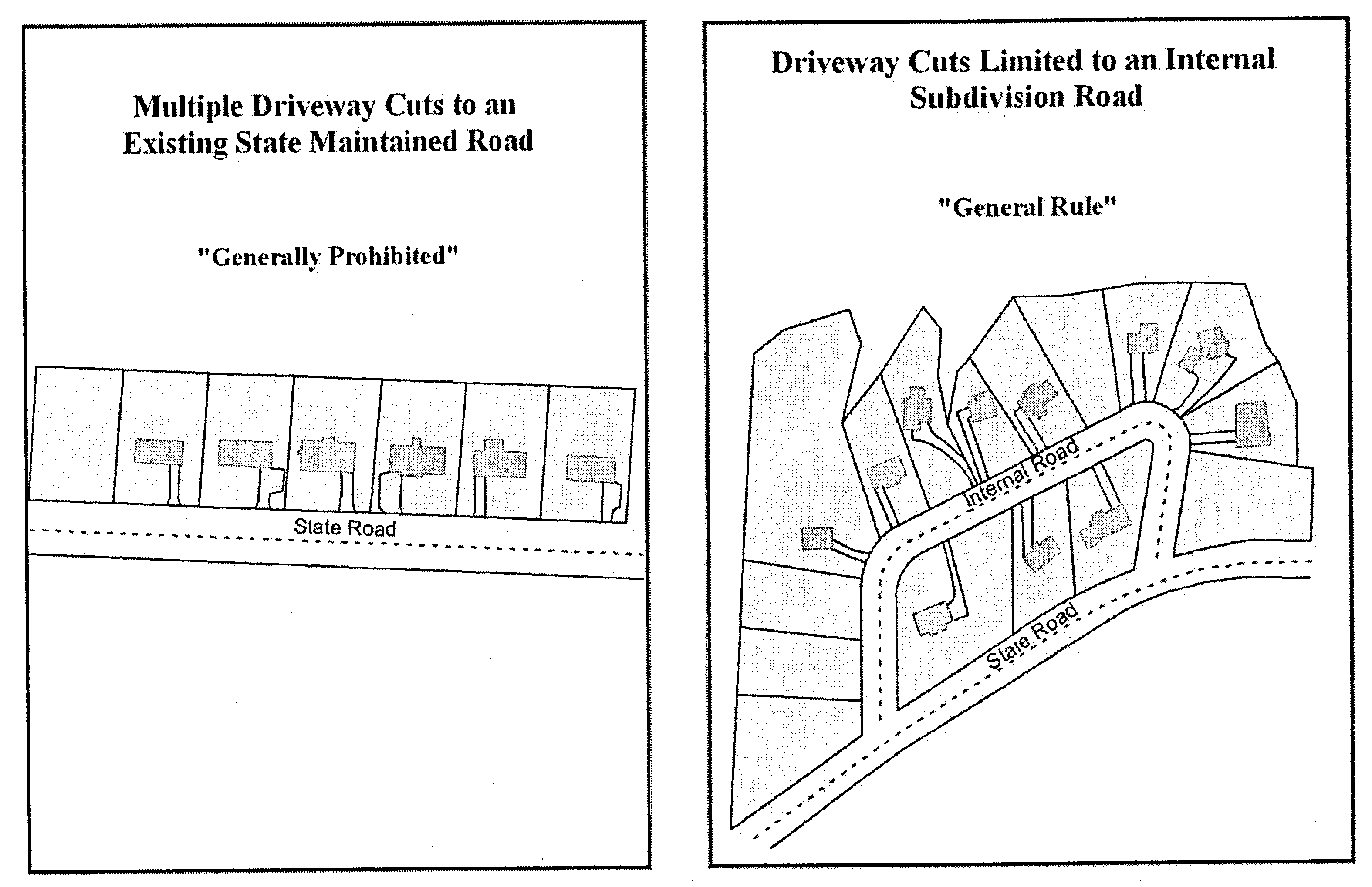
(e)
Reserve strips. Reserve strips (spite strips) of land for the sole purpose of controlling access to streets or circumventing right-of-way dedication are prohibited.
(f)
Half streets. Half streets are prohibited, except where the subdivision review board determines that it will be practical to construct the other half of the street when the adjoining property is developed.
(g)
Permits for connection to state roads. An approved NCDOT driveway connection permit is required for any change of use or connection of a nonresidential, multifamily, duplex and major subdivision development street to any existing state system road. This permit is required before any construction which connects the development road to the state system road, whether that development road is public or private.
(h)
Marginal access street.
(1)
Where a tract of land to be subdivided adjoins a principal arterial, minor arterial or major thoroughfare as designated on urban area transportation plan or the county thoroughfare plan, the subdivider must:
a.
Provide a collector road parallel to the arterial/thoroughfare, or
b.
Utilize the development's public road for access to double frontage lots.
(2)
Where double frontage lots are utilized, private driveways cannot have direct access to the arterial/thoroughfare to avoid stripping of driveways along the higher classified road. When it is not feasible for the subdivider to provide a collector road or utilize double frontage or when the board determines that the installation of such would result in a less desirable development design, the board may grant an exception to this requirement. The board must find that the spirit and intent of this chapter are met and the circumstances particular to the subject property, such as topography, shape of the tract, water features, or surrounding development patterns warrant the exception.
(Ord. No. 2021-05, 6-21-2021)
Sec. 44-516. - Street standards.
(a)
Applicability. This section applies to any development, subdivision or any other action that requires construction of internal roads. The term "private" as it appears in this chapter, refers to the maintenance responsibilities only of the road and not the dedication status, with the exception of subsection (d) below pertaining to neighborhood private roads.
(b)
Designation. All road rights-of-way must be designated in writing on the face of the plat as being a:
(1)
Dedicated public ROW. A ROW that has been dedicated to the public, but does not necessarily refer to construction status nor does it infer the acceptance for maintenance by NCDOT.
(2)
State road. A constructed road with a designated "SR" number which is being maintained by NCDOT.
(3)
Private road. A constructed road that is not dedicated to the public and will be maintained by an entity other than NCDOT. See subsection (d) below.
(c)
Roads standards within major subdivisions and developments.
(1)
All roads must have a dedicated right-of-way with roads designed and constructed to minimum NCDOT standards within the subdivision and to a state maintained road.
(2)
The construction of alleys and service roads in villages and planned developments must meet applicable NCDOT standards.
(3)
Roads must be maintained by the developer, owner(s) or homeowners' association until the NCDOT assumes responsibility for the maintenance. Maintenance responsibility must be noted on the final plat/plans.
(4)
Roads that are not eligible to be accepted into the NCDOT system must still be dedicated for public use and be built in accordance with NCDOT standards. Where a road has been offered for public dedication, that offer may not be withdrawn without prior review and approval from the county reviewing agency.
(5)
Curvilinear streets are encouraged in all subdivisions.
(6)
Round-about designs are encouraged in planned developments to encourage traffic calming and enhance aesthetically-pleasing neighborhoods.
(d)
Private roads. A private road is a road that meets the minimum NCDOT construction standards and meets NCDOT classification standards as verified by a state-licensed professional engineer (PE), but is not dedicated to the public and will not be maintained by the NCDOT.
(1)
Private roads may be allowed in the following situations:
a.
When the road is not eligible to be taken into the NCDOT maintenance system;
b.
Roads proposed in special districts, such as planned developments or villages; or
c.
Where the approving authority makes a determination that a public road is impractical.
(2)
Private roads are reviewed with the development proposal by the applicable reviewing county board. Private roads, approved by the board, must be perpetually maintained privately by a homeowners' association. At a minimum, the maintenance agreement must include the following:
a.
A legally incorporated homeowners' association must be established for the property owners within the entire development;
b.
All property owners within the development must be members of the homeowners' association;
c.
The developer must convey, in a fee simple ownership, all private roads within the development to the homeowners' association;
d.
The homeowners' association must have the responsibility for all maintenance of private roads.
e.
The passage of the responsibility for maintenance of private roads from the developer to the homeowners' association must be noted in the deed of each purchaser of property within the development.
f.
At the time of preparation of the sales agreement, the developer must include a disclosure statement to the prospective buyer. The disclosure statement must provide an explanation of the consequences and responsibilities regarding the maintenance of a private road and must fully and accurately disclose the party who is responsible for the construction and maintenance of the development roads.
Table 44-516-1. Road Classification and Construction Standards—Residential and Nonresidential
Notes:
(1)
In order to obtain a zoning authorization permit for construction, a minimum 15-foot access easement as noted in section 44-406 is required.
(2)
An exception to the right-of-way requirement may be allowed by the approving authority subject to the following conditions:
a.
The tract has an active development which is proposed to be re-developed;
b.
A less intense use is proposed for the tract; and
c.
A determination is made that practical difficulties exist and all opportunities have been exhausted.
(Ord. No. 2021-05, 6-21-2021)
Sec. 44-517. - Street connectivity.
Purpose: In general, interconnected developments provide for improved traffic flow, safety, reduce overall traffic congestion, provides access within and between adjoining developments and may be required by the county approving authority, while culs-de-sac are generally discouraged by the county.
(a)
External connectivity. Multiple accesses into a development may be required to provide additional ingress and egress. In determining whether to require multiple accesses, the county approving authority shall look at the following:
(1)
The overall number of lots served by the street system;
(2)
The proposed street system pattern;
(3)
The configuration and natural features of the tract of land;
(4)
The amount of road frontage available; and
(5)
The classification of NCDOT roads.
(b)
Internal connectivity. Internal connectivity is needed for convenient access, circulation, traffic control and safety.
(1)
Street segment. The maximum length of a street segment cannot exceed 1,000 feet unless interconnectivity can be achieved by exceeding the maximum, or topography, drainage, natural water features surrounding development patterns dictate otherwise, as determined by the county approving authority.
(2)
Projecting streets.
a.
Parcels must be arranged to allow for the opening of future streets and further development.
b.
Where adjoining areas are subdivided, proposed development must connect to adjoining stub outs or existing streets, subject to subsection d. below. The following applies:
1.
The streets in the proposed development must align with the existing adjoining streets.
2.
A reciprocal agreement must be provided indicating the road maintenance responsibilities for each subdivision using the interconnected road network. The agreement shall remain in force until NCDOT accepts maintenance responsibilities of the road(s).
3.
The road used for interconnectivity between the adjoining subdivisions should be for purposes of a secondary access and not be used as the primary entrance to the subdivision.
c.
Where adjoining areas are not subdivided, the arrangement of streets in the development must provide for the projection of streets stubbing to adjoining un-subdivided areas, subject to subsection d. below. Where stub out roads are required to be extended to the adjoining property line, the stub out must be:
1.
Dedicated with a continuous minimum NCDOT approved right-of-way to the property line in addition to right-of-way for the turn-around (cul-de-sac preferred or hammerhead); and
2.
Constructed to NCDOT standards including an improved turn-around which must qualify for inclusion into the NCDOT maintenance system.
d.
Continuation of an existing street or projection of a new street is not required where it would cause a street to project into a floodplain, topography constraints, other natural features or where other limitations or factors would prohibit the practical connectivity as determined by the county approving authority.
(Ord. No. 2021-05, 6-21-2021)
Sec. 44-518. - Sidewalks.
Purpose: An interconnected system of sidewalks or trails, provides a public benefit as an alternative transportation mode to automobiles, provides recreational opportunities within a development and connects developments.
(a)
Nonresidential requirements.
(1)
Pervious or impervious sidewalks, or a fee in-lieu, subject to subsection (c) below, are required for new developments along external roads where the property is part of an approved multi-modal plan such as a NCDOT bicycle/pedestrian plan and other plans including but not limited to the Carolina Thread Trail Plan and the Parks Master Plan. Sidewalks may also be required along one or both sides of all public external and internal streets within the project unless development patterns dictate otherwise.
(2)
Sidewalks must run the entire length of the property along the right-of-way, and be a minimum width of five feet.
(3)
Sidewalks/pedestrian facilities, or a fee in-lieu, are required for special district developments, subject to subsection (a)(1) above, and overlay districts as follows:
a.
MUC-O in section 44-430.10;
b.
PD in section 44-443.07;
c.
PD-IP in section 44-444(10);
d.
321-ED in 44-446.11(d); and
e.
Village in subsection 44-445.03(e)(7).
(4)
When subsection (1) above applies, sidewalks with a minimum width of five feet, are required along the front of commercial buildings adjacent to foundation plantings as required in subsection 44-523(g).
(5)
All sidewalks constructed within the public right-of-way require approval by NCDOT through an encroachment agreement.
(6)
All sidewalks, whether constructed within or outside of the public right-of-way, must be maintained by the developer, unless or until maintenance responsibilities are transferred or assigned to a homeowners association or other responsible entity.
(b)
Residential requirements.
(1)
Pervious or impervious sidewalks or hard surfaced pedestrian walkways, with a minimum width of five feet, are required along one side of the street for all new residential developments when 25 or more lots are proposed within the R-20 or higher density districts.
a.
The number of lots are cumulatively counted for the entire development as approved from the date of adoption of this chapter (February 6, 2007).
b.
Cul-de-sac roads less than 500 feet in length, without intersecting roads, are exempt from the sidewalk requirement.
(2)
Sidewalks are also required along the frontage of new residential developments where the property is part of an approved multi-modal plan such as, but not limited to, the Carolina Thread Trail Plan, Parks Master Plan, or a NCDOT bicycle/pedestrian plan.
(3)
The improved secondary open space requirement in subsection 44-543(d) may be used to meet the sidewalk requirement.
(4)
All sidewalks constructed within the public right-of-way require approval by NCDOT through an encroachment agreement.
(5)
All sidewalks, whether constructed within or outside of the public right-of-way, must be maintained by the developer, unless or until maintenance responsibilities are transferred or assigned to a homeowners association or other responsible entity.
(6)
A fee in-lieu may be approved, subject to subsection (c) below.
(c)
Fee in-lieu. The county will determine whether sidewalks are required or a fee in-lieu will be accepted. The county will consider the thoroughfare/transportation/multi-modal plan(s), connectivity, surrounding land uses and other factors, such as surrounding development patterns, anticipated or current pedestrian usage, etc. in determining whether to accept a fee in-lieu or require sidewalk installation. The fee in-lieu will be equivalent to the cost of sidewalk installation and backfill, for materials and labor, as quoted by a licensed contractor. These funds may be used for installation of sidewalks or bike paths, based on the transportation plan(s) and trails designated in the county master parks and recreation plan or other adopted multi-modal plans. The fee in-lieu is a one-time payment that is collected at the time of final approval which runs with the land and is not subject to an additional assessment at a future time.
(Ord. No. 2021-05, 6-21-2021)
Sec. 44-519. - Easements and underground utilities.
(a)
Utility easements. Utility easements must be noted on final development plans. The easements must be sufficiently wide to provide for installation of such utilities and access for maintenance and operation.
(b)
Utilities in drainage easements. Utilities in drainage easements are permitted only upon specific authorization from the reviewing board and only in the locations authorized. The reviewing board may approve utilities in drainage easements where it determines that adequate measures have been taken to avoid erosion, flooding, or other situations that would damage the utilities.
(c)
Underground utilities. All new on-site utilities (electric, telephone, cable, etc.) in major subdivisions, nonresidential and multifamily developments must be located underground unless technical restrictions prohibit doing so. The approving board shall determine if technical restrictions are applicable.
(Ord. No. 2021-05, 6-21-2021)
Sec. 44-520. - Fire protection.
All lots served by a municipal or county public water supply system in a development must be in accordance with applicable fire protection regulations.
(Ord. No. 2021-05, 6-21-2021)
Sec. 44-521. - Water supply and sanitary sewer.
(a)
Public water supply required. Public water supply is required in a residential and non-residential development as follows:
(1)
Any development which has public water system lines available must extend the public water system throughout the development to each lot as required by the county's water extension ordinance (chapter 42, article II of County Code).
(2)
Where public water is not available, the lots must be served by individual wells approved by the county division of environmental health or a community well system approved by the state department of environment, health and natural resources.
(b)
Public sanitary sewer required. Public sanitary sewer is required in a residential and non-residential development as follows:
(1)
Any development which has public sewer system lines available must extend the public sewer system throughout the development to each lot in accordance with building code and the current county sewer ordinance in effect.
(2)
Where public sewer is not available, each lot in the development must be served by an individual on-site septic system approved by the county division of environmental health or a private sewer system approved by the state department of environment, health and natural resources. On-site septic system approval is not required for parcels greater than five acres. The development plat must indicate that the parcel(s) have not been evaluated for building purposes.
(Ord. No. 2021-05, 6-21-2021)
Cross reference— Water and sewers, ch. 42.
Sec. 44-522. - Lighting standards.
Purpose: This section provides requirements for development to control light spillage and glare so as not to adversely affect motorists, pedestrians, and owners of adjacent properties.
(a)
Generally.
(1)
Subsection (b), (c) and (d) below apply to nonresidential and multifamily development. Subsection (e) below applies to new single-family residential subdivision development only.
(2)
All fixtures must be either semi-cutoff or full-cutoff fixtures only.
(3)
No fixture for nonresidential or multifamily development can be located within 20 feet of a residentially zoned property.
(b)
Outdoor illumination of building, landscaping and signs. The following provisions apply to the outdoor illumination of buildings, landscaping and signs:
(1)
Floodlights, spotlights or any other similar lighting cannot be used to illuminate buildings or other site features unless they are an integral architectural element that is designated on the development plan. Floodlights or other type of lighting attached to light poles that illuminate the site and/or building(s) are prohibited. When approved, exterior lighting should be integrated with the architectural character of the building.
(2)
The unshielded outdoor illumination of any building or landscaping is prohibited. To avoid light spillage, only semi-cutoff, cutoff, or full cutoff fixtures can be used.
(3)
Lighting fixtures used to illuminate a sign must either be by directed ground lighting sign or mounted on the top of the sign and be shielded from the sight of passing motorists.
(c)
Lighting for convenience store aprons and canopies. In addition to the provisions of subsections (a) and (b) above, the following provisions apply:
(1)
Recessed ceiling lights are encouraged; however, as an alternative indirect lighting may be used where the light is directed upward and then reflected down from the underside of the canopy. In this case, light fixtures must be shielded so that direct illumination is focused exclusively on the underside of the canopy.
(2)
Lights shall not be mounted on the top or sides (facia) of the canopy, and the sides of the canopy cannot be externally illuminated.
(3)
The lighting for new facilities (pump islands and under canopies) cannot exceed the average horizontal illumination of ten foot-candles at grade level.
(d)
Prohibited lighting and fixtures. The following are prohibited:
(1)
Vertical burn lamps and similar lighting fixtures.
(2)
Flashing, colored or obtrusive lighting.
(3)
The use of laser source light or any similar high intensity light for outdoor advertising or entertainment.
(4)
The operation of searchlights for advertising purposes.
(5)
Black lights and neon lights (including argon and similar rare-gas fixtures), except for signage.
(e)
Single-family residential development. When a common form of street lighting is provided in single-family residential subdivisions, it must be low-level intensity and consist of uniform fixtures. This section does not apply to individual residential lighting.
(Ord. No. 2021-05, 6-21-2021)
Sec. 44-523. - Landscaping standards.
Purpose: Landscaping, visual screening and buffers must be provided for all nonresidential and multifamily uses for the following:
♦
Remove, reduce, lessen or absorb the impact between one use or zone and another;
♦
Break up and reduce the impact of large parking areas;
♦
Provide aesthetic and visual interest;
♦
Obscure the view of outdoor storage, dumpsters, parking and loading areas;
♦
Provide protection from soil erosion, radiant heat, glare from headlights, noise pollution, storm water drainage problems; and
♦
Improve the urban and rural landscape resulting from the impacts of development and disturbance.
(a)
Applicability.
(1)
The landscaping requirements for parking applies to all surface parking facilities, except for one- or two-family dwellings not subject to a planned development.
(2)
The landscaping requirements do not apply to underground parking facilities.
(b)
Generally.
(1)
Required landscaping cannot obstruct visibility at intersections as required in section 44-407.
(2)
In providing the vegetation required by this division, the retention of existing significant vegetation is encouraged.
(3)
All dead or dying trees, stumps, litter, brush, weeds or other nuisance materials must be removed from the site at the time of occupancy.
(4)
All roadway slopes must be landscaped and all cuts and fills must be designed and/or vegetated to be sufficient to prevent erosion.
(5)
Developments must utilize existing topography, such as hills, ridges and berms, to screen parking and maintenance areas to the maximum extent possible.
(6)
All landscaping and screening which provide buffering and screening must be maintained as depicted on the detailed site plan. All landscaping and screening must be maintained by the developer, unless or until maintenance responsibilities are transferred or assigned to individual(s), a homeowners' association or other responsible entity. Sustainable maintenance systems, such as rain barrels or cisterns, which are architecturally compatible with the structure, are encouraged.
(7)
All plant material used must be classified as safe to use in USDA hardiness zone seven or less, to ensure they can survive an average minimum temperature of zero degrees Fahrenheit. Drought tolerant plant materials are encouraged.
(8)
The Manual of Woody Landscape Plants, latest edition, by Michael A. Dirr should be used as reference for the plant material standards.
(c)
Driveway landscaping requirements.
(1)
Paved driveways into parking facilities must be bordered by a landscape strip a minimum of eight feet in width; or
(2)
The landscape strip must consist of:
a.
At least 75 percent evergreens spaced a maximum of six feet apart in a minimum single or staggered row; or
b.
A row of ornamental trees spaced a maximum of 15 feet apart on each side of the driveway.
c.
The driveway landscape strip is required to extend 60 feet from the right-of-way or the full length of the driveway, whichever is less.
d.
The balance of the landscape strip must be covered with turf, a ground cover such as annuals or perennial planting beds, ornamental grasses, rock or wood mulch.
(3)
In lieu of the landscape strip bordering the driveway, landscaped planting beds may be installed at both sides of the driveway entrance having an area equal to that of the area of the driveway landscape strip; and
(4)
Any area where the driveway landscape strip abuts the parcel perimeter buffer, that portion of the driveway landscape strip is not required.
(d)
Perimeter landscaping requirements for parking facilities.
(1)
Parking facility—Rear yard. The perimeter of surface parking lots and the ground level of parking decks must be landscaped by a vegetative strip a minimum of eight feet in width. The landscaping strip must consist of 75 percent evergreens planted in a single or staggered row a minimum of six feet apart. The remaining 25 percent may consist of ornamental trees or deciduous shrubs. Ornamental trees may be planted intermittently throughout the perimeter landscape strip. The plantings consisting of low-growing evergreen shrubs, with the exception of the ornamental trees, cannot exceed three feet in height in order to address safety and visibility issues.
(2)
Parking facility—Front or side yard. The perimeter of surface parking lots and the ground level of parking decks must be landscaped by a vegetative strip a minimum of 12 feet in width, exclusive of abutting reserved or dedicated right-of-way. For parking facility perimeters in the front or side yard, require a staggered double row of vegetation which includes 75 percent low-growing evergreen shrubs planted six feet on center. The remaining 25 percent of the vegetation may be planted with ornamental trees or low-growing deciduous shrubs. Ornamental trees may be planted intermittently throughout the perimeter landscape strip. The plantings consisting of low-growing evergreen shrubs, with the exception of the ornamental trees, cannot exceed three feet in height in order to address safety and visibility issues.
(3)
Manicured turf, crushed brick, stone, ground-hugging vines or shrubs, ground cover, annuals, perennials, ornamental grasses, rock or wood mulch must cover the balance of the area.
(4)
Where the parking facilities are within 35 feet of the perimeter buffer abutting the side or rear yard, the parking perimeter landscape strip may be deleted.
(e)
Internal parking area landscaping.
(1)
All parking areas must have landscaped islands.
a.
If the parking facility is visible from a street, a landscape island is required for every ten spaces in a continuous row.
b.
If the parking facility is not visible from a street, a landscape island is required for every 15 spaces in a continuous row.
(2)
Each island must be a minimum of eight feet in any horizontal dimension, with concrete or asphalt curbing.
a.
The island must contain at least one major shade tree having a clear trunk height of at least five feet and a minimum of two-inch caliper diameter at breast height (DBH). The tree must be a minimum 15-gallon size or balled and burlapped at time of planting.
b.
Turf, ground cover, perennials, ornamental grasses, rock or wood mulch must cover the balance of the landscape island.
(3)
Foundation plantings or plantings along the perimeter of the parking lot, or in any part of a yard, is not considered as meeting the interior parking landscape requirement.
(f)
Parcel perimeter buffer.
(1)
Buffer requirement. More intensive uses must buffer between adjoining less intensive uses as defined in table 44-523-1.
Table 44-523-1. Use Intensity
 | Single-family and two-family |
|
Nonresidential uses in residential districts, for example churches,
schools and special uses | |
| Multifamily uses | |
| O & I uses | |
| RC or HC uses | |
| LI and GI uses |
(2)
Width of vegetative buffer area. Each required vegetative buffer area must have a minimum width of 15 feet.
(3)
Screening. Screening within the buffer area must consist of one of the following to create a solid screen:
a.
A dense vegetative planting incorporating trees and/or shrubs of a variety that must be equally effective in winter and summer to achieve a solid continuous visual screen within five years after the initial installation.
1.
All plant materials must be a conifer or broadleaf evergreen to achieve a minimum height of six feet within five years.
2.
Trees and/or shrubs must be adequately spaced.
3.
If a buffer area is greater than 100 feet in length, more than one species of plant material is required in order to minimize insect and disease infestations.
4.
One ornamental tree or large canopy tree is required for every 150 linear feet of buffer area. It may be planted in the buffer area or in the immediate adjacent area. It shall meet the following minimum standards:
i.
Each tree, at the time of installation, must have a clear trunk height of at least five feet and a minimum caliper DBH of two inches or a 15-gallon container size or balled and burlapped at time of planting.
ii.
Mature height must be at least 20 feet unless overhead utilities are in the planting area.
b.
No additional buffering is required if:
1.
Existing vegetation, located on the subject property, affords the degree of buffering and screening, in terms of height, opacity and separation, equivalent to or exceeding that found in a. above; or
2.
Existing vegetation, located on the adjoining property, affords the degree of buffering and screening, in terms of height, opacity and separation, equivalent to or exceeding that found in subsection (f)(3)a if the subject property owner acquires a preservation easement from the adjoining property owner. The preservation easement must be recorded at the county register of deeds and state that vegetation will be maintained and no structure will be built in the easement.
c.
A six-foot opaque structure such as a solid masonry wall, or a solid fence that is compatible with the principal structure. Chain link fencing cannot be used to meet this requirement; or
d.
A maintained, three-foot earthen-mound or berm with vegetation to achieve a six-foot screen with a minimum base width of 12 feet. This mound or berm cannot impound stormwater runoff or direct runoff to adjacent properties. All plant materials must be evergreen and a minimum three-gallon in size and two feet in height at the time of planting. Trees and/or shrubs shall be adequately spaced to form a solid continuous visual screen within three years after the initial installation. If a buffer area is greater than 100 feet in length, more than one species of plant material is required in order to minimize insect and disease infestations.
(4)
Exceptions to parcel perimeter screening requirements.
a.
Where a commercial or office-institutional development is proposed on a lot adjoining a vacant lot, the developer may be exempted from the parcel perimeter screening requirements, if the following conditions are met:
1.
Adjoining landowners execute a written acknowledgment of their consent to the waiver of such screening criteria and of its legal ramifications;
2.
The waiver is recorded at the register of deeds in both the grantor's and grantee's names; and
3.
The adjoining tract has either a natural vegetative or other screening structure or a minimum of 200 feet of road frontage, which acts to provide both a visual or a noise buffer between the developing lot and the affected tracts surrounding the adjoining lot which has waived the buffer requirements.
b.
Where a church/synagogue or other places of worship or school is proposed on a lot adjoining a vacant or built upon lot, the place of worship or school can be exempted from the perimeter buffer requirements if the following conditions are met:
1.
Adjoining landowners execute a written acknowledgment of their consent to the waiver of such screening criteria and of its legal ramifications; and
2.
The waiver is recorded at the register of deeds in both the grantor's and grantee's names.
c.
Where topography exists such that the effect of the screening cannot be achieved as determined by the planning director.
(g)
Foundation plantings. The pedestrian entranceway and/or surface parking facilities must be separated from the exterior wall of any principal structure by a landscape buffer. The landscaped buffer strip must be at least five feet in width along the building foundation or on the opposite side of the building entrance sidewalk. If the architecture makes this impractical, planter boxes which occupy 40 percent of the building façade length, or large flower pot type containers spaced a maximum of 20 feet on center along the entire façade may be used as an alternative.
(h)
Street trees.
(1)
Street trees—Multifamily or nonresidential. Street trees must be planted in all multifamily or nonresidential developments. All public interior streets and development fronting along existing external roads must provide the following along all street frontages:
a.
A three- to five-foot landscape strip between the curb and sidewalk, when sidewalks are required.
b.
A ten-foot (minimum) landscape strip behind the right-of-way (within the front setback).
c.
Street trees must be planted adjacent to the sidewalk or right-of-way and must meet the following.
1.
An average of one shade street tree is required for every 40 linear feet of road frontage on each side of the street, or where overhead lines are present, street trees of low-growing varieties must be planted an average of one tree for every 30 feet of street frontage on each side of the street. Trees should be spaced approximately equal distance.
2.
Each tree, at the time of installation, shall have a clear trunk height of at least five feet and a minimum caliper of two inches or a minimum 15-gallon container size or balled and burlapped at time of planting. An appropriate mulch bed must be provided around the tree.
3.
In the absence of overhead lines in the planting area, the shade street tree should achieve a mature height of over 20 feet and a mature spread of at least 15 feet.
4.
All trees planted within the public right-of-way shall require approval by NCDOT through an encroachment agreement.
5.
Street trees, whether planted within or outside of the public right-of-way, must be maintained by the developer, unless or until maintenance responsibilities are transferred or assigned to individual(s), a homeowners association or other responsible entity.
(2)
Street trees—Residential. Street trees must be planted in all major subdivision developments along the internal subdivision roads and the frontage of a corner lot on an existing external road, where it intersects with the internal subdivision road. Street trees must be planted adjacent to the sidewalk (when required) or right-of-way and must meet one of the following:
a.
Two-inch caliper or 15-gallon container street trees must be planted in a staggered pattern every 50 feet of street frontage as measured along the street centerline; or
b.
Existing vegetation which meet the standards of subsection (h)(2)a. above.
(i)
Alternative buffers and screening. In lieu of compliance with the buffer and screening requirements in subsection (f)(3) above, an applicant may submit to the planning director for his review and approval a detailed plan and specifications for landscaping and screening. The planning director may approve the alterative buffering and screening, in writing, upon finding that the proposal will afford a degree of buffering and screening, in terms of height, opacity and separation, equivalent to or exceeding that provided by the requirements.
(Ord. No. 2021-05, 6-21-2021)
Sec. 44-524. - Screening of mechanical equipment.
All mechanical equipment, such as air conditioners or pumps, must be screened from view of all streets, public places and neighboring properties, through the use of features such as berms, fences, building walls, false facades, or dense landscaping. Chain link fencing cannot be used. Mechanical equipment on rooftops must be screened from the view of the street with parapets, designed features and other materials compatible with the building and suitable for screening. An exception to the screening requirement is made for photo-voltaic (solar) panels.
(Ord. No. 2021-05, 6-21-2021)
Sec. 44-525. - Central solid waste storage area.
All new buildings and uses, except for single-family and two-family dwellings, must provide facilities for the central storage of solid waste within the lot. Where facilities are provided outside of a building, they must be screened from public rights-of-way and adjacent property by an enclosure constructed of materials compatible with the materials on the front building wall of the principal building. All the areas must have a solid and closable gate.
(Ord. No. 2021-05, 6-21-2021)
Sec. 44-526. - Screening of loading and service areas.
All loading and service areas must be screened from view of all streets and adjoining properties of less intensive use of through a buffer meeting the requirements of subsection 44-523(f). If the loading area abuts the perimeter buffering, the loading area is not required to be screened.
(Ord. No. 2021-05, 6-21-2021)
Sec. 44-527. - Screening of open storage.
Open storage must be screened from any street or any less intensive land use, as required in table 44-523-1 based on the principal use. Screening of the area used for open storage must meet the same requirements of subsections 44-523(f)(2) and (3). Open storage must be setback from adjoining property lines in accordance with the setback required for the principal structure (see table 44-404-1).
(Ord. No. 2021-05, 6-21-2021)
Sec. 44-534. - Off-street parking.
(a)
Applicability.
(1)
This section applies to all applications for development approval, unless the application is specifically exempted by another provision of this chapter.
(2)
The minimum parking requirements of this division apply to the entire development when the expansion cumulatively is equal to or greater than 50 percent of the existing aggregate leasable floor area of all structures on the development parcel. If the expansion of the leasable floor area is less than 50 percent, then the parking requirements apply only to the expansion area.
(b)
Compliance.
(1)
The developer is responsible for the construction and maintenance of the required off-street parking space and off-street loading space. This obligation continues while the structure or use is in existence.
(2)
An owner of any structure affected by this chapter cannot discontinue or change the required vehicle parking or loading spaces, apart from the discontinuance of the structure, unless alternative parking and loading space are approved as required by this division.
(c)
Methods of providing required parking.
(1)
All required parking must be located on the same lot as the principal use it serves, except as provided in subsection (c)(2) below.
(2)
In lieu of actual construction of required on-site parking spaces, required parking for a use on a lot may be located on another lot if the requirements of subsections (c)(2)a through e below, are met. The offsite parking may be combined with parking for other uses, subject to approval by the planning director.
a.
The use being served by the off-site parking is a permitted principal use in the zoning district within which the lot containing such parking is located.
b.
The off-site parking spaces must be located within 500 feet of a public entrance to the structure or land area containing the use for which such spaces are required.
c.
A safe, direct, attractive, and convenient pedestrian route must exist or be provided between the off-site parking and the use being served.
d.
The continued availability of off-site parking spaces, necessary to meet the requirements of this division, must be ensured by an appropriate reciprocal easement, satisfactory to the county attorney, and recorded with the register of deeds.
e.
Off-site required, off-street parking cannot be separated from the use it serves by arterial or collector streets, as shown on the thoroughfare plan, or other similar physical barriers to convenient access between the parking and the use.
(d)
Minimum number of parking spaces.
(1)
Schedule of off-street parking spaces. The number of required off-street parking spaces are shown in table 44-534-1:
a.
An exception to the number of parking space requirements may be considered for parking based upon documented industry standards or market studies.
Table 44-534-1. Required Parking Spaces
* GFA = Gross floor area
(2)
Calculation of certain parking requirements. Where parking requirements relate to number of seats, and seating is in the form of undivided pews and benches, 24 lineal inches is construed to be equal to one seat. Where parking requirements relate to movable seating in auditoriums and other assembly rooms, ten square feet of net floor area is construed to be equal to one seat, except where otherwise specified. Net floor area must be the actual area occupied by seating and related aisles and must not include accessory unoccupied areas or the thickness of walls.
(e)
Determination for unlisted uses. The determination for unlisted uses will be made as follows:
(1)
The planning director shall make a determination of the required off-street parking spaces for uses not listed in table 44-534-1.
(2)
In making a determination, the planning director will be guided by the requirements for similar uses, the number and kind of vehicles likely to be attracted to the proposed uses and studies of the parking requirements of such uses in other jurisdictions.
(f)
Maximum number of parking spaces.
(1)
If the proposed number of off-street parking spaces exceeds the minimum number of required spaces, the additional spaces must be composed of pervious pavement, or a bio-retention basin, rain garden, or equivalent measure must be provided to manage stormwater runoff. In no case shall the maximum number of spaces exceed 125 percent of the minimum number of spaces required.
(2)
The maximum number of off-street parking spaces permitted does not include required disabled accessible spaces.
(3)
The maximum number of parking spaces permitted does not apply to parking structures.
(Ord. No. 2021-05, 6-21-2021)
Sec. 44-535. - Joint-use facilities and shared parking.
(a)
When two or more uses, either on a single parcel or multiple parcels, provide for shared parking spaces, the number of parking spaces required for each individual business as shown in table 44-534-1, may be reduced by no more than ten percent of the total number of spaces. More than ten percent reduction in required parking spaces would constitute an amendment to the approved plan and must be resubmitted to the applicable authority for approval.
(b)
An agreement for such joint use, in the form of a reciprocal easement acceptable to the county attorney, must be filed with the planning director and recorded with the county register of deeds.
(Ord. No. 2021-05, 6-21-2021)
Sec. 44-536. - Parking standards.
(a)
Regular car parking. The minimum dimensions for required off-street spaces at various angles are shown in the table 44-536-1 and illustrated in figure 44-536-1 below.
Table 44-536-1. Parking Dimensions
| Figure 44-536-1 reference | 0° | 45° | 60° | 75° | 90° | 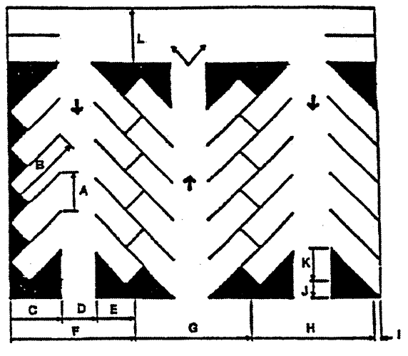 Figure 44-536.1. Parking Components Figure 44-536.1. Parking Components | |
| Stall width, parallel to aisle | A | 9.0 | 12.7 | 10.4 | 9.3 | 9.0 | |
| Stall length of line | B | 24.0 | 24.5 | 21.4 | 19.5 | 18.0 | |
| Stall depth to wall | C | 9.0 | 17.0 | 18.5 | 19.0 | 18.0 | |
| Aisle width between stall lines | D | 12.0 | 12.0 | 16.0 | 22.0 | 24.0 | |
| Stall depth, interlock | E | 9.0 | 14.8 | 17.0 | 18.3 | 18.0 | |
| Module, wall to interlock | F | 30.0 | 43.8 | 51.5 | 59.3 | 60.0 | |
| Module, interlocking | G | 30.0 | 41.6 | 50.0 | 58.6 | 60.0 | |
| Module, interlock to curb face | H | 30.0 | 41.8 | 49.4 | 56.9 | 58.0 | |
| Bumper overhang (typical) | I | 0.0 | 1.5 | 1.8 | 2.0 | 2.0 | |
| Offset | J | — | 6.3 | 2.7 | 0.5 | 0.0 | |
| Setback | K | 24.0 | 11.0 | 8.3 | 5.0 | 0.0 | |
| Cross aisle, one-way | L | 18.0 | 18.0 | 18.0 | 18.0 | 18.0 | |
| Cross aisle, two-way | — | 24.0 | 24.0 | 24.0 | 24.0 | 24.0 |
(b)
Compact car parking. Parking for compact cars may be provided for up to 30 percent of the required parking.
(1)
Ten percent of the total parking required must be compact car parking for parking areas that have ten or more spaces.
(2)
For 90-degree compact parking, the minimum stall width is eight feet, and the minimum stall length is 16 feet. Bumper overhang for compact parking is not required.
(3)
Compact parking spaces must be designated as being for the exclusive use of compact cars through the use of signs or pavement marking.
(4)
The parking layout dimensions (in feet) for eight-foot compact parking stalls at various angles are shown in table 44-536-2 below and illustrated in figure 44-536-1 above.
Table 44-536-2. Compact Car Spaces
(c)
Parking for persons with disabilities. Parking for persons with disabilities must meet North Carolina Accessibility Code.
(1)
Accessible parking spaces must be provided as follows in table 44-536-3 below:
Table 44-536-3. Disabled Parking Requirements
(2)
Parking spaces for the disabled must be designed and located as follows:
a.
All users must have direct access to a curb ramp, curb cut or sidewalk when necessary to allow access to the building, structure, or use served.
b.
Diagonal or perpendicular parking spaces must be a minimum of 12½ feet wide.
c.
Parallel parking spaces must be located either at the beginning or end of a block or adjacent to an alley entrance. Curbs adjacent to the spaces must be of a height which will not interfere with the opening and closing of motor vehicle doors.
d.
Parking spaces must be prominently outlined with paint different from ordinary striping and posted with a permanent fixed sign of a color and design approved by NCDOT.
(d)
Off-street parking design standards. Off-street parking design standards are as follows:
(1)
Except for single-family dwellings, every off-street parking area and driveway must have a hard surface consisting of asphalt or concrete pavement, or an alternative approved by the planning director, to provide a durable and dustless surface. In making a determination as to the suitability of a proposed alternative, the planning director must find the improvement provides:
a.
A safe and permanent surface, suitable for the quantity and quality of traffic expected to use it;
b.
A surface which will accept permanent delineation of parking spaces, aisles, accessways, and maneuvering areas; and
c.
A surface that will not contribute to subsidence, erosion, or sedimentation, either on site or off site.
(2)
All off-street parking lots must be graded and drained to dispose of all surface water accumulated within the area and not channeled to adjoining property.
(3)
Lighting intensities should be controlled to ensure that light and glare are not directed at adjacent properties, neighboring areas, and motorists.
(4)
Sales, dead storage, repair, dismantling and service of motor vehicles is not permitted on off-street parking spaces.
(5)
Off-street parking spaces, including all areas for maneuvering, must be located solely on private property and not on public property or public rights-of-way. In addition, off-street parking is allowed:
a.
Within the front setback, if one or more of the following factors are present, including but not limited to: severe topography, location of septic tank/repair areas, wells, other utilities, corner lot, irregular shaped lot, or to achieve inner-connectivity; or
b.
If located in the rear of the building, parking may be located within the required setback; or
c.
If located on the side of the building, parking may be located within the required setback.
(6)
All off-street parking areas must be designed to provide safe and convenient circulation, in accordance with commonly accepted traffic-engineering practices.
(Ord. No. 2021-05, 6-21-2021)
Sec. 44-537. - Loading standards.
(a)
Required loading space.
(1)
Every use requiring the receipt or distribution by vehicles, of materials and merchandise, must have one or more loading berths or other space for standing, loading and unloading on the same or adjoining premise.
(2)
Loading space must be sufficient to allow normal loading and unloading operations of a kind and magnitude appropriate to the property served.
(3)
Required loading space must be available for the loading and unloading of vehicles and cannot be used for the storage of vehicles or materials, off-street parking requirements, or conducting the principal use.
(b)
Loading space standards. All off-street loading spaces must meet the following standards:
(1)
Off-street loading spaces must be located and arranged so that a semi tractor-trailer truck (wheelbase 50 class) or a local delivery vehicle, as appropriate, must be able to gain access to and use such spaces;
(2)
Loading space must meet the minimum street and interior setbacks established for structures;
(3)
All loading space and maneuvering space must be surfaced with a dustless, all-weather material and maintained in a safe, sanitary, and neat condition;
(4)
No loading space may be located so that a vehicle using the space intrudes on or hinders the use of the public right-of-way or adjacent properties; and
(5)
Each required off-street loading space must have a minimum width of 12 feet and a minimum vertical clearance of 16 feet above the finished grade of the space. The length must be a minimum of 20 feet for local delivery and 60 feet for semi tractor-trailers.
(Ord. No. 2021-05, 6-21-2021)
Sec. 44-538. - Bicycle parking.
Bicycle-parking facilities shall be installed as part of nonresidential and multifamily developments within 500 feet of bicycle corridors identified in officially adopted bikeway plans. Bicycle-parking facilities should be designed in accordance with the recommendations from the Association of Pedestrian and Bicycle Professionals (APBP) or equivalent standards.
(Ord. No. 2009-12, 11-16-2009)
Sec. 44-543. - Neighborhood recreation/open space for non-cluster developments.
(a)
Applicability. The following developments must provide land for parks, sidewalks, trails, greenway, recreational and open space purposes:
(1)
All major residential conventional subdivisions must dedicate land or fee in-lieu of land for open space.
(2)
Mixed-use development that contains residential uses; and
(3)
Multifamily use.
(b)
Amount of land or fee in-lieu. In determining whether the county will accept a fee in-lieu of or proposed on-site open space, the county shall consider the parks and open space master plan, the comprehensive or small area plans and other accepted plans and the potential for connectivity with other developments or open space.
(1)
Determination. The amount of land to be provided for neighborhood recreation/open space in conventional subdivisions must be 2,500 square feet per dwelling unit, based on the following equation:
Required open space = the number of dwelling units × 2,500 square feet per dwelling
(2)
Payment in lieu of open space. In lieu of providing open space on site, a developer may make a one-time payment in the amount of $1,000.00 per lot. The fee in-lieu is payable to the parks trust fund for development of capital projects associated with the county parks master plan or other accepted plans.
(3)
Open space incentive. As an incentive to provide additional open space, a conventional subdivision can receive a density bonus for providing additional open space beyond the requirement in subsection (b)(1) above. For every 100 square feet of open space per lot above the minimum open space requirement (up to a maximum of 3,500 square feet) an increase in the number of lots is allowed at a direct proportion ranging from a minimum one percent to a maximum of ten percent of the total lots allowed. For example, a 100-lot subdivision proposes a total of 3,000 square feet of open space per lot. This represents 500 square feet beyond the 2,500-square-foot minimum open space requirement. Next, determine the multiplier for each 100-square-foot increment of additional open space using the following equation: the open space proposed per lot minus 2,500 then divide by 100. In the example, the equation would be: (3,000−2,500)/100 = 5, which also is the percentage multiplier for the lot bonus allowed. Finally, determine the number of bonus lots using the following equation: number of proposed lots × multiplier determined using the last step. In the example, the equation would look like this: 100 lots × 5% = 5 additional lots for a total of 105 lots.
(c)
Characteristics. Except as otherwise required by the county at the time of preliminary subdivision approval, the neighborhood recreation/open space must meet the following criteria:
(1)
Land characteristics. Neighborhood recreation/open space must be provided at a minimum proportion of 25 percent for primary open space and 75 percent for secondary open space.
a.
Primary open space is land ideal for building development. Primary open space also includes land with slopes less than 20 percent.
b.
Secondary open space includes floodplains, area of lakes, ponds, creeks, other water bodies, wetlands falling under the jurisdiction of State or Federal agencies, utility easements, steep slopes and other sensitive areas including woodland areas.
Sidewalk, whether voluntary or required under section 44-518, may be counted as part of the secondary open-space requirement, at a ratio of 1:2. For every square foot of sidewalk, two square feet of open space is credited toward the secondary open-space requirement.
(2)
Shape. If a sufficient amount of land is dedicated to accommodate future recreational facilities and activities, such as fields, courts or playground equipment, the shape of the dedicated land shall be suitable for such facilities and activities as determined by the planning director. Linear open space must be a minimum of five feet in width to accommodate trails and greenways.
(d)
Neighborhood recreation/open space improvements. Within the secondary open space area, an improved trail system composed of concrete, asphalt, composite materials, wood chips, grass or other appropriate trail materials must be installed. The trail system must comprise a minimum of 25 percent of the total secondary open-space requirement. The sidewalk requirement under section 44-518 may be counted as part of the improved secondary open-space requirement.
(e)
Neighborhood recreation/open space dedication and maintenance. Neighborhood recreation/open space shall be dedicated in accordance with the following:
(1)
Subdivision occupants shall be ensured direct access to and use of the subdivision's neighborhood recreation/open space, through the conveyance of the open space to a homeowners' association or a public agency or nonprofit organization. Such organization must be capable and willing to accept responsibility for maintaining the neighborhood recreation/open space for its intended purpose.
(2)
Trails or open spaces which are a designated component of the parks master plan as being part of a linear trail system must be dedicated and deeded to the county. Trail maintenance will be performed by the county as part of the park's division.
(3)
Each dedicated open space parcel and improvements shall be shown on the final plat recorded in the register of deeds, with a notation of its area.
(4)
The owner(s) of the neighborhood recreation/open space, whether it be the homeowners' association, public agency or nonprofit organization, is responsible for maintaining the open space so that it continues to effectively function for its intended use.
(Ord. No. 2021-05, 6-21-2021)
Sec. 44-544. - Open-space requirements for cluster subdivisions.
Purpose: A cluster subdivision design is an option to a conventional subdivision design. Cluster subdivisions provide for a subdivision design that is more efficient and better suited to the natural features of the land and blends into the character of a rural area. The purpose of a cluster subdivision is to allow lots to be smaller and concentrated on those parts of the subdivision site best suited to accommodate development with the least adverse impact. Clustering of lots:
♦
Provides recreational opportunities for the subdivision's residents;
♦
Conserves and protects significant natural areas and environmentally sensitive areas;
♦
Protects important historic resources;
♦
Allows smaller and less costly networks of roads and utilities;
♦
Encourages closer-knit and potentially safer neighborhoods;
♦
Preserves sensitive farmland, woodlands, scenic views and open space; and
♦
Reduces the amount of impervious surface and resulting stormwater runoff.
(a)
Minimum cluster subdivision site size. The minimum land area required for a cluster subdivision must be at least five contiguous acres.
(b)
Maximum number of lots in cluster subdivision. The maximum number of lots allowed within a cluster subdivision shall be determined by dividing the total gross acreage in the tract, not including external state road rights-of-way, by the density (maximum dwelling units per acre) as noted in table 44-404-1 for the applicable zoning district.
(c)
Lot design and dimensional requirements for a cluster subdivision. Lot width and setback requirements as shown on table 44-404-1 for the applicable zoning district may be reduced as follows:
(1)
The minimum lot area may be reduced by up to 75 percent of the lot area required in the underlying zoning district, but cannot be smaller than 7,000 square feet. For example:
•
A 40,000-square-foot-minimum lot may be reduced by seven percent, providing for a 30,000-square-foot reduction (40,000 × 0.75 = 30,000-square-foot lot reduction). With this reduction, the final minimum allowable lot is 10,000 square feet. (40,000−30,000 = 10,000-square-foot minimum lot).
•
A 30,000-square-foot minimum lot may be reduced by 75 percent, providing for a 22,500-square-foot reduction (30,000 × 0.75 = 22,500-square-foot reduction). With this reduction, the final minimum allowable lot is 7,500 square feet (30,000−22,500 = 7,500 square feet).
•
A 20,000-square-foot-minimum lot may be reduced by 75 percent, providing for a 15,000-square-foot reduction (20,000 × 0.75 = 15,000-square-foot reduction). However, lots may only be reduced to a minimum of 7,000 square feet. So although calculations show that each lot could be 5,000 square feet (20,000−15,000 = 5,000 square feet), a 7,000-square-foot lot minimum is required).
(2)
Cluster subdivisions located within protected watershed areas must comply with the watershed requirements as stipulated in section 44-434, and its subsequent subsections.
(3)
The minimum lot width requirement may be reduced by 50 percent, but cannot be less than 45 feet.
(4)
The minimum front setback requirement may be reduced by 33 percent, but cannot be less than 20 feet. Front setbacks cannot be reduced on streets located along the RP-O corridor, R-40 zoning district or along the subdivision perimeter boundary. Setbacks must comply with the requirements of subsection (d) below.
(5)
The minimum side and rear setback requirements may be reduced by 33 percent, but cannot be less than five feet. Side and rear setbacks cannot be reduced on streets located along the RP-O corridor, R-40 zoning district or along the subdivision perimeter boundary. Setbacks must comply with the requirements of subsection (d) below.
(d)
Perimeter-boundary setbacks. Setbacks abutting the perimeter boundaries of the entire cluster subdivision site must be 50 feet. Lands in this setback area may be dedicated and counted at open space. In lieu of this requirement, a permanent wooded buffer of 30 feet in width may be maintained around the perimeter of the subdivision. The wooded buffer must be connected to the open space within the subdivision.
(e)
Required open space. The total area dedicated as permanent open space must make up at least 25 percent of the net acreage of the subdivision, resulting from excluding the internal road rights-of-way. As an incentive to provide additional open space, a cluster subdivision can receive a density bonus for providing additional open space beyond the requirement in this section. For every one percent open space above the minimum open-space requirement an increase in the number of lots is allowed at a direct proportion ranging from a minimum one percent to a maximum of ten percent of the total lots allowed, as shown in subsection (b) above.
(f)
Open space use, location and design.
(1)
Open space must be dedicated or reserved for one or more of the following purposes:
a.
Conservation of and avoidance of development in any identifiable natural hazard areas, including areas that potentially pose a significant hazard to people or property:
1.
Designated floodways and floodway fringes identified in Federal Emergency Management Agency flood insurance studies;
2.
Regulatory wetlands; or
3.
Steep slopes, greater than 20 percent, and lands whose soils make them particularly susceptible to erosion when disturbed by development activities.
b.
Conservation and protection of any identified significant natural areas as identified in the county's natural heritage inventory;
c.
Protection, maintenance and dedication as open space of any identified historic resources or any public or private cemeteries that are part of the subdivision development. An exception would be areas retained by its original owners, such as a family or church owned and maintained cemetery;
d.
Provision of active and/or passive outdoor recreation opportunities such as, ball fields, playgrounds, tennis courts, swimming pools, basketball courts, golf courses, bikeways, walking trails, nature trails, and picnic areas;
e.
Retention of productive farmland or forestland for continued agricultural or forestry use;
f.
Land for pedestrian access, such as sidewalks or trails.
(2)
The highest priority for the location, design, and use of open space must be given to conserving and avoiding development in any natural hazard areas on the subdivision site.
(3)
Open space may contain only such buildings, structures, accessways, and parking facilities as are necessary for its intended use as open space.
(4)
The location, size, character, and shape of required open space shall be appropriate to its intended use. Open space proposed to be used for recreation, particularly active recreation, shall be located and designed so as to be conveniently and safely reached and used by those persons it is intended to serve. Open space proposed to be used for ball fields, playing fields, or other extensive active recreational facilities should be located on land that is relatively flat and dry.
(g)
Open space dedication. Open space shall be dedicated in accordance with the following:
(1)
Subdivision occupants shall be ensured direct access to and use of the subdivision's open space, through the conveyance of the open space to a homeowners' association or to a public agency or nonprofit organization. Such organization must be capable and willing to accept responsibility for managing the open space for its intended purpose.
(2)
Each dedicated open space parcel shall be shown on the final plat recorded in the register of deeds, with a notation of its area.
(h)
Open space maintenance. The owner(s) of the open space is responsible for maintaining the open space so that it continues to effectively function for its intended use.
(i)
Design procedure. Design procedures are as follows:
(1)
Existing features/site analysis. An existing features/site analysis must be included on the sketch plan. The sketch plan must indicate all features that exist on the subject site as described in subsection (f) above.
(2)
Identification of open space/conservation areas. Guidance as to which parts to classify as open space/conservation areas shall be based upon three factors:
a.
On-site visits by the planning director, the subdivider and the site designer.
b.
The open space standards described in subsection (f) above.
c.
The evaluation criteria as shown in subsection (j) below.
(3)
Principal structure setback from open spaces. Principal structures must be set back a minimum of 50 feet from all open space lots lines.
(4)
Street, trail and sidewalk locations and alignments. All streets, sidewalks and trails must be sited in locations having the least environmental impact. Trails must connect the housing clusters to the designated open space.
(j)
Evaluation criteria. In evaluating the layout of a site, the following criteria will be utilized in determining the site's features which allow for site design flexibility:
(1)
The open space must be reasonably contiguous and must abut existing open space on adjacent sites.
(2)
All wetlands, flood hazard areas and 20 percent slopes cannot be cleared, filled or graded. Water features cannot constitute more than 50 percent of the open space area.
(3)
The impacts on larger woodlands over five acres must be minimized as much as practical.
(4)
Where farmland preservation is the goal of a site design, dwellings must be located away from active farming areas, as is practical.
(5)
Where preserving scenic views is the goal of a site design, such scenic views should remain unblocked and uninterrupted. In wooded areas, where enclosure (i.e., a tree canopy) is a feature to be maintained, a no-cut and no-build buffer shall be considered along the public roadway.
(6)
Where historic or archeological preservation is the goal of a site design, new streets, driveways, fences and/or utilities cannot interfere with the historic site.
(7)
Where power line rights-of-way are proposed to be included as part of the open space, the right-of-way shall not exceed 30% of the required open space as stated in subsection (e) above.
(8)
Area used for the installation of individual and community wells and septic systems cannot exceed 30 percent of the open space.
(Ord. No. 2021-05, 6-21-2021)
Sec. 44-545. - Ownership and maintenance.
(a)
Homeowners' association. All neighborhood recreation and open space shall be maintained by a homeowners' association, in accordance with section 44-360.
(b)
Condominiums. The neighborhood recreation/open space and associated facilities may be controlled through the use of a plat or plan that conforms to the North Carolina Condominium Act (G.S. chapter 47C). All neighborhood recreation and open space land shall be held as a common element as defined in the North Carolina Condominium Act. A proposed operations budget and plan for longterm capital repair and replacement shall be submitted with the application for development approval.
(c)
Dedication of easements. The county may, but is not required to, accept easements for public use of any portion or portions of undivided parks and/or open space land, title of which is to remain in ownership by condominium or homeowners' association, provided:
(1)
Such land is accessible to county residents;
(2)
There is no cost of acquisition other than any costs incidental to the transfer of ownership, such as title insurance; and
(3)
A satisfactory maintenance agreement is reached between the developer, condominium or homeowners' association, and the county.
(d)
Transfer of easements to a private conservation organization. An owner may transfer perpetual easements to a private, nonprofit organization, among whose purposes it is to conserve parks and/or open space and/or natural resources (such as a land conservancy), provided that:
(1)
The organization is a bona fide conservation organization with perpetual existence;
(2)
The organization is financially capable of maintaining such parks and/or open space;
(3)
The conveyance contains legally enforceable provisions for proper reverter or retransfer in the event that the organization becomes unwilling or unable to continue carrying out its functions.
(Ord. No. 2021-05, 6-21-2021)
Sec. 44-546. - Connectivity.
An interconnected system of parks, trails, greenways, and bikeways provides a greater public benefit than isolated parks with access exclusively by automobiles. Such areas may provide form to neighborhoods, a common public gathering space, and an opportunity to protect natural areas. The county encourages developers to link linear parks and open space systems with other linear parks and open space areas.
(Ord. No. 2021-05, 6-21-2021)
Sec. 44-551. - General provisions.
(a)
Applicability. No sign may be displayed, maintained, or operated except in accordance with this division and any other applicable laws and regulations.
(b)
Permit required. Except for signs exempted under section 44-552 from the requirement for a permit, prior to the display of any sign, a zoning authorization permit must be obtained for the sign in accordance with section 44-557 of this division.
(c)
Substitution of non-commercial copy. Notwithstanding any provision in this division to the contrary, non-commercial copy may be substituted in place of commercial copy on any sign that is otherwise permitted under this division.
(d)
Exemption. The provisions of this division shall not apply to "off premises outdoor advertising" as defined in G.S. 160D-912 when subject to the provisions of G.S. 139-131.1 and G.S. 136-131.2.
(Ord. No. 2021-05, 6-21-2021)
Sec. 44-552. - Signs not requiring a permit.
To the extent that they comply with the applicable requirements of this division and with all other applicable laws and regulations, the following signs may be displayed without obtaining a zoning authorization permit:
(1)
A single on-site sign less than two square feet in area that has no commercial copy and that bears only the following for the property on which it is located: street names and/or numbers, post office box numbers, and/or the names of occupants of the premises.
(2)
Signs posted by authorized governmental entities on public property or within a public right-of-way.
(3)
Signs that have copy that only: (i) provides information to assist with direction or safety with respect to the premises on which they are located, such as signs that state "entrance," "exit," "one way," "telephone," "parking," "no parking," and similar instructions, or (ii) provides information pertinent to the immediate safety or legal responsibilities of passersby or the public, such as signs warning of high voltage and "no trespassing" signs. A sign permitted under this section 44-552(3) shall not exceed four square feet in area and shall not be placed in any sight triangle. If such a sign directs to an entrance or exit, it shall be located no farther than 15 feet from any entrance or exit to which it refers.
(4)
On-site signs located on a property owned or operated by a governmental entity or a nonprofit.
(5)
Banners displayed in conjunction with decorative light fixtures if located in a mixed use development, a village center, or a residential development.
(6)
The following temporary signs:
a.
Signs on property for sale or lease.
1.
Temporary signs are permitted on properties that are being marketed for sale or lease. One such sign is allowed along each street or road on which the property fronts. Such a sign must be located outside of any street or road right-of-way. Such a sign must be removed immediately once the property on which it is located is no longer being marketed for sale or lease.
2.
For a property less than one acre in area, each such sign cannot exceed six square feet in area. For a larger property, each such sign may be up to 20 square feet in area.
3.
In addition to the on-premises signs authorized above, when a property is being marketed for sale or lease, the property's owner may erect no more than three off-premises signs within one mile of the property that is for sale or lease. One or more such signs may be erected for no longer than 72 hours at any one time and no more than once every month.
b.
Construction signs. For a property where construction or development is occurring, one sign is permitted along each street or road that the property fronts. Each such sign cannot exceed 32 square feet in area and must be located outside of any street or road right-of-way. Each such sign must be removed within ten days after the earliest of: (i) the issuance of a certificate of occupancy for the project, (ii) the expiration or revocation of any of the permit(s) required for the construction or development, or (iii) the cessation of the construction or development.
c.
A single temporary sign not exceeding 32 square feet in area may be displayed on a property with a business or other establishment to coincide with a temporary event happening on the property. Each such sign shall not exceed 32 square feet in area. Such signs may be displayed no earlier than 30 days before the temporary event begins and no later than 14 days after the event concludes. A particular property may display one or more such temporary signs, regardless of whether those signs coincide with the same event, for no more than 60 total days during any calendar year.
d.
Temporary signs may be displayed within any public street right-of-way or road right-of-way preceding any election in which any residents of the county can vote. Each such sign: (i) cannot exceed six square feet in area or 42 inches in height, (ii) must be at least three feet from the edge of the street or road pavement, (iii) may be displayed no earlier than 30 days before the first date on which any county residents can vote, whether in the election itself or in any primary leading up to the election (iv) may be displayed no later than 14 days after the election ends, which shall not be deemed to have occurred until any necessary runoff elections have ended, (v) may not obscure motorist or pedestrian visibility at any intersection nor impede vehicular or pedestrian traffic, and (vi) may not obscure any other sign. However, any signs qualifying under G.S. § 136-32(b) shall be governed by G.S. § 136-32 rather than by this subsection.
(Ord. No. 2021-05, 6-21-2021)
Sec. 44-553. - Prohibited signs and sign locations.
The following are not permitted anywhere within the county:
(1)
Portable signs, roof signs, banners, balloons, or other air- or helium-filled signs and pennants made of lightweight fabric, plastic or similar materials, whether or not containing any copy, except that such signs may be used as signs for a temporary event held by a nonprofit in accordance with section 44-552(6)d.
(2)
Signs that contain pulsating, rotating or flashing lights.
(3)
Off-premises signs except as specifically permitted in this division.
(4)
Pavement markings for purposes other than traffic control.
(5)
Signs attached to or painted on utility poles, telephone poles, trees, parking meters, bridges or overpasses, rocks, other signs, benches, or refuse containers.
(6)
Signs placed within any sight triangle, except for traffic control signs displayed or approved by a governmental body with authority to do so.
(7)
Except where specifically allowed by this division and except for signs placed by or on behalf of a governmental body with authority to do so, signs on public property or in a public right-of-way.
(8)
Signs that contain language or pictures that are obscene as defined in G.S. 14-190.1.
(9)
Signs that imitate traffic control devices or that might reasonably be confused for traffic control devices.
(10)
Signs not maintained in accordance with section 44-557 of this division.
(11)
Signs on vehicles that are parked so that they are visible to the public where the principal use of the vehicles is not for transportation.
(Ord. No. 2021-05, 6-21-2021)
Sec. 44-554. - Freestanding signs.
For the purpose of determining the number of freestanding signs on a property, a sign is a single display surface or display device containing elements organized, related, and composed to form a unit. A sign with back-to-back or angled message surface is considered to be one sign.
(Ord. No. 2021-05, 6-21-2021)
Sec. 44-555. - Surface area computations.
(a)
The surface area of a sign is computed as including the entire area within a parallelogram, triangle, circle, semicircle or other regular geometric figure, including all of the elements of the display, but not including structural framing, display of identification licensing officially required by any government body, area dedicated to public service information, such as time and temperature, or structural elements outside the sign surface and bearing no advertising matter.
(1)
For signs mounted back to back, the surface area of one side is calculated. The back surface can be used for an identical or additional message.
(2)
For cylindrical signs, signs in the shape of cubes, "V-shape," or other signs which are substantially three-dimensional, the entire display surface or surfaces is included in computations of area.
(3)
For signs with rotating panels or light emitting diodes (LED) technology which have changeable copy, the display surface area will be computed as if the sign had a single message area.
(4)
For purposes of monument type signs, the surface area of the base will not be computed as part of the surface area of the sign.
(5)
The area devoted for signage on the face of a canopy, or awning sign counts toward the percentage of wall signage allowed, with the exception of canopies regulated in section 44-567.
(b)
Any blank surface areas of the sign that could be utilized as display area will be included in the surface area computation.
(c)
Embellishments (display portions of signs extending outside the general display area), surface area extending outside the general display area must be computed separately as part of the total surface area of the sign.
(d)
The following diagrams in figure 44-555-1 indicate how the area of a sign is to be calculated.
Figure 44-554-1. Surface Area of Signs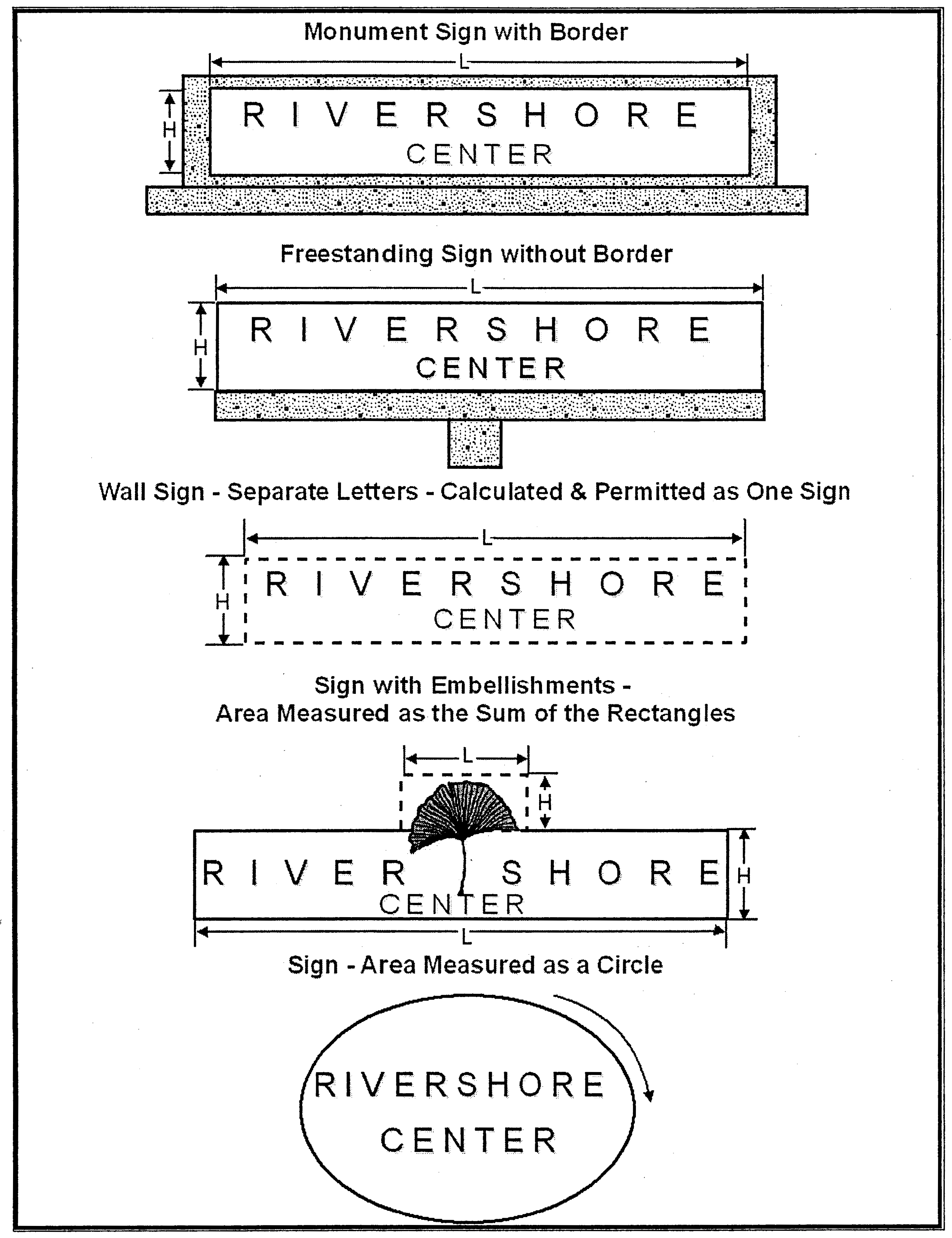
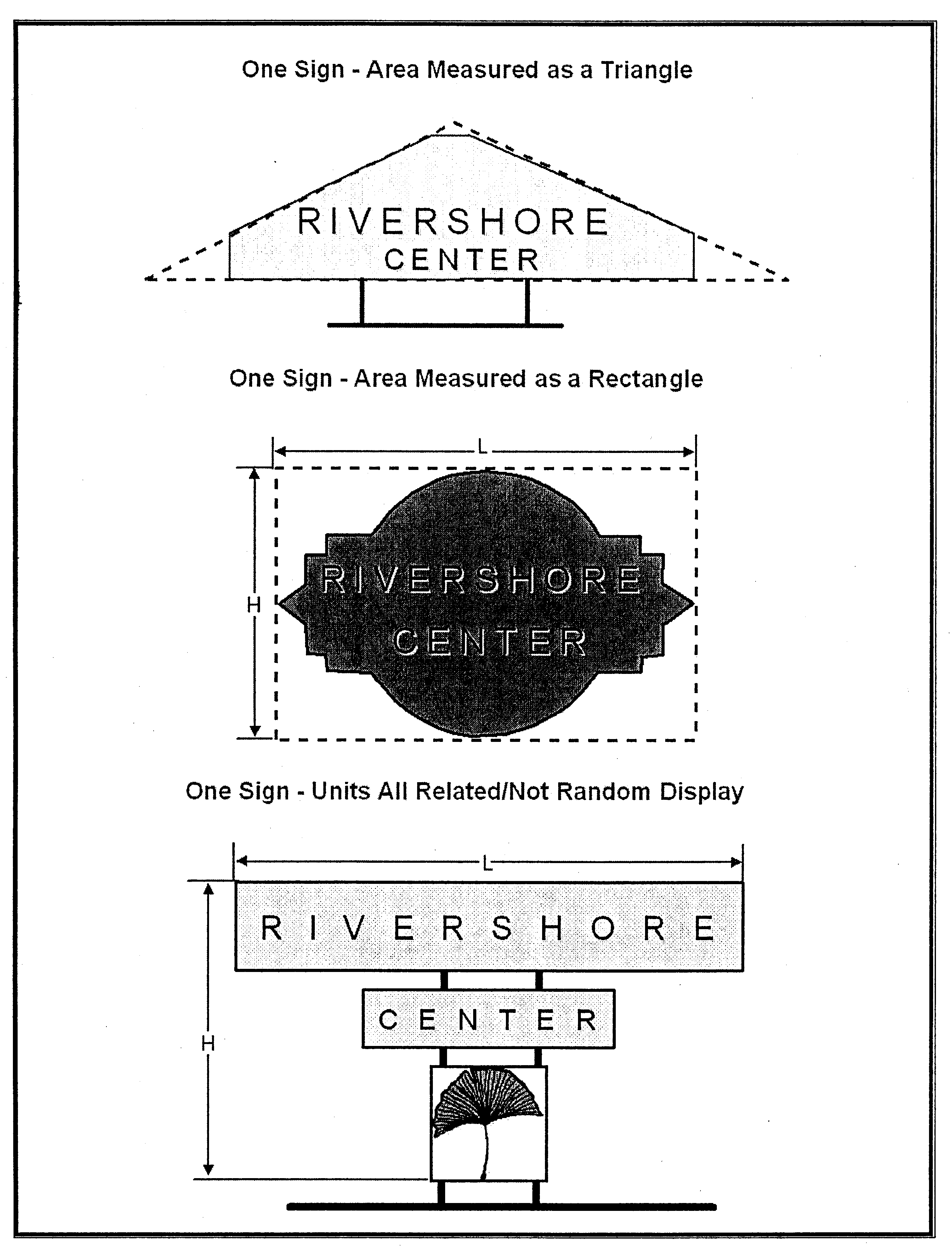
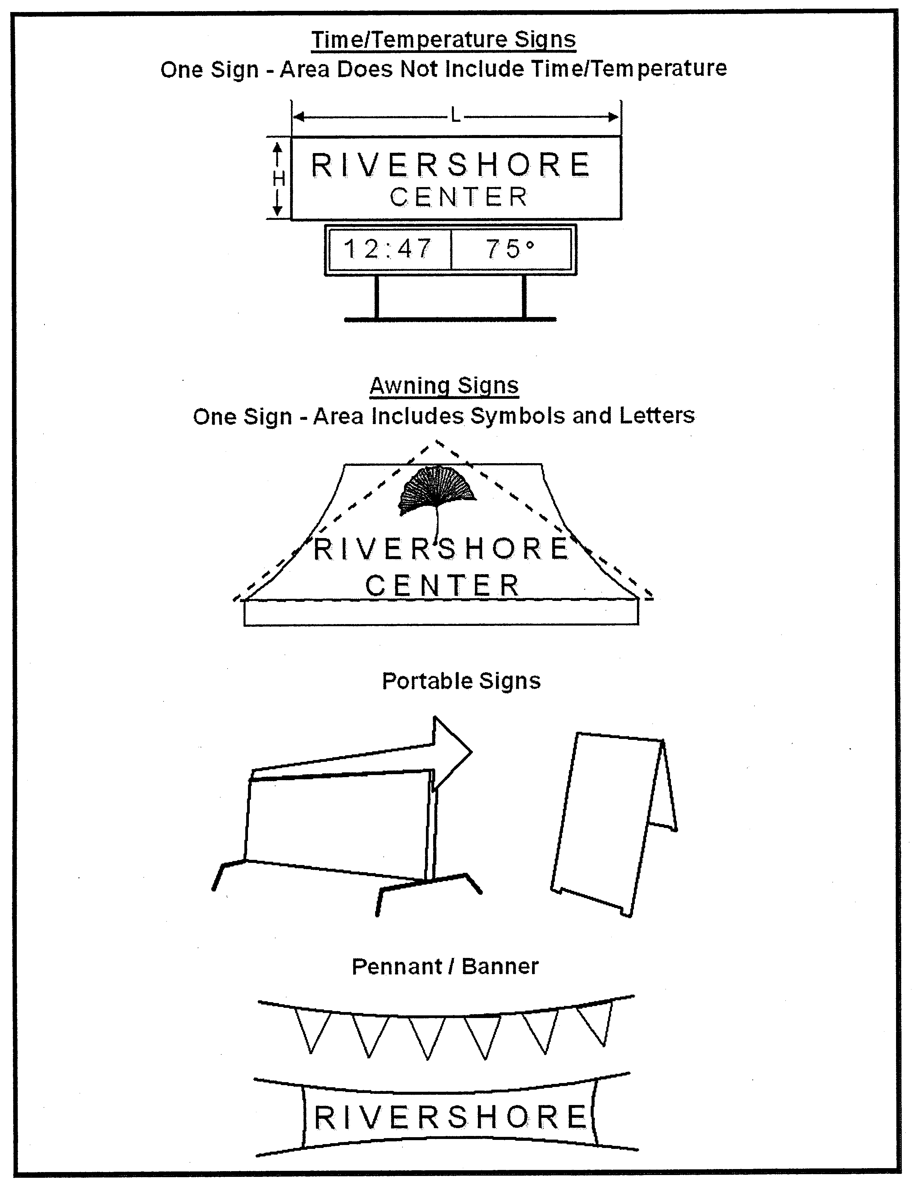
(Ord. No. 2021-05, 6-21-2021)
Sec. 44-556. - Direct illumination.
No source of illumination on a sign, such as floodlights, spotlights, or unshielded bulbs, may shine directly into any public right-of-way or any adjacent residential property. LED-lit signs must not be of an intensity that glares or creates a safety hazard to travelers along any public right-of-way.
(Ord. No. 2021-05, 6-21-2021)
Sec. 44-557. - Permits; standards generally; maintenance.
The following applies to signs regulated by this division:
(1)
Zoning authorization permit required. Before any sign is displayed or structurally altered, an application, along with a detailed site plan, diagrams or other pertinent information as specified in the procedures manual, must be submitted to obtain a zoning authorization permit. This requirement applies to all signs except for those specifically exempted in subsection 44-552. Once a permit is granted, if work for the permitted sign is not completed within six months from the date of the permit's issuance, the permit automatically becomes null and void.
(2)
Construction standards. All signs must be constructed and installed in accordance with the applicable provisions of this division, of the state building code, and of any other applicable laws, county codes, or other regulations.
(3)
Electrical standards. All illuminated signs must be energized and illuminated in accordance with the applicable provisions of this division, the state building code, and any other applicable laws, county codes, or other regulations.
(4)
Maintenance. All signs and sign structures must be maintained in good structural and aesthetic condition. They shall be kept safe and in good repair, free of deterioration or missing parts (examples of which would include, not for purposes of limitation, chipped paint, broken plastic, missing letters, disfigured surfaces, and incomplete illumination), and at all times they shall comply with all applicable provisions of this division, the state building code, and any other applicable laws, county codes, or other regulations.
(5)
Removal of copy. If all or part of a sign's copy is removed, the person owning or having control over the sign shall, within 60 days of the removal of the copy, either replace the copy or remove the remaining components of the sign. If the sign is removed, the zoning permit for the sign will be deemed to have become null and void.
(Ord. No. 2021-05, 6-21-2021)
Sec. 44-558. - Nonconforming signs.
(a)
An on-premises sign not in conformity with this article must be brought into compliance or removed within 180 days of the sign becoming nonconforming.
(b)
A nonconforming off-premises sign need not be removed, but the cost of all improvements made to the sign, in the aggregate from the time that the sign became nonconforming, may not exceed 50 percent of the value of the sign at the time it became nonconforming. A certified appraisal stating the value of the sign when it became nonconforming, along with the total cost of all improvements made to the sign since that time and the estimated cost of the proposed improvements, must be submitted with any application for a zoning authorization permit to make proposed improvements to such a nonconforming sign. Costs to convert the display of a nonconforming off-premises sign to an LED display are not subject to this section, but such a conversion must comply with the following:
Light-emitting diodes (LED), tri-vision, electronic messages and other similar technologies are allowed in all nonresidential districts, with the exception of the village district. LED and other similar technologies are allowed in residential districts only for the following uses: schools, places of worship, public use facilities, community recreation and other nonprofits. In all situations, this technology can be utilized only if the following requirements are met:
(1)
Pulsating or flashing sign structures or messages are prohibited.
(2)
LED signs must hold a static message a minimum of eight seconds.
(c)
Signs owned by nonprofits are exempt from subsections (a) and (b) above.
(Ord. No. 2021-05, 6-21-2021)
Sec. 44-559. - Violations.
Any person violating any section of this division is subject to all applicable enforcement, appeal, variance provisions of this chapter.
(Ord. No. 2021-05, 6-21-2021)
Sec. 44-560. - Penalty.
Any person violating any section of this division for which no other penalty is set forth shall be subject to the penalty contained within section 44-369.
(Ord. No. 2021-05, 6-21-2021)
Sec. 44-561. - On-premises freestanding signs.
On-premises freestanding signs are allowed as follows:
(1)
No more than one freestanding on-premises sign is allowed per lot, subject to the exceptions provided elsewhere in this section.
(2)
A single consolidated sign, of unified design and construction, is required when more than one use is located on a single lot.
(3)
All on-premises freestanding signs must observe the maximum permitted sign area requirements of table 44-561-1, except for signs on properties with home occupations, which are regulated in subsection (7) below.
(4)
For a lot that fronts on multiple streets or roads, one on-premises sign is permitted along each street or road that the lot fronts, provided that each sign is separated from any other by at least 150 feet and each sign is located a minimum of 100 feet from any residential district.
(5)
All parts of the sign and sign structure must be located outside of all street and road rights-of-way. The applicant is responsible for identifying the boundaries of all such rights-of-way and for providing that information in the sign permit application.
(6)
Light-emitting diodes (LED), tri-vision, electronic messages and other similar technologies are allowed in all nonresidential districts, with the exception of the village district. LED and other similar technologies are allowed in residential districts only for the following uses: schools, places of worship, public use facilities, community recreation and other nonprofits. In all situations, this technology can be utilized only if the following requirements are met:
a.
Pulsating or flashing sign structures or messages are prohibited.
b.
LED signs must hold a static message a minimum of eight seconds.
(7)
Unless specifically regulated under article VI, approved home occupations, cottage businesses, and supplemental or special uses may have one nonilluminated sign with a maximum area of four square feet and a maximum height of four feet, including the height of any pedestal attached to the sign.
(8)
Replacement of nonconforming on-premises signs must meet the sign requirements as shown in table 44-561-1.
(9)
Multiuse sign. One multiuse sign structure having no more than two sign surface areas may be erected on a property with a planned development along each street frontage from which there is a major entrance to a development. The maximum area and height permitted for each planned development on-premises sign is allowed at a factor of 1.5 × the maximum sign area and height limitation of a single-use sign as noted in table 44-561-1.
(10)
Additional multiuse sign. One additional multiuse on-premises sign, with a maximum area of 12 square feet and a maximum height of six feet, is permitted for each individual building within a planned development.
(11)
Lakefront properties with nonresidential uses. One additional on-premises freestanding sign, with a maximum sign surface area of 32 square feet and a maximum height of seven feet, is permitted for each commercially zoned property. In no case shall the maximum height exceed the adjacent road grade. Additionally, these requirements must be met:
a.
Neon or LED signs are not permitted.
b.
Only internal sign illumination and full cut-off downcast lighting is allowed in order to limit light spillage onto neighboring properties.
Table 44-561-1. On-Premises Single Development Sign Regulations
(Ord. No. 2021-05, 6-21-2021)
Sec. 44-562. - On-premises wall signs.
(a)
Wall signage is permitted on each wall of a nonresidential building and must not extend above its lower roofline.
(b)
Total wall signage for the front building wall is limited to two square feet of area per linear foot of the building wall; not to exceed 300 square feet. Side and rear wall signage is limited to one square foot of area per linear foot of the building wall; not to exceed 150 square feet.
(c)
Light-emitting diodes (LED), tri-vision, electronic messages and other similar technologies are allowed in all nonresidential districts, with the exception of the village district. This technology can be utilized subject to the following:
(1)
Pulsating or flashing sign structures or messages are prohibited.
(2)
LED signs must hold a static message a minimum of eight seconds.
(d)
Approved home occupations, cottage businesses or special uses may have one non-illuminated wall sign in lieu of an on-premises sign meeting the size requirements.
(Ord. No. 2021-05, 6-21-2021)
Sec. 44-563. - Off-premises signs—Billboards.
(a)
Off-premises signs are limited to one per lot. For signs mounted back-to-back or V-shaped, the surface area of one side is calculated. Double-stacked sign units are prohibited.
(b)
The maximum permitted area shall be 380 square feet per face for signs abutting I-40 and 250 square feet per face for all other signs.
(c)
The maximum sign height for signs fronting along limited-access highways is 50 feet or 50 feet as measured from the road surface adjacent to the sign, whichever is higher. For all other roads, the maximum sign height is 35 feet or 35 feet as measured from the road surface adjacent to the sign, whichever is higher.
(d)
Off-premises signs must meet the setback requirements of the district within which they are located with the exception of the front setback. All parts of the sign and sign structure must be located out of the right-of-way. However, if sign structures on adjacent lots are set back from the front lot line more than the required front-setback dimension, the signs must meet the greater front-setback requirement.
(e)
Off-premises signs must be separated from other structures on the same lot by a minimum of 50 feet.
(f)
Off-premises signs are permitted in highway commercial (HC) and industrial (LI and GI) districts only.
(g)
Off-premises signs are prohibited in the Highway 321 corridor on land zoned 321-ED (MX) and (I). In addition, off-premises signs are prohibited along NC Hwy. 150, NC Hwy. 127, NC Hwy. 10, NC Hwy. 16, and Hwy. 70 within the jurisdiction of the county.
(h)
Off-premises signs must be located a minimum of 400 feet from any residentially zoned property, park, school or hospital. This distance shall be measured from the nearest point of the sign to the nearest point of the property line that is residentially zoned or has one of the uses identified above. The right-of-way shall be included as part of the 400-foot requirement.
(i)
The minimum required distance between off-premises signs for federal aid primary highways (I-40) is 1,000 feet between signs on the same side of the right-of-way and 500 feet for signs on opposite sides of the right-of-way. The distance between off-premises signs in all other circumstances must be 1,000 feet measured radially from the sign.
(j)
As part of the application for a zoning permit for an off-premises sign, a notarized letter from the property owner where the sign will be located must be submitted stating that a lease agreement has been executed with the applicant. Also, a letter of intent from a prospective advertiser or advertising agency for the initial use of the sign board shall accompany any application for a zoning authorization permit.
(k)
The poster material of the off-premises sign shall be made of all-weather, fade-resistant material such as vinyl or similar synthetic material. For short-term advertisers (60 days or less), other material may be used subject to it being properly maintained to avoid separation and flagging from the billboard.
(l)
Lighting, if installed, shall be placed at the top of the sign and be directed such that the illumination is contained to the sign area of the off-premises sign. Flashing or strobe lights are prohibited.
(m)
No vegetation on public property, including the public right-of-way, shall be cut for the purpose of increasing or permitting visibility to the off-premises sign unless preapproved by the governmental authority having jurisdiction over the vegetation, such as NCDOT.
(n)
The back of the sign and the structural pole shall be painted in an earth-tone color, which includes shades of gray and brown.
(o)
All new sign structures must be supported by a steel monopole.
(p)
Off-premises roof signs are considered billboards and are subject to these regulations.
(q)
Off-premises wall signs are considered billboards and are subject to these regulations.
(r)
Off-premises signs must comply with the visibility regulations in section 44-407.
(s)
Tri-vision is allowed on off-premises signs.
(t)
An off-premises sign may be upgraded or constructed, where permitted, utilizing LED technology. In addition, an off-premises sign with LED technology must be separated from another off-premises sign with LED technology by 1,200 feet. A LED off-premises sign must hold a static message a minimum of eight seconds.
(Ord. No. 2021-05, 6-21-2021)
Sec. 44-564. - Off-premises directional signs.
(a)
Up to three off-premises directional signs are permitted under the following standards:
(1)
The principal use to which the sign directs is not located on a collector or arterial street and:
a.
The use is located in an office-institutional, commercial, or industrial district;
b.
The use is an approved special use; or
c.
The use is a legal nonconforming use.
(2)
A notarized letter, stating that permission has been obtained from the owner of the land where the sign is to be placed, shall accompany any application for a zoning authorization permit.
(3)
The sign cannot exceed 16 square feet for a single use or 48 square feet for more than one use.
(4)
The sign must be of unified design when more than one use utilizes a single sign.
(5)
The height of an off-premises directional sign cannot exceed six feet.
(6)
Such signs are not allowed for properties with home occupations.
(b)
Nonprofits may have up to two off-premises directional signs, regardless of location, unless extenuating circumstances exist to allow a total of three signs.
(c)
All parts of the sign and sign structure must be located outside all rights-of-way. The applicant is responsible for obtaining right-of-way information for any sign permit.
(d)
Off-premises directional signs cannot be illuminated.
(Ord. No. 2021-05, 6-21-2021)
Sec. 44-565. - Development entrance signs.
The following apply to signs at a residential development entrance or within a median for a development entrance:
(1)
The applicant or assigned HOA must maintain the sign and the area around the sign. The signs shall be removed, if not properly maintained, at no expense to the public. For purposes of this subsection, "properly maintained" means maintained in a manner that does not cause the sign to become a public nuisance or endanger public safety. The "area around the sign" means any area that includes supports, landscaping, or other features relating to the sign.
(2)
A maximum of two signs are permitted at each entrance.
(3)
If the sign is to be located within the right-of-way of any state system road, the applicant is responsible for obtaining the approval of the NCDOT.
(4)
The sign cannot exceed 32 square feet in area, as calculated under section 44-555 and figure 44-555-1.
(5)
Illumination of the sign is permitted.
(Ord. No. 2021-05, 6-21-2021)
Sec. 44-566. - Limited access user's signs.
For properties located within 500 feet of the beginning of the limited access portions of I-40, Highway 321 and the intersection of an arterial street, a single sign is permitted as follows:
(1)
Maximum height is limited to 50 feet and a maximum area of 100 square feet.
(2)
The planning director may allow a greater height, up to a maximum of 130 feet or 130 feet above the closest road surface elevation adjacent to the sign, whichever is higher. The additional height would be considered in order to permit seven seconds of visibility of the sign prior to the beginning of the exit ramp for traffic traveling at the legal speed limit. A report must be submitted by a professional engineer to validate this allowance.
(3)
If the planning director allows additional height, the maximum sign size may be increased five square feet for each foot of allowed height above 50 feet, up to a maximum of 650 square feet.
(4)
Signs must meet the setback requirements of the district within which they are located with the exception of the front setback. All parts of the sign and the sign structure must be out of the right-of-way.
(5)
Where a limited access highway user's sign is installed on a developed lot, there may be one additional on-premise sign installed, if it is separated from the limited access highway user's sign by more than 500 feet.
(Ord. No. 2021-05, 6-21-2021)
Sec. 44-567. - On-premises canopy signs for fuel-pump islands.
For any use where fuel-pump islands are permitted, in addition to one freestanding sign, one static fascia canopy sign is permitted on all sides of a fuel-pump island canopy that are visible from the public right-of-way. Each canopy sign may have a maximum area equal to 25 percent of the canopy fascia surface, up to a maximum height of two feet.
(Ord. No. 2021-05, 6-21-2021)
Sec. 44-568. - Definitions.
The following words, terms and phrases, when used in this article, shall have the meanings ascribed to them in this section, except where the context clearly indicates a different meaning:
Banner. Any object made of lightweight fabric or similar material that is mounted to a pole or a building at one or more edges.
Billboard A permanently affixed off-premise sign, other than an off-premise directional sign.
LED sign. A sign with light-emitting diodes technology designed to project a static display at eight-second intervals with the copy message transition taking no more than two seconds controlled by high speed modem and computer.
Limited access user sign. A sign displayed by a use located within 500 feet of an entrance to a limited-access highway if the sign is designed to be seen from the limited-access highway, but where the entrance to the use does not front along the limited access highway.
Monument sign. A sign that is permanently affixed to a base on the ground, without any airspace between the base and the bottom edge of the sign.
Nonprofit. An entity governed by the laws of G.S. ch. 55A or an entity that is exempt from taxation under section 501(a) of the Internal Revenue Code.
Off-premises (or off-site) directional sign. An off-premises sign, the copy of which only identifies a property or use that is not located on a collector or arterial street and provides direction to that property or use.
Off-premises (or off-site) sign. A sign identifying/advertising and/or directing the public to a business, or merchandise, or service, or institution, or residential area, or entertainment which is located, sold, rented, leased, produced, manufactured and/or furnished at a place other than the real property on which said sign is located.
On-premises (or on-site) sign. A sign or display that identifies or communicates a message related to the activity conducted, the service offered, or the commodity sold on the premises where the sign is located.
Pennant. Any lightweight plastic, fabric, or other material, whether or not containing a message of any kind, suspended from a rope, wire, or string, usually in series, designed to move in the wind.
Pole sign. A sign that is permanently affixed to the ground through use of a pedestal(s), with airspace between the ground and the bottom edge of the sign.
Portable sign. Any sign not permanently attached to the ground or other permanent structure, or a sign designed to be transported.
Sight triangle. A triangular-shaped portion of land established at street intersections and driveways in which nothing is erected, placed, planted, or allowed to grow in such a manner as to limit or obstruct the sight distance of motorists entering or leaving the intersection, as set forth in applicable legal requirements.
Sign. Any display surface or display device containing or intending to contain elements organized, related, and composed to form a unit designed to inform or attract attention.
Tri-vision. Rotating multipanel technology, typically used on off-premises signs.
Wall sign A sign affixed on and parallel to the exterior wall of any building and projecting not more than 12 inches from the wall. Signs mounted on porticoes shall be considered as wall signs.
(Ord. No. 2021-05, 6-21-2021)
Sec. 44-572. - Development standards—Deviation.
(a)
Approving authority of flexible development standards. Regardless of the minimum development standards otherwise required in this Code, the planning director shall have the authority to administer the flexible development standards listed in (b) below for the purpose of facilitating the orderly development and redevelopment of property within the county.
(1)
The planning director may place conditions on an approved deviation to assure any resulting impacts to adjacent properties are mitigated.
(2)
Decisions by the planning director shall be in writing and may be appealed to the board of adjustment by the procedures provided in section 44-331 of this chapter.
(b)
Maximum flexible development standards. The planning director may approve requests that deviate from required setbacks up to 24 inches and other standards up to ten percent upon determination that any one of the following conditions exists:
(1)
There are site or structural conditions that preclude strict adherence to the setback requirements, such as, but not limited to: the lot does not meet the dimensional standards established for the zoning district in which it is located; or the lot has topographic limitations that require placement of the structure or additions into the required setback area.
(2)
The part of the proposed structure that encroaches into the minimum setback area is necessitated by a life-safety code, Americans with Disabilities Act standard, or other public safety code requirements.
(3)
Because of the nature of the abutting property or intervening topographical or geographical features, the application of the ordinance requirement would not serve a useful purpose.
(4)
The applicant has agreed to conditions that would lessen impact of the deviation from adjacent properties.
(5)
A reduced lot area and/or lot dimensions will not inhibit the reasonable use of the lot.
(Ord. No. 2021-05, 6-21-2021)