
Brunswick City Zoning Code
CHAPTER 4
- PROPERTY DEVELOPMENT STANDARDS
Sec. 4.1. - Applicability of Property Development Standards.
4.1.1. Generally.
All developments shall comply with standards set forth in this Chapter, unless more restrictive standards apply based on the applicability of an overlay district as set forth in Chapter 2. Single and two-family dwellings constructed on a lot not part of an approved subdivision or site plan are exempt, unless stated to be applicable in Subsection 4.1.2 below. Review criteria as stated within 30-A M.R.S.A. § 4404, as amended, are contained in General Standards for each Subsection.
4.1.2. Single and Two Family Dwellings Constructed on Lots Separate From an Approved Subdivision or Site Plan.
Single and two family residential dwellings constructed on lots separate from an approved Subdivision or Site Plan shall comply with the standards in Subsections 4.2.2, 4.2.3 and 4.2.4 (Dimensional and Density Standards), 4.2.5 (Supplemental Dimensional and Density Standards and Exceptions), 4.5.1 (Sewer), 4.5.2 (Water), 4.5.3 (Solid Waste), 4.7 (Residential Recreation Areas), 4.8.2 (Curb Cuts), 4.13 (Signs) and 4.14.1 (Operation of Uses and Development) only.
Sec. 4.2. - Dimensional and Density Standards.
4.2.1. General Standard.
All development must comply with the applicable density and dimensional standards of the district in which the development is located.
4.2.2. Specific Standards.
A.
The tables in Subsection 4.2.3 (Growth Area Dimensional and Density Standards) and Subsection 4.2.4 (Rural Area Dimensional Standards) set forth density and dimensional standards applicable to development in the various Growth Area and Rural Area base zoning districts. The standards in the tables are supplemented by provisions in Subsection 4.2.5 (Supplementary Dimensional Standards and Exceptions) that set forth additional standards, alternative standards, and exceptions to the standards in the tables. Where standards in Subsection 4.2.5 conflict with those in Subsection 4.2.2 or Subsection 4.2.3, the standards in Subsection 4.2.5 shall govern.
B.
Nothing in this Ordinance precludes the subdivision of buildings into units, either attached or detached, on a single lot, provided that all applicable lot area, dimensional, and density standards are met. Applications for approval of any such proposal that involve Development Review must also include all legal documents related to unit associations, ownership in common, and appropriate by-laws, deeds, and covenants to be recorded in the Cumberland County Registry of Deeds by the applicant.
C.
If a Common Development Plan designation has been obtained pursuant to Subsection 5.2.9.H, the terms of that designation may vary the standards in Tables 4.2.3 and may result in the required dimensional standards applying to the lot(s) approved as the Common Development Plan area.
D.
If the density standard set forth in Table 4.2.3, as applied, results in fewer than four dwelling units for an undeveloped lot, or two units for a developed lot, increased density shall be permitted in accordance with 30-A M.R.S.A. § 4364-A provided other applicable dimensional standards are met.
E.
If the density standard set forth in Table 4.2.4, as applied, results in fewer than two dwelling units for a lot without a dwelling unit, increased density shall be permitted in accordance with 30-A M.R.S.A. § 4364-A provided other applicable dimensional standards are met.
4.2.3. Growth Area Dimensional and Density Standards.
NOTES:
[1] All new, enlarged, or redeveloped buildings and additions in the GM4 District subject to Development Review shall also be consistent with the Cook's Corner Design Standards, unless such design standards are waived in accordance with Subsection 5.2.9.0 ( Waiver Provisions).
[2] Area of new disturbance per parcel shall not exceed 1% of total acreage, measured as of the effective date of this Ordinance.
[3] 1 du per 20,000 sf of net site area for developments using subsurface wastewater disposal systems.
[4] Except that lands north of Bath Road shall be limited to 8 du/ac.
[5] Except that parcel between South Street and Longfellow Avenue shall be limited to 10 du/ac.
[6] Applicable only to the first floor of buildings along Maine Street. Does not apply to buildings on Park Row.
[7] Does not apply to buildings on Park Row.
[8] Front setback averaging applies; See Subsection 4.2.5.B(4).
[9] See Cook's Corner Design Standards for maximum front setbacks applicable along Bath Rd., Gurnet Rd., proposed Perimeter Rd, Thomas Point Rd., and all public and private connector roads.
[10] Applicable only to buildings along Maine Street. For all other buildings in the GM6 District, the build-to zone is determined by the range of front setback of principal buildings on the nearest occupied lots on either side on the same block face. Does not apply to buildings on Park Row.
[11] Limited to 50% impervious coverage and maximum building footprint of 20,000 sq. ft. north of Route 1.
[12] Except that parcels fronting onto Park Row front setbacks shall be consistent with the established average front setback (see subsection 4.2.5.B (4)), shall have minimum side and rear setbacks of 15 feet in width; a minimum lot width of 60 feet; a maximum footprint of 7, 500 square feet and a maximum impervious coverage of 45%.
[13] Expansions that will increase floor area by 50% or more require minimum height to be met for the entire building.
[14] Unless restricted to a lower height by Flight Path Overlay (FO) District regulations (see Subsection 2.3.7).
[15] Except that lands north of U.S. Highway 1 shall have a maximum building height of 60 ft.
[16] May be increased to up to 30,000 square feet for a community living facility as defined by 30-A M.R.S.A. § 4357-A,, as amended, with a Conditional Use Permit approved in accordance with Subsection 5.2.2 (Conditional Permits).
[17] 10,000 square feet for multifamily dwellings, and 20,000 square feet for the Bowdoin College Edwards Center for Art and Dance building.
[18] 300,000 square feet if the structure meets one of the conditions listed in Subsection 4.2.5.B(9).
[19] See Subsection 4.2.5.B(4) for additional setback requirements.
[20] See Subsection 4.2.5.B.(7) for additional height requirements.
[21] No building footprint restriction shall apply for properties located south of Route 1, along Cressey Road and Columbus Drive.
[22] See Subsection 4.2.5.F for minimum dimensional requirements for lots located within the Shoreland Protection Overlay.
[23] Except that public safety municipal facilities shall have no maximum building footprint per structure.
[24] Except that the public school facilities shall have no maximum building footprint per structure.
[25] Minimum height shall be determined based on the average height of each building. Utility substations, accessory buildings, and similar structures or building components, where otherwise allowed, and buildings existing prior to January 1, 2026, may be of lesser height and shall be excluded from this calculation.
[26] Porches, porticos, and similar attached architectural features may be a lesser height and shall be excluded from the height calculation.
4.2.4. Rural Area Dimensional and Density Standards.
NOTES: ac = acre(s) sf = square feet
[1] Area of new disturbance per parcel shall not exceed 1% of total acreage, measured as of the effective date of this of Ordinance.
[2] See Subsection 4.2.5.B(10) (Supplementary Dimensional and Density Standards and Exceptions) for additional requirements.
[3] Wooded buffers fronting Old Portland Road on [effective date of this Ordinance] shall be maintained at a minimum depth of 25 feet for structures having a footprint less than 5000 square feet and a minimum depth of 50 feet for structures having a footprint over 5000 square feet, subject only to necessary interruptions for infrastructure, to be finalized during Development Review or Building Permit approval.
[4] Additional building setback may be required in accordance with Subsection 4.2.5.B(4)e.
[5] See subsection 4.2.5.F for minimum dimensional requirements for lots located within the Shoreland Protection Overlay.
[6] RP1 impervious coverage standard shall apply for those areas along the New Meadows River zoned RP2.
[7] See subsections 2.3.10 and 5.2.12 and the Town of Brunswick Zoning Map for additional requirements for a Rural Protection Stormwater Management Overlay (RPSMO) permit.
[8] For lots greater than 2.5 acres and up to 10 acres, 10%. Additional acreage between 10 acres and 20 acres, 5%. Additional acreage greater than 20 acres, 2%.
[9] For lots greater than 5 acres and up to 10 acres, 10%. Additional acreage between 10 acres and 20 acres, 5%. Additional acreage greater than 20 acres, 2%.
[10] Except that the public school facilities shall have no maximum building footprint per structure.
4.2.5. Supplementary Dimensional and Density Standards and Exceptions.
A.
Calculation of Net Site Area. Net site area is calculated by subtracting from the parcel the full area of land that consists of:
(1)
Land areas of 5,000 or more contiguous square feet with sustained slopes of 25 percent or greater;
(2)
Any wetland, including but not limited to, coastal, forested and freshwater wetlands;
(3)
Any water body;
(4)
Any existing or proposed public street or private street right-of-way;
(5)
Habitat for species appearing on the official State or Federal lists of endangered or threatened species, where there has been evidence of the occurrence of the species;
(6)
Rare and endangered natural communities as listed and mapped by the Maine Natural Areas Program, including critically imperiled (S1), imperiled (S2), and rare plant communities (S3).
(7)
Any of the following as defined by the Natural Resources Protection Act (NRPA):
a.
High and moderate value waterfowl and wading bird habitat, including nesting and feeding areas; or
b.
Shorebird nesting, feeding, and staging areas; or
c.
Significant vernal pool habitat.
d.
Seabird nesting islands.
B.
Variations and Exceptions to Dimensional Standards.
(1)
Rear Lots ("Flag Lots").
a.
Rear lots, also known as "Flag Lots", are not subject to the lot width requirements of the zoning district in which it is located.
b.
A rear lot shall be accessed by one of the following:
i.
Access Strip.
(A)
A single rear lot may be accessed by a strip of land owned by the owner of the rear lot having a minimum width of 25 feet and a minimum public street frontage of 25 feet. In Growth Area zoning districts, these widths may be reduced to 15 feet with approval of a stormwater management plan by the Town Engineer.
(B)
No more than two (2) access strips shall be adjacent to each other unless a shared driveway is used. In such a case, the width of each access strip shall be reduced to 15 feet.
ii.
Deeded Right-of-Way. A rear lot may be accessed by a deeded right-of-way through another parcel or lot that has a minimum width of 25 feet. In Growth Area zoning districts, this width may be reduced to 15 feet with approval of a stormwater management plan by the Town Engineer.
c.
All rear lots shall have safe access for fire, police, and emergency vehicles as determined by the Fire Chief.
(2)
Spaghetti Lots Prohibited. No lot created by a subdivision having shore frontage on a river, stream, brook, great pond, or coastal wetland as defined, shall have a lot depth to shore frontage ratio greater than five (5) to one (1).
(3)
Cul-de-Sac Lot Width. Minimum lot width requirements may be reduced to 50 feet for lots fronting on a cul-de-sac.
(4)
Setbacks.
a.
Reduction of Minimum Front Setback to Average Setback. In the case where existing structures located on the same block form a uniform and consistent street wall with an average front setback less than the required minimum front setback by Subsection 4.2.3 (Growth Area Dimensional and Density Standards) or Subsection 4.2.4 (Rural Area Dimensional Standards), the minimum front setback required shall be reduced to the block average—provided that the front of a structure shall be no more than five (5) feet behind the reduced minimum front setback.
b.
Front Setback Requirement on Corner and Through Lots.
i.
Whenever a side or rear yard is adjacent to a street, the minimum front setback requirement shall apply to such side or rear yard.
ii.
To establish a new public street or private street right-of-way that would convert one (1) or more existing lots into a corner lot, existing structures on such new corner lot shall meet the minimum front setback requirement along the new public street or private street right-of-way.
c.
Permitted Encroachments into Required Setbacks. The following encroachments into required setbacks are allowed:
d.
Setback Requirements for Growth-College Districts.
i.
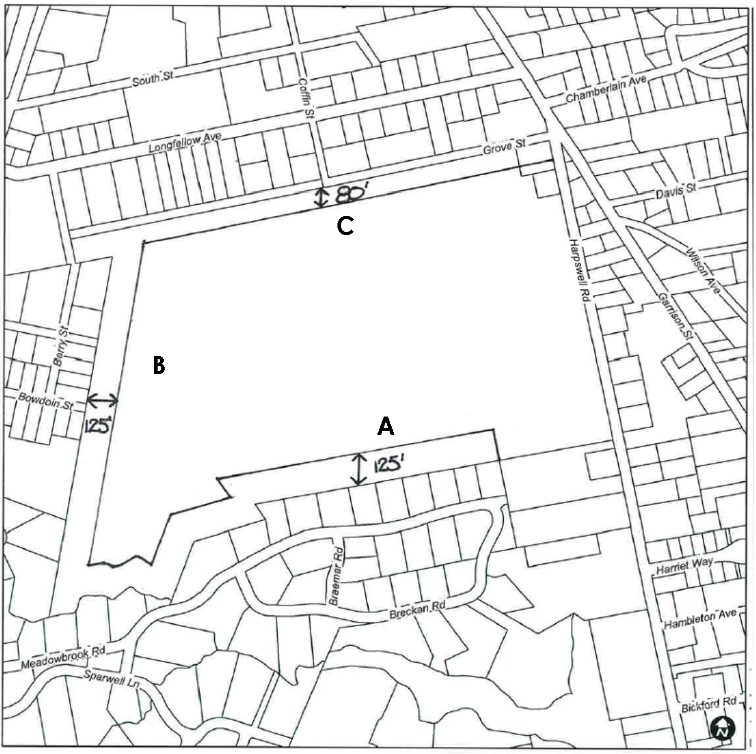
As illustrated by Figure 4.2.5.B(4)d, minimum setbacks within the Growth College 5 (GC5) Zoning District, along college boundaries A and B shall be 125 feet; 80 feet along college boundary C.
ii.
In the Growth College 2 (GC2) Zoning District, lots fronting on Park Row or Longfellow Avenue shall have a minimum rear and side setback of 25 feet.
iii.
Tree cutting, with the exception of hazard tree and overgrowth removal, is prohibited in the Growth College 5 (GC5) Zoning District within 125 feet of college boundaries A and B as illustrated by Figure 4.2.5.B(4)d.
Figure 4.2.5.B(4)d: Setback Requirements for Growth-College Districts
e.
Setback Requirements and Maximum Building Height for Accessory Structures. Swimming pools, tennis courts, garages, storage sheds, and other accessory structures not addressed by subsection c above may encroach into required rear and side setbacks in accordance with the following standards:
i.
With the exception of Growth Residential Zoning Districts, swimming pools, tennis courts, garages, storage sheds, and other structures accessory to a residential use may be located in a rear setback provided the structure does not exceed 15 feet in height and does not occupy more than ten (10) percent of the area of the rear setback, including the areas where the rear and side setback overlap.
ii.
In Growth Residential Zoning Districts, swimming pools, tennis courts, garages, storage sheds, and other accessory structures may be located no less than ten (10) feet to rear or side lot lines. For lots with a lot width of less than 80 feet, structures not exceeding one (1) story in height may be located no less than three (3) feet to side lot lines. In all other districts, swimming pools, tennis courts, garages, storage sheds, and other accessory structures may be located no less than five (5) feet to rear or side lot lines.
iii.
No swimming pool, tennis court, garage, storage shed, or other accessory structure shall be located closer to the street than the minimum front setback required for a principal building, excepting fences, gates, mailboxes, newspaper receptacles, signs, bus stop shelters, sand storage bins, and similar roadside structures with a footprint less than 100 square feet, as well as ornamental structures such as entry pillars and statues shall be permitted. No lighted structure in the front setback may shed glare onto the public right-of-way.
iv.
Any swimming pool, tennis court, garage, storage shed, or other accessory structure with a footprint greater than 600 square feet shall be located further to the rear of the lot than the principal structure in all Growth Area zoning districts. In Rural Area zoning districts, if any swimming pool, tennis court, garage, storage shed, or other accessory structure with a footprint greater than 600 square feet is located in front of the principal building, it shall be set back from the street at least twice the minimum front setback requirement.
f.
Setback Requirements for Driveways.
i.
Except as otherwise provided in subsections ii through iv below and sight distance criteria established in the Town of Brunswick Municipal Code of Ordinances, Chapter 14, Streets, Sidewalks and Other Public Places, as amended, driveways shall be set back at least 20 feet from side lot lines in Rural Area zoning districts and at least ten (10) feet from side lot lines in Growth Area zoning districts.
ii.
Common driveways may occupy any part of a side yard adjoining the lot of another user of the common driveway.
iii.
For lots with a lot width of less than 80 feet, no driveway setback shall be required for individual driveways.
iv.
The minimum side setback requirement for structures shall apply as the minimum driveway setback where it is less than the minimum driveway setback standard as stated in subsection i above.
(5)
Impervious Surface Coverage for Multiple-Lot Developments. If development is proposed on two (2) or more lots and the Director finds that the development functions as a single project, the maximum impervious surface coverage standard shall be applied to that project as though the lots were a single lot.
(6)
Height Limit for Fences and Walls. No fence on a residential lot in a Growth Area zoning district shall exceed six (6) feet in height unless written approval is provided by the Code Enforcement Officer in accordance with Table 4.2.5.B(4)c.
(7)
Height Limitations for Growth College Districts. Notwithstanding Subsection 4.12.2.B, for GC1 District, structures within 35 feet of a residential lot boundary with an existing 1-or 2-family dwelling located within the GR5 District shall be limited to a height of 55 feet. Building height may be increased five (5) feet for every additional ten (10) feet of setback up to a maximum height of 70 feet.
(8)
Height Limitation Exceptions. Otherwise applicable height limitations shall not apply to:
a.
Any flagpole, radio, wireless, satellite dish or television antenna, spire or cupola, chimney, elevator or stair bulkhead, parapet, railing, or any similar structure provided that such structure is firmly attached to the roof or side of a building and covers no more than ten (10) percent of the roof area; and
b.
Uses in the Telecommunications Overlay (TCO) District.
(9)
Maximum Building Footprint Area Limits in GM4 District.
a.
The maximum building footprint per structure is 250,000 square feet if the structure meets any one of the following conditions:
i.
The structure will be occupied entirely by Office, Industry Class I, or Industry Class II uses.
ii.
The principal use of the structure is a hotel.
b.
The maximum building footprint for a single-structure shopping center or mixed use development shall not exceed 300,000 square feet with no one (1) tenant occupying a footprint greater than 100,000 square feet.
c.
A Retail Class II business that occupies an area with a footprint of more than 50,000 square feet either as a separate building or part of a shopping complex, shall include specific community improvements in keeping with the 1998 Cook's Corner Master Plan as amended, such as community facilities, enhanced public space, environmental improvements, and public artwork with a minimum value of one percent of the total construction budget. This condition may be satisfied, through approval by the Planning Board, by providing:
i.
Community improvements on the project site; or
ii.
Community improvements elsewhere in the GM4 District; or
iii.
A cash payment, equal to one (1) percent of the total construction budget to the Town for planning and/or creation of community improvements in the GM4 District.
(10)
Lot Size Exceptions within Rural Protection (RP) Districts.
a.
Notwithstanding applicable dimensional and density standards, any lot in existence on October 9, 1991, located within the Rural Protection 1 (RP1) District and having an area of at least 160,000 square feet but less than ten (10) acres, may be divided into two (2) lots provided that neither lot has an area of less than 20,000 square feet.
For lots created in the Shoreland Protection Overlay, the minimum lot area must meet the standard identified in Table 4.2.5.F(1). For lots previously zoned Farm and Forest 3, this standard shall apply to those lots in existence as of the effective date of this Ordinance.
b.
Notwithstanding applicable dimensional and density standards any lot in existence on November 6, 2001, located within the Rural Protection 2 (RP2) District, and having an area of at least three and one-half (3.5) acres but less than seven (7) acres, may be divided into two (2) lots provided neither lot has an area of less than 20,000 square feet. For lots created in the Shoreland Protection Overlay, the minimum lot area must meet the standard identified in Table 4.2.5.F(1). For lots previously zoned Farm and Forest 3, this standard shall apply to those lots in existence as of the effective date of this Ordinance.
c.
Notwithstanding applicable dimensional and density standards, any lot located in the Rural Protection Districts (RP1 and RP2 may be transferred in part to an immediately abutting developed lot if it brings the neighboring lot into greater compliance with this ordinance. The abutter's lot must have existed as of July 19, 2021 and be both nonconforming and smaller than the conveyor's lot. The conveyor must retain a minimum lot size of 20,000 square feet and the division must not create any new nonconformities. For lots created in the Shoreland Protection Overlay, the minimum lot area must meet the standard identified in Table 4.2.5.F(1).
C.
Open Space Developments.
(1)
Description. An open space development is a subdivision or a single-lot split that is designed with the express intent of integrating open space and naturally occurring features into the siting of buildings and lots. Open space developments require a minimum portion of the development site be set aside as conservation land, allowing the remainder of the site to be divided into lots smaller than otherwise required. The area set aside for conservation may be owned in common by the residents of the development or may be owned by a third party, but shall be subject to an easement or covenant ensuring that it will be conserved as open space. To accommodate these smaller lots and their development, open space developments are subject to less restrictive dimensional standards than generally applicable in the zoning district. To encourage open space developments as an option to conventional subdivisions, open space developments are eligible for density bonuses, as provided in Subsection 4.2.5.E.
(2)
Single Lot Split Open Space Developments. Within Rural Area Zoning Districts, an open space development in the form of a single lot split allows the reduction of the minimum lot area requirement to 20,000 square feet, as long as the balance of the site is placed in permanent conservation protection by filing an Indenture for Division of Land form with the Code Enforcement Office and recording the Indenture in the Cumberland County Registry of Deeds. The remaining provisions of this Subsection pertain to open space developments in the form of subdivisions involving the approval of lots for sale and/or development or planned unit developments involving the approval of building footprints for the sale and development of individual units.
(3)
Review and Approval. An open space development in the form of a subdivision is reviewed and may be approved in accordance with the Development Review procedures in Subsection 5.2.9.
(4)
Protected Conservation Land. Conservation lands set aside in an open space development shall comply with the following standards:
a.
The land set aside as conserved open space shall include one (1) or more of the following, if noted on the property:
i.
All areas that are excluded from the calculation of Net Site Area (See Subsection 4.2.5.A.
ii.
Areas in active or potential agricultural or forestry use, including areas containing soils of statewide significance.
iii.
Important habitat, including areas consisting of Endangered or Threatened plants officially listed and ranked by the Maine Natural Areas Program as critically imperiled (S1), imperiled (S2),or rare plant communities (S3); habitat for Endangered or Threatened inland fish and wildlife under the Maine Endangered Species Act (MESA) or the U.S. Endangered Species Act (ESA); or Endangered and Threatened marine species under the Maine Marine Endangered Species Act (MMESA).
iv.
Scenic assets, as defined in the 2002 Brunswick Parks, Recreation, and Open Space Plan, as amended, and accessible for public view.
v.
Areas having historical value.
vi.
Areas that help define downtown.
vii.
Areas adjacent to land already protected under one (1) or more of the above categories.
viii.
Areas that could accommodate public access and/or passive recreational use.
ix.
Areas with frontage on tidal waters or local streams and rivers.
b.
Conserved open space may also include other open, undeveloped areas if none of the areas in Subsections a.i through a.ix above exist on the property.
c.
To the greatest extent practicable, conserved open space shall be located contiguous to any protected areas on the parcel or to any conserved open space on an adjacent lot or parcel, including without limitation any lands protected under Subsections 4.3 (Natural and Historic Areas), and 4.4 (Flood Hazard Areas).
d.
Protected conservation land may be owned in any manner consistent with fulfilling the purposes of this Subsection 4.2.5.C.
e.
No dwelling units, structures associated with dwelling units, or uses accessory to a dwelling unit shall extend into the required minimum protected conservation land unless expressly allowed in the terms of a conservation easement and approved by the holder of the conservation easement.
(5)
Dimensional Standards for Open Space Developments in Growth Area Districts.
a.
Minimum Conservation Land. An open space development shall set aside the minimum percentage of the development site area shown in Table 4.2.5.C(5) below as protected conservation land. The minimum protected conservation area requirement shall not be waived.
b.
Modified Dimensional Standards and Density Bonus. If the amount of protected conservation area meets the standard in Table 4.2.5.C(5) below, the modified dimensional standards shown in that Table shall apply instead of the comparable standards generally applicable in the district. For dimensional standards and zoning districts not shown in the Table, the standards generally applicable in the base zoning district shall apply.
NOTES:
[1] For lots containing septic systems and/or wells, lot area must be sufficient to accommodate the septic system and/or well. Septic systems must be set back at least 15 feet from any lot line.
[2] This may be reduced further in accordance with Subsection 4.2.5.B(4)a (Reduction of Minimum Front Setback to Average Setback).
i.
Density bonuses are only allowed if the development protects lands beyond those that are excluded from the Net Site Area calculation contained in Subsection 4.2.5.A. Any areas excluded from the net site area calculation may be counted to determine eligibility for dimensional flexibility, but may not be counted in determining eligibility for density bonuses.
(6)
Community Water and Sewer Facilities.
a.
Community water and sewer systems in open space developments are subject to all applicable State and Federal regulations, and the following standards:
i.
A community water or sewer system may be located within the required open space. No portion of a private community water or sewer system shall be located within any public right of way. The Review Authority shall require the applicant to present data showing the location of those soils best suited for sewage disposal fields.
ii.
A homeowners' or property owners' association or other appropriate mechanism shall be established to oversee the permanent maintenance and repair of any community water or sewer facility.
(7)
Ownership of Protected Conservation Land.
a.
General.
i.
Protected conservation land may be owned in a variety of ways so long as it is protected from future development. Potential forms of ownership include, but are not limited to, individuals or entities, property owners' associations, non-profit conservation organizations, or governmental entities. A conservation easement that complies with 33 M.R.S.A. § 476 et seq., as amended, may be required depending upon the environmental, aesthetic, recreational, cultural or historic significance of the land.
ii.
In Growth Area zoning districts, whenever possible, protected conservation land shall be set aside in one (1) or more parks, greens, or other recreational conservation land areas. The Review Authority, in consultation with the Conservation Commission, shall refer any such project to the Recreation Commission for their review.
iii.
In Rural Area zoning districts, protected conservation land may be included as a portion of one (1) or more parcels on which dwellings and other structures are permitted, provided that the Review Authority, in consultation with the Conservation Commission, approves the configuration of the conservation land and finds that the proposed development plan will not compromise its conservation value.
b.
Conservation Easements or Fee Simple Transfer to the Town. When a conservation easement or fee simple transfer is offered to the Town as a result of Development Review, the following process shall be followed:
i.
Except as stated in Subsection ii below, the Town will only consider accepting conservation easements or fee simple transfers on parcels larger than ten (10) contiguous acres in size, and only if the offer of an easement is accompanied by stewardship funds sufficient to offset the costs to the Town of monitoring and managing the easement for a period of at least 20 years.
ii.
Notwithstanding Subsection i above, if an area of land proposed for conservation protection is of exceptional significance to the Town, the Recreation Commission and/or the Conservation Commission may recommend to the Council that the area be accepted for ownership and/or maintenance by the Town because of its exceptional contribution to either Commission's purposes and proprieties. Upon receipt of any such request, the Council shall hold a public meeting on the request and may approve, approve in part, or deny the request to accept ownership and/or maintenance of those areas.
iii.
The Review Authority shall refer the request to the Conservation and/or Recreation Commission.
iv.
If referred to the Recreation Commission, it shall evaluate the land upon which the conservation easement or fee simple transfer is proposed. If referred to the Conservation Commission, it shall evaluate the land upon which the conservation easement or fee simple transfer is proposed and it shall make an evaluation regarding whether the proposed easement or fee simple transfer provides public benefits, as guided by policy documents adopted by the Town of Brunswick including, but not limited to the Climate Action Plan, and Parks, Recreation, and Open Space Plan, as amended. In making this determination, the Conservation Commission shall identify which of the categories of land listed in Subsection 4.2.5.C(4)a.i through ix are protected and determine their relative priority. It shall evaluate long-term stewardship and maintenance requirements of future Town ownership as well as the adequacy of alternative ownership mechanisms to protect important conservation values.
v.
A property being considered for the dedication of an easement or fee simple transfer to the Town may satisfy the criteria in Subsections b.i through iv above and not be recommended by the Conservation Commission if one (1) or more of the following conditions are found to apply:
(A)
The property poses stewardship and maintenance problems that the Commission finds to be impractical to protect in perpetuity and that cannot be addressed through stewardship funds.
(B)
The property owner insists on retaining rights to the land that are inconsistent with relevant protected conditions in Subsection 4.2.5.C(4)a.i through ix.
(C)
The development of the property or adjacent properties is possible or likely and would diminish its value as conserved land.
(D)
The property is part of an overall development proposal which would impinge on one (1) or more of relevant criteria in Subsection 4.2.5.C(4)a.i through ix.
(E)
The property contains areas of unmitigated contamination or environmental hazards.
vi.
The Conservation Commission, Director, and Town Attorney shall review the language of an easement. If they find that the easement satisfies the standards of this Subsection 4.2.5.C, staff shall refer the applicant and the easement language to the Town Council.
c.
Conservation Easement or Fee Simple Transfer to Qualified Not-for-Profit Conservation Organization or State or Federal Agency.
i.
A perpetual conservation easement or fee simple transfer restricting development may be granted to a qualified not-for-profit conservation organization, a land trust, the State of Maine, or a federal agency.
ii.
Any conservation easement or deed shall be approved by the Review Authority, after review by the Conservation Commission and Town Attorney, and shall be required as a condition of Subdivision or Site Plan approval.
iii.
Any conservation easement or deed shall be recorded in the Cumberland County Registry of Deeds prior to or simultaneously with the filing of a Final Subdivision Plan or Site Plan. In the case of minor site plans, a deed restriction enforceable by the Town may be substituted for a conservation easement.
iv.
Any conservation easement may permit only those uses authorized through the Development Review Process.
d.
Ownership of Protected Conservation Land by Individuals, Property Owners' Associations, or Another Entity.
i.
Protected conservation land may be owned by an individual, a homeowners' or property owners' association, or another entity. The documentation for the association shall be completed prior to approval of the final subdivision or site plan and recorded prior to the sale of the first lot or building permit issuance for first structure.
ii.
Standards for the ongoing maintenance of protected conservation lands that are enforceable by the Town against the individual, homeowners' or property owners' association, or other entity shall be established as a condition of Development Review Approval.
D.
Affordable Housing Developments. Repealed 6-20-2023.
E.
Density Bonuses.
(1)
Bonus development density is available for:
a.
Projects that preserve Wildlife Habitat Blocks or Wildlife Corridors pursuant to Subsection 2.3.5; and
b.
Projects that meet the standards for an Open Space Development in Subsection 4.2.5.C and permanently protect a minimum of an 50 percent of the developable net site area; and
(2)
Bonuses for projects that meet more than one (1) of the categories in Subsection 4.2.5.E(1) may be combined, but no combination of bonuses shall increase the maximum number of lots or units on a parcel by more than 35 percent above the number of lots or units that would otherwise be permitted pursuant to Subsections 4.2.3 or 4.2.4 as applicable.
(3)
If the final calculation that determines the total number of bonus units results in a fraction of a unit, the bonus shall be rounded downward to the nearest whole number.
(4)
Density bonuses awarded for development meeting the criteria in Subsection 4.2.5.E(1) are shown in Table 4.2.5.E (below):
F.
Additional Dimensional Standards within the Shoreland Protection Overlay.
(1)
Minimum lot area and minimum shore frontage standards for lots located within the Shoreland Protection Overlay are contained in Table 4.2.5.F(1). In addition to such standards, Subsections (2) through (5) below shall also apply.
NOTES:
[1] For marine activities, applicable district dimensional standards shall apply.
[2] Non-vegetated surfaces shall not exceed a total of twenty (20) percent of the portion of the lot located within the SPO. This limitation does not apply to public boat launching facilities. For the purposes of calculating lot coverage, non-vegetated surfaces include, but are limited to the following: structures, driveways, parking areas, and other areas from which vegetation has been removed. Naturally occurring ledge and rock outcroppings are not counted as nonvegetated surfaces when calculating lot coverage for lots of record on March 24, 1990 and in continuous existence since that date.
[3] Notwithstanding Section 3.4.2.A., these restrictions apply to accessory dwelling units in the shoreland protection overlay.
(2)
Land below the normal high-water line of a water body or upland edge of a wetland and land beneath roads serving more than two (2) lots shall not be included toward calculating minimum lot area.
(3)
Lots located on opposite sides of a public or private road shall be considered each a separate tract or parcel of land unless such road was established by the owner of land on both sides thereof after September 22, 1971.
(4)
The minimum width of any portion of any lot within 100 feet, horizontal distance, of the normal high-water line of a water body or upland edge of a wetland shall be equal to or greater than the shore frontage requirement for a lot with the proposed use.
(5)
If more than one (1) residential dwelling unit, principal governmental, institutional, commercial or industrial structure or use, or combination thereof, is constructed or established on a single parcel, all dimensional requirements shall be met for each additional dwelling unit, principal structure, or use.
(Ord. of 10-21-24; Ord. of 7-7-25; Ord. of 11-30-25; Ord. of 12-15-25; Ord. of 2-17-26)
Sec. 4.3. - Natural and Historic Areas.
4.3.1. Mapping of Natural and Historic Areas Requirements.
A.
General Standard. The development application shall include maps of all existing features important to the natural, scenic, and historic character of the Town or that add to the visual quality of a development. To the greatest extent practicable, developments shall avoid such features and incorporate them into the development site design as dedicated open space or as otherwise protected features.
B.
Specific Standards.
(1)
Any active farmland generating income within the development or proposed development shall be mapped and may be done with the help of the local soil and water conservation service.
(2)
Rivers, streams and brooks, as defined in 38 M.R.S.A. § 480-B(9), as amended, shall be mapped.
(3)
All wetlands shall be mapped, in accordance with the U.S. Army Corps of Engineers Wetland Delineation Manual and its most recent Regional Supplement for Northcentral and Northeast Region.
(4)
Other mapping requirements contained in Chapters 2 and 3 shall also be included on maps accompanying the development application.
4.3.2. Pollution.
A.
General Standard. The development will not result in undue water or air pollution.
B.
Specific Standards.
(1)
All development on former Brunswick Naval Air Station (BNAS) lands must be implemented and monitored in accordance with State and Federal laws governing said lands. All applications for development review must demonstrate that the proposal takes into account the actions necessary to comply with the BNAS Land Use Controls Implementation Plan, as amended.
(2)
In making determination that an application meets the General Standard 4.3.2.A above, the Review Authority shall at least consider:
a.
The elevation of the land above sea level and its relation to the flood plains. In accordance with Subsubsection 2.3.4;
b.
The nature of soils and subsoils, and their ability to adequately support waste disposal;
c.
The slope of the land and its effect on effluents; and
d.
The applicable Federal, State and local health and water resource rules and regulations.
4.3.3. Protection of Natural Vegetation.
A.
General Standard. The proposed development maximizes the preservation of natural landscape features, does not occur within or cause harm to land not suitable for development, will not have an undue adverse effect on the area's scenic or natural beauty, and, for a subdivision, has not occurred in violation of State rules relating to liquidation harvesting.
B.
Specific Standards.
(1)
With the exception of brush or invasive vegetation clearing activities, developments within Scenic Areas identified within the Brunswick Parks, Recreation and Open Space Plan, as amended, shall maintain an existing vegetated buffer of at least 25 feet along existing roads/rights-of-way except where doing so conflicts with the protection of other protected natural resources. The buffers may be broken only for driveways, streets, and stormwater infrastructure where it is impracticable to locate them elsewhere.
(2)
Except for developments within the Wildlife Protection Overlay (WPO) District, developments are encouraged to site building envelopes within or adjacent to forested areas and to discourage siting development in open fields.
(3)
If a violation of Chapter 23 Rule, as amended, adopted by the Maine Forest Service to substantially eliminate liquidation harvesting has occurred, the Review Authority must determine prior to granting approval for a subdivision that five (5) years have elapsed from the date the landowner under whose ownership the harvest occurred acquired the parcel.
4.3.4. Protection of Important Plant and Animal Habitat.
A.
General Standard. The development will have no adverse effect on Important Plant and Animal Habitats described in subsection 4.3.4.B(1)a-b.
B.
Specific Standards.
(1)
Developments shall provide any mitigation measures necessary to ensure that the development will not cause undue adverse impacts on the following habitat areas and the plant and animal species they support:
a.
The Wildlife Protection Overlay WPO District; and
b.
Areas identified and mapped by the Maine Department of Inland Fisheries and Wildlife (MDIFW), the Maine Natural Areas Program (MNAP), or the Town of Brunswick in consultation with MDIFW or MNAP as:
i.
Habitat for State or Federal-designated rare, threatened, or endangered plant or animal species;
ii.
High and moderate value inland waterfowl and wading bird habitats, including nesting and feeding areas;
iii.
Shorebird feeding or roosting areas;
iv.
Significant vernal pools; or
v.
Rare or exemplary natural communities.
(2)
Mitigation measures shall be based on an assessment of the development's potential impact on the Important Plant and Animal Habitat and adjacent areas supporting such habitat.
a.
Development shall be located, designed, or managed on the parcel so as to avoid, when possible, impacts on Important Plant and Animal Habitat.
b.
Where the development cannot be located, designed, or managed to entirely avoid adverse impacts on Important Plant and Animal Habitat, the applicant shall propose mitigation measures to offset those impacts, which shall be noted on the plan or otherwise approved as conditions by the Planning Board, and which may include:
i.
Provisions to restore or minimize adverse impacts to the Important Plant or Animal Habitat that will be adversely impacted; and/or
ii.
Provision to relocate, reestablish, or conserve the same area, type and quality of Important Plant or Animal Habitat as will be adversely impacted in a location and manner that will allow for no substantial net loss of area or quality of the habitat.
Any applicant proposing mitigation through options (i) or (ii) above shall have the burden to demonstrate that the proposed mitigation measures will be sufficient to limit adverse impacts on Important Plant or Animal Habitat to a reasonable level given the scope, scale and location of the development and the relative significance of the habitat being impacted.
(3)
Mitigation measures shall not be required by the Review Authority for development that meets any of the following criteria:
a.
The expansion of existing development altering less than 500 square feet of direct impact to Important Plant or Animal Habitat;
b.
Development that requires mitigation within the Wildlife Protection Overlay (WPO);
c.
Development that receives Army Corps of Engineers or Maine Department of Environmental Protection approved compensation to replace lost or degraded Important Plant and Animal Habitat with a function of equal or greater value.
4.3.5. Steep Slopes.
A.
General Standard. If a development site contains 5,000 or more contiguous square feet of slopes exceeding 25 percent, the impacts of the development on such slopes shall be minimized to the greatest extent practicable.
B.
Specific Standards. The following standards shall apply to developments whose site contains 5,000 or more contiguous square feet of slopes exceeding 25 percent:
(1)
Adequate erosion control and drainage measures shall be provided so that erosion and sedimentation is minimized to the greatest extent practicable during and after construction.
(2)
Cutting of trees, shrubs, and other natural vegetation shall be minimized, except in conjunction with logging operations performed pursuant to applicable guidelines of the Maine Forest Service and Maine Department of Environmental Protection.
(3)
Safety hazards due to excessive road or driveway grades such as potential road washouts, landslides, slumping, soil creep, flooding, or avalanches shall not be created.
(4)
Cutting of vegetation for recreational trails and utility lines is permitted provided mitigation measures are provided to return the site to its pre-construction condition to the greatest extent practicable.
(5)
Slope determinations shall be made based upon the topographic information. For clay embankments and highly erodible bluffs, recommendations by a Maine Certified Geologist are required.
4.3.6. Erosion and Sedimentation.
A.
General Standard. Developments shall be constructed in accordance with the Maine Department of Environmental Protection's Best Management Practices and shall not cause unreasonable soil erosion or a reduction in the land's capacity to hold water so that a dangerous or unhealthy situation results.
B.
Specific Standards.
(1)
An Erosion and Sedimentation Control Plan shall be submitted as part of the Development Review application in accordance with the Maine Department of Environmental Protection's Erosion and Sediment Control Best Management Practices Handbook, as amended.
(2)
Developments shall be designed so as to prevent soil erosion and sedimentation from entering water bodies, wetlands, and adjacent properties.
(3)
The procedures outlined in the erosion and sedimentation control plan shall be implemented during site preparation, construction, and clean-up stages.
(4)
Cutting or removal of vegetation along water bodies shall not increase water temperature or result in shoreline erosion or sedimentation.
(5)
Topsoil shall be considered part of the site and shall not be removed except for surplus resulting from roads, parking areas, and building excavations.
4.3.7. Groundwater.
A.
General Standard. Developments shall not, alone or in conjunction with existing activities, have an undue adverse effect on the quality or quantity of groundwater.
B.
Specific Standards.
(1)
There shall be no undue significant adverse impact on groundwater quality resulting from a development, either during or after development, with regard to on-site subsurface wastewater disposal, use of fertilizers or pesticides other than for normal residential purposes, infiltration of stormwater runoff, and such other activities that pose a potential threat to groundwater quality.
(2)
The applicant may be required to document existing water quality conditions and to establish a monitoring system to measure post-development levels of impacts. The applicant shall provide the Town with permanent access to such monitoring system, so that it can be added to Town-wide water quality monitoring programs.
(3)
If the site of a development utilizing on-site disposal proposing a density of three (3) or more bedrooms per acre overlies a sand and gravel aquifer mapped by the Maine Geologic Survey, or an Aquifer Protection Overlay District as identified on the Brunswick Zoning Map, the Review Authority may require a detailed hydrogeological evaluation conducted by a Maine-Certified hydrogeologist.
(4)
No groundwater extraction shall be permitted on the former BNAS lands unless first authorized by the U.S. Navy, in accordance with the BNAS Land Use Controls Implementation Plan, as amended.
4.3.8. Surface Waters, Wetlands, and Marine Resources.
A.
General Standard. Developments shall not have any undue adverse effect on the water quality of the body of water, its shoreline, or the functional integrity of freshwater or coastal wetlands, water bodies, or shorelines within the watershed of the development site.
B.
Specific Standard. The Review Authority shall consider reports or statements from qualified wetland scientists, hydrogeologists, the Maine Department of Environmental Protection, Maine Department of Marine Resources, or other agents, deemed appropriate by the Review Authority, that evaluate the impact of development on surface waters or wetlands.
4.3.9. Historic and Archeological Resources.
A.
General Standard. The development shall not have any undue adverse effect on any historic or archeological resources.
B.
Specific Standards.
(1)
Developments that include or are adjacent to buildings, sites, or districts listed on the National Register of Historic Places, identified by the Village Review Zone Contributing Resource Inventory, or the adopted Brunswick Comprehensive Plan, as amended, as being of historical importance shall be designed in such a manner as to minimize impacts on the historic feature.
(2)
When historic features to be protected include buildings, the placement and the architectural design of adjacent new structures shall be compatible with that of the historic structures.
(3)
When required, Certificates of Appropriateness shall be required for new construction, alterations or additions to existing structures and demolition of structures within the Village Review Zone prior to Planning Board consideration, in accordance with subsection 5.2.8.C(2).
(4)
Developments that include or are adjacent to areas that may have archeological artifacts or resources, based on information available to the Town from the Maine Historic Preservation Commission, shall be referred to the Maine Historic Preservation Commission for evaluation, and any recommendations or information provided by that Commission shall be considered by the Review Authority before making a decision on the Development Review application.
(Ord. of 12-15-25)
Sec. 4.4. - Flood Hazard Areas.
4.4.1. General Standard.
The risk of flooding for the proposed development is minimized if the activity occurs within a flood hazard area.
4.4.2. Specific Standards.
Flood hazard areas make up the Flood Protection Overlay (FPO) District. Development in the FPO District shall comply with the standards in Subsection 2.3.4 (Flood Protection Overlay (FPO) District).
Sec. 4.5. - Basic and Municipal Services.
4.5.1. Sewage Disposal.
A.
General Standard. Developments shall provide for adequate sewage waste disposal and shall not cause an unreasonable burden on municipal services if utilized.
B.
Specific Standards: Municipal Sewer.
(1)
Sewer lines that connect to the municipal sewer shall not be extended into the Rural Area identified in the adopted Brunswick Comprehensive Plan, as amended.
(2)
The Brunswick Sewer District may require the owners of property or developers of subdivisions and site plans located outside the Rural Area to connect to the public sewer system.
(3)
The sewerage system shall conform to all standards of the Brunswick Sewer District.
(4)
Development proposing three or more dwelling units and located outside the Rural Area as identified by the adopted Comprehensive Plan, as amended, shall be required to connect to the municipal sewer system if existing lines are accessible within 1,320 feet of the boundary of the project parcel.
C.
Specific Standards: On-Site Disposal.
(1)
Septic systems shall be built in accordance with the Maine Subsurface Wastewater Disposal Rules, CMR 241, as amended, and shall be suitability maintained for the type of system installed.
(2)
The Review Authority may require a hydrogeological study if the development involves a developed density of three (3) or more bedrooms per acre of net site area. If needed, the hydrogeological study shall cover the evaluation of any significant nearby water resources including, but not limited to, wells, ponds, and riverine and ocean resources. For properties located within the Rural Protection (RP) districts or the New Meadows River Watershed, the hydrogeological analysis shall include a computation of the project's projected nutrient load to the receiving tidal water. The hydrogeological study shall be prepared by, signed, stamped, and dated by a Maine Certified Geologist as required by 32 M.R.S.A. §§ 4903 and 4918, as amended.
(3)
The development plan shall include test pit samples to establish soil suitability, with locations flagged on the site. Each test pit must be marked with numbers corresponding to those indicated on the plan. There shall be two (2) passing test pits per lot, with each pit identifying soil consistency within a 20-foot radius of the central boring. The direction of groundwater flow and septic leachate impacts on existing and proposed well locations shall be described.
(4)
No portion of a septic system (including easements) shall be located within any portion of the right-of-way of a public road.
(5)
Surface wastewater disposal systems located within the Shoreland Protection Overlay District shall be designed to accommodate a three (3) foot or more rise in sea level, based on highest annual tide (HAT), over the average lifetime of the disposal system.
(6)
A common septic system serving more than one (1) lot may be utilized if designed and constructed in accordance with community septic system criteria as established by the Maine Subsurface Wastewater Disposal Rules, CMR 241, as amended. Such system shall be supported by a hydrogeological analysis by a Maine Certified Hydrogeologist. A back-up and maintenance plan must be provided. In the case of a "peat system," a financial guarantee approved by the Town shall be provided for bed replacement and disposal.
4.5.2. Water Supply and Quality.
A.
General Standard. Developments shall have sufficient water available for the reasonably foreseeable needs of the development and shall have no undue adverse impact on existing water supplies.
B.
Specific Standards: Public Water Supply.
(1)
Water mains proposed for connection to the existing public water system shall not be extended into the Rural Area identified by the adopted Brunswick Comprehensive Plan, as amended, unless required due to health and safety and environmental concerns.
(2)
The water system shall be designed and installed in accordance with all rules, terms, and conditions of the Brunswick and Topsham Water District.
(3)
The size and location of mains, gate valves, hydrants, and service connections are subject to review and approval by the Brunswick and Topsham Water District, and the Brunswick Fire Chief or designee.
(4)
Developments proposing three (3) or more dwelling units and located outside the Rural Area as identified on the adopted Brunswick Comprehensive Plan, as amended, shall be required to connect to the public water system if existing lines are accessible within 1,320 feet of the boundary of the project parcel.
C.
Specific Standards: Private Water Supply.
(1)
Individual wells shall be sited and constructed to prevent infiltration of surface water and contamination from subsurface wastewater disposal systems and other sources of potential contaminations.
(2)
Lot and site design shall permit placement of wells, subsurface wastewater disposal areas, and replacement areas in compliance with the Maine Subsurface Wastewater Disposal Rules, the Well Drillers and Pump Installers Rules, and the Brunswick Building Code.
(3)
If a central water supply system is proposed, the location and protection of the source, and the system design, construction, and operation shall conform to the Maine Rules Relating to Drinking Water, CMR 231, as amended.
(4)
No groundwater extraction is permitted on the former BNAS lands unless first authorized by the U.S. Navy, in accordance with the BNAS Land Use Controls Implementation Plan, as amended.
D.
Specific Standards: Fire Protection Water Supply. Water for the purpose of fire protection shall be provided in accordance with all applicable codes and standards as adopted in the Brunswick Municipal Code of Ordinances, Chapter 7, Fire Prevention and Protection, Sections 7-26, 7-27, 7-28, as amended.
E.
Specific Standards: Water Quality. Water supplies shall meet the primary drinking water standards contained in the Maine Rules Relating to Drinking Water, CMR 231, as amended. If existing water quality contains contaminants in excess of the secondary drinking water standards in those rules, such information shall be stated on the recorded plan.
4.5.3. Solid Waste Disposal.
A.
General Standard. Development utilizing municipal solid waste disposal services shall not cause an unreasonable burden on the municipality's ability to dispose of solid waste.
4.5.4. Stormwater Management.
A.
General Standard. Developments shall be designed to minimize the total area of impervious surface on the development site and shall incorporate stormwater management measures to minimize runoff volume and rate, as well as pollutant and nutrient loadings, from the site.
B.
Specific Standards: Applicability.
(1)
Single and two-family dwelling units are exempt from the standards of this Subsection provided appropriate measures are taken that prevent unreasonable soil erosion and sedimentation beyond the site or into a wetland or water body.
(2)
Any project that requires a Stormwater Management Law permit, other than a stormwater Permit by Rule (PBR) in accordance with Rules adopted pursuant to 38 M.R.S.A. § 420-D, as amended, shall be deemed to have met the requirements of this Subsection.
(3)
Developments not requiring a Stormwater Management Law Permit pursuant to 38 M.R.S.A. § 420-D, as amended and not otherwise exempt from the requirements of this Subsection shall meet the standards set forth in Subsection 4.5.4.C below.
(4)
Activities associated with stabilizing soil erosion, preventing sedimentation from developed land, or reconstruction of existing developed land shall be considered maintenance activity and do not require Development Review.
(5)
All land areas that are stripped, graded, grubbed, filled, bulldozed or excavated at any time or removal of vegetation for, or construction of, a development shall be considered "disturbed area". Disturbed area does not include maintenance activities. A land area on which the cutting of trees, without grubbing, stump removal or exposure of soil has taken place is not considered disturbed area.
(6)
Disturbed area that results in compacted soil and sparse vegetation; and lawn areas that are cut more than twice annually shall be considered "developed area".
(7)
For the purposes of Stormwater Management, disturbed area that results in low-permeability material that is highly resistant to infiltration by water, such as asphalt, concrete, or rooftop, and areas such as gravel roads and unpaved parking areas that will be compacted through design or use to reduce their permeability shall be considered "impervious area".
(8)
Existing impervious area that is required for any additional off-street parking facilities or on-site vehicle traffic circulation for a proposed use; and new principal and accessory structures or additions over existing impervious area shall be considered "redeveloped impervious area".
C.
Specific Standards: Stormwater Runoff Quality Standards.
(1)
All stormwater management plans for new disturbed area and redeveloped impervious area shall meet runoff treatment standards based on a percentage of impervious surfaces, and shall also meet a minimum treatment for the total developed area, as outlined in the Table 4.5.4.C, Sliding Scale Table for Stormwater Treatment Sizing.
(2)
The Review Authority may allow the total disturbed area and redeveloped impervious area to be reduced by in-kind restoration of existing impervious area or existing developed area. Restoration plans shall provide measures for improved soil infiltrative capacity and the creation of dense vegetative cover. Restoration plans may not result in new developed area. The following information may be required by the Review Authority: existing soil conditions (including depth to limiting factors), soil amendments, plant type(s), and plant density (total number of plants, location, and size). Restoration plans with a diverse variety of native grasses, shrubs, understory trees and overstory trees are preferred as site conditions allow.
NOTES:
1. Developments with more than one (1) acre of impervious surface may be required to obtain a Stormwater Management Law Permit from the Maine Department of Environmental Protection.
(3)
Stormwater management plans shall either:
a.
Use the treatment sizing methodology required under DEP's Chapter 500 Stormwater Rules (06-096 C.M.R. Ch. 500) (which includes stormwater management design practices in accordance with the DEP Stormwater Manual, Volume III-BMPs Technical Design Manual); or
b.
Rely on Low Impact Development (LID) design practices and techniques as approved by the Maine DEP; or
c.
Use alternative treatment measures and techniques approved by the Review Authority as appropriate for the site and providing at least an equivalent level of treatment as the standard techniques.
i.
The Review Authority may approve the use of alternative treatment measures and techniques upon a written waiver request submitted by the developer, and upon the recommendation from the Town's Engineer and/or Public Works Director.
ii.
The Review Authority's evaluation of alternative treatment measures and design practices shall be based on those set forth in Chapter 10 of the DEP Stormwater Manual, Volume III-BMPs Technical Design Manual, and/or any manual formally adopted by the Review Authority.
iii.
The developer bears the burden of showing that any alternative design meets the treatment standards to an equivalent degree.
D.
Specific Standards: Stormwater Runoff Quantity Standards.
(1)
Developments shall be designed to compare the post-development conditions rate of runoff to the pre-developed condition rate for the 2-year and 25-year, 24-hour event. Any stormwater draining onto or across the lot in its pre-improvement state shall not be impeded or redirected so as to create ponding on, or flooding of, adjacent lots.
(2)
Studies and or calculations using larger storm event precipitation data may be required at the discretion of the Review Authority and be reviewed by the Town Engineer or assigned qualified third party reviewer. Data used to provide proof may include, but is not limited to, data for the 50-year, 24-hour rain event; data for the 100-year, 24- hour rain event; or acceptable rainfall data from recently recorded significant precipitation event(s).
(3)
Developments that cannot control peak runoff rates to pre-development conditions shall submit a request for a waiver to the Review Authority, who may grant the request if it finds each of the following:
a.
Any increase in volume or rate of stormwater draining from the lot onto an adjacent lot following development can be handled on the adjacent lot without creating ponding, flooding, or other drainage problems, and that the owner of the lot being developed has obtained the legal right, written permission, or authorization by the property owner to increase the flow rate of stormwater onto the adjacent lot(s);
b.
Any increase in volume or rate of stormwater draining from the lot onto Town-owned property following development can be handled without creating ponding, flooding, or other drainage problems, and that the owner of the lot being developed has obtained the legal right, written permission, or authorization by the Town of Brunswick to increase the flow rate of stormwater runoff onto its property;
c.
Any increase in volume or rate of stormwater draining from the lot into the Town's separate storm sewer system can be accommodated in the system without creating downstream problems or exceeding the capacity of the storm sewer system. The developer bears the burden of proving adequate system capacity, which must be approved by the Public Works Director.
(Ord. of 12-15-25)
Sec. 4.6. - Landscaping Requirements.
4.6.1. General Standard.
A development's landscaping shall enhance structures, parking areas and other site improvements, and shall minimize the development's effect on abutting properties. Wherever practicable, existing topography and vegetation shall be maintained.
4.6.2. Specific Standards: Landscaping.
A.
Landscape design shall include all forms of plantings and existing and proposed vegetation, topography, water patterns, and utilitarian structures including, but not limited to, materials such as fences, walls, and where there is difficulty in achieving vegetation growth, a variety of paving types.
B.
Suitable plant material shall be selected according to its structure, texture, color, ultimate growth, and hardiness. A list of suitable plants and trees is available from the Planning and Development Department.
C.
Planting areas shall be protected from vehicular traffic and parking areas through the use of curbs, wheel stops, or other permanent barriers.
D.
Alternative landscaping may be approved by the Review Authority pursuant to Subsection 4.17.2.
4.6.3. Specific Standards: Street Trees.
The following standards apply whenever new principal structures are constructed within a Growth District.
A.
Street trees shall be provided along road frontages with a recommended spacing of 40-65 feet for large growing shade trees and recommended spacing of 30-35 feet for smaller growing trees to be planted under existing utility lines.
B.
Full size shade trees should not be planted under utility wires.
C.
Street trees shall be located at least ten (10) feet from hydrants, water, sewer, and service lines, and driveway/access road entrances.
D.
The size of street trees shall range from 1.75-inch caliper to 3-inch caliper.
E.
When tree planting is to take place in an esplanade or tree planting strip, the width of planting spaces should be a minimum of five (5) feet in width, measured from the back of the curb to edge of sidewalk.
F.
Proposed plantings in the Town right-of-way shall be reviewed and approved by the Town Arborist and abutting residential property owners as needed.
4.6.4. Specific Standards: Buffers.
A.
Landscaping shall provide for smooth transitions between surrounding properties, proposed and existing buildings, streetscapes, driveway or access road entrances, and parking and pedestrian walkways. Compatible transitions may be achieved by utilizing buffer areas with screening materials, landscaping, and/or natural topography. Appropriate buffer area plantings shall be determined in consultation with the Town Arborist or designee.
B.
A single or double row of trees may be required, depending on the difference in scale and character of the adjacent uses and structures.
C.
In order to provide year-round visual screens, tree plantings shall be comprised largely or entirely of evergreen trees. White pines shall not be used for low-level visual screening. Evergreen trees shall be between four (4) and eight (8) feet in height, with an average height of six (6) feet. Larger trees may be required for buffering of larger projects with structures that differ significantly from those on adjacent properties, or that produce significant potential visual or operating impacts.
D.
Evergreen trees planted in a single row shall be spaced between six (6) and ten (10) feet apart, with the majority being no more than eight (8) feet apart. If a double row of trees is required and trees are offset to reduce visibility from adjacent properties, wider spacing may be used, as long as visual screening from adjacent properties is achieved.
E.
Alternative buffer materials may be approved by the Review Authority pursuant to Subsection 4.17.2.
4.6.5. Specific Standards: Parking Lot and Entrance Landscaping.
Proposed and expanded parking lots, and associated entrances from a right-of-way, shall be landscaped in accordance with Subsection 4.9.3.B.
4.6.6. Specific Standards: Landscaping Maintenance.
All required landscaping shall be maintained pursuant to Subsection 4.15.2.
Sec. 4.7. - Residential Recreation Requirements.
4.7.1. General Standard.
New dwelling units shall pay a recreation facilities impact fee or reserve land for recreational use to avoid the creation of additional burdens on the Town's ability to provide recreational services. For more information see Chapter 20, Article II of the Brunswick Municipal Code of Ordinances.
Sec. 4.8. - Circulation and Access.
4.8.1. Street Standards.
A.
General Standard. The development will not cause unreasonable congestion or unsafe conditions on highways or public roads, either existing or proposed, and the traffic associated with the development shall maintain the existing Level of Service on any public road within 200 feet of any existing or proposed curb-cut.
B.
Specific Standards: Development of New Streets.
(1)
Streets shall be designed to integrate with the site's topography and natural features and provide safe travel for all users of the street. Any new street or road approved through the Development Review process shall be based upon the written recommendations of the Town Engineer, Fire Chief, Police Chief, and Director of Planning and Development—who shall review the project for safety.
(2)
All new public streets shall be classified in accordance with criteria set forth in the Brunswick Street Acceptance and Standards Ordinance, as amended. All new private roadways shall be classified in accordance with Appendix B, B.2 - Private Street Standards.
(3)
All street designs shall comply with the Town of Brunswick Complete Streets Policy, adopted August 15, 2016, as amended and contained in Appendix G. All new public street projects shall include designs and features to ensure that the street serves the needs all users, including motorists, transit users, bicyclists, and pedestrians of all abilities, as provided for within the Policy.
C.
Specific Standards: Street Design and Dedication Standards. Streets intended for public dedication shall be designed and constructed in accordance with the Brunswick Street Acceptance and Standards Ordinance, as amended. The Review Authority may approve private roadways for subdivisions; however if they do not conform to these standards they may not be considered for dedication. Applicants proposing private roadways shall apply the Private Street Standards contained in Chapter 14 of the Brunswick Municipal Code of Ordinances.
D.
Specific Standards: Interconnectedness.
(1)
General. The street design shall allow for proper continuation of streets from other adjacent subdivisions and built-up areas. Dead-ends are to be avoided unless based on site constraints and there are no other feasible alternatives. For purposes of this subsection, pedestrian or bicycle connections to adjacent lands may be sufficient to satisfy this standard. This standard may be waived in cases where interconnectedness would result in the disruption of community character.
(2)
GC5 and GC2 Connectivity Restriction. Development Review approvals in the GC5 and GC2 zoning districts shall not result in the construction of new streets or access for vehicles connecting to Meadowbrook Road, Whittier Street, Breckan Road, Atwood Lane, Bowdoin Street or Berry Street. No new construction within the GC5 and GC2 zoning districts shall be accessed through any of these streets.
E.
Specific Standards: Sidewalks.
(1)
Within all Growth Area zoning districts sidewalks on internal public or private streets and the development side of all adjacent perimeter streets are required to be constructed for all new developments except in any of the following situations:
a.
When it is determined by the Town Engineer or designee that the sidewalks will unreasonably interfere with or disrupt stormwater drainage;
b.
When public roadway construction/improvements that require sidewalk construction and/or replacement is scheduled within the current Brunswick Capital Improvements Program and funding is escrowed by the developer to complete sidewalks at the time of scheduled roadway construction/improvements;
c.
In a single or two-family residential development of less than 25 total dwelling units;
d.
When the public or private street is a dead-end street.
(2)
Double frontage lots within the Growth Area zoning districts shall have sidewalks provided on both street frontages.
(3)
Sidewalks shall be at least five (5) feet wide.
(4)
Required sidewalk locations are as determined by the Planning Board during subdivision review.
(5)
For existing private streets offered for dedication, sidewalks (one or both sides) are to be provided if determined necessary by the Town Engineer after consultation with the Brunswick Bicycle and Pedestrian Advisory Committee (BBPAC).
F.
Specific Standards: Traffic and Street Impact.
(1)
New development shall not cause unreasonable highway or public road congestion or unsafe conditions with respect to the use of existing or proposed highways or public roads. Traffic generated by the development shall maintain the Level of Service within 200 feet of any existing or proposed curb cut.
(2)
The applicant is responsible for assessing the impact of the proposed development on street systems, and shall be responsible for any associated improvements. If the Review Authority deems it necessary, the applicant shall undertake to improve, repair or reconstruct such street systems. If this is required by the Review Authority, the applicant shall be responsible only for the degree of improvement necessary to mitigate the impact of the proposed development.
(3)
If the development involves a subdivision that crosses municipal boundaries, the proposed subdivision will not cause unreasonable traffic congestion or unsafe conditions with respect to the use of existing public ways in the adjoining municipality in which part of the subdivision is located.
G.
Private Road Requirements for Subdivisions.
(1)
The design of all private roads shall be reviewed by the Fire Chief, Police Chief, and Town Engineer prior to final approval by the Review Authority. Roadways shall be built according to the final plan, as determined by the Town Engineer, prior to the issuance of a Building Permit for any lot with access on a private road.
(2)
The Final Subdivision Plan shall show the road clearly labeled "PRIVATE ROAD." with the following statement noted on the plan to be recorded: "The private road(s) as designed on this subdivision [or site plan] does not meet current standards for acceptance as a Brunswick Town Way and is intended to remain a private road maintained by a property owners' association."
(3)
A property owners' association shall be established to own and provide for the perpetual care and maintenance of the private road. Such association shall satisfy all standards for property owners' associations found in Subsection 5.1.7.
4.8.2. Refer to Chapter 14 of The Brunswick Municipal Code of Ordinances.
4.8.3. Pedestrian and Bicycle Access.
A.
General Standard. Developments shall be designed to accommodate bicyclists and pedestrians, addressing bicycle and pedestrian access, safety, circulation on and off site.
B.
Specific Standards.
(1)
Developments shall be designed to provide safe pedestrian and bicycle access, and shall propose improvements necessary to link pedestrian and bicyclists from identified points outside of the development.
(2)
Pedestrian pathways shall be provided within and between parking areas and between buildings, streets, and other parking areas.
(3)
In Growth Area zoning districts, developments with parking lots exceeding 30 spaces:
a.
Shall have sidewalks on the development site's frontages along a public road.
b.
Sidewalks shall be provided along the building's façade featuring a customer entrance as well as those façades facing a public road or parking lot.
c.
Continuous internal walkways shall be provided from the public sidewalk right-of-way to the principal customer entrance of all principal buildings on the site. At a minimum, walkways shall connect focal points of pedestrian activity such as, but not limited to, transit stops, street crossings, building and store entry points, and shall feature adjoining landscaped areas that include trees, shrubs, benches, flower beds, ground covers, or other such materials.
d.
Internal walkways provided in conformance with Subsection (2) above shall be distinguished from driving surfaces through the use of marked crosswalks and/or durable surface materials such as pavers, bricks, or scored concrete to enhance pedestrian safety and comfort.
4.8.4. Access for Persons with Disabilities.
(1)
Developments shall comply with the Americans with Disabilities Act.
(2)
If the development is located within the VRO district, or is a property listed on the National Register of Historic Places, or located within a National Register-listed Historic District, ADA compliance shall be compatible with Brunswick's historic architecture.
4.8.5. Shoreline Access.
Any existing public rights of access to the shoreline of a water body shall be maintained by means of easements or rights-of-way, or if applicable, shall be included in any required open space, with provisions made for continued public access.
Sec. 4.9. - Parking and Loading.
4.9.1. Minimum and Maximum Vehicle Parking Requirements.
A.
General Standard. A development shall provide adequate off-street parking and loading/unloading areas for motor vehicles and bicycles, or shall provide reasonable alternative parking.
B.
Specific Standards.
(1)
Specific Standards: Minimum Number of Off-Street Vehicle Parking Spaces. Except as otherwise provided in this Ordinance, new development shall provide the minimum number of off-street vehicle parking spaces in accordance with Table 4.9.1.A, based on the principal use(s) involved and the extent of development.
NOTES:
1. When computation of the number of required parking spaces results in a fraction, the result shall be rounded upward to the next highest whole number.
2. Except as otherwise provided in this section, where the minimum off-street parking space requirement is based on square feet of floor area, all computations shall be based on gross floor area.
3. Except as otherwise provided in this section, where the minimum off-street parking space requirement is based on the maximum occupancy capacity, all computations shall be based on the occupant load of the building or facility as established in accordance with the Brunswick Building Code.
4. Except as otherwise provided in this section, where the minimum off-street parking space requirement is based on the number of employees, students, or residents, all computations shall be based on the largest number of persons working on any single shift (for employees), or the maximum enrollment (for students), or the fire-rated capacity (for residents), as appropriate.
C.
Special Provisions in the Growth Mixed-Use 6 (GM6) District.
(1)
Off-street vehicle parking spaces are not required for a use in the GM6 District that:
(i)
Is located on a lot less than 10,000 square feet in size; or
(ii)
Is housed in an existing building with less than 10,000 square feet of gross floor area.
(2)
There shall be no off-street vehicle parking located within 20 feet of the edge of the public right-of-way of Maine Street. Compliance with this provision shall be required notwithstanding any nonconforming status of a structure or use, and shall be implemented upon any reconstruction of the principal structure. Compliance shall also be required upon redesign or substantial reconstruction of the parking area, to the extent reasonably practical (e.g. utility or site constraints or loss of required parking spaces).
D.
Applicability to Existing Development Use Changes and Expansions.
(1)
A change in the use of an existing development shall be accompanied by the provision of any additional off-street vehicle parking needed to make up the difference between the minimum number of spaces required by this Section for the existing use and the minimum number of spaces required by this Section for the new use.
(2)
If an existing structure or use is expanded in terms of the size unit used in this Section to determine the minimum number of off-street vehicle parking spaces required for the applicable use (e.g., dwelling units, floor area, seating capacity), such expansion shall be accompanied by the provision of any additional off-street vehicle parking needed to make up the difference between the minimum number of spaces required by this section for the existing development and the minimum number of spaces required by this section for the expanded development.
E.
Uses with Variable Parking Demands. Some uses have widely variable parking demand characteristics that make it difficult to establish a single appropriate minimum off-street vehicle parking standard. On receiving an application proposing such a use (as designated by reference to this Subsection in Table 4.9.1.A), the Director, in consultation with the Code Enforcement Officer, is authorized to apply a minimum requirement for a listed use deemed most similar to the proposed use, establish the minimum requirement by reference to a standard parking standards resource, or establish the minimum requirement based on a parking demand study prepared by the applicant using data from the Institute of Traffic Engineers (ITE) or other acceptable source.
F.
Requirements for Developments with Multiple Uses. Developments containing more than one (1) principal use shall provide vehicle parking spaces in an amount equal to the total of the requirements applied to all individual principal uses. This does not limit the opportunity to reduce the resulting minimum requirement through approval of an alternative parking plan justifying shared parking (see Subsection 4.9.4.A (Shared Parking).
G.
Maximum Number of Off-Street Vehicle Parking Spaces. For Retail Class II uses with more than 50,000 square feet of gross floor area, the number of off-street vehicle parking spaces shall not exceed 125 percent of the minimum number of spaces required by this Section unless the additional spaces are located within a parking structure or are allowed through approval of an alternative parking plan pursuant to Subsection 4.9.4.C (Provision over the Maximum Allowed).
H.
Accessible Parking Spaces. Within each off-street vehicle parking area, a portion of the total number of parking spaces shall be spaces specially designated, located, and reserved for use by persons with physical disabilities ("accessible parking spaces") in accordance with the standards of the Americans with Disabilities Act.
4.9.2. Minimum Bicycle Parking Requirements.
A.
All parking areas containing ten (10) or more vehicle parking spaces shall provide bicycle parking facilities (e.g., bike racks/lockers) to accommodate the parking of at least two (2) bicycles for every ten (10) vehicle parking spaces required, provided that no more than 20 bicycle parking spaces shall be required in any one (1) parking lot.
B.
Any bicycle parking facilities shall be located in a well-lit location that is conveniently accessible to a primary entrance(s) to the development's principal buildings, does not interfere with pedestrian traffic, and is protected from conflicts with vehicular traffic.
4.9.3. Design, Construction and Maintenance of Parking Areas.
A.
Location and Configuration.
(1)
Each parking area shall be designed with adequate access, turning radii and snow storage areas. Minimum dimensional standards shall apply as follows in Table 4.9.3:
(2)
No parking area may be constructed within a required setback.
(3)
Where practicable, in the GM6 District and Village Review Overlay Zone, off-street parking shall be located to the rear of the development's principal building and shall be accessed from a secondary street.
(4)
In all Growth Mixed-Use (GM) and Growth College (GC) zoning districts, a maximum of one (1) row of off-street parking may be located in front of the principal building being served (but not within the required front yard).
(5)
Parking lots shall be designed and landscaped to avoid long, uninterrupted rows of parked vehicles. Surface parking lots containing more than 30 spaces shall be broken into separate parking areas by the use of landscaped islands, pedestrian and bicycle areas, or buildings.
(6)
The Review Authority may waive the requirements of this Subsection where a primary structure already exists on the parcel and there is no other alternative for siting parking, or where compliance would be impractical.
B.
Landscaping. The following landscaping standards shall apply to all surface parking areas other than those for single and two-family dwellings on a single lot.
(1)
Perimeter Landscaping.
a.
Where a parking lot is within 50 feet of and visible from a street, other development (except another parking lot), or vacant property, perimeter landscaping shall be provided and maintained within a strip of land between the parking lot and the adjacent street right-of-way or easement or property line except where such strip is crossed by an authorized vehicular, bicycle, or pedestrian accessway, or utility easement.
b.
The perimeter landscaping strip shall be at least the minimum width necessary to adequately accommodate the proposed plantings and other screening material and avoid damage to such materials by parked vehicles.
c.
Perimeter landscaping shall consist of any combination of trees, evergreen shrubs, berms, walls, and fences that form a continuous solid/completely opaque screen not to exceed four (4) feet in height along the perimeter of the parking lot that is designed to screen the headlights of vehicles in the parking lot yet allow security surveillance of the parking lot from the adjacent street.
(2)
Interior Landscaping.
a.
Parking lots containing more than 30 parking spaces shall provide and maintain landscaped islands:
i.
At the end of every row of parking spaces;
ii.
Along a long row of parking, spaced no more than 20 parking spaces apart; and
iii.
Between at least every three (3) parallel parking bays.
b.
Islands shall be at least the minimum width necessary to adequately accommodate the proposed plantings and any proposed walkway through it and avoid damage to landscaping by parked vehicles.
c.
Each landscaped island shall include at least one (1) shade tree, provided that understory trees may be substituted for canopy trees in areas beneath overhead utility lines.
C.
Surfacing, Drainage, Lighting.
(1)
Parking areas shall be constructed with a suitably durable surface that minimizes dust and is appropriate for the use of the land, with adequate drainage.
(2)
Surfacing, grading and drainage shall facilitate groundwater recharge by minimizing impermeable pavement and run-off. Oil traps may be required for larger paved parking lots.
(3)
Parking areas shall be lighted in a manner that does not result in direct lighting to or glare to abutting residential properties or cause a traffic hazard due to glare.
D.
Modification/Waiver of Design Requirements. The Review Authority may waive or modify the design and construction standards in this subsection on finding that the total number of parking spaces required for the use cannot be accommodated in accordance with the standards, that the site layout prevents compliance with the standards, or that existing development on the site has been determined by the Code Enforcement Officer to be nonconforming with the standards.
E.
Maintenance. All parking lot areas shall be maintained pursuant to Section 4.15 (Maintenance).
4.9.4. Parking Alternatives.
The Review Authority may approve alternatives to complying with the requirements in Subsection 4.9.1 in accordance with the following standards.
A.
Shared Parking.
(1)
The Review Authority may allow use of a common parking facility to meet the minimum parking requirements for multiple uses or uses on multiple lots on finding that the uses generate parking demands during different times, or have characteristics making it likely that a significant portion of people will use the same parking space to access the other uses sharing the parking facility.
(2)
Shared parking spaces shall be located within 1000 feet walking distance of the primary pedestrian entrance to all uses.
(3)
The Review Authority may require cross easements or other legally enforceable documents that ensure the participating uses or property owners the right to joint use of the parking facility as long as the shared spaces are needed to comply with this Ordinance. If the shared parking becomes unavailable to a participating use, the uses shall provide alternative means of meeting off-street parking requirements.
B.
Off-Site and Satellite Parking.
(1)
The Review Authority may allow use of a parking facility located on one (1) lot to meet the minimum parking requirements for a use located on a separate lot.
(2)
The Review Authority may require legally enforceable documents that ensure that the served use has the right to use the off-site or satellite parking facility as long as the spaces are needed to comply with this Ordinance. If the off-site or satellite parking facility becomes unavailable to the served use, the use shall provide alternative means of meeting off-street parking requirements.
C.
Provision over the Maximum Allowed. The Review Authority may allow the maximum parking requirement applicable to a development in accordance with Subsection 4.9.1.G to be exceeded on finding that the additional spaces are justified by a parking demand study demonstrating that they are necessary to adequately serve a development.
D.
Parking Requirement Reductions. The Review Authority may allow additional reductions of the minimum vehicle parking requirements in Subsection 4.9.1. To support a request for an additional reduction, the Review Authority may require a parking demand study showing reduce transportation and vehicle parking demand due to the location, characteristics, or committed operations of the particular use (e.g., type of development, proximity to transit, employee carpool/vanpool program, off-peak work schedules).
4.9.5. Minimum Off-Street Loading Requirements.
A.
Minimum Number of Off-Street Loading Spaces.
(1)
General Standard. New development involving the routine vehicular delivery or shipping of goods, supplies, or equipment to or from the development site shall provide a sufficient number of off-street loading spaces to accommodate the delivery and shipping operations of the development's uses in a safe and convenient manner.
(2)
Specific Standards.
a.
Table 4.9.5.A(2) below sets forth the minimum number of off-street loading spaces that presumptively satisfies the loading space needs of medium-sized and large-sized delivery/shipping trucks based on the principal use and size of the development. It is assumed that the needs of small delivery/shipping trucks can be met through the temporary use of vehicle parking spaces or accessways, without impeding use of adjacent driveways or fire lanes.
b.
The Review Authority may require a higher or lower number of off-street loading spaces based on a finding that the characteristics of the particular development warrant such an increase or decrease, and that the general standard in Subsection (1) above is met.
NOTES:
1. For mixed-use developments, gross floor area devoted to residential uses is excluded.
2. Additional spaces may be required based on development-specific assessment relative to size.
B.
Exemptions in Growth Mixed-Use District 6 (GM6). Off-street loading spaces are not required for a nonresidential use in the GM6 District that:
(1)
Is located on a lot less than 10,000 square feet in size; or
(2)
Is housed in an existing building with less than 10,000 square feet of gross floor area.
C.
Applicability to Existing Development Expansions. If the gross floor area of an existing structure is expanded, such expansion shall be accompanied by the provision of any additional off-street loading needed to make up the difference between the minimum number of spaces required by this section for the existing development and the minimum number of spaces required by this Section for the expanded development.
D.
Design and Use of Off-Street Loading Areas.
(1)
Each loading space shall be of sufficient size to accommodate the types of vehicles likely to use it.
a.
The minimum loading space that presumptively satisfies loading space needs of a medium-size truck is at least 12 feet wide and 35 feet long, and has at least 13 feet of vertical clearance.
b.
The minimum loading space that presumptively satisfies loading space needs of a large-size truck is at least 12 feet wide and 75 feet long, and has at least 14 feet of vertical clearance.
c.
The Review Authority may require larger or smaller loading spaces on finding that the characteristics of the particular development warrant the variation, and the general standard in Subsection (1) above is met.
(2)
Where practicable, off-street loading areas shall be located to the rear of the principal building(s) it serves.
(3)
Loading areas shall be located and designed so vehicles can maneuver safely and conveniently to the loading space(s) and complete loading/unloading without interfering with vehicular, bicycle, or pedestrian traffic or use on streets, bike lanes, crosswalks, and parking areas.
(4)
Off-street loading areas shall be located and designed to screen and otherwise mitigate their potential adverse visual and noise impacts on adjacent streets and properties by any combination of buildings, walls or fences, or dense continuous hedge.
(Ord. of 2-17-26)
Sec. 4.10. - Lighting.
4.10.1. Outdoor Lighting.
A.
General Standard. Outdoor lighting shall not adversely impact road safety or adjacent properties and uses.
B.
Specific Standards.
(1)
Exemptions. The following types of lighting are exempt from the standards in this Subsection 4.10.1.(B):
a.
Lighting emitting brightness less than 2600 lumens;
b.
White string mini-lights used in window displays or in trees, bushes, and shrubs as part of the landscaping;
c.
Lighting of approved sports facilities;
d.
Short-term use of lighting for public festivals, celebrations, and the observance of holidays; and
e.
Lighting required and regulated by the Federal Aviation Administration (FAA).
(2)
Lighting Height. The maximum height of regulated freestanding lights shall be the height of the principal building or 25 feet, whichever is less.
(3)
Light Shielding.
a.
All lighting emitting brightness exceeding 2600 lumens shall:
i.
Conform to the Illumination Engineering Society (IES) Specification for Full Cutoff.
ii.
Be shielded to direct all light towards the ground so that the lighting elements are not exposed to normal view.
iii.
Avoid disability glare (i.e., avoid being a hazard or nuisance to motorists, pedestrians, or neighboring residents).
iv.
Be directed away from adjacent properties and streets, including properties separated from the development site by a street, road, or right-of-way, so that the lighting elements are not exposed to normal view by motorists or sidewalk pedestrians, or from adjacent properties.
b.
Compliance with this Subsection shall be achieved with fixture shielding, directional control designed into the fixture, fixture location, fixture height, fixture aim, or a combination of these measures.
(4)
Lighting Maintenance. All outdoor lighting shall be maintained pursuant to Section 4.15 (Maintenance).
Sec. 4.11. - Architectural Compatibility.
4.11.1. General Standard.
New development shall be compatible with its architectural surroundings in terms of its size, mass, and design and shall comply with any design standards or guidelines for the zoning district in which it is located.
4.11.2. Specific Standards.
A.
Developments shall comply with the Americans with Disabilities Act. Municipal resources shall be available to service the project, and any on-site or off-site impacts associated with the development of the project will be mitigated.
B.
New buildings shall be oriented toward public streets through the location of the main entrance to the building or the provision of windows or façade improvements designed to enhance the view from the street.
C.
Development in the GM4 zoning district shall be consistent with the Cook's Corner Design Standards.
D.
Development in the VRO zoning district shall be consistent with the Village Review Overlay District Design Guidelines.
E.
Except on parcels owned by Bowdoin College or the Town of Brunswick, development of land previously part of the Brunswick Naval Air Station (BNAS), shall be consistent with design guidelines established and administered by the Midcoast Regional Redevelopment Authority (MRRA).
F.
Except for parcels previously part of the BNAS, new construction and redeveloped structures within Growth Mixed Use and Growth Industrial Districts greater than 10,000 square feet in total floor area, shall comply with the following:
(1)
Materials, textures and color. The relationship of materials, texture and color of the building façade shall be visually compatible with that of the predominant materials traditionally used in the area. Materials common to New England, such as brick, clapboard and shingles are encouraged. Roofing material shall be complementary to such building materials used.
(2)
Façades.
a.
Horizontal façades greater than 100 feet in length shall incorporate wall plane projections or recesses having a depth of at least three (3) percent of the façade length and extending at least 20 percent of the façade length. No uninterrupted length of any façade shall exceed 100 horizontal feet.
b.
For non-residential structures over 20,000 square feet of gross floor area, ground floor façades facing public streets shall have display windows, clearly-defined entry areas, awnings or other such features along 40 percent or more of the horizontal length.
c.
For non-residential structures up to and equal to 20,000 square feet of gross floor area, ground floor façades shall be transparent between three (3) and eight (8) feet in height along 40 percent or more of the horizontal length.
(3)
Roof shapes. The building roof shape shall be visually compatible with those buildings visually related. Where no clear pattern exists, a roof pitch of five-twelfths (5/12) or steeper shall be used, or the building should be designed so as to appear to have a pitched roof. The roofline or parapet wall design shall screen any roof-mounted utility units.
(4)
[Frontage.] Buildings and additions shall be parallel to the street frontage to the greatest extent practical.
(5)
Linear commercial structures. Buildings with multiple storefronts shall be visually unified through the use of complementary architectural forms, similar materials and colors, consistent details and a uniform sign-mounting system.
Sec. 4.12. - Neighborhood Protection Standards.
4.12.1. General Standard.
Development shall be compatible with existing neighboring single or two-family dwellings.
4.12.2. Specific Standards.
A.
Applicability.
(1)
The neighborhood protection standards in this Subsection shall apply in the Growth Mixed-Use zoning districts and Growth Special Purpose zoning districts to any nonresidential, mixed use or multifamily development located on land that abuts or is across the street from a Growth Residential district lot that contains an existing single or two-family dwelling. However, the standards shall not apply to nonresidential, mixed use or multi-family development located on lots separated from the Growth Residential district lot containing a single or two-family dwelling by a public right-of-way greater than 55 feet in width.
(2)
Where the standards in this Section conflict with other design standards in this Ordinance, the more restrictive shall apply, including but not limited to those standards in Sections 4.10 (Lighting) and 4.14 (Performance Standards).
B.
Compatibility Standards.
(1)
Structures within 30 feet of lot lines shared with a Growth Residential zoning district lot containing a single or two-family dwelling shall not exceed a height of 35 feet.
(2)
Light poles and fixtures within 50 feet of lot lines shared with a Growth Residential zoning district lot containing a single or two-family dwelling shall not exceed a height of 20 feet.
(3)
A solid/completely opaque buffer (e.g. fencing, berms, landscaping) at least six (6) feet in height, or an alternative equivalent (subsection 4.17 - Alternative Equivalent Compliance) shall be installed along the lot lines shared with a Growth Residential zoning district lot containing a single or two-family dwelling. If the lot line exceeds 200 feet in width, the buffer only needs to be installed along the 200 feet of the lot line most directly between the new structure or use in the Growth Mixed Use or Growth Special Purpose zoning district and the Growth Residential zoning district lots containing single or two-family dwellings. If applicable, the finished side of the buffer material shall face the lot containing the single or two-family dwelling.
(4)
Roof-mounted heating, ventilation, air conditioning, and energy producing equipment shall be incorporated into the structural design or screened from the view of an adjacent Growth Residential zoning district single or two-family dwelling.
(5)
No drive-through facility audio speakers shall be located between the nonresidential or mixed-use development's principal building(s) and property lines shared with Growth Residential district lots containing a single or two-family dwelling, unless the speaker is located at least 100 feet away from and oriented to project sound away from the Growth Residential zoning district boundary.
(6)
Hours of operation for nonresidential uses located adjacent to a Growth Residential zoning district single or two-family dwelling shall be limited to 7:00am - 11:00pm.
(7)
All operations on the Growth Mixed Use or Growth Special Purpose zoned property shall comply with the standards of subsection 4.14 (Performance Standards - Noise) and all other applicable Town Ordinances regarding loud, offensive, or unreasonable noises.
Sec. 4.13. - Signs.
4.13.1. General Standard.
All new outdoor signs must be compatible in design and scale with their surroundings and shall not unreasonably interfere with the safe operation of adjoining roads, sidewalks, parking areas, or uses.
4.13.2. Specific Standards.
Signs may not unduly impact property values and should enhance and protect the physical appearance of the community, avoid distractions and obstructions, and reduce hazards that may be caused by signs.
A.
Standards and Permits Required.
(1)
No sign shall be erected or altered unless it conforms to these regulations. Signs must be kept clean, legible, and free from all hazards, such as, but not limited to, faulty wiring, loose fastenings, or deterioration, and must be maintained at all times in such condition so as not to be detrimental to the public health or safety, or constitute a distraction or obstruction that may impair traffic safety. Any such sign that becomes a nuisance or a hazard to public safety shall be removed from the premises if so ordered by the Code Enforcement Officer.
(2)
A permit is not required if the area of the sign is one (1) square foot or less.
(3)
If applicable, no sign shall be erected or altered unless it conforms to the Cooks Corner Design Standards, or meets the intent of design guidelines established for the Village Review Overlay Zone, or the Brunswick Landing Design Guidelines (administered by the Midcoast Regional Redevelopment Authority).
(4)
The construction, alteration, maintenance and repair of all signs shall conform to all applicable building and electrical codes adopted by the Town of Brunswick.
B.
Nonconforming Signs.
(1)
Continuance. A nonconforming sign may be continued even though it does not conform to the requirement of this Ordinance.
(2)
Change. Any change in the content of a nonconforming sign shall not constitute a change requiring the sign's compliance with the current sign standards in this Section 4.13 provided that, the sign is not a prohibited sign under subsection 4.13.2.C (Signs Expressly Prohibited), the changes do not make the sign more nonconforming, and a permit is obtained for the changes from the Code Enforcement Officer.
(3)
Termination of Identified Use or Activity. If a sign becomes nonconforming because the associated use or activity it identifies is terminated the sign face shall be removed within 30 days after the date the use or activity is terminated. If the sign face is not reused by another use or activity occupying the same site within one (1) year after the termination of the previous use, the entire sign, including all mountings, brackets, poles, sign faces, and other signage material, shall be removed.
(4)
New Signs and Waivers. New signs may be proposed for a site that contains nonconforming signs, provided that all new signs comply with this Section 4.13. The Review Authority may waive sign standards to allow new signs on a site containing nonconforming signs provided it finds that extenuating circumstances render compliance with this Section 4.13, infeasible or impractical, and that the signage plan for the entire site furthers the spirit and intent of this Ordinance by reducing visual clutter, or otherwise improves the aesthetic appearance of the signage on site by bringing the overall site into closer compliance with the requirements of this Section 4.13.
(5)
Restoration and Reconstruction. Any nonconforming sign that is destroyed or damaged by any cause may be restored or reconstructed to its pre-destruction or pre-damage condition provided that a permit for the restoration or reconstruction is obtained within one (1) year after the date of destruction or damage, and no existing nonconformity is increased and no new nonconformity is created. Any restoration or reconstruction of the sign approved more than one (1) year after the destruction or damage shall comply with all requirements of this Ordinance.
C.
Signs Expressly Prohibited. The following signs are prohibited in all zoning districts:
(1)
Off-premise signs. Except that business directory signs for three (3) or more businesses may be clustered in an off-premises location, to allow for wayfinding at entrances to a development, only when sufficient right, title, and interest is recorded at the Cumberland County Registry of Deeds, and the Planning Board finds that the following are met:
i.
Only one business directory sign is proposed per entrance to a development.
ii.
Signage is equally sized for each respective business and signage shall be subject to standards for Multi-tenant Signs 4.13.3(E).
iii.
All applicable Section 4.13 requirements are met.
The Code Enforcement Officer or his/her duly authorized representative has the authority to immediately remove any unauthorized off-premise sign.
(2)
Flashing illuminated signs, with the exception of Changeable Message signs allowed in Subsection 4.13.3.D.
(3)
Moving signs, including but not limited to inflatable/expandable object signs, wind/feather signs, streamers, pennants, large bundles of balloons [more than six (6)] and other signs with moving parts meant to attract the attention of the general public.
(4)
Roof signs.
(5)
Portable signs.
(6)
Distracting glare signs.
(7)
Signs located in, on, or projecting over any public right-of-way with the exception of signs as permitted in Subsection 4.13.2.D.
D.
Exemption of Town Council-Authorized Signs. Signs authorized by the Brunswick Town Council for installation on town-owned or leased property, or over public rights-of-way shall be permitted.
E.
Calculation of Size of Sign.
(1)
Two-Sided Sign. Only one (1) side of a sign shall be counted when determining the size of a two-sided sign.
(2)
Signs Within or on Structures. When the graphic representation of the sign occurs on a sign board, the size of the sign shall include the square footage of the sign board. For illuminated signs, all proportions of the sign that are illuminated shall be included in the square footage. Where individual sign graphics are attached to a structure and no sign board is used, the sign area is the sum of the areas of each of the graphic elements.
F.
Illumination.
(1)
Directly Illuminated Signs.
a.
The light emitted from a directly illuminated sign shall not result in light trespass beyond the intended area of illumination.
b.
Directly illuminated signs located in Growth Residential or any Rural zoning district are permitted only between the hours of 7:00 am and 11:00 pm or during hours open to the public, whichever is less.
(2)
Internally Illuminated Signs. Internally illuminated signs are permitted only in the GM4, GM5, GM7, GM8 (Bath Road only), GA, and GI zoning districts.
(3)
Tube Illuminated Signs. Tube illuminated signs, including neon signs, shall not result in excessive light trespass or glare in accordance with Subsection 4.14.1.J.
G.
Maximum Sign Size. No sign shall exceed 200 square feet, except for:
(1)
Any sign for which a smaller sign area is indicated in this Section 4.13; and
(2)
Wall signage on structures greater than 30,000 square feet, which shall not exceed 250 square feet.
H.
Sign Maintenance. All signs shall be maintained pursuant to Section 4.15 (Maintenance).
4.13.3. Standards for Sign Types Requiring Permits.
Signs are permitted as indicated in each Subsection below subject to a permit issued by the Code Enforcement Officer. The permit application shall indicate the type, size, and location of the sign and shall be accompanied by a fee as determined by the Town Council.
A.
Awning Signs.
(1)
The area of an awning sign shall not be included in the total building sign area permitted by this Ordinance.
(2)
The total area of awning signage shall not exceed one (1) square foot for each one (1) linear foot of awning width up to a maximum of 16 square feet.
(3)
A vertical clearance of no less than eight (8) feet shall be maintained for all parts of an awning.
B.
Campus-Type Signs. The following signage is permitted on parcels of land developed in a campus-type environment and shall supersede standards for the specific sign type.
(1)
Vehicle Entrance Signs. A freestanding pole or monument sign may be located at main vehicular entrances to the campus. Each sign shall comply with the following standards:
a.
Freestanding pole signs shall not exceed 25 square feet in total sign area nor exceed 15 feet in height.
b.
Freestanding monument signs shall not exceed 32 square feet in total sign area nor exceed ten (10) feet in height.
c.
Vehicle entrance signs shall be sited within the boundaries of the campus and shall not be located within the right-of-way of any public street nor create or aggravate a traffic hazard.
d.
For a campus-type parcel with multiple vehicular entry points, additional vehicle entrance signs, installed in accordance with Subsections a through c above, may be sited at each vehicular entry point.
(2)
Interior Campus Signs. Interior campus signs may be installed and shall comply with the following standards:
a.
Interior campus signs shall not exceed 15 square feet in size nor exceed ten (10) feet in height.
b.
Interior campus signs shall be sited within the boundaries of the campus and shall not be located within the right-of-way of any public street, nor create or aggravate a traffic hazard.
c.
Internal campus signs not exceeding a total sign area of six (6) square feet nor ten (10) feet in height are exempt from the requirement of obtaining a sign permit.
C.
Canopy Signs. Canopy signs are allowed in addition to other types of signs permitted by this Section 4.13. The sign area shall not extend beyond the edges of the canopy and shall comply with one (1) of the two (2) following alternative provisions:
(1)
The total sign area shall not exceed nine (9) percent of the total square footage of all sides of the canopy with no more than two (2) signs located anywhere on the canopy.
(2)
The total sign area shall not exceed 15 percent of the area of the side of the canopy on which it is located with no side containing more than one (1) sign.
D.
Changeable Message Signs. All changeable message signs shall comply with the following standards.
(1)
Changeable message signs shall only be permitted in the GM4, GM5, and GM8 (Bath Road frontage only) zoning districts.
(2)
Each sign shall meet the dimensional requirements per Section 4.13 of this Ordinance.
(3)
Messages shall remain fixed on the display surface for not less than five (5) seconds and may transition as rapidly as technologically practicable, but not to exceed a transition time of one (1) second, with no phasing, rolling, scrolling, flashing, or blending of content.
(4)
Such signs shall be equipped with a sensor or other device that automatically determines the ambient illumination conditions and be programmed to automatically dim the sign illumination to not exceed the ambient light conditions by more than 0.3 foot candles. The Code Enforcement Officer shall use the Illumination Measurement Criteria in accordance with the "Night-time Brightness Levels for On-Premise Electronic Message Centers" as recommended by the International Sign Association dated April 2011, as amended, which is on file in the Department of Planning and Development office.
(5)
Such signs shall not be visible from a controlled-access highway or ramp.
E.
Multi-tenant Signs. Multi-tenant signs are permitted at major entrances to multi-tenant developed properties and shall comply with the sign type standards in this Ordinance and may exceed such standards as follows:
(1)
In the GA, GM1, GM2, GM3, GM4, GM5, GM7, GM8 (Bath Road frontage only), and GI zoning districts a multi-tenant sign may consist of 25 square feet per tenant; not to exceed a cumulative sign area of 200 square feet nor 15 feet in height.
(2)
In the GM6, GM8 (excluding Bath Road frontage lots) and RM zoning districts a multi-tenant sign may consist of 18 square feet per tenant, not to exceed a cumulative sign area of 54 square feet nor 12 feet in height.
F.
Monument Signs.
(1)
In the GM1, GM2, GM3, GM4, GM5, GM7, GM8 (Bath Road frontage only), and GI zoning districts the size of the face of a monument sign shall not exceed 32 square feet nor a height of ten (10) feet.
(2)
In the GC2 and 3, GM6, GM8 (excluding Bath Road frontage lots) and RM zoning districts the size of a monument sign shall not exceed 18 square feet nor a height of eight feet. The maximum height of a monument sign is ten (10) feet.
(3)
In all other zoning districts the height of a monument sign shall not exceed six (6) feet nor 12 square feet in size.
(4)
Only one (1) monument sign per 250 feet of lot frontage is permitted. For a lot of record with less than 250 feet of lot frontage, one (1) monument sign is permitted.
G.
Tube illuminated Window Signs. Tube illuminated signs, including neon signs, that are placed inside a window are permitted, and shall not exceed 25 percent of the glass area of the window on which the sign is to be placed.
H.
Multiple-Driveway Signs. A multiple-driveway sign may not exceed two (2) square feet in area and shall be placed so as not to impede sight distance.
I.
Pole Signs.
(1)
Only one (1) pole sign per 250 feet of lot frontage is permitted. For a lot of record with less than 250 feet of lot frontage, one (1) pole sign is permitted.
(2)
In the GA, GM1, GM2, GM3, GM4, GM5, GM7, GM8 (lots with Bath Road frontage only), and GI Districts, the height of the pole sign shall not exceed 15 feet and the size of a pole sign shall not exceed 25 square feet.
(3)
In the GM6, GM8 (excluding lots with Bath Road frontage), GC2 and 3, and RM zoning districts, the height of a pole sign shall not exceed ten (10) feet and the size of the pole sign shall not exceed 18 square feet. Pole signs in these districts shall be constructed of materials that are made of or resemble wood.
(4)
In all other zoning districts the height of a pole sign shall not exceed ten (10) feet and the size of a pole sign shall not exceed 15 square feet. Pole signs in these districts shall be constructed of materials that are made of or resemble wood.
(5)
Pole signs shall be set back at least five (5) feet from a side or rear property line.
J.
Projecting Signs.
(1)
In all Growth Residential (GR) zoning districts, GM6, and GM8 (excluding lots with Bath Road frontage) zoning districts, Growth College (GC) zoning districts, and Rural Area zoning districts the size of a projecting sign shall not exceed six (6) square feet and the sign shall not project more than three (3) feet beyond the wall to which it is attached.
(2)
In the GM1, GM2, GM3, GM4, GM5, GM7, GM8 (lots with Bath Road frontage only), and GI zoning districts, the size of a projecting sign shall not exceed 25 square feet.
(3)
Where a projecting sign projects over a sidewalk, it must clear the sidewalk by at least eight (8) feet.
(4)
Any use that contains a projecting sign may not contain a pole sign, unless the projecting sign is located 50 feet or more from a public right-of-way.
(5)
Projecting signs shall not be placed above the first story of a structure unless it is related to a use that occurs above the first floor. Where a projecting sign occurs above the first story of a structure, it may not be placed higher than the midpoint of the second story.
K.
Wall Signs.
(1)
No wall sign shall protrude beyond the roof line or cornice structure of a building, and shall not cover windows, doors or architectural detailing of the building to which it is affixed.
(2)
In the GA, GM1, GM2, GM3, GM4, GM5, GM7, GM8 (lots with Bath Road frontage only), and GI zoning districts, each establishment shall be allowed wall signage not to exceed a total of 25 square feet. However establishments occupying a portion of the building's principal façade shall be allowed wall signage not to exceed 25 square feet or ten (10%) percent of that portion of the principal façade occupied by that establishment, whichever is greater.
(3)
In the GM6, GM8 (excluding lots with Bath Road frontage), GC2, GC3 and RM zoning districts, wall signs shall not exceed 16 square feet. Wall signs shall be placed on the building floor level of which the establishment is located.
(4)
In all other zoning districts, each establishment shall be allowed wall signage not to exceed a total of 16 square feet. However, establishments occupying a portion of the building's principal façade shall be allowed wall signage not to exceed 16 square feet or ten (10) percent of that portion of the principal façade occupied by that establishment, whichever is greater.
4.13.4. Temporary Signs Allowed and Not Subject to Permitting.
Temporary signs are permitted as indicated below and are not subject to a permit. Temporary signs listed below shall not be placed in a position that will impair vision, obstruct traffic, or create a hazard or nuisance to the general public.
A.
Sidewalk or Sandwich Signs.
(1)
Sidewalk or sandwich signs, including but not limited to, easel signs and other similar signs are permitted in any district and shall be made of durable materials (i.e., not of cardboard or paper).
(2)
Such signs shall be placed to allow at least five (5) feet of sidewalk width for unrestricted pedestrian movement and shall not create a vehicular traffic hazard.
(3)
Such sign shall not exceed eight (8) square feet in size per side.
(4)
Only one (1) sign per establishment is permitted and shall be removed each day at the close of business.
B.
Freestanding/Yard Signs.
(1)
The size of a freestanding/yard sign shall not exceed eight (8) square feet in GN, GR1-10, RR, RN, RF and RP1-2 Districts nor 24 square feet in all other zoning districts.
(2)
With the exception of political signs, a freestanding/yard sign may be placed on-premise no more than three (3) days prior to the activity and shall be removed within three (3) days of the end of the activity.
(3)
Political signs on private property may remain indefinitely, and shall not be located on Town-owned property, including but not limited to rights-of-way, schools, parks, cemeteries.
(4)
Freestanding/yard signs are prohibited to be located within a public right-of-way.
C.
Window Signs. Window signs are allowed provided they are placed on the inside of the window and occupy no more than 25 percent of the glassed area of the window on which the sign is to be placed.
D.
Flag Signs. A flag sign is allowed in all zoning districts so long as such sign is attached to a structure.
4.13.5. Special Event Signs Requiring Notice to Code Enforcement Officer.
A.
Prior to installing any special event sign, the building occupant or property owner shall submit written notification to the Code Enforcement Officer of the proposed sign's installation and removal.
B.
No individual building occupant or property owner may install a special event sign for more than 90 days within a calendar year, provided that special event or notice signs for an event exceeding 90 days in length may remain in place for (a) a period not to exceed five (5) calendar days immediately following the conclusion of the event, or (b) 180 days per calendar year, whichever is less, upon written approval by the Code Enforcement Officer.
C.
Special event signs shall not interfere with pedestrian or vehicular access.
D.
Special event signs shall be located on the property of which the special event is to take place.
4.13.6. Special Requirements Signs.
The following signs are allowed subject to special requirements without obtaining a permit from the Code Enforcement Officer.
A.
Public Safety Signs. Governmental bodies may erect and maintain signs necessary for the public safety and welfare, or as required by law, Ordinance or government regulation.
B.
Banners. Town Council permission is required to raise a banner over a Town-owned public right-of-way and the Town Council or its designee may restrict where and when such banners may be displayed.
C.
Official Business Directional Signs. An Official Business Directional Sign visible from a public way may be erected or maintained in the Town of Brunswick in accordance with the following standards and with applicable provisions of the Maine Traveler Information Services Act (23 M.R.S.A. § 1901-1925, as amended) and any related regulations of the Maine Department of Transportation (MDOT), not inconsistent with the provisions of this Section 4.13.
(1)
Qualifying Uses. The following uses are qualifying uses:
a.
Public and private schools and colleges.
b.
Airports.
c.
Cultural facilities and historic monuments.
d.
Recreational facilities.
e.
Municipal and other government facilities.
f.
Nonprofit organizations.
g.
Public accommodations and commercial businesses.
h.
Retail agricultural operation.
(2)
Number of Signs. Not more than four (4) official business directional signs may be permitted per each qualified use.
(3)
Placement of Signs. Official Business Directional Signs may not be installed on a State-Aid highway/road frontage, a Bath Road frontage, in the GM6 zoning district, the Village Review Overlay District, or the Maine Street or Park Row right-of-way.
(4)
Additional Requirements. The following additional requirements shall apply to Official Business Directional Signs:
a.
Official Business Directional Signs shall be a standard size of 12"x48".
b.
To obtain a permit for an Official Business Directional Sign, the business, service facility, or point of interest must be located within a five-mile radius of the proposed location of the sign.
c.
The background color of all signs shall be blue and shall be in accordance with the highway blue color tolerance charts PR-Color#3. All legends and borders shall be silver.
d.
All Official Business Directional Signs, apart from those proposed for Route 1 or Interstate 295, must direct travelers to a Brunswick based business, service facility or point of interest.
e.
The minimum distance between Official Business Directional Signposts shall be at least 300 feet as measured along the shortest straight line.
f.
No Official Business Directional Sign shall be placed closer than 200 feet from the property line of a commercial business offering directly competing goods or services.
g.
An Official Business Directional Sign shall be located no closer than 200 feet, nor further than 2,500 feet, from an intersection where a change in direction as indicated on said sign is required.
h.
No more than three (3) Official Business Directional Signs may be attached to an individual signpost assembly. No new signpost assembly shall be installed until existing signpost assemblies suitable for any newly proposed Official Business Directional Sign contain the maximum number of permitted signs.
(5)
Permitting and approval process. Any entity wishing to erect an Official Business Directional Sign shall make application with the Maine Department of Transportation on an application form provided by MDOT. Prior to submittal to the MDOT for final review, the application will require the signature of the Brunswick Code Enforcement Officer certifying compliance with the Town's Zoning Ordinance and the approval of the Town's Police and Public Works Departments.
(Ord. of 3-2-26)
Sec. 4.14. - Performance Standards.
4.14.1. Operation of Uses and Development.
A.
General Standard. Unless otherwise pre-empted by Federal or State law, the following standards shall apply to all development activities and uses regulated by this Ordinance, and shall be enforced by the Code Enforcement Officer.
B.
Specific Standard: General. All construction, drilling, or demolition work shall be conducted between 7:00 am and 7:00 pm except when prior written approval has been obtained from the Code Enforcement Officer. The Code Enforcement Officer shall only grant approval for work after hours in the case of special circumstances, and such approval shall not be granted on a regular basis.
C.
Specific Standard: Noise.
(1)
The following activities are exempt from the requirements of this section: parades, farming, forestry, emergency signals, watercraft, aircraft and automobile traffic.
(2)
The equivalent sound level measured in dBA (decibels-day/night average) resulting from any activity shall not exceed at any point on or beyond the lot line the maximum levels as set forth in the following table:
NOTES:
[1] The maximum equivalent sound level measured in dBA for any activity shall be computed based on representative samples during hours of operation over a one hour period. Daytime hours extend from 6:00 am to 8:00 pm.
[2] The sound level meter must be calibrated using manufacturing standards before and after conducting the measurement. The meter shall meet Type I or Type II specifications for ANSC standards.
(3)
If a lot abuts a district requiring a lower noise level, the maximum permitted level for the lot shall be reduced by five (5) dBA, provided, however, that the sound level shall not exceed 55 dBA or whichever is lower at the affected lot boundaries.
(4)
Adequate provisions shall be made to control unnecessary noise from and at the development site. The Review Authority may require the developer to establish pre- and post-development noise levels.
(5)
Noise associated with construction may achieve a maximum equivalent sound level measured in dBA of 75 between the hours of 7:00 am and 7:00 pm.
D.
Specific Standard: Smoke and Particulate Matter. In all cases, air pollution control and abatement shall comply with applicable minimum Federal, State, and local requirements, including receipt of all required permits. The maximum permitted density of smoke, dust, and other particulate emissions during normal operations of any activity shall not exceed the maximum allowable under the regulations of the Maine Department of Environmental Protection.
E.
Specific Standard: Dust and Fumes.
(1)
Emission of dust, dirt, fly ash, fumes, vapors or gasses that could cause injury to human health, animals, vegetation, or property, or that could soil or stain persons or property at any point beyond the lot line of the use creating that emission, shall be prohibited.
(2)
The developer shall apply and maintain asphalt, water, or calcium chloride on dirt roads, driveways, parking lots, and other surfaces to control the level of airborne dust and other particles associated with construction of the development.
F.
Specific Standard: Odors. No use may, as a result of normal operation, regularly emit odors that are offensive or harmful by reason of their character, intensity, or duration, and that are perceptible beyond the lot line. No odor may be considered offensive if it is commonly associated by way of character, intensity, or duration with a permitted use in the zoning district in which it is located. Odors commonly associated with a permitted use may not be perceptible beyond the zoning district boundary unless the use is permitted in an adjacent zoning district.
G.
Specific Standard: Vibrations. No use or activity shall cause inherent and recurring generated vibration perceptible without instruments at any point along the property line. Temporary construction is excluded from this restriction.
H.
Specific Standard: Unlicensed Motor Vehicles. With the exception of properties on which a legally-established vehicle sales, rental, or storage use, or a vehicle service or repair use, is located, not more than two (2) currently unregistered and/or uninspected motor vehicle shall be parked, kept, or stored outside. This provision shall not apply to vehicles that do not require registration and/or inspection.
I.
Specific Standard: Motor Vehicle and Watercraft Parking in Required Setbacks. The parking of motor vehicles and watercraft exceeding 16 feet in length (excluding canoes, kayaks, and rowing skulls), is not permitted in a required setback except for parking on driveways, parking lots and motor vehicle and watercraft display areas legally established in a required setback. For the purpose of watercraft storage, seasonal storage of all watercraft is allowed in a side and rear setback, but not in a front setback.
J.
Specific Standard: Lighting and Glare.
(1)
All installed outdoor lighting shall be operated to comply with Section 4.10 (Outdoor Lighting).
(2)
Building materials, including solar panels, with high light-reflective qualities shall not be used in the construction of buildings in such manner that reflected sunlight will throw intense glare to surrounding areas.
Sec. 4.15. - Site Feature Maintenance.
4.15.1. General Standard.
The Planning Board shall advise the applicant that site features constructed or installed as required by a development approval must be maintained in good repair, and replaced if damaged or destroyed, or in the case of living materials, if they die or are effectively destroyed after installation.
4.15.2. Specific Standards: Landscape Maintenance.
A.
Landscaped areas, screens, and plant materials required to be installed, or protected by this Ordinance or conditions attached to a development approval shall be maintained in a healthy growing condition and in a neat and orderly appearance, free from refuse and debris.
B.
If required, plant material dies or becomes diseased, it shall be replaced by the property owner on or before October of the year the dead or diseased planting is discovered or such further time frame deemed reasonable by the Code Enforcement Officer.
4.15.3. Specific Standards: Sign Maintenance.
A.
Any private sign, including signs for which a permit is not required, that has become damaged, dilapidated, or dangerous shall be repaired or removed immediately, or within the time frame deemed reasonable by the Code Enforcement Officer.
B.
If the paint on any sign has checked, peeled, or flaked to the extent the sign cannot be read in whole or in part, the sign shall be repainted or removed.
4.15.4. Specific Standards: Parking Area Maintenance.
All surface parking lots areas shall be maintained in a clean and neat condition. Potholes and surface breaks shall be promptly repaired, and litter and debris shall be removed on a regular basis.
4.15.5. Specific Standards: Outdoor Lighting Maintenance.
A.
All outdoor lighting installed on all property shall be maintained in compliance with the standards in Section 4.10 (Outdoor Lighting) and with any conditions attached to a development approval.
B.
Any lighting required to be installed pursuant to this Ordinance that becomes non-functional shall be promptly repaired or replaced so that it complies with the standards in Section 4.10 (Outdoor Lighting) and with any conditions attached to a development approval.
Sec. 4.16. - Financial and Technical Capacity.
4.16.1. General Standard.
The applicant has adequate financial and technical capacity to meet the standards of the proposed development.
4.16.2. Specific Standards.
A.
The applicant must show that they have right, title or interest in the development parcel.
B.
The applicant must show documentation from an independent third-party as to applicant's financial capacity.
Sec. 4.17. - Administrative Adjustments/Alternative Equivalent Compliance.
4.17.1. Administrative Adjustment.
A.
Purpose. During the Development Review process, an administrative adjustment by the Planning Board or Staff Review Committee is intended to allow minor deviations, or adjustments, to certain dimensional or numerical standards in this Ordinance based on specific criteria. The intent is to provide relief where application of a standard creates practical difficulties in allowing development that otherwise advances the purposes served by the standards of this Ordinance and the Town of Brunswick Comprehensive Plan, as amended, and is compatible with surrounding development.
B.
Applicability. The Planning Board or Staff Review Committee may grant an applicant's request for an administrative adjustment for one (1) or more of the standards identified in the table below, up to the limits set forth in the table for the type of standard.
C.
Standards. The Planning Board or Staff Review Committee may grant a request for an administrative adjustment only after finding that the adjustment falls within the limitations in Table 4.17.1.B and that:
(1)
The administrative adjustment is consistent with the character of development in the surrounding areas, and will not result in incompatible development.
(2)
Any potential adverse impacts resulting from the administrative adjustment will be mitigated to the greatest extent practicable.
(3)
The administrative adjustment is either:
a.
Required to compensate for some unusual aspect of the development site or the proposed development that is not shared by landowners generally;
b.
Proposed to protect sensitive natural resources or save healthy existing trees; or
c.
Required to eliminate a minor inadvertent failure to fully comply with a standard.
(4)
The administrative adjustment will not substantially interfere with the convenient and enjoyable use of adjacent lands, and will not pose a danger to public health or safety.
4.17.2. Alternative Equivalent Compliance.
A.
Applicability. The Review Authority may grant an applicant's request for an alternative equivalent compliance determination related to a proposed alternative design for standards in Section 4.6. (Landscaping), Section 4.8 (Circulation and Access), and Section 4.9 (Parking and Loading). The Review Authority shall not, however, have the authority to approve an alternative equivalent compliance proposal that includes violation or waiver of a street or stormwater engineering design standard applicable within the Town.
B.
Alternative Equivalent Compliance Review Standards. A request for an alternative equivalent compliance shall be approved only if the Review Authority finds that:
(1)
The proposed alternative design will achieve the intent of the standard(s) from which a deviation is sought to the same or a higher degree than the subject standard(s);
(2)
The proposed alternative design is consistent with the adopted Town of Brunswick Comprehensive Plan, as amended, and advances the goals of this Ordinance to the same or a higher degree than the standard(s) from which a deviation is sought; and
(3)
The proposed alternative design will impose no greater impacts on adjacent lands than would occur through compliance with the standard(s) from which a deviation is sought.
(Ord. of 12-15-25)
Sec. 4.18. - Affordable Housing.
4.18.1 Purpose.
The Town of Brunswick has adopted this Section to help promote and stimulate the creation of affordable housing units in the community. Such a need was identified in the 2008 Comprehensive Plan and in subsequent housing studies and recommendations by the Brunswick Housing Committee and Planning Board. Measures permitted in this Section are aimed at reducing development costs, defraying development costs over a greater number of units, and providing flexibility for denser development patterns in return for guaranteed affordability of units for a set period of time. Greater affordability is rewarded with greater cost reductions and more development flexibility.
4.18.2 Affordable Housing Defined.
For the purposes of this section 4.18, the following definitions shall apply:
Affordable Housing: A dwelling unit offered for sale or for lease at a rate deemed affordable for households earning less than or equal to the Area Median Income for the Brunswick Metropolitan Area ("very low," "low" or "moderate" income households) at the time of sale or lease.
A.
A unit offered for sale is "affordable" if its proposed sales price results in monthly housing costs (including mortgage principal and interest payments, mortgage insurance costs, homeowners' insurance costs and real estate taxes) that do not exceed 28% of the Area Median Income for the Brunswick Metropolitan Area. Determination of mortgage amounts and payments are to be based upon down payment rates and interest rates generally available to low- and moderate-income households.
B.
A unit offered for rent is "affordable" if its proposed monthly housing costs (including rent and basic utility and energy costs) do not exceed 30 percent of the Area Median Income for the Brunswick Metropolitan Area.
C.
Where bonuses are sought based upon affordability to very low-, low- or moderate-income households, the applicable Area Median Income for that income threshold shall apply.
Common Scheme of Development: A plan or process of development which:
A.
Takes place on contiguous or non-contiguous parcels or lots in the same immediate vicinity; and
B.
Exhibits characteristics of a unified approach, method, or effect such as:
(1)
unified ownership, management, or supervision;
(2)
sharing of common equipment or labor; or
(3)
common financing.
Very Low-Income Household: A household with a gross income of less than or equal to 50 percent of the applicable Area Median Income for the Brunswick Metropolitan Area at the time of lease or sale.
Low Income Household: A household with a gross income more than 50 percent but less than or equal to 80 percent of the applicable Area Median Income for the Brunswick Metropolitan Area at the time of lease or sale.
Moderate Income Household: A household with a gross income more than 80 and less than or equal to 120 percent of the applicable Area Median Income for the Brunswick Metropolitan Area at the time of lease or sale.
4.18.3 Affordable Housing Requirement.
A.
If located in a growth district where housing is permitted, development projects that will create 15 or more net new dwelling units for rent through new construction, addition to existing structures, or conversion or interior reconstruction of existing structures shall provide affordable housing according to the standards further defined by this Section 4.18.
B.
This subsection shall not apply to a development review project which is the subject of a final plan that has been submitted and for which the Staff Review Committee has completed its review on or before June 5, 2023.
C.
Development projects subject to the affordable housing requirement in this subsection shall comply with the following standards:
(1)
At least 15 percent of the units shall be affordable to a household with gross income at or below 80% of Area Median Income.
(2)
Where the required number of units results in a fraction, the number of required units shall be rounded to the nearest whole number (.5 shall be rounded up).
(3)
Where a particular project does not meet the threshold of 15 units to trigger the affordable housing requirement but is developed in conjunction with other projects under a common scheme of development, all projects under the common scheme of development will be treated as combined for the purpose of determining the affordability requirements under this Section.
(4)
Developments shall not be segmented or phased to avoid compliance with these provisions. In cases where projects are completed in phases, affordable units shall be provided in proportion to the development of market rate units per phase unless otherwise permitted by the Review Authority.
4.18.4 Integration and Use of Affordable Units.
All units designated as affordable for the purposes of this Section shall meet the following standards:
A.
Affordable units must be integrated with the rest of the development, must use a common entrance if in a structure containing multiple units, and must provide no indications from common areas that these units are affordable units.
B.
Affordable units shall be dispersed throughout the development and shall be comparable in number of bedrooms and parking availability to dwelling units in the neighborhood and in the development in which they are located. Exteriors of affordable units shall be consistent with the exterior of other units in the development, but need not be the same unit type (e.g. freestanding home vs. townhouse).
C.
Offsite units may not be used to fulfill the requirements of this section.
D.
Affordable housing units shall not be used for rentals with less than 30 day or month-to-month terms.
4.18.5 Affordable Housing Development Standards.
A development that provides affordable housing in accordance with Section 4.18.3 or on a voluntary basis shall be entitled to the following modified development standards:
A.
Required off-street parking may be reduced to 2 off-street parking spaces for every 3 units for the entire development project. The Reviewing Authority may further reduce the parking requirement pursuant to Section 4.9.4.D.
B.
Building permit fees and impact fees for recreation and other facilities imposed by the Town shall be reduced as follows:
(1)
A 50 percent reduction in the regular fees for each unit affordable to Moderate Income households;
(2)
A 75 percent reduction in the regular fees for each unit affordable to Low Income households; and
(3)
A 100 percent waiver of the regular fees for each unit affordable to Very Low Income households.
(4)
If a reduced traffic impact fee would exceed $10,000, the Town Council may further reduce or waive the fee upon request on finding that the added reduction or waiver is required to make the project economically viable.
C.
Bonus Density.
(1)
The maximum number of allowable units for a development providing affordable housing may be increased as provided in Table 4.2.5.E. The amount of density bonus depends on the affordability of the units relative to household categories defined in Subsection 4.2.5.D(2). If the calculated number of bonus units results in a decimal, that number shall be rounded up to the next whole number.
(2)
The development shall provide for the same percentage of affordable housing among the bonus units as provided for the remainder of the development.
(3)
Bonuses shall not be subject to the 35% maximum increase in number of lots as set forth in Section 4.2.5.E.
D.
All dimensional standards other than density may be modified by the Review Authority if it finds that:
(1)
The proposed modification is necessary to make the project economically viable;
(2)
The proposed modification is necessary to accommodate any bonus units (i.e., no alternative layout that better meets the dimensional standards can accomplish the same);
(3)
The proposed development pattern meets the standards of Section 4.11 (Architectural Compatibility); and
(4)
The proposed modification meets the dimensional standards to the greatest extent practical.
4.18.6 Maintaining Affordability of Units; Enforcement.
The affordability for all units requiring or voluntarily providing affordable housing as set forth in this Section shall be guaranteed in accordance with the following requirements:
A.
Affordability of units as defined by this section shall be guaranteed through effective deed restrictions and covenants to be recorded in the Cumberland County Registry of Deeds. The covenants shall outline sales prices, resale prices, initial rents and rent increases, as applicable, and income verification processes for affordable units, to ensure affordability for the entire affordability term. The covenants shall also outline a tenant selection process for affordable units consistent with state and federal fair housing laws. The deed restriction shall also identify a monitoring agent for the affordable units.
B.
The term of affordable units provided shall be no less than 30 years from the date of the Certificate of Occupancy.
C.
Any person who rents a designated affordable unit in violation of this Section or applicable affordability conditions or covenants shall be subject to standard enforcement procedures and penalties in accordance with this Ordinance. For willful failures to abide by this Ordinance, by any affordability restrictions set forth in a land use approval, or by any affordability covenants attached to a property, penalties shall be as set forth in Section 5.3.3 but shall be assessed in a total amount that in no event shall be less than the income received by the seller or lessor as a result of the violation.

