
Butte County Unincorporated
City Zoning Code
City Zoning Code
Division 2
Setback Requirements and Exceptions
24-52 - Purpose.
This article establishes rules for the measurement of setbacks and identifies permitted exceptions to the minimum required setbacks of structures from property lines.
(Ord. No. 4062, § 1, 9-10-13; Ord. No. 4105, § 1, 1-12-16)
24-53 - Setback measurement.
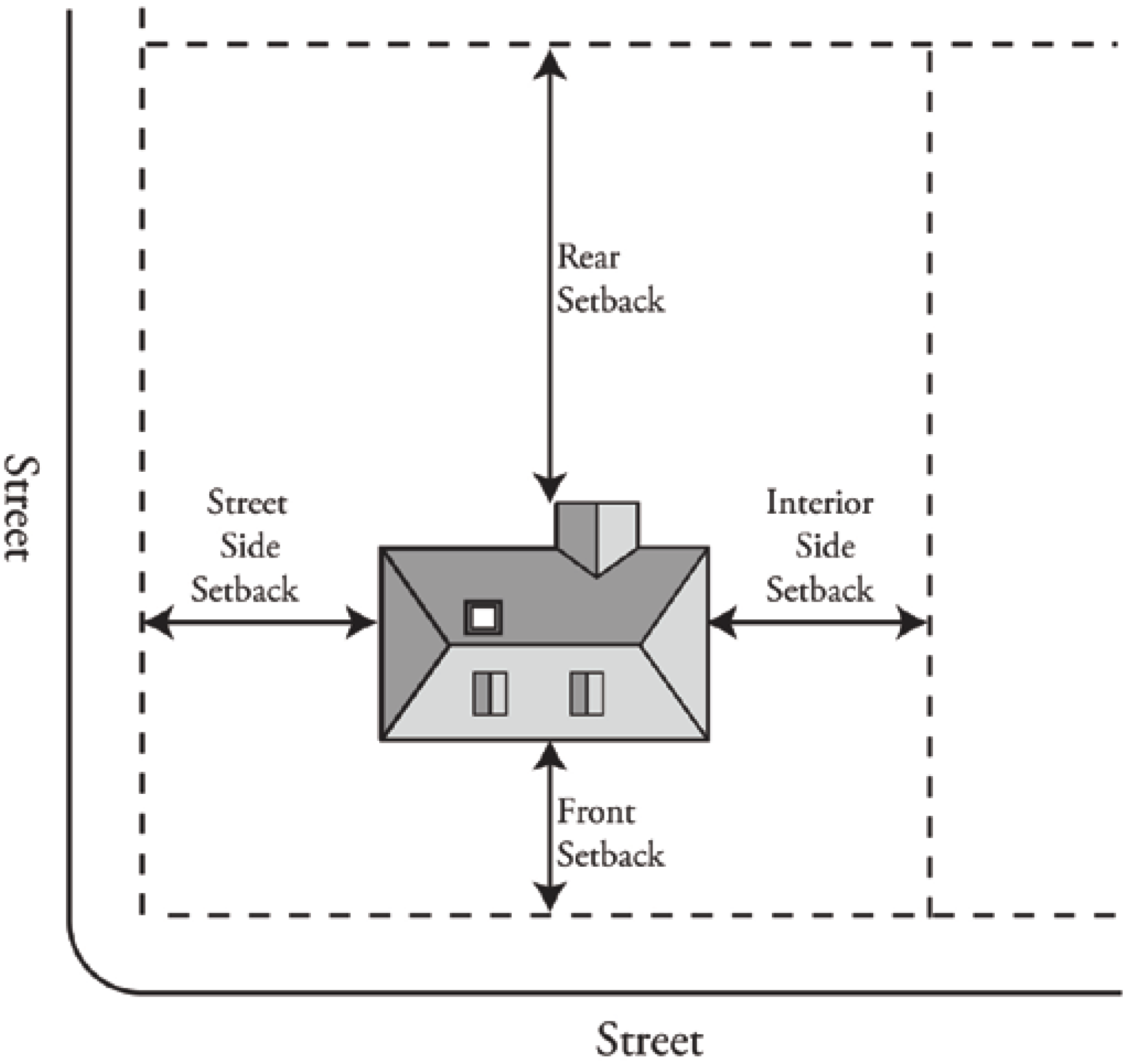
Setbacks shall be measured at right angles from the nearest point on the property line to the nearest point of the structure. On odd-shaped and corner lots, the Zoning Administrator shall determine the location of front, rear, and side property lines. See Figure 24-53-1 (Setback Measurement).
FIGURE 24-53-1 SETBACK MEASUREMENT
(Ord. No. 4062, § 1, 9-10-13; Ord. No. 4105, § 1, 1-12-16)
24-54 - Allowed projections.
Projections into required setback areas shall be permitted only as shown in Table 24-54-1 (Allowed Projections into Setback Areas).
(Ord. No. 4062, § 1, 9-10-13; Ord. No. 4105, § 1, 1-12-16)
24-55 - Projections over property lines.
Structures may not extend beyond a property line or into the public right-of-way.
(Ord. No. 4062, § 1, 9-10-13; Ord. No. 4105, § 1, 1-12-16)
24-56 - Road setbacks.
If the property line is located along the centerline of an existing road easement, the building setback line shall be established as the distance equal to one-half (½) the distance of the ultimate right-of-way as designated in the most recently adopted County Improvement Standards, plus the building setback line required by the applicable zone. If a property line is only partially located within an existing road easement, the setback will be equal to the distance from the property line to the edge of the right-of-way, plus the building setback line required by the applicable zone.
(Ord. No. 4062, § 1, 9-10-13; Ord. No. 4105, § 1, 1-12-16)
24-56.1 - Residential setback from orchards and vineyards.
A setback is established for residential development from existing orchards and vineyards that are located in residential zones in order to reduce interference and conflict with preexisting agricultural operations, while providing for the development potential allowed by residential zones. The residential setback from orchards and vineyards is subject to the following requirements (Refer to Article III, Division 7, Agricultural Buffers, for agricultural buffer setbacks required where a developing residentially zoned parcel is adjacent to a parcel zoned Agriculture):
A.
A setback between a new residence and an existing active orchard or vineyard shall be established as far away from the orchard or vineyard as practicable, taking into account adjacent agricultural uses and practices, provided it does not limit the allowed residential density permitted by the residential zone, and in no case is less than twenty-five (25) feet.
B.
Any proposed land division adjacent to an existing active orchard or vineyard use shall apply for a Residential Setback Recommendation with the Development Services Department in accordance with this section. The Residential Setback Recommendation shall be reviewed by the Agricultural Commissioner, in consultation with Development Services to determine an appropriate setback width (pursuant to Subsection A.). The Residential Setback Recommendation shall become part of the application and reviewed by the hearing body. Public noticing shall include reference to the Residential Setback Recommendation and the residential setback's recommended width.
C.
All building permits for residential development adjacent to existing orchards or vineyards shall be reviewed for compliance with the required residential setback. If no residential setback is shown on an applicable recorded parcel map or subdivision map, a review by the Zoning Administrator at a noticed public hearing shall be conducted to determine the appropriate setback pursuant to Subsection A.
D.
The residential setback shall be imposed from the property line (s) on the developing parcel and shown on the recorded parcel map or subdivision map or building permit site plan.
E.
The setback shall not apply to residential development adjacent to row crops or greenhouses and wholesale nurseries primarily engaged in growing crops, plants, vines or trees and their seeds.
F.
The setback shall not apply to backyard gardens and fruit and nut trees accessory to a residential use.
G.
The setback shall not apply to accessory structures as defined under Section 24-156 (Accessory Uses and Structures) excepting guest houses, which must comply with the setback.
H.
The setback shall not apply to orchard or vineyard uses that start operations after a building permit is approved (this does not apply to an existing orchard or vineyard that is removed and replaced).
I.
If the orchard or vineyard use is discontinued (i.e., the land is developed with residential uses) the setback shall no longer be applicable.
(Ord. No. 4105, § 1, 1-12-16)