


Butte County Unincorporated
City Zoning Code
City Zoning Code
Division 6
Riparian Areas
24-76 - Purpose.
This article establishes standards for riparian areas to:
A.
Reduce risks to property owners and the public from erosion and flooding;
B.
Protect and enhance the chemical, physical, and biological integrity of water resources in the county;
C.
Minimize pollutants entering water bodies from urban stormwater runoff; and
D.
Preserve riparian vegetation and protect wildlife habitat and wildlife corridors along natural drainage ways.
(Ord. No. 4062, § 1, 9-10-13)
24-77 - Applicability.
A.
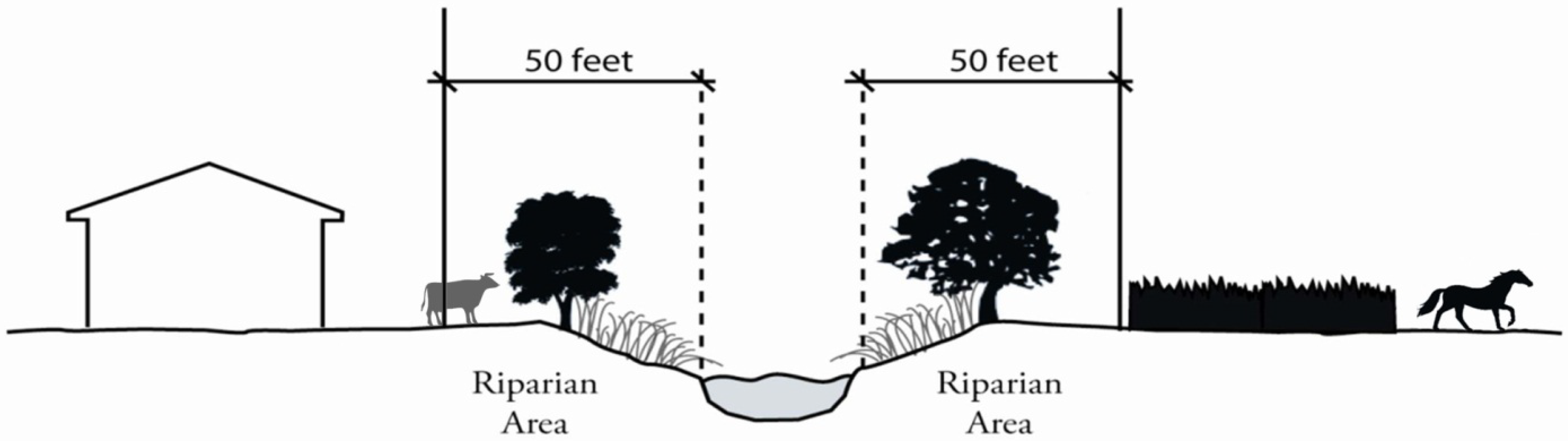
The standards in this article apply to all riparian areas within the county, in addition to the permitting requirements set forth under Article II, Zoning Districts, Land Uses, and Development Standards. As shown in Figure 24-77-1 (Riparian Areas), riparian areas are defined as areas between the banks and fifty (50) feet in width measured from the top bank of any intermittent or perennial stream or river landward. Excluded from this definition are stock ponds and other stock watering facilities, culverted sections of creeks and engineered systems developed by a public agency for collection of storm or flood waters, or systems other than natural creeks designed to deliver irrigation or water supplies.
(Ord. No. 4062, § 1, 9-10-13)
24-78 - Use regulations.
A.
Permitted Activities. The following activities are permitted as-of-right in riparian areas, subject to applicable performance standards below:
1.
Livestock grazing and agricultural practices in the Agriculture, Foothill Residential, Foothill Country Residential, Rural Residential, Rural Country Residential, Timber Mountain, and Timber Production zones;
2.
Native landscaping;
[3.
FIGURE 24-77-1 RIPARIAN AREAS]
FIGURE 24-77-1 RIPARIAN AREAS
4.
Fencing that does not interfere with the flow of flood waters or wildlife migration corridors, consistent with Article III, Division 3 (Walls and Fences);
5.
Roads used primarily for the maintenance of a property;
6.
Utilities, including the installation, operation and maintenance of water pumps;
7.
Storm drains into riparian areas and creeks;
8.
Trails and passive recreational activities not involving the establishment of any structures;
9.
Construction and maintenance of County-owned culverts, rip-rap, and other drainage facilities; and
10.
Construction and maintenance of County-owned bridges.
B.
Conditionally Permitted Uses.
1.
Uses, structures, and activities permitted in the applicable zone are permitted within riparian areas only with approval of a Minor Use Permit, except as described below for Commercial and Industrial Zones.
2.
To approve a Minor Use Permit for riparian area development, the Zoning Administrator shall make all of the following findings in addition to the findings in Article V, Division 5 (Conditional Use and Minor Use Permits):
a.
The proposed use, structure, or encroachment cannot be feasibly located outside the riparian area because such location would have a more adverse effect on the stream environment.
b.
Measures are included that provide adequate protection of wildlife habitat, water quality and in-stream habitat, and capacity for flood management.
C.
Uses allowed with an Administrative Permit in the Commercial and Industrial Zones.
1.
Uses, structures and activities permitted by-right in the applicable zone are permitted within riparian areas only with the approval of an administrative permit provided all of the following requirements are met:
a.
The Zoning Administrator has determined that site constraints limit the ability to develop the proposed uses outside of the riparian area.
b.
A biological resource evaluation is prepared indicating that the altered riparian area would be sufficient to protect the riparian resource. A minor use permit shall be required to address any findings of significant impacts to biological resources.
c.
An erosion and sediment control plan is prepared pursuant to Butte County Code Section 13-10. The plan shall identify measures to prevent sediment and other pollutant discharges from reaching riparian resources, and shall address both interim (during construction) and final (post construction) erosion control measures.
d.
Soil disturbance shall not be conducted during the rainy season (November 15 through April 1). The County may require financial security to ensure that control measures are implemented and maintained.
e.
All areas where land clearing has been completed between April 1 and November 15 shall be re-vegetated, hydroseeded, mulch protected, or otherwise stabilized no later than December 1.
f.
All other requirements under this chapter apply under the administrative permit.
(Ord. No. 4062, § 1, 9-10-13; Ord. No. 4161, § 1(Att. A), 5-7-19)
24-79 - Performance standards.
A.
Construction. Construction is prohibited in riparian areas unless the necessary permits have been obtained from other responsible governmental agencies and plans have been approved by the Director of Public Works and the Zoning Administrator.
B.
Grading or Alterations to Riparian Vegetation. Grading, alteration of the natural contours of the land, or cutting or alteration of natural vegetation that protects a riparian habitat is prohibited within riparian areas except when such action is:
1.
Necessary to protect public health and safety.
2.
Associated with an approved creek restoration and enhancement project intended to improve the health and environmental integrity of the waterway.
3.
Associated with an approved administrative permit, conditional use permit, minor use permit, tentative parcel or subdivision map, or mining permit.
C.
Streambed Alteration. Filling, grading, excavating, or obstructing streambeds is prohibited except in the following circumstances:
1.
Placement of County-approved storm drain and irrigation outflow structures shall be designed so as to eliminate or minimize increases in the rate and amount of storm or irrigation water discharge;
2.
Placement of public and nonpublic utility lines;
3.
Construction of bridges and their connecting roadways;
4.
Maintenance activities necessary to protect public health and safety; and
5.
Creek restoration and improvement projects.
6.
Development associated with an approved conditional use permit, minor use permit, tentative parcel or subdivision map, or mining permit.
(Ord. No. 4062, § 1, 9-10-13; Ord. No. 4162, § 1, 6-11-19))
24-80 - Coordination with other regulatory agencies.
All required permits from the California Department of Fish and Game, the U.S. Army Corps of Engineers, the California State Water Resources Control Board, the Central Valley Flood Protection Board, or other applicable agencies, including any permit required under an approved Habitat Conservation Plan, shall be obtained prior to, concurrently with, or as a condition of, the approval of any County permits for development within riparian areas. Evidence of approval or pending approval of any such permit shall be submitted to the County, including all appropriate supporting materials, environmental documentation, and studies.
(Ord. No. 4062, § 1, 9-10-13)