Butts County Unincorporated
City Zoning Code
City Zoning Code
APPENDIX A
I-75 OVERLAY DESIGN GUIDELINES1
ACKNOWLEDGEMENTS
Butts County Commissioners
Joe Brown, Jr.
Jalaludin K. "Keith" Douglas
Robert L. Henderson, Sr.
Russ Crumbley
Ken Rivers
Steering Committee
Prepared by
The Collaborative Firm
Alex Fite-Wassilak, Designer
Jahnee Prince, Vice-President
Michael Woodman, Director of Planning
Allison Buker, Planning Intern
Editor's note— Printed herein is the I-75 Overlay Design Guidelines of the city, as prepared by The Collaborative Firm, and adopted on Feb. 25, 2016. Amendments to these guidelines are indicated by parenthetical history notes following amended provisions. The absence of a history note indicates that the provision remains unchanged from the original document. Obvious misspellings and punctuation errors have been corrected without notation. For stylistic purposes, headings and catchlines have been made uniform and the same system of capitalization, citation to state statutes, and expression of numbers in text as appears in the Unified Development Code has been used. Additions made for clarity are indicated by brackets.
1.- INTRODUCTION
An introduction to this guide and how it applies to the Butts County I-75 Overlay District.
4. - MIXED-USE REQUIREMENTS
Guidelines that apply to the mixed use area:
5. - RURAL NEIGHBORHOOD
Standards that apply to the rural neighborhood subarea:
10.02 - Introduction—A brief introduction to the design guidelines.
Introduction
The 1-75 corridor of Butts County provides a vital transportation function between Macon and Atlanta. In order to properly prepare for the future development that will occur along the 1-75 corridor, it is vital for Butts County to guide the future development process. The overlay design guidelines indicate ways in which this corridor can function as a gateway and indicate ways future development can contribute towards a larger community with a distinct sense of place.
Purpose
The purpose of the Butts County 1-75 overlay district design guidelines is to provide for quality future development, also creating a sense of place along either side of the interstate, and promoting economic development in Butts County. This document serves to assist planners, architects, property owners, and developers to building in a certain way that works consistently with surrounding areas that are cohesive with the preferred principles of community design, architecture, landscape architecture, and site planning. Guidelines set forth in this document aim to do the following:
◊
Promote innovative, mixed-use developments that invite business investment to Butts County;
◊
Promote attractive and functional industrial development that leverages the highway access and provides jobs to the county;
◊
Promote the development of new, quality single-family housing and subdivisions that relate to their surroundings;
◊
Provide consistent standards for public areas including sidewalks, streetscaping, lighting, signage, and street furniture;
◊
Establish a high standard for aesthetically pleasing development and redevelopment that is harmonious with the surrounding neighborhoods and other uses; and
◊
Encourage accessibility for vehicles, pedestrians, and bicyclists.
Applicability
The district applies generally along 1-75 South of the Spalding County line down to the Lamar County line. The individual parcels included can be seen in the map entitled "Butts County 1-75 Overlay District Areas" as Figure 1.
Except as otherwise provided, any new structures constructed in the Butts County 1-75 overlay district are subject to the regulations contained herein. Existing structures are subject to these regulations to the extent required by non-conforming structures section.
In residential subdivisions where the final plat was recorded prior to the passage of the overlay shall not apply.
What is this document for?
This document is meant to be a how to guide for implementing the 1-75 overlay. It includes pictures, diagrams, and often more description to make understanding and implementing the rules easy.
10.03 - Area explanation—A brief description of each area.
In order to develop the 1-75 corridor of Butts County as a vibrant and sustainable development, this document proposes the use of three distinct subareas to create the overlay district. These three subareas are: Mixed use, rural neighborhood, and industry/commerce. Refer to "Butts 1-75 Overlay Area Map" in section 10.01 to determine which parcels belong to each subarea. Section 3 includes the guidelines that refer to industrial areas, section 4 pertains to the mixed use subarea, and section 5 addresses design guidelines for the rural neighborhood subarea.
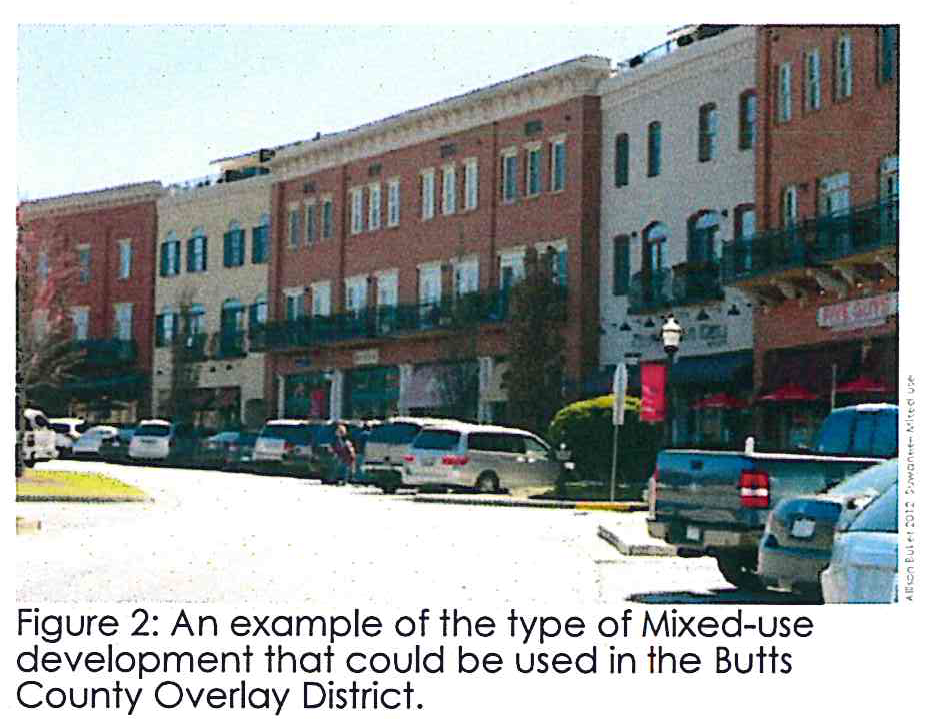
Mixed Use
Area A is zoned for a mix of different uses, including residential and commercial uses. These areas are usually close to busy intersections because theses areas are where more walkable commercial and mixed uses may form. Enhanced connectivity and increased intensity is the goal of these areas to help foster mixed uses nodes of activity and development along the corridor. For an example see Figure 2.
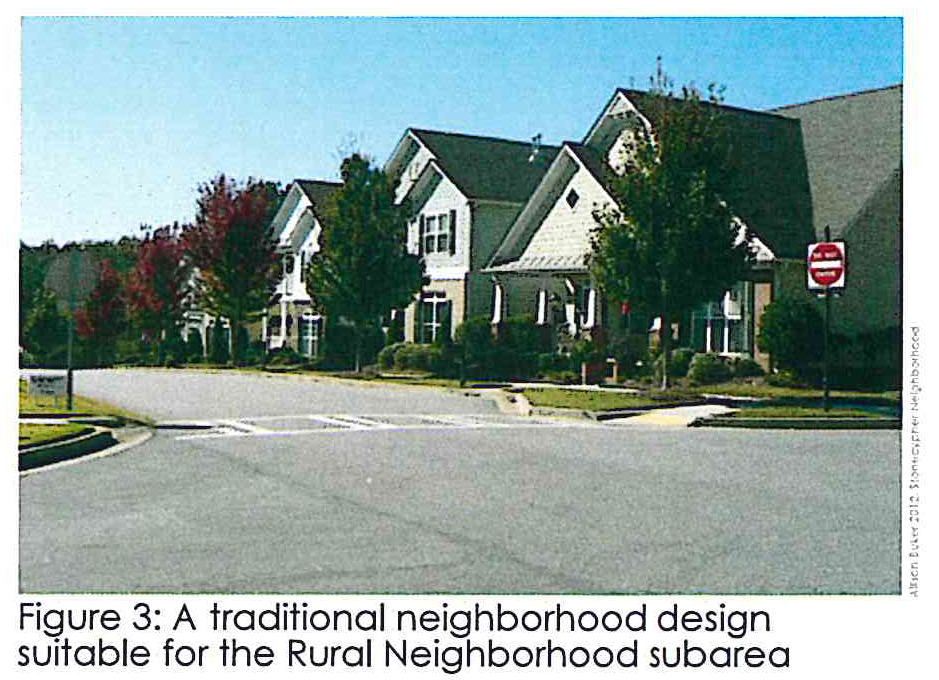
Rural Neighborhood
This area consists primarily of residential uses, including single family lots and subdivisions (Figure 3). Since the overlay area is planned to become a commercial corridor, separation is needed from the highway to keep noise levels for this area to a minimum. This need for separation should be balanced against the benefit that derives from connecting neighborhoods to surrounding compatible uses.
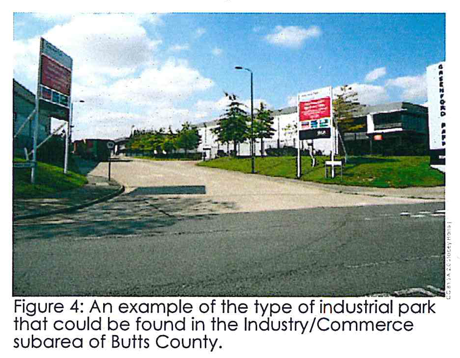
Industry/Commerce
The northwestern portion of 1-75 is almost exclusively zoned for industrial uses (Figure 4). The proximity between Atlanta and Macon make this area a prime location for new office and industrial developments. Properties here are not intended to serve pedestrians, but design guidelines are in place to promote development of an attractive and functional industrial area that fits in with the rest of the overlay corridor.
Definitions
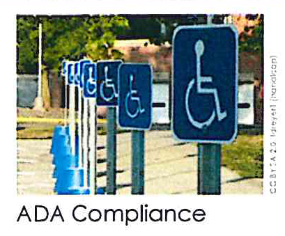
ADA compliance means to be up to code with the design, standards, and guidelines associated with the Americans with Disabilities Act (ADA).
Articulation means the revealing of how parts of the building fit into the whole by emphasizing each individual part. Commonly this effect can be accomplished through the use of physical offsets, material changes, architectural details, among many other techniques.
Berms means a flat strip of land, raised bank, or terrace bordering a river, canal, or roadside.
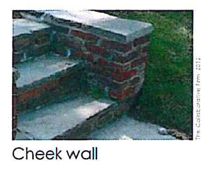
Cheek walls means a wall that is adjacent and connected to a stairwell.
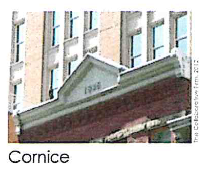
Cornice means a horizontal molded projection that is located at the very top of a building or wall.
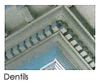
Dentils means a series of closely spaced, small, rectangular blocks placed beneath the cornices.
Facade means the plane of the building that faces a public right-of-way, very important for determining the character of the urban space around it.
Fenestration means the layout of windows, doors, and other opening along the exterior of a building.
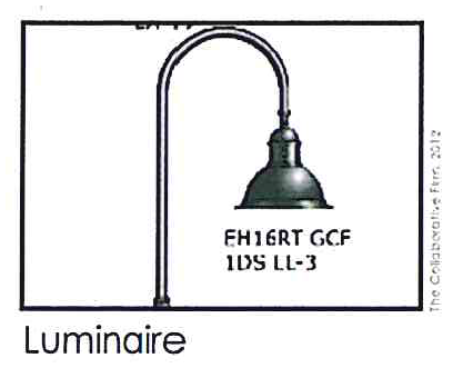
Luminaire means a lighting fixture complete with a light source, a reflector for directing the light, an opening for light to pass through, an outer shell for protection, and a connection to a source of power.
Offset means a ledge or recess in a wall formed by an adjacent reduction in thickness.
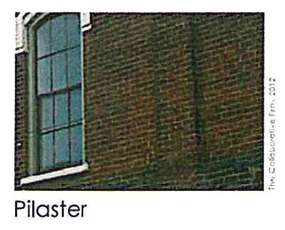
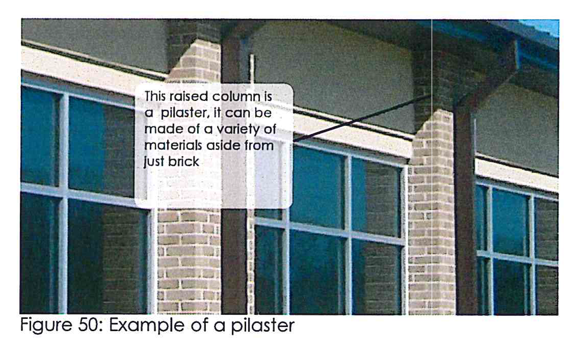
Pilaster means a column built into or applied to the face of a wall so that it projects slightly. Pilasters are often used in a decorative fashion.
Public right-of-way or ROW means a publicly-owned strip of land set aside for transportation that encompasses public roadways as well as sidewalks and public space adjacent to those roadways.
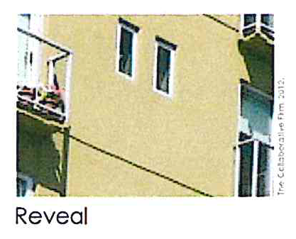
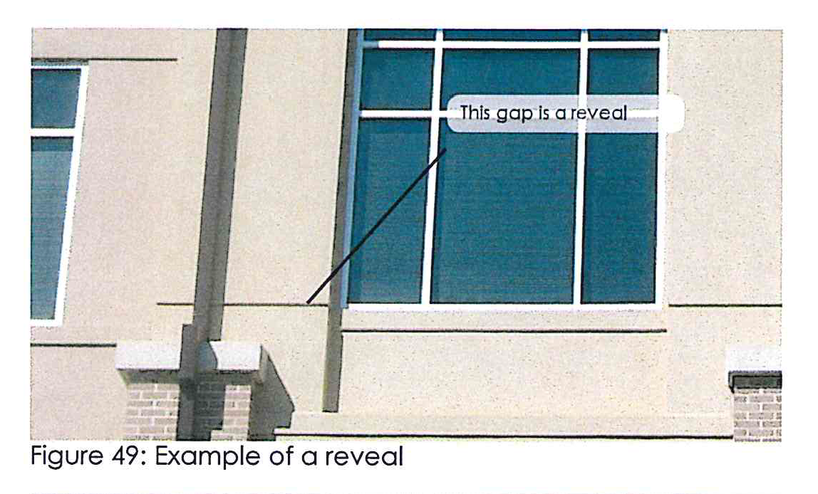
Reveal means a narrow opening, often between two architectural elements, on the surface of a wall showing the wall's thickness.
Right-of-way (ROW) means the legal right, established by usage or grant, to pass along a specific route through property belonging to another.
Spandrel means the surface area between two adjacent arches and the horizontal cornice above them.
Street furniture means a collective term for objects installed on public sections of streets and roads for a variety of purposes, including benches, bike racks, mail boxes, street lamps, traffic lights, traffic signs, bus stops, taxi stands, recycling bins, and waste receptacles.
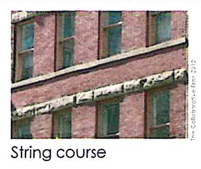
String course means a continuous horizontal band of building material, usually along a wall.
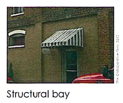
Structural bay means an architectural unit defined as the area between the structural supports such as columns or a wall.
2A.01 - Access and connectivity requirements.
The road system should have multiple routes for different options.
Connection to planned road system. It is intended that frontage roads and other local roads in the overlay district, and connections from development to such frontage roads and local roads, will be planned and coordinated with the road system of the surrounding area and with the plans for future roads in the overlay district. Accordingly, a lot owner may be required, as part of the land development approval process, to connect to an existing or planned frontage road or other part of the public or private street or road access system.
Connection to state routes. All commercial driveways onto state routes in the overlay district are subject to the Georgia Department of Transportation Regulations for Driveway and Encroachment Control or any official revisions thereto. No development permit or land-disturbance permit shall be issued that involves a driveway or other access onto a state route unless a commercial driveway permit or access approval from the Georgia Department of Transportation has been submitted to the zoning administrator.
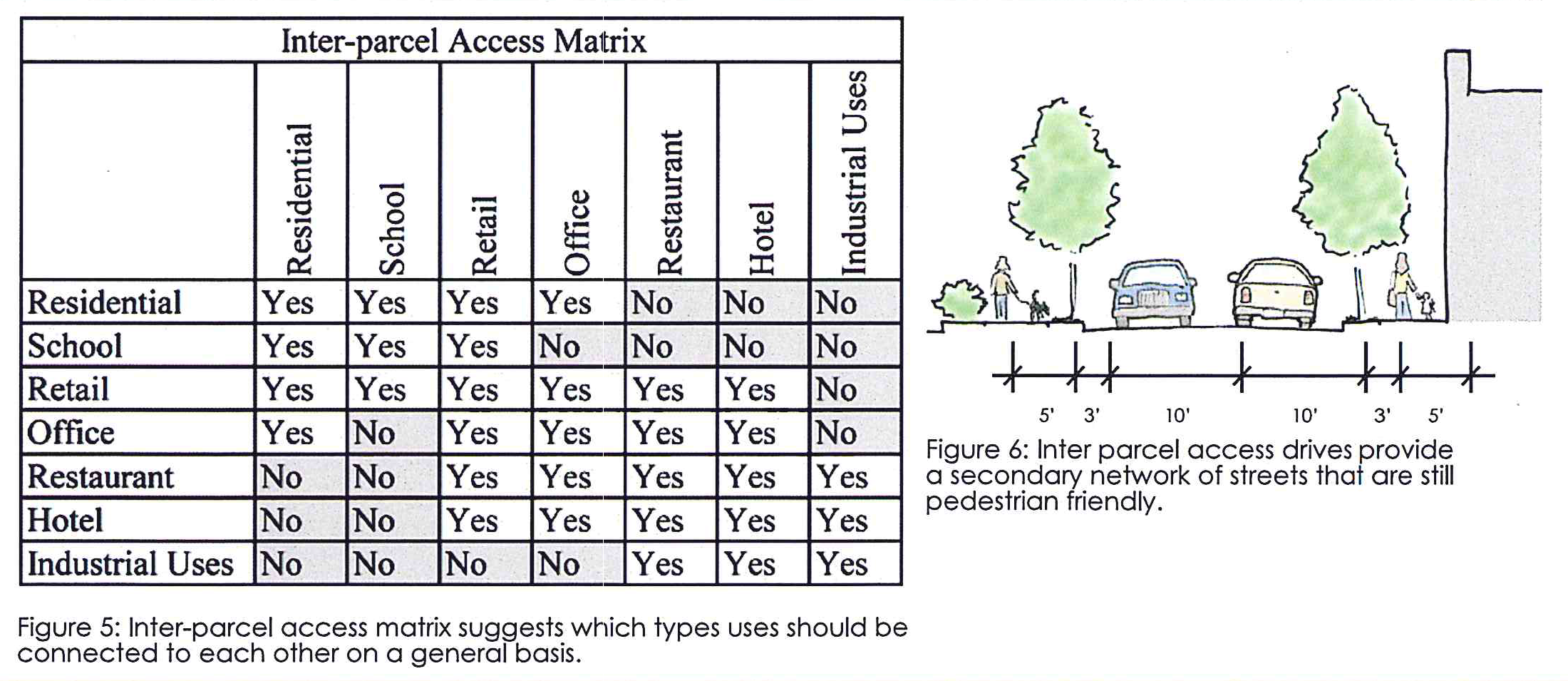
Inter-parcel access. Inter-parcel site access shall be provided to adjacent properties where the board of commissioners has determined that the land uses so connected are compatible. The following figure provides a basic guide for compatible uses, though the ultimate determination is up to the board of commissioners. Where inter-parcel access is required, property owners will be required to grant an access easement across the lot or development site to facilitate the movement of motor vehicles across the lot or development site (see Figure 5 and Figure 6).
Right-of-ways and easements. Prior to development approval, an additional road right-of-way for a county road or private road or an access easement may be required to be dedicated. The location, type, and amount of right-of-way or easement to be dedicated may also be needed at intersections or at other locations fronting the property where turning lanes or road intersection realignments are required for traffic safety and the right-of-way is inadequate to accommodate the road, drainage, and utility, and other improvements are necessitated by the development or called for in the future road plan for the overlay district.
Separation of directions of travel. On any two-lane, two-way directional travel road, or other access way, whether public or private, the directions of travel may be separated if necessary to minimize grading requirements, subject to the county's approval.
Crossing of streams with road, bridge or driveway access. Where roads, bridges, and driveways must cross streams and tributaries, they shall cross such streams and tributaries at the least sensitive places and while providing the shortest feasible bridge.
2A.02 - Standards for bicycle and pedestrian infrastructure.
Pedestrians and bicyclists should be considered in areas throughout the overlay.
Pedestrian accommodation. Pedestrians are a part of everyday roadway environment and attention must be paid to their presence in rural as well as urban areas.
Sidewalk density. As a general practice, sidewalks should not be constructed along any county road or state highway in the overlay district where future residential development density is expected to be lower than two dwelling units per acre or where industrial development is planned.
Sidewalks on both sides. Sidewalks used for pedestrian access to schools, parks, and shopping areas, and placed along all streets in office, institutional and commercial areas, should be provided along both sides of the road. In residential areas, sidewalks are desirable on both sides of the street but need to be provided on at least one side of all local streets.
Planting area. Sidewalks along streets with curbs and gutters should be separated from the curb by a planting strip of at least two feet along local residential streets and five feet along local collector and commercial streets. Sidewalks along streets without curbs and gutters should be separated by a drainage swale (see Figure 7).

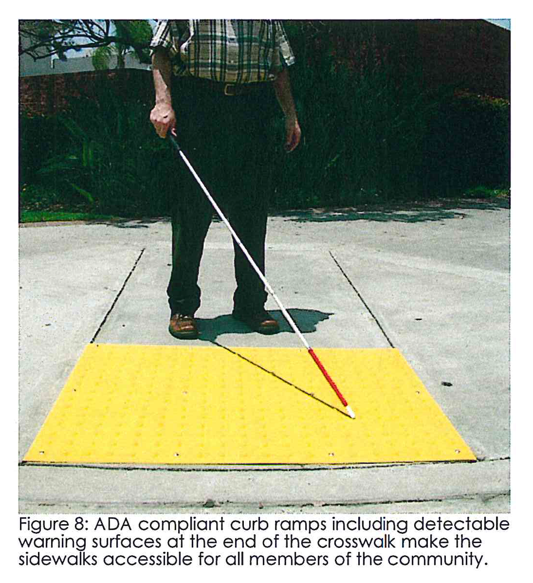
Curb ramps. At street intersection with traffic signalization, crosswalks shall be provided including curb ramps. Crosswalks within the overlay shall be the highly visible "piano key" style of five-inch parallel band pairs two feet apart. All curb ramps in the overlay are required to meet applicable requirements of the Americans with Disabilities Act (see Figure 8).
Connection to public sidewalks. Land developers are required to provide pedestrian connections on private properties to sidewalks on public or private roads.
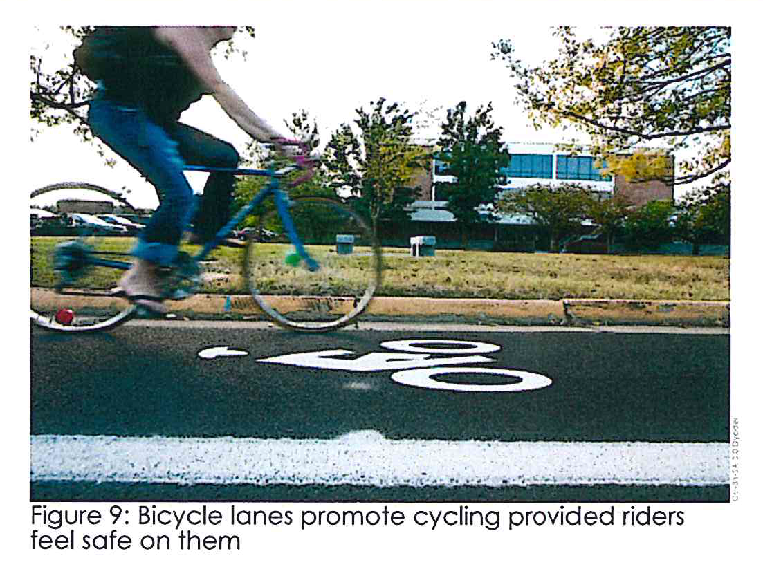
Bicycle lanes. Bicycle facilities may be provided by the private developer via incorporation of bicycle paths and/or bicycle lanes internal to the development. Subject to the approval of the zoning administrator, a bicycle lane may be incorporated within the right-of-way of a public road abutting the proposed development. Bicycle paths may be provided within their own dedicated right-of-way, an example can be seen in Figure 9.
Bicycle crossing. When a bicycle lane, bicycle path, or multi-use trail crosses a road intersection or a railroad, then ramps and adequate warning and safety signing and striping must be provided subject to the approval of the county engineer utilizing applicable requirements of the Americans with Disabilities Act and county standards.
Bicycle lane standards. Bicycle lanes on county roads shall be a minimum of four feet in width. On rural roads without curbs and gutters, the shoulders of roads may be paved, designated, and maintained for bicycle travel.
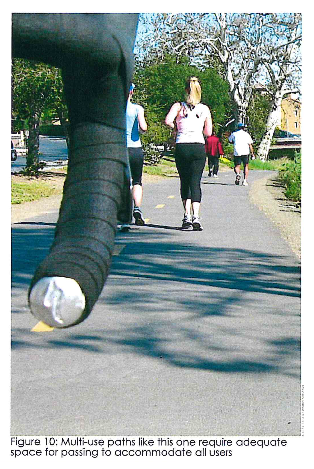
Bicycle path standards. Bicycle paths are separate paved trails not attached to the adjacent road. The minimum width for a bicycle path shall be ten feet. The county engineer may reduce this required width to eight feet in instances where he or she finds bicycle traffic and pedestrian use will be light and where the path presents a satisfactory and safe alignment vertically and horizontally. The county engineer may also authorize a reduction of the minimum width for short sections of the bicycle path where necessary to preserve trees, move the bicycle path alignment to avoid hazards, at narrow bridge crossings, or at other places as may be appropriate. When a bicycle path is incorporated into a multi-use trail, the multi-use trail should either be constructed to a width of 12 feet or provided with pullouts or passing areas in frequent places along the length of the multi-use trail to accommodate passing situations for different users traveling at different speeds (see Figure 10). Bicycle paths shall have a minimum two-foot wide graded shoulder area on at least one side of the bicycle path in addition to the width requirements mentioned above. Vertical clearance shall be eight feet minimum with ten feet desirable.
2B.01 - Buffer standards.
Buffers help ensure different uses in a smaller area.
Buffers west of I-75. Properties abutting the west right-of-way of Interstate 75 shall maintain a natural undisturbed buffer not less than 100 feet in width to serve as a visual and acoustical barrier to noise from the I-75 corridor. If 100 feet of undisturbed buffer is unavailable 50 feet of planted buffer should be used to achieve opacity.
Buffers east of I-75. Properties abutting the east right-of-way of Interstate 75 shall maintain a landscaped area not less than 30 feet in width that allows view of the businesses located on the frontage road.
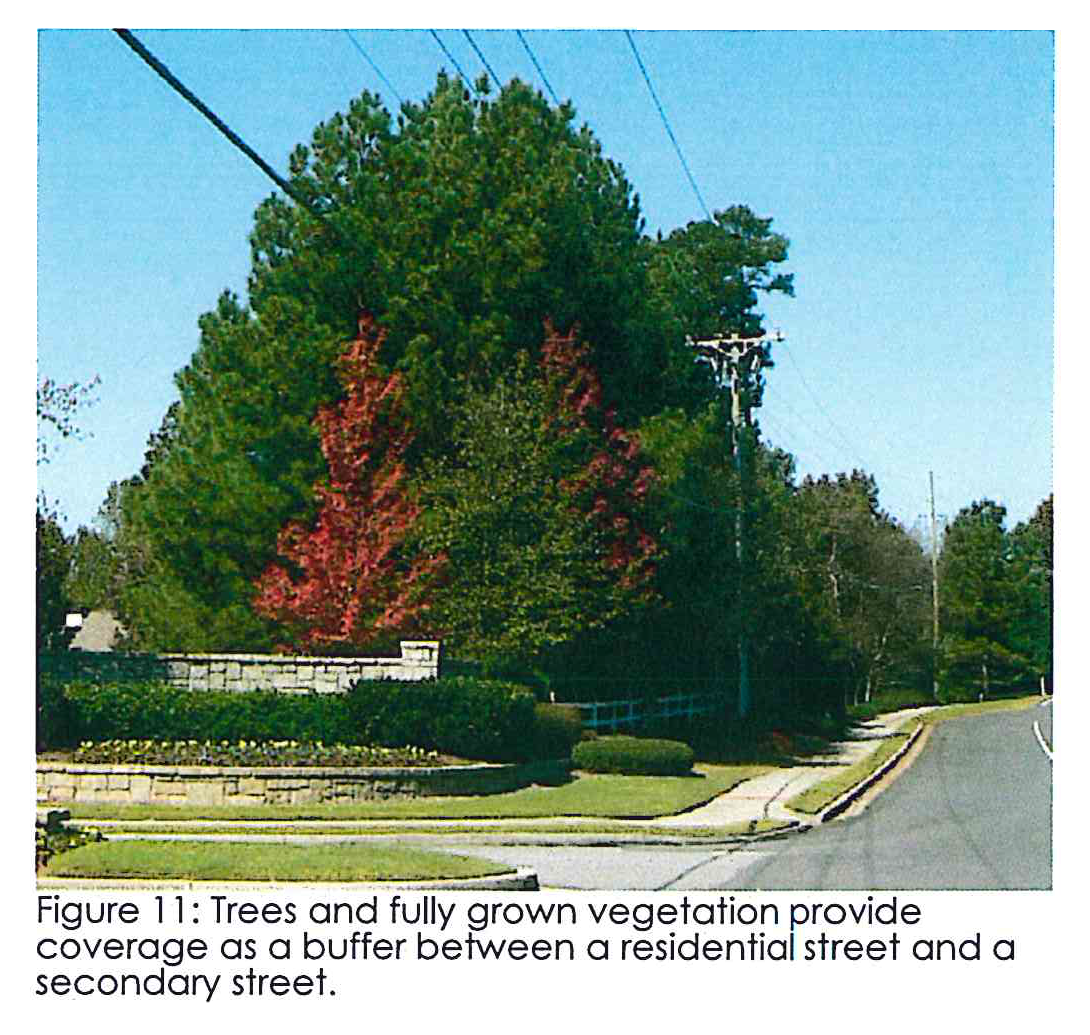
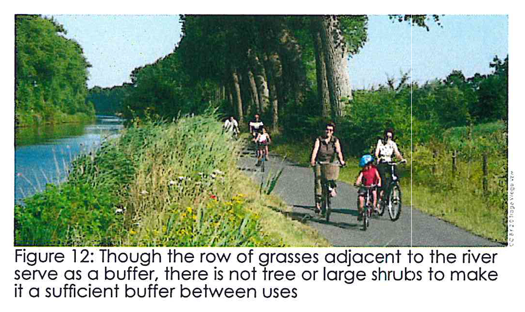
Buffers standards. Buffers shall contain a minimum of 75 percent of evergreen plant materials comprised of diverse array of plant species and no plant species may account for more than 15 percent of the plant material for the particular categories of canopy shade tree, understory tree, shrub, ground cover (see Figure 12). One tree shall be planted for every 50 linear feet of buffer area. Turf grass shall not be considered as an appropriate buffer material. A mature buffer can be seen in Figure 11.
Supplementing buffers. In those instances where the existing natural vegetation and topography are insufficient to achieve the desired level of screening as required by this Section, a planted buffer shall be provided and shall consist of plant material of such growth characteristics as will provide a visual screen having a height of not less than six feet in two years and planted in a minimum of two rows with staggered spacing such that a continuous opaque screen is created within two years of planting.
Buffer maintenance. Required buffer strips shall be established and maintained in perpetuity by the owner(s) of the non-residential land use. The required buffer strip shall not be disturbed by grading, property improvements or construction activities except where necessary to prevent a nuisance, to remove diseased, misshapen, or dangerous and decayed timbers, or any similar county approved enhancement. Any contemplated disturbance shall first be brought to the attention of the Butts County community development department and formal approval of a permit secured prior to initiating activity within the required buffer areas.
Certificate of occupancy. Buffers shall be provided in accordance with the approved plan prior to issuance of a certificate of occupancy.
No parking. Buffers shall be prohibited from being used for temporary or permanent parking or loading.
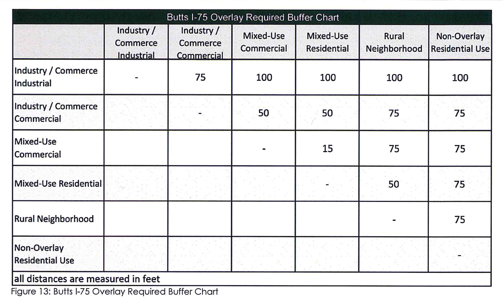
Buffers between uses. Refer to Figure 13 below for the buffer requirements between different uses within the overlay.
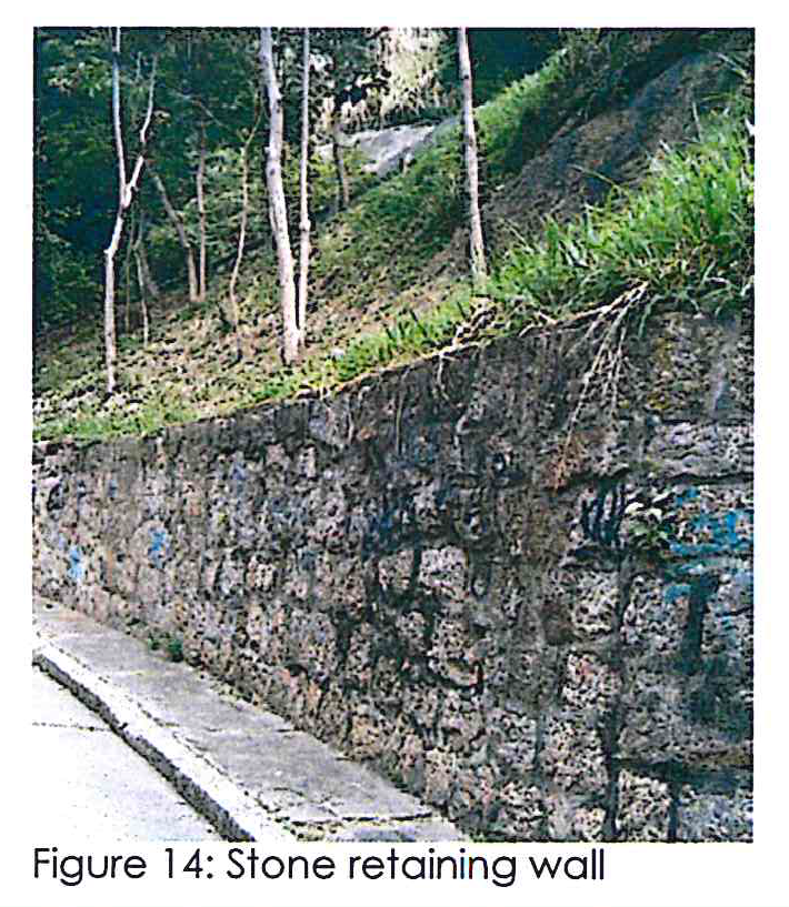
2B.02 - Retaining walls.
Retaining walls when facing a public street should look attractive.
Retaining walls. Tall, smooth faced concrete retaining walls are discouraged—walls visible from the right-of-way should be faced with brick, stone, or other architectural treatment and composed of wood material in areas where rural character predominates (see Figure 14). The height and length of retaining walls should be minimized and screened with appropriate landscaping.
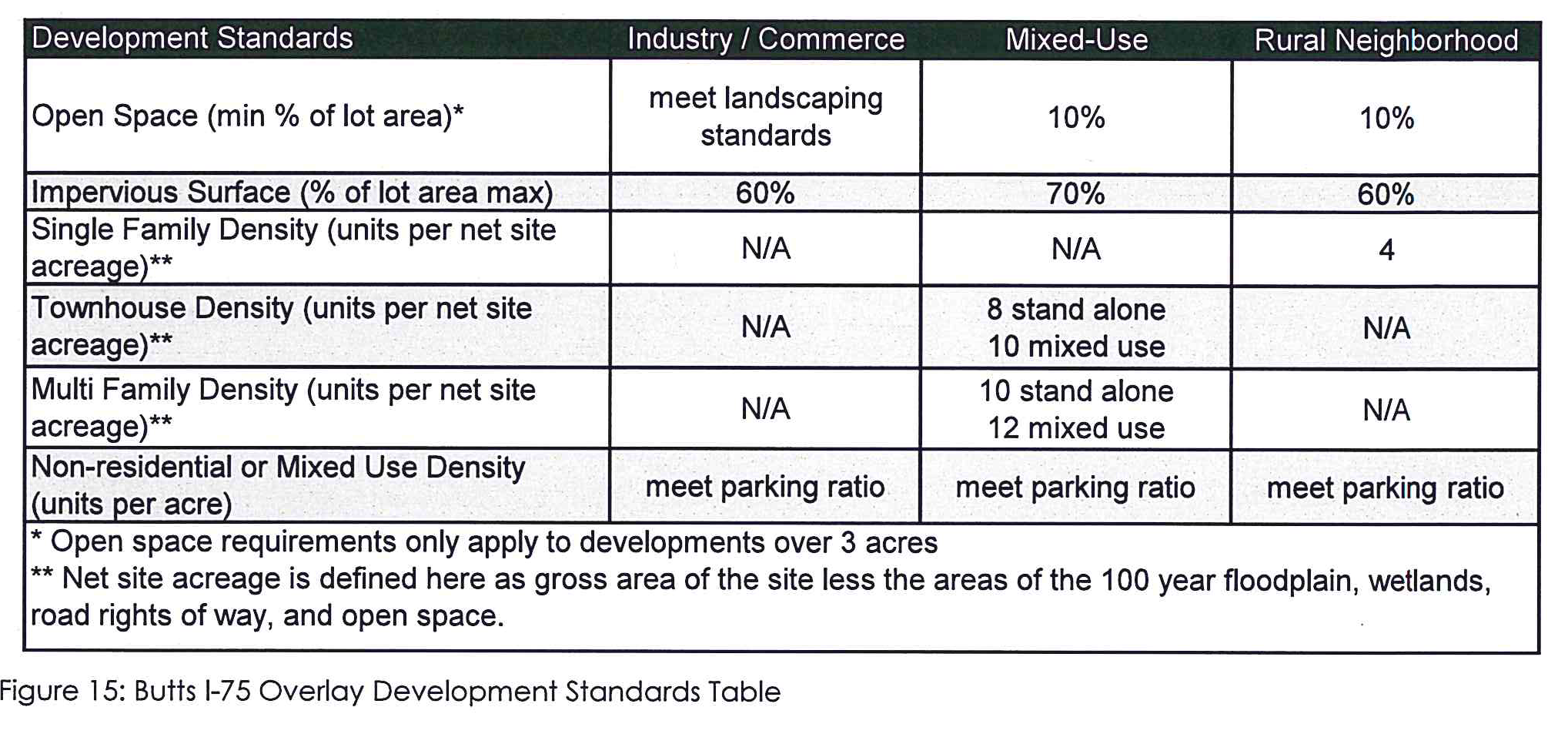
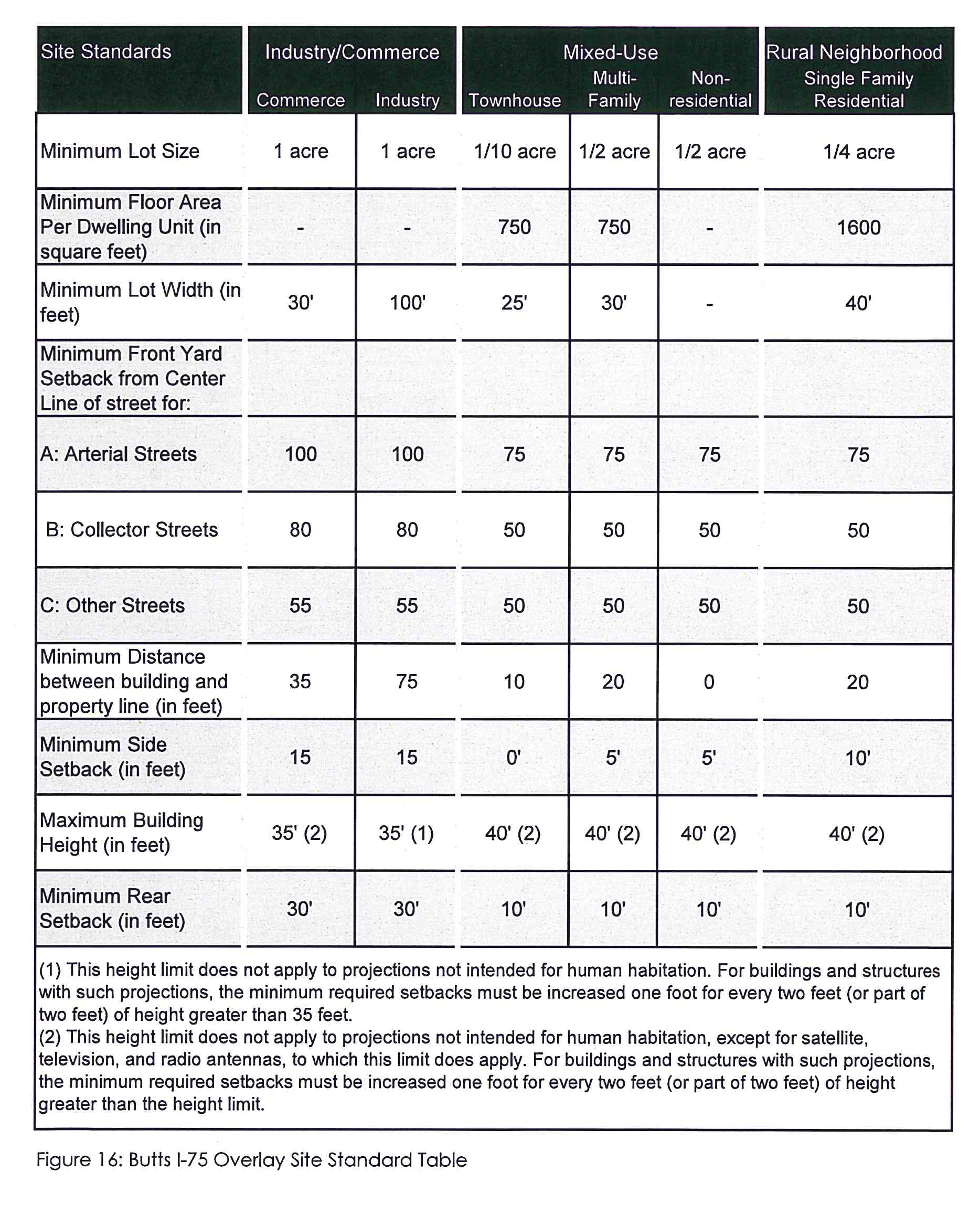
2B.03 - Development standards.
The standards for developing a piece of property in each subarea:
Development standards. Refer to Figure 15 below for the relevant development standards for each subarea within the overlay.
Site standards. Refer to Figure 16 below for some of the basic building standards for structures within the overlay.
2B.04 - Landscaping standards.
Landscaping makes:
Non-residential landscaping requirement. Each lot or development shall contain a minimum of 60 tree density units per acre proportional to the lot size. Each item listed below is inclusive to the 60 tree density units per acre.
•
Each lot or development must contain a minimum of one 2.5 inch caliper hardwood tree per 50 feet of roadway, located adjacent to the ROW, and not closer than 15 feet from any structure.
•
The required tree density shall be accomplished with the preservation of trees, tree planting, or a combination of preservation and planting.
Residential landscape requirement. Required tree density for residential property development or redevelopment subject to this section in the R-1, R-2, R-3, A-R zoning districts and the rural neighborhood overlay subarea. The required tree density shall be accomplished with the preservation of trees, tree planting, or a combination of preservation and planting.
•
Each residential lot one acre or less shall contain a minimum of three 1.5-inch caliper hardwood trees. Each residential lot greater than one acre shall contain a minimum of 7.5-inch caliper hardwood trees. No tree shall be planted closer than 15 feet from any structure. Remaining hardwood trees on each lot with a diameter breast height (DBH) of three inches or greater shall be credited as replacement trees.
•
Each residential lot shall contain a minimum of 20 gallons of shrubs per house. Of the 20 gallons, there shall be a minimum of two three-gallon shrubs per house.
•
Balance of lot area is to be seeded, sodded, hydro-seeded or stabilized with other landscape materials.
•
Recommended areas for additional tree preservation and planning include subdivision entrances, contiguous rear/side setbacks outside required drainage easements, external road frontage, stream-side buffers, and stormwater detention facilities.
2B.05 - Utilities and outdoor lighting.
How to deal with utility location and lighting outside:
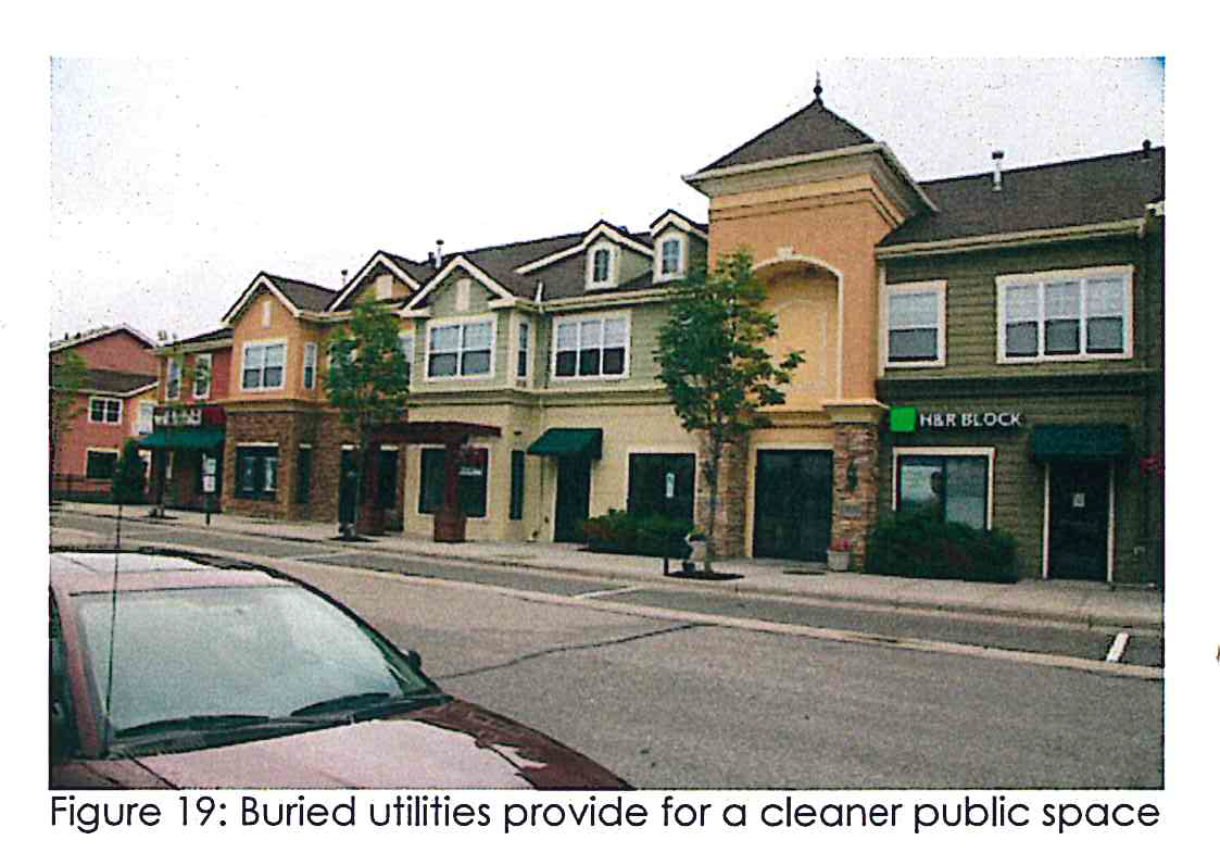
Utilities. All utility lines serving uses proposed or developed within the overlay district, including water, sewer, gas, electric, telephone, data and cable television, shall be installed underground (this excludes high voltage transmission power lines within easements of 100 feet or more). Underground utility trenches must be re-vegetated. Utility boxes and cabinets that are located above ground must be shielded from view with a continual ring of evergreen shrubs expected to reach maturity one foot higher than the height of the box. Any above ground boxes that cannot be buried shall, in addition to being screened by vegetation, be painted a neutral or earth tone color or otherwise made to blend in with their surroundings. For an example of a mixed-use area that has buried utilities, see Figure 19.
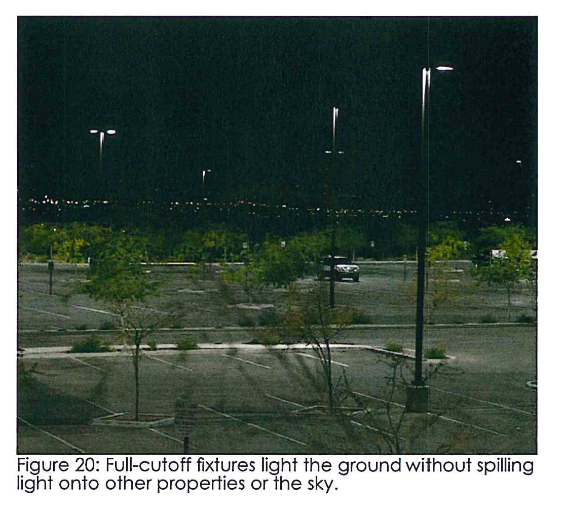
Outdoor lighting. All outdoor lighting hereafter installed, shall be full cut-off luminaires, or another luminaire which does not emit any direct light above a horizontal plane through the lowest direct-light-emitting part of the luminaire. Cut-off fixtures are not required for incandescent lighting with an intensity of 160 watts or less. Full cut-off luminaire is defined as outdoor light fixtures shielded or constructed so that no direct light rays are emitted by the installed fixture at angles above the horizontal plane. Full cut-off luminaires can be seen functioning in Figure 20. The following outdoor lighting practices are prohibited:
•
Glass tubes filled with neon, argon, or other gas and used for outdoor lighting, or for the purpose of outlining windows, doors or any other part of a building.
•
Metal halide, and/or quartz lighting, except when the designing engineer deems that color rendering is critical, as may be specifically approved by the zoning administrator as a part of an approved lighting plan for development within a commercial or industrial zoning district.
•
The outdoor use of laser source light, search lights or any similar high intensity light, when used for purposes of advertising, attraction, or entertainment, may be authorized by permit from the zoning administrator for a limited duration only upon a finding that the lighting will not be a nuisance or an unreasonable burden upon the community or the surrounding properties.
•
Lighting underneath the ceiling of a freestanding canopy or accessory structure such as a gasoline pump island that is not recessed into the ceiling of the canopy.
2B.06 - Stormwater management.
Stormwater management techniques should be used to address water runoff and water carried pollutants.
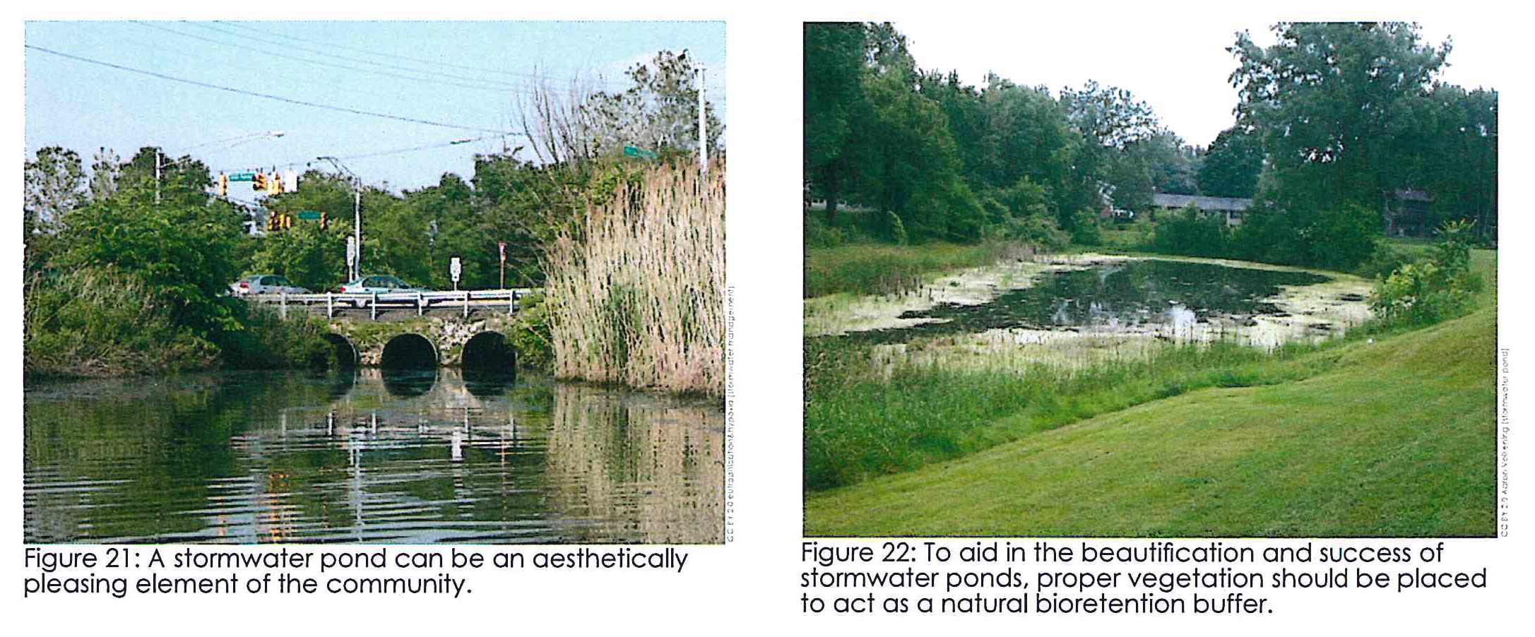
Storm water management. Designing man-made lakes and stormwater ponds for maximum habitat value will aid in stormwater run off as well as act as amenities for surrounding development (see Figure 21 and Figure 22). Fenced detention ponds in front yards are not permitted unless the zoning administrator rules that it is necessary.
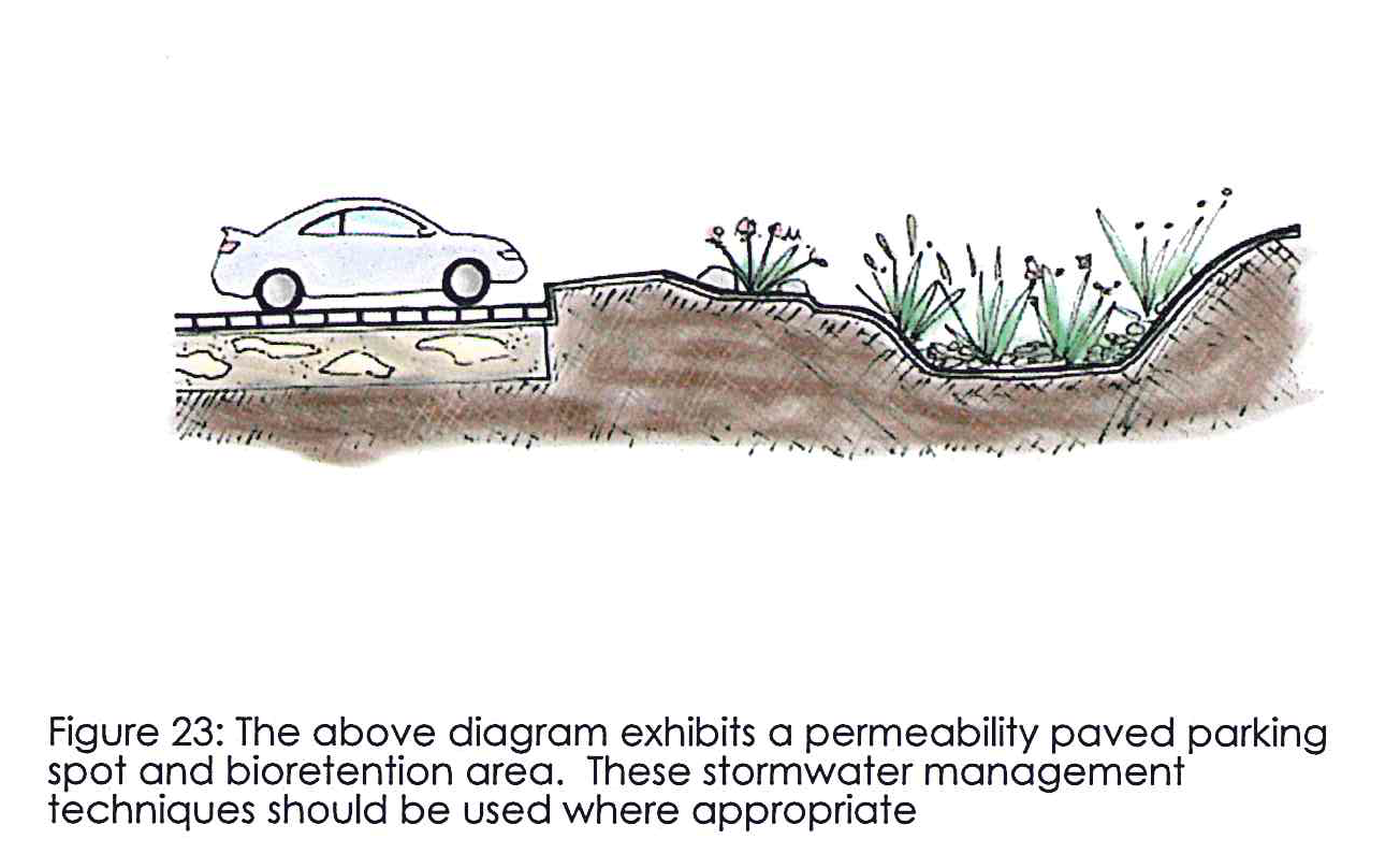
Bio-retention areas. Bioretention areas are similar to buffers but typically utilize low-lying vegetation and are a helpful tool for stormwater management. A bioretention area is a shallow, landscaped depression that receives runoff from impervious surfaces. The layered design of the bioretention area, which consists of an underdrain, a permeable sand/soil mix layer, and a top layer of rock and/or vegetation, filters debris particles, sediment, and other pollutants from runoff, prevents them from draining into a storm sewer system or waterway (see Figure 22).
Reduction of impervious surfaces: Evaluate and if appropriate install permeable pavements for overflow and employee parking where possible. Bioretention techniques are strongly encouraged.
3A.01 - Site arrangement.
Industrial sites should be arranged to be both functional and aesthetically pleasing.
Please be sure to refer to the "Butts I-75 Overlay Development Standards Table" and to the "Butts I-75 Overlay Site Standard Table."
Basic siting guidelines. Industrial park design: Industrial districts are typically laid out in a gridiron of large blocks 1,000 to 2,000 feet long and 600 to 1,000 feet deep. Road rights-of-way should be 80 to 100 feet for major roads and 60 feet for secondary roads. Curve radii need to be large enough to accommodate large trailer trucks There are five main guidelines that help create a well designed and functioning industrial site (see Figure 24 for a diagram).
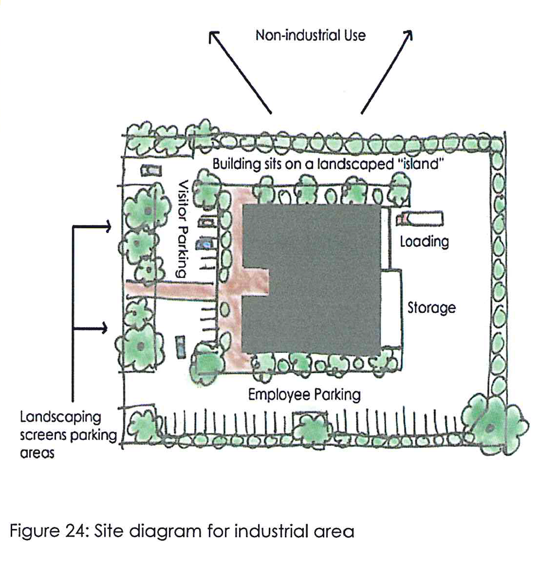
Site access. The site should be designed with separate entrances for trucks and for all other vehicles to prevent conflicts. Trucks should have ample room to maneuver the site.
Service spaces. Service areas and employee parking should be located on the sides or rear of the building, largely out of sight from the public right-of-way.
Visitor access. Visitors and patrons should have access to convenient parking located towards the front of the site and within easy distance of the main building.
Screening. Storage areas, mechanical equipment and work areas should be screened and appropriate buffering should be established between adjacent uses.
Aesthetics. The building and landscape should be designed to present its best view to the public.
3A.02 - Site access and internal circulation.
Site access should be carefully designed to avoid conflicts between trucks and other general vehicles.
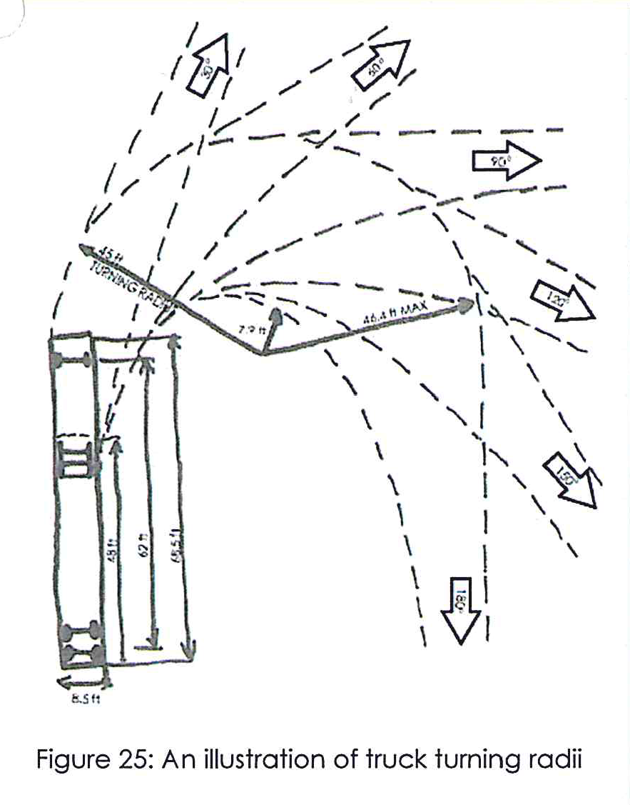
Truck access. Site access for trucks shall be provided as a separate, well-signed point of ingress and egress. Typically, truck/semi-truck access to the site should be designed with a minimum 30-foot-wide driveway and a minimum 45-foot turning radii to allow for sufficient maneuverability (based on Georgia DOT Design Policy Manual for minimum design vehicle with a 62-foot wheelbase) (see Figure 25). Truck access shall be located with sufficient separation to other vehicle points of access so as to avoid conflicts and congestion on the public ROW and on interior drive aisles. Curb cuts are encouraged to be minimized through shared access between neighboring industrial properties.
General vehicle access. Site access for general vehicles, including employees and visitors, shall be provided as a separate, well-signed, landscaped point of ingress and egress. Typically, access to the site should be designed with a minimum 20 foot-wide driveway. General vehicle access shall be located with sufficient separation from truck points of access to avoid conflicts and congestion on the public ROW and on interior drive aisles. The number of curb cuts for each site shall be minimized and shared access between neighboring industrial properties is encouraged.
Internal circulation. Internal circulation should promote safety, efficiency, convenience, and minimize conflict between visitor/employee vehicles and large trucks. Appropriate maneuvering and stacking areas for trucks should be a primary consideration in the overall design of the circulation system.
3A.03 - Site parking.
Parking should be designed to minimize views from the public ROW, while maintaining functionality.
Visitor parking. A small number of visitor parking spaces may be located toward the front of the site, with convenient access to the primary building. These parking spaces shall be located near general vehicle access points to avoid conflicts with trucks and service areas. Pedestrian walkways shall be clearly identified and connect parking areas to the primary building entrance.
Employee parking. Employee parking shall be located on the side or rear of the site to reduce visual exposure to the public ROW. Parking areas shall be located near other vehicle access points to avoid conflicts with trucks and service areas.
Truck parking. Truck parking shall be located at the rear of the site, behind the primary building and not within the required landscaped buffer yards. The dimensional requirements for delivery truck parking spaces shall be 12 feet by 20 feet and 12 feet by 60 feet for semi-trucks.
Service areas. Truck drive aisles and service areas shall be separate from visitor and employee drive aisles and be located on the side and/or rear of the site.
3A.04 - Site screening and security.
Industrial sites need access control but they should also look attractive.
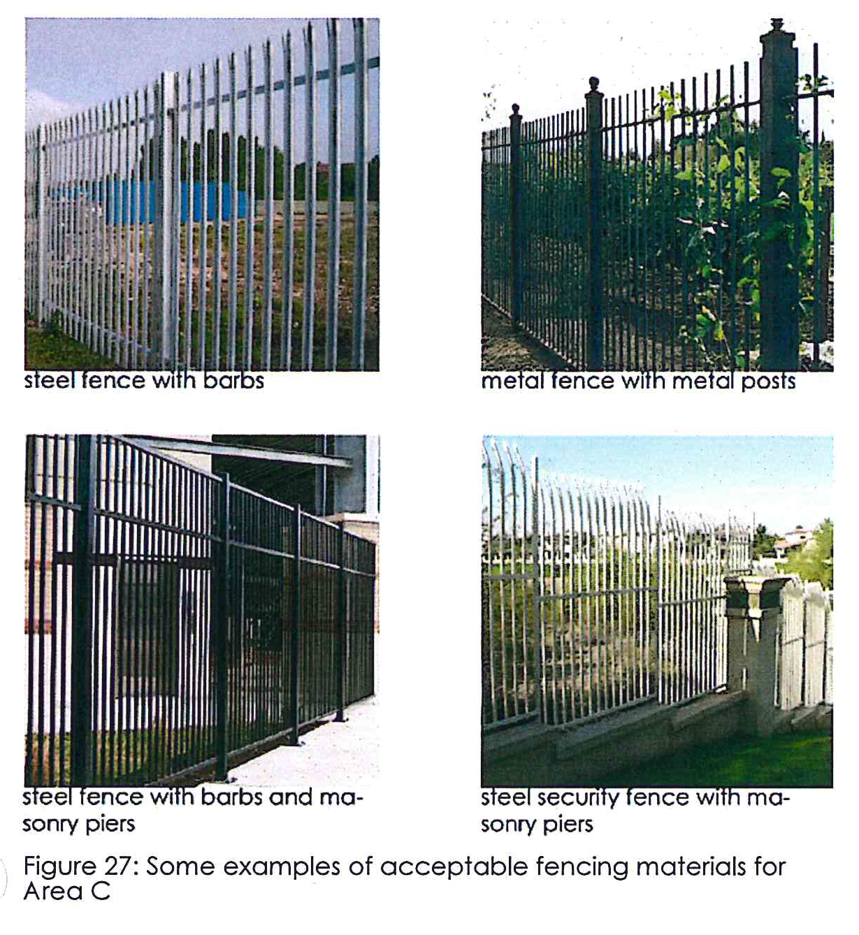
Fences and walls. The colors, materials, and appearance of fences and walls should be compatible with the overall design character/style of the development. Acceptable materials include painted or coated metal (aluminum, wrought iron, or steel), masonry, or stone, as shown in Figure 27. The use of razor or barbed wire is not permitted in areas visible from the public right-of-way. Security fencing when required adjacent to public rights-of-way, shall consist of wrought iron, tubular steel, or similar material. The use of chain-link fence material is not permitted in the front yard of a site, but may be used on the sides and rear if it's coated chain-link. Fences shall not exceed a height of six feet along the front and shall be no less than six feet and no more than eight feet on the side and rear. Design elements should be used to break up long expanses of uninterrupted walls, both horizontally and vertically.
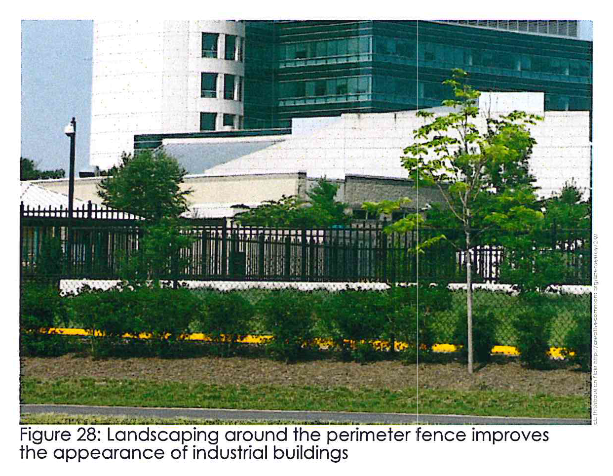
Walls. Walls over three feet in height should include design elements such as textured concrete block, interlocking "diamond" blocks, formed concrete with reveals, or similar effect. Significant landscaping should be used in combination with fences and walls to visually soften blank surfaces and to deter graffiti (see Figure 28).
3A.05 - Landscaping.
Industrial areas should have pleasant landscaping.
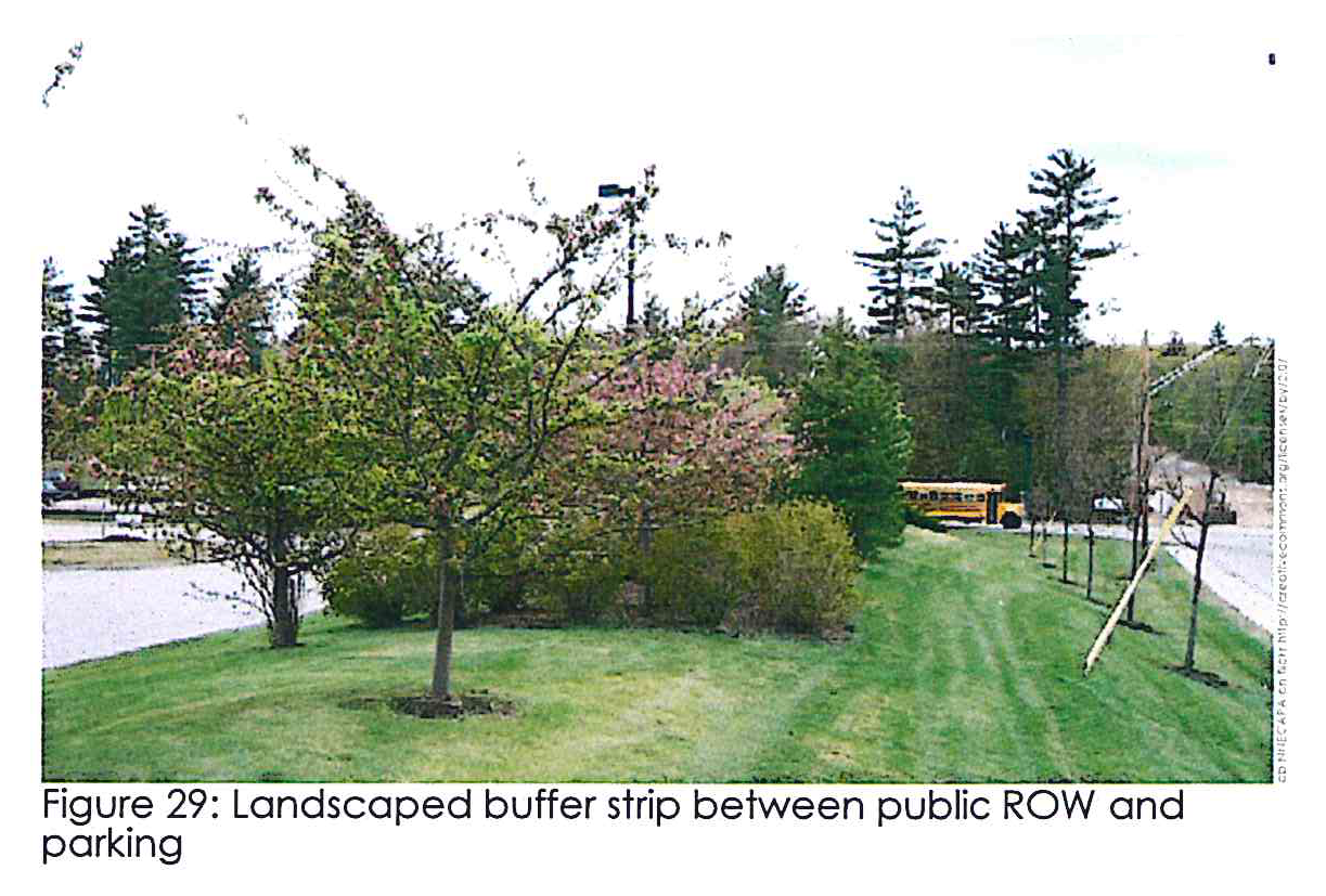
Landscaped buffer yards. A minimum landscape strip 20 feet wide is required adjacent to the public ROW. These areas shall incorporate a mix of trees, shrubs, and flowers to provide a multi-layered attractive element that softens the otherwise hard industrial appearance (see Figure 29).
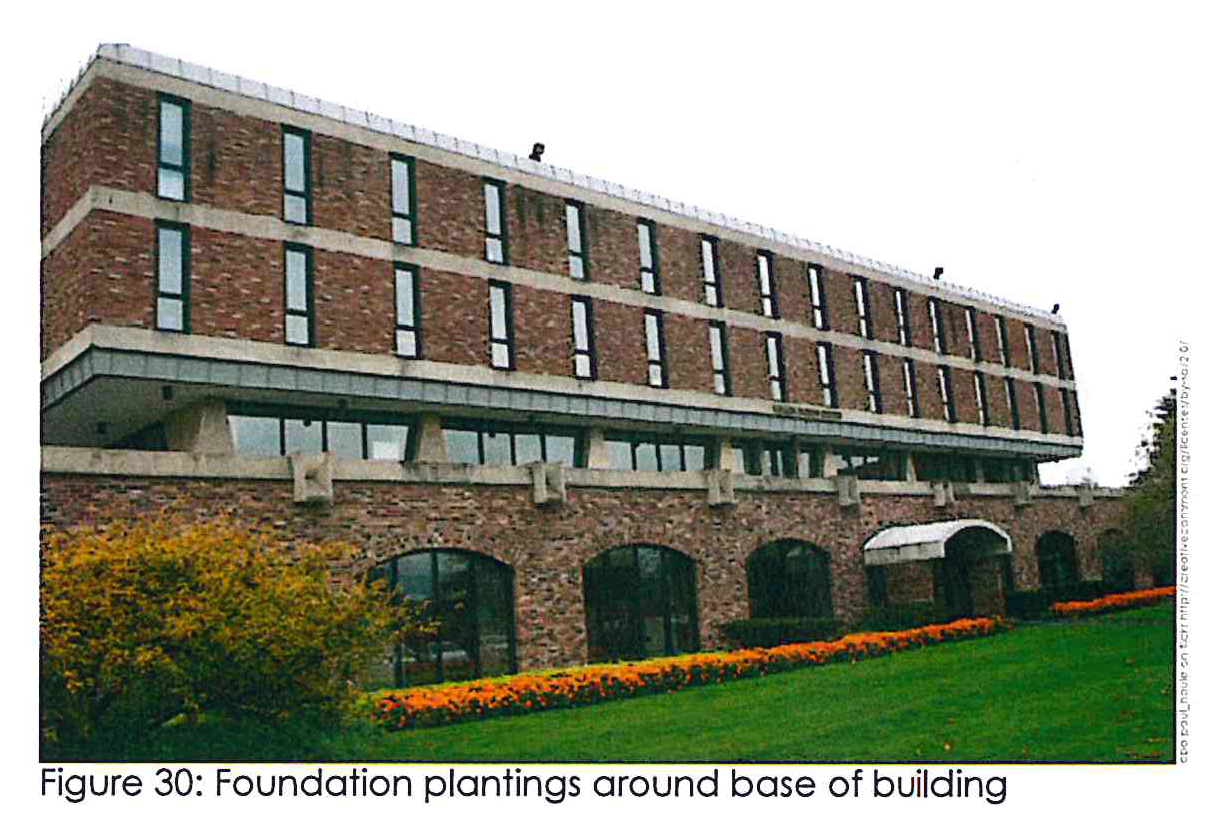
Foundation planting. A minimum five-foot foundation planting strip adjacent to the base of the main structures facing a public street shall be required (see Figure 30).
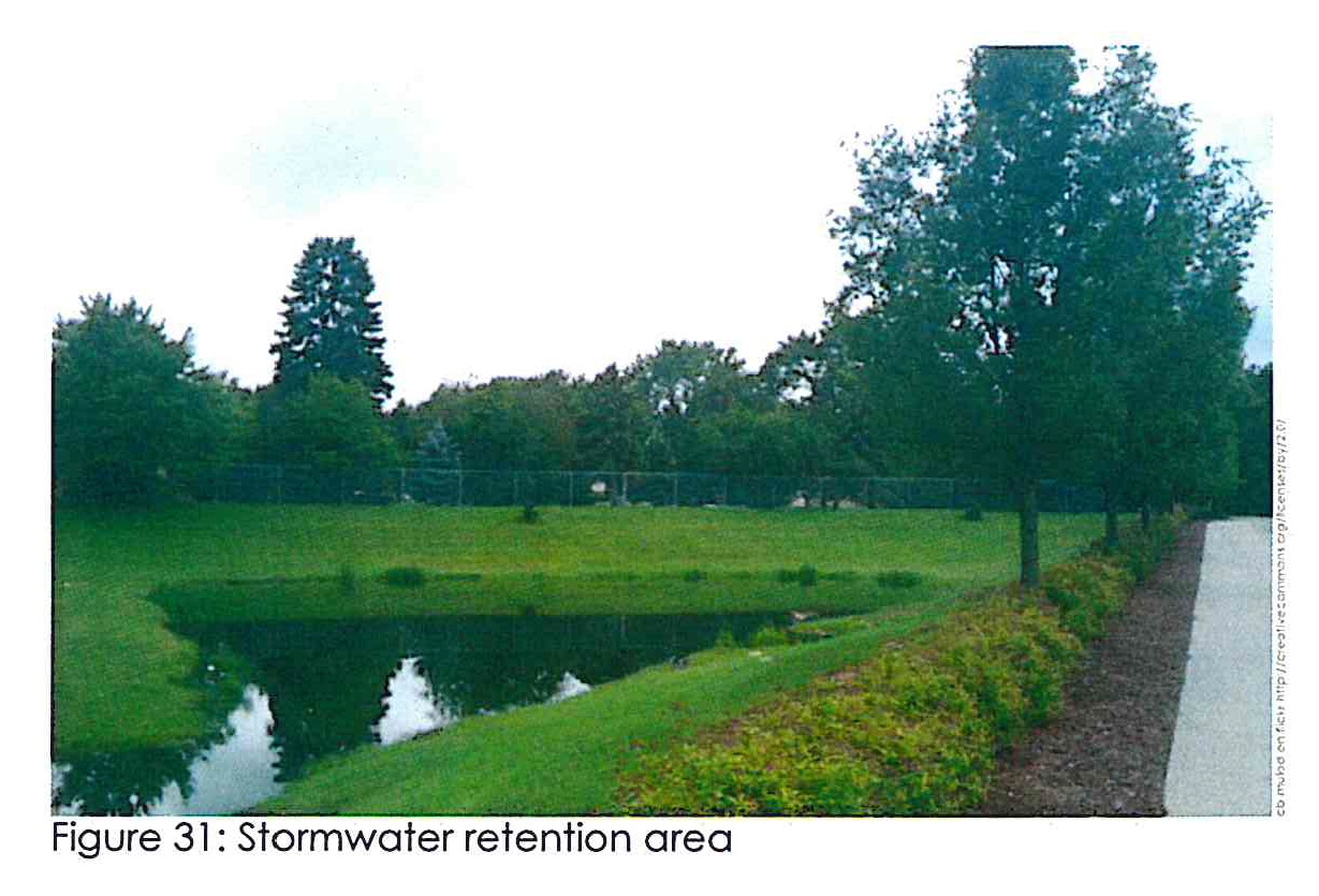
Detention/retention areas. Detention areas may be located within the required landscaped buffer yards as long as the required amount of planting material provided meets the standards for both buffer yards and detention/retention areas. A good example can be seen in Figure 31.
Street trees. Street trees shall be required to be planted at no less than 60 feet intervals along the entire property fronting all streets. Street trees may be placed in the right-of-way or, at a maximum of ten feet outside the street right-of-way if necessary given available right-of-way and visibility considerations including clear zone requirements.
3A.06 - Screening uses.
All working areas should be hidden from view of neighboring properties.
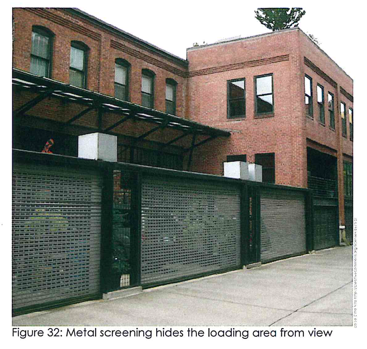
Screening of working areas. Storage areas, trash and recycling dumpsters, mechanical equipment, loading areas, and other work areas should be screened with fencing materials and landscaping where appropriate.
3A.07 - Signage.
Industrial areas should be able to promote themselves in a tasteful way.
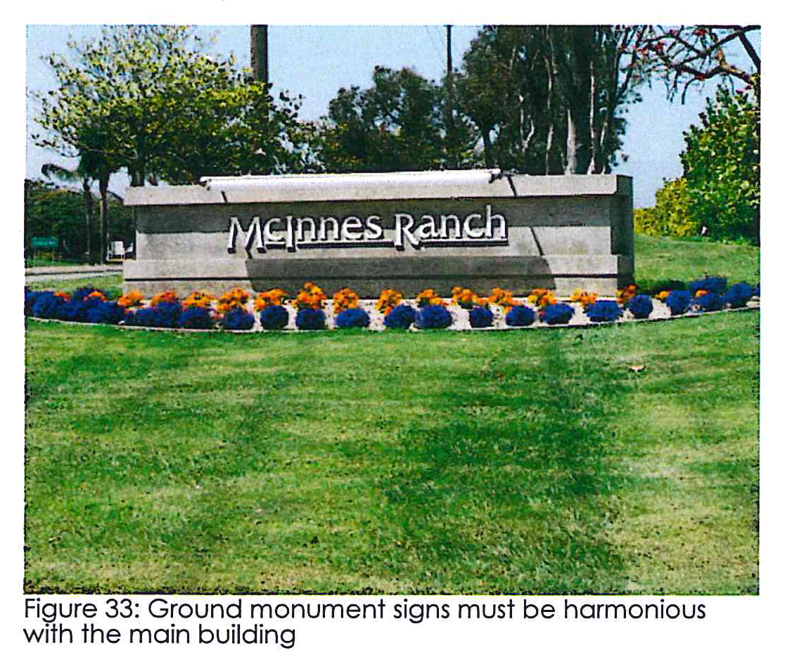
Entrance and ground signs. Sites with shared access are encouraged to use one entrance sign. As a matter of safety, entrance and ground signs must respect GDOT clear-zone restrictions. Entrance and ground signs shall be constructed of similar materials and color to that of the primary building and shall be landscaped around the sign base with low-lying shrubs and plants (see Figure 33). Lighting of entrance and ground signs shall be external illumination, internally illuminated signs and/or lettering shall be prohibited.
Directional signs. Directional signs are encouraged and shall be provided at one per vehicular access point, with a maximum sign area of six square feet and a maximum height of three feet.
3B.01 - Building design.
Industrial buildings should appear to be more than just a giant box.
Building materials. The following materials are prohibited on an industrial building facade fronting a county road or state highway: Corrugated and/or sheet metal siding; prefabricated steel panels; smooth-face concrete block; un-textured tilt-up concrete panels; plywood; vinyl siding; and synthetic stucco.
Entrances. Primary building entries shall be oriented toward the predominant public view, readily identifiable, and well defined through the use of projections, recesses, columns, roof structures, or other design elements.
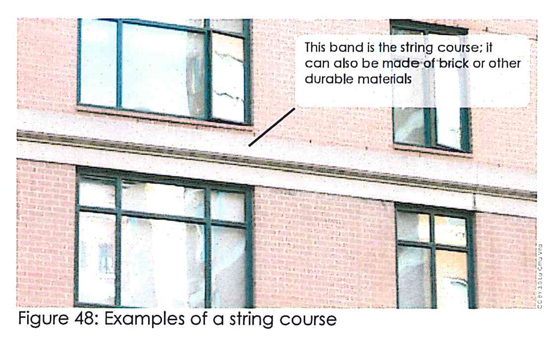
Horizontal articulation. Street-facing building facades shall be horizontally divided at least every 20 feet using architectural means such as string courses, recesses, cornice lines, reveals or the like. There must be at least one horizontal division on every building facade.
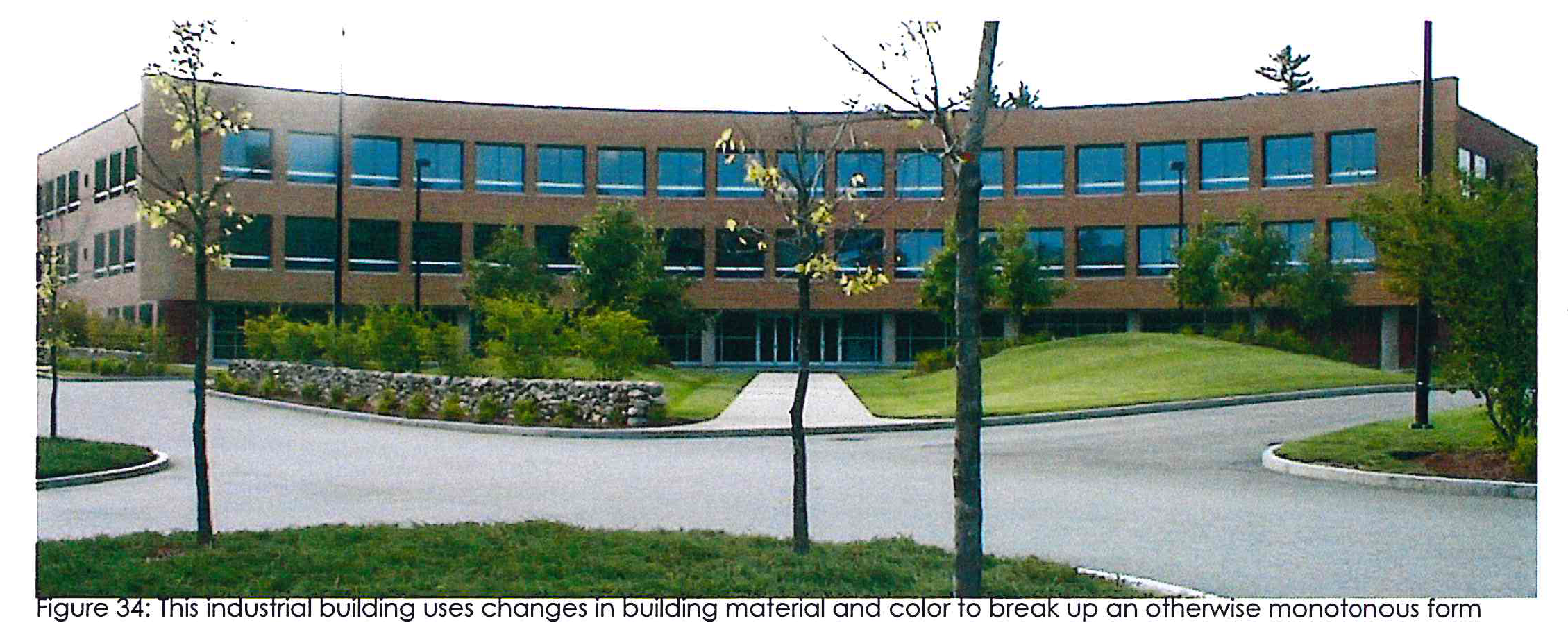
Vertical articulation. Street-facing building facades shall also be vertically divided utilizing major and minor articulations to create visual interest and avoid monotony. Major articulations shall occur at least every 120 feet of horizontal facade length. Major articulations may be accomplished through: A change of facade materials extending from grade through the cornice; physical offsets; and/or similar means intended to convey the impression of separate buildings. Minor articulations shall occur approximately every 60 feet of horizontal facade length and may be accomplished by: The use of pilasters; the use of smaller offsets; or similar means intended to create the appearance of structural bays. See Figure 34 for an industrial example.
Windows. All public street-fronting first stories shall have windows that shall be of clear, unpainted or similarly treated glass to allow views of building interior.
Rooftop mechanical equipment. Any mechanical equipment located on the roof of a building shall be as inconspicuous as possible from the right-of-way of the public road or state highway by the building roof, a parapet wall or by other screen approved by the zoning administrator. In the case of flat roofs, equipment may be located within a roof depression to comply with this requirement. If the elevation of the road or state highway is higher than the building and such screening cannot be accomplished, or in other cases where such screening is not feasible in the zoning administrator's opinion, equipment shall be painted to minimize its visibility.
Accessory buildings. Buildings accessory to the primary structure shall be designed to resemble that of the primary building with respect to architecture, materials, color, mass, and scale.
4A.01 - Street and sidewalk requirements.
Streets should be designed to allow all users to benefit.
Please be sure to refer to the "Butts 1-75 Overlay Development Standards Table" and to the "Butts 1-75 Overlay Site Standard Table."
Block size. Mixed-use areas are encouraged to be divided into blocks with a grid street pattern to allow multiple alternatives routes for transportation. The maximum block size fronting on State Highways 16 and 36 and the 1-75 frontage road, measured from road center line to road center line, shall be 1,000 feet. The maximum block size fronting on collector and local roads, measured from road center line to road center line, shall be 500 feet.
Service functions. Service functions such as deliveries or maintenance activities shall be integrated into the circulation pattern in a manner which minimizes conflicts with vehicles and pedestrians. On development sites of 15 acres or more, office and commercial developments shall have service and loading areas separate from main circulation and parking areas.
Interconnection. To promote interconnection culs-de-sac and other dead-end roads are prohibited, instead developers are encouraged to create blocks as referenced above. In cases where life safety is concerned, a dead-end may be granted by written approval from the zoning administrator.
Sidewalks. Sidewalks at least ten feet in width shall be provided on both sides of the street in mixed-use areas, except along the frontage road. In addition, a five-foot planting strip shall be provided from the back edge of the curb to the sidewalk. This area shall be landscaped with a mixture of ground cover and street trees.
Street trees. Street trees shall be required to be planted at no less than 50-foot intervals along the entire property fronting all streets. Street trees may be placed in the right-of-way or, at a maximum of ten feet outside the street right-of-way if necessary given available right-of-way and visibility considerations including clear zone requirements.
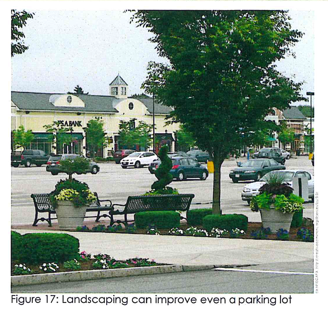
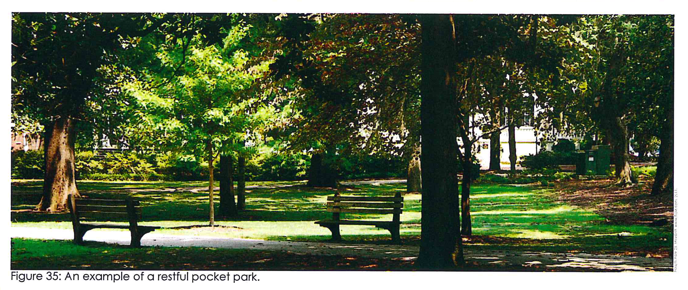
Open space. For fixed-use subdivisions of more than three acres, the developer shall set aside ten percent of the land to be used as an amenity area or green space open to the public. This area shall be centrally located to maximize accessibility and shall include pedestrian accommodations such as lighting, benches, and trash and recycling receptacles as appropriate. An example of a mature park that could result from the open space requirement can be seen in Figure 35.
4A.02 - Parking requirements.
Parking is necessary, but must be designed for visual interest.
Off-street parking. Off-street parking shall be provided on every lot on which any permitted or conditional use is established in accordance with the zoning ordinance.
•
One row of angled parking may be located between the street and the primary building. The remaining required parking spaces shall be located to the side and rear of the building.
•
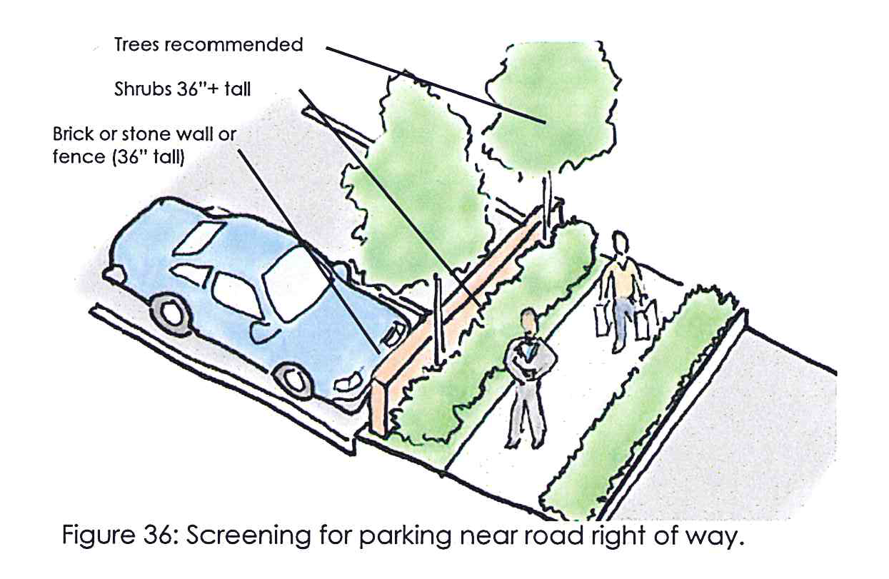
Parking screening. Any parking adjacent to the right-of-way must be screened by opaque shrubbery at least three feet in height when planted or by a masonry wall or fence measuring 36 inches high (see Figure 36). Parking lots over 50 spaces must provide pedestrian paths at least five feet wide towards the main entrance of the primary building and pedestrian crossing areas where such paths intersect with vehicular roads.
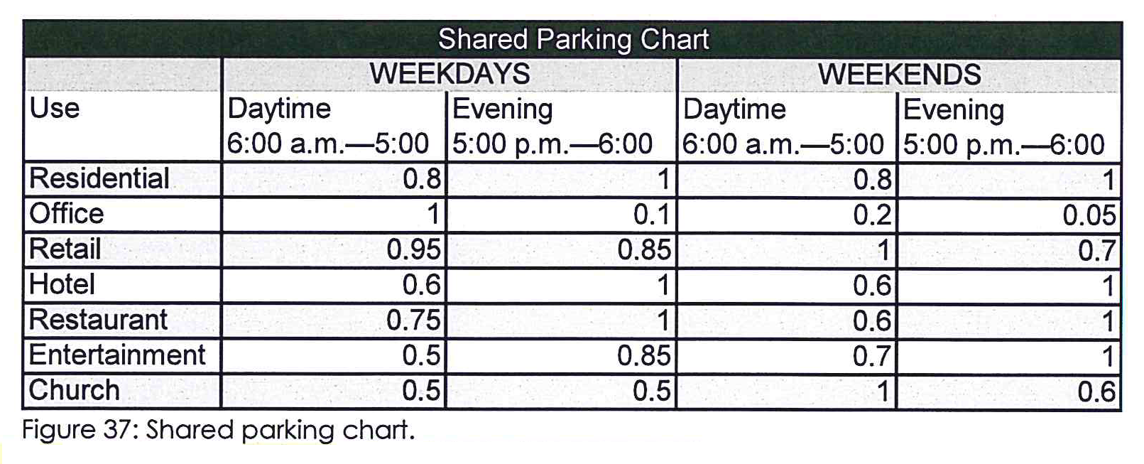
Shared parking. The zoning administrator may approve a reduction in the number of parking spaces required for a specific use where inter-parcel access is provided and a shared parking analysis, which is approved by the zoning administrator, demonstrates that adequate parking will be provided.
•
Per the table below, a shared parking calculation projection shall be provided that demonstrates that each use will have adequate parking provisions at all times. The process for determining the minimum parking requirements for a mixed use development or for contiguous properties containing multiple uses is:
•
Determine the minimum number of parking spaces required for each use category from division XXX of this zoning ordinance. If the use is undetermined at the time of construction, one space shall be provided for each 300 square feet of floor space.
•
Multiply each parking requirement by the corresponding percentage for each of the time periods shown on Figure 37.
•
Total the number of parking spaces for each of the time periods (add together the numbers in each column).
•
The largest column total is the minimum shared parking requirement for the development or collectively for the contiguous properties.
•
In no case shall parking spaces that are farther than 1,000 feet from a building entrance be counted towards shared parking requirements.
4A.03 - Parking landscaping requirements.
Streets should be designed to allow all users to benefit.
Parking landscaping. All parcels requiring off-street parking spaces shall contain landscaping and planting as follows (these items listed below are inclusive to the 60 tree density units per acre):
•
One shade tree for each seven spaces around the perimeter of the parking lot. Landscaped area shall be a minimum of ten feet wide.
•
One shade tree for each seven spaces in the interior of the parking lot. No parking space shall be more than 70 feet from any shade tree. Size of tree islands will be at least ten feet in width, which can be reduced, as determined by the county arborist and engineer, if permeable surfacing is employed.
•
Each tree shall be at least two-inch caliper and six feet in height at time of planting.
•
The minimum planting area or pervious area around each tree shall be 100 square feet.
•
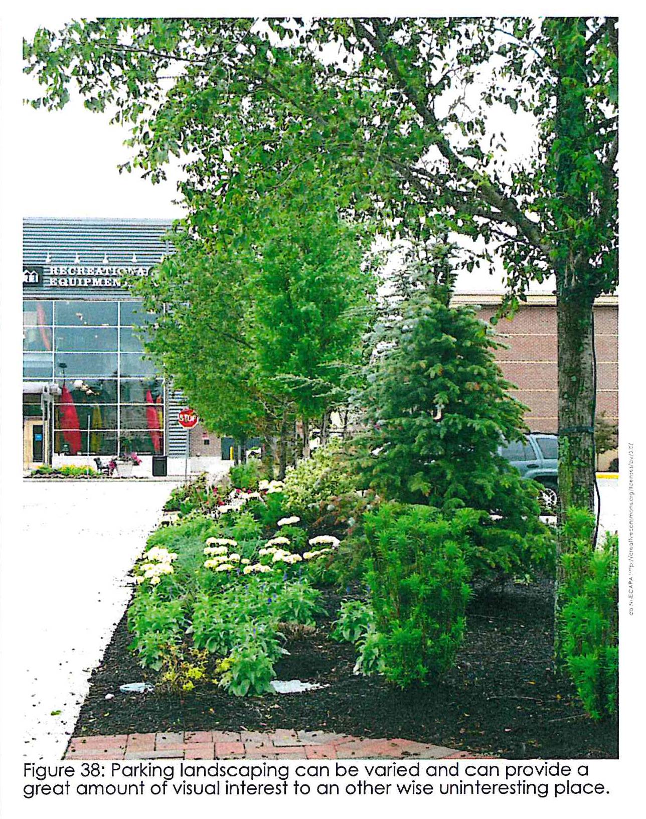
Trees shall be planted in landscaped strips surrounding the perimeter of the parking lot and shall be planted in planting areas or islands internal to the parking lot. An example of an internal island can be seen in Figure 38. Perimeter planting strips shall be a minimum of ten feet wide.
•
Ground areas shall be sodded, seeded or hydro-seeded with grass and/or planted with shrubs and/or ground cover species, and/or provided with oilier landscaping material or any combination thereof.
•
Planting areas may be recessed below the grade of parking surfaces with curb breaks on upgrade side of planting areas in order to allow natural irrigation of landscape material and percolation of runoff.
•
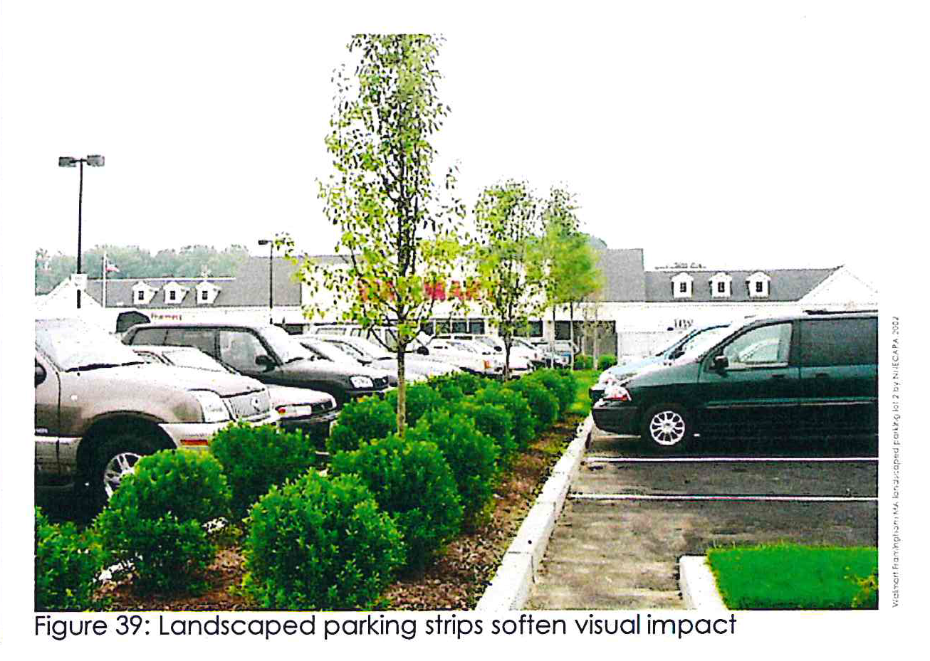
For parking lots with more than three parallel aisles, there shall be a continuous planting area at least eight feet wide and 15 feet long between alternate rows of opposing spaces. An example of this can be seen in Figure 39.
•
Each lot or development shall contain a minimum of 50 gallons of shrubs per acre.
•
Balance of lot area is to be seeded, sodded, hydro-seeded, or stabilized with other landscape materials.
4A.04 - Bicycle parking.
To encourage people out of their cars, bike spaces need to be provided.
Bicycle parking. All non-residential uses that are required to provide off-street parking spaces for motorized vehicles shall also provide bicycle parking spaces. Uses that require up to 50 off-street parking spaces for motorized vehicles shall provide at least one bicycle rack (two spaces), plus one more bicycle rack for each additional 50 parking spaces required for motorized vehicles.
•
Multi-family residential developments shall provide a minimum of one bicycle rack (two spaces) for up to ten dwelling units and one additional rack per each additional ten dwelling units.
•
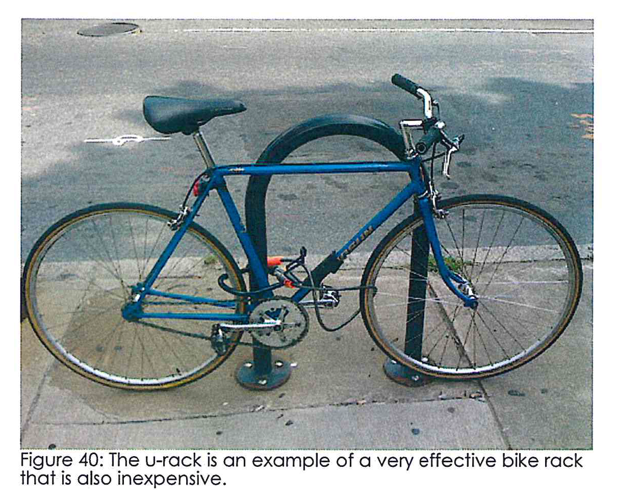
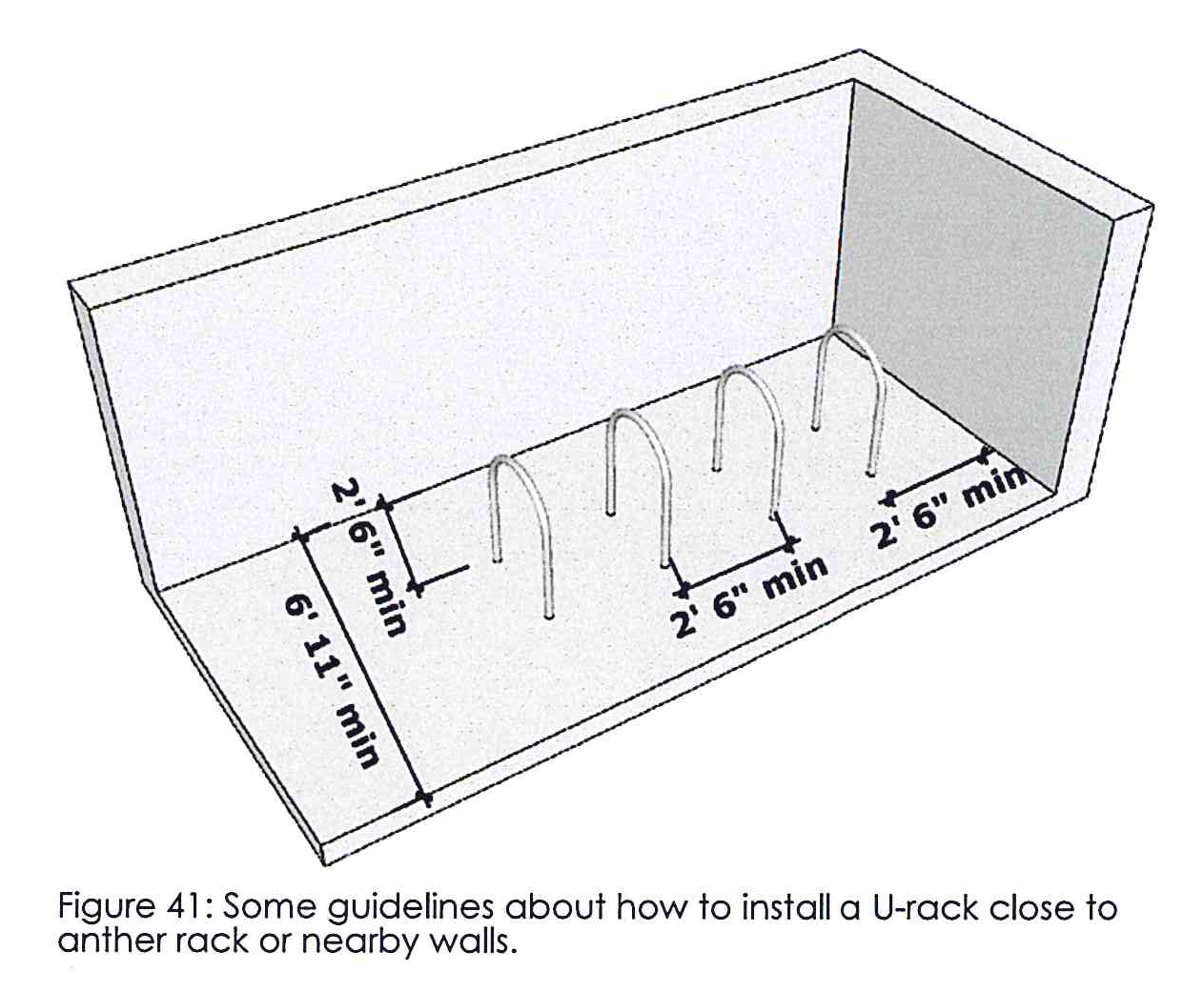
Bicycle spaces shall consist of one or more inverted U-racks parallel to one another anchored into concrete 30 inches apart and 30 inches away from nearby walls or obstacles, providing a clear length of at least 83 inches for easy access in and out. Each rack shall count as two bicycle spaces.
•
The zoning administrator may permit other styles of bicycle racks provided they meet similar criteria of durability and security.
•
No single bicycle parking area should exceed ten racks or 20 spaces or impede normal pedestrian flow.
•
It is recommended that the bicycle parking area be located within 100 feet of the facility entrance, preferably visible from that entrance. In no case shall the bicycle parking be further than 200 feet from the entrance.
4A.05 - Parking.
Parking is necessary, but should be shielded from view and made as visually appealing as possible.
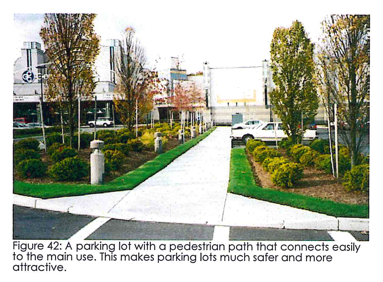
Paths. Surface parking shall provide safe pedestrian passage by incorporating an efficient system of pedestrian paths at least five feet wide (see Figure 35). Buildings that locate their parking in front must provide a crosswalk to connect the public sidewalk to the sidewalks adjacent to the building entrance (see Figure 42).
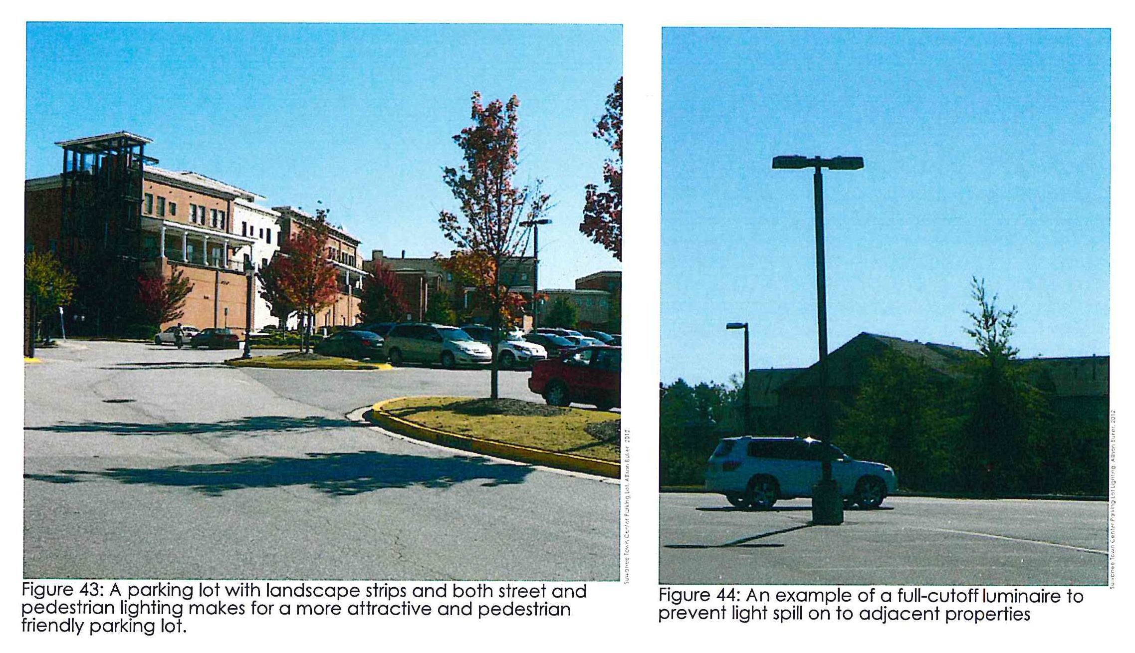
Illumination. Parking lots and structures shall follow basic Illuminating Engineering Society (IES) guidelines by providing even lighting of at least 0.2 foot-candles of horizontal intensity, but no more than four foot-candles (one foot-candle average). As seen in Figure 43, full cutoff luminaires shall be used to prevent wasted light, but do no need to dominate the parking lot. Parking lot and street light posts shall not exceed a height of 32 feet from finished grade (see Figure 44).
4A.06 - Site design.
Parcels with needs for loading zones and dumpster should use proper screening.
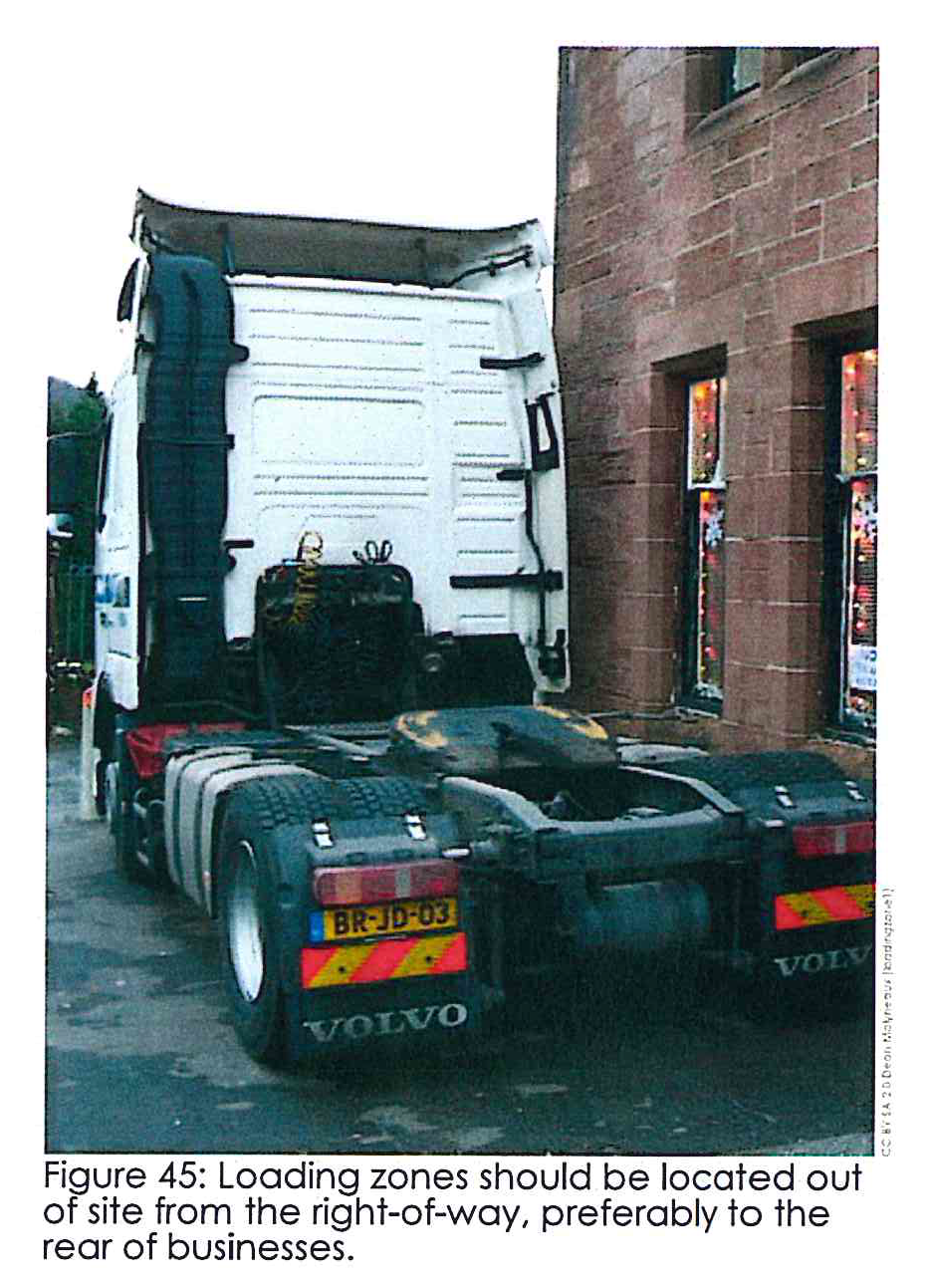
Location of loading areas. Loading areas shall be located to the rear of the building unless site design precludes a rear location, in which case loading shall be to the side of a building. Loading areas, at the determination of the zoning administrator, shall be permitted within front yards only if undue hardship can be shown.
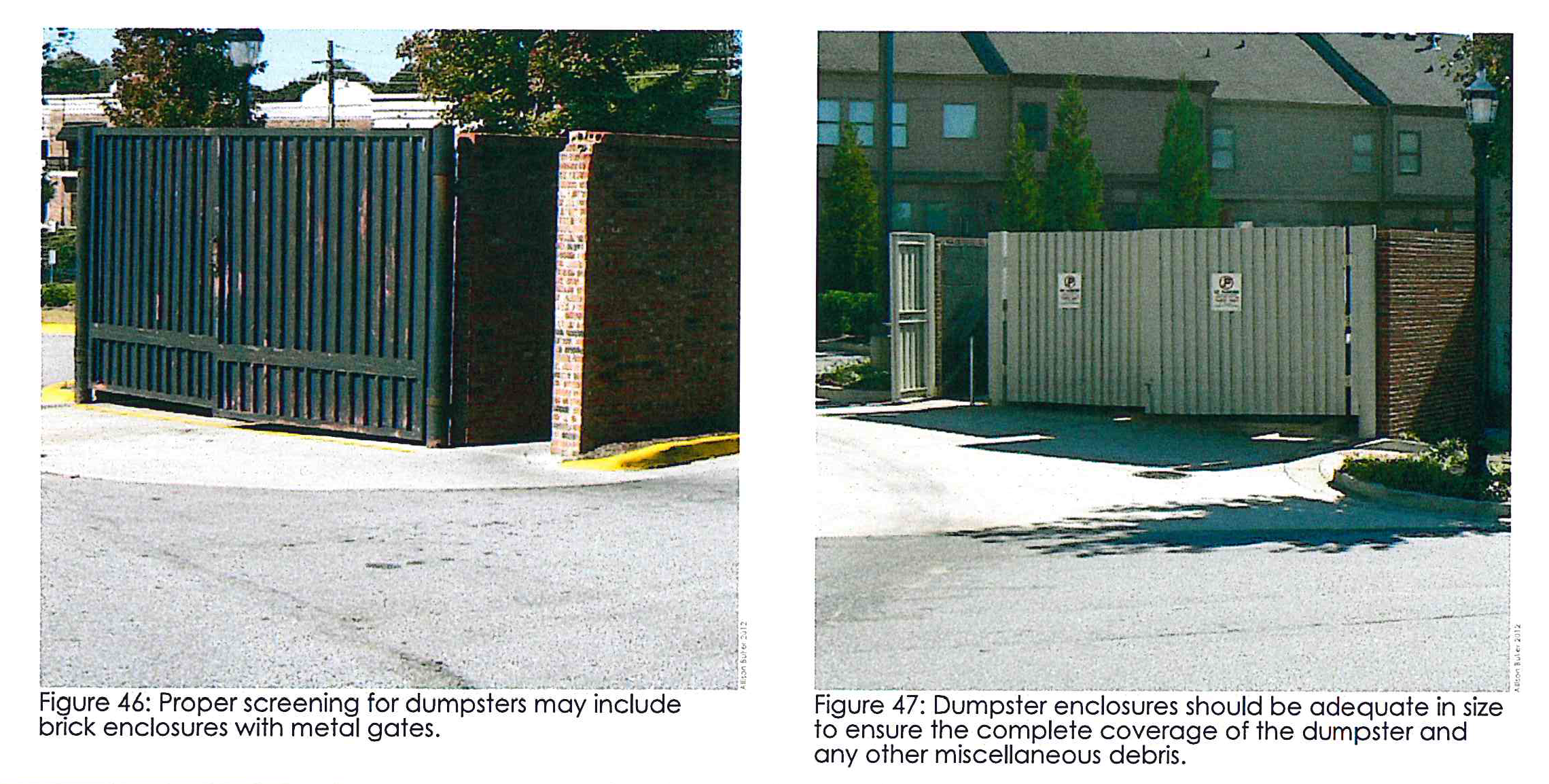
Trash enclosures. Trash enclosures shall be constructed of sturdy, durable, opaque materials making it so trash receptacles are completely screened from view. These enclosures should be similar to or designed to be compatible with the surrounding architecture. Trash enclosures should include adequate, accessible, and convenient areas for collecting and loading recyclable materials. Space should be provided within enclosures for pallets, skids, cartons, etc., and no overflow of these or other debris shall be allowed in public view (see Figure 46 and Figure 47).
4B.01 - Mixed-use building requirements.
Mixed-use buildings should be particularly pedestrian oriented.
Building materials. The following materials are prohibited fronting a county road or state highway: Corrugated and/or sheet metal siding; prefabricated steel panels; smooth-face, split or ground face concrete block; tilt-up concrete panels; and synthetic stucco. Steel or other metals shall not be used on building exteriors, except as may be necessary for roofing, window trim, gutters, and downspouts.
Primary entrances. Primary entrances, and individual tenant space entries, shall be designed to express greater architectural detail through the use of awnings, recessed areas, a change in material, variations of the material patterning, or other similar techniques.
Horizontal articulation. Street-facing building facades shall be horizontally divided at least every third floor using architectural means such as string courses, recesses, cornice lines, reveals or the like. There must be at least one horizontal division on every building facade.
Vertical articulation. Street-facing building facades shall also be vertically divided utilizing major and minor articulations to create visual interest and avoid monotony. Major articulations shall occur at least every 60 feet of horizontal facade length or at changes between tenants. Major articulations may be accomplished through: A change of facade materials extending from grade through the cornice; physical offsets; and/or similar means intended to convey the impression of separate buildings. Minor articulations shall occur approximately every 30 feet of horizontal facade length and may be accomplished by: The use of pilasters; the use of smaller offsets; or similar means intended to create the appearance of structural bays.
Effective mixed use buildings should create interest for pedestrians and drivers.
Windows. All street-fronting first stories shall have windows that meet the following requirements along the portion of the building fronting a public street or public sidewalk.
•
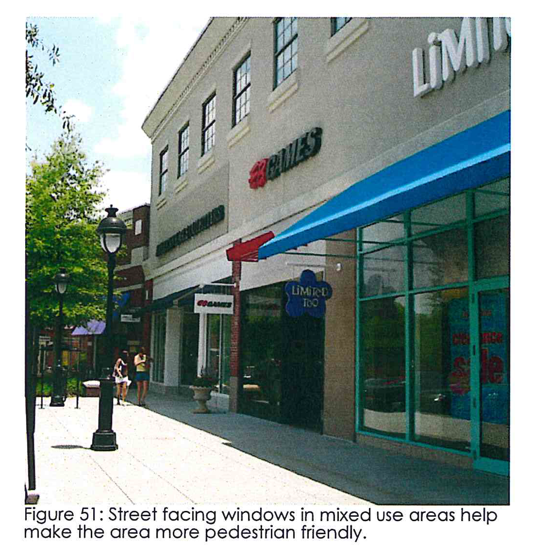
Windows shall be of clear, unpainted or similarly treated glass to allow views of store interior or display windows. Figure 51 has appropriate windows for this requirement.
•
Windows shall be located along a minimum of 60 percent of the linear measure of street frontage. Windows shall start a maximum of three feet above the sidewalk.
•
The maximum facade length without windows shall be 20 feet.
•
Glass doors and display cases may count towards window requirements.
•
Hospitals, hotels, townhouses, and multi-family residences' first stories rewire windows for a minimum 20 percent of first floor facade area, primarily arranged in a grid.
•
All building stories above the first story shall have windows that equal a minimum of 20 percent of the total facade area, with each story being calculated independently. Additionally, all street-facing upper story windows shall be predominately arranged in a grid, subject to individual window variation.
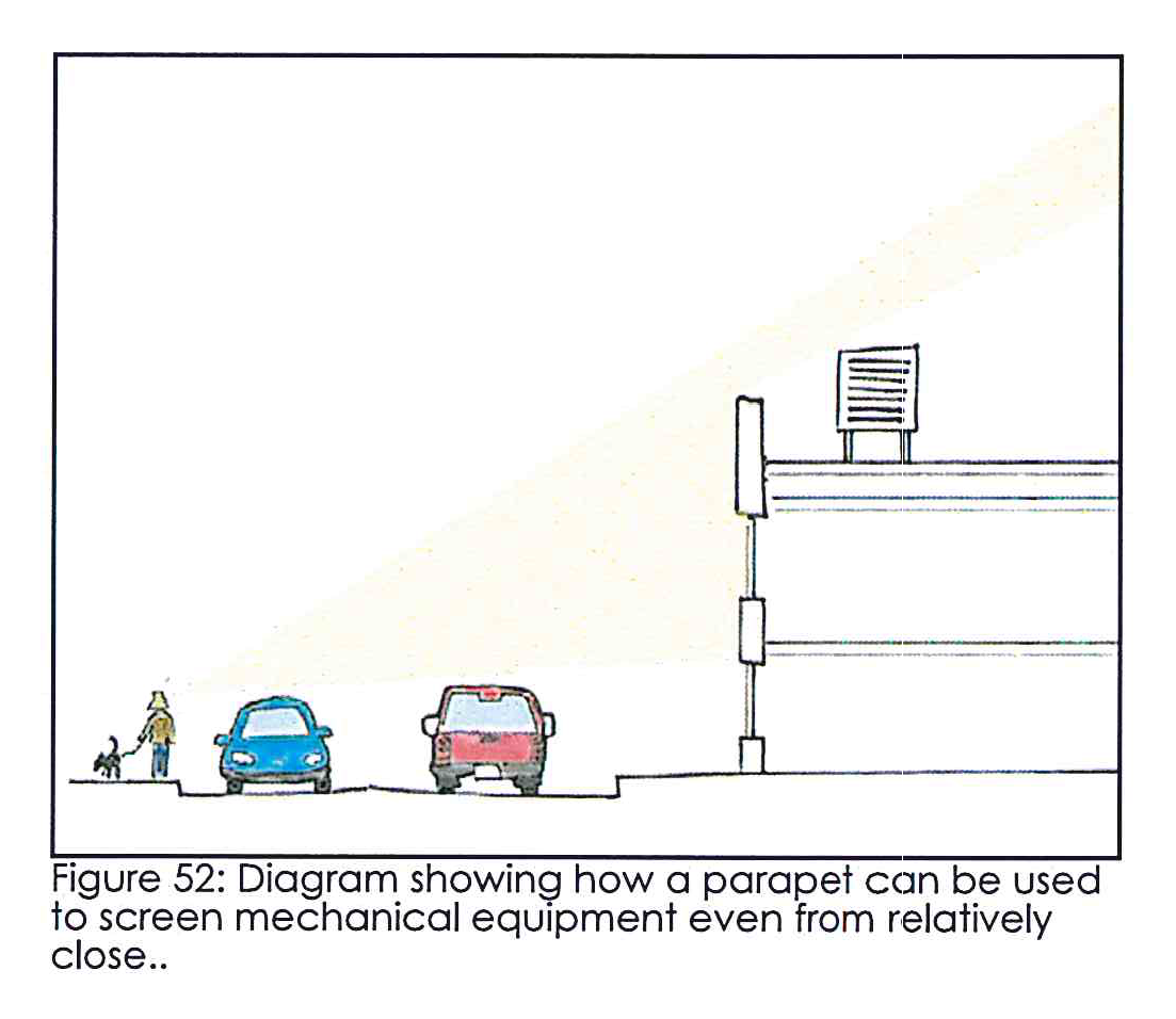
Rooftop mechanical equipment. Any mechanical equipment located on the roof of a building shall be as inconspicuous as possible from the right-of-way of the public road or state highway by the building roof, a parapet wall or by other screen approved by the zoning administrator (see Figure 52). In the case of flat roofs, cooling and air handling equipment may be located within a roof depression to comply with this requirement. If the elevation of the road or state highway is higher than the building and such screening cannot be accomplished, or in other cases where such screening is not feasible in the zoning administrator's opinion, equipment shall be painted to minimize its visibility.
Building height and massing. In mixed-use centers, the development of a complex of buildings is preferable to a single large structure because the varied massing provides visual interest and human scale. Additionally, the spaces created between the various buildings provide opportunities for pedestrian plazas, courtyards and other outdoor gathering areas. Buildings should try to maintain harmonious height differences between individual buildings.
4B.02 - Standards for building entrances.
Buildings should invest in visual appealing and noticeable entrances in order to attract business.
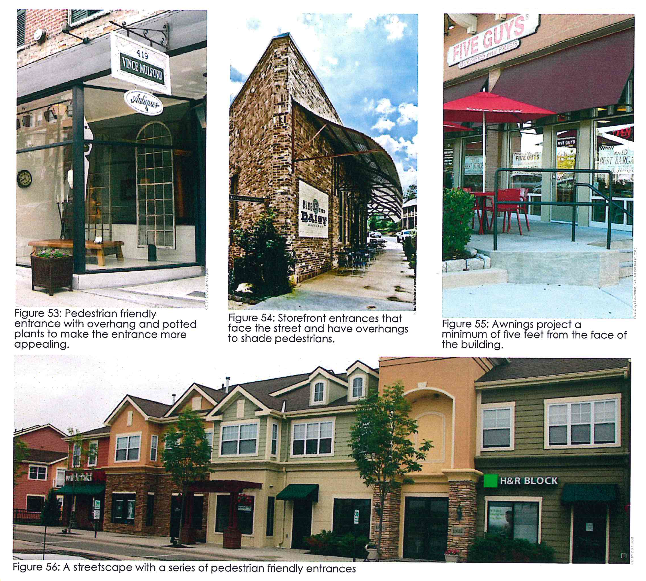
Entrances. All first story uses shall have a primary pedestrian entrance, which faces, is visible from, and is directly accessible from the sidewalk (see Figure 53, Figure 54, and Figure 56).
Coverings and awnings. Storefront canopies and/or awnings should measure at least five feet in depth extending over the sidewalk. These should be architecturally consistent with the building and roofed with glass, metal, or fabric wholly supported by brackets or cables attached to the building facade. Columns to support canopies are not permitted in the public right-of-way. Awnings and canopies should only include signage when such signage is located within an apron that is less than 12 inches in height and is subject to all other applicable sign requirements of the county.
5A.01 - Rural site design standards.
The rural neighborhood should be walkable and close-knit.
Please be sure to refer to the "Butts I-75 Overlay Development Standards Table" and to the "Butts I-75 Overlay Site Standard Table."
Block size. Rural neighborhood areas are encouraged to be divided into blocks to allow multiple alternative routes for transportation. The maximum block size, measured from road center line to road center line, shall be 500 feet.
Interconnection. To promote interconnection culs-de-sac and other dead-end roads are prohibited, instead developers are encouraged to create blocks as referenced above. In cases where life safety is concerned or undue hardship from crossing a wetland or stream, a dead-end may be granted by written approval from the zoning administrator.
Lot size. The rural neighborhood area allows a minimum lot size of 10,890 square feet for single-family houses.
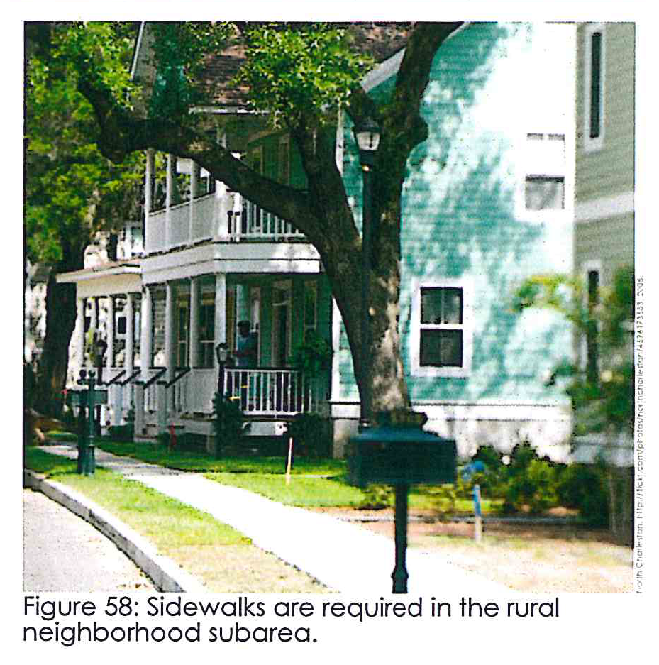
Sidewalks. Sidewalks at least five feet in width shall be provided on both sides of the street in rural neighborhood areas. In addition, a four-foot planting strip shall be provided from the back edge of the curb to the sidewalk (see Figure 58). This area shall be landscaped with a mixture of ground cover and street trees.
Street trees. Appropriate street trees shall be provided within the planting strip every 40 feet on center.
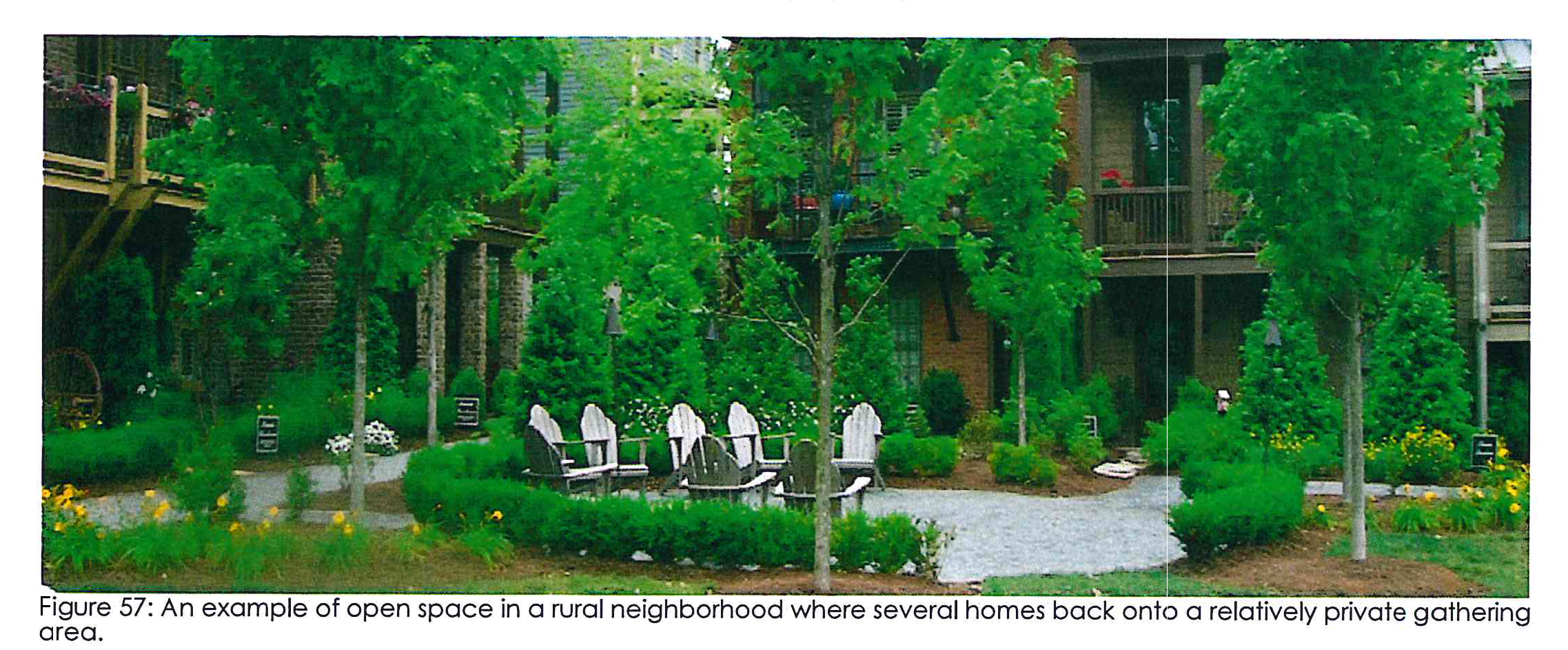
Open space. For rural neighborhood subdivisions of more than three acres, the developer shall set aside ten percent of the area in a common area as a park or other public amenity that is located to maximize accessibility by as many residences as possible. Said public amenity shall include pedestrian accommodations such as lighting, benches, and trash and recycling receptacles as appropriate. An example of a gathering space can be seen in Figure 57.
5A.02 - Residential yard standards.
Setting clear boundaries and screening mechanical areas can make a neighborhood look much better.
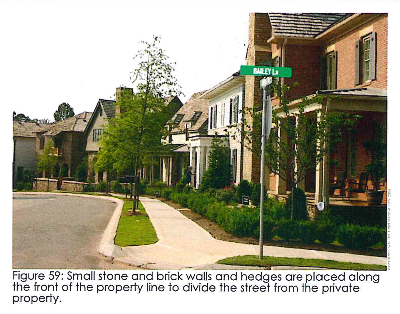
Frontage. The use of small walls, fences, or hedges along the property line adjacent to the street are encouraged to physically divide the street from private property (see Figure 59). Walls should be composed of brick or stone of a color and type harmonious with the main building and reach a height of 30 inches, while shrubs should have a minimum mature height of 24 inches and a maximum height of 30 inches. Fences should be wood finished to complement the main building and reach a height of no more than 30 inches.
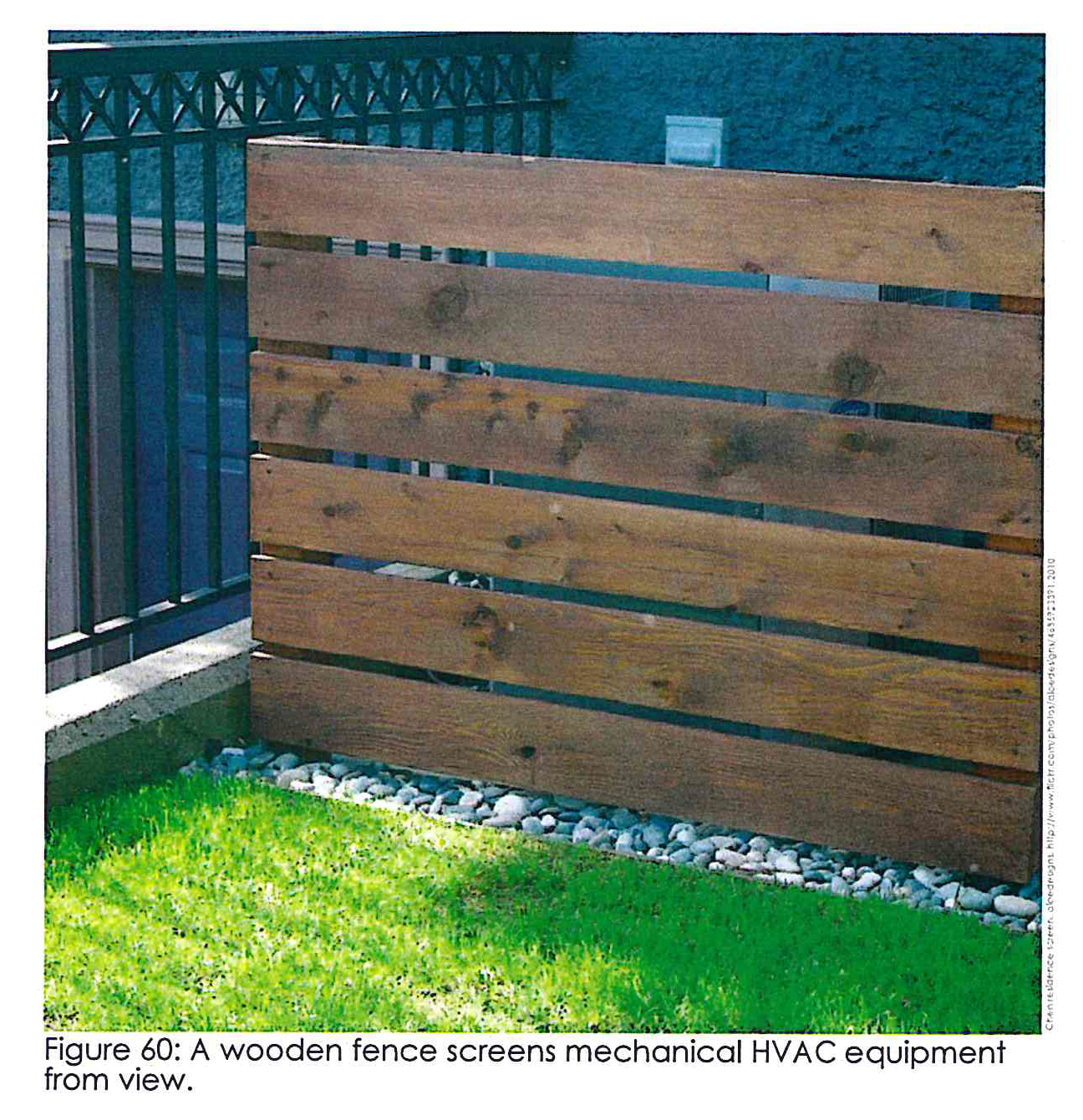
Mechanical equipment. All mechanical equipment, including HVAC and similar systems shall be screened from street level view on three sides by an opaque wall or fence constructed of brick, stucco, split-face block or wood (see Figure 60). A vegetative screen is permissible if the screen uses 100 percent evergreen materials at least two plants deep.
5B.01 - Rural building design standards.
The rural neighborhood should have appropriately scaled attractive houses.
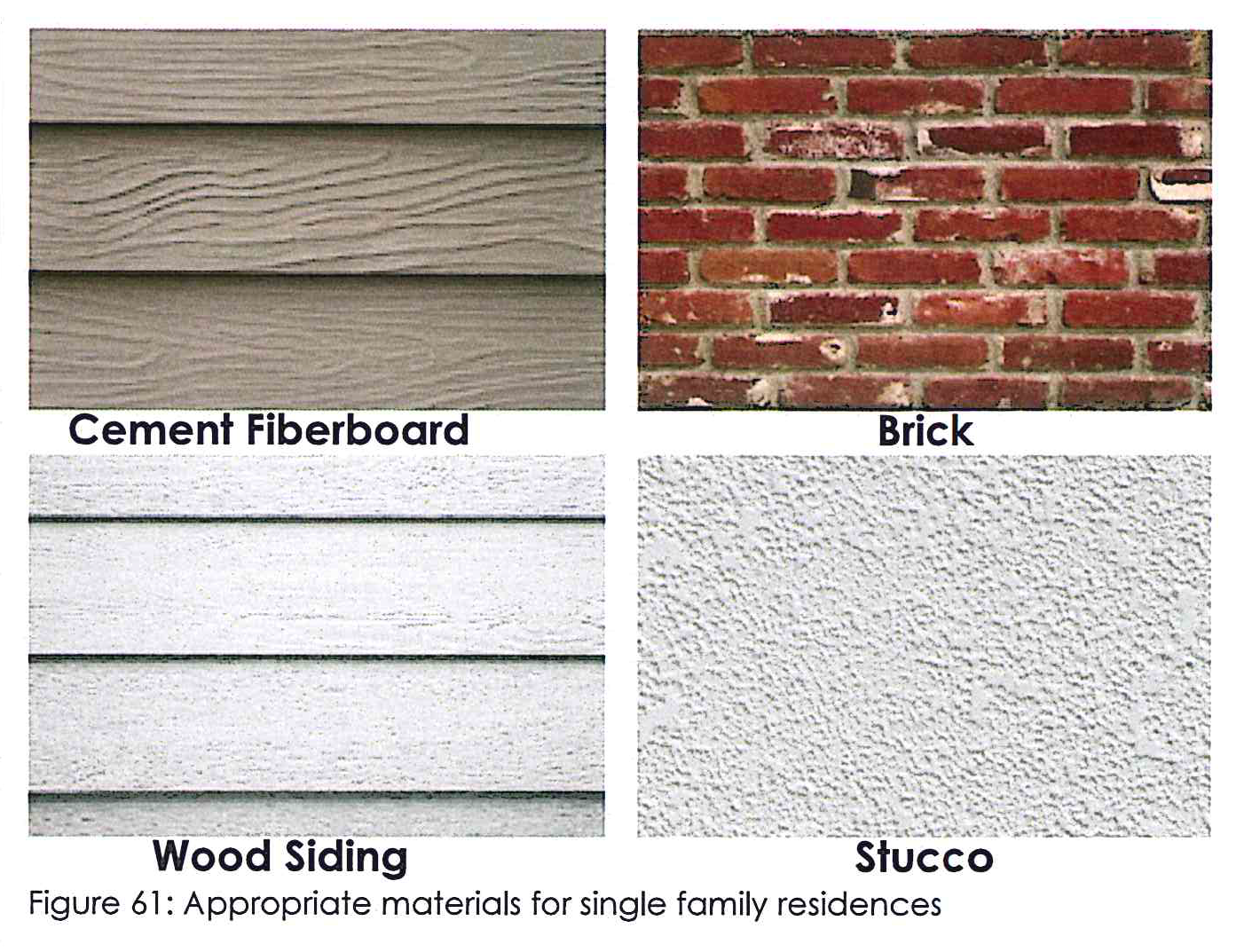
Building materials. The following materials are prohibited: corrugated and/or sheet metal siding; prefabricated steel panels; smooth-face, split or ground face concrete block; tilt-up concrete panels; vinyl siding; exterior insulated finishing systems (EIFS); and synthetic stucco. The following materials are encouraged: brick, stone, stucco, and cement board siding (see Figure 61).
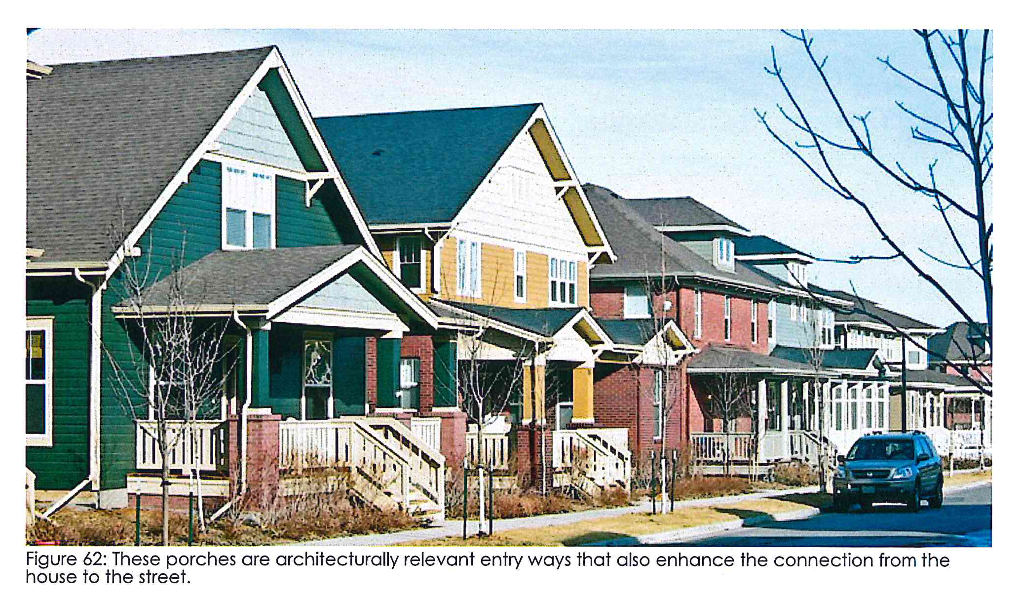
Entry ways. All residential entry ways shall be covered. The actual style of covering (e.g., porch, awning, etc.) can be determined by the architectural style (see Figure 62).
Chimneys. Chimneys shall be veneered in stone, brick, or stucco.
Garages. Garages whether attached or detached shall not face the street; instead garages shall face the side or rear of the lot.
Foundation. Brick or stone skirting around the entire foundation is recommended if architecturally appropriate.
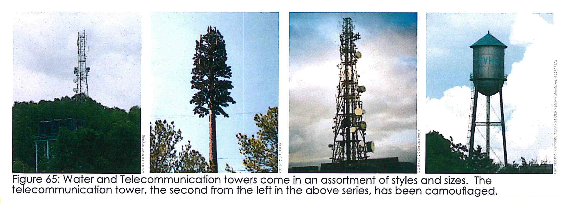
5B.02 - Towers.
Telecommunication towers should be as invisible as possible.
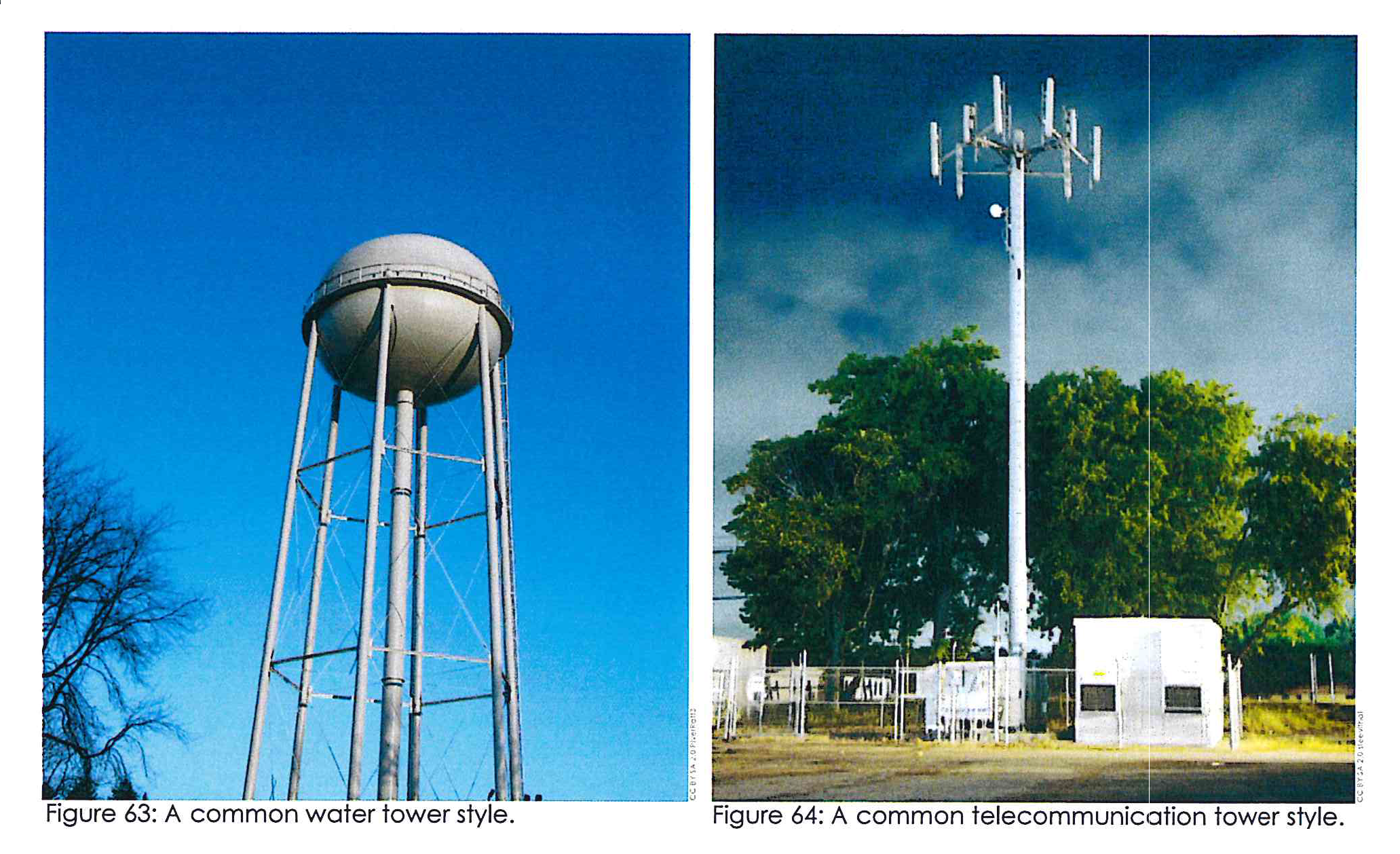
Water towers and telecommunication tower placement. Restrict the location of water towers or cell towers from being placed along ridges or in the middle of open fields (see Figure 63 and Figure 64). The base of towers should be screened with opaque fencing and landscaping.
General requirements for towers. A special land use permit, granted by the board of commissioners, shall be required for the construction of all new communication towers within the county after the following factors are considered (see Figure 65):
•
The proposed height of the tower.
•
Proximity to residential structures and residential district boundaries.
•
Nature of uses on adjacent and nearby properties.
•
Surrounding topography, tree coverage and foliage.
•
Design of the tower, with particular reference to design characteristics which have the effect of reducing or eliminating visual obtrusiveness.