
Butts County Unincorporated
City Zoning Code
City Zoning Code
CHAPTER 4
SITE DESIGN STANDARDS
Sec. 4.00.01. - Purpose.
The purpose of this chapter is to provide design standards applicable to all development activity within the county. This chapter also provides design standards applicable in specific situations, such as development within overlay districts or development of specific uses that require additional standards to address potential impacts.
Sec. 4.00.02. - Development standards in general.
(a)
Suitability of land. Land on which there is a danger to health, safety, or property should not be platted for residential use or other use that will continue or increase such danger when practicable, unless such hazards can be and are corrected. Examples of such conditions are as follows:
(1)
Land subject to flooding, improper drainage, or erosion.
(2)
Land with excessive slope or other physical constraints which make it unsuitable for development.
(b)
Name of subdivision. The name of the subdivision must have the approval of the planning and zoning commission. The name must not duplicate or closely approximate the name of an existing subdivision.
(c)
Access. Except where expressly provided herein, access to every subdivision must be provided over a public street, and every lot within a subdivision must be served by a publicly dedicated street or a private street approved by the planning and zoning commission.
(d)
Conformance with adopted land use plan. Proposed subdivisions should conform with the adopted Butts County land use plan and development policies in effect at the time of submission to the planning and zoning commission. When features of the Butts County land use plan such as sites for schools, public buildings, parks, major streets, or other public uses are located in whole or in part in a proposed subdivision, such features should be either dedicated or reserved by the subdivider for acquisition within a reasonable time by the appropriate public agency.
(e)
Reservation or dedication of public use areas.
(1)
Reservation of plan features. Where the features of the Butts County land use plan such as sites for schools, public buildings, parks, major streets, or other public uses are located in whole or in part in a proposed subdivision, such features must be reserved by the subdivider. However, no more than ten percent of the total area of the subdivision will be required for reservation to fulfill this requirement. Whenever the land required for such plan features is not purchased, acquired, optioned, or condemned by the appropriate public agency within a two-year period from the date of recording of the subdivision or by the time that at least 75 percent of the lots are built on and occupied, whichever is sooner, the subdivider may claim the original reservation and subdivide it in a manner that meets the requirements of this ordinance. Whenever a public body responsible for land acquisition executes a written release stating that the reserved land is not to be acquired, the planning and zoning commission will waive the reservation requirements.
(2)
Reservation omissions. The planning and zoning commission will not approve a subdivision plat when features specified in the Butts County land use plan are not incorporated into the subdivision plat and the reservation requirements for such features have not been waived.
(3)
Unsuitable reservations. Whenever the planning and zoning commission finds that a proposed reservation or dedication of land for public use is not suitable for such public use, it may require the rearrangement of lots to provide suitable land for public use.
(4)
Unnecessary reservations. Whenever the planning and zoning commission finds that a proposed reservation or dedication of land for public use is not necessary, it may permit the rearrangement of lots to eliminate the area proposed for such public use.
(f)
Planned developments. A planned development, including large-scale construction of housing units, streets, and off-street parking facilities, may be approved in accordance with the requirements for planned developments set forth in this ordinance. If the design of the project does not include standard streets, lots, or subdivision arrangements, departure from the normal requirements of this ordinance may be permitted if such deviations are consistent with the intent of this ordinance or are permitted in the requirements for planned developments set forth in this ordinance. If a planned development is to be phased, then each phase shall require a separate application and approval. The developer of such a proposal is urged to consult early with the planning and zoning commission to coordinate, plan, and plat properly.
(g)
Community assets. In all subdivisions, due regard must be shown for all natural features such as large trees, watercourses, historical sites, and similar community assets which will add attractiveness and value to the property if preserved.
Sec. 4.00.03. - Principles of site design and development.
Development design shall first take into account the protection of environmental and natural resources as set forth in chapter 3. All development shall be designed to avoid unnecessary impervious surface cover; to provide adequate access to lots and sites; and to avoid adverse effects of shadow, glare, noise, odor, traffic, drainage, and utilities on surrounding properties.
Sec. 4.00.04. - Applicability.
The design standards set forth in this chapter apply to all development in unincorporated Butts County.
Sec. 4.01.01. - Development standards for subdivision lots.
All subdivision lots established in Butts County must comply with the development standards contained in this ordinance. However, where provisions of the zoning ordinance apply and are stricter, those provisions take precedence. Development standards for lots are as follows:
(a)
Lot lines. As far as practical, side lot lines must be perpendicular or radial to street lines.
(b)
Jurisdictional limits and lot lines. Subdivision lots must not be divided by city or county boundary lines.
(c)
Lot frontage arrangements. Land must be subdivided in a manner that provides each lot in the subdivision with direct abutting access to an existing public street or to an approved private street contained within the proposed subdivision. Each lot must front for at least 60 feet upon an approved street or road. Flag lots are prohibited in subdivisions unless topographic conditions or the shape and orientation of the property to be subdivided make the inclusion of some flag lots necessary. Flag lots are not intended to provide access to other properties so as to circumvent the street and right-of-way requirements of this ordinance. When such a lot is allowed, the street frontage of each panhandle access must be at least 60 feet wide and no more than 500 feet long. No more than two such panhandle access points may abut each other or be closer than 1,000 feet apart. A flag lot is intended only to provide a means of using the rear portion of an extremely deep tract of land for residential purposes.
(d)
Adequate building sites. Each subdivision lot must contain an adequate building site not subject to flooding and outside the limits of existing easements or building setback lines required by this ordinance or any existing ordinance as is appropriate.
(e)
Double or reverse frontage lots. Double and reverse frontage lots, unless required by the planning and zoning commission, are prohibited except where essential to provide separation of residential development from traffic arteries or to overcome specific disadvantages of slope, orientation, or property size. A reserve strip planted with a vegetative screen across which there is no right of access may be required along the line of lots abutting a traffic artery or other such incompatible use.
(f)
Commercial and industrial lots. Size, shape, and arrangement of commercial and industrial lots, where platted and classified as a subdivision, are subject to the approval of the planning and zoning commission.
(g)
Lot remnants. Lot remnants are prohibited. Such remnant areas must be added to adjacent lots, rather than remain as unusable parcels.
(h)
Monuments. Solid steel rods at least one-half inch in diameter or square and two feet long must be set at all street corners, at all points where street lines intersect the exterior boundaries of the subdivision, at angle points in streets, at points of curve in streets, and at points of change of direction in the exterior boundaries of the subdivision. The top of the monument must have an indented cross to identify the finished grade. All other lot corners must be marked with solid steel rods no less than one-half inch in diameter, and at least two feet long, driven so as to be flush with the finished grade.
Sec. 4.01.02. - Design standards for lots.
The following regulations apply to properties in all zoning districts, unless the regulations of a particular zoning district expressly provide otherwise.
(a)
Sight distance. In order to ensure maintenance of adequate sight distances at intersections, no fence, wall, shrubbery, or other obstruction to vision between the heights of three feet and 15 feet above the ground is permitted within 20 feet of the intersection of the rights-of-way of streets or of streets and railroads.
(b)
Applicability to land, buildings, and open space. No building, structure, land, or open space may be used or occupied—and no building or structure or part of a building or structure may be erected, constructed, reconstructed, moved, or structurally altered — unless in conformity with all of the regulations specified for the district in which it is located.
(c)
Every use must be on a lot. No building or structure may be erected or use established unless upon a lot.
(d)
Only one principal building per lot. Only one principal building and its accessory buildings may be erected on any lot, except for planned developments or as otherwise provided.
(e)
Open space not to be encroached upon. No open space may be encroached upon or reduced in any manner except in conformity with the setback, off-street parking spaces, and other such required development standards contained in this ordinance. Shrubbery, driveways, retaining walls, fences, curbs, and buffers are not considered to be encroachments of setbacks. Open space areas as required by this ordinance must be permanently maintained as open space in accordance with the requirements of this ordinance.
(f)
Reduction of setbacks or lot area. Except as otherwise provided in this ordinance, a lot existing at the time of passage of this ordinance may not be reduced, divided, or changed as to produce a tract of land which does not comply with the minimum dimension or area requirements of this ordinance for the district in which it is located unless that reduction or division is necessary to provide land which is needed and accepted for public use.
(g)
Lots with multiple frontage. In the case of a corner lot or double frontage lot, front setback requirements apply to all lot lines abutting a street.
(h)
Landlocked lots. In the case of a landlocked lot (a lot without direct access to a public street or road) lawfully existing as of the effective date of this ordinance, the property owner is entitled to one building permit, as long as all of the following requirements are met:
(1)
No other principal building exists or is being constructed on the property.
(2)
No other valid building permit has been issued prior to the effective date of this ordinance and is currently valid.
(3)
The property was and continues to be under single ownership since the effective date of this ordinance.
(4)
The property owner has acquired a 60-foot easement to a city-maintained, county-maintained, or state-maintained street or road, and the easement has been duly recorded and made a part of the property deed.
(5)
In the event the property is divided, no additional permits will be issued.
Within the A-R district only, tracts of land which are accessible only by recorded easement may be divided one time only into no more than three lots when each new lot will be accessible by the recorded easement and shall in all other aspects comply with the requirements of this UDO. Any lot so created shall not be eligible for further division until such time as the lot has the required amount of road frontage except by approval of the planning commission.
(i)
Street frontage. Except where expressly provided herein, no principal building may be erected on any lot which has less than 60 feet of immediate frontage on at least one public street.
(j)
Setbacks and other spaces. No part of a setback, other open space, off-street parking, or loading space required for another building may be included as a part of the setback, off-street parking, or loading space required for another building, except as specifically provided for in this ordinance.
(k)
Substandard lots. Any lot existing at the time of the adoption of this ordinance which has an area or a width which is less than required by this ordinance is subject to the following exceptions and modifications:
(1)
Adjoining lots in same ownership. When two or more adjoining and vacant lots are within a non-approved development with continuous frontage and are in single ownership at the time of application and such lots have a frontage or lot area less than is required by the district in which they are located, such lots must be replatted so as to create one or more lots which conform to the minimum frontage and area requirements of the district.
(2)
Single lots. When a lot has an area or frontage which does not conform with the requirements of the district in which it is located, but was a lot at the effective date of this ordinance, such a lot may be used for any use allowed in the zoning district in which it is located as long as all other requirements of this ordinance are met.
(l)
Encroachment on public rights-of-way. No building, structure, service area, required off-street parking, or loading/unloading facility is permitted to encroach on public rights-of-way.
(m)
Physical design standards. Minimum design standards for driveways, loading areas, and other such physical site improvements are contained in applicable development regulations of Butts County. Consult that document for specific requirements.
(n)
Off-street parking and service requirements. Minimum standards for off-street parking and service requirements are contained in the Butts County standard for off-street parking and service facilities [See chapter 6].
(o)
Other applicable development regulations. Information concerning any other applicable development regulations may be obtained by consulting the zoning administrator.
(p)
Signs. Signs are permitted on all lots, subject to the regulations contained in the Butts County sign regulations.
Sec. 4.01.03. - Design standards for structures in rural zoning districts and residential zoning districts.
(a)
The following additional regulations shall apply in the R-1 district:
(1)
Minimum roof pitch: 5:12 (five feet of rise for each 12 feet of run).
(2)
Maximum density: One dwelling per 1.5 gross acres. A minimum of 30 percent of the gross site area shall be preserved as greenspace.
(b)
The following additional regulations shall apply in the R-2 district:
Maximum density: One dwelling per 1.5 gross acres.
(c)
The following additional regulations shall apply in the R-4 and R-M districts:
(1)
Maximum density: Eight dwelling units per net acre.
(2)
Length of townhouse row: More than four attached dwelling units must be arranged in adjacent sets of dwellings, each set having a front foundation line offset by at least ten feet from the foundation line of the adjacent set of dwelling units.
(3)
Firewalls: All side and rear walls of attached dwelling units which are less than ten feet from the lot line must be firewalls. (See Georgia Building Code for construction standards.)
(d)
Nonresidential primary use structures in residential zoning districts. In order to ensure that nonresidential uses allowed in residential districts are consistent with the residential nature of the district, where a nonresidential primary use is permitted by this ordinance on a lot zoned R-1, R-2, R-3, R-4 or R-5, such building shall be no larger than 10,000 square feet in area.
Sec. 4.01.04. - Design standards for structures in commercial, office, and institutional zoning districts.
(a)
The following additional regulations shall apply in the O-1 district:
Side setbacks and rear setbacks are not required adjacent to railroad rights-of-way.
(b)
The following additional regulations shall apply in the M-1 and M-2 districts:
(1)
Side setbacks and rear setbacks are not required adjacent to railroad rights-of-way.
(2)
Outside storage: Outside storage of building materials is the only outside storage permitted and must be completely screened from view from adjacent properties and streets. No other outside storage is permitted.
(c)
The following additional regulations shall apply in the M-3 district:
(1)
Side setbacks and rear setbacks are not required adjacent to railroad rights-of-way.
(2)
Outside storage must be completely screened from view from adjacent properties and streets.
(3)
Loading docks must be located to the side or rear of the building, unless the loading area is completely screened from the street.
(4)
The site must be designed to permit onsite maneuvering of all vehicles. No backing in from the street is permitted.
(5)
All applications for rezoning to M-3 must include the following information:
a.
Copies of a written description of the proposal designed to provide detailed information about all aspects of the proposed operation and its anticipated impact on the community. The description must include copies of any reports required by the U.S. Environmental Protection Agency or state environmental protection division. The description must also include information regarding minerals, processes (including steps to minimize adverse community impact), products, byproducts, wastes, and any additional information necessary to understand the proposal. Further, this report must address the immediate and anticipated future impacts, if any, of the proposed use on each of the following specific concerns:
1.
Noise.
2.
Odor.
3.
Water quality (surface and sewer).
4.
Smoke and particulate matter.
5.
Vibrations.
6.
Hazardous materials (ignitable, corrosive, explosive, toxic).
7.
Radiation.
8.
Lighting and glare.
9.
Fire hazards.
10.
Water usage.
11.
Any other concerns identified by the zoning administrator or applicant as pertinent to the proposed use.
b.
A listing of all federal, state, and local approvals and permits, if any, that will be required by the proposed use and the status of all requests for such approvals or permits.
c.
Project name.
d.
Project owner.
e.
Location of all proposed structures.
f.
Proposed buffers and/or screening.
Sec. 4.01.05. - Structure numbering.
(a)
Designation of street names and numbers. Streets now being maintained by the county and other public agencies within the unincorporated county shall in the future be named and numbered as now designated on the official map and official index of the county as amended by each implementing resolution. Every other street within the unincorporated county shown on the official index shall hereafter be referred to as designated on the official index for structure numbering purposes.
(b)
Designation of structure numbers. The emergency management director shall keep a record of all numbers assigned under this section. Such records may be maintained in data processing storage systems if so desired. Structure numbers for dwelling units, places of business, industrial locations and all other structures and uses requiring same shall be assigned by:
(1)
The emergency management director in conjunction with the United States Postal Service during the implementation stage of the system; and
(2)
The emergency management director following the implementation phase of the system.
(c)
Posting of designated structure numbers. The owner, occupant or person in charge of any dwelling unit, structure or use to which a number has been assigned shall be notified in writing by the implementing agency of the number assigned to the same. Within 60 days after receipt of such written notification, the owner, occupant or person in charge of any dwelling unit, structure or use to which a number has been assigned shall cause the same to be posted in either one or two locations depending on the following conditions:
(1)
If the mailbox is located on the same side of the street and adjacent to the driveway or curb cut, the number shall be affixed to the mailbox in letters two inches in height or larger and of a color contrasting with the color of the mailbox. This section does not preclude an individual from also numbering the front entrance of the structure if so desired.
(2)
If the mailbox is not on the same side of the street and adjacent to the driveway or curb cut, the number shall be posted at two locations:
a.
On the mailbox as prescribed by U.S. Postal Service regulations; and
b.
Either on the structure front if visible from the street or on an aboveground sign attached to a post or other object at the driveway or curb cut. The numbers shall be two inches in height or larger and of a color contrasting with the color of the background. This section does not preclude an individual from also numbering the front entrance of his structure if so desired.
(3)
In the case that a building is served by two or more driveways or curb cuts, the number shall be assigned and posted to the front entrance or driveway.
(4)
It shall be the duty of the owner, occupant or person in charge of the dwelling unit, structure or use, upon affixing the new number, to remove any different number which might be mistaken for or confused with the number assigned to the structure.
(5)
In such cases where the assigned number cannot be posted as required above, the number shall be posted as prescribed by the emergency management director after consultation with the owner.
(d)
Types of numbers. Two types of numbers are used under this section:
(1)
A primary number to be assigned to each street frontage of each parcel of land, whether or not the parcel is occupied. The primary number is required to be posted only if the parcel is occupied by a dwelling unit, structure or active use and the owner, occupant or person in charge is notified under section 4.01.05(c). Other primary numbers are reserved for future development of the numbered parcels and will be assigned at the time of development.
(2)
Secondary numbers may be used when a number of units, structures and uses coexist on the same parcel of land. Examples of parcels requiring secondary numbers include apartment projects, condominium projects, manufactured home developments, office parks, recreational vehicle parks, recreational areas, shopping centers and other uses where the use of secondary numbers would clarify the location of a unit or use for public safety purposes. To provide secondary numbers, the emergency management director shall work with the owner, manager, or person in charge of the project to determine a logical numbering system under the following guidelines:
a.
Existing numbered units and uses shall retain the present set of addresses with only the primary number being changed if the primary number is not in sequence with the overall system.
b.
Buildings on a single parcel with more than one and less than five units may be given a number designation as requested by the owner.
c.
A single building on a single parcel of land and with five or more units may be given numerical designations such as Suite 5, Apartment 5, etc., if so desired.
d.
Multiple buildings on the same parcel of land may be given secondary numbers consisting of number designations if the buildings are accessed from a main entrance to the project. Generally, the number designations should increase in a clockwise direction from the main entrance.
e.
Manufactured home developments, recreational vehicle parks, and similar uses shall be given number designations for lots or sections and number designations for individual lots or sites.
(e)
Implementation in stages. Because of the large and complex nature of the county and the existing numbering system now in place in some portions of the unincorporated county, this section shall be implemented in stages covering small sections of the entire area by the adoption of implementation resolutions for each section of the county. It shall be the policy of the county not to change existing numbered addresses if the existing system follows a logical and expandable order.
(f)
Exempt and excluded structures. Those structures that do not present a significant danger to human life if destroyed by fire or other events shall be excluded from the provisions of this section. The following structures shall be excluded from the provisions of this section:
(1)
Agricultural buildings not requiring a separate mailing address such as a barn, poultry house, outbuilding or equipment storage buildings. Buildings used as dwelling units, offices, or the normal work station of an employee shall not be exempt from the provisions of this section.
(2)
Storage and accessory buildings for the use of the occupant of another building on the property. Buildings used as dwelling units, offices, or the normal work station of an employee, or requiring a separate mailing address, shall not be exempt.
(g)
New structure and lots.
(1)
Structure numbers will be assigned to each new lot, tract or building site on the original drawings of a final subdivision plat or other plan requiring the approval of the building inspector or by the planning and development department.
(2)
No building, electrical, plumbing or mechanical permit for any new, remodeled or repaired structure will be issued by the building inspector following the implementation of this section in the affected area of the county until the owner, developer or builder has procured from the emergency management director the official structure number or numbers. Final approval for a certificate of occupancy of any principal building erected or repaired, or use requiring such number, shall be withheld until permanent and proper numbers have been displayed in accordance with the standards of this section.
(h)
Utility company compliance. Following the implementation of this section in any area of the county, all utility services regulated by the Georgia Public Service Commission or any utility cooperative service organization shall withhold service from any building until the owner or other requesting party has furnished the utility with a valid structure number.
Sec. 4.02.01. - Purpose and intent.
(a)
Attractive and integrated architectural and site design features tend to improve an area's image, raise overall property values, attract new businesses and residents, and improve the quality of life. There is a positive return on investment for providing attractive design features, for both government and property owners, and can provide similar enhancements to public safety, community health, and well-being.
(b)
This article establishes an overlay district for a defined area in the Interstate 75 corridor for the purposes of controlling land uses, setting standards and requirements for development, and providing for improved architecture and site design.
(c)
This article also identifies future road corridors in the overlay district. In addition, the overlay reserves land needed for future roads to provide a basis for provisioning of transportation facilities along with new development by designating corridors where the construction and improvement of transportation facilities are expected. Moreover, the overlay restricts the construction or expansion of permanent structures in the intended right-of-way of planned roads and protects the rights of landowners whose land is reserved.
(d)
This article helps to ensure road and highway access to foster economic development by predetermining appropriate routes of access to state routes and the county road system for properties within and near the corridor in a manner that protects private property rights, ensures public safety, and provides reasonable access and connectivity according to locally-determined standards.
Sec. 4.02.02. - Map of overlay district boundaries.
The map entitled "Interstate 75 Corridor Overlay District, Butts County, Georgia," which is hereby made a part of this ordinance, is hereby adopted.
Sec. 4.02.03. - Relationship to zoning districts.
This article establishes regulations that are in addition to the regulations of the underlying zoning district. Zoning districts listed in chapter 2, established in this ordinance, and as applied by the official zoning map, shall continue to apply, except as specifically modified by this article. This article imposes more restrictions on land uses than the rights conferred by underlying zoning and more land development standards than are applied outside the overlay district.
Sec. 4.02.04. - Relationship to environmental and watershed overlay districts.
Overlay districts listed in chapter 3, established in this ordinance, shall continue to apply, to the extent they involve property in this overlay district, unless specifically stated otherwise in this article.
Sec. 4.02.05. - Establishment of subareas.
(a)
Character of subareas. Within the overlay, there are distinct subareas that have different aims and requirements. The three subareas are:
(1)
Industry/commerce. Focuses on light industrial uses and supporting commercial uses adjacent to the I-75 highway.
(2)
Mixed-use. Focuses on walkable commercial, retail, and some residential as a local and regional destination.
(3)
Rural neighborhood. Similar to traditional neighborhood design, rural neighborhood focuses on walkable smaller neighborhoods but does not include a mix of uses.
(4)
Refer to the map "Interstate 75 Corridor Overlay District, Butts County, Georgia" for a determination of the applicable subarea.
(b)
Definitions. The phrase "non-industrial areas" as it is used in this article refers to mixed-use and rural neighborhood areas within the overlay. "Industrial areas" refers to those designated as part of the industry-commerce area as used in this article.
Sec. 4.02.06. - Regulation of uses.
(a)
Restrictions. Notwithstanding the permitted uses and special uses sections of the zoning districts established in this zoning ordinance, the following uses as defined shall not be permitted within the overlay district boundaries:
(1)
Adult entertainment establishments regulated by the county's adult entertainment ordinance.
(2)
Bars, taverns, or nightclubs, as defined in section 1.10.00, are prohibited except when located within the same structure of a hotel, motel or restaurant.
(3)
Reserved.
(4)
Bulk storage.
(5)
Composting facilities.
(6)
Crematories.
(7)
Extraction activities larger than five acres.
(8)
Food processing plants.
(9)
Gas tank sales.
(10)
Hazardous waste materials handling and storage facilities.
(11)
Incinerators.
(12)
Junkyards.
(13)
Landfill, construction and demolition.
(14)
Landfill, inert waste.
(15)
Landfill, sanitary.
(16)
Materials recovery facilities.
(17)
Motor vehicle impound lot.
(18)
Motorized race tracks.
(19)
Pawn shops.
(20)
Power plants, private.
(21)
Recovered materials processing facilities.
(22)
Recreational vehicle parks, except those that existed on the effective date of this article, which shall not be deemed nonconforming (notwithstanding other provisions of this section).
(23)
Salvage yards.
(24)
Slaughterhouses.
(25)
Solid waste handling facilities.
(26)
Truck stops; except that a facility with no more than 30 percent of the developed area being committed to the fueling of commercial trucks with diesel fuel will be permitted in the overlay district, on the west side of I-75 only, when it is within a mixed use development (P-M zoning district) of 20 acres of more.
(27)
Truck, utility trailer, and recreational vehicle rental and leasing (does not prohibit sales) and other similar uses including, but not limited to, those classified under 2007 NAICS Code 532120.
(b)
Additional permitted uses. Within each of the areas as defined in section 4.02.05, the specified uses are permitted by right in addition to the uses permitted by the underlying zoning. Refer to section 2.02.02 for a table of permitted uses.
(1)
Industry/commerce area:
a.
Any permitted use in the M-1 zoning district.
b.
Hotel.
c.
Hospital.
(2)
Mixed-use area:
a.
Any permitted use in the C-1 zoning district except: Drive-in theater.
b.
Hospital.
c.
Hotel.
d.
Dwelling, apartment.
e.
Dwelling, condominium.
f.
Dwelling, garden apartment.
g.
Dwelling, multiple-family.
h.
Dwelling, single-family attached.
i.
Dwelling, townhouse.
(3)
Rural neighborhood area:
a.
Dwelling, single-family detached.
(c)
Land uses that are not permitted by this section, but which lawfully existed at the time this overlay district was first made effective, may continue to exist but shall be considered nonconforming uses. Continuance of such nonconforming uses shall be as regulated in section 9.01.01 of this UDO.
(d)
Places of worship. Churches, synagogues, and similar places of worship shall not be located within a storefront where other leased spaces may be available for office, retail, and commercial service. Places of worship, where permitted, must have all principal buildings devoted for such uses located at least 300 feet from any property line. The purpose of this regulation is to prevent the location of churches in a way that would hinder the reasonable accommodation of alcoholic beverage service and alcoholic beverage sales within the overlay district.
(e)
Communication towers. Communication towers, including wireless telecommunications facilities and equipment, shall be set back a minimum of twice the tower's height from the right-of-way of Interstate 75 or other arterial, collector, or local county road.
Sec. 4.02.07. - General procedures.
(a)
Rezoning, special uses, and variances processes. If a property must be rezoned, or the development requires a special use or a variance in order to allow the proposed use or development proposal, such rezoning, special use, and variance processes remain independent of the special procedures of this article.
(b)
Rezoning, special uses, and variances standards for review. When an application for rezoning, special use, or variance is proposed in the overlay district, said application shall be reviewed for compliance with the requirements of this article, and failure to meet the regulations of this article shall be cause to deny such applications. When an application for rezoning, special use, or variance is proposed in the overlay district, said application shall be reviewed for consistency with the site design guidelines or adopted by reference in design guidelines for the overlay district, as applicable. An application for rezoning, special use, or variance pertaining to property within this overlay district should demonstrate compliance with the site design guidelines established in this article. Conditions of approval may be placed on the application to ensure compliance with the requirements or design guidelines of this article.
(c)
When an application for rezoning, special use, or variance is proposed in the overlay district, and such application requires the submission of architectural renderings or elevations of representative building types, the applicant should demonstrate that the proposed architecture of structures is consistent with the architectural guidelines of this article in addition to any other requirements and guidelines of the underlying zoning district. Inconsistency with such regulations or guidelines can be as a basis for disapproving such a rezoning, special use, or variance.
(d)
Preliminary plats. Development in this overlay district is subject to the preliminary and final plat requirements of chapter 10 of this UDO, when applicable. The additional requirements, standards, and guidelines for site design established in this article shall be considered during the process of reviewing and approving a preliminary plat. Inconsistency with site design requirements or design guidelines is a basis for the refusal to process the application and to deny the application.
(e)
Construction plans and land disturbance permits. The county engineer shall review construction plans to ensure that the applicant meets all development-related requirements of this article as a condition of the issuance of a land-disturbance permit. Furthermore, the zoning administrator and development review staff shall ensure that the site design provisions of this article are reflected in construction plans and will be followed. The zoning administrator and development review staff may cite inconsistency with the site design requirements of this article as a basis for disapproving the construction plans and land-disturbance permits. The zoning administrator and development review staff may place conditions of approval on the permit to ensure compliance with the requirements or design requirements of this article.
(f)
Site plan submittal and review. In order to demonstrate compliance with the standards of this overlay, detailed site plans must be submitted for review.
(1)
Concept plans shall include the following, as applicable:
a.
Use and phases of development;
b.
Lot lines and setbacks;
c.
Location, shape, size, and height of proposed buildings, common areas, plazas, and other amenities;
d.
Gross acreage and density;
e.
Lot sizes, dimensions and square footage;
f.
Building heights and stories;
g.
For large residential developments, the floor plan identifier (e.g., name or number);
h.
Amount of open space;
i.
Lakes, ponds, streams, floodplains and wetlands;
j.
Stormwater facilities;
k.
Recreation facilities;
1.
Proposed landscaping, tree save areas;
m.
Location of off-street or on-street parking;
n.
Location of streets, widths of rights-of-way, location of stop signs and other traffic control devices;
o.
Pedestrian circulation plan and illustrations of pedestrian amenities;
p.
Any other architectural and engineering data as may be required to evaluate the project.
(2)
In addition to site plans, architectural materials may be required. All application materials for architectural review are outlined in section 4.02.09(d).
Sec. 4.02.08. - Architectural review.
(a)
Required. This section outlines an administrative architectural review process. The applicant shall pay for all required fees involved within the architectural review process. The following activities and processes, when proposed within the area that is subject to this article, shall require architectural review:
(1)
Any principal building which is used or intended to be used for industry, commerce, office, institution, or multi-family residence.
(2)
Any addition to a principal building of more than 2,000 square feet or ten percent of the base square footage, whichever is lower, to a principal building which is used or intended to be used for industry, commerce, office, institution, or multi-family residence.
(3)
Entrance monument signs or displays to office parks, commercial and industrial uses, all subdivisions, and planned or condominium developments, including those for detached, single-family dwellings and manufactured homes.
(b)
Not required. The following accessory and principal buildings, when proposed within the area that is subject to this article, shall not require architectural review as established by this article:
(1)
Individual, detached single-family dwellings and manufactured homes when located on their own fee-simple lot are specifically exempt from architectural review, as are any customary accessory buildings and structures on the same lot.
(2)
Buildings related to agriculture or forestry.
(3)
Any principal building, addition thereto, or accessory building or addition thereto, which is found by the zoning administrator to be consistent with private covenants establishing architectural controls that have been reviewed and accepted by Butts County.
(4)
Nonconforming land uses that are not permitted by this article to be established in the overlay district, but which existed at the time this overlay district is made effective, may continue to exist without the requirement for an architectural review.
(c)
Relationship of architectural review to other permit processes.
(1)
The process of subdivision, as established and regulated by chapter 10 of this UDO, shall remain independent of and unaffected by the architectural review process which shall only occur after approval of a preliminary plat when required.
(2)
The process of construction plan approval and issuance of land disturbance permits, as established and required by chapter 10 of this UDO, may be concurrent with architectural review.
(3)
Where no land disturbance permit is required, the process of architectural review shall take place prior to the issuance of a building permit.
(4)
The process of architectural review shall take place concurrently with site plan review. All application materials required for architectural review are referenced in section 4.02.09(d).
Sec. 4.02.09. - Process for architectural review.
(a)
Generally. The county zoning administrator is authorized to distribute application forms and more specific procedures for architectural review which shall be consistent with the requirements of this section. The county architect shall hereafter refer to either an architect employed directly by the county or an architect serving as a consultant to the county for the purpose of architectural review.
(b)
Pre-application conference. All applicants for architectural review and approval may schedule a free pre-application conference with the county zoning administrator. A pre-application conference is a time where applicants can familiarize themselves with the application requirements and processes and gain preliminary input from staff as to the suitability of the proposed material change in appearance. Upon showing that there is an approved site plan for the property, the applicant may initiate an application for architectural review if architectural review is required.
(c)
Fee. At the time an application is submitted, the applicant shall submit, and the zoning administrator shall collect on behalf of the county, a fee for architectural review. The fee for architectural review shall be as set forth in a fee schedule adopted by the board of commissioners, as may be amended from time to time. At the discretion of the board, the fee schedule may vary based on the type of building or size of the building as to whether the architectural review is for a single, principal building or for multiple principal buildings, or the complexity of review. Said fee shall be used to offset the administrative costs to the county of processing such applications and shall be set at a level that compensates the services of an architect hired by the county for purposes of architectural review.
(d)
Application materials for architectural review. All applications for architectural review shall be made as required by the zoning administrator and shall at minimum contain the following information:
(1)
Elevation drawings. Three color copies of exterior elevation drawings of all four facades of all buildings, drawn to scale and signed by an architect, engineer or other appropriate professional, and one electronic file copy in PDF format. Exterior elevation drawings shall clearly show in sufficient detail the exterior appearance and architectural design of buildings or proposed change(s) to buildings or structures. Each application shall also indicate proposed materials, textures and colors. The zoning administrator may require that the applicant provide samples of materials and colors.
(2)
Surrounding area. Photographs of all adjacent parcels that clearly show any structures and the character of the land are required to see the character of the site. Photographs shall be submitted in printed copy and in digital form unless otherwise specified by the zoning administrator.
(3)
Existing structures. All applications involving existing buildings or structures or alteration thereof shall be accompanied by photographs of all sides of the existing building(s) or structure(s) affected and of adjoining properties. Photographs shall be submitted in printed copy and in digital form unless otherwise specified by the zoning administrator.
(4)
Site plan and landscaping plan. A copy of the proposed site plan and landscape plan shall be included with the submission of elevation drawings.
(e)
Completeness check. Upon submission of an application for architectural review and payment of the required fee, the zoning administrator shall review the application for completeness. Incomplete applications shall be refused and will not be processed until complete.
(f)
Authority, review and disposition. The county architect shall have final authority to review and approve, conditionally approve, or disapprove applications for architectural review. Depending on the nature of the application and its complexity, the zoning administrator shall determine whether review is by a consulting architect. The process of architectural review shall not exceed 30 days from the date such application was deemed complete, except by mutual agreement of the zoning administrator and the applicant.
(g)
Applications for architectural review. The zoning administrator shall consider the appropriateness of the application in the context of the following criteria:
(1)
Consistency with any adopted design guidelines.
(2)
Consistency and compatibility of the proposed application with the nature and character of the surrounding area.
(3)
The general design, character and appropriateness of design, scale of buildings, arrangement, texture, materials, and colors of the structure and the relation of such elements to similar features of structures in the immediate surrounding area, site, and landscaping.
(h)
Approved applications for architectural review shall bear the signature of the zoning administrator and the county architect, and one copy of the approved and signed plans shall be returned to the applicant; at least one copy of said approved plans shall be maintained in the office of the zoning administrator. If the plans are approved, the signature on the plans by the zoning administrator and the county architect as well as notice, verbal or written, that the plans have been approved and are ready for pick up by the applicant shall be the only notice required. Any applications that are conditionally approved shall require the applicant to submit three copies of the final, as approved plans and elevation drawings.
(i)
If the application for architectural review is not approved, the zoning administrator shall at the conclusion of the review period submit in writing to the applicant the reasons for disapproval with specific reference to code sections not met, design guidelines not complied with, or inconsistency with the criteria for architectural review for applications specified in this article. In addition, the zoning administrator may submit to the applicant a marked up copy of the plans and elevations submitted, conveying comments on said plans where revisions are needed.
(j)
Revision and resubmission. At any time after receiving the disapproval of an architectural review application, the applicant may revise and resubmit the application. A resubmittal fee shall be required, and the process shall follow the same time limits and procedures specified in this section for first-time applications. Any applications that are conditionally approved shall require the applicant to submit three copies of the final, as approved plans and elevation drawings.
(k)
Appeal. The decisions of the zoning administrator shall be final unless an appeal is made by the property owner subject to the provisions set forth in section 10.03.00.
(l)
Records. The zoning administrator shall keep records of all applications for architectural review, and the zoning administrator shall keep records of the disposition of all applications for architectural review. Such records shall be open to public inspection.
(m)
Building permit plans for single-family uses shall include:
(1)
A site plan;
(2)
Architectural elevations of all four sides of the proposed building indicating exterior treatments;
(3)
Samples of materials and colors used.
(n)
Building permits. No building permit shall be issued for a building that would be inconsistent with the requirements of this article. No building permit application required to undergo architectural review as required by this article shall be approved until architectural review has been completed in accordance with the requirements of this article. The chief building official may place conditions of approval on a building permit to ensure compliance with the requirements or design guidelines of this article.
Sec. 4.02.10. - Future roads.
(a)
All future roads.
(1)
In the event that a subdivision or land development proposes to access a substandard road, improvements shall be considered through a development agreement. Substandard roads are defined here as roads that do not meet right-of-way pavement width and/or county road standards. If the abutting substandard road provides the access to the subdivision or land development, the substandard road shall be upgraded to county standards for a local roadway from the subdivision or land development along the route of primary access to the nearest standard paved road.
(2)
The zoning administrator may require a traffic impact study for land developments or subdivisions that are anticipated to increase traffic volumes by more than ten percent. The study will determine the most appropriate road improvements, including driveway locations, and used as a basis for determining improvements required to the road system.
(b)
Future roads west of I-75. Due to the industry-commerce land uses programmed for areas west of I-75 in the overlay district, the road network must be laid out to maximize access to both State Highways 16 and 36. All new roads in the overlay district must meet the applicable Butts County or Georgia DOT standards for roadway construction.
(c)
Parcels adjacent to the eastern side of the I-75 right-of-way.
(1)
Frontage road east of I-75. In order to maximize visibility of and provide access to the mixed uses planned for areas east of I-75, a frontage road located parallel to I-75 must be constructed when developing properties adjacent to I-75. The minimum required right-of-way for the frontage road shall be 90 feet. The frontage road shall have two lanes plus a center turn lane with low level landscaping on either side and adequate space for a six-foot wide sidewalk on the developed side of the road. The frontage road shall be developed according to the applicable Butts County or Georgia Department of Transportation standards. Intersections with State Highways 16 and 36 must meet minimum Georgia DOT standards for distance from interstate highway interchanges. The exact placement of the frontage road right-of-way will be determined on a parcel by parcel basis as development occurs and funding is available.
(2)
Land adjacent to the eastern side of the I-75 right-of-way is hereby considered reserved for future intended use as a county frontage road right-of-way. The county shall not issue a subdivision plat, land disturbance, development, building or any other permit for development or building within a frontage road reserve area until the frontage road serving the development is under construction.
(3)
Each applicant for a permit to develop a parcel existing on the date of adoption of this section, within the area "reserved" for the frontage road, shall design the development proposal or subdivision plat in a manner that will not encroach upon the land designated to accommodate the frontage road.
(4)
Curb cut distance. A minimum distance of 500 feet shall be established between curb cuts onto the frontage road. New development along the frontage road shall be designed to provide inter-parcel access with adjoining tracts.
(5)
The frontage road shall be constructed from property line to property line according to applicable county and Georgia Department of Transportation standards. When a development is constructed in phases, only that portion of the frontage road serving the development phase may be required to be constructed concurrent with that phase of development.
(6)
Temporary turnarounds. Where the end of the frontage road will not connect with the existing road or driveway network, a temporary paved turnaround shall be provided by the developer and in compliance with applicable county and Georgia Department of Transportation standards.
(7)
Alternative routes. In cases where the applicant determines that such a reservation or right-of-way dedication is not practical or possible, the applicant shall determine and propose an alternative route for the frontage road corridor on the same lot, or on adjacent land owned by the permit applicant if applicable, so that the public purpose of providing a road connection through the lot is met while accommodating the development proposal.
(8)
Permit required. It shall be unlawful to initiate or carry out development upon land reserved for the frontage road without first securing a permit as required by this section.
(9)
Hearing on permit. Upon receiving an application for a permit involving reserved land, the zoning administrator shall arrange for the application to be scheduled for public hearing before the Butts County board of commissioners. The applicant shall be notified in writing of the date, time, and place of the hearing, by registered mail at least 15 days prior to the public hearing. The public shall be given notice by publication in a newspaper of general circulation in the county at least 15 days prior to the public hearing of the date, time, place, and nature of the hearing. At the hearing, the applicant or official representative shall have an opportunity to present evidence and argument in support of his or her application, as shall any government or individual that has an interest in the application.
(10)
Action on permit. Following the public hearing, the board of commissioners may take one of the following actions:
a.
Approve the permit as proposed, with or without conditions;
b.
Remove all or part of the reserved land and issue, with or without conditions, the permit authorizing development on the land removed from the corridor;
c.
Allow the applicant to relocate the reserved land to another part of the same parcel of land for which a permit is requested and issue, with or without conditions, the permit authorizing development on the land outside the reserved land;
d.
Modify the proposed permit application and issue it for development as modified, with or without conditions, if the development can reasonably be accomplished on the subject parcel without encroaching on the reserved land; or
e.
Delay action on the permit for a defined period of time not to exceed six months for the purpose of any of the following:
1.
Negotiating with the property owner for the purchase of all or a part of the reserved land by the county or other governmental agency;
2.
Acquiring the reserved land voluntarily;
3.
Acquiring a negative easement over the reserved land that prevents the property owner from building on the reserved land; or
4.
Taking the reserved land through eminent domain and the payment of just compensation to the property owner.
f.
Authority to acquire land for public use. After delaying action on the permit, the county may, but shall not be obligated to, negotiate for the voluntary dedication of the land, enter into an option to purchase, or use its powers of eminent domain and initiate condemnation proceedings subject to applicable state law and the payment of just compensation to the property owner.
(11)
Final action on permit. If the county delays action on the permit as provided by this section, and the county or other responsible governmental agency fails to arrange for the legal acquisition of all or a part of the reserved land within the specified time period which shall not exceed six months, then the county may approve the permit, with or without conditions, or in the absence of such approval, the permit can be deemed approved as submitted.
(12)
Inapplicability of reservation provision of development ordinance. In cases where this section applies, the procedures established in this section shall supersede the requirements of section 4.00.02(e), with respect to future major streets.
Sec. 4.02.11. - Grading and construction of roads.
(a)
Intent. Land adjacent to the eastern side of the I-75 right-of-way is reserved for the construction of frontage road with 90 feet right-of-way. Such a road is intended to be constructed without cost to the county to access the mixed use properties to be developed in the area. The Butts County subdivision regulations generally prescribe new road standards for the construction of new roads within land that is subdivided for the purpose of accessing property to be developed. The subdivision regulations do not prescribe exact locations for roads. In prescribing the approximate location of the frontage road, the county seeks to maximize the visibility of businesses that will locate in the I-75 corridor to ensure their success. The developers of these properties will thereby benefit from the installation of said frontage road.
(b)
Development agreement. The board of commissioners may negotiate a development agreement with any development applicant with regard to fire, parks and recreation, police, library services, and the grading and/or installation of road improvements.
(c)
Negotiating the development agreement. The applicant for development proposal may propose, and the county may agree to, any of the following as appropriate to the specific context:
(1)
The development applicant may voluntarily agree to pay for the entire cost of grading and provide all of the road improvements;
(2)
In cases where the full costs of road improvements are not proportional to the amount, type, or intensity of development proposed by the applicant, the applicant may submit a study prepared by a traffic engineer or transportation planner documenting the probable trips generated by the development. The results of the study will be compared to the total capacity of the road improvement, as accepted by the county, in order to arrive at a proportionate share the development would benefit from the proposed road improvement. In such cases, the applicant for development proposal may voluntarily agree to pay the pro-rated share of said road improvements attributed to the subject development as indicated in said study. The county shall reserve the right to require a traffic study completed by the applicant by a traffic engineer;
(3)
In cases where a developer agrees to provide a proportionate share of the cost of funding the proposed road, and the county has not or cannot secure funding for the remaining share of the costs of improving the proposed road, either through the participation of other developers or through public funds, the board of commissioners is authorized to escrow the funds contributed by the developer as a proportionate share of the total costs of such proposed road improvements in an interest-bearing account to be expended at the discretion of the county. If the county does not encumber for the specific purpose said escrowed funds submitted by the particular land developer within six years of the date such funds are escrowed, the contributor shall be entitled to, and upon written request the county will reimburse to the land developer, the escrowed funds plus that portion of interest in such account attributed to the developer's escrowed funds;
(4)
In cases where the timing of the road improvement cannot be assured to coincide with the development, and the developer has agreed to provide a proportionate share of the cost of funding the proposed road, the development applicant and the county may agree for the developer to conduct all or a negotiated part of the grading activities necessary for the road improvement, in lieu of escrowed funds for improvement of the proposed road itself; or
(5)
Any other written arrangement mutually agreed to by the development applicant and the board of commissioners.
Sec. 4.02.12. - Minimum access and connectivity requirements.
(a)
Connection to planned road system. It is intended that frontage roads and other local roads in the I-75 overlay district, and connections from development to such frontage roads and local roads, will be planned and coordinated with the road system of the surrounding area and with the plans for future roads in the overlay district. Accordingly, a lot owner may be required, as part of the land development approval process, to connect to an existing or planned frontage road or other part of the public or private street or road access system.
(b)
Connection to state routes. All commercial driveways onto state routes in the I-75 overlay district are subject to the Georgia Department of Transportation Regulations for Driveway and Encroachment Control or any official revisions thereto. No development permit or land-disturbance permit shall be issued that involves a driveway or other access onto a state route unless a commercial driveway permit or access approval from the Georgia Department of Transportation has been submitted to the zoning administrator.
(c)
Inter-parcel access. Inter-parcel site access shall be provided to adjacent properties where the board of commissioners has determined that the land uses so connected are compatible. The following figure provides a basic guide for compatible uses, though the ultimate determination is up to the board of commissioners. Where inter-parcel access is required, property owners will be required to grant an access easement across the lot or development site to facilitate the movement of motor vehicles across the lot or development site.
(d)
Right-of-ways and easements. Prior to development approval, an additional road right-of-way for a county road or private road or an access easement may be required to be dedicated. The location, type, and amount of right-of-way or easement to be dedicated may also be needed at intersections or at other locations fronting the property where turning lanes or road intersection realignments are required for traffic safety and the right-of-way is inadequate to accommodate the road, drainage, and utility, and other improvements are necessitated by the development or called for in the future road plan for the overlay district.
(e)
Separation of directions of travel. On any two-lane, two-way directional travel road, or other access way, whether public or private, the directions of travel may be separated if necessary to minimize grading requirements, subject to the county's approval.
(f)
Crossing of streams with road, bridge or driveway access. Where roads, bridges, and driveways must cross streams and tributaries, they shall cross such streams and tributaries at the least sensitive places and while providing the shortest feasible bridge.
Sec. 4.02.13. - Standards for pedestrian and bicycle infrastructure.
Land development or subdivision within the overlay district will be reviewed for conformity with the following standards and adherence to the following principles, which are articulated to ensure safe and convenient pedestrian access within and to/from the land development or subdivision:
(a)
Pedestrians are a part of everyday roadway environment, and attention must be paid to their presence in rural as well as urban areas.
(b)
As a general practice, sidewalks should not be constructed along any county road or state highway in the overlay district where future residential development density is expected to be lower than two dwelling units per acre or where industrial development is planned.
(c)
Sidewalks used for pedestrian access to schools, parks, and shopping areas, and placed along all streets in office, institutional and commercial areas, should be provided along both sides of the road. In residential areas, sidewalks are desirable on both sides of the street but need to be provided on at least one side of all local streets.
(d)
Sidewalks along streets with curbs and gutters should be separated from the curb by a planting strip of at least two feet along local residential streets and five feet along local collector and commercial streets. Sidewalks along streets without curbs and gutters should be separated by a drainage swale.
(e)
At street intersections with traffic signalization, crosswalks shall be provided including curb ramps. Crosswalks within the overlay shall be the highly visible "piano key" style with five-inch parallel band pairs two feet apart. All curb ramps in the overlay are required to meet applicable requirements of the Americans with Disabilities Act.
(f)
Land developers are required to provide pedestrian connections on private properties to sidewalks on public or private roads.
(g)
Bicycle facilities may be provided by the private developer via incorporation of bicycle paths and/or bicycle lanes internal to the development. Subject to the approval of the zoning administrator, a bicycle lane may be incorporated within the right-of-way of a public road abutting the proposed development. Bicycle paths may be provided within their own dedicated right-of-way.
(h)
When a bicycle lane, bicycle path, or multi-use trail crosses a road intersection or a railroad, then ramps and adequate warning and safety signing and or striping must be provided subject to the approval of the county engineer utilizing applicable requirements of the Americans with Disabilities Act and county standards.
(i)
Bicycle lanes on county roads shall be a minimum of four feet in width. On rural roads without curbs and gutters, the shoulders of roads may be paved, designated, and maintained for bicycle travel.
(j)
Bicycle paths are separate paved trails not attached to the adjacent road. The minimum width for a bicycle path shall be ten feet. The county engineer may reduce this required width to eight feet in instances where he or she finds bicycle traffic and pedestrian use will be light and where the path presents a satisfactory and safe alignment vertically and horizontally. The county engineer may also authorize a reduction of the minimum width for short sections of the bicycle path where necessary to preserve trees, move the bicycle path alignment to avoid hazards, at narrow bridge crossings, or at other places as may be appropriate. When a bicycle path is incorporated into a multiuse trail, the multi-use trail should either be constructed to a width of 12 feet or provided with pullouts or passing areas in frequent places along the length of the multi-use trail to accommodate passing situations for different users traveling at different speeds.
(k)
Bicycle paths shall have a minimum two-foot wide graded shoulder area on at least one side of the bicycle path in addition to the width requirements mentioned above. Vertical clearance shall be eight feet minimum with ten feet desirable.
Sec. 4.02.14. - General site design requirements.
(a)
Buffer along Interstate 75.
(1)
Properties abutting the west right-of-way of Interstate 75 shall maintain a natural undisturbed buffer not less than 100 feet in width to serve as a visual and acoustical barrier to noise from the I-75 corridor. If 100 feet of undisturbed buffer is unavailable, 50 feet of planted buffer should be used to achieve opacity.
(2)
Properties abutting the east right-of-way of Interstate 75 shall maintain a landscaped area not less than 30 feet in width that allows view of the businesses located on the frontage road.
(b)
Buffers standards. Buffers shall contain a minimum of seventy-five percent of evergreen plant materials comprised of diverse array of plant species, and no plant species may account for more than 15 percent of the plant material for the particular categories of canopy shade tree, understory tree, shrub, or ground cover. One tree shall be planted for every 50 linear feet of buffer area. Turf grass shall not be considered as an appropriate buffer material.
(c)
Supplementing buffers. In those instances where the existing natural vegetation and topography are insufficient to achieve the desired level of screening as required by this section, a planted buffer shall be provided and shall consist of plant material of such growth characteristics as will provide a visual screen having a height of not less than six feet in two years and planted in a minimum of two rows with staggered spacing such that a continuous opaque screen is created within two years of planting.
(d)
Buffer maintenance. Required buffer strips shall be established and maintained in perpetuity by the owner(s) of the nonresidential land use. The required buffer strip shall not be disturbed by grading, property improvements, or construction activities except where necessary to prevent a nuisance, to remove diseased, misshapen, or dangerous and decayed timbers, or any similar county approved enhancement. Any contemplated disturbance shall first be brought to the attention of the Butts County community development department and formal approval of a permit secured prior to initiating activity within the required buffer areas.
(e)
Certificate of occupancy. Buffers shall be provided in accordance with the approved plan prior to issuance of a certificate of occupancy.
(f)
No parking. Buffers shall be prohibited from being used for temporary or permanent parking or loading.
(g)
Buffers between uses. Refer to the table below for the buffer requirements between different uses within the overlay.
Butts I-75 Overlay Required Buffer Chart
(h)
Development standards. Refer to the table below for the relevant development standards for each subarea within the overlay.
(i)
Site standards. Refer to the table below for some of the basic building standards for structures within the overlay.
Site Standards
(j)
Nonresidential landscaping standards. Each lot or development shall contain a minimum of 60 tree density units per acre proportional to the lot size. Each item listed below is inclusive to the 60 tree density units per acre.
(1)
Each lot or development must contain a minimum of one 2.5 inch caliper hardwood tree per 50 feet of roadway, located adjacent to the ROW, and not closer than 15 feet from any structure.
(2)
The required tree density shall be accomplished with the preservation of trees, tree planting, or a combination of preservation and planting.
(k)
Residential landscaping standard. Required tree density for residential property development or redevelopment is subject to this section in the R-1, R-2, R-3, and A-R zoning districts and the rural neighborhood overlay subarea. The required tree density shall be accomplished with the preservation of trees, tree planting, or a combination of preservation and planting.
(1)
Each residential lot one acre or less shall contain a minimum of three one and one-half inch caliper hardwood trees. Each residential lot greater than one acre shall contain a minimum of seven one and one-half inch caliper hardwood trees. No tree shall be planted closer than 15 feet from any structure. Remaining hardwood trees on each lot with a diameter breast height (DBH) of three inches or greater shall be credited as replacement trees.
(2)
Each residential lot shall contain a minimum of 20 gallons of shrubs per house. Of the 20 gallons, there shall be a minimum of two three-gallon shrubs per house.
(3)
Balance of lot area is to be seeded, sodded, hydro-seeded or stabilized with other landscape materials.
(4)
Recommended areas for additional tree preservation and planting include subdivision entrances, contiguous rear/side setbacks outside required drainage easements, external road frontage, stream-side buffers, and stormwater detention facilities.
(l)
Utilities. All utility lines serving uses proposed or developed within the overlay district, including water, sewer, gas, electric, telephone, data and cable television, shall be installed underground (this excludes high voltage transmission power lines within easements of 100 feet or more). Underground utility trenches must be re-vegetated. Utility boxes and cabinets that are located above ground must be shielded from view with a continual ring of evergreen shrubs expected to reach maturity one foot higher than the height of the box. Any aboveground boxes that cannot be buried shall, in addition to being screened by vegetation, be painted a neutral or earth tone color or otherwise made to blend in with their surroundings.
(m)
Outdoor lighting. All outdoor lighting hereafter installed shall be full cut-off luminaires, or another luminaire which does not emit any direct light above a horizontal plane through the lowest direct-light-emitting part of the luminaire. Cut-off fixtures are not required for incandescent lighting with an intensity of 160 watts or less. Full cut-off luminaire is defined as outdoor light fixtures shielded or constructed so that no direct light rays are emitted by the installed fixture at angles above the horizontal plane. The following outdoor lighting practices are prohibited:
(1)
Glass tubes filled with neon, argon, or other gas and used for outdoor lighting, or for the purpose of outlining windows, doors or any other part of a building.
(2)
Metal halide, and/or quartz lighting, except when the designing engineer deems that color rendering is critical, as may be specifically approved by the zoning administrator as a part of an approved lighting plan for development within a commercial or industrial zoning district.
(3)
The outdoor use of laser source light, search lights or any similar high intensity light, when used for purposes of advertising, attraction, or entertainment, may be authorized by permit from the zoning administrator for a limited duration only upon a finding that the lighting will not be a nuisance or an unreasonable burden upon the community or the surrounding properties.
(4)
Lighting underneath the ceiling of a freestanding canopy or accessory structure such as a gasoline pump island that is not recessed into the ceiling of the canopy.
Sec. 4.02.15. - Industry/commerce site design requirements.
The following criteria are required for new construction in the Industry/Commerce area of the overlay:
(a)
Truck access. Separate entrances must be provided for trucks and all other vehicles to prevent conflicts and accidents. Site access for trucks shall be provided as a separate, well-signed point of ingress and egress. Typically, truck/semi-truck access to the site should be designed with a minimum 30-foot wide driveway and a minimum 45-foot turning radii to allow for sufficient maneuverability (based on Georgia DOT Design Policy Manual for minimum design vehicle with a 62-foot wheelbase). Truck access shall be located with sufficient separation to other vehicle points of access so as to avoid conflicts and congestion on the public right-of-way and on interior drive aisles. Curb cuts are encouraged to be minimized through shared access between neighboring industrial properties.
(b)
General vehicle access. Site access for general vehicles, including employees and visitors, shall be provided as a separate, well-signed, landscaped point of ingress and egress. Typically, access to the site should be designed with a minimum 20-foot wide driveway. General vehicle access shall be located with sufficient separation from truck points of access to avoid conflicts and congestion on the public right-of-way and on interior drive aisles. The number of curb cuts for each site shall be minimized, and shared access between neighboring industrial properties is encouraged.
(c)
Internal circulation. Internal circulation should promote safety, efficiency, convenience, and minimize conflict between visitor/employee vehicles and large trucks. Appropriate maneuvering and stacking areas for trucks should be a primary consideration in the overall design of the circulation system.
(d)
Employee parking. Employee parking shall be located on the side or rear of the site to reduce visual exposure to the public right-of-way. Parking areas shall be located near other vehicle access points to avoid conflicts with trucks and service areas.
(e)
Visitor parking. A small number of visitor parking spaces may be located toward the front of the site, with convenient access to the primary building. These parking spaces shall be located near general vehicle access points to avoid conflicts with trucks and service areas. Pedestrian walkways shall be clearly identified and connect parking areas to the primary building entrance.
(f)
Truck parking. Truck parking shall be located at the rear of the site, behind the primary building and not within the required landscaped buffer areas. The dimensional requirements for delivery truck parking spaces shall be 12 feet by 20 feet and 12 feet by 60 feet for semi-trucks.
(g)
Loading/service areas. Truck drive aisles and service areas shall be separate from visitor and employee drive aisles and be located on the side and/or rear of the site.
(h)
Fencing. Acceptable fencing materials include painted or coated metal (aluminum, wrought iron, or steel), masonry, or stone. The use of razor or barbed wire is not permitted in areas visible from the public right-of-way. Security fencing when required adjacent to public rights-of-way shall consist of wrought iron, tubular steel, or similar materials. The use of chain-link fence material is not permitted in the front yard of a site but may be used on the sides and rear if it's coated chain-link. Fences shall not exceed a height of six feet along the front and shall be no less than six feet and no more than eight feet on the side and rear.
(i)
Walls. Walls over three feet in height should include design elements such as textured concrete block, interlocking "diamond" blocks, formed concrete with reveals, or similar effect.
(j)
Landscaped buffer yard. A minimum landscape strip 20 feet wide is required adjacent to the public ROW. These areas shall incorporate a mix of trees, shrubs, and flowers to provide a multi-layered attractive element that softens the otherwise hard industrial appearance.
(k)
Foundation planting. A minimum five-foot foundation planting strip adjacent to the base of the main structures facing a public street shall be required.
(l)
Detention/retention areas. Detention areas may be located within the required landscaped buffer yards as long as the required amount of planting material provided meets the standards for both buffer yards and detention/retention areas.
(m)
[Street trees.] Street trees shall be required to be planted at no less than 60-foot intervals along the entire property fronting all streets. Street trees may be placed in the right-of-way or at a maximum of ten feet outside the street right-of-way if necessary given available right-of-way and visibility considerations including clear zone requirements.
(n)
Screening of working areas. Storage areas, trash and recycling dumpsters, mechanical equipment, loading areas, and other work areas should be screened with fencing materials and landscaping where appropriate.
(o)
Entrance and ground signs. As a matter of safety, entrance and ground signs must respect GDOT clear-zone restrictions. Entrance and ground signs shall be constructed of similar materials and color to that of the primary building and shall be landscaped around the sign base with low-lying shrubs and plants. Lighting of entrance and ground signs shall be external illumination; internally illuminated signs and/or lettering shall be prohibited.
(p)
Directional signs. Directional signs shall be provided at one per vehicular access point, with a maximum sign area of six square feet and a maximum height of three feet. These signs shall not count against the maximum number of ground signs allowed under the sign regulations of this UDO.
Sec. 4.02.16. - Industrial architectural requirements.
(a)
Building materials. The following materials are prohibited on an industrial building facade fronting a county road or state highway: corrugated and/or sheet metal siding; prefabricated steel panels; smooth-face concrete block; untextured tilt-up concrete panels; plywood; vinyl siding; and synthetic stucco.
(b)
Entrances. Primary building entries shall be oriented toward the predominant public view, readily identifiable, and well defined through the use of projections, recesses, columns, roof structures, or other design elements.
(c)
Horizontal articulation. Street-facing building facades shall be horizontally divided at least every 20 feet using architectural means such as string courses, recesses, cornice lines, reveals or the like. There must be at least one horizontal division on every building facade.
(d)
Vertical articulation. Street-facing building facades shall also be vertically divided utilizing major and minor articulations to create visual interest and avoid monotony. Major articulations shall occur at least every 120 feet of horizontal facade length. Major articulations may be accomplished through: a change of facade materials extending from grade through the cornice; physical offsets; and/or similar means intended to convey the impression of separate buildings. Minor articulations shall occur approximately every 60 feet of horizontal facade length and may be accomplished by: the use of pilasters; the use of smaller offsets; or similar means intended to create the appearance of structural bays.
(e)
Windows. All public street-fronting first stories shall have windows that shall be of clear, unpainted or similarly treated glass to allow views of building interior.
(f)
Rooftop mechanical equipment. Any mechanical equipment located on the roof of a building shall be as inconspicuous as possible from the right-of-way of the public road or state highway by the building roof, a parapet wall, or by other screen approved by the zoning administrator. In the case of flat roofs, equipment may be located within a roof depression to comply with this requirement. If the elevation of the road or state highway is higher than the building and such screening cannot be accomplished, or in other cases where such screening is not feasible in the zoning administrator's opinion, equipment shall be painted to minimize its visibility.
(g)
Accessory buildings. Buildings accessory to the primary structure shall be designed to resemble that of the primary building with respect to architecture, materials, color, mass, and scale.
Sec. 4.02.17. - Mixed-use site design standards.
(a)
Block size. Mixed-use areas are encouraged to be divided into blocks with a grid street pattern to allow multiple alternative routes for transportation. The maximum block size fronting on State Highways 16 and 36 and the I-75 frontage road, measured from road center line to road center line, shall be 1,000 feet. The maximum block size fronting on collector and local roads, measured from road center line to road center line, shall be 500 feet.
(b)
Service functions. Service functions such as deliveries or maintenance activities shall be integrated into the circulation pattern in a manner which minimizes conflicts with vehicles and pedestrians. On development sites of 15 acres or more, office and commercial developments shall have service and loading areas separate from main circulation and parking areas.
(c)
Interconnection. To promote interconnection, cul-de-sacs and other dead-end roads are prohibited; instead, developers are encouraged to create blocks as referenced above. In cases where life safety is concerned, a dead-end may be granted by written approval from the zoning administrator.
(d)
Sidewalks. Sidewalks at least ten feet in width shall be provided on both sides of the street in Mixed-Use areas, except along the frontage road. In addition, a five foot planting strip shall be provided from the back edge of the curb to the sidewalk. This area shall be landscaped with a mixture of ground cover and street trees.
(e)
Street trees shall be required to be planted at no less than 50-foot intervals along the entire property fronting all streets. Street trees may be placed in the right-of-way or at a maximum of ten feet outside the street right-of-way if necessary given available right-of-way and visibility considerations including clear zone requirements.
(f)
Open space. For mixed-use subdivisions of more than three acres, the developer shall set aside ten percent of the land to be used as an amenity area or green space open to the public. This area shall be centrally located to maximize accessibility and shall include pedestrian accommodations such as lighting, benches, and trash and recycling receptacles as appropriate.
(g)
Off-street parking. Off-street parking shall be provided on every lot on which any permitted or special use is established in accordance with section 6.01.11.
(1)
One row of angled parking may be located between the street and the primary building. The remaining required parking spaces shall be located to the side and rear of the building.
(2)
Parking screening. Any parking adjacent to the right-of-way must be screened by opaque shrubbery at least three feet in height when planted or by a masonry wall or fence measuring 36 inches high. Parking lots over 50 spaces must provide pedestrian paths at least five feet wide towards the main entrance of the primary building and pedestrian crossing areas where such paths intersect with vehicular roads.
(h)
Shared parking. The zoning administrator may approve a reduction in the number of parking spaces required for a specific use where inter-parcel access is provided and a shared parking analysis, which is approved by the zoning administrator, demonstrates that adequate parking will be provided.
(1)
Per the table below, a shared parking calculation projection shall be provided that demonstrates that each use will have adequate parking provisions at all times. The process for determining the minimum parking requirements for a mixed use development or for contiguous properties containing multiple uses is:
a.
Determine the minimum number of parking spaces required for each use category. See parking space requirements tables in chapter 6. If the use is undetermined at the time of construction, one space shall be provided for each 300 square feet of floor space.
b.
Multiply each parking requirement by the corresponding percentage for each of the time periods shown on the table below.
Shared Parking Chart
c.
Total the number of parking spaces for each of the time periods (add together the numbers in each column).
d.
The largest column total is the minimum shared parking requirement for the development or collectively for the contiguous properties.
(2)
In no case shall parking spaces that are farther than 1,000 feet from a building entrance be counted towards shared parking requirements.
(i)
Bicycle parking. All nonresidential uses that are required to provide off-street parking spaces for motorized vehicles shall also provide bicycle parking spaces. Uses that require up to 50 off-street parking spaces for motorized vehicles shall provide at least one bicycle rack (two spaces), plus one more bicycle rack for each additional 50 parking spaces required for motorized vehicles.
(1)
Multi-family residential developments shall provide a minimum of one bicycle rack (two spaces) for up to ten dwelling units and one additional rack per each additional ten dwelling units.
(2)
Bicycle spaces shall consist of one or more inverted U-racks parallel to one another anchored into concrete 30 inches apart and 30 inches away from nearby walls or obstacles, providing a clear length of at least 83 inches for easy access in and out. Each rack shall count as two bicycle spaces.
(3)
The zoning administrator may permit other styles of bicycle racks provided they meet similar criteria of durability and security.
(4)
No single bicycle parking area should exceed ten racks or 20 spaces or impede normal pedestrian flow.
(5)
It is recommended that the bicycle parking area be located within 100 feet of the facility entrance, preferably visible from that entrance. In no case shall the bicycle parking be further than 200 feet from the entrance.
(j)
Paths. Surface parking shall provide safe pedestrian passage by incorporating an efficient system of pedestrian paths at least five feet wide. Buildings that locate their parking in front must provide a crosswalk to connect the public sidewalk to the sidewalks adjacent to the building entrance.
(k)
Parking illumination. Parking lots and structures shall follow basic Illuminating Engineering Society (IES) guidelines by providing even lighting of at least 0.2 foot-candles of horizontal intensity, but no more than four foot-candles (one foot-candle average). Full cutoff luminaires shall be used to prevent wasted light and keep glare from reaching neighboring areas. Parking lot and street light posts shall not exceed a height of 32 feet from finished grade.
(l)
Location of loading areas. Loading areas shall be located to the rear of the building unless site design precludes a rear location, in which case loading shall be to the side of a building. Loading areas, at the determination of the zoning administrator, shall be permitted within front yards only if undue hardship can be shown.
(m)
Trash enclosures. Enclosures shall be constructed of sturdy, durable, opaque materials making it so trash receptacles are completely screened from view. These enclosures should be similar to or designed to be compatible with the surrounding architecture. Trash enclosures should include adequate, accessible, and convenient areas for collecting and loading recyclable materials. Space should be provided within enclosures for pallets, skids, cartons, etc., and no overflow of these or other debris shall be allowed in public view.
Sec. 4.02.18. - Mixed-use architectural requirements.
(a)
Building materials. The following materials are prohibited from fronting a county road or state highway: corrugated and/or sheet metal siding; prefabricated steel panels; smooth-face, split or ground face concrete block; tilt-up concrete panels; and synthetic stucco. Steel or other metals shall not be used on building exteriors, except as may be necessary for roofing, window trim, gutters, and downspouts.
(b)
[Entrances.] Primary entrances, and individual tenant space entries, shall be designed to express greater architectural detail through the use of awnings, recessed areas, a change in material, variations of the material patterning, or other similar techniques.
(c)
Horizontal articulation. Street-facing building facades shall be horizontally divided at least every third floor using architectural means such as string courses, recesses, cornice lines, reveals or the like. There must be at least one horizontal division on every building facade.
(d)
Vertical articulation. Street-facing building facades shall also be vertically divided utilizing major and minor articulations to create visual interest and avoid monotony. Major articulations shall occur at least every 60 feet of horizontal facade length or at changes between tenants. Major articulations may be accomplished through: A change of facade materials extending from grade through the cornice; physical offsets; and/or similar means intended to convey the impression of separate buildings. Minor articulations shall occur approximately every 30 feet of horizontal facade length and may be accomplished by: the use of pilasters; the use of smaller offsets; or similar means intended to create the appearance of structural bays.
(e)
Windows.
(1)
All street-fronting first stories shall have windows that meet the following requirements along the portion of the building fronting a public street or public sidewalk.
a.
Windows shall be of clear, unpainted or similarly treated glass to allow views of store interior or display windows.
b.
Windows shall be located along a minimum of 60 percent of the linear measure of street frontage. Windows shall start a maximum of three feet above the sidewalk.
c.
The maximum facade length without windows shall be 20 feet.
d.
Glass doors and display cases may count towards window requirements.
e.
Hospitals, hotels, townhouses, and multi-family residences first stories rewire windows for a minimum 20 percent of first floor facade area, primarily arranged in a grid.
(2)
All building stories above the first story shall have windows that equal a minimum of 20 percent of the total facade area, with each story being calculated independently. Additionally, all street-facing upper story windows shall be predominately arranged in a grid, subject to individual window variation.
(f)
Rooftop mechanical equipment. Any mechanical equipment located on the roof of a building shall be as inconspicuous as possible from the right-of-way of the public road or state highway by the building roof, a parapet wall, or by other screen approved by the zoning administrator. In the case of flat roofs, cooling and air handling equipment may be located within a roof depression to comply with this requirement. If the elevation of the road or state highway is higher than the building and such screening cannot be accomplished, or in other cases where such screening is not feasible in the zoning administrator's opinion, equipment shall be painted to minimize its visibility.
(g)
Entrances. All first story uses shall have a primary pedestrian entrance which faces, is visible from, and is directly accessible from the sidewalk.
Sec. 4.02.19. - Rural neighborhood site design standards.
(a)
Block size. Rural neighborhood areas are encouraged to be divided into blocks to allow multiple alternative routes for transportation. The maximum block size, measured from road center line to road center line, shall be 500 feet.
(b)
Interconnection. To promote interconnection, cul-de-sacs and other dead-end roads are prohibited; instead, developers are encouraged to create blocks as referenced above. In cases where life safety is concerned or undue hardship from crossing a wetland or stream, a dead-end may be granted by written approval from the zoning administrator.
(c)
Lot size. The rural neighborhood area allows a minimum lot size of 10,890 square feet for single-family houses.
(d)
Sidewalks. Sidewalks at least five feet in width shall be provided on both sides of the street in rural neighborhood areas. In addition, a four-foot planting strip shall be provided from the back edge of the curb to the sidewalk. This area shall be landscaped with a mixture of ground cover and street trees.
(e)
Street trees. Appropriate street trees shall be provided within the planting strip every 40 feet on center.
(f)
Open space. For rural neighborhood subdivisions of more than three acres, the developer shall set aside ten percent of the area in a common area as a park or other public amenity that is located to maximize accessibility by as many residences as possible. Said public amenity shall include pedestrian accommodations such as lighting, benches, and trash and recycling receptacles as appropriate.
Sec. 4.02.20. - Rural neighborhood architectural standards.
(a)
Building materials. The following materials are prohibited: Corrugated and/or sheet metal siding; prefabricated steel panels; smooth-face, split or ground face concrete block; tilt-up concrete panels; vinyl siding; exterior insulated finishing systems (EIFS); and synthetic stucco. The following materials are encouraged: brick, stone, and cement board siding.
(b)
Entry ways. All residential entry ways shall be covered. The actual style of covering (e.g., porch, awning, etc.) can be determined by the architectural style.
(c)
Chimneys. Chimneys shall be veneered in stone, brick, or stucco.
(d)
Garages. Garages whether attached or detached shall not face the street; instead, garages shall face the side or rear of the lot.
(e)
Mechanical equipment. All mechanical equipment, including HVAC and similar systems, shall be screened from street view on three sides by an opaque wall or fence constructed of brick, stucco, split-face block or wood. A vegetative screen is permissible if the screen uses 100 percent evergreen materials at least two plants deep.
Sec. 4.02.21. - Sign regulations.
(a)
Interstate signs. Properties within this overlay district that are directly adjacent to the Interstate 75 right-of-way shall be entitled to erect interstate signs, subject to the provisions for interstate signs in the sign regulations of this ordinance. Otherwise, signs within the overlay district are permitted in a manner consistent with the underlying zoning classification, as provided by the sign regulations of this ordinance, and shall also be subject to the following requirements.
(b)
Monument-style ground signs. For purposes of this section, "monument sign" shall mean a free standing sign permanently secured to the ground with a structural base below the sign face. In residential areas, monument signs may be composed of brick, stone, or other material approved by the zoning administrator. Nonresidential signs shall be consistent with the primary building on the applicable site, where applicable. Monument signs are subject to architectural review in the overlay.
(c)
Master uniform sign plan. For properties that contain more than two uses, buildings, or tenants constructed or managed as a single development, a master uniform sign plan for the entire property shall be required to be submitted for approval by the zoning administrator. Such plan shall demonstrate the size, location, design, and color of signs on the property. Master uniform sign plans are subject to architectural review and shall at minimum consist of the following:
(1)
Drawings and specifications to clearly illustrate the location, materials, size, letter style, and color of all signs to be placed as freestanding and building signs within the development.
(2)
Design standards such that signs of a similar type and function within the development shall have a consistency of size, lettering style, color scheme, and construction materials so as to present a unified design concept while also allowing some differences between tenant types and occupancies. Following approval by the zoning administrator, the requirements of the master uniform sign plan shall be referenced in documents involving the sale, lease, or other transfer of right of occupancy affecting any part of the development. Upon such approval, said master uniform sign plan shall be binding on the owner and any lessees, subtenants, purchasers, or other occupants, until or unless the uniform sign plan is replaced with another approved uniform sign plan.
Sec. 4.02.22. - Butts County I-75 overlay design guidelines.
The design guidelines which shall apply to the use and development of all properties within the Butts County I-75 overlay district is attached as appendix A and incorporated herein.
Sec. 4.03.01. - Bed and breakfast inn.
A structure which is used primarily as an owner-operated business for providing overnight accommodations to the public, even though the owner or manager may live on the premises. The number of guest rooms shall be ten or fewer. The establishment shall not contain restaurant facilities, but may provide food service for transient guests only. The inn may host events such as weddings, small business meetings, etc.
Sec. 4.03.02. - Campground/recreational vehicle park.
(a)
In general.
(1)
All RV parks and campgrounds, as defined in section 4.03.02(b), whether the camp spaces or lots are offered for ownership or rental, are subject to the requirements of this section.
(2)
Permanent occupancy prohibited.
a.
No recreational vehicle or tent shall be used as a permanent place of abode, dwelling or business. Continuous occupancy for a combined period of 120 days or more during any calendar year of a recreational vehicle or tent, or of a camp space by the same recreational vehicle or tent, shall constitute permanent place of abode.
b.
Removing the wheels of a recreational vehicle except for temporary purposes of repair or to attach the recreational vehicle to the ground for permanent stabilizing purposes is prohibited.
(3)
Development of an RV park or campground shall be based on a site plan meeting all requirements of this section and other relevant requirements of the Unified Development Ordinance, and shall subject to issuance of a development permit in accordance with the provisions and requirements for such permits found in the Unified Development Ordinance.
(4)
Predevelopment review and approval by the health department must be obtained prior to site plan approval and the issuance of a development permit.
(5)
Internal roadways and camp spaces within an RV park or campground shall be located outside of any flood hazard area (i.e., the 100-year flood plain).
(b)
Definitions related to recreational parks and campgrounds.
Camp space means a specific and designated portion of the land in an RV park or campground intended for the placement of a single recreational vehicle or tent for the use of its occupants.
Campground. See "RV park or campground."
Motor vehicle means every vehicle which is self-propelled by a motor or engine and is authorized to operate on public streets and highways.
Recreational vehicle means a vehicular type unit primarily designed as temporary living quarters for recreational, camping or travel use which either has its own motive power or is mounted on or towed by another vehicle. Any of the following and similar vehicles are "recreational vehicles":
(1)
Travel trailer means a vehicular, self-propelled or portable structure built on a chassis, so designed or constructed as to permit occupancy for dwelling or sleeping purposes.
a.
Dependent trailer means a travel trailer that is dependent upon a service building housing toilet facilities.
b.
Independent trailer means a travel trailer that has its own holding tank for waste and/or can be connected directly to a sewer connection.
(2)
House trailer means a trailer or semitrailer that is designed, constructed and equipped as a temporary dwelling and is equipped to be towed as a conveyance on streets and highways.
(3)
Motor home means every motor vehicle designed, used or maintained primarily for temporary or transient occupancy for travel, recreation and vacation.
(4)
Truck camper means any structure designed, used or maintained primarily to be loaded on or affixed to a motor vehicle for temporary or transient occupancy for travel, recreation and vacation.
(5)
Camping trailer means a canvas or folding structure mounted on wheels and designed for travel, recreation and vacation.
RV means recreational vehicle.
RV park or campground means any privately owned parcel of land that is accessible by motor vehicles and designed, maintained, intended or used for the purpose of supplying temporary accommodations to transients for overnight use by recreational vehicles and/or tents, and permanently designated as a developed camp area set aside for temporary camping purposes for two or more recreational vehicles or tents.
Tent means a portable shelter of material stretched and sustained by poles or ropes or other support device, whether placed directly on the ground or elevated above the ground.
Trailer, dependent. See under "Recreation vehicle."
Trailer, independent. See under "Recreation vehicle."
Transient means a temporary occupant of living quarters (such as a motel room, recreational vehicle or tent) while away from their permanent place of residence.
(c)
Area, density and other park standards.
(1)
The minimum land area of any RV park or campground shall be five contiguous acres. The maximum land area that can be devoted to an RV park or campground is 20 contiguous acres.
(2)
An RV park or campground must have at least 100 feet of frontage along a major thoroughfare designated as an arterial or collector road.
(3)
The overall density of an RV park or campground shall not exceed eight camp spaces per acre outside of any flood hazard area or required buffers. Camp spaces may be clustered within the RV park or campground in order to create open space, natural areas or buffers.
(4)
Grounds. The unpaved areas of an RV park or campground shall be maintained with grass, trees and/or shrubs to enhance the appearance of the park and to prevent soil erosion or the creation of dust during dry weather.
(5)
No individual camp space in any RV park or campground may be sold as an individual lot.
(6)
Lighting. All park roadways, pedestrian walkways and areas around park service buildings shall be illuminated to at least 0.3 foot candles.
a.
The park street system shall be adequately maintained and lighted by the owner of the RV park or campground. The lighting units shall be so spaced and equipped to provide for the safe movement of pedestrians and vehicle traffic at night.
b.
Lighting shall be located, aimed and shielded so that it is focused away from adjoining properties and public rights-of-way. Lighting should be focused downward in order to avoid light trespass, glare and light pollution. Levels of illumination must be appropriate for the security of the area without having an adverse impact on adjacent properties.
c.
No flashing, moving, neon or animated lights shall be allowed.
d.
Lighting requirements shall apply to all individual camp spaces as well as to the common areas, parking lots, park service buildings and recreation areas.
e.
Some or all of the lights may be extinguished after the RV park or campground is closed at night.
(7)
Park boundary treatment.
a.
An RV park or campground shall be bounded with buffer strip along all of the exterior lot lines of the park. The buffer strip shall meet the buffer standards of the Landscaping, Buffers and Tree Protection [section] of the Unified Development Ordinance.
b.
The buffer strip along the exterior side and rear lot lines shall be no less than 25 feet wide.
c.
A buffer of at least 25 feet in width, across which there shall be no right of access other than the approved entrance/exit roadway, shall be provided along the frontage of the RV park or campground.
(8)
Recreation areas.
a.
The RV park or campground shall provide at least one residential area. The number of residential areas shall be no less than one per 25 camp spaces or fraction thereof. Each recreation area provided shall contain at least 2,500 square feet and be improved with such recreation facilities as children's play equipment, outdoor cooking facilities, picnic tables or picnic shelters, as appropriate to the nature or operation of the RV park or campground.
b.
Recreation areas shall be so located as to be free of traffic hazards and shall be equally accessible by all occupants of the park.
(d)
Minimum setbacks and separations. The size of individual camp spaces shall be adequate to meet all setback and separation requirements of this subsection. The minimum size of a camp space may vary depending on the type and size of the vehicle or tent occupying or intended to occupy such space.
(1)
All camp spaces and all principal or accessory buildings within the park shall be located no closer than 40 feet to adjoining property lines.
(2)
Recreational vehicles and other vehicles shall be parked so that the vehicle is no less than ten feet and no more than 20 feet from the edge of any internal roadway giving access to the camp space.
(3)
Camp spaces shall be so arranged that RVs and tents shall be separated from each other and from other buildings and structures by at least 20 feet, provided further that:
a.
Any accessory structures or extensions (such as awnings, tie-down lines, and individual storage facilities) and any separate vehicles (such as automobiles, trucks, motorcycles or towing vehicles) shall be considered part of the recreational vehicle or tent for the purpose of measuring separation from other RVs or tents; and
b.
Separation between RVs and tents and an individual storage structure located on the camp space for use by the occupant of the RV or tent shall be at least eight feet.
(e)
Access and circulation.
(1)
Entrances and exits. The entrances and exits to the RV park or campground shall be only from the major thoroughfare on which it fronts. Internal roadways connecting to the major thoroughfare must be designed and constructed to public street standards within the thoroughfare's right-of-way, but shall be maintained as private roadways.
(2)
Internal streets.
a.
Access to all camp spaces and all park service buildings shall be from internal roadways within the park and in no case directly from any public road, street or highway.
b.
All internal roadways shall be private drives and shall be of adequate width to accommodate anticipated traffic. Internal roadways shall meet the following minimum requirements: One-way drive—minimum 12 feet in width; two-way drive—minimum 24 feet in width.
(3)
Surfacing. All roadways and parking areas within the RV park or campground shall be surfaced with concrete or asphalt, or an equivalent all-weather surfacing approved by the public works director and/or county engineer.
(4)
Off-street parking. Every RV park and campground shall provide sufficient parking and maneuvering space so that the parking, loading or maneuvering of recreational vehicles shall not necessitate the use of any public street or right-of-way.
(5)
All road signs and lot identification numbers must be sufficient for and meet the requirements of the county's E-911 system.
(f)
Park service buildings. Accessory structures and community service facilities may include the following uses:
(1)
Park manager's permanent residence.
(2)
Park management office and storage.
(3)
Community sanitary and laundry facilities.
(4)
Indoor community recreation center, not exceeding 1,800 square feet of gross floor area.
(5)
Commercial uses supplying essential goods or services for the use of park occupants, not exceeding 800 square feet of gross floor area.
(6)
An individual storage structure located on a camp space for use by the occupant of the camp space, not exceeding 320 square feet of gross floor area. Such storage structures shall not be used for temporary or permanent habitation.
(7)
Such other structures or facilities directly related to and necessary for the proper management, operation or maintenance of the RV park or campground as determined in writing by the zoning administrator prior to installation.
(g)
Health department requirements. Any RV park or campground must comply with all currently adopted rules and regulations of the Georgia Department of Human Resources regarding "tourist accommodations" and sewage disposal requirements of the Department of Human Resources or Department of Natural Resources (as applicable) or the Department of Environmental Health or Butts County Water and Sewage Authority, as applicable. Such rules and regulations, which may be amended from time to time, may include but are not limited to the following:
(1)
Water supply.
a.
The water supply shall comply with all federal, state and local laws and/or ordinances related to safe drinking water.
b.
Hose used for filling travel trailer water tanks shall be stored under sanitary conditions, used for no other purposes and be so handled that back siphonage cannot occur and that contaminants will not be introduced into the travel trailer's water tank.
(2)
Toilet facilities.
a.
Where dependent trailers are located, central toilet facilities shall be provided for each ten camp spaces or fraction thereof, with not less than one commode, one lavatory and one tub or shower head for each sex and separated from the other sex. In addition, at least one urinal shall be provided in each central toilet designated for men. It is not required for independent trailer sites to have access to central toilet facilities.
b.
Central toilets shall be plainly marked, separate for each sex, lighted at night and located within 200 feet of the camp spaces served.
c.
Anti-slip tubs, slip strips, appliqués or slip-proof mats shall be provided in each bathing facility and shall be kept clean and in good repair.
(3)
Sanitary sewage and disposal facilities.
a.
Connection shall be made to a public sewer whenever possible and feasible as determined by the health department and Butts County Water and Sewage Authority, as applicable.
b.
Each independent trailer camp space shall be provided with a sewer connection not less than three inches in diameter. Suitable fittings shall be provided at each sewer connection to permit a watertight junction to be made with the travel trailer outlet. Each sewer connection shall be so constructed that it can be closed and when not in use shall be capped to prevent escape of odors.
c.
Where public sewers are not available, sewage disposal shall be provided to effectively dispose of all water carried wastes in a sanitary manner. No sewage, waste water, or other liquid effluent shall be discharged in such manner as to enter surface or subsurface water except following a treatment process approved prior to construction in conformity with existing state and local laws. Such sewage disposal systems shall be constructed and maintained in a manner to prevent the creation of unsanitary conditions. Existing private sewage disposal systems giving satisfactory service as determined by the health department may be approved by said department.
(4)
Garbage and refuse disposal.
a.
All outside refuse or garbage storage containers shall be constructed of durable metal or other approved types of materials, which do not leak and do not absorb liquids and shall be provided with tight-fitting lids or covers and shall, unless kept in a special vermin proof room or enclosure, be kept covered when stored. Each container shall be located within 100 feet of the camp spaces it serves or in a location approved by the health department and shall be cleaned at such frequency as to prevent a nuisance or odor.
b.
Adequate cleaning facilities shall be provided and each garbage and/or recycling storage room, enclosure or container shall be thoroughly cleaned after the emptying or removal of refuse or garbage. Areas surrounding these rooms, enclosures and containers shall be kept clean and orderly. Liquid waste resulting from the cleaning of containers shall be disposed of as sewage.
c.
The RV park or campground shall dispose of the refuse in compliance with all federal, state and local laws and/or ordinances.
(5)
Insect and rodent control. Effective measures, approved by the health department, intended to eliminate the presence of rodents and flies, roaches and other insects on the premises shall be utilized. The premises shall be kept in such condition as to prevent the harborage or feeding of insects or rodents.
(6)
Laundry rooms. Where laundry facilities are provided, they shall be separate from other facilities, of sound construction and shall be kept clean and in good repair. Laundry rooms for guest use shall be vented to the exterior and shall be well lighted, ventilated and provided with hot and cold water under pressure. Dryers shall be vented to the outside.
(h)
Electrical service requirements.
(1)
All utilities, including electrical, shall be underground. Where on-site or offsite conditions require electrical supply lines to be above ground, there shall be no less than 18 feet of vertical clearance and three feet of horizontal clearance in all areas subject to recreational vehicle movement.
(2)
Any RV park or campground must comply with all requirements of the National Electrical Code regarding recreational vehicle parks which include, but are not limited to, the following:
a.
Every recreational vehicle site with electrical supply shall be equipped with at least one 20-ampere, 125-volt receptacle. A minimum of five percent of all recreational vehicle sites, with electrical supply, shall each be equipped with a 50-ampere, 125/250-volt receptacle. A minimum of 70 percent of all recreational vehicle sites with electrical supply shall each be equipped with a 30-ampere, 125-volt receptacle. Dedicated tent sites with a 15- or 20-ampere electrical supply shall be permitted to be excluded when determining the percentage of recreational vehicle sites with 30- or 50-ampere receptacles.
b.
Additional receptacles shall be permitted for the connection of electrical equipment outside the recreational vehicle within the recreational vehicle park.
c.
All 125-volt, single-phase, 15- and 20-ampere receptacles shall have listed ground-fault circuit-interrupter protection for personnel.
d.
Location.
1.
Where provided on back-in sites, the recreational vehicle site electrical supply equipment shall be located on the left (road) side of the parked vehicle, on a line that is five feet to seven feet from the left edge (driver's side of the parked RV) of the stand and shall be located at any point on this line from the rear of the stand to 15 feet forward of the rear of the stand.
2.
For pull-through sites, the electrical supply equipment shall be permitted to be located at any point along the line that is five feet to seven feet from the left edge (driver's side of the parked RV) from 16 feet forward of the rear of the stand to the center point between the two roads that gives access to and egress from the pull-through sites.
3.
The left edge (driver's side of the parked RV) of the stand shall be marked.
(Ord. of 6-14-2021(1), § 1)
Sec. 4.03.03. - Garage, repair.
A public garage intended to be used to make major commercial automobile, motorcycle, lawn mower, or other motor vehicle repairs; such a use should meet the following development standards as well as all other applicable regulations:
(a)
All body work and painting must be conducted within a fully enclosed building.
(b)
No open storage of junked or wrecked vehicles, dismantled parts, or supplies visible beyond the premises is permitted.
Sec. 4.03.04. - Personal care home.
(a)
A "personal care home" shall mean a building or group of buildings, a facility, or place in which is provided two or more beds and other facilities and services, including rooms, meals, and personal care for nonfamily ambulatory adults; and it otherwise complies with the rules and regulations contained in chapter 111-8-62: Personal Care Homes (Rules of the Georgia Department of Human Resources). For the purpose of this ordinance, personal care homes are classified as follows:
(1)
Family personal care home: A home for adults in a family-type residence, noninstitutional in character, which offers care to two through six persons.
(2)
Group personal care home: A home for adult persons in a residence or other type building(s), noninstitutional in character, which offers care to seven through 15 persons.
(3)
Congregate personal care home: A home for adults which offers care to 16 or more persons
(b)
State regulations. All personal care homes must comply with all applicable regulations of the Georgia Healthcare Facilities Regulation, the Georgia Department of Human Resources, the Office of Regulatory Services and/or any other regulatory agency(ies) of the State of Georgia that may be, from time to time, charged with regulatory duties concerning group care homes as well as the office of the State Fire Marshal. All personal care home applicants shall present a current State of Georgia issued permit when first applying for zoning approval.
(c)
Proximity to other personal care homes: Personal care homes shall not be allowed within 1,000 feet of each other as measured from property lines of each such personal care home as such lines exist based on duly recorded property records of Butts County and not altered to circumvent the requirements of this provision.
(d)
Owner occupant. All personal care homes shall be owner-occupied and the owner-occupant shall own no less than 50 percent of the premises, be listed on the deed as such, maintain the premises as his/her homestead exempt property, show the premises has his/her residence on all federal income tax returns, bank accounts, state-issued drivers license, and the fire insurance policy.
(Ord. of 6-14-2021(3), § 1)
Sec. 4.03.05. - Commercial race tracks.
(a)
Race tracks and persons and entities subject to this section. This section shall apply to any commercial race track which, for the purpose of this ordinance, shall be defined as any race track which provides for the racing of motor vehicles of any kind, and at which drivers or racing teams are compensated or awarded prizes, or at which members of the audience must purchase a ticket or pay some other entry fee. The requirements and restrictions of this ordinance shall apply to the operator of any such race track and also drivers of motor vehicles operated at such race tracks.
(b)
Hours of operation. No commercial race track shall conduct any race except during the hours of 8:00 a.m. to 10:00 p.m. on Sunday through Thursday and 8:00 a.m. to 11:00 p.m. on Fridays and Saturdays, unless other hours are expressly approved by the board of commissioners. No driver of any vehicle raced or intended to be raced at any commercial race track shall operate the vehicle at such race track outside the hours of operation in any race.
(c)
Noise restriction. It shall be a violation of this ordinance for any person or entity to conduct a race or any other operation at a commercial race track, or operate at a commercial race track a vehicle intended for racing, outside the hours of operation where such activity causes any noise plainly audible outside the boundaries of the property on which the commercial race track is located. For the purposes of this provision, if the operator of the commercial race track allows racing vehicles to remain on the premises and to be operated in any manner (including driving, revving the engine, spinning the tires or any other use of the vehicle) which causes noise in violation of this subsection, the operator of the commercial race track will be deemed to be operating the commercial race track in violation of this subsection.
Sec. 4.03.06. - Shooting range, indoor.
These are facilities where firing ranges are located only inside buildings. In order for an indoor shooting range to be established in Butts County, Georgia, it must comply with the following requirements:
(a)
Buildings housing firing ranges must be constructed to prevent the escape of bullets and also constructed with sound-proofing or setbacks such that no sound of the discharge of firearms is audible at the property line.
(b)
A site plan shall be submitted with the building permit application showing all facilities and construction standards, processes, and materials necessary to comply with the requirements of this definition.
Sec. 4.03.07. - Shooting range, outdoor.
These are any facilities where outdoor firing of firearms is performed on a commercial basis (i.e., requires a fee or membership). In order for an outdoor shooting range to be established in Butts County, Georgia, it must comply with the following requirements:
(a)
Minimum lot size: 100 acres.
(b)
A 200-foot vegetated buffer shall be required for all sides of the property abutting residential or commercial zones.
(c)
Firing ranges for rifles and pistols should be oriented so that firing is not directed towards any residential property within 2,000 yards from the firing line that is touching an arc width of 20 degrees, centered on the axis of firing (that is, within ten degrees of either side of said axis); ranges for shotgun use, including sporting clays, skeet, trap and five stands are not subject to this requirement.
(d)
All portions of any firing range (for pistol and rifle ranges, this is defined as the area from the firing line to the target backstop or berm, for the width of the shooting lanes; for ranges for shotgun use, including sporting clays, skeet, trap and five stands, this is defined as the area from the firing stations to a distance 100 yards from the firing stations in the direction of fire) must be located at least 1,000 feet from all property lines.
(e)
Hours of firing shall be limited to between 10:00 a.m. and 6:00 p.m., Monday to Saturday. No firing is permitted on Sunday.
(f)
A site plan shall be submitted with the special use application showing all facilities and ranges, the direction of firing, all residential property within 2,000 yards of the property boundaries, and all buffers and distances.
Sec. 4.03.08. - Fences and screening of junkyards and related uses.
Junkyards, salvage yards and recycling centers shall be fenced and screened from view from public roads and adjacent properties in the following manner:
(a)
Fencing. Commercial grade fencing at least eight feet in height measured from the ground shall fully secure all portions of the property in which junk, salvage or recyclable materials are stored or processed. The fencing shall be shown on any initial application for a junkyard, salvage yard or recycling center.
(b)
Screening. A screen shall be in place which completely screens all portions of the property in which junk, salvage or recyclable materials are stored or processed from the public right-of-way and adjacent properties. Screen may be accomplished by opaque fencing or vegetation; however, the screen must fully and effectively conceal such portions of the property and any junk or salvage or recyclable materials on a year-round basis. A plan for screening shall be submitted to the community development department accompanied by an application for an initial permit and shall be in sufficient detail to demonstrate compliance with said permit.
Sec. 4.03.09. - Kennel.
The housing for four or more dogs, cats, or other domestic animals for the purpose of providing an income or revenue. Kennels of a commercial nature must meet the following development standards: All structures must be set back 200 feet from all property lines.
Sec. 4.03.10. - Landfills and solid waste disposal facilities.
(a)
Permitted landfills/disposal facilities are classified into three types:
(1)
Inert waste landfills;
(2)
Construction and demolition (C&D) landfills; and
(3)
Municipal solid waste (MSW) landfills.
Each type of landfill is defined below. Landfills are permitted as a special use in the M-3 district. Landfills that are not permitted in any district include hazardous waste landfills. In the event a solid waste disposal facility is sought to be constructed that is not covered specifically herein, the zoning administrator shall make a determination as to what use it is most closely related to and apply the relevant regulations. This section incorporates by reference the definitions contained in O.C.G.A. § 12-8-22 and the regulations of the Georgia Department of Natural Resources pertaining to solid waste management.
(b)
Types of disposal facilities.
(1)
Inert waste landfill means a disposal facility accepting only wastes that will not or are not likely to cause production of leachate of environmental concern. Such wastes are limited to earth and earth-like products, concrete, cured asphalt, rocks, bricks, yard trimmings, stumps, limbs, and leaves. This definition excludes industrial and demolition waste not specifically listed above.
(2)
Construction/demolition waste landfill means a disposal facility accepting only waste building materials and rubble resulting from construction, remodeling, repair, and demolition operations on pavements, houses, commercial buildings and other structures. Such wastes include, but are not limited to, wood, bricks, metal, concrete, wall board, paper, cardboard, inert waste landfill material, and other nonputrescible wastes which have a low potential for groundwater contamination.
(3)
Municipal solid waste landfill means any facility or location where the final disposal of any amount of municipal solid waste occurs, whether or not mixed with or including commercial or industrial solid waste, and includes, but is not limited to, municipal solid waste landfills and municipal solid waste thermal treatment technology facilities. "Municipal solid waste" means any solid waste derived from households, including garbage, trash, and sanitary waste in septic tanks and means solid waste from single-family and multi-family residences, hotels and motels, bunkhouses, campgrounds, picnic grounds, and day use recreation areas. The term includes yard trimmings, construction or demolition waste, and commercial solid waste but does not include solid waste from mining, agricultural, or silvicultural operations or industrial processes or operations.
(4)
Hazardous waste disposal facility. Hazardous waste landfills are prohibited, and hazardous waste (which means any solid waste which has been defined as hazardous waste in regulations promulgated by the board of natural resources) may not be disposed of in inert, construction/demolition, or solid waste landfills.
(c)
Regulations applying to C&D and MSW landfills/disposal facilities.
(1)
Any C&D or MSW landfill/disposal facility must be located on a minimum of 250 acres. The landfill "cell" area (that is, holding actual waste) may not exceed 30 percent of the total acreage, with landfill operations areas (i.e., "cells" plus scales, offices, storage, other buildings, etc.) not exceeding 40 percent. No landfill cell may exceed 60 feet in height from the original grade, when fully filled and covered. No more than ten acres of the property can be active landfill cell at any one time.
(2)
All landfill cell areas and landfill operations areas must be surrounded by a chain-link fence at least six feet high and topped with anti-climbing devices.
(3)
All C&D and MSW landfills must be surrounded by a buffer at least 1,000 feet thick, located on the landfill property. The buffer must be sufficiently vegetated to be completely opaque and prevent viewing of any landfill cell at all times of the year from adjacent properties.
(4)
No landfill cell may be located within 2,000 feet of any residential dwelling or drinking-water well existing at the time of application for the permit. No landfill cell may be located within 250 feet of a wetland, groundwater recharge area, lake or other body of water, floodplain, stream or river.
(d)
Regulations applying to inert landfills.
(1)
Any inert landfill must be located on a minimum of 50 acres. The landfill "cell" area (actual waste disposal area) may not approach within 100 feet of the property line. No landfill cell may exceed 30 feet in height from the original grade, when fully filled and covered.
(2)
All landfill cell areas and landfill operations areas must be surrounded by a chain-link fence at least six feet high and topped with anti-climbing devices.
(3)
All inert landfills must be surrounded by a vegetated buffer at least 100 feet thick, located on the landfill property. The buffer must be sufficiently vegetated to be completely opaque and prevent viewing of any landfill cell at all times of the year from adjacent properties.
(e)
Regulations applying to all landfills and disposal facilities.
(1)
All lights at landfill/disposal facilities shall be downward firing and shielded. Unless the board of commissioners specifically approves otherwise, hours of operation of any landfill shall be no greater than 8:00 a.m. to 5:00 p.m. Monday to Friday, 8:00 a.m. to 4:00 p.m. Saturday, and no operation allowed on Sunday.
(2)
A landfill/disposal facility shall only be permitted where all county roads used for access have been built to a standard sufficient to withstand the projected number of trips per day at maximum weight for the vehicles expected. If a landfill is proposed adjacent to county roads that are not sufficient, according to the county engineer, to withstand the loads, or were not designed for such loads, the landfill owner may pay to bring such roads up to standard from the entrance(s) of the landfill to the nearest county or state road of sufficient strength; or the landfill shall be denied. Truck traffic shall be restricted to roads of sufficient strength.
(f)
An application for a special use permit for a landfill shall also submit the following information, and any other information required by the ordinances of the county:
(1)
A topographic site plan showing the proposed landfill, all surrounding uses in a one-half-mile radius from the boundaries of the subject property, the zoning on all adjacent parcels, the location of the landfill cells, all buffers and fences, highlighting land sloping 25 percent or more, and showing such other information as may be required by the zoning administrator.
(2)
Proximity to airports, private airstrips and similar uses within ten miles shall be indicated. Proximity to national historic sites within five miles shall be indicated.
(3)
A report from a geologist of the soil conditions on the landfill, discussing the topography (especially any steep slopes), the substrata, and any geologic hazards or relevant conditions on the property, as well as giving an opinion as to the property's suitability for the type of landfill proposed.
(4)
A site plan prepared by a qualified engineer depicting all floodplains, streams and rivers, watershed areas, wetlands, and groundwater recharge areas within one-half mile of the subject property (including on the subject property), as well as showing the location of the landfill and the landfill cells to those features, showing all buffers and setbacks. The plan shall also depict all water wells within one-half mile of the landfill cells.
(5)
A plan showing access, ingress and egress, including mechanisms to keep dust down and dirt off county roads. All access roads to landfill cells must be paved, and a truck cleaning station must be used at any exit. An estimate of daily truck traffic shall be provided, and entrances shall be located to minimize traffic hazards, with accel/decel lanes provided.
(6)
A traffic plan showing ingress and egress, number of trips per day, vehicle type, and maximum weight of vehicles expected.
(7)
A determination of plan consistency obtained under the solid waste management plan for Butts County demonstrating that the landfill is consistent with the plan.
(g)
In addition to the special use criteria in this code and the standards for the exercise of the zoning power, in considering a special use application for a landfill, the following additional criteria shall also apply:
(1)
Is the property and general area suitable for a landfill, considering geography, wetlands, streams and rivers, watersheds, groundwater recharge areas, adjacent uses and zoning, airports, national historic sites, jurisdictional boundaries and similar criteria?
(2)
Do the property and site plan meet all the buffer requirements relating to landfills?
(3)
Will the landfill have any negative impacts on the adjacent properties?
(4)
Are access, ingress and egress adequately provided for, considering the volume of traffic expected?
(5)
Is the use consistent with the future land use map, the Butts County comprehensive planning, the pattern of development in the area, and the solid waste management plan?
Sec. 4.03.11. - Nursing home.
A facility which admits patients on medical referral only and for whom arrangements have been made for continuous medical supervision. It maintains the services and facilities for skilled nursing care, rehabilitative nursing care, and has a satisfactory agreement with a physician and dentist who will be available for any medical and/or dental emergency and who will be responsible for the general medical and dental supervision of the home. It otherwise complies with the rules and regulations contained in chapter 290-5-8: Nursing Homes (Rules of the Georgia Department of Human Resources). Nursing homes must meet the following development standards:
(a)
Must be located on an arterial street/road.
(b)
All buildings must be placed at least 50 feet from any property lines.
(c)
A buffer must be maintained along the side and rear property lines.
Sec. 4.03.12. - Club or lodge.
Club or lodge establishments shall meet the following development standards:
(a)
Must be located on an arterial street/road.
(b)
All buildings must be placed at least 50 feet from any property lines.
(c)
A buffer must be maintained along the side and rear property lines.
Sec. 4.03.13. - Gas station.
Gas stations shall meet the following development standards:
(a)
All structures, including underground storage tanks, must be placed at least 30 feet from any property line.
(b)
Curb cuts must be located at least 15 feet from the intersection of street lines.
(c)
No outside storage is permitted.
Sec. 4.03.14. - Golf course.
Golf courses—public or private—shall meet the following development standards:
(a)
It must be for daytime use only.
(b)
All buildings, greens, and fairways must be set back at least 100 feet from any property line.
Sec. 4.03.15. - Hospital.
Hospitals shall meet the following development standards:
(a)
Must be located on an arterial street/road.
(b)
All buildings must be placed at least 50 feet from any property lines.
(c)
A buffer must be maintained along the side and rear property lines.
Sec. 4.03.16. - Immediate family member housing.
In the A-R district only, additional housing is permitted to be established for the immediate family of the owner of the subject property when the following standards are met:
(a)
The parent tract must be at least four acres.
(b)
The deeded lot area for immediate family housing must be a minimum of one acre.
(c)
Minimum lot frontage of 100 feet.
(d)
The home may be site-built, industrialized or class "A" manufactured home with a heated floor area of at least 1,200 square feet.
(e)
Must meet all minimum setbacks in the A-R zone.
(f)
The recipient of the immediate family lot must be within three steps of consanguinity from the owner of the parent tract and the resident of the parent tract.
Sec. 4.03.17. - Manufacturing.
Manufacturing in connection with the principal retail business or service on the lot shall be permissible in commercial districts, subject to the following standards:
(a)
Manufacturing area occupies less than 40 percent of the floor area.
(b)
Manufacturer employs no more than five persons in the manufacturing process. (The intent here is to ensure that activities which are primarily manufacturing in nature are directed away from commercial areas and into manufacturing areas. Establishments with five or fewer manufacturing employees in connection with a commercial activity are considered to be primarily commercial and compatible with a commercial district. Manufacturing activities with more than five employees would be considered large enough to belong in a manufacturing district with other such uses rather than in a commercial district.)
Sec. 4.03.18. - Nursery school or day care center.
Where a nursery school or day care center is operated in an A-R district, it shall meet the following development standards:
(a)
At least 200 square feet of outdoor play area must be provided.
(b)
At least 35 square feet of indoor space per child must be provided.
(c)
Outdoor play areas must be enclosed by a fence at least six feet high.
Sec. 4.03.19. - Nursery school or kindergarten.
Where a nursery school or kindergarten is operated in an R-4 or R-M district, it shall meet the following development standards:
(a)
Must have at least 150 square feet of outdoor play area for each child.
(b)
The outdoor play area must be enclosed by a wovenwire fence at least four feet high, the bottom of which must be either flush with the ground or with a masonry footing.
Sec. 4.03.20. - Recovered materials processing facilities and solid waste handling facilities.
(a)
Recovered materials processing facilities and solid waste handling facilities (referred to in this section as "facility") are permitted as a special use in the M3 district.
(b)
Recovered materials means those materials which have known use, reuse, or recycling potential; can be feasibly used, reused or recycled; and have been diverted or removed from the solid waste stream for sale, use, reuse, or recycling, whether or not requiring subsequent separation and processing.
Recovered materials processing facility means a facility engaged solely in the storage, processing, and resale or reuse of recovered materials; also known as a "recycling facility." Such definition shall not include a solid waste handling facility; provided, however, any solid waste generated by such facility shall be subject to all applicable laws and regulations relating to such solid waste.
Recycling means any process by which materials which would otherwise become solid waste are collected, separated, or processed and reused or returned to use in the form of raw materials or products.
Solid waste handling facility means any facility (including a composting facility), the primary purpose of which is the storage, collection, transportation, treatment, utilization, processing, or disposal, or any combination thereof, of solid waste.
(c)
Any materials recovery facility must be located on a minimum of 250 acres. The active waste handling area (that is, an area for handling, storing, collecting, processing, treating, etc. waste) may not exceed 40 percent of that acreage.
(d)
The boundary of the facility property (either inside or outside the vegetated buffer) must be surrounded by a wooden privacy fence, at least eight feet high. Any active waste handling area must be surrounded by a chain-link fence at least six feet high and topped with anti-climbing devices.
(e)
All facilities must be surrounded by a vegetated buffer at least 1,000 feet thick, located on the property. The buffer must be sufficiently vegetated to be completely opaque and prevent viewing of any waste handling area at all times of the year. At least 500 feet of the buffer must be vegetated, even if plantings are required; the planting plan shall be approved by the zoning administrator.
(f)
No waste handling area (as measured from the chain-link fence boundary) may be located within 2,000 feet of any residential dwelling (so used at the time of the application). Waste handling areas may not be located within 250 feet of a wetland, groundwater recharge area, lake or other body of water, floodplain, stream or river.
(g)
All lights at a facility shall be downward firing and shielded. Hours of operation of any facility shall be no greater than 8:00 a.m. to 5:00 p.m. Monday to Friday, 8:00 a.m. to 4:00 p.m. Saturday. No operation allowed on Sunday.
(h)
In addition to the special use criteria in chapter 10, in considering a special use application for a facility, the following additional criteria shall also apply:
(1)
Is the property and general area suitable for a facility, considering geography, wetlands, streams and rivers, watersheds, groundwater recharge areas, adjacent uses and zoning, airports, national historic sites, jurisdictional boundaries and similar criteria?
(2)
Do the property and site plan meet all the buffer requirements relating to facilities?
(3)
Will the facility have any negative impacts on the adjacent properties?
(4)
Are access, ingress and egress adequately provided for, considering the volume of traffic expected?
(5)
Is the use consistent with the future land use map, the Butts County Comprehensive Plan, the pattern of development in the area, and the applicable solid waste management plan?
(i)
When not in operation, vehicles used to haul waste may only be parked at a solid waste handling facility and shall not be parked in any non-manufacturing district.
Sec. 4.03.21. - Tattoo parlors.
Tattoo parlors shall meet the following development standards:
(a)
It must be located on either an arterial or collector road.
(b)
It must not be closer than 1,000 feet from any elementary, middle or high school.
(c)
It must not be closer than 1,000 feet from any kindergarten, pre-school or day care center.
(d)
It must not be closer than 1,000 feet from any church or church-owned properties.
(e)
It must not be closer than 1,000 feet from any establishment serving or selling alcoholic beverages.
(f)
It must not be closer than 1,000 feet from another tattoo parlor.
(g)
A tattoo license must be applied for and the applicant must meet all licensure requirements.
(h)
No tattoo parlor shall tattoo any person who is:
(1)
Younger than 18 years of age; or
(2)
Under the influence of alcohol or drugs.
(i)
All tattoo parlors shall have a startup and annual inspection by the board of health.
Sec. 4.03.22. - Utility substation.
Utility substations shall meet the following development standards:
(a)
Structures must be placed at least 30 feet from all property lines.
(b)
Structures must be enclosed by a wovenwire fence at least eight feet high with bottom of fence either flush with the ground or with a masonry footing.
(c)
No vehicles or equipment may be stored on the lot.
(d)
A buffer must be maintained along the side and rear property lines.
Sec. 4.03.23. - Manufactured homes.
(a)
Purpose. The purpose of this ordinance is to ensure that manufactured homes are installed on a site according to applicable federal and manufacturers' requirements; that manufactured homes are architecturally compatible with single-family residences and other land uses in Butts County currently and consistent with the board of commissioners' vision for future development in Butts County; and that pre-owned manufactured homes are in a safe and sound condition when they are relocated into Butts County.
(b)
Definitions. The following definitions apply to the words used in this section:
Applicant means any person seeking to install a pre-owned manufactured home in the unincorporated area of Butts County.
Architectural features means ornamental or decorative features attached to or protruding from an exterior wall, including cornices, eaves, gutters, belt courses, sills, lintels, bay windows, chimneys, and decorative ornaments.
Bay window means a window assembly whose maximum horizontal projection is not more than two feet from the vertical plane of an exterior wall and is elevated above the floor level of the home.
Certificate of occupancy means a document issued by the zoning administrator certifying that a manufactured home is in compliance with applicable requirements set forth by this ordinance and indicating it to be in a condition suitable for residential occupancy.
Compatibility, with regard to buildings, means achieving harmony in appearance of architectural features in the same vicinity.
Dormer means a window projecting from a roof.
Eave means the projecting lower edges of a roof overhanging the wall of a building.
Install means to construct a foundation system and to place or erect a manufactured home on such foundation system. Such term includes, without limitation, supporting, blocking, leveling, securing, or anchoring such manufactured home and connecting multiple or expandable sections of such manufactured home.
Jurisdiction means the unincorporated area of Butts County, Georgia.
Pre-owned manufactured home means any manufactured home that has been previously used as a residential dwelling and has been titled.
(c)
Installation permit and certificate of occupancy required.
(1)
No manufactured home shall be installed on any site without first obtaining an installation permit. An installation permit shall not issue unless the zoning administrator determines that:
a.
The site meets the requirements of this UDO for the location of manufactured housing;
b.
The manufactured home complies with federal and state requirements applicable to manufactured housing; and
c.
The manufactured home, once installed, will comply with the provisions of this ordinance.
(2)
No manufactured home shall be occupied without a certificate of occupancy. The zoning administrator shall not issue a certificate of occupancy for a manufactured home unless it has been installed in compliance with federal and state laws and regulations, manufacturers' instructions, and unless it is in conformity with all the provisions of this ordinance.
(d)
Installation requirements.
(1)
Hauling mechanisms removed. The transportation mechanisms, including wheels, axles, and hitch, must be removed prior to occupancy.
(2)
Installation regulations. The manufactured home shall be installed in accordance with the installation instructions from the manufacturer, as appropriate.
(3)
Approved septic system. Each manufactured home shall be connected to a public sanitary sewer system, community sewerage system, or on-site septic system with capacity available as approved by the health officer.
(4)
Foundation. The manufactured home shall be placed on a permanent foundation.
(5)
Masonry skirting. The entire perimeter area between the bottom of the structure of each manufactured home and the ground, including stairways, shall be underpinned with masonry that completely encloses the perimeter of the undercarriage and attached stairways except for proper ventilation and access openings.
(6)
Exterior finish. The exterior siding of the manufactured home shall consist of wood, hardboard, or vinyl siding material.
(7)
Roof pitch and materials. The manufactured home shall have a pitched roof with a slope of at least four feet in height for each 12 feet in width. Roof materials shall be wood shake, tile, or asphalt shingle material.
(8)
Square footage. The manufactured house shall meet the minimum square footage requirement for dwelling units in the applicable zoning district.
(9)
Porch. A porch or deck shall be provided facing the front yard or street prior to occupancy, with a ten-foot minimum depth and a minimum of 20 feet in length.
(10)
Additional architectural features. The manufactured home shall contain eaves with a minimum projection of six inches, window shutters, and at least one additional architectural feature such as dormers, bay windows, or another architectural feature that will provide equal compatibility with surrounding residences and land uses, as approved by the zoning administrator.
(11)
Yard. Each newly installed manufactured home shall be located so that there is an unshared yard adjacent to the structure that is at least 5,000 square feet.
(12)
Buffer. No manufactured home shall be located closer than 30 feet from the property line of an adjacent property having a residential zoning classification.
(e)
Legal nonconforming manufactured homes.
(1)
Legal nonconforming manufactured homes existing prior to the date of this division may remain in use without complying with this division; however, whenever a legal nonconforming manufactured home is replaced with a manufactured home, the replacement home shall comply with this division. Whenever a nonconforming manufactured home falls into such a state of disrepair that the certificate of occupancy is revoked, in order for a certification of occupancy to be reissued, the manufactured home shall be brought into compliance with this division.
(2)
If a legal nonconforming manufactured home can be classified as a total loss as a result of a natural disaster so declared by the federal, state, or Butts County government, a replacement manufactured home may be applied for and permitted even if the replacement manufactured home is nonconforming in use, size, dimension, installation, or design or located on a nonconforming lot; provided, however, that the following conditions are met:
a.
The damage occurs from a qualifying natural disaster;
b.
The replacement manufactured home shall not create a greater nonconformity than that which existed from the original manufactured home;
c.
The replacement manufactured home is compliant with current building codes (and adopted amendments);
d.
The replacement manufactured home is constructed to the Federal Manufactured Home Construction and Safety Standards governed by the National Manufactured Housing Construction and Safety Standards Act of 1974, and amended 42 U.S.C. §§ 5401—5445 (the HUD Code); and
e.
The replacement manufactured home is replaced within 12 months of the qualifying loss unless the owner shows that delay is beyond control of the owner but in no case shall replacement exceed 24 months from the qualifying loss.
Prior to installation of and issuance of a certificate of occupancy for a replacement manufactured home, the environmental health division of the Butts County Health Department must have issued permission and shall be connected to a compliant private septic system, or the replacement manufactured home has been approved for and shall be connected to a public sewer system. All other provisions of this division shall apply.
(f)
Mobile homes. No mobile homes, defined as units constructed prior to June 15, 1976, shall be allowed within the unincorporated area of Butts County. Only manufactured homes constructed to the Federal Manufactured Home Construction and Safety Standards governed by the National Manufactured Housing Construction and Safety Standards Act of 1974, as amended, 42 U.S.C. § 5401 et seq. shall be permitted to be installed or relocated within the jurisdiction. Pre-owned manufactured homes relocated into Butts County must comply with the provisions of this ordinance.
(g)
Pre-owned manufactured homes. In addition to the other requirements of this ordinance, the relocation and installation of pre-owned manufactured homes shall be subject to the following health and safety standards and conditions and inspection program.
(1)
Relocation permit. A permit shall be required to locate a pre-owned manufactured home in the jurisdiction. To obtain a relocation permit, applicants shall provide to the zoning administrator:
a.
An affidavit signed by the applicant that the pre-owned manufactured home meets health and safety standards required by this ordinance;
b.
Photographs of the interior and exterior of the pre-owned manufactured home providing evidence that the home meets the minimum health and safety standards of this ordinance; and
c.
The permit and inspection fee required by subsection (4) of this section.
(2)
Inspection. Upon receipt of a relocation permit, applicants may relocate the manufactured home onto a residential site of the proper zoning classification for the purposes of inspection. Applicant shall arrange for an inspection to be held prior to the installation of the manufactured home. At such time as the zoning administrator certifies that the manufactured home meets the requirements of this ordinance, applicants may install the manufactured home in accordance with the requirements of this ordinance.
(3)
Certificate of occupancy. A certificate of occupancy shall be issued to the applicant after installation and at such time that the zoning administrator certifies that the requirements of this ordinance have been met.
(4)
Fee. A permit and inspection fee in an amount set by the board of commissioners shall be charged to the applicant to cover the cost to process the permit application and inspect the pre-owned manufactured home. Such fee shall cover the initial inspection and one follow-up inspection. The applicant shall be charged an additional amount set by the board of commissioners for each additional follow-up inspection that may be necessary.
(5)
Alternative inspection. At the request of the applicant, the zoning administrator may, at his or her discretion, inspect a pre-owned manufactured home prior to its being relocated if the home is then located at another site within Butts County or within a convenient distance of Butts County. In the event that the zoning administrator travels outside of Butts County to inspect a pre-owned manufactured home, applicant shall pay mileage at the then-applicable federal reimbursement rate from the office of the zoning administrator, to the site of the inspection, and back to the office of the zoning administrator.
(6)
Rehabilitation. At the request of the applicant, and where the zoning administrator finds that rehabilitation of a pre-owned manufactured home that does not meet the health and safety standard of this ordinance can be accomplished in a reasonably short period of time and without causing any detriment to the neighborhood where the preowned manufactured home will be relocated in the jurisdiction, the zoning administrator may issue the relocation permit and delay inspection for a period of up to 45 days to allow for rehabilitation after the pre-owned manufactured home has been relocated into the county. The zoning administrator shall not grant such request unless the applicant presents satisfactory evidence of a feasible rehabilitation plan. The pre-owned manufactured home shall not be connected to utilities until the inspection is performed and a certificate of occupancy is issued.
(h)
Minimum health and safety standards. All pre-owned manufactured homes shall comply with the following health and safety standards before being issued a certificate of occupancy by the zoning administrator:
(1)
HUD Code. Every pre-owned manufactured home located in the jurisdiction shall be in compliance with the Federal Manufactured Housing Construction and Safety Standards Act, 42 U.S.C. §§ 5401—5445 (the HUD Code) and shall not have been altered in such a way that the home no longer meets the HUD Code.
(2)
Interior condition. Every floor, interior wall, and ceiling of a pre-owned manufactured home shall be in sound condition. Doors and windows shall be operable, watertight and in good working condition. The floor system shall be in sound condition and free of warping, holes, water damage, or deterioration.
(3)
Exterior condition. The exterior of all pre-owned manufactured homes shall be free of loose or rotting boards or timbers and any other conditions that might admit rain or moisture to the interior portions of the walls or to occupied spaces. The exterior siding shall be free of rot and rust. Roofs shall be structurally sound and have no obvious defects that might admit rain or cause moisture to collect on the interior portion of the home.
(4)
Sanitary facilities. Every plumbing fixture, water, and waste pipe of a pre-owned manufactured home shall be in a sanitary working condition when properly connected and shall be free from leaks and obstructions. Each home shall contain a kitchen sink. Each bathroom shall contain a lavatory and water closet. At least one bathroom shall contain a tub and/or shower facilities. Each of these fixtures shall be checked upon being connected to ensure they are in good working condition.
(5)
Heating systems. Heating shall be safe and in working condition. Unvented heaters shall be prohibited.
(6)
Electrical systems. Electrical systems (switches, receptacles, fixtures, etc.) shall be properly installed and wired and shall be in working condition. Distribution panels shall be in compliance with the approved listing, complete with required breakers, with all unused openings covered with solid covers approved and listed for that purpose. The home shall be subject to an electrical continuity test to assure that all metallic parts are properly bonded.
(7)
Hot water supply. Each home shall contain a water heater in safe and working condition.
(8)
Egress windows. Each bedroom of a manufactured home shall have at least one operable window of sufficient size to allow egress if necessary, which shall have a net clear opening that is a minimum of five square feet in area, 24 inches in height, and 20 inches in width. The opening shall have a sill height of not more than 44 inches above the floor. The opening shall be operational from the inside of the room without the use of keys, tools or special knowledge.
(9)
Ventilation. The kitchen in the home shall have at least one operating window or other ventilation device.
(10)
Smoke detectors. Each pre-owned manufactured home shall contain one operable battery-powered smoke detector in each bedroom and in the kitchen, which must be installed in accordance with the manufacturers' recommendations.
(11)
State law and regulations. Each pre-owned manufactured home shall be installed in compliance with the requirements of Georgia law, O.C.G.A. § 8-2-160 et seq., and the rules and regulations adopted pursuant to that law, as they may be amended from time to time.
(i)
Enforcement.
(1)
Permanent connection to utilities shall not be approved until the zoning administrator has issued a certificate of occupancy.
(2)
Owners of pre-owned manufactured homes that are not in compliance with this ordinance upon a third inspection shall have their permit revoked and shall be required to remove the home from the jurisdiction at their own expense.
(3)
Failure to remove a pre-owned manufactured home from the jurisdiction upon failure to receive a certificate of occupancy shall be punishable by a fine of $100.00. Each day any violation under this ordinance continues shall be considered a separate offense.
(Ord. of 3-27-2023, § 1)
Sec. 4.03.24. - Batching plants.
Batching plants locates in the M-1 zoning district shall have the following buffers:
(1)
There shall be an opaque natural or landscaped vegetative buffer at least 50 feet wide along the boundary of the property adjacent to any residential zoned property;
(2)
There shall be a 20-foot wide landscaped buffer strip along any portion of the property adjacent to a public road or adjacent to and boundary of the property adjacent to any property zoned for commercial or office-institutional uses.
(3)
No batching facilities or product storage shall be located within 300 feet of the property boundary adjacent to a residentially-zoned property or 100 feet of the property boundary adjacent to a property zoned commercial or office institutional uses; this setback area may be used for office, parking, utilities and stormwater management purposes.
(4)
Batching plant operations shall have procedures in place to control dust from the operation from leaving the property.
Sec. 4.03.25. - Marinas.
(a)
Signage. All marina facilities with one or more boat launching ramps must provide appropriate wake signage and education signage in order to maintain the safety of boaters in and around the marina.
(b)
Discharge of sewage from vessels. All marina operators shall advise all tenants that it is illegal to discharge treated or untreated sewage from vessels into the waters of Lake Jackson and the location of the nearest public sewage pump-out facility.
(c)
Petroleum products. Petroleum products is any petroleum based liquid, including, but not limited to, waste oil, new oil, anti-freeze, engine coolant, and waste gasoline and shall not be discharged into the waters of Lake Jackson, a storm drain, sewage treatment system, package plant or onto the open ground or any other surface waters. Care must be taken in handling these products and spills cleaned up promptly at the time detected. All permitted facilities shall maintain a supply of petroleum absorbent material and "spill dry" in a readily accessible location.
(d)
Waste oil. Waste oil includes waste engine oil, transmission fluid, hydraulic oil and gear oil. Waste oil must be stored in a nonleaking container clearly marked "waste oil," placed on an impervious surface, and covered in a manner that will prevent rain water from entering the container. Oil spills must be prevented from leaving the area by means of a berm or raining structure. Waste oil must be removed from the site by a permitted waste oil transporter and receipts and records shall be retained for inspection.
(e)
New oil. New oil includes new engine oil, transmission fluid, hydraulic oil and gear oil. These petroleum products must be kept in a clearly marked nonleaking container placed on an impervious surface with a surrounding berm or retaining structure, and covered in a manner that will prevent rain water from entering the container. Leaking containers must be emptied promptly upon detection, either by transferring the product to a nonleaking container or by disposing of it in the "waste oil" container.
(f)
Anti-freeze engine coolant. Anti-freeze is considered a hazardous product and when drained from an engine, it must be stored in a clearly marked container placed on an impervious surface with a surrounding berm or retaining structured, and covered to prevent rain water from entering the container. It must be removed from the site by a permitted liquid waste transporter, and receipts and records must be retained for inspection.
(g)
Waste gasoline. Waste gasoline must be stored in a nonleaking container, placed on an impervious surface with a surrounding berm or retaining structure and covered to prevent rainwater from entering the container. The container must be clearly labeled "waste gasoline" and the storage location must conform to local fire codes. Whenever possible, waste gasoline shall be filtered and used as a fuel. Waste gasoline shall not be discharged to the ground, storm sewers or to surface waters of the county.
(h)
Action plan. All marine facilities with fueling operations must have a written action plan to deal with large petroleum product spills. This plan must include, at a minimum, the names and telephone numbers of all agencies involved with fuel spills and a private cleanup contractor who can be contacted and hired in the event of a major spill.
(i)
Engine and parts storage. Engines and engine parts must be stored on a covered, impervious surface. Care must be taken to prevent oil and grease from leaking onto the open ground.
(j)
Engine and parts washing. Parts washing may not be done over open ground. Parts washing must be done in a container or parts washer. The parts must be rinsed or air dried over the parts cleaning container. The dirty parts washing fluid must be recycled or disposed of by a licensed waste hauler. The preferred disposal method is by a permitted-parts washing contractor who brings new fluid and takes away the sludge and dirty fluid.
(k)
Disposal of solid waste. Disposal or discharge of all solid waste in the waters of Butts County is prohibited. All facilities shall provide an adequate number of leak proof containers for the disposal of solid waste and garbage.
(l)
Hazardous waste management. Any hazardous wastes not already covered in this section must be disposed of properly. It is the responsibility of the marina owner to be aware of the quantity of hazardous waste generated at the marina and its EPA classification. Marina must comply with all EPA requirements of its classification. Marina should provide convenient containers for the disposal of small quantities of hazardous waste generated by marina patrons.
(m)
Boat cleaning in the water. Pressure washing should not be used for boat cleaning in the water. In the water hull scraping and any other abrasive process is discouraged. Detergents containing ammonia, sodium hypochlorite, chlorinate solvents, petroleum distillates, lye, or any traditional "sudsing" detergents that must be rinsed off are prohibited. Boaters should be encouraged to use biodegradable and phosphate-free soaps and detergents.
(n)
Fire safety. Smoking should be prohibited near fueling operations. Marina should have an evacuation plan for people and boats in case of fire. Ensure that marina is up to date on all local fire department regulations.
(Ord. of 5-24-2021, § 1.C.)
Editor's note— An ordinance adopted May 24, 2021, § 1.C., set out provisions intended for use as § 4.03.24. Inasmuch as there were already provisions so designated, said section has been codified herein as § 4.03.25 at the discretion of the editor.
Sec. 4.04.01. - Generally.
(a)
The purposes of the subdivision design standards are:
(1)
To encourage economically sound and stable development of land;
(2)
To assure the provision of required streets, utilities, and other facilities and services;
(3)
To assure the adequate provision of safe and convenient traffic access and circulation, both vehicular and pedestrian;
(4)
To assure the provision of needed public open spaces and building sites through the dedication or reservation of land for recreational, educational, and other public purposes; and
(5)
To assure that land is developed in conformity with the Butts County comprehensive plan.
(b)
At the discretion of the property owner and applicant, subdivision design may be proposed in compliance with alternative design standards.
(1)
Clustering, through the application of conservation subdivision standards, is permitted, as provided in section 4.05.00.
(2)
Within a mixed use (MU) district, alternative residential subdivision design standards are permissible, as provided in this ordinance.
Sec. 4.04.02. - General design standards for subdivisions.
(a)
All development shall be on a designated, platted, and recorded lot that meets all standards set forth in this UDO.
(b)
The standards for design and layout of conventional subdivisions are contained in this section. The standards for the design and installation of public improvements and infrastructure for subdivisions and all other developments are contained in chapter 6.
(c)
A subdivision shall have at least two entrances if the subdivision is planned to have 75 or more lots.
(d)
Submittal and procedural requirements regarding preliminary plats and final plats are set forth in chapter 10.
(e)
General requirements for potable water system.
(1)
Water mains properly connected with a county approved public water supply system shall be constructed in such a manner to adequately serve all lots shown on the subdivision plat for both residential use and fire protection.
(2)
All subdivisions shall be required to connect to a county approved public water system when said water system is within 200 feet radius of the property line of a lot created by a new subdivision development.
(3)
The subdividing of property resulting in the creation of no more than one additional lot, parcel, or tract of land shall be allowed to utilize a domestic primary water supply (on-site well water) in accordance with the rules and regulations of the state department of community health, environmental health division. The subdividing of property resulting in the creation of more than one additional lot, parcel, or tract of land shall be required to utilize a county approved public water system.
(4)
All public water facilities shall be installed subject to the policies and procedures of the applicable water and sewer utility provider.
(f)
General requirements for public sewer system.
(1)
When the subdivision is located within the service area of a public sewerage system, sanitary sewers shall be installed to serve all lots with connection to the public system.
(2)
All subdivisions shall be required to connect to a county approved public sewer system when said sewer system is within 200 feet radius of the property line of a lot created by a new subdivision development.
(3)
Where sanitary sewer service is not available, all lots without connection to the public system shall be developed with a private septic tank system or decentralized wastewater management system consistent with the zoning and minimum lot area requirements of this UDO or other such larger lot area requirement as may be required by the board of health at the time of preliminary plat.
(4)
The standards for a public sewer system are set forth in chapter 6.
(g)
General requirements for all other utilities. The applicant shall make the necessary arrangements with the appropriate utility companies for the installation of utilities to assure that all lots have adequate gas, if available, electrical, cable, and telephone communication services.
Sec. 4.04.03. - Design standards for blocks, easements, and lots.
(a)
Subdivision blocks shall be sufficient to provide for two tiers of lots. The length, width, and shapes of blocks shall be determined with regard to:
(1)
Applicable dimensional requirements of lots;
(2)
Applicable provision of required yards;
(3)
Provision of adequate sites to accommodate required parking, as set forth in section 6.01.11;
(4)
Protection of natural features and environmentally sensitive lands, as set forth in chapter 3; and
(5)
Provision of sites that are appropriate for the topographic conditions, natural conditions, and man-made features.
(b)
Side lot lines shall be at right angles to straight lines and radial to curved street right-of-way lines.
(c)
Except where expressly permitted, each lot shall have frontage on and access to an existing or proposed paved public street.
(d)
Rights-of-way for pedestrian crosswalks may be required in order to provide direct pedestrian access to schools, shopping centers, and parks. Such rights-of-way shall comply with the standards set forth in chapter 6.
(e)
Easements.
(1)
All lots within a subdivision shall provide easements, as required, for stormwater drainage, water systems, sanitary sewer systems, gas lines, electric lines, cables, telephone lines, and utility poles. Standards for such utility easements are set forth in chapter 6.
(2)
Where a subdivision is traversed by a river, stream, watercourse, or drainage way, there shall be provided a drainage easement along each side of the watercourse. The easement, an undisturbed buffer, shall be at a width specified in chapter 3.
Sec. 4.05.01. - Conservation subdivision (CS).
(a)
Generally.
(1)
The intent of the conservation subdivision (CS) is to provide for flexibility of design in order to promote environmentally sensitive and efficient uses of the land.
(2)
The number of residential dwelling units shall not exceed the number of such units permissible by the zoning district in which the CS is located.
(3)
All requirements set forth in section 4.04.00 regarding conventional subdivisions for provision of public improvements and infrastructure shall apply to conservation subdivisions except where specifically modified in this section.
(4)
Where there is conflict between the standards and requirements set forth in this section for the CS and the standards and requirements in section 4.04.00 regarding a conventional subdivision, the standards of this section shall apply. The standards set forth in this section are intended to replace the standards in section 4.04.00 regarding the design of subdivisions.
(5)
No building permits and no public improvements or services shall be authorized or installed for any CS until approval has been granted for the subdivision plat. Procedures for application, review, and approval of preliminary and final plats, and acceptance of public improvements, are set forth in chapter 10.
(6)
In addition to other application requirements, an application for CS approval shall include the following:
a.
Site analysis map depicting significant site features, consistent with the requirements of chapter 3 for the protection of natural resources and environmentally sensitive lands;
b.
Plan for management of open space and common facilities; and
c.
Legal instrument for permanent protection of designated open space.
(b)
Applicability. The CS development alternative shall be applied only to land in the A-R, R-1, and R-2 zoning districts. The number of dwelling units permissible in a CS development shall not exceed the number of dwelling units that are permissible in the underlying zoning district.
(c)
Purpose.
(1)
Promote the preservation of open space in environmentally sensitive areas, provide for open space connectivity, and provide for wildlife habitat and corridors within the region;
(2)
Preserve in perpetuity unique or sensitive natural resources such as groundwater recharge areas, floodplains, wetlands, streams, woodlands, and wildlife habitat;
(3)
Preserve important historic and archaeological sites;
(4)
Permit clustering of houses and structures on less environmentally sensitive soils, which will reduce the amount of infrastructure, including paved surfaces and utility easements, necessary for residential development; and
(5)
Reduce erosion and sedimentation by minimizing land disturbance and removal of vegetation in residential development.
(d)
Minimum requirements for water and sewer. The CS shall have access to, or propose to install, a central sanitary sewer system that meets the requirements of Butts County, the board of health and EPD. As an alternative, a shared drain field may be proposed whereby two or more lots have septic tanks which flow to a drain field in a designated common area or open space. Shared drain fields shall only be allowable when approved by the board of health. A homeowner's or property owner's association shall be required for management and maintenance of the common drain field.
(e)
The tract of land to be subdivided may be held in single or multiple ownership. If held in multiple ownership, however, the site shall be developed according to a single development plan. A legal instrument shall be required to designate the authority and responsibility for open space and other common areas.
(f)
The CS shall meet the following design requirements:
(1)
Minimum land area of ten acres;
(2)
Designation of open space pursuant to section 4.05.01(h);
(3)
Maximum number of dwelling units limited to the number of dwelling units permitted by the underlying zoning district (A-R, R-1 or R-2);
(4)
Clustering of residential development on remaining land after designation of protected open space (see section 4.05.01(g));
(5)
Location of dwellings and driveways to ensure minimal visual impact and to avoid interruption of views of open fields, pastures, or other agricultural areas;
(6)
Limiting impervious surface area to a maximum of three percent within designated open space areas and to a maximum of 60 percent of residential development areas (including lots, driveways, and roads); and
(7)
Meet the following standards presented in Table 4.05.01(f) for lots and building placement:
Table 4.05.01(f). Dimensional Standards for Lots and
Building Locations in Conservation Subdivisions
(g)
Open space standards.
(1)
All open space shall be permanently protected through a legal instrument of permanent protection approved by the board of commissioners.
(2)
The minimum open space requirement shall be 40 percent of the gross tract area or the sum of primary conservation areas (see section 4.05.01(h)), whichever is greater.
(3)
At least 75 percent of the open space shall be in one contiguous tract.
(4)
The open space shall adjoin any neighboring areas of protected open space, other protected areas, and non-protected natural areas that would be candidates for inclusion as part of a future area of protected open space.
(5)
Open space shall be directly accessible to the majority of lots within the subdivision. Non-adjoining lots shall be provided with safe, convenient access to the open space.
(h)
Designation of open space.
(1)
Primary conservation areas are required to be included within the open space. The following comprise primary conservation areas:
a.
The 100-year floodplain (see section 3.01.00);
b.
Watershed protection areas (see section 3.03.00);
c.
Groundwater protection areas (see section 3.04.00);
d.
Riparian buffer zone areas (see section 3.05.00);
Wetlands that meet the definition used by the U.S. Army Corps of Engineers pursuant to the Clean Water Act (see section 3.06.00);
e.
Populations of endangered or threatened species, or habitat for such species; and
f.
Archaeological sites, cemeteries, and burial grounds.
(2)
Secondary conservation areas shall be included within the open space, to the maximum extent feasible, in order to protect the following features:
a.
Important historic sites;
b.
Existing healthy, native forests of at least one acre contiguous area;
c.
Other significant natural features and scenic vistas such as ridge lines, peaks, and rock outcroppings, particularly those that can be seen from public roads;
d.
Prime agricultural lands of at least five acres contiguous area;
e.
Existing trails that connect the tract to neighboring areas; and
f.
Views from major and minor arterial roadways.
(i)
Permitted uses of open space may include the following:
(1)
Conservation of natural, archeological, or historical resources;
(2)
Meadows, woodlands, wetlands, wildlife corridors, game preserves, or similar conservation-oriented areas;
(3)
Unpaved walking or bicycle trails or paths;
(4)
Passive recreation areas, such as open fields;
(5)
Active recreation areas, such as playgrounds or playing fields which meet the following standards:
a.
Such areas do not exceed ten percent of the total open space; and
b.
Such areas are located outside any primary conservation areas.
(6)
Agriculture, horticulture, silviculture, equestrian, or pasture uses, provided that all applicable best management practices are used to minimize environmental impacts, and such activities are not conducted within primary conservation areas unless otherwise permitted by chapter 3 of this UDO;
(7)
Easements for drainage, access, and underground utility lines; and
(8)
Landscaped areas around stormwater management facilities and community wastewater disposal systems, provided that the stormwater management facilities or wastewater disposal system is located outside of primary conservation areas. A retention or detention pond shall not be considered part of the open space.
(j)
Prohibited uses of open space.
(1)
Golf courses;
(2)
Roads, parking lots, and impervious surfaces except as provided for in this section.
Sec. 4.06.01. - Purpose.
(a)
P-M zoning districts are intended to:
(1)
Encourage the development of large tracts of land as planned neighborhoods or communities.
(2)
Encourage flexible and creative concepts in site planning.
(3)
Preserve the natural amenities of the land by encouraging scenic and functional open areas within residential areas.
(4)
Create a more desirable environment than would be possible through the strict application of minimum requirements of other sections of this ordinance.
(5)
Provide for efficient use of land resulting in smaller networks of utilities and streets as well as lower development and housing costs.
(6)
Provide an environment of stable character which is compatible with surrounding residential areas.
(b)
Within the planned area, a variety of land uses may be permitted in an orderly relation to one another and to existing land uses. This may be accomplished through the application of sound comprehensive planning principles.
(c)
P-M districts are allowed only where public water and sewage is available.
Sec. 4.06.02. - Determining if an area is suitable for inclusion within a P-M district.
The standards for the exercise of the zoning power, as well as data submitted with the development plan of the applicant for a planned development, must be thoroughly considered by the planning and zoning commission as well as the board of commissioners when determining in which zoning district an area of land is to be placed. This will ensure that rational comprehensive planning principles encourage the development and preservation of land use patterns that provide healthful and safe living conditions for the residents of Butts County.
Sec. 4.06.03. - Boundaries of P-M districts.
The official map (section 2.01.01 of this ordinance) shows the boundaries of all P-M districts within Butts County.
Sec. 4.06.04. - Permitted uses.
Permitted uses in the P-M districts shall be as shown in the approved development plan.
Sec. 4.06.05. - Plan review and approval procedures.
(a)
Pre-application conference. Prior to filing a formal application for a P-M, the applicant may confer with the zoning administrator in order to review the general character of the plan (on the basis of tentative land use sketch) and to obtain information on development standards and ordinances affecting the proposed project.
(b)
Submission of application for P-M approval.
(1)
The applicant must file a proposed development plan with the zoning administrator. This application must be supported by a development plan and a written summary of intent. The relationship between the proposed development and the surrounding area, both existing and proposed, must be shown. The following information must be presented with the development plan:
a.
A general location map.
b.
Existing topographic conditions, including contour intervals of no more than five feet based on field surveys or photogrammetric methods.
c.
The existing and proposed land uses and the approximate location of all buildings and structures.
d.
The approximate location of existing and proposed streets.
e.
The approximate location of all existing and proposed utilities, including a preliminary utility and drainage plan.
f.
The present zoning pattern in the area.
g.
A legal description of the subject property.
h.
The location and use of existing and proposed public, semipublic, and community facilities such as schools, parks, and open areas on the site. This includes areas proposed to be dedicated or reserved for community or public use.
i.
Elevations of representative building types; however, this is not required for single-family detached dwellings.
(2)
If a proposed development creates special problems or involves unusual circumstances, additional information may be required in order to properly evaluate the proposal. Such additional information includes, but is not limited to, the following:
a.
An off-street parking and loading plan.
b.
An economic feasibility report or market analysis.
c.
A traffic study of the area and a circulation plan within the proposed development as well as to and from existing streets.
(3)
The written summary of intent submitted with the development plan must include the following information:
a.
A statement of the present ownership of all land within the proposed development.
b.
An explanation of the character of the proposed development; this includes a summary of acres, numbers and types of dwelling units, and gross density by type of land use.
c.
A general statement of the proposed development schedule.
d.
Agreements, provisions, and covenants which govern the use, maintenance, and protection of the development and any common or open areas.
(c)
Review and approval of P-M application.
(1)
An application for approval of a P-M district is treated administratively as an application for an amendment to this ordinance (rezoning). This is because P-M districts are created only upon request of a developer, whose application materials demonstrate a firm commitment to construction of a well-designed P-M district. Upon approval of the P-M district, existing zoning must be changed to a P-M zone, which is an amendment to the ordinance. The amendment procedures contained in section 10.02.03 must be followed in granting the amendment to permit the P-M district, with the exception of the 30-day time limit on planning and zoning commission recommendations. Since review of the development plan is much more complex than the review for other rezoning applications in which simple development standards are specified, the time allowed for the planning and zoning commission to send the written record of comments received at the public hearing, along with its recommendations on the proposed, to the board of commissioners is 60 days.
(2)
The zoning administrator will turn over the application materials to the planning and zoning commission for its recommendations. The planning and zoning commission will thoroughly study the materials and make written recommendations to the board of commissioners, stating the reasons for its recommendations within 60 days after the public hearing.
(3)
The power to approve an amendment creating a P-M district rests with the board of commissioners. After conducting a public hearing and considering recommendations from the planning and zoning commission, the board of commissioners will then make an official decision on the proposed P-M district. The board of commissioners may approve, disapprove, or conditionally approve the development plan.
(4)
If the development plan is approved as submitted, the official map will be changed to indicate the P-M district. If the plan is approved with modifications, the applicant shall have ten days following the public meeting at which the plan is approved with modifications to withdraw the application. If the applicant does not provide the zoning administrator with written notice that the application is withdrawn within that period, the official zoning map will then be changed to reflect the rezoning of the property to a P-M zoning classification. The site plan and supporting information of any approved plan will be identified and permanently filed with the zoning administrator. Any development of the subject property must comply with the approved development plan.
(5)
The official map will then be changed. The site plan and supporting information of any approved plan will be properly identified and permanently filed with the zoning administrator.
(6)
No building permits will be issued by the zoning administrator until the development plan has been approved by the board of commissioners.
(d)
Issuance of building permits. The zoning administrator will issue building permits for buildings and structures in the area covered by the approved development plan if the proposed buildings and structures are in conformity with the approved development plan, the development schedule, final plat, and all other applicable regulations. (See chapter 10.)
(e)
Revision of development plan after approval of plan.
(1)
Minor modifications.
a.
The zoning administrator is authorized to approve minor changes in any previously approved development plan subject to the limitations in this subsection.
b.
Minor modifications to an approved development plan for a P-M district may include, but are not limited to, refinements to the location of permitted uses provided such changes do not materially vary from the overall development concepts or nature of the approved development when compared with the approved development plan.
c.
Minor modifications to an approved preliminary plan for a development within the P-M district may include, but are not limited to, minor shifting of the location of streets, public or private ways, utility easements, parks or other public open spaces, or other incidental features of the plan, provided that such changes meet all the following:
1.
Do not increase densities.
2.
Do not change the outside boundaries of the development tract.
3.
Do not affect the form of ownership, control or maintenance of common areas.
(2)
Major modification.
a.
Any modification of an approved P-M district development plan requested by an owner or developer that does not qualify as a minor modification shall be a major modification.
b.
Major modifications in an approved P-M district development plan or a development within the P-M district shall constitute a new application and shall require re-advertisement of public hearing dates and re-hearing by the board of commissioners. In such case, the zoning administrator shall require the applicant to pay an additional fee commensurate with a new application.
(f)
Initiation of rezoning back to original district. Construction of the planned development must begin within one year of the approval of the P-M district. If no construction has begun by then, or if the applicant fails to maintain the approved development schedule, approval of the development plan will lapse. At its discretion and for good cause, the board of commissioners may extend the period for beginning construction of any phase of the project for one additional year. If approval of the development plan lapses under this provision, the planning and zoning commission may initiate zoning amendment proceedings to restore the previous zoning to the subject property.
Sec. 4.06.06. - Development standards for P-M districts.
In addition to the development standards pertaining to subdivision plat approval, the following standards are required within P-M districts:
(a)
Development plan. An approved development plan must be carried out (see section 4.06.05).
(b)
Density controls. The maximum number of dwelling units per acre in residential areas of a planned development must not exceed 5.5 dwelling units per net acre of residential development within the P-M district. (Net residential acreage refers only to land devoted primarily to residential purposes, exclusive of other uses, such as common open space, streets, and lakes. Gross acreage of residential development refers to land devoted primarily to residential purposes as well as open spaces, including private lakes within the P-M district held under individual, common, or collective ownership for the use of residents of the residential development. Gross acreage for residential development does not include areas reserved or dedicated for street rights-of-way.)
(c)
Deviation from required densities.
(1)
The board of commissioners may allow higher net or gross residential densities, as well as a higher density of a particular residential use, as long as the applicant can show that such a higher density will not be detrimental to the surrounding neighborhood.
(2)
The board of commissioners will consider a deviation from the specified maximum density only upon a favorable recommendation from the planning and zoning commission.
(d)
Dimensional and bulk regulations. The location of all proposed buildings and structures must be shown on the approved development plan; minimum lot sizes, setback lines, lot coverages, and floor areas shown on the development plan must be adhered to. The proposed location and arrangement of structures must not be detrimental to existing or proposed adjacent dwellings or to the development of the neighborhood.
(e)
Perimeter requirements. The board of commissioners may impose additional setbacks to protect the privacy of adjoining uses.
(f)
Control of area after completion. After completion of a planned development, the use of land and the construction, modification, or alteration of any buildings or structures within the P-M district must conform to the approved development plan. If community needs are found to be changing in the future and a revision of the approved development plan is thought to be needed, procedures contained in paragraph (e) of section 4.06.05 must be followed.
(g)
Public water and sewage service required. All buildings within P-M districts must be served by public water and sewage lines. Where such lines do not already exist, the developer is responsible for installation of them.
(h)
Development standards shown in approved development plan. Other development standards shown in an approved development plan apply only to the development shown on the specific development plan. Such development standards must be maintained. (See section 4.06.05 for related details.)
(i)
Design standards for all P-M developments.
(1)
General. Condition of soil, groundwater level, drainage, and ground slope must not create hazards to the property or to the health or safety of residents. The site must not be exposed to objectionable smoke, noise, odors, or other adverse conditions; no part subject to flooding or erosion can be used for any purpose that would expose people or property to danger.
(2)
Soil and ground cover. Exposed ground surfaces throughout the development must be protected with a vegetative growth that prevents soil erosion, standing puddles, and dust. If this is not possible, such areas may be covered with a solid material such as stone or may be paved.
(3)
Site drainage. The ground surfaces throughout the development must be equipped to drain all surface water in a safe, efficient manner, either through grading or installation of drains.
(4)
Required buffer. A buffer is required along all lot lines of the development. This is in addition to common open space.
Sec. 4.07.01. - Purpose and intent.
P-R zoning districts are intended to achieve the following purposes, intentions and objectives:
(a)
Flexibility. Allow and encourage more unique, flexible, creative and imaginative arrangements in residential development than are permitted through conventional land use requirements for suburban residential subdivisions. That flexibility is intended to be promoted primarily (but not exclusively) through the application of conservation subdivision principles in land subdivision and development as articulated in this article. Through allowances for clustering of residential lots and other flexible, innovative development arrangements, smaller networks of utilities and streets are possible which can thereby lower development and housing costs.
(b)
Planned and coordinated development. Allow and encourage the development of tracts of land as single developments that are planned neighborhoods or communities, including civic and semi-public uses (e.g., schools, playgrounds, meeting halls, etc.) that help to make up a community; this objective is achieved through some flexibility in permitted uses and a minimum land area for rezoning to and development of this zoning district.
(c)
Preservation of green spaces. Preserve the natural amenities of the land through maintenance of conservation areas, open spaces, and green spaces within developments. Areas considered natural amenities include, but are not limited to, floodplains, wetlands, steep slopes, rolling hills, open fields, and active farmland. This objective is achieved through the application of minimum open space requirements for planned residential developments and conservation subdivision principles in land subdivision and development.
(d)
Density bonus as an inducement. Provide for slightly higher gross residential development densities as an inducement to develop in a manner consistent with the comprehensive plan and this article.
(e)
Adequate public facilities and development agreements. Ensure that residential development within this zoning district is adequately served by public facilities and services needed for the type of development at the time development impacts occur. To implement this objective, this article provides a mechanism for negotiating development agreements (and/or the applicant's agreement to conditions of rezoning) for future public facilities, or land for future facilities, where additional facilities, not otherwise available but needed to serve the development proposed, are provided by the developer.
(f)
Direct the location of residential development in accordance with the comprehensive plan. Implement the residential growth goals, strategies, and recommendations of the Butts County comprehensive plan. It is specifically the intent of this article to prevent this zoning district from being used or applied in areas outside those properties designated as "Tier 1, Existing Urban or Suburban" and "Tier 2, 2007-2015 Development Areas" as shown on the map titled "Growth Phasing Program" in the adopted Butts County comprehensive plan.
(g)
Establish parameters for maintaining rural character. Even though the P-R zoning district is intended to allow for residential development at suburban and urban densities in appropriate locations, it is also a major goal of the county's comprehensive plan to preserve and retain rural character, even in these areas. Therefore, this ordinance establishes guidelines and recommendations for the preservation and retention of rural character. This objective is achieved by requiring the adherence of development proposals with principles of conservation subdivision design and land development and guidelines for maintaining rural character.
(h)
Coordinated and compatible design of buildings. Ensure that the designs of building forms are interrelated and architecturally harmonious and maintain compatibility with surrounding land uses and, where evident, rural character. This objective is achieved through the submission and review of architectural elevations for typical buildings in the planned residential development, the submission and review of a detailed site plan at the time of rezoning, and through the application of guidelines as specified in this article.
(i)
Encourage broader mixes of housing types. In the areas designated as "Tier 1, Existing Urban or Suburban" and "Tier 2, 2007-2015 Development Areas" as shown on the map titled "Growth Phasing Program" in the adopted Butts County comprehensive plan, encourage a broader mix of residential housing types, including detached and attached dwellings, than would normally be constructed in conventional residential subdivisions.
(j)
Specify additional application requirements. Establish application requirements that are more rigorous than rezoning applications and special use applications but no more onerous than is necessary to enable thorough analyses of the development proposal's consistency with the objectives and requirements of this article.
Sec. 4.07.02. - Definitions.
For purposes of this article, the following terms are defined. The fact that these definitions are provided in this article shall not prevent the zoning administrator from applying the definitions in this section to other articles of this ordinance where the context is appropriate in his or her opinion.
Conservation areas, primary means areas set aside for permanent protection, including the following:
(1)
Contiguous areas of at least 5,000 square feet having slopes over 25 percent;
(2)
The 100-year floodplain;
(3)
Buffer zones along all perennial and intermittent streams;
(4)
Wetlands that meet the definition used by the U.S. Army Corps of Engineers pursuant to the Clean Water Act;
(5)
Populations of endangered or threatened species, or habitat for such species; and
(6)
Archaeological sites, cemeteries and burial grounds.
Conservation areas, secondary means areas that should be included within the open space of a P-R zoning district or conservation subdivision to the maximum extent feasible, including the following:
(1)
Historic sites;
(2)
Existing healthy, native forests of at least one acre contiguous area;
(3)
Other significant natural features and scenic viewsheds such as ridge lines, peaks and rock outcroppings, particularly those that can be seen from public roads;
(4)
Existing trails that connect a conservation subdivision to neighboring areas.
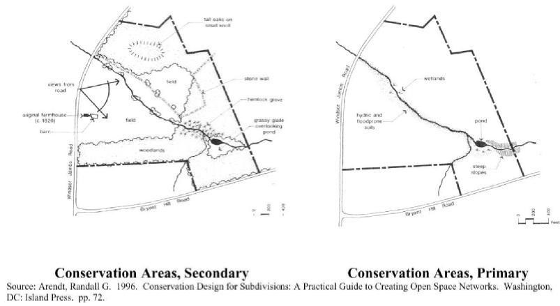
Sec. 4.07.03. - Permitted uses.
Permitted uses within P-R zoning districts shall be limited to the uses specified in this section:
(a)
Accessory building, structure, or use incidental to one or more permitted principal uses.
(b)
Church, synagogue, chapel, or other place of religious worship.
(c)
Club or lodge, nonprofit.
(d)
Conservation area.
(e)
Dwelling, single-family detached.
(f)
Dwelling, two-family.
(g)
The following dwelling types may be permitted subject to the limitation that no more than 40 percent of the total housing units shown in the approved development plan shall consist of any one type or combination of the specified dwelling types. Additional limitations on these types of dwellings may be imposed as conditions of zoning.
(1)
Dwelling, apartment.
(2)
Dwelling, cluster.
(3)
Dwelling, condominium.
(4)
Dwelling, garden apartment.
(5)
Dwelling, multiple-family.
(6)
Dwelling, patio.
(7)
Dwelling, single-family attached.
(8)
Dwelling, townhouse.
(h)
Golf course, planned as an integral part of the planned residential development.
(i)
Home occupation. Type I and Type II as defined in section 5.01.00 of this ordinance. Type II home occupations are subject to approval as a special use.
(j)
Intermediate care home, nursing home, or personal care home.
(k)
Nursery school or day care center.
(l)
Public building, structure, or use.
(m)
Recreation area owned, operated, and maintained by the owner(s) of the permitted use, exclusively for the use of residents and their guests.
(n)
Private school, college or university.
(o)
Office, enclosed retail trade establishment, or personal service establishment, but only in P-R zoning districts that have at least 200 dwelling units. The amount of land in a P-R zoning district devoted to offices, retail trade establishments, and personal service establishments, or some combination thereof, shall not exceed ten percent of the total site area of the P-R development nor 100 square feet of gross building space per dwelling unit provided in the P-R development.
Sec. 4.07.04. - Dimensional requirements.
All development in P-R zoning districts shall meet the requirements of this section.
(a)
Minimum open space requirements. Each P-R zoning district established shall have at minimum 30 percent of the gross land area of the P-R development as open space.
(b)
Base residential densities.The following base residential densities cannot be exceeded (i.e., below the minimum or above the maximum established in the table below), except by residential density bonus as provided in this article:
(c)
Residential density bonus.No density bonus shall be authorized or approved that exceeds the maximums in the table below:
A particular P-R development can receive the maximum permitted density bonus, or it may receive a partial density bonus. The amount of density bonus must be approved by the zoning administrator and the planning commission.
(d)
Maximum height limitations. The following maximum heights are established for types of land uses:
(e)
Additional requirements. The P-R development must meet the following:
(1)
Property within 200 feet of a local, collector, or arterial road abutting the P-R development shall remain in its natural state, except for approved access and utility crossings. Where sparsely vegetated, landscaping using native landscape material is shown on a plan approved by the zoning administrator and installed.
(2)
Tree preservation. The P-R development preserves significant trees, especially deciduous trees of at least eight inches caliper or coniferous trees of at least 15 feet in height, excluding diseased trees that are likely to die. Trees preserved may be located within open spaces or developed areas of the P-R development.
Sec. 4.07.05. - Application requirements.
Applicants proposing a P-R zoning district shall make application to the zoning administrator which shall include at minimum the specifications of this section. Such requirements are in addition to and do not replace basic application requirements for rezoning as specified in this ordinance.
(a)
Site analysis map. The applicant shall prepare and submit a site analysis map. The purpose of the site analysis map is to ensure that the important site features have been adequately identified prior to the creation of the subdivision or development and that the proposed open space will meet the requirements of this article. The site analysis map shall include the following features:
(1)
Property boundaries;
(2)
All streams, rivers, lakes, wetlands and other hydrologic features;
(3)
Topographic contours of no less than ten-foot intervals;
(4)
All primary and secondary conservation areas labeled by type, as defined in this article;
(5)
General vegetation characteristics, including the delineation of deciduous trees of at least eight inches caliper or coniferous trees of at least 15 feet in height;
(6)
General soil types;
(7)
The planned location of protected open space;
(8)
Existing roads and structures; and
(9)
Potential connections with existing greenspace and trails.
(b)
Development plan. Applications shall include a development plan which, unless specifically approved otherwise by the board of commissioners, shall be a condition of P-R rezoning approval and must be followed.
(c)
Land uses and development summary. The application shall include a list of all land uses proposed to be included in the P-R zoning district with the following information:
(1)
The total land area devoted to each of the land uses proposed.
(2)
The percentage of the total land area within the P-R zoning district devoted to each proposed land use.
(3)
The number of residential units by type and density.
(4)
The total square footage of buildings devoted to nonresidential uses.
(5)
Development schedule indicating the approximate dates for beginning and completing the project, or each phase if the development is to be phased, and the extent of development and types of land uses in each phase.
(d)
Dimensional requirements and comparison. The rezoning applicant shall submit with the application all dimensional requirements that are proposed to apply within the P-R zoning district for each land use, including, but not limited to, minimum lot sizes; minimum lot widths; maximum lot coverage; front, side and rear yards and building setbacks; and maximum heights. Such dimensional requirements shall be presented in a table on the development plan or in the written text accompanying the application that shows the proposed lot, height, coverage and other dimensional standards in relation to the dimensional requirements for the zoning district or districts in which the subject property is located at the time the zoning request is made.
(e)
Description of characteristics of improvements. The application shall contain descriptions of improvements to be constructed within the P-R zoning district, such as, but not limited to, street types, right-of-way widths, pavement widths, sidewalk locations and dimensions, and other improvements. Such proposed improvements shall be presented in a table in the written text accompanying the application that shows the proposed improvements in comparison with improvements that would be required otherwise without approval of a P-R zoning district.
(f)
Open space management plan. As a part of the application, an open space management plan shall be submitted which, unless specifically approved otherwise by the board of commissioners, shall be considered and become a condition of P-R rezoning approval. The applicant must identify the owner of the open space who is responsible for maintaining the open space and facilities located thereon. Open space within P-R zoning districts may be used for any of the following:
(1)
Conservation of natural, archeological or historical resources;
(2)
Meadows, woodlands, wetlands, wildlife corridors, game preserves, or similar conservation-oriented areas;
(3)
Walking or bicycle trails;
(4)
Passive recreation areas;
(5)
Agriculture, horticulture, silviculture or pasture uses, provided that all applicable best management practices are used to minimize environmental impacts, and such activities are not conducted within primary conservation areas;
(6)
Nonstructural stormwater management practices;
(7)
Easements for drainage, access, and underground utility lines; or
(8)
Other conservation-oriented uses compatible with the purposes of this article.
(g)
Instrument of permanent protection. As a part of the P-R rezoning application, or no later than prior to the issuance of a development permit, the applicant shall ensure that open space proposed in the P-R zoning district will be permanently protected through an instrument such as a conservation easement, fee-simple ownership, or permanent restrictive covenant. If a homeowners' association is the owner, membership in the association shall be mandatory and automatic for all homeowners of the subdivision and their successors. If a homeowners' association is the owner, the homeowners' association shall have lien authority to ensure the collection of dues from all members. The responsibility for maintaining the open space and any facilities located thereon shall be borne by the owner.
The open space within a conservation subdivision shall be protected in perpetuity by a binding legal instrument that is recorded prior to any vesting deed for property or lots within said subdivision. The instrument shall be a permanent conservation easement in favor of either:
(1)
A land trust or similar conservation-oriented non-profit organization with legal authority to accept such easements; or
(2)
A governmental entity with an interest in pursuing goals compatible with the purposes of this article.
If the entity accepting the easement is not the Butts County board of commissioners, then a third right of enforcement favoring the Butts County board of commissioners shall be included in the easement. The instrument for permanent protection shall include clear restrictions on the use of the open space, consistent with the requirements of this article, as well as any further restrictions the applicant chooses to place on the use of the open space.
(h)
Private restrictions. P-R zoning districts that have proposed commonly-owned facilities and space shall have private restrictions and covenants established which shall be subject to the approval of the county attorney and zoning administrator. The applicant for P-R rezoning involving commonly-owned facilities and space shall submit, along with the development plan application, a declaration of covenants, conditions and restrictions, articles of incorporation and by-laws for the property owners or homeowners' association. The declaration shall confer membership to the owner of property subject to assessment by the association, provide for voting rights in the association with suggestions for the division of power between the developer and the property owners, and provide for maintenance assessments, among other things.
(i)
Architectural elevations. Applications shall include perspective front, side and rear elevation drawings of representative building types, including details for typical detached single-family dwellings and their typical accessory buildings. These drawings shall indicate general architectural characteristics. If the P-R rezoning is approved, architectural elevations submitted as part of the application shall be considered binding unless specifically noted otherwise in the approval.
(j)
Facility impact analysis. The applicant shall submit an analysis of the public's ability to serve the proposed development with sheriff, police, fire protection, schools, water, sewer, roads, recreation facilities, solid waste collection and disposal, libraries, and other public facilities and services. The subdivider or land developer shall construct such oversized improvements and utilities that the county determines are necessary, provided that the subdivider or land developer shall not be obligated for the additional cost of improvements and utilities that are not uniquely required for that development, and provided the subdivider agrees to a proposal by the county to share in the cost arrangements for over-sizing improvements and utilities. A formula may be developed by the county to provide for a sharing of the cost of other improvements needed to serve the subdivision or land development when certain of the improvements are necessary to serve future subdivisions or developments in the vicinity.
(k)
Development agreement. Where the fiscal impact analysis submitted with the application notes possible future deficiencies in county facilities or services if the planned residential development is approved and constructed, or where desirable for other reasons, the applicant shall submit a draft "development agreement," specifying, among other components, provisions regarding developer-funding infrastructure to mitigate the facility deficiencies identified in the fiscal impact analysis. The zoning administrator, and other county staff as appropriate, will participate in the process of drafting the specific provisions of the development agreement with the applicant. It is intended that the draft development agreement will be generally accepted by appropriate county staff and be a part of the application prior to determining the application complete and processing the P-R rezoning application for public hearings. That intent shall not preclude changes and refinement of the development agreement during the public hearing process, as may be necessary to respond to recommendations of the planning commission, additional suggestions by staff, or to meet the approval of the Butts County board of commissioners.
(l)
Consistency with watershed water supply protection districts. Where a development is proposed in a watershed water supply district, excepting the Ocmulgee River Watershed District, the requirements of those districts shall be applicable to the proposed P-R development, unless the applicant submits a plan and studies, to the satisfaction of the zoning administrator, demonstrating that the impact of the development on water quality will be less than that which would have occurred under the standard requirements of the watershed water supply district. Additional approval processes may be necessary.
Sec. 4.07.06. - Procedures.
(a)
Pre-application conference. Prior to filing an application for a P-R zoning district, the applicant may confer with the zoning administrator in order to review the general character and certain specific elements of the proposal. Upon learning of a pending application for P-R rezoning, or at the most expedient time before accepting a P-R rezoning application as complete, the zoning administrator may schedule a pre-application conference with the applicant, who should provide and present at the pre-application conference all preliminary materials such as, but not limited to, a basic sketch plan of the development, general intentions for land uses, boundary surveys of the site to be rezoned, and notes regarding any prior discussions about utility, facility, service, and other infrastructure availability and/or deficiencies.
The zoning administrator may request that other appropriate staff attend the pre-application conference, which may include, but are not necessarily limited to, the following: Butts County public works; Butts County administration; Butts County board of education; and the Butts County water and sewer authority. Fire department personnel also should be in attendance to conduct a review for public safety of the road plan. At the pre-application conference, the applicant will receive general instruction and suggestions on filing the complete rezoning application, including suggested components of a "development agreement" as defined by this article. Any information or suggestions provided by county or agency officials shall not be binding or interpreted as providing approval or commitment of Butts County or the agencies represented with regard to the development proposal.
(b)
Recommendation and approval authority. All applications for P-R rezoning shall be subject to the public hearing and notice requirements specified in chapter 10. All applications for P-R rezoning shall be processed and considered by the planning commission and decided upon by the board of commissioners the same as any other applications for rezoning.
(c)
Revisions. Amendments to approved P-R zoning districts and development plans shall be permitted but governed by the procedures and provisions for changing the official zoning map.
(d)
Preliminary plat. If the applicant does not simultaneously seek and receive approval of the preliminary plat at the time of P-R rezoning approval, then the applicant shall be required to submit a preliminary plat application.
(e)
Development permit. Upon approval of a P-R rezoning application by the board of commissioners, and preliminary plat approval by the planning commission, the land developer may apply for development permit approval. Excavation, grading or land disturbance applications shall only be approved for development that has been approved in accordance with the provisions of this article.
(f)
Final plat. The applicant shall submit a final plat for approval in accordance with chapter 10 of this UDO.
(g)
Building permits and certificates of occupancy. No building permit or certificate of occupancy shall be issued for a building, structure, or use that has not been approved in accordance with the provisions of this article. The zoning administrator shall authorize the issuance of building permits for buildings and structures in the area covered by the approved P-R rezoning development plan if they are in substantial conformity with the approved development plan, after improvements are installed in accordance with applicable improvement requirements, and if found to be in conformance with all other applicable regulations. The zoning administrator shall authorize the issuance of a certificate of occupancy for any completed building structure or use located in the area covered by the P-R zoning district if it conforms to the requirements of the approved planned residential development and all other applicable regulations. After completion of a development in the P-R zoning district, the use of land and construction, modification or alteration of any buildings, structures or uses within the area covered by said development shall be regulated by the approved development plan for the P-R zoning district.
Sec. 4.07.07. - Criteria for approval.
In addition to the standards applicable to other zoning decisions, the county shall consider the following criteria in reviewing an application for a P-R zoning district:
(a)
Comprehensive plan. Whether the application is consistent with the comprehensive plan of the county.
(b)
Architectural compatibility. The extent to which the proposed site development features and architectural features of buildings within the proposed development are harmonious, compatible with adjacent and nearby existing development, and consistent with the guidelines for preserving rural character, if made applicable by this article.
(c)
Facility adequacy. Development within this zoning district is adequately served by public facilities and services needed for the type of development at the time development impacts occur. If such facilities and services are inadequate, as shown in the fiscal impact analysis submitted with the application or as determined independently by the county, a development agreement that mitigates facility or infrastructure deficiencies by the developer is considered adequate and is approved by the board of commissioners.
(d)
Open space adequacy. The adequacy of open spaces that are provided. Conformance with the open space requirements of this article is required. In addition, approval or denial of a P-R rezoning application and development plan shall be based on the extent to which the application and plan meet the following open space planning criteria:
(1)
Primary conservation areas are required to be included within the protected open space, unless the applicant demonstrates that this provision would constitute an unusual hardship and be counter to the purposes of this article.
(2)
A sufficient amount of secondary conservation areas are protected as permanent open space, as opposed to being devoted to lots and other uses.
(3)
The configuration of the open space tract is contiguous and undivided, or open space is provided in relatively undivided tracts that cannot reasonably be reconfigured into one contiguous, undivided tract.
(e)
Rural cluster siting criteria. Residential development shall be clustered or sited so as to minimize disruption of rural character. In such areas, the following additional criteria shall be adhered to:
(1)
A rural cluster subdivision may contain one or more residential clusters grouped into compact neighborhoods.
(2)
To the maximum practicable extent, existing historic rural features shall be preserved as part of the cluster development. These features include, but are not limited to, rock walls, fences, functional and structurally safe farm buildings, and landscape features.
(3)
Buildings shall be clustered or sited in the most accessible, least visually prominent, and most geologically stable portion or portions of the site.
(4)
Rural clusters shall be limited to locations that minimize the visual impact from adjacent lands and view corridors. Placing buildings so that vegetation, rock outcroppings, depressions in topography, or other natural features will screen them where they exist shall minimize the prominence of construction. In wooded or forested areas, the planning commission may require the scattering of buildings so as to save trees and minimize visual impacts.
(5)
Cluster lots shall be sited to minimize conflicts between housing and adjacent agriculturally-zoned property.
(6)
Cluster lots should border on open space on at least one side and have access to any core open spaces in the rural cluster.
(f)
Soil suitability for septic tanks and drain fields. When the P-R zoning district will not be served by public sanitary sewer or a community sewerage system, it is generally the intent that each lot has at least one-half acre of suitable soil for a septic tank drain field and that each lot has sufficient area for a replacement drain field, as may be more specifically determined by the Butts County health department depending on the specific nature of the development proposal, such as the number of bedrooms in dwellings, the types of amenities provided, and any other variables that would affect the sizing of septic tanks and placement of drain fields. Failure of the development proposal to meet this criterion may be cause to disapprove the P-R rezoning.
(g)
Access, safety, and convenience of school children. The development plan adequately considers the needs of school-age students with respect to access to bus stops within, adjacent to, or nearby the P-R development. Such considerations include safe and adequate sidewalks or paths from residential areas to places where the county schools' buses will stop to pick up and drop off students, lighting of the school bus stops during hours of darkness, and shelter or other safety and convenience considerations. Failure of the development proposal to meet this criterion may be cause to disapprove the PR rezoning.
(h)
Reducing wild land fire hazards. The development proposal should incorporate design considerations and/or regulations that mitigate structure ignition hazards consistent with recommendations of the National Fire Protection Association (NFPA) 1144, "Standard for Reducing Structure Ignition Hazards from Wildland Fire," 2008 or future edition, or similar acceptable publication or best practices. Failure of the development proposal to meet this criterion may be cause to disapprove the P-R rezoning.
Sec. 4.07.08. - Guidelines for preserving rural character.
(a)
Location of dwellings and other buildings. Siting dwellings and other buildings is one of the most important considerations, and therefore, this aspect receives particular attention. Areas of the open countryside are less able to absorb development without significant impact upon existing scenic and rural amenities.
Consistent: Dwelling is located close to the road (or at the edge of fields) to allow continued use of land for crops and pasture. Future development should respect the established pattern of crop lands, pasture and the rural, open space character of the area. Woodlands are preserved.
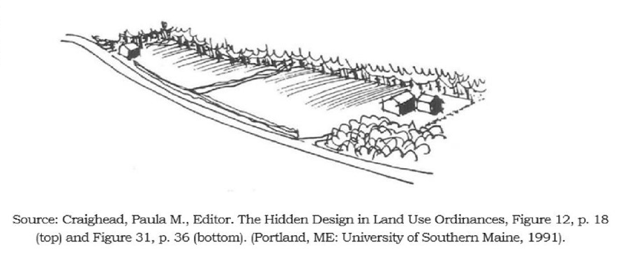
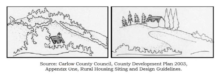
Above left (consistent): Building is sited within or adjacent to existing vegetation that partially screens the building.
Above right (inconsistent): Building is sited near top of ridge or hill and is too visible, and non-native landscaping has been introduced.
Below (inconsistent): New house is sited in a visually prominent location in the center of the site with no regard for existing conditions.
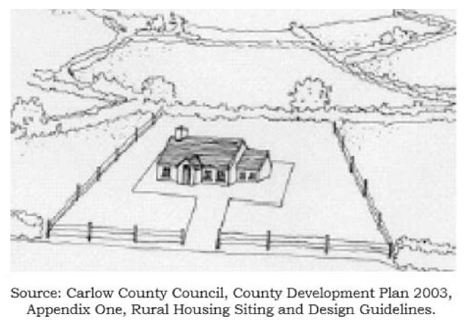
Consistent: New houses sited as not to compete with older structures in established settlement pattern.
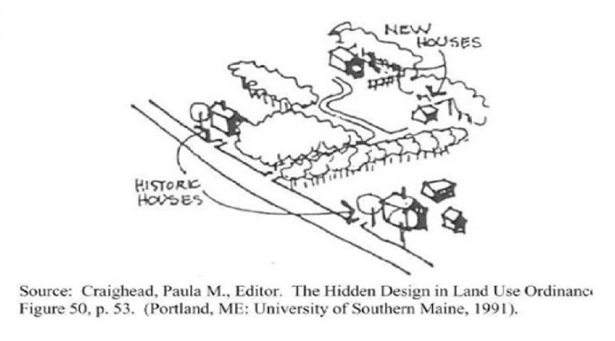
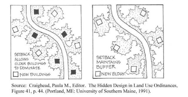
Propose a site and design structure that will minimize the visual impact of buildings and site on the natural landscape. In cases where there are practical reasons why a visible location must be selected, it will need to be justified and an explanation given as to why sites that are less visible cannot be utilized. In addition, approval of building locations on visually prominent sites requires mitigation of visual impacts through buffering or screening, additional (or different) architectural treatments, or other appropriate measures.
Below (consistent): The lots are clustered near existing dwelling(s), buildings are set back from open fields adjacent to road, and existing hedge rows and tree lines are maintained.
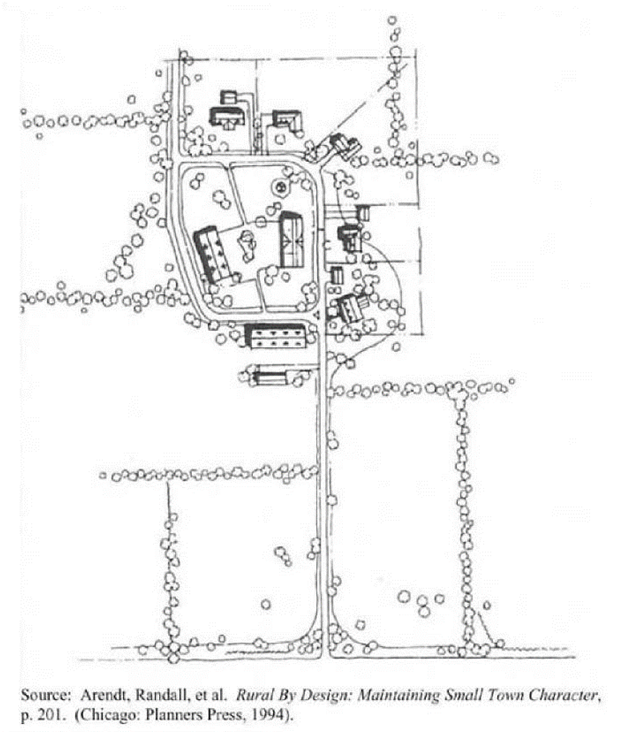
(b)
Excavation and grading. Dwelling and building sites should be chosen that require the least amount of excavation and grading (e.g., cut and fill). Excessive excavation unnecessarily disturbs the natural contours of the land and can result in negative visual impacts and unnatural-looking sites.
Inconsistent: Grading does not respect existing contours and does not blend into the landform. Avoid severe cutting, filling, padding, or terracing for home or building sites.
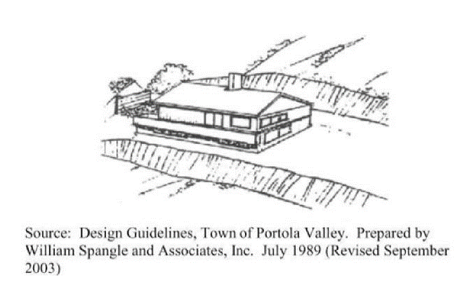
Projects involving more than one use or phase should be phased into workable units in a way that minimizes the amount of soil disturbance at any given point in time. When grading must occur, it should blend with the natural landform as much as possible. Grading to form level pads and building sites is strongly discouraged, and when required, such grading should be minimized.
(c)
Rural road design. Roads shall meet the standards established in section 6.01.06 of this ordinance. Access from a public road through a site should follow or have due regard for the contours of the site.
One-way streets shall be permitted and encouraged where appropriate for the terrain and where public safety would not be jeopardized. For instance, a two-way road may have the directions of flow split into one-way pairs that differ in elevation, circumnavigate difficult terrain, or avoid tree clearance.
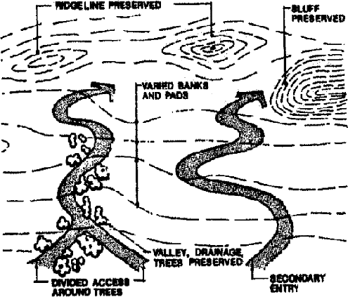
(d)
Access from dwellings and building sites onto public roads. Any new driveway or public or private road entrance should be carefully located considering the view from the public road.
For all rural cross-section streets, public or private, ditches are essential for proper drainage and shall be designed and provided to handle total volume and velocity of water for the particular road location. The following standards for ditches shall be followed:
(1)
Swales must be able to be designed to:
a.
Convey a 25-year storm event.
b.
Incorporate freeboard equivalent to 20 percent of the design depth with a one-foot minimum measured to the road shoulder.
c.
Be constructed using the following types of cross-sections:
1.
Parabolic;
2.
Trapezoidal with a minimum two-foot bottom;
3.
No "V" shaped cross-section.
d.
Limit velocities to or below the maximum contained in the Manual for Erosion and Sediment Control in Georgia, latest edition, for proposed channel liner.
e.
Have side slopes of 3H:1V, horizontal to vertical, or flatter and meet the following additional standards:
1.
Slopes must be able to be maintained by the property owner with standard mechanized equipment.
2.
Channel liners:
i.
Grassing if velocity is less than 2.0 f.p.s. Must be maintained until 100 percent of the development site has 70 percent permanent grassing established.
ii.
Sod if velocity is less than 5.0 f.p.s. Sod is recommended for all vegetated channel lining.
iii.
Rip rap is required if velocity is between 5.0 and 10.0 f.p.s. Design must be consistent with the Manual for Erosion and Sediment Control in Georgia, latest edition.
iv.
Concrete is not allowed for side ditches.
v.
Methods to reduce velocity should be used.
vi.
For a velocity over 10.0 f.p.s., side ditches are not allowed.
(2)
Driveway culvert designs shall be included as part of the construction drawings. The following standards shall apply:
a.
Culverts must be designed for a 25-year storm event.
b.
The minimum pipe size shall be 15 inches in diameter.
c.
Culverts must have end treatments:
1.
Flared end sections are preferred.
2.
Precast winged headwalls shall not be allowed.
3.
Alternative end treatments must be approved by the Butts County public works director or designee.
d.
Culverts must have storm drain outlet protection compliant with the standards established in the Manual for Erosion and Sediment Control in Georgia, latest edition.
e.
A minimum of one and one-half feet of cover under the driveway shall be provided.
f.
Culverts shall be designed to minimize exit velocities.
(3)
Cross drains must be designed to:
a.
Accommodate a 100-year storm event.
b.
Have a minimum pipe size no less than 18 inches in diameter.
c.
Have an end treatment meeting the following specifications:
1.
Flared end sections are preferred.
2.
Precast winged headwalls are allowed under site-specific conditions as determined by the county engineer or designee.
d.
Include storm drain outlet protection compliant with the standards established in the Manual for Erosion and Sediment Control in Georgia, latest edition.
e.
Provide a minimum of one and one-half feet of cover under the driveway.
f.
Minimize exit velocities.
g.
Allow reviewer to verify the impact of a 100-year storm event with the inclusion of the following standards:
1.
Headwater/pipe diameter, HW/d, shall be less than 2d.
2.
A minimum freeboard of one foot as measured from the road shoulder elevation shall be maintained.
(e)
Lighting. In the interest of preserving the rural atmosphere of the night sky in rural areas, street lighting along streets in new subdivisions or land developments is discouraged. If desired by a developer, streetlights must meet the approval of the zoning administrator for rural compatibility.
(f)
Roof materials.
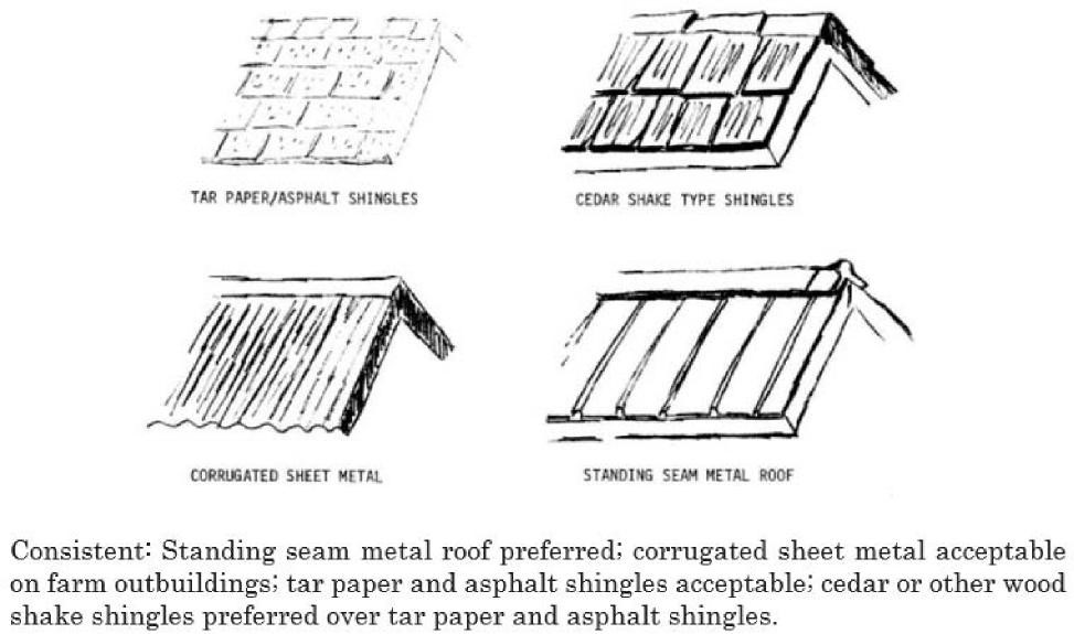
Consistent: Standing seam metal roof preferred; corrugated sheet metal acceptable on farm outbuildings; tar paper and asphalt shingles acceptable; cedar or other wood shake shingles preferred over tar paper and asphalt shingles.
(g)
Architecture and exterior building materials. Architecture and building types should be compatible with existing buildings in the area (see illustration, below), including stone chimneys, front (shed) porches, steep gabled roofs, and wood siding. If a dwelling or building is to be composed of building materials that are incompatible with the established building materials and architectural features, it can significantly change the character of the rural setting.
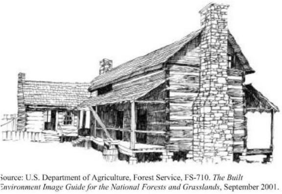
In such instances where building materials that are incompatible or not consistent with the provisions of the design and character of the district must be used, the dwelling or building should not face or be located within 50 feet of the public road right-of-way.
Consistent: Steep or moderately steep gabled roof pitches; roof materials are asphalt composition shingle, wood shake, or standing seam metal; front porch is provided; base exterior is stone and siding is wood (hardi plank); chimney is provided; structural (timber) elements exposed at front porch entrance; house is sited below ridgeline; garage also has steep gabled roof and does not dominate view.
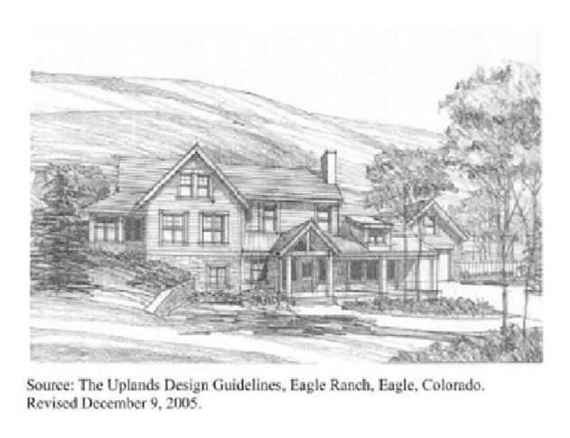
The use of natural materials for engineered structures is also encouraged, where appropriate. For instance, wood, stone, or dyed/textured concrete should be used for new guardrails, curbing, culverts and walls.
(h)
Garages and accessory buildings and structures. Garages (i.e., freestanding accessory buildings and structures for storage of vehicles) should complement the architectural style of the principal dwelling or building. They should not be visually prominent when viewed from the public road. Carport structures if composed of pre-fabricated metal shall not be located in a visible location in the front yard of a dwelling or building, or if they must be located in a visible area, they must be screened with native vegetation. Oversized accessory buildings for recreational vehicles, boats, and storage cannot be sited within front yards, and if provided, they shall be located as far to the rear of the lot as possible.
(i)
Landscaping. Native species should be preserved, where possible, and when landscaping is added, only native (indigenous to the region or area) species of trees, shrubs, vines, and other vegetation should be used. When new landscaping is introduced, trees and shrubs should be planted in groups and irregular patterns, not in rows.
Home sites should have carefully defined construction limits (building envelopes). Native vegetation must be left undisturbed outside building envelopes and areas for driveways, or where vegetation must be removed, it shall be replaced with native species. The introduction of new, sodded yards is discouraged in front yards, and a more natural appearance of native vegetation is sought.
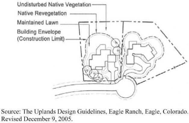
Use plant materials that blend with the environment. Landscape schemes that are rough, natural, and/or subdued in character are encouraged. Extensive areas of exotic plants and sod are discouraged where they would be visible from the public right-of-way.
(j)
Fences and walls. If fences are to be provided in the front yard of a dwelling or building, they must be composed of wood materials. Examples of acceptable wood materials for fences in front yards are shown below.
Sec. 4.08.01. - General provisions.
(a)
R-5 zoning districts are intended to provide areas where stable communities for affordable housing can be located and efficiently developed in a manner compatible with surrounding residential areas while preserving the natural amenities of the land.
(b)
R-5 districts are allowed only where public water and sewer are available. All dwellings must be served by public water and sewage and sewage lines. Where such lines do not already exist, the developer is responsible for installation of them.
Sec. 4.08.02. - Permitted uses.
The following are permitted as principal uses in R-5 districts:
(a)
Planned manufactured home community.
(b)
Recreation area owned, operated, and maintained by the owner(s) of the permitted use, exclusively for the use of residents and their guests.
(c)
Utility substation meeting the following development standards:
(1)
Structures must be placed at least 30 feet from all property lines.
(2)
Structures must be enclosed by a wovenwire fence at least eight feet high with the bottom of the fence either flush with the ground or with a masonry footing.
(3)
No vehicles or equipment may be stored on the lot.
(4)
A buffer must be maintained along the side and rear property lines.
Sec. 4.08.03. - Plan review and approval procedures.
(a)
Pre-application conference. Prior to filing a formal application for an R-5 district, the applicant may confer with the zoning administrator in order to review the general character of the plan (on the basis of tentative land use sketch, if available) and to obtain information on development standards and ordinances affecting the proposed project.
(b)
Submission of application for R-5 district approval.
(1)
The applicant must file a proposed development plan with the zoning administrator. This application must be supported by a development plan and a written summary of intent. The relationship between the proposed development and the surrounding area, both existing and proposed, must be shown. The following information must be presented with the development plan:
a.
A general location map.
b.
Existing topographic conditions, including contour intervals of no more than five feet based on field surveys or photogrammetric methods.
c.
The existing and proposed land uses and the approximate location of all buildings and structures.
d.
The approximate location of existing and proposed streets.
e.
The approximate location of all existing and proposed utilities, including a preliminary utility and drainage plan.
f.
The present zoning pattern in the area.
g.
A legal description of the subject property.
h.
The location and use of existing and proposed public, semipublic, and community facilities such as schools, parks, and open areas on the site. This includes areas proposed to be dedicated or reserved for community or public use.
(2)
If a proposed development creates special problems or involves unusual circumstances, additional information may be required in order to evaluate the proposal. Such additional information includes, but is not limited to, the following:
a.
An off-street parking and loading plan.
b.
An economic feasibility report or market analysis.
c.
A traffic study of the area and a circulation plan within the proposed development as well as to and from existing streets adjacent to the site.
(3)
The written summary of intent submitted with the development plan must include the following information:
a.
A statement of the present ownership of all land within the proposed development.
b.
An explanation of the character of the proposed development. This includes a summary of acres, number and types of dwelling units.
c.
A general statement of the proposed development schedule.
d.
Agreements, provisions, and covenants which govern the use, maintenance, and protection of the development and any common or open areas.
(c)
Review and approval of R-5 district application.
(1)
An application for approval of an R-5 district requires rezoning and shall be processed in the same manner provided by this ordinance for rezoning applications.
(2)
The zoning administrator will turn over the application materials to the planning and zoning commission for its recommendations.
(3)
The power to approve an amendment creating an R-5 district rests with the board of commissioners. After conducting the public hearing and considering recommendations from the planning and zoning commission, the board of commissioners will then make an official decision on the proposed R-5 district. The board of commissioners may approve, disapprove, or conditionally approve the development plan.
(4)
If the development plan is approved as submitted, the official map will be changed to indicate the R-5 district. If the plan is approved with modifications, the applicant shall have ten days following the public meeting at which the plan is approved with modifications to withdraw the application. If the applicant does not provide the zoning administrator with written notice that the application is withdrawn within that period, the official zoning map will then be changed to reflect the rezoning of the property to an R-5 zoning classification. The site plan and supporting information of any approved plan will be identified and permanently filed with the zoning administrator. Any development of the subject property must comply with the approved development plan.
(d)
Issuance of building permits. The zoning administrator will issue building permits for buildings and structures in the area covered by the approved development plan if the proposed buildings and structures are in conformity with the approved development plan, the development schedule, and all other applicable regulations.
(e)
Revision of development plan after approval of plan.
(1)
Minor extensions, alterations, or modifications of existing buildings or structures may be permitted after review and approval by the planning and zoning commission; such changes must be consistent with the purposes and intent of the development plan.
(2)
Any major or substantial change in the approved development plan which affects the intent and character of the development, the density of land use pattern, the location or dimensions of streets, or similar substantial changes must be reviewed and approved by the board of commissioners after receipt of recommendations from the planning and zoning commission and shall be subject to the same procedures as a rezoning application.
(f)
Initiation of rezoning back to original district. Construction of the planned development must begin within one year of the approval of the R-5 district. If no construction has begun by then, or if the applicant fails to maintain the approved development schedule, approval of the development plan will lapse. At its discretion, the board of commissioners may extend the period for beginning construction of any phase of the project for one additional year. If approval of the development plan lapses under this provision, the planning and zoning commission may initiate zoning amendment proceedings to restore the previous zoning to the subject property.
Sec. 4.08.04. - Development standards
for R-5 districts.
In addition to the development standards contained in section 4.01.02 of this ordinance, the following standards are required within R-5 districts:
(a)
Minimum standards applicable to the development as a whole:
(1)
Minimum development area: 12 acres.
(2)
Minimum development width: 150 feet for the entire development.
(3)
Minimum front setback as measured from the right-of-way of the road:
a.
Arterial streets/roads: 75 feet. The front of all buildings must be at least 35 feet from the front property line.
b.
Collector streets/roads: 50 feet. The front of all buildings must be at least 35 feet from the front property line.
c.
Other streets/roads: 50 feet. The front of all buildings must be at least 35 feet from the front property line.
(4)
Maximum building height: 35 feet. This height limit does not apply to projections not intended for human habitation, except for satellite, television, and radio antennas, to which this limit does apply. For buildings and structures with such projections, the minimum required setbacks must be increased one foot for every two feet (or part of two feet) of height greater than 35 feet.
(5)
Development standards shown in approved development plan. Other development standards shown in an approved development plan apply only to the development shown on the specific development plan. Such development standards must be maintained.
(6)
General. Condition of soil, groundwater level, drainage, and ground slope must not create hazards to the property or to the health or safety of residents. The site must not be exposed to objectionable smoke, noise, odors, or other adverse conditions; no part subject to flooding or erosion can be used for any purpose that would expose people or property to danger.
(7)
Soil and ground cover. Exposed ground surfaces throughout the development must be protected with a vegetative growth that prevents soil erosion, standing puddles, and dust. If this is not possible, such areas may be covered with a solid material such as stone or may be paved.
(8)
Site drainage. The ground surfaces throughout the development must be equipped to drain all surface water in a safe, efficient manner, either through grading or installation of drains.
(9)
All internal streets must be paved with a material and thickness which meets the standards specified in chapter 6. Minimum required pavement width is as follows:
a.
No on-street parking: 20 feet.
b.
Parking one side: 28 feet.
c.
Parking both sides: 36 feet.
(10)
Dead-end streets. All dead-end streets must have a turnaround at the closed end, with an outside paved diameter of at least 80 feet.
(11)
Street lighting. Outdoor lighting is required which will provide the following average maintained levels of illumination for the safe movement of pedestrians and vehicles at night:
a.
All parts of the street system of the development: Ten footcandle.
b.
Potentially hazardous locations, such as major street intersections, steps, and stepped ramps. Individually lighted, with a minimum of 20 footcandle.
(12)
Street construction and design.
a.
Grades. Minimum permitted grade for streets is ten percent. Short runs with a maximum grade of 15 percent may be permitted upon specific approval of the zoning administrator if traffic safety is ensured by adequate leveling areas and avoidance of lateral curves.
b.
Offset intersecting streets (street jogs) and reverse curves. Offset intersecting streets must be offset at the centerlines at least 150 feet. Reverse curves must be connected by a straight section that is at least 150 feet long.
(13)
Paved parking areas.
a.
Paved off-street parking areas must be provided for the use of residents. At least two spaces for each dwelling unit must be furnished. In a planned manufactured home community, resident parking must be furnished at the manufactured home space which it serves.
b.
Paved parking areas for guests may be either on-street, in a separate off-street lot, or a combination of both. At least 0.2 paved guest parking spaces per dwelling unit must be furnished.
c.
See chapter 6 for required parking space design standards.
(14)
Walks.
a.
General requirements. All developments must have safe, convenient, all-season pedestrian access of adequate width for intended use. Walks must be durable and convenient to maintain. Sudden changes in alignment and gradient should be avoided.
b.
Common walk system. Common walks, where provided, should be at least three and one-half feet wide.
c.
Individual walks. All manufactured home spaces must be connected either to common walks, paved streets, paved driveways, or parking spaces adjacent to paved streets. Such individual walks must have a minimum width of two feet.
(15)
Service buildings and other such facilities. Service buildings, recreation buildings and other such facilities of the development must meet the requirements of applicable codes and development regulations adopted by Butts County.
(16)
Each development shall have a reserved greenspace for the use of the residents and their guests which shall be of a size adequate to provide recreational opportunities for the anticipated number of residents and which shall in no case be less than 20 percent of the development area.
(b)
Each manufactured home within the development shall be located on a separate lot, which shall be subject to the following minimum standards:
(1)
Minimum floor area per manufactured home: 750 square feet.
(2)
Minimum front setback: 35 feet.
(3)
Minimum side setback for lots within development: 20 feet.
(4)
Minimum rear setback: 30 feet.
(5)
Minimum manufactured home lot area: 7,500 square feet.
(6)
All manufactured homes must be installed in accordance with the Georgia State Manufactured Housing Code.
Sec. 4.09.01. - Purpose.
The purpose of this section is to provide requirements for the landscaping of developments in industrial, commercial, office-institutional, multi-family residential, new residential subdivisions, and manufactured home zoning districts, in order to enrich the urbanized and natural environment of Butts County. It is the intent and purpose of this landscape section to reduce the adverse visual, environmental, and aesthetic effects of development in order to:
(a)
Minimize the rate of stormwater runoff;
(b)
Maximize the capability of groundwater recharge in urban or suburban areas;
(c)
Increase air filtration and the removal of particulate and gaseous pollutants through plant materials;
(d)
Provide shade and noise attenuation;
(e)
Filter and reduce the glare of headlights and reflected sunlight from parked automobiles onto the public street rights-of-way;
(f)
Improve the appearance of parking areas and vehicular surface areas; and
(g)
Minimize the visual blight created by large expanses of paved surface area.
Sec. 4.09.02. - Landscape plans.
A landscape plan shall be submitted upon application for a development permit. The plan shall include sufficient information to determine whether the proposed landscape improvements are in conformity with this section, including the following:
(a)
Identification of all trees, natural features and man-made structures that will be retained upon the site;
(b)
A description of proposed landscaping improvements and plantings, including the species, size, quantity and location of trees, shrubs and other landscaping materials;
(c)
Identification of all proposed structures, vehicle use areas, sidewalks, wheel stops or curbs, walls and fences; and
(d)
A depiction of adjoining streets and parcels sufficient to identify the same and to demonstrate the relationship between the development and the same.
Sec. 4.09.03. - General landscape standards.
(a)
Minimum specifications for plant materials.
(1)
All plant material shall be nursery grown, number 1 grade, meet current American Nursery and Landscape Association Standards, and installed according to accepted planting procedures.
(2)
Shrubs shall be a minimum one-gallon container size.
(3)
All landscaped areas and buffers shall be sodded or covered with ground cover.
(4)
All plant species shall be native to this region or appropriate for the region (generally, consistent with the "7b" Plant Hardiness Zone as defined by the Cooperative Extension, University of Georgia College Agricultural and Environmental Sciences). Installation of invasive species and the use of non-urban tolerant species of trees such as Bradford Pear shall be prohibited.
(5)
Subject to other portions of this section, at least 25 percent of the required trees installed in landscaped buffers, in landscaped parking areas, and to meet tree planting requirements shall be canopy/shade trees.
(6)
Existing trees, which are two inches DBH (diameter at breast height) or larger, may be counted toward meeting the requirements for landscaped buffers and tree retention.
(7)
Canopy trees shall not be installed under any overhead utility line, over any buried utilities, or within a utility easement.
(8)
When possible, the natural topography of the land shall be preserved and natural growth shall not be disturbed beyond that which is necessary to prevent a nuisance, to thin such natural growth where too dense for normal growth, or to remove diseased, misshapen, or dangerous and decayed timbers.
(b)
Requirements for landscaping.
(1)
At least 12 percent of the total gross land area of a development site shall be landscaped. The landscaped areas shall be located on the site in such manner as to maximize preservation of existing trees. Landscaped area requirements are in addition to required buffer areas.
(2)
A perimeter landscape area must be provided within the front and side yard setbacks (as applicable) that abut public rights-of-way. The perimeter landscape area shall be a minimum of ten feet in width and shall provide a minimum of three trees for each 100 linear feet of lot street frontage or major portion thereof, with no less than 50 percent of said trees being canopy/shade trees.
(3)
Grass or other ground cover shall be placed on all areas within the perimeter landscape areas. Grass shall be planted in all yard areas not occupied by buildings, driveways and vehicle parking areas. If grass areas are seeded, 100 percent cover must be provided within three months.
(4)
The perimeter of each principal building on a site shall have landscaped area and/or sidewalk not less than ten feet in width. Asphalt paving material shall not be allowed to abut the base or foundation of an exterior wall of a principal building. Portions of buildings intended for vehicle access shall be exempt from this requirement. Buildings in the M-1, M-2 and M-3 zoning districts shall be exempt with the exception that office buildings in said districts shall comply with this section.
(5)
Trees planted for the purpose of this section must meet the following criteria:
a.
All tree species shall be native to this region or appropriate for the region (generally, consistent with the "7b" Plant Hardiness Zone as defined by the Cooperative Extension, University of Georgia College Agricultural and Environmental Sciences);
b.
Shall have a minimum DBH (diameter at breast height) of two inches at time of planting;
c.
Shall have a minimum matured height of 15 feet;
d.
Shall be of a heat and drought tolerant species; and
e.
Shall be considered a mechanically strong tree species appropriate for an urban environment.
(6)
Installation shall be completed prior to issuance of a certificate of occupancy.
(7)
Trees, shrubs and ground cover for landscaped and buffer areas shall be consistent with guidelines prepared by the Cooperative Extension, University of Georgia College Agricultural and Environmental Sciences, as follows: Xeriscape: A Guide to Developing a Water-Wise Landscape and Landscape Plants for Georgia.
Sec. 4.09.04. - Landscape requirements for parking lots.
All lots, parcels, or tracts of land, with the exception only of single-family residential lots, for which a parking lot or vehicular use area is established after the adoption of this ordinance shall comply with the following:
(a)
Perimeter landscaping for parking lots. Parking lots shall have a landscaped perimeter having a minimum width of 15 feet along the entire length of any property line abutting a public or private right-of-way and a minimum width of five feet along all other property lines. There shall be one tree for every 30 feet of lot frontage along any property line abutting a public or private right-of-way and one tree for every 75 feet on all other property lines. Where a buffer is required along any property line, the buffer requirements in section 4.09.05 shall take precedence.
(b)
Interior landscaping.
(1)
Parking lots with 20 or more parking spaces shall provide interior landscaping. Interior landscaping shall consist of parking lot islands located at the ends of each single or double parking row and one parking lot island every 12 parking spaces in a row. Said islands shall be a minimum of 160 square feet in area for single parking rows and 320 square feet in area for double parking rows. Single parking row islands shall contain one tree, and double parking row islands shall contain two trees. Said islands shall have additional landscaping consisting of appropriate ground cover or plant materials such as shrubs, mulch, straw, or sod.
(2)
A minimum of five percent of the total parking lot area shall consist of internal landscaping.
(3)
Vehicle stops or curbing shall be required along all landscaped areas within a parking lot or vehicular use area.
(4)
The property owner/developer shall make provisions for sidewalks within required landscaped areas when required. In such cases, additional width of a landscaped area may be required.
Sec. 4.09.05. - Buffer and open space requirements.
(a)
The intent of these requirements shall be to enhance the visual and aesthetic appearance of the county. The purpose of these buffer and open space requirements is to:
(1)
Provide space definition and landscape continuity within the built environment;
(2)
Provide appropriate screening and relief from traffic, noise, heat, glare, odor, and the spread of dust and debris;
(3)
Reduce the impact of development on the drainage system and reduce flooding;
(4)
Provide for a sense of privacy;
(5)
Provide for reduction or elimination of incompatibility;
(6)
Reduce the visual impact of unsightly aspects of adjacent development;
(7)
Provide for the separation of spaces; and
(8)
Provide for passive recreational areas and pedestrian or multi-use greenways and greenbelts.
(b)
Location, measurement, and design of buffers.
(1)
Buffers shall be located on private property on the outer perimeter of a lot, parcel, or tract of land extending to the lot, parcel, or tract boundary line and between the property line and any fence or wall, whether required or voluntary. Buffers shall not occupy any portion of an existing, dedicated, or reserved public or private street, or right-of-way. Structures, including accessory buildings, etc., shall not be allowed in the buffers with the exception of fences and free-standing signs as permitted by this UDO.
(2)
Excluding buffers required for single-family residential subdivision developments, buffers shall consist of a minimum three trees per 100 linear feet. Buffer yards shall be maintained as green open space, consisting of grass or ground cover, along with required plantings and access drives only. Where such buffers are required, natural existing vegetation and trees shall be preserved when possible and may be substituted for any additional plantings as required here in this section.
(3)
Buffers required for single-family residential subdivision developments shall remain undisturbed where possible with the exception that utility crossings and access drives may be allowed. Said buffers are intended to protect existing agricultural uses from encroachment by new residential development, preserve open space, protect the natural environment, create greenways, greenbelts and opportunities for multiuse trails, and promote connectivity between such developments throughout the county.
(4)
Buffers shall be designed to avoid or minimize plantings within drainage, utility, or other easements.
(5)
Buffers shall be designed taking into consideration the site's soils conditions, topography, and natural resources. Native vegetation shall be used for landscaping and buffering unless the applicant demonstrates that the use of non-native, drought-resistant plants would best serve the site.
(6)
Buffers on multi-family residential, office, institutional, commercial, or industrial properties shall be established and maintained by the owner of the proposed development site. Buffers on single-family residential properties shall be maintained by the property owner.
(7)
Required building setbacks may be located in the buffer; however, where the buffer is greater than the setback, these buffer restrictions shall apply.
(c)
Buffer area standards.
Table 4.09.05(c). Buffer Area Standards.
(d)
When a single-family residential subdivision development is proposed adjacent to an active agricultural farming or processing operation, the following shall apply:
No dwelling constructed on the newly rezoned residential property shall be located less than 500 feet from the closest point of any existing major livestock enclosure or poultry house.
(e)
In addition to required buffers, R-4 and R-M districts shall provide for common open space areas within the development, to be maintained by the property owner(s), and said areas shall be a minimum of ten percent of the total project area or one-quarter acre, whichever is greater.
(f)
Single-family residential subdivision development in the R-1, R-2, R-5 and R-M districts shall provide a minimum of 15 percent of gross acreage as common open space, green space, greenways and/or greenbelt buffers, to be maintained by the property owner(s). Buffers required in Table 4.09.05(c) shall be included when meeting the requirements of this section.
Sec. 4.09.06. - Maintenance requirements.
(a)
All landscaped areas shall be maintained to ensure that plant materials are healthy and thrive. Any diseased or dead plant materials shall be replaced as soon as reasonably possible based on the growing season, but not later than three months following identification of the need for replacement.
(b)
All landscaped areas shall be provided with a watering plan, which shall be included with the landscaping plan, sufficient to ensure that plants are established in a healthy growing condition.
(c)
Where an irrigation system is proposed in a landscaped area, the system shall be shown on the landscaping plan. Where proposed, irrigation systems shall provide an automatic shut-off feature activated during rain events.
(d)
Necessary trimming and maintenance shall be performed to maintain the health of the plant materials, to provide an aesthetically pleasing appearance, and to assure that the landscaped and buffer areas serve the intended purpose.
(e)
A landscaping plan, as required by this UDO, shall remain enforceable on a site for the duration of site improvements regardless of a change of property ownership.
(f)
Maintenance. The owner of each parcel subject to the requirements of this section shall be responsible for the perpetual maintenance and protection of buffers and landscape plantings required thereby. This ordinance requires that diseased, infested, dying, dead or damaged landscaping be replaced.