
Calaveras County Unincorporated
City Zoning Code
City Zoning Code
Subtitle I
- Introductory Provisions
Chapter 17.01 - Purpose and Effect of the zoning code
Sections:
Chapter 17.02 - Interpretation of the zoning code
Sections:
Chapter 17.03 - Zoning Districts and Zoning Map
Sections:
17.01.010 - Title.
Title 17 of the Calaveras County Municipal Code shall be known and cited as the "Calaveras County Zoning Code", "zoning code of the county of Calaveras", or "zoning code".
17.01.020 - Authority.
The Calaveras County Zoning Code is adopted pursuant to the authority contained in Section 65850 of the California Government Code.
17.01.030 - Purpose.
The purpose of this zoning code is to implement the county's general plan and to protect and promote the public health, safety, peace, comfort, convenience, prosperity, and general welfare. More specifically, the code is adopted to achieve the following objectives:
A.
Provide standards for the orderly growth and development of the county, and guide and control the use of land, consistent with the goals and policies of the general plan.
B.
To provide a means to classify, and ensure the potential for adequate development of, real property in the unincorporated portion of the county;
C.
To ensure that there are adequate services available to meet the needs of residences, business, commerce, recreation and industry;
D.
To establish fair, consistent development standards;
E.
To provide a means of prompt, fair, project consideration and review.
F.
Allow for public participation in government decision-making regarding land use and development in a manner consistent with state law.
G.
Define duties and powers of administrative bodies and officers responsible for implementation of the code.
17.01.040 - Relationship to the general plan.
This zoning code implements the goals and policies of the Calaveras County general plan by regulating the use of land and structures within the county. This zoning code and the general plan shall be consistent with one another. Any permit, license, or approval issued pursuant to this zoning code must be consistent with the general plan and all applicable specific plans. In any case where there is a conflict between this zoning code and the general plan, the general plan shall control.
17.01.050 - Applicability.
A.
Applicability to Property. This zoning code shall apply, to the extent permitted by law, to all property within the unincorporated areas of Calaveras County, including all uses, structures, and land owned by any private person, firm, corporation or organization, or Calaveras County or other local, state or federal agencies. Any governmental agency shall be exempt from the provisions of this zoning code only to the extent that such property may not be lawfully regulated by Calaveras County.
B.
Discretionary Approvals. Where this zoning code provides for more discretion on the part of a county official or body, that discretion may be exercised to impose more stringent requirements than set forth in this zoning code as may be necessary to promote orderly land use development and the purposes of this zoning code.
C.
Compliance with Regulations. No land shall be used, and no structure shall be constructed, occupied, enlarged, altered, demolished, or moved in any zone, except in accordance with the provisions of this zoning code, including the development and performance standards herein, and any permit issued pursuant hereto. The temporary or transitory nature of a use does not exempt it from this requirement.
D.
Conflicting Regulations. The regulations of this zoning code and requirements or conditions imposed pursuant to this zoning code shall not supersede any other regulations or requirements adopted or imposed by the Calaveras County Board of Supervisors, the state of California, or any federal agency that has jurisdiction by law over uses and development authorized by this zoning code. All uses and development authorized by this zoning code shall comply with all other such regulations and requirements. Where conflict occurs between the provisions of the code and any other county ordinance, chapter, resolution, guideline, or regulation, the more restrictive provisions shall control, unless otherwise specified or context so requires.
E.
Private Agreements. This zoning code shall not interfere with or annul any recorded easement, covenant, or other agreement now in effect, provided that where this zoning code imposes greater restriction than imposed by an easement, covenant, or agreement, this zoning code shall control. Calaveras County shall not be responsible for monitoring or enforcing private agreements.
F.
Prior Ordinance. The provisions of this zoning code supersede all prior ordinances codified in Title 17 of the Calaveras County Municipal Code and any amendments. No provisions of this zoning code shall validate any land use or structure established, constructed, or maintained in violation of the prior zoning code, unless such validation is specifically authorized by this zoning code and is in conformance with all other regulations.
G.
Effect on Previously Approved Projects and Projects in Progress.
1.
Building Permit. Any building or structure for which a Building Permit has been issued may be completed and used in accordance with the plans, specifications, and permits on which said Building Permit was granted.
2.
Previously Approved Land Use Authorization. This zoning code shall not interfere with, repeal, abrogate, or annul any previously granted land use authorization. All allowances, requirements, and conditions of approval of previous land use authorizations shall apply until the applicable review authority specifically repeals the allowance, requirement, or condition.
3.
Land Use Authorization in Process. An application for a discretionary land use authorization that has been accepted by the planning department as complete for processing prior to the adoption of this Code or any applicable amendment shall be processed according to the requirements of this zoning code or, upon written request from the project applicant, the prior Code.
H.
Application During Local Emergency. The board of supervisors may authorize a deviation from a provision of this zoning code during a local emergency declared and ratified under the Calaveras County Municipal Code. The board of supervisors may authorize a deviation by resolution without notice or public hearing.
17.01.060 - Responsibility for administration.
The zoning code shall be administered by the Calaveras County Board of Supervisors, Planning Commission, and planning director as established in Chapter 17.26, Planning Authorities.
17.01.070 - Severability.
If any section, subsection, paragraph, sentence, clause, or phrase of this zoning code is for any reason held to be invalid or unconstitutional by the decision of any court of competent jurisdiction, such decision shall not affect the validity of the remaining portions of this zoning code. The Calaveras County board of supervisors hereby declares that it would have passed this zoning code, and each section, subsection, sentence, clause, and phrase thereof, regardless of the fact that any or one or more sections, subsections, sentences, clauses, or phrases be declared invalid or unconstitutional.
17.01.080 - Fees.
The board of supervisors shall establish by resolution, and may amend and revise from time to time, fees for processing the discretionary entitlement applications and other permits authorized or required by this zoning code. All fees shall be paid at the time an application is filed, and no processing shall commence until the fees are paid in full.
17.02.010 - Purpose.
The purpose of this chapter is to provide precision in the interpretation of the zoning code. The meaning and construction of words and phrases defined in this chapter apply throughout the code, except where the context indicates a different meaning.
17.02.020 - Rules of interpretation.
In interpreting the various provisions of the code, the following rules of interpretation shall apply:
A.
General Rules. The following general rules apply to the interpretation and application of the zoning code.
1.
The specific controls the general.
2.
In case of conflict between the text and a figure, illustration, heading, caption, diagram, or graphic, the text controls.
3.
Section and subsection headings contained herein shall not be deemed to govern, limit, modify, or in any manner affect the scope, meaning, or intent of any section.
4.
Unless the context clearly indicates the contrary, the following conjunctions shall be interpreted as follows:
a.
"And" indicates that all connected words or provisions shall apply.
b.
"And/or" indicates that the connected words or provisions may apply singularly or in any combination.
c.
"Or" indicates that the connected words or provisions may apply singularly or in any combination.
d.
"Either... or" indicates that the connected words or provisions shall apply singularly but not in combination.
5.
The words "shall", "will", "must", and "is to" are always mandatory and not discretionary. "Should" is a regulation that is not mandatory but must be either fulfilled or the applicant must demonstrate an alternative that fulfills the intent of the regulation. "May" is permissive.
6.
The present tense includes the past and future tenses, and the future tense includes the past.
7.
The singular number includes the plural, and the plural, the singular.
8.
All references to departments, committees, commissions, boards, or other public agencies are to those of the county of Calaveras, unless otherwise indicated.
9.
All references to public officials are to those of the county of Calaveras, and include designated deputies of such officials, unless otherwise indicated.
B.
Calendar Days. All references to days are to calendar days, unless otherwise indicated. If a deadline falls on a weekend or holiday, or a day or time when the county offices or receiving office are closed to the public, it shall be extended to the next working day. The end of a time period shall be the close of business on the last day of the period.
C.
State law and Other Code or Regulation Requirements. Where this title refers to provisions of State law (e.g., the California Government Code, Subdivision Map Act, Public Resources Code), other ordinances of the Calaveras County Code, or any other statute, code, or regulation, the references shall be interpreted to be to the applicable provisions as they may be amended from time to time.
D.
Definitions. The director shall make the interpretation for any definition not expressly identified in this zoning code.
E.
Interpretation of Land Use Regulation Tables. Land use regulations are established in the land use regulation tables for each zoning district and as specifically stated in any other part of this zoning code. Land uses are defined in Chapter 17.42, Use Classifications. In cases where a specific land use or activity is not defined, the planning director shall assign the land use or activity to a classification that is substantially similar in character. Land uses not listed in the tables or specifically allowed pursuant to this Code and not substantially similar to the uses that are allowed are prohibited. Section numbers in the right-hand column of the land use tables refer to other sections of this zoning code. Numbers in parentheses refer to specific limitations listed at the end of the table.
17.02.030 - Rules of measurement.
For all calculations, the applicant shall be responsible for supplying drawings illustrating the measurements that apply to a project. These drawings shall be drawn to scale and of sufficient detail to allow easy verification upon inspection by the director.
A.
Fractions. Whenever this zoning code requires consideration of distances, parking spaces, dwelling units, or other aspects of development or the physical environment expressed in numerical quantities, and the result of a calculation contains a fraction of a whole number, the results will be rounded as follows:
1.
General Rounding. Fractions exceeding one-half (0.5) or greater shall be rounded up to the nearest whole number and fractions equal to or less than one-half (0.5) shall be rounded down to the nearest whole number, except as otherwise provided.
2.
Exception for State Affordable Housing Density Bonus. The calculation of fractions related to permitted bonus density units for projects eligible for bonus density pursuant to Government Code Section 65915 or any successor statute, shall be rounded up to the next whole number.
B.
Measuring Distances.
1.
Measurements are Shortest Distance. When measuring a required distance, such as the minimum distance between a structure and a lot line, the measurement is made at the closest or shortest distance between the two objects.
2.
Distances are Measured Horizontally. When determining distances for setbacks and structure dimensions, all distances are measured along a horizontal plane from the appropriate line, edge of building, structure, storage area, parking area, or other object. These distances are not measured by following the topography or slope of the land.
3.
Measurements Involving a Structure. Measurements involving a structure are made to the closest support element of the structure. Structures or portions of structures that are entirely underground are not included in measuring required distances. See also Section 17.16.080, Setbacks.
4.
Measurement of Vehicle Stacking or Travel Areas. Measurement of a minimum travel distance for vehicles, such as driveways, are measured down the center of the vehicle travel area. For example, curving driveways and travel lanes are measured along the center arc of the driveway or traffic lane.
5.
Measuring Radius. When a specified land use is required to be located a minimum distance from another land use, the minimum distance is measured in a straight line from all points along the lot line of the subject project, in all directions.

FIGURE 17.02.030.B: MEASURING DISTANCES
C.
Measuring Height. Height is measured as the vertical distance from a point on the ground below a structure to a point directly above.
1.
Measuring Building Height. Building height is measured from the average base elevation to the highest point on the roof. Average base elevation is determined by taking the elevation of the lowest point at the ground, and the elevation of the highest point at the ground, and finding the average.
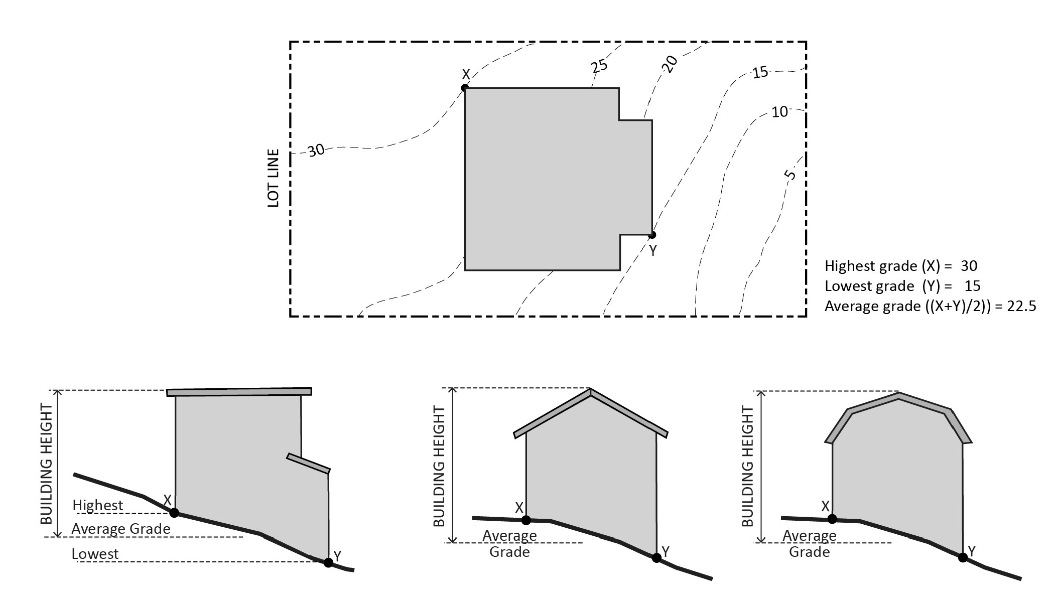
FIGURE 17.02.030.C.1: MEASURING BUILDING HEIGHT
2.
Measuring Height of Fences or Walls. The height of a fence or wall is measured as the vertical distance from the ground level on the lowest external side of the fence or wall to the highest point of such fence or wall.
FIGURE 17.02.030.C.2: MEASURING HEIGHT OF FENCES OR WALLS
3.
Measuring the Height of Decks. Deck height is determined by measuring from the ground to the top of the floor of the deck directly above the ground below.
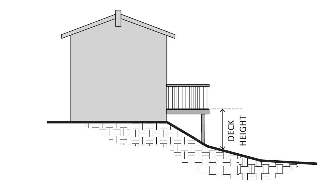
FIGURE 17.02.030.C.3: MEASURING HEIGHT OF DECKS
D.
Measuring Lot Width and Depth.
1.
Lot Width. Lot width is the horizontal distance between the side lot lines, measured at right angles to the lot along a straight line parallel to the front lot line.
2.
Lot Depth. Lot depth is measured along a straight line from the midpoint of the front property line of the lot to the midpoint of the rear property line or to the most distant point on any other lot line where there is no rear lot line.

FIGURE 17.02.030.D: MEASURING LOT WIDTH AND DEPTH
E.
Determining Average Slope. The average slope of a parcel is calculated using the following formula: S = 100(I)(L)/A, where:
1. S = Average slope (in percent)
2. I = Contour interval (in feet)
3. L = Total length of all contour lines on the parcel (in feet)
4. A = Area of subject parcel (in square feet)
F.
Determining Floor Area. The floor area of a building is the sum of the gross horizontal areas of all floors of a building or other enclosed structure, measured from the outside perimeter of the exterior walls and/or the centerline of interior walls.
1.
Included in Floor Area. Floor area includes, but is not limited to, all habitable space (as defined in the California Building Code) that is below the roof and within the outer surface of the main walls of principal or accessory buildings or the centerlines of party walls separating such buildings or portions thereof or within lines drawn parallel to and two feet within the roof line of any building without walls. In the case of a multi-story building that has covered or enclosed stairways, stairwells, or elevator shafts, the horizontal area of such features shall be counted only once at the floor level of their greatest area of horizontal extent.
2.
Excluded from Floor Area. Floor area does not include the following:
a.
Mechanical, electrical, and communication equipment rooms that do not exceed two percent of the building's total floor area;
b.
Bay windows or other architectural projections where the vertical distance between the lowest surface of the projection and the finished floor is 30 inches or greater;
c.
Covered porticoes, paseos, corridors, and courtyards designed for use by and accessible to the general public; and
d.
In non-residential buildings, areas used for off-street parking spaces or loading spaces, driveways, and maneuvering aisles.
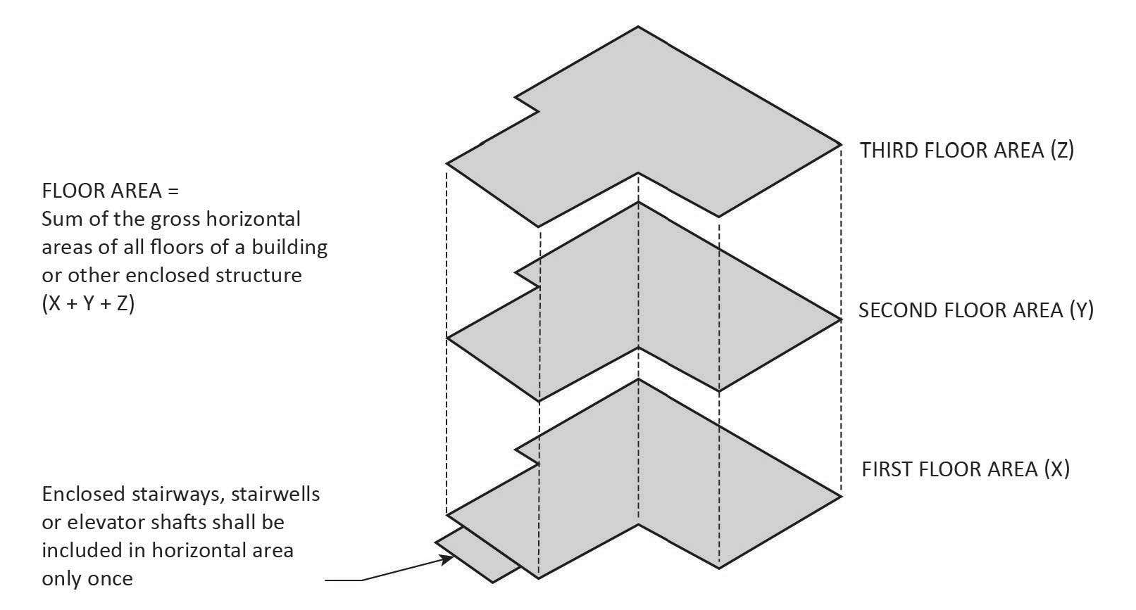
FIGURE 17.02.030.F: DETERMINING FLOOR AREA
G.
Determining Floor Area Ratio. The Floor Area Ratio (FAR) is the ratio of the floor area of all primary and accessory buildings on a site to the site area. To calculate the FAR, floor is divided by site area, and typically expressed as a decimal. For example, if the floor area of all buildings on a site totals 20,000 square feet, and the site area is 10,000 square feet, the FAR is expressed as 2.0.
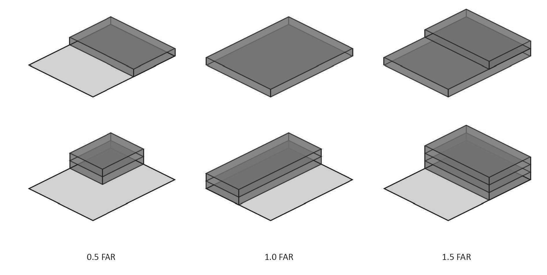
FIGURE 17.02.030.G: DETERMINING FLOOR AREA RATIO
H.
Determining Lot Frontage.
1.
Corner Lot. The front of a lot is the narrowest dimension of the lot with street frontage.
2.
Through Lot. The front of a through lot abuts the street that neighboring lots use to provide primary access.
I.
Determining Setbacks. A setback line defining a required setback is parallel to and at the specified distance from the corresponding front, side, or rear property line or other required measuring point. Required setbacks shall be unobstructed from the ground to the sky except where allowed pursuant to Section 17.16.080, Setbacks, subject to compliance with the Building Code.
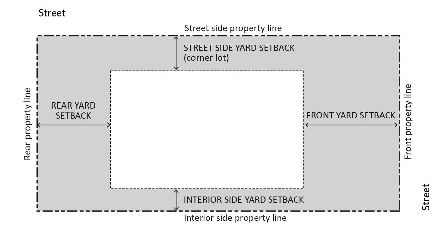
FIGURE 17.02.030.J: DETERMINING SETBACKS
J.
Measuring Signs. The calculations of measurements related to signs are described in Chapter 17.24, Signs.
17.03.010 - Establishment of zoning districts.
The county shall be classified into zoning districts, the designation and regulation of which are set forth in this zoning code and as follows.
A.
Base Zones. The county is divided into base zoning districts which are established as shown in Table 17.03.010, Base and Overlay Zoning Districts.
B.
Overlay Zones. Overlay zoning districts, one or more of which may be combined with a base zone, are established as shown in Table 17.03.010, Base and Overlay Zoning Districts.
17.03.020 - Official zoning map and district boundaries.
The boundaries of the zones established by this zoning code are not included in this zoning code but are shown on the Official zoning map maintained by the county. The Official zoning map, together with all legends, symbols, notations, references, zone boundaries, map symbols, and other information on the maps, have been adopted by the board of supervisors and are hereby incorporated into this zoning code by reference, together with any amendments previously or hereafter adopted, as though they were fully included here.
A.
Uncertainty of Boundaries. If an uncertainty exists as to the boundaries of any zoning district shown on the Official zoning map, the following rules shall apply:
1.
Boundaries indicated as approximately following the centerlines of alleys, lanes, streets, highways, streams, or railroads shall be construed to follow such centerlines.
2.
Boundaries indicated as approximately following lot lines, city or county limits, or extraterritorial boundary lines shall be construed as following such lines, limits, or boundaries.
B.
Parcels Containing Two or More Zoning Districts.
1.
For parcels containing two or more zoning districts, the location of the zoning district boundary shall be determined by the planning director.
2.
For parcels containing two or more zoning districts, the applicable regulations for each respective zone shall apply.