
Calhoun County Unincorporated
City Zoning Code
City Zoning Code
ARTICLE VI
- SUPPLEMENTAL REGULATIONS AND STANDARDS
Section 6:1 - Purpose.
These supplemental regulations are intended to address the development process in Calhoun County as it relates to the following areas: landscaping and open space; roadway and street intensity and service levels; buffering and screening between uses; Infrastructure and utility service; drainage, sediment control and grading; Available public facility service; access to major thoroughfares; and Communications towers and Antennas.
Section 6:2. - Landscaping and common open space standards.
6:2.1.
Definitions.
a)
Common open space. Common open space is land and/or water bodies used for recreation, amenity or buffer. Where required for residential development, it shall be freely accessible to all residents of a development or project. It shall not be occupied by buildings or structures, except as defined in Section 6:2.5.a), drives, parking or street right-of-way; nor shall it include individual yards or lots of residential dwelling units. Underground utilities shall be allowed if they are not part of a septic tank system. Applications for approval of RRSP-25 and RRSP-50 development projects may include Working Farms within Common Open Space, which are not required to be freely accessible by residents, and are not subject to the other limitations of this paragraph.
b)
Landscaping. Landscaping is a type of open space permanently devoted and maintained for the growing of shrubbery, grass, other plants, and decorative features to the land.
6:2.2.
Purpose. The purposes of landscaping and open space standards are to both protect and enhance the character, appearance, and image of Calhoun County, and improve the appearance of vehicular use areas and property abutting public rights-of-way; to protect, preserve and promote the aesthetic appeal, scenic beauty, character and value of land in the county; to promote public health and safety through reduction of noise pollution, storm water runoff, air pollution, visual pollution, and artificial light glare; and to provide as part of all high density residential projects sufficient open space and recreational areas for the inhabitants of such projects.
6:2.3.
Applicability. Where required elsewhere by Article 6, no new development, building, structure or vehicular use area shall hereafter be created or used unless open space and/or landscaping is provided in accord with the provisions of this section.
a)
Any necessary development approvals and permits submitted for new commercial or industrial projects should be granted and obtained prior to the commencement of any clearing, grading, tree removal or construction on a site, to include a submitted site landscaping plan.
b)
This requirement is not intended to apply to residential, silvicultural or agricultural uses. The Calhoun County Planning Commission will consider and review all said plans for approval, and all plans shall be subject to public input.
c)
The purpose and intent of this language is improving the aesthetics of thoroughfares and other public spaces, which will contribute to the general welfare, prosperity, and pride of a community, while mitigating potential environmental damage and promoting harmonious activities.
d)
No existing building, structure or vehicular use area shall be expanded or enlarged unless the minimum landscaping and/or open space required by the provisions of this section are provided to the extent of the alteration or expansion; not required for the existing use.
e)
The provisions of this section shall not apply to existing mobile home parks.
6:2.4.
Common open space or landscaping plan. An open space or landscaping plan shall be submitted as part of the application for a building permit. The plan shall:
a)
Designate areas to be reserved as open space and/or for landscaping. The specific design or open space and/or landscaping shall be sensitive to the physical and design characteristics of the site.
b)
Designate the type of open space which will be provided, and indicate the location of plant materials, decorative features, recreational facilities, etc.
c)
Specify the manner in which common open space shall be perpetuated, maintained and administered.
6:2.5.
Types of common open space and/or landscaping. The types of common open space which may be provided to satisfy the requirements of this chapter, together with the maintenance required for each are as follows:
a)
For residential uses.
1)
Natural areas are areas of undisturbed vegetation or areas replanted with vegetation after construction. Woodlands are specific types of natural areas. Maintenance is limited to removal of litter, dead trees and plant materials, and brush. Natural watercourses, considered to be open spaces, are to be maintained as free-flowing and devoid of debris. Stream channels shall be maintained so as not to alter flood levels.
2)
Recreational areas are designed for specific active recreational uses such as tot lots, tennis courts, swimming pools, ballfields and similar uses. Recreational areas shall be accessible to all residents of the development. Maintenance is limited to insuring that there exist no hazards, nuisances, or unhealthy conditions.
3)
Greenways are linear greenbelts linking residential areas with other open space areas. These greenways may contain bicycle paths, footpaths, and bridle paths. Connecting greenways between residences and recreational areas are encouraged. Maintenance is limited to insuring that there exist no hazards, nuisances, or unhealthy conditions.
4)
Landscaped areas and lawns including creative landscaped areas with gravel and tile, so long as the tile does not occupy more than two (2) percent of the required open space. Lawns, with or without trees and shrubs shall be mowed regularly to insure neatness and landscaped areas shall be trimmed, cleaned and weeded regularly.
b)
For nonresidential uses. Required landscaping shall be provided as follows:
1)
Along the outer perimeter of a use, where required by the buffer yard provisions of this chapter, to separate incompatible land uses.
2)
Within the interior, peninsula or island type landscaped areas shall be provided for any open vehicular use area containing more than twenty (20) parking spaces. Landscaped areas shall be located in such a manner as to divide and break up the expanse of paving and at strategic points to guide travel flow and directions. Elsewhere, landscaped areas shall be designated to soften and compliment the building site.
3)
Along the exterior walls of all structures exclusive of paved pedestrian ways or loading areas, a landscaped strip of at least five (5) feet wide shall be required.
4)
All commercial and industrial projects are encouraged when possible to leave borders and natural vegetation in place.
6:2.6.
Preservation of common open space. Land designated as "common open space" may not be separately sold, subdivided or developed. Excess land designated as common open space may be developed in the future. Open space areas shall be maintained so that their use and enjoyment as open space are not diminished or destroyed. Open space areas may be owned, preserved and maintained as required by this section by any of the following mechanisms or combinations thereof:
a)
Common ownership of the open space by a homeowner's association which assumes full responsibility for its maintenance.
b)
Dedication to and acceptance by the county.
c)
Deed restricted, private ownership which shall prevent development and/or subsequent subdivision of the open space land and provide the maintenance responsibility.
d)
In the event that any private owner of common open space fails to maintain same, the county may in accordance with the open space plan and following reasonable notice and demand that deficiency of maintenance be corrected, enter the open space to maintain same; the cost of such maintenance shall be charged to those persons having the primary responsibility for maintenance of the open space.
e)
Open space not in common ownership shall be perpetually maintained by the owner(s) having title to such open space.
(Ord. No. 2022-17, 7-25-2022)
Section 6:3. - Roadway and street intensity and service level standards.
6:3.1.
Purpose. The purposes of this section are:
a)
To relate land use and development to the design function and carrying capacity of the county road network,
b)
To reduce the cost of road repairs and maintenance by controlling development which would "overload" and accelerate the deterioration of existing streets, and
c)
To promote safety and convenience.
6:3.2.
Exceptions. The requirements of this section shall apply to all land uses and structures except:
a)
Single-family dwellings and subdivisions with one hundred (100) or more feet of street frontage, on average.
b)
Any use, building or structure in the RU District.
6:3.3.
Road classification. In order to carry out the purposes of subsection (a) above, all streets and roads in Calhoun County are hereby classified on the basis of their traffic carrying capacities and their design function in the circulation system.
a)
The classification system is based on concepts and criteria contained in the "Highway Functional Classification Manual, Concepts, Criteria, and Procedures", U.S. Department of Transportation, Federal Highway Administration. The manual classifies streets and roads into one of these functional categories: (1) local, (2) collector, and (3) arterial. Local streets are separated from other types because they carry significant volumes of foot and bicycle traffic and are used by children.
b)
For purposes of this chapter, these functional categories are refined to form a four street classification system, characterized as follows:
1)
Minor local (residential) street: A minor local street is one designed primarily to access abutting residential properties. This street normally terminates in a cul-de-sac, loop or other turnabout, with no more than two (2) access points.
2)
Major local (residential) street: A major local street is one designated primarily to access abutting residential properties. This street is characterized as one having two (2) or more access points, and receiving traffic from minor local streets.
3)
Collector street: A collector street is one that carries primarily residential traffic, but which provides no or only limited residential frontage and/or access.
4)
Arterial street: A street designated (1) to carry traffic from collector streets to the major arterial system, (2) to carry through traffic and (3) to carry intercounty traffic. Arterials are characterized as having access control, channelized intersections, restricted parking and signalization. The concept of service to abutting land is subordinate to the provision of travel service.
6:3.4.
Service level classification. The level of service for streets and roads is defined (according to the 1985 Highway Capacity Manual) in terms of vehicular delay. Delay is a measure of driver discomfort, frustration, fuel consumption, and lost travel time. Varied and complex factors contributing to delay include intersection geometry, frequency of curb cuts, traffic volumes, signalization and cycle length, etc.
a)
The various levels of service are classified A through F, depending on the delay factor and traffic flow conditions, as follows:
Level of Service A:
•
Free flow conditions
•
Low volumes
•
Little or no delays
•
Uninterrupted flow
•
No restriction on maneuverability
•
Drivers maintain desired speed
Level of Service B:
•
Stable flow conditions
•
Operating speeds beginning to be restricted
Level of Service C:
•
Stable flow but speed and maneuverability restricted by higher traffic volume
•
Satisfactory operating speed for urban conditions
•
Some delays at signals
Level of Service D:
•
High density, but stable flow
•
Restricted speeds
•
Noticeable delays at signals
•
Little freedom to maneuver
Level of service E:
•
Low, but relatively uniform operating speeds
•
Volumes at or near capacity
•
Approaching unacceptable delays at signals
Level of Service F:
•
Force flow conditions
•
Stop and go operation
•
Volumes below capacity may be zero
•
Average vehicle delay at signals is greater than one minute
6:3.5.
Standards. The following design capacity standards and service level designations shall govern the intensity of development along streets and roads in Calhoun County:
* ADT = Average Daily Traffic (trips)
To determine impact on ADT standards, The following table of "Traffic Generation Standards" shall be used in computing the number of trips to be generated by a given use. Also, traffic generated by existing uses on the impacted street shall be calculated by the table to determine aggregate daily traffic volumes and the capacity of the street to accommodate the proposed new use.
Source: TRB Report No. 365 "Travel Estimation Techniques for Urban Planning"
6:3.6.
To determine impact on service level designations, Section 6:3.5. Where required by Section 7:21 Large Scale Projects, the calculation to determine the impact on service level designations shall be made by a qualified traffic engineer representing the applicant. All data, including the recommendations of the engineer, shall be made available to the zoning administrator, who in turn may request review, comments and verification from the South Carolina Department of Highways and Public Transportation, regional transportation officials and county traffic engineers. Their suggestions and recommendations shall be reviewed with the applicant by the zoning administrator for possible incorporation in the final plan, or shall be referred to the planning commission for review.
6:3.7.
Application of standards, project review. All proposed nonexempt projects and land uses shall be evaluated by the zoning administrator on the basis of their traffic generating capacity and their impact on designated street service levels. Where the administrator determines that a proposed use will generate ADT (average daily traffic) in excess of the limits established by Section 6:3 or create a lower level of service than designated by Section 6:3.5 for streets and roads in the county, such use(s) shall be referred to the planning commission for review.
a)
In their review of the project application, the planning commission may consult the South Carolina Department of Highways and Public Transportation, other county and regional agencies involved in matters of transportation.
b)
The review may result in:
1)
Required modifications to the proposed use,
2)
Required modifications to the internal and/or external road network serving and impacted by the proposed use,
3)
A variance to the standards contained in this section 6.3,
4)
Mitigation,
5)
Required offsite improvements,
6)
Limiting frontage and access, or
7)
Denial, stating the reasons for denial.
c)
If denied by the planning commission, the applicant may appeal the decision to county council, who, in turn shall call for a public hearing, having given fifteen (15) days' notice of time and place in a newspaper of general circulation in the county. The council may overturn, modify or affirm the decision of the commission.
d)
Planning commission or county council approval on appeal shall be prerequisite to the issuance of a building permit for those projects referred by the administrator to the commission. Projects determined not to exceed the standards of Section 6:3.5 may be approved by the zoning administrator.
Section 6:4. - Buffer yard standards.
6:4.1.
Purpose. The purposes of the buffer yard are to ameliorate nuisances between adjacent land uses, and to promote land use compatibility. Additionally, the buffer yard offers the developer several options, each of which is calculated to "buffer" to an equivalent degree through distance (setbacks) and/or density (mass).
The unique feature of the buffer yard is that it is flexible. It may vary in distance and density based on: (1) what is proposed, (2) what is existing on the adjacent property, and (3) the type of buffer yard selected from one of the three prescribed by the buffer yard illustrations.
6:4.2.
Definition. A buffer yard is a strip of land located between different land uses. The buffer yard may contain specified types and amounts of live plantings and/or other structures needed to eliminate or minimize conflicts between land uses.
6:4.3.
Exceptions. The requirements of this section will apply to all land uses and structures except:
a)
Single-family dwellings;
b)
Manufactured homes on individual lots.
6:4.4.
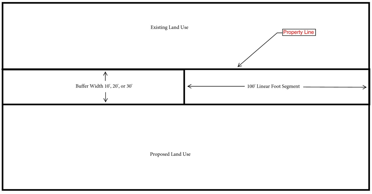
Where Required. Proposed new uses or substantially expanded uses (over 50 percent gross floor area) shall be required to provide buffer yards in accord with Table 6:4.1. The amount of land and the type of planting specified for each buffer zone required by this chapter are designed to limit possible nuisances between adjacent land uses or between a land use and a public road. The planting units required of buffer yards should be calculated to ensure that they do, in fact, function to "buffer."
6:4.5.
Location of buffer yards. Buffer yards shall be located on the outer perimeter of a lot or parcel, extending to the lot or parcel boundary line. Buffer yards shall not be located on any portion of an existing public or private street or right-of-way; however, they may occupy part or all of any required front, side or rear yard setback. Where required, buffer yards shall be developed as an integral part of the proposed use.
6:4.6.
Determination of buffer yard requirements. To determine the buffer yard required between adjacent parcels, the following procedure shall be followed:
a)
Identify the proposed land use.
b)
Identify the use of land adjacent to the proposed use.
c)
Determine the buffer yard required on each boundary (or segment thereof) of the proposed land use by referring to the table of buffer yard requirements and illustrations contained in this section which specify the buffer yard options between a proposed use and the existing adjacent use.
Where an existing use includes undeveloped land, the buffer yard requirements of this section shall apply only to that segment of the property line separating the two (2) uses.
6:4.7.
Buffer yard specifications. Tables 6:4.1, 6:4.2, and 6:4.3 in this section specify the type and quantity of plant materials required by each buffer yard. The requirements are stated in terms of the width of the buffer yard and the number of plants required per one hundred (100) linear feet of buffer yard. The requirements of a buffer yard may be satisfied by any one of the options.
6:4.8.
Required plantings. To determine the exact amount of required plantings, first determine the "plant unit multiplier". To do this, take the linear footage of the buffer yard and divide it by 100. (example: If a buffer yard is (65) linear feet: the "plant unit multiplier" would be .65.) Next, in order to determine the required number of plantings, multiply the "plant unit multiplier" by each separate number of required plantings required by each buffer yard type (refer to Tables 1, 2, & 3 in this section). All determined required plantings shall be rounded up to the next greatest whole number.
a)
The exact placement of required plants shall be the decision of the developer except that evergreen (or conifer) plant materials shall be planted in clusters rather than singly in order to maximize their chances of survival and increase screening.
b)
No required plantings and/or approved substitutions for the required plantings shall be located so as to obstruct travel vision at street or driveway intersections.
c)
All buffer yard areas not devoted to plants shall be seeded with lawn grass or suitable ground cover.
(*) If these buffer yard widths are selected, only one-half the number of required plant units per 100' shall be necessary.
(**) If these Buffer yard widths are selected, only one-quarter the number of required plant units per 100' shall be necessary.
d)
Example: If a particular boundary between land uses requires a Type (1) density classification, select either a 10', 20' or 30' wide buffer yard. If the 10' width is selected, the full complement of plantings listed must be placed in the buffer yard. If the 20' width is selected, only one-half (½) the number of listed plantings has to be provided, and for the 30' buffer yard, only one-quarter (¼) the required number of plants per one hundred (100) feet.
1)
If a fraction occurs when determining the amount of required plant units per 100 ft. of buffer yard, the required amount shall be the rounded up to the next greatest whole number.
e)
Example: If a land use requires 1.25 canopy trees for every 100' of buffer yard, then the developer should provide 2 canopy trees for every 100' of buffer yard.
6:4.9.
Minimum plant size. Plants shall be sufficiently sized to insure buffering and screening at the time of installation. Where the Buffer yard Illustrations indicate a mass or line of plants paralleling the length of the property line, the plant materials shall be sufficiently sized to insure obscurity at the time of installation. However, seedling plants may be used where berms or structures are required as part of the buffer yard. Landscape materials that are used for screening shall be of a size that allows growth to the desired height and opacity within one year.
* No caliper requirements.
6:4.10.
Plant Classification. Four basic plant types, adapted to local conditions, are specified for installation in buffer yards.
a)
Canopy trees: Large deciduous trees with a mature height of thirty (30) feet or greater. Examples include Hickory, Oaks, Magnolia, and Maples.
b)
Understory trees: Deciduous trees or large shrubs with a mature height of ten (10) to thirty (30) feet. Examples include Fruit Trees, Sourwoods, Dogwoods, Crepe Myrtles, and Holy Trees.
c)
Evergreen/conifers: Trees or large shrubs that reach at least (10) feet in height at maturity, and have grown foliage during all seasons of the year. Examples include Junipers, Cedars, Pine, Cypress, Blue Spruce Tree, Oak, Maple, Birch, Ash, Willow, Poplar, Aspen Beech, and Walnut.
d)
Shrubs: Prostrate or upright woody plants, evergreen or deciduous, with a mature height often less than (10) feet. Examples include Juniper, Ligustrum, Azalea, Camelia, Boxwood and Photinia.
6:4.11.
Species Diversity. Diversity among required plant material is mandatory for visual interest and to reduce the risk of losing a large population of plants due to disease.
a)
Species diversity requirement: No more than 50% of any plant unit requirement may be of a single species for any buffer yard type.
6:4.12.
Buffer yard substitutions.
a)
Evergreen canopy or evergreen understory trees may be substituted up to fifty (50) percent for deciduous understory and canopy trees.
b)
In all buffer yards, evergreen or conifer shrubs may be substituted for deciduous shrubs without limitation.
c)
Any existing plant material which otherwise satisfies the requirements of this section may be counted toward satisfying all such requirements.
d)
Where, owing to existing land use, lot sizes, configurations, topography, or circumstances peculiar to a given piece of property the buffer yard requirements of this section cannot reasonably be met, the developer may request and the zoning administrator may approve the substitution of appropriate screening, in the way of a fence or wall structure, along the property line of the proposed use.
1)
A six-foot high fence or wall may be substituted for a type 1 or 2 buffer yard and an eight-foot fence or wall may be substituted for a type 3 buffer yard.
2)
All fences and walls used as part of the buffer yard requirement must have the finished side facing outward. Fences shall be wooden or other durable or opaque material approved by the zoning administrator.
3)
Wooden fences shall be made of rot resistant material such as locust, cedar or redwood. If made of other woods, the post shall be rated for soil contact and the boards rated for outside use.
4)
Chain-link fences with wood, plastic, or metal strips are expressly prohibited. However, a chain-link fence with evergreen hedge is acceptable.
5)
Walls must be made of masonry materials including poured concrete, concrete block covered with stucco, or brick.
e)
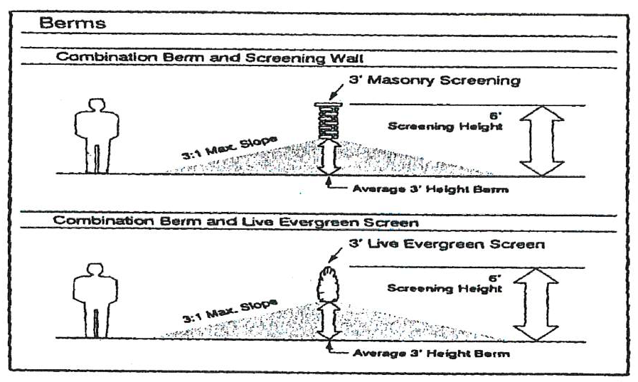
Berms may be substituted for the required buffer yard plantings provided the berm or any combination of berm, fence, and/or plantings provides an opaque screen that is six-foot high for a type 1 or 2 buffer yards and eight-foot high for type 3 buffer yards. Berms must parallel property lines when utilized.
6:4.13.
Outside storage. Any proposed commercial, industrial or other nonresidential use with over five hundred (500) square feet of outside storage area for materials to be sold, salvaged, stored and the like shall meet buffer yard requirements for light industry around the outside storage unit. Other uses on the site, if any, shall carry the appropriate buffer yard classification specified by Table 6:4.1.
6:4.14.
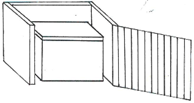
Containers and dumpsters. All exterior dumpsters or exterior garbage containers (excluding containers or groups containers with a combined capacity of less than six (6) cubic yards) shall be screened on all but one side by a fence or wall, intensive landscaping, or other suitable opaque enclosure. The average height of the enclosure shall be one (1) foot more than the height of the container but shall not be required to exceed eight (8) feet in height. The open side shall be obscured from street visibility to the extent possible.
6:4.15.
Fences and walls, appearance. All fences and walls used as a part of the buffer yard requirements must have a finished side that is facing adjoining property. The interior side of the fence or wall may be finished as owner deems appropriate. Where fences or walls are proposed by the developer, but not required by the applicable buffer yard requirements, they shall be established along the inside line of the buffer yard, toward the proposed use, except for ornamental fences or fences to the rear of the property, which may be built on the property line. Security fences and walls also may be established along the outer perimeter of the lot, with approval of the zoning administrator.
6:4.16.
Use of buffer yards. A buffer yard may be used for passive recreation; however, no plant material may be removed. All other uses are prohibited.
6:4.17.
Required maintenance. The maintenance of required buffer yards shall be the responsibility of the property owner. And all such yards shall be properly maintained so as to assure continued buffering. Failure to do so is a violation of this chapter and may be remedied in the manner prescribed for other violations.
(Ord. No. 2022-17, 7-25-2022)
Section 6:5. - Infrastructure and utility service requirements.
6:5.1.
Purpose. All development shall be provided with no less than minimum services in conformance with the provisions of this section. The property owner or developer, his agents or his assignees shall assume responsibility for the provision of basic services as a prerequisite to development does not in any way obligate the county council or its departments or agents to furnish such services.
6:5.2.
Utilities and services. No development shall be undertaken if adequate provision has not been made for the following basic services:
a)
Adequate power supply, normally electricity.
b)
Potable water supply of sufficient quantity and quality to satisfy domestic needs.
c)
Water supply of acceptable quantity and quality to satisfy commercial or industrial demand.
d)
Adequate means for treatment and disposal of domestic sewage and other liquid wastes.
e)
Adequate means for collection and disposal of solid wastes, except for single family residential developments.
6:5.3.
Easements. No development shall be undertaken unless adequate easements are provided to accommodate all required or planned utilities. The developer shall also demonstrate that adequate provisions have been made for access to and maintenance of all easements.
(Ord. No. 2022-17, 7-25-2022)
Section 6:6. - Drainage, sediment control and grading standards.
6:6.1.
Runoff to adjoining property restricted. No development shall be undertaken that appreciably increases the rate of surface water runoff reaching adjacent or surrounding property. Surface runoff shall be dissipated by retention/detention on the development parcel, percolation into the soil, evaporation, or in transport by natural drainage way or conduit to an appropriate point of discharge. The discharge rate shall not exceed a two-year frequency.
a)
All rain fall runoff shall be estimated by use of the rationale formula, Q = CIA, in which Q = quantity of runoff, cfs; C = average runoff coefficient, depending on slope, soil, land area and time of concentration; I-intensity of rainfall (in. per hr.); and A+ area under consideration (acres). The runoff coefficient must be selected from knowledge of the area and experience and must be appropriate to the types of development contemplated. For areas where the exact land use is known a precise runoff coefficient can be applied; however, as the drainage structures in the lower reaches of the area are considered, with variable land uses contributing to the runoff, calculated composite coefficient can be used.
b)
Rainfall runoff for development areas of varying sizes shall be calculated using the following standards at a minimum:
c)
Rainfall intensities in excess of the above minimum standards may be required.
d)
All drainage calculations and designs shall be approved by the county engineer. Estimates of both predevelopment and post development runoff must be provided. The county engineer may waive the requirements for the provision of such drainage calculations and design, at his discretion, for development utilizing ten (10) acres of land or less.
e)
All drainage structures, easements, and retention/detention facilities which are part of the drainage systems of traditional owner-occupied residential subdivisions and which are required and approved by Calhoun County shall be conveyed to the county in a format acceptable to the county for perpetual maintenance. Such facilities shall be fenced as specified by the county engineer.
f)
All retention/detention ponds accepted by the county for perpetual maintenance shall be assessed an impact fee, as established by county council resolution.
g)
The fees shall be paid prior to acceptance of such retention/detention facilities and related structures by the county council, shall be deposited in an escrow fund established by the county treasurer, and shall be designated and used solely for the required maintenance of retention/detention facilities and related drainage structures and easements.
h)
The county engineer is authorized to establish and to enforce construction standards for such retention/detention facilities and related drainage structures and easements. No such retention/detention facilities designed to hold water permanently shall be conveyed to the county. Such facilities shall be maintained in a manner acceptable to Calhoun County such as by means of a home owners association or some other format approved by the county attorney.
i)
However, all drainage structures, easements, and retention/detention facilities which are part of the drainage systems of commercial developments, industrial developments, multifamily apartment/rental developments and residential developments such as condominiums which involve common ownership of property and facilities shall be maintained perpetually by the owners of such development. In the case of such condominium residential development involving common ownership of property, evidence of the provision for perpetual maintenance of such drainage systems, structures, easements, and retention/detention facilities must be provided and approved by the county attorney prior to the issuance of certificates of occupancy for such structures. Such facilities should be fenced as specified by the county engineer. Should the owner not fence as suggested, the owner shall provide documentation necessary to hold the county harmless for damages resulting from storm water runoff. Such documentation must be approved by the county attorney.
6:6.2.
Reserved.
Section 6:7. - Available public facility service.
6:7.1.
Except for buildings, structures and development in the RU District, which are exempt from the requirements of this section, a developer must tie into existing public or private community water and/or sewer systems located within one thousand (1,000) feet of a proposed development, unless the public or private system has determined such connection is not feasible and provided further that the public and/or private system does not require extra consideration as provided for below: annexation.
6:7.2.
In the event that public or private system has been determined not feasible or in the event such public and/or private system requires such extra consideration as specified herein, then and in either such event, the developer may provide independent alternative water and/or sewer services provided such alternative services meet applicable regulations of the South Carolina Department of Health and Environmental Control.
Section 6:8. - Access to major thoroughfares.
No street or driveway shall enter a major thoroughfare as designated on the official major thoroughfares map at a point nearer than three hundred (300) feet from an existing thoroughfare, street, alley or driveway except where a tract of land would be rendered unusable by the strict application of this chapter. The county planning commission shall determine whether strict application of this Section of this Article shall be enforced.
Section 6:9. - Communications Towers and Antennas.
6:9.1.
Purpose. The purpose of this section is to establish general guidelines for the siting of wireless communications towers and antennas. The county endeavors to provide for the ever expanding communications needs while protecting the residential areas and associated land uses from the potential adverse impacts of towers and antennas. Other purposes of this section include:
a)
Provide guidelines that allow for the siting of cellular towers within Calhoun County.
b)
Discourage the location of towers in residential areas.
c)
Minimize the total number of towers located throughout the community.
d)
Strongly encourage the joint use of new and existing tower sites as a primary option rather than the construction of additional single-use towers.
e)
Encourage the location of towers and antennas in areas where the adverse impact on the community is minimal.
f)
Encourage the users of towers to configure them in a way that minimizes the adverse visual impact of the towers and antenna through careful design, siting, landscape screening and innovative camouflaging techniques.
g)
Enhance the ability of the providers of telecommunications services to provide services to the community quickly, effectively and efficiently.
h)
Avoid potential safety hazards and damage to property from tower failure through engineering and careful siting of tower structures.
6:9.2.
Definitions.
a)
Communications Tower as used in this ordinance shall mean a tower, pole, or similar structure which supports a telecommunications antenna operated for commercial purposes, above ground in a fixed location, freestanding, guyed, or on a building or other structure.
b)
Telecommunications, as defined in the federal Telecommunications Act of 1996, means the transmission, between or among points specified by the user, of information of the user's choosing, without change in the form or content of the information as sent and received.
c)
Antenna means a device, dish or array used to transmit or receive telecommunications signals.
d)
Height of communication tower is distance from base structure at ground level to top of tower, including top-mounted attachments such as lightning rods.
6:9.3.
Building Permit Required. Prior to the erection of a communication tower within the unincorporated area of Calhoun County, a building permit must be obtained from the Building Codes Official. Prior to the issuance of a building permit, the Building Codes Official or his designee must approve the proposed construction or erection of a communications tower subject to the standards of this section.
6:9.4.
Applicability.
a)
New towers and antennas. All new towers or antennas in Calhoun County shall be subject to these regulations, except as provided below in Sections 6:9.4.b) through 6:9.4.d).
b)
Amateur radio station operators/receive only antennas. This section shall not govern the installation of any antenna owned and operated by an amateur radio operator and used exclusively for private noncommercial purposes.
c)
Preexisting towers or antennas. Preexisting towers and antennas shall not be required to meet the requirements of this section unless moved or replaced.
d)
Proposed communications equipment co-locating on existing towers and structures without addition to their height shall not be subject to the requirements of this section.
6:9.5.
General Conditions.
a)
A freestanding or guyed communication tower may be located in all districts except the following: UD, RS, RM , OR, and SPI.
b)
The height of a freestanding or guyed communication tower must not exceed 300 feet. A tower and/or antenna mounted on an existing building, water tank, or structure other than a freestanding or guyed tower must not extend more than twenty (20) feet above the highest part of the structure.
c)
All conditions listed under the specific zoning district must be met.
d)
Setbacks:
1)
Minimum setback from residential structures/districts: One (1) foot setback for each foot in height of the proposed tower, plus fifty (50) feet measured from the base of the tower.
a.
In the case of a tower and/or antenna on a building, the setback must be measured from the base of the building.
b.
This requirement may be waived by the owner(s) of the residential structure.
2)
Minimum setback for fall zone: A communication tower must be located such that adequate setbacks are provided on all sides to prevent the tower's fall from encroaching onto adjoining properties. The fall zone shall be determined by an engineer certified by the State of South Carolina in a letter which includes the engineer's signature and seal.
e)
Historic and Scenic Property: A communication tower must not adversely affect any property listed in the National Register of Historic Places, State Heritage Preserves, State or National Parks, or any road or river that has been officially designated a scenic road or river.
f)
Co-Location:
1)
Certification of Unavailability of Existing Towers for Co-Location: For the purpose of co-location review, the applicant shall submit satisfactory written evidence (such as correspondence, agreements, contracts, etc.) that alternative towers, buildings, or other tall structures are not available for use within the tower applicant's tower site search area that are structurally capable of supporting the intended antenna or meeting the applicant's necessary height criteria, providing a location free of interference from other communication towers, or available at the prevailing market rate (as determined by county staff communications with persons doing business with the industry).
2)
Future Co-Location Opportunity: A communication tower shall be constructed for future co-location opportunity subject to engineering capabilities of that design. The tower's owner must submit documentation of his/her willingness to allow other users to co-locate on the tower at the prevailing market rate (as determined by county staff communications with persons doing business with the industry).
g)
Screening: A minimum of a six (6) foot non-climbable fence shall be placed around the tower and any associated building. Guy wires may be fenced separately.
h)
Lighting: A communications tower shall only be illuminated as required by the Federal Communications Commission or the Federal Aviation Administration. Nighttime strobe lighting shall not be incorporated unless required by the Federal Communications Commission, Federal Aviation Administration, or other regulatory agency.
i)
Signage: A communication tower shall not include signs on any portion of the tower, except as is required by applicable state or federal law, rule or regulation. However, signs for the purpose of identification, warning, emergency function and/or contact information may be placed as required by standard industry practices.
j)
Aesthetics: Towers and antennas shall meet the following requirements:
1)
Applicants must provide camouflaging such as man-made trees, clock towers, bell steeples, light poles or similar alternative-design mounting structures that camouflage or conceal the presence of antennas or towers, or provide documentation as to why camouflage is not feasible.
2)
The tower shall either maintain a galvanized steel finish or meet the applicable standards of the FAA. If the tower is not to be camouflaged by an alternative tower structure, the tower is to be painted a neutral color so as to reduce visual obtrusiveness.
3)
Whether a tower is camouflaged or not at a tower site, the design of the buildings and related structures shall, to the extent possible, use materials, colors, textures, screening and landscaping that will blend them into the natural setting and surrounding buildings.
4)
If an antenna is installed on a structure other than a tower, the antenna and supporting electrical and mechanical equipment must be a neutral color that is identical to or closely compatible with the color of the supporting structure so as to make the antenna and related equipment as visually unobtrusive as possible.
5)
Existing mature tree growth and natural land forms on the site shall be preserved to the maximum extent possible.
k)
State or Federal Requirements: All towers must meet or exceed current standards and regulations of the FAA, FCC, and any other agency of the state or federal government with authority to regulate towers and antennas. If such standards and regulations are changed, then the owners of the towers and antennas governed by this section shall bring such towers and antennas into compliance with such revised standards and regulations within six months of the effective date of such standards and regulations, unless a different compliance schedule is mandated by the controlling state or federal agency. Failure to bring towers and antennas into compliance with such revised standards and regulations shall constitute grounds for the removal of the tower or antenna at the owner's expense.
l)
Building codes; safety standards: To ensure the structural integrity of towers, the owner of a tower shall ensure that it is maintained in compliance with standards contained in applicable state and local building codes. If, upon inspection, the county concludes that a tower fails to comply with such codes and standards and constitutes a danger to persons or property, then upon notice being provided to the owner of the tower, the owner shall have 30 days to bring such tower into compliance with such standards. Failure to bring such tower into compliance within said 30 days shall constitute grounds for the removal of the tower or antenna at the owner's expense.
m)
Minimum distance between towers: Separation distances between towers shall be applicable to and measured between the proposed tower and preexisting towers. The separation distances shall be measured by drawing or following a straight line between the base of the existing tower and the proposed base, pursuant to a site plan, of the proposed tower.
6:9.6.
Application Requirements. An application for a building permit for a communications tower shall include the following information:
a)
A scaled site plan showing the location of the tower, guy, anchors (if any), buildings and other structures or improvements, parking, driveways and fences. Adjacent land uses shall also be noted on the site plan, with precise measurements noted between the proposed tower and any surrounding residential structures.
b)
Elevation drawing(s) shall clearly show the height and design of the tower, and the materials to be used, including color.
c)
Documentation indicating that co-location on existing towers or buildings in the vicinity of the proposed tower was attempted by the applicant but found unfeasible, with reasons noted.
d)
Documentation showing the structural capability of the communication tower to accommodate co-location and willingness of the tower owner to allow co-location of the tower.
e)
Inventory of existing sites. Each applicant for an antenna and/or tower shall provide to the Zoning Administrator an inventory of its existing towers, antennas or sites approved for towers or antennas that are either within the jurisdiction of the county or within one mile of the border thereof, including specific information about the location, height and design of each tower. The Zoning Administrator may share such information with other applicants applying for administrative approvals or conditional use permits under this section or other organizations seeking to locate antennas within the jurisdiction of the county; provided, however, that the Zoning Administrator is not, by sharing such information, in any way representing or warranting that such sites are available or suitable.
f)
Any other information as requested by staff or by the Board of Zoning Appeals to allow adequate review of approval criteria, including a line of sight analysis showing potential visual and aesthetic impacts. For instance, photographs may be required with the tower superimposed to assess visual impact. Additionally, the proposed tower's FAA study number may be required.
6:9.7.
Conditionally Approved Uses.
a)
General. The following provisions shall govern the issuance of conditional use permits for towers or antennas either as primary or accessory uses:
1)
The Zoning Administrator shall review the application and determine if the proposed use complies with the conditions outlined in this section.
2)
The Zoning Administrator may administratively approve the uses listed in this subsection.
3)
The Zoning Administrator, with input from the Building Codes official, shall have a maximum of thirty (30) days to act on the application. Staff's failure to act on the application within this time frame will result in the applicant being granted a building permit unless the applicant's obligation to provide requested information as specified by this ordinance and/or the zoning administrator or his designee is not met.
b)
List of Conditionally Approved Uses.
1)
Locating antennas on existing structures with modifications consistent with the General Conditions listed in this section and provided that:
a.
The antenna, as measured from the lowest grade, does not extend more than the maximum allowed building height for the zone wherein the structure is located.
b.
The antenna complies with all applicable FCC and FAA regulations.
c.
The antenna complies with all applicable building codes.
2)
Locating antennas on existing towers with modifications made consistent with the General Conditions listed in this section and provided co-location is accomplished in a manner consistent with the following:
a.
Any tower modifications or reconstructions to accommodate the co-location of an additional antenna is of the same tower type as the existing tower unless the Zoning Administrator allows reconstruction as a monopole.
b.
An existing tower may be modified or rebuilt to a taller height provided that it does not exceed the maximum allowed tower height established by the applicable zoning district.
c.
A tower which is being rebuilt to accommodate the co-location of an additional antenna may be moved temporarily onsite within fifty (50) feet of its existing location, provided only one (1) tower will remain on the site.
3)
Locating new towers consistent with the General Conditions listed in this section and the following:
a.
Proposed tower does not exceed the maximum tower height established by the applicable zoning district.
b.
Proposed tower is not closer in proximity to adjacent towers than allowed.
c.
Zoning Administrator has certified that co-location with an existing tower or attachment to an existing structure is not feasible.
d.
Proposed tower is to be built using monopole or guyed construction.
6:9.8.
Special Exception Uses.
a)
General. The following provisions shall govern the issuance of special exception permits for towers or antennas either as primary or accessory uses by the Board of Zoning Appeals.
1)
If the tower or antenna is not an exempt use listed under Section 6:9.4 or a conditionally approved use listed under Section 6:9.7 of this section, then a special exception permit shall be required for the construction of a tower or the placement of an antenna.
2)
In granting a special exception permit, the Board of Zoning Appeals may impose conditions to the extent that the Board of Zoning Appeals concludes such conditions are necessary to minimize any adverse effect of the proposed tower on adjoining properties.
3)
Any information of an engineering nature that the applicant submits, whether civil, mechanical, or electrical, shall be certified by a licensed professional engineer.
b)
Towers. Factors considered in granting special exception permits for towers. In addition to the general conditions required for consideration, the Board of Zoning Appeals shall consider the following:
1)
Proposed tower does not exceed the maximum height established by the applicable zoning district.
2)
Proximity of the tower to residential structures and residential district boundaries. Towers shall be a minimum of five hundred (500) feet from existing residential, public, school, or church areas.
3)
Nature of uses on adjacent and nearby properties.
4)
Design of the tower.
5)
Availability of suitable existing towers, other structures, or alternative technologies not requiring the use of towers or structures. Availability of suitable existing towers, other structures or alternative technology. No new tower shall be permitted unless the applicant demonstrates to the reasonable satisfaction of the Board of Zoning Appeals that no existing tower, structure or alternative technology that does not require the use of towers or structures can accommodate the applicant's proposed antenna. An applicant shall submit information requested by the Board of Zoning Appeals related to the availability of suitable existing towers, other structures or alternative technology. Evidence submitted to demonstrate that no existing tower, structure or alternative technology can accommodate the applicant's proposed antenna may consist of any of the following (although nothing should be construed to infer that meeting one, some or all of the following shall entitle the applicant to approval):
a.
No existing towers or structures are located within the geographic area which meet applicant's engineering requirements.
b.
Existing towers or structures are not of sufficient height to meet applicant's engineering requirements.
c.
Existing towers or structures do not have sufficient structural strength to support applicant's proposed antenna and related equipment.
d.
The applicant's proposed antenna would cause electromagnetic interference with the antenna on the existing towers or structures, or the antenna on the existing towers or structures would cause interference with the applicant's proposed antenna.
e.
The fees, costs or contractual provisions required by the owner in order to share an existing tower or structure or to adapt an existing tower or structure for sharing are unreasonable. Costs exceeding new tower development by 25% are considered to be unreasonable.
f.
The applicant demonstrated that there are other limiting factors that render existing towers and structures unsuitable.
g.
The applicant demonstrates that an alternative technology that does not require the use of towers or structures, such as a cable microcell network using multiple low-powered transmitters/receivers attached to a wireline system, is unsuitable. Costs of alternative technology that exceed new tower or antenna development shall not be presumed to render the technology unsuitable.
6)
Setbacks.
a.
Guy wires and accessory buildings must satisfy the minimum zoning district setback requirements.
b.
No tower shall exist within required buffer areas as prescribed within this ordinance.
c.
Proposed tower meets the setback requirements of this section.
7)
Minimum Distance between Towers. Separation distances between towers shall be applicable for and measure between the proposed tower and preexisting towers. The separation distances shall be measured by drawing or following a straight line between the base of the existing tower and the proposed base, pursuant to a site plan, of the proposed tower.
a.
Minimum distance between towers may be waived if applicant documents that existing towers in the area are incapable of supporting their equipment from a structural standpoint.
b.
Minimum distance between towers may be waived if applicant documents that transmission equipment on existing towers in the area would result in interference and impede their ability to transmit.
c.
Minimum distance between towers may be waived if applicant documents that the owner(s) of existing towers in the area refuses to make the tower space available at prevailing market rates for the Calhoun County area market.
8)
The Board of Zoning Appeals may waive or reduce the burden on the applicant of one or more of these criteria if the Board concludes and documents that the goals of this section are better served thereby.
6:9.9.
Tower Abandonment. A communication tower that is not used for communication purposes for more than 120 days (with no new application on file for any communication user) is presumed to be out of service and the owner of such tower must notify the Zoning Administrator and remove the tower within sixty (60) days.
Section 6:10. - Standards for Off-street Parking and Loading.
6:10.1.
Definition. An off-street parking space is an area, not in a street or alley, permanently reserved for the temporary storage of one (1) automobile and connected with a street or alley by a driveway which affords ingress and egress.
6:10.2.
Purpose. The purpose of this chapter is to ensure the provision of off-street parking in sufficient quantity to satisfy the demand generated by any given land use, and subsequently reduce the impact of development (requiring parking) on the public transportation system.
6:10.3.
Off-street parking requirements. Off-street automobile storage and parking space shall be provided on every lot on which any of the following uses are hereafter established. The number of parking spaces provided shall be at least as great as the number specified in Table 6:10.1 for the particular use(s). When application of said provision results in a fractional space requirement the next larger requirement shall prevail.
a)
The parking space requirements for a use not specifically listed in Table 6:10.1 shall be the same as for a listed use of similar characteristics of parking demand generation.
b)
Except for shopping centers, mixed uses, uses with different parking requirements occupying the same building or premises, or in the case of joint use of a building or premises by more than one use having the same parking requirements, the parking spaces required shall equal the sum of the requirements of the various uses computed separately.
c)
Whenever a building or use, constructed or established after the effective date of these regulations is changed or enlarged in floor area, number of employees, number of dwelling units, seating capacity or otherwise, to create a need for an increase of ten (10) percent or more in the number of existing parking spaces, such spaces shall be provided on the basis of the enlargement or change.
Parking Notes:
[1] Or one space per 30 square feet of assembly area without seats
[2] Plus additional spaces for office and administrative square feet
6:10.4.
Parking space for physically handicapped.
a)
When off-street parking is required for any nonresidential use, parking for the handicapped shall be included when calculating the overall parking requirements for a building or use, based on the following formula:
b)
Parking spaces for the physically handicapped shall measure twelve (12) feet by twenty (20) feet and shall be located as close as possible to ramps, walkways, and entrances.
c)
Parking spaces should be located so that physically handicapped persons are not compelled to wheel or walk behind parked cars to reach entrances, ramps or walkways.
6:10.5.
Reduction of off-street parking space. Off-street parking facilities at the effective date of this chapter shall not subsequently be reduced to an amount less than that required under this chapter for a similar new building or new use. Off-street parking facilities provided to comply with the provisions of this chapter shall not subsequently be reduced below the requirements of this chapter, except that by reason of reduced floor area or capacity or change in requirements that a reduction in off-street parking is reasonable and consistent with the public welfare.
6:10.6.
Land to provide parking. The land to provide parking must be on the same site as the use it is intended to serve; however, street separation is permissible.
6:10.7.
Design and construction standards.
a)
Applicability. The requirements of this section shall not apply to patio homes, duplexes, mobile homes, semidetached dwellings, or outdoor recreational uses or any uses in the RM District.
b)
Drainage and maintenance. Off-street parking facilities shall be properly graded for drainage to prevent damage to abutting property and/or public streets. Off-street parking areas shall be maintained in a clean, orderly, dust-free, and weed-free condition at the expense of the owner or lessee and not used for the sale, repair, or dismantling or servicing of any vehicles or equipment, except for service and auto repair stations.
c)
Separation from walkways and streets. Landscaping, curbing, fencing or other approved barriers to vehicular movement shall be provided along property boundaries to control entrance and exit of vehicles or pedestrians, and separate off-street parking spaces from sidewalks and streets. All parking spaces shall be designed so that vehicular movement onto a public street is in a forward motion.
d)
Surfacing and marking. Parking lots twenty (20) or more spaces shall be surfaced with asphalt or concrete, and shall be marked by painted lines, curbs or other means to indicate individual spaces. However, such requirements may be waived on an individual basis by the planning commission for rural churches, certain industrial uses, and uses not catering to the public.
e)
Lighting. Adequate lighting shall be provided if off-street parking spaces are to be used at night. Equipment for lighting parking facilities shall be arranged so that light does not interfere with traffic or adjoining residential uses. It is recommended that lighting fixtures be "dark sky" friendly and offer reasonable uses of outdoor lighting for nighttime safety, utility, security, and enjoyment while preserving the ambiance of the night. Energy conservation is encouraged. Care should be taken to minimize glare and obtrusive light by limiting outdoor lighting that is misdirected, excessive, or unnecessary.
f)
Parking and isle dimensions. Parking stalls shall be not less than nine (9) feet by nineteen (19) feet, except that a maximum of twenty percent (20) of the total number of stalls may be 8.5 feet by eighteen (18) feet. However, the dimensions of all parallel parking stalls shall be not less than nine (9) feet by twenty-four (24) feet. Minimum isle widths shall be as follows:
90 degree parking .....24 feet
60 degree parking .....20 feet
45 degree parking .....15 feet
g)
Joint use of off-street parking lots. Up to fifty (50) percent of the parking spaces required for: (1) theaters, public auditoriums, bowling alleys, dance halls, clubs, churches and religious institutions may be provided and used jointly by: (2) financial institutions, offices, retail stores, repair shops, service establishments, and similar uses not normally open, used, or operated during the same hours as those listed in (1); provided however, that written agreement assuring their retention for such purposes shall be properly drawn and executed by the parties concerned, approved as to form and content by the county attorney, and shall be filed with the application for a building permit.
6:10.8.
Off-street loading. All uses shall provide off-street loading areas sufficient for their requirements.
a)
Such space shall insure that no vehicle being loaded or unloaded in connection with normal operations will stand in or project onto a public street or sidewalk.
b)
Off-street loading and unloading areas shall in all cases be located on the same lot or parcel of land as the structure they are intended to serve.
(Ord. No. 2022-17, 7-25-2022)
Section 6:11. - Standards for Location, Construction and Maintenance of Signs.
6:11.1.
Purpose. The purpose of these regulations is to protect the dual interest of the public and the advertiser. They are designed to promote public safety and welfare and insure the maintenance of landscape quality and environmental preservation, while satisfying the needs of sign users for efficient and adequate identification, communication and advertising.
6:11.2.
Applicability and conformance. This chapter regulates the number size, placement and physical characteristics of signs, exempts certain signs, prohibits certain signs, and requires permits for certain signs. From and after the adoption of this chapter, no sign may be erected in the unincorporated area of the county unless it conforms with the requirements of this article.
6:11.3.
Applicable Definitions.
a)
Electronic changeable copy sign. A sign or portion thereof that displays electronic, non-pictorial or pictorial static images, static graphics, static pictures, or static text defined by a small number of matrix elements using different combinations of light emitting diodes (LED's) fiber optics, light bulbs, or other illumination devices within the sign display area where the text and/or pictorial or graphic messages in the sign display area change copy by electronic or electronically controlled means; Electronic changeable copy signs include computer programmable, microprocessor controlled electronic displays, and any all-digital signs that have the ability to change copy through electronic or electronically controlled means.
b)
Flashing sign. A directly or indirectly illuminated sign or portion thereof that exhibits changing light or color effect by any means, so as to provide intermittent illumination that changes light intensity in sudden transitory bursts and creates the illusion of intermittent flashing light by streaming, graphic bursts showing movement, or any mode of lighting which resembles zooming, twinkling, or sparkling.
c)
Freestanding sign. A sign standing directly upon the ground or having one (1) or more supports directly upon the ground, and being detached from any building or structure.
d)
Marquee sign. A sign attached to or hung from a marquee and said marquee shall be known to mean a canopy or covered structure projecting from and supported by a building, when such canopy or covered structure extends beyond the building line.
e)
Moving Sign. A sign in which any parts of the physical sign move, rotate, or are otherwise not static.
f)
Projecting sign. A sign which is attached to the face or outside wall of a building which projects out at an angle there from and projects more than twelve inches beyond the face of such wall.
g)
Roof sign. A sign that is mounted on the roof of a building or which is wholly dependent upon a building roof for support.
h)
Shimmering sign. A sign which reflects an oscillating sometimes distorted visual image.
i)
Video display sign. A sign that changes its message or background in a manner or method of display characterized by motion or pictorial imagery, which may or may not include text and depicts action or a special effect to imitate movement, the presentation of pictorials or graphics displayed in a progression of frames which give the illusion of motion, including, but not limited to, the illusion of moving objects, moving patterns or bands of light, or expanding or contracting shapes, not including electronic changeable copy signs. Video display signs include projected images or messages with these characteristics onto buildings or other objects, computer programmable, microprocessor controlled electronic displays, and any all-digital signs.
6:11.4.
Exempt signs. The following signs are exempt from the provisions of this article, and require no permit:
a)
One (1) sign or plate attached to the wall of each building, not more than one (1) square foot in area.
b)
Signs of duly constituted governing bodies, including traffic regulatory devices, legal notices and warnings at railroad crossings.
c)
Signs on the interior side of window glass.
d)
One (1) freestanding sign per lot, not to exceed six (6) square feet in area.
6:11.5.
Prohibited signs. The following signs are prohibited:
a)
Any sign which displays intermittent or flashing illumination or lights of changing degrees of intensity including all, flashing signs, shimmering signs, and video display signs.
b)
Electronic changeable copy signs.
c)
Moving Signs.
d)
Any sign or advertising device painted on a fence, power or telephone pole, tree, stone or any natural object.
e)
Signs placed with the primary purpose of providing a sign not otherwise allowed for by this chapter.
f)
Abandoned signs.
6:11.6.
Permitted signs. The following signs are allowed, subject to the issuance of a sign permit by the county and compliance with the applicable development standards of this Section 5-158:
a)
Signs permitted in the RS and RM Districts. The following signs and no others may be established or erected in the RS and RM Districts. One (1) freestanding sign for each nonresidential use permitted by such districts and one (1) freestanding sign for each subdivision, multifamily, group housing or mobile home park project or entrance thereto, provided the sign area does not exceed forty (40) square feet in area nor fifteen (15) feet in height, and if illuminated is done so by indirect or muted lighting.
b)
Signs permitted in the RUD, UD, OR, LD, and ID Districts. The following signs and no others shall be permitted in the above-referenced districts:
1)
All signs permitted by subsection 1. of this section, together with the conditions attached thereto.
2)
Freestanding signs for nonresidential uses, under the following conditions:
a.
Allowable area. Freestanding signs are allowed one (1) square foot of sign face per lineal foot of street frontage for the first one hundred (100) feet; and one-half (½) square foot of sign face for each lineal foot of street frontage in excess of one hundred (100) feet, up to a maximum of three hundred (300) square feet. Exception: A maximum of three hundred seventy-eight (378) square feet is allowed along the interstate corridor.
b.
Number of signs. One (1) freestanding sign is allowed for each developed site, lot or parcel. Where a site or parcel fronts on more than one street, one (1) additional freestanding sign is permitted for each additional street upon which it fronts. Such signs are not permitted on undeveloped lots or parcels. Where two (2) or more detached buildings occupy the same lot or parcel, each may have one (1) freestanding sign, provided the total sign area does not exceed the allowable limits specified by 2.(b)(1) of this section, based on the total lineal street frontage of the site or parcel on which they are to be located. Where two (2) or more attached businesses or buildings occupy the same site or parcel, i.e., shopping center, only one (1) freestanding sign for the aggregate businesses shall be permitted per street frontage.
c.
Height of signs. No freestanding sign shall exceed thirty-five (35) feet in height, except for an area paralleling and extending six hundred sixty (660) feet from the right-of-way of Interstate Highway 26 where signs may be erected to a height of fifty (50) feet.
3)
Permanent signs attached to buildings, under the following conditions:
a.
Allowable area. If there is no freestanding sign on the site, one and one-half (1½) square feet of sign area shall be permitted for each lineal front foot of the principal building.
b.
Types of signs. Flat, projecting, marquee, roof and awning signs are allowed.
c.
Number of signs. There is no limit on the number of signs if within the total allowable area limit. However, only one (1) projecting sign is allowed per building frontage, and shall be allowed only if there is no freestanding sign on the same site frontage; except for shopping centers, which may have one (1) projecting sign for each business use, plus allowable freestanding signs.
4)
Temporary signs, under the following conditions:
a.
Pennants, flags, and fluttering devices and similar exhibits to announce grand openings and mark special occasions; provided such exhibits are removed within thirty (30) days of the day they are permitted; further provided that no exhibit shall be repermitted within six (6) months of the time it or a similar display is removed from the premises.
b.
Portable signs, provided such signs are removed within three (3) months of the day they are permitted; no more than one (1) such is permitted for each nonresidential use; and no such sign shall repermitted within six (6) months of the time it is removed from the premises. Portable signs are not permitted on residential or undeveloped lots or parcel.
c.
Political signs, provided they will be removed two (2) weeks after the election has been held.
6:11.7.
Development standards. All signs allowed by this chapter shall comply with the development standards of this section.
a)
Visual area clearance. No sign shall be located so as to obstruct travel vision at street or driveway intersections.
b)
Vehicle area clearance. When a sign extends over an area where vehicles travel or are parked, the bottom of the sign structure shall be at least fourteen (14) feet above the ground. Vehicle areas include driveways, alleys, parking lots, and loading and maneuvering areas.
c)
Pedestrian area clearance. When a sign extends over sidewalks, walkways or other spaces accessible to pedestrians, the bottom of the sign structure shall be at least eight and one-half (8½) feet above ground.
d)
Sign materials. Signs must be constructed of durable materials, maintained in good condition and not permitted to fall in disrepair.
e)
Sign illumination. Signs when illuminated by direct lighting shall have such lighting shielded so as not to directly shine on abutting properties or in the line of vision of public using the streets or sidewalks.
f)
Location of sign. No signs including traffic signs and similar regulatory notices except those of a duly constituted governing body shall be located within any road right-of-way; no part of a sign, while permitted, shall be located closer than five (5) feet to any property line or within ten (10) feet of a public right-of-way.
6:11.8.
Sign measurement.
a)
Sign face area.
1)
The area enclosed in frames or cabinets is determined by measuring the outer dimensions of the frame or cabinet surrounding the sign face. Sign area does not include foundations or supports. Only one (1) side of a double-faced or V-shaped, freestanding sign is counted.
2)
For signs on a base material and attached without a frame, such as a wood board or plexiglass panel, the dimensions of the base material are to be used unless it is clear that part of the base contains no sign related display or decoration.
3)
For signs constructed of individual pieces attached to a building wall, sign area is determined by a perimeter drawn around all the pieces.
4)
For sign structures containing multiple modules oriented in the same direction, the modules together are counted as one (1) sign face.
5)
The maximum surface area visible at one time of a round or three-dimensional sign is counted to determine sign area.
6)
For signs incorporated into awnings, the entire panel containing the sign is counted as the sign face unless it is clear that part of the panel contains no sign related display or decoration.
b)
Clearances. Clearances are measured from the grade directly below the sign to the bottom of the sign structure enclosing the sign face.
c)
Building frontage. Building frontage is derived for each ground floor occupant's qualifying exterior walls.
6:11.9.
Removal of signs.
a)
The lawful use of any permanently mounted sign existing at the time of the enactment of this chapter may be continued although such use does not conform with the provisions of this chapter, except that those declared abandoned shall be removed within ninety (90) days of the effective date of this chapter.
b)
Any existing sign which is subsequently abandoned shall be removed, and any existing sign exceeding the allowable face area, and which is subsequently destroyed or damaged to the extent of fifty (50) percent or more of its replacement cost, shall be removed or brought into conformity with these regulations.
c)
Any nonconforming sign which is not permanently mounted shall be removed or brought into conformity no later than six (6) months following the effective date of this chapter.
d)
An order under this section shall be issued in writing to the owner of any abandoned or nonconforming sign, or of the building or the premises on which such sign is located, to comply within a stated period of time. Upon failure to comply with such notice, the county may remove the sign and any costs of removal incurred in the process may be collected in a manner prescribed by law.
(Ord. No. 2022-17, 7-25-2022)
Section 6:12. - Rural Residential Site Plans in the RP and RN Districts.
6:12.1
Purpose. The purpose of this section is to:
a)
Ensure new subdivisions in the Rural Districts are compatible with the rural character of the surrounding area;
b)
Encourage the designation and protection of Common Open Space in new subdivisions in rural zoning districts;
c)
Maintain existing wooded areas along County streets;
d)
Protect water quality through the maintenance of riparian buffers; and
e)
Preserve a significant, healthy tree canopy.
6:12.2.
Applicability of Regulations.
a)
This section applies to all lands to be subdivided in the Rural Preservation (RP) and Rural Neighborhood (RN) Districts that results in 8 or more lots. This section 6:12 supplements the other requirements of this ordinance applicable to development in the RP and RN districts.
b)
This section does not apply to subdivisions in the RP and RN Districts that result in 7 or fewer lots, which shall comply with the lot dimensional requirements in the applicable zoning district and other requirements of this ordinance applicable to development in the RP and RN districts.
c)
The value of conserving natural resources is recognized as an important consideration in subdivision development and design, particularly in Rural Districts. Therefore, RRSP-25 and RRSP-50 approvals are available in the RP and RN Districts as an alternative to RRSP-S development.
d)
Rural Residential Site Plan applicants in the RP and RN Districts shall comply with all other applicable provisions of the Zoning Ordinance and all other applicable laws.
e)
Any lot of record as of July 1, 2020 that is zoned RN or RP by the adoption of this ordinance may be subdivided into not more than eight (8) lots of not less than one acre each; any further subdivision of the subject properties shall be consistent with the requirements of Section 6:12 of this ordinance.
6:12.3.
Types of Rural Residential Site Plans.
a)
In the RP and RN Districts, a residential development that includes 8 or more lots is classified as a:
1.
Rural Residential Site Plan - Standard;
2.
Rural Residential Site Plan - 25; or
3.
Open Space Rural Residential Site Plan - 50.
b)
RRSP-S developments may, but are not required to have Common Open Space, neighborhood amenities, and public water service. RRSP-S developments are subject to all requirements in this section (6:12) except Section 6:12.6.
c)
A RRSP-25 development must have at least 25% Common Open Space, and RRSP-50 development must have at least 50% Common Open Space, and provide greenways and public water service to all lots. RRSP-25 and RRSP-50 developments are subject to all requirements in this section (6:12) except Section 6:12.5.
6:12.4.
Requirements Applicable to All Rural Residential Site Plans.
a)
Lot configuration. The developer shall demonstrate adequate attention to the following aspects of lot design:
1.
Lot size, width, depth, shape, grade, and orientation to streets;
2.
Relationship of residential lots to adjoining nonresidential development, existing or proposed;
3.
Building setback lines;
4.
Separation of residential lots from major thoroughfares, railroads, and other possible incompatible land uses; and
5.
Separation and proper screening of new development from adjacent existing development and streets. Suitable natural or commercial grade materials of sufficient height shall be used in the construction of the required buffers.
b)
Bufferyards. Adequate screening of the subdivision and protection of waterways through riparian bufferyards is required for Rural Residential Site Plan developments in the RP and RN Districts. Bufferyards shall follow the requirements of Section 6:4, unless specified herein.
1.
A Perimeter Bufferyard at least 30 feet in width is required along all property lines comprising the exterior boundary of a Rural Residential Site Plan development.
a.
Planting specifications shall be in accordance with the requirements for a Type (1) bufferyard, as specified in Section 6:4 (Bufferyard and screening standards), except that there shall be no reduction in the required number of plant units per 100 feet.
b.
Existing vegetation may count towards the required number of plant units if it is surveyed and depicted on all development plans.
2.
Along any Street frontage, a meadow or pasture at least 200 feet in width (as measured from the edge of the existing public right-of-way abutting the subdivision) shall satisfy the Perimeter Bufferyard requirement in paragraph 1 if:
a.
Any Dwelling on a Lot located adjacent to and directly visible across the Meadow or Pasture from the existing public right-of-way has its front façade facing the Meadow or Pasture. This may be accomplished by:
i.
Having a Single-Loaded Street serve the front of Dwellings that face the Meadow or Pasture, or
ii.
Providing driveway access along a Street or Alley located to the rear of the Dwellings.
b.
Utility meters and mechanical facilities, such as water heaters and HVAC units, are placed on the side or rear façade of a Dwelling, rather than on the front facade;
c.
The Meadow or Pasture is appropriately maintained by the HOA through mowing at least twice per calendar year;
d.
An Open Fence is provided along the property line adjacent to the existing public right-of-way that:
i.
Is 5 feet or less in height; and
ii.
Is constructed of wood, metal (other than chain-link), or a combination of wood and metal.
e.
All other standards apply in accordance with Section 6:4.
3.
Riparian bufferyards shall be observed for all Rural Residential Site Plan developments by the following requirements when applicable.
a.
An undisturbed, natural vegetative buffer shall be maintained along both banks of streams and along all impoundments. The buffer shall be a variable width buffer with an average width of at least 50 feet, and a minimum width of 30 feet.
b.
All land disturbing activity is prohibited within a riparian bufferyard.
c)
Tree Preservation. Trees 24 inches DBH and greater shall be considered protected trees within a proposed Rural Residential Site Plan, subject to the following requirements:
1.
Protected trees that are in good health may be considered for removal only if:
a.
The tree's structure, age, species, and tolerance to subdivision construction activities, or the surrounding soil properties indicate that the tree is diseased or dying or otherwise presents a safety hazard; or
b.
Removal of the tree will help protect a better quality tree; or
c.
Removal of the tree is necessary to meet minimum regulatory requirements for water (including fire suppression), wastewater, or transportation infrastructure necessary to serve the proposed neighborhood.
2.
The Critical Root Zone of each protected tree shall be protected before, during, and after construction of the subdivision.
a.
The Critical Root Zone has a radius of 1 foot for each 1 inch DBH of the tree.
b.
Structures, driveways, parking, material storage, clearing/grading activity, filling, and ditching in the Critical Root Zone are prohibited.
3.
Where possible, Common Open Space shall be planned around protected trees.
4.
Lot owners are responsible for maintaining protected trees in good health and shall not remove a protected tree unless the lot owner first demonstrates to the Zoning Administrator that it is diseased or dying or otherwise presents a safety hazard.
5.
Protected trees may be pruned if the pruning follows ANSI A300 Standards.
d)
Landscaping.
1.
At least two trees with a minimum caliper of 2½ inches shall be planted in the front yard of every residential lot within the subdivision.
2.
Existing, healthy trees may count towards this requirement.
e)
Homeowners Association.
1.
Homeowners' associations shall be established for all neighborhoods subject to an approved Rural Residential Site Plan that have Common Open Space and/or private roads.
2.
Homeowners' associations shall be responsible for maintenance of all Common Open Space, greenways, private roads, landscaping, buffering, screening, irrigation, and associated improvements, as applicable, within neighborhoods subject to an approved Rural Residential Site Plan.
6:12.5.
Requirements Applicable to RRSP-Standard Developments.
a)
Standard RRSP-S developments are subject to the:
1.
Lot dimensional requirements in Section 5:3.3 or Section 5:4.3, as applicable; and
2.
Density and Development Standards in Table 12:6-1.
6:12.6.
Requirements Applicable to RRSP-25 and RRSP-50 Developments.
a)
Purpose. The purposes of RRSP-25 and RRSP-50 developments are to:
1.
Preserve large, contiguous areas of Common Open Space in perpetuity;
2.
Connect Common Open Space with greenways, significant natural areas, preserved lands, parks, trails, and similar lands;
3.
Ensure neighborhood residents have convenient pedestrian and bicycle access to Common Open Space and recreation areas, which contributes to a high quality of life and creates a sense of community;
4.
Preserve the County's important natural, historical, and cultural assets;
5.
Protect prime agricultural land and preserve farming as an economic activity;
6.
Provide flexibility in lot size to: encourage creative neighborhood design;
7.
Reduce the length of streets necessary to serve the lots, thereby reducing impervious surface coverage in subdivisions which reduces the volume of surface water runoff;
8.
Reduce capital infrastructure costs and long-term infrastructure maintenance costs;
9.
Reduce soil erosion and sediment delivery by reducing the amount of clearing and grading on a site while increasing overall storm water infiltration;
10.
Reduce the cost of storm water management by minimizing the area contributing to runoff and reducing runoff volumes and storm water contaminants; and
11.
Discourage conventional subdivision development detrimental to the natural environment.
b)
Types of Open Space Subdivisions in RRSP-25 and RRSP-50 Developments.
1.
In RRSP-25 developments, at least 25% of the gross site acreage is preserved in perpetuity as Common Open Space.
2.
In RRSP-50 developments, at least 50% of the gross site acreage is preserved in perpetuity as Common Open Space.
c)
Density Bonus Eligibility. In addition to providing at least 25% Common Open Space, an RRSP-25 and RRSP-50 developments must meet all applicable requirements in this section and to be eligible for the Density Bonus specified in Table 6:12-2.
d)
Lot Maximum. Depending on the amount of Common Open Space provided, the maximum number of lots in RRSP-25 and RRSP-50 developments may be increased by up to 33.3% or 66.7% more than allowed in a Standard Subdivision, as specified in Table 6:12-2.
1.
The acreage of existing waterbodies and undevelopable areas, such as wetlands and creeks, shall not be used to calculate the maximum number of lots.
2.
The maximum number of lots shall be calculated using the following equations:
Total site acreage—Acreage of undevelopable areas = Net acreage
Net acreage/Gross density =
Maximum number of lots, rounded down to the nearest whole number
e)
No Maximum Lot Guarantee. The maximum number of lots specified in Table 6:12-2 does not guarantee that the RRSP will be approved with the maximum number of lots. If all other requirements are met, the RRSP may have up to the maximum number of lots.
f)
Dimensional requirements. RRSP-25 and RRSP-50 developments shall comply with the minimum dimensional requirements specified in Table 6:12-3.
g)
Common Open Space. Common Open Space standards for RRSP-25 and RRSP-50 developments shall follow the regulations in Section 6:2 (Landscaping and common open space standards) in addition to the standards in this section.
1.
Location.
a.
Common Open Space within an RRSP-25 or RRSP-50 development shall be contiguous where possible and connected by a greenway trail system.
b.
Common Open Space shall be located adjacent to other Common Open Space, greenways, significant natural areas, preserved lands, parks, trails, and similar lands on abutting properties.
2.
Composition of Common Open Space.
a.
The types of Common Open Space and their maintenance requirements are described in Section 6:2 (Landscaping and common open space standards).
b.
The composition of Common Open Space is specified in Table 6:12-4.
3.
Greenways Required.
a.
A greenway trail system is required within Common Open Spaces. Greenways may be located within natural areas, recreational areas, and landscaped areas.
b.
Greenways shall be a minimum of 8 feet in width.
c.
Greenways shall be curvilinear in design.
d.
Greenways may be unpaved if such systems are not dedicated sidewalks. All publicly-dedicated sidewalks shall be paved.
h)
Streets. RRSP-25 and RRSP-50 developments shall observe the following street standards:
1.
All streets shall be paved.
2.
Improved private gravel streets are not permitted.
3.
Two points of access are required for any subdivision with 50 or more lots. One additional point of access is required for each additional 100 lots.
4.
Cul-de-sacs may not exceed 20 percent of total street system length in RRSP-25 neighborhoods or 40 percent of total street system length in RRSP-50 neighborhoods.
6:12.7.
Approval Process.
a)
All subdivisions Rural Residential Site Plan developments require review and approval prior to beginning the platting process.
b)
RRSP-S developments are reviewed and approved, conditionally approved, or disapproved by the Planning Commission based on the approval criteria in Section 6:12.8.
c)
RRSP-25 and RRSP-50 developments are reviewed and approved, conditionally approved, or disapproved by the Zoning Administrator based on the approval criteria in Section 6:12.8.The Zoning Administrator will issue a certificate of zoning compliance upon final approval of a Rural Residential Site Plan by the Planning Commission or Zoning Administrator.
6:12.8.
Approval Criteria. The approving authority (Planning Commission or Zoning Administrator) shall approve the Rural Residential Site Plan if it finds that the following criteria are satisfied:
a)
The proposed RRSP conforms to the requirements of this section (6:12), Article 4, Article 6, the applicable zoning district regulations (Article 5), and any other applicable provisions of the Calhoun County Code.
b)
The RRSP represents an overall development pattern that is consistent with the Comprehensive Plan, Area Plan, and other adopted plans and studies relevant to the development site.
c)
The RRSP contains a sound, well-conceived parcel and land subdivision layout approved by County Public Works and, if applicable, the S.C. Department of Transportation, consistent with applicable land planning and site engineering design principles.
d)
The spacing and design of proposed curb cuts, driveway approaches, and intersection locations are consistent with applicable County and state traffic engineering design and public safety standards.
e)
All submittal requirements are satisfied.
6:12.9.
RRSP Submittal Requirements.
a)
The RRSP submittal shall be prepared by a qualified professional and includes:
1.
Site assets and constraints map; and
2.
Sketch Site plan.
b)
The site assets and constraints map is a graphic depiction of natural and cultural resources located on the development site. The purpose of the map is to identify: areas suitable for designation as Common Open Space, if provided in the subdivision; trees 24" DBH and larger; distinctive natural, historical, and cultural features; and undevelopable areas and areas where development is otherwise constrained. At a minimum, the following features, as applicable, shall be depicted on the map:
1.
Prime agricultural lands and soils;
2.
100-year floodplain;
3.
Wetlands, including isolated wetlands;
4.
Riparian buffers;
5.
Forestlands, natural areas and wildlife corridors that are at least 25 feet wide;
6.
Rare, threatened, or endangered species and habitats, as identified by federal and state listings;
7.
Trees 24 inches DBH and greater, including the Critical Root Zone and indicating tree health using a rating system (e.g., excellent, good, fair, poor);
8.
Steep slopes greater than 25%;
9.
Archeological sites, historical sites, and features eligible for or listed on the National Register of Historic Places;
10.
Cemeteries and burial grounds;
11.
Scenic view sheds;
12.
Unique natural features; and
13.
All easements.
c)
A site plan is a graphic depiction of the proposed RRSP development. At a minimum, the following features, as applicable, shall be depicted on the sketch plan:
1.
Boundaries, dimensions, and size of development site;
2.
Boundaries, dimensions, and size of all lots;
3.
Location and width of streets;
4.
Location and width of sidewalks;
5.
Proposed greenways;
6.
Common Open Space and landscaping plan, meeting the requirements of Section 6:2;
7.
Bufferyards;
8.
Trees 24" DBH and greater that are to remain, including their Critical Root Zones;
9.
Size and location of existing structures;
10.
Zoning and land uses on adjacent properties;
11.
Location and dimensions of proposed storm water ponds;
12.
Proposed easements;
13.
Acreage chart summarizing total acreage of lots, common open space, streets, ponds, wetlands, and undevelopable areas, as applicable;
14.
Zoning chart indicating the applicable zoning district, minimum lot dimensions, minimum setbacks, maximum height, and minimum parking;
15.
Phasing limits;
16.
A statement that the Perimeter Bufferyard shall be maintained in perpetuity by individual lot owners or the homeowners association, as applicable; and
17.
A statement regarding how water and sanitary sewer or septic service will be provided to all lots.
(Ord. No. 2022-17, 7-25-2022)
Section 6:13. - Manufactured Housing, Mobile Homes, and Recreational Vehicles.
6:13.1.
Purpose. The purpose of this section is to establish rules and regulations for the location and installation of manufactured homes, mobile homes, and recreational vehicles in the county to ensure an orderly, sound, sanitary environment for residents of such homes and recreational vehicles and to ensure that such homes and recreational vehicles will contribute to the general welfare of all county residents.
6:13.2.
Applicability of Regulations. The requirements of this Section 6:13 of the Calhoun County Zoning Ordinance shall apply to all Manufactured Homes and Mobile Homes located in Calhoun County, and to any Recreational Vehicles in Recreational Vehicle Parks in Calhoun County.
6:13.3.
Exceptions. It shall be unlawful for any person to cause or allow any mobile or manufactured home or recreational vehicle located in individual locations or in parks to be parked, located, placed, maintained, or used for business, living or other purposes on any street, alley, park, county property, or private property within the boundaries of the county except in conformance with these regulations, with the following exceptions:
a)
These regulations shall not apply to modular, prefabricated, or unitized dwellings permanently affixed to the ground on permanent foundations
b)
These regulations shall not apply to recreational vehicles that are not located in Recreational Vehicle Parks, and which are not permanently connected to any utilities (electricity, water, sewer or septic tank).
c)
In the event of a disaster, manufactured homes or travel trailers placed in the county to provide emergency housing relief shall be allowed a period of time not to exceed 60 days to comply with the provisions of this chapter. Similarly, in the event of such disaster, manufactured homes or travel trailers used for medical relief shall be exempt from the provisions of this chapter.
d)
Unoccupied manufactured homes that are principally for sale or resale on a manufactured home dealership lot are exempt from these regulations.
e)
In the event of expansion or enlargement of a mobile/manufactured home park existing at the time of adoption of the ordinance from which this chapter is derived, all of the terms and conditions of this chapter shall apply to the expanded or enlarged portions of such parks.
6:13.4.
Requirements for Manufactured Housing.
a)
All mobile homes and manufactured homes shall comply with South Carolina Uniform Standards Code for Manufactured Housing, S.C. Code 1976, § 40-29-5 et seq., and with Chapter 79 of the South Carolina Code of Regulations.
b)
All Mobile Homes and Manufactured Homes, whether on temporary or permanent foundations, shall have adequate visual screening between the walls and the ground surface to conceal all utilities, foundations, wheels, and other items, and to protect children from possible harm under Manufactured Homes. Such screening shall be of attractive, durable material and construction.
c)
All Manufactured Homes in Manufactured Home Parks shall have access to adequate outdoor storage space for the purpose of storing furniture, tools, outdoor equipment, and other such items which cannot easily be accommodated inside. Such facilities shall be provided in convenient proximity to all Manufactured Homes, and may consist of individual buildings or structures which are shared by several units. They shall be of such design and construction as to enhance the appearance of the premises and shall be of durable, weather resistant materials. The placement of any other structure(s) is prohibited without approval of the Planning Commission. Where adequate, the enclosed foundation crawl space of the Manufactured Home may be used for storage.
d)
Failure to bring a unit into compliance with the South Carolina Uniform Standards Code for Manufactured Housing and with all other Calhoun County Ordinances within 60 days after notice of deficiencies shall be a violation and subject to penalties as provided in the Calhoun County Code.
e)
Manufactured Home Parks shall not exceed a gross density of 4 units per acre if public sewer connections are used, and shall not exceed a gross density of 2 units per acre if septic tanks are used.
6:13.5.
Permit application required. Individuals desiring to place and occupy a mobile home, manufactured home, or mobile office for the first time or to move from one site to another within the unincorporated area of the county must obtain an installation permit from the county permitting agent. The installation permit shall be obtained prior to placement on the proposed site. Zoning approval, DHEC approval, moving permit, and copy of license of the installer shall be required prior to permitting. Applications for permits shall be filed with the permitting agent on a form to be developed by the permitting agent. The cost of the permit shall be set by the county council. Permits shall expire six months after the date of issue.
6:13.6.
Water Supply and Waste Disposal. The water supply and waste disposal systems of all mobile homes and manufactured homes shall be inspected and/or approved by the state department of health and environmental control (SCDHEC) before an installation permit may be issued. In the case of an existing waste disposal system, a written certification, by a septic tank contractor licensed by SCDHEC, of the systems existence and suitability shall be accepted in place of specific approval by SCDHEC.
6:13.7.
Recreational Vehicles.
a)
Recreational Vehicles are not permitted or allowed for use as a permanent residence. Any recreational vehicle used as a permanent residence shall be subject to all requirements for manufactured homes in all county ordinances.
b)
Recreational vehicles in recreational vehicle parks shall be used for temporary recreational housing, and shall not be occupied in the same RV park for more than 90 consecutive days in any calendar year.
6:13.8.
Abandonment and storage.
a)
Any manufactured home determined to be abandoned shall be considered unsafe and unhealthful and shall be required to be removed by its owner or the owner of the land on which it is located. If this is not done by the owner or landowner, the county may remove the manufactured home the expense of which shall be charged to the owner or landowner. Prior to removing an abandoned home the county shall give 30 days' written notice to the owner of a right to cure the defect. The notice shall be sent by regular mail to the last address available for real property tax purposes. The county shall not be required by this chapter to remove abandoned homes.
b)
Under no conditions shall a manufactured home in any condition be permitted for storage use in the county.
6:13.9.
Property Owner Consent. No manufactured home, mobile home, recreational vehicle or mobile office shall be permitted to be located on property owned by someone other than the manufactured home, mobile home, recreational vehicle or mobile office owner without written consent of the property owner, a copy of which shall be on file with the building official.
6:13.10.
License required for manufactured home. As required in S.C. Code 1976, § 31-17-320, within 15 days of bringing a manufactured home into Calhoun County or the purchase of a manufactured home in Calhoun County for dwelling purposes, the rental agent or person in possession shall obtain a license from the Calhoun County Tax Assessor.
6:13.11.
Exceptions. No license shall be required for manufactured homes held by dealers for resale, nor shall this article apply to manufactured homes licensed by the South Carolina Department of Transportation.
6:13.12.
Validity of license; display of decal; fee. Per requirements of S.C. Code 1976, § 31-17-340, a manufactured home license issued by the licensing agent shall be valid until title to such manufactured home is transferred to a new owner or until the manufactured home is relocated. The license shall be evidenced by a decal to be delivered to the owner or his agent on such form as shall be prescribed by the South Carolina Department of Revenue and shall be displayed on the manufactured home so as to be clearly and readily visible from the outside. The fee for a manufactured home license shall be $5.00. The fee shall be collected by the licensing agent issuing the license and shall be paid into the general fund of the county.
6:13.13.
New license required upon transfer. Per S.C. Code 1976, § 31-17-350, if the title to a manufactured home is transferred to a new owner, the new owner or his agent shall, within 15 days after the date of such transfer, obtain a new license from the licensing agent.
6:13.14.
Moving permit; Certificate concerning taxes; notice to electric supplier.
(a)
If the manufactured home is to be relocated, the owner shall, prior to relocation, obtain a moving permit from the permitting agent. Before issuing a moving permit, the permitting agent shall require a certificate from the county treasurer that there are no unpaid taxes due on the manufactured home and if taxes have not yet been assessed for the calendar year in which the move is being made, the assessor shall provide the county auditor with an assessment and the auditor shall apply the previous year's millage, and a zoning approval from the permitting agent if moved within the county.
(b)
If the manufactured home is to be removed beyond the boundaries of the county, any taxes that have been assessed for that calendar year shall be paid in full, and if taxes have not yet been assessed for the calendar year in which the move is being made, the assessor shall provide the county auditor with an assessment and the auditor shall apply the previous year's millage.
(c)
Per S.C. Code 1976, § 31-17-350, the county treasurer shall collect such taxes before issuing the requisite certificate to the licensing agent.
(d)
Per S.C. Code 1976, § 31-17-360, the licensing agent shall promptly notify the electric supplier that a permit has been issued.
(e)
The permit required by this section is not required of manufactured home dealers when they are moving a manufactured home from their sales lot to a customer's lot, but the manufactured home dealer is not relieved from obtaining any permit required from the department of transportation for the relocation.
6:13.15.
Moving permit; accompany home during move; responsibility to display.
Per S.C. Code 1976, § 31-17-370:
(a)
The moving permit shall accompany the manufactured home or mobile home while it is being moved.
(b)
The moving permit shall be designed and displayed in accordance with regulations issued by the state department of revenue.
(c)
It shall be the responsibility of the transporter that the required moving permit is properly displayed and accompanies the home while it is being moved.
6:13.16.
Moving permit; Submission to licensing agent of new county; new license required; copy of receipt to new county.
(a)
Per S.C. Code 1976, § 31-17-380, if the relocation is from one county to another, the owner, rental agent, or person in possession of the home, within 15 days after the home is relocated, shall submit the moving permit to the licensing agent of the county in which the home is relocated and obtain a new license pursuant to S.C. Code 1976, § 31-17-320.
(b)
The licensing agent issuing the moving permit shall promptly furnish the licensing agent of the county to which the home is being transported with the following:
(1)
A copy of the certified license application or permit;
(2)
A copy of the paid tax receipt from the county from which the home is being moved; and
(3)
Either of the following:
a.
A copy of the certificate of title; or
b.
A copy of the completed application for a certificate of title submitted to the department of public safety.
6:13.17.
Copy of applications, permits given to county assessor and auditor. Per S.C. Code 1976, § 31-17-390, a copy of all license applications and moving permits must be furnished to the county assessor and the county auditor within ten days of issuance.
6:13.18.
Submission to county auditor, copy of application for title; penalties.
(a)
Contemporaneously with the submission of an application for a certificate of title on a mobile or manufactured home as required by the S.C. Code 1976, § 56-19-240, the person submitting the application shall provide to the county auditor a copy of the completed application submitted to the department of public safety.
(b)
It is unlawful for a person applying for a title for a mobile or manufactured home to fail to provide a copy of the application to the county auditor.
(c)
A person who violates the provisions of this section is guilty of a misdemeanor and, upon conviction, must be punished by a fine of not less than $100.00 nor more than $500.00, or imprisonment for not more than 30 days.
6:13.19.
More restrictive regulations shall apply. The interpretation and application of the provisions of this chapter shall be held to be the minimum requirements necessary to uphold the purposes and objectives of the chapter. It is not intended that this chapter interfere with or annul any other legal easement, covenant, rules, regulations or other ordinance, provided that where the provisions and regulations imposed by the chapter are the greatest or most restrictive, this chapter shall govern. When the provisions or regulations of any other statute by the state or federal government are applicable, the state or federal law shall apply.
(Ord. No. 2022-17, 7-25-2022)