
Carlton City Zoning Code
Division I
GENERAL PROVISIONS
17.04.010 - Title.
The ordinance codified in this title shall be known and may be referred to as the City of Carlton Development Code, 2000.
(Ord. No. 2024-751, § 1, 6-25-2024)
17.04.020 - Purpose.
The ordinance codified in this title is enacted to:
A.
Implement the goals and policies of the City of Carlton, Comprehensive Plan 2024 as amended;
B.
Provide methods of administering and enforcing the provisions of this title; and
C.
Promote the public health, safety, and general welfare of the community.
(Ord. No. 2024-751, § 1, 6-25-2024)
17.04.030 - Conformance required.
Except as provided by Section 17.128.060 Nonconforming Situations, the use of all land, as well as the construction, reconstruction, enlargement, structural alteration, movement, use, or occupation of any structure within the City of Carlton shall conform to the requirements of this title.
(Ord. No. 2024-751, § 1, 6-25-2024)
17.04.040 - Remedies for unlawful structures or land use.
A.
No person shall locate, construct, maintain, repair, alter, or use a building or other structure, or use or transfer land in violation of this City of Carlton development code or any ordinance lawfully adopted by the City of Carlton.
B.
In the event a building or other structure is, or is proposed to be, located, constructed, maintained, repaired, altered, or used, or any land is, or is proposed to be, used, in violation of an ordinance or regulation designed to implement the City of Carlton Development Code, the City of Carlton or a person whose interest in real property in the city is or may be affected by the violation, may, in addition to other remedies provided by law, institute injunction, mandamus, abatement, stop order or other appropriate proceedings to prevent, temporarily or permanently enjoin, abate, or remove the unlawful location, construction, maintenance, repair, alteration or use.
C.
In addition to the enforcement provisions set forth in this development code, a person violating any of the provisions of this title may be cited into the City of Carlton Municipal Court, or any other court of competent jurisdiction to adjudicate such violation, and be subject to fines set by City Council Resolution for such violations.
Each day's violation of any provision of this title shall constitute a separate offense, punishable as set forth in this section. The penalties imposed by this section are in addition to and not in lieu of any other remedies.
(Ord. No. 2024-751, § 1, 6-25-2024)
17.04.050 - Interpretation.
The provisions of this title shall be interpreted as minimum requirements. Where this title imposes a greater restriction than is required by other provisions of law, or by other regulations, resolutions, easements, covenants or agreements between parties, the provisions of this title shall control. When there is doubt regarding the intent of this title as interpreted by the city staff, the Planning Commission may issue an interpretation of the question if they have first determined that such interpretation is within their power and is not a legislative act. The Planning Commission may request an interpretation of this title by the City Council.
(Ord. No. 2024-751, § 1, 6-25-2024)
17.04.060 - Severability.
The provisions of this title are severable. Should any section, clause, or provision of this title be adjudged invalid by a court of competent jurisdiction, that decision shall not affect the validity of any remaining portion of the title.
(Ord. No. 2024-751, § 1, 6-25-2024)
17.04.070 - Conflicting ordinances.
City of Carlton Ordinance No. 350 as amended, zone code; Ordinance No. 549 as amended, subdivision code; Ordinance No. 473 and all other ordinances or parts of ordinances in conflict herewith are hereby repealed.
(Ord. No. 2024-751, § 1, 6-25-2024)
17.08.010 - Districts.
For the purposes of this title, the incorporated area of the City of Carlton, Oregon, is hereby divided into the following zoning districts which implement the corresponding Carlton Comprehensive Plan land use map designations:
For the purposes of this title, the following overlay zones are placed in certain areas of the City of Carlton:
(Ord. No. 2024-751, § 1, 6-25-2024)
17.08.020 - Boundaries.
A.
The zoning district boundaries are shown on the official zoning map of the City of Carlton Zoning Map as amended. This map is hereby made a part of this title by reference. Any future changes to the zoning of land within the City of Carlton that are approved under the provisions of this title shall be annotated on an amending zoning map.
B.
In interpreting the location of such boundaries on the zoning map, the Planning Commission shall rely on the City of Carlton, Comprehensive Plan Map, as amended, and the following guidelines for the location of zoning district boundaries; section lines; property lines; lot lines; center lines of streets, alleys, streams, or railroad rights-of-way; city boundaries; or other planning criteria determined appropriate by the Planning Commission. Any decision of the Planning Commission regarding the location of a zoning district boundary may be appealed to the City Council pursuant to the general procedures outlined for appeal requests in Chapter 17.204.
C.
Whenever any public right-of-way is lawfully vacated, and the lands formerly served as a land use district boundary, the lands formerly within the vacated right-of-way shall be allocated proportionately between the subject land use districts.
(Ord. No. 2024-751, § 1, 6-25-2024)
17.12.010 - Grammatical interpretation.
Words used in the masculine include the feminine, and feminine the masculine. Words used in the present tense include the future; the singular number includes the plural. The word "shall" is mandatory and not directory. The word "may" is permissive. All terms in this code have their commonly accepted, dictionary meaning unless they are specifically defined in the following section or the context in which they are used clearly indicates to the contrary.
(Ord. No. 2024-751, § 1, 6-25-2024)
17.12.020 - Definitions.
The following words and phrases, when used in this title, shall have the meanings set forth in this section, except in those instances where the context clearly indicates a different meaning.
"Access" means the way or means by which pedestrians and/or vehicles shall have safe, adequate and usable ingress and egress to property. A private access is an access not in public ownership and is controlled by means of deed, dedications or easement.
"Access classification" means a ranking system for streets used to determine the appropriate degree of access management. Factors considered include functional classification, the adopted plan for the roadway, subdivision or abutting properties, and existing level of access control.
"Access management" means the process of providing and managing access to land development while preserving the regional flow of traffic in term of safety, capacity, and speed.
"Accessory structure" means a detached, subordinate building or portion of a primary structure, the use of which is incidental to that of the primary structure or to the use of the land.
"Accessory use" means a use incidental, appropriate and subordinate to the main use of the parcel, lot or structure.
"Addition" means a modification to an existing building or structure that increases the site coverage.
"Adjoining" means contiguous or abutting, exclusive of street width. It shall include the terms adjacent, abutting, or contiguous.
"Administrative review" means a decision affecting land use within the city that is based on the application and/or enforcement of existing standards contained in this title.
Alteration, Structural. "Structural alteration" means any change in the exterior dimensions of a building or a change or repair that would affect or materially change a supporting member of a building, such as a bearing wall, column, beam, or girder.
"Annexation" means the incorporation of a land area into the city with a resulting change in the boundaries of the city.
"Appeal" means a request for a review of the decision-making authority's action on an application or interpretation.
"Applicant" means the owner of record or contract purchaser who submits an application for approval of a permit or land use action.
"Basement" means that portion of a building between floor and ceiling that is partly below and partly above grade, but so located that the vertical distance from grade to the floor below is equal to or greater than the vertical distance from grade to ceiling. If such portion of a building is not a basement, it shall be considered a story.
"Bed and breakfast" means a structure designed and occupied as a residence and in which sleeping rooms are provided on a daily or weekly basis for use by travelers or transients for a charge or fee paid for the rental or use of the facilities. An operator of a bed and breakfast must be a permanent, full-time resident of the structure where the use takes place.
"Bike lane" means a four- to six-foot (4 to 6 ft.) portion of a roadway that has been designated by striping and pavement markings for the preferential or exclusive use of bicyclists.
"Block" means a parcel of land bounded by three (3) or more streets, railroad rights-of-way, waterways, or combination thereof.
"Building" means a structure having a roof and built for the support, shelter, or enclosure of persons, animals, or property of any kind.
"Building Footprint" means the plan view of a building or structure, measured from the outside edge of all exterior walls and supporting columns. The building footprint does not include patios; areas of porch, deck, and balcony less than 30 inches from finished grade; cantilevered covers, porches or projections; or ramps and stairways required for access. The footprint of each detached building or structure on a site is calculated separately.
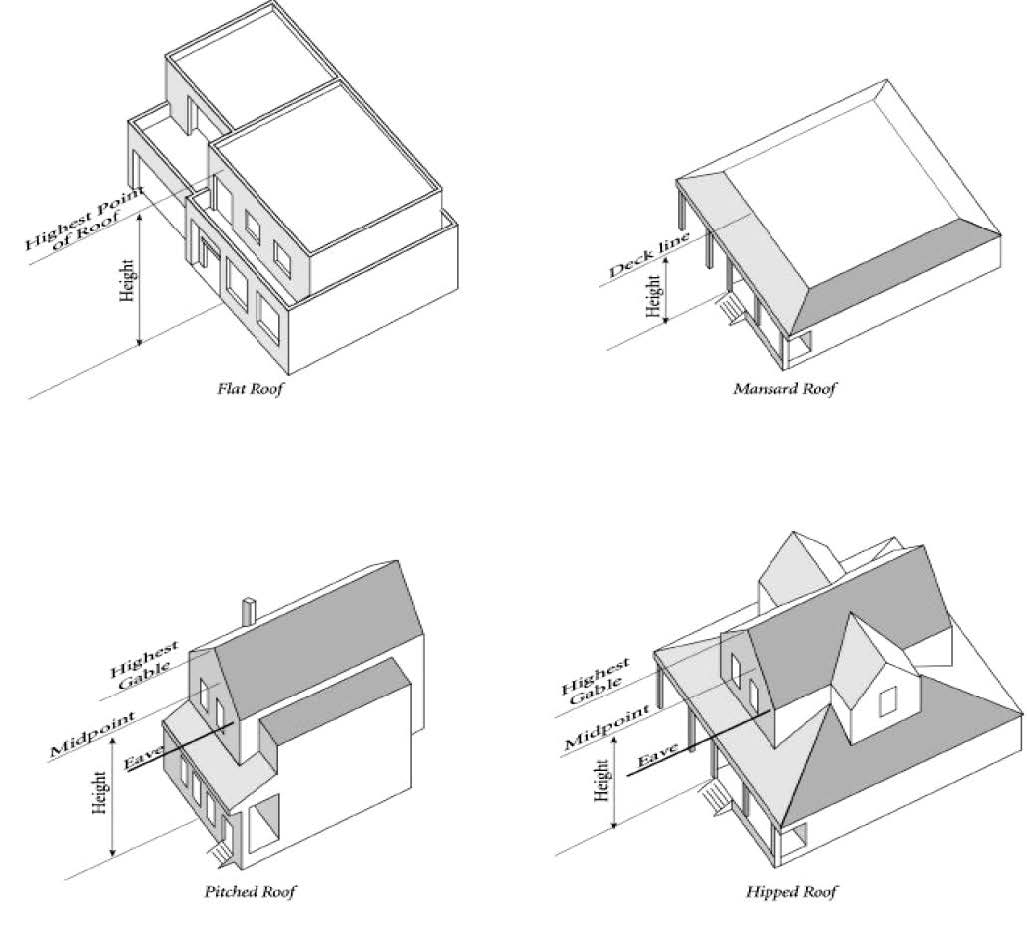
"Building height" means the vertical distance from a reference datum measured to the highest point of the coping of a flat roof or the deck line of a mansard roof or to the average height of the highest gable of a pitched or hipped roof. The reference datum shall be selected by either of the following; whichever yields a greater height of building:
1.
The elevation of the highest adjoining sidewalk or ground surface within five-foot horizontal distance of exterior wall of building when such sidewalk or ground surface is not more than ten (10) feet above lowest grade.
2.
An elevation ten (10) feet higher than the lowest grade when the sidewalk or ground surface described in subsection (1) of this section is more than ten (10) feet above lowest grade. The height of a stepped or terraced building is the maximum height of any segment of the building.
"Building line" means a line established by plat or ordinance a certain distance from a lot line or the street right-of-way beyond which a building cannot extend. The equivalent of a setback line.
"Building official" means an individual empowered by the City Council to administer and enforce the State Building Code (ORS 456.806 (1)).
Building, Primary. "Primary building" means a building in which is conducted a principal or main use of the building site on which it is situated.
"Building site" means a parcel, lot, or plot of land occupied or to be occupied by a principal use and accessory uses and/or building or group of buildings, which parcel, lot, or plot of land complies with all the requirements of this title relating to building sites.
"Cabana" means a stationary structure that may be prefabricated or demountable, with two (2) or more walls, used in conjunction with a manufactured home to provide additional living space and meant to be moved with the manufactured home.
"Carport" means a stationary structure consisting of a roof with its supports and not more than one wall or storage cabinet substituting for a wall and used for covering a vehicle parking space.
"Cemetery" means land used or intended to be used for the burial of the dead, and dedicated for cemetery purposes, including a columbarium, crematory, mausoleum, or mortuary, when operated in conjunction with and within the boundary of such cemetery.
"Change of use" means any use that differs from the previous use.
"Child care center" means a childcare facility, other than a "family child care home," that is certified under ORS 329A.280(3).
"City" means the City of Carlton, Oregon.
"City Manager" means the person appointed by City Council to the position and duties described in Chapter 2.08 of the Carlton Municipal Code.
"Clinic" means a facility for examination and treatment of human ailments by a group of physicians, dentists, or other licensed practitioners on an out-patient basis and not involving overnight housing of patients.
"Club" means an organization, group, or association supported by the members thereof, the purpose of which is to render a service primarily for members and their guests, but shall not include any organization, group, or association the primary activity of which is to render a service customarily carried on as a business for profit.
"Cottage cluster" means a grouping of no fewer than four (4) detached dwelling units, located on a single lot or parcel that includes a common courtyard. Cottage cluster may also be known as "cluster housing," "cottage housing," "bungalow court," "cottage court," or "pocket neighborhood."
"Commercial retail marijuana" means all parts of the plant cannabis family cannabaceae, genus cannabis whether growing or not, and the seed of such plants.
"Commercial retail marijuana facility" means a commercial retail marijuana facility licensed under Section 22, Chapter 1, Oregon Laws, 2015, that sells, distributes, transmits, gives, dispenses or otherwise provides medical marijuana to qualifying patients.
"Commission" means the Planning Commission of the City of Carlton, Oregon.
"Common area" means an area, feature, or building or other facility within a development designed and intended for the use or enjoyment of all occupants of the development or for the use and enjoyment of the general public.
"Community building" means a publicly owned and operated facility used for meetings, recreation, or education.
"Comprehensive plan" means the comprehensive plan of the City of Carlton, Oregon including all adopted supporting documents.
"Conditional use" means a use that requires a conditional use permit. See Chapter 17.152.
"Condominium" means property submitting to the provisions of ORS Chapter 100.
"Conforming" means in compliance with the regulations of this title.
"Council" means the City Council of Carlton, Oregon.
"Cross access" means a service drive providing vehicular access between two (2) or more contiguous sites so the driver need not enter the public street system.
"Cultivation" means a location where marijuana is produced or cultivated for use by a medical marijuana qualifying patient including within a building, structure or premises used for the cultivation or storage of medical marijuana that is physically separate and off-site from a medical marijuana dispensary.
"Dedication" means the limited grant by a property owner allowing the use of property by the public for specified purposes.
"Density" means the number of units per a given amount of land.
"Density, gross" means density calculated including all buildable and unbuildable land such as streets, streams, slopes, open space, easements, and other rights-of-way. Generally expressed in units per gross acre.
"Density, net" means density calculated excluding non-buildable land, such as streets, streams, slopes, open space, easements, and other rights-of-way. Generally expressed in units per net acre.
"Development" means any man-made change to improved or unimproved real estate, including but not limited to buildings or other structures, drilling, and site alteration such as that due to grading, paving, or excavation.
"Drive-through facility" means a drive-through use is a business activity involving buying or selling of goods or the provision of services where one of the parties conducts the activity from within a motor vehicle. Facilities usually associated with a drive-through use are queuing lanes, service windows, and service islands for vehicular use.
"Driveway" means a minor private way used by vehicles and pedestrians to gain access from an approved public access or right-of-way onto a lot or parcel of land.
"Dwelling" means a structure or portion thereof that is used for human habitation including permanent provisions for living, sleeping, eating, cooking and sanitation.
"Dwelling, Accessory" means an interior, attached, or detached residential structure that is used in connection with, or that is accessory to, a single-family dwelling and is located on the same lot.
"Dwelling, Cottage" means an individual dwelling unit that is part of a cottage cluster.
"Dwelling, Duplex or Two-Family" means a detached building containing two (2) dwelling units on a single lot.
"Dwelling, Multi-Family" means a building containing three (3) or more dwelling units on a single lot.
"Dwelling, Single-Family" means a detached building containing one (1) dwelling unit on a single lot.
"Dwelling, Single Room Occupancy" means a residential development with no fewer than four (4) attached units that are independently rented and lockable and provide living and sleeping space for the exclusive use of an occupant, but require that the occupant share sanitary or food preparation facilities with other units in the occupancy.
"Dwelling, Townhouse" means a dwelling unit constructed in a row of two (2) or more attached units where each dwelling unit is located on an individual lot and shares at least one (1) common wall with an adjacent unit, also commonly called a "single-family attached dwelling," "row house" or "common-wall house."
"Dwelling, Vacation Rental." See Chapter 17.125.
"Dwelling unit" means a single unit of one (1) or more habitable rooms providing complete independent facilities for occupants, including permanent provisions for living, sleeping, eating, cooking and sanitation.
"Easement" means a grant of right to use an area of land for a specific purpose.
"Eating and drinking establishment" means a retail service establishment where meals and/or beverages are prepared and served to the public generally for primarily indoor consumption on the premises.
"Employees" means all persons normally working on the premises during the largest shift. The Planning Commission shall determine the estimated number of employees of a new business and the number of employees of an established business shall be determined from an examination of the payroll.
"Expedited land division" means a division of land as defined in ORS 197.360.
"Face" means to front upon.
"Family Child Care Home" means a child care facility in a dwelling that is caring for not more than sixteen (16) children and is certified under ORS 329A.280(2) or is registered under ORS 329A.330.
"Farming" means the use of land for purposes defined in ORS Chapter 215.
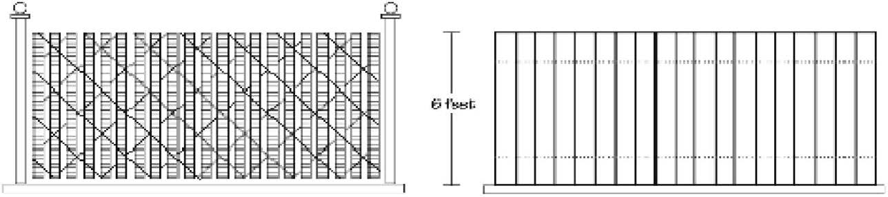
"Fence" means an unroofed barrier or an unroofed enclosing structure or obstruction constructed of any materials including but not limited to, wire, wood, cement, brick, and plastic.
Fence, Sight-Obscuring. "Sight-obscuring fence" means a fence or evergreen planting arranged in such a way as to obstruct vision. The example above at [below] is partially (approximately fifty (50) percent) sight obscuring, and the example [below] at right (e.g., solid wood, vinyl, etc.) is fully sight obscuring. Under either example, if the fence were constructed at less than four (4) feet in height it would not be considered sight-obscuring.
"Flood" or "flooding" See Chapter 17.56.
"Floor area" means the gross horizontal area under a roof of all floors of a building, measured from the exterior faces of the exterior walls or from the centerline of walls separating two (2) buildings, but not including:
1.
Attic space providing headroom of less than seven (7) feet;
2.
Basement, if the floor above is less than six (6) feet above grade;
3.
Uncovered steps or fire escapes;
4.
Private garages, carports, or porches;
5.
Accessory water towers or cooling towers;
6.
Off-street parking or loading spaces.
"Food cart" means the sale of food and/or non-alcoholic beverages from an enclosed mobile unit located on private property which is used for the purpose of preparing, processing or converting food for immediate consumption as a drive-in or walk-up service. Examples include trailers designed to prepare and serve food but does not include outdoor barbecue grills, street vendors. Exceptions include:
1.
Residential lemonade stands and similar short-term sales associated with residential uses, and
2.
Temporary uses that last less than seven (7) days in a calendar year that are directed toward a specific event.
"Frontage" means that dimension of a property that abuts a public or private street right-of-way.
"Functional area (intersection)" means that area beyond the physical intersection of two (2) streets that comprises decision and maneuver distance, plus any required vehicle storage length.
"Functional classification" means a system used to group public roadways into classes according to their purpose in moving vehicles and providing access.
Garage, Private. "Private garage" means an accessory building or portion of a main building used for the parking or temporary storage of automobiles in which no business, occupation, or service is provided.
Garage, Public. "Public garage" means a building, other than a private garage, used for the care, repair, or equipping of motor vehicles, or where such vehicles are parked or stored for compensation, hire, or sale.
"Grade" means the average elevation of the finished ground at the centers of all walls of a building, except that if a wall is parallel to and within five (5) feet of a sidewalk, the sidewalk elevation opposite the center of the wall shall constitute the ground elevation.
"Historic site" means a site or structure, generally fifty (50) years old or older, listed in the comprehensive land use plan as a historic or cultural resource properties listed individually in the National Register of Historic Places or a contributing property in a National Register Historic district, or property designated by local ordinance as an individual historic property or as a contributing property in a historic district.
"Home occupation" means a lawful occupation carried on by a resident of a dwelling as a secondary use within the same dwelling. The residential character of the property is maintained in a manner as not to give an outward appearance nor manifest any characteristic of a business in the ordinary meaning of the term. A home occupation shall not include the outside storage of equipment or materials.
"Homeowners association" means an association operating under recorded land agreements through which each lot owner of a planned development, condominium development, subdivision or other described land are automatically subject to a charge for a proportionate share of the expenses for the organization's activities, such as maintaining a common property.
"Hospital" means an establishment that provides sleeping and eating facilities to persons receiving medical, obstetrical, or surgical care with nursing service on a continuous basis.
"Hotel" means any building in which lodging is provided to guests for compensation and in which no provision is made for cooking in individual rooms.
"Improvement" means any permanent structure that becomes part of, placed upon, or is affixed to property.
"Industrial" means any enterprise involving the manufacturing, processing, or assembly of semi-finished or finished products from raw materials or similar treatment or packaging of previously prepared materials.
"Infusion" means a facility or business that incorporates marijuana (cannabis) by means of cooking, blending, or incorporation into consumable/edible goods.
"Joint access (or shared access)" means a driveway connecting two (2) or more contiguous sites to the public street system.
"Junk yard" means the use of more than two hundred (200) square feet of the area of any lot for the storage of salvage materials, including scrap metals or other scrap materials, or for the dismantling or "wrecking" of automobiles or other vehicles or machinery, whether or not such uses are conducted as a business for profit or otherwise.
"Kennel" means any lot or premises, on which four (4) or more dogs and/or cats over the age of six (6) months are kept for sale, lease, boarding, or training.
"Land division" means the process of dividing land to create lots or parcels.
"Livestock" means domestic animals of types customarily raised or kept on farms.
"Loading space" means an off-street space on the same lot with a building, or contiguous to a group of buildings, used for the temporary parking of a commercial vehicle while loading or unloading merchandise or materials, and which abuts upon a street, alley or other appropriate means of access.
"Lot" means a unit of land created by a subdivision or partitioning of land. Except where otherwise stated, the term "lot" includes the term "parcel."
Lot, Corner. "Corner lot" means a parcel abutting on two (2) intersecting streets, other than an alley. In the event a street front lot line is a curve at its point of intersection with a side lot line, the tangent to the curve at that point shall be considered the direction of the front lot line.
Lot, Flag. "Flag lot" means a parcel of land taking access by a relatively narrow strip of land between the major portion of the parcel and the point of public access to the parcel, all of which is in the same ownership or title.
Lot, Interior. "Interior lot" means a parcel other than a corner lot.
Lot, Through. "Through lot" means an interior lot having frontage on two (2) streets.
"Lot area" means the total area of a parcel, measured in a horizontal plane within the boundary lines. For flag lots, the access strip shall not be included in lot area for the purposes of minimum lot area requirements of this title.
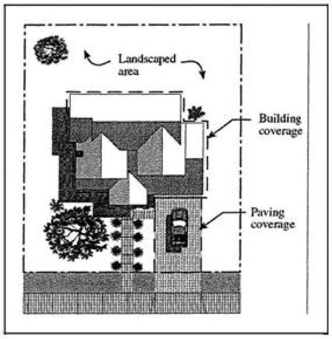
"Lot coverage" means the portion of a parcel covered or occupied by buildings, roofed structures, and impervious paved surfaces.
"Lot depth" means the horizontal distance measured from the midpoint of the front lot line to the midpoint of the rear lot line.
"Lot frontage" means the distance between the two (2) side lot lines measured at the minimum front setback line, parallel to the street line.
Lot Line, Front. "Front lot line" means the property line separating the lot from a street, other than an alley. In the case of a corner lot, the shortest property line along a street, other than an alley.
Lot Line, Rear. "Rear lot line" means a property line that is opposite and most distant from the front lot line. In the case of an irregular, triangular or other-shaped lot, a line ten (10) feet in length within the lot, parallel to and at a maximum distance from the front lot line.
Lot Line, Side. "Side lot line" means any property line that is not a front or rear lot line.
"Lot line adjustment" means the relocation of a common property line between two (2) abutting properties that does not involve the creation of a new lot or parcel.
"Lot of record" means a lawfully created lot or parcel established by plat, deed, or contract as duly recorded in Yamhill County property records.
"Lot width" means the average horizontal distance between the side lot lines, ordinarily measured parallel to the front lot line.
"Manufactured home" means a structure constructed for movement on the public highways that has sleeping, cooking and plumbing facilities, that is intended for human occupancy, that is being used for residential purposes and that was constructed in accordance with federal manufactured housing construction and safety standards and regulations in effect at the time of construction.
"Manufactured dwelling" means a residential trailer, mobile home, prefabricated structure, or manufactured home. A manufactured dwelling does not include any building or structure constructed to conform to the Oregon Structural Specialty Code or the One- and Two-Family Dwelling Code adopted pursuant to ORS 455.100 to 455.450 and 455.610 to 455.630, or any unit identified as a recreational vehicle by the manufacturer.
"Manufactured dwelling park" means any place where four (4) or more manufactured homes are located within five hundred (500) feet of one another on a lot, tract, or parcel of land under the same ownership, the primary purpose of which is to rent or lease space or keep space for rent or lease to any person for a charge or fee paid or to be paid for the rental, lease, or use of facilities or to offer space free in connection with securing the trade or patronage of such person. Manufactured dwelling park does not include a lot or lots located within a subdivision being rented or leased for occupancy by no more than one (1) manufactured dwelling per lot.
"Master plan" means a sketch or other presentation showing the ultimate location of lot lines and other details of layout such that future division may readily be made without violating the requirements of this title. It is intended that the lot lines and other details of future subdivision or partition be advisory only, and shall not be binding on the applicant or city; however, any restriction of building within future street locations may be imposed and be set forth in recorded deed restrictions.
"Medical marijuana" means all parts of the genus cannabis whether growing or not, and the seed of such plants that may be administered to treat or alleviate a qualifying patient's debilitating medical condition or symptoms associated with the patient's debilitating medical condition.
"Medical marijuana dispensary" means a medical marijuana facility registered by the Oregon Health Authority under ORS 475.300 to 475.346 and that sells, distributes, transmits, gives, dispenses or otherwise provides medical marijuana to qualifying patients.
"Medical marijuana qualifying patient" means a registry identification cardholder (person who has been diagnosed by a physician as having a debilitating medical condition) as further defined by ORS 475.302(3) or the designated primary caregiver of the cardholder as defined by ORS 475.302(5).
"Mini-warehouse storage" means an area or areas located within an enclosed building or structure designed and intended to be used for the rental of storage units to individuals for the safekeeping of personal items.
"Mobile home" means a structure constructed for movement on the public highways that has sleeping, cooking and plumbing facilities, that is intended for human occupancy, that is being used for residential purposes and that was constructed between January 1, 1962, and June 15, 1976, and met the construction requirements of Oregon mobile home law in effect at the time of construction.
"Motel" means a building or group of buildings on the same lot containing rooms designed for lodging, with or without cooking facilities, which are available for rent and in which each lodging unit is separate. The term includes auto courts, tourist courts, tourist homes, and motor lodges.
"New construction" means any remodeling of an existing structure, any construction of a new structure, or any placement of a manufactured home or building requiring a building or placement permit initiated on or after the effective date of the ordinance codified in this title.
"Nonconforming structure or use" means a lawfully existing structure or use at the time this title or any amendments thereto becomes effective, which does not conform to the requirements of the zone in which it is located.
"Nursing home" means any home, place or institution which operates and maintains facilities providing convalescent or nursing care, or both, for a period exceeding twenty-four (24) hours for two (2) or more ill or infirm patients not related to the nursing home administrator, or owner, by blood or marriage. Convalescent care may include, but is not limited to, the procedures commonly employed in nursing and caring for the sick and includes rest homes and convalescent homes, but does not include a boarding home for the aged, a retirement home, hotel, hospital, or a chiropractic facility licensed under Oregon Revised Statutes.
"NWI/LWI Maps" means a National Wetland Inventory (NWI) Map or, if available, a Local Wetland Inventory (LWI).
"Official zoning map" means the map or maps upon which the zoning districts in the City of Carlton are indicated.
"Outdoor storage" means the keeping, not within a building, of any goods, junk, material, merchandise or vehicles in the same place for more than twenty-four (24) hours.
"Owner" means the owner of record of real property as shown on the latest tax rolls or deed records of Yamhill County, and includes a person who furnishes evidence that they are purchasing a parcel of property under a written recorded or unrecorded land sale contract.
Parking Area, Private. "Private parking area" means an open area, building or structure, other than a street or alley, used for the parking of the automobiles of residents and guests of a building.
Parking Area, Public. "Public parking area" means an open area, building or structure, other than a private parking area, street or alley, used for the parking of automobiles and other motor vehicles, and available for use by persons patronizing a particular building or establishment.
"Parking space" means an enclosed or unenclosed surfaced area, exclusive of maneuvering and access area, permanently reserved for the temporary storage of an automobile and connected with a street or alley by a surfaced driveway that affords ingress and egress for automobiles.
"Partition" means to divide an area or tract of land into two (2) or three (3) parcels within a calendar year when such area or tract of land exists as a unit or contiguous units of land under single ownership at the beginning of such year. "Partition" does not include:
1.
Divisions of land resulting from lien foreclosures, divisions of land resulting from contracts for the sale of real property, and divisions of land resulting from the creation of cemetery lots; or
2.
A sale or grant by a person to a public agency or public body for state highway, county road, or other right-of-way purposes provided that such road or right-of-way complies with the applicable comprehensive plan and ORS 215.213(2)(q) to (s) and 215.283(2)(p) to (r).
"Pedestrian circulation system" means pedestrian connection(s) between entrance(s) of the proposed development and adjacent street(s), the parking area, and the existing or future development on adjacent properties.
"Pedestrian connection" means a continuous, unobstructed, reasonably direct route between two (2) points that is intended and suitable for pedestrian use. Pedestrian connections include but are not limited to sidewalks, walkways, accessways, stairways and pedestrian bridges. On developed parcels, pedestrian connections are generally hard surfaced. In parks and natural areas, pedestrian connections may be soft-surfaced pathways. On undeveloped parcels intended for redevelopment, pedestrian connections may also include right-of-way or easements for future pedestrian improvements.
"Pedestrian facilities" means improvements that provide for public pedestrian foot traffic including sidewalks, walkways, crosswalks and other improvements, such as lighting or benches, which provide safe, convenient and attractive walking conditions.
"Pedestrian plaza" means a small semi-enclosed area usually adjoining a sidewalk or a transit stop that provides a place for pedestrians to sit, stand, or rest. They are usually paved with concrete, paving stones or similar material and include seating, pedestrian scale lighting and similar improvements. Low walls or planters and landscaping are usually provided to create a semi-enclosed space and to buffer and separate the plaza from adjoining parking lots and vehicle maneuvering areas.
"Pedestrian scale lighting" means light standards or placement no greater than fourteen (14) feet in height located along walkways.
"Pedestrian way" means a right-of-way for pedestrian traffic.
"Permit" means any form of written approval pertaining to the use of land.
"Permitted use" means any use allowed in a zoning district and subject to the restrictions applicable to that zoning district as provided in the development code.
"Person" means every natural person, firm, partnership, association, social or fraternal organization, corporation, estate, trust, receiver, syndicate, branch of government, or any other group or combination acting as a unit.
"Place of worship" means a church, synagogue, temple, mosque, chapel, meeting house or other nonresidential place used for activities customarily associated with the practices of the religious activity, including worship services, religion classes, weddings, funerals, child care and meal programs.
"Planned unit development" means a type of development of a site that, as a single project, is based on a design that incorporates all elements of land, structures and uses in conformance with the applicable standards of this title.
"Planning Commission" means the Planning Commission of Carlton, Oregon.
"Plat" means the final map which is a diagram, drawing, re-plat or other writing containing all the descriptions, locations, specifications, dedications, provisions, and information concerning a subdivision or partition.
"Prefabricated structure" means a prefabricated structure, as defined in ORS 455.010, that is relocatable, more than eight and one-half (8½) feet wide and designed for use as a single-family dwelling.
"Professional office" means an office occupied by an accountant, architect, artist, attorney-at-law, professional engineer, land surveyor, land use planner, insurance agent, real estate broker, landscape architect, or practitioner of the human healing arts, or other professional business similar in type, scale and character.
"Quasi-judicial review" means an action or decision that requires substantial discretion or judgment in applying the standards or criteria of this title.
"Ramada" means a stationary structure having a roof extending over a manufactured home, which may also extend over a patio or parking space and is used principally for protection from the elements.
"Recreational vehicle" means a vacation trailer or other vehicular or portable unit which is either self-propelled, towed or is carried by a motor vehicle and which is intended for temporary human occupancy and is designed for vacation or recreational purposes but not residential use.
"Recreational vehicle park" means any area operated and maintained for the purposes of parking or providing space for overnight use by recreational vehicles.
"Remodeling" means any structural improvement or addition made to an existing structure which adds more than twenty (20) percent to the useable floor area; or adds more than five hundred (500) square feet to the useable floor area; or which permit value exceeds thirty-five (35) percent of the current year assessed improvement value.
"Reserve strip" means a strip of land, usually one (1) foot in width, deeded to the city, reserved across the end of a street or alley at the boundary of a subdivision or partition; or a strip of land deeded to the city between a dedicated street and adjacent property; in either case reserved or held by the city for future street extension or widening, or to prohibit access from property adjacent to a street.
"Residential care facility" means a residential care, residential training or residential treatment facility, as those terms are defined in ORS 443.400, that provides residential care alone or in conjunction with treatment or training or a combination thereof for six (6) to fifteen (15) individuals who need not be related. Staff persons required to meet licensing requirements shall not be counted in the number of facility residents, and need not be related to each other or to any resident of the residential care facility.
"Residential home" means a residential treatment or training home, as defined in ORS 443.400 (Definitions for ORS 443.400 to 443.455), a residential facility registered under ORS 443.480 (Definitions for ORS 443.480 to 443.500) to 443.500 (Investigation of registered facilities) or an adult foster home licensed under ORS 443.705 (Definitions for ORS 443.705 to 443.825) to 443.825 (Disposition of penalties recovered) that provides residential care alone or in conjunction with treatment or training or a combination thereof for five (5) or fewer individuals who need not be related. Staff persons required to meet licensing requirements shall not be counted in the number of facility residents, and need not be related to each other or to any resident of the residential home.
"Residential trailer" means a structure constructed for movement on the public highways that has sleeping, cooking and plumbing facilities, that is intended for human occupancy, that is being used for residential purposes and that was constructed before January 1, 1962.
"Retail cultivation" means a location where commercial retail marijuana is produced or cultivated including within a building, structure or premises used for the cultivation or storage of commercial retail marijuana that is physically separate and off-site from a commercial retail marijuana facility.
"Retail trade" means the process of selling to the consumer for direct consumption and not for resale.
"Right-of-way" means land that is owned in fee simple by the public and usually used for transportation facilities.
School, Elementary; Middle School or High School. "Elementary school, middle school or high school" means an institution, public or parochial, offering instruction in the several branches of learning and study, in accordance with the rules and regulations of the State Department of Education.
School, Trade or Commercial. "Trade or commercial school" means a building where the instruction is given to pupils for a fee in money or otherwise, which fee is the principal reason for the existence of the school.
"Service station" means any lot used primarily for the retail sales of motor vehicle fuels and lubricants for delivery on premises, and minor automobile repair and service.
"Setback" means the distance between a specified lot line and the foundation or exterior wall of a building or structure.
"Sign" means any writing, including letter, word, or numeral; pictorial presentation, including mural, illustration or decoration; emblem, including device, symbol or trademark; flag, including banner or pennant; or any other device, figure or similar thing which is a structure or any part thereof, or is attached to, painted on, or in any other manner represented on a building or structure or device; and is used to announce, direct attention to, or advertise; and is visible from any public right-of-way. Sign does not include house numbers. For purposes of Chapter 17.80, the following definitions apply:
1.
"Alteration" means any change in the size, shape, or method of illumination, position, location, construction, or supporting structure of a sign. A change in sign copy or sign face alone, including replacement of damaged or worn materials with like materials, shall not be considered an alteration.
2.
"Area" means the area of a sign shall be the entire area within any type of perimeter or border which encloses the outer limits of any writing, representation, emblem, figure, or character. If the sign is enclosed in a frame or cabinet the area is based on the inner dimensions of the frame or cabinet surrounding the sign face. When a sign is on a base material and attached without a frame, such as a wood board or Plexiglass panel, the dimensions of the base material are to be used. The area of a sign having no such perimeter, border, or base material shall be computed by enclosing the entire area within a parallelogram or a triangle of the smallest size sufficient to cover the entire message of the sign and computing the area of the parallelogram or a triangle. For the purpose of computing the number of signs, all writing included within such a border shall be considered one (1) sign, except for multi-faced signs on a single sign structure, which shall be counted as one (1) sign per structure. The area of multi-faced signs shall be calculated by including the total area of all sign faces.
3.
"Awning" means a shelter supported entirely from the exterior wall of a building and composed of non-rigid materials, except for the supporting framework.
4.
"Building face" means the single wall surface of a building facing a given direction.
5.
"Building frontage" means the portion of a building face most closely in alignment with an adjacent right-of-way or fronting a parking lot when so defined. A service station may use the overhanging canopy as a substitute for building frontage when computing the allowable sign area. The longest side of the canopy shall be used to compute the allowable sign area.
6.
"Canopy sign" means a sign hanging from a canopy or eaves, at any angle relative to the adjacent wall, the lowest portion of which is at least eight (8) feet above the underlying grade.
7.
"Flashing sign" means a sign any part of which pulsates or blinks on and off, except time and temperature signs and message signs allowed by conditional use.
8.
"Freestanding sign" means a sign supported by one (1) or more uprights, poles or braces placed in or upon the ground, or a sign supported by any structure primarily for the display and support of the sign.
9.
"Incidental signs" means a sign that is normally incidental to the allowed use of the property, but can contain any message or content. Such signs can be used for, but are not limited to, nameplate signs, warning or prohibition signs, and directional signs not otherwise allowed.
10.
"Indirect illumination" means a source of illumination directed toward such sign so that the beam of light falls upon the exterior surface of the sign.
11.
"Internal illumination" means a source of illumination from within a sign.
12.
"Message sign" means a sign that can change its message electronically and is designed to display various messages, including but not limited to signs displaying time and temperature.
13.
"Monument sign" means a square or rectangular sign that sits directly on the ground without pole or uprights.
14.
"Multi-faced sign" means a sign that has two (2) or more sign faces, contained in a single sign structure.
15.
"Mural" means an illustration (with or without words or numbers) that is painted or otherwise applied (without projections) to an outside wall of a structure.
16.
"Nonconforming sign" means any sign that lawfully exists prior to the effective date of the ordinance codified in this title but which due to the requirements adopted herein, no longer complies with the height, area and placement regulations or other provisions of these regulations.
17.
"Owner" means as used in these regulations, "owner" means owner or lessee of the sign. If the owner or lessee of the sign cannot be determined, then "owner" means owner or purchaser of the land on which the sign is placed.
18.
"Official sign" means a sign erected by a governmental agency or its designee, setting forth information pursuant to law.
19.
"Portable sign" means any sign that is not originally designed, regardless of any subsequent modification, to be permanently affixed to a building, structure, or the ground. These signs primarily include, but are not limited to, A-frame or sandwich board signs; signs attached to wood or metal frames and designed to be self-supporting and movable, including trailer mounted reader boards. Portable signs are considered temporary signs as defined and used in this title.
20.
"Projecting sign" means a sign the face of which is not parallel to the wall on which it is mounted, projecting more than eight (8) inches from a structure.
21.
"Real estate sign" means a sign for the purpose of rent, lease, sale, etc. of real property, building opportunities, or building space.
22.
"Roof line" means either the eaves of the roof or the top of the parapet, at the exterior wall. (A "mansard roof" is below the top of a parapet and is considered a wall for sign purposes.)
23.
"Roof sign" means a sign or any portion of which is displayed above the highest point of the roof, whether or not such sign also is a wall sign.
24.
"Rotating/revolving sign" means a sign, all or a portion of which, moves in some manner.
25.
"Sign face" means surface of a sign containing the message. The sign face shall be measured as set forth in the definition for "sign area."
26.
"Sign height" is measured from the grade of the curb line lowest to the base of the sign to the highest portion of the sign, sign structure or frame; whichever is greater highest point of the sign. In the absence of a curb line, the edge of the street pavement shall be used. In the absence of street pavement, the ground level shall be used to measure the height.
27.
"Sign structure" means the supports, uprights, braces, framework and other structural components of the sign.
28.
"Temporary sign" means a sign not permanently affixed to a structure on a property. These signs primarily include, but are not limited to, canvas, cloth, or paper banners or posters hung on a building wall or on a permanent pole such as on a freestanding sign support.
29.
"Wall sign" means a sign attached to, erected against or painted on a wall of a building or structure, with the exposed face of the sign in a plane approximately parallel to the face of said wall and not projecting more than eight (8) inches. A sign painted on an awning in which the face of the sign is approximately parallel to the wall shall also be considered a wall sign.
Space, Manufactured Home. "Manufactured home space" means an area reserved exclusively for the use of a single manufactured home.
"Story" means that portion of a building included between the upper surface of any floor and the upper surface of the floor next above, except that the top-most story shall be that portion of a building included between the upper surface of the top-most floor and the ceiling or roof above. If the finished floor level directly above a basement or cellar is more than six (6) feet above grade as defined herein, such basement or cellar shall constitute a story.
"Street" means the entire width between the boundary lines of a public or private way of travel for the purpose of providing ingress and egress for vehicular and pedestrian traffic and the placement of utilities to one (1) or more lots, parcels, areas, or tracts of land. A private way is excluded that is created to provide ingress and egress to land in conjunction with the use of such land for forestry, mining, or agricultural purposes.
1.
"Alley" means a thoroughfare not more than twenty (20) feet and not less than ten (10) feet in width, which has been dedicated or deeded to the public for public use providing a secondary means of access to abutting property.
2.
"Arterial" means a street of considerable continuity that is used primarily for through traffic and interconnection between major areas and designated on the current Carlton comprehensive plan.
3.
"Boundary" means a street that abuts the boundary of a development or site of a land use action.
4.
"Collector" means a street supplementary to the arterial street system, used partly by through traffic and partly for access to abutting properties and designated on the current Carlton comprehensive plan.
5.
"Cul-de-sac (dead-end)" means a short street with one (1) end open to traffic and the other terminated by a vehicle turn-around.
6.
"Frontage road" means a public or private drive parallel and adjacent to an arterial street providing access to abutting properties, but protected from through traffic.
7.
"Local access street" means a street intended primarily for access to abutting properties, but protected from through traffic.
8.
"Private street" means a street or right-of-way serving a subdivision or planned unit development that is not dedicated to the public or accepted by the city.
9.
"Pedestrian path" means an off-street facility or a walkway along an unpaved street designed primarily for pedestrian travel, providing safe and direct access separate from motor vehicle traffic, as designated in the Transportation System Plan.
10.
"Shared-use path" (also known as a multi-use path) is a paved, off-road facility designed for non-motorized travel by various users, including pedestrians, bicyclists, wheelchair, and other users. These paths provide a separate travel area from motorized traffic to provide a low-stress experience for a diverse range of users.
11.
"Mobility hub" A mobility hub is a defined area, located within or adjacent to the public right-of-way or on public or private property with pedestrian access, that integrates multiple transportation modes and amenities to facilitate public transportation access, support first-last mile connections, and enhance pedestrian and civic activity.
12.
"Bikeway" A bikeway is any transportation facility designated to accommodate bicycle travel, as identified in the City's adopted Transportation System Plan (TSP). Bikeways include striped on-street bike lanes, neighborhood bike routes (also known as bicycle boulevards or neighborhood greenways), and shared-use paths. These facilities may be located on or off the street and are designed to improve safety, connectivity, and comfort for people of all ages and abilities traveling by bicycle. Bikeways are referenced in Chapter 17.64 Street Standards.
"Structural alteration" means any change to the supporting members of a structure, including foundation bearing walls or partitions, columns, beams or girders, or any structural change in the roof or in the exterior walls.
"Structure" means that which is built or constructed, an edifice or building of any kind, or a piece of work artificially built up or composed of parts joined together in some definite manner.
"Stub-out (stub-street)" means a portion of a street or cross access drive used as an extension to an abutting property that may be developed in the future.
"Subdivision" means to divide a tract of land into four (4) or more lots within a single calendar year when such land exists as a unit or contiguous units under a single ownership at the beginning of the year.
"Tax lot" means a lot designation created by the county assessor for the purpose of levying property taxes.
"Temporary use" means a use that is: (1) seasonal or directed toward a specific event; or (2) occasioned by an unforeseen event.
"Unstable soil" means any soil type, as defined by the U.S. Natural Resources Conservation Service and identified in the comprehensive plan, which has severe limitations for development due to potential flooding, erosion, structural instability or inadequate sewage waste disposal.
"Urban growth boundary" means an adopted boundary around the city that defines the area in which the city expects to grow, where public facilities will be extended, and where joint planning responsibilities are exercised with Yamhill County.
"Use" means the purpose for which land or a structure is designed, arranged, or intended, or for which it is occupied or maintained.
"Veterinary clinic" means a facility designed to contain treatment and temporary care facilities for the cure and prevention of ailments or injuries of domestic animals, including both domestic pets and farm animals, under the direction of a licensed veterinarian.
"Vision clearance area" means a triangular area on a lot at the intersection of two (2) streets or a street and a railroad, two (2) sides of which are lines measured from the corner intersection of the right-of-way lines. The third side of the triangle is a line across the corner of the lot joining the ends of the other two (2) sides. Where the lines at the intersections have rounded corners the right-of-way lines will be extended in a straight line to a point of intersection.
"Visual obstruction" means any fence, hedge, tree, shrub, device, wall or structure between the elevations of three (3) and eight (8) feet above the adjacent curb height or above the elevation of the street edge where there is no curb, as determined by the city engineer, as so located at a street, drive, or alley intersection as to limit the visibility of pedestrians or persons in motor vehicles on said streets, drives, or alleys.
"Walkway" means a right-of-way deeded, dedicated, and designated for the use of nonmotorized vehicles and pedestrians.
"Warehouse" means a place for the safekeeping of goods and materials necessary for the functioning of an industrial or commercial enterprise.
"Wholesale" means the bulk sale of goods for resale to a person other than the direct consumer.
"Yard" means an open space on a lot that is unobstructed from the ground upward except as otherwise provided in this title.
Yard, Front. "Front yard" means a yard extending across the full width of the lot, the depth of which is the minimum horizontal distance between the front lot line and a line parallel thereto at the nearest point of the foundation of the main structure.
Yard, Rear. "Rear yard" means a yard extending across the full width of the lot, the depth of which is the minimum horizontal distance between the rear lot line and a line parallel thereto at the nearest point of the foundation of the main structure.
Yard, Side. "Side yard" means a yard, between the main structure and the side lot line, extending from the front yard, or front lot line where no front yard is required, to the rear yard or the rear lot line if no rear yard is required; the width of the required side yard shall be measured horizontally from the nearest point of the side lot line toward the nearest part of the foundation of the main structure.
"Zero side yard" means no required set back from the adjacent property line.
(Ord. No. 2024-751, § 1, 6-25-2024; Ord. No. 2025-753, § 1(Exh. A), 1-6-2026; Ord. No. 2025-755, § 1(Exh. A), 11-4-2025)
17.16.010 - Purpose.
The preservation of land use records is essential to meet the needs of the City of Carlton and to conform to the requirements of the Secretary of State, Archives Division.
(Ord. No. 2024-751, § 1, 6-25-2024)
17.16.020 - General.
The following constitutes the minimum records retention for various categories of land use records. When the requirements of the Secretary of State, Archives Division, are greater, those guidelines shall prevail. Records may be created and retained in a variety of media and physical formats, including but not limited to paper, microfilm, sound recordings, video recordings, magnetic tape and disk, and optical disk.
(Ord. No. 2024-751, § 1, 6-25-2024)
17.16.030 - Records retention.
A.
Council Meeting Records. Records documenting the proceedings of the council and may include minutes, agendas, tape recordings, exhibits, materials distributed by citizens, and other records. Minimum retention: (1) minutes, agendas, resolutions, and exhibits: permanent; (2) audio or visual recordings: one (1) year after minutes prepared; (3) other records: five (5) years.
B.
Planning Records. Records relating to general or comprehensive plan amendments, land use map changes, annexations, development code amendments and code interpretations. Any other documents adopted to guide long-term city growth and development of the city. May include public hearings records, plans, amendments, staff reports, periodic review records, maps, and other related records. Minimum retention: permanent.
C.
Historic Structures Inventory Records. Records documenting the results of inventory projects to designate historic properties within the city in conjunction with Oregon Land Conservation and Development Commission Goal 5 procedures. Minimum retention: permanent.
D.
Zone Change Records. Applications and decisions related to rezoning land. May include applications, staff reports, technical notes, approval orders, and related records. Minimum retention: (1) findings of fact, and decision documents: permanent; (2) other records: ten (10) years after approval or denial.
E.
Subdivision and Planned Unit Development Records. May include applications, site locations, site plans, staff reports, appeals reports, decision statements, maps, and related records. Minimum retention: (1) if approved and city conditions met: permanent; (2) if not approved: ten (10) years after expiration or revocation.
F.
Partition and Lot Line Adjustment Records. Applications, staff reports, technical notes, approval orders, maps, and related records. Minimum retention: (1) if approved and filed: permanent; (2) if not: ten (10) years after denial, expiration or revocation.
G.
Conditional Use Permit Records. Applications and decisions related to conditional use permit requests. May include applications, site plans, staff reports, and related records. Minimum retention: ten (10) years after expiration, revocation, or discontinuance of use.
H.
Variance Records. May include applications, site plans, descriptions of requests, site plans, staff reports, and related records. Minimum retention: ten (10) years after expiration, revocation, or discontinuance of use.
I.
Development Review Records. Records also may include applications, site plans, staff reports, maps, and related documents. Three-dimensional exhibits such as sample boards of brick, tile, and other building materials are not public records. Minimum retention: five (5) years.
J.
Sign Review Records. May include, descriptions, drawings, photographs, reports, applications, and related records. Minimum retention: life of the structure.
K.
Temporary Use Records. Records documenting actions relating to home occupations, fence permits, and nonconforming uses. May include applications, permits, staff reports, approval orders, and other documents. Minimum retention: five (5) years after discontinuance of use.
(Ord. No. 2024-751, § 1, 6-25-2024)