
Carlton City Zoning Code
Division III
GENERAL DEVELOPMENT STANDARDS
Chapter 17.96 - ACCESSORY STRUCTURES[3]
Sections:
Editor's note—Ord. No. 2025-753, § 1(Exh. A), adopted Jan. 6, 2026, amended Ch. 17.96 in its entirety. Former Ch. 17.96 pertained to similar subject matter, and derived from Ord. No. 2024-751, § 1, adopted June 25, 2024.
17.60.010 - Purpose.
The purpose of this chapter is to:
A.
Carry out the comprehensive plan with respect to development standards and policies.
B.
Ensure that natural features of the landscape, such as landforms, natural drainage-ways, trees and wooded areas, are preserved as much as possible and protected during construction.
C.
Promote energy conservation and efficiency in development through site planning and landscaping.
D.
Promote and maintain healthy environments and minimize development impacts upon surrounding properties and neighborhoods.
E.
Provide an economical, safe, accessible and multi-modal transportation system for the community in conjunction with the goals, policies and standards of the City's Transportation System Plan.
(Ord. No. 2024-751, § 1, 6-25-2024; Ord. No. 2025-755, § 1(Exh. A), 11-4-2025)
17.60.020 - Application of standards.
A.
The standards set forth in this chapter shall apply to partitions; subdivisions; planned unit developments; commercial, institutional and industrial projects; residential structures. Developments outside the city which will tie into or take access from city streets, or increase the flow or change the point of discharge to the city storm drainage system shall be subject to the improvement standards set forth in this title to the extent necessary to mitigate the impacts to these systems.
B.
The application of these standards to a particular development shall be modified as follows:
1.
Development standards that are unique to a particular use, or special use, shall be set forth within the district;
2.
Those development standards which are unique to a particular district shall be set forth in the section governing that district.
C.
No public works construction shall be undertaken until an agreement is executed between the developer and the city specifying the period within which required improvements and repairs shall be completed, as well as referencing the terms and conditions under which the city has approved the development. The agreement shall be in the form acceptable to the city.
(Ord. No. 2024-751, § 1, 6-25-2024)
17.60.030 - Application of public facility standards.
A.
Standards for the provision and utilization of public facilities or services available within the City of Carlton shall apply to all land developments in accordance with the following table of reference. No development permit shall be approved unless the following improvements are provided for prior to occupancy or operation, or unless future provision is assured in accordance with Chapter 17.216.
Legend:
C-1 Fire Hydrants for Commercial, Industrial Expansions, or Residential Uses: One or more fire hydrants are required as per the Uniform Building Code and Oregon Fire Code or if adequate fire flows are not available to the site. If the existing water lines are insufficient to provide adequate fire flows, water lines shall be upgraded to provide sufficient capacity at the developer's expense.
C-2 Single-Family Dwellings, Townhouses (2 units) or Duplexes: New dwellings are responsible for sidewalk construction across all property frontages including curb and gutter where necessary. In addition, if so required by the city engineer, a three-quarter street improvement to city street standards for all boundary streets (See Section 17.128.050).
a.
Demolition of an existing dwelling, and construction of a replacement dwelling is considered a new dwelling with regard to improvements.
b.
Improvements are required for additions which exceed fifty percent (50%) of the existing square footage of dwellings or remodels where the value of the alterations and improvements exceeds fifty percent (50%) of the current home value, as measured by the County Assessor. Garages, carports, sheds, and porches may not be included in the calculation of square footage if these spaces are not living spaces.
C-3 Street Improvements for Commercial, Institutional or Industrial Change of Use or Expansions: The city will require improvement to full city standards when the use meets any of the following criteria:
a.
The expanded use generates an average of 100+ trips per day as documented in the Trip Generation Manual of the Institute of Transportation Engineers or other qualified source; or
b.
The expanded use includes at least weekly shipping and delivery trips by vehicles over twenty thousand (20,000) pounds gross vehicle weight; or
c.
The subject use expands by at least twenty-five (25) percent based upon volume of business or footprint of facilities.
(Ord. No. 2024-751, § 1, 6-25-2024)
17.60.040 - Design standards.
The design of all improvements within existing and proposed rights-of-way and easements, all improvements to be maintained by the city, and all improvements for which city approval is required, shall comply with the requirements of the most recently adopted Public Works Design Standards in the City of Carlton.
(Ord. No. 2024-751, § 1, 6-25-2024)
17.64.010 - Purpose.
A.
To provide for safe, efficient, and convenient vehicular movement in the city.
B.
To provide adequate access to all proposed and anticipated developments in the city.
C.
To provide adequate area in all public rights-of-way for sidewalks, bikeways, landscape strips, sanitary sewers, storm sewers, water lines, natural gas lines, power lines, and other utilities commonly and appropriately placed in such rights-of-way.
D.
Preserve and protect the existing and intended function of the road and other transportation facilities.
E.
Ensure that land uses authorized under Comprehensive Plan Map and Zoning Map amendments are consistent with the identified function, capacity, and level of service of transportation facilities as described in the City's adopted Transportation System Plan and Future Streets Map.
F.
To ensure that public streets are improved to the function, capacity and level of service as described in the city's adopted Transportation System Plan and Future Streets Map (cross-referenced in 17.64.030 - General Provisions).
(Ord. No. 2024-751, § 1, 6-25-2024; Ord. No. 2025-755, § 1(Exh. A), 11-4-2025)
17.64.020 - Scope.
The provisions of this chapter shall be applicable to:
A.
The creation, dedication, or construction of all new public or private streets, pedestrian facilities, and bikeways in all developments in the city.
B.
The extension or widening of existing public or private street rights-of-way, easements, or street improvements including those which may be proposed by an individual or the city, identified by the city's adopted Transportation System Plan and Future Streets Map (cross-referenced in 17.64.030 - General Provisions), or which may be required by the city in association with other development approvals.
C.
The construction or modification of any utilities, bikeways, sidewalks, or other transportation infrastructure within public rights-of-way or private street easements.
(Ord. No. 2024-751, § 1, 6-25-2024; Ord. No. 2025-755, § 1(Exh. A), 11-4-2025)
17.64.030 - General provisions.
The following provisions shall apply to the dedication, construction, improvement, or other development of all public streets in the city, and are intended to provide a general overview of typical minimum design standards. All streets shall be designed in conformance with the specific requirements of the most recently adopted Standard Specifications for Public Works Design Standards Construction in the City of Carlton and the Transportation System Plan.
The standard sections contained in Standard Specifications for Public Works Design Standards Construction in the City of Carlton and the Transportation System Plan are minimum requirements only and shall not be construed as prohibiting the city engineer from requiring thicker sections or engineer designed pavement sections in lieu of standard sections where conditions warrant.
A.
The location, width, and grade of streets shall be considered in their relation to existing and planned streets, to topographical conditions, to public convenience and safety, and to the proposed use of the land to be served by the streets.
B.
Development proposals shall provide for the continuation, and connection to, all streets, bikeways and pedestrian facilities within the development and to existing streets, bikeways and pedestrian facilities outside the development.
C.
Alignment. All streets other than minor streets or culs-de-sac, as far as practical, shall be in alignment with existing streets by continuation of the centerline thereof. The staggering of street alignments resulting in "T" intersections shall leave a minimum distance recommended by the city engineer.
D.
Future Extension of Streets. In order to promote the development of an efficient network of city streets and connections to state and county roads, development shall provide future street extensions as shown on the Future Streets Map found in the Carlton Transportation System Plan (see Section 4.3.5 Future Streets Map & Functional Classification).
In addition to providing for future street extensions shown on the Future Streets Map, streets, bikeways and pedestrian facilities, shall also be extended to the boundary of a tract being developed, where necessary to give access to or permit a satisfactory future development of adjoining land. Reserve strips and street plugs may be required to preserve the objectives of street extensions.
E.
Existing Streets.
1.
Three-quarter street improvements to all existing streets adjacent to, within or necessary to serve the property, as outlined in Section 17.128.050, shall be required at the time of partitioning or subdivision.
Full street improvements to all existing streets adjacent to, within or necessary to serve the property, shall be required when it is determined that the vehicular and/or pedestrian impacts from the proposed development necessitate such improvements.
2.
For infill development that does not include partitioning or subdivision, construction of sidewalks, including curb and gutter where necessary, along all property frontages shall be the minimum requirement of development. A three-quarter street improvement (see Section 17.128.050) shall be required if the city engineer determines that the existing streets are not in condition to handle projected traffic loads.
3.
The city shall require the applicant to record an approved improvement deferral agreement or non-remonstrance agreement, see Section 17.216.030, in lieu of street improvements, where the following criteria are met:
a.
The existing roadway condition and sections are adequate to handle existing and projected traffic loads; and
b.
Existing public utilities (water, sanitary sewer and storm sewer) located within the existing roadway are adequate, or can be improved without damaging the existing roadway surface.
F.
New Streets. Where new streets are created, full street improvements shall be required. Three-quarter streets (see Section 17.128.050) may be approved in lieu of full street improvements on boundary streets when the city finds it to be practical to require the completion of the other one-quarter street improvement when the adjoining property is developed. The city may allow three-quarter street improvements if all of the following criteria are met:
1.
The adjoining land abutting the opposite side of the street is undeveloped; and
2.
Storm water drainage is provided for on the non-curbed side of three-quarter street improvements in areas judged by the city engineer to have drainage concerns. One-foot-wide reserve strips and street plugs may be required to preserve the objectives of three-quarter streets.
G.
Culs-de-Sac. Culs-de-sac shall have maximum lengths of four hundred (400) feet and serve no more than eighteen (18) dwelling units. All culs-de-sac shall terminate with circular turn-a-rounds.
H.
Dead-End Streets. When it appears necessary to continue a street or public access way into a future subdivision or adjacent acreage, streets, or public access way shall be platted to a boundary of a subdivision or partition. The street may be platted without a turnaround unless the Planning Commission finds that a turnaround is necessary.
I.
Street Names. Street names and numbers shall conform to the established pattern in the city and shall be subject to the approval of the city. Street names shall be required for all new publicly dedicated streets and private streets.
J.
Grades and Curves. Grades and curves shall meet the standards defined in the current Public Works Design Standards.
K.
Frontage Streets. If a development abuts or contains an existing or proposed arterial street or railroad right-of-way, the city may require frontage streets, reverse frontage lots with suitable depth, screen planting contained in a non-access reservation along the rear or side property line, or such other treatment as may be necessary for adequate protection of residential properties and to afford separation of through and local traffic.
L.
Vision Clearance Area. Vision clearance areas shall be maintained on corner lots at the intersection of all public streets and at the intersections of a public street with a private street as outlined in Section 17.92.080.
M.
Spacing Between Public Road Intersections. Spacing between public road intersections for each functional class of road shall conform to access spacing standards found in Section 17.100.030.
N.
Landscape Strip. The landscape strip includes the area located between a sidewalk and the curb.
Landscaping and plant materials used in the landscape strip are subject to the provisions of Chapter 17.84. Maintenance of landscape strips in the right-of-way is the continuing obligation of the adjacent property owner.
(Ord. No. 2024-751, § 1, 6-25-2024; Ord. No. 2025-755, § 1(Exh. A), 11-4-2025)
17.64.040 - Right-of-way and improvement widths.
The following standards are general criteria for all types of public streets, bikeways, landscape strips and sidewalks in the city. These standards shall be the minimum requirements for all streets, except where noted otherwise or where modifications are permitted under Section 17.64.050.
1 Ten-foot sidewalks required along commercially zoned property. Total right-of-way not to exceed maximum of 65-feet.
2 Local Narrow Option is considered a non-standard street and subject to Major Modification approval in Carlton Development Code Section 17.64.050. Local Narrow Option must always maintain a minimum unobstructed width of 20 feet for fire and emergency vehicle access and cannot be obstructed, including by parking. May only be used with approval of the City.
3 School Zone Collectors refer to S 3rd Street from Main Street to E Polk Street and E Polk Street from S Pine Street to S 3rd Street.
4 Although striped on-street bike lanes are not required, the standard for Existing Collector and New Collector streets requires "sharrow" pavement markings and/or signage to designate shared bicycle use. Striped bicycle lanes are required on W Grant Street from S Yamhill Street to S Pine Street, N Yamhill Street from Main Street to W Grant Street, and along all School Zone Collectors.
5 On-street parking permitted to be included during design phase where ROW available.
6 Bikeway widths refer to the total street width allocated to dedicated bicycle facilities including striped bike lanes, buffers, and other markings. The exact width and design of bikeway striping is subject to City Public Works Standards.
7 Right-of-way width and improvement standards generally assume 1' of ROW for curb and gutters, and 1' for shy distance on each side of the street except where noted otherwise.
8 The property line radius at intersections of local streets shall be twenty (20) feet. All other intersection property line radii shall be according to the specifications of the city engineer.
9 The radius of a cul-de-sac must be a minimum of 48' in width to support fire and emergency access per Oregon Fire Code (2022) Appendix D, Figure D103.1 Dead-End Fire Apparatus Access Road Turnaround, 96' diameter cul-de-sac.
10 7' flexible parking lanes allow for (optional) intermittent parking via curb bulb outs, providing additional ROW for widened sidewalks, landscaping, and street trees. Bulb outs within the parking lane shall provide spacing to accommodate a minimum of two (2) parking stalls between each bulb, except at intersections where parking is not permitted. This configuration must align with the city's existing street tree policy (17.84.090), which specifies spacing between street trees, ensuring that the placement of trees does not interfere with driveways, parking stalls, or other infrastructure.
(Ord. No. 2024-751, § 1, 6-25-2024; Ord. No. 2025-755, § 1(Exh. A), 11-4-2025)
Cross reference— Refer to 2025 Carlton Transportation System Plan Section 4.4 for illustrated cross-sections of right-of-way and improvement standards. Improvements must be consistent with Public Works Design Standards and receive city approval prior to implementation.
17.64.050 - Modification of right-of-way and improvement width.
The public street standards of Section 17.64.040 may be modified through either a major modification or a minor modification. Consideration shall be given to public safety, durability, cost of maintenance, function, appearance, and other appropriate factors to advance the goals of the adopted Carlton Comprehensive Plan and Transportation System Plan as a whole.
A.
Major Modification. When a major modification is desired as part of a development application, the modifications shall be processed as a Type III modification and shall meet the following criteria:
1.
The modification is necessary to provide design flexibility in instances where:
a.
Unusual topographic, geographic or physical conditions impose an unusual hardship on the applicant, and an equivalent alternative which can accomplish the same design purpose is available; or
b.
Parcel shape or configuration precludes accessing a proposed development with a street which meets the full standards of Section 17.64.040; or
c.
A modification is necessary to preserve trees or other natural features determined by the city to be significant to the aesthetic character of the area; or
d.
A planned unit development is proposed and the modification of street standards is necessary to provide greater privacy or aesthetic quality to the development; or
e.
A minor change to a specification or standard is required to address a specific design or construction problem which, if not enacted, will result in an unusual hardship. Self-imposed hardships shall not be used as a reason to grant a modification request; or
f.
Application of the standards of this chapter to the development would be grossly disproportional to the impacts created.
2.
Modification of the standards of Section 17.64.040 shall only be approved if the city finds that the specific design proposed provides adequate vehicular access based on anticipated traffic volumes.
B.
Minor Modification. When a minor change to an approved development application is required to address a specific design or construction problem the modifications shall be processed as a Type I modification by the city engineer using the criteria:
1.
Modifications to driveway location, size, and sharing standards;
2.
Modifications to sidewalk and planter strips widths and location that preserve existing street trees, trees on private property, or to ensure compliance with ADA standards;
3.
Other modifications that do not expand or reduce a quantifiable standard by more than twenty (20) percent. This may include sight distance, vertical alignment, horizontal alignment, geometric design, access spacing, and grades;
4.
The modification is the minimum necessary to achieve the purpose.
(Ord. No. 2024-751, § 1, 6-25-2024)
17.64.060 - Private streets.
A.
Streets and other rights-of-way that are not dedicated for public use shall comply with the following:
1.
Private streets shall only be allowed where the applicable criteria of Section 17.88.030(D) are satisfied. Private streets shall have a minimum easement width of twenty (20) feet and a minimum paved or curbed width of eighteen (20) feet. Private streets shall serve a maximum of ten (10) dwelling units.
2.
Unless otherwise specified in the Public Works Design Standards in the City of Carlton, all private streets serving more than two (2) dwelling units shall be constructed to the same pavement structural section specifications required for public streets. Provision for the maintenance of the street shall be provided in the form of a maintenance agreement, homeowners association, or other instrument acceptable to the city attorney.
3.
A turn-around shall be required for any private street which has only one (1) outlet and which is in excess of two hundred (200) feet long or which serves more than two (2) residences. Turn-arounds for private streets shall be either a circular turn-around with a minimum paved radius of thirty-five (35) feet, or a "tee" or "hammerhead" turn-around with a minimum paved dimension across the "tee" of seventy (70) feet and a twenty (20) foot width with appropriate radius at the corners.
B.
Any grant of a private street or land functioning as an easement shall not be accepted by the city and dedicated for public use except upon approval of the council and upon meeting the specifications of Sections 17.64.020 and 17.64.040.
(Ord. No. 2024-751, § 1, 6-25-2024)
17.64.070 - Access easements.
A private access easement created as the result of an approved partitioning shall conform to the following:
A.
Partition access easements shall only be allowed where the applicable criteria of Section 17.88.030(D) are satisfied. The easement shall comply with the following standards:
1.
Minimum width: twenty (20) feet;
2.
Minimum paved or curb to curb width: twenty (20) feet;
3.
Maximum length: two hundred fifty (250) feet;
4.
No more than three (3) dwelling units shall have sole access to the easement.
B.
Unless otherwise specified in the Public Works Design Standards in the City of Carlton, all private streets serving more than two (2) dwelling units shall be constructed to the same pavement structural section specifications required for public streets. Provision for the maintenance of the street shall be provided in the form of a maintenance agreement, homeowners association, or other instrument acceptable to the city attorney.
C.
A turn-around shall be required for any access easement which has only one (1) outlet and which is in excess of two hundred (200) feet long or which serves more than two (2) residences. Turn-arounds shall be either a circular turn-around with a minimum paved radius of thirty-five (35) feet, or a "tee" or "hammerhead" turn-around with a minimum paved dimension across the "tee" of seventy (70) feet and a twenty (20) foot width with appropriate radius at the corners.
D.
All private access easements serving more than two (2) residences shall be designated as fire lanes and signed for no parking.
(Ord. No. 2024-751, § 1, 6-25-2024)
17.68.010 - Purpose.
The purpose of this chapter is to provide adequate areas for the parking, maneuvering, loading and unloading of vehicles for all land uses in the city.
(Ord. No. 2024-751, § 1, 6-25-2024)
17.68.020 - Scope.
Development of off-street parking and loading areas for commercial, industrial, or multi-family development shall be subject to the Site Design Review procedures of Chapter 17.156. The provisions of this chapter shall apply to the following types of development:
A.
Any new building or structure erected after the effective date of the ordinance codified in this title, except as provided in subsection E of this section.
B.
The construction or provision of additional floor area, seating capacity, or other expansion of an existing building or structure.
C.
A change in the use of a building or structure that would require additional parking spaces or off-street loading areas under the provisions of this chapter.
D.
As a condition of approval in a land use decision.
E.
Off-street parking and off-street loading areas are not required within the Downtown Parking District per Section 17.68.120.
(Ord. No. 2024-751, § 1, 6-25-2024)
17.68.030 - Location.
Off-street parking and loading areas shall be provided on the same lot with the main building or structure or use except that:
A.
In any residential zone or for any residential use permitted in a nonresidential zone, automobile parking areas may be located on another lot if such lot is within two hundred (200) feet of the lot containing the main building, structure or use.
B.
In any nonresidential zone, the parking area may be located off the site of the main building, structure or use if it is within five hundred (500) feet of such site.
(Ord. No. 2024-751, § 1, 6-25-2024)
17.68.040 - Joint use.
Parking area may be used for a loading area during those times when the parking area is not needed or used. Parking areas may be shared subject to city approval for nonresidential uses where hours of operation or use are staggered such that peak demand periods do not occur simultaneously. The requirements of Section 17.68.050 may be reduced accordingly. Such joint use shall not be approved unless satisfactory legal evidence is presented which demonstrates the access and parking rights of parties.
(Ord. No. 2024-751, § 1, 6-25-2024)
17.68.050 - Off-street parking requirements.
Except where other city code provisions waive off-street parking requirements or allow credit for on-street parking in lieu of off-street parking, developments and changes in use that are subject to site design review shall provide off-street parking as required by Section 17.68.080 and approved by the city in the amount not less than listed below.
Residential
Public Uses
Commercial Uses
Industrial Uses
(Ord. No. 2024-751, § 1, 6-25-2024)
17.68.055 - Adjustment of parking standards.
A.
An applicant may apply for an up to a twenty (20) percent reduction to the off-street parking requirements as a minor variance as set forth in Section 17.148.040.
B.
An applicant may apply for a reduction to the off-street parking requirements greater than twenty (20) percent as a major variance as set forth in Section 17.148.050. The applicant shall demonstrate compliance with the following standards in lieu of the approval criteria in Section 17.148.050:
1.
The application shall be accompanied by a site plan, drawn to scale, showing the dimensions and arrangement of the proposed development and parking plan, the extent of the adjustment requested along with findings for each applicable approval criteria.
2.
Approval criteria for the adjustment are as follows:
a.
Documentation. The applicant shall document that the individual project can be served by the proposed amount of parking and available on-street parking by completing a parking analysis for surrounding uses and on-street parking availability. The applicant shall show that there is a continued fifteen (15) percent on-street parking vacancy in the area adjacent to the use during peak parking periods.
i.
For the purposes of demonstrating the availability of on street parking, the applicant shall undertake a parking study during time periods specified by the community development director. The time periods shall include those during which the highest parking demand is anticipated by the proposed use. Multiple observations during multiple days shall be required. Distances are to be calculated as traversed by a pedestrian that utilizes sidewalks and legal crosswalks or an alternative manner as accepted by the community development director.
ii.
The on-site parking requirements may be reduced based on the parking vacancy identified in the parking study. The amount of the reduction in on-site parking shall be calculated as follows:
(a)
Vacant on-street parking spaces within three hundred (300) feet of the site will reduce on-site parking requirements by 0.5 parking spaces; and
(b)
Vacant on-street parking spaces between three hundred (300) and six hundred (600) feet of the site will reduce on-site parking requirements by 0.2 parking spaces.
b.
Function and Use of Site. The applicant shall demonstrate that modifying the amount of required parking spaces will not significantly impact the use or function of the site and/or adjacent sites.
c.
Compatibility. The proposal is compatible with the character, scale and existing or planned uses of the surrounding neighborhood.
d.
Safety. The proposal does not significantly impact the safety of adjacent properties and rights-of-way.
e.
Services. The proposal will not create a significant impact to public services, including fire and emergency services.
(Ord. No. 2024-751, § 1, 6-25-2024)
17.68.060 - Residential driveways.
All single and joint use residential driveways shall be paved and have a minimum of twelve (12) foot and maximum twenty-four (24) foot approach width from the curb line.
(Ord. No. 2024-751, § 1, 6-25-2024)
17.68.070 - Off-street loading requirements.
Buildings or structures to be built or substantially altered which receive and distribute materials and merchandise by trucks shall provide and maintain off-street loading berths in sufficient number and size to adequately handle the needs of the particular use.
A.
The following standards shall be used in establishing the minimum number of berths required:
Note: For buildings or structures up to six thousand (6,000) square feet regular off-street parking areas may be used to meet the off-street loading requirements.
B.
A loading berth shall contain a space a minimum of twelve (12) feet wide and thirty-five (35) feet long and have a vertical clearance of fourteen (14) feet. Where the vehicles generally used for loading and unloading exceed these dimensions, the required size of these berths shall be increased.
(Ord. No. 2024-751, § 1, 6-25-2024)
17.68.080 - Parking and loading area requirements.
All parking and loading areas, except those for single-family dwellings, townhouses and duplexes, shall be developed and maintained as follows:
A.
Surfacing: all driveways, parking, and loading areas shall have a durable, hard surface.
B.
Parking spaces: parking spaces shall be a minimum nine (9) feet wide and eighteen (18) feet in length.
C.
Drive Aisles. The following drive aisle dimensions shall apply:
1.
Without adjacent parking, drive aisle width:
a.
One-way: ten (10) feet;
b.
Two-way: sixteen (16) feet.
2.
With adjacent parking:
D.
Areas used for parking and maneuvering of vehicles shall be drained as to avoid flow of water across sidewalks.
E.
Except for parking to serve residential uses, parking and loading areas adjacent to residential zones or adjacent to residential uses shall be designed to minimize disturbance of residents.
F.
Groups of more than four (4) parking spaces shall be so located and served by a driveway that their use will require no backing movements or other maneuvering within a street right-of-way other than an alley.
G.
Service drives to off-street parking areas shall be designed and constructed to facilitate the flow of traffic, provide maximum safety of traffic access and egress and the maximum safety of pedestrians and vehicular traffic on the site.
H.
Service drive exits shall have a minimum triangular vision clearance area two (2) sides of which are formed by the intersection of the driveway centerline and the street right-of-way line, which shall be fifteen (15) feet.
I.
Parking spaces along the outer boundaries of a parking area shall be contained by a curb or a bumper rail at least four (4) inches high, located a minimum of three (3) feet from the property line, to prevent a motor vehicle from extending over an adjacent property or a street.
J.
Where a street(s) abutting a proposed development does not contain on-street parking and the classification of the subject street includes on-street parking, where practicable, the Planning Commission may require the developer to provide on-street parking as a condition of site design review or land division (subdivision or partition) approval. Where a developer is required to create on-street parking spaces, the Planning Commission may reduce off-street parking requirements for the subject development by up to an equal number of spaces.
(Ord. No. 2024-751, § 1, 6-25-2024)
17.68.090 - General provisions—Off-street parking and loading.
A.
The provision and maintenance of off-street parking and loading space is a continuing obligation of the property owner. No building permit shall be issued until plans are presented that show an area that is and will remain available for exclusive use as off-street parking and loading space. The subsequent use of property for which the building permit is issued shall be conditional upon the unqualified continuance and availability of the amount of parking and loading space required by this title. Should the owner or occupant of any lot or building change the use to which the lot or building is put, thereby increasing off-street parking and loading requirements, it shall be unlawful and a violation of this title to begin or maintain such altered use until such time as the increased off-street parking and loading requirements are observed.
B.
Requirements for types of buildings and uses not specifically listed herein shall be determined by the Planning Commission based upon the requirements of comparable uses listed and expectations of parking and loading need.
C.
In the event several uses occupy a single structure or parcel of land, the total requirements for off-street parking shall be the sum of the requirements of the several uses computed separately, unless a reduction is approved for shared parking pursuant to Section 17.68.040.
D.
Required parking spaces shall be available for the parking of operable passenger automobiles of residents, customers, patrons, and employees only, and shall not be used for storage of vehicles or materials or for the parking of trucks used in conducting the business or use.
(Ord. No. 2024-751, § 1, 6-25-2024)
17.68.100 - Parking lot landscaping and screening standards.
All parking lots, which for purposes of this section include areas of vehicle maneuvering, parking, and loading, shall be landscaped and screened as follows:
A.
Lighting. Any light used to illuminate parking or loading area shall be arranged to be directed entirely onto the loading or parking area, shall be deflected away from any residential use and shall not cast a glare or reflection onto moving vehicles on the public rights-of-way.
B.
Screening Abutting Property Lines. Parking for commercial, industrial and multifamily uses which abut a residential use or zone property line shall be screened by a five-foot landscaped strip. Where a buffer between zones is required, the screening should be incorporated into the required buffer strip, and will not be an additional requirement. The screen shall grow to be at least thirty-six (36) inches higher than the finished grade of the parking areas, except for required vision clearance areas.
C.
Landscape Standards. Landscaping within or adjacent to a parking lot shall consist of a minimum of ten (10) percent of the total parking area plus a ratio of one (1) tree per ten (10) parking spaces. Trees and landscaping shall be installed as follows:
1.
The tree species shall be an appropriate large canopied shade tree and shall be selected from the street tree list to avoid root damage to pavement and utilities, and damage from droppings to parked cars and pedestrians;
2.
The tree shall be planted in a landscaped area such that the tree bole is at least three (3) feet from any curb or paved area;
3.
The landscaped area shall be planted with shrubs, grass, or living groundcover to assure ninety (90) percent coverage within two (2) years;
4.
That portion of a required landscaped yard, buffer strip or screening strip abutting parking stalls may be counted toward required parking lot landscaping as long as the tree species, living plant material coverage and placement distribution criteria are also met;
5.
A parking or loading area or drive aisle which runs adjacent to a property line shall be separated from an adjacent public or private street by a landscaped area a minimum of ten (10) feet in width and shall be separated from an adjacent property by a landscaped area a minimum of five (5) feet in width;
6.
Landscaped areas in parking lots, service drives or loading areas shall have an interior width of not less than five (5) feet;
7.
A landscaped area shall be located to separate blocks of parking spaces at a minimum of one (1) landscaped area per ten (10) parking spaces.
D.
Wheel Guards. Parking lot landscaping shall be protected from damage by secured wheel guards to prevent vehicles entering into landscaped areas.
E.
Hedge Screening. The required hedge screen shall be installed as follows:
1.
Evergreen shrubs shall be planted so that eighty (80) percent of the desired screening is achieved within two (2) years, one hundred (100) percent within four (4) years;
2.
Living ground cover in the screen strip such that ninety (90) percent coverage is achieved within two (2) years.
(Ord. No. 2024-751, § 1, 6-25-2024)
17.68.110 - Bicycle parking.
A.
The following minimum number of bicycle parking spaces shall be provided:
Bicycle parking shall also be required for expansions and other remodeling that increases the required level of automobile parking.
B.
At a minimum bicycle parking facilities shall be consistent with the following design guidelines:
1.
All bicycle parking shall be within one hundred (100) feet from a building entrance and located within a well-lit and clearly visible area;
2.
Bicycle parking shall be convenient and easy to find. Where necessary, a sign shall be used to direct users to the parking facility;
3.
Each bicycle parking space shall be at least two (2) feet by six (6) feet with a vertical clearance of six (6) feet;
4.
An access aisle of at least five (5) feet shall be provided in each bicycle parking facility;
5.
Bicycle parking facilities shall offer security in the form of either a lockable enclosure in which the bicycle can be stored or a stationary object, i.e., a "rack," upon which the bicycle can be locked. Structures that require a user-supplied lock shall accommodate both cables and U-shaped locks and shall permit the frame and both wheels to be secured (removing the front wheel may be necessary.) Note: businesses may provide long-term, employee parking by allowing access to a secure room within a building.
6.
For multi-family residential development, all bicycle parking shall be covered by a roof structure.
(Ord. No. 2024-751, § 1, 6-25-2024)
17.68.120 - Downtown Parking District.
A.
New or expanded development within the Downtown Parking District as established in Figure 17.68.120-1 are exempt from the minimum off-street parking requirements of Section 17.68.050 and the off-street loading requirements of Section 17.68.070.
B.
If off-street parking or loading is provided, the development standards of Section 17.68.080 and parking lot landscaping and screening standards of Section 17.68.100 shall apply.
Figure 17.68.120-1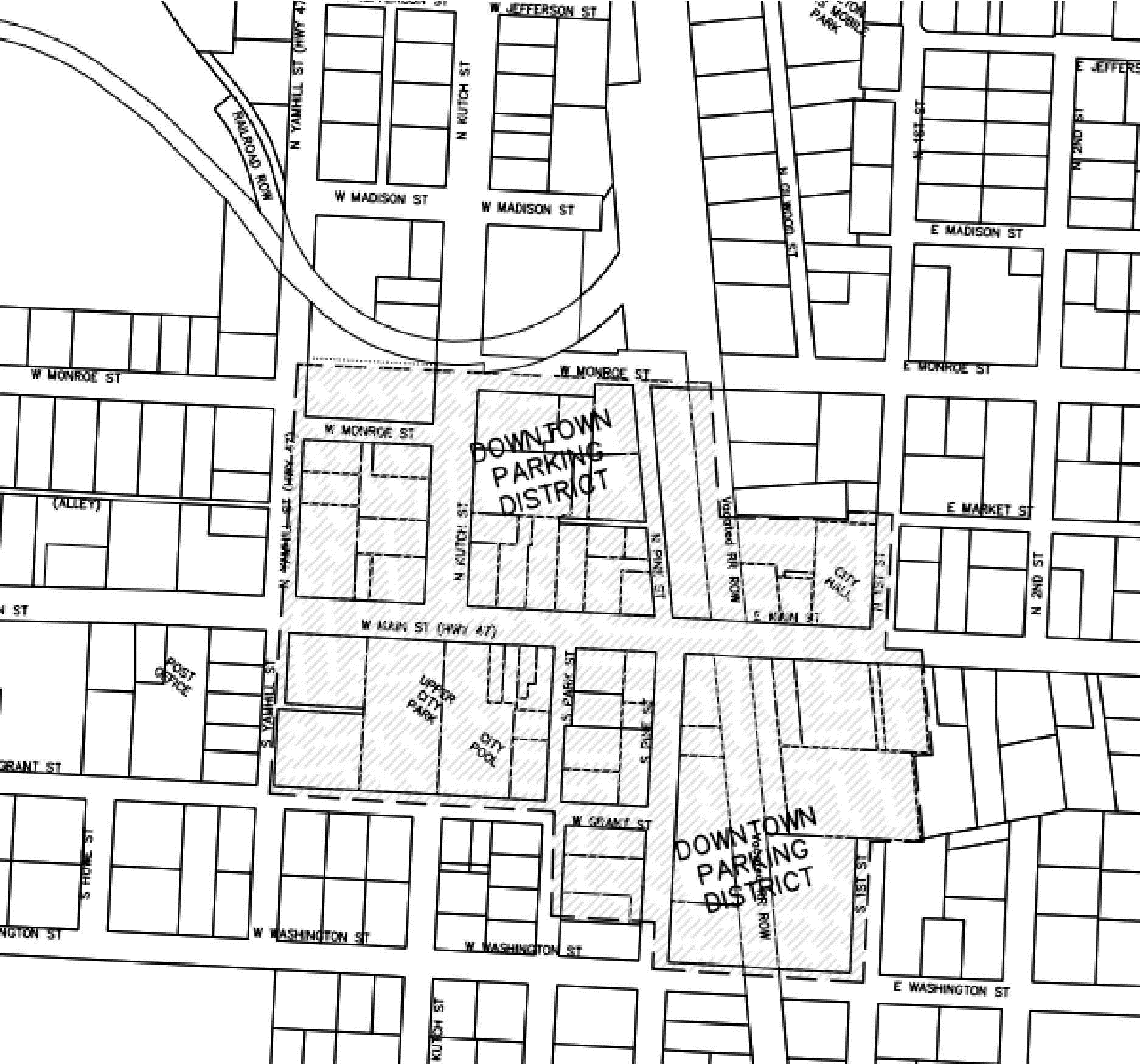
(Ord. No. 2024-751, § 1, 6-25-2024)
17.72.010 - Purpose.
To provide for the drainage of surface water from all residential, commercial and industrial development; to minimize erosion; to reduce degradation of water quality due to sediments and pollutants in stormwater runoff.
(Ord. No. 2024-751, § 1, 6-25-2024)
17.72.020 - Scope.
A.
The provisions of this chapter shall apply to all new residential land partitions and subdivisions, planned unit developments, multi-family developments, commercial developments, institutional developments and industrial developments; and to the reconstruction or expansion of such developments.
B.
The provisions of this chapter shall apply to all drainage facilities that impact any public storm drain system, public right-of-way or easement dedicated to or located within all off-street parking and loading areas.
C.
All stormwater runoff shall be conveyed to a public storm sewer or natural drainage channel having adequate capacity to carry the flow without overflowing or otherwise causing damage to public and/or private property. In the case of private development, the developer shall pay all costs associated with designing and constructing the facilities necessary to meet this requirement.
D.
The storm drainage facilities for new developments and redevelopment with over five-thousand (5,000) square feet of impervious surface shall include both detention and treatment.
(Ord. No. 2024-751, § 1, 6-25-2024)
17.72.030 - Plan for storm drainage and erosion control.
No construction of any facilities in a development included in Section 17.72.020 shall be permitted until a storm drainage and erosion control plan for the project is prepared by an engineer registered in the State of Oregon and approved by the city. This plan shall contain at a minimum:
A.
The methods to be used to minimize the amount of runoff, siltation, and pollution created from the development both during and after construction.
B.
Plans for the construction of storm sewers, open drainage channels, and other facilities that depict line sizes, profiles, construction specifications, and other such information as is necessary for the city to review the adequacy of the storm drainage plans.
C.
A storm drainage report shall be submitted with the land use application. It shall include at a minimum: upstream basins, on-site basins, topography, soils, land use, existing systems and discharges, existing capacity, design storm, existing conditions and post development conditions. The report shall be done in compliance with the current city Design Standards. The report shall be stamped by a registered professional engineer in Oregon.
D.
The erosion control plan shall be in accordance with the requirements of the 1200-C or 1200-Z permits. These permits shall be acquired by the developer prior to construction and copies sent to the city.
(Ord. No. 2024-751, § 1, 6-25-2024)
17.72.040 - General standards.
A.
All development shall be planned, designed, constructed and maintained to:
1.
Protect and preserve existing natural drainage channels;
2.
Protect development from flood hazards;
3.
Provide a system by which water within the development will be controlled without causing damage or harm to the natural environment, or to property or persons within the drainage basin;
4.
Assure that waters drained from the development are treated to industry standard using industry accepted stormwater treatment techniques and as shown in the Public Works Design Standards. This may include standard treatment facilities as well as low impact development (LID) facilities. Hard filters are considered the last option for public facilities;
5.
Assure that waters are drained from the development in such a manner that will not cause erosion to any greater extent than would occur in the absence of development;
6.
Avoid placement of surface detention or retention facilities in road rights-of-way. Public underground detention or retention facilities are considered a last option.
7.
Where downstream system capacity is insufficient, additional detention or system improvements are required.
B.
Where culverts cannot provide sufficient capacity without significant environmental degradation, the city may require the watercourse to be bridged or spanned.
C.
In the event a development or any part thereof is traversed by any watercourse, channel, stream or creek, gulch, or other natural drainage channel, adequate easements for storm drainage purposes shall be provided to the city. This does not imply maintenance by the city.
D.
Channel obstructions are not allowed except as approved for the creation of detention or retention facilities approved under the provisions of this title. Fences with swing gates may be utilized.
E.
Prior to acceptance of a storm sewer system by the city, the storm sewers shall be flushed and inspected by the city. All costs shall be borne by the developer.
F.
Easements for creeks and other watercourses shall be provided and shall extend fifteen (15) feet in each direction from the waterway centerline, ten (10) feet from the top of a recognizable bank, or sufficient width to pass 10-year flood flows or 100-year floodway on FEMA regulated stream, whichever is greater. The easements required by this chapter shall be held to prohibit the placement of any building on or over the easement, but shall not preclude landscaping, and shall be held to require restoration of the site following any excavation or other disturbance permitted by the easement.
G.
The specific location, size and capacity of storm drain facilities will be subject to the approval of the city engineer with reference to the applicable Public Works Design Standards and storm drainage master plan. In the absence of an adopted plan, the location, size and capacity will be subject to the hydrologic and hydraulic analysis by the developer's engineer and approved by the city engineer.
(Ord. No. 2024-751, § 1, 6-25-2024)
17.76.010 - Purpose.
To provide adequate services and facilities appropriate to the scale and type of development.
(Ord. No. 2024-751, § 1, 6-25-2024)
17.76.020 - Standards.
A.
The design of all improvements within existing and proposed rights-of-way and easements, all improvements to be maintained by the city, and all improvements for which city approval is required, shall comply with the requirements of the most current adopted Standard Specifications for Public Works Construction in the City of Carlton.
B.
The location, design, installation and maintenance of all utility lines and facilities shall be carried out with minimum feasible disturbance of soil and site.
C.
Standards for Water Improvements.
1.
All developments shall be required to be linked to existing water facilities adequately sized to serve their intended area by the construction of water distribution lines, reservoirs and pumping station which connect to such water service facilities. All necessary easements required for the construction of these facilities shall be obtained by the developer and granted to the city pursuant to the requirements of the city.
2.
Specific location, size and capacity of such facilities will be subject to the approval of the city engineer with reference to the most current adopted City of Carlton water master plan. All water facilities shall conform with existing city pressure zones and shall be looped where possible and necessary to provide adequate capacity and fire flows during peak demand at every point within the system in the development to which the water facilities will be connected. The city will not expect the developer to pay for the extra pipe material cost for waterlines exceeding eight (8) inches in size. Installation costs shall remain entirely the developer's responsibility.
3.
The design of the water facilities shall take into account provisions for the future extension beyond the development to serve adjacent properties that, in the judgment of the city, cannot be feasibly served otherwise.
4.
Design, construction and material standards shall be as specified in the Public Works Design Standards and by the city engineer for the construction of such public water facilities in the city.
5.
The developer shall provide evidence of fire flow capability through fire hydrant tests and/or a hydraulic model.
D.
Standards for Sanitary Sewer Improvements.
1.
All developments shall be required to be linked to existing sanitary sewer collection facilities adequately sized to serve their intended area by the construction of sewer lines which connect to existing adequately sized sewer facilities. All necessary easements required for the construction of these facilities shall be obtained by the developer and granted to the city pursuant to the requirements of the city.
2.
Specific location, size and capacity of such facilities will be subject to the approval of the city engineer with reference to the most current adopted wastewater facilities plan. All sewer facilities shall be sized to provide adequate capacity during peak flows from the entire area potentially served by such facilities. The city will not expect the developer to pay for the extra pipe material cost for sanitary sewer lines exceeding twelve (12) inches in size. Installation costs shall remain entirely the developer's responsibility.
3.
All properties shall be provided with gravity sanitary sewer service to a public sanitary sewer system except for parcels that have unique topographic or other natural features that make gravity sewer extension impractical as determined by the city engineer. Pumping stations will be allowed only when it has been demonstrated to the satisfaction of the city engineer that the development cannot be served by gravity. Maintenance of residential pump station (serving a single dwelling, multi-family unit or facility) is the responsibility of the property owner.
4.
Temporary sewer service facilities, including pumping stations, will be permitted only if the city engineer approves the temporary facilities, including all facilities necessary for transition to permanent facilities.
5.
The design of the sewer facilities shall take into account provisions for the future extension beyond the development to serve upstream properties that, in the judgment of the city, cannot be feasibly served otherwise.
6.
All land divisions or other developments requiring subsurface sanitary sewer disposal systems shall be prohibited.
7.
Design, construction and material standards shall be as specified by the city engineer for the construction of such sewer facilities in the city.
8.
Prior to acceptance of the sanitary sewer system by the city, the sewers shall be flushed and inspected by the city as required by the Standard Specifications for Public Works Construction in the City of Carlton. All costs shall be borne by the developer.
9.
Industrial facilities that produce wastewater in greater capacity or stronger than standard residential wastewater shall provide a pretreatment system per the requirements of Chapter 13.08 of this code.
E.
Street Lights. All developments shall include underground electric service, light standards, wiring and lamps for street lights according to the specifications and standards of the city engineer. The developer shall install all such facilities and make the necessary arrangements with the serving electric utility for the street lighting system.
F.
Private Utilities. All development which has a need for private utilities, including but not limited to electricity, gas, and communications services shall install them pursuant to the requirements of the district or company serving the development.
1.
Except as otherwise provided herein, all utility lines, cables or wires, including but not limited to those used for electricity, communications services and street lighting which are on or adjacent to land partitioned, subdivided or developed within the City of Carlton after the effective date of the ordinance codified in this title, shall be required to be placed underground. The intent of the city is that no poles, towers, or other structures associated with utility facilities shall be permitted on any street or lot within or adjacent to such partition, subdivision or development.
2.
Exceptions. Above ground facilities shall be permitted for the following in which case the above provisions shall not apply:
a.
Emergency installations or electric transmission lines or to through feeders operating at distribution voltages which act as a main source of supply to primary lateral and to direct connected distribution transformers and primary loads. Should it be necessary to increase the capacity of major power transmission facilities for service to the area, such new or revised installations shall be made only on rights-of-way or easements on which existing overhead facilities exist at the time of such capacity increase;
b.
Appurtenances and associated equipment such as surface-mounted transformers, pedestal-mounted terminal boxes, meter cabinets, telephone cable closures, connection boxes and the like;
c.
Structures without overhead wires, used exclusively for fire alarm boxes, streetlights, or municipal equipment installed under the supervision and with the approval of the city engineer;
d.
Power substations, pumping plants, and similar facilities necessary for transmission or distribution of utility services shall be permitted subject to compliance with all zoning regulations and other applicable land use regulations. The engineer for all such facilities, prior to any construction being started, shall approve plans showing landscaping and screening;
e.
Certain industries requiring exceptionally large power supplies may request direct overhead power as a condition;
f.
If existing overhead utilities within or adjacent to the development total less than one hundred fifty (150) linear feet, the city may allow the applicant to record an approved improvement deferral agreement, see Section 17.216.030, in lieu of relocating existing private utilities underground at the time of development.
3.
Information on Development Plans. The developer or subdivider shall show on the development plan or in his or her explanatory information, easements for all underground utility facilities. Plans showing the location of all underground facilities as described herein shall be submitted to the city engineer for review and approval. Care shall be taken in all cases to ensure that aboveground equipment does not obstruct vision clearance areas for vehicular traffic.
4.
Future Installations. The owner(s) or contract purchaser(s) of subdivided real property within a subdivision shall, upon conveyance or transfer of any interest including a leasehold interest in or to any lot or parcel of land, provide in the instrument conveying such interest a covenant running with and appurtenant to the land transferred under which grantee(s) or lessee(s), their heirs, successors, or assigns mutually covenant not to erect or allow to be erected upon the property conveyed any overhead utility facilities, including electric, communication, and cable television lines, poles, guys, or related facilities, except such facilities as are exempt from underground installation under this title or are owned or operated by the city. Such covenant shall require grantees to install, maintain, and use underground electric, telephone, cable television, or other utility services used or to be used to serve the premises. A copy of the covenant shall be submitted with the final plats.
G.
Easements for public and private utilities shall be provided as deemed necessary by the city, special districts, and utility companies. Easements for special purpose uses shall be of a width deemed appropriate by the responsible agency. Such easements shall be recorded on easement forms approved by the city attorney and designated on the final plat of all subdivisions and partitions. Minimum required easement width and locations are as follows:
(1)
Centered on utility line.
(2)
Centered on property line, where possible.
(3)
All property lines fronting existing or proposed street rights-of-way.
(4)
Measured from edge of right-of-way.
(5)
Determined on a case-by-case basis.
(6)
Sanitary sewers over ten (10) feet deep shall have wider easements as needed per depth.
(Ord. No. 2024-751, § 1, 6-25-2024)
17.78.010 - Purpose.
A.
The purpose of this chapter is to mitigate, minimize or eliminate the adverse impacts caused by grading, fill and excavation activities on public or private property. It establishes policies, procedures and minimum requirements for grading and earthwork construction. It is intended to promote the general health, safety and welfare of the public and requires the applicant to follow sound land development practices.
(Ord. No. 2024-751, § 1, 6-25-2024)
17.78.020 - Grading Permit.
A.
Permit Required. A city-issued grading permit shall be required before the commencement of any of the following filling or grading activities:
1.
Grading activities in excess of fifty (50) cubic yards of earth;
2.
Grading activities which may result in the diversion of existing drainage courses, both natural and human-made, from their natural point of entry or exit from the grading site;
3.
Grading and paving activities resulting in the creation of impervious surfaces greater than two thousand (2,000) square feet or more in area;
4.
Any excavation beyond the limits of a basement or footing excavation, having an unsupported soil height greater than five (5) feet after the completion of such a structure; or
5.
Grading activities involving the clearing or disturbance of one-half (½) acres (twenty-one thousand seven hundred eighty (21,780) square feet) or more of land.
B.
Applicability. Those fill, excavation and grading activities proposed to be undertaken in conjunction with a land use application, including but not limited to subdivisions, planned unit developments, partitions and site plan reviews, are subject to the standards of this chapter. However, a separate grading permit is not required. Approval of the construction plans submitted through the land use application process shall constitute the grading plan.
C.
Grading permit exemptions. The following filling, excavation and grading activities shall not require the issuance of a grading permit:
1.
Excavation for utilities, or for wells or tunnels allowed under separate permit by other governmental agencies;
2.
An excavation below finished grade for basements and footings of a building, retaining wall or other structure authorized by a valid building permit. The placement of any fill material removed from such an excavation requires a grading permit if:
a.
It exceeds fifty (50) cubic yards,
b.
More than fifty (50) cubic yards are removed from the site, or
c.
The fill is placed on the site to a depth greater than one (1) foot;
3.
Farming practices as defined in ORS 30.930 and farm uses as defined in ORS 215.203, except that buildings associated with farm practices and farm uses are subject to the requirements of this chapter;
4.
Excavation for cemetery graves;
5.
Sandbagging, diking, ditching, filling or similar work when done to protect life or property during an emergency;
6.
Repaving of existing paved surfaces that does not alter existing drainage patterns; or
7.
Maintenance work on public roads performed under the direction of the City, County or Oregon State Department of Transportation personnel.
(Ord. No. 2024-751, § 1, 6-25-2024)
17.78.030 - Excavations.
A.
Maximum Slope. The slope of cut surfaces shall not be steeper than is safe for the intended use, and shall not be more than one (1) unit vertical in two (2) units horizontal unless the owner or owner's authorized agent furnishes a geotechnical report (developed by a certified engineering geologist, or a professional engineer who is also a geotechnical engineer), justifying a steeper slope, with the following exceptions:
1.
A cut surface shall be permitted to be at a slope of 1.5 units horizontal to one (1) unit vertical provided that the geotechnical report supports this slope and all of following are met:
a.
It is not intended to support structure of surcharges.
b.
It is adequately protected against erosion.
c.
It is not more than five (5) feet in height.
d.
It is approved by the building code official.
e.
Ground water is not encountered.
2.
A cut surface in bedrock stall be permitted to be at a slope if one (1) horizontal unit to one (1) vertical unit provided that the geotechnical report supports this slope.
(Ord. No. 2024-751, § 1, 6-25-2024)
17.78.040 - Fills.
A.
Maximum Slope. The slope of fill surfaces shall not be steeper than the natural repose of the material and it shall be safe for the intended use. The slope shall not be more than one (1) unit vertical in two (2) units horizontal unless the owner or owner's authorized agent furnishes a geotechnical report justifying a steeper slope, with the following exceptions:
1.
A fill surface shall be permitted to be at a slope of 1.5 units horizontal to one (1) unit vertical provided that the geotechnical report (developed by a certified engineering geologist, or a professional engineer who is also a geotechnical engineer) supports this slope and all of following are met:
a.
It is not intended to support structure of surcharges.
b.
It is adequately protected against erosion.
c.
It is not more than five (5) feet in height.
d.
It is approved by the building code official.
e.
Ground water is diverted.
B.
Benching. Where existing grade is at a slope steeper that one (1) unit vertical in five (5) unites horizontal, and the depth of the fill exceeds five (5) feet, benching shall be provided in accordance with the design standards and be not less than ten (10) feet in width and two (2) feet in depth.
(Ord. No. 2024-751, § 1, 6-25-2024)
17.78.050 - Setbacks.
A.
Cut and fill slopes shall be set back from the property lines in accordance with this section. Setback dimensions shall be measured perpendicular to the property line and shall be:
Minimum of two (2) feet.
Maximum of ten (10) feet.
Distance equals H/5, where H = height of slope.
Distance required for an interceptor drain or ditch.
B.
Slope Protection. Where required to protect adjacent properties at the toe of a slope from adverse effects of the grading, additional protection, approved by the building official and/or City Engineer, shall be included. Examples of such protection include, but are not limited to:
1.
Setbacks greater than those required by subsection (A) of this section;
2.
Provisions for retaining walls of similar construction;
3.
Erosion protection of the fill slopes; or
4.
Provision for the control of surface waters.
(Ord. No. 2024-751, § 1, 6-25-2024)
17.78.060 - Conflicts and Greater Restrictions.
A.
Where the provisions of this chapter are less restrictive or conflict with comparable provisions of this code, regional, state or federal law, the provisions that are more restrictive shall govern. Where this chapter imposes restrictions that are more stringent than regional, state and federal law, the provisions of this chapter shall govern. However, nothing in this chapter shall relieve any party from the obligation to comply with any applicable federal, state or local regulations or permit requirements.
B.
Compliance with this chapter and the minimum requirements, minimum standards, and design procedures as set forth in the city's adopted Public Works Design Standards does not relieve the designer, owner, or developer of the responsibility to apply conservative and sound professional judgement to protect the health, safety, and welfare of the public. It is not the intent of this chapter to make the city a guarantor or protector of public or private property in regard to land development activity.
(Ord. No. 2024-751, § 1, 6-25-2024)
17.78.070 - Submittal Requirements.
A.
An engineered grading plan or an abbreviated grading plan shall be prepared in compliance with the submittal requirements of the Public Works Design Standards and the Grading Permit whenever a city-approved grading permit is required. In addition, a geotechnical engineering report and/or residential lot grading plan may be required pursuant to the criteria listed below.
B.
Abbreviated Grading Plan. The city shall allow the applicant to submit an abbreviated grading plan in compliance with the submittal requirements of the Public Works Design Standards if the following criteria are met:
1.
No portion of the proposed site is within Sensitive Lands including but not limited to: unstable conditions, 100-year flood plain, steep slopes, uncontrolled fill has been placed, or poor soils.
2.
The proposed filling or grading activity does not involve more than fifty (50) cubic yards of earth.
C.
Engineered Grading Plan. The city shall require an engineered grading plan in compliance with the submittal requirements of the Public Works Design Standards to be prepared by a professional engineer if the proposed activities do not qualify for abbreviated grading plan.
D.
Geotechnical Engineering Report. The city shall require a geotechnical engineering report in compliance with the minimum report requirements of the Public Works Design Standards to be prepared by a professional engineer who specializes in geotechnical work (certified engineering geologist, or a professional engineer who is also a geotechnical engineer) when any of the following site conditions may exist in the development area:
1.
When any publicly maintained facility (structure, street, pond, utility, park, etc.) will be supported by any engineered fill;
2.
When an embankment for a stormwater pond is created by the placement of fill;
3.
When, by excavation or fill, the soils remaining in place are greater than three (3) feet high.
E.
Residential Lot Grading Plan. The city shall require a residential lot grading plan in compliance with the minimum report requirements of the Public Works Design Standards to be prepared by a professional engineer for all land divisions creating new residential building lots or where a public improvement project is required to provide access to an existing residential lot.
(Ord. No. 2024-751, § 1, 6-25-2024)
17.80.010 - Purpose.
A.
The purpose of these sign regulations is to provide equitable signage rights, promote traffic and pedestrian safety, and increase the economic viability of the city, by classifying and regulating the location, size, type and number of signs, in a content-neutral manner.
B.
Within the commercial areas, the city recognizes the need for businesses and organizations to inform the public about their location and their services. It also recognizes that a sign is a relative low cost form of business advertising.
C.
The city recognizes that the citizens of Carlton want to retain their unique small-town quality. One (1) method of preserving the look of a small town is by controlling the number, size and type of signs allowed within the commercial district and to provide design guidelines that benefit the citizens and the businesses in improving the visual quality of the community.
(Ord. No. 2024-751, § 1, 6-25-2024)
17.80.020 - Definitions.
See Signs, Section 17.12.020.
(Ord. No. 2024-751, § 1, 6-25-2024)
17.80.030 - General provisions.
A.
Conflicting Standards. Signs shall be allowed subject to the provisions of this chapter, except when these provisions conflict with the specific standards for signs in the subject district.
B.
Signs Subject to State Approval. Off-premise advertising signs visible to the traveling public from state highways are further subject to the regulations and permit requirements of the State of Oregon, Department of Transportation.
C.
Uniform Sign Code. All signs shall comply with the provisions of the Uniform Sign Code of the Uniform Building Code.
D.
Sign Clearances. A minimum of eight (8) feet above sidewalks and fifteen (15) feet above driveways shall be provided under all free standing or wall mounted signs.
(Ord. No. 2024-751, § 1, 6-25-2024)
17.80.040 - Signs allowed.
The following signs and sign work are allowed outright in all zones. These signs shall not require a permit, and shall not be included when determining compliance with total allowed area:
A.
Re-painting, changes to the sign face or copy and maintenance of signs legally existing on the effective date of the ordinance codified in this chapter.
B.
Temporary Signs.
1.
Real estate signs not exceeding six (6) square feet that advertise the sale, rental, or lease of premises upon which the sign is located. Real estate signs may be used up to two (2) years without a permit. Only one (1) real estate sign per lot may be displayed at any time, except on corner lots. Two (2) signs are permitted on corner lots; however only one (1) sign per street frontage is permitted.
2.
Political signs shall not exceed six (6) square feet. Political signs may be used up to sixty (60) days prior to an election but shall be removed not later than seven (7) days following the date of the election.
3.
Portable signs and other temporary signs that do not exceed six (6) square feet in area.
4.
Balloons that do not exceed a total cumulative diameter of twenty-four (24) inches.
C.
Signs posted by or under governmental authority including legal notices, traffic, danger, no trespassing, emergency and signs related to public services or safety.
D.
Directional or informational signs bearing no advertising message and not exceeding four (4) square feet in area erected for the convenience of the public such as signs identifying restrooms, public telephones, walkways and similar features or facilities.
E.
Flags with a total cumulative area not to exceed seventy-five (75) square feet per lot.
F.
Signs within a building.
G.
In a commercial or industrial zone, signs painted or hung on the inside of windows.
H.
Reserved.
I.
Memorial signs or tablets and names of buildings and dates of erection when cut into or attached to the surface or facade of the building.
J.
Signs placed by a public utility showing the location of underground facilities.
K.
Government Signs. Signs posted by or under governmental authority including legal notices, traffic, danger, no trespassing, emergency and signs related to public services or safety.
L.
Building or freestanding signs that display or reflect the history or character of Carlton, as approved by the City Council, after recommendation by the Planning Commission.
(Ord. No. 2024-751, § 1, 6-25-2024)
17.80.050 - Signs prohibited.
The following signs are prohibited in all zones:
A.
Portable signs within the public right-of-way, except for sidewalk or sandwich board signs that comply with Section 17.80.080(D).
B.
Signs that emit odor, visible matter, or sound, however an intercom system for customers remaining in their vehicles, such as used in banks and "drive thru" restaurants, shall be allowed.
C.
Signs that use or employ side guy lines of any type.
D.
Signs that obstruct any fire escape, required exit, window or door opening used as a means of egress.
E.
Signs closer than twenty-four (24) inches horizontally or vertically from any overhead power line or public utility guy wire.
F.
No vehicle or trailer shall be parked on a public right-of-way or public property, or on private property so as to be visible from a public right-of-way which has attached thereto or located thereon any sign or advertising device for the basic purpose of providing advertisement of products or directing people to a business or activity located on the same or nearby premises. This provision applies where the primary purpose of a vehicle is for advertising purposes and is not intended to prohibit any form of vehicular sign, such as a sign attached to a motor vehicle which is primarily used for business purposes, other than advertising.
G.
Rotating/revolving signs, except by conditional use permit.
H.
Flashing signs.
I.
Private signs that project into public rights-of-way, except signs under a canopy that project over a public sidewalk where the sign is not less than eight (8) feet above the sidewalk.
J.
Signs that obstruct required vision clearance area as defined in Section 17.92.080 or obstruct a vehicle driver's view of official traffic control signs and approaching or merging traffic, or which present a traffic hazard.
K.
Signs that interfere with, imitate, or resemble any official traffic control sign, signal or device, emergency lights, or appears to direct traffic, such as a beacon light.
L.
Signs attached to any pole, post, utility pole, or otherwise placed in the public right-of-way.
M.
Signs or sign structures placed on or over private property without the written consent of the owner or agent thereof.
N.
Pennants, banner signs and streamers except in nonresidential zones, which do not exceed a total cumulative area of twelve (12) square feet.
O.
Billboard signs.
P.
Roof signs, except by variance.
Q.
Signs attached to trees, shrubs, stones or fences.
R.
Bench signs, except as a conditional use, or those designating donor(s).
S.
Any sign on unimproved property unless allowed as a real estate or temporary sign.
T.
Any illegible sign or sign that has twenty-five (25) percent or more of its surface destroyed, defaced or missing.
U.
Message signs, except by conditional use permit.
(Ord. No. 2024-751, § 1, 6-25-2024)
17.80.060 - Signs in noncommercial zones.
The following regulations apply to signs in the AH, R-1, R-2, PF, MH, MX, and R-3 zones:
A.
Maximum Number. Any combination of signs not exceeding the sign area and height limitations of this section; plus signs allowed in Section 17.80.040.
B.
Maximum total sign area for property on which the building or buildings are located:
1.
Single-family and two-family (duplex) dwelling: six (6) square feet;
2.
Multiple family dwelling: twenty-four (24) square feet;
3.
Public and semi-public: thirty-two (32) square feet.
C.
Maximum sign height of freestanding signs: six (6) feet.
D.
Location of freestanding signs: where fences are allowed.
E.
Illumination. Signs may only be indirectly illuminated by a concealed light source, and shall not flash, blink, fluctuate or produce glare.
(Ord. No. 2024-751, § 1, 6-25-2024)
17.80.070 - Review procedures in noncommercial zones.
A.
Permit Required. No property owner, lessee or contractor shall construct or alter any sign without first obtaining a valid sign permit.
B.
Current Signs. Owners of conforming or nonconforming signs existing as of the date of adoption of this title are not required to obtain a permit.
C.
Permit Fees. Permit fees may be established by City Council resolution.
D.
Application Requirements.
1.
An application for a sign permit shall be made on a form prescribed by the city manager. The application shall include, at a minimum, a sketch drawn to scale indicating the proposed sign and identifying existing signs on the premises, the sign's location, graphic design, structural and mechanical design and engineering data which ensures its structural stability. The application shall also contain the names and address of the sign company, person authorizing erection of the sign and the owner of the subject property.
2.
The city manager shall issue a permit for a sign unless the sign does not comply with the provisions of these regulations or other provisions of this title. Sign permits mistakenly issued in violation of these regulations or other provisions of this title are void. The city manager may revoke a sign permit if he or she finds that there was a material and misleading false statement of fact in the application for the permit.
E.
Design, Construction, and Maintenance. All signs shall be designed, constructed, and maintained according to the following standards:
1.
All signs shall comply with the applicable provisions of Uniform Building Code in effect at the time of the sign permit application and all other applicable structural, electrical and other regulations. The issuance of a sign permit under these regulations does not relieve the applicant of complying with all other permit requirements;
2.
All signs shall be maintained in a good structural condition at all times;
3.
The owner shall be responsible for its erection and maintenance and its compliance with the provisions of these regulations or other laws or ordinances regulating signs.
(Ord. No. 2024-751, § 1, 6-25-2024)
17.80.080 - Signs in commercial and industrial zones.
All signs in the Commercial Business, Commercial Industrial, Downtown and General Industrial zones shall conform to Sections 17.80.020 through 17.80.050 and the following standards:
A.
Signs or sign structures located in commercial and industrial zones which are within seventy-five (75) feet of a residentially zone property shall be set back so as to meet the side and front yard setback requirements of the adjoining residential district.
B.
Accessory temporary signs are permitted provided such signs are securely affixed to the surface of a building wall or window, and must have the date of initial posting clearly written on the face of the sign. Such signs, including but not limited to sale signs and special product announcements, must be removed not later than ten (10) days after initial posting. Such signs shall not exceed the permitted ratio of sign area, including temporary signs, to building face area.
C.
Historical signs that are an integral part of a building design, or signs with a cultural significance to the community, as determined by the Planning Commission, may be exempted from the standards for signs.
D.
Sidewalk signs or sandwich boards are permitted provided:
1.
There is only one (1) sidewalk or sandwich board sign per business entrance. Vacant lots may have one (1) sandwich board sign per lot.
2.
The sign is professional in appearance with a maximum height of three (3) feet and a maximum width of two (2) feet in width. The height of the sign is measured from the grade of the curb line lowest to the base of the sign, to the highest point of the sign, sign structure or frame; whichever is greater.
3.
The total sign area does not exceed six (6) square feet per side. The base material used to support a sign shall be included in the dimensions used to calculate the sign area.
4.
The sign is removed at the close of each business day.
5.
Reserved.
6.
Sidewalk or sandwich board signs shall only be allowed within an adjacent public right-of-way along the frontage of the business displaying the sign, when they can be placed so that a minimum clear width of three (3) feet within the right-of-way is available for pedestrians immediately adjacent to the sign. Adjacent private property may be used to provide the three (3) foot clear width area when approved by the city manager.
7.
The sign is not to be located within a sidewalk bulb-out area or a location that interferes with traffic visibility.
E.
Reserved.
F.
Suspended signs that are suspended from the underside of a horizontal plane surface and is supported by that surface, shall have a maximum area of three (3) square feet and shall not project more than thirty (30) inches from the face of the building.
(Ord. No. 2024-751, § 1, 6-25-2024)
17.80.090 - Signs in commercial and industrial zones—Appearance.
Signs shall be constructed of wood, brick, tile, masonry, synthetic materials, canvas, vinyl, glass, wrought iron, or metal. Signs shall be constructed of materials consistent with the age, appearance and purpose of the buildings adjacent to the sign. The design shall reflect and be consistent with the appearance, design, architecture and historical character of adjacent buildings and uses. Fluorescent or unusually bright colors shall not be permitted.
(Ord. No. 2024-751, § 1, 6-25-2024)
17.80.100 - Signs in commercial and industrial zones—Size.
A.
Businesses with Two or More Street Frontages.
1.
Land abutting more than one (1) street shall be allowed its quota of signs on each of the streets, and up to ten (10) percent of the permitted quota on any street may be deducted there from and added to the other street frontage.
2.
Where a business located on a corner erects an attached sign designated to be read from both intersecting public streets, the total aggregate area of such sign shall not exceed one-half that which would be allowed for separate signs fronting on the intersecting public streets.
3.
Where a business located on a corner is allowed a monument sign, it may have one (1) such sign designed to be read from both intersecting public streets, or two (2) such freestanding signs, provided that each sign is designed to be read from only one (1) of the intersecting streets.
B.
Area.
1.
Wall signs shall not exceed ten (10) percent of the building face facing a street. For purposes of the area, the height of the lower level or story or twenty (20) feet, whichever is larger, shall be multiplied by the building frontage. Height of lettering cannot exceed twenty-four (24) inches.
2.
Awning signs shall not exceed ten (10) percent of the awning area. For purposes of calculating the awning area, the height shall be multiplied by the width of the awning.
3.
Projecting signs shall not exceed five (5) percent of the building face facing a street. For purposes of calculating the area, the height of the lower level or story, or twenty (20) feet, whichever is less, shall be multiplied by the building frontage. Height of lettering cannot exceed eight (8) inches.
4.
Roof signs are not permitted except by variance.
5.
Freestanding signs: one (1) square foot of sign area for each linear foot of property frontage upon a city street or a total of fifty (50) square feet for each street frontage, whichever is lesser.
C.
Height. Not more than four (4) feet above the eave line provided the maximum height above the ground line shall not exceed twenty (20) feet.
D.
Location. Attached to the building, except such signs shall not be roof signs.
(Ord. No. 2024-751, § 1, 6-25-2024)
17.80.110 - Signs in commercial and industrial zones—Design review requirements.
All signs permitted within the commercial or industrial zones of the city shall conform with the following design review criteria, unless otherwise provided for in this title:
A.
Signs must be compatible in design and color with the architectural and historical qualities of Carlton and with the buildings with which they are associated.
B.
Signs illuminated by spotlights or indirect lighting shall be lighted so that glare from the light source is not visible to pedestrian or vehicle traffic.
C.
Directory signs (wall, projecting, and freestanding), and the individual signs comprising a directory sign shall be uniform or consistent in size, shape, and design. Individual signs in a directory sign may be added, moved, or substituted with signs for new businesses or uses without going through the design review process, provided that the design is consistent and the provisions of the original permit are met.
(Ord. No. 2024-751, § 1, 6-25-2024)
17.80.120 - Signs in commercial and industrial zones—Permit application.
A.
Permit Required. No property owner, lessee or contractor shall construct, alter or relocate any sign without first obtaining a valid sign permit.
B.
Current Signs. Owners of conforming or nonconforming signs existing as of the date of adoption of this title are not required to obtain a permit.
C.
Permit Fees. Permit fees may be established from time to time by City Council resolution.
D.
Application Requirements. An application for a sign permit shall be made on a form prescribed by the city manager. The application shall include the following information:
1.
The names and addresses of the sign company, person authorizing erection of the sign and the owner of the subject property;
2.
The location by street address of the proposed sign;
3.
A drawing suitable for folding for file storage, accurately colored and to scale showing the details of the sign, including all mounting structures and devices, materials from which constructed, lighting, and the name of the proposed lettering style, along with detailed illustration of the sign face;
4.
An accurate scaled site plan, showing the location of building(s), street(s) and other existing sign(s);
5.
In the case of wall and projecting signs, an accurate scaled drawing of all building faces to be signed, including the scaled outlines of all existing a proposed signs.
E.
Design, Construction, and Maintenance. All signs shall be designed, constructed, and maintained according to the following standards:
1.
All signs shall comply with the applicable provisions of Uniform Building Code in effect at the time of the sign permit application and all other applicable structural, electrical and other regulations. The issuance of a sign permit under these regulations does not relieve the applicant of complying with all other permit requirements;
2.
All signs shall be maintained in a good structural condition at all times;
3.
The owner shall be responsible for its erection and maintenance and its compliance with the provisions of these regulations or other laws regulating signs.
(Ord. No. 2024-751, § 1, 6-25-2024)
17.80.130 - Sign in commercial and industrial zones—Review procedure.
A.
All signs requiring a permit shall be reviewed by the City staff. Staff shall consider the design, lettering, arrangement, size, texture, materials, colors, lighting, placement, and appropriateness of the proposed sign in relation to other signs and other structures on the premises and contiguous area in keeping with the intent of this title. City staff shall approve, modify or deny the permit.
B.
In the event the permit is modified or denied by the City staff, the applicant may appeal to the Planning Commission by giving written notice of the appeal to the City Recorder no later than ten (10) days following the modification or denial of the sign permit application by the City staff. The Planning Commission shall hear the matter at its next regularly scheduled meeting. The City staff shall furnish to the Planning Commission its findings and conclusions with respect to the permit. The Planning Commission may modify or deny the permit.
(Ord. No. 2024-751, § 1, 6-25-2024)
17.80.140 - Nonconforming signs.
Signs that were legally established prior to the adoption of this Code on October 8, 2003, and no longer meet the sign code standards are considered nonconforming signs. Nonconforming signs may continue to be in use, subject to the restrictions in this section:
A.
General Requirements for Nonconforming Signs.
1.
A nonconforming sign shall not be:
a.
Modified, unless the modification brings the sign into compliance with this chapter. A change of copy is allowed, except that any change in a wall sign that is painted on a structure shall comply with the requirements of this chapter.
b.
Expanded.
c.
Relocated.
2.
A nonconforming sign may undergo normal maintenance, except:
a.
"Normal maintenance" excludes major structure repairs designed to extend the useful life of the nonconforming sign.
b.
If a nonconforming sign is damaged by wind, fire, neglect or by any other cause, and such damage exceeds sixty (60) percent of its replacement value, the nonconforming sign shall not be repaired and shall be removed.
3.
Upon change of use of a business or premises, a nonconforming sign shall be brought into compliance with this Code within one hundred eighty (180) days.
B.
Abandoned Signs. All signs and sign structures for a business shall be removed within thirty (30) days after that business ceases to operate on a regular basis. Abandoned signs that are not removed may be removed by the city following notice to the property owner. The property owner will be assessed the cost of sign removal if the owner fails to remove the abandoned sign and the city exercises its authority under this provision.
(Ord. No. 2024-751, § 1, 6-25-2024)
17.80.150 - Variances—Signs.
Any allowance for signs not complying with the standards set forth in these regulations shall be by variance. Variances to this chapter will be processed according to the procedures in Chapter 17.148; however, the criteria in Chapter 17.148 shall not be used, but instead the following criteria shall be used to review and decide sign variance applications:
A.
There are unique circumstances or conditions of the lot, building or traffic pattern such that the existing sign regulations create an undue hardship;
B.
The requested variance is consistent with the purpose of this chapter as stated in Section 17.80.010;
C.
The granting of the variance compensates for those circumstances in a manner equitable with other property owners and is thus not a special privilege to any other business. The variance requested shall be the minimum necessary to compensate for those conditions and achieve the purpose of this chapter;
D.
The granting of the variance shall not decrease pedestrian or traffic safety; and
E.
The variance request shall not be the result of a self-imposed condition or hardship.
(Ord. No. 2024-751, § 1, 6-25-2024)
17.80.160 - Unlawful sign removal.
A.
Any unlawful sign that has not been removed within thirty (30) days after notification of the property owner may be removed by the city and the costs charged to the property owner. If removal costs have not been paid and the sign reclaimed within thirty (30) days of its removal by the city, the city is entitled to file a lien against the property on which the sign was located to secure payment of such costs and expenses of removal by the city. The city may sell or otherwise dispose of the sign so removed and apply the proceeds towards the cost of removal.
B.
Signs which are found upon public streets, sidewalks, rights-of-way, or other public property, or which present an immediate and serious danger to the public may be removed without prior notice.
(Ord. No. 2024-751, § 1, 6-25-2024)
17.80.170 - Conditional uses.
A.
Procedures. Applications for conditional use permits for rotating/revolving signs or message signs shall be processed according to the procedure set forth in Chapter 17.156 of this title. The criteria to be reviewed and applied in conditional use permit proceedings are set forth in this section, and the criteria of Chapter 17.152 shall not be applied.
B.
Decision Criteria. The following criteria shall be used to review and decide conditional use permit applications for rotating/revolving, and message signs:
1.
The proposed sign is located in the CB, CI, or IG zones;
2.
The proposed sign, when conditioned, will not significantly increase or lead to street level sign clutter, or to signs adversely dominating the visual image of the area;
3.
The proposed sign, as conditioned, will not adversely impact the surrounding area to a significant degree;
4.
The proposed sign will not present a traffic or safety hazard;
5.
If the application is for a message sign, no rotary beacon lights, zip lights, strobe lights, or similar devices shall be allowed. No chaser effect or other flashing effect consisting of external lights, lamps, bulbs or neon tubes are allowed;
6.
If the application is for a rotating/revolving sign, such sign cannot flash or be illuminated by intermittent light. Rotating/revolving signs shall revolve at a speed no greater than five (5) revolutions per minute;
7.
The total allowed sign area for a business shall be reduced by twenty-five (25) percent if the business has a rotating/revolving or message sign;
8.
The proposed sign will comply with all other regulations, including, but not limited to height and placement restrictions.
(Ord. No. 2024-751, § 1, 6-25-2024)
17.84.010 - Purpose.
The purpose of this chapter is to establish standards to encourage quality landscaping that will contribute to the appearance and aesthetic appeal of the City of Carlton.
(Ord. No. 2024-751, § 1, 6-25-2024)
17.84.020 - Scope.
All construction, expansion, or redevelopment of structures or parking lots for commercial, multi-family, or industrial uses shall be subject to the landscaping requirements of this chapter. The construction of new streets containing landscape strips shall also be subject to the landscaping requirements of this chapter.
Properties within the Downtown Parking District (Figure 17.68.120-1) are exempt from landscaping requirements, except as specifically required by Chapter 17.30 Downtown (D) District design standards and guidelines.
(Ord. No. 2024-751, § 1, 6-25-2024)
17.84.030 - Approval process.
A.
Landscaping plans shall be submitted as required by the Site Design Review of Chapter 17.156.
B.
Submittal Requirements. The applicant shall submit a landscape plan for approval that includes:
1.
The percentage of the lot area to be landscaped;
2.
The location, type, size, and species of existing and proposed plant materials;
3.
All existing and proposed site features including walkways, graveled areas, mailboxes, street lamps, patios, terraces, courts, fences, decks, foundations, potted trees and potted plants, and other open spaces;
4.
The location and height of fences, buffers, and screening;
5.
The location of underground irrigation system sprinkler heads where applicable;
6.
A narrative that addresses soil conditions and erosion control measures that will be used.
(Ord. No. 2024-751, § 1, 6-25-2024)
17.84.040 - Landscaping installation and compliance.
All landscaping required by this title and approved by the Planning Commission shall be installed prior to issuance of a final occupancy permit unless security equal to one hundred twenty (120) percent of the cost of the landscaping is filed with the city assuring such installation within six (6) months of occupancy. The applicant will obtain cost estimates for landscape materials and installation to the satisfaction of the city prior to approval of the security. "Security" may consist of a faithful performance bond payable to the city, cash, certified checks, time certificates of deposit, assignment of a savings account or other such assurance of completion as shall meet with the approval of the city attorney. The city staff prior to any security being returned shall make the final landscape inspection. Any portions of the plan not installed, not installed properly, or not properly maintained shall cause the inspection to be postponed until the project is completed. If the installation of the landscaping is not completed within the six (6) month time period or within an extension of time authorized by the city, the security may be used by the city to complete the installation. Any portion of the security that remains after installation of the landscaping shall be returned to the applicant.
(Ord. No. 2024-751, § 1, 6-25-2024)
17.84.050 - Minimum landscaped area requirements.
Except as modified by the development standards of the underlying zoning district, the following area requirements shall be the minimum areas devoted to landscaping:
A.
Multi-Family Developments: A minimum of twenty-five (25) percent of the lot area shall be devoted to landscaping in multi-family developments. The minimum landscaped area may be reduced to ten (10) percent where the development dedicates one-quarter acre or more land for a neighborhood park, consistent with the adopted Parks Development Plan.
B.
Commercial Developments: A minimum of ten (10) percent of the lot area shall be devoted to landscaping in commercial developments.
C.
Industrial Developments: A minimum of ten (10) percent of the lot area shall be devoted to landscaping in industrial developments.
D.
Developments within Public Zones: A minimum of ten (10) percent of the lot area shall be devoted to landscaping in public zones.
E.
Single-Family, Townhouse and Duplex Dwellings: All yard areas not otherwise improved with structures, parking, and circulation (driveways, walkways, etc.) shall be landscaped. At least fifty (50) percent of front yard areas not covered with driveways, patios, or paths shall contain planted areas (includes any trees retained in the development).
F.
Construction Clean-up: Contractors shall remove all equipment, signage, and debris, including excess soil, rock, building materials, and planting materials and containers, from the premises within seven (7) days of completing construction/landscape installation.
For expansions of existing developments and parking lots, the minimum new landscaped area shall be determined by: First calculating the percentage of the increase of total floor area or parking area; multiplying the lot area by this percentage of increase; multiplying the resulting area by the minimum percentage for the type of development.
(Ord. No. 2024-751, § 1, 6-25-2024)
17.84.060 - General provisions.
A.
For purposes of satisfying the minimum requirements of this title, a "landscaped area" must at a minimum be fifty (50) percent comprised of plant canopy area at maturity. Landscaping materials should be selected and sited to produce a hardy and drought-resistant landscaped area. Selection should include consideration of soil type and depth, the amount of maintenance required, spacing, exposure to sun and wind, the slope and contours of the site, and compatibility with existing native vegetation preserved on the site. Within the minimum plant canopy area, the following plant start size and variety standards shall apply.
1.
For all new residential development, and for every twenty-five (25) feet of linear street frontage:
a.
One tree.
b.
Four (4) one-gallon shrubs or accent plants.
c.
The remaining area shall consist of grasses, ground cover plants, shrubs, bark, rock, annuals or perennials.
2.
For all new non-residential development, and for every twenty-five (25) feet of linear street frontage:
a.
One tree.
b.
Five (5) five-gallon or eight (8) one-gallon shrubs or accent plants.
c.
The remaining area shall consist of grasses, ground cover plants, shrubs, bark, rock, annuals or perennials.
3.
For all landscaped areas, a minimum of fifty (50) percent of plant materials shall be native species selected from the Oregon Flora Native Plant List, as adopted by City Council. (http://oregonflora.org/garden/index.php).
B.
Required landscape areas not otherwise planted, per subsection 17.84.060(A), shall consist of one (1) or more of the following: outdoor recreation area, islands and perimeter planting areas in parking and loading areas, screening walls or fences as required in this Section and elsewhere in this title, interior courtyards, solariums, greenhouses, and/or outdoor recreation facilities.
C.
Landscaping to be done in the adjacent landscape strips within the public right-of-way shall be counted toward the required on-site landscaping for non-residential development provided the landscaping meets the standards of this section.
D.
Nuisance plants. Plants listed on the Nuisance Plant List, as adopted by City Council, are prohibited from being planted in landscaping areas. All new landscaping areas must be cleared of groundcovers and shrubs on the Nuisance Plant List. Trees listed on the Nuisance Plant List are not required to be removed.
E.
The landscape design shall incorporate existing significant trees and vegetation preserved on the site.
F.
Landscaping shall be used to create an attractive streetscape along property frontage for commercial and industrial developments located along arterial or collector streets.
(Ord. No. 2024-751, § 1, 6-25-2024)
17.84.070 - Screening and buffering.
Where required by ordinance, or where placed as a condition of approval, screening and buffering shall meet the following minimum requirements:
A.
Screening shall be used to eliminate or reduce the visual and noise impacts of the following uses:
1.
Commercial and industrial uses when abutting residential uses;
2.
Industrial uses when abutting commercial uses;
3.
Service areas and facilities, including garbage and waste disposal containers, recycling bins, and loading areas;
4.
Outdoor storage areas;
5.
At and above-grade electrical and mechanical equipment, such as transformers, heat pumps, and air conditioners;
6.
Any other area or use as required by this title.
B.
Screening may be accomplished by the use of sight-obscuring plant materials (generally evergreens), earth berms, walls, fences, building parapets, building placement, or other design techniques.
C.
Buffering shall be used to mitigate adverse visual impacts, dust, noise or pollution, and to provide for compatibility between dissimilar adjoining uses. Where buffering is required in subsection 17.84.070(A), one (1) of the following buffering alternatives shall be employed:
1.
Planting area: width not less than twenty (20) feet, planted with the following materials:
a.
At least two (2) rows of deciduous or evergreen trees staggered and spaced not more than ten (10) feet apart; and
b.
At least one (1) row of evergreen shrubs which will grow to form a continuous hedge at least five (5) feet in height within one (1) year of planting; and
c.
Lawn, low-growing evergreen shrubs or evergreen ground cover covering the balance of the area.
2.
Berm plus planting area: width not less than fifteen (15) feet, developed in accordance with the following standards:
a.
Berm form shall not slope more than forty (40) percent (2.5 Horizontal Run: 1 Vertical Run) on the side away from the area screened from view; and
b.
A dense evergreen hedge shall be located so as to most effectively buffer the proposed use; and
c.
Combined total height of the berm plus the hedge shall be at least five (5) feet within one year of planting.
3.
Wall plus planting area: width must not be less than five (5) feet developed in accordance with the following standards:
a.
A masonry wall or fence not less than six (6) feet in height; and
b.
Lawn, low-growing evergreen shrubs, and evergreen ground cover covering the balance of the area.
4.
Other methods that produce an adequate buffer considering the nature of the impacts to be mitigated, as approved by the city.
(Ord. No. 2024-751, § 1, 6-25-2024)
17.84.080 - Planting and maintenance.
All landscaping shall be continually maintained, including necessary watering, weeding, pruning, mowing, and replacement, in a substantially similar manner as found on the landscape plan that was approved by the city staff. In addition, the following shall apply:
A.
No sight-obscuring plantings exceeding twenty-four (24) inches in height shall be located within any required vision clearance area as defined in Subsection 17.92.080.
B.
Plant materials shall not cause a hazard. Landscape plant materials over walks, pedestrian paths, and seating areas shall be pruned to a minimum height of eight (8) feet and to a minimum height of fifteen (15) feet over streets and vehicular traffic areas.
C.
Landscape plant materials shall be selected which does not generally interfere with utilities above or below ground.
D.
Landscape plant material shall be installed to current nursery industry standards.
E.
Landscape plant materials shall be properly guyed and staked to current industry standards as necessary. Stakes and guy wires shall not interfere with vehicular or pedestrian traffic.
F.
All landscape material shall be guaranteed by the developer for a period of one (1) year from the date of installation. A copy of the guarantee shall be furnished to the city by the developer.
G.
Plant materials shall be suited to the conditions under which they will be growing. As an example, plants to be grown in exposed, windy areas that will not be irrigated should be sufficiently hardy to thrive under these conditions. Plants should have vigorous root systems and be sound, healthy, and free from defects, diseases, and infections.
H.
Deciduous trees shall be fully branched, have a minimum caliper of one and one-half (1½) inches, and a minimum height of eight (8) feet at the time of planting.
I.
Evergreen trees shall be a minimum of six (6) feet in height, fully branched.
J.
Shrubs shall be supplied in minimum one (1) gallon containers or eight-inch burlap balls with a minimum spread of fifteen (15) inches and a minimum height of eighteen (18) inches.
K.
Ground cover plants shall be spaced in accordance with current nursery industry standards to achieve covering of the planting area. Rows of plants are to be staggered for a more effective covering. Ground cover shall be supplied in a minimum four-inch size container or equivalent if planted eighteen (18) inches on center.
L.
All developments are required to provide appropriate methods of irrigation for the landscaping. Sites with over one thousand (1,000) square feet of total landscaped area shall be irrigated with automatic sprinkler systems to insure the continued health and attractiveness of the plant materials. Hose bibs and manually operated methods of irrigation may be used for landscaped areas totaling less than one thousand (1,000) square feet. Irrigation shall not be required in wooded areas, wetlands, floodplains, or along natural drainage channels or stream banks. Sprinkler heads shall not be a hazard to the public.
M.
Appropriate methods of care and maintenance of landscaped plant material shall be provided by the owner of the property.
N.
Landscape plant material shall be protected from damage due to heavy foot traffic or vehicular traffic by protective tree grates, pavers or other suitable methods.
(Ord. No. 2024-751, § 1, 6-25-2024)
17.84.090 - Street trees.
A.
All new residential developments shall install a minimum of one (1) street tree per mature canopy spread, to range between twenty-five (25) feet and forty (40) feet of street frontage, or fraction thereof.
B.
Street trees shall be planted within the landscape strip, if present, or within the front yard.
C.
All street trees must be a species listed in the adopted approved street tree list.
D.
To create a variety of street trees:
1.
If there are fewer than eight (8) or fewer required trees, they may all be the same species;
2.
If there are between eight (8) and twenty-four (24) required trees, no more than forty (40) percent of new street trees on a single block can be of one species; or
3.
If there are more than twenty-four (24) required trees, no more than twenty-four (24) percent of them can be of one species.
E.
As determined by the City Engineer in review of detailed site improvement plans, street trees may be spaced more than forty (40) feet apart, if tree spacing is shown to conflict with required placement of streetlights, street signs, utilities and street access at minimum width. In these cases, options for relocating lights, signs, utilities and driveway access are to be first explored along with selection of a different species of tree shown to the approved street tree list.
(Ord. No. 2024-751, § 1, 6-25-2024)
17.88.010 - Purpose.
To provide for the orderly, safe, efficient and livable development of land within the City of Carlton.
(Ord. No. 2024-751, § 1, 6-25-2024)
17.88.020 - Scope.
The provisions of this chapter shall apply to all subdivisions, planned unit developments and partitions within the City of Carlton.
(Ord. No. 2024-751, § 1, 6-25-2024)
17.88.030 - Standards for lots or parcels.
A.
Minimum Lot Area. Minimum lot area shall conform to the requirements of the zoning district in which the parcel is located unless lot size averaging is approved according to the provisions of subsection 17.176.030(A)(12).
B.
Oversized Lots. When single-family residential use is proposed for a lot with an area double or greater than the minimum density of the underlying zone the applicant shall provide a Master Plan demonstrating the potential for further division of the lot at a future date.
C.
Lot Width and Depth. The depth of a lot or parcel shall not be more than three times the width of the parcel, with the following exceptions:
1.
Parcels created for public utility uses or in zones where there is no minimum lot area requirement shall be exempt from width to depth ratio provisions.
2.
Lots within residential zones where the permitted minimum lot width is less than forty (40) feet may be permitted to have a width-depth ratio of no greater than 5:1.
D.
Access. All lots and parcels created after the effective date of the ordinance codified in this title shall provide a minimum frontage, on an existing or proposed public street, equal to twenty (20) feet, or as required by the underlying zone, whichever is greater. The city may approve an exception when residential lots or parcels and planned unit developments are accessed via a private street or easement developed in accordance with the provisions of Chapter 17.64.060 or when the City finds that public street access is:
1.
Infeasible due to parcel shape, terrain, or location of existing structures; and
2.
Not necessary to provide for the future development of adjoining property.
E.
Flag Lots. Where flag lots are proposed consistent with subsection 17.176.030(A)(10), the following standards shall be met:
1.
The access strip shall not be less than twenty (20) feet wide. The access strip shall be improved with minimum twelve (12) foot wide paved driveways that meet applicable City standards. If said access strip is over one hundred fifty (150) feet in length, the driveway shall terminate in a turn-around capable of accommodating emergency fire vehicles consistent with Oregon Fire Code standards;
2.
The access strip shall not be included in the calculation of lot area for purposes of determining compliance with any minimum lot size provision of this title.
F.
Through Lots. Through lots are prohibited. The City may approve an exception where essential to provide separation of residential development from major traffic arteries, adjacent nonresidential activities, or to overcome specific disadvantages of topography and orientation. A ten (10) foot wide screening or buffering easement, pursuant to the provision of Chapter 17.84, may be required by the city during the review of the land division request.
G.
Lot Side Lines. The side lines of lots, as far as practicable, shall run at right angles to the right-of-way line of the street upon which the lots face.
H.
Lot Grading. The minimum elevation at which a structure may be erected, taking into consideration the topography of the lot, the surrounding area, drainage patterns and other pertinent data, shall be established by the building inspector.
I.
Utility Easements. Utility easements shall be provided on lot areas where necessary to accommodate public utilities. Such easements shall have a minimum total width as specified in Section 17.76.020.
(Ord. No. 2024-751, § 1, 6-25-2024)
17.88.040 - Standards for blocks.
A.
General. The length, width, and shape of blocks shall be designed with regard to providing adequate building sites for the use contemplated; consideration of needs for convenient access, circulation, control, and safety of street traffic; and recognition of limitations and opportunities of topography.
B.
Sizes.
1.
Block Length. Except as provided in Section 17.100.030 for the Main Street Special Transportation Area (STA), blocks in residential and commercial districts shall be a minimum of one hundred (100) feet long and shall not exceed six hundred (600) feet in length between street right-of-way lines, unless the previous adjacent development pattern or topographical conditions justify a variation. Blocks that exceed six hundred (600) feet in length shall provide a pedestrian/bicycle accessway located within one hundred (100) feet of the midpoint of the block and designed to meet the standards of section 17.88.050.I.
2.
Block Perimeter. Block perimeters in residential and commercial districts shall not exceed one thousand four hundred (1,400) feet.
C.
Alleys. Alleys may be provided in all districts, however, alleys shall be provided in commercial and industrial areas, unless other permanent provisions for access to off-street parking and loading facilities are provided.
(Ord. No. 2024-751, § 1, 6-25-2024)
17.88.050 - Improvement requirements.
All improvements required by this title or as conditions of approval of any subdivision or partition shall be completed prior to the issuance of any building permits for any structures within the subject development. If the developer requests approval to record the final plat before all required improvements have been constructed and all conditions of approval have been met by the developer and accepted by the city, the developer shall provide a security guarantee satisfactory to the city that all improvements will be constructed in conformance with all city standards and ordinances and all conditions of approval will be satisfied in compliance with Section 17.216.030. If the total street frontage of the development is less than or equal to two hundred fifty (250) feet, the applicant may request to sign and the city may grant an improvement deferral agreement or non-remonstrance agreement.
A.
Frontage Improvements. Street improvements shall be required for all public streets on which a proposed land division fronts in accordance with Chapter 17.64. Frontage improvements shall include: sidewalks, curbing, pavement, storm sewer, sanitary sewer, water lines, other public utilities as necessary, and such other improvements as the city shall determine to be reasonably necessary to serve the development or the immediate neighborhood.
B.
Street Improvements.
1.
Internal Streets. All public or private streets within the land division shall be constructed as required by the provisions of Chapter 17.64. Private driveways serving flag lots or private streets shall be surfaced as per the requirements of this title.
2.
Boundary Streets. All public or private streets along the boundary of the land division shall be constructed as required by the provisions of Chapter 17.64. The pavement and sidewalk shall be extended beyond the frontage of the development sufficiently to transition the width. At a minimum this shall be a three (3) (parallel) to one (1) (perpendicular) slope.
C.
Monuments. Upon completion of street improvements, centerline monuments shall be established and protected in monument boxes at every street intersection at all points of curvature, points of tangency of street center lines, and other points required by state law.
D.
Bench Marks. Elevation benchmarks shall be set at intervals established by the city engineer. The benchmarks shall consist of a brass cap set in a curb or other immovable structure.
E.
Surface Drainage and Storm Sewer System. Drainage facilities shall be provided within the land division and to connect the land division drainage to drainage-ways or to storm sewers outside the land division and shall be consistent with the most current adopted stormwater master plan, Public Works Design Standards and Chapter 17.72. Design of drainage within the land division shall take into account the capacity and grade necessary to maintain unrestricted flow from areas draining through the land division and to provide extension of the system to serve such areas. The design shall take into account provisions for the future extension beyond the land division to serve upstream properties that, in the judgment of the city, cannot be served otherwise.
F.
Sanitary Sewers. Sanitary sewer shall be installed to serve the land division and to connect the land division to existing mains both on and off the property being divided, and shall be consistent with the most current adopted wastewater facilities plan, Public Works Design Standards and Chapter 17.76. The design shall take into account provisions for the future extension beyond the land division to serve upstream properties that, in the judgment of the city, cannot be served otherwise. The city may require that the construction of sewage lines of a size in excess of that necessary to adequately service the development in question, where such facilities are or will be necessary to serve the entire area within which the development is located when the area is ultimately developed.
G.
Water System. Water lines with valves and fire hydrants serving the land division and connecting the land division to the city mains shall be installed, and shall be consistent with the most current adopted water master plan, Public Works Design Standards and Chapter 17.76. The design shall take into account provisions for extension beyond the land division to adequately loop the city system and to serve the area within which the development is located when the area is ultimately developed. However, the city will not expect the developer to pay for the extra pipe material cost of mains exceeding eight (8) inches in size. Installation costs shall remain entirely the developer's responsibility.
H.
Sidewalks. Sidewalks shall be installed along both sides of each public street within the land division as well as along all frontages to existing streets. Sidewalks shall be extended as required to connect to other sidewalk systems. The city may defer sidewalk construction until the dwellings or structures fronting the sidewalk are constructed. Any required off-site sidewalks, sidewalks fronting public property, or sidewalks adjacent to existing structures shall not be deferred.
I.
Pedestrian/Bicycle Access Way Design Standards. Pedestrian/bicycle access ways shall be installed where required based on block length or other locations elected by the applicant and shall meet the following design standards:
1.
Minimum dedicated width: twenty (20) feet;
2.
Minimum paved width: five (5) to ten (10) feet;
3.
Minimum landscape strip: five (5) feet on either side of pavement or one ten (10) foot wide landscape strip, planted with a minimum of one (1) tree and five (5) shrubs per 35 linear feet meeting the minimum standards of Section 17.84.080;
4.
Vision clearance: a clear line of visions for the entire length of the access way shall be required;
5.
Pedestrian scale lighting fixtures shall be provided along the walkway and lighted to a level where the system can be used at night;
6.
The access way shall be designed to prohibit vehicle traffic.
J.
Other.
1.
Curb cuts and driveway installations, excluding common drives, are not required of the land divider but, if installed, shall be according to the city standards.
2.
Street trees shall be planted in accordance with Section 17.84.090. The city may defer street tree planting until the dwellings or structures fronting the street are constructed.
3.
Streetlights. The installation of underground electric service, light standards, wiring, and lamps for streetlights of a type required by city standards following the making of necessary arrangements with the serving electric.
4.
Street Signs. The installation of street name signs and traffic control signs is required at locations determined to be appropriate by the city and shall be of a type required by city standards.
5.
Utility lines and facilities shall be installed in accordance with Chapter 17.76.
(Ord. No. 2024-751, § 1, 6-25-2024)
17.88.060 - Improvement procedures.
In addition to other requirements, improvements installed by a developer for any land division, either as a requirement of these regulations or at his or her own option, shall conform to the requirements of this title and improvement standards and specifications adopted by the city, and shall be installed in accordance with the following procedure:
A.
Improvement work shall not commence until plans have been checked for adequacy and approved by the city engineer. Plans shall be prepared in accordance with requirements of the city. Other agency approvals shall be obtained as required which may include ODOT, Yamhill County, DEQ and OHA.
Improvement work shall not commence until all permits have been obtained, fees been paid and a preconstruction meeting held with the city.
B.
Improvement work shall not commence until the city has been notified in advance; and, if work has been discontinued for any reason, it shall not be resumed until the city has been notified.
C.
Improvements shall be constructed under the inspection and to the satisfaction of the city engineer, and other agencies as required. The city may require changes in typical sections and details in the public interest, if unusual conditions arise during construction to warrant the change.
D.
All underground utilities, sanitary sewers, and storm drains installed in streets by the developer shall be constructed prior to the surfacing of the streets. Stubs for service connections for underground utilities and sanitary sewers shall be placed to a length eliminating the necessity for disturbing the street improvements when service connections are made. Unless otherwise approved by the city, this shall be interpreted as extending to the right-of-way or easement line.
E.
Upon completion of the public improvements and prior to final acceptance of the improvements by the city, the developer shall provide two (2) certified as-built drawings of all public utility improvements to the city. As-built conditions and information shall be reflected on one (1) set of Mylar base as-built drawings. The developer's engineer shall submit the as-built drawings to the city.
(Ord. No. 2024-751, § 1, 6-25-2024)
17.92.010 - New buildings—Required to be located on a lot.
Every building erected shall be located on a lot as herein defined.
(Ord. No. 2024-751, § 1, 6-25-2024)
17.92.020 - Yards apply only to one building.
No required yard or other open space or required driveway provided around or for any building or structure for the purpose of complying with the provisions of this title shall be considered as providing a yard or open space for any other building, nor shall any yard or other required space on an adjoining lot be considered as providing a yard or open space on the lot whereon the building is to be erected.
(Ord. No. 2024-751, § 1, 6-25-2024)
17.92.030 - No parking in yard areas.
Exclusive of city-approved paved or gravel driveways, no parking shall be allowed within the required front yard area or yards located adjacent to a street. The side yard and rear yard areas may not be used for parking of vehicles, except in city-approved parking areas. The yard areas adjacent to a street shall not be used for the permanent storage of utility trailers, house or vacation trailers, boats, or other similar vehicles.
(Ord. No. 2024-751, § 1, 6-25-2024)
17.92.040 - Front yard projections.
Planter boxes, chimneys and flues, steps, cornices, eaves, gutters, belt courses, leaders, sills, pilasters, lintels, and other ornamental features which extend not more than eighteen (18) inches from main buildings are exempt from the front yard setback provisions and need not be included when determining the setback.
(Ord. No. 2024-751, § 1, 6-25-2024)
17.92.050 - Side yard projections.
A.
Cornices, eaves, gutters, and fire escapes, when not prohibited by any other code or ordinance, may project into a required side yard not more than one-third (⅓) of the width of the side yard provided a minimum setback of thirty-six (36) inches is maintained.
B.
Chimneys, flues, belt courses, leaders, sills, pilasters, lintels, and ornamental features may project not more than eighteen (18) inches into a required side yard, provided, however, chimneys and flues shall not exceed six (6) feet in width.
C.
Uncovered decks and patios attached to the main building when measured directly beneath the outside edge of the deck or patio may be extended to the side yard property line when they are thirty-six (36) inches or less in height from ground level.
(Ord. No. 2024-751, § 1, 6-25-2024)
17.92.060 - Rear yard projections.
A.
Chimneys, flues, belt courses, leaders, sills, pilasters, lintels, gutters and other ornamental features, may project not more than eighteen (18) inches into a required rear yard, provided, however, chimneys and flues shall not exceed six (6) feet in width.
B.
A fire escape, balcony, outside stairway, cornice or other unenclosed, unroofed projections may project not more than five (5) feet into a required rear yard and set back at least six (6) feet from any property line.
C.
Planter boxes, steps, uncovered porches when not more thirty-six (36) inches above grade are exempt from the minimum rear yard depth requirements.
D.
Uncovered decks and patios attached to the main building when measured directly beneath the outside edge of the deck or patio may be extended to the rear yard property line when they are thirty-six (36) inches or less in height from ground level.
(Ord. No. 2024-751, § 1, 6-25-2024)
17.92.070 - Vision clearance.
A.
A vision clearance area shall be maintained at each access to a public street and on each corner of property at the intersection of two (2) streets or a street and a railroad. A vision clearance area shall contain no planting, sight-obscuring fence (open chain link excluded), wall, structure, or temporary or permanent obstruction exceeding three (3) feet in height, measured from the ground. The preceding provisions shall not apply to the following:
1.
Public utility poles;
2.
A tree trimmed (to the trunk) to a line at least eight (8) feet above the level of the intersection;
3.
Another plant species of open growth habit that is not planted in the form of a hedge and which is so planted and trimmed as to leave at all seasons a clear and unobstructed cross-view;
4.
A supporting member or appurtenance to a permanent building lawfully existing on the date this standard becomes effective;
5.
An official warning sign or signal;
6.
A place where the natural contour of the ground is such that there can be no cross-visibility at the intersection;
7.
The post section of a pole sign when there are no more than two (2) posts and any post is less than eight (8) inches in diameter;
8.
Telephone switch boxes provided they are less than ten (10) inches wide at the widest dimension.
B.
For single use residential driveways, the vision clearance area shall consist of a triangular area, two (2) sides of which are the curb line and the edge of the driveway. Where no curbs exist, the future location of the curb, based on future full street improvements shall be used.
C.
The following measurements shall establish the vision clearance areas:
(Ord. No. 2024-751, § 1, 6-25-2024)
17.92.080 - Fences, walls and hedges.
A.
Materials.
1.
Fences and walls shall not be constructed of nor contain any material that could cause bodily harm, such as barbed wire, broken glass, spikes, or any other hazardous or dangerous materials. Electric fences are not permitted;
2.
Electric or barbed wire fences intended to contain or restrict cattle, sheep, horses or other livestock, and existing prior to annexation to the city, may remain;
3.
All required swimming pool and hot tub fencing shall be a minimum of four (4) feet in height and be equipped with a self-locking gate that closes automatically.
B.
Standards.
1.
Every fence shall be maintained in a condition of reasonable repair and shall not be allowed to become and remain in a condition of disrepair including noticeable leaning, missing sections, broken supports, non-uniform height, and uncontrolled growth of vegetation;
2.
Fences shall not exceed four (4) feet in height in any front yard;
3.
The maximum fence height in a street side yard shall not exceed six (6) feet;
4.
Fences within a front or street side yard shall also conform to the clear vision requirements at intersections, which further restrict the use or height of sight-obscuring fences;
5.
In no instance shall a fence extend beyond the property line including into a public right-of-way. It is the responsibility of the property owner to determine the property line;
6.
Fences shall not exceed seven (7) feet in height.
(Ord. No. 2024-751, § 1, 6-25-2024)
17.96.010 - Generally.
Accessory structures shall comply with the requirements of this chapter.
(Ord. No. 2025-753, § 1(Exh. A), 1-6-2026)
17.96.020 - Standards applicable to all properties in the R-1, R-2, R-3 and MX districts.
A.
Location. Accessory structures shall not be located within a setback as described by the zone for a front or street side yard.
B.
Height. The maximum allowable height is fifteen (15) feet measured according to building height as defined and is limited to one (1) story.
C.
Reduced Rear Yard Setback. Accessory structures may occupy a portion of the minimum rear yard setback of the applicable zone if shown to meet all specifications as follows:
1.
The structure footprint is four hundred eighty (480) square feet or less, according to the definition of building footprint in Chapter 17.12.
2.
The structure does not exceed one-story in height and is no higher than ten (10) feet, according to the definition of building height.
3.
The outer edges of any roof eave are located at least three (3) feet from the nearest property line.
4.
The structure footprint does not occupy more than twenty (20) percent of the minimum rear yard setback of the zone.
D.
Building Separation. Accessory structure shall be separated from the primary buildings by minimum distances as described in State of Oregon Specialty Codes for compliance with structural, mechanical, plumbing, electrical and fire standards.
E.
Building Size and Lot Coverage. The combine footprints of primary and accessory structures on any lot shall not exceed the maximum lot coverage standard of the applicable zone.
F.
Prohibited Exterior Materials. Except for small accessory structures with a building footprint of one hundred (100) square feet or less, plastic sheeting, tarpaulins and other flexible membrane materials are prohibited. Shipping containers are prohibited under this chapter.
G.
Accessory structures shall not be constructed prior to construction of a primary structure on the same property and shall not be constructed over public utility and access easements.
(Ord. No. 2025-753, § 1(Exh. A), 1-6-2026)
17.96.030 - Standards applicable to all properties in the AH, MH, CB, D, CI, PF and GI districts.
A.
Location and Number. Accessory structures may be located anywhere the primary structure may be placed. There is no limit to the number of permitted accessory structures.
B.
Height. Accessory structures shall comply with the height provisions in the underlying zone for the primary structure.
C.
Setbacks. Accessory structures shall comply with the setback provisions in the underlying zone for the primary structure.
D.
Building Size. If applicable, accessory structures shall not exceed building size and lot coverage provisions of the underlying zone.
E.
Design Standards. Design standards may apply, subject to Chapter 17.156 Site Design Review and provisions of the underlying zone.
F.
Accessory structures shall not be constructed prior to construction of a primary structure on the same property and shall not be constructed over public utility and access easements.
(Ord. No. 2025-753, § 1(Exh. A), 1-6-2026)
17.100.010 - Purpose.
The purpose is to implement the access management policies of the City of Carlton, Transportation System Plan. Access control standards manage access to land development while preserving the flow of traffic in terms of safety, capacity, functional classification, and level of service. Major roadways, including highways, arterials, and collectors serve as the primary network for moving people and goods. These transportation corridors also provide access to businesses and homes and have served as the focus for commercial and residential development. If access points are not properly designed, these roadways will be unable to accommodate the needs of development and retain their primary transportation function. To achieve this purpose, state and local roadways have been categorized in the City of Carlton, Transportation System Plan by function and classified for access purposes based upon their level of importance and function. Regulations are applied to these roadways for the purpose of reducing traffic accidents, personal injury, and property damage attributable to poorly designed access systems, and to thereby improve the safety and operation of the roadway network. This protects the substantial public investment in the existing transportation system and reduces the need for expensive remedial measures.
(Ord. No. 2024-751, § 1, 6-25-2024)
17.100.020 - Applicability.
This title shall apply to all public streets within Carlton and to all properties that abut these roadways.
(Ord. No. 2024-751, § 1, 6-25-2024)
17.100.030 - Access spacing standards.
A hierarchy of spacing standards is established that is dependent on the functional classification of the street.
(1)
Measured between street centerlines.
(2)
Measured between edge of driveways.
(3)
The intersection and driveway spacing standards have been updated from the 2009 TSP.
(4)
Where minimum spacing between driveways on adjacent lots cannot be achieved due to lot width, driveways on adjacent lots shall be combined. Combined driveways are encouraged for all townhouse dwellings.
(Ord. No. 2024-751, § 1, 6-25-2024)
17.100.040 - General standards.
A.
Lots that front on more than one (1) street shall be required to locate motor vehicle accesses on the street with the lower functional classification.
B.
When a residential subdivision is proposed that would abut an arterial, it shall be designed to provide through lots along the arterial with access from a frontage or local street. Access rights of these lots, to the arterial shall be dedicated to the City of Carlton and recorded with the deed. A berm or buffer yard may be required at the rear of through lots to buffer residences from traffic on the arterial.
C.
Subdivisions with frontage on the state highway system shall be designed to share access points to and from the highway. If access off of a secondary street is possible, then access should not be allowed onto the state highway.
D.
Wherever a proposed development abuts unplatted developable land within the urban growth boundary, street stubs shall be provided to provide access to abutting properties or to logically extend the street system into the surrounding area.
E.
Local streets shall connect with surrounding streets to permit the convenient movement of traffic between residential neighborhoods or facilitate emergency access and evacuation. Connections shall be designed to avoid or minimize through traffic on local streets. Appropriate design and traffic control such as four-way stops and traffic calming measures are the preferred means of discouraging through traffic.
F.
In all cases reasonable access or the minimum number of access connections, direct or indirect, necessary to provide safe access to and from a street shall be granted.
1.
Single-family or townhouse dwelling shall have one (1) driveway.
2.
Duplex dwelling may have two (2) driveways if minimum spacing standards in Section 17.100.030 are met, or a single combined driveway.
3.
A multi-family dwelling site or cottage cluster shall have one (1) driveway unless a second is required for circulation on large lots. Driveways shall meet minimum spacing standards in Section 17.100.030.
4.
Commercial and industrial facilities shall have one (1) driveway unless a second is required for circulation or loading on large lots. Driveways shall meet minimum spacing standards in section 17.100.030.
G.
New connections shall not be permitted within the functional area of an intersection as defined by the connection spacing standards of this title, unless no other reasonable access to the property is available.
(Ord. No. 2024-751, § 1, 6-25-2024)
17.100.050 - Joint and cross access.
A.
Adjacent commercial properties classified as major traffic generators (i.e., shopping plazas, office parks), shall provide a cross access drive and pedestrian access to allow circulation between sites.
B.
Systems of joint use driveways and cross access easements shall be established wherever feasible and shall incorporate the following:
1.
A continuous service drive or cross access corridor extending the entire length of each block served to provide for driveway separation consistent with the access management classification system and standards;
2.
A design speed of ten (10) mph and a maximum width of twenty-four (24) feet to accommodate two-way travel aisles designated to accommodate automobiles, service vehicles, and loading vehicles;
3.
Stub-outs and other design features to make it visually obvious that the abutting properties may be tied in to provide cross-access via a service drive;
4.
A unified access and circulation system plan for coordinated or shared parking areas is encouraged.
C.
Pursuant to this section, property owners shall:
1.
Record an easement with the deed allowing cross access to and from other properties served by the joint use driveways and cross access or service drive;
2.
Record an agreement with the deed that remaining access rights along the roadway will be dedicated to the City of Carlton and pre-existing driveways will be closed and eliminated after construction of the joint-use driveway;
3.
Record a joint maintenance agreement with the deed defining maintenance responsibilities of property owners.
D.
The City of Carlton may reduce required separation distance of access points where they prove impractical, provided all of the following requirements are met:
1.
Joint access driveways and cross access easements are provided in accordance with this section;
2.
The site plan incorporates a unified access and circulation system in accordance with this section;
3.
The property owner enters into a written agreement with the City of Carlton, recorded with the deed, that pre-existing connections on the site will be closed and eliminated after construction on each side of the joint use driveway.
(Ord. No. 2024-751, § 1, 6-25-2024)
17.100.060 - Nonconforming access features.
Legal access connections in place as of the effective date of the ordinance codified in this title that do not conform with the standards herein are considered nonconforming features and shall be brought into compliance with applicable standards under the following conditions:
A.
When new access connection permits are requested;
B.
Change in use or enlargements or improvements that will increase trip generation.
(Ord. No. 2024-751, § 1, 6-25-2024)
17.100.070 - Review procedures.
A.
Access Permit Required. Access to a public street (e.g., a new curb cut or driveway approach) requires an access permit. An access permit may be in the form of a letter to the applicant, or it may be attached to a land use decision notice as a condition of approval. In either case, approval of an access permit shall follow the procedures and requirements of the applicable road authority, as determined through the Type I review procedures found in Section 17.188.010.
B.
Traffic Study Requirements.
1.
The city shall require a traffic impact analysis (TIA) prepared by a qualified professional to determine access, circulation, and other transportation requirements when:
a.
The development generates twenty-five (25) or more peak-hour trips or two hundred fifty (250) or more daily trips.
b.
An access spacing exception is required for the site access driveway(s) and the development generates ten (10) or more peak-hour trips or one hundred (100) or more daily trips.
c.
The development is expected to impact intersections that are currently operating at the upper limits of the acceptable range of level of service during the peak operating hour.
d.
The development is expected to significantly impact adjacent roadways and intersections that have previously been identified as high crash locations or areas that contain a high concentration of pedestrians or bicyclists such as a schools.
2.
The scope of the TIA shall be in accordance with the direction and approval of the City Engineer. If impacted streets includes ODOT or Yamhill County, then the scope must meet their requirements as well. At a minimum the TIA shall include the following items: project description, current conditions (street condition, traffic control) trip generation, traffic volumes for the existing conditions and development and build-out, safety analysis including geometry, operational analysis current and post development, site specific conditions and impacts (schools, parks, other large traffic or pedestrian generators), and recommendations.
3.
Transportation Assessment. If a TIA is not required, the applicant's traffic engineer shall submit a transportation assessment letter to the city indicating the proposed land use action is exempt.
a.
This letter shall outline the trip-generating characteristics of the proposed land use and verify that the site-access driveways or roadways meet City of Carlton sight-distance requirements and roadway design standards.
b.
The Public Works Director may waive the requirement for a transportation assessment letter if a clear finding can be made that the proposed land use action does not generate twenty-five (25) or more peak-hour trips or two hundred fifty (250) or more daily trips and the existing and or proposed driveway(s) meet the City's sight-distance requirements and access spacing standards.
C.
Conditions of Approval. The city may require the closing or consolidation of existing curb cuts or other vehicle access points, recording of reciprocal access easements (i.e., for shared driveways), development of a frontage street, installation of traffic control devices, and/or other mitigation as a condition of granting an access permit, to ensure the safe and efficient operation of the street and highway system.
D.
Access permit reviews shall address the following criteria:
1.
Access shall be properly placed in relation to sight distance, driveway spacing, and other related considerations, including opportunities for joint and cross access;
2.
The road system shall provide adequate access to buildings for residents, visitors, deliveries, emergency vehicles, and service vehicles;
3.
The access shall be consistent with the access management standards in the most current adopted City of Carlton Transportation System Plan.
E.
Any application that involves access to the State Highway System shall be reviewed by the Oregon Department of Transportation for conformance with state access management standards.
(Ord. No. 2024-751, § 1, 6-25-2024)
17.104.010 - Applicability.
This chapter is applicable to all sites or structures defined as historic sites in Section 17.12.020.
(Ord. No. 2024-751, § 1, 6-25-2024)
17.104.020 - Review procedures.
A.
Upon receipt of a land use application or demolition permit a determination shall be made if the site has historical significance by being listed as a historic or cultural resource. If the site is of historical significance the Planning Commission shall conduct a site design review and consider the following:
1.
The state of repair of the building and cost of restoration or repair;
2.
The character of the neighborhood;
3.
Other factors the Planning Commission feels appropriate.
B.
Following review and hearing, the Planning Commission shall make a recommendation for approval, approval with mitigation, or denial of the land use action.
(Ord. No. 2024-751, § 1, 6-25-2024)
17.104.030 - Preservation of historical record.
If a site with historical significance is to be demolished or significantly altered, the Planning Commission may direct that an acceptable detailed pictorial and graphic record be prepared prior to demolition or alteration.
(Ord. No. 2024-751, § 1, 6-25-2024)
17.106.010 - Purpose.
The following standards are intended to promote human-scale design in new development, while ensuring visibility of adjacent public ways to encourage crime prevention, traffic calming, and safe and convenient walking in neighborhoods. The standards are intended to provide flexibility in building style and detailing.
(Ord. No. 2024-751, § 1, 6-25-2024)
17.106.020 - Applicability.
This chapter applies to the following building types:
A.
Single-family dwellings, duplexes and two (2) attached townhouse dwellings are not subject to Site Design Review, but new dwellings are required to comply with Section 17.106.025; no other provisions of Chapter 17.106 apply to single-family dwellings, duplexes or two (2) attached townhouse dwellings;
B.
Three (3) or more attached townhouse dwellings are subject to all provisions of Chapter 17.106;
C.
Multi-family housing, including residential care facilities, are subject to all provisions of Chapter 17.106;
D.
Mixed-use buildings (residential and other use combined) are subject to all provisions of Chapter 17.106;
E.
Cottage clusters are subject to the provisions of Section 17.106.040.
(Ord. No. 2024-751, § 1, 6-25-2024)
17.106.025 - Single-family dwelling garage standards.
A.
All single-family dwellings shall have a garage or carport containing not less than two hundred (200) square feet of covered vehicle/storage space. The garage shall be constructed of materials that are similar in color, material, and appearance to the primary structure. The garage or carport shall be constructed prior to occupancy.
(Ord. No. 2024-751, § 1, 6-25-2024)
17.106.030 - Design standards.
A.
The standards of this section apply to multi-family dwellings, mixed-use buildings and three (3) or more attached townhouse dwellings.
B.
Building Orientation Standard. All residential buildings shall be oriented to a street. This standard is met when at least one (1) building on a site is placed within twenty (20) feet of a street right-of-way ("street"), and such building contains a dwelling entrance facing the street. Multi-family building entrances may include entrances to individual units, lobby entrances, or breezeway/courtyard entrances (i.e., to a cluster of units). Alternatively, a building may have its entrance oriented to a side yard or central courtyard when a direct pedestrian walkway is provided between the building entrance and the street, and the elevation facing the street contains windows, a porch and/or a balcony to avoid a blank wall appearance and to provide visibility of the street from the dwelling or garage, as applicable.
Figure 17.106.030(B-1) Building Orientation
C.
Except as allowed for townhouse dwellings under subsection 17.106.030(E), for the purposes of complying with subsection 17.106.030(B), no off-street parking, garage or carport entrance, drive, or other vehicle areas shall be placed between any building and the street to which it is oriented.
D.
Building form and detailing. New buildings and building additions subject to site development review shall conform to all of the following standards, as applicable. The graphics provided with each standard are intended to show examples of how to comply. Other building styles and designs can be used to comply, so long as they are consistent with the text of this section. An architectural feature (i.e., as shown in the graphics) may be used to comply with more than one (1) standard.
1.
Building Form. The continuous horizontal distance (i.e., as measured from end-wall to end-wall) of individual buildings shall not exceed one hundred sixty (160) feet. All buildings shall incorporate design features, including one (1) or more of the following: offsets, balconies, covered porches, projections or window reveals to preclude large expanses of uninterrupted building surfaces, as generally shown in Figure 17.106.030(D). Along the vertical face of a structure, such features shall occur at a minimum of once every forty (40) feet, and on each floor shall contain at least two (2) of the following features:
a.
Recess deck, patio, courtyard, or entrance that has a minimum depth of four (4) feet;
b.
Extension floor area, deck, patio, or entrance that projects a minimum of two (2) feet and runs horizontally for a minimum length of four (4) feet; and/or
c.
Offsets or breaks in roof elevation of two (2) feet or greater in height.
Figure 17.106.030(D-1) Building Form (Multifamily Housing Example)
2.
Eyes on the Street. All building elevations visible from a street right-of-way shall provide doors, porches, balconies, and/or windows. A minimum of fifty (50) percent of front (i.e., street-facing) elevations, and a minimum of twenty-five (25) percent of side and rear building elevations shall meet this standard. "Percent of elevation" is measured as the horizontal plane (lineal feet) containing doors, porches, balconies, terraces and/or windows. The standard applies to each full and partial building story.
Figure 17.106.030(D-2) Examples of Architectural Details
Figure 17.106.030(D-3) Examples of Architectural Details (Continued)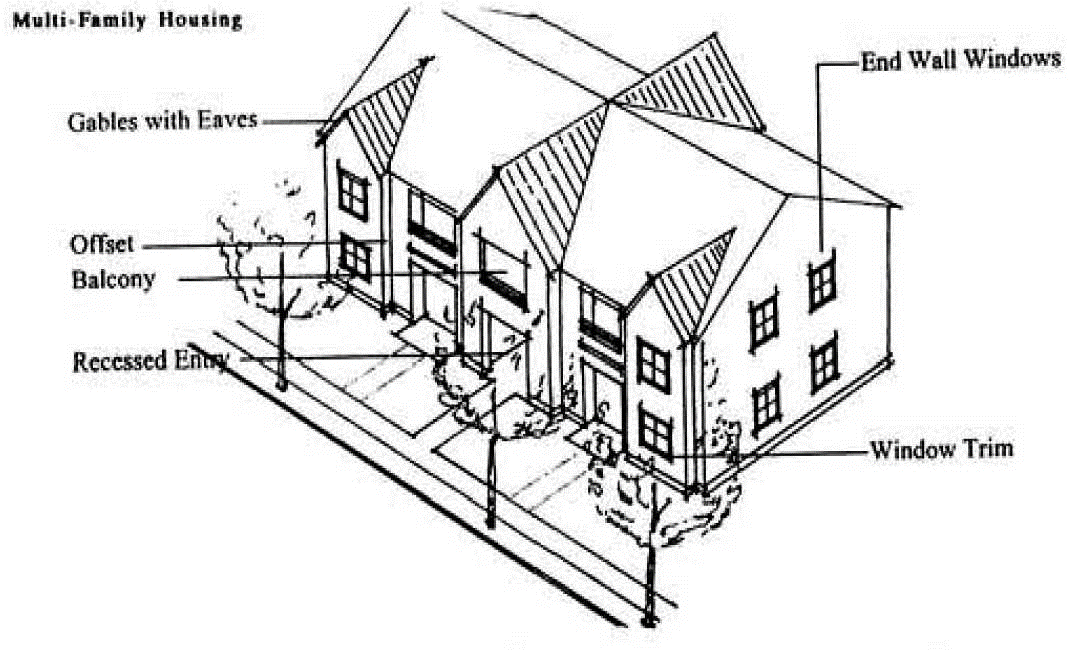
3.
Detailed Design. All buildings shall provide detailed design along all elevations (i.e., front, rear and sides). Detailed design shall be provided by using at least two (2) of the following architectural features on all elevations, as appropriate for the proposed building type and style (may vary features on rear/side/front elevations):
a.
Dormers;
b.
Gables;
c.
Recessed entries;
d.
Covered porch entries;
e.
Cupolas or towers;
f.
Pillars or posts;
g.
Eaves (minimum six-inch projection);
h.
Off-sets in building face or roof (minimum sixteen (16) inches);
i.
Window trim (minimum four (4) inches wide);
j.
Bay windows;
k.
Balconies;
l.
Decorative patterns on exterior finish (scales/shingles, wainscoting, or ornamentation);
m.
Decorative cornices and roof lines (e.g., for flat roofs);
n.
An alternative feature providing visual relief, similar to options in subsections (3)(a) through (m) of this section.
4.
Façade Variety. Duplicative front façades of townhouse dwellings in a development with three (3) or more attached dwellings are prohibited. Variety shall be created by incorporating a minimum of two (2) of the following design features:
a.
Varied or staggered front setbacks, with variations of at least five feet;
b.
Different building heights, with the two (2) heights varying by at least five (5) feet;
c.
Varied rooflines such as hipped or pitched roofs;
d.
Varied architectural features listed in subsections (3)(a) through (m) of this section, with each dwelling including at least one (1) architectural feature not repeated more frequently than once every four (4) dwellings.
E.
Standard Vehicle Access. Except as provided under subsection 17.106.030(F), dwellings shall have garages or other covered parking accessed from a shared driveway or alley oriented to a side or rear yard. Such access shall be created at the time of subdivision or site development review approval, as applicable.
Figure 17.106.030(E-1) Townhouses with Alley Access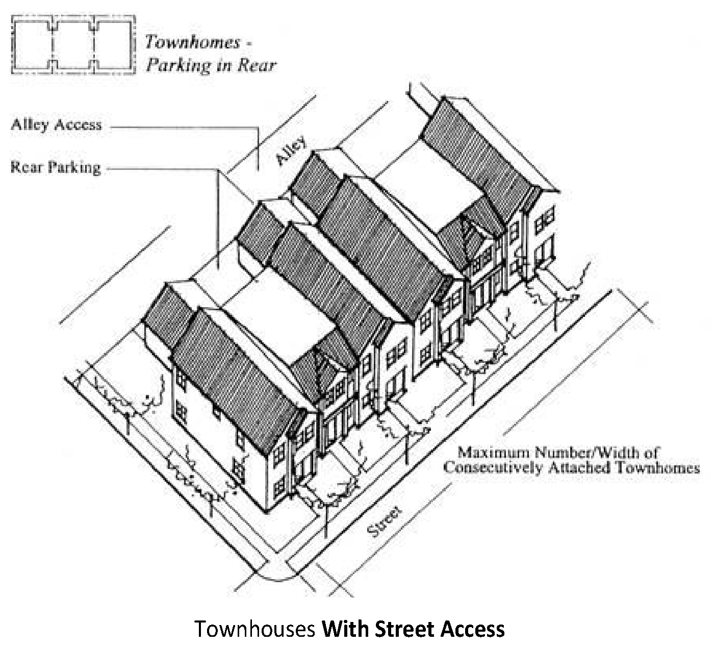
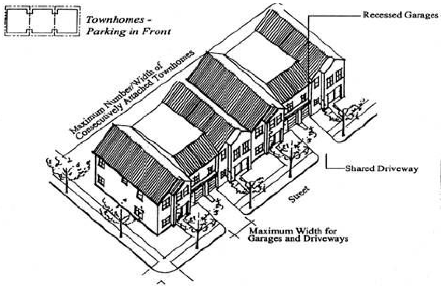
F.
Alternative (Front) Vehicle Access. As an alternative to 17.106.030(E) a garage or other parking area may be located adjacent to a front yard, subject to the following standards, which are intended to minimize interruption of adjacent sidewalks by driveway entrances, slow traffic, improve appearance of the streets, and to minimize paved surfaces and reduce stormwater runoff.
1.
When a garage opening faces a street, it shall be setback from the street property line by not less than twenty (20) feet or recessed behind the front elevation (i.e., living area or covered front porch) by a minimum of four (4) feet.
2.
The maximum allowable driveway within a front or street side setback is twenty (20) feet.
3.
The total width of all garage openings on any street-facing building elevation shall not exceed fifty (50) percent of the total width of the building elevation on which the opening(s) are located, or twenty-two (22) feet, whichever is less. For example, a twenty-four (24) foot wide unit may have one (1) twelve (12) foot wide recessed garage facing the street.
4.
Two (2) adjacent garages shall share one (1) driveway when individual driveways would otherwise be separated by less than twenty (20) feet (i.e., the width of one (1) on-street parking space). When a driveway serves more than one (1) lot, the developer shall record an access and maintenance easement/agreement to benefit each lot, before building permit issuance.
G.
Open Space. New multi-family developments subject to the provisions of this chapter shall provide open space in compliance with all of the following requirements:
Figure 17.106.030(G) Multifamily Housing (Open Space)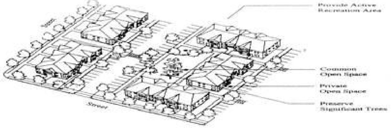
1.
Common Open Space Standard. A minimum of fifteen (15) percent of the site area shall be designated and permanently reserved as usable common open space in developments that are at least one (1) acre in size with more than ten (10) dwelling units. The site area is defined as the lot or parcel on which the development is planned, after subtracting any required dedication of street right-of-way and other land for public purposes (e.g., public park or school grounds, etc.).
a.
Required setback yards and landscaped area required by Chapter 17.84 may be counted toward meeting the common open space requirement if they meet all common open space requirements of this subsection.
b.
Sensitive lands and historic buildings or landmarks open to the public and designated by the comprehensive plan may be counted toward meeting the common open space requirements.
c.
To ensure usable open space, at least one (1) common open space area shall be provided within the development that is at least five hundred (500) square feet in size and has a minimum dimension of twenty (20) feet for all sides.
2.
Private Open Space Standard. Private open space areas shall be required for dwelling units based on all of the following standards:
a.
A minimum of fifty (50) percent of all ground-floor housing units shall have front or rear patios or decks measuring at least forty-eight (48) square feet. Ground-floor housing means the housing unit entrance (front or rear) is within five (5) feet of the finished ground elevation (i.e., after grading and landscaping);
b.
A minimum of fifty (50) percent of all upper-floor housing units shall have balconies or porches measuring at least twenty-four (24) square feet. Upper-floor housing means housing units that are more than five (5) feet above the finished grade; and
c.
Where private open space areas face adjacent single-family residences, a combination of landscaping and screening shall be provided as a buffer. This buffer shall include a minimum of one (1) tree, not less than one and one-half (1.5) inches in caliper, for every twenty-five (25) linear feet of abutting property width and a minimum six-foot-tall decorative, sight obscuring fence or wall made of wood, stone, brick or vegetation (chain link fencing with or without slats is not permitted to meet this standard).
3.
Common Areas. Common areas shall be maintained by a homeowners association or other legal entity. A homeowners association may also be responsible for exterior building maintenance. A copy of any applicable covenants, restrictions and conditions shall be recorded and provided to the city before building permit approval.
4.
Exemptions. Exemptions to the common open space standard may be granted for the first twenty (20) units of a larger project when the development is located within one-quarter mile (measured walking distance) of a public park, and there is a direct, accessible (i.e., Americans with Disabilities Act-compliant), lighted, and maintained pedestrian trail or sidewalk between the site and the park. An exemption shall be granted only when the nearby park provides active recreation areas such as play fields; children's play area, sports courts, walking/fitness course, or similar facilities.
H.
Landscaping and Screening. All yards not otherwise improved with buildings, parking, circulation, or recreation facilities shall be landscaped pursuant to Section 17.84.050. All landscaping shall be installed in accordance with Chapter 17.84 and approved plans prior to issuance of building occupancy permits.
I.
Trash Receptacles. Trash receptacles shall be oriented away from adjacent residences and shall be fully screened with an evergreen hedge or solid fence or wall of not less than six (6) feet in height.
(Ord. No. 2024-751, § 1, 6-25-2024)
17.106.040 - Cottage clusters.
A.
Cottage clusters shall meet the design standards of this subsection. No other design standards shall apply to cottage clusters unless noted in this subsection.
B.
Dimensional Standards. The dimensional standards of the zone where the cottage cluster is located shall apply with the following exceptions:
1.
The maximum height for a cottage dwelling is twenty-five (25) feet.
2.
The maximum footprint for a cottage dwelling in nine hundred (900) square feet.
3.
The maximum gross floor area for a cottage dwelling is one thousand six hundred (1,600) square feet.
4.
Cottages shall be separated by a minimum distance of six (6) feet. The minimum distance between all other structures, including accessory structures, shall be in accordance with building code requirements.
5.
Cottages shall meet the minimum setbacks of the underlying zone or a minimum perimeter setback of ten (10) feet, whichever is less.
6.
No maximum net density shall apply to cottage clusters.
C.
Cluster Size.
1.
Cottage clusters shall have a minimum of four (4) cottage dwellings.
2.
Cottage clusters in the R-1 and R-2 zones shall have a maximum of twelve (12) cottage dwellings per cluster. Cottage clusters in the R-3 and MX zones shall have no maximum number of cottage dwellings per cluster. Multiple clusters are permitted on a single development site.
D.
Cottage Orientation. Cottages must be clustered around a common courtyard, meaning they abut the associated common courtyard or are directly connected to it by a pedestrian path, and must meet the following standards (see Figure 17.106.040-1):
1.
Each cottage within a cluster must either abut the common courtyard or must be directly connected to it by a pedestrian path.
2.
A minimum of fifty (50) percent of cottages within a cluster must be oriented to the common courtyard and must:
a.
Have a main entrance facing the common courtyard;
b.
Be within ten (10) feet from the common courtyard, measured from the façade of the cottage to the nearest edge of the common courtyard; and
c.
Be connected to the common courtyard by a pedestrian path.
3.
Cottages within twenty (20) feet of a street property line may have their entrances facing the street.
4.
Cottages not facing the common courtyard or the street must have their main entrances facing a pedestrian path that is directly connected to the common courtyard.
E.
Common Courtyard Design Standards. Each cottage cluster must share a common courtyard in order to provide a sense of openness and community of residents. Common courtyards must meet the following standards (see Figure 17.106.040-1):
1.
The common courtyard must be a single, contiguous piece.
2.
Cottages must abut the common courtyard on at least two (2) sides of the courtyard.
3.
The common courtyard must contain a minimum of one hundred fifty (150) square feet per cottage within the associated cluster.
4.
The common courtyard must be a minimum of fifteen (15) feet wide at its narrowest dimension.
5.
The common courtyard shall be developed with a mix of landscaping, lawn area, pedestrian paths, and/or paved courtyard area, and may also include recreational amenities. Impervious elements of the common courtyard shall not exceed seventy-five (75) percent of the total common courtyard area.
6.
Pedestrian paths must be included in a common courtyard. Paths that are contiguous to a courtyard shall count toward the courtyard's minimum dimension and area. Parking areas, required setbacks, and driveways do not qualify as part of a common courtyard.
Figure 17.106.040-1: Cottage Cluster Orientation and Common Courtyard Standards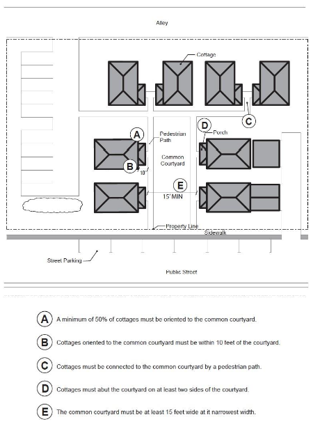
F.
Community Buildings. Cottage cluster projects may include community buildings for the shared use of residents that provide space for accessory uses such as community meeting rooms, guest housing, exercise rooms, day care, or community eating areas. Community buildings must meet the following standards:
1.
Each cottage cluster is permitted one (1) community building, which shall count towards the maximum average floor area, pursuant to subsection (D)(5).
2.
A community building that meets the development code's definition of a dwelling unit must meet the maximum nine hundred (900) square foot footprint limitation that applies to cottages, unless a covenant is recorded against the property stating that the structure is not a legal dwelling unit and will not be used as a primary dwelling.
G.
Pedestrian Access.
1.
An accessible pedestrian path must be provided that connects the main entrance of each cottage to the following:
a.
The common courtyard;
b.
Shared parking areas;
c.
Community buildings; and
d.
Sidewalks in public rights-of-way abutting the site or rights-of-way if there are no sidewalks.
2.
The pedestrian path must be hard-surfaced and a minimum of four (4) feet wide.
H.
Parking Design (see Figure 17.106.040-2).
1.
Clustered parking. Off-street parking may be arranged in clusters, subject to the following standards:
a.
Cottage cluster projects with fewer than twelve (12) cottages are permitted parking clusters of not more than five (5) contiguous spaces.
b.
Cottage cluster projects with twelve (12) cottages or more are permitted parking clusters of not more than eight (8) contiguous spaces.
c.
Parking clusters must be separated from other spaces by at least four (4) feet of landscaping.
d.
Clustered parking areas may be covered.
2.
Parking location and access.
a.
Off-street parking spaces and vehicle maneuvering areas shall not be located:
i.
Within of twenty (20) feet from any street property line, except alley property lines; or
ii.
Between a street property line and the front façade of cottages located closest to the street property line. This standard does not apply to alleys.
b.
Off-street parking spaces shall not be located within ten (10) feet of any other property line, except alley property lines. Driveways and drive aisles are permitted within ten (10) feet of other property lines.
3.
Screening. Landscaping, fencing, or walls at least three (3) feet tall shall separate clustered parking areas and parking structures from common courtyards and public streets.
4.
Garages and carports.
a.
Garages and carports (whether shared or individual) must not abut common courtyards.
b.
Individual attached garages up to two hundred (200) square feet shall be exempted from the calculation of maximum building footprint for cottages.
c.
Individual detached garages must not exceed four hundred (400) square feet in floor area.
d.
Garage doors for attached and detached individual garages must not exceed twenty (20) feet in width.
I.
Accessory Structures. Accessory structures must not exceed four hundred (400) square feet in floor area.
J.
Existing Structures. On a lot or parcel to be used for a cottage cluster project, an existing single-family dwelling on the same lot at the time of proposed development of the cottage cluster may remain within the cottage cluster project area under the following conditions:
a.
The existing dwelling may be nonconforming with respect to the requirements of this code.
b.
The existing dwelling may be expanded up to the maximum dimensions in subsection (B); however, existing dwellings that exceed the maximum height and/or footprint of this code may not be expanded.
c.
The floor area of the existing dwelling shall not count towards the maximum average floor area of a cottage cluster.
d.
The existing dwelling shall be excluded from the calculation of orientation toward the common courtyard, per subsection (1)(a) of this section (E).
Figure 17.106.040-2: Cottage Cluster Parking Design Standards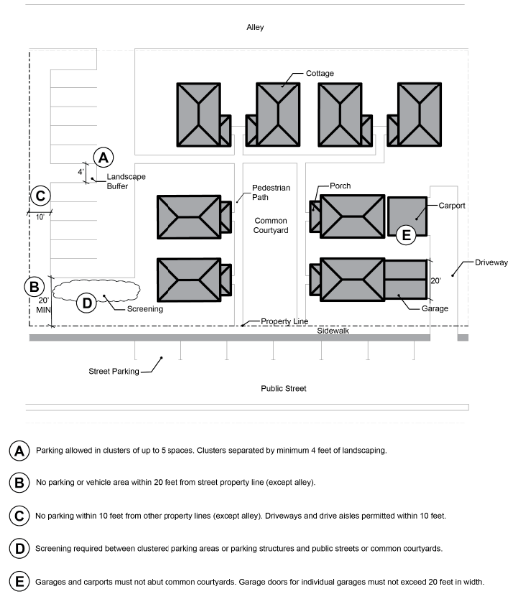
(Ord. No. 2024-751, § 1, 6-25-2024)