
Carlton City Zoning Code
Division II
ZONING AND DEVELOPMENT PROVISIONS
Chapter 17.56 - FLOODPLAIN MANAGEMENT (FP) OVERLAY ZONE[2]
Editor's note—Ord. No. 2024-752, § 1(Exh. 1), adopted Jan. 7, 2025, amended Ch. 17.56 in its entirety to read as set out herein. Former Ch. 17.56, §§ 17.56.010—17.56.070 pertained to similar subject matter and derived from Ord. No. 2024-751, § 1, adopted June 25, 2024.
17.20.010 - Purpose.
The Residential-Low Density (R-1) district preserves existing neighborhood residential areas and provides for future neighborhood residential housing opportunities including single-family detached homes, duplexes, and other similarly scaled dwellings. The R-1 district is consistent with the Residential comprehensive plan designation.
(Ord. No. 2024-751, § 1, 6-25-2024)
17.20.020 - Permitted uses.
The following uses are permitted in the Residential-Low Density District:
A.
Single-family dwelling, including a single-family manufactured home and a prefabricated structure.
B.
Duplex dwelling.
C.
Accessory dwelling, subject to the provisions of Section 17.20.060.
D.
Cottage cluster, subject to the provisions of Section 17.106.040.
E.
Planned unit development, subject to the provisions of Chapter 17.112.
F.
Family child care home.
G.
Residential home.
H.
Home Occupation, subject to the provisions of Chapter 17.124.
I.
Vacation rental subject to the provisions of Chapter 17.125.
J.
Public park and recreation area.
K.
Single Room Occupancy - one (1) per lot size of at least seven thousand five hundred (7,500) square feet.
(Ord. No. 2024-751, § 1, 6-25-2024)
17.20.030 - Conditional uses.
The following uses are permitted as conditional uses, provided that such uses are approved in accordance with Chapter 17.152.
A.
Place of worship.
B.
Public or private school.
C.
Community building.
D.
Utility facility including utility rights-of-way.
E.
Bed and breakfast.
(Ord. No. 2024-751, § 1, 6-25-2024)
17.20.035 - Density standards.
A.
The minimum net density in the Residential-Low Density District shall be 4.6 dwelling units per net acre.
B.
The maximum net density in the Residential-Low Density District shall be determined by the allowed minimum lot areas.
(Ord. No. 2024-751, § 1, 6-25-2024)
17.20.040 - Dimensional standards.
The following dimensional standards shall be the minimum requirements for all development in the R-1 district except for modifications permitted under Chapter 17.132.
(Ord. No. 2024-751, § 1, 6-25-2024)
17.20.050 - Development standards.
All development in the R-1 district shall comply with the applicable provisions of Chapters 17.128 through 17.140. In addition, the following specific standards shall apply:
A.
Accessory Structures. Accessory structures as provided for in Chapter 17.96.
B.
Off-Street Parking. Parking shall be as specified in Chapter 17.68.
C.
Subdivisions and Partitions. Land divisions shall be reviewed in accordance with the provisions of Chapters 17.172 through 17.176, as applicable.
D.
Cottage clusters shall be subject to the Site Design Review procedures of Chapter 17.156.
E.
Yards and Lots. Yards and lots shall conform to the standards of Chapter 17.92.
F.
Signs. Signs shall conform to the requirements of Chapter 17.80.
G.
Driveways. Driveways shall conform to the standards 17.68.060.
H.
Landscaping and Screening. Where landscaping, fencing or other screening is required pursuant to land division approval or other land use approval, all such landscaping shall be installed in accordance with Chapter 17.84 and approved plans prior to issuance of building occupancy permits.
I.
Building and Site Design. All residential structures shall conform to the design standards of Chapter 17.106.
1.
Single-family dwellings shall comply with the garage or carport standards in Section 17.106.025.
(Ord. No. 2024-751, § 1, 6-25-2024)
17.20.060 - Accessory dwelling standards.
Accessory dwellings shall conform to all of the following standards:
A.
A maximum of one (1) accessory dwelling is allowed per single-family dwelling. The unit may be a detached building, in a portion of a detached accessory building (e.g., above a garage or workshop), or a unit attached or interior to the primary dwelling (e.g., an addition or the conversion of an existing floor).
B.
Size. An accessory dwelling shall not exceed eight hundred (800) square feet of floor area. However, accessory dwellings that result from the conversion of a level or floor (e.g., basement, attic, or second story) of the primary dwelling may occupy the entire level or floor, even if the floor area of the accessory dwelling would be more than 800 square feet.
C.
Other Development Standards. Accessory dwellings shall meet all other development standards (e.g., height, setbacks, lot coverage, etc.) for buildings in the zoning district, except that:
1.
Conversion of an existing legal non-conforming structure to an accessory dwelling is allowed, provided that the conversion does not increase the non-conformity.
2.
Conversion of an existing legal accessory structure to an accessory dwelling is allowed.
3.
Accessory dwellings are not included in minimum or maximum density calculations.
D.
Parking. No off-street parking is required for an accessory dwelling.
(Ord. No. 2024-751, § 1, 6-25-2024)
17.22.010 - Purpose.
The Residential-Medium Density (R-2) district provides for neighborhood residential housing including single-family dwellings, duplexes, townhouses and cottages at compatible scale. The R-2 district is consistent with the Residential comprehensive plan designation.
(Ord. No. 2024-751, § 1, 6-25-2024)
17.22.020 - Permitted uses.
The following uses are permitted in the Residential-Medium Density District:
A.
Single-family dwelling, including a single-family manufactured home and a prefabricated structure.
B.
Duplex dwelling.
C.
Accessory dwelling, subject to the provisions of Section 17.20.060.
D.
Townhouse dwelling (maximum of two (2) consecutively attached townhouse units).
E.
Cottage cluster, subject to the provisions of Section 17.106.040.
F.
Planned unit development subject to the provisions of Chapter 17.112.
G.
Family child care home.
H.
Residential home.
I.
Home Occupation, subject to the provisions of Chapter 17.124.
J.
Vacation rental dwelling subject to the provisions of Chapter 17.125.
K.
Public park and recreation area.
L.
Single Room Occupancy - one (1) per lot size of at least six thousand (6,000) square feet.
(Ord. No. 2024-751, § 1, 6-25-2024)
17.22.030 - Conditional uses.
The following uses are permitted as conditional uses, provided that such uses are approved in accordance with Chapter 17.152.
A.
Place of worship.
B.
Public or private school.
C.
Community building.
D.
Utility facility including utility rights-of-way.
E.
Bed and breakfast.
(Ord. No. 2024-751, § 1, 6-25-2024)
17.22.035 - Density standards.
A.
The minimum net density in the Residential-Medium Density District shall be 5.8 dwelling units per net acre.
B.
The maximum net density in the Residential-Medium Density District shall be determined by the allowed minimum lot areas.
(Ord. No. 2024-751, § 1, 6-25-2024)
17.22.040 - Dimensional standards.
The following dimensional standards shall be the minimum requirements for all development in the R-2 district except for modifications permitted under Chapter 17.132.
(Ord. No. 2024-751, § 1, 6-25-2024)
17.22.050 - Development standards.
All development in the R-2 district shall comply with the applicable provisions of Chapters 17.128 through 17.140. In addition, the following specific standards shall apply:
A.
Accessory Structures. Accessory structures as provided for in Chapter 17.96.
B.
Off-Street Parking. Parking shall be as specified in Chapter 17.68.
C.
Subdivisions and Partitions. Land divisions shall be reviewed in accordance with the provisions of Chapters 17.172 through 17.176 as applicable.
D.
Cottage clusters shall be subject to the Site Design Review procedures of Chapter 17.156.
E.
Yards and Lots. Yards and lots shall conform to the standards of Chapter 17.92.
F.
Signs. Signs shall conform to the requirements of Chapter 17.80.
G.
Driveways. Driveways shall conform to the standards 17.68.060.
H.
Landscaping and Screening. All front and street side yards shall be landscaped pursuant to Section 17.84.050. Other landscaping, fencing or other screening may be required pursuant to land division approval or other land use approval. All landscaping shall be installed in accordance with Chapter 17.84 and approved plans prior to issuance of building occupancy permits.
I.
Building and Site Design. All residential structures shall conform to the design standards of Chapter 17.106.
1.
Single-family dwellings shall comply with the garage or carport standards in Section 17.106.025.
(Ord. No. 2024-751, § 1, 6-25-2024)
17.24.010 - Purpose.
The manufactured home (MH) district provides areas for the development of residential manufactured dwelling parks to increase the choice and mixture of single-family housing opportunities. The MH district is consistent with the Manufactured Home comprehensive plan designation.
(Ord. No. 2024-751, § 1, 6-25-2024)
17.24.020 - Permitted uses.
The following uses are permitted in the Manufactured Home District:
A.
Single-family dwelling; including a single-family manufactured home and a prefabricated structure.
B.
Duplex dwelling.
C.
Accessory dwelling, subject to the provisions of Section 17.20.070.
D.
Manufactured dwelling park, subject to the provisions of Chapter 17.120.
E.
Planned unit development, subject to the provisions of Chapter 17.112.
F.
Family child care home.
G.
Residential home.
H.
Home occupation, subject to the provisions in Chapter 17.124.
I.
Vacation rental dwelling, subject to the provisions of Chapter 17.125.
J.
Public park and recreation area.
K.
Single Room Occupancy - one (1) per lot size of at least seven thousand five hundred (7,500) square feet.
(Ord. No. 2024-751, § 1, 6-25-2024)
17.24.030 - Conditional uses.
The following uses are permitted as conditional uses, provided that such uses are approved in accordance with Chapter 17.152.
A.
Place of worship.
B.
Public or private school.
C.
Community building.
D.
Utility facility including utility rights-of-way.
(Ord. No. 2024-751, § 1, 6-25-2024)
17.24.035 - Density standards.
A.
The minimum net density in the Manufactured Home District shall be 4.6 dwelling units per net acre.
B.
The maximum net density in the Manufactured Home District shall be determined by the allowed minimum lot areas. Maximum net density for manufactured dwelling parks shall be as specified in Chapter 17.120.
(Ord. No. 2024-751, § 1, 6-25-2024)
17.24.040 - Dimensional standards.
The following dimensional standards shall be the minimum requirements for all development in the MH district except as provided for manufactured dwelling parks under Chapter 17.120 or for modifications permitted under Chapter 17.132.
(Ord. No. 2024-751, § 1, 6-25-2024)
17.24.050 - Development standards.
Except as otherwise provided for manufactured dwelling parks under Chapter 17.120, all development in the MH district shall comply with the applicable provisions of Chapters 17.128 through 17.140. In addition, the following specific standards shall apply:
A.
Accessory Structures. Accessory structures as provided for in Chapter 17.96.
B.
Off-Street Parking. Parking shall be as specified in Chapter 17.68.
C.
Subdivisions and Partitions. Land divisions shall be reviewed in accordance with the provisions of Chapter 17.172 through 17.176 as applicable.
D.
Yards and Lots. Yards and lots shall conform to the standards of Chapter 17.92.
E.
Signs. Signs shall conform to the requirements of Chapter 17.80.
F.
Driveways. Driveways shall conform to the standards 17.68.060.
G.
Landscaping and Screening. Where landscaping, fencing or other screening is required pursuant to land division approval or other land use approval, all such landscaping shall be installed in accordance with Chapter 17.84 and approved plans prior to issuance of building occupancy permits.
H.
Building and Site Design. All residential structures shall conform to the design standards of Chapter 17.106.
1.
Single-family dwellings shall comply with the garage or carport standards in Section 17.106.025.
(Ord. No. 2024-751, § 1, 6-25-2024)
17.28.010 - Purpose.
The Residential-Medium High Density (R-3) district provides opportunities for higher density housing in close proximity to substantial commercial and public development where full urban services are available. The R-3 district is consistent with the Residential comprehensive plan designation.
(Ord. No. 2024-751, § 1, 6-25-2024)
17.28.020 - Permitted uses.
The following uses are permitted in the Residential-Medium High Density district:
A.
Duplex dwelling.
B.
Townhouse dwelling.
C.
Multi-family dwelling.
D.
Manufactured dwelling park subject to the provisions of Chapter 17.120.
E.
Cottage cluster subject to the provisions of Section 17.106.040.
F.
Planned unit development subject to the provisions of Chapter 17.112.
G.
Family child care home.
H.
Residential homes and residential care facilities.
I.
Home occupation, subject to the provisions of Chapter 17.124.
J.
Single-family dwelling, including a manufactured home and a prefabricated structure, on a lot within a subdivision platted after adoption of Ordinance #619 on November 10, 2003.
K.
Single-family dwelling including single-family manufactured dwelling lawfully existing as of adoption of Ordinance #619 on November 10, 2003.
L.
Accessory dwelling, subject to the provisions of Section 17.20.070.
M.
Vacation rental dwelling subject to the provisions of Chapter 17.125.
N.
Public park and recreation area.
O.
Single Room Occupancy - one (1) per lot size of at least three thousand (3,000) square feet.
(Ord. No. 2024-751, § 1, 6-25-2024)
17.28.030 - Conditional uses.
The following uses are permitted as conditional uses, provided that such uses are approved in accordance with Chapter 17.152.
A.
Place of worship.
B.
Public or private school.
C.
Community building.
D.
Utility facility including utility rights-of-way.
E.
Bed and breakfast.
(Ord. No. 2024-751, § 1, 6-25-2024)
17.28.035 - Density standards.
A.
The minimum net density in the Residential-Medium High Density district shall be twelve (12) dwelling units per net acre.
B.
The maximum net density in the Residential-Medium High Density district shall be thirty-two (32) dwelling units per net acre.
(Ord. No. 2024-751, § 1, 6-25-2024)
17.28.040 - Dimensional standards.
The following dimensional standards shall be the minimum requirements for all development in the R-3 district except for modifications permitted under Chapter 17.132.
(Ord. No. 2024-751, § 1, 6-25-2024)
17.28.050 - Development standards.
All development in the R-3 district shall comply with the applicable provisions of Chapters 17.128 through 17.140. In addition, the following specific standards shall apply:
A.
Accessory Structures. Accessory structures as provided for in Chapter 17.96.
B.
Off-street Parking. Parking shall be as specified in Chapter 17.68.
C.
Subdivisions and Partitions. Land divisions shall be reviewed in accordance with the provisions of Chapters 17.172 through 17.176, as applicable.
D.
Multi-family and townhouse dwellings (three (3) or more units) and cottage clusters shall be subject to the Site Design Review procedures of Chapter 17.156.
E.
Signs. Signs shall conform to the requirements of Chapter 17.80.
F.
Driveways. Driveways shall conform to the standards 17.68.060.
G.
Landscaping and Screening. Minimum landscaped area requirements of Section 17.84.050 shall be met, including landscaping requirements for all front and street side yards. Other landscaping, fencing or other screening may be required pursuant to land division approval or other land use approval. All landscaping shall be installed in accordance with Chapter 17.84 and approved plans prior to issuance of building occupancy permits.
H.
Building and Site Design. All residential structures shall conform to the design standards of Chapter 17.106.
1.
Single-family dwellings shall comply with the garage or carport standards in Section 17.106.025.
(Ord. No. 2024-751, § 1, 6-25-2024)
17.30.010 - Purpose and applicability.
A.
Chapter 17.30 establishes land use and design standards for downtown Carlton. The Downtown (D) district is the historic, commercial and civic core of Carlton. It is also a major wine-processing center for the region. As such, it offers a unique opportunity to combine local commercial services, wine making, tourism-oriented services, and public amenities in an attractive, walkable, mixed-use environment. Chapter 17.30 is intended to guide land use, development, redevelopment, and historic restoration consistent with the Comprehensive Plan and the objectives described above.
B.
Chapter 17.30 applies to properties designated Downtown (D) district on the City of Carlton Zoning Map. Within the Downtown district, the provisions of this chapter apply to three (3) distinct subareas or "sub-districts," as indicated in Figure 1.
1.
Main Street Sub-district (D-MS)
2.
Winery-Gallery Sub-district (D-WG)
3.
Railroad Sub-district (D-RR)
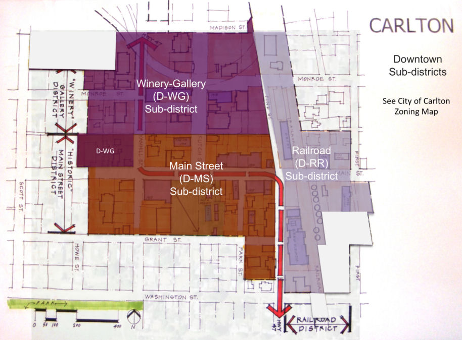
Figure 1 - Downtown Sub-districts
(Ord. No. 2024-751, § 1, 6-25-2024)
17.30.020 - Permitted uses.
The following uses are permitted in the Downtown district subject to the Site Design Review (Chapter 17.156), provided such uses are primarily conducted indoors, do not include drive-through facilities, and are not otherwise subject to conditional use permit approval (Section 17.30.030).
A.
Art galleries and artist studios.
B.
Banks and similar financial institutions.
C.
Commercial services, including retail sales and personal and professional services.
D.
Bed and breakfast inn.
E.
Dwellings, provided dwelling units within one hundred (100) feet of Main Street shall be located on the second story, or above, in a building meeting the design standards of this chapter.
F.
Eating and drinking establishments (not including food carts or drive-through facilities).
G.
Offices, including professional, administrative, medical, governmental, and similar office uses.
H.
Outdoor (unenclosed) uses subject to the limitations of Section 17.30.040.
I.
Overnight accommodations, including hotels, motels, inn, and similar lodging uses.
J.
Parks, plazas, outdoor dining areas, sidewalk café seating and sales (permit required), and similar outdoor uses, subject to the limitations of Section 17.30.040.
K.
Public and/or institutional uses, including public parking; and new on-premise parking subject to a public shared parking agreement.
L.
Retail sales and commercial services.
M.
Theaters, including movie theaters, subject to a public shared parking agreement when on premise parking is provided.
N.
Manufacturing and/or processing of food, beverages, arts, crafts, and/or similar goods, including wineries, subject to the limitations of Section 17.30.040.
O.
Child care centers and family child care homes.
P.
Residential care facilities.
Q.
Other uses the city manager or Planning Commission, as applicable, determines to be similar to those uses listed above.
(Ord. No. 2024-751, § 1, 6-25-2024)
17.30.030 - Conditional uses.
The following uses and uses determined by the city to be similar to those listed are allowed with a conditional use permit, except such uses located within one hundred (100) feet of Main Street are limited to those lawfully existing as of February 9, 2011; such lawfully created nonconforming uses are allowed to continue pursuant to Chapter 17.164.
A.
Veterinary clinics and animal boarding facilities.
B.
Drive-through facility, including but not limited to drive-up windows (e.g., restaurants, banks, and pharmacies), automatic teller machines and similar facilities. Electric fueling stations for plug-in electric vehicles do not require a conditional use permit but are subject to site review.
C.
Manufacturing and/or processing uses that meet any one (1) of the following criteria require a conditional use permit:
1.
Uses with shift(s) arriving or departing earlier than 7:00 a.m. or later than 9:00 p.m. on thirty (30) or more days during a calendar year.
2.
Processing or packaging of meat, fish, dairy, or other animal products.
3.
Taxidermy.
4.
Uses the city manager or Planning Commission, as applicable, determines to be similar to those listed in subsections 1—3, above.
D.
Food carts, subject to the provisions in Chapter 17.126.
(Ord. No. 2024-751, § 1, 6-25-2024)
17.30.040 - Prohibited uses and uses permitted with limitations.
A.
Prohibited Uses.
1.
Self-storage units, including mini-storage warehouses, portable storage units and similar facilities are prohibited, except temporary storage facilities that are accessory to a primary permitted use are permitted when setback at least one hundred (100) feet from Main Street and screened from all public rights-of-way.
2.
Commercial parking facilities on surface parking lots when not subject to a public shared parking agreement.
3.
Unenclosed commercial or industrial uses that do not meet the standards and limitations of this chapter.
B.
Permitted Outdoor Display, Storage and/or Sales. Except as permitted under Section 17.30.020, or as approved with a conditional use permit under Section 17.30.030, outdoor display, storage, and/or sales of merchandise shall not exceed three (3) days in any seven (7) day period, and shall be located under cover of a projecting roof, canopy, awning, or other city-approved shelter. None of the uses permitted herein shall interfere with pedestrian, bicycle, or automobile circulation.
C.
Permitted manufacturing, processing and/or packaging and distribution activities are permitted provided such activities shall meet all of the following standards:
1.
Manufacturing, processing, packaging, and storage, including waste/recycling handling and storage, and similar activities must be enclosed within a building; except as approved with a conditional use permit, or as permitted for wineries under subsection 17.30.040(C)(2).
2.
Outdoor processing, packaging, bottling, and storage directly related to winery operations is permitted pursuant to subsection 17.30.040(D), provided such activity is not located within one hundred (100) feet of Main Street.
3.
Where a parcel is located within one hundred (100) feet of Main Street, manufacturing and processing uses shall comprise not more than fifty (50) percent of the total site area. The balance of the site area must contain permitted commercial, residential (e.g., upper story) public, institutional, or open space use, pursuant to subsection 17.30.040(C)(5).
4.
Where a parcel is located more than one hundred (100) feet from Main Street, manufacturing and processing uses shall comprise not more than eighty (80) percent of total site. The balance of the site area must be in a permitted commercial, residential (e.g., upper story), public, institutional, or open space use, pursuant to subsection 17.30.040(C)(5).
5.
Shared parking and open space areas may be used to satisfy the requirements of subsections 17.30.040(C)(3) or 17.30.040(C)(4) where such areas are improved to city standards and allow public access, either through dedication to the city or through a public access easement with a maintenance agreement. Examples of open space areas include plazas, outdoor seating/dining areas, convertible plazas that may be used for parking or special events/community gatherings, and similar uses.
6.
Adequate water, sanitary sewer, and fire protection services must be available to the proposed use, as determined by the applicable local decision-making body.
7.
All applicable building code, state licensing, and health and safety requirements must be met.
8.
The city decision-making body may require conditions of approval to ensure compliance with the above use requirements.
D.
Winery-Related Land Use Standards. The following requirements apply to wineries in the Downtown district. The requirements apply twenty-four (24) hours per day, seven (7) days per week, year-round.
1.
Use of street for loading and unloading of trucks:
a.
Not permitted within twenty (20) feet of Highway 47 right-of-way.
b.
Position truck at least twenty (20) feet from any intersection.
c.
Position truck so that traffic is not impeded. If needed, have designated person to direct traffic around area.
d.
Place markers and/or cones to designate loading area.
e.
If using forklifts, have safety lights turned on.
f.
Don't block sidewalk access.
g.
Clean up any material left on street or sidewalks.
2.
Use of street for truck mounted bottling or processing operations:
a.
Obtain Police Department approval in advance of using street for this purpose.
b.
Position truck at least twenty (20) feet from any intersection.
c.
Position truck so that traffic is not impeded. If needed, have designated person to direct traffic around area.
d.
Place markers and/or cones to designate loading area.
e.
If using forklifts, have safety lights turned on.
f.
Don't block sidewalk access.
g.
Clean up any material left on street or sidewalks.
3.
Use of street for dumpster/containers of grape pumices or other material:
a.
Obtain Police Department approval in advance of using street for this purpose.
b.
Place container at least twenty (20) feet from any intersection. Position truck so that traffic is not impeded. If needed, have designated person to direct traffic around area.
c.
Comply with 72-hour maximum placement ordinance if on right-of-way.
d.
Don't block sidewalk access.
e.
Place markers and/or cones to alert drivers especially at night.
f.
Use only four (4) foot or lower containers to allow better sight lines.
g.
Insure that any runoff of liquid is contained and cleaned up so that no runoff goes into storm sewers.
h.
If using forklifts, have safety lights turned on.
i.
Clean up any material left on street or sidewalks.
4.
Wineries may add on-site food service, subject to Site Design Review to ensure compliance with applicable land use requirements and building codes.
(Ord. No. 2024-751, § 1, 6-25-2024)
17.30.050 - Dimensional standards.
The following dimensional standards shall apply to all development in the Downtown district, except for modifications permitted under Chapter 17.132.
(Ord. No. 2024-751, § 1, 6-25-2024)
17.30.055 - Design review requirements.
A.
Purpose. Downtown design standards and sub-district design guidelines are intended to support downtown development and revitalization consistent with Carlton's historical context and its vision for the future. Because much of Carlton's historic downtown is intact, the standards and guidelines build on that historic integrity while allowing contemporary interpretations of building forms and styles scaled to specific downtown sub-districts.
B.
Applicability.
1.
The design standards of Section 17.30.060, general design guidelines of Section 17.30.065, and sub-district design guidelines of Section 17.30.070 apply to all new structures and exterior remodels of structures in the Downtown district that are subject to Site Design Review per Chapter 17.156. Site Design Review is required only for that portion of a structure or development that is proposed to change.
2.
The regulations related to building materials and colors under subsection 17.30.060(F) apply to all exterior building projects for all new development and alternation of existing buildings.
C.
Adjustments. The Planning Commission may adjust the design standards of Section 17.30.060, without the need for a variance, upon finding that the proposed design is not expressly prohibited by this chapter, is consistent with the purpose in subsection 17.30.055(A) and the general design guidelines in Section 17.30.065, and meets the intent of the standard for which the adjustment is requested.
(Ord. No. 2024-751, § 1, 6-25-2024)
17.30.060 - Downtown design standards.
The following design standards apply to development in the Downtown District.
A.
Building Orientation, Parking, and Entrance Standards. The following standards are intended to facilitate safe, direct, and convenient pedestrian access to buildings and uses, enhance the appearance of the downtown, and facilitate redevelopment without compromising the historic integrity of the downtown. All of the standards below must be met, or adjustments approved, as applicable, for Site Design Review approval:
1.
Comply with the dimensional standards in subsection 17.30.050.
2.
Provide at least one (1) primary building entrance facing an abutting street (i.e., within forty-five (45) degrees of the street property line); or if the building entrance is turned more than forty-five (45) degrees from the street (i.e., front door is on a side elevation), the primary entrance shall open onto a pedestrian plaza or courtyard and a walkway shall connect the primary entrance to the plaza and sidewalk.
3.
Development abutting Main Street shall orient to Main Street. Where a development does not abut Main Street, it shall provide a primary entrance facing the street that is likely to have the most pedestrian traffic, as determined by the Planning Commission.
4.
Buildings on lots abutting a plaza or a parking/plaza area shall have at least one (1) secondary entrance oriented to such plaza or parking/plaza area.
5.
Building entrances shall be recessed or otherwise covered by pedestrian shelters, consistent with subsection 17.30.060(G).
6.
Rear building entrances, and entrances facing a plaza or parking area that may also serve as a plaza or community gathering space during special events, shall incorporate patios with decorative landscape structures, such as garden walls, arbors, trellises, porticos, or pergolas with lighted pathways. Such patios and structures shall comprise not less than thirty (30) percent of the building frontage where it abuts the plaza/parking area.
7.
Off-street parking, trash pick-up, and above ground utilities, including but not limited to utility vaults and propane tanks, shall not be placed between building entrances and the street(s) to which they are oriented, but shall be oriented internally to the block, screened, and accessed by alleys to the extent practicable.
8.
Where off-street parking is provided, it shall conform to the dimensional standards and landscape standards of Chapter 17.68.
9.
Street access points, including new or modified driveway approaches, shall conform to the Access Control Standards in Section 17.100. Uses and development located outside the Downtown District shall not receive vehicle access through the Downtown District, except driveway approaches lawfully established prior to February 9, 2011 are permitted, subject to the requirements of Chapter 17.100.
10.
Where a development contains multiple buildings and there is insufficient street frontage to which buildings can be oriented, a primary entrance may be oriented to plaza, courtyard, or similar space containing pedestrian amenities. When oriented this way, the primary entrance(s), plaza, or courtyard shall be connected to the street by a landscaped and lighted walkway with an approved surface not less than five (5) feet in width.
11.
Buildings on corner lots shall have corner entrances or contain architectural features that emphasize the corner (e.g., chamfered/rounded edge, windows, molding, art).
12.
Primary building entrances shall be at least fifty percent (50%) transparent so that two-way views, in and out of a building, are possible. This standard can be met by a door with a window, a transom window above the door, or sidelights beside the door. Where ATMs or kiosks are proposed, they shall be visible from the street for security and have a canopy, awning, or other weather protection shelter.
B.
Front Façade. Materials used on the front façade shall turn the building corners and extend for a length of at least 12-inches across each side elevations to avoid the appearance of a false front building.
C.
Building Openings. The following standards are intended to facilitate safe, direct, and convenient pedestrian access to buildings and uses, enhance the appearance of the downtown, and protect the historic integrity of the downtown. For the purposes of this chapter, "transparent" means allowing two-way views in and out of a building. All of the following standards must be met, or adjustments approved, as applicable:
1.
Architectural detailing shall define building entrances. Detailing may include, but is not necessarily limited to, a stoop or recess behind the front plane of the building, a canopy or awning cover, an entryway plaza (e.g., with pavers and seating), planter beds, window boxes, or similar detailing.
2.
The ground floor, street- or plaza-facing elevation(s) of buildings located within one hundred (100) feet of Main Street shall comprise not less than sixty (60) percent transparent windows. Building abutting Main Street shall have windowed doors and transom windows, except where historical precedence dictates otherwise.
3.
All ground floor building elevations located more than one hundred (100) feet from Main Street and facing a street, plaza, or courtyard shall comprise not less than thirty (30) percent transparent windows.
4.
All side building elevations not otherwise subject to the provisions of subsection 2 or 3, above, shall comprise not less than twenty (20) percent transparency; except zero-lot line/common wall elevations are not required to provide windows.
5.
Window coverage shall be measured along the width of the street-facing elevation, between the building base (twenty-four (24) inches above the sidewalk grade, whichever is less) and a plane seventy-two (72) inches above the sidewalk grade.
6.
The Planning Commission may grant exceptions (no adjustment required) to the window transparency standards for buildings containing industrial processing uses, provided the subject elevation contains detailing (e.g., false windows, offsets, projections, bays, changes in materials and/or texturing, or similar details) that break up the wall into smaller components.
7.
Windows shall contain trim, reveals or recesses of not less than four (4) inches in width or depth as applicable. The use of sills and decorative detailing and ornamentation around windows (e.g., patterning, corbels, medallions, pediments, shutters, or similar features), as appropriate for the sub-district, is required. This provision also applies to false windows.
8.
Windows in the D-MS Sub-district. In the D-MS sub-district, upper story windows shall be vertically oriented, their height greater than their width. Upper story windows shall follow the vertical lines of the lower level piers and the horizontal definition of spandrels and any cornices. Paired or grouped windows that, together, are wider than they are tall, shall be visually divided to express the vertical orientation of individual windows. Except for transom windows and bay windows, windows and display cases shall not break the front plane of the building; projecting display boxes and bay windows are not allowed on elevations facing Main Street. For reasons of durability and historic compatibility, display cases, when provided, shall be flush with the building façade (not affixed to the exterior) and integrated into the building design with trim or other detailing. Window flower boxes are allowed provided they do not encroach into the pedestrian through-zone.
9.
Decorative wall-mounted lighting, consistent with the architectural of the building, shall be provided for signage and at primary entrances.
10.
The Planning Commission may require security lighting at rear entries.
11.
The Planning Commission may grant an exception to the window transparency requirement for parking garages, provided the building design shall incorporate openings, screening, or other detailing, subject to Site Design Review.
D.
Building Height Bonus (Option). The following standards are intended to support the urban design objectives for downtown and facilitate mixed-use development through increased building height, while protecting the historic integrity of downtown buildings. All of the standards below must be met, or adjustments approved, as applicable, for approval of a building height bonus:
1.
The maximum allowable height may be increased from thirty-five (35) feet to forty-five (45) feet on corner lots located within one hundred (100) feet of the following intersections, pursuant to subsections 2 and 3, below: Main Street/Pine Street, Main Street/Kutch Street, Main Street/Yamhill Street, and Pine Street/Grant Street.
2.
The portion of the building exceeding thirty-five (35) feet shall cover not more than thirty (30) percent of the building floor plate, as defined by the building foundation perimeter except the height increase may be extended to up to one hundred (100) percent of the floor plate for a mixed-use building where the upper story incorporates multifamily dwelling units or overnight accommodations (e.g., hotel) and civic space is provided pursuant to subsection 17.30.060(L).
3.
The portion of the building exceeding thirty-five (35) feet in height shall step-back from (recess behind) the building plane of the ground floor by at least four (4) feet.
E.
Building Line and Rhythm.
1.
Horizontal Rhythm. Buildings facing a street or plaza must incorporate rhythmic divisions that relate to historic building patterns. Front elevations should be articulated (e.g., offset, recess, projection, or similar "break" in the wall plane) not less than once every twenty-five (25) feet. (This standard does not apply to building elevations that are less than fifty (50) feet in width.) Articulation should be subtle. For example, slight offsets in a building elevation, roofline and/or the rhythmic placement of windows, pilasters, awnings/canopies, trim, art/medallions, or other detailing and ornamentation can satisfy the standard. Changes in paint color do not satisfy this standard. Side and rear elevations may be articulated less frequently but should complement the overall building design. The Planning Commission may allow alternative detailing, such as a mural or landscape trellis where other detailing is impractical, such as on a zero-lot line elevation to reduce the apparent scale and avoid blank walls (i.e., until an abutting property develops). See examples in Section 17.30.070.
2.
Horizontal Lines. Building elevations within one hundred (100) feet of Main Street shall follow prominent horizontal lines existing on adjacent buildings at similar levels along the street frontage. Examples of such horizontal lines include but are not necessarily limited to the base below a series of storefront windows; an existing awning or canopy line; a belt course between building stories; and/or an existing cornice or parapet line. See examples in Section 17.30.070. Exceptions: Where adjacent buildings do not provide a historically appropriate reference, the development may establish new horizontal lines consistent with historical precedence. See examples in Section 17.30.070.
3.
Ground Floor/Upper Floor Division. Building elevations within one hundred (100) feet of Main Street shall maintain clear visual division between the ground level floor and upper floors; this is accomplished, for example, through the use of a belt course, transom, awnings or canopies in the D-MS sub-district, and through the use of wood trim and other detailing in the D-WG and D-RR sub-districts, consistent with historical precedence.
4.
Vertical Rhythm. Buildings shall reflect a vertical orientation, through either actual volume, roof form, and/or the use of surface detail; for example, the use of vertically oriented sash windows and masonry trim in the D-MS sub-district, and pitched roofs and/or board and batten siding and corrugated metal detailing in the D-WG and D-RR sub-districts. See examples in Section 17.30.070.
5.
Roof Form.
a.
D-MS: Predominate roof form shall be a flat roof with appropriately scaled cornice or stepped parapet top.
b.
D-WG: Predominate roof form shall be pitched (4:12 minimum); gabled, hipped, modified pitched roof forms are allowed.
c.
D-RR: No restriction on roof form provided the form reflects historic precedence (e.g., depot, ranch/farm buildings, silos/granary tower, historic main street, etc.) and is not an artificial or applied roof form.
F.
Materials and Color.
1.
Exterior Cladding.
a.
D-MS: Except as permitted under subsection 'd', below, exterior cladding on new buildings shall predominately consist of durable reddish brick blends, as generally illustrated in Section 17.30.070; brick veneer is also permitted, except as otherwise required for designated historic buildings.
b.
D-WG: Except as permitted under subsection 'd', below, exterior cladding of buildings shall predominately consist of wood or fiber cement (lap, panel, board and batten, shingle or similar siding), stucco, stone, textured concrete, split-face concrete block, and/or similar masonry. Corrugated metal may be used as a secondary material only; vinyl siding and faux/cultured stone are not permitted.
c.
D-RR: Except as permitted under subsection 'd', below, exterior cladding of buildings shall predominately consist of wood or fiber cement (lap, panel, board and batten, shingle or similar siding), stucco, stone, split-face concrete block, brick, corrugated or sheet metal. Vinyl siding and faux/cultured stone are not permitted.
d.
Building Additions: Building additions shall conform to the above standards or contain cladding similar to the original cladding of the structure. For purposes of this subsection, "original" means the cladding (material and detailing) used when the building was first constructed.
e.
Secondary Cladding. Any material permitted above may be used as secondary exterior cladding in the respective sub-district. Metals such as copper, steel, iron, bronze and similar appearance metals may be used as trims or accents (e.g., flashing, wainscoting, weather protection features, ornamentation, etc.) when non-reflective and consistent with historic precedence. In addition, rough-hewn wood, and timbers may be used as accents in the D-WG and D-RR sub-districts.
2.
Four Sides of Building. New buildings shall be designed so that all four (4) sides contain complementary exteriors. Changes in material, texture or detailing (e.g., use of two (2) or more different types of material) shall break up otherwise blank walls and define a building's base, middle and top. Side and rear elevations that do not face a street, plaza, patio, or pedestrian access way need not have two (2) or more types of material where changes in texture or detailing break up the wall, consistent with the overall composition of the building.
3.
Roofs.
a.
Where pitched roofs are proposed, roof surfaces shall be wood, slate, cement tile, asphalt shingles, flat metal, or standing rib seam sheet metal.
b.
Metal roofing shall have a non-glare (e.g., matte finish).
c.
Where flat roofs are proposed, cornices and parapets shall incorporate materials that are consistent with historic precedence, as applicable, or otherwise consistent with the overall composition of the building.
d.
Roofs must be non-reflective and light in color (e.g., light gray or ash, brown, or other earth-tone), and not clash with exterior cladding.
4.
Windows and Doors. All windows and doors must have wood or vinyl-coated wood trim, or masonry trim and sills. See also, Pedestrian Shelter requirements under subsection 17.30.060(K).
5.
Substitute Materials. The Planning Commission may approve an adjustment allowing substitute materials that are equal in appearance and durability to those listed above, provided such materials are historically appropriate. The applicant will be required to provide specifications from the manufacturer.
6.
Color. Paint and materials colors shall be consistent with the historic color palette on file at Carlton City Hall. Color schemes shall be simple and coordinated over the entire building to establish a sense of overall composition. Reflective, luminescent, sparkling, and "day-glow" colors and finishes, and clashing paint colors or patterns are prohibited. Metals shall be matte finish, earth-tone color, or burnished/non-reflective (e.g., metal that has a non-reflective finish is allowed in the RR sub-district).
G.
Pedestrian Shelters. Within the D-MS sub-district, awnings, canopies, recesses or similar pedestrian shelters shall be provided along at least sixty (60) percent of a building's ground floor elevation(s) where the building abuts a sidewalk or civic space (e.g., plaza). Within the D-WG and D-RR sub-districts, the minimum pedestrian shelter requirement is forty (40) percent.
1.
Pedestrian shelters used to meet the above standard shall extend at least five (5) feet over the pedestrian area, be proportionate to the building in its dimensions, and not obscure the building's architectural details.
2.
Pedestrian shelters shall align with one (1) another to the extent practical.
3.
Shelters shall not conflict with mezzanine or transom windows.
4.
Colored canvas (not plastic) awnings and metal or plexiglass canopies, when consistent with historical styles, are allowed.
Exceptions: Pedestrian shelters are not required where historical precedence dictates otherwise. In addition, the Planning Commission may reduce the minimum shelter depth upon finding that existing right-of-way, easements, or building code requirements preclude a standard shelter.
H.
Civic Space and Pedestrian Amenities.
1.
Purpose. The city encourages the provision of civic space in new development through regulatory incentives. Civic space such as plazas, courtyards, patios, mobility hubs, and expanded sidewalks/outdoor seating areas should be provided along street frontages and where gaps between buildings occur. Civic spaces can make the downtown more attractive and inviting while providing informal gathering places for rest, socialization, and accessing public transportation services.
2.
Applicability. The following applies to Site Design Review proposals involving: (a) a height bonus pursuant to subsection 17.30.060(H); (b) an adjustment to a code standard under site review; or (c) where the applicant voluntarily provides civic space.
3.
Civic Space Standards. At least three (3) percent, or not less than three hundred (300) square feet, of the site should be designated and improved as civic space (plaza, landscaped courtyard, sidewalk extension, or similar space). Such areas should be accessible to the general public, with the highest priority locations being those areas with the highest pedestrian activity. Civic spaces should be connected to a public right-of-way by a sidewalk or pedestrian access way. All civic spaces shall have dimensions that allow for reasonable pedestrian access. For example, a small site may provide a 4-foot wide strip adjoining and adding on to the sidewalk for a small café seating area, whereas a larger site at a street corner may provide a plaza adjacent to a building entrance. Civic spaces shall include pedestrian amenities, per subsection 4, below. See also, Chapter 17.84 Site and Landscaping Design.
4.
Pedestrian Amenities Standards. Where street frontage improvements are required to comply with the Transportation System Plan, or where civic space is required under subsection 17.30.060(H), street frontages shall be improved with pedestrian amenities such as benches, public art, pedestrian-scale lighting, shade structures, way-finding signs, or similar pedestrian facilities in an amount equal to or greater than one-half of one percent (0.5%) of the estimated construction cost of the proposed building(s), subject to review and approval by the Planning Commission. Where a civic space adjoins a building entrance, the cost of providing a weather protection canopy, awning, arcade, overhanging eave, arbor, portico, or similar feature, consistent subsection 17.30.060(K), may be credited toward the one-half of one percent (0.5%) requirement. Pedestrian amenities such as seating, planters, public art and pedestrian lighting (e.g., street lamps or pathway bollard lights) at street corners or paved mid-block pedestrian access ways between buildings may also be counted toward the one-half of one percent (0.5%) requirement. The cost of a proposed public-private parking facility may be subtracted from building costs used in the assessment of civic space improvements. A licensed architect, landscape architect, or other qualified professional, shall prepare cost estimates for civic space improvements, which shall be subject to review and approval by the Planning Commission.
5.
Mobility hub standards. Mobility hubs are designated spaces that consolidate transportation services, amenities, and civic space enhancements to support seamless travel across modes while fostering a vibrant and inclusive public realm. Mobility hubs must be designed to complement adjacent civic spaces, plazas, or streetscapes and may be co-located with public gathering spaces. Design standards for public transportation elements shall be coordinated with Yamhill County Transit standards and may seek to integrate City permitted uses and elements including but not limited to public seating, shade structures, trash and recycling receptacles, public art or culturally reflective design features, landscaping, wayfinding signage or system maps, bicycle parking (racks or corrals), pedestrian-scale lighting, and ADA-compliant features. Mobility hubs proposed as part of a development or streetscape improvement shall be subject to review and approval by the city engineer or his or her authorized representative in coordination with Yamhill County Transit.
I.
Signs. In addition to complying with requirements of Chapter 17.80 Signs, conformance to following standards is required in the Downtown district:
1.
Building designs shall incorporate a sign band or otherwise provide for blade signs, awning signs, marquees, or other compatible sign types.
2.
Pole signs are prohibited.
3.
Monument signs shall not exceed six (6) feet in height and forty-eight (48) square feet of sign face for each side of a two-sided sign. A minimum of fifty (50) feet of street frontage is required for one (1) monument sign.
4.
On multitenant buildings, signs shall be designed to accommodate multiple tenants.
J.
Landscaping. In addition to complying with requirements of Chapter 17.84 Site and Landscaping Design, conformance to [the] following standards is required in the Downtown district:
1.
All Downtown Sub-districts: Landscape designs must be compatible with the downtown, where buildings are generally placed closer together than in other districts. Designs take into consideration exposure to sun and wind, opportunities for pedestrian safety and comfort (e.g., buffering vehicle areas, summer shade, etc.), maintenance requirements, and downtown beautification objectives. These factors are to be balanced so that the resulting design is functional, attractive, and cost-effective. For example, landscaping must define pedestrian pathways, buffer parking lots from outdoor seating areas, break up large blank walls, and add color and interest to streetscapes, parking lots, and plaza areas.
2.
D-MS: Zero (0) percent, minimum, except for required street trees (twenty-five (25) square feet per tree planting area), required civic space, and any required screening, as applicable, subject to site review.
3.
D-WG and D-RR: Ten (10) percent, minimum; may include required street trees (twenty-five (25) square feet per tree), planter beds, plant containers or window boxes, arbors, trellises, and climbing vines on garden walls and fences, as applicable. Where landscape structures such as arbors are proposed, the Planning Commission may count the total surface area to be covered by plants within two (2) years of planting.
4.
Maintenance: All landscape and civic space areas shall be maintained and, as necessary, replaced by the property owner to ensure plant survival and upkeep of street furnishings, paving, and other built features. The use of water-conserving features, such [as] small parking lot perimeter swales, and rain gardens fed by cisterns or roof drains is encouraged.
K.
Mechanical Equipment.
1.
Building Walls. Mechanical equipment shall not be mounted on any building where it will be visible within one hundred (100) feet of Main Street. When mechanical equipment, such as utility vaults, air compressors, generators, antennae, satellite dishes, or similar equipment, must be installed on a rooftop or adjacent to a building wall, it shall be screened from view. Where such equipment is installed on a side or rear building elevation and is adjacent to a plaza, pathway, or other public space, it shall be screened in accordance with Chapter 17.84. Standpipes, meters, vaults and similar incidental equipment need not be screened but shall not be placed on a front elevation when other practical alternatives exist; such equipment shall be placed low on a side or rear elevation to the extent practical.
2.
Rooftops. Except as provided below, rooftop mechanical units shall not be visible from the street or any alley, pedestrian access way or civic space. Such units should be screened behind a parapet wall or painted with muted, earth-tone colors that make them visually subordinate to their backgrounds. Exception: Equipment for small-scale renewable energy (e.g., mini-wind turbines, solar panels, and similar features) is allowed subject to site review; the Planning Commission may exempt such a facility from the screening standard upon finding that the screening would interfere with its operation, and the facility does not adversely impact any buildings of local historic significance.
3.
Ground-Mounted Mechanical Equipment. Ground-mounted equipment (e.g., generators and air compressors) shall be limited to side or rear yards and screened in accordance with Chapter 17.84. The Planning Commission may require additional setbacks and/or noise attenuating equipment to promote compatibility with adjacent uses.
4.
Plazas and Open Spaces. Mechanical equipment and garbage storage areas are not permitted within plazas or other public open spaces, except as approved with an Adjustment. Where such facilities are allowed, the Planning Commission may require that such facilities be screened completely from view and set back from a civic space for aesthetic reasons and to minimize odors or noise.
L.
Historic Building Alterations. In addition to complying with requirements of Chapter 17.104 Historic Sites, conformance to following standards is required for historic building alterations in the Downtown district:
1.
Restoration, rehabilitation or remodeling projects shall incorporate, whenever possible, original design elements that have been removed, changed, or covered over.
2.
Scale, proportion and materials used in alteration or additions to existing structures, such as the size and relationship of new windows, doors, entrances and other building features, shall be visually compatible with the original architecture on buildings of local historical significance.
M.
Off-Street Parking. Parking shall conform to the standards in Chapter 17.68. Exemptions apply to properties within the Downtown Parking District, subject to the provisions of Section 17.68.120.
(Ord. No. 2024-751, § 1, 6-25-2024; Ord. No. 2025-755, § 1(Exh. A), 11-4-2025)
17.30.065 - General design guidelines for downtown design standards.
A.
Purpose. The general design guidelines contained in this section describe and illustrate the standards contained in Section 17.30.060 and provide examples of how a project may comply with the standards. The Planning Commission shall rely upon the guidelines below and the illustrations in Section 17.30.070 in order to:
1.
Interpret the discretionary standards contained in Section 17.30.060, or
2.
Grant adjustments to Section 17.30.060. The Commission may approve an adjustment only upon making affirmative findings on each of the following guidelines, as it deems applicable.
B.
General Design Guidelines.
1.
Does the proposal contribute to the attributes that make the subject downtown sub-district (D-MS, D-WG, and/or D-RR) distinct? For example, does the proposal respond to the building forms, scale, setbacks, orientation, architectural style, materials, detailing, color, signage, parking, and/or other elements that distinguish the sub-district without mimicking other building designs? Is the proposal compatible with existing structures that have retained their historic integrity? It is not the city's intent to create an architectural theme, but rather to ensure that new buildings and alterations fit the historic context.
2.
If the proposal involves remodeling a building listed on a local state, or national historical register, is the remodel consistent with the guidelines for altering such historic resources?
3.
Does the proposal enhance the streetscape or other public spaces with appropriate building placement, orientation, height, architectural detailing and landscaping?
4.
If located at the intersection of Main Street/Pine Street, Main Street/Yamhill Street, or Pine Street/Grant Street, does the design enhance the "gateway" location with a corner plaza or vertical building elements (e.g., increased height) at the corner? (See Main Street Guidelines - Figure 2 in Section 17.30.070.)
5.
Does the structure have a compatible building scale relationship with adjacent residences? For example, does the structure step-down in height adjacent to single-family dwellings?
6.
Does the building design address all four (4) sides of the building with a unified design? For example, are the materials, textures and colors on each elevation coordinated?
7.
Where a zero-setback is proposed, does the side elevation facilitate common wall development in the future?
8.
Where the proposal includes an adjustment to the window transparency standards or other detailing standards, does the proposed design adequately break up the building elevation (avoid creating a blank wall) and express storefront character in other ways?
9.
Does the building contain openings (doors or windows) adjacent public spaces or parking areas, including those that may also serve as plazas or community gathering places during special events?
10.
Do the facade and roofline have a rhythm that is consistent with adjacent buildings, or appropriately transition from one (1) building to another?
11.
Does the proposal contain adequate sidewalks? Sidewalks must contain a sufficient pedestrian through zone (clearance) and Americans with Disabilities Act accessibility. Sidewalks within the MS sub-district must also contain a furnishing zone, per Section 17.30.070.
12.
If located adjacent to a plazas or area with curb extension or widened sidewalk, does the proposal include benches, café seating, or public art, per Section 17.30.070?
13.
If the proposal adjusts the lot coverage standard or contains on-premise parking, does it manage stormwater drainage more effectively than would be possible under a conventional design? Does it utilize on-site retention with water quality features?
14.
Does the proposal promote water conservation, for example, through drought-tolerant plantings or capturing rainwater for use in landscape irrigation?
15.
If the proposal leaves a gap between buildings (non-common wall development), does it provide landscaping (e.g., courtyard garden), or a plaza, with seating in that area?
(Ord. No. 2024-751, § 1, 6-25-2024)
17.30.070 - Subdistrict design guidelines.
The following design guidelines apply to development within each of the downtown sub-districts, in addition to the design standards on Section 17.30.060.
A.
Main Street Sub-District Guidelines
1.
Building entrances orient to street with access to future Plaza and Ladd Park.
2.
Buildings must be one (1) to three (3) stories tall, with division between the first and second stories, meeting the dimensional standards of Section 17.30.050
3.
Brick masonry predominant material, except as historic precedence dictates; note brick detailing and "patterns."
4.
Flat roof with cornice or parapet on Main Street; secondary shed okay; gable okay on other streets if gable faces front and side setback is met.
5.
Canvas awnings or flat and shed painted metal canopies, except where historic buildings have no awning or canopy.
6.
Storefront windows with transom, with standards based on historic height, detailing, orientation, proportions, and percentages of glass. Upper story windows: vertical orientation, detailing and proportions.
7.
Sidewalk: Scored concrete (8'—12') with option for paver inlay.
8.
Furnishing area with benches, lighting (bollards or lamps), planters/baskets.
9.
Street trees in cutouts with grates; trees to be selected from the adopted approved street tree list.
10.
Curb extensions at intersections and at mid-block pedestrian crossings.
11.
No pole signs or internally-lit signs; building-mounted metal or blade signs.
12.
Allow historically appropriate wall mounted light fixtures.
Main Street Guidelines - Figure 1
Main Street Guidelines - Figure 2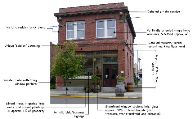
Main Street Guidelines - Figure 3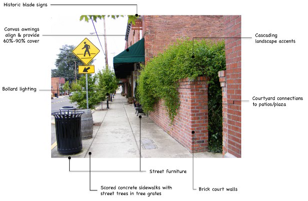
Main Street Guidelines - Figure 4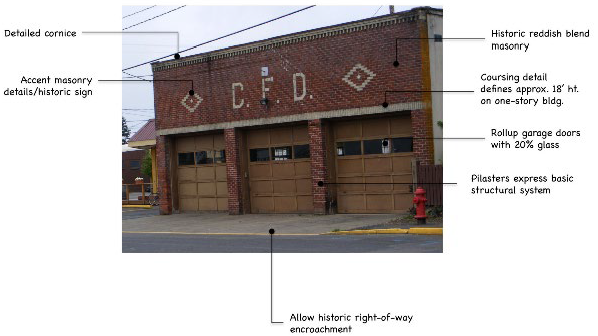
Main Street Guidelines - Figure 5 (Remodel Example)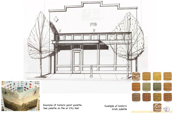
Main Street Guidelines - Figure 6 (Infill Building Example)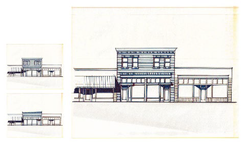
Main Street Guidelines - Figure 7 (Corner Building Example)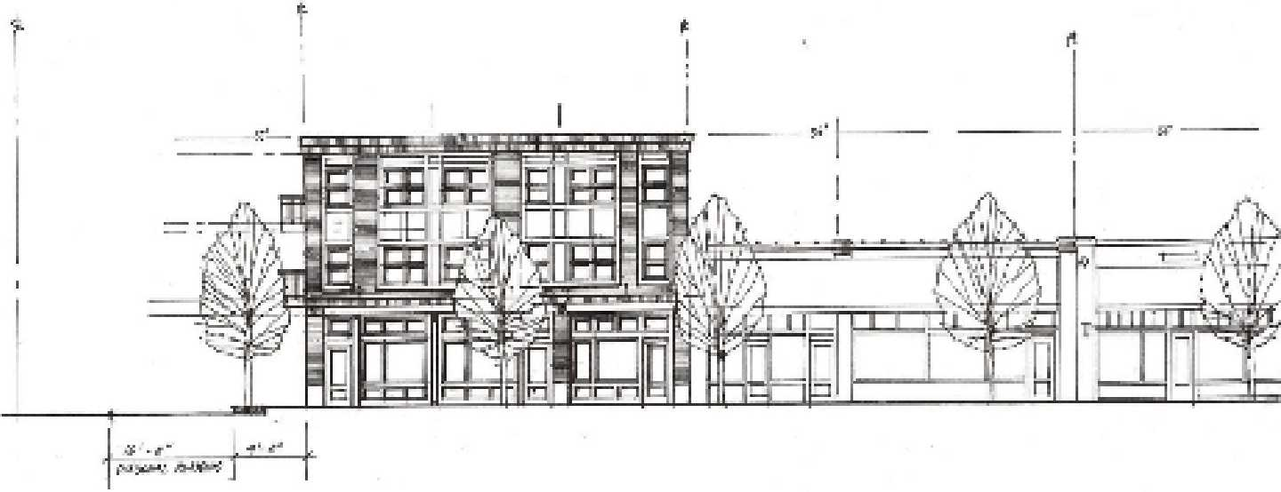
Main Street Guidelines - Figure 8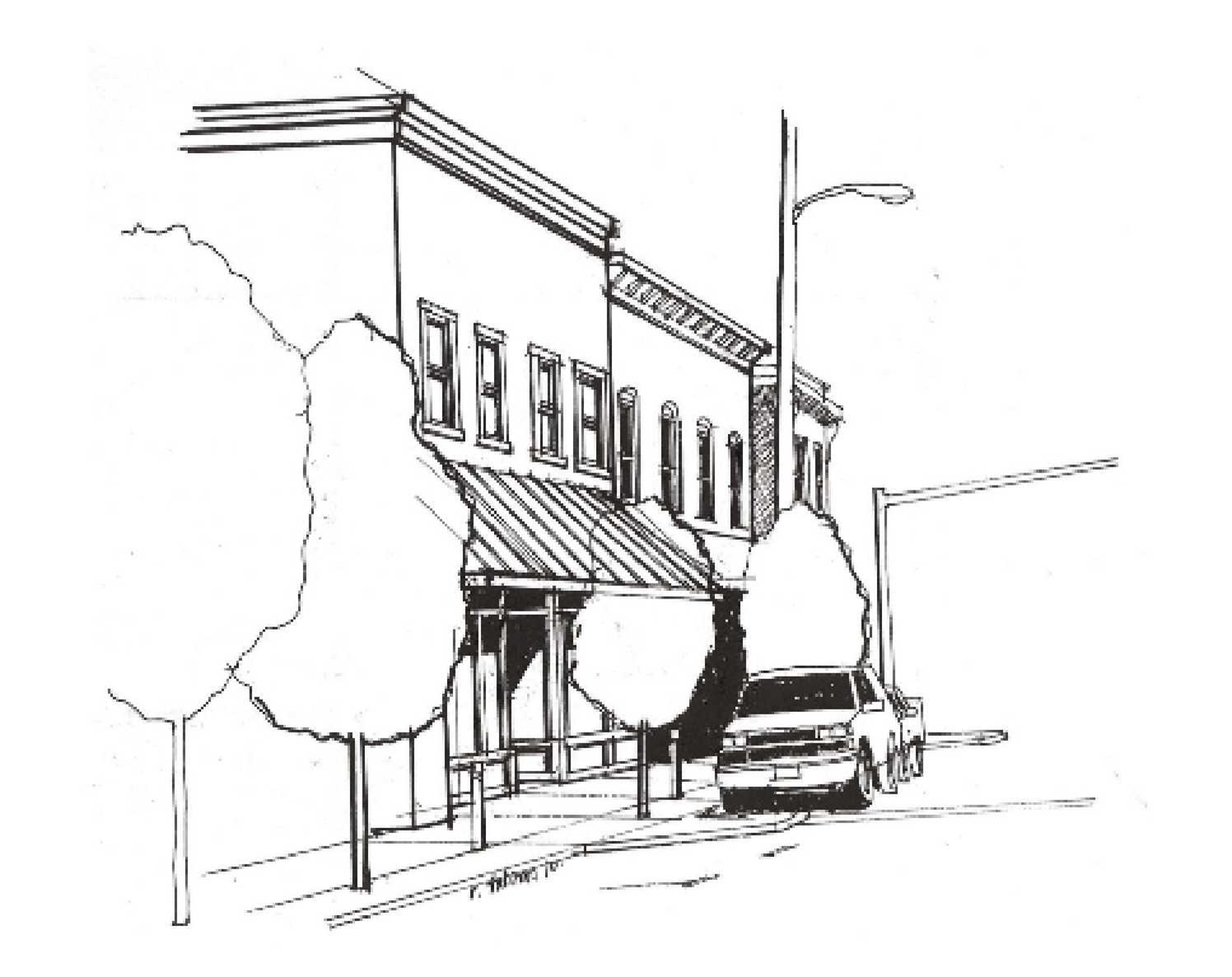
Main Street Guidelines - Figure 9 (Corner Gateway/Height Bonus Example)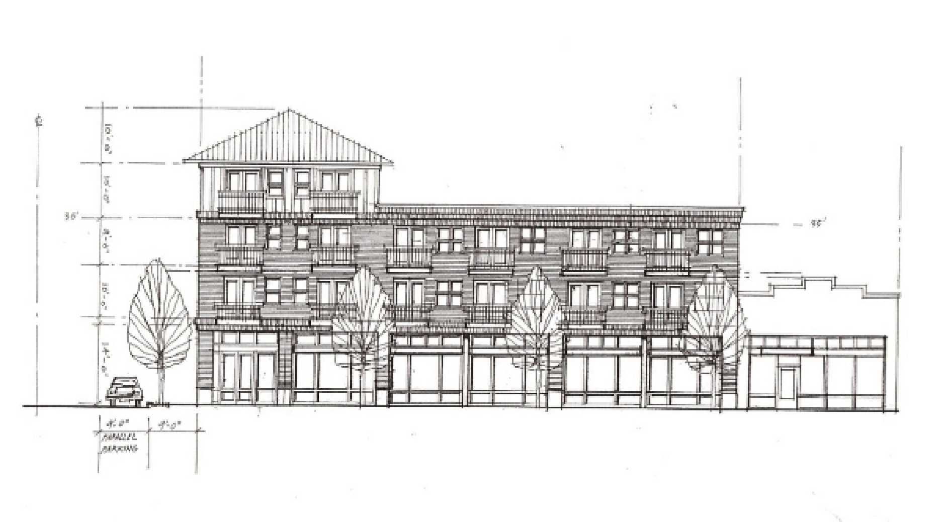
Downtown Streetscapes Standards Main Street Intersections and Typical Cross-Street
Sections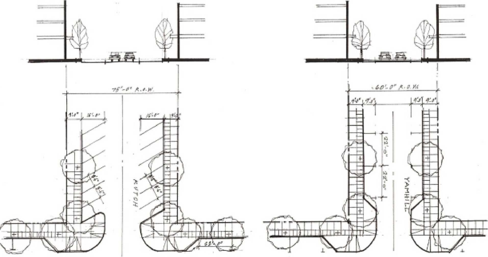
B.
Winery-Gallery Sub-District Guidelines.
1.
Balances "public/tourism" exposure with "production" exposure needs.
2.
Larger, simpler building forms; predominately agricultural building materials uses artistic building elements as accents, "iconic" forms.
3.
Buildings orient to plaza; buildings fronting Kutch Street or Pine Street should also orient to respective street with entrance or detailing and connecting pathway.
4.
Repeat forms found on existing buildings in the district; includes flat roof, gable roof and shed roof buildings; does not include mansard or Quonset building forms in this district.
5.
Roof materials to include selected metal colors, composition (dark), flat roof materials; do not include tile or wood shake or shingle roofs.
6.
Windows: Windows may include storefronts (vertical or square); garage doors with glass; fixed windows; single or double hung windows.
7.
Materials: Minimum of at least two (2) materials permitted in subsection 17.30.060(F)(1)(b) each covering a minimum of 30 percent (30%) of exterior. No chain link fences abutting streets or plazas.
Winery-Gallery District Guildelines - Figure 1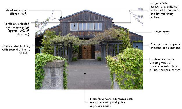
Winery-Gallery District Guildelines - Figure 2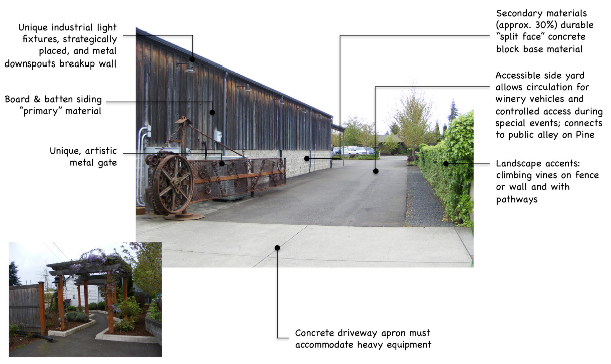
Winery-Gallery District Guildelines - Figure 3
Winery-Gallery District Guidelines - Figure 4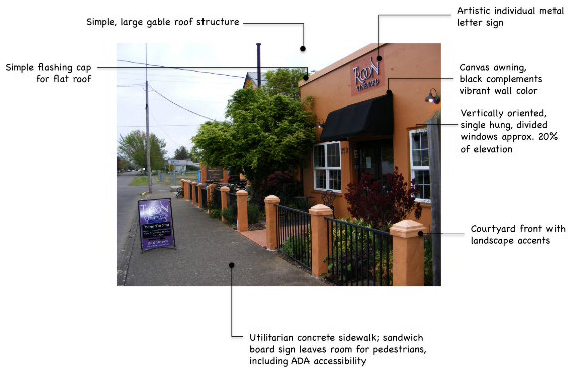
Winery-Gallery Guidelines - Figure 5 Special Events Plaza-Convertible Parking Area
Framework
C.
Railroad Sub-District Guidelines.
1.
Iconic forms (grain elevator, depot, Quonset, grain silos); asymmetrical, agricultural.
2.
Repeat or adapt forms found on existing buildings from railroad era.
3.
Repeat building materials found on existing RR district buildings using materials permitted in subsection 17.30.060(F)(1)(c). No chain link fences abutting streets.
4.
Roof materials: Historic metal finish or painted metal, composition (dark). No wood shakes or shingle roofs. No tile roofs.
5.
Windows: Windows may vertical or square proportions; fixed windows; single or double hung windows.
6.
Sidewalks scored concrete (6'—8').
Railroad District Guidelines - Figure 1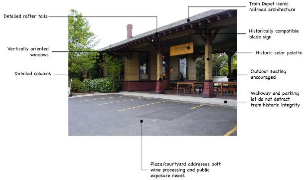
Railroad District Guidelines - Figure 2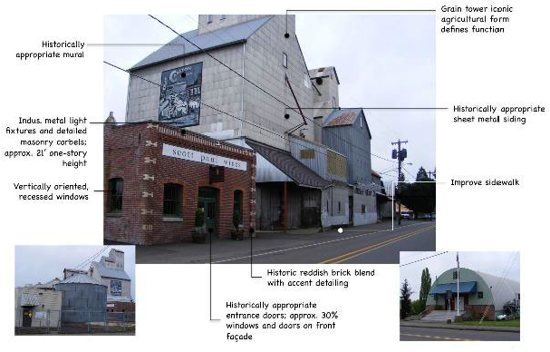
(Ord. No. 2024-751, § 1, 6-25-2024)
17.32.010 - Purpose.
The commercial business (CB) district provides an area for commercial uses outside Downtown Carlton. It provides a broad range of commercial uses appropriate within a shopping district, and a visual attraction for visitors.
(Ord. No. 2024-751, § 1, 6-25-2024)
17.32.020 - Permitted uses.
The following uses are permitted outright in the commercial business district, subject to Site Design Review in accordance with Chapter 17.156:
A.
Residences that are located on the second story above a permitted use commercial building.
B.
Business offices including, but not limited to, insurance, real estate and title insurance; credit agencies, brokerages, loan companies, and investment companies; and, miscellaneous offices such as detective agencies, drafting services or contractors offices.
C.
Professional offices including, but not limited to, medical, dental, engineering and legal services.
D.
Art gallery, artisan's or craftsperson's studio, photographic studio, picture framing.
E.
Banks and other financial institutions.
F.
Retail sales outlet including, but not limited to, food stores, pharmacy, furniture store, hobby or photography store, florist, liquor store, hardware store, appliance or stereo equipment store, pet shop, sporting goods, department store, jewelry, gift, and other types of retail activities.
G.
Eating and drinking establishment, such as a restaurant, delicatessen, tavern, or snack shop, but not including drive-through facility or food cart.
H.
Bakery, butcher shop, candy manufacturing when retail sales are provided on the premises.
I.
Retail and service related stores such as TV and radio sales and service, bicycle shop, gunsmith, equipment rental, upholstery shop or other similar activities where a service department is customarily a secondary activity to the retail use.
J.
Service related businesses such as barber shops, beauty shops, advertising agencies, printing or photocopying, dancing or music school, health and fitness club, or other activities where the primary activity is the providing of a service to retail customers.
K.
Bed and breakfast.
L.
Place of worship, club lodge, or fraternal organizations.
M.
Vacation rental dwelling when such dwelling is a legal nonconforming use subject to the provisions of Chapter 17.125.
N.
Child care centers.
O.
Family child care homes in a dwelling that is a legal nonconforming use.
(Ord. No. 2024-751, § 1, 6-25-2024)
17.32.030 - Conditional uses.
The following conditional uses are allowed in the commercial business district subject to obtaining a conditional use permit per Chapter 17.152 and completing Site Design Review in accordance with Chapter 17.156:
A.
Automobile, truck, motorcycle, trailer, recreational vehicle and boat sales or repair, except retail and service uses entirely enclosed in a building and setback one hundred (100) feet or more from a residential zone are permitted under Section 17.32.020.
B.
Retail tire sales, service and repair; tire recapping, service and repair, paint and body shop.
C.
Automobile service station, including towing services and vehicle washing and polishing facilities, and services.
D.
Parts and accessory sales for automobiles, trucks, motorcycles, trailers, recreational vehicles and boats, except retail and service uses entirely enclosed in a building and setback one hundred (100) feet or more from a residential zone are permitted under Section 17.32.020.
E.
Lumberyard and contracting supplies for lumber, stone, masonry or metal (sales only).
F.
Special trade contracting facilities such as floor laying, building equipment, masonry and stone, plumbing, electrical, metal work or painting, except showrooms and similar office or retail uses entirely enclosed in a building and setback one hundred (100) feet or more from a residential zone are permitted under Section 17.32.020.
G.
Welding shop and blacksmith where activities are conducted wholly within a building.
H.
Newspaper, periodical, publishing and printing, except such uses entirely enclosed in a building and setback one hundred (100) feet or more from a residential zone are permitted under Section 17.32.020.
I.
Tractor and farm equipment, logging equipment sales and service.
J.
Veterinary clinics, except such uses entirely enclosed in a building and setback one hundred (100) feet or more from a residential zone are permitted under Section 17.32.020.
K.
Drive-through facility.
L.
Cabinet manufacturing shop, except such uses entirely enclosed in a building and setback one hundred (100) feet or more from a residential zone are permitted under Section 17.32.020.
M.
Tent and awning shop, except such uses entirely enclosed in a building and setback one hundred (100) feet or more from a residential zone are permitted under Section 17.32.020.
N.
Public utility buildings and structures, including community centers, except such uses entirely enclosed in a building and setback one hundred (100) feet or more from a residential zone are permitted under Section 17.32.020.
O.
Theaters, including movie theaters, except such uses entirely enclosed in a building and setback one hundred (100) feet or more from a residential zone are permitted under Section 17.32.020.
P.
Commercial (private) automobile parking facilities, except as accessory to a primary permitted use, as specified in Chapter 17.68.
Q.
Wineries, and wine sales and tasting rooms operated in conjunction with a winery.
R.
Food carts, subject to the provisions in Chapter 17.126.
S.
Medical marijuana dispensary subject to the conditional use criteria listed in Section 17.152.035.
T.
Commercial retail marijuana facility subject to the conditional use criteria listed in Section 17.152.035.
(Ord. No. 2024-751, § 1, 6-25-2024)
17.32.040 - Limitations on use.
A.
All business, services, processing, or merchandise displays shall be conducted wholly within an enclosed building except for the following:
1.
Off-street parking or loading;
2.
Drive-through facility;
3.
Temporary display and sales of merchandise, not exceeding three (3) days in any seven (7) day period, provided it is under cover of a projecting roof and does not interfere with pedestrian, bicycle, or automobile circulation;
4.
Businesses, which, in all cases, require outdoor storage of merchandise, e.g., automobile, RV sales lots, or gas stations.
5.
Outdoor events, such as weddings, music concerts, religious gatherings, public gatherings, sporting events, and similar uses and activities, when not accessory to a permitted use, require approval of a special event permit. Special event permits are staff-level approvals; except that use of a public right-of-way requires City Council approval.
B.
Not more than fifty (50) percent of the floor area of the building and not more than twenty-five (25) percent of the lot area of the commercial enterprise shall be used in the manufacturing, processing, or compounding of products.
(Ord. No. 2024-751, § 1, 6-25-2024)
17.32.050 - Dimensional standards.
The following minimum dimensional standards apply to development in the CB district, with the exception of modifications permitted under Chapter 17.132.
(Ord. No. 2024-751, § 1, 6-25-2024)
17.32.060 - Development standards.
All developments in the CB district shall comply with the applicable provisions of Chapters 17.128 through 17.140. In addition, the following specific standards shall apply:
A.
Off-Street Parking. Off-street parking, if provided, shall be located at the rear of the property in accordance with Chapter 17.68.
B.
Signs. Signs in the CB district shall be subject to the provisions of Chapter 17.80.
C.
Subdivisions and Partitions. All land divisions shall be reviewed in accordance with the provisions of Chapters 17.172 through 17.176, as applicable.
D.
Site Design Review. New development and expansion of existing structures or uses may be subject to Site Design Review. See Chapter 17.156 for requirements.
E.
Landscaping. Landscaping improvements shall be installed and maintained in all yard areas accordance with Chapter 17.84. Additionally, screening shall be required for the following:
1.
All outdoor storage areas shall be screened by a six-foot (6 ft.) sight-obscuring fence or wall;
2.
Where a commercial use abuts a residential zone, a six-foot (6 ft.) sight-obscuring fence or wall shall be installed along the full length of the property line. This requirement shall not cause the placement of a fence or wall in the vision clearance area required by Section 17.92.070.
Where landscaping, fencing or other screening is required pursuant to site design review approval or other land use approval, all such landscaping shall be installed in accordance with Chapter 17.84 and approved plans prior to issuance of building occupancy permits.
F.
Standards for Wineries, Outdoor Entertainment, and Outdoor Gatherings. In addition to the requirements set forth in Chapter 17.152 Conditional Use Permits, an application for a winery, winery-related use, or outdoor entertainment/outdoor gathering shall include an analysis of projected attendance or occupancy of the venue/site, access and egress in compliance with applicable fire code requirements, projected parking demand during peak periods of use, sanitary facilities, evidence of compliance with Oregon Health Department requirements, as applicable, and information on existing and projected noise levels above ambient noise levels. The above information shall be provided at a sufficient level of detail so that the Planning Commission can make findings of compliance with Chapter 17.152. At a minimum, the following standards shall apply:
1.
Off-street parking shall be sufficient so that public ways are not obstructed and vehicles are not required to back onto a public way. Off-street parking facilities need not be paved or striped, but at a minimum shall have a gravel or crushed rock surface conforming to the city's public works design standards.
2.
A minimum buffer yard of twenty (20) feet shall be provided between all parking areas and adjacent residential districts. The buffer yard shall provide a partially sight-obscuring screen of shrubs, trees, and ground cover plantings. The buffer yard may be reduced to ten (10) feet where a fully sight-obscuring fence is also provided around the perimeter of the parking area.
3.
A minimum buffer yard of twenty (20) feet shall be provided between all outdoor entertainment/gathering areas and adjacent residential districts. The buffer yard shall provide a partially sight-obscuring screen of shrubs, trees, and ground cover plantings. The buffer yard may be reduced to ten (10) feet where a fully sight-obscuring fence is also provided around the perimeter of the parking area.
4.
Uses that are expected to sustain noise levels exceeds sixty (60) dBA beyond the subject property for more than three (3) hours cumulatively in any twenty-four (24) hour period may be limited to specific daytime hours. The Planning Commission shall consider the proximity of residential districts and public testimony in establishing conditions, which may include monitoring of noise levels.
5.
Sanitary facilities shall be sufficient for projected usage and all State licensing requirements shall be met.
6.
The Planning Commission may modify the off-street parking and/or buffer yard requirements in subsections F.1.—3., above, where it finds that additional or less mitigation is required for the use to comply with the conditional use criteria of Chapter 17.152.
(Ord. No. 2024-751, § 1, 6-25-2024)
17.36.010 - Purpose.
The commercial industrial (CI) district provides areas for a range of commercial light manufacturing, wholesale, transportation, and service uses. To assure compatibility between these uses and adjacent residential and industrial uses, special design standards are specified.
(Ord. No. 2024-751, § 1, 6-25-2024)
17.36.020 - Permitted uses.
The following uses are permitted in the CI district, subject to Site Design Review in accordance with Chapter 17.156:
A.
All uses permitted in the CB district, Section 17.32.020.
B.
All conditional uses in the CB district (except food carts) and without the CB district standards for residential district setbacks or building enclosure, Section 17.32.030.
C.
Warehouses including mini-warehouse storage; assembly, including light manufacturing, processing, packaging, treatment, fabrication of goods or merchandise; laboratories, offices, bottling and distribution centers, light repair facilities, wholesale businesses, and similar uses. These uses must be located and arranged according to a plan providing for aesthetic and other conditions in harmony with the neighborhood, and not be offensive or obnoxious by reason of emission of odor, dust, smoke, gas, light, noise or vibration. All such uses must first be approved by the Planning Commission.
D.
Commercial retail marijuana facility subject to the conditional use criteria listed in Section 17.152.035.
(Ord. No. 2024-751, § 1, 6-25-2024)
17.36.030 - Conditional uses.
The following conditional uses are allowed in the Commercial Industrial district subject to obtaining a conditional use permit per Chapter 17.152 and completing Site Design Review in accordance with Chapter 17.156:
A.
Public utility structures, such as pump stations, reservoirs, and electric substations.
B.
Food carts, subject to the provisions in Chapter 17.126.
C.
Medical marijuana dispensary subject to the conditional use criteria listed in Section 17.152.035.
(Ord. No. 2024-751, § 1, 6-25-2024)
17.36.040 - Limitations on use.
All business, services, processing, or merchandise displays shall be conducted wholly within an enclosed building except for the following:
A.
Off-street parking or loading;
B.
Drive-through windows or service stations;
C.
Temporary display and sales of merchandise provided it is under cover of a projecting roof and does not interfere with pedestrian, bicycle, or automobile circulation;
D.
Businesses, which, in all cases, require outdoor storage of merchandise, e.g., automobile, RV sales lots, or gas stations.
(Ord. No. 2024-751, § 1, 6-25-2024)
17.36.050 - Dimensional standards.
The following minimum dimensional standards apply to development in the CI district, with the exception of modifications permitted under Chapter 17.132.
(Ord. No. 2024-751, § 1, 6-25-2024)
17.36.060 - Development standards.
All developments in the CI district shall comply with the applicable provisions of Chapters 17.128 through 17.140. In addition, the following specific standards shall apply:
A.
Off-Street Parking. Off-street parking shall be as specified in Chapter 17.68.
B.
Signs. Signs shall be subject to the provisions of Chapter 17.80.
C.
Subdivisions and Partitions. All land divisions shall be reviewed in accordance with the provisions of Chapters 17.172 through 17.176, as applicable.
D.
Site Design Review. New development and expansion of an existing structures or uses may be subject to Site Design Review. See Chapter 17.156 for requirements.
E.
Landscaping. Landscaping improvements shall be installed and maintained in all yard areas accordance with Chapter 17.84. Additionally, screening shall be required for the following:
1.
All outdoor storage areas shall be screened by a six-foot (6 ft.) sight-obscuring fence or wall;
2.
Where a commercial use abuts a residential zone, a six-foot (6 ft.) sight-obscuring fence or wall shall be installed along the full length of the property line. This requirement shall not cause the placement of a fence or wall in the vision clearance area.
Where landscaping, fencing or other screening is required pursuant to Site Design Review approval or other land use approval, all such landscaping shall be installed in accordance with Chapter 17.84 and approved plans prior to issuance of building occupancy permits.
F.
Standards for Wineries, Outdoor Entertainment, and Outdoor Gatherings. In addition to the requirements set forth in Chapter 17.152 Conditional Use Permits, an application for a winery, winery-related use, or outdoor entertainment/outdoor gathering shall include an analysis of projected attendance or occupancy of the venue/site, access and egress in compliance with applicable fire code requirements, projected parking demand during peak periods of use, need for sanitary facilities, evidence of compliance with Oregon Health Department requirements, as applicable, and information on existing and projected noise levels above ambient noise levels. The above information shall be provided at a sufficient level of detail so that the Planning Commission can make findings of compliance with Chapter 17.152. At a minimum, the following standards shall apply:
1.
Off-street parking shall be sufficient so that public ways are not obstructed and vehicles are not required to back onto a public way. Off-street parking facilities need not be paved or striped, but at a minimum shall have a gravel or crushed rock surface conforming to the city's public works design standards.
2.
A minimum buffer yard of twenty (20) feet shall be provided between all parking areas and adjacent residential districts. The buffer yard shall provide a partially sight-obscuring screen of shrubs, trees, and ground cover plantings. The buffer yard may be reduced to ten (10) feet where a fully sight-obscuring fence is also provided around the perimeter of the parking area.
3.
A minimum buffer yard of twenty (20) feet shall be provided between all outdoor entertainment/gathering areas and adjacent residential districts. The buffer yard shall provide a partially sight-obscuring screen of shrubs, trees, and ground cover plantings. The buffer yard may be reduced to ten (10) feet where a fully sight-obscuring fence is also provided around the perimeter of the parking area.
4.
Uses that are expected to sustain noise levels exceeds sixty (60) dBA beyond the subject property for more than three (3) hours cumulatively in any twenty-four (24) hour period may be limited to specific daytime hours. The planning commission shall consider the proximity of residential districts and public testimony in establishing conditions, which may include monitoring of noise levels.
5.
Sanitary facilities shall be sufficient for projected usage and all State licensing requirements shall be met.
6.
The Planning Commission may modify the off-street parking and/or buffer yard requirements in subsections F.1.—3., above, where it finds that additional or less mitigation is required for the use to comply with the conditional use criteria of Chapter 17.152.
(Ord. No. 2024-751, § 1, 6-25-2024)
17.40.010 - Purpose.
The General Industrial (GI) district provides land for and to encourage the grouping together of warehousing, manufacturing, and other industrial uses which, because of their normal characteristics, would be relatively objectionable when operated in close proximity to business commercial and residential uses.
(Ord. No. 2024-751, § 1, 6-25-2024)
17.40.020 - Permitted uses.
The following uses are permitted in the GI district, subject to Site Design Review in accordance with Chapter 17.156:
A.
Public utility and public service installations, including repair and storage facilities and personal wireless service facilities.
B.
Warehouses including mini-warehouse storage; assembly, including light manufacturing, processing, packaging, treatment, fabrication of goods or merchandise; laboratories, offices, bottling and distribution centers, light repair facilities, wholesale businesses, and similar uses. These uses must be located and arranged according to a plan providing for aesthetic and other conditions in harmony with the neighborhood, and not be offensive or obnoxious by reason of emission of odor, dust, smoke, gas, light, noise or vibration.
(Ord. No. 2024-751, § 1, 6-25-2024)
17.40.030 - Conditional uses.
The following uses may be allowed in the GI district subject to obtaining a conditional use permit per Chapter 17.152:
A.
Junk yard.
B.
Bulk storage of flammable liquids or gases.
C.
Concrete or asphalt batch plants.
D.
Chemical, fertilizer, insecticide, or paint product manufacturing.
E.
Extraction and processing of minerals, rocks, sand, gravel, or other earth products.
F.
Food carts, subject to the provisions in Chapter 17.126.
G.
Medical marijuana dispensary subject to the conditional use criteria listed in Section 17.152.035.
H.
Commercial retail marijuana facility subject to the conditional use criteria listed in Section 17.152.035.
(Ord. No. 2024-751, § 1, 6-25-2024)
17.40.040 - Prohibited uses.
A.
Rendering plants.
B.
Any other use which is or can be operated in such a manner as to create a dangerous, injurious, noxious or otherwise objectionable fire, explosive or other hazard; noise or vibration, smoke, dust, dirt, or other forms of air pollution; electrical or other disturbance; glare; or other substance, condition or element in such amount as to adversely affect the surrounding area or premises.
(Ord. No. 2024-751, § 1, 6-25-2024)
17.40.050 - Limitations on use.
The following special development limitations shall apply:
A.
Outside storage abutting or facing a residential or commercial zone shall be enclosed by a fully sight-obscuring fence or wall.
B.
Requirements.
1.
The fence or wall shall fully obstruct the storage from view on the sides of the property abutting or facing these zones and shall be at least six (6) feet in height or the maximum height of the stored materials, whichever is greater;
2.
The fence or wall shall be of such material and design that it will reduce noise emanating from the site; and have an appearance and be maintained so as not to detract from the adjacent residences or commercial activities;
3.
The fence or wall shall be free of advertising, graffiti or extraneous markings.
C.
Outside storage in a required yard shall not exceed eight (8) feet in height.
(Ord. No. 2024-751, § 1, 6-25-2024)
17.40.060 - Dimensional standards.
The following minimum dimensional standards apply to development in the General Industrial district, with the exception of modifications permitted under Chapter 17.132:
(Ord. No. 2024-751, § 1, 6-25-2024)
17.40.070 - Development standards.
All development in the General Industrial district shall comply with the applicable provisions of Chapters 17.128 through 17.140. In addition, the following specific standards shall apply:
A.
Off-Street Parking. Off-street parking shall conform to the standards of Chapter 17.68.
B.
Signs. Signs shall conform to the provisions of Chapter 17.80.
C.
Site Design Review. New development or expansion of existing structures or uses may be subject to Site Design Review. See Chapter 17.156 for requirements.
D.
Subdivisions and Partitions. All land divisions shall be reviewed in accordance with the provisions of Chapters 17.172 through 17.176, as applicable.
E.
Landscaping. Landscaping improvements shall be installed and maintained in all yard areas accordance with Chapter 17.84. Where landscaping, fencing or other screening is required pursuant to site design review approval or other land use approval, all such landscaping shall be installed in accordance with Chapter 17.84 and approved plans prior to issuance of building occupancy permits.
(Ord. No. 2024-751, § 1, 6-25-2024)
17.44.010 - Purpose.
The Public Facility (PF) district provides for the location of large public and semi-public lands, buildings, facilities and uses in a manner that will not unreasonably disrupt or alter areas of the community.
(Ord. No. 2024-751, § 1, 6-25-2024)
17.44.020 - Permitted uses.
The following uses are permitted in the PF district and subject to Site Design Review, in accordance with Chapter 17.156:
A.
Publicly owned buildings and facilities such as city halls, community centers, libraries, schools, fire stations and police stations.
B.
Public outdoor recreation facilities such as parks, swimming pools, golf courses and playgrounds.
C.
Public utility structures and buildings, such as pump stations, communication or transmission towers, reservoirs, electric substations, water and sewage treatment facilities and necessary right-of-way for identified public utilities; including office or administrative buildings.
D.
Lands designated for public open space such as nature preserves or scenic areas.
E.
Uses clearly accessory and subordinate to the above.
(Ord. No. 2024-751, § 1, 6-25-2024)
17.44.050 - Dimensional standards.
The following dimensional standards, with the exception of modifications allowed under Chapter 17.132, shall be required for all development in the Public Facility district:
(Ord. No. 2024-751, § 1, 6-25-2024)
17.44.060 - Development standards.
All development in the Public Facility district shall comply with the applicable provisions of Chapters 17.128 through 17.140. In addition, the following specific standards shall apply:
A.
Off-street Parking. Off-street parking shall conform to the standards of Chapter 17.68.
B.
Signs. Signs shall conform to the provisions of Chapter 17.80.
C.
Site Design Review. All new development or expansion of existing structure or use shall be subject to the Site Design Review procedures of Chapter 17.156.
D.
Subdivisions and Partitions. All land divisions shall be reviewed in accordance with the provisions of Chapters 17.172 through 17.176, as applicable.
E.
Landscaping. Landscaping improvements shall be installed and maintained in all yard areas accordance with Chapter 17.84. Where landscaping, fencing or other screening is required pursuant to site design review approval or other land use approval, all such landscaping shall be installed in accordance with Chapter 17.84 and approved plans prior to issuance of building occupancy permits.
(Ord. No. 2024-751, § 1, 6-25-2024)
17.48.010 - Purpose.
The Agricultural Holding (AH) district allows an orderly phasing of urban development of land. It is a holding district that allows agricultural uses to continue until such time that the agricultural lands are needed for urban uses and public facilities and services are available.
(Ord. No. 2024-751, § 1, 6-25-2024)
17.48.020 - Permitted uses.
No building, structure, or land shall be used and no building or structure shall be hereafter erected, altered, or enlarged in this district except for the following uses:
A.
Raising or harvesting crops for the feeding, breeding, and management of livestock; for dairy; or for any other agricultural or horticultural use or any combination thereof. Includes the preparation of the products raised thereon for man's use and disposal by marketing or otherwise.
B.
Wineries, and wine sales and tasting rooms when operated in conjunction with a winery.
C.
One single-family dwelling, a prefabricated structure, or a single-family manufactured home for owners, operators, or help required to carry out a use specified in subsection A of this section, on a lot lawfully created prior to (effective date of Ordinance), contingent upon the availability of public sewer and water services.
D.
Accessory buildings as are needed and normally required in connections with a use specified in subsection A of this section.
(Ord. No. 2024-751, § 1, 6-25-2024)
17.48.030 - Conditional uses.
The following uses are permitted as conditional uses, provided that such uses are approved in accordance with Chapter 17.152:
A.
The establishment of more than one (1) dwelling in conjunction with farm use.
B.
Utility facility including utility rights-of-way.
(Ord. No. 2024-751, § 1, 6-25-2024)
17.48.040 - Limitations on use.
A.
The term "livestock," as used in this district, shall not include swine.
B.
No livestock shall be kept on parcels of less than three (3) acres.
C.
Poultry or bees shall not be kept on parcels of less than one (1) acre.
D.
The total livestock permitted per parcel shall be limited to the square footage of the parcel divided by the minimum area required for each animal listed as follows:
1.
Livestock: twenty-five thousand (25,000) square feet per animal over six (6) months of age;
2.
Poultry: five hundred (500) square feet per animal;
3.
Bees: one thousand (1,000) square feet per colony.
E.
If a residence is located on a parcel described in subsection D of this section, the lot area per animal shall be in addition to a seven thousand five hundred (7,500) square foot per residence requirement.
F.
Animal shelters shall not be located closer than seventy (70) feet to an abutting street or non-agricultural district.
(Ord. No. 2024-751, § 1, 6-25-2024)
17.48.050 - Dimensional standards.
The following minimum dimensional standards, with the exception of modifications permitted under Chapter 17.132, shall be required for all development in the agricultural holding district:
(Ord. No. 2024-751, § 1, 6-25-2024)
17.48.060 - Development standards.
All developments in the AH district shall comply with the applicable provisions of Chapters 17.128 through 17.140. In addition, the following specific standards shall apply:
A.
Accessory Structures. Accessory structures as provided for in Chapter 17.96.
B.
Off-Street Parking. Off-street parking, as specified in Chapter 17.68.
C.
Signs. Signs shall be subject to the provisions of Chapter 17.80.
D.
Land divisions shall be prohibited in the AH district.
E.
Rezone. A zone change in accordance with Chapter 17.180 shall be required prior to land division or conversion of AH property to non-agricultural use.
(Ord. No. 2024-751, § 1, 6-25-2024)
17.52.010 - Purpose.
A.
The Mixed Density Residential (MX) zone is intended to support a mix of residential uses that will promote:
1.
The physical and social integration of citizens diverse in age, lifestyle and economic status;
2.
An adequate supply of housing that is affordable by households at all income levels;
3.
Diverse types of housing;
4.
An alternative means of developing land and otherwise promote public health, safety and welfare that fosters a strong sense of neighborhood identity based on a shared, coherent, functionally efficient physical environment; and
5.
The distinctive, small-town character of Carlton.
B.
The MX zone is designed to provide a coordinated and attractive living environment that responds to local conditions and emphasizes a range of good circulation opportunities for walking, bicycling, and driving personal vehicles. Essential development characteristics within the MX zone are:
1.
A mixing of residential housing types including single-family and multi-family options, in both attached and detached configurations;
2.
Generally regular geometric network of streets, alleys and blocks arranged to provide easy orientation and alternative routes for each destination;
3.
Common and private open spaces woven into street and block patterns and dedicated to collective social activity, recreation and visual enjoyment.
(Ord. No. 2024-751, § 1, 6-25-2024)
17.52.020 - Residential density and variety.
To achieve balance and integration of a range of housing types, sizes, and densities, the following standards apply.
A.
The minimum net density shall be eight (8) dwelling units per net acre.
B.
Except for duplex, the maximum net density shall be twenty (20) dwelling units per net acre.
C.
No single residential dwelling type may account for more than seventy-five (75) percent of the units in a proposed development.
(Ord. No. 2024-751, § 1, 6-25-2024)
17.52.030 - Permitted uses.
The following uses are permitted in the Mixed Density Residential District:
A.
Single-family dwelling, including a manufactured home or a prefabricated structure.
B.
Accessory dwelling, subject to Section 17.20.070.
C.
Duplex dwelling.
D.
Townhouse dwelling.
E.
Multi-family dwelling.
F.
Cottage cluster subject to the provisions of Section 17.106.040.
G.
Open space uses.
H.
Residential homes and residential care facilities.
I.
Family child care homes.
J.
Home occupation, subject to the provisions of Chapter 17.124.
K.
Vacation rental dwelling, subject to the provisions of Chapter 17.125.
L.
Single Room Occupancy - one (1) per lot size of at least four thousand (4,000) square feet.
(Ord. No. 2024-751, § 1, 6-25-2024)
17.52.040 - Conditional uses.
If authorized under the procedures provided for conditional uses in this title, the following uses will be permitted in the MX zone:
A.
Manufactured dwelling park, in accordance with the provisions of Chapter 17.120.
(Ord. No. 2024-751, § 1, 6-25-2024)
17.52.050 - Building setbacks.
A minimum of five (5) foot setback is required from all alleys. For residential uses, a minimum of ten (10) foot setback is required for a front yard (street side) setback, except 20 feet for a garage or carport opening when facing street. Open covered and uncovered porches may extend within the front setback to within five (5) feet of the front property line. Except as may otherwise be required with the MX zone, there shall be no other minimum building setbacks.
(Ord. No. 2024-751, § 1, 6-25-2024)
17.52.060 - Lot requirements.
A.
Minimum lot size requirements for the MX District are:
1.
Single-family and duplex dwelling: four thousand (4,000) square feet.
2.
Townhouse dwelling: two thousand (2,000) square feet and two thousand four hundred (2,400) square feet for corner lots.
3.
Cottage cluster: eight thousand (8,000) square feet.
4.
All other lots: five thousand (5,000) square feet.
The minimum lot size requirements shall apply in conjunction with the maximum density standard; the more restrictive standard shall control.
B.
Lot Frontage. Lots within the MX zone shall have the following street frontage requirements:
C.
Lot Coverage. The total lot coverage shall not exceed seventy-five (75) percent.
(Ord. No. 2024-751, § 1, 6-25-2024)
17.52.070 - Building height.
No building height shall exceed three (3) stories or thirty-five (35) feet in height.
(Ord. No. 2024-751, § 1, 6-25-2024)
17.52.080 - Development standards.
All development in the MX district shall comply with the applicable provisions of Chapters 17.128 through 17.140. In addition, the following specific standards shall apply:
A.
Accessory Structures. Accessory structures as provided for in Chapter 17.96.
B.
Off-street Parking. Parking shall be as specified in Chapter 17.68.
C.
Subdivisions and Partitions. Land divisions shall be reviewed in accordance with the provisions of Chapters 17.172 through 17.176, as applicable.
D.
Multi-family and townhouse dwellings (three (3) or more units) and cottage clusters shall be subject to the Site Design Review procedures of Chapter 17.156.
E.
Signs. Signs shall conform to the requirements of Chapter 17.80.
F.
Driveways. Driveways shall conform to the standards 17.68.060.
G.
Landscaping and Screening. Minimum landscaped area requirements of Section 17.84.050 shall be met, including landscaping requirements for all front and street side yards. Other landscaping, fencing or other screening may be required pursuant to land division approval or other land use approval. All landscaping shall be installed in accordance with Chapter 17.84 and approved plans prior to issuance of building occupancy permits.
H.
Building and Site Design. All residential structures shall conform to the design standards of Chapter 17.106.
1.
Single-family dwellings shall comply with the garage or carport standards in Section 17.106.025.
(Ord. No. 2024-751, § 1, 6-25-2024)
17.52.090 - Reserved.
Editor's note— Ord. No. 693, § 1(Exh. A), adopted Dec. 12, 2011, repealed § 17.52.090, which pertained to architectural guidelines and standards and derived from Ord. No. 642, § 1, adopted 2005.
17.52.100 - Reserved.
Editor's note— Ord. No. 693, § 1(Exh. A), adopted Dec. 12, 2011, repealed § 17.52.100, which pertained to special standards for certain uses and derived from Ord. No. 642, § 1, adopted 2005.
17.56.010 - Purpose.
The purpose of the floodplain management overlay zone is to promote public health, safety, and general welfare, and to minimize public and private losses due to flooding in special flood hazard areas by provisions designed to:
A.
Protect human life and health;
B.
Minimize expenditure of public money for costly flood control projects;
C.
Preserve natural and beneficial floodplain functions;
D.
Minimize the need for rescue and relief efforts associated with flooding and generally undertaken at the expense of the general public;
E.
Minimize prolonged business interruptions;
F.
Minimize damage to public facilities and utilities such as water and gas mains; electric, telephone and sewer lines; and streets and bridges located in special flood hazard areas;
G.
Help maintain a stable tax base by providing for the sound use and development of flood hazard areas so as to minimize blight areas caused by flooding;
H.
Notify potential buyers that the property is in a special flood hazard area;
I.
Notify those who occupy special flood hazard areas that they assume responsibility for their actions;
J.
Participate in and maintain eligibility for flood insurance and disaster relief.
(Ord. No. 2024-752, § 1(Exh. 1), 1-7-2025)
17.56.012 - Methods of Reducing Flood Losses.
In order to accomplish its purposes, this ordinance includes methods and provisions for:
A.
Restricting or prohibiting development which is dangerous to health, safety, and property due to water or erosion hazards, or which result in damaging increases in erosion or in flood heights or velocities;
B.
Requiring that development vulnerable to floods, including facilities which serve such uses, be protected against flood damage at the time of initial construction;
C.
Controlling the alteration of natural floodplains, stream channels, and natural protective barriers, which help accommodate or channel flood waters;
D.
Controlling filling, grading, dredging, and other development which may increase flood damage;
E.
Preventing or regulating the construction of flood barriers which will unnaturally divert flood waters or may increase flood hazards in other areas;
F.
Employing a standard of "no net loss" of natural and beneficial floodplain functions.
(Ord. No. 2024-752, § 1(Exh. 1), 1-7-2025)
17.56.015 - Definitions.
For the floodplain management overlay zone only, the following terms, words or phrases shall be interpreted so as to give them the meaning they have in common usage.
A.
"Appeal": A request for a review of the interpretation of any provision of this ordinance or a request for a variance.
B.
"Area of shallow flooding": A designated Zone AO, AH, AR/AO or AR/AH on a community's Flood Insurance Rate Map (FIRM) with a one (1) percent or greater annual chance of flooding to an average depth of one (1) to three (3) feet where a clearly defined channel does not exist, where the path of flooding is unpredictable, and where velocity flow may be evident. Such flooding is characterized by ponding or sheet flow.
C.
"Area of special flood hazard": The land in the floodplain within a community subject to a one (1) percent or greater chance of flooding in any given year. It is shown on the Flood Insurance Rate Map (FIRM) as Zone A, AO, AH, A1-30, AE, A99, AR. "Special flood hazard area" is synonymous in meaning and definition with the phrase "area of special flood hazard."
D.
"Base flood": The flood having a one (1) percent chance of being equaled or exceeded in any given year.
E.
"Base flood elevation (BFE)": The elevation to which floodwater is anticipated to rise during the base flood.
F.
"Basement": Any area of the building having its floor subgrade (below ground level) on all sides.
G.
"Development": Any man-made change to improved or unimproved real estate, including but not limited to buildings or other structures, mining, dredging, filling, grading, paving, excavation or drilling operations or storage of equipment or materials.
H.
"Fill": Placement of any materials such as soil, gravel, crushed stone, or other materials that change the elevation of the floodplain. The placement of fill is considered "development."
I.
"Fish Accessible Space": The volumetric space available to fish to access.
J.
"Fish Egress-able Space": The volumetric space available to fish to exit or leave from.
K.
"Flood or Flooding":
a.
A general and temporary condition of partial or complete inundation of normally dry land areas from:
(1)
The overflow of inland or tidal waters.
(2)
The unusual and rapid accumulation or runoff of surface waters from any source.
(3)
Mudslides (i.e., mudflows) which are proximately caused by flooding as defined in paragraph (a)(2) of this definition and are akin to a river of liquid and flowing mud on the surfaces of normally dry land areas, as when earth is carried by a current of water and deposited along the path of the current.
b.
The collapse or subsidence of land along the shore of a lake or other body of water as a result of erosion or undermining caused by waves or currents of water exceeding anticipated cyclical levels or suddenly caused by an unusually high water level in a natural body of water, accompanied by a severe storm, or by an unanticipated force of nature, such as flash flood or an abnormal tidal surge, or by some similarly unusual and unforeseeable event which results in flooding as defined in paragraph (a)(1) of this definition.
L.
"Flood elevation study": an examination, evaluation and determination of flood hazards and, if appropriate, corresponding water surface elevations, or an examination, evaluation and determination of mudslide (i.e., mudflow) and/or flood-related erosion hazards.
M.
"Flood Insurance Rate Map (FIRM)": The official map of a community, on which the Federal Insurance Administrator has delineated both the special hazard areas and the risk premium zones applicable to the community. A FIRM that has been made available digitally is called a Digital Flood Insurance Rate Map (DFIRM).
N.
"Flood Insurance Study (FIS)": See "Flood elevation study."
O.
"Floodway": The channel of a river or other watercourse and the adjacent land areas that must be reserved in order to discharge the base flood without cumulatively increasing the water surface elevation more than a designated height. Also referred to as "Regulatory Floodway."
P.
"Functionally Dependent Use": A use which cannot perform its intended purpose unless it is located or carried out in proximity to water. The term includes only docking facilities, port facilities that are necessary for the loading and unloading of cargo or passengers, and ship building and ship repair facilities, but does not include long-term storage or related manufacturing facilities.
Q.
"Green Infrastructure": Use of natural or human-made hydrologic features to manage water and provide environmental and community benefits. Green infrastructure uses management approaches and technologies that use, enhance, and/or mimic the natural hydrologic cycle processes of infiltration, evapotranspiration, and reuse. At a large scale, it is an interconnected network of green space that conserves natural systems and provides assorted benefits to human populations. At a local scale, it manages stormwater by infiltrating it into the ground where it is generated using vegetation or porous surfaces, or by capturing it for later reuse. Green infrastructure practices can be used to achieve no net loss of pervious surface by creating infiltration of stormwater in an amount equal to or greater than the infiltration lost by the placement of new impervious surface.
R.
"Habitat Restoration Activities": Activities with the sole purpose of restoring habitats that have only temporary impacts and long-term benefits to habitat. Such projects cannot include ancillary structures such as a storage shed for maintenance equipment, must demonstrate that no rise in the BFE would occur as a result of the project and obtain a CLOMR and LOMR, and have obtained any other required permits (e.g., CWA Section 404 permit).
S.
"Hazard Trees": Standing dead, dying, or diseased trees or ones with a structural defect that makes it likely to fail in whole or in part and that present a potential hazard to a structure or as defined by the community.
T.
"Highest adjacent grade": The highest natural elevation of the ground surface prior to construction next to the proposed walls of a structure.
U.
"Historic structure": Any structure that is:
a.
Listed individually in the National Register of Historic Places (a listing maintained by the Department of Interior) or preliminarily determined by the Secretary of the Interior as meeting the requirements for individual listing on the National Register;
b.
Certified or preliminarily determined by the Secretary of the Interior as contributing to the historical significance of a registered historic district or a district preliminarily determined by the Secretary to qualify as a registered historic district;
c.
Individually listed on a state inventory of historic places in states with historic preservation programs which have been approved by the Secretary of Interior; or
d.
Individually listed on a local inventory of historic places in communities with historic preservation programs that have been certified either:
(1)
By an approved state program as determined by the Secretary of the Interior; or
(2)
Directly by the Secretary of the Interior in states without approved programs.
V.
"Hydraulically Equivalent Elevation": A location (e.g., a site where no net loss standards are implemented) that is approximately equivalent to another (e.g., the impacted site) relative to the same 100-year water surface elevation contour or base flood elevation. This may be estimated based on a point that is along the same approximate line perpendicular to the direction of flow.
W.
"Hydrologically Connected": The interconnection of groundwater and surface water such that they constitute one (1) water supply and use of either results in an impact to both.
X.
"Impervious Surface": A surface that cannot be penetrated by water and thereby prevents infiltration and increases the amount and rate of surface water runoff, leading to erosion of stream banks, degradation of habitat, and increased sediment loads in streams. Such surfaces can accumulate large amounts of pollutants that are then "flushed" into local water bodies during storms and can also interfere with recharge of groundwater and the base flows to water bodies.
Y.
"Low Impact Development": An approach to land development (or redevelopment) that works with nature to manage stormwater as close to its source as possible. It employs principles such as preserving and recreating natural landscape features and minimizing effective imperviousness to create functional and appealing site drainage that treats stormwater as a resource rather than a waste product. Low Impact Development refers to designing and implementing practices that can be employed at the site level to control stormwater and help replicate the predevelopment hydrology of the site. Low impact development helps achieve no net loss of pervious surface by infiltrating stormwater in an amount equal to or greater than the infiltration lost by the placement of new impervious surface. LID is a subset of green infrastructure.
Z.
"Lowest floor": The lowest floor of the lowest enclosed area (including basement). An unfinished or flood resistant enclosure, usable solely for parking of vehicles, building access or storage in an area other than a basement area is not considered a building's lowest floor, provided that such enclosure is not built so as to render the structure in violation of the applicable non-elevation design requirements of this ordinance.
AA.
"Manufactured dwelling": A structure, transportable in one (1) or more sections, which is built on a permanent chassis and is designed for use with or without a permanent foundation when attached to the required utilities. The term "manufactured dwelling" does not include a "recreational vehicle" and is synonymous with "manufactured home."
BB.
"Manufactured dwelling park or subdivision": A parcel (or contiguous parcels) of land divided into two (2) or more manufactured dwelling lots for rent or sale.
CC.
"Mean Higher-High Water": The average of the higher-high water height of each tidal day observed over the National Tidal Datum Epoch.
DD.
"Mean sea level": For purposes of the National Flood Insurance Program, the National Geodetic Vertical Datum (NGVD) of 1929 or other datum, to which Base Flood Elevations shown on a community's Flood Insurance Rate Map are referenced.
EE.
"New construction": For floodplain management purposes, "new construction" means structures for which the "start of construction" commenced on or after the effective date of a floodplain management regulation adopted by the City of Carlton and includes any subsequent improvements to such structures.
FF.
"No Net Loss": A standard where adverse impacts must be avoided or offset through adherence to certain requirements so that there is no net change in the function from the existing condition when a development application is submitted to the state, tribal, or local jurisdiction. The floodplain functions of floodplain storage, water quality, and vegetation must be maintained.
GG.
"Off-site": Mitigation occurring outside of the project area.
HH.
"On-site": Mitigation occurring within the project area.
II.
"Ordinary High Water Mark": The line on the shore established by the fluctuations of water and indicated by physical characteristics such as a clear, natural line impressed on the bank; shelving; changes in the character of soil; destruction of terrestrial vegetation; the presence of litter and debris; or other appropriate means that consider the characteristics of the surrounding areas.
JJ.
"Qualified Professional": Appropriate subject matter expert that is defined by the community.
KK.
"Reach": A section of a stream or river along which similar hydrologic conditions exist, such as discharge, depth, area, and slope. It can also be the length of a stream or river (with varying conditions) between major tributaries or two (2) stream gages, or a length of river for which the characteristics are well described by readings at a single stream gage.
LL.
"Recreational vehicle": A vehicle which is:
a.
Built on a single chassis;
b.
Four hundred (400) square feet or less when measured at the largest horizontal projection;
c.
Designed to be self-propelled or permanently towable by a light duty truck; and
d.
Designed primarily not for use as a permanent dwelling but as temporary living quarters for recreational, camping, travel, or seasonal use.
MM.
"Riparian": Of, adjacent to, or living on, the bank of a river, lake, pond, or other water body.
NN.
"Riparian Buffer Zone (RBZ)": The outer boundary of the riparian buffer zone is measured from the ordinary high water line of a fresh waterbody (lake; pond; ephemeral, intermittent, or perennial stream) or mean higher-high water line of a marine shoreline or tidally influenced river reach to 170 feet horizontally on each side of the stream or one hundred seventy (170) feet inland from the MHHW. The riparian buffer zone includes the area between these outer boundaries on each side of the stream, including the stream channel. Where the RBZ is larger than the special flood hazard area, the no net loss standards shall only apply to the area within the special flood hazard area.
OO.
"Riparian Buffer Zone Fringe": The area outside of the RBZ and floodway but still within the SFHA.
PP.
"Silviculture": The art and science of controlling the establishment, growth, composition, health, and quality of forests and woodlands.
QQ.
"Special flood hazard area": See "Area of special flood hazard" for this definition.
RR.
"Start of construction": Includes substantial improvement and means the date the building permit was issued, provided the actual start of construction, repair, reconstruction, rehabilitation, addition, placement, or other improvement was within one hundred eighty (180) days from the date of the permit. The actual start means either the first placement of permanent construction of a structure on a site, such as the pouring of slab or footings, the installation of piles, the construction of columns, or any work beyond the stage of excavation; or the placement of a manufactured dwelling on a foundation. Permanent construction does not include land preparation, such as clearing, grading, and filling; nor does it include the installation of streets and/or walkways; nor does it include excavation for a basement, footings, piers, or foundations or the erection of temporary forms; nor does it include the installation on the property of accessory buildings, such as garages or sheds not occupied as dwelling units or not part of the main structure. For a substantial improvement, the actual start of construction means the first alteration of any wall, ceiling, floor, or other structural part of a building, whether or not that alteration affects the external dimensions of the building.
SS.
"Structure": For floodplain management purposes, a walled and roofed building, including a gas or liquid storage tank, that is principally above ground, as well as a manufactured dwelling.
TT.
"Substantial damage": Damage of any origin sustained by a structure whereby the cost of restoring the structure to its before damaged condition would equal or exceed fifty (50) percent of the market value of the structure before the damage occurred.
UU.
"Substantial improvement": Any reconstruction, rehabilitation, addition, or other improvement of a structure, the cost of which equals or exceeds fifty (50) percent of the market value of the structure before the "start of construction" of the improvement. This term includes structures which have incurred "substantial damage," regardless of the actual repair work performed. The term does not, however, include either:
a.
Any project for improvement of a structure to correct existing violations of state or local health, sanitary, or safety code specifications which have been identified by the local code enforcement official and which are the minimum necessary to assure safe living conditions; or
b.
Any alteration of a "historic structure," provided that the alteration will not preclude the structure's continued designation as a "historic structure."
VV.
"Undeveloped Space": The volume of flood capacity and fish-accessible/egress-able habitat from the existing ground to the Base Flood Elevation that is undeveloped. Any form of development including, but not limited to, the addition of fill, structures, concrete structures (vaults or tanks), pilings, levees and dikes, or any other development that reduces flood storage volume and fish accessible/egress-able habitat must achieve no net loss.
WW.
"Variance": A grant of relief by City of Carlton from the terms of a floodplain management regulation.
XX.
"Violation": The failure of a structure or other development to be fully compliant with the community's floodplain management regulations. A structure or other development without the elevation certificate, other certifications, or other evidence of compliance required in this ordinance is presumed to be in violation until such time as that documentation is provided.
(Ord. No. 2024-752, § 1(Exh. 1), 1-7-2025)
17.56.020 - Applicability.
A.
Lands to which this Ordinance applies: This ordinance shall apply to all special flood hazard areas within the jurisdiction of the City of Carlton, Yamhill County, Oregon.
B.
Basis for Establishing the Areas of Special Flood Hazard. The special flood hazard areas identified by the Federal Insurance Administrator in a scientific and engineering report entitled "The Flood Insurance Study for Yamhill County, Oregon and Incorporated Areas, dated March 2, 2010," with accompanying flood insurance map (FIRM) is hereby adopted by reference and declared to be part of this chapter. The flood insurance study and the FIRM are on file at the City Hall. The best available information for flood hazard area identification as outlined in Subsection 17.56.070. shall be the basis for regulation until a new FIRM is issued which incorporates the data utilized under Subsection 17.56.070.
C.
Coordination with State of Oregon Specialty Codes. Pursuant to the requirement established in ORS 455 that the City of Carlton administers and enforces the State of Oregon Specialty Codes, the City of Carlton does hereby acknowledge that the Oregon Specialty Codes contain certain provisions that apply to the design and construction of buildings and structures located in special flood hazard areas. Therefore, this ordinance is intended to be administered and enforced in conjunction with the Oregon Specialty Codes.
D.
Compliance. All development within special flood hazard areas is subject to the terms of this ordinance and required to comply with its provisions and all other applicable regulations.
E.
Penalties for Noncompliance. No structure or land shall hereafter be constructed, located, extended, converted, or altered without full compliance with the terms of this ordinance and other applicable regulations. Violations of this ordinance are subject to enforcement by the City of Carton under Section 17.04.040.
F.
Abrogation. This ordinance is not intended to repeal, abrogate, or impair any existing easements, covenants, or deed restrictions. However, where this ordinance and another ordinance, easement, covenant, or deed restriction conflict or overlap, whichever imposes the more stringent restrictions shall prevail.
G.
Severability. This ordinance and the various parts thereof are hereby declared to be severable. If any section clause, sentence, or phrase of the Ordinance is held to be invalid or unconstitutional by any court of competent jurisdiction, then said holding shall in no way effect the validity of the remaining portions of this Ordinance.
H.
Interpretation. In the interpretation and application of this ordinance, all provisions shall be:
1.
Considered as minimum requirements;
2.
Liberally construed in favor of the governing body; and
3.
Deemed neither to limit nor repeal any other powers granted under state statutes.
(Ord. No. 2024-752, § 1(Exh. 1), 1-7-2025)
17.56.030 - Warning and disclaimer of liability.
A.
Warning. The degree of flood protection required by this ordinance is considered reasonable for regulatory purposes and is based on scientific and engineering considerations. Larger floods can and will occur on rare occasions. Flood heights may be increased by man-made or natural causes. This ordinance does not imply that land outside the areas of special flood hazards or uses permitted within such areas will be free from flooding or flood damages.
B.
Disclaimer of liability. This ordinance shall not create liability on the part of the City of Carlton, any officer or employee thereof, or the Federal Insurance Administrator for any flood damages that result from reliance on this ordinance or any administrative decision lawfully made hereunder.
(Ord. No. 2024-752, § 1(Exh. 1), 1-7-2025)
17.56.040 - Administration.
A.
Designation of the Floodplain Administrator. The City Manager is hereby appointed to administer, implement, and enforce this ordinance by granting or denying development permits in accordance with its provisions. The Floodplain Administrator may delegate authority to implement these provisions.
B.
Duties and Responsibilities of the Floodplain Administrator. Duties of the floodplain administrator, or their designee, shall include, but not be limited to:
1.
Permit Review. Review of all floodplain development permits to:
a.
Determine that the permit requirements of this ordinance have been satisfied;
b.
Determine that all other required local, state, and federal permits have been obtained and approved;
c.
Determine if the proposed development is in a floodway.
i.
If located in the floodway assure that the floodway provisions of this ordinance in Section 17.56.070.D are met; and
ii.
Determine if the proposed development is in an area where Base Flood Elevation (BFE) data is available either through the Flood Insurance Study (FIS) or from another authoritative source. If BFE data is not available then ensure compliance with the provisions of Section 17.56.070.A.8; and
iii.
Provide to building officials the Base Flood Elevation (BFE) applicable to any building requiring a floodplain development permit.
d.
Determine if the proposed development qualifies as a substantial improvement as defined in Section 17.56.015.
e.
Determine if the proposed development activity is a watercourse alteration. If a watercourse alteration is proposed, ensure compliance with the provisions in Section 17.56.070.A.1.
f.
Determine if the proposed development activity includes the placement of fill or excavation.
g.
Determine whether the proposed development activity complies with the no net loss standards in Section 17.56.080.A.
C.
Information to be obtained and maintained. The following information shall be obtained and maintained and shall be made available for public inspection as needed:
1.
The actual elevation (in relation to mean sea level) of the lowest floor (including basements) and all attendant utilities of all new or substantially improved structures where Base Flood Elevation (BFE) data is provided through the Flood Insurance Study (FIS), Flood Insurance Rate Map (FIRM), or obtained in accordance with Section 17.56.070.A.8.
2.
The elevation (in relation to mean sea level) of the natural grade of the building site for a structure prior to the start of construction and the placement of any fill and ensure that the requirements of Sections 17.56.040.B.1 and 17.56.050 are adhered to.
3.
Upon placement of the lowest floor of a structure (including basement) but prior to further vertical construction, documentation, prepared and sealed by a professional licensed surveyor or engineer, certifying the elevation (in relation to mean sea level) of the lowest floor (including basement).
4.
Where base flood elevation data are utilized, As-built certification of the elevation (in relation to mean sea level) of the lowest floor (including basement) prepared and sealed by a professional licensed surveyor or engineer, prior to the final inspection.
5.
Maintain all Elevation Certificates (EC) submitted to the community.
6.
The elevation (in relation to mean sea level) to which the structure and all attendant utilities were floodproofed for all new or substantially improved floodproofed structures where allowed under this ordinance and where Base Flood Elevation (BFE) data is provided through the FIS, FIRM, or obtained in accordance with Section 17.56.070.
7.
All floodproofing certificates required under this ordinance.
8.
All variance actions, including justification for their issuance.
9.
All hydrologic and hydraulic analyses performed as required under Section 17.56.070.D.
10.
All Substantial Improvement and Substantial Damage calculations and determinations as required under Section 17.56.040.D.4.
11.
Documentation of how no net loss standards have been met (see Section 17.56.090.A).
12.
All records pertaining to the provisions of this ordinance.
D.
Requirement to notify other entities and submit new technical data.
1.
Community Boundary Alterations. The Floodplain Administrator shall notify the Federal Insurance Administrator in writing whenever the boundaries of the community have been modified by annexation or the community has otherwise assumed authority or no longer has authority to adopt and enforce floodplain management regulations for a particular area, to ensure that all Flood Hazard Boundary Maps (FHBM) and Flood Insurance Rate Maps (FIRM) accurately represent the community's boundaries. Include within such notification a copy of a # map of the community suitable for reproduction, clearly delineating the new corporate limits or new area for which the community has assumed or relinquished floodplain management regulatory authority.
2.
Watercourse Alterations. The Floodplain Administrator shall notify adjacent communities, the Department of Land Conservation and Development, and other appropriate state and federal agencies, prior to any alteration or relocation of a watercourse, and submit evidence of such notification to the Federal Insurance Administration. This notification shall be provided by the applicant to the Federal Insurance Administration as a Letter of Map Revision (LOMR) along with either:
a.
A proposed maintenance plan to assure the flood carrying capacity within the altered or relocated portion of the watercourse is maintained; or
b.
Certification by a registered professional engineer that the project has been designed to retain its flood carrying capacity without periodic maintenance.
The applicant shall be required to submit a Conditional Letter of Map Revision (CLOMR) when required under Section 17.56.040.D. Ensure compliance with all applicable requirements in Sections 17.56.040.D. and 17.56.070.A.1.
3.
Requirement to Submit New Technical Data. A community's base flood elevations may increase or decrease resulting from physical changes affecting flooding conditions. As soon as practicable, but not later than six (6) months after the date such information becomes available, a community shall notify the Federal Insurance Administrator of the changes by submitting technical or scientific data in accordance with Title 44 of the Code of Federal Regulations (CFR), Section 65.3. The community may require the applicant to submit such data and review fees required for compliance with this section through the applicable FEMA Letter of Map Change (LOMC) process. The Floodplain Administrator shall require a Conditional Letter of Map Revision prior to the issuance of a floodplain development permit for:
a.
Proposed floodway encroachments that increase the base flood elevation; and
b.
Proposed development which increases the base flood elevation by more than one (1) foot in areas where FEMA has provided base flood elevations but no floodway.
An applicant shall notify FEMA within six (6) months of project completion when an applicant has obtained a Conditional Letter of Map Revision (CLOMR) from FEMA. This notification to FEMA shall be provided as a Letter of Map Revision (LOMR).
4.
Substantial Improvement and Substantial Damage Assessments and Determinations. Conduct Substantial Improvement (SI) (as defined in section 17.56.15) reviews for all structural development proposal applications and maintain a record of SI calculations within permit files in accordance with Section 17.56.040.C. Conduct Substantial Damage (SD) (as defined in Section 17.56.015) assessments when structures are damaged due to a natural hazard event or other causes. Make SD determinations whenever structures within the special flood hazard area (as established in Section 17.56.030.B) are damaged to the extent that the cost of restoring the structure to its before damaged condition would equal or exceed fifty (50) percent of the market value of the structure before the damage occurred.
(Ord. No. 2024-752, § 1(Exh. 1), 1-7-2025)
17.56.050 - Floodplain Development Permit
A.
Floodplain Development Permit Required. A floodplain development permit shall be obtained before construction or development begins within any area horizontally within the special flood hazard area established in Section 17.56.030.B. The floodplain development permit shall be required for all structures, including manufactured dwellings, and for all other development, as defined in Section 17.56.015, including fill and other development activities.
B.
Application for Floodplain Development Permit. Application for a floodplain development permit may be made on forms furnished by the Floodplain Administrator and may include, but not be limited to, plans drawn to scale showing the nature, location, dimensions, and elevations of the area in question; existing or proposed structures, fill, storage of materials, drainage facilities, and the location of the foregoing. Specifically, the following information is required:
1.
In riverine flood zones, the proposed elevation (in relation to mean sea level), of the lowest floor (including basement) and all attendant utilities of all new and substantially improved structures; in accordance with the requirements of Section 17.56.040.C.
2.
Proposed elevation in relation to mean sea level to which any non-residential structure will be floodproofed.
3.
Certification by a registered professional engineer or architect licensed in the State of Oregon that the floodproofing methods proposed for any non-residential structure meet the floodproofing criteria for non-residential structures in Section 17.56.070.C.3.
4.
Description of the extent to which any watercourse will be altered or relocated.
5.
Base Flood Elevation data for subdivision proposals or other development when required per Sections 17.56.040.1 and 17.56.070.A.7.
6.
Substantial improvement calculation for any improvement, addition, reconstruction, renovation, or rehabilitation of an existing structure.
7.
The amount and location of any fill or excavation activities proposed.
(Ord. No. 2024-752, § 1(Exh. 1), 1-7-2025)
17.56.060 - Variance Procedure.
A.
Eligibility. A variance as described in this section is for floodplain management purposes only. Flood insurance premium rates are determined by federal statute according to actuarial risk and will not be modified by the granting of a variance.
B.
Conditions that warrant Variance approval.
1.
Generally, variances may be issued for new construction and substantial improvements to be erected on a lot of one-half (½) acre or less in size contiguous to and surrounded by lots with existing structures constructed below the base flood level, in conformance with the provisions of Sections 17.56.060.B.3 and 5, and 17.56.060.C. As the lot size increases beyond one-half (½) acre, the technical justification required for issuing a variance increases.
2.
Variances shall only be issued upon a determination that the variance is the minimum necessary, considering the flood hazard, to afford relief.
3.
Variances shall not be issued within any floodway if any increase in flood levels during the base flood discharge would result.
4.
Variances shall only be issued upon finding:
i.
A showing of good and sufficient cause;
ii.
A determination that failure to grant the variance would result in exceptional hardship to the applicant; and,
iii.
A determination that the granting of a variance will not result in increased flood heights, additional threats to public safety, extraordinary public expense, create nuisances, cause fraud on or victimization of the public, or conflict with existing laws or ordinances.
5.
Variances may be issued by a community for new construction and substantial improvements and for other development necessary for the conduct of a functionally dependent use provided that the criteria of this section are met, and the structure or other development is protected by methods that minimize flood damages during the base flood and create no additional threats to public safety.
6.
Variances shall not be issued unless it is demonstrated that the development will not result in net loss of the following proxies for the three floodplain functions in the SFHA: undeveloped space; pervious surface; or trees 6 inches dbh or greater (see Section 17.56.090 and associated options in Table 1).
C.
Variance Notification and Process. A proposal to vary Floodplain Management standards herein is subject to the Type III process described in Section 17.197.030 and the Major Variance fee established at the time of application submittal. Any applicant to whom a variance is granted shall be given written notice that the issuance of a variance to construct a structure below the Base Flood Elevation will result in increased premium rates for flood insurance and that such construction below the base flood elevation increases risks to life and property. Such notification and a record of all variance actions, including justification for their issuance shall be maintained in accordance with Section 17.56.040.C.
(Ord. No. 2024-752, § 1(Exh. 1), 1-7-2025)
17.56.070 - Provisions for Flood Hazard Reduction.
A.
General Standards. In all special flood hazard areas, the no net loss standards (see Section 6.0) and the following standards shall be adhered to:
1.
Alteration of Watercourses. Require that the flood carrying capacity within the altered or relocated portion of said watercourse is maintained. Require that maintenance is provided within the altered or relocated portion of said watercourse to ensure that the flood carrying capacity is not diminished. Require compliance with Section 17.56.040.D.
2.
Anchoring. All new construction and substantial improvements shall be anchored to prevent flotation, collapse, or lateral movement of the structure resulting from hydrodynamic and hydrostatic loads, including the effects of buoyancy. All manufactured dwellings shall be anchored per Section 17.56.080.C.4.
3.
Construction Materials and Methods. All new construction and substantial improvements shall be constructed with materials and utility equipment resistant to flood damage. All new construction and substantial improvements shall also be constructed using methods and practices that minimize flood damage.
4.
Water Supply, Sanitary Sewer, and On-Site Waste Disposal Systems. All new and replacement water supply systems shall be designed to minimize or eliminate infiltration of flood waters into the system. New and replacement sanitary sewage systems shall be designed to minimize or eliminate infiltration of flood waters into the systems and discharge from the systems into flood waters. On-site waste disposal systems shall be located to avoid impairment to them or contamination from them during flooding consistent with the Oregon Department of Environmental Quality.
5.
Electrical, Mechanical, Plumbing, and Other Equipment. Electrical, heating, ventilating, air-conditioning, plumbing, duct systems, and other equipment and service facilities shall be elevated at or above the base flood level or shall be designed and installed to prevent water from entering or accumulating within the components and to resist hydrostatic and hydrodynamic loads and stresses, including the effects of buoyancy, during conditions of flooding. In addition, electrical, heating, ventilating, air- conditioning, plumbing, duct systems, and other equipment and service facilities shall meet all the requirements of this section if replaced as part of a substantial improvement.
6.
Tanks. Underground tanks shall be anchored to prevent flotation, collapse and lateral movement under conditions of the base flood. Above-ground tanks shall be installed at or above the base flood level or shall be anchored to prevent flotation, collapse, and lateral movement under conditions of the base flood.
7.
Subdivision proposals and other proposed developments.
a.
All new subdivision proposals and other proposed new developments (including proposals for manufactured dwelling parks and subdivisions) shall include within such proposals Base Flood Elevation data.
b.
All new subdivision proposals and other proposed new developments (including proposals for manufactured dwelling parks and subdivisions) shall:
i.
Be consistent with the need to minimize flood damage.
ii.
Have public utilities and facilities such as sewer, gas, electrical, and water systems located and constructed to minimize or eliminate flood damage.
iii.
Have adequate drainage provided to reduce exposure to flood hazards.
iv.
Comply with no net loss standards in Section 17.56.090.A.
8.
Use of Other Base Flood Elevation Data.
a.
When Base Flood Elevation data has not been provided in accordance with Section 17.56.020.B, the local floodplain administrator shall obtain, review, and reasonably utilize any Base Flood Elevation data available from a federal, state, or other source, in order to administer Section 17.56.070. All new subdivision proposals and other proposed new developments (including proposals for manufactured dwelling parks and subdivisions) must meet the requirements of Section 17.56.070.A.7.
b.
Base Flood Elevations shall be determined for development proposals in any A zone that does not have an established base flood elevation. Development proposals located within a riverine unnumbered A Zone shall be reasonably safe from flooding; the test of reasonableness includes use of historical data, high water marks, FEMA provided Base Level Engineering data, and photographs of past flooding, etc., where available. Failure to elevate at least two (2) feet above grade in these zones may result in higher insurance rates.
9.
Structures Located in Multiple or Partial Flood Zones. In coordination with the State of Oregon Specialty Codes:
a.
When a structure is located in multiple flood zones on the community's Flood Insurance Rate Maps (FIRM) the provisions for the more restrictive flood zone shall apply.
b.
When a structure is partially located in a special flood hazard area, the entire structure shall meet the requirements for new construction and substantial improvements.
(Ord. No. 2024-752, § 1(Exh. 1), 1-7-2025)
17.56.080 - Specific Standards for Riverine Flood Zones.
These specific standards shall apply to all new construction and substantial improvements in addition to the General Standards contained in section 17.56.070.A of this ordinance and the no net loss standards (see Section 17.56.090.A).
A.
Flood Openings. All new construction and substantial improvements with fully enclosed areas below the lowest floor (excluding basements) are subject to the following requirements. Enclosed areas below the Base Flood Elevation, including crawl spaces shall:
1.
Be designed to automatically equalize hydrostatic flood forces on walls by allowing for the entry and exit of floodwaters;
2.
Be used solely for parking, storage, or building access;
3.
Be certified by a registered professional engineer or architect or meet or exceed all of the following minimum criteria:
a.
A minimum of two (2) openings;
b.
The total net area of non-engineered openings shall be not less than one (1) square inch for each square foot of enclosed area, where the enclosed area is measured on the exterior of the enclosure walls;
c.
The bottom of all openings shall be no higher than one (1) foot above grade;
d.
Openings may be equipped with screens, louvers, valves, or other coverings or devices provided that they shall allow the automatic flow of floodwater into and out of the enclosed areas and shall be accounted for in the determination of the net open area; and,
e.
All additional higher standards for flood openings in the State of Oregon Residential Specialty Codes Section R322.2.2 shall be complied with when applicable.
B.
Garages.
1.
Attached Garages. Attached garages may be constructed with the garage floor slab below the Base Flood Elevation (BFE) in riverine flood zones, if the following requirements are met:
a.
If located within a floodway the proposed garage must comply with the requirements of Section 17.56.080.D;
b.
The floors are at or above grade on not less than one (1) side;
c.
The garage is used solely for parking, building access, and/or storage;
d.
The garage is constructed with flood openings in compliance with Section 17.56.080.A to equalize hydrostatic flood forces on exterior walls by allowing for the automatic entry and exit of floodwater;
e.
The portions of the garage constructed below the BFE are constructed with materials resistant to flood damage;
f.
The garage is constructed in compliance with the standards in Section 17.56.070.A and,
g.
The garage is constructed with electrical, and other service facilities located and installed so as to prevent water from entering or accumulating within the components during conditions of the base flood.
2.
Detached Garages. Detached garages must be constructed in compliance with the standards for appurtenant structures in Section 17.56.080.C.6 or non-residential structures in Section 17.56.080.C.3 depending on the square footage of the garage.
C.
For Riverine Special Flood Hazard Areas with Base Flood Elevations. In addition to the general standards listed in Section 17.56.070.A the following specific standards shall apply in Riverine (non-coastal) special flood hazard areas with Base Flood Elevations (BFE): Zones A1-A30, AH, and AE.
1.
Before Regulatory Floodway. In areas where a regulatory floodway has not been designated, no new construction, substantial improvement, or other development (including fill) shall be permitted within Zones A1-30 and AE on the community's Flood Insurance Rate Map (FIRM), unless it is demonstrated that the cumulative effect of the proposed development, when combined with all other existing and anticipated development, will not increase the water surface elevation of the base flood more than one (1) foot at any point within the community and will not result in the net loss of flood storage volume. When determined that structural elevation is not possible and where the placement of fill cannot meet the above standard, impacts to underdeveloped space must adhere to the no net loss standards in Section 17.56.090.A.
2.
Residential Construction. New construction, conversion to, and substantial improvement of any residential structure shall have the lowest floor, including basement, elevated at or above the Base Flood Elevation (BFE). Enclosed areas below the lowest floor shall comply with the flood opening requirements in Section 17.56.070.
3.
Non-Residential Construction.
a.
New construction, conversion to, and substantial improvement of any commercial, industrial, or other non-residential structure shall:
i.
Have the lowest floor, including basement elevated at or above the Base Flood Elevation (BFE); or
ii.
Together with attendant utility and sanitary facilities: a) Be floodproofed so that below the base flood level the structure is watertight with walls substantially impermeable to the passage of water; b) Have structural components capable of resisting hydrostatic and hydrodynamic loads and effects of buoyancy; and, c) Be certified by a registered professional engineer or architect that the design and methods of construction are in accordance with accepted standards of practice for meeting provisions of this section based on their development and/or review of the structural design, specifications and plans. Such certifications shall be provided to the Floodplain Administrator as set forth Section 17.56.040.C.
b.
Non-residential structures that are elevated, not floodproofed, shall comply with the standards for enclosed areas below the lowest floor in Section 17.56.080.A.
c.
Applicants floodproofing non-residential buildings shall be notified that flood insurance premiums will be based on rates that are one (1) foot below the floodproofed level (e.g., a building floodproofed to the base flood level will be rated as one (1) foot below.
4.
Manufactured Dwellings.
a.
Manufactured dwellings to be placed (new or replacement) or substantially improved that are supported on solid foundation walls shall be constructed with flood openings that comply with Section 17.56.080.A.
b.
The bottom of the longitudinal chassis frame beam shall be at or above Base Flood Elevation;
c.
Manufactured dwellings to be placed (new or replacement) or substantially improved shall be anchored to prevent flotation, collapse, and lateral movement during the base flood. Anchoring methods may include, but are not limited to, use of over-the-top or frame ties to ground anchors (reference FEMA's "Manufactured Home Installation in Flood Hazard Areas" guidebook for additional techniques); and,
d.
Electrical crossover connections shall be a minimum of twelve (12) inches above Base Flood Elevation (BFE).
5.
Recreation Vehicles. Recreational vehicles placed on sites are required to:
a.
Be on the site for fewer than one hundred eighty (180) consecutive days, and
b.
Be fully licensed and ready for highway use, on its wheels or jacking system, is attached to the site only by quick disconnect type utilities and security devices, and has no permanently attached additions; or
c.
Meet the requirements of Section 17.56.080.C.4, including the anchoring and elevation requirements for manufactured dwellings.
6.
Appurtenant (Accessory) Structures. Relief from elevation or floodproofing requirements for residential and non-residential structures in Riverine flood zones may be granted for appurtenant structures that meet the following requirements:
a.
Appurtenant structures located partially or entirely within the floodway must comply with requirements for development within a floodway found in Section 17.56.080.D.
b.
Appurtenant structures must only be used for parking, access, and/or storage and shall be used for human habitation;
c.
In compliance with State of Oregon Specialty Codes, appurtenant structures on properties that are zoned residential are limited to one (1) story structures less than two hundred (200) square feet, or four hundred (400) square feet if the property is greater than two (2) acres in area and the proposed appurtenant structure will be located a minimum of twenty (20) feet from all property lines. Appurtenant structures on properties that are zoned as non-residential are limited in size to one hundred twenty (120) square feet;
d.
The portions of the appurtenant structure located below the Base Flood Elevation must be built using flood resistant materials;
e.
The appurtenant structure must be adequately anchored to prevent flotation, collapse, and lateral movement of the structure resulting from hydrodynamic and hydrostatic loads, including the effects of buoyancy, during conditions of the base flood;
f.
The appurtenant structure must be designed and constructed to equalize hydrostatic flood forces on exterior walls and comply with the requirements for flood openings in Section 17.56.080.A.
g.
Appurtenant structures shall be located and constructed to have low damage potential;
h.
Appurtenant structures shall not be used to store toxic material, oil, or gasoline, or any priority persistent pollutant identified by the Oregon Department of Environmental Quality unless confined in a tank installed incompliance with Section 17.56.070.A.6; and,
i.
Appurtenant structures shall be constructed with electrical, mechanical, and other service facilities located and installed so as to prevent water from entering or accumulating within the components during conditions of the base flood.
D.
Floodways. Where the floodway is an extremely hazardous area due to the velocity of the floodwaters which carry debris, potential projectiles, and erosion potential, the following provisions apply:
1.
Prohibit encroachments, including fill, new construction, substantial improvements, and other development within the adopted regulatory floodway unless:
a.
Certification by a registered professional civil engineer is provided demonstrating through hydrologic and hydraulic analyses performed in accordance with standard engineering practice that the proposed encroachment shall not result in any increase in flood levels within the community during the occurrence of the base flood discharge; or
b.
A community may permit encroachments within the adopted regulatory floodway that would result in an increase in base flood elevations, provided that conditional approval has been obtained by the Federal Insurance Administrator through the Conditional Letter of Map Revision (CLOMR) application process, all requirements established under 44 CFR 65.12 are fulfilled, and the encroachment(s) comply with the no net loss standards in Section 17.56.090.A.
2.
If the requirements of Section 17.56.080.D. are satisfied, all new construction, substantial improvements, and other development shall comply with all other applicable flood hazard reduction provisions of Sections 17.56.070 and 17.56.090.
E.
Standards for Shallow Flooding Areas. Shallow flooding areas appear on FIRMs as AO zones with depth designations or as AH zones with Base Flood Elevations. For AO zones the base flood depths range from one (1) to three (3) feet above ground where a clearly defined channel does not exist, or where the path of flooding is unpredictable and where velocity flow may be evident. Such flooding is usually characterized as sheet flow. For both AO and AH zones, adequate drainage paths are required around structures on slopes to guide floodwaters around and away from proposed structures.
1.
Standards for AH Zones. Development within AH Zones must comply with the standards in Sections 17.56.070 and 17.56.080.
2.
Standards for AO Zones. In AO zones, the following provisions apply in addition to the requirements in Sections 17.56.080. and 17.56.080.E.
a.
New construction, conversion to, and substantial improvement of residential structures and manufactured dwellings within AO zones shall have the lowest floor, including basement, elevated above the highest grade adjacent to the building, at minimum to or above the depth number specified on the Flood Insurance Rate Maps (FIRM) or at least two (2) feet if no depth number is specified. For manufactured dwellings the lowest floor is considered to be the bottom of the longitudinal chassis frame beam.
b.
New construction, conversion to, and substantial improvements of non-residential structures within AO zones shall either:
i.
Have the lowest floor (including basement) elevated above the highest adjacent grade of the building site, at minimum to or above the depth number specified on the Flood Insurance Rate Maps (FIRMS) or at least two (2) feet if no depth number is specified; or
ii.
Together with attendant utility and sanitary facilities, be completely floodproofed to or above the depth number specified on the FIRM or a minimum of two (2) feet above the highest adjacent grade if no depth number is specified, so that any space below that level is watertight with walls substantially impermeable to the passage of water and with structural components having the capability of resisting hydrostatic and hydrodynamic loads and the effects of buoyancy. If this method is used, compliance shall be certified by a registered professional engineer or architect as stated in section 5.2.3.3(A)(4).
c.
Recreational vehicles placed on sites within AO Zones on the community's Flood Insurance Rate Maps (FIRM) shall either:
i.
Be on the site for fewer than one hundred eighty (180) consecutive days, and
ii.
Be fully licensed and ready for highway use, on its wheels or jacking system, is attached to the site only by quick disconnect type utilities and security devices, and has no permanently attached additions; or
iii.
Meet the elevation requirements of Section 17.56.080.E.2 and the anchoring and other requirements for manufactured dwellings of Section 17.56.070.E.2.(c).
d.
In AO zones, new and substantially improved appurtenant structures must comply with the standards in Section 17.56.080.C.6.
e.
In AO zones, enclosed areas beneath elevated structures shall comply with the requirements in Section 17.56.080.A.
(Ord. No. 2024-752, § 1(Exh. 1), 1-7-2025)
17.56.090 - Standards for Protection of SFHA Floodplain Functions.
The standards described below apply to all special flood hazard areas as defined in Section 17.56.015.
A.
No Net Loss Standards. No net loss of the three (3) proxies for the floodplain functions is required for development in the special flood hazard area that would reduce undeveloped space, increase impervious surface, or result in a loss of trees that are 6-inches dbh or greater. No net loss can be achieved by first avoiding negative effects to floodplain functions to the degree possible, then minimizing remaining effects, then replacing and/or otherwise compensating for, offsetting, or rectifying the residual adverse effects to the three (3) floodplain functions. Prior to the issuance of any development authorization, the applicant shall:
1.
Demonstrate a legal right by the project proponent to implement the proposed activities to achieve no net loss (e.g., property owner agreement);
2.
Demonstrate that financial assurances are in place for the long-term maintenance and monitoring of all projects to achieve no net loss;
3.
Include a management plan that identifies the responsible site manager, stipulates what activities are allowed on-site, and requires the posting of signage identifying the site as a mitigation area.
B.
Compliance with no net loss for undeveloped space or impervious surface is preferred to occur prior to the loss of habitat function but, at a minimum, shall occur concurrent with the loss. To offset the impacts of delay in implementing no net loss, a twenty-five (25) percent increase in the required minimum area is added for each year no net loss implementation is delayed.
C.
No net loss must be provided within, in order of preference: 1) the lot or parcel that floodplain functions were removed from, 2) the same reach of the waterbody where the development is proposed, or 3) the special flood hazard area within the same hydrologically connected area as the proposed development. Table 1 presents the no net loss ratios, which increase based on the preferences listed above.
D.
Undeveloped Space.
1.
Development proposals shall not reduce the fish-accessible and egress-able undeveloped space within the special flood hazard area.
2.
A development proposal with an activity that would impact undeveloped space shall achieve no net loss of fish-accessible and egress-able space.
3.
Lost undeveloped space must be replaced with fish-accessible and egress-able compensatory volume based on the ratio in Table 1 and at the same flood level at which the development causes an impact (i.e., plus or minus one (1) foot of the hydraulically equivalent elevation).
i.
Hydraulically equivalent sites must be found within either the equivalent 1-foot elevations or the same flood elevation bands of the development proposal. The flood elevation bands are identified as follows:
(1)
Ordinary High Water Mark to 10-year,
(2)
10-year to 25-year,
(3)
25-year to 50-year,
(4)
And 50-year to 100-year.
ii.
Hydrologically connected to the waterbody that is the flooding source;
iii.
Designed so that there is no increase in velocity; and
iv.
Designed to fill and drain in a manner that minimizes anadromous fish stranding to the greatest extent possible.
E.
Impervious Surfaces. Impervious surface mitigation shall be mitigated through any of the following options:
1.
Development proposals shall not result in a net increase in impervious surface area within the SFHA, or
2.
Use low impact development or green infrastructure to infiltrate and treat stormwater produced by the new impervious surface, as documented by a qualified professional, or
3.
If prior methods are not feasible and documented by a qualified professional stormwater retention is required to ensure no increase in peak volume or flow and to maximize infiltration, and treatment is required to minimize pollutant loading. See Section 17.56.090.G for stormwater retention specifications.
F.
Trees. Development proposals shall result in no net loss of trees 6-inches dbh or greater within the special flood hazard area. This requirement does not apply to silviculture where there is no development.
1.
Trees of or exceeding 6-inches dbh that are removed from the RBZ, Floodway, or RBZ-fringe must be replaced at the ratios in Table 1.
2.
Replacement trees must be native species that would occur naturally in the Level III ecoregion of the impact area.
G.
Stormwater Management. Any development proposal that cannot mitigate as specified in Section 17.56.090.A and B must include the following:
1.
Water quality (pollution reduction) treatment for post-construction stormwater runoff from any net increase in impervious area; and
2.
Retention facilities that must:
i.
Limit discharge to match the pre-development peak discharge rate (i.e., the discharge rate of the site based on its natural groundcover and grade before any development occurred) for the 10-year peak flow using a continuous simulation for flows between fifty (50) percent of the 2-year event and the 10-year flow event (annual series).
ii.
Treat stormwater to remove sediment and pollutants from impervious surfaces such that at least eighty (80) percent of the suspended solids are removed from the stormwater prior to discharging to the receiving water body.
iii.
Be designed to not entrap fish and drain to the source of flooding.
iv.
Be certified by a qualified professional.
3.
Stormwater treatment practices for multi-parcel facilities, including subdivisions, shall have an enforceable operation and maintenance agreement to ensure the system functions as designed. This agreement will include:
i.
Access to stormwater treatment facilities at the site by the City of Carlton for the purpose of inspection and repair.
ii.
A legally binding document specifying the parties responsible for the proper maintenance of the stormwater treatment facilities. The agreement will be recorded and bind subsequent purchasers and sellers even if they were not party to the original agreement.
iii.
For stormwater controls that include vegetation and/or soil permeability, the operation and maintenance manual must include maintenance of these elements to maintain the functionality of the feature.
iv.
The responsible party for the operation and maintenance of the stormwater facility shall have the operation and maintenance manual on-site and available at all times. Records of the maintenance and repairs shall be retained and made available for inspection by the City of Carlton for five (5) years.
H.
Activities Exempt from No Net Loss Standards. The following activities are not subject to the no net loss standards in Section 17.56.090.A; however, they may not be exempt from floodplain development permit requirements.
1.
Normal maintenance of structures, such as re-roofing and replacing siding, provided there is no change in the footprint or expansion of the roof of the structure;
2.
Normal street, sidewalk, and road maintenance, including filling potholes, repaving, and installing signs and traffic signals, that does not alter contours, use, or alter culverts. Activities exempt do not include expansion of paved areas;
3.
Routine maintenance of landscaping that does not involve grading, excavation, or filling;
4.
Routine agricultural practices such as tilling, plowing, harvesting, soil amendments, and ditch cleaning that does not alter the ditch configuration provided the spoils are removed from special flood hazard area or tilled into fields as a soil amendment;
5.
Routine silviculture practices that do not meet the definition of development, including harvesting of trees as long as root balls are left in place and forest road construction or maintenance that does not alter contours, use, or alter culverts;
6.
Removal of noxious weeds and hazard trees, and replacement of non-native vegetation with native vegetation;
7.
Normal maintenance of above ground utilities and facilities, such as replacing downed power lines and utility poles provided there is no net change in footprint;
8.
Normal maintenance of a levee or other flood control facility prescribed in the operations and maintenance plan for the levee or flood control facility. Normal maintenance does not include repair from flood damage, expansion of the prism, expansion of the face or toe or addition of protection on the face or toe with rock armor.
9.
Habitat restoration activities.
I.
Riparian Buffer Zone (RBZ)
1.
The Riparian Buffer Zone is measured from the ordinary high-water line of a fresh waterbody (lake; pond; ephemeral, intermittent, or perennial stream) or mean higher-high water of a marine shoreline or tidally influenced river reach to one hundred seventy (170) feet horizontally on each side of the stream or inland of the MHHW. The riparian buffer zone includes the area between these outer boundaries on each side of the stream, including the stream channel.
2.
Habitat restoration activities in the RBZ are considered self-mitigating and are not subject to the no net loss standards described above.
3.
Functionally dependent uses are only subject to the no net loss standards for development in the RBZ. Ancillary features that are associated with but do not directly impact the functionally dependent use in the RBZ (including manufacturing support facilities and restrooms) are subject to the beneficial gain standard in addition to no net loss standards.
4.
Any other use of the RBZ requires a greater offset to achieve no net loss of floodplain functions, on top of the no net loss standards described above, through the beneficial gain standard.
5.
Under FEMA's beneficial gain standard, an area within the same reach of the project and equivalent to five (5) percent of the total project area within the RBZ shall be planted with native herbaceous and shrub vegetation and designated as open space.
Table 1 No Net Loss Standards
Notes (table above):
1.
Ratios with asterisks are indicated in the BiOp
2.
Mitigation multipliers of 100% result in the required mitigation occurring at the same value described by the ratios above, while multipliers of 200% result in the required mitigation being doubled.
a.
For example, if only 500 ft 2 of the total 1000 ft 1180 2 of required pervious surface mitigation can be conducted on-site and in the same reach, the remaining 500 ft 2 of required pervious surface mitigation occurring off-site at a different reach would double because of the 200% multiplier.
3.
RBZ impacts must be offset in the RBZ, on-site or off-site.
4.
Additional standards may apply in the RBZ (See Riparian Buffer Zone).
(Ord. No. 2024-752, § 1(Exh. 1), 1-7-2025)