
Casselberry City Zoning Code
CHAPTER II
DISTRICT AND GENERAL REGULATIONS
ARTICLE VIII. - NONCONFORMING USES AND NONCOMPLIANT STRUCTURES[7]
Cross reference— Nonconforming signs, § 3-16.9.
Section 2-4.1. - Implementing the Comprehensive Plan.
In order to implement the Comprehensive Plan in a manner consistent with F.S. § 163.3201, the following land development regulations are hereby established. These regulations are intended to provide a regulatory framework with which to implement the goals, objectives, and policies of the Comprehensive Plan. The land development regulations shall be applied in managing land use, infrastructure, and resource conservation issues surrounding the use and/or development of specific lots, parcels, and tracts of land or any combination thereof within the City of Casselberry.
Section 2-4.2. - Future Land Use Map designations and corresponding zoning districts.
Table 2-4.2, Future Land Use Map (FLUM) Designations and Zoning Districts, references adopted FLUM designations contained in the land use element of the City of Casselberry Comprehensive Plan and identifies corresponding zoning districts which are hereby established in order to implement the FLUM designations, respectively.
_____
TABLE 2-4.2. FUTURE LAND USE MAP DESIGNATIONS AND ZONING DISTRICTS
_____
The maximum land use density and intensity permitted in each zoning district is described in Article V: Zoning District Regulations, Section 2-5.3. Similarly, Article V contains Table 2-5.3: Land Use By District, which lists each land use allowed within the respective zoning districts.
(Ord. No. 96-867, § I, 7-15-96; Ord. No. 99-964, § I, 10-4-99; Ord. No. 02-1045, § 4, 5-13-02; Ord. No. 02-1071, § II, 12-9-02; Ord. No. 06-1200, § 1, 7-24-06; Ord. No. 09-1294, § 2, 5-11-09; Ord. No. 10-1332, § 1, 6-28-10; Ord. No. 18-1482, § 1, 6-11-18)
Section 2-4.3. - Official zoning map and district boundaries.
A.
Map adoption. The boundaries of each zoning district are on the official zoning map for the City of Casselberry, Florida. The boundaries of the districts, together with all explanatory statements thereon, are hereby adopted and incorporated as a part of these land development regulations.
B.
Map amendment. Any changes or amendments to the official zoning map shall be consistent with the Comprehensive Plan Future Land Use Map. In addition, any changes or amendments to the official zoning map shall not be approved unless the change or amendment is found to be in compliance with all procedures set forth in these land development regulations. If changes or amendments are made to district boundaries or other subject matter portrayed on the official zoning map, such changes or amendments shall be made promptly after official adoption of the change or amendment as provided for herein. The Community Development Department shall be responsible for assuring that the physical updating and amendment of the official zoning map is carried out in a timely manner.
The new official zoning map may correct drafting and clerical errors or omissions in the prior official zoning map, but no such corrections shall have the effect of amending the land development regulations or any subsequent amendment thereto without duly noticed public hearings as provided herein.
When any official zoning map is replaced, the prior map, or any significant parts thereof remaining, shall be preserved together with all available records pertaining to its adoption and amendment.
Section 2-4.4. - Interpretation of district boundaries.
When uncertainty exists as to boundaries of the districts on the official zoning map, the following rules shall apply:
1.
Centerlines. Boundaries indicated as approximately following the centerlines of streets, highways and alleys shall be construed as following such lines.
2.
Lot, section and tract lines. Boundaries indicated as approximately following platted lot lines, section or tract lines shall be construed as following such lines.
3.
Political boundaries. Boundaries indicated as approximately following political boundaries shall be construed as following such political boundaries.
4.
Railroad lines. Boundaries indicated as following railroad lines shall be construed to be following the centerline of the railroad rights-of-way.
5.
Shorelines. Boundaries indicated as following shorelines shall be construed as following such shorelines, and in the event of change in the shoreline shall be construed as moving with the actual shoreline. Boundaries indicated as approximately following the centerline of streams, lakes, canals, or other bodies of water shall be construed to follow such centerlines.
6.
Parallel lines. Boundaries indicated as parallel to or extensions of features indicated in Subsections 1. through 5. above shall be so construed. Distances not specifically indicated on the official zoning map shall be determined by the scale of the map.
7.
Bisecting lines. Where district boundary lines approximately bisect blocks, the boundaries are the median line of such blocks, between the centerlines of boundary streets.
8.
Uncertainties. Where physical or cultural features existing on the ground are at variance with those shown on the official zoning map or in case any other uncertainty exists, the City Commission shall interpret the intent of the official zoning map as to the location of district boundaries.
9.
Street abandonments. Where a public road, street or alley is officially vacated or abandoned, the regulations applicable to the property to which it reverted shall apply to such vacated or abandoned road, street, or alley.
10.
Excluded areas. Where parcels of land and water areas have been inadvertently excluded from a zoning district classification in any manner, said parcels shall be classified in conformance with the most restrictive zoning district which abuts the excluded area until or unless changed pursuant to amendment procedures contained herein.
Section 2-4.5. - Compliance with district regulations.
No building or structure shall be erected, reconstructed or structurally altered, nor shall any building, land or water be used for any purpose other than a use permitted in the district in which such building, land or water is located. No building or land shall be used so as to produce greater heights, smaller yards, less unoccupied area, or higher density or intensity than is prescribed for such building or land within the district regulations in which the building or land is located. No lot which is now or which may be hereafter built upon shall be so reduced in area so that the yards and open spaces will be smaller than prescribed by these land development regulations.
Section 2-4.6. - Procedures and criteria for review of "similar" uses.
Wherever in the definitions of respective land uses cited in Section 2-5.2 reference is made to the phrase "other similar" uses, the Planning and Zoning Commission and City Commission shall apply the following procedures and criteria in the review of such uses:
1.
The criteria for review shall be the same general criteria used in review of conditional uses.
2.
Procedures for review shall be the same procedures used in review of a conditional use.
3.
In addition, the Planning and Zoning Commission and City Commission shall determine: (1) whether the use is similar in character to other uses cited in the specific land use classification; and (2) whether the impacts generated by the use are similar in character to the impact generated by other uses cited in the specific land use classification.
Section 2-5.1. - Introduction.
This Article describes the purposes and intent of each zoning district, identifies permitted and conditional uses by zoning district, and provides size and dimensional regulations for respective zoning districts. All proposed new development shall be required to comply with site plan review (ref. Article XVIII) and applicable performance criteria (ref. Chapter III).
In addition, all development shall be directed toward the following:
1.
Protecting the quality and character of existing neighborhoods, including compatibility of land use and structures and excluding transient accommodations;
2.
Preserving open space;
3.
Maintaining densities which are compatible with existing and anticipated future developments;
4.
Requiring that new development provide public facilities which meet adopted level of service criteria consistent with provisions of Article IX;
5.
Promoting compatibility with natural features of the land; and
6.
Allowing supportive community facilities cited in Table 2-5.3 as well as accessory uses to the principal residential use.
The location and distribution of specific types of nonresidential activities shall be determined based on the following considerations:
1.
Trip generation characteristics, including impact on transportation facilities and offstreet parking systems;
2.
Location and site requirements based on specific needs of respective commercial activities, their market area, anticipated employment generation and floor area requirements;
3.
Compatibility with and impact on nearby residential and other surrounding commercial activities;
4.
Relationship to surrounding land uses and natural systems; and
5.
Impact on existing and planned community services and utilities.
Section 2-5.2. - Purpose and intent of zoning districts.
This Section presents the basic purpose and intent of each zoning district.
A.
Residential zoning districts. The overall purpose and intent of residential zoning districts are to provide a management framework for implementing Comprehensive Plan residential development objectives and policies.
All residential development shall comply with the Comprehensive Plan, with performance criteria in Chapters III and IV, as well as with all other applicable land development regulations. Notwithstanding, single-family and two-family dwellings shall not be required to comply with site plan review procedures, but must comply with surface water management criteria as well as any other applicable performance criteria. The maximum density is not guaranteed by rights. Instead, the maximum density shall be determined based on a site-specific assessment, including consideration of the natural characteristics of the site as well as performance standards stipulated in Chapter III. Following is a description of the intended purpose of each zoning district herein established, including reference to the Comprehensive Plan Future Land Use Map designations which shall be implemented through the land development regulations:
1.
Low density single-family residential zoning district (R-12.5, R-9, and R-8, RMH-8). These zoning districts are established to implement Comprehensive Plan policies for low density residential (LDR) land use designation delineated on the Comprehensive Plan Future Land Use Map. These zoning districts, except the RMH-8, are designed to accommodate conventional single-family permanent residential development. The RMH-8 district is intended to accommodate mobile homes.
The maximum allowable residential density for development within these designations shall be five dwelling units per gross acre and the minimum lot size is denoted below:
Specific density on a site will be determined by such factors as natural features of the land, existing density and/or intensity of surrounding development, level of accessibility, adequacy of public facilities, and other factors identified in the land development regulations.
2.
Planned residential development zoning district (PRD). The PRD zoning district is established to implement Comprehensive Plan policies which promote cluster residential development and innovative, high quality residential design within the "Low Density Residential," "Medium Density Residential" and "High Density Residential" land use designations delineated on the Comprehensive Plan Future Land Use Map (FLUM). The maximum allowable density shall not exceed five units per acre in areas designated Residential Low Density on the Comprehensive Plan Future Land Use Map. The maximum allowable density shall not exceed 13 units per acre in areas designated Residential Medium Density on the Comprehensive Plan Future Land Use Map. The maximum allowable density shall not exceed 20 units per acre, or 25 units/acre with density bonuses, in areas designated Residential High Density on the Comprehensive Plan Future Land Use Map.
The PRD is designed to accommodate cluster residential development in order to provide innovative, high quality residential design, preserve open space, including environmentally sensitive land, and in order to concentrate development within developable uplands. The purpose is to encourage flexible cluster design techniques, such as townhouses, attached patio homes, zero lot lines, and other similar design techniques while preserving greater amounts of open space than can generally be achieved through conventional single-family detached units on standard lots. Within areas designated Residential Low Density on the Comprehensive Plan Future Land Use Map, attached dwelling and two-family development shall not be permitted.
Planned Residential Developments (PRD) shall be available for multi-family residential development in areas where urban services are readily available and in order to concentrate development within areas designated as suitable for high-density development. The purpose of this district is to encourage high standards of design, while protecting adjacent areas of lower density development. Such residential development shall be located in proximity to commercial centers, with safe and adequate pedestrian access and access to mass transit service. Density bonuses shall be available to properties with a future land designation of High Density Residential as an incentive for the provision of additional open space; public lake access; provision of mass transit facilities; and high standards of residential design.
3.
Medium density single/two-family residential zoning district (R-2F). The R-2F zoning district is established to implement Comprehensive Plan policies for medium density residential (MDR) land use designation. Lots for single-family residential units shall be no less than 8,000 square feet. Lots for two-family residential units shall be 9,000 square feet. This zoning district is designed to accommodate single- and two-family residential units.
4.
Medium density multifamily residential zoning district (RMF-13). The RMF-13 zoning district is established to implement Comprehensive Plan policies for land use areas designated "MDR" on the Comprehensive Plan Future Land Use Map (FLUM). The RMF-13 zoning district is intended to accommodate multifamily residential development with a maximum density of 13 units per acre.
Review of specific densities of developments shall be directed toward preserving stability of established residential areas. Sites for medium density residential developments should be located so that they provide a smooth transition between lower density residential areas and areas developed and/or designated for other more intense uses. Generally, medium density residential development should be located between the perimeter of low density residential areas and more intense development.
5.
High density multifamily residential zoning district (RMF-20). The RmF-20 zoning district is established to implement Comprehensive Plan policies for land use areas designated "HDR" on the Comprehensive Plan Future Land Use Map (FLUM). The RMF-20 zoning district is intended to accommodate multifamily residential developments which exceed a maximum density of 13 units per acre in order to recognize existing development patterns and allow such established land uses within a conforming zoning district.
Sites for high density residential developments should be located so that they provide a smooth transition between low and medium density residential area and areas developed and/or designated for other more intense uses. Generally, high-density residential development should be located between the perimeter of low and medium density residential areas and more intense development such as commercial or industrial areas.
B.
Commercial zoning districts. The overall purpose and intent of commercial zoning districts are to provide a management framework for implementing Comprehensive Plan commercial development objectives and policies.
All commercial development shall comply with the Comprehensive Plan, performance criteria in Chapters III and IV, as well as all other applicable land development regulations. Table 2-5.3 cites the allowable commercial uses, accessory uses, and appropriate facilities allowed within each commercial zoning district. Following is a description of the intended purpose of each zoning district herein established, including reference to the Comprehensive Plan Future Land Use Map designation which shall be implemented through the land development regulations.
Properties zoned for commercial development shall be designed to minimize negative impacts upon adjacent residential areas as well as upon the roadway network, by incorporating appropriate traffic control and urban design measures. Such measures shall include appropriate site design, landscape and buffering techniques.
1.
Office/residential zoning district (OR). The zoning district is established to implement Comprehensive Plan policies for areas designated "Commercial" (C) on the Comprehensive Plan Future Land Use Map (FLUM). The OR zoning district is intended to accommodate business and professional offices as well as single-family and two-family dwellings incidental to the office use.
The allowable maximum residential density shall be 13 units per acre. The maximum intensity of office or mixed-use development shall not exceed a floor area ratio (FAR) of 0.2 inclusive of all residential and nonresidential floor area. The OR zoning district expressly excludes transient lodging and guest homes as well as all other commercial development, excepting business and professional offices.
Consistent with Comprehensive Plan policies, development within the OR zoning district shall include perimeter landscaping and screening consisting of a vegetative berm system, where feasible, including an upper-story tree canopy and lower-story hedge or shrubbery, and/or an aesthetic decorative fence or wall to ensure privacy and promote compatibility among existing and anticipated future residential uses and office developments. Landscaping, screening and buffering shall be applied to ensure smooth transition between differing residential structure types and densities.
2.
Limited commercial zoning district (CL). The CL zoning district is established to implement Comprehensive Plan land use policies for areas designated "Commercial" on the Comprehensive Plan Future Land Use Map (FLUM). The CL zoning district is intended to accommodate limited commercial development which shall include shops catering primarily to the following markets:
a.
Neighborhood residential markets within the immediate vicinity as opposed to Citywide or regional markets.
b.
Specialized markets with customized market demands and limited inventory as opposed to larger full service or large-scale discount operations.
Commercial development within the CL zoning district shall be restricted to those uses identified in Table 2-5.3. Uses which are not intended to be accommodated within the limited commercial area include the following: large-scale discount stores or supermarkets; department stores; wholesale and warehousing activities; sales, service or repair of motor vehicles, machine equipment or accessory parts, including tire and battery shops; automotive services centers; and fast food establishments primarily serving in disposable containers and/or providing drive-in facilities. In addition, the CL zoning district is not intended to accommodate transient residential uses, including motels or hotels.
Single-family, duplex and multiple-family residential activities may be accommodated in the CL zoning district only if approved as a conditional use pursuant to conditions and procedures identified in Article VI. The allowable residential density shall be a maximum 13 units per acre. The intensity of limited commercial development shall not exceed a floor area ratio (FAR) of 0.20. Sites within this designation are intended to accommodate shops with limited inventory of goods which comply with Comprehensive Plan policies and the land development regulations.
3.
General commercial zoning district (CG). The CG zoning district is established to implement Comprehensive Plan land use policies for areas designated "Commercial" (C) on the Comprehensive Plan Future Land Use Map (FLUM). The CG zoning district is intended to accommodate general commercial uses which shall include general retail sales and all other general commercial uses listed in Table 2-5.3. The intensity of general commercial development shall not exceed a floor area ratio (FAR) of 0.25; however, the FAR may be increased to 0.35 on sites adjacent to arterial roadways if approved by the Planning and Zoning Commission pursuant to applicable site plan review procedures and performance criteria.
The CG zoning district is not intended to accommodate manufacturing of goods or other activities which may generate nuisance impacts, including glare, smoke or other air pollutants, noise, vibration or major fire hazards, or other impacts generally associated with more intensive industrial uses.
4.
Service commercial zoning district (CS). The CS zoning district is established to implement Comprehensive Plan land use policies for areas designated "Commercial" (C) on the Comprehensive Plan Future Land Use Map (FLUM). The CS zoning district is intended to accommodate service commercial uses which shall include trades and services, vehicular services, laboratories, light manufacturing which does not generate nuisance impacts, and other service commercial uses identified in Table 2-5.3. The intensity of service commercial development shall not exceed a floor area ratio (FAR) of 0.25; however, the FAR may be increased to 0.35 on sites adjacent to arterial roadways if approved by the Planning and Zoning Commission pursuant to site plan review procedures and performance criteria.
The CS zoning district is not intended to accommodate manufacturing of goods or other activities which may generate nuisance impacts, including glare, smoke or other air pollutants, noise, vibration or major fire hazards, or other impacts generally associated with more intensive industrial uses.
C.
Mixed-use zoning districts. The purpose and intent of the mixed-use zoning districts are to provide a management framework for implementing Comprehensive Plan policies for low intensity nonresidential/medium residential (LI/MDR), high intensity nonresidential/medium residential (HI/MDR), and planned mixed-use: high rise (PMX-HIGH) and planned mixed-use: medium rise (PMX-MID) land use designations. All mixed-use development shall comply with the Comprehensive Plan, performance criteria in Chapter III, as well as other applicable land development regulations. Following is a description of the intended purpose of each zoning district herein established:
1.
Mixed-use office/residential zoning district (OR). The OR zoning district is established to implement Comprehensive Plan policies for areas designated "LI/MDR" on the Comprehensive Plan Future Land Use Map (FLUM). The OR zoning district is intended to accommodate business and professional offices as well as single-family, duplex, and multifamily residential structures.
The allowable maximum residential density shall be 13 units per acre. The maximum intensity of office or mixed-use development shall not exceed a floor area ratio (FAR) of 0.2 inclusive of all residential and nonresidential floor area. The OR zoning district expressly excludes transient lodging and guest homes as well as all other commercial development, excepting business and professional offices.
Consistent with Comprehensive Plan policies, development within the OR zoning district shall include perimeter landscaping and screening consisting of a vegetative berm system, where feasible, including an upper-story tree canopy and lower-story hedge or shrubbery, and/or an aesthetic decorative fence or wall to ensure privacy and promote compatibility among existing and anticipated future residential uses and office developments. Landscaping, screening and buffering shall be applied to ensure smooth transition between differing residential structure types and densities.
2.
Planned mixed-use development zoning districts (PMX-L and PMX-H, PMX-HIGH and PMX-MID). The PMX-L and PMX-H zoning districts are intended to implement the Comprehensive Plan Future Land Use Map (FLUM) designations for "Low Intensity/Medium Density Residential" and "High Intensity/Medium Density Residential," respectively. The PMX-HIGH and PMX-MID zoning districts are intended to implement the Comprehensive Plan Future Land Use Map (FLUM) designation for "Major Thoroughfare Mixed-Use (MTMU)".
a.
PMX-L zoning districts. Development within the PMX-L zoning district shall provide for general retail and service commercial activities as well as attached and detached residential units. The maximum land use intensity shall be 0.25 floor area ratio (FAR) and the gross residential density shall not exceed 13 units per acre. An intensity bonus of 0.05 FAR may be granted if 30 percent of the total floor area of the mixed-use development shall be in residential use. Land use within the PMX-L zoning district shall be consistent with Table 2-5.3.
The location of PMX-L zoning districts and development within PMX-L zoning districts shall comply with the following policies:
i.
Medium density residential development shall generally be located in between areas zoned for low density residential development and areas zoned for low intensity nonresidential development.
ii.
The PMX-L zoning district shall be located along collector roadways or roadways having a higher functional classification.
iii.
Land area of greater than three acres and under single ownership which complies with Subparagraphs i. and ii. above shall be encouraged to develop as a mixed-use planned unit development.
b.
PMX-H zoning district. Properties designated PMX-H shall have a maximum land use intensity of 0.50 floor area ratio (FAR) and a maximum gross residential density of 13 units per acre. The location of PMX-H zoning districts and development within PMX-H zoning districts shall comply with the following policies:
i.
Properties zoned PMX-H shall have direct access to roadways classified as arterials.
ii.
Properties zoned PMX-H shall be developed at a high intensity with wide-ranging general retail commercial activity and shall have a high potential for multifamily attached residential units.
iii.
Properties zoned PMX-H shall not be located adjacent to areas zoned for low density residential development and in single-family use. In the event of existing incompatible development, substantial buffering including structural setbacks, site design, and appropriate vehicular access controls shall be mandated as part of the site plan review process.
iv.
Development within the PMX-H zoning district shall be removed from existing or proposed areas of less intensive development. Where potential land use conflicts may be anticipated, the site plan shall incorporate techniques such as those identified in Subparagraph iii. above in order to mitigate potential adverse impacts.
v.
Properties zoned PMX-H shall have convenient access to public transit. The site plan for PMX-H developments shall incorporate techniques which encourage the use of public transit.
vi.
Land area of greater than three acres and under single ownership shall be encouraged to develop as a mixed-use planned unit development.
vii.
The site plan for properties zoned PMX-H shall be designed to minimize adverse impacts on the transportation system. The site plan shall incorporate measures designed to accomplish this objective through techniques such as dedicated cross-easements, joint use of parking and internal circulation facilities as well as limited points of access and egress. In addition, the site plan shall promote use of mass transit where possible.
viii.
Comprehensive graphics plan. Developments within PMX-H zoning shall have the option to submit a "comprehensive graphics plan" to the Planning and Zoning Commission for review and consideration as part of the site plan approval process. The comprehensive graphics plan shall be consistent with Article XVI, Chapter 3, Part III of Unified Land Development Regulations except where specifically noted within this Section of the Code. The "comprehensive graphic plan" shall include a sign plan detailing all signage and graphics for all structures and businesses on-site. At a minimum, a "comprehensive graphics plan" shall address the following specific details:
Eligibility for option of "comprehensive graphics plan."
To be eligible to submit to the Planning and Zoning Commission for the option of a "comprehensive graphics plan" the site must meet all of the following criteria:
1.
The future land use designation must be High Intensity Nonresidential/Medium Density Residential (HI-MDR).
2.
The zoning must be Planned Mixed Use-High Intensity (PMX-H).
3.
The site must be at an identified "gateway" intersection, pursuant to the Community Redevelopment Agency's Redevelopment Plan or the Comprehensive Plan.
4.
The site must be developed as a shopping center or mixed use project which includes a shopping center. A shopping center is defined within Section 5-21.2 of the ULDRs.
"Comprehensive graphics plan" requirements.
In order to submit for approval of a "comprehensive graphics plan", a developer shall:
1.
Demonstrate how the overall signage permitted shall be distributed to all the business and structures on-site.
a.
List the amount of sign copy area available for all signage. This shall be one overall control number derived from the standard formula provided for in Section 3-16.3.A of the sign code. Details must include the calculations of building frontage. Each building shall be identified and included in the calculations. If a building has yet to be designed, the approximate building footprint shall be utilized.
b.
List the respective area(s) of the monument, and/or ground sign(s) and the copy area on each sign. This includes signs on outparcels.
c.
Show the geographical location of each monument, and/or ground sign on an approved overall site plan.
d.
List the amount of wall signage allocated to each tenant. (This amount cannot exceed the total amount of copy area available.) If tenant space has yet to be determined, list the formula to be used to determine sign copy area distribution.
e.
List the amount of wall signage allocated to each outparcel building. (This amount, in conjunction with all other sign area, cannot exceed the total amount of copy area available.)
2.
Submit, as a part of the "comprehensive graphics plan", a master plan for wall signage which demonstrates an uniform design theme.
3.
Describe the process for individual tenants or outparcels to obtain signs. This include directions regarding authorization from the property manager and the property owner.
4.
List the quantity and size of each ground, directional and wall sign available for each outparcel.
5.
Provide delineated elevations of all ground, and monument signs proposed.
6.
Provide color renderings of all ground and/or monument signage.
7.
Provide details regarding any amenities such as landmarks or City identifiers that will be constructed as part of the comprehensive sign plan.
8.
Describe the process for any future modifications to the "comprehensive graphics plan" as approved by the Planning and Zoning Commission.
Parameters of review.
Planning and Zoning Commission may grant approval of a "comprehensive graphics plan" as a part of the approved site plan. Consideration of the "comprehensive graphics plan" shall be limited to the following listed options. All other sign criteria shall be consistent with Article XVI, Chapter 3, Part III of Unified Land Development Regulations.
1.
For all ground and/or monument signs, sign height in excess of 15 feet but no greater than 26 feet.
a.
No advertising for retailers shall be placed at a height greater than 15 feet.
b.
The sign must include the project's name.
c.
The project's name may be placed at a height greater than 15 feet.
d.
Architectural features may be placed on a sign at a height greater than 15 feet, but no greater than 26 feet in height.
2.
Ground/monument signs shall be utilized for no more than six tenants on any one sign.
3.
With parcels in excess of 700 linear feet of street frontage along an arterial street, the "comprehensive graphics plan" may include up to a total of four ground and/or monument signs. All signs shall provide a minimum 300 feet of separation between the ground/monument signs.
4.
The aggregate sign copy area shall be two square feet for each linear foot of building frontage along primary roadways.
The following signs shall not be eligible for inclusion in the "comprehensive graphics plan" option:
1.
Roof signs,
2.
Pylon signs,
3.
Off-premises signs,
4.
Flashing, audible, traveling, animated, intermittently illuminated signs,
5.
Window signs, and
6.
Any sign not otherwise permitted by the Sign Code (Article XVI, Chapter 3, Part III of the ULDRs).
Criteria for review. Consideration for reviewing these special sign criteria shall be based on the improvements and urban design amenities incorporated into the site plan. This shall include consideration of the overall design of the proposed signage, the architecture for the building and sign, and any landmarks or City identifiers. The applicant shall have the burden of presenting an overall design theme that reinforces principles of human scale and sound design, including safety, prevention of sign clutter, linking people with all activity centers, provision of open space amenities, and other development amenities. Amenities may include, but not be limited to, water fountains, clock towers, public art, pedestrian overpass and mass transit features.
The Planning and Zoning Commission shall determine whether the proposed "comprehensive graphics plan" satisfies the intention of this ordinance. Before it approves the "comprehensive graphics plan" and any concomitant waivers, the Planning and Zoning Commission must find that the applicant has incorporated urban design amenities generally exceeding the minimum standards of design as applied to commercial development and which enhances the overall appearance of the project and the City. Qualified proposals would document how any particular goals or policies such as Urban Design Guidelines, Redevelopment Plan, Seminola Boulevard Small Area Study or other special plans or small area studies are being met by the "comprehensive graphics plan".
c.
Planned Mixed-Use: High-Rise (PMX-HIGH) zoning districts. Development within the PMX-HIGH zoning district shall provide for general retail and service commercial activities as well as attached residential units. The maximum land use intensity shall be 2.0 floor area ratio (FAR) and the gross residential density shall not exceed 80 dwelling units per acre (DUA). Hotel units may be provided with a density of up to 80 DUA, if deemed compatible with surrounding uses. The maximum height shall not exceed ten (10) stories. Land Uses within the PMX-HIGH zoning district shall be consistent with Table 2-5.3 and development criteria shall be consistent with Table 2-5.4. Mixed-use projects shall be considered as residential land uses for the purpose of Table 2-5.3. Development must be in accordance with the specific design and development criteria adopted for both the PMX-HIGH and PMX-MID zoning categories as provided within ULDR Article VII, General Regulations and FLU Policy 1.5 in the Comprehensive Plan.
i.
PMX-HIGH zoning shall be located adjacent to a major arterial corridor.
ii.
No minimum acreage is required; however, properties should be aggregated to provide sufficient development area and have adequate concurrency capacity to support the allowed building densities and intensities within this district.
iii.
As adopted by the MTMU future land use district, a mix of uses is desirable within this zoning district.
iv.
Development within this zoning district shall consider accommodating regional and local transportation goals.
d.
Planned Mixed Use: Medium-Rise (PMX-MID) zoning districts. Development within the PMX-MID zoning district shall provide for general retail and service commercial activities as well as attached residential units. The maximum land use intensity shall be 1.0 floor area ratio (FAR) and the gross residential density shall not exceed 25 dwelling units per acre (DUA). Hotel units may be provided with a density up to 80 DUA, if deemed compatible with surrounding uses. The maximum height shall be six stories. Uses within the PMX-MID zoning district shall be consistent with Table 2-5.3. Development shall be consistent with the criteria provided in Table 2-5.4 Development must be in accordance with the specific design and development criteria adopted for both the PMX-HIGH and PMX-MID zoning categories as provided within ULDR Article VII, General Regulations and FLU Policy 1.22 in the Comprehensive Plan.
i.
PMX-MID zoning shall be located adjacent to a major arterial corridor and, if adjacent to low density residential development, shall provide sufficient buffers and landscaping.
ii.
No minimum acreage is required; however, properties should be aggregated to provide sufficient development area to support the allowed building densities and intensities within this district.
iii.
As adopted by the MTMU future land use district, a mix of uses is available within this zoning district.
iv.
Developments within this zoning district that are three acres or greater are hereby defined as "Developments of Community Impact" and require City Commission approval.
v.
Development within this zoning district shall consider accommodating regional and local transportation goals.
D.
Public and semipublic services zoning district (PS). The purpose and intent of PS zoning districts are to provide a management framework for implementing Comprehensive Plan policies for areas designated for public use on the Future Land Use Map (FLUM). All public and semipublic services hereafter developed shall comply with the Comprehensive Plan, performance criteria in Chapters III and IV, as well as other applicable land development regulations.
The PS zoning district is intended to accommodate existing public and semipublic services including all land uses incorporated within the PS zoning district within Table 2-5.3. Site plans for public facilities shall incorporate measures which mitigate against land use incompatibility as well as against adverse environmental impacts. Plans shall include appropriate buffering, landscaping, and screening as deemed appropriate and reasonable. The City shall allow a maximum 0.80 impervious surface ratio.
E.
Recreation and open space (ROS). The purpose and intent of the ROS zoning district are to provide a management framework for implementing Comprehensive Plan policies for areas designated for recreation and open space on the Future Land Use Map (FLUM). All recreation and open space areas hereafter developed shall comply with the Comprehensive Plan, performance criteria in Chapters III and IV as well as other applicable land development regulations.
The ROS zoning district is intended to accommodate existing and anticipated future needs for recreation and open space including all land uses incorporated within the ROS zoning district within Table 2-5.3. The site plans for recreation and open space shall incorporate measures which mitigate against land use incompatibility as well as adverse environmental impacts and shall include appropriate buffering, landscaping, and screening. The City shall allow a maximum 0.30 impervious surface ratio and a maximum 0.10 floor area ratio (FAR).
F.
Industrial zoning districts (I and I-M). The overall purpose and intent of the industrial zoning districts are to provide a management framework for implementing Comprehensive Plan industrial development objectives and policies.
All industrial development shall comply with the Comprehensive Plan performance criteria in Chapters III and IV, as well as all other applicable land development regulations. Table 2-5.3 cites the allowable industrial uses, accessory uses, and appropriate facilities allowed within each industrial zoning district. Following is a description of the intended purpose of each zoning district herein established, including reference to the Comprehensive Plan Future Land Use Map designation which shall be implemented through the land development regulations. The maximum intensity of industrial development shall be no greater than 0.35 floor area ratio (FAR).
Properties zoned for industrial development shall be designed to minimize negative impacts upon adjacent residential areas as well as upon the roadway network by incorporating appropriate traffic control and urban design measures, including appropriate site design, landscape and buffering techniques.
The industrial zoning district (I) shall provide for a wide range of clean, light industry, including electronics and other high-technology uses, light fabrication, warehousing, wholesale commercial, manufacturing, and supportive office activities. This zoning district is not intended to accommodate activities which may generate nuisance impacts, including glare, smoke or other air pollutants, noise, vibration or major fire hazards, or other impacts generally associated with more intensive industrial uses.
The industrial medium (I-M) zoning district shall allow, as a principal use, adult entertainment establishments/sexually oriented businesses in addition to the uses noted above. The City shall provide adequate locations for adult entertainment establishments within the industrial-medium future land use designation as required by the United States and Florida Constitutions. The I-M District shall be the only location for adult entertainment establishments/sexually oriented businesses in the City. Properties located within the I-M zoning district shall meet the design and performance criteria provided in Section 2-7.28 of this Code.
G.
Conservation overlay zoning district. The conservation overlay zoning district is intended to implement the mapped conservation overlay zone identified in the Comprehensive Plan future land use element. This overlay zoning district includes floodways, wetlands, 100-year floodplain uplands, water management areas, vegetative communities, and wildlife habitat which contains threatened, endangered, or species of special concern, and other environmentally sensitive areas identified in the Comprehensive Plan.
The underlying zoning district shall determine the land use density and intensity. However, more restrictive development constraints within specific environmentally sensitive areas may be imposed based on site plan review in a manner consistent with Chapters III (Performance Criteria) and IV (Specific Development Procedures). Applicants proposing development of areas within (or potentially within) the conservation overlay zoning district shall be required to verify through environmental assessment the specific boundaries of their respective development sites.
H.
Seminola Boulevard Overlay Zoning District. The purpose and intent of this overlay district is to implement the design guidelines for the redevelopment of the Seminole Greyhound Park properties, and adjacent city properties included in the Seminola Boulevard Small Area Study, known as Phase I or "SB-1" and the Seminola Dog Track Small Area Study, known as Phase II or "SB-2". This zoning overlay district will coincide with the underlying zoning designations and shall comply with the existing Comprehensive Plan's Future Land Use Map designations of both small study areas.
The "SB-2" overlay zoning designation promotes more compact and efficient design to create a traditional neighborhood development. These criteria shall be imposed at the time of site plan review process in a manner consistent with Chapter III (Performance Criteria) of the Code.
I.
Transportation Concurrency Exception Area Overlay District. The purpose and intent of the TCEA Overlay District is to establish and designate the Community Redevelopment Area (CRA) as a Transportation Concurrency Exception Area (TCEA) as shown on Map 2 of the Future Land Use Map Series in the City's Comprehensive Plan. This designation will provide exemptions to the State's Growth Management transportation concurrency requirements to enable the City to support urban infill development, redevelopment, and the achievement of the City's redevelopment goals by addressing mobility, urban design, land use mix, and network connectivity. The City will work with the development community to provide Transit Emphasis Corridor passenger amenities along US 17-92 and will work with LYNX towards a long range vision of implementing higher capacity transit modes along US 17-92, such as bus rapid transit or streetcar service.
(Ord. No. 96-867, § II, 7-15-96; Ord. No. 99-964, § II, III 10-4-99; Ord. No. 99-966, § I, 12-6-99; Ord. No. 02-1071, § III, 12-9-02; Ord. No. 06-1200, § III, 7-24-06; Ord. No. 09-1294, § 3, 5-11-09; Ord. No. 09-1299, § 1, 8-10-09; Ord. No. 16-1446, § 1, 8-22-16; Ord. No. 22-1573, § II, 11-14-22)
Section 2-5.3. - Land use by districts.
A.
Permitted and Conditional Uses. Table 2-5.3, Land Use by Districts, stipulates the permitted and conditional uses by district. Permitted uses are uses allowed by right provided all applicable regulations within the land development regulations are satisfied as well as other applicable laws and administration regulations. Conditional uses are allowable only if approved by the City pursuant to administrative procedures found in Article VI. The applicant requesting a conditional use must demonstrate compliance with conditional use criteria set forth in Article VI.
No permitted use or conditional use shall be approved unless a site plan for such use is first submitted by the applicant. The applicant shall bear the burden of proof in demonstrating compliance with all applicable laws and ordinances during the site plan review process. Site plan review process is set forth in Article XVIII.
B.
Prohibited Uses.
1.
Those areas within Table 2-5.3 that are blank and do not designate a P (permitted) or C (conditional) are prohibited uses within the district.
2.
Footnote 5 in Table 2-5.3 provides the prohibited uses within the Industrial District.
3.
The definitions provided in ULDR Section 5-2 for "vehicular services, maintenance and light mechanical repair" and "light manufacturing" exclude the following uses within the City: body repair and painting, tire recapping, salvage yards, recycling facilities and factories.
4.
The following uses are prohibited throughout the City limits:
a.
Hazardous waste dumpsites and transfer stations.
b.
Landfills or facilities for the bulk storage, handling and processing of materials on the Florida Substance List.
c.
Activities that require the bulk storage, use and transportation of restricted substances, agricultural chemicals, hazardous toxic waste, medical waste, feedlots or other animal facilities.
d.
Wastewater treatment plants, percolation ponds, septic tanks, petroleum product storage, mines, and exaction of waterways or drainage facilities in all significant water sites including the Prime Recharge Areas or within a 500-foot radius of a potable water wellhead.
e.
The business of outdoor advertising is a prohibited land use in all zoning districts of the City. The "business of outdoor advertising" means the business of constructing, erecting, operating, using, maintaining, leasing, or selling permanent outdoor advertising structures, outdoor advertising signs, or outdoor advertisements.
Footnotes:
(1)
P: Permitted uses. C: Conditional uses. Where a P or C is not listed, then that land use is prohibited in that zoning district.
(2)
Within areas designated Residential Low Density on the Comprehensive Plan Future Land Use Map, attached dwelling and two-family development shall not be permitted.
(3)
The permissible uses enumerated shall not be construed to include, either as principal or accessory uses, any of the following:
A.
Display or sale of new or used mobile homes; however, an occupied mobile home or an unoccupied mobile home previously occupied on the same site may be sold on that site by its owner or licensed dealer.
B.
Any service station, or service or repair garage.
C.
Sale, display, or storage on the premises of secondhand or used merchandise.
D.
Raising or keeping of animals, reptiles, insects, poultry, or fowl in any mobile home park.
E.
Occupancy of a site by a mobile home for living quarters, except on a rental basis.
F.
A separate utility building on any mobile home site, except for a demountable, code-approved storage closet.
G.
Storage or parking of mobile homes, except when a mobile home is located on a site preparatory to occupancy or between periods of occupancy.
(4)
Within an area designated for "commercial" development on the Comprehensive Plan's Future Land Use Map (FLUM), residential uses permitted within the OR district shall be restricted to single-family and two-family dwellings which are incidental to an approved commercial use. This footnote shall not apply to the fifteen (15) "Office Residential" properties which were amended to a "Commercial" Future Land Use designation as part of Ordinance 10-1335 on August 9, 2010.
(5)
The following uses shall be prohibited in any industrial district:
A.
Any use or activity that is not in full compliance with all the requirements and standards set for industrial districts.
B.
Drive-in restaurants.
C.
Drive-in theaters, bowling alleys, skating rinks, golf driving ranges, miniature golf courses, and similar carnival or commercial type amusements, except recreational centers or facilities provided by an employer of the district for the exclusive use of employees, their families, and guests.
D.
Dwellings, except living quarters for custodians, guards, and caretakers, when these facilities are accessory to the primary occupancy of the premises.
E.
Elementary, junior high, or high schools.
(6)
Business and professional offices may be approved as a conditional use along collector or arterial roads in the RMF-13 district only on sites where sufficient land area cannot be assembled to accommodate medium-to-high density residential development.
(7)
Please refer to Section 2-7.24.A and B for performance criteria for limited access self-storage facilities.
(8)
Please refer to Section 2-7.24.A for performance criteria for multi-access self-storage facilities.
(9)
The conservation district is an overlay district that incorporates all "conservation" areas designated on the City's Comprehensive Plan Future Land Use Map. Environmental performance criteria and mitigation measures within Article XI provide regulatory procedures necessary to protect natural resources within the conservation overlay district. The Comprehensive Plan and land development regulations state procedures for alternative uses which may be permitted within a conservation overlay designation. The environmental performance criteria shall be applied to reduce and control the density and intensity of land development options in order to protect the physical and biological functions of "conservation" areas.
(10)
The permitted, conditional, and prohibited land uses in the SB-2 overlay district are provided in the SB-2 district guidelines in ULDR Section 2-7.26.C.3.
(11)
Refer to Section 2-7.27 for performance criteria for PMX-L and PMX-H zoning districts.
(12)
Refer to ULDR Section 2-7.28 for the Industrial and Industrial Medium district distance requirements.
(13)
Please refer to Section 2-7.29 for performance criteria for check cashing/payday loan businesses.
(14)
Reserved.
(15)
Refer to Section 2-7.30 for performance criteria for Non-Traditional Uses that include body art studios, check cashing/payday loan businesses and pawn shops.
(16)
Refer to Section 2-7.36(E)(2)(a) for permitted zoning districts for Wireless Communication Facilities.
(17)
Any pharmacy must be located at least 2,500 feet from other pharmacies, shall not be located within 5,000 feet of a school or daycare, and shall not be located directly adjacent to publicly-owned property. Distance is measured by drawing a straight line on a scaled exhibit from the subject property line beginning the measurement to the proposed pharmacy's closest property line.
(18)
Permitted by right as a principal use, but only with a Future Land Use of Commercial.
(19)
Conditionally approved as principal use; permitted by right as an accessory use to drugstores and grocery stores.
(20)
Prohibited as a principal use; conditionally approved as an accessory use to drugstores and grocery stores.
(21)
Institutional pharmacies are permitted in every zoning district where medical services/hospitals/nursing homes are permitted.
(22)
The use must be in conjunction with an on-site principal use and requires site plan review prior to storage of material on the site.
(Ord. No. 96-867, § III, 7-15-96; Ord. No. 96-872, § II, 10-14-96; Ord. No. 98-901, § II, 2-2-98; Ord. No. 99-964, V, 10-4-99; Ord. No. 01-1040, § I, 10-22-01; Ord. No. 02-1045, § 5, 5-13-02; Ord. No. 02-1071, § IV, 02-1071; Ord. No. 03-1078, § I, 2-10-03; Ord. No. 06-1200, § IV, 7-24-06; Ord. No. 08-1247, §§ 1, 2, 8-11-08; Ord. No. 08-1251, § 2, 11-20-08; Ord. No. 09-1262, § 6, 1-12-09; Ord. No. 1294, § 4, 5-11-09; Ord. No. 10-1313, § 1, 3-8-10; Ord. No. 10-1336, § 1, 8-9-10; Ord. No. 15-1420, § 2, 3-9-15; Ord. No. 15-1429, § 1 (Exh. A), 10-12-15; Ord. No. 16-1439, § II(Exh. A); Ord. No. 17-1458, § II, 6-12-17, 4-11-16; Ord. No. 16-1447, § 1, 7-25-16; Ord. No. 17-1463, § 2, 7-24-17; Ord. No. 17-1466, § 1, 8-28-17; Ord. No. 17-1466, § II(Exh. A), 8-28-17; Ord. No. 18-1477, § II(Exh. A), 5-14-18; Ord. No. 18-1488, § II, 8-27-18; Ord. No. 22-1573, § III(Exh. A), 11-14-22; Ord. No. 24-1607, § II(Exh. A), 9-23-24)
Section 2-5.4. - Size and dimension criteria.
A.
Minimum lot or site requirements for all uses. Table 2-5.4 incorporates required size and dimension regulations which shall be applicable within each respective zoning district. All developments shall have a total land area sufficient to satisfy all standards stipulated within the land development regulations, including but not limited to:
•
Minimum lot and setback requirements;
•
Open space, buffers, and landscaping;
•
Surface water management and flood damage prevention;
•
Public facilities requirements;
•
Access, internal circulation and offstreet parking;
•
Wetland protection;
•
Soil erosion and sedimentation control standards;
•
Exterior appearance and structural quality;
•
Shoreline protection;
•
Preservation of upland vegetation as well as marine, fisheries and wildlife habitats, especially those supporting flora and fauna species that are threatened, endangered or of special concern;
•
Preservation of historical and archaeological resources; and
•
Nuisance abatement criteria.
Conventional single-family lots shall meet square footage requirements stipulated in Table 2-5.4. Similarly, development within other specified nonresidential districts shall maintain sites meeting size and dimension requirements stipulated in Table 2-5.4.
B.
Density and intensity of land use. Density and intensity shall be consistent with the Comprehensive Plan. The density and intensity expressed in Table 2-5.4 is the maximum density/intensity which can be achieved, given by type of land use. However, the maximum density/intensity is not guaranteed by right. Instead, the maximum density shall be determined based on a site-specific assessment, including consideration of the natural characteristics of the site as well as performance standards stipulated in Chapter III.
Gross residential density is calculated by dividing the "maximum allowable units" by the "gross area of land" (i.e., dwelling units/gross land area). Gross land area shall be defined as contiguous land area under common ownership, as identified in the development plan.
Residential density shall be determined by dividing the "maximum allowable units" by the "net developable acres of land" (i.e., dwelling units/net land area). All residential densities stipulate the maximum net densities. Net land area shall be defined as developable contiguous land area under common ownership as identified in the development plan.
Where the state or federal government provides for development rights within environmentally sensitive wetlands under state or federal jurisdiction, density shall in no case exceed one unit per five acres. Development options shall be based on physical and biological data obtained from specific site investigations. These determinations shall be predicated on findings rendered by professionals competent in producing data and analysis necessary to support environmental impact assessments, including findings regarding the impacts of potential development on the physical and biological value and function of environmentally sensitive lands. This Section shall not prevent, as a minimum, a single-family home from being built on a legal lot of record where state and federal agencies having jurisdiction approve such development which is specifically identified in the development plan.
In reviewing site plan applications for development of particular building sites, the specific residential density approved by the City shall include the following considerations:
•
Protect neighborhood cohesiveness and stability of residential characters;
•
Ensure compatible transitions in land use density and intensity;
•
Protect environmentally sensitive areas, particularly wetlands and floodplains;
•
Minimize impacts of flood hazards to development;
•
Require that all applicable land development regulations are satisfied including, but not limited to, performance criteria of Chapter III; and
•
Ensure that the number of units proposed is suitable for the site and that the site plan incorporates design features which are consistent with the requirements of the land development regulations.
The maximum intensity stipulated for nonresidential activities is stated in terms of floor area ratio. Floor area ratio (FAR) refers to the total floor area of building(s) on any lot, parcel, or site divided by the area of the lot, parcel, or site. For purposes of calculating floor area, parking area located beneath the building shall not be counted unless the clear height of the parking area exceeds seven feet. In the latter instance, the parking area shall be calculated as floor area in the FAR computation. FAR computations shall include all uses on the lot, parcel, or site, including both residential and nonresidential floor area.
FLOOR AREA RATIO ILLUSTRATION
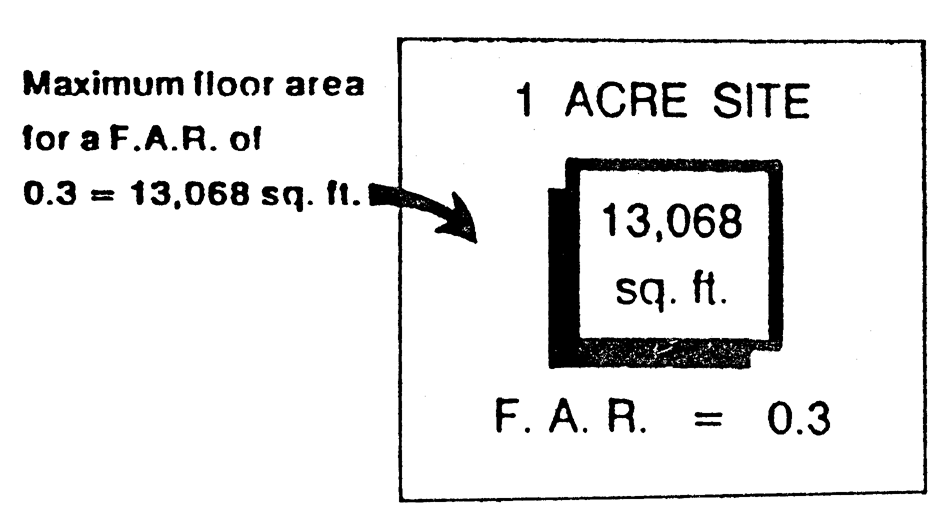
FLOOR AREA RATIO (FAR)
FAR =
Total Building Floor Area / Total Lot Area
The City shall reserve the power to mandate changes in the site plan as well as mandate reductions in the density and/or intensity of development proposed by an applicant/developer if the City finds that the proposed site plan does not satisfy provisions of the Comprehensive Plan and/or the land development regulations.
C.
Potable water and wastewater services. Reference Article IX of the land development regulations.
D.
Impervious surface requirements (ISR) for all uses. The term "impervious surface" is defined as that portion of the land which is covered by buildings, pavement, or other cover through which water cannot penetrate. The impervious surface ratio requirement controls the intensity of development, by restricting the amount of the land covered by any type of impervious surface.
1.
Compliance with ISR stipulated in Table 2-5.4. All proposed development shall comply with the standards given in the table of impervious surface ratios in Table 2-5.4.
Where a proposed development is donating or dedicating land based on a plan approved by the City, the gross site before dedication or donation shall be used to calculate ISR. This does not relieve the applicant from providing all required onsite buffers, landscaping, stormwater management areas, setbacks, and other required project amenities.
2.
Calculation of ISR. The impervious surface ratio (ISR) is calculated for the gross site by dividing the total impervious surface by the gross site area. Water bodies, including retention/detention areas, are impervious and shall be included as such in the ISR calculation.
Cluster development or other site design alternatives may result in individual lots exceeding the ISR, while other lots may be devoted entirely to open space. The City may require, as a condition of approval, deed restrictions or covenants which guarantee the maintenance of such open space in perpetuity. The ISR requirement shall not be bypassed or reduced. However, the intent is to allow maximum flexibility through calculating ISR on the gross site, and not on a lot-by-lot basis.
3.
Use of porous material. Porous concrete, porous asphalt, "turf block," or similar materials may be used subject to approval of the City Engineer.
The burden of proof shall reside with the applicant. The applicant shall demonstrate that the material is designed consistent with accepted industry specifications. The material shall be designed to retain its porosity, stability, and durability for a reasonable period of time based on professionally accepted principles and practices.
E.
Building yards. Table 2-5.4 provides building yards for conventional single-family lots as well as for nonresidential sites. The yards shall be measured from the subject lot lines of the building site.
A variance to these yards may be granted by the Planning and Zoning Commission if the applicant meets the requirements of Section 1-2.7, herein, and the standards for considering variances of Section 1-2.7(C) and the following additional standards:
1.
The reduced yard is consistent with the established yard on existing developed lots within the general vicinity;
2.
The reduced yard will not adversely impact adjacent land uses;
3.
The reduced yard will not adversely impact any planned acquisition of needed public rights-of-way which may be identified on the City's official street name map;
4.
The proposed development with the reduced yard is consistent with the Comprehensive Plan, land development regulations and does not adversely impact the public's general health, safety, and welfare;
5.
The reduced yard shall not allow encroachment on existing easements.
Footnotes:
A.
As measured from the property line to the main structure.
B.
This is a ratio of impervious surface area and open space to the lot size. Impervious surfaces include rooftops, driveways and sidewalks, as well as asphalt and concrete parking surfaces.
C.
In all areas Zoned CG, CS, I, RMF-13, RMF-20, PRD, PMX-L, or PMX-H, building height in excess of 35 feet may be permitted as a conditional use. Additionally, refer to Sections 2-7.11 and 3-10.12 for exceptions to the maximum height limit.
D.
The maximum density is not guaranteed by right. Instead, the maximum density shall be determined based on site-specific assessment, including consideration of the natural characteristics of the site, as well as the performance standards stipulated in Chapter III of the ULDRs.
E.
No buildings shall be located within 50 feet of the ordinary high-water line or wetland line of any Class III waters per Section 3-11.1(C)(2). Additionally, buffers shall be 25 feet on lots less than five acres created prior to February 17, 1992. Swimming pools shall not be located within 35 feet of the ordinary high-water line of a lake per ULDR Section 1-5.7(d).
F.
There shall be a side yard on each side of a residential structure of not less than ten feet for one- and two-story buildings, 12 feet for three-story buildings, 14 feet for four story buildings and two additional feet for each story over four. Any side yard abutting a street shall be the same as the front yard requirement on the intersecting street, unless platted and designated otherwise.
G.
The average lot in any townhouse group shall not be less than 2,000 square feet per dwelling unit, and no lot in any group shall contain an area less than 1,800 square feet.
H.
Required minimum yards provided herein are for those yards between townhouse buildings within the development. ULDR Table 3-13.7(C2), Minimum Standards for Required Bufferyards and Landscape Screening, and Article XIII, Landscaping, provides requirements for perimeter yards of the development parcel (including front, side and rear).
I.
Unless otherwise provided in Table 2-5.4, required lot area, lot width, and setbacks shall be determined based on specific development review procedures cited in Article XX of the ULDR.
J.
The maximum allowable density shall be based upon the Future Land Use Map designation. The maximum allowable density shall not exceed 5 units per acre in areas designated Low Density Residential and 13 units per acre in areas designated Medium Density Residential.
K.
No structure shall be constructed in excess of 24 feet in height within 100 feet of the side or rear lot line of any existing single-family residential structure or residentially zoned, undeveloped lot.
L.
In lieu of these side yard requirements, a four-hour rated firewall may be substituted. However, a lot abutting residentially zoned property shall have a side yard of at least 30 feet. Refer to Table 3-13.7(C1) Minimum Standards for Required Bufferyards.
M.
For parcels located on an arterial road, the maximum FAR may be increased to 0.35.
N.
The parking of passenger vehicles shall not be permitted in the front 50 percent of required front yards and bufferyards as otherwise established.
O.
Reserved.
P.
Any buildings or structures erected within this district shall be for parks and recreation purposes or protective services and shall support said purposes; any major buildings or major structures erected within this district shall be approved by the City Commission after receiving recommendations from the Building and Zoning Officials and the Parks Manager of the City; otherwise, the City Manager or their designee may approve the building or structure. The City Manager or their designee shall determine those improvements that constitute major buildings or structures based on the size of the improvement as compared to the size and purpose of the property.
Q.
Impervious area greater than 30 percent shall require a conditional use approval.
R.
The City has adopted a conservation overlay designation, and any land located within this designated area shall undergo an environmental impact review prior to development or redevelopment. Areas depicted in the overlay are environmentally sensitive and consist of remaining wildlife habitat areas and vegetative communities, as well as wetlands, floodplains, and areas impacted by potable water wellfields within the corporate City limits. Development within the conservation overlay zone may or may not be allowed at reduced densities and intensities. Where site-specific conservation measures cannot mitigate the adverse impacts of proposed development, development applications shall be denied.
S.
Refer to ULDR Section 2-7.28 for design and performance standards for the Industrial and Industrial Medium zoning district.
T.
See Section 2-7.33 for minimum living area, density, and other design criteria for assisted living facilities.
U.
The maximum allowable impervious surface ratio (ISR) shall be based upon the Future Land Use Map designation. The maximum allowable ISR ratio shall not exceed 50% impervious/50% open space in areas designated Low Density Residential and 75% impervious/25% open space in areas designated Medium Density Residential.
V.
These requirements will not apply to those mobile home parks existing in the City of Casselberry as of January 1, 2020. Mobile home parks existing in the City of Casselberry as of January 1, 2020 will utilize the procedures provided in Article III of the ULDR to rezone to RMHP and establish minimum lot area, minimum required lot width, and setbacks.
(Ord. No. 96-867, § IV, 7-15-96; Ord. No. 98-901, § III, 2-2-98; Ord. No. 99-964, § VII, 10-4-99; Ord. No. 02-1045, § 7, 5-13-02; Ord. No. 06-1200, § V, 7-24-06; Ord. No. 09-1262, § 7, 1-12-09; Ord. No. 09-1294, § 5, 5-11-09; Ord. No. 15-1418, § V, 4-13-15; Ord. No. 15-1420, § 3, 3-9-15; Ord. No. 15-1429, § 2(Exh. B), 10-12-15; Ord. No. 16-1446, §§ 2, 3(Exhs. A, B), 8-22-16; Ord. No. 19-505, § 1(Exh. A), 2-11-19; Ord. No. 20-1536, § I(Exh. A), 8-24-20; Ord. No. 22-1573, § IV(Exh. B), 11-14-22)
Section 2-5.5. - Affordable Housing under the Live Local Act.
A.
Applicability. Except as otherwise provided, the provisions of this Section shall apply to qualifying developments authorized by Fla. Stat. 166.04151 in the CL, CG, CS, I, I-M, PMX-L, PMX-H, PMX-MID, or PMX-HIGH zoning districts.
B.
Affordability commitment. Any affordable housing development built under the preemptive regulations in the "Live Local Act" (2023) must comply with Fla. Stat. 166.04151's mandate of providing a minimum of 40 percent affordable housing for 30 years by recording a restrictive covenant on the property to that effect; if the development does not comply with the Act for 30 years, then the City will consider the affordable housing units non-conforming uses subject to Article VIII, Nonconforming Uses and Noncompliant Structures.
1.
The City will enforce the restrictive covenant. After a property is no longer qualified as affordable housing due to violation of the restrictive covenant, the City may impose additional regulations on the development, at the City Commission's discretion at a public hearing, to include stricter design standards, landscaping, upgraded amenities, and other regulations designed to protect the area and ensure compatibility of nearby uses.
C.
Development of land authorized under Fla. Stat. 166.04151.
1.
Density. Proposed development authorized under Fla. Stat. 166.04151 shall not exceed the maximum allowed density for residential development in the City.
2.
Height. Proposed development authorized under Fla. Stat. 166.04151 shall not exceed the highest currently allowed height for a commercial or residential development located in the City within 1 mile of the proposed development or three stories, whichever is higher.
3.
Site Design. Proposed development authorized under Fla. Stat. 166.04151 shall adhere to the performance standards in Section 3-10.14, Multifamily Development Design Standards.
4.
Equal Treatment of Dwelling Units. All affordable dwelling units shall be proportional in size to the market-rate dwelling units. Further, all units shall be commingled in the same structure utilizing the same principal entrance(s). Additionally, all common areas and amenities shall be accessible and available to all residents regardless of whether they inhabit an affordable or market-rate dwelling unit.
5.
Mixture of Uses Required. Any site plan for proposed development authorized under Fla. Stat. 166.04151 that is administratively approved under this Section shall be mixed-use with retail or office use on the bottom floor. Overall, at least 65% of all uses of the total square footage must be used for residential purposes, with at least 40 percent dedicated to affordable dwelling units.
a.
The first floor of each building must be non-residential, and all floors must be built out in one phase. The non-residential use must have a certificate of occupancy before the residential use is given a certificate of occupancy.
b.
At least two uses are required in each multi-family building. Home-based businesses or institutional uses are not considered an appropriate second principal use.
6.
Unified Lot. All residential and non-residential components of a proposed development authorized under Fla. Stat. 166.04151 shall be located on the same or a unified parcel.
7.
Administrative Site Plan Review and Approval. A site plan that complies with Fla. Stat. 166.04151 and with all other applicable state and local laws and regulations and that is consistent with the City's Comprehensive Plan, except provisions of Fla. Stat. 166.04151 establishing allowable densities, height, and land use, shall be administratively approved by the City Manager or their designee. An affected person may appeal an administratively approved decision by the City Manager to the Planning and Zoning Board as provided in Section 1-2.1.
D.
Abandoned projects. If construction has not begun on the affordable housing project within two years of the issuance of the building permit, then the property will be governed by the entitlements allowed under the property's zoning without the benefit of the preemptive provisions of Fla. Stat. 166.04151.
(Ord. No. 23-1586, § II, 12-11-23)
Section 2-6.1. - Purpose and intent.
The purpose of this Article is to ensure that conditional uses shall only be permitted on specific sites where the proposed use may be adequately accommodated, without generating adverse impacts on properties and land uses within the immediate vicinity. This Section is intended to provide the procedures and criteria for considering the approval of conditional uses on specific sites within various zoning districts. Conditional uses shall be permitted upon a finding that the respective use and proposed site plan satisfy the provisions of this Article.
Section 2-6.2. - Specific criteria for approving a conditional use.
A conditional use shall be permitted only upon a finding that the proposed conditional use, application, and applicable performance criteria (ref. Chapter III) comply with the criteria herein specified unless the City determines that the proposed conditional use does not meet the criteria herein provided and that the proposed conditional use is adverse to the public's interest. In addition, the site plan criteria of an application for a conditional use shall describe the proposed land use characteristics and site plan techniques proposed to mitigate against possible adverse impacts to properties in the immediate vicinity.
A.
Characteristics of use described. The following characteristics of a proposed conditional use shall be clearly described as part of the conditional use application:
1.
Scale and intensity of use as measured by the following:
a.
Floor area ratio;
b.
Traffic generation;
c.
Square feet of enclosed building for each specific use;
d.
Proposed employment;
e.
Proposed number and type of service vehicles; and
f.
Offstreet parking needs.
2.
On- or offsite improvement needs generated by the proposed use, including:
a.
On- or offsite facilities required to service the proposed use such as utilities, public facilities, roadway or signalization improvements, or other similar improvements, including proposed accessory structures or facilities; and
b.
Other unique facilities/structures proposed as part of site improvements.
3.
Onsite amenities proposed to enhance the site and planned improvements. Amenities include mitigative techniques such as open space, setbacks from adjacent properties, screening and buffers, including landscaped berms proposed to mitigate against adverse impacts to adjacent sites.
B.
Criteria for conditional use review and approval. In addition to site plan procedures (ref. Article XVIII) and performance criteria (ref. Chapter III), applications for a conditional use shall clearly demonstrate the following:
1.
Land use compatibility. The applicant shall demonstrate that the conditional use, including its proposed scale and intensity, traffic generating characteristics, and offsite impacts, are compatible and harmonious with adjacent land use, and will not adversely impact land use activities in the immediate vicinity.
2.
Sufficient site size and adequate site specifications to accommodate the proposed use. The size and shape of the site, the proposed access and internal circulation, and the urban design enhancements must be adequate to accommodate the proposed scale and intensity of conditional use requested. The site shall be of sufficient size to accommodate urban design amenities such as screening, buffers, landscaping, open space, offstreet parking, efficient internal traffic circulation, and similar site plan improvements needed to mitigate against potential adverse impacts of the proposed use.
3.
Proper use of mitigative techniques. The applicant shall demonstrate that the conditional use and site plan has been designed to incorporate mitigative techniques needed to prevent adverse impacts to adjacent land uses. In addition, the design scheme shall appropriately address offsite impacts to ensure that land use activities in the immediate vicinity, including community infrastructure, are not burdened with adverse impacts detrimental to the general public health, safety and welfare.
4.
Hazardous waste. The proposed use shall not generate hazardous waste or required use of hazardous materials in its operation without use of City-approved mitigative techniques designed to prevent any adverse impact to the general health, safety and welfare. The plan shall provide for appropriate identification of hazardous waste and hazardous material, and regulate its use, storage and transfer consistent with best management principles and practices. No use which generates hazardous waste or uses hazardous materials shall be located in the City unless the specific location is consistent with the Comprehensive Plan policies and land development regulations, and does not adversely impact wellfields, aquifer recharge areas, or other conservation resources.
5.
Compliance with applicable laws and ordinances. A conditional use application shall demonstrate compliance with all applicable federal, state, county, and City laws and ordinances. Where permits are required from governmental agencies other than the City, these permits shall be obtained as a condition of approval.
Section 2-6.3. - Review procedures.
The application for a conditional use on a form to be provided by the Department of Community Development shall be submitted to the Department of Community Development with the site plan required pursuant to Article XVIII. The procedure for approval shall be the same as for the procedures identified in Article XVIII for site plan review.
Section 2-7.1. - Applicability of provisions.
The land development regulations set by this Chapter shall apply uniformly to each district, class or kind of structure or land except as hereinafter provided.
Section 2-7.2. - Restrictions on buildings and structures.
No building or other structure shall hereafter be erected or altered which does not conform to size and dimension requirements stipulated in Article V (Table 2-5.3) or which does not conform to all other applicable land development regulations.
Section 2-7.3. - Independent yard or open space.
No part of any yard, open space, offstreet parking, or loading space required in connection with any building or site for the purpose of complying with land development regulations shall be included as part of a yard, open space, offstreet parking or loading space similarly required for any other building or site, nor shall any required yard, open space, offstreet parking or loading space required in connection with any building or site be transferred to enable another building or site to meet its respective requirements; nor shall land, required yard, open space, offstreet parking or loading space for any building or site be included for consideration for development rights credit for another site.
(Ord. No. 02-1045, § 8, 5-13-02)
Section 2-7.4. - Yard and building site requirements.
No lot, building site, or required yard shall be reduced in dimension or area below the minimum requirements set forth herein.
Section 2-7.5. - Distance between principal buildings.
The minimum distance between principal buildings for four or more residential units or commercial buildings shall be 30 feet. The distance shall be measured at the narrowest space between buildings and shall not include roof overhang. This requirement may be modified if the Fire Marshal recommends a lesser distance based on considerations cited in the National Fire Protection Association Code (NFPA) and NFPA advisory standards. Any request for modification of the requirement must also be accompanied by a staff recommendation, including the comments of the Fire Marshal. The burden of proof in demonstrating the need for a modified yard requirement shall be on the applicant.
Section 2-7.6. - Lots of record less than minimum size.
Any nonconforming lot of record at the time of the adoption of this ordinance which contains less lot area or width than required in the district in which it is located may be used for a use permitted in such district. The provision shall not be construed to permit more than one dwelling unit on a lot with less area per family than required for the district in which such lot is located. However, if the substandard lot adjoins other land under the same ownership which if used could correct the nonconforming lot area or width, then:
1.
The substandard lot shall not be permitted a vested development right unless the nonconformity is remedied; and, furthermore,
2.
Any subsequent sale or ownership transfer of the substandard lot, adjoining lot, or portion thereof shall not result in a vested development right in the subject substandard lot(s) unless the transaction corrects deficiencies in the substandard lot(s).
Section 2-7.7. - Regulations for required yards.
A.
Purpose, use and maintenance of yards. The purpose of yards required in this Chapter is to provide open space around and between structures for health, safety and aesthetic purposes. The purpose is also to prevent structures within dedicated easements. All required yards and landscaped areas where not used for parking, driveways, sidewalks, or other approved structures shall be planted and maintained in lawn, sod, or landscaping including flower beds, shrubs, hedges or other generally accepted landscaping material approved by the City. Landscaping material, including trees, shall not obstruct the vision of the motoring public as established in F.S. §§ 71.090—71.092. The landscape requirements of Article XIII shall further regulate development within all zoning districts, excepting single-family zoned districts.
B.
Required yard measurements. Required yards shall be measured on a perpendicular to the property line to the first vertical plane which intersects any portion of the structure other than a nominal roof overhang. On irregular lots, the side yards shall be measured from the front building line when the lot frontage is narrower than the rear of the lot, and from the rear building line when the rear of the lot is narrower than the front of the lot.
The building line shall be determined from the extreme support of the roof of the main structure or appurtenance thereto. On front, side, and rear yards, a roof projection or eaves shall not exceed 36 inches.
C.
General encroachments into required yards. Every part of every required yard shall be open and unobstructed from the ground to the sky except as hereinafter provided or as otherwise permitted in the land development regulations:
1.
Sills or belt courses may not project over 18 inches into a required yard;
2.
Movable awnings may not project over three feet into a required yard, provided that where the yard is less than five feet in width the projection shall not exceed one-half the width of the yard;
3.
Chimneys, fireplaces or pilasters may not project over two feet into a required yard;
4.
Fire escapes, stairways, and balconies which are unroofed and unenclosed may project not over five feet into a required rear yard, or not over three feet into a required side yard of a multiple dwelling, hotel or motel;
5.
Hoods, canopies, or marquees may not project over three feet into a required yard;
6.
Fences, walls and hedges shall be permitted in required yards subject to the provisions established herein; and
7.
Accessory parking may be located in a required front, rear or side yard except that no parking shall be permitted within 15 feet of a public street;
8.
Play equipment, wires, lights, mailboxes, ornamental entry columns and gates, and outdoor furniture are not considered encroachments;
9.
Docks and other waterfront accessory structures approved by the City Engineer in compliance with the City's land development regulations are not considered yard encroachments.
D.
Front yards.
1.
Lots with double frontage. Front yard regulations shall apply to both streets on through lots and double-frontage lots.
2.
Corner lots. There shall be a front yard on each street side of a corner lot, provided, however, that the buildable width of such lot shall not be reduced to less than 30 feet; provided, further, that no building on a corner lot shall project beyond the front yard line on either street.
3.
Encroachment of porches or terraces. An open unenclosed and uncovered porch or paved terrace may project into the front yard for a distance of not more than ten feet.
E.
Side yard. Width of required side yards shall be measured in such a manner that the yard established is a strip of at least the minimum width required by district regulations with its inner edge parallel with the side lot line.
F.
Rear yard. Depth of required rear yards shall be measured in such a manner that the yard established is a strip of at least the minimum width required by district regulations with its inner edge parallel with the rear lot line.
G.
Yard encroachment by shading. Notwithstanding any other provisions of the land development regulations, no new building, or manmade object will be located in such a manner that it will cast a shadow (damaging to the use of a solar system) into adjacent required yard setbacks, between the hours of 8:00 a.m. E.S.T. and 4:00 p.m. E.S.T. at the winter solstice. The purpose of this is to enhance the natural warming during winter months for plant life and habitat on adjoining property as well as safeguarding the users of solar heating roof panels.
H.
Yard abutting alley. Whenever a lot abuts on an alley, one-half of the alley width may be considered as a portion of the required rear yard.
(Ord. No. 02-1045, § 9, 5-13-02)
Section 2-7.8. - Erection of more than one principal structure on a lot.
In any district, more than one structure housing a permitted or permissible principal use may be erected on a single lot, provided that yard and other requirements of the zoning provisions shall be met for each such structure on a separate lot.
Section 2-7.9. - Accessory structures.
A.
General requirements. Accessory structures must be constructed simultaneously with, or following, the construction of the principal structure and shall not be used until after the principal structure has been fully erected.
1.
Accessory structures shall be designed to blend aesthetically with the main structure, except for permanent or temporary tent-like structures, which must meet the criteria of this Code.
2.
Owners may request administrative approval by the Administrative Official for accessory structures to encroach in a recorded easement if the following conditions are met, in addition to the other requirements of this Section:
a.
The property owner must obtain letters of no objection from all local utility providers and regulatory agencies having jurisdictional rights to the easement;
b.
The property owner must execute an encroachment agreement with the City holding the City harmless from any damage resulting from the authorized construction or removal of improvements.
3.
Applicants may file appeals from the decision of the Administrative Official to the Planning and Zoning Commission (P&Z) within 30 days of the rendering of the Administrative Official's decision.
4.
No more than two such accessory structures may be located on any lot.
5.
Accessory structures which are attached to the principal structure shall be considered part of the principal structure and shall not exceed the height of the roof line of the principal structure.
6.
An accessory structure shall not project beyond the established front facades of the principal structure.
7.
Type of accessory structure. Regardless of the intended duration of the structure, a building permit and site plan are required prior to construction, including tent-like structures.
a.
Temporary Structures.
1)
For purposes of this section, a temporary accessory structure is defined as an accessory structure that is installed for a special short-term period, event, or use. Short-term (temporary) is hereby defined as any period of time that does not exceed 35 days.
2)
A building permit must be obtained for the use of the temporary structure, and it will not be approved for more than 35 days in a calendar year, but may be renewed by the Administrative Official once per year (for a total of 70 days) with proof of extenuating circumstances. The applicant must file a written application for an extension before expiration of the permit with reasons that demonstrate that the application of Section 2-7.9 constitutes a hardship. The temporary structure, even if a tent-like structure, must comply with all pertinent City Codes.
b.
A permanent accessory structure is defined as an accessory structure that is intended to remain in place for a period greater than 35 days.
c.
In the event the National Weather Service issues a tropical storm watch in the Seminole County area, all temporary tent-like structures shall be removed immediately and stored so they do not become a projectile.
8.
A variance from the requirements of this Section may be granted by the Planning and Zoning Commission.
B.
Accessory structures equal to or less than 160 square feet.
1.
Setback requirements are established as follows:
a.
A minimum ten-foot setback is required from the main structure.
b.
The accessory structure may be located adjacent to a side or rear lot line.
c.
No accessory structure shall be closer than four feet to any other accessory structure on the same lot.
d.
On through lots, the accessory structure must be set back a minimum of 15 feet from the designated rear lot line.
2.
Height. The wall height shall not exceed eight feet and roof peaks shall not exceed 11 feet.
C.
Accessory structures greater than 160 square feet and less than or equal to 500 square feet.
1.
Setback requirements.
a.
A minimum ten-foot setback is required from the main structure.
b.
The accessory structure shall meet the same minimum side, rear setbacks as the main structure.
c.
No accessory structure shall be closer than four feet to any other accessory structure on the same lot.
d.
No detached accessory structure shall occupy more than 25 percent of the area behind the main building line.
2.
Height. The roofline of the accessory structure shall not exceed the height of the roofline of the principal structure.
D.
Accessory structures. Accessory structures greater than 500 square feet in area shall require conditional use approval.
E.
Detached, open carports. A detached, open carport, consists of a roof and supporting members and a finished foundation .
1.
Setback. A minimum five-foot setback is required from the rear and side property lines.
2.
Area. The area shall not exceed 500 square feet in area.
3.
Height. The overall height of the accessory structure shall not exceed 15 feet or the height of the roofline of the main structure, whichever is less.
F.
Tent-Like Structures as Accessory Structures. Erection of tent-like structures (to include tent or canopy structures) to serve as accessory structures shall be subject to the following criteria:
1.
The tent-like structure must be built in the back yard (i.e. behind the principal structure). In the case of corner or through lots, tent-like structures are allowed in the portion of the lot that is commonly used as the back yard by the occupant.
2.
The tent-like structure shall be screened from any street by up to an eight-foot high fence, wall or hedge to provide 100 percent opacity. It shall not be a violation of this Section if up to two feet of the top of the tent-like structure is visible from the street, provided that the eight-foot high fence, wall or hedge is in place.
3.
If the tent-like structure is used to protect a parked vehicle, a paved driveway or permanent designated area shall be constructed to connect the parking area to the driveway (per Section 3-10.9A.4.a).
G.
Requirements for swimming pools and/or screen enclosures.
1.
Required yards and setbacks.
a.
All setbacks for swimming pools shall be measured from the outside edge of the pool coping.
b.
No pool and/or screen enclosure shall be located forward of the front building line.
c.
Pools and/or screen enclosures shall not be located in any side yard, as defined in table 2-5.4, Article V, of the ULDR.
d.
The pool and/or screen enclosure shall be located a minimum of five feet from the rear property line.
e.
The pool shall be set back a minimum of four feet from the primary structure to allow for proper maintenance and safety. This distance may be decreased by the administrative official if safety and maintenance issues are adequately addressed, and engineering details are approved by the administrative official or his designee.
2.
Easements. Where an area is encumbered by an easement, the DRC may approve construction of patio or decking within the easement area under the following conditions:
a.
All such improvements shall be constructed separately from the pool shell and structure with an expansion joint to enable removal of the improvements, if necessary, to service the easement area;
b.
The property owner must obtain letters of no objection from all local utility providers and regulatory agencies having jurisdictional rights to the easement; and
c.
The property owner must execute an encroachment agreement with the city holding the city harmless from any damage resulting from the authorized construction or removal of improvements.
Appeals from the DRC decision shall be to the P&Z within 30 days of the rendition of the DRC Order.
3.
Height. The overall height of the screen enclosure shall not exceed 12 feet, unless the screen enclosure is attached to the principal building, in which case the screen structure shall not exceed the height of the roof line of the principal building. Design computations and construction details shall be submitted with all screen enclosure plans showing that the structures comply with the wind load and live load requirements of the Florida Building Code as adopted in Chapter 1, Article IV of the ULDR.
4.
Waterfront lots. A pool shall be located not less than 35 feet from the ordinary high water or wetland line, and a screen enclosure shall be located not less than 25 feet from the ordinary high water or wetland line. The design of the adjacent grading between the pool and the lake shall be consistent with the requirements of Section 3-12.3(P) of the ULDR.
(Ord. No. 94-814, § I, 10-17-94; Ord. No. 95-827, § I, 6-5-95; Ord. No. 02-1045, §§ 11, 12, 5-13-02; Ord. No. 04-1121, § 3, 3-22-04; Ord. No. 05-1164, § 1, 7-25-05; Ord. No. 10-1342, § 1, 1-10-11; Ord. No. 12-1369, § 7, 2-13-12; Ord. No. 1459, § 1, 6-12-17; Ord. No. 25-1625, § IV, 11-17-25)
Section 2-7.10. - Fences and walls.
Any wall or fence erected within the City shall meet professionally accepted building standards and the regulations cited below.
For the purpose of this Code the term "fence" shall be used to describe a manmade structure erected for separation, security or privacy purposes through the means of intermittent posts supporting vertical or horizontal members made of wood, metal, vinyl, aluminum, chain link, or barbed wire. While the opacity may vary, the height and location are dictated by the regulations within this ordinance.
A wall may be erected for the same purposes but shall include only those structures with continuous footers. The main structure of the wall may be constructed of brick, stone or concrete block. The wall construction may be used in combination with decorative veneers of brick, rock, stone, stucco or any other material meeting accepted aesthetic performance criteria.
A.
Building permit required. No fence or wall shall be erected, replaced or receive major repair until a permit for same has been issued. The Administrative Official shall determine the types of fence or wall repair that are major and require a building permit.
B.
Commercial or industrial fences. Fences or walls may be erected in any commercial or industrial district to provide buffering. The fence height shall not exceed eight feet above the finished grade. Fences constructed with chain link shall use vinyl clad chain link, either green or black. When other materials are used for fencing, the finished side shall face out. Walls shall be finished similarly on both sides. Barbed wire or similar materials may be used in an industrial district provided the use is limited to a maximum of three strands installed a minimum of six feet above the finished grade. Barbed wire may be used in a commercial district provided a conditional use is granted by the Administrative Official and the use is limited to a maximum of three strands installed a minimum of six feet above the finished grade.
C.
Residential fences or walls. In any residential district, no fence or wall shall be erected or project beyond the property line. For the purpose of this section of the code, a front yard is defined as the area between those property lines adjacent to the street and the principal structure. No wall or fence in excess of three feet may be maintained within a front yard as indicated in the detail below.
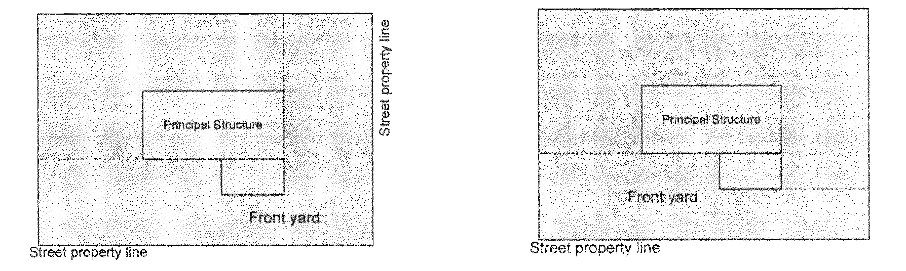
1.
Front yard fences. Fences within the front yard forward of the front building line of the main building shall be limited to a maximum height of three feet; provided, however, that they be of approved, open decorative type construction, such as open chain link, wood, vinyl, aluminum, or split rail fencing.
2.
Side and rear yard fences. Side and rear yard fences or walls may be erected or maintained to a maximum height of eight feet above the finished grade. Fences located in the rear yard of through lots may not be located closer than ten feet to the adjacent street.
3.
Through lots. For the purpose of this section of the fence/wall requirements regarding a residential through lot, the front yard regulations shall apply only to the main street of the property. The main street shall be determined by factors including the address of the house, the location of the main entrance of the house, the location of the driveway, and the orientation of the front yards of adjacent properties. It is the intent of this regulation to allow a fenced rear yard on such properties without the need for a variance. In cases where the orientation of the front and rear yards are not consistent with the majority of properties on the same street, a variance will be required. Corner lot regulations still apply to those properties which are through lots as well as corner lots. See detail below which shows Street A as the main street.
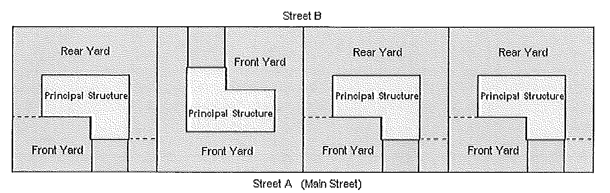
4.
Material. All fences or walls shall be constructed from approved material enumerated herein and shall be erected with the finished side facing out. Barbed wire or similar materials shall not be allowed in any residential districts.
5.
Undeveloped properties. Undeveloped residential properties may be fenced upon approval by the Administrative Official of the location and material type.
6.
Non-compliant fences and walls. Legally existing non-compliant fences and walls on residential properties may be replaced, restored, or reconstructed as originally permitted. Such replacement, restoration, or reconstruction shall adhere to the current permitting requirements expressed within this section. The burden of proof in establishing the legal non-compliant status of an existing fence or wall rests solely with the applicant. Those applicants who are unable to effectively prove such legal noncompliance shall be subject to the current fence and wall regulations of this section.
7.
Fence and wall locations. There shall only be one fence or one wall per perimeter, per property. A new fence or wall shall not be erected directly adjacent to an existing fence or wall on the same lot.
8.
Appearance. Fences shall present a uniform appearance. Attachments to increase the height or length of an existing fence shall be of the same material, color, and design as the existing fence.
(Ord. No. 02-1045, § 13, 5-13-02; Ord. No. 08-1251, § 2, 11-20-08; Ord. No. 10-1331, § 1, 7-12-10; Ord. N. 10-1342, § 2, 1-10-11; Ord. No. 12-1379, § 1, 9-24-12)
Section 2-7.11. - Exceptions to height regulations.
Water, fire, radio, and television towers, and similar structures and their necessary mechanical appurtenances may be erected above the height limits established in Article V. The height of satellite dishes and communication towers are regulated by Section 2-7.22. The maximum height of a church spire, dome, cupola, or flagpole shall not exceed the width of the widest rights-of-way abutting the parcel or lot.
(Ord. No. 02-1045, § 14, 5-13-02)
Section 2-7.12. - Structures to have access.
Every building hereafter erected or moved shall be on a lot adjacent to a public street, or with access to an approved private street, and all structures shall be so located on lots as to provide safe and convenient access for servicing, fire protection, and required offstreet parking.
Section 2-7.13. - Reserved.
Editor's note— Ord. No. 97-882, § III, adopted 8-18-97, repealed § 2-7.13, which pertained to swimming pools.
Section 2-7.15. - Regulation of obstructions to visibility.
A.
Regulation against obstruction to traffic and traffic visibility. Cross reference Chapter 82 of the City Code of Ordinances.
Section 2-7.16. - Required garage or carport.
Every single-family dwelling unit shall be required to provide a garage or carport. If a carport or similar unenclosed vehicle storage structure is provided, then the principal structure shall contain a fully enclosed utility storage area of at least 60 square feet, which shall be designed as an integral part of the principal structure. If a fully enclosed garage is provided, then no utility structure shall be mandated.
Section 2-7.17. - Home based businesses.
(1)
Home Based Business f/k/a Home Occupation means a business that operates in whole or in part from a residential property and that meets the criteria in Fla. Stat. 559.955 and this Code.
(2)
In accordance with Fla. Stat. 559.955, Home Based Businesses are not regulated or licensed in a manner that is different from other businesses, except that a permitted Home Based Business must meet the following criteria:
(A)
The employees of the business who work at the residential dwelling must also reside in the residential dwelling, except that up to a total of two employees or independent contractors who do not reside at the residential dwelling may work at the business. The business may have additional remote employees that do not work at the residential dwelling.
(B)
Parking related to the business activities of the Home Based Business must comply with City zoning requirements in the residential zoning category found in Article X, Section 3-10.9, and the need for parking generated by the business may not be greater in volume than would normally be expected at a similar residence where no business is conducted. The use of vehicles or trailers operated or parked at the business or on a street right-of-way are regulated in Article X, Section 3-10.9. Vehicles and trailers used in connection with the business must be parked in legal parking spaces that are not located within the right-of-way, on or over a sidewalk, or on any unimproved surfaces at the residence. The parking or storage of heavy equipment at the business which is visible from the street or neighboring property is regulated as provided in Article X, Section 3-10.9. For purposes of this paragraph, the term "heavy equipment" means commercial, industrial, or agricultural vehicles, equipment, or machinery, and also means the same as both "Prohibited Vehicle" as defined in Section 3-10.9A, and "heavy machinery" as defined in Section 5-21.2.
(C)
As viewed from the street, the use of the residential property must be consistent with the uses of the residential areas that surround the property. External modifications made to a residential dwelling to accommodate a Home Based Business must conform to the residential character and architectural aesthetics of the neighborhood. The Home Based Business may not conduct retail transactions at a structure other than the residential dwelling; however, incidental business uses and activities may be conducted at the residential property.
(D)
The activities of the Home Based Business must be secondary to the property's use as a residential dwelling.
(E)
The business activities must comply with Article XVII, Nuisance Abatement, with respect to equipment or processes that create noise, vibration, heat, smoke, dust, glare, fumes, or noxious odors.
(F)
All business activities must comply with Article XI, Environmental Protection, and state and federal regulations with respect to the use, storage, or disposal of any corrosive, combustible, or other hazardous or flammable materials or liquids.
(G)
A Home Based Business is subject to all applicable City, County, and other business taxes.
(H)
If any Home Based Business requires a license or permit from the State of Florida or any agency thereof, the Home Based Business shall provide the City with a current, valid copy of any such permit or license before any such business may receive a business tax receipt. Any such license or permit from the state or any agency thereof shall be kept active and current and a duplicate copy shall be filed with the City at the time of all subsequent renewals of the business tax receipt.
(I)
The Home Based Business may not display a sign in front of the dwelling, except as provided in Article XVI, Signs.
(J)
Any person desiring to conduct a Home Based Business in the City shall first apply to the appropriate city department for a business tax receipt. Such application shall be on a form prepared by the City, and shall include, but not be limited to, the following information:
1.
Name of applicant.
2.
Location of residence wherein the Home Based Business, if approved, will be conducted.
3.
Total floor area of the first floor of the residence.
4.
A sketch showing the floor plan and the area thereof to be utilized for the conduct of the Home Based Business.
5.
The nature of the Home Based Business sought to be approved.
6.
A notarized letter of authorization from the property owner, if the applicant is not the property owner.
(Ord. No. 01-1045, § 15, 5-13-02; Ord. No. 09-1305, § 1, 10-12-09; Ord. No. 24-1606, § II, 9-23-24)
Section 2-7.18. - Manufactured housing.
Manufactured housing may be permitted in all residential or mixed-use districts within the City if the units comply with the following standards:
1.
City's adopted building codes;
2.
State of Florida building standards of F.S. chs. 320 and 553;
3.
U.S. Department of Housing and Urban Development Manufactured Home Construction and Safety Standards of 1974 (i.e., F.S. § 320.823);
4.
Appearance and architectural performance criteria cited in Chapter III;
5.
All applicable provisions of the Comprehensive Plan and the land development regulations;
6.
Adopted City fire codes.
Section 2-7.19. - Community residential homes.
The criteria provided for community residential homes in Table 2-7.19 summarizes that provided in Florida Statute Chapter 419, Site selection of community residential homes. Refer to FS Chapter 419 for all criteria relative to this issue.
(Ord. No. 16-1447, § 2, 7-25-16)
Section 2-7.20. - Mobile homes.
A.
Mobile home site standards and requirements. Every mobile home within the mobile home park shall be located on a mobile home site which complies with the development standards recorded in Table 2-5.4, Size and Dimension Regulations.
In addition to the standards referenced above, mobile home sites shall comply with the following:
1.
Mobile home site driveways. All mobile home sites shall be provided with paved driveways with unobstructed access to a paved mobile home park street. Driveways shall be a minimum of ten feet wide and designed, sized, and constructed in accordance with Chapter 68 of the City Code of Ordinances.
2.
Mobile home site landscaping. All mobile home sites shall have a minimum of two trees.
B.
Mobile home park standards and requirements. All mobile home parks shall comply with the following development standards and requirements:
1.
Buffers. A landscaped buffer strip not less than 15 feet in width shall be provided along all park boundaries. Buffer strips shall contain suitable indigenous plantings and/or structural site screening as determined in accordance with the site plan review process established in Article XVIII. Street rights-of-way may not be used as a buffer strip.
2.
Community facilities. No community building or recreational facility shall be located within 50 feet of any mobile home park site or have a height of more than 30 feet.
3.
Mobile home park streets. Paved mobile home park streets shall be provided adjacent to each mobile home site. The common area in which the street is located shall have a width of 26 feet with curb and gutter or 24 feet without curb and gutter and shall be adequately lighted.
4.
Street name markers. Street name markers shall comply with the standards in Article XIX, Section 4-19.2(V)(21).
5.
Health and sanitation requirements.
a.
Garbage disposal. Provisions shall be made for at least semiweekly disposal of garbage within the entire mobile home park.
b.
Compliance. The sanitary regulations of the state and county shall be complied with as to all fixtures installed or maintained.
c.
Sewage disposal. Mobile home parks shall provide sewage disposal connected to the City sewage system, if a sanitary sewer is available within 100 feet of any part of the mobile home park.
d.
Water supply. City water supply shall be available to each mobile home site and within 100 feet of every travel trailer site.
6.
Miscellaneous standards. The mobile park shall comply with drainage, utility, open space, and other standards determined in accordance with the site plan review process established in Article XVIII. To the extent feasible, all utility facilities shall be located underground.
C.
Design requirements. All mobile homes used for residential purposes shall, within 120 days of adoption of this Code, comply with the blocking, tiedown, ground anchor, permanent skirting, and concrete step requirements set forth below in this Section. In cases where the 120-day time limitation would create an undue hardship and where the affected party requests in writing an extension, the extension may be granted for not more than an additional 60 days within which to comply with this Section.
1.
Attached structures. All mobile homes used for residential purposes shall comply with the following requirements pertaining to attached structures:
a.
All such mobile homes shall have a garage or a carport with an attached utility room, and concrete steps for principal mobile home entrances.
b.
All such mobile homes shall have permanent mobile home type banded aluminum skirting or alternative permanent skirting around the sides of the mobile home between the floor of the mobile home and the ground.
c.
All permanent structures attached to a mobile home, including enclosed porches, screened enclosures, storage closets, and carports, shall conform to all applicable provisions of construction codes adopted by the City.
d.
All portable or demountable awnings, roofs, or similar appurtenances which do not meet the requirements of c. above shall be dismantled and stored either within the mobile home or in some permanent building before a mobile home is left unoccupied for a period of 30 days or more.
2.
Blocking, tiedown, and anchor standards. All blocking, tiedown, and anchor standards shall be installed and shall comply with the Division of Motor Vehicles regulations, Chapter 15C-1.10, as it now exists or as it may be amended or renumbered from time to time, which is hereby adopted as the minimum blocking, tiedown, and anchor standards of the City, and as set out in the Appendix.
3.
Responsibility of owner. As shall relate to mobile home parks or rental mobile home spaces, it shall be the responsibility of the owner of the mobile home to provide the required blocking, tiedowns, ground anchors, concrete steps, and permanent skirting, and the installation of the same.
(Ord. No. 02-1045, § 16, 5-13-02)
Section 2-7.21. - Townhouses.
A.
Application for development. An applicant for a townhouse development shall submit with the application a site plan indicating compliance with the following criteria:
1.
As part of the data necessary to complete an application for townhouse development, a typical tentative plan showing front elevations of the proposed units and typical tentative floor plans of the proposed units, prepared by a registered architect, shall be submitted as part of the application. The site plan shall include, but not be limited to, location of buildings in relation to property and lot lines, offstreet parking areas, patio and service areas including garbage disposal areas, landscaping, walls, public and private streets, driveways, common facilities, open spaces, and walkways. In addition, lot size, percentage of ground coverage, open space, square footage of units, and similar considerations shall be included as data on the plan.
2.
A townhouse development shall be in a single ownership at the time of development. A legal plat shall be placed on the public records of the county prior to the development of any lot or parcel of land within the townhouse development.
B.
Lot size. The average lot in any townhouse group shall not be less than 2,000 square feet per dwelling unit, and no lot in any group shall contain an area less than 1,800 square feet.
C.
Number of dwellings. No single townhouse group shall contain less than four (4) nor more than eight (8) single-family dwellings.
D.
Firewalls. Each unit shall be separated from the others by an approved firewall; these walls shall be without openings or other provisions for passage or visibility between units, and in all cases shall comply with the Standard Building Code and the National Fire Protection Association (NFPA) Code as adopted by the City.
E.
Stairways, doors, utilities, and services. No two dwelling units shall be served by the same interior or exterior stairway or by the same exterior door, and each unit shall be independently served by separate utilities and services.
(Ord. No. 20-1536, § II, 8-24-20)
Section 2-7.22. - Satellite dishes.
A.
A satellite dish is a structure which shall be an accessory use to the primary or principal use upon a lot. The following regulations shall apply to the location, height, design, construction, operation, maintenance, and existence of satellite dishes:
1.
Permit required. Every person intending to install or materially reconstruct a satellite dish shall apply for a building permit from the City prior to the installation or commencement of work on said satellite dish.
2.
Residential districts. One satellite-dish-shaped antenna is permitted as an accessory structure for each property within the single-family and one- and two-family residential districts of the City. The size of the satellite antenna shall not exceed 11 feet in diameter. No satellite dish may be mounted to exceed the roofline of any dwelling unit.
Satellite dishes shall be setback eight feet from the rear and/or side property lines. No satellite dish shall be permitted in a front yard.
Satellite dishes shall be of the metal mesh variety that is painted in a corresponding color so as to blend in with the surrounding vegetation or buildings. Landscape screening including fencing, hedges, trees, etc., of heights necessary to screen the view of the dish, shall be placed or planted so as to buffer adjacent neighbors.
3.
Multifamily residential districts. In multifamily residential development subject to site plan review, satellite dishes shall be permitted as accessory structures pursuant to site plan review standards. The size of the satellite antenna shall not exceed ten feet in diameter or 12 feet in height.
4.
Nonresidential districts. Satellite dishes shall be permitted as accessory structures in nonresidential zoning districts in the City. The number, location, and size of all satellite dishes on such properties shall be subject to site plan approval pursuant to City site plan review standards.
5.
Aesthetics. Satellite dishes must be screened through the addition of architectural features or landscaping that is compatible and in harmony with the elements and characteristics of the lot or parcel of land upon which the satellite dish is located and with surrounding lands.
Conditions of approval may be imposed to mitigate any negative impact from the installation of the satellite dish. The cost of such condition to the applicant shall be considered coequally with the public benefit to be derived from said condition.
(Ord. No. 96-872, § III, 10-14-96; Ord. No. 97-885, §§ I—IV, 6-16-97; Ord. No. 02-1045, §§ 17—21, 5-13-02; Ord. No. 17-1463, § 3, 7-24-17)
Section 2-7.23. - Transit bus shelters.
A.
Shelter locations. Transit bus shelters may be erected in the City subject to the following conditions:
1.
Transit bus shelters may be placed at any officially designated transit stop location along arterial roadways that lie within municipal corporate boundaries.
2.
Transit bus shelters may be erected on private property subject to the specified review and approval process established in Subsections (B) and (C)(2) below.
3.
In addition to Subsections (A)(1) and (2) above, no transit bus shelter shall be erected in any public rights-of-way without the prior authorization of a representative of the State Department of Transportation (FDOT), the Public Works Department Director, and the Community Development Department Director or their designees. Once such authorization is received, the City shall issue a permit authorizing the construction of a transit bus shelter on a public rights-of-way.
B.
Applications. In the review of applications to construct transit bus shelters on public rights-of-way and private property, the Administrative Official shall consider the following factors:
1.
Purpose and intent. The purpose and intent of all requirements of this Section.
2.
Comprehensive Plan. Whether the proposal is consistent with all applicable policies of the City of Casselberry Comprehensive Plan, 2018-2028; and
3.
Compatibility. The compatibility of the proposal with surrounding land uses and the general character of the area, including such factors as height, build, construction materials, scale intensity, noise, drainage, lighting, and appearance.
C.
Permits. Permits for transit bus shelters shall be issued subject to the following:
1.
Permits for use of rights-of-way. A rights-of-way utilization agreement acceptable to FDOT and the Public Works Department shall be required prior to the issuance of any permit authorizing the construction of a transit bus shelter in a public rights-of-way.
2.
Permits for private property. Any transit bus shelter erected on private property will be required to obtain a building permit. A site plan will be required showing the location of the proposed shelter, to be reviewed by the DRC and the Planning and Zoning Commission/Land Planning Agency.
3.
Permit revocation. Upon termination of use of a transit bus shelter for a period exceeding 30 calendar days, the permit shall be null and void, the structure shall be removed, and the site shall be returned to its original condition by the permittee.
D.
Construction standards. All transit bus shelters shall be constructed in accordance with the South Standards Building Code as adopted by the City, and the following requirements:
1.
Transit bus shelters shall not exceed 100 square feet in area, shall be located on a solid base surface, shall be structurally sound, and shall be transparent, glasslike or similar material.
2.
Transit bus shelters shall meet all setback and location requirements of FDOT and the Federal Department of Transportation, as applicable
3.
Transit bus shelters shall conform to the encroachment requirements of F.S. ch. 337 and Section 14-20.003, Florida Administrative Code, as either is amended from time to time.
4.
Transit bus shelters shall meet all City site standards with regard to maintaining vehicular visibility, and shall not otherwise obstruct any public or private street, driveway, or sidewalk.
5.
Signage. A maximum of 24 square feet of commercial signage shall be allowed per transit bus shelter. No shelter shall contain more than two commercial sign faces.
E.
Maintenance. Transit bus owners shall be responsible for the maintenance of the shelter. A maintenance agreement shall be entered into by the applicant prior to the issuance of a building permit for the construction of a transit bus shelter.
F.
Enforcement. Enforcement of these regulations shall be governed by Article II of the Unified Land Development Regulations. Failure to maintain transit bus shelters in accordance with the approved site plan, as well as failure to ensure continual maintenance of the structure and grounds surrounding transit bus shelters, shall be considered failure to properly maintain a structure and shall be considered a Class I violation, and subject to all authorized fines and penalties as established in Article II of these regulations.
(Ord. No. 94-788, § III, 2-7-94; Ord. No. 25-1625, § V, 11-17-25)
Section 2-7.24. - Self-storage facilities.
A.
The following general regulations shall apply to all future self-storage facilities including limited and multi-access facilities.
1.
Use of bays. Bays shall not be used to manufacture, fabricate or process goods; service or repair vehicles, boats, small engines, or electrical equipment, or to conduct similar repair activities; conduct garage sales or retail sales of any kind; or conduct any other commercial or industrial activity on the site. Individual storage bays or private postal boxes within a self-storage facility use shall not be considered premises for the purpose of assigning a legal address in order to obtain an occupational license or other governmental permit or license to do business nor as a legal address for residential purposes.
2.
Storage bays. Storage bays shall be prohibited from having electrical outlets.
3.
Landscaping. Supplemental landscaping to be required in addition to the landscaping requirements of the Unified Land Development Regulations shall include at least one group of two or more tree plantings on each side of the building between the building and the parking lot.
4.
Dumpster. Dumpsters shall be screened from view of adjacent lots and streets and meet the Unified Land Development Requirements of Section 3-10.2.3.
5.
Signage. Signs shall be limited to monument and wall signage. An approved site may have one monument sign not to exceed 15 feet in height. Wall signs may not project above the exterior wall face. The copy area available for all signs shall be limited to the sign area as described in the Unified Land Development Regulations sign code. Further, trucks, vans, or vehicles are prohibited from parking on site in such a way that the vehicles could be used as advertising or signage.
6.
Lighting. Outdoor lighting, at a minimum needs to discourage vandalism. All outdoor lighting shall be shielded to ensure that light and glare are directed to the premises and do not impact adjacent properties. Any on-site lighting is prohibited from creating traffic hazards on adjacent roadways. Outdoor lighting that abuts residential zoned property cannot exceed 15 feet in height.
7.
Vehicle leasing/vehicle maintenance. For the purposes of this Code vehicle leasing or vehicle storage is not considered to be a use that falls within the definition of self-storage. Vehicle leasing, maintenance or storing must be applied for as a separate conditional use as specified in the Unified Land Development Regulations Table 2-5.4. The appropriateness of vehicle leasing or storage would be based on review of adequate parking, adequate screening of vehicles, adequate access, and other criteria. Vehicle repair or maintenance shall be absolutely prohibited and is not part of either principal or conditional use approval.
8.
Hours of operation. The operating hours for a proposed facility will be considered with regards to the surrounding uses.
B.
The following specific regulations shall apply to all future limited access self-storage facilities:
1.
Outdoor storage. Outdoor storage of any kind shall be prohibited. All storage must be within enclosed buildings.
2.
Architectural features. The proposed building must be designed in such a manner which provides building articulation to prevent a monolithic appearance. Windows or openings on the front and sides of the proposed building must be provided. The building must have 18 percent fenestration on the building front. The design of the building must include a varied roof line or pitch. All mechanical structures located on the roof of the proposed building must be screened from view. No roll-up doors are permitted on the exterior of the facility.
3.
Minimum lot size. Lot size for this particular use must be at a minimum of 2½ acres, must have 300 feet of frontage on an arterial road and must have access on a major arterial road.
4.
Retail component. The proposed limited access storage facility may have a retail component as a part of the rental office. This component may be devoted to the rental and sale of retail items used for moving and storage including but not limited to: hand trucks, cartons, tape and packing materials. This component shall not exceed more than 49 percent of the total building space.
(Ord. No. 98-901, § V, 2-2-98)
Section 2-7.25. - Churches.
A.
Zoning Districts: The requirements shall apply to a church that is established in any residential zoning district.
B.
Minimum yard requirements:
C.
The overall height of the church and its spire shall not exceed the width of the widest rights-of-way abutting the parcel or lot.
D.
The floor area ratio (FAR) shall not exceed .20.
E.
The minimum open space requirement is 20 percent and the impervious surface ratio shall not exceed 80 percent.
F.
Minimum lot width is 70 feet, however, a corner lot shall have a minimum width of 80 feet.
G.
The parking area of the church shall not occupy any of the front yard area.
(Ord. No. 02-1045, § 22, 5-13-02)
Section 2-7.26. - Seminola Boulevard Overlay District (SB-2) Design Guidelines.
A.
Intent. The Seminola Boulevard Overlay Zoning District (SB-2) is established to provide guidelines and standards to allow and promote the redevelopment of the Seminola Dog Track study area as a mixed use activity center that will provide a variety of residential housing types and densities along with supporting and compatible commercial, office and community uses. The resulting planned development will provide an internal focus for the community to be developed on the dog track property, as well as for the larger surrounding community. The community will be planned to promote pedestrian and bicycle mobility, to connect to adjacent neighborhoods, to include joint use parks and facilities, to provide educational opportunities and to afford residents the chance to know their neighbors, to care about and become actively involved in their community.
B.
Definitions. Additional definitions not listed here can be found in the City of Casselberry's Unified Land Development Regulations (ULDR) Article XXI, Language and Definitions, or a Webster's Dictionary.
Aesthetic. The perception of elements of the natural or manmade environment that is pleasing to the eye.
Apartments/Condominiums. A building containing three or more dwelling units, other than town homes, including units that are located one over the other.
Appurtenances. The visible, functional, or ornamental objects necessary to, and part of, buildings or structures.
Arcade or colonnade. A covered, continuous, open-air walkway at standard sidewalk level attached to or integral with the building frontage; the overhead structure is supported architecturally by columns or arches along the sidewalk. Sometimes referred to in classical architecture as a "loggia".
Awning. An architectural projection roofed with flexible material supported entirely from the exterior of a building, for the purpose of protecting a door, window or pedestrians from the weather.
Balcony. A porch connected to a building on upper stories supported by either a cantilever or brackets.
Bed and breakfast. Overnight accommodations with a morning, and perhaps evening, meal in a dwelling unit provided to transitory lodgers for compensation.
Blockface. The facades or building elevations of the structures on increments of land composed of an aggregate of lots, tracts and alleys, circumscribed by thoroughfares.
Buffer yard. Open spaces, landscape areas, fences, walls, berms or any combination thereof used to physically separate or screen one use or property from another so as to visually shield or block noise, lights or other nuisances.
Building line. A line parallel to the property line, along which the forward building edge is located. Exact location of building lines shall be established by the Administrative Official at the time of application.
Commercial center. A retail/service commercial area located along Seminola Boulevard and comprised of individual commercial lots. The buildings shall provide frontage along the roadway; however, primary access may be from the rear of the property where the parking is located.
Courtyard. A private or semi-private open space, unobstructed from the ground to the sky, that is bounded on two or more sides by the walls of a building or by fencing and landscaping on the same lot, that designates the space.
Directional sign. a sign utilized to provide direction to developments that are not located directly on Seminola Boulevard or Main Street.
Drug paraphernalia. Equipment, product, or material of any kind which is primarily intended or designed for use in manufacturing, compounding, converting, concealing, producing, processing, preparing, injecting, ingesting, inhaling, or otherwise introducing into the human body a controlled substance, including but not limited to the following: various types of pipes, carburetion tubes, masks and devices, roach clips, and bongs.
Entry. Point of entry or departure from a structure.
Primary: The main entrance into a building that the majority of customers or residents may use to access the building.
Secondary: An alternate entrance into a structure, usually from a secondary road or parking lot.
Expression line. Delineates the division between the first story and the second story of a building. This line is either molding that extends a minimum of two inches from the building wall or is a jog in the surface plane of the building wall greater than two inches.
Facade. The exterior wall of a building exposed to public view or that wall viewed by persons not within the building.
Primary: The side of the building that fronts on the primary roadway.
Secondary: Secondary facades include building elevations that are visible from the roadway; that portion of the building that fronts on a side street or a parking area that provides access to the buildings.
Fly loft. An unpartitioned attic or gallery directly over the stage of a church, theater, or auditorium used for lighting and other mechanical stage-related equipment.
Garden homes. A two-storied single-family detached residential unit on a minimum 40-inch wide lot.
Impervious surface. Any building material that reduces and/or prevents absorption of stormwater into the underground aquifer (such as buildings, driveways, sidewalks, swimming pools). For purpose of this Section, wetlands, lakes and retention areas up to the normal water level (natural water bodies) or the control elevation (altered or manmade stormwater management systems) will not be included in the gross site area or the total impervious surface area for the ISR calculation.
Linear building. A building constructed in front of a parking garage, theater, grocery store or other large structure, to conceal large expanses of blank wall area and to face the street with a facade that has doors and windows opening onto the sidewalk. Parking garages and their linear frontages may be built at different times.
Main street. A primary street within the village center.
Marquee. A permanently roofed architectural projection the sides of which are vertical which provides protection against the weather for pedestrians, and which is supported entirely from an exterior wall of a building.
Neighborhood business area. A commercial area often located on an arterial or collector street, providing convenience goods and services for residents of the surrounding area. This commercial area is developed as a unified project.
Opacity. Degree of obscuration of light. The range is from 0 to 100 percent. For example, a window has 0 percent opacity and a wall has 100 percent.
Open space. Any parcel or area of land or water, set aside, dedicated, designated or reserved for public or private use or enjoyment. Includes amenities such as tot lots, lakes, parks, plazas, swimming pools and passive or active recreation facilities.
Overlay district. A zoning district that encompasses one or more underlying zones that imposes additional requirements above that required by the underlying zone.
Park, active. Active use recreational facilities to include ball fields and courts.
Pavers. Preformed paving blocks that are installed on the ground to form patterns while at the same time facilitate pedestrian and vehicular travel.
Planned unit development. An area of minimum contiguous size, as specified per Code, to be planned, developed, operated and maintained according to plan as a single entity and containing one or more structures with appurtenant common areas.
Plaza. A public open space that may be improved and landscaped, usually surrounded by streets and buildings. Sometimes called a "square".
Pedestrian friendly. The relationship between an individual and his or her environment that encourages comfort, safety and ease of movement by foot.
Porch, front. A roofed area, attached at the ground floor level or first floor level, and to the front of a building, open except for railings and support columns.
Porte-Cochere. An attached, covered porch that matches the main structure in both design and materials, usually associated with providing protection from the weather for vehicular drive-through facilities.
Project. A planned development with the necessary site improvements on a particular lot, tract or parcel of land.
Public spaces. Parks, playgrounds, plazas, sidewalks, trails, paths and other recreational areas and open spaces where the public is directly invited to visit or permitted to congregate.
Residential street. A street serving single-family detached residential properties.
School: A public or private educational facility (college, adult, church, or technical) or educational institution (elementary and secondary).
Screening. A method of visually shielding or obscuring one abutting or nearby structure or use from another by fencing, walls, berms, or densely planted vegetation.
Secondary street. Any internal street within a development with frontage uses other than single-family detached residential.
Sidewalk cafe. A restaurant with tables located in an open area in front of the premises.
Stadium: A lighted outdoor facility that provides more than 100 seats and is used in conjunction with a ball field, ball park or ball courts.
Steeple. A tall tower surmounting a church or place of worship, often ending in a spire.
Stoop. A small platform and/or entrance stairway at a structure door, sometimes covered by a secondary roof or awning.
Storefront. Building frontage for the ground floor usually associated with general retail uses.
Street rights-of-way line. The dividing line between a lot, tract or parcel of land and a contiguous street.
Streetscape. A design term that refers to all the elements that constitute the physical makeup of a street, and that, as a group, define its character, including building frontage, street paving, street furniture, landscaping, including trees and other plantings, awnings, marquees, signs and lighting.
Town home. A one-family dwelling in a row of at least four such units in which each unit has its own front and rear access to the outside. No unit is located over another unit, and each unit is separated from any other unit by one or more vertical common fire-resistant walls.
Village center. A small, compact center of pedestrian character with a core of mixed-use, office, commercial, residential and/or community services. Villages often incorporate local scale economic and social functions that are integrated with housing. A village center typically has an easily recognizable central area of focus and is designed and constructed to be pedestrian friendly. Main Street is located within the village center.
Wing wall. An extension of a building, visible from the street or adjacent property, that provides no structural support; instead, it provides screening of mechanical equipment, trash receptacles, and other service and utility items.
C.
SB-2 Overlay District Guidelines.
1.
Planned Unit Development. Several different plans may serve equally well to meet the planning and design criteria for the property. There is the ability to utilize the Planned Unit Development process, as provided in ULDR Article XX, within the SB-2, for site development. The PUD shall further define the applications of these SB-2 guidelines for the tracts within the PUD. The PUD shall have the flexibility to make minor modifications to the standards contained in this Section. A developer's agreement shall be utilized with the PUD to further define the responsibilities of the landowner in the implementation of a development subject to the SB-2 guidelines.
2.
Minor modifications to the approved planned unit development and site plans.
a.
Minor site plan and architectural design modifications shall be reviewed and approved, approved with conditions, or denied by signature of the Administrative Official. A denial of a minor site plan modification may be appealed to the Planning and Zoning Commission in the same manner as a regular site plan. Appeal procedures governing decisions of the Planning and Zoning Commission are established in ULDR Section 1-2.6(E).
b.
Minor modifications to approved planned unit developments and site plans shall include the following changes:
(1)
Building additions less than 500 square feet.
(2)
An increase of impervious surface up to 1,000 square feet.
(3)
Addition/deletion of awnings, canopies or other ornamental structures; redesign and relocation of pools, parking spaces, drives and driveways; or modifications in stairs or elevations of decks, porches, terraces and common area fencing.
(4)
Changes to landscape placement, modification of landscape quantities that result in meeting the approved quantities (such as increase in dbh and reduction in quantity), and signage location and design.
(5)
Other types of minor modifications that may be approved from time to time by the Planning and Zoning Commission as meeting the criteria for minor modifications.
(6)
Increases or decreases in parcel size and density of up to 10 percent, provided the density shall not exceed the overall density allowed per Section C.4.b. of this requirement.
(7)
Increases or decreases in size of retention ponds of up to 10 percent of the total area of each particular development provided that there is no reduction in required overall open space or pervious area in the SB-2. This shall not allow the approved site area for parks to be reduced in size in the SB-2.
c.
Major modifications to the approved planned development or site plan that are not minor modifications, shall be reviewed by the Planning and Zoning Commission as a revised site plan.
3.
Permitted, Conditional and Prohibited Uses.
a.
Permitted and conditional uses allowed within the Seminola Boulevard Overlay Area, Phase 2, are generally provided in ULDR Table 2-5.3, Land Use by District. In the event of a conflict between the SB-2 Overlay District Guidelines and the City's ULDR fees, the stricter requirements shall apply. Additional clarification of uses within SB-2 is provided below.
(1)
Permitted Uses:
Residential:
Single-family detached
Foster home/group home less than or equal to six residents, provided, however, that a proposed group home must not be in a radius of 1,000 feet of another existing such home
Town homes
Apartments
Assisted living facilities
Independent living facilities
Community:
Administrative services (public and not-for-profit)
Day care facilities
Parks and recreation, active, within a PUD
Parks and recreation, passive
Places of worship
Commercial:
Amusement (enclosed)
Business and professional offices including banks and financial institutions
General retail and services up to 30,000 square feet, no drive-thru
Limited commercial
Medical services
Parking lots and facilities
Personal services
Restaurants (excluding drive-thru)
(2)
Conditional Uses:
Residential:
Group homes (7—14 residents), pursuant to Section 2-7.19 of the City Code and the Federal Fair Housing Act
Community:
Cemeteries
Clubs or lodges (public and not-for-profit)
Communication towers, places of worship only, so long as the criteria of ULDR Chapter II, Article VI are met and that the proposed tower does not have a negative impact on property values and aesthetics. *
Community centers (public and not-for-profit)
Cultural or civic activities
Educational institutions (elementary/secondary)
Educational facilities (college, adult, church, and technical)
Nursing homes (rest and convalescent homes)
Parks and recreation, active
Fly-loft or church steeple (height in excess of Section 2-7.11)
* (must be stealth design)
Commercial:
Banks and financial institutions with drive-thru
Bars and lounges
Bed and Breakfast/Inns
Fuel dispensing (in conjunction with a convenience store that fronts on Seminola Boulevard)
General retail and services up to 30,000 square feet. with drive-thru
General retail and services, 30,001 to 50,000 square feet, without drive-thru
Open-air farmers markets as a Special Events, City Code Chapter 14
Sidewalk cafe/outdoor dining
Restaurants with drive-thru, commercial center district only
Self-storage, limited access
Veterinary medical services, without outdoor kennels
Television and radio broadcasting
(3)
Prohibited uses:
Two-family dwellings
Mobile homes
Permanent emergency shelters
Treatment and recovery facilities (except as expressly mandated by law)
Golf course facilities
Heliports
Hospitals, extended care
Piers, boat slips and docks
Amusement, unenclosed
Boat sales
Body piercing establishment
Car wash
Drug paraphernalia sales
Funeral homes
Hotels/motels
Restaurants (with drive-thru and fast food in village center and neighborhood business districts)
Service station
Tattoo parlors
Utility trailer rentals
Vehicular sales/service/leasing
Veterinary medical services, with outside kennels
All industrial activities listed in Table 2-5.3, except those industrial uses indicated within this Section as permitted or conditional.
Agriculture
Billboards
Junkyard
4.
Design Standards.
a.
Land uses.Land uses. Land uses for the SB-2 shall be as provided in subparagraph 2-7.26.C.3.a of this section. The transfer of any development rights from one property, parcel, development or site, to another is prohibited.
b.
Density and intensity.
(1)
The density of residential uses may not exceed 13 dwelling units per acre (dua) for each type of residential use development proposed within the SB-2 and may not exceed nine dwelling units per acre of residential development for the entire SB-2.
(2)
Residential densities may be increased to 20 dua for a development site and 13 dua per residential acre for the entire SB-2 if land is provided for public spaces and facilities as set forth in this Section.
(3)
For purposes of calculations for the maximum densities per tract, adjoining parklands may be utilized provided the park area is under the control of the master association.
(4)
Nonresidential uses may not exceed a Floor Area Ratio (FAR) of .35 overall within the gross area of the nonresidential properties of the SB-2 and may not exceed a 1.0 FAR for individual developments within the SB-2.
(5)
Residential units located above commercial or business uses shall be calculated in the developments feet floor area ratio (FAR) only, not as dwelling units per acre.
(6)
Assisted living facilities. The density calculation in Section 2-7.33 shall be used.
c.
Open space.
(1)
Single-family detached residential lots shall provide a minimum of 35 percent open space for individual lots. Garden homes shall provide at least 25 percent open space for an individual lot. At least 50 percent space shall be provided for the combined single-family uses, and can include park land or water bodies set aside for open space within the SB-2. Town home development and non-residential uses shall provide a minimum of 25 percent open space.
(2)
Open space area attributed to one development or planned community cannot be transferred or used for another development's open space requirement.
d.
Impervious surface.
(1)
The Impervious Surface Ratio (ISR) for the overall SB-2 development area shall not exceed 50 percent for single-family residential areas, and can include park land set aside for pervious space within the SB-2. Garden Homes shall not exceed 75 percent impervious area for each lot. ISR shall not exceed 75 percent for all town home development and non-residential areas. Residential uses located over commercial will be calculated as floor area ratio (FAR) rather than for ISR.
(2)
ISR shall be calculated on an individual lot-by-lot basis for single-family detached residential areas and shall not exceed 65 percent per lot or 75 percent for Garden Homes.
e.
Floor area ratio (FAR). The maximum FAR for individual sites shall not exceed 1.0 maximum, provided that the total FAR for the cumulative commercial and apartment over commercial uses in the SB-2 does not exceed .35.
f.
Buffer yards. Buffering is required between the development within the Seminola Boulevard Phase 2 overlay district (SB-2) and the existing adjacent land uses outside SB-2. This information is graphically depicted in Architectural and Site Guidelines (Exhibit C [to Ordinance No. 02-1071]). The text within these design guidelines supercedes the information provided graphically.
(1)
(a)
Single-family detached (Exhibit C: SFBY):
i.
A minimum 15-foot wide landscaped buffer with an average of one canopy tree every 25 feet on center.
ii.
A six-foot solid vinyl fence.
iii.
Minimum 50 feet rear building setback.
(1)
(b)
Garden Homes (Exhibit C: GHBY):
i.
A minimum 15-foot wide landscaped buffer with an average of one canopy tree every 25 feet on center.
ii.
A six-foot solid vinyl fence.
iii.
Minimum 50 feet rear building setback.
(2)
Town home development (Exhibit C: THBY & B-R/NR > 30 feet):
i.
Buildings up to 30 feet in height:
Minimum 50 feet buffer width.
Canopy trees shall be provided 35 feet on-center with understory trees planted at the rate of six trees for every 100 linear feet.
The building elevation oriented toward the buffer line may be passive or active.
ii.
Buildings over 30 feet in height:
Minimum 100 feet buffer width.
Canopy trees shall be provided 30 feet on-center with understory trees planted at the rate of nine trees per 100 linear feet.
The building elevation oriented toward the buffer line may be passive or active.
iii.
Regardless of the building height, a minimum six-foot high brick or masonry wall is required if adjacent to properties outside SB-2.
(3)
Commercial districts and places of worship (Exhibit C: B-NR≤30 feet & B-R/NR>30 feet):
i.
Buildings up to 30 feet in height:
Minimum 50 feet buffer width.
Canopy trees shall be provided 35 feet on-center with understory trees planted at the rate of six trees for every 100 linear feet.
ii.
Buildings greater than 30 feet in height:
Minimum 100 feet buffer width.
Canopy trees shall be provided 30 feet on-center with understory trees planted at the rate of nine trees per 100 linear feet.
iii.
Building orientation:
When the distance between the building and uses outside SB-2 is between 50—100 feet, the elevation facing the buffer line shall be passive (no windows, balconies, or porches).
When the distance between the building and uses outside SB-2 is greater than 100 feet, the elevation facing the buffer line may be active or passive.
iv.
Regardless of the building height, a minimum 75 percent opaque buffer is required at the time of installation if adjacent to properties outside SB-2. The buffer opacity may be achieved via a six-foot brick or masonry wall, berm, landscaping, or a combination thereof.
(4)
In all areas, except single-family detached residential:
i.
The 50 percent of the buffer immediately adjacent to the properties outside the SB-2 must be fully landscaped for nonresidential uses. The remaining 50 percent of the required buffer area may be utilized for parking, access drives, and/or retention.
ii.
Passive walkways may be provided in buffer yards.
iii.
Buffers may be comprised of walls, fences, earthen berms, landscaping, or some combination thereof.
iv.
Accessory structures are not permitted within the required landscaped buffer.
g.
Public areas. The provision of public spaces and facilities is encouraged in order to enhance the quality of life within the community. Density bonuses may be granted as described herein only if the design standards and principles of the district are adhered to for all structures, both public and private. The developer making the donations shall be responsible for adherence to these design standards or shall forfeit all density bonuses resulting from the donation.
(1)
Public spaces.
i.
Plaza and courtyard areas are highly encouraged within the district. Amenities such as landscaping, benches, and modular pavers and/or bricks shall be used to define and differentiate these public spaces.
ii.
Public park sites are desirable but must be of sufficient size, appropriate location, and suitable usability when donated to the City. If the City accepts the park site, it will be developed and maintained by the City.
iii.
The donor will receive a density bonus of five dwelling units for every acre of land donated for public space purposes up to a total credit of 100 dwelling units.
iv.
The density bonus may be used to develop up to 20 du/acre on an individual development site as long as the overall density of residential development for the SB-2 does not exceed 13 dwelling units per acre.
v.
Open space credits will be given to the developer in exchange for public parklands provided to the City within SB-2. Credit arrangements shall be delineated as part of the developer's agreement.
(2)
Public facilities.
i.
Similarly, if a suitable site is donated to the City for a public use, such as a public school, structured parking or a police or fire sub-station, the donor will receive a five-du/acre-density bonus per donated acre, up to a 50-dwelling unit credit.
ii.
The density bonus may be used to develop up to 20 du/acre on a single development site as long as the overall density of residential development for the SB-2 does not exceed 13 dwelling units per acre.
h.
Building standards. The following minimum standards shall apply to building sites. This information is graphically depicted in the district layouts provided in Architectural and Site Guidelines (Exhibit C). The text within these design guidelines supercedes the information provided graphically.
(1)
a.
Single-family detached residential: (Exhibit C: SF-1, SF-2, SF-3, SF-SS)
Lot Area:
5,000 square feet minimum.
Lot Width:
50 feet minimum.
Yards:
Front:
15—20 feet minimum staggered yards. Adjacent depths must exist randomly. The front elevation and garage location of adjacent properties shall be different.
Side:
• Five feet minimum; 25 feet from properties outside the SB-2.
• 0 feet minimum for one side yard will apply to properties with a shared garage structure.
Side/Corner:
20 feet minimum.
Rear:
• 20 feet minimum. 50 feet minimum when the property is directly abutting single-family lots outside the SB-2.
• 0 feet minimum will apply to properties with a shared rear property line for a shared garage structure.
Height:
35 feet maximum; one-story minimum, two-story maximum.
Living Area:
• 1,300 square feet minimum;
• A minimum of 1,750 square feet will be required when directly adjacent to single-family lots equal to or greater than one-half acre.
Encroachments:
Porches:
Porches may be as close as ten feet from the front property line.
Garages:
• Garages for parking are required. Rear-entry garages are preferred. If utilized, the rear entry garages shall be at least 20 feet from the rear property line.
• The other acceptable garage types are either front loaded garages that are at least four feet behind the front building line, side-entry garages or a detached garage.
• Shared detached garage structures may not be erected adjacent to single-family properties outside SB-2.
• Front entry garages may be utilized for no more than 50 percent of the total units. Of that allowed number of front-loaded garages, at least 60 percent of the units must be two-story units.
Pools/Screen:
• 7.5 feet minimum rear setback.
Enclosures:
• 25 feet minimum setback for properties adjacent to single-family lots outside SB-2.
Driveways:
Driveways shall be at least 19 feet in length and shall not exceed 16 feet in width.
Driveways shall have a decorative surface including brick, stamped pavements, or interlocking pavers.
(1)
(b)
Garden Homes (Exhibit C: GHBY)
Lot area: 4,800 square feet minimum.
Lot width: 40 feet minimum.
Yards:
Front: 20 feet minimum. The front elevation and garage door of adjacent properties shall be varied.
Side: five feet minimum; five feet from properties outside the SB-2.
Side/Corner: ten feet minimum; ten feet from properties outside the SB-2.
Rear: 20 feet minimum. 30 feet from single-family lots outside the SB-2.
Height: 35 feet maximum; two stories.
Living Area: • 1,500 square feet minimum;
Encroachments:
Porches: Porches may be as close as eight feet from the front property line.
Garages:
• Two car garages for parking are required.
• Front loaded garage shall be at least two feet behind the front building line. The garage shall be at least 20 feet from the property line.
Pools/screen:
• five feet minimum rear setback. 15 feet minimum setback for properties adjacent to Enclosures:
single-family lots outside SB-2.
Driveways: Driveways shall be at least 20 feet in length and shall not exceed 16 feet in width. Driveways shall have a decorative surface including brick, stamped pavements, or interlocking pavers.
(2)
Town Homes: (Exhibit C: TH-1 & THSS)
Lot Area:
1,600 square feet minimum.
Lot Width:
20 feet minimum.
Yards:
Front:
15 feet minimum.
Side:
15 feet minimum between unattached buildings or adjacent development; 50 feet minimum from adjacent single-family uses outside the SB-2, subject to buffer requirements.
Side/Corner:
15 feet minimum.
Rear:
20 feet minimum; 50 feet minimum from adjacent single-family uses outside the SB-2, subject to buffer requirements.
Height:
40 feet maximum; but no more than 30 feet if the structure is within 100 feet of single-family lots outside the SB-2. Two stories minimum, four stories maximum.
Living Area:
Two Bedroom.
1,100 square feet minimum.
Three Bedroom.
1,300 square feet minimum.
Encroachments:
Porches:
Porches may be as close as five feet from the front property line.
Parking:
• Garages must be rear-entry type and 20 feet from the rear property line.
• Parking lots for additional parking needs must be located in the rear of the building and must be visually screened from the primary road frontage by walls, fences, landscaping or some combination thereof. Parallel on-street parking may be provided.
Driveways:
Driveways shall be at least 20 feet in length and shall not exceed a maximum ten feet width at the rights-of-way for one-car garages or a maximum 16 feet width for two-car garages.
Pools, spas, screened enclosures, sheds:
Not permitted.
(3)
Assisted and independent living facilities (ALF/ILF).Assisted and independent living facilities (ALF/ILF).
Lot Area:
20,000 square feet.
Yards and landscape buffers:
Seminola Boulevard Setback:
• A landscape buffer (15 feet minimum width, 25 feet maximum width) is required along Seminola Boulevard as measured from the edge of the Seminola Boulevard rights-of-way.
• A maximum building setback from the landscape buffer will be no greater than 15 feet.
Secondary Street Setback:
• A landscape buffer of ten feet shall be provided along all secondary streets.
• A maximum setback of 15 feet is allowed as measured from the outside edge of the landscape buffer to the building facade.
Side:
15 feet minimum; minimum of 15 feet between unattached buildings.
Rear:
20 feet minimum; 50 feet minimum from adjacent single-family uses outside SB-2.
Rear Buffer:
A 50 foot landscape buffer shall be provided to the properties outside the SB-2 overlay district to the north.
Height:
40 feet maximum; 30 feet maximum height if the structure is within 100 feet of single-family lots outside the SB-2. Two stories minimum, four stories maximum.
Living area per unit:
See Section 2-7.33 for minimum living area and common area requirements.
Facades:
• Building facades fronting onto Seminola Boulevard and the secondary street, shall appear as frontages in design and mass such that 65 percent of the frontage must be occupied by a building or an architectural detail such as a wall or pergola.
• Porte-cocheres are required.
Encroachments:
Porches:
Porches may be as close as five feet from the front property line.
Parking:
• Garage structures are encouraged and must be harmonious with the primary structure.
• Parking spaces not provided within a garage structure shall be located to the rear and/or side of buildings fronting Seminola Boulevard. Parking that can be viewed from Seminola or the secondary street is required to be screened by landscaping provided at a four-foot minimum height and the plantings shall provide 75 percent opacity at the time of installation. The screen may also include walls, fences and berms.
• One-way parallel parking is allowed along frontage roads but must be adequately screened. Plantings shall be four feet minimum height and provide 75 percent opacity at the time of installation. The screen may include walls, fences and berms.
• Parking may be directly adjacent to secondary streets provided that a minimum ten feet side buffer of adequate screening is implemented. Plantings shall be four feet minimum height and provide 75 percent opacity at the time of installation. The screen may include walls, fences, and berms.
(4)
Apartments/Condominiums:
Lot Area:
Five acres maximum within the Seminola Boulevard Overlay District Phase II. Apartment/condominium development must be a transition from commercial development and may not occur adjacent to properties located outside SB-2.
DUA:
13 dwelling units per acre, maximum.
Yards:
Front:
15 feet minimum.
Side:
15 feet minimum; minimum of 15 feet between unattached buildings.
Side/Corner:
15 feet minimum.
Rear:
20 feet minimum.
Height:
40 feet maximum; 30 feet maximum height if the structure is within 100 feet of single-family lots outside the SB-2; two stories minimum; four stories maximum.
Living Area per unit:
One Bedroom
1,000 square feet minimum.
Two Bedroom
1,100 square feet minimum.
Three Bedroom
1,300 square feet minimum.
Facades:
• Building frontages shall occupy no less than 65 percent of a block's street facing frontage along Seminola Boulevard and secondary streets with a "Main Street" character.
Encroachments:
Porches:
Porches may be as close as five feet from the front property line.
Parking:
• Garage structures are encouraged.
• Parking shall be located to the rear and/or side of buildings fronting Seminola Boulevard, providing the following screening is included: Plantings shall be four feet minimum height and provide 75 percent opacity at the time of installation. The screen may include walls, fences and berms.
• One-way parallel parking is allowed along frontage roads but must be adequately screened. Plantings shall be four feet minimum height and provide 75 percent opacity at the time of installation. The screen may include walls, fences and berms.
• Parking may be directly adjacent to secondary streets provided that a minimum ten feet side buffer of adequate screening is implemented. Plantings shall be four feet minimum height and provide 75 percent opacity at the time of installation. The screen may include walls, fences, and berms.
(5)
Apartments over commercial. A leasing office must be provided on the first floor of the commercial structure to accommodate leasing and management needs for the multi-family use. The apartment component shall be included in the intensity calculation for floor area ratio (far) and not as density of dwelling units per acre (dua).
Front Yard:
• Residential units above commercial, office and public uses may have a front setback of 0.0 feet.
Height:
• 40 feet maximum.
Living Area:
Studio
500 square feet minimum.
One Bedroom
800 square feet minimum.
Two Bedroom
1,100 square feet minimum.
Three Bedroom
1,300 square feet minimum.
(6)
Schools (educational facilities and educational institutions).
Site Area:
Three acres minimum.
Yards:
Front:
50 feet minimum.
Side:
25 feet minimum.
Side/Corner:
25 feet minimum.
Rear:
• 20 feet minimum.
• 50 feet minimum for buildings 30 feet or less in height adjacent to single-family uses outside the SB-2.
• 100 feet minimum for buildings greater than 30 feet in height adjacent to single-family uses outside the SB-2.
Height:
• 60 feet maximum. 30 feet maximum within 100 feet of adjacent single-family outside SB-2.
• An additional setback for every required yard of 20 feet for each and every additional ten feet of building height greater than 40 feet is required. (Example: a 70 foot building height requires a 110 foot front yard, 85 foot side yard and 80 foot rear yard)
• A fly-loft or steeple may not exceed a maximum height of 70 feet.
• A conditional use approval may be sought for a greater height for a school fly-loft or a steeple.
• One story minimum with a minimum 20 feet height; three stories maximum.
Parking:
• Parking shall be located to the side or rear of the building and shall be screened with landscaping.
• Limited street-front parking may be provided for visitors and short-term parking if approved during the site plan review process.
• Stadium/Ball Parks and Courts: Parking spaces shall be provided based on the rated patron capacity ratio (RPC) of spaces per patrons. The minimum RPC is 1:7. The maximum RPC is 1:4. Determination of the required number of parking spaces shall be made by the Administrative Official based on the combination of uses on the site.
(7)
Village center. A component of traditional neighborhood development consisting of street oriented retail and restaurants with professional offices and/or apartments above the commercial/office component that provides services to the immediate residential community. This development shall be located along Seminola Boulevard and Main Street. (Exhibit C: VC & C-SS)
Site Area:
Six-acre minimum.
Facade:
• 65 percent of the Seminola Boulevard frontage and any street that has a "Main Street" character frontage must be occupied by either a building facade or accessory architectural element (pergola, wall detail, etc.).
Primary Entrance Facade:
• Must be on the primary road on which the building fronts.
• Residential units above commercial, office and public uses may have a front setback of 0.0 feet.
• A building may be recessed from the front setback (along either Seminola Boulevard and/or secondary streets) for the purpose of an arcade or for sidewalk cafe/outside dining. An arcade/sidewalk cafe area should be a minimum ten feet clear height inside the arcade space with an eight feet minimum sidewalk width. Each sidewalk cafe will be reviewed individually at the time of site plan approval for the commercial structure.
Seminola Boulevard Setback:
• A landscape buffer (ten feet minimum, 25 feet maximum) is required along Seminola Boulevard as measured from the edge of the Seminola Boulevard rights-of-way.
• A maximum setback of 15 feet is permitted as measured from the outside edge of the landscape buffer to the building facade.
• A maximum setback of 40 feet is allowed along Seminola Boulevard as measured from the edge of the Seminola Boulevard rights-of-way to the building facade.
• Landscape buffer may be comprised of hardscape plaza area within village center.
Main Street Setback:
0 feet as measured from right-of-way to the primary building facade.
Secondary Street setback:
0 feet minimum—ten feet maximum.
Height:
• 40 feet maximum. 30 feet maximum if the structure is within 100 feet of single-family lots outside SB-2.
• One-story minimum with a two-story minimum facade; three-stories maximum.
Encroachments:
Awnings and similar architectural elements may extend five feet into the rights-of-way on Main Streets and secondary streets.
Parking:
• Primary parking shall be located at the rear and/or side of the building and shall be screened from roadways.
• Limited street-front parking may be provided for visitors and short-term parking and shall be parallel to the street.
(8)
Neighborhood Business: A unified development of commercial uses within one or more connected structures that are located along Seminola Boulevard in SB-2 and collector roads that are contiguous to, and extend from, Seminola Boulevard. (Exhibit C: C-A thru C-E & C-SS)
Site Area:
Two-acre minimum.
Facade:
• 65 percent of the Seminola Boulevard frontage must be occupied by either a building facade or accessory architectural element (pergola, wall detail, etc.).
Primary Entrance Facade:
• May front Seminola Boulevard, secondary streets, and commercial parking lots.
• If the primary entrance facade does not face Seminola Boulevard, the Seminola Boulevard facade must be an articulated, architecturally detailed wall. No unarticulated walls shall face any street.
Seminola Boulevard Setback:
• A landscape buffer (ten feet minimum, 25 feet maximum) is required along Seminola Boulevard as measured from edge of the Seminola Boulevard right-of-way.
• A maximum building setback from the landscape buffer will be computed based on the sidewalk width and the parking method (parallel or angled) with the appropriate road width and stall to curb width as determined by generally accepted parking standards (i.e., Site Planning Standards, Joe Dechiara & Lee Koppelman). (Exhibit C, Option A-E)
• An access road for drive-thrus and/or deliveries may be placed between Seminola Boulevard and the building provided the primary entrance does not face Seminola Boulevard. In this case, a 20-foot setback is permitted as measured from the outside edge of the landscape buffer to the building facade.
• When a primary entrance facade faces and immediately fronts Seminola Boulevard (i.e. no access or frontage roads), the required landscape buffer may be comprised of hardscape plaza areas.
Secondary Street Setback:
• A minimum landscape buffer of ten feet shall be provided along all secondary streets.
• A maximum setback of 15 feet is allowed as measured from the outside edge of the landscape buffer to the building facade.
• A maximum setback of 20 feet is allowed if an access road (primary facade does not face road) is located between the secondary street and the building facade as measured from the outside edge of the landscape buffer. (Exhibit C, Option CSS)
• A setback of 0 feet (maximum ten feet) is allowed on secondary streets with streetscapes that include on-street parallel parking, street trees, and sidewalks of sufficient width (minimum ten feet). In this case, a landscape buffer is not required.
Yards:
Side (not adjacent to secondary streets):
• 0 feet minimum; 50 feet minimum from adjacent single-family uses outside the SB-2.
Rear:
• 20 feet minimum, 50 feet minimum from adjacent single-family uses outside the SB-2.
Height:
• One-story. 24 feet minimum: Two-story, 30 feet minimum.
• Two-story facade on Seminola Boulevard and secondary streets.
• 40 feet maximum; 30 feet maximum if the structure is within 100 feet of single-family lots.
• Four-story maximum.
Encroachments:
Awnings and similar architectural elements may extend five feet into the right-of-way on secondary streets and within the landscape buffer along Seminola Boulevard and secondary streets where landscape buffers are provided.
Parking:
• Parking shall be located to the rear and/or side of buildings fronting Seminola Boulevard, providing the following screening is provided along street frontages: Plantings shall be four feet minimum height and provide 75 percent opacity at the time of installation. The screen may include walls, fences and berms.
• One row of angled or parallel parking is allowed along one-way frontage roads but must be adequately screened. Plantings shall be four feet minimum height and provide 75 percent opacity at the time of installation. The screen may include walls, fences and berms.
• Parking may be directly adjacent to secondary streets provided that a minimum ten feet buffer of adequate screening is implemented. Plantings shall be four feet minimum height and provide 75 percent opacity at the time of installation. The screen may include walls, fences, and berms.
(9)
Commercial Center. Retail and office development comprised of individual commercial lots located along Seminola Boulevard. Provides a variety of shops, services and restaurants that serve the needs of the surrounding neighborhoods. (Exhibit C: C-A thru C-E & C-SS)
Site Area:
One-acre minimum.
Facade:
• 65 percent of the Seminola Boulevard frontage must be occupied by either a building facade or accessory architectural element (pergola, wall detail, etc.).
Primary Entrance Facade:
• May front Seminola Boulevard, secondary streets, and commercial parking lots.
• If the primary entrance facade does not face Seminola Boulevard, the Seminola Boulevard facade must be an articulated, architecturally detailed wall. No unarticulated walls shall face any street.
Seminola Boulevard Setback:
• A landscape buffer (ten feet minimum, 25 feet maximum) is required along Seminola Boulevard as measured from edge of the Seminola Boulevard right-of-way.
• A maximum building setback from the landscape buffer will be computed based on the sidewalk width and the parking method (parallel or angled) with the appropriate road width and stall to curb width as determined by generally accepted parking standards (i.e., Site Planning Standards, Joe Dechiara & Lee Koppelman). (Exhibit C, Option A-E)
• An access road for drive-thrus and/or deliveries may be placed between Seminola Boulevard and the building provided the primary entrance does not face Seminola Boulevard. In this case, a 20-foot setback is permitted as measured from the outside edge of the landscape buffer to the building facade. The drive-thru must be located at the rear or side of the building and not visible from the primary roadway.
• When a primary entrance facade faces and immediately fronts Seminola Boulevard (i.e. no access or frontage roads), the required landscape buffer may be comprised of hardscape plaza areas.
Secondary Street Setback:
• A landscape buffer of ten feet shall be provided along all secondary streets.
• A maximum setback of 15 feet is allowed as measured from the outside edge of the landscape buffer to the building facade.
• A maximum setback of 20 feet is allowed if an access road (primary facade does not face road) is located between the secondary street and the building facade.
• A setback of 0 feet (maximum ten feet) is allowed on secondary streets with streetscapes that include on-street parallel parking, street trees, and sidewalks of sufficient width (minimum ten feet). In this case, a landscape buffer is not required.
Yards:
Side (not adjacent to secondary streets):
• 0 feet minimum, 50 feet minimum from adjacent single-family uses outside the SB-2.
• 30 feet minimum adjacent to commercial buildings outside SB-2.
Rear:
• 20 feet minimum, 50 feet minimum from adjacent single-family uses outside the SB-2.
Height:
• One-story, 24 feet minimum; two-story, 30 feet minimum.
• 40 feet maximum; 30 feet maximum if the structure is within 100 feet of single-family lots outside SB-2.
• Four-story maximum.
Encroachments:
• Awnings and similar architectural elements may extend five feet into the right-of-way on secondary streets and within the landscape buffer along Seminola Boulevard and secondary streets where landscape buffers are provided.
Parking:
• Parking shall be located to the rear and/or side of buildings fronting Seminola Boulevard, providing the following screening is provided along street frontages: Plantings shall be four feet minimum height and provide 75 percent opacity at the time of installation. The screen may include walls, fences and berms.
• One row of angled or parallel parking is allowed along one-way frontage roads but must be adequately screened. Plantings shall be four feet minimum height and provide 75 percent opacity at the time of installation. The screen may include walls, fences and berms.
• Parking may be directly adjacent to secondary streets provided that a minimum ten-foot buffer of adequate screening is implemented. Plantings shall be four feet minimum height and provide 75 percent opacity at the time of installation. The screen may include walls, fences, and berms.
D.
General Design Criteria.
1.
General Provisions.
a.
Accessory Structures:
(1)
Single-family: Accessory structures may contain storage and trash receptacles. Accessory structures shall not exceed the maximum impervious surface ratio for the lot and shall not exceed 160 square feet in building area. The structure height shall not exceed the first floor height of the main structure.
(2)
Townhomes: Accessory structures, including spas, pools, trash receptacles, and sheds are not permitted in the yards of town home units.
b.
Alleys: Alleys are preferred throughout the Seminola Boulevard Overlay District (SBOD) SB-2 to minimize curb cuts and to provide access to parking and service areas behind buildings. If alleys are provided, they shall allow pedestrian circulation, and accommodate parking. Alley locations should be mid-block. Dimensions are not fixed but shall be designed to accommodate the alley's purpose. Alleys may be incorporated into parking lots as drive aisles and fire lanes.
c.
Antennas: The installation of any antenna structure mounted on a roof of a building shall not be erected nearer to the lot line than the total height of the antenna structure above the roof, nor shall such antenna structure be erected near electric power lines or encroach upon any street or other public place.
d.
Civic Sites: Civic buildings contain uses of special public importance and should be encouraged. Civic buildings include, but are not limited to, municipal buildings, churches, libraries, schools, daycare centers, recreation facilities and places of assembly.
e.
Design: Traditional Neighborhood Development (TND) and Community Policing Through Environmental Design (CPTED) design concepts and planning principles, are chief among the design principles to be followed.
f.
Drive-thru: Drive-thru service windows are permitted behind and to the side of the main structure provided they do not substantially disrupt pedestrian activity or surrounding uses.
(1)
Drive-thru facilities must be designed as to not detract from the pedestrian and appearance-related design principles of the SB-2.
(2)
Drive-thru facilities are permitted on the rear or side yard, however, they shall be screened from view of Seminola Boulevard and Main Street with an architectural or landscape screening at least five feet in height with at least 90 percent opacity at the time of installation, along the entire drive-thru lane.
(3)
The window shall be covered with a permanent porte-cochere type structure with architectural details consistent with the main building.
(4)
Speakers shall be set at a volume that is not audible at adjacent land uses.
g.
Equipment locations and material:
(1)
Equipment to be located at the rear or side of a structure, not facing streets:
• Window and wall air conditioners
• Electrical utility meters
(2)
Equipment to be located in rear yards only:
• Antennas
• Ham radio antennas in residential areas
• Recycle bins, trashcans and dumpsters
• Permanent barbecues
• Utility boxes and machinery, including but not limited to: backflow devices, commercial electric meters, air conditioning units and irrigation and pool pumps.
• Solar panels
(3)
Mechanical equipment located on the roof shall be fully screened from view.
(4)
Prohibited equipment: This following equipment is prohibited to protect the overall design, aesthetics, and value of the properties within SB-2. Safety, whether it is construction regarding wind load requirements or use of water bodies, is also a concern regarding types of materials and location of equipment.
• Clotheslines
• Backlit awnings
• Plastic or PVC roof tiles
• Glossy-finish awnings
• Clothes drying yards
• Reflective or bronze-tint glass
• Satellite dishes and antennas with diameter greater than: one meter in residential areas and two meters in commercial areas, except as mandated by federal law
• Rooftop antennas and rooftop satellite dishes, except as mandated by federal law
• Motorized vehicles on water bodies, except service craft
• Fences made of chain link, barbed wire, or plain wire mesh
Exception: Vinyl coated chain link fences for retention areas, lift stations, and playgrounds may be utilized if approved through the site plan review process. Existing perimeter fence may remain until the area goes through site redevelopment.
h.
Fences and Walls:
(1)
General Requirements.
i.
Walls and fences are not permitted across the front of properties except for decorative screening walls, four feet in height or less, and signage wall as provided in the signage criteria.
ii.
Fences and walls located behind the front building line, shall be no greater than six feet in height, and shall be located no closer than halfway between the front and rear building lines.
iii.
Chain link fences are prohibited, except for playgrounds and parks when approved during the site plan review process.
iv.
Fences, walls, or hedges shall be a minimum 25 percent opaque.
(2)
Permitted materials: Materials and colors shall be appropriate and compatible with the materials and colors of the main building on the site.
• Wood (termite resistant): stained, sealed, or painted
• Concrete masonry units with stucco (match color and texture of building walls)
• Reinforced concrete with stucco (match color and texture of building walls)
• Wrought iron, aluminum (vertical one-half-inch minimum dimension. Four-inch to six-inch spacing)
• Brick
• Vinyl: Single-family detached residential only.
(3)
School Fencing:
• Decorative screen walls and/or fences, a maximum six feet 0 inches height, shall be required across the front of the property.
• A vinyl coated chain link fence may be permitted around the perimeter of the school property that does not front a public roadway or pedestrian way. Fencing along a public roadway or pedestrian way shall be decorative.
• Vinyl coated chain link fence may be permitted around the perimeter of school playgrounds and/or ball courts.
• The limits of decorative wall and or fences and vinyl coated chain link shall be approved through the site plan review process.
• Barbed wire is prohibited.
i.
Large Footprint Buildings: Commercial buildings with a footprint greater than 30,000 shall require a conditional use approval. Such buildings must abide by the following special limitations:
(1)
Buildings may be one story in height on any frontage except Seminola Boulevard and Murphy Road, but shall be at least 24 feet in height. This may be accomplished with linear buildings or higher ceiling heights and/or parapets.
(2)
To encourage use by pedestrians and decrease the need for solely auto-oriented patronage, large-footprint buildings must reinforce the urban character of the overlay district and shall therefore continue a connected system of walkable street frontages.
(3)
Buildings are exempt from maximum lot size restrictions; however, building footprints may not be larger than a single block.
(4)
Loading docks, service areas and trash disposal facilities shall be screened from view of streets, parks, squares or significant pedestrian spaces by walls, fencing and/or landscaping which provide a 100 percent opacity at the time of issuance of the certificate of occupancy.
(5)
These structures shall not have blank facades or a field of parking between the frontage of the building and the roadway. Parking may be accommodated on the side or rear of the structure. The parking shall be visually screened from adjacent roadways by a wall and landscaping.
j.
Pool Enclosures:
(1)
The pool enclosure shall be no higher than the ridge of the main body of a single story house, and no higher than the eaves of a two-story house.
(2)
The width of the pool enclosure shall not extend past the side building lines of the house. On one side of the rear of the house, the pool enclosure shall be held a minimum of six feet inside the side building lines of the house to allow placement of the pool and air conditioning equipment. Air conditioning equipment and pool equipment shall not be visible from the primary roadway in front of the house.
k.
Service Areas: Service areas are provided in commercial and town home areas and include, but are not limited to, loading docks, delivery entrances, trashcans or dumpsters, mechanical, air conditioning and utility equipment. Service areas shall be located in the rear and shall not be visible from the roadway, adjacent properties and parking areas. They shall be screened with opaque walls, fences, earthen berms, evergreen landscaping materials, or some combination thereof.
2.
General Site Guidelines.
a.
Landscaping. The location of landscaping can dramatically impact the overall appearance of a development. Landscaping shall be used to enhance the architectural design of buildings and open spaces throughout the district. Landscape requirements for sites within SB-2 shall be in accordance with ULDR Article XIII unless superceded by the following criteria.
(1)
Residential.
(a)
Single-family:
♦ Two trees for the first 6,000 square feet of lot area.
♦ One tree for each additional 1,000 square feet of lot area, or portion thereof.
(b)
Town homes:
♦ Four feet minimum landscape strip adjacent to the front and each side of town home buildings. Landscaping within this strip shall consist of ornamental trees and decorative shrubbery.
♦ For each residential unit within each building, one canopy tree shall be planted.
(c)
ALF/ILF/Apartments:
♦ Based on the general requirements of ULDR Article XIII.
(2)
Village Center Neighborhood Business and Commercial Center.
♦ Canopy trees/street trees shall be planted an average of 35 feet on-center (oc) along the rights-of-way. Unified species shall be planted to provide a uniform appearance.
♦ If on-street planting is provided, a minimum four feet wide landscape strip shall be provided with approved plant materials no further than 24 inches oc spacing reaching a maximum maintained height of 36 inches.
♦ If no landscape area is available at the building front, containerized plant material may be provided to enhance the building facade and entryways. Trees shall be at least eight feet in height.
♦ Trees planted in paved areas shall be provided openings at the base of the tree that are large enough to allow natural mature growth of the species. Decorative gratings that are ADA compliant must be provided.
(3)
Schools.
♦ Shall adhere to the general requirements of ULDR Article XIII.
(4)
Rights-of-way.
♦ Canopy trees of uniform species, preferably live oak, shall be planted with an average of 35 feet on center within all rights-of-way adjacent to each development.
♦ If planted in paved areas, openings at the base of the tree must be large enough to allow natural, mature growth of all species.
(5)
General requirements:
• Parking lot screening shall be accomplished with 75 percent opaque landscaping at the time of planting and 90 percent opacity within two years. Fences and/or walls may be interspersed with the landscaping, at least four, and no greater than six, feet in height.
• All trees shall be planted in accordance with the specifications provided in ULDR Article XIII.
• Trees species shall be selected from the Streetwise Tree Table provided below, or shall be approved by the City based on Appendix B, the Preferred Tree List in ULDR Article XIV.
• All areas not paved or built shall have landscaping, consisting of sod, organic mulch, ground cover, shrubs, canopy trees, and palm trees. All landscaping shall be properly maintained at all times.
• All trees, shrubbery, sod, mulch and irrigation shall be installed and operational prior to the issuance of a certificate of occupancy for each development project.
_____
Streetwise Tree Table
_____
b.
Lighting. Outdoor lighting shall be in accordance with ULDR Section 3-10.2, Lighting Standards, and shall be provided to enhance the appearance of nonresidential buildings, to promote pedestrian and vehicular safety, and to avoid adverse impacts such as glare on residential areas.
• A comprehensive street lighting program utilizing decorative streetlight fixtures shall be approved for each development that must be compatible with the overall design of the SB-2 development.
• Lighting may be used to emphasize key architectural and landscape features.
• In residential areas, streetlights shall be spaced an average of 100 feet on-center.
• In the mixed use and commercial areas, streetlights shall be spaced an average of 60—75 feet on-center.
• Outdoor sports complexes: Lighting levels for competition play fields shall be in accordance with state guidelines for the level of play. High mast lighting should be shielded so as to minimize adverse impacts such as glare on residential areas.
c.
Parking. The intent is to encourage a balance between compact pedestrian oriented development and necessary car storage. The goal is to construct neither more nor less parking than is needed. A parking analysis, in accordance with ULDR Article XV, may be presented for review at the time of site plan approval to request a reduction in the parking requirement. The parking spaces provided within a development shall not exceed the requirements of Article XV or the following criteria:
(1)
Residential parking:
Single-family residential:
Two parking spaces, minimum, per residential unit.
Townhomes:
Two parking spaces, minimum, per residential unit, plus guest parking at the rate of one space per three residential units.
Apartments/Condominiums:
Two parking spaces, minimum, per residential unit, plus guest parking at the rate of one space per three residential units.
ALF/ILF:
The applicant shall provide a parking analysis justifying the proposed parking solution.
Residential over commercial:
One parking space, minimum, per bedroom/studio unit.
(2)
Village Center: There shall be no minimum-parking requirement in the village center. The applicant shall provide a parking analysis justifying the proposed parking solutions. Parking shall be located to the side or rear of the building and must be screened. Parallel parking is allowed along the street front. Driveways, drive aisles and pedestrian connections to these parking areas shall be heavily landscaped with streetwise trees that present a unified site.
(3)
Neighborhood Business/Commercial Center:
Retail, up to 30,000 square feet:
Four per 1,000 square feet of building area, maximum.
Retail greater than 30,000 square feet:
Four per 1,000 square feet of building area, maximum.
Office:
One per employee for each tenant space plus one per 400 square feet of building area, maximum.
Restaurants:
One per 100 square feet of building area, maximum.
• Parking shall be located to the side or rear of the building and must be screened. Driveways, drive aisles and pedestrian connections to these parking areas shall be heavily landscaped with streetwise trees that present a unified site.
• Limited street-front parking may be provided for visitors and short-term parking. Parallel parking shall be allowed only with a landscaped, screened frontage road. Plantings shall be four-foot minimum height and provide 90 percent opacity. The screen may include walls, fences and berms.
(4)
Schools:
Parking shall be based on use, refer to ULDR Section 3-15.2. The applicant shall provide parking analysis justifying parking solutions based on criteria published by the American Planning Institute or similarly recognized standards and the analysis shall be based on student and employee counts, drop-off and pick-up needs, as well as concurrent/non-concurrent school uses including recreational and/or performing art facilities.
(5)
Parks:
Requirements shall be determined by the City's Parks Department based on commonly used criteria for the particular use. Shared parking with adjacent uses may be utilized.
(6)
General requirements:
• Parking space dimensions for perpendicular or angled parking shall be 10 feet × 20 feet with a minimum 12 foot drive lane (24 feet for two-way traffic). However, 40 percent of the required parking spaces may be reduced to 9 feet × 18 feet. Further, ten percent of the reduced parking spaces (9 feet × 18 feet) may be utilized for compact spaces measured 8 feet × 16 feet. Parallel parking spaces shall be 8 feet × 23 feet minimum with a minimum ten-foot wide drive lane for one-way traffic and minimum 20-foot drive lane for two-way traffic. On-street parking shall be parallel-type only, unless otherwise designated. Refer to generally accepted parking design standards (i.e., Site Planning Standards, Joe Dechiara & Lee Koppelman).
• Parking must meet the requirements of the Americans with Disabilities Act and the Florida Accessibility Code.
• Marked, on-street parking shall be provided in all mixed use, commercial and town home areas except along Seminola Boulevard.
• On-street parking spaces shall be counted to help satisfy the parking requirement for the directly contiguous development if the buildings are set back no more than 20 feet from the right-of-way.
• Parking structures are encouraged and must meet the districts architectural and design guidelines. Retail/commercial storefronts shall be incorporated into the garages elevation along street frontages. There shall be no access to parking lots or garages from the primary road frontage.
d.
Signs. Signs shall be designed and located to enhance the pedestrian oriented characteristics of the overlay district. These standards allow for reasonable identification of buildings with deeper front yard setbacks and for buildings when the adjacent principal building obstructs the visibility of pedestrian-oriented signs.
(1)
General Guidelines:
(a)
Materials: Wood, metal, canvas, neon, tile, engraved into the facade and painted on facade.
(b)
Location:
• Signs shall be coordinated in size and placement with the building and storefront.
• Signs and awnings shall not conceal the cornice or expression line.
• Signs shall be unified. Signs shall not be varied in size, shape and location on the storefront presenting visual confusion.
• Ground signs shall be located to eliminate any sight visibility concerns.
(c)
Facade signs:
a. Must maintain the same height so as to present a uniform frontage.
b. Individual letters and symbols mounted flat to the wall may be internally lit or backlit.
(d)
Copy area:
• Calculation. Copy area shall be based on the primary building frontage. The maximum combined ground and facade sign copy area for a particular site is 1.5 square feet for each linear foot of building frontage along the primary roadway; or as otherwise stated herein for a specific sign. The roadway frontage utilized to provide the property address is the only frontage used to determine copy area.
• Maximum copy area:
Ground sign: 100 square feet.
Facade signs: 125 square feet (cumulative).
(e)
Prohibited signs:
Changeable copy signs.
Trailer/portable signs.
A-frame signs, except as provided herein.
Any sign prohibited by ULDR Article XVI
(2)
Overlay District Project Signs: Project signs may be located at entrance points into the district. A maximum of two signs is allowed. The type and location of signs shall be determined at the time of site plan review or planned development review. Additionally, directional signs may be allowed as needed to indicate developments not located directly on Seminola Boulevard or Main Street. The number, size, and location shall be determined at the time of site plan or planned development review by the Planning and Zoning Commission.
(3)
Village Center/Neighborhood Business/Commercial Districts:
(a)
Site identification sign(s): Principal (free-standing) buildings, greater than 10,000 square feet of building area, with a front setback of 15 feet, shall be permitted to locate one ground sign between the principal building and the frontage street.
Maximum height: eight feet.
Maximum copy area: 40 square feet.
(b)
Tenant Signs:
i. Mounted flat to the facade: centered and within the expression line of the facade. Allowed copy area is 1.0 square feet per 4.0 linear feet of building frontage. Maximum allowed facade copy area is 150 square feet.
ii. Sign may project from the facade: under an awning, arcade or colonnade. Must be a minimum ten-foot height above the finished floor elevation with a maximum 20 feet height. The copy area shall not exceed six square feet.
iii. Signs shall not be placed on the awnings and the awnings shall not conceal any architectural treatments.
iv. An A-frame menu board, no greater than two feet × four feet in area, may be located on the tenant space in the village center if not within dedicated walkways or public spaces.
(4)
Schools:
(a)
One monument sign, maximum height of eight feet, per each entryway into the project. A maximum of two signs is allowed for the school site. The maximum allowed copy area is 48 square feet for each sign.
(b)
Directional signs may be allowed in the parking area and shall not exceed two square feet of copy area per sign.
(5)
Residential-Subdivision/Apartments:
(a)
One monument sign, maximum six-foot height or one wall sign at each entryway into the project; a maximum of two signs is allowed for each project.
(b)
The maximum copy area allowed is 32 square feet for each sign.
(6)
Park:
(a)
One site sign per entryway.
(b)
Maximum six feet height; maximum 32 square feet of copy area.
e.
Streets, Sidewalk, and Bicycle Connections. A system of interconnected streets shall be provided in order to improve resident mobility and to reduce the need for trips on Seminola Boulevard. Connections between development parcels within the SB-2 shall be provided consistent with the design guidelines within this section. Each development must provide pedestrian and bicycle connections to all adjacent development sites.
(1)
Streets:
(a)
Local streets shall be considered to be both public ways and neighborhood amenities. They will have continuous detached sidewalks, bikeways, street trees and other amenities, such as benches and streetlights.
(b)
Streetscapes shall be similar throughout the area. When a street front landscape strip is not provided in the commercial and mixed use area due to a 0 feet setback, street trees, selected from the Streetwise Tree Table, shall be incorporated into the sidewalk design in six × six foot planters or tree grates located at the edge of the curb, spaced 30 feet on average.
(c)
Streets shall include sidewalks, landscaping and streetlights as approved during the site plan and planned development process.
(2)
Sidewalks:
(a)
Sidewalks must be provided on both sides of all streets. Handicap access shall be provided at all approaches on all intersections and pedestrian crossing areas.
(b)
Sidewalks must be a minimum of five feet in width for residential areas and six feet in width in nonresidential areas.
(c)
Sidewalks adjoining commercial or mixed-use developments shall be ten feet minimum width where adjacent to on-street parking.
(d)
In the event a City park is established within the SB-2, each development must identify a preferred route to the park and provide either a wider sidewalk (eight feet) along one side of the route or provide four-foot wide on-street bike lanes along the development's portion of the most direct route.
(e)
Curbs within all areas, except detached single-family residential, shall be standard FDOT two-foot concrete "F" type to channel water into stormwater systems, protect pedestrians, and to keep cars out of landscaping. Curbs within detached single-family residential projects may be a Miami curb. See detail provided.
(f)
Use of modular pavers, stamped concrete, and/or bricks at sidewalk intersections shall be required in mixed-use and commercial areas (except Seminola Boulevard) to enhance pedestrian awareness.
(g)
All primary entrances shall be well defined and easily recognizable.
f.
Additional Site Requirements:
(1)
Mechanical structures are not allowed in the required front or side yards. If structures are visible from the street, they shall be screened by a wing wall or fence.
(2)
There shall be no outside display or storage of goods, materials, equipment or services except as provided for outside dining.
(3)
All trash and garbage pickup in commercial and town home housing shall occur at the rear of the building.
(4)
All miscellaneous equipment, including, but not limited to, condensing units, pool equipment, satellite dishes and antennas, irrigation, and recycle bins/garbage cans shall be located in such a way that the equipment is not visible from the primary road. Enclosures or landscape means of treating the equipment is required. However, the screening and placement of the equipment may not interfere with the transmission or reception of satellite dishes and antennas.
(5)
All utilities shall be located underground.
(6)
Mail delivery shall be provided at the door of businesses and multi-family residences. If this is not possible, mail shall be delivered to a kiosk that is provided within each neighborhood and/or commercial area. Single-family residence mail delivery may be provided either to the door, via curbside mailboxes or a kiosk that is provided within the neighborhood. If curbside mailboxes are provided, the use of dual mailboxes on each post is required to reduce the number of posts within the right-of-way.
3.
General Architectural Guidelines. These guidelines encourage the quality and functional construction desired in the SB-2. It is necessary to determine proper locations of various equipment and the appropriate type of material to acquire the preferred result. The architectural style of nonresidential buildings in the SB-2 shall be compatible throughout the SB-2 and must be approved by the Planning and Zoning Board.
a.
Building Elements. When utilized in residential or commercial buildings, these guidelines will be applied to the elements provided on the chart.
_____
Each of these building elements shall occur forward of the front building line and may encroach within the right of-way, excluding Seminola Boulevard, but shall not extend past the curb line. However, stoops may occur forward of the front building line but may only encroach within the right-of-way with approval to insure that sidewalks have clear access for pedestrians. Balconies are encouraged in all areas, both residential and nonresidential. Balconies and porches should be used to connect homes to the street and other public places.
• Awnings and marquees shall be made of fabric. High gloss or plasticized fabrics are prohibited.
• Balconies may have roofs but are required to be open, un-air conditioned parts of the buildings.
• Open multi-story verandas, awnings, balconies, and enclosed useable space shall be permitted above the colonnade. Colonnades may wrap around a corner to a side street.
• Front porches may have multi-story verandas or balconies above. They are required to be open and un-air conditioned parts of the buildings.
• Stoops may be covered or uncovered.
_____
b.
Facades. Building facades for commercial, schools, and mixed-use buildings (except places of worship) should be designed to maximize use of fenestration and articulation and to avoid large, flat, uninteresting surfaces.
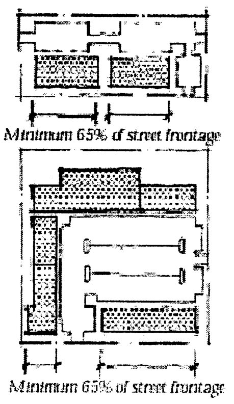
facades
(1)
Building frontages or architectural treatments should occupy no less than 65 percent of a block's street-facing frontage along Seminola Boulevard and secondary streets with a "Main Street" character. This calculation is based on the linear building frontage along the primary or secondary street divided by the linear street frontage of that same road.
(2)
Blank walls shall not exceed 20 linear feet for commercial/mixed use buildings or 40 lineal feet for school buildings without being interrupted by a window, entry, pilaster, lattice, change in building plane, or similar architectural element.
(3)
Building facades facing the street or housing the primary customer entry shall be designed to provide an interesting and pleasing appearance, with appropriate architectural details such as texture and color changes, arches, porticos, parapets, canopies, cornices, arcades, awnings, display windows, balconies, columns, clock towers and artwork.
(4)
Building facades shall not repeat more than two times per block face. Such facade repeats shall not occur on consecutive lots.
(5)
Architectural details such as cornices should be used and walls and rooflines should be designed to provide variations and visual relief. Vertically oriented windows should be used on upper floors as well.
(6)
All nonresidential buildings, other than schools, are required to provide an expression line that delineates the division between the first story and the second story. A cornice shall delineate the tops of the facades. The expression line and cornice shall either be moldings extending a minimum of two inches, or jogs in the surface plane of the building wall greater than two inches. Awnings shall not cover the expression line.
(7)
Each floor of any building facade, other than single-family residences, town homes or places of worship, facing a park, square, or street shall contain transparent windows covering from 15 percent to 70 percent of the wall area.
(8)
Retail storefront areas only: The ground floor along the building frontage shall have transparent storefront windows covering no less than 50 percent of the wall area to allow natural surveillance of the streets and clear views of merchandise. Storefronts facing roadways, parks and squares shall remain unshuttered at night and shall utilize transparent glazing material, and shall provide a view of interior spaces lit from within.
(9)
Buildings on sites that adjoin two or more streets shall be designed and constructed to ensure that the facades facing side streets shall have similar facade elevations facing primary streets to prevent blank, windowless walls or facades that are not in the same design theme.
(10)
Entry:
(a)
Village Center: The primary facade shall contain the primary entry; only secondary entrances may be provided in the secondary facade.
(b)
Neighborhood Business and Commercial Center: The primary entry may be located in either the primary or secondary facade; however, the secondary facade shall be provided with similar architectural elements as the primary facade.
(c)
Major building entries should be emphasized with distinct architectural treatments, a variety of building planes, materials and colors.
c.
Orientation.
(1)
Buildings should be oriented toward and near the street to allow short and direct pedestrian access. Building orientation should also encourage the design of public plazas.
(2)
Residential areas are the most pedestrian-oriented of all developments, and therefore should be oriented toward and near the street.
(3)
Buildings shall generally be built to the same front and side setbacks as adjacent buildings.
(4)
All dimensions of buildings and streetscape should be at a pedestrian and human scale.
d.
Structural Elements.
(1)
Walls: Variations in building materials are encouraged to help provide a visual break and to break up the visual mass of single large buildings.
Materials:
• Concrete masonry units with stucco
• Reinforced concrete with stucco
• "Hardie-Plank" siding
• Pre-cast concrete accents
• Wood (termite resistant): painted white, left natural or painted/stained with colors approved by the architectural review board.
• Stone (natural or veneer)
• Brick
(2)
Roofs: Roofs shall be designed to add visual interest, reduce massing and screen rooftop equipment.
(a)
Downspouts are to match gutters in material and finish.
(b)
Three-dimensional cornices, decorative parapets, overhanging eaves, multiple roof planes per facade and sloping roofs are to be used to achieve the design objectives.
(c)
Permitted types include: gabled, hipped, shed, barrel, vaulted and domed. Applied mansard roofs are not permitted. Low sloped roofs shall be permitted for schools in combination with other permitted types of roof. Building parapets and/or cornices should be designed to provide variation and visual relief. Variations in roof types are encouraged to break up the visual mass of single large buildings.
(d)
Materials:
• Metal (galvanized, copper, aluminum, zinc-alum); standing seam or "Five-Vee"; maximum 24-inch spacing
• Shingles (Asphalt or metal, "dimensional" type"), slate, cedar shakes
• Tile (clay, torra cotta, concrete); barrel, flat, french
• Gutters (copper, aluminum, galvanized steel)
• Roof and gutters
(Ord. No. 02-1071, § V, 12-9-02; Ord. No. 06-1204, § I, 9-25-06; Ord. No. 07-1228, §§ II—V, 11-13-07; Ord. No. 08-1233, § 1, 2-11-08; Ord. No. 12-1376, §§ 1—5, 7-23-12; Ord. No. 12-1376, §§ 1—5, 7-23-12; Ord. No. 15-1425, §§ 1—4, 6-8-15; Ord. No. 25-1625, § VI, 11-17-25)
Section 2-7.27. - Large retail establishments.
Large retail establishments shall be a permitted use within the CG, PMX-H, PMX-MID, and PMX-HIGH zoning districts. This use shall be supported for properties with a Commercial, High Intensity Non-Residential/Medium Density Residential, or Major Thoroughfare Mixed-Use future land use designation. Large retail establishments may offer ancillary uses, such as vehicular part sales and services and free-standing fuel sales. The location and design of these uses shall adhere to the following standards to alleviate negative effects to surrounding residential uses:
1.
The ancillary use must be affiliated with a Large retail establishment, as defined in the ULDRs. Further, vehicular part service is limited to tires and batteries services, if provided as ancillary to the Large retail establishment and in accordance with these requirements.
2.
Vehicular part sales and service areas shall be incorporated into the same structure as the retailer and must be screened from view from residential uses with an eight (8) foot high, 100% opaque, screen wall, where feasible, or through the use of intensive landscaping; be well-maintained; and not have product stored or displayed outside of the building. Large retail establishments may include a fueling area, which may be free-standing, and which must be screened with landscaping at 75% or greater in opacity to a height of at least four (4) feet at mature growth.
3.
The vehicular part sales and service areas must not emit noises, glare, dust, smoke, or fumes, in violation of Section 3-17.4, including glare from safety or security lights, into adjacent residential uses.
4.
Hours of operation for vehicular part sales and services areas are limited to 7:00 a.m. to 7:00 p.m. Monday through Friday and 9:00 a.m. to 7:00 p.m. Saturdays and Sundays.
5.
Vehicular part sales and service areas and fuel sales areas must be oriented away from residential uses and must be located at a minimum of 100-feet from the nearest adjacent residential building.
6.
In connection with fuel sales, outside public address systems or automated screens with speakers are not permitted within fuel pumps, and no speakers are permitted in the fueling area projecting announcements or music.
7.
A landscape plan adhering to the requirements in Article XIII, Landscaping, shall be provided and must include intensive landscaping along the perimeter of the property adjacent to residential uses with the equivalent to 120 plant units per 100 linear feet. Landscaping shall be irrigated and well-maintained in perpetuity.
Ord. No. 03-1078, § II, 2-10-03; Ord. No. 22-1575, § II, 11-14-22)
Sec. 2-7.28 - Industrial and Industrial-Medium district distance requirements.
No adult entertainment establishments/sexually oriented businesses may be established within 250 feet of any place of worship, park, or area zoned for residential uses. This separation requirement shall not apply when single family or multiple-family residential dwelling units, parks or places of worship establish or locate within 250 feet of an I or IM District property after October 1, 2018. For purposes of this Section, distance measurements shall be made in a straight line, without regard to intervening structures or objects, from the nearest property line of the property used as an adult entertainment establishment/sexually oriented business to the nearest property line of the property being used or zoned for a place of worship, park or for residential uses.
(Ord. No. 06-1200, § VI, 7-24-06; Ord. No. 15-1418, § VI, 4-13-15; Ord. No. 18-1488, § III, 8-27-18)
Section 2-7.29. - Check cashing/payday loan businesses.
(1)
Check cashing/payday loan businesses shall be permitted in General Commercial Zoning Districts (CG), except that no check cashing/payday loan business or its agents or facilitators shall be located within two miles of any other check cashing/payday loan business or within 2,500 feet of any residential zoning district, any retirement or assisted living facility for senior citizens, any day-labor employer or temporary employment agency, any traditional bank, credit union or trust company, any pawn shop, or any retail business that provides check cashing or loan services as an incidental part of its business.
(2)
This distance shall be measured, without regard to municipal boundaries, following the shortest route of ordinary pedestrian travel from the main entry of the check cashing/payday loan's establishment, continuing along the pedestrian walkway provided on the check cashing/payday loan's property to a public thoroughfare, and then continuing along the public thoroughfare to the nearest property line of the business or district set forth in Section 2-7.29 (1).
(3)
Variances to the distance requirements may be requested through an application submitted to the City Commission utilizing the procedures and criteria provided in ULDR Section 1-2.7.
(4)
Check cashing/payday loan businesses lawfully operating on August 11, 2008, shall be deemed legally nonconforming uses governed by Chapter II, Article VIII of the Unified Land Development Regulations.
(Ord. No. 08-1247, § 2, 8-11-08)
Section 2-7.30. - Non-traditional uses.
Non-traditional uses are a service or retail use that requires additional regulations to ensure that the business is in harmony with the goals and vision of the City. Non-traditional uses include, but are not limited to body art establishments, check cashing/payday loan businesses, and pawn shops. These uses are defined in Chapter V, Glossary.
A.
Regulations.
1.
Prior to issuance of a business tax receipt, the proposed non-traditional use must receive a conditional use approval from the Planning and Zoning Commission to operate at a specific location.
2.
Location.
a.
Criteria for the location of check cashing/payday loan businesses are provided in ULDR Section 2-7.29.
b.
The following location criteria apply to all other non-traditional uses:
1)
A non-traditional use shall not be located within a radius of 1,500 feet of another non-traditional use, including check cashing/payday loan establishments; nor shall such use be located within 300 feet of an educational institution, church, park, day care facility, or residentially zoned land. The method of measurement is the same as provided within ULDR Section 2-7.29(2).
2)
A non-traditional use may only be permitted in a planned, unified shopping center with a minimum of 10,000 square feet of gross leasable area.
3.
Only one non-traditional use may be permitted in any single shopping center. Check cashing and payday loan uses may operate together in one location.
4.
Design. A non-traditional use shall be housed in a building that complies with the following regulations:
a.
The building in which the use is located conforms to all current land development and building regulations.
b.
The building shall be painted in muted colors and finished in materials that are consistent and harmonious with the surrounding area and with the character of the City.
c.
There shall be no security bars on the outside of doors or windows which are visible from a public right-of-way.
d.
Exterior phones and roll up doors shall be prohibited.
e.
Windows shall not be obscured by the placement of signs, dark window tinting, shelving, racks or similar obstructions.
B.
Hours of Operation. Non-traditional uses shall only operate between the hours of 7:00 a.m. and 11:00 p.m.
C.
Maintenance. The building and site shall be maintained in a neat, clean, and orderly condition.
D.
Signs. All signs shall be legally permitted in accordance with ULDR Article XVI.
(Ord. No. 10-1313, § 2, 3-8-10)
Section 2-7.31. - Eminent domain waivers, exceptions and variances.
(A)
Findings of fact. The City Commission hereby finds that the acquiring of private property by various governmental or public agency entities, so authorized by law through the eminent domain process, through trial, or negotiations prior thereto, is an extremely costly and burdensome process. Allowing the appropriate City Administrative Official, pursuant to established guidelines, procedures and criteria, to grant waivers and exceptions from certain City land development codes or regulations, or to apply for variances on behalf of affected property owners serves a valid public purpose and promotes the general safety and welfare of the citizens and land owners of the City.
(B)
Intent. It is the intent of this article to establish fair procedures by which the appropriate City staff can grant waivers and exceptions to City land development, sign and engineering codes and regulations, where appropriate, or to seek such waivers or variances before the appropriate boards, in order that property owners who have been subjected to the condemnation process have a viable and fair alternative in preventing any adverse impact upon their property as a result of the condemnation process and allow the continued use of their property in a manner similar to its pre-condemnation condition. Further, it is the intent of this section to establish procedures which will reduce the cost of acquisitions of real property needed for public improvements.
(C)
Authority of department directors. The Administrative Official or designee(s), shall have the authority to grant waivers or exceptions, or to seek variances on behalf of owners of property from applicable codes, ordinances, regulations, or resolutions. The Administrative Official or designee shall provide a copy of the determination letter to the City Attorney's office if the property is in a condemnation lawsuit, or in pre-suit negotiations, stating that the waiver or exception does not adversely affect the public health, safety or welfare.
(D)
Application for waivers, exceptions and variances.
(1)
The condemning authority, or the landowner, may apply in writing to the Administrative Official or designee for a determination that the granting of the waiver or exception will not result in a condition which adversely affects the health, safety or welfare of the general public.
(2)
The Administrative Official or designee shall, within 30 days of receipt of the application, issue a signed letter to all parties granting or denying the waiver or exception.
(3)
If the waiver or exception is denied by the Administrative Official or designee, the owner or condemning authority may apply for, at no cost to the owner, a variance before the appropriate board.
(E)
Waivers, exceptions and variances. If, as a result of a governmental taking, either by negotiation or condemnation, existing lots, parcels, structures, or uses of land become nonconforming with the provisions of the City code, the following provisions shall apply:
(1)
Existing characteristics of use which become nonconforming or increase in nonconformity as a result of a taking, including but not limited to, minimum lot size, setbacks, open space, off-street parking, landscape requirements, drainage and retention shall be required to meet code requirements to the greatest extent possible, to the satisfaction of the Administrative Official or designee. Thereafter, the existing characteristic of use shall be deemed conforming only to the extent of those nonconformities caused by the governmental or public agency's acquisition. Waivers, exceptions or variances shall:
a.
Provide at least 70 percent of the required parking.
b.
Maintain at least 50 percent of the required front yard.
c.
Provide, at the minimum, a five-foot street front landscape strip. The landscape material provided shall be appropriate for the planting area and the overall site.
d.
Maintain the existing on-site drainage and retention and strive to meet the minimum requirements of the St. Johns River Water Management District.
Any further expansion or enlargement thereof shall be in accordance with all applicable code requirements.
(2)
Existing characteristics of use which become nonconforming or increase in nonconformity as a result of a taking, including but not limited to, minimum lot size, setbacks, open space, off-street parking, landscape requirements, drainage and retention shall be required to meet code requirements to the greatest extent possible, to the satisfaction of the Administrative Official or designee. Thereafter, the existing characteristics of use shall be deemed conforming only to the extent of those nonconformities caused by the governmental or public agency's acquisition. Waivers, exceptions or variances shall not exceed a 30 percent reduction of the required parking standard, 50 percent reduction in the required front yard, elimination of the street front landscape strips, or reduction in drainage and retention that does not meet the minimum requirements of the St. Johns River Water Management District. Any further expansion or enlargement thereof shall be in accordance with all applicable code requirements.
(3)
In granting any waiver or exception to code requirements, the Administrative Official or designee shall, in conjunction with the appropriate experts, determine that the requested waiver or exception:
a.
Will not adversely affect visual, safety, aesthetic or environmental concerns of neighborhood properties.
b.
Will not adversely affect the safety or pedestrians or operations of motor vehicles.
c.
Will preserve code-required off-street parking requirements to the greatest extent practicable. The reconfiguration, reduction, or removal of landscape and/or open space requirement may be considered to preserve off-street parking.
(4)
If any legally existing structures (principal or accessory), or vehicular use area must be relocated as a direct result of the governmental taking, or as a result of safety concerns, if allowed to remain after the taking, then the Administrative Official, or designee, the Building Official and Fire Marshal may allow the relocation of the structure on the remaining property, so as to comply with all applicable regulations to the greatest extent practicable, as determined by the Administrative Official or designee. If the relocation results in substandard characteristics of use, it shall be deemed thereafter to be conforming but only to the extent of those non-conformities caused by the governmental or public agency's acquisition. Any future expansion or enlargement thereof shall be in accordance with all applicable code requirements.
(5)
Legally existing structures (principal or accessory) or vehicular use areas which become nonconforming or increase in nonconformity according to subsection (1), which are thereafter damaged or destroyed, other than by voluntary demolition, to an extent of more than 50 percent of the property appraiser's assessed valuation at the time of destruction can be restored, but only to predestruction condition in accordance with the Florida Fire Prevention and Florida Building Code. Any expansion or enlargement that does not increase the nonconformity of a characteristic of use shall be permitted in accordance with all applicable code requirements. Where expansion or enlargement increases the nonconformity of a characteristic of use, relief from appropriate City board(s) is necessary. This Subsection does not apply to signs, which are addressed in Subparagraph (F).
(6)
If the structure to be relocated harbors a nonconforming use, the Administrative Official may permit the relocation pursuant to this section, if the Administrative Official or designee determines that public harm will not result.
(7)
Where part of a principal structure is taken, the reconstruction of the taken structure (same size and use) may be permitted. The reconstruction must meet city codes to the greatest extent possible, to the satisfaction of the Administrative Official or designee. The reconstructed structure must meet the requirements of the Florida Building Code and Florida Fire Prevention Code as determined by the Building Official and Fire Marshal. The reconstructed structure shall thereafter be deemed conforming as to those nonconformities caused by the governmental or public agency's acquisition.
(8)
Any alterations, repairs or rehabilitation work necessitated by a governmental or public agency acquisition or condemnation of real property may be made to any existing structure, building, electrical, gas, mechanical or plumbing system provided that the alteration, repair or rehabilitation work conforms to the requirements of the Florida Building Code and Florida Fire Prevention Code. The Building Official and Fire Marshal shall determine the extent to which the existing system shall be made to conform to the requirements of the technical codes for new construction.
(F)
Signs. A sign which is located on a parcel that is subject to condemnation action by a governmental or public agency may be allowed to be relocated on the remaining portion of the parcel in accordance with the following:
(1)
Conforming signs.
a.
The sign is to be relocated on the remaining parcel in such a manner as to meet the setback and distance separation requirements. If setback and distance separation requirements cannot be met due to the size and/or configuration of the remaining parcel, then, subject to the Administrative Official's discretion, the sign may be relocated so as to comply with such regulations to the greatest extent practicable as determined by the Administrative Official. Regardless of the sign location, all sight visibility requirements shall be met.
(2)
Nonconforming signs, including billboards.
a.
Any existing nonconformity of a sign, other than setback or distance separation, shall not be increased upon relocation. A nonconforming sign may not be structurally altered or enhanced upon relocation.
b.
If the sign to be relocated is a nonconforming sign, upon proof submitted by the applicant and subject to the determination by the Planning and Zoning Commission that public harm would not occur, then such sign may be relocated pursuant to this subsection, notwithstanding the provisions of Subsection 3-16.9(b) of the City sign ordinance.
(G)
Authority for staff to testify at judicial proceedings on the likelihood of variances.
(1)
The Administrative Official, or his designee, is hereby authorized to testify in judicial proceedings as to the likelihood of whether a variance from City codes or regulations would or would not be granted or the reasons the Administrative Official has or has not granted the waiver or exception.
(2)
In testifying, the Administrative Official or his designee is specifically authorized to employ the following criteria:
a.
History of similar variances, waivers or exceptions being granted or denied by the appropriate boards in and for the City of Casselberry.
b.
Analysis of why the variance, waiver or exception would or would not adversely affect surrounding property owners.
c.
Analysis of the hardship imposed by the condemnation action initiated by the governmental or public agency.
d.
Analysis of any and all other criteria normally considered by the appropriate boards or departments in granting or denying similar variances, waivers or exceptions and how those criteria relate to the subject and neighboring properties.
e.
That the granting of a variance, waiver or exception would or would not adversely affect the public health, safety or welfare.
(H)
Code violations threatening public health, safety and welfare.
(1)
The provisions of this section shall not be interpreted to allow for the continued existence of building or other safety code violations that are determined to be an immediate threat to the public health, safety or welfare.
(2)
The appropriate building, fire, code enforcement officials and inspectors are hereby authorized to take any and all necessary steps to enforce all applicable development, land use, building and safety codes even though the subject property is part of a condemnation action or other government acquisition of property.
(I)
Administrative Official's determination. Many of the determinations made by the Administrative Official, or designee, are subjective in nature; however, those determinations are provided based on the community's history and goals and by utilizing best practice methods. Those determinations are provided in the best interest of the community and the Administrative Official incurs no personal liability as a result of discharging his/her duties in making said determinations.
(J)
The granting of a variance, waiver or exception under this Ordinance shall not be considered a non-monetary benefit to the property owner.
(K)
Nothing herein shall cause the City to be liable for damages, expenses or losses for any action taken by the City pursuant to this Ordinance.
(L)
The provisions of this Ordinance shall not be interpreted to grant or allow a vested right in any particular building, development or property that is subject to or affected by the governmental or public agency's acquisition.
(Ord. No. 08-1250, § 1, 11-10-08; Ord. No. 12-1369, § 8, 2-13-12)
Section 2-7.32. - Lake Concord Overlay District Standards.
A.
Purpose and intent. The Lake Concord Overlay District (LCOD) is established to create a sustainable and economically viable mixed use community with high standards of building and structure design that provides a unique activity center that incorporates guiding principles adopted by the City Commission on May 14, 2012. The guidelines include:
1.
Creating a distinct district which caters to uses which can benefit and enhance the park setting and maximize daytime and evening use by the public.
2.
Encouraging the integration of public and private space through design, urban form and features such as landscaping and streetscaping.
3.
Providing harmony between buildings and land uses by utilizing materials and articulation to create visually desirable buildings and locating and orientating buildings to complement and enhance the environment.
4.
Building upon the unique identity at Lake Concord Park by incorporating the design elements and creating space which will allow the City to expand its events and activities.
5.
Creating pedestrian areas for public use and enjoyment that provide interesting experiences and features.
B.
Applicability. The LCOD Standards shall apply to all structures and spaces within the overlay district. The overlay district is located along US Highway 17-92 at Triplet Lake Drive. The boundary of the district is hereby attached to [Ordinance No. 14-1414] as Exhibit A and by this reference made a part hereof. Each application for new construction or major renovation, as defined in the City of Casselberry Code of Ordinances, or any development undergoing a change of use or increase of intensity review, shall comply with all applicable overlay district and underlying zoning district standards. The subdistricts are as follows:
1.
North District (Including land north of Triplet Lake Drive).
2.
South District (Including land south of Triplet Lake Drive).
3.
West District (Outparcel west of US Highway 17-92).
The boundaries of the sub districts are hereby attached to [Ordinance No. 14-1414] as Exhibit B and by this reference made a part hereof.
C.
Conformity. The overlay district has a future land use designation of Major Thoroughfare Mixed Use (MTMU) and is within the PMX-MID (Planned Mixed Use—Mid Rise) zoning district. MTMU and PMX-MID allow for and encourage mixed or multiple-use development patterns that can be designed to be served by public transportation and to be walkable. All new and redeveloped property shall conform to:
1.
Lake Concord Overlay District (LCOD) standards;
2.
The City of Casselberry Unified Land Development Regulations (ULDR) (Including mandatory standards within the Community Redevelopment District (CRD) Urban Design Standards. Mandatory standards are provided in Table C1, C2 and C3 of the CRD standards); and
3.
The City of Casselberry Comprehensive Plan.
Where conflicts arise between the ULDR and the LCOD standards, the LCOD standards shall prevail.
D.
Permitted, conditional and prohibited land uses.Section 2-5.3, Land use by district, and table C3, Community Redevelopment District Uses of the Community Redevelopment District Design standards provide the general requirements for this overlay district. The exceptions to this are provided as follows:
1.
Permitted uses:
a.
Two-family dwelling (carriage homes with interior access) [1].
b.
Parks and recreation—Passive.
c.
Hotels/motels/transient—Interior access.
d.
Retail (less than 18,000 square feet).
e.
Restaurants that include drive-thru (only within the West district [2].
2.
Conditional uses:
a.
Water related structures (Docks).
b.
Day care facilities.
c.
Parks and recreation, active.
d.
Limited commercial.
e.
Medical services.
f.
Parking garage.
3.
Prohibited uses:
a.
Hotels/motels—exterior access.
b.
Large scale retail (18,000 square feet or more).
c.
Restaurants that include drive-thru (except for the West District [3]).
d.
Enclosed amusements.
E.
Urban realm.
1.
Streetscape elements such as hardscape and street furniture shall be of a similar style and design throughout the urban realm and are hereby attached to [Ordinance No. 14-1414] as Exhibit E and by this reference made a part hereof.
2.
Areas that create animated and attractive spaces are encouraged within the urban realm. This includes decorative plazas, fountains, pocket parks, public art, landscaped strips, and pedestrian amenities.
3.
Soft and natural features such as plantings, low walls, or decorative low fencing, should be used to create some distinction between the public space and private residential and commercial spaces.
4.
Public urban realm. The standards for the public urban realm apply to all publicly owned land including public park land and other public property, the privately owned street frontage along US Hwy 17-92 and the public easements provided through the privately owned portions of the Lake Concord District to provide pedestrian connectivity.
a.
US Highway 17-92. A comfortable safe sidewalk shall be provided along US Highway 17-92 which provides a landscape buffer between the sidewalk and the road and the sidewalk and the overlay district parcels/properties. A 20-foot wide area shall be provided, with the City retaining title to the property or obtaining an easement. The boardwalk area shall be exempt from this requirement. An exception may be made where the pedestrian area impacts upon wetland, flood plain or other conservation area. Approval will be required from the Florida Department of Transport (FDOT) and other relevant government agencies.
b.
Gateway. Artistic gateway features shall be created at the eastern entrance to the LCOD at the corner of Triplet Lake Drive and US Highway 17-92. The design intent for each of these gateway features is to establish a distinctive design character for the City of Casselberry and to create an attractive memorable gateway that defines the overlay district and also the residential neighborhoods beyond.
c.
Events. The public park land within the LCOD shall be known as Lake Concord Park. Lake Concord Park is a designated special use park and is not regulated by Chapter 14, Division 2, Special Events. The City's Parks and Recreation Division schedules and regulates activities that occur within the City's special use parks.
5.
Private urban realm. The standards for the private urban realm shall apply to all privately owned portions of the Lake Concord District.
a.
To create an attractive pond edge and to provide an environmental benefit to the wetland area, the southernmost pond on the residential parcel shall be vegetated along the shoreline with a minimum of 50 percent of native species. The plantings shall be spaced a maximum of 30 inches apart with at least three rows of emergent species and three rows of appropriate upland species. Distribution of plantings may be spatially adjusted subject to site geometry of the pond.
b.
Physical boundaries (hedges, or landscaped walls or fences) surrounding commercial buildings shall be no higher than three feet.
c.
A hedge may be provided up to six feet in height to separate the public and private residential areas providing that vehicular sight visibility obstructions are not created.
d.
Restaurants and eateries will be encouraged to provide designated outdoor eating areas which are dog friendly.
F.
Size and dimension regulations.
1.
Setbacks. Differing land uses and/or the height and mass of a building can create impacts upon neighboring properties and/or buildings. Effort shall be made to minimize these impacts through the use of setbacks. A suitable distance shall be provided between properties or buildings within the overlay district and outside of the overlay district, to provide safety, light, and air circulation and enhancement of privacy. The following minimum setbacks shall be required:
a.
Adjoining parcel—The minimum setback from the property line is nine feet.
b.
Adjacent to right-of-way.
i.
US Highway 17-92—20 feet (This may include land from the back of curb of the roadway where a pedestrian area is provided as defined in Subsection E, "Urban Realm.")
ii.
Other roadways—Seven and one-half feet.
iii.
A greater setback may be required on the corner of rights-of-way to ensure that the site visibility requirements are met. Requirements shall meet either the City Code requirements (Article VI, Sight distance and roadside hazards and Section 82-182—Obstructions to sight distance at intersections) or FDOT standards.
c.
Between buildings—Setbacks shall be based upon the required fire separation of ten feet. For buildings in excess of 35 feet in height, an additional 15-foot separation between buildings shall be required for each additional ten feet in height.
2.
Floor area ratio (FAR)—1.0.
3.
Maximum height of buildings—Six stories.
4.
Minimum first floor ceiling height.
a.
12 feet—Commercial.
b.
Nine feet—Residential.
5.
Pervious Surface Area [4]—20 percent minimum.
6.
Impervious Surface Area [5]—80 percent maximum.
7.
Dwelling units per acre [6]—25.
8.
Right-of-way—Minimum 50-foot width.
9.
Minimum dwelling unit size.
a.
One bedroom—485 square feet.
b.
Two bedroom—1,055 square feet.
c.
Three Bedroom—1,230 square feet.
G.
Connectivity.
1.
Vehicle access.
a.
A pick up and drop off point shall be designated by the developer in the commercial parcel to allow for deliveries and access by the City and vendors for City park events.
b.
Access and loading areas will be provided in the commercial parcel for public park land maintenance and city events.
c.
Access for delivery or waste collection shall be provided to the commercial areas through the commercial parking lot area.
2.
Pedestrian Access.
a.
Pedestrian access and circulation shall be provided throughout the LCOD and to neighboring parcels (Golf course, Masonic Lodge, Church property, North District to Boardwalk) and roadways. These sidewalks shall be positioned to provide the pedestrian the most direct and convenient route to their destination.
b.
Public access easements on private property. Public access easements shall be dedicated on private property throughout the LCOD to provide pedestrian connections to the public park land from the roadway and neighboring sites.
a.
Width. The public access easement shall be a minimum of eight feet.
b.
Design. The design of the sidewalk shall be consistent with the standards shown in Exhibit E, Streetscape materials [and by this reference made a part hereof].
c.
Landscaping. Where the public access easement adjoins an open space within the private development, trees, landscaping, streetscape materials, and form used by the private developer shall be similar to landscaping within the public park land.
d.
Location. The approximate locations for these easements are hereby attached to [Ordinance No. 14-1414] as Exhibit C and by this reference made a part hereof.
c.
Sidewalk.
i.
Width. The minimum width of the sidewalks throughout the public park land and public realm shall be eight feet. A minimum five-foot wide encroachment-free sidewalk shall be provided in the private commercial and residential properties.
ii.
Parking areas. Pedestrian connections through parking areas shall be clearly identifiable to pedestrians and motorists. This shall be achieved through a change in color, differing material or a grade change from the parking area. The locations of the connections shall be determined at the site plan approval stage.
iii.
Adjacent roadways. Where possible a three-foot wide landscape strip shall be provided between the sidewalk and back of curb.
3.
Bicycle access and storage. Non-automotive transportation such as bicycles shall be accommodated at convenient locations within the LCOD.
H.
Appearance and compatibility. General. Corporate brands and design shall adhere to standards in this section. The building may retain elements of its corporate image within the architectural style but will need to satisfy the following requirements:
1.
Architectural features.
a.
All building facades shall appear as frontages. Building facades shall be designed to maximize use of fenestration and articulation and to avoid large, flat, uninteresting surfaces.
b.
Doors, windows, and other architectural features shall be used to break large wall planes into smaller components. Blank walls shall not exceed 20 linear feet without being interrupted by a window, entry, pilaster, lattice, change in building plane, or similar architectural element.
c.
Features shall be encouraged on corners of the buildings such as a rise in height of the roof line, clock feature or other distinctive feature. This shall be encouraged particularly where the building is at the end of a key vista.
d.
An expression line that delineates the division between the first story and the second story shall be required for all properties above one story. A variation of the location of the expression line may be provided where additional stories are added. A cornice shall delineate the tops of the facades. Awnings shall not cover the expression line.
e.
Each floor of any building facade, other than carriage homes or places of worship, facing public park land shall contain transparent windows covering from 15 percent to 70 percent of the wall area.
f.
Roof types. Variations in roof types are encouraged to break up the visual mass of single large buildings.
i.
Roofs shall be designed to add visual interest, reduce massing and screen rooftop equipment.
ii.
Downspouts are to match gutters in material and finish.
iii.
Three-dimensional cornices, decorative parapets, overhanging eaves, multiple roof planes per facade and sloping roofs are to be used to achieve the design objectives.
iv.
Permitted roofs include: gabled, hipped, shed, barrel, vaulted, flat or domed.
v.
Building parapets or cornices should be included to provide variation and visual relief.
g.
Roof materials.
i.
Metal (galvanized, copper, aluminum, zinc-alum); standing seam or "Five-Vee"; maximum 24-inch spacing.
ii.
Shingles (Asphalt or metal - "dimensional" type), slate, cedar shakes.
iii.
Tile (clay, terra cotta, concrete); barrel, flat, french.
iv.
Gutters (copper, aluminum, galvanized steel).
v.
Decorative metal railings.
h.
Screen enclosures. Where screening is used to enclose windows or balcony space on residential buildings it shall be provided similarly for all units on the entire floor. Screening shall not be provided sporadically.
i.
Rain gutters shall be positioned so as not to detract from the design of the building. Where used they shall be incorporated into the design of the building to match accent colors or the colors of the building.
2.
Color. Building colors shall be the same as, or substantially similar to, the color palette defined as the Benjamin Moore Historical Color Collection (HC-1 through HC-174), or other colors deemed appropriate by City staff. Luminous, brightly colored or neon colored structures are prohibited.
3.
Exterior materials. All exterior materials and colors shall be appropriate and compatible with one another. The following materials and other similar materials may be used:
a.
HardiePlank® siding.
b.
Brick.
c.
Pre-cast concrete accents.
d.
Stone (natural or veneer).
e.
Wood (termite resistant): Stained, sealed, or painted.
f.
Wrought iron, aluminum (vertical, ½" min. Dimension, 4" to 6" spacing).
g.
Steel frame.
h.
Stucco: With banding or with hand struck joints.
i.
Decorative metal panels.
j.
Simulated stone.
k.
Glass.
4.
Residential standards.
a.
No accessory structures can be added or building alterations made to the carriage home units.
b.
There shall be no outdoor storage within any of the patios or balconies of the residential units except for patio furniture.
c.
Balconies. Where balconies are provided on buildings with less than a 20-foot setback from a roadway they shall be interior balconies.
d.
Balconies within residential dwellings or commercial properties shall be kept free of clutter. No items shall be stored over the railings. The only items to be maintained within the balcony area are outdoor table and chairs.
5.
Retail storefront areas.
a.
The ground floor building frontage shall have transparent storefront windows covering no less than 50 percent of the wall area to allow natural surveillance of the streets and clear views of merchandise.
b.
Storefronts facing a roadway, park, square or pedestrian trail shall remain unshuttered at night and shall utilize transparent glazing material that provides a view of interior spaces lit from within.
6.
Restaurant outdoor dining.
a.
Restaurants are required to provide an outdoor dining area which faces towards the public park land and or water body. This area shall account for a minimum of 30 percent of the restaurants' eating areas. (North and South district only).
b.
Outdoor heaters, amplified music or speakers shall be reviewed at the time of application.
c.
Views to the public park land shall be open with a maximum three-foot high fence, wall or hedge between the patio and public space. Landscaping/buffering shall be incorporated into the outdoor dining area, which may consist of container plants, permanent landscape areas, garden walls, temporary fencing or other satisfactory measures to delineate the area devoted to outdoor dining, subject to planning division approval.
d.
A pedestrian connection shall be provided from the restaurant to the public park land.
e.
Conservatory style areas may be provided as an alternative to the outdoor dining area providing that a significant portion of the conservatory dining area provides clear views to the public park land or water body and provides windows that cover at least 70 percent of the portion of the property facing the park area.
I.
Parking standards.
1.
Minimum parking space dimension:
a.
Surface area parking—Nine feet by 18 feet.
b.
Garage/under-roof—Ten feet by 20 feet.
2.
Minimum parking ratio:
a.
Residential—1.75 parking spaces per residential unit.
b.
Restaurant—One space for each 100 square feet of building area.
c.
Retail/service/commercial—Three spaces for each 1,000 square feet of floor space.
d.
Hotels/motels—One space for each sleeping unit, plus one for each 400 square feet of public meeting area and restaurant space.
3.
Each 12 parking stalls must be separated by a parallel landscaped area with a minimum dimension of nine feet.
4.
Natural materials are encouraged such as crushed granite, grass permeable pavers, or asphaltic concrete pavers to promote the park environment.
5.
Division of parking spaces. Painted stripes shall not be used for the division of parking spaces. Division of parking spaces may be created using a small indication at the entrance area, a change in color of spaces or a change in material. An exception to this may be made within the residential portion of the South District where parking is not visible from the public park land. In this scenario, landscape screening may be used and painted stripes shall be permitted.
6.
Designated parking spaces. If parking spaces are designated for a particular building or use, those spaces shall be identified either using the wheel stop or a form of paved numbering/lettering. Spray painted numbers and/or individual signs shall not be allowed. Other design ideas may be used where approved by the City. Required disability parking is an exception.
7.
A minimum of 50 parking spaces shall be provided immediately adjacent to the public park land area within the South District Commercial parcel. These parking spaces shall be constructed from natural materials similar to the natural materials as provided in subsection 4. this section.
8.
Garages.
a.
Garages are to be used for parking. Minimal storage is allowed but the primary use of the garage is for vehicular parking.
b.
Garages shall be designed in keeping with the site using similar material and decorative designs as used on the residential buildings.
J.
Landscaping, streetscape, and lighting.
1.
General.
a.
Preferred landscaping material is hereby attached to [Ordinance No. 14-1414] as Exhibit D, and by this reference made a part hereof. Additional types of landscaping may be used and will be reviewed during the site plan approval stage.
b.
All portions of each site that are not devoted to building or paving shall be landscaped.
c.
Landscaping shall be provided around monument signs.
d.
Landscaping shall be provided to minimize the impacts on adjacent properties.
2.
Landscaping requirement. Landscaping shall be provided as required within Article XIII "Landscaping", of the ULDR, and shall be provided adjacent to all buildings. An exception to this may be made for the following:
a.
Landscape strips along the right-of-way. Where the City of Casselberry has provided landscaping along the public right-of-way.
b.
Perimeter landscaping. Where public park land is adjacent to private properties within the LCOD.
c.
Parking areas. Where landscaping is better provided in a congregated location to serve the public interest. Options for alternative design may be provided.
d.
Screening. Bufferyards are required to create a suitable distance and screening only between land uses or buildings within the LCOD and properties outside of the LCOD where the land uses are different or the height and mass of the buildings are different. A certain width of landscaped area is required along with specifications for the amount of landscaping to provide suitable screening. Bufferyard distances are provided within the Unified Land Development Regulations and the following exception to this is where a right-of-way exists between different land uses or heights of building. The full width of the buffer and the landscape requirement as required within Article XIII 'Landscaping' shall still be required. Sufficient space for landscaping shall be provided and may include a minimum six-foot wide landscape median within the right-of-way. Landscaping provided within the median may be credited towards the bufferyard requirement.
3.
Trees. Trees shall be provided at a minimum of four-inch caliper throughout the LCOD except for understory trees which shall be provided at a minimum three-inch caliper.
a.
There shall be at least three different species of trees within the LCOD.
b.
Trees may be clustered where appropriate to the species.
c.
Trees shall be provided:
(a)
Within parking landscape islands;
(b)
Along pedestrian walkways and within pedestrian areas;
(c)
Within areas where people convene or rest; and
(d)
Along street frontages.
4.
A waiver determination may be made by the City's Administrative Official, providing that the reduction in landscaping or location of landscaping does not affect the:
a.
Protection of trees;
b.
Aesthetics of the site;
c.
Provision of an appropriate separation between buildings and land uses;
d.
Screening of land uses or buildings;
e.
Provision of shade within parking areas; or
f.
Surface water drainage.
5.
Streetscape.
a.
Benches shall be installed at regular intervals in locations where pedestrians are likely to gather.
b.
Trash Receptacles shall be installed near seating areas and right-of-way areas near busy intersections.
c.
Streetscape material shall be of a similar design to those provided in Exhibit E [and by this reference made a part hereof].
6.
Lighting.
a.
The average illumination levels shall conform to the luminance levels provided in ULDR Section 3-10.2(6).
b.
Exhibit E "Streetscaping Materials" provides preferred street furniture.
c.
Light fixtures shall be aimed away from residentially zoned properties and shall be of an intensity that does not create a negative impact on the adjacent residential properties.
d.
Up-lighting is desired throughout the public park land and within the private development open space to enhance key artistic features within the LCOD.
K.
Signage.
1.
General standards.
a.
All signs within the overlay district shall be of a high standard of design, architectural quality, attractive, and be durable and well built.
b.
Franchise logos and corporate colors are exempt from the requirements of the Benjamin Moore Historical Palette. These logos and colors are permitted and shall be calculated as part of the overall signage allowed for a site or individual business.
c.
Signage within the site shall be located to minimize the appearance of clutter.
d.
Spray painted and handwritten signage is prohibited.
2.
Commercial signs.
a.
Ground signs.
a.
All ground signs shall be monument signs.
b.
The maximum height of each sign shall not exceed ten-foot.
c.
A distance of 200 feet is required between each monument sign. Distance is measured along the roadway frontage.
d.
The sign base shall not exceed 80 percent of the width of the sign body.
e.
The sign base material shall be similar throughout the LCOD as provided within Exhibit E [and by this reference made a part hereof].
b.
Façade signs.
a.
The scale and proportions of a sign shall be harmonious with the architecture and fit with the scale of the individual building on which it resides without dominating the facade.
b.
The signs shall be flush mounted to the facade and located in the sign band above the transom, if one exists, or between the transom (or storefront windows) and second floor window sill (or between the transom and eaves on a single story building).
c.
Signs shall not cover windows, or roof shapes or dominate trim.
c.
Pedestrian ground sign. A commercial ground sign used to inform pedestrians using the public park land of the name of a commercial establishment.
a.
A pedestrian ground sign will be required on the boundary of any commercial property abutting the public park land and shall be visible to pedestrians using the park.
b.
The ground sign shall be allowed in addition to the permitted sign copy area.
c.
The ground sign shall be no more than two square feet in size and not exceed a height of two and one-half feet.
d.
A corporate logo will be permitted on the pedestrian ground sign.
d.
Commercial directional signage. Signs used to direct and inform vehicles or pedestrians of exits, entrances, driveways or off-street parking areas.
a.
All commercial directional signage shall be of the same design, color and font and shall be a similar design and color to the street furniture as provided in Exhibit E "Streetscape material" [and by this reference made a part hereof]. Each premises may have a maximum of one directional sign except premises with two roadway frontages who may have two directional signs.
b.
The signs shall not exceed two square feet.
c.
The maximum height of a directional sign is four feet above the crown of the road.
d.
Directional signage shall not include any commercial logos or advertisement.
e.
Sign lighting. At no time shall the light from a sign be directed towards a residence.
f.
Wayfinding signage. Wayfinding signage shall be provided to create a way to navigate to, through and from the district, to key places of interest within the district and to nearby places of interest.
a.
The signs shall be congregated on a way finding post and shall match the color and be of a similar design of the street furniture provided in Exhibit E "Streetscape material" [and by this reference made a part hereof].
b.
Private property owners shall grant sign easements within the commercial properties for wayfinding signage in appropriate locations as required by the City.
c.
Way finding signs shall not provide commercial signage.
L.
Equipment.
1.
Utilities, including franchised utilities, power and light, telephone, water, sewer, cable television, wiring to street lights and gas, shall be installed underground. (ULDR Section 4-19.2 X., Utilities).
2.
Equipment such as utility boxes and machinery, including but not limited to: backflow devices, transformers, commercial electric meters, air conditioning units, antennas, irrigation and pool pumps, etc., related to any structure, shall not be visible from the right-of-way or the public park land.
3.
All such equipment shall be appropriately screened using natural features such as landscaping or other features which are in keeping with and appropriate to the immediate vicinity of the site and the surrounding area.
4.
Permanent barbecues shall only be permitted where located within a shared amenity area within a multi-family project. Mechanical equipment located on the roof shall be fully screened from view. Where Solar Panels are in view they shall be sensitively incorporated into the design of the building.
5.
Noise creating features such as air conditioning units or sound systems shall be located so as to not create a disturbance to residential properties.
6.
Prohibited equipment. The following is prohibited to protect overall design, aesthetics, and value of the properties within the overlay district:
i.
Backlit awnings.
ii.
Plastic or PVC roof tiles.
iii.
Reflective or bronze-tint glass.
iv.
Satellite dishes and antennas with diameter greater than one meter in residential areas and two meters in commercial areas, except as mandated by federal law.
v.
Rooftop antennas and rooftop satellite dishes, except as mandated by federal law.
vi.
Fences made of chain link, barbed wire, or plain wire mesh are prohibited. Fences made of black vinyl chain link may be permitted along the Eastern boundary of the South District where:
(a)
It is not possible to provide other opaque screening due to environmental and/or land constraints; and
(b)
Vegetation is planted alongside the fence which will provide 100 percent opacity within 18 months of being planted. If opacity is not achieved within this period, an alternative measure of screening, as determined by the City Administrative Official, will be required.
M.
Operations.
1.
Delivery/trash collection.
a.
Delivery of goods shall be scheduled between 7:00 a.m.—11:00 p.m., Monday—Saturday in accordance with Section 58-56 of the City Code. All commercial properties will be required to work with the City to ensure that deliveries do not interfere with planned events within the public park area.
b.
Loading areas, service areas and trash disposal facilities shall be screened from view of streets, parks, squares or significant pedestrian spaces, by walls, fencing and/or landscaping which provide 100 percent opacity. The trash receptacle shall be screened by a decorative wall that is designed to appear as part of the building.
2.
Water bodies. There shall be no motorized vehicles on water bodies except service craft.
N.
Conservation and energy efficiency.
1.
Conservation. It is important to preserve wetland areas to protect plants, animal species and ecological services such as feeding downstream waters, trapping floodwaters, recharging groundwater supplies, removing pollution and providing fish and wildlife habitat. Development around wetlands shall adhere to St Johns River Water Management District requirements and additional standards required by the City.
2.
Energy efficiency. The goal is to create development that becomes a benchmark for "green living" and makes it easy for people to live in an environmentally friendly way through using the highest standards of design (including energy efficiency/renewable energy, sustainable construction methods and green technologies). This will maximize environmental performance and community safety and encourage healthy lifestyles. At a minimum all new buildings will be required to meet National Association of Home Builders (NAHB) standards.
(Ord. No. 14-1414, § II, 1-26-15)
This use shall be permitted where the use is in association with a multiple-family dwelling. Two-family dwellings shall not form more than ten percent of the overall dwelling units of the development.
--- (2) ---
As provided in Exhibit B to this ordinance [Ordinance No. 14-1414].
--- (3) ---
As provided in Exhibit B to this ordinance [Ordinance No. 14-1414].
--- (4) ---
The calculation for pervious/impervious surface area shall be determined for each sub district prior to site plan approval. Area within the public park land may be used by public and private land owners towards their pervious/impervious requirement of the land uses within each sub district. Each parcel is attributed their proportional share of the public park land depending on the size of the parcel. Public park land attributed to one parcel or land use may not be transferred or used for another developments open space or pervious calculations.
--- (5) ---
The stormwater retention areas are considered as pervious for the impervious surface area calculation of a site.
--- (6) ---
The residential parcel may utilize the public park land within the South district to meet density requirements for development.
Section 2-7.33. - Assisted living facilities.
A.
Minimum living space. Minimum square footage of indoor living space shall be provided as follows:
1.
Independent living units:
i.
Studio—350 square feet minimum.
ii.
1 Bedroom—525 square feet minimum.
iii.
2 bedroom—750 square feet minimum.
2.
Residential suites:
i.
Studio—300 square feet minimum.
ii.
1 Bedroom—400 square feet minimum.
iii.
2 Bedroom—600 square feet minimum.
B.
Minimum common area. Minimum square footage of common area for assisted living facilities shall be 50 square feet per bed.
C.
Density calculation. For purposes of determining the maximum number of assisted living facility units in relation to the comprehensive plan future land use classification of residential density ranges, the following density calculations shall apply. For the purposes of this section, one bed shall be the equivalent of one licensed resident or occupant.
1.
A unit with a full kitchen shall equal one dwelling unit.
2.
Residential suites as defined in Section 5-21.2 which are provided shall use a conversion factor of two beds equals one dwelling unit. The dwelling unit density shall be subordinate to the permissible building square footage, height, parking requirements and setback requirements.
D.
Parking requirements.
1.
Independent living units: One space per bed.
2.
Residential suites: One space per two beds for residents plus one space per 20 beds for staff.
E.
Other requirements.
1.
All assisted living facilities shall have a porte-cochere.
(Ord. No. 15-1420, § 4, 3-9-15)
Section 2-7.34. - Oxford Park Overlay District Standards.
A.
Purpose and intent. The Oxford Park Overlay District (OPOD) was established to create a sustainable and economically viable mixed-use community with high standards of building and site design that promotes the creation of a functional activity center. Based on previous corridor studies of Oxford Road, the City's goals for the OPOD include:
1.
Encourage pedestrian activity and first-floor retail within mixed-use developments.
2.
Developing area roadways as "Complete Streets".
3.
Establishing uniform design standards within the City of Casselberry to create a cohesive feel and sense of place.
4.
Allowing for flexibility in parking standards and allowing for joint parking facilities with a parking study establishing the required off-street parking per site.
5.
Establishing flexibility in site design to reflect changes in markets and changes in the way people use spaces.
6.
Facilitating an atmosphere of family-oriented developments with eateries, shopping, and public spaces to create a destination with a unique identity.
7.
Establishing the relationship between the buildings and the street, supporting mixed-use development, and allowing for a smaller block structure.
B.
Applicability and Order of Priority. The OPOD Standards shall apply to all properties which have been designated with this overlay zone. Each application for new construction, major renovation, change in land use, or increase of density or intensity, as defined in the City of Casselberry Code of Ordinances and this Section, submitted after October 22, 2018, shall comply with all applicable overlay district and underlying zoning district standards. Where conflicts arise between the OPOD Standards and the Unified Land Development Regulations (ULDR); including the Community Redevelopment District (CRD) Urban Design Standards and Article VIII, Nonconforming Uses; the OPOD Standards shall prevail.
C.
Permitted, conditional and prohibited land uses.
1.
The following uses are permitted uses in the OPOD, subject to consistency with the future land use and zoning category:
a.
General retail sales and services
b.
Limited or "neighborhood" commercial activities
c.
Restaurants
d.
Business and professional offices
e.
Hotels - interior access only.
f.
Medical services
g.
Veterinary clinics without outdoor kennels
h.
Parking garages as a part of a development
i.
Multi-family residential, including townhomes, condominiums and apartments
j.
Mid-rise dwellings with mixed-uses
k.
Personal services
l.
Breweries and Wineries
m.
Sale of alcoholic beverages for onsite consumption as an ancillary use to a restaurant
n.
Drycleaners - drop-off and pickup service only (no facility on site)
o.
Cinemas and theaters
p.
Large retail establishments
2.
The following uses are conditional uses in the OPOD, subject to consistency with the land use and zoning category:
a.
Child and Adult Care Facilities
b.
Package liquor stores
c.
Drive-through Establishments
d.
Pharmacies
e.
Bars and lounges
3.
The following uses are prohibited in the OPOD:
a.
Single Family Homes and duplexes
b.
Nursing Home
c.
Exterior Access - motels/transient lodging
d.
Non-traditional uses
e.
Self-storage - limited access or multi-access
f.
Service Stations/Fuel Dispensing/Gas Stations
g.
Vehicular sales
h.
Vehicular service
i.
Boat or Recreational vehicle sales
j.
Any use not permitted in this Section or in the underlying zoning district
D.
Site Design. The elements of site design will be reviewed during the site plan review process outlined in Article XVIII, Site Plan Review.
1.
Block Design. The City encourages the subdivision of larger blocks into smaller blocks to create walkable development sites. The City Engineer, where applicable, may limit the number of curb cuts to protect pedestrians.
a.
Street Design. New local streets shall be designed to meet the Complete Streets Policy and Design Guidelines and must be approved by the City Engineer, or his/her designee, during the site plan review process.
b.
Curb extensions shall be utilized to protect pedestrians and minimize crossing distances.
c.
Access for delivery or waste collection shall be located at the rear of the building, where possible, and shall be screened from the public right-of-way and be within a dedicated enclosure. The design and location of the enclosure shall accommodate daily waste collection and shall not create potential conflicts with pedestrians, buildings, or parked vehicles.
d.
Loading Docks. Loading docks and service areas shall be placed behind the building and shall be screened from the public right-of-way.
e.
Transit Shelters. Transit shelters shall be provided at all transit stop locations. The transit shelters shall be 6'× 13' and shall be LYNX-style or Park-style. Alternative design of transit facilities will be considered if compatible with the area.
2.
Parking Lot Orientation.
a.
Parking shall be located to the rear of the building, where possible, and screened so that it does not dominate the streetscape. Buildings, hedges, and landscaping shall be used to screen parking areas.
b.
Every ten (10) parking stalls must be separated by a parallel landscaped area.
c.
Designated Parking Spaces. If parking spaces are designated for a particular building or use, those spaces shall be identified either using the wheel stop or a form of paved numbering/lettering. The City will consider alternative methods of designations if compatible with the area. Spray painted numbers and individual signs shall not be allowed. Required accessible parking is an exception to this requirement.
d.
Structured Parking. Structured parking is encouraged to maximize the use of space available.
i.
Structured parking facilities may front a public right-of-way so long as the architecture of the garage matches that of the surrounding buildings and blends in aesthetically to the surrounding area.
ii.
Direct pedestrian access from parking structures to buildings, streets, or pedestrian gathering spaces is required.
iii.
Bicycle parking shall be provided within the parking structure and shall be located within a designated area on all floors, if possible, but at a minimum on the first floor, and in a manner to prevent a bicycle and a car from crossing paths.
e.
Drive-through Establishments. Drive-through establishments may be conditionally approved for parcels adjacent to SR 436 or U.S. Highway 17-92 if decorative screen walls and landscaping are provided to mitigate drive-through appearance.
3.
Pedestrian Connectivity.
a.
Public access easements are encouraged to provide pedestrian connections between public areas throughout the OPOD.
i.
Width. The public access easement, if provided, shall be a minimum of six (6) feet.
ii.
Design. The location and design of the connections shall be determined at the site plan approval stage.
iii.
Landscaping. Where the public access easement adjoins an open space within the private development, trees, landscaping, streetscape, and hardscape materials are to be used to create a sense of place.
b.
Sidewalks
i.
Width. The minimum width of the sidewalks shall be six (6) feet.
ii.
Parking Areas. Pedestrian connections through parking areas shall be clearly identifiable to pedestrians and motorists. This shall be achieved through a change in the color of the sidewalk, differing material or a grade change from the parking area. The locations of the connections shall be determined at the site plan approval stage.
iii.
Adjacent roadways. A minimum two (2) foot wide landscape and irrigated strip shall be provided between the sidewalk and the back of curb.
c.
Bicycle Access and Storage. To encourage use of non-automotive transportation such as bicycles, bicycle storage must be provided at convenient locations within the OPOD. The locations of bicycle access and storage shall be determined at the site plan approval stage.
4.
Encroachments within City right-of-way. The following features are permitted within the setback area and may also encroach up to eight (8) feet into the public right-of-way, with appropriate permits from the City Public Works and Utilities Department, provided that at least six (6) feet remains clear for pedestrian circulation and fire safety access.
a.
Awnings (eight (8) feet of vertical clearance required)
b.
Canopies (eight (8) feet of vertical clearance required)
c.
Outdoor seating when located in front of the primary building façade. When outdoor seating is provided, the following additional requirements must be met:
i.
A public sidewalk with at least six (6) feet of clear zone shall be provided.
ii.
Tables shall not encroach into the clear zone.
iii.
There shall be an open and accessible area, not blocked by tables, connecting the sidewalk to the front door for fire safety access.
E.
Building Setback. Building setbacks shall be reviewed as part of the Planned Unit Development process in Article XX, when applicable, or during the site plan review process outlined in Article XVIII, Site Plan Review. To create a pedestrian oriented urban setting, buildings shall meet the following setback requirements:
1.
A minimum setback often (10) feet from all property lines abutting rights-of-way or from any right-of-way easement on the property, whichever is greater.
2.
On-site parking will not be allowed between the building frontage and the right-of-way.
3.
Curb space for the safe and accessible drop off and pick up of pedestrians is allowed.
4.
There is no maximum setback from the front property line in order to accommodate pedestrian gathering areas such as plazas and parks.
F.
Design Standards for Commercial, Mixed-Use, and Multi-Family Developments. Unless otherwise stated within the OPOD standards, building and site design shall follow the City's Commercial Design Standards listed in Section 2-7.35, and will be reviewed during the site plan review process outlined in Article XVIII, Site Plan Review.
1.
Color. Building colors shall be determined at the time of site plan approval and reviewed for compatibility with the OPOD. Luminous, brightly colored or neon colored structures, as determined in site plan review, are prohibited. Earth-tones or muted colors shall be utilized.
2.
Outdoor storage in residential units. There shall be no outdoor storage on the patios or balconies of the residential units or in parking spaces. Specifically, vehicles longer than 22-ft., recreational vehicles, business-related vehicles, boats and other watercraft vessels, trailers, semi-tractor trailers and/or cabs, or storage bins shall not be located in parking spaces.
G.
Parking Standards. Parking standards will be reviewed as part of the Planned Unit Development process in Article XX, when applicable, or during the site plan review process outlined in Article XVIII, Site Plan Review.
1.
Minimum parking space dimension shall be 9 feet by 18 feet.
2.
There is no minimum parking requirement within the OPOD, except for accessible parking required within Section 3-15.7. The applicant shall provide a parking analysis completed by a licensed traffic engineer justifying the proposed parking solution. Factors to consider when calculating the overall parking demand include, but are not limited to:
a.
Detailed analysis of normal and peak parking demands for the development
b.
Field parking counts of similar developments in the area
c.
Size and usage of the development / number of units
d.
Availability and proximity of mass transit
e.
Demographics of the expected user group
f.
Availability and expected use of ride share programs (Uber, Lyft, others)
g.
Availability and expected use of bicycle and pedestrian facilities
h.
Surrounding land uses
i.
Number of parking spaces to be reserved or restricted
j.
Availability and proximity of overflow parking areas
k.
Mix of the type of parking spaces available, including private garages, private driveways, public surface parking, public on-street parking, metered parking, etc.
l.
Management strategies for the usage of visitor / overflow parking spaces
m.
Opportunity to share parking with surrounding properties
H.
Landscaping. The landscaping standards will be reviewed during the site plan review process outlined in Article XVIII, Site Plan Review.
1.
Landscaping will be reviewed pursuant to Article XIII. Reductions in the landscape requirements may be permitted due to site constraints such as enlarged pedestrian areas including plazas and sidewalks, structured parking, community features, outdoor dining areas or any other enhanced design feature that would be covered by landscaping.
2.
Bufferyards are required to create a suitable distance between land uses or buildings, where the land uses are different, or the height and mass of the building is different. A certain width of landscaped area is required, along with specifications for the amount of landscaping to provide suitable screening.
3.
Trees shall be provided at a minimum of 4-inch caliper throughout the OPOD except for understory trees, which shall be provided at a minimum 3-inch caliper.
4.
Tree mitigation will be required as per Article XIV - Tree protection.
I.
Streetscape. All streets, either public or private shall meet the City's streetscape requirements.
1.
Benches shall be installed at regular intervals in locations where pedestrians are likely to gather.
2.
Trash receptacles shall be installed near seating areas and right-of-way areas.
3.
The light fixture used for all streets shall be the 50 W Mitchell LED Top Hat with Ribs, Bands & Medallions on a Victorian pole in black.
4.
Street furniture shall be consistent with the City's standards.
a.
Benches - Victor Stanley CR 138 or CR 158 in black
b.
Trash Cans - Victor Stanley SD 42 in black
J.
Signage. In addition to the standards in Article XVI, Signs, of the ULDR, new signs within the OPOD shall also comply with the following standards:
1.
A multi-tenant building shall be required to submit a master sign plan that demonstrates a uniform sign design during the site plan review process.
2.
Wall Signs
a.
Wall signs should not obscure windows, piers, pilasters, and ornamental features. Typically, wall signs should be centered on horizontal surfaces.
b.
Wall signs may only be internally lit. Externally lit signs are prohibited.
3.
Blade Signs
a.
Maximum four (4) square feet per sign.
b.
May encroach a maximum of three (3) feet over a public sidewalk or right-of-way with a permit from the City Public Works and Utilities Department.
c.
Blade signs must either be attached to the building or hung under the soffit of an architectural arcade or under a canopy/awning, and must maintain a vertical clearance of eight (8) feet from finished sidewalk.
4.
Ground Signs
a.
All ground signs shall be monument signs.
i.
Monument signs cannot exceed 50 square feet.
ii.
Monument signs cannot exceed 10 feet in height.
K.
Equipment. The elements of equipment design will be reviewed during the site plan review process outlined in Article XVIII, Site Plan Review.
1.
Utilities, including franchised utilities, power and light, telephone, water, sewer, cable television, wiring to street lights and gas, shall be installed underground.
2.
Equipment such as utility boxes and machinery, including but not limited to: backflow devices, transformers, commercial electric meters, air conditioning units, antennas, irrigation and pool pumps, generators, etc., related to any structure, shall not be visible from the right-of-way or significant pedestrian spaces. All such equipment shall be appropriately screened using natural features such as landscaping or other features which are compatible with and appropriate to the immediate vicinity of the site and the surrounding area.
3.
Permanent barbecues shall only be permitted where located within a shared amenity area within a multi-family project.
4.
Mechanical equipment located on the roof shall be fully screened from view. Where solar panels are in view they shall be sensitively incorporated into the design of the building to ensure compatibility with the area.
5.
Prohibited equipment. The following is prohibited to protect overall design, aesthetics, and value of the properties within the OPOD:
a.
Satellite dishes and antennas with diameter greater than three (3) feet in residential areas and six (6) feet in commercial areas, except as otherwise mandated by federal or state law.
b.
Rooftop antennas and rooftop satellite dishes, except as otherwise mandated by federal or state law.
c.
Fences made of chain link, barbed wire, or plain wire mesh.
6.
Delivery/trash collection
a.
Loading areas, service areas and trash disposal facilities shall be screened from view by walls, fencing and/or landscaping which provides 100% opacity.
b.
The trash receptacle shall be screened by a decorative wall that is designed to appear as part of the building. Exceptions to this will be made for an underground vault system for waste collection.
(Ord. No. 19-1511, § II, 5-13-19; Ord. No. 22-1574, § II, 11-14-22)
Section 2-7.35. - Commercial design standards for commercial uses.
A.
Procedure. The following standards apply to developers proposing to develop commercial properties for commercial, non-residential uses within the City of Casselberry. These standards shall apply to all projects that have a Future Land Use of Commercial (C) or Major Thoroughfare Mixed Use (MTMU) and their associated zoning districts including OR, CL, CG, CS and PMX-Mid and PMX-High. These standards do not supersede the standards within the Community Redevelopment District (CRD), Lake Concord Overlay District (LCOD) Seminola Boulevard Overlay District (SB2), or within Section 3-10.2, Appearance of site and structures, and in the event of a conflict, the stricter standards apply.
B.
Definitions. For purposes of Section 2-7.35 the following definitions apply.
1.
Articulate means to give emphasis to or distinctly identify a particular element. An articulated façade means the emphasis of elements on the face of a wall including a change in setback, materials, roof pitch or height.
2.
Breezeway means a structure for the principal purpose of connecting a main building or structure on a property with other buildings.
3.
Building Face, Front means any building face which can be touched by a line drawn perpendicular to street (public or private).
4.
Building Face, Public means any building side which is visible from public or private right-of-way and/or the faces that contain public entry.
5.
Design standards means statements and graphics intended to direct the planning and development of the built environment in a particular manner or style so that the end result contributes positively to the overall development.
6.
Pedestrian Oriented Development means development designed with an emphasis primarily on the street sidewalk and on pedestrian access to the site and buildings/structures rather than on auto access. The buildings/structures are generally located close to the public or private right-of-way and the main entrance is oriented to the street sidewalk. There are generally windows or display cases along building facades. Although parking is provided, it is generally limited in size and location.
7.
Pedestrian Walkway means a surfaced walkway, separate from the traveled portion of a public or private right-of-way or parking lot/driving aisle.
8.
Public/Private Right-of-Way means any public or private road or access easement intended to provide public access to any lot/development, but excluding any service road or internal driving aisles.
C.
Design Standards.
1.
Facades and Exterior Walls.
i.
Facades shall be articulated to reduce the massive scale and the uniform, impersonal appearance of large commercial buildings and provide visual interest.
ii.
Varying wall offsets shall be used at a minimum of every five feet to achieve horizontal façade articulation. Wall offsets shall occur at a minimum of every 20 feet, or shall extend over 20 percent of the façcade.
iii.
Developments shall use animating features such as arcades, display windows, entry areas, or awnings along at least 60 percent of the façade.
iv.
A minimum of two feet between facade elements is required to achieve vertical articulation.
v.
Articulation of facades shall apply to the front and sides of all buildings. Articulation of the rear of the building will be required. Review of the rear articulation requirement will be subject to use, view from public right-of-way or other site constraint.
2.
Roof Design.
i.
Roof lines shall be varied with a change in height every 40 linear feet or 20 percent of the building length, whichever is less. Parapets, mansard roofs, gable roofs, hip roofs, or dormers shall be used to conceal flat roofs and roof top equipment from public view. Alternating lengths and designs may be acceptable and can be addressed during preliminary site plan review.
ii.
Proposed buildings shall incorporate at least two of the following elements or features:
a.
Eaves that overhang a minimum of 24 inches with a minimum fascia depth of eight inches.
b.
Three or more roof slope planes per primary façade.
c.
An additional vertical change in roof height, consisting of a minimum 24 inches change in elevation.
d.
Dormers or other additional roof elements facing primary street frontage.
3.
Materials and Colors.
i.
Prohibited Façade Materials
a.
Corrugated metal siding/butler buildings
b.
Plastic siding, plastic laminates
c.
Unpainted concrete block/plain concrete walls
d.
Plywood
e.
Corrugated fiberglass
ii.
Predominant exterior building materials shall be high quality materials. These include:
a.
Brick
b.
Wood
c.
Stucco
d.
Pre-cast concrete accents
e.
Stone (natural or veneer)
f.
Other material that is compatible with the surrounding buildings.
iii.
Façade Colors.
a.
Façade colors shall be low reflectance, subtle, neutral, or earth tone colors. The use of high intensity colors, metallic colors, black or fluorescent colors is prohibited.
b.
Colors prohibited above, but used within a company logo or color pattern, will be reviewed on a case-by-case basis, if required as a part of a franchise agreement, for example.
c.
Building trim and accent areas may feature brighter colors, including primary colors, but neon tubing shall not be an acceptable feature for building trim or accent.
4.
Building entryways.
i.
Each principal building on site shall have clearly defined, highly visible customer entrances featuring no less than three of the following:
a.
Canopies or porticos
b.
Overhangs
c.
Recesses/projections
d.
Arcades
e.
Raised corniced parapets over the door
f.
Peaked roof forms
g.
Arches
h.
Outdoor patios
i.
Display Windows
j.
Architectural details such as tile work and moldings which are integrated into the building structure and design.
k.
Integrated planters or wing walls that incorporate landscape areas and/or places for siting.
5.
Site Design.
i.
Entrances. All sides of the principal building that directly face an abutting public or private right-of-way shall feature at least one customer entrance. Where a principal building directly faces more than two abutting public or private rights-of-way, this requirement shall apply only to two sides of the building, including the side of the building facing the primary street.
ii.
Parking Lot Orientation.
a.
No more than 60 percent of the off-street parking area for the entire property shall be located between the front facade within the front yard of the principal buildings and the primary abutting street unless the principal buildings and parking lots are screened from view by out parcel developments and additional tree plantings and landscape buffers.
b.
Parking shall be located to the rear of the building or screened so that it does not dominate the streetscape. Hedges and landscaping shall be used to screen parking areas. When large parking lots are necessary, an increase in the landscaping buffer widths shall be required to screen the lot and divide the lot into smaller components.
iii.
Pedestrian Access.
a.
Sidewalks at least six feet in width shall be provide along all sides of the lot that abuts a public or private right-of-way.
b.
Continuous internal pedestrian walkways, no less than five feet in width, shall be provided from the public sidewalk or right-of-way to the principal customer entrance of all principal buildings on the site. At a minimum, walkways shall connect focal points of pedestrian activity such as, but not limited to, transit stops, street crossings, building and store entry points, and shall feature adjoining landscaped areas that include trees, shrubs, benches, flower beds, ground covers, or other such materials for no less than 50 percent of their length.
c.
Sidewalks no less than five feet in width shall be provided along the full length of the building along any façade featuring a customer entrance, and along any façade abutting public parking areas. Such sidewalks shall be located at least six feet from the façade of the building to provide planting beds for foundation landscaping, except where features such as arcades or entryways are a part of the façade.
d.
All internal pedestrian walkways shall be distinguished from driving surfaces through the use of durable, low maintenance surface materials such as pavers, bricks or scored concrete to enhance pedestrian safety and comfort, as well as the attractiveness of the walkways. Signs shall be installed to designate pedestrian walkways.
iv.
Central Features and Community Spaces.
a.
Each commercial establishment shall contribute to the establishment or enhancement of community and public spaces by providing at least two of the following: patio/seating area, pedestrian plaza with benches, transportation cover/seating, window shopping walkways, outdoor play area, water feature, clock tower, or artwork visible from public or private rights-of-way or pedestrian access. If the site is limited in space so that it is impractical to provide two features, one feature must be provided.
(Ord. No. 17-1460, § 1, 6-12-17)
Section 2-7.36. - Communication tower, communication antenna, and wireless communication facility regulations.
A.
Purpose and intent. The regulations and requirements set forth herein are adopted for the following purposes:
1.
To provide for the location of communication towers, and communication antennas, and wireless communication facilities within the City of Casselberry.
2.
To protect residential areas and land uses from potential adverse impacts of communication towers, and antennas, and wireless communication facilities.
3.
To minimize adverse visual impacts of communication towers, and antennas, and wireless communication facilities through careful design, siting, landscape screening, and innovative camouflaging techniques.
4.
To accommodate the growing need for communication towers, and antennas, and wireless communication facilities.
5.
To promote and encourage shared use/co-location of existing and new communication towers and wireless communication facilities as a primary option rather than construction of additional single-use towers and facilities.
6.
To promote consider the public health, safety, aesthetics and general welfare of the City by providing for the placement or maintenance of communication towers, antennas, and wireless communication facilities on privately-owned and publicly-owned property within the City.
7.
To promote the public health, safety, aesthetics, and general welfare of the City by providing for the placement or maintenance of wireless communication facilities on private and public property and in public rights-of-way and public easements within the City.
8.
To avoid potential damage to adjacent properties from tower failure through engineering and careful siting of tower structures.
9.
To adopt and administer rules and regulations not inconsistent with state and federal law, the City's home-rule authority, and in accordance with the provisions of the Federal Telecommunications Act of 1996 and other federal and state law: establishing reasonable rules and regulations necessary to manage the placement or maintenance of wireless communications facilities in the public rights-of-way by all communications services providers: and minimizing disruption to the public rights-of-way.
10.
To promote safe conditions in the public right-of-way for users in all modes of transportation, to include pedestrians, bicycles, and vehicles.
B.
Applicability.
1.
All communication towers, communication antennas, and wireless communication facilities, as defined in Section 5-21.2 and Section 68-153, City Code of Ordinances, located within the City of Casselberry shall be subject to these regulations and all other applicable regulations, including those located on privately-owned and publicly-owned property, in city, county, or state public rights-of-way, and in public easements within the corporate limits of the City of Casselberry.
2.
All communication towers legally existing on October 10, 1996 (the effective date of Ordinance No. 96-872) shall be subject to the provisions of Chapter 2, Article 8, Nonconforming Uses and Noncompliant Structures. Routine maintenance shall be permitted on such existing towers. New construction other than routine maintenance on an existing communication tower shall comply with the requirements of this Section.
3.
All wireless communication facilities that were legally permitted on or before August 3, 2017 (the effective date of the wireless communication facility regulations of this Section) shall be subject to the provisions of Chapter 2, Article 8, Nonconforming Uses and Noncompliant Structures. Routine maintenance shall be permitted on such existing facilities. New construction other than routine maintenance on an existing wireless communication facility shall comply with the requirements of this Section.
4.
All government-owned communication towers and wireless communication facilities with public safety systems or equipment shall be exempt from the requirements of this Section.
5.
These regulations are subject to state and federal law limitations.
C.
Definitions. See Section 5-21.2, and Section 68-153, Definitions City Code of Ordinances for applicable definitions.
_____
D.
Communication towers and communication antennas.
1.
Permitted uses and conditional uses. The allowable use of communication towers as either permitted uses or conditional uses in zoning districts shall be as set forth in Table 2-5.3.
2.
Separation requirements. For purposes of measurement, communication tower setbacks as listed in Table 2(a) and separation distances as listed in Table 2(b) shall be calculated and applied to facilities located in the City of Casselberry irrespective of municipal and county jurisdictional boundaries.
a.
Communication tower separation shall be measured from the base of the tower to the nearest property line of off-site uses (Table 2(a)) and/or designated areas as specified in the table set forth in Table 2(b).
b.
Separation distances between communication towers shall be applicable for, and measured between, the proposed towers and existing towers. The separation distances shall be measured by drawing or following a straight line between the base of the existing tower and the base, pursuant to a site plan, of the proposed tower. The separation distances (listed in linear feet) shall be as follows:
3.
Performance standards for Communications Towers.
a.
Setbacks. In addition to setback requirements set forth in Subsection 2-7.36(D)(2) all communication towers must meet the following separation requirements:
i.
Communication tower setbacks shall be measured from the base of the tower to the property line of the parcel on which it is located. A minimum setback of five feet is required for the guy lines for any guyed tower.
ii.
Communication towers shall comply with the minimum setback requirements of the district in which they are located.
iii.
Where there is a principal building housing a principal use located on the site, the tower shall be located behind the main building line. All communication towers shall be set back a minimum of 50 feet from any arterial roadway.
b.
Height of Communications Towers.
i.
No communication tower/antenna shall exceed 200 feet in height from ground level.
ii.
Method of determining communication tower height. Measurement of communication tower height shall include antenna, base pad, and other appurtenances and shall be measured from the average finished grade of the parcel within 20 feet of the base of the tower.
c.
Illumination. Communication towers shall not be artificially lighted except to assure human safety or as required by the Federal Aviation Administration (FAA), at which time dual mode lighting shall be requested from the FAA.
d.
Finished color. Communication towers not requiring FAA painting/marking shall have either a galvanized finish or be painted a non-contrasting blue or gray finish. The color should be selected to minimize the equipment's visibility.
e.
Structural design. Communication towers shall be constructed to the EIA/TIA 222-E Standards, as published by the Electronic Industries Association, which may be amended from time to time, and all City of Casselberry construction/building codes. Further, any improvements and/or additions (i.e., antennas, satellite dishes, etc.) to existing communication towers shall require submission of site plans, sealed and verified by a professional engineer, which demonstrate compliance with the EIT/TIA 222-E Standards in effect at the time of said improvement or addition. Said plans shall be submitted to, and reviewed and approved by, the City of Casselberry Community Development Department at the time building permits are requested.
f.
Type of construction. Communication towers shall be monopole construction. Special design features such as stealth construction may be required by the Planning and Zoning Commission upon a finding that the visual impact of the proposed construction is incompatible with the character of the surrounding area. Lattice or guyed construction may be approved by the Planning and Zoning Commission as a conditional use only upon showing that use of monopole construction techniques are impracticable.
g.
Fencing. A vinyl coated (black or green) chain link fence or masonry wall not less than six and no greater than eight feet in height from finished grade shall be provided around each communication tower. Access to the tower shall be through a locked gate. A solid masonry wall or other wall or fence type may be required through site plan review where required for appearance and/or land use compatibility pursuant to Subsections 3-10.2(1) and (2). The fencing requirements contained herein may be adjusted where site plan considerations warrant or where stealth construction techniques are used.
h.
Landscaping. The visual impacts of a communication tower shall be mitigated through landscaping or other screening materials at the base of the tower and ancillary structures. The following minimum standards for landscaping and buffering of communication towers shall be required around the perimeter of the tower and accessory structures, except that the standards may be waived by the Planning and Zoning Commission for those sides of the proposed tower that are located adjacent to undevelopable lands and lands not in public view, and for towers using stealth construction techniques. Landscaping shall be installed on the outside of fences. Further, the use of existing vegetation shall be preserved to the maximum extent practicable and may be used as a substitute of or in supplement toward meeting landscaping requirements. The following landscaping shall be provided:
i.
A continuous landscape screen consisting of canopy trees a minimum of 14 feet tall and a maximum of 25 feet apart shall be planted around the perimeter of the fence;
ii.
A continuous hedge at least 30 inches high at planting capable of growing to at least 36 inches in height within 18 months shall be planted in front of the tree line referenced above;
iii.
All landscaping shall be of the evergreen variety or appropriate variety to provide an opaque screen;
iv.
All landscaping shall be xeriscape compatible or irrigated;
v.
All landscaping shall be properly maintained to ensure good health and viability.
i.
Parking. A minimum of one parking space to accommodate maintenance vehicles shall be provided within the fenced area.
j.
Accessory buildings or structures. All accessory buildings or structures under 100 square feet shall be set back a minimum of five feet from the rear or side property line, and a minimum of 25 feet from the front property line. All accessory buildings or structures exceeding 100 square feet shall be subject to the principal building setbacks for the zoning district as established in Table 2-5.4.
k.
Design compatibility. Communication towers and the ancillary facilities shall be subject to design review for compliance with Section 3-10.2. The Planning and Zoning Commission shall be authorized to place conditions of site plan approval to ensure design compatibility with the surrounding area.
l.
Design to accommodate co-location. All communication towers shall be designed to accommodate additional users of identical technology. At a minimum, the amount of co-location shall be as follows:
i.
All communication towers up to 100 feet in height shall be engineered and constructed to accommodate a minimum of one additional communication service provider;
ii.
All communication towers exceeding 100 feet in height shall be engineered and constructed to accommodate a minimum of two additional communication service providers.
4.
Communication antenna. Any communication antenna which is not attached to a communication tower, shall be a permitted accessory use to any commercial, industrial, office, or institutional structure; provided:
a.
The communication antenna does not exceed more than 20 feet above the highest point of the structure or 20 percent of the building height, whichever is less; and
b.
The communication antenna is set back from the roof edge ten feet or ten percent of the roof depth, whichever is greater; and
c.
The communication antenna complies with all applicable FCC and FAA regulations; and
d.
The communication antenna complies with all applicable building codes.
5.
Collocation of communication antenna.
a.
Collocation of communication antenna on towers. Collocation of communication antenna on towers, including nonconforming towers, are subject only to building-permit review, which may include a review for compliance with this section, if the applicants meet the following requirements:
i.
The collocation does not increase the height of the tower to which the antennas are to be attached, measured to the highest point of any part of the tower or any existing antenna attached to the tower; and
ii.
The collocation does not increase the ground space area, commonly known as the compound, approved in the site plan for equipment facilities and ancillary facilities, except as allowed under this section; and
iii.
The collocation consists of antennas, equipment facilities, and ancillary facilities that are of a design and configuration consistent with all applicable regulations, restrictions, or conditions, if any, applied to the initial antennas placed on the tower and to its accompanying equipment facilities and ancillary facilities and, if applicable, applied to the tower supporting the antennas. Such regulations may include design and aesthetic requirements but not procedural requirements, other than those authorized by this subsection, of the applicable ULDRs in effect at the time the initial antenna's placement was approved.
Such collocations shall not be subject to the design or placement requirements of the ULDRs in effect at the time of the collocation that are more restrictive than those in effect at the time of the initial antenna placement approval, to any other portion of the ULDRs, or to public hearing review. Such collocation applications are not subject to the Planning and Zoning Commission's approval and shall be decided by the City Manager or designee.
b.
Collocation on structures, other than towers. Except for [a] historic building, structure, site, object, or district, the following collocation applications on all other existing structures shall be subject to no more than administrative review for compliance with this section and building permit standards, and F.S. § 365.172, if they meet the following requirements:
i.
The collocation does not increase the height; and
ii.
The collocation does not increase the existing ground space area, otherwise known as the compound, if any, approved in the site plan for the equipment facility and ancillary facilities.
iii.
The collocation consists of antennas, equipment facility and ancillary facilities that are of a design and configuration consistent with any applicable structural or aesthetic design requirements and any requirements for location on the structure in effect at the time of approval of the structure, but not prohibitions or restrictions on the placement of additional collocations on the existing structure or procedural requirements other than those authorized by this subsection at the time of the collocation application; and
iv.
The collocation consists of antennas, equipment facility and ancillary facilities that are of a design and configuration consistent with all applicable restrictions or conditions, if any, that do not conflict with subsection (3), and were applied to the initial antennas placed on the structure and to its accompanying equipment facility and ancillary facilities and, if applicable, applied to the structure supporting the antennas.
c.
If only a portion of the collocation does not meet the requirements of any of the above subsections, such as an increase in the height or a proposal to expand the ground space approved in the site plan for the equipment facility by more than 400 square feet or 50 percent, where all other portions of the collocation meet the requirements of this subsection, that portion of the collocation only may be reviewed as set forth in subsection (f) below. A collocation proposal under this subsection that increases the ground space area approved in the original site plan, for equipment facilities and ancillary facilities, by no more than a cumulative amount of 400 square feet or 50 percent of the original compound size, whichever is greater, shall require no more than administrative review for compliance with the city's regulations; including, but not limited to, ULDRs and building permit review; provided, however, that any collocation proposal that increases the original compound size more than such greater cumulative amount shall be reviewed as if it were a new communications facility.
d.
Any existing tower, including a nonconforming tower, may be structurally modified to permit collocation or may be replaced through no more than administrative review and building permit review, and is not subject to public hearing review, if the overall height of the tower is not increased and if the replacement tower is a monopole tower; or, if the pre-existing tower is a stealth tower, the replacement tower is a similar stealth tower.
e.
The owner of the existing tower on which the proposed antennas are to be collocated shall remain responsible for compliance with any applicable condition or requirement of a permit or agreement, or any applicable condition or requirement of the land development regulations to which the pre-existing tower must comply, including any aesthetic requirements, provided the condition or requirement is not inconsistent with this subsection.
f.
Collocations, or portions thereof, not meeting the requirements set forth in subsections (a) and (b) above shall be subject to the approval and permitting process set forth in subsection (6)(a) below, and shall meet the standards and additional requirements set forth herein.
6.
Approval and permitting process for Communications Towers and Antenna.
a.
Site plan review. Notwithstanding the requirements of Article XVIII, Section 4-18.2 of the Unified Land Development Regulations, all communication tower and applicable communication antenna applications shall be reviewed under the general site plan review procedure prior to issuance of a building permit pursuant to the site plan review requirements of Chapter IV, Section 4-18.1-5. Any request to deviate from any of the requirements of this Section shall require conditional use approval from the Planning and Zoning Commission. In addition to the submittal requirements contained therein, the following information shall be required:
i.
Documentation of compliance with separation requirements of Tables (2)(a) and (2)(b). The applicant shall indicate the exact distance, location, and identification of other communication towers on an appropriate map or drawing. This documentation shall include, but not be limited to, the distances between the base of the tower and the location of the residential uses and residential zoning districts as documented by a professional surveyor. The applicant shall also identify the type of construction of the existing communication tower(s) and the owner/operator of the existing tower(s) within three miles of the proposed tower location;
ii.
Drawing(s) showing elevation of the proposed communication tower, indicating the finished color and, if applicable, the method of camouflage and illumination;
iii.
Site plans, landscape plans, or other information showing compliance with the performance standards outlined in Subsection (3);
iv.
A statement by the applicant as to how construction of the communication tower will accommodate collocation of additional antennas for future users. This documentation shall include information that collocation shall provide accommodation for a communication provider of identical technology. The statement shall set forth all efforts made to co-locate on existing structures.
v.
If applicable, a signed affidavit from the landowner or tower owner that an executed lease agreement with a service provider for placement of the communication antenna collocation exists or will be executed upon approval of the application, and where the tower or antenna will be collocated.
b.
Conditional use review. All communication towers requiring conditional use review shall be subject to the conditional use review criteria in Chapter 2, Article VI. Notwithstanding any of the foregoing provisions of this Section, if a communication tower is to be located on City-owned property, the tower shall in all cases be subject to the conditional use approval process.
c.
Building permits. Except for eligible facilities requests in accordance with Subsection 2-7.36(F), a building permit shall be required for the construction and modification of all communication towers and communication antennas.
d.
Permit processing timeframes; "shot clock". The City's action on proposals to place or maintain Communications Facilities shall be subject to the applicable standards and time frames set out in F.S. § 365.172, 47 U.S.C. § 1455(a) and Orders issued by the FCC, as same may be amended from time to time. All Federal and State "shot clock" timeframe guidelines that apply to any particular permit are hereby recognized by the City, and the City will make all reasonable efforts to comply. The following procedures apply to construction of a new tower or modifications:
i.
Notification of completeness. The City Manager or designee shall notify the applicant within 20 business days after the date the application is submitted as to whether the application is, for administrative purposes only, properly completed and has been properly submitted in accordance with the requirements set forth above. However, such determination shall not be deemed as an approval of the application. Such notification shall indicate with specificity any deficiencies which, if cured, could make the application properly completed.
ii.
The City shall grant or deny each properly completed application for a collocation based on the application's compliance with this section, applicable provisions of the City Code and any other applicable regulations, and within the normal timeframe for a similar building permit review but in no case later than 45 business days after the date the application is determined to be properly completed. This timeframe shall not apply to lease negotiations for collocation on city-owned property. Eligible facilities shall be subject to the requirements set forth in subsection (F).
iii.
The City shall grant or deny each properly completed application for any other communication tower or antenna based on the application's compliance with this section and any other applicable law, including but not limited to the City Code, and within the normal timeframe for a similar type of review, but in no case later than 90 business days after the date the application is determined to be properly completed. This timeframe shall not apply to lease negotiations for wireless communications facilities on City-owned property.
iv.
An application is deemed submitted or resubmitted on the date the application is received by the City. If the City does not notify the applicant in writing that the application is not completed in compliance with the City's regulations within 20 business days after the date the application is initially submitted or additional information resubmitted, the application is deemed, for administrative purposes only, to be properly completed and properly submitted. However, the determination shall not be deemed as an approval of the application. If the application is not completed in compliance with the City's regulations, the City shall so notify the applicant in writing indicating with specificity any deficiencies in the required documents or deficiencies in the content of the required documents which, if cured, would make the application properly completed. Upon resubmission of information to cure the stated deficiencies, the City shall notify the applicant, in writing, within the normal timeframes of review, but in no case longer than 20 business days after the additional information is submitted, of any remaining deficiencies that must be cured. However, if applicant does not cure the application deficiencies within 20 business days after receiving the notice of deficiencies, the application shall be considered withdrawn or closed unless an extension, due to reasonable circumstances, of the time to cure is requested by the applicant prior to the expiration of the 20-day period, and such extension is granted by the City Manager or designee.
v.
The timeframes specified above may be extended only to the extent that the application has not been granted or denied, because the City's procedures generally applicable to all other similar types of applications require action by the City Commission or Planning and Zoning Commission, and such action has not taken place within the specified timeframes. Under such circumstances, the City Commission or Planning and Zoning Commission, as applicable, shall either grant or deny the application at its next regularly scheduled meeting, or, otherwise, the application shall be deemed automatically approved; accordingly, the City Manager or designee may by letter to the applicant extend the timeframe for a decision until the next available scheduled meeting date of the City Commission or Planning and Zoning Commission as to whether to grant or deny an application for a permit taken pursuant to this section. To be effective, a waiver of the timeframes set forth herein must be voluntarily agreed to by the applicant and the City. The City may request, but not require, a waiver of the timeframes by the applicant, except that, with respect to a specific application, the City may require a one-time waiver in the case of a declared local, state, or federal emergency that directly affects the administration of all permitting activities of the City. Notwithstanding the foregoing, the City and an applicant may voluntarily agree to waive the timeframes set forth above.
f.
Public notice. For purposes of this ordinance, any conditional use request, variance request, or appeal of the Planning and Zoning Commission's decision regarding this section, shall require public notice to all directly abutting property owners and all property owners of properties that are located within the corresponding separation distance listed in Subsection 2.b.
E.
Wireless communication facilities. All wireless communication facilities in the City of Casselberry shall be subject to these regulations except as noted for small wireless facilities:
1.
General Requirements.
a.
Within the City of Casselberry, wireless communication facilities, as defined in Section 68-153, shall be permitted on private or public property, and within city, county, and state public rights-of-way and public easements, subject to the requirements of this Section. For wireless facilities in the rights of way. Chapter 68 applies.
b.
All wireless communication facilities in or on privately-owned and publicly-owned property and in public rights-of-way and public easements shall be constructed, utilized, and maintained in a manner consistent with the City ULDRs. If in the right-of-way, Chapter 68 applies.
c.
Collocation of wireless communication facilities is strongly encouraged. Where multiple providers are seeking to locate in the same geographic area, every effort should be made to co-locate.
d.
Wireless communication facilities attached to a permitted and legally installed and maintained vertical structure in a public right-of-way or public easement, such as a street light pole or utility pole, is strongly encouraged, but still subject to applicable design standards in Chapter 68, except as provided in state law.
2.
Use, height and separation requirements.
a.
Zoning and maximum heights. Wireless communication facilities shall be permitted in the zoning districts indicated below, at the maximum heights indicated. The zoning of the nearest adjacent property will apply to wireless communication facilities proposed in a city, county, or state public right-of-way.
_____
b.
Height compatibility. In addition to the maximum heights in (a) above, the size and height of vertical structures supporting wireless communication facilities in the right-of-way or public easements shall not be greater than the maximum size and height of vertical structures of the same type (i.e., other street light poles for street light pole installations, other utility poles for utility pole installations, etc.) in the same block-face.
c.
Determination of similar zoning district in adjoining jurisdictions. When a wireless communication facility is proposed to be located in a right-of-way within the city limits which is adjacent to property located in an adjoining jurisdiction, the City Engineer, in consultation with the Community Development Director, or his or her designee, shall determine the corresponding zoning district for purposes of applying the zoning and maximum height requirements of this Section.
d.
Separation from off-site adjacent residential. In accordance with F.S. § 337.401(7)(d)4, except for the placement of small wireless facilities in the right-of-way or collocated facilities pursuant to Article IV of the code, no wireless communication facility shall be permitted within 75 feet of any off-site adjacent single-family or multi-family residential principal structure. Documentation shall be submitted with any application for permit approval to demonstrate conformance with the separation requirement.
e.
Separation distances between wireless communication facilities. In accordance with F.S. § 337.401(7)(d)4, the placement of small wireless facilities is not limited by minimum separation distances. Except for small wireless facilities which are governed by F.S. 337.401(7), the minimum separation distance between macro wireless communication facilities shall be 600 feet. Separation distances shall be irrespective of jurisdiction or location in rights-of-way or on parcels of land and shall be measured by drawing or following a straight line between the base of the existing wireless communication facility and the base of the proposed facility. Documentation shall be submitted with any request for a wireless communication facility to demonstrate conformance with the requirement for separation distances between wireless communication facilities.
f.
The City may request that the proposed location of a small wireless facility be proposed for another location in the right-of-way and placed on an alternative city utility pole or support structure or a new utility pole. The City and the applicant may negotiate the alternative location, including any objective design standards and reasonable spacing requirements for ground-based equipment, for 30 days after the date of the request. At the conclusion of the negotiation period, if the alternative location is accepted by the applicant, the applicant must notify the City of such acceptance and the application shall be deemed granted for any new location for which there is agreement and all other locations in the application. If an agreement is not reached, the applicant must notify the City of such nonagreement and the City must grant or deny the original application within 90 days after the date the application was filed. A request for an alternative location, an acceptance of an alternative location, or a rejection of an alternative location must be in writing and provided by electronic mail.
3.
Approval and permitting process.
a.
Private and public property (except public right-of-way ). Wireless communication facilities that comply with the requirements of this Section may be installed and located on private or public property through the building permit review and approval process. If in the right-of-way, Chapter 68 applies. Also, a right-of-way permit is required, unless the application is for the replacement or modification of a wireless facility, except a tower, that would result in a wireless facility not discernibly different from the existing facility; then only building permit review is required. Such wireless communication facilities shall be exempt from site plan review provided the proposed wireless communication facility does not impact or conflict with improvements or landscaping on the subject property. In the event a proposed wireless communication facility conflicts with existing or proposed improvements or landscaping on the subject property, a site plan revision shall be required before permit issuance.
i.
Submittal Requirements. In addition to the standard building permit submittal requirements, applicants for wireless communication facilities shall submit plans which include the following:
(a)
A site plan of the entire property indicating where the limits of work are located on the property, and a blow-up of the limits of work area depicting the details of the proposed installation.
(b)
Depiction and identification within a minimum of 100 feet of work of all above ground infrastructure and improvements, including without limitation, pavement, curb, sidewalks, buildings, utility poles, etc. and all below ground infrastructure and utilities, including without limitation, foundations, tanks, utilities, etc. within limits of work.
(c)
Depiction and identification within a minimum of 50 feet of work of all existing landscaping and vegetation.
(d)
Depiction and identification of all existing easements within limits of work and any additional easement(s) acquired (e.g., access easement, temporary construction easement, or other easement) for construction of work. Easements must denote recording information.
(e)
Depiction and identification of the separation distance from all residential uses, include addresses, zoning, and type of residential use (e.g. single-family residential, multi-family, townhomes).
(f)
A profile view of the wireless communication facility demonstrating overall height and compliance with the pole construction requirements, design requirements, and all other applicable requirements of this Section.
(g)
Indication of the assigned address on the plan and a copy of the address assignment letter from Seminole County.
(h)
Depiction and identification of all wireless communication facilities located within a 600-foot radius measured from the center of the proposed wireless communication facility to the center of any existing wireless communication facility. If none exist within the 600-foot radius, the plans must denote this.
(i)
Depiction and identification of all proposed improvements for the wireless communication facility.
ii.
Permit processing timeframes: "shot clock". The City's action on proposals to place or maintain communications facilities shall be subject to the applicable standards and time frames set out in F.S. § 365.172, 47 U.S.C. § 1455 (a) and Orders issued by the FCC, as may be amended from time to time. All Federal and State "shot clock" timeframe guidelines that apply to any particular permit are hereby recognized by the City, and the City will make all reasonable efforts to comply. The following procedures apply to construction or installation of a new wireless communication facility or modification thereto:
(a)
Notification of completeness. The City Manager or designee shall notify the applicant within 20 business days after the date the application is submitted as to whether the application is, for administrative purposes only, properly completed and has been properly submitted in accordance with the requirements set forth above. However, such determination shall not be deemed as an approval of the application. Such notification shall indicate with specificity any deficiencies which, if cured, could make the application properly completed.
(b)
The City shall grant or deny each properly completed application for a collocation based on the application's compliance with this section, applicable provisions of the City Code and any other applicable regulations, and within the normal timeframe for a similar building permit review, but in no case later than 45 business days after the date the application is determined to be properly completed. This timeframe shall not apply to lease negotiations for collocation on City-owned property. Eligible facilities shall be subject to the requirements set forth in subsection (F).
(c)
The City shall grant or deny each properly completed application for any other wireless communications facility based on the application's compliance with this section and any other applicable law, including but not limited to the City Code, and within the normal timeframe for a similar type of review, but in no case later than 90 business days after the date the application is determined to be properly completed. This timeframe shall not apply to lease negotiations for wireless communications facilities on City-owned property.
(d)
An application is deemed submitted or resubmitted on the date the application is received by the City. If the City does not notify the applicant in writing that the application is not completed in compliance with the City's regulations within 20 business days after the date the application is initially submitted or additional information resubmitted, the application is deemed, for administrative purposes only, to be properly completed and properly submitted. However, the determination shall not be deemed as an approval of the application. If the application is not completed in compliance with the City's regulations, the City shall so notify the applicant in writing indicating with specificity any deficiencies in the required documents or deficiencies in the content of the required documents which, if cured, would make the application properly completed. Upon resubmission of information to cure the stated deficiencies, the City shall notify the applicant, in writing, within the normal timeframes of review, but in no case longer than 20 business days after the additional information is submitted, of any remaining deficiencies that must be cured. However, if applicant does not cure the application deficiencies within 20 business days after receiving the notice of deficiencies, the application shall be considered withdrawn or closed unless an extension due to reasonable circumstances of the time to cure is requested by the applicant prior to the expiration of the 20-day period and such extension is granted by the City Manager or designee.
(e)
The timeframes specified above may be extended only to the extent that the application has not been granted or denied, because the City's procedures generally applicable to all other similar types of applications require action by the City Commission or Planning and Zoning Commission, and such action has not taken place within the specified timeframes. Under such circumstances, the City Commission or Planning and Zoning Commission, as applicable, shall either grant or deny the application at its next regularly scheduled meeting, or, otherwise, the application shall be deemed automatically approved; accordingly, the City Manager or designee may by letter to the applicant extend the timeframe for a decision until the next available scheduled meeting date of the City Commission or Planning and Zoning Commission. To be effective, a waiver of the timeframes set forth herein must be voluntarily agreed to by the applicant and the City. The City may request, but not require, a waiver of the timeframes by the applicant, except that, with respect to a specific application, the City may require a one-time waiver in the case of a declared local, state, or federal emergency that directly affects the administration of all permitting activities of the City. Notwithstanding the foregoing, the City and an applicant may voluntarily agree to waive the timeframes set forth above.
b.
Public rights-of-way. Wireless communication facilities that comply with the requirements of this Section may be installed and located within public rights-of-way and public easements within the city limits of the City of Casselberry through the right-of-way permitting process set forth in Article IV, Communications Right-of-Way, Chapter 68, City Code of Ordinances.
4.
Objective design standards. These design standards apply to all wireless facilities, except for small wireless facilities in the right-of-way.(See Chapter 68).
a.
Type of pole construction. The following vertical pole structures may be used as support structures for new wireless communication facilities, subject to compliance with the requirements of this Section, to include the maximum heights set forth in Section 2-7.36 (E)(2).
i.
Utility poles.
(a)
Utility poles may be used as wireless communication facility support structures when wireless communication facilities are added to an existing utility pole, or an existing utility pole is replaced to support wireless communication facilities.
(b)
Except for small wireless facilities, collocated or installed in accordance with Section 68-156 of the City Code, wireless communication facilities shall not be installed on existing, replacement, or new wood utility poles.
(c)
New and replacement utility poles that support wireless communication facilities shall match the style, design, and color of non-wood utility poles in the surrounding area.
(d)
New utility poles shall not be permitted in areas that have streetscaping or where the above-ground utilities have been removed or placed underground.
(e)
In areas where decorative street lights are the predominant fixture, utility poles that support wireless communication facilities shall match the style, design, and color of the decorative streetlight poles.
ii.
Streetlights and on-site light poles.
(a)
Street lights in public rights-of-way and on-site light poles may be used as wireless communication facility support structures when wireless communication facilities are added to an existing light pole, or an existing light pole is replaced to support wireless communication facilities.
(b)
Such street lights or on-site light poles shall continue to match the style, design, and color of existing street light poles on that particular street or parcel of land.
(c)
In areas where decorative street lights are the predominant fixture, streetlight poles that support wireless communication facilities shall match the style, design, and color of the decorative streetlight poles.
iii.
Stand-alone wireless support structure.
(a)
New poles designed specifically to support wireless communication facilities may be used for wireless communication facilities.
(b)
For placement in public rights-of-way, an applicant must provide satisfactory evidence to the City that no existing utility poles or streetlights can be reasonably used for the wireless communication facility placement instead of the construction of a new, single-purpose support pole.
(c)
New wireless support structures shall be a decorative monopole with a black finish.
(d)
In areas where decorative street lights are the predominant fixture, wireless support structures shall match the style, design, and color of the decorative streetlight poles.
iv.
Traffic signal poles.
(a)
Except for small wireless facilities collocated pursuant to Chapter 68 of the City Code, wireless communication facilities shall not be installed on traffic signal poles owned by the City or located in the City's public right-of-way.
(b)
Wireless communication facilities may be installed on traffic signal poles which are not owned by the City and not located in the City's public rights-of-way, if authorized by the agency owning the pole and the agency having control of the right-of-way, provided such installation complies with the requirements of this division.
b.
Installation and stealth requirements for public and private property (except in the right-of-way).
i.
Stealth design for above-ground communications facilities, and in particular, utility poles and wireless support structures, shall be utilized wherever possible to minimize the visual impact of communications facilities on, and preserve compatibility with, surrounding neighborhoods, and to eliminate the need to locate any ground or elevated equipment on the exterior of a communications facility or existing structure. Stealth design is not required with respect to wireline pole attachment installations made in the communication space of utility poles. The City will not limit the size or configuration of a small wireless facility or any of its components, if the size is in accordance with F.S. § 337.401. To the extent reasonably practicable for the site, and to the extent permitted by state law, stealth design features shall include, but are not limited to, the following:
(a)
For new utility poles and new wireless support structures, as well as existing structures in the public rights-of-way, (i) top mounted antennas within enclosures that do not extend the diameter of the supporting communications facility pole, wireless support structure, existing structure or other support structure at the level of antenna attachment, or (ii) side mounted antennas within enclosures that extend no more than two feet beyond the exterior dimensions of the supporting structure at the level of antenna attachment shall be utilized. For purposes of calculating the above, the dimensions of the supporting communications facility pole, wireless support structure, existing structure or other support structure do not include any platform, rack, mount or other hardware used to attach an antenna or antenna enclosure to the supporting structure. Nothing contained in this subparagraph (1) shall be construed to limit stealth design as specified in other subparagraphs below.
(b)
Small wireless facilities are prohibited on utility poles, wireless support structures, or similar structures 15 feet or less in height unless incorporated into and hidden in the pole under a top mounted street light in a design substantially similar to the acorn lights in the City.
(c)
The use of foliage and vegetation based on conditions of the specific area where the communication facility is to be located. Trees shall be approved by the City's landscape plans examiner under separate permit.
(d)
Equipment wraps (the imagery in a wrap shall not contain any commercial speech).
(e)
Flag poles.
(f)
Street light fixtures.
(g)
Other stealth design proposed by an applicant and approved by the City based on unique circumstances applicable to the facility or the location or both.
ii.
Ground-mounted equipment cabinets and battery backup cabinets shall be permitted when such cabinets are located on a concrete pad on the ground. On private and public property, equipment boxes for wireless communication facilities must be located in areas with existing foliage or another aesthetic feature to obscure the view of the equipment box. Additional plantings may be provided to meet this requirement. The external finish of all ground mounted cabinets and associated hardware shall be dark gray, dark hunter green, or wrapped as approved by the City.
iii.
Pole-mounted equipment cabinets or battery backup cabinets shall be permitted when mounted to the same support pole as the communication antenna. Such cabinets shall be a minimum of 12 feet above finished grade, excluding the electric meter and disconnect switch. Individual pole mounted equipment components shall be no more than 15 cubic feet in volume. The equipment cases and all mounting and banding fixtures shall match the color of the pole, or painted or wrapped as approved by the City. Small wireless facilities shall be flush mounted to the vertical structure, if the public right-of-way is fifteen feet or less in width and the facility is to be located adjacent to real property used as a single-family residence.
iv.
Electric power and communication lines servicing wireless communication facilities shall be located underground. Aerial connections shall be prohibited, except as provided in F.S. § 337.401, for small wireless facilities.
v.
No exposed wiring or conduit is permitted. Above the electric meter and disconnect switch, all conduit and wiring shall be located inside the pole, except as provided in F.S. § 337.401. for small wireless facilities.
vi.
Exterior looping of excess cable length installed on any wireless communication facility is prohibited, except as provided in F.S. § 337.401, for small wireless facilities.
vii.
Electric meters and disconnect switches shall be located on the equipment cabinet or the wireless support structure, and shall not be located on a separate meter pole. When pole-mounted, electric meters and disconnect switches shall not be located on the side of the pole that faces the sidewalk. Conduit leading to the electric meter box and disconnect switch shall match the color of the pole, if pole mounted; otherwise, the finish shall be black, except as provided in F.S. § 337.401. for small wireless facilities.
viii.
The grounding rod shall not extend above the top of the sidewalk and must be placed in a pull box, and the ground wire between the pole and ground rod must be inside an underground conduit.
ix.
All pull boxes must be vehicle load bearing, comply with FDOT standard specification 365, as amended, and be listed on the FDOT approved products list. No new pull boxes may be located in pedestrian ramps.
x.
No signals, lights, or illumination shall be permitted on an antenna, except in the case of a light pole on a pole to which such antenna is attached, unless required by applicable state or federal laws or rules.
xi.
For purposes of emergency contact, the owner of the wireless communication facility shall place one identification label on the equipment advising of the name and contact telephone number of the owner of the wireless communication facility.
xii.
FCC emissions standards. All personal wireless service facilities in the public rights-of-way shall comply with current radio frequency emissions standards of the Federal Communications Commission.
xiii.
Aerial towers and aerial fiber-optic cable connections are not permitted, except as provided in F.S. § 337.401, for small wireless facilities.
c.
Placement requirements. Applicable to Wireless Facilities (Except for Small Wireless Facilities in the Right-of-way)
i.
All wireless communication facilities and accessory equipment, including, but not limited to landscaping, fencing or other screening features, shall be located to avoid any physical or visual obstruction to pedestrian, bicycle, or vehicular traffic, or to otherwise create safety hazards to pedestrians, bicyclists, or motorists.
ii.
Wireless communication facilities shall be located at least ten feet from a driveway.
iii.
When located within a public right-of-way, public easement, or private street:
(a)
Stand-alone wireless support structures shall be located in line with other vertical structures in the right-of-way, such as streetlight poles, when possible.
(b)
Where available, wireless communication facilities shall be located in the parkway strip or street furniture zone (as defined in Section 5-21.2), Unified Land Development Regulations. In no instance when a parkway strip or street furniture zone is available, shall wireless communication facilities be located in the pedestrian clear zone (as defined in Section 5-21.2, Unified Land Development Regulations). Wireless communications facilities in the parkway strip or street furniture zone shall generally be placed in the center of the parkway strip or street furniture zone and shall meet minimum Florida Department of Transportation and City of Casselberry roadway setback requirements from the back-of-curb.
(c)
Where there is no parkway strip or street furniture zone, wireless communication facilities shall maintain a minimum five foot wide pedestrian clear zone between the wireless communication facility and edge of sidewalk.
(d)
Wireless communication facilities shall be located at least ten feet from the edge of existing trees 12 inches or greater in diameter at breast height. No trees within public rights-of-way or private property can be trimmed by the provider, or its agents, for the purpose of locating and installing a wireless communication facility.
ii.
When located in any other location that is adjacent to a sidewalk or pedestrian way, a minimum five foot wide pedestrian clear zone shall be maintained.
iii.
Wireless communication facilities shall be set back a minimum of 25 feet from a traffic signal pole and set back a minimum of 15 feet from any pedestrian ramp.
iv.
Notwithstanding the above, the City may require greater setbacks from these and other fixtures in the right-of-way to ensure proper sight lines for public safety purposes.
v.
When adjacent principal use buildings are located within ten feet of the right-of-way, wireless communication facilities shall be located between tenant spaces or adjoining properties where their shared property line intersect the right-of-way.
vi.
The City may request that the proposed location of a small wireless facility be proposed for another location in the right-of-way and placed on an alternative City utility pole or support structure or on a new utility pole. The City and the applicant may negotiate the alternative location, including any objective design standards and reasonable spacing requirements for ground-based equipment, for 30 days after the date of the request. At the conclusion of the negotiation period, if the alternative location is accepted by the applicant, the applicant must notify the City of such acceptance and the application shall be deemed granted for any new location for which there is agreement and all other locations in the application. If an agreement is not reached, the applicant must notify the City of such nonagreement and the City must grant or deny the original application within 90 days after the date the application was filed. A request for an alternative location, an acceptance of an alternative location, or a rejection of an alternative location must be in writing and provided by electronic mail.
d.
Setback and landscape buffer requirements. When located on privately- or publicly-owned parcels of land (i.e., not right-of-way), wireless communication facilities, support structures/poles, cabinets, and equipment shall conform to the following setback and landscape buffer requirements, which are similar to the requirements for other types of accessory uses (refer to the definitions for yards in Section 5-21.2, Unified Land Development Regulations, for determining front, side, and rear yards).
i.
Front yards. Wireless communication facilities shall be located behind the front building line established by existing buildings on the property, and shall not be located in front landscape buffers. Exception: Poles located in public easements adjacent to the right-of-way which support wireless communication facilities.
ii.
Side yards. Wireless communication facilities shall not be located in the required side yard setback or landscape buffer. Exception: Utility poles located in public easements that support wireless communication facilities.
iii.
Rear yards. Wireless communication facilities shall be no closer than six feet to the rear lot line. Exception: Utility poles located in public easements that support wireless communication facilities.
iv.
The City may require the use of landscaping as a buffer, consistent with the landscaping otherwise located on the property. Additional landscaping or fencing may be required if deemed necessary to buffer adjacent properties or to screen the proposed wireless communication facility equipment.
e.
Modification of existing wireless communication facilities. Collocation, removal, or replacement of reception or transmission equipment for an existing wireless communication facility shall only be subject to a building permit and, if applicable, a rights-of-way engineering permit in public rights-of-way, either of which shall include an administrative review for compliance with this section, provided the modification does not result in a wireless communication facility that is readily discernibly different in size, type and appearance, when viewed from ground level, from surrounding properties, and the replacement or modification of equipment that is not visible from surrounding properties, all as reasonably determined by the City Engineer. This requirement shall not supersede any lease agreement between a service provider and landowner, including the City.
f.
Maintenance.
i.
All wireless communication facilities shall be maintained consistent with city approvals, the requirements of the unified land development regulations, and in good repair, including exterior finishes, surfaces and structures.
ii.
Routine maintenance not modifying the wireless communications facility from the approved permitted drawings may be performed without a permit from the City.
iii.
Damaged poles or facilities shall be immediately repaired, removed, or replaced. Within public rights-of-way, if damage to a wireless communication facility poses a safety hazard to the public, the City has a right to remove at the owner's expense.
iv.
All safety practices required by applicable law or accepted industry practices and standards shall be used during the placement or maintenance of communications facilities and wireless communication facilities.
v.
The use of any portion of a wireless communication facility or support structure for the posting of signs or for advertising purposes, including, but not limited to, the display of lights, banners and streamers, is strictly prohibited.
g.
Waivers. Notwithstanding the waiver provisions set forth in Section 68-164 of the City Code, which are applicable to the collocation of small wireless facilities within public rights-of-way, waivers related to the following situations for wireless communication facilities located on private or public property and in rights-of-way, may be granted by the Community Development Director and City Engineer, respectively, upon their finding that such waiver would not be contrary to the public interest.
i.
To increase the maximum height of a wireless communication facility up to ten percent, the applicant must show the increased height:
(a)
Accommodates the collocation of antennas from more than one wireless provider; or
(b)
Improves transmission impacted by surrounding buildings or topography, if there is adequate tree canopy to mitigate for the increase in height.
ii.
To decrease the separation distance requirement between wireless communication facilities required in Section 2-7.36(E)(2) by up to ten percent, the applicant must show:
(a)
An existing utility pole is being replaced; or
(b)
Impediments such as a dense tree canopy or tall structure interfere with signal transmission.
iii.
To reduce the installation and stealth requirements in Section 2-7.36(E)(4)(b), the placement requirements in Section 2-7.36(E)(4)(c), or the setback and landscape buffer requirements in Section 2-7.36(E)(4)(d), the applicant must show the intent of this Section is better served by such waiver.
F.
Eligible Facilities Request.
1.
Applicability and Intent. This section implements Section 6409(a) of the Middle Class Tax Relief and Job Creation Act of 2012 ("Spectrum Act") as interpreted by the Federal Communications Commission's ("FCC") Acceleration of Broadband Deployment Report & Order dated October 21, 2014, which requires local governments to approve any eligible facilities request for modification of an existing tower or base station that does not result in a substantial change to the physical dimensions of such tower or base station. This section shall apply only to eligible facilities requests for an eligible support structure that is a legal conforming or legal nonconforming structure at the time a completed eligible facilities request is submitted to the City. To the extent that the nonconforming structures and use provisions of the City ULDRs would operate to prohibit or condition approval of an eligible facilities request otherwise allowed under this section, such provisions are superseded by this section. This subsection shall not apply to an eligible facilities request replacement of the existing tower or base station. This subsection shall also not apply where the wireless communications facility requested to be modified is located upon a City-owned structure, or upon non-right-of-way property which is either City-owned or City-leased.
2.
Sole and Exclusive Procedure. Except as may otherwise be provided in this section, and notwithstanding any other provisions in the City Code, the provisions of this section shall be the sole and exclusive procedure for review and approval of an eligible facilities request which the applicant asserts is subject to review under the Spectrum Act. To the extent that other provisions of the City Code establish a parallel process for review and approval of a project application for a proposed eligible facilities request, the provisions of this section shall control. In the event that an application for a project approval incudes a proposal to modify an eligible support structure, and the applicant does not assert in the application that the proposal is subject to review under Section 6409 of the Spectrum Act, such proposal shall not be entitled to review under this section and may be subject to review under other applicable provisions of the City Code.
3.
Application Requirements. No eligible facilities request shall be deemed complete unless it is in writing, accompanied by the application fee, includes the required submittals, and is attested to by the authorized person submitting the application on behalf of the applicant. The application shall be submitted on a form prepared by the City. The applicant shall be obligated to demonstrate conclusively that the proposed modification satisfies the standards set forth herein and that the modification shall meet all Applicable Codes.
4.
Review of Application. The City shall review an eligible facilities request application to determine if the proposed modification is subject to this section, and if so, if the proposed modification will result in a substantial change to the physical dimensions of an eligible support structure.
5.
Timeframe for Review. Within 45 calendar days of the date on which an applicant submits a request seeking approval under this subsection, the City shall approve, and may not deny, an eligible facilities request, unless it determines that the application is not covered by this section or proposes a substantial change to the physical dimensions of the eligible support structure.
6.
Tolling of Timeframe for Review. The 45-day period begins to run when the application is filed with the Land Use Administrator or designee in person during the City's regular business hours, and may be tolled only by mutual agreement, or in cases where the City determines that the application is incomplete.
a.
To toll the time frame for incompleteness, the City must provide written notice to the applicant within 30 calendar days of receipt of the application, clearly and specifically delineating all missing documents or information.
b.
The time frame for review begins running again when the applicant makes a supplemental submission in response to the City's notice of incompleteness.
c.
Following a supplemental submission, the City shall have ten calendar days to notify the applicant that the supplemental submission did not provide the information identified in the original notice delineating missing information. The time frame is tolled in the case of second or subsequent notices pursuant to the same procedure used for the first notice of incompleteness. Except as may be otherwise agreed to by the applicant and the City, second or subsequent notices of incompleteness may not specify missing documents or information that were not delineated in the original notice of incompleteness.
d.
Notices of incompleteness from the City shall be deemed received by the applicant upon the earlier of personal service upon the applicant three days from deposit of the notice in the U.S. Mail, postage prepaid, to the applicant, or by electronic mail if the applicant has agreed to receive notices in such a manner.
e.
If after submittal of the application the applicant modifies the eligible facilities request, the modified application shall be considered a new application subject to commencement of a new application review period.
7.
Approval or Denial. An eligible facilities request shall be approved, and an eligible facilities permit issued, upon determination by the City that the proposed modification is subject to this section and that it does not substantially change the physical dimensions of an eligible support structure. An eligible facilities request shall be denied upon determination by the City that the proposed modification is not subject to this section or will substantially change the physical dimensions of an eligible support structure.
8.
Denial. A denial of an eligible facilities request shall be in writing and shall set forth the reasons for the denial.
9.
Remedies. Applicant and City retain any and all remedies that are available at law or in equity and any action challenging a denial of an application or notice of a deemed approved remedy, may be brought in a court of competent jurisdiction within 30 days following the date of the denial or following the date of notification of the deemed approved remedy.
10.
Applicable Code Requirements. Nothing in this section shall relieve the applicant from compliance with applicable building, structural, electrical, and safety codes and with other laws codifying objective standards reasonably related to health and safety. Any approved eligible facilities request may be conditioned upon compliance with such codes and other laws.
11.
Expiration of Approval. An approved eligible facilities request shall be valid for a term of 180 days from the date of approval or the date the application is deemed approved.
12.
Not Covered as an Eligible Facilities Request. Should the City determine that an applicant's request is not covered by Section 6409(a) of the Spectrum Act, the presumptively reasonable time frame under 47 U.S.C. § 332 (c)(7), as prescribed by the FCC's Shot Clock order, will begin to run from the issuance of the City's decision that the application is not a covered request. To the extent such information is necessary, the City may request additional information from the applicant to evaluate the application under 47 U.S.C. § 332 (c)(7), pursuant to the limitations applicable to other reviews under that statute.
13.
Failure to Act. In the event the City fails to approve or deny a request under this section within the timeframe for review, accounting for any tolling, the request shall be deemed granted. The application deemed granted does not become effective until the applicant notifies the City in writing after the review period has expired, accounting for any tolling, that the application has been deemed granted.
G.
Abandonment. In the event the use of any communication tower or wireless communication facility has been discontinued for a period of 180 consecutive days, the tower or facility shall be deemed to be abandoned. Except for those facilities located within public rights-of-way, determination of the date of abandonment shall be made by the Administrative Official who shall have the right to request documentation or affidavits from the communication tower owner/operator regarding the issue of tower usage. Upon such abandonment, the owner/operator of the tower shall have an additional 180 days within which to: (i) reactivate the use of the tower or transfer the tower to another owner/operator who makes actual use of the tower, or (ii) dismantle and remove the tower. Except as provided herein, the abandonment of communication towers and wireless communication facilities within public rights-of-way shall be managed in accordance with the procedures set forth in Section 68-174, City Code of Ordinances.
(Ord. No. 17-1463, § 4, 7-24-17; Ord. No. 18-1486, § 2, 7-23-18; Ord. No. 20-1546, § II(Exh. A), 12-14-20)
Section 2-7.37. - Hotels, motels, and transient lodging.
A.
Purpose and intent. The regulations and requirements set forth herein are adopted for the following purposes:
1.
To create land use regulations within the City's Unified Land Development Regulations for hotel, motel, and transient lodging facilities consistent with Section 2-5.3, Table 2-5.3, Land Use by District, and Table 2-5.4, Size and Dimension Regulations.
2.
To ensure that lodging development, operation, and maintenance of hotels, motels, and transient lodging considered as quality by the City is encouraged through a defined planning, design, and engineering process.
3.
To define the types of hotel, motel, and lodging facilities essential for a changing and upgraded hospitality industry.
4.
To promote public health, safety, general welfare, and aesthetics of the City through siting within applicable zoning of hotel, motel, and lodging facilities, while attempting to minimize potential public and private nuisances.
B.
Applicability. This Section shall apply to all lodging facilities within the City.
C.
Standards. The following elements shall be reviewed for hotels, motels, and transient lodging facilities:
1.
Hotel, motel, and transient lodging facilities, as defined in Section 5-21.2 of the City's Unified Land Development Regulations, is a commercial land use.
2.
The hotel or motel shall have one (1) hotel manager and one (1) employee on premises at all times to respond to guests, public safety personnel, and the public.
3.
Pedestrian access to the hotel or motel shall be through securable locked doors monitored by security cameras located in close proximity to a managed front desk.
4.
The hotel, motel or transient lodging staff shall maintain records documenting the stay of guests, and these records may be made available upon request to emergency service personnel.
5.
Amenities provided shall be for hotel and motel guests and their visitors only and within designated secured areas. Amenities shall be for health, relaxation, and recreational purposes for guests, as determined by the facility developer.
6.
Hotel and motel buildings may require additional buffering and screening above the minimum requirements listed in the City's Unified Land Development Regulations when the hotel/motel is adjacent to residential uses or residentially zoned property. The site will be required to provide along the perimeter a minimum ten (10) foot bufferyard, a minimum six (6) foot high masonry screen wall, irrigated landscaping for screening, and directional lighting away from the adjacent residential land uses or residentially zoned property.
7.
Hotels, motels and transient lodgings that provide a full dining facilities and exercise facilities for guests may receive an intensity bonus up to 20% above the permissible floor area ratio or room total.
8.
The maximum occupancy of a hotel/motel room is governed by the Florida Fire Prevention Code, although hotel/motel operators or managers may further restrict the maximum occupancy.
9.
Except for "vacation rentals" as defined by state law, hourly rentals, apartment leases, or the sale of units as fee simple condominiums for temporary or permanent residence are prohibited. If a change in use of a hotel/motel to multi-family units is approved by the City, the facility will be subject to the density limitations and property development regulations applied to all multi-family buildings.
10.
For extended stay hotels only, interior corridors or hallways leading to and from rooms, except emergency exits, shall be provided. Exterior access hallways for extended stay hotels are prohibited.
(Ord. No. 19-1527, § II, 12-9-19)
Section 2-7.38. - Collection bins.
A.
Duties and Responsibilities.
1.
It is the duty and responsibility of both the record property owner and the collection bin owner to comply with the provisions of this Section co-equally. The record property owner and collection bin owner are individually, jointly, and severally liable for any violation of this Section.
2.
It is the duty and responsibility of the collection bin owner to request placement of a collection bin on the record property owner's site, prior to placement of the collection bin. The collection bin owner must obtain notarized written authorization from the record property owner and provide that written authorization to the City of Casselberry (City) to receive a local business tax receipt, prior to establishment of the collection bin on the property.
3.
It is the duty and responsibility of the collection bin owner to apply for a local business tax receipt in the collection bin owner's name and to keep that license current. A local business tax receipt is non-transferable between a collection bin owner, a record property owner, and a non-profit charitable entity for a collection bin on a property. The collection bin owner must verify compliance with all requirements of Chapter 496, Florida Statutes and this Code of Ordinances, as amended from time to time, prior to obtaining a local business tax receipt.
4.
It is the duty and responsibility of the collection bin owner to maintain the collection bin through the entirety of collection bin use while on the record property owner's site. City code enforcement staff will notify the record property owner for litter or debris outside of the collection bin and shall enforce the City's Code of Ordinances for collection bin maintenance.
B.
[Obtaining.] Each collection bin is subject to obtaining a local business tax under Article II, Sections 26-26 through 26-45, as amended from time to time.
C.
Location and Site Requirements:
1.
Collection bins are only permitted on developed property located in the City's commercial or industrial zoning districts.
2.
Collection bins must be located on improved, graded, level, and paved surfaces that constitute part of the collection bin location.
3.
Collection bins must:
a.
Not exceed 6.0-feet in height, 5.0-feet in width, and 5.0-feet in depth;
b.
Not be placed on vacant land, unimproved parcels, lots, tracts, or unused developed property;
c.
Not be placed on public property, public rights-of-way, sidewalks, access easements, utility easements/corridors/pull boxes/vault covers, stormwater facilities/drainage easements, and not cause a visual obstruction to vehicular or pedestrian traffic;
e.
Not be placed in landscaped bufferyards or planting areas;
f.
Not be placed within adopted building setbacks, 50-feet from residential property lines, 10-feet from property lines, 20-feet from public rights-of-way lines, drive aisles, parking spaces, designated fire lanes/fire hydrants, or designated loading and unloading zones; and
g.
Comply with all of the requirements of Section 496.4121, Florida Statutes, as amended from time to time.
4.
Collection bins must be constructed of metal or other durable material, be aesthetic with the surrounding land uses as determined by the City, and not be accessible by anyone other than the entity responsible for retrieval of the contents within the collection bins. Collection of material on the record property owner's site shall be in bulk only. Sorting/processing of material on the record property owner's site is prohibited.
5.
The collection bins must be serviced or replaced, as needed, with collection timing to ensure that no overflow of items are outside of the collection bin.
6.
Any items or materials left outside the collection bin is litter, as defined by the City, and shall be removed within twenty-four (24) hours of notification by the City. Failure to remove the litter within forty-eight (48) hours shall result in revocation of a local business tax receipt and the City having the collection bin removed at the record property owner's expense.
7.
No more than one (1) collection bin is permitted on a legal lot of record.
(Ord. No. 20-1531, § II, 2-10-20)
Section 2-8.1. - Purpose and intent.
This Article is intended to permit the continuation of those lots, structures, uses, characteristics of use, or combinations thereof, which were lawful before the passage of this Code, but which would be prohibited, regulated, or restricted under the terms of this Code or future amendments thereto. This Article is designed to provide standards and guidelines for the control and management of nonconforming uses and noncomplying buildings and structures, especially in regulating changes in the use of land or in the buildings or structures, including quality, volume or intensity, location, ownership or tenancy, accessory or incidental uses, extension, enlargement, replacement, or any other change in characteristic.
It is the intent of this Article to permit these nonconformities and non-compliances to continue until they are removed but not to encourage their survival. Such uses are declared by this Chapter to be incompatible with permitted uses in the districts involved. It is further the intent of this Article that nonconformities and non-compliances shall not be enlarged upon, expanded or extended nor be used as grounds for adding other structures or uses prohibited elsewhere in the same district.
(Ord. No. 10-1332, § 2, 6-28-10; Ord. No. 18-1482, § 2, 6-11-18)
Section 2-8.2. - Definitions.
For purposes of this Code the terms "nonconforming use" and "noncomplying building or structure" are defined as follows:
1.
Nonconforming use. A use of a building or structure or a tract of land which does not, on the effective date of this ordinance or amendment thereto, conform to any one of the current permitted uses or the district in which it is located. Herein such nonconforming use may be referred to as a "nonconformity."
2.
Noncomplying building or structure. Any building or other structure which is a lawful use (permitted or nonconforming) but which does not comply with all applicable provisions of this Code, including size and dimension regulations, offstreet parking requirements, landscape requirements, nuisance abatement standards, or height requirements either on the effective date of this ordinance or as a result of any subsequent amendment. Herein such noncomplying building or structure may be referred to as a "noncompliance."
Section 2-8.3. - Continuance of lawful non- conformities and/or noncompliances.
A.
Continuance of nonconformance. A nonconforming use lawfully existing at the time of the enactment of this ordinance may be continued subject to the provisions of this Code.
B.
Continuance of noncompliance. The lawful use of a noncomplying building or structure may be continued subject to provisions of this Code.
C.
Rules for interpretation. Nothing in this Code shall be interpreted as authorization for or approval of the continuation of any illegal use of a building, structure, or land that was in violation of any ordinance in effect at the time of the passage of this ordinance. The casual, intermittent, temporary, or illegal use of land, building or structure shall not be a basis to establish the existence of a nonconforming use. A lawful building permit issued for any building or structure prior to the enactment of this ordinance, the construction of which is in conformity with approved site plans, if applicable, and building plans shall not be affected by this ordinance if the building or structure is built in full compliance with this Code as it existed at the time of the issuance of the building permit. However, if such building or structure does not conform to the provisions of this Code which cause such planned building, structure or use to be nonconforming or noncomplying, then it shall be nonconforming or noncomplying, or both, as the case may be, by applying this ordinance to the building, structure or use.
Section 2-8.4. - Noncomplying lots or building sites of record.
In any district in which single-family dwellings are permitted, notwithstanding limitations imposed by other provisions of this Code, a single-family dwelling and customary accessory buildings may be erected on any single lot or building site of record at the effective date of adoption or amendment of these land development regulations. Such lot or building site must be in separate ownership and not of continuous frontage with other building sites under the same ownership. This provision shall apply even though such lot or building site fails to meet the requirements for area or width, or both, that are generally applicable in the district, provided that yard dimensions and other requirements not involving area or width, or both, of the lot or building site shall conform to the regulations for the district in which such lot or building site is located. Variance of area, width and yard requirements shall be obtained only through action of the Planning and Zoning Commission.
If two or more building sites or combinations of building sites and portions of building sites with continuous frontage in single ownership are of record at the time of passage or amendment of this Article and if all or part of the building sites do not meet the requirements for building site width and area as established by this Article, the land involved shall be considered to be an undivided parcel for the purposes of this Article, and no portion of said parcel shall be used or sold which does not meet building site width and area requirements established by the land development regulations, nor shall any division of the parcel be made which leaves remaining any building site with width or area below the requirements stated in the land development regulations.
(Ord. No. 12-1369, § 9, 2-13-12)
Section 2-8.5. - Increase in nonconformities prohibited.
A nonconforming use shall not be extended, expanded, enlarged, or increased in intensity. Such prohibitions shall include, but shall not be limited to, the following:
1.
Extension of a nonconforming use to any other building or other structure or the extension of a nonconforming use to any land area other than the specific land area that was actually and directly occupied by such use on the effective date of this ordinance (or on the effective date of a subsequent amendment thereto that causes such use to become nonconforming).
2.
Extension of a nonconforming use within a building or other structure to any portion of floor area on the same or another floor that was not actually and directly occupied by such use on the effective date of this ordinance (or on the effective date of a subsequent amendment thereto that causes such use to become nonconforming).
3.
Operation of a nonconforming use in such manner as to conflict with any performance standards established for the district in which the use is located.
4.
The addition of signs attached to a nonconforming building or structure intended to be seen from off the premises.
5.
Additions which increase the area of a building or structure if the building or structure is occupied, in whole or in part, by a nonconforming use.
6.
Structural alterations to any building or structure occupied by a nonconforming use except as permitted by this Section.
Pursuant to the powers and procedures cited in Section 1-2.7, the Planning and Zoning Commission may grant a variance which authorizes the reconstruction of a nonconforming use which is destroyed by fire or storm damage. The Planning and Zoning Commission shall manage unanticipated future redevelopment activities necessitated by fire or other natural disasters with careful consideration of growth management and the local economy, and shall consider the recommendations of the Administrative Official. Therefore, if, in the future, structures within the City receive storm damage or fire damage in excess of 50 percent of their appraised value, all such damaged structures shall be required to meet all current laws and ordinances, including those enacted since construction of the subject structure. However, in evaluating petitions for a variance to this standard, the Planning and Zoning Commission shall balance the need to protect life and property with the equally compelling need to preserve and sustain the economic base of the community. Any such replacement, restoration, or reconstruction which may subsequently be authorized by the Planning and Zoning Commission may only occur in compliance with those building, plumbing, electrical, gas, fire, and other construction and safety related regulations of the City of Casselberry in effect at the time of application for a permit to allow replacement, restoration or reconstruction. The Planning and Zoning Commission shall ensure that reasonable effort is undertaken to remedy any prior nonconformity. However, in no event shall the destroyed nonconforming structure be replaced to a degree or level which increases the prior existing nonconformance. Prior to granting any City permits for reconstruction, the applicant shall provide any and all applicable state or federal permits authorizing such reconstruction.
Nothing contained in this Article shall in any way prohibit a nonconforming use from acquiring additional offstreet parking area, subject to applicable landscape requirements.
(Ord. No. 12-1369, § 10, 2-13-12)
Section 2-8.6. - Effect of actual construction.
To avoid undue hardship, nothing in this Article shall be deemed to require a change in plans, construction or designated use of any building on which actual construction was lawfully begun prior to the effective date of adoption or amendment of the land development regulations and upon which actual building construction has been diligently carried on. "Actual construction" is hereby defined to include the placing of materials in permanent position and fastened in a permanent manner, except that, where demolition or removal of an existing building has been substantially begun preparatory to rebuilding, such demolition or removal shall be deemed to be "actual construction," provided that work shall be diligently carried on until completion of the building involved.
Section 2-8.7. - Repairs and maintenance to structure accommodating a nonconforming use.
On any building devoted in whole or in part to any nonconforming use, work may be done in any period of 12 consecutive months on ordinary repairs, or on repair or replacement of nonbearing walls, fixtures, wiring or plumbing, to an extent not exceeding ten percent of the current replacement value of the building, provided that the cubic content of the building as it existed at the time of passage or amendment of this Chapter shall not be increased.
Nothing in the land development regulations shall be deemed to prevent the strengthening or restoring to a safe condition of any building or part thereof declared to be unsafe by any official charged with protecting the public safety, upon order of such official.
Section 2-8.8. - Alterations to noncomplying structures.
Where a lawful structure exists at the effective date of adoption or amendment of this Code, and it could not be built or used under the terms of this Code by reason of restrictions on area, lot coverage, height, yards, location on the lot, or other site development standards or requirements concerning the structure, it may be continued so long as it remains otherwise lawful, subject to the following provisions:
1.
Alteration, extension, enlargement or expansion of noncomplying building or structure. No such alteration, extension, enlargement or expansion of a nonconforming use or noncomplying building or structure shall be permitted in a way which increases its noncompliance with present site development and use standards of the zoning district in which it is located, but any such structure or use or portion thereof may be altered to decrease its noncompliance with present site development standards of the zoning district in which it is located. Nothing in this Subsection shall prohibit the City from ordering compliance with all other provisions of this Code and applicable building construction and safety related codes.
2.
Replacement, restoration and reconstruction of non-complying building or structure. In the event that any lawful existing non-complying structure, as provided for in this Article, is destroyed by any means, such structure or use may be authorized upon receiving a variance from the Planning and Zoning Commission. In such case, the Planning and Zoning Commission shall require that any replacement, restoration, and reconstruction occur only in compliance with those building, plumbing, electrical, gas, fire, and other construction and safety related regulations of the City of Casselberry in effect at the time of application for a permit to allow replacement, restoration or reconstruction. The Planning and Zoning Commission shall require remedy of any prior noncompliance where the Planning and Zoning Commission finds the same to be reasonable. However, in no event shall the destroyed non-complying structure be replaced to a degree or level which increases the prior existing noncompliance. Prior to granting any City permit for reconstruction, the applicant shall provide any and all applicable state and federal permits authorizing such reconstruction.
3.
Repairs and maintenance of noncomplying building or structure. Routine repairs and maintenance of noncomplying structures or uses on fixtures, wiring or plumbing, or on the repair or replacement of walls shall be permitted.
4.
Change in location of noncomplying building or structure. Should any noncomplying structure be moved for any reason to any distance whatever from its original permitted location, it shall thereafter conform to the regulations for the zoning district in which it is located after it is moved.
5.
Treatment of offstreet parking and landscape requirements. All changes in nonconformities or noncompliances shall satisfy the appropriate parking and landscape provisions cited below. Any required offstreet parking and/or landscape improvements shall be managed through the offstreet parking and landscape regulations of this Code.
a.
If only parking is deficient at the time of the proposed change and the change does not require any additional parking space which would increase the then-existing parking deficiency, the change is permitted, provided the then-existing parking deficiency and its attendant landscaping are corrected to the extent sufficient land was available on the site on the effective date of this ordinance to accommodate some or all of the deficient offstreet parking or to the extent land is available onsite at the time of the proposed change of use, whichever land area is greater.
b.
If only landscaping is deficient at the time of the proposed change and the change does not require additional parking space, the change is permitted, providing the then existing landscaping deficiency is corrected to the extent sufficient land was available on the site on the effective date of this ordinance to accommodate some or all of the then-deficient landscaping or to the extent land is available onsite at the time of the proposed change of use, whichever land area is greater.
c.
If the parking area is deficient at the time of the proposed change and the proposed change requires any additional parking space over the then-existing parking deficiency, the change is prohibited unless the net additional parking area and its attendant landscaping are provided and any prior existing deficiencies are corrected under the same criteria of Subsection 2-8.8(5)(a) above.
d.
If both parking and landscaping are deficient at the time of the proposed change and the change does not require any additional parking or any additional landscaping which would increase the need for parking or landscaping over the then-existing deficiencies, the change is permitted provided the deficiencies are corrected to the extent sufficient land was available on the site on the effective date of this ordinance to accommodate some or all of the then-deficient parking or landscaping, or to the extent land is available on the site at the time of the proposed change, whichever land area is greater.
If sufficient land was not available on the site on the effective date of this ordinance to allow correction of all of the parking and landscaping deficiencies and sufficient land is not then (at the time of the proposed change) available, priority for correcting the landscaping and parking deficiencies shall be determined on a case-by-case basis by the Administrative Official, and the City Engineer if the change is a minor change in site plan, or by the Planning and Zoning Commission if the change requires full site plan review.
e.
If parking and landscaping are in compliance at the time of the proposed change and the proposed change does not render either the parking or landscaping deficient, the change is permitted. If the proposed change would render either the parking or landscaping, or both, to become deficient, and therefore noncomplying, the change is prohibited unless the required additional parking and landscaping are provided.
(Ord. No. 12-1369, § 11, 2-13-12)
Section 2-8.9. - Abandonment or discontinuance of a nonconforming use.
If a nonconforming use is removed or abandoned, or ceases for a continuous period of more than 90 consecutive days, any and every future use of the premises shall be in conformity with the use provisions of the land development regulations. All material and equipment associated with the abandoned or discontinued nonconforming use shall be completely removed from the premises by its owner within six months after the expiration of the 90-day period. No additional structure which does not conform to the requirements of this Article shall be erected in connection with such nonconforming use of land.