
Casselberry City Zoning Code
CHAPTER III
PERFORMANCE CRITERIA
ARTICLE X. - APPEARANCE, DESIGN AND COMPATIBILITY
The City of Casselberry shall not approve a site plan unless a finding is made that such site plan conforms to all applicable provisions of the land development regulations.
ARTICLE XIII.- LANDSCAPING[1]
Editor's note— Ord. No. 15-1418, §§ III, IV, adopted April 13, 2015, repealed the former Article XIII, §§ 3-13.1—3-13.10, and enacted a new Art. III as set out herein. The former Art. III pertained to similar subject matter. See Code Comparative Table for complete derivation.
ARTICLE XIV.- TREE PROTECTION[2]
Editor's note— Ord. No. 15-1419, §§ I, II, adopted April 13, 2015, repealed the former Article XIV, §§ 3-14.1—3-14.19, and enacted a new Article XIV as set out herein. The former Article XIV pertained to similar subject matter. See Code Comparative Table for complete derivation.
Section 3-9.1.- Purpose and intent.
Concurrency is a finding that the public facilities and services necessary to support a proposed development are available, or will be made available, concurrent with the impacts of the development. This Article is intended to provide a systematic process for the review and evaluation of all proposed development for its impact on concurrency facilities and services, as required by the Local Government Comprehensive Planning and Land Development Regulation Act, F.S. ch. 163, pt. II, and Rule 9J-5.0055, Florida Administrative Code.
Facilities in Casselberry that are subject to these regulations include:
•
Potable water.
•
Sanitary sewer.
•
Drainage.
•
Recreation and open space.
•
Solid waste.
•
Traffic circulation.
The purpose of this Article is to ensure that development orders and permits are conditioned on the availability of concurrency facilities and services which meet adopted level of service requirements identified in this Article. This Article is also intended to describe the requirements and procedures for determining consistency of proposed development with the City of Casselberry's Comprehensive Plan.
Section 3-9.2. - Consistency with City's Comprehensive Plan.
All development applications shall demonstrate compliance with the City of Casselberry Comprehensive Plan as well as with all applicable provisions of the City land development regulations and the Comprehensive Plan. Further, development applications shall demonstrate that specified concurrency facilities shall be available at prescribed levels of service concurrent with the impact of the development of those facilities.
Section 3-9.3. - Definition of concurrency management terms.
The following definitions shall apply to concurrency management rules and regulations:
Appeal: A request for a review of an administrative interpretation of any provision of this Article, or a review of a decision made by any administrative official or board or commission.
Building permit: For purposes of the concurrency management ordinance, a permit which authorizes the construction of a new building, or the expansion of floor area, or the increase in the number of dwelling units contained in an existing building, or change in use shall qualify as a building permit.
Capacity: Refers to the availability of a public service or facility to accommodate users, expressed in an appropriate unit of measure, such as gallons per day or average daily trips.
Capacity, available: Capacity which can be reserved or committed to future users for a specific public facility or service.
Capacity, committed: The amount of capacity which has been committed to accommodate existing developments, developments which have been issued certificates of concurrency, and vested developments.
Capacity reservation certificate: A certificate issued by the City pursuant to the terms and conditions of this Article which constitutes proof that adequate capacity for each concurrency facility has been reserved to serve the densities and intensities of development within the timeframe designated on the certificate.
Capacity, reserved: Capacity which has been removed from the available capacity pool and allocated to a particular property for a set period of time.
Capacity, vested: Capacity which has been withdrawn from the available capacity pool through issuance of a vesting determination.
Certificate of concurrency: A valid statement issued by the City relating to a specific development project on a specific parcel of real property or part thereof, which states that all predevelopment concurrency requirements are satisfied and that a specified quantity of concurrency facilities are reserved for a specified period of time. The issuance of a certificate of concurrency shall be a prerequisite to the issuance of any final development order.
Certificate of occupancy: A document issued by the proper authority allowing the occupancy or use of a building and certifying that the structure or use has been constructed or will be used in compliance with all the applicable municipal codes and ordinances.
Concurrency credit memorandum: A concurrency credit memorandum documents the unused concurrency facility capacity to which an applicant for redevelopment is entitled (ref. Section 3.9.4(C)).
Concurrency facilities: Public facilities and services for which a level of service must be met concurrent with the impacts of development or an acceptable deadline, as mandated in the Comprehensive Plan pursuant to F.S. ch. 163 and 9J-5.0055, Florida Administrative Code, shall include:
•
Potable water.
•
Sanitary sewer.
•
Drainage.
•
Recreation and open space.
•
Solid waste.
•
Traffic circulation.
Concurrency management monitoring system: The data collection, processing and analysis performed by the City to determine available capacity for concurrency facilities. Data utilized shall be the most current reliable information available to the City.
Concurrency management system: The procedure and process that the City uses to ensure that no development order or permit is issued by the City unless the necessary concurrency facilities are available or are assured to be available consistent with the City of Casselberry Comprehensive Plan. The procedure and process is also intended to ensure that sufficient capacity for concurrency facilities is available to meet and maintain adopted levels of service. As part of the concurrency management system the City shall operate and maintain a concurrency management monitoring system.
Concurrency review: Evaluation by the City Administrative Official based on adopted level of service standards to ensure that public facilities and services needed to support development are available concurrent with the impacts of such development as defined in this Article.
Concurrency status report: A documented status report prepared by the City identifying available concurrency facility capacity. The status report shall be produced, modified and adjusted from time to time as a result of the reservation of capacity or other act which alters the availability of concurrency facility capacity.
Design capacity: The potential or suitability for holding, storing or accommodating the demands upon a concurrency facility.
Developer's agreement: An agreement entered into between the City and another party associated with the development of land, including agreements associated with development orders issued pursuant to F.S. § 380.01.
Development order: Any order or permit granting, denying or granting with conditions an application for a preliminary development order, a final development order, a development permit or any other official action of the City having the effect of permitting the development of land.
Development order, final: This shall mean the last discretionary act of the City before development can commence. The last discretionary act shall occur through an act of official authorization and with recorded documentation from the City of Casselberry thereby approving the final development plans for a proposed development project. The issuance of a final development order after the effective date of the ordinance adopting the Comprehensive Plan shall only occur if the final development plan complies with the goals, objectives, and policies established in the Comprehensive Plan.
Final development orders shall include the City's final approval of the following development procedures:
•
Final subdivision plat approved subsequent to the adoption of the Comprehensive Plan;
•
Building permit;
•
Preliminary plat;
•
Site plan approval;
•
Planned unit development (PUD) final development plan; and
•
Developments of regional impact (DRI) approval.
Development order, non-impact: For the purposes of concurrency management, development orders such as approvals or permits for dredge and fill operations, driveway construction, signs, electrical or plumbing improvements, tree removal, and similar activities having no impact on concurrency facilities shall be exempt from the concurrency management review process.
Development order, preliminary: The following development orders are deemed to be preliminary development orders. Applicants for such permits shall not be eligible to receive a "certificate of concurrency" until such time as an application for a final development order is submitted.
•
Comprehensive Plan amendment.
•
Rezoning.
•
Conditional use.
•
Variance.
Letter of capacity reservation: A letter of capacity reservation confirms the conditions under which an applicant receives an allocation of concurrency capacity. The letter is provided subsequent to the applicant's payment of the concurrency reservation fee (ref. Section 3-9.7(B)).
Level of service: An indicator of the operational efficiency of service provided by a concurrency facility.
Level of service standard: The adopted volume of demand required for each concurrency facility in order to achieve acceptable operational efficiency.
Pool, available capacity: The total unused capacity of concurrency facilities existing at any point in time.
Proceeding in good faith: Tangible and continuing actions taken by an applicant of an approved final development order to perform actual project construction and implementation leading to completion of a final development plan within a reasonable period of time. Moreover, a certificate of completion for the development of infrastructure must be received within three years of the date from which the construction was authorized in order to satisfy the definition of the said term.
Reservation period: The length of time for which capacity may be reserved.
Vested rights: A development order shall be deemed "vested" and not subject to the requirements of concurrency management if development circumstances meet criteria for common law or statutory vesting, as defined below. All "nonvested" development or development orders are subject to all requirements of this Article.
Vested rights, common law: A right not created by statute or the provisions of the City of Casselberry Comprehensive Plan which would authorize the development of real property or the continued development of real property notwithstanding the provisions of the City of Casselberry Comprehensive Plan. Such vesting may be found to exist whenever the applicant proves by a preponderance of evidence that the real property owner, acting in good faith upon some act or omission of the City, has made a substantial change in the position or has incurred such extensive obligations and expenses that it would be highly inequitable and unjust to destroy the right to develop or to continue the development of the real property. The assignment of the particular zoning classification or the assignment of a particular land use designation to parcel of real property does not guarantee or vest any specific development rights to any person or entity as to said real property.
Vested rights, statutory: A statutory right to develop or to continue the development of real property pursuant to the provisions of F.S. § 163.3187(8), or its successor provisions. Such vesting may be found to exist if a valid and unexpired final development order was issued by the City prior to the effective date of the City's 1992 Comprehensive Plan, if the development has commenced construction and the development is in the process of being completed or further development is continuing in good faith as of and subsequent to effective date of the City's 1992 Comprehensive Plan. Statutory vesting does not occur unless all material requirements, conditions, limitations and regulations of the development order have been met and are being maintained. The Unified Land Development Regulations shall not apply to developments which have commenced duly approved construction prior to the effective date of the City's Comprehensive Plan.
Section 3-9.4. - Applicability and exemptions.
All applications for final development orders shall be subject to concurrency review unless specifically exempted below. However, in no case shall a development order be issued for a minimum threshold project which would impact a concurrency facility for which a moratorium or deferral on development has been placed.
A.
Projects below the minimum threshold. The following development shall be exempt from concurrency review:
1.
Residential projects which would result in the creation of one single-family dwelling or one two-family dwelling—as well as projects that entail structural alterations, including room additions to single-family structures—which do not change the land use.
2.
Change of use or expansion of nonresidential projects of up to ten percent of the existing gross floor area, providing such change of use or expansion is estimated to generate less than 120 vehicle trips per day and create no more than one equivalent residential unit of utility demand. Trip generation data shall be pursuant to the latest edition of the publication entitled: Trip Generation, Institute of Traffic Engineers.
3.
Construction of residential or nonresidential accessory buildings and structures which do not create additional public facility demand.
4.
Actions administered through non-impact development orders as well as other developments which do not increase demand on concurrency facilities, such as grading or excavation of land or structural alterations which do not include a change of use and satisfy provisions of 1. and 2. above.
B.
Vested projects. Projects which have valid final development orders or permits prior to the effective date of the 1992 Comprehensive Plan shall be considered to be vested and therefore exempt from concurrency management. This shall include the following:
1.
Any project for which a valid building permit has been issued and has not expired; and
2.
All vacant lots in single-family detached, single-family attached and two-family subdivisions which were platted and recorded prior to the effective date of this Article; and
3.
Approved developments of regional impact with a development order that has not expired; and
4.
Any project which the City Commission may, on a case-by-case basis, approve as a "vested" project pursuant to the definition of a vested rights, common law vested rights and/or statutory vested rights as established in this Article.
C.
Redevelopment projects. Proposed redevelopment shall be credited for 110 percent capacity of the existing project. If a redevelopment project generates demand in excess of 110 percent of the buildings or establishment it is replacing, a concurrency review shall be required; however, the concurrency review shall only be directed to the demand generated which exceeds the demand of prior existing development.
The site plan for redevelopment must be submitted no more than one year after demolition in order to qualify for a concurrency credit memorandum. If the proposed redevelopment generates equal or less demand than the existing project, the applicant for concurrency review shall be given a concurrency credit memorandum within 30 days of the concurrency evaluation which enables the applicant to reserve the unused capacity. The concurrency credit memorandum will expire within five years of its issuance. The applicant's submission of an application for a demolition permit shall initiate the concurrency review for the express purpose of issuing credits for redevelopment.
D.
Public facilities. Public facilities necessary to ensure the protection of the health, safety and general welfare of the citizens of the City of Casselberry, including public schools (pre-kindergarten through 12th grade), shall be exempt from concurrency review. This shall include all public facility construction projects included in the city's capital improvements program required to meet any adopted level of service standard.
Section 3-9.5. - Criteria for concurrency and final development orders.
A final development order shall not be granted for a proposed development unless the City finds that adequate capacity for concurrency facilities exists at or above adopted level of service in order to accommodate the impacts of the proposed development, or that improvements necessary to bring concurrency facilities up to their adopted level of service will be in place concurrent with the impacts of the development.
The City shall find that the following criteria have been met in order for a proposed development to be found in compliance with concurrency management requirements:
1.
The necessary concurrency facilities and services are in place at the time a development permit is issued, or a development permit is issued subject to the condition that the necessary facilities and services will be in place by a specified date when the impacts of the development are anticipated to occur; or
2.
The necessary facilities are under construction at the time a development permit is issued; or
3.
The necessary facilities and services are the subject of a binding executed contract for the construction of the facilities or the provision of services at the time the development permit is issued; or
4.
The necessary facilities and services have been included in the capital improvements program and are programmed for construction prior to or concurrent with the impacts of the proposed development; or
5.
In the case of road facilities, the necessary improvements are committed in the first three years of the applicable adopted Florida Department of Transportation five-year work program, or the Seminole County five-year transportation plan; or
6.
The necessary facilities and services are guaranteed in an enforceable development agreement. An enforceable development agreement may include, but is not limited to, development agreements pursuant to F.S. § 163.3220, or an agreement or development order issued pursuant to F.S. ch. 380, or any other development agreement entered into between the City and a development. The agreement must guarantee that the necessary facilities and services will be in place prior to or concurrent with the impacts of the development.
Section 3-9.6. - Concurrency administration.
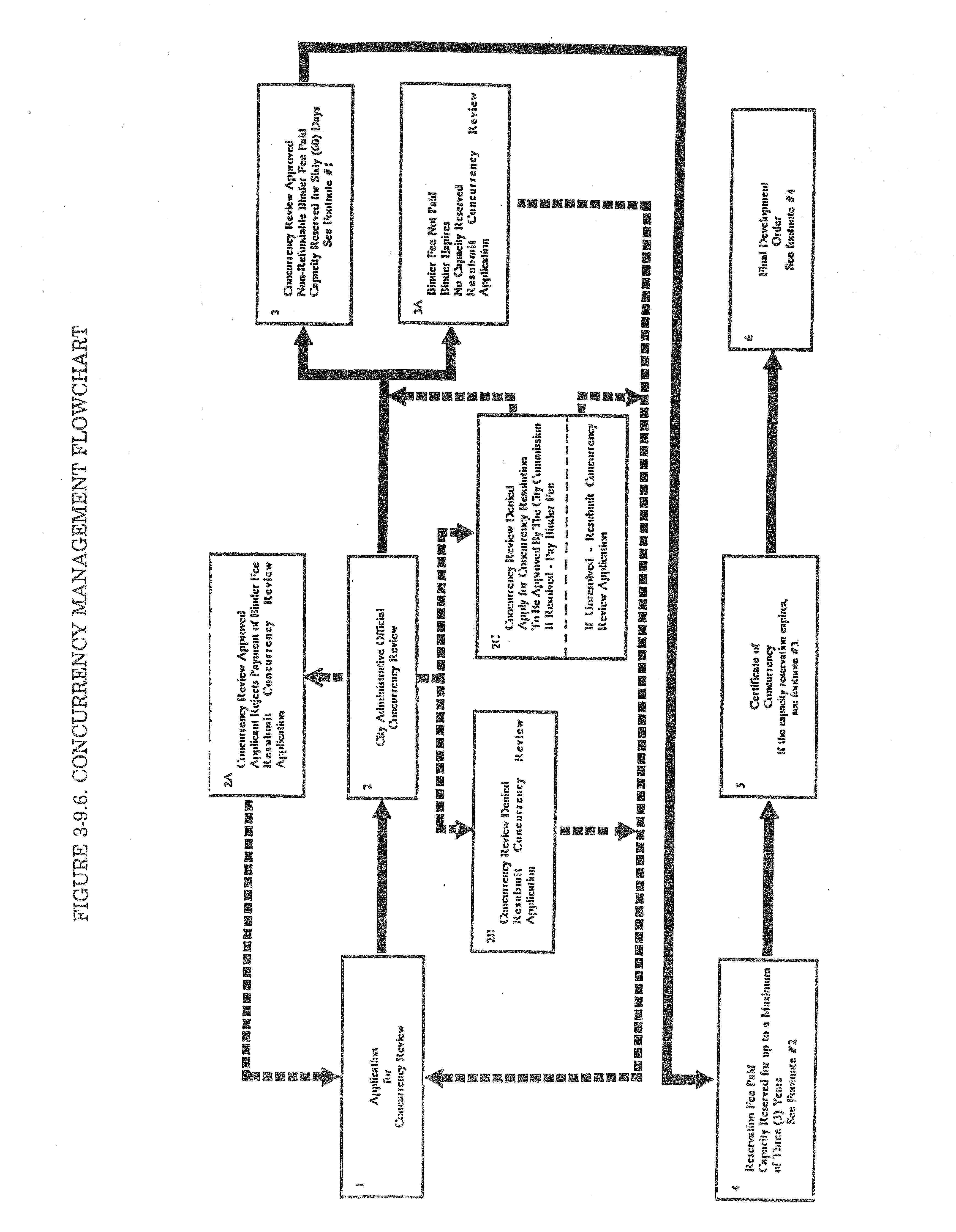
The City Administrative Official shall be responsible for concurrency reviews as required by this Article. The City Administrative Official shall determine whether adequate capacities for concurrency facilities are available to satisfy the demands of each proposed development. Refer to Table 3-9.6, Concurrency Management Flowchart, for a graphic summary of the administration process.
A.
Application for concurrency review. Concurrency review shall be initiated upon submission and acceptance of an application for concurrency review. An applicant may request a concurrency review upon making application in an acceptable form to the City Administrative Official. At the request of the applicant and pursuant to payment of a fee established in the manner set forth in this ordinance, the City Administrative Official may render concurrency findings.
B.
Project impact assessment. The City Administrative Official shall use the best available information to establish and evaluate existing capacities for concurrency facilities. The applicant shall be responsible for supplying the anticipated land uses, densities and/or intensities of a proposed development and the anticipated date of completion of proposed development. The City Administrative Official shall assess the anticipated impacts of the proposed development on concurrency facilities.
C.
Project phasing/timing of improvements. Concurrency facilities associated with a phased development may also be phased. However, all concurrency facilities necessary to accommodate the impacts of each phase must be available or a schedule for the acquired improvements must be approved prior to the issuance of a final development order. The schedule of facility improvements shall ensure that all facility improvements necessary to accommodate the impacts of the development (or portion thereof) for which a certificate of completion or certificate of occupancy has been applied shall be in place prior to the issuance of the certificate. Under no circumstances shall the final certificate of occupancy or completion be issued for a project unless all required facility improvements required by the development order or development agreement have been completed.
D.
Development agreements. If the minimum requirements for concurrency cannot be met, concurrency may be achieved by guaranteeing necessary facility improvements in an enforceable development agreement. Said development agreement may include guarantees to construct required facility improvements or to provide funds equivalent to the cost of providing such facility improvements.
E.
Concurrency review determination. Upon the conclusion of the concurrency review, the City Administrative Official shall prepare a written determination concerning the proposed development. This determination shall address, but is not limited to:
1.
The anticipated public facility impacts of the proposed development;
2.
The ability of existing facilities to accommodate the proposed development at the adopted level of service standards;
3.
Any existing facility deficiencies that will need to be corrected prior to the completion of the proposed development;
4.
The facility improvements or additions necessary to accommodate the impact of the proposed development at the adopted level of service standards and the entities responsible for the design and installation of all required facility improvements or additions; and
5.
The date such facility improvements or additions will need to be completed to be concurrent with the impacts on such facilities created by the proposed development.
F.
Action required to bind concurrency review. After receiving an approved concurrency review, the applicant may pay a binder fee within ten calendar days of the date of the determination, in order to bind the available capacity required to service the proposed development. The amount and method of the fee payment shall be determined by resolution of the City Commission. Payment of the binder fee shall enable the applicant to reserve available capacity required to service the proposed development for a period not exceeding 60 calendar days. Within the 60-calendar-day period, the applicant shall be required to reserve the capacity by paying a concurrency reservation fee as described below in Section 3-9.7. The binder fee shall be credited to the capacity reservation fee. However, if no capacity is reserved within the 60-calendar-day period, the binder fee shall not be refunded.
G.
Concurrency denials. In the event that the City's concurrency review reveals that the proposed development would generate public facility impacts beyond that which can be absorbed by available capacity, the City shall determine whether there is a financial or other legally binding commitment to ensure that public facilities necessary to correct the anticipated deficiency will be in place concurrent with the impacts of the proposed development. If the City and/or a developer are unable to provide such assurances, the project shall be denied.
H.
Concurrency resolution. If the City Administrative Official determines that an application for concurrency review cannot be supported by sufficient concurrency facility capacity, the applicant may file an application for concurrency resolution and pay the requisite filing fee as shall be established by resolution of the City Commission. The purpose for the concurrency resolution process shall be to enable an applicant to negotiate a development agreement which identifies terms for resolving the capacity deficiency. The development agreement shall be consistent with F.S. § 163.3220 and applicable City ordinances.
If the applicant successfully resolves capacity deficiencies, the applicant may reserve capacity pursuant to the terms of the development agreement. If the issues cannot be resolved, the application shall be deemed to be denied and, at any time, the applicant may resubmit the concurrency review application to the City Administrative Official.
Section 3-9.7. - Capacity reservation.
A.
Reservation of capacity. At any time during the 60-day interval following receipt of an approved concurrency determination, the applicant may pay a concurrency reservation fee in order to reserve concurrency facility capacity. The amount of the fee and the timeframe of the concurrency reservation shall be based on a fee schedule established by resolution of the City Commission. The timeframe of the concurrency reservation shall not exceed two years with a two-year renewal. The amount of the fee shall vary with the timeframe of the concurrency reservation. If the applicant fails to pay the fee required to reserve capacity, the available capacity assigned to the applicant shall be returned to the available capacity pool and the applicant will not be eligible to file for concurrency determination until 60 calendar days following the expiration of the binder fee.
Upon payment of a capacity reservation fee, the applicant shall receive a letter of capacity reservation from the City Administrative Official. The letter of capacity reservation does not represent overall development approval and shall not release a recipient from complying with all applicable land development regulations. No final development order shall be granted until the applicant has first purchased a concurrency reservation.
B.
First come, first served. Letters of capacity reservation shall be issued on a first come, first served, basis by the City Administrative Official. Letters of capacity reservation shall be valid only for the specific land uses, densities, intensities, construction and improvement schedules contained in the application. Letters of capacity reservation run with the land and are transferable to a successor in ownership. Reservation of capacity for concurrency shall expire if the underlying development order or development agreement expires or is revoked.
C.
Project deferrals/development moratoriums. If at any time the City's inventory of the capacity of concurrency facilities indicates that concurrency facilities have dropped below its adopted level of service standard, the City shall cease to issue development orders for projects which would impact the deficient facilities or the area impacted by the deficient concurrency facilities, as defined within this ordinance. Such a suspension or moratorium on the issuance of development orders shall continue until such time as the adopted level of service standard is reestablished, the Comprehensive Plan is amended to reflect an acceptable level of service standard for the facilities in question, or alternative arrangements are made to ensure capacity will be available, consistent with Section 3-9.5(1)—(6).
D.
Certificate of concurrency. Simultaneously with the receipt of a final development order, the applicant shall receive a certificate of concurrency. The certificate of concurrency shall cite the terms of the concurrency reservation, including the allocation of available capacity, the timeframe for the allocation, and other appropriate legal assurances.
_____
Section 3-9.8. - Adopted level of service standards.
Level of service standards for those public facilities for which concurrency is required are set forth below:
_____
Section 3-9.9. - Methodology for determining demands on concurrency facilities.
A.
Roadways. In determining demand for available capacity for roadways, the following criteria shall be used:
1.
Residential development. For proposed residential development (except within planned developments), the following trip generation rates shall be used to calculate the impact of the proposed development:
2.
Nonresidential development and mixed-use planned unit development (PUD). For all other development categories allowed within the future land use element, the impacts of development shall be measured by utilizing the average peak trip generation rate associated with the land use designation in which the proposed development shall occur, using the most recent published edition of the Institute of Traffic Engineers' Trip Generation Manual. Internal capture rates may be considered in determining traffic volumes for mixed-use developments; however, the applicant shall bear the burden of demonstrating any internal capture rates of the total nonresidential trips.
3.
Other methods and procedures. If the preliminary level of service information indicates a deficiency in capacity based on adopted level of service standards (reference Section 3-9.8 for adopted level of service standards for roadways), the developer may, at his option, prepare a more detailed alternative highway capacity analysis as described in the Highway Capacity Manual (Special Report 209, Transportation Research Board, National Research Council, 1985), or conduct a travel time and delay study following professional standards and procedures contained in the Florida Department of Transportation, Traffic Engineering Office, in its Manual for Uniform Traffic Studies.
For all new developments which are anticipated to generate 500 or more trips per day, the developer shall be required to submit a traffic analysis which identifies the development's impact on the City's transportation system.
The City Administrative Official may also require the submission of a traffic analysis for developments that generate less than 500 trips per day if the site location, anticipated total trip generation, circulation patterns or other such factors warrant a more extensive review of traffic impacts.
The impact area for the traffic analysis shall include adjacent and connected roadway segments as determined by the City Administrative Official. The applicant may apply alternative trip allocations together with a statement of trip allocation methodology consistent with professional standards established in one or more of the following documents:
•
Highway Capacity Manual, Special Report 209, Transportation Research Board, National Research Council, 1985.
•
Florida Highway System Plan, "Traffic Analysis Procedures," Florida Department of Transportation, Bureau of Multi-Modal Systems Planning, 1987.
•
Florida Highway System Plan, "Level of Service Standards and Guidelines Manual," Florida Department of Transportation, 1988.
•
Trip Generation, Institute of Transportation Engineers (latest edition).
•
Transportation and Land Development, Stover, Virgil G., Institute of Transportation Engineers, 1988.
The traffic analysis shall include the following:
a.
Total projected average weekday trips for the proposed development.
•
Pass-by capture rate (commercial land uses only);
•
Internal capture rate (planned development only);
•
Peak external trips based on ITE Trip Generation Manual, fifth (or most recent) edition; and
•
Peak hour directional projected vehicle trips on all segments of the arterial and collector street system which are adjacent to the development project or as determined necessary by the City Administrative Official.
b.
Design capacity of the accessed road(s).
c.
Analysis of traffic distribution on the road network including all links impacted by more than ten percent of project traffic or 500 trips per day, whichever is greater. The trip distribution shall be consistent with the "presets" contained in the approved trip generation model. As determined by the City Administrative Official, the approved trip generation model shall be the Seminole County trip generation model, the Orlando Urban Area Transportation Study (OUATS) model, or another distribution model approved by the City.
d.
Necessary operational improvements to the City-, county-, or state-maintained transportation system in order to maintain the adopted level of service for the roadway.
e.
Other related information as required by the City.
f.
Justification, including appropriate references, for the use of any trip generation rates, adjustment factors or traffic assignment methods not previously approved by the City.
g.
The latest edition of the Institute of Transportation Engineers (ITE) Trip Generation Manual shall be used to calculate these estimates. Adjustments to these estimates may be made, based on special trip generation information supplied by the applicant.
If the alternative methodology, after review and acceptance by the City Administrative Official, indicates no deficiency in the capacity based on the adopted level of service standard, notwithstanding that the Comprehensive Plan indicates a deficiency in capacity based on the adopted level of service standard, the results of the alternative methodology will be used. However, the City shall, at its discretion, reserve the option to have the methodology reviewed by a professional transportation engineer or transportation planner prior to accepting the methodology. The cost for such review shall be borne by the applicant.
B.
Other facilities. The level of service standards for all concurrency facilities are listed in Section 3-9.8. The applicant shall provide the City Administrative Official with the information required to apply the adopted level of service standard as cited below. The demand on concurrency facilities generated by the applicant's development shall be determined as cited below.
1.
Solid waste. The demand for solid waste collection and disposal capacity shall be determined by applying the standard cited below:
2.
Potable water. For residential development, the demand for potable water shall be determined by multiplying 120 gallons times the total number of persons served proposed (i.e., 120 × total persons served).
For nonresidential development, the demand for potable water shall be determined by multiplying 120 gallons times the total equivalent units of population served (i.e., multiply 120 × the total equivalent units of population served).
3.
Sanitary sewer. For residential development, the demand for sanitary sewer shall be determined by multiplying 90 gallons times the total number of persons served proposed (i.e., 90 × total persons served).
For nonresidential development, the demand for sanitary sewer shall be determined by multiplying 90 gallons times the total equivalent units of population served (i.e., multiply 90 × the total equivalent units of population served).
4.
Drainage. The applicant shall provide evidence demonstrating that the proposed project shall meet the City's adopted level of service standards for drainage. The applicant shall provide for stormwater conveyance capacity equal to or in excess of a ten-year stormwater event for stormwater management and construct retention areas to withstand a 25-year storm event.
5.
Recreation area. The demand for recreation area shall be determined by multiplying the City's recreation area level of service standard (i.e., 3.5 acres per 1,000 population or 0.0035 acre × each person served by the development).
Section 3-9.10. - Determination of available capacity.
For purposes of these regulations, the available capacity of a facility shall be determined by adding the cumulative total supply for each public facility component as cited in Step 1 and subtracting cumulative total demand for each infrastructure component as cited in Step 2.
Step 1: Add the indicators of available facility capacity:
1.
Capacity of existing facility. The total capacity of existing facilities operating at the required level of service; and
2.
Capacity of committed new facility, excluding roadways. The total capacity of committed new facilities, if any, that will become available on or before the date a certificate of occupancy is issued for the development. The capacity of committed facilities may be counted and deemed concurrent only if the following standards are met:
a.
The necessary facilities and services are in place at the time a development permit is issued; or
b.
The development permit is issued subject to the condition that the necessary facilities and services will be in place concurrent with the impacts of development; or
c.
The necessary public facilities and services are guaranteed in an enforceable development agreement to be in place concurrent with the impacts of development. An enforceable development agreement may include, but is not limited to, development agreements pursuant to F.S. § 163.3220, or an agreement or development order issued pursuant to F.S. ch. 380. The agreement must guarantee that the necessary facilities and services will be in place when the impacts of the development occur.
3.
Capacity of new roadways. The total capacity of new roadways, if any, that will become available on or before the date a certificate of occupancy is issued for the development. The capacity of new roadways may be counted and deemed concurrent only if the standards of Subsection 3-9.10(2) are met. In addition, roadway facilities may be deemed concurrent based on the adopted five-year capital improvements program and schedule which, as a minimum, satisfy the following criteria:
a.
The five-year capital improvements program must include improvements necessary to correct any identified facility deficiencies and maintain adopted levels of service for existing and permitted development; and
b.
The five-year capital improvements program must be a realistic, financially feasible program based on currently available revenue sources; and development orders will only be issued if the public facilities necessary to serve the development are programmed to commence and become available within the first three years of the five-year schedule of capital improvements; and
c.
The five-year capital improvements program must identify whether funding is for design, engineering, consultant fees, or construction and must indicate, by funded year, how the dollars will be allocated; and
d.
The five-year capital improvements program must identify both the year in which actual construction of the roadway project will commence, together with the anticipated fiscal year at which time construction will be finalized and functional operation of the roadway facility begins. Actual construction and functional operation of the roadway facility must commence on or before the third year of the five-year schedule of capital improvements; and
e.
In the situation where scheduled projects occur in phases that become functionally operational at the completion of each individual phase, the commencement and completion dates for each independent phase will be identified in the five-year schedule of capital improvements; and
Step 2: Subtract the committed capacity:
1.
Existing demand based on existing development. The demand for services or facilities created by existing development as provided by the City.
2.
Demand to be generated by vested development, valid capacity reservation certificates, and valid certificates of concurrency. The demand for the service or facility created by the anticipated completion of other vested and/or approved developments.
Footnotes:
1.
The binder fee shall be credited to the capacity reservation fee. However, if no capacity is reserved within the 60-calendar-day period, the binder fee shall not be refunded.
2.
Capacity may be reserved for a period of one, two or three years. The capacity reservation fee shall be based on the timeframe selected for the reservation. The fee schedule shall be established by resolution of the City Commission.
3.
If the capacity reservation expires, the applicant shall be required to demonstrate that "good faith effort" was expended in attempting to obtain a final development order prior to renewing the capacity reservation. If such "good faith effort" is not demonstrated to the City's satisfaction, the applicant shall be required to reapply for concurrency review. In such case, the applicant must wait 60 calendar days prior to reapplying.
4.
Upon receipt of a final development order, the terms of the final development order shall govern the capacity reservation.
_____
Sec. 3-9.11. - Proportionate fair-share alternative program.
(A)
Purpose and intent. The purpose of this section is to establish a method whereby the impacts of development on transportation facilities can be mitigated by the cooperative efforts of the public and private sectors, to be known as the Proportionate Fair-Share Program, as required by and in a manner consistent with F.S. § 163.3180(16).
(B)
Applicability. The Proportionate Fair-Share Program shall apply to all developments in the City that impact a road segment in the City's Concurrency Management System (CMS) and have been notified of a failure to achieve transportation concurrency on a roadway segment or segments. The Proportionate Fair-Share Program does not apply to developments of regional impact (DRIs) using proportionate share under F.S. § 163.3180(12), developments meeting the de minimis standards under F.S. § 163.3180(6), or to developments exempted from concurrency as previously provided in Section 3-9.4, as amended from time to time, of this chapter.
(C)
General requirements
(1)
An applicant may choose to satisfy the transportation concurrency requirements of the City by making a proportionate fair-share contribution, pursuant to the following requirements:
(a)
The proposed development is consistent with the comprehensive plan and applicable land development regulations.
(b)
The City's Five Year Capital Improvement Program (CIP) includes a transportation improvement(s) that, upon completion, will accommodate additional traffic generated by the proposed development, as determined by the City Staff.
(2)
The Public Works Director may choose to allow an applicant to satisfy transportation concurrency through the Proportionate Fair-Share Program by contributing to an improvement that, upon completion, will accommodate additional traffic generated by the proposed development, as projected by City staff using the best available data and methodologies, but is not contained in the capital improvement program where one of the following apply:
(a)
The City adopts, by resolution or ordinance, a commitment to add the improvement to the Five Year Capital Improvement Program no later than the next regular update. To qualify for consideration under this Section, the proposed improvement must be reviewed by City Staff and must be found to be financially feasible. This means that additional developer contributions or other funding sources are anticipated, during a period not to exceed ten years, to fully mitigate the specified impact(s) on the identified transportation facility or facilities.
(b)
If, in the opinion of the Public Works Director, the funds in the adopted City Five Year Capital Improvement Program are insufficient to fully fund construction of a transportation improvement required by the concurrency management system, then a proportionate fair-share payment may be required for another improvement which will, in the opinion of the Public Works Director, significantly benefit the impacted transportation system. The improvement or improvements funded by the proportionate fair-share component must be adopted into the capital improvement program of the comprehensive plan at the next annual capital improvements element update.
(3)
Any improvement project proposed to meet the developer's fair-share obligation must meet generally accepted design standards for the State of Florida and the City of Casselberry.
(D)
Application process.
(1)
City Staff shall notify an applicant in writing of a failure to satisfy transportation concurrency requirements. Upon receipt of such notice, applicants may submit a proposed proportionate fair-share calculation to the Public Works Director or designee for review.
(2)
Pursuant to F.S. § 163.3180(16)(e), proposed proportionate fair-share mitigation for development impacts to facilities on the Strategic Inter-modal System requires the concurrence of the Florida Department of Transportation (FDOT).
(3)
When a proportionate fair-share calculation is deemed by the Public Works Director to be sufficient and eligible, a proportionate share agreement will be prepared between the City and the applicant. The stipulations of the agreement shall include but not be limited to the amount of payment, description of work, and timing of payment. The City Commission shall approve and execute a proportionate share agreement on behalf of the City.
(E)
Determining proportionate fair-share obligation.
(1)
Proportionate fair-share mitigation for concurrency impacts may include, without limitation, separately or collectively, private funds, contributions of land, and construction and contribution of facilities.
(2)
A development shall not be required to pay more than its proportionate fair-share. The fair market value of the proportionate fair-share mitigation for the impacted facilities shall not differ regardless of the method of mitigation.
(3)
The methodology used to calculate an applicant's proportionate fair-share obligation shall be as provided for in F.S. § 163.3180(12), as follows:
Proportionate Share = σ [(Development Trips;sub\sub;)/(SV Increase;sub\sub;)] × Cost;sub\sub;] - IMPACT FEE CREDITS
Where:
Development Tripsi= Those trips from the development that are assigned to roadway segment i and have triggered a deficiency per the concurrency management system;
SV Increasei= Service volume increase provided by the eligible improvement to roadway segment i per Section E;
Costi= Adjusted cost of the improvement to segment i. Cost shall include all improvements and associated costs, such as design, right-of-way acquisition, planning, engineering, inspection, and physical development costs directly associated with construction at the anticipated cost in the year it will be incurred.
IMPACT FEE CREDITS = See section 3-9.11(F)(1) where applicable.
(4)
For the purposes of determining proportionate share obligations, the City shall determine improvement costs based upon the projected future cost of the improvement as obtained from the Capital Improvements Program or another method approved by the Public Works Director.
(5)
The City has the option to accept right-of-way dedication for all or a portion of the proportionate fair-share payment. Credit for the dedication of the non-site related right-of-way shall be assigned a value by appropriate City staff or, at the option of the applicant, by fair market value established by an independent appraisal approved by the City and at no expense to the City. The applicant shall supply a drawing and legal description of the land and a certificate of title or title search of the land to the City at no expense to the City. If the estimated value of the right-of-way dedication proposed by the applicant is less than the City estimated total proportionate fair-share obligation for that development, then the applicant must also pay the difference.
(F)
Impact fee credit for proportionate fair-share mitigation.
(1)
Proportionate fair-share mitigation shall be applied as a credit against impact fees if the proposed improvement is on the list of approved projects in the most recent City Impact Fee Ordinance and Technical Report. Credits will be given for that portion of the impact fees that would have been used to fund the improvements on which the proportionate fair-share contribution is calculated. The portion of impact fees available for the credit will be based on the historic distribution of impact fee funds to the arterial roadways and collector roadways in the appropriate impact fee district. Impact fee credits shall be calculated at the same time as the applicant's proportionate share obligation is calculated.
(2)
Any road impact fee credit based upon proportionate fair-share contributions for a proposed development cannot be transferred to any other parcel or parcels of real property within the City.
(G)
Appropriation of fair-share revenues.
(1)
Proportionate fair-share revenues shall be placed in the appropriate project account for funding of scheduled improvements in the City capital improvements program.
(2)
In the event a scheduled facility improvement is removed from the Capital Improvement Program, then the revenues collected for its construction may be applied toward the construction of another improvement within that same corridor that would mitigate the impacts of development pursuant to the requirements of Subsection (C)(2)(b) of this Section.
(3)
Where an applicant constructs a transportation facility that exceeds the applicant's proportionate fair-share obligation calculated under Subsection (2), then the City shall reimburse the applicant for the excess contribution using impact fee credits. These credits will not be transferable as discussed in Subsection (F)(2) of this Section. Where excess contributions exceed impact fee credits, the City may reimburse such funds as cash or through other methods acceptable to the applicant and the Public Works Director.
(Ord. No. 06-1207, § 1, 10-23-06)
Section 3-9.12. - Public school facility concurrency.
A.
The following terms are used in discussing level of service standards for public schools:
Proportionate Share Mitigation: A developer improvement or contribution identified in a binding and enforceable agreement between the Developer, the School Board and the local government with jurisdiction over the approval of the development approval to provide compensation for the additional demand on educational facilities created through the residential development of the property, as set forth in F.S. § 163.3180(13)(e).
Permanent Florida Inventory of School Houses (FISH): Meaning the permanent facilities within the inventory of land, buildings and rooms in public educational facilities used by the Florida Department of Education, Office of Educational Facilities; and
Concurrency Service Area (CSA): A geographic unit promulgated by the School Board and adopted by local governments within which the level of service is measured when an application for residential development is reviewed for school concurrency purposes. The CSA coincides with groupings of school attendance zones within each school type based on adjacency.
Level of Service (LOS) standard: A standard established to measure utilization of capacity within a Concurrency Service Area (CSA). Current LOS within a CSA is determined by dividing the full-time equivalent student count (FTE) for the Fall Semester at the same type of schools by the permanent FISH capacity of the same type of schools. Projected or future LOS is determined by dividing the projected enrolled students at the same type of schools within a CSA by the planned permanent FISH capacity of the same type of schools.
B.
Use of Concurrency Service Area (CSA) Boundaries. The City shall apply school concurrency using CSA boundaries adopted by the School Board. The CSAs are described geographically in Maps 1—3 of the support documents of the Comprehensive Plan and may be updated from time to time by the School Board.
C.
CSAs for Each Type of School. The CSA boundaries established by the School Board will be based on clustered attendance zones for each school type (elementary, middle and high school) based on adjacency and will be re-evaluated by the School Board, as needed.
D.
Concurrency Review. The City shall require that all new residential development be reviewed for school concurrency prior to the issuance of development approval of a site plan, a final subdivision plan or the functional equivalent.
E.
Development Review Process. The City shall withhold or condition the approval of any site plan, final subdivision, or functional equivalent for new residential units not exempted from concurrency until a school capacity availability letter determination (SCALD) has been issued by the school board to the city indicating that adequate school facilities exist or until a mitigation agreement has been reached, pursuant to the availability standard specified in section 163.3180(13)(e), Florida Statutes.
F.
Notification of Submittal of Residential Applications. The City shall notify the School Board within 15 working days of receipt of any land use or development application having a residential component and will transmit submitted subdivision plans and site plans to the school board for their review.
G.
Residential Uses Exempt from the Requirements of School Concurrency. The following residential uses shall be exempt from the requirements of school concurrency:
1.
All single-family lots of record at the time the school concurrency implementing ordinance became effective on January 1, 2008.
2.
Any new residential development that has a preliminary plat or site plan approval or the functional equivalent for a site specific development order prior to the commencement date of the School Concurrency Program on January 1, 2008.
3.
Any amendment to a previously approved residential development which does not increase the number of dwelling units or change the type of dwelling units.
4.
Any age-restricted community with no permanent residents under the age of 18 (a restrictive covenant limiting the age of residents to 18 and older shall be required).
H.
Level of Service (LOS) Standard. To ensure the capacity of schools is sufficient to support student growth, the City shall apply a LOS standard for schools. The desired LOS standard shall be 100 percent of the aggregate permanent FISH capacity for each school type within each CSA.
To financially achieve the desired LOS standard at the high school level, a tiered LOS standard is established as follows:
I.
Results of Concurrency Review. The City shall not deny development approval due to failure to achieve the adopted LOS for public school facilities when the following occurs:
1.
Adequate school facilities are planned and will be in place or under construction within three years of the development approval.
2.
The developer executes a legally binding commitment to provide mitigation proportionate to the demand for public school facilities consistent with the methodology below.
J.
Proportionate Share Mitigation. In the event there is not available school capacity to support a development, the School Board may entertain proportionate share mitigation options and, if accepted, shall enter into an enforceable and binding agreement with the developer to mitigate the impact from the development through the creation of additional school capacity.
1.
When the anticipated student impacts from a proposed development cause the adopted LOS to be exceeded, the developer's proportionate share will be based on the number of additional student stations necessary to achieve the established LOS. The amount to be paid will be calculated by the cost per student station for elementary, middle and high school as determined and published by the State of Florida.
2.
The methodology used to calculate a developer's proportionate share mitigation shall be as follows:
Proportionate Share = ( 1 Development students - Available Capacity) × 2 Total Cost per student station
Where:
1 Development students = those students from the development that are assigned to a CSA and have triggered a deficiency of the available capacity.
2 Total Cost = the cost per student station as determined and published by the State of Florida.
3.
The applicant shall be allowed to enter a 90-day negotiation period with the School Board in an effort to mitigate the impact from the development through the creation of additional capacity. Upon identification and acceptance of a mitigation option deemed financially feasible by the School Board, the developer shall enter into a binding and enforceable development agreement with the School Board.
a.
A mitigation contribution provided by a developer to offset the impact of a residential development must be directed by the School Board toward a school capacity project identified in the School Board's Five-Year Capital Improvement Plan. Capacity enhancing projects identified within the first three years of the Five-Year Capital Improvement Plan shall be considered as committed.
b.
If capacity projects are planned in years four or five of the School Board's Five-Year Capital Improvement Plan within the same CSA as the proposed residential development, the developer may pay his proportionate share to mitigate the proposed development.
c.
If a capacity project does not exist in the Capital Improvement Plan, the School Board will add a capacity project to satisfy the impacts from a proposed residential development, if it is funded through the developer's proportionate share mitigation contributions. Mitigation options may include, but are not limited to:
i.
Contribution of land or payment for land acquisition suitable for and in conjunction with, the provision of additional school capacity; or
ii.
Mitigation banking based on the construction of an educational facility in exchange for the right to sell capacity credits; or
iii.
Provide modular or permanent student stations acceptable for use as an educational facilities; or
iv.
Provide additional student stations through the remodeling of existing buildings acceptable for use as an educational facility; or
v.
Construction or expansion of permanent student stations at the impacted school within the CSA; or
vi.
Construction of an educational facility in advance of the time set forth in the School Board's Five-Year Capital Improvement Plan.
4.
For mitigation measures (i) thru (vi) above, the estimated cost to construct the mitigating capacity will reflect the estimated future construction costs at the time of the anticipated construction. Improvements contributed by the developer shall receive school impact fee credit.
5.
Developer shall receive an impact fee credit for the proportionate share mitigation. Credits will be given for that portion of the impact fees that would have been used to fund the improvements on which the proportionate fair share contribution was calculated. The portion of impact fees available for the credit will be based on the historic distribution of impact fee funds to the school type (elementary, middle, high) in the appropriate CSA. Impact fee credits shall be calculated at the same time as the applicant's proportionate share obligation is calculated. Any school impact fee credit based on proportionate fair share contributions for a proposed development cannot be transferred to any other parcel or parcels of real property within the CSA.
6.
A proportionate share mitigation contribution shall not be subsequently amended or refunded after final site plan or plat approval to reflect a reduction in planned or constructed residential density.
7.
Impact fees shall be credited against the proportionate share mitigation total.
8.
Any proportionate share mitigation must be directed by the School Board toward a school capacity improvement identified in the School Board's Five-Year Capital Improvement Plan.
9.
Upon conclusion of the negotiation period, a second Determination Letter shall be issued. If mitigation is agreed to, the School Board shall issue a new Determination Letter approving the development subject to those mitigation measures agreed to by the local government, developer and the School Board. Prior to, site plan approval, final subdivision approval or the functional equivalent, the mitigation measures shall be memorialized in an enforceable and binding agreement with the local government, the School Board and the Developer that specifically details mitigation provisions to be paid for by the developer and the relevant terms and conditions. If mitigation is not agreed to, the Determination Letter shall detail why any mitigation proposals were rejected and why the development is not in compliance with school concurrency requirements. A SCALD indicating either that adequate capacity is available, or that there is not a negotiated proportionate share mitigation settlement following the 90-day negotiation period constitutes final agency action by the School Board for purposes of Chapter 120, F.S.
K.
Appeal Process. A person substantially affected by a School Board's adequate capacity determination made as a part of the School Concurrency Process may appeal such determination through the process provided in Chapter 120, F.S.
(Ord. No. 09-1265, § 1, 2-9-09)
Editor's note— Ord. No. 09-1265, § 1, Feb. 9, 2009, set out provisions intended for use as § 3-9.11. Inasmuch as § 3-9.11 currently exists in the Code, and at the editor's discretion, these provisions have been included as § 3-9.12.
Section 3-10.1.- Site location and character of use.
The Comprehensive Plan together with the land development regulations, including size and dimension regulations, general provisions, performance standards, and the list of permitted and conditional uses, offstreet parking, landscaping, required open spaces, yards and building setbacks, shall collectively be the principal guides in determining the suitability of the location of the proposed use.
Section 3-10.2. - Appearance of site and structures.
Within all zoning districts within the City of Casselberry, the appearance of site and structures shall be coordinated for the purpose of creating a pleasing and harmonious overall environment within this section and Section 2-7.35. The choice of building materials, plant materials, lighting and other building and site improvements shall be commensurate with the objectives of the subject use and considering impact on surrounding properties or transportation corridors. Evaluation of the appearance of a project shall be based on the quality of its overall design and relationship to the impacted area considering the following factors:
1.
Harmonious overall design. The exterior of buildings and structures including mass, facade and materials shall be in harmony with the site and the architectural style of the adjacent vicinity. Awnings or ornamental features and signs shall be designed in a manner harmonious with the building design and shall be of appropriate scale, shape, and pattern in order to reinforce good design principles. Similarly, awnings or ornamental features and signs shall not use incompatible or extraordinary scale, shapes, color schemes, patterns or other extraordinary features for purposes of attracting attention.
All new residential structures shall comply with the following aesthetic requirements:
a.
Siting. The front wall of all single-family detached residential structures shall be no less than 20 feet in width. All transportation equipment must be removed from any manufactured dwelling units.
b.
Width of structure. The minimum width of the main body of a single-family dwelling shall be not less than 20 feet, as measured across the narrowest dimension.
c.
Foundations. Foundations shall be constructed using any one of the following methods:
i.
Slab on grade or a continuous foundation wall. All foundation slabs and walls above grade shall be finished with brick veneer, stucco, or skirting (see "Skirting" below for required criteria), so that no concrete block or unfinished poured concrete visible from the public way or publicly used land is exposed. Rough openings for air vents shall be finished with hardware.
ii.
Brick or concrete piers. Piers shall have poured concrete footings. Piers shall not be exposed, but shall be screened using an opaque continuous skirting (see "Skirting" below for required criteria).
d.
Walls. Exterior walls shall be finished. Reflection from exterior walls shall not be greater than reflection from siding coated with clean, white gloss exterior enamel.
e.
Main entrances. Main entrances shall be either recessed or covered. Recessed entrances shall have a minimum dimension of three feet as measured from the exterior wall to the entrance door. Covered entrances shall have either a gable roof or a shed roof with columns and shall have a minimum dimension of three feet as measured from the exterior outermost vertical surface of the roof to the entrance door and a minimum width of 3½ feet. The ridge of entrance roofs may either terminate into the wall, if sufficient dimension above the door allows, or the ridge shall be connected with the unit's main roof.
f.
Stairs. Units having entrance doors with thresholds higher than one foot above finished grade shall have permanent steps with finished surfaces and a permanent landing shall be included with a minimum depth dimension of three feet as measured from the top tread nose to the unit's wall.
g.
Skirting. The construction material of any required skirting shall be similar in appearance to foundations of existing residences. The material may be masonry veneer, painted stucco, wood or simulated wood siding. Wood or simulated wood siding shall appear as a continuous plane or shall be recessed to the siding of the unit's walls. Where wood or simulated wood siding is used for skirting, its dimension, color, texture, and direction (vertical or horizontal) shall match the walls of the structure. Plywood and particleboard shall be prohibited for use as skirting material. No space shall exist between the ground and the bottom of skirting which is greater than four inches. All skirting material shall be durable, shall present a harmonious appearance and shall be maintained in perpetuity.
2.
Location and screening of mechanical equipment and utility hardware. Mechanical equipment or other utility hardware on roofs shall be harmonious with the building or they shall be located and/or screened so as not to be visible from any public ways within the impacted area.
3.
Location and screening of solid waste container.
a.
Front-end-loaded refuse container location requirements. No front-end-loaded refuse container shall be located within any required front or street side yard setback. No such container shall be located in any required parking space or vehicular use area, or in any required bufferyard or landscaping area.
i.
Service access. Front-end-loaded refuse container sites shall be provided which allow refuse vehicle service access without manually moving the container(s) for service. Fifty feet of clear backup as measured perpendicular from the screen areas shall be provided from the face of the refuse containers' screening unless otherwise approved by the Public Works Director who shall find that the reduction is necessary to provide property rights enjoyed by others in the same zoning district, and will not be detrimental to public health, safety, and welfare. No encroachment into this area by parking spaces, non-driveway sidewalks, or landscape areas shall be allowed.
ii.
Siting obstructions. No front-end-loaded refuse container shall be sited within six feet of any building/structure, nor sited below obstructing wires nor obstruct any electrical service equipment, fire protection equipment, nor any roof overhangs nor sited adjacent to any other obstruction to the container dumping process.
iii.
Container pads. Front-end-loaded refuse container pad(s) shall be provided for all front-end-loaded containers and shall be constructed either of, as a minimum, 3,000 psi concrete six inches thick with six inch by six inch, 10 by 10 wire mesh, four inches thick with number 3 steel reinforcing bars on 12-inch centers in each direction, or as approved by the Public Works Director who shall find that the reduction is necessary to provide property rights enjoyed by others in the same zoning district, and will not be detrimental to public health, safety, and welfare. A six-foot-long approach slab of identical width, thickness, and composition to the container pad shall also be constructed adjacent and of equal slope to said pad(s).
iv.
Front-end-loaded refuse container screening requirements. Front-end-loaded refuse containers shall be opaquely screened from view from public streets and adjacent properties, to a height of at least six feet, or six inches higher than the height of the container (whichever is higher). This screening may be achieved by walls, landscaping or buffer yards, or by virtue of the location of the container on the building site.
b.
Roll-off compactor container location requirements.
i.
Container pads. Roll-off compactor container pad(s) shall be provided for all roll-off compactor containers, and shall be constructed of minimum 3,000 psi concrete, steel reinforced, six inches thick, and shall comply with the following minimal dimension requirements for each container: ten feet wide by 20 feet long.
ii.
Service access. A paved service vehicle access apron, constructed to a minimum load of 60,000 pounds and extending a minimum of 45 feet in front of each roll-off compactor container, is required. Service height clearance of 25 feet is required in the container service access area.
iii.
Electrical requirements. The industry recommendations for roll-off compactor electrical requirements are: three-phase, 460 to 480 volt, 60 ampere electrical service to each compactor location. Other electrical requirements may be approved by the Public Works Director.
4.
Utility lines. All utility lines shall be placed underground. All telephone lines shall be placed underground. Service lateral electrical distribution lines serving individual installations shall be placed underground. Other high-voltage electrical lines may be placed underground or on concrete poles provided that the poles are within the street right-of-way and have provisions for street lighting. Large transformers shall be placed on the ground and be mounted on pads and contained within enclosures or vaults. Where enclosures or vaults are used, the construction and design shall be compatible with primary building design. Landscaping with shrubs and plants shall be provided to screen pad-mounted transformers.
5.
Commercial and manufacturing activities conducted in enclosed buildings. All businesses, services or manufacturing or processing shall be conducted within completely enclosed buildings. If the City determines that a demonstrated necessity exists for limited outside storage or display due to the impracticality and unreasonableness of enclosure of such services, storage and display areas, such service, storage and display areas or yards shall be screened by a continuous fence or wall or by landscaping and berm system approved by the City so as to provide a 90 percent opaque screen with a minimum height of five to eight feet, unless the same is demonstrated by the applicant to the Planning and Zoning Commission's satisfaction to be impractical and unreasonable.
6.
Exterior lighting.
A.
General provisions.
1.
Title. This Ordinance together with the amendments thereto, shall be known and may be cited as the Casselberry Exterior Lighting Ordinance.
2.
Purposes. The general purpose of this Ordinance is to protect and promote the public health, safety and welfare, and quality of life of Casselberry residents, by establishing regulations and a process of review for exterior lighting. This Ordinance establishes standards for exterior lighting in order to accomplish the following:
a. To protect against direct glare and excessive lighting;
b. To eliminate the increase of lighting levels on competing sites;
c. To provide safe roadways for motorists, cyclists and pedestrians;
d. To protect and reclaim the ability to view the night sky, and thereby help preserve the quality of life;
e. To prevent light trespass in all areas of the City;
f. To promote efficient and cost effective lighting;
g. To ensure that sufficient lighting can be provided where needed to promote safety and security;
h. To provide lighting guidelines;
i. To provide assistance to property owners and occupants in bringing nonconforming lighting into conformance with this Ordinance; and
j. To conserve valuable natural resources.
3.
Compliance. All exterior lighting installed after the effective date of this Ordinance shall be in conformance with the requirements established by this Ordinance and any other applicable ordinances. All existing lighting installed prior to the effective date of this Ordinance shall be subject to the following provisions:
a. Application of this ordinance. If a property owner or agent for the owner on the date this Ordinance takes effect, has applied for a City of Casselberry Community Development Department Site Plan Review, Conditional Use Review, or Subdivision, except single-family homes and duplexes, then all existing lighting on the property must be brought into conformance with this Ordinance.
b. Amortization. All existing exterior lighting that is not in conformance with this Ordinance shall be brought into conformance with this Ordinance within five years from the date of adoption of this Ordinance, by April, 2007.
c. Conflicts. All those required to submit a photometric plan as required by Section 6.C.1, shall comply with the following statutes in effect when this ordinance was adopted. Lighting may vary from this ordinance to the extent necessary to comply with:
(1) Section 655.92, F.S., related to ATM lighting;
(2) Section 812.173, F.S., related to parking lots for convenience businesses;
(3) Lighting on schools required by F.S. ch. 235;
(4) Airport lighting required by F.S. ch. 332 and Federal Law;
(5) Lights required on vehicles under State Uniform Traffic Control Statutes or for vessels under Vessel Safety Statutes under F.S. chapters 316 and 327;
(6) Lighting for public health required by F.S. § 381.0072, and § 381.0086;
(7) Electrical Code Statute requirements under State Building Code;
(8) F.S. § 553.963 and § 553.904, Efficiency and Energy Conservation statutes, under Building Code Standards;
(9) Lighting for outdoor theaters under F.S., § 555.07;
(10) Lighting for financial institutions under F.S. ch. 655; and
(11) Other State and Federal laws and regulations that may apply and preempt this ordinance.
d. In case of a conflict between the ordinance and any other provision of the Unified Land Development; Regulations, the more restrictive requirement shall apply.
B.
Definitions. Unless specifically defined below, words or phrases used in this Ordinance shall be interpreted so as to give them the meaning they have in common usage and to give this Code its most reasonable application:
Accent lighting. Decorative lights used to draw attention to particular features or objects such as plants, trees, walls, fountains, or buildings. Such lights shall be aimed to accentuate shadows or to highlight a particular object at night. Accent lights shall not impact safety and security, such as masking steps or ledges, or produce glare such that a person or property owner cannot see properly. They shall be limited to low voltage systems of 12 volts or 24 volts. The lighting should aesthetically enhance the overall site and not create glare or light trespass.
Average Lighting. The sum of the calculated illuminance points on the photometric plan divided by the total number of calculated illuminance points within the site boundary. Sub-area averages, such as canopies, air/water, telephone, vacuum. ATM, and the like, shall only include points within that sub-area. Illuminance levels shall be computed over developed portions of each site only, and shall not include enclosed building pad areas or retention areas lying outside required landscape buffers. Time-averaged or other alternative methods of computing illuminance levels shall not be permitted.
Back-Lighting. The illumination of an awning, canopy or building roof, fascia, facade or similar area by any type of lighting source from behind the fascia, facade or roof in order to be seen through those structures.
Bulb. The source of electric light. To be distinguished from the whole assembly (See luminaire).
Canopy. Any raised, protective cover such as, but not limited to, awnings, marquees, overhangs, porte cochere, and drive-thru's.
Existing lighting. Any and all lighting installed prior to the effective date of this Ordinance.
Exterior Lighting. Temporary or permanent lighting that is installed, located or used in such a manner to cause light rays to shine outside. Fixtures that are installed indoors that are intended to light something outside or act to draw attention are considered exterior lighting for purposes of this Ordinance.
Eyebrow Lighting. Fixtures that downlight the entire or partial perimeter of canopies and/or buildings. This term does not include wall packs.
Fixture. The assembly that holds the lamp in a lighting system. It includes the elements designed to give light output control, such as a reflector (mirror) or refractor (lens), the ballast, housing, and the attachment parts.
Foot-candle. Illuminance produced on a surface one foot from a uniform point source of one candela. Measured by a calibrated light meter.
Full Cut-Off Fixtures. Fixtures, as installed, that are designed or shielded in such a manner that all light rays emitted by the fixture, either directly from the lamps or indirectly from the fixture, are projected below a horizontal plane running through the lowest point on the fixture where light is emitted (See Figure 1).
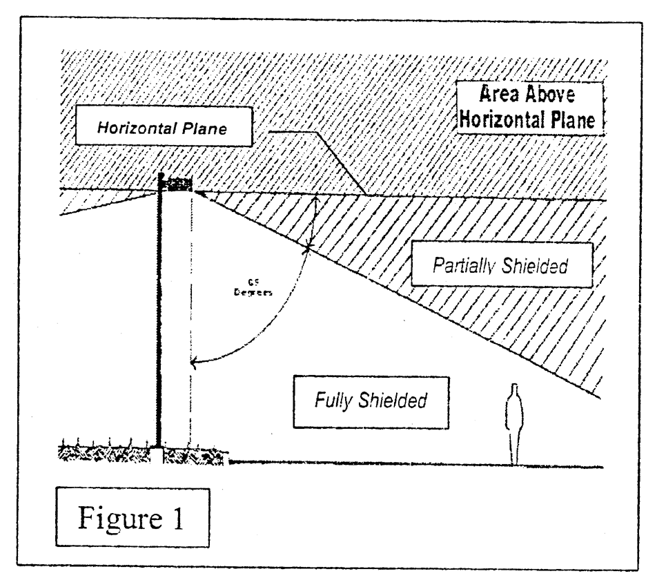
Glare. Intense light that results in discomfort and/or a reduction of visual performance and visibility.
Illuminance. Density of luminous flux incident on a surface. Unit is foot-candle.
Lamp. The source of electric light; the bulb and its housing. To be distinguished from the whole assembly (See Luminaire).
Light Loss Factor (LLF). A percentage amount applied to the actual anticipated foot-candle levels of a fixture, which reduces the calculated light level output on the photometric plan to account for lower light level output from a fixture due to the age of the bulb, and dirt that occurs over time.
Light Pollution. Any adverse effect of manmade light including, but not limited to, light trespass, uplighting, the uncomfortable distraction to the eye, night blindness, or any manmade light that diminishes the ability to view the night sky.
Light Trespass. Light falling where it is not wanted or needed, generally caused by a light on a property that shines onto the property of others.
Lighting Any or all parts of a luminaire that function to produce light.
Lighting, Animated. Flashing or moving lights that otherwise change at intervals more frequently than once each six seconds.
Lighting Subject to this Ordinance. All uses within nonresidential zoning districts (OR, CL, CG, CS, I, PS), multi-family subdivisions, and mobile home park districts and all nonresidential uses within PRD and planned mixed use (PMX) districts. Streets in residential subdivisions shall be subject to this ordinance as set forth in Section 6.C.2.e.2.
Luminaire. The complete lighting unit, including the lamp, the fixture, and other parts.
Non-Essential. Lighting that is not necessary for an intended purpose, such as site safety.
Recessed. A lamp built into a horizontal fixture or portion of a fixture, so that the lamp is fully cut-off and no part of the lamp extends or protrudes beyond the underside of a fixture or portion of a fixture (See Figure 2).
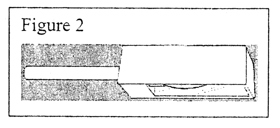
Shielded, Fully. Constructed in such a manner that all light emitted by the fixture, either directly from the lamp or a diffusing element, or indirectly by reflection or refraction from any part of the luminaire, is not projected above 65 degrees of a vertical line running through the fixture to the ground (See Figure 1)
Shielded, Partially. Shielded in such a manner that more than zero but less than ten percent of the light emitted directly from the lamp or indirectly from any part of the fixture is projected between 65 degrees and the horizontal plane of the fixture (See Figure 1).
Special District(s). Areas within the City of Casselberry that are individually demarcated through special studies or government regulations and that contain design criteria or standards specific to that area. Examples within the City include the Seminola Blvd. Small Area Study, Phases I and II, and the Community Redevelopment Area.
Sports Complex. As used within this ordinance, "sports complex" shall include, but shall not be limited to, public and private ballfields and stadiums, golf driving ranges, and other venues that require greater lighting heights to effectively illuminate an area for sport or related activities.
Street Lighting. Poles and luminaries used to illuminate any road or street, public or private, of various classifications, parking and vehicular use areas, and pathways and walkways.
Streets and Roadways. Streets and roadways are classified in the City of Casselberry Comprehensive Policy Plan Transportation Element.
Uplighting. Lighting that is directed in such a manner as to shine light rays above the horizontal plane (See Figure 1).
C.
Criteria.
1.
Photometric plan.
a. All applications for site plan review, conditional use, or subdivisions, except applications for duplexes and single-family homes shall include lighting plans showing location, type, and height of all fixtures and poles, and photometrics in foot-candle output of all proposed and existing fixtures on-site and within 50 feet of the site. On-site lighting calculations shall include, but are not limited to, lighting for parking lot, canopies, eyebrow lighting, recessed lighting along the building front and/or overhang, and interior building light. Accent lighting shall also be included in these calculations, when applicable. Rejection or acceptance of the photometric plan shall be based on this Code. The plan shall include any calculations or modifications required to comply with the Florida Statutes listed in Section 6.A.3 of this Code.
b. The photometric plan shall include a table showing the average, minimum, and maximum foot-candles on the site, and the calculations deriving the averages. In addition, a fixture detail shall be submitted including pictures of each fixture, and proposed wattage per fixture. The photometric plan shall not include time averaging or other alternative methods of measurement. The use of a Light Loss Factor (LLF) shall be prohibited, except that the bulb manufacturer's specifications noted for the particular bulb may be factored into the calculation in a photometric plan, if the specifications are supplied by the applicant and the specifications show all light loss will occur within 90 days from the date the light is installed.
2.
Exterior lighting. Street lighting shall be installed on all internal and perimeter streets, within parking and vehicular use areas, and along pedestrian walkways in accordance with the sections of this Code. Section 4-19.2.V.20, ULDR, and the CRA Design Guidelines. All lighting shall comply with the requirements of the City's adopted electrical code.
a. Glare.
(1) All lighting including, but not limited to, parking and building lighting, shall be focused, directed, and arranged so as to avoid producing glare and/or becoming a nuisance, or a traffic or safety hazard.
(2) Shielding, either partially or fully, may be required for any light source as necessary to eliminate glare.
(3) Site lighting using spot or floodlight fixtures mounted on building walls, roofs, or poles shall be shielded, either fully or partially, and angled downward, so that no light escapes above a 65-degree angle measured from a vertical line from the center of the light extended to the ground, and the light shall not cause glare or light trespass (See Figure 1). The up-lighting of landscaping and architectural features shall be exempt from this requirement, but must meet the requirements of Section 3-10.2(6)(C)(2)(b)(6).
(4) Fixtures with motion detectors, photocells, or timers that allow a floodlight to turn on at dusk and turn off by 11:00 p.m. shall be used whenever possible.
(5) Sensor-activated lights shall have a ten-minute time limit and shall be located in such a manner as to prevent direct glare, light trespass and uplighting.
b. Luminaire.
(1) The light source (bulb) for any exterior lighting, whether for externally lit signs, entrance doors, street lights, or service or drop-off areas, shall not be visible from public view, regardless of mounting height. See examples in Figure 3. Bulbs shall be recessed into the fixture and the lens shall be flat and frosted.
(2) All fixtures, except wall mount fixtures, must be horizontal, and full cut-off type fixtures. Wall mount fixtures shall be full cut-off and fully shielded to prevent glare.
(3) Fixtures under canopies shall be recessed or the sides of the fixture box shall be opaque.
(4) All specialty light fixtures shall be horizontal, full cut-off fixtures with recessed bulbs and flat lenses.
(5) Globe type lights that are allowed in Special Districts shall have stacked reflectors directing light downwards.
(6) Accent lighting shall be limited to low voltage systems of 12 or 24 volts with a maximum individual bulb wattage of 50 watts. A full cutoff fixture with a recessed bulb shall be used. The bulb shall be fully shielded and aimed away from any vehicular use areas or roadways. Fiber optic or "rope" lighting shall not be allowed.
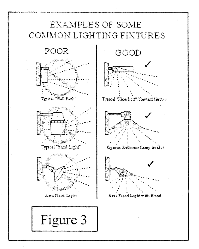
c. Illuminance. Table 1 is provided as a general synopsis of the illumination level requirements provided in the text. In the event of a conflict between the table and the text, the text controls.
Table 1: Illuminance Levels
(1) Parking Lots. Lighting for commercial, industrial, office and multi-family parking lots shall meet the following additional criteria:
(a) The maximum illuminance shall be 5 foot-candles with an average of 2.5 foot-candles.
(b) Illuminance shall be 0.5 foot-candles at the property boundary. Approach and driveway lighting may be 1.5 foot-candles. This illuminance must be reduced to 0.5 foot-candles within 10 feet of the approach or driveway along the property line.
(2) Canopy:
(a) Under-lighting of all canopies shall be no more than a maximum illuminance of 50 foot-candles with an average illuminance of 30 foot-candles.
(b) No part of a canopy shall be back-lighted. Canopy fascias may be down-lighted with a shielded light source (eyebrow lighting). This lighting must be included in the photometric plan calculations.
(3) Property Boundaries. The maximum illuminance at any property boundary shall be 0.5 foot-candles. Driveway approaches may exceed this limit with a maximum illuminance of 1.5 foot-candles. This level shall be reduced to 0.5 foot-candles within 10 feet of the driveway approach.
(4) Accessory Uses. Lighting levels shall be 3.0 foot-candles, and shall be reduced to the required illuminance within 15 ft. of the defined location as provided in Table 1. Illuminance Levels.
(5) Specialty Lighting. Illuminance levels for recreational specialty lighting are based upon the IESNA classification of Class IV facility, social and recreational play. Vehicle display lots are based upon car dealership uses for the front row along the primary roadway in the IESNA Handbook. Illumination levels for the remainder of the vehicle display lot shall conform to parking lot and property boundary illumination levels. Front row vehicle display lighting shall conform to the boundary illumination levels.
d. Height.
(1) Fixture Heights. Table 2 provides the fixture height requirements by location. In the event of a conflict between the table and text, the text controls.
Table 2: Fixture Height
(2) Parking Lots and Vehicular Use Areas. Lighting for parking lots and vehicular areas shall not exceed 20 feet in height measured from the closest onsite paved surface, not including sidewalks or curbs, to the top of the luminaire.
(3) Specialty Lighting. Fixtures heights may exceed the maximum 20 feet height upon variance approval by the Planning and Zoning Commission, as provided in ULDR Section 1-2.7.
e. Light Pole Locations and Separations.
(1) New Development.
(a) Light poles shall be placed on interior portions of the site. Placement on property boundaries shall be prohibited except as noted in subsection 2 and 3.
(b) Light poles may be allowed on property boundaries for driveway approaches, parking spaces located along the perimeter of the site, or for approved accessory uses located along the perimeter of the site. Poles shall be located at least 3.5 feet from the back of the curb in a landscape area. Poles shall not be located within sidewalks or pedestrian walkways.
(c) Street and roadway light pole locations shall not be allowed within any sidewalk. Spacing shall be as follows:
1. Arterial—a minimum 3.5 ft. from the back of the curb at an opposite formation with a spacing of 100—120 ft. on center
2. Collector—staggered formation with a spacing of 130—150 ft. on center
3. Local staggered formation with a spacing of 150 ft. on center.
(d) Paragraph (1) applies to new development only.
(2) Existing development. Light pole separations and pole height requirements shall not apply to existing light poles. However, illuminance and fixture requirements shall apply. The location requirements shall be applied for existing light poles located within sidewalks and other locations where threats to public safety exist.
(3) Landscaping. Light pole locations shall take into account tree and other landscaping locations as indicated on the landscaping plan.
3.
Special districts: Lighting for all land uses within Special Districts shall follow the design guidelines approved by those Districts. Approved District criteria shall supersede all other lighting standards within this Article. In the absence of special design criteria, the criteria in this Article shall apply.
4.
Prohibited lights.
a. Search lights.
b. Animated lights.
D.
Violations, legal actions and penalties. A violation of this Ordinance, or any provision thereof, shall be punishable according to Section 1-1.11 of the City of Casselberry's Unified Land Development Code.
7.
Signs. Signs shall be required to be harmonious with the urban design theme of the project and shall be aesthetically pleasing and reinforce good principles and practices of streetscape design.
8.
Pedestrian sidewalks. Sidewalks shall be constructed to link major activity centers and shall also link vehicle use areas including parking areas with all principal buildings. The pedestrian circulation system shall include marked pedestrian crossings in order to separate vehicular and pedestrian traffic.
9.
Loading docks.
a.
When loading docks are required, they shall be located at the rear of the principal structure being served. Similarly, parking for trucks and all other company owned or controlled vehicles shall be located at the rear of the principal structure.
b.
No loading docks shall be permitted within 100 feet of any residentially zoned property or within 40 feet of any property line adjacent to any zoning district other than residential.
10.
Storage areas. Any proposed exterior storage areas shall be located at the rear of the principal structure. Such outside storage areas shall be enclosed by a solid wall with solid entrance and exit gates. The wall shall be a minimum of six feet and a maximum of eight feet in height, and in no case shall materials be stacked or stored so as to exceed the height of the wall. Storage areas shall be located at least 75 feet from any street right-of-way. No motor vehicle which is inoperative shall be stored or used for storage on any lot or parcel of land in any PUD unless it is within a completely enclosed building.
(Ord. No. 94-800, § III, 5-16-94; Ord. No. 02-1046, § 1, 5-13-02; Ord. No. 04-1121, §§ 4—7, 3-22-04; Ord. No. 09-1294, § 6, 5-11-09; Ord. No. 12-1369, § 12, 2-13-12; Ord. No. 17-1460, § 1, 6-12-17)
Section 3-10.3. - Minimum maintenance standards and guidelines.
A.
Buildings and accessory structures.
1.
Any part of a principal or accessory building visible from the street or from other buildings shall be finished so as to be harmonious with other visible building walls of the same building. Side building walls, where visible from the street, shall be finished or painted so as to be harmonious with the front of the building.
2.
All deteriorated or damaged structural and decorative building elements visible from a public right-of-way on a principal or accessory building shall be repaired or replaced to match as closely as possible the existing or original materials and construction of the building. Rotten or weakened portions shall be removed, repaired or replaced in such a manner as to be compatible with the rest of the structure or to match the original materials and construction techniques. All exposed wood shall be stained or painted, except wood that is generally recognized to withstand outdoor exposure without such treatment. Every such part shall be clean of graffiti, litter, dirt, mildew or other debris; and where surfaces are painted, once painted or normally painted, not more than ten percent of such surface may be free of paint; painted surfaces shall be maintained without peeling or chalking.
3.
Chimneys and all other rooftop structures on a principal or accessory building shall be repaired and cleaned in order to remain structurally sound and to present a neat and clean appearance.
4.
All roofs and existing gutters and down spouts on a principal or accessory building shall be properly maintained to prevent damage to the structure and to adjoining properties and the public.
5.
Existing miscellaneous, nonfunctional elements on a principal or accessory building, such as empty electrical conduits, unused sign brackets, etc., shall be removed and the building surface repaired or rebuilt as required to match adjacent surfaces and original or former condition. Wires and conduit shall be secured and located as inconspicuously as possible.
6.
Accessory structures which are structurally deficient, whether attached or unattached to the principal structure, shall be repaired and painted to present a neat and clean appearance or they shall be removed or demolished.
B.
Walls and fences.
1.
All fences, retaining walls, non-structural walls, and their supporting elements shall be structurally sound, kept free of overgrowth, trash and debris and be repaired and painted to present a neat and clean appearance. Both sides of all walls shall be maintained in a similar manner.
2.
All deteriorated or damaged structural and decorative fences or walls, or portions of fences and walls, shall be repaired or replaced to match as closely as possible with the existing or original materials and construction of the fence or wall. Rotten or weakened portions shall be removed, repaired or replaced in such a manner as to be compatible with the rest of the fence or wall or to match the original materials and construction techniques. All exposed wood shall be stained or painted, except wood that is generally recognized to withstand outdoor exposure without such treatment. Every such part shall be clean of graffiti, litter, dirt, mildew or other debris; and where surfaces are painted, once painted or normally painted, not more than ten percent of such surface may be free of paint; painted surfaces shall be maintained without peeling or chalking.
C.
Vacant and developed sites.
1.
Landscaping. All green areas (front, side and rear yards) shall be kept free of overgrowth, weeds, trash and debris. All dead tree limbs and dead trees shall be removed.
2.
Parking lots. Parking areas shall be well-maintained and kept free of overgrowth, potholes, weeds, trash and debris. Paving, striping, and traffic control signs and pavement markings shall be maintained in good repair and in a neat and clean appearance.
3.
Site maintenance obligation. The owners and successors of property developed under an approved site plan shall not remove, destroy, modify, subvert or render inoperable, through act or omission, any of the site improvements, designs, standards or conditions, required for the property.
4.
Public right-of-way. Landowners shall keep the adjoining sidewalks and rights-of-way free from excessive overgrowth, trash and debris. Exceptions to this requirement are special landscaping features that are part of a City installed and maintained streetscape project. Additionally, placement of gravel, concrete, mulch, or any other material within the City's rights-of-way require issuance of a Right-of-Way Utilization permit by the Public Works Department in conformance with City Code Chapter 68, Roadway and Utility Construction.
5.
Outdoor/open air storage. Outdoor/open air storage means those open areas on the exterior of a structure or within the property that are uncovered such as a yard or patio. Storage in carports, front porches or porte-cocheres shall be governed by Section 3-10.3(6).
a.
Unimproved land: Outdoor/open air storage is prohibited.
b.
Commercial and industrial properties: There shall be no outdoor/open air sale, storage or display of goods, materials or services, except as provided on an approved site plan.
c.
Residential properties:
1)
Permanent outdoor/open air storage is not allowed within the front yard, including, but not limited to, permanent play structures such as tree houses, forts and similar structures; and upholstered furniture, which is furniture designed and constructed for indoor use.
2)
Acceptable storage areas include a garage, rear yard or side yard screened from view of the right-of-way. Screen material includes healthy landscape material, fences or walls.
3)
Storage containers shall not be stored in the front yard and shall be stored in a manner so they are not visible from the roadway. Storage containers include, but are not limited to; garbage bags/cans, recycling bins, and other plastic, metal, wood, cardboard, or composite storage receptacles.
4)
Garbage, trash, and recycling receptacles shall be placed by the curb no sooner than 12:00 noon of the day preceding pick-up and must be removed no later than 12:00 noon of the day following the day of collection. The trash receptacles shall then be stored as provided herein.
6.
Carport, front porch, or porte-cochere use. Approved storage within the confines of a carport, front porch, or porte-cochere is limited to:
a.
Operable vehicles;
b.
Furniture constructed and intended for outdoor use;
c.
Outdoor cooking and heating equipment;
d.
Toys;
e.
Bicycles.
7.
Swimming pool standards. All swimming pools (above ground and in-ground), spas, and ponds will be maintained in good working order to prevent stagnant water that is likely to breed mosquitoes. Water clarity will be maintained so the bottom of the pool, spa, or pond is visible and free from any debris. Swimming pools will be protected by an enclosure and/or fence with safety locks to prevent unauthorized entry as provided in F.S. Ch. 515.29, as amended from time to time.
D.
Applicability. The minimum maintenance standards and guidelines shall be applicable to all unimproved and improved properties within the geographical boundaries of the City of Casselberry, Florida. Said minimum maintenance standards and guidelines shall be in addition to any other standards, codes, ordinances, rules, regulation or other statutory requirements applicable to such properties. Nothing herein shall be construed to repeal the requirements of Article VIII, Sections 2-8.1 through 2-8.9 of these Unified Land Development Regulations. To the extent that this Section conflicts with said requirements of the City Code, Sections 2-8.1 through 2-8.9 shall preempt the terms of this Section.
E.
Enforcement. The minimum maintenance standards and guidelines shall be enforced pursuant to the provisions of Chapter 2, Article IV, Division 2, entitled "Code Enforcement Board," and Chapter 2, Article V, of the Code of the City of Casselberry, Florida, entitled "Code Enforcement Citations." A violation of any part of this Section shall be a civil infraction for which the penalty shall be $100.00 (Class II).
(Ord. No. 95-853, § III, 12-11-95; Ord. No. 12-1370, § 4, 3-26-12)
Section 3-10.4. - Protection of historic or archaeological resources.
Any historic sites or structures designated by the federal or state government or by the City of Casselberry must be the subject of a site plan review. Such site plan review, in addition to compliance with site plan review procedures of Article XVIII and performance criteria of Chapter III, shall be designed in a manner consistent with the U.S. Secretary of the Interior's Standards for Rehabilitation (as may be hereinafter amended).
Development activities shall include precautions necessary to prevent the following adverse impacts to historic or archaeological sites of significance:
1.
Destruction or alteration of all or part of such site;
2.
Isolation from or significant alteration to its surrounding environment;
3.
Introduction of visible, audible, or atmospheric elements that are out of character with the property or significantly alter its setting;
4.
Transfer or sale of a site of significance without adequate conditions or restrictions regarding preservation, maintenance, or use; and
5.
Other forms of neglect resulting in its deterioration.
A.
Mitigation plan required. Development which impacts a historic or archaeological site or structure identified in the adopted Comprehensive Plan shall include a site plan which mitigates any potential adverse impacts. This site plan shall address the following impacts:
1.
Destruction or alteration of all or part of such site;
2.
Isolation from or alteration of the surrounding environment;
3.
Introduction of visual, audible, or atmospheric elements that are out of character with a property or alter its setting;
4.
Transfer or sale of the site of significance without adequate conditions or restrictions regarding preservation, maintenance, use or reuse;
5.
Vegetation removal shall not be permitted on a historic or archaeological site unless the vegetation to be removed is a part of a duly authorized scientific excavation, or is a part of an approved development plan; and
6.
Other forms of neglect resulting in resource deterioration.
Any proposed rehabilitation or relocation of a designated historic structure shall follow the U.S. Secretary of the Interior's Standards for Rehabilitation and Guidelines for Rehabilitating Historic Buildings. In addition, an applicant requesting the relocation, demolition, or rehabilitation of a historic structure shall provide a mitigation plan which includes narrative and graphic information adequately identifying techniques for reinforcing the historic significance of the structures. The mitigation plan shall also address the following considerations:
1.
The historic character and aesthetic interest the building, structure, or object contributes to its present setting;
2.
Whether there are definite plans for the area to be vacated and the effect of those plans on the character of the surrounding neighborhood;
3.
Whether the building, structure, or object can be moved without significant and irreversible damage to its physical integrity;
4.
Whether the building, structure, or object represents the last remaining example of its kind in the neighborhood or City;
5.
Whether definite plans exist to reuse the subject property if a proposed demolition is carried out, and the effect of those plans on the character of the surroundings;
6.
Whether reasonable measures can be taken to save the building, structure, or object to a level safe from occupation;
7.
Whether the building, structure, or object is capable of earning reasonable economic return on its value.
B. Preventing destruction of discovered archaeological sites. The developer shall cease construction activities on a development site when artifacts are uncovered during either land preparation or construction. The developer shall notify the City of such potential discovery, and the City Building Official and/or the developer shall contact the Florida Department of State of such discovery. Construction shall not recommence until the state has determined the archaeological significance of the discovery and the restrictions which shall be imposed on development. Development may continue in areas which will not impact the site of the discovery.
(Ord. No. 95-853, § III, 12-11-95)
Section 3-10.5. - Division of land.
No person shall divide any land in a manner that would result in any portion of said land failing to meet the minimum requirements herein established for the zone in which said land is located. Any subdivision of land shall comply with Article XIX of the land development regulations.
(Ord. No. 95-853, § III, 12-11-95)
Section 3-10.6. - Land clearing, excavation or fill.
No site work which: (1) impacts the 100-year floodplain or impacts a designated conservation area; (2) redirects and/or increases or reduces offsite natural drainage or runoff from a site; or (3) results in removal of vegetation, shall be undertaken without prior site plan approval. The City shall require plans prepared by a Florida registered engineer and other competent professionals as may be required which shall demonstrate compliance with the City's surface water management performance criteria in Article XII. In addition, the plans for land excavation or fill shall demonstrate that the proposed site alterations shall include mitigation techniques designed to comply with performance criteria addressing the following:
1.
Native habitat protection (Article XI);
2.
Site reclamation, including restoration of vegetative cover within disturbed upland open space; planting and stabilizing banks of drainageways with vegetation which is tolerant to anticipated changes in water levels, including hydric conditions (Article XI);
3.
Sedimentation and soil erosion control (Article XI);
4.
Protection of aquifer recharge (Article XI);
5.
Flood damage prevention (Article XI); and
6.
Tree and native vegetation protection (Articles XIII and XIV).
7.
A silt barrier shall be provided around construction sites to control dust and dirt particulate during the construction process.
The City shall not permit commercial borrow pits or mining activities since there are no sites within the City appropriate for such use.
(Ord. No. 95-853, § III, 12-11-95; Ord. No. 02-1045, § 23, 5-13-02)
Section 3-10.7. - Reserved.
Editor's note— Ord. No. 15-1418, § I, adopted April 13, 2015, repealed § 3-10.7, which pertained to open space. See Code Comparative Table for complete derivation.
Section 3-10.8. - Reserved.
Editor's note— Ord. No. 15-1418, § II, adopted April 13, 2015, repealed § 3-10.8, which pertained to required screening of residential and nonresidential uses. See Code Comparative Table for complete derivation.
Section 3-10.9. - Parking of vehicles in residential districts.
The parking of prohibited vehicles, permitted vehicles, and recreational equipment in residential districts shall be regulated as follows:
A.
Prohibited Vehicles. The following vehicles are prohibited from parking in all residential districts, including the right-of-way, unless the vehicle is parked in accordance with the criteria provided in this Section and the vehicle is in the process of making deliveries, or is actively engaged in service work. These requirements do not include recreational equipment.
1.
Any vehicle greater than 22 feet in length, including attachments.
2.
Any vehicle greater than eight feet in height, including attachments.
3.
Vehicles and equipment, including but not limited to: farm, grading or industrial equipment; step vans; stakebed trucks; flatbed trucks; non-recreational utility trailers equal to or greater than 25 feet in length, including hitches; dump trucks; trucks without a bed; buses; tractor cabs; tractor trailers; wreckers; hearses; tow dollies; vehicles with three or more axles; utility bed trucks; trucks of any size which have operating motorized cooling units; and trucks with scrolling signs.
B.
Permitted Use Vehicles. Vehicles that are permitted to be parked within the residential districts.
1.
Personal vehicles. Any personal use motor vehicle that is less than or equal to 22 feet in length or eight feet in height and that may have four square feet or less of total sign copy area, not to exceed two square feet on either side of the vehicle, shall park in the following locations:
a.
Garage.
b.
Carport.
c.
Driveway accessing the carport or garage. This includes that portion of a side yard that accesses a side-entry garage or carport.
d.
Front yard on a prepared parking area.
e.
Parking of personal vehicles is permitted in the rear yard in a legally permitted attached or detached garage if a prepared parking area extends from the garage to the roadway.
2.
Business related vehicles. Any motor vehicle that is used for business purposes that is less than or equal to 22 feet in length or eight feet in height and may also have either copy area or attachments. A maximum of one business related vehicle is allowed on a residential site.
a.
Types of business related vehicles.
1)
Vehicles with sign copy area. Any vehicle with commercial sign copy area greater than a total of four square feet, or that exceeds two square feet of sign copy area on any one side, or has sign copy area on the front or rear of the vehicle.
2)
Vehicles with attachments or accessories. Any vehicle with attachments or accessories (racks and similar structures) designed to haul, store, or transport ladders, pipes, hoses, cord, scaffolding and the like.
3)
Utility trailers used for business purposes that are less than twenty-five feet in length.
b.
Approved parking locations for business related vehicles.
1)
Single-family district parking.
a)
Garage.
b)
Carport.
c)
Screened side yard. Only one side yard may be utilized for business related vehicles or recreational equipment parking. One side yard shall remain open and free of vehicles.
d)
Screened rear yard.
2)
Multi-family district parking.
a)
Individual parking locations provided on the approved site plan.
b)
An approved parking lot/area that is screened from adjacent residential properties and the business related vehicle is permitted by the management company or a homeowner's or condo association.
3.
Additional requirements for business related vehicles.
a.
Sign copy area.
1)
Business related sign copy area/advertising is measured in the same manner as "sign area," as defined in Article XVI, Signs, of the Unified Land Development Regulations.
2)
Sign copy may be reduced on a vehicle by the use of a one-piece, solid-colored magnetic cover of the same or similar color as the vehicle to enable front yard parking as provided in Section 3-10.9 B(1).
3)
Reflective signage shall not be viewable from the right-of-way.
4)
Dealer and manufacturer added identification or lettering on a vehicle shall not be considered as commercial copy area.
b.
No more than one Business related vehicle may be parked on a residential lot other than a Business related vehicle that is providing an immediate service to the residence.
c.
Governmental emergency response vehicles. Sedan, pick-up, sport utility vehicles (SUV), and/or van type vehicles that are owned or operated by governmental entities that are used to respond to emergency situations, and that exceed the maximum four square feet of copy sign area requirement, have sign copy area on the front and/or rear of the vehicle, or have reflective copy area, may be parked on residential property and shall be exempted from the requirements of this Section related to sign copy. The vehicle may also have emergency type attachments such as lights, sirens, and nudge bars. The subject vehicle may not exceed any of the other criteria provided in ULDR Section 3-10.9 A.
C.
Recreational equipment. Recreational equipment includes recreational vehicles (RV); motor homes; boats; trailers designed to carry recreational equipment; all-terrain vehicles (ATVs); campers; pickups with a mounted camper; and similar equipment; motorized or not, for the resident's individual and personal use and licensed to the property owner/resident where it is located.
1.
Approved parking locations for recreational equipment.
a.
Single-family and two-family residential district parking (R-8, R-9, R-12.5, R-2F, RMH-8, and detached residential in a PRD) shall be in any of the following locations:
1)
Garage.
2)
Carport.
3)
Screened side yard. Only one side yard may be utilized for business related vehicles or recreational equipment parking.
4)
Screened rear yard.
b.
Multi-family residential district parking. Parking in multi-family residential districts (RMF-13, RMF-20, PMX-L, PMX-H, RMHP, and PRD) shall be regulated as follows:
1)
Three to 24 dwelling units. Parking of recreational equipment on site is prohibited.
2)
Twenty-five dwelling units or more:
i)
Recreational equipment shall be parked only in areas specifically designated for such parking purposes. The management company and/or homeowner's association are encouraged to actively enforce the requirements of any lease or restrictive covenants on the common areas that relate to recreational equipment parking.
ii)
A minimum of one space per 25 units shall be provided for the purpose of parking and storing recreational equipment. Any fraction of 25 shall require spaces rounded up to the next whole number.
3)
The recreational equipment storage area shall be at a distance as remote as possible from surrounding residential districts or uses and from the dwelling units within the complex.
4)
The recreational equipment storage area shall be a paved surface consistent with the rest of the parking area within the development, and shall provide ample ingress and egress and space for easy maneuverability for the types of vehicles and equipment using the area.
2.
Additional requirements for recreational equipment.
a.
At no time shall recreational equipment be used as a residence while stored or parked on residential property.
b.
Recreational equipment may be parked overnight in the driveway or designated parking area of a residential property for the sole purpose of loading, unloading, or cleaning. Overnight parking shall not occur more than one consecutive 24-hour period.
c.
If the recreational equipment cannot be parked in the locations provided in Section 3-10.9.C, the recreational equipment shall be removed from the residential district.
d.
Storage or long-term parking of recreational equipment within any street or right-of-way is prohibited.
e.
Only one recreational vehicle/motor home is permitted at a single-family residence.
D.
General Requirements applied to permitted vehicles and recreational equipment (Sketch A).
1.
Business related and recreational equipment parking is limited to one vehicle in a side yard.
2.
Screening requirements.
a.
Screening is defined as visual shielding or obscuring of a vehicle or equipment by a solid opaque fence or wall or healthy landscape material.
(1)
Business related vehicles. The height of the screen material shall be eight feet in height.
(2)
Recreational equipment. The height of the screen material shall be between six and eight feet in height, regardless of the height of the equipment. Enforcement of this screening requirement shall become effective February 1, 2012.
b.
Screening shall be provided between adjacent properties, lakes, and other water bodies.
c.
Recreational and business-related vehicles stored in the side yard shall be screened at the front from the roadway by use of a fence, gate, or landscaping.
d.
Screen material shall run parallel or perpendicular to property lines to ensure a rectangular-like and orderly screen and to eliminate the potential of an unorganized/angular screen.
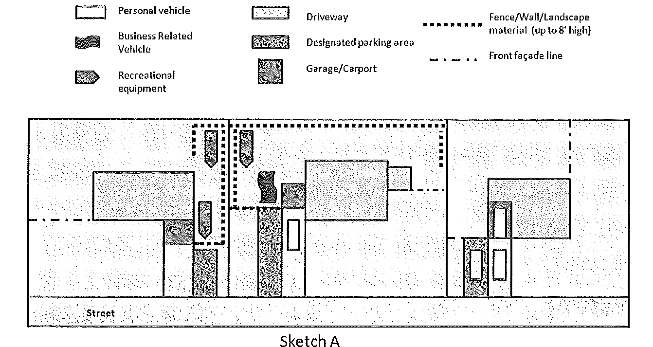
3.
Lot requirements.
a.
Business related vehicles and recreational equipment shall be parked behind the front facade(s) of the principal structure. The intent is to eliminate the possibility of parking forward of any portion of the principal structure.
b.
Side yard parking shall be behind the rearmost front facade of the principal structure, on the side of the yard the vehicle or equipment is parked, as demonstrated by Sketch B.
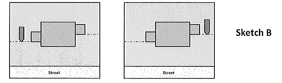
c.
Corner lots. A corner lot shall have one side yard, one back yard, and two front yards. The front yards are those yards that abut both streets. The maximum one-third front yard coverage shall be applied to only one front yard.
d.
Through lots. Parking shall be allowed in the back rear yard, if substantially screened from adjacent lots.
4.
Only one personal vehicle with a temporary registration and temporary license plate is permitted per residential structure at any point in time.
E.
Prepared parking area. Parking shall only occur on a prepared parking area located in the front yard or within that portion of the side yard that provides access to a side entry garage or carport. Driveways and designated parking areas are designated parking areas.
1.
Definitions. The following definitions apply to Section 3-10.9 of the ULDR.
a.
Circular driveway. A circular driveway is an access designed as a semi-circle with two aprons onto the right-of-way.
b.
Driveway. A path designed for vehicles that connect a residential unit or garage/carport with a public or private street.
c.
Designated parking area (DPA). An outdoor area in the front yard of a residential lot which is designed in accordance with the requirements of this Section for the parking of personal vehicles.
d.
Front yard. The area forward of the front facades extending to the street property line and between the side property lines.
2.
General requirements for prepared parking areas.
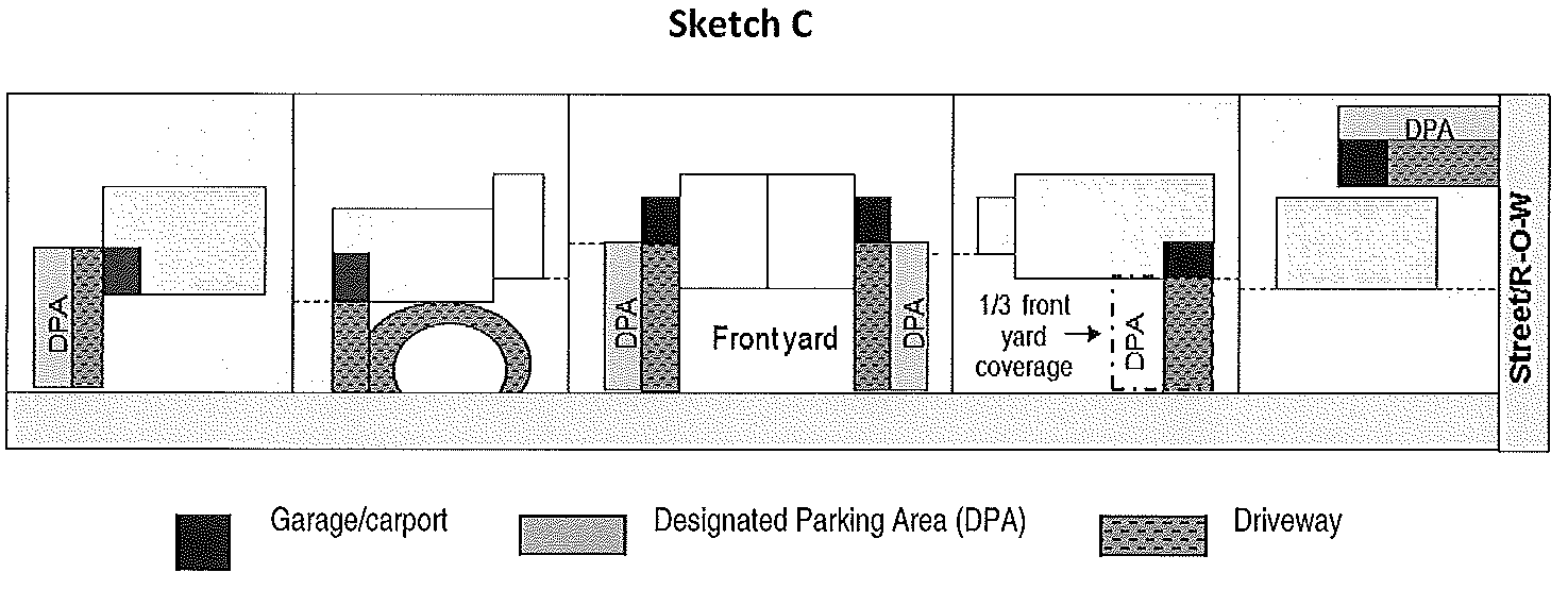
a.
Location and design.
1)
Single-family residential districts. See Sketch C.
a)
Parking on the driveway and/or designated parking area shall be confined to no more than one third of the front yard.
b)
The driveway/designated parking area shall be cohesive and restricted to one side of the yard or the other. The driveway/designated parking area shall be located to the side of the property where the carport or garage is located.
c)
The driveway/designated parking area shall not be located in the middle of the front yard unless the driveway is designed to be circular or unless the lot configuration, natural topography, natural feature, or entrance alignment with a public or private street prevent the driveway from being located elsewhere.
d)
A landscaped or grassed area shall be provided between the circular driveway and the right-of-way.
e)
Exemptions. The following parking situations shall be allowed:
i)
Circular driveways may exceed the maximum one-third (1/3) width for the front yard. A designated parking area is not permitted in addition to a circular driveway.
ii)
Rear yard parking. The detached garage shall be a legally permitted structure. As required for front yard parking, the driveway/designated parking area shall be on one side of the rear yard and adjacent to the carport or garage.
2)
Duplex-residential unit or R-2F zoning district. One designated parking area with a maximum ten (10) foot width is permitted immediately adjacent to each driveway.
b.
Materials.
1)
The driveway/designated parking area may be constructed of pervious or impervious materials.
2)
Pervious parking areas shall have a border to define the area and restrict migration of materials. Such border may include healthy landscape plants, landscape timbers, pavers, brick or similar materials.
c.
General requirements.
1)
Vehicles parked on the driveway/designated parking area shall not encroach into the sidewalk. The sidewalk shall be defined in F.S., § 316.003, and shall include any portion of a sidewalk that traverses a driveway.
2)
Impervious area. The impervious surface ratio (ISR) for each residential site shall not exceed the maximum allowed ISR provided in Table 2-5.4, Size and Dimension Regulations, except for those properties where the front yard has been reduced due to eminent domain actions. In those cases, maximum lot coverage may not exceed 60% ISR.
3)
Permit. A site construction permit shall be required from the Building Division whenever impervious materials are used to construct a driveway or designated parking area on any residential lot.
4)
Conformance. An existing driveway or designated parking area that is not consistent with criteria E.2.(a) Location and E.2.(b) Materials shall become compliant on or before February 1, 2010, except for those driveways and designated parking areas that have been constructed based on a permit issued by the City of Casselberry. Where a City permit was issued, the driveways and designated parking areas shall be considered lawful non-complying structures for purposes of Chapter II, Article VIII of the City's ULDR.
F.
Unlicensed and/or Inoperable Vehicles. All vehicles located on a residential site shall be fully licensed and operable. An unlicensed and/or inoperable vehicle on any residential site shall either be: (1) currently licensed and be rendered operable, or (2) the unlicensed/inoperable vehicle must be parked in a garage or removed from the property.
(Ord. No. 94-815, § I, 10-17-94; Ord. No. 95-853, § III, 12-11-95; Ord. No. 02-1045, §§ 25, 26, 5-13-02; Ord. No. 04-1121, § 8, 3-22-04; Ord. No. 06-1194, § 1, 6-11-07; Ord. No. 07-1215, §§ 1—3, 7-23-07; Ord. No. 07-1229, §§ 2, 3, 11-26-07; Ord. No. 08-1238, §§ 1, 3, 4, 4-24-08; Ord. No. 08-1251, § 2, 11-20-08; Ord. No. 09-1295, §§ 1, 2, 7-13-09; Ord. No. 10-1314, § 1, 4-12-10; Ord. No. 10-1343, § 1, 1-10-11; Ord. No. 12-1384, § 1, 12-10-12)
Section 3-10.10. - Reserved.
Editor's note— Ord. No. 97-882, § II, adopted Aug. 18, 1997, repealed § 3-10.10, which pertained to the adopted standard building code, fire code, and related codes, and derived from Ord. No. 95-853, § III, adopted Dec. 11, 1995.
Section 3-10.11. - Conditions for onsite individual wastewater treatment systems.
The City of Casselberry shall assist in assuring implementation of state regulations imposing mandated standards for inspections, operation, and maintenance of onsite individual wastewater treatment systems. The City shall require that residents connect to the public wastewater system as the system becomes available.
A.
Use of onsite wastewater treatment systems. Use of onsite wastewater collection systems shall be limited to the following conditions:
1.
Existing septic tanks may remain in service until such time as the City of Casselberry public wastewater collection system is made available.
2.
Use of private septic tank systems for new development shall not be permitted. No alteration to an existing septic tank shall be permitted without approval of the City Public Works Director and the Seminole County Environmental Health Services Unit of all related plans and specifications governing the type, location, capacity, design, and layout. All such specifications shall comply with applicable state, county or City regulations.
B.
Coordinate with the Seminole County Public Health Unit. The City shall require that all proposed development which impacts an existing septic tank be required to provide evidence of approval by the Seminole County Public Health Unit prior to receiving a development order or permit from the City. Any such approval by the City shall be conditioned upon the applicant's compliance with Comprehensive Plan policy requirements for ongoing facility maintenance and operation and with the public works septic tank elimination program.
C.
Development orders and permits. Issuance of development orders or permits shall be conditioned upon demonstration of compliance with applicable federal, state, and local permit requirements for onsite wastewater treatment systems.
The City of Casselberry shall regulate the location, timing, and scale of development in order to assure that new development shall be effectively served by wastewater services.
D.
Onsite wastewater treatment and water quality regulations. The City of Casselberry shall coordinate with appropriate federal, state, and county agencies to assure that issuance of permits for replacement of existing onsite wastewater treatment systems is conditioned upon compliance with current regulatory requirements and water quality standards.
(Ord. No. 95-853, § III, 12-11-95)
Section 3-10.12. - Design criteria for buildings in excess of 35 feet in height.
In all areas designated as Commercial, Industrial, High Density Residential, Medium Density Residential or Low Intensity Nonresidential/Medium Density Residential on the City of Casselberry Comprehensive Plan Future Land Use Map and zoned CG, CS, IND, RMF-13, RMF-20, PRD or PMX-L, building heights in excess of 35 feet may be permitted as a conditional use pursuant to the criteria established in Article VI of this Code. Notwithstanding, in areas designated High Intensity Nonresidential/Medium Density Residential on the City of Casselberry Comprehensive Plan Future Land Use Map, building heights in excess of 35 feet may be allowed pursuant to site development approval.
In all cases, the setback requirement for yards which abut any residentially zoned area which is not in an area designated by the City of Casselberry Comprehensive Plan Future Land Use Map as Low Intensity Nonresidential/Medium Density Residential or High Intensity Nonresidential/Medium Density Residential, shall be an additional 15 feet for each additional ten feet in height or fraction thereof in excess of 35 feet.
In addition to the regular landscape and buffering requirements of this Code, a minimum six foot high masonry wall of decorative construction shall be provided along any yard boundary which abuts any residentially zoned area and/or planned to be residentially zoned which is not in an area designated by the City of Casselberry Comprehensive Plan Future Land Use Map as Low Intensity Nonresidential/Medium Density Residential or High Intensity Nonresidential/Medium Density Residential. In those instances where a minimum 50 feet of buffer or natural area is provided the Planning and Zoning Commission/Land Planning Agency may waive this requirement provided the retention and perpetual maintenance of significant sight obscuring vegetation.
In any event a final determination as to the allowable height of any building will be based upon the City's ability to ensure an acceptable level of service for all necessary public facilities and services to that building.
(Ord. No. 768, § I, 7-7-93; Ord. No. 95-853, § III, 12-11-95; Ord. No. 19-505, § 3, 2-11-19)
Section 3-10.13. - Community redevelopment district urban design standards.
A.
Established. In addition to, and supplemental to, all Unified Land Development Regulations heretofore and hereafter established, there is hereby created an overlay zoning classification known as the "Community Redevelopment District Urban Design Standards Overlay" (CRD-UDS). The legal description of the property subject to this overlay is attached to Ordinance No. 03-1106 as Exhibit "A", and by this reference incorporated as part of this Code.
B.
Community Redevelopment District Urban Design Standards. Property located within Exhibit "A" shall be subject to all provisions in the "Community Redevelopment District Urban Design Standards Overlay," which are hereby attached to Ordinance No. 03-1106 as Exhibit "B," and by this reference made a part hereof. This Section shall be in addition to and shall overlay all other zoning classifications where it is applied, so that any parcel of land lying in Exhibit "A" shall also lie within one or more of the other zoning classifications provided in the Unified Land Development Regulations. The effect shall be the creation of new zoning classifications consisting of the regulations and requirements of both the underlying classifications and the design standards overlay.
C.
Application of Standards. All Unified Land Development Regulations not provided in this Section relating to the underlying zoning classification assigned to property shall continue to apply to the Community Redevelopment District, Exhibit "A." Where the community redevelopment district urban design standards and the underlying districts differ, the more restrictive standard shall apply.
D.
Classification. That the Official Zoning Map established in Article IV Section 2-4.3 of the Unified Land Development Regulations of the Code of Ordinances of the City of Casselberry, Florida, as amended and supplemented, for the property located within Exhibit "A" is hereby amended and given the CRA-UDS zoning district classification. That classification is defined in Subsection D.
E.
Exceptions. Additions, extensions, renovations, replacement, reconstruction or redevelopment of an existing structure or project shall be exempt from the provisions of this Section as provided in Unified Land Development Regulation Section 2-8.8. A change in uses as defined by Unified Land Development Regulation Section 2-8.9 will require compliance with the provisions of this Section.
F.
Applications Review by Administrative Official.
1.
Building Permits. Any development application requiring a building permit and involving an exterior alteration visible from the public right-of-way shall be referred to the Administrative Official. The Administrative Official shall approve, approve with conditions, or deny the application, stating in writing the reasons for any denial, which shall include appropriate citations to this Section and the City's Unified Land Development Regulations.
2.
Other Applications Review. Upon acceptance by the Planning Department of any application which requires review by the Planning and Zoning Commission or City Commission, the application shall be forwarded to the Administrative Official. The Administrative Official shall prepare recommendations for the consideration of the applicable reviewing authority, including an analysis of compliance with the provisions of this Section and citations to any Section provisions as to which compliance has not been attained.
G.
Vested Rights.
1.
Any owner of land who has applied for development approval prior to the effective date of this Section may petition the City Commission for a vested rights determination, by filing such petition with the City Manager, along with a $100.00 fee for such request, within 90 days of the effective date of this Section, seeking exemption as to a particular parcel of land from the provisions of this Section. In addition, Applicant must reimburse the City for the City Attorney's review of such application. Such petition shall be evaluated by the City Attorney and an analysis of the petition shall be made based on the following criteria:
a.
The existence of a valid and unexpired development order of the City authorizing the specific development for which a determination is sought.
b.
Expenditures or obligations made or incurred by the property owner in reliance upon the terms and conditions of the development order, or the application of the Unified Land Development Regulations, prior to the enactment of this Section.
c.
Other factors that demonstrate that it is inequitable or unjust to deny the owner the opportunity to complete the previously approved development under the conditions of approval by requiring the owner to comply with the requirements of this Section. For the purposes of this Section, the following factors shall always be considered in determining whether it is equitable or unjust to deny the owner the opportunity to complete the previously approved development; in addition to any others raised by the owner:
i.
Whether the injury suffered by the owner outweighs the public harm resulting from the development proceeding without the development being required to comply with the land development regulations set forth in this Section; and
ii.
Whether the expenses or obligations for the development were made or incurred subsequent to the effective date of this Section.
2.
The City Attorney shall submit a written analysis as to whether the owner has a vested right and whether such vested right would result in the owner being exempt from the provisions of this Section.
3.
The City Commission shall make a prompt decision on the petition at a quasi-judicial hearing. The decision of the City Commission shall be reduced to writing and shall constitute final administrative review. Prior to the City Commission hearing, the City Commission shall provide notice to the application consisting of mailing to the applicant by certified mail (return receipt requested) a notice of meeting.
4.
The property owner may appeal the decision of the City Commission to the courts as provided by law.
5.
Existing lawful uses at the effective date of this Section shall be automatically exempt from this Section.
(Ord. No. 03-1088, §§ II—VII, 6-23-03; Ord. No. 03-1106, §§ I—VIII, 12-08-03; Ord. No. 12-1369, § 13, 2-13-12; Ord. No. 25-1625, § VII, 11-17-25)
Section 3-10.14. - Multifamily development design standards.
A.
All proposed development shall conform to Article XV regarding off-street parking, loading, and other regulations, including, but not limited to, strategies to reduce trips and parking demand, pedestrian-oriented design elements, bicycle facilities, pay-to-park, or additional fees based on demand.
B.
All proposed development shall conform to Article XIII, Landscaping, regarding landscape and buffer requirements. Additional landscaping may be required to help screen and/or mitigate impact on adjacent properties.
C.
Properties located within an overlay district shall comply with any relevant standards. When there is a conflict between the provisions contained in this section and the provisions of an overlay district, the stricter provision shall apply.
D.
The first floor of each multi-family building must be concrete.
E.
Minimum multi-family and condominium unit size shall conform to the minimum living areas in Table 2-5.4 based on the subject property's current zoning designation. However, if the proposed development is authorized under Fla. Stat. 166.04151, the following minimum living area requirements apply:
•
Studio must be larger than 500 sq. ft.;
•
One-bedroom must be larger than 700 sq. ft.;
•
Two-bedroom must be larger than 1,000 sq. ft.;
•
Three or more bedrooms must be larger than 1,200 sq. ft.
F.
Minimum multi-family and condominium building setbacks shall conform to the setbacks in Table 2-5.4 based on the subject property's current zoning designation. However, in accordance with Section 2-5.5, if the proposed development is authorized under Fla. Stat. 166.04151, the following setbacks apply:
•
Front—20 ft
•
Side Interior—10 ft
•
Side/Corner Lot—20 ft
•
Rear—20 ft
•
For buildings taller than 35 ft., a greater setback may be required when adjacent to single-family residential use or zoning.
G.
Amenities required within multi-family developments include:
a.
Each unit must have an in-unit washer/dryer and independent balcony.
b.
Pool with restrooms.
c.
Gymnasium.
d.
Park space.
e.
Doggy runs (if pets are allowed).
f.
Minimum six foot wide sidewalks.
g.
Flex office space.
h.
A minimum of one electric vehicle charging station must be provided for a development requiring more than 50 parking spaces. The charging station shall serve two parking spaces.
H.
Enhanced architectural standards shall be integrated into the building form to break up large building mass and long walls. Architectural features shall be displayed on all sides of a building, incorporating a base, middle, and top to maintain pedestrian scale. The building mass shall be proportionate to the site, streets, open space, and surrounding developments. Alternating lengths and designs may be acceptable and shall be addressed during site plan review.
a.
Buildings shall include at least three architectural elements on facades fronting a right of way and two elements on other facades. Architectural elements shall include, but not be limited to, porticos, balconies, columns, awnings, canopies, and recessed/projected access.
b.
Integrated ornamental and structural building articulation is required, including projections and recesses with a minimum depth of 24 inches.
c.
Varied roof line and form, stepped or decorative parapets, cornices and eaves, and belt courses must be utilized in the building design.
d.
Windows and doors shall include surrounds, casing, or headers. Windows may have shutters or other decorative features.
e.
Building materials and finishes shall be consistent on all facades. High-quality materials and finishes such as brick, stone, vertical board, or batten siding shall be used as primary materials; EIFS/traditional stucco finish shall not be the primary material on the front facade or those facing a street.
(i)
Prohibited materials include unfinished concrete or block, corrugated fiberglass or metal, sheet, or tin siding.
f.
Accessory structures not designed or incorporated as part of the principal building and approved as part of a site plan or as part of the amenities listed in this Section are prohibited.
I.
Onsite lighting shall adhere to Section 3-10.2.6 and be consistent throughout the development to complement the building's architecture. Light fixtures shall be decorative with concealed light sources, and light poles shall have fluted bases. The use of illuminated bollards instead of poles is encouraged in exclusively pedestrian areas.
(Ord. No. 23-1586, § III, 12-11-23)
Section 3-11.1.- Preservation of wetlands.
In order to promote and preserve natural hydrological conditions and to preserve water recharge areas, water supply, water quality, environmentally sensitive areas, and natural habitats, the following regulations shall be applied to wetlands.
A.
Definitions. Wetlands shall be defined based on hydrology as well as hydric soil and wetland vegetation. Wetlands shall include those areas that are inundated or saturated by surface or ground water at a frequency and duration sufficient to support, and that under normal circumstances do or would support, a prevalence of vegetation typically adapted for life in saturated soil conditions. Flora and fauna species which shall be protected by the regulations of Section 3-11.7 are listed in Official Lists of Endangered and Potentially Endangered Fauna and Flora in Florida, Florida Game and Freshwater Fish Commission, latest edition and as hereafter may be amended. Wetland boundaries shall be made in accordance with the requirements of the FDER, SJRWMD, and the U.S. Army Corps of Engineers and shall include the largest or most inclusive area whether isolated or contiguous with a natural or artificial water body. The City reserves the right to regulate construction activities or any physical alteration of wetlands whether or not such activities are regulated by state or federal permitting agencies.
B.
Wetland development restrictions and interpretations. Wetlands serve a vital natural function to filter contaminants carried by surface water percolating to groundwater aquifers. Wetlands also are vital to the quantity of water reaching aquifer storage sheds. No development shall be permitted in wetlands excepting where state and/or federal agencies having jurisdiction provide for alteration of the wetland. The U.S. Army Corps of Engineers, Florida Department of Environmental Regulation and St. Johns River Water Management District definitions shall be used to ascertain wetlands within the City of Casselberry. For purposes of land management, the City will employ the definition which allows it to claim the larger area. Wetlands possess three essential characteristics: (1) hydrophytic vegetation, or plant life with a water or water-saturated soils habitat; (2) hydric soils, or soils that are water-saturated; and (3) wetland hydrology or permanent or periodic inundation of soils to the surface by water.
In cases where the agencies having jurisdiction determine that wetlands may be altered, the City shall coordinate with the jurisdictional agencies for purposes of rendering legal, equitable, and environmentally sensitive determinations of the development rights to be permitted on such waters and/or lands under the jurisdiction of the state or federal government. Regardless of actions or inactivities by federal or state permitting agencies, the City shall reserve the right to determine the appropriate land use, density/intensity, and special mitigation measures including, but not limited to, maximum mitigation ratios to be imposed on a development. The applicant shall bear the burden of proof in determining that development shall not adversely impact wetlands.
Where the City Unified Land Development Regulations provide for development rights within wetlands for lots of record in residential areas, the density shall in no case exceed 0.2 unit per acre. In addition, the density (i.e., 0.2 unit per acre) may accrue to the adjacent upland which is under unified control.
Such determinations shall be based on physical and biological data obtained from specific site investigations. These determinations shall be predicated on findings rendered by professionals competent in producing data and analysis necessary to support impact assessments, including findings regarding the impacts of potential development on the physical and biological value and function of environmentally sensitive lands.
C.
Wetland buffer zones. Wetlands shall be protected from impacts generated by adjacent land uses through natural upland buffer zones. The upland buffer is an area landward of the upland edge of a wetland (i.e., the upland/wetland jurisdictional line). The buffer area has a direct groundwater or surface water influence and provides an upland buffer which separates developed upland from a wetland area. The purpose of the buffer area is to ensure the continuing function of respective wetland communities, prevent pollutants from surface water runoff from entering the wetlands, and to enhance water quality.
Development within wetland buffer zones shall comply with the requirements of this Section and, as a minimum, be consistent with applicable state and federal regulatory policies affecting the specific sites. However, where conflicts between the City, state and federal regulatory policies conflict, the more restrictive shall prevail. The exact boundary of an upland buffer area shall be established by field investigation and shall be sufficient to protect adjacent wetlands.
1.
Establishing the wetland line. The wetland line shall be established based upon field survey of site, of field surveys of the site by a professional biologist or registered engineer provided by the applicant and verified by the St. Johns River Water Management District, the DER, and/or the U.S. Army Corps of Engineers. The field investigation which delineates a larger area shall be used as the wetland line.
2.
Vegetative buffers. Environmentally sensitive areas including wetlands and Class III waters shall provide buffers of 50 feet. Buffers shall be 25 feet on lots less than five acres created prior to February 17, 1992. New and redeveloped areas and arterial roadways shall provide buffers of 50 feet. No hazardous waste shall be stored or disposed of on upland buffers.
Should it be necessary to establish or replenish shoreline vegetation or littoral zones, the developer should consult Appendix A, Aquatic Plants Suitable for Establishment of Littoral Zones and Shoreline Restoration, and an excerpt from Aquascaping: Planting and Maintenance, Circular 912 published by IFAS. This appendix will provide a list of suitable water-oriented plants for varying site conditions as well as nondesirable plants. Aquatic planting that is necessary shall be illustrated on the required landscape plan submittal for site plan review (reference Section 3-13.10).
Natural buffer zones shall be based on guidelines contained in Buffer Zones for Water, Wetlands, and Wildlife (Center for Wetlands; Brown, Schaefer, and Brandt, 1989). An applicant for development may propose alternative methodology, but such methodology shall be subject to verification and must address the following:
a.
Erodibility of soils upland of the wetland line;
b.
Depth of the water table below the soil surface in the zone immediately upland of the wetland line; and
c.
Habitat requirements of aquatic and wetland dependent wildlife based on:
i.
Habitat suitability;
ii.
Spatial requirements;
iii.
Access to upland habitat; and
iv.
Noise impacts.
3.
Required dedication of conservation easements. The City may require applicants for site plan approval or subdivision development approval to include the dedication of conservation easements or reservations where the City finds that the dedication is warranted in order to protect the value and function of a wetland and upland buffer.
Section 3-11.2. - Soil erosion and sedimentation control.
A.
Applicability. In order to prevent both soil erosion and sedimentation, a soil erosion and sedimentation control plan shall be required as a part of an application for site plan review whenever a development will involve any clearing, grading, or other form of disturbing land by the movement of earth.
B.
Definitions. For the purposes of this Article the following definitions are provided:
1.
Soil erosion: Any removal and/or loss of soil by the action of water, gravity, or wind. Erosion includes both the detachment and transport of soil particles.
2.
Sedimentation: The settling out of the soil particles which are transported by water or wind. Sedimentation occurs when the velocity of water or wind in which soil particles are suspended is slowed to a sufficient degree and for a sufficient period of time to allow the particles to settle out of suspension or when the degree of slope is lessened to achieve the same result.
3.
Erodible slope: All slopes with inclines in excess of four percent unless modified by the City Engineer based on consideration of specific soil conditions.
4.
Large flat surface area (unpaved): An area which is flat or whose slope is less than four percent and which consists of more than 1,000 square feet of exposed soil.
C.
Erosion control measures. All measures necessary to minimize soil erosion and to control sedimentation in the disturbed land area shall be implemented. The following protection shall be provided for all disturbed areas: minimize velocities of water runoff, maximize protection of disturbed areas from stormwater runoff, and prevent or retain sedimentation within the development site as early as possible following disturbances.
D.
Applicability. Appropriate measures shall be taken during land clearing and building operations to assure that exposed, destabilized or otherwise altered soil is expeditiously covered with an acceptable erosion control material. The provision shall be applicable to the act of subdividing and installation of related improvements as well as during the development review process including the period during which improvements may occur as well as the length of time soil may be exposed to the environment.
The tree and native vegetation protection ordinance shall be applicable to all clearing and grading activities and shall include specifications for management principles guiding the removal or placement of vegetation and landscaping design. Regulations shall also require developers to take precautionary measures, where necessary, to avert destruction or damage to native vegetation.
Section 3-11.3. - Wellhead protection.
A.
Purpose and intent. The purpose and intent of this Section is to protect potable water from contamination by establishing a protection area around municipal potable water wells and prohibiting certain land uses and activities within the area which have the potential to contaminate groundwater.
B.
The regulations set forth herein shall apply to all development proposed in area surrounding a wellhead.
C.
Establishment of wellhead protection area. A Wellhead Protection Area means an area designated by the City of Casselberry consisting of a 500 foot radial setback distance around a potable water well where ground water is provided the most stringent protection measures to protect the ground water source for a potable water well and includes the subsurface and surrounding the well.
D.
Mapping. Wellhead protection area maps shall be available for review in the Engineering Department. Such maps will designate and graphically represent the wellhead protection area and may be amended from time to time as updated information becomes available.
E.
Restrictions in the wellhead area.
1.
The City shall require new development and redevelopment to meet the following restrictions within a wellhead protection area.
a.
New wastewater treatment facilities shall be provided with Class 1 reliability as described in Chapter 62-600, F.A.C., and flow equalization. New wastewater ponds, basins, and similar facilities shall be lined or sealed to prevent measurable seepage. Unlined reclaimed water storage systems are allowed for reuse project permitted under Part III of Chapter 62-610, F.A.C.
b.
New reuse and land application projects shall be prohibited except for new projects permitted under Part III of Chapter 62-610, F.A.C.
c.
The following is prohibited:
i.
New wastewater residuals land application site, as defined in Chapter 62-640, F.A.C.
ii.
New phosphogypsum stack systems, as regulated under Chapter 62-673, F.A.C.
iii.
New Class I and Class III underground injection control wells, as regulated in Chapter 62-528, F.A.C.
iv.
New solid waste disposal facilities regulated under Chapter 62-701, F.A.C.
v.
New hazardous waste treatment storage, disposal, and transfer facilities requiring permits under Chapter 62-730, F.A.C.
vi.
New aboveground and underground tankage of hazardous wastes regulated under Chapter 62-730, F.A.C.
d.
New discharges to ground water of industrial wastewater, as regulated under Chapters 62-660, 62-670, 62-673, F.A.C., shall be prohibited except as provided below:
i.
All non-contact cooling water discharges (without additives); and
ii.
Discharges specifically allowed within a wellhead protection area in Chapters 62-660, 62-670, 62-671, and 62-673, F.A.C.
e.
New Class V underground injection control wells, as regulated in Chapter 62-528, F.A.C., are prohibited except as provided below:
i.
Thermal exchange process wells (closed-loop without additives) for use at single-family residences.
ii.
Aquifer storage and recovery systems wells, where the injected fluid meets the applicable drinking water quality standards in Chapter 62-550, F.A.C.
f.
New generators of hazardous waste, as regulated under Chapter 62-730, F.A.C., which excludes household hazardous waste as defined in 40 C.F.R. Part 261.4(b)(1)(1994), hereby incorporated and adopted by reference, shall comply with the secondary containment requirements of 40 C.F.R. Part 264 Subpart I (1994), hereby incorporated and adopted by reference.
g.
Underground storage tanks regulated under Chapter, 62-761, F.A.C., shall not be installed 90 days after the effective date of this rule. Replacement of an existing underground storage tank system regulated under Chapter 62-761, F.A.C., within the same excavation, or addition of new underground storage tanks regulated under Chapter 62-761, F.A.C., at a facility with other such underground storage tanks is exempt from this provision, provided that the replacement or new underground storage tank system is installed with secondary containment as required in Chapter 62-761, F.A.C.
h.
Aboveground storage tanks regulated under Chapter 62-762, F.A.C., shall not be installed 90 days after the effective date of this rule. Replacement or upgrading of an existing aboveground storage tank or addition of new aboveground storage tanks which are regulated under Chapter 62-762, F.A.C., at a facility with other such aboveground storage tanks is exempt from this provision, provided that the replacement or new aboveground storage tank system meets the applicable provisions of Chapter 62-762, F.A.C.
i.
Storage tanks which meet the auxiliary power provisions of Rule 62-555.320(6), F.A.C., for operation of potable water well and storage tanks for substances used for the treatment of potable water are exempt from the provisions of this rule. Storage tanks regulated under Chapters 62-761 and 62-762, F.A.C., shall continue to meet the requirements of those chapters.
j.
Applicants should take note that to prevent the vertical migration of fluids, a water management district may require a construction permit for new water wells, which shall meet the applicable construction standards contained in Chapter 62-532, F.A.C.
2.
Emergency equipment, including storage tanks, that is necessary to provide power to ensure a continuous supply on an emergency basis of public water supply, electrical benefit are exempt from the provisions of this chapter. This does not exempt these services from meeting other applicable Department rules.
3.
Discharge to ground water from Department approved remedial corrective actions for contaminated sites located within wellhead protection areas shall not be subject to the discharge restrictions in this chapter.
F.
Wellhead protection area review process.
1.
The City shall review all site plans, master plans, and subdivision plans for consistency to the terms and requirements of this Section and no application or plan shall be approved unless full compliance is demonstrated. Permits issued in violation of this Section convey no right or privilege on the grantee.
(Ord. No. 99-930, § I, 4-5-99)
Section 3-11.4. - Aquifer recharge protection.
The City rests on an area with high aquifer recharge potential. To maintain the natural rate of percolation within aquifer recharge areas, development applications shall comply with the following requirements:
A.
Surface water management. Development plans shall maximize quality and quantity of stormwater percolating downward to groundwater storage areas. The provisions of Article XII governing stormwater management, including onsite retention and detention of surface runoff, shall be met. Onsite retention structures for new development shall be designed for net retention and infiltration of predevelopment recharge to groundwater aquifers. Chapter 40C-42, F.A.C., regulating retention of the first one inch of rainfall, shall be satisfied.
B.
Compatible land use for preserving groundwater quality. Pursuant to provisions of Article V certain acceptable manufacturing uses meeting nuisance abatement performance standards may be permitted as conditional uses within commercial land use districts, provided that the use does not exceed the density and intensity of use allowed within the commercial district and shall be restricted according to sanitary sewer as set forth within F.S. § 381.272.
C.
Impervious surface and open space ratios. The impervious surface and open space ratios established in Article V shall govern all development.
D.
Specific restrictions on development within recharge areas. All development within designated prime recharge areas shall comply with the following development requirements:
1.
Development shall be required to preserve predevelopment topography with regard to soil type, drainage rates, and grade elevation, and shall be designed so as to minimize the reduction of recharge of the surficial aquifer. The groundwater level and fluctuations shall be no worse than under predevelopment conditions.
2.
Removal of soil from a development site or any portion thereof which is located above 25 feet mean sea level (MSL) is prohibited. On such sites or portions thereof the reduction of the natural topography shall be limited to six feet above the normal high water table (with the exception of drainage conveyance or retention ponds) or eight feet below existing land surface, whichever is more restrictive.
3.
No clearing of soil or vegetation may occur before a permit is issued.
4.
No excavation which cuts below the seasonal high water table (this practice lowers the water table level) shall be allowed. This includes but is not limited to excavations for building foundations, parking lots, and site drainage. Open drainage conveyances below the normal high water table shall be prohibited. Underground piping of stormwater is required when inverts are lower than the normal high water table.
5.
Impermeable surfaces of recharge areas shall be regulated as follows:
a.
Development on sites with any land having an elevation no greater than 25 feet above mean sea level (MSL) shall restrict impermeable surfaces to 50 percent of the total area of the site which is 25 feet or less MSL.
b.
Development on sites with any land exceeding 25 feet mean sea level (MSL) shall restrict impermeable surfaces to 35 percent of the total area of the site which is above 25 feet MSL.
E.
Prohibited land uses. The following land uses and activities are prohibited within prime aquifer recharge areas:
1.
Sanitary landfills;
2.
Wastewater treatment facilities;
3.
Petroleum, pesticide storage facilities, and prohibited manufacturing activities cited in Article V;
4.
All other land uses that store, handle, or generate hazardous materials or wastes. A hazardous material or waste, as regulated by this Section, shall consist of the following:
a.
Chapter 38F-41 of the Florida Administrative Code (the Florida Substance List).
b.
Title 40 of the Code of Federal Regulations Part 261 (Identification and Listing of Hazardous Wastes).
c.
Title 40 of the Code of Federal Regulations Part 302.4 (Table 302.4) (List of Hazardous Substances and Reportable Quantities).
d.
Title 40 of the Code of Federal Regulations Part 355, Appendix A and B (List of Extremely Hazardous Substances).
5.
Aboveground or belowground pipes for pollutants or contaminants.
Section 3-11.5. - Lakeshore protection.
A.
Shoreline protection and lakefront littoral zone established. To protect lakes from nutrient enrichment and degraded biological diversity, a shoreline protection zone shall be established. This zone shall include existing aquatic vegetation, wetlands, and the upland buffer.
B.
Land use restrictions within lakeshore protection zone. Only passive and water-related recreation activities, if authorized by Department of Environmental Regulation, St. Johns River Water Management District and Department of Natural Resources, shall be permitted within the shoreline protection zone. No other construction activity shall encroach into the lakeshore protection zone.
C.
Shoreline protection plan. Development occurring adjacent to lake shoreline or wetland areas shall prepare a design and management plan as part of the required site plan prior to the construction of any onsite stormwater management system. This plan shall include the following:
1.
Plan for vegetative cover. The shoreline protection plan shall include a narrative and graphic presentation demonstrating that native vegetation shall be preserved as mandated by the tree and native vegetation protection policies of the Comprehensive Plan. Only native vegetation shall be planted and maintained within the shoreline and lakefront littoral zone. The plan for vegetative cover shall specify how vegetation is to be established within this zone, including the extent, method, type and timing of any planting to be provided. The plan should also include the removal of non-native or nuisance species.
2.
Plan for shoreline and lakefront littoral zone management. The shoreline protection plan shall include a shoreline management plan that describes procedures to ensure minimal impacts to water quality and shoreline erosion. Where deemed necessary, silt screening shall be implemented to retain effluvial sediments carried by runoff stormwater or wave action. The plan shall comply with the erosion and sedimentation performance standards of this Article. The plan shall also include:
a.
Cross sections of shoreline management plan. Include typical cross sections of the surface water management system showing the average water elevation and the three-foot contour (i.e., below average elevation) or a 75-foot distance from the wetland buffer, whichever is greater.
b.
Lakefront littoral zone management strategies. Provide a description of any management procedure to be followed in order to ensure the continued viability and health of the lakefront littoral zone. The lakefront littoral zone as established shall consist entirely of native vegetation and shall be maintained permanently as part of the water management system. Development within the lakefront littoral zone shall be limited to water-dependent structures defined within the land development regulations. The developer's lakefront littoral zone management plan shall include a plan acceptable to the City for the longterm management and maintenance of stormwater, lake, and lakefront shoreline. The burden for perpetual maintenance rests with the property owner. Should the City establish a Citywide utility district, the City may implement a City management strategy to be funded through an equitable assessment of property owners.
c.
Should it be necessary to establish or replenish shoreline vegetation or littoral zones, the developer should consult Appendix A, Aquatic Plants Suitable for Establishment of Littoral Zones and Shoreline Restoration, and an excerpt from Aquascaping: Planting and Maintenance, Circular 912 published by IFAS. This appendix will provide a list of suitable water-oriented plants for varying site conditions as well as nondesirable plants. Any aquatic planting that is necessary shall be illustrated on the required landscape plan submitted for site plan review (reference Section 3-13.10).
3.
Plan for protecting Class III waters. All lakes within or adjacent to the City are Class III waters. Plans for lakeshore protection shall include the following protective measures:
a.
Dredging and filling activities shall be limited to FDER, FDNR, U.S. Army Corps of Engineers, and SJRWMD and any other applicable agency approved dredging.
b.
Ensure good water quality by coordinating with the FDER, FDNR, and the St. Johns River Water Management District in monitoring the quality of stormwater runoff and all discharge. The City shall notify the appropriate agency with jurisdiction as potential issues or problems are identified by the City.
c.
Limit the use of Class III waters to water-dependent activities that are in the public interest and satisfy a community need.
d.
Protection of aquatic and wetland wildlife and vegetative species.
4.
Required wetland buffer zones. The lakefront protection plan shall comply with performance criteria applicable to wetland buffer zones within the Article.
5.
Monitoring and management. Development shall ensure that the shoreline management plan is conducted in accordance with the plan by performing monitoring in accordance with the plan authorized by state and federal permits. However, the City may require additional monitoring deemed appropriate.
D.
Exemptions to the lakefront protection regulations. The following activities shall be exempt from the lakefront protection regulations:
1.
Minor maintenance or emergency repair to existing structures or improved areas.
2.
Clearing of shoreline vegetation to create walking trails having no structural components, not to exceed four feet in width. The City reserves the power to restrict the number and design of walking trails.
3.
Timber catwalks, docks, and trail bridges that are less than four feet wide, provided that no filling, flooding, dredging, draining, ditching, tiling or excavating is done, except limited filling and excavating necessary for the installation of pilings.
4.
Recreational fishing and temporary blinds.
5.
Constructing fences where no fill activity is required and where navigational access will not be impaired by construction of the fence.
Notwithstanding, any permitted development shall provide a plan acceptable to the City which ensures maintenance of water quality and shoreline integrity in perpetuity.
Section 3-11.6. - Sinkholes.
Sinkholes generally have unstable soils and high relief of slopes. The City finds regulation of development in the vicinity of sinkholes necessary in order to protect the public from potential damage resulting from sinkhole collapse and to protect groundwater quality from potential contamination. Such contamination may be introduced through sinkhole passages that provide for rapid downward percolation of contaminants into groundwater storage areas. Therefore, development occurring adjacent to an existing sinkhole shall be subject to development restrictions. Such development restrictions shall be determined on a case-by-case basis according to the geological and hydrological circumstances causing the formation. The developer shall be required to submit an environmental audit certified by a competent professional that addresses the above-noted geological and hydrological circumstances and shall certify that a proposed development is not potentially disruptive to the natural or manmade environment and promotes public health, safety and welfare. The City shall require any such developer to hold the City harmless from any and all further claims arising from such proposed development.
Section 3-11.7. - Upland habitat preservation and protection of flora and fauna.
Vegetative communities and wildlife habitats (particularly those identified as habitat for endangered or threatened species or species of special concern) which are deemed environmentally significant shall be protected from adverse impacts associated with development. Endangered and potentially endangered fauna and flora species indigenous to habitats as identified in Section 3-11.1(A) shall be protected pursuant to this Section.
Applicants for development within any areas identified as refuge, breeding, feeding, or habitat areas of endangered or threatened species or species of special concern shall prepare a habitat management plan which shall as a minimum include the following:
1.
Critical habitat management plan required. Site plans and preliminary plats shall include a "Critical Habitat Management Plan" prepared by a professional biologist, ecologist, or other related professional. The plan shall ensure the protection of endangered and threatened flora and fauna as identified in Section 3-11.1(A) which shall be protected pursuant to this Section. As a minimum standard this plan shall analyze the following issues:
a.
Identify the occurrences of designated species by a qualified ecologist;
b.
Land needs to support continued onsite presence of the species;
c.
Impacts of proposed development which will disturb the species;
d.
Management plans and measures necessary to protect the subject species;
e.
Cost to developer to implement the management plan as approved.
2.
Criteria for reviewing critical habitat plan. Development activities which have an adverse effect upon a designated species shall require mitigation acceptable to the City or shall not be permitted. Viable (i.e., capable of living) habitat for endangered or threatened species or species of special concern occurring on a site shall be identified on the management plans as preservation areas. All development activities shall be prohibited within these preservation areas with the exception of recreational and educational uses where such uses will not adversely affect such species.
The City staff shall review the critical habitat management plan as well as the federal and/or state agencies having jurisdiction. The final development plan shall comply with directives of the federal and/or state or local agencies having jurisdiction and the most restrictive shall apply.
3.
Reservation of conservation easements. The applicant shall provide a conservation easement which ensures the preservation of habitats.
Section 3-11.8. - Land use and soil compatibility.
Land use activities, including their densities and intensities, shall be compatible with soil types. Soil on sites proposed for development shall have properties capable of supporting the proposed development.
In the event the future land use map or the official zoning map identifies a land use allowed within an incompatible soil type, a field study may be performed on the site by a professional hydrologist, registered engineer, soil scientist or other professional competent in delineating and evaluating actual soil types exhibited on the subject site. The City shall reserve the right to have such a field study verified by the local U.S. Soil Conservation Office or a comparable state agency and shall render a decision ensuring that the land use is compatible with the soil type.
Section 3-11.9. - Floodplain protection.
The following regulations, together with the provisions of Article XII, Stormwater Management, and provisions contained in the City of Casselberry Code, shall apply to all construction within the City of Casselberry.
1.
Purpose and intent of floodplain management. Floodplains serve the following important functions in the hydrologic cycle:
•
Floodplains provide natural storage and conveyance of floodwaters;
•
The water on flooded lands may provide recharges to groundwater and is a basic source of flow to rivers, streams and estuaries;
•
Temporary storage of surface waters on floodplains regulates flood elevations and the timing, velocity and rate of flood discharges;
•
Floodplains maintain water quality by reducing erosion, removing nutrients and other pollutants and allowing sediment to settle; and
•
Natural floodplains export detritus and other food sources to open water bodies and are vital habitat for fish, birds, wildlife and native plant communities.
Regulation of development within floodplains is necessary in order to accomplish the following objectives:
•
To minimize the potential for property damage and personal injury from flooding;
•
To restrict adverse interference with the normal movement of surface waters;
•
To maintain the optimum storage capacity of watersheds;
•
To maintain desirable groundwater levels;
•
To maintain the natural hydrological and ecological functions of wetlands and other floodprone lands;
•
To prevent increased erosion and sedimentation; and
•
To maintain water quality.
2.
Minimize development within upland flood zone. This Subsection regulates the uplands within the 100-year flood zone. Wetlands, on the other hand, are regulated pursuant to Section 3-11.1 herein. Land outside wetlands but situated within the 100-year flood zone as delineated on the Federal Emergency Management Agency's federal insurance rate maps are referred to as "uplands of the flood zone."
3.
Required floodplain protection techniques. Applicants for development and redevelopment shall be required to position structures and impervious surfaces to areas outside the floodplain zone to the extent lawful and pursuant to provisions stipulated below. Where development occurs within the flood zone, to maintain reasonable use of land and to avoid a taking without just compensation, compensatory mitigation shall be required to maintain minimal loss of its natural flow regime as stipulated herein. The 100-year flood zone is delineated within the Comprehensive Plan Future Land Use Map series, and its demarcations are determined by the most recent issue of flood insurance maps prepared by the Federal Emergency Management Agency.
The following limitations and restrictions shall apply to all development allowed within flood zone areas:
a.
Compensatory mitigation. Where the applicant chooses to develop on uplands of the 100-year floodplain, compensatory storage shall be provided through excavation of a volume of uplands equivalent to the loss of storage within the 100-year flood zone caused by the placement of fill or the construction of impervious surface. Whenever possible adjacent uplands outside the flood zone are eligible to be excavated.
b.
Additional open space requirements. Open space requirements stipulated in Article V shall be increased by five percent above stipulated requirements when alteration to uplands of the flood zone occurs through compensatory storage. Open space shall be located within flood zone areas to the maximum extent possible.
c.
Impervious surface principles. In the event compensatory mitigation is instituted, maximum impervious surface area principles shall be reduced by five percent.
d.
Stormwater facilities. Drainage facilities shall be in place and functional concurrent with criteria established in the concurrency management system. Such drainage facilities shall be designed to:
i.
Comply with the City's established level of service standards and state stormwater
facility standards cited in Article IX: Concurrency Management;
ii.
Maintain the natural flow regime and function of the floodplain;
iii.
Support and further regional stormwater policies prepared by the SJRWMD.
Section 3-11.10. - Construction of driveways, swales, and other improvements affecting drainage.
The design of new or existing driveways or other elements within the circulation system potentially impacting drainage shall be approved by the City Engineer prior to commencement of construction or excavation activity. Review by the City Engineer is necessary in order to ensure that: (1) new driveways and other elements of the circulation system provide adequate drainage, swales, ditches or similar stormwater channels; and (2) improvements to existing driveways or other elements of the circulation system are designed to protect and/or enhance existing or planned drainage improvements, as deemed appropriate by the City Engineer. Driveways are encouraged to be paved and culverts shall be designed to meet FDOT standards. The City Engineer shall administer the provisions of this Section based on generally accepted engineering principles and practices.
Section 3-11.11. - Conservation of potable water supply.
The City shall assist in regulating development for purposes of complying with policies of the St. Johns River Water Management District directed toward conservation of potable water supply and to achieve a reduction in the current rates of water consumption. Therefore, site plans shall be required to comply with the following potable water supply performance criteria:
1.
Where nonpotable alternative sources of irrigation water are available, potable water supplies shall not be used to meet irrigation needs.
2.
All new development shall be required to use water-saving plumbing fixtures.
3.
In order to reduce demand for irrigation water (which in turn often places greater demand upon potable water sources), at least 70 percent of all landscaping material obtained from offsite sources for use on any site should be native plant material adapted to soil and climatic conditions existing on the subject site. Further, at least 50 percent of all trees used in landscaping shall be drought-tolerant native species adapted to soil and climatic conditions existing onsite in order to lessen water demand.
4.
The City shall require, to the extent lawful, reuse of water, including use of cisterns for collecting rainwater for use in spray irrigation. In addition, the City may require mandatory hookup to systems distributing reclaimed water within 500 feet of the site.
Section 3-11.12. - Hazardous waste storage and disposal.
No hazardous wastes shall be stored or disposed of on lands designated "Conservation" on the Comprehensive Plan Future Land Use Map. Similarly, no hazardous wastes shall be stored or disposed of on upland buffers pursuant to this Article.
Section 3-11.13. - Irrigation wells.
The City is committed to the protection of its resources and its permitted development. The City shall enforce the following permitting procedures to mitigate potential adverse impacts on land use caused by the construction of irrigation wells. Any proposed irrigation well shall require submission of a plan which demonstrates compliance with the regulatory criteria cited herein.
Irrigation wells as regulated herein are defined as: wells constructed for the obtaining of groundwater for the irrigation of lawns and landscaping, and whose size or capacity is below the thresholds for regulation by state agencies.
All irrigation wells shall comply with the following criteria:
1.
A permit shall be required for the construction of irrigation wells within the City of Casselberry. Application shall be made to the City Engineer.
2.
All irrigation wells shall be constructed by a water well contractor licensed under
Chapter 17-531, F.A.C., to engage in the business of construction, repair, or abandonment
of wells.
3.
All irrigation wells shall be constructed in accordance with all applicable state regulations and good engineering practices. The provisions of Rule 17-532.500, F.A.C., are incorporated herein by reference.
4.
The permittee shall demonstrate to the City that the issuance of a permit for an irrigation well will not cause adverse impacts on adjacent land use, as exemplified by, but not limited to:
a.
Significant reduction in water levels in an adjacent water body or wetland; or
b.
Significant potential for land collapse or subsidence caused by a reduction in groundwater levels.
5.
In this regard, all irrigation wells shall be constructed such that the water-bearing zone from which the well obtains its water is either connected to the Floridan Aquifer or other water-bearing zones so connected. Proof of such shall be provided prior to approval.
6.
Within 30 days after completion of the construction of any irrigation well as permitted herein, a written report containing geophysical logs, geologic samples and logs, and well-pumping tests shall be submitted to the City Engineer for approval.
7.
Use of an irrigation well shall not be permitted until approved, as evidenced by a written release for the use of the irrigation well by the City Engineer.
Section 3-11.14. - Dust and particulate control.
A silt barrier shall be provided around construction sites to control dust and dirt particulate matter during the construction process.
(Ord. No. 02-1045, § 27, 5-13-02)
_____
APPENDIX A. - AQUATIC PLANTS SUITABLE FOR ESTABLISHMENT OF LITTORAL ZONES AND SHORELINE RESTORATION
Prohibited Aquatic Plants (regardless of planting location) *
Recommended Deep Water Plants (littoral zone)
Recommended Shoreline Plants (at or above water line)
Recommended Shallow Water Emergent Plants (at or below water line)
(Ord. No. 24-1613, § I, 12-16-24)
_____
Section 3-12.1.- Purpose and intent.
This Article is intended to protect water resources in the City, recognizing that they are critical to the public health, safety, and welfare. This Article is intended to encourage innovative approaches to stormwater management. The concurrent control of erosion, sedimentation, and flooding is mandatory. The following provisions shall apply to both public and private improvements.
Section 3-12.2. - Definitions.
Addition or alteration: Any work beyond maintenance of the existing condition including additions or alterations to an existing system, changes of any part of an existing system to capacities or locations different from those originally constructed, and changes in the rate, volume, or timing of discharges.
Adverse impacts: Any modifications, alterations or effects upon a feature or characteristic of water or floodprone land, which are, or potentially may be, harmful or injurious to human health, welfare, safety or property, or which unreasonably interfere with the enjoyment of life or property, including outdoor recreation. The term includes secondary and cumulative as well as direct impacts.
Detention (or to detain): The collection and temporary storage of stormwater in such a manner as to provide for treatment through physical, chemical, or biological processes with subsequent gradual release of the stormwater to the receiving waters, in which the capacity for the specified treatment volume of stormwater is again provided within 72 hours following a storm event.
Development project: Any manmade change or improvement to land which increases the amount of impervious cover or results in the change in elevation of any portion of the land or changes the existing stormwater system and flood management system. A development project shall include but shall not be limited to all projects which require site plan or subdivision approval under the City's land development regulations.
Discharge: The outflow of water from a project site, drainage basin or other facility.
Drainage system (artificial): Any canal, ditch, culvert, dike, storm sewer or other manmade facility which tends to control the surface flow of water.
Drainage system (natural): Surface streams or marshes which convey water to natural points of drainage.
Elevation: Height in feet expressed in relation to mean sea level and referenced to the National Geodetic Vertical Datum (NGVD).
Filtration or to filter: The selective removal of suspended matter from stormwater by passing the water through suitable fine-textured granular media such as porous soil, sand and gravel or other natural or artificial aggregate, which may be used in conjunction with filter fabric or underdrain pipe or both.
Flood or flooding: A general and temporary condition of partial or complete inundation of normally dry land areas from the unusual and rapid accumulation of runoff of surface waters from any source.
Flood insurance rate map (FIRM): An official map of a community, on which the Federal Emergency Management Agency has delineated both the areas of special flood hazard and the risk premium zones applicable to the community.
Flood insurance study: The official report provided by the Federal Emergency Management Agency. The report contains flood profiles, as well as the flood boundary-floodway map and the water surface elevation of the base flood.
Floodway: The normal channel of a watercourse and the adjacent land areas that must remain unobstructed to convey the regulatory flood discharge without raising flood elevations above specified levels as determined in Section 1-10.7 [sic] (A) through (D).
Hydrograph: A graph of discharge, or, for the purposes of these regulations, volume of stormwater, versus time required for each selected outfall point.
Impervious surface: A surface which is highly resistant to infiltration by water. It includes surfaces such as compacted sand, limerock, or clay, as well as most conventionally surfaced streets, roofs, sidewalks, porous and nonporous parking lots and other similar structures.
Legal positive outfall: Is the availability of a permanent and legally established watercourse or similar facility or means which has the hydraulic capability of conveying the stormwater discharge from a development project to receiving waters downstream. "Legally established watercourse" refers to a watercourse which is established by either an express easement, plat dedication, or other documentation, or implied easement or servitude as may be demonstrated to exist in accordance with Florida law.
Lowest floor: The top surface of the lowest area within the inside perimeter of the exterior walls of a building. For slab-on-grade type buildings or buildings with basements the top surface of the slab or basement floor would constitute the lowest floor. For footing, foundation walls, or pile type buildings with crawl spaces under the building without basements, the top surface of the finished flooring above the horizontal joist, beam or other supporting member would constitute the lowest floor.
Maintain or maintenance: To keep in an acceptable state of performance and repair as determined by the City Engineer. The City Engineer shall determine if the performance standards of the respective water management plans are maintained.
Master stormwater management plan or master plan: An engineering plan, written report, or engineering drawing outlining the primary and secondary drainage and stormwater treatment facilities needed for the proper development of a specific increment of the incorporated area of the City of Casselberry.
National Geodetic Vertical Datum (NGVD): As corrected in 1929, is a vertical control used as a reference for establishing varying elevations within the floodplain.
Off-line: The storage of a specified portion of the stormwater in such a manner so that subsequent runoff in excess of the specified volume of stormwater does not flow into the area storing the initial stormwater.
Online: The storage of a specified portion of the stormwater in such a manner so that subsequent runoff in excess of the specified volume of stormwater does flow into the area storing the initial stormwater.
Regulatory flood: The 100-year flood. The 100-year flood is that flood which has a one percent probability of being equaled or exceeded in any given year, as indicated on the official City of Casselberry flood hazard map.
Retention or to retain: The prevention of, or to prevent the discharge of, a given volume of stormwater runoff into surface waters of the state by complete onsite storage where the capacity to store the given volume of stormwater is again provided within 72 hours following the storm event. The required storage volume must be provided by a decrease of stored water caused by percolation through soil, evaporation, evapotranspiration, or spray irrigation. Retention shall be "off-line" (i.e., outside of the primary drainage path), unless it is demonstrated by the applicant that water quality in the receiving waters will not be adversely impacted by "online" retention.
Retention/detention (dry): Refers to a retention or detention area, an area where the lowest elevation lies at least two feet above the wet season groundwater table.
Retention/detention (wet): Refers to a retention or detention area, the lowest elevation of which penetrates the dry season groundwater table.
Sediment: Fine particulate material which is capable of gravity settlement, whether mineral or organic, and which is in suspension or has settled in a water body.
Stormwater and flood management system: A system of natural or artificial water bodies or watercourses which stores, conveys and/or treats water. The system generally includes a dam, impoundment, reservoir, inlet, pipe, swale, ditch, appurtenant work or works, or a combination thereof, that is intended to provide drainage, water storage conveyance, prevent or impair inundation, or other water management capabilities in and for a discrete area or a work that traverses waters in the City of Casselberry. A system may be designed and constructed in phases.
Water: All water above, on, or beneath the surface of the ground including natural or artificial watercourses, lakes, ponds, or diffused surface water and water standing, percolating or flowing beneath the surface of the ground within the City of Casselberry.
Water body: Any natural or artificial pond, lake, reservoir or other area which ordinarily or intermittently contains water and which has a discernible shoreline.
Watercourse: Any natural or artificial channel, ditch, canal, stream, river, creek, waterway or wetland which flows either continuously or intermittently, and which has a definite channel, bed, banks or other discernible boundary.
Watershed: A drainage area or drainage basin contributing to the flow of water directly or indirectly into receiving waters.
Wetland: Wetlands shall be defined based on hydrology as well as hydric soil and wetland vegetation. Wetlands shall include those areas that are inundated or saturated by surface or groundwater at a frequency and duration sufficient to support, and that under normal circumstances do, or would support, a prevalence of vegetation typically adapted for life in saturated soil conditions. Flora and fauna species which shall be protected by the regulations of Section 3-11.7 are listed in Official Lists of Endangered and Potentially Endangered Fauna and Flora in Florida, Florida Game and Freshwater Fish Commission, latest edition and as hereafter may be amended. Wetland boundaries shall be made in accordance with the requirements of the FDER, SJRWMD, and the U.S. Army Corps of Engineers and shall include the largest or most inclusive area whether isolated or contiguous with a natural or artificial water body.
Section 3-12.3. - Standards and requirements.
The following general criteria shall be applicable to all stormwater management plans as approved by the City Engineer:
A.
Rules of construction. These requirements are intended to complement regulations of the Florida Department of Environmental Regulation (FDER) including but not limited to those found in the Florida Administrative Code, chapter 17-25, Regulation of Stormwater Discharge, and the Stormwater Rules of the St. Johns River Water Management District, all as adopted or as may be amended from time to time. Approval of a stormwater management system under these requirements shall not relieve any applicant of the necessity to obtain required permits or approvals from other state, regional or local agencies, including specifically, but not limited to, observance of DER permitting requirements for the use of the "landward extent of waters of the state," as defined in the Florida Administrative Code, Section 17-4.02(17). In the event of a conflict between the City regulations and state regulations, the more restrictive regulations shall prevail.
B.
Nonstructural methods. When possible, the nonstructural approach shall be used to meet both surface water quantity and quality requirements.
C.
Stand-alone systems. The drainage system for each phase of a development shall be capable of standing on its own if subsequent areas planned for development are not developed.
D.
Accommodating existing runoff. Permitted rates and volumes of stormwater runoff, whether discharged into natural or artificial watercourses, shall meet existing water quality standards at the first downstream receiving water body for which such standards have been established.
E.
Innovative techniques. The general criteria, as outlined herein, shall in no way be construed as prohibiting new and innovative techniques.
1.
All such new and innovative techniques shall be subject to the approval of the City Engineer at a pre-design conference prior to their use in the design of any development.
2.
Storm drainage information shall include adequate data to show that the surface runoff from the project during construction, as well as thereafter, shall be controlled in a manner so as not to degrade, either directly or indirectly, bodies of receiving water from the standpoint of their classification and use. Types of data necessary shall include information relating to:
a.
Water quality.
b.
Water quantity.
c.
Frequency characteristics of the runoff.
d.
Control structures.
e.
Treatment techniques.
f.
Effects on the quality and use of the receiving bodies of water.
F.
Maintain predevelopment conditions. The storage and controlled release or retention onsite, and the infiltration into the ground, of excess stormwater runoff from any commercial, industrial, and residential developments will be required so that neither runoff rate nor volume therefrom will be greater than it was prior to development.
G.
The effects of soil on stormwater runoff disposal. The procedure for disposing of excess stormwater runoff shall be dependent on the hydrologic soil classifications of the soils within the proposed development boundaries. The hydrologic soil classification shall be as used and defined by the Soil Conservation Service of the U.S. Department of Agriculture (A, B, C, or D, and A/D, B/D, and C/D) in the publication, Seminole County, Florida—Soils, and in other publications of the Soil Conservation Service. However, the location and designation of the various soil types as depicted therein shall be fully substantiated by a soils analysis, if required by the City Engineer.
H.
Natural drainageways and watercourses. Should the proposed development area contain an existing natural watercourse drainageway, channel, or the like, the natural watercourse and the vegetation inherent therewith shall be maintained and the proposed development designed so as to preserve them. However, the use of the natural watercourse to carry off runoff, after treatment, from any development may be permitted if provision for control of sediment in the excess runoff is made prior to entrance of the runoff to the natural watercourse. This does not preclude the use of isolated wetlands for storage and treatment of stormwater runoff as long as the integrity of the wetland is not degraded.
I.
Upstream runoff. The drainage system for each development shall be sized to accommodate existing upstream runoff.
J.
Effect of development on environmentally sensitive lands. No site alteration shall cause siltation of wetlands, pollution of wetlands, or reduce the natural retention or filtering capabilities of wetlands.
K.
Avoiding potential health hazards. No site alteration shall allow water to become a health hazard.
L.
Provide necessary facilities. All site alteration activities shall provide for such water-retention and settling structures and flow-attenuation devices as may be approved by the City Engineer to ensure that the foregoing standards and requirements are met.
M.
Maintain existing surface drainage. Site alteration shall not adversely affect existing surface water flow pattern. To the extent feasible, drainage subbasin boundaries shall be maintained.
N.
Maximize recharge. The parcel shall be developed to maximize the amount of natural rainfall which is infiltrated into the soil and to minimize direct overland runoff into adjoining streets and watercourses. Stormwater runoff from roofs and other impervious surfaces shall be diverted into swales or terraces on the lot when possible.
O.
Overland flow. To the extent feasible runoff from impervious areas shall be diverted so as to flow over vegetated areas prior to flowing into gutters, storm drains and retention areas.
P.
Waterfront development. Waterfront properties which drain directly into adjacent water bodies shall utilize pre-berms, terracing, swales, and natural vegetative buffers to divert, detain, and/or filter stormwater before it enters the receiving water body in an effort to preserve the aquatic environment therein.
Q.
Preservation of native vegetation. In no case shall reduction of the groundwater occur so as to disturb natural vegetation on- or offsite.
Section 3-12.4. - General conditions for drainage easements.
Easements shall be provided for the installation of, access to and/or maintenance of public utilities and drainage systems and other publicly owned or maintained improvements and facilities that are not located within public street rights-of-way or upon land otherwise owned, controlled or legally accessible by the responsible public entity. The City Engineer shall have the authority to increase the minimum required width of drainage easements when deemed necessary to provide for proper access, maintenance and/or functioning of the drainage system. Furthermore, easements shall be required when necessary for the functioning of the affected system, facility or improvement.
A.
Review and approval. Easements for all facilities must be shown on construction drawings and approved by the City Engineer. The easements and rights-of-way must be executed, accepted by the City Commission, and recorded in the public records prior to issuance of construction permit. The relationship between the type of drainage system and the minimum width of the easement shall be as follows:
B.
Subdivisions. Easements which are required within a platted subdivisions shall be clearly identified on the face of the plat and included in the dedication.
C.
Prohibited easements. Easements shall not be established, conveyed, dedicated or otherwise utilized for the purpose of providing access to lots, tracts or parcels established after the effective date of this Code. However, the City Engineer shall have the authority to require the developer to provide access easements to a lot or tract or record when such an access easements is necessary to provide legal access to such lot or tract.
D.
Offsite. Easements shall be required when access to, maintenance of and/or utilization of offsite improvements is necessary and not otherwise provided to ensure the proper functioning of the affected improvement.
Section 3-12.5. - Open storm drainage systems and outfall ditches.
Open drainage systems are considered to be grassed swales, ditches and canals. This Section applies to all such open drainage systems except roadside swales. Drainage facilities shall be designed for rainstorms of the intensities shown in the FDOT Drainage Permit Manual for ten-year return periods based on time of concentration. Any drainage system within the City shall include sufficient runoff or retention facility approved by the City Engineer so as to remove or adequately retain stormwater without flooding or adversely affecting existing water quality standards at the site or in surrounding properties.
A.
Soil conditions. Open storm drainage systems shall be acceptable only within areas that do not contain high water table soils. The bottom of the drainage facility shall not be located below the high water table elevation or more than 72 inches below existing grade except by authority of the City Engineer. Reduction of the groundwater table shall be minimized and determined on a site-specific basis.
B.
Allowable velocities. All open storm drainage systems shall be designed and constructed to produce velocities not greater than two feet per second.
C.
Minimum longitudinal grade. The longitudinal grade of open drainage systems shall not be less than 0.05 percent.
D.
Design tailwater. All open channels shall be designed considering the tailwater condition of the receiving waters. Where information is unavailable, maximum tailwater elevation shall be determined based upon the storm event utilized in the channel design.
E.
Channel curvature. Without channel protection, a minimum centerline radius of 50 feet or ten times the bottom width, whichever is larger, shall be utilized.
F.
Fencing. The open drainage system shall be fenced when the water depth exceeds 2.0 feet for a period greater than 24 hours or the depth of the ditch exceeds five feet. Open drainageways with slopes of greater than four to one shall be fenced.
G.
Side slopes. The maximum allowable side slopes shall be:
H.
Bottom. The minimum bottom dimension of open drainage systems shall be four feet. Swales 1.0 foot deep or less may have a triangular cross section.
I.
Maintenance berm. All open drainage systems shall have an unobstructed, stabilized maintenance berm on one or both sides. The minimum requirement for maintenance berm is as follows:
J.
Freeboard. A minimum freeboard of 18 inches shall be maintained between the design water surface and the top of slope for all open channels.
K.
Slope protection. All side slopes and maintenance berms of open drainage systems shall be stabilized with sod to provide a dense stand of grass within 90 days.
L.
Channel protection. Unless otherwise approved by the City Engineer, the following minimum requirements shall be provided for protection of the wetted perimeter during design flows:
M.
Utility crossing. Where it is necessary for a utility to cross an open drainage system, the following minimum requirements shall be adhered to:
1.
Minimum of a three-foot cover from the design grade of the waterway.
2.
Utilities shall be adequately marked to protect against accidental damage during maintenance operations.
3.
No aerial supports shall be allowed in the confines of the waterway.
4.
All sleeves or crossings shall meet the minimum standards and specifications according to the FDOT utility accommodations guidelines.
Section 3-12.6. - Roadway drainage design and performance standards.
A.
All roads. All roadways shall be designed in accordance with the following standards:
1.
Cross-slope. All roadways shall be designed using a standard crown section (runoff directed from the centerline toward the edge of pavement). Super elevated curves may direct runoff across all travel lanes. The minimum allowable cross-slope for all streets shall be one-fourth inch per foot.
2.
Minimum groundwater and high water clearances. All streets shall be designed to provide a minimum clearance of one foot between the bottom of the base and the estimated seasonal high water table, to the artificial water table induced by an underdrain or exfiltration system.
3.
Roadway underdrains. If underdrains systems are used, their flow contributions shall be incorporated in the design of the stormwater management system. Reference Section 3-12.14, Roadway Underdrains, for detailed performance criteria for the construction and operation of roadway underdrains.
B.
Rural sections. Rural sections shall comply with the following standards:
1.
Post-storm capacity. Provide the capacity for the given volume of stormwater within 72 hours following the storm event assuming average antecedent conditions. The storage volume must be provided by decrease of stormwater caused only by percolation through soil, evaporation or evapotranspiration.
2.
Runoff percolation. Swale systems shall percolate 80 percent of the runoff from the three-year, one-hour storm.
3.
Slope. Swale section roadways shall be designed in accordance with the following standards:
4.
State swale criteria. Swales shall meet the criteria in subsection 40C-42.021(29), F.A.C. Specific authority F.S. §§ 373.044, 373.113, 373.118, 373.177, 373.418. Law implemented F.S. §§ 373.413, 373.416, 403.813. History: New 9-25-91.
C.
Urban sections. All urban section roadways shall comply with the following standards:
1.
Curb, gutter and grades. All urban section roadways shall be designed using either Miami curb and gutter or standard curb and gutter. The minimum allowable centerline grade for all streets with curb and gutter shall be 0.30 percent, except in intersections where flatter grades shall be allowable.
2.
Allowable length of gutter flow. Unless the design requires shorter distance, the maximum distance in which surface water will be allowed to run in the gutter shall be as follows:
3.
Inlet interception rates. All inlets shall be spaced in such a manner that 100 percent of the approaching gutter flow shall be intercepted. However, the actual required spacing will depend on the characteristics of the particular site and the flow quantities to be handled.
4.
Low-point inlets. On arterial and collector roadways, in order to prevent siltation and to provide for a safety factor against clogging at a low point, it is required to construct multiple inlets at all low points. Preferably three inlets should be constructed on each side of the roadway, one at a low point and one each side of a point 0.2 feet higher than the low point. On all other roadways, inlets at low points shall be designed with a super-standard intake opening.
5.
Inlets. For maintenance purposes, all curb inlets shall be designed for heavy traffic loads. Said inlets shall not be constructed within the radii of curb returns.
a.
Inlets shall be placed at all points where the cross-slope on a roadway reverses from a negative to a positive to prevent stormwater from crossing the roadway.
b.
Wherever possible, curb inlets shall be placed in front of lot lines.
c.
No stormwater runoff will be allowed to enter the roadway gutter from areas outside of the roadway limits. Offsite flows from directly connected impervious areas more than 0.5 acre shall be intercepted prior to right-of-way line.
d.
Inlet grates shall be designed to minimize clogging with debris such as leaves.
e.
The top elevations of all inlets shall be flush with contiguous sidewalks. Slopes between inlet tops and sidewalks shall be one-fourth inch per one foot as a maximum.
6.
Tolerance. The tolerance for ponded water in curb construction is one-fourth inch maximum; if exceeded, the section of curb shall be removed and constructed to grade.
Section 3-12.7. - Storm sewer design criteria.
A.
Allowable velocities. All storm sewers shall be designed and constructed to produce velocities within the following range when flowing full:
B.
Energy dissipation. All systems shall consider exit velocities. Energy dissipation structures shall be provided when exit velocities can cause erosion.
C.
Hydraulic gradient. All storm sewers shall be designed considering the hydraulic gradient of the system. The hydraulic grade line shall be calculated utilizing pipe friction losses and entrance and exit losses in each manhole. The maximum allowable hydraulic gradient for roadways shall be as follows:
D.
Design tailwater. All storm sewer systems shall be designed considering the tailwater condition of the receiving waters. When information is unavailable, maximum tailwater elevations shall be determined based upon a 10-year storm.
E.
Wet systems. All storm sewer systems shall be designed to drain dry following the storm event. Temporary system flooding due to slow tailwater drawdown rates is allowable. However, systems which are designed to stay wet are prohibited.
Section 3-12.8. - Drainage pipes and structures.
A.
Pipe size. The minimum allowable drainage pipe size shall be 15 inches.
B.
Length. The relationship between pipe size and maximum length of pipe allowable without an access structure shall be as follows:
C.
Structure requirements. All storm pipes shall have end structures such as, but not limited to, headwalls, mitered collars, inlets and manholes.
D.
Pipe clearance. Unless otherwise authorized by the City Engineer, the minimum clearance for all storm pipes shall be:
E.
Public roadways. All pipes crossing roadways within public rights-of-way shall be either reinforced concrete pipe or elliptical reinforced concrete pipe.
F.
Conflict manholes. Conflict manholes shall be used only when there is no reasonable alternate design. Where it is necessary to allow a sanitary line or other utility to pass through a manhole, inlet or junction box, the utility shall be ductile iron or another suitable material.
Where utility lines pass through manholes, the utility shall be placed in such a manner as to provide a minimum of 1.0 foot clearance between the bottom of the manhole and the bottom of the shell of the utility pipe.
Conflict manholes shall be oversized to accommodate the decreased maneuverability inside the structure and flow retardance.
G.
Storm sewer alignment. All storm sewer layouts shall avoid abrupt changes in direction of slope and shall maintain reasonable consistencies in flow velocity unless specially designed and accounted for in head loss calculation.
All storm sewer systems shall maintain a reasonable slope through all manholes. Manholes shall be required wherever there is a change in pipe size, material, slope or vertical or horizontal alignment.
H.
Inlets, manholes and junction boxes. All inlets, manholes and junction boxes shall conform to the latest edition of the FDOT Roadway and Traffic Design Standards. Inlets which require heavy traffic tops shall be either DOT types 1, 2, 3, or 4.
Pipes shall extend through the wall and be flush with the inside wall. Concrete shall be constructed around them neatly. All surfaces shall be plastered so as to prevent leakage. Water-stop materials are recommended. Plastered areas should not crack and should be properly prepared to bond to old surfaces. Paved inverts are required.
For all concrete structures, all fins and irregular projections shall be chipped off flush with the surface immediately following the removal of forms. All projecting wires and nails shall be cut off at least one-half inch under the surface. All cavities produced by metal spacers, form ties, bolts, honeycomb spots, etc., shall be carefully cleaned, saturated with water and then carefully painted with mortar. All construction and expansion joints in the completed work shall be left exposed for its full length, with clean edges. Mortar topping for upper horizontal surfaces shall not be used.
For all concrete surfaces which are to receive a surface finish, the contractor shall remove the forms and finish the concrete immediately after the concrete has sufficiently set.
Section 3-12.9. - Drainage structure material specifications.
Drainage structures and materials shall conform to the latest edition of the Florida Department of Transportation's Roadway and Traffic Design Standards and Standard Specifications for Road and Bridge Construction. Drainage structures and materials not detailed in aforementioned standards and specifications shall be designed in conformance with good engineering practices and shall require approval by the City Engineer. The City Engineer shall be authorized to require a drainage structure design differing from FDOT standards when necessary.
A.
Pipe materials. The following pipe materials are acceptable for use in the City of Casselberry:
1.
Polyvinyl chloride pipe.
2.
Corrugated aluminum structural plate pipe and pipe arch.
3.
Corrugated aluminum pipe and pipe arch.
4.
Class III reinforced concrete pipe.
5.
Class HE-III elliptical reinforced concrete pipe.
6.
HTPE.
All metal pipes not employing a watertight band at the joints shall have all joints wrapped with filter fabric.
Section 3-12.10. - Retention facilities.
Retention systems are designed to prevent the discharge of a given volume of stormwater runoff into surface waters in the state by complete onsite storage. Examples may include excavated or natural depression storage areas, pervious pavement with subgrade, or aboveground storage areas.
Retention systems shall comply with the following requirements:
A.
Dedicated retention pond plat. Retention ponds within platted subdivisions shall not be dedicated or conveyed in the form of an easement but rather shall be platted as a separate tract of land dedicated to the entity responsible for maintenance.
B.
Redeveloped sites. Alterations, expansions and activities which do not cause an increase or net decrease in impervious area shall be required to comply only with Paragraph D., immediately below, of this Section.
C.
Post-storm capacity. Unless retention ponds are approved as a water feature or other similar special facility, such retention facilities shall be designed to ensure dry bottom within 72 hours after the design storm event. Dry bottom shall mean the absence of standing water. The storage volume must be provided by a decrease of stored water caused only by percolation through soil, evaporation or evapotranspiration.
Retention basins shall have sufficient storage so as to contain the increased runoff after development, based upon the 25-year frequency, 24-hour design rainfall, with a minimum freeboard of one foot, considering that infiltration out of the basin through the side and bottom is occurring during these storms. Minor flooding of the area and streets in the vicinity of the retention basin during the theoretical 100-year frequency, 24-hour design rainfall will be permitted.
D.
Retention of first half-inch runoff. Provide for either of the following:
1.
Off-line retention of the first one-half inch of runoff or 1.25 inches of runoff from the impervious area, whichever is greater; or
2.
Online retention of an additional one-half inch of runoff over that volume specified in Subparagraph (1) above.
E.
Peak discharge. The peak discharge resulting from a 25-year frequency, 24-hour design runoff, as computed for the developed or redeveloped area, shall not exceed the peak discharge resulting from a 25-year frequency, 24-hour design runoff for existing conditions in the area. In other words, retention ponds shall be designed to retain the difference in runoff volume between pre- and post-development or the pollution abatement volume, whichever is greater.
F.
Discharge to Outstanding Florida Waters. Retention systems which direct discharge to Class I, Class II, or Outstanding Florida Waters shall provide either of the following:
1.
At least an additional 50 percent of the applicable treatment volume specified in Subparagraph D.2., above. Off-line retention must be provided for at least the first one-half inch of runoff or 1.25 inches of runoff from the impervious area, whichever is greater, of the total amount of runoff required to be treated; or
2.
Online retention of the runoff from the three-year, one-hour storm or an additional 50 percent of the treatment volume specified in Subparagraph D.2., above, whichever is greater.
G.
Construction requirements. Retention facilities shall comply with the following:
1.
Maintenance berms. Adequate maintenance berms shall be provided and shall be a minimum of 20 feet in width for ponds with fencing and a minimum of 15 in width for ponds without fencing.
2.
Fencing. For purposes of public safety the following regulations apply: Normally dry basins that impound more than two feet of water for more than 24 hours or permanently wet basins shall be fenced or otherwise restricted from public access. Fences are not required when side slopes are no steeper than 4:1 (horizontal:vertical) out to a depth of two feet below the seasonal low normal water elevation, as approved by the City Engineer.
3.
Freeboard. A minimum of one foot of freeboard above the design high-water elevation shall be provided.
4.
Side slopes. Maximum allowable side slopes shall be four to one unless otherwise approved by the City Engineer.
5.
Vegetative slope stabilization. Retention systems shall be stabilized with pervious material or permanent vegetative cover. Permanent vegetative cover must be utilized except for previous pavement systems, when SCS hydrologic group A soils underlie the retention basin.
The disturbed areas in and around the ponds shall be revegetated. Top and side slopes shall be sodded; bottoms shall be seeded and mulched.
6.
Bottom dimension. Minimum bottom dimension shall be four feet in width.
7.
Structure requirements. All pipes entering or leaving the retention/detention ponds shall have a permanent end treatment (i.e., headwall, mitered collar, energy dissipator, control structure, etc.).
8.
Outfall structures. An outfall structure will normally be required for retention systems except where deemed unnecessary by the City Engineer. The location of the structure and the shape of the pond shall be designed such that no "short-circuiting" of the flow occurs and that maximum disposition of suspended solids is achieved. In all cases, retention facilities shall be designed considering the event of a possible overflow. A path for such overflow shall be determined and structures in the development so situated that no flood damage shall occur either onsite or offsite.
When the outfall structure employs a weir within an inlet to control the water surface (diversion box), the structure shall be oversized and provide an access manhole or grate on either side of the weir.
Outfall structures shall be designed to prevent floating materials and oils from being discharged into the receiving waters.
9.
Outflow hydrograph. The outflow hydrograph, as computed for the developed or redeveloped area, shall approximate the hydrograph of conditions existing before development or redevelopment prior to its entrance into any watercourse outside the developed or redeveloped area. In addition, the existing shape, timing, and effect of the outflow hydrographs on downstream flow shall be maintained as much as possible. Runoff rates and volumes resulting from the development, in excess of existing amounts, shall be accommodated in an approved manner on site.
10.
Design without positive outfall. Developments without a positive outfall for discharge shall retain all runoff resulting from the design storm as computed for the developed condition.
H.
Maintenance. Percolation performance shall be evaluated yearly for each dry retention area. The retention areas shall percolate stored water within 72 hours of the end of the design rainfall event. If the percolation test indicates bottom maintenance is required, it shall be performed by exercising the following procedure:
1.
Remove four to six inches of retention area bottom material and scarify excavated bottom.
2.
Replace excavated material with clean sand material to design grade and seed and mulch per original design.
(Ord. No. 02-1066, §§ 1, 2, 9-23-02)
Section 3-12.11. - Wet detention stormwater management systems.
Wet detention systems collect and temporarily store stormwater in a permanently wet impoundment in such a manner as to provide for treatment though physical, chemical, and biological processes with subsequent gradual release of stormwater.
Wet detention stormwater management systems shall comply with the following requirements:
A.
Dedicated retention pond plat. Retention ponds within platted subdivisions shall not be dedicated or conveyed in the form of an easement but rather shall be platted as a separate tract of land dedicated to the entity responsible for maintenance.
B.
Redeveloped sites. Alterations, expansions and activities which do not cause an increase or net decrease in impervious area shall be required to comply only with Paragraph C., immediately below, of this Section.
C.
Retention of runoff. Pollution abatement shall be accomplished by providing a treatment volume of the greater of the following:
1.
First one-inch runoff; or
2.
Two and five-tenths inches of runoff from the impervious area.
D.
Outfall criteria. Detention ponds and detention with filtration ponds shall be required to have an outfall structure, except where deemed unnecessary by the City Engineer. The location of the structure and the shape of the pond shall be designed such that no "short-circuiting" of the flow occurs and that maximum disposition of suspended solids is achieved.
When the outfall structure employs a weir within an inlet to control the water surface (diversion box), the structure shall be oversized and provide an access manhole or grate on either side of the weir. Outfall structures shall be designed to prevent floating materials and oils from being discharged into the receiving waters. Unless otherwise approved by the City Engineer, outfall structures shall be as simple as possible and shall employ fixed control elevations (i.e., no valves, removable weirs, pumps, etc.).
The outfall structure shall be required to limit peak offsite discharges to predevelopment rates. The structure shall be the discharge point for the filtration system.
Detention ponds shall be designed so that the outfall structures shall bleed down 50 percent of the stormwater volume specified in Paragraph A., immediately above, within 48 to 60 hours following a storm event, but no more than one-half of this volume will be discharged within the first 48 hours.
E.
Design without positive outfall. Developments without a positive outfall for discharge shall retain all runoff resulting from the design storm as computed for the developed condition.
F.
Detention with filtration. Detention with filtration ponds shall be designed to attenuate peak outflows to predevelopment rates and to provide filtration for the pollution abatement volume.
G.
Permanent pool. Contain a permanent pool of water sized to provide an average residence time of at least 14 days during the wet season (June—October).
H.
Littoral zone. Provide a littoral zone to be designed as follows:
1.
The littoral zone shall be gently sloped (six to one or flatter). At least 30 percent of the wet detention system surface area shall consist of a littoral zone. The percentage of littoral zone is based on the ratio of vegetated littoral zone to surface area of the ponds at the control elevation.
2.
The treatment volume should not cause the pond level to rise more than 18 inches above the control elevation unless the applicant affirmatively demonstrates that the littoral zone vegetation can survive at greater depths.
3.
Eighty percent coverage of the littoral zone by native non-nuisance aquatic and wetland plants is required within the first 24 months of completion of the system or as specified by permit conditions. Should it be necessary to establish or replenish shoreline vegetation or littoral zones, the developer should consult Appendix A (following Article XI), Aquatic Plants Suitable for Establishment of Littoral Zones and Shoreline Restoration, an excerpt from Aquascaping: Planting and Maintenance, Circular 912 published by IFAS. This appendix will provide a list of suitable water-oriented plants for varying site conditions as well as nondesirable plants. Any aquatic planting that is necessary shall be illustrated on the required landscape plan submitted for site plan review (reference Section 3-13.10).
4.
To meet the 80 percent coverage requirement, planting of the littoral zone is required. Plant spacing shall be two feet on center for herbaceous plants and eight feet on center for trees. As an alternative, portions of the littoral zone may be established by placement of wetland topsoils (at least a four-inch depth) containing a seed source of desirable native plants. When utilizing this alternative, the littoral zone must be stabilized by mulching or other means and at least the portion of the littoral zone within 25 feet of the inlet and outlet structures must be planted.
5.
In lieu of littoral zone. In lieu of the requirements of Paragraph H., above, the applicant may provide either of the following:
a.
At least 50 percent additional permanent pool volume over that specified in Paragraph G., above; or
b.
Treatment of the stormwater pursuant to Paragraphs 40C-42.024(2)(B)2., 3., 4., 6., or (c), F.A.C., prior to the stormwater entering the wet detention pond.
I.
Pool depth. Be designed so that the mean depth of the permanent pool is between two and eight feet and the maximum depth does not exceed 12 feet below the invert of the bleed-down device, unless the applicant affirmatively demonstrates that alternative depths will not inhibit the physical, chemical, and biological treatment processes or cause the resuspension of pollutants into the water column due to anaerobic conditions in the bottom sediments and water.
J.
Pool configuration. The shape of all detention basins shall be such that no short-circuiting of flow occurs and so that maximum disposition of suspended solids is achieved in the basin. Dredging of the settled sediments will be carried out when necessary so that the capacity of the basin is not reduced below that for which it is designed.
K.
Flow paths. Be designed so the flow path through the pond has an average length to width ratio of at least two to one. The alignment and location of inlets and outlets should be designed to maximize flow paths in the pond. If short flow paths are unavoidable, the effective flow path should be increased by adding diversion barriers such as islands, peninsulas, or baffles to the pond. Inlet structures shall be designed to dissipate the energy of water entering the pond.
L.
Bleed-down devices. Be designed so that bleed-down devices incorporating dimensions smaller than three inches minimum width or less than 20 degrees for "V" notches shall include a device to eliminate clogging. Examples include baffles, grates, and pipe elbows.
M.
Location of bleed-down devices. Be designed so that bleed-down structure invert elevations are at or above the estimated postdevelopment normal groundwater table elevation. If the structure is proposed to be set below this elevation, groundwater inflow must be considered in the drawdown calculations, calculation of average residence time, estimated normal water level in the pond, and pollution removal efficiency of the system. Proposed peak discharge resulting from the design storm for the parcel shall not exceed predevelopment peak discharge for the parcel in question.
N.
Access. Provide for permanent maintenance easements or other acceptable legal instruments to allow for access to and maintenance of the system, including the pond, littoral zone, inlets, and outlets. The easement or other acceptable instrument must cover the entire littoral zone.
O.
Additional construction requirements. Retention facilities shall comply with the following:
1.
Maintenance berms. Adequate maintenance berms shall be provided and shall be a minimum of 20 feet in width for ponds with fencing and a minimum of 15 feet in width for ponds without fencing.
2.
Fencing. Facilities shall be fenced when the water depth exceeds two feet for a period greater than 24 hours or the depth of the facility exceeds five feet.
3.
Freeboard. A minimum of one foot of freeboard above the design high-water elevation shall be provided.
4.
Side slopes. Maximum allowable side slopes shall be six to one unless otherwise approved by the City Engineer.
5.
Bottom dimension. Minimum bottom dimension shall be four feet.
6.
Structure requirements. All pipes entering or leaving the retention/detention ponds shall have a permanent end treatment (i.e., headwall, mitered collar, energy dissipator, control structure, etc.).
(Ord. No. 02-1066, § 3, 9-23-02)
Section 3-12.12. - Detention with filtration systems.
Detention with filtration systems is the selective removal of pollutants from stormwater by the collection and temporary storage of stormwater and the subsequent gradual release of the stormwater into surface waters in the state through at least two feet of suitable fine-textured granular media such as porous soil, uniformly graded sand, or other natural or artificial fine aggregate, which may be used in conjunction with filter fabric and/or perforated pipe.
Detention with filtration systems shall comply with the following standards:
A.
Retention of runoff. Pollution abatement shall be accomplished by providing detention with filtration for the greater of the following:
1.
Off-line detention with filtration of the first one inch of runoff or 2.5 inches of runoff from the impervious area, whichever is greater; or
2.
Online detention with filtration of an additional one-half inch of runoff over that volume specified in Subparagraph (1) above, whichever is greater.
B.
Post-storm capacity. Provide the capacity for the specified treatment volume of stormwater within 72 hours following a storm event.
C.
Filter material. Have pore spaces large enough to provide sufficient flow capacity so that the permeability of the filter is equal to or greater than the surrounding soil. The design shall ensure that the particles within the filter do not move. When sand or other fine-textured aggregate other than natural soil is used for filtration, the filter material should be of quality sufficient to satisfy the following requirement:
1.
Filter material should be washed (less than one percent silt, clay and organic matter) unless filter cloth is used which is suitable to retain the silt, clay and organic matter within the filter:
2.
Filter material should have a uniformity coefficient of 1.5 or greater but not more than 4.0; and
3.
Filter material should have an effective grain size of 0.20 to 0.55 millimeter in diameter. These criteria are not intended to preclude the use of multilayered filters nor the use of materials to increase ion exchange, precipitation or the pollutant absorption capacity of the filter.
D.
Maintenance and inspection. Include, at a minimum, capped and sealed inspection and cleanout ports which extend to the surface of the ground at the following locations for each drainage pipe:
1.
The terminus; and
2.
Every 400 feet or every bend of 45 or more degrees, whichever is less.
E.
Filter stabilization. Utilize filter fabric or other means to prevent the filter material from moving or being washed out through the perforated pipe.
F.
Safety factor. Be designed with a safety factor of at least two unless the applicant affirmatively demonstrates based on plans, test results, calculations or other information that a lower safety factor is appropriate for the specific site conditions. Examples of how to apply this factor for the specific site conditions include but are not limited to the following:
1.
Reducing the design percolation rate by half;
2.
Doubling the length of the filtration system; or
3.
Designing for the required drawdown within 36 hours instead of 72 hours.
G.
Invert elevation of the perforated pipe. Be designed so that invert elevation of the perforated pipe is above the seasonal high groundwater table elevation. If the pipe is proposed to be set below this elevation, the pipe should be separated by structural means from the hydraulic contribution of the surrounding water table or groundwater inflow must be considered in the drawdown calculations.
H.
Additional construction requirements. Detention with filtration facilities shall comply with the following construction requirements:
1.
Outfall criteria. Detention with filtration ponds shall be required to have an outfall structure, except where deemed unnecessary by the City Engineer. The location of the structure and the shape of the pond shall be designed such that no "short-circuiting" of the flow occurs and that maximum disposition of suspended solids is achieved.
When the outfall structure employs a weir within an inlet to control the water surface (diversion box), the structure shall be oversized and provide an access manhole or grate on either side of the weir. Outfall structures shall be designed to prevent floating materials and oils from being discharged into the receiving waters. Unless otherwise approved by the City Engineer, outfall structures shall be as simple as possible and shall employ fixed control elevations (i.e., no valves, removable weirs, pumps, etc.).
The outfall structure shall be required to limit peak offsite discharges to predevelopment rates. The structure shall be the discharge point for the filtration system.
Detention with filtration ponds shall be designed to attenuate peak outflows to predevelopment rates and to provide filtration for the pollution abatement volume.
2.
Maintenance berms. Adequate maintenance berms shall be provided and shall be a minimum of 20 feet in width for ponds with fencing and a minimum of 15 feet in width for ponds without fencing.
3.
Fencing. Facilities shall be fenced when the water depth exceeds two feet for a period greater than 24 hours or the depth of the facility exceeds five feet.
4.
Freeboard. A minimum of one foot of freeboard above the design high-water elevation shall be provided.
5.
Side slopes. Maximum allowable side slopes shall be six to one unless otherwise approved by the City Engineer.
6.
Bottom dimension. Minimum bottom dimension shall be four feet in width.
7.
Structure requirements. All pipes entering or leaving the retention/detention ponds shall have a permanent end treatment (i.e., headwall, mitered collar, energy dissipator, control structure, etc.).
I.
Disposition of stormwater in impervious area. In areas where the soils have been classified under the SCS Hydrologic Soils Classification System as Types C and D (impervious), or A/D, B/D, and C/D (high groundwater table areas), the overall stormwater management system shall be that of providing detention basins to attenuate peak discharge from the contributory drainage area and to settle solids washed off or eroded therefrom.
Section 3-12.13. - Underground exfiltration trench systems.
Underground exfiltration system is the belowground system consisting of a conduit such as perforated pipe surrounded by natural or artificial aggregate which is utilized to percolate stormwater into the ground. This technique for stormwater management requires substantial maintenance for optimum effectiveness. Therefore, the City shall approve underground exfiltration trench systems for use on redevelopment projects without existing stormwater retention facilities and/or insufficient area to accommodate conventional drainage systems. No new development shall employ the use of underground exfiltration systems.
Underground exfiltration trench systems shall comply with the following requirements:
A.
Retention of runoff. Pollution abatement shall be accomplished by providing for either of the following:
1.
Off-line storage of the first one-half inch of runoff or 1.25 inches of runoff from the impervious area, whichever is greater; or
2.
Online storage of an additional one-half inch of runoff over that volume specified in Subparagraph (1), above.
B.
Post-storm capacity. Provide the capacity for the specified treatment volume of stormwater within 72 hours following a storm event. The storage volume must be provided by a decrease of stored water caused only by percolation as described in Subparagraph (A), above.
C.
Safety factor. Be designed with a safety factor of at least two unless the applicant affirmatively demonstrates based on plans, test results, calculations or other information that a lower safety factor is appropriate for the specific site conditions. Examples of how to apply this factor include but are not limited to reducing the design percolation rate by half or designing for the required drawdown within 36 hours instead of 72 hours.
D.
Standards. Exfiltration systems shall be designed to percolate surface runoff through a subsurface system. The exfiltration system shall consist of a minimum six-inch-diameter perforated pipe. The perforated pipe shall be surrounded by a minimum of 12 inches of coarse, calcium-free aggregate. The coarse aggregate shall be completely wrapped by a filter fabric and the trench shall be backfilled with good, clean sand. Exfiltration systems shall be designed such that the bottom of the trench is not below the high groundwater table elevation.
E.
Sediment sumps. Provide sediment sumps prior to the trench. The sumps shall:
1.
Remove a particle of 0.1 millimeter in diameter (approximately a No. 100 sieve size) unless the applicant affirmatively demonstrates that another grain size is more appropriate for the site.
2.
Be designed for an inflow rate equal to the design peak flow rate of the project's internal stormwater system conveying water to the exfiltration trench.
F.
Maintenance and inspection. Exfiltration systems shall be designed considering maintenance requirements. Provide cleanout and inspection sumps at the terminus of each pipe.
G.
Invert elevation of trench. Be designed so that the invert elevation of the trench must be at least two feet above the seasonal high groundwater table elevation unless the applicant demonstrates based on plans, test results, calculations or other information that an alternative design is appropriate for the specific site conditions.
H.
Capacity to retain treatment volume. The exfiltration system shall be designed so that the system must have the capacity to retain the required treatment volume without considering discharges to ground or surface waters.
I.
Alternative sizing of runoff. In lieu of the requirements of Paragraphs G. and H. above, the applicant may size exfiltration trenches for the runoff from the 30-year, one-hour design storm using the following methodologies described in the following St. Johns River Water Management District (SJRWMD) publications:
1.
The latest version of the SJRWMD Management and Storage of Surface Waters Permit Information Manual when the seasonal high groundwater table elevation is one foot or more below the trench bottom; or
2.
Technical Publication No. 87-5, Field Testing of Exfiltration Systems, when the seasonal high groundwater table elevation is within one foot of or above the trench bottom.
Applicants which utilize the criteria of Subparagraph I.1., above, and whose system direct discharges to Class I, Class II, or Outstanding Florida Waters shall provide an additional 50 percent of the treatment volume specified in Paragraph I., above.
J.
Access manholes. Access manholes shall be located at terminal ends, turns and changes in grade and shall be spaced no greater than 300 feet apart.
K.
Discharge to Outstanding Florida Waters. Exfiltration trench systems which direct discharge to Class I, Class II, or Outstanding Florida Waters shall provide either of the following:
1.
At least an additional 50 percent of the applicable treatment volume specified in Subparagraph A.1., above. Off-line storage must be provided for at least the first one-half inch of runoff or 1.25 inches of runoff from the impervious area, whichever is greater, of the total amount of runoff required to be treated; or
2.
Online storage of the runoff from the three-year, one-hour storm or an additional 50 percent of the treatment volume specified in Subparagraph A.2., above whichever is greater.
Section 3-12.14. - Roadway underdrains performance criteria.
A.
General conditions. The use of roadway underdrains shall conform to the following performance criteria:
1.
Unless otherwise approved the slope of roadway underdrains shall conform with the curb slope.
2.
All roadway underdrains shall be placed two feet from the back of curb.
3.
Roadway underdrains shall not be placed deeper than six inches above the low water table level.
4.
All roadway underdrains and underdrains located along lot lines shall be clearly identified on the plans and in the field to prevent their disturbance during utility installation.
B.
Maintaining structural integrity of roads. In cases where there is a prevalence of soils that exhibit adverse water table characteristics, underdrains or fill or other acceptable alternatives that will provide necessary measures to maintain the structural integrity of the road will be required. The determination of need shall be made by reference to applicable portions of the most recent edition of the Soil Survey and Supplement for Seminole County, Florida, as prepared by the U.S. Department of Agriculture, Soil Conservation Service, and Soil Survey Supplement, or whatever subsequent authoritative soil survey may be published for Seminole County after adoption of these regulations, or according to information generated by developers.
Wherever roadway construction reveals unexpected water-bearing strata that would cause deterioration of the pavement, underdrains or other acceptable alternatives that will provide necessary measures to maintain the structural integrity of the road will be required even though not shown on the plans.
C.
Soils with unacceptable water table characteristics. Wherever road construction on a lot development is planned in areas of the proposed subdivision having soil types with unacceptable water table characteristics, underdrains must be designed with free gravity outlets at carefully selected discharge points. Erosion control measures shall be provided as needed at all discharge points.
D.
Finished grades exceeding degree of limitation. Whenever road cuts in otherwise suitable soils indicate that the finished grade will result in a road-surface-to-water-table relationship that adversely exceeds the degree of limitation stated above, underdrains or other acceptable alternatives that will provide necessary measures to maintain the structural integrity of the road will be provided.
E.
Filtering media. Filtering media shall consist of stone, gravel, or slag, and shall contain no friable materials.
F.
Materials specifications. Underground drainage systems materials shall conform to Section 3-12.16.
Section 3-12.15. - Roadway underdrain design criteria.
Roadway underdrain is a drainage system installed adjacent to a roadway to improve the infiltration and percolation characteristics of the natural soil when permeability is restricted due to periodic high water table conditions or the presence of layers of fine-textured soil below the roadway. These systems usually consist of a system of interconnected belowground conduits such as perforated pipe, which simultaneously limit the water table elevation and intercept, collect, and convey stormwater which has percolated though the soil.
Natural environmental features in the City of Casselberry primarily associated with soil limitations and high groundwater conditions normally necessitate the provision of underdrains in order to comply with these drainage requirements. As such, the following requirements shall apply to underdrains:
A.
Runoff. Pollution abatement shall be accomplished by providing for either of the following:
1.
Off-line storage of the first one-half inch of runoff or 1.25 inches of runoff from the impervious area, whichever is greater; or
2.
Online storage of an additional one-half inch of runoff over that volume specified in Subparagraph A.1., above.
Underdrain systems may contain areas of standing water only following a rainfall.
B.
Post-storm capacity. Provide the capacity for the specified treatment volume of stormwater within 72 hours following a storm event. The storage volume must be provided by a decrease of stored water caused only by percolation through soil with subsequent transport through the underdrain pipes, evaporation or evapotranspiration.
C.
Safety factor. Be designed with a safety factor of at least two. Examples of how to apply this factor include but are not limited to reducing the design percolation rate by half or designing for the required drawdown within 36 hours instead of 72 hours.
D.
Groundwater drawdown criteria. Either the water table shall not be lowered more than three feet below the high water table for the parcel, or the water table shall not be lowered more than five feet below the high water table at the location of the underdrain.
E.
Pond underdrain criteria. Pond underdrains shall be designed to provide a drawdown for detention basins and to provide detention with filtration for purposes of pollution abatement. The design of all pond underdrains shall be approved by the City Engineer.
F.
Underdrain outlet. All pond underdrains shall be designed such that the tailwater elevation shall not exceed the top of the underdrain outlet pipe.
G.
Cleanouts. All pond underdrains shall be provided with cleanouts at the ends of each run and at intervals not to exceed 100 feet.
H.
Maintenance and inspection requirements. All privately maintained pond underdrains must be checked and maintained on an annual basis to insure proper operation. Written confirmation of inspection must be received by the City within 30 days of the inspection. If the underdrain system no longer functions as designed and approved, such underdrains must be removed, replaced or repaired. Include, at a minimum, a capped and sealed inspection and cleanout ports which extend to the surface of the ground at the following locations of each drainage pipe:
1.
The terminus; and
2.
Every 100 feet or every bend of 45 or more degrees, whichever is less.
I.
Tree clearance. Pond underdrains shall not be located within 15 feet of any proposed or existing tree.
J.
Pond underdrain standards. Pond underdrains shall be designed as either a flexible, fine aggregate filter system or a rigid, coarse aggregate filter system.
1.
Flexible, fine aggregate filter. The flexible, fine aggregate filter system shall consist of a minimum six-inch diameter, perforated, corrugated tubing continuously surrounded with a filter fabric envelope (sock) to prevent the soil from moving and being washed out through the underdrain pipe. The tubing shall be covered by a minimum of two feet of fine aggregate conforming to the size and gradation specified in Section 3-12.16. The filter aggregate shall be backfilled with a blanket of crushed stone or equivalent material.
2.
Rigid, coarse aggregate filter. The rigid, coarse aggregate filter system shall consist of a minimum six-inch diameter perforated PVC pipe. The pipe shall be surrounded by a minimum of six inches of calcium-free, coarse aggregate. The coarse aggregate shall be completely wrapped in a filter fabric and backfilled with a minimum of two feet of fine aggregate conforming with Section 3-12.16.
3.
Indigenous soil. Provide at least two feet of indigenous soil between the bottom of the stormwater holding area and the underdrain pipe(s).
4.
Discharge points. Underdrains must be designed with free gravity outlet at carefully selected discharge points. Erosion control measures shall be stabilized with permanent vegetative cover at all discharge points.
K.
Adjacent property protection. Underdrains shall not significantly affect water table conditions on adjacent property. The City Engineer shall have the authority to require the developer to implement specific measures deemed necessary to avoid or correct any adverse impact of drainage facilities upon adjacent property.
Section 3-12.16. - Acceptable underdrain materials.
A.
Underdrains. The following is a list of underdrain materials acceptable for use in the City of Casselberry:
1.
Perforated corrugated tubing. Corrugated, polyethylene tubing perforated throughout and meeting the requirements of FDOT M-252.
2.
Perforated PVC pipe. Polyvinyl chloride pipe conforming to the requirements of ASTM D-3033. The perforations shall meet the requirements of ASTM C-508.
B.
Exfiltration pipe. The following is a list of pipe materials acceptable for use in exfiltration systems:
1.
Aluminum pipe perforated 360 degrees meeting the requirements of AASHTO M-196.
2.
Perforated Class III reinforced concrete pipe with perforations meeting the requirements of ASTM C-444.
3.
Polyvinyl chloride pipe perforated 360 degrees meeting the requirements of ASTM D-3033.
C.
Fine aggregate. Sand filter media shall be of a quality sufficient to satisfy the following requirements:
•
Washed (less than one percent silt, clay and organic matter).
•
Uniformity coefficient: 1.5 or greater.
•
Effective grain size: 0.2—0.55 mm.
D.
Coarse aggregate. Clean, calcium-free stone containing no friable materials and a gradation equivalent to FDOT size number 56 or 57. Acceptable material types are as follows:
1.
Calcium-free limestone.
2.
River gravel.
3.
Railroad ballast.
4.
Blast furnace slag.
E.
Filter-fabric envelope (sock). Strong, porous polyester knitted fabric. The envelope shall be a continuous one-piece material that fits over the tubing like a sleeve. It shall be knitted of continuous 100-200 denier yarn and shall be free from chemical treatment or coating that significantly reduces porosity and permeability. The fabric envelope shall conform to the following minimum properties:
1.
Equivalent opening size (U.S. standard sieve): 100 (0.150 mm).
2.
Tensile strength [pounds]: 50.
3.
Bursting strength [psi]: 90—125.
F.
Filter fabric. Pervious sheet of monofilament yarn woven, knitted or bonded to form a fabric with the following minimum properties:
1.
Equivalent opening size (U.S. standard sieve): 100 (0.150 mm).
2.
Tensile strength (pounds): 50.
3.
Bursting strength (psi): 200.
4.
Puncture strength (pounds): 32.
G.
Riprap. Riprap is not an acceptable material for drainage structures.
Section 3-12.17. - Fence materials for use in conjunction with drainage facilities.
Fencing of open drainage systems and drainage retention/detention ponds shall, when required, conform to FDOT standard specifications for type B.
A.
Chain link. Chainlink fence fabric shall be a minimum of six feet in height. Concrete bases are required.
B.
Framing. Posts, top rails, and braces shall conform to Section 966-1.2 and 966-1.3 of the FDOT standards except that galvanized pipe conforming to ASTM Specification A120-67 may be used.
C.
Accessories. Fence fabric and accessories for steel fencing shall conform to Section 966-1.1 of the FDOT standards. Fabric shall be galvanized steel of No. 11 gauge or aluminum coated steel of No. 9 gauge. Bottom tension wire shall be provided and shall be No. 6 gauge.
D.
Gates. Gates shall be provided and shall be of the same materials as line fence. Gates shall be double-hung and producing a clear 20-foot-wide opening. Steel gate frames shall be galvanized after fabrication.
E.
Alternatives. Alternative fence materials and designs may be allowed as approved by the City Engineer.
Section 3-13.1.- Applicability.
This ordinance shall be applicable to all land lying within the incorporated area of the City of Casselberry, Florida. If provisions of this Article conflict with other land development regulations, the more restrictive provisions shall apply.
(Ord. No. 15-1418, § IV, 4-13-15)
Section 3-13.2. - Purpose and intent.
A.
Purpose. The purpose of these regulations is to establish minimum standards for the installation and maintenance of landscaping on properties within the City.
B.
Intent. These regulations have been established to create, enhance, protect and preserve landscaping. Open space and spaces between buildings required by this Article shall provide landscaping which enhances the aesthetics of the site, provides adequate light and air, provides appropriate separation between buildings and uses, creates screening and enhances privacy, provides sufficient area for recreation and leisure pursuits and facilitates surface water drainage.
(Ord. No. 15-1418, § IV, 4-13-15)
Section 3-13.3. - General regulations.
The following general regulations shall apply to all landscaped areas:
A.
Florida-friendly landscaping. All developments shall incorporate tolerant, native and noninvasive exotic plants in landscape plans as a water conservation measure. Landscape designs shall incorporate appropriate plant material which will survive and flourish with comparatively little supplemental irrigation. A list of plants which require minimal water can be found in the most up to date version of the "Florida-Friendly Landscaping Guide to Plant Selection & Landscape Design" - University of Florida, Institute of Food & Agricultural Sciences (IFAS). Selection should be based on:
1.
Appropriate plant selection, location, and arrangement.
2.
Land clearing standards and preservation of native vegetation.
3.
Site planning and design.
4.
Efficient irrigation and water conservation measures.
5.
Reduction of stormwater run-off.
6.
Yard waste management.
7.
Fertilizer and pesticide management.
8.
Landscape maintenance.
9.
Shoreline considerations.
B.
Nuisance and invasive exotic vegetation. All nuisance and invasive exotic vegetation on new development sites shall be removed prior to the issuance of a certificate of occupancy. The most up to date version of the "Florida Exotic Pest Plant Council Invasive Plant List" shall be used.
C.
Required coverage. All landscape open area, including landscape strips and islands required by this Article, and ground not covered by building, paving, or other structures, shall be covered by a living plant material such as grass, ground cover, shrubs, and other living planted landscaping materials, excepting a mulched area having a radius no larger than three feet from the outside diameter of the fill.
D.
Structures. Landscaping shall be placed around all structures so as to enhance the appearance of the structure and to screen any unsightly features.
E.
Grass. Grass areas shall be planted in species normally grown as permanent lawns in the vicinity of the City of Casselberry, Florida. Grass areas shall be sodded. Seed shall only be allowed within retention areas.
F.
Synthetic or artificial material. Synthetic or artificial material in the form of trees, shrubs, grass, ground covers or vines shall not be used in lieu of plant requirements in this Section.
G.
Mulches. Organic mulches, e.g. pine and cypress; and inorganic mulches e.g. rock, stone and gravel shall be required in planting beds to a minimum depth of two inches. Mulches will help in holding moisture, cooling the surface, reducing weed growth, slowing erosion, and, in the case of organic mulches, even improve the soil quality as they decompose.
H.
Open Space. Table 2-5.4, Size and Dimension Regulations, cites the maximum allowable impervious surface ratio within each district. Open space shall be comprised of permeable surfaces, excluding principal structures, parking or paved areas and any other impermeable surfaces. Areas used to filtrate stormwater such as stormwater ponds, rain gardens and swales shall not be counted as open space, except as may be allowed in Section I below.
I.
Drainage systems. In order to maximize the developable area of a site, innovative designs for landscape areas may be considered by creating rain gardens, bioswales, and/or bioretention areas that emulate natural hydrology. Such systems may be provided within any of the required landscape areas where appropriate design is provided. Appropriate design is a retention/drainage area as well as an improvement to the aesthetics of the site. For wet detention or dry retention pond systems, up to 50 percent may be counted as open space if the pond is natively landscaped in such a manner to emulate a natural wetland or lake system, generally consisting of both significant upland and emergent species. Appropriate maintenance criteria will be imposed to ensure all such systems in this Section are properly maintained in perpetuity.
J.
Landscape strips. All landscape strips shall be six feet in diameter with concrete curbing along the outer perimeter where they meet a parking area or drive aisle. All landscape strips required by this Article shall be protected from vehicular encroachment by raised curbing.
K.
Berms, walls and fences. Berms, walls and fences are encouraged to reduce the impacts upon a surrounding land use or roadway.
1.
Where a berm, wall or a fence is constructed within the required landscape strip, plant requirements for landscape strips may be reduced by 50 percent.
2.
Berms.
a.
Berms must be covered with live vegetation and be at least 18 inches in height with a maximum slope of three to one (3:1). The minimum crown of the berm shall be two feet.
b.
The required height of a berm between land uses for buffering and screening purposes depends upon the surrounding land use (See Tables 3-13.7(C1) and (C2)).
3.
Fences. When used to buffer or screen, a fence shall be of a solid material and maintain a character and scale appropriate to the neighboring land use.
4.
Walls, fences and berms along right-of-way.
a.
All required plant material shall be planted on the side facing the right-of-way.
b.
Within the landscape setback facing a public street, walls and fences shall be at least six feet inside the property line.
c.
The maximum height of a berm along a right-of-way is five-foot. The height required will depend upon the impact of the land use on the roadway and/or the adjacent land use using Table 3-13.7.(C2).
L.
Sight distances. Required sight distances for landscaping adjacent to public rights-of-way and points of access shall adhere to Florida Department of Transportation Standards (FDOT) Standards Index 546 and Section 82-182, Obstructions to sight distance at intersections of the City Code whichever is more restrictive.
M.
Clearance over roadways/fire lanes. All trees, whether new or existing, shall have a minimum of 14 feet of clearance over all roadways/fire lanes, whether public or private, to allow for the unobstructed passage of emergency apparatus.
N.
Survival. All landscaping shall be adequately watered at time of planting and during the growth process to ensure adequate growth.
O.
Lakeshore restoration plantings. Should it be necessary to establish or replenish shoreline vegetation or littoral zones, the owner should consult a list of suitable water-oriented plants for varying site conditions as well as nondesirable plants from the following:
1.
Florida Exotic Pest Plant Council's List of Invasive Plant Species.
2.
Florida Friendly Plants for Stormwater Pond Shorelines, IFAS Publication ENH1215.
3.
Creating Wildlife Habitat with Native Florida Freshwater Wetland Plants, IFAS Publication CIR912.
(Ord. No. 15-1418, § IV, 4-13-15)
Section 3-13.4. - Specifications for plant materials.
A.
Trees.
1.
Plant quality. All required plant materials shall be of a species adaptive to the East Central Florida region and shall conform to standards for "Florida No. 1" or better, as stated in "Grades and Standards for Nursery Plants, Part I (2005) and Part II" (2005), State of Florida, Department of Agriculture, as may be amended hereafter.
2.
Size. All newly planted trees shall be a minimum of three-inch caliper. The minimum tree height shall be 12 feet.
3.
Canopy and understory trees. The requirements are for canopy trees. Due to site conditions should understory trees be required they shall be planted at a rate of two understory trees equal one canopy tree.
4.
Species of tree. Species of trees shall be selected based upon the location of the tree to ensure that the tree can reach its full potential without causing a disturbance to site infrastructure. No tree species shall account for more than 50 percent of the total number of trees. If palms are used, they shall constitute no more than 25 percent of the total tree requirements for any provisions herein.
5.
Tree grouping. Trees or palms having an average mature crown spread of less than 30 feet may be substituted by grouping trees so as to create the equivalent of 20 feet crown spread or by planting three trees. Such a grouping shall count as one tree toward meeting the tree requirement for any provisions herein.
6.
Preferred trees. A list of preferred trees can be found in the most up to date version of "Florida-Friendly Landscaping Guide to Plant Selection & Landscape Design" - University of Florida, Institute of Food & Agricultural Sciences. This list gives guidance to the appropriate trees for appropriate locations including the mature tree height and canopy spread. Specifically, use of native trees is strongly recommended. A list of preferred native trees based on location and needs can be found through the Florida Native Plant Society website https://www.fnps.org/plants
B.
Shrubs.
1.
All shrubs shall be a minimum of two feet in height immediately after planting and planted no further apart than four feet on center.
2.
Shrubs planted for the purpose of creating a hedge of six-foot in height shall be a minimum of three feet in height immediately after planting.
3.
Hedges shall reach the required height and form a solid and unbroken visual screen within one year after planting.
An alternate size or species of landscaping may be allowed where current market conditions are such that required specifications for shrubs and/or trees are not readily available. The applicant shall provide sufficient evidence of such, including relevant contact information for the landscape retailers contacted.
(Ord. No. 15-1418, § IV, 4-13-15; Ord. No. 24-1613, § II, 12-16-24)
Section 3-13.5. - Tree placement.
A tree shall be provided with an appropriate area to grow to its full potential. When planting any tree, attention shall be paid to the full height, canopy width and root structure of the tree at the tree's mature age. Spacing, area and distance from other trees, structures and infrastructure shall be required to reduce the chances of disturbance to the future health of the tree or any buildings or infrastructure. Depending on the characteristics of the tree species and the function of the respective tree the following shall apply:
A.
Tree spacing. Trees should be spaced between ten and 50 feet apart.
B.
Planting area. Trees should be provided a minimum area dimension of six feet and a minimum of 60 square feet of continuous landscaped open area.
C.
Distance from overhead and underground utility and power lines.
1.
Overhead. Trees next to power lines shall be planted using the table below. The measurement shall be made from the nearest edge of the tree trunk.
University of Florida IFAS Extension
2.
Underground. Roots planted near underground utility or power lines may be damaged in the event that repairs are required. Utmost care shall be taken when planting new trees and when carrying out any excavation work near trees as specified in Article XIV - Tree Protection.
(Ord. No. 15-1418, § IV, 4-13-15)
Section 3-13.6. - Credit for existing trees.
Credit shall be granted for trees which are preserved on a site and which meet the tree requirements of Section 3-13.4. All existing trees must be above six inches caliper, be certified by a tree expert to be in a healthy condition and be of an appropriate species in accordance with the definition included within this Ordinance. Where a tree is of value to the site, staff shall grant an inch for inch credit for the preserved tree based on the retained tree's caliper. City staff will determine whether a tree should be preserved on the basis of such factors as extraordinary size of tree, vigorous health, large canopy cover, historic value, rareness, and age. No credit will be granted for preserved trees which are classified as undesirable, are extremely poor specimens or which are in declining health. Tree credits may only be applied to the required tree plantings of Section 3-13.7.C.5., Other Landscape Requirements for Non-Vehicular Use Areas, or as a tree bank alternative in Section 3-14.8.F.3.
(Ord. No. 15-1418, § IV, 4-13-15)
Section 3-13.7. - Development landscape and buffer requirements.
Landscape and buffering requirements for new development shall be as provided below. No certificate of occupancy shall be issued unless the underlying parcel has at least the required minimum number of trees and landscaping as required by this Section or has written approval from the City. Existing plant material on a site may be counted towards the requirements of Section 3-13.7 where the applicant can demonstrate that existing plant material is of a sufficient quality and does not include invasive material. Determination of quality shall be made by the City Manager or his/her designee.
A.
Single family and duplex homes. All newly constructed single-family detached homes and duplex homes shall provide the following number of trees per lot:
(1) 5,000 square feet is the minimum size permitted lot area for a Planned Residential Development (PRD) according to Table 2-5.4, Size and Dimension Regulations.
(2) 8,000 square feet is the minimum permitted lot area for a Single Family Dwelling according to Table 2-5.4, Size and Dimension Regulations.
If a duplex (2 units) is built within one singular lot the requirement for trees shall still be as required above.
B.
All other new construction (all except single family and duplex). All other new construction shall follow the landscape requirements provided within Section 3-13.7. C below. All other new construction includes office, commercial, industrial, multi-family residential and planned residential development and shall also apply to the following:
1.
Projects containing more than 1,000 square feet of new impervious surface area;
2.
Attached or detached additions to buildings which increase the floor area in excess of 1,000 square feet; or
3.
Addition of parking spaces of 25 percent or more of the total number of parking spaces.
C.
The following landscape and buffering requirements shall apply to Section 3-13.7.B, All other new construction.
1.
Bufferyard/screening.
a.
Purpose. To provide standards that protect the health, safety, and welfare of the public, improve the appearance of the community, preserve the natural resources of the community, and ensure land use compatibility where different types and/or intensities of land use activities abut another.
b.
The City may require more restrictive buffers including a combination of landscaping, fence, berm or wall as a buffer between uses of differing intensity.
c.
The height of screening provided shall be sufficient to screen neighboring properties for all high and medium impact uses.
d.
Minimum standards. The buffer shall comply with the following minimum standards stipulated below:
TABLE 3-13.7.(C1). BUFFERYARD AND LANDSCAPE SCREENING TYPES
(1) A plant unit is a measurement describing the amount of required plant material in flexible units based on the below-stated unit values:
(2) If berms are chosen as a screening method - this shows the maximum height of berm permissible for screening purposes.
(3) For properties with Recreation and Open Space (ROS) Future Land Use Map (FLUM) designation and zoned ROS (Recreation and Open Space), passive recreational features, such as walkways, bikeways, sidewalks, shared-use paths, and multi-use paths may be located within the bufferyard, subject to ULDR Article XVII, Site Plan Review, provided no required plant material is eliminated, and the width of the bufferyard is substantially maintained.
TABLE 3-13.7.(C2). MINIMUM STANDARDS FOR REQUIRED BUFFERYARDS
AND LANDSCAPE SCREENING
(1)
Impact Variables. A use is considered "low," "medium," or "high" impact based on its effect on adjacent land uses considering the following criteria:
a.
Noise.
b.
Outdoor parking and loading space.
c.
Exterior storage.
d.
Production of dust, fumes and vibration.
e.
Litter, including use of disposable containers.
f.
Lighting.
g.
Overall design compatibility with adjacent uses, including scale, elevation, building material, roof and fenestration.
h.
Hours of operation for all commercial and/or industrial activities.
i.
Any other variable appropriate as determined by the Planning and Zoning Commission.
Examples of low, medium or high impacts could include but are not limited to, respectively, commercial land uses, industrial land uses or the impact of a right-of-way.
(2)
If all or any part of the buffer has been provided on the adjacent property, the proposed use must provide only that amount of the buffer which has not been provided on the adjacent property. The adjacent property must be within the incorporated limits of the City.
2.
Landscape strips along street frontage.
a.
Purpose. To create a barrier from the right-of-way and to ensure that the frontage of the development is attractive and creates a pleasant view from the right-of-way.
b.
Location of landscape strip. A landscape strip shall be required to be located within the property line and/or building setback.
c.
Minimum standards. The landscape strip shall comply with the following minimum standards stipulated below:
TABLE 3-13.7.(C3). MINIMUM STANDARDS FOR LANDSCAPE STRIPS ALONG
THE RIGHT-OF-WAY
d.
The required screening material shall be provided along the entire length of the landscape strip.
e.
A combination of plant heights and placement shall be required.
f.
A rain garden, bioretention, or other approved stormwater treatment facility may be used in this location.
g.
Necessary accessways from the public right-of-way through all such landscaping shall be permitted to provide a safe, accessible, and adequate accommodation for all users within the transportation system and that such accessways may be subtracted from the linear dimension used to determine the number of trees required.
3.
Off-street parking areas.
a.
Purpose. To provide areas for tree planting to provide shade, to delineate and guide major traffic movement within the parking area, to prevent cross space driving wherever possible, to support drainage, to alleviate flooding by providing pervious surface area and to improve the aesthetics of the site.
b.
This section provides the minimum requirements for landscaping and tree planting, within off-street parking areas. This includes:
i.
All paved areas for off-street parking, drives and aisles,
ii.
Standing zones and accessory vehicular use areas.
This does not include parking areas located on a privately owned single family, duplex or town homes
c.
Landscape requirement for parking areas.
i.
Subdivision of parking areas. Landscaping strips shall be used to subdivide parking areas between separate lots. A landscape strip may also be required between uses within a lot depending upon the nature and uniformity of said lot.
ii.
Where (2) rows of parking spaces on a lot are adjacent to each other (i.e., head to head), a landscape strip with a minimum dimension of six feet shall be planted along the common boundary.
iii.
Landscape provision between spaces. Each ten parking stalls must be separated by a parallel landscaped area with a minimum dimension of nine feet.
iv.
Landscape provision at the end of a parking aisle. The end of each aisle and corner area must be landscaped with a minimum width of six feet.
d.
The total number of required trees shall be one tree for each 100 square feet or fraction thereof of required landscape area per Table 3-13.7.(C4).
TABLE 3-13.7.(C4). MINIMUM INTERIOR LANDSCAPE FOR
OFF-STREET PARKING AREA
e.
Where space is limited to provide the required number of parking spaces due to these landscape requirements, the applicant may provide an alternative landscape arrangement, providing they meet the requirements of Section 3-13.11 "Modifications".
4.
Perimeter areas.
a.
Purpose. To provide landscaping, to define the perimeter of the entire lot and prevent adjacent lots from becoming a large expanse of paving.
b.
Perimeter landscaped areas must meet the requirements provided in Table 3-13.7.(C5).
TABLE 3-13.7.(C5). MINIMUM PARKING LOT PERIMETER LANDSCAPING
c.
Required plant material in perimeter landscape strip. One canopy shade tree and ten shrubs per 35 linear feet or fraction thereof are required in perimeter landscaped areas. If there are restrictions within the site or adjacent to the site which prevent the planting of a canopy tree; e.g., under a power line; a more appropriate tree shall be chosen which may be an understory tree.
d.
Exception. Individual lots which are part of an approved landscape plan will not be required to provide perimeter landscaping.
5.
Non-vehicular open space.
a.
Purpose. To improve the aesthetics of the site and to increase the tree canopy within the City.
b.
This area excludes any landscaping areas required as part of the following; Bufferyard/screening (Section 3-13.7.C.1.), Landscape strips along street frontage (Section 3-13.7.C.2.), Off-street parking areas (Section 3-13.7.C.3.) and Perimeter areas (Section 3-13.7.C.4.). This area includes the remaining areas of open space. Requirements are provided in Table 3-13.7.(C6)
TABLE 3-13.7.(C6). LANDSCAPE REQUIREMENTS IN NON-VEHICULAR USE AREAS
Trees, as required above, shall be spaced in clusters or situated in strategic locations consistent with good principles of design and plant installation.
(Ord. No. 15-1418, § IV, 4-13-15; Ord. No. 23-1583, § II, 7-24-23)
Section 3-13.8. - Maintenance.
A.
The property owner and successors in ownership shall maintain all landscaping in perpetuity.
1.
Maintenance of landscaping shall be the responsibility of the owner, tenant or agent, jointly and severally. Said landscaping shall be maintained in a good condition so as to present a healthy, neat and orderly appearance. All landscaped areas shall be kept free of weeds, refuse and debris.
2.
Height at intersection. The height of landscaping shall be maintained to be in line with the required sight distances as provided within Section 3-13.3.L., General Regulations of this Article.
3.
Stormwater treatment systems must also be maintained in accordance with their approved design parameters. Specifications for maintenance of stormwater facilities will be included in the City's stormwater code.
B.
Irrigation. All landscaped areas must be equipped with efficient irrigation systems. The irrigation design shall provide for 100 percent coverage of all planted areas, and irrigation zones shall accommodate plants with similar watering requirements.
1.
All irrigation systems shall comply with:
a.
F.S. § 373.62, Water Conservation; Automatic Sprinkler Systems
b.
F.S. § 373.228, Landscape Irrigation Design as defined in the Florida Building Code, Plumbing Volume, Appendix F, including drip irrigation, for plants, trees, sod, and other landscaping.
c.
Minimum standards and requirements for the design and installation of irrigation systems shall conform to Appendix F of the Florida Building Code.
d.
In an effort to conserve water:
i.
Shrubs, trees, ground covers, and low-mass plantings shall be watered with bubblers of low-volume emitters placed in separate zones from turf sprinklers.
ii.
Irrigation system shall include soaker hose, drip, sub surface or other type of efficient watering system,
iii.
All irrigation systems shall include a rain sensor device or switch which will override the irrigation cycle of the system when adequate rainfall has occurred.
2.
Watering shall take place between the hours designated by St John River Water Management District. A variance from these hours may be allowed where the applicant meets requirements within the F.S. § 373.62, Water Conservation; Automatic Sprinkler Systems.
3.
In very narrow areas where sprinkler heads would overspray, mulches, gravel or other nonliving forms of ground cover shall be utilized.
4.
Connection to lawn irrigation systems is required by Section 608.16.5 of the Florida Building Code.
5.
Irrigation wells. The City is committed to the protection of its resources and its permitted development. The City shall enforce permitting procedures to mitigate potential adverse impacts on land use caused by the construction of irrigation wells. Any proposed irrigation well shall require submission of a plan which demonstrates compliance with the regulatory criteria in Section 3-11.13, Irrigation Wells.
(Ord. No. 15-1418, § IV, 4-13-15)
Section 3-13.9. - Landscape performance criteria.
A landscape plan shall be submitted to staff along with the site plan prior to Planning and Zoning Commission approval or prior to the issuance of building or paving permit where a site plan is required. The landscape plan shall contain the following:
1.
Name, address and phone number of the owner and designer.
2.
North arrow, scale and date, minimum scale one inch equals 50 feet.
3.
Property lines, easements and rights-of-way with internal and property line dimensions.
4.
Location, name, size and caliper of all existing trees.
5.
Location, name, size and caliper of all existing trees to be removed.
6.
Location, name, size, caliper and mature spread and height of all new and retained landscape material including quantity, quality and spacing.
7.
Location and name of all trees planted in excess of the required trees.
8.
Location of existing or proposed overhead and underground utility service, including those on neighboring properties within a distance of 50 feet. A separate landscape plan may be provided showing the mature height and canopy spread of all trees. Any obstruction to the mature growth of the tree such as a power line, structure or tree shall be highlighted on the plan.
9.
Location and size of any existing or proposed structures, including those on adjoining parcels within 25 feet of the property line and all existing or proposed landscaping, buildings or other improvements on adjacent property within 25 feet of the common property line.
10.
Height, width, type, material, and location of any existing or proposed site features, such as earthen mounds, swales, walls, and water areas.
11.
Location and size of any existing or proposed vehicular use areas.
12.
Location and size of any existing or proposed sidewalks, curbs and wheel stops.
13.
Location, dimensions and area of landscaping for freestanding signs.
14.
Irrigation plan, showing location of sprinkler heads, meters, materials, water source and backflow preventers shall be provided at the time of permitting. Note shall be placed on the landscape plan stating "Irrigation shall be provided to all landscaped areas.'
15.
Calculations of dimensions, and square footage of landscape areas, including:
a.
Total site area,
b.
Bufferyards,
c.
Landscape strips along the street frontage,
d.
Off-street parking area or other accessory vehicular use area,
e.
Perimeter, and
f.
Non-vehicular open space.
14.
Any aquatic planting that is necessary for retention areas, lakeshore restoration or wetland buffers shall be indicated showing location, name, size at planting, growth habits, and quantity of plants used.
15.
The landscaping plan shall be drawn by a landscape architect or other person with comparable experience in the field of landscaping.
16.
If a rain garden, bioretention, or other stormwater treatment facility is proposed, information regarding its performance and specifications shall be included.
(Ord. No. 15-1418, § IV, 4-13-15; Ord. No. 25-1625, § VIII, 11-17-25)
Section 3-13.10. - Review and approval procedure.
Landscape plans shall be subject to review and approval as part of the site plan review procedure. The Administrative Official shall authorize the inspection of all landscaping and irrigation and no certificate of occupancy shall be issued until landscaping and irrigation are completed in accordance with the submitted landscape and irrigation plans and the requirements of this Article.
(Ord. No. 15-1418, § IV, 4-13-15)
Section 3-13.11. - Modifications.
A.
Modifications to the requirements of Section 3-13.7 may be granted by the City providing that; change in size specification, relocation and or change in species of landscaping or location of landscaping at its full mature size does not affect the:
1.
Protection of existing or proposed trees taking into account the mature growth size of all trees,
2.
Provision of an appropriate separation between buildings and land uses,
3.
Screening of land uses and or buildings,
4.
Provision of shade within parking areas,
5.
Adequate surface water drainage,
6.
Site infrastructure such as buildings, utility/power lines, and
7.
Aesthetics of the site.
8.
Stormwater treatment facility performance, function, and maintenance.
B.
Where a legally noncomplying site exists, owners shall adhere to Section 2-8.8, Alterations to noncomplying structures.
C.
A tree bank alternative may be utilized where the applicant is not able to provide trees on site in accordance with Article XIV.
(Ord. No. 15-1418, § IV, 4-13-15)
Section 3-13.12. - Voluntary tree planting.
This Article shall not be interpreted to restrict, regulate or limit the voluntary planting of any tree in Casselberry. The provisions of this Article govern only the planting of trees which are required to be planted or retained under this Article.
(Ord. No. 15-1418, § IV, 4-13-15)
Section 3-13.13. - Violation.
If at any time after issuance of a Certificate of Occupancy or other form of approval, the landscaping of a development to which this Article is applicable is found to be in nonconformance, the Administrative Official shall issue notice to the owner that action is required to comply with this Section and shall describe what action is required to comply. The owner, tenant, or agent shall have 30 days to restore the landscaping as required. If the landscaping is not restored within the allotted time, such person shall be in violation of this ordinance, the punishment for which shall be as provided pursuant to the City of Casselberry Code of Ordinances.
(Ord. No. 15-1418, § IV, 4-13-15)
Section 3-14.1.- Applicability.
This ordinance shall be applicable to all land lying in the incorporated area of the City of Casselberry, Florida. If provisions of this Section conflict with other land development regulations, the more restrictive provisions shall apply.
(Ord. No. 15-1419, § II, 4-13-15)
Section 3-14.2. - Purpose and intent.
A.
Purpose. The purpose of this Article is to establish protective regulations for trees within the City,
B.
Intent. The intent of this Article is to encourage the protection of the maximum number of trees within the City and to enhance the City's tree canopy. It is further the intent of this Article to:
1.
Encourage the protection of native trees of the area;
2.
Ensure healthy growth, healthy condition and survival of trees through good cultural practices;
3.
Encourage the correct selection of trees, location of trees and maintenance of trees to maximize public benefits and minimize hazard, nuisance, hardscape damage, and maintenance costs.
C.
Trees help to:
1.
Better control problems of flooding, soil conservation, air pollution and noise;
2.
Make the City a healthier, more attractive and safer place in which to live.
To this end, it shall be unlawful to cut down, damage, poison, or in any other manner destroy or cause to be destroyed any tree or other vegetation as covered by the provisions of this ordinance except in accordance with the provisions set forth herein.
Notwithstanding, in case of emergencies involving natural disasters such as, but not limited to, flood, freeze or other natural disasters, the requirements of this ordinance may be waived by the Administrative Official.
(Ord. No. 15-1419, § II, 4-13-15)
Section 3-14.3. - Permit required for removal, permit exemptions, and exemptions from replacement requirements.
No person directly or indirectly, shall cut down, destroy, remove, relocate or effectively destroy through damaging any tree situated on any real property or clear any lot or acreage located within the City, without first obtaining a permit, except as provided in this provision. Where a permit is issued for removal of a tree, a tree replacement determination must be made in accordance with Section 3-14.7, Tree replacement requirements, and in accordance with the exemptions provided in this Section.
A.
Exemptions to tree permitting and replacement requirements.
1.
Definitions for Purposes of this Section.
a.
Residential Property means a single family, detached building located on a lot that is actively used for single family residential purposes and that is either a conforming use or a legally recognized nonconforming use in accordance with the local jurisdiction's applicable land development regulations.
2.
The following are exempt from obtaining a tree removal permit prior to tree removal and replacement trees are not required
a.
Trees on Residential Property, including duplexes.
b.
Nurseries. All trees and plants within a licensed plant or tree nursery shall be exempt from the terms and provisions of this Article, only if trees are planted and growing on the premises of the licensee and are for sale or intended sale to the general public in ordinary course of the licensee's business.
c.
Undesirable trees, as specified in the Florida Exotic Pest Plant Council (FEPPC) Invasive Plant List.
d.
Trees less than six inches caliper, unless newly planted as part of an approved landscape plan.
e.
Trees (except specimen trees) that are so located as to prevent construction of an approved building or structure, where the City has determined that the applicant has demonstrated reasonable consideration in attempting to avoid the loss of trees in planning the precise location of proposed structures.
3.
The following must be replaced, as provided in Section 3-14.7, and permitting requirements are as noted:
a.
Trees on vacant residential property intended for new residential construction or redevelopment require a tree removal permit, unless Subsection A.2(e) applies.
b.
Trees on non-residential property that pose an immediate danger to persons or property are not included in the exemption provided in Fla. Stat. 163.045, but do not require permits to remove.
B.
Criteria for issuance of permits. The issuance of a permit for tree removal as required by this Article shall be based on the following criteria:
1.
Necessity to remove diseased trees or trees weakened by age, storm, fire or other injury that:
a.
Pose a safety hazard to people, buildings or other improvements on a lot or parcel of land;
b.
Pose a safety hazard to vehicular traffic or threaten to cause disruption to public services and public easements;
c.
Could create damage to lakes, ponds, streams, or rivers, through runoff or erosion.
2.
Topography of the land and the effect of tree removal on erosion, soil retention and the diversion or increased flow of surface water.
3.
Necessity to remove trees in order to construct proposed improvements to allow economic enjoyment of the property, including:
a.
Need for access around the proposed structure for construction equipment (maximum of ten feet).
b.
Need for access to the building site for construction equipment.
c.
Essential grade changes.
d.
Need for locating street or road right-of-way; utilities; drainage ways; as well as the need to provide reasonable use and property access.
4.
Necessity of tree in a previously permitted stormwater treatment facility through a local, regional, or state agency.
C.
Assessing tree required for removal.
1.
When assessing the tree, attention shall be made of:
a.
The extent to which tree removal is likely to result in one or more of the criteria in Section 3-14.3(B) Criteria for issuance of permits.
b.
Good forestry practices, i.e., the number of healthy trees that a given parcel of land will support.
c.
The extent of any damage or hardship which would result to the applicant from a denial of the requested permit.
d.
The species and size of the tree/s proposed for removal.
e.
The following factors shall also be considered:
i.
Trees forming the current canopy;
ii.
Preservation of the next generation of trees and
iii.
The trimming of lower branches.
D.
Filing application. An application for tree removal shall be filed on official forms provided by the City. Completed applications shall be returned to the Community Development Department, along with the following:
1.
A tree inventory consisting of a scaled aerial photograph or drawing of a scale of one inch equals 300 feet or greater indicating:
a.
Property boundaries.
b.
The location of all individual trees, (other than undesirable trees* and those below six inches caliper) including:
i.
The caliper of each tree; and
ii.
Trees common name.
(*Undesirable trees are listed in Florida Exotic Pest Plant Council (FEPPC) Invasive Plant List.)
c.
An indication of all trees proposed for removal.
d.
The location of existing and proposed improvements, if any, including structures, paving and utility easements.
e.
The location of any overhead or underground utility lines.
2.
Reasons for removal of trees, providing photographic evidence.
3.
A plan showing where the applicant could place trees, to replace the value of the removed caliper inches.
4.
The appropriate permit fees.
E.
Permit contents. The tree removal permit, when issued, shall specifically identify which trees shall be permitted to be removed. The removal permits merely authorize the removal of the trees specified therein. Nothing in this Article shall be construed to require the removal of such trees by the permittee unless the existence of the tree is creating health, safety or welfare issues.
F.
Time for application. Application for a tree removal permit shall be made prior to tree removal. If trees are removed illegally a permit form shall still be required after the fact. The following are circumstances where a tree permit may not be required or may be applied for after tree removal:
1.
A permit form is not required when involved in a site plan application or subdivision application process; however, the applicant shall be required to provide a list of all trees to be removed and show this on a site plan prior to the beginning of the development process.
2.
The City may provide verbal authorization to an applicant where a tree poses a safety hazard to people or property. A permit will be required after the fact.
G.
Exempting portion of the tree survey. Upon request, the Administrative Official may permit an applicant to omit certain portions of the tree inventory where compliance with the requirements set forth herein would be unnecessarily burdensome and the exempted portions are not needed to evaluate the application.
H.
Permit fee. A nonreturnable permit fee to be established by resolution of the City Commission shall be required. Such a fee is deemed necessary for the purpose of processing the application and making the necessary inspection for administration and enforcement of this Article.
I.
Permit expiration. The permit shall automatically expire six months after issuance. Site plans approved by the City shall expire according to the dates applied to an approved site plan application.
J.
Restrictions on tree removal after permit expiration. Trees not removed during the life of the permit may not be removed without the issuance of a new permit or site plan.
(Ord. No. 15-1419, § II, 4-13-15; Ord. No. 19-1529, § I, 12-9-19; Ord. No. 21-1548, § II, 3-8-21; Ord. No. 24-1613, § III, 12-16-24)
Section 3-14.4. - Reserved.
Editor's note— Ord. No. 24-1613, § IV, adopted December 16, 2024, repealed § 3-14.4, which pertained to Establishment of City Tree Advisory Committee (CTAC) and derived from Ord. No. 15-1419, § II, April 13, 2015; Ord. No. 18-1483, § 1, July 23, 2018.
Section 3-14.5. - Tree protection and survival.
A.
Burden of tree protection is on the property owner. It shall be the responsibility of the property owner, developer or applicant to ensure that any tree shown on the tree inventory for which a tree removal permit has not been obtained, be protected. The property owner shall guarantee survival of retained or replacement trees.
B.
Restrictions during construction. It shall be unlawful for any person, during the construction of any structures or other improvements, to place any material (such as oil, solvent, concrete) which may be harmful to the tree, machinery, or temporary soil deposits within the dripline of any tree for which a tree removal permit is required but has not been obtained. This provision includes soil that is placed in the dripline permanently for the purpose of a grade change, unless the grade is changed according to the guidelines described in the Florida Division of Forestry, Department of Agriculture and Consumer Services Publication, Tree Protection Manual for Builders and Developers.
C.
Protection during construction.
1.
During demolition and/or development or construction, including installation of irrigation systems or any other underground installations, protective barriers shall be placed around all trees to be preserved and shall remain in place throughout the period of construction and/or demolition in order to prevent the destruction or damaging of roots, stems or crowns of such trees.
2.
The protective barrier shall be clearly visible and be made of a minimum of one-inch wide stakes spaced a minimum five feet to eight feet and three feet above ground and linked together with brightly colored plastic tape or other similar material. The protective barrier shall be placed at the dripline of the protected tree, unless the structure has been permitted by the Planning and Zoning Commission to be erected within the dripline of a tree with a wide canopy. Each section of the barrier shall be clearly visible - See illustration for protective barrier detail.
Figure 3-14.5 Protective Barrier Detail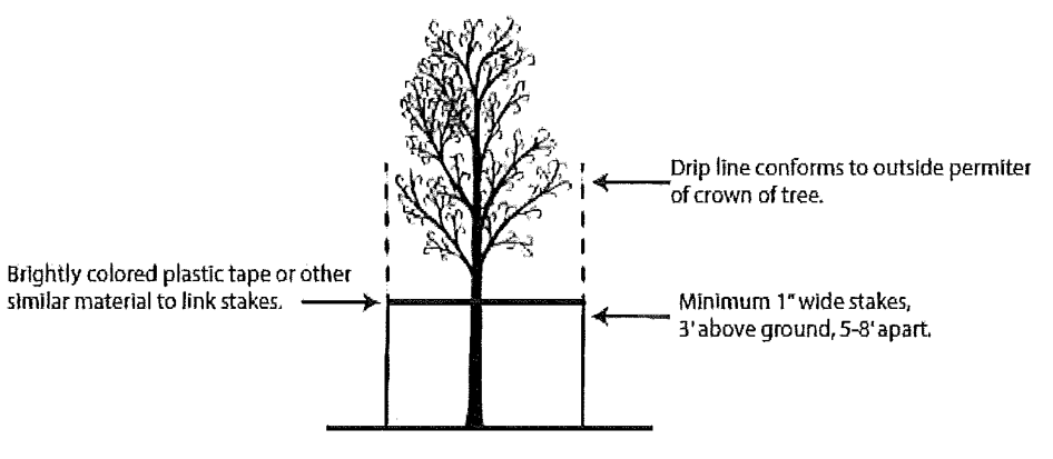
3.
Nothing is to be stored within the protective area. The barriers shall remain in place and intact throughout construction; however, barriers may be removed temporarily to accommodate construction needs, provided that the manner and purpose for such temporary removal will not harm the tree/s.
D.
Irrigation. The trees shall be properly irrigated throughout the building process.
E.
Cut and fill guidelines. It shall be unlawful to add or remove any material or ground within the dripline of a protected tree which is necessary for the growth of the subject tree. When raising the existing grade of a site, it shall be unlawful to raise the grade within the dripline of trees more than six inches without incorporating retaining walls to preserve the tree's root system. If a tree well is to be used, construct it no closer to the tree than the dripline and grade the soil outside of the well to prevent runoff water from draining into the well.
F.
Structure and pavement location. It shall be unlawful to place any structure or impervious paving within a six-foot radius of any tree trunk which has the potential of reaching a caliper of six inches or more.
G.
Attachments. It shall be unlawful to attach anything to a tree trunk having a diameter of six inches or more, other than protective wires, braces or other similar noninjurious materials.
H.
Pruning. All pruning shall be carried out by a tree expert prior to construction.
I.
Shearing of trees. Trees intended for shade purposes shall be allowed to reach their mature height and canopy spread. Shearing shall not be permitted.
J.
Trees damaged or destroyed during construction shall be subject to the provisions of Section 3-14.8, Violations, waivers and appeals.
(Ord. No. 15-1419, § II, 4-13-15)
Section 3-14.6. - Specimen trees.
A.
Designation. A tree shall be determined to be a "Specimen Tree" by a tree expert. This tree shall then be adopted by resolution by the City Commission. A permanent record of all trees so designated by the City Commission shall be kept by the City. The Order can protect individual trees, groups, areas or woodlands.
B.
Exempt trees. A tree which is deemed an undesirable tree by the Florida Invasive Species Council (FISC) Invasive Plant List shall be exempt.
C.
Removal. Notwithstanding any other provisions of this Code, a specimen tree shall not be removed except for extraordinary circumstances and only by final permit approved by the City Commission.
(Ord. No. 15-1419, § II, 4-13-15; Ord. No. 24-1613, § V, 12-16-24)
Section 3-14.7. - Tree replacement requirements.
A.
Tree replacement. All trees, except those listed as undesirable by the Florida Invasive Species Council (FISC) Invasive Plant List, shall be replaced.
B.
Tree species. Relocated or replacement trees shall include only species defined as preferred trees under this ordinance or such other trees properly approved by the Administrative Official.
C.
Transplanting and maintenance requirements. All trees transplanted pursuant to this ordinance shall be maintained in a healthy, living condition. Any such trees which die or become diseased or damaged shall be replaced by the applicant. The City shall retain perpetual jurisdiction to ensure compliance with this Section.
D.
All replacement trees shall meet the following requirements:
1.
Specifications for plant materials (Section 3-13.4, A),
2.
Tree placement (Section 3-13.5),
3.
Tree protection for development (Section 3-14.5), and;
4.
Maintenance (Section 3-13.8).
E.
Replacement cost. The cost of replacing the trees shall be incurred by the property owner.
F.
Replacement standard. The specifications for the replacement of trees is provided in the following categories:
1.
Developed property with an approved landscape plan.
a.
All sites with an approved landscape plan shall replace trees according to the original permitted landscape plan approval.
b.
If the tree removed from the site was not part of the approved landscape plan, tree replacement will not be required.
c.
An alternative species may be used where the tree does not form part of a row or cluster of trees which form and create the landscape aesthetics of the site. The replacement tree will be of similar characteristics to the tree removed.
d.
A tree of less shade or screening potential may be provided where the applicant can show that the site is unable to accommodate a tree of equal shade or screening potential of the tree removed.
The applicant will be required to show that the tree has been planted in excess of those provided as part of the site plan.
2.
Property without an approved landscape plan. Tree replacement for sites which do not have an approved landscape plan shall be determined as follows:
a.
The site shall be reviewed to assess whether it meets the required site tree standards:
i.
Not fewer than three trees per 6,000 square feet.
ii.
All trees used to meet site requirements must be above 6 inches caliper, be certified by a tree expert to be in a healthy condition and be a preferred tree as defined within this ordinance.
b.
The applicant shall provide the:
i.
Site area,
ii.
Impervious/ pervious calculations,
iii.
Number, species, size (caliper) and location of all trees on site (excluding undesirable).
c.
Credit shall be applied to healthy trees on site as follows:
d.
Where the site meets tree requirements, replacements trees will not be required.
e.
Where the site does not meet tree requirements, the size and number of additional trees to be replaced shall be determined based upon the caliper of the tree removed in accordance with the table below.
f.
All trees removed must be replaced with the number of inches as specified in the column "Total Replacement Required" according to the size of tree removed.
g.
Where a property has space to provide several trees which will improve the landscaping aesthetics of the site they may provide several trees at three-inch caliper or more based upon staff approval.
h.
The number of trees permitted and the size of tree required for replacement will depend upon the space available on the property in question.
i.
Trees shall be planted in locations to not create an impact upon existing structures and tree locations.
j.
The applicant shall submit:
i.
A aerial plan that includes:
a)
Property boundaries;
b)
All existing trees, structures, underground and over ground powerlines both on the site and within the immediate vicinity on neighboring properties;
ii.
Marked locations where space is available for a tree, using the Florida Friendly Landscaping Guide to choose the right size tree for the right location;
iii.
Statement and any other evidence stating reasoning why the site is unable to accommodate the required amount of replacement trees.
k.
Staff shall review this against the following:
i.
Fulfillment of required replacement inches or more using the table above;
ii.
Ability to replace trees on site;
iii.
Improvement to the aesthetics of the property.
l.
Where a property provides 75 percent or more trees which provide an equal shade potential to the tree removed, a tree of less shade or screening potential may be provided.
G.
Tree Bank alternative.
1.
A Tree Bank fund is established by the City to provide an option to make a fee payment to the City in lieu of providing the required trees on site. Tree requirement covers replacement trees on a site or trees required in accordance with Article XIII—Landscaping.
2.
The Tree Bank alternative may only be utilized as a last resort after all other design alternatives to provide required landscaping and to preserve and/or replace existing trees have been considered. Property owners must submit an application and a site plan on a form to be provided by the City.
3.
The applicant must demonstrate that there is insufficient room on the site for required trees due to:
a.
Existing/proposed trees;
b.
Existing structures including utility lines;
c.
Land condition (Topography, soil, etc.);
d.
Insufficient area for tree to establish;
4.
A site plan shall be included to demonstrate that there is no room on the site to allow for the mature development of a tree.
5.
The Administrative Official has the option to accept a cash payment to the Tree Bank in lieu of tree replacement when the Administrative Official finds the applicant has submitted a complete application, and has demonstrated that all design alternatives have been exhausted.
6.
The payment into the Tree Bank shall be determined by the current wholesale market value published by Central Florida nurseries, plus installation costs to the City, applied to the number of required replacement trees which cannot be reasonably accommodated on site. The wholesale value will be recalculated and adjusted annually on October 1st. The payment shall be calculated by dividing the total of the replacement inches that will not be accommodated on-site by three inches (which is the minimum planting caliper) and then multiplying the result by the current wholesale value plus installation costs to the City of a three inch caliper live oak tree (Quercus virginiana).
7.
The Tree Bank fund is a part of the City of Casselberry general fund but is reserved exclusively for the design, acquisition, installation and maintenance of trees on public property, or in certain circumstances, on private property. Before approving planting trees on private property, the Administrative Official must find that the trees will provide aesthetic benefits to many of the same citizens who would have benefitted from the installation of the trees on public property. The private property owner must be willing to sign a tree maintenance agreement with the City.
(Ord. No. 15-1419, § II, 4-13-15; Ord. No. 18-1483, § 2, 7-23-18; Ord. No. 24-1613, § VI, 12-16-24)
Section 3-14.8. - Violations, waivers and appeals.
A.
Trees which have been removed without a permit, without documentation pursuant to Section 3-14.3, or which have been intentionally damaged or destroyed by the property owner or related party shall be replaced and associated fines shall be paid in accordance with Fla. Stat. [ch.] 162, or the table below:
B.
Remedial action.
1.
Where violations of this Article have occurred, the property owner shall be notified by the City of Casselberry that remedial action is required. Upon such notification, the property owner shall submit to the City a certified check to be held in escrow. The amount of money to be held in escrow by the City shall be equal to the restoration cost of the property to the condition it existed prior to the Code violation. The value associated with restoration shall be determined by the City. The property owner shall also pay an administration fee for staff time; this amount shall be determined by the City Commission by Resolution. The property owner may provide documentation to the City regarding the associated value to restore the property.
2.
Upon the City's acceptance of the funds held in escrow, the property owner may submit to the Planning and Zoning Commission a restoration plan. The restoration plan may require tree replacement and/or may include payment into the City's Tree Bank. The restoration plan may also include irrigation if required. The Planning and Zoning Commission shall review the restoration plan and determine whether it adequately restores the property to its state prior to the violation of this Article. The applicant presenting the restoration plan has the burden to demonstrate to the Planning and Zoning Commission that the property will be restored to meet the purpose and intent of Article XIV, Tree Protection. The restoration plan shall include a deadline by which the plan must be completed.
3.
In addition to the procedure noted above, the City may also utilize the Code Enforcement Provisions within the City Code regarding violations to the Article.
C.
Waivers.
1.
The Planning and Zoning Commission may grant a waiver to Section 3-14.7(G)(5) where the applicant demonstrates 1) that the literal interpretation of the section will deny the applicant reasonable use of property and 2) where such waiver can be demonstrated to be consistent with the purpose and intent of the tree regulations as stated in Section 3-14.2. By way of example, the preservation of any approved tree over a caliper of 24 inches may be considered as the basis for the granting of a waiver from the literal application of the provisions of Section 3-14.7. The particular use made of the property by the applicant shall not be a legitimate basis for granting a waiver.
2.
Dead trees on undeveloped commercial properties (excluding trees that have been intentionally damaged). In order to encourage the use of undeveloped commercial properties a waiver may be requested to exclude diseased, distressed or dead trees from replacement requirements. The waiver request shall include a detailed analysis by a registered landscape architect or certified arborist itemizing the tree(s), including the species, caliper, condition, and location and explaining the reason for the proposed exclusion. The waiver may be granted by staff upon review of a tree removal permit application. Such trees may receive a full, partial, or pro-rated waiver based upon the condition of the tree. No waivers based upon tree quality shall be considered for trees which have been illegally damaged or removed without a tree removal permit.
3.
The applicant shall provide the City with a written request for the waiver, providing details of the requests and reasons therefore along with any evidence such as sketches, surveys and statistical information. The applicant should state clearly and in detail the waivers requested and reasons therefore, and the application must:
a.
Be accompanied by evidence such as sketches, surveys and statistical information.
b.
Be accompanied by an application fee, the amount of which shall be determined by the resolution of the City Commission.
c.
Be executed and sworn to by the owner or authorized agent.
4.
The Planning and Zoning Commission may approve or grant said waiver only if it determines that said waivers are not contrary to the intent of this ordinance and that a literal enforcement of the standards of this ordinance would be impracticable and would result in an unreasonable and unnecessary hardship pursuant to Section 1-2.7(C)(4).
5.
Appeals. Any person adversely affected by the enforcement or interpretation of this Article may appeal to the City Commission within 30 days, and all procedures specified in the zoning provisions of the Code shall be used for such appeal.
(Ord. No. 15-1419, § II, 4-13-15; Ord. No. 21-1548, § III, 3-8-21)
Section 3-15.1.- Applicability.
Parking shall be provided in all districts at the time any building or structure is erected or enlarged or increased in capacity by a change of use or the addition of dwelling units, floor area, seats, employees or other factors determinative of parking demand as stated in this Article.
Section 3-15.2. - Parking spaces required by use.
Offstreet parking spaces shall be provided in accordance with the following schedule:
(Ord. No. 98-901, § IV, 2-2-98; Ord. No. 16-1446, § 3, 8-22-16; Ord. No. 19-1505, § 2(Exh. B), 2-11-19)
Section 3-15.3. - Computation of parking spaces.
In computing the number of required parking spaces the following rules shall govern:
1.
Floor area calculation. Floor area means the gross floor area of a particular use. The gross floor area for a particular use includes common areas such as hallways, storage areas, restrooms, and similar areas.
2.
Interpretation of computation with fractions. When calculation in accordance with the foregoing list results in requiring a fractional space, any fraction shall require one additional space.
3.
Requirements for uses not identified. The parking requirement for any use not specified shall be the same as that required for a use of a similar nature as recognized herein or, where not recognized herein, shall be based on criteria published by the American Planning Association or similarly recognized standards of their profession and such standard shall be approved by the Planning and Zoning Commission.
4.
Requirements for mixed uses. In the case of mixed uses the parking spaces shall be equal to the sum of the several uses computed separately.
5.
Applicability of standards to expanding uses. Whenever a building or use is enlarged in floor area, number of dwelling units, seating capacity or in any other manner so as to create a need for a greater number of parking spaces than that existing such spaces shall be provided in accordance with this Section. Any parking deficiency shall be brought into conformity concurrently with the enlargement or change of use.
6.
Location of offstreet parking spaces. Unenclosed parking spaces may be located within a required yard. Parking areas required by activities other than residential may be located on the same lot as the principal structure or may be located all or in part on another lot. If located on another lot, such lot shall have an appropriate zoning designation and shall not be more than 300 feet, measured along a street or streets, from the principal structure of the activity.
7.
Combined parking spaces. The required parking spaces for any number of separate uses may be combined in one lot but the required space assigned to one use may not be assigned to another use at the same time.
8.
Driveways serving single-family dwellings. To meet the requirements for two parking spaces for each single-family dwelling, a driveway leading to a carport or garage may be considered a parking space if the driveway is at least 20 feet in length between the front lot line and the front of the carport or garage.
Section 3-15.4. - General regulations impacting parking areas.
A.
Use of parking areas for purposes other than parking prohibited. All parking areas shall be used for automobile parking only, with no motor vehicles sales or any other sales activity, dead storage, nonemergency repair work, dismantling or servicing of any kind.
B.
Reduction, change of area. Areas reserved for offstreet parking or loading in accordance with the requirements of this ordinance shall not be reduced in area or changed to any other use, unless the permitted use which it serves is discontinued or modified, except where equivalent parking or loading space is provided to the satisfaction of the Administrative Official.
C.
Lighting. Parking areas designed for nighttime use shall have a system of lighting to provide adequate illumination for the entire parking area. Such lighting shall be directed away from adjacent residential properties and public ways. Energy conservation measures shall be employed, including directing light sources downward and away from the sky.
D.
Paving of parking surface, maintenance and construction specifications. All parking areas shall be paved to meet City standards and maintained in perpetuity. The paving plan shall be approved by the Administrative Official before construction is begun on any parking area. The owner or successor in ownership shall be responsible for perpetual maintenance. This provision shall be enforced by the City's code enforcement regulations.
Parking lots shall be paved with concrete or asphalt or, upon approval of the City Engineer, with other dustfree, porous materials. Parking lots paved with concrete or asphalt shall be paved in accordance with the following specifications:
1.
Asphalt. Driveways, from street to property line, shall have an eight-inch limerock base and shall be paved with one inch of Type III virgin asphalt. Parking lots with a stabilized subbase shall have a six-inch limerock base and shall be paved with one inch of Type III virgin asphalt. Parking lots without a stabilized subbase shall have an eight-inch limerock base and shall be paved with one inch of Type III virgin asphalt.
2.
Concrete. Driveways and parking lots, excepting single- and two-family structures, shall be paved with six inches of 3,000 psi concrete.
E.
Drainage plans for parking surfaces. Adequate drainage shall be provided for all parking areas. Drainage plans shall comply with provisions of Article XII and shall be approved by the City before construction is begun on any parking area.
F.
Site plan required. A site plan must be submitted to and approved by the Planning and Zoning Commission prior to the commencement of construction on any parking lot. The site plan shall include the site characteristics, including but not limited to elevation, slope, drainage, soil type and adjacent surface conditions, and the type and amount of anticipated traffic flow.
G.
Traffic impacts. A traffic impact analysis shall be required for site plan reviews pursuant to standards, procedures and criteria defined herein. The traffic impact analysis is designed to achieve objectives stipulated in the transportation element of the Comprehensive Plan and the concurrency management program stipulated in Article IX. The applicant shall comply with the criteria established in Article IX for traffic impact analysis.
Section 3-15.5. - Access, internal circulation, offstreet parking and other traffic impacts.
The Planning and Zoning Commission and/or designated staff shall advise on matters related to this Section.
A.
Internal circulation system design and access/egress considerations. Driveways, curb cuts, and areas for the parking and internal circulation of vehicles shall be located, designed and controlled so as to provide for safe and convenient circulation within the site and safe and convenient access from and onto adjoining streets. The City staff shall review such design considerations based on standard traffic engineering principles and practices and such specifications as may be adopted by resolution of the Planning and Zoning Commission. Requirements of Article IX shall be applied for offstreet parking. Among factors to be considered shall be need for acceleration and deceleration lanes; the number, location and size of curb cuts and access aisles to parking spaces, the arrangement, delineation and marking for parked areas; and the means of access to buildings for firefighting apparatus and other emergency vehicles.
B.
Separation of vehicular and pedestrian areas. Parking areas and driveways shall be clearly identified and separated from principal pedestrian routes and recreation areas by curbs, pavement markings, planting areas, fences or similar features designed to promote pedestrian safety.
C.
Driveway and curb cut approvals. The City shall require that the proposed location of driveways and curb cuts be coordinated with utility companies responsible for providing utility services in order to ensure that proposed construction activities are consistent with improvement plans as well as operation and maintenance activities and policies of utility service providers. No site plan or building permit shall be issued until proof of such coordination is presented to the City by the applicant/developer.
In addition, the applicant/developer submitting plans for driveway and curb cut improvements shall comply with applicable surface water management regulations of Article XII.
D.
Fire lanes and zones. Fire lanes and zones shall be provided pursuant to the Casselberry Fire Protection Code adopted in Section 42-31 of the Code of Ordinances.
_____
Section 3-15.6. - Design and specifications for parking and loading areas.
A.
Driveways, aisles, and stalls. The term "driveways" as used within the context of this Article shall describe the entrance roadway used to connect the parking area with the nearest street or streets. Driveways may be either one- or two-way and shall be constructed to meet the minimum dimensions below, and in any case shall allow for the maneuvering of fire protection vehicles. Aisles are those circulation paths between rows of vehicles allowing access to the individual stalls. The aisles shall be designed to meet the minimum dimensions below. However, when an aisle is coincident with a fire lane, the aisle must be a minimum of 20 feet wide to accommodate fire protection vehicles. Stalls (i.e., parking spaces) are the actual parking area designated for the storage of individual vehicles. The various angles for parking stalls are provided below with their respective dimensions. In addition, the construction and delineation of stalls shall follow the standards outlined in Subparagraphs 1. through 4.
1 Modifications. Forty percent of total spaces may have a width and length of nine feet by 18 feet. The Planning and Zoning Commission may approve modifications to the specifications of Section 3-15.6(A) upon demonstrated need by the applicant and based on recommendations of the City staff. In considering modifications to the specifications required by this Section, the Planning and Zoning Commission shall be guided by the current edition of the Architectural Graphic Standards by Ramsey and Sleeper, or an equivalent commonly accepted source of standards.
_____
1.
Each stall shall be accessible from an aisle or driveway and designed so that no automobile shall back into a public street in order to exit a parking stall. The internal design of the parking lot shall be designed to facilitate vehicular circulation and avoid conflict between pedestrian and vehicular movements. Internal circulation also shall be designed so as not to create conflict with access into or egress from the site and shall be consistent with the landscape requirements of this Code.
2.
No door or pedestrian entrance at ground level shall open directly upon any driveway or access aisle unless the doorway or pedestrian entrance is at least three feet or more from said driveway or aisle and appropriate improvements are provided to allow for safe pedestrian access to the door.
3.
All paved parking spaces shall have lines between spaces to indicate individual stalls, and each stall may be required to be equipped with wheel stops if deemed appropriate by the Planning and Zoning Commission based on recommendations of the City staff.
a.
Wheel stops for stalls adjacent to landscaped strips shall be located 2½ feet from the front end of the stall to prevent encroachment into required landscaped areas. The front two feet of the stall may be kept as a maintained vegetative ground cover area although no credit will be extended toward the open space requirements of this Code.
b.
Wheel stops for stalls not adjacent to landscaped strips shall be located 3½ feet from the front end of the stall. The front three feet of the stall may be kept as a maintained vegetative ground cover area although no credit will be extended toward the open space requirements of this Code.
4.
All publicly maintained and operated parking facilities intended for public use and all businesses, firms, or other persons licensed to do business with the public shall comply with requirements for access established in the Accessibility Requirements Manual published by the Department of Community Affairs, Florida Board of Building Codes and Standards.
B.
Entries, exits, drives and vehicle maneuvering areas. All uses which are required to provide three or more offstreet parking spaces shall have entry and exit ways and drives at least 20 feet in width to accommodate two-way traffic unless a one-way traffic system is utilized, in which case entry and exit ways and drives shall be at least 12 feet in width. In the event a one-way traffic system is utilized, appropriate traffic direction markers shall be installed. The internal circulation system, including drives and maneuvering areas, shall be designed to permit convenient maneuvering of cars and service vehicles into and out of each parking and loading space, and shall be arranged so that no vehicle need back onto a public right-of-way. No occupied parking or loading space shall interfere with access to any other parking or loading space, or with any pedestrian walkway. The design of parking facilities shall also comply with landscape requirements of Article XIII.
C.
Required off-street loading spaces. The following off-street loading spaces shall be provided for the uses indicated. All loading areas shall be designed in a manner that maintains all movements onsite without entry directly into the right-of-way.
1.
Every hospital, institution, hotel, commercial or industrial building, or similar use having a floor area in excess of 10,000 square feet, requiring the receipt or distribution by vehicle of materials and merchandise shall have at least one permanently maintained off-street loading space for each 10,000 square feet of gross floor area or fraction thereof.
2.
Retail operations, wholesale operations, and industrial operations with a gross floor area of less than 10,000 square feet shall provide sufficient space for loading and unloading, so as not to hinder the free movement of vehicles and pedestrians over a sidewalk, street, or alley.
D.
Accessibility parking and passenger loading zones. Chapter 11, Florida Accessibility Code for Building Construction, Florida Building Code 2001, and all subsequent modifications, amendments and updates, as adopted by the City of Casselberry, provides the criteria for accessibility parking and passenger loading zones.
1.
Parking spaces.
a.
Any commercial real estate property owner offering parking for the general public shall provide specially designed and marked motor vehicle parking spaces for the exclusive use of physically disabled persons who have been issued parking permits pursuant to F.S. §§ 316.1958, 320.0842, 320.0843, 320.0845 or 320.0848.
b.
Diagonal or perpendicular parking spaces shall be a minimum of 12 feet wide (see Figure A).
_____
FIGURE A
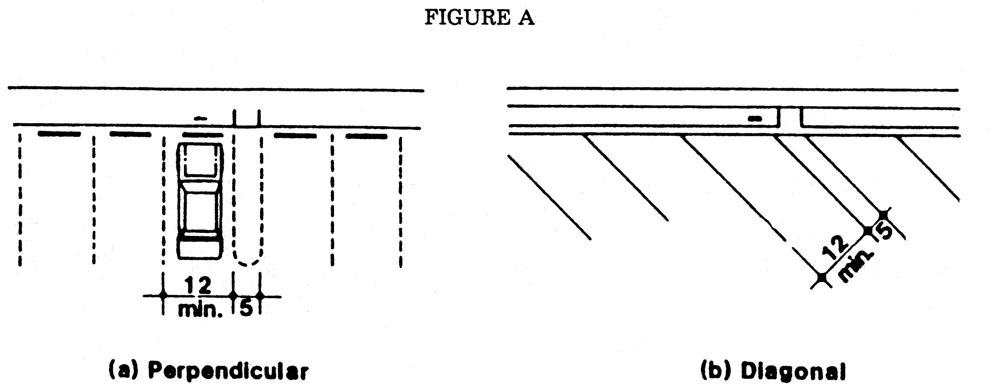
Fig. A
c.
Parallel parking spaces shall be located either at the beginning or end of a block or adjacent to alley entrances (see Figure B). Curbs adjacent to such spaces shall be of a height which will not interfere with the opening and closing of motor vehicle doors.
FIGURE B
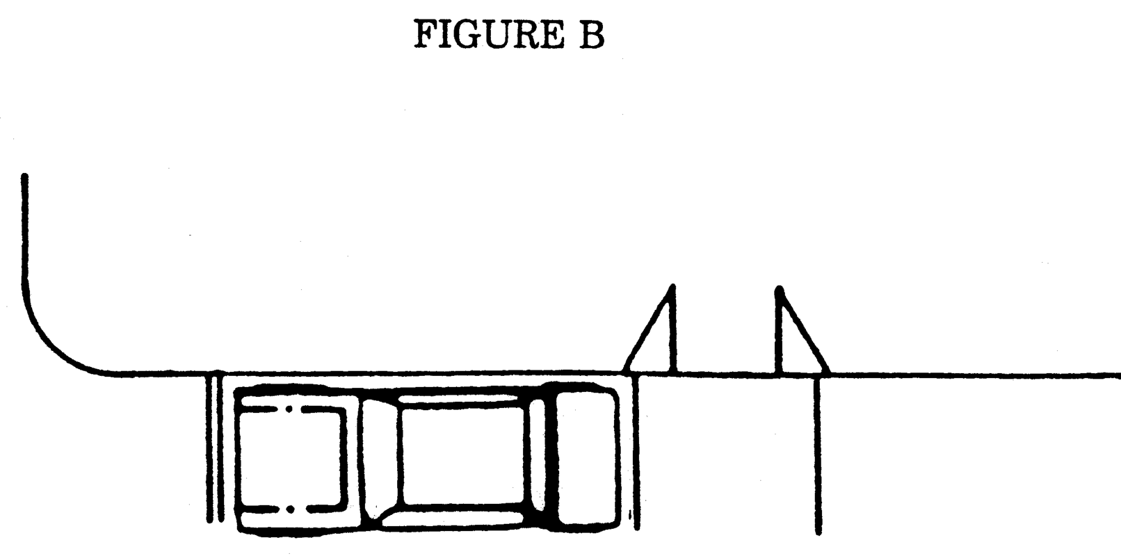
Fig. B
d.
Each such parking space shall be conspicuously outlined in blue paint, and shall be posted and maintained with a permanent, abovegrade sign bearing the international symbol of accessibility or the caption "PARKING BY DISABLED PERMIT ONLY," or bearing both such symbol and caption (see Figure C). Such signs shall not be obscured by a vehicle parked in the space. All handicapped parking spaces must be signed and marked in accordance with the standards adopted by the Department of Transportation.
FIGURE C
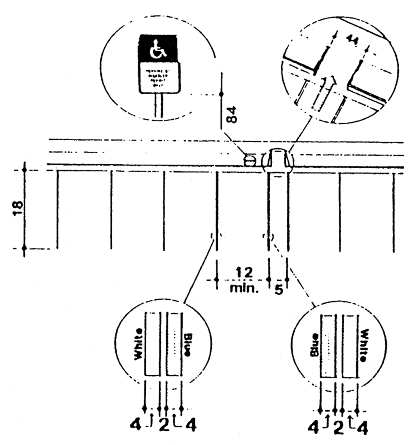
Fig. C
_____
e.
All spaces shall have an adjacent access aisle 60 inches wide minimum (see Figure A). Parking access aisles shall be part of the accessible route to the building or facility entrance and shall comply with the Accessible Route Section of the Florida Board of Building Codes and Standards, Accessibility Requirements Manual. Two accessible parking spaces may share a common access aisle. Parked vehicle overhangs shall not reduce the clear width of an accessible circulation route.
f.
All spaces shall have access to a curb ramp or curb cut, when necessary to allow access to the building served, and shall be located so that users will not be compelled to wheel behind parked vehicles.
g.
The minimum number of such parking spaces shall comply with the following table:
2.
Passenger loading zones. Passenger loading zones shall provide an access aisle at least 48 inches wide and 20 feet long adjacent and parallel to the vehicle pull-up space (see Figure D). If there are curbs between the access aisle and the vehicle pull-up space, then a curb ramp complying with the Curb Ramp Section of the Florida Board of Building Codes and Standards, Accessibility Requirements Manual, shall be provided.
A minimum vertical clearance of 108 inches shall be provided at accessible passenger loading zones and along vehicle access routes to such areas from site entrances.
FIGURE D
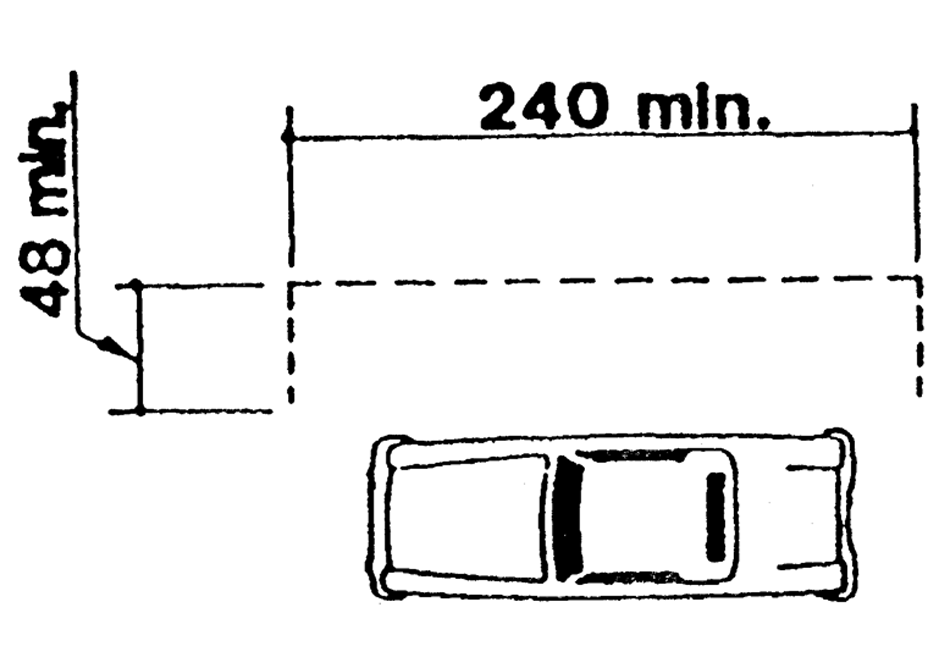
Fig. D
3.
Fire lanes and zones. Fire lanes and zones shall be provided pursuant to the Casselberry Fire Protection Code adopted in Section 42-31 of the Code of Ordinances.
(Ord. No. 04-1121, §§ 9, 10, 3-22-04)
Section 3-16.1.- Purpose, intent and scope.
A.
It is the purpose of this article to promote the public health, safety and general welfare through reasonable, consistent and non-discriminatory sign standards. The sign regulations in this article are also designed and intended to meet the statutory requirement that this municipality adopt land development regulations that regulate signage, a requirement set forth in Section 163.3202(f), Florida Statutes. The sign regulations in this article are not intended to censor speech or to regulate viewpoints, but instead are intended to regulate the adverse secondary effects of signs. The sign regulations are especially intended to address the secondary effects that may adversely impact aesthetics and safety. The sign regulations are designed to serve substantial governmental interests and, in some cases, compelling governmental interests such as traffic safety and warning signs of threats to bodily injury or death. The City specifically finds that these sign regulations are narrowly tailored to achieve the compelling and substantial government interests of traffic safety and aesthetics, and that there is no other way for the City to further these interests.
This article regulates signs, as defined in this Land Development Regulations, which are placed on private property or on property owned by public agencies including the City and over which the City has zoning authority. This article is not intended to extend its regulatory regime to objects that are not traditionally considered signs for purpose of government regulation.
The City of Casselberry is primarily a single family residential community within Central Florida. In order to preserve and promote the City as a desirable community in which to live, relax and do business, a pleasing, visually attractive environment is of foremost importance. The regulation of signs within the City is a highly contributive means by which to achieve this desired end.
These sign regulations have been prepared with the intent of enhancing the visual environment of the City and promoting its continued well-being, and are intended to:
1.
Encourage the effective use of signs as a means of communication in the City:
2.
Maintain and enhance the aesthetic environment and the City's ability to attract sources of economic development and growth;
3.
Improve pedestrian and traffic safety;
4.
Minimize the possible adverse effect of signs on nearby public and private property:
5.
Foster the integration of signage with architectural and landscape designs;
6.
Lessen the visual clutter that may otherwise be caused by the proliferation, improper placement, illumination, animation, excessive height, and excessive size (area) of signs which compete for the attention of pedestrian and vehicular traffic;
7.
Allow signs that are compatible with their surroundings and aid orientation, while precluding the placement of signs that contribute to sign clutter or that conceal or obstruct adjacent land uses or signs;
8.
Encourage and allow signs that are appropriate to the zoning district in which they are located;
9.
Establish sign size in relationship to the scale of the lot and building on which the sign is to be placed or to which it pertains;
10.
Preclude signs from conflicting with the principal permitted use of the site and adjoining sites;
11.
Regulate signs in a manner so as to not interfere with, obstruct the vision of or distract motorists, bicyclists or pedestrians;
12.
Except to the extent expressly preempted by state or federal law, ensure that signs are constructed, installed and maintained in a safe and satisfactory manner, and protect the public from unsafe signs;
13.
Preserve, conserve, protect, and enhance the aesthetic quality and scenic beauty of all districts of the City;
14.
Allow for traffic control devices without regulation consistent with national standards and whose purpose is to promote highway safety and efficiency by providing for the orderly movement of road users on streets and highways, and that notify road users of regulations and provide warning and guidance needed for the safe, uniform and efficient operation of all elements of the traffic stream;
15.
Protect property values by precluding, to the maximum extent possible, sign types that create a nuisance to the occupancy or use of other properties as a result of their size, height, illumination, brightness, or movement;
16.
Protect property values by ensuring that sign types, as well as the number of signs, are in harmony with buildings, neighborhoods, and conforming signs in the area;
17.
Regulate the appearance and design of signs in a manner that promotes and enhances the beautification of the City and that complements the natural surroundings in recognition of this City's reliance on its natural surroundings and beautification efforts in retaining economic advantage for its resort community, as well as for its major subdivisions, shopping centers and industrial parks;
18.
Enable the fair and consistent enforcement of these sign regulations;
19.
Promote the use of signs that positively contribute to the aesthetics of the community, are appropriate in scale to the surrounding buildings and landscape, and advance the City's goals of quality development;
20.
Provide standards regarding the non-communicative aspects of signs, which are consistent with city, county, state and federal law;
21.
Provide flexibility and encourage variety in signage, and create an incentive to relate signage to the basic principles of good design; and
22.
Assure that the benefits derived from the expenditure of public funds for the improvement and beautification of streets, sidewalks, public parks, public rights-of-way, and other public places and spaces, are protected by exercising reasonable controls over the physical characteristics and structural design of signs.
B.
Where there is conflict between this article and other sections of this Code, the most restrictive regulations shall apply.
C.
This article does not regulate government signs on government property, including traffic control devices, since this constitutes government speech for purposes of public safety.
(Ord. No. 99-931, § I, 3-1-99; Ord. No. 17-1458, § III(Exh. A), 6-12-17)
Section 3-16.2. - Definitions.
Animated signs: Signs that flash, revolve, or move or otherwise change their message (this does not include a manually changeable copy sign).
Awning sign: Any sign attached to, in any manner, or otherwise made a part of any awning or awning-like structure which projects beyond a building or extends along and projects beyond the wall of the building, generally designed and constructed to provide protection from the weather.
Banner sign: A temporary sign either enclosed or not enclosed in a rigid frame and secured or mounted to allow movement caused by the atmosphere. Flags are not banners.
Building frontage: The side of the main building on the primary roadway for a single tenant building. Multi-tenant buildings shall use the building elevation that includes the primary entrances as the building frontage. Corner units may only utilize one building elevation for the calculation of copy area.
Changeable copy sign (manual): The message on the sign is changed manually (without the use of an electrical or electronic signal) using individual letters, numbers, phrases, or symbols. Examples include reader boards with manually changeable letters or changeable pictorial panels.
Commercial message: Any wording, logo, emblem, character, pictograph, trademark, or symbol used to represent a firm, organization, entity, product, or service, or other representation that, directly or indirectly, names, advertises, or calls attention to a product or service. For purposes of this section, terms such as sale, special, clearance, or other words which relate to commercial activity shall be deemed to be commercial messages.
Discontinued sign: A sign that is not operated or maintained for a period of 90 days or longer. The intent of the owner of the sign shall not be a consideration in whether or not the sign is a discontinued sign. The following conditions shall be conclusively considered as the failure to operate or maintain a sign: (1) a sign displays advertising for a product or service which is no longer available, or (2) a sign displays advertising for a business which is no longer licensed, or (3) the sign is blank. A discontinued sign includes a sign advertising a business that no longer has a certificate of occupancy or that no longer does business at the location at which the sign is located. A discontinued sign includes a sign for a purpose of which the purpose has lapsed. If the discontinued sign is on a freestanding sign structure that is conforming with the City's Uniform Land Development Regulations (ULDR) and in compliance with the Florida Building Code, then only the sign face will be considered discontinued: however, if the discontinued sign is on a freestanding sign structure that is either nonconforming with the City's ULDR or out of compliance with the Florida Building Code, then the freestanding sign structure shall be removed.
Electronic message centers: An on-premise ground sign component without moving parts that utilizes a computer or other electronic means to change the digital message displayed through the use of intermittent light or lights, including light emitting diodes, liquid crystal display, plasma screen image display, or similar equipment.
Facade sign: Any wall, awning, or marquee signs
Feather signs, teardrop signs,or flutter signs: A professionally produced lightweight temporary advertising medium, mounted on a pole, that resembles a sail, used outdoors.
Flag: Any fabric, or similar material, or bunting which is not a banner and which is placed on a permitted permanent flagpole or flagpole holder which is permanently attached to the primary structure containing non-commercial speech.
Government sign: Any temporary or permanent sign erected by or on the order of a public official or quasi-public entity at the federal, state, or local government level in the performance of any duty.
Ground sign: Any sign supported by one or more uprights, posts, or bases placed upon or affixed in the ground and not attached to any part of a building.
Inflatable sign: Any sign inflated or supported by wind, air, or pneumatic noncombustible pressure.
Ingress and egress sign: A non-commercial sign at the entrance to or exit from a parcel or a building which is necessary to provide directions for vehicular or pedestrian traffic or provide a warning for pedestrian or vehicular traffic safety.
Marquee sign: Any sign attached to, in any manner, or otherwise made a part of any permanent roof-like structure which projects beyond a building or extends along and projects beyond the wall of the building, generally designed and constructed to provide protection from the weather.
Monument sign: Any ground sign supported totally by a solid base of masonry, brick, or other material, which base is not less than 80 percent of the total sign area width and which is of a finished or decorative type construction.
Motor vehicle sign: A sign mounted, placed, written, or painted on a vehicle or trailer whether motor-driven or not.
Off-premises commercial sign: A sign or billboard identifying an activity which is not conducted or products or services which are not available on the premises where the sign is located.
On-premises sign: A sign (1) identifying an activity conducted or products or services available on the premises where the sign is located, or (2) displaying a noncommercial message or (3) any combination of the first two. The on-premises/off-premises distinction applies only to commercial signs.
Outdoor advertising: Advertising with a commercial message done outdoors.
Permanent sign: Any sign which is intended to be and is constructed of lasting and enduring condition, remaining unchanged in character, condition (beyond normal wear and tear) and position and in a permanent manner affixed to the ground, wall or building, which requires a building permit. Unless otherwise provided for herein, a sign other than a temporary sign shall be deemed a permanent sign.
Premises: A designated parcel, tract, lot or area of land, together with improvements located thereon, if any, established by plat, subdivision, or as otherwise permitted by law, to be used, developed or built upon as a unit.
Primary roadway: The public right-of-way which is identified as the address of the premises.
Projecting sign: Any sign affixed to a building or wall in such a manner that its leading edge extends more than six inches beyond the surface of such building or wall.
Roof sign: Any sign erected or installed upon the roof of any building or structure.
Sign: For the purposes of these regulations, the term "sign" shall include all structural members. A sign shall be construed to be a display surface or device containing organized and related elements composed to form a single unit. In cases where matter is displayed in a random or unconnected manner without an organized relationship of the components, each such component shall be considered to be a single sign. The term "sign" for regulatory purposes shall not include signs not visible from any street, property, or water body. A sign means any device, fixture, placard, or structure that uses any color, form, graphic, illumination, symbol, or writing, to advertise, announce the purpose of, or identify the purpose of a person or entity, or to communicate information to the public. The definition of a sign does not include:
(1) Signs required or installed by a government agency on private property;
(2) Notices required to be posted by law or ordinance on private property.
Sign area: The area of a sign face (which is also the sign area of a wall sign or other sign with only one face) shall be computed by means of the smallest square, circle, rectangle, or triangle that will encompass the extreme limits of the writing, representation, emblem, or other display, together with any material or color forming an integral part of the background of the display or used to differentiate the sign from the backdrop or structure against which it is placed, but not including any supporting framework, bracing, or decorative fence or wall when such fence or wall otherwise meets zoning ordinance regulations and is clearly incidental to the display itself.
Snipe sign: Any sign of any material whatsoever that is placed on public property, or attached in any way to a public utility pole, tree, or any object located or situated on any public road rights-of-way, public easements or public alleys. Snipe signs are prohibited.
Streamer signs and pennants: Any temporary sign constructed of lightweight plastic, fabric, or other material, whether or not containing a message of any kind, suspended loosely from a rope, wire, or string, usually in a series, attached to any staff, cord, building, sometimes at only one or two edges, designed to move in the wind.
Subdivision: Shall have the same meaning as defined in the Unified Land Development Regulations of the City of Casselberry.
Temporary sign: A sign which is not intended for permanent use, and not permanently attached to the ground, a structure, or a building or designed to be permanently attached to the ground, a structure, or a building. Unless otherwise provided in this Code, a sign with an intended use for a period of time related to an event shall be deemed a temporary sign, such as a flag.
Trailer sign: Any temporary sign that is capable of being transported by means of wheels.
Wall sign: Any sign painted on or attached to a wall of a building or structure and in the same plane as the wall.
Wall wrap sign: Any sign composed of fabric, plastic, vinyl, mylar or a similar material that drapes or hangs over the side of a building, wall or window.
Window sign: Any sign placed inside or upon the window panes or glass of any window or door.
Zoning districts: Zoning districts defined in Article V.
(Ord. No. 99-931, § I, 3-1-99; Ord. No. 04-1121, § 11, 3-22-04; Ord. No. 08-1237, § 1, 3-24-08; Ord. No. 10-1340, § 1, 11-8-10; Ord. No. 14-1404, § 1, 2-10-14; Ord. No. 17-1458, § III(Exh. A), 6-12-17; Ord. No. 18-1484, § I, 5-14-18; Ord. No. 25-1619, § II, 3-24-25)
Section 3-16.3. - On-premises permanent sign regulations.
A.
On-premises signs permitted. On-premises permanent signs are permitted within the City of Casselberry and any such lawful sign may display a noncommercial message in addition to, or in lieu of, any other message.
B.
Street address signs. For each parcel and for each tenant space, signs for the official street address shall be displayed for public safety and traffic circulation purposes only, and to serve as a visible street address for 911 purposes, delivery of mail and official government notification, and shall be posted as provided in Seminole County Code section 90.5.
1.
For a parcel in residential use, the street address sign shall not exceed two square feet in sign area.
2.
For a parcel in non-residential use, the street address sign shall not exceed four square feet in sign area.
3.
The street address sign in a residential use may only be externally illuminated, and in a non-residential use may be externally or internally illuminated.
C.
Commercial, office, institutional and industrial zoning districts:
1.
Permitted signs. Ground, window and facade signs. Electronic message centers shall be permitted as provided in Section 3-16.6.
2.
Sign area. The total area provided for all facade and ground signs.
a.
Premises improved with building(s).
1.
Ground floor: Any premises improved with a single tenant building or the first floor of a multi-tenant building may display ground and facade signs with an aggregate sign area of two square feet for each linear foot of building frontage where the primary entrance is located.
2.
Buildings with additional floors:
a.
Either exterior or interior access: Tenant spaces on additional stories of a multi-tenant building may display ground and facade signs with an aggregate sign area of one square foot for each linear foot of building frontage.
b.
Premises not improved with buildings. Any premises not improved with a building may display ground signs with an aggregate sign area of two square feet for each linear foot of building frontage which would be allowed to be developed under the Unified Land Development Regulations of the City of Casselberry.
3.
Maximum sign size.
a.
Ground sign. May not exceed 100 square feet.
b.
Window signs. Total area of all window signs shall not exceed 25 percent of the total glass area of the window in which they are placed. Window signs shall not count against total allowable copy area.
c.
Facade signs.
1.
Single tenant (single or multi-story building) may not exceed 350 square feet.
2.
Multi-tenant building:
a.
Single story buildings: not to exceed 250 square feet for an individual tenant unit.
b.
Multi-story buildings:
i.
First floor: not to exceed 250 square feet for an individual unit.
ii.
Additional floors:
1.
Exterior access: 1 square foot of signage per each linear foot of building frontage for each unit; not to exceed 150 square feet for an individual unit.
2.
Interior access: Regardless of the number of stories, facade copy area above the ground floor level may not exceed 150 square feet.
c.
Ingress and egress ground signs at entrances. May not exceed six square feet.
4.
Maximum number of signs.
a.
Ground signs:
* All signs shall be monument signs with a 300-foot separation between signs.
b.
Facade signs. There is no limit on the number of facade signs on the ground floor of a building or on additional floors of a multi-story building with exterior access; provided however, that the maximum allowed square footage for all facade signs is not exceeded. Multi-story buildings with interior access are allowed a single sign above the ground floor level.
c.
Ingress and egress ground signs at entrances. Each premises may have a maximum of two ingress and egress signs at entrances except premises with two roadway frontages may have four ingress and egress signs at entrances.
5.
Maximum height.
a.
The maximum height of a ground sign is 15 feet above the crown of the road. Sign height is measured from the elevation of the roadway crown located adjacent to the sign structure.
b.
The maximum height of a facade sign is the lower of the roof line or the fascia.
c.
The maximum height of a ingress and egress ground sign at an entrance is four feet above the crown of the road.
6.
Location. A sign structure may be erected at the property line; provided, however, that no part of the sign projects over the property line and that no part of the sign is closer than ten feet to the paved surface of the road adjacent to the sign structure. No sign shall project over public property.
D.
Residential zoning districts. On-premises signs are permitted provided that the total sign area may not exceed six square feet.
E.
Ingress and egress ground signs at entrances to subdivisions.
1.
Number. One ingress and egress sign is permitted at each subdivision entrance.
2.
Location and placement. These signs may be located in any zoning district; provided, however, that the development is a permitted or approved use in such a district. Such signs shall not be located nearer than 25 feet from any intersection of any street rights-of-way.
3.
Sign area and elevation: These signs shall not exceed a total of 48 square feet of sign area or a maximum height of 15 feet above the elevation of the crown of the road adjacent to the sign structure location.
F.
Fire lane and fire zone signs. See the Casselberry Fire Prevention Code adopted in Section 42-31 of the Code of Ordinances.
G.
Flag poles or brackets.
1.
Flagpoles and flags. For each parcel and development site in residential use with one principal structure, one flagpole may be installed and two flags may be displayed per flagpole. For each parcel and development site that is over ½ acre in size and is in nonresidential use, up to three flagpoles may be installed and up to two flags may be displayed per flagpole. A flag shall not exceed 24 square feet in size.
2.
Flag brackets and flags. For each principal structure on a parcel, up to two flag brackets may be attached or placed for the display of flags. A flag displayed from a flag bracket shall not exceed 24 square feet in size.
3.
For the purpose of determining the size of a flag, only one side of the flag shall be counted as the display surface.
4.
Flags on parcels in non-residential use may be externally illuminated.
(Ord. No. 99-931, § I, 3-1-99; Ord. No. 04-1121, § 12, 3-22-04; Ord. No. 17-1458, § III, 6-12-17; Ord. No. 18-1484, § II, 5-14-18; Ord. No. 25-1619, § II, 3-24-25)
Section 3-16.4. - On-premises temporary sign regulations.
A.
The City has an interest in allowing the following signs in order to comply with State and local laws and to promote public safety on City property and in the street right-of-way. Any sign which does not meet the criteria of this section and is not specifically permitted elsewhere in this section is prohibited. The following signs are exempt from the building permitting requirements of this section:
1.
Temporary signs. Temporary signs do not require a building permit, however, all temporary signs with a commercial message, except signs on property for sale or lease, must be registered with the Community Development Department. Noncommercial temporary signs regardless of size shall not require an application to the Community Development Department but shall conform to Table 3-16.4.
2.
Address signs. Signs not exceeding two square feet in area and bearing only street address numbers, post office box numbers, and the names of the occupants of any private premises, for safety and traffic circulation purposes only. Every building and temporary structure must display an address sign that is clearly visible from the street for 911 purposes.
B.
General criteria. The following criteria apply to all temporary signs unless otherwise enumerated within this Article. These criteria are provided within Table 3-16.4. If there is a conflict between the text and the table, the text prevails.
1 A business with a current Business Tax Receipt is entitled to no more than two temporary commercial signs at any one time, subject to the four-sign limit per parcel. However, no more than one temporary commercial sign per business may be a banner, feather, teardrop, or inflatable sign. Temporary commercial signs are limited to a maximum duration of display of no more than 35 days per calendar year per business. Exceptions may be authorized by the City Manager or designee for individual needs, such as grand openings, closings, re-openings, etc.
2 The square footage limitation is per side for a back-to-back sign. For example, a four square foot limitation means that there is a limit of four square feet of surface area per side of a back-to-back sign, and an aggregate limit of eight square feet is allowed if the sign is a back-to-back temporary sign.
3 Not applicable to signs displayed on flagpoles.
4 Minimum sign setbacks do not apply to wall signs. All temporary signs are prohibited on public property and public rights-of-way.
5 Not applicable to signs displayed on flagpoles.
6 There is no limit to the number of separate messages that may appear on the allowable surface(s) of any temporary sign.
1.
Duration for display of temporary sign. If a temporary sign pertains to an event, the temporary sign shall be removed within and by no later than seven calendar days after the event is concluded. If a temporary commercial sign does not pertain to an event, the temporary sign shall be removed within and by no later than 35 days after being erected.
2.
Display of temporary sign requires permission of real property owner. A temporary sign on any parcel shall not be maintained if the placement of the same does not have the permission of the owner of real property.
3.
A temporary sign may not display any lighting and/or illuminations of any kind, including those that flash, move, rotate, scintillate, blink, flicker, or vary in intensity of color.
4.
A temporary sign may not incorporate fluorescent color or exhibit fluorescence.
5.
A temporary sign may not obstruct a permanent sign or the vision between pedestrians and vehicles. A temporary sign may not obstruct the view of a permanent sign as viewed from any public road, street or highway or any public sidewalk, and may not obstruct the vision between pedestrians and vehicles using the public right-of-way, including, but not restricted to, those meeting intersection visibility requirements.
6.
Temporary sign may display multiple messages. A temporary sign may display multiple independent messages on any portion of the sign surface of a temporary sign.
7.
A temporary sign does not require a building permit from the City, however registration is required for all temporary commercial signs, except for signs on property for sale or lease.
8.
Article XVI is not intended to regulate interior-facing signage. The City does not intend that Article XVI regulate or be applicable to signage located in the interior of school yards, ball/play fields or similar uses where such signage is designed to face the interior of such location and is not designed to be viewed or seen from adjacent roadways.
9.
Removal responsibility. The removal of temporary signs is the joint and several responsibility of the owner of the property upon which the sign is placed, and, if applicable, a candidate for whom such sign was placed.
10.
Fee Exemption. All temporary signs with commercial messaging sized six square feet or less do not require a fee. A fee will apply to temporary commercial signs larger than six square feet, as provided by resolution, except on property for sale or lease. All noncommercial temporary signs regardless of size are exempt from fees.
(Ord. No. 99-931, § I, 3-1-99; Ord. No. 02-1045, § 29, 5-13-02; Ord. No. 11-1361, §§ 1, 2, 11-14-11; Ord. No. 14-1404, § 2, 2-10-14; Ord. No. 17-1458, § III (Exh. A), 6-12-17; Ord. No. 18-1484, § III, 5-14-18; Ord. No. 24-1594, § I, 3-25-24)
Section 3-16.5. - Off-premises signs.
Off-premises signs prohibited. Off-premises signs are prohibited.
(Ord. No. 17-1458, § III(Exh. A), 6-12-17)
Section 3-16.6. - Electronic message centers (EMCs).
Electronic message centers shall be permitted as follows:
A.
Zoning Districts. EMCs are only permitted in CG, CS, PMX-H, PMX-HIGH, PMX-MID, I, I-M, ROS and PS. All EMCs must comply with the standards of the zoning district as well as this section.
B.
Sign Cabinet Materials. The sign cabinet shall be constructed of all aluminum extrusion or better as approved by city staff taking into consideration compatibility with the affected property and the surrounding area and applicable sound building standards. The EMC must blend harmoniously with the principal structure through using similar materials and colors.
C.
Sign Type. An EMC is only allowed as part of a monument sign with all required landscape islands, in accordance with Section 3-16.3. The monument sign shall include decorative stone features.
D.
Height. The maximum height of the sign with the EMC shall be 15 feet above the crown of the road. Sign height shall be measured from the elevation of the roadway crown located adjacent to the sign structure.
E.
EMC Area. The maximum size of the electronic display shall be 32 sq. ft., which will be deducted from the overall sign area allowance for the ground sign. Variances are not permitted from this maximum size. The electronic display portion of the sign must occupy a secondary position on the sign, occupying less than 50% of the sign, accessory to and smaller than the primary part of the sign containing the name of the business(es).
F.
Color. Any color is permissible for the background, text and clipart, but the background must be solid, and must contrast with the text.
G.
Message Display.
1.
Static messages shall hold the display face for a minimum of five (5) minutes before changing to another static image.
2.
Any change in message shall be completed instantaneously, with no static, fade, dissolve, scroll, or fly-in, and no special effects between messages.
3.
The message must be static. There shall be no animation, flashing, scintillating lighting, movement or varying of light intensity during the message. A message or image may not scroll, undulate, expand, contract, bounce, rotate, spin, twist or otherwise give the appearance of optical illusion or movement as it comes onto, is displayed on, or leaves the sign board. The message or image shall not have the appearance of flashing, flickering, blinking, pulsating, or motion videos.
4.
The digital signage text should facilitate maximum readability. The text should utilize ADA-approved fonts, such as Calibri and Helvetica. The characters should be sans-serif. Italic, oblique, script, highly decorative, or unusually shaped characters are prohibited. This subsection shall not apply to fonts used to display a logo, which may vary.
5.
No words, phrases or characters should be used if they will interfere with, mislead or confuse traffic, or a traffic sign, signal or device. No sign shall display light of such intensity to cause glare or otherwise impair the vision of a driver.
6.
The maximum brightness shall not exceed a brightness level of 0.3 footcandles over ambient lighting conditions when measured with a light meter held perpendicular to the sign at 10 ft. away.
7.
All electronic message centers shall come equipped with functioning automatic dimming technology/light sensing devices which automatically adjust, at all times while the electronic message center is operating, the sign's brightness in direct correlation with ambient light conditions, in order to ensure the message meets the standard for maximum brightness.
8.
If a sign malfunctions, fails, or ceases to operate in its usual or normal programmed manner, the sign must be repaired or disconnected within forty-eight (48) hours by the owner/operator of the sign. The sign must be equipped with a default mechanism or setting that will cause the sign to turn off or show a black screen if a visible malfunction or failure occurs.
H.
Setbacks. The setback for a sign that integrates an EMC shall be the same setback for the monument sign in that zoning district.
I.
Location.
1.
Signs less than 100 feet from a residential or multi-family zoning district or less than 100 feet from a residential or multi-family use, including those multi-family uses in a Planned Mixed-Use development, may not display an EMC.
2.
Signs with an EMC may not be located adjacent to a Local Residential Street.
3.
Signs with an EMC greater than 40% of the sign area may not be located within 1000 feet of a signalized intersection or another sign with an EMC.
4.
Only one EMC is permitted per street frontage.
J.
[Prohibited.] A non-conforming sign is prohibited from adding an EMC to the sign face.
K.
Approval Process. At time of permit application, the sign owner/operator must submit a certification from the sign manufacturer that the light intensity of the sign meets the Code requirements. The owner/operator must also provide an accurate field method used to ensure maximum light levels are not exceeded. Upon issuance of a building permit for an electronic message center, the applicant shall sign an affidavit of acknowledgement provided by the community development department which requires the owner/operator of the sign to acknowledge the display requirements set forth in the City Code and the penalties for failure to abide by these requirements.
(Ord. No. 25-1619, § II, 3-24-25)
Section 3-16.7. - General provisions.
A.
Setback distance. Setback distance for all signs is the shortest horizontal distance from the property line to the nearest point of the sign, or its supporting members, whichever is nearest to the property line.
B.
Maintenance standards. All signs must be properly maintained in a state of good repair such that they do not create a threat to public safety.
C.
Sign illumination for permanent signs.
1.
Sign illumination is prohibited for temporary signs except trailer signs.
2.
Permanent sign on a parcel in residential use. A permanent sign located on a parcel in residential use in any zone may not be separately or specially illuminated, unless otherwise specified in this article.
3.
Permanent sign on a parcel in nonresidential use. A permanent sign on a parcel in nonresidential use may be illuminated by internal illumination, internal indirect (halo) illumination, or lit by external indirect illumination, unless otherwise specified in this article. However, a permanent sign may not be illuminated in a manner that leaves the illumination device exposed to public view except with the use of neon tubing as provided in subsection 8 of this section for window signs.
4.
Internal illumination. Outdoor internally illuminated signs, including but not limited to awning/canopy signs, cabinet signs (whether freestanding or building mounted), changeable copy panels or signs on service islands, shall be constructed with an opaque background and translucent letters or other graphical elements, or with a colored background and lighter letters or graphics.
5.
External indirect illumination. Externally lit signs are permitted to be illuminated only with steady, stationary, down directed and shielded light sources directed solely onto the sign. Light bulbs or tubes exclusively used for illuminating a separate sign shall not be visible from the adjacent public rights-of-way or residential properties.
6.
Illumination of signs adjacent to single-family residential uses. No sign located within 50 feet of a property with a single-family use or zoned for a single-family use shall be internally illuminated.
7.
Any portion of the sign face or sign structure that is illuminated shall count against the total square footage of allowable sign area.
8.
Neon.
(a)
Exposed neon is not allowed, except for window signs.
(b)
Neon borders. Neon illumination used as a sign copy projection, border, frame or other embellishment of sign copy is prohibited.
(c)
LED lights or any illuminating device bordering or surrounding windows is prohibited
D.
Discontinued signs.
1.
Sign structures that remain vacant, unoccupied or devoid of any message, or display a message pertaining to a time, event or purpose that no longer applies, for a period of 90 days, shall be deemed to be discontinued.
2.
Once a sign is discontinued, the owner's rights to maintain the sign are immediately terminated.
3.
After a sign structure has been deemed discontinued, it shall be the responsibility of the property owner or the property owner's authorized agent to remove the discontinued sign and to patch and conceal any and all damage to any other structure resulting from removal of the sign.
4.
Removal of a discontinued nonconforming sign shall include all sign support components, angle irons, poles, and other remnants of the discontinued sign that are not currently in use, or proposed for immediate reuse, as evidenced by a sign permit application for a permitted sign.
E.
Drive-through lane signs.
For a drive-through establishment, an additional display sign is allowed for each drive-through lane provided that such sign does not exceed 40 square feet in size and does not exceed eight feet in height. The additional display sign may be internally illuminated and may emit sound only as part of a business transaction. Any sounds emitted must comply with Section 58-56 of the Code of Ordinances of the City of Casselberry.
(Ord. No. 99-931, § I, 3-1-99; Ord. No. 08-1238, § 2, 3-24-08; Ord. No. 14-1404, § 3, 2-10-14; Ord. No. 17-1458, § III(Exh. A), 6-12-17)
Section 3-16.8. - Prohibited signs.
A.
Any sign found posted or otherwise affixed upon any public property contrary to the provisions of this article shall be removed by the City. The person responsible for any such posting shall be liable for the cost incurred in the removal, and the City is authorized to effect the collection of said cost.
B.
The following signs are prohibited within the City of Casselberry:
1.
Any sign not permitted or defined within this Article is prohibited.
2.
Snipe signs. Litter and snipe signs are deemed abandoned property. Any litter or snipe sign placed on or affixed to public property or placed in the right-of-way, including but not limited to public property and rights-of-way along or adjoining any roadway, in violation of this section is hereby declared to be abandoned property and is subject to being removed by any person, so long as such removal is accomplished in a safe and peaceful manner. Nothing herein shall be construed to permit any person who removes such abandoned property to do so in a manner that endangers any person, property or the safety of any other person traveling on such roadway.
3.
Off-premises signs.
4.
Any sign which obstructs the view in any direction at a street, road, access drive, alleyway, or intersection or any other traveled way.
5.
Motor vehicle signs except when the motor vehicle is actively engaged in making deliveries, pickups or otherwise actively in use and has as its primary purpose some use other than as a sign.
6.
Roof signs.
7.
Animated, revolving or moving signs, except that manually changeable copy signs are allowed, and a premises is allowed a maximum of three static LED signs no more than 4.5 square feet with photocells that display a maximum of four characters.
8.
Signs that contain lighting in violation of Subsection 3-10.2(6), or which impair the vision of motorists or otherwise distract motorists so as to interfere with motorists' ability to safely operate their vehicles.
9.
Electronic message center signs, except as provided in Section 3-16.6.
10.
Signs containing objects that digitally or electronically produce color and/or black and white images similar to a television screen. Also, multi-vision signs or display devices capable of presenting two or more separate images or ad copy sequentially by use of rotating multi-side cylinders.
11.
Signs in the right-of-way.
12.
Wall wrap signs.
13.
Abandoned signs; Discontinued signs.
14.
Signs, other than traffic control device signs, that use the word "stop" or "danger", or present or imply the need or requirement of stopping or the existence of danger, or which are a copy or imitation of traffic control device signs and which are adjacent to the right-of-way of any road, street, or highway.
15.
Signs that obstruct, conceal, hide or otherwise obscure from view any traffic control device sign or official traffic signal.
16.
Streamer signs and pennants.
(Ord. No. 99-931, § I, 3-1-99; Ord. No. 08-1237, § 1, 3-24-08; Ord. No. 10-1340, § 2, 11-8-10; Ord. No. 14-1404, § 4, 2-10-14; Ord. No. 17-1458, § III(Exh. A), 6-12-17; Ord. No. 18-1484, § IV, 5-14-18; Ord. No. 25-1619, § II, 3-24-25)
Section 3-16.9. - Nonconforming signs.
Any sign which conformed to the existing sign regulations when initially erected and subsequently became or becomes nonconforming due to the initial enactment of Ordinance No. 737 or any subsequent amendment thereto, including this Ordinance, may continue as a lawful nonconforming sign subject to the following provisions:
A.
Compliance. Except as prohibited by federal or state law:
1
Any lawfully existing signs that become nonconforming due to the enactment of this Ordinance must be brought into compliance with the provisions of this Ordinance prior to March 1, 2018.
2.
Any lawfully existing signs that become nonconforming due to the enactment of Ordinance No. 08-1237 must be brought into compliance with the provisions of this article prior to March 1, 2020. As also provided by general law, the only electronic display type signs or animated signs that shall be considered lawful nonconforming signs are those signs which lawfully existed as of March 2008, and which continuously maintain their sign message for at least six seconds, as required by the prior City Code.
3.
Any lawfully existing signs that become nonconforming due to the enactment of Ordinance No. 99-931 must be brought into compliance with the provisions of this Ordinance prior to March 1, 2004.
4.
Any sign that was not brought into compliance pursuant to the requirements of Ordinance No. 737 or any subsequent amendments thereto shall be brought into compliance with the provisions of this Ordinance upon the effective date of this Ordinance or shall be removed.
B.
Alteration or repair. Lawful nonconforming signs shall not be moved, structurally altered or enlarged in any way, including increased in height, weight, width or depth, or structurally replaced. A lawful nonconforming sign shall be made to conform to the requirements of this ordinance if it is damaged or destroyed and the cost of reconstruction or repair is 50 percent or more of the depreciated value of the sign structure at the time it was damaged or destroyed. The value shall be determined by an appraiser experienced with sign values.
C.
Signs subject to immediate removal. Any sign erected without a required building permit is unlawful and must be removed by the owner thereof.
D.
Off-premises signs. Off-premises signs may not be converted to electronic display type signs.
(Ord. No. 99-931, § I, 3-1-99; Ord. No. 08-1237, § 1, 3-24-08; Ord. No. 09-1262, § 8, 1-12-09; Ord. No. 17-1458, § III(Exh. A), 6-12-17)
Section 3-16.10. - Building permits required.
A.
Permits required. Only signs larger than six square feet require a building permit provided that no building permit is required for the display of a flag. No person shall erect, alter, repair or relocate any sign that requires a permit without first obtaining a building permit for such work from the Community Development Department. No permit shall be issued until the Community Development Department determines that such work is in accordance with the requirements contained in this code, and the Community Development Department determines such work will not violate any building, electrical or other adopted codes of the City of Casselberry. Temporary signs do not require a building permit, however registration is required for temporary commercial signs, except signs on property for sale or lease.
B.
Applications. All required building permit applications shall be filed on forms supplied by the Community Development Department. The application shall contain the information and documents required in Section 3-16.10.C and shall be accompanied by the required building permit fee.
C.
Permit contents. The completed application for a building permit for a sign shall include the following applicable information:
1.
The name, address and telephone number of the property owner.
2.
The name, address, telephone number and registration number of the engineer.
3.
The name, address, telephone number and license number of the sign contractor/manufacturer.
4.
The address and name of the business where the sign is to be erected. The zoning district, the building frontage of the tenant space and the road frontage of the parcel is also required.
5.
The types of sign, square footage, height and location of all signage currently displayed on the site.
6.
The type of sign, square footage, height and location of the sign or signs proposed to be erected on the site. If the sign is to be electrically lighted, additional information is to be provided regarding the Testing Laboratory or the ETL Number, and the name and address of the Electrical Contractor.
7.
A fully dimensioned site plan showing the lot frontage, building frontage, parking areas and location of all existing and proposed signs. For ground signs, the site plan must show the distance from the right-of-way and edge of pavement, and street corner visibility calculations per Section 82-182 of the Casselberry City Code, where applicable.
8.
Sign plan (does not apply to temporary signs). The application shall:
a.
Provide a summary table listing location type and area of any existing and proposed signs.
b.
Provide fully dimensioned elevation drawing of any proposed sign, showing sign type, height and copy area.
c.
For facade signs, provide an elevation of the building, showing placement of any sign.
9.
The type of construction, sign supports, electrical details.
10.
Wind load calculations and footer details as required by the City's adopted building code.
D.
Investigation/time limits. Upon the receipt of a completed building permit application and upon payment of the appropriate building permit fee by the applicant, the Community Development Department shall promptly conduct an investigation of the application, the proposed sign and the premises. The Administrative Official of the Community Development Department shall grant or deny the building permit application within 20 days from the date the completed application with application fee was filed with the Community Development Department.
E.
Issuance or Denial of Permit:
1.
If, after review and investigation as required herein, the Administrative Official determines that the application meets the requirements contained in this Ordinance and determines the proposed sign will not violate any building, electrical or other adopted codes of the City of Casselberry, the Administrative Official shall issue the permit.
2.
If, after review and investigation as required herein, the Administrative Official determines that one or more reasons for denial exist, the permit shall be denied and the Administrative Official shall make a written report of the denial and the reasons therefore. A copy of the report shall be sent by certified mail to the designated return address of the applicant on the application. The application for a permit shall be denied if one or more of the following conditions are found to exist:
a.
The application does not comply with the requirements of this article; or
b.
The application would violate any building, electrical or other adopted codes of the City of Casselberry.
F.
Permit fees. The building permit fee for signs shall be determined pursuant to the building permit fee schedule established by separate ordinance.
(Ord. No. 99-931, § I, 3-1-99; Ord. No. 08-1237, § 2, 3-24-08; Ord. No. 17-1458, § III(Exh. A), 6-12-17)
Section 3-16.11. - Maintenance.
All signs, support structures, frames and apparatus thereof both existing and new shall be maintained in a safe and sanitary condition. All devices or safeguards which are required when such signs are constructed, altered, or repaired shall be maintained in good sound working condition.
(Ord. No. 17-1458, § III (Exh. A), 6-12-17)
Section 3-16.12. - Interpretation.
For purposes of this ordinance all noncommercial speech shall be deemed to be on-premises. Nothing in this ordinance shall be construed to regulate the content of the message displayed on any sign.
(Ord. No. 99-931, § I, 3-1-99; Ord. No. 17-1458, § III(Exh. A), 6-12-17)
Sec. 3-16.13. - Appeals to the Planning and Zoning Commission.
A.
Whenever it is alleged that there has been an error in an order, action, decision, determination, or requirement by the Administrative Official in the enforcement and application of any provision contained within this article or any other provision of this Code pertaining to sign permits (including any allegation that the Administrative Official has failed to act within applicable time frames), the aggrieved party may file a written appeal with the Planning and Zoning Commission.
B.
The written appeal shall be filed with the Planning and Zoning Commission within 30 days of the date of the alleged error. The written appeal shall describe the alleged error and the applicable provisions of the Code pertaining to the Administrative Official's order, action, decision, determination, requirement, or failure to act.
C.
The Planning and Zoning Commission shall hold a hearing within 45 calendar days following receipt of the written appeal, not counting the day of the receipt and not counting any Saturday, Sunday, or legal holiday which falls upon the first or the 45 th day after the date of receipt.
D.
The Planning and Zoning Commission shall render a written decision within ten days following the hearing.
E.
If the Planning and Zoning Commission does not render a decision within ten days following the hearing, the sign permit shall be deemed denied.
F.
Failure to appeal the decision regarding a sign application by the Administrative Official or designee to the Planning and Zoning Commission shall not be deemed a failure to exhaust administrative remedies. The applicant may choose to proceed directly to a judicial action once the sign application has been denied by the Administrative Official or designee.
G.
If an administrative appeal is filed by the applicant, and the Planning and Zoning Commission fails to meet within the proscribed time, the appeal will be deemed denied, and the decision of the Administrative Official or designee regarding the sign application will be deemed a final decision subject to immediate appeal to a court of competent jurisdiction.
H.
Once a decision is appealed to the Planning and Zoning Commission, the Administrative Official or designee shall take no further action on the matter pending the Commission's decision, except for unsafe signs which shall present an immediate and serious danger to the public, in which case the City may pursue any proper legal remedy available to it.
I.
The Planning and Zoning Commission shall comply with all applicable rules of conduct and procedures that pertain to zoning and that are not inconsistent with the provisions in this section.
(Ord. No. 08-1237, § 3, 3-24-08; Ord. No. 12-1369, § 14, 2-13-12; Ord. No. 17-1458, § III(Exh. A), 6-12-17)
Section 3-16.14. - Appellate decisions deemed final, subject to review.
The appellate decisions, pursuant to Section 3-16.13 A. above, shall be deemed final, subject to judicial review by the Circuit Court of the Eighteenth Judicial Circuit in and for Seminole County, Florida, filed in accordance with the requirements of law, seeking such appropriate remedy as may be available.
(Ord. No. 08-1237, § 3, 3-24-08; Ord. No. 17-1458, § III(Exh. A), 6-12-17)
Section 3-16.15. - Substitution of non-commercial speech for commercial speech.
Notwithstanding anything contained in this section or Code to the contrary, any sign erected pursuant to the provisions of this section or Code may, at the option of the owner, contain a non-commercial message in lieu of a commercial message and the non-commercial copy may be substituted at any time in place of the commercial copy. The non-commercial message (copy) may occupy the entire sign face or any portion thereof. The sign face may be changed from commercial to non-commercial messages, or from one non-commercial message to another non-commercial message, as frequently as desired by the owner of the sign, provided that the size, height, setback and other dimensional criteria contained in this section and Code have been satisfied.
(Ord. No. 08-1237, § 3, 3-24-08; Ord. No. 17-1458, § III(Exh. A), 6-12-17)
Section 3-16.16. - Content neutrality as to sign message (viewpoint).
Notwithstanding anything in this section or Code to the contrary, no sign or sign structure shall be subject to any limitation based upon the content (viewpoint) of the message contained on such sign or displayed on such sign structure.
(Ord. No. 08-1237, § 3, 3-24-08; Ord. No. 17-1458, § III(Exh. A), 6-12-17)
Section 3-16.17. - Severability.
A.
Generally. If any part, section, subsection, paragraph, subparagraph, sentence, phrase, clause, term, or word of this section is declared unconstitutional by the valid judgment or decree of any court of competent jurisdiction, the declaration of such unconstitutionality shall not affect any other part, section, subsection, paragraph, subparagraph, sentence, phrase, clause, term, or word of this section.
B.
Severability where less speech results. Without diminishing or limiting in any way the declaration of severability set forth above in Section 3-16.17 A., or elsewhere in this section, this Code, or any adopting ordinance, if any part, section subsection, paragraph, subparagraph, sentence, phrase, clause, term, or word of this section is declared unconstitutional by the valid judgment or decree of any court of competent jurisdiction, the declaration of such unconstitutionality shall not affect any other part, section, subsection, paragraph, subparagraph, sentence, phrase, clause, term, or word of this section, even if such severability would result in a situation where there would be less speech, whether by subjecting previously exempt signs to permitting or otherwise.
C.
Severability of provisions pertaining to prohibited signs. Without diminishing or limiting in any way the declaration of severability set forth above in Section 3-16.17 A., or elsewhere in this section, this Code, or any adopting ordinance, if any part, section, subsection, paragraph, subparagraph, sentence, phrase, clause, term, or word of this section or any other law is declared unconstitutional by the valid judgment or decree of any court of competent jurisdiction, the declaration of such unconstitutionality shall not affect any other part, section, subsection, paragraph, subparagraph, sentence, phrase, clause, term, or word of this section that pertains to prohibited signs, including specifically those signs and sign-types prohibited and not allowed under Section 3-16.8 of this section. Furthermore, if any part, section, subsection, paragraph, subparagraph, sentence, phrase, clause, term, or word of Section 3-16.8 is declared unconstitutional by the valid judgment or decree of any court of competent jurisdiction, the declaration of such unconstitutionality shall not affect any other part, section, subsection, paragraph, subparagraph, sentence, phrase, clause, term, or word of Section 3-16.8 thereby ensuring that as many prohibited sign types as may be constitutionally prohibited continue to be prohibited.
D.
Severability of prohibition on off-site signs. If any part, section, subsection, paragraph, subparagraph, sentence, phrase, clause, term, or word of this section and/or any other Code provisions and/or laws as declared invalid or unconstitutional by the valid judgment or decree of any court of competent jurisdiction, the declaration of such unconstitutionality shall not affect the prohibition on off-site signs as contained in this section and Code.
(Ord. No. 08-1237, § 3, 3-24-08; Ord. No. 17-1458, § III (Exh. A), 6-12-17)
Section 3-17.1.- Performance standards for nuisance abatement.
The purpose of performance standards for nuisance abatement is to control the impacts of any use, including commercial and industrial uses; to permit potential nuisances to be measured factually and objectively; to ensure that all industries will institute methods to protect the City from hazards and nuisances which can be prevented; and to protect industries from arbitrary exclusion or persecution based upon the nuisance production by any particular type of industry.
Section 3-17.2. - Application of standards.
As of the effective date of this ordinance:
1.
Any use established or changed, and any buildings, structures or land developed, constructed or used, for any permitted, conditional, or other permissible principal or accessory use shall comply with all of the performance standards herein set forth for the district involved.
2.
If any existing use or building or other structure is extended, enlarged, moved, structurally altered or reconstructed, the performance standards for the district involved shall apply with respect to such extended, enlarged, moved, structurally altered or reconstructed building or other structure or portion thereof.
3.
Within one year after the effective date of this regulation, all existing uses, buildings or other structures shall comply with the performance standards herein set forth for the district involved, provided, however, that, if the City Commission finds that, because of the nature of the corrective action required, the one-year period is inadequate, it may, as a special exception, grant not more than one extension for a period not more than 12 months. All new installations shall comply when put into operation.
Section 3-17.3. - Procedures for enforcement.
A.
Purpose of procedures. The purpose of the procedures for enforcing performance standards is to ensure that an objective determination is made in those cases where there may be uncertainty as to whether an individual land use or group of land uses complies with the performance standards of this Chapter, and to formulate practical ways for the alleviation of such noncompliance.
B.
Enforcement procedures. Alleged violations of the performance standards shall be investigated by the Administrative Official and/or other staff as needed.
1.
Required data. Following the initiation of an investigation, the Administrative Official and/or other designated staff may require the owner or operator of any proposed use to submit such data and evidence as is needed to make any objective determination. The evidence may include, but is not limited to, the following items:
a.
Plans of the existing or proposed construction and development.
b.
A description of the existing or proposed machinery, processes and products.
c.
Specifications for the mechanisms and techniques used or proposed to be used in restricting the possible emission of any of the dangerous and objectionable elements as set forth in this Section.
d.
Measurements of the amount and rate of emission of said dangerous or objectionable elements.
Failure to submit data required by the City shall constitute grounds for denial or revocation of an occupancy permit, whichever is appropriate, to meet the intent of this Article.
2.
Evaluation of proposed land uses. Subsequent to a review of proposed land uses or development plans, the City Administrative Official and/or other designated staff may determine that there are reasonable grounds to believe that the proposed use may violate the performance standards cited herein. In such cases where substantial uncertainty exists as to whether a proposed new land use will comply with the performance standards, the Administrative Official may, at the applicant's expense, request a statement of a professional engineer registered in the State of Florida, which certifies that the planned land use is designed to satisfy the performance standards. Findings of the said engineer shall be presented to the Planning and Zoning Commission for review and evaluation concurrent with site plan review.
3.
Evaluation of existing development. When the City of Casselberry ascertains a probable noncompliance by an existing land use, the Administrative Official and/or other designated staff with the consent of the Administrative Official shall investigate as follows:
a.
Where determination can be made by the City staff, using equipment normally available to the City or obtainable without extraordinary expense, such determinations shall be made before notice of violation is issued.
b.
Where technical complexity or extraordinary expense makes an investigation utilizing City personnel and/or equipment unreasonable, the City Commission may retain an expert consultant to determine if a land use activity is in compliance with performance standards. Such consultants shall be fully qualified to give the required information and shall be persons or firms mutually agreeable to the City of Casselberry and to the owner or operator of the use in question. In the event of inability to select a mutually agreeable consultant, the City and the owner or operator may select independent consultants, in which event each party shall bear its own costs irrespective of the final determination of compliance or noncompliance with the performance standards in question. If one consultant is mutually agreed upon, the cost of the consultant's services shall be borne by the owner or operator of said use, if the use is found to be in violation of the performance standards, but if the use is found by the final authority to be in compliance with the regulations the City shall bear the cost of the consultant's services.
4.
Action by City. Within 30 days following the receipt of the required evidence, the Administrative Official and/or other designated staff shall make a determination as to compliance or noncompliance with the performance standards. In the event of noncompliance, the Administrative Official may require modifications or alterations in the existing construction or the operational procedures to ensure that compliance with the performance standards will be maintained. The operator shall be given a reasonable length of time to effect any changes prescribed by the Administrative Official for the purpose of securing compliance with the performance standards. If, after the conclusion of the time granted for compliance with the performance standards, the Administrative Official and/or other designated staff finds the violation is still in existence, the matter shall be referred to the Code Enforcement Board.
Section 3-17.4. - Specific standards for nuisance abatement.
All uses in all zoning districts shall conform to the standards of performance described within the provisions below and shall be constructed, maintained and operated in a manner which is not injurious or offensive to the occupation of adjacent premises due to the emission or creation of noise, vibration, smoke, dust or other particulate matter, toxic or noxious waste materials, odors, fire and explosive hazard or glare.
A.
Processing and storage. All businesses, services, or manufacturing or processing of materials, goods or products shall be conducted within completely enclosed buildings in all zoning districts. Very limited storage may be permitted outdoors upon demonstration of need and subsequent approval by the Planning and Zoning Commission, but shall be effectively screened by a 95 percent or greater opaque wall, fence or planting so that such materials will not be visible from a public way, except in those cases where the Planning and Zoning Commission determines such screening is unreasonable.
B.
Air pollutants. Air pollutants, including smoke, particulate matter, odor and toxic matter, shall be regulated by the standards cited below:
1.
Smoke and particulate matter standards.
a.
Requirements. All uses shall be controlled to prevent the emission or discharge of any smoke or particulate matter, from any source whatever, to a density greater than the density as described as No. 1 on the Ringelmann chart; provided that the following exceptions shall be permitted: smoke, the shade or appearance of which is equal to but no darker than No. 2 on the Ringelmann chart, for a period, or periods, aggregating four minutes in any 30 minutes.
b.
Method of measurement. For the purpose of grading the density of smoke, the Ringelmann chart, as published and used by the U.S. Bureau of Mines, which is hereby made a part of this Article, shall be the standard.
c.
Locational requirements for measurement. Smoke and particulate matter will be measured at its point of emission into the atmosphere and/or at the point of discharge from an area of confinement, storage, or display.
2.
Odor standards.
a.
Requirements. All uses shall be controlled to prevent the emission of odorous gases or other material in such quantities as to be offensive at the specified points of measurement.
b.
Method of measurement. A noxious concentration shall be deemed to be the point at which the measurement of the threshold of smell can be achieved.
c.
Locational requirements for measurement. Noxious odors shall be measured as specified at a point 25 feet from the point of origin.
3.
Toxic gases, fumes, vapors, and matter.
a.
Control of toxic substances. All uses shall be controlled to prevent the discharge of any toxic gases or matter in such quantity that may endanger the public health, safety or welfare or cause damage or injury to other people or uses.
b.
Locational requirement for measurement. Measurement shall be made at point of discharge into the atmosphere.
C.
Fire and explosive hazards. All operations, activities and uses shall be conducted so as to comply with the performance standards governing fire and explosion hazards prescribed below. Such uses shall comply with the rules and regulations of the National Fire Code published by the National Fire Protection Association as well as Chapter 4A, Rules of the State Fire Marshal, F.A.C.
1.
Explosive detonable materials. Explosive detonable materials shall include, but not be limited to, all primary explosives, such as lead azide, lead styphnate, fulminates and tetracene; all high explosives such as TNT, RDX, HMX, PETN, and picric acid; propellants and components thereof, such as dry nitrocellulose, black powder, boron hydrides, hydrazine and its derivatives; pyrotechnics and fireworks such as magnesium powder, potassium chlorate and potassium nitrate; blasting explosives, such as dynamite and nitroglycerine; unstable organic compounds, such as acetylides, tetraxoles and ozonides; unstable oxidizing agents, such as perchloric acid, perchlorates and hydrogen perolear fuels, fissionable materials and products, and reactor elements, such as Uranium 235 and Plutonium 239.
2.
Regulations governing fire hazard solids. The storage or utilization of solid materials which are susceptible to intense burning shall be within spaces having fire-restrictive construction of no less than two hours and protected with an automatic fire extinguishing system. However, such storage or utilization is not permitted unless approved by the City Planning and Zoning Commission after consultation and approval of the Fire Marshal.
3.
Fire hazard liquids and gases.
a.
The storage, utilization or manufacture of flammable liquids or gases which produce flammable or explosive vapors shall be permitted only in accordance with this Section, exclusive of the storage of finished products in original sealed containers (60 gallons or less), which shall be unrestricted.
b.
The total storage capacity of flammable liquids and gases shall be restricted to the capacity expressly permitted by the City Planning and Zoning Commission after consultation with the Fire Marshal.
D.
Glare and lighting standards. Any lighting elements or structural materials installed on the site shall be prevented from casting or reflecting glare or light beyond the boundaries of the site, as provided in Section 3-10.2.6.
E.
Vibration standards.
1.
Requirements. All uses shall be controlled to prevent the transmission of any vibration, from any source or at any time whatever, that exceeds the maximum displacement set forth in Subsection (4) below.
2.
Method of measurement. The displacement of earth caused by vibration shall be measured in inches by an appropriate instrument approved by the City Commission upon recommendation of the Planning and Zoning Commission.
3.
Locational requirement for measurement. Vibration shall be measured as specified along the boundaries of the site.
4.
Permitted vibration transmissions.
F.
Electromagnetic radiation.
1.
Requirements. All uses shall be controlled to prevent any intentional source of electromagnetic radiation which does not comply with the current regulations of the Federal Communications Commission regulations regarding such sources of electromagnetic radiation. Further, any operation in compliance with the Federal Communications Commission regulations shall not be permitted if such radiation causes an abnormal degradation in performance of other magnetic receptors of quality and proper design because of proximity, primary field, blanketing, spurious re-radiation, conducted energy in power or telephone systems or harmonic content.
2.
Method of measurement. For the purposes of determining the level of radiated electromagnetic interference, standard field strength measuring techniques shall be applied. For determining interference transmitted or conducted by power or telephone lines, a suitable turntable peak reading, radio frequency voltmeter shall be used. This instrument shall, by means of appropriate isolation coupling, be alternately connected from line to line and from line to ground during the measurement.
3.
Determination of electromagnetic interference. The determination of "abnormal degradation in performance," and "of quality and proper design" shall be made in accordance with good engineering practices as defined in the latest principles and standards of the American Institute of Electrical Engineers, the Institute of Radio Engineers, and the Radio Manufacturers Association. In case of any conflict between the latest standards and principles of the above groups, precedence in the interpretation shall be in the following order:
•
American Institute of Electrical Engineers;
•
Institute of Radio Engineers; and
•
Radio Manufacturers Association.
For the purposes of determining the maximum allowable levels of radiated electromagnetic interference and electromagnetic interference transmitted or conducted by power or telephone lines, maximum allowable levels will be adopted by the City Commission upon recommendation of the Planning and Zoning Commission and qualified electrical engineers.
G.
For noise control, see Section 58-56.
(Ord. No. 02-1046, § 2, 5-13-02; Ord. No. 24-1599, § IV, 5-13-24)