
Cedar Key City Zoning Code
ARTICLE X
- HARDSHIP RELIEF
4-10.00.01. - Purpose.
The purpose of this article is to provide mechanisms for obtaining relief from the provisions of this Code where hardship would otherwise occur, and to protect private property rights.
4-10.00.02. - Methods.
This article provides for three forms of hardship relief as follows:
A.
Variances. Part 4-10.01.00 addresses the hardship that may be caused in particular cases by the imposition of the Code's development design standard.
B.
Transfer of development rights. Part 4-10.02.00 addresses the hardship that may be caused in particular cases by the Code's Resource Protection Standard.
C.
Existing nonconforming development. Part 4-10.03.00 addresses the hardship that would be caused if nonconforming development were required to immediately come into compliance with this Code.
4-10.01.01. - Restrictions on Variances.
No variance may be granted from any of the provisions in Article II (Land Use) and Article IV (Consistency/Concurrency) or from the policies and objectives of the City Comprehensive Plan (Ordinance) except by Amendment of the Plan and ordinance in the manner prescribed by state law, except when the Code or Comprehensive Plan specifically allow for such variance.
4-10.01.02. - Granted by City Commission.
The Administrator may recommend the approval or denial of a variance from any provision of this Code, except as provided in Part 4-10.01.01 above, and the City Commission may grant a variance if the following procedures are followed and findings made.
A.
Part of development review. Any person desiring to undertake a development activity not in conformance with this Code may apply for a variance in conjunction with the application of development review. A development activity that might otherwise be approved by the Administrator must be approved by the City Commission if a variance is sought. The variance shall be granted or denied in conjunction with the application for development review.
B.
Process. The application for development review must be submitted at least 30 days in advance of a hearing. Notice of a public hearing must be made by mail to all property owners whose property abuts the property requesting a variance; by posting a notice of the hearing on the property, and by posting a notice at City Hall. All required notices of the public hearing shall be made at least 15 days prior to the hearing. The developer or his designated representative must be present at the hearing.
4-10.01.03. - Limitation on Granting Variances.
A.
Initial determination. The Administrator and Technical Review Committee shall first determine whether the need for the proposed variance arises out of the physical surroundings, shape, topographical condition, or other physical or environmental conditions that are unique to the specific property involved, or if the condition(s) that exist(s) are common to numerous sites so that requests for similar variances are likely to be received. The City Commission shall make a finding that is:
1.
Unique to this site alone; or,
2.
Advises of the cumulative effect of granting the variance to all who may apply.
B.
Required findings. The City Commission shall not vary the requirements of any provision of this Code unless it makes a positive finding, based on substantial competent evidence, on each of the following:
1.
There are practical or economic difficulties in carrying out the strict letter of the regulation.
2.
The variance request is not based exclusively upon a desire to reduce the cost of developing the site.
3.
The proposed variance will not substantially increase congestion on surrounding streets, and will not increase the danger of fire, or other hazards to the public.
4.
The proposed variance will not substantially diminish property values in, nor alter the essential character of, the area surrounding the site.
5.
The effect of the proposed variance is in harmony with the general intent of this Code and the specific intent of the relevant subject area(s) of this Code, such as parking, buffer zones, accessory uses, and the like.
C.
Imposition of conditions. In granting a development approval involving a variance, the City Commission may impose such conditions and restrictions upon the premises benefited by a variance as may be necessary to allow a positive finding to be made on any of the foregoing factors, or to minimize the injurious effect of the variance.
D.
Part of public hearing. The initial determination, required findings and imposition of conditions shall be a part of the public hearing.
E.
Record of variances to be maintained. The Administrator shall maintain a record of all variances including the justification for their issuance and a copy of the notice of the variance. The Administrator shall report all variances in the annual report to the City Commission.
4-10.01.04. - Coastal Construction Setbacks.
4-10.01.05. - Parking.
Variances to the parking requirement of this Code shall only be granted in accordance with the provisions contained at Section 4-6.03.02 of this Code.
(History: Ord. No. 372)
4-10.02.01. - Generally.
The density or intensity of a use that would have been allowed on a site designated as an "Environmentally Sensitive" or "Conservation" area in the absence of the application of this Code may be used through the transfer of development rights off-site or by "clustering" the development within non-sensitive areas within the project site.
4-10.02.02. - Sending Zones.
Lands from which development rights may be transferred are "sending zones." Only land within the jurisdiction of the City may be used as a sending zone. Submerged lands within the jurisdiction of the state are not eligible as a sending zone.
4-10.02.03. - Receiving Zones.
Lands to which development rights may be transferred are "receiving zones." Only land which is not a Wetland or Shoreline Protection Zone and which is not environmentally sensitive or a conservation area may be designated as a receiving zone. See Section 4-5.01.00 of this Code.
4-10.02.04. - Transferable Development Rights.
A.
Development rights created. Development rights are hereby created by the City of Cedar Key. All protected environmentally sensitive areas, except for those owned by a public agency and those subject to a conservation easement or other legal restriction precluding the physical development of the land on the effective date of the Code, are assigned City of Cedar Key Development Rights.
B.
Transferable ratio. Fifty percent of the development potential for Wetlands or other environmentally sensitive areas may be transferred. Owners of protected environmentally sensitive areas are entitled to transfer fractional development rights at the ratio herein established from lands which have not otherwise been used for determining development potential to lands which may be designated as receiving zones. In computing the land area and development rights to be transferred any fraction equal to one-half or greater shall be rounded to the nearest whole number.
C.
Severability. City of Cedar Key Development Rights shall be severable from the underlying use and shall be transferable to receiver zones.
D.
Use of development rights on commercial receiving zones. If the receiver site is designated for commercial uses, each development right may be used to increase the intensity of the commercial use by 50 percent of the development potential of the sending zone. Fifty percent of the impervious surface ratio (lot coverage) and 50 percent of the floor area ratio that may have potentially existed on the sending zone may be transferred to the commercial receiving zone.
E.
Use of development rights on residential receiving zones. If the receiver site is designated for residential uses, each development right may be used to increase the density of the residential use by two and one-half dwelling units per acre of the development potential that may have existed on the sending zone.
F.
Maximum density/intensity. Development rights transferred may not be used to increase the density or intensity of a site above the levels established in Part 4-2.04.00 of this Code, density and intensity bonuses. A site may not exceed 14 dwelling units per acre and may not exceed 50 percent ISR (Lot Coverage) or 100 percent FAR (Floor Area Ratio) after receiving transferred rights.
G.
Limitations because of conflicts. If the City determines, during the review process established in this Code, that the receiving zone parcel proposed for development reflects unique or unusual circumstances, or that development of the parcel at the maximum density would affect surrounding uses in a manner contrary to the public health, safety, and welfare, or would be inconsistent with the Comprehensive Plan, the City Commission may limit the number of development rights transferred to the receiver parcel. Any development order that limits the use of development rights to less than the maximum density indicated above shall include specific findings of fact on which the restriction is based and shall specify what changes, if any, would make the parcel proposed for development eligible for development at the maximum indicated density.
4-10.02.05. - Procedure for Transferring Development Rights.
A.
Timing. Development rights allotted to an environmentally sensitive area may be transferred to any person at any time and shall be deemed, for taxation and all other purposes, to be appurtenant to the land from which the rights are transferred until a development order is issued authorizing use of the development rights at a receiver parcel at which time they shall attach to the receiver parcel for all purposes.
B.
Recordation of transfer of development rights. No development right shall increase the intensity or density of the use of a receiver site until the owner of the transferor parcel has recorded a deed in the chain of title of the transferor parcel expressly restricting the use of the land in perpetuity to a conservation zone. The deed restriction shall be expressly enforceable by the City, and a boundary plat for the transferor parcel shall be recorded reflecting the restriction. The plat shall indicate the area of the site so transferred by indicating the number of acres, fractions of acres or square feet therein.
C.
Evidence of restriction required for development approval. A developer of a receiver site must submit, in conjunction with his application for development approval, evidence that the transferor parcel has been restricted to non-development uses and that a boundary plat has been recorded in accordance with the above provision.
D.
Process. An application to transfer development rights must be submitted at least 30 days in advance of a hearing. Notice of a public hearing must be made by mail to all property owners whose property abuts both the sending zone and the receiving zone; by posting a notice on both the sending zone and receiving zone property; and, by posting a notice at City Hall. All required notices shall be made at least 15 days prior to the hearing. An application to transfer development rights shall be heard by the City Commission which shall make a determination to grant or deny the application based on the requirements of this Code. The decision by the City Commission shall be supported by written findings.
E.
Record of transfer to be made and land posted. The Administrator shall maintain a record of all transfers of development rights and the City Land Use Map shall reflect the designation of sending zones as conservation areas. Sending zones shall be posted with signs designating the area as a "Coastal Resource Protection Zone." Signs shall be no larger than 12 by 18 inches and limited to five feet in height and shall not occur closer than a distance of 98 feet apart. The cost of signs required shall be paid by the person receiving the development rights transferred from the site.
4-10.02.06. - Effect of a Transfer of Development Rights.
By transferring the development rights of a sending zone the owner shall be deemed to have waived all future right of development, including, but not limited to, any development right(s) or activities which may have been authorized by Part 4-5.01.03 of this Code, Development Activities Within Protected Zones.
4-10.02.07. - Limitations on Clustering.
If the City determines, during the development review process established in this Code, that a proposed cluster development reflects unique or unusual circumstances, or that development of the parcel at the maximum density allowed would, as a result of the density concentration allowed through clustering, affect surrounding uses and properties in a manner contrary to the public health, safety, and welfare, or would be out of scale with surrounding development, the City Commission may limit the development to a level necessary to ensure compatibility with surrounding properties. Any development order that limits the use of development rights to less than the maximum density otherwise allowed by this Code shall include specific findings of fact on which the restriction is based and shall specify what changes, if any, would make the parcel proposed for development eligible for development at the maximum indicated density.
(History: Ord. No. 371)
4-10.03.01. - Defined.
Nonconforming development is development that does not conform to the land use regulations in Article II and/or the development design and improvement standards in Article VI and/or the sign standards in Article VII.
4-10.03.02. - Continuation of Nonconforming Development.
Subject to the provisions below for terminating nonconforming development, such development may, if otherwise lawful and in existence on the date of enactment of this Code, remain in use in its nonconforming state.
4-10.03.03. - Termination of Nonconforming Development.
A.
Generally. Nonconforming development must be brought into full compliance with the use regulations in Article II of this Code, and the development design and improvement standards in Article VI of this Code, in conjunction with the following activities:
1.
When the gross floor area of the development is expanded by more than 20 percent. Repeated expansions of a development, constructed over any period of time commencing with the effective date of this Code, shall be combined in determining whether this threshold has been reached.
2.
Reconstruction of the principal structure after the structure has been substantially destroyed by fire, storm or other calamity. A structure is "substantially destroyed" if the cost of reconstruction is 50 percent or more of the fair market value of the structure before the calamity. If there are multiple principal structures on a site, the cost of reconstruction shall be compared to the combined fair market value of all the structures. Properties listed on the Local Register of Historic Places shall be exempt from this provision, provided redevelopment of the historic structure does not cause it to lose its historic designation.
B.
Special provisions for specific nonconformities.
1.
Nonconformity with stormwater management requirements. In addition to the activities listed in Section 4-10.03.03 A., an existing development that does not comply with the stormwater management requirements of this Code must be brought into full compliance when the use of the development is intensified, resulting in an increase in stormwater runoff or added concentration of pollution in the runoff.
2.
Nonconformity with parking and loading requirements. In addition to the activities listed in Section 4-10.03.03 A., full compliance with the requirements of this Code shall be required where the seating capacity, area, or other factor controlling the number of parking or loading spaces required by this Code is increased by 20 percent or more.
3.
Nonconforming signs.
a.
Defined. A nonconforming sign is any legal sign within the City which after October 18, 2016 is prohibited by or does not conform to the requirements of this Code; except that signs that are within ten percent of the height and size limitations of this Code and that in all other respects conform to the requirements of this Code shall not be deemed nonconforming signs.
b.
Amortization. Except for outdoor advertising signs as provided in Section 4-8.05.10 of this chapter, nonconforming signs shall be removed or altered to be in conformance with this Code as follows:
i.
Notwithstanding any other provision of this subsection, all unlawful and nonconforming temporary signs within public rights-of-way shall not be amortized and shall be subject to immediate removal by the City;
ii.
Notwithstanding any other provision of this subsection, all parcels with signs that together constitute more than 150 percent of the permitted sign area for that parcel shall be required to reduce the total sign area to no more than 150 percent of the allowed sign area within 90 days from October 18, 2016. Any remaining nonconforming signs shall be amortized as described below.
iii.
All nonconforming signs with a cost of less than $100.00 shall be removed or made to conform by December 31, 2016.
iv.
All nonconforming signs with a cost of between $100.00 and $1,000.00 shall be removed or made to conform within two years from October 18, 2016.
v.
All nonconforming signs with a cost of more than $1,000.00 shall be removed or made to conform within five years from October 18, 2016.
vi.
Any owner of a nonconforming sign requesting an amortization period shall by December 31, 2016 file with the Administrator a sworn statement setting forth the cost of the sign together with any proof available of said cost. Upon acceptance by the Administrator of the claimed cost, the owner shall be required to execute a written amortization agreement acknowledging the owner's obligation to remove the nonconforming sign no later than the expiration date of the amortization period determined applicable to the sign.
c.
Continuation of nonconforming signs.
i.
Prohibition against increases in nonconformity. Nonconforming signs shall not be: structurally changed or altered in any manner that increases the degree of nonconformity, but may be altered to decrease its nonconformity.
ii.
Ordinary repair and maintenance. Ordinary repair and maintenance of nonconforming signs covered by an amortization agreement or legal nonconforming outdoor advertising signs is permitted as follows: (a) work necessary to keep the sign in a good state of repair; or (b) painting or otherwise altering the copy of the sign face.
d.
Substantial destruction.
i.
Amortized signs. Should a nonconforming sign covered by an amortization agreement be destroyed or damaged by any means to an extent of more than 50 percent of its cost established when entering the amortization agreement, it may only be reconstructed in compliance with Article 8 of this Code
ii.
Outdoor advertising signs. Should a legal nonconforming outdoor advertising sign be destroyed or damaged by any means to an extent of more than 50 percent of its replacement cost; it shall not be reconstructed except in compliance with Article 8 of this Code, provided however, that if the location of the substantially destroyed sign does not conform with Article 8 of this Code, the City Commission may utilize the procedures of F.S. § 70.20 for reconstruction and relocation of a sign, or for provision of just compensation for the removal of a sign, or may permit the reconstruction of the sign at the same location of the substantially destroyed sign, whichever the Commission determines is in the best interest of the City.
e.
Prolonged vacancy. After a vacancy of six months, all nonconforming signs governed by an amortization agreement shall be removed or brought into compliance.
4.
Nonconforming vehicle use areas.
a.
A vehicle area is any portion of a development site used for parking, circulation, and/or display of motorized vehicles, except junk or automobile salvage yards.
b.
In addition to the activities listed in Section 4-10.03.03 A., an existing vehicle use area that does not comply with the requirements of this Code must be brought into full compliance when 25 percent or more of the paving or surface of the vehicle use area is replaced or resurfaced.
c.
When the square footage of a vehicle use area is increased, compliance with this Code is required as follows:
i.
Expansion by ten percent or less: When the vehicle area or underlying use is expanded by less than ten percent, only the expansion area must be brought into compliance with this Code.
ii.
Expansion by more than ten percent: When a vehicle area or underlying use is expanded by more than ten percent, the entire vehicle use area requirement of this Code shall be brought into compliance.
iii.
Repeated expansions: Repeated expansions of the underlying use, or resurfacing or replacement of paving of a vehicle use area over a period of time commencing with the effective date of this Code shall be combined in determining whether the above threshold has been reached.
5.
Nonconformity with base flood elevation.
a.
Elevation or replacement of existing structures on a site developed before adoption of this Code or City Ordinance #221 or #242 may be permitted by a variance solely for the purpose of meeting the Base Flood Elevation (BFE) requirements of Ordinance #221, "FEMA".
b.
Any variance granted under this part shall not, on average, increase or intensify other nonconformities with this Code or any City Ordinance and shall otherwise be consistent with this Code or the City's Comprehensive Plan.
c.
In granting a variance under this part, the City Commission or Land Development Regulation Commission shall encourage the resisting of existing development to reduce or eliminate any other nonconformities.
d.
Nothing in this part shall be interpreted as disallowing activities permitted under Section 4-10.03.03.01 A. and B. (Ordinance 260).
(History: Ord. No. 250)
4-10.03.04. - Reconfiguration of Nonconforming Lots.
A.
Generally. Any number of adjacent lots, some or all of which are nonconforming, may be realigned if the standards in this subsection are met.
B.
Definition. "Reconfigured" shall mean that the direction of the long axis of the lot is changed 90 degrees. See Figure 4-10.03.04-A below.
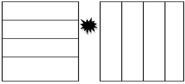
Figure 4-10.03.04-A: Reconfiguration of Four (4) Adjacent Lots
C.
Standards. The City Commission may approve an application for such reconfiguration if each of the following is found:
1.
The resulting alignment is compatible with surrounding development.
2.
The resulting alignment creates lots that can be built upon meeting required setbacks or other site design requirements.
3.
Each re-aligned lot fronts on a public or private street.
4.
The reconfiguration maintains the same number of lots, or results in fewer lots.
5.
No reconfigured lot is smaller than the smallest of the original lots.
6.
No reconfigured lots may have any improvements on them.
7.
The reconfigured lots may not be developed at a higher density after the reconfiguration than was allowed before the reconfiguration.
D.
Procedure.
1.
If the total number of lots, as realigned, is three (3) or more, the replat requirements in F.S. ch. 177, shall be met.
2.
If the total number of lots, as realigned, is less than three (3), the Minor Replat procedure in this Code may be used.
(History: Ord. Nos. 359, 369)
4-10.04.01. - Generally.
A.
When allowed. The City of Cedar Key, Comprehensive Plan prohibits construction of bulkheads and seawall except where demonstrated necessary to protect an existing structure. Bulkheads and seawalls shall only be allowed in compliance with this section. No variances may be granted.
B.
Factors to be considered in reviewing proposed bulkhead or seawall. The City Commission shall consider the following factors in its review of an application for a bulkhead or seawall:
1.
Whether the proposed bulkhead or seawall has been demonstrated by a qualified Florida Registered Engineer to be necessary to protect an existing structure from loss due to coastal subsidence.
2.
Whether the bulkhead or seawall is the minimum size necessary to protect the threatened structure.
3.
Whether the applicant has demonstrated that practical alternative means of protecting the structure were considered and determined ineffective.
4-10.04.02. - Submittals.
A.
Application. A bulkhead or seawall permit application shall be applied for on a form provided by the Building Official. At a minimum, the following information shall be provided:
1.
Name, address, and telephone number of the owner.
2.
If an agent is making the application on behalf of the owner, the name, address, and telephone number of the agent, and a signed authorization by the owner that the agent is acting on the owner's behalf.
3.
The address of the property, or other description of its location.
4.
A description of the proposed bulkhead or seawall. Detailed information shall be provided relating to each of the factors listed in 4-10.04.01 B. above.
5.
Certification by a Florida Registered Engineer that the proposed bulkhead or seawall is needed for the preservation of an existing structure.
B.
Site plan. In addition to the written application, the applicant shall submit a site plan prepared by a registered engineer, architect, or landscape architect. The Building Official may waive the requirement that the site plan be prepared by a registered engineer, architect, or landscape architect if the Building Official finds that, due to the simplicity of the project, the necessary site design information may be adequately presented on plans prepared by a non-professional. The site plan shall show the following, where relevant to the project:
1.
The location of the site and all surrounding uses, public facilities, and environmental resources within 200 feet of the boundaries of the site;
2.
The location of all existing uses, public facilities and environmental resources on the site, including all setbacks, environmental buffers, and other non-developable areas as set forth in this Code;
3.
The location of the proposed bulkhead or seawall and facilities including the following:
4.
Buildings, including accessory buildings and any other man-made structures.
5.
Stormwater management facilities.
6.
Utilities, including dumpsters and air conditioning units.
4-10.04.03. - Procedures.
A.
Review by Building Official.
1.
The Building Official shall review the application and site plan for completeness. If incomplete, the Building Official shall return the submittals to the applicant with a description of what additional information is needed.
2.
Upon receipt of a complete application and site plan, the Building Official shall review the submittals and, within 20 days of receipt of the complete submittals, prepare a report addressing the following:
a.
Whether the proposal is consistent with the Cedar Key Comprehensive Plan and complies with all applicable provisions of this Code;
b.
Any failure by the proposal to adequately address any of the factors listed in 4-10.04.01 B. above.
B.
Notice. Upon receipt of complete submittals, the Building Official shall place the application on the agenda of the next City Commission meeting allowing for the 20-day review period set forth in 4-10.04.03 A.2. above. The Building Official shall then immediately post a sign on the property giving notice of the nature of the proposed use and the date, time, and location of the City Commission meeting at which the application will be considered.
C.
Review by City Commission. The City Commission shall hold a quasi-judicial hearing, in accordance with the procedures established in Section 4-12.02.04 of this Code, on the application for a development order authorizing the construction of the bulkhead or seawall. The Commission's decision to grant or deny the requested development order shall be set forth in a written order which shall contain findings and conclusions on each of the factors listed in B. above.
The City Commission may approve an application with conditions so long as each condition is reasonable, clearly described, and supported by a finding or conclusion of the Commission on one or more of the factors listed in 4-10.04.01 B. above.
(History: Ord. No. 374)