
Cedar Key City Zoning Code
ARTICLE V
- RESOURCE PROTECTION STANDARDS
4-5.00.01. - Purpose.
The purpose of this article is to protect natural resources, including, but not limited to, shellfish harvesting areas, marine breeding grounds, and coastal waters, from the specific and cumulative impacts and harmful effects of development.
4-5.00.02. - Application.
Developers should apply the provisions of this article to a proposed development site before any other development design work is done. Application of the provisions of this article will divide a proposed development site into areas that may be developed and areas that must generally be left free of development activity. The proposed development should then be designed to fit within the areas that may be developed.
4-5.00.03. - Relationship to Plan and Other Requirements.
In addition to meeting the provisions of this article, development plans shall comply with the adopted Comprehensive Plan and applicable federal, state and water management district regulations relating to conservation, environmentally sensitive lands, and resource protection. In all cases the strictest of the applicable standards shall apply.
4-5.00.04. - Compliance When Subdividing Land.
Each lot of a proposed subdivision or resubdivision of land into two or more lots must include a site suitable for constructing a structure in conformity with the standards of this article.
4-5.01.01. - Definitions.
Accessory use means a use of land or structure or portion there of customarily incidental and subordinate to the principal use of the land or structure and located on the same parcel with the principal use.
Adjacent to a protected area means any location within 500 feet of the boundary of any protected environmentally sensitive or conservation area, whether the location is on or off the development site.
Adverse effects means any modifications, alterations, or effects on waters, associated wetlands, or shore lands, including their quality, quantity, hydrology, surface area, species composition, or usefulness for human or natural uses which are or may potentially be harmful or injurious to human health, welfare, safety or property, to biological productivity, diversity, or stability or which unreasonably interfere with the reasonable use of property, including outdoor recreation or commercial fisheries. The term includes secondary and cumulative as well as direct impacts.
Associated wetlands means any wetland that is adjacent or contiguous to waters, or which has a direct hydrologic connection to waters.
Beneficial functions of a protected area means those functions described in the City's Comprehensive Plan which justify designating an area as environmentally sensitive.
Clearing means the removal of trees and vegetation from the land, not including the ordinary mowing lawn grass.
Direct hydrologic connection means a surface water connection which, under normal hydrological conditions, occurs on the average of 30 or more consecutive days per year. In the absence of reliable hydrologic records, a continuum of wetlands may be used to establish a direct hydrologic connection.
Mean high water line means the intersection of the tidal plane of mean high water with the shore. Mean high water means the average height of the high waters over a 19-year period. For shorter periods of observation, mean high water means the average height of the high waters after corrections are applied to eliminate known variations and to reduce the result to the equivalent of a mean 19-year value.
Pollutant means any substance, contaminant, noise, or man-made or man-induced alternation of the chemical, physical, biological, or radiological integrity of air or water in quantities or at levels which are or may be potentially harmful or injurious to human health or welfare, animal or plant life, or property, or which unreasonably interfere with the enjoyment of life or property, including outdoor recreation and commercial fisheries.
Protected environmentally sensitive area means an environmentally sensitive area designated for protection in the conservation, coastal management or other elements of the City's Comprehensive Plan.
Significant adverse effect means any modification, alteration, or effect upon a protected environmentally sensitive area which measurably reduces the area's beneficial functions as delineated in the City's Comprehensive Plan.
Water or waters includes, but is not limited to, water on or beneath the surface of the ground or in the atmosphere, including natural or artificial watercourses, coastal waters, bays, inlets, bayous, streams, lakes, ponds, or diffused surface water and water percolating, standing, or flowing beneath the surface of the ground.
Water body means any natural or artificially created area with a discernible shoreline which ordinarily or intermittently contains water.
Watercourse means any natural or artificially channel, ditch, canal, stream, waterway or wetland through which water flows, either continuously or intermittently, and which has a discernible boundary.
Water's edge/wetland's edge means the boundary established by the mean high water line.
4-5.01.02. - Creation of Wetland and Shoreline Protection Zones.
A.
Creation. There are hereby created environmentally sensitive "Wetland and Shoreline Protection Zones", (protected zones) in which special restrictions on development apply. The boundaries of these zones shall be the most landward extent of the following:
1.
Areas 50 feet landward of the mean high water line.
2.
Areas within the dredge and fill jurisdiction of the Department of Environmental Regulation as authorized by F.S. ch. 403.
3.
Areas within the jurisdiction of the U.S. Army Corps of Engineers as authorized by Section 404, Clean Water Act, or Section 10, River and Harbor Act.
4.
Areas within the jurisdiction of the Suwannee River Water Management District.
B.
Determination of boundaries. A developer may obtain a determination of the boundaries of a protected zone by submitting to the department by certified mail or hand delivery a request for determination of boundaries. The request must, at a minimum, set forth an adequate description of the land the developer wishes to develop, the nature of the developer's right to ownership or control of the land, and other information needed to make the determination. The department shall have ten working days after receipt of the request to respond to the developer.
C.
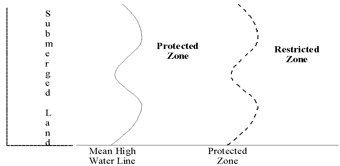
Purpose: To protect natural resources such as coastal waters, shellfish harvesting areas and marine breeding grounds.
D.
Definitions: The "Protected Zone" is 50 feet landward of the mean high water line or within state jurisdiction. (See Section 4-5.01.02). The "Restricted Zone" is land which abuts a protected zone for a distance of 500 feet, or which is in the coastal high hazard area. (See Section 4-5.01.07).
ILLUSTRATION OF PROTECTED AND RESTRICTED ZONES
EXAMPLES OF PROTECTIVE MEASURES AND RESTRICTIONS
A.
Protected zone: Development is prohibited, except for water-dependent uses such as docks and walkways. All vegetation is protected and removal is by permit only. Variances may be allowed and compensatory protective measures or mitigation may be required when variances are granted.
B.
Restricted zone: Twenty-five percent of vegetation is protected. Impervious surface (lot coverage) is limited to 40 percent of the land area. (Land area includes both the protected and restricted zones, but coverage is limited to the restricted zone.)
EXAMPLES OF PROHIBITED ACTIVITIES
A.
Clearing: Clearing more land than permitted is prohibited without authorization.
B.
Pollutants: Fertilizers, pesticides and other toxic chemicals are prohibited in the protected zone and use is restricted in the restricted zone.
C.
Stormwater discharge: Direct disposal of stormwater into coastal waters is prohibited, i.e., no drainage ditches into coastal waters.
4-5.01.03. - Development Activities Within Protected Zones.
A.
Except as expressly provided herein, no development activity shall be permitted in protected zone.
B.
Presumed insignificant adverse affects permitted. Certain activities and certain activities when mitigated are presumed to have an insignificant adverse affect on the beneficial functions of protected zones. Notwithstanding the prohibition in Section 4-5.01.03 above, these activities may be undertaken or may be permitted with mitigation unless it is shown by competent and substantial evidence that the specific activity would have a significant adverse effect on the protected environmentally sensitive area. The following uses and activities are presumed to have an insignificant adverse effect on protected zones:
1.
Scenic, historic, wildlife or scientific preserves.
2.
Minor maintenance or emergency repair to structures or improved areas existing before adoption of this Code.
3.
Commercial or recreational fishing.
4.
Cultivating aquacultural, agricultural or horticultural products that occur naturally on the site.
5.
Constructing fences where no fill activity is required and where navigational or shoreline access will not be impaired by construction of the fence.
6.
Developing a "Wetlands Stormwater Discharge Facility" or "Treatment Wetland" in accordance with state permits under § 17-25 and 17-6 F.A.C.
7.
When mitigated, as hereinafter provided, clearing of shoreline vegetation to provide a corridor or walking trail not to exceed 15 feet in width per 100 feet of shoreline, of sufficient length from the shore to allow access for boats, swimmers or fishermen.
8.
When mitigated, as hereinafter provided, constructing timber docks, catwalks, and trail bridges that are less than or equal to four feet wide, provided that no filling, flooding, dredging, draining, ditching, tiling or excavating is done, except limited filling and excavating necessary for the installation of pilings.
9.
Developing an area that no longer functions as a wetland, except a former wetland that has been filled or altered in violation of any rule, regulation, statute, or this Code. The developer must demonstrate that the water regime has been permanently altered, either artificially or naturally, in a manner to preclude the area from maintaining surface water or hydroperiodicity necessary to sustain wetland structure and function. If the water regime of a wetland has been artificially altered, but wetland species remain the dominant vegetation of the area, the department shall determine the feasibility of restoring the altered hydrology. If the wetland may be restored at a cost that is reasonable in relation to the benefits to be derived from the restored wetland, the developer shall, as a condition of development, restore the wetland and comply with the requirements of this Code.
C.
Mitigation of activities in protected zones. Clearing of wetland and shoreline vegetation for access shall be mitigated by increasing the native vegetation buffer zone to compensate for the loss of wetlands or shoreline vegetation. The increase in the native vegetation buffer zone shall be in addition to any vegetative zones required by this Code and shall be computed on a minimum area equal to the area cleared. When site elevation is too high for wetland vegetation, a buffer zone of upland vegetation shall be maintained or created.
D.
Prohibited activities in protected zones. Only those activities authorized in Part 4-5.01.03 A. may be permitted in a protected zone and the following activities are specifically prohibited:
1.
Drain fields for septic tanks or gray water systems.
2.
Dredging or filling.
3.
The use or storage of fertilizers, herbicides, defoliants or pesticides.
(History: Ord. No. 247)
4-5.01.04. - Special Uses in Protected Zones.
A.
When allowed. Water dependent activities identified in Article II of this Code which would otherwise be prohibited may be allowed if the developer shows:
1.
That the public benefit of the activity substantially outweighs the adverse environmental effects: and
2.
That no practical alternative to placement in the protected zone exists; and
3.
A recorded deed restriction limits the use to water-dependent uses.
B.
Permittable water dependent activities. Development of a protected zone may include the following permittable water-dependent activities:
1.
Projects not exceeding 10,000 cubic yards of material placed in or removed from watercourses, water bodies or wetlands.
2.
Dockage or marinas where dock length does not exceed 25 percent of the width of the water body and containing less than one slip per 100 feet of shoreline. All docks and slips shall be at least 100 feet from any federal navigation project. No docking terminus or other structure shall be located over sea grass bed.
3.
New riprap or similar structures (not including seawalls, bulkheads or the like) not exceeding 50 feet of shoreline. Rip rap shall be placed at the toe of all replaced bulkheads and seawalls.
4.
Installation of buoys, aids to navigation, signs and fences.
5.
Performance of maintenance dredging for ten years from the date of the original permit. Thereafter, performance of maintenance dredging so long as less than 10,000 cubic yards of material is removed.
6.
Installation of subaqueous transmission and distribution lines for water, wastewater, electricity, communication cables, oil or gas. Lines may be entrenched in (not exceeding 10,000 cubic yards of dredging), laid on, or embedded in bottom waters.
7.
Construction of foot bridges and vehicular bridges.
8.
Replacement or widening of bridges on pilings or trestles where the effects of pollutants discharged into open waters are minimized.
9.
Construction of artificial reefs.
10.
Other activities allowed by FDER Rule §17.90 F.A.C.
C.
Minimization of impacts. The water dependent activity shall be designed, constructed, maintained and undertaken in a way that minimizes the adverse impacts on the beneficial functions of the protected zone.
(History: Ord. No. 247)
4-5.01.05. - Design Standards for Special Uses.
A.
Generally. The following standards apply to special uses allowed in Protected Zones and are in addition to the standards for the Coastal High Hazard Area Restricted Development Zone in Section 4-5.01.07.
1.
Development in the Protected Zone shall be designed to:
a.
Allow the movement of aquatic life requiring shallow water;
b.
Maintain existing flood and tidal channel capacity;
c.
Assure stable shoreline embankments.
2.
Development that encroaches on the Protected zone shall not be located:
a.
On unstable shorelines where water depths are inadequate to eliminate or minimize the need for offshore or foreshore channel construction dredging, maintenance dredging, spoil disposal, filling, beach feeding, and other channel maintenance activities;
b.
In areas where there is inadequate water mixing and flushing;
c.
In areas which have been identified as hazardous due to high winds, flooding, or boating activity.
3.
Access roads, parking areas, and similar structures shall be located on upland sites.
4.
Non-developed portions of the Protected Zone that are damaged during construction shall be restored or replaced through replanting of vegetation, restocking of fish, shellfish, and wildlife, re-establishment of drainage patterns and the like. To the maximum extent possible, the restored or replaced areas shall match their prior ecological functioning.
5.
Accessory uses shall be limited to those which are water-dependent or necessary for operation of the development. Accessory uses shall be consistent in scale and intensity and shall be clearly subordinate to the principal and surrounding uses. Fill shall not be placed in waters or associated wetlands to create usable land space for accessory uses.
B.
Mitigation of special uses in protected zones. The following policies shall apply to special uses permitted in protected zones:
1.
Compensatory mitigation is required whenever a special use is permitted under Section 4-5.01.04 of this Code. Mitigation required shall meet the standards of the Florida Administrative Code Rules 17-312.300 through 17-312.390.
2.
Environmentally sensitive lands of the same type as those destroyed or degraded shall be purchased, created, enhanced and/or restored to compensate for the loss of such lands.
3.
Compensatory mitigation shall not be the basis for approving a project that could not otherwise be approved.
4.
A developer of a compensatory mitigation plan shall grant a conservation easement under F.S. § 704.06, on the newly purchased, created, enhanced or restored environmentally sensitive lands to protect them from any future development except those allowed in Section 4-5.01.03 of this Code.
5.
Compensatory mitigation for wetlands shall require that the amount of wetlands purchased, created, enhanced, or restored shall be large enough to assure that amount of wetlands destroyed or degraded will be completely and successfully replaced. Replacement through purchase or conservation easement of existing functional wetlands shall be on a 1.5:1 ratio. Replacement by creation, enhancement or restoration shall be on a 2:1 ratio for salt marsh and a 3:1 ratio for mangroves. Replacement which depends substantially upon natural recolonization of created or restored wetlands shall be at 3:1 for salt marsh and 4:1 for mangroves.
(History: Ord. No. 247)
4-5.01.06. - Additional Criteria and Requirements for Marinas.
In addition to the design standards for special uses, marinas and multi-slip docking facilities shall meet all requirements as cited in the Laws of Cedar Key, Chapter 3, 4-7.3.
4-5.01.07. - Creation of Restricted Development Zones.
There is hereby created a restricted development zone (restricted zone) adjacent to each wetland and shoreline protected zone (protected zones). The restricted zone shall encompass all land within the coastal high hazard area (CHHA) which abuts or is adjacent to a protected zone or any lands within 500 feet of a protected zone.
A.
Development within restricted zones. Resource protection within the restricted zone shall be assured through the following regulations:
1.
All development within the restricted zones shall be designed, constructed and maintained to avoid significant adverse effects on adjacent protected zones.
2.
Areas landward of the mean high water line which are within a protected zone may be used to determine the allowable units or square footage (density or intensity) that will be allowed on a site containing all or part of such a zone. This development potential may be transferred from the protected zone to the restricted zone, or may be transferred beyond the zone as provided for in the clustering and transfer of development rights (TDR) provisions of Article X of this Code. Allowable development potential may not, however, be transferred from outside a protected or restricted zone to within such a zone.
B.
Design standards in restricted zones. The following special design standards shall apply within restricted zones adjacent to protected zones:
1.
Developers shall completely restore any portion of a protected zone damaged during construction. Complete restoration means that any damaged area shall, within three years, be operating as effectively as the natural system did prior to being destroyed.
2.
The development shall leave a minimum of 25 percent of the site within the restricted zone as trees, shrubs, or other natural vegetation, or replace existing vegetation at a minimum 2:1 ratio.
3.
Total impervious surface, including, but not limited to, buildings, houses parking and driving areas, garages, accessory buildings, pools and walkways, is limited to 40 percent of the land area of the entire site.
4.
Point source and non-point source discharges are prohibited, except for stormwater, which may be discharged only if it meets the standards of the Suwannee River Water Management and shall provide for off-line retention or detention with filtration of the first one-inch of run-off.
5.
Siltation and erosion control measures shall be applied to stabilize banks and other un-vegetated areas during and after construction. Sediment settling ponds shall be installed for stormwater runoff prior to creation of any impervious surface. For lots and parcels that are cleared, silt screens shall be placed between the construction site and the water body to prevent erosions and siltation.
6.
Wherever possible, natural buffers shall be retained between all development and all protected zones. If a natural buffer does not exist, a buffer of the minimum size necessary to prevent significant adverse effects on the protected zone shall be created. The factual basis for the decision as to the size of the buffer shall be stated as a finding in the written record.
7.
Any channels constructed shall be of a minimum depth and width capable of achieving the intended purposes. Sides of channels shall reflect an equilibrium shape to prevent slumping and erosion and to allow re-vegetation.
8.
Any dredging shall be conducted at times of minimum biological activity to avoid fish, shellfish and crustacean migration and spawning and other cycles and activities of wildlife.
9.
Any spoil that results from dredging shall be disposed of at upland sites and stabilized within 30 days, unless the spoil is causing turbidity or other problems, in which case immediate stabilization is required.
10.
If dredging changes the littoral drift processes and causes any adjacent shores to erode, the developer shall periodically replenish these shores with the appropriate quantity and quality of aggregate.
11.
Septic tank permitting in restricted zones, when permitted, shall conform to the requirement of Sections 4-4.03.03 and 4-4.04.04 of this Code. If septic tanks are allowed, there may be no more than two septic tanks per acre of land within the restricted zone, unless it denies reasonable use of the land and no alternative is available.
12.
If no natural vegetation exists, strips of buffer vegetation shall be planted between development activities and the protected zone. Buffers shall consist of a minimum of 25 percent of the site area and shall be composed of native plant species.
C.
Coastal setbacks. Development in the restricted zone shall not encroach on the protected zone, except as provided in Section 4-5.01.03 of this Code or by a variance which shall be the minimum required to allow reasonable use of property and prevent a "taking". Granting of a variance may require other reasonable protective measures necessary to prevent significant adverse effects on a protected zone.
D.
Protective measures. The factual basis for the decision to require one or more of the following protective measures in addition to the design standards shall be stated as a finding in the written record, such as a request for a variance from the coastal setback or encroachment on a protected zone. Protective measures may include, but are not limited to the following:
1.
Limiting removal of vegetation to the minimum necessary to carry out the development activity.
2.
Expeditiously replanting denuded areas.
3.
Maintaining the natural drainage pattern.
4.
Stabilizing banks and other unvegetated areas by siltation and erosion control measures.
5.
Minimizing the amount of fill used in the development activity.
6.
Decreasing lot coverage, impervious surface, to compensate for the areas of encroachment on the protected zone.
7.
Designing, locating, constructing and maintaining all development in a manner that minimizes environmental damage.
8.
Using deed restrictions and other legal mechanisms to require the developer and successors to protect the environmentally sensitive areas and maintain the development and protective measures applied.
9.
Prohibiting septic tanks.
10.
Creating buffer zones of native vegetation greater than the minimum required.
Increasing off-line detention and retention with filtration of stormwater.
4-5.01.08. - Prohibited On-Going Activities.
The following standards shall apply to post-development activities in a protected or restricted zone:
A.
Clearing. Absent an amendment to the development order, no person shall clear more vegetation than was permitted for the original development.
B.
Point source and non-point source discharges. Absent an amendment to the development order, point and non-point source discharges shall continue to meet the standards applicable to the original development.
C.
Fertilizers, herbicides, pesticides, or defoliants. Fertilizers, herbicides, pesticides, or defoliants shall not be applied in protected zones unless authorized under F.S. §§ 373.451—373.4575 or a governmentally authorized mosquito control program. Restricted zone usage shall be at minimum appropriate quantities and frequencies.
D.
Fuel, hazardous and toxic substances, and wastes.
1.
Storage or disposal of all types of wastes is prohibited in Protected and Restricted Zones.
2.
No toxic or hazardous wastes or substances shall be stored in outdoor containers.
3.
Developments where fuel or toxic substances will be stored, sold or transferred shall employ the best available facilities and procedures for the prevention, containment, recovery, and mitigation of spillage. Facilities and procedures shall be designed to prevent substances from entering the water or soil and shall employ adequate means for prompt and effective clean-up of spills.
E.
Spray vehicles. Vehicles used for mixing or spraying of chemicals are prohibited from withdrawing water directly from surface waters.
F.
Pump-out, holding, and treatment of wastes from mobile sources. Sewage, solid wastes, and petroleum waste generated by vessels or vehicles on a site shall be properly collected and disposed of as provided by law.
G.
Prohibited uses. Long-term storage of equipment or materials, and the disposal of wastes is prohibited.
4-5.02.01. - Purpose, Intent and Application.
The purpose of this part is to provide standards necessary to protect the habitats of species-both flora and fauna-of endangered, threatened, or special concern status in the City with the intent that appropriate amounts of land be set aside to protect those habitats. Areas to which this part applies shall be identified in the conservation element of the Comprehensive Plan.
4-5.02.02. - Habitat Management Plan Required.
A habitat management plan shall be prepared as a prerequisite to the approval of any development proposed on a site containing areas subject to this part.
A.
Content. The plan shall be prepared by an ecologist, biologist or other related professional and shall be approved by the Department of Natural Resources or Game and Freshwater Fish Commission. The plan shall document the presence of affected species, the land needs of the species that may be met on the development site, and shall recommend appropriate habitat management plans and other measures to protect the subject wildlife.
B.
Conformity of final development plan. The final development plan approved for a development shall substantially conform to the recommendations in the habitat management plan.
C.
Preservation of land. Where land on a proposed development site is to be preserved as habitat of rare, endangered or special concern species, such land shall be adjacent to existing viable habitat, a significant wetland system, floodplain, or wildlife corridor. If such lands are not adjacent to the development site, land to be set aside shall be of such quantity and quality as to provide viable habitat, as documented in the requirements of part 4-5.02.02 A., above.
D.
Fee in lieu. As an alternative to preservation of land, the City may establish a fee-in-lieu-of-land program, whereby the City can purchase land which will provide a significant habitat.
4-5.02.03. - Bird Colony Habitat.
Any mangrove or wetland area which serves as an active nesting, feeding or breeding area for a colony of birds shall not be altered, including any of the special uses which may have otherwise been permitted under this article, unless specifically authorized by an approved habitat management plan meeting the requirements of Part 4-5.02.02 of this Code.
(History: Ord. No. 247)
4-5.03.01. - Definitions.
Crown means the main mass of branching of a plant above the ground.
DBH (diameter at breast height). "Breast height" is defined to be 54 inches above the surface of the ground at the base of the plan or tree. In the case of a plant with multiple main stems, the diameter shall be the sum of the diameters of the stems.
Drip line means the outermost perimeter of the crown of a plant as projected vertically to the ground.
Mangrove means rooted trees and seedlings of the following species: Buttonwood Mangrove-.Conocarpus erecta, Red Mangrove - Rhizophora mangle, White Mangrove-Laguncularia racemosa Gaertn., and Black Mangrove - Avicennia germinans.
Protected trees means any tree that has a DBH of more than eight inches, and which is not otherwise exempted from this Code. For the purposes of this Code, all Mangroves, Cedars - Juniperus silicola, Red Bay - Persea borbonia, and all palm trees with at least four and one-half feet of clear trunk between the ground level and lowest branch are declared to be "protected trees."
Protected vegetation. For the purposes of this Code, all salt marsh vegetation, including Smooth Cordgrass - Spartina alterniflora, Black Needlerush - Juncus roomerianus, Saltgrass - Distichlis spicata, Glasswort - Salicornia perennia, and Saltwort - Baltis maritima, are declared to be "protected vegetation."
Remove means to clear, cut down, damage, poison, or in any other manner destroy or cause to be destroyed, a tree or vegetation.
Tree protection zone means a circular zone around each protected tree with a minimum radius of six feet and a maximum radius of 20 feet to be determined by the drip line of the tree.
4-5.03.02. - Exemptions for Nuisance Trees and Certain Activities.
Nuisance trees, including Brazilian Pepper, Malaleuca and Australian Pine shall be exempt from the tree protection requirements of the Code. Certain activities, including utility operations, surveying, and activities required by emergencies such as hurricanes, shall be exempt to the minimum extent required to achieve the purpose of the activity. Except for emergencies, a permit shall be required for utility and surveying removal of trees and vegetation.
4-5.03.03. - Approval Required for Removal of Trees and Vegetation.
It is the intent of this section to minimize the removal of protected trees and to preserve not-less-than 25 percent of existing native vegetation on a site. A permit shall be required for removal of trees and vegetation. No permit may be issued unless the conditions of this section are met. The permit fee shall include an amount to be dedicated for future costs of maintenance of protected and heritage trees situated on City property and annual costs of purchasing and planting new trees. The fee shall be calculated on a per inch sliding scale, based on the size of the tree removed. The fee shall be promulgated by resolution of the City Commission and shall be adjusted periodically to reflect current maintenance and replanting costs. In the event that a tree or vegetation is removed without a permit, a penalty in the amount of four times the promulgated fee will be charged. In the event that a tree is removed without a permit, the diameter shall be measured at the top of the remaining stump. A tree which is removed due to death caused by a naturally occurring disease shall be subject to the permit requirement, but shall be exempt from the permit fee. All owners, tenants and/or contractors shall be jointly and severally liable for the permit fees and penalties imposed by this section.
A.
Conditions for authorization. Developers shall take reasonable measures to design and locate the proposed improvements so that the amount and number of protected vegetation and trees to be removed is minimized. The design must attempt to preserve specimen, historic or landmark trees. No authorization for the removal of protected vegetation or trees shall be granted unless the developer demonstrates one or more of the following conditions:
1.
A permissible use of the site cannot reasonably be undertaken unless specific trees and vegetation are removed or relocated.
2.
The tree is located in such proximity to an existing or proposed structure that the safety, utility or structural integrity of the structure is impaired.
3.
The tree materially interferes with the location, servicing or functioning of existing utility lines or services.
4.
The tree or vegetation creates a substantial hazard to motor, bicycle, or pedestrian traffic by virtue of physical proximity to traffic or visual impairment.
5.
The tree is diseased or weakened by age, abuse, storm or fire and is likely to cause injury or damage to people, buildings or improvements.
6.
Any law or regulation requires the removal.
B.
Replacement of removed vegetation. Removed vegetation in excess of 75 percent of the existing vegetation in the restricted area and any vegetation removed from the protected area shall be replaced according to the mitigation provisions of Part 4-5.01.05 B. of this Code and the following:
1.
For each square foot of vegetation removed, one square foot shall be replaced.
2.
Replacement may be accomplished by moving vegetation from one location to another on the site, providing measures are taken to ensure survival, or by replacement with other native species.
3.
Where practicable, replacement vegetation shall be planted on the development site. Where impracticable, replacements may be donated, or a fee inlieu may be paid, to the City for the purpose of planting on public property. The fee in lieu shall be based on the cost of replacement vegetation required.
C.
Historic, specimen and landmark trees. Historic, specimen and landmark trees are those that have been officially designated by the City Commission, upon the advice of the administrator or the Cedar Key Garden Club, to be of high value because of their history, location, size, age, type or other relevant criteria. A public hearing on the designation shall be held by the City with due notice to the owner of the tree.
D.
Removal of historic, specimen and landmark trees. No historic, specimen or landmark trees shall be removed without a finding by the City Commission that the tree is a hazard or that it is not economically or practically feasible to develop the parcel without removing the tree. The developer shall explain in detail why the tree is a hazard or why it is not economically or practically feasible to develop the parcel without removing the tree. The Administrator shall make a recommendation to the commission as to whether the removal should be denied or approved. The decision by the commission shall be made within 30 days of the date the application to remove the tree is filed.
No permit for removal of a tree shall be required if the exemption set forth in F.S. § 163.045 is applicable.
(Ord. Nos. 535, 550)
4-5.03.04. - Protection of Trees and Vegetation During Development Activities.
In order to assure the health and survival of protected trees and vegetation that are not to be removed, including injuries caused by clearing, grade changes, excavations, chemicals or mechanical injuries, developers shall take appropriate protective measures as specified in the "Tree Protection Manual for Builders and Developers," published by the Florida Division of Forestry, herewith incorporated by reference. Protected trees and vegetation which do not survive the impacts of development shall be replaced as provided in Part 4-5.03.03.02 of this Code.
4-5.03.05. - Special Protection of Mangroves and Saltmarshes.
Removal or alteration of mangroves and salt marshes shall be in accordance with all applicable Florida DEP rules, regulations and standards.
4-5.04.01. - Delegation of Responsibility.
The City hereby delegates the responsibility for groundwater, wellhead and aquifer recharge area identification and protection to the Cedar Key Water and Sewer District and Suwannee River Water Management District, (Districts).
4-5.04.02. - Protection Upon Identification.
Any future groundwater aquifer recharge area identified by CKW&SD or SRWMD shall be protected by the City by designation as an environmentally sensitive conservation area subject to the protective provisions of this Code and the districts' rules and regulations.
4-5.05.01. - Title.
The provisions contained herein shall constitute the Coastal Construction Code for construction within the coastal building zone of Cedar Key, Florida, and shall be referred to as the "Coastal Code".
4-5.05.02. - Purpose.
The purpose of the Coastal Code is to provide minimum standards for the design and construction of buildings and structures to reduce the harmful effects of hurricanes and other severe storms occurring in the Gulf of Mexico which surrounds Cedar Key. These standards are intended to specifically address design features which affect the structural stability of the beach, dunes, and topography of adjacent properties. The Coastal Code is site specific to the coastal building zone as defined herein and is not applicable to other locations. In the event of a conflict between this section and other sections of this Code, the requirements resulting in the more restrictive design shall apply. No provisions in this chapter shall be construed to permit any construction in any area prohibited by City, county, state, or federal regulation.
4-5.05.03. - Scope.
A.
Applicability. The requirements of this Coastal Code shall apply to the following types of construction in the coastal building zone and on coastal barrier islands in Cedar Key, Florida:
1.
The new construction of, or substantial improvement to major structures, uninhabitable major structures, and minor structures as defined herein.
2.
Construction which would change or otherwise have the potential for substantial impact on coastal zone (i.e., excavation, grading, paving).
3.
Construction located partially within the coastal building zone.
4.
Reconstruction, redevelopment or repair of a damaged structure from any cause which meets the definition of substantial improvement as defined herein.
B.
Exceptions. The requirements of the coastal code shall not apply to the following:
1.
Minor work in the nature of normal beach cleaning and debris removal.
2.
Structures in existence prior to the effective date of the code, except for substantial improvements as defined herein.
3.
Construction for which a valid and unexpired building permit was issued prior to the effective date of this Code.
4.
Construction extending seaward of the seasonal high-water line which is regulated by the provisions of F.S. § 161.041 (i.e., groins, jetties, moles, breakwaters, seawalls, piers, revetments, beach nourishment, inlet dredging, etc.).
5.
Construction of non-habitable major structures as defined herein, except for the requirements of Section 4-5.05.05 D.
6.
Construction of minor structures as defined herein, except for the requirements of Section 4-5.05.05 E.
7.
Structures listed in the National Register of Historic Places or the State Inventory of Historic Places.
8.
Construction for improvement of a major structure to comply with existing state or local health, sanitary, or safety code specifications which are solely necessary to assure safe living conditions.
C.
Application for permits. Applications for building permits for construction in the coastal building zone shall be required by the Building Official to be certified by an architect or professional engineer registered in the State of Florida. Such certifications shall state that the design plans and specifications for the construction are in compliance with the criteria established by this Coastal Code.
4-5.05.04. - Definitions.
General. The following terms are defined for general use in the Coastal Code:
Beach means the zone of unconsolidated material that extends landward from the mean low water line to the place where there is a marked change in material or physiographic form, or to the line of permanent vegetation, usually the effective limit of storm waves. "Beach" is alternatively termed "shore"
Breakaway wall or frangible wall means a partition independent of supporting structural members that will withstand design wind forces, but which will fail under hydrodynamic, wave, and run-up forces associated with the design storm surge. Under such conditions, the wall shall fail in a manner such that it breaks up into components which minimize the potential for damage to life or adjacent property. It shall be a characteristic of a breakaway or frangible wall that it shall have a horizontal design loading resistance of no less than ten nor more than 20 pounds per square foot.
Building support structure means any structure which supports floor, wall, or column loads, and transmits them to the foundation. The term shall include beams, grade beams, or joists, and includes the lowest horizontal structural member exclusive of piles columns, or footings.
Coastal barrier islands means all of Cedar Key.
Coastal building zone means the land area seaward of the most landward velocity zone (V-zone) boundary line established by the Federal Emergency Management Agency and shown on the Flood Insurance Rate Maps.
Coastal construction control line means the landward extent of that portion of the beach-dune system which is subject to severe fluctuations based upon a 100-year storm surge, storm waves, or other predictable weather conditions as established by the Department of Natural Resources in accordance with F.S. § 161.053.
Construction means the building of or substantial improvement to any structure or the clearing, filing or excavation of any land. It shall also mean any alterations in the size or use of any existing structure or the appearance of any land. When appropriate to the context, "Construction" refers to the act of construction or the result of construction.
Dune means a mound or ridge of loose sediments, usually sandsized, deposited by natural or artificial means, which lies landward of the beach.
Major structure includes but is not limited to residential buildings (including mobile homes), commercial, institutional, industrial, and other construction having the potential for substantial impact on coastal zones.
Mean high-water line means the intersection of the tidal plane of mean high water with the shore. Mean high water is the average height of high waters over a 19 year period.
Minor structure includes, but is not limited to, pile-supported, clavated dune and beach walkover structures; beach access ramps and walkways; stairways; pile-supported elevated viewing platforms, gazebos and boardwalks; lifeguard support stands; public and private bathhouses; sidewalks, driveways, parking areas, shuffleboard courts, tennis courts, handball courts, racquet-ball courts, and other uncovered paved areas; earth retaining walls; sand fences, privacy fences, ornamental walls, ornamental garden structures, aviaries, and other ornamental construction. It shall be a characteristic of minor structures that they are considered to be expendable under design wind, wave, and storm forces.
Mobile home means manufactured housing which conforms to the Federal Manufactured Housing Construction and Safety Standard or the Uniform Standards Code ANSI A 119.1 pursuant to F.S. § 320.823.
Nonhabitable major structure includes, but is not limited to, swimming pools, parking garages, pipelines, piers, canals, lake ditches, drainage structures, other water retention structures, water and sewage treatment plants, electrical power plants, transmission and distribution lines, transformer pads, vaults, and substations, roads, bridges, streets, and highways, and underground storage tanks.
NGVD means National Geodetic Vertical Datum - a geodetic datum established by the National Ocean Service and frequently referred to as the 1929 Mean Sea Level Datum.
One hundred year storm or 100-year storm means a shore incident hurricane or any other storm with accompanying wind, wave, and storm surge intensity having a one percent chance of being equaled or exceeded in any given year, during any 100-year interval.
Seasonal high-water line means the line formed by the intersection of the rising shore and the elevation of 150 percent of the local mean tidal range above mean high water.
State Minimum Building Code means the building code adopted by Cedar Key pursuant to the requirements of F.S. § 553.73.
Substantial improvement means any repair, reconstruction, or improvement of a structure, the cost of which equals or exceeds 50 percent of the market value of the structure either:
a.
Before the repair or improvement is started; or
b.
If the structure has been damaged and is being restored, before the damage occurred.
Where two or more permits are applied for within a one-year period, the cost of the repairs, reconstructions or improvements associated with such permits shall be added together to determine whether the cost equals or exceeds a total of 50 percent of the market value of the structure.
Regardless of value, in no instance may more than 50 percent of the existing floor area be added without being treated as a "substantial improvement." For the purposes of this definition, "substantial improvement" is considered to occur when the first alteration of any wall, ceiling, floor, or other structural part of the building commences, whether or not that alteration affects the external dimensions of the structure. The term does not, however, include either any project for improvement of a structure to comply with existing state or local health, sanitary, and safety code specifications which are solely necessary to assure safe living conditions; or any alteration of a structure listed on the National Register of Historic Places or the State Inventory of Historic Places.
4-5.05.05. - Coastal Construction Requirements.
A.
General. Construction within the coastal building zone and on coastal barrier islands shall meet the requirements of this chapter. All structures shall be designed so as to minimize damage to life, property, and the natural environment. Assistance in determining the design parameters to minimize such damage may be found in the reference documents listed in Section 4-5.05.05 C.
B.
Structural requirements for major structures.
1.
Design and construction: Major structures, except for mobile homes, shall be designed and constructed in accordance with section 1205 of the 1986 revisions to the 1985 Standard Building Code using a fastest-mile wind velocity of 110 miles per hour. Major structures, except mobile homes, shall also comply with the applicable standard for construction found elsewhere in the Standard Building Code.
2.
Mobile homes: Mobile homes shall conform to the Federal Mobile Home Construction and Safety Standards or the Uniform Standards Code ANSI A-119.1, pursuant to F.S. § 320.823, as well as the requirements of Section 5.B.3 which follows.
3.
Elevation, flood proofing, and siting: All major structures shall be designed, constructed and located in compliance with the National Flood Insurance Regulations as found in 44 CFR Parts 59 and 60 or the Cedar Key Flood Plain Ordinance, whichever is more restrictive.
C.
Design conditions.
1.
Velocity pressure. Major structures, except mobile homes, shall be designed in accordance with the requirements of Section 1205 of the 1986 revisions of the 1985 Standard Building Code using a minimum fastest-mile wind velocity of 110 mph. These minimum design pressures are as follows:
VELOCITY PRESSURE (PSF)
BUILDING HEIGHT 60 FEET OR LESS
GUST VELOCITY PRESSURE (PSF)
BUILDING HEIGHT OVER 60 FEET
2.
Foundations. The elevation of the soil surface to be used in the design of foundations, calculation of pile reactions and bearing capacities shall not be greater than that which would result from the erosion reasonably anticipated as a result of design or conditions. Foundation design and construction of a major structure shall consider all anticipated loads acting simultaneously with live and dead loads. Erosion computations for foundation design shall account for all vertical and lateral erosion and scour producing forces, including localized scour due to the presence of structural components. Foundation design and construction shall provide for adequate bearing capacity taking into consideration the type of soil present and the anticipated loss of soil above the design grade as a result of localized scour. Erosion computations are not required landward of coastal construction control lines established or updated since June 30, 1980. Upon request the Department of Natural Resources may provide information as to those areas within coastal building zones where erosion and scour of a 100-year storm event is applicable.
3.
Wave forces. Calculations for wave forces resulting from design storm conditions on building foundations and superstructures may be based upon the minimum criteria and methods prescribed in the Naval Facilities Engineering Command Design Manual, NAVFAC DM-26, U.S. Department of Navy; Shore Protection Manual. U.S. Department of the Army Corps of Engineers; U.S. Department of Army Coastal Engineering Research Center Technical Papers and Reports; the Technical and Design Memoranda of the Division of Beaches and Shores, Florida Department of Natural Resources; or other professionally recognized methodologies which produce equivalent design criteria. Breaking, broken, and non-breaking waves shall be considered as applicable. Design wave loading analysis shall consider vertical uplift pressures and all lateral pressures to include impact as well as dynamic loading and the harmonic intensification resulting from repetitive waves.
4.
Hydrostatic loads: Calculations for hydrostatic loads shall consider the maximum water pressure resulting from a fully, peaked, breaking wave super-imposed upon the design storm surge with dynamic wave setup. Both free and hydrostatic loads shall be considered. Hydrostatic loads which are confined shall be determined by using the maximum elevation to which the confined water would freely rise if unconfined. Vertical hydrostatic loads shall be considered both upward and downward on horizontal or inclined surfaces of major structures (i.e., floors, slabs, roofs, walls). Lateral hydrostatic loads shall be considered as forces acting horizontally above and below grade on vertical or inclined surfaces. Hydrostatic loads on irregular or curved geometric surfaces shall be determined by considering the separate vertical and horizontal components acting simultaneously under the distribution of the hydrostatic pressures.
5.
Hydrodynamic loads. Hydrodynamic loads shall consider the maximum water pressure resulting from the motion of the water mass associated with the design storm. Full intensity loading shall be applied on all structural surfaces above the design grade which would affect the flow velocities.
D.
Structural requirements for utilities. All sewage treatment and public water supply systems shall be flood-proofed to prevent infiltration of surface water anticipated under design storm conditions. Underground utilities, excluding pad transformers and vaults, shall be flood-proofed to prevent infiltration of surface water expected under design storm conditions or shall otherwise be designed to function when submerged under such storm conditions.
E.
Structural requirements for minor structures. Minor structures need not meet the specific structural requirements of Section 4-5.05.05, except that they shall be designed to produce the minimum adverse impact on the beach and dune system and shall comply with the applicable standards of construction found in the Standard Building Code as adopted by Cedar Key, Florida.
F.
Location of construction. Construction, except for elevated walkways, lifeguard support stands, piers, beach access ramps, gazebos, and coastal or shore protection structures, shall be located a sufficient distance landward of the beach to permit natural shoreline fluctuations and to preserve dune stability. Construction, including excavation, may occur to the extent that the natural storm buffering and protection capability of the dune is not diminished.
G.
Public access. Where the public has established an access way through private lands to lands seaward of mean high tide or water line by prescription, prescriptive easement, or other legal means, development or construction shall not interfere with such right of access unless a comparable alternative access way is provided. The developer shall have the right to improve, consolidate, or relocate such public access ways so long as they are:
1.
Of substantially similar quality and convenience to the public;
2.
Approved by the City Commission and approved by the Department of Environmental Protection whenever improvements are involved seaward of the coastal construction control line; and
3.
Consistent with the coastal management element of the Cedar Key Comprehensive Plan adopted pursuant to F.S. § 163.3178.
4-5.05.06. - Rules of Interpretation.
It is anticipated that there may be some conflict between this provision and the flood hazard mitigation requirements of this Code, which was required to be passed by the Federal Emergency Management Agency (FEMA) in order to ensure that the City of Cedar Key, Florida, could remain eligible for participation in the Federal Flood Insurance Program. Both said ordinances shall be administered and enforced within the City. In the event of conflict, between the provisions of said ordinances, then the most stringent or strict regulation applicable to a give situation shall apply.
(History: Ord. No. 330)
4-5.06.01. - General.
Any violation of this Code is a public nuisance and may be restrained by injunction or otherwise abated in a manner provided by law.
4-5.06.02. - Restoration.
Any violator may be required to restore land to its undisturbed condition. In the event that restoration is not undertaken in a reasonable time after notice, the City may take necessary corrective action, the cost of which shall become a lien upon the property until paid.
4-5.06.03. - Additional Remedies and Penalties.
In addition to any remedy or penalty provided in this Article, any person who violates the provisions of this article shall be subject to the remedies and penalties provided in Article XII of this Code.
(History: Ord. No. 220)