
Cedar Key City Zoning Code
ARTICLE VI
DEVELOPMENT DESIGN AND IMPROVEMENT STANDARDS
4-6.00.01. - Purpose.
The purpose of this article is to provide development design and improvement standards applicable to all development activity in the City.
4-6.00.02. - Responsibility for Improvements.
All improvements required by this article shall be designed, installed, and paid for by the developer.
4-6.00.03. - Principles of Development Design.
The provisions of this article are intended to ensure functional and attractive development. Development design shall first take into account the protection of natural resources as prescribed in Article V of this Code, Resource Protection Standards. All development shall be designed to:
A.
Avoid unnecessary impervious surface cover;
B.
Provide adequate access to lots and sites;
C.
Provide adequate parking;
D.
And assure compatibility with surrounding properties by avoiding the adverse effects of drainage, noise, odor, traffic, shadow, glare and utilities.
4-6.00.04. - Residential Subdivisions.
Notwithstanding any other provisions of this article, residential subdivisions for single-family homes or duplexes, including minor replats, shall comply with the following. Except as specifically provided below, no other provisions of this article, or the submittal requirements in Article XII, shall apply to such subdivisions.
A.
Submittals. The submittals for subdivisions shall comply with the requirements of F.S. ch. 177, and shall, in addition, show the setback lines established by Article V of this Land Development Code, and the outlines of a buildable area upon which a home can be built in compliance with the setbacks and the impervious surface ratios in 4-6.01.02, the setback requirements in 4-6.01.03, height limitations in 4-6.01.03.
B.
Streets.
1.
Streets shall conform to the general design standards in 4-6.02.04 A through G. Nothing else in Section 4-6.02.04 shall apply, including the classification system in 4-6.02.02 and 4-6.02.03
2.
If the streets are to be dedicated to the City of Cedar Key, they shall meet the design standards for residential streets contained at Technical Construction Standards cited at Section 4-1.06.02 of this Code.
3.
If the streets are to remain private, they shall meet the design standards for residential streets contained at Technical Construction Standards cited at Section 4-1.06.02 of this Code.
4.
Dead-end streets shall provide a turn-around of adequate dimension to accommodate emergency service and waste collection vehicles.
C.
Sidewalks. Sidewalks may be required on streets that connect to an existing street with sidewalks. When required, the sidewalk shall extend the entire length of the new street on the same side, or sides, of the street so as to match the sidewalk(s) on the existing street. Sidewalks may only be required by action of the City Commission following a determination by the Commission that sidewalks are needed and appropriate for the proposed residential subdivision.
D.
Utilities. Prior to approval of the plat, the developer shall document the manner in which each lot is serviceable by the following utilities: electricity, water, sewer and telephone. All utilities shall be placed underground in accord with 4-6.04.03 and 4-6.04.04 of this article.
E.
Responsibility for improvements. It shall be the responsibility of the developer to install all improvement required by this section. Section 4-12.02.13 relating to guarantees and sureties shall apply.
(History: Ord. No. 299)
4-6.01.01. - Minimum Lot Area Requirements.
All developments shall have total land area sufficient to meet all requirements of this Code including, but not limited to, land required to provide setbacks, buffers, stormwater management, off-street parking and circulation, protection of environmentally sensitive land and natural resources, open space, and any other provisions which may require land area to be set aside.
A.
Definitions. The following terms when used in this section shall mean:
Lot means the least fractional part of subdivided lands having limited fixed boundaries, and an assigned number, letter, or other name through which it may be identified.
Lot of record means a platted residential lot in existence on February 17, 1997.
Parcel of record means any parcel of land recognized as a single parcel for ad valorem taxation purposes by the Levy County Property Appraiser's office on February 17, 1997.
B.
Minimum upland lot size. In all areas within the limits of the City of Cedar Key not included within the boundaries identified by Map 4-6.01.01 of this section, the minimum lot size shall be 7,500 square feet and no real estate parcel therein shall be divided, subdivided, replatted or recorded so as to create any lot with an upland area of less than 7,500 square feet or the average size of lots in any adjacent subdivision, whichever lot size is larger.
C.
Single non-conforming lots or parcels of record (not under common ownership). Any residential lot of record or parcel of record within the limits of the City of Cedar Key which: (i) is not included within the boundaries identified by Map 4-6.01.01 of this section; and (ii) contains less than 7,500 square feet of upland area; and (iii) is not under common ownership with any adjacent lot or parcel; and (iv) has not, at any time after February 17, 1997, been under common ownership with any adjacent lot or parcel; shall be considered a legal non-conforming lot or parcel of record and may be developed as a matter of right.
D.
Multiple non-conforming lots or parcels of record (under common ownership). If there exists multiple adjacent lots of record or parcels of record: (i) which are not included within the boundaries identified by Map 4-6.01.01 of this section; and (ii) any one of which contains less than 7,500 square feet of upland area; and (iii) which are currently under common ownership or have been under common ownership at any time after February 17, 1997; then all such lots and parcels must be combined or replatted in a manner that results in lots or parcels which have a minimum size of 7,500 square feet or the average size of lots in any adjacent subdivision, whichever lot size is larger. If the combined total square feet of such lots or parcels is less than 15,000 square feet, then all such lots or parcels must be combined into one lot or parcel.
E.
Specific requirements within area indicated in Map 4-6.01.01.
1.
Minimum upland lot size. In all areas included within the boundaries identified by Map 4-6.01.01 of this section, the minimum lot size shall be 2,500 square feet and no lot of record or parcel of record within said boundaries shall be divided, subdivided, replatted or recorded so as to create any lot with an upland area of less than 2,500 square feet.
2.
Exception. Within the boundaries identified by Map 4-6.01.01 of this section, residential parcels of record containing less than 2,500 square feet of upland area may be developed with a maximum of one residential unit per parcel of record, if all other provisions of this Code are met. Multiple abutting parcels of record under common ownership, any one of which is less than 2,500 square feet, must be replatted through the minor replat provisions of this Code to create new platted lots that are not less than 2,500 square feet.
(History: Ord. Nos. 294, 410, 425, 458, 540)
4-6.01.02. - Impervious Surface Ratio (ISR).
A.
Generally. Impervious surface on a development site shall not exceed the limits established in § 2.02.10, Article II, Chapter Four, Laws of Cedar Key.
B.
Treatment of cluster development and TDR provision. Site design within a development may provide for the clustering of building units to provide common open space as impervious surface, and land development rights may be transferred from one site to another. As a condition of approval, deed restrictions, covenants or conservation easements shall guarantee the maintenance of such open space in perpetuity. Lands proposed for a Transfer of Development Rights (TDR) shall be in the same zoning districts and shall share the same characteristics and development potential.
(History: Ord. No. 426)
4-6.01.03. - Setback Requirements.
A.
Coastal construction setback line. Except as provided for water-dependent commercial uses guaranteed by deed restrictions and residential water access structures allowed in Section 4-5.01.03 of this Code, all structures and buildings shall be located 50 feet landward of the mean high water line or any existing bulkhead or water surface. A hardship variance may be granted for the minimum amount required to prevent a taking of private property without compensation, providing the encroachment on the protected zone is mitigated and protective measures as provided in Section 4-5.01.07 C. and D. are taken to reduce the adverse effect of the variance. The coastal construction setback line may be interpreted as the average distance from the mean high water line to the face(s) or side(s) of structures nearest the water, and shall be measured from the eaves or roofline. Open decks or walkways which encroach on the protected zone shall meet the requirements of Section 4-5.01.03 of this Code.
B.
Front, side and rear yard setbacks. There are no minimum setbacks required for front, side and rear yards providing that one of the following requirements is met:
1.
Compatibility is assured through compliance with Section 4-3.02.00, Infill Development, of this Code.
2.
If the distance from the exterior wall to the property line of adjacent property is less than five feet, the applicant must show evidence of a maintenance easement granted by adjacent property owners.
3.
A structure may be built on the property line provided the owners shall grant an attachment easement to the adjacent property owners.
4-6.01.04. - Building Height.
A.
Generally. Building height is limited to:
Thirty-two (32) feet on a structure with a flat roof; or
Thirty-eight (38) feet on a structure with a pitched roof.
B.
Measurement of building height. Structure height is measured as the vertical distance from the base of a structure to the top of the structure. For the purposes of this subsection:
1.
The base of a structure is the highest point of the natural or existing ground elevation immediately adjacent to the subject building or structure; except that in those areas of the City located in whole or in part within the Coastal High Hazard Area (FEMA "V" Zone) as delineated on the Flood Insurance Rate Map (FIRM), where the base is the Base Flood Elevation (BFE) as established on the FIRM; and
2.
The top of a structure is the highest point on the roof of the structure.
C.
Exceptions to height limitations. Church spires, chimneys, water towers, transmitter towers, smoke stacks, flag poles, television antennae, parapets, and similar structures and their necessary mechanical appurtenances, may, where specifically permitted by the commission, be erected above the height limits established herein.
(History: Ord. No. 426.)
4-6.02.01. - General.
This section establishes minimum requirements applicable to public and private streets, parking and loading areas, bikeways, pedestrian ways, and access control to and from public streets. The standards in this section are intended to minimize the traffic impacts of development, to assure that all development adequately and safely provides for the storage and movement of vehicles consistent with good engineering design and construction standards.
A.
Compliance with Technical Construction Standards. All required elements of the transportation system shall be provided in compliance with the engineering design and constructions standards contained in the Technical Construction Standards sources cited in Section 4-1.06.02 of this Code.
B.
Average daily traffic (ADT). Average daily traffic (ADT) shall be calculated from trip generation rates prepared by the Institute of Traffic Engineers. Other sources may be used if the developer demonstrates that the alternative source better reflects local conditions.
4-6.02.02. - Streets.
The Future Traffic Circulation Map and any amendments thereto adopted by the City as part of the Comprehensive Plan is the official street map and classification system for streets in the City. Existing and proposed streets shall be classified according to the following hierarchy and functions in order to allow for regulation of access; road, right-of-way, lane and pavement widths; design speed, ADT, circulation patterns; and construction standards.
A.
Local roads. This is the lowest order of street in the hierarchy. Local Roads provide direct access to abutting properties with an access driveway allowed every 20 feet. Design speed for local roads is 15 to 25 miles per hour (MPH). Maximum ADT is 1,500. Right-of-way (ROW) width shall be 60 feet. Moving lanes shall be nine feet and parking lanes eight feet wide. Total pavement width is 34 feet. Gutters and curbs shall be required.
B.
Collector roads. Collector roads provide access to and from local roads. Access points are allowed every 40 feet. Design speed for collector roads is 25 to 35 MPH. Maximum ADT is 3,000. ROW width shall be 60 feet. Moving lanes shall be 11 feet wide and parking lanes eight feet wide. Total pavement width is 38 feet. Gutters and curbs shall be required.
C.
Arterial roads. Arterial roads provide a link between the City and regional or state highways. Access points are allowed every 50 feet. Design speed for arterial roads is 35 to 55 MPH. Maximum ADT is 7,000. ROW width shall be 80 feet. Moving lanes shall be 14 feet wide and parking lanes shall be eight feet wide. Total pavement width is 54 feet. Arterial roads shall meet all DOT requirements.
D.
Special purpose streets. The City may require the designation or creation of special purpose streets such as alleys, divided streets, limited traffic streets, pedestrian walkways and marginal access streets. The standards shall be established at the time of creation of any special purpose street.
4-6.02.03. - Rights-of-Way (ROW).
Rights-of-way requirements for road construction shall be as specified for the street classification indicated in Part 4-6.02.02 of this Code. The ROW shall be measured from lot line to lot line.
A.
Future rights-of-way. Where roadway construction, improvement or reconstruction is not required to serve the needs of the proposed development, future ROW shall nevertheless be reserved for future use. No part of reserved areas, ROW easements or existing ROW shall be used to satisfy minimum requirements of this Code.
B.
Encroachment. No encroachment shall be permitted into existing ROW, except as follows:
1.
Temporary use, such as festivals, street dances and street markets, when authorized by the City Commission.
2.
To allow the use of air space over City sidewalks in the Historic District Overlay Zone for porches or balconies with unenclosed walls (except for insect screening and protective railings) and canopies, marquees or awnings. Permitted uses shall have a minimum vertical clearance of nine feet, six inches from ground (sidewalk) level and shall be visually compatible with adjacent uses. Supporting posts or columns may be permitted on the ROW between the curb and the first one foot of sidewalk, but no other permanent obstruction of the ROW shall be allowed. Applicants for the use of ROW shall sign a hold harmless and waiver of liability agreement before the City shall authorize such use.
3.
To use ROW for public or private utilities including, but not limited to, sanitary sewer, potable water, telephone, cable or electric transmission wires and gas lines, subject to the placement specifications and technical construction standards which apply.
4.
Sidewalks and bicycle ways shall be placed within the ROW
C.
Vacations of rights-of-way. Applications to vacate a ROW may be approved by the City Commission upon a finding that all of the following requirements are met:
1.
The requested vacation is consistent with the Comprehensive Plan.
2.
The ROW does not provide the sole access to any property. Remaining access shall not be by easement.
3.
The vacation shall not jeopardize the current or future location of any utility.
4.
The proposed vacation is not detrimental to the public interest.
5.
The proposed vacation provides a positive benefit to the City.
6.
The proposed vacation does not involve a ROW with coastal access.
4-6.02.04. - Street Design Standards.
A.
Generally. The following standards are in addition to the classification requirement in Sections 4-6.02.02 and 4-6.02.03 of this Code, and shall be in compliance with technical construction standards.
1.
Streets shall be dedicated to the City upon completion, inspection and acceptance by the City. No street shall be accepted unless designed and constructed in accordance with the standards of this Code.
2.
Streets shall, to the extent practicable, conform to the natural topography of the site, preserving existing hydrological and vegetative patterns, and minimizing erosion potential, runoff, and the need for site alteration. Particular effort should be directed toward securing the flattest possible grade near intersections.
3.
Streets shall be laid out to avoid environmentally sensitive areas and to avoid stormwater runoff into those areas.
4.
Private streets and streets under common ownership may be allowed, provided they meet the design and construction standards of this Code.
5.
The street layout in all new development shall be coordinated with and interconnected to the street system of the surrounding area.
6.
Streets in proposed subdivisions shall be connected to rights-of-way in adjacent areas, or allow for future connection to undeveloped areas, to allow for proper inter-neighborhood traffic flow.
7.
Residential streets shall be arranged to discourage through traffic.
8.
Streets shall intersect as nearly as possible at right angles and in no case shall be less than 75 degree angles.
9.
New intersections along one side of an existing street, shall where possible, coincide with existing intersections.
10.
No two streets may intersect with any other street on the same side at a distance of less than 300 feet measured from centerline to centerline of the intersecting street.
B.
Curbing requirements. Curbing constructed in accordance with the standards cited in this Code shall be required for the purposes of drainage, safety and delineation and protection of pavement edge along streets in the following cases:
1.
Along designated parking lanes.
2.
Where the channeling of stormwater is required.
3.
Where narrow lots averaging less than 40 feet in width take direct access from a street upon which no on-street parking is required.
C.
Shoulders. Where required, shoulders shall measure at least four feet in width and shall be required on each side of streets and shall be located within the ROW. Shoulders shall consist of stabilized turf or other material permitted by technical construction standards. Shoulders and/or drainage swales are required as follows:
1.
On local roads where necessary for stormwater management or road stabilization;
2.
On collector streets, two four-foot wide shoulders. Shoulders will be grass surfaced except in cases where grass cannot be expected to survive. In no case will shoulders be paved;
3.
Where required by FDOT; and
4.
On arterial streets where curbing is not required.
D.
Acceleration, deceleration, and turning lanes. The City may require deceleration or turning lanes or acceleration lanes if indicated by a traffic study. Design of lanes shall be indicated in the study and lanes shall be the same width as for moving lanes in the roadway type.
E.
Clear visibility triangle. In order to provide a clear view of intersecting streets to motorists, there shall be a triangular area of clear visibility formed by two intersecting streets or the intersection of a driveway and a street. The following standards shall be met:
1.
Nothing shall be erected, placed, parked, planted or allowed to grow in such a manner as to materially obstruct or impede vision between a height of two feet and ten feet above the grade, measured at the centerline of the intersection.
2.
The clear visibility triangle shall be formed by connecting a point on each street centerline, to be located at a distance of 75 feet from the intersection of the street centerlines, and a third (3rd) line which connects the two points. (See example illustrated)
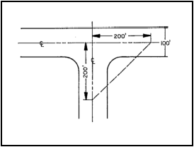
Figure 4-6.02.04-A. Example of Clear
Visibility Triangle
F.
Street signs and signals. The developer shall deposit with the City sufficient funds to provide all necessary roadway signs and traffic signals as may be required based on City, county or state traffic standards, including street sign names at each intersection created by the development.
G.
Street trees. The developer shall provide street trees in accordance with the landscaping provisions of this article.
4-6.02.05. - Sidewalks and Bikeways.
Developers shall provide sidewalks on both sides of local and collector roads within the development. New road construction shall include bikeways. Sidewalks and bikeways shall be designed and constructed in accordance with technical construction standards, including provisions for access by physically handicapped persons.
4-6.02.06. - Access.
All developments shall have access to public rights-of-way at the rate of one access point for each 50 residential units or any fraction thereof. Driveways and access points shall be as specified in Section 4-6.02.02 of this Code and the distance between access points shall be measured from the centerline of the proposed driveway to the centerline of the nearest adjacent driveway or access point. Adjacent uses may share a common driveway provided that appropriate access easements are granted between or among the property owners.
4-6.02.07. - Standards for Drive-Up Facilities.
All facilities providing drive-up or drive-through service shall provide on-site stacking lanes in accordance with the following standards:
A.
Turning movements in relation to driveways and intersections shall be minimized.
B.
The facilities and stacking lanes shall be designed and located to minimize or avoid conflict with or obstruction of vehicular or pedestrian traffic.
C.
A by-pass lane shall be provided.
D.
Stacking lanes shall provide a minimum of 120 feet on the site, exclusive of other access and parking.
E.
Construction of stacking lanes shall conform to the technical construction standards referenced in this Code.
4-6.02.08. - Driveway Aprons.
A.
Definitions. For the purpose of this section the following definitions shall apply:
Curb cut means the opening along the curb line at which point vehicles may enter or leave the roadway.
Driveway apron means the improved area between a public street and private property (not to exceed six feet nor be less than three feet in length) intended to provide ingress and/or egress of vehicular traffic from the public street or thoroughfare to a property.
Driveway apron width means the width of the driveway apron measured parallel with the edge of the street or roadway at the street right-of-way line.
Right-of-way means lands conveyed or dedicated to the public to be used for a street, alley, walkway, drainage facility, or other public purpose.
B.
Compliance required. All driveways aprons constructed or removed within the City limits shall be constructed or removed as provided for in this section. All required driveway aprons shall be constructed prior to the initiation of construction of any improvements on the property served by the driveway.
C.
Unauthorized construction, curb cutting declared unlawful. It shall be unlawful for any person to construct, cut, break out or remove any curb along a street or alley except as authorized by the provisions of this section.
D.
Permit required. No person shall remove, alter or construct any curb, driveway apron, gutter, pavement, or perform any other improvement on any public street or designated street right-of-way without obtaining a permit authorizing the improvement from the City Building Official.
E.
Submission of plans; information required.
1.
No driveway apron permit shall be issued until there is filed with the building official two copies of plans showing the location and dimensions of all proposed improvements. Plans are not required for driveway aprons serving a single-family residence. The building official shall meet with applicants for single-family residential driveway permits at the single family lot and determine the eligibility and appropriate location for requested driveways.
2.
Additional plans may be required for driveways connecting to streets maintained by the Florida Department of Transportation or Levy County within the corporate limits.
3.
Information required on plans submitted shall include:
a.
Existing and proposed driveway locations and widths;
b.
Proposed location of off-street loading and unloading facilities, interior parking arrangements, and traffic circulating patterns;
c.
Retaining walls, drainage, utility poles, trees and other physical features which affect the driveway location;
d.
Driveways on adjacent properties and on opposite side of the street.
F.
Design standards.
1.
The number of driveways serving any one parcel shall be reduced to a practical minimum, and shall be located to reduce vehicular and pedestrian conflicts.
2.
All aprons shall be hard surfaced in conformance with the standards and specifications adopted by the City Commission by resolution and on file in the office of the City Building Official.
3.
Where applicable, driveway aprons shall cross the sidewalk area at the sidewalk grade established by the City Building Official.
4.
Driveway aprons shall be constructed to conform to the existing paved street grade or grade approved by the City Building Official for non-paved streets.
5.
Driveway aprons shall be constructed as nearly to a right angle to the street or roadway as possible.
6.
The width of a driveway apron shall be within the minimum and maximum limits as specified below.
7.
For single family residential, the width of the driveway apron shall not be less than 16 feet measured from the outside edge to outside edge. For all other driveways the width of the opening shall not exceed the driveway width by more than three feet on each side.
8.
No curb shall be cut unless a concrete driveway apron is constructed the full width of the opening with adequate curb on each end and the construction extends from the gutter to the sidewalk. Where there is no existing sidewalk, this construction shall extend a sufficient distance from the gutter so that the rise of the drive will be at least six inches above the level of the gutter at the extreme end.
9.
All driveway aprons shall be constructed with a minimum setback distance of five feet from any interior property line, and with a two-foot minimum offset from the property line at the roadway connection. These offsets may be reduced for single-family residences at the recommendation of the City Building Official.
10.
No driveway apron shall be permitted to interfere with any municipal facility such as traffic signal standards, catch basins, fire hydrants, utility poles, fire alarm supports or other similar type structures.
G.
Costs.
1.
All costs of any change proposed in any physical improvements originally installed by the City and all costs of the installation of any driveway apron or necessary signing shall be borne by the property owner.
2.
All costs and responsibilities for maintenance and/or repair of any driveway apron.
H.
Unnecessary driveway aprons.
1.
When the use of any driveway apron is changed, making any portion or all of a driveway apron unnecessary, the owner of the property accessed by such driveway apron shall, at his/her expense, replace all necessary curbs, gutters, sidewalks, and grass areas within the public right-of-way.
2.
All driveway aprons in the City except those serving a single-family residence, shall be reviewed and approved by the City Building Official prior to the issuance of any building permit for the erection, construction, reconstruction or change in the use of any building, structure or land.
I.
Prohibited curb cuts. It is unlawful for any person to construct, cut, break out or remove any curb or establish any new curb cuts along both sides of 2nd Street downtown and bounded by D Street to the west and Depot Street to the east.
(History: Ord. Nos. 356, 403)
4-6.03.01. - Basic Requirement for Off-Street Parking.
Off-street parking facilities shall be provided for all development within the City except for the downtown exception area. Where applicable, the parking facilities shall be maintained as long as the use exists that the facilities were designed to serve.
A.
Invalidation of previous provisions and waivers.
1.
Any change of use, redesign or increase in space which would change the parking requirements of this Code shall invalidate any previous parking provisions or waiver of parking requirements and parking shall be re-computed and the provisions of this Code applied, except that any previously granted wavier may be considered in determining parking requirements for existing areas to the extent that such waiver has been documented. When no specific number of parking spaces previously waived has been documented the administrator may determine a past waiver on the basis of one parking space per single-family residential dwelling unit or one parking space per 250 square feet of commercial space which existed prior to the change of use, redesign or increase in space.
2.
In determining parking requirements for new uses the administrator shall consider the highest use to which the structure may be used, unless limited by a legal instrument which specifies the intended use for which the parking requirement applies.
3.
Waivers shall run with the property and shall not be transferable from one site to another.
4.
Uses shall be determined by Part 4-6.03.02 of this Code. When a proposed use is not considered in Part 4-6.03.02 or when an interpretation is required, the administrator shall apply the use classifications or categories of Chapter 4 of the Standard Building Code adopted by reference in Part 4-1.06.02 of this Code.
B.
Computations. Floor area shall be the sum of the gross horizontal area of all floors of a building measured from the exterior faces of walls. Fractional numbers of one-half shall be rounded to the next whole number.
C.
Parking study. When a parking study is required by this Code the study shall include, but shall not be limited to, estimates based on professionally accepted sources such as ULI, ITE or the Traffic Institute for uses comparable to the proposed use. Comparability shall be determined by density, scale, bulk, area, type of activity and location. The study shall document the source(s) of data used to develop recommendations.
(History: Ord. Nos. 250, 399, 549)
4-6.03.02. - Number of Parking Spaces Required.
A.
The minimum number of parking spaces required for off-street parking shall be according to Table 4-6.03.02:
TABLE 4-6.03.02
NUMBER OF PARKING SPACES REQUIRED
B.
Parking study required for change in minimum requirements. Any development, except for one single-family dwelling unit, proposing fewer than the required number of parking spaces or any request for a change, waiver or variance from the requirements of this Code shall provide the City Commission with five copies of a parking study, as described in Section 4-6.03.01 A. of the Code. Said study shall be conducted at the expense of the developer or petitioner and shall provide justification for any change in the minimum requirements of this Code. The City Commission shall make a determination, after public notice and a public hearing, on the basis of the study within 30 days of public notice.
C.
[Reserved.]
D.
Assessed parking. The City may assess the owner(s) of areas to be served by parking for the creation of public parking areas. The required off-street parking for a particular use shall be reduced by its proportionate share of any public parking area for which it has been specially assessed.
E.
Joint use parking. The City may authorize a reduction in the total number of required parking spaces for two or more uses jointly providing parking when their respective hours of operation and need for parking do not normally overlap. As a condition of approval, the owner(s) shall submit a legal agreement guaranteeing the joint use of off-street parking for as long as the uses requiring parking exist or until the required parking is provided elsewhere.
F.
Parking deferral. The City commission may defer all or part of the parking requirements of this Code through a written agreement with the owner(s) or developer which provides that deferred parking spaces required shall be provided, within three years of the date of the agreement. Thereafter, the parking deferral may only be extended as the result of a parking study which meets the requirements of this Code. The decision to grant or deny an extension of the deferral shall be based on findings in the parking study. An extension shall not exceed the three year period of the original deferral.
G.
Historic preservation exemption. The City commission may grant a reduction in, or exemption from, the parking requirements of this Code for the preservation of any property that has been placed on the Local Register of Historic Places or located in a Historic District and subject to the historic preservation provisions of this Code. The City may grant the reduction or exemption without the need for a parking study unless a severe parking shortage or severe traffic congestion exists or will result from the reduction or exemption. The reduction or exemption shall apply only to the area of existing buildings which are included in the Local Register or District.
H.
Handicapped parking. Parking areas to be used by the general public shall provide handicapped parking consistent with F.S. § 316.1955/1956.
I.
Off-shore development parking. Any off-shore development within three miles seaward of the City limits and not connected by a bridge or ferry system, which cannot show evidence of accessible parking for owners or users, shall meet the requirements of this Code through the provision of alternate off-site off-street parking.
J.
Downtown exception area. All parcels or lots with existing structures as of December 1, 2005 and within an area bounded by: 1st Street on the south; 3rd street on the north; A street on the east; and D street on the west shall be exempt from the off-street parking and loading requirements of this Code. In addition, all parcels or lots with existing structures on the north side of 3rd Street between A and D streets; and, all parcels or lots with existing structures along both sides of Dock Street shall be exempt from the off-street parking and loading requirements of this Code. The Planning and Development Administrator shall maintain an inventory of the lots and parcels within the downtown exception area that have existing structures as of December 1, 2005.
(History: Ord. Nos. 399, 429, 549)
4-6.03.03. - Off-Street Loading.
Spaces to accommodate off-street loading for business vehicles shall be provided at the rate of one space for the first 10,000 square feet of floor area, and one space for each additional 20,000 square feet. Joint uses may be authorized for businesses located within a radius of 300 feet of the loading area, provided that all businesses submit a legal agreement which guarantees the joint use of the area.
4-6.03.04. - Design Standards of Off-Street Parking and Loading Areas.
All facilities shall meet the location, size and layout provisions of this Code.
A.
Location. Except as provided herein, all required off-street parking and the use it is intended to serve shall be located on the same parcel.
B.
Alternate locations. The City Commission may authorize the use of off-site off-street parking spaces which will serve the use for which it is intended. Residential off-site off-street parking shall be within 250 feet of the units served. Commercial or offshore off-site off-street parking shall be within one-half mile of the commercial site or shoreline. Land designated for off-site off-street parking shall meet the standards of this Code and shall be reserved for parking purposes through recorded deed restrictions or legal agreements which shall continue in effect for so long as the parking need of the use it serves shall continue.
C.
Size.
1.
Standard and compact parking spaces shall be sized according to Figure 4-6.03.04.C.
2.
Other spaces shall be sized as follows:
a.
Parallel parking spaces shall be a minimum of eight feet wide and 22 feet long.
b.
[Reserved.]
c.
Handicapped parking spaces shall be as specified in F.S. § 316.1955.
d.
Off-street loading spaces shall be ten feet wide, 25 feet long, provide vertical clearance of 15 feet, and provide adequate area for maneuvering, ingress and egress. Larger spaces may be required or built to accommodate larger vehicles and up to 55 feet in length may be required if full-length tractor-trailers must be accommodated.
Figure 4-6.03.04.C.
| Standard Cars | Compact Cars |
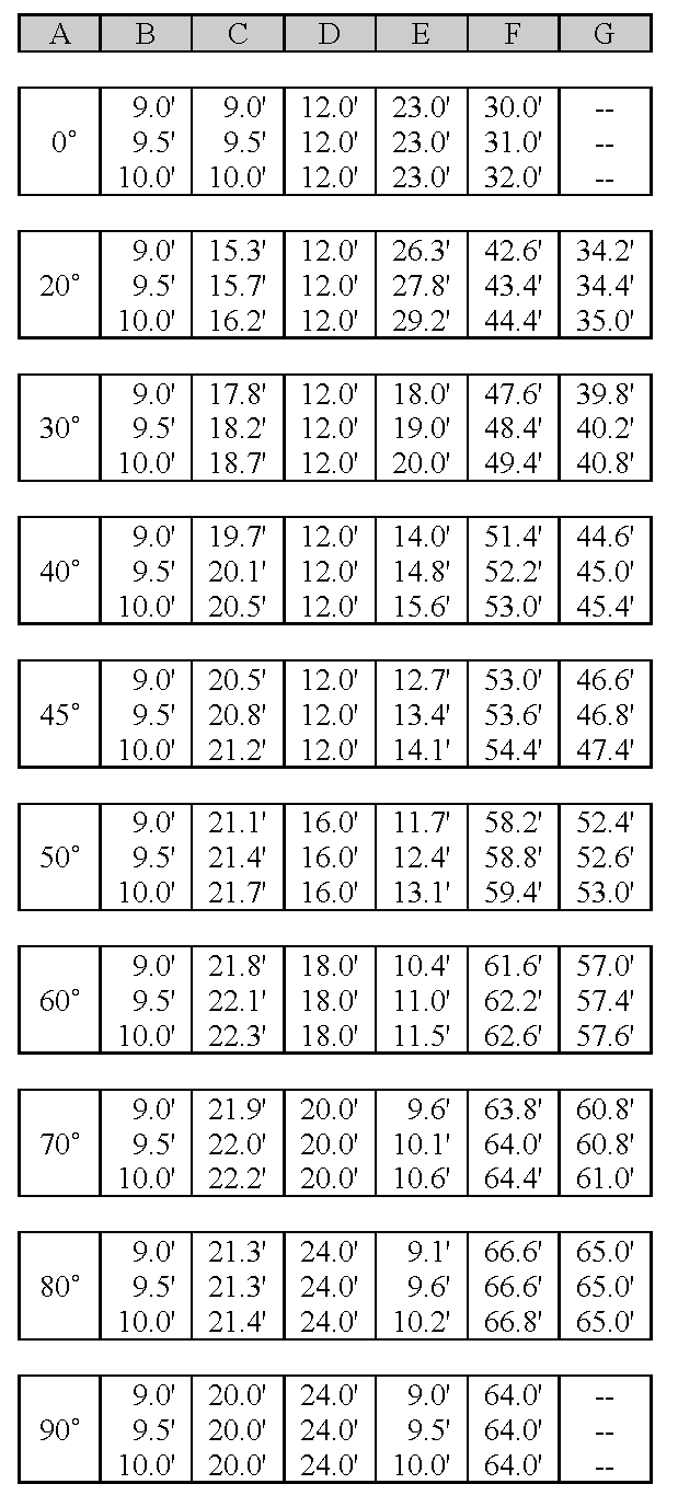 | 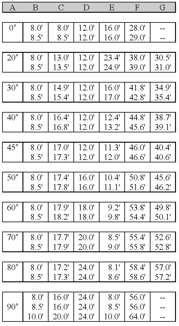 ;adv=14; A = Parking angle B = Stall width C = Stall to curb D = Aisle width E
= Curb length per car F = Minimum overall double row with aisle between G = Stall
center (does not include overhang)
;adv=14; A = Parking angle B = Stall width C = Stall to curb D = Aisle width E
= Curb length per car F = Minimum overall double row with aisle between G = Stall
center (does not include overhang)
|
E.
Layout. Parking and loading areas, circulation facilities, roadways and driveways shall be designed to be safe and convenient and meet the following regulations:
1.
No parking space shall be located so as to block access by emergency vehicles.
2.
The design shall be based on a definite and logical system of drive lanes to serve the parking and loading spaces. A physical separation or barrier, such as vertical curbs, may be required to separate parking spaces from travel lanes.
3.
Parking spaces for all uses, except single family residential uses, shall be designed to permit entry and exit without moving any other vehicles.
4.
Aisles and driveways shall not be used for parking vehicles, except that the driveway of a single family or duplex residence may be counted as one or more, depending on length, parking spaces as determined by the administrator.
5.
Each off-street parking space shall open directly onto an aisle or driveway that, except for single family or duplex residences, is not a public street.
6.
The overall layout of a site shall assure that buildings, parking and loading areas, landscaping and open space shall be designed as integral parts of the development plan so that pedestrians moving within the site are not unreasonably exposed to vehicular traffic or obstacles.
7.
No more than 25 percent of the parking spaces in a layout shall be for compact cars.
(Ord. No. 549)
4-6.03.05. - Aquaculture Commercial Fishing Exemption.
Editor's note— Ord. No. 549 removed the text of § 4-6.03.05, which derived from Ord. No. 394.
4-6.04.01. - Requirements for All Developments.
The following basic utilities are required for all developments subject to the criteria listed herein:
A.
Electricity. Every principal use and every lot within a subdivision shall have available to it a source of electric power adequate to accommodate the reasonable needs of such use and every lot within the subdivision.
B.
Telephone. Every principal use and every lot within a subdivision shall have available to it a telephone service cable adequate to accommodate the reasonable needs of such use and every lot within such subdivision.
C.
Water and sewer. Every principal use and every lot within a subdivision shall have central potable water and wastewater hookup whenever required by the City's Comprehensive Plan and where the topography permits the connection to a district water or sewer line by running a connecting line no more than 200 feet from the lot line to such water or sewer line.
D.
Illumination. All streets, driveways, sidewalks, bikeways, parking lots and other common areas and facilities within a development, except a single-family residence, shall provide illumination meeting the standards of the Technical Construction Standards cited in this Code.
E.
Fire hydrants. All developments served by a central water system shall include a system of fire hydrants consistent with technical standards.
4-6.04.02. - Compliance with Technical Construction Standards.
All utilities required by this Code shall meet or exceed the minimum standards contained in the technical construction manuals referenced in Part 4-1.06.02 of this Code.
4-6.04.03. - Underground Utilities.
All electric, telephone, cable television, and other communication lines (exclusive of transformers or enclosures containing electrical equipment), gas distribution, sewer and water lines shall be placed underground within easements or dedicated public rights-of-way in any area not presently served by utilities. Existing areas may convert to underground utilities at the expense of the owner(s) of the properties involved. Any utility apparatus placed above ground shall be appropriately screened.
4-6.04.04. - Utility Easements.
When a developer installs or causes the installation of water, sewer, electrical power, telephone or cable television facilities and intends that such facilities shall be owned, operated or maintained by a public utility or any entity other than the developer, the developer shall transfer to such utility or entity the necessary ownership or easement rights to enable the utility or entity to operate and maintain such facilities.
4-6.05.01. - Definitions.
Alter or alteration means work done on a stormwater management system other than that necessary to maintain the system's original design and function.
Detention means the collection and storage of surface water for subsequent discharge.
Existing. For the purposes of this part, the average condition immediately before development or redevelopment of a site begins.
Impervious surface means a surface that has been compacted or covered with a layer of material so that it is highly resistant to the infiltration of water. It includes, but is not limited to, semi-impervious surfaces such as compacted clay or lime rock, as well as most conventionally surfaced streets, roofs, sidewalks, parking lots and other similar structures.
Maintenance means that action taken to restore or preserve the original design and function of any stormwater management system.
Natural systems means systems which predominantly consist of or are used by those communities or plants, animals, bacteria and other flora and fauna which occur indigenously on the land, in the soil or in water.
Rate means volume per unit of time.
Retention means the collection and storage of runoff without subsequent discharge to surface waters.
Runoff coefficient means ratio of the amount of rain which runs off a surface to that which falls on it; a factor from which runoff can be calculated.
Sediment means the mineral or organic particulate material that is in suspension or has settled in surface or ground waters.
Site means generally, any tract, lot or parcel of land or combination or tracts, lots, or parcels of land that are in one ownership, or in diverse ownership but contiguous, and which are to be developed as a single unit, subdivision or project.
Stormwater runoff means that portion of the stormwater that flows from the land surface of a site either naturally, in manmade ditches, or in a closed conduit system.
Stormwater management system means the system, or combination of systems, designed to treat stormwater, or collect, convey, channel, hold, inhibit, or divert the movement of stormwater on, through and from a site.
Surface water means water above the surface of the ground whether or not flowing through definite channels, including the following:
a.
Any natural or artificial pond, lake, reservoir, or other area which ordinarily or intermittently contains water and which has a discernible shoreline; or
b.
Any natural or artificial canal, channel, ditch, culvert, drain, stream, river, creek, waterway, gully, ravine, street, roadway, swale or wash in which water flows in a definite direction, either continuously or intermittently, and which has a definite channel, bed or banks; or
c.
Any wetland.
Wetland means land that is inundated or saturated by surface water or groundwater at a frequency and duration sufficient to support, and that under normal circumstances do or would support, a prevalence of vegetation typically adapted for life in saturated soil conditions. The term includes, but is not limited to, salt marshes, tidal flats, mangrove swamps, marine meadows, swamp hammocks, hardwood swamps, cypress ponds, bay heads and bogs, wet prairies and freshwater marshes.
4-6.05.02. - Relationship to Other Stormwater Management Requirements.
In addition to meeting the requirements of this Code, the design and performance of all stormwater management systems shall comply with applicable state regulations, including Chapter 17-25, F.A.C. and the rules of the Suwannee River Water Management District. In all cases the strictest of the applicable standards shall apply.
4-6.05.03. - Stormwater Management Requirements.
Before any development permit may be issued, all development, except a single family or duplex residential dwelling unit, must be designed, constructed and maintained to meet the performance standards of the Suwannee River Water Management District (SRWMD) or DEP. In addition, all development shall meet the requirements of the City's Comprehensive Plan, including the following:
A.
Impervious surface cover shall be limited to 40 percent of the site area.
B.
A vegetated coastal buffer zone (protected zone) fifty feet landward of the mean high water line shall be retained or created along the shores, banks or edges of all natural or man-made surface waters, except as may be otherwise provided by this Code or the Comprehensive Plan.
C.
To the maximum extent practicable, natural systems shall be used to accommodate stormwater.
D.
No surface water shall be channeled or directed into coastal waters, a central sanitary sewer system, or onto abutting property.
E.
All residential development which is exempt from SRWMD standards shall meet the following standards:
1.
Lots shall be graded to provide on-site retention of stormwater volume equal to three-quarters inch of depth over the entire lot area or site.
2.
Erosion and sediment control (such as fabric silt fences or staked straw bales) shall be used during construction.
F.
The above standards shall apply to all new development and redevelopment, (for purpose of the above standards, redevelopment shall be defined as projects where the estimated value of construction exceeds 50 percent of the assessed value of the improvements on the property as shown on the tax assessment roll at the time of construction).
(History: Ord. No. 247)
4-6.05.04. - Stormwater Management Manual.
The department shall use The Florida Development Manual: A Guide to Sound Land and Water Management, published by DEP, for the guidance of persons seeking approval of a Stormwater Management System.
4-6.06.01. - Exemption.
Lots or parcels of land on which a single family home without a home occupational license is used as a residence shall be exempt from the provisions of these buffer zone and landscaping regulations. This shall not be construed to exempt any residential developments that require the approval of a development plan.
4-6.06.02. - Required Landscaping for Vehicle Use Areas.
All vehicle use areas containing more than 1,000 square feet, including parking lots and circulation areas, shall be landscaped at the rate of five canopy trees, one understory tree and 12 shrubs per 1,500 square feet of planting area.
4-6.06.03. - Required Landscaping for Buffer Zones.
A landscaped strip along parcel boundaries shall be required as a buffer zone between incompatible uses and zoning districts. This shall not be interpreted to mean that parcels within a planned mixed use development must meet these requirement. The width and vegetated density of the buffer zone will depend on the nature of the adjoining uses, as follows:
A.
Minimum buffer zone. The minimum buffer zone required shall consist of an area ten feet wide, landscaped at the rate of five canopy trees, two understory trees and 20 shrubs per 100 feet of boundary. Plants shall be spread reasonably evenly along the length of the buffer.
B.
Maximum buffer zone. The maximum buffer zone required shall consist of an area 20 feet wide, landscaped at the rate of six canopy trees, three understory trees and 28 shrubs per 100 feet of boundary, spread reasonably evenly along the length of the buffer.
C.
Determination of buffer required. Noise, hours of operation, visual compatibility and principal uses shall be considered in the determination of the required buffer zone.
D.
Responsibility for buffer zones. The desired width of a buffer zone between two parcels is the sum of the required buffer zones of the parcels. Where a new use is proposed next to an existing use that has less than the required buffer zone for that use, an inadequate buffer zone will be tolerated, except as provided below, until the nonconforming parcel is redeveloped and brought into conformity with the buffer zone requirements of this Code. Where a residential use is proposed next to an existing nonresidential use, or a nonresidential use is proposed next to an existing residential use, and the existing use does not have a conforming buffer zone abutting the property proposed for development, the proposed use shall provide 75 percent of the combined required buffer zones of the two uses.
4-6.06.04. - Required Landscaping for Streets.
Developers shall plant or retain, within five feet of the right-of-way of each street within a residential development, one shade tree for every 50 linear feet of right-of-way. Existing trees and native tree species that need less water and maintenance are preferred.
4-6.06.05. - Landscape Design and Materials.
All landscaped areas required by this Code shall conform to Section 4-5.03.00, "Trees and Native Vegetation" and the following general design and maintenance principles:
A.
The functional elements of the development plan, particularly the drainage systems and internal circulation systems for vehicles and pedestrians, should be integrated into the landscaping plan.
B.
Landscaping should be used to minimize potential erosion through the use of ground covers or any other type of landscape material that aids in soil stabilization. Mulches shall be a minimum depth of two inches and plastic surface covers shall not be used.
C.
Landscaping should enhance the visual environment through the use of materials that achieve variety with respect to seasonal changes, species of living material selected, textures, colors and size at maturity.
D.
Landscaping should enhance public safety and minimize nuisances.
E.
Landscaping should be used to provide windbreaks, channel wind and increase ventilation.
F.
Landscaping should maximize the shading of streets and vehicle use areas.
G.
The selection and placement of landscaping materials should consider the effect on existing or future solar access, of enhancing the use of solar radiation, and of conserving the maximum amount of energy.
H.
Landscaping should be protected from vehicular and pedestrian encroachment by means of raised planting surfaces, depressed walks, curbs, edges, etc.
I.
Landscaping should not interfere, at or before maturity, with power, cable television, or telephone lines, sewer or water pipes, or any other existing or proposed overhead or underground utility service.
J.
The developer should provide sufficient soil and water to sustain healthy growth of all plants.
4-6.06.06. - Replacement of Plants.
Within six months of a determination by the department that a plant is dead or severely damaged or diseased, the plant shall be replaced by the developer in accordance with the standards specified in this Code.
4-6.07.01. - General.
A.
Title. These regulations shall be known as the Floodplain Management Ordinance of the City of Cedar Key, hereinafter referred to as "these regulations."
B.
Scope. The provisions of these regulations shall apply to all development that is wholly within or partially within any flood hazard area, including, but not limited to, the subdivision of land; filling, grading, and other site improvements and utility installations; construction, alteration, remodeling, enlargement, improvement, replacement, repair, relocation or demolition of buildings, structures, and facilities that are exempt from the Florida Building Code; placement, installation, or replacement of manufactured homes and manufactured buildings; installation or replacement of tanks; placement of recreational vehicles; installation of swimming pools; and any other development.
C.
Intent. The purposes of these regulations and the flood load and flood resistant construction requirements of the Florida Building Code are to establish minimum requirements to safeguard the public health, safety, and general welfare and to minimize public and private losses due to flooding through regulation of development in flood hazard areas to:
1.
Minimize unnecessary disruption of commerce, access and public service during times of flooding;
2.
Require the use of appropriate construction practices in order to prevent or minimize future flood damage;
3.
Manage filling, grading, dredging, mining, paving, excavation, drilling operations, storage of equipment or materials, and other development which may increase flood damage or erosion potential;
4.
Manage the alteration of flood hazard areas and shorelines to minimize the impact of development on the natural and beneficial functions of the floodplain;
5.
Minimize damage to public and private facilities and utilities;
6.
Help maintain a stable tax base by providing for the sound use and development of flood hazard areas;
7.
Minimize the need for future expenditure of public funds for flood control projects and response to and recovery from flood events; and
8.
Meet the requirements of the National Flood Insurance Program for community participation as set forth in the Title 44 Code of Federal Regulations, Section 59.22.
D.
Coordination with the Florida Building Code. These regulations is intended to be administered and enforced in conjunction with the Florida Building Code. Where cited, ASCE 24 refers to the edition of the standard that is referenced by the Florida Building Code.
E.
Warning. The degree of flood protection required by these regulations and the Florida Building Code, as amended by this community, is considered the minimum reasonable for regulatory purposes and is based on scientific and engineering considerations. Larger floods can and will occur. Flood heights may be increased by manmade or natural causes. These regulations do not imply that land outside of mapped special flood hazard areas, or that uses permitted within such flood hazard areas, will be free from flooding or flood damage. The flood hazard areas and base flood elevations contained in the Flood Insurance Study and shown on Flood Insurance Rate Maps and the requirements of Title 44 Code of Federal Regulations, Sections 59 and 60 may be revised by the Federal Emergency Management Agency, requiring this community to revise these regulations to remain eligible for participation in the National Flood Insurance Program. No guaranty of vested use, existing use, or future use is implied or expressed by compliance with these regulations.
F.
Disclaimer of liability. These regulations shall not create liability on the part of the City Commission of the City of Cedar Key or by any officer or employee thereof for any flood damage that results from reliance on these regulations or any administrative decision lawfully made thereunder.
4-6.07.02. - Applicability.
A.
General. Where there is a conflict between a general requirement and a specific requirement, the specific requirement shall be applicable.
B.
Areas to which these regulations applies. These regulations shall apply to all flood hazard areas within the City of Cedar Key, as established in 4-6.07.02 C. of these regulations.
C.
Basis for establishing flood hazard areas. The Flood Insurance Study for Levy County, Florida and Incorporated Areas dated November 2, 2012, and all subsequent amendments and revisions, and the accompanying Flood Insurance Rate Maps (FIRM), and all subsequent amendments and revisions to such maps, are adopted by reference as a part of these regulations and shall serve as the minimum basis for establishing flood hazard areas. Studies and maps that establish flood hazard areas are on file at City Hall.
D.
Submission of additional data to establish flood hazard areas. To establish flood hazard areas and base flood elevations, pursuant to 4-6.07.05 of these regulations the Floodplain Administrator may require submission of additional data. Where field surveyed topography prepared by a Florida licensed professional surveyor or digital topography accepted by the community indicates that ground elevations:
1.
Are below the closest applicable base flood elevation, even in areas not delineated as a special flood hazard area on a FIRM, the area shall be considered as flood hazard area and subject to the requirements of these regulations and, as applicable, the requirements of the Florida Building Code.
2.
Are above the closest applicable base flood elevation, the area shall be regulated as special flood hazard area unless the applicant obtains a Letter of Map Change that removes the area from the special flood hazard area.
E.
Other laws. The provisions of these regulations shall not be deemed to nullify any provisions of local, state or federal law.
F.
Abrogation and greater restrictions. These regulations supersede any ordinance in effect for management of development in flood hazard areas. However, it is not intended to repeal or abrogate any existing ordinances including, but not limited to, land development regulations, zoning ordinances, stormwater management regulations, or the Florida Building Code. In the event of a conflict between these regulations and any other ordinance, the more restrictive shall govern. These regulations shall not impair any deed restriction, covenant or easement, but any land that is subject to such interests shall also be governed by these regulations.
G.
Interpretation. In the interpretation and application of these regulations, all provisions shall be:
1.
Considered as minimum requirements;
2.
Liberally construed in favor of the governing body; and
3.
Deemed neither to limit nor repeal any other powers granted under state statutes.
4-6.07.03. - Duties and Powers of the Floodplain Administrator.
A.
Designation. The Building Official is designated as the Floodplain Administrator. The Floodplain Administrator may delegate performance of certain duties to other employees.
B.
General. The Floodplain Administrator is authorized and directed to administer and enforce the provisions of these regulations. The Floodplain Administrator shall have the authority to render interpretations of these regulations consistent with the intent and purpose of these regulations and may establish policies and procedures in order to clarify the application of its provisions. Such interpretations, policies, and procedures shall not have the effect of waiving requirements specifically provided in these regulations without the granting of a variance pursuant to 4-6.07.07 of these regulations.
C.
Applications and permits. The Floodplain Administrator, in coordination with other pertinent offices of the community, shall:
1.
Review applications and plans to determine whether proposed new development will be located in flood hazard areas;
2.
Review applications for modification of any existing development in flood hazard areas for compliance with the requirements of these regulations;
3.
Interpret flood hazard area boundaries where such interpretation is necessary to determine the exact location of boundaries; a person contesting the determination shall have the opportunity to appeal the interpretation;
4.
Provide available flood elevation and flood hazard information;
5.
Determine whether additional flood hazard data shall be obtained from other sources or shall be developed by an applicant;
6.
Review applications to determine whether proposed development will be reasonably safe from flooding;
7.
Issue floodplain development permits or approvals for development other than buildings and structures that are subject to the Florida Building Code, including buildings, structures and facilities exempt from the Florida Building Code, when compliance with these regulations is demonstrated, or disapprove the same in the event of noncompliance; and
8.
Coordinate with and provide comments to the Building Official to assure that applications, plan reviews, and inspections for buildings and structures in flood hazard areas comply with the applicable provisions of these regulations.
D.
Substantial improvement and substantial damage determinations. For applications for building permits to improve buildings and structures, including alterations, movement, enlargement, replacement, repair, change of occupancy, additions, rehabilitations, renovations, substantial improvements, repairs of substantial damage, and any other improvement of or work on such buildings and structures, the Floodplain Administrator, in coordination with the Building Official, shall:
1.
Estimate the market value, or require the applicant to obtain an appraisal of the market value prepared by a qualified independent appraiser, of the building or structure before the start of construction of the proposed work; in the case of repair, the market value of the building or structure shall be the market value before the damage occurred and before any repairs are made;
2.
Compare the cost to perform the improvement, the cost to repair a damaged building to its pre-damaged condition, or the combined costs of improvements and repairs, if applicable, to the market value of the building or structure;
3.
Determine and document whether the proposed work constitutes substantial improvement or repair of substantial damage; and
4.
Notify the applicant if it is determined that the work constitutes substantial improvement or repair of substantial damage and that compliance with the flood resistant construction requirements of the Florida Building Code and these regulations is required.
E.
Modifications of the strict application of the requirements of the Florida Building Code. The Floodplain Administrator shall review requests submitted to the Building Official that seek approval to modify the strict application of the flood load and flood resistant construction requirements of the Florida Building Code to determine whether such requests require the granting of a variance pursuant to 4-6.07.07 of these regulations.
F.
Notices and orders. The Floodplain Administrator shall coordinate with appropriate local agencies for the issuance of all necessary notices or orders to ensure compliance with these regulations.
G.
Inspections. The Floodplain Administrator shall make the required inspections as specified in 4-6.07.06 of these regulations for development that is not subject to the Florida Building Code, including buildings, structures and facilities exempt from the Florida Building Code. The Floodplain Administrator shall inspect flood hazard areas to determine if development is undertaken without issuance of a permit.
H.
Other duties of the Floodplain Administrator. The Floodplain Administrator shall have other duties, including, but not limited to:
1.
Establish, in coordination with the Building Official, procedures for administering and documenting determinations of substantial improvement and substantial damage made pursuant to 4-6.07.03 D. of these regulations;
2.
Require applicants who submit hydrologic and hydraulic engineering analyses to support permit applications to submit to FEMA the data and information necessary to maintain the Flood Insurance Rate Maps if the analyses propose to change base flood elevations or flood hazard area boundaries; such submissions shall be made within six months of such data becoming available;
3.
Review required design certifications and documentation of elevations specified by these regulations and the Florida Building Code to determine that such certifications and documentations are complete;
4.
Notify the Federal Emergency Management Agency when the corporate boundaries of the City of Cedar Key are modified; and
5.
Advise applicants for new buildings and structures, including substantial improvements that are located in any unit of the Coastal Barrier Resources System established by the Coastal Barrier Resources Act (Pub. L. 97-348) and the Coastal Barrier Improvement Act of 1990 (Pub. L. 101-591) that federal flood insurance is not available on such construction; areas subject to this limitation are identified on Flood Insurance Rate Maps as "Coastal Barrier Resource System Areas" and "Otherwise Protected Areas."
I.
Floodplain management records. Regardless of any limitation on the period required for retention of public records, the Floodplain Administrator shall maintain and permanently keep and make available for public inspection all records that are necessary for the administration of these regulations and the flood resistant construction requirements of the Florida Building Code, including Flood Insurance Rate Maps; Letters of Map Change; records of issuance of permits and denial of permits; determinations of whether proposed work constitutes substantial improvement or repair of substantial damage; required design certifications and documentation of elevations specified by the Florida Building Code and these regulations; documentation related to appeals and variances, including justification for issuance or denial; and records of enforcement actions taken pursuant to these regulations and the flood resistant construction requirements of the Florida Building Code. These records shall be available for public inspection at City Hall.
4-6.07.04. - Permits.
A.
Permits required. Any owner or owner's authorized agent (hereinafter "applicant") who intends to undertake any development activity within the scope of these regulations, including buildings, structures and facilities exempt from the Florida Building Code, which is wholly within or partially within any flood hazard area shall first make application to the Floodplain Administrator, and the Building Official if applicable, and shall obtain the required permit(s) and approval(s). No such permit or approval shall be issued until compliance with the requirements of these regulations and all other applicable codes and regulations has been satisfied.
B.
Floodplain development permits or approvals. Floodplain development permits or approvals shall be issued pursuant to these regulations for any development activities not subject to the requirements of the Florida Building Code, including buildings, structures and facilities exempt from the Florida Building Code. Depending on the nature and extent of proposed development that includes a building or structure, the Floodplain Administrator may determine that a floodplain development permit or approval is required in addition to a building permit.
C.
Buildings, structures and facilities exempt from the Florida Building Code. Pursuant to the requirements of federal regulation for participation in the National Flood Insurance Program (44 C.F.R. Sections 59 and 60), floodplain development permits or approvals shall be required for the following buildings, structures and facilities that are exempt from the Florida Building Code and any further exemptions provided by law, which are subject to the requirements of these regulations:
1.
Railroads and ancillary facilities associated with the railroad.
2.
Nonresidential farm buildings on farms, as provided in F.S. § 604.50.
3.
Temporary buildings or sheds used exclusively for construction purposes.
4.
Mobile or modular structures used as temporary offices.
5.
Those structures or facilities of electric utilities, as defined in F.S. § 366.02, which are directly involved in the generation, transmission, or distribution of electricity.
6.
Chickees constructed by the Miccosukee Tribe of Indians of Florida or the Seminole Tribe of Florida. As used in this paragraph, the term "chickee" means an open-sided wooden hut that has a thatched roof of palm or palmetto or other traditional materials, and that does not incorporate any electrical, plumbing, or other non-wood features.
7.
Family mausoleums not exceeding 250 square feet in area which are prefabricated and assembled on site or preassembled and delivered on site and have walls, roofs, and a floor constructed of granite, marble, or reinforced concrete.
8.
Temporary housing provided by the Department of Corrections to any prisoner in the state correctional system.
9.
Structures identified in F.S. § 553.73(10)(k), are not exempt from the Florida Building Code if such structures are located in flood hazard areas established on Flood Insurance Rate Maps
D.
Application for a permit or approval. To obtain a floodplain development permit or approval the applicant shall first file an application in writing on a form furnished by the community. The information provided shall:
1.
Identify and describe the development to be covered by the permit or approval.
2.
Describe the land on which the proposed development is to be conducted by legal description, street address or similar description that will readily identify and definitively locate the site.
3.
Indicate the use and occupancy for which the proposed development is intended.
4.
Be accompanied by a site plan or construction documents as specified in 4-6.07.05 of these regulations.
5.
State the valuation of the proposed work.
6.
Be signed by the applicant or the applicant's authorized agent.
7.
Give such other data and information as required by the Floodplain Administrator.
E.
Validity of permit or approval. The issuance of a floodplain development permit or approval pursuant to these regulations shall not be construed to be a permit for, or approval of, any violation of these regulations, the Florida Building Codes, or any other ordinance of this community. The issuance of permits based on submitted applications, construction documents, and information shall not prevent the Floodplain Administrator from requiring the correction of errors and omissions.
F.
Expiration. A floodplain development permit or approval shall become invalid unless the work authorized by such permit is commenced within 180 days after its issuance, or if the work authorized is suspended or abandoned for a period of 180 days after the work commences. Extensions for periods of not more than 180 days each shall be requested in writing and justifiable cause shall be demonstrated.
G.
Suspension or revocation. The Floodplain Administrator is authorized to suspend or revoke a floodplain development permit or approval if the permit was issued in error, on the basis of incorrect, inaccurate or incomplete information, or in violation of these regulations or any other ordinance, regulation or requirement of this community.
H.
Other permits required. Floodplain development permits and building permits shall include a condition that all other applicable state or federal permits be obtained before commencement of the permitted development, including, but not limited to, the following:
1.
The Suwannee River Water Management District; F.S. § 373.036.
2.
Florida Department of Health for on-site sewage treatment and disposal systems; F.S. § 381.0065 and Chapter 64E-6, F.A.C.
3.
Florida Department of Environmental Protection for activities subject to the Joint Coastal Permit; F.S. § 161.055.
4.
Florida Department of Environmental Protection for activities that affect wetlands and alter surface water flows, in conjunction with the U.S. Army Corps of Engineers; Section 404 of the Clean Water Act.
5.
Federal permits and approvals
4-6.07.05. - Site Plans and Construction Documents.
A.
Information for development in flood hazard areas. The site plan or construction documents for any development subject to the requirements of these regulations shall be drawn to scale and shall include, as applicable to the proposed development:
1.
Delineation of flood hazard areas, flood zone(s), base flood elevation(s), and ground elevations if necessary for review of the proposed development.
2.
Location of the proposed activity and proposed structures, and locations of existing buildings and structures; in coastal high hazard areas, new buildings shall be located landward of the reach of mean high tide.
3.
Location, extent, amount, and proposed final grades of any filling, grading, or excavation.
4.
Where the placement of fill is proposed, the amount, type, and source of fill material; compaction specifications; a description of the intended purpose of the fill areas; and evidence that the proposed fill areas are the minimum necessary to achieve the intended purpose.
5.
Extent of any proposed alteration of sand dunes or mangrove stands, provided such alteration is approved by the Florida Department of Environmental Protection.
B.
The Floodplain Administrator is authorized to waive the submission of site plans, construction documents, and other data that are required by these regulations but that are not required to be prepared by a registered design professional if it is found that the nature of the proposed development is such that the review of such submissions is not necessary to ascertain compliance with these regulations.
C.
Alteration of sand dunes or mangrove stands in coastal high hazard areas. For activities that propose to alter sand dunes or mangrove stands in coastal high hazard areas (Zone V), an engineering analysis that demonstrates the proposed alteration will not increase the potential for flood damage shall be signed and sealed by a Florida Licensed engineer and submitted with the site plan and construction documents.
D.
Submission of additional data. When additional hydrologic, hydraulic or other engineering data, studies, and additional analyses are submitted to support an application, the applicant has the right to seek a Letter of Map Change from FEMA to change the base flood elevations or change boundaries of flood hazard areas shown on FIRMs, and to submit such data to FEMA for such purposes. The analyses shall be prepared by a Florida licensed engineer in a format required by FEMA. Submittal requirements and processing fees shall be the responsibility of the applicant.
4-6.07.06. - Inspections.
A.
General. Development for which a floodplain development permit or approval is required shall be subject to inspection.
B.
Development other than buildings and structures. The Floodplain Administrator shall inspect all development to determine compliance with the requirements of these regulations and the conditions of issued floodplain development permits or approvals.
C.
Buildings, structures and facilities exempt from the Florida Building Code. The Floodplain Administrator shall inspect buildings, structures and facilities exempt from the Florida Building Code to determine compliance with the requirements of these regulations and the conditions of issued floodplain development permits or approvals.
D.
Buildings, structures and facilities exempt from the Florida Building Code, lowest floor inspection. Upon placement of the lowest floor, including basement, and prior to further vertical construction, the owner of a building, structure or facility exempt from the Florida Building Code, or the owner's authorized agent, shall submit to the Floodplain Administrator the certification of elevation of the lowest floor prepared and sealed by a Florida licensed professional surveyor.
E.
Buildings, structures and facilities exempt from the Florida Building Code, final inspection. As part of the final inspection, the owner or owner's authorized agent shall submit to the Floodplain Administrator a final certification of elevation of the lowest floor or final documentation of the height of the lowest floor above the highest adjacent grade; such certifications and documentations shall be prepared as specified in 6.07.06 (D) of these regulations.
F.
Manufactured homes. The Floodplain Administrator shall inspect manufactured homes that are installed or replaced in flood hazard areas to determine compliance with the requirements of these regulations and the conditions of the issued permit. Upon placement of a manufactured home, certification of the elevation of the lowest floor shall be submitted to the Floodplain Administrator.
4-6.07.07. - Variances and Appeals.
A.
General. The City Commission shall hear and decide on requests for appeals and requests for variances from the strict application of these regulations. Pursuant to F.S. § 553.73(5), the City Commission shall hear and decide on requests for appeals and requests for variances from the strict application of the flood resistant construction requirements of the Florida Building Code.
B.
Appeals. The City Commission shall hear and decide appeals when it is alleged there is an error in any requirement, decision, or determination made by the Floodplain Administrator in the administration and enforcement of these regulations. Any person aggrieved by the decision may appeal such decision to the Circuit Court, as provided by Florida Statutes.
C.
Limitations on authority to grant variances. The City Commission shall base its decisions on variances on technical justifications submitted by applicants, the considerations for issuance in 4-6.07.07 F. of these regulations, the conditions of issuance set forth in 4-6.07.07 G. of these regulations, and the comments and recommendations of the Floodplain Administrator and the Building Official. The City Commission has the right to attach such conditions as it deems necessary to further the purposes and objectives of these regulations.
D.
Historic buildings. A variance is authorized to be issued for the repair, improvement, or rehabilitation of a historic building that is determined eligible for the exception to the flood resistant construction requirements of the Florida Building Code, Existing Building, Chapter 12 Historic Buildings, upon a determination that the proposed repair, improvement, or rehabilitation will not preclude the building's continued designation as a historic building and the variance is the minimum necessary to preserve the historic character and design of the building. If the proposed work precludes the building's continued designation as a historic building, a variance shall not be granted and the building and any repair, improvement, and rehabilitation shall be subject to the requirements of the Florida Building Code.
E.
Functionally dependent uses. A variance is authorized to be issued for the construction or substantial improvement necessary for the conduct of a functionally dependent use, as defined in these regulations, provided the variance meets the requirements of Section 4-6.07.07 F., is the minimum necessary considering the flood hazard, and all due consideration has been given to use of methods and materials that minimize flood damage during occurrence of the base flood.
F.
Considerations for issuance of variances. In reviewing requests for variances, the City Commission shall consider all technical evaluations, all relevant factors, all other applicable provisions of the Florida Building Code, these regulations, and the following:
1.
The danger that materials and debris may be swept onto other lands resulting in further injury or damage;
2.
The danger to life and property due to flooding or erosion damage;
3.
The susceptibility of the proposed development, including contents, to flood damage and the effect of such damage on current and future owners;
4.
The importance of the services provided by the proposed development to the community;
5.
The availability of alternate locations for the proposed development that are subject to lower risk of flooding or erosion;
6.
The compatibility of the proposed development with existing and anticipated development;
7.
The relationship of the proposed development to the Comprehensive Plan and floodplain management program for the area;
8.
The safety of access to the property in times of flooding for ordinary and emergency vehicles;
9.
The expected heights, velocity, duration, rate of rise and debris and sediment transport of the floodwaters and the effects of wave action, if applicable, expected at the site; and
10.
The costs of providing governmental services during and after flood conditions including maintenance and repair of public utilities and facilities such as sewer, gas, electrical and water systems, streets and bridges.
G.
Conditions for issuance of variances. Variances shall be issued only upon:
1.
Submission by the applicant, of a showing of good and sufficient cause that the unique characteristics of the size, configuration, or topography of the site limit compliance with any provision of these regulations or the required elevation standards;
2.
Determination by the City Commission that:
a.
Failure to grant the variance would result in exceptional hardship due to the physical characteristics of the land that render the lot undevelopable; increased costs to satisfy the requirements or inconvenience do not constitute hardship;
b.
The granting of a variance will not result in increased flood heights, additional threats to public safety, extraordinary public expense, nor create nuisances, cause fraud on or victimization of the public or conflict with existing local laws and ordinances; and
c.
The variance is the minimum necessary, considering the flood hazard, to afford relief;
3.
Receipt of a signed statement by the applicant that the variance, if granted, shall be recorded in the Office of the Clerk of the Court in such a manner that it appears in the chain of title of the affected parcel of land; and
4.
If the request is for a variance to allow construction of the lowest floor of a new building, or substantial improvement of a building, below the required elevation, a copy in the record of a written notice from the Floodplain Administrator to the applicant for the variance, specifying the difference between the base flood elevation and the proposed elevation of the lowest floor, stating that the cost of federal flood insurance will be commensurate with the increased risk resulting from the reduced floor elevation (up to amounts as high as $25.00 for $100.00 of insurance coverage), and stating that construction below the base flood elevation increases risks to life and property.
Editor's note— See Resolution 380, §4, for required conditions for aquaculture facilities variance.
4-6.07.08. - Violations.
A.
Violations. Any development that is not within the scope of the Florida Building Code but that is regulated by these regulations that is performed without an issued permit, that is in conflict with an issued permit, or that does not fully comply with these regulations, shall be deemed a violation of these regulations. A building or structure without the documentation of elevation of the lowest floor, other required design certifications, or other evidence of compliance required by these regulations or the Florida Building Code is presumed to be a violation until such time as that documentation is provided.
B.
Authority. For development that is not within the scope of the Florida Building Code but that is regulated by these regulations and that is determined to be a violation, the Floodplain Administrator is authorized to serve notices of violation or stop work orders to owners of the property involved, to the owner's agent, or to the person or persons performing the work.
C.
Unlawful continuance. Any person who shall continue any work after having been served with a notice of violation or a stop work order, except such work as that person is directed to perform to remove or remedy a violation or unsafe condition, shall be subject to penalties as prescribed by law.
4-6.07.09. - Definitions.
Unless otherwise expressly stated, the following words and terms shall, for the purposes of these regulations, have the meanings shown in this section. Where terms are not defined in these regulations and are defined in the Florida Building Code, such terms shall have the meanings ascribed to them in that code. Where terms are not defined in these regulations or the Florida Building Code, such terms shall have ordinarily accepted meanings such as the context implies.
Accessory storage shed means a storage shed with a floor area 200 square feet or less that is located on the same parcel of property as the principal structure and the use of which is incidental to the use of the principal structure. Accessory structures should constitute a minimal initial investment, may not be used for human habitation, and be designed to have minimal flood damage potential.
Appeal means a request for a review of the Floodplain Administrator's interpretation of any provision of these regulations.
ASCE 24 means a standard titled Flood Resistant Design and Construction that is referenced by the Florida Building Code. ASCE 24 is developed and published by the American Society of Civil Engineers, Reston, VA.
Base flood means a flood having a one-percent chance of being equaled or exceeded in any given year. [Also defined in FBC, B, Section 202.] The base flood is commonly referred to as the "100 year flood" or the "1-percent-annual chance flood."
Base flood elevation means the elevation of the base flood, including wave height, relative to the National Geodetic Vertical Datum (NGVD), North American Vertical Datum (NAVD) or other datum specified on the Flood Insurance Rate Map (FIRM). [Also defined in FBC, B, Section 202.]
Basement means the portion of a building having its floor subgrade (below ground level) on all sides. [Also defined in FBC, B, Section 202; see "Basement (for flood loads)".]
Coastal high hazard area means a special flood hazard area extending from offshore to the inland limit of a primary frontal dune along an open coast and any other area subject to high velocity wave action from storms or seismic sources. Coastal high hazard areas are also referred to as "high hazard areas subject to high velocity wave action" or "V Zones" and are designated on Flood Insurance Rate Maps (FIRM) as Zone V1 V30, VE, or V.
Design flood means the flood associated with the greater of the following two areas: [Also defined in FBC, B, Section 202.]
1.
Area with a floodplain subject to a one-percent or greater chance of flooding in any year; or
2.
Area designated as a flood hazard area on the community's flood hazard map, or otherwise legally designated
Design flood elevation means the elevation of the "design flood," including wave height, relative to the datum specified on the community's legally designated flood hazard map. In areas designated as Zone AO, the design flood elevation shall be the elevation of the highest existing grade of the building's perimeter plus the depth number (in feet) specified on the flood hazard map. In areas designated as Zone AO where the depth number is not specified on the map, the depth number shall be taken as being equal to two feet. [Also defined in FBC, B, Section 202.]
Development means any man-made change to improved or unimproved real estate, including, but not limited to, buildings or other structures, tanks, temporary structures, temporary or permanent storage of equipment or materials, mining, dredging, filling, grading, paving, excavations, drilling operations or any other land disturbing activities.
Encroachment means the placement of fill, excavation, buildings, permanent structures or other development into a flood hazard area which may impede or alter the flow capacity of riverine flood hazard areas.
Existing building and existing structure means any buildings and structures for which the "start of construction" commenced before March 1, 1984. [Also defined in FBC, B, Section 202.]
Existing manufactured home park or subdivision means a manufactured home park or subdivision for which the construction of facilities for servicing the lots on which the manufactured homes are to be affixed (including, at a minimum, the installation of utilities, the construction of streets, and either final site grading or the pouring of concrete pads) is completed before March 1, 1984.
Expansion to an existing manufactured home park or subdivision means the preparation of additional sites by the construction of facilities for servicing the lots on which the manufactured homes are to be affixed (including the installation of utilities, the construction of streets, and either final site grading or the pouring of concrete pads).
Federal Emergency Management Agency (FEMA) means the federal agency that, in addition to carrying out other functions, administers the National Flood Insurance Program.
Flood or flooding means a general and temporary condition of partial or complete inundation of normally dry land from: [Also defined in FBC, B, Section 202.]
1.
The overflow of inland or tidal waters.
2.
The unusual and rapid accumulation or runoff of surface waters from any source.
Flood damage-resistant materials means any construction material capable of withstanding direct and prolonged contact with floodwaters without sustaining any damage that requires more than cosmetic repair. [Also defined in FBC, B, Section 202.]
Flood hazard area means the greater of the following two areas: [Also defined in FBC, B, Section 202.]
a.
The area within a floodplain subject to a one-percent or greater chance of flooding in any year.
b.
The area designated as a flood hazard area on the community's flood hazard map, or otherwise legally designated.
Flood Insurance Rate Map (FIRM) means the official map of the community on which the Federal Emergency Management Agency has delineated both special flood hazard areas and the risk premium zones applicable to the community. [Also defined in FBC, B, Section 202.]
Flood Insurance Study (FIS) means the official report provided by the Federal Emergency Management Agency that contains the Flood Insurance Rate Map, the Flood Boundary and Floodway Map (if applicable), the water surface elevations of the base flood, and supporting technical data. [Also defined in FBC, B, Section 202.]
Floodplain Administrator means the office or position designated and charged with the administration and enforcement of these regulations (may be referred to as the Floodplain Manager).
Floodplain development permit or approval means an official document or certificate issued by the community, or other evidence of approval or concurrence, which authorizes performance of specific development activities that are located in flood hazard areas and that are determined to be compliant with these regulations.
Florida Building Code means the family of codes adopted by the Florida Building Commission, including: Florida Building Code, Building; Florida Building Code, Residential; Florida Building Code, Existing Building; Florida Building Code, Mechanical; Florida Building Code, Plumbing; Florida Building Code, Fuel Gas.
Functionally dependent use means a use which cannot perform its intended purpose unless it is located or carried out in close proximity to water, including only docking facilities, port facilities that are necessary for the loading and unloading of cargo or passengers, and ship building and ship repair facilities; the term does not include long term storage or related manufacturing facilities.
Hardship means as related to variance from the floodplain management regulations and the flood provisions of the Florida Building Code, means the exceptional difficulty associated with the land that would result from a failure to grant a requested variance. The City requires variances to be exceptional, unusual, and peculiar to the property involved. Mere economic or financial hardship alone is not exceptional. Inconvenience, aesthetic considerations, physical handicaps, personal preferences, or the disapproval of one's neighbors likewise cannot, as a rule, qualify as an exceptional hardship. All of these problems can be resolved through other means without granting a variance, even if the alternative is more expensive, or requires the property owner to build elsewhere or put the parcel to a different use than originally intended.
Highest adjacent grade means the highest natural elevation of the ground surface prior to construction next to the proposed walls or foundation of a structure.
Historic structure means any structure that is determined eligible for the exception to the flood hazard area requirements of the Florida Building Code, Existing Building, Chapter 12 Historic Buildings.
Letter of Map Change (LOMC) means an official determination issued by FEMA that amends or revises an effective Flood Insurance Rate Map or Flood Insurance Study. Letters of Map Change include:
Letter of Map Amendment (LOMA) means an amendment based on technical data showing that a property was incorrectly included in a designated special flood hazard area. A LOMA amends the current effective Flood Insurance Rate Map and establishes that a specific property, portion of a property, or structure is not located in a special flood hazard area.
Letter of Map Revision (LOMR) means a revision based on technical data that may show changes to flood zones, flood elevations, special flood hazard area boundaries and floodway delineations, and other planimetric features.
Letter of Map Revision Based on Fill (LOMR-F) means A determination that a structure or parcel of land has been elevated by fill above the base flood elevation and is, therefore, no longer located within the special flood hazard area. In order to qualify for this determination, the fill must have been permitted and placed in accordance with the community's floodplain management regulations.
Conditional Letter of Map Revision (CLOMR) means a formal review and comment as to whether a proposed flood protection project or other project complies with the minimum NFIP requirements for such projects with respect to delineation of special flood hazard areas. A CLOMR does not revise the effective Flood Insurance Rate Map or Flood Insurance Study; upon submission and approval of certified as-built documentation, a Letter of Map Revision may be issued by FEMA to revise the effective FIRM.
Light-duty truck as defined in 40 C.F.R. 86.082-2, any motor vehicle rated at 8,500 pounds Gross Vehicular Weight Rating or less which has a vehicular curb weight of 6,000 pounds or less and which has a basic vehicle frontal area of 45 square feet or less, which is:
1.
Designed primarily for purposes of transportation of property or is a derivation of such a vehicle, or
2.
Designed primarily for transportation of persons and has a capacity of more than 12 persons; or
3.
Available with special features enabling off-street or off-highway operation and use.
Lowest floor means the lowest floor of the lowest enclosed area of a building or structure, including basement, but excluding any unfinished or flood-resistant enclosure, other than a basement, usable solely for vehicle parking, building access or limited storage provided that such enclosure is not built so as to render the structure in violation of the non-elevation requirements of the Florida Building Code or ASCE 24. [Also defined in FBC, B, Section 202.]
Mangrove stand means an assemblage of mangrove trees which are mostly low trees noted for a copious development of interlacing adventitious roots above ground and which contain one or more of the following species: Black mangrove (Avicennia Nitida); red mangrove (Rhizophora mangle); white mangrove (Languncularia Racemosa); and buttonwood (Conocarpus Erecta).
Manufactured home means a structure, transportable in one or more sections, which is eight feet or more in width and greater than 400 square feet, and which is built on a permanent, integral chassis and is designed for use with or without a permanent foundation when attached to the required utilities. The term "manufactured home" does not include a "recreational vehicle" or "park trailer." [Also defined in 15C-1.0101, F.A.C.]
Manufactured home park or subdivision means a parcel (or contiguous parcels) of land divided into two or more manufactured home lots for rent or sale.
Market value means the price at which a property will change hands between a willing buyer and a willing seller, neither party being under compulsion to buy or sell and both having reasonable knowledge of relevant facts. As used in these regulations, the term refers to the market value of buildings and structures, excluding the land and other improvements on the parcel. Market value may be established by a qualified independent appraiser, actual cash value (replacement cost depreciated for age and quality of construction), or tax assessment value adjusted to approximate market value by a factor provided by the Property Appraiser.
New construction for the purposes of administration of these regulations and the flood resistant construction requirements of the Florida Building Code, structures for which the "start of construction" commenced on or after March 1, 1984 and includes any subsequent improvements to such structures.
New manufactured home park or subdivision means a manufactured home park or subdivision for which the construction of facilities for servicing the lots on which the manufactured homes are to be affixed (including at a minimum, the installation of utilities, the construction of streets, and either final site grading or the pouring of concrete pads) is completed on or after March 1, 1984.
Park trailer means a transportable unit which has a body width not exceeding 14 feet and which is built on a single chassis and is designed to provide seasonal or temporary living quarters when connected to utilities necessary for operation of installed fixtures and appliances. [Defined in F.S. § 320.01.]
Recreational vehicle means a vehicle, including a park trailer, which is: [See F.S. § 320.01.)
1.
Built on a single chassis;
2.
Four hundred square feet or less when measured at the largest horizontal projection;
3.
Designed to be self propelled or permanently towable by a light duty truck; and
4.
Designed primarily not for use as a permanent dwelling but as temporary living quarters for recreational, camping, travel, or seasonal use.
Sand dunes means naturally occurring accumulations of sand in ridges or mounds landward of the beach.
Special flood hazard area means an area in the floodplain subject to a one-percent or greater chance of flooding in any given year. Special flood hazard areas are shown on FIRMs as Zone A, AO, A1 A30, AE, A99, AH, V1 V30, VE or V. [Also defined in FBC, B Section 202.]
Start of construction means the date of issuance of permits for new construction and substantial improvements, provided the actual start of construction, repair, reconstruction, rehabilitation, addition, placement, or other improvement is within 180 days of the date of the issuance. The actual start of construction means either the first placement of permanent construction of a building (including a manufactured home) on a site, such as the pouring of slab or footings, the installation of piles, the construction of columns. Permanent construction does not include land preparation (such as clearing, grading, or filling), the installation of streets or walkways, excavation for a basement, footings, piers, or foundations, the erection of temporary forms or the installation of accessory buildings such as garages or sheds not occupied as dwelling units or not part of the main buildings. For a substantial improvement, the actual "start of construction" means the first alteration of any wall, ceiling, floor or other structural part of a building, whether or not that alteration affects the external dimensions of the building. [Also defined in FBC, B Section 202.]
Substantial damage means damage of any origin sustained by a building or structure whereby the cost of restoring the building or structure to its before-damaged condition would equal or exceed 50 percent of the market value of the building or structure before the damage occurred. [Also defined in FBC, B Section 202.]
Substantial improvement means any repair, reconstruction, rehabilitation, addition, or other improvement of a building or structure, the cost of which equals or exceeds 50 percent of the market value of the building or structure before the improvement or repair is started. If the structure has incurred "substantial damage," any repairs are considered substantial improvement regardless of the actual repair work performed. The term does not, however, include either: [Also defined in FBC, B, Section 202.]
1.
Any project for improvement of a building required to correct existing health, sanitary, or safety code violations identified by the building official and that are the minimum necessary to assure safe living conditions.
2.
Any alteration of a historic structure provided the alteration will not preclude the structure's continued designation as a historic structure. [See Instructions and Notes]
Variance means a grant of relief from the requirements of these regulations, or the flood resistant construction requirements of the Florida Building Code, which permits construction in a manner that would not otherwise be permitted by these regulations or the Florida Building Code.
4-6.07.10. - Buildings and Structures.
Design and construction of buildings, structures and facilities exempt from the Florida Building Code. Pursuant to 6.07.04(C) of these regulations, buildings, structures, and facilities that are exempt from the Florida Building Code, including substantial improvement or repair of substantial damage of such buildings, structures and facilities, shall be designed and constructed in accordance with the flood load and flood resistant construction requirements of ASCE 24. Structures exempt from the Florida Building Code that are not walled and roofed buildings shall comply with the requirements of 6.07.16 of these regulations.
4-6.07.11. - Subdivisions.
A.
Minimum requirements. Subdivision proposals, including proposals for manufactured home parks and subdivisions, shall be reviewed to determine that:
1.
Such proposals are consistent with the need to minimize flood damage and will be reasonably safe from flooding;
2.
All public utilities and facilities such as sewer, gas, electric, communications, and water systems are located and constructed to minimize or eliminate flood damage; and
3.
Adequate drainage is provided to reduce exposure to flood hazards; in Zones AH and AO, adequate drainage paths shall be provided to guide floodwaters around and away from proposed structures.
B.
Subdivision plats. Where any portion of proposed subdivisions, including manufactured home parks and subdivisions, lies within a flood hazard area, the following shall be required:
1.
Delineation of flood hazard areas, flood zones, and design flood elevations, as appropriate, shall be shown on preliminary plats; and
2.
Compliance with the site improvement and utilities requirements of Article 12 of these regulations.
4-6.07.12. - Site Improvements, Utilities and Limitations.
A.
Minimum requirements. All proposed new development shall be reviewed to determine that:
1.
Such proposals are consistent with the need to minimize flood damage and will be reasonably safe from flooding;
2.
All public utilities and facilities such as sewer, gas, electric, communications, and water systems are located and constructed to minimize or eliminate flood damage; and
3.
Adequate drainage is provided to reduce exposure to flood hazards; in Zones AH and AO, adequate drainage paths shall be provided to guide floodwaters around and away from proposed structures.
B.
Sanitary sewage facilities. All new and replacement sanitary sewage facilities, private sewage treatment plants (including all pumping stations and collector systems), and on-site waste disposal systems shall be designed in accordance with the standards for on-site sewage treatment and disposal systems in Chapter 64E-6, F.A.C. and ASCE 24 Chapter 7 to minimize or eliminate infiltration of floodwaters into the facilities and discharge from the facilities into flood waters, and impairment of the facilities and systems.
C.
Water supply facilities. All new and replacement water supply facilities shall be designed in accordance with the water well construction standards in Chapter 62-532.500, F.A.C. and ASCE 24 Chapter 7 to minimize or eliminate infiltration of floodwaters into the systems.
D.
Limitations on placement of fill. Subject to the limitations of these regulations, fill shall be designed to be stable under conditions of flooding including rapid rise and rapid drawdown of floodwaters, prolonged inundation, and protection against flood-related erosion and scour. In addition to these requirements, if intended to support buildings and structures (Zone A only), fill shall comply with the requirements of the Florida Building Code.
E.
Limitations on sites in coastal high hazard areas (Zone V). In coastal high hazard areas, alteration of sand dunes and mangrove stands shall be permitted only if such alteration is approved by the Florida Department of Environmental Protection and only if the engineering analysis required by 4-6.07.05 B. of these regulations demonstrates that the proposed alteration will not increase the potential for flood damage. Construction or restoration of dunes under or around elevated buildings and structures shall comply with 4-6.07.16 E. of these regulations.
4-6.07.13. - Manufactured Homes.
A.
General. All manufactured homes installed in flood hazard areas shall be installed by an installer that is licensed pursuant to F.S. § 320.8249, and shall comply with the requirements of Chapter 15C-1, F.A.C. and the requirements of these regulations.
B.
Foundations. All new manufactured homes and replacement manufactured homes installed in flood hazard areas shall be installed on permanent, reinforced foundations that:
1.
In flood hazard areas (Zone A) other than coastal high hazard areas, are designed in accordance with the foundation requirements of the Florida Building Code, Residential Section R322.2 and these regulations. Foundations for manufactured homes subject to 4-6.07.13 F., Section F are permitted to be reinforced piers or other foundation elements of at least equivalent strength.
2.
In coastal high hazard areas (Zone V), are designed in accordance with the foundation requirements of the Florida Building Code, Residential Section R322.3 and these regulations.
C.
Anchoring. All new manufactured homes and replacement manufactured homes shall be installed using methods and practices which minimize flood damage and shall be securely anchored to an adequately anchored foundation system to resist flotation, collapse or lateral movement. Methods of anchoring include, but are not limited to, use of over-the-top or frame ties to ground anchors. This anchoring requirement is in addition to applicable state and local anchoring requirements for wind resistance.
D.
Elevation. Manufactured homes that are placed, replaced, or substantially improved shall comply with 4-6.07.13 (E. or F.) or Section F. of these regulations, as applicable.
E.
General elevation requirement. Unless subject to the requirements of 4-6.07.13 F. of these regulations, all manufactured homes that are placed, replaced, or substantially improved on sites located: (a) outside of a manufactured home park or subdivision; (b) in a new manufactured home park or subdivision; (c) in an expansion to an existing manufactured home park or subdivision; or (d) in an existing manufactured home park or subdivision upon which a manufactured home has incurred "substantial damage" as the result of a flood, shall be elevated such that the bottom of the frame is at or above the elevation required, as applicable to the flood hazard area, in the Florida Building Code, Residential Section R322.2 (Zone A) or Section R322.3 (Zone V).
F.
Elevation requirement for certain existing manufactured home parks and subdivisions. Manufactured homes that are not subject to 4-6.07.13 E. of these regulations, including manufactured homes that are placed, replaced, or substantially improved on sites located in an existing manufactured home park or subdivision, unless on a site where substantial damage as result of flooding has occurred, shall be elevated such that either the:
1.
Bottom of the frame of the manufactured home is at or above the elevation required, as applicable to the flood hazard area, in the Florida Building Code, Residential Section R322.2 (Zone A) or Section R322.3 (Zone V); or
2.
Bottom of the frame is supported by reinforced piers or other foundation elements of at least equivalent strength that are not less than 48 inches in height above grade.
G.
Enclosures. Enclosed areas below elevated manufactured homes shall comply with the requirements of the Florida Building Code, Residential Section R322.2 or R322.3 for such enclosed areas, as applicable to the flood hazard area.
H.
Utility equipment. Utility equipment that serves manufactured homes, including electric, heating, ventilation, plumbing, and air conditioning equipment and other service facilities, shall comply with the requirements of the Florida Building Code, Residential Section R322, as applicable to the flood hazard area.
4-6.07.14. - Recreational Vehicles and Park Trailers.
A.
Temporary placement. Recreational vehicles and park trailers placed temporarily in flood hazard areas shall:
1.
Be on the site for fewer than 180 consecutive days; or
2.
Be fully licensed and ready for highway use, which means the recreational vehicle or park model is on wheels or jacking system, is attached to the site only by quick-disconnect type utilities and security devices, and has no permanent attachments such as additions, rooms, stairs, decks and porches.
B.
Permanent placement. Recreational vehicles and park trailers that do not meet the limitations in 4-6.07.14 A., of these regulations for temporary placement shall meet the requirements of 4-6.07.13 of these regulations for manufactured homes.
4-6.07.15. - Tanks.
A.
Underground tanks. Underground tanks in flood hazard areas shall be anchored to prevent flotation, collapse or lateral movement resulting from hydrodynamic and hydrostatic loads during conditions of the design flood, including the effects of buoyancy assuming the tank is empty.
B.
Above-ground tanks, not elevated. Above-ground tanks that do not meet the elevation requirements of 4-6.07.15 C. of these regulations shall:
1.
Be permitted in flood hazard areas (Zone A) other than coastal high hazard areas, provided the tanks are anchored or otherwise designed and constructed to prevent flotation, collapse or lateral movement resulting from hydrodynamic and hydrostatic loads during conditions of the design flood, including the effects of buoyancy assuming the tank is empty and the effects of flood-borne debris.
2.
Not be permitted in coastal high hazard areas (Zone V).
C.
Above-ground tanks, elevated. Above-ground tanks in flood hazard areas shall be attached to and elevated to or above the design flood elevation on a supporting structure that is designed to prevent flotation, collapse or lateral movement during conditions of the design flood. Tank-supporting structures shall meet the foundation requirements of the applicable flood hazard area.
D.
Tank inlets and vents. Tank inlets, fill openings, outlets and vents shall be:
1.
At or above the design flood elevation or fitted with covers designed to prevent the inflow of floodwater or outflow of the contents of the tanks during conditions of the design flood; and
2.
Anchored to prevent lateral movement resulting from hydrodynamic and hydrostatic loads, including the effects of buoyancy, during conditions of the design flood.
4-6.07.16. - Other Development.
A.
General requirements for other development. All development, including man-made changes to improved or unimproved real estate for which specific provisions are not specified in these regulations or the Florida Building Code, shall:
1.
Be located and constructed to minimize flood damage;
2.
Be anchored to prevent flotation, collapse or lateral movement resulting from hydrostatic loads, including the effects of buoyancy, during conditions of the design flood;
3.
Be constructed of flood damage-resistant materials; and
4.
Have mechanical, plumbing, and electrical systems above the design flood elevation or meet the requirements of ASCE 24, except that minimum electric service required to address life safety and electric code requirements is permitted below the design flood elevation provided it conforms to the provisions of the electrical part of building code for wet locations.
B.
Concrete slabs used as parking pads, enclosure floors, landings, decks, walkways, patios and similar nonstructural uses in coastal high hazard areas (Zone V). In coastal high hazard areas, concrete slabs used as parking pads, enclosure floors, landings, decks, walkways, patios and similar nonstructural uses are permitted beneath or adjacent to buildings and structures provided the concrete slabs are designed and constructed to be:
1.
Structurally independent of the foundation system of the building or structure;
2.
Frangible and not reinforced, so as to minimize debris during flooding that is capable of causing significant damage to any structure; and
3.
Have a maximum slab thickness of not more than four inches.
C.
Decks and patios in coastal high hazard areas (Zone V). In addition to the requirements of the Florida Building Code, in coastal high hazard areas decks and patios shall be located, designed, and constructed in compliance with the following:
1.
A deck that is structurally attached to a building or structure shall have the bottom of the lowest horizontal structural member at or above the design flood elevation and any supporting members that extend below the design flood elevation shall comply with the foundation requirements that apply to the building or structure, which shall be designed to accommodate any increased loads resulting from the attached deck.
2.
A deck or patio that is located below the design flood elevation shall be structurally independent from buildings or structures and their foundation systems, and shall be designed and constructed either to remain intact and in place during design flood conditions or to break apart into small pieces to minimize debris during flooding that is capable of causing structural damage to the building or structure or to adjacent buildings and structures.
3.
A deck or patio that has a vertical thickness of more than 12 inches or that is constructed with more than the minimum amount of fill necessary for site drainage shall not be approved unless an analysis prepared by a qualified registered design professional demonstrates no harmful diversion of floodwaters or wave runup and wave reflection that would increase damage to the building or structure or to adjacent buildings and structures.
4.
A deck or patio that has a vertical thickness of 12 inches or less and that is at natural grade or on nonstructural fill material that is similar to and compatible with local soils and is the minimum amount necessary for site drainage may be approved without requiring analysis of the impact on diversion of floodwaters or wave runup and wave reflection.
D.
Other development in coastal high hazard areas (Zone V). In coastal high hazard areas, development activities other than buildings and structures shall be permitted only if also authorized by the appropriate federal, state or local authority; if located outside the footprint of, and not structurally attached to, buildings and structures; and if analyses prepared by qualified registered design professionals demonstrate no harmful diversion of floodwaters or wave runup and wave reflection that would increase damage to adjacent buildings and structures. Such other development activities include but are not limited to:
1.
Bulkheads, seawalls, retaining walls, revetments, and similar erosion control structures;
2.
Solid fences and privacy walls, and fences prone to trapping debris, unless designed and con-structed to fail under flood conditions less than the design flood or otherwise function to avoid obstruction of floodwaters; and
3.
On-site sewage treatment and disposal systems defined in 64E-6.002, F.A.C., as filled systems or mound systems.
E.
Nonstructural fill in coastal high hazard areas (Zone V). In coastal high hazard areas:
1.
Minor grading and the placement of minor quantities of nonstructural fill shall be permitted for landscaping and for drainage purposes under and around buildings.
2.
Nonstructural fill with finished slopes that are steeper than one unit vertical to five units horizontal shall be permitted only if an analysis prepared by a qualified registered design professional demonstrates no harmful diversion of floodwaters or wave runup and wave reflection that would increase damage to adjacent buildings and structures.
3.
Where authorized by the Florida Department of Environmental Protection or applicable local approval, sand dune construction and restoration of sand dunes under or around elevated buildings are permitted without additional engineering analysis or certification of the diversion of floodwater or wave runup and wave reflection if the scale and location of the dune work is consistent with local beach-dune morphology and the vertical clearance is maintained between the top of the sand dune and the lowest horizontal structural member of the building.
F.
Accessory storage sheds. Relief from the requirements of these regulations for Accessory Storage Sheds, (as defined in Section 4-6.07.09), may be granted by the Floodplain Administrator, upon proof that the following standards are met:
1.
Shall be constructed of flood resistant materials.
2.
Shall be used only for storage.
3.
Shall not be used for human habitation.
4.
Shall be designed and anchored to resist wind loads and flotation.
5.
Shall be constructed and placed on the lot to offer the minimum resistance to the flow of floodwaters.
6.
Only one accessory storage shed shall be allowed per lot, regardless of size.
7.
Service facilities such as electrical and HVAC equipment shall be elevated or floodproofed to or above the BFE.
(For guidance, see FEMA Technical Bulletin 7, page 3 and Technical Bulletin 5, pages 18 & 19.)
4-6.08.01. - Generally.
Certain uses have unique characteristics that require the imposition of development standards and regulations in addition to those minimum standards which may pertain to the general group of uses encompassing the use. These uses are identified in this part together with the specific standards and additional regulations that apply to the development and use of land for the specified activity. These standards and regulations shall be met in addition to all other standards of this Code, unless specifically exempted.
4-6.08.02. - Recreational Vehicles (RVs) and RV Parks.
It is the intent of this section to regulate and provide standards for the location of recreational vehicles and development of RV parks.
A.
Parking location and use. Parking of a recreational vehicle, except in an established RV Park, shall be permitted only for the purpose of storing the vehicle, and such vehicle shall not:
1.
Be used for storage of goods, materials or equipment other than those items considered to be part of the vehicle essential for its immediate use;
2.
Discharge or discard any litter, effluent, sewage, or other matter into any public right-of-way or upon any private property while parked as provided in this section;
3.
Be connected to any utility such as electricity or water;
4.
Be occupied or used for living, sleeping or housekeeping purposes;
5.
Be parked on public streets for longer than eight hours in any 24-hour period, except as may be authorized for special events by action of the City commission.
B.
Development of RV Parks. Recreational vehicle parks shall comply with the provisions of City Ordinance 221 - "FEMA" which is hereby incorporated by reference.
4-6.08.03. - Junkyards.
All junkyards shall comply with the following standards:
A.
Junkyard operators shall be responsible for compliance with all applicable Federal and State regulations pertaining to the handling, storage and disposal of waste fluids. In no case shall disposal of waste fluids be permitted on site, except with the express approval of the DER.
B.
In any open area, it shall be prohibited to keep any ice box, refrigerator, deep-freeze locker, clothes washer, clothes dryer, or similar air-tight unit having an interior storage capacity of one and one-half cubic feet or more from which the door has not been removed.
C.
All outdoor storage facilities shall be surrounded by a substantial continuous masonry, wooden or metal fence (not including chain link or openwork fences), or a wall, any of which shall be a minimum of eight feet in height without openings of any type except for one entrance and/or one exit which shall not exceed 25 feet in width.
D.
Gates at the entrance and/or exit shall be of material without openings.
E.
The fence shall be constructed of the same type of material throughout.
F.
Fences shall be at least 15 feet from any street line or setback line. The area outside the fence shall be used as a vegetated buffer and no storage or dismantling shall be permitted outside the fenced area.
G.
Fences shall not be constructed of metal that will rust, and will be maintained in good repair at all times.
H.
Materials stored within the fenced area shall not be visible above the height of the fence.
4-6.08.04. - Marinas.
A.
Purpose. The purpose of this section is to prevent the expansion of the area closed to shellfish harvesting established by the Florida Department of Agriculture, Shellfish Harvesting Classification Maps.
B.
Definitions.
Marina. means any structure, such as a dock or floating dock, which is used for docking, or otherwise mooring vessels, and constructed to provide temporary or permanent docking space for more than ten boats.
C.
Notwithstanding any other provisions of the Laws of Cedar Key to the contrary, the creation of new marinas is prohibited unless the applicant demonstrates that a proposed marina will not cause an expansion of the area closed to shellfish harvesting as established by the Florida Department of Agriculture, Shellfish Harvesting Classification Maps.
D.
In showing that the proposed marina will not cause an expansion of the area closed to shellfish harvesting, the applicant shall use the same dilution analysis calculation used by the Department of Agriculture to determine the impacts of marinas and moorings. The dilution analysis calculation used by the Department of Agriculture calculates a "marina buffer," or radii surrounding proposed marinas, using the following equations and assumptions:
Equations:
Volume =
(Boat occupancy)(fecal coliform contribution/person/day)(Number of boats)
(NSSP fecal coliform standard MPN/100 ml)(Number of tides/day)
Radius = √ ((360º/Shoreline angle in degrees)(V in cubic feet)/(π)(Water depth in feet))
Assumptions:
1.
Waters of the marina buffer zone dilute fecal coliform density to the appropriate ISSC bacteriological water quality standard at the buffer zone boundary (i.e., 14 MPN/100 ml for Approved and Conditionally Approved waters).
2.
Daily fecal coliform contribution per person is 2 x 10⁹ FC/person/day.
3.
Mixing of fecal coliform in receiving waters is uniform and fecal coliform die off is negligible.
4.
All slips are occupied with two people per boat.
5.
All boats discharge in the time interval between consecutive tidal height (high/low) extremes.
6.
Boats discharge during the tidal cycle ("TC") of longest duration. Since tides are constant and predictable, if tides are always diurnal, TC=1/day, and if tides are always or sometimes semi-diurnal, TC=2/day.
E.
Approval of proposed marinas by the City Commission must be made at a quasi-judicial hearing conducted pursuant to the requirements of Chapter 4, Section 4-12.02.04.
(History: Ord. No. 400)
4-6.08.05. - Dog Friendly Dining.
A.
Public food service establishments that have received a permit pursuant to this section are exempt from those sections of the Food and Drug Administration Food Code that prohibit live animals in public food service establishments to the extent allowed by the approved permit.
B.
Definitions.
Administrator means the Cedar Key Code Enforcement Officer.
Division means the Florida Department of Business and Professional Regulation, Division of Hotels and Restaurants.
Public Food Service Establishment. Public food service establishment has the meaning given it by F.S. § 509.013.
C.
No dog shall be in a public food service establishment unless allowed by state law and the public food service establishment has received and maintains a permit pursuant to this section allowing dogs in designated outdoor areas of the establishment.
D.
Public food service establishments must apply for and receive a permit from the Administrator before patrons' dogs are allowed on the premises. The City shall adopt a reasonable fee by resolution to cover the cost of processing the initial application, permitting, inspections, and enforcement. The application shall be submitted on a form provided for such purpose by the Administrator, and shall include, along with any other such information deemed reasonably necessary by the Administrator in order to implement and enforce the provisions of this section, the following:
1.
Name, location, mailing address and division-issued license number of the public food service establishment.
2.
Title, name, mailing address, and telephone contact information of the permit applicant. Applications shall be accepted from only the owner of the public food service establishment or the owner's authorized agent, which authorization must be in writing and notarized. The name, mailing address, and telephone contact information of the owner of the public food service establishment shall be provided if the owner is not the permit applicant.
3.
A diagram and description of the outdoor area which is requested to be designated as available to patrons' dogs, including dimensions of the designated area; a depiction of the number and placement of tables, chairs, and restaurant equipment, if any; the entryways and exits to the designated outdoor area; the boundaries of the designated area and of the other outdoor dining areas not available for patrons' dogs; any fences or other barriers; surrounding property lines and public rights-of-way, including sidewalks and common pathways. The diagram shall be accurate and to scale but need not be prepared by a licensed design professional. A copy of the approved diagram shall be attached to the permit.
4.
Days of the week and hours of operation that patrons' dogs will be permitted in the designated outdoor area of the public food service establishment.
E.
Public food service establishments that receive a permit to allow dogs in a designated outdoor area pursuant to this subsection are subject to the following requirements:
1.
Employees shall wash their hands promptly after touching, petting, or otherwise handling any dog. Employees shall be prohibited from touching, petting, or otherwise handling any dog while serving food or beverages or handling tableware or before entering other parts of the public food service establishment.
2.
Patrons in a designated outdoor area shall be advised by appropriate signage, at conspicuous locations, that they should wash their hands before eating. Waterless hand sanitizer shall be provided at all tables in the designated outdoor area.
3.
Patrons shall keep their dogs under control and on a leash at all times. Employees and patrons shall be instructed that they shall not allow dogs to come into contact with serving dishes, utensils, tableware, linens, paper products, or any other items involved with food service operations.
4.
Employees and patrons shall not allow dogs to come in contact with chairs, tables, or other furnishings.
5.
All table and chair surfaces shall be cleaned and sanitized with an approved product between seating of patrons. Spilled food and drink shall be removed from the floor or ground as soon as possible but in no event less frequently than between seating of patrons.
6.
All dog waste shall be cleaned immediately and the area sanitized with an approved product. A kit with the appropriate materials for this purpose shall be kept near the designated outdoor area.
7.
Dogs shall not be permitted to be in, or to travel through, indoor or nondesignated outdoor portions of the public food service establishment. Ingress and egress to the designated outdoor area shall not require entrance into or passage through any indoor area or non-designated outdoor portions of the public food service establishment.
8.
At all times while the designated outdoor portion of the public food service establishment is available to patrons and their dogs, at least one sign shall be posted in a conspicuous and public location near the entrance to the designated outdoor portion of the public food service establishment, notifying patrons that the designated outdoor portion of the public food service establishment is currently available to patrons accompanied by their dog or dogs. The mandatory sign shall be not less than eight and one-half inches in width and 11 inches in height and printed in easily legible typeface of not less than 20 point font size.
9.
At least one sign reminding employees and patrons of the applicable rules, including those contained in this section, and any permit conditions, which may be imposed by the Administrator, be posted in a conspicuous location within the designated outdoor portion of the public food service establishment. The mandatory sign shall be not less than eight and one-half inches in width and 11 inches in height and printed in easily legible typeface of not less than 20 point font size.
10.
The public food service establishment and designated outdoor area shall comply with all permit conditions and the approved diagram.
11.
Employees and patrons shall not allow any dog to be in the designated outdoor areas of the public food service establishment if the public food service establishment is in violation of any of the requirements of this section.
12.
Permits shall be conspicuously displayed in the designated outdoor area.
F.
Expiration. A permit issued pursuant to this section shall expire automatically upon the sale of the public food service establishment and cannot be transferred to a subsequent owner. The subsequent owner may apply for a permit pursuant to this section if the subsequent owner wishes to continue to allow patrons' dogs in a designated outdoor area of the public food service establishment.
G.
Request for review of permit decision. An applicant or any adversely affected person may request an appeal to the City Commission of a final decision of the Administrator on an application pursuant to this section. The appeal shall be in accordance with Part 4-12.12.00 of this chapter.
H.
Complaints and reporting. Complaints may be made in writing to the Administrator. The Administrator shall accept, document, and respond to all complaints and shall timely report to the division all complaints and the response to such complaints. The Administrator shall provide the division with a copy of all approved applications and permits issued.
I.
Enforcement and penalties. It shall be unlawful to fail to comply with any of the requirements of this section. Each instance of a dog on the premises of a public food service establishment that does not have a valid permit authorizing dogs at the establishment is a separate violation. Any public food service establishment that fails to comply with the requirements of this section shall be guilty of violating this part of the Laws of Cedar Key and shall be subject to any and all enforcement proceedings consistent with the Laws of Cedar Key and general law. Each day a violation exists shall constitute a distinct and separate offense.
(History: Ord. No. 469)