
Chapel Hill City Zoning Code
APPENDIX B
NEIGHBORHOOD CONSERVATION DISTRICTS
DIVISION 1. - NORTHSIDE NEIGHBORHOOD CONSERVATION DISTRICT PLAN (CD-1)[3]
Editor's note—Ord. No. 2016-02-08/O-7, §§ I—II, adopted Jan. 28, 2016, amended Div. 1 in its entirety to read as herein set out. Former Div. 1, §§ 1.1—1.6, pertained to similar subject matter, and derived from an ordinance adopted Feb. 23, 2004; Ord. No. 2012-01-09/O-4, § I; Ord. No. 2012-06-05/O-9, § I; and Ord. No. 2014-03-10/O-2, § 3.
DIVISION 11. - ZONING ATLAS[8]
Editor's note— At the instruction of the city, former Div. 10 has been redesignated as Div. 11 to read as set out.
Sec. 1.1. - Summary.
This Northside Neighborhood Conservation District Plan has been prepared and adopted in accordance with section 3.6.5 in Chapel Hill's Land Use Management Ordinance, and has been incorporated into the Land Use Management Ordinance by reference.
The purpose of a Neighborhood Conservation District is to establish special regulations especially designed for and intended to help preserve the character of a particular, older residential neighborhood. This plan contains the following special regulations for the Northside Neighborhood Conservation District (CD-1).
(Ord. No. 2016-02-08/O-7, §§ I, II)
Sec. 1.2. - Vision statement.
The following vision statement expresses the objectives and purpose of this plan: To ensure that the Northside neighborhood will continue to be just that, a neighborhood.
• Preserve the history, charm and composition of a proud and historic community.
• Promote and protect the diversity and family character of the neighborhood.
• Protect the family atmosphere and ensure that all future development is comparable with the majority of the neighborhood in scale and function.
• As properties change ownership, make certain that families seeking homeownership have opportunities to buy a home and can afford to live in this community.
• Promote more affordable homeownership opportunities for low and moderate income families and households.
• Nurture an environment that promotes community interaction and fosters a safe and proud neighborhood.
These are the goals to achieve through the development of the Northside Neighborhood Conservation District.
(Ord. No. 2016-02-08/O-7, §§ I, II)
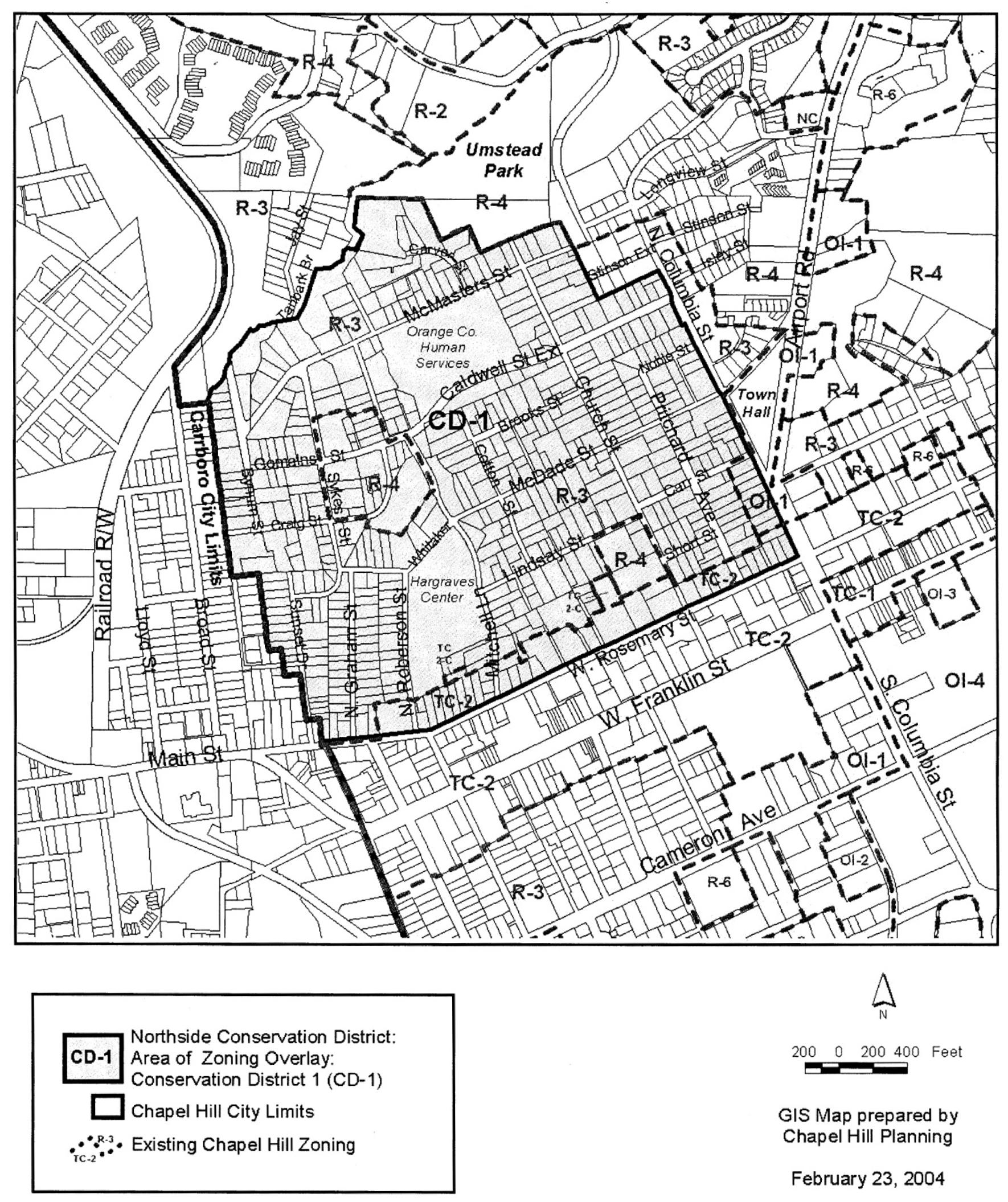
Sec. 1.3. - Boundaries.
The boundaries of the Northside Neighborhood Conservation District are the Tanyard Branch trail to the north, North Columbia Street to the east, West Rosemary Street to the south, and the Carrboro city limit to the west. Please see section 1.6, Attachment, for a map of the district boundaries. The boundaries shall be indicated on the official Zoning Atlas which accompanies the Land Use Management Ordinance.
(Ord. No. 2016-02-08/O-7, §§ I, II)
Sec. 1.4. - Special design standards to apply to development in the Northside Conservation District.
The following design standards shall apply to all development within the Northside Conservation District, and are incorporated into Chapel Hill's Land Use Management Ordinance by reference. No application for development shall be approved that does not comply with these standards. For the Northside Neighborhood Conservation District, these standards replace/supercede general provisions in the Land Use Management Ordinance where such standards differ. For standards that are not specifically identified in this plan, provisions of the underlying zoning district for a particular parcel shall apply.
*For the Northside Neighborhood Conservation District, these standards and regulations replace/supersede general, otherwise applicable provisions in the Land Use Management Ordinance where such standards applicable to the property differ. For standards that are not specifically identified in the Plan, provisions of the underlying zoning district for a particular parcel shall apply.
**For the purposes of the Northside Neighborhood Conservation District a Motor Vehicle shall be defined as a self-propelled, four-wheeled conveyance, such as a car or truck that does not run on rails.
***For the maximum number of parked four-wheeled motor vehicles used for the conveyance of persons or goods per zoning lot, these standards shall have an effective date of September 1, 2012.
****For purposes of determining whether any proposed addition is equal to or greater than the standards set forth in this section to require review by the planning commission cumulative applications for additions to the same structure shall be combined and considered a single application.
(Ord. No. 2016-02-08/O-7, §§ I, II)
Sec. 1.5. - Design guidelines.
A set of design guidelines for development in the Northside Neighborhood Conservation District shall be adopted by the town council. The town manager shall encourage applicants proposing development in the Northside Neighborhood to design such development in accordance with the adopted guidelines to the extent that it is feasible to do so. The guidelines shall be adopted as an addendum to Chapel Hill's existing document, "Design Guidelines," which is a component of Chapel Hill's Comprehensive Plan. The guidelines shall become part of the comprehensive plan, but not part of the Land Use Management Ordinance.
(Ord. No. 2016-02-08/O-7, §§ I, II)
Sec. 1.6. - Attachment Map of Neighborhood Conservation District Boundaries.
Northside Neighborhood Conservation District
Showing Area of Zoning Overlay
Adopted February 23, 2004 and Re-adopted January 25, 2016
(Ord. No. 2016-02-08/O-7, §§ I, II)
Sec. 2.1. - Summary.
This Greenwood Neighborhood Conservation District Plan has been prepared and adopted in accordance with section 3.6.5 in Chapel Hill's Land Use Management Ordinance, and has been incorporated into the Land Use Management Ordinance by reference.
The purpose of a neighborhood conservation district is to establish special regulations especially designed for and intended to help preserve the character of a particular, older residential neighborhood. This plan contains special regulations for the Greenwood Neighborhood Conservation District (CD-2) as described below.
(Ord. of 6-12-2006)
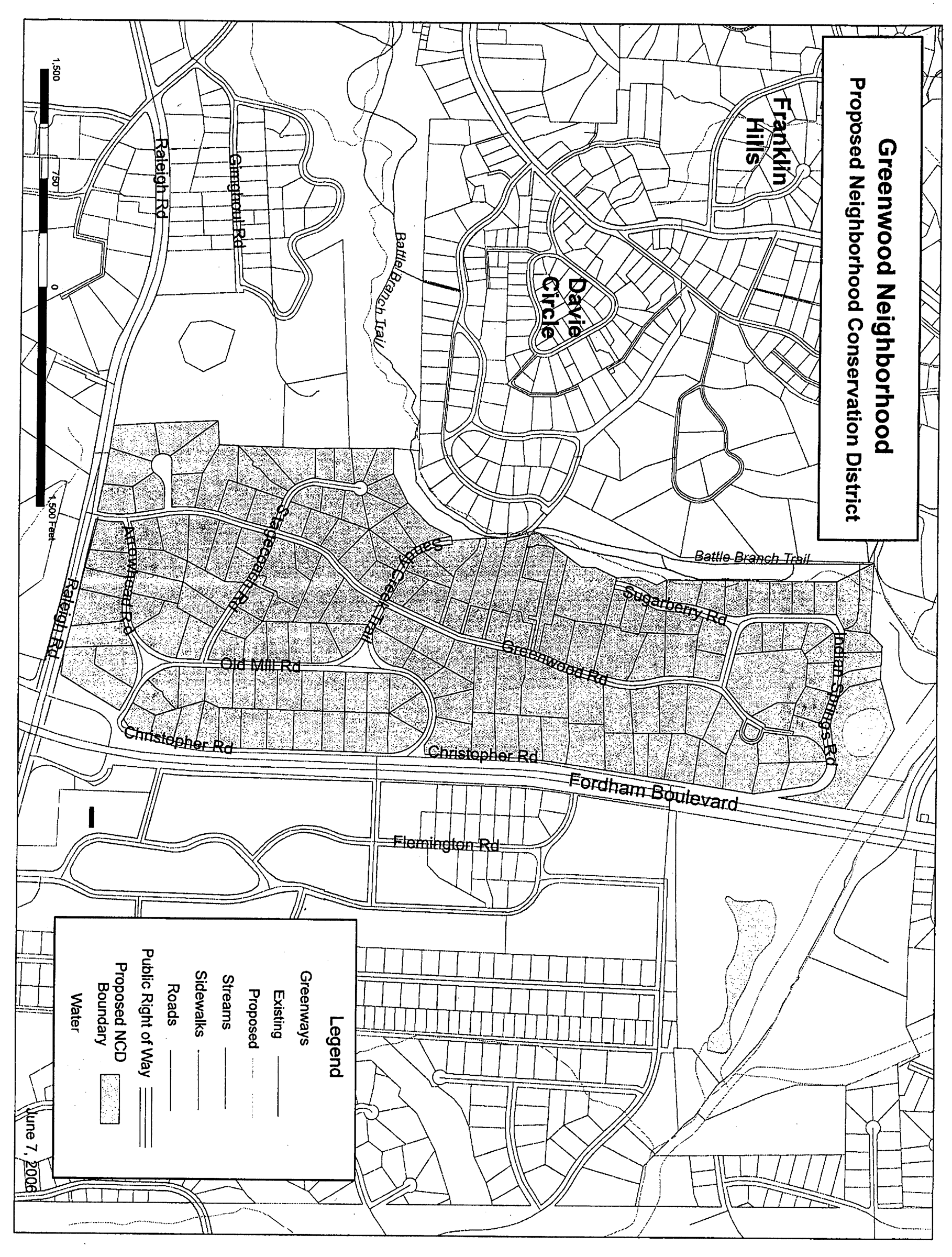
Sec. 2.2. - Boundaries.
The boundaries of the Greenwood Neighborhood Conservation District generally are the northern boundary of lots fronting on Indian Springs Road to the north, Christopher Road and Fordham Boulevard to the east, Raleigh Road to the south, and a combination of Battle Branch and church properties to the west. Please see section 2.5 for the map of the district boundaries. The boundaries shall be indicated on the official zoning atlas which accompanies the Land Use Management Ordinance.
(Ord. of 6-12-2006)
_____
Sec. 2.3. - Special design standards to apply to development in the Greenwood Conservation District.
The following design standards shall apply to all development within the greenwood conservation district, and are incorporated into Chapel Hill's Land Use Management Ordinance by reference. No application for development shall be approved that does not comply with these standards. For the Greenwood Neighborhood Conservation District, these standards replace/supersede general provisions in the Land Use Management Ordinance where such standards differ. For standards that are not specifically identified in this plan, provisions of the underlying zoning district for a particular parcel shall apply.
The standards for the Greenwood Neighborhood Conservation District are as follows:
Greenwood Neighborhood Conservation District Plan
*For the Greenwood Neighborhood Conservation District, these standards replace/supersede general, otherwise applicable provisions in the Land Use Management Ordinance where such standards applicable to the property differ. For standards that are not specifically identified in this plan, provisions of the underlying zoning district for a particular parcel shall apply.
**Front yard for this fence standard shall be the street the house faces.
***Refer to section 4.12.2 of the Land Use Management Ordinance for information regarding variances from dimensional regulations and "house size" limitations.
(Ord. of 6-12-2006; Ord. No. 2016-03-21/O-2, § 7)
Sec. 2.5. - Attachment.
1.
Map of [Greenwood] Neighborhood Conservation District Boundaries.
(Ord. of 6-12-2006)
Sec. 3.1. - Summary.
This Kings Mill/Morgan Creek Neighborhood Conservation District Plan has been prepared and adopted in accordance with section 3.6.5 in Chapel Hill's Land Use Management Ordinance, and has been incorporated into the Land Use Management Ordinance by reference.
The purpose of a neighborhood conservation district is to establish special regulations especially designed for and intended to help preserve the character of a particular, older residential neighborhood. This plan contains special regulations for the Kings Mill/Morgan Creek Neighborhood Conservation District (CD-3) as described below.
(Ord. of 6-12-2006)
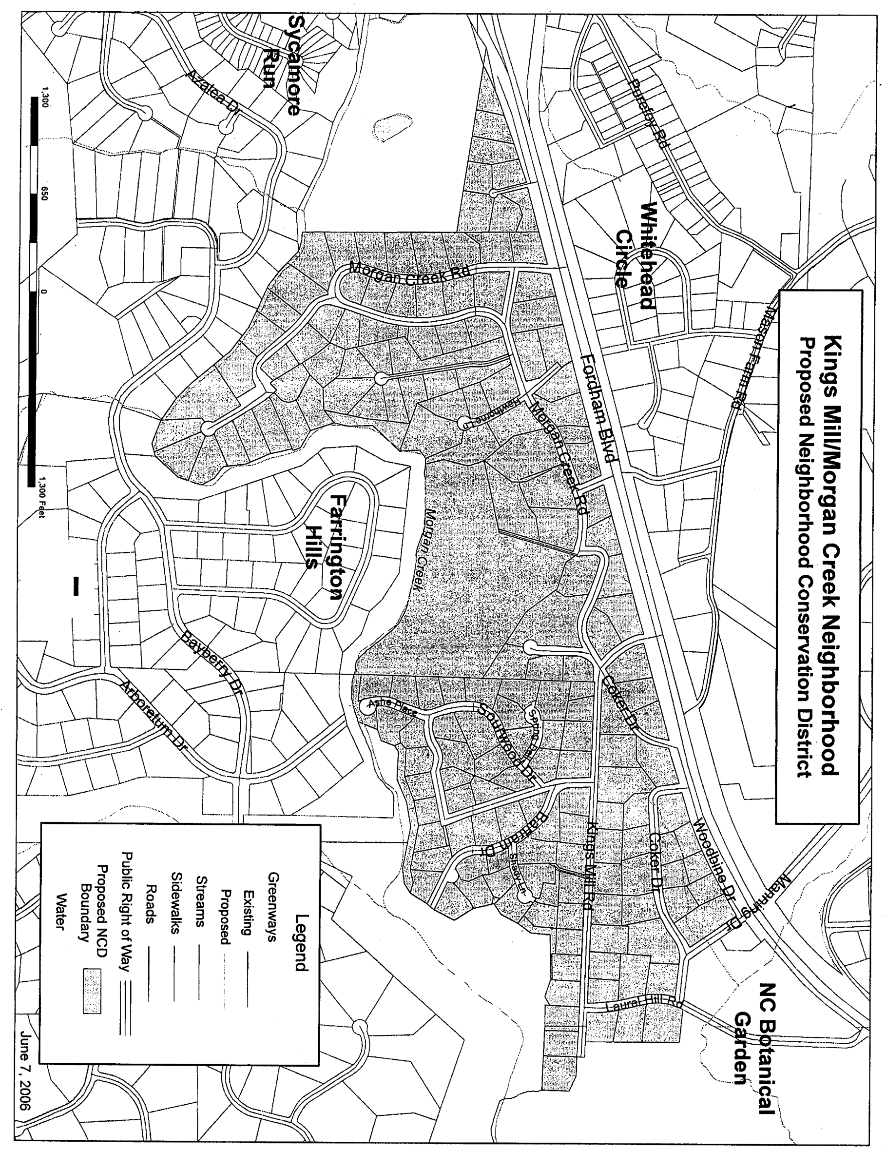
Sec. 3.2. - Boundaries.
The boundaries of the Kings Mill/Morgan Creek Neighborhood Conservation District generally are Fordham Boulevard to the north, the UNC Botanical Garden to the east, Morgan Creek to the south, and Merritt's pasture to the west. Please see the section 3.4 for a map of the district boundaries. The boundaries shall be indicated on the official zoning atlas which accompanies the Land Use Management Ordinance.
(Ord. of 6-12-2006)
_____
Sec. 3.3. - Special design standards to apply to development in the Kings Mill/Morgan Creek Conservation District.
The following design standards shall apply to all development within the Kings Mill/Morgan Creek Conservation District, and are incorporated into Chapel Hill's Land Use Management Ordinance by reference. No application for development shall be approved that does not comply with these standards. For the Kings Mill/Morgan Creek Neighborhood Conservation District, these standards replace/supersede general provisions in the Land Use Management Ordinance where such standards differ. For standards that are not specifically identified in this plan, provisions of the underlying zoning district for a particular parcel shall apply.
The standards for the Kings Mill/Morgan Creek Neighborhood Conservation District are as follows:
Kings Mill/Morgan Creek Neighborhood Conservation District Plan
*For the Kings Mill/Morgan Creek Neighborhood Conservation District, these standards replace/supersede general, otherwise applicable provisions in the Land Use Management Ordinance where such standards applicable to the property differ. For standards that are not specifically identified in this plan, provisions of the underlying zoning district for a particular parcel shall apply.
**Front yard for this fence standard shall be the street the house faces.
***Refer to section 4.12.2 of the Land Use Management Ordinance for information regarding variances from dimensional regulations and "house size" limitations.
(Ord. of 6-12-2006; Ord. No. 2016-03-21/O-2, § 8)
Sec. 3.4. - Attachment.
1.
Map of [Kings Mill/Morgan Creek] Neighborhood Conservation District Boundaries.
(Ord. of 6-12-2006)
Sec. 4.1. - Summary.
This Pine Knolls Neighborhood Conservation District Plan has been prepared and adopted in accordance with section 3.6.5 in Chapel Hill's Land Use Management Ordinance, and has been incorporated into the Land Use Management Ordinance by reference.
The purpose of a neighborhood conservation district is to establish special regulations especially designed for and intended to help preserve the character of a particular, older residential neighborhood. This plan contains special regulations for the Pine Knolls Neighborhood Conservation District (CD-4) as described below. The special regulations included here for height limits, floor area ratios, limitations on front yard parking, and specific notification requirements apply only to single-family development and single-family dwellings with accessory apartments.
(Ord. of 6-12-2006; Ord. No. 2016-02-08/O-8, § I)
Sec. 4.2. - Boundaries.
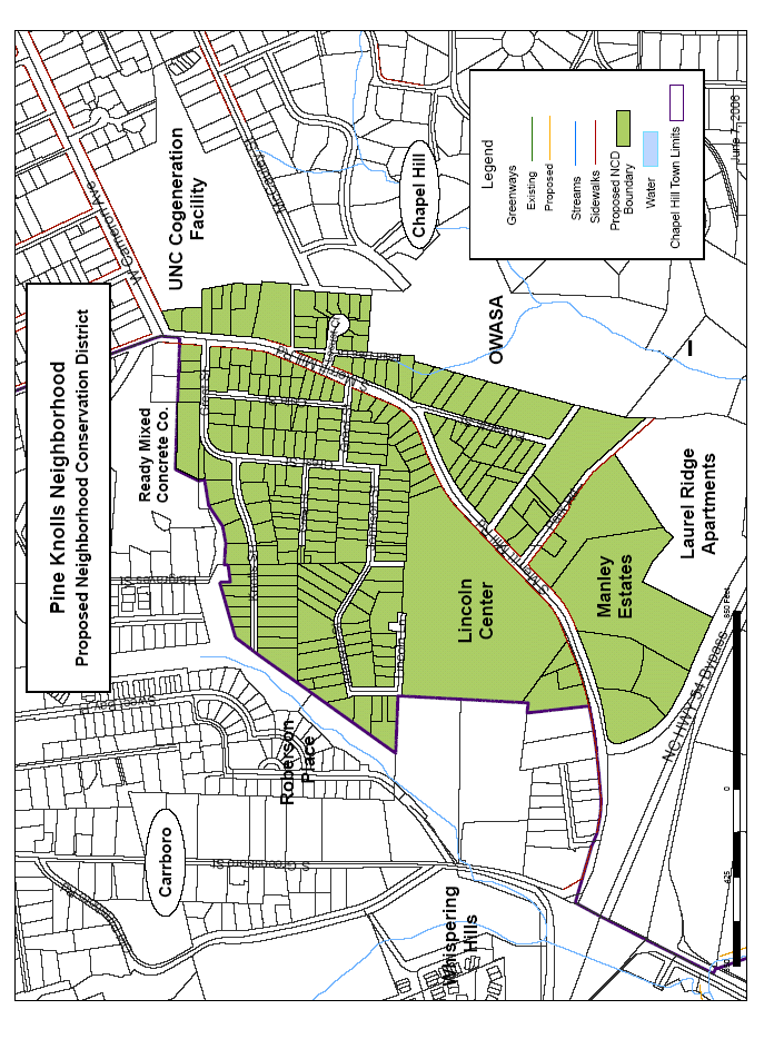
The boundaries of the Pine Knolls Neighborhood Conservation District generally are as follows: to the north, the backs of properties on the north side of Crest Street; to the east, the backs of properties on the east side of Merritt Mill Road, Raintree Lane, and Edwards Street; to the south, Fordham Boulevard; to the west, the Chapel Hill city limits. Please see section 4.5, Attachment, for a map of the district boundaries. The boundaries shall be indicated on the official zoning atlas which accompanies the Land Use Management Ordinance.
(Ord. of 6-12-2006)
_____
Sec. 4.3. - Special design standards to apply to development in the Pine Knolls Conservation District.
The following design standards shall apply to all development within the Pine Knolls Conservation District, and are incorporated into Chapel Hill's Land Use Management Ordinance by reference. No application for development shall be approved that does not comply with these standards. For the Pine Knolls Neighborhood Conservation District, these standards replace/supercede general provisions in the Land Use Management Ordinance where such standards differ. For standards that are not specifically identified in this plan, provisions of the underlying zoning district for a particular parcel shall apply. The special regulations included here for height limits, floor area ratios, limitations on front yard parking, and specific notification requirements apply only to single-family development and single-family dwellings with accessory apartments.
The standards for the Pine Knolls Neighborhood Conservation District are as follows:
Pine Knolls Neighborhood Conservation District Plan
*For the Pine Knolls Neighborhood Conservation District, these standards and regulations replace/supersede general, otherwise applicable provisions in the Land Use Management Ordinance where such standards applicable to the property differ. For standards that are not specifically identified in this Plan, provisions of the underlying zoning district for a particular parcel shall apply.
**For the purposes of the Pine Knolls Neighborhood Conservation
***For the Maximum number of parked four-wheeled motor vehicles used for the conveyance of persons or goods per zoning lot, these standards shall have an effective date of September 1, 2012.
****For purposes of determining whether any proposed addition is equal to or greater than the standards set forth in this section to require review by the planning commission, cumulative applications for additions to the same structure shall be combined and considered a single application.
(Ord. of 6-12-2006; Ord. No. 2012-01-09/O-5, § I; Ord. No. 2012-06-25/O-10, § I; Ord. No. 2013-06-24/O-11, § I; Ord. No. 2014-03-10/O-2, § 3; Ord. No. 2016-02-08/O-8, § II)
Sec. 4.4. - Design guidelines.
A set of design guidelines for development in the Pine Knolls Neighborhood Conservation District shall be adopted by the town council. The town manager shall encourage applicants proposing development in the Pine Knolls neighborhood to design such development in accordance with the adopted guidelines to the extent that it is feasible to do so. The guidelines shall be adopted as an addendum to Chapel Hill's existing document, "Design Guidelines," which is a component of Chapel Hill's Comprehensive Plan. The guidelines shall become part of the comprehensive plan, but not part of the Land Use Management Ordinance.
(Ord. of 6-12-2006)
Sec. 4.5. - Attachment.
1.
Map of the Pine Knolls Neighborhood Conservation District Boundaries.
(Ord. of 6-12-2006)
Sec. 5.1. - Summary.
This Mason Farm/Whitehead Circle Neighborhood Conservation District Plan has been prepared and adopted in accordance with section 3.6.5 in Chapel Hill's Land Use Management Ordinance, and has been incorporated into the land use management ordinance by reference.
The purpose of a neighborhood conservation district is to establish special regulations especially designed for and intended to help preserve the character of a particular, older residential neighborhood. This plan contains special regulations for the Mason Farm/Whitehead Circle Neighborhood Conservation District (CD-5) as described below.
(Ord. No. 2007-06-11/O-5, § 1)
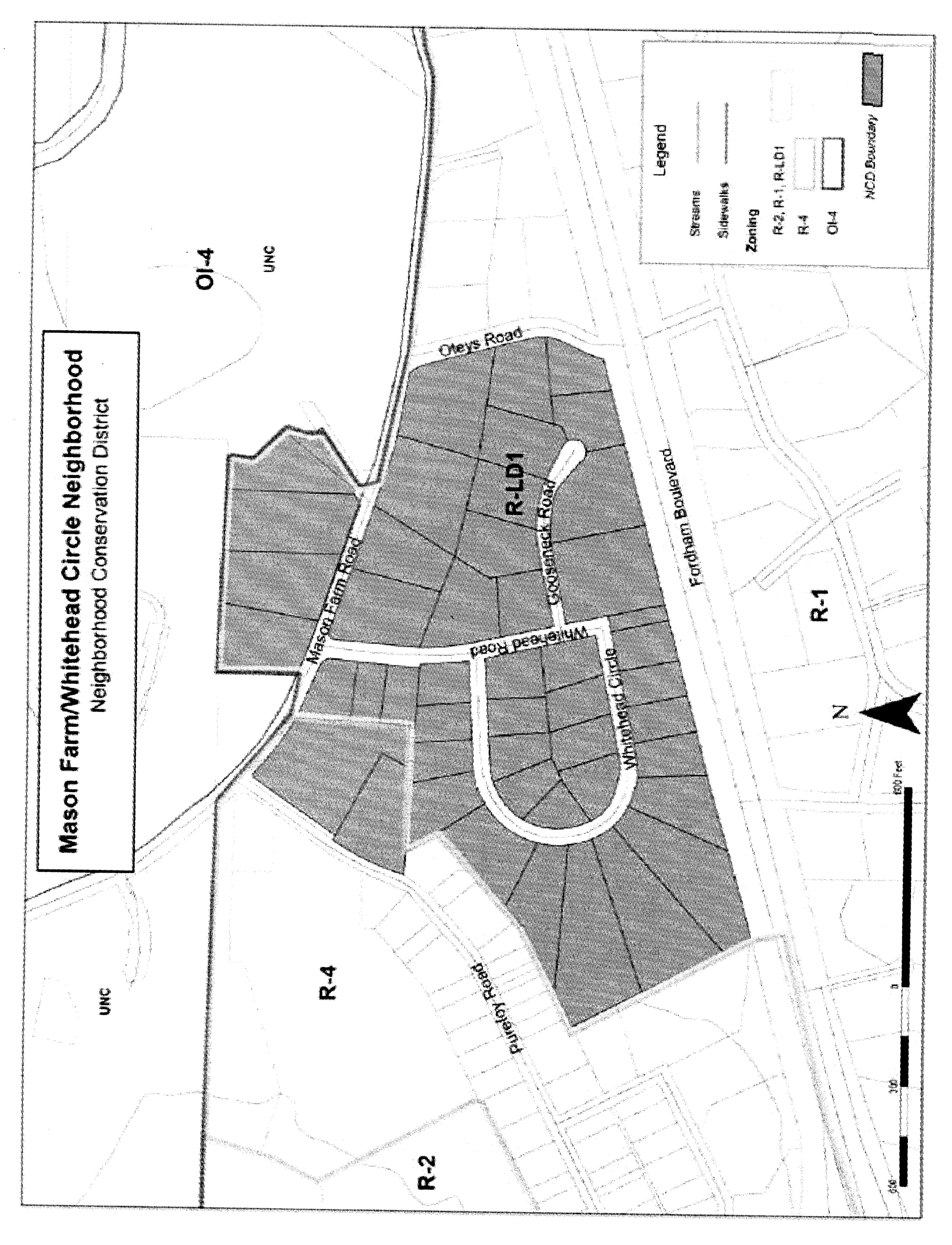
Sec. 5.2. - Boundaries.
The boundaries of the Mason Farm/Whitehead Circle Neighborhood Conservation District generally are Fordham Boulevard to the south, Mason Farm Road to the north, Otey's Road to the east, and Purefoy Road to the northwest. Please see Attachment 1 for a map of the District boundaries. The boundaries shall be indicated on the official zoning atlas which accompanies the land use management ordinance.
(Ord. No. 2007-06-11/O-5, § 1)
_____
Sec. 5.3. - Special design standards to apply to development in the Mason Farm/Whitehead Circle conservation district.
The following design standards shall apply to all development within the Mason Farm/Whitehead Circle conservation district, and are incorporated into Chapel Hill's Land Use Management Ordinance by reference. No application for development shall be approved that does not comply with these standards. For the Mason Farm/Whitehead Circle neighborhood conservation district, these standards replace/supersede general provisions in the land use management ordinance where such standards differ. For standards that are not specifically identified in this plan, provisions of the underlying zoning district for a particular parcel shall apply.
The standards for the Mason Farm/Whitehead Circle neighborhood conservation district are as follows:
Mason Farm/Whitehead Circle Neighborhood Conservation District Plan
*For the Mason Farm/Whitehead Circle neighborhood conservation district, these standards replace/supersede general, otherwise applicable provisions in the land use management ordinance where such standards applicable to the property differ. For standards that are not specifically identified in this plan, provisions of the underlying zoning district for a particular parcel shall apply.
(Ord. No. 2007-06-11/O-5, § 1; Ord. No. 2016-03-21/O-2, § 9)
Sec. 5.4. - Attachment.
Map of [Mason Farm/Whitehead Circle] Neighborhood Conservation District boundaries.
(Ord. No. 2007-06-11/O-5, § 1)
Sec. 6.1. - Summary.
This Coker Hills Neighborhood Conservation District Plan has been prepared and adopted in accordance with section 3.6.5 in Chapel Hill's Land Use Management Ordinance, and has been incorporated into the Land Use Management Ordinance by reference.
The purpose of a neighborhood conservation district is to establish special regulations especially designed for and intended to help preserve the character of a particular, older residential neighborhood. This plan contains special regulations for the Coker Hills Neighborhood Conservation District (CD-6) as described below.
(Ord. No. 2007-10-8/O-8, § I)
Sec. 6.2. - Boundaries.
The boundaries of the Coker Hills Neighborhood Conservation District generally are Clayton Road to the south, Allard Road to the north, Velma Road to the east, and Curtis Road to the west. Please see section 7.1 for a map of the district boundaries. The boundaries shall be indicated on the official Zoning Atlas which accompanies the Land Use Management Ordinance.
(Ord. No. 2007-10-8/O-8, § I)
Sec. 6.3. - Special design standards to apply to development in the Coker Hills Neighborhood Conservation District.
The following design standards shall apply to all development within the Coker Hills Neighborhood Conservation District, and are incorporated into Chapel Hill's Land Use Management Ordinance by reference. No application for development shall be approved that does not comply with these standards. For the Coker Hills Neighborhood Conservation District, these standards replace/supersede general provisions in the Land Use Management Ordinance where such standards differ. For standards that are not specifically identified in this plan, provisions of the underlying zoning district for a particular parcel shall apply. The standards for the Coker Hills Neighborhood Conservation District are as follows:
* For the Coker Hills Neighborhood Conservation District, these standards replace/supersede general, otherwise applicable provisions in the Land Use Management Ordinance where such standards applicable to the property differ. For standards that are not specifically identified in this plan, provisions of the underlying zoning district for a particular parcel shall apply.
(Ord. No. 2010-10-8/O-8, § I)
Sec. 6.4. - Attachment.
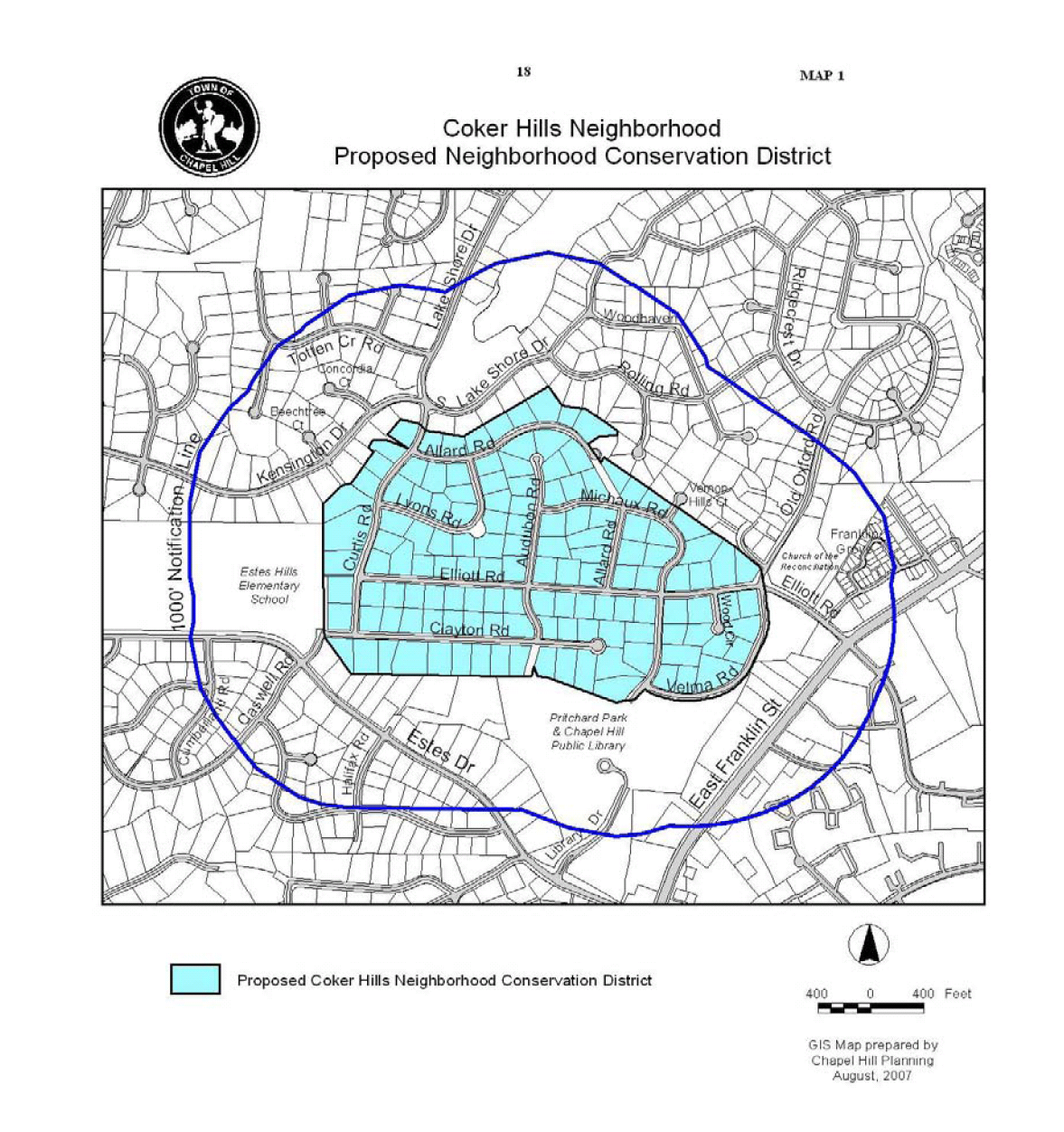
(Ord. No. 2007-10-8/O-8, § I)
Sec. 7.1. - Summary.
This Highland Woods Neighborhood Conservation District Plan has been prepared and adopted in accordance with section 3.6.5 in Chapel Hill's Land Use Management Ordinance, and has been incorporated into the Land Use Management Ordinance by reference.
The purpose of a neighborhood conservation district is to establish special regulations especially designed for and intended to help preserve the character of a particular, older residential neighborhood. This plan contains special regulations for the Highland Woods Neighborhood Conservation District (CD-7) as described below.
(Ord. No. 2011-05-23/O-2, § I(Att.))
Sec. 7.2. - Boundaries.
The Highland Woods Neighborhood Conservation District is surrounded by UNC property to the north and east with the Ronald McDonald House and the SECU Family House to the south. The area is bound by Fordham Boulevard to the west and Old Mason Farm Road to the south. Please see section 8.4 for a map of the Highland Woods Neighborhood Conservation District boundaries. The boundaries shall be indicated on the official zoning atlas which accompanies the Land Use Management Ordinance.
(Ord. No. 2011-05-23/O-2, § I(Att.))
Sec. 7.3. - Special design standards to apply to development in the Highland Woods Neighborhood Conservation District.
The following design standards shall apply to all development within the Highland Woods Neighborhood Conservation District, and are incorporated into Chapel Hill's Land Use Management Ordinance by reference. No application for development shall be approved that does not comply with these standards. For the Highland Woods Neighborhood Conservation District, these standards shall replace/supersede general provisions in the Land Use Management Ordinance where such standards differ. For standards that are not specifically identified in this plan, provisions of the underlying zoning district for a particular parcel shall apply.
The design standards for the Highland Woods Neighborhood Conservation District are as follows:
Highland Woods Neighborhood Conservation
District Plan
* For the Highland Woods Neighborhood Conservation District, these standards replace/supersede general, otherwise applicable provisions in the Land Use Management Ordinance where such standards applicable to the property differ. For standards that are not specifically identified in this Plan, provisions of the underlying zoning district for a particular parcel shall apply.
(Ord. No. 2011-05-23/O-2, § I(Att.))
Sec. 7.4. - Attachment.
1.
Map of the Highland Woods Neighborhood Conservation District Boundary

(Ord. No. 2011-05-23/O-2, § I(Att.))
Sec. 8A.1. - Summary.
This Glen Lennox Area Neighborhood Conservation District Plan for Conservation District-8A (CD-8A) has been prepared and adopted in accordance with section 3.6.5 in Chapel Hill's Land Use Management Ordinance, and has been incorporated into the Land Use Management Ordinance by reference.
The purpose of a neighborhood conservation district is to establish special regulations especially designed for and intended to help preserve the character of a particular, older residential neighborhood. This plan contains special regulations for the Glen Lennox Area Neighborhood Conservation District-8A (CD-8A). The Glen Lennox Area Neighborhood Conservation District-8B (CD-8B) Plan can be found in a separate document.
(Ord. No. 2011-10-26/O-6, § I(Att. 2))
Sec. 8A.2. - Boundaries.
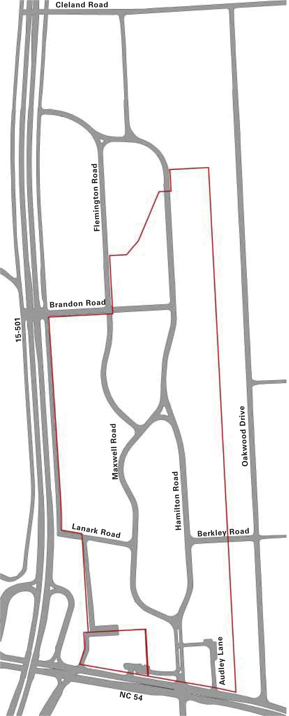
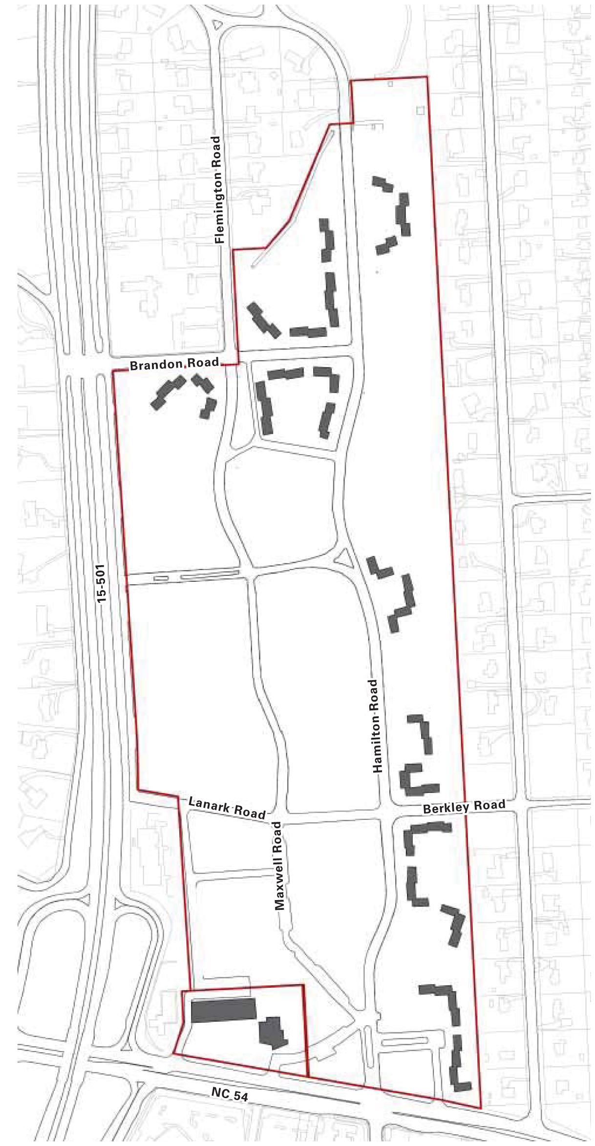
The Glen Lennox Area Neighborhood Conservation District-8A (CD-8A) includes Flemington Road, Hayes Road, Hamilton Road, and Oakwood Drive (see below). The boundaries shall be indicated on the official zoning atlas which accompanies the Land Use Management Ordinance.

(Ord. No. 2011-10-26/O-6, § I(Att. 2))
Sec. 8A.3. - Special design standards to apply to development in the Glen Lennox Area Neighborhood Conservation District-8A.
The following design standards shall apply to all development within the Glen Lennox Area Neighborhood Conservation District-8A, and are incorporated into Chapel Hill's Land Use Management Ordinance by reference. No application for development shall be approved that does not comply with these standards. For the Glen Lennox Area Neighborhood Conservation District-8A, these standards shall replace/supersede general provisions in the Land Use Management Ordinance where such standards differ. For standards that are not specifically identified in this plan, provisions of the underlying zoning district for a particular parcel shall apply.
The design standards for the Glen Lennox Area Neighborhood Conservation District-8A are as follows:
* For the Glen Lennox Area Neighborhood Conservation District-8A, these standards replace/supersede general, otherwise applicable provisions in the Land Use Management Ordinance where such standards applicable to the property differ. For standards that are not specifically identified in this plan, provisions of the underlying zoning district for a particular parcel shall apply.
+ The street setback would apply to the street frontage of the main entrance of the principal structure; otherwise, the street setback is twenty-six (26) feet.
**The front yard is defined as the area between the street and a line drawn parallel to the street from the point of the house that is closest to the street.
† Duplex dwelling units existing or for which a vested right had been established as of October 24, 2011, may be continued and shall not be considered as a nonconforming use. No duplex shall be enlarged, extended, or expanded unless such a building or structure is thereafter devoted to a conforming use.
(Ord. No. 2011-10-26/O-6, § I(Att. 2); Ord. No. 2016-03-21/O-2, § 10)
Sec. 8A.4. - Reserved.
Editor's note— Ord. No. 2016-03-21/O-2, § 10, adopted Mar. 21, 2016, deleted § 8A.4 which pertained to attachment and derived from Ord. No. 2011-10-26/O-6, § 1(Att. 2), adopted Oct. 26, 2011.
Sec. 8B.1. - Summary.
This Glen Lennox Area Neighborhood Conservation District Plan for Conservation District-8B (CD-8B) has been prepared and adopted in accordance with section 3.6.5 in Chapel Hill's Land Use Management Ordinance, and has been incorporated into the Land Use Management Ordinance by reference.
The purpose of a neighborhood conservation district is to establish special regulations especially designed for and intended to help preserve the character of a particular, older residential neighborhood. This plan contains special regulations for the Glen Lennox Area Neighborhood Conservation District-8B (CD-8B). The Glen Lennox Area Neighborhood Conservation District-8A (CD-8A) Plan can be found in a separate document.
(Ord. No. 2011-10-26/O-7, § I(Att. 2))
Sec. 8B.2. - Boundaries.
The Glen Lennox Area Neighborhood Conservation District-8B (CD-8B) includes Rogerson Drive (see below). The boundaries shall be indicated on the official zoning atlas which accompanies the Land Use Management Ordinance.

(Ord. No. 2011-10-26/O-7, § I(Att. 2))
Sec. 8B.3. - Special design standards to apply to development in the Glen Lennox Area Neighborhood Conservation District-8B.
The following design standards shall apply to all development within the Glen Lennox Area Neighborhood Conservation District-8B, and are incorporated into Chapel Hill's Land Use Management Ordinance by reference. No application for development shall be approved that does not comply with these standards. For the Glen Lennox Area Neighborhood Conservation District-8B, these standards shall replace/supersede general provisions in the Land Use Management Ordinance where such standards differ. For standards that are not specifically identified in this plan, provisions of the underlying zoning district for a particular parcel shall apply.
The design standards for the Glen Lennox Area Neighborhood Conservation District-8B are as follows:
* For the Glen Lennox Area Neighborhood Conservation District-8B, these standards replace/supersede general, otherwise applicable provisions in the Land Use Management Ordinance where such standards applicable to the property differ. For standards that are not specifically identified in this Plan, provisions of the underlying zoning district for a particular parcel shall apply.
**The front yard is defined as the area between the street and a line drawn parallel to the street from the point of the house that is closest to the street.
† Duplex dwelling units existing or for which a vested right had been established as of October 24, 2011, may be continued and shall not be considered as a nonconforming use. No duplex shall be enlarged, extended, or expanded unless such a building or structure is thereafter devoted to a conforming use.
(Ord. No. 2011-10-26/O-7, § I(Att. 2); Ord. No. 2016-03-21/O-2, § 11)
Sec. 8B.4. - Reserved.
Editor's note— Ord. No. 2016-03-21/O-2, § 10, adopted Mar. 21, 2016, deleted § 8B.4 which pertained to attachment and derived from Ord. No. 2011-10-26/O-7, § I(Att. 2), adopted Oct. 26, 2011.
Sec. 8C.1. - Summary.
This Glen Lennox Area Neighborhood Conservation District Plan has been prepared and adopted in accordance with section 3.6.5 in Chapel Hill's Land Use Management Ordinance, and has been incorporated into the Land Use Management Ordinance by reference.
The purpose of a Neighborhood Conservation District (NCD) Zoning Overlay is to establish special regulations especially designed for and intended to help preserve the character of a particular, older residential neighborhood. This Plan contains special regulations for the Glen Lennox Area Neighborhood Conservation District-8C (CD-8C) as described in this document. Development in the CD-8C district may occur upon approval by the town council of a development agreement or shall be considered to be a special use and subject to the special use permit standards and procedural requirements of section 4.5 of the Land Use Management Ordinance.
NCD Zoning Overlay regulations have also been established for the single-family residential neighborhood in the Glen Lennox Area Neighborhood. These regulations are referred to as Glen Lennox Area Neighborhood Conservation District-8A (CD-8A) and Glen Lennox Area Neighborhood Conservation District-8B (CD-8B) and were adopted by the Chapel Hill Town Council on October 26, 2011. Together, the regulations for CD-8A, CD-8B, and CD-8C form the complete set of regulations for the Glen Lennox Area Neighborhood.
For a copy of the CD-8A and CD-8B regulations, please visit www.townofchapelhill.org/glenlennox or contact the Chapel Hill Planning Department at 919-968-2728.
(Ord. No. 2012-05-30/O-4, § I)
Sec. 8C.2. - Background.

INTRODUCTION
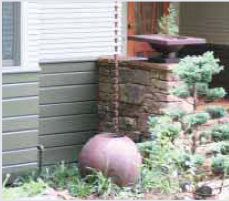
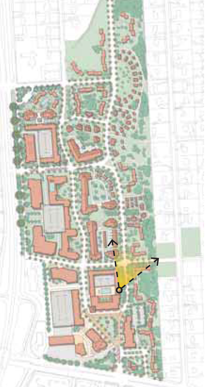
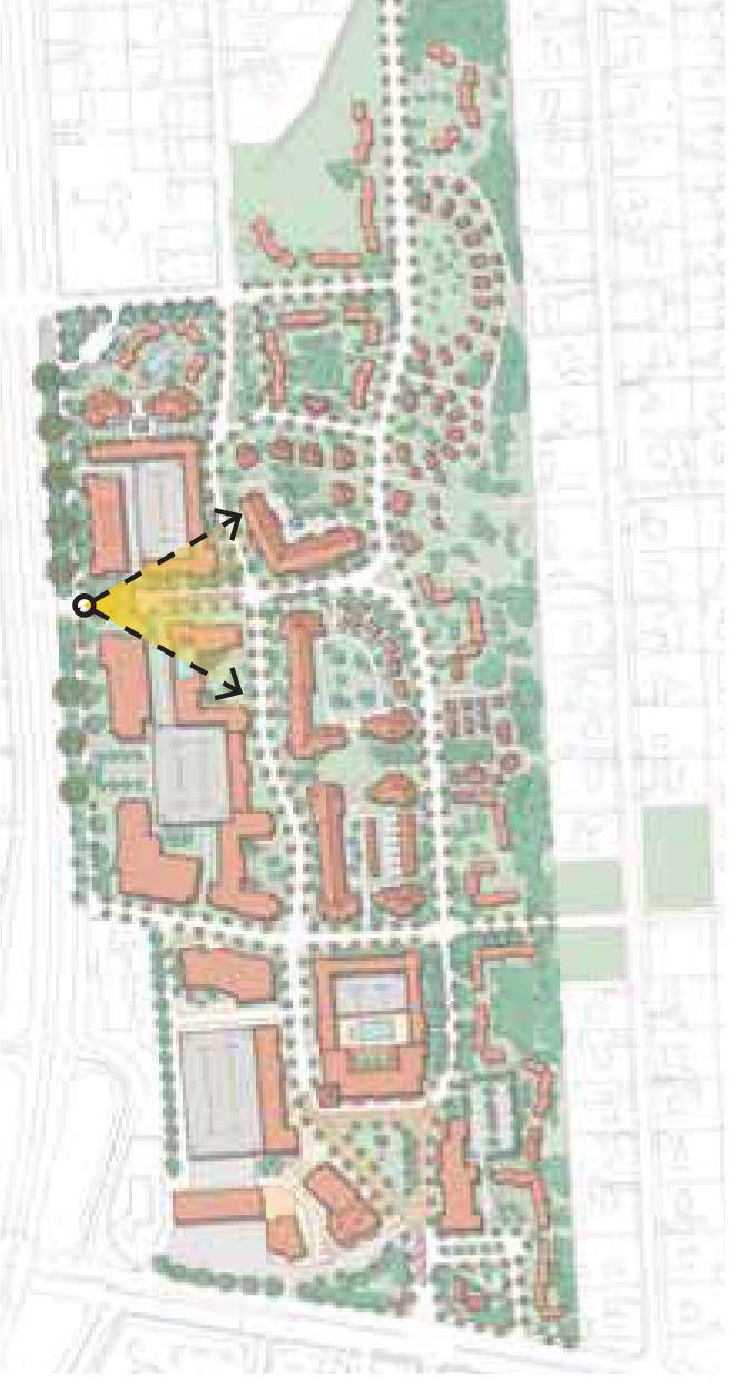
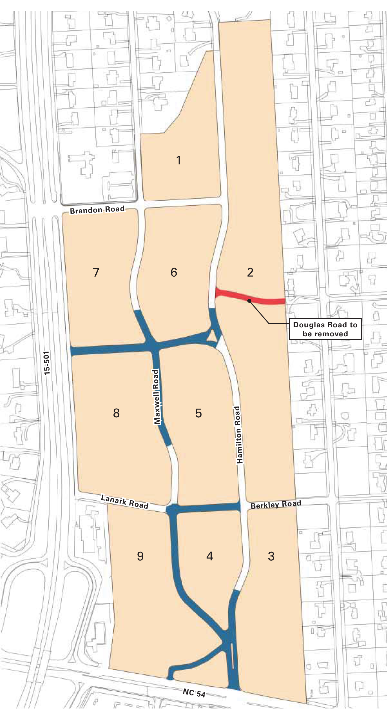
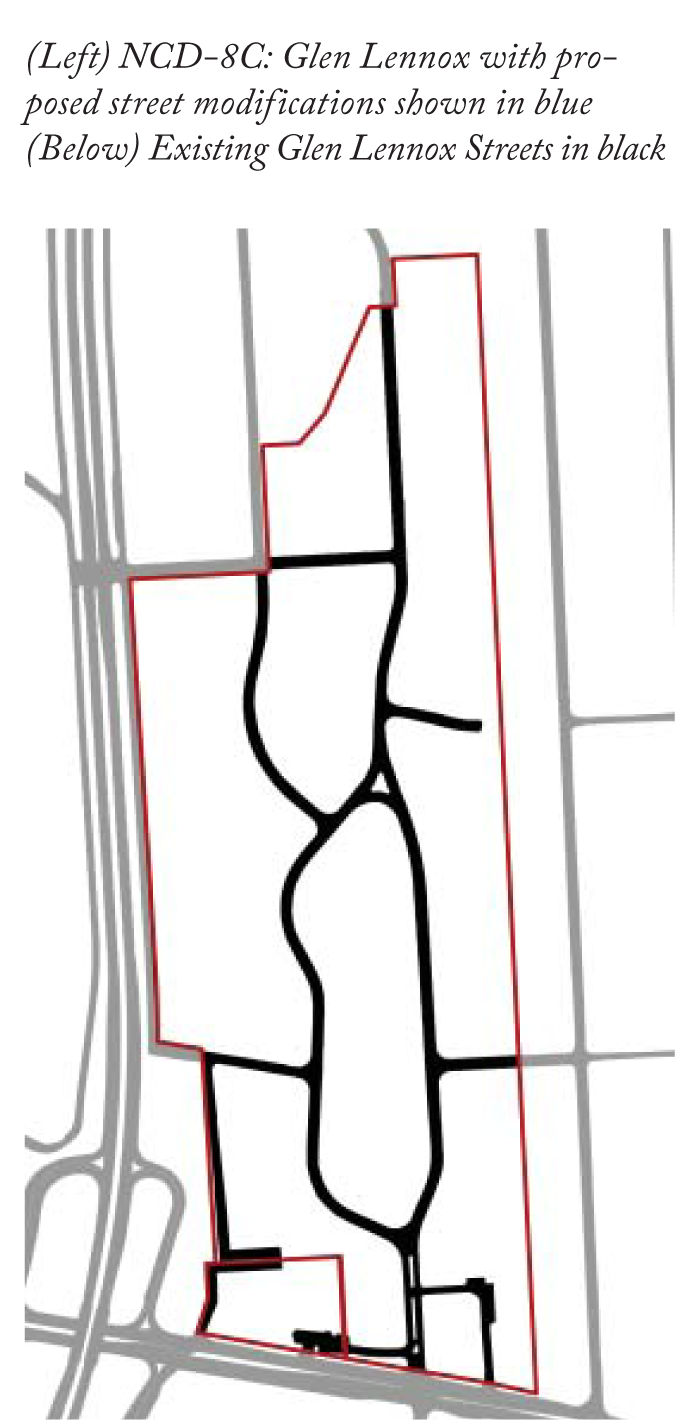
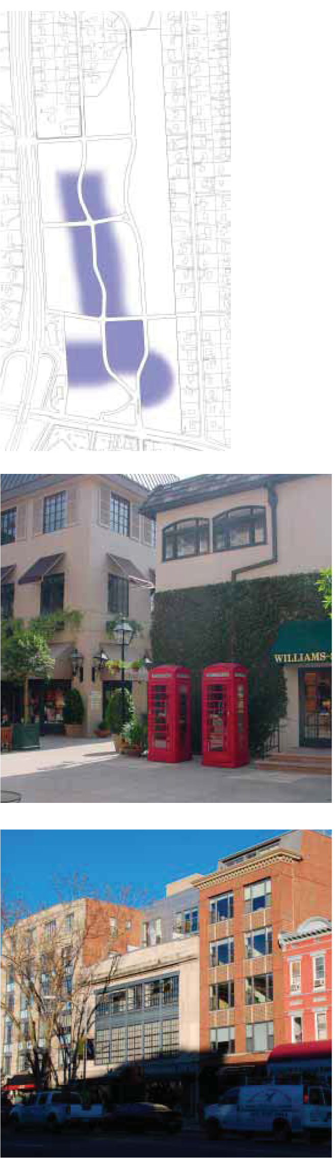
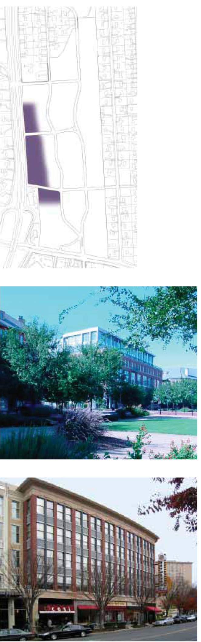
For nearly four (4) years, the redevelopment of the Glen Lennox apartment and commercial property has been the focus of a conversation among the neighborhood and apartment residents, the property owners, and the town. In order to address the concerns about the redevelopment and to collaboratively and creatively use planning tools to maintain the character of the neighborhood, the Glen Lennox Area Neighborhood Conservation District Development Committee (the Committee) was formed.
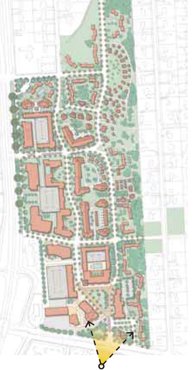
This diverse and representative Committee successfully authored Neighborhood Conservation District (NCD) Zoning Overlay regulations for the single-family residential section of the Glen Lennox Area; these regulations are referred to as CD-8A and CD-8B and are shown in yellow and blue on the diagram to the left. For more information about the regulations for CD-8A and CD-8B, please visit www.townofchapelhill.org/glenlennox or contact the Chapel Hill Planning Department at 919-968-2728.
The purpose of this document is to provide the NCD Zoning Overlay regulations for the Glen Lennox apartment and commercial property; these regulations are referred to as CD-8C and are shown in purple on the diagram to the left. This document also provides design guidelines for new development and records the unique characteristics of the area and the extraordinary efforts of the committee.
The following pages of this plan describe the process; the physical context of the area; the history of the Glen Lennox apartment and commercial property; and also the guiding principles that emerged from this process.

Background
The Glen Lennox Area Neighborhood, a well-loved neighborhood in Chapel Hill, is home to people of varying cultures, ages, and backgrounds. Residents and community members play at the local Oakwood Park, eat at the restaurants in the Glen Lennox commercial property, attend services at the Church of the Holy Family, and play soccer on the nearby fields. The apartment residents and the neighborhood residents feel that this is one (1) neighborhood and enjoy the amenities that this area has to offer.
From this sense of cohesion and uniqueness has come the Glen Lennox Area Neighborhood Conservation District Plan which provides regulations and visions for the growth of the area, both the apartment and commercial property and the single-family residential sections.
The development of these regulations has been a great example of collaboration, compromise, visioning, and patience. A process which began as antagonistic and distrustful evolved into a process in which people felt that their ideas, thoughts, and needs were heard and respected. While everyone has made compromises throughout this effort, a plan has developed that the Glen Lennox Area Neighborhood and the owners of the Glen Lennox property respond to positively and with the hope that this area will become a community gathering space for all.
PROCESS

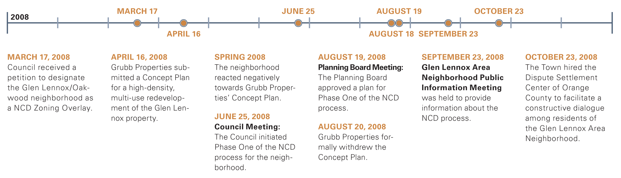
Process
This process began in the spring of 2008 with the submittal of a Concept Plan by Grubb Properties for the Glen Lennox apartment and commercial property. This plan was strongly opposed by the neighborhood and apartment residents who were concerned that the character of the neighborhood would be negatively impacted. As a result of the opposition, Grubb Properties withdrew their proposal and publicly apologized for its submittal.
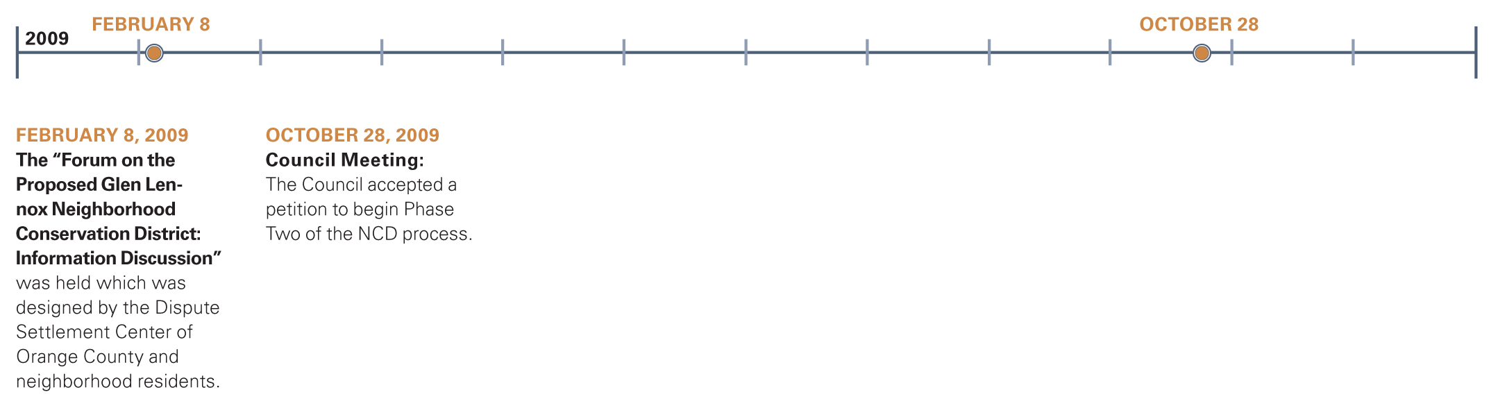
In the spring of 2010, Grubb Properties began to hold monthly meetings to hear resident concerns and better understand the needs of the community. Neighborhood residents petitioned the Town Council to create a Neighborhood Conservation District for the Glen Lennox Area Neighborhood. Through this process, the Committee was created and composed of representative stakeholders in the process: neighborhood residents, apartment residents, Grubb Properties, the Church of the Holy Family, Planning commission, and a resident of an existing Town of Chapel Hill Neighborhood Conservation District.
The Committee's charge was to develop a Neighborhood Conservation District plan proposal in accordance with the provisions of the Town's Land Use Management Ordinance while also exploring the use of alternative neighborhood preservation tools to achieve the neighborhood's goals.
Beginning in June of 2010, the Committee held regular meetings (one (1) to two (2) per month) to achieve consensus about the redevelopment of the apartment and commercial property; to discuss the appropriate planning tools and regulations for the Glen Lennox property; and to discuss the creation of regulations for the single-family residential sections of the Glen Lennox Area Neighborhood. From 2010-2012, the Committee discussed, compromised, expressed their needs and wants, and truly came together to create a workable plan for all those involved.

In the spring of 2011, the Committee and neighborhood residents created the Neighborhood Conservation District regulations for the single-family residential sections of the Glen Lennox Area Neighborhood. These regulations (CD-8A and CD-8B) provide regulations for new construction and/or additions to existing units.
From late 2011 through the Spring of 2012, the Committee worked to create the Neighborhood Conservation District regulations for the Glen Lennox apartment and commercial property. The Committee held discussions regarding what should be preserved on the site, what is currently missing from the site, and what form new development should take, including appropriate heights, density, and uses. The resulting regulations and design guidelines are referred to as CD-8C, and are illustrated in this document.

Together, CD-8A, CD-8B, and CD-8C create the regulations and visions for the future of the Glen Lennox Area Neighborhood. This Chapel Hill neighborhood has always been a desirable place for people of all backgrounds and cultures to live and visit, and the area will continue to grow and develop under the guidance of the Glen Lennox Area Neighborhood Conservation District Plan.

EXISTING CONDITIONS
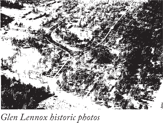
Glen Lennox is located on a seventy-acre site at the intersection of NC Highway 54 and US 15-501, two miles from the center of Chapel Hill. The property includes 440 apartments of rental housing and a commercial center, all of which were built by 1953. The apartments are housed in seventy-eight (78) one-story brick buildings. The shopping center consists of a two-story structure with a covered arcade supported on slender steel columns. The site has wide winding streets across the rolling topography in a wooded setting.
Today, the 60-year old structures have some physical challenges such as foundation settling, stoop separation, roof problems, cracking, efflorescence of the brick, aging trees and poor site drainage in areas. Despite these issues, the property is well managed and occupied by several long-time residents. It remains one of the few neighborhood-like and affordable rental opportunities in Chapel Hill.
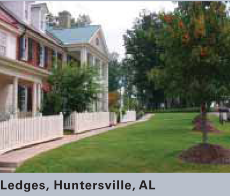
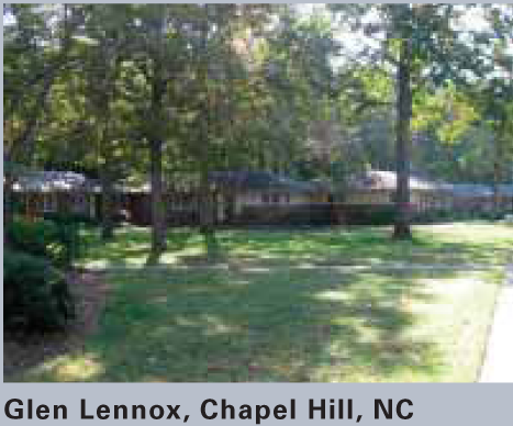
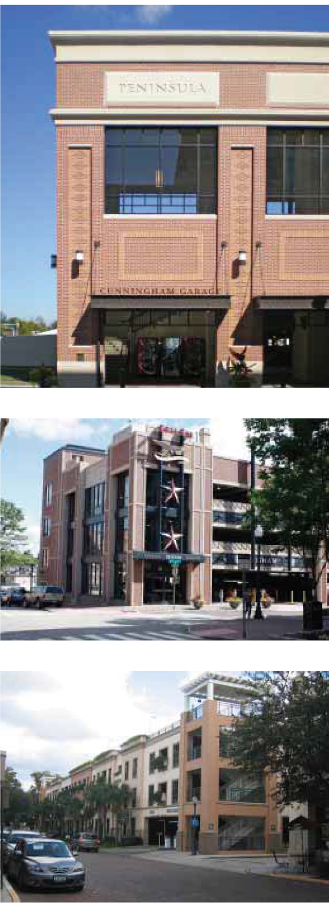
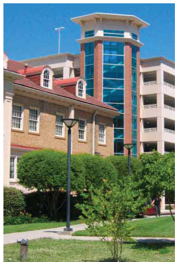
In order to gain a better understanding of the regional architecture, the Urban Design Associates design team visited historic neighborhoods and successful new developments. The photos on the following page represent a variety of housing types and architectural vocabularies that can be used as precedents for Glen Lennox.

Precedents

X-Rays
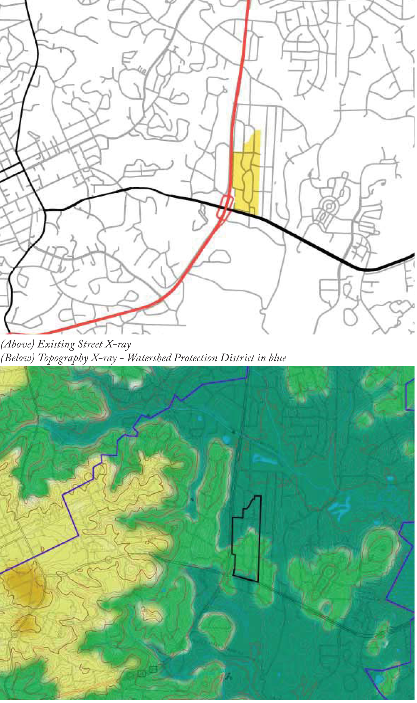
As part of the site analysis, the design team collected data, through mapping of the area, review of previous plan studies, and a physical documentation of the area. These elements help to understand the local context, inform the plan for Glen Lennox, and the appropriate character for new development.
The UDA X-Rays® presented on this page isolate specific elements to reveal existing challenges or patterns surrounding a site.
Streets
Glen Lennox lies at an important local and regional crossroads. Access to NC Highway 54 and US 15-501 are a major amenity, given they are primary connectors. This level of access can be a major asset to market new development. The property has an effective internal street network, including picturesque curvilinear streets that add to the charm of the neighborhood.
Topography
The site benefits from a fair amount of rolling topography that slopes toward Bolin Creek - a prominent feature of the very northern boundary of the site. While the topography creates visual interest on the site, it also poses a challenge for site development.
Portrait of Existing Conditions
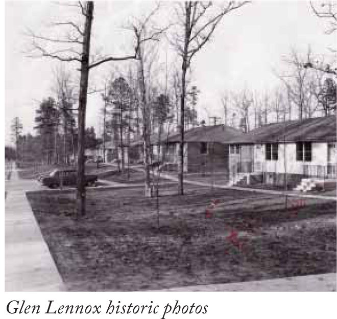
HISTORY
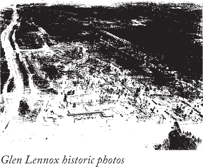
Demand Creates Opportunity
After World War II, American colleges and universities across the country swelled with the ranks of returning veterans taking advantage of educational allowances provided through the GI Bill. The University of North Carolina at Chapel Hill was no exception to this with enrollment increasing from four thousand one hundred (4,100) in 1941 to over six thousand eight hundred (6,800) by 1946 in just that five-year period alone. 1 Similarly, the town of Chapel Hill exploded after the war with the population of the town growing by over two hundred fifty (250) percent from 1940 to 1950. 2 This growth caused enormous demand for housing and led to a severe shortage by the late 1940s. It was around that time, as the story goes, that former UNC President W.D. Carmichael approached local businessman and contractor William Muirhead with the idea of creating a modern housing development to provide relief to the impending housing crisis. [4]
A Community Vision
Examples of "modern" planned communities existed throughout the country and were often featured in popular magazines of the day. Many of these served as reference for Muirhead when planning began for a new community in Chapel Hill. In nearby Raleigh as well, a number of "modern style" apartment communities had begun to emerge outside of the traditional downtown and by 1949 the first modern "shopping center" between Washington, D.C. and Atlanta was completed. Named Cameron Village and designed by renowned architect Leif Valand, this complex was a significant model for Muirhead. 4 As friends and professional colleagues, Leif Valand and Muirhead collaborated in planning the new Chapel Hill community that was named Glen Lennox; "Glen" coming from the Muirhead's Scottish immigrant heritage, and "Lennox" from the maiden name of Mrs. Muirhead. 5
Vision Becomes Reality
The community was laid out with wide curvilinear streets and sidewalks to accommodate the automobile as well as the pedestrian and formed a loose grid-like pattern across the rolling topography. Each of the streets was named after a personal connection to the Muirheads like Hamilton Road, the street Mrs. Muirhead grew up on in Scotland. Many existing trees were preserved, but new street trees were also planted. The apartments were designed and built in a single story "cottage" style with lawns and plantings, these gave the homes a picturesque quality and a sense of spaciousness in spite of the multi-family format and smaller unit size when compared to single-family houses of its day. Glen Lennox opened in 1950 with three hundred fourteen (314) apartments and by 1953 had expanded to include the four hundred forty (440) units found on the property today. [5]
A Modern Shopping Center to Serve Chapel Hill
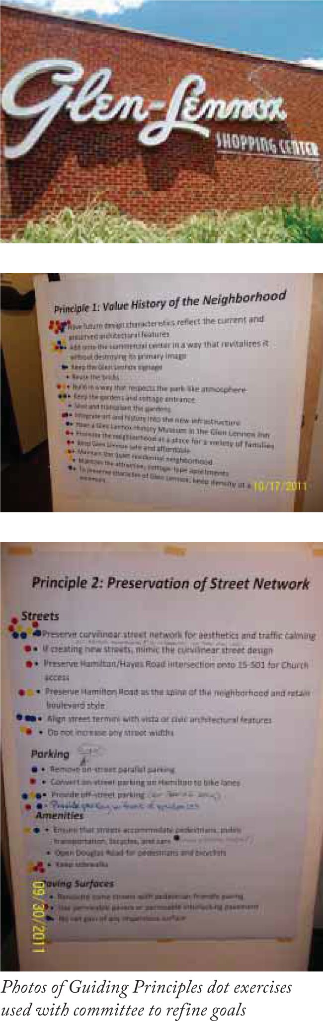
Integrated with Muirhead's housing community was a vision for a modern shopping center to serve the needs of a rapidly growing community that included the adjacent residents of his Glen Lennox Cottages. In 1952, he completed construction of Chapel Hill's first shopping center also believed to be the second in North Carolina. 7 It was designed in the modern style with a streamlined appearance utilizing a combination of brick and storefront materials with a low-slung, covered arcade supported on slender steel columns. The shopping center was designed with all of the modern conveniences in mind including a full service Sinclair Gas Station, the Colonial Grocery Store, and the Dairy Bar Restaurant where one could order a toasted egg salad sandwich, a milkshake, or an ice cream float among other favorites. The shopping center, unlike the traditional downtown where parking was rare and metered, parking at Glen Lennox was designed to accommodate the modern automobile with plenty of free surface parking located between the stores and Raleigh Road (NC-54). Other notable tenants at the time included Pace's Gift Shop, a Laundromat, the Glen Lennox Beauty Salon, a branch of the Bank of Chapel Hill, and Glen Lennox Pharmacy all of which would later become regular institutions in the town's post war history. [6]
Glen Lennox Over The Years
Over the years following its construction, Glen Lennox quickly became a favorite housing choice for many young families that formed the "babyboomer" generation following the war. It also became a favorite of graduate students as Muirhead wisely provided a shuttle bus system to the campus since the community was originally considered so far "out of town". 9 In addition, the community restricted undergraduate students, creating a stable base of slightly older residents that took pride in their neighborhood. Many of North Carolina's most successful future lawyers, doctors and businessmen lived in Glen Lennox over the years as they attended graduate school, worked at the University, or interned at the hospital as medical students. For many families, it was where they had their children, discovered their career path, and participated in the educational and social experiences that would shape their lives and friendships. Famous residents such as football legend and UNC All American, Charlie "Choo-Choo" Justice once lived at Glen Lennox where rumor has it the pet policy was changed to accommodate the pet boxer of the future NFL star Roy Williams, current coach of the legendary UNC basketball team lived for a short time in Glen Lennox in 1979 during his first year as the assistant part-time coach under Dean Smith. [7]
For many others, the apartments and shopping center represents an era of American optimism, the promise of modern living, and the stream-lined aesthetics of a new form of shopping experience that would later become the dominant pattern. Whether it is a student's memory of a milkshake from the Dairy Bar on a study break in the 1950s, a childhood experience of collecting soda bottles to redeem at the Colonial Grocery for two (2) cents each in the early 60s, or a great dinner at Bin 54 restaurant just last week, many memories like these have shaped the Glen Lennox brand over the years.

GUIDING PRINCIPLES
The Guiding Principles for the development of Glen Lennox grew from discussions of the Glen Lennox Area Neighborhood Conservation District Development Committee and the community. These principles guide the proposed redevelopment plan of the Glen Lennox apartment and commercial property and should be referenced in future redevelopment plans for Glen Lennox. The following pages describe each of the eleven (11) Guiding Principles and provide further details about each principle.
» Value the history of the neighborhood and the Glen Lennox apartment and commercial property
» Preserve the street network
» Create and maintain public open space
» Balance the new development with preservation of the trees and tree canopy
» Keep a portion of the buildings
» Transition and vary density and heights of the buildings
» Provide landscaped buffers for sensitive neighbors
» Preserve the Church of the Holy Family's visibility and accessibility
» Create an effective transportation strategy
» Encourage community sustainability
» Encourage and support community diversity
| GUIDING PRINCIPLES | ||
|---|---|---|
| VALUE THE HISTORY OF THE NEIGHBORHOOD AND THE GLEN LENNOX APARTMENT AND COMMERCIAL PROPERTY | PRESERVE THE STREET NETWORK | CREATE AND MAINTAIN PUBLIC OPEN SPACE |
| » Ensure that the future design characteristics respect the current and preserved architectural features | » Maintain a north-south street as a spine through the neighborhood | » Incorporate universal accessibility |
| » Preserve the character, identity, and brand of the Glen Lennox apartment and commercial property | » Street preservation allows for infrastructure and landscaping preservation | » Preserve the character of the undulating public open spaces |
| » Honor the legacy of the Glen Lennox property through documentation and education | » Preserve the curvilinear street network for aesthetics and traffic calming | » Create a public open space for community gathering |
| » Utilize open space for recreational programming | ||
 |  |  |
| GUIDING PRINCIPLES | |||
|---|---|---|---|
| BALANCE THE NEW DEVELOPMENT WITH PRESERVATION OF THE TREES AND TREE CANOPY | KEEP A PORTION OF THE BUILDINGS | TRANSITION AND VARY DENSITY AND HEIGHTS OF THE BUILDINGS | PROVIDE LANDSCAPED BUFFERS FOR SENSITIVE NEIGHBORS |
| » Develop a tree life-cycle plan | » Preserve buildings where physically and economically viable | » Keep the highest intensity of uses near 15-501 and NC Highway 54 intersection | » Create a smooth transition between the residential and mixed use areas |
| » Actively maintain the trees | » Weave together the old and new structures for added variety and cohesion | » Use trees and open spaces to transition between densities within the site | » Incorporate a green buffer that includes trees and plantings |
| » Plant additional trees along the street network and buffer areas | » Lower heights and density near single-family residences | » Protect views from the Church of the Holy Family with landscape | |
 |  |  |  |
| GUIDING PRINCIPLES | |||
|---|---|---|---|
| PRESERVE THE CHURCH OF THE HOLY FAMILY'S VISIBILITY AND ACCESSIBILITY | CREATE AN EFFECTIVE TRANSPORTATION STRATEGY | ENCOURAGE COMMUNITY SUSTAINABILITY | ENCOURAGE AND SUPPORT COMMUNITY DIVERSITY |
| » Allow for adequate green space in the transitional area between the Church and the new apartments | » Include bicycle and pedestrian amenities such as dedicated bike space and sidewalks | » Evaluate and implement a redevelopment plan that balances people, planet and prosperity | » Include a mix of affordable rental and homeownership housing types |
| » Preserve the tree line along Brandon Road | » Integrate the proposed bus rapid transit station along the periphery of Block 8 of the Glen Lennox property | » Encourage eco-friendly site design, building materials and practice | » Provide a variety of housing options for people of all backgrounds, ages, abilities, and income |
| » Have appropriate adjacent uses and be height sensitive | » Provide greenways | » Establish ongoing operational measures to maintain and improve environmental sustainability over time | » Incorporate Universal Design |
| » Ensure accessibility from 15-501 | » Accommodate bus service | » Attend to water conservation, water quality, and air quality | |
| » Ensure connectivity throughout the whole site | » Incorporate stormwater management practices | ||
| » Promote alternate modes of transportation | |||
| » Provide recycling | |||
| » Include no smoking areas | |||
 |  |  |  |
(Ord. No. 2012-05-30/O-4, § I)
Vickers, James. Chapel Hill: An Illustrated History. Chapel Hill NC: Barclay Publishers, 1985, Page 167.
Jacobson, Linda. Glen Lennox Apartment: Synthesizing Visual and Written Evidence to Reveal Postwar Middle Class Culture, Page 2.
Hobbs, Pat. Interviewed by Rachel Russell, Chapel Hill, NC, March 12, 2010.
North Carolina History Project. Accessed March 2010. http://www.northcarolinahistory.org/encyclopedia/74/entry
Hobbs, Pat. Interviewed by Rachel Russell, Chapel Hill, NC, March 12, 2010.
--- (5) ---
Vickers, James. Chapel Hill: An Illustrated History. Chapel Hill NC: Barclay Publishers, 1985, Page 168.
--- (6) ---
Eyre, John Douglas. Profiles of Chapel Hill Since 1900. Chapel Hill NC: The Chapel Hill Historical Society, 2009, Page 104.
Mann, Charly. Chapel Hill's Glen Lennox Apartments and Shopping Center; Chapel Hill Memories, 2010.
--- (7) ---
Mann, Charly. Chapel Hill's Glen Lennox Apartments and Shopping Center; Chapel Hill Memories, 2010.
Hobbs, Pat. Interviewed by Rachel Russell, Chapel Hill, NC, March 12, 2010. Chansky, Art and Dick Vitale. Blue Blood: Duke-Carolina, Inside the Most Storied Rivalry in College Hoops, Page 28.
Sec. 8C.3. - Plan Summary.
MASTER PLAN
Overview
The Master Plan provides a comprehensive strategy to guide new development in Glen Lennox. The plan is organized around four (4) themes that reflect the key guiding principles. These themes are:
Street Network
» Preserve the street network
» Create an effective transportation strategy
Open Space
» Create and maintain public open space
» Balance the new development with preservation of the trees and tree canopy
» Provide landscaped buffers for sensitive neighbors
» Encourage community sustainability
Land Use, Height, and Density
» Transition and vary density and heights of the buildings
» Encourage and support community diversity
Preservation
» Value the history of the neighborhood and the Glen Lennox apartment and commercial property
» Keep a portion of the buildings
» Preserve the Church of the Holy Family's visibility and accessibility
The diagrams that follow illustrate key aspects of these plan themes.
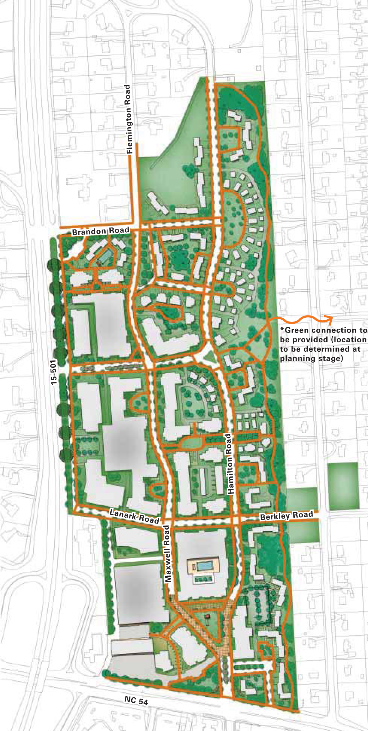
MASTER PLAN
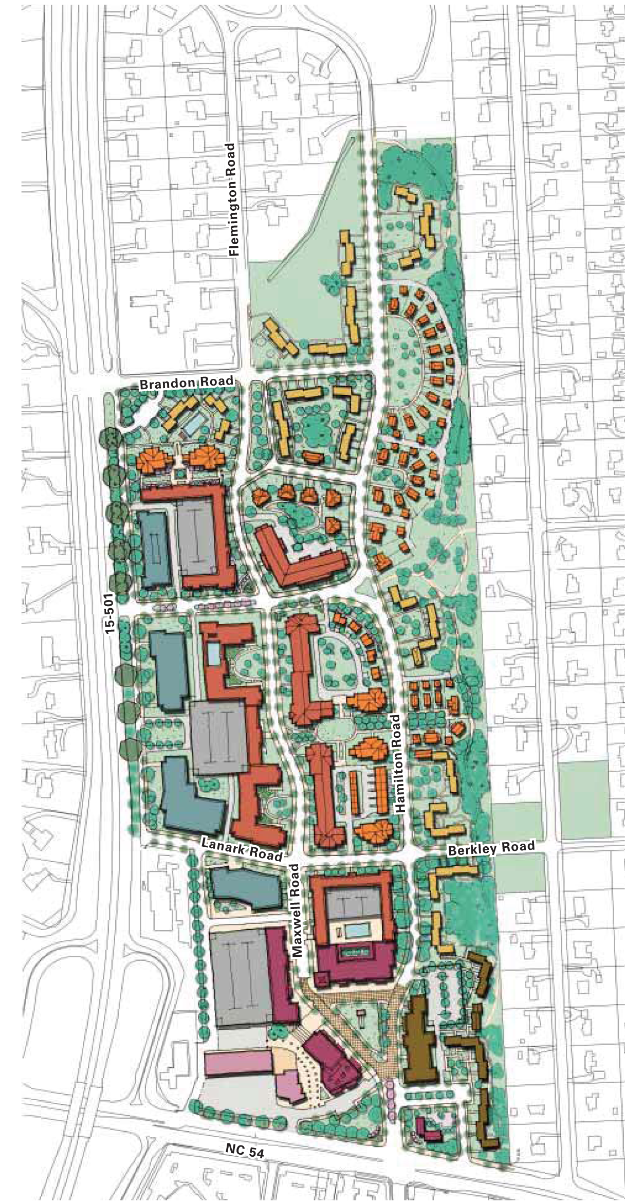
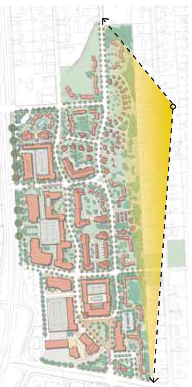
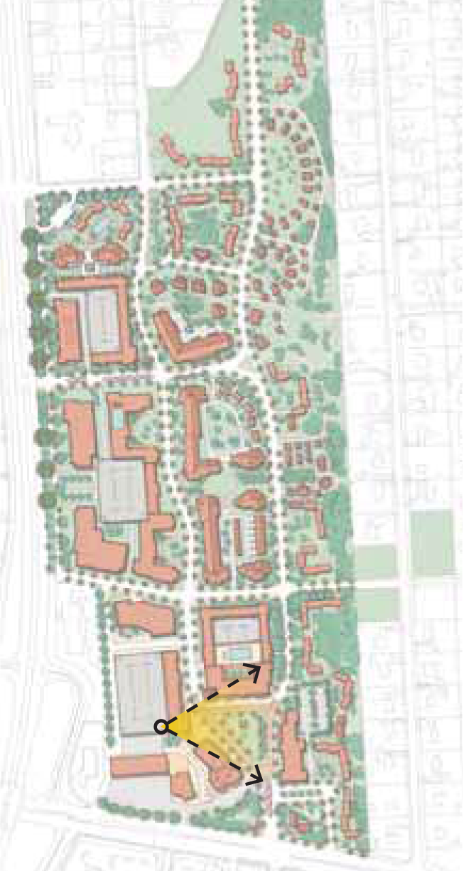
The plan for Glen Lennox creates a village center near Raleigh Road and a new entrance off of 15/501. These two (2) features are connected by a network of preserved and new streets that create winding, tree-lined addresses for new development.
The scale of the proposed development transitions from the single-family densities of the neighborhoods to the north and east, to a village-supporting scale at the south and west of the site, nearest the intended and existing commercial uses.
This layout has sought to preserve existing trees along existing streets in order to preserve the best characteristics of the existing community.
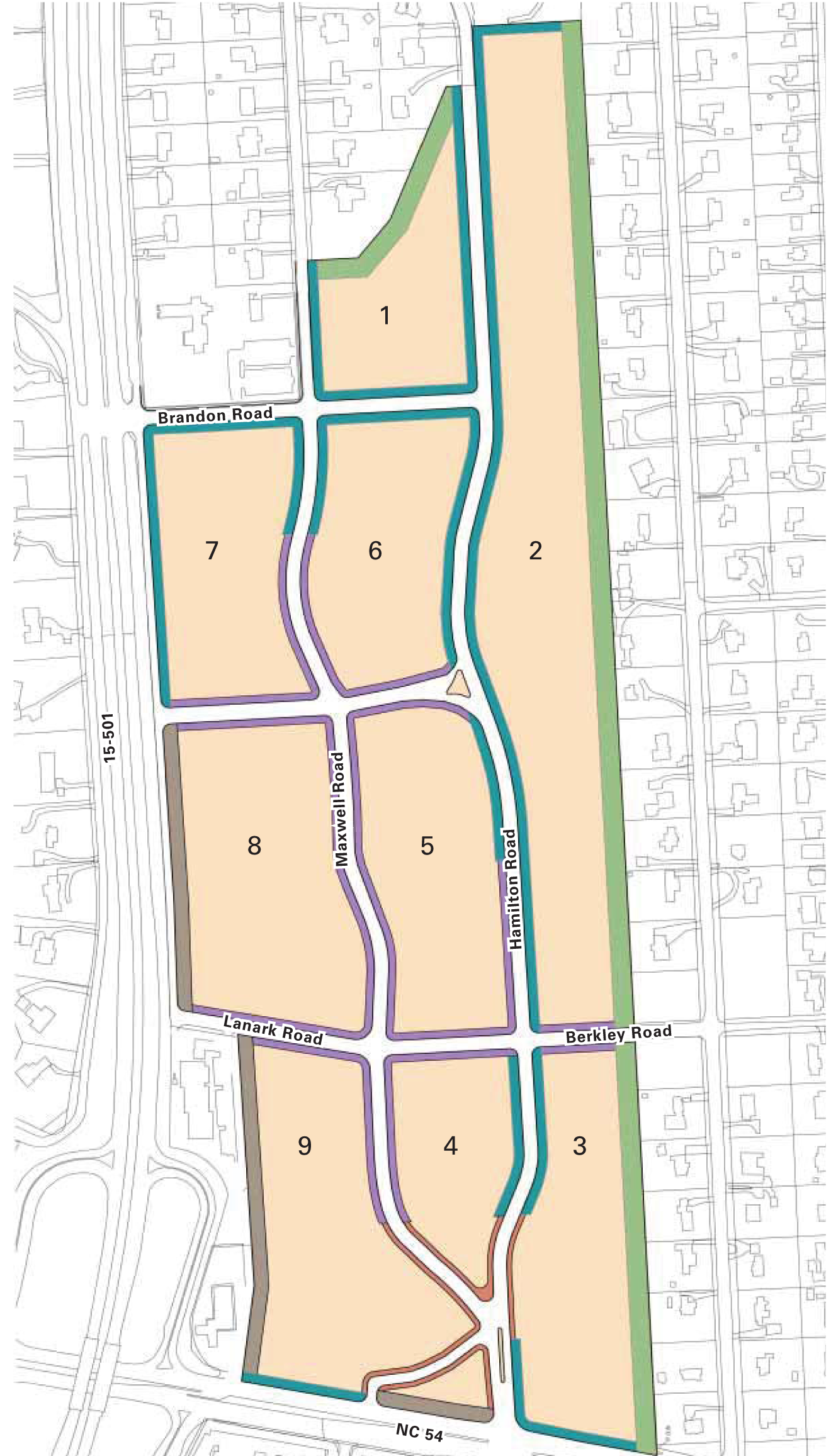
STREET NETWORK
Existing Streets
The existing layout at Glen Lennox has the following characteristics:
» Effective internal street network
» Picturesque curvilinear streets, adding to the character of the neighborhood
» A lack of east-west connections
» One (1) main entrance at Raleigh Road and a secondary entrance at Brandon Road (adjacent to the Church of the Holy Family)

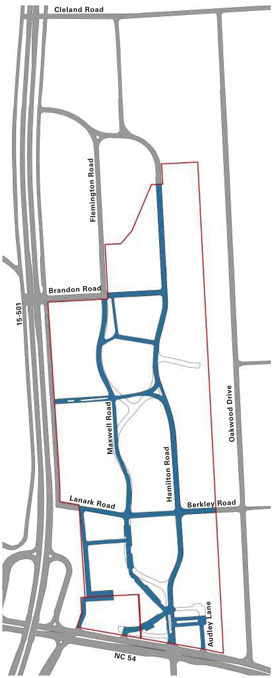
Proposed Streets
The proposed street network at Glen Lennox builds on the assets of the existing network while overcoming some of its shortcomings for redevelopment. Some key changes are these:
» Realign a portion of Maxwell Street to create effective block structure and a more efficient traffic flow
» Increase pedestrian and vehicular connectivity within the site
〉 New streets parallel to Brandon and Lanark Road
〉 Expansion of Lanark Road to connect to Berkley Road
» Create a new and improved entrance from 15-501 to minimize the traffic burden adjacent to the Church.

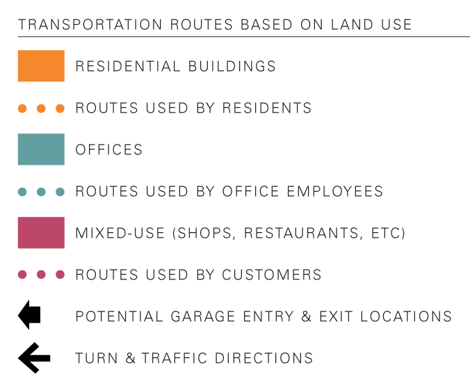
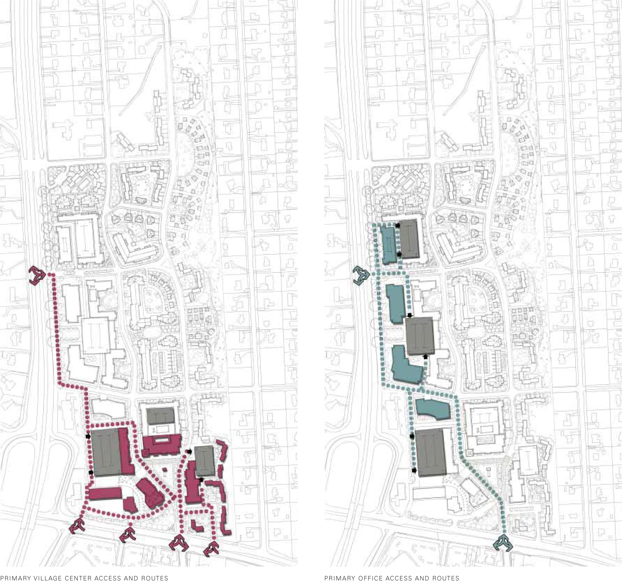
Transportation Routes Based On Proposed Land Use
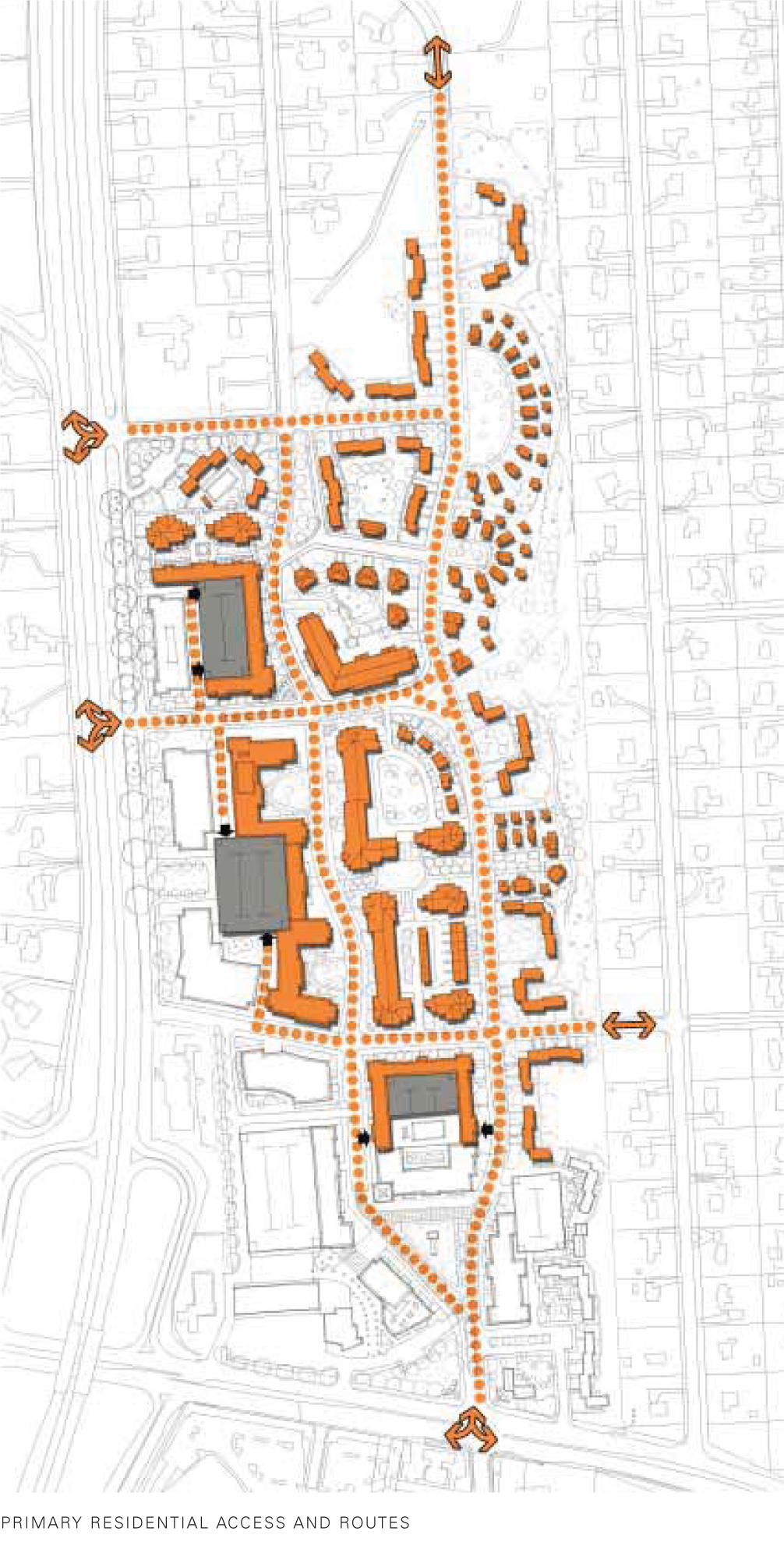
One (1) of the typical concerns about bringing new land uses into an existing neighborhood is the traffic congestion. These diagrams illustrate the different routes anticipated for each type of user. Because of the positioning of commercial uses closest to arterial roads and entrances, the traffic generated by these uses will have less of an impact on the neighborhoods than if the plan were configured differently. As a result, congestion is limited and the mix of uses may also result in fewer trips outside of the neighborhood.
OPEN SPACE
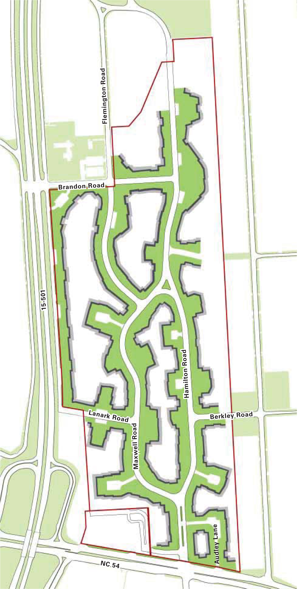
Existing Frontage
This diagram highlights the connected system of undulating open spaces created by the existing buildings. The existing open space is a valued asset to the community.

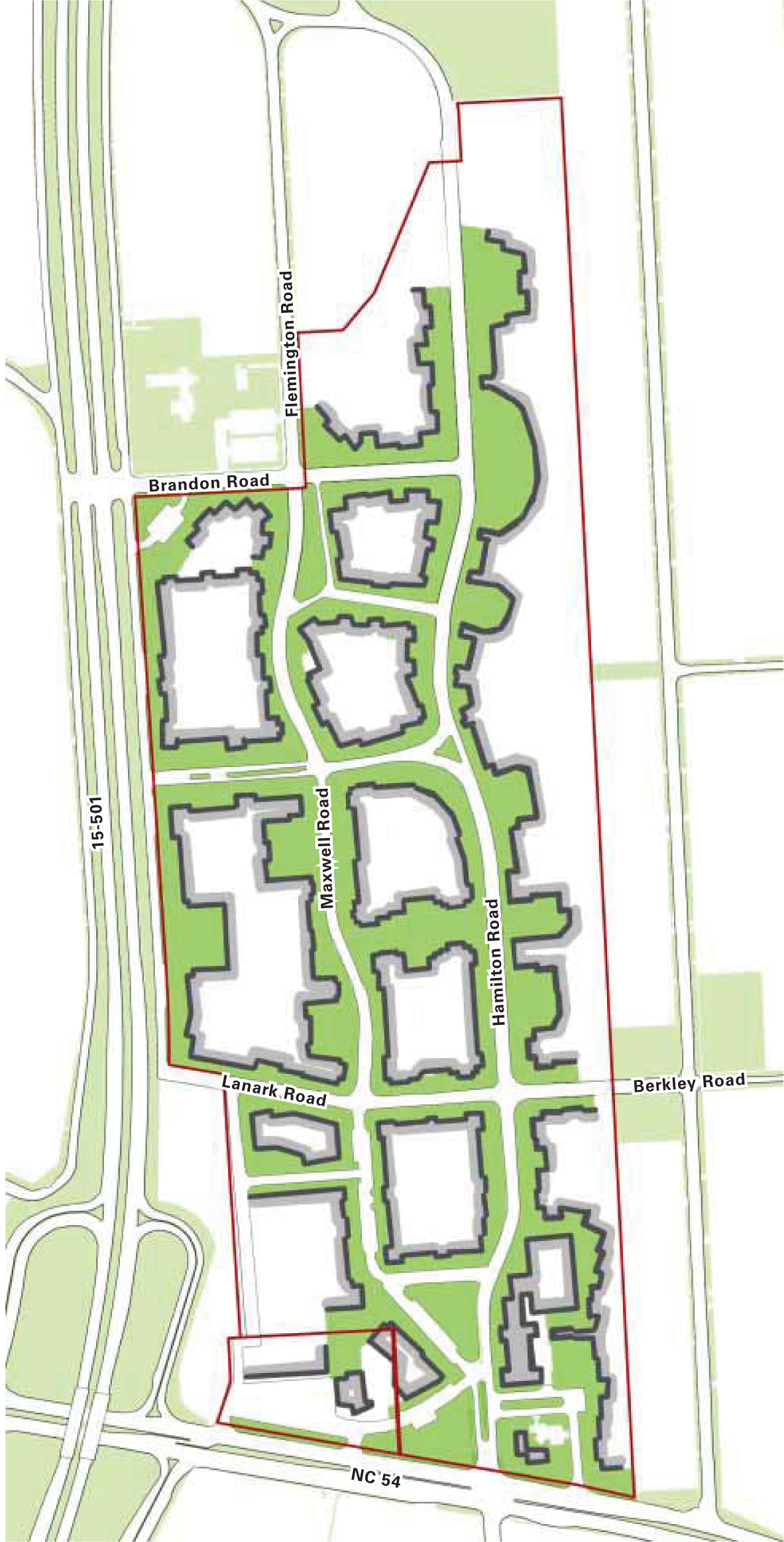
Proposed Frontage
The proposed frontage preserves the character and feel of the connected, undulating spaces while also creating new public spaces.

Proposed Open Space Network
» Various new open spaces that vary in size and character and promote a distinctive sense of placemaking
» Buffer areas adjacent to single-family residences
» Sidewalk and trails that create a complete pedestrian network throughout the site
» Paths and trails to be designed to be bicycle-friendly wherever possible

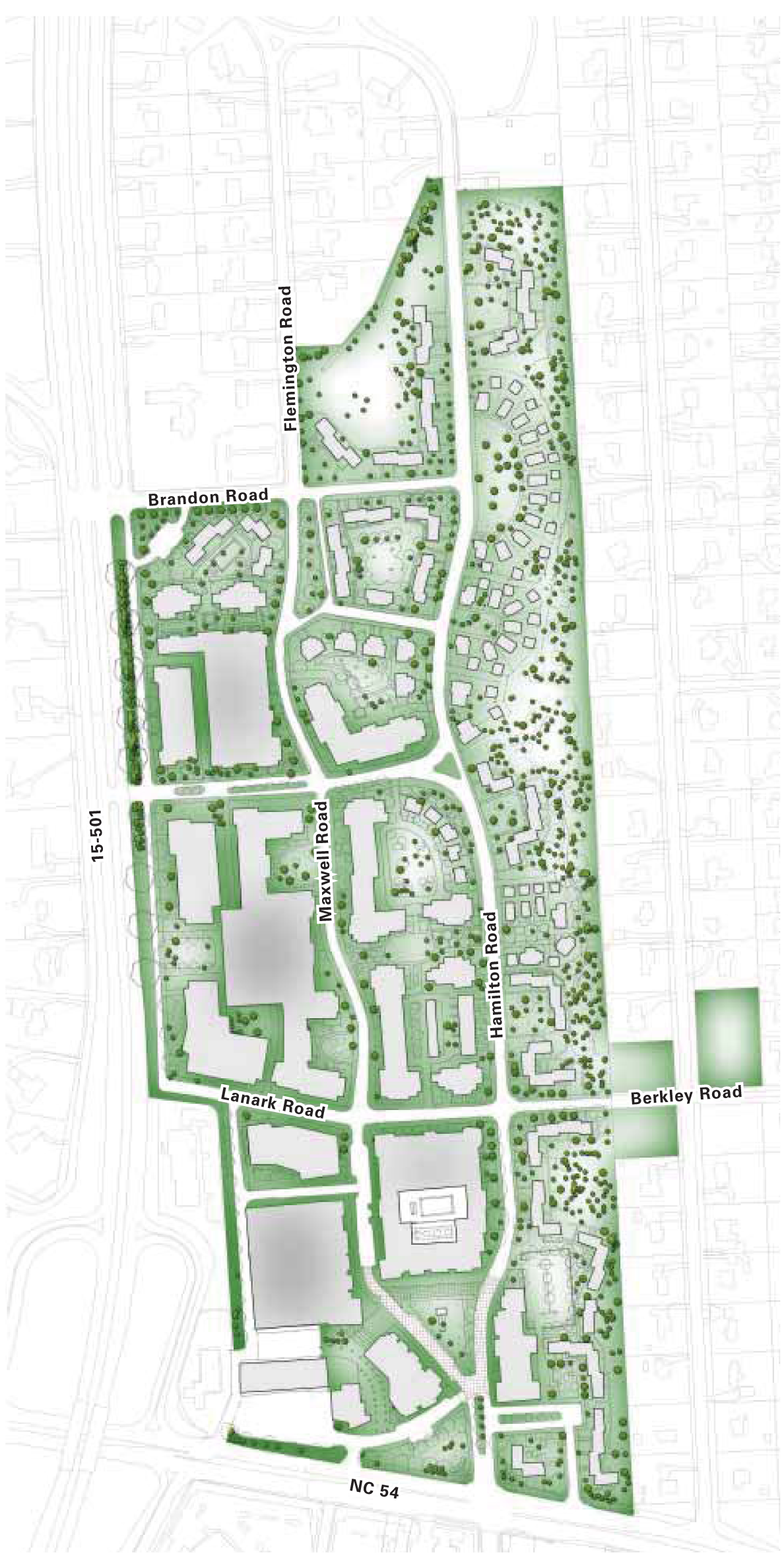
Tree Preservation
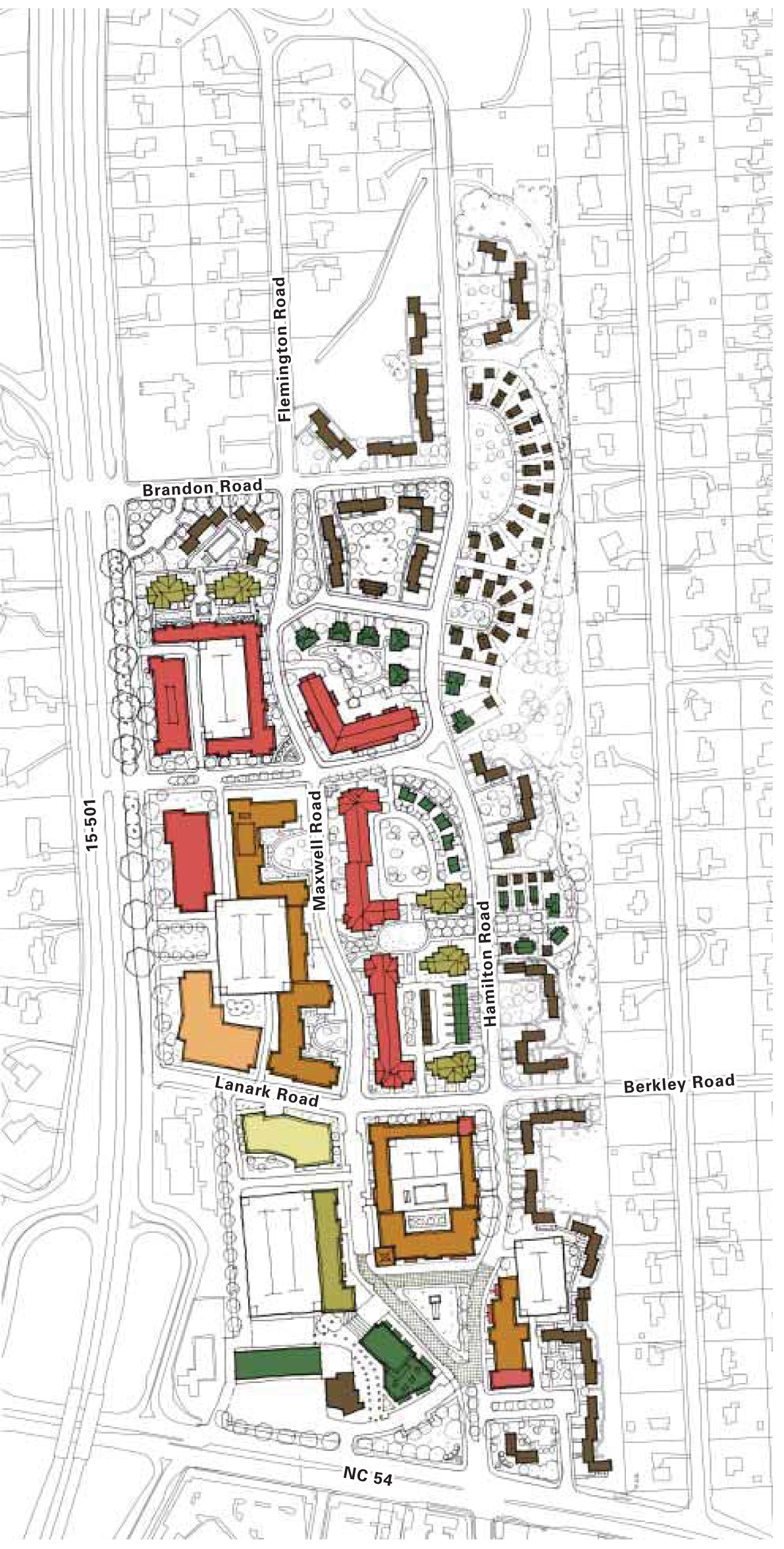
This diagram depicts potential locations where existing trees that are in good health are preserved, especially along the north and east boundary of the property.
Parks
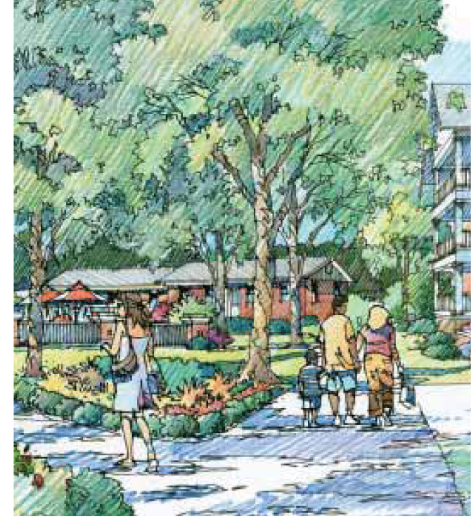
» A variety of parks are provided, including public gathering areas, paved plazas, formalized gardens, community gardens, courtyards, neighborhood parks, passive recreation areas of lawn and tot lots.
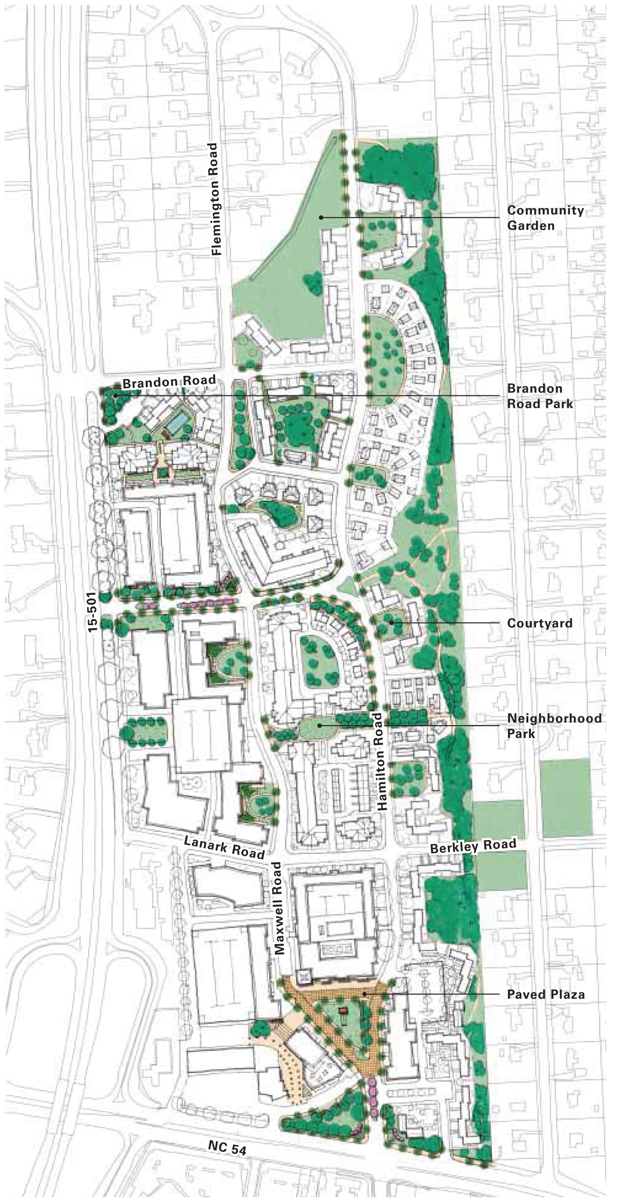
» Similar scale parks in the region have been studied as precedents. The diagrams on the following page are shown at the same scale for open space comparison.
» An open space plan would be crucial for programming an appropriate diversity of uses in each of the parks.
LAND USE, HEIGHT, AND DENSITY
Proposed Land Use
» Mix of uses across the site including:
〉 Residential: a variety of residential buildings, including for-rent and for-sale units
〉 Hospitality: a boutique style inn with preserved cottages
〉 Office: a mix of small tenants and corporate users
〉 Retail: boutique shops and restaurants, and limited anchor tenants
〉 Civic space
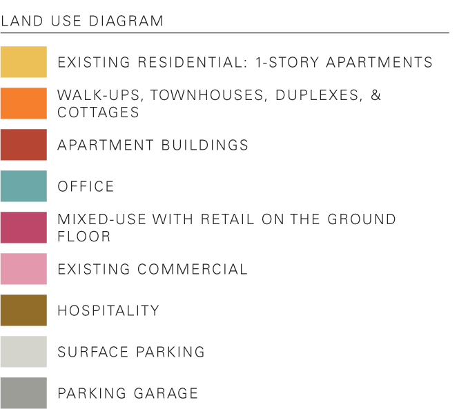
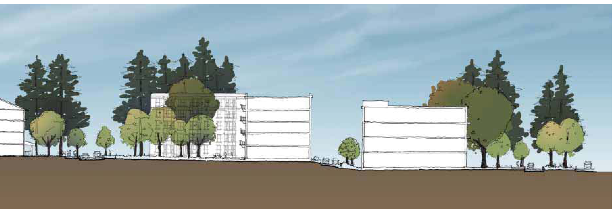
Proposed Height
» A variety of building heights to preserve the desired character and charm without discouraging growth and development
» Highest intensity is focused on southwest corner of property, along 15-501.
» Lower heights near single-family residences
» Heights transition from tallest to lowest going west to east and south to north

Proposed Density
» Highest intensity focused on the southwest corner of property, along 15-501
» Lower density near single-family residences

PRESERVATION
Preservation of Existing Buildings
» These buildings are intended to be retained through the development period (of at least 25 years). They will require further in-depth study of structural and material viability as development plans continue to evolve.
» Lower-scale residences along the eastern edge of the site help transition to the adjacent residential neighborhoods.
» Existing commercial center should be integrated into the new development plan.
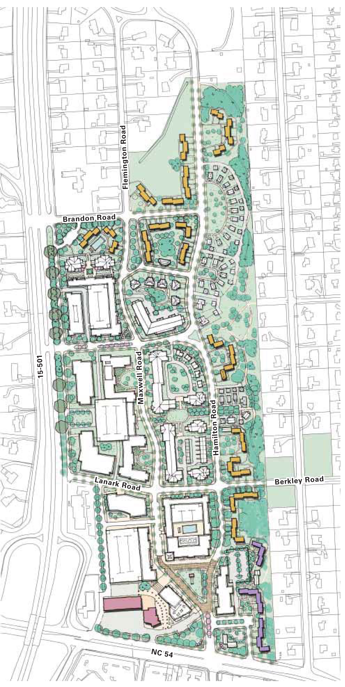
Proposed Use of Preserved Buildings
» Existing buildings will either retain their original use, or they will be re-purposed to better integrate with the plan vision. An example of this are the units adjacent to the proposed Inn, which could be used as hotel units or converted to office or restaurant uses.
CHARACTER
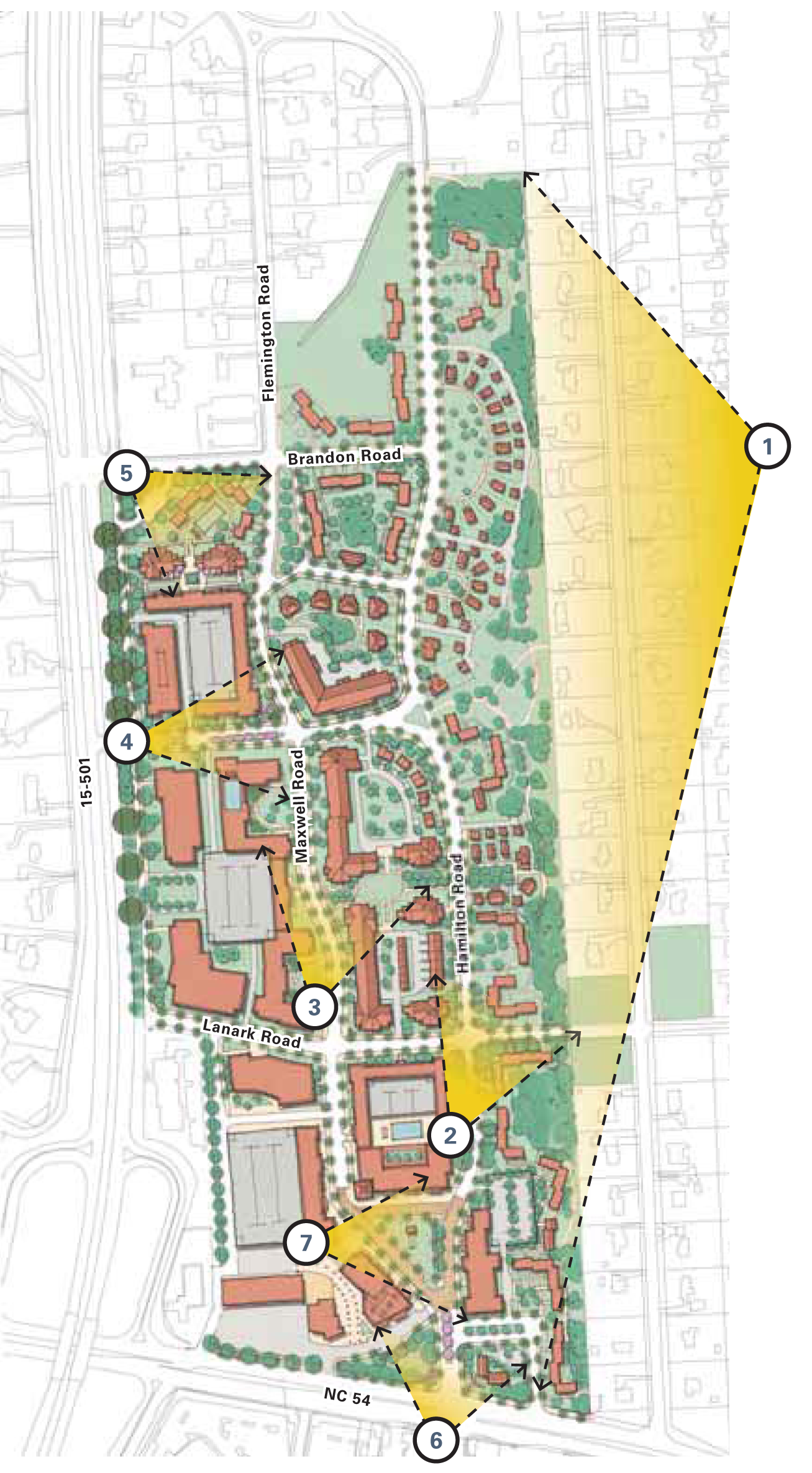
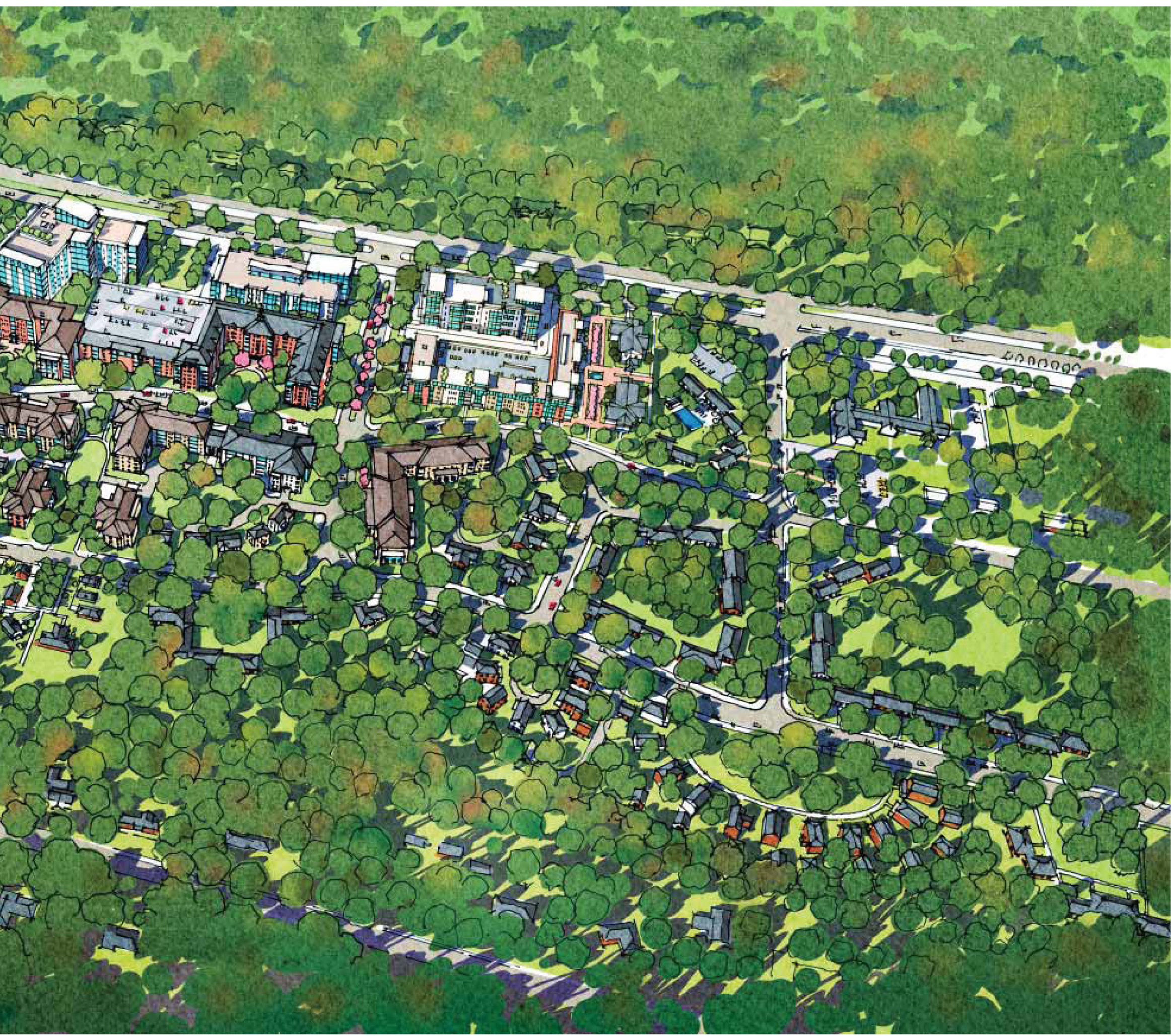
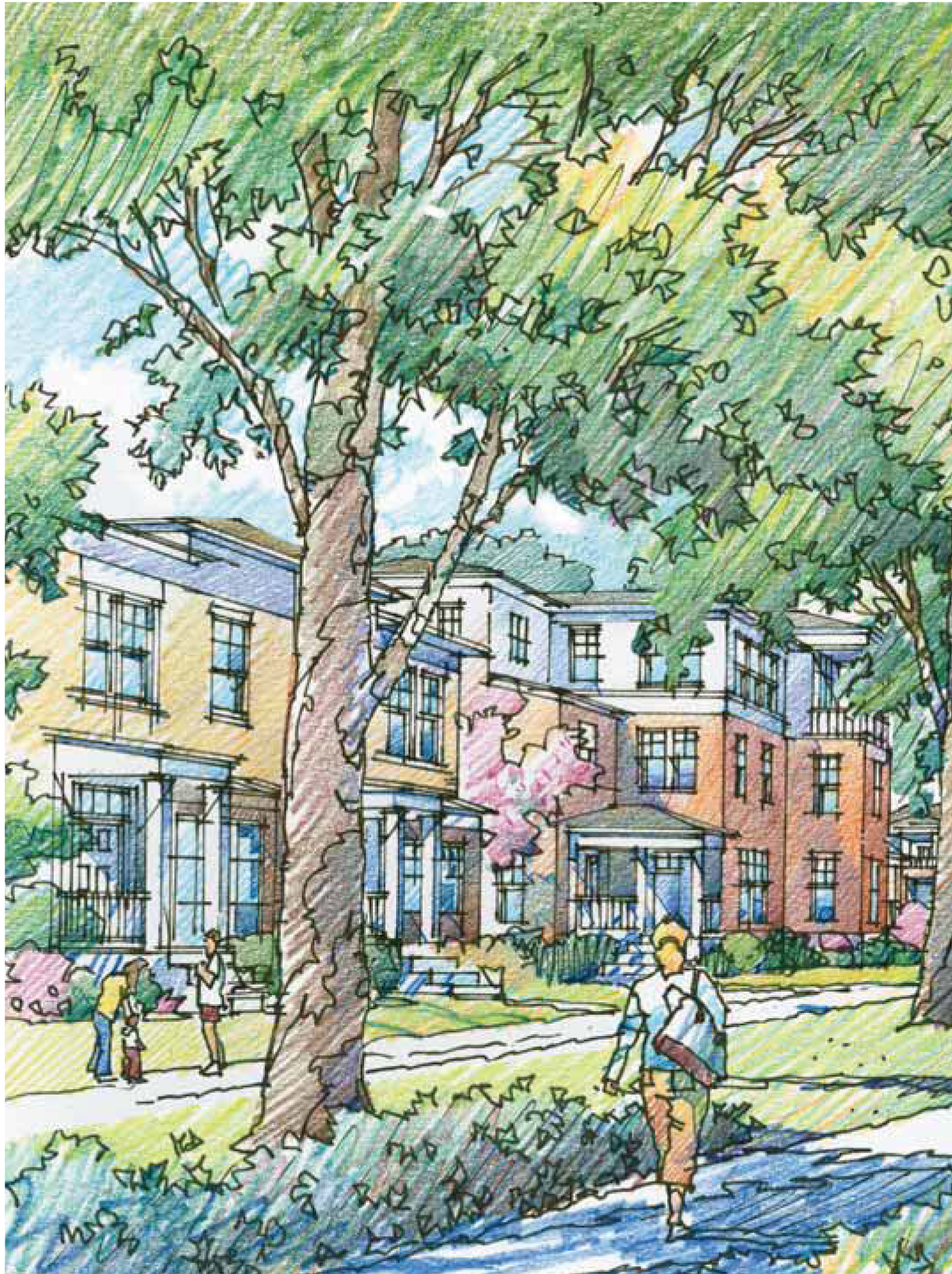
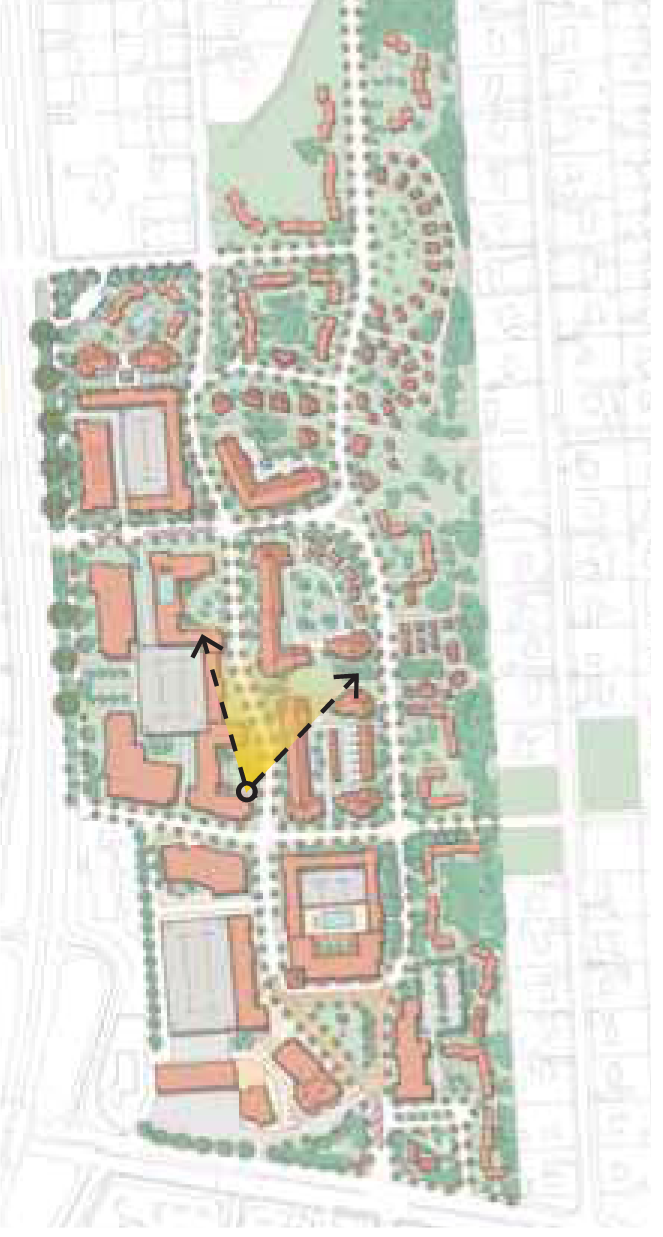
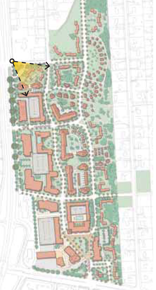
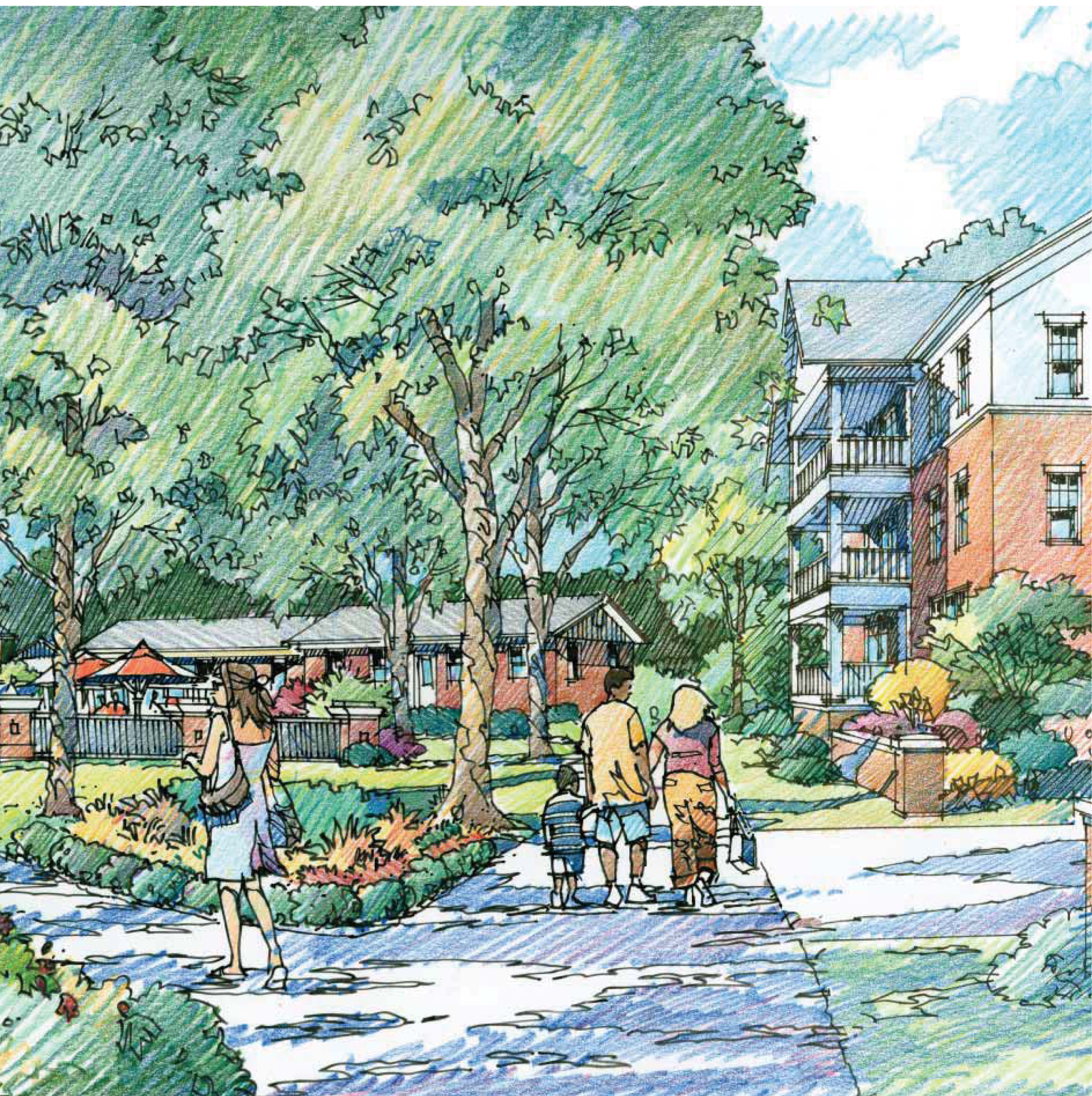
Glen Lennox is designed as a walkable neighborhood with a series of open spaces and mix of uses. Each address in the plan has a distinct character and feel. The following pages contain the artist's impressions of a possible image for the new neighborhood that will continue to evolve as the actual buildings are planned and developed.
1.
Aerial view
2.
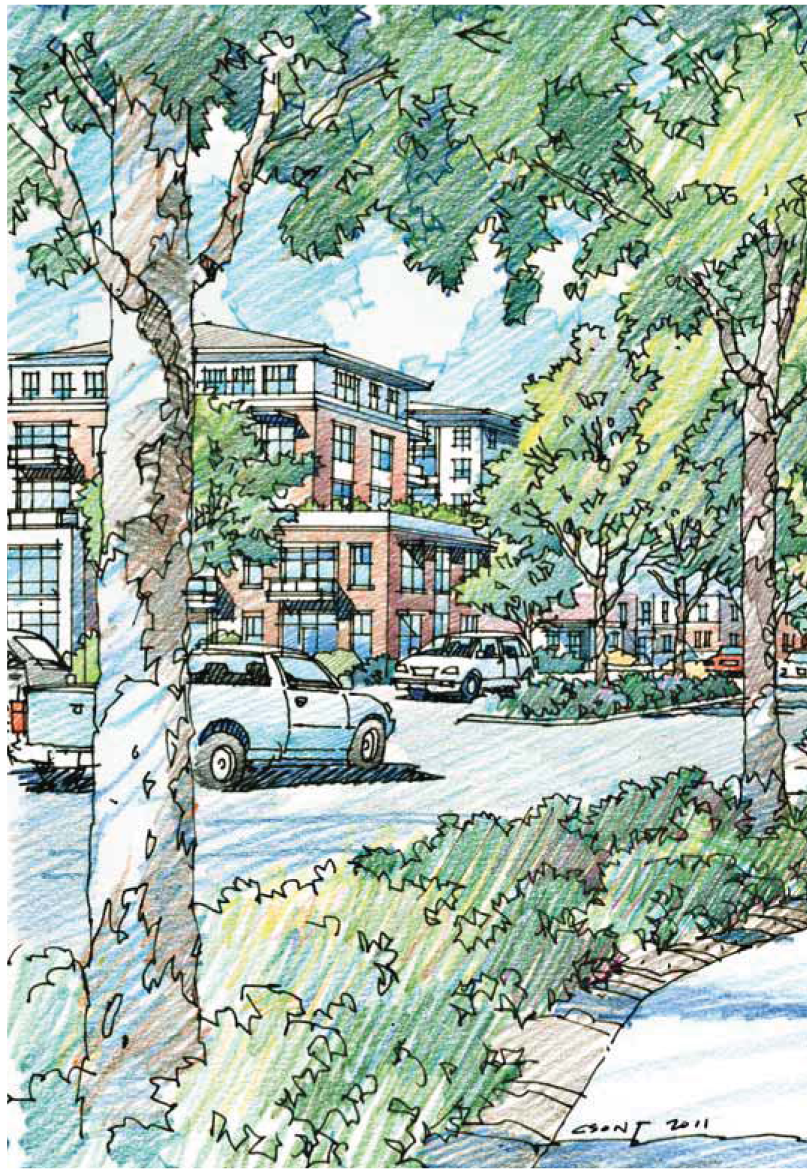
View along Hamilton Road
3.
View along Maxwell Road
4.
New entry to 15-501
5.
Proposed courtyard adjacent to existing units on Brandon Road
6.
Entry view off Raleigh Road
7.
New village green
Aerial View
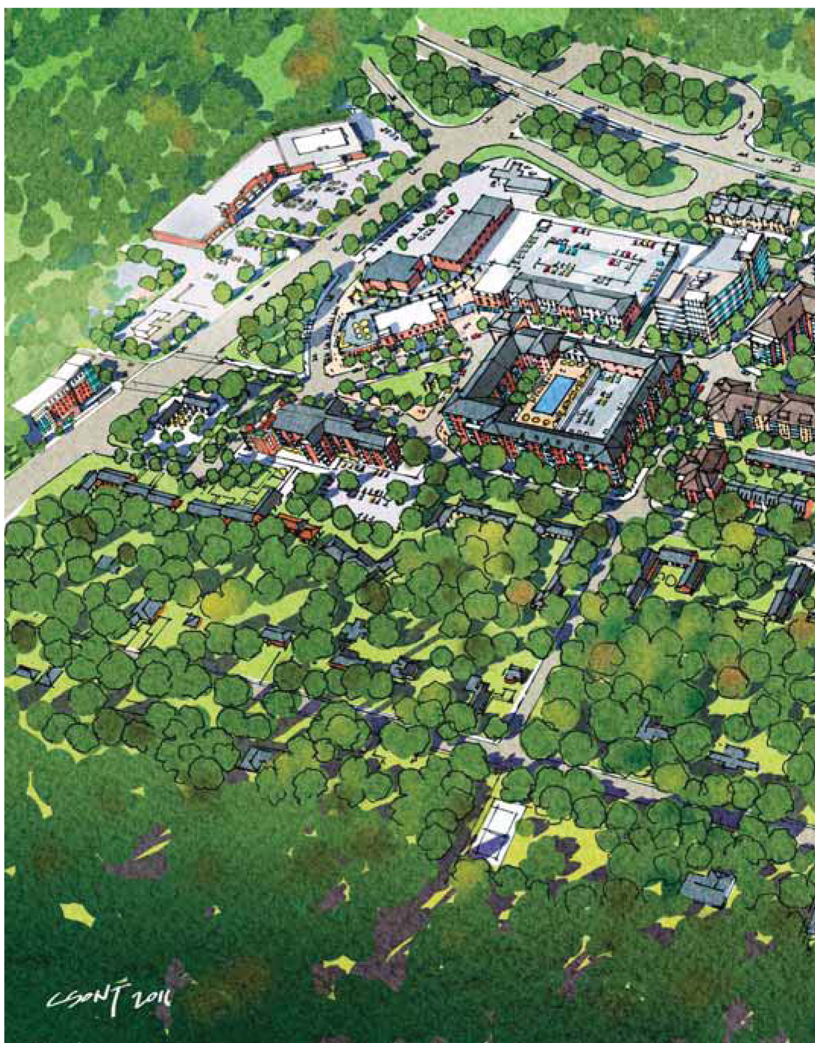
» A variety of building heights and density to preserve the desired character and charm without discouraging growth and development.
» Highest intensity focused on southwest corner of property, along 15-501
» Lower heights and density near single-family residences
» Preservation of tree canopy
View Along Hamilton Road
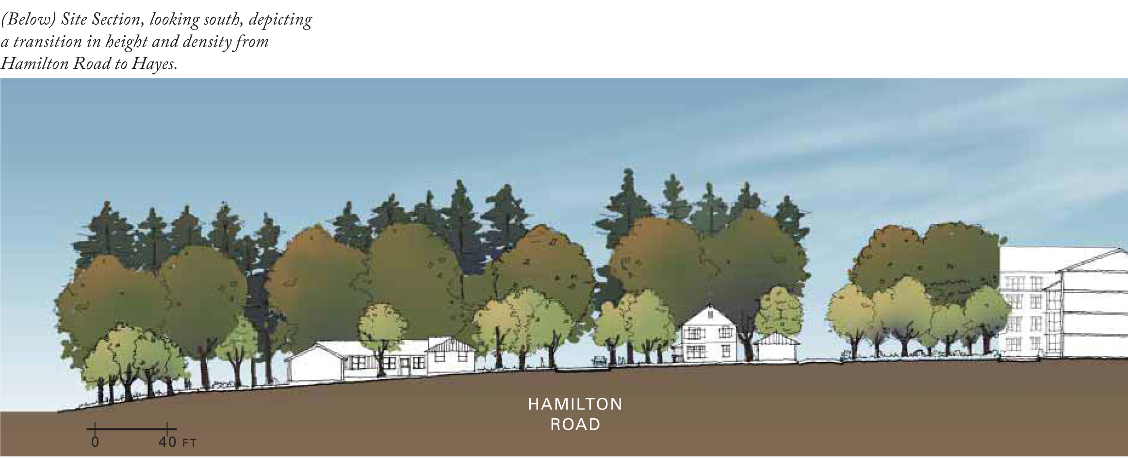
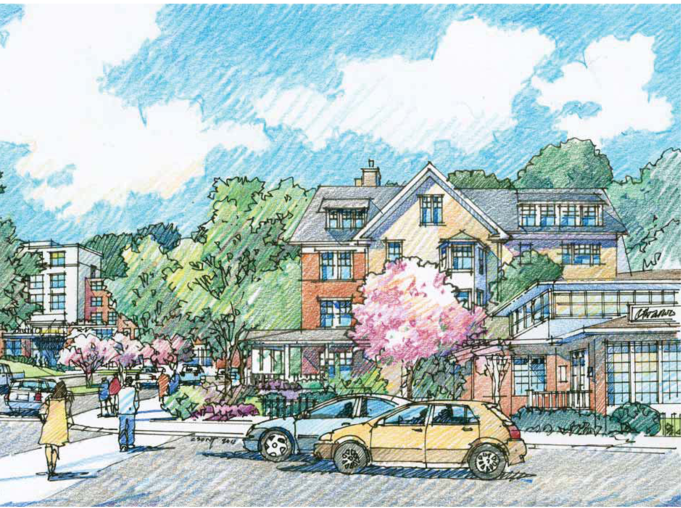
» New development transitioning from mid-rise apartments to existing one-story residential neighborhood on Hamilton Road
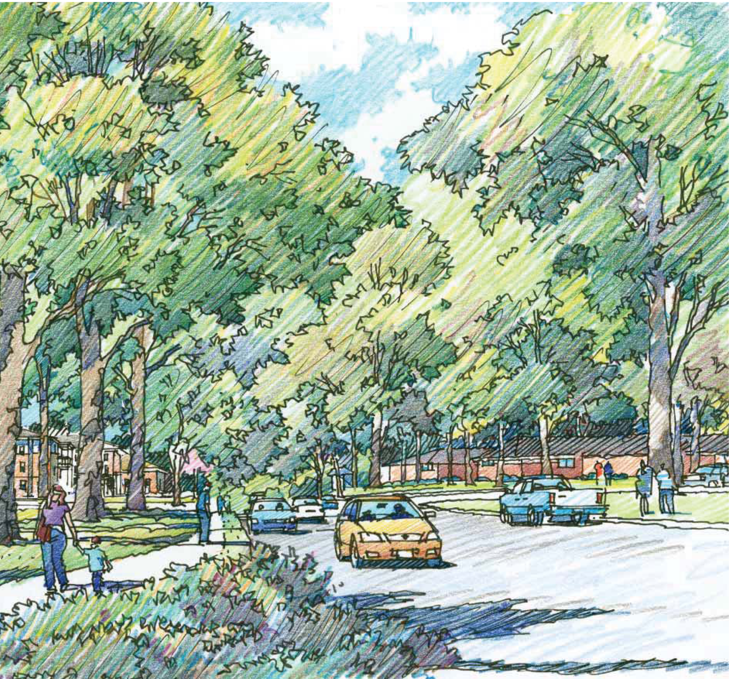
View Along Maxwell Road
» Maxwell Road aligned with apartments and public greens between buildings
» Variety of height and architecture
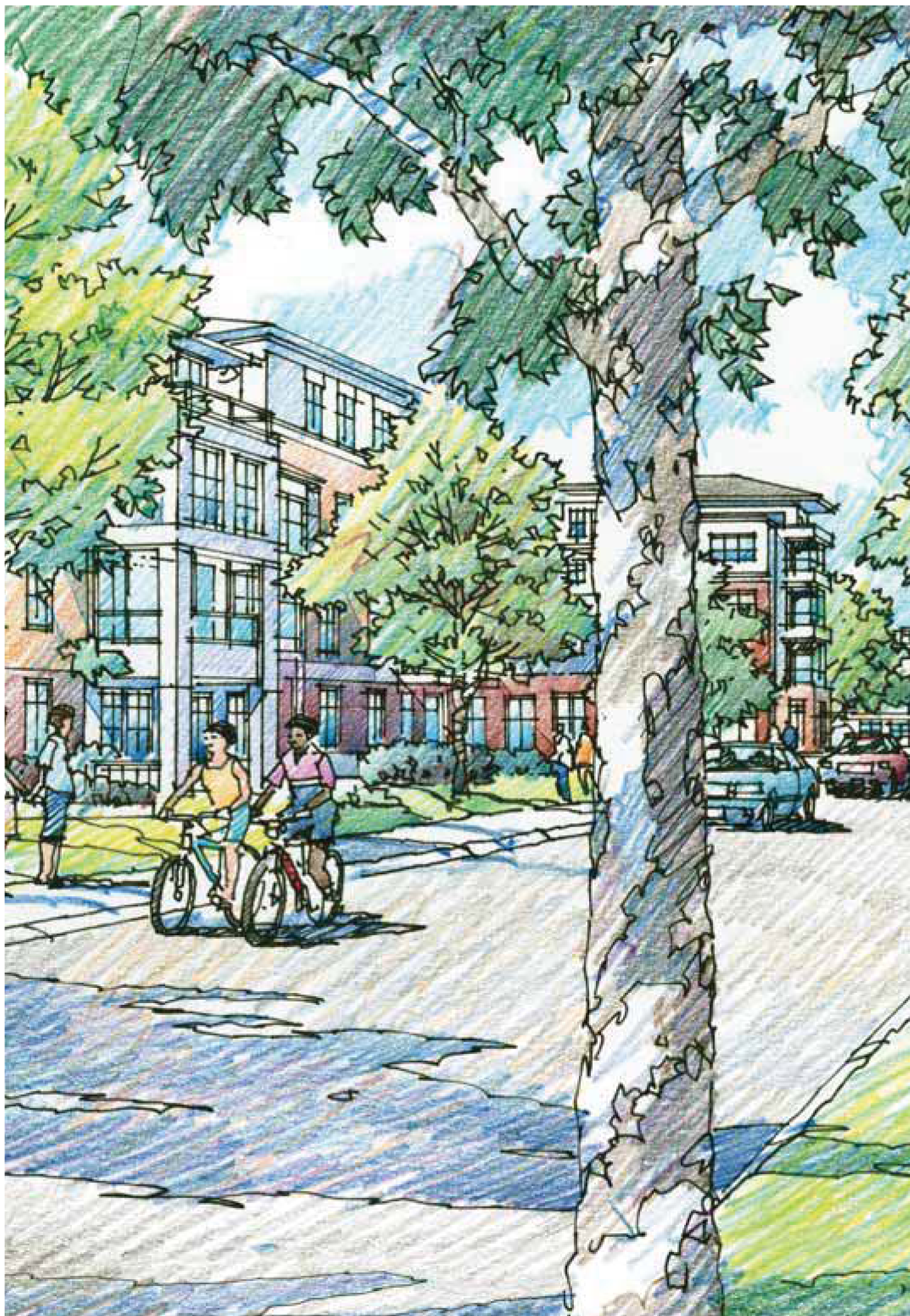
The West Gateway into the Site
» A new tree-lined entrance from 15-501
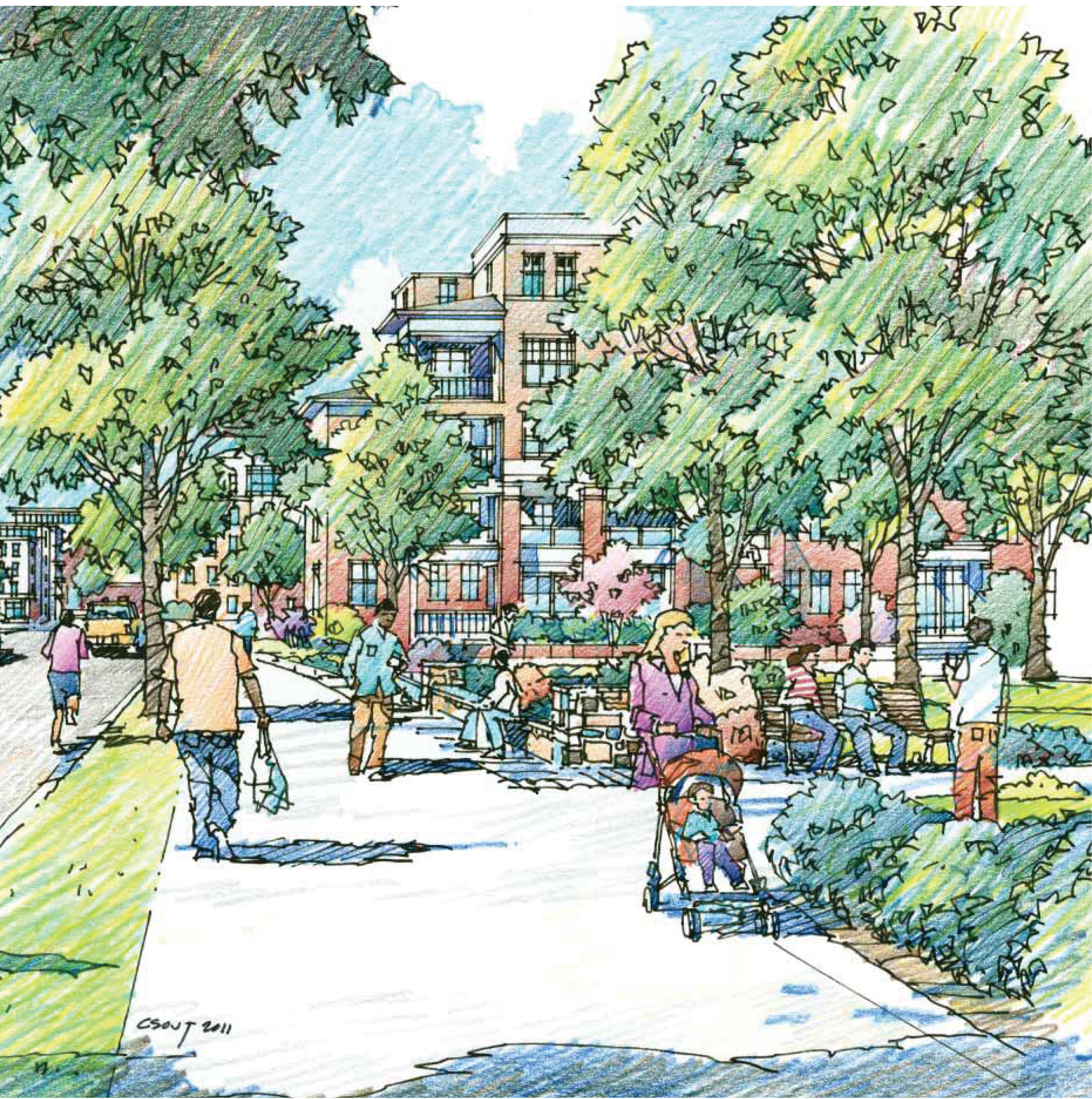
Proposed Courtyard Adjacent to Existing Units on Brandon Road
» Preserve buildings
» Maintain existing buildings on Brandon Road and preserve church's visibility
» Create a courtyard, defined by buildings surrounding it
» Potential location for community pool, tot lots, neighborhood park
Entry View off Raleigh Road
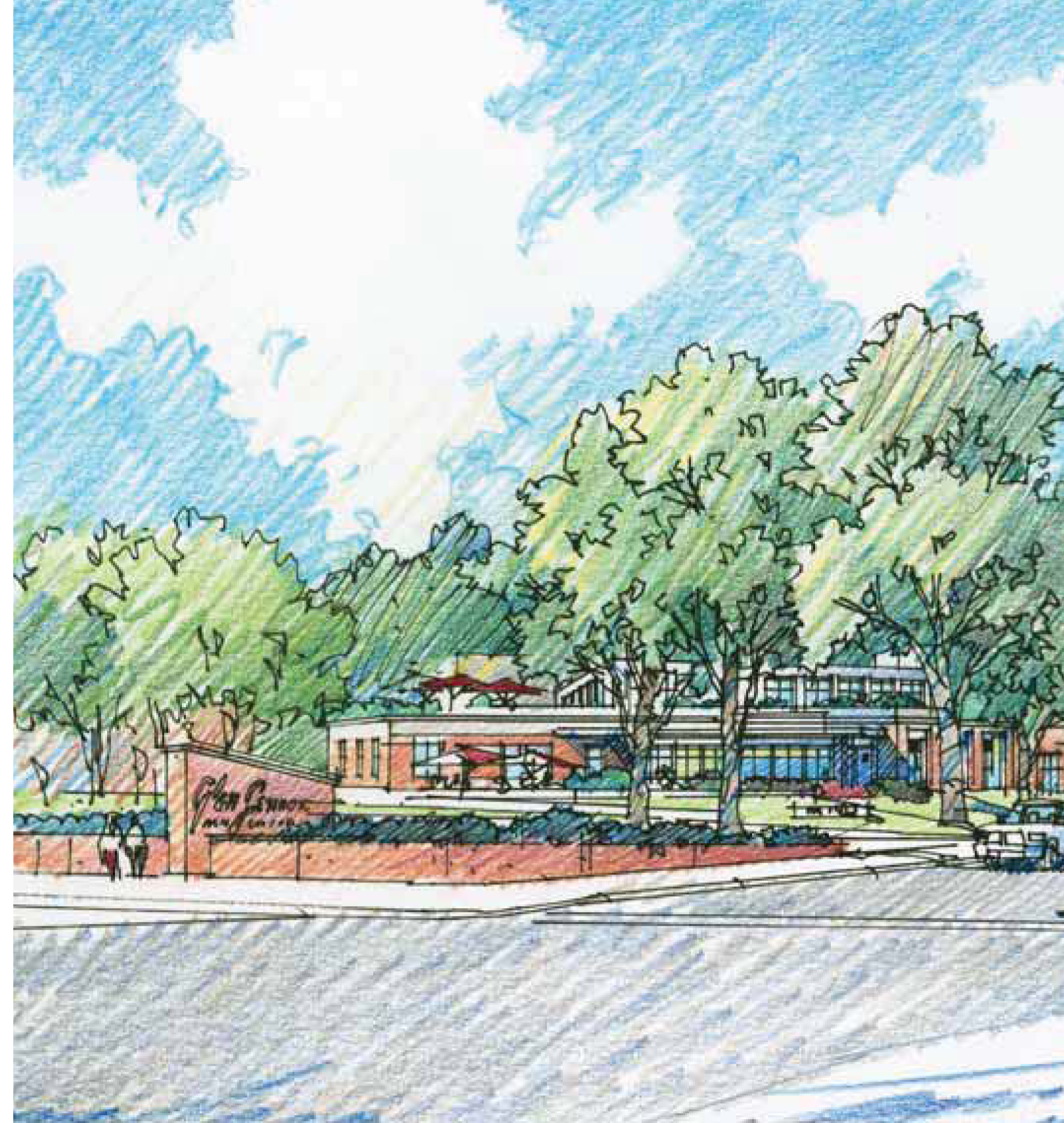
» Improve entrance off Raleigh Road by providing additional landscaping and green space
» Maintain existing units on Raleigh Road to preserve the historic character of Glen Lennox
» Great location for the inn due to visibility
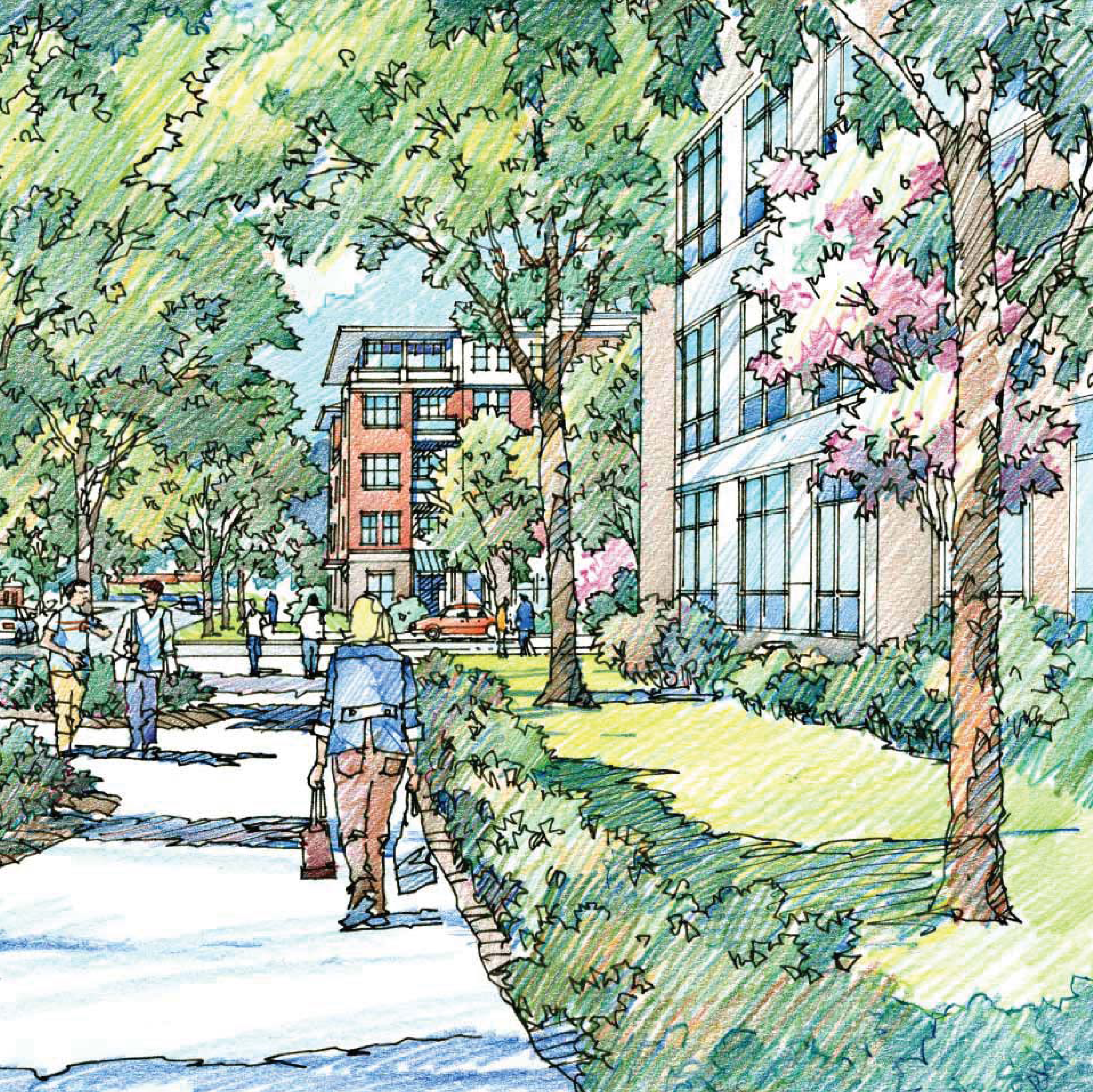
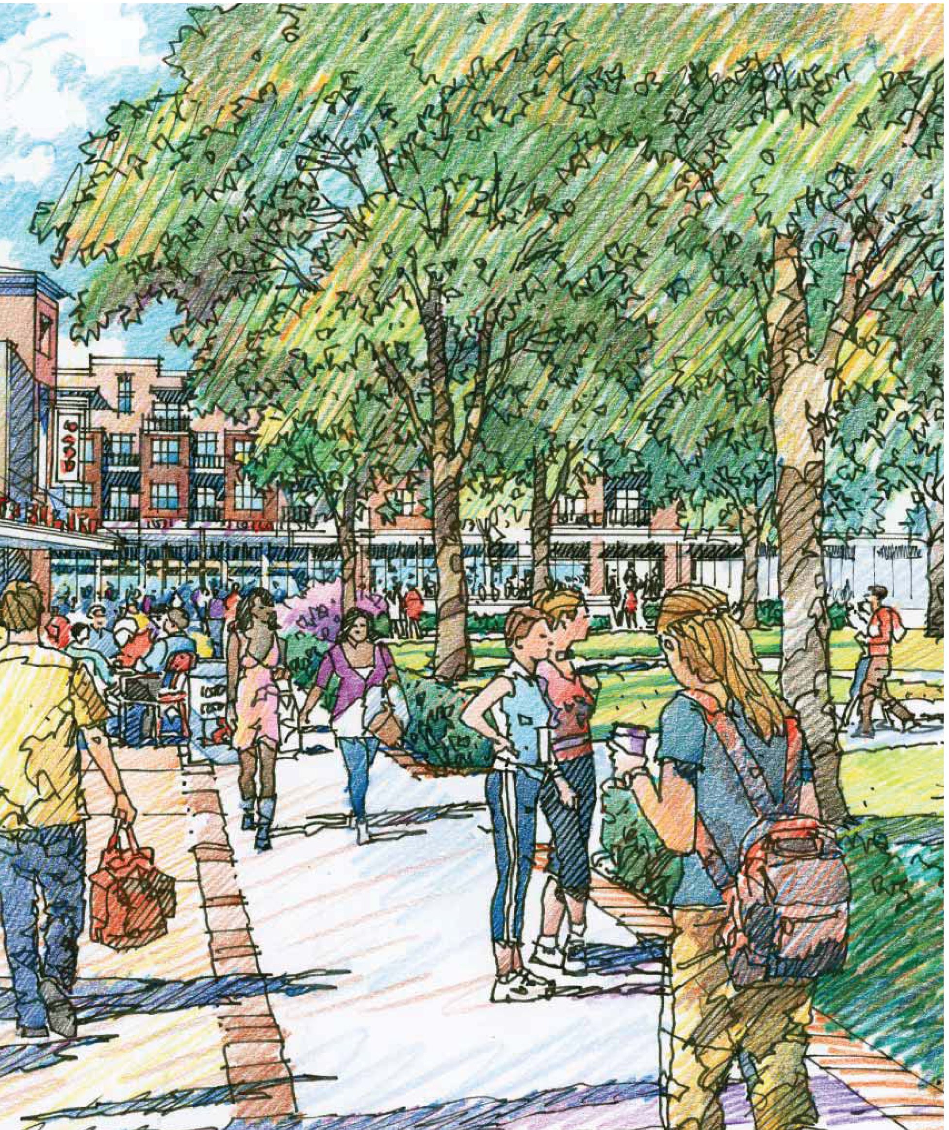
New Village Green
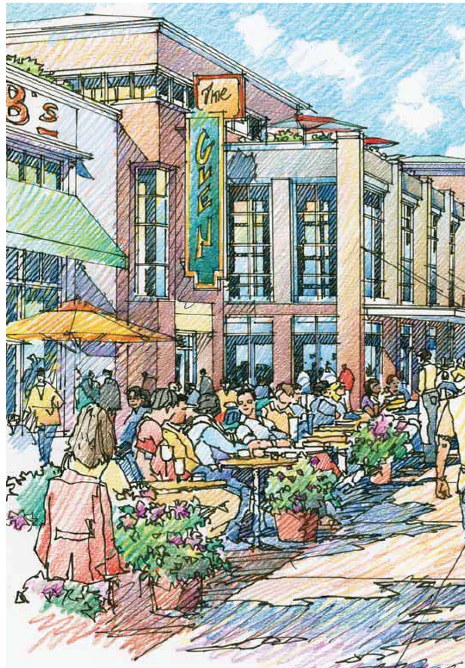
» A vibrant and walkable retail environment with restaurants and small shops
» Outdoor seating and desirable streetscaping enhance the public realm
» Enhance Glen Lennox's intimate character and pedestrian walkability
» Village green acts as a heart for the development, a central, programmable gathering space for the community
» Prime park frontage, perfectly suited for restaurants and recreation-oriented uses
(Ord. No. 2012-05-30/O-4, § I)
Sec. 8C.4. - NCD Zoning Overlay Regulations.
Special Design Standards to apply to development in the Glen Lennox Area Neighborhood Conservation District-8C
The following Design Standards shall apply to all development within the Glen Lennox Area Neighborhood Conservation District-8C, and are incorporated into Chapel Hill's Land Use Management Ordinance by reference. No application for development shall be approved that does not comply with these standards. For the Glen Lennox Area Neighborhood Conservation District-8C, these standards shall replace/supersede general provisions in the Land Use Management Ordinance where such standards differ. For standards that are not specifically identified in this Plan, provisions of the underlying zoning district for a particular parcel shall apply.
The photographs and illustrations used throughout this chapter are examples and are not binding. The language, maps, and Allowable Land Use Chart are binding and can be regulated.
The design standards for the Glen Lennox Area Neighborhood Conservation District-8C are as follows:
INTRODUCTION
The following pages describe the plan framework, the open space and impervious surface requirements, setback regulations, height regulations, allowable land uses, and parking guidelines. Building placement and typologies will be addressed in the subsequent section.
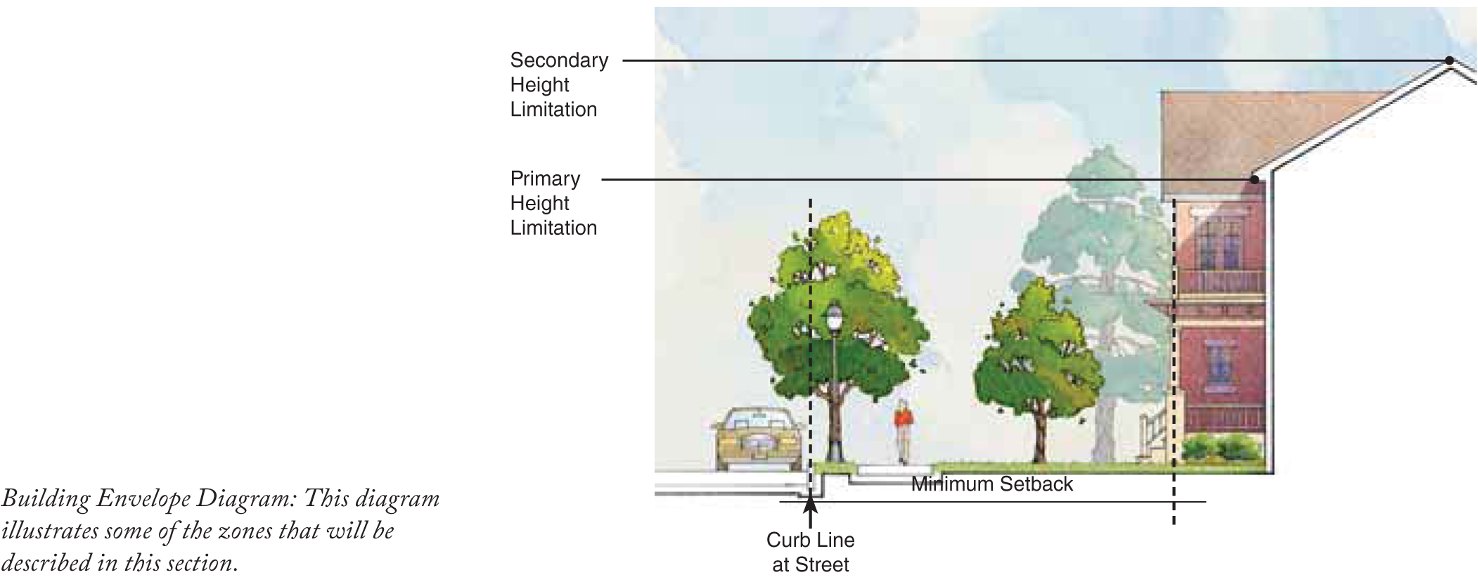
Key Definitions
Building envelope: The three-dimensional space within which a structure is permitted to be built on a zoning lot, and which is defined by setback and height regulations.
Height limitation (primary): The maximum height allowed for any structure located at the minimum setback required for such structure.
Height limitation (secondary): The absolute maximum height allowed for any structure.
Impervious surface: A surface composed of any material that impedes or prevents the natural infiltration of water into the soil.
Open space: Land devoted to uses characterized by vegetative cover or water bodies, that may include agricultural uses, pastures, meadows, parks, recreational areas, lawns, gardens, walks/trails, ponds, and streams.
Setback: The horizontal distance between the curb line (for Street Setback) or interior lot line (for Interior Setback) of a zoning lot and any structure on such zoning lot, measured perpendicularly to the curb or lot line.
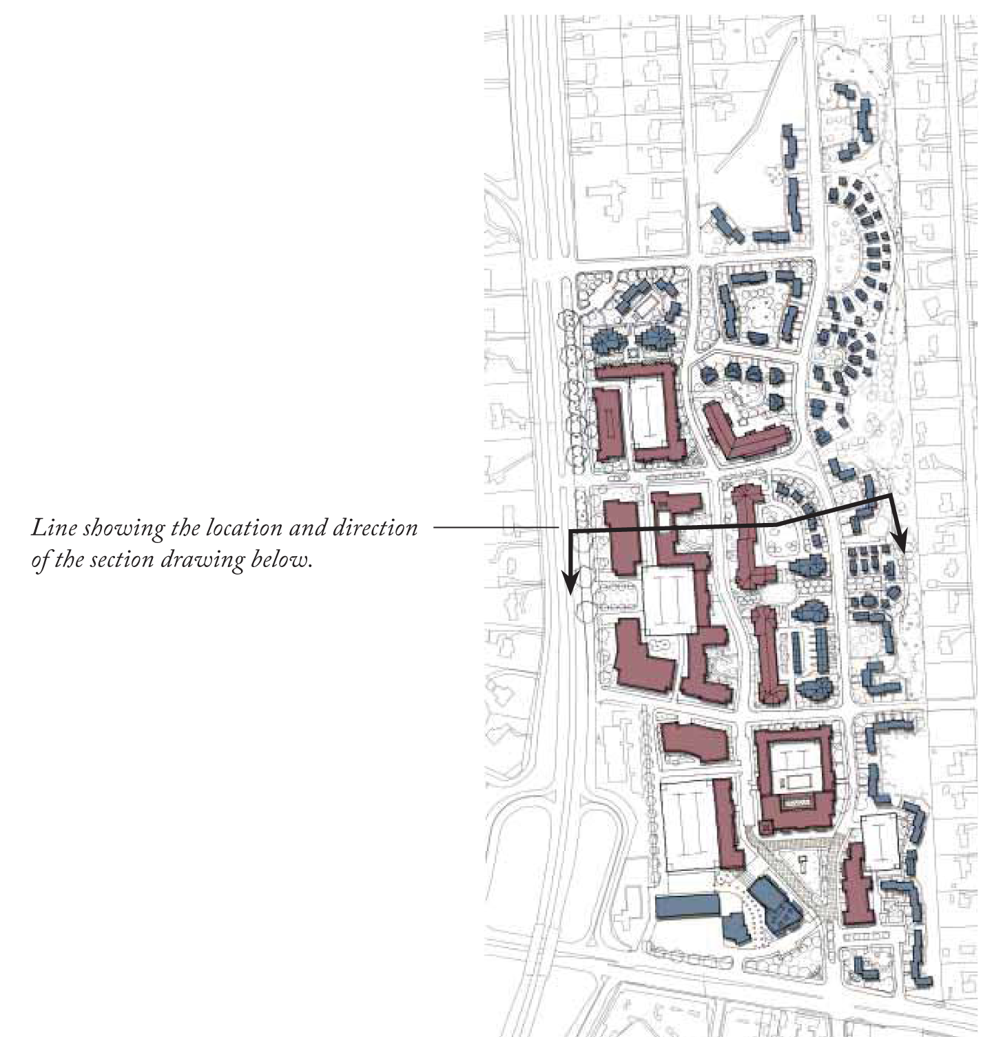
Plan Framework
The diagram to the left illustrates a proposed block structure, and desired street connections. Regulations for developable land are addressed in the subsequent plans.
The implementation of this plan is dependent upon NCDOT approval of new street connections.
SETBACK PLAN
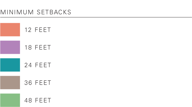
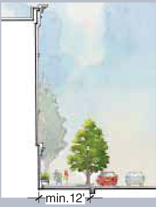
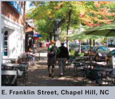
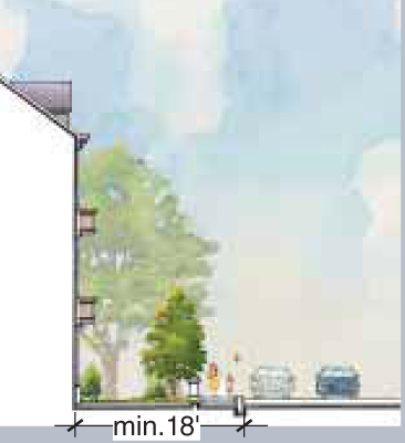
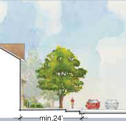
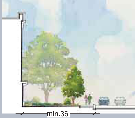
Setbacks illustrated in the adjacent diagram are measured from the curb or from the exterior property lines. Generally, setbacks are shallowest for the mixed-use core (allowing for a vibrant and active street frontage). Deeper setbacks have been prescribed elsewhere to preserve trees and to maintain compatibility with adjacent residential areas.
| Setback | Section
| Photo |
|---|---|---|
Minimum 12 Feet
|  |  |
Minimum 18 Feet
|  | 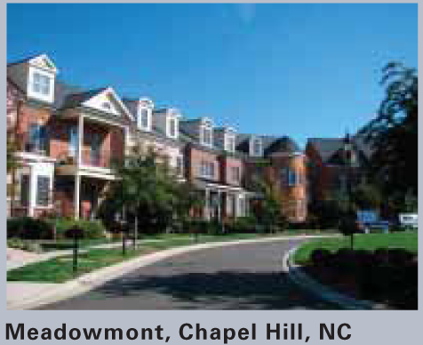 |
Minimum 24 Feet
|  | 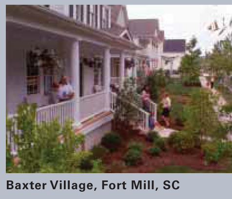 |
Minimum 36 Feet
|  |  |
Minimum 48 Feet
|  |  |
HEIGHT PLAN
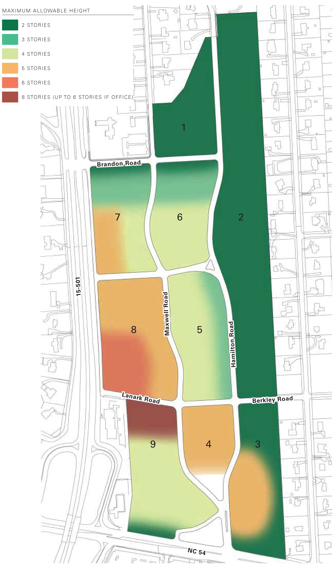
The height regulations control the scale of future development with the vision of preserving the neighborhood's character while accommodating higher density. The allowable heights transition from lower scale adjacent to the NCD-8A and NCD-8B zones to taller development at the southwestern edge of the site.
It is important for there to be flexibility in the delineation of height zones within the identified blocks to accommodate future development. This is illustrated in the diagram to the right. Additionally, while these regulations limit the height of the building as a whole, certain vertical architectural elements are allowed to protrude outside of the prescribed building envelope.
Height is measured from the average ground level along the primary street-facing facade to the bottom of the roof structure. Allowable height per story is measured from floor to floor and indicated by use below:
» Residential Ground Floors: 9'-16'
» Residential Upper Floors: 9'-12', up to 22' for penthouse units
» Non-Residential Ground Floors: 12'-18'
» Non-Residential Upper Floors: 12'-16'
ALLOWABLE LAND USE CHART

IMPERVIOUS SURFACE PLAN
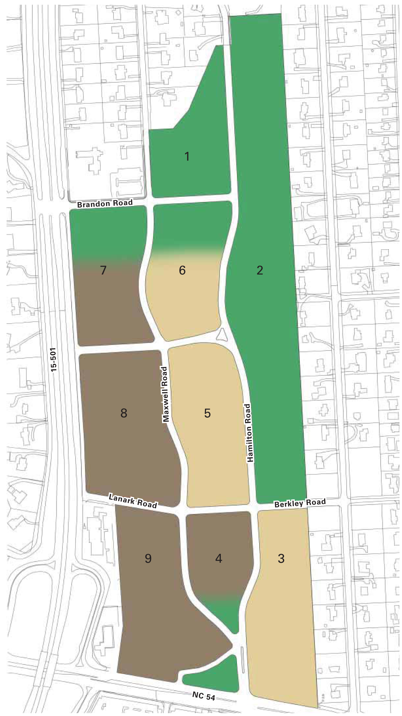
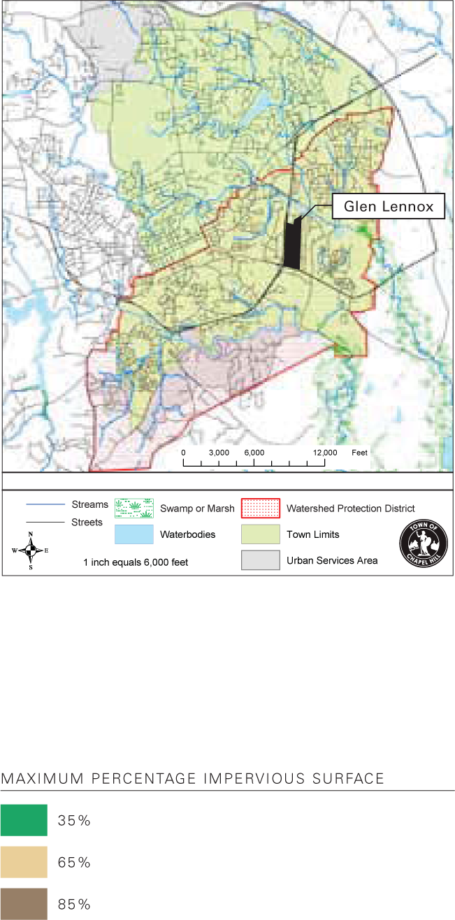
Within Chapel Hill's Watershed Protection District, impervious surface percentages are stipulated based on type of development. The Glen Lennox site falls under the category of "high-density development" as it is defined in the Land Use Management Ordinance.
Pervious areas can include pervious paving and porous parking/service areas provided permeability is retained. The diagram to the right illustrates the recommended percentage of impervious surface based on the desired density across the site.
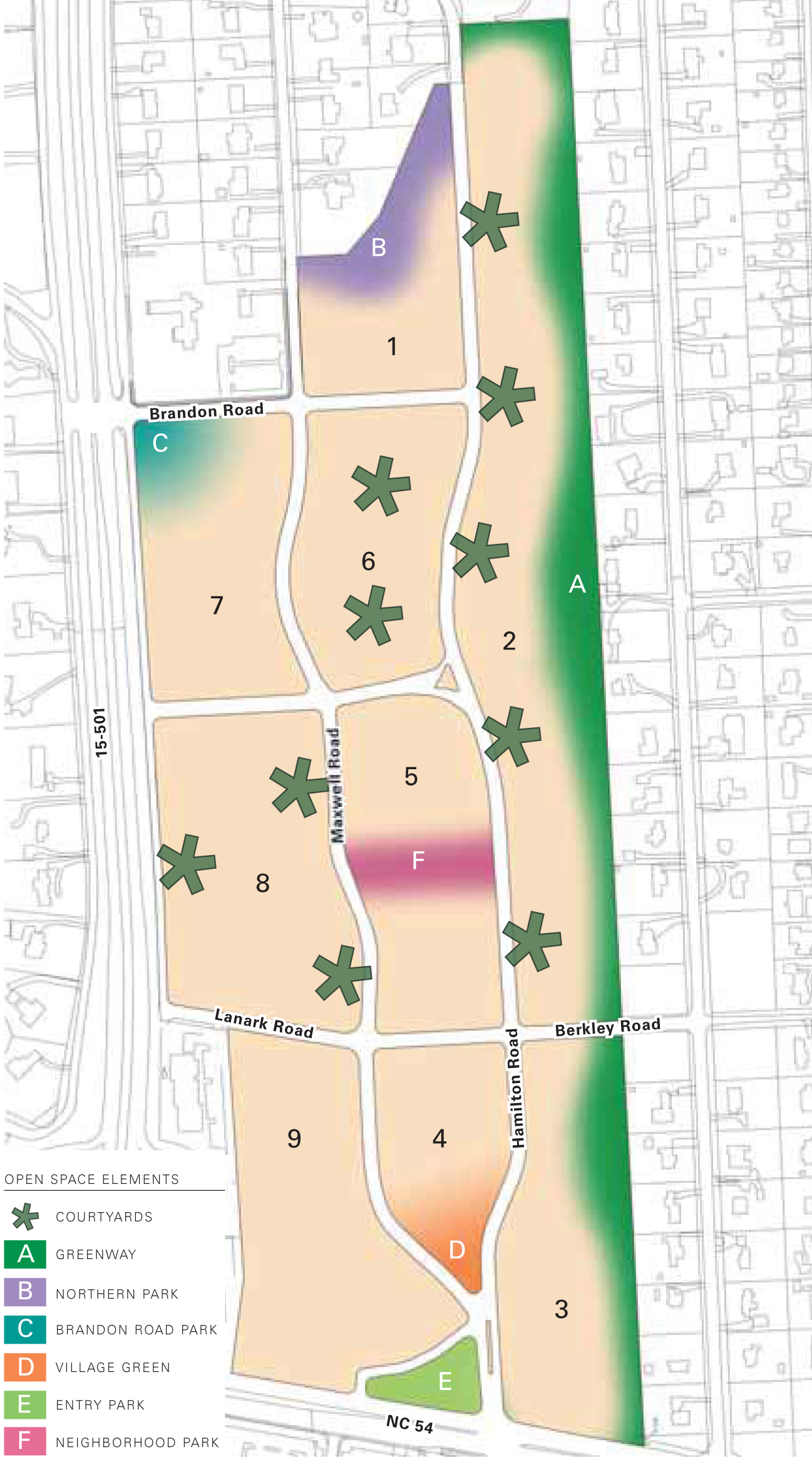
Open Space Recommendations
The percentage of open space will be greater than 33% of the entire site area and will include a majority of usable, functional spaces. The following six (6) open space elements are required as part of any proposed plan:
A Greenway: A greenway at the eastern boundary of the site will serve to buffer new development from existing neighboring properties (see also: Setback Plan).
B Northern Park: An area at the northern boundary of the site will serve as a buffer to the existing stream bed and could contain public uses such as a community garden (see also: Setback Plan).
C Brandon Road Park: A park space of a minimum 0.33 acres will be preserved at Brandon Road.
D Village Green: A park shall be established that is a minimum 0.33 acres.
E Entry Park: A green space of a minimum of 0.5 acres shall be established at the entry off of NC54.
F Neighborhood Park: Dedicated public open space area of .33 acres.
In addition, it is recommended that courtyards be implemented throughout the site in order to serve the residents. They may engage the street edge on one (1) side to vary the building line, or may also be used to preserve existing trees.
PARKING REGULATIONS
The goal for parking at Glen Lennox is to adequately support the needs of the customers and residents while discouraging parking lots and facilities from dominating the streetscapes. To this end, these pages outline the number of parking spaces required by use as well as some general guidelines for siting and screening parking facilities. As development plans continue to evolve, a parking model should be implemented in order to take advantage of opportunities where land uses can share parking spaces at different times in the day, thereby reducing the required number of overall parking spaces.
It is important to note that while the ultimate density of development at Glen Lennox will justify structured parking, surface parking lots may be permitted in the early phases so long as they are adequately screened from existing residences and well landscaped/lit in the interim.
In addition to these provisions, supportive sustainable practices about alternative vehicles, such as bicycles and electric cars should be included.
Placement Guidelines
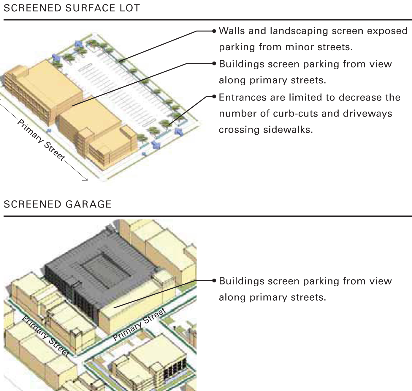
» Parking areas are necessary components to development, but are best located out of public view.
» Vehicular and pedestrian access points to parking areas should be visible and easily accessed from public rights-of-way.
» Parking structures can either be connected to other buildings, or free standing and naturally ventilated.
Screening Guidelines
» Surface parking lots are permitted within the interior of blocks. They should be screened from public rights-of-way by buildings, low walls, fences, or landscaping.
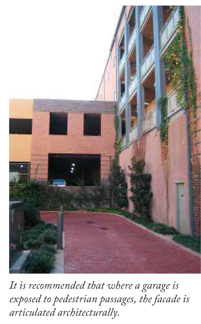
» Parking garages should be lined by buildings along public rights-of-way. When exposed to the street, they must have an architectural treatment to the facade.
(Ord. No. 2012-05-30/O-4, § I)
Sec. 8C.5. - Design Guidelines.
Design Guidelines for development in the Glen Lennox Area Neighborhood Conservation District-8C
The purpose of these Design Guidelines is to assist property owners in the planning of new structures and/or improvements to existing structures within the Glen Lennox Area Neighborhood Conservation District-8C (CD-8C). The hope and intent is that these guidelines will be followed to the greatest extent possible, helping to assure that improvements enhance the overall neighborhood quality.
Chapel Hill's Land Use Management Ordinance contains regulations and provisions that must be followed as any new development or redevelopment occurs with the Glen Lennox Area Neighborhood Conservation District-8C (CD-8C). These guidelines are intended to be a supplement to the regulations for development planned within the Glen Lennox Area Neighborhood Conservation District-8C (CD-8C).
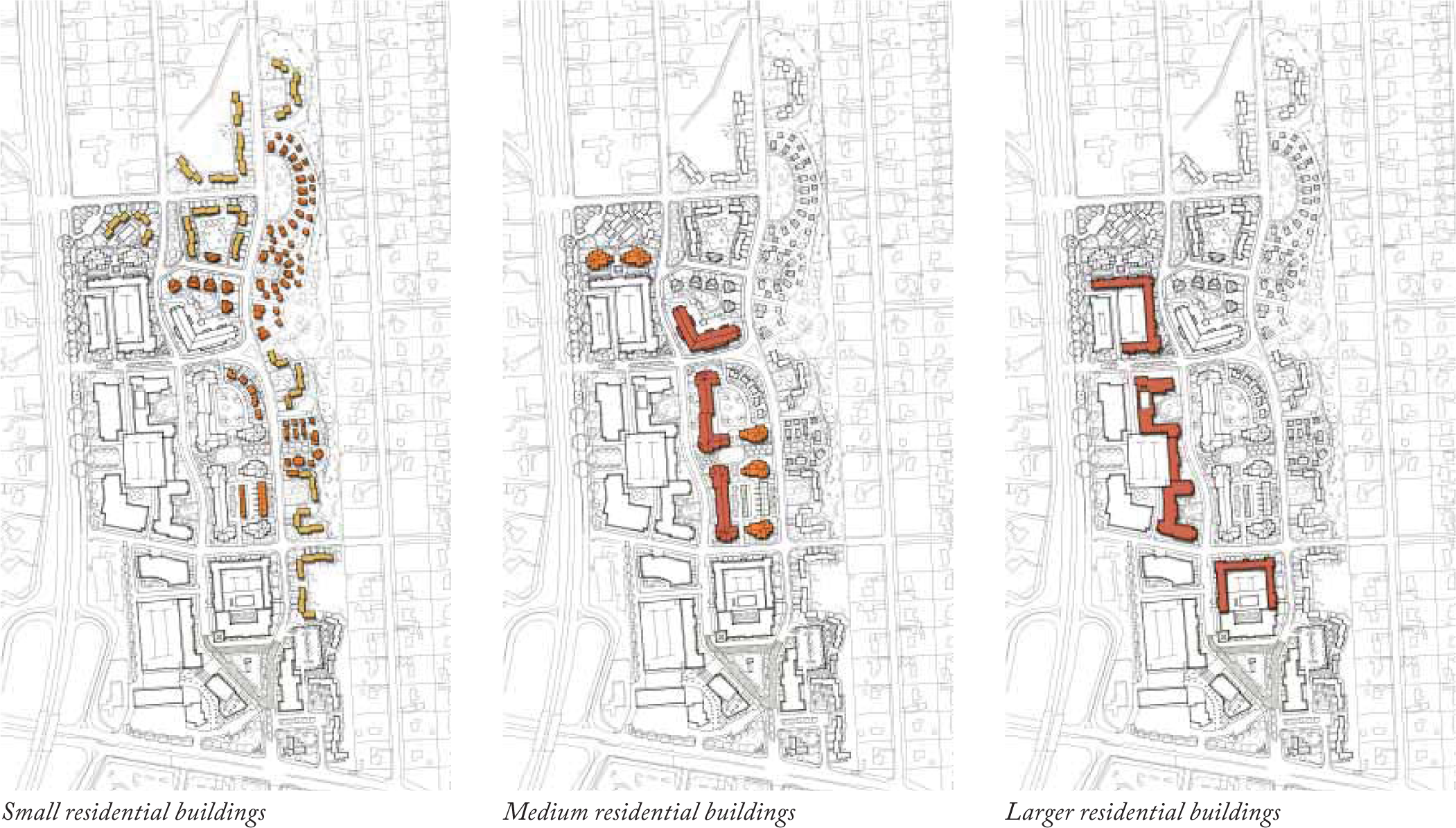
BUILDING TYPOLOGIES
Overview
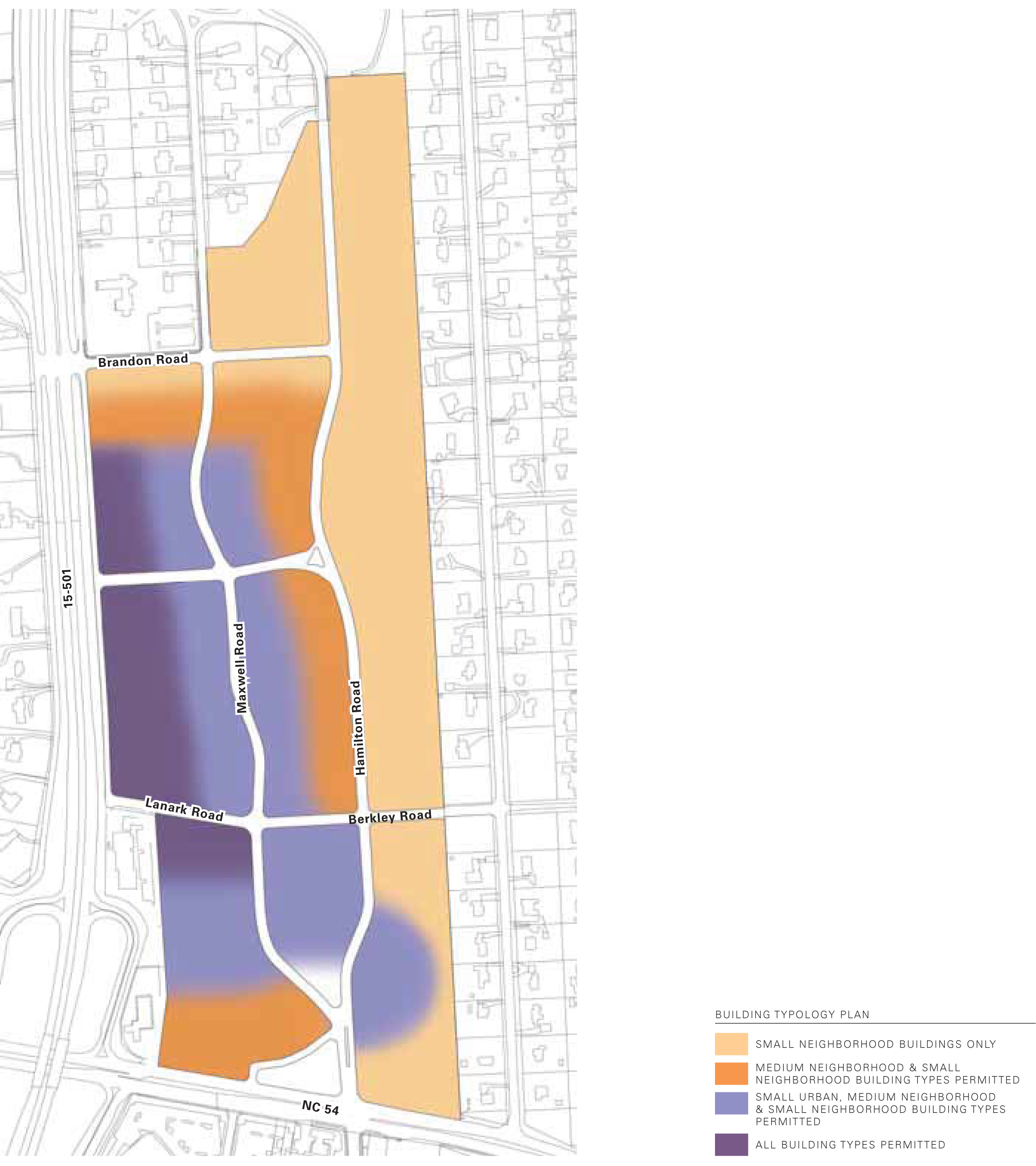
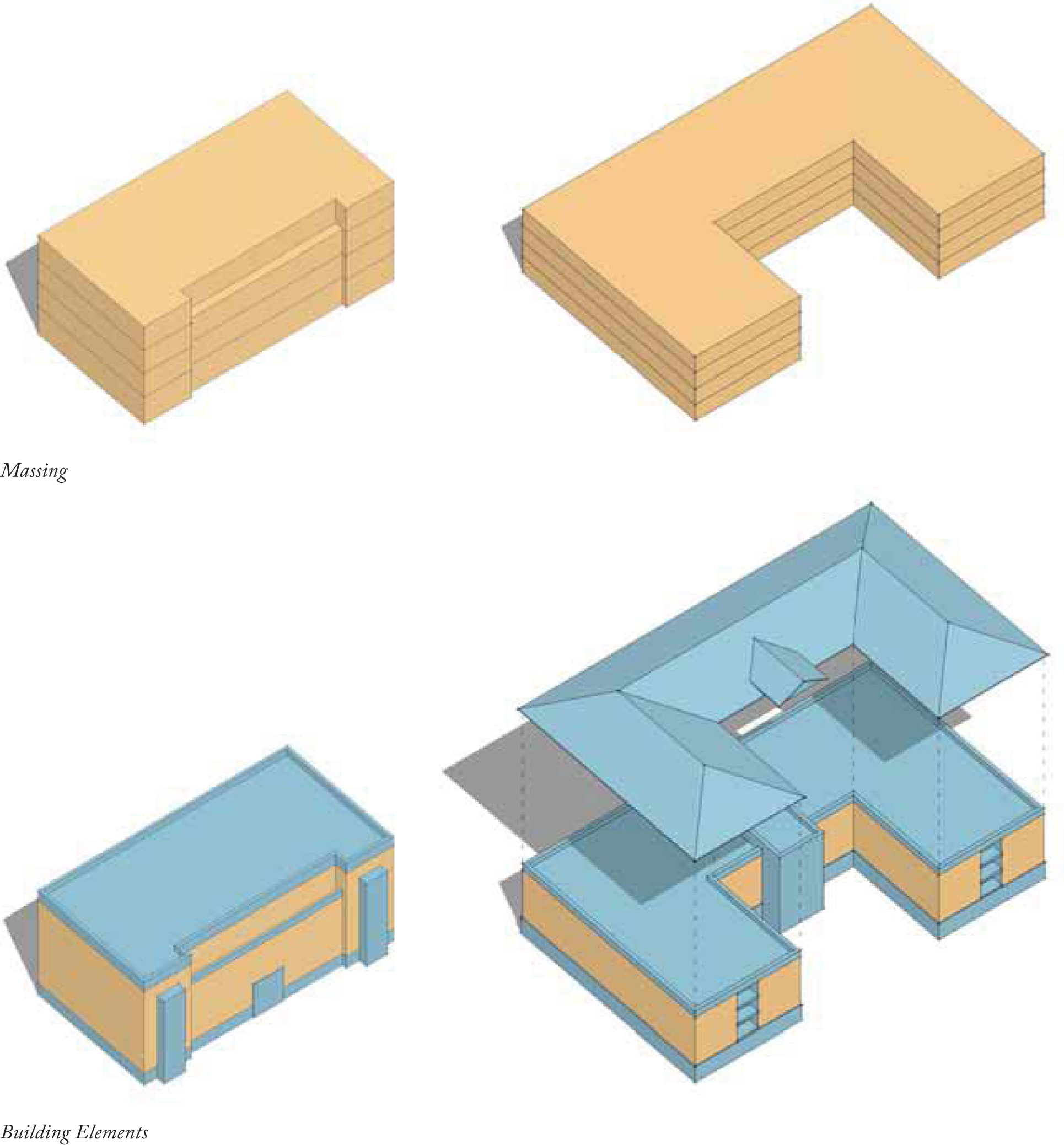
Great neighborhoods usually have a variety of building types that create a vibrant social environment. This section defines the potential building typologies for the Glen Lennox apartment and commercial property and identifies general locations for them within the plan, while providing guidelines on building placement, vertical and horizontal articulation, and general massing. These recommendations are intended to provide general guidelines for massing and articulation, yet are not of a regulatory nature.
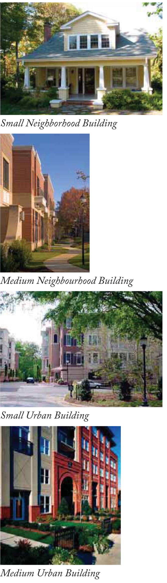
Small Neighborhood Building
Detached, single-family dwellings; duplexes; townhouses; small, free-standing commercial units; and small professional offices are included in this typology. These are typically one-and-a-half (1½) to two (2) stories, and are most commonly residential in character although a mix of uses may be accommodated.
Medium Neighborhood Building
This building typology will have the massing and scale that is complimentary to the surrounding neighborhood. Composed facades and a pitched roofscape are sensitive methods for providing more scale, typically up to three (3) stories. This building type can still accommodate a mix of uses ranging from multi-family residential to small professional offices, restaurant spaces, artist studios, or the like.
Small Urban Building
Small urban buildings at Glen Lennox will range in height from four (4) to five (5) stories and are characteristic of traditional mixed-use buildings. They will accommodate both residential and commercial uses and will provide a transition in scale from the neighborhood buildings to the uses along Hayes Road.
Medium Urban Building
This type allows for a larger floor plan making it a good choice for commercial functions, while also accommodating a denser form of residential development. The height for these buildings will range from five (5) to eight (8) stories, depending on use and location.
The following pages provide a more detailed description of each of these types.
Small Neighborhood Buildings
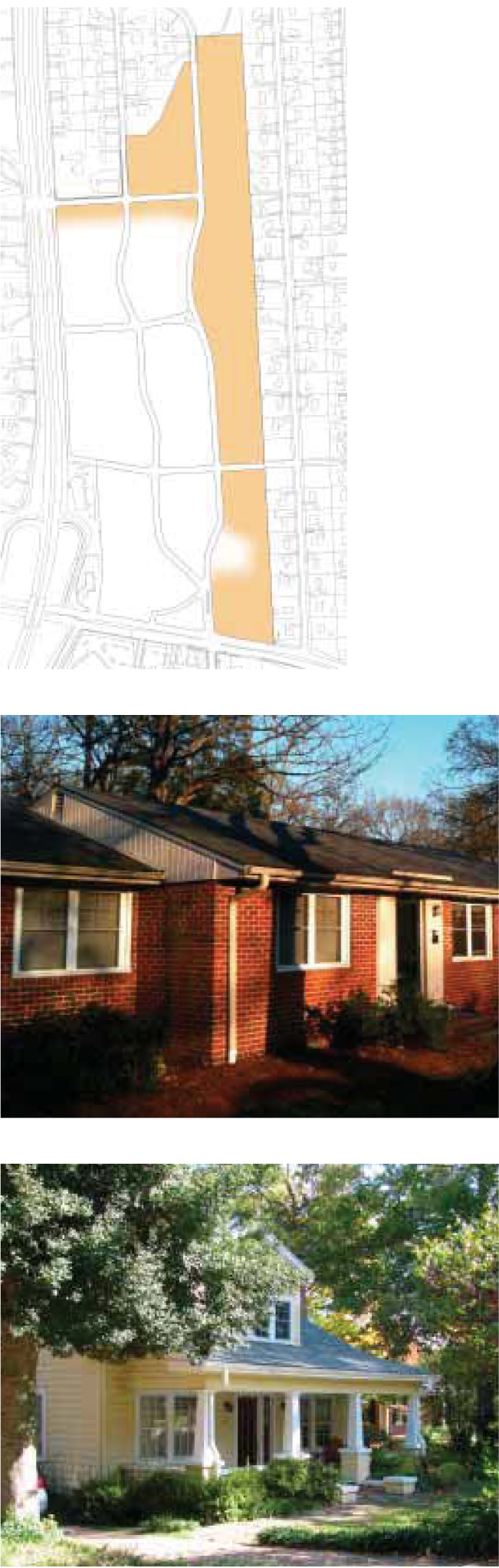
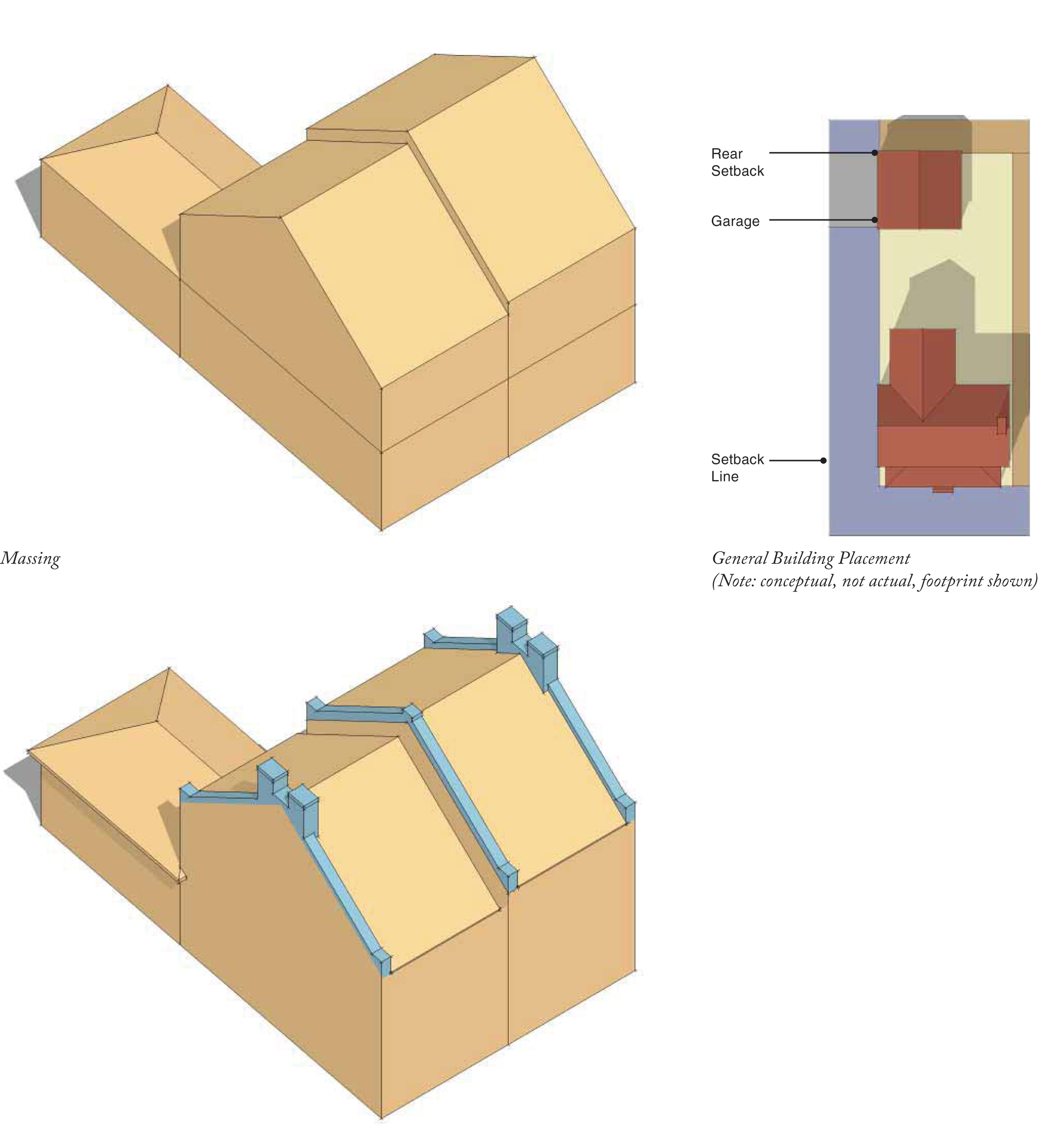
Definition
These buildings contain one (1) dwelling unit within a single structure. They may be either detached in a single-family form, or attached groups of multiple units. These units typically have private yards on three (3) to four (4) sides. Front and side street setbacks provide a zone within which the building facade must be located. On-site parking may be accessed through either an alley or a side driveway.
Site Placement
» Front Setback: refer to setback diagram on page 60 in NCD Regulations.
» Side Setback (between buildings): n/a
» Alley (Rear) Setback: minimum five (5) feet.
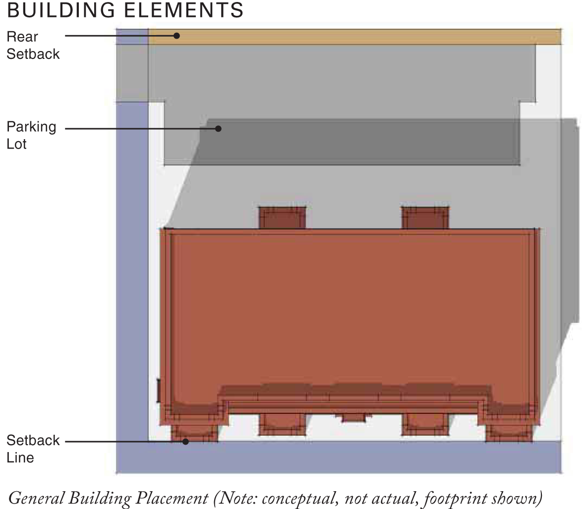
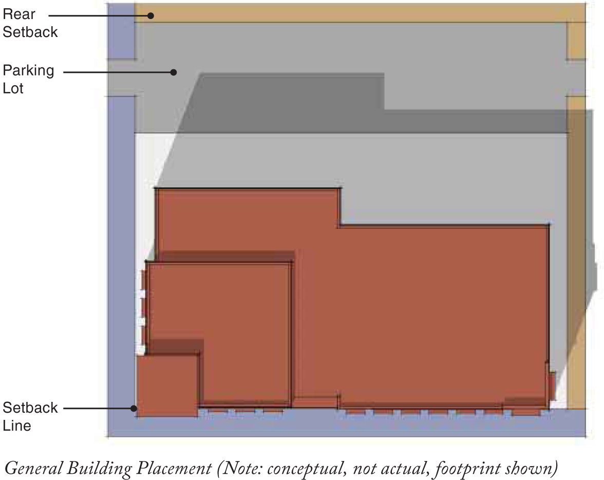
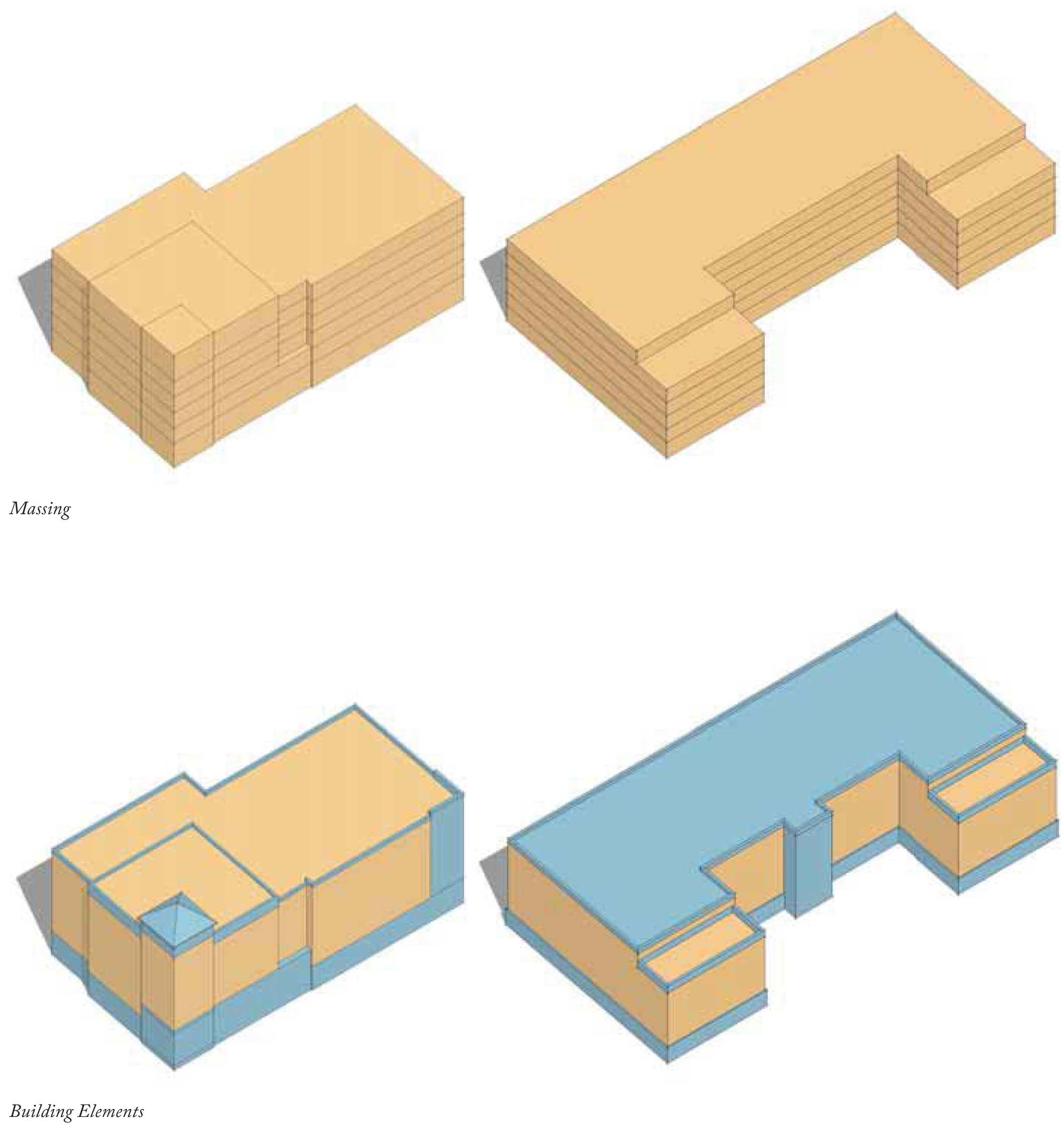
Building Elements
» The main massing (yellow) should be simple geometries with additive elements (blue) to add facade variety and livable space to each unit. Special elements such as bay windows, roof dormers, balconies, decorative eaves and cornices, and ornamented doorways should be provided.
» Define base, middle and top (may use window composition, ornament and special feature to accomplish this).
» Residential entries should be raised when possible and take the form of a stoop or porch.
» The middle is characterized by residential windows.
» The top can be articulated by varying roofscaped to enrich the facade of the street.
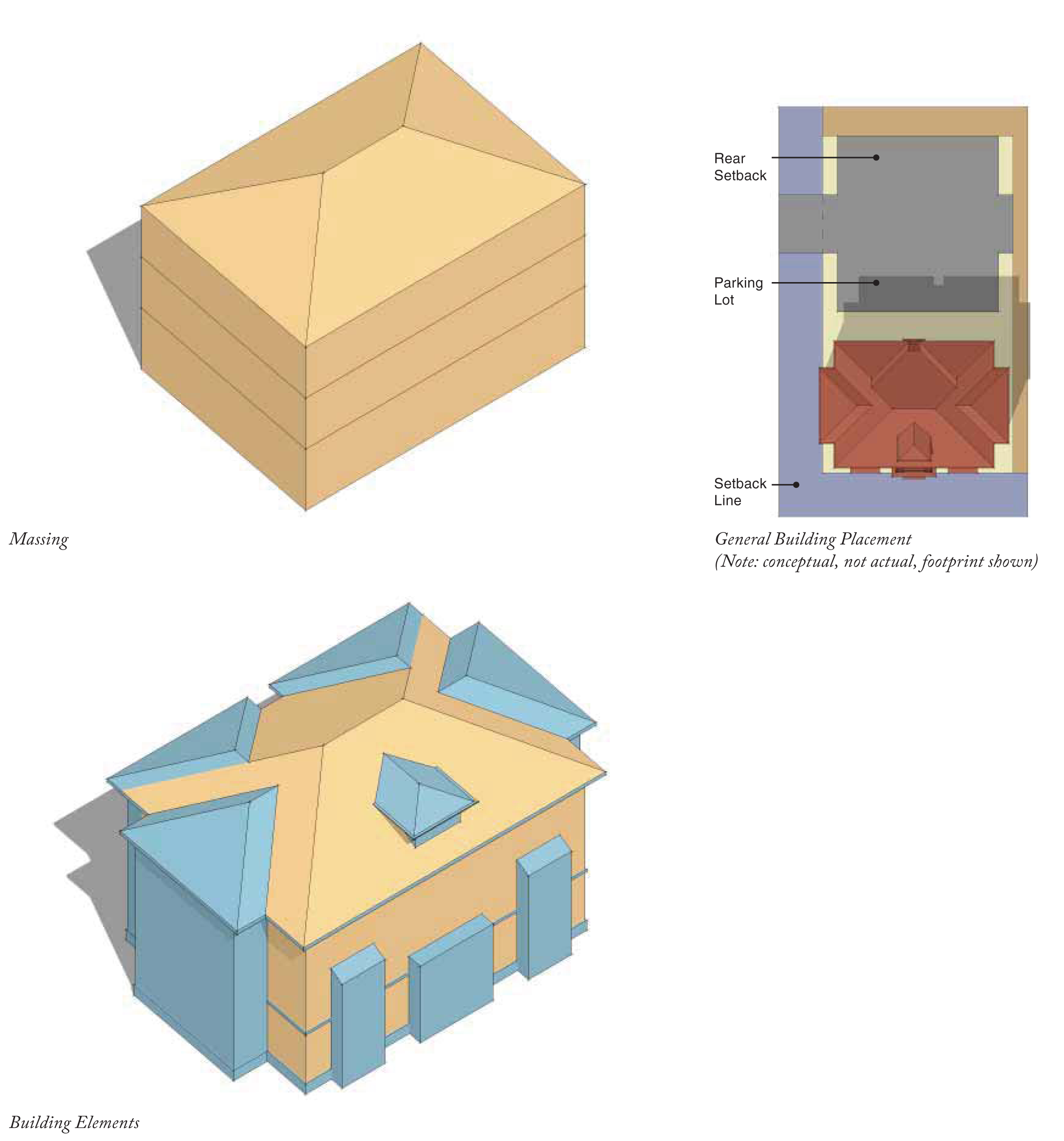
Medium Neighborhood Buildings
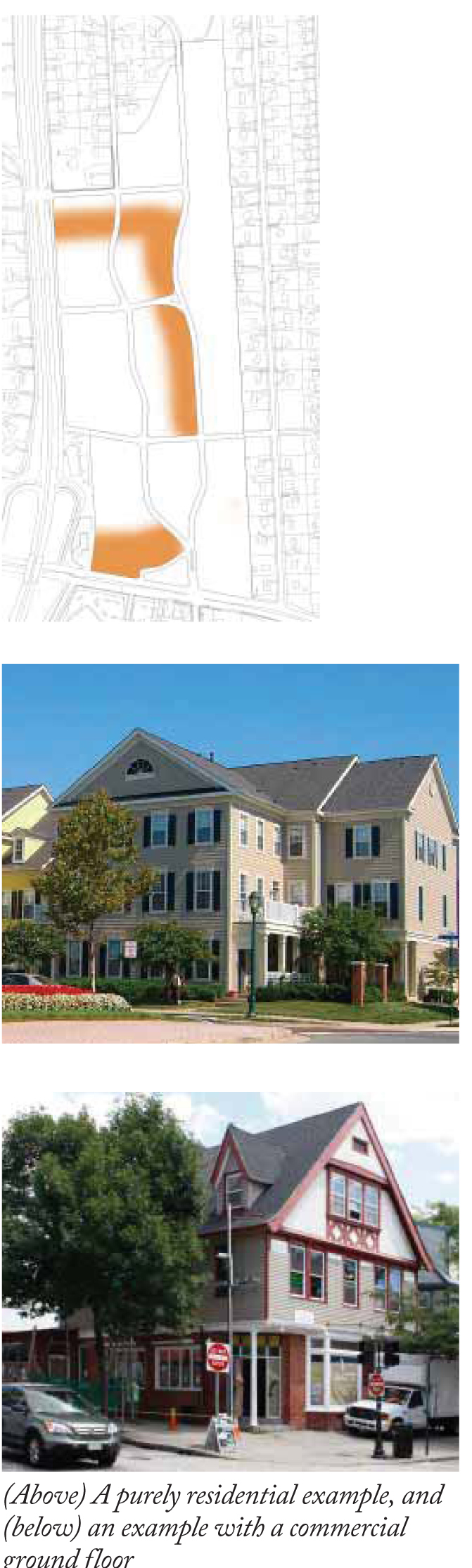
Definition
This typology can be up to three (3) or four (4) stories and takes the form of a large house with a simple massing. Porches and balconies are often incorporated to provide outdoor living space. While these buildings are primarily residential, they can also accommodate retail and commercial uses on the ground floor. Parking should be placed behind the main massing and accessed through the rear of the building.
Site Placement
» Front Setback: refer to setback diagram on page 60 in NCD Regulations.
» Side Setback (between buildings): minimum seven (7) feet.
» Alley (Rear) Setback: minimum five (5) feet.
Building Elements
» Facades should be composed of vertical bays.
» Each vertical element may be distinguished by one (1) of the following: material, color, architectural style, height, window type, facade composition, storefront or entry type.
» Define base, middle and top.
» For mixed-use buildings, ground floor retail storefronts should sit at grade.
» Residential entries should be raised when possible and take the form of a stoop or porch.
» The middle is characterized by a continuous pattern of windows.
» The top can be articulated by varying roofscaped to enrich the facade of the street.
Small Urban Buildings
Definition
Small urban buildings tend to be sited in a more urban manner along the sidewalk. They range from four (4) to five (5) stories, and occur as residential only, commercial only, or mixed-use. Parking should be placed behind the building either in a surface lot or structured parking. Service is also provided in the rear of the building.
Site Placement
» Front Setback: refer to setback diagram on page 60 in NCD Regulations.
» Side Setback (between buildings): n/a
» Alley (Rear) Setback: minimum five (5) feet.
Building Elements
» Facades should be composed of vertical bays.
» Each vertical element may be distinguished by one (1) of the following: material, color, architectural style, height, window type, facade composition, storefront or entry type.
» Stepping the building stories back is encouraged to provide more visual interest to the streetscape and to keep with the current character.
» For mixed-use buildings, ground floor retail storefronts should sit at grade.
» The middle is characterized by a continuous pattern of windows.
» The top can be articulated by varying roofscaped to enrich the facade of the street.
Medium Urban Buildings
Definition
Medium urban buildings are most appropriate along the edge of the site on 15-501 and Lanark Road. They have simple massing and have a direct relationship to the sidewalk and the street. Buildings range from four (4) to eight (8) stories and accommodate a variety of uses. Parking should be placed behind the building either in a surface lot or structured parking. Service is also provided in the rear of the building.
Site Placement
» Front Setback: refer to setback diagram on page 60 in NCD Regulations.
» Side Setback (between buildings): n/a
» Alley (Rear) Setback: minimum five (5) feet.
Building Elements
» Facades should be composed of vertical bays.
» Each vertical element may be distinguished by one (1) of the following: material, color, architectural style, height, window type, facade composition, storefront or entry type.
» Stepping the building stories back is encouraged to provide more visual interest to the streetscape and to keep with the current character.
» For mixed-use buildings, ground floor retail storefronts should sit at grade.
» The middle is characterized by a continuous pattern of windows.
» The top can be articulated by varying roofscaped to enrich the facade of the street.
STOREFRONTS, SIGNAGE, AND MATERIALS
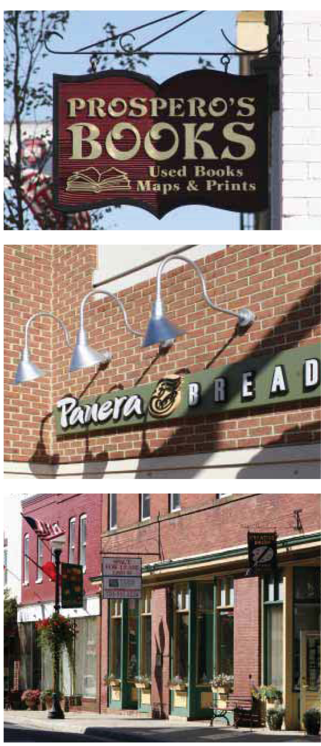
Storefront Design
Storefront Composition
» Storefront design must utilize the full height of the groundfloor facade frontage.
» Storefronts shall maintain a typical rhythm wherever possible.
Awnings
» Awnings are encouraged and may provide additional signage space by incorporating names and logos.
Openings And Transparency
» Storefront entrances shall be clearly distinguished from those serving floors above.
» Glazing should constitute a large portion of the groundfloor retail facades.
» Shop windows should provide views into the shop as well as its displays. The use of operational doors and windows that allow for direct connection and movement between the sidewalk and restaurant and shop interiors is encouraged.
Signage
Signage must comply with town's sign regulations per Land Use Management Ordinance Section 5.14 Signs.
Materials
Building materials should fit in harmoniously within the community's existing architecture, including a portion of the buildings utilizing brick compatible with the existing buildings, and also reflect the cherished characteristics of the regional architecture.
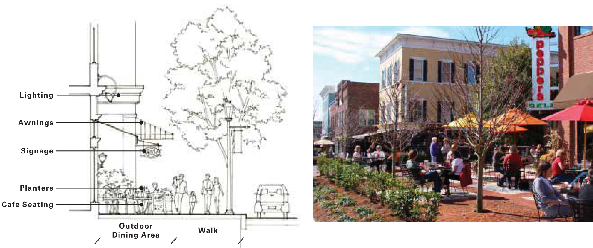
LANDSCAPE
Public Open Space and Parks
Public open spaces are the hallmark of a community. The range of public open spaces include the neighborhood parks accommodating passive and active use, squares as gathering space, courtyards, community gardens, playgrounds, nature preserve and trails. Once an overall park plan for Glen Lennox is established to program the various outdoor uses, the parks will contribute to the quality of experience and distinctiveness within the community.
Essential Elements
» Accessible by all
» Year-round landscape plant material for seasonal interest
» Dedicated site furniture including benches, trash receptacles, and lighting unique to specific spaces
» Preserve existing habitat
» Coordinated landscape and plant palettes
» Special lighting for public spaces
» Walking/running/bike trail when possible
Residential Landscape
A high-quality, sustainable residential landscape is an integral part of a Glen Lennox home. These landscapes will complement and soften the built environment and lend character to houses, streets, and neighborhoods. Furthermore, residential landscapes can create intimate outdoor rooms, reinforce entrances to houses, and help delineate property boundaries.
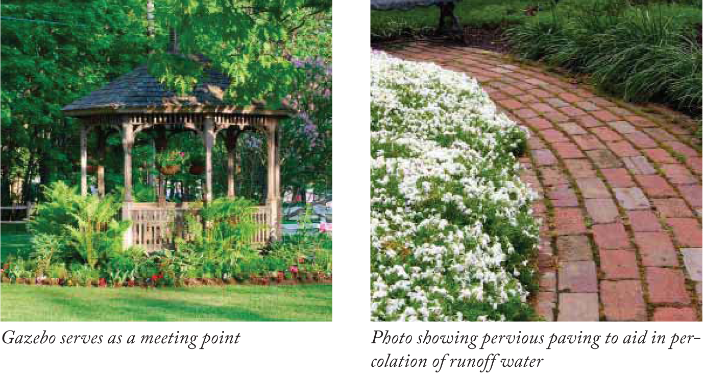
Sustainable Landscapes: Designing with Ecology in Mind
To help Glen Lennox be a sustainable community, the following is a list of sustainable devices and techniques encouraged for residents to use:
» Native plantings to reduce watering
» Increased yard planting in place of lawn to reduce maintenance
» Proper shade tree placement to reduce solar gain
» Pervious paving or the use of a driveway strip to enhance porosity
» Rain barrels, rain chains, and rain gardens to catch rain water for irrigation
» Greywater retention to recycle water
(Ord. No. 2012-05-30/O-4, § I(Att.), 5-30-2012)
Sec. 9.1. - Summary.
This Little Ridgefield Neighborhood Conservation District Plan has been prepared and adopted in accordance with section 3.6.5 in Chapel Hill's Land Use Management Ordinance, and has been incorporated into the Land Use Management Ordinance by reference.
The purpose of a Neighborhood Conservation District is to establish special regulations especially designed for and intended to help preserve the character of a particular, older residential neighborhood. This Plan contains special regulations for the Little Ridgefield Neighborhood Conservation District (CD-9) as described below.
Sec. 9.2. - Boundaries.
The Little Ridgefield Neighborhood Conservation District is bound by Fordham Boulevard to the west, Booker Creek to the east, Willow Drive to the north, and South Estes Drive to the south.
Please see Attachment B [section 9.4] for a map of the Little Ridgefield Neighborhood Conservation District boundaries. The boundaries shall be indicated on the official Zoning Atlas which accompanies the Land Use Management Ordinance.
Sec. 9.3. - Special design standards to apply to development in the Little Ridgefield Neighborhood Conservation District.
The following design standards shall apply to all development within the Little Ridgefield Neighborhood Conservation District, and are incorporated into Chapel Hill's Land Use Management Ordinance by reference. No application for development shall be approved that does not comply with these standards. For the Little Ridgefield Neighborhood Conservation District, these standards shall replace/supersede general provisions in the Land Use Management Ordinance where such standards differ. For standards that are not specifically identified in this Plan, provisions of the underlying zoning district for a particular parcel shall apply.
The design standards for the Little Ridgefield Neighborhood Conservation District are as follows:
Little Ridgefield Neighborhood
Conservation District Plan
* For the Little Ridgefield Neighborhood Conservation District, these standards replace/supersede general, otherwise applicable provisions in the Land Use Management Ordinance where such standards applicable to the property differ. For standards that are not specifically identified in this Plan, provisions of the underlying zoning district for a particular parcel shall apply.
(Ord. No. 2015-02-23/O-3, § I(Att.); Ord. No. 2016-03-21/O-2, § 12)
Sec. 9.4. - Attachment.

Sec. 10A.1. - Summary.
This Elkin Hills Neighborhood Conservation District Plan has been prepared and adopted in accordance with Section 3.6.5 in Chapel Hill's Land Use Management Ordinance, and has been incorporated into the Land Use Management Ordinance by reference.
The purpose of a Neighborhood Conservation District is to establish special regulations especially designed for and intended to help preserve the character of a particular, older residential neighborhood.
(Ord. No. 2017-01-23/O-1, §§ I—III)
Sec. 10A.2. - Boundaries.
The Elkin Hills Neighborhood Conservation District is west of Martin Luther King Jr. Blvd., south and east of Estes Drive and south of the Carolina North property. The main roads in the neighborhood are Barclay Road and Severin Street. The northeast portion of the neighborhood is zoned Residential-1 (R-1) and identified as CD-10A.
A map of the Elkin Hills Neighborhood Conservation District boundaries for CD-10A is labeled and outlined below. The boundaries shall be indicated on the official Zoning Atlas which accompanies the Land Use Management Ordinance.
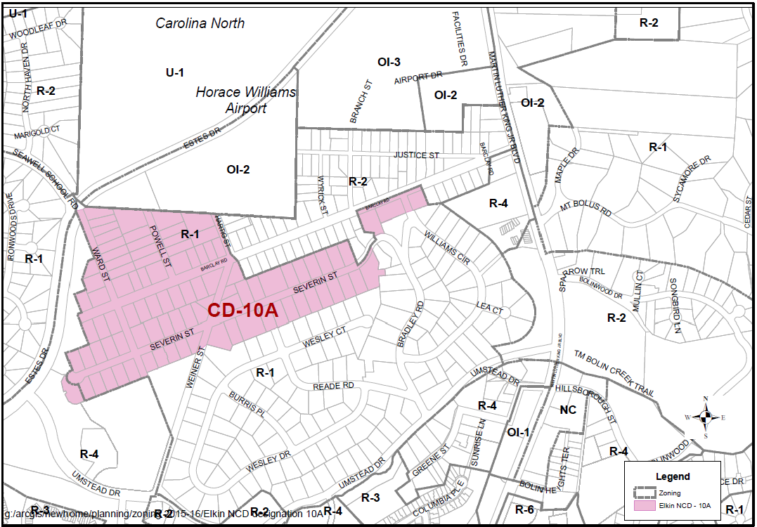
(Ord. No. 2017-01-23/O-1, §§ I—III)
Sec. 10A.3. - Special design standards to apply to development in the Elkin Hills Neighborhood Conservation District-10A.
The following Design Standards shall apply to all development within the Elkin Hills Neighborhood Conservation District-10A and are incorporated into Chapel Hill's Land Use Management Ordinance by reference. No application for development shall be approved that does not comply with these standards. For the Elkin Hills Neighborhood Conservation District-10A, these standards shall replace/supersede general provisions in the Land Use Management Ordinance where such standards differ. For standards that are not specifically identified in this Plan, provisions of the underlying zoning district for a particular parcel shall apply.
Conservation District-10A.
Neighborhood Conservation District-10A (CD-10A) includes the following streets in the neighborhood: Barclay Road west of Hartig Street, most of Severin Street (except for two lots), Powell Street, Ward Street, and two lots on Barclay Road east of Williams Circle and one lot west of Williams Circle.
The boundaries shall be indicated on the official Zoning Atlas which accompanies the Land Use Management Ordinance.
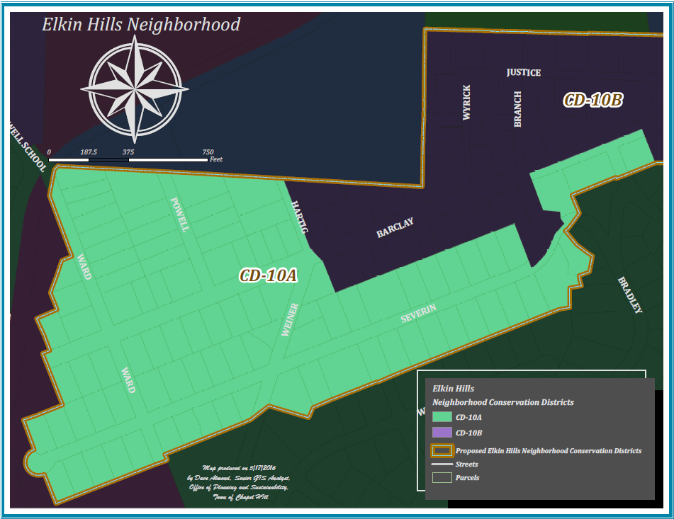
The design standards for the Elkin Hills Neighborhood Conservation District CD-10A are as follows:
(Ord. No. 2017-01-23/O-1, §§ I—III)
Sec. 10B.1 - Summary.
This Elkin Hills Neighborhood Conservation District Plan has been prepared and adopted in accordance with Section 3.6.5 in Chapel Hill's Land Use Management Ordinance, and has been incorporated into the Land Use Management Ordinance by reference.
The purpose of a Neighborhood Conservation District is to establish special regulations especially designed for and intended to help preserve the character of a particular, older residential neighborhood.
(Ord. No. 2017-01-23/O-2, §§ I—III)
Sec. 10B.2. - Boundaries.
The Elkin Hills Neighborhood Conservation District is west pf Martin Luther King Jr. Blvd., south and east of Estes Drive and south of the Carolina North property. The main roads in the neighborhood are Barclay Road and Severin Street. The northeast portion of the neighborhood is zoned Residential-2 (R-2) and identified as CD-10B.
Please see Attachment 3 for a map of the Elkin Hills Neighborhood Conservation District boundaries for CD-10B and as described below. The boundaries shall be indicated on the official Zoning Atlas which accompanies the Land Use Management Ordinance.
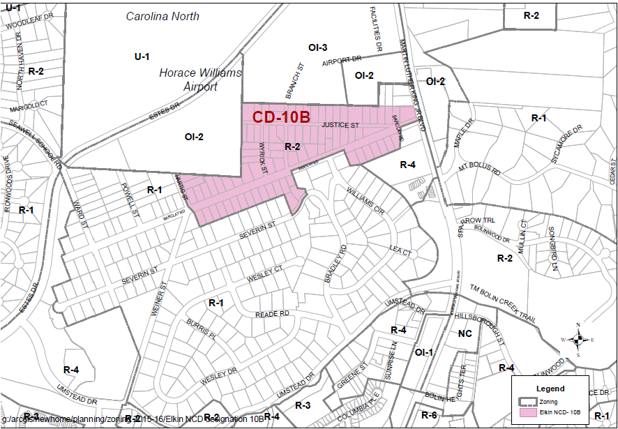
(Ord. No. 2017-01-23/O-2, §§ I—III)
Sec. 10B.3. - Special design standards to apply to development in the Elkin Hills Neighborhood Conservation District-10B.
The following Design Standards shall apply to all development within the Elkin Hills Neighborhood Conservation District-10B, and are incorporated into Chapel Hill's Land Use Management Ordinance by reference. No application for development shall be approved that does not comply with these standards. For the Elkin Hills Neighborhood Conservation District-10B, these standards shall replace/supersede general provisions in the Land Use Management Ordinance where such standards differ. For standards that are not specifically identified in this Plan, provisions of the underlying zoning district for a particular parcel shall apply.
Conservation District-10B
The Elkin Hills Neighborhood Conservation District-10B (CD-10B) is generally the eastern portion of the Elkin Hills neighborhood and includes the following streets: eastern portion of Barclay Road from Hartig Street to Martin Luther King Jr. Blvd., Justice Street, Branch Street, Wyrick Street, and two lots on Severin Street.
The boundaries shall be indicated on the official Zoning Atlas which accompanies the Land Use Management Ordinance.
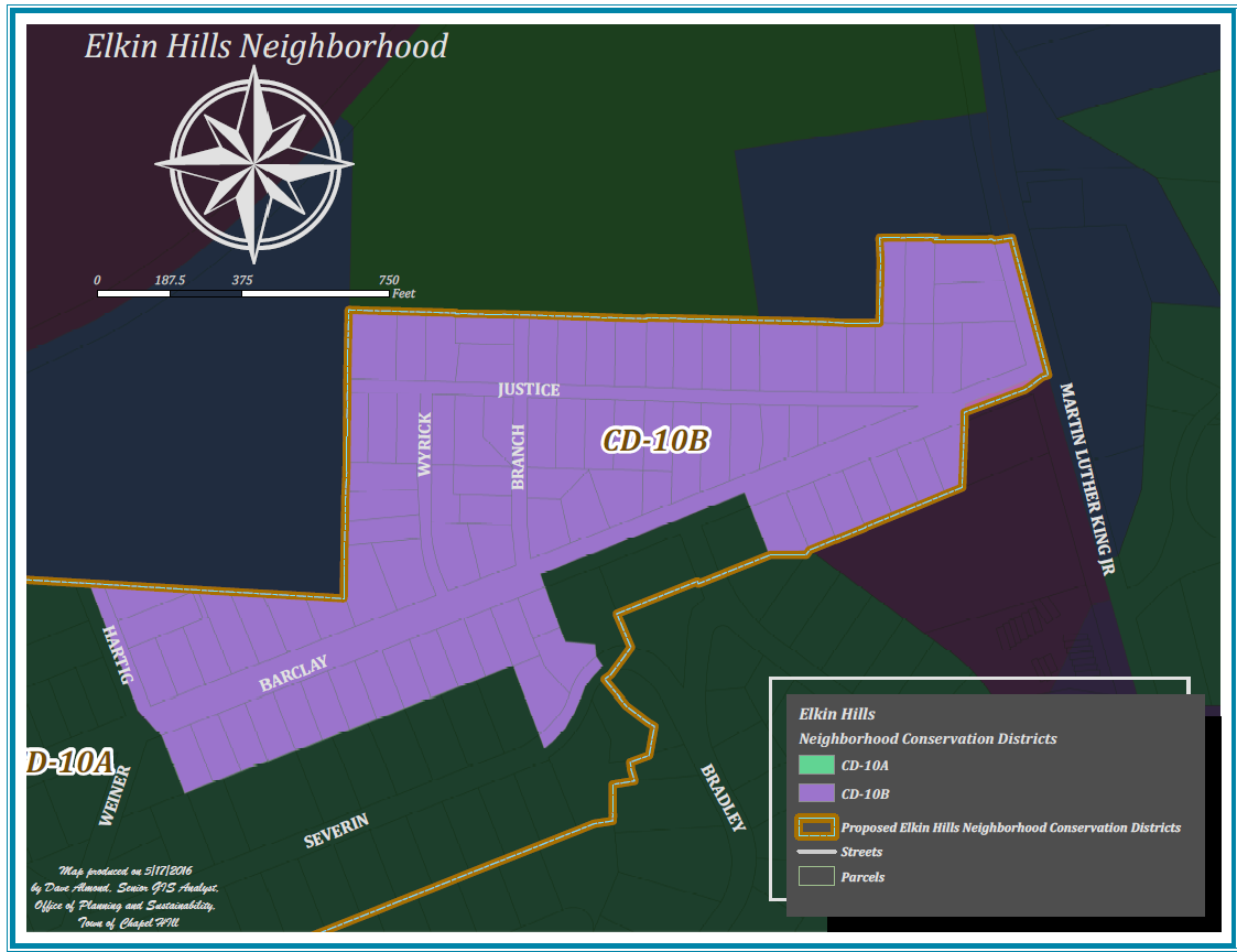
The design standards for the Elkin Hills Neighborhood Conservation District CD-10B are as follows:
(Ord. No. 2017-01-23/O-2, §§ I—III)
Sec. 11.1. - Attachment.
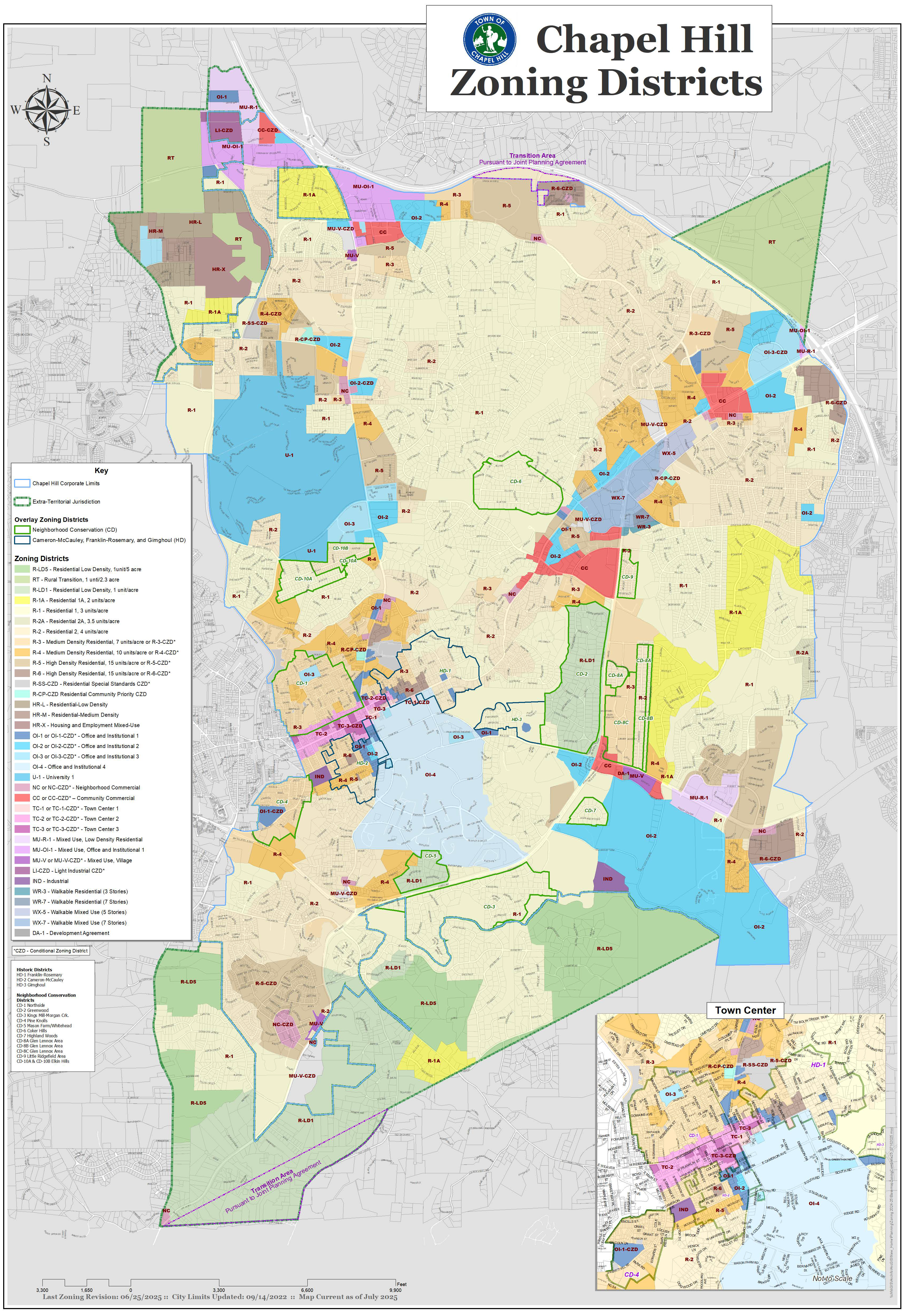
(Ord. of 6-12-2006; Ord. of 7-2007; Amend. of 9-8-2008; Ord. No. 2007-10-8/O-8, § I; Amend. of 7-1-2010; Ord. No. 2015-02-23/O-3, 2-23-2015; Amend. of 4-14-2015; Ord. of 2015-11-23/O-16; Amend. of 4-18-2016; Amend. of 2-7-2017; Amend. of 10-3-2019; Ord. of 2019-11-13/O-1; Ord. No. 2021-06-28/O-1; Ord. No. 2020-06-24/O-4; Ord. No. 2020-06-24/O-7; Ord. No. 2020-10-28/O-9; Ord. No. 2020-12-09/O-1; 2020-12-09/Item #20 (Hazard Zone Removal); Ord. No. 2020-12-09/O-2; Ord. No. 2021-03-10/O-1; Ord. No. 2021-03-10/O-2; Ord. No. 2021-03-24/O-1; Ord. No. 2021-05-19/O-3; Ord. No. 2021-06-23/O-8; Ord. No. 2021-11-10/O-2, § 1; Ord. No. 2021-11-17/O-5, § 1; Ord. No. 2021-12-01/O-1; Ord. No. 2022-04-27/O-2; Ord. No. 2022-04-27/O-3; Ord. No. 2022-05-04/O-1; Ord. No. 2022-06-08/O-11; Ord. No. 2022-06-15/O-2, § 1; Ord. No. 2022-09-14/O-4, § 1; Ord. No. 2022-09-4/O-5, § 1; Ord. No. 2022-10-19/O-1; Ord. No. 2022-11-02/O-1, § 1; Ord. No. 2022-10-12/O-5, § 1; Ord. No. 2023-03-22/O-6; Ord. No. 2023-04-26/O-2, § 1; Ord. No. 2023-05-24/O-3, § 1; Ord. No. 2023-06-14/O-1; Ord. No. 2023-06-14/O-2; Ord. No. 2023-06-21/O-5; Ord. No. 2023-06-21/O-7; Ord. No. 2023-11-15/O-3, § 1; Ord. No. 2023-11-15/O-4, § 1; Ord. No. 2023-11-29/O-2, § 1; Ord. No. 2023-11-29/O-4, § 1; Ord. No. 2024-04-17/O-9, § 1; Ord. No. 2025-04-09/O-6, § 1; Ord. No. 2025-04-23/O-2, § 1; Ord. No. 2025-05-07/O-1, § 1; Ord. No. 2025-05-07/O-2, § 1; Amend. of 06-25-2025(1); Ord. No. 2025-06-18/O-3, § 1; Ord. No. 2025-06-18/O-4, § 1; Ord. No. 2025-10-08/O-6, § 1)