
Chapel Hill City Zoning Code
ARTICLE 3
- ZONING DISTRICTS, USES, AND DIMENSIONAL STANDARDS
This article establishes zoning districts and describes the various uses permitted within the zoning districts, as well as design regulations. Several types of zoning districts are established.
First, 'Conventional' districts (section 3.3) divide the town into various residential, commercial and industrial zones. Each district establishes uses that are permitted "as of right," and uses permitted only as "special uses." Special uses require an evidentiary hearing in order to assess whether conditions are needed in order to make the use compatible with other uses in the district. The uses permitted in each district are listed in section 3.7.
'Conditional Zoning' Districts (section 3.4) include district-specific plans, site-specific standards, and conditions agreed upon, in writing, by the town council and the property owner(s) to ensure that the use or group of uses is compatible with adjoining districts and uses. Such Conditional Zoning Districts are established by the town council pursuant to NCGS 160D-703.
'Special' districts (section 3.5) involve uses which cannot be adequately addressed by the base district regulations. Unlike the overlay districts, these districts are independent of the conventional zoning districts. The special districts have separate use and design regulations.
'Overlay' districts are established in section 3.6. Within these districts, the standards of both the conventional and overlay districts apply. These districts address special situations such as groundwater recharge, historic preservation, airport hazards, and utility conversions where the base district regulations are not sufficient to protect the public.
One essential function of zoning is to regulate the dimensional aspects of development. Section 3.8 establishes regulations governing the configuration and location of lots, buildings, structures and paved surfaces. This includes lot size, density, intensity, lot width, and setbacks from streets and property lines. These standards are consolidated in a schedule called the Dimensional Matrix (Table 3.8-1). The amount of a lot that may be covered with built or paved surfaces ("impervious surface ratio") is also established in the dimensional matrix.
Section 3.9 establishes incentives in the form of additional density and other regulatory measures in order to encourage redevelopment and enhanced site design. Landowners are permitted through rezoning to transfer densities from environmentally sensitive sites that are inappropriate for development to sites that are suitable for increases in density.
Some uses, while permitted in a zoning district, raise special concerns which require additional regulations. These regulations are established in article 6. They apply regardless of whether the use is permitted as of right or as a special use within the district.
(Ord. No. 2017-04-05/O-7, § 1; Ord. No. 2017-11-29/O-4, § 1; Ord. No. 2020-10-28/O-10, § 1; Ord. No. 2021-05-19/O-1, § 5)
Cross reference— Keeping certain animals in town, Ch. 4, § 4-10.
3.1.- Establishment and intent of zoning districts.
The town and its extraterritorial planning jurisdiction are hereby divided into zoning districts as enumerated below. The use regulations and intensity regulations applicable for such zoning districts are designated in sections 3.7 and 3.8 of this article.
3.1.1 Conventional districts may be established by the town council approval of a conventional rezoning pursuant to the procedures established in section 4.4.2 of this appendix. Such approval authorizes the full range of uses in accordance with the standards applicable to the conventional district.
3.1.2 The Light-Industrial Conditional Zoning District (LI-CZD), may be established by the town council approval of a conditional zoning district pursuant to the procedures established in section 4.4.3 of this appendix. The light-industrial conditional zoning district incorporates district-specific rezoning plans and conditions agreed to by the owner(s) of the rezoned land. Such approval authorizes development of the Light-Industrial conditional zoning district-specific rezoning plan in accordance with the standards applicable to the conditional zoning district, as modified by the conditions contained with the conditional zoning district approval.
3.1.3 The Residential-Community Priority-Conditional Zoning District (R-CP-CZD) may be established by the town council approval of a conditional zoning district pursuant to the procedures established in section 4.4.5 of this appendix, provided the conditional zoning district is deemed consistent the Future Land Use Map Update to Chapel Hill 2020. The Residential-Community Priority-Conditional Zoning District (R-CP-CZD) incorporates community priority rezoning plans and conditions agreed to by the owner(s) of the rezoned land. Such approval authorizes development of the community priority rezoning plan in accordance with the standards applicable to the conditional zoning district, as modified by the conditions contained with the conditional zoning district approval.
3.1.4 Conditional Zoning Districts, other than the LI-CZD and R-CP-CZD, may be established by the town council approval of a conditional zoning district pursuant to the procedures established in section 4.4.7 of this appendix, provided the conditional zoning district is deemed consistent with the Future Land Use Map (2050) in the comprehensive plan by locating in conformance with an adopted small area plan, in a Focus Area as defined in the Future Land Use Map Update to Chapel Hill 2020, or in one of the following land use categories
Medium Residential
High Residential
Commercial/Office
Mixed Use
Village Center
Institutional
University
Conditional zoning districts incorporate district-specific plans, site-specific standards, and conditions agreed to, in writing, by the town and the owner(s) of the property included in the conditional zoning district. Conditional zoning districts are designated with the suffix CZD on the zoning atlas.
(Ord. No. 2017-04-05/O-7, § 2; Ord. No. 2017-11-29/O-4, §§ 2, 3, 11-29-2017; Ord. No. 2018-03-21/O-1, § 1, 3-21-2018; Ord. No. 2021-05-19/O-1, § 6; Ord. No. 2022-11-16/O-3, § 1)
3.2. - Zoning Atlas.
3.2.1 The boundaries of zoning districts described in this article are hereby established as shown on the official zoning atlas which accompanies this appendix and which, with all notations, references, and other information shown thereon, shall be as much a part of this appendix as if fully described herein.
3.2.2 The official zoning atlas shall be authenticated by the planning director and shall be retained in the office of the planning department.
3.2.3 Copies of the zoning atlas, or portions thereof, may be made. However, the official zoning atlas is the final and sole authority as to the zoning status of land within the town and its extraterritorial jurisdiction.
3.2.4 Amendments to the official zoning atlas shall be entered by the planning director. Maps and descriptions accompanying enacted amendments shall be displayed in the office of the planning department until such time as such amendments are entered on the official zoning atlas.
3.2.5 The planning director shall authenticate the entry of each amendment on the official zoning atlas and shall maintain a record of the nature and date of entry of each amendment. Following each zoning atlas amendment, prior versions of the zoning atlas shall be maintained for public inspection in either paper or digital formats. Changes to the official zoning atlas other than those authorized by duly approved amendments to this appendix shall be prohibited.
3.2.6 Unless otherwise provided, zoning district boundaries shall be located on municipal corporate lines, section lines, parcel lines, natural boundary lines or on the center lines of highways, streets, alleys, or railroad rights-of-way. In cases where these lines are not used, the zoning district lines shall be as determined by using the scale of the official zoning atlas. If a parcel of land is divided by a zoning district boundary line at the time of enactment of this appendix or by subsequent amendments thereto, the appropriate standards and uses for each zone shall apply on the portion of the parcel covered by that zone.
3.2.7 The town manager shall render a decision as to any dispute of the boundary or location of property within a zoning district in accordance with the procedures for determinations (section 4.11)
(a)
When a district boundary is shown as approximately following a street, highway, alley, road, right-of-way, parkway, public utility right-of-way, railroad, stream, or watercourse, the boundary shall be deemed to be the center line of such feature.
(b)
Boundaries indicated as approximately following platted lot lines shall be construed as following such lot lines.
(c)
Boundaries indicated as approximately following established municipal limits and county borders shall be construed as following such lines.
(d)
Boundaries indicated as separated from but approximately parallel to any of the features indicated above, or any land marked or monumental line, shall be deemed to be parallel to the aforesaid center line.
(e)
Distances not specifically indicated on the official zoning atlas shall be determined by the scale of the map.
(f)
Where a street, highway, railroad or other physical monument or marker on the ground, by which a boundary is determined, varies from that as shown on the official zoning atlas, the physical monument or marker located on the ground shall control.
(g)
Where physical or cultural features, such as flood plains, vary from those shown on the official zoning atlas, or in other circumstances not covered above, the town manager shall determine the district boundaries.
(Ord. No. 2021-05-19/O-1, §§ 7, 8)
3.3. - Conventional districts.
3.3.1 Town Center (TC-1, TC-2, TC-3)
The town center (TC) districts are intended to provide for the development of the commercial, service, and social center of Chapel Hill while maintaining its character, its pedestrian-oriented scale, and its nature as a concentration of business, administrative, financial, governmental, and support functions serving the community; and to encourage further residential development in the central area of Chapel Hill. The zoning regulations for the TC districts are designed to achieve the following objectives:
• Buildings are designed and located so that they provide visual interest and create enjoyable, human-scale spaces.
• Building design blends with the natural terrain by means such as terracing or other techniques that minimize grading.
• Designs are compatible, in form and proportion, with the neighboring area.
• Designers strive for creativity in form and space wherever contrast and variety are appropriate to the larger environment.
• Buildings and projects include visual variety and also maintain a strong sense of unity.
• Buildings and projects include a high level of architectural detailing to help maintain a sense of scale.
Applicants are encouraged to consult the Design Guidelines for Downtown Chapel Hill (prepared by Downtown Small Area Plan Work Group, August 1998) before submitting an application for approval in a town center district.
3.3.2 Community Commercial District (CC)
The community commercial (CC) district is intended to provide for the development of high-intensity commercial and service centers that serve community-wide or regional commercial and service needs.
3.3.3 Neighborhood Commercial District (N.C.)
The neighborhood commercial (N.C.) district is intended to provide for the development of low-intensity commercial and service centers that are accessible by pedestrians from the surrounding neighborhoods, serve the daily convenience and personal service needs of the surrounding neighborhoods, and are of such a nature as to minimize conflicts with surrounding residential uses.
3.3.4 Office/Institutional—4 District (0I-4)
See Special Districts, Section 3.5.2.
3.3.5 Office/Institutional—3 District (0I-3)
The office/institutional-3 (OI-3) district is intended to provide for major educational, research, public service, and office uses, and their necessary support functions, while minimizing conflicts with adjacent land uses.
3.3.6 Office/Institutional—2 (District (0I-2)
The Office/Institutional-2 (OI-2) district is intended to provide for medium-intensity office and institutional development.
3.3.7 Office/Institutional—1 District (0I-1)
The office/institutional-1 (OI-1) district is intended to provide for low-intensity office and institutional development and, where appropriate, to serve as a transition between residential zoning districts and high-intensity nonresidential zoning districts.
3.3.8 Industrial District (I)
The industrial (I) district is intended to provide for public and private uses of a wholesale, distribution, limited processing, and production nature serving the needs of the Chapel Hill community, and to ensure the compatibility of such uses with their surroundings.
3.3.9 Residential Districts (R-6, R-5, R-4, R-3, R-2, R-2A, R-1, R-1A, R-LD1, R-LD5)
The residential districts are intended to provide for residential development of appropriate intensities consonant with the suitability of land, availability of public services, accessibility to major activity centers and transportation systems, and compatibility with surrounding development.
3.3.10 Rural Transition District (RT)
The rural transition (RT) district is intended to be applied to land which is used for agricultural, very low-intensity residential, or open space uses, but which is projected in the comprehensive plan for conversion to more intensive urban uses at such time as community services are available and community needs for such uses are present.
3.3.11 Materials Handling District (MH)
The materials handling (MH) district is intended to provide for public operation of a solid waste management facility.
(Ord. No. 2007-02-26/O-5, § 1; Ord. No. 2021-05-19/O-1, § 4)
3.4. - Conditional Districts.
3.4.1 All conditional use districts established pursuant to North Carolina General Statutes Section 160A-382 that existed as of October 28, 2020 are hereby converted to conditional zoning districts pursuant to North Carolina General Statutes 160D. Any conditional use district established prior to October 28, 2020 shall be henceforth shown on the zoning atlas with a CZD suffix. Any proposed modifications to such districts established prior to October 28, 2020 shall be considered pursuant to Section 4.4.5.
(Ord. No. 2007-02-26/O-5, § 2; Ord. No. 2008-11-24/O-4, § 1; Ord. No. 2017-04-05/O-7, § 3; Ord. No. 2019-05-22/O-2, § 1; Ord. No. 2020-10-28/O-10, § 2; Ord. No. 2021-05-19/O-1, § 9)
3.4.2. Residential-Special Standards-Conditional Use Districts.
The residential-special standards-conditional use district (R-SS-C) established pursuant to North Carolina General Statutes Section 160A-382 is hereby converted to a defined conditional zoning district pursuant to North Carolina General Statutes 160D and section 3.4.3 of this appendix. Any R-SS-C district established prior to October 2020 shall be henceforth shown as R-SS-CZD on the zoning atlas. Any proposed modifications to R-SS-C districts established prior to October 2020 shall be considered pursuant to Section 4.4.7.
(Ord. No. 2008-11-24/O-4, § 2; Ord. No. 2017-04-05/O-7, § 3; Ord. No. 2020-10-28/O-10, § 3; Ord. No. 2022-11-16/O-3, § 2)
3.4.3 (a) Parallel conditional zoning districts are hereby established that parallel each of the following conventional districts:
R-1
R-1A
R-2
R-2A
HR-L
HR-M
R-LD1
R-LD5
R-3
R-4
R-5
R-6
TC-1
TC-2
TC-3
CC
N.C.
OI-3
OI-2
OI-1
A parallel conditional zoning district may be established through the town council's approval of a conditional zoning district pursuant to section 4.4.5. Development in a parallel conditional zoning district is subject to the same uses, standards, and regulations applicable to the parallel conventional district including overlay district regulations, as modified by the approved district-specific plans, site-specific standards, and conditions:
(1)
That are proposed or agreed to, in writing, by the owner(s) of the subject land;
(2)
That incorporate any proposed modifications to use, intensity, or development standards applicable in the parallel conventional district; and,
(3)
That, pursuant to NCGS 160D-703 (b) are limited to conditions that address conformance of the allowable development and use of the rezoning site with Town regulations and plans adopted pursuant to NCGS 160D-501, and impacts reasonably expected to be generated by the allowable development or use of the site.
In addition to the uses designated as permissible in a conditional zoning district in Table 3.7-1: Use Matrix, eligible uses in a parallel conditional zoning district shall only be those uses designated as permitted as a principal use, as an accessory use, or as a special use in the applicable conventional district as identified in Table 3.7-1: Use Matrix.
One goal of the town's comprehensive plan is to promote energy conservation through building design. Therefore, applicants are encouraged to meet the Architecture 2030 Challenge guidelines as amended.
(b)
The following defined conditional zoning districts are hereby established to provide an alternative to general use and parallel conditional zoning districts:
(1)
Light Industrial Conditional Zoning District (LI-CZD) pursuant to 3.4.4 and the applicable provisions of this appendix
(2)
Residential Special Standards Conditional Zoning District (R-SS-CZD) pursuant to 3.4.5 and the applicable provisions of this appendix
(3)
Mixed Use Village Conditional Zoning District (MU-V-CZD) pursuant to 3.4.6 and the applicable provisions of this appendix
(4)
Residential-Community Priority-Conditional Zoning District (R-CP-CZD) pursuant to 3.4.7 and the applicable provisions of this appendix
Development in a defined conditional zoning district is subject to the applicable provisions in this appendix, as modified by the approved district-specific plans and conditions:
(1)
That are proposed or agreed to by the owner(s) of the subject land;
(2)
That incorporate any proposed modifications to applicable regulations; and
(3)
That are limited to conditions that address conformance of the allowable development and use of the rezoning site with town regulations and adopted plans, and impacts reasonably expected to be generated by the allowable development or use of the site.
(Ord. No. 2017-11-29/O-4, § 5; Ord. No. 2019-05-22/O-2, § 1; Ord. No. 2020-10-28/O-10, § 4; Ord. No. 2021-05-19/O-1, § 10; Ord. No. 2022-11-16/O-3, § 3)
3.4.4 Innovative, Light Industrial Conditional Zoning District
a)
Innovative, Light Industrial Conditional Zoning District (LI-CZD).
A LI-CZD may be established through the town council's approval of a conditional zoning district rezoning application pursuant to section 4.4.3, which incorporates district-specific rezoning plans and conditions agreed to by the owner(s) of the rezoned land. Once a LI-CZD is established, a property owner may submit final plans applications to the town manager for review and approval in accordance with the standards of this appendix and the conditions and rezoning plan attached to the conditional zoning district rezoning approval.
b)
Purpose.
The LI-CZD district is intended to support and encourage job-creating uses that fit Chapel Hill's character and desired brand of being a place for creative, sustainable and entrepreneurial companies to start, grow or relocate. Encouraged uses include research activities; manufacturing, light; food processing, light and flex space, and associated support functions serving both the needs of the community and region. A LI-CZD may only be applied to areas designated as innovative, light industrial opportunity area on the land use plan as adopted and amended by the town council.
A LI-CZD is intended to be applied to areas within the Town limit so that municipal services can be provided to properties containing innovative, light industrial uses that will need the full range of municipal services such as police, fire, public works, transit, and building inspections. It is further intended to increase the town's non-residential tax base, provide a place for innovative, light industrial businesses to locate, and to promote a healthy and sustainable economy in order to provide the range of services desired by the community and necessary to maintain public health, safety, and welfare.
c)
Standards applicable to development in a LI-CZD.
1)
Intent: The standard conditions applicable to a LI-CZD are intended to foster an efficient use of land-enabling productive use of limited developable land in Chapel Hill and allowing for enhanced protection of environmentally-sensitive areas that may be present on a lot. Development in a LI-CZD shall be designed in a manner that provides a mix of non-residential uses which area integrated, interrelated, and linked by non-vehicular connections and vehicular connections consistent with the adopted comprehensive plan and its various adopted elements. Development shall be designed in a manner to be congruent with adjacent land uses, and mitigate impacts to surrounding properties to the full extent required by this appendix.
2)
Standard conditions:
A.
The following standard conditions, contained within subdivisions (c)(3)—(c)(8), apply to development within a LI-CZD and shall be included in a conditional zoning district rezoning approval.
B.
Where a general standard or provision of this appendix expressly conflicts with a standard established in this division (c) the standards of this division (c) control, otherwise the general standards and provisions of the appendix are applicable to development within a LI-CZD.
C.
Pertinent general standards:
i.
Applicable overlay zoning districts and standards - section 3.6 "Overlay Districts."
ii.
Permitted Uses - section 3.7 "Use Regulations."
iii.
Permitted land use intensity and dimensional standards — section 3.8 "Dimensional Standards."
iv.
General development standards - Article 5, Design and Development Standards.
v.
Special standards - Article 6, Special Regulations for Particular Uses.
D.
The town council, in approving a conditional zoning district rezoning may determine that additional and/or alternate standards are appropriate provided that the intent of the LI-CZD standards have been met to an equal or greater degree.
3)
Stormwater management performance criteria.
A.
Stormwater management is required in accordance with section 5.4 "Stormwater Management" of this appendix except as listed below to provide additional protections to ensure that the impacts of innovative, light industrial development are mitigated on surrounding properties and the community as a whole.
B.
Stormwater detention capacity: Stormwater detention/retention shall be designed to provide an additional ten (10) percent storage capacity above the volume required to meet the stormwater runoff rate criteria established for the 25-year 24-hour storm event in section 5.4.6(c) of this appendix.
C.
Total suspended solids (TSS) removal: Notwithstanding section 5.4.6(a) of this appendix the minimum impervious area treated for eighty-five (85) percent average annual TSS removal shall be fifty (50) percent of the post-construction total impervious area within the project's limits of land disturbance.
4)
Landscape buffer requirements.
A.
Landscape buffers are required in accordance with section 5.6.6 of this appendix except as listed below.
B.
Proposed development that directly abuts a railroad track, does not require a buffer on that lot line.
C.
Proposed development that abuts a lot within the innovative, light industrial opportunity area, as shown on the land use plan does not require a buffer on that lot.
D.
Proposed development abutting a non-Interstate, arterial street, shall require a Type B buffer on that lot line.
E.
Proposed development abutting vacant land zoned MU-R-1 or MU-OI-1 shall require a Type B buffer on that lot line.
5)
Landscape protection plan.
A.
Landscape protection plans are required in accordance with section 5.7.3 "landscape protection" of this appendix except that specimen trees are not required to be identified on landscape protection plans. Rare trees and significant tree stands are required to be identified and protected in accordance with section 5.7 of this appendix.
6)
Parking and loading.
A.
Vehicular parking minimum and maximum ratios: To accommodate and encourage wide variety of innovative, light industrial, research activity, and flex space uses in the LI-CZD, an alternative parking ratio, differing up to thirty (30) percent of the ratios established in section 5.9.7 "Parking Ratios" of this appendix, may be granted by the town manager if, based on substantial evidence, the town manager finds that compliance with the full minimum off-street vehicular parking space requirements of section 5.9.7 of this appendix would not be required by the applicant's proposed use or that compliance with the maximum off-street vehicular parking space requirements would not provide enough parking spaces required by the applicant's proposed use.
B.
Loading docks shall be placed to the rear or side façade of buildings and not on the same side as the primary public entrance.
C.
Placement of parking areas. The applicant is encouraged to limit the amount of parking between the building and the public right-of-way, except where parking is adjacent to a railroad track.
7)
Accessory uses.
A.
Accessory uses, listed as "A" in table 3.7-1 "Use Matrix" of this appendix, on a cumulative basis shall constitute no more than one-third (⅓) of the built floor area of a given zoning lot at any one time.
8)
Signage.
A.
Signage shall be allowed in accordance with the requirements for the "I" zoning district pursuant to section 5.14 "Signs" of this appendix.
(Ord. No. 2007-02-26/O-5, § 2; Ord. No. 2008-11-24/O-4, § 1; Ord. No. 2017-04-05/O-7, § 4; Ord. No. 2017-11-29/O-4, § 4; Ord. No. 2020-10-28/O-10, § 5)
3.4.5 Residential-Special Standards-Conditional Zoning District (R-SS-CZD).
The residential-special standards-conditional zoning district (R-SS-CZD) as established in 3.4.3 permits uses as described in section 3.7 and Table 3.7-1 (Use Matrix) of this appendix, and are permitted only upon approval of a conditional zoning district rezoning application by the town council pursuant to section 4.4.5 of this appendix. Residential development and the recreational, open space, and other urban amenities associated with such development when located within the residential-special standards-conditional zoning district shall, to the extent practical, comply with the goals and objectives of the comprehensive plan.
Zoning atlas amendment applications, proposing to rezone a site to the residential-special standards-conditional zoning district shall comply with a) or b) below:
(a)
An applicant must demonstrate that the proposed development complies with the following objective:
(1)
Promotion of a one hundred (100) percent affordable on-site housing component.
Or
(b)
An applicant must demonstrate that the proposed development complies with each of the following objectives:
(1)
Promotion of affordable housing on-site, and off-site when appropriate, that complies with or exceeds the council's current affordable housing policy.
(2)
Implementation of an energy management and conservation plan that addresses carbon reduction, water conservation and other conservation measures that comply with or exceed the council's current energy management/conservation policies.
(3)
Encouragement of a balanced private and public transportation system that promotes connectivity and safety for vehicles, bicycles, and pedestrians including direct and/or indirect improvements to the community's transportation systems.
(4)
Support of a healthy downtown district by identifying or providing reasonable accessible pedestrian/bicycle and non-vehicular access to downtown.
(5)
Promotion of art (private or public) in private development that is visually accessible to the public and/or providing direct/indirect opportunities for public art.
(6)
Protection of adjoining residential uses and neighborhoods with appropriate screening/buffering and/or architectural design elements that is congruous and sensitive to the surrounding residential areas.
(7)
Protection/restoration of the natural environment by implementing program(s) addressing stream restoration, wildlife habitat, woodland, meadow restoration, steep slope protection, and exotic invasive vegetation management, including programs that encourage private/public partnership to restore and enhance environmental resources.
(8)
Promotion of green and ecologically sound developments.
(9)
Encouragement of a community character that promotes economic vitality, economic protection, and social equity."
(Ord. No. 2020-10-28/O-10, § 6)
3.4.6 The Mixed-Use Village Conditional Zoning District (MU-V-CZD).
Purpose statement: The mixed-use village conditional zoning district (MU-V-CZD) established in 3.4.3 is intended to provide for the coordinated development of office, commercial, and residential uses and their necessary support functions in the vicinity of key highway intersections and transit corridors in Chapel Hill. The district is designed to facilitate stated public policies to encourage design which emphasizes lively, people-oriented environments and compatible, visually interesting development. This district provides areas where moderate scale mixed use centers can locate with an emphasis on development of a balance of residential, office and commercial uses.
It is further intended that the mixed use districts shall encourage development within which mutually supporting residential, commercial and office uses are scaled, balanced and located to reduce general traffic congestion by providing housing close to principal destinations, and convenient pedestrian and bicycle circulation systems and mass transit to further reduce the need for private automobile usage. Mixed use districts are intended to encourage development that allows multiple destinations to be achieved with a single trip. These standards encourage a design such that uses within a mixed use district are arranged in a manner that encourages internal vehicular trip capture and the development patterns that encourage walking, transit and bicycling as alternatives to automotive travel.
When such districts adjoin residential development or residential zoning districts, it is intended that arrangement of buildings, uses, open space, and vehicular or pedestrian and bicycle access shall be such as to provide appropriate transition and reduce potentially adverse effects.
(a)
The mixed-use village conditional zoning district (MU-V-CZD) is permitted only upon approval of a conditional zoning district rezoning application by the town council pursuant to section 4.4.5 of this appendix.
(b)
Permitted uses and development intensities.
(1)
The uses permitted in the MU-V-CZD include the following:
A.
Vertical mixed-use buildings, or
B.
Uses listed in subsection (2), below, which are mixed horizontally. Uses are "mixed horizontally" where:
i.
Such uses comprise not less than the minimum, and not more than the maximum, percentage of floor area prescribed in subsection (b)(2)A, below; and
ii.
Uses within a land use category set forth below, are located not further than eight hundred (800) feet from the uses located within another land use category;
iii.
The uses within separate land use categories, as set forth below, are linked by a continuous system of sidewalks or trails. Sidewalks or trails shall be considered "continuous" if they are interrupted only by street intersections, but shall not be considered "continuous" if interrupted by natural or man-made barriers to pedestrian and bicycle movement or by a street consisting of more than two (2) lanes of traffic, unless a pedestrian and bicycle island is provided.
(c)
Land use categories.
(1)
An MU-V shall include office, commercial, and residential uses as described below. The mix of floor area within a proposed development shall contain at least twenty-five (25) percent of the floor area devoted to residential uses and at least twenty-five (25) percent of the floor area devoted to office/commercial uses.
(2)
For purposes of this section:
A.
Uses within the "Residential" land use category include the following:
Dwelling units, single-family,
Dwelling units, two-family,
Dwelling units, three-family,
Dwelling units, four-family,
Dwelling units, multifamily, five (5) to ten (10) dwelling units,
Dwelling units, multifamily, over ten (10) dwelling units,
B.
Uses within the "Non-Residential" land use category include the following:
Business, office-type,
Child/adult day care facility (See section 3.6),
Clinic,
College, university, or professional school
Fine arts educational institution,
Hotel or motel,
Research activities,
Research activities, light
Bank,
Barber shop/beauty salon,
Business—convenience,
Business—general,
Business—wholesale,
Manufacturing, light,
Personal services,
Public service facility,
Publishing and/or printing,
Recreation facility: Commercial.
C.
Uses not enumerated above shall not be considered to be within a residential or non-residential land use category within the meaning of this section.
(d)
Dimensional Restrictions.
(1)
Except as otherwise specifically provided in this section, regulations governing the dimensions of lots and buildings are hereby established as shown in Table 3.8-1.
(2)
Permitted density shall not exceed fifteen (15) dwelling units per acre for MU-V-CZD collector and MU-V-CZD local and twenty (20) du/are for MU-V-CZD arterial. Permitted intensity and impervious surface restrictions shall be as established in section 3.8 Table 3.8-1 unless development rights are transferred pursuant to section 3.9.2 of this appendix. The frontage and setback requirements shall not apply to parks and open space.
(e)
Mixed Use Development Design Standards.
(1)
All design standards specified in article 5 of this appendix and in the town's design guidelines in effect at the time a proposal is being reviewed shall apply to the design of development proposed as a mixed use development as defined by this article along with the provisions of subsections (2) through (5), below.
(2)
Any application for mixed use development shall include a concept plan as provided in section 4.3. The application shall also include a phasing plan that specifies the stages of development build out. The phasing plan shall identify the sequence of development for the land uses shown on the application. The phasing plan information may be prepared as a plan, a table, or a report. It shall include general phasing of internal and external traffic circulation systems, amenities, and utility improvements that will be constructed concurrent with the land use development. Land use development scheduling shall include a general indication of size, either in square footage or acres. The plan shall also indicate the expected impact of the development on existing or proposed public facilities, including but not limited to, streets, transit, schools, water and sewer systems, and public safety. The applicant shall provide assurances that all the use categories will be constructed and that the project will, in fact, result in a mixed use development satisfying the purpose section of this district. The applicant shall include all of the required use categories (residential, commercial, and office uses) in the first phase of the project.
(3)
Outparcels are hereby defined as development or parcels of land generally located at the perimeter boundary of a mixed-use development. All plans for outparcels within a mixed-use development proposal shall include a set of design criteria for the outparcel(s). These design criteria shall be prepared to maintain visual compatibility and overalldesign compatibility with the entire development. The criteria shall address the location, form, scale, materials and colors of structures as they relate to the design concept of the entire development, and shall be consistent with the design guidelines.
(4)
Off-street parking requirements shall be fifty (50) percent of the minimum parking requirements listed in the parking and loading standards (section 5.9 of this appendix). Required loading areas may overlap automobile parking bays where it can be demonstrated that hours of peak operation do not conflict with delivery schedules. Dimensional standards for parking and loading may be varied by the town manager.
(5)
The applicant shall provide a bus stop consistent with the design criteria of sections 21-7 and 21-28.1 of the town Code of Ordinances. Such stops shall be located within one-half (½) of a mile of all dwelling units or office buildings. Notwithstanding the provisions of section 21-7 of the town Code of Ordinances, a resolution of the town council shall not be required prior to the designation of bus stops. Instead, this section only requires that bus stops be indicated on the subdivision plat or site plan. Different locations may be designated by resolution(s) of the town council following approval of the mixed use development.
(6)
Buffers are not required between different uses or use categories within the MU-V-CZD District.
(Ord. No. 2020-10-28/O-10, § 7; Ord. No. 2023-06-21/O-6, § 2)
3.4.7 Residential-Community Priority-Conditional Zoning District (R-CP-CZD).
The Residential-Community Priority-Conditional zoning district (R-CP-CZD) as established in 3.4.3 is intended to support and encourage the production of quality affordable housing throughout town. Developments reviewed and entitled pursuant to the Community Priority Process for Affordable Housing Development Review may be permitted in the R-CP-CZD.
(a)
Eligibility Criteria for the R-CP-CZD. Zoning atlas amendment applications proposing to rezone a site to the Residential-Community Priority-Conditional Zoning District (R-CP-CZD) must demonstrate that the proposed development complies with the following criteria:
(1)
Twenty-five (25) percent of rental units must be affordable at or below sixty (60) percent of Area Median Income (AMI) for a period of at least thirty (30) years and
(2)
Twenty-five (25) percent of for-sale units must be affordable at or below eighty (80) percent AMI for a period of at least ninety-nine (99) years.
(b)
Community Priority Process for Affordable Housing Development Review. An application for a conditional zoning to a R-CP-CZD which meets the eligibility criteria defined in section 3.4.7(a) of this appendix may be reviewed and entitled through the Community Priority Process for Affordable Housing Development Review as defined in section 4.4 of this appendix.
(c)
Non-residential uses in the R-CP-CZD. Non-residential uses that are permitted as a CZ** in Table 3.7-1: Use Matrix must be proposed and reviewed as a component of a development in a Residential-Community Priority-Conditional Zoning District (R-CP-CZD) application. Such uses shall not represent more than twenty-five (25) percent of the total floor area of the proposed development. Floor area restrictions shall not apply to non-residential uses that are accessory uses to an allowable residential use.
(Ord. No. 2022-11-16/O-3, § 4)
3.5. - Special districts.
Special districts have been created to deal with unique, location-specific situations where special standards and procedures are appropriate. The following special districts are defined below: mixed use districts, office/institutional-4 district, traditional neighborhood development district, and transit oriented development district.
3.5.1 Mixed Use Districts.
Purpose statement: The mixed use districts are intended to provide for the coordinated development of office, commercial, and residential uses and their necessary support functions in the vicinity of key highway intersections and transit corridors in Chapel Hill. They are designed to facilitate stated public policies to encourage design which emphasizes lively, people oriented environments and compatible, visually interesting development. This district provides areas where moderate scale mixed use centers can locate with an emphasis on development of a balance of residential, office and commercial uses.
It is further intended that the mixed use districts shall encourage development within which mutually supporting residential, commercial and office uses are scaled, balanced and located to reduce general traffic congestion by providing housing close to principal destinations, and convenient pedestrian and bicycle circulation systems and mass transit to further reduce the need for private automobile usage. Mixed use districts are intended to encourage development that allows multiple destinations to be achieved with a single trip. These standards encourage a design such that uses within a mixed use district are arranged in a manner that encourages internal vehicular trip capture and the development patterns that encourage walking, transit and bicycling as alternatives to automotive travel.
When such districts adjoin residential development or residential zoning districts, it is intended that arrangement of buildings, uses, open space, and vehicular or pedestrian and bicycle access shall be such as to provide appropriate transition and reduce potentially adverse effects.
(a)
Establishment and intent of mixed use districts.
Three mixed use (MU) districts are hereby established. The boundaries of the mixed use districts are as shown on the official zoning atlas. The districts are identified as Mixed Use-OI-1 (MU-OI-1), Mixed Use-R-1 (MU-R-1), and Mixed Use-Village (MU-V).
It is the intent of the Town of Chapel Hill to reserve the MU-OI-1 and MU-R-1 designations and regulations for areas already so zoned as of September 2002 and to reserve MU-V for areas already so zoned as of October 2020. The policy of the town is to grant no further rezonings to MU-OI-1, MU-R-1, or to MU-V and to reserve future mixed-use village zoning designations for MU-V-CZD.
(b)
Permitted uses and development intensities—Mixed Use-Village (MU-V).
(1)
The uses permitted in the MU-V districts include the following:
A.
Vertical mixed use buildings, or
B.
Uses listed in subsection (2), below, which are mixed horizontally. Uses are considered to be "mixed horizontally" where:
1.
Such uses comprise not less than the minimum, and not more than the maximum, percentage of floor area prescribed in subsection (b)(2)A, below; and
2.
Uses within a land use category set forth below, are located not further than eight hundred (800) feet from the uses located within another land use category; and
3.
The uses within separate land use categories, as set forth below, are linked by a continuous system of sidewalks or trails. Sidewalks or trails shall be considered "continuous" if they are interrupted only by street intersections, but shall not be considered "continuous" if interrupted by natural or man-made barriers to pedestrian and bicycle movement or by a street consisting of more than two (2) lanes of traffic, unless a pedestrian and bicycle island is provided.
(2)
Land use categories.
A.
An MU-V shall include office, commercial, and residential uses as described below. The mix of floor area within a proposed development shall contain at least twenty-five (25) percent of the floor area devoted to residential uses and at least twenty-five (25) percent of the floor area devoted to office/commercial uses.
B.
For purposes of this section:
1.
Uses within the "Residential" land use category include the following:
Dwelling units, single-family,
Dwelling units, two-family with accessory apartments,
Dwelling units, duplex,
Dwelling units, multifamily, three to seven dwelling units,
Dwelling units, multifamily, over seven dwelling units,
2.
Uses within the "Non-Residential" land use category include the following:
Business, office-type,
Child/adult day care facility (See section 3.6),
Clinic,
College or university,
Fine arts educational institution,
Hotel or motel,
Research activities,
Bank,
Barber shop/beauty salon,
Business—convenience,
Business—general,
Business—wholesale,
Manufacturing, light,
Personal services,
Public service facility,
Publishing and/or printing,
Recreation facility: Commercial.
3.
Uses not enumerated above shall not be considered to be within a residential or non-residential land use category within the meaning of this section.
(c)
Dimensional Restrictions.
(1)
Except as otherwise specifically provided in this section, regulations governing the dimensions of lots and buildings are hereby established as shown in Table 3.8-1.
(2)
Permitted density shall not exceed fifteen (15) dwelling units per acre for MU-V collector and MU-V local and twenty (20) du/are for MU-v arterial. Permitted intensity and impervious surface restrictions shall be as established in section 3.8 Table 3.8-1 unless development rights are transferred pursuant to section 3.9.2 of this appendix. The frontage and setback requirements shall not apply to parks and open space.
(d)
Mixed Use Development Design Standards—MU-V.
(1)
All design standards specified in article 5 of this appendix and in the town's design guidelines in effect at the time a proposal is being reviewed shall apply to the design of development proposed as a mixed use development as defined by this article along with the provisions of subsections (2) through (5), below.
(2)
Any application for mixed use development shall include a concept plan as provided in section 4.3 and a special use permit as provided in section 4.6 of this appendix. The special use permit shall include a phasing plan that specifies the stages of development build out. The phasing plan shall identify the sequence of development for the land uses shown on the special use permit. The phasing plan information may be prepared as a plan, a table, or a report. It shall include general phasing of internal and external traffic circulation systems, amenities, and utility improvements that will be constructed concurrent with the land use development. Land use development scheduling shall include a general indication of size, either in square footage or acres. The plan shall also indicate the expected impact of the development on existing or proposed public facilities, including but not limited to, streets, transit, schools, water and sewer systems, and public safety. The applicant shall provide assurances that all the use categories will be constructed and that the project will, in fact, result in a mixed use development satisfying the purpose section of this district. The applicant shall include all of the required use categories (residential, commercial, and office uses) in the first phase of the project.
(3)
Outparcels are hereby defined as development or parcels of land generally located at the perimeter boundary of a mixed use development. All plans for outparcels within a mixed use development proposal shall include a set of design criteria for the outparcel(s). These design criteria shall be prepared to maintain visual compatibility and overall design compatibility with the entire development. The criteria shall address the location, form, scale, materials and colors of structures as they relate to the design concept of the entire development, and shall be consistent with the design guidelines.
(4)
Off-street parking requirements shall be fifty (50) percent of the minimum parking requirements listed in the parking and loading standards (section 5.9 of this appendix). Required loading areas may overlap automobile parking bays where it can be demonstrated that hours of peak operation do not conflict with delivery schedules. Dimensional standards for parking and loading may be varied by the town manager.
(5)
The applicant shall provide a bus stop consistent with the design criteria of sections 21-7 and 21-28.1 of the town Code of Ordinances. Such stops shall be located within one-half (½) of a mile of all dwelling units or office buildings. Notwithstanding the provisions of section 21-7 of the town Code of Ordinances, a resolution of the town council shall not be required prior to the designation of bus stops. Instead, this section only requires that bus stops be indicated on the subdivision plat or site plan. Different locations may be designated by resolution(s) of the town council following approval of the mixed use development.
(6)
Buffers are not required between different uses or use categories within the MU-V District.
(e)
Permitted Uses and Development Intensities—Mixed Use-OI-1.
(1)
The uses permitted in the mixed use OI-1 zone, except in situations described in subsection (2) below, are single and two-family dwellings, and those other non-residential uses listed in section 3.7 as permitted in the OI-1 zone, except that "Medical Aircraft Hangar" is not permitted. The land use intensity ratios, setbacks, and height limitations that apply in the mixed use zone, except in situations described in subsection (2) below, are those that apply to the OI-1 zone, as set forth in section 3.8.
(2)
If development of property in a mixed use-OI-1 zone is proposed, and the proposal meets all of the following thresholds, then the set of permitted use and intensity regulations described in subsection (3) shall apply. Those thresholds are:
A.
Minimum lot size of twenty (20) contiguous acres (may include parcels on both sides of a street).
B.
Uses proposed in one (1) of the following mixed use combinations:
• Office, commercial, and residential uses,
• Office and commercial uses,
• Office and residential uses.
C.
Office, commercial, and residential uses, as defined and permitted in section 3.5.1(e)(3), individually shall not utilize more than fifty-five (55) percent of the approved floor area nor less than twenty (20) percent of the approved floor area.
(3)
If a development proposal in a mixed use-OI-1 district meets all of the thresholds listed in subsection (2), then the following use and intensity regulations shall apply:
A.
For commercial floor area, permitted uses shall be those listed in section 3.7 as permitted uses in the community commercial (CC) district, except as noted in paragraph D below.
B.
For residential floor area, permitted uses shall be those listed in section 3.7 as permitted uses in the R-5 district, except that in addition, multifamily development of more than seven units shall be permitted.
C.
For office floor area, permitted uses shall be those listed in section 3.7 as permitted uses in the OI-1 district, including business, office type and clinic.
D.
The following uses are not permitted in the mixed use-OI-1 zone:
• Automotive repair,
• Automotive, trailer, and farm implement sales or rental,
• Kennel,
• Supply yard,
• Veterinary hospital.
E.
Dimensional standards shall be those listed in section 3.8, for the community commercial (CC) zone.
F.
For the portions of a site devoted to residential development, the density limitations described in section 3.8 for the R-5 zone shall apply.
G.
Minimum setbacks from the perimeter boundary of the specified development tract shall be as follows:
• Street: Fifty (50) feet.
• Interior: Fifty (50) feet.
• Immediately adjacent to residential use or residentially zoned property: Fifty (50) feet.
H.
Minimum setbacks internal to the specified development tract shall be as follows:
• Street: Zero (0) feet.
• Interior: Zero (0) feet.
I.
The minimum setback parking area from the perimeter boundary of the specified development tract shall be seventy-five (75) feet from the street.
J.
Maximum height limits shall be as follows:
• Primary: forty-four (44) feet.
• Secondary: Ninety (90) feet.
K.
Type "C" buffers shall be required around all perimeters of the development tract, except in circumstances where a higher level of buffer is required. A Type "D" buffer with a minimum width of fifty (50) feet shall be required adjacent to a non-interstate arterial street. (Ord. No. 2004-02-23/O-2)
(4)
All design standards specified in article 5 of this appendix and in the town's design guidelines in effect at the time a proposal is being reviewed shall apply to the design of development proposed as a mixed use development as defined by this article with the following special provisions:
A.
Site analysis: Any application for mixed use development shall include a site evaluation analysis which identifies the physical character of the site. Elements of the site to be investigated include topography, slope conditions, soil characteristics and subsurface constraints, drainage patterns, vegetation, and other existing conditions.
B.
Outparcels: Outparcels are hereby defined as development or parcels of land generally located at the perimeter boundary of a mixed use development. All plans for outparcels within a mixed use development proposal shall include a set of design criteria for the outparcel(s). These design criteria shall be prepared to maintain visual compatibility and overall design compatibility with the entire development. The criteria shall address the location, form, scale, materials and colors of structures as they relate to the design concept of the entire development, and shall be consistent with the design guidelines.
C.
Off-street parking requirements shall be eighty (80) percent of the minimum requirements listed in section 5.9.
(5)
Development tracts of between ten (10) and twenty (20) acres can meet the mixed use threshold in the following manner. If development of property in a mixed use-OI-1 zone is proposed, and the proposal meets all the following thresholds, then the set of permitted use and intensity regulations described in subsection (3) shall apply. Those thresholds are:
A.
Development is proposed on tracts of size between ten (10) and twenty (20) contiguous acres (may include parcels on both sides of a public street if at least five (5) acres of the total are located on both sides of the street).
B.
The proposed development tract is adjacent to, or across a public street from, a mixed use development that has been approved by the town council in accordance with the provisions of this article.
C.
The proposed uses, circulation patterns and buffers are demonstrated to be compatible with the adjacent approved mixed use development. In addition, landscape treatments and architecture shall be demonstrated to be compatible with the adjacent approved mixed use development to the extent such landscape treatments and architecture have been specified in the adjacent special use permit approved by the town council.
D.
Uses for the proposed tract are proposed in one (1) of the following combinations:
• Office, commercial, and residential uses,
• Office and commercial uses, or
• Office and residential uses.
E.
Office, commercial and residential uses, as defined and permitted in section 3.5.1(e)(3), individually shall not utilize more than fifty-five (55) percent of the approved floor area nor less than twenty (20) percent of the approved floor area.
(f)
Permitted Uses and Development Intensities—Mixed Use-R-1.
(1)
Permitted uses and intensities. The uses permitted in the mixed use-R-1 zone, except in situations described in subsection (2) below, are single-family dwellings, and those other non-residential uses listed in section 3.7 as permitted in the R-1 zone. The land use intensity ratios, setbacks, and height limitations that apply in the mixed use zone, except in situations described in subsection (2) below, are those that apply to the R-1 zone, as set forth in section 3.8.
(2)
Mixed use threshold. If development of property in a mixed use-R-1 zone is proposed, and the proposal meets all of the following thresholds, then the set of permitted use and intensity regulations described in subsection (3) shall apply. Those thresholds are:
A.
Minimum lot size of twenty (20) contiguous acres (may include parcels on both sides of a street).
B.
Uses proposed in one (1) of the following combinations:
• Office, commercial, and residential uses,
• Office and commercial uses,
• Office and residential uses.
C.
At least sixty (60) percent of floor area devoted to "business, office-type" uses, as defined in this Land Use Management Ordinance.
D.
No more than eighty-five (85) percent of floor area devoted to "business, office-type" uses.
(3)
Mixed use development intensity and use regulations. If a development proposal in a mixed use-R-1 district meets all of the thresholds listed in subsection (2), then the following use and intensity regulations shall apply:
A.
For commercial floor area, permitted uses shall be those listed in section 3.7, as permitted uses in the community commercial district, except as noted in paragraph D, below.
B.
For residential floor area, permitted uses shall be those listed in section 3.7 as permitted uses in the R-5 district, except that in addition multifamily development of more than seven units shall be permitted.
C.
For office floor area, permitted uses shall be those listed in section 3.7 as permitted uses in the OI-1 district.
D.
The following uses are not permitted in the mixed use zone:
• Automotive repair,
• Automotive, trailer, and farm implement sales or rental,
• Kennel,
• Supply yard,
• Veterinary hospital.
E.
Dimensional standards shall be those listed in section 3.8, in a community commercial (CC) zone.
F.
For the portions of a site devoted to residential development, the density limitations described in section 3.8 for the R-5 zone shall apply.
G.
Minimum setbacks from the perimeter boundary of the specified development tract shall be as follows:
• Street: Fifty (50) feet.
• Interior: Fifty (50) feet.
• Immediately adjacent to residential use or residentially zoned property: Fifty (50) feet.
H.
Minimum setbacks internal to the specified development tract shall be as follows:
• Street: Zero (0) feet.
• Interior: Zero (0) feet.
I.
The minimum setback for any parking area from the perimeter boundary of the specified development tract shall be seventy-five (75) feet from the street.
J.
Maximum height limits shall be as follows:
• Primary: Twenty-nine (29) feet.
• Secondary: Ninety (90) feet.
K.
Type "C" buffers shall be required around all perimeters of the development tract, except in circumstances where a higher level of buffer is required. A Type "D" buffer with a minimum width of fifty (50) feet shall be required adjacent to a non-interstate arterial street. (Ord. No. 2004-02-23/O-2)
(4)
Mixed use development design standards. All design standards specified in article 5 of this appendix and in the town's design guidelines in effect at the time a proposal is being reviewed shall apply to the design of development proposed as a mixed use development as defined by this article with the following special provisions:
A.
Site analysis: Any application for mixed use development shall include a site evaluation analysis which identifies the physical character and structure of the site. Elements of the site to be investigated include topography, slope conditions, soil characteristics and subsurface constraints, drainage patterns, vegetation, and other existing conditions.
B.
Outparcels: Outparcels are hereby defined as development or parcels of land generally located at the perimeter boundary of a mixed use development and physically separated from the remainder of the development. All plans for outparcels within a mixed use development proposal shall include a set of design criteria for the outparcel(s). These design criteria shall be prepared to maintain visual compatibility and overall design compatibility with the entire development. The criteria shall address the location, form, scale, materials and colors of structures as they relate to the design concept of the entire development, and shall be consistent with the design guidelines.
C.
Off-street parking requirements shall be eighty (80) percent of the minimum requirements listed in section 5.9.
(5)
Additions to approved mixed use developments. Development tracts of between ten (10) and twenty (20) acres can meet the mixed use threshold in the following manner. If development of property in a mixed use-R-1 zone is proposed, and the proposal meets all the following thresholds, then the set of permitted use and intensity regulations described in subsection (3) shall apply. Those thresholds are:
A.
Development is proposed on tracts of size between ten (10) and twenty (20) contiguous acres (may include parcels on both sides of a public street if at least five (5) acres of the total are located on both sides of the street).
B.
The proposed development tract is adjacent to, or across a public street from, a mixed use development that has been approved by the town council in accordance with the provisions of this article and section 4.8.
C.
The proposed uses, circulation patterns and buffers are demonstrated to be compatible with the adjacent approved mixed use development. In addition, landscape treatments and architecture shall be demonstrated to be compatible with the adjacent approved mixed use development to the extent such landscape treatments and architecture have been specified in the adjacent special use permit approved by the town council.
D.
Uses for the proposed tract are proposed in one of the following combinations:
• Office, commercial, and residential uses,
• Office and commercial uses, or
• Office and residential uses.
E.
At least sixty (60) percent of the proposal's floor area shall be devoted to "business, office-type" uses, as defined in this Land Use Management Ordinance.
F.
No more than eighty-five (85) percent of the proposal's floor area shall be devoted to "business, office-type" uses.
(g)
Review and approval procedure.
Review and approval procedures specified in section 4.5 shall apply to applications for development approval in a mixed use zoning district. All development proposed under the conditions specified in subsections (b)(1), (d)(2), (d)(3), (e)(2), and (e)(3) shall be considered to be special uses.
(Ord. No. 2007-02-3a, §§ 1—3; Ord. No. 2007-04-11/O-4, § 1; Ord. No. 2020-10-28/O-10, § 8)
3.5.2 Office/Institutional—4 District (OI-4)
(a)
Purpose and intent.
The purpose and intent of the office/institutional-4 district (OI-4) is to establish procedural and substantive standards for the town council's review and approval of development on large tracts of land where the predominant use is to be college, university, hospital, clinics, public cultural facilities, and related functions.
The objective of this section and the OI-4 district is to allow for growth and development while protecting the larger community, nearby neighborhoods, and the environment from impacts accompanying major new development. A key feature of this district is the preparation of a development plan that would allow the property owner, immediate neighbors, and the larger community to understand specifically what levels of development are being proposed, and what impacts would likely accompany the development, so that mitigation measures can be designed and implemented.
(b)
Overview of Development Review Procedures.
Procedures in this zoning district are designed to facilitate:
• Articulation of development plans that involve multiple buildings in multiple locations over an extended time period on a given tract of land, as defined in a development plan;
• Identification of total infrastructure needs for such proposed development as specified in a development plan and cumulative impacts resulting from full development as specified in a development plan; and
• Provision of measures to mitigate the negative impacts, including off-site construction of parking decks as described in subsection (d)(2), phased in a manner appropriate with the pace of construction.
To this end, owners of property zoned OI-4 are encouraged to prepare detailed development plans, as described below, for review and approval by the town council. For buildings that are included in an approved development plan, site development permits for individual buildings are to be issued by the town manager, following a determination by the town manager that such individual building plans are generally consistent with the town council-approved development plan.
For development proposed within an OI-4 zoning district that is not included in a town council-approved development plan, but is a minor modification according to the provisions of subsection (j) of this section, the town manager may approve a change to the development plan and issue a site development permit. For development proposed within an OI-4 zoning district that is not included in a town council-approved development plan and that cannot be considered a minor modification to the plan according to subsection (j) of this section, such development shall be considered to be a special use, and subject to the special use permit procedural requirements of section 4.5 of this appendix. In the alternative, the applicant may apply to the town council for an amendment to the development plan.
Once a property is zoned office/institutional-4, all regulations, standards, and procedures prescribed for the previously-applicable zoning district shall apply until (1) a development plan is approved; or (2) six (6) months have elapsed, whichever comes first.
(c)
Concept plan review. Prior to submittal of a development plan or modification of development plan, a concept plan review shall be conducted by the Town Council. It is the intent of the conceptual development plan process to provide an opportunity for the Town Council, Town Manager and citizens to review and evaluate the impact of the proposed development on the character of the area in which it is proposed to be located.
(1)
Submittal requirements. Applications for conceptual development plan review shall be filed with the Town Manager. The Town Manager shall prescribe the form(s) on which information shall be submitted. Application submittal requirements shall include the following:
A.
Descriptions of proposed development with building locations, building sizes, parking arrangements, and description of building heights with consideration of impact on adjacent areas.
(d)
Development Plan.
A development plan shall address issues such as general location and size of new facilities, parking, utilities, stormwater management, impervious surface, and access/circulation. A development plan shall identify the general location, size, and proposed uses of buildings. A development plan shall project anticipated impacts on streets, water and sewer facilities, stormwater runoff, air quality, noise, and lighting.
(1)
Submittal requirements. Application submittal requirements shall include the following:
A.
Specific descriptions of proposed development with building locations, building sizes, parking arrangements, and description of building heights with consideration of impact on adjacent areas.
B.
Analysis of impacts resulting from proposed development, along with options to mitigate impacts relating to:
• Transportation management (traffic, transit, parking, bikes, pedestrians, air quality);
• Stormwater management analysis (quantity and quality); and
• Noise and lighting analysis.
Individual effects must be evaluated in the context of the whole development plan and not in isolation. Impacts shall be evaluated in accordance with guidelines endorsed for use by the town council.
C.
Preliminary timetable and sequencing schedule for building construction and for related mitigation measures.
(2)
Off-site components. Mitigation measures involving construction of parking decks may need to be developed outside the boundaries of the development plan. Notwithstanding any other provision of this Land Use Management Ordinance, a parking deck proposed to mitigate impacts of a development plan, and approved by the town council as part of a development plan, may be located on a site not within the boundaries of an OI-4 zoning district. Any such facility shall be reviewed as a site development permit according to the provisions of subsection (i)(2) of this section.
(e)
Permitted uses and development intensities.
Permitted uses shall be identical with uses listed in the use matrix (section 3.7) as being permitted in OI-3, except that place of assembly shall be considered to be a permitted use and not a special use. The maximum floor area allowed shall be as provided in a development plan that is approved by the town council. Special restrictions apply in perimeter transition areas (see subsection (g)).
For purposes of calculating compliance with a specified maximum floor area, the following land uses shall not be counted as floor area: new residential development (including Dwellings and residence halls), and new public cultural facilities.
(f)
Standards.
Development in the OI-4 zoning district shall be designed in a manner that provides a mix of uses which are integrated, interrelated and linked by pedestrian ways, bikeways, and other transportation systems. Development plans shall, as practical and consistent with applicable laws and regulations, include measures to encourage reduction of automobile use and promote alternative modes of transportation; to mitigate adverse environmental impacts; to promote conservation of non-renewable energy resources; and to achieve visual continuity in the siting and scale of buildings. Specifically, a development plan shall address the following:
(1)
Noise: Noise levels from development proposed in the development plan shall not exceed those allowed by the Town of Chapel Hill Noise Ordinance.
(2)
Environment: Development proposed in the development plan shall minimize impacts on natural site features, and be accompanied by measures to mitigate those impacts.
(3)
Transportation: Development proposed in the development plan shall be accompanied by measures to mitigate transportation impacts that are caused by the development.
(4)
Stormwater management: Development proposed in the development plan shall be accompanied by measures to mitigate stormwater impacts (quantity and quality) that are caused by the development.
(5)
Public utilities: There shall be a general demonstration that water, sewer, and other needed utilities can be made available to accommodate development proposed in the development plan.
(6)
Historic districts: The provisions of section 3.6.2 of this appendix shall apply to any development proposed within one of Chapel Hill's Historic Districts.
(g)
Perimeter transition areas.
A development plan shall designate a perimeter transition area establishing appropriate standards at borders of the development plan, necessary to minimize impacts of development proposed in the development plan on adjacent property, to be approved by the town council as part of the development plan. Standards shall address:
(1)
Screening mechanical equipment,
(2)
Exterior lighting,
(3)
Height limits,
(4)
Landscaping.
(h)
Procedures for approval of development plans.
Applications for a development plan, special use permit, or site development permit shall be filed with the town manager.
(1)
Application submittal requirements. The town manager shall prescribe the form(s) of applications as well as any other material he/she may reasonably require to determine compliance with this section. Applications shall include information described in subsection (d)(1).
(2)
Process for review.
A.
Applications for development plan approval may be reviewed by the planning commission, and the planning commission may conduct a preliminary forum to review the application and the town manager's report and to provide comments to the applicant.
B.
Applications for development plan approval will be considered at an evidentiary hearing. Relevant evidentiary procedures for such hearings are as set forth in NCGS 160D-406. Notice of the date, time, and place of the Town Council evidentiary hearing shall be published in a newspaper of general circulation in the planning jurisdiction once a week for two (2) successive weeks, with the first notice to be published not less than ten (10) nor more than twenty-five (25) days prior to the date of the hearing.
C.
Presentation of Evidence. - The applicant, the town council, and any person who would have standing to appeal the decision under NCGS 160D-1402(c) shall have the right to participate as a party at the evidentiary hearing. Other witnesses may present competent, material, and substantial evidence that is not repetitive as allowed by the town council. All persons who intend to present evidence at the evidentiary hearing shall be sworn.
Objections regarding jurisdictional and evidentiary issues, including, but not limited to, the standing of a party, may be made to the town council. The mayor shall rule on any objections, and the mayor's rulings may be appealed to the full town council. These rulings are also subject to judicial review pursuant to NCGS 160D-1402. Objections based on jurisdictional issues may be raised for the first time on judicial review.
D.
The applicant shall bear the burden of presenting evidence sufficient to establish persuasively that the proposed development will comply with the determinations required in subsection (h)(3).
E.
A record of the proceedings of the hearing shall be made and shall include all documentary evidence presented at the evidentiary hearing. Town council action on an application for development plan approval shall occur within one hundred twenty (120) days of the date of submittal of a complete application.
(3)
Town council action.
A.
The town council shall approve a development plan unless it finds that the proposed development would not:
• Maintain the public health, safety, and general welfare; or
• Maintain the value of adjacent property; or
• Comply with all required regulations and standards of this chapter, including all applicable provisions of article 2 and with all other applicable regulations; or
• Conform with the general plans for the physical development of the Town as embodied in this chapter and in the comprehensive plan.
B.
Town council action shall be to:
• Approve;
• Approve with conditions; or
• Deny.
(i)
Actions after decision on development plan.
(1)
Recording approval. If the application for approval of a development plan is approved or approved with conditions, the town manager shall issue the approval in accord with the action of the town council. The applicant shall record such approval in the office of the county register of deeds. The development plan, including all conditions attached thereto, shall run with the land and shall be binding on the original applicant as well as all successors, assigns, and heirs.
(2)
Individual site development permits. If the development plan is approved, or approved with conditions, the town manager may then accept applications for individual site development permits for specific buildings that are described in the development plan. No work on a building identified on the development plan may begin until a site development permit has been issued. The town manager shall prescribe the form(s) of applications as well as any other material he/she may reasonably require to determine compliance with the development plan. Any application for a site development permit in a perimeter transition area shall include provisions for mailed notification to property owners within one thousand (1,000) feet of the proposed development. If the town manager finds that the application is consistent with the development plan, he/she shall approve the application and issue the site development permit within fifteen (15) working days of the submittal of a complete application. If the town manager finds that the application is not consistent with the development plan he/she shall deny the application within fifteen (15) working days of the acceptance of the application and refer the applicant to the special use permit process described in section 4.5 of this appendix. Alternatively, the applicant may apply for an amendment to the development plan.
(3)
Expiration, abandonment, revocation of development plan. If an application for a site development permit pursuant to an approved development plan has not been submitted to the town manager within two (2) years of the date of approval of the development plan, the approval shall automatically expire. On request by the holder of an approved development plan, the town council shall approve the abandonment of the plan if it determines that no subsequent development approvals have been granted and no construction activity has taken place pursuant to the development plan. If material conditions of a development plan are violated, and remain in violation after giving the property owner a reasonable amount of time to correct such violation, the town council may revoke the plan after notification to the property owner and opportunity for property owner response at a public meeting of the town council.
(j)
Process for amending the development plan.
The town manager is authorized to approve minor modifications and changes in the ordering of phases in an approved development plan, as long as such changes continue to be in compliance with the approving action of the town council and all other applicable requirements, and result in a configuration of buildings that is generally consistent with the approved development plan. The town manager shall not have the authority to approve changes that constitute a major modification of the development plan.
Before making a determination as to whether a proposed action is a minor or major modification, the town manager shall review the record of the proceedings on the original application for the development plan and any subsequent applications for modifications of the development plan, and shall use the following criteria in making a determination:
(1)
A change in the boundaries of the development plan approved by the town council shall constitute a major modification;
(2)
A substantial change in the floor area or number of parking spaces approved by the town council shall constitute a major modification. (General rule: more than a 5% increase in overall net new floor area or parking in a development plan approved by the town council would be considered substantial.);
(3)
Substantial changes in pedestrian or vehicular access or circulation approved by the town council shall constitute a major modification. (General rule: changes that would affect access or circulation beyond the boundaries of a development plan would be considered substantial.); and
(4)
Substantial change in the amount or location of open areas approved by the town council shall constitute a major modification.
If the proposed action is determined to be a major modification, the town manager shall require the filing of an application for approval of the major modification, following procedures outlined in this section for initial approval of a development plan.
(Ord. No. 2005-06-15/O-5, § 1; Ord. No. 2021-05-19/O-1, §§ 11—13)
3.5.3 Traditional Neighborhood Development District
[RESERVED]
3.5.4 Transit Oriented Development District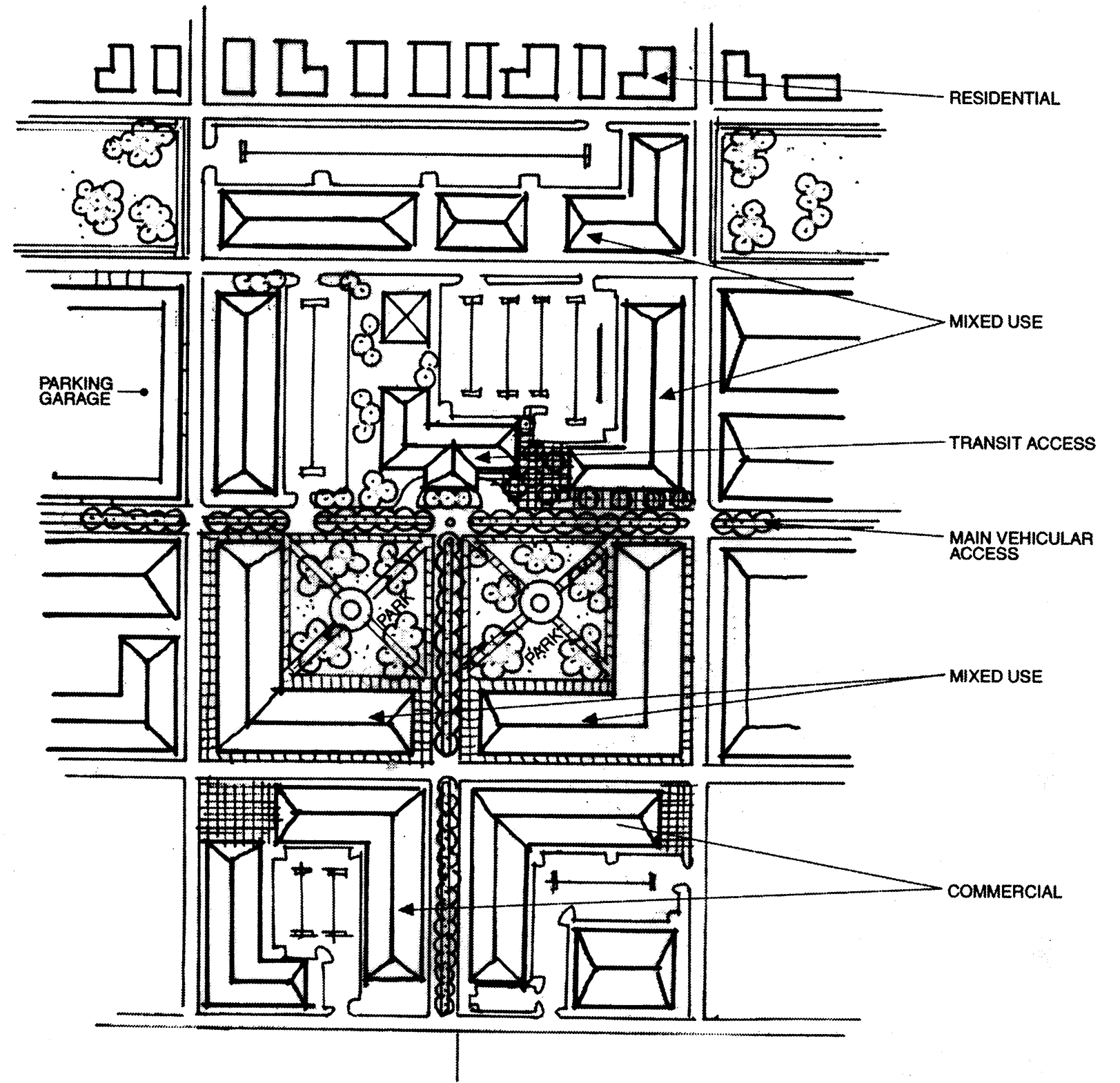
App. A Section 3-5-4
Purpose statement: The transit oriented development district encourages a mixture of residential, commercial, and employment opportunities within identified light rail station or other high capacity transit areas. The district allows for a more intense and efficient use of land at increased densities for the mutual reinforcement of public investments and private development. Uses and development are regulated to create a more intense built-up environment, oriented to pedestrians and bicycles, to provide a density and intensity that is transit supportive. The development standards of the zone also are designed to encourage a safe and pleasant pedestrian and bicycle environment near transit stations by encouraging an intensive area of shops and activities, by encouraging amenities such as benches, kiosks, and outdoor cafes, and by limiting conflicts between vehicles and pedestrians and bicycles. It is the intent of this section that a TOD district be restricted to areas within one-half of a mile of a transit station, which area is equivalent to a typical 10-minute walking distance.
Because most transit users will walk only one-quarter to one-half of a mile to a transit facility, transit influence areas require high densities on small areas of land. The town therefore finds and determines that uses inconsistent with transit will undermine the most efficient use of limited land areas within a TOD, and may render the transit system unworkable. Accordingly, the uses permitted within the core (TOD-C) and perimeter (TOD-P) zoning districts are those which are dependent upon, or which may generate, a relatively high level of transit usage. Uses which would interfere with transit usage and which generate few transit trips are not permitted.
(a)
Designation procedures.
A transit oriented development may be designated pursuant to the procedures established in section 4.4 of this appendix.
(b)
Designation criteria.
To be designated a transit oriented development district, the area must meet the following criteria:
(1)
At least fifty (50) percent of the territory within a TOD must lie within one-quarter (¼) of a mile of a transit station or major bus boarding location, and shall be classified as transit oriented development-core ("TOD-C").
(2)
Areas between one-quarter (¼) of a mile and one-half (½) of a mile from a transit station or a major bus boarding location may be classified as transit oriented development-perimeter ("TOD-P"). No land area shall be zoned "TOD-P" unless it adjoins an area zoned "TOD-C."
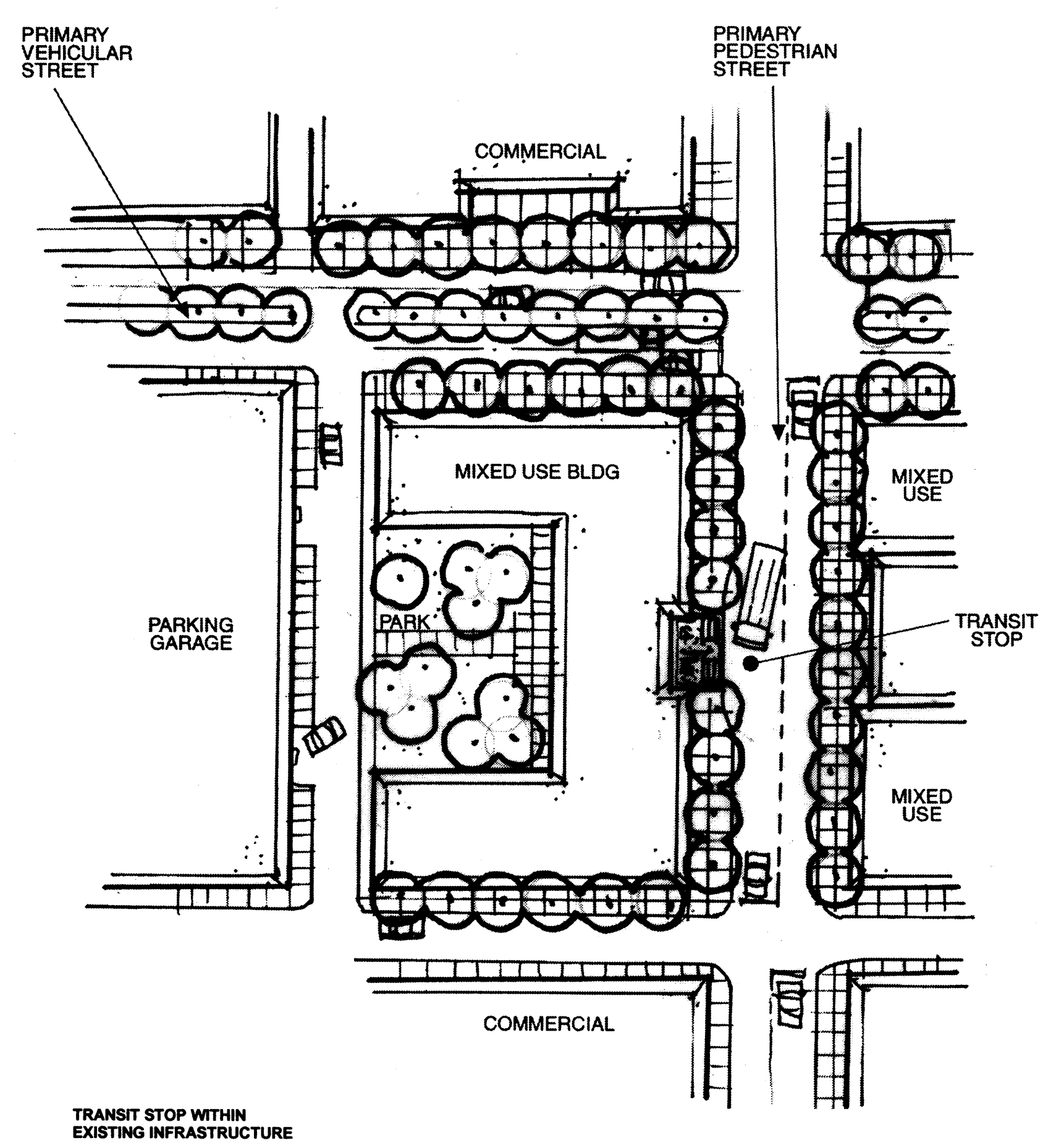
(c)
Uses and dimensional standards.
The TOD district shall establish minimum levels of density and intensity required to support transit ridership, and prohibit lower levels of density which will not support transit ridership and will create unacceptable levels of vehicular congestion.
The TOD district shall establish permitted, special and prohibited uses. Land uses which are not supportive of public transportation in that they tend to not generate transit ridership, and which require access primarily by automobile, shall be prohibited.
(d)
Development standards.
The ordinance designating the TOD shall include standards governing landscaping, lot layout, buffers, setbacks, parks and open space, parking, transportation, and urban design. The ordinance shall establish maximum setbacks and maximum parking requirements which support transit usage.
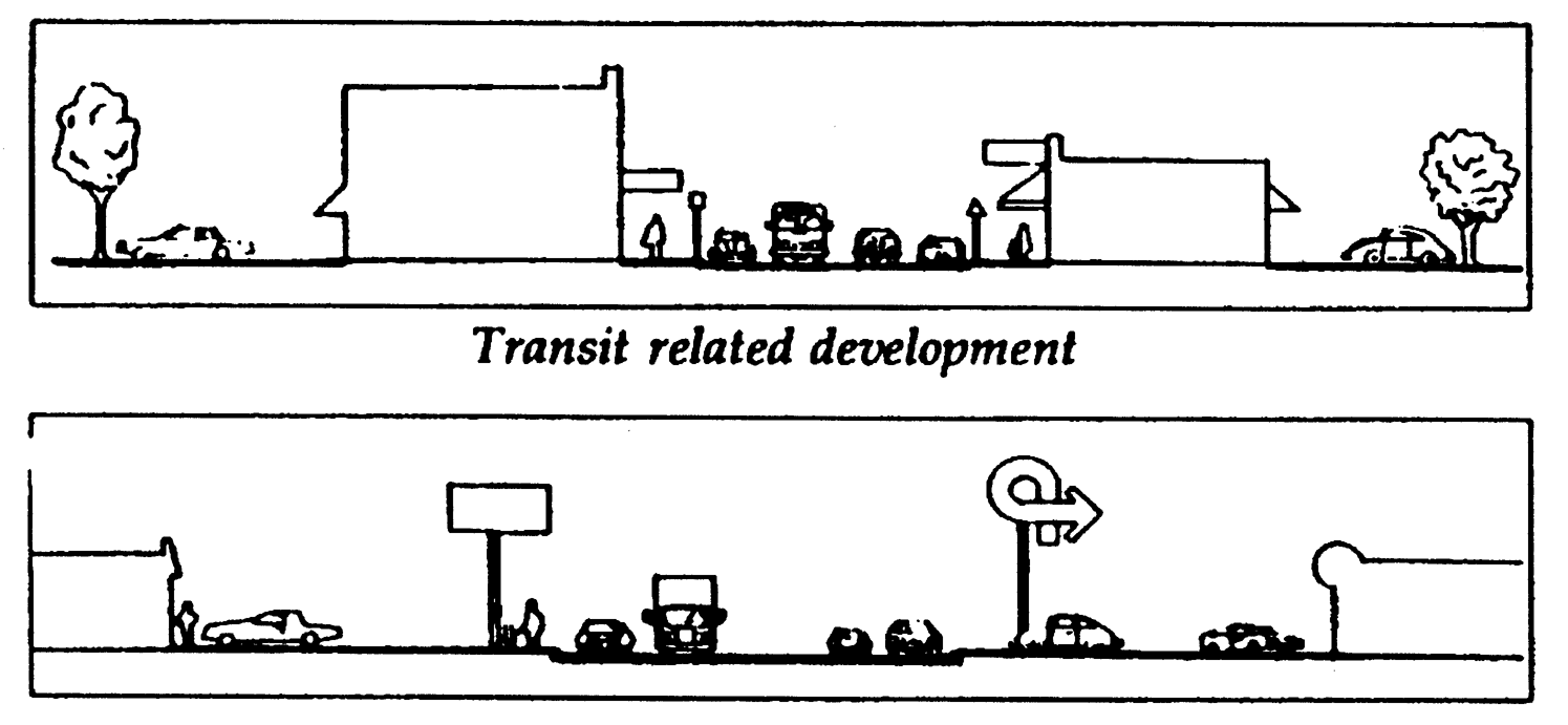
Example: Buildings within a TOD district feature small front setbacks in order to provide efficient pedestrian and bicycle movement (top graphic). Buildings in conventional commercial strips do not support transit usage because pedestrians are separated from buildings by parking lots and wide setbacks (bottom graphic).
(Source: USDOT, A Guide to Land Use and Public Transportation (Dec. 1989))
3.5.5. University-1 District
(a)
Purpose and intent. The purpose and intent of the University-1 district (U-1) is to establish procedural and substantive standards for the town council's review and approval of development on large tracts of land where the predominant uses are to be public or private development for college/university, research activity, civic, hospital, clinics, cultural, and/or related or support functions with integrated supporting housing, general business, convenience business, office-type business, recreation, utility, and/or open space uses.
The objective of the U-1 district is to allow for orderly and sustainable growth and major new development while mitigating impacts to nearby neighborhoods, the community, and the environment. A key feature of this district is the concurrent review of a rezoning application and an initial proposed development agreement within such district that allows the property owner, immediate neighbors, and community to understand the type and intensity of development being proposed, the timing of that development, the potential impacts of the development, the mitigation measures that will be implemented to address those impacts, and the commitments of both the developer and the town regarding public facilities and services needed to support the proposed development. A development agreement that is approved by ordinance as a legislative decision of the town council pursuant to G.S. 160D-1003 is an integral component of the U-1 zoning district.
(b)
Overview of development review procedures. Procedures in this zoning district are designed to facilitate:
1.
Articulation of a long-term development plan that provides a context for more detailed intermediate and short term plans and projects;
2.
Articulation of detailed plans that involve multiple buildings over an extended time period on a defined portion of the zoning district that is subject to an individual development agreement;
3.
Identification of the infrastructure needs and impacts related to the development specified in a development agreement;
4.
Provision of measures to mitigate the negative impacts of development in the development agreement and to promote sustainability of approved development, with the mitigation implemented in a manner appropriate with the pace of development; and
5.
Provision of predictability and certainty as to the type, intensity, and design of development set out in a town council-approved development agreement.
Applicants proposing that property be zoned U-1 must submit a long-range development plan and supporting analysis at the time of petition for rezoning to this district. Upon approval by the town council of a development agreement in this district, site development permits for individual buildings are to be issued by the town manager, following a determination by the town manager that such individual building projects do not violate the town council-approved development agreement.
For development proposed within the U-1 zoning district that is not included in a town council-approved development agreement, but is a minor modification according to the provisions of this section, the town manager may approve a change to the development agreement and issue a site development permit.
Except as specifically authorized as a permitted use under subsection 3.5.5(g)(1), development proposed within this zoning district that is not included in a town council-approved development agreement and/or that cannot be considered a minor modification to a development agreement shall be considered to be a special use and subject to the special use permit standards and procedural requirements of section 4.5 of this appendix. In the alternative, the applicant may apply to the town council for an amendment to the development agreement.
The terms used within this section have the same meaning and scope as provided by this appendix and state law. Provided, however, that to the extent a council-approved and owner-executed development agreement define a term to have a different meaning or scope, that meaning and scope shall apply as specified in the development agreement.
(c)
Minimum requirements.
An application for rezoning to a U-1 district may only be initiated by the owner of the property to be rezoned or a duly authorized agent of the owner.
An application for rezoning to a U-1 district must, in addition to all other requirements of this ordinance, include:
1.
A long-range plan for the development of the entire area proposed to be included in the district.
2.
An ecological assessment of the entire area proposed to be included in the district.
3.
A proposed development agreement for a discrete portion of the land to be placed in the district.
The town manager may specify forms and reasonable requirements related to these mandated materials to be submitted with a rezoning petition.
(d)
Long-range development plan. When an application for a rezoning to this district is submitted, the developer shall submit a long-range development plan to provide an opportunity for the town council, town manager and citizens to see the developer's current plans at a conceptual level for long-term development of all property within the proposed zoning district. This long-range plan is necessary to provide a context for individual development agreements for development within the district. The long-range plan shall represent a good faith depiction of the developer's intentions relative to overall development of the site. It is not, however, submitted for town approval and shall not be deemed to create a binding commitment on behalf of the developer or the town.
The long-range development plan shall be submitted to the town manager prior to or concurrently with the submission of an application to rezone property into this district. An updated long-range development plan shall also be submitted with all applications for approval of a development agreement within the district or for approval of major modifications of a development agreement within the district.
(e)
Development agreement. A proposed development agreement in this district must include all provisions mandated by state law and shall at a minimum include:
1.
A legal description of the property subject to the agreement and the names of its legal and equitable property owners.
2.
The duration of the agreement.
3.
The development uses permitted on the property, including population densities and building types, intensities, placement on the site, and design.
4.
A description of public facilities that will service the development, including who provides the facilities, the date any new public facilities, if needed, will be constructed, and a schedule or triggering points to assure public facilities are available concurrent with the impacts of the development.
5.
A description, where appropriate, of any reservation or dedication of land for public purposes and any provisions to protect environmentally sensitive property.
6.
A description of all local development permits approved or needed to be approved for the development of the property together with a statement indicating that the failure of the agreement to address a particular permit, condition, term, or restriction does not relieve the developer of the necessity of complying with the law governing their permitting requirements, conditions, terms, or restrictions.
7.
A description of any conditions, terms, restrictions, or other requirements determined to be necessary by the town council for the public health, safety, or welfare.
8.
A description, where appropriate, of any provisions for the preservation and restoration of historic structures.
9.
A development schedule, including commencement dates and interim completion dates at no greater than five-year intervals, provided, however, the failure to meet a commencement or completion date shall not, in and of itself, constitute a material breach of the development agreement pursuant to NCGS 160D-1008 but must be judged based upon the totality of the circumstances.
The development agreement may provide that the entire proposed development or any phase of it be commenced or completed within a specified period of time. The development agreement may include other defined performance standards to be met by the applicant and/or its successors in interest.
(f)
Permitted within the boundary of a development agreement.
(1)
Permitted uses within a development agreement. The predominant uses are to be public or private development for college/university, research activity, civic, hospital, clinics, cultural, and/or related or support functions with integrated supporting housing, general business, convenience business, office-type business, recreation, utility, and/or open space uses. Uses that may be approved within a development agreement in this district include all uses allowed within the OI-4 district as permitted uses, special uses, or accessory uses. The maximum floor area, density of development, building heights and general locations, other attributes of development intensity, and design guidelines for the development permitted shall be as provided in a town council-approved development agreement. The development agreement may provide that specified uses shall require a town council-approved special use permit.
A large central cogeneration/utility plant may only be approved within a development agreement in this district upon approval of a special use permit by the town council. For the purposes of this section, a large central cogeneration/utility plant includes any facility designed to produce steam, heat, electric power, chilled water, or cooling for other buildings and that is designed to or has the capacity to serve more than two million square feet of building space. The process established by section 4.5.3 of this appendix shall be followed in the consideration of this special use permit and sections 4.5.4 and 4.5.5 of this appendix shall apply to modification, expiration, and revocation of this special use permit. The town council shall not approve that permit unless each of the following findings is made:
1.
That the use is located, designed, and proposed to be operated so as to maintain or promote the public health, safety, and general welfare;
2.
That the use is located, designed, and proposed to be operated so as to maintain or enhance the value of contiguous property, or that the use is a public necessity;
3.
That the use conforms with the general plans for the physical development of the town as embodied in the comprehensive plan; and
4.
That the use conforms with the applicable terms of the development agreement.
(g)
Permitted and special uses outside a boundary area of a development agreement.
(1)
Permitted uses outside the boundary area of a development agreement. Uses that may be approved as permitted uses within the zoning district but outside the boundary area or terms of a town council-approved development agreement are:
Community gardens;
Local farmers markets;
Recreational facility, non-profit;
Trails, greenways, and recreational land;
Public use facilities;
Solar energy collection arrays;
Radio, television, or wireless transmitting and/or receiving facilities, provided the total height of an antenna-supporting structure is not more than one hundred twenty (120) feet and there is a five hundred-foot or more setback from the property line;
Wind turbines designed to produce 100kW or less, provided the total height is not more than one hundred twenty (120) feet, there is a minimum ground clearance of thirty (30) feet from rotors, and there is a five hundred-foot or more setback from the property line. Wind turbines designed to produce 100kW or less may also be located on rooftops.
These permitted uses shall require a zoning compliance permit pursuant to section 4.9 of this appendix and, as is provided for OI-3 and OI-4 districts in Table 3.7-1 (Use Matrix), shall not require a special use permit based on the floor area of the proposed development.
(2)
Uses subject to a special use permit outside the boundary area of a development agreement. Uses that may be approved as special uses within this zoning district outside the boundary or terms of a town council-approved development agreement (including proposed uses for property formerly covered by a development agreement that has expired or been terminated) are limited to those uses allowed within the OI-4 district as permitted uses, special uses, or accessory uses as set forth in Table 3.7-1 (Use Matrix). These special uses shall be subject to the dimensional requirements for the OI-4 district as set forth in Table 3-8.1 (Dimensional Matrix) and the perimeter transition area requirements applicable in the OI-4 district.
(h)
Existing conditions within a U-1 zoning district. Existing uses, structures, and conditions within a U-1 zoning district as of the effective day property is placed in this district may be continued as specified by this section. All existing uses of land that do not involve the use of a building can be continued as they exist as of the effective date the property is zoned U-1 and can be changed to any use permitted by subsection 3.5.5(f)(1). Any existing building within the U-1 district can be used for the use in effect as of the effective date property is zoned U-1 and can be changed to any use permitted pursuant to a development agreement as authorized by subsection 3.5.5(f)(1). Any existing building being used for a use permitted by this appendix or by an applicable development agreement may be expanded to the extent that the town manager finds that the expansion is exempt from the transportation impact analysis requirements of subsection 5.8(g) of this appendix. Any new construction, development, or site improvements associated with continuation of existing conditions shall be consistent with the terms of all applicable development agreements in effect within the district.
(i)
Development standards. Development in the U-1 zoning district shall be designed to provide a mix of uses within all major phases of the development that are integrated, interrelated and linked by pedestrian ways, bikeways, and/or other transportation systems. Development agreements shall, to the extent practical and consistent with applicable laws and regulations, include measures to encourage reduction of automobile use and promote alternative modes of transportation; to provide sustainable building design and land uses; to mitigate adverse environmental impacts; to promote conservation of non-renewable energy resources; to exceed minimally accepted practices; and to achieve visual continuity in the siting and scale of buildings.
Specifically, a development agreement in this district shall at a minimum address the following:
1.
Plan consistency. The proposed development shall be generally consistent with the long range development plan for the district submitted by the owner. The development shall be generally consistent with the adopted comprehensive plan for the town.
2.
Transportation. Proposed development shall be accompanied by reasonable measures to mitigate transportation impacts that are caused by the development. Proposed development shall address parking, transit, traffic, road, greenway, bikeway, and pedestrian access.
3.
Fiscal impact. Proposed development shall be accompanied by reasonable measures to mitigate any adverse fiscal impacts for the town; provided that, pursuant to NCGS 160D-1001 (b), the town may not impose any tax or fee not authorized by otherwise applicable law.
4.
Housing. Proposed development shall be accompanied at appropriate times by on-site housing to mitigate the impacts that are caused by the development. Such housing shall address student and/or workforce housing needs. A range of housing availability and price levels shall be shall be provided within each major phase and area of the proposed development.
5.
Noise and lighting. Noise and lighting levels from proposed development shall not exceed those allowed by town ordinances or the provisions of the development agreement, whichever are more stringent.
6.
Environment. Proposed development shall seek to minimize impacts on natural site features and shall be accompanied by reasonable measures to mitigate those impacts. Proposed development shall address preservation of open land and natural areas, management of stormwater quality and quantity, energy generation and use, preservation of solar access, solar orientation of buildings, air quality, sustainable water and wastewater management, protection of stream buffers, soil erosion and sedimentation control, landscape and vegetation protection.
7.
Public utilities and services. Proposed development shall assure that there are adequate public utilities and services and shall be accompanied by reasonable measures to assure the availability of such services concurrent with the creation of the need for the services. There shall be a general demonstration that police, fire, emergency, water, sewer, school, recreation, and other necessary utilities and public services will be available to accommodate the proposed development.
The development agreement shall provide for regular monitoring, reporting, and evaluation of the effectiveness of the development standards.
(j)
Minor and major modifications to development agreements. A development agreement may be modified or canceled by mutual consent of the parties to the agreement or by their successors in interest.
Either party may propose a major or minor modification to any town council-approved development agreement. Upon receipt of a proposed modification, the town manager shall consider the following criteria in making the determination as to whether a proposed adjustment is a major or a minor modification to a development agreement:
1.
A substantial change in the boundaries of the development agreement shall constitute a major modification. Any single proposed increase or decrease in the area of land subject to the development agreement approved by the town council of more than five (5) percent shall be considered substantial. A cumulative increase of fifteen (15) percent or more in the land area subject to the development agreement shall be considered substantial.
2.
A substantial change in the floor area or number of parking spaces shall constitute a major modification. Any single proposed increase or decrease in new floor area or number of parking spaces of more than a five (5) percent in a development agreement approved by the town council shall be considered a major modification. A cumulative increase of fifteen (15) percent or more in the floor area or number of parking spaces subject to the development agreement shall be considered a major modification. Provided, under no circumstances shall a change in floor area of less than one thousand (1,000) square feet or fewer than ten (10) parking spaces be deemed either a major amendment or minor modification and such changes shall be reported by the applicant to the town manager.
3.
Changes that would substantially affect pedestrian, bicycle, or vehicular access or circulation beyond the boundaries of the development agreement shall constitute a major modification.
4.
Substantial change in the amount or location of open space within the boundaries of a development agreement shall constitute a major modification. Any single change that increases or decreases the amount of open space by more than five (5) percent shall be considered a major modification. A cumulative increase or decrease in the amount of open space by fifteen (15) percent or more or a substantial change in the location of designated open space shall be considered a major modification.
Notwithstanding the above, some proposed changes to a town-council approved development agreement that do not meet the threshold to constitute a major modification may in the judgment of the town manager, because of size, perimeter location or transportation impacts, merit public review. In the event the manager makes such a determination he may submit the proposed minor modification at a town council meeting to allow an opportunity for council review and citizen comment. Unless the other party to the development agreement agrees otherwise, such a review shall not extend the time period allowed for a decision by the manager on the minor modification or convert the change from a minor modification into a major modification.
All proposed adjustments to a town council-approved development agreement shall be publicly posted in such a manner that citizens of Chapel Hill will have the opportunity to express any concerns to the town council and/or the town manager. The town manager shall determine whether a proposed adjustment to a town council-approved development agreement is a major or a minor modification within fifteen (15) working days of receipt of a proposed adjustment and shall promptly notify the town council and applicant of that determination. If the proposed action is determined to be a major modification, the town manager shall require the filing of an application for approval of the amendment, following procedures outlined in subsection 3.5.5(k) of this appendix.
In the event state or federal law is changed after a development agreement has been entered into and the change prevents or precludes compliance with one or more provisions of the development agreement, the town council may modify the affected provisions, upon a finding that the change in state or federal law has a fundamental effect on the development agreement. In so doing, the procedures set forth for original approval of the development agreement shall be followed.
Except for grounds specified in NCGS 160D-108(c) or 160D-108.1(f), the town shall not apply subsequently adopted ordinances or development policies to the development that is subject to the approved development agreement.
(k)
Procedure for review of development agreements, amendments, and modifications.
(1)
Application submittal requirements. Applications for approval of a development agreement, a major modification to a previously approved development agreement, and a minor modification to a previously approved development agreement within a U-1 zoning district shall be submitted to the town manager. The town manager shall prescribe the form(s) of applications as well as any other material as the town manager may reasonably require to determine compliance with this section.
(2)
Process for review.
A.
Informal consultation. Prior to submission of a proposed development agreement or a major modification to a previously approved development agreement within this district, the applicant shall consult with the town manager and town council regarding the proposed development. The applicant is encouraged to engage in active discussion and collaboration with the town staff, town council, town advisory boards, neighbors, and the community in the preparation of a proposed development agreement or amendment and plans for development.
B.
Draft agreement. A draft development agreement and long-range development plan for the activity to be addressed in the development agreement shall be submitted to the town manager prior to the submission of a formal development agreement. The manager and applicant shall present the draft agreement to the planning commission, such other advisory boards as deemed appropriate by the town council, and the town council for review and comment. The manager and applicant shall also present the draft agreement in informal public information sessions for public review and comment. A formal application for approval of a development agreement may be submitted upon completion of the review, comment, and revision of the draft development agreement.
C.
Initial development agreement. Applications for approval of an initial development agreement within this zone shall be processed concurrently with the petition for rezoning to the U-1 district. The legislative hearing on the initial development agreement shall be noticed and held concurrently with the hearing on the proposed rezoning. Notice of the legislative hearing before the town council on the proposed development agreement shall follow the same notice requirements as are applicable for hearings on proposed zoning atlas amendments. The public notice shall include the location of the property covered by the proposed development agreement, the development uses proposed on the property, and the place a copy of the proposed development agreement may be obtained or reviewed. The town council's legislative hearing on the proposed development agreement shall be open to the public and all interested persons shall be given the opportunity to present comments. The town council shall take action on an application for an initial development agreement within this zone concurrently with action on the application for rezoning to this district. The initial development agreement may be applicable to all or part of the land within the district.
D.
Subsequent development agreements and major modifications. Subsequent new development agreements within this zoning district and major modifications of a previously approved development agreement shall be considered using the following process:
1.
Upon receipt of an application for approval, the town manager shall review the proposal for completeness. The town manager shall determine within fifteen (15) working days whether the application is complete and shall promptly notify the town council and applicant of that determination. If the application is determined to be incomplete, a notice of the deficiencies in the mandatory items to be included in a proposed agreement or major amendment shall be provided to the applicant with the notice of the town manager's determination. If the application is determined to be complete, the town manager shall notify the applicant of that determination and shall prepare a report on the proposed agreement or major modification.
2.
The town manager shall submit a complete proposed agreement or major modification and the town manager's report to the planning commission for review and comment. The planning commission shall review the application and the town manager's report and shall submit to the town council a written recommendation regarding the proposed agreement or amendment. The planning commission shall submit its recommendation within thirty-five (35) calendar days of the meeting at which the town manager's report is submitted to it or within such further time consented to in writing by the applicant or by town council resolution. If the planning commission fails to prepare its recommendation to the town council within this time limit, or extensions thereof, the town council may consider the proposed agreement without a comment or recommendation from the planning commission.
3.
The town council shall hold a legislative hearing on a proposed subsequent development agreement or major modification to a previously approved development agreement. Notice of the date, time, and place of the legislative hearing before the town council shall follow the same published, mailed, and posted notice requirements as are applicable for hearings on proposed zoning atlas amendments. The public notice shall include the location of the property covered by the proposed development agreement, the development uses proposed on the property, and the place a copy of the proposed development agreement may be obtained or reviewed. The town council's legislative hearing on the proposed agreement or major modification shall be open to the public and all interested persons shall be given the opportunity to present comments.
4.
The town council shall issue a decision on a proposed subsequent development agreement or major modification to a previously approved development agreement within one hundred twenty (120) calendar days of the date of the town manager's determination that a complete application was submitted or such further time as mutually agreed to by the applicant and the town.
E.
Minor modifications to a previously approved development agreement may be approved by the town manager as long as such changes continue to be in substantial compliance with the approving action of the town council and all other applicable requirements and result in a configuration of buildings/development that is generally consistent with the town council-approved development agreement. The town manager shall not have the authority to approve changes that constitute a major modification of a town council-development agreement, which includes change in uses permitted or the density of overall development permitted unless permitted to make such modifications by the terms of the town-council-approved development agreement.
F.
The time periods referenced in this subsection shall not run during any period in which the applications for subsequent development agreements or major modification to a previously approved development agreement have been returned to the applicant for substantial modification or analysis. The time periods set forth in this subsection may also be modified by mutual consent of the applicant and the town council.
(l)
Actions after the decision on a development agreement.
(1)
Recording approval. If the application for approval of a development agreement or major modification is approved or approved with conditions, the town manager shall execute the development agreement or modification in accord with the action of the town council. The applicant shall then execute the development agreement or modification and record the development agreement or modification in the office of the applicable county register of deeds within fourteen (14) days after the town enters into the development agreement. The burdens of the development agreement are binding upon, and the benefits of the agreement shall inure to, all successors in interest to the parties to the agreement.
(2)
Individual site development permits. After an executed development agreement is recorded, the town manager may then accept applications for individual site development permits for specific buildings that the applicant proposes to build within the physical boundaries covered by the agreement. No construction work on any such building identified in the agreement may begin until a site development permit has been issued. The town manager shall prescribe the form(s) of applications as well as any other material the town manager may reasonably require to determine compliance with the agreement. The town manager shall approve or deny of the individual site development permit application within fifteen (15) working days of the manager's determination that the individual site development plan application is complete. The town manager shall approve the application upon finding it is substantially consistent with and does not violate any term of the agreement and shall deny approval upon finding the application is not substantially consistent with or violates a term of the agreement. If the application is denied, the town manager shall specify the grounds for finding that it is inconsistent or in violation and refer the applicant to the special use permit process described in section 4.5 of this appendix. Alternatively, the applicant may modify the site development permit application or apply for a major modification to the development agreement. Provided, under no circumstances shall a change in floor area of less than one thousand (1,000) square feet or fewer than ten (10) parking spaces be deemed either a minor modification or major modification of the development agreement nor require approval or modification of an individual site development permit; such changes shall be reported by the applicant to the town manager.
(3)
Expiration, abandonment, revocation of development agreement. The term of any development agreement shall be set forth in the agreement. The development agreement shall also contain specific provisions relative to default or termination of the agreement.
(4)
Periodic review and amendment of the development agreement. The town manager shall at least every twelve (12) months conduct a review of the development agreement at which time the applicant or its successors in interest must demonstrate good faith compliance with the terms of the development agreement. The town manager shall promptly report the results of this review to the town council. If, as a result of this periodic review, the town council finds and determines that the applicant or its successors in interest has committed a material breach of the terms or conditions of the agreement, the town manager shall serve notice in writing, within a reasonable time not to exceed thirty (30) working days after the periodic review, upon the applicant or its successors in interest setting forth with reasonable particularity the nature of the breach and the evidence supporting the finding and determination, and providing the applicant or their successors in interest a reasonable time in which to cure the material breach. If the applicant or its successors in interest fail to cure the material breach within the time given, then the town council unilaterally may terminate or modify the development agreement pursuant to NCGS 160D-1008; provided, the notice of termination or modification may be appealed to the board of adjustment in the manner provided by ) NCGS 160D-405. Thereafter the applicant or its successors in interest may pursue any other rights and remedies available at law or in equity. If the town council elects to unilaterally modify the agreement, the applicant or its successors in interest may elect for the development agreement to be terminated rather than accede to the development agreement with the modifications unilaterally made by the town council.
(Ord. No. 2021-05-19/O-1, §§ 14-21)
3.5.6 Development Agreement—1 District.
(a)
Purpose and intent. The purpose and intent of the Development Agreement-1 district (DA-1) is to establish procedural and substantive standards for the town council's review and approval of development where the predominant uses are to be private development that includes uses such as housing, general business, convenience business, office-type business, recreation, utility, and/or open space uses.
The objective of the DA-1 district is to allow for orderly and sustainable growth and major new development while mitigating impacts to nearby neighborhoods, the community, and the environment. A key feature of this district is the concurrent review of a rezoning application and an initial proposed development agreement within such district that allows the property owner, immediate neighbors, and community to understand the type and intensity of development being proposed, the timing of that development, the potential impacts of the development, the mitigation measures that will be implemented to address those impacts, and the commitments of both the developer and the Town regarding public facilities and services needed to support the proposed development. A development agreement that is approved by ordinance as a legislative decision of the town council pursuant to NCGS 160D-1003 is an integral component of the DA-1 zoning district.
(b)
Overview of development review procedures. Procedures in this zoning district are designed to facilitate:
1.
Articulation of a long-term development plan that provides a context for more detailed intermediate and short term plans and projects;
2.
Articulation of detailed plans that involve multiple buildings over an extended time period on a defined portion of the zoning district that is subject to an individual development agreement;
3.
Identification of the infrastructure needs and impacts related to the development specified in a development agreement;
4.
Provision of measures to mitigate the negative impacts of development in the development agreement and to promote sustainability of approved development, with the mitigation implemented in a manner appropriate with the pace of development; and
5.
Provision of predictability and certainty as to the type, intensity, and design of development set out in a town council-approved development agreement.
Applicants proposing that property be zoned DA-1 must submit a long-range development plan and supporting analysis at the time of petition for rezoning to this district. Upon approval by the town council of a development agreement in this district, site development permits for individual buildings are to be issued by the town manager, following a determination by the town manager that such individual building projects do not violate the town council-approved development agreement.
For development proposed within the DA-1 zoning district that is not included in a town council-approved development agreement, but is a minor modification according to the provisions of this section, the town manager may approve a change to the development agreement and issue a site development permit.
Except as specifically authorized as a permitted use under section 3.5.6(e)(1), development proposed within this zoning district that is not included in a town council-approved development agreement and/or that cannot be considered a minor modification to a development agreement shall be considered to be a special use and subject to the special use permit standards and procedural requirements of section 4.5 of this appendix. In the alternative, the applicant may apply to the town council for an amendment to the development agreement.
The terms used within this Section have the same meaning and scope as provided by this appendix and state law. Provided, however, that to the extent a council-approved and owner-executed development agreement defines a term to have a different meaning or scope, that meaning and scope shall apply as specified in the development agreement.
(c)
Minimum Requirements. Areas with contiguous acres of developable property (as defined by NCGS 160D-1004) under common ownership or management may be placed in a DA-1 zoning district:
An application for rezoning to a DA-1 district must, in addition to all other requirements for this ordinance, include:
1.
An ecological analysis of the entire area proposed to be included in the district.
2.
A proposal to establish a development agreement of the land to be place in the district.
The requirement of an approved development agreement may include work or restrictions beyond the property zoned DA-1.
The town manager may specify forms and reasonable requirements related to these mandated materials to be submitted with a rezoning petition.
(d)
Development agreement. A proposed development agreement in this district must include all provisions mandated by state law and shall at a minimum include:
1.
A legal description of the property subject to the agreement and the names of its legal and equitable property owners.
2.
The duration of the agreement.
3.
The development uses permitted on the property, including population densities and building types, intensities, placement on the site, and design.
4.
A description of public facilities that will service the development, including who provides the facilities, the date any new public facilities, if needed, will be constructed, and a schedule or triggering points to assure public facilities are available concurrent with the impacts of the development.
5.
A description, where appropriate, of any reservation or dedication of land for public purposes and any provisions to protect environmentally sensitive property.
6.
A description of all local development permits approved or needed to be approved for the development of the property together with a statement indicating that the failure of the agreement to address a particular permit, condition, term, or restriction does not relieve the developer of the necessity of complying with the law governing their permitting requirements, conditions, terms, or restrictions.
7.
A description of any conditions, terms, restrictions, or other requirements determined to be necessary by the Town Council for the public health, safety, or welfare.
8.
A description, where appropriate, of any provisions for the preservation and restoration of historic structures.
9.
A development schedule, including commencement dates and interim completion dates provided, however, the failure to meet a commencement or completion date shall not, in and of itself, constitute a material breach of the development agreement pursuant to NCGS 160D-1008 but must be judged based upon the totality of the circumstances.
The development agreement may provide that the entire proposed development or any phase of it be commenced or completed within a specified period of time. The development agreement may include other defined performance standards to be met by the applicant and/or its successors in interest.
(e)
Permitted uses within the boundary of a development agreement.
(1)
Permitted uses within a development agreement. The predominant uses are to be private development for housing, general business, convenience business, office-type business, recreation, utility, and/or open space uses. The permitted uses, special uses, or accessory uses in the Development Agreement-1 (DA-1) within the boundary of a development agreement are limited to those uses as set forth in Table 3.7-1: Use Matrix and may be further limited by the terms of any development agreement entered into by a property owner and the Town.
(2)
The maximum floor area, density of development, building heights and general locations, other attributes of development intensity, and design guidelines for the development permitted shall be as provided in a town council-approved development agreement. The development agreement may provide that specified uses shall require a town council-approved special use permit.
(f)
Permitted and special uses outside a boundary area of a development agreement.
(1)
Uses that may be approved as permitted uses within the DA-1 zoning district but outside the boundary area or terms of a town council-approved development agreement are:
○ Community gardens;
○ Local farmers markets;
○ Recreational facility, non-profit;
○ Trails, greenways, and recreational land;
○ Public use facilities;
○ Solar energy collection arrays;
○ Wind turbines designed to produce one hundred (100) kW or less, provided the total height is not more than one hundred twenty (120) feet, there is a minimum ground clearance of 30 feet from rotors, and there is a 500-foot or more setback from the property line. Wind turbines designed to produce 100kW or less may also be located on rooftops.
These permitted uses shall require a zoning compliance permit pursuant to section 4.9 of this appendix.
(2)
Uses that may be approved as special uses within this zoning district outside the boundary or terms of a Town Council-approved development agreement (including proposed uses for property formerly covered by a development agreement that has expired or been terminated) are limited to those uses as set forth in Table 3.7-1 (Use Matrix). These special uses shall be subject to the dimensional requirements as set forth in Table 3-8.1 (Dimensional Matrix) and the applicable perimeter transition area requirements.
(g)
Existing conditions within a DA-1 zoning district. Existing uses, structures, and conditions within a DA-1 zoning district as of the effective day property is placed in this district may be continued as specified by this section. All existing uses of land that do not involve the use of a building can be continued as they exist as of the effective date the property is zoned DA-1. Any existing building being used for a use permitted by this appendix or by an applicable development agreement may be expanded to the extent that the town manager finds that the expansion is exempt from the transportation impact analysis requirements of section 5.8(g) of this appendix. Any new construction, development, or site improvements associated with continuation of existing conditions shall be consistent with the terms of all applicable development agreements in effect within the district.
(h)
Development standards. Development in the DA-1 zoning district shall be designed to provide a mix of uses within all major phases of the development that are integrated, interrelated and linked by pedestrian ways, bikeways, and/or other transportation systems. Development agreements shall, to the extent practical and consistent with applicable laws and regulations, include measures to encourage reduction of automobile use and promote alternative modes of transportation; to provide sustainable building design and land uses; to mitigate adverse environmental impacts; to promote conservation of non-renewable energy resources; to exceed minimally accepted practices; and to achieve visual continuity in the siting and scale of buildings. In the DA-1 zone, a development agreement covering land may provide for standards and regulations that are different from those which would otherwise be applicable under the LUMO. Except as specifically provided otherwise by the terms of any approved development agreement, the regulations found in this Appendix applicable in the R-1 zoning district shall apply.
Specifically, a development agreement in this district shall at a minimum address the following:
1.
Plan consistency. The proposed development shall be generally consistent with the long range development plan for the district submitted by the owner. The development shall be generally consistent with the adopted comprehensive plan for the Town.
2.
Transportation. Proposed development shall be accompanied by reasonable measures to mitigate transportation impacts that are caused by the development. Proposed development shall address parking, transit, traffic, road, greenway, bikeway, and pedestrian access.
3.
Fiscal impact. Proposed development shall be accompanied by reasonable measures to mitigate any adverse fiscal impacts for the Town; provided that, pursuant to NCGS 160D-1001(b), the Town may not impose any tax or fee not authorized by otherwise applicable law.
4.
Housing. Proposed development shall be accompanied at appropriate times by on-site housing to mitigate the impacts that are caused by the development. A range of housing availability and price levels shall be shall be provided within each major phase and area of the proposed development.
5.
Noise and lighting. Noise and lighting levels from proposed development shall not exceed those allowed by Town ordinances or the provisions of the development agreement, whichever are more stringent. In cases where property frontage is along a US highway, lighting standards may be governed by North Carolina Department of Transportation standards in the event they are less stringent than the Town ordinance.
6.
Environment. Proposed development shall seek to minimize impacts on natural site features and shall be accompanied by reasonable measures to mitigate those impacts. Proposed development shall address preservation of open land and natural areas, management of stormwater quality and quantity, energy generation and use, preservation of solar access, solar orientation of buildings, air quality, sustainable water and wastewater management, protection of stream buffers, soil erosion and sedimentation control, landscape and vegetation protection.
7.
Public utilities and services. Proposed development shall assure that there are adequate public utilities and services and shall be accompanied by reasonable measures to assure the availability of such services concurrent with the creation of the need for the services. There shall be a general demonstration that police, fire, emergency, water, sewer, school, recreation, and other necessary utilities and public services will be available to accommodate the proposed development.
The development agreement shall provide for regular monitoring, reporting, and evaluation of the effectiveness of the development standards.
(i)
Minor and major modifications to development agreements. A development agreement may be amended or canceled by mutual consent of the parties to the agreement or by their successors in interest.
Either party may propose a major modification or minor modification to any town council-approved development agreement. Upon receipt of a proposed adjustment, the town manager shall consider the following criteria in making the determination as to whether a proposed adjustment is a major or a minor modification to a development agreement:
1.
A substantial change in the boundaries of the development agreement shall constitute a major modification. Any single proposed increase or decrease in the area of land subject to the development agreement approved by the town council of more than five (5) percent shall be considered substantial. A cumulative increase of 15 percent or more in the land area subject to the development agreement shall be considered substantial.
2.
A substantial change in the floor area or number of parking spaces shall constitute a major modification. Any single proposed increase or decrease in new floor area or number of parking spaces of more than a five (5) percent in a development agreement approved by the town council shall be considered a major modification. A cumulative increase of fifteen (15) percent or more in the floor area or number of parking spaces subject to the development agreement shall be considered a major modification. Provided, under no circumstances shall a change in floor area of less than one thousand (1,000) square feet or fewer than ten (10) parking spaces be deemed either a major or minor modification and such changes shall be reported by the applicant to the town manager.
3.
Changes that would substantially affect pedestrian, bicycle, or vehicular access or circulation beyond the boundaries of the development agreement shall constitute a major modification.
4.
Substantial change in the amount or location of open space within the boundaries of a development agreement shall constitute a major modification. Any single change that increases or decreases the amount of open space by more than five (5) percent shall be considered a major modification. A cumulative increase or decrease in the amount of open space by fifteen (15) percent or more or a substantial change in the location of designated open space shall be considered a major modification.
Notwithstanding the above, some proposed changes to a town council-approved development agreement that do not meet the threshold to constitute a major modification may in the judgment of the town manager, because of size, perimeter location or transportation impacts, merit public review. In the event the manager makes such a determination he/she may submit the proposed minor modification at a town council meeting to allow an opportunity for council review and public comment. Unless the other party to the development agreement agrees otherwise, such a review shall not extend the time period allowed for a decision by the manager on the minor modification or convert the change from a minor modification into a major modification.
All proposed adjustments to a town council-approved development agreement shall be publicly posted in such a manner that the public will have the opportunity to express any concerns to the town council and/or the town manager. The town manager shall determine whether a proposed adjustment to a town council-approved development agreement is a major or a minor modification within fifteen (15) working days of receipt of a proposed adjustment and shall promptly notify the town council and applicant of that determination. If the proposed action is determined to be a major modification, the Town Manager shall require the filing of an application for approval of the major modification, following procedures outlined in section 3.5.6 (j) of this appendix.
In the event state or federal law is changed after a development agreement has been entered into and the change prevents or precludes compliance with one (1) or more provisions of the development agreement, the town council may modify the affected provisions, upon a finding that the change in state or federal law has a fundamental effect on the development agreement. In so doing, the procedures set forth for original approval of the development agreement shall be followed.
Except for grounds specified in 160D-108(c) or 160D-108.1(f), the town shall not apply subsequently adopted ordinances or development policies to the development that is subject to the approved development agreement."
(j)
Procedure for review of development agreements, major and minor modifications.
(1)
Application submittal requirements. Applications for approval of a development agreement, a major modification to a previously approved development agreement, and a minor modification to a previously approved development agreement within a DA-1 zoning district shall be submitted to the town manager. The town manager shall prescribe the form(s) of applications as well as any other material as the town manager may reasonably require to determine compliance with this section.
(2)
Process for review.
A.
Informal consultation. Prior to submission of a proposed development agreement or a major modification to a previously approved development agreement within this district, the applicant shall consult with the town manager and town council regarding the proposed development. The applicant is encouraged to engage in active discussion and collaboration with the town staff, town council, town advisory boards, neighbors, and the community in the preparation of a proposed development agreement or modification and plans for development.
B.
Draft agreement. A draft development agreement and long-range development plan for the activity to be addressed in the development agreement shall be submitted to the town manager prior to the submission of a formal development agreement. The manager and applicant shall present the draft agreement to the planning commission, such other advisory boards as deemed appropriate by the town council, and the town council for review and comment. The manager and applicant also shall present the draft agreement in informal public information sessions for public review and comment.
C.
Initial development agreement: Applications for approval of an initial development agreement within this zone shall be processed concurrently with the petition for rezoning to the DA-1 district. The legislative hearing on the initial development agreement shall be noticed and held concurrently with the hearing on the proposed rezoning. Notice of the legislative hearing before the town council on the proposed development agreement shall follow the same notice requirements as are applicable for hearing on proposed zoning atlas amendments. The public notice shall include the location of the property covered by the proposed development agreement; the development uses proposed on the property, and how a copy of the proposed development agreement may be obtained or reviewed. The town council shall take action on an application for an initial development agreement within this zone concurrently with action on the application for rezoning to this district. The initial development agreement may be applicable to all or part of the land within the district.
D.
Subsequent development agreements and major modifications. Subsequent new development agreements within this zoning district and major modifications of a previously approved development agreement shall be considered using the following process:
1.
Upon receipt of an application for approval, the town manager shall review the proposal for completeness. The town manager shall determine within fifteen (15) working days whether the application is complete and shall promptly notify the town council and applicant of that determination. If the application is determined to be incomplete, a notice of the deficiencies in the mandatory items to be included in a proposed agreement or major modifications shall be provided to the applicant with the notice of the town manager's determination. if the application is determined to be complete, the town manager shall notify the applicant of that determination and shall prepare a report on the proposed agreement or major modifications.
2.
The town manager shall submit a complete proposed agreement or major modifications and the town manager's report to the planning commission for review and comment. The planning commission shall review the application and the town manager's report and shall submit to the town council a written recommendation regarding the proposed agreement or major modification. The planning commission shall submit its recommendation within thirty-five (35) calendar days of the meeting at which the town manager's report is submitted to it or within such further time consented to in writing by the applicant or by town council resolution. If the planning commission fails to prepare its recommendation to the Town Council within this time limit, or extensions thereof, the town council may consider the proposed agreement without a comment or recommendation from the planning commission.
3.
The town council shall hold a legislative hearing on a proposed subsequent development agreement or major modifications to a previously approved development agreement. Notice of the date, time, and place of the legislative hearing before the town council shall follow the same published, mailed, and posted notice requirements as are applicable for hearings on proposed zoning atlas amendments. The public notice shall include the location of the property covered by the proposed development agreement, the development uses proposed on the property, and the place a copy of the proposed development agreement may be obtained or reviewed.
4.
The town council shall make a decision on a proposed subsequent development agreement or major modifications to a previously approved development agreement within one hundred twenty (120) calendar days of the date of the town manager's determination that a complete application was submitted or such further time as mutually agreed to by the applicant and the town.
E.
Minor modifications to a previously approved development agreement may be approved by the town manager as long as such changes continue to be in substantial compliance with the approving action of the town council and all other applicable requirements and result in a configuration of buildings/development that is generally consistent with the town council-approved development agreement. The town manager shall make a decision on the proposed minor amendment within one hundred twenty (120) calendar days of the date of the town manager's determination that a complete application was submitted or such further time as mutually agreed to by the applicant and the town. The town manager shall not have the authority to approve changes that constitute a major modification of a town council-development agreement.
F.
The time periods referenced in this subsection shall not run during any period in which the applications for subsequent development agreements or major modifications to a previously approved development agreement have been returned to the applicant for substantial modification or analysis. The time periods set forth in this subsection may also be modified by mutual consent of the applicant and the town council."
(k)
Actions after decision on a development agreement.
(1)
Recording approval. If the application for approval of a development agreement or major modification is approved or approved with conditions, the town manager shall execute the development agreement or major modification in accord with the action of the town council. The applicant shall then execute the development agreement or major modification and record the development agreement or amendment in the office of the applicable county register of deeds within fourteen (14) days after the town enters into the development agreement. The burdens of the development agreement are binding upon, and the benefits of the agreement shall inure to, all successors in interest to the parties to the agreement.
(2)
Individual site development permits. After an executed development agreement is recorded, the town manager may then accept applications for individual site development permits for specific buildings that the applicant proposes to build within the physical boundaries covered by the agreement. No construction work on any such building identified in the agreement may begin until a site development permit has been issued. The town manager shall prescribe the form(s) of applications as well as any other material the town manager may reasonably require to determine compliance with the agreement. The town manager shall approve or deny of the individual site development permit application within fifteen (15) working days of the manager's determination that the individual site development plan application is complete. The town manager shall approve the application upon finding it is substantially consistent with and does not violate any term of the agreement and shall deny approval upon finding the application is NOT substantially consistent with or violates a term of the agreement. If the application is denied, the Town manager shall specify the grounds for finding that it is inconsistent or in violation and refer the applicant to the special use permit process described in section 4.5 of this appendix. Alternatively, the applicant may modify the site development permit application or apply for a major modification to the development agreement. Provided, under no circumstances shall a change in floor area of less than one thousand (1,000) square feet or fewer than ten (10) parking spaces be deemed either a minor or major modification of the development agreement nor require approval or modification of an individual site development permit; such changes shall be reported by the applicant to the town manager.
(3)
Expiration, abandonment, revocation or development agreement. The term of any development agreement shall be set forth in the agreement. The development agreement shall also contain specific provisions relative to default or termination of the agreement.
(4)
Periodic review and amendment of the development agreement. The town manager shall at least every twelve (12) months conduct a review of the development agreement at which time the applicant or its successors in interest must demonstrate good faith compliance with the terms of the development agreement. The town manager shall promptly report the results of this review to the town council. If, as a result of this periodic review, the town council finds and determines that the applicant or its successors in interest has committed a material breach of the terms or conditions of the agreement, the town manager shall serve notice in writing, within a reasonable time not to exceed thirty (30) working days after the periodic review, upon the applicant or its successors in interest setting forth with reasonable particularity the nature of the breach and the evidence supporting the finding and determination, and providing the applicant or their successors in interest a reasonable time in which to cure the material breach. If the applicant or its successors in interest fail to cure the material breach within the time given, then the town council unilaterally may terminate or modify the development agreement pursuant to NCGS 160D-1008; provided, the notice of termination or modification may be appealed to the board of adjustment in the manner provided by 160D-405. Thereafter the applicant or its successors in interest may pursue any other rights and remedies available at law or in equity. If the town council elects to unilaterally modify the agreement, the applicant or its successors in interest may elect for the development agreement to be terminated rather than accede to the development agreement with the modifications unilaterally made by the town council.
3.5.7. Historic Rogers Road Neighborhood District.
a)
Purpose and Intent. The purpose of the Historic Rogers Road Neighborhood (HR) District is to implement the relevant goals and recommendations of the Mapping Our Community's Future community planning effort, completed in May 2016. The intent of Mapping Our Community's Future and the HR District is to:
1)
Create opportunities for long-term residents to continue living in the community and to age in place;
2)
Preserve the socioeconomic and cultural diversity of the neighborhood;
3)
Increase physical connections within the neighborhood, including for pedestrians and bicyclists;
4)
Respect and protect the natural character of the neighborhood;
5)
Ensure that new development is consistent with neighborhood character and the vision that residents have developed for its future;
6)
Provide greater residential housing choice, affordability, and diversity;
7)
Increase economic opportunities within the neighborhood;
8)
Increase recreational resources within the neighborhood; and
9)
Ensure that new development is adequately served by infrastructure, including streets, sidewalks, and utilities.
b)
Applicability. Except where exempted in Section 3.5.7(c), Exemptions, the standards in this section apply to all land and development located within the HR district and subdistrict boundaries as identified and located on the Chapel Hill Zoning Atlas.
c)
Exemptions. Minor additions to lawfully-established buildings that existed on May 22, 2019 are exempt from the standards in this section. For the purposes of this section, "minor additions" are defined as increases in the amount of floor area on a lot of up to 25 percent beyond what existed on May 22, 2019 or up to a maximum total size of 2,000 square feet of heated floor area, whichever is greater.
d)
Reserved.
e)
District Boundary. The boundary for the HR District is depicted in Figure 3.5.7(e), below:
| Figure 3.5.7(e): HR District Boundary |
 |
|
NOTES:
[1] Because the Historic Rogers Road Neighborhood, as defined in Mapping Our Community's Future, is located across two jurisdictions (the Town of Chapel Hill and the Town of Carrboro), a parallel district was prepared for the Town of Carrboro, to be applicable in the grey-shaded area on the map. |
f)
Subdistricts Established. The HR District is comprised of subdistricts, or character areas. The purpose and intent of each subdistrict is as follows:
1)
Residential-Low Density (HR-L) Subdistrict. The Residential-Low Density (HR-L) Subdistrict is established with the intent to protect and preserve the character of existing lower-density areas (minimum lot size 14,500 square feet, or no more than three lots per acre) within the neighborhood while providing for compatible new development, including new housing choice options, and increased home occupation opportunities for residents.
2)
Residential-Medium Density (HR-M) Subdistrict. The Residential-Medium Density (HR-M) Subdistrict is established with the intent of designating areas within the neighborhood for medium-density (minimum lot size 9,000 square feet, or no more than five lots per acre) residential development that offers a broader range of housing options and increased home occupation opportunities for residents.
3)
Housing and Employment Mixed-Use (HR-X) Subdistrict. The Housing and Employment Mixed-Use (HR-X) Subdistrict is established with the intent of providing areas within the neighborhood with a broader range of housing and employment options. These areas are intended to concentrate new development into nodes to balance desired new uses while protecting the overall neighborhood character. Uses appropriate in the HR-X Subdistrict include live-work units, flex offices, and low-intensity neighborhood-serving establishments such as healthcare, assisted living, elder care, child care, and recreation facilities.
4)
Conservation (HR-C) Subdistrict. The Conservation (HR-C) Subdistrict is established with the intent of preserving and protecting environmentally sensitive areas as well as lands under joint management by the Town of Chapel Hill and Orange County.
NOTE: As of May 22, 2019, no lands bear the HR-C designation. This subdistrict is established as a placeholder for future use within the district, subject to a rezoning.
g)
Modification of District Standards.
1)
Minor modifications or deviations of up to 10 percent may be approved by the Planning Director through an administrative adjustment for the following numerical requirements:
A.
Maximum single-family home size;
B.
Maximum block length; or
C.
Street Configuration
2)
In order to be granted a modification, the applicant requesting the modification must demonstrate all of the following:
A.
The modification is consistent with the character of development on surrounding land and results in development that is compatible with surrounding land uses;
B.
The modification results in development that is consistent with both the purpose and intent statement of the HR District, as stated in Section 3.5.7(a), and the purpose and intent statement of the subdistrict in which the development is located, as stated in Section 3.5.7(g)(2);
C.
The modification compensates for some unusual aspect of the site or the proposed development that is not shared by landowners in general;
D.
The modification will not pose a danger to the public health or safety; and
E.
Any adverse impacts resulting from the modification will be fully mitigated.
3)
No modification granted under this section shall result in a change in use.
h)
Development Standards. This section sets out the special standards for new development or redevelopment in the HR District. Development standards for properties within the Residential- Low Density (HR-L) and Residential-Medium Density (HR-M) Subdistricts not listed in this section (including Recreational Area for Residential Subdivisions, Required Buffers for Adjacent Vacant Land Zoning, and Permitted Sign Types, Dimensional Standards, and Lighting) shall comply with the standards for development in the R-1 District listed in Article 5.
For new development or redevelopment within the Housing and Employment Mixed-Use (HR-X) Subdistrict, any standards not within this section shall comply with the standards for development in the Mixed Use-Village (MU-V) District in Article 5.
Where a general standard or provision within this appendix expressly conflicts with a standard established in this division (h), the standards of this division (h) control, otherwise the general standards and provision of the appendix are applicable to development within the HR District.
1)
Buffering.
A.
Purpose and Intent. The standards in this section are intended to protect the residential character of existing neighborhoods surrounding new mixed-use development in the HR District.
B.
Applicability. The standards in this section shall apply to lands in the Housing and Employment Mixed-Use (HR-X) Subdistrict.
C.
Buffering Standards.
Development in the Subdistrict shall maintain a Type "D" buffer when adjacent to Residential-Low Density (HR-L) or Residential-Medium Density (HR-M) Subdistricts and Residential-1 (R-1) and Residential-1A (R-1A) Districts and shall comply with Section 5.6. The use of alternate bufferyards are not permitted within the Housing and Employment Mixed-Use (HR-X) Subdistrict.
The required perimeter buffer shall use existing vegetation, if sufficient to provide the required buffer, and/or new plantings to meet the requirements of an interior Type D buffer as described in the Town of Chapel Hill Public Works Engineering Design Manual.
Buffering is not required between different uses or use categories within the Housing and Employment Mixed-Use (HR-X) Subdistrict.
2)
Exterior Lighting.
A.
Purpose and Intent. The standards in this section are intended to protect the primarily residential nature of the neighborhood, limit impacts on surrounding properties, and limit environmental impacts of nighttime lighting with a dark skies approach.
B.
Applicability. The standards in this section shall apply to non-residential development in the HR-L and HR-M Subdistricts.
C.
Lighting Standards
1.
Shielding. Exterior lighting fixtures shall be shielded in such a way that directs light downward.
2.
Not Visible from Lot Line or Streets. Exterior lighting fixtures shall be configured such that the bulb or source of illumination is not visible from grade level of adjacent lots or street rights-of-way.
3)
Signage.
A.
Purpose and Intent. The signage standards in this section are intended to increase home-based employment opportunities for residents of the Historic Rogers Road Neighborhood by allowing limited signage for Major Home Occupation and Minor Home Occupation uses.
B.
Applicability.
1.
The standards in this section shall apply to Major Home Occupation and Minor Home Occupation uses within the HR District.
2.
All other developments and uses located in the HR District shall comply with the signage standards in Section 5.14.
C.
Signage Standards
1.
A lot that houses a legally-established Major Home Occupation as an accessory use may have either:
a.
A maximum of one wall-mounted sign with a maximum area of eight square feet; or
b.
A maximum of one cantilevered ground sign with a maximum area of four square feet.
2.
A lot that houses a legally-established Minor Home Occupation as an accessory use may have a maximum of one wall-mounted sign with a maximum area of four square feet.
3.
Signs shall be non-illuminated.
4.
Such signs shall comply with the standards of Section 5.14.3, Signs in the Public Right-of-Way, 5.14.5, Prohibited Signs, and 5.14.6, General Standards
4)
Maximum Residential Building Size.
a.
Purpose and Intent. The intent of the limitations on residential building size in this section is to protect the character of the Historic Rogers Road Neighborhood through compatible residential design.
b.
Applicability. The standards in this section shall apply to new single-family, duplex, and three-family residential uses in Residential-Low Density (HR-L) and Residential-Medium Density (HR-M) subdistricts of the HR District established after May 22, 2019.
c.
Measurement.
1.
The standards listed below apply to heated square feet of a residential structure only.
2.
Portions of a residential structure used for a home occupation shall count toward the maximum square footage.
3.
For duplex, and three-family dwellings, the maximum size is applied to each unit. For example, a duplex can be up to 2,400 square feet in size (up to 1,200 square feet per dwelling unit).
d.
Standards. Table 3.5.7(h)(4) shows the standards for maximum residential building size in the HR District.
5)
Streets.
A.
Purpose and Intent. The intent of the street standards in this section is to ensure that future development in the Historic Rogers Road Neighborhood is served by adequate streets that:
1.
Mitigate new traffic generated by development;
2.
Increase connections within the neighborhood and between the neighborhood and surrounding areas in accordance with the goals and recommendations in Mapping Our Community's Future; and
3.
Prioritize the safety of pedestrians, bicyclists, and drivers.
B.
Applicability.
1.
The standards in this section shall apply to:
a.
Development in the Housing and Employment Mixed-Use (HR-X) Subdistrict; and
b.
New residential subdivisions in the HR-L and HR-M Subdistricts.
2.
Minor subdivisions as defined in Section 4.6.3 shall, at the minimum, include in their applications:
a.
A description of how the subdivision and future development will accommodate the standards of this section; and
b.
Dedication of right-of-way for roads meeting these standards.
C.
Standards. In addition to compliance with the standards in the Town of Chapel Hill Public Works Engineering Design Manual and Chapter 17, Streets and Sidewalks, of the Town Code of Ordinances, the following standards shall apply to development in the HR District.
1.
Maximum Block Length. The maximum block length, as measured from right-of-way line to right-of-way line of two parallel streets forming the sides of a block, or right-of-way line to property line, shall be 850 linear feet. Nothing shall prevent block lengths of less than 850 linear feet.
2.
Preferred Street Configuration.
a.
To the maximum extent practicable, new streets shall be configured in accordance with the following guidelines:
i.
New roadways shall extend and connect existing roadways into a coherent street network;
ii.
New roadways shall intersect at right (90 degree) angles;
iii.
New roadways shall be configured in straight-sided blocks, rather than curvilinear;
iv.
New roadway networks shall avoid the use of permanent dead-end streets (including cul-de-sac streets);
v.
New roadways shall follow lot lines so as to serve lots on both sides of the roadway; and
vi.
New roadways shall be configured such that a minimum of 50% of each side of the roadway, by length, is usable for development. This may include future off-site development if a roadway is located at the site boundary.
b.
Nothing in this section shall prevent the installation of dead-end streets expected to be extended in the future for the purpose of connection to future development.
c.
In cases where adherence to these guidelines is made impracticable by environmental constraints, existing infrastructure, existing structures, lot lines, or easements, applicants shall work with the Planning Director and applicable staff members to propose a street network that meets the goals and standards of this section.
6)
Stormwater. In addition to the standards and requirements of Section 5.4, Stormwater Management, stormwater facilities in the HR District shall, to the maximum extent practicable:
A.
Incorporate into their design public amenities such as pervious walking paths, open space, low-impact design features, and landscaping;
B.
Utilize Low Impact Development (LID) methods for stormwater management in accordance with the NC Department of Environmental Quality; and
C.
Avoid features such as chain-link fences, un-landscaped or gravel-only stormwater catchment areas, and visible stormwater pipes.
7)
Minimum Lot Size.
A.
Purpose and Intent. The standards of this section are intended to meet the insights and guiding principles of the community.
B.
Applicability. The standards in this section shall apply to lands in the Housing and Employment Mixed-Use (HR-X) Subdistrict.
C.
Lot Size Standard. Development in the Subdistrict shall have a minimum lot size of twenty (20) contiguous acres (may include parcels on both sides of street).
8)
Traffic Impact Analysis.
A.
Purpose and Intent. The intent of the standards in this section is to ensure that future development in the Historic Rogers Road Neighborhood mitigates impacts of new traffic generated by development in the Housing and Employment Mixed-Use (HR-X) Subdistrict.
B.
Applicability. The standards in this section shall apply to:
1.
Development in the Housing and Employment Mixed-Use (HR-X) Subdistrict.
C.
Standards.
1.
Development in the Housing and Employment Mixed-Use (HR-X) Subdistrict shall submit a Traffic Impact Analysis (TIA) that is consistent with the Town and North Carolina Department of Transportation (NCDOT) standards for the development. The TIA shall be conducted by a qualified party chosen by the Town and the cost of preparing a TIA shall be borne by the developer/property owner.
2.
The developer/property owner shall be responsible for the improvements recommended by the TIA prior to the Zoning Final Inspection.
3.
The developer/property owner shall be responsible for all off-site roadway improvements, if the existing street right-of-way has sufficient width, recommended by the TIA to mitigate the impacts of the development.
9)
Transition Areas.
A.
Purpose and Intent. The standards in this section are intended to protect the residential character of existing neighborhoods surrounding new mixed-use development in the Housing and Employment Mixed-Use (HR-X) Subdistrict.
B.
Applicability. The standards in this section shall apply to lands in the Housing and Employment Mixed-Use (HR-X) Subdistrict that are adjacent to lands zoned Residential-Low Density (HR-L), Residential-Medium Density (HR-M), Residential-1 (R-1), or Residential-1A (R-1A). Where a HR-X zone adjoins land that is zoned HR-L, HR-M, R-1, or R-1A, an appropriate transition between the HR-X and the adjoining properties shall be provided. The following standards are applicable to development in the Housing and Employment Mixed-Use (HR-X) Subdistrict within one hundred (100) feet from adjoining Residential-Low Density (HR-L), Residential-Medium Density (HR-M), Residential-1 (R-1), or Residential-1A (R-1A).
C.
Standards.
1.
Height.
a.
Standards shall be those listed in Section 3.8 as Residential-Medium Density (HR-M) Subdistrict.
2.
Setbacks.
a.
Standards shall be those listed in Section 3.8 as Residential-Medium Density (HR-M) Subdistrict.
3.
Uses.
a.
Permitted uses shall be those listed in Section 3.7 as Residential-Medium Density (HR-M) Subdistrict.
(Ord. No. 2009-06-22/O-13, § 1; Ord. No. 2014-03-10/O-2, § 3; Ord. No. 2015-06-15/O-1, § I; Ord. No. 2016-06-13/O-2, §§ 1—4; Ord. No. 2018-05-23/O-4, § 1; Ord. No. 2018-06-27/O-2, §§ 1—4; Ord. No. 2019-05-22/O-2, § 1; Ord. No. 2021-05-19/O-1, §§ 22—29; Ord. No. 2025-06-18/O-2, § 1)
3.6. - Overlay Districts.
Purpose statement: It is the intent of this section to provide for an airport hazard district, historic districts, neighborhood conservation districts, resource conservation district, and watershed protection district, which shall overlay the zoning districts enumerated in sections 3.3 through 3.5 above, and which shall provide for special review of development within such overlay districts in accord with the intents, procedures, and standards established for the districts in this article.
3.6.1 Reserved.
Editor's note— Ord. No. 2015-11-23/O-16, adopted Nov. 23, 2015, states that upon notification by the University of North Carolina that the Horace Williams Airport is closed, subsection 3.6.1, which pertained to the Airport Hazard District shall be repealed.
3.6.2 Historic Districts.
Purpose statement: The historic district is intended to protect and conserve the heritage and character of the Chapel Hill community by providing for the preservation of designated areas within the planning jurisdiction, including individual properties therein that embody important elements of social, economic, political, or architectural history, and by promoting the stabilization and enhancement of property values throughout such areas. The purpose of requiring regulation of placement and design of telecommunications equipment in this district is to help achieve these objectives and to protect the special character of the historic district.
It is intended that these regulations ensure, insofar as possible, that buildings or structures in the historic district shall be in harmony with other buildings or structures located therein. However, it is not the intention of these regulations to require the reconstruction or restoration of individual or original buildings, or to prohibit the demolition or removal of such buildings, or to impose architectural styles from particular historic periods, but rather to encourage design, whether contemporary or traditional, which is harmonious with the character of the historic district.
(a)
Establishment of historic district.
(1)
The historic district is hereby established as a district which overlays other zoning districts established in sections 3.3—3.5. The boundaries of the historic district are as shown on the official zoning atlas.
(2)
No new historic district or any change to the boundaries of any existing historic district shall be designated until the North Carolina Department of Cultural Resources, or its successor agency, shall have been given an opportunity, in accord with Chapter NCGS 160D-944, or its successor statutes, to make recommendations with respect to the establishment of such new district or change in the boundaries of an existing district.
(3)
The use and development of any land or structure within the historic district shall comply with use regulations and intensity regulations applicable to the use district in which it is located.
(b)
Certificate of appropriateness required.
(1)
No exterior portion of any building or other structure (including masonry walls, fences, light fixtures, steps and pavement, or other appurtenant features), or any aboveground utility structure, or any type of outdoor advertising sign shall be erected, altered, restored, moved, or demolished within the historic district until an application for a certificate of appropriateness as to exterior architectural features has been approved. For purposes of this article, "exterior architectural features" shall include the architectural style, general design, and general arrangement of the exterior of a building or other structure, including the kind and texture of the building material, the size and scale of the building, and the type and style of all windows, doors, light fixtures, signs, and other appurtenant fixtures. In the case of outdoor advertising signs, "exterior architectural features" shall be construed to mean the style, material, size, and location of all such signs.
(2)
A certificate of appropriateness shall be issued prior to the issuance of a zoning compliance permit or any other permit granted for purposes of constructing, altering, or demolishing buildings or structures. A certificate of appropriateness shall be required whether or not a zoning compliance permit is required. Any zoning compliance permit or other permit not issued in conformity with this section shall be invalid.
(3)
The town and all public utility companies shall be required to obtain a certificate of appropriateness prior to initiating any changes in the character of street paving, sidewalks, utility installations, lighting, walls, fences, structures, and buildings on property owned or franchised by the Town of Chapel Hill or public utility companies, excluding regulatory signs, other traffic control measures and devices, and utility distribution systems located in public right-of-way.
(4)
A certificate of appropriateness application and amendments to a certificate of appropriateness application may be reviewed and approved by the town manager according to specific review criteria contained in state law and Design Principles and Standards approved by the commission when the application is determined to involve minor works or modifications. Minor works or modifications are defined as those exterior changes that do not involve any substantial alterations, and do not involve additions or removals that could impair the integrity of the property and/or the district as a whole. Such minor works or modifications shall be limited to those listed in the Commission's Design Principles and Standards, or a successor document. No application involving a minor work or modification may be denied without the formal action of the commission. Ordinance requirements for notification of affected property owners must be met for all applications.
(c)
Certain changes not prohibited.
(1)
Nothing in this article shall be construed to prevent the ordinary maintenance or repair of any exterior architectural feature in the historic district that does not involve a change in design, material, or outer appearance thereof, or to prevent the construction, reconstruction, alteration, restoration, moving, or demolition of any such feature that the building inspector or similar official shall certify is required by the public safety because of unsafe or dangerous condition.
(2)
On the basis of preliminary sketches or drawings and other supporting data, the town manager may exempt from requirements for a certificate of appropriateness projects involving the ordinary maintenance or repair of any exterior architectural feature that does not involve a change in design, material, or outer appearance thereof. The town manager shall notify the commission of all such exemptions.
(d)
Procedures for approval of certificates of appropriateness.
(1)
Application submittal requirements.
A.
Applications for certificates of appropriateness shall be filed with the town manager.
B.
The town manager shall prescribe the form(s) on which applications are made, as well as any other material which may reasonably be required to determine the nature of the application.
C.
The commission may specify criteria for situations in which the town manager may waive any of the application material requirements.
D.
No application shall be accepted by the town manager unless it complies with such requirements. Applications which are not complete shall be returned forthwith to the applicant, with a notation of the deficiencies in the application.
(2)
Notification of affected property owners. Prior to approval or denial of an application for a certificate of appropriateness by the historic district commission, the commission shall take such action as may reasonably be required to inform the owners of any property likely to be materially affected by the application, and shall give the applicant and such owners an opportunity to be heard.
(3)
Procedures for decisions on certificates of appropriateness. Decisions on certificates of appropriateness are quasi-judicial and shall follow the procedures in NCGS 160D-406.
(4)
Evidentiary hearing. In cases where the commission deems it necessary, it may hold an evidentiary hearing concerning the application provided such evidentiary hearing is held pursuant to the relevant quasi-judicial procedures in NCGS 160D-406.
(5)
Action on the application. The town manager or the commission shall approve the application, approve the application with conditions, or deny the application for a certificate of appropriateness by the end of the next commission meeting following ninety days after the application is filed; provided, if timely action is not taken, and the time for taking action is not extended by the Commission and consented to by written notice from the applicant, the certificate of appropriateness shall be deemed to have been approved as submitted and shall be issued administratively.
The Commission may extend the time for consideration and deliberation for a period or for periods up to a total of one hundred eighty days from the date of acceptance of the application as complete, where it finds such action to be necessary:
a)
Because of meeting cancellations or postponements, quorum shortages, or backlogs of pending applications with priority by filing date, or other practical considerations; or
b)
To receive additional information requested by the Commission, or to deliberate fully on memoranda submitted by one or more parties, or to seek resolution of outstanding questions, issues, or goals.
Nothing herein shall prevent extensions by and with the consent of the Applicant. The time periods for action by the Commission shall be stayed during periods of appeal to the Board of Adjustment by any party.
Under no circumstances shall the time period for which the Commission or staff may take action on an application for a certificate of appropriateness be extended beyond 180 days from the date an application is filed. An application is considered filed when it has been submitted, deemed complete by the town manager, and the requisite application fee has been received by the Town.
The town manager or the commission may impose such reasonable conditions on the approval of an application as will ensure that the spirit and intent of this article are achieved. An application for a certificate of appropriateness authorizing the demolition of a building or structure within the historic district may not be denied. However, the effective date of such a certificate may be delayed for up to three hundred sixty-five (365) days from the date of approval. The maximum period of delay authorized by this section shall be reduced by the commission where it finds that the owner would suffer extreme hardship or be permanently deprived of all beneficial use of or return from such property by virtue of the delay. During such period the commission may negotiate with the owner and with any other parties in an effort to find a means of preserving the building. If the commission finds that the building has no particular significance or value toward maintaining the character of the historic district, it shall waive all or part of such period and authorize earlier demolition or removal. In every case, the record of the commission's action shall include the reasons for its action."
(6)
Actions subsequent to decision. The town manager shall notify the applicant of a decision in writing, and shall file a copy of it with the town's planning department. If the application is denied, the notice shall include the reasons for such action.
(7)
Appeal of decision. A decision by the commission on an application for a certificate of appropriateness may be appealed to the board of adjustment in accordance with the provisions of section 4.10. Appeals of administrative decisions shall be made to the historic district commission pursuant to the relevant procedures in NCGS 160D-405.
(8)
Submittal of new application. If the commission denies an application for a certificate of appropriateness, a new application affecting the same property may be accepted by the town manager only if substantial change, with respect to the reasons for its denial, is made in plans for the proposed construction, reconstruction, alteration, restoration, or moving.
(9)
A certificate of appropriateness shall be valid for three hundred sixty-five (365) calendar days from date of issuance, or, in the case of a certificate for demolition, from the effective date. If the authorized work has not commenced within that period, has not been extended by the commission, or has been discontinued for more than three hundred sixty-five (365) calendar days from the date of issuance, such certificate of appropriateness shall expire and the applicant shall be required to reapply and obtain a new certificate of appropriateness before commencing further work.
(e)
Review criteria.
(1)
When considering the application, the commission shall apply the Design Principles and Standards and shall, in approving, approving with conditions, disapproving, or deferring an application, make findings of fact indicating whether the application is incongruous with the special character of the historic district, and shall cause these findings of facts to be entered into the minutes of its meetings. The minutes shall also contain a summary of any citation to evidence, testimony, studies, or other authority upon which the commission based its decision.
(2)
The review shall not consider interior arrangement or use.
(3)
The review shall not consider plantings and other vegetation.
(4)
The review shall not consider paint color.
(f)
Prevention of demolition by neglect.
(1)
The purpose of this article is to protect Chapel Hill's historic architectural resources by intervening when a significant resource is undergoing demolition by neglect.
Demolition by neglect is defined as a situation in which a property owner, or others having legal possession, custody or control of a property, allow the condition of property located in a historic district to suffer such deterioration, potentially beyond the point of repair, as to threaten the structural integrity of the structure or its relevant architectural detail to a degree that the structure and its character may potentially be lost to current and future generations.
(2)
Control of demolition by neglect of structures within designated historic districts.
A.
In order to promote the purposes of historic preservation, this subsection requires that owners of historic properties maintain their properties and not allow them to fall into disrepair. The requirements of this subsection are applicable only to properties in the historic districts of Chapel Hill.
B.
Conditions of neglect defined and prohibited.
Owners or others having legal possession, custody or control of a property in historic districts shall maintain or cause to be maintained the exterior and structural features of their properties and not allow conditions of neglect to occur on such properties. It is a violation of the town's land use management ordinance to not remedy a condition of neglect within the period of time set by a final administrative determination, as described in subsection (C), below.
Conditions of neglect include, but are not limited to, the following:
1.
Deterioration of exterior walls, foundations, or other vertical support that causes leaning, sagging, splitting, listing, or buckling.
2.
Deterioration of flooring or floor supports, roofs, or other horizontal members that causes leaning, sagging, splitting, listing, or buckling.
3.
Deterioration of external chimneys that causes leaning, sagging, splitting, listing, or buckling.
4.
Deterioration or crumbling of exterior plasters or mortars.
5.
Ineffective waterproofing of exterior walls, roofs, and foundations, including broken windows or doors.
6.
Defective protection or lack of weather protection for exterior wall and roof coverings, including lack of paint, or weathering due to lack of paint or other protective covering.
7.
Rotting, holes, and other forms of decay.
8.
Deterioration of exterior stairs, porches, handrails, window and door frames, cornices, entablatures, wall facings, and architectural details that causes delamination, instability, loss of shape and form, or crumbling.
9.
Deterioration that has a detrimental effect on the surrounding historic district.
10.
Deterioration that contributes to a hazardous or unsafe condition.
11.
Deterioration of fences, gates, and accessory structures.
C.
Procedure for enforcement. Enforcement of these provisions shall be undertaken as described in section 4.13 of the Land Use Management Ordinance ("Violations and Penalties"), with the following additional components:
1.
Upon receipt of a complaint or upon observation, if the town manager makes a preliminary determination that a property in a historic district is being neglected, as defined in subsection 3.6.2(f)(2)B, the manager shall inform the property owner of the preliminary determination and notify the historic district commission of the preliminary determination. The town manager will seek remedial action by the property owner.
2.
If remedial action has not commenced within thirty (30) days of initial notification, the town manager, after consultation with the historic district commission, shall make a finding of violation of the land use management ordinance. Procedures outlined in section 4.12 shall be followed, including notification of right to and process for appeal as described in section 4.12.
(3)
Safeguards for undue economic hardship. Upon notification from the town manager of required remedial action, the property owner may by written request claim undue economic hardship.
If a claim of undue economic hardship is made owing to the effects of this article, the town manager shall notify the historic district commission within five (5) business days following the receipt of the written request for a determination of undue hardship. The commission shall at its next regular meeting, schedule a hearing on the request within the limitations of its procedures for application deadlines.
The petitioner shall present the information provided under subsection (A) below to the commission at or prior to the hearing. The commission may require that an owner and/or parties in interest furnish such additional information as the commission may reasonably conclude is relevant to its determination of undue economic hardship, and may, in its sole discretion, hold the hearing open and allow the owner or party in interest a reasonable period of time (to be established by the commission) to furnish the requested additional information. The commission may request the staff to furnish additional information, as the commission believes is relevant. The commission shall also state which form of financial proof it deems relevant and necessary to a particular case.
In the event that any of the required information is not reasonably available to the owner and/or parties in interest and cannot be obtained by the owner, the owner shall describe the reason why such information cannot be obtained.
A.
When a claim of undue economic hardship is made owning to the effects of this article, the owner and/or parties in interest must provide evidence during the hearing upon the claim, describing the circumstances of hardship. The minimum evidence shall include for all property:
1.
Nature of ownership (individual, business, or nonprofit) or legal possession, custody, and control.
2.
Financial resources of the owner and/or parties in interest.
3.
Cost of repairs.
4.
Assessed value of the land and improvements.
5.
Real estate taxes for the previous two (2) years.
6.
Amount paid for the property, date of purchase, and party from whom purchased, including a description of the relationship between the owner and the person from whom the property was purchased, or other means of acquisition of title, such as by gift or inheritance.
7.
Annual debt service, if any, for previous two (2) years received.
8.
Any listing of the property for sale or rent, price asked, and offers received, if any.
In addition, for income-producing property:
9.
Annual gross income from the property for the previous two (2) years.
10.
Itemized operating and maintenance expenses for the previous two (2) years.
11.
Annual cash flow, if any, for the previous two (2) years.
B.
Within sixty (60) days of the commission's hearing on the claim, the commission shall make a determination of undue or no undue economic hardship and shall enter the reasons for such finding into the record. In the event of a finding of no undue economic hardship, the commission shall report such finding to the town manager, and the town manager shall cause to be issued an order for such property to be repaired within the time specified.
C.
In the event of a finding of undue economic hardship, the finding shall be accompanied by a recommended plan to relieve the economic hardship. This plan may include, but is not limited to, property tax relief as may be allowed under North Carolina law, loans or grants from the town, the county, or other public, private, or nonprofit sources, acquisition by purchase or eminent domain, building code modifications, changes in applicable zoning regulations, or relaxation of the provisions of this article sufficient to mitigate the undue economic hardship. The commission shall report such finding and plan to the town manager. The town manager shall cause to be issued an order for such property to be repaired within the time specified, and according to the provisions of the recommended plan.
(4)
Appeals. Decisions under this section made by the historic district commission may be appealed to the board of adjustment on the record in accordance with the procedures described in section 4.10.
(5)
Stay of proceedings. Issuance of an approved certificate of appropriateness for improvements, accompanied by actions to bring the property into compliance with this section, will stay an enforcement proceeding seeking compliance with this section for said property.
(6)
Other town powers. Nothing contained within this article shall diminish the town's power to declare an unsafe building or a violation of the minimum housing code.
3.6.3 Resource Conservation District.
The resource conservation district (herein sometimes RCD) is intended to be applied to the areas within and along watercourses within the town's planning jurisdiction in order to preserve the water quality of the town's actual or potential water supply sources, to minimize danger to lives and properties from flooding in and near the watercourses to preserve the water-carrying capacity of the watercourses, and to protect them from erosion and sedimentation, to retain open spaces and greenways and to protect their environmentally-sensitive character, to preserve urban wildlife and plant life habitats from the intrusions of urbanization, to provide air and noise buffers to ameliorate the effects of development, and to preserve and maintain the aesthetic qualities and appearance of the town.
(a)
Definitions and rules of interpretation.
In the interpretation and application of this Article, all provisions shall be: (a) considered as minimum requirements, (b) strictly construed in favor of the public interest and community benefit, and (c) deemed neither to limit nor repeal any other powers provided by town ordinance or state statute. The following terms and phrases, among others, shall have specific meanings for purposes of this section, and are defined in Appendix A:
Ditch or canal
Ephemeral stream
Intermittent stream
Land disturbance
Modified natural stream
Obligate and facultative wetland vegetation
Perennial stream
Perennial water body
Riparian buffer
Stream
Stream bank
Stream corridor
Streams subject to the provisions of this article and subsection 3.6.4 include those shown on the town's Geographic Information System (GIS) coverage, the most recent version of the U.S. Geological Survey 1:24,000 scale (7.5 minute) topographic map, or the soils map in the U.S. Department of Agriculture Orange County Soil Survey and shall be subject to field verification by the Town of Chapel Hill Engineering Department. The most current versions of the following documents shall be used to classify streams within the Planning Jurisdiction of the Town of Chapel Hill: (1) North Carolina Division of Water Quality "Stream Classification Form and Internal Guidance Manual" and (2) Town of Chapel Hill "Field Procedures for Classification of Streams".
(Ord. No. 2003-11-10/O-3, § 2)
(b)
Establishment of resource conservation district.
The resource conservation district (RCD) is hereby established as a district that overlays other zoning districts established in article 3. The resource conservation district shall consist of:
(1)
Land within stream corridors as established in section 3.6.3(c), and
(2)
Land with vertical elevation at or below the resource conservation district elevation as established in section 3.6.3(d).
The resource conservation district does not apply to areas exempt from this section as further described in subsection section 3.6.3(i), below.
(c)
Resource conservation district stream corridors.
The corridors in Table 3.6.3-1 are hereby established as part of the resource conservation district. These distances shall be measured as the horizontal, linear distance from the stream bank. There shall be three zones to stream corridors, with dimensions as shown in Table 3.6.3-1.
Table 3.6.3-1: Definition of Stream Corridor Zones
For purposes of Table 3.6.3-1, an asterisk (*) means "Or out to the point of resource conservation district elevation, whichever is greater."
The presence of an ephemeral stream as defined in Appendix A does not place the underlying and nearby land within the resource conservation district. Restrictions associated with ephemeral streams are contained in section 5.4.
For single-family or two-family development on lots that were lawfully established prior to January 27, 2003 (or those lots identified on a preliminary plat approved by the town council prior to January 27, 2003), the resource conservation district stream corridor boundary shall be that as prescribed by the Chapel Hill Development Ordinance in effect prior the enactment of this Land Use Management Ordinance on January 27, 2003.
With respect to continuation or expansion of development existing as of January 27, 2003, the resource conservation district stream corridor boundary shall be that as prescribed by the Chapel Hill Development Ordinance in effect prior the enactment of this Land Use Management Ordinance on January 27, 2003. For new development other than single-family or two-family on an existing lot (created before January 27, 2003), the resource conservation district boundary shall be determined as described in this section.
A graphic illustration of Stream Corridor Zones follows:
App. A Section 3-6-3
(d)
Resource Conservation District Elevation
A resource conservation district elevation is hereby established and defined to be the elevation three feet above the 100-year floodplain elevation. The 100-year floodplain elevation shall be established as:
(1)
The regulatory floodplain as delineated in the latest revision of the flood insurance rate maps, flood boundary floodway maps, and Flood Insurance Study for the Town of Chapel Hill, North Carolina, Orange, Durham, and Chatham Counties, as designated by the associate director of the Federal Emergency Management Agency; or
(2)
For flood areas shown on the flood insurance rate maps, flood boundary floodway maps, and Flood Insurance Study for The Town of Chapel Hill, North Carolina, Orange, Durham, and Chatham Counties as designated by the associate director of the Federal Emergency Management Agency, but where the base flood elevations and flood hazard factors have not been determined, the 100-year floodplain plan elevation shall be calculated using engineering methodology compatible (as determined by the town manager) with that used to develop the flood insurance rate maps, flood boundary, floodway maps, and flood insurance study; or
(3)
For development proposals near perennial streams in unmapped areas that involve more than five (5) acres or more than fifty (50) lots, the 100-year floodplain elevation shall be calculated using engineering methodology compatible (as determined by the town manager) with that used to develop the flood insurance rate maps, flood boundary, floodway maps, and flood insurance study.
(e)
Permitted uses and activities in resource conservation district.
(1)
Provided they are permitted within the conventional district, and subject to the provisions of subsections (f), (g), and (h) of this section, the uses permitted in column (A) of Table 3.6.3-2 shall be permitted uses within the resource conservation district. Such uses shall be restricted to the corridor zones indicated in columns (B), (C), and/or (D) of Table 3.6.3-2.
(2)
No land disturbance, other than for a use or activity expressly permitted in subsection (1) above, is permitted within the resource conservation district unless a variance is approved pursuant to subsection (j), below.
Table 3.6.3-2: Permitted Uses within Resource Conservation District
"P" means the activity is permitted as of right, "N" means that the activity is prohibited; "S-" means that the activity is permitted only upon approval of a special use permit-minor, a parallel/defined conditional zoning district, or a subdivision application by the town council; "V" means that the activity is permitted only with a variance granted by the board of adjustment.
(Ord. No. 2004-02-23/O-2; Ord. No. 2020-10-28/O-10, § 9; Ord. No. 2023-11-29/O-5, § 1)
(f)
Dimensional regulations.
(1)
In lieu of the dimensional regulations generally applicable to the General Use District, the following standards shall apply to the Resource Conservation District, for all uses except public greenways and necessary public utilities:
Table 3.6.3-3: Dimensional Regulations in RCD
Application of these regulations shall be established in Section 3.6.3(h), below.
(g)
Standards for development in resource conservation district.
The following standards and criteria shall apply to any portion of a development or, as appropriate, to any land disturbance, within the resource conservation district:
(1)
The lowest floor elevation of all permanent structures shall be placed at least eighteen (18) inches above the resource conservation district elevation and in such a manner as not to adversely impede the flow of waters. (This clause refers to floors of buildings. It does not refer to bridges or roads.)
(2)
Wherever practicable no stormwater discharge shall be allowed directly off an impervious surface into a stream channel.
(3)
Safe and convenient access, such as streets and driveways shall be provided to any development at or above the resource conservation district elevation unless otherwise authorized by the town manager. Utility lines, roads and driveways shall be located, as much as practicable, parallel to the flow of waters. Where a road, driveway, or utility line necessarily must cross a watercourse, such crossing shall be located and designed so as to allow convenient access by wildlife through and beyond such crossing, and shall be designed to safely convey floodwaters to the same extent as before construction of said crossings.
A.
Streets and bridges shall be spaced at an average interval of at least four hundred (400) feet within the proposed development, and not closer than two hundred (200) feet from streets on contiguous property. This distance shall be measured from the edge of the paved surface.
B.
Shared driveways shall be permitted and encouraged within the managed use and upland areas of the RCD in order to minimize impervious surface coverages.
(4)
The site plan shall be designed to minimize adverse environmental and flooding effects on the resource conservation district and to achieve the purposes of this chapter. Permanent structures shall be located, to the maximum extent feasible, as far from the watercourse, and as close to the outer boundary of the resource conservation district, as is practical. Permanent structures shall be clustered as much as practical, to minimize land disturbance, to maximize undeveloped open space, and to maximize retention of natural vegetation and buffers. Integrated management practices, as described in section 5.4, shall accompany all development within the resource conservation district.
(5)
Water supply, sanitary sewer, and on-site waste disposal systems shall be designed to:
A.
Prevent the infiltration of flood waters into the system(s),
B.
Prevent discharges from the system(s) into flood waters and,
C.
Avoid impairment during flooding to minimize flood damage. Finished floor elevations to be served by sanitary sewer shall be at or above the rim elevation of the nearest upstream manhole cover or be otherwise approved by the town manager. Sanitary sewer manholes must be provided with locking, watertight manhole covers, or be elevated to a height sufficient to prevent submersion or infiltration by floodwaters. All sewer and sewer outfall lines shall use gravity flow to a point outside the resource conservation district or be otherwise approved by the town manager and the orange water and sewer authority (OWASA).
(6)
Electrical, heating, ventilation, plumbing, gas, air-conditioning, and other service/utility facilities shall be designed and/or located so as to prevent water from entering or accumulating within the components during conditions of flooding during the base flood discharge.
(7)
To the maximum extent feasible, all utility and service facilities shall be installed, constructed and otherwise protected so as to remain operational should floodwaters reach the resource conservation district elevation.
(8)
Land disturbing activity shall be kept to the minimum feasible. The smallest practicable area of land shall be exposed at any one time during development. Such minimal area shall be kept exposed as short a duration of time as is practical. Temporary vegetation or mulching shall be used as needed to protect exposed areas. Natural plant covering and vegetation shall be retained and protected to the maximum degree practical when developing the site, as shall natural features and terrain. Disturbed areas shall be replanted with native trees, shrubs and ground cover.
(9)
Cutting or filling shall be permitted within the watercourse only if the resulting change to the hydraulic characteristics of the watercourse will:
A.
Reduce or maintain the water surface elevation during the base flood discharge in the vicinity of the development; provided however, that in no case will cutting or filling be permitted within the watercourse if greater than a one foot per second increase in the velocity would result; or
B.
Reduce or maintain the velocity of flow during the base flood discharge in the vicinity of the development; provided however, that in no case will cutting or filling be permitted within the watercourse if greater than one-half (½) foot rise in the base flood elevation would result.
(10)
All new construction and/or substantial improvements (including the placement of prefabricated buildings and manufactured homes) shall be designed (or modified) and adequately anchored to prevent flotation, collapse, or lateral movement of the structure.
(11)
All manufactured homes permitted to be placed within resource conservation district shall be anchored to resist flotation, collapse, or lateral movement by meeting the minimum requirements of the North Carolina Building Code (latest revision).
(12)
Any manufactured home, new manufactured home park or new manufactured home subdivision permitted to be placed within the resource conservation district shall:
A.
Have stands or lots elevated on compacted fill or on pilings so that the lowest floor of the mobile home will be at least eighteen (18) inches above the resource conservation district elevation;
B.
Have adequate surface drainage;
C.
Provide access for haulers;
D.
Have lots large enough to permit steps when the mobile home is placed on pilings; and
E.
Have pilings placed in stable soils no more than ten (10) feet apart, and reinforcement shall be provided for pilings more than six (6) feet above ground level.
(13)
Development shall not be permitted if it results in any increased regulatory floodway elevation, during base flood discharge, as certified by a registered professional engineer.
(14)
For all new construction and substantial improvements, fully enclosed areas below the lowest floor that are subject to flooding shall be designed to automatically equalize hydrostatic flood forces on exterior walls by allowing for the entry and exit of floodwaters. Designs for meeting this requirement must either be certified by a registered professional engineer or architect or must meet or exceed the following minimum criteria:
A.
A minimum of two (2) openings having a total net area of not less than one (1) square inch for every square foot of enclosed area subject to flooding shall be provided.
B.
The bottom of all openings shall be no higher than one (1) foot above grade.
C.
Openings may be equipped with screens, louvers, or other covering or devices provided that they permit the automatic entry and exit of floodwaters.
(h)
Procedures in resource conservation district.
(1)
Other approvals required.
No permit or approval required to be issued by the town under the provisions of this article shall be valid until all other permits or variances for the same proposal required by any other ordinance of the town or statute of the State of North Carolina or the United States have been received from those agencies from which such permits or variances are required.
(2)
Records and filings.
A.
The town manager shall maintain records of all development permits, approvals, certification of as-built finish floor elevation(s), certification of flood proofing measures, or variances regarding development within the resource conservation district. Such records shall include all actions on applications for such permits, approvals, or variances, as well as any conditions attached thereto. A letter of map revision (LOMR) must be approved by the Federal Emergency Management Agency, or its successor agency, prior to variance approval by the town. The town manager shall report variances granted for the relocation or alteration of riverine watercourses to adjacent communities, the N.C. Department of Crime Control, or its successor agency, and Public Safety and the Federal Emergency Management Agency, or its successor agency. Such report shall contain assurance that the relocation or alteration maintains the watercourse's flood carrying capacity.
B.
The town manager shall notify any applicant in writing of the decision on any application for any permit, approval, or variance with respect to property within the resource conservation district and shall file a copy of it with the town's planning department.
The applicant shall record any variance with the Orange County Register of Deeds within sixty (60) days after written notice of approval of such variance by the Board of Adjustment.
(3)
Exemptions. When a landowner or other affected party believes that the town's Geographic Information System (GIS) coverages inaccurately depict surface waters, he or she shall consult the town manager. Upon request, the town manager shall make an on-site determination. When considering affirmative exemption requests, the town manager shall examine the particular parcel of land, existing information related to the parcel or the area, and other relevant information. Requests for affirmative exemption shall be in writing and shall include an explanation of the request. Any disputes over on-site determinations shall be referred to the town manager in writing. A determination of the town manager as to the accuracy or application of the town's GIS data is subject to appeal as provided in section 4.10. Surface waters shall not be subject to this section if an on-site determination shows that they fall into one of the following categories:
A.
Ditches and manmade conveyances, such as gutters, other than modified natural streams.
B.
Man-made ponds and lakes located outside natural drainage ways.
C.
Ephemeral streams.
(4)
Requirements for development applications. Every application which proposes development or land-disturbing activities wholly or partially within the resource conservation district shall include the following, unless affirmatively exempted by the town manager in part or entirely, for the whole area covered by the application:
A.
A utilities plan;
B.
A grading plan showing existing and final contours;
C.
A sedimentation and erosion control plan;
D.
A storm water management plan;
E.
A soils analysis;
F.
Plans view showing: the topography of the site at a minimum horizontal scale of 1:60, at two-foot contour intervals; the location of streams, watercourses, stormwater runoff channels, etc.; the limits of the floodway and floodplain; existing or proposed storm and sanitary sewers and sewer outfalls; septic tank systems and outlets, if any; existing and proposed structures and development; the 100-year flood and RCD elevations and limits; and existing and proposed tree lines;
G.
Profile view showing: at a minimum horizontal scale of 1:60, and minimum vertical scale of 1:10, the elevations of the watercourses bed; waterway openings of existing and proposed culverts and bridges within or near the site; size and elevation of existing or proposed sewer and drain outlets; the 100-year water surface elevations and limits; and the elevation of the Resource Conservation District;
H.
A description of existing vegetation, including significant trees and shrubs; and a landscape plan for the completed development;
I.
A description of wildlife habitats, noting the types of habitat on site and their potential as habitats for various species of wild life and identifying any relevant limiting factors;
J.
Description of proposed storage of materials and of waste disposal facilities;
K.
Certificate from a registered professional engineer or architect with respect to floodproofing, or from a registered professional engineer or surveyor with respect to elevation, that any floodproofing measures on nonresidential uses or finished elevations meet the requirements of this article;
L.
Copies of notifications to and responses by adjacent communities, the North Carolina Department of Crime Control, or its successor agency, and Public Safety, and the Federal Emergency Management Agency, or its successor agency, regarding any proposed alteration or relocation of a riverine watercourse;
M.
The increase in elevation of the 100-year flood upstream from the development, velocity changes and rate of rise changes, runoff, water quality change, sediment deposit rate changes, and the duration of the flood. The town manager shall approve the methodology used to determine the changes;
N.
A list of owners of properties located within five hundred (500) feet of the subject property boundaries with the full name and address of each property owner, with stamped, pre-addressed mailing envelopes for each owner on the mailing list.
(i)
Development in the resource conservation district.
(1)
Development in resource conservation district after January 27, 2003. Development and land-disturbing activities within the RCD are prohibited after the effective date (January 27, 2003) of this section unless exempted by this section, or permitted by subsection (e) of this section, or allowed pursuant to a variance authorized by this section and approved by the board of adjustment.
(2)
Application of resource conservation district ordinance to use of lawfully established development existing on January 27, 2003 (or for which a vested right has been established) outside of the regulatory floodplain.
Section 3.6.3 shall not apply to the continued use, operation or maintenance of any lawfully established development (outside of the regulatory floodplain) existing, or for which construction had substantially begun, on or before January 27, 2003 (or for which a vested right had been established). With respect to the requirements of section 3.6.3, such development shall not be considered as nonconforming within the meaning of article 7 of this appendix.
(3)
Exemptions for reconstruction, rehabilitation, renovation or expansion of development existing on January 27, 2003 (or for which a vested right had been established) outside of the regulatory floodplain. (Ord. No. 2004-02-23/O-2)
A.
This article shall not apply to use, operation, maintenance, reconstruction, rehabilitation, or renovation of any lawfully established development (outside of the regulatory floodplain) existing, or for which construction had substantially begun, on or before January 27, 2003 (or for which a vested right had been established). With respect to the requirements of this article, such development shall not be considered as nonconforming within the meaning of article 7 of this appendix. (Ord. No. 2004-02-23/O-2)
B.
Within the part of the resource conservation district that is outside of the regulatory floodplain, expansion of development is allowed only under the following circumstances:
1.
With respect to the requirements of section 3.6.3, any single- family or two-family dwelling or single dwelling unit within a townhouse development may be expanded. With respect to the requirements of section 3.6.3, the dwelling or dwelling unit as expanded pursuant to this subsection shall not be considered as nonconforming within the meaning of article 7;
2.
With respect to the requirements of section 3.6.3, development, other than single-family or two-family dwellings or single dwelling units within a townhouse development, development on any single zoning lot may be expanded to the extent of ten (10) percent or less of its footprint as it existed on January 27, 2003; however, this exemption shall not apply in cases where a development has been expanded one (1) or more times since January 27, 2003, and where the past and proposed expansions, considered together, would increase the development's footprint by a total of more than ten (10) percent of its footprint as it existed on January 27, 2003. With respect to the requirements of section 3.6.3, such development as expanded pursuant to this subsection shall not be considered as nonconforming within the meaning of article 7.
(4)
Application of the resource conservation district to the reconstruction, rehabilitation renovation, or expansion of development existing within the regulatory floodplain and floodway.
A.
Within the regulatory floodplain, the reconstruction, rehabilitation, or renovation of a development existing, or for which construction had substantially begun, on or before March 19, 1984, is prohibited unless the reconstruction, rehabilitation, or renovation complies with the requirements of the Federal Emergency Management Agency, or its successor agency, in place at the time of reconstruction, rehabilitation, or renovation.
B.
Within the regulatory floodplain, the expansion of a development existing, or for which construction had substantially begun, on or before March 19, 1984, is prohibited unless:
1.
The expansion is permitted by subsection (e) and meets the design standards of subsection (g) of this section; or
2.
The expansion is permitted by a variance authorized by this article and approved by the board of adjustment.
(j)
Variances in the Resource Conservation District.
(1)
An application for a variance shall be filed with the town clerk in accord with the provisions of section 4.12 of this appendix. In addition to the materials required by that subsection, the application must also comply with the submittal requirements of subsection (h) of this section. On receipt of a complete application, the town manager shall cause an analysis to be made by appropriate town staff based on the findings required in subsection (4.12.2). Within a reasonable period of time, the town manager shall submit the application and a report of his or her analysis to the board of adjustment.
(k)
Transfer of development rights. The resource conservation district is hereby designated as a sending area for purposes of transferring development rights (see section 3.9.2, below). Applicants are encouraged to attempt to transfer development rights within a resource conservation district before requesting a variance pursuant to subsection (j).
(l)
Warning and disclaimer of liability. With respect to flood hazard, the degree of protection required by this section is considered reasonable for regulatory purposes. Larger floods than anticipated or protected against herein will occur on occasion. This section does not imply that land outside the resource conservation district or uses or variances permitted or allowed within such district will be free from flooding or flood damages. This section shall not create any liability on the part of the town, or any officer or employee thereof, for any flood damages that result from reliance on this section or any administrative decision or process lawfully made thereunder.
3.6.4 Watershed Protection District (WPD)
(a)
Intent.
(1)
The watershed protection district (herein sometimes WPD) is intended to be applied to a portion of the New Hope Watershed draining to Jordan Lake in order to ensure long-term water quality of the Jordan Lake Reservoir, to protect possible future sources of drinking water for the town and surrounding localities, and to control pollution sources affecting water quality.
(2)
In the interpretation and application of this article, all provisions shall be:
A.
Considered as minimum requirements;
B.
Strictly construed in favor of the public interest and community benefit; and
C.
Deemed neither to limit nor repeal any other powers provided by town ordinance or state statute.
(b)
Authority. This section is established pursuant to the authority vested in the Town of Chapel Hill by the Session Laws and the General Statutes of North Carolina, including, but not limited to, particularly North Carolina General Statutes Chapter 143, Article 21, the authority referenced in section 1.2 of this ordinance, and implementing regulations of the North Carolina Environmental Management Commission or successor statutes and regulations (Administrative Code Section 15 NCAC 28, .0100, .0200, and .0300), hereafter referred to as "state watershed regulations."
(c)
Establishment of Watershed Protection District.
(1)
The watershed protection district is established for certain lands within the New Hope Watershed as a district that overlays other zoning districts established in section 3. All development within the watershed protection district shall comply with the requirements of this section. In addition, all development within the watershed protection district shall comply with the requirements of any additional overlay districts and the underlying zoning district.
(2)
The area of the district shall be defined generally as an area extending five (5) miles from the normal pool elevation of the Jordan Lake Reservoir, or to the ridge line of the watershed, whichever is less.
(3)
The specific location of the watershed protection district shall be set by ridge lines, identifiable physical features such as highways, or property lines, and shall be shown on the official zoning atlas.
(d)
District Applicability. This section shall apply to development and land-disturbing activities within the WPD after the effective date (July 1, 1993) of this section with the following exemptions:
(1)
Continued Use, Operation or Maintenance of Development Existing on July 1, 1993. This section shall not apply to the continued use, operation or maintenance of any development existing, or for which construction had substantially begun, on or before July 1, 1993. In addition, this section shall not apply to existing development which has established a vested right under North Carolina zoning law as of July 1, 1993, based on the following criteria:
A.
Substantial expenditure of resources (time, labor, money) based on a good faith reliance upon having received a valid approval to proceed with the project;
B.
Having an outstanding valid building permit; or
C.
Having expended substantial resources (time, labor, money) and having an approved site specific development plan pursuant to section 20.4 of the Development Ordinance.
With respect to the requirements of this section, such development shall not be considered as nonconforming within the meaning of section 7 of this appendix.
(2)
New Development Not Requiring an Erosion and Sedimentation Control Permit. New development activities that do not require an erosion and sedimentation control permit under State law or approved local government program shall be exempt from the provisions of this section.
(3)
New Single-Family Development on Lots Existing as of July 1, 1993. Single-family development constructed or to be constructed on lots of record as of July 1, 1993 which are established through a duly approved and properly recorded final plat shall be exempt from the provisions of this section.
(4)
Existing Lots That Do Not Meet Intensity Requirements.
A.
Lots of record as of July 1,1993 that do not meet the intensity requirements in subsection 3.6.4(f) and that are not contiguous to any other lot owned by the same party are exempt from the provisions of this section if it is developed for single-family residential use.
B.
Lots of record as of July 1, 1993 that do not meet the intensity requirements in subsection 3.6.4(f) and that are contiguous to any other lot owned by the same party must be recombined in order to establish a lot or lots that meet or nearly meet the intensity requirements for the intended type of development.
(5)
Redevelopment. Redevelopment activity that does not have a net increase of built-upon area, redevelopment of lawfully established single-family residences, or redevelopment that meets other exemption criteria of this section is exempt from the provisions of this section. Redevelopment activity that does have a net increase of built-upon area must provide equal or greater stormwater control than the previous development, subject to the performance standards in subsection 3.6.4(g).
(6)
Expansions to Existing Development. Expansions to existing development as of July 1, 1993, must meet the requirements of this section; however, the built-upon area of existing development is not required to be included in density and impervious surface area calculations, and there are no restrictions on expansion of lawfully established single-family development.
(7)
Reconstruction of Buildings or Built-Upon Areas. Any building or built-upon area existing prior to July 1, 1993, not meeting the restrictions of this ordinance that has been damaged or removed may be repaired and/or reconstructed, provided:
A.
Repair or reconstruction is initiated within twelve (12) months and completed within two (2) years of such damage or removal.
B.
The total amount of space devoted to built-upon area may not be increased unless stormwater control that equals or exceeds the previous development is provided, subject to the performance standards in subsection 3.6.4(g).
C.
Reconstruction of buildings or built-upon area initially constructed on or after July 1, 1993 must meet the requirements of this section.
D.
Reconstruction of single-family residential development is exempt from these requirements.
(e)
Permitted uses within the Watershed Protection District.
(1)
The requirements or permitted uses indicated in the underlying zoning district, or any applicable overlay zone, apply in the watershed protection district, provided the standards of sections 3.6.4(f) and 3.6.4(g) are met.
(2)
Agriculture, subject to the provisions of the Food Security Act of 1985 and the Food, Agricultural, Conservation and Trade Act of 1990.
(3)
Silviculture, subject to the provisions of the Forest Practices Guidelines Related to Water Quality (15 NCAC 1I.0101 - .0209).
(f)
Intensity Regulations.
(1)
The intensity regulations are those generally applicable to the underlying zoning district, or any applicable overlay zone, except as modified below.
(2)
Any development in the watershed protection district shall be subject to the following options, as described in Table 3.6.4-1. All options must meet the applicable performance standards in subsection 3.6.4(g).
Table 3.6.4-1: Development Options
(g)
Performance standards. The following standards and criteria shall apply to any portion of a development or, as appropriate, to any land disturbance within the Watershed Protection District.
(1)
Hazardous materials. Any proposed development which uses and stores hazardous materials shall prepare an emergency contingency plan as part of its development application. The emergency contingency plan shall be prepared in accordance with the requirements of the Superfund Amendments and Reauthorization Act (SARA), the Comprehensive Environmental Response, Compensation and Liability Act (CERCLA), or Section 311 of the Clean Water Act, as amended. The plan shall identify buildings and the locations of points of storage and use of hazardous materials and shall be updated annually. The plan shall be approved by the town manager.
Any container or tank used to store hazardous materials shall be equipped with leak detection devices and shall be double-walled or have other secondary containment features to be approved by the town manager.
Points of storage or use of hazardous materials shall be protected by a corrosion-resistant dike, sized to handle the maximum amount of hazardous material to be stored or used.
All floor drains that could collect hazardous materials shall be connected to a corrosion resistant tank or catch basin sized to handle the maximum amount of hazardous material to be stored or used. These floor drains shall not be open to the site's natural drainage system.
(2)
Solid waste minimization. All development shall submit a plan to be approved by the town manager which minimizes solid waste and promotes the recycling of materials in accordance with Section 5.13 of the Development Ordinance.
(3)
Ownership, Design, and Maintenance of Stormwater Control Measures. Development activities which exceed the low density option requirements must control and treat stormwater runoff. Stormwater control measures shall be designed and constructed in accordance with standards and specifications established by the town manager, and designed to control and treat runoff from the first one (1) inch of precipitation and remove eighty-five (85) percent of the Total Suspended Solids using wet detention ponds, or using other measures accepted by the state.
Unless otherwise approved, ownership of the stormwater control measures shall remain with the property owner or a property owner's association.
The property owner shall post a performance bond or other surety instrument satisfactory to the town manager, in an amount approved by the town manager to assure maintenance, repair, or reconstruction necessary for adequate performance of the stormwater control measures.
(4)
Construction Standards. New development shall minimize built-upon area, minimize stormwater runoff impact to the receiving waters, minimize concentrated stormwater flow, maximize the use of sheet flow through vegetated areas, maximize the flow length through vegetated areas, divert stormwater away from surface water supply waters as much as possible, and employ best management practices to minimize water quality impacts.
(5)
Cluster Provisions. The clustering of development superseding general cluster development requirements of section 3.8.8, where they conflict, is encouraged, subject to the following additional standards:
A.
Minimum lot sizes are not applicable to single-family cluster development projects; however, the overall density of the project meets the associated density and drainage/stormwater control requirements of section 3.6.4(f) for all land use types;
B.
Areas of concentrated development are located in upland areas and away, to the maximum extent practicable, from surface waters and drainageways;
C.
Built-upon areas are designed and sited to minimize stormwater runoff impact to the receiving waters and minimize concentrated stormwater flow; and
D.
The remainder of the tract shall remain in a vegetated or natural state. The title to this area shall be conveyed to an incorporated property owners association, a local government for preservation as a park or open space, a conservation organization, or placed in a permanent conservation or farmland preservation easement. Where a property association is not incorporated, a maintenance agreement shall be filed with the property deeds.
(h)
Variances.
(1)
Application. An owner of property who alleges that carrying out the strict letter of the provisions of this section would create practical difficulties or unnecessary hardships may apply for a variance. Applications shall meet the following requirements:
A.
An application for a variance from the board of adjustment shall be filed with the town clerk in accord with the provisions of section 4.12.1. In addition to materials required by that section, the application must also comply with applicable submittal requirements.
B.
Any owner of property applying to the board of adjustment for a variance from the provisions of this section shall have the burden of establishing that such variance should be granted by the board.
C.
For all proposed variances, the town manager shall notify in writing all other local governments having jurisdiction within the watershed area governed by the state regulations and the entity using the water supply for consumption. A reasonable comment period shall be allowed for local governments to submit comments to the board of adjustment prior to a decision by the board.
(2)
Minor Variances. A request for a variance from any requirement of this article that does not conflict with any provision in state watershed regulations as amended, may be considered by the board of adjustment of the Town of Chapel Hill.
(3)
Major Variances.
A.
A request for a variance from any requirement of this article that conflicts with any provision in state watershed regulations, as amended, constitutes a major variance. A request for such a variance shall be considered by the board of adjustment and referred to the North Carolina Environmental Management Commission or its successor agency, in accordance with the following procedures:
1.
If the board of adjustment decides in favor of granting the variance, the board of adjustment shall prepare a preliminary record of the hearing with all deliberate speed and send it to the environmental management commission. The preliminary record of the hearing shall include:
i.
The variance application;
ii.
The hearing notices;
iii.
The evidence presented;
iv.
Motions, offers of proof, objections to evidence, and rulings on them;
v.
Proposed findings and exceptions; and
vi.
The proposed decision, including all conditions proposed to be added to the permit.
B.
If the environmental management commission approves the variance as proposed, approves the variance with additional conditions, or denies the variance, the commission shall prepare a decision and send it to the board of adjustment. The board of adjustment shall prepare a final decision in accordance with the commission's decision.
(i)
Correction of violations. The owner of any land within the watershed protection district shall be presumed responsible for any violation of this section committed on his or her property. The owner of any land within the watershed protection district shall be responsible for correcting any activity undertaken therein in violation of this section. In addition, any other person found in violation of this article shall be liable as provided by law. The town may institute any appropriate action to restrain or prevent any violation of this section or to require any person who has committed any such violation to correct the violation or restore the conditions existing before the violation. The town manager shall enforce this section as provided for in section 4.13 of this appendix.
(j)
Other approvals required. No permit or approval required to be issued by the town under the provisions of this section shall be valid until all other permits or variances for the same proposal required by any other ordinance of the town or Orange or Durham Counties or statute of the State of North Carolina or the United States have been received from those agencies from which such permits or variances are required.
(k)
Records and filings.
(1)
The town manager shall maintain records of all development permits, approvals, or variances regarding development within the watershed protection district. Such records shall include all actions on applications for such permits, approvals, or variances, as well as any conditions attached thereto.
(2)
The town manager shall submit annually a description of each project receiving a variance and the reasons given by the board of adjustment for granting the variance to the North Carolina Environmental Management Commission.
(3)
The town manager shall maintain records of annual inspections of engineered stormwater management controls.
(4)
The town manager shall notify any applicant in writing of the decision on any application for any permit, approval, or variance with respect to property within the watershed protection district and shall file a copy of it with the town's planning department.
(5)
The applicant shall record any variance with the county register of deeds within sixty (60) days after written notice of approval of such variance by the board of adjustment.
3.6.5 Neighborhood Conservation District
Purpose Statement: Within the Town of Chapel Hill there are unique and distinctive older in-town residential neighborhoods or commercial districts which contribute significantly to the overall character and identity of the town and are worthy of preservation and protection. Some of these districts are designated as historic districts, others may lack sufficient historical, architectural or cultural significance at the present time to be designated as historic districts. As a matter of public policy, the town council aims to preserve, protect, enhance, and perpetuate the value of these residential neighborhoods or commercial districts through the establishment of neighborhood conservation districts.
The purposes of a neighborhood conservation district in older town residential neighborhoods or commercial districts are as follows:
• To promote and provide for economic revitalization and/or enhancement
• To protect and strengthen desirable and unique physical features, design characteristics, and recognized identity, charm and flavor
• To protect and enhance the livability of the town;
• To reduce conflict and prevent blighting caused by incompatible and insensitive development, and to promote new compatible development;
• To stabilize property values;
• To provide residents and property owners with a planning bargaining tool for future development;
• To promote and retain affordable housing;
• To encourage and strengthen civic pride; and
• To encourage the harmonious, orderly and efficient growth and redevelopment of the town.
(a)
Designation criteria. To be designated a neighborhood conservation district, the area must meet the following criteria:
(1)
The area must contain a minimum of one (1) block face (all the lots on one (1) side of a block);
(2)
The area must have been platted or developed at least forty (40) years prior to the date of the submittal and acceptance of a petition to initiate Phase One of the neighborhood conservation district process, or prior to a town council action to initiate Phase One of the neighborhood conservation district process;
(3)
At least seventy-five (75) percent of the land area in the proposed district is presently improved;
(4)
The area must possess one (1) or more of the following distinctive features that create a cohesive identifiable setting, character or association;
A.
Scale, size, or type of construction;
B.
Lot layouts, setbacks, street layouts, alleys or sidewalks;
C.
Special natural or streetscape characteristics, such as creek beds, parks, gardens or street landscaping;
D.
Land use patterns, including mixed or unique uses or activities; or
E.
Abuts or links designated historic landmarks and/or districts.
(5)
The area must be predominantly residential in use and character.
Any designated historic overlay district shall be deemed to satisfy the criteria listed above.
(b)
Zoning authority. Separate ordinances are required to designate each district. Ordinances designating each neighborhood conservation district shall identify the designated district boundaries, and specify the individual purposes and standards for that district.
(1)
Overlay district. Neighborhood conservation districts are designed as overlays to the regular zoning districts. Property designated within these districts must also be designated as being within one (1) of the general use districts. Authorized uses must be permitted in both the general use district and the overlay district. Property designated as a neighborhood conservation district may have additional designations. Such property shall comply with all applicable use restrictions.
(2)
Zoning designation.
A.
The zoning designation for property located within a neighborhood conservation district shall consist of the base zone symbol and the overlay district symbol (CD) as a suffix. Neighborhood conservation districts shall be numbered sequentially to distinguish among different districts, i.e., R-4 (CD-1), R-1 (CD-2), etc.
B.
The designation of property within a neighborhood conservation district places such property in a new zoning district classification and all procedures and requirements for zoning/rezoning must be followed.
C.
In the event of a conflict between the provisions of a specific neighborhood conservation district ordinance and the general use district regulations, the provisions of the neighborhood conservation district ordinance shall control.
D.
Except as modified by this section, the procedures for zoning changes set forth in section 4.4 shall otherwise apply to the designation of an area as a neighborhood conservation district.
(c)
Initiation. The process to initiate the designation of a neighborhood conservation district shall consist of two (2) phases. Phase One must be completed in order to initiate Phase Two.
(1)
Phase One shall consist of a town sponsored public information meeting to provide general information about neighborhood conservation districts including a review of existing neighborhood conservation districts and an explanation of the rezoning process.
A.
Phase One may be initiated by the town council; by property owners representing fifty-one (51) percent of the land area within the proposed district, upon submittal and acceptance of a petition by the town council; or by fifty-one (51) percent of property owners in a proposed district upon submittal and acceptance of a petition by the town council.
B.
The town manager shall prescribe the form(s) on which a neighborhood conservation district petition is made.
C.
The planning commission shall review the council motion or the petition to initiate Phase One of the process to create a neighborhood conservation district. The planning commission shall designate a preliminary boundary and set a date to hold a public information meeting regarding the proposed neighborhood conservation district.
D.
Notification of the public information meeting shall be sent to all property owners located within the preliminary boundary and within five hundred (500) feet of the boundary.
(2)
Phase Two shall consist of a planning commission feasibility review and town council action.
A.
Phase Two may be initiated by the town council; by property owners representing fifty-one (51) percent of the land area within the proposed district, upon submittal and acceptance of a petition to the town council; or by fifty-one (51) percent of property owners in a proposed district upon submittal and acceptance of a petition to the town council.
B.
The town manager shall prescribe the form(s) on which a neighborhood conservation district petition is made.
C.
The planning commission shall review the council motion or the petition to initiate Phase Two of the process to create a neighborhood conservation district. The planning commission shall set a date and conduct a neighborhood conservation district feasibility review.
D.
Notification of the planning commission's neighborhood conservation district feasibility review time, date, and place shall be sent to all property owners located within the preliminary boundary and within five hundred (500) feet of the boundary.
E.
The town staff shall submit to the planning commission a written analysis of the petition and include a recommendation with specific reference to:
• The community goals: a statement of objective for the neighborhood conservation district;
• The level of urgency: a description of current development activity in the neighborhood;
• The plenary or committee structure: a proposal of who will participate in the process of drafting a neighborhood conservation district rezoning proposal. A committee structure shall include ten (10) percent of households in the initial boundary or twenty (20) people, whichever is less, and a plenary structure shall open the process to the entire neighborhood; and
• The initial boundary: a map of properties to be included in the neighborhood conservation district.
F.
The planning commission shall conduct the neighborhood conservation district feasibility review. The neighborhood conservation district feasibility review shall be open to the public and all interested persons shall be given the opportunity to present arguments in favor of or against a rezoning and to ask questions.
G.
After the neighborhood conservation district feasibility review, the planning commission shall submit its recommendation to the town council with specific reference to the community goals, the level of urgency, the plenary or committee structure, and the initial proposed boundary of the neighborhood conservation district.
H.
After the neighborhood conservation district feasibility review, the town council shall review the planning commission's recommendation and the town staff recommendation and act on the petition. Action on the petition may include endorsement to begin the rezoning process to establish a neighborhood conservation district or to not begin the process.
I.
Endorsement to begin the rezoning process shall include reference to the community goals, the level of urgency, the plenary or committee structure, and the initial boundary of the neighborhood conservation district.
J.
Notification of the town council action shall be sent by first class mail to owners of properties located within the preliminary boundary and within five hundred (500) feet of the boundary.
(d)
Designation procedures.
(1)
Following initiation for designation of a neighborhood conservation district, the planning commission, or a committee designated by the town council with representation from the planning commission, shall develop a neighborhood conservation plan for the proposed district that may include:
A.
Maps indicating the boundaries, age of structures and land use of the proposed district;
B.
Maps and other graphic and written materials identifying and describing the distinctive neighborhood and building characteristics of the proposed district; and
C.
Zoning standards for new construction, additions or alterations to the street facades of existing buildings or structures within the proposed district.
(2)
All owners of properties within the proposed district shall be afforded the opportunity to participate in drafting the conservation plan. A conservation plan shall be approved as part of a zoning atlas amendment creating a neighborhood conservation district.
(e)
Zoning standard.
(1)
The conservation plan approved as part of the zoning ordinance creating a neighborhood conservation district may include zoning standards for new construction or placement of any building, structure, foundation, sign, public art or outdoor apparatus or equipment (including visible utility boxes or mechanical equipment; trucks; lawn or landscaping equipment, but not including lawnmowers or hand tools; playground equipment; or sports equipment), and any additions, alterations, relocation of existing buildings, structures, foundations, sign, public art, or outdoor apparatus or equipment.
(2)
The conservation plan, and requisite design standards shall not apply to those activities which constitute ordinary repair and maintenance, i.e., using the same material and design.
(3)
In addition, the zoning standards may include the following elements governing the features of all property (public or private) within the proposed district:
A.
Building orientation;
B.
General site planning (primary, ancillary structures);
C.
Density;
D.
Floor area ratio;
E.
Signage;
F.
Buffering and screening;
G.
Entrance lighting;
H.
Driveways and sidewalks;
I.
Satellite dishes, utility boxes;
J.
Street furniture;
K.
Public art;
L.
Demolition (see subsection (f).
(f)
Administration of ordinance.
(1)
No building permit shall be issued for new construction or an addition to an existing building or structure within a designated neighborhood conservation district without the submission and approval of a zoning compliance application and the issuance of a zoning compliance permit by the town manager.
(2)
The town manager shall review the design plans to determine compliance with the zoning standards contained in the neighborhood conservation plan adopted for the district.)
(3)
If the town manager determines that the zoning compliance application is in conformance with the zoning standards adopted for the district, the town manager shall approve the plans and issue a zoning compliance permit and the department of building inspections may issue a building permit.
(4)
If the town manager determines that the zoning compliance application is not in conformance with the zoning standards adopted for the district, the town manager shall not approve the plans, and will issue notification of non-compliance, identifying the specific zoning standards violated.
(5)
The applicant may appeal the town manager's determination to the board of adjustment as provided in section 4.12.
(Ord. No. 2003-11-10/O-3, § 2; Ord. No. 2004-02-23/O-2; Ord. No. 2006-01-09/O-7, § 1; Ord. No. 2006-03-06/O-1, § 1; Ord. No. 2007-10-08/0-7, § 1; Ord. No. 2009-11-23/O-10, § 1; Ord. No. 2013-09-23/O-2.1, §§ 7, 8; Ord. No. 2014-03-10/O-2, § 3; Ord. No. 2015-11-23/O-8, § 1; Ord. No. 2015-11-23/O-12, § 1; Ord. No. 2015-11-23/O-16, § 1; Ord. No. 2016-03-21/O-2, § 1; Ord. No. 2019-11-20/O-3, §§ 1—5; Ord. No. 2015-11-23/O-16, § 1; Ord. No. 2021-04-21/O-3, §§ 1, 2; Ord. No. 2021-05-19/O-1, §§ 30—33; Ord. No. 2021-11-17/O-4, § 1)
3.7. - Use regulations.
Purpose statement: It is the intent of this article to provide for patterns of land use in accord with the comprehensive plan, and to promote the organization of land uses so as to minimize conflicts between different types of land use activities while recognizing the community's need for such activities.
3.7.1 Permitted, Special and Accessory Uses
Uses of land or structures which are not expressly listed in section 3.7.2 as permitted principal uses, permitted accessory uses, permitted uses in a conditional zoning district, or permitted special uses in a zoning district or planned development are prohibited uses and shall not be established in that district or planned development. Bona fide farms in areas outside of Chapel Hill's municipal boundaries, but within Chapel Hill's transition and extra territorial jurisdiction area as defined in the joint planning agreement with Orange County, shall not be subject to these use regulations, as provided by N.C. General Statutes 160D-903(c).
Uses listed as permitted special uses in a zoning district may be established in that district only after issuance and recordation of a special use permit in accord with the procedures and conditions specified in article 4, section 4.5. Planned developments may be established in any zoning district only after the issuance and recordation of a special use permit in accord with the procedures and conditions specified in article 4, section 4.5.
3.7.2 Use Matrix
Except as otherwise specifically provided in this chapter, regulations governing the use of land and structures within the various zoning districts and classifications of planned developments are hereby established as shown in the following table, Use Matrix.
3.7.3 Use Groups
The division of permitted uses into use groups as shown in the use matrix is intended to differentiate such uses by intrinsic intensity relative to other uses and for application of certain standards as provided in this chapter.
[Use Matrix begins on next page]
•Definitions of uses are listed in Appendix A
•Definitions of Wireless Communication Facility uses are listed in Appendix A, and in Section 5.20.3.
⁁ Uses in Table 3.7-1, Use Matrix, are applicable only to private property outside improved public rights-of-way. See Section 5.20.9(d) for small wireless facilities inside improved rights-of-way.
* Uses in this table are pursuant to a development agreement. If there is no development agreement governing the site, see Section 3.5.6(f)(1) and (2).
** Two-family, three-family, and four-family developments shall not be permitted in any neighborhood conservation districts that do not otherwise allow for single-family with accessory apartment, duplexes, triplexes, or multi-family.
KEY:
"—" Not Permitted;
"S-" Permitted as a special use - minor or as a CZ in the parallel conditional zoning districts enumerated in 3.4.3(a);
"S+" Permitted as a special use - major or as a CZ in the parallel conditional zoning districts enumerated in 3.4.3(a);
"A" Permitted as an accessory use; In LI-CZD refer to article 6 of this appendix for standards applicable to accessory uses labeled as "AY".
"P" In OI-3, OI-4, LI-CZD, MH, and HR-X: Permitted as a principal use;
"CZ" Permitted as a principal use in the parallel conditional zoning district and in the defined conditional zoning districts;
"Y" In LI-CZD, permitted under additional prescribed standards in section 6.22
"Z" in LI-CZD, permitted when the town council approves this use as part of a conditional zoning district rezoning application. Additional prescribed standards in section 6.22 apply to a use labeled as "Z".
Except in OI-3, OI-4, MH, HR-X, and Conditional Zoning Districts detailed in section 3.4.3 any permitted use that exceeds twenty thousand (20,000) square feet in floor area and/or forty thousand (40,000) square feet in land disturbance shall require a special use permit. See standards prescribed in Section 4.5. For existing public elementary and secondary schools, "P" indicates permitted as a principal use.
Note: The use groups established in the 2nd column of Table 3.7-1 are used to determine whether a site plan is needed for a change in use (see section 4.7.1(f), and the applicability of buffers (see Section 5.6.6, Schedule of Required Buffers).
(Ord. No. 2004-02-23/O-2; Ord. No. 2007-02-26/O-5, § 3; Ord. No. 2009-03-09/O-6a, § 1; Ord. No. 2009-06-08/O-11; Ord. No. 2010-01-11/O-2, § 1b; Ord. No. 2012-01-30/O-2, § 2; Ord. No. 2015-06-15/O-1, § II; Ord. No. 2016-03-21/O-1, § 1; Ord. No. 2016-03-21/O-3, § 2; Ord. No. 2017-04-05/O-7, §§ 5—7; Ord. No. 2017-11-29/O-4, § 6; Ord. No. 2018-05-23/O-4, § 2; Ord. No. 2018-11-28/O-1, § 1; Ord. No. 2019-05-22/O-2, §§ 4, 5; Ord. No. 2020-02-19/O-2, § 1; Ord. No. 2020-06-24/O-3, § 1; Ord. No. 2020-10-28/O-10, § 10; Ord. No. 2020-11-04/O-2, § 1; Ord. No. 2021-05-19/O-1, § 34; Ord. No. 2021-06-23/O-9, § 1; Ord. No. 2022-11-16/O-3, § 5; Ord. No. 2023-06-21-O-6, § 3; Ord. No. 2023-11-29/O-5, § 2; Ord. No. 2024-11-13/O-1, § 1; Ord. No. 2025-06-18/O-2, § 2)
3.8. - Dimensional standards.
Purpose statement: It is the intent of this article to provide for performance standards which serve to define the development character of an area, and to ensure the compatibility of development both with the environmental characteristics, accessibility levels, and special amenities offered by the development site and with surrounding land uses and development intensities. It is further intended that the establishment of intensity regulations reflect the protection of critical environmental areas and the suitability of land for a particular level of development intensity, in accord with the goals and objectives of the comprehensive plan.
The setback and height regulations established in the dimensional matrix are intended to ensure adequate solar access, privacy, and ventilation; access to and around buildings, off-street parking areas, loading space, and service areas; space for landscaping; and spacing between buildings and portions of buildings to reduce potential adverse effects of noise, odor, glare, or fire. Adequate solar access is deemed to consist of varying levels of access ranging from rooftop solar access in high-intensity zoning districts to south wall solar access in low-intensity zoning districts.
3.8.1 Establishment and General Applicability of Dimensional Regulations.
Except as otherwise specifically provided in this chapter, regulations governing the dimensions of lots and buildings are hereby established as described in section 3.8.2 and shown in Table 3.8-1.
(a)
No land or structure shall be used or occupied, and no structure, or part thereof, shall be constructed, erected, altered, or moved except in compliance with the dimensional regulations herein specified for each zoning district.
(b)
No portion of land used in connection with an existing or proposed structure or use of land and necessary for compliance with the dimensional regulations of this article shall also be used, through sale or otherwise, as part of the land required in connection with any other development.
(c)
Except as otherwise provided in this chapter, dimensional regulations applicable to OI-3 and OI-4 zoning districts and planned development zoning lots shall be applied to the district or lot as a whole and not to individual parts thereof.
3.8.2 Dimensional Regulations.
About the Building Envelope. Sections (f)—(j) define the three-dimensional building envelope. All structures, or portions thereof, must be placed within the building envelope and may not encroach the building envelope unless specifically exempted by this Appendix.
• Divisions (f) and (g) regulate the setback height and core height, respectively, which together define the vertical extent of the building envelope.
• Divisions (h)—(j) regulate the street, interior, and north setback lines, respectively, which together define the perimeter setback line and horizontal extent of the building envelope.
Definitions. Refer to Appendix A for definitions of applicable terms.
(a)
Zoning District. Column (A) refers to the applicable Zoning District. The requirements set forth in sections (b)—(i) below, relate to the zoning district specified in the row under Column (A),
(b)
Minimum Lot Size. Column (B) is expressed in square feet of gross land area.
Notes:
(1)
Where a zoning lot is located in more than one zoning district, the minimum gross land area required of such zoning lot shall be the sum of the areas derived by multiplying the minimum gross land area required for each represented district by the proportion of the zoning lot located within that district.
(2)
For all uses that consist of three (3) or more dwelling units, the minimum lot size is two (2) times the figure shown in Column (B).
(c)
Minimum Frontage. Column (C) is the minimum width of the lot measured along the street.
Notes:
(1)
Where a zoning lot fronts on two (2) or more streets, minimum street frontage width requirements shall be considered met if the frontage along any one of such streets meets the minimum street frontage width requirements.
(2)
Where a zoning lot fronts on a turning circle of a cul-de-sac or at a point of a street where the radius of the curvature of the right-of-way is less than ninety (90) feet, the minimum street frontage width requirement shall be thirty-five (35) feet.
(d)
Minimum Lot Width. Column (D) is the minimum width of the lot, expressed in feet, measured at least twenty-five (25) feet interior from the minimum street setback. No portion of a lot, created as part of a subdivision, between a street setback and the opposite interior (rear) setback, shall be less than twenty (20) feet in width.
Exception:
(1)
Authorized flag lots, created as part of a subdivision and subject to the lot layout standards in section 5.2, may contain areas between a street setback and the opposite interior (rear) setback that are less than twenty (20) feet in width. Authorized flag lots shall reach the minimum lot width at a point not to exceed two hundred (200) feet from the street right-of-way.
Notes:
(2)
Where a zoning lot fronts on two (2) or more streets, minimum lot width requirements shall be considered met if the lot width at the street setback from any one of such streets meets the minimum lot width requirement.
(3)
Where a zoning lot fronts on a turning circle of a cul-de-sac or at a point of a street where the radius of the curvature of the right-of-way is less than ninety (90) feet, the minimum lot width shall be reached at a distance derived by the following formula: D = 50 (W)(35) - 50, where W = minimum required lot width, and D = maximum distance from street right-of-way to where the lot width equals the minimum required width for that district.
(e)
Maximum Setback Height: Column (E) is the maximum allowable height at the perimeter setback line of a zoning lot, as defined by the minimum street, interior, and solar setbacks.
(1)
Height shall be measured from mean finished grade, along the street façade of the building. Where a structure fronts more than one (1) street, height shall be measured from the lower, more restrictive mean finished grade.
(2)
To determine mean finished grade, take the spot elevations from the highest and lowest points of the foundation. The average of these two (2) spots elevations is the mean finished grade and the elevation from which height measurements are made.
(3)
The entire structure, and all portions thereof, is subject to the maximum setback height.
Exceptions:
A.
The structure or part thereof is below the allowable core height, as described in division (g) below.
B.
The structure or part thereof is explicitly exempted in section 3.8.3 Exceptions to Setback and Height Requirements, below.
C.
The structure or part thereof is explicitly exempted as provided elsewhere in this Appendix.
(4)
For purposes of applying setback and height regulations to development within an OI-3 or OI-4 zoning district or within a townhouse development or a planned development, all contiguous land within the district, townhouse development, or planned development shall be considered as a single zoning lot.
(f)
Maximum Core Height: Column (F) is the maximum allowable height in the interior or core area of a lot. The core height provides additional allowable height on the interior of a zoning lot based on the horizontal distance measured away from the perimeter setback line of the lot. The allowable core height increases with the distance interior to the lot, measured from the perimeter setback line at a rate described below.
(1)
In all Zoning Districts, except those explicitly named in subdivision (2), the allowable core height increases at a rate of one (1) foot in height for every two (2) feet of distance interior to the lot, measured away from the perimeter setbacks. This is equivalent to a slope of ½ (rise/run) or 1:2.
(2)
In the Town Center - 1 to 3, Office/Institutional 3 to 4 zoning districts the allowable core height increases at the following rates:
A.
Street and interior setbacks: one (1) feet in height for every one (1) feet of distance interior to the lot, measured away from the street and interior setbacks. This is equivalent to a slope of 1/1 (rise/run) or 1:1.
B.
Solar setbacks: one (1) feet in height for every one (1) foot and seven-tenths of a foot (1.7 feet) of distance interior to the lot, measured away from the street and interior setbacks. This is equivalent to a slope of 1/1.7 (rise/run) or 1:1.7.
(3)
No structure, or part thereof, shall project beyond the allowable core height of a structure or part thereof.
Exceptions:
A.
The structure or part thereof is explicitly exempted in section 3.8.3 Exceptions to Setback and Height Requirements, below.
B.
The structure or part thereof is explicitly exempted as provided elsewhere in this Appendix.
(4)
If a structure is located in the vicinity of an airport, the height limitations set forth in Federal Aviation Regulations, Part 77, or successor regulations, shall apply where such limitations are stricter than those established in this appendix.
(g)
Minimum Street Setback. Column (G) establishes a minimum setback from the street right-of-way line. Where a zoning lot fronts on a street with a right-of-way width not meeting the standards of this appendix, street setback shall be measured from a line running parallel to the centerline of the street at a distance from such centerline equal to one-half (1/2) the standard right-of-way width of the street.
Exception:
(1)
The town manager or town council may exempt lots from this requirement upon making one (1) of the following findings:
A.
Where a building line has already been established by existing structures along the block which are situated on lots comprising at least twenty-five (25) percent of the street frontage, the building may be constructed at the established building line; or
B.
The existing right-of-way is adequate to encompass any anticipated need for widening of the street or other improvements and widening of the right-of-way to town standards would create nonconforming street setbacks for other structures on the street.
(h)
Minimum Interior Setback. Column (H) establishes a minimum setback measured from the interior lot lines.
Exception:
(1)
The interior setback requirements may be reduced to zero (0) under certain conditions (see section 5.2.8.).
Note:
(2)
Side setbacks are set at zero (0) in many non-residential districts in order to encourage the formation of a street wall, as is found in traditional commercial centers such as the TC district along Franklin Street.
(i)
Minimum Solar Setback. Column (I) establishes a minimum setback measured from north lot lines. Where a solar setback and either a street or interior setback both apply to the same portion of a lot line, the required minimum setback shall be the greater of the two (2).
Exceptions:
(1)
The solar setback may be reduced to zero (0) under certain conditions (see section 5.2.8).
(2)
Minimum solar setback requirements shall not apply to any structure, or part thereof, when the proposed height of the structure is ninety (90) percent, or less, of the maximum allowed setback height. In such cases, the lesser interior setback may be used instead.
(j)
Maximum Impervious Surface Ratio. Column (J) establishes the maximum ratio of impervious surface on a lot. The maximum amount of impervious surface area is divided by multiplying the gross land area of the lot by the ratio established in Column (K) and as described below:
(1)
Single-family and two-family residential development: (.50)
(2)
Multifamily developments, fraternities and sororities, non-residential, or mixed-use development: (.70).
Exception:
(3)
Impervious surface restrictions shall not apply to town center zoning districts.
(k)
Maximum Floor Area Ratio. Maximum floor area allowed shall be the number of square feet derived by multiplying gross land area by the applicable floor area ratio (FAR) as shown in Table 3.8.1. Exceptions:
(1)
A maximum floor area ratio shall not apply to:
A.
Dwelling Units, Single-Family
B.
Dwelling Units, Single-Family with Accessory Apartment
C.
Dwelling Units, Single-Family with Cottage
D.
Public Cultural Facilities
(2)
For two-family dwellings on a single zoning lot, the floor area shall be .40 in all zones and overlay zones, except where the overlay zone establishes a more restrictive floor area ratio for duplexes.
(3)
For public elementary and secondary schools, the maximum floor area ratio shall be 0.174 unless a higher floor area ratio is established in Column (L).
(4)
Where a lot is partially within the resource conservation district, the maximum allowable floor area of the portion of the lot outside of the resource conservation district shall be calculated as the sum of:
A.
The product of, and
(i)
The floor area ratio of the portion of the zoning lot outside the resource conservation district, and
(ii)
The area, in square feet, of the portion of the zoning lot outside the resource conservation district.
B.
The product of
(i)
The floor area ratio applicable to a permitted use in the resource conservation district, and
(ii)
The area, in square feet, of the portion of the zoning lot within the resource conservation district.
(Ord. No. 2023-06-21/O-6, § 4)
[Dimensional Matrix begins on next page]
Table 3.8-1: Dimensional Matrix
Footnotes:
(1)
The notation "N/A" indicates that the requirements does not apply within the particular zoning district.
(2)
Existing lots of record as of December 7, 1992, which are subsequently rezoned to R-LD5 can be subdivided to create up to three (3) lots of not less than two (2) acres gross land area in size each; provided, however the remaining land shall be developed with a minimum lot size of at least five (5) acres gross land area for each lot, and provided that no lot created under this exemption shall have a new direct access onto an arterial street.
(3)
Lots that front on (take their address and ingress/egress from) Rogers Road shall have a minimum street setback of fifty (50) feet. The intent of this standard is to preserve the rural character of the historic Rogers Road corridor. Lots that existed on May 22, 2019 and are smaller than seventeen thousand four hundred twenty-four (17,424) square feet (.4 acres) are exempt from this standard.
(4)
Lots that front on Rogers Road shall have no maximum street setback. The intent of this standard is to preserve the rural character of the historic Rogers Road corridor.
(Ord. No. 2023-06-21/O-6, § 5; Ord. No. 2025-06-18/O-2, § 3)
3.8.3 Exceptions to Setback and Height Regulations.
(a)
The following features shall not be subject to the required minimum setbacks provided the town manager determines that such features do not significantly impair the degree of solar access provided adjacent properties through application of the appropriate solar setback requirements:
(1)
Roof overhangs which do not exceed more than thirty-six (36) inches into the setback;
(2)
Free-standing signs and projecting signs, provided such signs comply with the sign standards established in section 5.14;
(3)
Fences and walls not exceeding six (6) feet in height may be located within interior setbacks and those not exceeding four (4) feet in height may be located within street setbacks. Arches or trellises up to eight (8) feet in height and five (5) feet in width may be constructed over a gate if integrated into the fence or gate design and not located within a sight triangle. No more than two (2) such arches or trellises shall be permitted per parcel:
(4)
Flagpoles, home satellite dishes and TV antennas, bridges, and transmission poles, towers, and cables;
(5)
Patios, decks and swimming pools not exceeding three (3) feet in height, provided they are not constructed closer than five (5) feet from the property line of the zoning lot. Protective railings, as required by building code, may be added to the decking height;
(6)
Mechanical equipment, such as HVAC condenser units, water heaters, generators, electrical panels, backflow preventers no more than two (2) feet in height, and similar structures that encroach up to five (5) feet into the setback, comply with the noise regulations set forth in Chapter 11, Article 3 and are associated with residential developments of less than five (5) units;
(7)
Window wells located in interior and solar setbacks not exceeding the minimum International Residential Code (IRC) or International Building Code (IBC) requirements for egress;
(8)
Sidewalks, pathways, and accessibility ramps and other structures promoting access for people with disabilities;
(9)
Driveways that comply with the regulations set forth in Chapter 17 ;
(10)
Electric vehicle charging stations and related mechanical equipment that maintain a minimum setback of five (5) feet from the property line;
(11)
Bus shelters and rideshare shelters that are not located within sight triangles and as approved by Chapel Hill Transit; and
(12)
Wells, so long as any required well house does not exceed four (4) feet in height;
(b)
The following features may project above the building envelope defined by the maximum height limitations and additional setback requirements contained in Rules for Interpretation of Table 3.8-1, Columns (F) and (G), below, provided the town manager determines that such features do not significantly impair the degree of solar access provided adjacent properties through application of the appropriate solar setback requirements:
(1)
Accessory radio or television antennas, flagpoles, monuments, cupolas, parapets, dormers, clock towers or decorative towers with a footprint not exceeding twenty (20) percent of the principal building, provided the projection of such structures above the building envelope does not exceed fifteen (15) percent of the maximum height limitation that defines the portion of the building envelope penetrated by such structures;
(2)
Steeples or spires provided the projection of such structures above the building envelope does not exceed fifteen (15) percent of the maximum height limitation that defines the portion of the building envelope penetrated by such structures;
(3)
Smokestacks, water tanks, or windmills, provided such structures do not exceed in height the horizontal distance therefrom to the nearest lot line;
(4)
Transmission poles, towers, and cables;
(5)
Chimneys, flues, vents, or similar structures shall not extend more than one (1) foot above the minimum height required to comply with International Building Code (IBC) requirements; and
(6)
Solar collectors that do not extend more than one (1) foot above the nearest roof peak if mounted on a pitched roof, or do not exceed ten (10) feet in height above their mounting surface if mounted on a flat roof and provided the solar collectors are not visible from the street level.
(Ord. No. 2023-06-21-O-6, § 6)
3.8.4 Transitional Control Intensity Modifications.
(a)
In office/institutional—Three (3) districts, all development located within one hundred (100) feet of a residential district shall observe floor area ratios equal to those required for office/institutional—1 districts, as shown in Table 3.8-1.
(b)
In all nonresidential zoning districts and planned developments (TC-1, TC-2, TC-3, MU-V, CC, NC, OI-3, OI-2, OI-1, I, LI-CZD, PD-SC, PD-OI and PD-I), the following setback and height regulation modifications shall apply:
(1)
Minimum street setback across a street from residentially zoned land shall be equal to the street setback applicable in the residential district across the street. Except when MU-V development is separated from the residential district by an arterial street with a right-of-way of one hundred (100) feet or greater, in which case the setbacks of the underlying zoning district would apply.
(2)
Minimum interior setback adjacent to residentially zoned land shall be equal to the interior setback applicable in the adjacent residential district.
(3)
Minimum solar setback adjacent to residentially zoned land shall be equal to the solar setback applicable in the adjacent residential district.
(4)
The primary height limitation applicable at any of the modified setbacks identified in (1)—(3) above shall not exceed thirty-five (35) feet.
3.8.5 Reserved.
3.8.6 Reserved.
Editor's note— Ord. No. 2010-06-21/O-11, § 4, adopted June 21, 2010, repealed subsection 3.8.5, Housing Floor Area Restrictions for Major Subdivisions and subsection 3.8.6, Alternatives to Floor Area Restrictions of the Land Use Development Ordinance; provided, however, that in the event Section 2 of this ordinance No. 2010-06-21/O-11 is, subsequent to its enactment, ruled void or unenforceable in its entirety or in substantial part by a final order of a court of competent jurisdiction, Sections 3.8.5 and 3.8.6 shall be automatically reinstated without the need for further action by the Town Council.
3.8.7 Incentive for Residential Construction in Town Center (TC) Districts.
The purpose of this section is to provide an incentive for the construction of dwelling units in the town center.
(a)
The amount of floor reserved for residential uses on new or expanded lots shall be excluded from the floor area ratio calculation as follows:
TC Residential Floor Area Bonus
3.8.8 Cluster Development.
(a)
Generally. The town encourages cluster developments as defined in Appendix A [Definitions]. Cluster developments, as defined in Appendix A [Definitions], require modification of lot size standards; individual lots may be somewhat smaller but the sum of reductions in lot area becomes common recreation area for the benefit of all residents of the cluster development. The recreation area is increased and the intensity of development is controlled. Cluster developments also allow the developer greater design flexibility and will permit reasonable use of land with difficult topography.
(b)
Approval requirements. The town council may approve a cluster development in any residential district, or the HR-L or HR-M Special Districts, if it finds that:
(1)
The tract proposed for cluster development is at least two (2) acres in size.
(2)
Public, separate, water supply and sewerage connections are available for every subdivided lot.
(3)
The total number of lots proposed for the tract, excluding parcels of reserved recreation area, is not greater than the number determined by multiplying the total gross land area by the maximum density established in section 3.8 for that zoning district.
(4)
The recreation area reserved within the tract shall conform to the recreation area standards of section 5.5.
(5)
The minimum amount of land reserved as recreation area shall be the sum of all reductions in minimum gross land area as a result of the cluster form of development, combined with the minimum recreation area reservation required in section 5.5. Only the minimum recreation area reservation required in section 5.5 may be dedicated outside the boundaries of the land being subdivided as specified in section 5.5.2.
(c)
Reductions in lot and setback requirements. For lots created as part of a cluster development, minimum gross land area, minimum lot width, and minimum setback requirements may be reduced as follows:
(1)
Minimum lot size requirements specified in section 3.8 may be reduced to five thousand, five hundred (5,500) square feet gross land area.
(2)
Minimum lot width requirements specified in section 3.8 for R-LD5, R-LD1, R-1A, R-1, R-2A, and R-2 zoning districts may be reduced to fifty (50) feet.
(3)
Minimum street setback requirements specified in Section 3.8 may be reduced to ten (10) feet except where the street lot line forms an exterior boundary of the cluster development.
(4)
Minimum interior setback requirements specified in Section 3.8 for R-LD5, R-LD1, R-1A, R-1, R-2A, and R-2 zoning districts may be reduced to eight (8) feet except where the interior lot line forms a boundary of the cluster development.
(5)
Minimum solar setback requirements specified in Section 3.8 for R-LD5, R-LD1, R-1A, R-1, R-2A, and R-2 zoning districts may be reduced to ten (10) feet except where the north lot line forms a boundary of the cluster development.
(d)
Floor area ratios and impervious surface limitations. For lots created as part of a cluster development, floor area ratios and impervious surface limitations, as shown in Table 3.8-1, shall be calculated using the gross land area of the lot or the minimum lot size for the zoning district, whichever is greater.
(Ord. No. 2004-02-23/O-2; Ord. No. 2005-10-10/O-6, § 2; Ord. No. 2007-02-26/O-3a, §§ 4, 5; Ord. No. 2007-02-26/O-5, §§ 4, 5; Ord. No. 2008-04-28/O-4, § 1; Ord. No. 2008-11-24/O-4, § 3; Ord. No. 2009-04-15/O-4; Ord. No. 2010-06-21/O-1, § 1; Ord. No. 2010-06-21/O-11, § 4; Ord. No. 2015-11-23/O-6, § I; Ord. No. 2015-11-23/O-8, § II; Ord. No. 2015-11-23/O-12, § 2; Ord. No. 2016-03-21/O-1, §§ 2, 3; Ord. No. 2017-04-05/O-7, §§ 8, 9; Ord. No. 2018-05-23/O-4, § 3; Ord. No. 2019-05-22/O-2, §§ 6, 7; Ord. No. 2020-10-28/O-10, § 11; Ord. No. 2022-11-16/O-3, § 6)
3.9. - Incentive zoning.
Purpose statement: It is the intent of this section to provide for increased levels of allowable development intensities as incentive for the provision of certain public benefits beyond those normally required by this appendix or provided by private developers.
3.9.1 Bonus Criteria.
(a)
An applicant may be granted a density bonus by the town council by establishing any of the incentive items as described in Column (A) in Table 3.9-1 herein consistent with the standards described in Columns (B) and (C) of Table 3.9-1.
Table 3.9-1: Bonus Density Chart
3.9.2 Transfer of Development Rights.
Purpose: This section establishes procedures for transferring densities from sending to receiving parcels. At the voluntary request of the landowners in the sending areas and the receiving areas, the town may increase densities in the receiving areas and reduce densities in the sending areas.
(a)
Sending areas created.
(1)
The resource conservation district is hereby designated as a "sending area" for purposes of this section. Severable development rights are hereby created in the resource conservation district (RCD).
(2)
For purposes of this subsection, "development potential" means the number of dwelling units or floor area permitted by the provision of section 3.6.3.
(3)
Documentation of compliance with the requirements for eligibility as a sending area shall be submitted with the application for development approval requesting an increase in density in the receiving area provided.
(b)
Receiving districts designated.
Severable development rights may be exercised only in conjunction with the development or subdivision of any parcel of land that is located in a receiving district. A parcel of land which receives developments rights pursuant to this section shall be referred to as a "receiving district." The following districts are hereby designed as receiving districts for purposes of transferring severable development rights:
(c)
Recordation of transfer of development rights.
(1)
Conditional zoning district.
No development rights shall be used on the receiving site until a conditional zoning district has been approved as provided herein. The conditional zoning district shall include a condition requiring recordation of a deed in accordance with the requirements of subsection (2), below.
(2)
Dedication.
Prior to issuance of a building permit, the owner of the transferor parcel shall record a deed in the chain of title of the transferor parcel expressly restricting the use of the land in perpetuity to open space, agricultural lands or street/road right-of-way. The deed restriction shall be expressly enforceable by the town council, and a boundary plat for the transferor parcel shall be recorded reflecting the restriction.
(d)
Evidence of restriction required for development approval.
A developer of a receiver site must submit, in conjunction with his/her application for development approval, evidence that the transferor parcel has been restricted to non-development uses and that a boundary plat has been recorded in accordance with the above provisions. No plat for a subdivision in conjunction with which severable development rights are exercised shall be recorded by the register of deeds, and no new building, or part thereof, or addition to or enlargement of an existing building, that is part of a development project in conjunction with which severable development rights are exercised shall be occupied, until documents have been recorded in the office of the register of deeds transferring title from the owner of the severable development rights to the receiver.
(Ord. No. 2007-02-26/O-5, § 6; Ord. No. 2017-04-05/O-7, § 10; Ord. No. 2020-10-28/O-10, § 12)
3.10 - Inclusionary zoning.
Purpose statement. This section promotes the public health, safety and welfare of the town by promoting housing of high quality located in neighborhoods throughout the community for households of a variety of income levels, ages and sizes in order to meet the town's goal of preserving and promoting a culturally and economically diverse population in our community.
Based upon the review and consideration of reports and analyses of the housing supply in the town, the town finds and determines that the diversity of its housing stock has declined for many reasons including increasing property values and construction costs. The town recognizes the need to provide affordable housing to households of a broad range of income levels in order to maintain a diverse population and to provide housing for those who live or work in the town. Without intervention, the trend toward rising housing prices will result in an increasingly inadequate supply of affordable housing for town residents and local employees, which will have a negative impact upon the ability of local employers to maintain an adequate local work force and will otherwise be detrimental to the public health, safety and welfare of the town and its residents. Since the remaining land appropriate for new residential development within the town is limited, it is essential that a reasonable proportion of such land be developed into housing units affordable to low- and moderate-income households and working families. The town finds and determines that additional market rate development would displace and eliminate opportunities for additional affordable housing in the town unless the restrictions on use established by this section are included. This displacement would create the following threats to the health, safety, or the general welfare of the community:
• Increases in travel time and distances for persons who provide services or are employed in the town, but who cannot find decent, affordable shelter, which in turn increases traffic congestion, reduces air and water quality, and has an adverse impact on public health resulting from excessive commuting; and
• An imbalance in population diversity; and
• Inconsistency with the vision for future development and the specific policies of the town's comprehensive plan.
The regulations set forth in this section further a key goal of the town's comprehensive plan: to create and preserve affordable housing opportunities. The regulations also support other goals of the town including the reduction of traffic congestion and associated air pollution; and the prevention of sprawl through the maintenance of the urban services boundary. Documentation exists demonstrating that the construction of residential dwelling units in Chapel Hill generates need for affordable housing for workers and families. These regulations are intended to provide a structure for cooperative participation by the public and private sectors in the production of affordable housing.
3.10.1 Applicability and Minimum Project Size.
(a)
Single-family and two-family units. This section applies to all development that includes:
(1)
At least five (5) single-family dwelling units or two-family dwelling units; or
(2)
At least five (5) single-family lots; or
(3)
Two-family lots in which six (6) or more residential units are allowed by the Chapel Hill Land Use Management Ordinance, either individually or as part of the same subdivision.
(b)
Multifamily units. This section applies to all development that includes:
(1)
New development that creates at least five (5) multifamily dwelling units; or
(2)
Any vertical mixed use building that creates at least five (5) multifamily dwelling units; or
(3)
Renovation or reconstruction of an existing building that contains multifamily dwelling units, and that increases the number of dwelling units from the number of dwelling units in the original structure by at least five (5); or
(4)
Any change in use of all or part of an existing building from a nonresidential use to a residential use that has at least five (5) dwelling units.
3.10.2 Affordable Dwelling Units or Lots Required.
(a)
General requirement. A development that is subject to this section shall provide the number of affordable dwelling units required by Table 3.10-1, below.
Table 3.10-1 Inclusionary Zoning Requirements
(1) The set-aside requirement for the town center is reduced in order to address differences in development potential, development style, development costs, and to accommodate the town's policies relating to urban form.
(b)
Calculation of units required.
(1)
For development of multifamily dwelling units:
A.
The required number of affordable dwelling units is based on the total number of dwelling units that are approved by the town.
B.
To calculate the number of affordable dwelling units required in a development subject to these regulations, the total number of approved unrestricted units shall be multiplied by the percentage established in subsection 3.10.2(a), above. If the product includes a fraction, the fraction of a unit shall be provided in the form of a payment in lieu of providing dwelling units, as described in section 3.10.3.
C.
If the property is redeveloped or expanded, additional affordable dwelling units shall be provided and shall be based upon the additional units approved by the town. A requirement to provide affordable dwelling units shall be triggered if the resulting number of units is five (5) or more greater than what already exists.
(2)
For subdivision proposals:
A.
Each lot that is large enough for only one (1) single-family dwelling unit or that is limited by restrictive covenants to development only with a single-family dwelling unit is counted as one (1) single-family dwelling unit.
B.
In zoning districts where a two-family dwelling unit is a permitted use, each lot that is large enough for a two-family dwelling unit is counted as two (2) dwelling units.
C.
The minimum number of affordable dwelling units for a subdivision is determined by multiplying the number of dwelling units permitted on lots in the approved subdivision, as calculated according to subsections 3.10.2(b)2.A. and 3.10.2(b)2.B, above, by the percentage specified in subsection 3.10.2(a). If the product includes a fraction, the fraction of a unit shall be provided in the form of a payment in lieu of providing dwelling units, as described in section 3.10.3.
(c)
Location of affordable dwelling units. Except as otherwise specifically authorized by this section, the affordable dwelling units shall be located within the development subject to these regulations.
(d)
Development bonuses. It is the intent of the town to facilitate the provision of affordable housing and compliance with these requirements by incorporating development bonuses to accompany and support the affordable housing requirements. These bonuses are described as follows, and set out in Table 3.10.1:
(1)
The density bonus is computed by multiplying the maximum number of dwelling units approved in the zoning district (see section 3.8, Table 3.8-1, Maximum Density) by the density bonus percentage established in Table 3.10-1, above.
(2)
For subdivisions, if the applicant elects to use a density bonus, the minimum lot size required by section 3.8 may be reduced by up to twenty-five (25) percent to accommodate the additional lots.
(3)
The floor area bonus for single-family and multifamily dwelling units is calculated by multiplying the bonus for affordable dwelling units established in Table 3.10-1 by the total number of affordable dwelling units including any fractions.
(e)
Rental units. Nothing required by section 3.10 shall be construed to establish rent control. Where the zoning district allows multifamily dwelling units, the applicant may substitute rental units for units intended for sale, pursuant to an approved affordable housing performance agreement (see section 3.10.4, below). If rental units are added, they are added voluntarily by the developer/property owner.
(f)
Floor area. The suitability of the proposed livable square footage for the affordable dwelling units shall be evaluated when considering the Affordable Housing Plan required in 3.10.4. For the purposes of this section, livable square footage is defined as the portion of the dwelling unit that is heated and/or cooled space."
3.10.3 Alternatives to On-Site Development of Affordable Housing Units.
(a)
This section 3.10.3 provides alternatives to the construction of affordable dwelling units onsite as a way to comply with this section. The alternatives are listed in subsection (d), below.
(b)
The alternatives must be:
(1)
Approved by the town council, or approved by the planning commission in circumstances where the planning commission has final approval authority; and
(2)
Agreed to by the applicant in an affordable housing performance agreement (see section 3.10.4).
(c)
This section does not apply unless the applicant demonstrates to the satisfaction of the town council or the planning commission, in circumstances where the planning commission has final authority, the following:
(1)
The alternative provides an equivalent amount of affordable dwelling units in a way that the town council or planning commission determines better achieves the goals, objectives and policies of the comprehensive plan than providing them on-site; or
(2)
Providing on-site affordable dwelling units is not economically feasible and the alternative means of compliance:
A.
Will further affordable housing opportunities in the town to an equivalent or greater extent than constructing affordable dwelling units on-site as required by section 3.10.2; and
B.
Will not cause the town to incur any net cost as a result of the alternative compliance mechanism; or
(3)
It is impossible to provide the units on-site because of federal or state law.
(d)
The town council, or the planning commission, in circumstances where the planning commission has final authority, may approve one or more of the following options to providing affordable dwelling units that are required by this section.
(1)
Land dedication. Obligations may be satisfied by dedication of land in lieu of providing affordable housing on-site, as follows:
A.
The land shall be dedicated to the town or its designee.
B.
The land shall be located within the Town of Chapel Hill's urban services boundary, and shall be suitable for development as determined by the town council.
C.
The value of land to be dedicated in satisfaction of this alternative means of compliance and its suitability shall be determined, at the cost of the developer, by an independent certified appraiser and by such alternative and means of valuation as approved by the town council, or the planning commission, in circumstances where the planning commission has final authority.
D.
Land deeded to the town must be zoned such as to allow construction of at least that number of dwelling units for which the obligation of construction is being satisfied by the dedication of land. Land so deeded to the town or its designee shall be of equivalent or greater value than the payment in lieu contribution that would be required under this section; or, if the land is of lesser value, dedication of the land shall be accompanied by a payment in lieu equivalent to the difference. The land shall be served by adequate infrastructure (water, sewer, roads) to allow construction of residential dwelling units. The deed shall convey a fee simple interest at no cost to the town.
(2)
Dedication of existing units. Restricting existing dwelling units which are approved by the town council, or the planning commission, in circumstances where the planning commission has final authority, as suitable affordable housing dwelling units through covenants, contractual arrangements, or resale restrictions. The town manager shall determine whether the form and content of the restrictions comply with this section. Off-site units shall be located within the Town of Chapel Hill or its extraterritorial jurisdiction or joint planning area. The restriction of such existing units must result in the creation of units that are of equivalent value, quality, and size of the permanently affordable dwelling units which would have been constructed on-site if this alternative had not been utilized. Where a proposed development consists of ownership units, units created under this section shall be ownership units. The value of dwelling units created pursuant to this section as a way of meeting the permanently affordable dwelling unit requirement shall be determined, at the expense of the developer, by a certified appraiser or by such alternative means of valuation as approved by the town council, or the planning commission, in circumstances where the planning commission has final authority.
(3)
Off-site construction of affordable housing within the incorporated areas of the town joint planning area or its extraterritorial jurisdiction. Off-site construction of units should be located in proximity to public transit service. Such construction should not be located in environmentally sensitive areas, including property that would only be built upon with approval of an RCD variance or steep slope variance.
(4)
A payment in lieu of housing. The town council may approve a payment in lieu (hereinafter a "payment") of providing affordable dwelling units, in accordance with the criteria established below. The town council shall establish the payment amounts by resolution.
A.
Applicability. The town council, or the planning commission, in circumstances where the planning commission has final authority, may accept a payment for all or part of the affordable housing obligation imposed by this section. A payment may be approved if:
1.
The calculation of the housing obligation results in a fractional number of units, in which case the fractional amount shall be fulfilled with a payment in lieu; or
2.
The payment provides opportunity for an equivalent or greater amount of affordable dwelling units in a way that the town council, or the planning commission, in circumstances where the planning commission has final authority, determines better achieves the goals, objectives, and policies of the comprehensive plan.
B.
Amount of payment.
1.
Each year, affordable housing agencies actively involved in producing affordable housing will be asked to provide the town council with a list of new affordable units from the past fiscal year and to specify for each unit the dollar amount of subsidy needed to make each unit affordable. The per unit average of the subsidies will be calculated, and this average will be multiplied by the average percent increase in the cost of new homes constructed in the Town of Chapel Hill for that fiscal year. The result will be the payment in lieu fee for the coming year.
The council shall annually establish the per unit payment amount.
2.
For purposes of determining the total payment amount, the per unit amount established by the town pursuant to paragraph B.1, above, shall be multiplied by fifteen (15) percent of the number of units approved in the development. For purposes of this calculation, fractional amount shall be taken to the second decimal point and shall not be rounded up or down. If the cash payment is in lieu of providing one or more but not all of the required units, the calculation of required affordable dwelling units shall be prorated.
C.
Use of payment. The payment shall be made to the town and reserved to be used for affordable housing purposes.
(5)
An alternative proposed by the applicant that directly provides or enables the provision of affordable housing units within the town extra territorial jurisdiction or joint planning area. The alternative shall be approved by the town council, or the planning commission, in circumstances where the planning commission has final authority, and made a condition of approval of the application.
3.10.4 Affordable Housing Plan.
(a)
Applicability. Applications that are subject to this section shall include an affordable housing plan as described below. An affordable housing plan describes how the application complies with each of the applicable requirements of this section.
(b)
Approval.
(1)
The affordable housing plan shall be approved along with the application.
(2)
Minor modifications to the plan are subject to approval by the town manager. Major modifications are subject to approval by the town body that originally approved the application and will be considered upon petition from the applicant. Items that are considered major and minor may be designated in the affordable housing plan.
(c)
Contents. The affordable housing plan shall include at least the following:
(1)
General information about the nature and scope of the development subject to these regulations.
(2)
For applicants that request an alternative to on-site provision of affordable housing, evidence that the proposed alternative will further affordable housing opportunities in the town to an equivalent or greater extent than compliance with the otherwise applicable on-site requirements of this section.
(3)
The total number of market rate units and affordable dwelling units in the development.
(4)
The number of bedrooms and bathrooms in each affordable dwelling unit.
(5)
The approximate square footage of each affordable and each unrestricted, market rate dwelling unit.
(6)
The approximate location within any multifamily residential structure, or any subdivision of land, of each affordable dwelling unit.
(7)
The pricing for each affordable dwelling unit or lot. The pricing of each unit or lot shall be determined at time of approval. At time of sale this price may be adjusted if there has been a change in the median income or a change in the formulas used in this ordinance.
(8)
The order of completion of market rate and affordable dwelling units.
(9)
Documentation and specifications regarding the exterior appearance, materials and finishes of the development for each of the affordable dwelling units, unless it is stated that market rate units and affordable dwelling units shall have identical exterior finishes. It is strongly encouraged that the appearance of affordable units be comparable to the appearance of market-rate units.
(10)
Documentation of features incorporated into the design of the affordable dwelling units that accommodate lifelong living and aging in place. Examples of such features, also referred to as components of "universal design," are elements that provide increased accessibility to and throughout the dwelling such as accessible points of entrance to the dwelling, wider doorways, and bedrooms accessible without steps.
(11)
Documentation of the extent to which construction of the affordable units incorporates energy-efficient and durable design and materials, to minimize ongoing maintenance costs for those units.
(12)
Any and all other information that the town manager may require that is needed to achieve the council's affordable housing goals.
3.10.5 Recorded Agreements, Conditions and Restrictions.
(a)
An affordable housing performance agreement shall be executed between the town and an applicant, in a form approved by the town attorney, based on the affordable housing plan described in section 3.10.5, which formally sets forth development approval and requirements to achieve affordable housing in accordance with this ordinance and location criteria. The agreement shall identify:
• The location, number, type, and size of affordable housing units to be constructed;
• Sales and/or rental terms; occupancy requirements;
• A timetable for completion of the units; and
• Restrictions to be placed on the units to ensure their permanent affordability and any other terms contained in the approval resolution by the town council or planning commission as applicable.
• If land is to be conveyed as part of compliance with these requirements, the agreement will identify the land to be conveyed, its fair market value, and the time at which the land will be conveyed.
• If a payment in lieu of housing fee is to be part of compliance with these requirements, the agreement shall identify the amount of fees to be paid and the time of payment.
(b)
The applicant or owner shall execute any and all documents deemed necessary by the town manager, including, without limitation, restrictive covenants and other related instruments, to ensure the permanent affordability (see section 3.10.10) of the affordable housing units or lots in accordance with this section.
(c)
The applicant or owner must prepare and record all documents, restrictions, easements, covenants, and/or agreements that are specified by the town council (or planning commission, as appropriate) as conditions of approval of the application prior to issuance of a zoning compliance permit for any development subject to this section.
(d)
Documents described above shall be recorded in the Orange or Durham County Registry of Deeds as appropriate.
3.10.6 Development Cost Offsets.
(a)
Development cost offsets. Along with provisions outlined in subsection 3.10.2(d) related to density bonuses accompanying these inclusionary housing requirements, the town also agrees to waive certain development-related fees for projects that are subject to these requirements. If an application proposes development in compliance with the provisions of section 3.10 of this ordinance, otherwise applicable town application fees, building permit fees, plan review fees, inspection fees, and such other development fees and costs which would otherwise be due shall be waived for the affordable dwelling units component of the application. If application fees are paid for a proposed development that subsequently adds additional affordable dwelling units to the development plan, a pro rata refund of such fees shall be provided to the applicant upon approval of the development to reflect the additional affordable units. This waiver does not apply to any market rate units, or to any fees associated with water, wastewater, or stormwater.
(b)
Application. Waiver requests must be submitted in writing and can only be granted when the affordable housing agreement is fully executed.
3.10.7 Integration of Affordable Housing Units.
(a)
Location of affordable housing units. The affordable housing performance agreement (as described in subsection 3.10.4(a)) shall include description of the location of affordable housing units. Affordable housing units or lots shall be located within the development subject to these regulations, unless the applicant is granted an exception or alternative to providing on-site housing as described in section 3.10.3. Affordable units shall be sited in multiple locations within the development subject to these regulations. The locations shall be approved by the town manager.
(b)
Phasing of construction. The affordable housing plan and the affordable housing performance agreement shall include a phasing plan that provides for the timely and integrated development of the affordable housing units as the development project subject to these regulations is built out. The phasing plan shall provide for the development of the affordable housing units concurrently with the market rate units. Zoning compliance permits shall be issued for the development project based upon the phasing plan. The phasing plan shall be approved by the town manager prior to the issuance of any zoning compliance permit. Subsequent to approval, the phasing plan may be adjusted by the town manager when necessary in order to account for the different financing and funding environments, economies of scale, and infrastructure needs applicable to development of the market rate and the affordable housing units.
(c)
Exterior appearance. The exterior appearance of the affordable housing units in any development subject to these regulations shall be compatible in style and quality with the market rate units in the development, subject to town manager approval.
(d)
Number of bedrooms in the affordable units. The affordable housing units shall have a number of bedrooms in the approximate same proportion as the market rate units. Where this calculation results in a fraction in the number of affordable units having a specified number of bedrooms, the number of bedrooms in the affordable units shall be established in the affordable housing plan to be approved by the manager. In any such plan, the number of units with the higher fraction shall be favored. (By way of illustration, if a calculation based on the first sentence of this paragraph results in three and one-quarter (3.25) three-bedroom affordable units and three and three-quarters (3.75) two-bedroom affordable units, the approved plan shall include three (3) three-bedroom affordable units and four (4) two-bedroom affordable units.)
3.10.8 Target Income Levels for Pricing of Affordable Housing Units or Lots.
(a)
In development projects subject to these regulations, at least one affordable housing unit or lot and at least fifty (50) percent of the affordable housing units or lots shall be offered for sale to low-income households at a price that on average is affordable to a household with an annual income that is at or below sixty-five (65) percent of area median income, based on household size for the Durham-Chapel Hill Metropolitan Statistical Area, as determined by the United States Department of Housing and Urban Development (HUD).
(b)
Any remaining affordable units or lots shall be sold to low-income households at a price that is affordable to a household with an annual income that is at or below eighty (80) percent of area median income, based on household size for the Durham-Chapel Hill Metropolitan Statistical Area, as determined by the United States Department of Housing and Urban Development (HUD).
(c)
At the time of first sale of an affordable housing unit or lot, the developer shall be required to execute and record any documents necessary to ensure and maintain the number and sales conditions of affordable housing units or lots as specified in section 3.10.10 and required by this chapter.
3.10.9 Price of Affordable Dwelling Units or Lots. The price of affordable dwelling units offered by the developer shall be established such that the total cost of mortgage principal and interest, property taxes, homeowners and condominium association fees, any mandatory maintenance fees, and homeowner's insurance does not exceed thirty (30) percent of the maximum specified income levels of purchasers, as established in section 3.10.8. Calculation of housing costs shall be based on projected tax obligations, a thirty-year fixed rate mortgage, a five (5) percent down payment, and projected mortgage rates.
3.10.10 Period of Affordability. In developments subject to these regulations that contain for-sale units or lots, affordable housing units or lots shall be resold to low- and moderate-income households for a period of at least ninety-nine (99) years or as long as permissible by law. The owner shall execute and record all documents required by this section to ensure compliance with this subsection.
(Ord. No. 2010-06-21/O-11, § 2; Ord. No. 2014-03-10/O-2, § 3; Ord. No. 2020-10-28/O-10, § 13; Ord. No. 2021-05-19/O-1, §§ 35, 36)
3.11. - Blue Hill Form District.
3.11.1.1 Purpose. The Blue Hill Form District, previously known as the Ephesus/Fordham Form District, established in Section 3.11 is intended for the specific area of the town designated as a focus area in the Comprehensive Plan 2020. This Form District fosters a residential, mixed use and pedestrian-friendly area. The Form District is also intended to support the Town's Goals for creating a place for everyone and nurturing our community, by promoting diverse and affordable housing options serving a range of income levels as well as improved stormwater treatment for water quality. Unlike conventional zoning, this Form District fosters more predictable results and a high-quality public realm. This is achieved by prescribing the physical form of buildings and other elements, by addressing the relationship between building façades and the public realm, and by specifying the form and mass of buildings and the scale and types of streets and blocks. This Form District is considered a Special Appearance District, in accordance with Town Charter Chapter 5, Article 5, Appearance of Structures.
3.11.1.2 Overall Site Design.
A.
Purpose. The purpose of this section is to provide general and specific design and development standards by addressing details of site planning and project design. These standards are intended to ensure that proposed development is compatible with existing and future development on neighboring properties, and produces an environment of stable and desirable character, consistent with the Blue Hill Form District. These standards are implemented to ensure that development within this Form District will be designed, arranged, phased and constructed in a safe, orderly, energy-efficient, and visually harmonious manner and will incorporate environmental stewardship. Energy-efficient design of buildings is encouraged so that they may be constructed, operated and maintained in a manner that minimizes the use of energy without constraining the building function or the comfort or productivity of the occupants.
B.
Applicability. Except as otherwise specifically provided in this code, no land or structure in the Blue Hill Form District may be used or occupied, and no excavation, removal of soil, clearing of a site, or placing of fill may take place on land contemplated for development, and no structure, or part of a structure, may be constructed, erected, altered, renovated, or moved except in compliance with the general and specific design and development standards specified here and the standards contained in the Design Manual.
C.
Application of Land Use Management Ordinance Requirements. Applications for development in the Form District shall meet the standards of subsection 1 or elect to meet the standards of subsection 2 for enhanced development opportunities:
1.
Conventional Standards:
a.
Conditions. The development shall conform to the standards of Land Use Management Ordinance Section 5.4.
b.
Standards for Lot, Placement, Mass, and Form. The development shall conform to the standards of Section 3.11.2.8.
c.
Exemptions. Except as otherwise provided in this Code, the following sections of the Land Use Management Ordinance do not apply:
i.
Section 3.11.4.3, Stormwater Management.
2.
Enhanced Development Option:
a.
Conditions. The development shall conform to the standards of Land Use Management Ordinance Section 3.11.4.3.
b.
Standards for Lot, Placement, Mass, and Form. The development shall conform to the standards of Section 3.11.2.3 or 3.11.2.4 as applicable based on the Subdistrict.
c.
Exemptions. Except as otherwise provided in this Code, the following sections of the Land Use Management Ordinance do not apply:
i.
Section. 3.6.3, Resource Conservation District.
ii.
Section 4.7, Site plan review.
iii.
Section 5.3.2, Steep Slopes.
iv.
Section 5.4, Stormwater management.
v.
Section 5.19 , Jordan watershed stormwater management for new development.
3.
In addition to exemptions outlined above, and except as otherwise provided in this Code, the following sections of the Land Use Management Ordinance do not apply in the Blue Hill Form District:
a.
Section 3.7.2, Use Matrix.
b.
Section 3.7.3, Use Groups.
c.
Section 3.8, Dimensional standards.
d.
Section 3.10, Inclusionary zoning
e.
Section 4.8, Master land use plan
f.
Section 5.1, Overall site design.
g.
Section 5.5, Recreation.
h.
Section 5.6, Landscaping, screening and buffering.
i.
Section 5.11, Lighting Standards.
j.
Section 5.17, Prevention of demolition by neglect.
k.
Article 6, Special Regulations for Particular Uses.
Where sections of the Land Use Management Ordinance, other than those listed above, expressly conflict with a standard set out in Section 3.11, the standards of this Section control.
D.
Application of Town Code. For development standards not covered by section 3.11, the other applicable sections in the Town's Code of Ordinances shall be used as the requirement. Similarly, all development must comply with all applicable federal, state or local regulations and ordinances. Where the Town's Code of Ordinances expressly conflicts with a standard set out in section 3.11, the standards of this Section control.
E.
Application of Town Design Manual. The town maintains a design manual which contains specific design and construction standards. Such standards must be in accord with the general performance standards contained here, and must reflect, where applicable, generally accepted design and construction practices and techniques. The design manual must contain sufficient flexibility in the application of specific standards so as to permit modifications of the standards where such modifications have been determined by the town manager to be equally or more appropriate to safe, orderly, energy-efficient, and visually harmonious development due to particular conditions of a development site, and that such modifications continue to be in conformance with the Blue Hill Form District general performance standards contained in this section 3.11. Where the Design Manual expressly conflicts with a standard set out in this section 3.11, the standards of this section control.
F.
Application of Town Comprehensive Plan. Unless otherwise provided in this section 3.11, the Blue Hill Form District regulations shall serve as a mechanism for accommodating and implementing the guidance of the town's adopted Comprehensive Plan, which includes but is not limited to other plans related to greenways, bicycle facilities, parks and stormwater.
G.
Application of Blue Hill Design Guidelines.
1.
For the purposes of maintaining a consistent and cohesive design aesthetic in the Blue Hill Form District, the Blue Hill Design Guidelines shall be used to interpret the standards of Section 3.11.
2.
Certificate of appropriateness review.
a.
The Design Guidelines shall serve as a reference for the Community Design Commission's review for a certificate of appropriateness as established in 3.11.4.7.D.1.
b.
Applicants for development shall use the Design Guidelines in preparing projects for the Community Design Commission's review. For guidelines applicable to certificate of appropriateness review as indicated in the appendix of the Design Guidelines, the Community Design Commission shall deem the application to have met a given standard of Section 3.11 if the application complies with at least one lettered statement under the applicable guideline(s).
3.
The Design Guidelines shall provide guidance to the Community Design Commission in determining whether a design alternative is warranted.
4.
Where qualitative terms such as "compatible" and "appropriate" are used in Section 3.11 to describe the form of the built environment, the Community Design Commission shall refer to the Design Guidelines when making a determination of whether development exhibits such qualities.
5.
The town council shall consider revisions to the Blue Hill Design Guidelines to reflect changes in best practices for urban design, changes in technology, and/or changes to development regulations. The town manager shall revise the Design Guidelines as needed to make technical corrections or improve formatting.
H.
Application of design alternatives. Where a proposed variation to the requirements of section 3.11 meets the intent of the Design Guidelines and satisfies the provisions of section 3.11.1 in terms of building form, aesthetic quality, orderly development, and high-quality public realm, and where the Community Design Commission makes a finding that a proposed design alternative could provide an equivalent or better result that meets the purpose and intent of section 3.11, the Community Design Commission may approve such an alternative design as part of a certificate of appropriateness.
3.11.2. District Character.
3.11.2.1. Districts and Frontages.
A.
District summary. The Blue Hill District is a vital node of living, shopping and working, centrally located between downtown Chapel Hill and Durham. The Form District ensures that this essential hub is able to reach its full potential as both a destination and a community. The regulations support residential and mixed uses at varying levels of intensity, all of which will combine to foster a lively and engaging street environment easily accessible to pedestrians, bicyclists, transit riders and automobile users.
B.
District intent. This Form District is intended to implement the Ephesus Church Road/Fordham Boulevard Small Area Plan. Specifically, the Blue Hill District provides the implementation mechanism for the citizen-endorsed vision for the project area, which is a more dense, walkable urban environment with balanced access for all modes of travel.
C.
Subdistricts established. In order to implement the vision of the Ephesus Church Road/Fordham Boulevard Focus Area Plan, the following subdistricts have been established and are depicted on the Regulating Plan in section 3.11.2.2.
1.
Walkable Residential (WR-). The Walkable Residential Subdistrict is intended to create residential neighborhoods with a mix of housing types, together with civic buildings and open space essential to creating neighborhoods. The Walkable Residential Subdistricts are differentiated by the maximum building height permitted.
a.
WR-3: maximum height limit of three (3) stories (forty-five (45) feet).
b.
WR-7: maximum height limit of seven (7) stories (ninety (90) feet).
D.
Frontages established. Frontages are established in this code to apply certain standards for development along all thoroughfares in the district, both existing and proposed. All public thoroughfare frontages shall be assigned one of the frontage types defined in this code.
1.
Type A Frontage. The Type A Frontage is intended for areas where the highest level of walkability is desired. The Frontage creates a "main street" environment with buildings pulled up to the street edge. Type A frontage is differentiated into Type A-1, Type A-2, and Type A-3 to provide three different levels of build-to-zone coverage, sidewalk width, and setback criteria. Type A frontages are generally appropriate for Collector Streets, Local Streets, and District Streets.
2.
Type B Frontage. The Type B Frontage is intended for areas adjacent to major streets where pushing buildings back creates a quiet pedestrian setting at the building. While buildings are allowed to be pulled up to the street edge, they may also be set back behind one or two rows of head-in or angle parking served by a single drive aisle.
3.
Type C Frontage. Streets with significant traffic volumes that are not conducive to sustained pedestrian activity have been designated with a Type C Frontage.
4.
Type D Frontage. The Type D Frontage is appropriate for Alleys that are shared between sites and provide residents and businesses access to garages, parking decks, loading docks and service areas. An alley used to satisfy the maximum block length requirement shall meet the assigned frontage requirement.
5.
Type E Frontage. The Type E Frontage is intended for non-vehicular thoroughfares where development fronts on a multiuse path corridor and/or a significant natural feature.
6.
The Regulating Plan shows assigned frontages for existing streets and some proposed streets in the district. Frontages along all new thoroughfares west of Fordham Boulevard not otherwise shown in the Regulating Plan are assigned as Type A-1. Frontages along all new thoroughfares south of Europa Drive, east of 15-501, and north of Ephesus Church Road not otherwise shown in the Regulating Plan are assigned as Type A-1. Frontages along all new thoroughfares south of Ephesus Church Road and east of Fordham Boulevard not otherwise identified in the Regulating Plan are assigned as Type A-2. Frontages along any new thoroughfares north of Europa Drive not otherwise identified in the Regulating Plan are assigned as Type A-2.
For new thoroughfares not shown on the Regulating Plan, the town manager may assign a different frontage other than what is described in the preceding paragraph where one of the following applies:
a.
Because there are Type A-1 and/or Type A-2 Frontages on other sides of the development parcel;
b.
To protect sensitive natural areas or save healthy existing trees;
c.
To protect natural conditions, such as watercourses, riparian buffers, natural rock formations or topography;
d.
Due to the presence of existing utilities or other easements;
e.
For traffic safety, site distance considerations, intersection spacing, or intersection alignment and/or adequate site distance;
f.
Because there are no other options for ingress and egress;
g.
To provide greater consistency with pedestrian infrastructure, building placement and/or streetscape on adjoining lots and/or the opposite side of the street; or
h.
Because an alternative designation of frontage would promote greater consistency with the overall objectives of the district.
7.
Corner lot application of frontage.
a.
Where a corner lot has two different assigned frontages, the more restrictive frontage requirement shall apply to the assigned frontage, and must be continued for a minimum of seventy-five (75) feet around the corner, measured from the intersection of the two (2) right-of-way lines.
b.
Where a corner lot has the same assigned frontage on two (2) or more sides, the town manager shall designate one (1) side of the lot as the primary frontage where one (1) of the following applies:
i.
To provide greater consistency with pedestrian infrastructure, building placement and/or streetscape on adjoining lots and/or the opposite side of the street.
ii.
Because of a condition where a longer frontage on a development parcel promotes consistent pedestrian character; or
iii.
Because the frontage designation would promote greater walkability and support the overall objectives of the district as described in section 3.11.1.
The assigned frontage requirements shall apply to that primary frontage, and must be continued along all other frontages for a minimum of seventy-five (75) feet around the corner, measured from the intersection of the two (2) right-of-way lines.
c.
Any frontages not designated as the primary frontage shall be deemed secondary lot frontages, and shall meet at least one half (½) of the minimum Build-to-zone percentage requirement of the underlying frontages unless a design alternative is approved by the community design commission.
3.11.2.2. Regulating Plan.
The Walkable Residential (WR-), Walkable Mixed Use (WX-) subdistricts are identified and located on the Town of Chapel Hill Official Zoning Map. The Regulating Plan is intended to show the general areas of each subdistrict and associated road frontage(s). Additional street right-of-way or public easement may be required at the time of development, in accordance with the Ephesus Church/Fordham Boulevard Small Area Plan, the Ephesus Fordham District Illustrative Block Studies, the Ephesus Fordham sections of the Mobility and Connectivity Plan and this section 3.11.
[The image of the map above is revised to show a Type A-2 frontage in (purple) along the north side of Franklin Street, the south side of Legion Road extension, the north side of Legion Road, both sides of Europa Drive and both sides of the new/proposed street that crosses Elliott Road extending from Franklin Street eastward to the new/proposed street that parallels the Booker Creek greenway. The Type A frontage previously shown is now labelled as Type A-1 frontage. No changes are made to Type C frontage.]
3.11.2.3. Walkable Residential (WR-3 and WR-7).
Development in the Walkable Residential Subdistricts that meets the Enhanced Development Option conditions as specified in Section 3.11.1.2.C. shall be subject to the following standards:
1.
Lot
Outdoor amenity space is a ratio of net land area. Recreation space is a ratio of gross land area.
[Lighting standards can be found in the Sec. 3.11.2.7. Measurements and Exceptions.]
2.
Placement
1. For the definition of Build-to-Zone (BTZ), see Section 3.11.2.7. Measurements and Exceptions, subsection G.
2. For additional information regarding other terms, definitions and requirements, see Section 3.11.2.7. Measurements and Exceptions.
3.
Mass
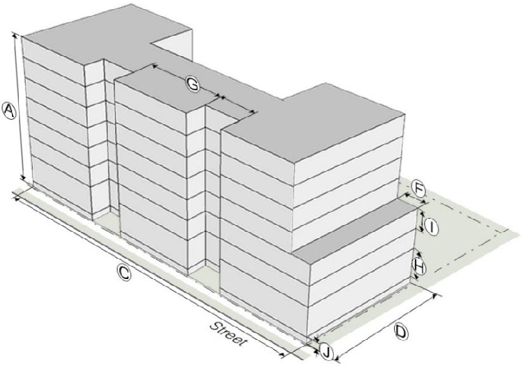
*The second story shall be at least 2/3rds the floor area of the first story.
**Separation is required when aggregate multiple buildings placed in proximity would otherwise exceed the Width and Depth criteria. See also Pedestrian Connectivity."
4.
Form
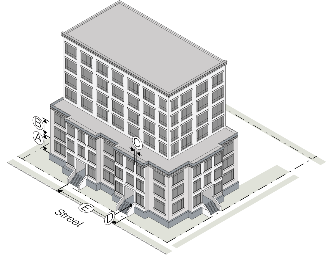
3.11.2.4. Walkable Mixed Use (WX-5 and WX-7)
Development in the Walkable Mixed Use Subdistricts that meets the Enhanced Development Option conditions as specified in Section 3.11.1.2.C. shall be subject to the following standards:
1.
Lot
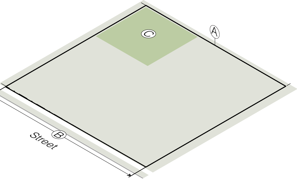
Outdoor amenity space is a ratio of net land area. Recreation space is a ratio of gross land area.
[Lighting standards can be found in the Sec. 3.11.2.7. Measurements and Exceptions.]
2.
Placement
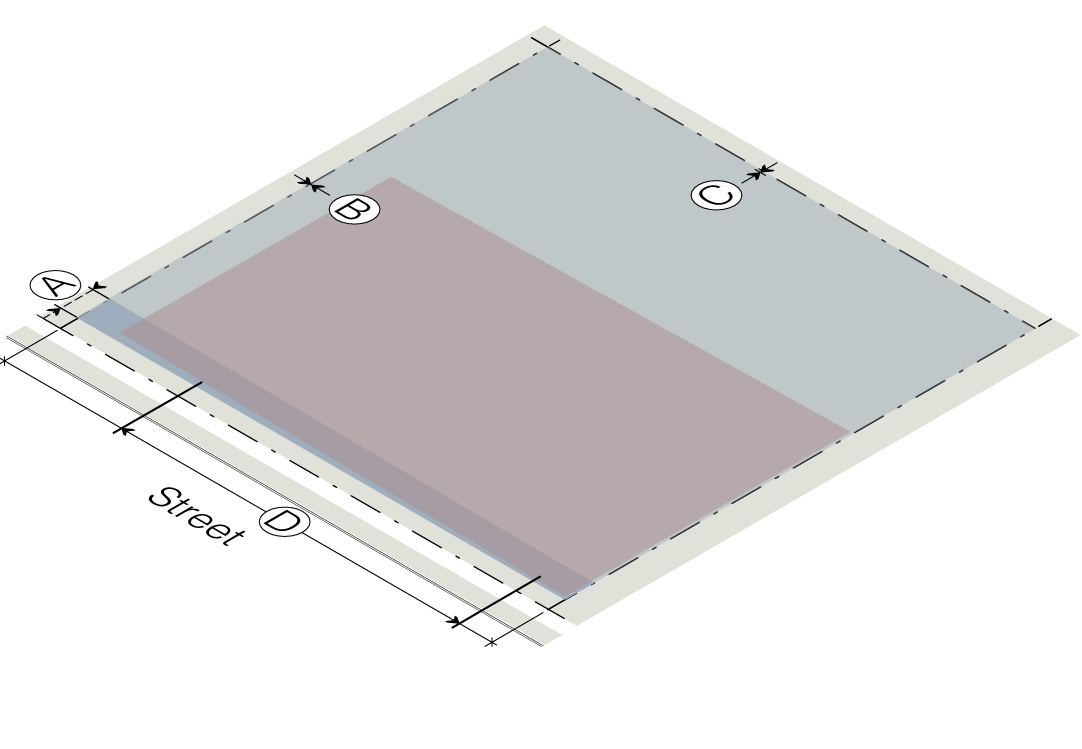
1. For the definition of Build-to-Zone (BTZ), see Section 3.11.2.7. Measurements and Exceptions, subsection G.
2. For additional information regarding other terms, definitions and requirements, see Section 3.11.2.7. Measurements and Exceptions.
3.
Mass

*The second story shall be at least 2/3rds the floor area of the first story
**Separation is required when aggregate multiple buildings placed in proximity would otherwise exceed the Width and Depth criteria. See also Pedestrian Connectivity.
***Greater floor plate area is permitted above the 3 rd floor for a building that includes non-residential uses, subject to provision of a 20' building stepback, as described in Section 3.11.2.7.T.
4.
Form
3.11.2.5. Frontages.

TYPE A FRONTAGE
Canopy trees meeting the stated average spacing are required. Where conflicts exist due to utility locations, fire access, or required site lines, an equivalent or better alternative for tree type, location, and average spacing can be reviewed and approved by the Community Design Commission.
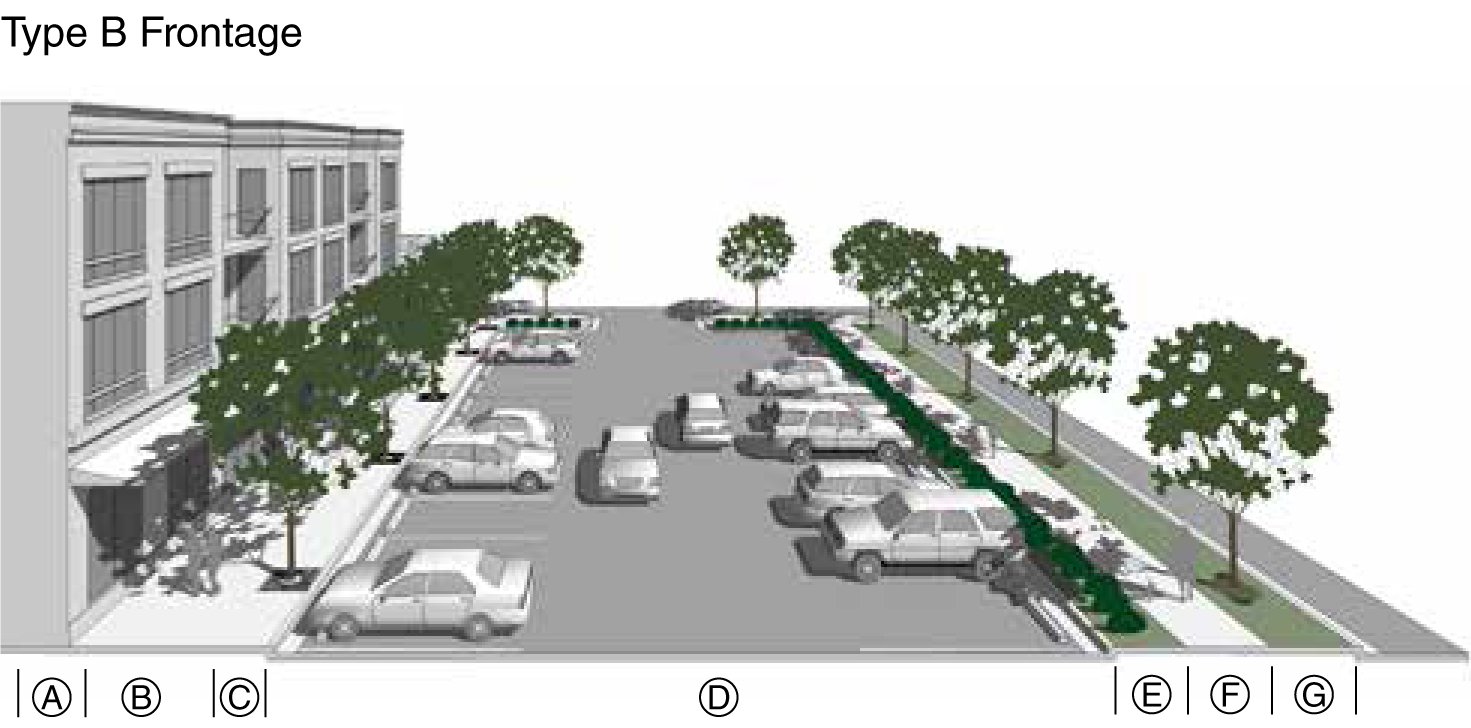
TYPE B FRONTAGE
Canopy trees meeting the stated average spacing are required. Where conflicts exist due to utility locations, fire access, or required site lines, an equivalent or better alternative for tree type, location, and average spacing can be reviewed and approved by the Community Design Commission.
Type C Frontage
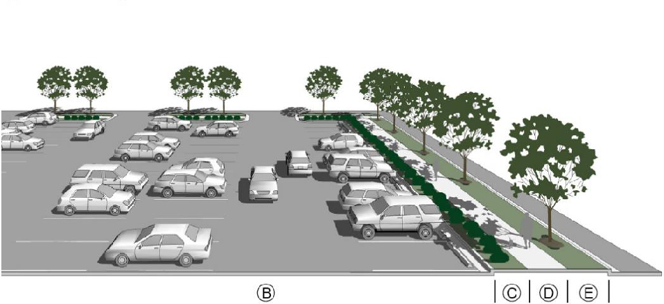
TYPE C FRONTAGE
Canopy trees meeting the stated average spacing are required. Where conflicts exist due to utility locations, fire access, or required site lines, an equivalent or better alternative for tree type, location, and average spacing can be reviewed and approved by the Community Design Commission.
Type D Frontage
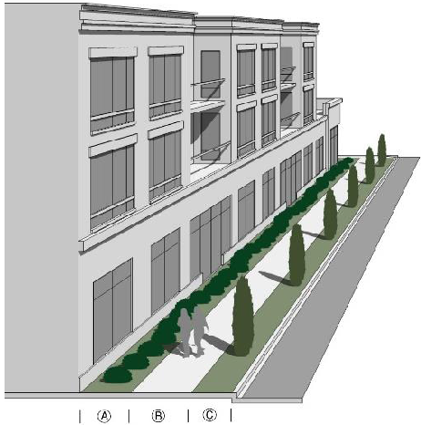
TYPE D FRONTAGE
A mix of columnar trees, understory trees and shrubs may be provided to meet shrub/tree spacing requirements. Where conflicts exist due to utility locations, fire access, or required site lines, an equivalent or better alternative for tree type, location, and average spacing can be reviewed and approved by the Community Design Commission.
TYPE E FRONTAGE
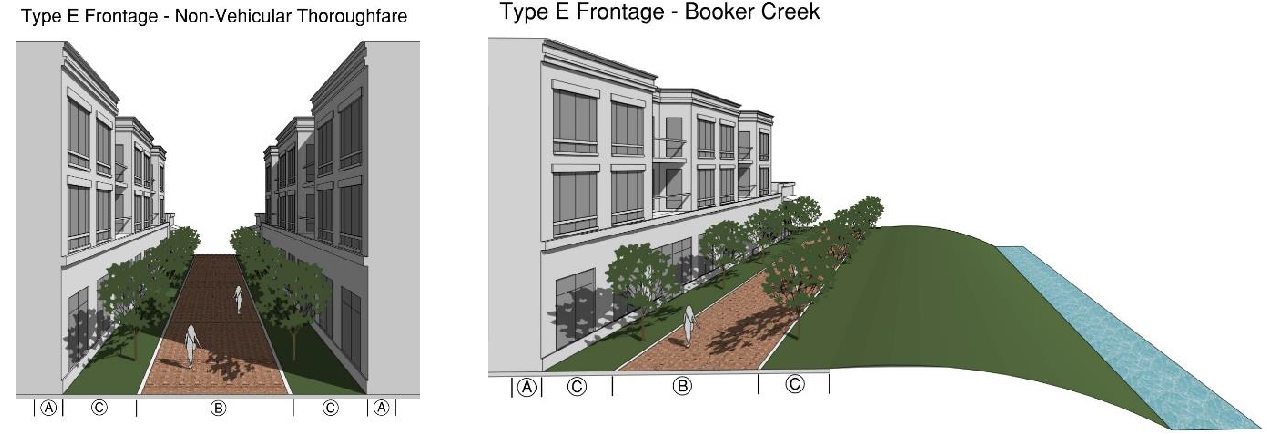
A mix of canopy trees and understory trees, provided on both sides of the sidewalk or path may be provided to meet tree spacing requirements.
3.11.2.6. Building Elements.
The following standards are intended to ensure that certain building elements, when added to a street-facing façade, are of sufficient size to be usable, functional and architecturally compatible with the building to which they are attached. These regulations do not apply to building elements on building façades that do not face a street. Building elements are permitted by subdistrict as shown in each subdistrict.
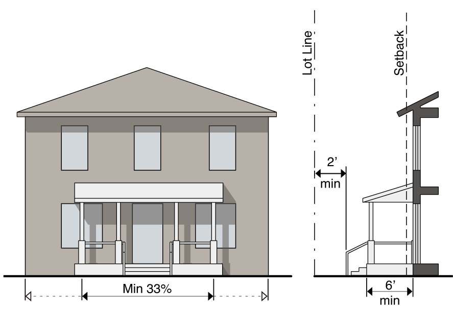
A.
Front porch. A raised structure attached to a building, forming a covered entrance to a doorway.
1.
A front porch must be at least six (6) feet deep (not including the steps).
2.
A front porch must be continuous, with a width not less than thirty-three (33) percent of the building façade from which it projects.
3.
A front porch must be roofed and may be screened, but cannot be fully enclosed.
4.
A front porch, including the steps, may extend into a front setback, provided that such extension is at least two (2) feet from the vertical plane of any lot line.
5.
A front porch may not encroach into the public right-of-way.
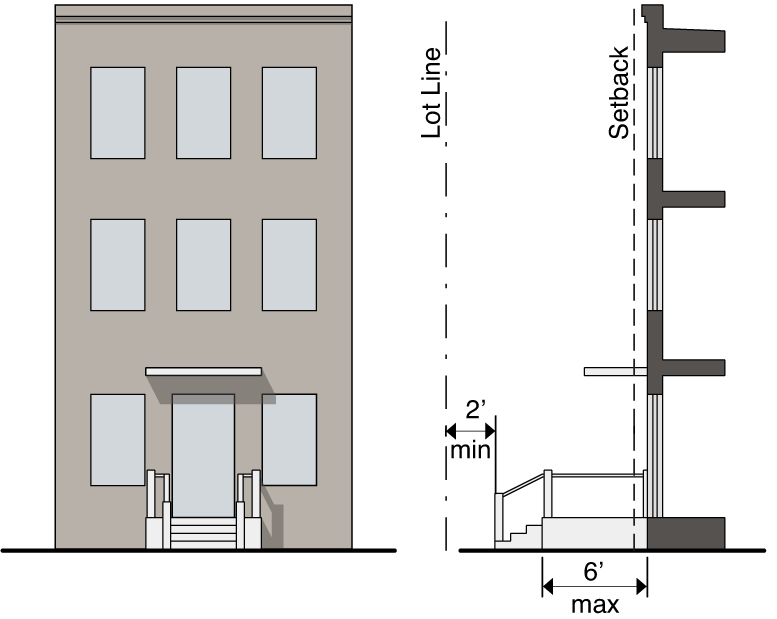
B.
Stoop. A small raised platform that serves as an entrance to a building.
1.
A stoop may be no more than six (6) feet deep (not including the steps) and six (6) feet wide.
2.
A stoop may be covered but cannot be fully enclosed.
3.
A stoop, including the steps, may extend into a front setback, provided that such extension at least two (2) feet from the vertical plane of any lot line.
4.
A stoop may not encroach into the public right-of-way.
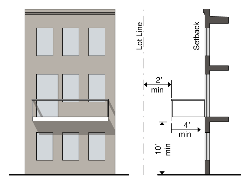
C.
Balcony. A platform projecting from the wall of an upper-story of a building with a railing along its outer edge, often with access from a door or window.
1.
A balcony must be at least four (4) feet deep and may extend into a required setback, provided that such extension is at least two (2) feet from the vertical plane of side interior or rear lot line.
2.
A balcony must have a clear height above the sidewalk of at least ten (10) feet.
3.
A balcony may be covered and screened, but cannot be fully enclosed.
4.
A balcony may encroach up to six (6) feet into the public right-of-way but must be at least two (2) feet inside the curb line or edge of pavement, whichever is greater.
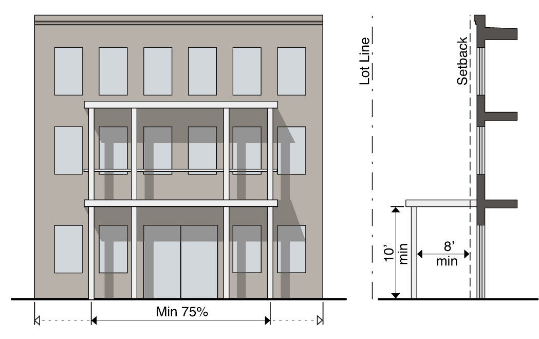
D.
Gallery. A covered passage extending along the outside wall of a building supported by arches or columns that is open on three (3) sides.
1.
A gallery must have a clear depth from the support columns to the building's façade of at least eight (8) feet and a clear height above the sidewalk of at least ten (10) feet.
2.
A gallery must be contiguous and extend over at least seventy-five (75) percent of the width of the building façade from which it projects.
3.
A gallery may extend into a required front setback.
4.
A gallery may encroach up [to] eight (8) feet into the public right-of-way but must be at least two (2) feet inside the curb line or edge of pavement, whichever is greater.
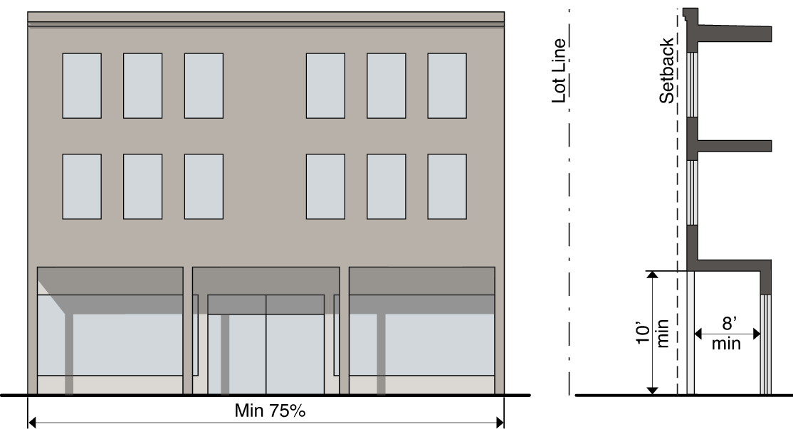
E.
Arcade. A covered passage extending along the outside wall of a building supported by arches or columns that is open on three (3) sides.
1.
An arcade must have a clear depth from the support columns to the building's façade of at least eight (8) feet and a clear height above the sidewalk of at least ten (10) feet.
2.
An arcade must be continuous and extend over at least seventy-five (75) percent of the width of the building façade.
3.
An arcade may extend into a required front setback.
4.
An arcade may not encroach into the public right-of-way.
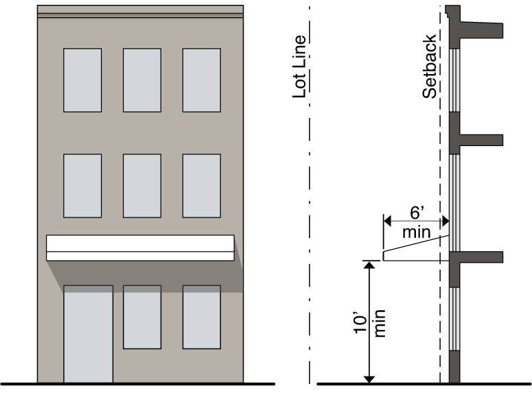
F.
Awning/Canopy. A wall-mounted, cantilevered structure providing shade and cover from the weather for a sidewalk.
1.
An awning/canopy must be a minimum of ten (10) feet clear height above the sidewalk and must have a minimum depth of six (6) feet.
2.
An awning/canopy may extend into a front setback.
3.
An awning/canopy may encroach up to eight (8) feet into the public right-of-way but must be at least two (2) feet inside the curb line or edge of pavement, whichever is greater.
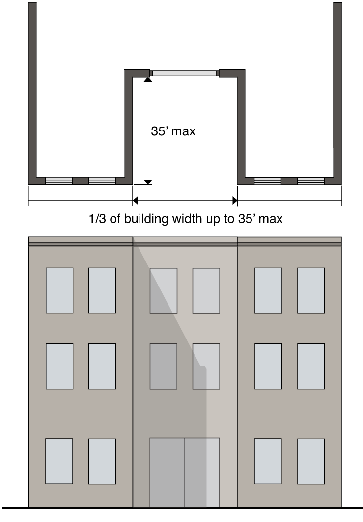
G.
Forecourt.An open area at grade, or within 30 inches of grade, that serves as an open space, plaza or outdoor dining area.
1.
A forecourt must be no more than one-third of the length of the building face and no longer than 35 feet in width, except where a larger space would increase pedestrian interest and/or allow more variation in the massing and design of the building. Where such purpose is achieved, the width may increase up to 50 feet with approval of a design alternative.
2.
A forecourt may be no more than 35 feet in depth, except where a larger space would achieve the purposes defined above, in which case the depth may increase up to 50 feet with approval of a design alternative.
3.
A maximum of one forecourt is permitted for every 100 feet in lot width.
4.
A forecourt meeting the above requirements is considered part of the building for the purpose of measuring the build-to zone.
5.
The area of a forecourt may be included in the calculation of required outdoor amenity space.
H.
Other Building Elements or Design Treatments. Architectural elements or design treatments at the ground level not included above may be approved by the Community Design Commission if they are deemed to contribute to walkability by activating the street frontage, whether associated with residential or other uses.
3.11.2.7 Measurements and Exceptions.
A.
Net land area. Net land area is the area included within the rear, side and front lot lines. Net land area does not include existing or proposed right-of-way, whether dedicated or not dedicated to public use.
B.
Lot Dimensions.
1.
Lot Width. Lot width is the distance between the two side lot lines measured at the primary street property line along a straight line or along the chord of the property line on a curvilinear lot.
C.
Block Length. Block length is the distance between two intersections or an intersection and the terminus of a road. Block length is measured from right-of-way line to right-of-way line or right-of-way line to property line. Block length requirements apply to the block face along all frontages designated by Type A, B, C, D or E, as shown on the Regulating Plan (Section 3.11.2.2) or assigned by the town manager. A new public thoroughfare created by the block length standard shall connect to another street where practical, and shall align at the project boundary such that a future connection is viable as determined by the town. A partial width public thoroughfare created near the property line, intended for expansion by the adjacent property owner at the time of future development, shall be located so that at least half of the ultimate right-of-way width is provided.
a.
The maximum allowable block length may be increased by ten percent (10%) through an administrative adjustment where one or more of the following applies:
i.
Proposed to protect sensitive natural areas or save healthy existing trees;
ii.
Required to protect natural conditions, such as watercourses, riparian buffers, natural rock formations or topography;
iii.
Required based on some unusual aspect of the development site or the proposed development that is not shared by landowners generally within the Blue Hill district (e.g., unusual lot size, configuration, or surrounding parcelization patterns);
iv.
Required due to the presence of existing utilities or other easements
v.
Required for traffic safety, site distance considerations, intersection spacing, or intersection alignment; or
vi.
Proposed because there are no other options for ingress and egress.
b.
Where the Community Design Commission makes a finding that a proposed design alternative for block length will provide access, support future extension and connectivity to adjacent properties, and supports a walkable public realm consistent with the purpose and intent of Section 3.11.2.1.B. and where one or more of the site constraints listed below applies, the Community Design Commission may approve an alternatively designed block length up to 600 feet as part of a Certificate of Appropriateness;
i.
Proposed to protect sensitive natural areas or save healthy existing trees;
ii.
Required to protect natural conditions, such as watercourses, riparian buffers, natural rock formations or topography;
iii.
Required based on some unusual aspect of the development site or the proposed development that is not shared by landowners generally within the Blue Hill District (e.g., unusual lot size, configuration, or surrounding parcelization patterns);
iv.
Required due to the presence of existing utilities or other easements;
v.
Required for traffic safety, site distance considerations, intersection spacing, or intersection alignment; or
vi.
Proposed because there are no other options for ingress and egress.
D.
Block Perimeter. Block perimeter is measured along the property line or right-of-way line along streets, thoroughfares, or other public lands.
a.
The maximum allowable block perimeter may be increased by five percent (5%) through an administrative adjustment where one (1) or more of the following applies:
i.
Proposed to protect sensitive natural areas or save healthy existing trees;
ii.
Required to protect natural conditions, such as watercourses, riparian buffers, natural rock formations or topography;
iii.
Required based on some unusual aspect of the development site or the proposed development that is not shared by landowners generally within the Blue Hill district (e.g., unusual lot size, configuration, or surrounding parcelization patterns);
iv.
Required due to the presence of existing utilities or other easements;
v.
Required for traffic safety, site distance considerations, intersection spacing, or intersection alignment; or
vi.
Proposed because there are no other options for ingress and egress.
b.
Consistent with Section 3.11.2.C.b, the maximum allowable block perimeter may be increased up to two thousand four hundred (2,400) feet by application to and approval from the Community Design Commission for a design alternative.
c.
A site bound by vehicular or non-vehicular thoroughfares on all sides, forming a complete block and complying with the maximum block perimeter as specified for the Subdistrict, is encouraged where feasible. A site that is only partially bound by thoroughfares shall locate the thoroughfares in a way that allows a feasible alignment for a vehicular or non-vehicular connection on adjacent properties that would complete the block without exceeding the maximum block perimeter.
E.
Gross land area. Gross Land Area is all area within the boundaries of a zoning lot (net land area) plus half of the following areas located within or adjoining the lot: (1) publicly-owned or otherwise permanently dedicated open space, such as parks, recreation areas, water bodies, cemeteries and the like, and (2) existing or proposed right-of-way, whether dedicated or not dedicated to public use; provided that the total amount of credited open space and public streets shall not exceed ten (10) percent of the net land area of the zoning lot.
F.
Outdoor amenity space.
1.
In General. Outdoor amenity space is required for all uses. Outdoor amenity space must be provided on the lot, or lands permanently designated as publically accessible open space, and must be available as unenclosed exterior space appropriately improved as a pedestrian amenity or for aesthetic appeal and cannot include areas used for vehicles, except for incidental service, maintenance or emergency actions. Outdoor amenity space shall be made available to the general public.
2.
Fee alternative. A minimum of ten (10) percent of any outdoor amenity space requirement must occur on the development site; however, up to ninety (90) percent of the outdoor amenity space requirement may, with the approval of the town manager, be met through payment of a fee in-lieu to the town. The amount of the payment is the product of the amount of outdoor amenity space required multiplied by a dollar amount established by the town council annually as part of the budget process. The applicant must make the payment before issuance of a form district permit, provided, however, that the town manager may allow phasing of payments consistent with the approved phasing of the development.
3.
Greenway alternative. Form District development applications for sites that include any land which overlaps a portion of a proposed greenway shown on the town's adopted Greenway Master Plan must be designed to accommodate the extension of that greenway in accordance with the Greenway Master Plan. A developer's financial obligation to contribute to the dedication and construction of the greenway is based on the formulas for calculation of amenity space and recreation space provided in this section 3.11.2.7. Land dedicated for a public pedestrian and non-motorized vehicle easement or deeded to the town along the greenway may be substituted for required improved outdoor amenity or recreation space, where deemed acceptable by the town manager.
4.
Standards.
a.
The minimum size of outdoor amenity space is the number of square feet derived by multiplying the net land area of the development by the applicable ratio shown for the zoning district.
b.
Outdoor amenity space may be met in one contiguous open area or in multiple open areas on the lot and must meet minimum dimensions described as follows:
i.
Where not located adjacent to a building, or where located adjacent to a building that is three stories in height or less, an outdoor amenity space must be at least 20 feet in width and length.
ii.
Where located adjacent to a building that is four stories in height or greater, the outdoor amenity space shall have greater dimensions, such that the space is in proportion to the associated building, provides a comfortable scale for pedestrians, and invites public use and enjoyment. In no case shall the area of a single outdoor amenity space be required to exceed the minimum outdoor amenity space ratio as specified for the Subdistrict.
iii.
Where located in the build-to zone and used to create inviting space along a street facing façade, the width of the outdoor amenity space measured perpendicular to the right-of-way may be less than the dimension prescribed above, subject to approval of a design alternative.
c.
Outdoor amenity space must be adjacent or adjoining a public right-of way, greenway, or publicly accessible thoroughfare, and must be within one-half story in elevation of the adjoining public walkway except under the following circumstances:
i.
An administrative adjustment is provided due to unusual topographical or environmental conditions of the site.
ii.
A design alternative is approved for outdoor amenity space to be within two stories in elevation of the adjoining public walkway. A rooftop amenity space must be highly visible from the adjoining public walkway and must have an easily identified route of public access, including provision of ADA access.
d.
Outdoor amenity space may be counted to meet the build-to-zone percentage requirements; however, only half the width of the applicable outdoor amenity space can be counted toward the required percentage.
e.
Where pedestrian connectivity requirements are met through spaces between buildings, any portions meeting all requirements of this section 3.11.2.7.F.4 may qualify as outdoor amenity space.
f.
Outdoor amenity space cannot be parked or driven upon, except for emergency access and permitted temporary events.
g.
Outdoor amenity spaces may include but not be limited to:
i.
Facilities such as a playground, sport court, dog park, garden, community garden, park, green, pavilion, seating area plaza or water feature
ii.
Areas used to meet minimum tree canopy coverage as required under Section 5.7.2 for applications that require Council approval.
h.
Outdoor amenity space expressly does not include:
i.
Any streetscape components located within the public right-of-way; and
ii.
Any landscaping internal to or screening a parking lot.
i.
The requirement for outdoor amenity space may also be met by means of a design alternative approved by the Community Design Commission where the space is located on a parcel other than the subject property, no further than eight hundred (800) feet from the subject parcel and within the boundaries of the Blue Hill District. This provision is intended to allow the aggregation of outdoor amenity space to create larger, publically accessible areas.
G.
Recreation space.
1.
In general. Active, improved outdoor space must be provided for common active recreational use by residents of multifamily or mixed use developments.
2.
Fee alternative. In lieu of providing recreation space, an applicant may, with the approval of the town manager, make a payment to the town whereby the town may acquire or develop recreation land or greenways to serve the development. A minimum of fifty (50) percent of the required recreation space must be met through a payment in lieu. The amount of the payment is the product of the amount of recreational space required multiplied by a dollar amount established by the town council annually as part of the budget process. The applicant must make the payment before issuance of a Form District permit, provided, however, that the town manager may allow phasing of payments consistent with the approved phasing of the development.
3.
Greenway alternative. Form District development applications for sites that include any land which overlaps a portion of a proposed greenway shown on the town's adopted Greenway Master Plan must be designed to accommodate the extension of that greenway in accordance with the Greenway Master Plan. A developer's financial obligation to contribute to the dedication and construction of the greenway is based on the formulas for calculation of amenity space and recreation space provided in section 3.11.2.7. Land dedicated for a public pedestrian and non-motorized vehicle easement or deeded to the town along the greenway may be substituted for required improved outdoor amenity or recreation space, where deemed acceptable by the town manager.
4.
Standards.
a.
The minimum size of active recreation space is the number of square feet derived by multiplying gross land area of the development by the applicable ratio shown for the zoning district and building height. Where a development contains residential and nonresidential uses, this standard applies only to the residential portion of the building. The land area used for applying the ratio described above is calculated based on the proportion of residential floor area.
b.
Recreation space not provided as a Fee or Greenway Alternative shall be provided on-site at ground level, at the perimeter lot line of the site.
c.
Recreation space shall be unobstructed above by any building elements. Canopies, coverings, or other roofs incidental to the intended use or purpose of the recreation space may be considered as unobstructed above.
d.
A pedestrian connection shall be provided between a recreation space and an adjoining public sidewalk or greenway.
e.
A pedestrian connection shall be provided between a recreation space and at least one area provided for outdoor amenity space.
H.
Building setbacks.
1.
There are three types of building setbacks—front, side interior and rear.
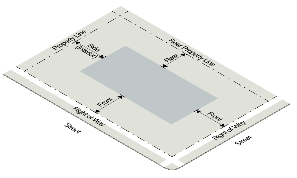
2.
Front setbacks are measured from the edge of the nearest right-of-way line.
3.
Side interior setbacks are measured from the side property line or the edge of the right-of-way where applicable.
4.
Rear setbacks are measured from the rear property line or the edge of the right-of-way where applicable.
5.
When the side interior or rear setback is zero (0) or five (5) feet, the building or structure must be placed on the side or rear property line or be placed a minimum of five (5) feet from the side or rear property line or the edge of the right-of-way line where applicable.
6.
The town manager will determine the application of front, side and rear setbacks to any irregularly-shaped lot.
I.
Build-to Requirements.
1.
The build-to zone is the area on the lot where a certain percentage of the front building façade must be located, measured as a minimum and maximum setback range from the edge of the right-of-way.
2.
The required percentage specifies the amount of the front building façade that must be located in the build-to zone, measured based on the width of the building divided by the buildable width of the lot and applied as follows:.
a.
On a lot developed according to the Conventional conditions, the required build-to percentage applies to the primary Frontage. On a corner lot, the required build-to percentage additionally applies to the continuation of the Frontage for a minimum of seventy-five (75) feet around the corner, in accordance with Section 3.11.2.1.D.7. For additional principal structures along secondary Frontages, the street-facing building façade(s) must meet the maximum setback requirement for at least two-thirds (⅔) of the façade width.
b.
On a lot developed according to the Enhanced Development conditions, the required build-to percentage applies to all Frontages. Secondary Frontages may have a reduced percentage in accordance with Section 3.11.2.1.D.7.
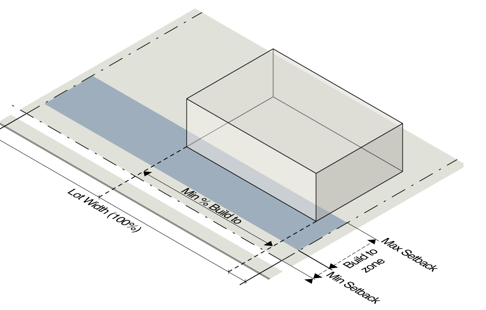
3.
On a Type A Frontage on a corner lot, a building façade, outdoor amenity space, outdoor dining area, and/or building element must be placed to meet the maximum setback requirement for the first thirty (30) feet along the street extending from the block corner, measured from the intersection of the two (2) right-of-way lines.
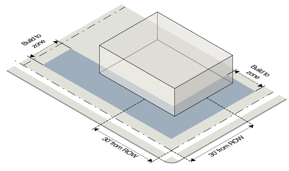
4.
Outdoor seating and dining areas may qualify as building façade for the purpose of meeting the build-to requirement provided that the following standards are met:
a.
The front building façade is located no more than ten (10) feet behind the maximum street setback;
b.
The outdoor seating and dining area is no more than two-thirds (⅔) the width of the building.
c.
The outdoor seating and dining area is no more than sixteen (16) feet deep; and
d.
The seating area is separated from the sidewalk by a wall or fence no higher than four (4) feet above the sidewalk.
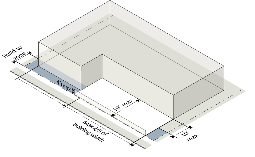
5.
Structured parking may count towards meeting the build-to requirement only where ground story conditioned space is provided for at least the first thirty (30) feet of the structured parking measured inward from the interior wall of a street-facing façade.
J.
Setback encroachments. All buildings and structures must be located at or behind required setbacks, except as listed below. Unless specifically stated no building or structure can extend into a required setback or public right-of-way.
1.
Building features.
a.
Porches, stoops, balconies, galleries and awnings/canopies can extend into a required setback under section 3.11.2.6.
b.
Building eaves, roof overhangs, gutters, downspouts, light shelves, bay windows and oriels less than ten (10) feet wide and cornices, belt courses, sills, buttresses or other similar architectural features may encroach up to two (2) feet into a required setback.
c.
Low impact stormwater management features may encroach into the first two (2) feet of the minimum front setback. The features may include, but are not limited to:
i.
Rain barrels or cisterns, six (6) feet or less in height;
ii.
Planter boxes;
iii.
Bioretention areas; and
iv.
Similar features, as determined by the town manager.
d.
Low impact stormwater management features listed above may encroach into a side interior or rear setback, provided such extension is at least two (2) feet from the vertical plane of any lot line.
e.
Unenclosed patios, decks or terraces may encroach into a side interior or rear setback, provided that such extension is at least two (2) feet from the vertical plane of any lot line.
f.
Handicap ramps may encroach to the extent necessary to perform their proper function.
g.
Structures below and covered by the ground may encroach into a required setback.
2.
Mechanical equipment and utility lines.
a.
Mechanical equipment associated with residential uses, such as HVAC units and security lighting, may encroach into a side interior or rear setback, provided that such extension is at least three (3) feet from the vertical plane of any lot line.
b.
Minor structures accessory to utilities (such as hydrants, manholes, and transformers and other cabinet structures) may encroach into a side interior or rear setback.
c.
Mechanical equipment and utility lines below and covered by the ground may encroach into any required setback.
d.
Aboveground mechanical equipment and minor structures shall not be placed within ten (10) feet of a sidewalk for a Type A or a Type B street frontage, unless the town manager approves an alternative proposal that demonstrates compliance to the maximum extent feasible with the intent of this section.
3.
Other setback encroachments.
a.
Fences and walls permitted in section 3.11.4.2.G.
b.
Signs permitted in section 5.14.
K.
Building height.
1.
Building height is measured in both the number of stories and in feet. Building height is the vertical distance from the average grade at the foundation to the highest portion of the structure
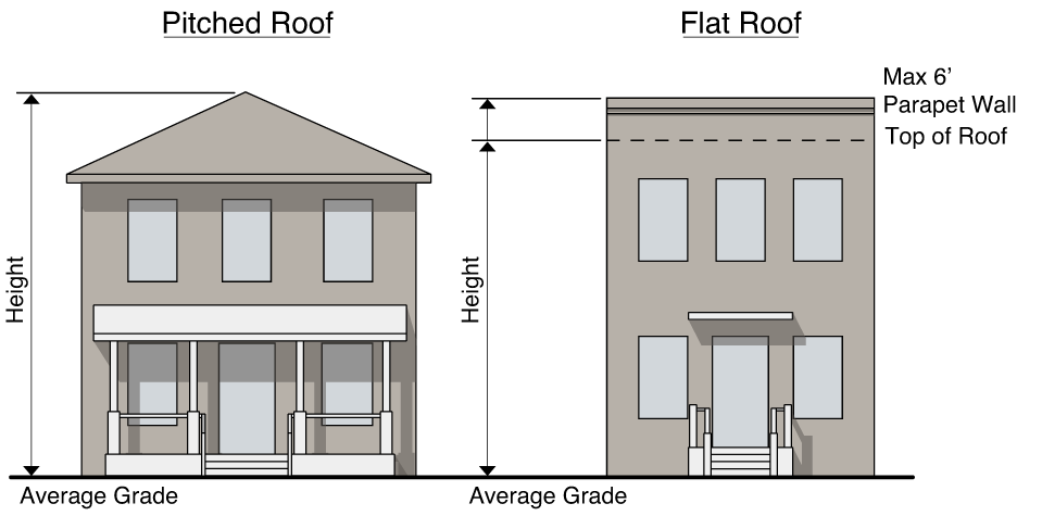
2.
Average grade is determined by calculating the average of the highest and lowest elevation along natural or improved grade (whichever is more restrictive) along the front of the building parallel to the primary street setback line.
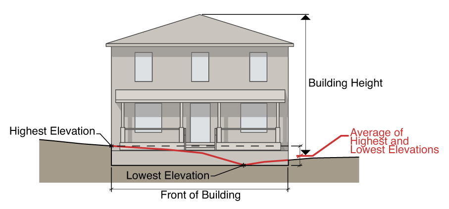
3.
Where a lot slopes downward from the front property line, one story that is additional to the specified maximum number of stories may be built on the lower, rear portion of the lot.
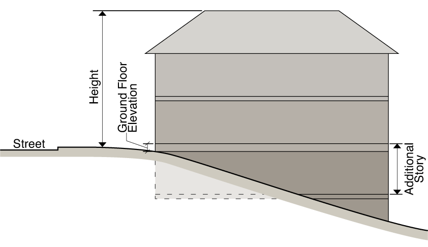
4.
An attic does not count as a story where fifty (50) percent or more of the attic floor area has a clear height of less than seven and one-half (7½) feet; measured from the finished floor to the finished ceiling.
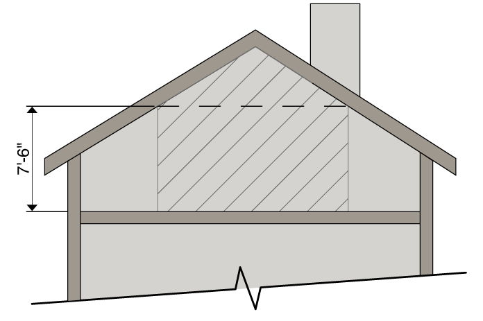
5.
A basement with fifty (50) percent or more of its perimeter wall area surrounded by natural grade is not considered a story.
L.
Height encroachments. Any height encroachment not specifically listed is expressly prohibited except where the town manager determines that the encroachment is similar to a permitted encroachment listed below.
1.
The maximum height limits do not apply to spires, belfries, cupolas, domes not intended for human occupancy; monuments, water tanks/towers or other similar structures which, by design or function, must exceed the established height limits.
2.
The following accessory structures may exceed the established height limit of the district provided they do not exceed the maximum height by more than fifteen (15) percent of the maximum height limitation that defines the portion of the building envelope penetrated by such structures:
a.
Chimney, flue or vent stack, spire, smokestack, water tank, windmill;
b.
Rooftop deck, patio, shade structure;
c.
Monument, steeple, flagpole;
d.
Accessory radio or television antenna, relay tower;
e.
Transmission pole, tower or cable;
f.
Garden, landscaping;
g.
Skylight;
h.
Cupola, clock tower or decorative tower not exceeding twenty (20) percent of the principal building footprint;
i.
Parapet wall; and
j.
Solar panel, wind turbine, rainwater collection system.
3.
The following accessory structures may exceed the established height limits provided they do not exceed the maximum building height by more than ten (10) feet, do not occupy more than twenty-five (25) percent of the roof area, and are set back at least ten (10) feet from the edge of the roof:
a.
Elevator or stairway access to roof;
b.
Greenhouse; and
c.
Mechanical equipment.
4.
An accessory structure located on the roof must not be used for any purpose other than a use incidental to the principal use of the building.
M.
Story height.
1.
Story height is the height of each story of building and it is measured from the top of the finished floor to the ceiling above.
2.
Minimum ground story height applies to the first thirty (30) feet of the building measured inward from the interior wall of a street-facing façade. At least fifty (50) percent of the ground story must meet the minimum height provisions.
3.
At least eighty (80) percent of each upper story must meet the minimum upper story height provisions.
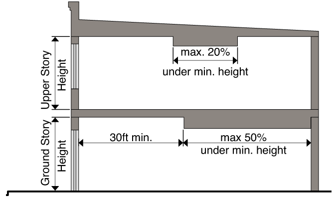
N.
Ground floor elevation.
1.
Ground floor elevation is the height of the ground floor relative to the height of the sidewalk and it is measured from top of the abutting curb to the top of the finished ground floor.
2.
Minimum ground floor elevation applies to the first twenty (20) feet of the lot measured from the right-of-way line.
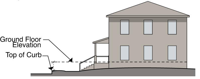
O.
Transparency.
1.
Transparency is the minimum percentage of windows and doors that must cover a ground or upper story façade. Transparency is required for any building façade facing a street.
2.
The transparency requirement on ground story façades is measured between two (2) and ten (10) feet above the adjacent sidewalk.
3.
The transparency requirement on upper story façades is measured from the top of the finished floor to the top of the finished floor above. When there is no floor above, upper story transparency is measured from the top of the finished floor to the top of the wall plate.
4.
Glass is considered transparent where it has a transparency higher than eighty (80) percent and external reflectance of less than fifteen (15) percent. Windows must be clear, unpainted, or made of similarly-treated glass; spandrel glass or back-painted glass does not comply with this provision.
5.
Transparency applies to street-facing façades only.
6.
For ground story retail uses, a minimum of sixty (60) percent of all windows must allow views into the ground story for a depth of at least six (6) feet.
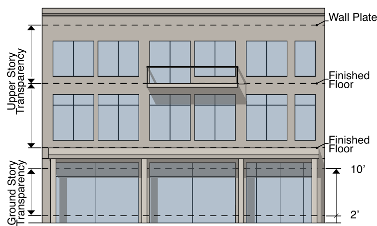
P.
Blank wall area.
1.
Blank wall area means a portion of the exterior façade of the building that does not include: windows or doors; columns, pilasters or other articulation greater than twelve (12) inches in depth; or a substantial material change (paint color is not considered a substantial change).
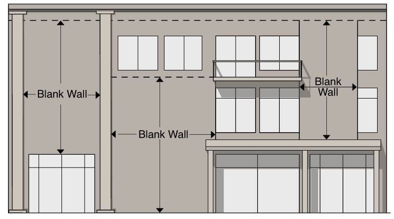
2.
Blank wall area applies in both a vertical and horizontal direction.
3.
Blank wall area applies only to ground and upper story street-facing façades.
Q.
Building entrances.
1.
An entrance providing both ingress and egress, operable to residents at all times or to customers during normal business hours, is required along each side of the building facing a streetscape or any other non-vehicular, publically accessible area to meet the public realm principal entrance requirements. Additional entrances are permitted.
2.
The principal entrance separation requirements must be met for each development along street-facing facades, but are not applicable to adjacent (existing) development.
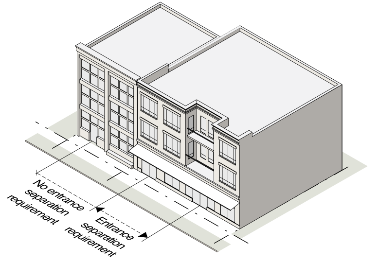
3.
An angled (clipped corner) entrance may be provided at any corner of a building along the street to meet the street entrance requirements, provided the applicable entrance spacing requirements can still be met.
4.
A principal entrance may be oriented perpendicular to the adjacent public realm, where the entrance is clearly defined by a Building Element, with approval of the Community Design Commission.
5.
For a residential building façade, entries to individual units are considered principal entrances.
R.
Building materials.
1.
Applicability. The requirements of this section apply to all building façades, including masonry walls, fences, light fixtures, steps and pavement, visible from any street right-of-way or public easement.
2.
Primary materials. Primary material changes must occur only at inside corners. The following materials are required for not less than seventy-five (75) percent of the building wall surface area on each façade:
a.
Brick and tile masonry;
b.
Stone (or synthetic equivalent);
c.
Wood—Clapboard or shingles;
d.
Glass curtain wall;
e.
Cementitious siding; and
f.
Stucco (cementitious finish).
3.
Accent materials. The following materials may make up twenty-five (25) percent of the building wall surface area on each façade:
a.
Pre-cast masonry (for trim and cornice elements only);
b.
External Insulation Finishing System—EIFS (for trim and cornice elements only);
c.
Gypsum Reinforced Fiber Concrete (GFRC—for trim elements only);
d.
Metal (for beams, lintels, trim elements and ornamentation only);
e.
Split-faced block (for piers, foundation walls and chimneys only);
f.
Wood—Clapboard or shingles;
g.
Cementitious siding; and
h.
Glass block.
4.
Alternate Materials. Alternate building materials may be approved by the Community Design Commission. New materials must be considered equivalent or better than the materials listed above, and regionally-available materials are preferred. The following specific criteria is provided for alternate building materials:
a.
Architectural concrete shall utilize detailing, patterns, and/or panel size to convey visual interest and a sense of scale.
b.
Architectural metals shall be appropriate to the local climate and shall utilize detailing, patterns, and/or panel size to convey visual interest and a sense of scale.
S.
Pedestrian Connectivity.
1.
Publicly accessible routes shall be provided to meet the minimum spacing requirements, and should be provided in coordination with Building Separation as defined in section 3.11.2.7.U.2.
2.
Pedestrian connectivity shall include a sidewalk with a minimum width of eight (8) feet and a minimum eight (8) foot clear zone, connecting to a streetscape sidewalk on at least one end and allowing pedestrians to move from one side of a building or lot to another. Where not terminating at another existing sidewalk, an easement may be required to accommodate future connectivity.
3.
Design Considerations.
a.
Pedestrian routes serving to meet Pedestrian Connectivity requirements shall be adequately lit as per Section 3.11.4.5. (Site Lighting), with 0.5 (min) and 15.0 (max) foot candles at any point.
b.
Building elements and structures used for shade purposes may be provided within the minimum required space between buildings, so long as pedestrian access is maintained.
c.
Unenclosed overhead walkways may be provided to connect one building to another or to structured parking, so long as the walkway maintains a clear height above the pedestrian through access of at least twelve (12) feet.
4.
Pedestrian Connectivity Spacing.
a.
The maximum pedestrian connectivity spacing may be increased by five percent (5%) through an administrative adjustment where one or more of the following applies:
i.
Proposed to protect sensitive natural areas or save healthy existing trees;
ii.
Required to protect natural conditions, such as watercourses, riparian buffers, natural rock formations or topography;
iii.
Required based on some unusual aspect of the development site or the proposed development that is not shared by landowners generally within the Blue Hill District (e.g., unusual lot size or configuration);
iv.
Required due to the presence of existing utilities or other easements; or
v.
Proposed because there are no other options for ingress and egress.
vi.
Where an administrative adjustment to building size has been granted for maximum building width or depth in a corresponding location.
b.
Where the Community Design Commission makes a finding that a proposed design alternative for pedestrian connectivity will provide access that at a minimum meets the purpose or intent of Section 3.11.2.1.B and where one or more of the site constraints listed below applies, the Community Design Commission may approve alternatively designed pedestrian connectivity spacing up to the maximum allowable block length as part of a Certificate of Appropriateness:
i.
Proposed to protect sensitive natural areas or save healthy existing trees;
ii.
Required to protect natural conditions, such as watercourses, riparian buffers, natural rock formations or topography;
iii.
Required based on some unusual aspect of the development site or the proposed development that is not shared by landowners generally within the Blue Hill District (e.g., unusual lot size or configuration); or
iv.
Required due to the presence of existing utilities or other easements.
v.
Based on design considerations associated with the provision of public space in excess of the minimum requirements, and/or in support of a walkable public realm.
T.
Mass Variation. Mass variation is the way the form and shape of a building changes to establish a sense of human scale. This may be achieved by changing the heights of different parts of a building and by creating offsets in wall planes to express individual building modules. All buildings four stories in height or greater shall have a reduced upper story floor plate area as specified for the Subdistrict. Further, building facades of buildings four stories in height or greater along all frontages designated by Type A, B, C or E shall meet either the building step back requirement or the module offset requirement, as specified for the Subdistrict. A building three stories in height or less is not subject to the above. Frontage designations are as shown on the Regulating Plan (Section 3.11.2.2) or assigned by the town manager.
1.
Upper Story Floor Plate Area. The maximum upper story floor plate area shall be based on the conditioned floor area measured for the ground story and applies at the fourth story and above. Where multiple stories are subject to the floor plate area requirement, both an average upper story and maximum upper story floor plate area apply.
a.
Bonus. An upper story bonus is permitted for a building or a site that includes a non-residential use as listed in the Permitted Use Table under 3.11.3.4. Where non-residential square footage is required under Section 3.11.3.5.A.4, the bonus described in this subsection is only available for square footage that exceeds the minimum required. For each square foot of non-residential use provided, the floor plate area of an upper story may increase by one (1) square foot in excess of the average upper story and maximum upper story floor plate, subject to provision of a twenty (20) foot building step back in accordance with Section 3.11.2.7.T.2.b.
2.
Building Step Back. The building step back shall be measured as the horizontal change in the building wall plane, perpendicular to the applicable frontage or property line.
a.
In addition to applicable frontages, a ten (10) foot building step back above the second or third floor is also required for buildings four (4) stories or greater at the boundary of the Form District.
b.
A twenty (20) foot building step back above the second or third floor is required for the primary street frontage of a building that utilizes an upper story bonus in accordance with Section 3.11.2.7.T.1.a. A building façade located outside of the build-to zone remains subject to this requirement.
c.
A building step back is not required where a street-facing façade is located at the maximum setback line or outside of the maximum setback, and is not the primary frontage of a building that utilizes an upper story bonus, or where a building façade facing the Form District boundary is located more than twenty (20) feet from the boundary.
3.
Module Offset. The module offset shall be measured as the horizontal change of a portion of the building wall plane at ground level, perpendicular to the applicable frontage. The module width shall be measured for the portion of the wall plane closer to the sidewalk, while the width of offset shall be measured for the portion further from the sidewalk. The dimensions of modules and offsets should maintain a sense of proportion to the building as a whole.
a.
Offset areas may count towards a build-to zone requirement when the area meets the criteria for a forecourt, outdoor amenity space, or outdoor dining area.
b.
A module offset is not required where a building façade is located at the maximum setback line or outside of the maximum setback.
4.
The Community Design Commission may approve a design alternative for mass variation, where a building exhibits varied heights, smaller building masses and/or articulated facades that provide a positive visual impact and a sense of scale in the public realm.
U.
Building Footprint, Width, and Depth.
1.
Maximum Building Dimensions.
a.
Maximum building width and secondary wing width are measured parallel to the primary frontage for each site.
b.
Maximum building depth and secondary wing depth are measured perpendicular to the primary frontage for each site, and apply to side facades. A building and wing must adjoin portions of the public realm for the full measurement of their depth.
c.
A secondary wing, if included, shall be appended to the rear of the building to create an extension of the building's depth. The wing may not be configured to increase the maximum building width. The depth of the wing shall be measured starting at the point where the building footprint exceeds the baseline maximum depth.
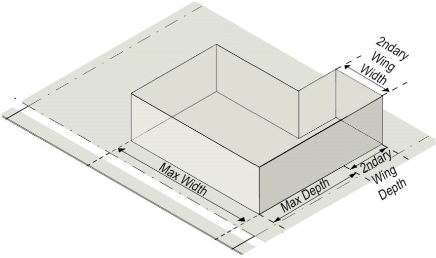
d.
A Wrapped Parking Configuration is one where the building is integrated with structured parking and where the building fully screens at least two (2) sides of the parking structure from view as follows:
i.
the building shall fully screen the side along the primary frontage.
ii.
where the site has additional frontages, the building shall fully screen at least one other side along a frontage.
iii.
if the above are not met, the footprint must meet the standards of a different Building Configuration.
e.
The maximum dimensions for Structured Parking are applicable to any configuration of structured parking, including standalone, wrapped, and podium configurations, except that the dimensions are not applicable to portions of the structured parking below grade.
f.
The maximum building width and/or depth may be increased by five percent (5%) through an administrative adjustment where one or more of the following applies:
i.
Based on some unusual aspect of the development site or the proposed development that is not shared by landowners generally within the Blue Hill district (e.g., unusual lot size, configuration, or surrounding parcelization patterns);
ii.
Based on design considerations due to existing or proposed utilities or easements;
iii.
Based on design considerations for the accommodation of life safety, ingress or egress requirements.
iv.
Based on design considerations associated with the provision of public space in excess of the minimum requirements, and/or in support of a walkable public realm.
2.
Building Separation.
a.
Multiple buildings may be constructed on a lot provided that each building or aggregation of buildings meets the maximum building dimensions.
b.
Where required, the minimum separation between two (2) buildings on a lot shall be the distance between building facades measured parallel to the street frontage.
c.
Unbuilt area used to meet building separation requirements shall be configured for Pedestrian Connectivity as defined in section 3.11.2.7.S.
d.
Service drives and vehicular access may be provided between buildings. The roadway width shall not count towards meeting the minimum building separation unless the town manager determines that it functions effectively as shared pedestrian-vehicular space.
e.
Multiple buildings arranged such that their combined width and/or depth does not exceed the maximum applicable dimensions shall not be subject to Building Separation requirements.
3.11.2.8 Conventional Development.
Development in the Form District that meets the Conventional conditions as specified in Section 3.11.1.2.C. shall be subject to the following standards:
1.
Lot
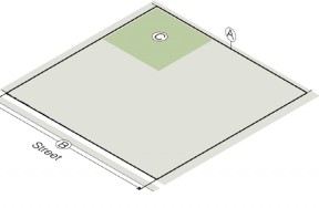
Outdoor amenity space is a ratio of net land area.
Recreation space, Residential density, and Floor area ratio are ratios of gross land area.
2.
Placement
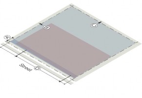
For additional information regarding other terms, definitions and requirements, see Section 3.11.2.7. Measurements and Exceptions.
3.
Mass
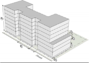
*The second story shall be at least two-thirds (⅔) the floor area of the first story
**Greater floor plate area is permitted above the 3 rd floor for a building that includes non-residential uses, subject to provision of a twenty (20) foot building stepback, as described in Section 3.11.2.7.T.
4.
Form
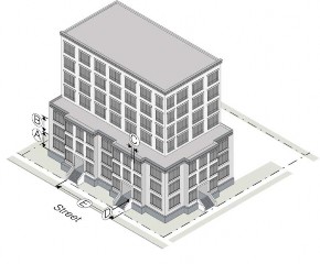
3.11.3. Use Requirements.
3.11.3.1. Permitted Uses.
A.
A lot or building must be occupied with only the principal uses permitted on the permitted use table in section. 3.11.3.4. Accessory uses and structures are permitted in conjunction with a permitted principal use.
B.
Any one (1) or more uses permitted in a Form District may be established on any lot within the subdistrict, subject to the permitted use table, and in compliance with all other applicable requirements of Section 3.11.
3.11.3.2. Accessory Uses.
A.
Accessory uses and structures must be accessory and clearly incidental and subordinate to a permitted principal use or building.
B.
No accessory use or structure may be established prior to the establishment of a permitted principal use or building.
C.
The town manager is authorized to determine when a use or structure is accessory. In order to classify a use or structure as accessory, the town manager must determine that the use or structure:
1.
Is subordinate to the principal use or building in terms of area, extent and purpose;
2.
Contributes to the comfort, convenience or necessity of occupants of the principal use or building served;
3.
Is located on the same lot as the principal use or building, or on a contiguous lot in the same ownership;
4.
Does not involve operations not in keeping with the character of the principal use or building served; and
5.
Is not of a nature likely to attract visitors in larger numbers than would normally be expected for the principal use or building.
D.
All accessory structures must meet the dimensional requirements applicable to a principal structure in the subdistrict.
E.
Food trucks must comply with Section 6.20 of the Land Use Management Ordinance.
3.11.3.3. Classification of Uses.
A.
In order to regulate use, categories of uses have been established in Section 3.11.3.5, providing a systematic basis for assigning land uses to appropriate categories with other similar uses. Use categories classify land uses and activities based on common functional, product or physical characteristics.
B.
The town manager is responsible for categorizing all uses into the use categories in Section 3.11.3.5. When determining the use category in which a proposed use fits, the town manager must consider the following criteria:
1.
The actual or projected characteristics of the proposed use.
2.
The relative amount of site area or floor area and equipment devoted to the proposed use.
3.
Relative amounts of sales.
4.
The customer type.
5.
The relative number of employees.
6.
Hours of operation.
7.
Building and site arrangement.
8.
Types of vehicles used and their parking requirements.
9.
The number of vehicle trips generated.
10.
How the proposed use is advertised.
11.
The likely impact on surrounding properties.
12.
Whether the activity is likely to be found independent of the other activities on the site.
C.
Where a use not listed is found by the town manager not to be similar to any other permitted use, the use is not permitted.
3.11.3.4. Permitted Use Table.
Uses permitted by subdistrict are shown below. Broad use categories have been established in order to regulate a variety of similar uses and are defined in Section 3.11.3.5. Customary accessory and temporary categories, as determined by the town manager, are permitted in the Form Districts, including, but not limited to, home occupations, food trucks and trailers, and outdoor seasonal sales, subject to issuance of a Zoning Compliance Permit.
KEY:
P = Use permitted under any of the following circumstances:
1.
Expansion of an existing public elementary or secondary school
2.
Enhanced Development Option conditions are met as specified in Section 3.11.1.2.C
3.
Floor area of proposed development is less than twenty thousand (20,000) square feet, and disturbed land is less than forty thousand (40,000) square feet.
Otherwise, permitted following Town Council approval of special use permit.
S+ = Use permitted following town council approval of special use permit.
S- = Use permitted following board of adjustment approval of special use permit.
L = Limited use (refer to section 3.11.3.5.A.4.)
(Ord. No. 2023-11-29/O-5, § 3)
3.11.3.5. Use Categories.
A.
Residential uses.
1.
Household living. Residential occupancy of a dwelling unit by a family on a monthly or longer basis in structures with self-contained dwelling units, including kitchens. The term household living includes an establishment with support and supervisory personnel that provides room and board, personal care and habitation services in a family environment for not more than six (6) residents who are handicapped, aged, disabled, or who are runaway, disturbed or emotionally deprived children and who are undergoing rehabilitation or extended care. The household living does not include a fraternity or sorority, club, rooming house, institutional group or the like. Household living includes the following:
a.
Detached living. One (1) or two (2) dwelling units in a single principal structure.
b.
Attached living. Three (3) or more dwelling units in a single principal structure where each unit is separated vertically by a common side wall. Units cannot be vertically mixed.
c.
Multifamily living. Three (3) or more dwelling units vertically and horizontally integrated.
2.
Group living. Residential occupancy of a structure by a group of people that does not meet the definition of family. Tenancy is usually arranged on a monthly or longer basis. Generally, group living facilities have a common eating area for residents, and residents may receive care or training. Group living does not include a fraternity or sorority, club, rooming house, institutional group or the like.
3.
Social service living. Uses not considered household living that primarily provide treatment of those with psychiatric, alcohol, or drug problems, and transient housing related to social service programs.
4.
Limited use. Residential uses in the WX-5 and WX-7 subdistricts must include a non-residential use as part of the same application, in order to accomplish the Form District intent for a mixture of uses. For purposes of this section, a non-residential use includes any use listed in the Permitted Use Table (Sec. 3.11.3.4) that is not listed in the residential use category. To satisfy this requirement, the application must satisfy at least one of the criteria below. A building or site with non-residential floor area exceeding the minimum defined below may utilize the Upper Story Floor Area Bonus established in Section 3.11.2.7.T.1.a.
a.
Mixed use building. Where each building contains a vertical mix of uses, a minimum of 10% of the building floor area must contain a non-residential use. A certificate of occupancy must be issued for at least 50% of the non-residential floor area prior to issuance of a certificate of occupancy for more than 90% of the residential floor area.
b.
Mixed use site. A site with multiple buildings may include buildings with a single use, so long as a minimum of 15% of the total floor area for the site contains a non-residential use.
5.
Short-term rental. Establishments as defined in Section 6.27.3 of this appendix, and in addition, any configuration of lodging units that does not meet the definition of overnight lodging under Section 3.11.3.5.C.7. Short-term rentals shall be subject to the requirements of Section 6.27 of this appendix.
B.
Public uses.
1.
Civic/place of worship. Places of public assembly that provide ongoing life safety, educational and cultural services to the general public, as well as meeting areas for religious practice.
2.
Parks and open space. Public gathering areas for passive or active outdoor recreation, and having few structures.
3.
Utilities, minor. Public or private infrastructure serving a limited area with no on-site personnel.
4.
Utilities, major. Public or private infrastructure serving the general community, or with on-site personnel.
C.
Commercial uses.
1.
Commercial parking. Facilities providing parking that is not accessory to a principal use. Facilities may or may not charge a fee.
2.
Day care. Uses providing care, protection, and supervision of children or adults on a regular basis away from their primary residence. Care is typically provided to a given individual for fewer than eighteen (18) hours each day, although the facility may be open twenty-four (24) hours each day.
3.
Indoor recreation. Commercial uses, varying in size, providing daily or regularly scheduled recreation-oriented activities in an indoor setting.
4.
Medical. Uses providing medical or surgical care to patients. Some uses may offer overnight care.
5.
Office. Activities conducted in an office setting and generally focusing on business, professional or financial services.
6.
Outdoor recreation. Commercial uses, varying in size, providing daily or regularly scheduled recreation-oriented activities either wholly outdoors or within outdoor structures.
7.
Overnight lodging. Accommodations arranged for short term stays of less than thirty (30) days for rent or lease, consisting of a collection of lodging units that are serviced by on-site staff and are not otherwise defined as short-term rentals. In a building that includes both household living and overnight lodging, each use shall constitute a distinct portion of the building with separate access points.
8.
Personal service. Facilities involved in providing personal services or repair services to the general public.
a.
Animal care. A facility where four or more domesticated animals more than four months of age are housed, groomed, bred, boarded, trained or sold. No outdoor activity associated with care of animals is permitted.
9.
Restaurant/bar. Establishments that prepare and sell food or drink for on- or off-premises consumption.
10.
Retail sales. Facilities involved in the sale, lease or rental of new or used products.
a.
Fuel sales. The sale or dispensing of fuels for motor vehicles. The zoning lot on which fuel sales are located must have a minimum gross land area of twenty thousand (20,000) square feet. The zoning lot must front on an arterial or collector street. Adequate provision must be made for ventilation and the dispersion and removal of fumes, and for the removal of hazardous chemicals and fluids. Driveways for a service station/convenience store may not be located within three hundred (300) feet of any intersecting street or within seven hundred fifty (750) feet of driveways intersecting the same street and serving another existing or approved service station. These distances are measured centerline to centerline.
11.
Vehicle sales/service. Direct sales, rental, leasing or servicing of passenger vehicles, light and medium trucks, and other consumer motor vehicles such as motorcycles, boats and recreational vehicles. Maximum land area of one (1) acre is permitted. Vehicle parking areas must be screened as required in Section 3.11.4.2.C. All servicing or repair of vehicles must occur indoors. All storage of parts and other similar items must occur indoors.
D.
Industrial uses.
1.
Light industrial. Manufacturing, assembly, repair or servicing of industrial, business, or consumer machinery, equipment, products, or by-products mainly by providing centralized services for separate retail outlets. Contractors, building maintenance services and similar uses perform services off-site. Few customers, especially the general public, come to the facility.
2.
Self-service storage. Facilities providing separate storage areas for personal or business use designed to allow private access by the tenant for storing personal property.
3.
Warehouse and distribution. Facilities involved in the storage or movement of goods for themselves or other firms. Goods are generally delivered to other firms or the final consumer with little on-site sales activity to customers.
4.
Waste-related service. Uses that receive solid or liquid wastes from others for transfer to another location, and uses that collect sanitary wastes or that manufacture or produce goods or energy from the composting of organic material.
5.
Heavy industrial. Facilities involved in research and development activities without light fabrication and assembly operations; limited industrial/manufacturing activities. The uses emphasize industrial businesses, and sale of heavier equipment. Factory production and industrial yards are located here. Sales to the general public are limited.
E.
Open uses.
1.
Agriculture. Uses with established areas for the raising of animals and crops, conservation, and the secondary industries associated with agricultural production.
a.
Community garden. Areas of land managed and maintained by a group of individuals to grow and harvest food crops and non-food ornamental crops, for personal or group use, consumption or donation. May be divided into separate plots for cultivation by one (1) or more individuals or may be farmed collectively by members of the group, and may include common areas maintained and used by the group. Accessory storage and incidental parking are permitted. On-site sales may be permitted upon approval of a special use permit.
2.
Resource extraction. Uses that extract minerals and other solids and liquids from the land.
3.11.4. Design and Development Standards.
3.11.4.1. Parking and Access Standards.
A.
Applicability.
1.
General. No building or land, or any part of any building or land, may be occupied or used until parking has been provided in accordance with this section.
2.
Additions.
a.
A building or site may be renovated or repaired without providing additional parking, provided there is no increase in gross floor area or improved site area.
b.
When a building, use or site is increased in gross floor area or improved site area, parking is required for the additional floor or site area only.
c.
When the gross floor area or improved site area is increased by more than fifty (50) percent cumulatively, both the existing use and the additional floor or site area must conform to the parking requirements of Section 3.11.
3.
Change in use.
a.
A change in use must comply with the parking requirements unless the town manager determines the use has the same or a lesser parking demand than the previous use.
b.
Where required parking spaces for the new use exceed the required parking spaces for the existing use, additional parking is only required for the difference between the current parking spaces required and the parking spaces required for the new use.
B.
Vehicle parking.
1.
Required spaces. The minimum and maximum parking spaces are provided in the table below and are required unless an alternative is approved by the town manager.
2.
Outdoor dining. Outdoor dining located in the build-to zone or a forecourt permitted under Section 3.11.2.6 are exempt from the calculation of required vehicle parking spaces.
3.
Parking maximums. Parking spaces provided in an underground or structured parking garage do not count toward the maximum number of spaces permitted.
4.
Appearance of Structured Parking. Structured parking visible from the public realm shall be architecturally compatible with the principal building as deemed appropriate by the Community Design Commission. An architectural screen that utilizes durable materials and/or other features offering visual interest shall be provided.
C.
Required parking. The following vehicle and bicycle parking spaces are required for each use.
1.
Reductions.
a.
A reduction of up to twenty (20) percent of the minimum number of required vehicular parking spaces may be permitted through the granting of an alternative ratio by the town manager if, based on substantial evidence, the manager finds that compliance with the full minimum off-street vehicular parking space requirements of this section would not be required by the applicant's proposed use. This reduction applies to bicycle parking spaces as well, provided that the ratio between Class A and Class B spaces remains the same as the requirement in this section.
b.
A total reduction of up to forty (40) percent of the minimum number of required vehicular and bicycle parking spaces may be permitted for projects serving the elderly or handicapped, following a positive recommendation from the planning director and approval of the town manager.
c.
Motorcycle and scooter parking may substitute for required parking spaces. Existing parking may be converted to take advantage of this provision.
i.
Motorcycle and scooter parking may substitute for up to five (5) vehicle spaces or five (5) percent of the required parking spaces, whichever is less. For every two (2) motorcycle or scooter parking spaces provided, the vehicle parking space requirement is reduced by one (1) space.
ii.
Motorcycle and scooter parking spaces must be identified or designated through the use of signage or pavement markings.
d.
A reduction of up to twenty (20) percent of the minimum parking requirements may be achieved by providing a transportation management plan subject to approval by the town manager or subject to approval by the town council if the proposed use requires town council approval. The transportation management plan shall identify efforts to promote the use of alternate modes of transportation and may include required parking and/or payment to the Town of Chapel Hill Parking Fund in accord with Chapter 11A of the Chapel Hill Code of Ordinances for a portion of the required spaces.
e.
A reduction of up to fifty (50) percent of the minimum number of required vehicular parking spaces is permitted if the mix of uses within a proposed development contains at least twenty-five (25) percent of the floor area devoted to Residential uses and at least twenty-five (25) percent of the floor area devoted to Commercial uses.
f.
A reduction of the number of required spaces may be achieved through a shared parking analysis certified by a professional engineer and subject to approval by the town manager. Such an analysis may include, where appropriate, considerations of peak hour usage, mode split, internal capture, remote parking as defined in this section, transportation demand management, and other approved parking management strategies.
g.
Nothing in this section precludes an applicant from pursuing Shared Parking as outlined in Section 5.9.3.
D.
Location of parking. Required vehicle parking must be located on the same lot as the use they are intended to serve, except as listed below.
1.
On-street parking.
a.
Each on-street parking space may be used to reduce the total required parking spaces by one (1) space, provided that the on-street space is located on a public right-of-way immediately abutting the subject property.
b.
Each on-street parking space may only be counted for one (1) property. Where a space straddles an extension of a property line, the space may only be counted by the owner whose property abuts fifty (50) percent or more of the on-street parking space.
2.
Remote parking.
a.
All required parking spaces may be located off-site, in a commercial parking lot or as shared parking associated with another land use, if the parking area is located within six hundred sixty (660) feet from the primary entrance of the use served.
b.
Up to fifty (50) percent of the required parking spaces may be located more than six hundred sixty (660) feet off-site, if the parking area is located within one thousand two hundred (1,200) feet from the primary entrance of the use served.
c.
Specifically designated parking spaces for employees may be located off-site up to two thousand six hundred forty (2,640) feet from the primary entrance of the use served.
d.
All remote parking spaces used to meet an on-site parking requirement must be located within the boundaries of the Form District.
e.
The distances referred to above are measured by the most direct route of travel on the ground and are measured in the following manner:
i.
From the front door of the principal structure on the applicant's property;
ii.
In a straight line to the nearest public sidewalk, street, road or highway;
iii.
Along a public sidewalk, walkway, street, road, or highway by the nearest route; and
iv.
To the edge of the off-site parking area to be used by the applicant to meet parking requirements.
E.
Bicycle parking.
1.
Required Spaces
a.
The minimum required bike spaces required are provided in the Table above and are required unless an equivalent or better alternative is approved by the town manager.
b.
In no case is a single occupiable space or unit required to provide more than 20 bicycle parking spaces.
2.
General requirements. Bicycle parking may be provided through various types of facilities, provided the facility meets the following:
a.
Each required bicycle parking space is at least two (2) feet by six (6) feet;
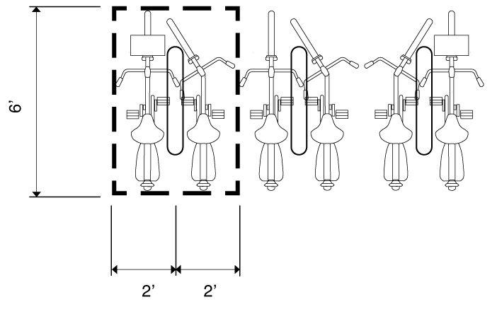
b.
Bicycle racks are securely anchored, are easily usable with both u-locks and cable locks and support a bicycle at two (2) points of contact to prevent damage to the bicycle wheels and frame;
c.
Where a bike can be locked on both sides without conflict, each side can be counted as a required space;
d.
Spacing of the racks provide clear and maneuverable access; and
e.
Facilities may be placed on private property or within the public right-of-way. Facilities in the right-of-way must be approved by the town manager.
3.
Short-term bicycle parking. Short-term bicycle parking is intended for clients and customers. Short-term bicycle racks must be publicly accessible and be located no more than one hundred (100) feet from the building entrance the bicycle rack is intended to serve.
4.
Long-term bicycle parking. Long-term bicycle parking is intended for residents and employees.
a.
Long-term bicycle parking must be covered and weather-resistant.
b.
Required spaces can be in the form of a covered bicycle rack, in a locker, within a building, or within a parking structure.
c.
Long-term bicycle racks must be located no more than one hundred (100) feet from the building entrance the bicycle rack is intended to serve.
F.
Drive-thru standards.
1.
Location. Drive-thru locations are subject to approval of a Special Use Permit. Drive-thru areas, including but not limited to menu boards, stacking lanes, trash receptacles, ordering box, drive up windows, and other objects associated with the drive-thru, must be located interior to the site. Drive-thru windows and lanes may not be placed on a street-facing facade and the associated building. Drive-thru lanes are considered a vehicular access point subject to the requirements of Sec. 3.11.4.1.G.
2.
Required stacking. Adequate stacking space must be made available on-site for any use having a drive-thru. No more than three (3) drive-thru lanes are permitted.
a.
Restaurant. A restaurant (including a coffee shop) with a drive-thru must provide a minimum of six (6) spaces before the order board, with another four (4) spaces provided between the order board and the transaction window.
b.
Bank. A bank with a drive-thru must provide a minimum of three (3) spaces measured from the teller box.
c.
Pharmacy. A pharmacy with a drive-thru must provide a minimum of three (3) spaces measured from the order box.
d.
Dry cleaner. A dry cleaner with a drive-thru must provide a minimum of three (3) spaces measured from the pick up door.
e.
All other uses. Stacking required for all other uses will be determined by the town manager.
3.
Dimensions.
a.
The number of required stacking spaces includes the space at the window or communication/mechanical device (e.g., order board, pick up window).
b.
If a drive-thru has multiple order boxes, teller boxes or pick up windows, the number of required stacking spaces may be split between each order box, teller box or pick up window.
c.
Vehicles may not encroach on or interfere with the public use of streets and sidewalks by vehicles, bicycles or pedestrians.
d.
Drive-thru lanes must be separated by striping or curbing from other parking areas. Individual lanes must be striped, marked or otherwise distinctly delineated.
4.
Screening.
a.
Drive-thru windows and lanes must be screened from the public realm along Type A and Type B Frontages and adjacent ground floor residential uses for the entire length of the drive-thru lane, including but not limited to menu boards, stacking lanes, trash receptacles, ordering box, drive up windows, and other objects associated with the drive-thru must be screened.
b.
Screening must be a continuous compact evergreen hedge. At the time of installation, the screening must be at least three (3) feet in height and reach a height of four (4) feet within three (3) years of planting.
c.
In lieu of the compact evergreen hedge, a screening wall with a minimum height of four (4) feet may be installed. The wall must be compatible with the principal building in terms of texture, quality, material and color.
G.
Service drive, loading dock access and vehicular access.
1.
Vehicular Access. The number of vehicular access points from a thoroughfare to any parcel shall be limited as follows:
a.
No more than two (2) access points in any continuous 200' of lot frontage
b.
No more than three (3) access points overall unless otherwise approved by the Community Design Commission.
c.
Where two (2) such access points are located along the same block face, they shall be separated by a minimum of 30 feet.
d.
Where a building fronts multiple streets or alleys, no access point may be located on the more restrictive assigned frontage or on the primary frontage, as applicable under Sec. 3.11.2.1.E.7., unless otherwise approved by the Community Design Commission.
e.
No vehicular access may be provided between a building façade and a Type E Frontage.
f.
Internal vehicular connections to adjacent parcels are encouraged, particularly where a parcel has only one street frontage and where multiple access points are desired.
2.
Access Width. A parking lot, garage opening, or service access shall not exceed two (2) lanes in width unless otherwise approved by the town manager. Access points on alleys are exempt from this requirement.
3.
Gating. Vehicular entry gates at garage entries shall be positioned a minimum of twenty (20) feet behind the front wall of the building.
4.
Pedestrian access. Where vehicular access to any parcel crosses any pedestrian path or sidewalk, the crossing shall be clearly marked and lighted for the safety of the pedestrian, and the public sidewalk shall remain generally in a continuous alignment in plan and profile with the sidewalk on either side of the vehicular access.
3.11.4.2. Landscaping Standards.
A.
General applicability. No building or land, or any part of any building or land, may be occupied or used until landscaping and screening has been provided in accordance with this section.
B.
Multifunctional landscaping and stormwater management. Nothing in this section is intended to prevent the applicant from using landscaped areas for stormwater purposes, including landscape, screening, sidewalk and streetscape areas. Where low impact stormwater management features are incorporated, grading and edge treatments for landscaping and screening areas must allow stormwater inflow. In such cases, no berming or curbs are necessary. The town manager may modify the landscaping standards of this section or the design manual to achieve this end.
C.
Surface parking lots.
1.
Applicability.
a.
New construction. All new surface parking lots with more than ten (10) spaces must provide parking lot landscaping in accordance with Section 3.11.4.2. Multiple platted lots contained on a single site plan and any separate parking areas connected with drive aisles are considered a single parking area.
b.
Additions.
i.
An existing parking lot may be renovated or repaired without providing additional landscaping, provided there is no increase in the size of the parking lot.
ii.
When an existing parking lot is increased in size, landscaping is required for the new parking area only.
iii.
When an existing parking lot is increased in size by more than fifty (50) percent cumulatively, landscaping is required for both the existing parking lot and the new parking area.
2.
Perimeter screening. All surface parking lots (of any size) with frontage on any portion of a public street (not including an alley) must be screened with the following (see also Section 3.11.2.5):
a.
A minimum five-foot wide, landscaped area with a continuous row of shrubs must be provided between the street and parking lot. For the Type C Frontage area along Fordham Boulevard, the community design commission will review and have the discretion to increase the required planting zone up to twelve (12) feet.

b.
Shrubs must be a minimum of eighteen (18) inches in height when planted and must reach a minimum size of thirty-six (36) inches in height within three (3) years of planting.
c.
A 36-inch wall may be substituted for the continuous row of shrubs.
d.
Breaks for pedestrian and vehicle access are permitted.
3.
Interior islands.
a.
A landscaped interior island must be provided every ten (10) parking spaces. Interior islands must be distributed evenly throughout the parking area. Interior islands may be consolidated or intervals may be expanded in order to preserve existing trees.
b.
An interior island abutting a single row of parking spaces must be a minimum of eight (8) feet in width and one hundred fifty (150) square feet in area. Each island must include one (1) canopy tree.
c.
An interior island abutting a double row of parking spaces must be a minimum of eight (8) feet in width and three hundred (300) square feet in area. Each island must include two (2) canopy trees.
d.
All required trees must be chosen from the approved the plant selection standards in the Town of Chapel Hill Design Manual.
e.
Interior islands may be installed below the level of the parking lot surface to allow for runoff capture.
4.
Median islands.
a.
A landscaped median island must be provided between every six (6) single parking rows. Intervals may be expanded in order to preserve existing trees.
b.
A landscaped median island must be a minimum of eight (8) feet wide.
c.
Landscaped median islands may be installed below the level of the parking lot surface to allow for runoff capture.
d.
Any trees planted in landscaped median islands must be canopy trees unless the median is designed as a bioretention basin in accordance with Section 3.11.4.3.
5.
Sidewalks in medians. Where a sidewalk is added to a median, additional median width equal to the sidewalk width must be provided.
6.
Trees. No parking space may be farther than seventy-five (75) feet from the trunk of a tree.
D.
Frontages. Frontages must be planted in accordance with the Design Manual. Tree planting zones without grates must be a minimum of eight (8) feet in width. Tree planting zones with grates must be a minimum of six (6) feet in width. Tree planting zones must be installed using structural soils, as described in the Design Manual. Tree maintenance and replacement is the responsibility of the property owner.
E.
Service area and mechanical screening.
1.
Applicability. All new service areas and the installation of new mechanical equipment must provide screening in accordance with Section 3.11.4.2.
2.
Service areas.
a.
Trash and recycling collection and other similar service areas must be located to the side or rear of buildings.
b.
Service areas must be screened on three (3) sides by a wall a minimum six (6) feet in height and on the fourth side by a solid gate at a minimum of six (6) feet in height.

c.
The wall must be opaque and be constructed of high quality materials including one or a combination of the following: decorative blocks; brick; stone; cast-stone; split-faced block; stucco over standard concrete masonry blocks; glass block; or other material approved by the town manager.
d.
The gate and wall must be maintained in good working order and must remain closed except when trash pick-ups occur.
3.
Roof-mounted equipment.
a.
Roof-mounted equipment must be set back at least ten (10) feet from the edge of the roof and screened from ground level view from abutting property or abutting public street (not including an alley).
b.
Buildings must provide a parapet wall or other architectural element that is compatible with the principal building in terms of texture, quality, material and color that fully screens roof-mounted equipment from ground level view.
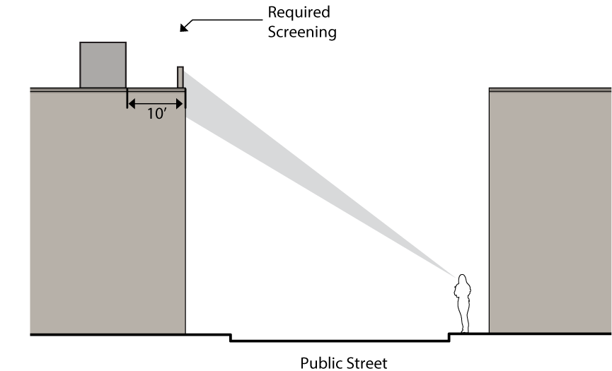
c.
The town manager may modify these standards to ensure effective equipment functionality and ventilation.
4.
Wall-mounted equipment. It is the intent of this section that aboveground mechanical equipment and minor structures accessory to utilities, excluding equipment and structures necessary for life safety, shall be minimally visible and minimally encroach into the pedestrian path.
a.
Wall-mounted equipment located on any surface that is visible from a public street (not including an alley) must be fully screened by landscaping or a wall or fence that cannot be seen through, and that is compatible with the principal building in terms of texture, quality, material and color.
b.
Screening must be of a height equal to or greater than the height of the mechanical equipment being screened.
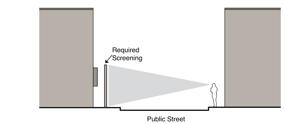
c.
The town manager may modify these standards to ensure effective equipment functionality and ventilation.
d.
Unless otherwise approved as a permitted setback encroachment in Section 3.11.2.7, wall-mounted mechanical equipment and minor structures accessory to utilities, excluding equipment and structures necessary for life safety, shall not be placed within ten (10) feet of a sidewalk for a Type A or a Type B street frontage.
5.
Ground-mounted equipment. It is the intent of this section that aboveground mechanical equipment and minor structures accessory to utilities, excluding equipment and structures necessary for life safety, shall be minimally visible and minimally encroach into the pedestrian path.
a.
Ground-mounted mechanical equipment that is visible from a public street (not including an alley) must be fully screened by landscaping or a wall or fence that cannot be seen through, and that is compatible with the principal building in terms of texture, quality, material and color.
b.
Screening must be of a height equal to or greater than the height of the mechanical equipment being screened.
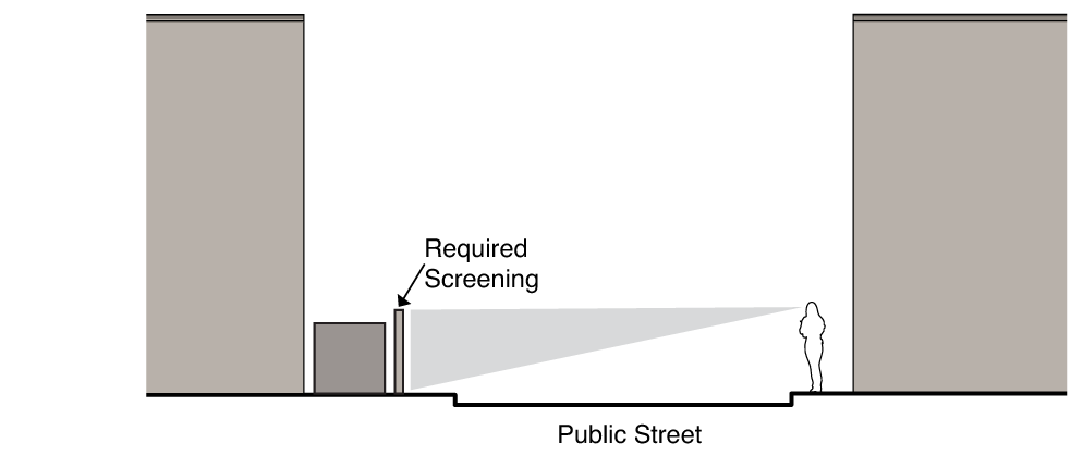
c.
The town manager may modify these standards to ensure effective equipment functionality and ventilation.
d.
Unless otherwise approved as a permitted setback encroachment in Section 3.11.2.7, ground-mounted mechanical equipment and minor structures accessory to utilities, excluding equipment and structures necessary for life safety, shall not be placed within ten (10) feet of a sidewalk for a Type A or a Type B street frontage.
F.
Street trees. Street trees may be required in conformance with Section 3.11.2.5.
G.
Fence and walls.
1.
Applicability. All new fence and walls must be installed in accordance with Section 3.11.4.2.
2.
Standards.
a.
Fences and walls may be placed up to the property line, and any posts or supporting rails must face inward toward the property being fenced.
b.
A wall or fence located in a front setback, not used for a required screen, cannot be more than six (6) feet height. The opacity of the wall or fence above four (4) feet in height must exceed seventy-five (75) percent.
c.
A wall or fence located in a side interior or rear setback cannot be more eight (8) feet in height.
d.
Walls must be constructed of high quality materials including one or a combination of the following: decorative blocks; brick; stone; cast-stone; split-faced block; stucco over standard concrete masonry blocks; glass block; or other material approved by the town manager.
e.
Fences must be constructed of high quality materials including one or a combination of the following: wood, composite fencing; wrought iron, steel, aluminum, PVC vinyl; or other material approved by the town manager.
f.
No wall or fence may be located within any required drainage or utility easement.
g.
Barbed wire or concertina wire is not permitted.
h.
Chain-link fences are not permitted in any front setback.
H.
Residential protection buffer. The following buffer is required along any perimeter lot line that immediately abuts any residential district that is not within a Blue Hill Form District. This standard does not apply to residential land that is separated from the Blue Hill Form District by a street.
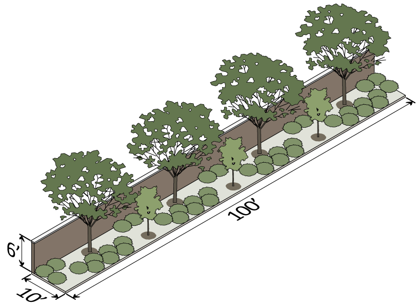
1.
The Community Design Commission may approve a variation to the requirements above in order to accommodate trails and outdoor amenities in the Buffer area.
2.
Either a wall or fence may be used in the Buffer, with intermittent breaks so as not to create an impassible barrier, as appropriate based on context.
3.
Buildings within 20' of the perimeter lot line are subject to mass variation standards as describes in Sec. 3.11.2.7.T.
I.
Plant installation and maintenance. All plants and trees must be maintained and installed in accordance with in the Town of Chapel Hill Design Manual.
3.11.4.3. Stormwater Management.
A.
Authority. This section is adopted pursuant to the authority vested in the Town of Chapel Hill by the Session Laws and the General Statutes of North Carolina and the authority referenced in Section 1.2 of the Land Use Management Ordinance.
B.
Purpose. The purpose of this section is to establish minimum stormwater performance criteria, management requirements and controls to protect and safeguard the general health, safety, and welfare of the public residing in watersheds within this jurisdiction. This section seeks to meet that purpose through the following objectives:
1.
Minimize increases in stormwater runoff from any development in order to reduce flooding, siltation and streambank erosion and maintain the integrity of stream channels;
2.
Minimize increases in non-point source pollution caused by stormwater runoff from development that would otherwise degrade local water quality;
3.
Minimize the total volume of surface water runoff that flows from any specific site during and following development in order to replicate the pre-development hydrology to the maximum extent practicable;
4.
Reduce stormwater runoff rates and volumes, soil erosion and non-point source pollution, wherever possible, through stormwater management controls and to ensure that these management controls are properly maintained and pose no threat to public safety;
5.
Meet the requirements of the National Pollutant Discharge Elimination System (NPDES Phase 2) regulations as established by the Clean Water Act and administered by the North Carolina Department of Natural Resources, or its successor agency; and
6.
Control nonpoint and point source pollution associated with new development and redevelopment and help protect the water supply uses of Jordan Lake.
C.
Applicability.
1.
This section applies to all new development and redevelopment projects for which a form district permit is required. No development or redevelopment for which a form district permit is required pursuant to this section shall occur except in compliance with the provisions, conditions, and limitations of the permit.
2.
Projects that disturb less than one-half (½) acre of land, including cumulative disturbance are exempt from subsection 3.11.4.3.F.4.
D.
Design manual and standard details.
1.
The town shall use the policy, criteria, and information, including technical specifications and standards in the town's "Design Manual and Standard Details" and the July 2007 publication of the "Stormwater Best Management Practices Manual," as amended, published by the North Carolina Department of Environment and Natural Resources' Division of Water Quality, as the basis for stormwater review decisions and for determining the proper design, implementation and performance of engineered stormwater controls and other practices for compliance with this section.
2.
If the specifications or guidelines of either design manual are more restrictive or apply a higher standard than the other, or other laws or regulations, the more restrictive specifications or guidelines apply.
3.
Whenever an applicant proposes to utilize a practice or practices not designed and constructed in accordance with the criteria and specifications in the design manuals, the applicant shall have the burden of demonstrating that the practices will satisfy the minimum water quality performance standards of this section. The town manager shall require the applicant to provide the documentation, calculations, and examples necessary for the town manager to determine whether such an affirmative showing is made.
E.
Application requirements.
1.
Unless otherwise exempted by this section, every permit application for development must be accompanied by a stormwater impact statement in order for the permit application to be considered.
2.
The town manager shall prescribe the forms and information that shall be submitted to determine compliance with this chapter, with sufficient copies for necessary referrals and records.
F.
Design and performance standards. The following are required stormwater management performance criteria:
1.
Stormwater treatment shall be designed to achieve average annual eighty-five (85) percent total suspended solids (TSS) removal and must apply to the volume of post-development runoff resulting from the first one-inch of precipitation. Alternative treatment methods to achieve eighty-five (85) percent average annual TSS removal may be acceptable. The eighty-five (85) percent requirement applies to eighty-five (85) percent of the additional suspended solids that are the result of the new development.
2.
The stormwater runoff volume leaving the site post-development shall not exceed the stormwater runoff volume leaving the site pre-development (existing conditions) for the local two-year frequency, 24-hour duration storm event for all development. This may be achieved by hydrologic abstraction, recycling and/or reuse, or any other accepted scientific method.
3.
The stormwater runoff rate leaving the site post-development shall not exceed the stormwater runoff rate leaving the site pre-development (existing conditions) for the local one-year, two-year, and 25-year 24-hour storm events.
4.
Notwithstanding subsection 3.11.4.3.F.1, the minimum impervious area treated for eighty-five (85) percent average annual TSS removal shall be fifty (50) percent of the post construction total impervious area.
G.
Post-construction requirements.
1.
Inspection, operation and maintenance plan.
a.
The owner or owners of a development must sign and record an inspection, operation, and maintenance plan that shall be binding on all subsequent owners of the site, portions of the site, and lots or parcels served by the stormwater management facility. Until the transference of all property, sites, or lots served by the engineered stormwater controls and practices, the original owner or owners, shall have primary responsibility for carrying out the provisions of the maintenance agreement.
b.
The inspection, operation, and maintenance plan shall require the owner or owners, to maintain, repair and, if necessary, reconstruct the stormwater management facility and shall state the terms, conditions, and schedule of maintenance for the stormwater management facility. In addition, it shall grant to the Town of Chapel Hill the right of entry in the event that the town manager has reason to believe it has become necessary to inspect, monitor, maintain, repair, or reconstruct the stormwater management facility; however, in no case shall the right of entry, of itself, confer an obligation on the town to assume responsibility for the stormwater management facility.
c.
The inspection, operation, and maintenance plan must be approved by the town manager prior to permit approval and shall be recorded with the county register of deeds prior to issuance of a certificate of occupancy.
2.
Upon completion of a project and before a certificate of occupancy shall be granted, all of the documents enumerated below must be submitted to the town manager and a final stormwater management inspection must be scheduled. After performing the final inspection and reviewing and approving the documents, the town manager will issue an approval notification to the town's inspections division.
a.
A copy of the recorded stormwater facility and maintenance easement, signed and sealed by a registered North Carolina professional land surveyor and recorded by the county register of deeds, showing the "Stormwater Management Facility and Maintenance Easements", the stormwater management facilities, and the maintenance access locations. For purposes of maintenance, the maintenance access must be shown on the exhibit and extend from the "Stormwater Facility Easement" to the nearest public right-of-way. The following notes must be included on the recorded final plat or easement exhibit.
i.
All engineered stormwater management control, treatment, and conveyance structures located on or below the ground shall be wholly contained within an easement entitled: "Reserved Stormwater Facility Easement Hereby Dedicated" and shall be reserved from any development which would obstruct or constrict the effective management, control, and conveyance of stormwater from or across the property, other than the approved design and operation functions.
ii.
The reserved stormwater facility and maintenance easements and the facilities they protect are considered to be private, with the sole responsibility of the owner to provide for all required maintenance and operations as approved by the town manager except as noted in section I. below.
iii.
The reserved stormwater facility and maintenance easements and the inspections, operations, and maintenance plan are binding on the owner, heirs, successors, and assigns.
b.
A copy of the recorded inspection, operation, and maintenance plan signed by the owner and recorded by the county register of deeds, for the stormwater management facilities. The inspection, operations, and maintenance plan must include a description and details of the device or structure, an inspections checklist, and operating and maintenance procedures. The plan should identify contact information, who will perform the inspections, frequency of inspections, inspections and maintenance logs, any specific equipment needs or certifications (e.g., confined space certification), action levels or thresholds (e.g., remove sediment after depth exceeds one (1) foot), and disposal methods. The person responsible for the maintenance of stormwater management facilities shall submit an annual inspection report to the town.
c.
Certified as-built plans signed and sealed by qualified registered North Carolina professional engineer, showing final design specifications for all stormwater management facilities and practices and the field location, size, depth, and planted vegetation of all measures, controls, and devices, as installed.
d.
Certified final survey signed and sealed by a registered North Carolina professional land surveyor, showing building footprints, driveways, all other impervious surfaces, stormwater drainage/conveyance piping, and stormwater management structures. The survey should be in DXF binary format using state plane coordinates and NAVD 88.
e.
Certification, signed and sealed by a qualified registered North Carolina professional engineer, that the stormwater management facilities were constructed in accordance with the approved plans and specifications.
3.
Annual inspection. An original inspection report shall be provided to the town beginning one (1) year from the date of the recorded inspection, operation, and maintenance plan and each year thereafter on or before that date of recordation.
H.
[Meeting the inspection and maintenance requirements.] The Ephesus/Church Fordham Municipal Service District (MSD) through the town's departments, agencies, officers, employees, consultants, contractors or agents may assist with meeting the inspection and maintenance requirements as provided in the service district plan and provided for in right of entry agreements with the property owners and responsible parties. The MSD may also provide the financial assurance required for issuance of certificate of occupancy upon approval of the town manager.
I.
Failure to maintain practices. If a responsible party fails or refuses to meet the requirements of the maintenance covenant, the town, after reasonable notice, may correct a violation of the design standards or maintenance needs by performing all necessary work to place the facility in proper working condition. In the event that the stormwater management facility becomes a danger to public safety or public health, or is otherwise not functioning as designed, the town shall notify the party responsible for maintenance of the stormwater management facility in writing. Upon receipt of that notice, the responsible person shall have thirty (30) days to effect maintenance and repair of the facility in an approved manner. After proper notice, the town may assess the owners of the facility for the cost of repair work and any penalties; and the cost of the work shall be a lien on the property, or prorated against the beneficial users of the property, and may be placed on the tax bill and collected as ordinary taxes by the county.
J.
Variances. Persons who wish to undertake uses and activities prohibited by this section may pursue a variance. The procedures for requesting a variance from the requirements of this section shall be as follows:
1.
The procedures for requesting a variance from the requirements in this subsection are contained in section 4.12 of the Land Use Management Ordinance.
3.11.4.4 Reserved.
Editor's note— Ord. No. 2016-12-05/O-5, § II, adopted December 5, 2016, repealed § 3.11.4.4, which pertained to sign standards and codified these provisions in § 5.14, Signs.
3.11.4.5. Site Lighting
A.
Applicability.
1.
General. No building or land, or any part of any building or land, may be occupied or used until site lighting has been provided in accordance with this section.
a.
The installation of site lighting, replacement of site lighting, and changes to existing light fixture wattage, type of fixture, mounting, or fixture location must be made in compliance with section 3.11.4.5. Routine maintenance, including changing the lamp, ballast, starter, photo control, fixture housing, lens and other required components, is permitted for all existing fixtures.
b.
This following site lighting requirements do not apply to lighting installed in the public right-of-way.
2.
Additions.
a.
When a building or site is renovated, any new or replaced outdoor light or lighting fixture must conform to the requirements of section 3.11.4.5.
b.
When the gross floor area or improved site area is increased, the additional floor or site area must conform to the lighting requirements of section 3.11.4.5.
c.
When the gross floor area or improved site area is increased by more than fifty (50) percent cumulatively, both the existing use and the additional floor or site area must conform to the lighting requirements of section 3.11.4.5.
3.
Change in use. A change in use does not trigger application of this section.
B.
Light level measuring.
1.
Light levels are specified, calculated and measured in footcandles. All footcandles values are maintained footcandles.
2.
Measurements are to be made at ground level, with the light-registering portion of the meter held parallel to the ground pointing up.
C.
Prohibited sources. The following light fixtures and sources cannot be used:
1.
Cobra-head-type fixtures having dished or drop lenses or refractors, which contain sources that are not incandescent;
2.
Temporary searchlights and other high-intensity narrow-beam fixtures; and
3.
Light sources that lack color correction or do not allow for uniform site lighting.
D.
Design and installation requirements.
1.
The maximum light level of any light fixture cannot exceed 5.0 footcandles measured at the back of curb in relation to a street.
2.
Where the Blue Hill Form District adjoins a residential district, the maximum light level of any light fixture cannot exceed 2.0 footcandles measured at that property line.
3.
Lighting must not be oriented onto adjacent properties, streets or sidewalks.
4.
Service connections for all freestanding lighting fixtures must be installed underground.
E.
Parking and pedestrian areas.
1.
Light fixtures within parking and vehicular display areas may be no higher than thirty (30) feet.
2.
Light fixtures within pedestrian areas may be no higher than fifteen (15) feet.
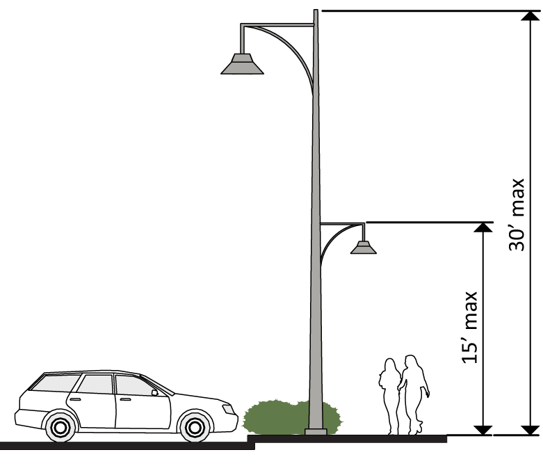
3.
Light fixtures located within fifty (50) feet of the property line of a residential district may be no higher than fifteen (15) feet.
4.
Light fixtures within twenty-five (25) feet of a street right-of-way (not including an alley) must be forward throw fixtures.
5.
All light fixtures must be full cutoff, except as listed in paragraph 6. below.
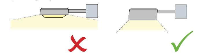
6.
Non-cutoff (unshielded) fixtures can be used when the maximum initial lumens generated by each fixture is less than nine thousand five hundred (9,500) initial lamp lumens. These fixtures generally feature globes or vertical glass planes and must be coated with an internal white frosting to diffuse light.
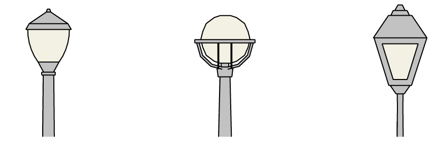
F.
Flood lights and flood lamps.
1.
Flood light fixtures must either be aimed down at least forty-five (45) degrees from vertical, or the front of the fixture shielded so that no portion of the light bulb extends below the bottom edge of the shield.
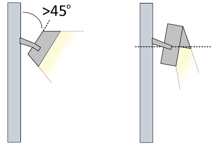
2.
Any flood light fixture located within fifty (50) feet of a street right-of-way must be mounted and aimed perpendicular to the right-of-way, with a side-to-side horizontal aiming tolerance not to exceed fifteen (15) degrees.
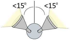
3.
All flood lamps emitting one thousand (1,000) or more lumens must be aimed at least sixty (60) degrees down from horizontal, or shielded so that the main beam is not visible from adjacent properties or the street right-of-way.
G.
Vehicular canopies. Lighting under vehicular canopies must be less than twenty-four (24) maintained footcandles, and be designed to prevent glare off-site. Acceptable lighting designs include the following:
1.
Recessed fixture incorporating a lens cover that is either recessed or flush with the bottom surface of the canopy;
2.
Light fixture incorporating shields, or is shielded by the edge of the canopy itself, so that light is restrained to five (5) degrees or more below the horizontal plane;
3.
Surface mounted fixture incorporating a flat glass that provides a cutoff design or shielded light distribution; or
4.
Indirect lighting where light is beamed upward and then reflected down from the underside of the canopy, provided the fixture is shielded so that direct illumination is focused exclusively on the underside of the canopy.
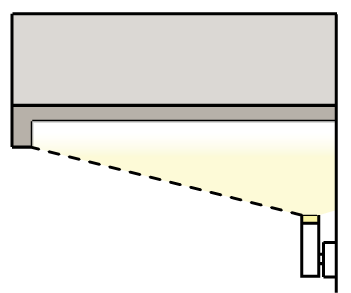
H.
Building lighting.
1.
Lighting fixtures must be selected, located, aimed, and shielded so that direct illumination is focused exclusively on the building façade, plantings, and other intended site features and away from adjoining properties and the street right-of-way.
2.
All wall pack fixtures must be full cutoff fixtures.
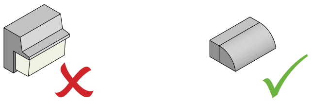
3.
Only lighting used to accent architectural features, landscaping or art may be directed upward, provided that the fixture is located, aimed or shielded to minimize light spill into the night sky.
3.11.4.6. Outdoor Display and Storage.
A.
Applicability. The following requirements apply to any site where merchandise, material or equipment is stored outside of a completely enclosed building.
B.
Outdoor display.
1.
Defined.
a.
Outdoor display is the outdoor display of products actively available for sale that are placed inside a fully-enclosed building at the end of each business day.
b.
Outdoor display includes the outdoor placement of propane gas storage racks, ice storage bins, soft drink or similar vending machines is considered outdoor display
2.
Standards. Outdoor display is permitted in association with any permitted nonresidential principal ground floor use in accordance with the following provisions:
a.
Outdoor display visible from a street must be removed and placed inside a fully-enclosed building at the end of each business day, except propane gas storage racks, ice storage bins, soft drink or similar vending machines may remain outside overnight.
b.
Outdoor display is permitted adjacent to the primary façade with the principal customer entrance, but cannot extend more than eight (8) feet from the façade and occupy no more than thirty (30) percent of the horizontal width of the façade.
c.
Outdoor display cannot impair the ability of pedestrians to use the sidewalk or parking areas and must comply with ADA clearance and accessibility.
C.
Limited outdoor storage.
1.
Defined. Limited outdoor storage includes, but is not limited to:
a.
Outdoor sale areas for sheds, building supplies, garden supplies, plants, lawn movers, barbecues and other similar items; and
b.
The outdoor storage of merchandise or material in boxes, in crates, on pallets or other kinds of shipping containers.
2.
Standards. Limited outdoor storage may not be more than twelve (12) feet in height and must be fully screened from view from the public right-of-way and abutting properties.
D.
General outdoor storage.
1.
Defined. General outdoor storage includes, but is not limited to:
a.
The outdoor storage of contractors equipment;
b.
The outdoor storage of fleet vehicles; and
c.
The outdoor storage of soil, mulch, stone, lumber, pipe, steel, salvage, junk or recycled materials, and other similar merchandise, material or equipment.
2.
Standards. General outdoor storage is not permitted in a Form District.
3.11.4.7. Administration of Form Districts.
A.
Zoning compliance permit. Where required by this section 3.11, a zoning compliance permit consistent with Land Use Management Ordinance, section 4.9, is required.
B.
Special use permit. Where required by this section 3.11, a special use permit consistent with Land Use Management Ordinance, section 4.5, is required.
C.
Form District permit.
1.
Review required.
a.
It is unlawful to begin any excavation, removal of soil, clearing of a site, or placing of any fill on lands contemplated for development, or to begin any construction, moving or alteration of any building or other structure, including accessory structures and signs, until the town manager has issued a Form District Permit for such action, certifying that the development complies with the applicable provisions of this Section. Form District Permits are not required for minor modifications such as ordinary repairs, interior upfits or other renovations which do not increase or decrease floor area by more than five (5) percent of the permitted amount or two thousand five hundred (2,500) square feet, whichever is greater. A zoning compliance permit or other permits may be required for such changes.
b.
It is unlawful to change the type of use or type of occupancy of any land or structure, or to extend any use on any lot on which exists a nonconforming use, until the town manager has issued a Form District permit for such action, certifying that the intended use complies with the applicable provisions of this section.
2.
Site-specific vesting plan. For the purposes of the Land Use Management Ordinance, a Form District Permit constitutes a site-specific vesting plan.
3.
Application Submittal Requirements. Applications for a Form District Permit are submitted to the town manager. The town manager will prescribe the forms on which applications are made. The town manager will prescribe any material that may reasonably be required to determine compliance with this Section and the Land Use Management Ordinance, with sufficient copies for necessary referrals and records. No application may be accepted by the town manager unless it complies with such submittal requirements. Applications that are not complete will be returned to the applicant, with a notation of the deficiencies in the application.
a.
An urban design assessment is required as part of a complete application, providing a preliminary determination of whether elements of the proposed development meet the urban design intent of the Blue Hill District. Urban design assessments will be prepared by consultants under contract with the town and the costs of the analyses will be included in the development application fees.
b.
Traffic impacts of proposed new development and redevelopment shall be considered in the review of applications. A traffic impact analysis as provided for in section 5.8.1.G is required to identify and quantify the traffic impacts of proposed developments, and to identify facility improvements necessary to maintain acceptable levels of service. A traffic impact analysis is required for Form District Permit review, unless affirmatively exempted by the town manager.
4.
Action on the application.
a.
The applicant must meet with the town prior to filing of the Form District permit application to determine whether new right-of-way or public easement will be required for the development, in accordance with the regulating plan, section 3.11.2.2. If new rights-of-way or public easements are required, the proposed dedication shall be shown on the Form District permit application, and the final dedication shall be recorded prior to the issuance of a building permit. Prior to issuance of a Form District permit, a phasing schedule shall be approved by the town manager that addresses necessary public improvements by the applicant and right-of-way and public easement improvements to be constructed by the town.
b.
The town manager will take final action on the application. Final action on an application will be based solely on findings as to compliance with all applicable provisions of this section 3.11 and the Land Use Management Ordinance, including all applicable conditions of an approved major or minor subdivision, and must be one of the following:
i.
Approval of application; or
ii.
Approval of application subject to reasonable conditions to ensure compliance with applicable regulations and conditions; or
iii.
Denial of application.
c.
Final action must be taken within seventy-five (75) working days of the acceptance of an application or 15 working days from approval of a certificate of appropriateness (whichever is later), or within such further time consented to by written notice from the applicant or by town council resolution. The town manager must reach a decision on a complete and otherwise actionable application within the prescribed time limit, or any extension.
5.
Actions subsequent to decision.
a.
In the case of approval or approval with conditions, the town manager will issue the Form District permit. In the case of denial of an application, the town manager must notify the applicant of the reasons for such denial.
b.
Where engineering construction permits are required by the Town Code of Ordinances, such permit may not be issued prior to issuance of the Form District permit.
c.
Where a building permit is required by chapter 5 of the Land Use Management Ordinance, or a sign permit is required, such permits may not be issued prior to issuance of the Form District permit and engineering construction permit required for the development.
6.
Appeal of decision. A decision by the town manager in granting or denying a Form District permit may be appealed to the board of adjustment in accord with the provisions of the Land Use Management Ordinance, section 4.11.
7.
Modification of Form District Permits. The town manager may approve a minor modification of a Form District Permit administratively. A change from what is included in an approved Form District Permit will be considered a major modification under the following circumstances:
a.
A change of use is proposed.
b.
An increase in the number of dwelling units is proposed.
c.
A change in floor area is proposed, resulting in an increase of more than five (5) percent of the permitted amount or two thousand five hundred (2,500) square feet, whichever is greater.
d.
The change would render a building approved under a Form District Permit out of substantial conformance as defined in subsection 3.11.4.8.B.
Any other changes may be approved by the town manager or the town manager's designee and shall not constitute a major modification. The application fee for a modification to a Form District Permit is established by the council as part of the budget process.
8.
Performance and maintenance guarantees.
a.
Conditions attached to an approval of a Form District permit may include the following:
i.
A condition requiring the applicant to provide performance guarantees and/or maintenance guarantees deemed necessary to ensure compliance with the requirements of this Section and the conditions of permit approval.
ii.
A condition permitting the applicant to provide performance guarantees in lieu of actual completion of required improvements prior to use or occupancy of the development authorized by the Form District permit, provided the delayed completion of such improvements is determined to be compatible with the public health, safety and welfare.
b.
Such performance guarantees and maintenance guarantees must be satisfactory as to their form and manner of execution, and as to the sufficiency of their amount in securing the satisfactory construction, installation, or maintenance of the required improvements.
c.
The condition requiring or permitting a performance guarantee must specify a reasonable time period within which required improvements must be completed. Such time period must be incorporated in the performance guarantee. The length of such time period may not exceed two (2) years from the date the Form District permit is issued.
d.
No performance guarantee will be released until certification of the satisfactory completion of all required improvements covered by such performance guarantee has been submitted to and approved by the town manager.
e.
If the required improvements covered by a performance guarantee are not completed in accordance with the terms of the performance guarantee, the obligor will be liable to the town for the reasonable cost of the improvements not completed and the town may, either prior to or after the receipt of the proceeds, complete such improvements.
9.
Expiration and revocation of Form District permit approvals.
a.
Starting time limit. If the use, construction, or activity authorized by approval of an application for a Form District permit or modification of Form District Permit is not started within twelve (12) months of the date of approval, or within such further time stipulated in the approval, the approval will expire and any town permit issued pursuant to the approval will be void. The town manager may grant a single extension of the starting time limit for up to twelve (12) months, unless he/she determines that paramount considerations of health, the general welfare, or public safety require re-approval. The town manager will determine whether the use, construction, or activity has started.
b.
Completion time limit. If all construction and actions authorized or required by a Form District permit or modification of Form District permit are not completed by the completion date stipulated in the permit or modification, the permit holder may request an extension of the completion time limit from the town manager. The town manager may grant extensions of the time limit for periods of up to twelve (12) months if he/she determines that:
i.
The permit holder submitted the request within sixty (60) days of the completion date;
ii.
The permit has proceeded with due diligence and good faith; and
iii.
Conditions have not changed so substantially as to warrant reconsideration of the approved development.
c.
The town manager will determine whether or not all construction and actions authorized or required have been completed.
10.
Revocation of Form District permit.
a.
If any conditions of a Form District permit or modification of Form District permit, including completion time limits, or requirements of this section applicable to the permit or modification are violated, the town manager may revoke the permit or modification.
b.
The town manager may reinstate a revoked Form District permit or modification of Form District permit if he/she determines that:
i.
The holder of the revoked permit or modification submitted a request for reinstatement within ninety (90) days of the revocation;
ii.
The violations that were the cause of the revocation have been corrected; and
iii.
The development fully complies with all conditions of the permit or modification and all applicable requirements of this section and the Land Use Management Ordinance.
c.
Certificate of occupancy. No building or structure for which a Form District permit has been issued may be used or occupied until, after final inspection, a certificate of occupancy has been issued indicating compliance with the provisions of this section, the Land Use Management Ordinance, and all other state and local laws, including conditions of the Form District permit and all other required permits.
D.
Certificate of appropriateness.
1.
Review Required
a.
No exterior portion of any building or related structure (including structured parking visible from the public realm, masonry walls, fences, light fixtures, steps and pavement), or any above-ground utility structure or stormwater control measure at grade may be erected, altered, restored or moved within the Form District until an application for a certificate of appropriateness as to the aesthetic quality of exterior architectural features and accessory utility features has been approved, based upon the criteria and standards established in this Section 3.11. The above requirements do not apply to the demolition of any buildings or structures or routine maintenance of structures.
b.
For purposes of this Section 3.11, "exterior architectural features" shall include the architectural style, general design, and general arrangement of the exterior of a building or other structure, including the following: kind and texture of the building material, type and style of all windows and doors, orientation and treatment of building entrances, building elements as described in Section 3.11.2.6, type and style of light fixtures, quality of associated streetscape environment, quality and activation of pedestrian connectivity routes, quality and activation of associated outdoor amenity spaces, screening of associated vehicular and services areas, cohesive design aesthetic for all buildings and structures on the site, and appropriate transitions to surrounding development.
Accessory utility features further includes the screening of transformers and cabinet structures, as well as the appearance of visible stormwater control measures at grade. Review should give consideration toward the hierarchy of street-facing facades as they relate to the different frontage types. For development along streets with Type C Frontage requirements, the Community Design Commission shall review and approve certificates of appropriateness consistent with 3.11.4.2.C.2.a.
c.
A certificate of appropriateness shall be issued prior to the issuance of a Form District permit, zoning compliance permit or any other permit granted for purposes of constructing or altering buildings or structures.
d.
The town and all public utility companies shall be required to obtain a certificate of appropriateness prior to initiating any changes in the character of structures and buildings on property owned or franchised by the Town of Chapel Hill or public utility companies, excluding street paving, sidewalks, utility installations, lighting, walls, fences, regulatory signs, other traffic control measures and devices, and utility distribution systems located in public right-of-way.
e.
A certificate of appropriateness application may be reviewed and approved by the town manager according to specific review criteria contained in state law and guidelines approved by the community design commission when the application is determined to involve minor work. Minor works are defined as those exterior changes that do not involve any substantial alterations. Such minor works shall be limited to those listed in the community design commission's rules of procedure, or a successor document. No application involving minor work may be denied without the formal action of the commission. Ordinance requirements for notification of affected property owners must be met for all applications.
2.
Certain changes not prohibited.
a.
Nothing in this section shall be construed to prevent the ordinary maintenance or repair of any exterior architectural feature in the Form District that does not involve a change in design, material, or outer appearance, or to prevent the construction, reconstruction, alteration, restoration, moving, or demolition of any feature that the building inspector or similar official certifies is required by the public safety because of unsafe or dangerous condition.
b.
On the basis of preliminary sketches or drawings and other supporting data, the town manager may exempt from requirements for a certificate of appropriateness projects involving the ordinary maintenance or repair of any exterior architectural feature that does not involve a change in design, material, or outer appearance. The town manager must notify the community design commission of all such exemptions.
3.
Application submittal requirements.
a.
Applications for a certificate of appropriateness are submitted to the town manager. The town manager will prescribe the forms on which applications are made. The town manager will prescribe any material that may reasonably be required to determine compliance with this section and the Land Use Management Ordinance, with sufficient copies for necessary referrals and records. No application may be accepted by the town manager unless it complies with such submittal requirements. Applications that are not complete will be returned to the applicant, with a notation of the deficiencies in the application.
b.
Prior to approval or denial of an application for a certificate of appropriateness by the community design commission, the commission must take such action as may reasonably be required to inform the owners of any property likely to be materially affected by the application, and will give the applicant and such owners an opportunity to be heard.
c.
In cases where the commission deems it necessary, it may hold an administrative hearing concerning the application.
4.
Action on the application.
a.
Within one hundred (100) working days of the acceptance of an application, or within such further time consented to by written notice from the applicant, the town manager or the community design commission shall issue a certificate of appropriateness, issue a certificate of appropriateness with conditions, or deny the application.
b.
Such action must be an administrative decision based upon the criteria and standards established in this Section 3.11. The Design Guidelines shall serve as a reference for the Community Design Commission's review.
c.
Failure to take final action on an application within the prescribed time limit, or extensions, will result in the issuance of a certificate of appropriateness for the application submitted.
d.
The town manager or the community design commission may impose such reasonable conditions with the issuance of a certificate of appropriateness as will ensure that the spirit and intent of section 3.11 are achieved.
5.
Actions subsequent to decision. The town manager will notify the applicant of a decision in writing, and file a copy of it with the town's planning department. If the application is denied, the notice must include the reasons for such action.
6.
Appeal of decision. A decision by the community design commission on an application for a certificate of appropriateness may be appealed to the board of adjustment in accordance with the provisions of Land Use Management Ordinance section 4.10.
7.
Submittal of new application. If the community design commission denies an application for a certificate of appropriateness, a new application affecting the same property may be submitted only if substantive change is made in plans for the proposed construction, reconstruction or alteration.
8.
Modification of certificate of appropriateness. The community design commission may review and approve a major modification of a certificate of appropriateness. A major modification is defined as any change that exceeds "minor work" as it is defined in subsection 3.11.4.7.D.1.e. Any change considered "minor work" shall be deemed a minor modification and may be reviewed and approved by the town manager. The application fee for a modification to a certificate of appropriateness is established by the council as part of the budget process.
E.
Nonconforming build-to requirement. The nonconforming provisions of the Land Use Management Ordinance apply to this section. The following standards clarify the application of the Land Use Management Ordinance nonconforming provisions to the build-to zone requirements of this section. Expansion of an existing building is required to meet the build-to zone requirements, except as permitted in the following situations.
1.
Additions. Expansion of an existing building which is unable to meet the build-to requirement of this section must comply with the following nonconforming provisions:
a.
Front: Addition. Any addition to the front must be placed in the build-to zone. The addition does not have to meet the build-to zone percentage for the lot.
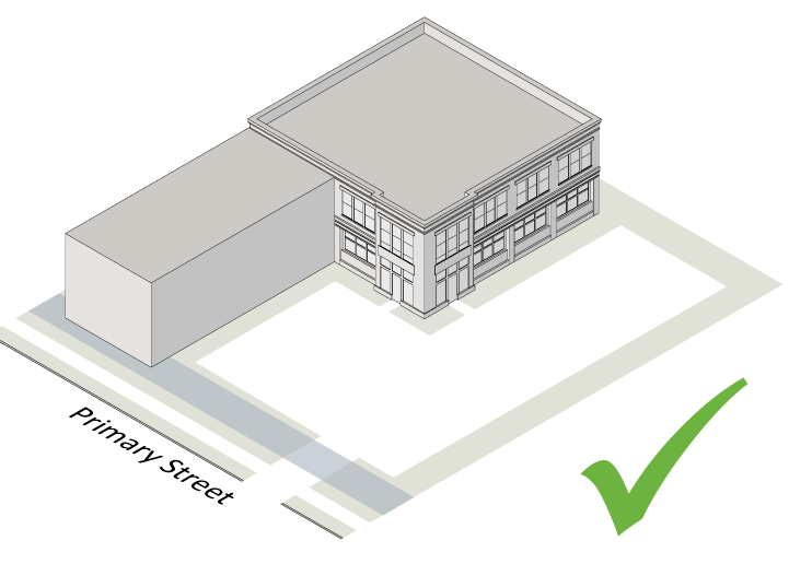
b.
Rear: Addition. Rear additions are permitted. The intent is to ensure a building addition does not increase the degree on the nonconformity in relation to the build-to zone.
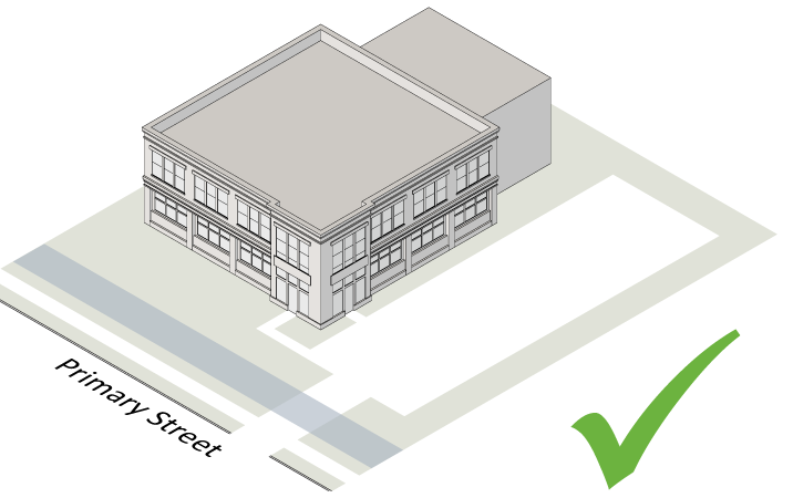
c.
Side: Addition. Side additions are not permitted
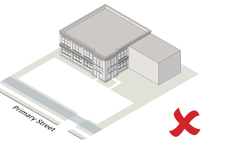
2.
New buildings. Where a new building is being constructed on a lot or site with an existing building on it that doesn't meet the build-to requirement, the following nonconforming provisions apply.
a.
Front: New building. All new buildings must be placed in the build-to zone until the build-to zone percentage for the lot has been met.
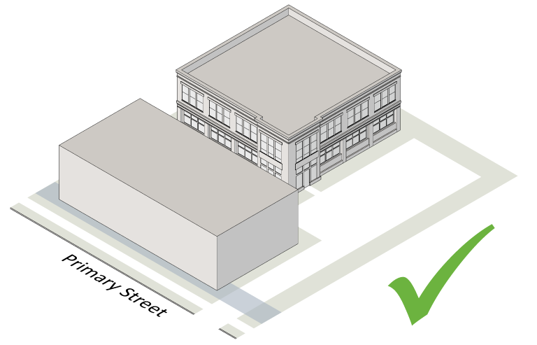
b.
Rear: New building. New buildings located outside of the build-to zone are not permitted until the build-to zone percentage for the lot has been met.
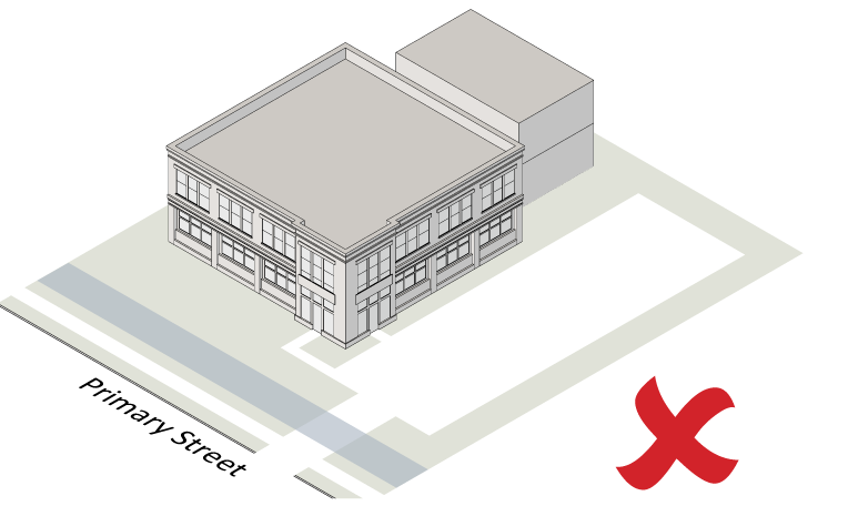
c.
Side: New building. New buildings located outside of the build-to zone are not permitted until the build-to zone percentage for the lot has been met.
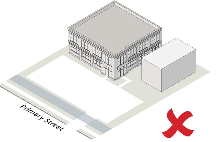
F.
Phased Redevelopment.
1.
Build-Out Plan. Where appropriate for demonstrating the phased redevelopment of a site, the applicant may submit a build-out plan conveying the overall general intent and system of development as part of the application for a Form District Permit and Certificate of Appropriateness. A build-out plan shall be required when a proposed improvement would not meet the standards of Section 3.11 except in the context of construction of a future improvement. The build-out plan shall include the following information:
a.
The boundary of the site subject to phased redevelopment.
b.
The type and location of improvements within the site, with sufficient detail to demonstrate overall compliance with Section 3.11.
c.
A phasing plan.
d.
Proposed interim treatments at the boundaries of phases, as necessary to provide buffering and screening between initial and subsequent phases.
e.
Proposed alternative improvements to be made if a subsequent phase is delayed.
2.
Design Alternative. The Community Design Commission may approve buildings and related structures not meeting the standards of Section 3.11 as a design alternative, where a build-out plan identifies a sequence of improvements that will bring all phases into conformance with Section 3.11 and provides adequate buffering and screening between phases. Such approval may include buildings and building additions located outside the build-to zone; however, no structure shall be approved in a location that would significantly restrict the ability of future buildings to meet build-to zone requirements.
3.11.4.8. Defined Terms.
A.
General provisions.
1.
General meaning of words and terms.
a.
All words and terms used have their commonly accepted and ordinary meaning unless they are specifically defined in section 3.11.4.9 or the context in which they are used clearly indicates to the contrary.
b.
When vagueness or ambiguity is found to exist as to the meaning of any word or term used, any appropriate canon, maxim, principle or other technical rule of interpretations or construction used by the courts of this state may be employed to resolve vagueness and ambiguity in language.
2.
Graphics, illustrations and photographs. The graphics, illustrations and photographs used to visually explain certain provisions of section 3.11.4.9 are for illustrative purposes only.
B.
Defined terms. The following terms are defined for the purpose of this Section. Terms not defined may be defined in Appendix A. If there is a conflict between a definition in Appendix A and this section, the definition in this section will be used.
Addition (to an existing building) means any walled and roofed expansion to the perimeter of a building in which the addition is connected by a common load-bearing wall other than a fire wall. Any walled and roofed addition which is connected by a fire wall or is separated by independent perimeter load-bearing walls is "new construction."
Attic means habitable or uninhabitable space within a building situated within the structure of a pitched roof and above the uppermost regular story.
Block length means the distance between two (2) intersections or an intersection and the terminus of a road.
Buildable means land area that is suitable and available for development unconstrained by physical layout, topography, regulatory factors, existing or planned public facilities, utilities and the like.
Building façade means the face of a building that delineates the edge of conditioned floor space.
Building depth means the largest total dimension of a building footprint measured perpendicular to the primary frontage.
Building width means the largest total dimension of a building footprint measured parallel to the primary frontage.
Day means one (1) calendar day. Working day means a day that the Town of Chapel Hill is open during normal business hours. This excludes weekends and observed holidays.
Gross floor area means the sum in square feet of the horizontal area of all floors of the building measured from the exterior walls or from the centerline when two (2) buildings or units abut. Gross floor area includes basement floor area when more than fifty (50) percent of the basement height is above the established curb level or above the finished lot grade level where the curb level has not been established. Elevator shafts, stairwells, floor space used for mechanical equipment, attics, balconies and mezzanines, enclosed porches, and floor area devoted to accessory uses is included in the calculation of gross floor area. However, the following is not included: any space devoted exclusively to on-site parking; or outdoor loading, display, storage, utility service areas; and uninhabited enclosed space on tops of roofs; or attic space having head room of less than even (7) feet, six (6) inches.
Ground floor means the floor of a building that is at or nearest to the level of the ground around the building. Does not include the floor of a basement.
Improved site area means the sum of the horizontal area of the outside portion of the site and includes any space devoted to on-site parking; outdoor loading, display, storage, utility service, decorative areas and landscaped areas that are part of the original site plan approval.
Pedestrian Connectivity means a publically accessible route between buildings that allows pedestrians to move from one (1) side of a building or lot to another through a privately owned or publicly dedicated area. The route must connect to or allow future connection to other such routes, sidewalks, greenways, or thoroughfares. Pedestrian connectivity may include a through-street or alley, and may be designed as a trail, greenway or other similar passage. Vehicular use may be allowed as desired by the applicant, provided that the design of the pedestrian route prioritizes pedestrian movements.
Public Realm means the streetscape or any other nonvehicular, publically accessible area located along the designated frontage of a street, alley shared between sites, or non-vehicular thoroughfare.
Raceway means an enclosed channel of metal or nonmetallic materials designed expressly for holding wires or cables associated with illuminating a sign.
Right-of-way means a fee simple dedication of private property or an easement, whereby public access and utility easements are granted.
Sidewalk clear zone means an area of the sidewalk equivalent to the minimum required width for which pedestrians have a safe and adequate place to walk free of any obstructions. Any entryways, doors, door swings, outdoor dining, sandwich boards, benches, lighting or other streetscape features shall be placed outside of the clear zone.
Street facing façade means a building façade which directly abuts an arterial, collector, local or district street.
Substantial conformance means conformance which leaves a reasonable margin for minor modification provided that: such modification is consistent with and does not materially alter the character of the approved development including the uses, layout and relationship to adjacent properties depicted on the approved Form District permit or certificate of appropriateness; such modification does not increase or decrease floor area by more than five (5) percent of the permitted amount or two thousand five hundred (2,500) square feet (whichever is greater); such modification is consistent with any proffered or imposed conditions that govern development of the site; and, such modification is in accordance with the requirements of the Town of Chapel Hill Land Use Management Ordinance.
This section means section 3.11 of the Land Use Management Ordinance.
Thoroughfare means a route provided for the purposes of creating connectivity and/or establishing blocks, to include all types of streets, alleys, and non-vehicular paths and greenways with a defined right-of-way.
Upper story means any story above the ground story or floor.
(Ord. No. 2014-05-12/O-3, § I, 5-12-2014; Ord. No. 2015-10-26/O-1, § I; Ord. No. 2016-04-18/O-1, § 1; Ord. No. 2016-04-18/O-3, §§ I, II; Ord. No. 2016-04-18/O-4, §§ I—IV; Ord. No. 2016-04-18/O-5, § I; Ord. No. 2016-04-18/O-6, § I; Ord. No. 2016-04-18/O-7, §§ I—V; Ord. No. 2016-04-18/O-8, § I; Ord. No. 2016-06-27/O-10.1, §§ I—VI; Ord. No. 2016-06-27/O-12, § I; Ord. No. 2016-12-05/O-5, §§ II—IV; Ord. No. 2017-03-06/O-1, §§ 1—18; Ord. No. 2018-05-23/O-5.1, §§ 1—40; Ord. No. 2018-06-27/O-5.1, § 1; Ord. No. 2018-06-27/O-5.2, §§ 1, 2; Ord. No. 2018-06-27/O-5.3, §§ 1, 2; Ord. No. 2019-06-26/O-3, §§ 1—9; Ord. No. 2020-02-19/O-1, §§ 1—15; Ord. No. 2021-05-19/O-1, §§ 37—41; Ord. No. 2021-06-16/O-1, §§ 1—3; Ord. No. 2021-10-27/O-8, § 1)