
Chapel Hill City Zoning Code
ARTICLE 5
- DESIGN AND DEVELOPMENT STANDARDS
This section establishes the criteria for designing a lot, a development, or a site. Section 5.2 describes how to establish lots and lot lines. The reader should also consult the Dimensional Matrix in the zoning regulations (section 3.8, Table 3.8-1) for additional standards governing lot design.
Environmental protection is an important theme of the comprehensive plan and town policy. This article contains a number of standards to minimize the impact of development on the environment. Standards to control erosion and the development of steep slopes are established in section 5.3. (The reader should also refer to the resource conservation district regulations in article 3 of this appendix, and the floodplain management regulations of chapter 5 of the town code, for additional environmental regulations). Criteria for controlling stormwater and drainage are set out in section 5.4. The central theme of these regulations is to encourage "low-impact design" that disperses pavement into small modules, and replicates the natural hydrological system of the site. Section 5.5 requires a portion of most developments to be used as parks or open space. This includes reserving areas for common open space, with the payment of fees in lieu of reserving these areas in order to create design flexibility. Section 5.6 requires developers and landowners to provide landscaping, as well as landscaped buffers between incompatible uses. Section 5.7 requires the protection of trees from incompatible development. This section describes what trees require protection, and how the root systems and other features are protected.
The design of street systems and regulation of traffic are described in section 5.8. This includes not only vehicular access, but also facilities for pedestrian and bicycle access. Section 5.9 establishes both a minimum and a maximum amount of vehicle parking spaces that must accompany new development.
The design of buildings and structures to facilitate access by disabled persons is an increasingly important consideration in construction and development. This issue is addressed in chapter 5 of the town code of ordinances, and the state building code.
Lighting and signage provide visibility for development, but can also create unsafe conditions and clutter. Controlling light spillage onto adjoining properties is important to Chapel Hill's neighborhoods. This issue is addressed in section 5.11. Section 5.14 controls the type, size and location of signs.
The final sections of the code relate to construction activities. The design of utilities and site infrastructure, such as solid waste collection and water and sewer systems, is governed by sections 5.12—5.13. Section 5.15 establishes standards to minimize the potential for nuisance-type conditions during construction activities.
5.1.- Overall site design.
5.1.1. Intent.
It is the intent of this article to provide general performance standards to ensure that development within the Chapel Hill planning jurisdiction will be designed, arranged, and constructed in a safe, orderly, energy-efficient, and visually harmonious manner, and will reflect the basic character of the development site and its immediate surroundings as well as the nature of the proposed uses of the site. Site and structure designs that emphasize energy conservation are encouraged.
5.1.2. Applicability.
Except as otherwise specifically provided in this appendix, no land or structure shall be used or occupied, and no excavation, removal of soil, clearing of a site, or placing of fill shall take place on land contemplated for development, and no structure, or part thereof, shall be constructed, erected, altered, renovated, or moved except in compliance with the general performance standards specified herein and the specific standards contained in the design manual required below.
5.1.3. Public Works Design Manual.
The town manager shall maintain a public works design manual which shall contain specific design and construction standards. The town manager shall revise the Public Works Engineering Design Manual as needed in accordance with the provisions of the Land Use Management Ordinance. Such standards shall be in accord with the general performance standards contained herein, and shall reflect, where applicable, generally accepted design and construction practices and techniques and requirements of the town Code of Ordinances. The public works design manual shall contain sufficient flexibility in the application of specific standards so as to permit modification of the standards where such modifications have been determined by the town manager to be equally or more appropriate to safe, orderly, energy-efficient, and visually harmonious development due to particular conditions of a development site, and that such modifications continue to be in conformance with the general performance standards contained herein.
(Ord. No. 2017-06-26/O-9)
5.2. - Lot Layout standards.
Purpose statement: The purposes of these standards are to ensure that lots in new subdivisions, and the placement of buildings within lots, are designed and located so as to:
• Protect and conserve environmental resources;
• Maximize energy efficiency and conservation;
• Be visually harmonious both within the development site and in relation to adjacent developments;
• Be integrated to the degree of their compatibility with each other and are separated to the degree of their incompatibility;
• Be designed with a street network that provides safe, adequate access to all lots within the subdivision, and to properties adjoining the subdivision where such access is deemed desirable for the orderly future development of these properties;
• Be arranged so as to preserve or enhance vistas.
5.2.1. General Site Arrangement.
Structures shall be placed and arranged so as not to adversely affect adjacent property. Adverse effects shall include, but are not limited to, the removal of lateral support, the creation of hazard, nuisance, or danger, unreasonable loss of light and air or solar access, or unreasonable loss of privacy or views.
5.2.2. Applicability of Lot Design Standards.
Each lot in a subdivision shall comply with the lot design standards contained in this section. Newly created or revised lots shall be designed so that any existing structures continue to meet the requirements of this appendix or so that any existing nonconformity is not increased, extended, or enlarged. The standards of this section, however, do not apply to recreation areas, lots within approved planned developments and townhouse lots created as part of a minor subdivision provided:
(a)
The town manager has approved provisions for the unified control of and responsibility for the development and for the maintenance of common areas; and
(b)
The town manager has approved provisions for ensuring access to and use of recreation areas or areas otherwise designated for the residents' common use and benefit.
5.2.3. Lot Arrangement.
The arrangement of lots in a subdivision shall comply with the provisions of this article and shall provide vehicular access to buildings on them from an approved street.
5.2.4. Access to Streets.
Every subdivided lot shall front on a street meeting the standards of this article and of the design manual, including all required improvements such as sidewalks, curbs, and gutters.
Double frontage lots are prohibited except where necessary to separate residential development from arterial streets or to overcome specific disadvantages of topography and orientation. Where double frontage lots are permitted, a bufferyard shall be provided adjacent to the higher classified street to prohibit access by motorized vehicles.
5.2.5. Lot Dimensions.
Every subdivided lot shall comply with the dimensional standards contained in this appendix (Section 3.8), as well as other standards of the county health department for lots not served by a public water supply and/or a public sanitary sewer system.
Where the gross land area of a lot(s) in the subdivision is greater than or equal to twice the minimum gross land area required in section 3.8 for the zoning district, the town manager or town council, as appropriate, may require that the subdivision be arranged to allow future orderly subdivision of such lots and the opening of future streets where needed to serve such potential lots.
5.2.6. Flag Lots.
The Town of Chapel Hill discourages and restricts forming flag lots in subdivisions. A flag lot shall be permitted if necessary to allow a property owner reasonable use and benefit from his/her land or to alleviate situations which would otherwise cause extreme hardship for him/her.
Flag lots are prohibited except when allowed upon findings that:
(a)
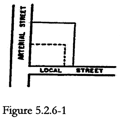
The flag lot is necessary to eliminate access onto an arterial street (See Figure 5.2.6-1);
(b)
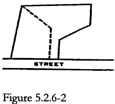
The flag lot is necessary to reasonably utilize irregularly shaped land (See Figure 5.2.6-2);
(c)
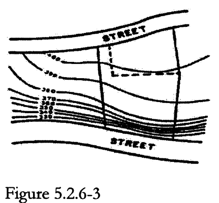
The flag lot is necessary to reasonably utilize land with difficult topography (See Figure 5.2.6-3).
No flag lot will be allowed if it increases the number of access points onto an arterial or collector street.
That portion of a flag lot between the street onto which it has access and the point where a lot dimension parallel to the street first equals or exceeds the minimum lot width specified in section 3.8 shall not be longer than two hundred (200) feet. The lot width and street frontage of a flag lot may be reduced to thirty-five (35) feet. The town manager may approve further reductions to a minimum of twenty (20) feet where topographical conditions permit the construction of an adequate driveway within that width. The town manager may also require greater widths where necessary to ensure adequate access.
5.2.7. Location of Lot Lines.
Interior lot lines extending from a street should be approximately perpendicular or radial to the street right-of-way line.
Lot lines shall be located to permit efficient installation and maintenance of utility lines on utility easements and to maximize buildable area.
5.2.8. Zero Lot Line Setback Modifications.
Interior and solar setbacks for structures on lots within a subdivision may be reduced to zero provided such reductions are shown on the approved final plat and the following requirements are met:
(a)
The interior or north lot line designated for a zero setback (the zero lot line) shall not be used for a zero setback on the other property abutting the lot line.
(b)
The setback between the lot line opposite the zero lot line and any structure on the lot shall equal or exceed two (2) times the minimum interior setback specified in section 3.8.
(c)
The wall constructed against the zero lot line shall be at least six (6) feet high and shall not contain windows, doors, air conditioning units, or other openings. Any wall facing the zero lot line but not constructed against it shall conform to the minimum interior or solar setback, as appropriate, specified in section 3.8.
(d)
A wall maintenance easement shall be provided on the other property abutting the zero lot line. The width of such easement shall be at least four (4) feet.
(e)
The zero setback shall be approved as part of a subdivision approval or the owners of the other property abutting the zero lot line shall consent, by recorded agreement or deed restriction, to the zero setback.
5.3. - Critical areas and environmental performance standards.
5.3.1. Erosion and Sedimentation Control.
All developments shall comply with the provisions of applicable soil erosion and sedimentation control regulations (article 5 of chapter 5 of the town code of ordinances). Certification of compliance with or exemption from the requirements of such regulations shall be submitted to the town manager prior to issuance of any zoning compliance permit for the development. No engineering construction permit or building permit shall be issued until certification of the completion of control measures and facilities required for all associated land-disturbing activity has been submitted to the town manager.
5.3.2. Steep Slopes.
(a)
Purpose and Intent. The purpose of this section is to minimize the grading and site disturbance of steep slopes by restricting land disturbance on steep slopes, and by requiring special construction techniques for development on steep slopes. These provisions are intended to:
(1)
Protect water bodies (streams and lakes) and wetlands from the effects of erosion on water quality and water body integrity,
(2)
Protect the plant and animal habitat of steep slopes from the effects of land disturbance, and
(3)
Preserve the natural beauty and economic value of the town's wooded hillsides.
(b)
Definitions. For purposes of this section, "slope" means the ratio of elevation change to horizontal distance, expressed as a percentage. Slope is computed by dividing the vertical distance ("rise") by the horizontal distance ("run"), and multiplying the ratio by one hundred (100). A "steep slope" is equal to or steeper than fifteen (15) percent.
"Cut and fill slopes" include all slopes graded by excavating part of a higher area, raising the surface of a lower area, or combining the two (2) methods of construction.
(c)
Applicability.
(1)
For purposes of this section, a "steep slope" shall include only those areas of size four hundred (400) square feet or greater. Three (3) different categories of steep slopes are established in this section, as described in Table 5.3-1.
(2)
Steep slope regulations contained in this section shall not apply to single-family dwelling units or two-family/accessory apartment dwelling units on lots lawfully created prior to January 27, 2003, or lots created pursuant to a preliminary plat approved by the town manager prior to January 27, 2003.
(3)
Steep slope regulations contained in this section shall not apply to existing cut and fill slopes associated with roads, parking lots or driveways.
(d)
Contents of Application Requirements. The following information shall be provided for any application proposing development where the project area includes an area of steep slopes:
(1)
A slope and topographic map for both existing and proposed conditions based on a map depicting contours at an interval of two (2) feet or less. The map shall indicate, through cross-hatching or separate colors, all areas within each slope category described in Table 5.3-1, below.
(2)
The location of any existing swales, streams, or areas of concentrated flow.
(3)
A map showing current land use cover type or ground cover on steep slopes.
(4)
A map showing soil types for the whole site, and providing from the county soil survey the names of the soil types and depths to bedrock for each type.
(5)
Additional information may be required if steep slopes will be impacted by development.
(6)
Applications for subdivisions shall include a slope and topographic map for both existing and proposed conditions based on a map depicting contours at an interval of two (2) feet or less. The map shall indicate, through cross-hatching or separate colors, all areas within each slope category described in Table 5.3-1, below. Areas containing slopes of 4:1 (25%) or steeper shall be called out on recorded subdivision plats for single - and two-family development along with a note that reads "No more than twenty-five (25) percent of the total combined area of 4:1 (25%) or steeper shall be disturbed."
(e)
Cut and Fill Slope Requirements. All new cut and fill slopes must not be steeper than a 3:1 slope (33%). Steeper slopes may be conditionally approved by the Town Manager.
(f)
Disturbance limitations. No more than twenty-five (25) percent of the total combined area of 4:1 (25%) or steeper slopes shall be disturbed unless a variance is granted by the Board of Adjustment.
(g)
Construction Techniques.
(1)
All plans must show provisions for reducing and minimizing stormwater runoff during construction of steep slopes and cut and fill slopes.
(2)
All perimeter dikes, swales, ditches, perimeter slopes; all slopes 2:1 or steeper; all slopes between 2:1 and 3:1 and greater than ten (10) feet in length; and all slopes between 3:1 and 4:1 and greater than fifty (50) feet in length and all slopes steeper than 3:1 shall be provided temporary or permanent stabilization with ground cover sufficient to restrain erosion as soon as practicable but in any event within even (7) calendar days of any phase of grading.
(3)
All other disturbed areas shall be provided temporary or permanent stabilization with ground cover sufficient to restrain erosion as soon as practicable but in any event within fourteen (14) calendar days of termination or completion of any phase of grading.
(4)
When any given area of construction is completed, it must have a permanent, stabilizing ground cover applied within the specified time period above. If irrigation is not provided, then the exposed soil shall be planted with species which can survive without irrigation. Vegetative cover or any alternative cover (rock, masonry, etc.) shall be maintained in perpetuity.
Table 5.3-1: Slope Construction Restrictions and Requirements
| Slope Category | Illustration | Development Restrictions |
|---|---|---|
|
Less than 15%
(approx. 7:1) |  | No additional application requirements, design requirements, construction requirements, or land disturbance limitations pursuant to this Section. |
| 15% (7:1) or greater, but less than 25% (4:1) | 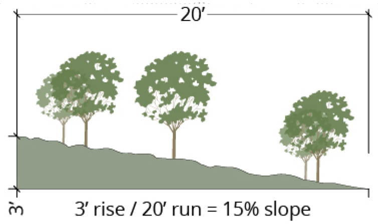 |
See D. above for application requirements.
See E. above for cut and fill slope requirements. See F. above for disturbance limitations. See G. above for construction techniques. |
| 25% (4:1) or greater | 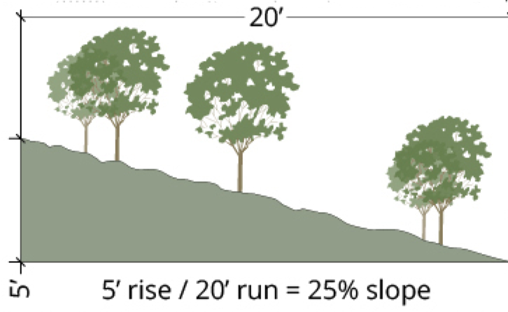 |
See D. above for application requirements.
See E. above for cut and fill slope requirements. See. G. above for construction techniques. |
(Ord. No. 2015-11-23/O-8, § III; Ord. No. 2016-03-21/O-1, § 7
5.4. - Stormwater management.
5.4.1. Purpose.
The purpose of this section is to establish minimum stormwater management requirements and controls to protect and safeguard the general health, safety, and welfare of the public residing in watersheds within this jurisdiction. This ordinance seeks to meet that purpose through the following objectives:
(a)
Minimize increases in stormwater runoff from any development in order to reduce flooding, siltation and streambank erosion and maintain the integrity of stream channels;
(b)
Minimize increases in non-point source pollution caused by stormwater runoff from development that would otherwise degrade local water quality;
(c)
Minimize the total volume of surface water runoff that flows from any specific site during and following development in order to replicate the pre-development hydrology to the maximum extent practicable;
(d)
Reduce stormwater runoff rates and volumes, soil erosion and non-point source pollution, wherever possible, through stormwater management controls and to ensure that these management controls are properly maintained and pose no threat to public safety; and
(e)
Meet the requirements of the National Pollutant Discharge Elimination System (NPDES Phase 2) regulations as established by the Clean Water Act and administered by the North Carolina Department of Natural Resources, or its successor agency.
5.4.2. Applicability.
(a)
This section shall apply to all new development and redevelopment projects for which a zoning compliance permit is required.
(b)
To prevent the adverse impacts of stormwater runoff, the town has developed a set of performance standards that must be met at all new development and redevelopment sites. The following activities are exempt from these stormwater performance criteria:
(1)
Any logging and agricultural activity that is consistent with all federal, state and local regulations;
(2)
Individual single-family and two-family development and redevelopments that do not disturb more than twenty thousand (20,000) square feet of land area, including cumulative disturbance since the adoption of the Land Use Management Ordinance on January 27, 2003, provided they are not part of a larger common plan of development.
(3)
Repairs to any stormwater treatment facility deemed necessary by the town.
(4)
For purposes of this section, "Larger common plan of development" shall be as defined in subsection 5.19.3(h) of this appendix and includes subdivisions that create four (4) or more residential lots.
(c)
Individual single-family and two-family residential construction that are exempt from stormwater performance criteria under subsection 5.4.2(b)(2) above shall discharge runoff in an non-erosive and diffuse manner using techniques approved by the town manager. Discharge system/techniques shall be in accordance with the standards established in the town's design manual.
(Ord. No. 2004-02-23/O-2; Ord. No. 2012-12-03/O-4, § 1)
5.4.3. Design manual and Standard Details.
The town may furnish additional policy, criteria and information, for the proper implementation of the requirements of this section and may provide such information in the design manual and standard details, which manual may include a list of acceptable stormwater treatment practices, including the specific design criteria for each stormwater practice. The manual may be updated and expanded from time to time, at the discretion of the town, based on improvements in engineering, science, monitoring, and local maintenance experience. Stormwater treatment practices that are designed and constructed in accordance with these design and sizing criteria will be presumed to meet the minimum water quality performance standards.
5.4.4. Application Submittal Requirements.
Unless otherwise exempted by this section, every permit application for development must be accompanied by a stormwater impact statement in order for the permit application to be considered.
The town manager shall prescribe the form(s) and information that shall be submitted to determine compliance with this chapter, with sufficient copies for necessary referrals and records.
Information requirements may be adjusted or waived by the town manager for a particular development application upon written request of the applicant, provided that at least one of the following circumstances can be demonstrated:
(a)
Alternative measures for on-site and/or off-site management of stormwater have been proposed, and these measures are approved by the town manager and comply with local ordinance(s).
(b)
It is otherwise demonstrated that the proposed development will not produce any significant change to the existing pre-application hydrology.
5.4.5. Waivers for Stormwater Management Facilities Requirements.
Unless otherwise exempted by this section, every development application shall provide for stormwater management. The requirements for stormwater management facilities may be waived in whole or in part by the approving body, provided that it is demonstrated by the applicant that at least one (1) of the following conditions applies:
(a)
Alternative measures for on-site and/or off-site management of stormwater have been proposed, and these measures are approved by the town manager and comply with local ordinance(s).
(b)
It is otherwise demonstrated that the proposed development will not produce any significant change to the existing pre-application hydrology.
5.4.6. General Performance Criteria for Stormwater Management.
The following are required stormwater management performance criteria for new development and redevelopment that increases impervious surface:
(a)
Stormwater quality treatment shall be designed to achieve eighty-five percent (85%) average annual total suspended solids (TSS) removal for runoff generated from the first inch of precipitation. Alternative treatment methods to achieve eighty-five percent (85%) average annual TSS removal may be acceptable.
(b)
The stormwater runoff volume leaving the site post-development shall not exceed the stormwater runoff volume leaving the site pre-development (existing conditions) for the local 2-year frequency, 24-hour duration storm event for all development except single-family and two-family dwellings on lots existing as of January 27, 2003, or on lots pursuant to a preliminary plat that was approved by the town council prior to January 27, 2003. This may be achieved by hydrologic abstraction, recycling and/or reuse, or any other accepted scientific method.
(c)
For new Conditional Zoning and major Special Use Permit applications, the stormwater runoff rate leaving the site post-development shall not exceed the stormwater runoff rate leaving the site pre-development (existing conditions) for the local 1-year, 2-year, 25-year, and 100-year 24-hour storm events.
(c1)
For all other development permit applications, the stormwater runoff rate leaving the site post-development shall not exceed the stormwater runoff rate leaving the site pre-development (existing conditions) for the local 1-year, 2-year, and 25-year 24-hour storm events.
(d)
Land disturbance within the stream channel of any ephemeral stream shall be minimized, and prohibited unless explicitly authorized by issuance of a zoning compliance permit after demonstration of the necessity for the disturbance.
5.4.7. Integrated Management Practices.
Applicants shall utilize integrated management practices/best management practices to meet the standards established in subsection 5.4.6, using one (1) or more approved design options. Low impact design options are encouraged. Descriptions and standard details of approved integrated management practices/best management practices are included in the town design manual.
Consideration shall be given in all stormwater management strategies to the relationship between temporary facilities required and installed during construction as part of soil erosion and sedimentation control regulations; and permanent facilities designed to manage stormwater post-construction on an on-going basis.
5.4.8. Maintenance.
Stormwater management facilities that are constructed on privately-owned land and that are not within a public easement shall be maintained by the owner of the subject property. Stormwater management facilities that are constructed on public land, within public rights-of-way, and/or within public easements shall be maintained by the public body with ownership/jurisdiction.
The following requirements shall be met for all stormwater management facilities that are constructed on privately-owned property and not within a public easement.
(a)
Maintenance easement.
Prior to the issuance of any permit that has a stormwater management facility as one of the requirements of the permit, the applicant or owner of the site must execute a maintenance easement agreement that shall be binding on all subsequent owners of land served by the stormwater management facility. The agreement shall provide for access to the facility at reasonable times for periodic inspection by the town, or its contractor or agent, and for regular or special assessments of property owners to ensure that the facility is maintained in proper working condition to meet design standards and any other provisions established by this section. The property owner shall record such easement, in a form and format approved by the town manager, with the office of the appropriate county register of deeds.
(b)
Maintenance covenants.
Maintenance of all stormwater management facilities shall be ensured through the creation of a formal maintenance covenant that must be approved by the town manager and recorded in the office of the appropriate county register of deeds. This covenant shall be entitled, "Stormwater Operations and Maintenance Plan." A schedule for maintenance and inspections shall be included as part of the covenant.
The owner, or the owner's assigns, are responsible for maintenance of stormwater management facilities; however, the town may, under certain circumstances, accept dedication of existing or future stormwater management facilities for public maintenance and inspection.
(c)
Requirements for maintenance covenants.
All stormwater management facilities must be inspected by the responsible party, in accordance with the approved schedule in the stormwater operations and maintenance plan, to identify maintenance and repair needs, and to ensure compliance with the requirements of this appendix. Any identified maintenance and/or repair needs found must be promptly addressed by the responsible party. The inspection and maintenance requirement may be increased as deemed necessary by the Town to ensure proper functioning of the stormwater management facility.
(d)
Records of installation and maintenance activities.
Parties responsible for the inspection, operation, and maintenance of a stormwater management facility shall make records of the installation and of all maintenance and repairs and shall retain the records for at least five (5) years. These records shall be made available to the town upon request and/or as specifically outlined in the maintenance covenant.
(e)
Failure to maintain practices.
If a responsible party fails or refuses to meet the requirements of the maintenance covenant, the town, after reasonable notice, may correct a violation of the design standards or maintenance needs by performing all necessary work to place the facility in proper working condition. In the event that the stormwater management facility becomes a danger to public safety or public health, or is otherwise not functioning as designed, the town shall notify the party responsible for maintenance of the stormwater management facility in writing. Upon receipt of that notice, the responsible person shall have thirty (30) days to effect maintenance and repair of the facility in an approved manner. After proper notice, the town may assess the owner(s) of the facility for the cost of repair work and any penalties; and the cost of the work shall be a lien on the property, or prorated against the beneficial users of the property, and may be placed on the tax bill and collected as ordinary taxes by the county.
5.4.9. Inspection.
(a)
Inspection of stormwater facilities.
Inspections shall be conducted as prescribed by the stormwater operations maintenance plan covenant. Additional inspections may be conducted by the town on any reasonable basis, including but not limited to: routine inspections; random inspections; inspections based upon complaints or other notice of possible violations; inspection of drainage basins or areas identified as higher than typical sources of sediment or other contaminants or pollutants; inspections of businesses or industries of a type associated with higher than usual discharges of contaminants or pollutants or with discharges of a type that are more likely than the typical discharge to cause violations of state or federal water or sediment quality standards or the National Pollutant Discharge Elimination System (NPDES) stormwater permit; and joint inspections with other agencies inspecting under environmental or safety laws. Inspections may include, but are not limited to: reviewing maintenance and repair records; sampling discharges, surface water, groundwater, and material or water in drainage control facilities; and evaluating the condition of drainage control facilities and other stormwater treatment practices.
(b)
Right-of-Entry for Inspection.
When any new drainage control facility is installed on private property, or when any new connection is made between private property and a public drainage control system the property owner shall grant to the town the right to enter the property at reasonable times and in a reasonable manner for the purpose of inspection. This includes the right to enter a property when the town has a reasonable basis to believe that a violation of this ordinance is occurring or has occurred, and to enter when necessary for abatement of a public nuisance or correction of a violation of this appendix.
(Ord. No. 2024-05-01/O-1, § 1)
5.5. - Recreation.
5.5.1. Applicability.
(a)
This section applies to:
(1)
Any major subdivision that creates lots reasonably expected to be used for dwelling units; or
(2)
Any multifamily development of five (5) or more units; or
(3)
Any common plan of development of five (5) or more units.
(b)
In all cases the Chapel Hill Parks and Recreation Commission shall review and make recommendations to the town council on the provision or dedication of parks and open space.
(c)
In all cases the Chapel Hill Greenways Commission shall review and make recommendations to the town council in the event that proposed development may be located on or have an impact on greenway areas identified in the town's comprehensive plan, greenway project conceptual plans adopted by the council, and/or greenway project master plans adopted by the council.
(d)
Provision or dedication of parks and open space is not required for a minor subdivision.
(e)
Phases of development within a subdivided tract that occur after the initial subdivision must provide the required parks and open space appropriate for the subsequent development of those tracts. For example, if multifamily dwellings are built within an already subdivided tract, those dwellings must comply with recreation and outdoor space ratios required for multifamily dwellings by this section.
5.5.2. Minimum Recreation Space.
(a)
Residential subdivisions.
This section applies to any application for subdivision approval in the zoning districts enumerated below. The minimum size in square feet of a recreation space shall be derived by multiplying the gross land area of the development by the applicable ratio shown below:
(Ord. No. 2004-02-23/O-2; Ord. No. 2022-11-16/O-3, § 11)
(b)
Suitability of land.
(1)
Land provided or dedicated as recreation space shall be outside of the resource conservation district and of a character, shape and location suitable for use as a playground, playfield, or for other active recreation purposes including greenway pedestrian and non-motorized vehicle easements. Recreation spaces shall be located on land that is relatively flat and dry and is otherwise capable of accommodating active recreation uses, except as exempted under the provisions of subsections (e)(2) and (e)(3), below.
(2)
For sites that abut or include areas designated as future greenways on the town's comprehensive plan, greenway project conceptual plans adopted by the council, and greenway project master plans adopted by the council, the town council may require that a dedicated public pedestrian and non-motorized vehicle easement along all such areas be the recreation space provided under this ordinance.
(3)
Recreation spaces shall be conveniently accessible to all residents of the subdivision and, other than greenway pedestrian and non-motorized vehicle easements, shall have at least fifty (50) feet of frontage on at least one (1) public street within the subdivision. Land provided or reserved for active recreation shall form a single parcel except where the town council determines that two (2) or more parcels are more suitable to the needs of a particular subdivision. The Town Council may require that such parcels be connected. In large developments it is desirable to have parks and recreation areas within walking distance of new residences.
(c)
Method of provision or dedication.
Land provided or dedicated for recreation purposes shall be designated on the subdivision's final plat(s). The town council may require that such land be dedicated to the town or other appropriate public body. If the town does not require that the land be dedicated or deeded to an appropriate public body, then the town may require that a neighborhood or homeowners' association be established for the continuing maintenance and control of common recreation area and facilities.
(d)
Payments in lieu of provision or dedication.
(1)
In lieu of providing or dedicating recreation space required pursuant to this section, a developer of a subdivision may, with the approval of the town council, make a payment to the town whereby the town may acquire or develop recreation land to serve the subdivision. A developer may make a partial payment in combination with the partial provision of recreation space if the town council determines that the combination is in the best interests of the citizens of the area to be served.
(2)
The town council may require a payment to the town in lieu of providing or dedicating recreation space required pursuant to this section where the minimum recreation space required by this section equals four (4) acres or less.
(3)
The town shall use such payment only for the acquisition or development of recreation, park, greenways, or open space sites, as allowed by law.
(4)
Payments in lieu of recreation space shall be determined by the following formula:
A per square foot value of the property shall be determined, as established by Orange County and/or Durham County for real estate tax purposes. The value established by Orange County and/or Durham County shall include only the value of the land and shall not include the value of existing structures and improvements. The square foot value shall be multiplied by the number of square feet of recreation space required for the development to arrive at a base value. The base value shall be multiplied by a recreation space payment in lieu multiplier to determine the required amount of payment in lieu of recreation.
The payment in lieu multiplier for recreation space shall be established by the town council annually as part of the budget process.
(5)
The developer shall make the payment before approval of a final plat for the subdivision, provided, however, that the town manager may allow phasing of payments consistent with the approved phasing of the subdivision.
(6)
In the event that a property owner successfully appeals the county valuation of the property after the payment in lieu for recreation space is made to the town, and the resulting change in valuation would have reduced the amount of the payment in lieu for recreation space, the town shall reimburse the developer the difference between what was paid and what would have been paid had the revised valuation been used.
(Ord. No. 2005-10-10/O-6, § 1; Ord. No. 2006-04-10/O-5, § 1)
(e)
Exemptions.
(1)
The town council may exempt an application from the recreation space requirements in this section if the required recreation area is less than three thousand (3,000) square feet.
(2)
If the town council determines that assembling a piece of land to meet the requirements of subsection (b) either would create undue hardships or is not necessary because the active recreational needs of the subdivision are already being met by dedicated land or by existing recreation spaces, it may waive any requirements of that subsection. In such cases, the required recreational space may be used for preserving woods, steep slopes, ponds, streams, glens, rock outcrops, native plant life, and wildlife cover. These spaces would provide for the community's need for passive recreational areas and/or greenways.
(3)
If the site abuts or includes areas designated as future greenways on the town's comprehensive plan, greenway project conceptual plans adopted by the council, and greenway project master plans adopted by the council, land area dedicated as a public pedestrian non-motorized vehicle easement or deeded to the town along the greenway may be applied to requirements for dedication of recreation space and exempted from the land suitability requirements of subsection (b).
(f)
Substitution of off-site land for dedicated recreation space.
(1)
Any subdivider required to provide or dedicate recreation space pursuant to this section may, with the approval of the town council, dedicate recreation space outside the boundaries of the land being subdivided but in a nearby area of town.
(2)
The substitute dedicated recreation space shall be in a location acceptable to the town council, shall be comparably valued, and shall meet all suitability requirements as set forth under the provisions of subsection (b), above.
(g)
Multifamily dwelling units and common plan of developments of five (5) or more units.
Improved active recreation space (either indoors or outside) shall be provided for the common active recreational use of residents of multifamily developments. For sites that abut or include areas designated as future greenways in the town's comprehensive plan, greenway project conceptual plans adopted by the council, and greenway project master plans adopted by the council; land dedicated for a public pedestrian and non-motorized vehicle easement or deeded to the town along the greenway may be substituted for required improved active recreation space. The minimum size of such active recreation space shall be the number of square feet derived by multiplying gross land area of the development by the applicable ratio shown below.
(Ord. No. 2007-02-26/O-3a, § 6; Ord. No. 2007-02-26/O-5, § 8; Ord. No. 2020-10-28/O-10, § 14; Ord. No. 2022-11-16/O-3, § 12)
(h)
Payments in lieu of improved recreation space.
In lieu of providing recreation space required pursuant to this section, a developer of a multifamily dwelling or planned development may, with the approval of the town council (or planning commission if final approval is by the planning commission), make a payment to the town whereby the town may acquire or develop recreation land or greenways to serve the development. A developer may make a partial payment in combination with the partial provision of recreation space if the town council determines that the combination is in the best interests of the citizens of the area to be served.
The town council (or planning commission if final approval is by the planning commission), may require a payment to the town in lieu of providing or dedicating recreation space required pursuant to this section.
The town shall use such payment only for the acquisition or development of recreation, park, or open space sites to serve residents of the development or residents of more than one (1) subdivision or development within the immediate area. The amount of the payment shall be the product of the amount of active recreational space required, multiplied by a dollar amount established by the town council annually as part of the budget process.
The developer shall make the payment before issuance of a zoning compliance permit for the development, provided, however, that the town manager may allow phasing of payments consistent with the approved phasing of the development.
(i)
Connectivity.
Purpose statement: The town hereby finds and determines that an interconnected system of parks, trails, greenways, and bikeways provides a greater public benefit than isolated parks with access exclusively by automobiles. Such areas can provide form to neighborhoods, a common public gathering space, and an opportunity to protect natural areas.
Active recreation space provided pursuant to this section shall be aligned with and shall adjoin any area designated as a park or open space area on adjoining property, including any public greenway, linear park, or similar facility. Sidewalks, trails, or similar facilities shall align with such facilities in an adjoining tract or, where adjoining tracts are unimproved, with any area designated for parks or open space in the comprehensive plan or any parks master plan adopted by the town.
(Ord. No. 2009-05-18/O-4, §§ 1—8; Ord. No. 2014-03-10/O-2, § 3; Ord. No. 2023-06-21/O-6, § 11)
5.6. - Landscaping, screening and buffering.
5.6.1. Purpose of buffers.
Buffers shall be required to separate a proposed development from adjacent major streets and different adjacent land uses or zoning designations in order to minimize potential nuisances such as the transmission of noise, dust, odor, litter, and glare of lights; to reduce the visual impact of unsightly aspects of adjacent development; to provide for the separation of spaces; and to establish a sense of privacy.
5.6.2. Buffers required.
(a)
A buffer is a strip of land together with the screening required thereon. Except as otherwise specifically provided in this appendix, the type of buffer required between a proposed development and adjacent streets, land uses or zoning designations shall be as specified in subsection 5.6.6, Schedule of Required Buffers. Where the proposed development site and the adjacent land are both located within either town center district, no buffer shall be required.
(b)
Where the proposed development site is located in a Residential-Special Standards-Conditional zoning district, no buffer shall be required.
(c)
Where the proposed development site is located in a materials handling (MH) zoning district, a two hundred (200) foot Type "E" landscape buffer shall be required.
(d)
Width and screening specifications for each buffer type shall be detailed and illustrated in the design manual. Screening required within buffers is intended to provide separation of spaces without necessarily eliminating visual contact between the spaces, and may consist of existing vegetation, planted vegetation, a landscaped earth berm, a decorative wall, a wood fence, or a combination of the above. Any of the options specified in the design manual for the required buffer type shall satisfy the buffer requirements of this section.
(e)
Eating/drinking establishments and places of worship shall be separated by either a Type "A" buffer, or a screening device as provided in subsection 5.6.7.
(f)
Where the proposed development site is located in a Residential-Community Priority-Conditional Zoning District (R-CP-CZD), any multi-family or townhouse development of five (5) or more units and any non-residential uses shall be separated from adjacent off-site residential uses by a ten (10) foot Type "B" landscape buffer unless such off-site uses are in Town Center (TC), Office/Institutional (OI), or Mixed Use (MU) zoning districts. Upon a finding that site constraints make such a buffer impracticable, the town manager may waive the requirement for a buffer.
5.6.3. Location of buffers.
Required buffers shall be located along the interior or street lot lines nearest the adjacent streets, land uses, or zoning designations except where such lot lines are intersected by crossing accessways or utility easements, or by a joint parking area. Buffers shall not be located on any portion of an existing or proposed street right-of-way or easement.
5.6.4. Use of buffer.
Provided the required buffer width and screening is maintained, a buffer may contain pedestrian and bicycle paths, utilities that must cross the buffer, and other minor or passive uses compatible with the general separation of land uses.
5.6.5. Responsibility for buffer.
(a)
Where vacant zoning lots are adjacent, the first zoning lot to be developed shall provide the buffer required next to vacant land. At the time it is developed, the second zoning lot shall provide all additional screening and/or land that might be necessary to provide the buffer required between the developed land uses.
(b)
Where a buffer meeting the requirements of this section is provided on an adjacent zoning lot, the screening and/or land within that buffer may be counted as contributing to the total buffer required between the adjacent existing land use and the proposed land use.
5.6.6. Schedule of required buffers.
Specifications for each buffer type are contained in the design manual. The buffer requirement noted in the schedule of required buffers may be reduced by one grade of intensity (e.g., C to a B) if the development is designed such that there is no parking between the buildings located on the site and the adjacent street.
Table 5.6.6-1. Schedule of Required Buffers
Rules of interpretation for schedule of required buffers:
— No buffer required.
* Adjacent land uses and vacant land uses and lands across a local street from the proposed use.
# Existing uses includes uses approved as part of development for which a Special Use Permit or Zoning Compliance Permit has been issued.
(Ord. No. 2004-02-23/O-2; Ord. No. 2007-02-26/O-5, § 9; Ord. No. 2017-04-05/O-7, § 14; Ord. No. 2018-11-28/O-1, § 2)
5.6.7. Other Required Screening.
In addition to the bufferyard screening required above, and the screening required for off-street parking and for refuse storage facilities, all business, service, repair, processing, storage, or merchandise display conducted outside of an enclosed building shall be screened from adjacent streets and properties by means of an effective screening device of a height appropriate to its screening function. Appropriate screening devices may include solid decorative brick walls, wood fences, berms, or tight evergreen hedges which shall reach the necessary height within two (2) years of planting, or a combination of the above.
5.6.8. Alternative Buffers and Screening.
In lieu of compliance with the above bufferyard and screening requirements, a developer may submit to the community design commission for its approval a detailed plan with specifications for landscaping and screening which will afford a degree of buffering and screening equivalent to or exceeding that provided by the above requirements.
5.6.9. Existing Vegetation.
Existing vegetation shall be retained and maintained whenever possible so as to permit such vegetation to contribute to buffer and screening requirements.
5.6.10. Maintenance of Landscaping.
All landscaping and screening providing required buffering and screening shall be maintained so as to continue its effectiveness.
5.7. - Tree protection.
5.7.1 General Provisions.
(a)
Short title. This section shall be known and may be cited as the Chapel Hill Tree Protection Ordinance.
(b)
Purpose. The intent of this section is to preserve, maintain, and increase tree canopy to protect the public health, safety, and welfare and enhance the quality of life in Chapel Hill.
(c)
Applicability and permits. The provisions of this article apply to all land in the town's zoning jurisdiction. For tree canopy coverage standards, see section 5.7.2.
(1)
Activities that require a zoning compliance permit:
i.
All work impacting trees on lots designated for non-residential, multi-family residential, and mixed use, and
ii.
All work impacting trees on lots designated for single- and two-family residential use where total land disturbance exceeds five thousand (5,000) square feet.
(2)
Activities that require review and approval by the town's urban forester:
i.
Private work on public land, and
ii.
The practice of forestry as defined by North Carolina General Statute 105-277.2-.7 which is permitted only after an applicant submits a plan for harvesting and replanting consistent with the most current Forest Practices Guidelines Related to Water Quality published by the N.C. Department of Natural Resources and Community Development, or its successor agency.
(d)
Exceptions not subject to the provisions of this article are:
(1)
Land in the town's Town Center and Office/Institutional-4 zoning districts, provided, however, that subsection 5.7.4 of this article shall apply;
(2)
Routine maintenance of existing trees outside the public right-of-way, including pruning done in a manner consistent with established arboricultural standards;
(3)
The removal of dead, severely damaged or diseased trees that have been diagnosed and, if applicable, determined by a certified arborist to be beyond treatment or recovery, the burden of proof being placed on the remover;
(4)
Land surveying provided no trees greater than six (6) inches dbh are damaged or removed; and
(5)
Eradication of exotic, non-native, and invasive or otherwise undesirable species listed in subsection 5.7.6(d).
(e)
Emergency waiver. The provisions of this section are waived if compliance would impede the rescue of life or property from immediate danger or the repair of utilities in the event of emergencies such as wind storms, ice storms, or other disasters. Any emergency work shall follow as closely as possible the standards outlined in the town's landscape standards and specifications.
5.7.2 Tree Canopy Coverage Standards.
(a)
Minimum canopy coverage standards. The town desires to maintain the maximum practical tree canopy cover across all land uses within the town's jurisdiction.
Tree canopy coverage standards are required for applications proposing tree removal that require council approval, including special use permits, major special use permit modifications, conditional zoning district rezonings, and major conditional zoning district modifications.
For residential Neighborhood Conservation Districts, the district may request from the town council that tree protection regulations apply as per section 5.7 using a canopy coverage standard consistent with the existing neighborhood character.
When tree canopy is subject to the provisions of this section, the following minimum tree canopy coverage percentages are required within the zoning lot boundaries exclusive of public right-of-way:
Table 1: Minimum Tree Canopy Coverage
Standards
(b)
Modifications to canopy coverage standards. The town council may allow a modification to these regulations when public purposes are met and canopy removal supports other goals of the town, including but not limited to:
• Goals of the Comprehensive Plan
• LEED or "green" building and low impact development, including solar access and "daylighting"
• Affordable housing
• Stormwater management
• Community character of adjoining property, or established managed landscapes, or established streetscapes
(c)
Implementation of standards. The highest priority for all projects shall be the maintenance and replacement of canopy on-site. Mitigation payments shall be used when providing canopy on-site is not practicable.
Compliance with canopy protection and replacement standards of subsection 5.7.2 is demonstrated by the following:
(1)
Approval and implementation of a landscape protection plan prepared in accordance with subsection 5.7.3(b).
(2)
Approval and implementation of a planting plan prepared in accordance with landscape architectural standards and the town's design manual.
(3)
Maintenance of protected and planted trees.
(4)
Tree mitigation payments as per subsection 5.7.2(d)3.
Compliance with the canopy coverage standards in Table 1 shall be accomplished by the following methods:
(1)
Protection of existing tree canopy. The extent of existing tree canopy coverage retained at the time of permit application may be documented by survey or by using current aerial photographs available on the town's web page or similar resource.
i.
Required cleared active recreation areas, water bodies, access easements, public and private right-of-way, stormwater and utility easements shall not be included in the total land area used in the canopy coverage calculation.
ii.
Trees planted in a town right-of-way as part of an approved street tree planting plan may count toward total tree canopy coverage.
(2)
Replacement of canopy. If the existing protected tree canopy is less than the minimum standard as shown in Table 1, the required minimum canopy shall be established. The tree canopy deficit is determined by subtracting the area of retained tree canopy as shown on the landscape protection plan from the minimum area of canopy coverage required in Table 1 in subsection 5.7.2.
i.
One (1) replacement tree per five hundred (500) square feet of tree canopy coverage deficit shall be planted in accordance with an approved planting plan.
ii.
All canopy trees planted in accordance with the town's design manual to meet the town's buffer and parking lot shading standards can all be counted when calculating replacement canopy trees provided.
iii.
Supplemental canopy trees planted to complete the canopy coverage requirements shall be planted no less than twenty (20) feet from any other proposed or existing canopy tree.
iv.
Replacement trees that are planted in an adjacent right-of-way may count toward total tree canopy.
v.
Installation and maintenance.
Plantings. All required plantings shown on an approved planting plan shall be prepared, installed and maintained according to the town's landscaping standards and specifications and must be planted or an accepted performance guarantee placed with the town in order to satisfy compliance with the requirements of this section.
(a)
Replacement tree caliper shall be two and one-half (2.5) inches at installation.
(b)
Upon approval by the town manager, a replacement tree with a caliper of four (4) inches or greater may count for two (2) replacement trees.
Maintenance. The property owner is responsible for assuring that the lot in its entirety will continue to meet minimum tree canopy coverage after issuance of a certificate of occupancy.
Trees that are damaged or decline in health during construction shall be assessed for viability and safety.
(a)
Viable trees shall be treated to promote their continued health and safety.
(b)
If the town manager determines a protected tree in a required buffer or other required planting is dead or dying at the time of the issuance of a certificate of occupancy, replacement of the tree may be required.
(3)
Mitigation. If the applicant chooses not to plant replacement canopy trees, payments to the Town of Chapel Hill Tree Mitigation Fund shall be calculated according to the current development fee schedule approved by the town council.
(4)
Tree mitigation fund. A primary objective of the tree mitigation fund is to use payments for the installation and maintenance of trees on public property. The town shall also use all such payments for the cost associated with implementation of this ordinance, for town sponsored tree management programs, and for the study, inventory, maintenance or treatment of public trees requiring the services of a certified arborist or other qualified consultant. Mitigation funds will not be used in lieu of general fund support for the existing urban forest management program.
5.7.3 Landscape Protection Plan.
(a)
Activities requiring a landscape protection plan.
(1)
Zoning compliance permit applications, required per subsection 5.7.1(c), shall include a landscape protection plan unless otherwise exempted.
(2)
Work limited to the removal of trees may require a landscape protection plan and shall conform to the required tree replacement and mitigation standards as described in subsection 5.7.2.
(b)
Landscape protection plan standards.
(1)
The town manager shall prescribe the contents of landscape protection plans and the information that may be reasonably required to determine compliance with this article, with sufficient copies for necessary referrals and records. Minimum requirements for the landscape protection plan include the following information:
i.
The size, location, and type of all existing rare and specimen trees as defined in subsection 5.7.6 within fifty (50) feet of proposed land disturbance.
ii.
All significant trees stands, as defined in subsection 5.7.5.
iii.
Areas where trees, vegetation, and soils are to be protected and preserved and areas where trees, vegetation, and soils are to be removed or modified. This includes indicating proposed grading, utilities, and improvements as well as access, staging, and storage areas. The plan shall graphically identify each tree to be saved or removed.
iv.
The critical root zones (CRZ) of all existing rare and specimen trees within or overlapping the disturbed area, and the measures of tree, vegetation, and soil protection and management that will be used before, during, and after all construction activities to promote the survival or retention of such elements. The CRZ is defined as a circular area surrounding a tree, of which the center is the center of the tree trunk and which has a radius of at least one (1) foot for every inch of trunk diameter (dbh) taken at four and one-half (4.5) feet above grade.
CRZ radius = diameter breast height (inches) × one (1) foot
v.
The percentage of the property with tree canopy coverage to be protected, if subject to minimum tree canopy standards. The town manager may require that a certified arborist and/or a licensed landscape architect confirm the accuracy of this information.
vi.
The location of tree protection fencing along the limits of disturbance with a detail of the tree protection fence and a note indicating that a pre-construction meeting with the town's urban forester will be scheduled prior to the start of work.
(c)
Implementation of landscape protection plan.
(1)
Protective fencing. Fences, or other equally effective measures as determined by the town manager, shall be used to protect areas identified on an approved landscape protection plan during demolition and construction activity. Protective fencing shall be installed according to town standards. Field adjustments may be allowed subject to prior approval by the town manager. All land disturbing activity, storage of equipment, building material, soil, and other debris shall be kept outside the protected areas.
(2)
Landscaping activities taking place after the removal of protective fencing shall be accomplished with light machinery or hand labor and in accordance with the town's landscaping standards and specifications. This requirement should be noted on the plans.
(3)
Pre-construction conference. Prior to the commencement of any activities requiring a zoning compliance permit, a pre-construction conference with the town's urban forester or landscape architect shall take place to review procedures for protection and management of all protected landscape elements identified on the landscape protection plan.
(4)
On-site supervision. For all development other than that related to single-family and two-family dwellings on individual zoning lots, the following on-site supervision is required:
i.
The applicant shall designate as landscape protection supervisors one or more persons who have completed instruction in landscape protection procedures with the town.
ii.
It shall be the duty of the landscape protection supervisor to ensure the protection of new or existing landscape elements, as defined in the landscape protection plan. The approved landscape protection supervisor shall supervise all site work to assure that development activity conforms to provisions of the approved landscape protection plan. At least one (1) identified landscape protection supervisor shall be present on the development site at all times when activity that could damage or disturb soil and adjacent landscape elements occurs such as:
• Clearing and grubbing;
• Any excavation, grading, trenching or moving of soil;
• Removal, installation, or maintenance of all landscape elements and landscape protection devices; or
• Delivery, transporting, and placement of construction materials and equipment on site.
(d)
Public hazard.
(1)
A certificate of occupancy may be denied for any development if the town manager determines that a public hazard as defined in this article exists on said lot, until that public hazard is abated.
(2)
A street dedicated to the town may not be accepted for maintenance at the end of the warranty period until any public hazard related to a tree in the right-of-way is abated.
(e)
Enforcement.
(1)
The town manager shall have development sites inspected frequently to assure that work is conforming to the approved landscape protection plan and the applicable sections of this article.
(2)
Absence of a landscape protection supervisor(s) from the site at times when development activity is taking place that has the potential to adversely affect trees to be preserved may result in the issuance of a stop-work order until a landscape protection supervisor is present.
5.7.4. Trees in Public Rights-of-Way.
(a)
Tree planting.
(1)
Trees may be planted on any public street right-of-way provided they are consistent with plans for public landscaping that have been approved and permitted by the State of North Carolina or the Town of Chapel Hill, they will not hinder the repair or construction of public utilities and a permit has been issued by the town manager when required.
(2)
Trees planted on any public street right-of-way may be of a species and in a location desired by the abutting property owner except that no trees or shrubs shall be planted close enough to any public street intersection to interfere with the sight distance at the intersection or with streets, sidewalks, signs, street lights, or above- and below-ground utility lines as specified in the town's landscaping standards and specifications.
(3)
All planting of trees and shrubs on public property shall be subject to general considerations of public health, safety and convenience, and the material and aesthetic value accruing to the whole community. Planting shall be restricted to the species known to be suited to the local climate and environment and shall be intended to preserve and enhance the beauty and variety of the public landscape as recommended in the town's landscaping standards and specifications.
(b)
Prohibited trees. Notwithstanding subsection 5.7.4.a, it shall be unlawful to plant in any public right-of-way any of the following:
(1)
Any trees which by the nature of their fruit, root system, brittleness of wood, or susceptibility to disease are deemed undesirable as specified in the town's landscaping standards and specifications;
(2)
Any invasive exotic plant materials as identified in the design manual and in subsection 5.7.6(d).
(c)
Public hazards.
(1)
It shall be the duty of the owner of the property wherein or whereupon a public hazard exists, to abate the hazard by removing or trimming the growth.
(2)
Where the roots of a public tree constitute a hazard to private property, or where trees on private property may damage sidewalks, curbs, or public streets or whose roots may enter public sewers or water mains shall be considered a public hazard and shall be pruned or removed by the town's public works department, as deemed necessary by the town manager.
(3)
If the owner of property, after being notified of the existence of a public hazard on their property, fails to abate the hazard within thirty (30) days, the town manager shall have the hazard abated and assess the exact cost to the owner as provided by law in the case of special assessments or liens.
(4)
Where the growth and limbs of public trees constitute a hazard to private property, the town, upon notice, shall correct the condition or permit affected property owners to correct the condition using established arboricultural standards.
(5)
Where the growth of trees interferes with public utilities, such conditions shall be corrected by proper pruning, removal, or replacement of the tree causing the interference. Corrective measures shall be carried out in accordance with the provisions of this article and the town's landscaping standards and specifications.
(d)
Removal of trees.
(1)
Private parties shall not remove trees from public property or public street rights-of-way without approval by the town's urban forester.
(2)
The town may remove dead or diseased trees or trees that interfere with the proper maintenance or improvement of a public street right-of-way, easement owned or maintained by the town or any public street or highway. A tree on the right-of-way line that is half or more than halfway on the right-of-way at its base will be considered to be on the right-of-way and, therefore, a public tree.
(3)
The town retains the right to remove any tree except that no rare tree shall be removed from land or easements owned by the town unless the town manager determines there is no reasonable way the tree can be saved.
5.7.5 Significant Tree Stands.
(a)
Significant tree stand defined. For purposes of this section, a "Significant Tree Stand" means an area of contiguous mature woods greater than five thousand (5,000) square feet in size where over half of the canopy is provided by hardwoods with a diameter breast height (dbh) greater than twenty-four (24) inches.
(b)
Applicability. The provisions of this section apply to any application requiring a landscape protection plan.
(c)
Submittal requirements. A landscape protection plan shall delineate the boundaries of all significant tree stands and describe their dominant plant species. All plans shall also show the proposed clearing limit lines and calculate the percentage of significant tree stand areas that are proposed to be cleared.
(d)
Preservation of significant tree stands. The significant tree stand delineation shall be used during the design review process to determine the most suitable and practical areas for woodland conservation. To the extent practicable, significant tree stands shall be preserved and incorporated into site design. Areas designated for preservation on approved plans shall be protected during construction.
5.7.6 Rare and Specimen Trees.
(a)
Rare and specimen tree defined. With the exception of invasive exotic species listed in subsection 5.7.6.(d),
(1)
A rare tree is:
i.
Any healthy living pine tree that has a trunk diameter of thirty-six (36) inches or more, or any other species that:
ii.
Has a trunk diameter at breast height (dbh) of twenty-four (24) inches or more; or
iii.
Has a trunk dbh of twelve (12) inches or more in the case of North Carolina native species from the list of genera in this section; or
iv.
Is listed as a State or National Champion by the North Carolina Forest Service or the American Forestry Association; or
v.
Provides unique habitat for any endangered or threatened wildlife species protected by federal law; or
vi.
Has been cited by the town council as being historically significant; or
vii.
Represents an uncommon species, such as Long Leaf Pine, Live Oak, or Sequoia Redwood, that the town manager considers to be desirable and not to pose a threat to the local ecological balance.
(2)
A specimen tree is:
i.
Any healthy living pine tree that has a trunk diameter of eighteen (18) inches or more, or any other species that:
ii.
Has a trunk diameter at breast height (dbh) of twelve (12) inches or more; or
iii.
A trunk dbh of six (6) inches or more in the case of the North Carolina native species from a following list of genera:
(3)
North Carolina Native Genera:
Aesculus (Buckeye)
Amelanchier (Serviceberry)
Asimina (Pawpaw)
Carpinus (Hornbeam)
Cercis (Redbud)
Chionanthus (Fringetree)
Cornus (Dogwood)
Crataegus (Hawthorn)
Diospyros (Persimmon)
Fagus (Beech)
Halesia (Silverbell)
Hamamelis (Witch-hazel)
Ilex (Holly)
Juniperus (Cedar)
Ostrya (Hophornbeam)
Oxydendrum (Sourwood)
Sassafras (Sassafras)
Tsuga (Hemlock)
(b)
Rare and specimen trees on developing land.
(1)
Rare and specimen trees shall be shown on all landscape protection plans if such trees are within fifty (50) feet of areas of proposed soil disturbance or construction activity. These trees shall be identified and located by survey on the approved landscape protection plan if such trees are located on the development site or adjacent public property. The town urban forester may visit the site to determine the accuracy of identification.
(2)
Proposed development should maximize the preservation of rare and specimen trees. Flexible approaches such as adjustments to lot layout, placement of buildings and paved surfaces and location of utilities should be pursued in order to save rare and specimen trees.
(3)
Notwithstanding any provision of the Land Use Management Ordinance to the contrary, saving of a rare or specimen tree shall constitute sufficient evidence that subsections 4.12.2(a)—(e) have been met in any variance application.
(4)
No rare tree shall be removed unless the town manager determines there is no reasonable way the property can be otherwise developed, improved or properly maintained, and the tree saved.
(c)
Voluntary protection of rare trees on private land.
(1)
Rare trees shall be protected if voluntarily registered by the property owner.
(2)
Registration of such trees shall survive transfer of ownership if language is contained in the document transferring ownership and shall extend the coverage hereof and render the owner of the lot subject to the following privileges:
i.
The owner shall be entitled to consultation with the town urban forester concerning proper care of the tree at no charge.
ii.
If a permitted auxiliary structure or addition to a house is being planned, notwithstanding any provision of the Land Use Management Ordinance to the contrary, saving of a rare or specimen tree shall constitute sufficient evidence that subsection 4.12.2 of the Land Use Management Ordinance has been met in any variance application.
iii.
Subject to approval by the town manager, the voluntary listing and protection of rare trees on a site may be considered in lieu of all or a portion of the tree canopy mitigation requirements included in this section of the ordinance that may otherwise be required on that site.
(3)
Once so registered, trees may be removed from the register at a later date at the request of the property owner.
(d)
Invasive exotic species. The following invasive exotic species are not required to be shown on proposed landscape protection plans, regardless of size. These species cannot be planted in a public right-of-way or to satisfy any town landscaping requirements and are recommended for removal and replacement, should they be identified on developing property:
Acer platanoides (Norway Maple)
Alianthus altissima (Tree of Heaven)
Albizia julibrissin (Mimosa)
Broussonetia papyrifera (Paper Mulberry)
Melia azadarach (Chinaberry)
Morus alba (White Mulberry)
Paulownia tomentosa (Princess Tree)
Populus alba (White Poplar)
Pyrus calleryana (Callery/Bradford Pear)
Quercus accutissima (Sawtooth Oak)
Ulmus pumilia (Siberian Elm)
5.7.7 Administrative Mechanisms.
(a)
Fees. Reasonable fees sufficient to cover the costs of administration, inspection, appraisal, and publication of notice shall be charged to applicants for zoning compliance permits established by this article. The amount of such fees shall be fixed by the town council.
(b)
Penalties.
(1)
In the event that other mitigation measures contained herein are determined by the town manager to be insufficient, any act constituting a violation of this article resulting in the loss or destruction of trees may subject the landowner to a civil penalty up to one and one-half (1.5) times the monetary value of the trees removed or destroyed up to a maximum of twenty thousand dollars ($20,000.00). For purposes of such determination, the town manager shall apply the most current formula of the council of tree and landscape appraisers, or a similar method in common use and accepted by courts of law.
(2)
Development activity which has taken place in compliance with conditions of the zoning compliance permit issued for that activity shall establish a presumption that the property owner has met the requirements of this section. It shall be the duty of the permit holder to demonstrate that the activity was in compliance with the issued permit.
(3)
Unless otherwise specified in this article, the Town of Chapel Hill shall enforce the provisions of this article in accordance with procedures, penalties, and remedies described in article 4 of the Land Use Management Ordinance.
(c)
Appeals. Unless otherwise specified in this appendix, determinations, appeals, and variances of or from provisions of this article shall be pursuant to the provisions of article 4 of this appendix.
(Ord. No. 2007-06-11/O-7, §§ 1, 2; Ord. No. 2010-12-06/O-9, § 1; Ord. No. 2017-04-05/O-7, § 15; Ord. No. 2021-05-19/O-1, § 89; Ord. No. 2023-06-21-O-6, § 12)
5.8. - Access and circulation.
5.8.1. External Circulation.
(a)
All development shall have access to a publicly maintained street. No zoning compliance permit or building permit shall be issued for any structure absent evidence of access to a publicly maintained street. Access may include direct access to a publicly maintained street or access via a recorded access easement across intervening property.
Every subdivided lot shall front on a public street meeting the standards of this section and of the design manual, including all required improvements such as sidewalks, curbs and gutters. (Ord. No. 2004-02-23/O-2)
(b)
The type and arrangement of streets, driveways and public alleys within a development shall be in compliance with and coordinate to Chapel Hill's Transportation Plan.
(c)
Principal vehicular access points to the development shall be designed to encourage smooth traffic flow with minimum hazards to pedestrian, bicycle, and other vehicle traffic. Accommodations for controlled turning movements into and out of the development and improvement of the approach street shall be provided where existing or anticipated heavy traffic flows indicate need.
(d)
Whenever appropriate to the type, size, and location of development, the site shall be so arranged as to facilitate the future utilization or accommodation of public transportation.
(e)
Bicycle and pedestrian systems in the vicinity of the development site shall be extended to the site to the extent practicable. Access to the site shall be in compliance with and coordinate to existing and future town bicycle and pedestrian systems and the systems of adjacent developments. Bicycle, pedestrian and transit improvements shall be installed along all public streets within and on the external street frontage of the development, to the extent practicable, in accordance with provisions in the Chapel Hill Design Manual.
(f)
Access for cyclists and pedestrians shall be by safe and convenient routes which need not be limited to the vicinity of vehicular access points. Accommodations for safe intersections of bicycle and/or pedestrian routes with adjacent vehicular routes shall be provided where existing or anticipated heavy traffic flows indicate need.
(g)
Traffic impacts of proposed new development and redevelopment shall be considered in the review of applications. A traffic impact analysis is required to identify and quantify the traffic impacts of proposed developments, and to identify facility improvements necessary to maintain acceptable levels of service. A traffic impact analysis is required for the following applications, unless affirmatively exempted by the town manager: major subdivision, special use permit, special use permit modification, conditional zoning district rezoning and site plan review. Guidelines and requirements for conducting traffic impact analyses are available in the town engineering department. The guidelines provide a standard process, set of assumptions, set of analytical techniques, and presentation format to be used in an analysis. A set of criteria for exempting an application from the analysis requirement is included in the guidelines. Traffic impact analyses will be prepared by consultants under contract with the town and the costs of the analyses will be included in the development application fees. (Ord. No. 2004-02-23/O-2)
5.8.2. Internal Circulation.
Purpose statement: The provisions of this section are designed to ensure that internal circulation systems provide the types, amounts, and locations of accessibility appropriate to the type and size of the development, are designed so as to facilitate the movement of persons, goods, services, and waste products in a safe and efficient manner, maximize pedestrian and bicycle orientation with a minimum of impermeable surface, and provide safe and convenient vehicular access for emergency and service vehicles.
(a)
Generally.
(1)
Streets, public alleys, bicycle circulation systems and bike lanes, pedestrian circulation systems and sidewalks, and bus stop amenities shall be provided and designed in accordance with the design manual.
(2)
The integration or separation of circulation systems and patterns shall be provided as appropriate to the type and size of the development and to the existing or anticipated traffic flows, as defined in the design manual.
(b)
Projecting streets.
Where adjoining areas are not subdivided, the arrangement of streets in the subdivision shall provide for the projection of streets into such unsubdivided areas. Parcels shall be arranged to allow the opening of future streets and logical further subdivision. Where necessary to the neighborhood pattern, existing streets in adjoining areas shall be continued and shall be at least as wide as such existing streets and in alignment therewith. Where streets change design in alignment and width, the applicant shall provide transition sufficient to ensure safe and efficient traffic flow. This section is not intended to require local designated streets to project into floodplains, bluffs or other natural features or existing development that has not made accommodations for connection.
(c)
Reserve strips prohibited.
There shall be no reserve strips controlling access to land dedicated or intended to be dedicated to public use.
(d)
Non-access easement.
When deemed necessary, a vehicular non-access easement may be required on a lot(s) for the purpose of controlling ingress and egress to vehicular traffic.
5.8.3. Sight line triangle easements.
(a)
Where necessary to ensure proper visibility for the safe flow of vehicular traffic at street intersections and major driveway intersections with streets, sight line triangle easements shall be provided at the corners of such intersections in accord with the standards set forth in the design manual. Major driveways are considered to be those serving multifamily or non-residential developments.
(b)
No structure or planting that would interfere with safe sight lines shall be permitted within the sight line triangle easement.
5.9. - Parking and loading.
5.9.1. Off-Street Parking and Loading Required.
(a)
Off-street bicycle and vehicular parking shall be provided for all uses of land, structures, and buildings as well as for any expansion of such uses or increase in the intensity of use in accord with the requirements of this section. (Ord. No. 2004-02-23/O-2)
(b)
Except within the town center districts, off-street loading space shall be provided for all retail business, wholesale, and industrial uses as well as for any expansion of such uses or change in use requiring the regular delivery or shipping of goods, merchandise or equipment to site by semi-trailer trucks, in accord with the requirements of this section. Loading required by development within the town center districts shall be provided through access to approved on-street loading spaces and/or public alleys provided in conformance with Chapel Hill's adopted plan for town center loading access.
(c)
In the case of mixed uses, the total requirements for off-street parking or loading space shall be the sum of the requirements for the various uses computed separately.
(Ord. No. 2017-04-05/O-7, § 16)
5.9.2. Methods of Providing Required Parking and Loading.
(a)
All required parking or loading space shall be located on the same zoning lot as the principal use(s) it serves, except as provided for below. (Ord. No. 2004-02-23/O-2)
(b)
In lieu of actual construction of required on-site parking spaces, all or any portion of the off-street parking required in this section may be provided by the following means.
(1)
Required parking for a use on a zoning lot may be located on another zoning lot, either by itself or combined with parking for other uses, subject to certification by the town manager that the following requirements have been met:
A.
The use being served by the off-site parking shall be a permitted principal use, as established in section 3.7 in the zoning districts within which the zoning lot containing such parking is located;
B.
The off-site parking spaces shall be located within twelve hundred (1,200) feet walking distance of a public entrance to the structure or land area containing the use for which such spaces are required. A safe, direct, attractive, lighted and convenient pedestrian and bicycle route shall exist or be provided between the off-site parking and the use being served;
C.
The continued availability of off-site parking spaces necessary to meet the requirements of this section shall be ensured by an appropriate restriction on the title to the land providing the off-site parking spaces, in the form of a declaration, covenant, or contract;
D.
For purposes of determining applicable minimum and maximum land use intensities, the land area devoted to off-site parking shall be added to the gross land area of the zoning lot containing the use being served by such parking and shall be subtracted from the gross land area of the zoning lot containing the off-site parking; and
E.
For places of worship upon appropriate findings by the town council, off-site parking may be used to provide required parking without obtaining a restriction on the title to the land providing the off-site parking spaces. Appropriate findings shall include reasonable assurance of the continued availability of off-site parking and that sufficient space exists on the church's zoning lot to provide the required off-street parking should the off-site parking become no longer available.
(2)
For uses located within either town center zoning district, compliance with parking requirements may be achieved by making payments to the Town of Chapel Hill Parking Fund in accord with Chapter 11A of the Chapel Hill Code of Ordinances.
(3)
For uses located within either town center zoning district, compliance with parking requirements may be achieved by providing a transportation management plan subject to approval by the town manager or subject to approval by the town council if the proposed use requires town council approval. The transportation management plan shall identify efforts to promote the use of alternate modes of transportation and may include required parking and/or payment to the Town of Chapel Hill Parking Fund in accord with Chapter 11A of the Chapel Hill Code of Ordinances for a portion of the required spaces.
5.9.3. Shared Parking.
Up to one-half (½) of the parking spaces required for one use may be used to satisfy the parking requirements for either a second use on the same zoning lot or a use for which the provisions of subsection 5.9.2, above are utilized, subject to certification by the town manager that such joint usage of parking complies with the following provisions:
(a)
The peak usage of the parking facility by one use will be at night or on Sundays (such as with theaters, assembly halls, or places of worship), and the peak usage of the parking facility by the second use will be at other times, as provided below; or
(b)
The second use is an ancillary use to the first use, such as restaurants and meeting rooms to hotels and motels.
5.9.4. Use of Required Parking and Loading Space.
(a)
Required parking areas shall be available for the parking of operable vehicles of residents, customers, and employees, and shall not be used for the storage of vehicles or materials, or for the parking of vehicles used for loading or unloading, or in conducting the use.
(b)
Required loading space shall be available for the loading and unloading of vehicles, and shall not be used for the storage of vehicles or materials, or to meet off-street parking requirements, or in conducting the use.
5.9.5. Parking Design Standards.
All parking areas shall meet the following minimum design requirement:
(a)
Ingress to and egress from parking areas shall conform to the design manual for such features as curbs, driveway cuts, etc.
(b)
In the town center, TND or TOD districts, if a setback is provided between a principal structure and a street, such setback shall not be used for off-street parking.
(c)
All parking spaces and maneuvering space shall be surfaced with an all-weather material or gravel, which shall be maintained in a safe and sanitary condition. This division (c) does not apply to parking areas that are not within the front yard area of a single-family zoning lot.
(d)
No parking area or maneuvering space shall be located within a public street right-of-way. Parked vehicles in off-street parking spaces shall be prevented from intruding on travel lanes, walkways, public streets, or adjacent properties by means of walls, curbs, wheel stops, or other appropriate means.
(e)
The size of parking spaces shall be adequate for the safe parking of vehicles and maneuvering space shall be provided so that parking movements can be accomplished in one continuous maneuver. Parking facilities designed to accommodate five (5) or more vehicles shall be designed in accord with the standards for stalls and aisles as set forth in the standard details and specifications.
(f)
Curbed islands shall be required at the ends of or between parking aisles where necessary for traffic control or drainage control.
(g)
Except for single-family dwellings or two-family dwelling units, parking spaces shall be provided with adequate aisles or turnaround areas so that all vehicles may enter adjacent streets in a forward manner.
(h)
Parking facilities shall be designed to connect with parking facilities on adjacent zoning lots where appropriate to eliminate the need to use the abutting street(s) for cross movements.
(i)
All off-street parking facilities shall be provided with a drainage system meeting the design standards contained in section 5.4.
(j)
All lighting of and within parking facilities shall conform to the lighting design standards contained in section 5.11.
(k)
Adequate provision shall be made for the ventilation, dispersion, and removal of smoke and gases from above-ground and below-ground parking structures.
(l)
Parking facilities designed with the appropriate number, size and type of handicapped parking spaces, ramps, crosswalks and associated infrastructure to comply the Americans With Disabilities Act standards, North Carolina Accessibility Code, and town standard. Such spaces shall be clearly defined and reserved for the exclusive use by handicapped persons.
(m)
Parking facilities shall be designed with walkways and lighting to facilitate safe walking movements to and from parked vehicles.
(Ord. No. 2023-06-21/O-6, § 13)
5.9.6. Parking Landscaping Standards.
Purpose statement: It is the intent of this subsection to protect and promote the public health, safety, and general welfare by requiring the landscaping of parking areas which will serve to:
• Reduce radiant heat from surfaces;
• Reduce wind and air turbulence;
• Reduce noise;
• Reduce the glare of automobile lights;
• Ameliorate stormwater drainage problems; and
• Protect and preserve the appearance, character, and value of adjacent properties.
(a)
Applicability.
(1)
New Construction.
A.
All new surface parking lots with more than ten (10) spaces shall provide parking lot landscaping in accordance with this subsection. Notwithstanding, for developments within a residential community priority conditional zoning district (R-CP-CZD), only new surface parking lots with more than twenty (20) spaces shall provide parking lot landscaping in accordance with this subsection.
B.
Multiple platted lots contained on a single site plan, and any separate parking areas connecting with drive aisles, are considered a single parking area.
(2)
Additions.
A.
An existing parking lot may be renovated or repaired without providing additional landscaping, provided there is no increase in the area of the parking lot.
B.
When an existing parking lot is increased in area, landscaping is required for the new parking area only.
C.
When an existing parking lot is increased in area by more than fifty (50) percent cumulatively, landscaping is required for both the existing parking lot and the new parking area.
(3)
Demolition. When fifty (50) percent or more of an existing parking lot is demolished and replaced by a new parking lot, landscaping is required for the new parking area. For the purposes of this section, demolition is defined as "disturbed area" (see Appendix A. Definitions).
(b)
Multifunctional landscaping.
(1)
Nothing in this section is intended to prevent the applicant from using landscaped areas for stormwater mitigation purposes, including landscape, perimeter screening, interior islands and median islands.
(2)
Where low impact stormwater management features are incorporated, grading and edge treatments for landscaping and screening areas must allow stormwater inflow. In such cases, no berming or curbs are necessary.
(3)
Multifunctional landscape areas must be sized appropriately to meet their intended function.
(4)
The town manager may modify the landscaping standards of this subsection or the design manual to allow stormwater mitigation in parking lot landscape areas.
(c)
Design standards.
(1)
Entrance Drives. Entrance drives into parking facilities shall be bordered by a landscaped buffer strip a minimum of eight (8) feet in width, which shall be landscaped in accordance with town landscaping standards.
(2)
Surface Parking Lots.
A.
Foundation Buffer Strip. Parking facilities, unless located on or within a structure, shall be separated from the exterior wall of a structure (exclusive of paved pedestrian and bicycle entrance ways or loading areas) by a landscaped buffer strip at least five (5) feet in width, which shall be landscaped in accordance with town landscaping standards.
1.
For developments within a Residential-Community Priority-Conditional Zoning District (R-CP-CZD), the required minimum width of landscaped buffer strips shall be an average of three (3) feet as measured along each building face for which such a buffer strip is required. Where such buffer strips are located adjacent to a wall that does not include dwelling unit windows, they may be substituted for paved pedestrian walkways that are otherwise in accordance with town standards.
B.
Perimeter Screening. All surface parking lots (of any size) with frontage on any portion of a public street (not including an alley) shall be screened with the following:
1.
A minimum five-foot wide, landscaped area with a continuous row of shrubs between the street and parking lot. Shrubs must be a minimum of eighteen (18) inches in height when planted and must reach a minimum size of thirty-six (36) inches in height within three (3) years of planting; OR
2.
A 36-inch wall may be substituted for the five-foot wide landscaped area with a continuous row of shrubs.
3.
Breaks for pedestrian and vehicle access are permitted.
4.
Perimeter screening may be installed below the level of the parking lot surface to allow for runoff capture if included as part of an approved stormwater management plan.
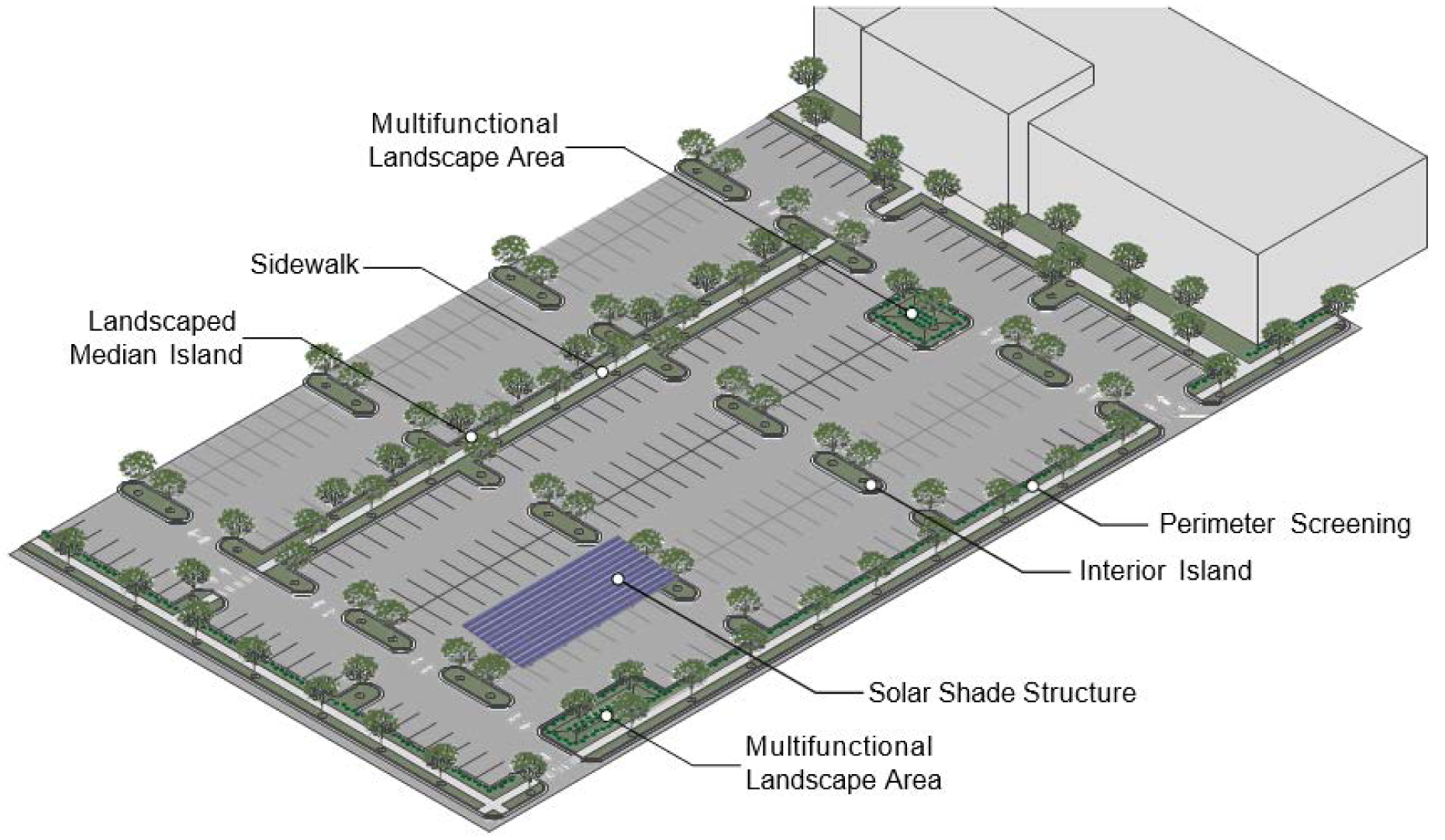
C.
Interior Islands.
1.
A landscaped interior island must be provided every ten (10) parking spaces in excess of twenty (20) spaces. Interior islands must be distributed evenly throughout the parking area. Interior islands may be consolidated or intervals maybe expanded in order to preserve existing trees.
2.
An interior island abutting a single row of parking spaces must be a minimum of eight (8) feet in width and one hundred fifty (150) square feet in area. Each island must include one (1) canopy tree unless the island is designed as a bioretention basin.
3.
An interior island abutting a double row of parking spaces must be a minimum of eight (8) feet in width and three hundred (300) square feet in area. Each island must include two (2) canopy trees unless the island is designed as a bioretention basin.
4.
Interior islands may be installed below the level of the parking lot surface to allow for runoff capture if included as part of an approved stormwater management plan.
5.
If designed as a bioretention basin, interior islands must be ten (10) feet in width and must be planted with recommended vegetation for bioretention areas.
6.
Landscaped interior islands are not required for surface parking areas in a Residential-Community Priority-Conditional Zoning District (R-CP-CZD).
D.
Median Islands.
1.
A landscaped median island must be provided between every six (6) single parking rows. Intervals may be expanded in order to preserve existing trees.
2.
A landscaped median island shall be a minimum width of eight (8) feet, as measured from back of curb to back of curb.
3.
Landscaped median islands may be installed below the level of the parking lot surface to allow for runoff capture if included as part of an approved stormwater management plan.
4.
Any trees planted in landscaped median islands must be canopy trees unless the median is designed as a bioretention basin.
5.
If designed as a bioretention basin, median islands must be ten (10) feet in width and must be planted with recommended vegetation for bioretention areas.
E.
Pedestrian Access.
1.
Well-marked, ADA-compliant pedestrian access must be provided.
2.
Access perpendicular to the main entrance from the parking area should be provided, whenever possible,
3.
Where a sidewalk is added to a median, additional median width equal to the sidewalk width must be provided.
F
Trees. No parking space shall be farther than seventy-five (75) feet from the trunk of a canopy tree.
G.
Shade Structures. Shade structures are encouraged in parking facilities, included shade structures featuring solar panels. Since such structures also provide shading of parking spaces, the town manager may modify the tree spacing requirements of this subsection or the design manual in trade for shade structures in a parking lot.
H.
Parking Adjacent to Residential Zoning. Surface parking facilities and the ground level of parking structures must be screened from any adjacent residentially zoned property. Either as a component of, or in addition to any other underlying perimeter landscape buffer requirements, this screening must be provided by:
1.
A continuous compact evergreen hedge at least three (3) feet in height that will reach a height of four (4) feet within three (3) years of planting; OR
2.
A screening fence or wall a minimum height of four (4) feet and no more than six (6) feet in height. The fence or wall must be compatible with the principal building in terms of texture, quality, material and color.
I.
Drive-Thru Screening.
1.
Where drive-thru windows and lanes are permitted to be placed between a public street (not including an alley) or ground floor residential use and the associated building, the entire length of the drive-thru lane, including but not limited to menu boards, stacking lanes, trash receptacles, ordering box, drive up windows, and other objects associated with the drive-thru must be screened.
2.
Screening must be a continuous compact evergreen hedge or a screening wall. At the time of installation, a hedge must be at least three (3) feet in height and reach a height of four (4) feet within three (3) years of planting. A screening wall must be a minimum height of four (4) feet. The wall must be compatible with the principal building in terms of texture, quality, material and color.
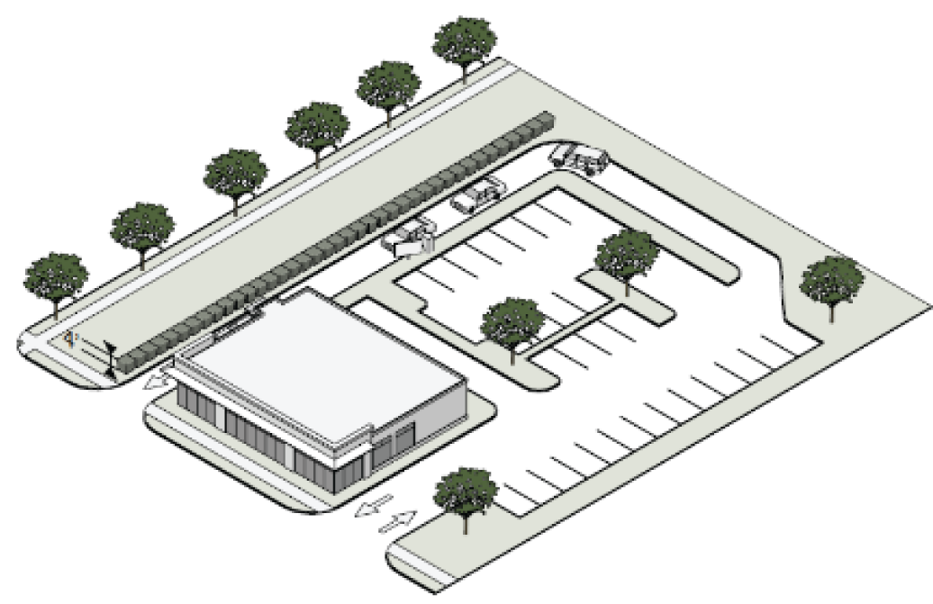
(d)
Plant Installation and Maintenance.
(1)
All plants must be installed in accordance with the Town of Chapel Hill Design Manual, including minimum usable soil volume, calculations and installation instructions.
(2)
No invasive exotic plants, as defined by the Southeast Exotic Pest Plant Council, may be installed. Where invasive exotic plants exist on the site, they must be removed during the landscape installation process.
(3)
Where vehicles hang over medians or islands, shrubs and trees must be planted a minimum of three (3) feet from back of the curb or wheel stop.
(4)
All plants and trees must be maintained in accordance with in the Town of Chapel Hill Design Manual.
(5)
In providing the vegetation required in this subsection, vegetation may be retained where, in the opinion of the Town Manager, the vegetation is significant and can feasibly be preserved.
(Ord. No. 2022-11-16/O-3, §§ 14, 15)
5.9.7. Minimum and Maximum Off-Street Parking Space Requirements.
The following minimum and maximum vehicular parking requirement shall apply for the appropriate use and zoning district. Vehicle parking requirements shall not apply for uses located within the Office/Institutional-3, Office/Institutional-4, or Historic Rogers Road Neighborhood Housing and Employment Mixed-Use.
A reduction of up to twenty (20) percent of the minimum number of required vehicular parking spaces may be permitted through the granting of a minor variance by the board of adjustment if, based on substantial evidence in the record of its proceedings, the board finds that compliance with the full minimum off-street vehicular parking space requirements of this section would necessitate the removal of or would seriously endanger significant specimen trees on or adjacent to the zoning lot on which such parking is required.
For all residential uses located in a Residential-Community Priority-Conditional Zoning District (R-CP-CZD), the minimum number of vehicular parking spaces required per dwelling unit shall be reduced by twenty (20) percent.
* Minimum vehicular and bicycle parking requirements shall not apply for uses located within the Office/Institutional-3 or Office/Institutional-4 Districts.
** For two-family dwelling units, please see Article 6. No minimum vehicular parking requirement shall apply.
*** See section 4.11 Bicycle Parking in the Town of Chapel Hill 2005 Design Manual.
Note: The minimum number of parking spaces required for elderly or handicapped dwellings may be reduced to one (1) per two (2) dwelling units upon findings made by the town council that (1) reasonable assurances exist that the dwelling units served by the parking spaces will be maintained for occupancy by the elderly or handicapped and/or (2) that sufficient space exists on the property to ensure that should the units be converted to another form of occupancy or use, that sufficient parking can be provided on the site to satisfy the parking requirements of the new use, without violating the land use intensities of Table 3.8-1.
In the case of a use not listed above, the minimum and maximum bicycle and vehicular parking space requirements shall be determined by the town manager. In making such determinations, the town manager shall be guided by the requirements for similar uses, the number and kind of bicycles and vehicles likely to be attracted to the use, and studies of minimum parking space requirements for such use in other jurisdictions.
Minimum vehicular parking requirements for an individual site may be reduced by the town council in the context of a special use permit approval, or the planning commission in the context of a site plan review approval, if evidence is submitted to demonstrate and the town council, or planning commission, finds that:
(a)
Sidewalks, bicycle facilities, transit service and transit amenities are in place such that, together with the number of vehicular parking spaces that are proposed, transportation needs are adequately served; or
(b)
The particular use that would be specified in the special use permit is of a nature that generates lower-than-average trips, and that the special use permit would limit use of the property to what is specified; or
(c)
Arrangements for shared parking with nearby facilities is ensured.
(Ord. No. 2004-02-23/O-2; Ord. No. 2007-02-26/O-5, § 10; Ord. No. 2007-06-11/O-8a, § 1; Ord. No. 2008-10-27/O-3, §§ 1, 2; Ord. No. 2010-10-11/O-7, § 1; Ord. No. 2014-03-10/O-2, § 3; Ord. No. 2018-11-28/O-1, § 3; Ord. No. 2022-11-16/O-3, § 16; Ord. No. 2023-06-21/O-6, § 14)
_____
5.9.8. Loading Space Design Standards.
All loading spaces shall meet the following minimum design requirements:
(a)
Off-street loading spaces shall be located and arranged so that a semi-trailer truck (WB 43 Design Vehicle) shall be able to gain access to and use such spaces by means of one (1) continuous parking maneuver.
(b)
Loading space shall observe the minimum street and interior setbacks established for structures in section 3.8 of this appendix.
(c)
All loading space and maneuvering space shall be surfaced with an all-weather material which shall be maintained in a safe and sanitary condition.
(d)
No loading space shall be located so that a vehicle using such space intrudes on travel lanes, walkways, public or private streets, or adjacent properties.
(e)
Each required off-street loading space shall have a minimum width of twelve (12) feet, a minimum depth of fifty-five (55) feet, and a vertical clearance of fourteen (14) feet above finished grade of the space.
(f)
Loading areas shall be screened from adjacent streets and adjacent properties by means of an effective screening device which is at least six (6) feet in height above the grade of the loading area. Appropriate screening devices may include solid decorative brick walls, wood fences, berms, tight evergreen hedges which shall reach the required height within two (2) years of planting, or any combination of the above.
5.9.9. Parking in Front Yards.
(a)
Applicability. The restrictions of this section shall apply to single-family and two-family dwelling units in all zoning districts.
(b)
Generally. Parking and drive areas located in front yards (between the street and a line drawn parallel to the street from the point of the house that is closest to the street) shall be maintained in a safe and sanitary condition, shall not contribute to soil erosion or to tree damage, and shall be clearly designated and covered with an all-weather surface or gravel.
(c)
Coverage. Parking and drive areas shall be limited to forty (40) percent of the front yard area of any zoning lot. Access to front yard parking shall be limited to properly approved curb cuts or other approved access points.
Single- and two-family residential driveway areas can be further reduced by:
(1)
Constructing shared driveways with a recorded shared access agreement between any pair of lots
(2)
Designing driveways as a ribbon driveway:
A.
Each strip shall be two feet (2') to three feet (3') wide with a separation between the strips measuring three feet (3').
B.
Strips can terminate at the sidewalk or driveway apron, to a parking pad at the side or rear of the structure to accommodate side-by-side parking, or garage entry.
C.
Separation strips may be planted with grass or another ground cover, filled with landscaping rocks, or gravel.
(d)
Exceptions. The town manager may grant an exception to subsection (c) where he/she finds all of the following conditions to exist on the property and all other parking options, including parking in the back and side yard, have been eliminated;
(1)
The parking area is clearly defined and/or marked with appropriate materials such as rocks, timbers and hedges; and
(2)
The parking area is maintained in a safe and sanitary condition; and
(3)
The parking area does not contribute to soil erosion or tree damage; and
(4)
Access to front yard parking shall be limited to properly approved curb cuts or other approved access points; and
(5)
The location and dimension of such parking area is traditionally and customarily associated with the subject structure; and
(6)
The parking area shall be screened by means of an effective screening device between the parking area and the street which is at least four (4) feet in height above the grade of the edge of the parking area. Appropriate screening devices may include decorative brick walls, fences, evergreen hedges which shall reach the required height within two (2) years of planting, or any combination of the above.
(7)
If the parking lot is located in the historic district, the historic district commission grants a certificate of appropriateness for the parking area.
(Ord. No. 2023-06-21-O-6, § 15)
5.9.10. Minimum Off-Street Loading Space Requirements.
The following minimum loading space requirements shall apply for the appropriate use:
(Ord. No. 2012-06-25/O-7, §§ 1, 2; Ord. No. 2012-06-25/O-8, § 1; Ord. No. 2015-11-23/O-6, §§ III, IV; Ord. No. 2015-11-23/O-9, § I; Ord. No. 2016-03-21/O-1, § 8; Ord. No. 2016-03-21/O-3, § 3; Ord. No. 2025-06-18-O-2, § 7)
5.10. - Disability Access.
Except for single-family and two-family developments, all buildings and facilities shall be accessible to and usable by the physically handicapped in accordance with the building code provisions contained in chapter 5 of the Town Code of Ordinances.
(Ord. No. 2023-06-21/O-6, § 16)
5.11. - Lighting Standards.
Purpose statement: This section provides standards for lighting that shall be designed to minimize spillover of light onto adjacent property, glare that could impair vision, and/or other conditions that deteriorate normally accepted qualities and uses of adjacent property.
5.11.1. Applicability.
The provisions of this section apply to any outside lighting used around buildings, recreation areas, parking areas, walkways, drives, or signs.
Lighting sources shall be shielded or arranged so as not to produce within any public right-of-way glare that interferes with the safe use of such right-of-way and so as not to constitute a nuisance to the occupants of adjacent properties.
5.11.2. Mounting Heights.
Outdoor lighting, except sports and athletic field lighting, shall be mounted at heights no greater than fifteen (15) feet for non-cutoff lights; and no greater than thirty-five (35) feet for full cutoff lights.
5.11.3. Sports Fields.
Lighting for sports and athletic fields must include glare control features and must be designed so that primary illumination is directed onto the play area and ancillary areas such as bleachers, stands, and similar areas. All lighting fixtures for sports fields shall be equipped with a glare control package including louvers, shields, or similar devices). The fixtures must be aimed so that their beams are directed and fall within the primary playing or performance area.
5.11.4. Offsite Illumination.
Increases in illumination on off-site property shall not result in lighting levels in excess of 0.3 foot-candles, measured at ground level. Where existing ambient off-site lighting levels are in excess of 0.3 foot-candles, no increase in measurable off-site lighting levels will be allowed as a result of outdoor lighting in the development.
5.11.5. Buildings, Streets, Driveways and other Passageways.
Except for single- and two-family dwellings, all streets, driveways, bikeways, sidewalks, pedestrian paths, parking areas, and other common areas and facilities shall be lighted where necessary to ensure the security of property and the safety of persons using such streets, driveways, bikeways, sidewalks, pedestrian paths, parking areas, and other common areas and facilities. Specific standards for and restrictions on lighting are included in the town's design manual.
All principal entrances and exits to principal buildings used for nonresidential purposes or containing more than five (5) dwelling or lodging units shall be sufficiently lighted to ensure the safety of residents and the security of the building.
5.11.6. Submittals.
Each application for a zoning compliance permit for development other than a single-family, single-family with accessory apartment, or two-family dwelling units shall include a lighting plan that shows existing and proposed lighting fixture types and locations. The plan shall indicate, by isolux contour diagram and grid points, the measured and calculated pre-development and post-development foot-candles at grade both on the development site and on adjacent property where lighting impacts are expected. The lighting plan must be sealed by a professional engineer with demonstrable expertise in lighting design and mitigation strategies, or a lighting specialist who is lighting certified (LC) by NCQLP (National Town Council on Qualifications for the Lighting Professions).
(Ord. No. 2023-06-21/O-6, § 17)
5.12. - Utilities.
5.12.1. Water and Sewerage.
(a)
Service by public systems.
(1)
All development within the boundaries of Chapel Hill's Urban Services Area, as defined in the comprehensive plan, shall be served by a public water supply and a public sanitary sewer system. No zoning compliance permit or building permit shall be issued for any structure within the town's urban services area (as defined in the comprehensive plan), absent evidence that the structure can be served by public water and sewer facilities. Existing development not served by public water and sewer shall not be considered as nonconforming within the meaning of article 7 of this chapter. Provided however that permits may be issued to authorize the reconstruction, rehabilitation, renovation, or expansion of a development existing on or before January 27, 2003, whether or not such development is served by a public water supply and a public sanitary sewer system, subject to applicable regulations, including demonstration of compliance with county health department regulations. (Ord. No. 2003-09-22/O-2, § 1)
Exception: The town manager, or designee, may exempt individual single- and two-family development from the requirement for public water and sewer facilities, based on the presentation of substantial evidence by the applicant that such public facilities are not immediately adjacent to the lot and are not accessible by private lateral utility service lines. A letter from the Orange Water and Sewer Authority or successor agency stating that an extension of public water or sewer main would be required to serve the subject property shall constitute substantial evidence as described above. New development that is granted this exception, to allow private water or sewer facilities, shall connect to public water and sewer facilities, by private lateral utility service lines, at such time that public facilities become accessible by private lateral utility service lines.
(2)
Fire hydrants of sufficient water pressure to provide adequate fire protection shall be provided where necessary, as determined by the town manager.
(3)
All proposed public water and sanitary sewer installations shall be approved by the Orange Water and Sewer Authority (OWASA). Certification of such approval shall be submitted to the town manager prior to issuance of any zoning compliance permit for the development being served.
(4)
No building permits shall be issued until all required water mains and fire hydrants are installed and operational. For purposes of this subsection, "operational" means that the water mains and fire hydrants are capable of delivering sufficient water to meet domestic and fire fighting needs.
(5)
No certificate of occupancy for a structure shall be issued until the following documents have been submitted to the town manager:
A.
Certification from the Orange Water and Sewer Authority that all water and/or sewer facilities necessary to serve such structure have been completed to the Orange Water and Sewer Authority standards; and
B.
As-built construction drawings of those completed water and/or sewer facilities located within a public right-of-way or easement.
(b)
Service by individual systems.
(1)
Individual water supply systems intended to provide potable water are permitted outside of the urban services area, subject to approval by the appropriate county health department. Certification of such approval shall be submitted to the town manager prior to issuance of any zoning compliance permit for the development being served.
(2)
Individual subsurface sewage disposal systems are permitted outside of the urban services area, subject to approval by the appropriate county health department. Certification of such approval shall be submitted to the town manager prior to issuance of any zoning compliance permit for the development being served. A lot with an individual subsurface sewage disposal system shall also have a replacement filed location approved by the appropriate county health department. (Ord. No. 2004-02-23/O-2)
5.12.2. Other Utilities.
(a)
All utility lines, except as provided in (b), other than lines used only to transmit electricity between generating stations or substations shall be placed underground, and all surface disruptions required for installation shall be rehabilitated to the original or an improved condition. Three-phase electric power distribution lines are not required to be placed underground except as provided in subsection (c), below.
(b)
Utility lines shall not be required to be buried if the existing power lines meet all of the following criteria:
(1)
The power lines existed above ground at the time of first approval of a plat or development plan by the town, whether or not the power lines are subsequently relocated during construction of the subdivision or development plan.
(2)
The power lines are located outside the boundaries of the parcel of land that contains the subdivision or the property covered by the development approval and/or the legislative decision.
(c)
Three-phase electric power distribution lines.
(1)
Three-phase electric power distribution lines shall be placed underground if:
A.
Duke Energy agrees in a written statement to provide utilities underground; and
B.
Three-phase lines shall be placed underground by the applicant where:
1.
There is a rational nexus between the impact of the proposed development and the proposed utility requirement; and
2.
The costs of placing the utilities underground are roughly proportionate to the impacts of the development on adjoining properties or the town; and
3.
Placing the utility underground does not violate any provision of the electrical code or other relevant safety standard.
(2)
Three-phase lines are not required to be placed underground if the applicant or Duke Energy demonstrates the applicability of the criteria in subsection (b) above and that the burial would create economic hardship or a danger to public health or safety as it relates to the size, nature, timing, and scope of the proposed development.
(d)
A letter or letters certifying the availability of immediate service from each of the other utilities (electric, gas, telephone, cable television) serving a structure shall be submitted to the town manager prior to issuance of a zoning compliance permit for such structure.
(e)
No certificate of occupancy for a structure shall be issued until the following documents or certifications from the appropriate utilities that all facilities necessary to provide electric, gas, telephone, and/or CATV service to such structure have been completed to the standards of the appropriate utilities have been submitted to the town manager.
(Ord. No. 2016-03-21/O-1, § 9; Ord. No. 2021-05-19/O-1, § 90)
5.13. - Solid waste collection and recycling.
(a)
All developments shall provide a detailed solid waste management plan, including a recycling plan and a plan for managing and minimizing construction debris, subject to approval by the town manager.
(b)
All developments shall provide secure, safe, and sanitary facilities for the storage and pickup of solid waste and recyclables. Such facilities shall be convenient to collection and shall be appropriate to the type and size of the development being served.
(c)
Except for single- and two-family dwellings, all solid waste and recyclables storage facilities shall be screened by a solid wall, fence, tight evergreen hedge, or combination of the above. Such screening shall be of sufficient height and design to effectively screen the facility from the view from adjacent residential uses and streets, and from adjacent properties.
5.14. - Signs.
5.14.1. Intent.
It is the intent of this section to authorize the use of signs with regard to size, layout, style, typography, legibility, and arrangements compatible with their surroundings; appropriate to the identity of individual properties, occupants, and/or the community; and as appropriate to traffic safety.
5.14.2. Applicability.
(a)
No sign visible from the public right-of-way, whether exterior to or interior to a structure, shall be erected, displayed, or substantially altered (unless specifically exempted) except in accord with the provisions of this Land Use Management Ordinance and until a zoning compliance permit has been issued for the sign.
(b)
Except where expressly exempted in this Section, all signs must be located on the same lot as the permitted use and be clearly incidental, customary and commonly associated with the operation of the permitted use.
5.14.3. Signs in the Right-of-Way.
(a)
Signs must not encroach into the public right-of way unless expressly exempted in this Section.
(b)
Wall signs, awning signs, canopy signs, projecting signs, crown signs and shingle signs may encroach over the public sidewalk but must not encroach on or over any streets or alleys. All signs must be a minimum of 24 inches inside the curb line or edge of pavement, whichever is greater.
5.14.4. Signs Exempt from Regulation.
The following signs are exempt from regulation and permit requirements under this Section, provided that signs comply with the provision of this section and are not illuminated.
(a)
Signs bearing only property identification numbers and names, post office box numbers, names of occupants of the premises on which the signs are located, or other identification of premises not of a commercial nature, provided the signs are not illuminated and do not exceed 2 signs per zoning lot and 2 square feet in area per display surface.
(b)
Flags and insignia of a government, when not displayed in connection with a commercial promotion.
(c)
Legal notices, identification and informational signs, and traffic directional or regulatory signs erected by or on behalf of a governmental body.
(d)
Memorial signs, plaques or tablets, and names and construction dates of buildings when cut into any masonry surface.
(e)
Signs directing and guiding traffic and parking on private property on which the signs are located, provided such signs are not illuminated, bear no advertising, and do not exceed 4 square feet in area per display surface.
(f)
Real estate signs advertising the sale, rental, or lease of the premises, provided that, in addition to complying with the support and sign height standards for a cantilevered ground sign, such signs:
(1)
Do not exceed 1 sign per street frontage and 4 square feet in area per display surface for property zoned residential; and
(2)
Do not exceed 1 sign per street frontage and 16 square feet per display surface for property zoned non-residential or located within an approved planned development.
(g)
Residential property management sign permanently fixed to the building facade, including contact information, building address and/or building name, provided that the signs:
(1)
Do not exceed 1 sign per building facade and 4 square feet in area per display surface, and are attached to a residential structure with 7 or less dwelling units.
(h)
Construction site identification signs whose message is limited to project name, identification of architects, engineers, contractors and other individuals or firms involved with the construction, the name of the building, the intended purpose of the building and the expected completion date. Construction site identification signs may not exceed 4 square feet in area per display surface and 6 feet in height for single-family or duplex construction; and 32 square feet in area per display surface and 8 feet in height for multifamily or non-residential construction.
The signs must be non-illuminated. Construction site identification signs must not exceed 1 sign per construction site, must not be erected prior to the issuance of a building permit, and must be removed within 7 days of issuance of a certificate of occupancy.
(i)
Fence wrap signs when affixed to perimeter fencing at a construction site. Such signs must be removed at the time a Certificate of Occupancy is issued for the final portion of any construction at that site or 24 months from the time the fence wrap was installed, whichever is shorter. No fence wrap affixed pursuant to this exemption may display any advertising other than advertising sponsored by a person directly involved in the construction project and for which monetary compensation for the advertisement is not paid or required.
(j)
Temporary political signs advertising candidates or election issues, provided such signs do not exceed 4 square feet in area per display surface, and provided that any such signs, on private property, are removed within 10 days after the primary or election day; and provided further that any such signs in the public right-of-way are not erected prior to 30 days before the beginning date of "one-stop" early voting under G.S. 163-227.2 and ending on the 10th day after the primary or election day. Any such sign that remains more than 30 days after this period ends is to be deemed unlawfully placed and abandoned property, and a person may remove and dispose of such political sign without penalty. The NC Department of Transportation may remove any signs erected without authority or allowed to remain beyond the deadline established in this paragraph. Signs in the right-of-way must be placed in compliance with the following:
(1)
The sign permittee must obtain the permission of any property owner of a residence, business, or religious institution fronting the right-of-way where a sign would be erected.
(2)
No sign is permitted in the right-of-way of a fully controlled access highway.
(3)
No sign may obscure motorist visibility at an intersection.
(4)
No sign may be higher than 42 inches above the edge of the pavement of the road.
(5)
No sign may be larger than 18 inches by 24 inches.
(6)
No sign may obscure or replace another sign.
(k)
Yard or garage sale signs announcing yard or garage sales, provided the signs do not exceed one sign per site of the sale and 4 square feet in area per display surface, and are removed within 7 days of posting.
(l)
Public event announcements by public or nonprofit organizations of special events or activities of interest to the general public, provided such signs do not exceed 1 sign per site of such events or activities and 12 square feet in area per display surface, and are removed within 14 days of posting.
(m)
Temporary signs, provided such signs are on the property in which the business is located, do not exceed a total of 32 square feet of display area per business. Temporary signs include, wall signs or free standing signs, including feather signs, not permanently attached to the ground. Signs not attached to the building may not exceed 8 feet in height. Unless exempt otherwise, signs regulated in Section 5.14.5. are prohibited as temporary signs.
(n)
A sign held by or attached to a human, located in front of the business, during business hours, for the purposes of advertising or otherwise drawing attention to an individual, business, commodity, service or product. This may also include a person dressed in costume for the purpose of advertising or drawing attention to an individual, business, commodity, service or product.
(o)
Signs on registered, licensed vehicles that are parked in a manner that serves the purpose of advertising a business, is generally located in front of the business, and is parked in a standard size parking space.
(p)
Information kiosks or bulletin boards erected by or on behalf of a governmental body on public property or rights-of-way in the Town Center Districts for the display of handbills or posters of community interest, provided such kiosks or bulletin boards contain no more than 6 square feet in area per sign display surface, and a maximum of 72 square feet per kiosk or bulletin board.
(q)
Signs stating that a business (other than a home occupation) is open, provided that there is no more than one such sign per business establishment, any illumination is steady (does not blink or flash), and the sign does not exceed 2 square feet in display area.
(r)
Non-commercial signs not covered by other exemptions listed in this section, provided such signs are located on private property and are non-illuminated.
5.14.5. Prohibited Signs.
The following signs are prohibited except where they are exempt from regulation in 5.14.4 above.
(a)
Moving signs. Animated, rotating, or other moving or apparently moving signs, including vehicular billboards.
(b)
Wind signs. Devices consisting of banners, streamers, pennants, wind-blown propellers, balloons, inflatable devices, strung light bulbs and similar installations, unless approved by the Town Manager for non-commercial, non-profit enterprises. A feather sign not complying with Section 5.14.4.M. Temporary Sign standards is considered a prohibited sign.
(c)
Digital changeable copy. Digital changeable copy that scrolls, blinks, or flashes, including but not limited to LCD, LED and any similar technology, except as used to display time and temperature or gas price.
(d)
Signs that are not permanent. Any sign that is not permanently affixed to the ground or a structure (except sidewalk signs), including but not limited to trailer signs. Any sign that does not comply with Section 5.14.4.M. Temporary Signs standards is considered a prohibited sign.
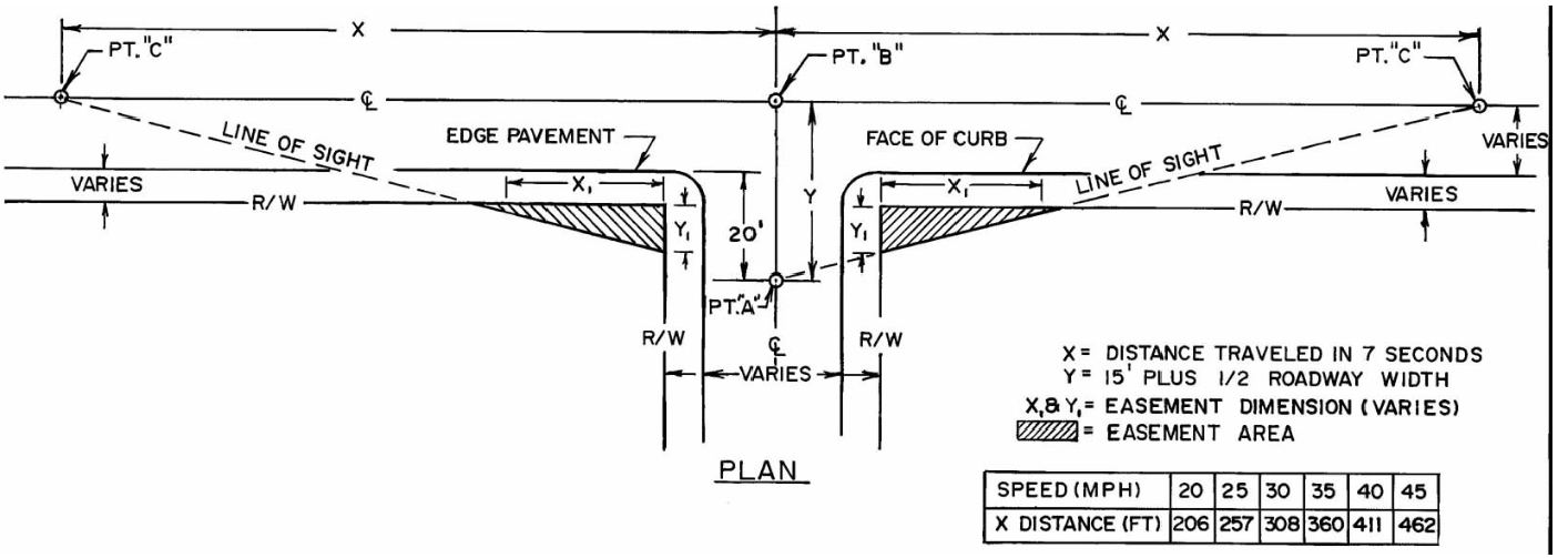
(e)
Traffic safety precautions. Notwithstanding any other provision in this Land Use Management Ordinance, the following restrictions shall apply to signs in order to preserve the safety of pedestrian, bicycle, and vehicular movement:
(1)
No sign may make use of the words "STOP", "SLOW", "CAUTION", "DANGER", or any other word, phrase, symbol or character in such manner as is reasonably likely to be confused with traffic directional and regulatory signs.
(2)
Except as used to display time and temperature, no sign may contain flashing lights.
(3)
No sign, or part of a sign, may be located within a sight distance area established below.
(4)
No sign may be erected so that by its location, color, nature or message is likely to be confused with or obstruct the view of traffic signals or signs, or is likely to be confused with the warning lights of an emergency or public safety vehicle.
5.14.6 General Standards.
(a)
Subject matter related to premises. The subject matter of any sign must be related to the premises on which the sign is located, except where specifically exempted by this Land Use Management Ordinance.
(b)
Non-commercial message. Whenever the ordinance permits a commercial sign, a non-commercial message may be substituted for the commercial message. The right to substitute the non-commercial message does not waive any other requirement imposed by this Land Use Management Ordinance as to the number, size, type, construction, location, lighting, safety or other regulated attribute.
(c)
Cessation or vacation of use. When the use or establishment to which a sign is related ceases or is vacated, any sign, including all of its supports, frames and hardware, must be removed within 4 months of the cessation or vacating of the use or establishment unless the sign is used by a new use or establishment on the premises in conformance with all current regulations of this Land Use Management Ordinance.
(d)
No signs in public right-of-way. All signs, including the supports, frames, and embellishments, shall not be located within any public right-of-way (except where specifically exempted by this Land Use Management Ordinance). No sign may be attached, affixed, or painted on any utility pole, light fixture, telephone or telegraph pole, any tree, rock or other natural object.
(e)
Unified sign plan.
(1)
Where a zoning lot contains more than 3 principal uses or establishments, the provisions of this Section apply to the zoning lot as a whole, and the owners of the zoning lot are responsible for allocating permitted signs and display surface area among the individual uses or establishments.
(2)
A unified sign plan is an overall plan for placement and design of multiple signs for a building or group of buildings on a zoning lot.
(3)
The unified sign plan submitted for a zoning lot must show all signs located or proposed on the zoning lot.
(4)
The unified sign plan must display harmony and consistency with regard to number and size of signs, placement of signs, materials and color, size and style of lettering, and type of sign illumination.
(5)
Unified Sign Plans are not required in Town-Center or Mixed-Use Village Zoning Districts or in mixed-use developments encumbered by a Master Land Use Plan.
(f)
Address on ground signs. The street address number must be included on all ground signs. Numerals must be at least 9" in height. The area of the address is not included in any calculation of total sign area.
(g)
Historic designation. Any sign in place prior to January, 2003, that does not comply with the standards of this Section for size, location, height or sign type is considered a nonconforming sign that is permitted to be continued, be maintained, repaired, or replaced if damaged or destroyed.
| 5.14.7. Permitted Signs |
RT, R-,
MH, PD-H |
TC-, C,
NC, OI-, MU-V MU-V-CZD, I |
PD-SC PD-
OI, PD-MU, PD-I |
Mixed Use
OI-1, Mixed Use R-1 | WR-Subdistricts | WX-Subdistricts | Sign Area Allocation (max) | ||
|---|---|---|---|---|---|---|---|---|---|
|
Type A
Frontage |
Type B, C
Frontage |
Type A
Frontage |
Type B, C
Frontage | ||||||
| Building Signs | |||||||||
 | P* | P | P | P | — | — | P | P | Maximum 5% of the building facade up to and including the fourth floor, for all of these sign types combined. No individual sign shall exceed 250 sq. ft. in area |
 | P* | P | P | P | — | — | P | P | |
 | P* | P | P | P | — | — | P | P | |
 | P* | P | P | P | — | — | P | P | |
 | P* | P | P | P | P* | P* | P | P | Based on sign area |
 | — | P | P | P | — | — | P | P | Maximum 2.5% of the building facade (in addition to other building signs) |
| Ground Signs | |||||||||
 | P* | P | — | — | P | P | P | P | Based on sign area |
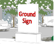 | P* | P | — | — | — | P* | P | P | |
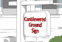 | P** | P | P | P | — | P* | — | P | |
 | P | — | P | P | — | — | — | — | |
KEY: P = Sign type permitted P* = For allowed nonresidential uses only
P** = For residential identification sign only — = Not Permitted
(h)
Wall sign.

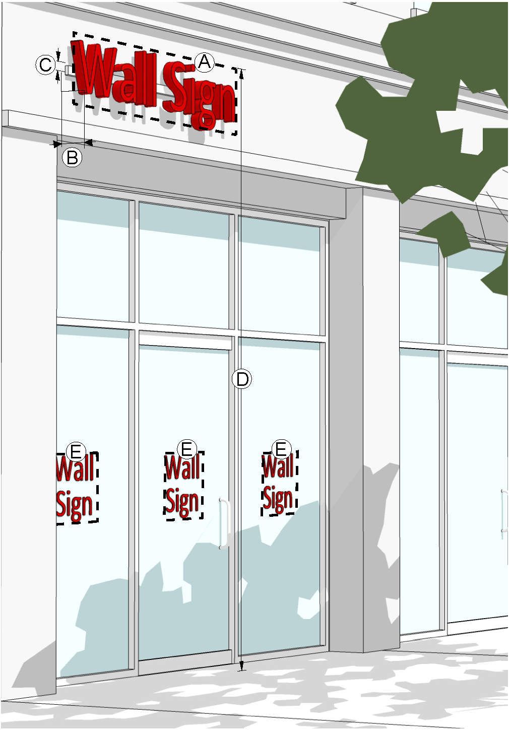
(i)
Awning Sign.
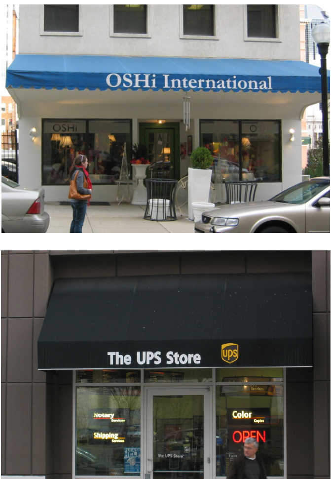
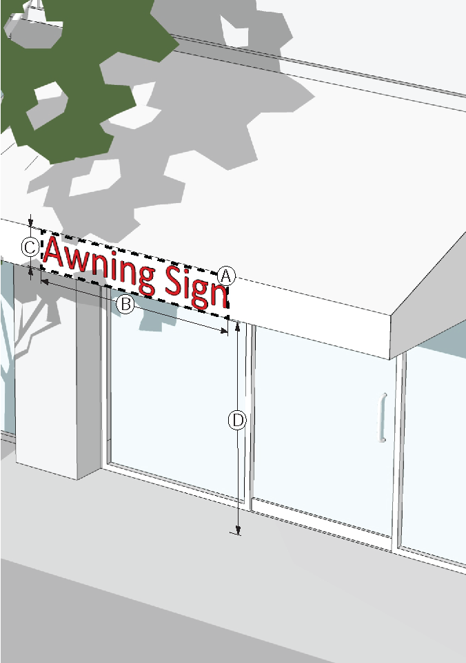
(j)
Canopy Sign.
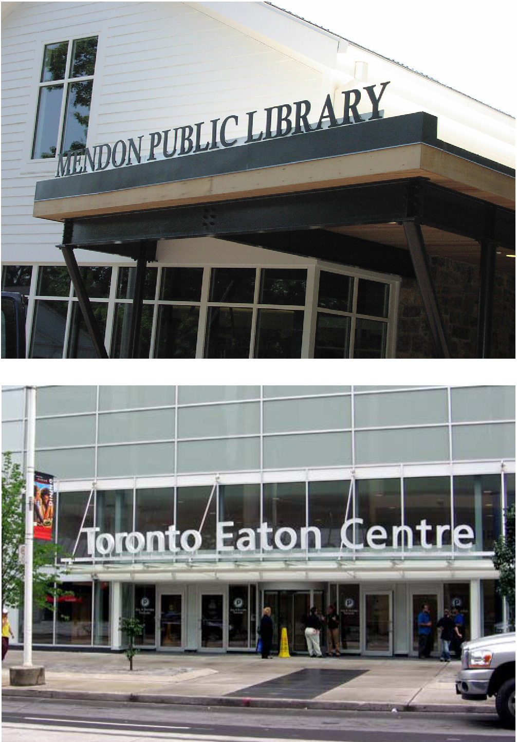
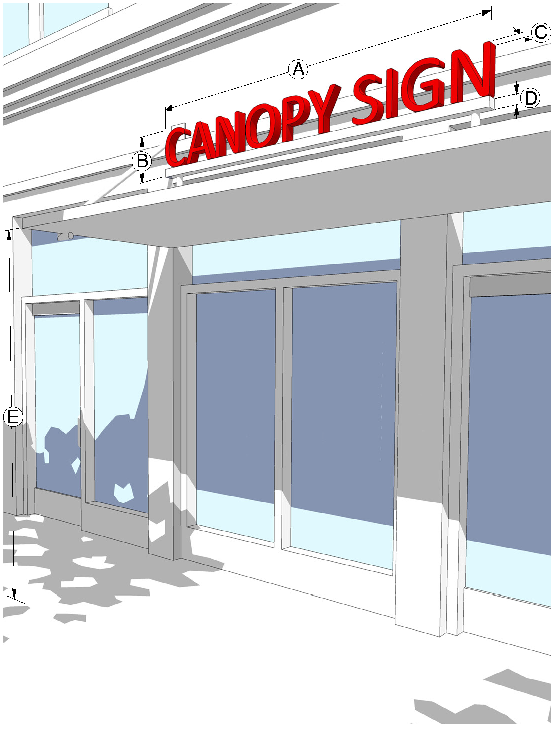
(k)
Projecting Sign.

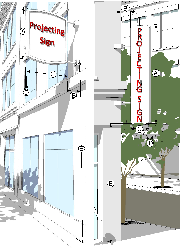
(l)
Shingle Sign.
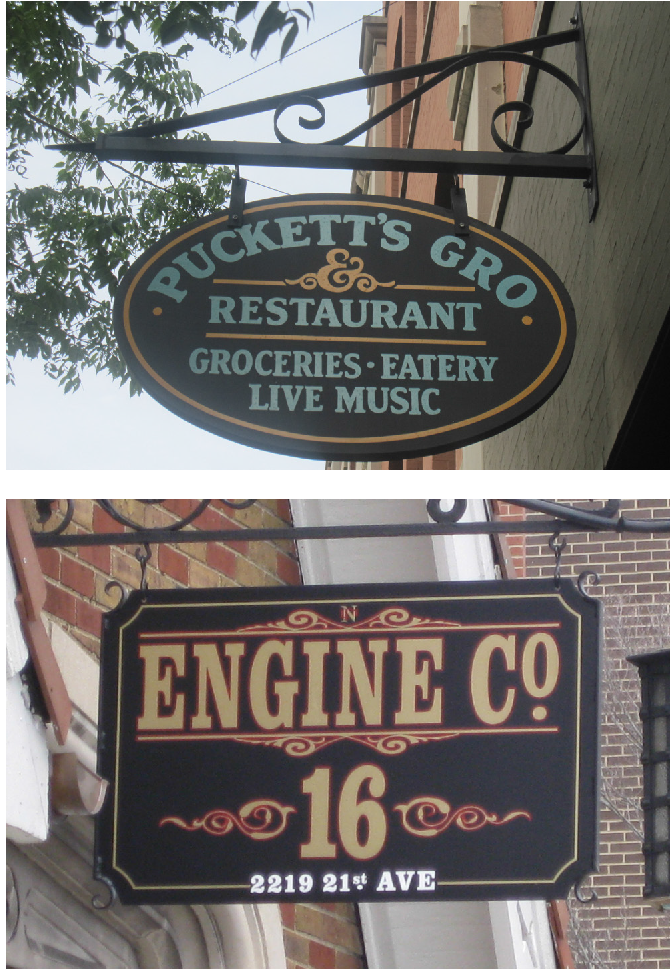
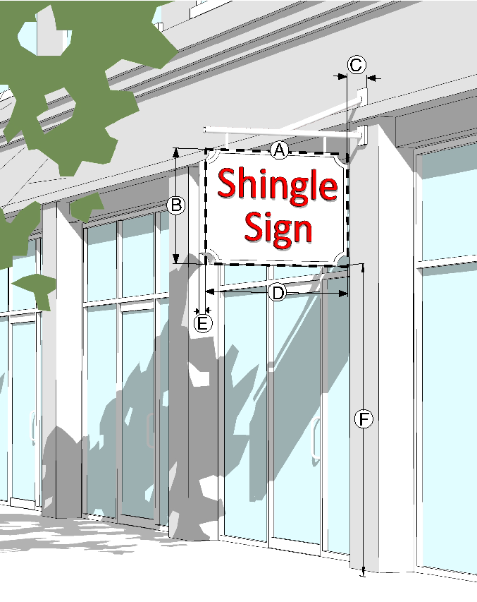
(m)
Crown Sign.


(n)
Development Identification Sign.
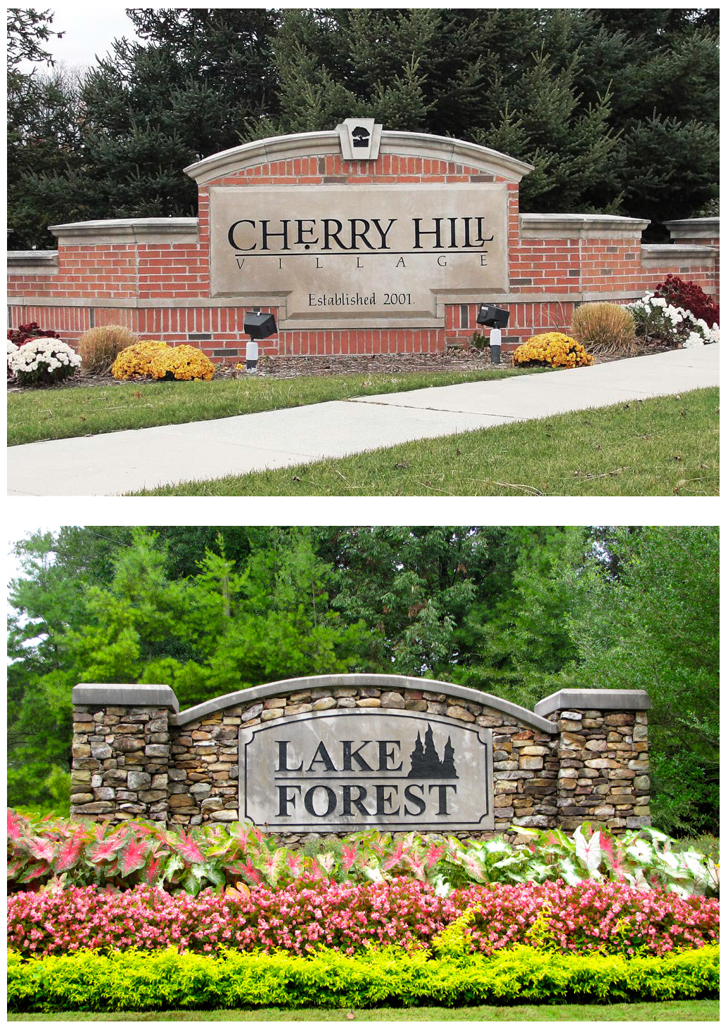
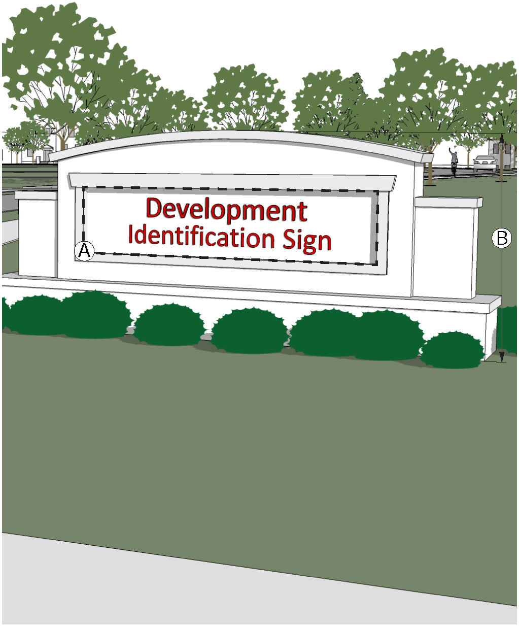
(o)
Commercial Center Sign.
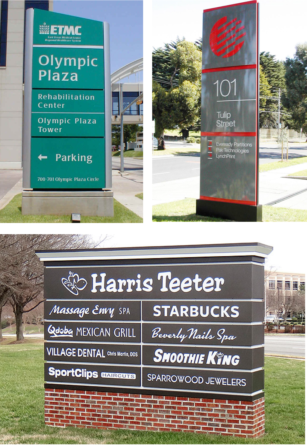
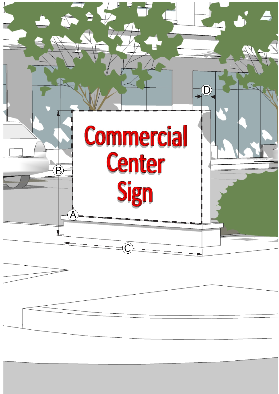
(p)
Ground Sign.
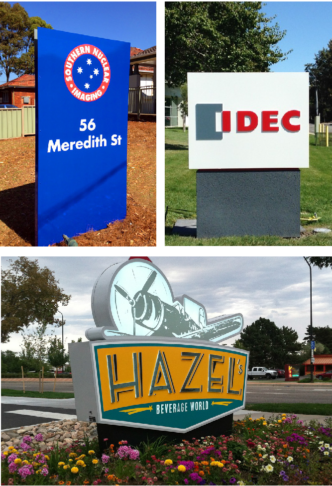
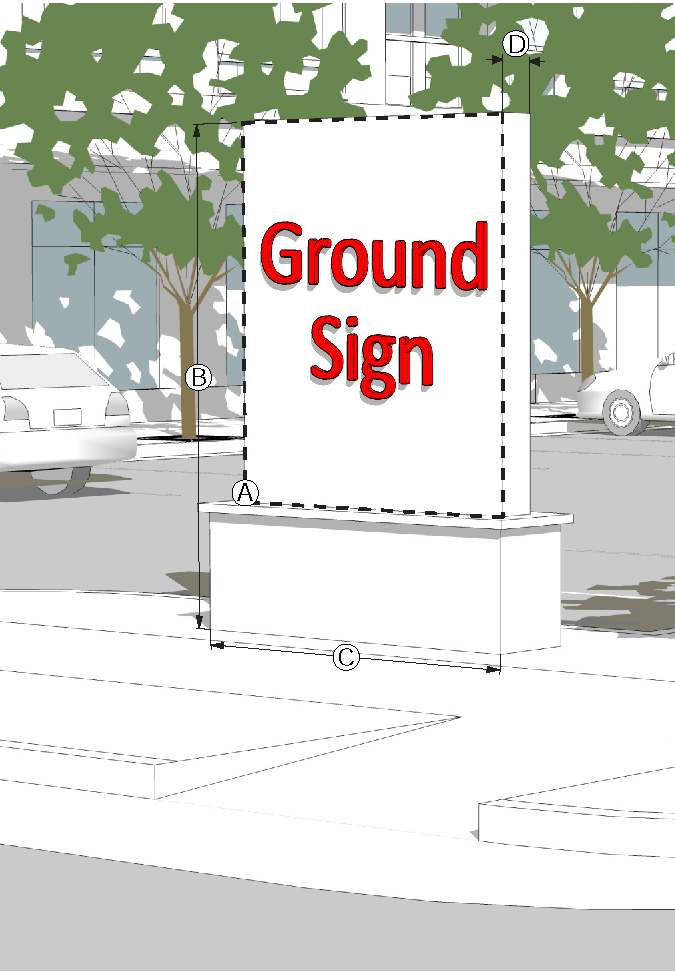
(q)
Cantilevered Ground Sign.
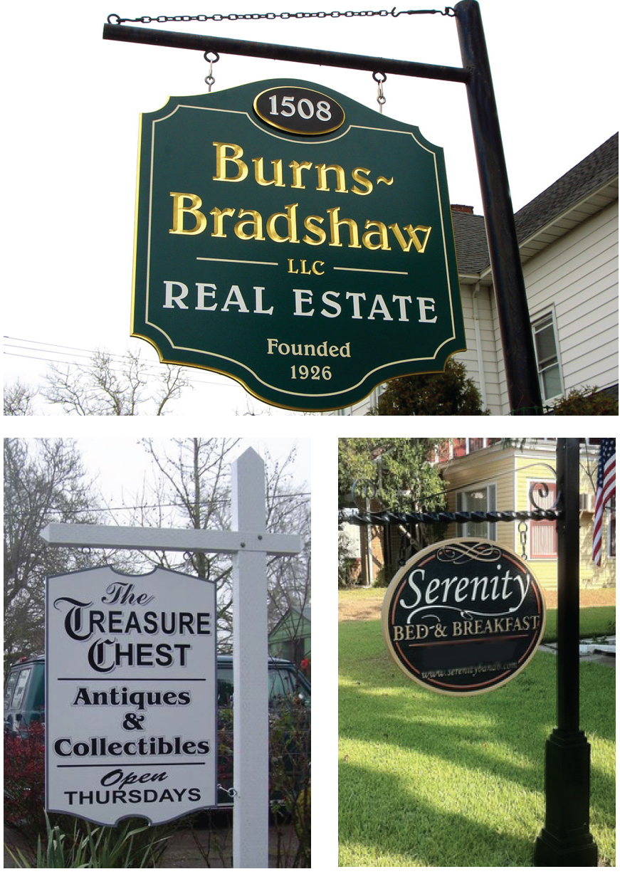
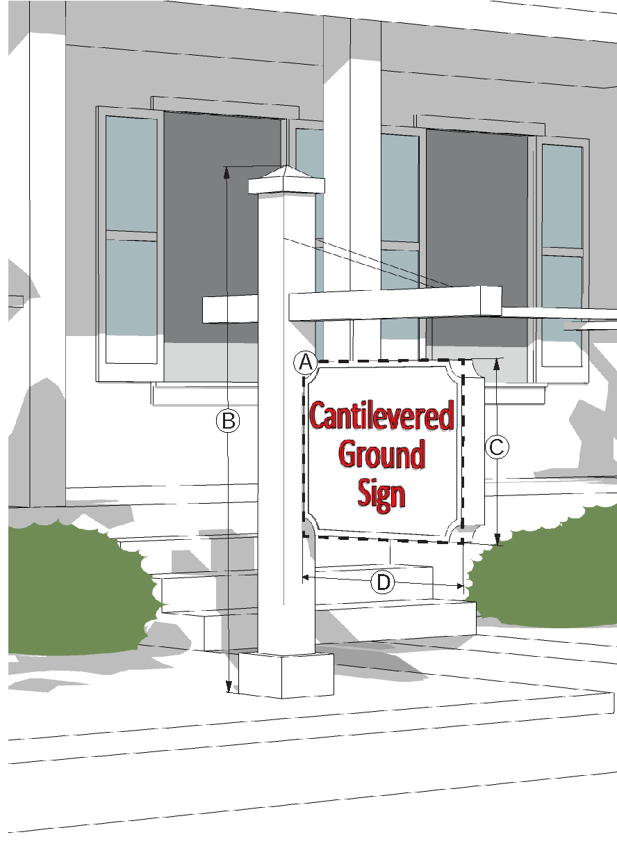
5.14.8. Specialty Sign Types.
(a)
Sidewalk Sign. A sidewalk sign is a movable sign not secured or attached to the ground or surface upon which it is located. This sign type is typically an A-frame or spring-mounted sign.
(1)
A sidewalk sign is permitted in the R-4, R-5, OI, NC, CC, TC and MU districts
(2)
Except in the Town Center and Ephesus-Fordham districts, sidewalk sign is permitted only along roadways with a posted speed limit of 35 MPH or less.
(3)
A sidewalk sign must be no more than 42" tall and 36" wide. The sign face must be no more than 6 square feet in area.
(4)
There may be no more than 1 sidewalk sign per tenant, generally located adjacent to the primary facade in front of the business.
(5)
A sidewalk sign must be located outside the public right-of-way, except in the Town Center, where sidewalk signs may be placed within the right-of-way in accordance with Chapter 16 of the Town Code. The sign must not obstruct vehicular, bicycle or pedestrian traffic, and must comply with ADA clearance and accessibility.
(6)
The sign must be removed and placed indoors at the close of each business day.
(7)
No illumination is permitted.
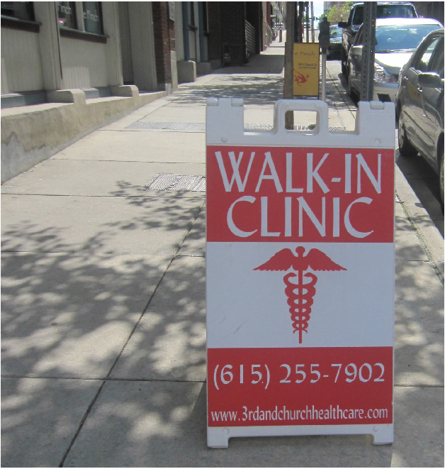
(b)
Parking Lot Identification Banners.
(1)
Non-illuminated parking lot identification banners may be hung from private street lights in all non-residential districts for no more than 90 days with the approval of the Town Manager.
(2)
Each parking lot identification banner must not exceed 4 square feet in display area, and must be limited to the name of the building or development.
(3)
One or two banners may be approved for display from each street light.
(4)
The colors, shape, materials, appearance and duration of display for such banners must be approved by the Town Manager.
(c)
Gas Stations.
(1)
Pumps. Signs located on the top of gas pumps (pump toppers) must comply with the following standards:
A.
Gas stations may install one pump topper per pump.
B.
Pump toppers are limited to a maximum of 6 square feet per side and no more than 2 sides per pump.
C.
The base of the pump must be a neutral color, and must not contain any signage.
D.
No internal illumination of the pump or pump topper is allowed.
(2)
Canopies. Gas station canopy signs must comply with the following standards:
A.
The sign must be an integral component of the pump canopy (composed of lettering mounted, painted or otherwise affixed to the pump canopy, and not located on the top or bottom of the canopy).
B.
The features, materials, colors and designs used in the pump canopy must be similar to the principal structure. Such features are considered similar where the materials and colors of the canopy are the same as the predominant materials and colors of the principal structure.
C.
Each canopy sign may not exceed 4 square feet of display area. The maximum letter height or trademark height must not exceed 18 inches.
D.
Additional canopy sign area may be permitted by transferring building sign display area. If building sign display area is transferred, one canopy sign is permitted on each side of a canopy, up to a maximum of three sides.
E.
The canopy must not encroach upon any publicly dedicated rights-of-way.
F.
The message must be limited to the name or registered trademark of the establishment located on the zoning lot.
G.
No internal canopy illumination is permitted.
(3)
Digital Gas Price Display. Gas prices may be displayed as digital (electronic) changeable copy).
5.14.9. Sign Measurements.
(a)
Computation of Sign Area. The area of all signs is determined as follows:
(1)
For wall signs, awning signs, canopy signs and crown signs consisting of freestanding letters or logos, sign area is calculated as the total area of the rectangle, circle or square that fully encloses all the letters or logo.

(2)
For signs on a background, the entire area of the background is calculated as sign area, including any material or color forming the sign face and the background used to differentiate the sign from the structure on which it is mounted. Display surface includes the face of the structure that the message is affixed to. Display surface does not include any structural members not bearing advertisement.
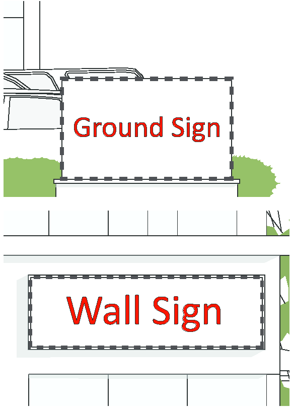
(3)
The sign area of a three-dimensional sign is calculated as total area of the smallest rectangle, circle or square that fully encloses the largest profile of the three-dimensional sign.
(4)
The area for a sign with more than one face is calculated by adding the area of all sign faces that are 45 degrees or greater; where the sign face angle is less than 45 degrees only the area of the largest sign face is computed as part of the sign area.
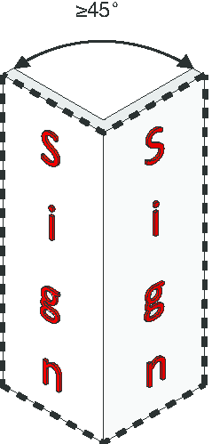
(b)
Measurement of Sign Height.
(1)
The total height of a sign is measured from the highest point of the sign or supporting structure to the top of the abutting sidewalk (or the crown of the adjacent roadway where no sidewalk exists).
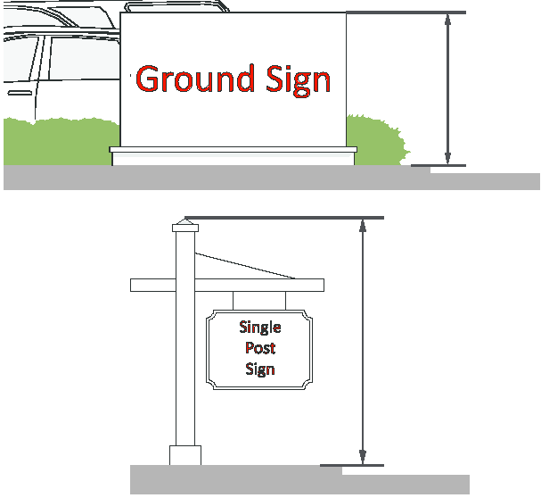
(c)
Measurement of Sign Height: Commercial Center Sign.
(1)
The height of a Commercial Center Sign is measured from the mean natural grade.
(2)
Mean natural grade is measured along a line parallel to the street frontage for a distance of 100 feet on either side of the base of the sign, and along a line perpendicular to the street starting at the right-of-way for a distance equal to the width of the proposed sign.
(3)
Where the proposed location of the sign is below the natural grade of the adjacent street frontage, the overall height of the base of the sign may be increased by up to 10 feet in order to achieve the maximum permitted height, as measured from the natural grade of the adjacent street frontage.
(4)
Landscaping around the base of a sign must be shown on a landscape plan. The landscaping must buffer and screen that portion of the base of the sign located below the natural grade of the adjacent street frontage.
(5)
The design of the base of the sign must complement the features and frame of the sign.
(6)
In those situations where compliance with Federal Emergency Management Agency (FEMA) floodplain regulations prohibits the installation of a contiguous structural base, the Town Manager may approve an alternate base design. Landscaping and screening must be incorporated into the alternate base design.
(d)
Sign Setback. Signs required to be set back are typically measured from the property line. However, in instances where the property line is adjacent to a drainage area or other right-of-way that may reasonably be anticipated to exist in the future, the Town Manager may allow the sign to be placed at the property line without any setback.
(e)
Sign Maintenance. All signs must be maintained in good condition and present a neat and orderly appearance. Failure by the owner or tenant to remove poorly maintained signs may result in enforcement action by the Town. The Town Manager may cause to be removed (after due notice) any sign which shows gross neglect, becomes dilapidated, or if the ground area around it is not well maintained.
5.14.10. Changeable Copy.
Changeable copy on signs must meet the following requirements.
(a)
Defined. A sign or portion of a sign that has a readerboard for the display of text information in which each alphanumeric character, graphic or symbol is defined by objects (not consisting of an illumination device) that may be changed or re-arranged manually or mechanically without altering the face or the surface of the sign.
(b)
Where Allowed.
(1)
Manual changeable copy signs are limited to the following uses:
A.
Place of worship or school;
B.
Theater with marquee; and
C.
Gas station.
(2)
Manual changeable copy is allowed in conjunction with a permitted commercial center sign, ground sign or marquee wall sign only.
(3)
The manual changeable copy portion of the sign may be no greater than 50% of the total sign area on each display face.
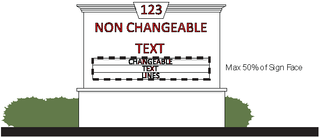
(4)
No electronic or digital changeable copy is allowed, except for digital time and temperature signs and gas price signs at gas stations.
5.14.11. Sign Illumination.
Illumination of signs must be in accordance with the following requirements.
(a)
Prohibited Light Sources. The following light sources are not permitted:
(1)
Blinking, flashing, chasing or scrolling.
(2)
Bare bulb illumination, that exceed 0.3 foot candles at the property line.
(3)
Colored lights used in any manner so as to be confused with or construed as traffic control devices.
(4)
Direct reflected light that creates a hazard to operators of motor vehicles.
(b)
Brightness. The light from any illuminated sign must not be of an intensity or brightness that will interfere with the comfort, convenience and general welfare of residents or occupants of adjacent properties. Brightness must not exceed Town maximum foot-candle standards.
(c)
Internal Illumination.
(1)
Internal illumination is not allowed in the RT, R-, MH and PD-H Districts.
(2)
Channel letters may be internally lit, halo lit or back-lit.
(3)
For internally illuminated signs, the background must be opaque or a substantially darker color than the sign message.
(4)
Light emitting diodes (LED)'s are permitted as a light source only where the LED is behind an acrylic, metal or similar sign face and returns in such a manner that the LED modules are not visible from the exterior of the sign.
(5)
Internal illumination for shingle and cantilever signs is limited to the text, letter or logo. The background may not be internally or externally illuminated.
(6)
The letter or message of internally illuminated signs must consist of non-reflective materials.
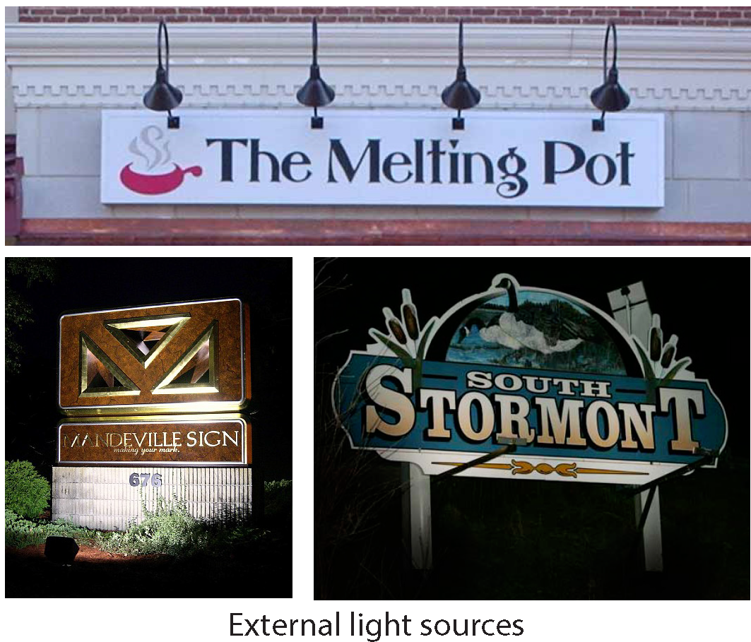
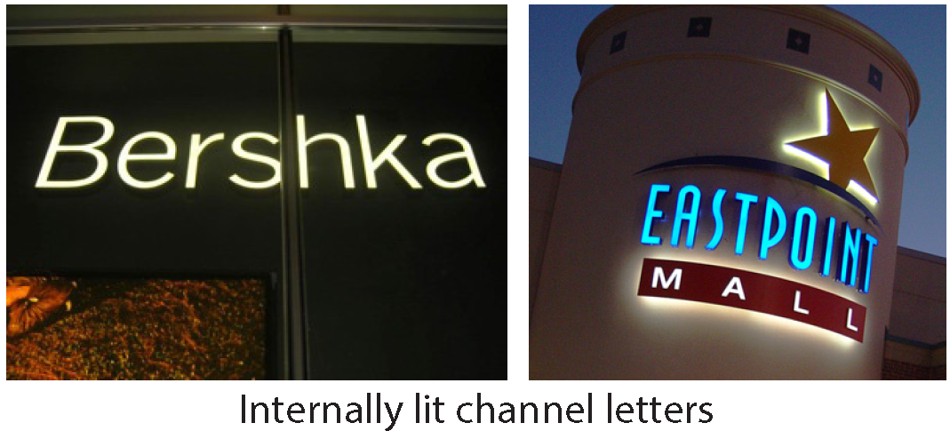

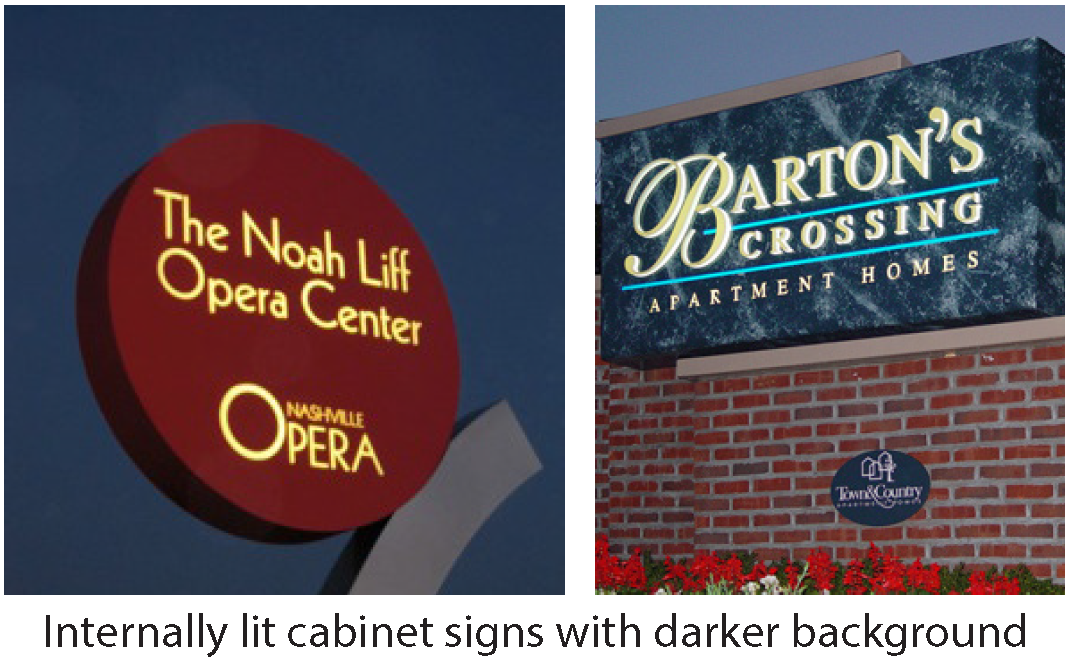
(d)
External Illumination.
(1)
Lighting directed toward a sign must be shielded so that it illuminates only the face of the sign and does not shine directly onto public right-of-way or adjacent properties. External lighting of signs in the RT, R-, MH and PD-H Districts is permitted if illumination levels are low and all fixtures are concealed.
(2)
Flood lights or spotlights near the top of a sign must be focused downward onto the sign. Floodlights or spotlights must be aimed such that the entire beam falls within the intended area of the sign to be lit.
(j)
Raceways and Transformers.
(1)
If a raceway is necessary, it must not extend in width or height beyond the area of the sign.
(2)
Raceways must be finished to match the background wall or canopy, or integrated into the overall design of the sign.
(3)
Visible transformers are not permitted.
5.14.12 Definitions.
(a)
Premises: A building together with its immediate and adjacent grounds.
(b)
Sign: Sign: Any device, structure, fixture, painting, or visual image using words, graphics, symbols, numbers, or letters designed and used for the purpose of attracting attention or communicating a readable, comprehensive, legible message. Signs may not contain obscenity as defined in N.C.G.S. Sec. 14-190.1 [2]
(c)
Sign, Commercial Message: A sign that conveys a message of a commercial nature including commercial activity, content, commodity, service, entertainment, product, transaction, use, or advertising for any business.
(d)
Sign, Non-Commercial Message: A sign which has no commercial content, but instead involves only the expression of ideals opinions, or beliefs.
(e)
Temporary Sign: A sign with or without a structural frame, not permanently attached to a building, structure, or ground and intended for a limited period of display.
5.14.13 Guidelines for Administrative Adjustment of Signage Regulations.
Intent: The intent of permitting the administrative adjustment of the Sign Ordinance standards is to provide for flexibility that is compatible with the Town of Chapel Hill's character; to acknowledge the artistic creativity of sign makers, business owners, and individuals; to create visual harmony between the sign, structure, and site where the sign is located; and to enhance retail areas consistent with the Chapel Hill 2020 Comprehensive Plan and subsequent small area plans, development agreements, and form-based district codes.
(a)
Adjustment Applications: Adjustment applications shall be made on forms available from the Development Services Center. An application shall consist of a completed application form; any necessary supporting documentation such as plot plans, building elevations, photographs or other information; and an application fee.
(b)
Review: Adjustment applications shall be reviewed by the Director of Planning and Development Services and Development Services Center staff. Applications are available for public review and comment.
(c)
Approval Criteria: The standards in this chapter may be adjusted administratively when the Director of Planning and Development Services determines all the following criteria are met:
(1)
The intent of the Sign Ordinance is better achieved with the administrative adjustment than by other alternatives allowed by this section;
(2)
Sufficient reason is shown for the adjustment in order to address exceptional or extraordinary circumstances or conditions applicable to the property involved (including topographical issues), or intended use of the property, that are not contemplated or provided for by this chapter;
(3)
The modification is compatible with the scale, character, and design of the building in which the use is located;
(4)
The modification is compatible with the scale, character, design and lighting of the adjacent neighborhood or focus area;
(5)
The modification is consistent with the purpose of this chapter and would not adversely affect the neighborhood in which the business is located; and
(6)
The modification is within the standards identified in the table below.
(Ord. No. 2007-02-26/O-3a, §§ 7, 8; Ord. No. 2007-02-26/O-5, §§ 11—13; Ord. No. 2011-04-25/O-3, §§ 1, 2; Ord. No. 2016-06-27/O-11, § I; Ord. No. 2016-12-05/O-5, § I; Ord. No. 2020-10-28/O-10, § 15; Ord. No. 2020-11-04/O-1, § 1)
* http://www.ncga.state.nc.us/enactedlegislation/statutes/html/bysection/chapter_14/gs_14-190.1.html
5.15. - Performance standards during construction.
5.15.1. Applicability.
The provisions of this section apply to any special use permit, subdivision plat, site plan review approval, or zoning compliance permit.
5.15.2. Criteria.
All development subject to subsection 5.15.1, above, shall comply with the following standards during the construction process:
(a)
The applicant shall comply with the Noise Control Code for the Town of Chapel Hill (chapter 11, article III of the Town Code of Ordinances).
(b)
The applicant shall comply with the stormwater management standards, section 5.4 of this appendix.
(c)
The applicant shall comply with the town's erosion and sedimentation control standards, section 5.3.1 of this appendix and article 5 of chapter 5 of the Town Code of Ordinances.
(d)
All filling, grading, dredging and other development shall occur only on the property subject to the application unless otherwise required by the conditions of approval.
(e)
No construction or development shall occur that interferes with the use of a recorded easement.
(f)
Bicycle and pedestrian systems shall be maintained during construction activities.
5.15.3. Penalties for Violation.
If the town manager determines that the applicant is in violation of any of the standards set forth in subsection 5.15.2 above, the applicant shall be subject to section 4.13 of this appendix. The town manager may revoke the zoning compliance permit, site plan review, or special use permit until the site subject to the application, or any contiguous property affected by a violation of this section, is restored to its state prior to the violation. The applicant may appeal the decision of the town manager pursuant to section 4.10 of this appendix.
5.16. - Adequate public school facilities.
5.16.1. Intent and Scope.
The purpose of this article is to ensure that, to the maximum extent practical, new residential development occurring in the Orange County portion of Chapel Hill's zoning/subdivision regulation jurisdiction will be approved only when it can reasonably be expected that adequate public school facilities will be available to accommodate such new development. This article shall apply in those portions of the Town of Chapel Hill and its zoning jurisdiction in Orange County.
5.16.2. Findings and Purposes.
The town council does hereby find that:
a)
The portion of Orange County served by the Chapel Hill/Carrboro school system has for the past decade been experiencing rapid growth in population; and
b)
This rapid growth, and that which is anticipated, creates a demand for additional school facilities to accommodate the children who reside within new developments; and
c)
The responsibility for planning for and constructing new school facilities lies primarily with the Chapel Hill/Carrboro School Board, with funding provided by Orange County; and
d)
Chapel Hill, Carrboro, Orange County and the Chapel Hill/Carrboro School Board have recognized the need to work together to ensure that new growth within the school district occurs at a pace that allows Orange County and the school district to provide adequate school facilities to serve children within such new developments; and
e)
To implement the Memorandum of Understanding between Orange County, Chapel Hill, Carrboro, and the Chapel Hill/Carrboro School Board, the Chapel Hill Town Council desires to provide a mechanism to assure that, to the extent possible, new development will take place only when there are adequate public school facilities available, or planned, which will accommodate such new development.
5.16.3. Certificate of Adequacy of Public School Facilities.
(a)
No application for approval of a subdivision preliminary plat, zoning compliance permit, minor subdivision final plat, zoning compliance permit for site plan review, zoning compliance permit for special use permit, zoning compliance permit for special use permit major modification for a project containing a residential use, or for a zoning compliance permit for a conditional zoning district containing residential uses may be approved unless on the date of such approval there exists a valid and current certificate of adequacy of public school facilities applicable to the project for which such approval is sought.
(b)
A certificate of adequacy of public school facilities shall not be required for a conventional rezoning, a conditional zoning district or for approval of a master land use plan. However, if a rezoning or master plan is approved, a certificate of adequacy of public school facilities shall be required before any residential development of the property is authorized pursuant to any of the approvals specified in subsection (a) of the section, and the rezoning of the property or approval of a master plan provides no indication as to whether the certificate of adequacy of public school facilities will be issued. The application for rezoning or master plan approval shall contain a statement to this effect.
(c)
A certificate of adequacy of public school facilities must be obtained from the school district. The school district will issue or deny a certificate of adequacy of public school facilities in accordance with the provisions of a memorandum of understanding between Chapel Hill, Carrboro, Orange County, and the Chapel Hill/Carrboro School District.
(d)
An applicant shall seek from the school district a certificate of adequacy of public school facilities for a proposed residential development before an application for approval of a zoning compliance permit for a subdivision preliminary plat application, minor subdivision final plat, zoning compliance permit for a site plan review application, zoning compliance permit for a special use permit, zoning compliance permit for a special use permit modification, or for a zoning compliance permit for a conditional zoning district containing residential uses is submitted to the town. The certificate of adequacy of public school facilities, if issued, shall expire as provided in section 16.5.
(e)
A certificate of adequacy of public school facilities attaches to the land in the same way that development permission attaches to the land. A certificate of adequacy of public school facilities may be transferred along with other interests in the property with respect to which such certificate of adequacy of public school facilities is issued, but may not be severed or transferred separately.
5.16.4. Service Levels.
As provided in the memorandum of understanding between Orange County, Chapel Hill, Carrboro, and the Chapel Hill/Carrboro School District, adequate service levels for public schools shall be deemed to exist with respect to a proposed new residential development if, given the number of school age children projected to reside in that development, and considering all the factors listed in the memorandum of understanding, the number of students projected to attend the elementary schools, the middle schools, and the high school[s] within the Chapel Hill/Carrboro School District will not exceed the following percentages of the building capacities of each of the following three school levels:
For purposes of this article, the term "building capacity" means the capacity of permanent buildings, not mobile units or trailers, and shall be determined as provided in the adequate public school facilities memorandum of understanding among the towns of Chapel Hill and Carrboro, and Orange County and the Chapel Hill/Carrboro Board of Education.
These percentages are currently in the memorandum of understanding. These percentages may be adjusted by mutual agreement of parties to the memorandum of understanding by an amendment thereto.
5.16.5. Expirations of Certificates of Adequacy of Public School Facilities.
(a)
A certificate of adequacy of public school facilities that has been obtained pursuant to subsection 16.3(d) before an application for approval of a subdivision preliminary plat, minor subdivision final plat, site plan, special use permit, special use permit major modification, or for a conditional zoning district containing residential uses has been submitted shall expire unless the developer submits and the town accepts as complete an application for approval of that subdivision preliminary plat, minor subdivision final plat, site plan, special use permit, special use permit major modification, or for a conditional zoning district containing residential uses within ninety (90) days of the date of the certificate of adequacy of public school facilities and receives the requested approval within two (2) years of the date of the certificate of adequacy of public school facilities.
(b)
A certificate of adequacy of public school facilities issued in connection with approval of a subdivision preliminary plat, minor subdivision final plat, site plan, special use permit, special use permit modification, or for a conditional zoning district containing residential uses shall expire automatically upon the expiration or such approval.
5.16.6. Exemption From Certification Requirement for Development with Negligible Student Generation Rates.
A certificate of adequacy of public school facilities shall not be required under the following circumstances:
(a)
For residential development permanently restricted to dormitory-style housing for university students.
(b)
For a residential development permanently restricted by law and/or covenant to housing for the elderly and/or adult care living and/or adult special needs.
5.16.7. Applicability to Previously Approved Projects and Projects Pending Approval.
(a)
Except as otherwise provided herein, the provisions of this article shall apply to applications for approval of subdivision preliminary plat, site plans, special use permit, and special use permit modification that are submitted for approval after the effective date of this article.
(b)
The provisions of this article shall apply to subdivision preliminary plats, site plans, special use permits and special use permit modifications that have expired.
(c)
The provisions of this article shall not apply to minor modifications to subdivision preliminary plat, site plan, special use permit, or special use permit major modification approvals issued prior to the effective date of this article so long as the approvals have not expired and the proposed minor modifications do not increase the number of dwelling units authorized within the development by more than five (5) percent or five (5) dwelling units, whichever is less."
(d)
The town council shall issue an exception to the certificate of adequacy of public school facilities requirement to an applicant whose application for approval of a subdivision preliminary plat, minor subdivision final plat, site plan, special use permit or special use permit modification covering property within a planned development or master plan project that was approved prior to the effective date of this article, if the town council finds, after an evidentiary hearing, that the applicant has (1) applied to the school district for a certificate of adequacy of public school facilities and the application has been denied, (2) in good faith made substantial expenditures or incurred substantial binding obligations in reasonable reliance on the previously obtained preliminary plat approval, planned development or master plan approval, and (3) would be unreasonably prejudiced if development in accordance with the previously approved development or plan is delayed due to the provisions of this ordinance. In deciding whether these findings can be made, the town council shall consider the following, among other relevant factors:
(1)
Whether the developer has installed streets, utilities, or other facilities or expended substantial sums in the planning and preparation for installation of such facilities which were designed to serve or to be paid for in part by the development of portions of the preliminary plat, planned development or master planned project that have not yet been approved for construction;
(2)
Whether the developer has installed streets, utilities, or other facilities or expended substantial sums in the planning and preparation for installation of such facilities that directly benefit other properties outside the development in question or the general public;
(3)
Whether the developer has donated land to the School District for the construction of school facilities or otherwise dedicated land or made improvements deemed to benefit the School District and its public school system;
(4)
Whether the developer has had development approval for a substantial amount of time and has in good faith worked to timely implement the plan in reasonable reliance on the previously obtained approval;
(5)
The duration of the delay that will occur until public school facilities are improved or exist to such an extent that a Certificate of Adequacy of Public School Facilities can be issued for the project, and the effect of such delay on the development and the developer.
The decision of the town council is subject to review by the Orange County Superior Court by proceedings in the nature of certiorari. Any petition for review by the superior court shall be filed with the clerk of superior court within thirty (30) days after a written copy of the decision of the town council is delivered to every aggrieved party who has filed a written request for such copy with the clerk to the town council at the time of its evidentiary hearing on the application for an exception. The written copy of the decision of the town council may be delivered to the aggrieved party either by personal service or by certified mail, return receipt requested.
The mayor of the town or any member temporarily acting as mayor may, in his or her official capacity, administer oaths to witnesses in any evidentiary hearing before the town council concerning an exception.
5.16.8. Appeal of School District Denial of a Certificate of Adequacy of Public School Facilities.
The applicant for a certificate of adequacy of public school facilities which is denied by the school district may, within thirty (30) days of the date of the denial, appeal the denial to the town council of Chapel Hill. Any such appeal shall be heard by the town council at an evidentiary hearing before it. At this evidentiary hearing the school district will present its reasons for the denial of the certificate of adequacy of public school facilities and the evidence it relied on in denying the certificate of adequacy of public school facilities. The applicant appealing the denial may present its reasons why the certificate of adequacy of public school facilities application should have, in its view, been approved and the evidentiary basis it contends supports approval. The town council may (1) affirm the decision of the school district, (2) remand to the school district for further proceedings in the event evidence is presented at the evidentiary hearing before the town council not brought before the school district, or (3) issue a certificate of adequacy of public school facilities. The town council will only issue a certificate of adequacy of public school facilities if it finds that the certificate of adequacy of public school facilities certificate of adequacy of public school facilities should have been issued by the school district as prescribed in the memorandum of understanding among the school district, Orange County and Chapel Hill. A decision of the town council affirming the school district may be appealed by the applicant for a certificate of adequacy of public school facilities by proceedings in the nature of certiorari and as prescribed for an appeal under section 16.7(d) of this article.
5.16.9. Information Required From Applicants.
The applicant for a certificate of adequacy of public school facilities shall submit to the school district all information reasonably deemed necessary by the school district to determine whether a certificate of adequacy of public school facilities should be issued under the provisions of the memorandum of understanding between Chapel Hill, Orange County, and the school district. An applicant for a certificate of adequacy of public school facilities exception or an applicant appealing a certificate of adequacy of public school facilities denial by the school district shall submit to the town council all information reasonably deemed necessary by the town manager to determine whether an exception should be granted as provided in section 16.7(d) of this article or for the evidentiary hearing of an appeal of a school district denial of a certificate of adequacy of public school facilities as provided in section 16.8 of this article. A copy of a request for a certificate of adequacy of public school facilities exception or of an appeal of a school district denial of a certificate of adequacy of public school facilities shall be served on the superintendent of the school district. Service may be made by personal delivery or certified mail, return receipt requested.
(Ord. No. 2003-02-10/O-1, § 1; Ord. No. 2021-05-19/O-1, §§ 91—96)
5.17. - Prevention of demolition by neglect.
5.17.1. Intent.
The purpose of this ordinance is to protect Chapel Hill's historic architectural resources by intervening when a significant resource is undergoing demolition by neglect.
Demolition by neglect is defined as a situation in which a property owner, or others having legal possession, custody or control of a property, allow the condition of property located in a Historic District to suffer such deterioration, potentially beyond the point of repair, as to threaten the structural integrity of the structure or its relevant architectural detail to a degree that the structure and its character may potentially be lost to current and future generations.
5.17.2. Control of demolition by neglect of structures within designated Historic Districts.
(a)
In order to promote the purposes of historic preservation, this subsection requires that owners of historic properties maintain their properties and not allow them to fall into disrepair. The requirements of this subsection are applicable only to properties in the Historic Districts of Chapel Hill.
(b)
Conditions of neglect defined and prohibited.
Owners or others having legal possession, custody or control of a property in Historic Districts shall maintain or cause to be maintained the exterior and structural features of their properties and not allow conditions of neglect to occur on such properties. It is a violation of the Town's Land Use Management Ordinance to not remedy a condition of neglect within the period of time set by a final administrative determination, as described in Section 5.17.2(c), below.
Conditions of neglect include, but are not limited to, the following:
(1)
Deterioration of exterior walls, foundations, or other vertical support that causes leaning, sagging, splitting, listing, or buckling.
(2)
Deterioration of flooring or floor supports, roofs, or other horizontal members that causes leaning, sagging, splitting, listing, or buckling.
(3)
Deterioration of external chimneys that causes leaning, sagging, splitting, listing, or buckling.
(4)
Deterioration or crumbling of exterior plasters or mortars.
(5)
Ineffective waterproofing of exterior walls, roofs, and foundations, including broken windows or doors.
(6)
Defective protection or lack of weather protection for exterior wall and roof coverings, including lack of paint, or weathering due to lack of paint or other protective covering.
(7)
Rotting, holes, and other forms of decay.
(8)
Deterioration of exterior stairs, porches, handrails, window and door frames, cornices, entablatures, wall facings, and architectural details that causes delamination, instability, loss of shape and form, or crumbling.
(9)
Deterioration that has a detrimental effect on the surrounding historic district.
(10)
Deterioration that contributes to a hazardous or unsafe condition.
(c)
Procedure for enforcement.
Enforcement of these provisions shall be undertaken as described in section 4.13 of the Land Use Management Ordinance ("Violations and Penalties"), with the following additional components:
(i)
If the town manager makes a preliminary determination that a property in a historic district is being neglected, as defined in subsection 5.17.2(b), the manager shall inform the property owner of the preliminary determination and notify the historic district commission of the preliminary determination. The town manager will seek remedial action by the property owner.
(ii)
If remedial action has not commenced within thirty (30) days of initial notification, the town manager, after consultation with the historic district commission, shall make a finding of violation of the Land Use Management Ordinance. Procedures outlined in section 4.13 shall be followed, including notification of right to and process for appeal as described in section 4.12.
5.17.3. Variances for Undue Economic Hardship.
Where a determination made under the provisions of this section would, in any particular case, cause undue economic hardship to a property owner, the board of adjustment shall grant such variance as it deems necessary to eliminate that undue economic hardship. A property owner shall be required to demonstrate, through competent substantial evidence, the existence of undue economic hardship. Evidence of such hardship may include, by way of illustration: An appraisal of the property before and after the proposed renovation or repair; and the estimated cost of the repair in relation to such appraisals.
5.17.4. Stay of Proceedings.
Issuance of an approved certificate of appropriateness for improvements, accompanied by actions to bring the property into compliance with this section, will stay an enforcement proceeding seeking compliance with this section for said property.
5.17.5. Other Town Powers.
Nothing contained within this article shall diminish the town's power to declare an unsafe building or a violation of the minimum housing code.
(Ord. No. 2005-02-14/O-9a, § 1)
5.18 - Jordan watershed riparian buffer protection.
5.18.1 Authority.
This section is adopted pursuant to the authority vested in the Town of Chapel Hill by the Session Laws and the General Statutes of North Carolina, particularly Session Law 2009-216 (House Bill 239), Session Law 2009-484 (Senate Bill 838), and the authority referenced in section 1.2 of this ordinance.
5.18.2 Purpose and Intent.
The purpose of this section is to protect and preserve existing riparian buffers throughout the Jordan Watershed as generally described in 15A North Carolina Administrative Code 2B.0262 in order to maintain their nutrient removal and stream protection functions. Additionally this section will help protect the water supply uses of Jordan Reservoir.
Buffers adjacent to streams provide multiple environmental protection and resource management benefits. Forested buffers enhance and protect the natural ecology of stream systems, as well as water quality through bank stabilization, shading, and nutrient removal. They also help to minimize flood damage in floodprone areas. Well-vegetated streamside riparian areas help to remove nitrogen and prevent sediment and sediment-bound pollutants such as phosphorous from reaching the streams.
5.18.3 Definitions.
The definitions in appendix A of this ordinance shall apply to this section except as modified herein:
Access trails means pedestrian trails constructed of pervious or impervious surfaces and related structures to access a surface water, including boardwalks, steps, rails, and signage.
Airport facilities means all properties, facilities, buildings, structures, and activities that satisfy or otherwise fall within the scope of one (1) or more of the definitions or uses of the words or phrases "air navigation facility", "airport", or "airport protection privileges" under G.S. 63-1; the definition of "aeronautical facilities" in G.S. 63-79(1); the phrase "airport facilities" as used in G.S. 159-48(b)(1); the phrase "aeronautical facilities" as defined in G.S. 159-81 and G.S. 159-97; and the phrase "airport facilities and improvements" as used in Article V, Section 13, of the North Carolina Constitution, which shall include, without limitation, any and all of the following: airports, airport maintenance facilities, clear zones, drainage ditches, fields, hangars, landing lighting, airport and airport-related offices, parking facilities, related navigational and signal systems, runways, stormwater outfalls, terminals, terminal shops, and all appurtenant areas used or suitable for airport buildings or other airport facilities, and all appurtenant rights-of-way; restricted landing areas; any structures, mechanisms, lights, beacons, marks, communicating systems, or other instrumentalities or devices used or useful as an aid, or constituting an advantage or convenience to the safe taking off, navigation, and landing of aircraft, or the safe and efficient operation or maintenance of an airport or restricted landing area; easements through, or interests in, air space over land or water, interests in airport hazards outside the boundaries of airports or restricted landing areas, and other protection privileges, the acquisition or control of which is necessary to ensure safe approaches to the landing areas of airports and restricted landing areas, and the safe and efficient operation thereof and any combination of any or all of such facilities. Notwithstanding the foregoing, the following shall not be included in the definition of "airport facilities":
(1)
Satellite parking facilities;
(2)
Retail and commercial development outside of the terminal area, such as rental car facilities; and
(3)
Other secondary development, such as hotels, industrial facilities, freestanding offices and other similar buildings, so long as these facilities are not directly associated with the operation of the airport, and are not operated by a unit of government or special governmental entity such as an airport authority, in which case they are included in the definition of "airport facilities".
Channel means a natural water-carrying trough cut vertically into low areas of the land surface by erosive action of concentrated flowing water or a ditch or canal excavated for the flow of water.
Commission means the North Carolina Environmental Management Commission.
Diameter at breast height (DBH) means the diameter of a tree measured at four and one-half (4.5) feet above the ground surface level.
Development means any land disturbing activity which adds to or changes the amount of impervious or partially impervious cover on a land area or which otherwise decreases the infiltration of precipitation into the soil.
Director means the Director of the North Carolina Department of Environment and Natural Resources' Division of Water Quality.
Ditch or canal means a manmade channel other than a modified natural stream constructed for drainage purposes that is typically dug through inter-stream divide areas. A ditch or canal may have flows that are perennial, intermittent, or ephemeral and may exhibit hydrological and biological characteristics similar to perennial or intermittent streams.
Division means the North Carolina Department of Environment and Natural Resources' Division of Water Quality or its successor.
Ephemeral stream means a feature that carries only stormwater in direct response to precipitation with water flowing only during and shortly after large precipitation events. An ephemeral stream may or may not have a well-defined channel, the aquatic bed is always above the water table, and stormwater runoff is the primary source of water. An ephemeral stream typically lacks the biological, hydrological, and physical characteristics commonly associated with the continuous or intermittent conveyance of water.
Existing development means development, other than that associated with agricultural or forest management activities, that meets one of the following criteria:
(1)
It either is built or has established a vested right based on statutory or common law as interpreted by the courts, for projects that do not require a state permit, as of the effective date of either local new development stormwater programs implemented under 15A NCAC 2B.0265 or, for projects requiring a state permit, as of the applicable compliance date established in 15A NCAC 2B.0271 (5) and (6); or
(2)
It occurs after the compliance date set out in Sub-Item (4)(d) of 15A NCAC 2B.0265 but does not result in a net increase in built-upon area.
Greenway/hiking trails means pedestrian trails constructed of pervious or impervious surfaces and related structures including but not limited to boardwalks, steps, rails, and signage, and that generally run parallel to the shoreline.
High value tree means a tree that meets or exceeds the following standards: for pine species, 14-inch DBH or greater or 18-inch or greater stump diameter; or for hardwoods and wetland species, 16-inch DBH or greater or 24-inch or greater stump diameter.
Intermittent stream means a well-defined channel that contains water for only part of the year, typically during winter and spring when the aquatic bed is below the water table. The flow may be heavily supplemented by stormwater runoff. An intermittent stream often lacks the biological and hydrological characteristics commonly associated with the continuous conveyance of water.
Jordan Nutrient Strategy or Jordan Water Supply Nutrient Strategy means the set of rules in 15A NCAC 2B.0262 through .0273 and .0311(p).
Jordan Reservoir means the surface water impoundment operated by the U.S. Army Corps of Engineers and named B. Everett Jordan Reservoir, as further delineated for purposes of the Jordan nutrient strategy in 15A NCAC 2B.0262(4).
Jordan watershed means all lands and waters draining to B. Everett Jordan Reservoir.
New development means any development project that does not meet the definition of existing development set out in this section.
Perennial stream means a well-defined channel that contains water year-round during a year of normal rainfall with the aquatic bed located below the water table for most of the year. Groundwater is the primary source of water for a perennial stream, but it also carries stormwater runoff. A perennial stream exhibits the typical biological, hydrological, and physical characteristics commonly associated with the continuous conveyance of water.
Perennial waterbody means a natural or man-made basin, including lakes, ponds, and reservoirs, that stores surface water permanently at depths sufficient to preclude growth of rooted plants. The waterbody must be part of a natural drainage way. A waterbody is part of a natural drainage way when it is fed by an intermittent or perennial stream or when it has a direct discharge point to an intermittent or perennial stream.
Shoreline stabilization is the in-place stabilization of an eroding shoreline. Stabilization techniques which include "soft" methods or natural materials (such as root wads, or rock vanes) may be considered as part of a restoration design. However, stabilization techniques that consist primarily of "hard" engineering, such as concrete lined channels, riprap, or gabions, while providing bank stabilization, shall not be considered stream restoration.
Stream restoration is defined as the process of converting an unstable, altered or degraded stream corridor, including adjacent riparian zone and floodprone areas to its natural or referenced, stable conditions considering recent and future watershed conditions. This process also includes restoring the geomorphic dimension, pattern, and profile as well as biological and chemical integrity, including transport of water and sediment produced by the stream's watershed in order to achieve dynamic equilibrium.
Referenced or referenced reach means a stable stream that is in dynamic equilibrium with its valley and contributing watershed. A reference reach can be used to develop natural channel design criteria for stream restoration projects.
Stream means a body of concentrated flowing water in a natural low area or natural channel on the land surface.
Stump diameter means the diameter of a tree measured at six (6) inches above the ground surface level.
Surface waters means all waters of the state as defined in G.S. 143-212 except underground waters.
Tree means a woody plant with a DBH equal to or exceeding five (5) inches or a stump diameter exceeding six (6) inches.
Temporary road means a road constructed temporarily for equipment access to build or replace hydraulic conveyance structures such as bridges, culverts, pipes or water dependent structures, or to maintain public traffic during construction.
5.18.4 Applicability.
This section applies to all landowners and other persons conducting activities in the area described in section 1.4. The N.C. Division of Water Quality shall administer the requirements of 15A NCAC 02B.0267 and .0268 for activities conducted by the entities not subject to this section.
5.18.5 Relation to Other Ordinances.
The requirements of this section shall supersede requirements of subsection 3.6.4(f). If the provisions of this section otherwise conflict with other provisions of this ordinance, the most stringent provisions shall control. This section is not intended to interfere with, abrogate, or annul any other ordinance, rule, regulation, or other provision of law.
Parties subject to this section shall abide by all state rules and laws regarding waters of the state including, but not limited to, 15A NCAC 2B.0230 and .0231, 15A NCAC 2H.0500, 15A NCAC 2H.1300, and Sections 401 and 404 of the Federal Water Pollution Control Act.
5.18.6 Riparian Area Protection.
(a)
Riparian buffer zones. The protected riparian buffer shall have two (2) zones as follows:
(1)
Zone One shall consist of a vegetated area that is undisturbed except for uses and activities provided for in subsection 5.18.7(b). The location of Zone One shall be as follows:
A.
For intermittent and perennial streams, Zone One shall begin at the top of the bank and extend landward a distance of thirty (30) feet on all sides of the surface water, measured horizontally on a line perpendicular to a vertical line marking the top of the bank.
B.
For perennial waterbodies located within a natural drainage way, Zone One shall begin at the normal pool elevation and extend landward a distance of thirty (30) feet, measured horizontally on a line perpendicular to a vertical line marking the normal pool elevation.
(2)
Zone Two shall consist of a stable, vegetated area that is undisturbed except for uses and activities provided for in subsection 5.18.7(b). Grading and revegetating in Zone Two is allowed provided that the health of the vegetation in Zone One is not compromised. Zone Two shall begin at the outer edge of Zone One and extend landward twenty (20) feet as measured horizontally on a line perpendicular to the surface water. The combined width of Zones One and Two shall be fifty (50) feet on all sides of the surface water.
(b)
[Minimum criteria.] The following minimum criteria shall be used for identifying protected riparian areas:
(1)
This section shall apply to uses in or activities conducted within, or outside of with hydrological impacts in violation of the diffuse flow requirements set out in subsection 5.18.6(c) upon, fifty-foot-wide riparian buffers directly adjacent to intermittent streams, perennial streams and perennial waterbodies, excluding wetlands.
(2)
Wetlands adjacent to, or within fifty (50) feet of, intermittent streams, perennial streams and perennial waterbodies shall be considered as part of the riparian buffer but are regulated pursuant to 15A NCAC 2B.0230 and .0231, 15A NCAC 2H.0500, 15A NCAC 2H.1300, and Sections 401 and 404 of the Federal Water Pollution Control Act.
(3)
An intermittent stream, perennial stream or perennial waterbody shall be subject to these requirements if it is approximately shown on one of the following maps:
A.
The most recent hard copy paperbound version of the soil survey map prepared by the Natural Resources Conservation Service of the United States Department of Agriculture.
B.
The most recent version of the 1:24,000 scale (seven and one-half (7.5) minutes) quadrangle topographic maps prepared by the United States Geologic Survey (U.S.G.S.).
C.
A map approved by the Geographic Information Coordinating Council and by the N.C. Environmental Management Commission. Prior to approving a map, the commission is required to provide a thirty-day public notice and opportunity for comment.
(4)
Waterbodies subject to this section shall be subject to field verification by the town manager. Where it is believed the map has inaccurately depicted surface waters or the origination point of a stream is in question, the town manager shall make an onsite determination upon written request by the landowner, the division, or other affected party. A town representative who has successfully completed the division's surface water identification training certification course, its successor, or other equivalent training curriculum approved by the division, shall verify the location of the waterbody or origination point using the latest version of the division publication, Identification Methods for the Origins of Intermittent and Perennial Streams. Any disputes about onsite determinations made according to this subsection shall be referred to the director of the division, in writing.
Surface waters that appear on the maps shall not be subject to these buffer requirements if an onsite determination reveals any of the following cases:
A.
Manmade ponds and lakes that are not part of a natural drainage way that is classified in accordance with 15A NCAC 2B.0100, including ponds and lakes created for animal watering, irrigation, or other agricultural uses.
B.
Ephemeral streams.
C.
The absence on the ground of a corresponding intermittent or perennial stream, or perennial waterbody.
D.
Ditches or other manmade water conveyances, other than modified natural streams.
(c)
Diffuse flow requirements.
(1)
Diffuse flow of runoff shall be maintained in the riparian buffer by dispersing concentrated flow prior to its entry into the buffer and reestablishing vegetation.
(2)
Concentrated runoff from new ditches or manmade conveyances shall be converted to diffuse flow at non-erosive velocities before the runoff enters Zone Two of the riparian buffer.
(3)
Periodic corrective action to restore diffuse flow shall be taken as necessary and shall be designed to impede the formation of erosion gullies.
(4)
No new stormwater conveyances are allowed through the buffer except for those specified subsection 5.18.7(b), Table of Uses, addressing stormwater management ponds, drainage ditches, roadside ditches, and stormwater conveyances.
(d)
Exemptions for existing and ongoing uses and activities. This section shall not apply to uses and activities that are existing and ongoing; however, this section shall apply at the time an existing and ongoing use or activity is changed. A change of use or activity shall involve the initiation of any use or activity that does not meet either of the following criteria:
(1)
It was an existing and ongoing use or activity within the riparian buffer as of the effective date of this section and has continued since that time. Such uses shall include, but may not be limited to, agriculture, buildings, industrial facilities, commercial areas, transportation facilities, maintained lawns, utility lines and on-site sanitary sewage systems, any of which involve either specific, periodic management of vegetation or displacement of vegetation by structures or regular activity. Only the portion of the riparian buffer occupied by the footprint of the existing use is exempt from this section. Change of ownership through purchase or inheritance is not a change of use. Activities necessary to maintain uses are allowed provided that the site remains similarly vegetated, no impervious surface is added within 50 feet of the surface water where it did not previously exist as of the effective date of this section, and existing diffuse flow is maintained.
(2)
Project or proposed development that is determined by the town manager to meet at least one of the following criteria:
A.
Project or proposed development requires a State 401 Certification and Federal 404 Permit and the certification and permit were issued prior to the effective date this section;
B.
Project or proposed development, such as landfills, NPDES wastewater discharges, land application of residuals and road construction activities, requires a state permit, has begun construction or is under contract to begin construction and has received all required state permits and certifications prior to the effective date of this section;
C.
Project or proposed development is being reviewed through the Clean Water Act Section 404/National Environmental Policy Act Merger 01 Process (published by the U.S. Army Corps of Engineers and Federal Highway Administration, 2003) or its immediate successor and the applicant has reached agreement with the department of environment natural resources on avoidance and minimization by the effective date of this section; or
D.
Project or proposed development is not required to be reviewed by the Clean Water Act Section 404/National Environmental Policy Act Merger 01 Process (published by the U.S. Army Corps of Engineers and Federal Highway Administration, 2003) or its immediate successor if a finding of no significant impact has been issued for the project and the project has the written approval of the town manager prior to the effective date of this section.
5.18.7 Requirements for Uses and Activities.
(a)
Uses and activities designated in subsection 5.18.7(b) as exempt, allowable, and allowable with mitigation within a riparian buffer shall have the following requirements:
(1)
Exempt. Uses and activities designated as exempt are permissible without authorization by the town provided that they adhere to the limitations of the use or activity as defined in subsection 5.18.7(b), and a notice of exemption has been submitted to the town prior to beginning the activity. In addition, exempt uses shall be designed, constructed and maintained to minimize soil disturbance and to provide the maximum water quality protection practicable, including construction, monitoring, and maintenance activities.
(2)
Allowable. Uses and activities designated as allowable may proceed provided that there are no practical alternatives to the requested use pursuant to in subsection 5.18.8(c). This includes construction, monitoring, and maintenance activities. These uses and activities require written authorization from the town manager.
(3)
Allowable with mitigation. Uses and activities designated as allowable with mitigation may proceed provided that there are no practical alternatives to the requested use pursuant to in subsection 5.18.8(c) and an appropriate mitigation strategy has been approved pursuant to in subsection 5.18.8(e). These uses and activities require written authorization from the town manager.
(b)
The following table sets out uses and activities within, or outside with impacts upon, the buffer and categorizes them as exempt, allowable, or allowable with mitigation. All uses and activities not categorized as exempt, allowable, or allowable with mitigation are prohibited and may not proceed within the riparian buffer or outside the buffer if the use would impact the buffer, unless a variance is granted pursuant to subsection 5.18.8(d).
* To qualify for the designation indicated in the column header, a use or activity must adhere to the limitations defined for it in a given listing as well as the requirements established in subsection 5.18.7(a).
1 Provided that:
• No heavy equipment is used in Zone One.
• Vegetation in undisturbed portions of the buffer is not compromised.
• Felled trees are removed by chain.
• No permanent felling of trees occurs in protected buffers or streams.
• Stumps are removed only by grinding.
• At the completion of the project the disturbed area is stabilized with native vegetation.
• Zones One and Two meet the requirements of subsections 5.18.6(a) and 5.18.6(c).
2 Provided that, in Zone One, all of the following BMPs for overhead utility lines are used. If all of these BMPs are not used, then the overhead utility lines shall require a no practical alternative evaluation by the town, as defined in subsection 5.18.8(c).
• A minimum zone of ten (10) feet wide immediately adjacent to the water body shall be managed such that only vegetation that poses a hazard or has the potential to grow tall enough to interfere with the line is removed.
• Woody vegetation shall be cleared by hand. No land grubbing or grading is allowed.
• Vegetative root systems shall be left intact to maintain the integrity of the soil. Stumps shall remain where trees are cut.
• Riprap shall not be used unless it is necessary to stabilize a tower.
• No fertilizer shall be used other than a one-time application to re-establish vegetation.
• Construction activities shall minimize the removal of woody vegetation, the extent of the disturbed area, and the time in which areas remain in a disturbed state.
• Active measures shall be taken after construction and during routine maintenance to ensure diffuse flow of stormwater through the buffer.
• In wetlands, mats shall be utilized to minimize soil disturbance.
3 Provided that poles or aerial infrastructure shall not be installed within ten (10) feet of a water body unless the town completes a no practical alternative evaluation as defined in subsection 5.18.8(c).
4 Provided that, in Zone One, all of the following BMPs for underground utility lines are used. If all of these BMPs are not used, then the underground utility line shall require a no practical alternative evaluation by the town, as defined in subsection 5.18.8(c).
• Woody vegetation shall be cleared by hand. No land grubbing or grading is allowed.
• Vegetative root systems shall be left intact to maintain the integrity of the soil. Stumps shall remain, except in the trench where trees are cut.
• Underground cables shall be installed by vibratory plow or trenching.
• The trench shall be backfilled with the excavated soil material immediately following cable installation.
• No fertilizer shall be used other than a one-time application to re-establish vegetation.
• Construction activities shall minimize the removal of woody vegetation, the extent of the disturbed area, and the time in which areas remain in a disturbed state.
• Measures shall be taken upon completion of construction and during routine maintenance to ensure diffuse flow of stormwater through the buffer.
• In wetlands, mats shall be utilized to minimize soil disturbance.
5 Perpendicular crossings are those that intersect the surface water at an angle between seventy-five (75) degrees and one hundred five (105) degrees.
(Ord. No. 2012-04-30/O-4, § 1)
5.18.8 Procedures, Requirements, and Approvals.
(a)
No new clearing, grading, or development shall take place nor shall any new building permits be issued in violation of this section.
(b)
Approval for new development. The town manager shall issue an approval for new development only if the development application contains measures to avoid impacts to riparian buffers defined in subsection 5.18.6(b), or where the application indicates an impact to riparian buffers, it demonstrates that the applicant has done the following, as applicable:
(1)
Determined the activity is exempt from requirements of this section and a notice of exemption has been submitted to the town manager;
(2)
Received an authorization certificate from the town manager pursuant to subsection 5.18.8(c);
(3)
Received an approval from the town manager for a mitigation plan pursuant to subsection 5.18.8(e); and
(4)
Received a variance pursuant to subsection 5.18.8(d).
(c)
Authorization certificate and determination of no practical alternatives.
(1)
Except as otherwise specifically provided in this section, it shall be unlawful to undertake uses and activities designated as allowable or allowable with mitigation until the town manager has issued an authorization certificate for such uses and activities. Persons who wish to undertake uses and activities designated as allowable or allowable with mitigation shall submit a request for a "no practical alternatives" determination to the town manager. The applicant shall certify that the project meets all the following criteria for a determination of "no practical alternatives:"
A.
The basic project purpose cannot be practically accomplished in a manner that would better minimize disturbance, preserve aquatic life and habitat, and protect water quality;
B.
The use or activity cannot practically be reduced in size or density, reconfigured, modified or redesigned to better minimize disturbance, preserve aquatic life and habitat, and protect water quality; and
C.
Best management practices shall be used as necessary to minimize disturbance, preserve aquatic life and habitat, and protect water quality.
(2)
The applicant shall also submit at least the following information in support of his or her assertion of "no practical alternatives:"
A.
The name, address and phone number of the applicant;
B.
The nature of the use or activity to be conducted by the applicant;
C.
The location of the use or activity;
D.
A map of sufficient detail to accurately delineate the boundaries of the use or the land to be utilized in carrying out the activity, the location and dimensions of any disturbance in riparian buffers associated with the use or activity, and the extent of riparian buffers on the land;
E.
An explanation of why this plan for the use or activity cannot be practically accomplished, reduced or reconfigured to better minimize disturbance to the riparian buffer, preserve aquatic life and habitat and protect water quality; and
F.
Plans for any best management practices proposed to be used to control the impacts associated with the activity.
(3)
Within sixty (60) days of a submission that complies with subsection 5.18.8(c)(2), the town manager shall review the entire project and make a finding of fact as to whether the criteria in subsection 5.18.8(c)(1) have been met. A determination of "no practical alternatives" shall result in issuance of an authorization certificate. The town manager's failure to act within sixty (60) days shall be construed as a determination of "no practical alternatives" and an authorization certificate shall be issued to the applicant unless one of the following occurs:
A.
The applicant agrees, in writing, to a longer review period;
B.
The town manager determines that the applicant has failed to furnish requested information necessary for the town to render a decision;
C.
The final decision is to be made pursuant to hearing; or
D.
The applicant refuses access to his/her records or premises for the purpose of gathering information necessary for the town manager to render a decision.
(4)
The town manager may attach conditions to the authorization certificate that support the purpose, spirit and intent of this section.
(5)
Any appeals of determinations regarding authorization certificates shall be referred to the director of the division.
(d)
Variances.
(1)
Requirements for variances. Persons who wish to undertake uses and activities prohibited by this section may pursue a variance. The procedures for requesting a variance from the requirements of this section shall be as follows:
a.
For any variance request, the town board of adjustment shall make a finding of fact as to whether there are practical difficulties or unnecessary hardships that prevent compliance with the riparian buffer protection requirements. A finding of practical difficulties or unnecessary hardships shall require that the following conditions are met:
If the applicant complies with the provisions of this section, he or she can secure no reasonable return from, nor make reasonable use of, his or her property. Merely proving that the variance would permit a greater profit from the property shall not be considered adequate justification for a variance. Moreover, the town board of adjustment shall consider whether the variance is the minimum possible deviation from the terms of this section that shall make reasonable use of the property possible;
The hardship results from application of this section to the property rather than from other factors such as deed restrictions or other hardship;
The hardship is due to the physical nature of the applicant's property, such as its size, shape, or topography, such that compliance with provisions of this section would not allow reasonable use of the property;
The applicant did not cause the hardship by knowingly or unknowingly violating this section;
The applicant did not purchase the property after the effective date of this section, and then request a variance; and
The hardship is rare or unique to the applicant's property.
The variance is in harmony with the general purpose and intent of the state's riparian buffer protection requirements and this section and preserves its spirit; and
In granting the variance, the public safety and welfare have been assured, water quality has been protected, and substantial justice has been done.
(2)
Minor variances. A minor variance request pertains to uses and activities that will impact only Zone Two of the riparian buffer. Minor variance requests shall be reviewed and approved by the town board of adjustment based on the criteria in subsections 5.18.8(d)(1)A through 5.18.8(d)(1)C and in accordance with section 4.12 and as provided by NCGS 160D. The board may attach conditions to the variance approval that support the purpose, spirit and intent of the riparian buffer protection program. Request for appeals to decisions made by the town board of adjustment shall be made in writing to the Director of the Division. Appeals from a decision by the director on a minor variance request are subject to review as provided in North Carolina General Statute Chapter 150B, Articles, 3 and 4.
(3)
Major variances. A major variance request pertains to uses and activities that will impact any portion of Zone One or any portion of both Zones One and Two of the riparian buffer. If the town board of adjustment has determined that a major variance request meets the requirements in subsections 5.18.8(d)(1)A through 5.18.8(d)(1)C and as provided by NCGS 160D, then it shall prepare a preliminary finding and submit it to the North Carolina Environmental Management Commission in care of the Director of the Division. Within ninety (90) days after receipt, the environmental management commission is required to review preliminary findings on major variance requests and take one of the following actions: approve, approve with conditions and stipulations, or deny the request. Appeals from a commission decision on a major variance request are subject to review as provided in N.C.G.S. Chapter 150B, Articles 3 and 4.
(e)
Mitigation.
(1)
This subsection shall apply to persons who wish to impact a riparian buffer in the Jordan watershed when one of the following applies:
A.
A person has received an authorization certificate pursuant to subsection 5.18.8(c) for a proposed use or activity that is designated as "allowable with mitigation;" or
B.
A person has received a variance pursuant to subsection 5.18.8(d) and is required to perform mitigation as a condition of a variance approval.
(2)
Issuance of the mitigation approval. The town manager shall issue a mitigation approval upon determining that a proposal meets the requirements set out in this section. The approval shall identify at a minimum the option chosen, the required and proposed areas, and either the mitigation location or the offset payment amount as applicable.
(3)
Options for meeting the mitigation requirement. The mitigation requirement may be met through one of the following options:
A.
Payment of a compensatory mitigation fee to the Riparian Buffer Restoration Fund pursuant to 15A NCAC 02B.0269 and contingent upon acceptance of payments by the N.C. Ecosystem Enhancement Program, or to a private mitigation bank that complies with banking requirements of the U.S. Army Corps of Engineers and the applicable trading criteria in 15A NCAC 02B.0273;
B.
Donation of real property or of an interest in real property pursuant to subsection 5.18.8(e)(6); or
C.
Restoration or enhancement of a non-forested riparian buffer pursuant to the requirements of subsection 5.18.8(e)(7).
(4)
The area of mitigation. The town manager shall determine the required amount of mitigation area, which shall apply to all mitigation options identified in subsection 5.18.8(e)(3) and as further specified in the requirements for each option set out in this subsection, according to the following:
A.
The impacts in square feet to each zone of the riparian buffer shall be determined by the town manager by adding the following:
1.
The area of the footprint of the use causing the impact to the riparian buffer;
2.
The area of the boundary of any clearing and grading activities within the riparian buffer necessary to accommodate the use; and
3.
The area of any ongoing maintenance corridors within the riparian buffer associated with the use.
B.
The required amount of mitigation area shall be determined by applying the following multipliers to the impacts determined in subsection 5.18.8(e)(4)A to each zone of the riparian buffer:
1.
Impacts to Zone One of the riparian buffer shall be multiplied by three;
2.
Impacts to Zone Two of the riparian buffer shall be multiplied by one and one-half (1.5); and
3.
Impacts to wetlands within Zones One and Two of the riparian buffer that are subject to mitigation under 15A NCAC 2H.0506 shall comply with the mitigation ratios in 15A NCAC 2H.0506.
(5)
The location of mitigation. For any option chosen, the mitigation effort shall be located within the same subwatershed of the Jordan watershed, as defined in 15A NCAC 02B.0262, and the same distance from the Jordan Reservoir as the proposed impact, or closer to the reservoir than the impact, and as close to the location of the impact as feasible. Alternatively, the applicant may propose mitigation anywhere within the same subwatershed of the Jordan watershed, as defined in 15A NCAC 02B.0262, provided that the mitigation proposal accounts for differences in delivery of nutrients to the affected arm of Jordan Reservoir resulting from differences between the locations of the buffer impact and mitigation. Additional location requirements for the property donation option are enumerated in subsection 5.18.8(e)(6)C.1.
(6)
Donation of property. Any donation of real property or an interest in real property shall be subject to acceptance by the town. Further, the donee organization and the donated real property or interest in real property shall be approved by the North Carolina Department of Environment and Natural Resources. Persons who choose to satisfy their mitigation determination by donating real property or an interest in real property shall meet the following requirements:
A.
The donation of real property interests may be used to either partially or fully satisfy the payment of a compensatory mitigation fee to the riparian buffer restoration fund pursuant to 15A NCAC 02B.0273. The value of the property interest shall be determined by an appraisal performed in accordance with subsection 5.18.8(e)(6)D.4. The donation shall satisfy the mitigation determination if the appraised value of the donated property interest is equal to or greater than the required fee. If the appraised value of the donated property interest is less than the required fee calculated pursuant to 15A NCAC 02B.0273, the applicant shall pay the remaining balance due.
B.
The donation of conservation easements to satisfy compensatory mitigation requirements shall be accepted only if the conservation easement is granted in perpetuity.
C.
Donation of real property interests to satisfy the mitigation determination shall be accepted only if such property meets all of the following requirements:
1.
In addition to the location requirements of subsection 5.18.8(e)(5), the property shall be located within an area that is identified as a priority for restoration in, or is otherwise consistent with the goals of, the Basinwide Wetlands and Riparian Restoration Plan for the Cape Fear River Basin developed by N.C. Division of Water Quality pursuant to N.C.G.S. 143-214.10;
2.
The property shall contain riparian buffers not currently protected by the state's riparian buffer protection program that are in need of restoration as defined in subsection 5.18.8(e)(7)D.;
3.
The restorable riparian buffer on the property shall have a minimum length of one thousand (1,000) linear feet along a surface water and a minimum width of fifty (50) feet as measured horizontally on a line perpendicular to the surface water;
4.
The size of the restorable riparian buffer on the property to be donated shall equal or exceed the amount of mitigation area responsibility determined pursuant to subsection 5.18.8(e)(4);
5.
Restoration shall not require removal of manmade structures or infrastructure;
6.
The property shall be suitable to be successfully restored, based on existing hydrology, soils, and vegetation;
7.
The estimated cost of restoring and maintaining the property shall not exceed the value of the property minus site identification and transaction costs;
8.
The property shall not contain any building, structure, object, site, or district that is listed in the National Register of Historic Places established pursuant to Public Law 89-665, 16 U.S.C. 470 as amended;
9.
The property shall not contain any hazardous substance or solid waste;
10.
The property shall not contain structures or materials that present health or safety problems to the general public. If wells, septic, water or sewer connections exist, they shall be filled, remediated or closed at owner's expense in accordance with state and local health and safety regulations;
11.
The property and adjacent properties shall not have prior, current, and known future land use that would inhibit the function of the restoration effort; and
12.
The property shall not have any encumbrances or conditions on the transfer of the property interests.
D.
At the expense of the applicant or donor, the following information shall be submitted to the town with any proposal for donations or dedications of interest in real property:
1.
Documentation that the property meets the requirements laid out in subsection 5.18(e)(6)C.;
2.
U.S. Geological Survey 1:24,000 (7.5 minute) scale topographic map, county tax map, USDA Natural Resource Conservation Service County Soil Survey Map, and county road map showing the location of the property to be donated along with information on existing site conditions, vegetation types, presence of existing structures and easements;
3.
A current property survey performed in accordance with the procedures of the North Carolina Department of Administration, state property office as identified by the state board of registration for professional engineers and land surveyors in "Standards of Practice for Land Surveying in North Carolina.";
4.
A current appraisal of the value of the property performed in accordance with the procedures of the North Carolina Department of Administration, State Property Office as identified by the appraisal board in the "Uniform Standards of Professional North Carolina Appraisal Practice;" and
5.
A title certificate.
(7)
Riparian buffer restoration or enhancement. Persons who choose to meet their mitigation requirement through riparian buffer restoration or enhancement shall meet the following requirements:
A.
The applicant may restore or enhance a non-forested riparian buffer if either of the following applies:
1.
The area of riparian buffer restoration is equal to the required amount of mitigation area determined pursuant to subsection 5.18.8(c)(4); or
2.
The area of riparian buffer enhancement is three (3) times larger than the required amount of mitigation area determined pursuant to subsection 5.18.8(c)(4);
B.
The location of the riparian buffer restoration or enhancement shall comply with the requirements in subsection 5.18.8(e)(5);
C.
The riparian buffer restoration or enhancement site shall have a minimum width of fifty (50) feet as measured horizontally on a line perpendicular to the surface water;
D.
Enhancement and restoration shall both have the objective of establishing a forested riparian buffer according to the requirements of this subsection. Enhancement shall be distinguished from restoration based on existing buffer conditions. Where existing trees are sparse, that is greater than or equal to one hundred (100) trees per acre but less than two hundred (200) trees per acre, a buffer may be enhanced. Where existing woody vegetation is absent, that is less than one hundred (100) trees per acre, a buffer may be restored;
E.
The applicant shall first receive an authorization certificate for the proposed use according to the requirements of subsection 5.18.8(a). After receiving this determination, the applicant shall submit a restoration or enhancement plan for review and approval by the town. The restoration or enhancement plan shall contain the following:
1.
A map of the proposed restoration or enhancement site;
2.
A vegetation plan. The vegetation plan shall include a minimum of at least two (2) native hardwood tree species planted at a density sufficient to provide three hundred twenty (320) trees per acre at maturity;
3.
A grading plan. The site shall be graded in a manner to ensure diffuse flow through the riparian buffer;
4.
A fertilization plan; and
5.
A schedule for implementation.
F.
Within one (1) year after the town manager has approved the restoration or enhancement plan, the applicant shall present proof to the town manager that the riparian buffer has been restored or enhanced. If proof is not presented within this timeframe, then the person shall be in violation of both the state's and the town's riparian buffer protection program;
G.
The mitigation area shall be placed under a perpetual conservation easement that will provide for protection of the property's nutrient removal functions; and
H.
The applicant shall submit annual reports for a period of five (5) years after the restoration or enhancement showing that the trees planted have survived and that diffuse flow through the riparian buffer has been maintained. The applicant shall replace trees that do not survive and restore diffuse flow if needed during that five-year period.
5.18.9 Compliance and Enforcement.
(a)
Site inspections.
(1)
Agents, officials, or other qualified persons authorized by the town manager may periodically inspect riparian buffers to ensure compliance with this section.
(2)
Notice of the right to inspect shall be included in the letter of approval of each variance and buffer authorization.
(3)
Authorized agents, officials or other qualified persons shall have the authority, upon presentation of proper credentials, to enter and inspect at reasonable times any property, public or private, for the purpose of investigating and inspecting the site of any riparian buffer. No person shall willfully resist, delay, or obstruct an authorized representative, employee, or agent of the town, while that person is inspecting, or attempting to inspect, a riparian buffer nor shall any person obstruct, hamper or interfere with any such representative while in the process of carrying out their official duties. The town shall have the power to conduct such investigations as deemed reasonably necessary to carry out the duties as prescribed in this section.
(4)
Notice of violation.
A.
If it is determined that a person has failed to comply with the requirements of this section, or rules, or orders adopted or issued pursuant to this section, a notice of violation shall be served upon that person. The notice may be served by personal service or by certified mail, return receipt requested.
B.
The notice shall specify the violation and inform the person of the actions that need to be taken to comply with this section, or rules or orders adopted pursuant to this section. The notice shall direct the person to correct the violation within a specified reasonable time. The notice shall inform the person that any person who violates or fails to act in accordance with any of the provisions of this section or rules or orders adopted or issued pursuant to this section is subject to the civil and criminal penalties and other enforcement actions as provided in this section.
(5)
Power to require statements. The town shall also have the power to require written statements, or the filing of reports under oath, with respect to pertinent questions relating to land-disturbing activities.
(b)
Civil penalties.
(1)
Assessment of penalties. Any person who violates or fails to act in accordance with any of the provisions of this section or rules or orders adopted or issued pursuant to this section shall be subject to a civil penalty. A civil penalty for a violation may be assessed in an amount not to exceed ten thousand dollars ($10,000.00) per day. If any violation for which a penalty may be assessed is continuous, a civil penalty may be assessed for each day of the violation in an amount not to exceed twenty-five thousand dollars ($25,000.00) per day for as long as the violation occurs. Each day of a continuing violation shall constitute a separate violation under subsection 5.18.9(b)(1).
(2)
Notice of civil penalty assessment. The town manager shall provide written notice of the civil penalty amount and the basis for the assessment to the person assessed. The notice of civil penalty assessment shall be served by any means authorized under N.C.G.S. 1A-1, Rule 4 including personal service or by certified mail, return receipt requested, and shall direct the violator to either pay the assessment or contest the assessment, within thirty (30) days after receipt of the notice of assessment by written demand for an evidentiary hearing.
(3)
Evidentiary Hearing. Any decision imposing a civil penalty may be appealed to the town board of adjustment. The board shall hold an evidentiary hearing in accordance with sections 4.10 thorough 4.13.
(4)
Appeal of final decision. Appeal of the final decision of the town board of adjustment shall be to the Superior Court of Orange County. Such appeal shall be in the nature of a certiorati and must be filed within thirty (30) days of receipt of the final decision. A copy of the appeal must be served on the town manager by any means authorized under N.C.G.S. 1A-1, Rule 4.
(5)
Demand for payment of penalty. An assessment that is not contested is due when the violator is served with a notice of assessment. The civil penalty must be paid within thirty (30) days or the assessment, if not appealed, or within thirty (30) days after the conclusion of the administrative or judicial review of the assessment. If payment is not received within thirty (30) days after demand for payment is made, the town may institute a civil action to recover the amount of the assessment. The civil action may be brought in the Orange County Superior Court or in the judicial district where the violator's residence or principal place of business is located. Such civil actions must be filed within three (3) years of the date the assessment was due.
(c)
Criminal penalties. Any violation of any provision of this section shall constitute a misdemeanor and shall subject the violator to a penalty of five hundred dollars ($500.00) or imprisonment for not more than thirty (30) days. Each day of a continuing violation shall constitute a separate violation under subsection 5.18.9(c)(1). (Failure to comply with the requirements of 15A NCAC 02B.0267, as amended by SL 2009-484, may result in imposition of enforcement measures as authorized by N.C.G.S. 143-215.6B.)
(d)
Injunctive relief.
(1)
Civil action in superior court. Whenever the town manager has reasonable cause to believe that any person is violating or threatening to violate this section or any rule or order adopted or issued pursuant to this section, the town manager may, either before or after the institution of any other action or proceeding authorized by this section, institute a civil action in the name of the town for injunctive relief to restrain the violation or threatened violation. The action shall be brought in the Superior Court of Orange County.
(2)
Order to cease violation. Upon determination by a court that an alleged violation is occurring or is threatened, the court shall enter any order or judgment that is necessary to abate the violation, to ensure that restoration is performed, or to prevent the threatened violation. The institution of an action for injunctive relief under this section shall not relieve any party to the proceedings from any civil or criminal penalty prescribed for violations of this section.
(e)
Compliance with requirements. Any person engaged in new uses or activities as defined by this section who fails to meet the requirements of this section shall be deemed in violation of this section.
(Ord. No. 2010-12-06/O-2, § 1; Ord. No. 2021-05-19/O-1, §§ 97—100)
5.19. - Jordan watershed stormwater management for new development.
5.19.1. Authority.
This section is adopted pursuant to the authority vested in the Town of Chapel Hill by the Session Laws and the General Statutes of North Carolina, particularly Session Law 2009-216, Session Law 2009-484, and the authority referenced in Section 1.2 of this [Land Use Management] Ordinance.
5.19.2. Purpose.
The purpose of this section is to control the adverse effects of nitrogen and phosphorus in stormwater runoff and nonpoint and point source pollution associated with new development and redevelopment as generally described in 15A North Carolina Administrative Code 2B.0265. This section will establish provisions for the long-term responsibility for, and maintenance of, structural and nonstructural stormwater best management practices (BMPs) to ensure that they continue to function as designed, are maintained appropriately, and pose no threat to public safety. Additionally this section will help protect the water supply uses of Jordan Lake.
5.19.3. Definitions.
The definitions in Appendix A of the Chapel Hill Land Use Management Ordinance shall apply to this section except as modified herein:
(a)
"Approved accounting tool" means the accounting tool for nutrient loading approved by the North Carolina Environmental Management Commission for the relevant geography and development type under review.
(b)
"Built-upon area" (BUA) means that portion of a development project that is covered by impervious or partially impervious surface including, but not limited to, buildings; pavement and gravel areas such as roads, parking lots, and paths; and recreation facilities such as tennis courts.
(c)
"Commission" means the North Carolina Environmental Management Commission.
(d)
"Department" means the North Carolina Department of Environment and Natural Resources.
(e)
"Director" means the Director of the North Carolina Department of Natural Resources' Division of Water Quality.
(f)
"Division" means the North Carolina Department of Natural Resources' Division of Water Quality or its successor.
(g)
"Existing development" means development not otherwise exempted by this ordinance that meets one (1) of the following criteria:
(1)
It either is built or has established a statutory or common-law vested right as of the effective date of this section; or
(2)
It occurs after the effective date of this section, but does not result in a net increase in built-upon area and does not decrease the infiltration of precipitation into the soil.
(h)
"Larger common plan of development or sale" means any area where multiple separate and distinct construction or land-disturbing activities will occur under one (1) plan. A plan is any announcement or piece of documentation including, but not limited to, a sign, public notice or hearing, advertisement, loan application, drawing, permit application, zoning request, or computer design; or physical demarcation including, but not limited to, boundary signs, lot stakes, or surveyor markings indicating that construction activities may occur on a specific plot.
(i)
"Outfall" means a point at which stormwater enters surface water or exits the property of a particular owner.
(j)
"Owner" means the legal or beneficial owner of land, including but not limited to a mortgagee or vendee in possession, receiver, executor, trustee, or long-term or commercial lessee, or any other person or entity holding proprietary rights in the property or having legal power of management and control of the property. "Owner" shall include long-term commercial tenants; management entities, such as those charged with or engaged in the management of properties for profit; and every person or entity having joint ownership of the property. A secured lender not in possession of the property does not constitute an owner, unless the secured lender is included within the meaning of "owner" under another description in this definition, such as a management entity.
(k)
"Person" means, without limitation, individuals, firms, partnerships, associations, institutions, corporations, municipalities and other political subdivisions, and governmental agencies.
(l)
"Redevelopment" means any development on previously-developed land. Redevelopment of structures or improvements that (i) existed prior to December 2001, (ii) would not result in an increase in built-upon area, and (iii) provides stormwater control at least equal to the previous development is not required to meet the nutrient loading targets of this section.
(m)
"Stormwater system" means all engineered stormwater controls owned or controlled by a person that drain to the same outfall, along with the conveyances between those controls. A system may be made up of one (1) or more stormwater controls.
(n)
"Structural best management practice" or "stormwater management facility" means a physical structure designed to trap, settle out, or filter pollutants from stormwater runoff; to alter or reduce stormwater runoff velocity, amount, timing, or other characteristics; to approximate the pre-development hydrology on a developed site; or to achieve any combination of these goals.
(o)
"Substantial progress" for the purposes of determining whether sufficient progress has been made on an approved plan, means one (1) or more of the following construction activities toward the completion of a site or subdivision plan shall occur:
(1)
Obtaining a grading permit and conducting grading activity on a continuous basis and not discontinued for more than thirty (30) days; or
(2)
Installation and approval of on-site infrastructure; or
(3)
Obtaining a building permit for the construction and approval of a building foundation.
Substantial progress for purposes of determining whether an approved plan is null and void is not necessarily the same as "substantial expenditures" used for determining vested rights pursuant to applicable law.
(p)
"Variance" means any variation in the design, operation, or maintenance requirements of a wet detention pond or other approved stormwater management facility.
5.19.4. Applicability.
(a)
This section shall apply to all new development and redevelopment projects for which a zoning compliance permit is required except as exempted by subsection 5.19.4(b).
(b)
The following new development and redevelopment projects are exempt from this section:
(1)
Single-family residential, single-family residential with accessory apartment, duplex residential, or recreational facility development and redevelopment that disturb less than one (1) acre of land, including cumulative disturbance, provided they are not part of a larger common plan of development or sale; and
(2)
Commercial, industrial, institutional, or multi-family development that disturbs less than one-half (½) acre of land, including cumulative disturbance, provided they are not part of a larger common plan of development or sale.
(c)
No development or redevelopment for which a zoning compliance permit approval is required pursuant to this section shall occur except in compliance with the provisions, conditions, and limitations of the permit.
5.19.5. Design Manuals and Standard Details.
The town shall use the policy, criteria, and information, including technical specifications and standards in the town's "Design Manual and Standard Details" and the July 2007 publication of the "Stormwater Best Management Practices Manual," as amended, published by the North Carolina Department of Environment and Natural Resources' Division of Water Quality, as the basis for stormwater review decisions and for determining the proper design, implementation and performance of engineered stormwater controls and other practices for compliance with this section.
If the specifications or guidelines of either design manual are more restrictive or apply a higher standard than the other, or other laws or regulations, that fact shall not prevent application of the more restrictive specifications or guidelines.
Whenever an applicant proposes to utilize a practice or practices not designed and constructed in accordance with the criteria and specifications in the design manuals, the applicant shall have the burden of demonstrating that the practice(s) will satisfy the minimum water quality performance standards of this section. The town manager shall require the applicant to provide the documentation, calculations, and examples necessary for the town manager to determine whether such an affirmative showing is made.
5.19.6. Application Requirements.
Unless otherwise exempted by this section, every permit application for development and redevelopment must be accompanied by a stormwater management report and stormwater management plan, in order for the permit application to be considered. The report and plan must be signed and sealed by a North Carolina-registered professional engineer.
The town manager shall prescribe the form(s) and information that shall be submitted to determine compliance with this section, with sufficient copies for necessary referrals and records.
5.19.7. Design and Performance Standards for Stormwater Management.
(a)
Nitrogen and phosphorus loading.
(1)
Stormwater systems shall be designed to control and treat the runoff generated from all surfaces by one (1) inch of rainfall. The treatment volume shall be drawn down pursuant to standards specific to each practice as provided in the state design manual.
(2)
The nitrogen load contributed by the proposed development shall not exceed 2.2 pounds per acre per year.
(3)
The phosphorus load contributed by the proposed development shall not exceed 0.82 pound per acre per year.
(4)
Notwithstanding 15A NCAC 2B. 104(q), redevelopment subject to this section that would replace or expand existing structures or improvements and would result in a net increase in built-upon area shall have the option of either meeting the loading standards identified in subsections 5.19.7(a)(2) and (3) above, or achieve thirty-five (35) percent and five (5) percent reduction for nitrogen and phosphorus, respectively, compared to the existing development.
(5)
The applicant shall determine the need for and shall design structural best management practices to meet these loading rate targets by using the approved accounting tool.
(b)
Nitrogen and phosphorus standards are supplemental. The nitrogen and phosphorus loading standards in this section are supplemental to, not replacements for, stormwater standards otherwise required by section 5.4 of the town's Land Use Management Ordinance.
(c)
Partial offset of nutrient control requirements. Before using offsite offset options, a development subject to this section shall attain a maximum nitrogen loading rate onsite of six (6) pounds per acre per year for single-family and two-family residential development and ten (10) pounds per acre per year for other development, including multi-family residential, commercial and industrial and shall meet all requirements for structural best management practices otherwise imposed by this section. A person subject to this section may achieve the additional reductions in nitrogen and phosphorus loadings by making offset payments to the North Carolina Ecosystem Enhancement Program (program) contingent upon acceptance of payments by that program. An applicant may propose other offset measures, including providing his or her own offsite offset or utilizing a private seller. All offset measures permitted by this section shall meet the requirements of 15A NCAC 02B.0273(2) through (4) and 15A NCAC 02B.0240.
(d)
Structural best management practices that are designed, constructed, and maintained in accordance with the criteria and specifications in the design manuals and the approved accounting tool will be presumed to meet the minimum water quality performance standards of this section.
5.19.8. Inspection, Operation and Maintenance Plan.
(a)
The owner or owners of a development must sign and record an inspection, operation, and maintenance plan that shall be binding on all subsequent owners of the site, portions of the site, and lots or parcels served by the stormwater management facility. Until the transference of all property, sites, or lots served by the engineered stormwater controls and practices, the original owner or owners, shall have primary responsibility for carrying out the provisions of the maintenance agreement.
The inspection, operation, and maintenance plan shall require the owner or owners, to maintain, repair and, if necessary, reconstruct the stormwater management facility and shall state the terms, conditions, and schedule of maintenance for the stormwater management facility. In addition, it shall grant to the Town of Chapel Hill the right of entry in the event that the town manager has reason to believe it has become necessary to inspect, monitor, maintain, repair, or reconstruct the stormwater management facility; however, in no case shall the right of entry, of itself, confer an obligation on the town to assume responsibility for the stormwater management facility.
The inspection, operation, and maintenance plan must be approved by the town manager prior to permit approval and shall be recorded with the county register of deeds prior to issuance of a certificate of occupancy.
(b)
Annual inspection. An original inspection report shall be provided to the town beginning one (1) year from the date of the recorded inspection, operation, and maintenance plan and each year thereafter on or before that date of recordation. The owner shall provide evidence of the renewal of the maintenance bond or surety or a certified statement of the escrow account.
(c)
Maintenance bond or surety. Prior to issuance of a certificate of occupancy, the owner shall post a maintenance bond or other surety instrument satisfactory to the town manager, in an amount equal to one hundred twenty-five (125) percent of the construction cost of each stormwater management facility to assure maintenance, repair, or reconstruction necessary for adequate performance of the stormwater management facility, or establish a stormwater maintenance (sinking fund) budget and escrow account as described in subsections 5.19.8(d)(2) and (3) below.
(d)
Special requirement for homeowners' and other associations. For all stormwater management facilities required pursuant to this section and that are to be or are owned and maintained by a homeowners' association, property owners' association, or similar entity, the required inspection, operation, and maintenance plan shall include all of the following provisions:
(1)
Acknowledgment that the association shall continuously operate and maintain the stormwater management facilities.
(2)
A stormwater maintenance (sinking fund) budget that includes the following items:
i.
A list of all stormwater management facilities and drainage conveyance system components and their annual maintenance and replacement costs, and
ii.
Establishment of an escrow account, which can be spent solely for sediment removal, structural, biological or vegetative replacement, major repair, or reconstruction of the stormwater management facility. If stormwater management facilities are not performing adequately or as intended or are not properly maintained, the town, in its sole discretion, may remedy the situation, and in such instances the town shall be fully reimbursed from the escrow account.
(3)
Both developer contribution and annual sinking funds shall fund the escrow account. Prior to plat recordation or issuance of construction permits, whichever shall first occur, the developer shall pay into the escrow account an amount equal to twenty-five (25) percent of the initial construction cost of the engineered stormwater management facilities. Two-thirds (⅔) of the total amount of sinking fund budget shall be deposited into the escrow account within the first five (5) years and the full amount shall be deposited within ten (10) years following initial construction of the stormwater management facilities. Funds shall be deposited each year into the escrow account. A portion of the annual assessments of the association shall include an allocation into the escrow account until it is fully funded. Any funds drawn down from the escrow account shall be replaced in accordance with the schedule of anticipated work used to create the sinking fund budget.
(4)
The percent of developer contribution and lengths of time to fund the escrow account may be varied by the town depending on the design and materials of the stormwater management facility.
(5)
Granting to the town a right of entry to inspect, monitor, maintain, repair, and reconstruct stormwater management facility, as needed.
(6)
Allowing the town to recover from the association and its members, any and all costs the town expends to maintain or repair the stormwater management facility or to correct any operational deficiencies. Failure to pay the town all of its expended costs, after forty-five (45) days written notice, shall constitute a violation of this section. In case of a deficiency, the town shall thereafter be entitled to bring an action against the association and its members, as permitted by law, to pay, or foreclose upon the lien hereby authorized by the agreement against the property, or both. Interest, collection costs, and attorney fees shall be added to the recovery.
(7)
A statement that this plan shall not obligate the town to maintain or repair any stormwater management facilities, and the town shall not be liable to any person for the condition or operation of stormwater management facilities.
(8)
A statement that this plan shall not in any way diminish, limit, or restrict the right of the town to enforce any of its ordinances as authorized by law.
(9)
A provision indemnifying and holding harmless the town for any costs and injuries arising from or related to the stormwater management facility, unless the town has agreed in writing to assume the maintenance responsibility for the structural BMP and has accepted dedication of any and all rights necessary to carry out that maintenance.
5.19.9 Post-Construction Requirements.
(a)
Upon completion of a project and before a certificate of occupancy shall be granted, all of the documents enumerated below must be submitted to the town manager and a final stormwater management inspection must be scheduled. After performing the final inspection and reviewing and approving the documents, the town manager will issue an approval notification to the town's inspections division.
(1)
A copy of the recorded stormwater facility and maintenance easement, signed and sealed by a registered North Carolina professional land surveyor and recorded by the county register of deeds, showing the "Stormwater Management Facility and Maintenance Easement(s)", the stormwater management facility(ies), and the maintenance access locations. For purposes of maintenance, the maintenance access must be shown on the exhibit and extend from the "Stormwater Facility Easement" to the nearest public right-of-way (ROW). The following notes must be included on the recorded final plat or easement exhibit.
A.
All engineered stormwater management control, treatment, and conveyance structures located on or below the ground shall be wholly contained within an easement entitled: "Reserved Stormwater Facility Easement Hereby Dedicated" and shall be reserved from any development which would obstruct or constrict the effective management, control, and conveyance of stormwater from or across the property, other than the approved design and operation functions.
B.
The reserved stormwater facility and maintenance easement(s) and the facilities it/they protect are considered to be private, with the sole responsibility of the owner to provide for all required maintenance and operations as approved by the town manager.
C.
The reserved stormwater facility and maintenance easement(s) and the inspections, operations, and maintenance plan are binding on the owner, heirs, successors, and assigns.
(2)
A copy of the recorded inspection, operation, and maintenance plan signed by the owner and recorded by the county register of deeds, for the stormwater management facility(ies). The inspection, operations, and maintenance plan must include a description and details of the device or structure, an inspections checklist, and operating and maintenance procedures. The plan should identify contact information, who will perform the inspections, frequency of inspections, inspections and maintenance logs, any specific equipment needs or certifications (e.g., confined space certification), action levels or thresholds (e.g., remove sediment after depth exceeds one (1) foot), and disposal methods. The person responsible for the maintenance of stormwater management facilities shall submit an annual inspection report to the town.
(3)
Certified as-built plans signed and sealed by qualified registered North Carolina professional engineer, showing final design specifications for all stormwater management facilities and practices and the field location, size, depth, and planted vegetation of all measures, controls, and devices, as installed.
(4)
Certified final survey signed and sealed by a registered North Carolina professional land surveyor, showing building footprints, driveways, all other impervious surfaces, stormwater drainage/conveyance piping, and stormwater management structures. The survey should be in DXF binary format using state plane coordinates and NAVD 88.
(5)
Certification, signed and sealed by a qualified registered North Carolina professional engineer, that the stormwater management facility(ies) was/were constructed in accordance with the approved plans and specifications.
(6)
The maintenance bond or surety or a certified statement of the escrow account.
5.19.10. Variances.
(a)
Requirements for variances. The procedures for requesting a variance, as defined for this section, from the requirements of this section shall be as follows:
(1)
For a variance request, the town board of adjustment shall make a finding of fact as to whether there are practical difficulties or unnecessary hardships that prevent compliance with the design, operation, or maintenance requirements of a wet detention pond or other approved stormwater management facility. A finding of practical difficulties or unnecessary hardships shall require that the following conditions are met:
A.
If the applicant complies with the provisions of this section, he or she can secure no reasonable return from, nor make reasonable use of, his or her property. Merely proving that the variance would permit a greater profit from the property shall not be considered adequate justification for a variance. Moreover, the town board of adjustment shall consider whether the variance is the minimum possible deviation from the terms of this section that shall make reasonable use of the property possible;
B.
The hardship results from application of this section to the property rather than from other factors such as deed restrictions or other hardship;
C.
The hardship is due to the physical nature of the applicant's property, such as its size, shape, or topography, such that compliance with provisions of this section would not allow reasonable use of the property;
D.
The applicant did not cause the hardship by knowingly or unknowingly violating this section;
E.
The applicant did not purchase the property after the effective date of this section, and then request a variance; and
F.
The hardship is rare or unique to the applicant's property.
(2)
The variance is in harmony with the general purpose and intent of the state's stormwater management requirements and this section and preserves its spirit; and
(3)
In granting the variance, the public safety and welfare have been assured, water quality has been protected, and substantial justice has been done.
(b)
If the town board of adjustment has determined that a variance request meets the requirements in subsections 5.19.11(a)(1) through 5.19.11(a)(3), then it shall prepare a preliminary finding and submit it to the North Carolina Environmental Management Commission in care of the director of the division. Within ninety (90) days after receipt, the environmental management commission is required to review preliminary findings on variance requests and take one (1) of the following actions: approve, approve with conditions and stipulations, or deny the request. Appeals from a commission decision on a variance request are subject to review as provided in N.C.G.S. Chapter 15 OB, Articles 3 and 4.
5.19.11. Compliance and Enforcement.
(a)
Site inspections.
(1)
Agents, officials, or other qualified persons authorized by the town manager may periodically inspect stormwater management facilities to ensure compliance with this section.
(2)
Notice of the right to inspect shall be included in the zoning compliance permit.
(3)
Authorized agents, officials or other qualified persons shall have the authority, upon presentation of proper credentials, to enter and inspect at reasonable times any property, public or private, for the purpose of investigating and inspecting the stormwater management facility. No person shall willfully resist, delay, or obstruct an authorized representative, employee, or agent of the town, while that person is inspecting, or attempting to inspect, a stormwater management facility nor shall any person obstruct, hamper or interfere with any such representative while in the process of carrying out their official duties. The town shall have the power to conduct such investigations as deemed reasonably necessary to carry out the duties as prescribed in this section.
(b)
Notice of violation.
(1)
If it is determined that a person has failed to comply with the requirements of this section, or rules, or orders adopted or issued pursuant to this section, a notice of violation shall be served upon that person. The notice may be served by personal service or by certified mail, return receipt requested.
(2)
The notice shall specify the violation and inform the person of the actions that need to be taken to comply with this section, or rules or orders adopted pursuant to this section. The notice shall direct the person to correct the violation within a specified reasonable time. The notice shall inform the person that any person who violates or fails to act in accordance with any of the provisions of this section or rules or orders adopted or issued pursuant to this section is subject to the civil and criminal penalties and other enforcement actions as provided in this section.
(c)
Power to require statements. The town shall also have the power to require written statements, or the filing of reports under oath, with respect to pertinent questions relating to land-disturbing activities.
(d)
Civil penalties.
(1)
Assessment of penalties. Any person who violates or fails to act in accordance with any of the provisions of this section or rules or orders adopted or issued pursuant to this section shall be subject to a civil penalty. A civil penalty for a violation may be assessed in an amount not to exceed ten thousand dollars ($10,000.00) per day. If any violation for which a penalty may be assessed is continuous, a civil penalty may be assessed for each day of the violation in an amount not to exceed twenty-five thousand dollars ($25,000.00) per day for as long as the violation occurs. Each day of a continuing violation shall constitute a separate violation under this subsection.
(2)
Notice of civil penalty assessment. The town manager shall provide written notice of the civil penalty amount and the basis for the assessment to the person assessed. The notice of civil penalty assessment shall be served by any means authorized under G.S. 1A-1, Rule 4 including personal service or by certified mail, return receipt requested, and shall direct the violator to either pay the assessment or contest the assessment, within thirty (30) days after receipt of the notice of assessment by written demand for an evidentiary hearing.
(3)
Evidentiary Hearing. Any decision imposing a civil penalty may be appealed to the town board of adjustment. The board shall hold an evidentiary hearing in accordance with sections 4.10 thorough 4.13.
(4)
Appeal of final decision. Appeal of the final decision of the town board of adjustment shall be to the superior court of Orange County. Such appeal shall be in the nature of a certiorari and must be filed with thirty (30) days of receipt of the final decision. A copy of the appeal must be served on the town manager by any means authorized under G.S. 1A-1, Rule 4.
(5)
Demand for payment of penalty. An assessment that is not contested is due when the violator is served with a notice of assessment. The civil penalty must be paid within thirty (30) days or the assessment, if not appealed, or within thirty (30) days after the conclusion of the administrative or judicial review of the assessment. If payment is not received within thirty (30) days after demand for payment is made, the town may institute a civil action to recover the amount of the assessment. The civil action may be brought in the Orange County Superior Court or in the judicial district where the violator's residence or principal place of business is located. Such civil actions must be filed within three (3) years of the date the assessment was due.
(e)
Criminal penalties. Any violation of any provision of this section shall constitute a misdemeanor and shall subject the violator to a penalty of five hundred dollars ($500.00) or imprisonment for not more than thirty (30) days. Each day of a continuing violation shall constitute a separate violation under this subsection. Failure to comply with the requirements of 15ANCAC 02B.0265, as amended by SL 2009-216 and SL 2009-484, may result in imposition of enforcement measures as authorized by N.C.G.S. 143-215.6B.
(f)
Injunctive relief.
(1)
Civil action in superior court. Whenever the town manager has reasonable cause to believe that any person is violating or threatening to violate this section or any rule or order adopted or issued pursuant to this section, the town manager may, either before or after the institution of any other action or proceeding authorized by this section, institute a civil action in the name of the town for injunctive relief to restrain the violation or threatened violation. The action shall be brought in the superior court of Orange County.
(2)
Order to cease violation. Upon determination by a court that an alleged violation is occurring or is threatened, the court shall enter any order or judgment that is necessary to abate the violation, to ensure that restoration is performed, or to prevent the threatened violation. The institution of an action for injunctive relief under this section shall not relieve any party to the proceedings from any civil or criminal penalty prescribed for violations of this section.
(g)
Compliance with requirements. Any person engaged in new uses or activities as defined by this section who fails to meet the requirements of this section shall be deemed in violation of this section.
(Ord. No. 2012-10-24/O-4, § 1; Ord. No. 2021-05-19/O-1, § 101; Ord. No. 2023-06-21/O-6, § 18)
5.20 - Wireless communication facility.
5.20.1 Authority.
This section is adopted pursuant to the authority vested in the Town of Chapel Hill by the General Assembly of the State of North Carolina with particular reference to Article 9 Part 3 of Chapter 160D of the North Carolina General Statutes.
5.20.2 Purpose and Intent.
The purpose of this Ordinance is to establish general guidelines for the locating of wireless communication facilities and their component parts, including but not limited to towers, antenna, ground equipment and related accessory structures. The purposes and intent of this Ordinance are to:
(a)
Promote the health, safety, and general welfare of the public by regulating the location of existing and new towers and base stations.
(b)
Minimize the impacts of WCFs on surrounding land uses by establishing standards for location, structural integrity, and compatibility.
(c)
Encourage the location and collocation of WCF equipment on existing towers and base stations thereby minimizing new visual, aesthetic and public safety impacts as well as effects upon the natural environment and wildlife, and to reduce the need for additional towers.
(d)
Accommodate and facilitate the growing need and demand for wireless services.
(e)
Encourage coordination between wireless infrastructure and wireless services providers.
(f)
Establish predictable and balanced codes governing the construction and location of new WCFs within the confines of permissible local regulations.
(g)
Establish review procedures to ensure that applications for WCFs are reviewed and acted upon within a reasonable period of time as required by applicable state and federal regulations.
(h)
Respond to the policies embodied in the Telecommunications Act of 1996, The Middle Class Tax Relief and Job Creation Act of 2012, and other applicable federal and state regulations in such a manner as not to unreasonably discriminate between providers of functionally equivalent personal wireless services or to prohibit or have the effect of prohibiting personal wireless services.
(i)
Protect the character of the town while meeting the needs of its citizens to enjoy the benefits of wireless communication facilities.
(j)
Minimize the clutter of new WCF infrastructure in the rights-of-way.
(k)
Prevent interference with the use of streets, sidewalks, alleys, parkways, public utilities, public views, and other public ways and places.
(l)
Prevent the creation of visual and physical obstructions and other conditions that are hazardous to vehicular and pedestrian traffic.
(m)
Prevent interference with the facilities and operations of facilities lawfully located in rights-of-way or public property.
(n)
Protect against environmental damage, including damage to trees.
(o)
Encourage the siting of new wireless communication facilities on existing base stations and towers or on new base stations and towers outside the right-of-way wherever possible in order to minimize the placement, frequency and density of new wireless communication facilities in right-of-way in support of public safety purposes, including vehicular and non-vehicular access and circulation, sight lines, as well as aesthetics.
(p)
Preserve the unique character of town neighborhoods by promoting use of town property for new WCFs and managing design and location through contractual lease provisions in addition to regulatory authority.
5.20.3. Definitions.
For purposes of this Section, 5.20, and Table 3.7-1, the following are defined terms:
Amateur radio tower means any tower used for amateur radio transmissions consistent with the "Complete FCC U.S. Amateur Part 97 Rules and Regulations" for amateur radio towers.
Ancillary structure means for the purposes of this ordinance, any form of development associated with a communications facility, including foundations, concrete slabs on grade, guy anchors, generators, and transmission cable supports, but excluding equipment cabinets.
Antenna means any apparatus designed for the transmitting and/or receiving of electromagnetic waves, including telephonic, radio or television communications. Types of elements include omni-directional (whip) antennas, sectionalized (panel) antennas, multi or single bay (FM & TV), yagi, or parabolic (dish) antennas.
Antenna array means a single or group of antenna elements and associated mounting hardware, transmission lines, or other appurtenances which share a common attachment device such as a mounting frame or mounting support structure for the sole purpose of transmitting or receiving electromagnetic waves.
Antenna element means any antenna or antenna array.
Antenna structure registration (ASR) number means the registration number as required or listed by the FAA and FCC.
Application means a request that is submitted by an applicant to the town for a permit to collocate wireless facilities or to approve the installation, modification, or replacement of a utility pole, town utility pole, or wireless support structure.
Applicable codes means the North Carolina State Building Code and any other uniform building, fire, electrical, plumbing, or mechanical codes adopted by a recognized national code organization together with State or local amendments to those codes enacted solely to address imminent threats of destruction of property or injury to persons.
Base station means a structure or equipment at a fixed location that enables Commission-licensed or authorized wireless communications between user equipment and a communications network. The term does not encompass a tower as defined in this subpart or any equipment associated with a tower. Examples include transmission equipment mounted on a rooftop, water tank, silo or other above-ground structure other than a tower. "Base station" includes, but is not limited to:
(1)
Equipment associated with wireless communications services such as private, broadcast and public safety services, as well as unlicensed wireless services and fixed wireless services such as microwave backhaul; and
(2)
Radio transceivers, antennas, coaxial or fiber optic cable, regular and backup power supplies, and comparable equipment, regardless of technological configuration (including Distributed Antenna Systems and small-wireless networks); and
(3)
Any structure other than a tower that, at the time the application is filed under this section, supports or houses equipment described in this definition that has been reviewed and approved under the applicable zoning or siting process, or under another town regulatory review process, even if the structure was not built for the sole or primary purpose of providing such support; and
(4)
The term does not include any structure that, at the time the relevant application is filed with the State or local government that does not support or house any equipment described in these definitions.
Breakpoint technology means the engineering design of a monopole wherein a specified point on the monopole is designed to have stresses concentrated so that the point is at least five percent (5%) more susceptible to failure than any other point along the monopole so that in the event of a structural failure of the monopole, the failure will occur at the breakpoint rather than at the base plate, anchor bolts, or any other point on the monopole.
Broadcast facility means a communications facility licensed by the Federal Communications Commission Media Bureau to transmit information on the AM, FM or Television spectrum to the public.
Cellular on wheels (COW) means a temporary wireless communication facility, typically located on a trailer that can be erected/extended to provide short term, high volume communications services to a specific location.
Collocation means the placement, installation, maintenance, modification, operation, or replacement of wireless facilities on, under, within, or on the surface of the earth adjacent to existing structures, including utility poles, town utility poles, water towers, buildings, and other structures capable of structurally supporting the attachment of wireless facilities in compliance with applicable codes. The term "collocation" does not include the installation of new utility poles, town utility poles, or wireless support structures.
Concealed means a tower, base station, ancillary structure or equipment compound that is not readily identifiable as a wireless communication facility and that is designed to be aesthetically compatible with existing and proposed building(s) and uses on a site or in the neighborhood or area. There are two types of concealed facilities:
(1)
Base stations - including but not limited to faux panels, parapets, windows, dormers or other architectural features that blend with an existing or proposed building or structure; and
(2)
Concealed tower - which looks like something else that is common in the geographic region such light standard or flagpole with a flag that is proportional in size to the height and girth of existing structures in the area.
Communications service means cable service as defined in 47 U.S.C. § 522(6), information service as defined in 47 U.S.C. § 153(24), telecommunications service as defined in 47 U.S.C. § 153(53), or wireless services.
Communications service provider means a cable operator as defined in 47 U.S.C. § 522(5); a provider of information service, as defined in 47 U.S.C. V 153(24); a telecommunications carrier, as defined in 47 U.S.C. V 153(51); or a wireless provider.
Distributed antenna system (DAS) means a DAS system consists of: (1) a number of remote communications nodes deployed throughout the desired coverage area, each including at least one antenna for transmission and reception; (2) a high capacity signal transport medium (typically fiber optic cable) connecting each node to a central communications hub site; and (3) radio transceivers located at the hub site (rather than at each individual node as is the case for small cells) to process or control the communications signals transmitted and received through the antennas. DAS systems can be either outdoor or indoor.
Distributed antenna system (DAS) hub means ancillary equipment usually contained in a shelter or other enclosure which does not have any wireless transmission or receiving equipment contained therein but is utilized in the deployment and operation of wireless DAS receive/transmit infrastructure that is located elsewhere.
Development area means the area occupied by a communications facility including areas inside or under an antenna-support structure's framework, equipment cabinets, ancillary structures, and/or access ways.
Dual purpose facility means a structure that is built or an existing structure that is modified to serve two primary purposes one of which is a wireless communication facility. Examples include but are not limited to decorative light poles, banner poles, church steeples, clock towers and public art.
Discontinued means any tower without any mounted transmitting and/or receiving antennas in continued use for a period of 180 consecutive days.
Eligible facilities request means a request for a modification of an existing wireless tower or base station that involves collocation of new transmission equipment or replacement of transmission equipment but does not include a substantial modification.
Eligible support structure means any tower or base station as defined in this section, provided that it is existing at the time the relevant application is filed under this section.
Equipment compound means the area surrounding the ground-based wireless communication facility including the areas inside or under a tower's framework and ancillary structures such as equipment necessary to operate the antenna on the structure that is above the base flood elevation including cabinets, shelters, pedestals, and other similar structures.
Equipment cabinet means any structure above the base flood elevation including cabinets, pedestals, and other similar structures and used exclusively to contain radio or other equipment necessary for the transmission or reception of wireless communication signals.
Equipment shelter means a self-contained prefabricated building, made of permanent materials such as steel or concrete, which contains all electronic ancillary equipment and normally including a generator.
Existing means a constructed tower or base station is existing for purposes of this section if it has been reviewed and approved under the applicable zoning or siting process, or under another State or local regulatory review process, provided that a tower has not been reviewed and approved because it was not in a zoned areas when it was built, but was lawfully constructed, is existing for purposes of this definition.
Feed lines means cables or fiber optic lines used as the interconnecting media between the transmission/receiving base station and the antenna.
Federal Aviation Administration (FAA) means the division of Department of Transportation of the United States government that inspects and rates civilian aircraft and pilots, enforces the rules and air safety, and installs and maintains air-navigation and air traffic-control facilities.
Federal Communications Commission (FCC) means an independent United States government regulatory agency that oversees all interstate and international communication and maintains standards and consistency among ever-growing types of media and methods of communication while protecting the interests of both consumers and businesses.
Flush-mounted means any antenna or antenna array attached directly to the face of the support structure or building such that no portion of the antenna extends above the height of the support structure or building. Where a maximum flush-mounting distance is given, that distance shall be measured from the outside edge of the support structure or building to the inside edge of the antenna.
Guyed tower means a non-concealed style of tower consisting of a single truss assembly composed of sections with bracing incorporated. The sections are attached to each other, and the assembly is attached to a foundation and supported by a series of wires that are connected to anchors placed in the ground or on a building.
Handoff candidate means a wireless communication facility that receives call transference from another wireless facility, usually located in an adjacent first "tier" surrounding the initial wireless facility.
Height means the linear distance from the rooftop or side of the structure where wireless communication facilities are attached, or above ground level (AGL) for new and replacement utility poles or towers to the highest physical point on the wireless communication facility, including antennas but excluding lightning rods.
Lattice tower means a non-concealed self-supporting tapered style of tower that consists of vertical and horizontal supports with multiple legs and cross bracing, and metal crossed strips or bars to support antennas.
Least visually obtrusive profile means the design of a wireless communication facility intended to present a visual profile that is the minimum profile necessary for the facility to properly function.
Macrocell means a wireless communications facility that exceeds the defined standards of a small wireless facility.
Micro wireless facility means a small wireless facility that is no larger in dimension than twenty-four (24) inches in length, fifteen (15) inches in width and twelve (12) inches in height and that has an exterior antenna, if any, no longer than eleven (11) inches.
Monopole tower means a non-concealed style of freestanding tower consisting of a single shaft usually composed of two (2) or more hollow sections that are in turn attached to a foundation. This type of tower is designed to support itself without the use of guy wires or other stabilization devices. These facilities are mounted to a foundation that rests on or in the ground or on a building's roof. All feed lines shall be installed within the shaft of the structure.
Neutral host antenna means an antenna or an antenna array designed and utilized to provide services for more than one (1) wireless provider, or a single wireless provider utilizing more than one (1) frequency band or spectrum, for the same or similar type of services.
Node means a single location as part of a larger antenna array which can consist of one or multiple antennas, such as part of a DAS network antenna array.
Non-concealed means a wireless communication tower or base station that is readily identifiable as such type of equipment and structure.
Over the air reception devices (OTARD) means devices which are limited to either a "dish" antenna one meter (39.37 inches) or less in diameter designed to receive direct broadcast satellite service, including direct-to-home satellite service, or to receive or transmit fixed wireless signals via satellite, or an antenna that is one meter or less in diameter and is designed to receive video programming services via broadband radio service (wireless cable), or to receive or transmit fixed wireless signals other than via satellite or an antenna that is designed to receive local television broadcast signals.
Public safety communications equipment means all communications equipment utilized by a public entity for the purpose of ensuring the safety of the citizens of the town and operating within the frequency range of 145 MHZ through 155 MHZ, 445 MHZ through 475 MHz and 700 MHz through 1,000 MHz and any future spectrum allocations at the direction of the FCC.
Radio frequency emissions means any electromagnetic radiation or other communications signal emitted from an antenna or antenna-related equipment.
Radio frequency interference (RFI) means any electromagnetic radiation or other communications signal that causes reception or transmission interference with another electromagnetic radiation or communications signal.
Radio frequency propagation analysis means computer modeling to show the level of signal saturation in a given geographical area.
Replacement means a modification of an existing tower to increase the height, or to improve its integrity, by replacing or removing one (1) or several tower(s) located in proximity to a proposed new tower in order to encourage compliance with this section, or improve aesthetics or functionality of the overall wireless network.
Rights-of-way (ROW) means an improved right-of-way owned, leased, or operated by the town, including any public street or alley that is not part of the State highway system.
Satellite earth station means a single or group of parabolic or dish antennas mounted to a support device that may be a pole or truss assembly attached to a foundation in the ground, or in some other configuration, including the associated separate equipment cabinets necessary for the transmission or reception of wireless communications signals with satellites.
Search ring means an area designated by a wireless infrastructure provider or wireless services provider for a new base station or tower, produced in accordance with accepted principles of wireless engineering. The area identifies where a base station or tower must be located in order to meet service objectives of the wireless service provider using the base station or tower.
Site means for towers other than towers in the public rights-of-way, the current boundaries of the leased or owned property surrounding the tower and any access or utility easements currently related to the site, and, for other eligible support structures (base stations), further restricted to that area in proximity to the structure and to other transmission equipment already deployed on the ground.
Small wireless facility means a wireless communication facility that meets both of the following qualifications:
(1)
Each antenna is located inside an enclosure of no more than six (6) cubic feet in volume, or, in the case of an antenna that has exposed elements, the antenna and all its exposed elements could fit within an enclosure of no more than six (6) cubic feet;
(2)
All other wireless equipment associated with the facility has a cumulative volume of no more than twenty-eight (28) cubic feet. For purposes of this section, the following types of ancillary equipment are not included in the calculation of equipment volume: electric meters, concealment elements, telecommunications demarcation boxes, ground-based enclosures, grounding equipment, power transfer switches, cut-off switches, vertical cable runs for the connection of power and other services, or other support structures;
Small wireless network means a collection of interrelated small wireless facilities designed to deliver wireless service.
Stanchion means a vertical support structure generally utilized to support exterior lighting elements.
Streamlined processing means expedited review process for collocations required by the federal government (Congress and/or the FCC) for wireless communication facilities.
Structure means anything constructed or erected, the use of which required permanent location on the ground, or attachment to something having a permanent location on the ground, including advertising signs.
Substantial change pursuant to 47 USC §1455 means a modification or collocation to an eligible support structure if it meets any of the following criteria:
(1)
For towers other than towers in the public rights-of-way (ROW), it increases the height of the tower by more than ten percent (10%) or by the height of one additional antenna array with separation from the nearest existing antenna not to exceed twenty (20) feet, whichever is greater; for all other eligible support structures (including towers within a ROW and base stations), it increases the height of the structure by more than ten percent (10%) or ten (10) feet, whichever is greater; or
(2)
Changes in height should be measured from the original support structure in cases where deployments are or will be separated horizontally, such as on buildings' rooftops; in other circumstances, changes in height should be measured from the dimensions of the tower or base station, inclusive of originally approved appurtenances and any modifications that were approved prior to the passage of the 47 USC §1455; or
(3)
For towers other than towers in the public ROW, it involves adding an appurtenance to the body of the tower that would protrude from the edge of the tower more than twenty (20) feet of the width of the tower structure at the elevation of the appurtenance, whichever is greater; for other eligible support structures (including towers within a ROW and base stations) it involves adding an appurtenance to the body of the structure that would protrude from the edge of the structure by more than six (6) feet; or
(4)
For any eligible support structure (tower or base station), it involves installation of more than the standard number of new equipment cabinets for the technology involved, but not to exceed four (4) cabinets; or for towers in the public rights-of-way and base stations, it involves installation of any new equipment cabinets on the ground if there are no pre-existing ground cabinets associated with the structure, or else involves installation of ground cabinets that are more than ten (10) percent larger in height or overall volume than any other ground cabinets associate with the structure; or
(5)
It entails any excavation or deployment outside the current site;
(6)
It would defeat the concealment elements of the eligible support structure; or
(7)
It does not comply with conditions associated with the siting approval of the construction or modification of the eligible support structure or base station equipment, provide however that this limitation does not apply to any modification that is non-compliant only in a manner that would not exceed the thresholds identified in 1- 6 above.
Substantial modification pursuant to NCGS 160D-931(19) means a modification or collocation involving the mounting of a proposed wireless facility on a wireless support structure that substantially changes the physical dimensions of the support structure. A mounting is presumed to be a substantial modification if it meets any one or more of the criteria listed below. The burden is on the town to demonstrate that a mounting that does not meet the listed criteria below still constitutes a substantial change to the physical dimensions of the wireless support structure.
(1)
Increasing the existing vertical height of the structure by the greater of (i) more than ten percent (10%) or (ii) the height of one additional antenna array with separation from the nearest existing antenna not to exceed twenty (20) feet.
(2)
Except where necessary to shelter the antenna from inclement weather or to connect the antenna to the tower via cable, adding an appurtenance to the body of a wireless support structure the greater of (i) more than twenty (20) feet or (ii) more than the width of the wireless support structure at the level of the appurtenance.
(3)
Increasing the square footage of the existing equipment compound by more than 2,500 square feet.
Temporary wireless communication facility means a temporary tower or other structure, typically located on a trailer that provides interim short-term communications when permanent WCF equipment is unavailable or offline. A temporary wireless communication facility meets an immediate demand for service in the event of emergencies and/or public events where the permanent wireless network is unavailable or insufficient to satisfy demand.
Tower means any structure build for the sole or primary purpose of supporting any FCC Commission-licensed or authorized antennas and their associated facilities, including structures that are constructed for wireless communications services including, but not limited to, private, broadcast, and public safety services, as well as unlicensed wireless services and fixed wireless services such as microwave backhaul, and the associated site. The tower can be concealed or non-concealed.
Tower base means the foundation, usually concrete, on which the tower and other support equipment are situated. For measurement calculations, the tower base is that point on the foundation reached by dropping a perpendicular from the geometric center of the tower.
Tower height means the vertical distance measured from the grade line to the highest point of the tower, including any antenna, lighting or other equipment affixed thereto.
Transmission equipment means equipment that facilitates transmission of any Commission-licensed or authorized wireless communication service including, but not limited to, radio transceivers, coaxial or fiber-optic cable, and regular and backup power supply. The term includes equipment associated with wireless communications services including but not limited to, private, broadcast, and public safety services, as well as unlicensed wireless services and fixed wireless services such as microwave backhaul.
Utility pole means a structure that is designed for and used to carry lines, cables, wires, lighting facilities, or small wireless facilities for telephone, cable television, electricity, lighting, or wireless services.
Variance means a modification of the terms of this ordinance where a literal enforcement of this ordinance would result in an unnecessary site specific hardship and shall be reviewed and may be granted by the Board of Adjustment.
Wireless communication facility (WCF) means equipment at a fixed location that enables wireless communications between user equipment and a communications network, including (i) equipment associated with wireless communications and (ii) radio transceivers, antennas, wires, coaxial or fiber-optic cable, regular and backup power supplies, and comparable equipment, regardless of technological configuration. The term includes small wireless facilities. The term shall not include any of the following:
(1)
The structure or improvements on, under, within or adjacent to which the equipment is collocated.
(2)
Wireline backhaul facilities.
(3)
Coaxial or fiber-optic cable that is between wireless structures or utility poles or town utility poles or that is otherwise not immediately adjacent to or directly associated with a particular antenna.
Wireless communications services means services that include, but are not limited to, commercial mobile service, private mobile service, broadcast, and public safety services, as well as unlicensed wireless services and fixed wireless services such as microwave backhaul.
Wireless infrastructure provider means any person with a certificate to provide telecommunications service in the State who builds or installs wireless communication transmission equipment, wireless communication facilities or wireless support structures for small wireless facilities but that does not provide wireless services.
Wireless provider means a wireless infrastructure provider or a wireless services provider.
Wireless services means any services, using licensed or unlicensed wireless spectrum, including the use of Wi-Fi, whether at a fixed location or mobile, provided to the public using wireless facilities.
Wireless service provider means a person who provides wireless services
Wireless support structure means a new or existing structure, such as a monopole, lattice tower or guyed tower that is designed to support or capable of supporting wireless facilities. A utility pole or a town utility pole is not a wireless support structure.
5.20.4 Existing Towers and Exemptions.
(a)
Existing towers and base stations existing prior to the enactment of the WCF Ordinance on or permitted prior to the adoption of this ordinance shall be allowed to continue to operate provided they met the requirements set forth by the town at the time of final inspection; not including any towers that are currently in violation of this ordinance and pre-existing Tower Ordinance of the town.
(b)
Exempt Activities and Facilities. The following wireless communication facilities are exempt from the development standards of this ordinance and subject only to the completion of a Wireless Communication Facility Application and issuance of a building permit for applicable codes; notwithstanding any other provisions:
(1)
A government-owned communications facility, upon the declaration of a state of emergency by federal, state, or local government, and a written determination of public necessity by the town designee; except that such facility must comply with all federal and state requirements. No communications facility shall be exempt from the provisions of this division beyond the duration of the state of emergency.
(2)
A government-owned communications facility erected for the purposes of installing antenna(s) and ancillary equipment necessary to provide communications for public health and safety.
(3)
A temporary wireless communication facility, upon the declaration of a state of emergency by federal, state, or local government, or determination of public necessity by the town and approved by the town; except that such facility must comply with all federal and state requirements. The WCF may be exempt from the provisions of this division up to sixty (60) days after the duration of the state of emergency.
(4)
Over the air reception devices ("OTARD") as that term is defined by the FCC, including satellite earth stations that are one (1) meter (39.37 inches) or less in diameter in all residential zoning districts and two (2) meters or less in all other zoning districts. OTARD devices are exempt provided that same do NOT require the construction of a tower or other structure, which height exceeds 12 feet above the residential structure of the consumer who desires to receive fixed wireless services, satellite transmissions, or over the air reception of television signals.
(5)
Routine maintenance of small wireless facilities.
(6)
Replacement of small wireless facilities with small wireless facilities that are the same size or smaller.
(7)
Micro wireless facilities: Installation, placement, maintenance, or replacement of micro wireless facilities that are suspended on cables strung between existing utility poles or town utility poles in compliance with applicable codes by or for a communications service provider authorized to occupy the town rights-of-way and who is remitting taxes under G.S. 105-164.4(a)(4c) or G.S. 105-164.4(a)(6).
5.20.5 General Provisions.
(a)
Where applicable. This ordinance (Section 5.20 and its subparts) and the related terms in Table 3.7-1 shall apply to the development activities of communications service, wireless infrastructure and wireless services providers for equipment including the installation, construction, or modification of all macrocell and small wireless antenna and related ancillary equipment on concealed and non-concealed existing and new wireless communication facilities on public and private land and in town's and other rights-of-way including but not limited to:
(1)
Non-commercial, amateur radio station antennas and towers.
(2)
Temporary wireless communication facility also known as Cell on Wheels (COW).
(3)
Existing towers and base stations.
(4)
Collocation on existing towers and base stations.
(5)
Expansion of existing towers and base stations.
(6)
Replacement towers and base stations.
(7)
Proposed new towers and base stations.
(8)
Broadcast towers and antenna.
(b)
Abandonment (Discontinued Use).
(1)
Wireless communication facility towers, antennas, and the equipment compound shall be removed, at the tower or base station owners' expense, within one hundred eighty (180) days of cessation of use, unless the abandonment is associated with a replacement as provided in the "Replacement" section of this ordinance, in which case the removal shall occur within ninety (90) days of cessation of use.
(2)
A tower or base station owner wishing to extend the time for removal or reactivation shall submit an application stating the reason for such extension. The town may extend the time for removal or reactivation up to sixty (60) additional days upon a showing of good and unique cause. If the tower or antenna is not removed within this time, the town may give notice that it will contract for removal within thirty (30) days following written notice to the tower or base station owner. Thereafter, the town may cause removal of the tower with costs being borne by the tower or base station owner.
(3)
Upon removal of the wireless communication facility tower, antenna, and equipment compound, the development area shall be returned to its natural state and topography and vegetated consistent with the natural surroundings or consistent with the current uses of the surrounding or adjacent land at the time of removal, excluding the foundation, which does not have to be removed.
(c)
Interference with public safety communications. In order to facilitate the regulation, placement, and construction of antenna, and to ensure that all parties are complying to the fullest extent possible with the rules, regulations, and/or guidelines of the FCC, each wireless provider shall agree in a written statement to the following:
(1)
Compliance with "Good Engineering Practices" as defined by the FCC in its rules and regulations.
(2)
Compliance with FCC regulations regarding susceptibility to radio frequency interference, frequency coordination requirements, general technical standards for power, antenna, bandwidth limitations, frequency stability, transmitter measurements, operating requirements, and any and all other federal statutory and regulatory requirements relating to radio frequency interference (RFI).
(3)
In the case of an application for collocated wireless communication facility, the applicant, together with the wireless provider, shall use their best efforts to provide a composite analysis of all users of the site to determine that the applicant's proposed facilities will not cause radio frequency interference with the town's public safety communications equipment and will implement appropriate technical measures, as described in antenna element replacements, to attempt to prevent such interference.
(4)
Whenever the town has encountered radio frequency interference with its public safety communications equipment, and has reasonable cause to believe that such interference has been or is being caused by one or more antenna arrays, the following steps shall be taken:
i.
The town shall provide written notification to all wireless service providers operating in the town of possible interference with the public safety communications equipment, and upon receipt of such notifications, the wireless providers shall use their best efforts to cooperate and coordinate with the town and among themselves to investigate and mitigate the interference, if any, utilizing the procedures set forth in the joint wireless industry-public safety "Enhanced Best Practices Guide," released by the FCC in Appendix D of FCC 04-168 (released August 6, 2004), including the "Good Engineering Practices," as may be amended or revised by the FCC from time to time in any successor regulations.
ii.
If any wireless provider fails to cooperate with the town in complying with the owner's obligations under this section or if there is a determination of radio frequency interference with the town's public safety communications equipment, the wireless provider who failed to cooperate and/or the wireless provider which caused the interference shall be responsible for reimbursing the town for all costs associated with ascertaining and resolving the interference, including but not limited to any engineering studies obtained by the town to determine the source of the interference. For the purposes of this subsection, failure to cooperate shall include failure to initiate any response or action as described in the "Enhanced Best Practices Guide" within twenty-four (24) hours of town's notification.
5.20.6 Building Code Requirements, Permits, Fees, WCF Siting Preferences and Wireless Communication Facility Matrix.
(a)
Building Code Requirements. All wireless communication facility infrastructure(s) shall be constructed and maintained in conformance with all applicable code requirements.
(b)
Permits and fees required. All wireless communication facility infrastructure(s) shall be subject to completion of a Wireless Communication Facility application, the development standards described on the WCF application and in this section and all legally permissible permit and review fees.
(c)
Wireless Communication Facility Siting Preferences. Siting of new wireless communication facilities of any type shall be in accordance with the siting preferences below and the WCF Use Matrix Table 3.7.1 in Section 3.7. The most preferred option is listed first as number one (1) with the least preferred option last as number six (6). Where a lower-ranked alternative is proposed, the applicant must demonstrate through relevant information why the higher ranked options are not technically feasible, practical or justified given the location of the proposed facilities. The applicant must provide this information in its application in order for the application to be considered complete.
Permitted Wireless Communication Facility Use List is as follows in Table 5.20-1:
| Table 5.20-1: Wireless Communication Facility Siting Preferences | ||||||
|---|---|---|---|---|---|---|
| Wireless Communication Facility Type | Macrocell Tower Examples | Macrocell Base Station Example | Small Wireless Facility Tower Examples | Small Wireless Facility Base Station Examples | Standards | |
| 1. |
Collocation on existing tower or base station, located on:
A. Town owned land B. Other publicly owned land C. Private property* D. Rights-of-way |  |  | No examples at this time of the new infrastructure |  |
5.20.8
5.20.9(c) |
| 2. |
New concealed base station, located on:
A. Town owned land B. Other publicly owned land C. Private property* D. Rights-of-way | Not Applicable |  | Not Applicable |  |
5.20.8
5.20.9(d) 5.20.9(e) 5.20.9(f) |
| 3. |
New non-concealed rooftop base station, located on:
A. Town owned land B. Other publicly owned land C. Private property* | Not Applicable |  | Not Applicable |  |
5.20.8
5.20.9(e) 5.20.9(f) |
| 4. |
New concealed dual purpose tower, located:
A. On Town owned land B. On other publicly owned land C. On private property* D. In rights-of-way |  | Not Applicable |  | Not Applicable |
5.20.8
5.20.9(d) for inside rights-of-way and 5.20.9(e) 5.20.10 for outside rights-of-way |
| 5. | New non-concealed base station, located in rights-of-way | Not Applicable | Not Applicable | Not Applicable |  |
5.20.8
5.20.9(d) |
| 6. |
New non-concealed tower, located on:
A. Town owned land B. Other publicly owned land C. Private property* |  | Not Applicable |  | Not Applicable |
5.20.8
5.20.10 |
*The sub preferences for private property shall be:
1.
Non-residential districts,
2.
Multi-family districts (where permitted),
3.
Single-family residential districts (where permitted) shall only be on lots not used for single-family homes. Examples include, but are not limited to parks, open space, schools, religious institutions, and public safety facilities.
See Section 3.7 Table 3.7.1 Use Matrix for complete listing of Wireless Communication Facilities and corresponding zoning districts.
5.20.7 Exempt Wireless Communication Facilities.
(a)
Development standards. Exempt wireless communication facilities listed in section 5.20.4 are subject only to applicable codes (State Building Code requirements).
(b)
Approval process. Installation of exempt wireless communication facilities can commence upon approval of the Wireless Communication Facility Application and issuance of a Building Permit in accordance with applicable codes.
5.20.8 General Requirements.
All WCFs except those meeting exempt criteria in 5.20.4(b) are subject to the following:
(a)
Development standards.
(1)
Signage. All wireless communication facilities shall be clearly identified with the following information:
i.
Name plate signage shall be provided in an easily visible location to include: FCC Antenna Registration System (ASR) registration number (if applicable); site owner's name, site identification number and/or name, phone number of contact to reach in event of an emergency or equipment malfunction, any additional security and safety signs.
ii.
If more than 220 voltage is necessary for the operation of the facility and is present in a ground grid or in the tower, signs located every twenty (20) feet and attached to the fence or wall shall display in large, bold, high contrast letters, minimum height of each letter four (4) inches, the following: "HIGH VOLTAGE - DANGER."
iii.
No outdoor advertising signage is permitted at the wireless communication facility.
(2)
Lighting. Lighting on wireless communication facility towers and base stations shall not exceed the Federal Aviation Administration (FAA) minimum standards. All other lighting shall be subject to the following:
i.
Any lighting required by the FAA must be of the minimum intensity and number of flashes per minute (i.e., the longest duration between flashes) allowable by the FAA. Dual lighting standards are required with strobe during daytime and red flashing lights at night unless prohibited by the FAA.
ii.
Lights shall be filtered or oriented so as not to project directly onto surrounding property or rights-of-way, consistent with FAA requirements.
(3)
Structural integrity. The entire tower or base station and all appurtenances shall be designed pursuant to the design requirements of ASCE 7, including wind speed design requirements, and tower loading/wind design requirements of Electronic Industries Association/Telecommunications Industry Association (EIA/TIA) 222-H, Series II, including any subsequent modification to those specifications.
(4)
Grading shall be minimized and limited only to the area necessary for the new tower and equipment.
(5)
Parking. One parking space is required for each tower development area located outside of the rights-of-way. The space shall be provided within the leased area, or equipment compound or the development area as defined on the site plan.
(6)
Buffers and landscaping shall be per Table 5.6.6-1 titled, Schedule of Required Buffers.
(7)
A signed statement from the wireless communication facility owner or owner's agent stating that the radio frequency emissions comply with FCC standards for such emissions as set forth in 47 CFR 1.1307, 1.310, 2.091 or 2.093, as applicable (Report and Order, ET Docket 93-62 (Guidelines for Evaluating the Environmental Effects of Radiofrequency Radiation), 11 FCC Rcd 15123 (1996); Second Memorandum Opinion and Order and Notice of Proposed Rule Making, ET Docket 93-62 (WT Docket 97-192), 12 FCC Rcd 13494 (1997). In addition, any collocation, modification or upgrade application shall contain an analytical report which confirms that following installation, the composite facility will remain in compliance with FCC standards as stated in OET-65.
(b)
Application requirements. All non-exempt wireless communication facilities are subject to approval of a Wireless Communication Facility Application and submission of legally permissible and applicable fees.
5.20.9 Administrative Approvals - Wireless Communication Facilities.
(a)
Non-commercial, Amateur Radio Station Towers and Antennas.
(1)
Development standards.
i.
The tower and antennas shall be accessory to a legal, principal use on site (such as a residence).
ii.
Collocation of any WCF equipment not used for the purposes of either a satellite earth station or an amateur wireless tower is prohibited.
iii.
Height. Amateur tower height, location and other technical specifications shall comply with federal and state law. Amateur towers shall not exceed sixty-five (65) feet. Amateur tower permits shall be issued conditioned upon the tower being used solely for non-commercial purposes and no commercial wireless communications facilities may be collocated thereon (notwithstanding the provisions of 47 USC §1455(a)).
iv.
Structures, including towers, shall meet the setback requirements for primary structures for the zoning district in which the proposed facility shall be located.
v.
Applicant shall commit in writing that the facility will be erected in accordance with manufacturer's recommendations.
vi.
If more than 220 voltage is present in the ground grid or in the tower, a sign shall be attached to the tower and shall display in large bold letters the following: "HIGH VOLTAGE - DANGER."
vii.
Applicant shall certify that the proposed facility meets or exceeds FCC guidelines for radio frequency radiation exposure.
(2)
Application requirements. Applicant's copy of current, valid FCC license for amateur radio operation (not applicable for satellite earth station applicants).
(3)
Approval process. Administrative approval by the Town's Planning and Development Services Department.
(b)
Non-Exempt Temporary Wireless Communication Facilities and Cellular on Wheels.
(1)
Development standards.
i.
Proof of notification of installation or construction from the FAA, if applicable.
ii.
Height shall be less than 120 feet.
iii.
It does not involve any excavation (or excavation where prior disturbance exceeds proposed excavation by at least 2 feet).
iv.
Description of proposed location, including type of temporary structure, type of electrical service to be utilized, description of temporary necessity requiring Temporary WCF.
v.
Duration of proposed cellular on wheel facility shall not exceed 14 calendar days.
(2)
Approval process. Administrative approval by the Town's Planning and Development Services Department.
(c)
Collocation on any existing tower or base station.
(1)
Development standards.
i.
On an existing monopole, lattice or guy tower outside the rights-of-way the applicant shall demonstrate the proposed collocation does not exceed the definition of substantial modification under applicable state law.
ii.
On any concealed tower, concealed dual-purpose tower, concealed or non-concealed base station inside or outside the town's rights-of-way, the applicant shall demonstrate the proposed collocation does not exceed the definition of a substantial change under applicable federal law.
iii.
For any tower or base stations (concealed or non-concealed) inside or outside the town rights-of-way exceeding either the definition of substantial modification or substantial change, the applicants shall minimize the substantial modifications or substantial changes as much as possible.
(2)
Approval process when not a Substantial Modification (collocation on monopole, lattice and guy towers).
i.
Town planning staff designee shall review the wireless communication facility application and provide comment, approval or denial of the WCF application in writing which shall be postmarked to the applicant forty-five (45) days from submission or within some other mutually agreed upon time frame. The notice shall identify the deficiencies in the application which, if cured, would make the application complete. The application shall be deemed complete if the additional materials cure the deficiencies identified.
ii.
Applications shall be processed on a nondiscriminatory basis and shall be deemed approved if the town fails to approve or deny the application within 45 days from the time the application is deemed complete or a mutually agreed upon time frame between the city and the applicant.
iii.
For denials, the town shall document the basis for a denial, including the specific code provisions on which the denial was based and send the documentation to the applicant on or before the day the town denies an application.
iv.
The applicant may cure the deficiencies identified by the town and resubmit the application within thirty (30) days of the date on which the application was denied without paying an additional fee, in instances in which a fee is permitted to be charged in accordance with state law. Any subsequent review shall be limited to the deficiencies list in the prior denial. The town shall approve or deny the revised application within 30 days of the date on which the application was resubmitted. Any subsequent review shall be limited to the deficiencies cited in the prior denial.
(3)
Streamlined approval process when not a Substantial Change (collocation on any base station or any concealed wireless communication tower).
i.
A collocation application entitled to streamlined processing under 47 USC §1455 shall be deemed complete unless the town notifies the applicant within thirty (30) days of submission (or within some other mutually agreed upon timeframe) that the submission is incomplete. Notices of application incompleteness shall identify specifically the deficiencies in the application which, if cured, would make the application complete. The applicant may cure the deficiencies identified by the town and resubmit the application within thirty (30) days of the date on which the application was denied without paying an additional fee, in instances in which a fee is permitted to be charged in accordance with state law. Any subsequent review shall be limited to the deficiencies list in the prior denial. The town shall approve or deny the revised application within sixty (60) days of the date on which the application was initially submitted, excluding the tolling period between notice of incompleteness and resubmittal date. Any subsequent review shall be limited to the deficiencies cited in the prior denial.
ii.
A collocation application not entitled to streamlined processing under 47 USC §1455 shall be deemed complete unless the town notifies the applicant within thirty (30) days of submission (or within some other mutually agreed upon timeframe) that the submission is incomplete. Notices of application incompleteness shall identify specifically the deficiencies in the application which, if cured, would make the application complete. Upon notice of deficiency, the timeline for a decision shall be tolled until the applicant re-submits to correct such deficiency. The town shall, within ten (10) days of re-submission, notify the applicant of continuing deficiencies or the application will be deemed complete. The timeline for a decision shall be likewise tolled during the additional re-submission deficiency period until the 2 nd resubmission. Approval or denial of a complete application shall be in writing and shall be postmarked to the applicant by the ninetieth (90) day after the initial submission, excluding any tolling period.
iii.
Upon resubmission of the revised application the town shall follow the process identified in this section, above, until all deficiencies identified are deemed cured.
iv.
If the town does not respond in writing to the applicant for a collocation under subsection (A) above within the specified timeframe in subsection (A) above, then the application shall be deemed approved. If the town does not respond in writing to the applicant for a collocation under subsection (B) above within the specified timeframe in subsection (B) above, the applicant has available the remedies established by federal or state regulations.
v.
Application entitled to the streamlined review process shall not be subject to design or placement requirement, or public hearing review. All applications shall be initially submitted to the town for review and processing.
(4)
Streamlined approval process for Substantial Modification (collocation on any non-concealed tower.)
i.
Approval process for collocations exceeding the definition of a substantial modification or substantial change.
ii.
A substantial change collocation shall be reviewed and a decision rendered within ninety (90) days of receipt of the application, subject to any applicable tolling for application deficiencies and resubmissions, so long as the applicant demonstrates that the facilities will be used, immediately upon completion of construction, to provide personal wireless services, or within such other mutually agreed upon time.
iii.
Speculative collocations without an associated wireless service provider are not entitled to review and decision within ninety (90) days, or to any of the other protections of the Telecommunications Act.
(d)
New Small Wireless Facilities Inside Town Rights-Of-Way.
(1)
Development Standards - Placement or Replacement of New Utility Pole.
i.
New dual purpose facilities shall comply with objective design standards for decorative dual purpose utility poles or reasonable and nondiscriminatory concealment requirements to minimize the visual impact of the small wireless facility.
ii.
Small wireless facilities shall be no larger in size that specified in the definition for these facilities.
iii.
All new small wireless facilities shall be designed with considerations of height, scale, color, texture and architectural design of the buildings parallel the rights-of-way where the new facility is proposed. All cables, conduits, electronics and wires shall be enclosed within the structure.
iv.
No portion of a small wireless facility shall obstruct pedestrians or vehicular or bicycle access, obstruct sight lines or visibility for traffic, traffic signage or signals, or interfere with access by persons with disabilities.
v.
Wireless equipment (other than antenna) associated with the WCF shall be located inside the dual purpose tower or designed to be flush-mounted to the pole matching the height, scale, color, texture and architectural design of the proposed facility.
vi.
Initial height of new facilities shall not exceed forty (40) feet. New and replacement dual purpose facilities are considered towers for purposes of determining future collocations and height increases allowed by 47 USC §1455 and are subject to section 5.20.9(c).
vii.
A photo rendering shall be provided of the proposed antenna that depicts aesthetic features including, but not limited to, the use of colors and concealment with a before and after installation exhibit.
viii.
Spacing Requirements. To minimize the adverse visual impacts from the proliferation of antennas and associated above-ground equipment for small wireless facilities, no small wireless facility in the right-of-way shall be located, to the extent practicable, within one hundred sixty-five (165) feet of any other small wireless facility in a right-of-way, unless the wireless service provider desiring to install small wireless facilities less than one hundred sixty-five (165) feet apart demonstrates to the town's satisfaction why such placement is necessary.
ix.
Applicants shall include an attestation that the small wireless facilities shall be activated for use by a wireless services provider to provide service no later than one (1) year from the permit issuance date, unless the town and the wireless provider agree to extend this period or a delay is caused by a lack of commercial power at the proposed site.
x.
Abandoned small wireless facilities shall be removed within 180 days of abandonment. Should the wireless services provider fail to remove the facility within this time period, the town may have facility removed and may recover the actual cost of such removal, including legal fees, if any, from the wireless service provider. A wireless facility shall be deemed abandoned at the earlier of the date that the wireless services provider indicates that it is abandoning such facility or the date that is 180 days after the date that such wireless facility ceases to transmit a signal, unless the wireless services provider give the town reasonable evidence that it is diligently working to place such wireless facility back in service.
xi.
Small Wireless Facilities located in the public right-of-way shall be in accordance with the requirements of, inter alia, Chapter 17 Article IV of the Code of Ordinances.
(2)
Development Standards - New Small Wireless Facility on Existing Utility Pole.
i.
Small wireless facilities shall be no larger in size than specified in the definition for these facilities.
ii.
Small wireless facilities added to an existing utility pole are considered a base station for purposes of determining future collocation height increases allowed by 47 USC §1455 and are subject to Sec. 5.20.9(c).
iii.
Concealed new base station antenna and associated concealed wireless equipment is preferred over new non-concealed base stations.
iv.
No portion of a small wireless facility shall obstruct pedestrians or vehicular or bicycle access, obstruct sight lines or visibility for traffic, traffic signage or signals, or interfere with access by persons with disabilities.
v.
Height shall not extend more than ten (10) feet above the existing utility pole, town's utility pole, or structure on which it is collocating
vi.
Neutral host antenna, smart poles and prefabricated multi-tenant dual-purpose facilities are preferred unless the applicant demonstrates that there is no commercially available single antenna system, smart pole or multi-tenant dual purpose tower that can function to meet its needs at the proposed location.
vii.
Wireless equipment (other than the antenna) associated with the facility to be located in accordance with the descending order of preference:
(a)
Dual-purpose utility pole (tower) with equipment concealed inside the pole or concealed and mounted outside the pole matching the scale and design of the pole. Concealed on the ground away from the tower;
(b)
Concealed at the base of the tower;
(c)
Non-concealed on the tower;
(d)
Non-concealed on the ground next to the tower or away from tower to be determined on a case-by-case basis depending on sidewalk and right-of-way width;
viii.
Wireless photo rendering shall be provided of the proposed antenna that depicts aesthetic features including, but not limited to, the use of colors and concealment and with a before and after installation exhibit.
ix.
Spacing Requirements. To minimize the adverse visual impacts associated with the proliferation and clustering of antennas and associated above-ground equipment associated with a small wireless facility, no small wireless facility in the right-of-way shall be located, to the extent practicable, within one hundred sixty-five (165) feet of any other small wireless facility in a right-of-way, unless the wireless service provider desiring to install small wireless facilities less than one hundred sixty-five (165) feet apart demonstrates to the town's satisfaction why such placement is necessary.
x.
Applicants shall certify that collocation of small wireless facilities shall commence within six (6) months of approval and be activated for use by a wireless services provider to provide service no later than one (1) year from the permit issuance date, unless the town and the wireless provider agree to extend this period or a delay is caused by a lack of commercial power at the proposed site.
xi.
Abandoned small wireless facilities shall be removed within 180 days of abandonment. Should the wireless services provider fail to remove the facility within this time period, the town may have facility removed and may recover the actual cost of such removal, including legal fees, if any, from the wireless service provider. A wireless facility shall be deemed abandoned at the earlier of the date that the wireless services provider indicates that it is abandoning such facility or the date that is 180 days after the date that such wireless facility ceases to transmit a signal, unless the wireless services provider give the town reasonable evidence that it is diligently working to place such wireless facility back in service.
xii.
Small Wireless Facilities located in the public right-of-way shall be in accordance with the requirements of, inter alia, Chapter 17, Article IV of the Code of Ordinances.
(3)
Approval process.
i.
All work within the town rights-of-way is subject to approval of a work permit for work that involves excavation, affects traffic patterns or obstructs vehicular traffic within or along the town's rights-of-way. Any/all work in the public right-of-way is subject to approval of a permit as provided in Article IV. The provider shall comply with all the provisions and terms of Chapter 17, Article IV of the Code of Ordinances and the right-of-way work permit. As-built construction drawings shall be provided to the town for all structures, equipment, cable, pipes and conduit located within a town or public right-of-way, and within any town-owned utility or multi-purpose easement; and which must include, for fiber optic cable, the number of strands of fiber in the conduit. If any of the town's utilities or other infrastructure is relocated within the right-of-way as part of the construction, the town shall have final approval of the design and engineering of such relocated items.
ii.
The town planning staff designee shall review the WCF application and provide comment on any deficiencies in the wireless communication facility application in writing within thirty (30) days of submission or within some other mutually agreed upon time frame. The comment notice shall identify the deficiencies in the WCF application, which, if cured, would make the application complete. The wireless communication facility shall be deemed complete on resubmission if the resubmitted materials cure the original deficiencies indicated by the town.
iii.
If the town does not approve or deny the application following resubmission then the application shall be deemed approved within forty-five (45) days from the time the application is deemed complete or a mutually agreed upon time frame between the town and the applicant.
iv.
The town may deny an application on the basis that it does not meet any of requirements below:
(a)
The town's applicable codes;
(b)
Local code provisions or regulations that concern public safety, objective design standards for decorative utility poles, town utility poles, or reasonable and nondiscriminatory concealment requirements
(c)
Public safety and reasonable spacing requirements concerning the location of ground-mounted equipment in a right-of-way; or
(d)
Historic preservation requirements.
If town denies an application, then the town must:
(e)
Document the basis for a denial, including the specific code provisions on which the denial was based;
(f)
Send the documentation to the applicant on or before the day the town denies an application.
The applicant may cure the deficiencies identified by the town and resubmit the application within thirty (30) days of the denial without paying an additional application fee. The town shall approve or deny the revised application within thirty (30) days of the date on which the application was resubmitted. Any subsequent review shall be limited to the deficiencies cited in the prior denial.
v.
Within ninety (90) days following written notice from the town, Wireless infrastructure provider shall, at its own expense, protect, support, temporarily or permanently disconnect, remove, relocate, change or alter the position of any small wireless facilities within the rights-of-way whenever the town has determined that such removal, relocation, change or alteration, is reasonably necessary for the construction, repair, maintenance, removal, or installation of any improvements in or upon the rights-of-way. When permanent disconnect and removal is required, the town shall, if requested, make available another location in the rights-of-way for a replacement or relocated new small wireless facility of equivalent height and type as the one removed and as nearby as practicable to the location of the original removed facility, consistent with the permitting requirements herein and all applicable laws.
(e)
Small Wireless Facilities Outside Town Rights-of-way (Not in Single-Family Residential Districts).
(1)
Development standards for:
i.
Concealed and Non-concealed New Base Stations.
(a)
Small wireless facilities shall be no larger in size than specified in the definition for these facilities.
(b)
Concealed new base station antenna and concealed wireless equipment associated with the facility is preferred over new non-concealed base stations.
(c)
The top of the attached wireless communication facility antenna shall not be more than ten (10) feet above the existing or proposed building or structure.
(d)
Concealed WCF antennas, feed lines and ground related equipment shelters/cabinets shall be designed to architecturally match the façade, roof, wall, and/or structure on which they are affixed so that they blend with the existing structural design, color, and texture. A photo rendering shall be provided of the WCF that depicts aesthetic features including, but not limited to, the use of colors, concealment, screening and buffering, with a before and after installation exhibit.
(e)
When a new base station is located on a nonconforming building or structure, the existing permitted nonconforming setback shall prevail.
ii.
New Concealed Dual Purpose Tower.
(a)
Small wireless facilities shall be no larger in size than specified in the definition for these facilities.
(b)
Concealment design is required to minimize the visual impact of wireless communication facilities. For this reason, all new towers shall be a concealed dual-purpose wireless communication facility.
(c)
All new small wireless towers shall be designed with considerations of height, scale, color, texture and architectural design of the buildings where the new facility is proposed. All cables, conduits, electronics and wires shall be enclosed within the structure.
(d)
Neutral host antenna, smart poles and prefabricated multi-tenant dual-purpose facilities are preferred unless the applicant demonstrates that there is no commercially available single antenna system, smart pole or multi-tenant dual purpose tower that can function to meet its needs at the proposed location.
(e)
Height: The initial height including antenna shall not exceed forty (40) feet. New small wireless facilities are considered towers for purposes of determining future collocations and height increases allowed by 47 USC §1455 and are subject to 5.20.9(c).
iii.
New Non-concealed Tower.
(a)
Small wireless facilities shall be no larger in size than specified in the definition for these facilities.
(b)
Initial height shall be limited to forty (40) feet. New small wireless facilities are considered towers for purposes of determining future collocations and height increases allowed by 47 USC §1455(a and are subject to 5.20.9(c).
(c)
Other wireless equipment. Due to concerns including but not limited to the impact on sidewalk space, the interruption of line of sights with pedestrian traffic, vehicular parking and transit stops and cluttered appearance in rights-of-ways, the town promotes the following:,
(d)
Neutral host antenna, smart poles and prefabricated multi-tenant dual-purpose facilities are preferred, unless the applicant demonstrates that there is no commercially available single antenna system, smart pole or multi-tenant dual purpose tower that can function to meet its needs at the proposed location.
(e)
Wireless equipment (other than the antenna) associated with the facility to be located in accordance with the descending order of preference:
(a)
Concealed on the ground away from the tower;
(b)
Concealed at the base of the tower;
(c)
Non-concealed on the tower;
(d)
Non-concealed on the ground next to the tower or away from tower to be determined on a case by case basis depending on sidewalk and right-of-way width.
iv.
A photo rendering shall be provided of the proposed antenna that depicts a before and after installation exhibit.
v.
Spacing Requirements. To minimize the adverse visual impacts associated with the proliferation and clustering of antennas and associated above-ground equipment associated with a small wireless facility, no small wireless facility in the right-of-way shall be located, to the extent practicable, within one hundred sixty-five (165) feet of any other small wireless facility in a right-of-way, unless the wireless service provider desiring to install small wireless facilities less than one hundred sixty-five (165) feet apart demonstrates to the town's satisfaction why such placement is necessary.
vi.
Applicants shall certify that collocation of the small wireless facilities shall commence within six (6) months of approval and be activated for use by a wireless services provider to provide service no later than one (1) year from the permit issuance date, unless the town and the wireless provider agree to extend this period or a delay is caused by a lack of commercial power at the proposed site.
vii.
Abandoned small wireless facilities shall be removed within 180 days of abandonment. Should the wireless services provider fail to remove the facility within this time period, the town may have facility removed and may recover the actual cost of such removal, including legal fees, if any, from the wireless service provider. A wireless facility shall be deemed abandoned at the earlier of the date that the wireless services provider indicates that it is abandoning such facility or the date that is 180 days after the date that such wireless facility ceases to transmit a signal, unless the wireless services provider give the town reasonable evidence that it is diligently working to place such wireless facility back in service.
(2)
Approval process.
i.
The town planning staff designee shall review and provide comment on any deficiencies in wireless communication facility applications in writing within thirty (30) days of submission or within some other mutually agreed upon time frame. The comment notice shall identify the deficiencies in the WCF application, which, if cured, would make the application complete. The WCF application shall be deemed complete on resubmission if the resubmitted materials cure the original deficiencies indicated by the town.
ii.
If the town does not approve or deny the application following resubmission then the application shall be deemed approved within forty-five (45) days from the time the application is deemed complete or a mutually agreed upon time frame between the town and the applicant.
iii.
The town may deny an application on the basis that it does not meet any of requirements below:
(a)
The town's applicable codes;
(b)
Local code provisions or regulations that concern public safety, reasonable and nondiscriminatory concealment requirements
(c)
Historic preservation requirements.
If the town denies an application, then the town must:
(d)
Document the basis for a denial, including the specific code provisions on which the denial was based;
(e)
Send the documentation to the applicant on or before the day the town denies an application.
The applicant may cure the deficiencies identified by the town and resubmit the application within thirty (30) days of the denial without paying an additional application fee. The town shall approve or deny the revised application within thirty (30) days of the date on which the application was resubmitted. Any subsequent review shall be limited to the deficiencies cited in the prior denial.
(f)
Macrocell Facility: Concealed or Non-concealed New Base Station.
(1)
Development standards.
i.
Concealed new base stations are preferred over new non-concealed base stations.
ii.
The top of the attached wireless communication facility antenna shall not be more than ten (10) feet above the existing or proposed building or structure.
iii.
Concealed WCF antennas, feed lines and ground related equipment shelters/cabinets shall be designed to architecturally match the façade, roof, wall, and/or structure on which they are affixed so that they blend with the existing structural design, color, and texture. A photo rendering shall be provided of the WCF that depicts aesthetic features including, but not limited to, the use of colors, concealment, screening and buffering, with a before and after installation exhibit.
iv.
When a new wireless communication facility base station is located on a nonconforming building or structure, the existing permitted nonconforming setback shall prevail.
(2)
Approval process.
i.
Town planning staff designee shall review and provide comment on any deficiencies in WCF applications in writing which shall be postmarked to the applicant within forty-five (45) days of submission or within some other mutually agreed upon time frame. The notice shall identify the deficiencies in the wireless communication facility application, which if cured, would make the application complete. The WCF will be deemed complete on resubmission if the resubmitted materials cure the original deficiencies indicated by town.
ii.
If the town does not respond in writing to the applicant of an eligible facility collocation request within the specified timeframe, the application shall be deemed complete.
iii.
The town shall issue a written decision approving or denying an application request within forty-five (45) days of such application being deemed complete.
(g)
Outdoor Distributed Antenna System Hub Outside Town Right-of-Way.
(1)
Development standards.
i.
Setbacks for outdoor distributed antenna system hub shelters/buildings shall meet the setback standards of the underlying zoning district.
ii.
Equipment shelters/building shall be architecturally compatible with the general character of the neighborhood and historic character if applicable.
iii.
Equipment shelters/buildings/cabinets shall be screened with materials and colors consistent with the surrounding backdrop and/or textured to match the existing structure. The use of foliage and vegetation around ground equipment may be required based on conditions of the specific area where the ground equipment is to be located.
(2)
Approval process:
Administrative approval by the Town's Planning and Development Services Department.
5.20.10 Special Use Permit Approvals - Wireless Communication Facilities.
(a)
Small Wireless Facilities Outside Town Rights-of Way in Single-Family Residential Districts.
(1)
General Development Standards - New Concealed Dual Purpose Tower.
i.
Small wireless facilities shall be no larger in size than specified in the definition for these facilities.
ii.
Concealment design is required to minimize the visual impact of wireless communication facilities. For this reason, all new towers shall be a concealed dual-purpose wireless communication facility.
iii.
All new dual purpose towers shall be designed with considerations of height, scale, color, texture and architectural design of the buildings where the new facility is proposed. All cables, conduits, electronics and wires shall be enclosed within the structure.
iv.
Neutral host antenna, smart poles and prefabricated multi-tenant dual-purpose facilities are preferred, unless the applicant demonstrates that there is no commercially available single antenna system, smart pole or multi-tenant dual purpose tower that can function to meet its needs at the proposed location.
v.
Height: The initial height including antenna shall not exceed forty (40) feet. These small wireless facilities are considered towers for purposes of determining future collocations and height increases allowed by 47 USC §1455 and are subject to 5.20.9(c).
(2)
Approval process. A new concealed small wireless tower or base station shall be reviewed and a decision rendered within one hundred and fifty (150) days of receipt of the application, subject to any applicable tolling for application deficiencies and resubmissions, so long as the applicant demonstrates that the facilities will be used, immediately upon completion of construction, to provide personal wireless services, or within such other mutually agreed upon time. (Speculative towers without an associated wireless service provider are not entitled to review and decision within one hundred fifty (150) days, or to any of the other protections of the Telecommunications Act.) Construction permits issued for new concealed small wireless tower or base station shall be valid for a term of one hundred eighty (180) days and shall lapse and be void if construction of the contemplated concealed small wireless tower or base station is not completed within that time.
(b)
Macrocell Facilities.
(1)
Development Standards - New Concealed Dual Purpose Tower, New Non-concealed Tower and Replacement Tower.
i.
Visibility.
(a)
Concealed:
1.
New concealed wireless communication facility towers shall be designed to match adjacent structures and landscapes with specific design considerations such as architectural designs, height, scale, color, and texture with existing structures and landscapes on the property.
2.
New antenna mounts shall be concealed and match the concealed WCF tower.
3.
In residential zoning districts, new concealed wireless communication facility towers shall only be permitted on lots whose principal use is not single-family residential, such as schools, churches, synagogues, fire stations, parks, and other public property.
ii.
Height.
(a)
Where permitted new towers in single-family districts shall be limited to 70 feet.
(b)
Where permitted new towers in non-single-family districts shall be limited to 120 feet.
iii.
Setbacks. New towers shall be subject to the setbacks described below for breakpoint technology:
(a)
If the concealed wireless communication facility has been constructed using breakpoint technology (see 'Definitions'), the minimum setback distance shall be equal to 110 percent (110%) of the distance from the top of the structure to the breakpoint level of the structure, or the minimum side and rear yard requirements, whichever is greater. Certification by a registered professional engineer licensed by the State of North Carolina of the breakpoint design and the design's fall radius must be provided together with the other information required herein from an applicant. (For example, on a 100-foot tall monopole with a breakpoint at eighty (80) feet, the minimum setback distance would be twenty-two (22) feet (110 percent of twenty (20) feet, the distance from the top of the monopole to the breakpoint) in addition to the minimum side or rear yard setback requirements for that zoning district.
(b)
If the concealed wireless communication facility tower is not constructed using breakpoint design technology, the minimum setback distance shall be equal to the height of the proposed WCF.
iv.
Equipment cabinets and equipment shelters. Electronic equipment shall be contained in either (a) equipment cabinets or (b) equipment shelters. Equipment cabinets shall not be visible from pedestrian and right-of-way views. Equipment cabinets may be provided within the principal building on the lot, behind a screen on a rooftop, or on the ground within the fenced-in and screened equipment compound.
v.
Fencing. All equipment compounds shall be enclosed with an opaque fence or masonry wall in residential zoning districts and in any zoning district when the equipment compound adjoins a public right-of-way. Alternative equivalent screening may be approved through the site plan approval process.
vi.
Equipment compound. The fenced-in compounds shall not be used for the storage of any excess equipment or hazardous materials. No outdoor storage yards shall be allowed in a tower equipment compound. The compound shall not be used as habitable space.
vii.
Non-concealed. New antenna mounts shall extend no more than 10 feet from the tower structure, unless it is demonstrated through RF propagation analysis that compliance with this limitation will not meet the network objectives of the desired coverage area.
(a)
New concealed wireless communication facility towers shall be configured and located in a manner that shall minimize adverse effects including visual impacts on the landscape and adjacent properties.
(b)
A balloon test shall be required subsequent to the receipt of the photo simulations in order to demonstrate the proposed height and concealment solution of the WCF. The applicant shall arrange to raise a colored balloon no less than three (3) feet in diameter at the maximum height of the proposed tower, and within twenty-five (25) horizontal feet of the center of the proposed tower. The applicant shall meet the following for the balloon test:
1.
Applicant must inform the Planning Department and abutting property owners in writing of the date and times, including alternative date and times, of the test at least fourteen (14) days in advance.
2.
A 3-foot by 5-foot sign with lettering no less than 3 inches high stating the purpose of the balloon test shall be placed at closest major intersection of proposed site.
3.
The date, time, and location, including alternative date, time and location, of the balloon test shall be advertised in a locally distributed newspaper by the applicant at least seven (7) but no more than fourteen (14) days in advance of the test date.
4.
The balloon shall be flown for at least four (4) consecutive hours during daylight hours on the date chosen. The applicant shall record the weather, including wind speed during the balloon test.
5.
Re-advertisement will not be required if inclement weather occurs.
viii.
Wireless communication facility towers shall be engineered and constructed for collocation as follows: 2 tenants between 80 and 100 feet in height and for 3 tenants between 101 and 120 feet in height.
ix.
Grading shall be minimized and limited only to the area necessary for the new WCF and equipment compound.
x.
Simulated photographic evidence of the proposed tower and antenna appearance from any and all residential areas within 1,500 feet and vantage points approved by the [Planning Department] including the facility types the applicant has considered and the impact on adjacent properties including:
(a)
Overall height.
(b)
Configuration.
(c)
Physical location.
(d)
Mass and scale.
(e)
Materials and color.
(f)
Illumination.
(g)
Architectural design.
xi.
Applicant shall provide a written statement of compliance with all applicable FCC rules and regulations.
xii.
A map of the same search ring submitted and used by the applicant's site locator with a statement confirming the same.
xiii.
A map indicating applicant's existing RF signal propagation, a map indicating applicant's proposed new radio frequency (RF) signal propagation, and a map indicating the proposed improvements' coverage area, which provides sufficient justification for the requested support structure height.
xiv.
A statement from the applicant providing information regarding justification for the proposed new WCF facility.
xv.
An affidavit by a radio frequency engineer demonstrating compliance with the Permitted Use List (Section 5.20.6(c)) of this ordinance and providing the qualifications of affiant. If a lower ranking alternative is proposed the affidavit must address why higher ranked options are not technically feasible, practical, and/or justified given the location of the proposed communications facility.
xvi.
Statement as to the potential visual and aesthetic impacts of the proposed tower and equipment on all adjacent residential zoning districts.
xvii.
Written statement by a registered professional engineer licensed by the State of North Carolina specifying the design structural failure modes of the proposed facility, if applicable.
xviii.
A radio frequency propagation plot indicating the coverage of existing antenna sites, coverage prediction, and design radius, together with a certification from the applicant's radio frequency engineer that the proposed facility's coverage or capacity potential cannot be achieved by any higher ranked alternative such as a concealed facility, attached facility, replacement facility, collocation, or new tower and reasons why such alternative structures are unacceptable.
xix.
All other documentation, evidence, or materials necessary to demonstrate compliance with the applicable approval criteria set forth in this ordinance.
xx.
Prior to issuance of a building permit, proof of FAA compliance with Subpart C of the Federal Aviation Regulations, Part 77, and "Objects Affecting Navigable Airspace," if applicable.
xxi.
Proof of compliance with National Environmental Policy Act and National Historic Preservation Act.
(c)
Broadcast towers.
(1)
Development standards.
i.
Broadcast tower determination of need. No new broadcast towers shall be permitted unless the applicant demonstrates that no existing broadcast tower can accommodate the applicant's proposed use.
ii.
The zoning lot on which a broadcast facility is located shall have a minimum gross land area of one hundred fifty thousand (150,000) square feet.
iii.
Height. Height for broadcast towers shall be evaluated on a case-by-case basis; the determination of height contained in the applicant's FCC Form 351/352 construction permit or application for construction permit and an FAA determination of no hazard (FAA Form 7460/2) shall be considered prima facie evidence of the tower height required for such broadcast facilities.
iv.
Setbacks. New broadcast towers and anchors shall be setback a minimum of five hundred (500) feet from any single-family dwelling unit on same zone lot; and a minimum of 1 foot for every 1 foot of tower height from all adjacent lots of record.
v.
Equipment cabinets. Except for AM broadcast towers, cabinets shall not be visible from pedestrian views.
vi.
Fencing. All broadcast facility towers, AM antenna(s) towers, and guy anchors shall each be surrounded with an anti-climbing fence compliant with applicable FCC regulations.
vii.
Equipment compound. The fenced in compounds shall not be used for the storage of any excess equipment or hazardous materials. No outdoor storage yards shall be allowed in a tower equipment compound. The compound shall not be used as habitable space.
(2)
Approval process. A new broadcast tower application shall be reviewed and a decision rendered within one hundred and fifty (150) days of receipt of the application, subject to any applicable tolling for application deficiencies and resubmissions, so long as the applicant demonstrates that the facilities will be used, immediately upon completion of construction, to provide AM/FM/TV Broadcast services, or within such other mutually agreed upon time. Construction permits issued for new broadcast towers shall be valid for a term of one hundred eighty (180) days and shall lapse and be void if construction of the contemplated concealed small wireless tower or base station is not completed within that time.
5.20.11 Wireless Communication Facility Fees.
(a)
The town council shall set application fees (which shall not be considered a license, franchise or privilege tax) payable to the Town Planning Department to cover the necessary processing cost of all Wireless Communication Facility Applications.
(b)
Supplemental review. The town reserves the right to conduct a supplemental review to be conducted within and subject to the same timeframe for initial reviews and approvals for any Permit subject to the following:
(1)
Where due to the complexity of the methodology or analysis required to review an application for a Special Use Permit, the town may require the applicant to pay for a technical review by a third party expert, the costs of which shall be borne by the applicant and be in addition to other applicable fees. Schedules of current supplemental review fees consistent with applicable state law are listed in the town Fee Schedule.
(2)
Based on the results of the supplemental technical review, the approving authority may require changes to the applicant's application or submittals.
(3)
The supplemental technical review may address any or all of the following:
i.
The accuracy and completeness of the application and any accompanying documentation.
ii.
The applicability of analysis techniques and methodologies.
iii.
The validity of conclusions reached.
iv.
Whether the proposed communications facility complies with the applicable approval criteria set forth in these codes.
v.
Other engineering or technical items deemed by the town to be relevant to determining whether a proposed communications facility complies with the provisions of these codes and not within the knowledge of town staff.
(Ord. No. 2018-05-23/O-4, § 4; Ord. No. 2021-05-19/O-1, §§ 102, 103)