
Chewelah City Zoning Code
CHAPTER 18
08 - ZONES
18.08.010 Text And Official Map
- The city is divided into base zoning districts as shown on the official zoning map, which, together with all notes on the map, is adopted by reference and declared to be part of this title. The zones shown on the map and described in this title are:
Single-family residential (R-1)
Single-family residences (R-1B)
multi-family residential high density (R-3)
Retail business (R-B)
Commercial industrial (C-I)
Airport-Golf Course Zones (APGC)
Community Facilities (C-F)
The following overlay districts may also apply to the base zoning districts, which may provide additional standards:
Floodplain management overlay (FM)
Critical resource area overlay (CRA)
Shoreline enhancement overlay (SE)
Airport Overlay (AO)
Downtown business district overlay (DBD)
- If, in accordance with the provisions of this title and RCW 36.70, 36.70A and 36.70B, changes are made in zone boundaries or other matters portrayed on the official zoning map, such changes shall be made on the official zoning map promptly after the amendment has been approved by the city council. Once the map has been amended, the mayor shall verify the amendment and sign the official zoning map.
- No changes of any nature shall be made in the original map or matters shown thereon except in conformity with the procedures set forth in this title.
(Ord. No. 900, § 7, 8-3-2016)
18.08.020 Use Classifications
- Table 18.08.020 provides examples of permitted, conditionally permitted, and expressly prohibited uses in the various base zones. Permitted uses are allowed as a matter of right. Because of considerations of traffic, noise, lighting, hazards, health and environmental issues, certain uses may be permitted subject to a conditional use permit. Expressly prohibited uses are those that are not clearly allowed in the zone. For purposes of this section the following apply:
- "P" indicates a permitted use.
- "C" indicates a use that requires a conditional use permit.
- "X" indicates expressly prohibited uses.
- Uses allowed in the overlay zones are addressed in the applicable sections.
Table 18.08.020 Permitted, Conditionally Permitted and Prohibited Uses by Base Zone
| P = Permitted | C = Conditionally Permitted | X = Expressly Prohibited |
Uses may be affected if property is also an overlay district (see applicable overlay section)
| R-1 | R-1B | R-3 | R-B | C-1 | APGC | C-F | |
| Residential | |||||||
| Single-family detached dwellings (including Designated Manufacture Homes) | P | P | P | X | P(5) | P | X |
| Mobile Homes | (18) | (18) | (18) | (18) | X | X | X |
| Accessory Dwelling Units (ADUs)(2) | P | P | P | X | X | P | X |
| Duplex Dwellings | P | P | P | P(16) | P(5) | C | X |
| Cottage Housing (6) | P | P | P | P(16) | X | X | X |
| Townhouses (17) | P | P(16) | |||||
| Multi-Family Dwellings | X | X | P | P(16) | X | C | C |
| Manufacture Home Park (11) | C | C | C | C(16) | X | X | X |
| Co-Living Housing (8) | X | X | P | P(16) | X | X | X |
| Adult Family Home | P | P | P | C | X | P | P |
| Group Home for children | P | P | P | C | X | P | P |
| Emergency Housing | X | X | X | C(16) | C | X | X |
| Emergency Shelter | X | X | X | C(16) | C | X | X |
| Permanent Supportive Housing | P | P | P | P(16) | P | P | P |
| Transitional Housing | P | P | P | P(16) | XP | P | X |
| Commercial | |||||||
| Keeping of Livestock | P | P | P | P | P | P | P |
| Beekeeping | P(15) | X | X | X | X | C | P(15) |
| Temporary Stands for sale of Agricultural Products | X | X | X | C | C | C | X |
| Commercial Nurseries and Greenhouses | X | X | X | P | P | X | X |
| Domestic Pets | P | P | P | P | P | P | P |
| Gardening or Fruit Raising (1) | P | P | P | P | X | P | P |
| Home Occupation | P | P | P | P | X | P | P |
| Accessory Uses and Structures | P | P | P | P | P | P | P |
| Child Day Care - center | C | C | C | P | X | C | C |
| Child Day Care - mini | C | C | C | P | X | C | X |
| Child Day Care - home | P | P | P | P | X | P | X |
| Public Garages | X | X | X | P | C | X | C |
| Telecommunication Facilities | X | X | X | P | C | X | P |
| Temporary Uses, including Business, Contractors, Real Estate Offices | C | C | C | P | P | C | C |
| Medical and Dental Offices | X | X | X | P | P | X | C |
| Convalescent Facilities | X | X | C | P | C | X | C |
| Museum, Art Galleries | C | C | P | C | P | P | P |
| Automotive Showroom and Supply Store | X | X | X | P | P | X | X |
| Bakery, Candy, Ice Cream, and similar Food Manufacturing | X | X | X | P | P | X | X |
| Car or Boat Sales (new or used) | X | X | X | P | P | X | X |
| Motorcycle or Motor Scooter Sales and Repair | X | X | X | P | P | X | X |
| Antique Stores | X | X | X | P | P | X | X |
| Catering Services | X | X | X | P | P | X | X |
| Department Stores, Building Supply Outlets, Floor Covering and Rug Stores | X | X | X | P | P | X | X |
| Dressmaking and Custom Tailoring | X | X | X | P | P | X | X |
| Dry Good Stores | X | X | X | P | P | X | X |
| Financial Institutions | X | X | X | P | P | X | X |
| Furniture Stores including Incidental Repair and Custom Furniture Upholstering | X | X | X | P | P | X | X |
| Restaurants, including Drive Ins | X | X | X | P | P | X | X |
| Private Clubs, Fraternities, and Lodges | X | X | X | P | P | X | X |
| Liquor Stores, Taverns, Night Clubs | X | X | X | P | P | X | X |
| Places of Assembly, including, Auditorium, Funeral Homes, Art Gallery, etc. | X | X | X | P | P | X | C |
| Tire Shops, excluding Tire Recapping | X | X | X | P | P | X | X |
| Armories | X | X | X | C | P | X | X |
| Theaters, excluding Drive-Ins | X | X | X | P | P | X | X |
| Professional and General Offices | X | X | X | P | P | X | X |
| Business and Trade Schools | X | X | X | P | P | X | X |
| Studios, Commercial Art, Photography, Film Exchange, Preprocessing | X | X | X | P | P | X | X |
| Printing Establishments | X | X | X | P | P | X | X |
| Wholesale and Mail Order (not stocking goods premises) | X | X | X | P | C | X | X |
| Service Station | X | X | X | P | C | X | X |
| Car Wash | X | X | X | P | C | X | X |
| Secondhand Store | X | X | X | P | P | X | X |
| Dry Cleaning and Laundry | X | X | X | P | P | X | X |
| Animal Clinics | X | X | X | C | C | X | X |
| Hotel or Motel | X | X | X | P | P | X | X |
| Mixed Use (office, commercial and/or residential on single parcel or in a single structure) | X | X | X | P | P | X | C |
| Recreational | |||||||
| Amusement Enterprises | X | X | X | P | P | X | X |
| Recreational Vehicle Park | X | X | X | C | C | C | X |
| Parks, Playgrounds, Golf Course | P | P | P | X | X | P | P |
| Recreational Camps | X | X | X | X | X | C | X |
| Gold Course | C | C | C | X | X | P | C |
| Industrial | |||||||
| On Site Hazardous Waste Storage and Treatment (7) | X | X | X | P | P | X | X |
| Offsite Hazardous Waste Storage and Treatment | X | X | X | X | C | X | X |
| Other similar Retail Wholesale and Commercial Businesses | X | X | X | P | P | X | X |
| Manufacture, Assembly, Compounding, Packaging, or Treatment of Products, similar to Scientific, Business, or Industrial Machinery or Instrumentation, Food Products, Clothes, or Recreational Equipment | X | X | X | X | P | C | X |
| Research, Experimental or Testing Laboratories | X | X | X | X | P | X | X |
| Electrical Vehicle Charging Station - Level 1 | P | P | P | P | P | P | P |
| Electrical Vehicle Charging Station - Level 2 | P | P | P | P | P | P | P |
| Electrical Vehicle Charging Station - Level 3 | X | X | X | P | P | C | P |
| Electrical Vehicle - Battery Exchange Station | X | X | X | P | P | C | C |
| Mini Storage Facilities | X | X | X | C | P | C | X |
| Warehouses | X | X | X | X | C(10) | X | X |
| Drop Hammer or similar equipment (9) | X | X | X | X | C | X | X |
| Community Facilities | |||||||
| Schools (3) | C | C | C | C | X | C | C |
| Assisted Living Facilities | C | C | C | C | X | C | C |
| Churches and Charitable Institutions | C | C | C | C | X | C | C |
| Hospitals and Nursing Homes | C | X | C | C | X | C | C |
| Community-Based Behavioral Health Facilities (12) | X | X | X | C | C | X | C |
| Municipal buildings | C | C | C | P | P | C | P |
| Public/Private Utilities | C | C | C | C | C | C | C |
| Essential Public Facilities | (13) | (13) | (13) | (13) | (13) | (13) | (13) |
Notes:
- Including sales of products, provided no retail stand, greenhouse, permanent sign, or other commercial structure is erected.
- Subject to standards provided in CMC 18.12.170 Accessory Dwelling Units.
- Including specialty schools such as dance and music.
- Not more than eight persons.
- Occupied by a caretaker of the permitted use only.
- Subject to standards provided in CMC 18.12.180 Cottage Housing.
- Accessory to a permitted activity generating hazardous waste provided that the facility meets the state sitting criteria adopted in RCW 70.105.210.
- Allowed only on lots that would also allow at least six multifamily residential units under the base zoning district standards. For purposes of calculating unit density, a sleeping unit within co-living housing shall be considered equal to one-quarter of a dwelling unit.
- Drop hammers in areas adjoining residential zones may be permitted provided muffling equipment is installed to minimize the noise effect of such equipment if such noise would unduly interfere with the residential property.
- Subject to a Planned Development permit.
- Subject to CMC 18.12.090.
- Subject to additional standards provided in CMC 18.12.160 Community-based Behavioral Health Facilities.
- Subject to an essential public facilities siting process pursuant to RCW 36.70A.200 and the Chewelah Comprehensive Plan.
- Subject to additional standards provided in CMC 18.12.120 Special Standards for The Keeping of Livestock.
- Subject to additional standards provided in CMC 18.12.121 Beekeeping.
- New residential development within the R-B zone must be located above or behind a non-residential use on lots with frontage along East Main Street, West Main Street, and US 395.
- Subject to standards provided in CMC 18.12.190 Townhouses.
- Mobile homes may only be placed within an existing mobile home park or manufactured housing community in existence before June 12, 2008.
(Ord. No. 900, § 7, 8-3-2016)
18.08.030 Interpretations
- The city planner shall interpret and rule on the meaning, intent and proper general application of the provisions of this title. Upon written request and as determined necessary, the city planner shall issue a written interpretation within thirty days of receipt of the request by the city. The written interpretation shall concisely identify the issue as well as the reasoning behind the interpretation.
- The city planner may permit in a zone any use not specifically described in this title after a finding that such use is similar to permitted uses in the zone and that the use is in keeping with the spirit and intent of the zone in which the use is to be located.
(Ord. No. 900, § 7, 8-3-2016)
18.08.040 Zone Boundaries
The zone boundary lines are indicated on the adopted zoning map. Zone boundaries are lot lines or the center lines of streets and alleys, unless otherwise indicated. If uncertainty exists as to the boundary of any zone the following rules shall apply:
- Where the street layout actually varies on the ground from that shown on the zoning map, the designations shown on the map shall be applied to the streets as actually laid out.
- Where the location of the zone boundaries are shown on the map to be other than street, alley or lot lines, and the depth of the zone is not indicated, then the zone boundary shall be located by use of the scale on the map.
- Where the application of the above rules does not clarify the zone boundary location, the administrator shall interpret the map and by written decision determine the location of the zone boundary. The city planner and city council shall be advised of the decision. A copy of the written decision shall be kept on file.
(Ord. No. 900, § 7, 8-3-2016)
18.08.050 (Reserved)
Editor's note— Ord. No. 884, § 1(Exh. A), adopted May 6, 2015, repealed Section 18.08.050, which pertained to low density residential (L-R) zone and derived from Ord. No. 668, § 3(part), adopted 1997; and Ord. No. 737, § 5, adopted 2001.
18.08.060 Single-Family Residential (R-1) Zone
- Purpose and Intent. The purpose and intent of the R-1 zone is to provide for the enhancement and protection of areas for single-family residences.
- Uses. Table 18.08.020 describes uses which are permitted and conditionally permitted in the R-1 zone.
- Development Standards.
- Minimum lot size: seven thousand two hundred square feet.
- Minimum lot width: sixty feet.
- Setback requirements:
- The minimum setbacks for a principal building shall be:
- Front yard: twenty feet;
- Rear yard: ten feet;
- Side yard: ten feet, except fifteen feet on a side yard adjacent to a street.
- Front yard: twenty feet;
- The minimum setbacks for an accessory building shall be:
- Front yard: twenty feet;
- Rear yard: five feet, except fifteen feet when the accessory building is a garage taking access from the alley adjacent to the rear yard;
- Side yard: ten feet, except fifteen feet on a side yard adjacent to a street or alley.
- The minimum setbacks for a principal building shall be:
- Maximum building height: Two stories, not to exceed thirty feet, except schools, churches, and other uses which require a conditional use permit in which the height shall not exceed fifty feet.
- Maximum lot coverage: thirty-five percent.
- Minimum lot size: seven thousand two hundred square feet.
- Other Applicable Regulations. In addition to the requirements contained in this section the requirements contained in CMC 18.12, Supplementary Standards, shall also apply to development in the single-family residential zone, including, but not limited to, accessory dwelling units (ADUs).
(Ord. No. 900, § 7, 8-3-2016)
18.08.070 (Reserved)
Editor's note— Ord. No. 884, § 1(Exh. A), adopted May 6, 2015, repealed Section 18.08.070, which pertained to single-family residences only (R-1A) zone and derived from Ord. No. 668, § 3(part), adopted 1997; and Ord. No. 737, §§ 7, 9, adopted 2001.
18.08.080 Single-Family Residences (R-1B) Zone
- Purpose and Intent. The purpose and intent of the R-1B zone is to provide for a single-family residence area with less restrictive standards. Designated manufactured homes are permitted uses.
- Table 18.08.020 describes uses which are permitted and conditionally permitted in the R-1B zone.
- Development Standards.
- Minimum lot size: five thousand five hundred square feet.
- Minimum lot width: forty-six feet.
- Setback requirements:
- The minimum setbacks for a principal building shall be:
- Front yard: twenty feet;
- Rear yard: ten feet;
- Side yard: ten feet, except fifteen feet on a side yard adjacent to a street.
- Front yard: twenty feet;
- The minimum setbacks for an accessory building shall be:
- Front yard: twenty feet;
- Rear yard: five feet;
- Side yard: ten feet, except fifteen feet on a side yard adjacent to a street.
- Front yard: twenty feet;
- The minimum setbacks for a principal building shall be:
- Maximum building height: Two stories, not to exceed thirty feet, except schools, churches, and other uses which require a conditional use permit in which the height shall not exceed fifty feet.
- Maximum lot coverage: forty-five percent.
- Minimum lot size: five thousand five hundred square feet.
- Other Applicable Regulations. In addition to the requirements contained in this section the requirements contained in CMC 18.12, Supplementary Standards, shall also apply to development in the R1-B zone, including, but not limited to, accessory dwelling units (ADUs).
(Ord. No. 900, § 7, 8-3-2016)
18.08.090 (Reserved)
Editor's note— Ord. No. 884, § 1(Exh. A), adopted May 6, 2015, repealed Section 18.08.090, which pertained to single-family residences site built (R-1H) zone and derived from Ord. No. 668, § 3(part), adopted 1997.
18.08.100 (Reserved)
Editor's note— Ord. No. 884, § 1(Exh. A), adopted May 6, 2015, repealed Section 18.08.100, which pertained to multi-family residential (R-2) zone and derived from Ord. No. 668, § 3(part), adopted 1997.
18.08.110 Multi-Family Residential High Density (R-3) Zone
- Purpose and Intent. The purpose and intent of the R-3 zone is to provide for a higher density multi-family residential area uses.
- Table 18.08.020 describes uses which are permitted and conditionally permitted in the R-3 zone.
- Development Standards.
- Minimum lot size per dwelling unit unless otherwise specified (i.e., townhouses or cottage developments): three thousand six hundred square feet.
- Minimum lot width unless otherwise specified (i.e., townhouses): forty feet.
- Setback requirements:
- The minimum setbacks for a principal building shall be:
- Front yard: fifteen feet except for street-facing garages, which must maintain a minimum twenty-foot setback.
- Rear yard: ten feet;
- Side yard: ten feet, except fifteen feet on a side yard adjacent to a street.
- Front yard: fifteen feet except for street-facing garages, which must maintain a minimum twenty-foot setback.
- The minimum setbacks for an accessory building shall be:
- Front yard: twenty feet;
- Rear yard: five feet;
- Side yard: ten feet, except fifteen feet on a side yard adjacent to a street.
- The minimum setbacks for a principal building shall be:
- Maximum building height: Three stories, not to exceed thirty-five feet, except schools, churches, and other uses which require a conditional use permit in which the height shall not exceed fifty feet.
- Maximum lot coverage: sixty percent.
- Minimum lot size per dwelling unit unless otherwise specified (i.e., townhouses or cottage developments): three thousand six hundred square feet.
- Other Applicable Regulations. In addition to the requirements contained in this section, the requirements contained in CMC 18.12, Supplementary Standards, shall also apply to development in the R-3 zone, including, but not limited to, accessory dwelling units (ADUs).
(Ord. No. 900, § 7, 8-3-2016)
18.08.120 Retail Business (R-B) Zone
- Purpose and Intent. The purpose of the R-B zone is to provide for the location of businesses that can conveniently serve the population of the entire area as well as visitors with a varied and specialized selection of goods and services.
- Uses. Table 18.08.020 describes uses which are permitted and conditionally permitted in the R-B zone.
- Development Standards.
- Minimum lot size: seven thousand two hundred square feet.
- Setback requirements:
- The minimum setback for nonresidential uses shall be:
- Front yard: zero feet;
- Rear yard: zero feet, except fifteen feet required on lots adjoining the R zone without an intervening alley;
- Side yard: zero feet, except ten feet required on corner lots and those adjoining an R zone.
- The minimum setback for residential uses shall be:
- Front yard: twenty feet;
- Rear yard: ten feet;
- Side yard: ten feet, except fifteen feet on a side yard adjacent to a street.
- The minimum setback for nonresidential uses shall be:
- Maximum building height:
- Nonresidential: Three stories, not to exceed forty-five feet;
- Residential: Two stories, not to exceed thirty feet.
- Maximum lot coverage:
- Nonresidential: eighty percent. If separate off-street parking is provided lot coverage may be one hundred percent with review and approval of a variance application.
- Residential: thirty-five percent.
- Maximum floor area ratio (FAR):
- Nonresidential:
- Downtown: 2.0;
- Other areas: 1.0;
- Residential: Not applicable.
- Nonresidential:
- Other Standards. Normal daytime display of salable items may be placed in a neat and orderly manner on the sidewalk adjacent to the merchant's business. The display shall not materially affect sidewalk traffic and shall be moved from the sidewalk at the end of each day.
- Other Applicable Regulations. In addition to the requirements contained in this section, the requirements contained in CMC 18.12, Supplementary Standards, shall also apply to development in the retail business zone.
(Ord. No. 900, § 7, 8-3-2016)
18.08.130 Commercial Industrial (C-I) Zone
- Purpose and Intent. The purpose of the C-I zone is to ensure that suitable land will be available to accommodate a variety of business, warehouse and industrial uses in commercial park development, and to accommodate wholesale and warehouse establishments, and to provide greater flexibility in the zoning regulations for those industries which do not create noise, odors, smoke, or other objectionable nuisances.
- Uses. Table 18.08.020 describes uses which are permitted and conditionally permitted in the C-I zone.
- Development Standards.
- Minimum lot size: twenty thousand square feet.
- Setback requirements:
- Front yard: zero feet;
- Rear yard: zero feet, except fifteen feet required on lots adjoining an R zone without an intervening alley;
- Side yard: zero feet, except ten feet required on corner lots or lots adjoining an R zone.
- Maximum lot coverage: eighty percent;
- Maximum building height: Three stories, not to exceed forty-five feet;
- Maximum floor area ratio (FAR): 0.5.
- Other Applicable Regulations. In addition to the requirements contained in this section the requirements contained in CMC 18.12, Supplementary Standards, shall also apply to development in the commercial industrial zone.
(Ord. No. 900, § 7, 8-3-2016)
18.08.135 Airport-Golf Course (APGC1), (APGC2), (APGC3) Zones
- Airport-Golf Course Zone 1 (APGC1).
- Purpose and Intent. The purpose of the APGC1 zone is to ensure compatibility between the land use and activities generated by the Chewelah Municipal Airport and the existing single-family residential area adjacent to the airport. This zone will be governed by an additional set of regulations to be found in the airport overlay zone that specifically addresses airport safety considerations as they apply to adjacent land use. The APGC1 zone will accommodate single-family residences, hangars and other aviation oriented uses and the Chewelah Municipal Airport.
- Uses. Table 18.08.020 describes uses that are permitted, conditionally permitted or prohibited within the APGC1 zone.
- Development Standards.
- Minimum lot size: seven thousand two hundred square feet.
- Minimum lot width: sixty feet.
- Setback requirements:
- Minimum setbacks for a principal building shall be:
- Front yard: ten feet;
- Rear yard: one of the following, measured from the rear property line:
- Fifty-five feet where the rear of the lot abuts the golf course,
- Ten feet where the rear of the lot does not abut the golf course;
- Side yard: five feet, except fifteen feet on a side yard adjacent to a street.
- Minimum setbacks for an accessory building shall be:
- Front yard: ten feet;
- Rear yard: five feet;
- Side yard: five feet, except fifteen feet on a side yard adjacent to a street.
- Minimum setbacks for a principal building shall be:
- Maximum building height: two stories, not exceed thirty feet, except in cases where the airport overlay zone imposes more restrictive limits.
- Maximum lot coverage: sixty percent.
- No structure shall be permitted to be newly built or newly placed at any point within thirty-nine and one-half feet from the centerline of Richmond Lane.
- Airport-Golf Course Zone 2 (APGC2).
- Purpose and Intent. The purpose of the APGC2 zone is to provide for single-family residences, low-density multi-family residences (no more than eight units/acre) and golf course. This district will also be governed by an additional set of regulations to be found in the airport overlay zone, specifically addressing airport safety considerations.
- Uses. Table 18.08.020 describes uses that are permitted, conditionally permitted or prohibited within the APGC2 zone.
- Development Standards.
- Minimum lot size (single-family): seven thousand two hundred square feet. Minimum lot size (multi-family, no more than eight units): forty-three thousand five hundred sixty square feet.
- Minimum lot width (single-family): sixty feet. Minimum lot width (multi-family): one hundred feet.
- Setback requirements:
- Minimum setbacks for a principal building shall be:
- Front yard: twenty feet (see Part B,3,f of this section);
- Rear yard: one of the following, measured from the rear property line:
- Fifty-five feet where the rear of the lot abuts the golf course,
- Ten feet where the rear of the lot does not abut the golf course;
- Side yard: ten feet, except fifteen feet on a side yard adjacent to a street.
- Minimum setbacks for an accessory building shall be:
- Front yard: twenty feet;
- Rear yard: five feet;
- Side yard: five feet.
- Minimum setbacks for a principal building shall be:
- Maximum building height: two stories, not to exceed thirty feet.
- Maximum lot coverage: forty percent.
- The prescribed front yard setbacks may include the area included in Tract A, less any street or street right-of-way, but in no case shall the structure be closer than five feet from the property line.
- Airport-Golf Course Zone 3 (APGC3).
- Purpose and Intent. The purpose of the APGC3 zone is to provide for a lower density single family residential area, low density multi-family (no more than eight units/acre) and a golf course. Portions of this district will be governed by an additional set of regulations found in the airport overlay zone, specifically addressing airport safety considerations.
- Uses. Table 18.08.020 describes uses that are permitted, conditionally permitted or prohibited within the APGC3 zone.
- Development Standards.
- Minimum lot size (single-family): ten thousand square feet. Minimum lot size (multi-family): forty-three thousand five hundred sixty square feet (one acre).
- Minimum lot width (single-family): sixty feet. Minimum lot width (multi-family): one hundred feet.
- Setback requirements:
- Minimum setbacks for a principal building shall be:
- Front yard: twenty feet (see Part C,3,f of this section;
- Rear yard: One of the following, measured from the rear property line:
- Fifty-five feet where the rear of the lot abuts the golf course,
- Ten feet where the rear of the lot does not abut the golf course;
- Side yard: ten feet, except fifteen feet on a side yard adjacent to a street.
- Minimum setbacks for an accessory building shall be:
- Front yard: twenty feet;
- Rear yard: five feet;
- Side yard: five feet.
- Minimum setbacks for a principal building shall be:
- Maximum building height: two stories, not to exceed thirty feet.
- Maximum lot coverage: forty percent.
- The prescribed front yard setbacks may include the area included in Tract A, less any street or street right-of-way, but in no case shall the structure be closer than five feet from the property line.
(Ord. No. 900, § 7, 8-3-2016; Ord. No. 923, §§ 1, 2, 5-16-2018)
18.08.136 Community Facilities (C-F) Zone
- Purpose and Intent. The primary purpose of the community facilities district is to provide for the conduct of public, institutional and special needs, non-profit activities, including civic centers, government offices, special needs housing, medical complexes, parks, schools, houses of worship, recreation complexes or utility installations.
- Uses. Table 18.08.020 describes uses which are permitted and conditionally permitted in the C-F zone.
- Development Standards.
- Minimum lot size: one acre (forty-three thousand five hundred and sixty square feet).
- Setback requirements:
- Front yard: thirty feet;
- Rear yard: twenty-five feet;
- Side yard: ten feet except twenty-five feet required on corner lots or lots adjoining a residential zone.
- Maximum lot coverage: forty-five percent.
- Maximum building height: three stories not to exceed forty-five feet.
- Maximum floor areas ration (FAR): four tenths.
- Special requirements:
- A minimum of ten feet on the rear and side setback areas adjoining a residential zone shall be landscaped and maintained to provide an adequate screen and buffer between the community facility and any residential development.
- No two story building in the C-F zone shall be constructed within fifty feet of an adjoining residential district.
- Master Plan Required. Any development proposed within the C-F zone shall be reviewed in the context of a master plan of development for the entire site area. Such master plan shall include:
- A dimensioned site plan, drawn to scale, encompassing the entire site, indicating building locations, landscaping areas, circulation, access and parking, pedestrian facilities, proposed lighting, utility locations, setbacks, easements, proposed phasing and any other information useful to describe the function and aesthetic of the master plan proposal.
- A written description of the uses proposed to be conducted on site.
- Conceptual building elevations.
- An inventory of proposed signs, including drawings with locations shown on the site plan.
- Other Application Regulations. In addition to the requirements contained in this section, the requirements contained in CMC 18.12, Supplementary Standards shall also apply to development in the C-F zone.
(Ord. No. 900, § 7, 8-3-2016)
18.08.140 Critical Resource Area Overlay (CRA) Zone
- Intent. The intent of this section is to promote the general health, safety and welfare of city residents by conserving and protecting critical areas. The critical resource area overlay (CRA) zone is designed to protect and preserve critical environmental resources while allowing appropriate development activities when carried out in a responsible manner with minimal impacts on the environmental resources using best available science and in consistency with the requirements of the Growth Management Act. In addition, the intent is to protect the public health, welfare and safety of residents of Chewelah.
- Purpose.
- The purpose of this section is to:
- Maintain the character of the city and to safeguard the public interest in the preservation and conservation of natural areas.
- Designate and classify ecologically sensitive and hazardous areas and to protect these areas and their functions and values, while also allowing for reasonable use of private property.
- Implement the goals, policies, guidelines, and requirements of the City of Chewelah Comprehensive Plan and the Growth Management Act.
- Compliance with the provisions of this section does not constitute compliance with other federal, state, and local regulations and permit requirements that may be required (for example, Shoreline Substantial Development Permits, Hydraulic Project Approval Permits, Army Corps of Engineers Section 404 Permits, National Pollutant Discharge Elimination System Permits). The applicant is responsible for complying with these requirements, apart from the process established in this section. Where applicable, the Administrator will encourage use of information such as permit applications to other agencies or special studies prepared in response to other regulatory requirements to support required documentation submitted for critical areas review.
- The purpose of this section is to:
- General Provisions.
- The city's critical resource area maps in the City of Chewelah Comprehensive Plan provide generalized information on the location of critical areas. A site-specific analysis which indicates that any critical area regulated by this section or CMC 18.08.150 exists on a lot will result in that portion of the lot being classified as a critical area or floodplain area.
- The following features shall not be altered or developed except as permitted by this section:
- Water features, including rivers, streams, creeks, lakes, ponds and wetlands.
- Areas that provide habitat to priority species.
- Geologically hazardous areas, including landslides and slopes of forty percent or greater.
- The City requires applicants to demonstrate that development on a site determined to have critical areas will protect the resource by taking one of the following steps (listed in order of preference):
- Avoiding impacts to the resource altogether.
- Minimizing the impacts by limiting the degree or magnitude of the action and its implementation by using appropriate technology, or by taking affirmative steps to avoid or reduce impacts.
- Rectifying the impact by repairing, rehabilitating or restoring the affected environment to the conditions existing at the time of the initiation of the project.
- Reducing or eliminating the impact over time by preservation and maintenance operations during the life of the action.
- Compensating for the impact by replacing, enhancing, or providing substitute resources or environments.
- Monitoring the impact and taking appropriate corrective measures.
- If a critical resource area on the property that is being developed in the city crosses a jurisdictional line, the Administrator shall coordinate with Stevens County in the review of the project.
- Best Available Science.
- Critical areas reports and decisions to alter critical areas shall rely on the best available science to protect the functions and values of critical areas and must give special consideration to conservational and protective measures necessary to preserve or enhance their functions and values.
- The best available science is that scientific information applicable to the critical area. This data must be prepared by local, state, or federal natural resource agencies, a qualified scientific professional or team of qualified scientific professionals that is consistent with criteria established in WAC 365-195.
- In the context of critical area protection, a valid scientific process is one that produces reliable information useful in understanding the consequences of a local government's regulatory decisions, and in developing critical area policies and development regulations that will be effective in protecting the functions and values of critical areas. To determine whether information received during the permit review process is reliable scientific information, the Administrator shall determine whether the source of the information displays the characteristics of a valid scientific process. Such characteristics are as follows:
- "Peer review.” The information has been critically reviewed by other persons who are qualified scientific experts in that scientific discipline. The proponents of the information have addressed the criticism of the peer reviewers. Publication in a referred scientific journal usually indicates that the information has been appropriately peer reviewed.
- "Methods.” The methods used to obtain the information are clearly stated and reproducible. The methods are standardized in the pertinent scientific discipline or, if not, the methods have been appropriately peer reviewed to ensure their reliability and validity.
- "Logical conclusions and reasonable inferences.” The conclusions presented are based on reasonable assumptions supported by other studies and consistent with the general theory underlying the assumptions. The conclusions are logically and reasonably derived from the assumptions and supported by the data presented. Any gaps in information and inconsistencies with other pertinent scientific information are adequately explained.
- "Quantitative analysis.” The data has been analyzed using appropriate statistical or quantitative methods.
- "Context.” The information is placed in proper context. The assumptions, analytical techniques, data, and conclusions are appropriately framed with respect to the prevailing body of pertinent existing information.
- "References.” The assumptions, analytical techniques, and conclusions are well referenced with citations to relevant, credible literature and other pertinent existing information.
- Uses.
- Uses allowed on a lot containing or located within two hundred feet of a critical area shall be the same as those allowed in the zone in which the lot is located. Each use shall be evaluated using the review process required for the use in the zone in conjunction with the requirements of this section and applicable state and federal regulations. Nothing in this section is intended to preclude the reasonable use of property.
- Coordination with Other Permit Processes.
- This section may require review and/or permit in addition to those otherwise required by other sections of the Chewelah Municipal Code or other city rules and regulations.
- Uses and activities in a critical area or buffer for which no permit or approval is required remain subject to the performance standards and other sections of the Chewelah Municipal Code or other city rules and regulations.
- The Administrator may approve, approve with conditions, or deny any permit application for a use or activity in order to comply with the requirements of this section.
- This section may be used in conjunction with CMC 18.08.150 and the City of Chewelah Shoreline Master Program.
- Permit Application Process for Frequently Flooded Areas, Wetlands, Fish and Wildlife Habitats, Geo-Hazard Areas, and Critical Aquifer Recharge Areas.
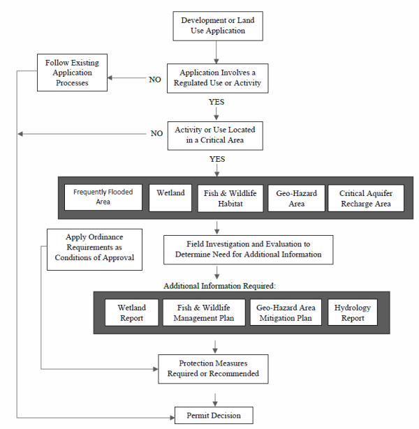
- Review.
- All uses proposed within the critical resource overlay zone shall be subject to a site plan review process.
- All applications for permits to conduct activities having possible impact(s) to critical areas must:
- Establish if critical areas are present by providing a report prepared by a qualified professional with demonstrated qualifications in the area of concern. The report shall use scientifically valid methods and studies in the analysis of critical area data and the field reconnaissance shall reference the source of science used.
- Identify if impact(s) could occur.
- Make an estimate of the probable impact(s).
- Refer to the provisions herein to guide development decisions which strive to mitigate impact(s).
- A critical areas report identifying the precise area of critical resource, its function and resource value and a mitigation and enhancement plan, if necessary, shall be submitted as part of the application.
- The report shall be prepared by a qualified professional with demonstrated qualifications in the area of concern. The City may retain consultants at the applicant's expense to assist in the review of the technical study, if needed. The hearing examiner, in considering the site plan review, shall determine if the study and the Administrator's review are adequate.
- The report shall use scientifically valid methods and studies in the analysis of critical area data and the field reconnaissance shall reference the source of science used. The critical areas report shall evaluate the proposal and all probable impacts to critical areas in accordance with the provisions of this section.
- The report contents shall at a minimum contain the following:
- The name and contact information of the applicant, a description of the proposal, and identification of the permit requested.
- A copy of the site plan for the development proposal in accordance with CMC 18.16.040 shall be obtained prior to any clearing or development activities within two hundred feet of the critical area; except in the case of an aquifer recharge/wellhead protection area in which a site plan review shall be obtained for new commercial or industrial uses or a change in use if the use is listed or is similar to a listed use categorized as a high or moderate risk in Table 2 of the Stevens County Critical Aquifer Recharge Study. Activities listed in Part H,1 are exempt from site plan review.
- The names and qualifications of the persons preparing the report and documentation of any fieldwork performed on the site, including dates.
- Exemptions and Exceptions.
- The following activities shall be allowed in critical areas without site plan review provided they are not prohibited by any other chapter of the Chewelah Municipal Code or other city rules and regulations or other law, provided a site plan describing the proposal has been reviewed and approved by the building official and provided they are conducted using best management practices and at a time designed to minimize adverse effects to the critical resource:
- Conservation or preservation of soil, water, vegetation, fish, shellfish, and other wildlife.
- Outdoor recreational activities which do not involve disturbance of the resource or site area, including fishing, hunting, bird watching, hiking, boating, horseback riding, swimming, canoeing, and bicycling.
- The harvesting of wild crops in a manner that is not injurious to natural reproduction of such crops and provided the harvesting does not require tilling of soil, planting of crops, or alteration of the resource by changing existing topography, vegetation, water conditions or water sources.
- Education, scientific research, and use of nature trails.
- Existing and ongoing agricultural activities, including farming, horticulture, aquaculture, irrigation, ranching or grazing of animals. Activities on areas lying fallow as part of a conventional rotational cycle are part of an ongoing operation. Activities which bring an area into agricultural use are not part of an ongoing operation. An operation ceases to be ongoing when the area on which it was conducted has been converted to another use or has lain idle for more than twelve consecutive months.
- Normal and routine maintenance of legally constructed irrigation and drainage ditches, provided that this exemption shall not apply to any ditches used by salmonids.
- Normal and routine maintenance, repair or operation of existing serviceable structures, facilities, or improved areas. Maintenance and repair do not include any modification that changes the character, scope, or size of the original structure, facility, or improved area and does not include the construction of a maintenance road.
- Minor modification of existing serviceable structures provided such minor modifications are located wholly outside the designated buffer zone and where modification or construction does not adversely impact functions of the critical area. The buffer zones are:
- Chewelah Creek: fifty feet as measured from the ordinary high water mark.
- Thomason and Paye Creeks: twenty-five feet as measured from the ordinary high water mark.
- The following activities shall be allowed in critical areas without site plan review provided they are not prohibited by any other chapter of the Chewelah Municipal Code or other city rules and regulations or other law, provided a site plan describing the proposal has been reviewed and approved by the building official and provided they are conducted using best management practices and at a time designed to minimize adverse effects to the critical resource:
- Emergency Activities.
- Criteria for granting a Temporary Emergency Permit. Notwithstanding the provisions of this section or any other laws to the contrary, the Administrator may issue a temporary emergency wetland permit or allow regulated uses or activities in a Fish and Wildlife Habitat Conservation Area or Geologically Hazardous Area if:
- The Administrator determines that an imminent threat to public health, safety, or the environment will occur if an emergency permit is not granted; and
- The threat or loss may occur before a wetland permit or Fish and Wildlife Habitat Conservation Area review can be issued or conditioned under the procedures otherwise required by this section.
- Conditions of an Emergency Permit. Any emergency permit granted shall:
- Incorporate to the greatest extent practicable the standards and criteria required for non-emergency activities.
- Be limited in duration to the time required to complete the authorized emergency activities, not to exceed ninety days without reapplication.
- Require contact of the Washington Department of Fish and Wildlife for an emergency Hydraulic Project Approval if necessary.
- Reasonable Use Exception. If the applicant for a development proposal demonstrates to the satisfaction of the Administrator that application of the standards of this section would deny all reasonable use of the property, development satisfying the project conditions imposed by the Administrator and fulfilling the criteria below shall be allowed. The applicant shall pay fees as determined by the City which may include mailing and processing costs and shall submit documentation on forms provided by the City demonstrating that all of the following are met to the satisfaction of the Administrator:
- Reasonable intent to mitigate impacts to critical areas and buffers consistent with the purpose and standards of this section.
- There is no reasonable use with less impact on the wetland, fish and wildlife habitat or geo-hazard area.
- The requested use or activity will not result in any damage to the other property and will not threaten public health, safety or welfare, on or off the property.
- Any alteration to the wetland, fish and wildlife habitat or geo-hazard area is the minimum necessary to allow for reasonable use of the property.
- The inability of the applicant to derive reasonable use is not the result of actions by the applicant in subdividing the property or adjusting boundary lines thereby creating the undevelopable condition after the effective date of this section.
- Decision. The Administrator shall include findings on each of the evaluation criteria listed above in a written decision. The written decision shall comply with Notice of Decision standards provided in CMC 18.20.040 Part D. The written decision shall include conditions necessary to serve the purposes of this section.
- Criteria for granting a Temporary Emergency Permit. Notwithstanding the provisions of this section or any other laws to the contrary, the Administrator may issue a temporary emergency wetland permit or allow regulated uses or activities in a Fish and Wildlife Habitat Conservation Area or Geologically Hazardous Area if:
- Frequently Flooded Areas.
- Purpose. It is the intent of the City to recognize and diminish potential hazards that may be caused by inappropriate development in areas where severe and costly flooding is anticipated to occur. Based on historical observation and information collected by the Federal Emergency Management Agency, the City endorses a cautious posture that limits construction in areas located within zones designated to be flood prone. This decision stems from local, as well as state and federal, understanding that development limitations in these areas help to serve the health, safety and public welfare of the people of the City.
- Classification. Classification of frequently flooded areas, according to the minimum guidelines, should include, at a minimum, the 100-year floodplain designations of the Federal Emergency Management Agency and the National Flood Insurance Program. The following are categories of frequently flooded areas established for the purpose of classification:
- Floodways. The channel of a stream, plus any adjacent floodplain areas, that must be kept free of encroachment in order that the base flood be carried without substantial increases in flood heights.
- Floodplains. The floodway and special flood hazard areas.
- Special Flood Hazard Areas. The areas adjoining the floodway which are subject to a one percent or greater chance of flooding in any given year, as identified and determined by the Federal Insurance Administration.
- Designation. All city lands and waters which are currently identified within the 100-year floodplain in the Federal Emergency Management Agency publication entitled “The Flood Insurance Rate Map for Stevens County, WA, and Incorporated Areas,” with accompanying flood insurance rate and boundary maps are designated as frequently flooded areas. If and when this study becomes updated to reflect new conditions, designation of frequently flooded areas will include the changes.
- All new development within designated frequently flooded areas shall be in compliance with CMC 18.08.150.
- Wetlands.
- Purposes of this section are to:
- Recognize and protect the beneficial functions performed by many wetlands, which include, but are not limited to, providing food, breeding, nesting and/or rearing habitat for fish and wildlife; recharging and discharging groundwater; contributing to stream flow during low flow periods; stabilizing stream banks and shorelines; storing storm and flood waters to reduce flooding and erosion; and improving water quality through biofiltration, adsorption, and retention and transformation of sediments, nutrients, and toxicants.
- Regulate land use to avoid adverse effects on wetlands and maintain the functions and values of wetlands throughout the City of Chewelah.
- Establish review procedures for development proposals in and adjacent to wetlands.
- Compliance with the provisions of this section does not constitute compliance with other federal, state, and local regulations and permit requirements (for example, Shoreline Substantial Development Permits, Hydraulic Project Approval Permits, Army Corps of Engineers Section 404 Permits, National Pollutant Discharge Elimination System Permits). The applicant is responsible for complying with these requirements, apart from the process established in this section.
- The classification of a wetland shall be defined according to the Washington State Wetland Rating System for Eastern Washington: 2014 Update (Ecology Publication # 14-06-030 or as revised and approved by Ecology) and the 1987 Federal Wetland Delineation Manual and appropriate Regional Supplement, or as amended.
- Identification and Rating.
- Identification and Delineation. Identification of wetlands and delineation of their boundaries pursuant to this section shall be done in accordance with the approved 1987 Federal Wetland Delineation Manual and appropriate Regional Supplement, or as amended. All areas within the city meeting the wetland designation criteria in that procedure are hereby designated critical areas and are subject to the provisions of this section. Wetland delineations are valid for five years; after such date the Administrator shall determine whether a revision or additional assessment is necessary
- Rating. Wetlands shall be rated according to the Washington Department of Ecology wetland rating system, as set forth in the Washington State Wetland Rating System for Eastern Washington: 2014 Update (Ecology Publication #14-06-030, or as revised and approved by Ecology), which contains the definitions and methods for determining whether the criteria for the following are met:
- Category I wetlands perform many functions very well (scores between 22-27 points).
- They include:
- Alkali wetlands.
- Wetlands of high conservation value that are identified by scientists of the Washington Natural Heritage Program/Department of Natural Resources.
- Bogs and calcareous fens.
- Mature and old-growth forested wetlands over one quarter acre with slow-growing trees.
- Forests with stands of aspen.
- These wetlands are those that:
- Represent a unique or rare wetland type; or
- Are more sensitive to disturbance than most wetlands; or
- Are relatively undisturbed and contain ecological attributes that are impossible to replace within a human lifetime; or
- Provide a high level of function.
- They include:
- Category II wetlands perform functions well (scores between 19-21 points).
- They include:
- Forested wetlands in the floodplains of rivers.
- Mature and old-growth forested wetlands over one quarter acre with fast-growing trees.
- Vernal pools.
- These wetlands are difficult, though not impossible, to replace and provide high levels of some functions. These wetlands occur more commonly than Category I wetlands but still need a relatively high level of protection.
- They include:
- Category III wetlands have a moderate level of functions (scores between 16-18 points). These wetlands can often be adequately replaced with a well-planned mitigation project. Wetlands scoring between 16-18 points generally have been disturbed in some way and are often less diverse or more isolated from other natural resources in the landscape than Category II wetlands.
- Category IV wetlands have the lowest level of functions (scores fewer than 16 points) and are often heavily disturbed. These are wetlands that should be able to be replaced, and in some cases, improved. However, experience has shown that replacement cannot be guaranteed in any specific case. These wetlands may provide some important functions and also need to be protected.
- Category I wetlands perform many functions very well (scores between 22-27 points).
- Illegal Modifications. Wetland rating categories shall not change due to illegal modifications made by the applicant or with the applicant’s knowledge.
- Regulated Activities.
- For any regulated activity, a critical areas report (see Part G,3) may be required to support the requested activity.
- The following activities are regulated if they occur in a regulated wetland or its buffer:
- The removal, excavation, grading, or dredging of soil, sand, gravel, minerals, organic matter, or material of any kind.
- The dumping of, discharging of, or filling with any material.
- The draining, flooding, or disturbing of the water level or water table.
- Pile driving.
- The placing of obstructions.
- The construction, reconstruction, demolition, or expansion of any structure.
- The destruction or alteration of wetland vegetation through clearing, harvesting, shading, intentional burning, or planting of vegetation that would alter the character of a regulated wetland.
- "Class IV - General Forest Practices" under the authority of the "1992 Washington State Forest Practices Act Rules and Regulations," WAC 222.12.030, or as amended.
- Activities that result in:
- A significant change of water temperature.
- A significant change of physical or chemical characteristics of the sources of water to the wetland.
- A significant change in the quantity, timing or duration of the water entering the wetland.
- The introduction of pollutants.
- Subdivisions. The subdivision and/or short subdivision of land in wetlands and associated buffers are subject to the following:
- Land that is located wholly within a wetland or its buffer may not be subdivided.
- Land that is located partially within a wetland or its buffer may be subdivided provided that an accessible and contiguous portion of each new lot is:
- Located outside of the wetland and its buffer; and
- Meets the minimum lot size requirements of CMC 18.08.
- Exemptions and Allowed Uses in Wetlands.
- Small isolated wetlands in arid landscapes often have a higher value and perform greater functions than in other settings. However, in certain circumstances, applying the buffers in Part K,7 may result in buffer areas greater than that of the wetland being protected. In these instances, the Administrator may consult with the Department of Ecology to determine whether exemptions from mitigation sequencing and/or reduced buffers are warranted.
- Activities allowed in wetlands. The following activities are allowed in wetlands. These activities do not require submission of a critical areas report, except where such activities result in a loss of the functions and values of a wetland or wetland buffer. These activities include:
- Existing and ongoing agricultural activities, provided that they implement applicable Best Management Practices contained in the latest edition of the USDA Natural Resources Conservation Service Field Office Technical Guide; or develop a farm conservation plan in coordination with the local conservation district. Best Management Practices and/or farm plans should address potential impacts to wetlands from livestock, nutrient and farm chemicals, soil erosion and sediment control and agricultural drainage infrastructure. Best Management Practices and/or farm plans should ensure that ongoing agricultural activities minimize their effects on water quality, riparian ecology, salmonid populations, and wildlife habitat.
- Those activities and uses conducted pursuant to the Washington State Forest Practices Act and its rules and regulations (WAC 222-12-030) where state law specifically exempts local authority, except those developments requiring local approval for Class 4 – General Forest Practice Permits (conversions) as defined in RCW 76.09 and WAC 222-12.
- Conservation or preservation of soil, water, vegetation, fish, shellfish, and/or other wildlife that does not entail changing the structure or functions of the existing wetland.
- The harvesting of wild crops in a manner that is not injurious to natural reproduction of such crops, provided that the harvesting does not require tilling of soil, planting of crops, chemical applications, or alteration of the wetland by changing existing topography, water conditions, or water sources.
- Drilling for utilities/utility corridors under a wetland, with entrance/exit portals located completely outside of the wetland buffer, provided that the drilling does not interrupt the groundwater connection to the wetland or percolation of surface water down through the soil column. Specific studies by a hydrologist are necessary to determine whether the groundwater connection to the wetland or percolation of surface water down through the soil column will be disturbed.
- Enhancement of a wetland through the removal of non-native invasive plant species. Removal of invasive plant species shall be restricted to hand removal unless permits from the appropriate regulatory agencies have been obtained for approved biological or chemical treatments. All removed plant material shall be taken away from the site and appropriately disposed of. Plants that appear on the Washington State Noxious Weed Control Board list of noxious weeds must be handled and disposed of according to a noxious weed control plan appropriate to that species. Re-vegetation with appropriate native species at natural densities is allowed in conjunction with removal of invasive plant species.
- Educational and scientific research activities.
- Normal and routine maintenance and repair of any existing public or private facilities within an existing right-of-way, provided that the maintenance or repair does not expand the footprint of the facility or right-of-way.
- Stormwater management facilities. A wetland or its buffer can be physically or hydrologically altered to meet the requirements of a LID, Runoff Treatment or Flow Control Best Management Practice if ALL of the following criteria are met:
- The wetland is classified as a Category IV or a Category III wetland with a habitat score of 3-5 points.
- There will be “no net loss” of functions and values of the wetland.
- The wetland does not contain a breeding population of any native amphibian species.
- The hydrologic functions of the wetland can be improved as outlined in questions 3, 4, 5 of Chart 4 and questions 2, 3, 4 of Chart 5 in the “Guide for Selecting Mitigation Sites Using a Watershed Approach,” as provided by the Department of Ecology; or the wetland is part of a priority restoration plan that achieves restoration goals identified in a Shoreline Master Program or other local or regional watershed plan.
- The wetland lies in the natural routing of the runoff, and the discharge follows the natural routing.
- All regulations regarding stormwater and wetland management are followed, including but not limited to, local and state wetland and stormwater codes, manuals, and permits.
- Modifications that alter the structure of a wetland or its soils will require permits. Existing functions and values that are lost would have to be compensated/replaced.
- Stormwater LID Best Management Practices required as part of new or redevelopment projects can be considered within wetlands and their buffers. However, these areas may contain features that render LID Best Management Practices infeasible. A site-specific characterization is required to determine if an LID Best Management Practice is feasible at the project site.
- Wetland Buffers.
- Buffer Requirements. The following buffer widths have been established in accordance with the best available science. They are based on the category of wetland and the habitat score as determined by a qualified wetland professional using the Washington State Wetland Rating System for Eastern Washington: 2014 Update (Ecology Publication #14-06-030, or as revised and approved by Ecology).
Wetland Buffer RequirementsWetland Category Buffer width (in feet) based on habitat score 3-5 6-7 8-9 Category I: Based on total score 75 110 150 Category I: Forested 75 110 150 Category I: Bogs and Wetlands of High Conservation Value 190 (buffer width not based on habitat scores) Category I: Alkali 150 (buffer width not based on habitat scores) Category II: Based on total score 75 110 150 Category II: Vernal pool 150 (buffer width not based on habitat scores) Category II: Forested 75 110 150 Category III (all) 60 110 150 Category IV (all) 40
- Buffer Requirements. The following buffer widths have been established in accordance with the best available science. They are based on the category of wetland and the habitat score as determined by a qualified wetland professional using the Washington State Wetland Rating System for Eastern Washington: 2014 Update (Ecology Publication #14-06-030, or as revised and approved by Ecology).
- Increased Wetland Buffer Area Width. Buffer widths shall be increased on a case-by-case basis as determined by the Administrator when a larger buffer is necessary to protect wetland functions and values. This determination shall be supported by appropriate documentation showing that it is reasonably related to protection of the functions and values of the wetland. The documentation must include but is not limited to the following criteria:
- The wetland is used by a state or federally listed plant or animal species or has essential or outstanding habitat for those species, or has unusual nesting or resting sites such as heron rookeries or raptor nesting trees.
- The adjacent land is susceptible to severe erosion, and erosion-control measures will not effectively prevent adverse wetland impacts.
- The adjacent land has minimal vegetative cover or slopes greater than thirty percent.
- Buffer averaging to improve wetland protection may be permitted when all of the following conditions are met:
- The wetland has significant differences in characteristics that affect its habitat functions, such as a wetland with a forested component adjacent to a degraded emergent component or a “dual-rated” wetland with a Category I area adjacent to a lower-rated area.
- The buffer is increased adjacent to the higher-functioning area of habitat or more-sensitive portion of the wetland and decreased adjacent to the lower-functioning or less-sensitive portion as demonstrated by a critical areas report from a qualified wetland professional.
- The total area of the buffer after averaging is equal to the area required without averaging.
- The buffer at its narrowest point is never less than either seventy-five percent of the required width or seventy-five feet for Category I and II, fifty feet for Category III and twenty-five feet for Category IV, whichever is greater.
- Averaging to allow reasonable use of a parcel may be permitted when all of the following are met:
- There are no feasible alternatives to the site design that could be accomplished without buffer averaging.
- The averaged buffer will not result in degradation of the wetland’s functions and values as demonstrated by a critical areas report from a qualified wetland professional.
- The total buffer area after averaging is equal to the area required without averaging.
- The buffer at its narrowest point is never less than either seventy-five percent of the required width or seventy-five feet for Category I and II, fifty feet for Category III and twenty-five feet for Category IV, whichever is greater.
- Measurement of Wetland Buffers. All buffers shall be measured perpendicular from the wetland boundary as surveyed in the field. The buffer for a wetland created, restored, or enhanced as compensation for approved wetland alterations shall be the same as the buffer required for the category of the created, restored, or enhanced wetland. Buffers must be fully vegetated in order to be included in buffer area calculations. Lawns, walkways, driveways, and other mowed or paved areas will not be considered buffers or included in buffer area calculations.
- Buffers on Mitigation Sites. All wetland mitigation sites shall have buffers consistent with the buffer requirements of this section. Buffers shall be based on the expected or target category of the proposed wetland mitigation site.
- Overlapping Critical Area Buffers. If buffers for two contiguous critical areas overlap (such as buffers for a stream and a wetland), the wider buffer applies.
- Allowed Buffer Uses. The following uses may be allowed within a wetland buffer in accordance with the review procedures of this section, provided they are not prohibited by any other applicable law and they are conducted in a manner so as to minimize impacts to the buffer and adjacent wetland:
- Conservation and Restoration Activities. Conservation or restoration activities aimed at protecting the soil, water, vegetation, or wildlife.
- Passive Recreation. Passive recreation facilities designed and in accordance with an approved critical areas report, including:
- Walkways and trails, provided that those pathways are limited to minor crossings having no adverse impact on water quality. They should be generally parallel to the perimeter of the wetland, located only in the outer twenty-five percent of the wetland buffer area, and located so as to avoid removal of significant trees. They should be limited to pervious surfaces no more than five feet in width for pedestrian use only. Raised boardwalks utilizing non-treated pilings may be acceptable.
- Wildlife-viewing structures.
- Educational and scientific research activities.
- Normal and routine maintenance and repair of any existing public or private facility within an existing right-of-way, provided that the maintenance or repair does not increase the footprint or use of the facility or right-of-way.
- The harvesting of wild crops in a manner that is not injurious to natural reproduction of such crops, provided that the harvesting does not require tilling of soil, planting of crops, chemical applications, or alteration of the wetland by changing existing topography, water conditions, or water sources.
- Drilling for utilities/utility corridors under a buffer, with entrance/exit portals located completely outside of the wetland buffer boundary, provided that the drilling does not interrupt the groundwater connection to the wetland or percolation of surface water down through the soil column. Specific studies by a hydrologist are necessary to determine whether the groundwater connection to the wetland or percolation of surface water down through the soil column is disturbed.
- Enhancement of a wetland buffer through the removal of non-native invasive plant species. Removal of invasive plant species shall be restricted to hand removal unless permits from the appropriate regulatory agencies have been obtained for approved biological or chemical treatments. All removed plant material shall be taken away from the site and appropriately disposed of. Plants that appear on the Washington State Noxious Weed Control Board list of noxious weeds must be handled and disposed of according to a noxious weed control plan appropriate to that species. Re-vegetation with appropriate native species at natural densities is allowed in conjunction with removal of invasive plant species.
- Repair and maintenance of non-conforming uses or structures, where legally established within the buffer, provided they do not increase the degree of nonconformity.
- Signs and Fencing of Wetlands and Buffers (optional).
- Temporary Markers. The outer perimeter of the wetland buffer and the clearing limits identified by an approved permit or authorization shall be marked in the field with temporary “clearing limits” fencing in such a way as to ensure that no unauthorized intrusion will occur. The marking is subject to inspection by the Administrator prior to the commencement of permitted activities. This temporary marking shall be maintained throughout construction and shall not be removed until permanent signs, if required, are in place.
- Permanent Signs. As a condition of any permit or authorization issued pursuant to this section, the Administrator may require the applicant to install permanent signs along the boundary of a wetland or buffer.
- Permanent signs shall be made of an enamel-coated metal face and attached to a metal post or another non-treated material of equal durability. One sign must be posted at fifty-foot intervals, or one per lot if the lot is less than fifty feet wide; and must be maintained by the property owner in perpetuity. The signs shall be worded as follows or with alternative language approved by the Administrator:
Protected Wetland Area Do Not Disturb
Contact City of Chewelah
Regarding Uses, Restrictions, and Opportunities for Stewardship - The provisions of Part K,15,a may be modified as necessary to ensure protection of sensitive features or wildlife.
- Permanent signs shall be made of an enamel-coated metal face and attached to a metal post or another non-treated material of equal durability. One sign must be posted at fifty-foot intervals, or one per lot if the lot is less than fifty feet wide; and must be maintained by the property owner in perpetuity. The signs shall be worded as follows or with alternative language approved by the Administrator:
- Fencing.
- The applicant shall be required to install a permanent fence around the wetland or buffer when domestic grazing animals are present or may be introduced on site.
- Fencing installed as part of a proposed activity or as required in Part K,15,c,(1) shall be designed so as to not interfere with species migration, including fish runs, and shall be constructed in a manner that minimizes impacts to the wetland and associated habitat.
- Critical Areas Report for Wetlands.
- If the Administrator determines that the site of a proposed development includes, is likely to include, or is adjacent to a wetland, a wetland report prepared by a qualified professional shall be required. The expense of preparing the wetland report shall be borne by the applicant.
- Minimum Standards for Wetland Reports. The written report and the accompanying plan sheets shall contain the following information:
- The written report shall include at a minimum:
- The name and contact information of the applicant; the name, qualifications, and contact information for the primary author(s) of the wetland critical areas report; a description of the proposal; identification of all the local, state, and/or federal wetland-related permit(s) required for the project; and a vicinity map for the project.
- A statement specifying the accuracy of the report and all assumptions made and relied upon.
- Documentation of any fieldwork performed on the site, including field data sheets for delineations, rating system forms, baseline hydrologic data, etc.
- A description of the methodologies used to conduct the wetland delineations, wetland ratings, or impact analyses, including references.
- Identification and characterization of all critical areas, wetlands, water bodies, shorelines, floodplains, and buffers on or adjacent to the proposed project area. For areas off-site of the project site, estimate conditions within two hundred fifty feet of the project boundaries using the best available information.
- For each wetland identified on-site and within two hundred fifty feet of the project boundary, provide: the wetland rating, including a description of and score for each function, per Part K,2,a-b; required buffers; hydrogeomorphic classification; wetland acreage based on a professional survey from the field delineation (acreages for on-site portion and entire wetland area including off-site portions); Cowardin classification of vegetation communities; habitat elements; soil conditions based on site assessment and/or soil survey information; and to the extent possible, hydrologic information such as location and condition of inlet/outlets (if they can be legally accessed), estimated water depths within the wetland, and estimated hydroperiod patterns based on visual cues (e.g., algal mats, drift lines, flood debris, etc.). Provide acreage estimates, classifications, and ratings based on entire wetland complexes, not only the portion present on the proposed project site.
- A description of the proposed actions including an estimation of acreages of impacts to wetlands and buffers based on the field delineation and survey and an analysis of site development alternatives, including a no-development alternative.
- An assessment of the probable cumulative impacts to the wetlands and buffers resulting from the proposed development.
- A description of reasonable efforts made to apply mitigation sequencing pursuant to Part K,17,a in order to avoid, minimize, and mitigate impacts to critical areas.
- A discussion of measures, including avoidance, minimization, and compensation, proposed to preserve existing wetlands and restore any wetlands that were degraded prior to the current proposed land use activity.
- A conservation strategy for habitat and native vegetation that addresses methods to protect and enhance on-site habitat and wetland functions.
- An evaluation of the functions of the wetland and adjacent buffer. Include reference for the method used and data sheets.
- A copy of the site plan sheet(s) for the project must be included with the written report and must include, at a minimum:
- Maps (to scale) depicting delineated and surveyed wetland and required buffers on-site, including buffers for off-site critical areas that extend onto the project site; the development proposal; other critical areas; grading and clearing limits; areas of proposed impacts to wetlands and/or buffers (include square footage estimates).
- A depiction of the proposed stormwater management facilities and outlets (to scale) for the development, including estimated areas of intrusion into the buffers of any critical areas. The written report shall contain a discussion of the potential impacts to the wetland(s) associated with anticipated hydroperiod alterations from the project.
- The written report shall include at a minimum:
- Compensatory Mitigation.
- Mitigation Sequencing. Before impacting any wetland or its buffer, the applicant shall demonstrate that the following actions have been taken. Actions are listed in the order of preference:
- Avoid the impact altogether by not taking a certain action or parts of an action.
- Minimize impacts by limiting the degree or magnitude of the action and its implementation, by using appropriate technology, or by taking affirmative steps to avoid or reduce impacts.
- Rectify the impact by repairing, rehabilitating, or restoring the affected environment.
- Reduce or eliminate the impact over time by preservation and maintenance operations.
- Compensate for the impact by replacing, enhancing, or providing substitute resources or environments.
- Monitor the required compensation and take remedial or corrective measures when necessary.
- Requirements for Compensatory Mitigation:
- Compensatory mitigation for alterations to wetlands shall be used only for impacts that cannot be avoided or minimized and shall achieve equivalent or greater biologic functions. Compensatory mitigation plans shall be consistent with Wetland Mitigation in Washington State – Part 2: Developing Mitigation Plans--Version 1, (Ecology Publication #06-06-11b, Olympia, WA, March 2006 or as amended), and Selecting Wetland Mitigation Sites Using a Watershed Approach (Eastern Washington) (Publication #10-06-07, November 2010, or as amended).
- Mitigation ratios shall be consistent with Part K,19.
- Compensating for Lost or Affected Functions. Compensatory mitigation shall address the functions affected by the proposed project, with an intention to achieve functional equivalency or improvement of functions. The goal shall be for the compensatory mitigation to provide similar wetland functions as those lost, except when either:
- The lost wetland provides minimal functions, and the proposed compensatory mitigation action(s) will provide equal or greater functions or will provide functions shown to be limiting within a watershed through a formal Washington state watershed assessment plan or protocol; or
- Out-of-kind replacement of wetland type or functions will best meet watershed goals formally identified by the City, such as replacement of historically diminished wetland types.
- Approaches to Compensatory Mitigation (optional). Mitigation for lost or diminished wetland and buffer functions shall rely on the following approaches:
- Wetland mitigation banks. Credits from a certified wetland mitigation bank may be used to compensate for impacts located within the service area specified in the mitigation bank instrument. Use of credits from a wetland mitigation bank certified under WAC 173-700 is allowed if:
- The Administrator determines that it would provide appropriate compensation for the proposed impacts.
- The impact site is located in the service area of the bank.
- The proposed use of credits is consistent with the terms and conditions of the certified mitigation bank instrument.
- Replacement ratios for projects using bank credits is consistent with replacement ratios specified in the certified mitigation bank instrument.
- Permittee-responsible mitigation. In this situation, the permittee performs the mitigation after the permit is issued and is ultimately responsible for implementation and success of the mitigation. Permittee-responsible mitigation may occur at the site of the permitted impacts or at an off-site location within the same watershed. Permittee-responsible mitigation shall be used only if the applicant’s qualified wetland professional demonstrates to the Administrator’s satisfaction that the proposed approach is ecologically preferable to use of a mitigation bank, consistent with the criteria in this section.
- Wetland mitigation banks. Credits from a certified wetland mitigation bank may be used to compensate for impacts located within the service area specified in the mitigation bank instrument. Use of credits from a wetland mitigation bank certified under WAC 173-700 is allowed if:
- Types of Compensatory Mitigation. Mitigation for lost or diminished wetland and buffer functions shall rely on a type listed below in order of preference. A lower- preference form of mitigation shall be used only if the applicant’s qualified wetland professional demonstrates to the Administrator’s satisfaction that all higher-ranked types of mitigation are not viable, consistent with the criteria in this section.
- Restoration. The manipulation of the physical, chemical, or biological characteristics of a site with the goal of returning natural or historical functions to a former or degraded wetland. For the purpose of tracking net gains in wetland acres, restoration is divided into:
- Re-establishment. The manipulation of the physical, chemical, or biological characteristics of a site with the goal of returning natural or historical functions to a former wetland. Re-establishment results in a gain in wetland acres (and functions). Activities could include removing fill material, plugging ditches, or breaking drain tiles.
- Rehabilitation. The manipulation of the physical, chemical, or biological characteristics of a site with the goal of repairing natural or historical functions of a degraded wetland. Rehabilitation results in a gain in wetland function but does not result in a gain in wetland acres. Activities could involve breaching a dike to reconnect wetlands to a floodplain or return tidal influence to a wetland.
- Establishment (Creation). The manipulation of the physical, chemical, or biological characteristics of a site to develop a wetland on an upland or deepwater site where a wetland did not previously exist. Establishment results in a gain in wetland acres. Activities typically involve excavation of upland soils to elevations that will produce a wetland hydroperiod, create hydric soils, and support the growth of hydrophytic plant species.
- If a site is not available for wetland restoration to compensate for expected wetland and/or buffer impacts, the Administrator may authorize creation of a wetland and buffer upon demonstration by the applicant’s qualified wetland professional that:
- The hydrologic and soil conditions at the proposed mitigation site are conducive for sustaining the proposed wetland and that creation of a wetland at the site will not likely cause hydrologic problems elsewhere.
- Adjacent land uses and site conditions do not jeopardize the viability of the proposed wetland and buffer (e.g., due to the presence of invasive plants or noxious weeds, stormwater runoff, noise, light, or other impacts).
- The proposed wetland and buffer will eventually be self-sustaining with little or no long-term maintenance.
- If a site is not available for wetland restoration to compensate for expected wetland and/or buffer impacts, the Administrator may authorize creation of a wetland and buffer upon demonstration by the applicant’s qualified wetland professional that:
- Enhancement. The manipulation of the physical, chemical, or biological characteristics of a wetland site in order to heighten, intensify, or improve specific function(s) or to change the growth stage or composition of the vegetation present. Enhancement is undertaken for specified purposes such as water quality improvement, flood water retention, or wildlife habitat. Enhancement results in a change in some wetland functions and can lead to a decline in other wetland functions, but does not result in a gain in wetland acres. Activities typically consist of planting vegetation, controlling non-native or invasive species, modifying site elevations or the proportion of open water to influence hydroperiods, or some combination of these activities. Applicants proposing to enhance wetlands or associated buffers shall demonstrate how the proposed enhancement will increase the wetland’s/buffer’s functions, how this increase in function will adequately compensate for the impacts, and how existing wetland functions at the mitigation site will be protected.
- Protection/Maintenance (Preservation). Removing a threat to, or preventing the decline of, wetland conditions by an action in or near a wetland. This includes the purchase of land or easements, or repair of water control structures or fences. This term also includes activities commonly associated with the term preservation. Preservation does not result in a gain of wetland acres. Permanent protection of a Category I or II wetland and associated buffer at risk of degradation can be used only if:
- The Administrator determines that the proposed preservation is the best mitigation option.
- The proposed preservation site is under threat of undesirable ecological change due to permitted, planned, or likely actions that will not be adequately mitigated under existing regulations.
- The area proposed for preservation is of high-quality or critical for the health of the watershed or basin due to its location. Some of the following features may be indicative of high-quality sites:
- Category I or II wetland rating (using the wetland rating system for eastern Washington).
- Rare or irreplaceable wetland type (for example, bogs, mature forested wetlands, estuarine wetlands) or aquatic habitat that is rare or a limited resource in the area.
- The presence of habitat for priority or locally important wildlife species.
- Provides biological and/or hydrological connectivity.
- Priority sites in an adopted watershed plan.
- Permanent preservation of the wetland and buffer will be provided through a conservation easement or tract held by an appropriate natural land resource manager, such as a land trust.
- The Administrator may approve other legal and administrative mechanisms in lieu of a conservation easement if it determines they are adequate to protect the site.
- Ratios for preservation in combination with other forms of mitigation generally range from 10:1 to 20:1, as determined on a case-by-case basis, depending on the quality of the wetlands being impacted and the quality of the wetlands being preserved. Ratios for preservation as the sole means of mitigation generally start at 20:1.
- Restoration. The manipulation of the physical, chemical, or biological characteristics of a site with the goal of returning natural or historical functions to a former or degraded wetland. For the purpose of tracking net gains in wetland acres, restoration is divided into:
- Mitigation Sequencing. Before impacting any wetland or its buffer, the applicant shall demonstrate that the following actions have been taken. Actions are listed in the order of preference:
- Location of Compensatory Mitigation. Compensatory mitigation actions shall generally be conducted within the same sub-drainage basin and on the site of the alteration except when the applicant can demonstrate that off-site mitigation is ecologically preferable. The following criteria will be evaluated when determining whether the proposal is ecologically preferable. When considering off-site mitigation, preference should be given to using alternative mitigation, such as a mitigation bank or advance mitigation.
- There are no reasonable opportunities on site or within the sub-drainage basin (e.g., on-site options would require elimination of high-functioning upland habitat) that have a high likelihood of success based on a determination of the capacity of the site to compensate for the impacts. Considerations should include anticipated replacement ratios for wetland mitigation, buffer conditions and proposed widths, available water to maintain anticipated hydrogeomorphic classes of wetlands when restored, proposed flood storage capacity, and potential to mitigate riparian fish and wildlife impacts (such as connectivity).
- On-site mitigation would require elimination of high-quality upland habitat.
- Off-site mitigation has a greater likelihood of providing equal or improved wetland functions than the altered wetland.
- Off-site locations shall be in the same sub-drainage basin.
- The design for the compensatory mitigation project needs to be appropriate for its location (i.e., position in the landscape). Therefore, compensatory mitigation should not result in the creation, restoration, or enhancement of an atypical wetland.
- Timing of Compensatory Mitigation. It is preferred that compensatory mitigation projects be completed prior to activities that will disturb wetlands. At the least, compensatory mitigation shall be completed immediately following disturbance and prior to use or occupancy of the action or development. Construction of mitigation projects shall be timed to reduce impacts to existing fisheries, wildlife, and flora.
- The Administrator may authorize a one-time temporary delay in completing construction or installation of the compensatory mitigation when the applicant provides a written explanation from a qualified wetland professional as to the rationale for the delay. An appropriate rationale would include identification of the environmental conditions that could produce a high probability of failure or significant construction difficulties (e.g., project delay lapses past a fisheries window, or installing plants should be delayed until the dormant season to ensure greater survival of installed materials). The delay shall not create or perpetuate hazardous conditions or environmental damage or degradation, and the delay shall not be injurious to the health, safety, or general welfare of the public. The request for the temporary delay must include a written justification that documents the environmental constraints that preclude implementation of the compensatory mitigation plan. The justification must be verified and approved by the Administrator.
- Wetland Mitigation Ratios.
Category and Type of Wetland Creation or Re-establishment Rehabilitation Enhancement Category I: Bog, Natural Heritage site Not considered possible Case by case Case by case Category I: Mature Forested 6:1 12:1 24:1 Category I: Based on functions 4:1 8:1 16:1 Category II 3:1 6:1 12:1 Category III 2:1 4:1 8:1 Category IV 1.5:1 3:1 6:1 - Compensatory Mitigation Plan. When a project involves wetland and/or buffer impacts, a compensatory mitigation plan prepared by a qualified professional shall be required, meeting the following minimum standards:
- Wetland Critical Areas Report. A critical areas report for wetlands must accompany or be included in the compensatory mitigation plan and include the minimum parameters described in Part K,16,b.
- Compensatory Mitigation Report. The report must include a written report and plan sheets that must contain, at a minimum, the following elements. Full guidance can be found in Wetland Mitigation in Washington State-P art 2: Developing Mitigation Plans (Version 1) (Ecology Publication #06-06-011b, Olympia, WA, March 2006 or as amended).
- The written report must contain, at a minimum:
- The name and contact information of the applicant; the name, qualifications, and contact information for the primary author(s) of the compensatory mitigation report; a description of the proposal; a summary of the impacts and proposed compensation concept; identification of all the local, state, and/or federal wetland-related permit(s) required for the project; and a vicinity map for the project.
- Description of how the project design has been modified to avoid, minimize, or reduce adverse impacts to wetlands.
- Description of the existing wetland and buffer areas proposed to be impacted. Include acreage (or square footage), water regime, vegetation, soils, landscape position, surrounding lands uses, and functions. Also describe impacts in terms of acreage by Cowardin classification, hydrogeomorphic classification, and wetland rating, based on Part K,2,b.
- Description of the compensatory mitigation site, including location and rationale for selection. Include an assessment of existing conditions: acreage (or square footage) of wetlands and uplands, water regime, sources of water, vegetation, soils, landscape position, surrounding land uses, and functions. Estimate future conditions in this location if the compensation actions are NOT undertaken (i.e., how would this site progress through natural succession?).
- Surface and subsurface hydrologic conditions, including an analysis of existing and proposed hydrologic regimes for enhanced, created, or restored compensatory mitigation areas. Include illustrations of how data for existing hydrologic conditions were used to determine the estimates of future hydrologic conditions.
- A description of the proposed actions for compensation of wetland and upland areas affected by the project. Include overall goals of the proposed mitigation, including a description of the targeted functions, hydrogeomorphic classification, and categories of wetlands.
- A description of the proposed mitigation construction activities and timing of activities.
- Performance standards (measurable standards for years post-installation) for upland and wetland communities, a monitoring schedule, and a maintenance schedule and actions proposed by year.
- A discussion of ongoing management practices that will protect wetlands after the development project has been implemented, including proposed monitoring and maintenance programs (for remaining wetlands and compensatory mitigation wetlands).
- Proof of establishment of Notice on Title for the wetlands and buffers on the project site, including the compensatory mitigation areas.
- The scaled plan sheets for the compensatory mitigation must contain, at a minimum:
- Surveyed edges of the existing wetland and buffers, proposed areas of wetland and/or buffer impacts, location of proposed wetland and/or buffer compensation actions.
- Existing topography, ground-proofed, at two-foot contour intervals in the zone of the proposed compensation actions if any grading activity is proposed to create the compensation area(s). Also, existing cross-sections of on-site wetland areas that are proposed to be impacted, and cross-section(s) (estimated one-foot intervals) for the proposed areas of wetland or buffer compensation.
- Conditions expected from the proposed actions on site, including future hydrogeomorphic types, vegetation community types by dominant species (wetland and upland), and future water regimes.
- Required wetland buffers for existing wetlands and proposed compensation areas. Also, identify any zones where buffers are proposed to be reduced or enlarged outside of the standards identified in this section.
- A planting plan for the compensation area, including all species by proposed community type and water regime, size and type of plant material to be installed, spacing of plants, typical clustering patterns, total number of each species by community type, and timing of installation.
- The written report must contain, at a minimum:
- Buffer Mitigation Ratios. Impacts to buffers shall be mitigated at a minimum 1:1 ratio. Compensatory buffer mitigation shall replace those buffer functions lost from development.
- Protection of the Mitigation Site. The area where the mitigation occurred and any associated buffer shall be located in a critical area tract or a conservation easement consistent with this section.
- Monitoring. Mitigation monitoring shall be required for a period necessary to establish that performance standards have been met, but not for a period less than five years. If a scrub-shrub or forested vegetation community is proposed, monitoring may be required for ten years or more. The project mitigation plan shall include monitoring elements that ensure certainty of success for the project’s natural resource values and functions. If the mitigation goals are not obtained within the initial five-year period, the applicant remains responsible for restoration of the natural resource values and functions until the mitigation goals agreed to in the mitigation plan are achieved.
- Advance Mitigation. Mitigation for projects with pre-identified impacts to wetlands may be constructed in advance of the impacts if the mitigation is implemented according to federal rules, state policy on advance mitigation, and state water quality regulations consistent with Interagency Regulatory Guide: Advance Permittee-Responsible Mitigation (Ecology Publication #12-06-015, Olympia, WA, December 2012, or as amended).
- Alternative Mitigation Plans. The Administrator may approve alternative wetland mitigation plans that are based on best available science, such as priority restoration plans that achieve restoration goals identified in the City of Chewelah Shoreline Master Program. Alternative mitigation proposals must provide an equivalent or better level of protection of wetland functions and values than would be provided by the strict application of this section. The Administrator shall consider the following for approval of an alternative mitigation proposal:
- The proposal uses a watershed approach consistent with Selecting Wetland Mitigation Sites Using a Watershed Approach (Eastern Washington) (Ecology Publication #10-06-07, November 2010, or as amended).
- Creation or enhancement of a larger system of natural areas and open space is preferable to the preservation of many individual habitat areas.
- Mitigation according to Part K,17,e is not feasible due to site constraints such as parcel size, stream type, wetland category, or geologic hazards.
- There is clear potential for success of the proposed mitigation at the proposed mitigation site.
- The plan shall contain clear and measurable standards for achieving compliance with the specific provisions of the plan. A monitoring plan shall, at a minimum, meet the provisions in Part K,20.
- The plan shall be reviewed and approved as part of overall approval of the proposed use.
- A wetland of a different type may be justified based on regional needs or functions and values. The replacement ratios may not be reduced or eliminated unless the reduction results in a preferred environmental alternative.
- Qualified professionals in each of the critical areas addressed shall prepare the plan.
- The Administrator may consult with agencies with expertise and jurisdiction over the critical areas during the review to assist with analysis and identification of appropriate performance measures that adequately safeguard critical areas.
- Purposes of this section are to:
- Fish and Wildlife Habitat Conservation Areas.
- Purpose. The City designates Fish and Wildlife Habitat Conservation Areas within the city and its urban growth area in accordance with Washington Department of Fish and Wildlife Priority Habitat and Species Program, or as amended. The Administrator shall ask the appropriate resource agencies to review and comment on the development impacts and provisions of the Habitat Management Plan.
- Fish and Wildlife Habitat Conservation Area. For purposes of this section, fish and wildlife habitat conservation areas shall include all of the following:
- The Washington State Department of Fish and Wildlife Priority Habitats and Species Recommendations for Species and Habitats, for:
- Endangered species listed at WAC 220-610-010.
- Threatened species listed at WAC 220-400-010.
- Sensitive species listed at WAC 220-400-100.
- Bald eagle habitat pursuant to WAC 220-610-100.
- Endangered or threatened species listed in accordance with the federal Endangered Species Act together with the areas with which they have a primary association.
- The Washington State Department of Fish and Wildlife Priority Habitats and Species Recommendations for Species and Habitats, for:
- Water Bodies.
- Streams shall be designated in accordance with the Washington State Department of Natural Resources stream type as provided in WAC 222-16-030 with the following provisions:
- Type S Water. All waters inventoried as “shorelines of the state” under RCW 90.58 and the rules promulgated pursuant to RCW 90.58, including periodically inundated areas of their associated wetlands.
- Type F-A Water. Segments of natural waters, other than Type S Waters, which are within defined channels greater than ten feet in width, as defined by the Ordinary High Water Mark and periodically inundated areas of their associated wetlands or within lakes, ponds, or impoundments having a surface area of one-half acre or greater at seasonal low water and which in any case contain fish habitat.
- Type F-B Water. Segments of natural waters, other than Type S Waters, which are within defined channels less than ten feet in width, as defined by the Ordinary High Water Mark, or within lakes, ponds, or impoundments having a surface area of less than one-half acre at seasonal low water and which in any case contain fish habitat.
- Type Np Water. All segments of natural waters within defined channels that are perennial nonfish habitat streams. Perennial streams are waters that do not go dry any time of a year of normal rainfall. However, for the purpose of water typing, Type Np Waters include the intermittent dry portions of the perennial channel below the uppermost point of perennial flow.
- Type Ns Water. All segments of natural waters within defined channels that are not Type S, F, or Np Waters. These are seasonal, nonfish habitat streams in which surface flow is not present for at least some portion of a year of normal rainfall and are not located downstream from any stream reach that is a Type Np Water. Ns Waters must be physically connected by an aboveground channel system to Type S, F, or Np Waters.
- Streams shall be designated in accordance with the Washington State Department of Natural Resources stream type as provided in WAC 222-16-030 with the following provisions:
- Classes of Wildlife Conservation Areas.
- The City shall use two general classifications of Fish and Wildlife Habitat Conservation Areas. These classifications are not intended to prioritize protection of one class of habitat over the other, but to recognize that the two types of habitat areas have differing functions and values within the urban environment. In reviewing development proposal(s), the City shall consider the Fish and Wildlife Habitat Conservation Areas classification in establishing buffer widths, mitigation requirements, and permit conditions. Any decision regarding establishment of buffers, buffer widths, access restrictions, vegetation conservation and restoration requirements, mitigation requirements, or permit conditions shall be a Type II review, subject to CMC 18.20.030.
- Aquatic and Riparian Habitat Conservation Areas. With this classification, the City recognizes that riparian habitat within the city limits and urban growth area frequently coincides with shoreline areas, flood hazard areas, wetlands and aquifer recharge areas. Riparian areas typically offer relatively contiguous habitat that is essential to a diverse array of fish and wildlife species. Best available science indicates that these areas are especially sensitive to pressures from urban development, and that they provide important habitat functions and values for many species, including anadromous fish species.
- Upland Habitat Conservation Areas. With this classification, the City recognizes that those upland areas within the defined city limits and urban growth boundary that are not otherwise designated as critical areas are frequently the most suited for human development. Upland habitats that support federal or state identified endangered, threatened or sensitive species, or any habitats which are identified as providing a high level of functions and values, must be protected in accord with federal and state regulations. However, in considering best available science, this classification also is intended to ensure that development is not subject to burdensome regulation in those areas most suited to support it. Upland habitat areas shall not include those portions of the city and Urban Growth Area where a development pattern is already established such that connectivity of habitat has already been broken and protection of identified habitat areas is unlikely to provide measurable benefit to any of the priority species identified by Washington Department of Fish and Wildlife.
- The City shall use two general classifications of Fish and Wildlife Habitat Conservation Areas. These classifications are not intended to prioritize protection of one class of habitat over the other, but to recognize that the two types of habitat areas have differing functions and values within the urban environment. In reviewing development proposal(s), the City shall consider the Fish and Wildlife Habitat Conservation Areas classification in establishing buffer widths, mitigation requirements, and permit conditions. Any decision regarding establishment of buffers, buffer widths, access restrictions, vegetation conservation and restoration requirements, mitigation requirements, or permit conditions shall be a Type II review, subject to CMC 18.20.030.
- Mapping. Priority Habitat and Species maps used by Washington Department of Fish and Wildlife depict general locations of Fish and Wildlife Habitat Conservation Areas. However, because species populations and habitat systems are dynamic, agency consultation shall be required to verify designation as a habitat conservation area, except in cases in which a plan or agreement for the habitat or species in question has been prepared and approved by the Washington Department of Fish and Wildlife and the City.
- Standards. In addition to the general provisions of this section and the requirements of the underlying zone, the following minimum standards shall apply to development activities within and adjacent to fish and wildlife habitat conservation areas:
- Alterations shall not degrade the functions and values of the habitat. A habitat conservation area may be altered only if the proposed alterations of the habitat or the mitigation proposed do not degrade the functions and values of the habitat.
- Non-indigenous species shall not be introduced. No non-indigenous plant, wildlife, or fish species shall be introduced into a fish and wildlife habitat conservation area unless authorized by a federal or state permit or approval.
- Mitigation shall attempt to preserve contiguous corridors. Where wildlife corridors exist, such as along stream corridors, mitigation shall preserve those corridors by appropriate buffer widths.
- Approvals of activities may be conditioned. The Administrator may condition approval of activities allowed within or adjacent to a Fish and Wildlife Habitat Conservation Area or its buffers, as necessary to minimize or mitigate adverse impacts.
- Mitigation shall achieve equivalent or greater biological function. Mitigation alterations to habitat conservation areas shall achieve equivalent or greater biological function. Mitigation shall address each function affected by alteration to the habitat.
- Habitat Assessment. Habitat Management Plans for Fish and Wildlife Habitat Conservation Areas shall include a habitat assessment to evaluate the presence or absence of a priority species of habitat.
- All projects shall comply with applicable federal, state, and local regulations regarding the species and habitats identified upon a site.
- The Washington State Department of Fish and Wildlife priority habitat and species management recommendations shall be consulted in developing specific measures to protect a specific project site.
- Any approved alteration or development shall be required to minimize impacts to native vegetation. Where disturbance is unavoidable, the applicant shall restore the area to the extent possible using native plants appropriate to the site. New plantings shall be monitored and maintained in good growing condition and kept free of invasive weeds until well established upon the site.
- Within Riparian Habitat Conservation Areas, vegetation shall not be removed unless no other alternative exists. In such cases clearing shall be limited to those areas necessary and disturbed areas shall be replanted with site-appropriate native riparian vegetation.
- Access to Fish and Wildlife Habitat Conservation Areas or buffers may be restricted in accord with the findings of a critical areas report, mitigation report, Priority Habitat Species Management recommendations or other best available science. Access restrictions may include fencing and signs, as needed to ensure protection of habitat functions and values. Restrictions may be seasonal in nature.
- All activities, uses and alterations proposed to be located in or adjacent to water bodies used by anadromous fish shall give special consideration to the preservation and enhancement of associated habitats.
- Buffer Requirements for Fish and Wildlife Habitat Conservation Areas.
- Buffers are required for activities in or adjacent to fish and wildlife habitat conservation areas when needed to protect habitat functions and values. Fish and wildlife habitat buffer widths shall reflect the sensitivity of the habitat type and intensity of human activity proposed to be conducted nearby and shall be consistent with recommendations issued by the Washington Department of Fish and Wildlife.
- Riparian buffers shall be required to Type S, F, Np and Ns waters and shall extend landward perpendicularly from the ordinary high water mark as follows:
- Type S waters: seventy-five feet.
- Type F waters: seventy-five feet.
- Type Np waters: sixty feet.
- Type Ns waters: fifty feet.
- Undifferentiated Type N waters shall be considered as Type Np waters unless verified otherwise by a qualified professional.
- The Administrator may allow the recommended habitat area buffer width to be reduced in accordance with a critical areas report, the best available science, and the management recommendations issued by the Washington Department of Fish and Wildlife, only if:
- It will not reduce habitat functions and values.
- It will provide additional resource protection, such as buffer enhancement.
- The total area contained in a buffer area after averaging is no less than the area that would have been contained in the standard buffer.
- Maximum buffer width is not reduced by more than fifty percent in any location.
- The Administrator may allow a required buffer width to be reduced in accordance with a Fish and Wildlife Habitat Management Plan if:
- The width reduction will not reduce stream or habitat functions, including those of nonfish habitat.
- The width reduction will not degrade the habitat, including habitat for anadromous fish.
- The proposal will provide additional habitat protection(s).
- The total area contained in the riparian habitat area of each stream on the development proposal site is not decreased.
- The recommended riparian habitat area width is not reduced by more than thirty-five percent in any one location.
- The width reduction is not located within another critical area or associated buffer.
- The reduced riparian habitat area width is supported by best available science.
- The Administrator may allow a required buffer width to be reduced by twenty-five percent as compensation for riparian enhancement when a critical areas report demonstrates that:
- Nonnative and/or invasive plant species cover more than forty percent of the buffer area.
- Native trees and/or shrub vegetation covers less than twenty-five percent of the buffer area.
- The stream buffer has slopes of less than twenty-five percent.
- Includes an enhancement plan for the reduced buffer which:
- Includes planting of appropriate native tree and shrub species at a minimum planting density of ten feet on-center for trees and five feet on-center for shrubs.
- Compares how the proposed enhancement will benefit the value and functions of the subject area as opposed to retaining the required buffer without enhancement.
- Provides a monitoring and maintenance plan for the enhanced buffer for five years from the date of completing the enhancement.
- Any structure legally existing as of the effective date of this section and located within a standard buffer width required under this section may undergo normal maintenance and repair, or replacement; provided, however, that such action does not increase the degree of nonconformity.
- Signs and fencing of habitat conservation areas. The outer perimeter of the habitat conservation area or buffer shall be marked in the field by appropriate temporary markers during construction and, if necessary, shall be delineated by a permanent marker after completion of the activity at the discretion of the Administrator. Fencing may be required at the discretion of the Administrator in order to exclude harmful disturbances such as grazing animals.
- Habitat Management Plan.
- Prepared by a qualified professional. A habitat management plan report for a habitat conservation area shall be prepared by a qualified professional who has professional course work and training and has prepared reports for the relevant type of habitat.
- Area addressed in the critical areas report.
- The project area of the proposed activity.
- All habitat conservation area within two hundred feet of the project area.
- All shorelines, floodplains, and other critical areas and related buffers within two hundred feet of the project area.
- Habitat assessment. A habitat assessment is an investigation of the project area to evaluate the presence or absence of potential critical wildlife species habitat. A critical area habitat report shall contain the following:
- Detailed description of vegetation on and adjacent to the project area.
- Identification of any species of local importance, priority species, or endangered, threatened, or sensitive species that have primary association with the habitat on or adjacent to the project area, and assessment of potential impacts to the use of the site by the species.
- A discussion of any federal, state, or local special management recommendations.
- A detailed discussion of potential impacts on habitat by the project, including impacts to water quality.
- A discussion of measures including avoidance, minimization and mitigation, proposed to preserve existing habitats in accordance with the following:
- The applicant shall avoid all impacts that degrade the functions and values of a critical area or areas. Unless otherwise provided in this title, if alteration to the critical area is unavoidable, all adverse impacts to or from critical areas and buffers resulting from a developing proposal or alteration shall be mitigated in accordance with an approved critical areas report and SEPA documents.
- Mitigation shall be in-kind and on-site, when possible, and sufficient to maintain the functions and values of the critical area, and to prevent risk from a hazard posed by a critical area.
- Mitigation shall not be implemented until after the Administrator's approval of a critical areas report that includes a mitigation plan, and mitigation shall be in accordance with the provisions of the approved critical areas report.
- A discussion of ongoing management practices that will protect the habitat after the project site has been developed, including monitoring and maintenance.
- When appropriate the Administrator may request additional information relevant to the habitat characteristics and management of the site.
- Geologically Hazardous Areas.
- A minimum twenty-five-foot buffer shall be established from the top, toe or sides of an identified geological hazard, including landslides, earthquake fault lines, or steep slope areas (forty percent or greater). The buffer may be increased, if necessary, to protect public health, safety and welfare, based on information contained in a geotechnical report prepared by a qualified professional engineer.
- The hearing examiner may allow a reduction in the buffer provided the geotechnical report substantiates the following findings:
- The proposed development will not create a hazard to the subject property or surrounding properties or rights-of-way; or erosion or sedimentation to off-site properties or bodies of water.
- The proposal uses construction techniques which minimize disruption of existing topography and natural vegetation.
- The proposal mitigates all impacts identified in the geotechnical report.
- Buffers shall be maintained with plants or trees that provide soil stability and erosion control.
- Critical Aquifer Recharge/Wellhead Protection Areas.
- The wellhead protection area maps provided by the Washington State Department of Health provide a graphical representation of drinking water source protection areas.
- In areas designated as highly susceptible to aquifer contamination, all uses shall be connected to the city's sewer system. No new uses on a septic system are permitted in high susceptibility areas of critical aquifer recharge without explicit authorization from Tri-County Health District.
- For uses located within a critical aquifer recharge area and requiring site plan review, a disclosure form indicating activities and hazardous materials that will be used shall be provided for review and approval.
- Impervious surfaces shall be minimized within the critical aquifer recharge areas.
- Best management practices shall be followed by commercial and industrial uses located in the critical aquifer recharge areas.
- A spill prevention and emergency response plan shall be prepared and submitted for review and approval.
- Reasonable Use Exception.
- If application of the requirements in this section would deny all reasonable economic use of the lot, development will be permitted if the applicant demonstrates all of the following to the satisfaction of the hearing examiner when reviewed through a site plan review process:
- There is no other reasonable use or feasible alternative to the proposed development with less impact on the critical area.
- The proposed development does not pose a threat to the public health, safety and welfare on or off of the subject lot.
- Any alterations permitted to the requirements of this section shall be the minimum necessary to allow for reasonable use of the property.
- The inability of the applicant to derive reasonable economic use of the property is not the result of actions by the applicant in subdividing the property or adjusting a boundary line thereby creating the undevelopable condition after the effective date of this section.
- The proposal mitigates the impacts on the critical area to the maximum extent possible.
- If application of the requirements in this section would deny all reasonable economic use of the lot, development will be permitted if the applicant demonstrates all of the following to the satisfaction of the hearing examiner when reviewed through a site plan review process:
(Ord. No. 900, § 7, 8-3-2016)
18.08.150 Floodplain Management Overlay (FM) Zone
- Purpose and Intent. The purpose of the floodplain management overlay zone is to minimize public and private losses due to flood conditions in specific areas designated by the Federal Emergency Management Agency and the Federal Insurance Administration. The requirements of this section must be met in addition to those of the underlying zone. This zone is intended to meet the requirements of the federal government to maintain the city's eligibility for resident participation in the flood insurance program.
- Establishment of Boundaries. The areas of special flood hazard are shown as an overlay zone on the city's official zoning map and are identified more specifically on the flood insurance rate maps and flood boundary-floodway maps. The flood hazard area includes land within the one-hundred-year floodplain and the floodway. The floodway area includes the channel or other watercourse and adjacent land areas that must be reserved in order to discharge the base flood without cumulatively increasing the water surface elevation more than one foot. For areas of special flood hazard studied in detail, the floodway boundary is delineated upon the flood insurance study maps.
- Warning and Disclaimer of Liability. The creation of this zone does not imply that all areas outside of the overlay zone will always be safe from flooding. Therefore, the establishment of this zone shall not create liability on the part of the city, any officer or employee thereof, or the Federal Emergency Management Agency, for any flood damages that result from reliance on this section or any administrative decisions lawfully made thereunder.
- Permitted Uses. All uses permitted in the underlying zone subject to site plan review and to special building code requirements, so long as the applicant can demonstrate that the proposed development will not increase the risk of flooding or flood damage for properties upstream or downstream of the site.
- Site Plan Review. Site plan review shall be obtained before construction or development begins within the FM zone. The review shall be for all "structures" including mobile homes and for all other "development" including fill and other activities. Site plan review shall be in accordance with CMC 18.16.040 and shall include information necessary to gauge the effect of the proposed development on floodplain management. In the case of a proposal for an uncovered deck, the site plan review may be performed administratively as outlined in CMC 18.08.140 Part H.
- General Standards. In all areas of special flood hazards, the following standards are required:
- Anchoring:
- All new construction and substantial improvements shall be anchored to prevent flotation, collapse or lateral movement of the structure;
- All mobile/manufactured homes must be anchored to prevent flotation, collapse or lateral movement of the structure and shall be installed using methods and practices that minimize flood damage. Anchoring methods include, but are not limited to, use of over-the-top or frame ties to ground anchors.
- Construction materials and methods:
- All new construction and substantial improvements shall be constructed with materials and utility equipment resistant to flood damage.
- All new construction and substantial improvements shall be constructed using methods and practices that minimize flood damage.
- Electrical, heating, ventilation, plumbing, and air-conditioning equipment and other service facilities shall be designed and/or otherwise elevated or located so as to prevent water from entering or accumulating within the components during conditions of flooding.
- Utilities:
- All new and replacement water supply systems shall be designed to minimize or eliminate infiltration of flood waters into the system.
- New and replacement sanitary sewage systems shall be designed to minimize or eliminate infiltration of flood waters into the systems and discharge from the systems into flood waters.
- On-site waste disposal systems shall be located to avoid impairment to them or contamination from them during flooding.
- Subdivision proposals:
- All subdivision proposals shall be consistent with the need to minimize flood damage.
- All subdivision proposals shall have public utilities and facilities such as sewer, gas, electrical, and water systems located and constructed to minimize flood damage.
- All subdivision proposals shall have adequate drainage provided to reduce exposure to flood damage.
- When base flood elevation has not been provided or is not available from another authoritative source it shall be generated at the expense of the property owner by a professional engineer or hydrologist qualified to do so.
- Anchoring:
- Specific Standards. In all areas of special flood hazards where the base flood elevation has been provided the following standards are required:
- Residential construction:
- New construction and substantial improvement of any residential structure shall have the lowest floor, including basement, elevated to a level equal to or greater than one foot above base flood elevation.
- Fully enclosed areas below the lowest floor that are subject to flooding are prohibited, or shall be designed to automatically equalize hydrostatic flood forces on exterior walls by allowing for the entry and exit of flood waters. Designs for meeting this requirement shall be certified by a registered professional engineer or architect or shall meet or exceed the following minimum criteria:
- A minimum of two openings having a total net area of not less than one square inch for every square foot of enclosed area subject to flooding shall be provided;
- The bottom of all opening shall be no higher than one foot above grade; and
- Openings may be equipped with screens, louvers or other coverings or devices provided that they permit the automatic entry and exit of flood waters.
- Nonresidential construction:
- New construction and substantial improvement of any non-residential structure shall either have the lowest floor, including basement, elevated to the level equal to or greater than one foot above base flood elevation; or, together with attendant utility and sanitary facilities, shall:
- Be floodproofed so that below the base flood level the structure is watertight with walls substantially impermeable to the passage of water;
- Have structural components capable of resisting hydrostatic and hydrodynamic loads and effects of buoyancy; and
- Be certified by a registered professional engineer or architect that the design and methods of construction are in accordance with accepted standards of practice for meeting provisions of this Part based on their development and/or review of the structural design, specifications and plans.
- Nonresidential structures that are elevated, not floodproofed, must meet the same standards for space below the lowest floor as described in Part G,1,b of this section.
- New construction and substantial improvement of any non-residential structure shall either have the lowest floor, including basement, elevated to the level equal to or greater than one foot above base flood elevation; or, together with attendant utility and sanitary facilities, shall:
- Residential construction:
- Manufactured Homes. All manufactured homes to be placed or substantially improved shall be elevated on a permanent foundation such that the lowest floor of the manufactured home is at least one foot above the base flood elevation and is securely anchored to an adequately anchored foundation system in accordance with the provisions of Part G,1 of this section.
- Floodways. Floodways are extremely hazardous areas due to the velocity of flood waters which carry debris, potential projectiles, as well as due to erosion potential. The following provisions apply:
- Encroachments, including fill, new construction, substantial improvements, and other development are prohibited unless a technical evaluation demonstrates that encroachments shall not result in any increase in flood levels during the occurrence of the base flood discharge.
- If Part I,1 above is satisfied, all new construction and substantial improvements shall comply with all applicable flood hazard reduction provisions of Parts F and G of this section, except the placement of any manufactured home is prohibited unless in an existing mobile home park or existing mobile home subdivision.
- Conditions for Variances.
- A variance to the requirements in this section may be requested and shall be processed in accordance with CMC 18.16.030.
- Any applicant to whom a variance has been granted shall be given written notice that the variance is assumed by the applicant and/or occupant(s) of the resulting development, not the city.
(Ord. No. 900, § 7, 8-3-2016)
18.08.160 Shoreline Enhancement Overlay (SE) District
- Purpose and Intent. The purpose of the shoreline enhancement district is to preserve and enhance the community appearance along the shoreline of the Chewelah Creek and to implement the policies and procedures of the Washington Shoreline Management Act and the shoreline policies and procedures of the Chewelah comprehensive plan. The intent is to provide for the management of the Chewelah Creek shoreline, to allow reasonable development, to improve public access to the creek and to protect and enhance views from adjacent upland areas.
- General Provisions. The shoreline enhancement overlay district extends from the Chewelah Creek a minimum of twenty-five feet measured landward from the natural floodway boundary unless otherwise noted.
- Uses and Setbacks.
- Uses allowed on a lot in the shoreline enhancement area shall be the same as those listed in the use zone in which the lot is located. Each use shall be evaluated using the review process required for the use in the zone in conjunction with the requirements of state and federal regulations.
- The Chewelah Creek shoreline is designated into three environmental categories:
- Urban environment;
- Rural environment;
- Natural environment.
- All uses locating on the shoreline shall be water dependent or water related uses and shall comply with any applicable policies and regulation of the designated environmental category.
- Review. No project or activity shall be undertaken within the shoreline area without first obtaining site plan review, in accordance with CMC 18.16.040.
- General Requirements.
- All development shall provide public access as close to the water as possible, consistent with the protection of environmental resources and water quality.
- All new development activities shall be located and designed to prevent or minimize the disturbance of the shoreline as well as to prevent or minimize the need for shoreline stabilization and flood protection works, such as bulkheads, riprap, levees, dikes, jetties, or substantial site.
- Upon project completion, all disturbed shoreline areas shall be restored to as near as preproject configuration as possible and replanted with native grasses, shrubs, and/or trees in keeping with existing bank vegetation.
- All new development shall plan for on-site stormwater management and water quality treatment required by the city.
(Ord. No. 900, § 7, 8-3-2016)
18.08.170 Airport Overlay (AO) Zone
- Use Restrictions Within AO Zone.
- No use may be made of land or water within any zone established by this chapter in such a manner as to create electrical interference with navigational signals or radio communication between the airport and aircraft, make it difficult for pilots to distinguish between airport lights and others, result in glare in the eyes of pilots using the airport, impair visibility in the vicinity of the airport, create bird strike hazards or otherwise in any way endanger or interfere with the landing, takeoff, or maneuvering of aircraft intending to use the airport.
- No non-native trees shall be allowed to grow over fifty feet high and no structures shall be built over thirty feet in height.
- Nonconforming Uses.
- Regulations Not Retroactive. These restrictions shall not be construed to require the removal, lowering or other change or alteration of any structure or tree not conforming to the restrictions laid out in the AO zone, as of the effective date of the adoption of the AO zone. Nothing contained in these regulations shall require any change in the construction, alteration or intended use of any structure, the construction or alteration of which was begun prior to the effective date of this zone adoption, and is diligently pursued.
- Marking and Lighting. The owner of any existing nonconforming structure or tree is required to permit the installation, operation and maintenance thereon of such markers and lights as shall be deemed necessary by the airport manager to indicate to the operators of aircraft in the vicinity of the airport the presence of such airport obstruction. Such markers and lights shall be installed, operated and maintained at the expense of the city of Chewelah airport fund.
- Avigation Easement. The city of Chewelah shall be provided a perpetual avigation easement providing for the right-of-way for the free and unobstructed passage and flight of aircraft prior to approval of any future plats, development permits, variances, and at such time property is purchased within the APGC-1, APGC-2 and APGC-3 zones. The avigation easement shall be recorded on the title of the subject property. The avigation easement shall incorporate the following language:
The APGC-1, APGC-2 and APGC-3 zones contain a perpetual public-use aviation/noise easement that provides for the right-of-way for the free and unobstructed passage and flight of aircraft, of any and all kinds now known or hereafter invented, of the class, size and category operationally compatible with the Chewelah Municipal Airport.
The avigation easement provides for the right to allow, make and emit such noise, light and vibrations, fumes, exhaust, smoke, air currents, dust, fuel particles, radio, television and other electromagnetic interferences, and all other effects as may be inherent to the lawful operation of aircraft for avigation or flight in the air.
The avigation easement precludes the right to sue due to noise, light and vibrations, fumes, exhaust, smoke, air currents, dust, fuel particles, radio, television and other electromagnetic interferences, and all other effects as may be inherent to the lawful operation of aircraft for avigation or flight in the air
The avigation easement protects the Chewelah Municipal Airport from being forced to set aside buffer lands, reroute air traffic, erect sound or other barriers, establish curfews, noise or other regulations, except to the extent, if any, that such actions are validly required by state or federal authorities.
(Ord. No. 900, § 7, 8-3-2016)
18.08.180 Downtown Business District Overlay (DBD) Zone
- Purpose and Intent. The purpose of the DBD overlay zone is to implement the Chewelah re-generation downtown revitalization and traffic movement plan by providing for high density commercial and residential development, with maximum building footprint.
- Uses. The permitted and conditionally permitted uses shall be as in the underlying zone identified in Table 18.08.020.
- Development Standards. The development standards shall be as in the underlying zone except as modified in this section.
- The minimum setback requirements are:
- Front yard: zero feet;
- Rear yard: zero feet, except fifteen feet required on lots adjoining the R zone without an intervening alley or street;
- Side yard: zero feet, except ten feet required on lots adjacent to a residential zone.
- Maximum lot coverage: one hundred percent.
- Maximum floor area ratio (FAR): 2.0.
- The minimum setback requirements are:
- Other Standards. Shall be as in underlying zone.
- Other Applicable Regulations. In addition to the requirements contained in this section, the requirements contained in CMC 18.12, Supplementary Standards, shall also apply to development in the downtown business district overlay zone.
(Ord. No. 900, § 7, 8-3-2016)