
Clarkston City Zoning Code
ARTICLE III
ZONING DISTRICT REGULATIONS
Sec. 301. - Establishment of zoning districts.
The city establishes the following zoning districts listed in Table 3.1, which apply to property as illustrated on the official zoning map.
(Ord. No. 480, § 1, 6-6-23)
Sec. 302. - Conversion of previous zoning district designations.
(Ord. No. 480, § 1, 6-6-23)
Sec. 303. - Future land use areas and associated zoning districts.
Zoning districts that are compatible and acceptable within the future land use areas as set forth in the City of Clarkston comprehensive plan shall be as follows:
(Ord. No. 480, § 1, 6-6-23)
Sec. 304. - Additional Regulations.
Additional regulations for a variety of development and building types can be found in Article IV (Use Regulations), Article V (Site Design Standards), and Article VI (Parking).
(Ord. No. 480, § 1, 6-6-23)
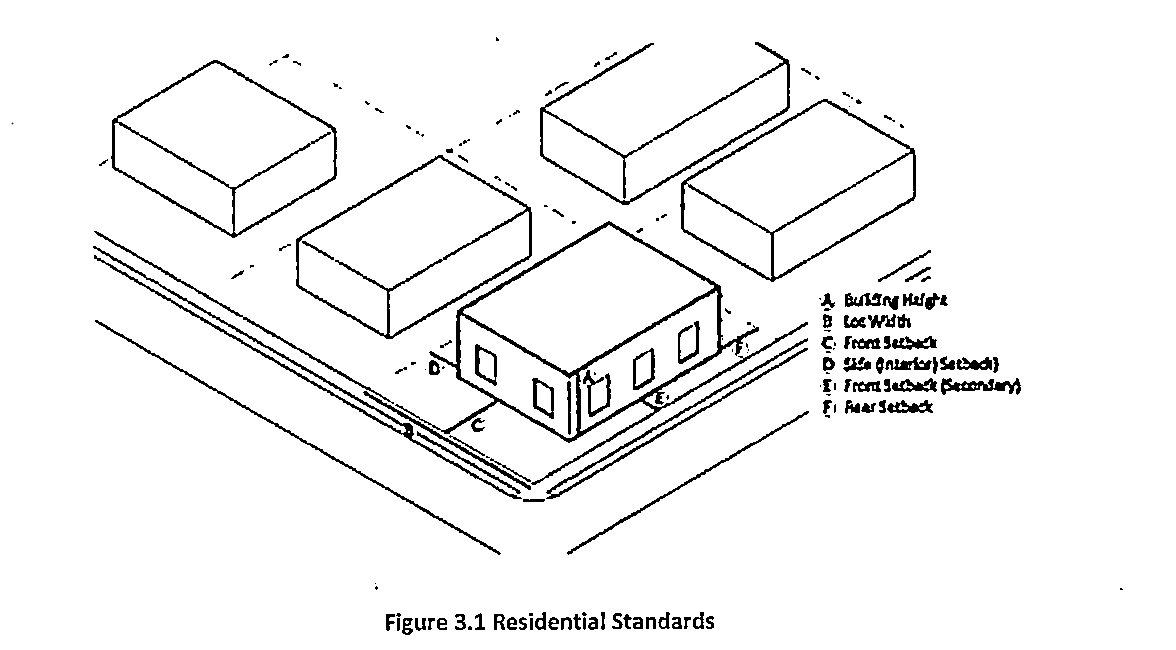
Sec. 305. - Dimensional Standards.
Dimensional requirements for residential zoning districts are established in Table 3.4, Residential Zoning Districts Dimensional Requirements. Buffer requirements on Table 5.3 also apply.
(Ord. No. 480, § 1, 6-6-23)
Sec. 306. - NR-1, low-density neighborhood residential district.
(a)
Purpose and intent. The NR-1 zoning district is intended primarily for single-family detached residences requiring greater amounts of open space.
(b)
Permitted and conditional uses shall be as provided in Table 4.1 of this zoning ordinance. In cases where a use is permitted but there are supplemental use regulations for that use specified in Article IV of this chapter, such regulations shall also apply.
(c)
Dimensional requirements shall be as provided in Table 3.4.
(d)
Site and building standards shall be as provided in Article V.
(Ord. No. 480, § 1, 6-6-23)
Sec. 307. - NR-2, medium-density neighborhood residential district.
(a)
Purpose and intent. The NR-2 zoning district is intended for single-family detached, townhomes, and attached residences on smaller lots where large amounts of open space are not required and/or desired.
(b)
Permitted and conditional uses shall be as provided in Table 4.1 of this zoning ordinance. In cases where a use is permitted but there are supplemental use regulations for that use specified in Article IV of this chapter, such regulations shall also apply.
(c)
Dimensional requirements shall be as provided in Table 3.4.
(Ord. No. 480, § 1, 6-6-23)
Sec. 308. - NR-3, high-density neighborhood residential district.
(a)
Purpose and intent. The NR-3 zoning district is intended for residences at a greater density on smaller lots in order to provide for a variety of housing types, including single family detached, single-family attached, duplexes, triplexes, quadruplexes, cluster homes and condominiums. This district may also serve as a transitional zone between light commercial/office uses and districts reserved for lower density single-family uses.
(b)
Permitted and conditional uses shall be as provided in Table 4.1 of this zoning ordinance. In cases where a use is permitted but there are supplemental use regulations for that use specified in Article IV of this chapter, such regulations shall also apply.
(c)
Dimensional requirements shall be as provided in Table 3.4.
(d)
Site and building standards shall be as provided in Article V.
(Ord. No. 480, § 1, 6-6-23)
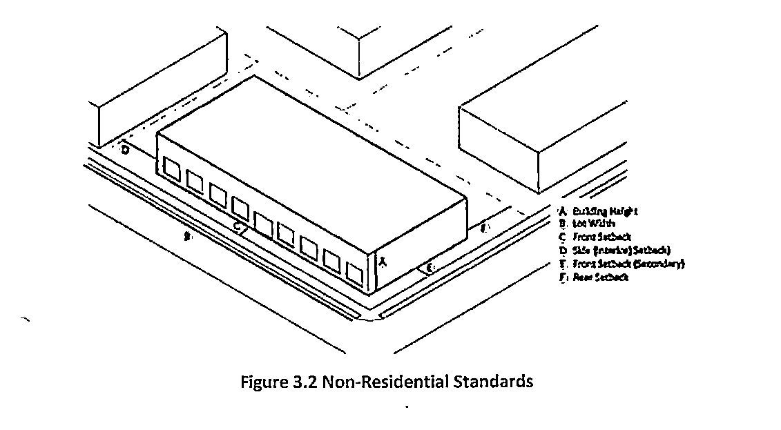
Sec. 309. - Dimensional Requirements.
Dimensional requirements for non-residential zoning districts are established in Table 3.5, Non-Residential Zoning Districts Dimensional Requirements. Buffer requirements on Table 5.3 also apply.
(Ord. No. 480, § 1, 6-6-23)
Sec. 310. - NC-1, low-density neighborhood commercial district.
(a)
Purpose and intent. The NC-1 zoning district is intended to provide suitable areas for limited retail and personal services serving residents in the immediate vicinity. Uses located within this district supply those goods and services which require frequent purchasing with a minimum of customer travel. The scope at which properties are developed within the NC-1 district should reflect their relatively small market areas. This zoning district may serve as a step down from more intense commercial uses to residential uses.
(b)
Permitted and conditional uses shall be as provided in Table 4.1 of this zoning ordinance. In cases where a use is permitted but there are supplemental use regulations for that use specified in Article IV of this chapter, such regulations shall also apply.
(c)
Dimensional requirements shall be as provided in Table 3.5.
(d)
Site and building standards shall be as provided in Article V.
(Ord. No. 480, § 1, 6-6-23)
Sec. 311. - NC-2, moderate-density neighborhood commercial district.
(a)
Purpose and intent. The NC-2 zoning district is intended to provide suitable areas for the provision of retail and personal services oriented towards those neighborhoods making up the adjacent community. The regulations which apply within this district are designed to encourage the formation of compatible and economically healthy business and service uses which benefit from close proximity to each other.
(b)
Permitted and conditional uses shall be as provided in Table 4.1 of this zoning ordinance. In cases where a use is permitted but there are supplemental use regulations for that use specified in Article IV of this chapter, such regulations shall also apply.
(c)
Dimensional requirements shall be as provided in Table 3.5.
(d)
Site and building standards shall be as provided in Article V.
(Ord. No. 480, § 1, 6-6-23)
Sec. 312. - I, light industrial district.
(a)
Purpose and intent. The I zoning district is intended to provide suitable areas for business distribution/service facilities, transportation terminals and manufacturing/assembly processes which do not emit noise, vibration, smoke, gas, fumes, or odors from an enclosed building. These districts should have access to arterial roadways and utilities and discourage uses which are incompatible with light manufacturing. When located on the perimeter of an industrial node, I-zoned properties should provide for uses that are low in intensity and scale to ensure compatibility with adjacent properties.
(b)
Permitted and conditional uses shall be as provided in Table 4.1 of this zoning ordinance. In cases where a use is permitted but there are supplemental use regulations for that use specified in Article IV of this chapter, such regulations shall also apply.
(c)
Dimensional requirements shall be as provided in Table 3.5.
(d)
Site and building standards shall be as provided in Article V.
(Ord. No. 480, § 1, 6-6-23)
Sec. 313. - Railroad open space district.
(a)
Purpose and intent. The R-OS zoning district is intended to be preserved as open space with no structures, improvements, or signs being erected in the railroad right-of-way.
(b)
Permitted and conditional uses shall be as provided in Table 4.1 of this zoning ordinance. In cases where a use is permitted but there are supplemental use regulations for that use specified in Article IV of this chapter, such regulations shall also apply.
(c)
Dimensional requirements shall be as provided in Table 3.5.
(d)
Site and building standards shall be as provided in Article V.
(Ord. No. 480, § 1, 6-6-23)
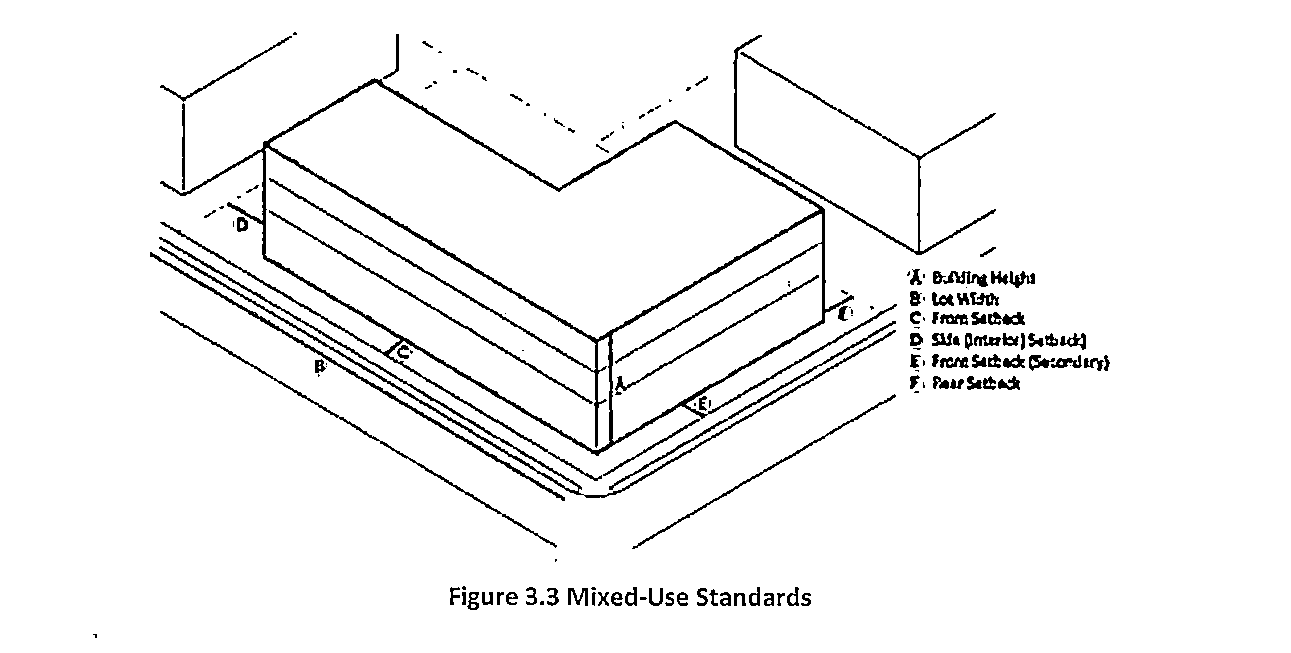
Sec. 314. - Dimensional Requirements.
Dimensional requirements for mixed use zoning districts are established in Table 3.6, Mixed-Use Zoning Districts Dimensional Requirements. Buffer requirements on Table 5.3 also apply.
(Ord. No. 480, § 1, 6-6-23)
Sec. 315. - NR-CD, neighborhood residential-community development district.
(a)
Purpose and intent. The NR-CD zoning district is primarily intended for multi-family housing developments. However, the district allows for a mix of housing types, including single-family attached, townhomes, and detached structures, as well as some limited institutional and personal service uses that would be convenient to nearby residents.
(b)
Permitted and conditional uses shall be as provided in Table 4.1 of this zoning ordinance. In cases where a use is permitted but there are supplemental use regulations for that use specified in Article IV of this chapter, such regulations shall also apply.
(c)
Dimensional requirements shall be as provided in Table 3.6.
(d)
Site and building standards shall be as provided in Article V.
(Ord. No. 480, § 1, 6-6-23)
Sec. 316. - RC, residential/commercial district.
(a)
Purpose and intent. The RC zoning district is intended to allow converted residential structures with commercial uses to coexist with residential uses. Commercial uses will be limited in order to maintain the current balance and aesthetic in the surrounding area. Residences converted to office uses are acceptable when kept at current scale.
(b)
Permitted and conditional uses shall be as provided in Table 4.1 of this zoning ordinance. In cases where a use is permitted but there are supplemental use regulations for that use specified in Article IV of this chapter, such regulations shall also apply.
(c)
Dimensional requirements shall be as provided in Table 3.6.
(d)
Site and building standards shall be as provided in Article V.
(Ord. No. 480, § 1, 6-6-23)
Sec. 317. - TC, town center district.
(a)
Purpose and intent.
(1)
Promote development of a compact, pedestrian-oriented town center consisting of a high-intensity employment center, vibrant and dynamic mixed-use areas;
(2)
Promote a diverse mix of residential, business, commercial, office, institutional, cultural and entertainment activities for workers, visitors, and residents;
(3)
Encourage bicycle and pedestrian-oriented development at densities and intensities that will help to support transit usage and town center businesses;
(4)
Promote the health and well-being of residents by encouraging physical activity, alternative transportation, and greater social interaction;
(5)
Create a place that represents a unique, attractive, and memorable destination for visitors and residents; and
(6)
Enhance the community's character through the promotion of high-quality urban design.
(b)
Permitted and conditional uses shall be as provided in Table 4.1 of this zoning ordinance. In cases where a use is permitted but there are supplemental use regulations for that use specified in Article IV of this chapter, such regulations shall also apply.
(c)
Dimensional requirements shall be as provided in Table 3.5. Unless otherwise stated in this section.
(1)
The maximum front building setback may not exceed the average front yard depth of the nearest two (2) lots on either side of the subject lot or twelve (12) feet, whichever is less.
(i)
If one or more of the lots required to be included in the averaging calculation are vacant, such vacant lots will be deemed to have a yard depth of zero (0) feet.
(ii)
Lots fronting a different street than the subject lot or separated from the subject lot by a street or alley may not be used in determining the average.
(iii)
When the subject lot is a corner lot, the average setback will be determined on the basis of the two (2) adjacent lots that front on the same street as the subject lot.
(iv)
When the subject lot abuts a corner lot fronting on the same street, the average setback will be determined on the basis of the abutting corner lot and the nearest two (2) lots that front on the same street as the subject lot.
(2)
A building may be set back farther than the maximum setback in order to accommodate an outdoor eating area. In order to preserve the continuity of the street wall, the building may be set back no more than twelve (12) feet from the front or street side property line.
(d)
Site and building standards shall be as provided in Article V.
(Ord. No. 480, § 1, 6-6-23)
Sec. 318. - Planned Unit Development.
(a)
Planned unit development is defined as two (2) or more buildings to be constructed on a tract or several tracts of land. Planned unit developments are not a zoning district and must comply with the underlying zoning district unless otherwise stated in this zoning ordinance.
(b)
Purpose and intent. Planned unit developments encourage the best possible site plans and building arrangements under a unified plan of development rather than on a lot-by-lot basis. The developer benefits from better land utilization, economy in the provision of roads and utilities and flexibility in design. The city gains the advantages of variety in building types, compatibility of uses and optimum community development. Review of the development plan by the city provides an opportunity to assure that the development will be in harmony with the character of the neighborhood in which the development is located. The purpose of the planned unit development shall be to:
(1)
Provide for unified approaches to the development of land;
(2)
Provide for a simplified process of enabling development which would otherwise require numerous applications for variances from the provisions of the zoning code;
(3)
Provide for the development of stable environments that are compatible with surrounding areas of the community; and
(4)
Assure the provision of park and recreation land and facilities for the use of the occupants of the development.
(Ord. No. 480, § 1, 6-6-23)
Sec. 319. - Clemsil Overlay District.
(a)
Boundaries: The boundaries of the Clemsil Overlay District shall be established by the official zoning map amendment and is adopted contemporaneously with the adoption of this section and which is incorporated by reference as if fully set forth herein and made a part of this Chapter. The zoning map amendment shall be maintained by the city manager.
(b)
In general, the Clemsil Overlay District consists of properties with their primary frontage on the following streets:
(1)
Smith Street.
(2)
Lincoln Street.
(3)
Tribble Street.
(4)
Clark Street.
(5)
Lester Street.
(6)
See Clemsil Map.
(c)
To the extent that the official zoning map is unclear as to whether a particular parcel is located within the Clemsil Overlay District, the City manager shall determine whether such property is located within the boundaries of the Clemsil Overlay District based upon the official zoning map.
(d)
Primary uses and structures: All properties located within the Clemsil Overlay District shall be governed by all of the requirements of the underlying zoning district regulations. Where the requirements of the underlying zoning district and the requirements of this section are in conflict, the requirements of this section shall control.
(e)
In addition, the following primary uses of land and structures shall also be authorized within the overlay district:
(1)
Accessory uses and structures. The following accessory uses shall be authorized in the Clemsil Overlay District
(i)
Accessory uses and structures incidental to any authorized use.
(ii)
Parking lots which are accessory to any authorized use.
(iii)
Open Space and Parks
(f)
Architectural guidelines for Residential: Architectural design of all residential buildings and accessory structures within the Clemsil Overlay shall comply with the following guidelines:
(1)
Each building elevation shall be constructed of wood, vinyl siding, brick (three (3) sided- front, and sides), stone, cinder blocks, cement fiberboard siding, or any combination thereof.
(2)
Roofing materials for pitched or hip roofs shall consist of tile, slate, stone, wood shake or architectural-style shingles.
(3)
Porch/Stoop.
(4)
Shutters (optional).
(5)
Exterior painting shall be of neutral colors.
(g)
Primary uses and structures: The following primary uses of land and structures shall be authorized in the Clemsil Overlay District;
(1)
All uses authorized in the NR-3 zoning district on all property located within the Clemsil Overlay District unless otherwise prohibited in this section. Cottage housing developments are permitted in clusters of no more than two (2) homes on a parcel.
(2)
Detached single-family residences/ cottage housing development at a maximum density of two (2) units per parcel with a minimum lot size of 2,500 square feet per lot.
(3)
Minimum residential unit size seven hundred fifty (750) sq. ft.
(4)
Building coverage (Max a % of lot area) seventy-five (75) percent.
(h)
Prohibited primary uses and structures: The following primary uses of land and structures shall be prohibited within the Clemsil Overlay District.
(1)
New multi-family residential dwellings (duplexes and triplexes).
(2)
Townhomes.
(3)
Parking lots as a primary use.
(4)
Boarding/rooming house.
(5)
New places of assembly, including religious institutions.
(6)
Bed and breakfast.
(7)
Hotel or motels.
(8)
Daycare facilities.
(9)
Personal care homes.
(10)
Transitional housing facility.
(11)
Industrial and office buildings.
(i)
Special administrative permit approved by the city manager:
(1)
Home occupation involving no customer contact and no employee other than the person residing on the premises.
(j)
Miscellaneous building standards for Clemsil Overlay Districts:
(1)
Corner lots shall not be required to have an additional fifteen (15) feet of street frontage.
(2)
Cottage and one (1) story ranch.
(3)
Setback minimum requirements;
(i)
Front: 10'
(ii)
Rear: 15'
(iii)
Side: 7'
(4)
Minimum lot size shall be two thousand five hundred (2,500) sq. ft.
(k)
No lot shall be developed to exceed the maximum allowable coverage by buildings, structures, driveways or parking areas, or any other impervious surface specified as follows:
(1)
Attached Single-Family Residential - seventy-five (75) percent
(2)
Measurement of building height shall be fifteen feet (15'.)
(i)
Rear and side fences are optional.
(ii)
Fences along public right-of-way shall be four (4) feet maximum. Fence height shall be measured from ground level. If ground level is lower than the level of the adjoining street pavement, then a fence may be higher so that it may be four (4) feet above the level of the pavement. The level of ground shall not be altered in such a way to provide additional fence height.
(iii)
Fences can be made of wood, brick, stone, wrought iron, or landscaped.
(l)
Parking: Minimum of two (2) parking spaces per dwelling unit.
(m)
Landscaping requirements:
(1)
Landscape strips:
(i)
A continuous landscaped strips shall be constructed along public rights-of-way except at points of ingress or egress. Street trees shall be between the curb and sidewalk.
(ii)
The landscape strip in the front yard shall be planted with a row of street trees of at least three and one-half (3.5) inches in caliper and planted not less than thirty (30) feet on center. Trees of the following types shall be used:
a.
Crape myrtle (Lagerstroemia indica) cultivars, with a standard trunk, but only under electric power lines.
b.
All serviceberry (Amelanchier) species, but only under electric power lines.
c.
All dogwood (Cornus) species.
d.
October Glory red maple (Acer rubrum 'October Glory').
e.
Red Sunset maple (Acer rubrum 'Red Sunset').
f.
All oak (Quercus) species.
g.
Japanese zelkova (Zelkova serrata).
h.
Ginkgo (Ginkgo biloba), but only male cultivars.
i.
Trident maple (Acer buergerianum).
j.
Allee lacebark elm (Ulmus parvifolia 'Emer II').
k.
Other varieties are subject to the review and approval of the city arborist or the city manager or their designee.
(n)
Plans required: The approval process for development within the Clemsil Overlay shall meet the requirements of Sec. 204 through Sec. 206.
(Ord. No. 480, § 1, 6-6-23)