
Clarkston City Zoning Code
ARTICLE V
- SITE DESIGN
DIVISION 7: - BUFFERS, SCREENING, AND LANDSCAPING
The purpose of this section is to ensure and facilitate the preservation and/or replacement of trees and landscaping as part of the land development process within Clarkston and to provide minimum landscape, buffer and screening standards for development in the city so as to enhance architectural features, improve energy efficiency, improve water quality, reduce environmental damage, reduce urban heat island effect, provide quality wildlife habitat, control of soil erosion and aesthetics and to provide a scenic amenity within Clarkston. In addition to the regulations set forth herein, the regulations in The Clarkston Tree Protection Plan shall also apply. All tree protection plans and landscape plans submitted to meet city requirements shall be prepared and stamped by a Georgia licensed landscape architect, provided however that an architect or engineer may also provide such plans if knowledgeable in landscape architectural design and/or tree protection plan preparation.
(Ord. No. 480, § 1, 6-6-23)
Sec. 501. - General application.
The following design standards shall apply to all zoning districts.
(Ord. No. 480, § 1, 6-6-23)
Sec. 502. - Administrative variance.
The City manager has the authority to modify certain provisions of this article pursuant to Section 216.
(Ord. No. 480, § 1, 6-6-23)
Sec. 503. - Removal of soil.
No soil, mineral, or similar material may be removed from any lot except that which is purely incidental to construction of a building or structure. No excavation on any lot exceeding one (1) foot in depth, except for the purpose of constructing a fence, locating poles, or underground service connections of public utilities shall be permitted unless a building permit is first secured.
(Ord. No. 480, § 1, 6-6-23)
Sec. 504. - Utilities location.
Electrical transformer stations, telephone exchanges and gas regulating stations, may be located in any zoning district subject to compliance with the following conditions and requirements and approval by the mayor and city council.
(a)
Such facilities shall be essential for service to the area in which located or for the proper functioning of the total utility system of which the same is a part.
(b)
Such facility shall be enclosed by an opaque structure not less than ten feet (10) feet high.
(c)
Any building or structure, except an enclosing fence, shall be setback not less than fifty (50) feet from any property line, and shall meet all other applicable yard requirements of the district in which it is located.
(d)
Open spaces on the premises shall be suitably landscaped and maintained, and a planted buffer strip at least ten (10) feet wide shall be located along the side and rear property lines.
(e)
When such facilities are located within any residential district, the storage of vehicles and equipment on the premises shall be prohibited.
(f)
The area surrounding such a facility shall not be adversely affected by, and shall be protected from, noise, odor, glare, dust, fumes, gas, smoke, vibration, or any other obnoxious characteristics.
(Ord. No. 480, § 1, 6-6-23)
Sec. 505. - Street frontage requirement.
Every building hereafter erected or moved shall be on a lot adjacent to a public street, or with access to an approved private street, and all structures shall be so located on lots as to provide safe and convenient access for servicing, fire protection, and required off-street parking.
In the event a land locked lot exists, as of the effective date of this zoning ordinance, the property owner shall be entitled to only one (1) building permit, provided;
(a)
No other primary building exists or is being constructed on said property;
(b)
No other valid building permit has been issued prior to the effective date of this zoning ordinance and is currently valid;
(c)
The property was and continues to be under single ownership since the effective date of this zoning ordinance;
(d)
The property owner has acquired a twenty (20) foot access easement to a publicly maintained street, and said easement has been duly recorded and made part of the property deed; and
(e)
In the event said property is divided, no additional permits will be issued.
(Ord. No. 480, § 1, 6-6-23)
Sec. 506. - Setback averaging.
(a)
When a vacant lot located in the NR-1 or NR-2 zoning district authorized for single-family detached dwellings is proposed for single-family development, and is located where at least sixty (60) percent of the other lots on the same block face are occupied by single-family detached dwellings, then setback averaging shall apply.
(b)
Where setback averaging applies, the minimum front setback for the vacant lot to be developed shall be the average of the actual front setbacks of the existing dwellings adjacent to the vacant lot and on the same block face.
(c)
When the averaged calculation requires a proposed structure to be closer to the street than the otherwise applicable minimum front setback for the zoning district where the vacant lot is located, then setback averaging shall not be applied.
(d)
Where application of setback averaging would make it impossible for the proposed dwelling to comply with the applicable zoning district's rear yard setback requirement, then the proposed dwelling may be constructed closer to the street, up to the minimum front setback required in the subject zoning district, only to the extent necessary to satisfy the minimum rear yard setback requirement.
(Ord. No. 480, § 1, 6-6-23)
Sec. 507. - Lot reduction prohibited.
No lot, even though it may consist of one (1) or more adjacent lots of record, shall be reduced in size so that the minimum lot size, lot width, front, side or rear setbacks, or other requirements of this zoning ordinance are not maintained. Yards or lots created after the effective date of this zoning ordinance shall meet at least the minimum requirements established by this zoning ordinance. This section shall not apply when a portion of a lot is acquired for a public purpose.
(Ord. No. 480, § 1, 6-6-23)
Sec. 508. - One primary residential building per lot.
Only one (1) permitted primary use, and its authorized accessory uses(s), shall be authorized per lot, unless multiple or mixed uses are specifically authorized on the same lot elsewhere in this zoning ordinance.
(Ord. No. 480, § 1, 6-6-23)
Sec. 509. - Requirements for moving a building.
No building shall be relocated within the city unless, when relocated, it meets all requirements of this zoning ordinance and other City Code requirements, and prior to the transportation of the structure, the relocation has been approved by the City of Clarkston.
(Ord. No. 480, § 1, 6-6-23)
Sec. 510. - Building materials.
(a)
Permitted exterior building materials.
(1)
Brick masonry;
(2)
Stone masonry;
(3)
Cement wood or fiber cement siding, including simulated half-timbering;
(4)
Hard coat stucco;
(5)
Cedar shingles or fiber cement;
(6)
Architectural concrete;
(7)
Precast or tilt-up panel (for industrial buildings only);
(8)
Glass;
(9)
Wood siding;
(10)
Material not listed in this section, which shall contribute to innovative design or green construction as determined by the city manager on a case by case basis; and/or
(11)
Architectural accent materials as approved by the city manager.
(b)
Exterior building materials that are permitted on industrial buildings.
(1)
EIFS.
(2)
Standing seam or corrugated metal (not more than forty (40) percent of the exterior of the structure).
(c)
Prohibited materials.
(1)
Concrete block.
(2)
Vinyl siding.
(Ord. No. 480, § 1, 6-6-23)
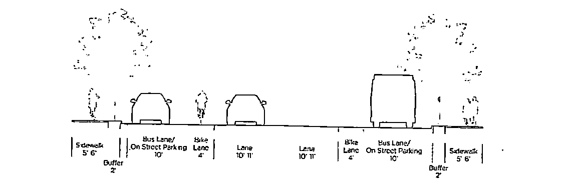
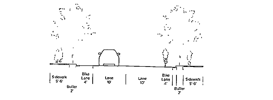
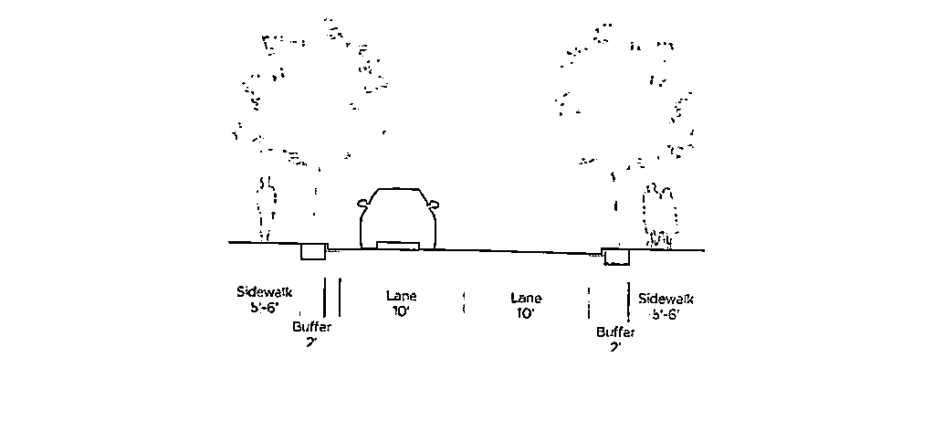
Sec. 511. - Functional classification of streets.
For purposes of this zoning ordinance, all of the streets, roads and highways in the City of Clarkston are classified according to the Georgia Department of Transportation. The following are typical street sections for each classification:
(a)
Arterial.
(b)
Collector.
(c)
Residential.
(Ord. No. 480, § 1, 6-6-23)
Sec. 512. - Street Connectivity.
(a)
New streets shall be designed to create an interconnected system of grid-patterned roads, modified only to accommodate topographic conditions. Each new street shall connect to the existing street grid.
(Ord. No. 480, § 1, 6-6-23)
Sec. 513. - Vision clearance at intersections.
In all zoning districts, no fence, wall, structure, shrubbery or other obstruction to vision between the heights of three (3) feet and fifteen (15) feet, except utility poles, light or street sign standards or tree trunks, shall be permitted within twenty-five (25) feet of the intersection of rights-of-ways of streets, highways and railroads. Streets without right-of-way shall be measured from the driving surface or curb at the intersection.
(Ord. No. 480, § 1, 6-6-23)
Sec. 514. - Yard and other spaces.
Any building, structure or use hereafter erected, altered or established shall comply with the yard space requirements of the district in which it is located. The required yard space for any building, structure, or use shall be contained on the same parcel as the building, structure or use and such required yard space shall fall entirely upon land in the district(s) in which the primary use is permitted.
No part of a yard or other open space or off-street parking or loading space(s) required for any one building shall be included as a part of the yard or off-street parking or loading space(s) required for another building, except as specifically provided for herein.
(Ord. No. 480, § 1, 6-6-23)
Sec. 515. - Permitted encroachments upon required setbacks.
The following setback encroachments are permitted in all zoning districts:
(a)
Cornices, eaves, chimneys, porches, bay windows, or other similar architectural features may extend into the required front, side and rear yard provided such extensions do not exceed three (3) feet.
(b)
Steps and landings may extend into the required setbacks provided such extensions do not exceed ten (10) feet for the front yard, and three (3) feet for the side yard.
(Ord. No. 480, § 1, 6-6-23)
Sec. 516. - Reduction in front yard setback.
In the NC-1, NC-2, TC, NC-RD, and RC districts, fifty (50) percent reduction in the required front yard setback is allowed when all required parking is located exclusively in the rear yard of the parcel and an eighty (80) percent reduction in the required front yard setback is allowed when all parking is located in an underground parking structure, or a parking structure that is wrapped with commercial uses so that it is concealed.
(Ord. No. 480, § 1, 6-6-23)
Sec. 517. - Front yard.
(a)
Front yard general requirements.
(1)
The square footage contained within the front yard which meets open space criteria established in Article III may count towards the open space requirement as required by that zoning district.
(2)
Automobile parking shall be prohibited from being located within the front yard, except where otherwise permitted in this zoning ordinance.
(3)
Non-residential front yards shall permit and encourage pedestrians to walk on the surface of the front yard excluding fountains, pedestrian furniture, public art and similar elements.
(4)
Residential front yards.
i.
When sidewalk level residential units are provided, the front yard shall be landscaped with the exception of terraces, porches, stoops and walkways, which may occupy a maximum of fifty (50) percent of the front yard area.
ii.
Terraces, porches and stoops shall have a maximum finished floor height of twenty-four (24) inches above finished-grade, unless existing topographical considerations render this requirement unreasonable.
iii.
Shall only permit automobile parking when located on the permitted accessory driveway asphalt or gravel surface. Said accessory driveway shall not exceed thirty-five (35) percent coverage of the total lot.
(Ord. No. 480, § 1, 6-6-23)
Sec. 518. - Relationship of building to street.
(a)
The primary pedestrian access to all sidewalk level uses and business establishments with public or private street frontage:
(1)
Shall face and be visible from the public or private street when located adjacent to such street. When located adjacent to a street that functions as an arterial street or a collector street, said entrance shall face and be visible from such street.
(2)
Shall be directly accessible and visible from the sidewalk adjacent to such street.
(3)
Shall remain unlocked during business hours for non-residential uses.
(b)
A street address number shall be located directly above the primary building entrance, shall be clearly visible from the sidewalk and shall be a minimum of six (6) inches in height.
(c)
Buildings with residential uses at the sidewalk level shall meet the following regulations:
(1)
All primary pedestrian entrances not adjacent to a public sidewalk shall be linked to the public sidewalk with a pedestrian walkway a minimum of six (6) feet wide.
(2)
All such buildings with more than four (4) residential units that are adjacent to the sidewalk shall have individual entrances to such units directly accessible from the sidewalk and shall open directly onto the adjacent sidewalk, park, plaza, terrace or porch adjacent to the sidewalk. All pedestrian walkways providing such access shall be perpendicular to the street, unless topography prohibits, and shall be permitted to share said walkway with one (1) adjacent unit.
(3)
Such buildings shall have equal percentages of fenestration on all street frontages.
(Ord. No. 480, § 1, 6-6-23)
Sec. 519. - Storefront street requirements and fenestration.
(a)
The following table designates certain streets and roads in Clarkston as Storefront Streets.
(b)
All uses that front Storefront Streets, with the exception of religious institutions and fire stations, shall meet the following sidewalk level requirements:
(1)
The first floor shall have a minimum floor-to-ceiling height of fifteen (15) feet.
(2)
Sidewalk level uses with street frontage on the Storefront Streets shall only be retail, office, or restaurant establishments with outdoor dining. Said uses shall have a minimum depth of twenty (20) feet from any building facade along the public sidewalk.
(3)
The length of facade without intervening fenestration or entryway shall not exceed twenty (20) feet.
(4)
Fenestration shall be provided for a minimum of sixty-five (65) percent of the length of all street frontages:
i.
Beginning at a point not more than three (3) feet above the sidewalk, to a height no less than ten (10) feet above the sidewalk; or
ii.
Beginning at the finished floor elevation to a height no less than ten (10) feet above the finished floor elevation when the finished floor elevation is three (3) or more feet above the sidewalk; or
iii.
Beginning at a point not more than sidewalk level, to a height no less than ten (10) feet above the finished floor elevation when the finished floor elevation is below the sidewalk.
(5)
Fenestration shall not utilize painted glass, reflective glass or other similarly treated or opaque windows. Entrances may be counted towards fenestration requirements.
i.
Fenestration shall be provided for a minimum of fifty (50) percent of the length of the street frontage for residential uses on all streets and for non-residential uses.
ii.
Parking decks and structures located along storefront streets shall meet all of the above requirements. See Section 604 for additional requirements for parking decks.
(Ord. No. 480, § 1, 6-6-23)
Sec. 520. - Building facades and entrances.
(a)
Building facades of commercial and mixed use structures shall be articulated to minimize the monotonous appearance of large buildings through the use of architectural elements such as recessed windows and entries, offset surfaces, differentiated piers and columns, offset planes, textured materials, or awnings.
(1)
Variations in facade treatment shall be continued throughout the structure, including its roof line and front and rear facades.
(b)
Delineation of building floors at the third story above sidewalk level and lower shall be executed through windows, belt courses, cornice lines or similar architectural detailing.
(c)
Franchise architecture. Buildings where the proposed architecture is the result of "corporate" or franchise style shall be prohibited. New construction should provide variety and diversity and express its own uniqueness of structure, location or tenant. Buildings shall be consistent with the local architectural vernacular, establish a sense of permanence, and avoid over- commercialization. Building design shall reflect local, unique, and traditional designs rather than chain or franchise designs.
(d)
Color. The overall exterior color scheme shall be compatible with those of surrounding properties and shall be primarily earth tones. Accents, like doors and shutters, can be non-earth tones.
(Ord. No. 480, § 1, 6-6-23)
Sec. 521. - Proportion and scale for multi-family and non-residential uses.
The following requirements shall apply to all multi-family and non-residential development, including parking decks structures:
(a)
Building massing. All new development proposals shall incorporate means of reducing the apparent size and bulk of the building. The following methods for reducing the apparent size and mass of larger buildings shall be required.
(1)
Discontinuous building massing. Every building shall reduce its perceived height and bulk by dividing the building mass into smaller scale components. Building walls exceeding one hundred (100) continuous linear feet shall utilize offsets, such as projections, recesses, and changes in floor level, to add architectural interest and variety, and to relieve the negative visual effect of a simple long wall.
(2)
Variation in building silhouettes. Variation in the roofline of buildings and offsets in pitched roofs and gables shall be required. Parapets in building masses exceeding one hundred (100) continuous linear feet shall be varied in height and projection and shall use decorative elements such as crown or dental moldings, brick soldier courses, or similar detail.
(3)
Building step backs. Buildings in excess of fifty (50) feet in height shall be required to step back that portion of the building greater than fifty (50) feet in height a minimum linear distance of ten (10) feet away from the building facade located below the fifty (50) foot height plane.
(Ord. No. 480, § 1, 6-6-23)
Sec. 522. - Blocks and street infrastructure.
(a)
Non-residential developments with more than six hundred (600) feet of frontage along a single street shall be divided by streets into blocks having a maximum length of six hundred (600) feet, as measured from street curb to street curb. Number and location of curb cuts shall be approved by the city manager.
(b)
Streets used to divide properties into blocks shall meet all of the street and sidewalk designations of this zoning ordinance.
(c)
Opportunities for inter-parcel vehicle access points between all contiguous commercial, office, industrial or multi-family residential tracts shall be provided.
(d)
Streets with greater than two hundred and fifty (250) total linear feet of un-intersected street frontage shall be prohibited from terminating with a cul-de-sac.
(e)
Gates and security arms shall be prohibited from crossing any public street or sidewalk.
(Ord. No. 480, § 1, 6-6-23)
Sec. 523. - Pedestrian and bicycle pathways.
(a)
Pathways shall form a logical, safe and convenient system for pedestrian access to all dwelling units and other buildings and facilities.
(b)
Pathways shall be so located and safeguarded as to minimize contact with automotive traffic.
(c)
Pathways that are appropriately located, designed and constructed may be combined with other easements and used by emergency and service vehicles, but shall not be used by other automotive traffic.
(d)
Pathways shall meet the width requirements depending on the street type described in Sec. 511.
(Ord. No. 480, § 1, 6-6-23)
Sec. 524. - Lighting.
(a)
General provisions.
(1)
The purpose of these criteria are to create standards for outdoor lighting which will provide nighttime safety, security and utility, while reducing light pollution and light trespass, and increase conservation of energy.
(2)
Any lighting used to illuminate parking areas, access drives or loading areas shall be of such a design or level of illumination so as to minimize the amount of ambient lighting perceptible from adjacent properties and that would impair the vision of motorists.
(3)
The Illuminating Engineering Society of North America (IESNA) Lighting Handbook, Ninth Edition, shall be used as a guide for lighting installations. The definitions in this handbook shall be used for technical terminology unless otherwise specified in this code.
(b)
Lighting standards.
(1)
Entrances into developments from a street may be lighted for traffic safety reasons provided such lighting does not exceed the foot candle requirements for lighting walkways and streets.
(2)
Lighting poles mounted on private property within fifty (50) feet from the street right-of-way may not exceed a height of sixteen (16) feet.
(3)
Accent lighting for building facades and other vertical structures shall be directed solely onto the building or structure and not toward the sky or onto adjacent properties. Direct light emissions shall not be visible above the roofline or beyond the building's edge. Shielding shall be provided to restrict light to the object being accented.
(4)
All pole mounted fixtures shall be mounted parallel to the ground. Building mounted floodlights shall be direct cutoff type and set parallel to the ground.
(5)
All interior lighting shall be designed to prevent the light source or high levels of light from being visible from the street.
(6)
Lighting for uses adjacent to residentially zoned property shall be designed and maintained such that illumination levels do not exceed 1.0 foot-candles along property lines. Lighting for uses adjacent to non-residentially zoned property shall be designed and maintained such that illumination levels do not exceed three and zero tenths (3.0) foot-candles along property lines.
(7)
The use of search lights, laser lighting, LED lighting in the forms of channel strips, ropes or similar configurations, or lights that pulse, flash, rotate or simulate motion for advertising or promotions is prohibited.
(8)
All lighting fixtures designed or placed so as to illuminate any portion of a site shall meet the following requirements:
i.
Fixtures.
a.
Any wall or pole-mounted light fixture shall be a cutoff luminaire whose source is completely concealed with an opaque housing and shall not be visible from any street. The light output of the fixture shall be two and five tenths (2.5) percent or less of the total output at ninety (90) degrees from the vertical plane and ten (10) percent or less of total output at eighty (80) degrees from the vertical plane.
b.
Light fixtures for canopies covering fueling stations and at individual drive-through facilities shall be mounted such that the lens cover is recessed or flush with the bottom surface of the canopy and/or shielded by the fixture or the edge of the canopy. The light output of the fixture shall be two and five tenths (2.5) percent or less of the total output at ninety (90) degrees from the vertical plane and ten (10) percent or less of total output at eighty (80) degrees from the vertical plane.
ii.
Lamps.
a.
For parking lot and site lighting, the same type of lamp must be used for the same or similar type of lighting on any one site or development. All exterior luminaires that operate at greater than one hundred (100) watts shall contain lamps having a minimum efficacy of sixty (60) lumens/watt unless the luminaire is controlled by a motion sensor.
b.
Illumination levels. All site lighting shall be designed so that the level of illumination as measured in foot-candles (fc) at any one (1) point meets the following standards. Minimum and maximum levels are measured at any one (1) point. Average level is not to exceed the specified limit by more than twenty (20) percent, and is derived using only the area of the site included to receive illumination. Points of measure shall not include the area of the building or areas which do not lend themselves to pedestrian traffic. Also, if the major portion of the lighting design is to be in the front of a building, the average level should not be affected by additional lighting in the back of the same building, which would raise the average of the intended area for lighting. Illumination levels are as follows:
iii.
Methods of measurement Horizontal illumination levels shall be measured at ground level by a light meter certified by its manufacturer as being calibrated in accordance with standards of the National Institute of Standards and Technology. Maximum illumination readings must be taken directly beneath the luminaire. Vertical illumination readings shall be taken on the surface of the object being lighted or at five (5) feet above the ground for pedestrian areas.
iv.
Exemptions.
a.
Decorative seasonal lighting for festivals and holidays with a power rating of seventy-five (75) watts or less.
b.
Temporary emergency lighting used by police, firefighters, or other emergency services.
c.
Hazard warning luminaires or safety or security lighting required by regulatory agencies or state or federal law.
v.
Requirements for submittals.
a.
Site lighting plans shall be submitted to the city manager for review and approval for any new lighting installations. Plans shall be at a scale to allow the reviewer to determine conformance with this chapter, such as 1" = 20' or 1" = 40'.
b.
Site lighting plans shall include:
1.
Location and mounting information for each light.
2.
Illumination calculations showing light levels in foot candles at points located on a ten (10) foot or smaller grid, including an illustration of the areas masked out per the requirements above regarding points of measurement.
3.
A fixture schedule listing fixture design, type of lamp, and wattage of each fixture, and number of lumens after using eighty-five (85) percent depreciation of initial output for both metal halide and high pressure sodium.
4.
Manufacturer's photometric data for each type of light fixture.
5.
An illumination summary, including the minimum, average and maximum foot-candles calculations.
(Ord. No. 480, § 1, 6-6-23)
Sec. 525. - Automobile uses.
(a)
Drive-through service windows and drive-in facilities shall not be located between a building and the street.
(b)
Gasoline fuel dispenser structures and associated vehicular services such as air pumps and car washes shall not be located between a building and the street.
(Ord. No. 480, § 1, 6-6-23)
Sec. 526. - Loading bay regulations.
(a)
Loading areas shall not face any public street.
(b)
Loading and dumping activities located within one hundred and fifty (150) feet of a single-family residential property shall only be permitted to undertake said activities during normal business hours (8:00 a.m.—5:00 p.m.).
(c)
Accessory mechanical systems and features including HVAC systems shall not be visible from the public right-of-way.
(Ord. No. 480, § 1, 6-6-23)
Sec. 527. - Standards applying to all planned unit developments.
All planned unit developments (PUD) shall meet the following standards and such other requirements as are set forth with respect to each of the four (4) permitted types of planned unit developments:
(a)
Review of Planned Unit Developments.
(1)
Plans for all Planned Unit Developments must be designed and submitted for review and approval pursuant to Article II of this zoning ordinance.
(b)
Permitted locations.
(2)
Planned Unit Developments shall be permitted as outlined in Table 4.1.
(c)
Development standards.
(1)
The development shall utilize design and development features that would not be possible by the application of lot-by-lot zoning district regulations.
(2)
Site planning. Site planning in the proposed planned unit development shall give consideration to the topography; it shall be compatible with the topography of the land and shall preserve any unusual and valuable natural features.
(3)
The development shall not adversely affect developed or undeveloped neighboring properties; it should consider the location of structures, screening, setbacks and street design in the evaluation of the relationship of the development to its surrounding areas.
(4)
Service and emergency access. Access and circulation shall adequately provide for firefighting and other emergency equipment, service deliveries and refuse collection.
(5)
Infrastructure. Provision shall be made for acceptable design and construction of storm sewers and stormwater retention facilities, as required by Chapter 19 of the City Code and by DeKalb County. Transportation and other infrastructure, such as schools, water and sewer shall be adequate for the proposed development or there shall be a definite proposal for making them so. All planned developments are required to connect to county water and sewer system.
(6)
Covenants. The planned unit development shall include such covenants and legal provisions as will assure conformity to the achievement of the plan
(i)
General private deed covenants. The entire planned development shall be included within private deed covenants running with the land to assure the continuance of the planned residential development in accordance with approved plans and development. No certificate of occupancy shall be issued until a copy of the recorded legal covenants has been submitted to the city.
(d)
Conformance with existing zoning.
(1)
Future land use map. Planned unit developments shall not violate the provisions of the future land use map.
(2)
Permitted Uses. Only those uses permitted in the zoning district in which the proposed development is located shall be permitted in the planned unit development.
(3)
Signs. Planned unit developments shall strictly comply with the signage provisions of Chapter 15.5 of the Clarkston City Code.
(4)
Off-street parking requirements. The off-street parking requirements of this zoning ordinance shall be met.
(5)
Yards. Along the exterior boundaries of a planned development, no yard shall be less than five (5) feet in width and buffer requirements of this ordinance shall be met.
(6)
Common open space requirements. The open space requirements for the underlying district shall be met unless otherwise stated in this section.
(i)
Open space maintenance. In the event the property owners' association for a planned residential or cottage housing development fails to maintain the common open space property, the city may serve written notice upon the property owners' association and upon the residents and owners of the planned development setting forth the manner in which the organization has failed to maintain the common open space in reasonable condition. Said notice shall include a demand that such deficiencies of maintenance be corrected within thirty (30) days thereof, and shall state the date and place of a hearing thereon which shall be held within fifteen (15) days of the notice.
a.
If the deficiencies are not corrected within said thirty (30) days, the city, in order to preserve the taxable values of the properties within the planned development and to prevent the common open space from becoming a public nuisance, may enter upon said common open spaces and maintain the same for one (1) year and thereafter until the property owners' association is prepared to provide proper maintenance.
b.
The cost of such maintenance by the city shall be assessed ratably against the properties within the planned residential or cottage development that have a right of enjoyment of the common open space and shall become a tax lien upon said properties. The city at the time of entering upon said common open space for the purpose of maintenance, shall file a notice of such lien in the office of the county tax assessor upon the properties affected by such lien within the planned residential development.
(ii)
Phased development projects. Planned Unit Development applicants may propose construction phases (commencement and completion dates) for a planned residential development project that has identified, logical geographical sections or pods; a construction phasing plan shall be reviewed by the planning and zoning board and the mayor and city council for approval.
(iii)
Performance bonds required. The landowner shall furnish such bond(s) as may be recommended to the mayor and city council by the planning and zoning board and approved by the mayor and city council to be reasonably required to assure performance in accordance with the planned development plan and to protect the public interest in the event of abandonment of said plan before completion.
(Ord. No. 480, § 1, 6-6-23)
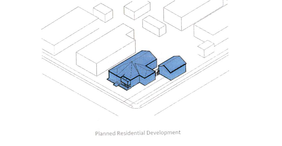
Sec. 528. - Planned Residential Development.
The following regulations apply to planned residential developments:
(a)
Density.
(1)
The overall density for a development is determined by an approved overall concept plan for new development.
(b)
Permitted Uses. At least two (2) types of residential structures can be permitted in a planned residential development.
(1)
Single family detached homes.
(2)
Single family attached homes (townhomes).
(3)
Duplexes.
(4)
Multi Family.
(c)
Perimeter compatibility. Land uses developed at the perimeter of the site shall be developed in a manner that is compatible with adjacent off-site land uses or zoning. Compatibility shall be judged on the basis of similar land uses, average lot sizes, setbacks, and other development standards.
(Ord. No. 480, § 1, 6-6-23)
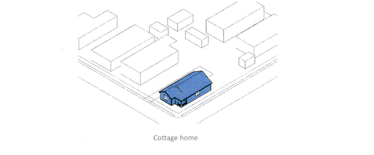
Sec. 529. - Cottage Housing Development.
The following regulations apply to cottage housing developments (CHDs):
(a)
The following requirements shall apply to all CHDs:
(1)
Density and minimum lot area.
i.
In CHDs, the permitted density shall be one (1) dwelling unit per two thousand nine hundred four (2,904) square feet of lot area (fifteen (15)/acre).
ii.
Cottage homes shall be developed in clusters of a minimum of two (2) homes to a maximum of twelve (12) homes.
(2)
Lot coverage and floor area. The maximum first floor or main floor area for an individual principal structure in a CHD shall be one thousand two hundred fifty (1,250) square feet.
(3)
Front yard setbacks. When fronting a public street, the front yard setback shall be at least fifteen (15) feet with an allowable seven (7) foot encroachment for a front porch. On non-public streets, the front yard setback shall be at least ten (10) feet with an allowable encroachment for a front porch of no greater than five (5) feet.
(4)
Required open space.
i.
A minimum of four hundred (400) square feet per unit of common open space is required.
ii.
At least fifty (50) percent of the cottage home units shall be oriented around the common open space with their covered porches or main entry facing the common open space.
iii.
All of the cottage units shall be located within one-hundred (100) feet walking distance of the common open space.
iv.
The common open space shall have cottages abutting at least two (2) sides.
(5)
Parking. Parking spaces for each cottage home unit shall be provided as follows;
i.
Location. Parking shall be located on the CHD property. It may be located in a structure, under a structure, or outside a structure provided that:
a.
Parking is screened from direct view from street by one (1) or more building facades, by garage doors, or by a fence and landscaping;
b.
Parking is not located in the front yard;
c.
Parking may be located between any structure and the rear lot line of the lot or between any structure and a side lot line which is not a street side lot line.
(6)
Additional requirements.
i.
Cottage homes shall have a covered porch at least sixty (60) square feet in size.
ii.
All structures shall maintain ten (10) feet of separation between houses.
iii.
The condominium association or homeowners' association shall maintain the required open space and all common areas.
iv.
Each cottage home shall have access to clothes washers and dryer facilities, either through installation of connections to clothes washers and dryers in the cottage home, or access to clothes washers and dryers in a building located off the common open space.
v.
Developers of cottage homes are encouraged to provide pervious parking areas. In any event, every cottage home development shall comply with Chapter 22 of the Clarkston City Code regarding stormwater management.
(b)
Lots may be reduced in size, as would otherwise be prohibited by Section 507, in order to develop cottage housing in compliance with this section.
(c)
Common areas shall be required for four or more homes and owned by a condominium association, homeowners' association or jointly by the owners of the individual parcels within the planned development.
(Ord. No. 480, § 1, 6-6-23)
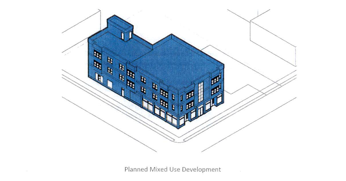
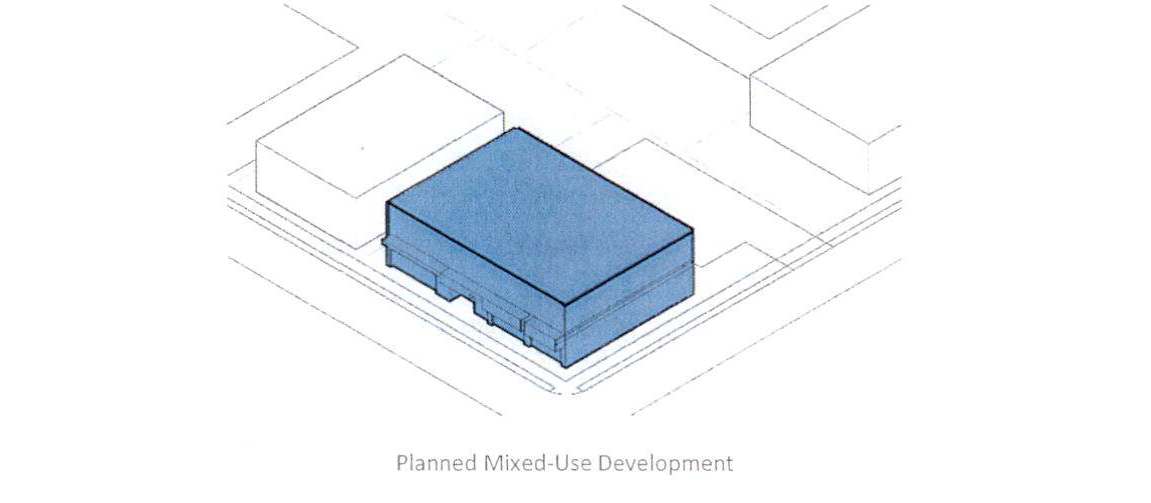
Sec. 530. - Planned mixed-use development.
(a)
Density.
(1)
The overall density for a development is determined by an approved overall concept plan for new development.
(b)
Permitted Uses.
(1)
Single family attached (townhomes).
(2)
Multi-family (duplex, triplex, and apartment buildings).
(3)
Commercial.
(4)
Office.
(5)
Retail.
(c)
Land use mix. A Planned Mixed-Use Development (PMU) must contain at least two (2) types of land use that are not otherwise allowed together in another zoning district. Each Planned Mixed-Use development is anticipated to include a mix of land uses. Non-residential development must be at a scale and type that is compatible with the residential component of the development
(d)
Perimeter compatibility. Land uses developed at the perimeter of the site shall be developed in a manner that is compatible with adjacent off-site land uses or zoning. Compatibility shall be judged on the basis of similar land uses, average lot sizes, setbacks, and other development standards.
(Ord. No. 480, § 1, 6-6-23)
Sec. 531. - Planned Commercial Development.
(a)
Density.
(1)
The overall density for a development is determined by an approved overall concept plan for new development.
(b)
Permitted Uses.
(1)
Commercial.
(2)
Office.
(3)
Retail.
(c)
Land Use Mix. A Planned Commercial Development must contain at least two (2) types of land use that are not otherwise allowed together in another zoning district. Each Planned Commercial development is anticipated to include a mix of commercial land uses.
(d)
Perimeter compatibility. Land uses developed at the perimeter of the site shall be developed in a manner that is compatible with adjacent off-site land uses or zoning. Compatibility shall be judged on the basis of similar land uses, average lot sizes, setbacks, and other development standards.
(Ord. No. 480, § 1, 6-6-23)
Sec. 532. - Open space.
The following provisions shall apply to all open space required by the Clarkston Zoning Ordinance:
(a)
Open space requirement.
(1)
Required yards and, sidewalk clear zones and landscape strips which are constructed on private property may be counted towards this requirement.
(2)
Open space may also include balconies, roof-top terraces, landscaped areas, fountains, parks, plazas, trails and paths, hardscape elements related to sidewalks and plazas, and similar features which are located on private property.
(3)
Open space shall not include areas devoted to public or private vehicular access.
(4)
Where open space is held in common ownership, covenants or other legal arrangements shall specify ownership of the open space; method of and responsibility for maintenance; taxes and insurance; compulsory membership and assessment provisions; and shall be incorporated into legal instruments sufficient to ensure that the open space criteria are maintained.
(5)
10% of the required open space shall be green space.
a.
Green space is left natural or undeveloped.
b.
Can be activated or non-activated.
(b)
Open space implementation and maintenance.
(1)
Implementation. All open space including buffers, setbacks, and sidewalk clear zones, shall be fully implemented prior to occupancy and if not completed, the occupancy permit shall not be issued.
(2)
Maintenance. The owner of the open space improvements shall provide adequate maintenance of the opens space improvements for a minimum of one (1) year from the date of issuance of the certificate of occupancy. The city shall inspect landscape improvements at least once during this period to ensure that the approved plan has been fully implemented and maintained. When a private property owner provides landscaping within the public right-of-way and the landscaping dies within a one (1) year period, such landscaping shall be replaced within a reasonable time not to exceed six (6) months for planting by the owner at the owner's sole expense.
(c)
Relocation of open space. Relocation of minimum open space requirements: Up to twenty (20) percent of a development's required open space may be relocated to an offsite location provided:
(1)
The city council has reviewed and approved the transfer request;
(2)
A written agreement among all owners of record shall be provided with the request and held on file with the city clerk. All renewed or terminated leases shall be filed with the Planning and Economic Development Manager or Director.
(3)
The receiving site(s) is designated as a park open space in the comprehensive plan;
(4)
The receiving site(s) is located within one thousand three hundred and twenty (1,320) linear feet of the donating property (.25 miles);
(5)
Designated open space sites shall comply with the following:
(i)
The open space shall provide active or passive recreational amenities;
(ii)
The open space shall be no greater than twenty-four (24) inches above or below the adjacent public sidewalk for a minimum distance of fifteen (15) feet from the beginning of the adjacent sidewalk;
(iii)
The open space shall be visible and accessible from any point along ninety (90) percent of any adjacent sidewalk; and
(iv)
The open space shall permit and encourage pedestrians to walk on a minimum of eighty (80) percent of the surface of the parcel.
(d)
Additional square footage can be obtained through a density bonus in the TC,
(1)
For every one (1) square foot of additional open space provided in excess of the minimum open space requirement in this section the maximum floor area for the development shall increase by five (5) square feet.
(2)
For every one (1) square foot of additional green space provided in excess of the minimum green space requirement in this section the maximum floor area for the development shall increase by ten (10) square feet.
(3)
To receive density bonus for additional open space requires that at least twenty-five (25) percent of the total open space for the project be open to the public.
(Ord. No. 480, § 1, 6-6-23)
Sec. 533. - Buffers.
A planted or natural buffer strip is required to protect single-family, and multiple-family residential land uses from negative impacts such as litter, dust, wind, light spill, noise, unsightly views, and other characteristics commonly associated with non-residential land uses and related vehicular and pedestrian traffic which adversely impact the quality of residential life. The required buffer shall provide necessary visual and acoustical privacy for the conduct of residential uses in an undisturbed environment and shall assist in the protection and preservation of property values in residential districts.
(a)
General Requirements. Required buffer strips shall be established and maintained by the owner of the non-residential land use. The required buffer strip shall:
(1)
Be depicted in detail on each site plan or plat prior to final approval. Type and location of natural and planted vegetation shall be included.
(2)
Not be disturbed by grading, property improvements or construction activities except where necessary to prevent a nuisance, or to thin such natural growth where too dense to permit normal growth, or to remove diseased, misshapen, or dangerous and decayed timbers, or any similar city approved enhancement. Any contemplated disturbance shall first be brought to the attention of the city and formal approval secured prior to initiating activity within the required buffer areas.
(3)
Utilize existing vegetation where the city has determined that existing vegetation is appropriate for inclusion within the buffer strip, or when required, be supplemented with approved, additional plantings.
(4)
Be completely installed in accordance with the approved plan prior to issuance of a certificate of occupancy.
(5)
Not be used for temporary or permanent parking or loading other than for provision of drainage improvements as mandated by local law, or for a structure other than a fence.
(6)
Be planted and maintained in a healthy, growing condition by the property owner.
(7)
Not extend nearer to a street right-of-way line than the established primary building setback line of the nearest adjoining lot.
(8)
Preserve the natural topography of the land and shall not be disturbed beyond that which is necessary to prevent a nuisance, or to thin such natural growth where too dense for normal growth, or to remove diseased, misshapen, or dangerous and decayed timbers. However, a slope easement may be cleared and graded where required to prevent soil erosion; provided such easement shall be immediately replanted upon completion of easement improvements.
(Ord. No. 480, § 1, 6-6-23)
Sec. 534. - Buffer dimensions.
Transitional buffers are intended to create a visual screen in order to diminish the potential negative impacts of nonresidential and mixed land uses on adjacent residential land uses. Similarly, transitional buffers diminish the potential negative impacts of higher intensity residential development on adjacent single-family residential land uses.
(Ord. No. 480, § 1, 6-6-23)
Sec. 535. - Buffers and landscaping.
(a)
Existing conditions.
(1)
In those instances where the existing natural vegetation and topography are insufficient to achieve the desired level of screening as required by this article, a planted buffer shall be provided and shall consist of plant material of such growth characteristics as will provide an opaque acoustical and visual screen having a height of not less than six (6) feet at the time of planting and planted in a minimum of two (2) rows, with staggered on center spacing such that a continuous opaque screen is created within two (2) years of planting.
(2)
Existing natural vegetation and topography within a buffer shall be preserved and protected with a five (5) foot setback required between the vegetated and planted buffer.
(b)
Materials and ratios.
(1)
Plant materials. Buffers shall contain a minimum of seventy-five (75) percent of evergreen plant materials comprised of at least three (3) different species for every fifty (50) linear feet and a maximum of twenty-five (25) percent of deciduous plant materials. Plant species shall be native, naturalized or other species well-adapted to the local climate and rainfall patterns, disease and pest-free, healthy and vigorous, and obtained from nurseries in USDA hardiness zones 6 or 7.
(2)
Planting ratios. One (1) tree and five (5) shrubs shall be planted for every fifty (50) square feet of buffer area.
(c)
The following plants shall be approved for such purpose but shall not be exclusive of other plants which may be suitable, provided that they can form a hardy screen, dense enough and high enough both to interrupt vision and to diffuse the transmission of sound:
(d)
Substitute materials. Other evergreen plant materials having the same growth characteristics as the aforementioned may be substituted, subject to approval by the city prior to installation.
(e)
Invasive species are prohibited. Bamboo, Eleagnus, Privet, Kudzu, English Ivy, Japanese Honey Suckle and Wisteria shall be prohibited from being planted.
(f)
Detention ponds. In addition to the screening requirements regulated by this article, the following additional regulations shall apply:
(1)
The bottom and sides of detention ponds shall be planted with fast-germinating erosion-controlling vegetation, continuous over the entire surface of disturbed soils both inside and outside of the pond.
(2)
Larger-growing species of perennial plants shall be interplanted in the wet areas of the pond (up to the twenty-five (25) year storm inundation line) on minimum ten (10) foot centers, that are capable of thriving in intermittently wet and dry soils and will provide food and habitat for birds and other wildlife.
(3)
Trees are prohibited within or on the outer slopes of detention ponds in order to prevent damage to the pond structure.
(Ord. No. 480, § 1, 6-6-23)
Sec. 536. - Screening.
The setback requirements of this zoning ordinance shall not prohibit any necessary retaining wall or fence except those which cause a public or safety hazard. Additionally, retaining walls and fences in a residential zoning district shall adhere to the following requirements:
(a)
Fences and walls shall meet the height and location standards in Table 5.2
(b)
Fences and walls shall meet the following material standards:
(1)
Front yard fences shall be made of brick, stone, stucco, split rail, wood, wrought iron. Side and rear yard fences may be vinyl-coated chain link.
(c)
Fence foundations and frames shall be on the interior facing of the fence only.
(Ord. No. 480, § 1, 6-6-23)
Sec. 537. - Fences in buffers.
Fences within required buffer strips shall meet the following requirements:
(a)
Fences shall be constructed of solid materials. Use of cyclone fencing which utilizes inserts as screening shall be prohibited.
(b)
Painted or stained wood shall be maintained.
(c)
Metal fencing shall be painted or vinyl coated.
(d)
Fence supports shall face inwards.
(e)
Posts shall be anchored in concrete when the fence will be over six (6) feet.
(f)
Fences may step down a slope, however supports shall be vertical and plumb.
(Ord. No. 480, § 1, 6-6-23)
Sec. 538. - Other fence standards.
(a)
Site visibility.
(1)
On corner lots within all zoning districts, no wall, fence, foliage, or other obstruction to traffic line of sight vision shall exceed a height of two and one-half (2½) feet within the triangular area formed by the intersection of right-of-way lines at two (2) points measured twenty (20) feet along the property line from the intersection. Within said triangle there shall be no sight obscuring wall, fence or foliage higher than thirty (30) inches above grade or in the case of trees, foliage lower than eight (8) feet. Vertical measurement shall be made at the top of the curb on the street or alley adjacent to the nearest side of the triangle or if no curb exists, from the edge of the nearest traveled way.
(b)
Fences measurement rule.
(1)
Heights of fences, hedges, and other continuous foliage shall be measured from the adjacent top of the street curb, surface of an alley, or the official established grade thereof, whichever is higher. Along interior lot lines, the measurement shall be from the average grade of the lot line of the parcel on which the fence is located.
(c)
Fences and hedges, exceptions.
(1)
The city manager may approve that fences or plantings of a height in excess of these regulations be placed as shielding between different uses, or between like uses upon agreement between the parties affected thereby, provided that no such approval shall have the effect of reducing corner visibility as provided for herein.
(Ord. No. 480, § 1, 6-6-23)
Sec. 539. - Screening of dumpsters, loading areas and mechanical systems.
(a)
All dumpsters, trash, and recycling receptacles shall be enclosed with a wall of equal or greater height on three (3) sides, the material of which shall be similar to the material on the outside of the primary building.
(b)
Dumpsters shall be placed in the rear yard and may be located five (5) feet from the property line if the adjoining property is zoned non-residential and five (5) feet from all applicable buffers if the adjoining property is zoned residential.
(c)
Loading dock entrances for non-residential uses shall be screened so that loading docks and related activity are not visible from the public right-of-way.
(d)
Pursuant to section 5-44 of this Code of Ordinances, temporary construction trash and recycling dumpsters which are not enclosed shall be permitted from the time a building or land disturbance permit is issued, until the certificate of occupancy is granted.
(Ord. No. 480, § 1, 6-6-23)
Sec. 540. - Sidewalks and street trees.
In addition to the requirements below, the city may provide developers with adopted typical streetscape designs for designated areas. Such design may include additional materials, details and specifications regarding street trees, street lights, litter containers, benches and similar sidewalk-related items. Conformity with the city bike and pedestrian plan is also required where applicable. In addition, properties with required landscape strip or sidewalk clear zones which are located on private property shall provide a permanent easement arrangement with the city to ensure public access to said zones.
(a)
Public sidewalks shall be located along both sides of all streets and shall have minimum widths as specified in the Street Type Dimensions Table. Sidewalks shall consist of two (2) zones: a landscape strip and a sidewalk clear zone.
(b)
Landscape strip requirements.
(1)
Minimum landscape strip dimensions for front yards along the street frontage for each lot in any zoning district shall be ten (10) linear feet.
(2)
Permanent structures shall be prohibited within landscape strips (such as buildings, parking spaces, dumpsters, drainage structures and detention facilities). Exceptions include driveways, sidewalks foot paths, necessary retaining walls, signs, and the deposition of storm water runoff or drainage swales through landscape strips perpendicular to the strip.
(3)
Signs within landscape strips may only be located in areas of turf or ground cover and must not conflict with the growth potential of trees and shrubs.
(4)
Design standards: All required landscape strips must be designed with at least sixty (60) percent coverage in trees and shrubs, and no more than forty (40) percent coverage in grass and ground cover. Landscape strip coverage will be calculated as follows:
(i)
Calculate the total spatial area of the landscape strip.
(ii)
Count the number of trees within the landscape strip and multiply by fifty (50) square feet for trees less than six (6) inch caliper and one hundred and fifty (150) square feet for trees greater than six-inch caliper. (This will allow some credit for the spatial coverage of the tree canopy).
(iii)
Measure the spatial coverage of the proposed shrub beds and add to the tree coverage.
1.
Twelve (12) square feet for each five (5) gallon shrub;
2.
Nine (9) square feet for each three (3) gallon shrub;
3.
Six (6) square feet for each two (2) gallon shrub or ground cover; or
4.
Three (3) square feet for each one (1) gallon shrub or ground cover.
5.
This total area shall be greater than or equal to sixty (60) percent of the total area of the strip.
(5)
The required overstory trees within the front landscape strip(s) shall be a minimum of three-inch caliper or twelve (12) feet to fourteen (14) feet tall at the time of planting.
(6)
The required understory trees within the front landscape strip(s) shall be a minimum of two-inch caliper or eight (8) feet to ten (10) feet tall at the time of planting.
(7)
Any exposed ground shall be planted with a living ground cover or lawn, with an appropriate mulching material.
(8)
All trees and landscape materials should be planted at the proper planting times, preferably in the fall, winter or spring and maintained in perpetuity. The city may require performance bonds be posted if planting is delayed due to seasonality.
(9)
Trees within required landscape strips shall be provided as follows:
(i)
Landscape strips shall have a minimum of one (1) tree for every thirty (30) linear feet of a landscape strip to the nearest whole number.
(ii)
Clumping is permitted provided that adequate spacing is allowed for future growth.
(10)
Landscape strips shall be shown on the landscape plan for review and approval as part of the building permit process.
(c)
Landscape strip requirements.
(1)
Said zone shall be located immediately adjacent to the curb and shall be continuous.
(2)
This zone may be used for street trees, street lights, benches, planters, trash receptacles, bicycle parking racks and other street furniture, pedestrian lights, landscaping, or sod. Additional pavement or other similar elements shall be permitted only as approved by the city manager.
(d)
Sidewalk clear zone requirements.
(1)
Said zone shall be located immediately contiguous to the landscape zone and shall be continuous.
(2)
Said zone shall be hardscape, and shall be unobstructed for a minimum height of eight (8) feet. Special paving within the sidewalk clear zone shall be permitted only as approved by the city manager.
(3)
Where newly constructed sidewalks abut narrower existing adjacent sidewalks, the newly constructed sidewalk shall provide an adequate transitional clear zone width for the purposes of providing a safe facilitation of pedestrian traffic flow between the adjacent sidewalks, as approved by the city manager.
(4)
Utilities, including telephone, electric power and cable television in both public and private rights-of-way, shall be placed underground except when extreme conditions of underlying rock or other conditions prevent this requirement from being met and only as approved by the city manager.
(e)
Street tree planting requirements:
(1)
Street trees are required and shall be planted in the ground a maximum of fifty (50) feet on center or grouped one hundred and twenty (120) feet on-center within the landscape zone and spaced equal distance between street lights.
(2)
All newly planted trees shall be a minimum of four (4) inches in caliper measured thirty-six (36) inches above ground, shall be a minimum of sixteen (16) feet in height, shall have a minimum mature height of forty (40) feet, and shall be limbed up to a minimum height of ten (10) feet. Said trees shall be in proportion in height to the first floor of building.
(3)
Trees shall have a minimum planting area of thirty-six (36) square feet and shall have a three-inch raised curb provided along the perimeter of the planting area. All plantings, planting replacement and planting removal shall be approved by the designated City manager, in keeping with the City of Clarkston's tree ordinance replacement values.
(4)
Tree planting areas shall provide porous drainage systems that allow for drainage of the planting area.
(5)
The area between required plantings shall either be mulched, planted with sod or shall be paved as approved by the city manager. Paving within the landscape strip shall be limited to a maximum of fifty (50) percent of the total area within the landscape zone.
(6)
Physical permanent root barriers shall be required along the required street curbs to prevent roots from damaging the curbs.
(7)
Required tree plantings may be permitted to be planted in the adjacent front yard when extreme conditions like topography prevent the planting of street trees within the landscape zone and only as approved by the city manager.
(8)
Street tree species shall be consistent for an entire block length. Similar species shall be permitted to change on individual block faces and only when approved by the planning and zoning board.
(9)
Street lights or pedestrian lights in the landscape zone shall be spaced equidistant between all required street trees.
(f)
Sidewalks disturbed by development. Any development that disturbs existing city-funded sidewalks including the clear zone and landscape zone shall be replaced by the property owner to its pre-disturbance state and condition.
(Ord. No. 480, § 1, 6-6-23)
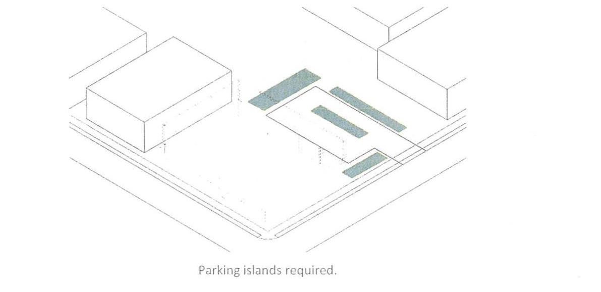
Sec. 541. - Parking areas.
Parking lots designed with fifteen (15) or more parking spaces shall be designed as follows:
(a)
Where parking bays exceed fifteen (15) continuous spaces, a planter island meeting the following criteria is required. The planting islands shall be located no farther apart than every ten (10) parking spaces and at the terminus of all rows of parking.
(1)
Each separated planter island shall contain a minimum of two hundred fifty (250) square feet per tree.
(2)
Each planter island area shall include at least one (1) shade tree. The remaining area may be planted with shrubs, lawn or living ground cover not to exceed three (3) feet in height with mulch of pine straw, bark, wood chips, turf grass, rocks and the like.
(3)
All planter islands must be curbed to prevent vehicular encroachment.
(b)
To promote better growth of trees and shrubs and to encourage flexibility in parking design, the area of not more than four (4) planter islands may be combined into one (1) large island, provided that the large island include one (1) shade tree per two hundred (200) square feet, with a minimum distance of thirty (30) feet exists between shade trees.
(Ord. No. 480, § 1, 6-6-23)
Sec. 542. - Tree requirements.
(a)
Existing tree cover and natural vegetation shall be preserved and/or replaced with suitable vegetation. All existing, healthy hardwood or softwood trees with a caliper of two (2) or more inches at a point three (3) feet above the ground shall be retained whenever feasible; if not feasible, the tree shall be replaced.
(b)
A minimum of one (1) overstory tree and one (1) understory tree shall be required for each five hundred (500) square feet of the total minimum required open space outside the parking areas. All other existing trees of at least twenty (20) feet in canopy diameter and height shall be counted. Trees required for screening purposes shall not be included in the aforementioned calculation.
(c)
Except as required by this section and to meet specific community design policies established for various areas of Clarkston, trees shall be planted and/or retained in areas of the site to enhance the overall project design and provide such amenities as visual attractiveness, natural resources preservation, energy conservation, etc.
(d)
All retained or planted trees shall be protected or situated as to prevent damage from environmental changes, particularly grading and other contractor operations, resulting from any building or other improvements as stipulated in the Clarkston Tree Protection Plan.
(e)
Tree replacement and all tree plantings shall be submitted and approved coincident with the landscaping plan for the site.
(f)
The following trees shall be permitted:
Other trees may be approved on a case by case basis. The general criteria for overstory replacement trees are large growing (forty (40) feet tall or greater), and ecologically compatible with the site. The general criteria for understory replacement trees are medium growing (ten (10) to thirty-five (35) in height), and ecologically compatible with the site. All planting and replanting plans are subject to the city arborist's approval.
(Ord. No. 480, § 1, 6-6-23)
Sec. 543. - Installation and maintenance.
(a)
Installation. All landscaping shall be installed in a sound workmanlike manner and according to accepted good planting procedures. The city arborist shall inspect all landscaping and no certificate of occupancy or similar authorization will be issued unless the landscaping meets the requirements provided in this zoning ordinance.
(b)
Agreement and bonding. Prior to issuance of a certificate of occupancy, the developer or owner shall post a performance bond or cash escrow guaranteeing all landscaping materials and work for a period of two (2) years after approval or acceptance thereof by the city in a sum established by the city arborist. The bond will be in the amount of one hundred (100) percent of the estimated cost of replacing all of the landscaping required by these specifications. At the end of two (2) years, the building inspector shall make an inspection and notify the owner or developer and the bond company of any corrections to be made.
(c)
Maintenance. The owner, occupant, tenant and respective agent of each, if any, shall be jointly and severally responsible for the maintenance and protection of all required landscaping in perpetuity, in accordance with the following standards:
(1)
Keep landscaping reasonably free of visible signs of insects and disease and appropriately irrigated to enable landscaping to exist in a healthy growing condition;
(2)
Mow or trim landscaping in a manner and at a frequency appropriate to the use made of the material and species on the site so as not to detract from the appearance of the general area. Growth of plant material at maturity shall be considered where future conflicts such as view, signage, street lighting, utilities and circulation might arise;
(3)
Maintain all landscaping to minimize property damage and public safety hazards, including removal of dead or decaying plant material, and removal of low hanging branches next to sidewalks and walkways obstructing street lighting;
(4)
Plantings in the buffer area shall be replaced unless the city arborist deems such replacement unnecessary;
(5)
Pruning, trimming, and maintenance shall be performed to maintaining healthy plant matter in accordance with the specifications set forth by the American Forestry Association, the National Arborist Association, or other professional arboricultural organizations; and
(6)
See Article VI, District Regulations for additional maintenance requirements.
(Ord. No. 480, § 1, 6-6-23)