
Crestview City Zoning Code
CHAPTER 4
ZONING DISTRICTS AND OVERLAYS
Sec. 4.00.00.- Generally.
The purpose of this chapter is to describe the zoning districts and permissible uses of land within the City of Crestview, in accordance with the city Code and comprehensive plan. Any violation of this chapter shall be punished as provided for in section 1-11 of the city Code and F.S. ch. 162.
(Ord. No. 1789, § 4.00.00, 2-8-2021)
Sec. 4.01.00. - Land use districts, density and intensity.
Land use categories and adopted densities and intensities are as described below:
(Ord. No. 1789, § 4.01.00, 2-8-2021)
Sec. 4.02.00. - Official zoning map.
Zoning districts and zoning district boundaries are hereby established and declared to be in effect upon all land and water areas included within the boundaries of each district as shown on the map designated the as "Official Zoning Map of the City of Crestview, Florida." The official zoning map is on file in the City of Crestview city hall. Such map and all notations, references and other information shown thereon are as much a part of this chapter as if the information set forth thereon was fully described and set out in this section.
(Ord. No. 1789, § 4.02.00, 2-8-2021)
Sec. 4.03.00. - Establishment and purpose of zoning districts.
A.
Residential districts.
1.
R-1E Single-Family Estate District. The single-family estate zoning district is established to provide for single-family dwellings and allowed accessory structures customarily associated with residential development in legacy neighborhoods and un-platted residential areas where larger lot sizes are customary. The maximum density is 2.0 dwelling units per acre. Each single-family dwelling must be placed on one parcel, lot, tract or other division of land.
2.
R-1 Single-Family Low-Density District. The single-family low-density zoning district is established to provide for single-family dwellings, accessory dwelling units and allowed accessory structures customarily associated with residential development in legacy neighborhoods and un-platted residential areas. The maximum density is 4.0 dwelling units per acre. Each single-family dwelling must be placed on one parcel, lot, tract or other division of land.
3.
R-2 Single-Family Medium-Density District. The single-family medium-density zoning district is established to provide for single-family dwellings in traditional residential neighborhoods. The R-2 zoning district is limited to single-family homes and allowed accessory structures. The maximum density is 6.0 dwelling units per acre. Each single-family dwelling must be placed on one parcel, lot, tract or other division of land.
4.
R-3 Single- and Multifamily Dwelling District. The single- and multifamily dwelling density zoning district is established to provide for single- and multifamily dwellings in higher-density residential neighborhoods. The R-3 zoning district is limited to single- and multifamily dwellings and accessory structures. The maximum density is 8.0 dwelling units per acre in the residential (R) future land use, and 10.0 dwelling units per acre in the mixed-use (MU) future land use. Each parcel, lot, tract or other division of land may contain multiple single- or multifamily dwellings according to the density allowed by the size of each piece of land.
B.
Mixed-use districts.
1.
MU Mixed-Use District. The mixed-use district is established to provide for a variety of land uses, including single- and multifamily dwellings and small, low-impact commercial developments, including retail sales, professional offices, service industries, bed and breakfasts, other similar uses and accompanying accessory uses. Uses may be limited by location due to impacts and compatibility issues. The maximum density for dwellings is 20.0 dwelling units per acre, and the maximum allowed floor area ratio (FAR) for commercial uses is 2.0. Each parcel, lot, tract or other division of land may contain multiple single- or multifamily dwellings according to the density allowed by the size of each piece of land.
C.
Commercial and industrial districts.
1.
C-1 Commercial Low-Intensity District. The commercial low-intensity district is established to provide for multifamily apartments, condominiums and low-intensity commercial uses, including restaurants, small-scale retail sales, service industries, entertainment, light manufacture and repair, small professional offices, hotels, gas stations, other similar uses and allowed accessory uses. Uses may be limited by location due to impacts and compatibility issues. The maximum allowed density for dwelling units is 25 dwelling units per acre. The maximum allowed floor area ratio (FAR) is 2.0 for commercial uses.
2.
C-2 Commercial High-Intensity District. The commercial high-intensity district is established to provide for high-intensity commercial developments, including restaurants, large-scale retail sales and service industries, entertainment, light manufacture and repair, professional offices, hotels, gas stations, other similar uses and allowed accessory uses. Uses may be limited by location due to impacts and compatibility issues. The maximum allowed floor area ratio (FAR) is 3.0.
3.
IN Industrial District. The industrial district is established to provide for all types of manufacture and repair as well as gas stations, other similar uses and accompanying accessory uses. Uses may be limited by location due to impacts and compatibility issues. The maximum allowed floor area ratio (FAR) is 3.0.
D.
Public land and conservation districts.
1.
P Public Lands District. The public lands district is established to provide for municipal, governmental or otherwise institutional uses, such as city, county, state or federal buildings, parks, schools, other similar uses and allowed accessory uses. Uses may be limited by location due to impacts and compatibility issues. The maximum allowed floor area ratio (FAR) is 2.0.
2.
E Conservation District. The conservation district is established to provide for passive recreation or educational uses that are compatible with the conservation purpose of the district. Such passive uses include passive parks, open spaces and areas designated for protection, such as water bodies, wetlands, and habitats for protected species.
(Ord. No. 1789, § 4.03.00, 2-8-2021)
Sec. 4.04.00. - Zoning district comparison to future land use categories.
A.
The future land use map of the comprehensive plan establishes allowable land uses within the city. The zoning districts set forth within this LDC must be consistent with the future land use map. Any rezoning of land must maintain this consistency. Table 4.04.00 sets forth the allowable zoning districts which are consistent with each land use category from the future land use map.
B.
When a parcel of land is annexed or rezoned, it is necessary to assign a new zoning district to a piece of land. The following criteria shall be applied to the determination of the appropriate zoning district:
1.
Whether the requested zoning district is consistent with the future land use category according to Table 4.04.00.
2.
Whether the uses within the requested zoning district are compatible with the uses in adjacent zoning districts. Compatibility is determined by considering scale of use; intensity of use as determined by floor area ratio and impervious surface coverage; hours of operation; impacts from noise in parking lots or structures; noise from outdoor gathering places; noise from outdoor speakers; noise from processes such as from body shops, equipment shops, and industrial activities; lighting from parking lots or structures and vehicles; and security lighting. Compatibility shall consider the range of allowable uses on parcels adjacent to the proposed rezoning parcel and the typical impacts for those uses.
3.
Whether the requested use is substantially more intense or less intense than allowable development on adjacent parcels. The range of uses permissible according to the land use category and zoning district on the adjacent parcels is the basis for determination. The existence of a nonconforming use on adjacent parcels which is substantially more or less intense than the requested zoning shall not establish the sole reason for denial of the requested zoning.
4.
Whether the requested use is based on soil types, topography, protection of natural resources, and protection of designated historic areas.
Table 4.04.00. Zoning Districts in Future Land Use Categories
(Ord. No. 1789, § 4.04.00, 2-8-2021)
Sec. 4.05.00. - Establishment and purpose of overlay districts.
A.
Purpose. The purpose of overlay districts is to provide a means of modifying the site design and development requirements applicable to the underlying zoning district.
B.
Downtown overlay district. The downtown overlay district is established to preserve and promote the downtown area of Crestview. The intent of the downtown overlay district is to provide flexibility in location and design requirements to support and encourage economic development in the downtown area.
1.
The downtown overlay district is intended as a location where specific site design features will be provided to ensure flexibility in the location of activities, accessory structures, and other site design requirements, consistent with a downtown location.
2.
The downtown overlay district is intended to encourage the provision of design features necessary to support economic development and to maintain appropriate development characteristics within the downtown overlay district. Specific design requirements can be found in chapter 6 of this LDC.
3.
Developments within the downtown overlay district are exempt from the requirements of section 6.08.00.
4.
See Figure 4.05.00 below for the boundary of the downtown overlay district.
Figure 4.05.00. Downtown Overlay District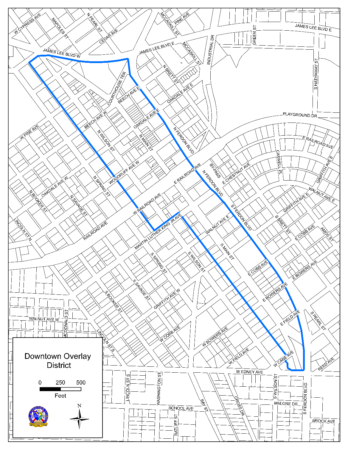
C.
Foxwood overlay district. The Foxwood overlay district is established to preserve a number of the original site design characteristics required by Okaloosa County prior to the area's annexation. The intent of the Foxwood overlay district is to allow any future residential development to conform to the same site requirements as the residential dwellings that exist in this area as of February 2021.
1.
The Foxwood overlay district is intended create specific setback requirements for the area that deviate from and supersede those required by the underlying assigned zoning designation. These specific deviations can be found in chapter 6 of this LDC.
2.
Figure 4.05.01 below reflects the boundary of the Foxwood overlay district:
Figure 4.05.01. Foxwood Overlay District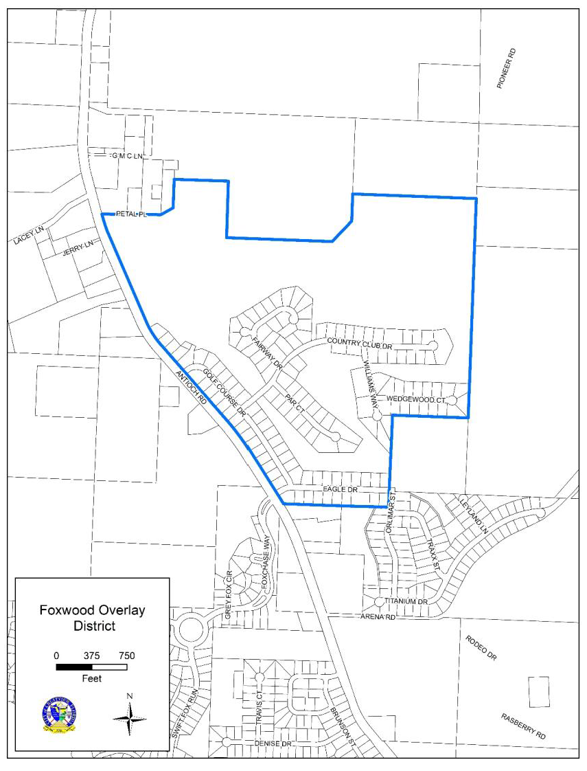
(Ord. No. 1789, § 4.05.00, 2-8-2021; Ord. No. 1808, att.(4.05.00), 4-12-2021; Ord. No. 1891, att. 1(4.05.00), 8-22-2022)
Sec. 4.06.00. - Land uses permissible in each zoning district.
A.
How to read the table of permissible uses (Table 4.06.00).
1.
Within the Table 4.06.00, the letter "P" indicates that the land use is permissible, subject to compliance with the standards of the zoning district.
2.
The letter "S" indicates that the use is permissible, subject to compliance with the standards of the zoning district, and the supplemental standards specified for the use. Supplemental standards are contained in chapter 7 of this LDC.
3.
An empty cell indicates the use is prohibited.
4.
Reference back to section 4.05.00.B.3 for uses not allowed in the downtown overlay district.
5.
Any use that is not identified in Table 4.06.00 is prohibited unless it is found to be substantially similar by the planning administrator.
a.
A requested use shall be considered substantially similar when the characteristics of the requested use are equivalent in type, intensity, degree, or impact when compared to a use named in Table 4.06.00. Examples of characteristics to be considered include the following:
(1)
Typical hours of operation;
(2)
Use of outdoor storage;
(3)
Trip generation rates;
(4)
Generation of noise, light pollution, odor, smoke, electromagnetic interference, or vibration; and
(5)
Customary activities associated with the use.
b.
A requested use shall be consistent with the comprehensive plan.
c.
A requested use shall be consistent with the purposes of the zoning district applicable to the parcel.
d.
The administrative interpretation of uses shall be subject to appeal, as set forth in chapter 9 of this LDC.
Table 4.06.00. Permissible Uses in Each Zoning District
(Ord. No. 1789, § 4.06.00, 2-8-2021; Ord. No. 1830, att.(4.06.00), 9-13-2021; Ord. No. 1891, att. 1(4.06.00), 8-22-2022)
Sec. 4.07.00. - Change of use requirements.
A.
A request to change the permissible use of a parcel of land or structure shall be considered according to the procedures established in chapter 9 of this LDC.
B.
A change of the permissible use of a parcel of land or structure shall meet the following criteria:
1.
The requested use is permissible according to Table 4.06.00.
2.
When the requested use has greater impacts than the existing use, it shall be established only in compliance with the following site design and development standards:
a.
Parking, loading, handicapped access, stacking lanes, or driveway standards set forth in chapter 8 of this LDC.
b.
Landscaping and buffering requirements set forth in chapter 6 of this LDC.
c.
Level of service standards set forth in the City of Crestview Engineering Standards Manual.
d.
Impervious surface coverage standards for the applicable zoning district, set forth in chapter 6 of this LDC.
3.
The requested use does not require exterior building alterations, except that such alterations may be permissible in compliance with applicable building and safety codes.
4.
The requested use can be granted a new certificate of occupancy.
(Ord. No. 1789, § 4.07.00, 2-8-2021)