
Crestview City Zoning Code
CHAPTER 6
DEVELOPMENT STANDARDS
Sec. 6.00.00.- Generally.
6.00.01.
Applicability.
A.
The purpose of this chapter is to provide development standards applicable to all development activity within the city. Subdivisions, new land uses and structures, and alterations to existing land uses and structures shall be designed, constructed, and established in compliance with the development standards for the applicable zoning district and the development standards for all zoning districts as set forth in this chapter.
B.
Infrastructure standards for roads and streets, sanitary sewer, potable water, stormwater drainage, solid waste and natural groundwater aquifers shall be found in the Crestview Engineering Standards Manual.
6.00.02.
Measurements.
A.
Lot width and lot frontage.
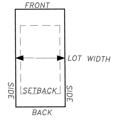
Figure 6.00.02(A). Lot Width
1.
Lot width is the horizontal distance between side lot lines measured at the intersection of the front setback and the side lot lines.
2.
Lot frontage is the property line fronting a right-of-way.
a.
Minimum lot frontage for residential zoned property shall be 40 feet, except for flag lots.
B.
Setbacks and yards.
1.
Setbacks are measured as the shortest distance from the face of the exterior building wall to the property line. A yard is the space from the property line or right-of-way line to the vertical face of a building.
2.
The rear yard setback for any waterfront lot is measured to the mean high-water line.
3.
Eave overhangs of the primary structure shall meet the specifications and requirements of the current Florida Building Code.
a.
Eave overhangs of equal to or less than the limits of the Florida Building Code shall not be included as a main part of any building.
b.
No eave overhang shall be closer than three feet from any property line.
c.
The city building official may provide additional requirements.
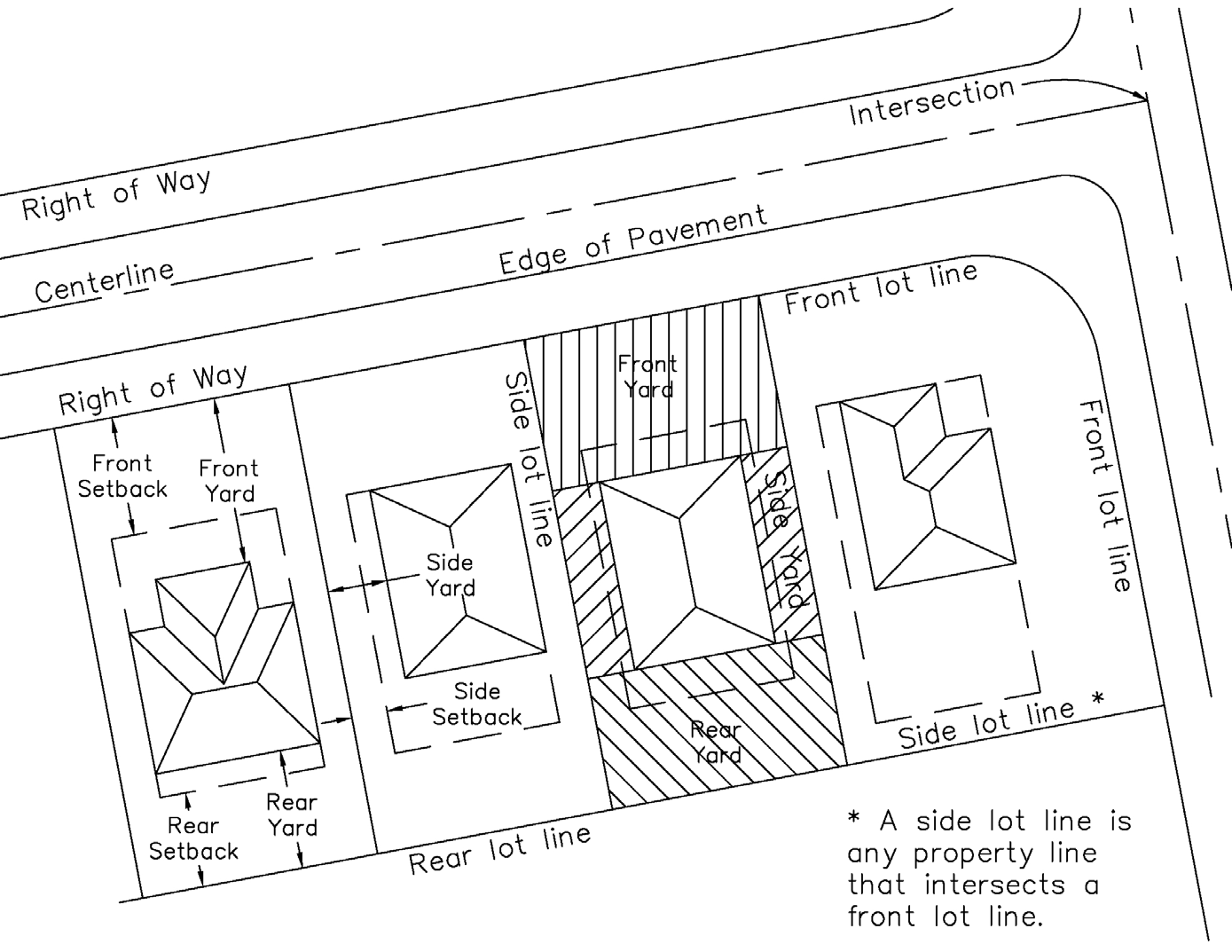
Figure 6.00.02(B). Setbacks and Yards
C.
Specific measurement requirements for flag lots.
1.
The design requirements for platting flag lots are set forth in section 6.07.00.C.
2.
A flag lot is exempt from the frontage requirements set forth in this LDC, provided that the width of the pole or access portion of the lot is not less than 25 feet.
3.
The maximum length of the pole portion of the lot, measured from the right-of-way to the end of the pole at the point of connection to the flag, is 150 feet.
4.
The setbacks for a flag lot are measured for the flag portion of the lot, excluding the pole portion of the lot.
D.
Impervious surface ratio. The impervious surface ratio is calculated by dividing the total of all impervious surfaces on the lot by the total lot area. Water bodies are impervious surfaces.
E.
Building height.
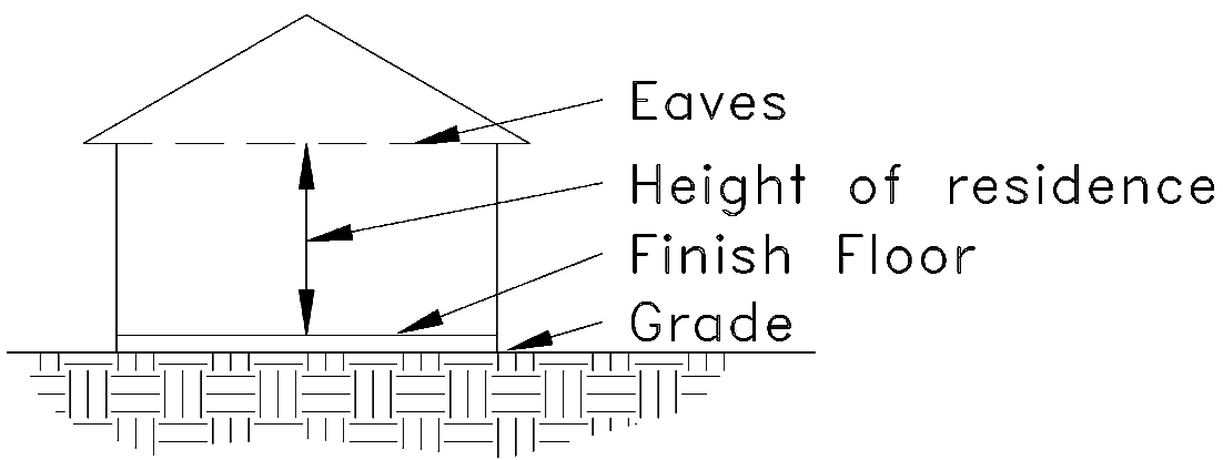
Figure 6.00.02(E). Building Height
1.
Building height is measured from the top of the floor at the finished floor elevation to the eave of the highest habitable floor.
2.
Calculation of maximum building height shall not include the roof above the eave of the highest habitable floor.
3.
Calculation of maximum building heights shall not include water towers, utility facility, or appurtenances or attachments such as chimneys, elevator shafts, antennas, decorative architectural features, steeples, air conditioning equipment enclosures, cupolas, weather vanes, and other similar building features. All appurtenances or attachments which are exempt for purposes of calculating the maximum height shall not be habitable. In certain zoning districts, it may be necessary to calculate the height of a building from mean sea level in order to determine compatibility with the Eglin Air Force Base mission, in which case appurtenances shall also be considered.
F.
Setbacks for property abutting unopened or terminating rights-of-way.
1.
Applicability. The standards set forth in this section apply to properties abutting rights-of-way that are unopened, considering there are no plans to open such rights-of-way for public travel, and for properties abutting rights-of-way that terminate with no feasible or planned extension, and where no other properties exist nearer to the point of termination thereof.
2.
Front setback standards. For applicable properties, the front setback along such unopened or terminating right-of-way may be the same as the side setback according to the underlying zoning district. If such setback is utilized, the front of any primary structure, and primary access provided to such structure shall not be from the unopened or terminating right-of-way. Such setback standard shall also apply to any accessory structures placed on an applicable property subject to all other applicable standards contained in chapter 7 of this Code.
6.00.03.
Compatibility standards pertaining to building height in all zoning districts.
A.
Applicability. The standards set forth in this subsection 6.00.03 apply to buildings other than single-family structures when such buildings are located adjacent to single-family residential structures.
B.
Maximum height standards.
1.
The maximum height for buildings located 100 feet or less from a single-family residential structure shall not exceed two times the number of stories of said structure.
2.
The maximum height for buildings located 100 feet or less from multiple single-family residential structures shall not exceed two times the number of stories of the tallest structure.
(Ord. No. 1789, § 6.00.00, 2-8-2021; Ord. No. 1915, att. 1(6.00.00, 6.00.04), 1-23-2023; Ord. No. 1991, § 2, 4-28-2025)
Sec. 6.01.00. - Residential districts.
6.01.01.
Site development standards.
A.
Lots existing before the effective date of the ordinance from which this LDC is derived shall continue to be considered as compliant regardless of any requirements of this chapter that are not met.
B.
The base standards for development in residential zoning districts are provided in Table 6.01.01.
C.
A lot of record is a lot established on or before December 31, 2020. A lot of record is exempt from the lot area requirements set forth in Table 6.01.01.
Table 6.01.01. Development Standards in Residential Zoning Districts
6.01.02.
Residential design standards. All single-family dwellings, whether site-built or built off site and moved onto the lot, shall comply with the following design standards. In all cases below, the Florida Building Code, Residential, shall be complied with.
A.
The minimum length and width of the building shall be 20 feet.
B.
The minimum roof pitch shall be 3:12.
C.
The minimum roof overhang shall be 12 inches, exclusive of porches and patios.
D.
All single-family dwellings shall be situated on the lot so that the front door of the home faces the front yard.
1.
Mobile homes, manufactured homes, or modular homes not located within a manufactured home community may be oriented up to 90 degrees to the front yard on the lot in any way which the location of the front door may face the side yard. In no case shall the front door of the home face a rear yard.
2.
Properties containing mobile homes, manufactured homes, or modular homes placed per the provisions of subsection 6.01.02.D.1 of this section may not have any fences taller than four feet located between the front door of the homes and the front property line.
3.
Single-family dwellings located on flag lots may be oriented so that the front door faces the access drive.
4.
All other aforementioned development standards in section 6.00.00 shall be required, other than those that are superseded in this subsection 6.01.02.
E.
The building shall be constructed according to standards established by the Florida Building Code, Residential.
F.
The exterior siding material shall consist of approved materials in accordance with the Florida Building Code, Residential. Where vinyl lap siding is used, the siding shall not have a glossy surface or be reflective.
G.
The dwelling shall be attached to a permanent foundation system, including supporting, blocking, leveling, securing, and anchoring the home and connecting multiple and expandable sections of the home. The foundation shall be designed and constructed according to the requirements of the current Florida Building Code, Residential.
H.
Roof materials shall be any material approved by the Florida Building Code, Residential.
I.
For dwellings elevated 48 inches or less, the area beneath the home shall be enclosed by brick, concrete, wood, rock, vinyl or other materials specifically manufactured for this purpose and shall enclose the space between the floor joists and the ground level, except for the required minimum ventilation and access. Such access shall remain closed when not being used for that purpose.
J.
For manufactured homes, all tongues, wheels, axles, transporting lights and other towing apparatus shall be removed from the site prior to occupancy.
K.
For manufactured homes, none manufactured before June 15, 1976, shall be permitted.
L.
At each exterior door, there shall be a landing that is in accordance with the Florida Building Code, Residential.
M.
Duplex (two connected single-family dwelling unit) structures:
1.
May be placed across a single side property line, at the line of unit separation, provided all other zoning requirements and setbacks are observed, and the unit-separating wall meets the appropriate standards of the Florida Building Code and any applicable fire codes.
2.
The minimum length and width of each duplex unit shall be 20 feet.
3.
All other aforementioned design standards in this section shall be required, other than those that are superseded in this subsection 6.01.02.M.
4.
Each unit in a duplex structure must have its own utility connections.
N.
Recreational vehicles, campers, camp trailers or mobile dwelling vehicles that are not regulated by the Florida Building Code, Residential, are not permitted for use as dwellings.
(Ord. No. 1789, § 6.01.00, 2-8-2021; Ord. No. 1830, att.(6.01.02), 9-13-2021; Ord. No. 1851, att. 1, 1-24-2022; Ord. No. 1891, att. 1(6.01.02), 8-22-2022; Ord. No. 1915, att. 1(6.01.00), 1-23-2023)
Sec. 6.02.00. - Mixed-use districts.
6.02.01.
Site development standards.
A.
The base standards for development in the mixed-use zoning districts are provided in Table 6.02.01, except as modified below.
B.
Specific site development standards apply within the downtown overlay district, as set forth in section 6.04.01. Standards in the DOD supersede the standards in the underlying zoning district.
Table 6.02.01. Development Standards in Mixed-Use Zoning Districts
6.02.02.
Standards for mixing uses on one lot.
A.
Uses identified in Table 4.06.00 for the mixed-use zoning district may be combined on one development lot or parcel.
B.
When combining uses, the development may include the maximum number of residential units based on the density calculation plus the maximum amount of floor area based on the floor area ratio. Residential dwelling units are not included in the calculation of floor area.
C.
Shared parking is required. A parking study shall be prepared according to the standards set forth in section 8.06.06 to demonstrate the actual parking requirements for the project.
D.
Where multiple uses and multiple buildings are proposed on one lot, there is no buffer requirement between buildings containing different uses.
E.
Multiple buildings proposed on one lot shall have an integrated design. An integrated design shall not be construed to mean that buildings are identical.
F.
Access to residential units shall be separated from access to nonresidential development in order to provide privacy for residents. A shared entrance to a building may be established, provided that the interior entrances to the residential areas and nonresidential areas are separated.
G.
Balconies, courtyards, plazas, recreation areas, and outdoor gathering places shall be located and designed to ensure privacy for residents.
H.
Buildings may have a common wall. However, when separated, the separation shall be a minimum of five feet to ensure space for maintenance of each building.
6.02.03.
Standards for mixing uses within one building.
A.
Uses identified in Table 4.06.00 for the mixed-use zoning district may be combined within one building. The building may stand alone on a development parcel or may be integrated into a mixed-use development consisting of multiple buildings.
B.
When combining uses, the development may include the maximum number of residential units based on the density calculation plus the maximum amount of floor area based on the floor area ratio. Residential dwelling units shall not be included in the calculation of floor area.
C.
Shared parking is required. A parking study shall be prepared according to the standards set forth in section 8.06.06 to demonstrate the actual parking requirements for the project.
D.
Access to residential units shall be separated from access to nonresidential development in order to provide privacy for residents within the building. This requirement may be met when an elevator serves upper floor residential units through a secured access method, such as key-activated access to residential floors.
E.
Balconies, courtyards, plazas, recreation areas, and outdoor gathering places shall be located and designed to ensure privacy for residents.
(Ord. No. 1789, § 6.02.00, 2-8-2021; Ord. No. 1808, att.(6.02.00), 4-12-2021; Ord. No. 1915, att. 1(6.02.00), 1-23-2023)
Sec. 6.03.00. - Commercial and industrial districts.
6.03.01.
Site development standards.
A.
The base standards for development in commercial and industrial zoning districts are provided in Table 6.03.01.
B.
Specific site development standards apply within the downtown overlay district, as set forth in section 6.04.01.
C.
Proposed building height, including appurtenances and building attachments, in any district shall be analyzed to determine if it exceeds any limitations of the Eglin Air Force Base. In consultation with an Eglin AFB representative, the city may establish the maximum height at less than the heights in Table 6.03.01, but no less than the maximum structure height (above mean sea level) causing no major negative mission impacts for Eglin AFB, as depicted on the map.
Table 6.03.01. Development Standards
in Commercial and Industrial Zoning Districts
6.03.02.
Nuisance/pollution standards for industrial developments. All uses and activities conducted in the IN zoning district shall conform to the standards of performance described in this subsection. The failure to conform to any such standards is hereby declared to be a public nuisance.
A.
Fire and explosion hazards. All activities and all storage of flammable and explosive materials or products at any place shall be provided with adequate safety devices against the hazards of fire and explosion, including adequate firefighting and fire suppression equipment, as prescribed by all applicable fire prevention laws, ordinances, and regulations.
B.
Radiation. Any operation involving radiation (e.g., the use of neutrons, protons and other atomic or nuclear particles) shall be conducted in accordance with the codes, rules, and regulations of state and federal regulating agencies. Radiation limitations shall not exceed quantities established as safe by the United States Bureau of Standards.
C.
Electromagnetic radiation. For the purpose of these regulations, electromagnetic interference shall be defined as disturbances of an electromagnetic nature which are generated by the use of electrical equipment, other than planned and intentional sources of electromagnetic energy, which would interfere with the proper operation of electromagnetic radiation for such purposes as communication, experimentation, entertainment, broadcasting, heating, navigation, therapy, vehicle velocity measurement, weather survey, aircraft detection, topographical survey, personal pleasure or any other use directly or indirectly associated with these purposes which does not comply with the current regulations of the Federal Communications Commission (FCC) regarding such sources of electromagnetic radiation. Further, said operations, in compliance with the FCC regulations, shall be unlawful if such radiation causes an abnormal degradation of performance of other electromagnetic radiators or electromagnetic receptors of quality and proper design because of proximity, primary field, blanketing, spurious re-radiation, conducted energy in power or telephone systems or harmonic content. The determination of abnormal degradation of performance and of quality and proper design shall be made in accordance with good engineering practices as defined in the latest principles and standards of the American Institute of Electrical Engineers, the Institute of Radio Engineers and the Radio Manufacturers' Association.
D.
Toxic or hazardous matter. Any activity involving the use or storage of toxic or hazardous matter shall comply with all state, federal and local laws and all regulations of any federal, state, or local agency concerning pollution control or toxic substances.
E.
Waste disposal. No activity shall be conducted which results in the discharge of any liquid or solid waste, including industrial wastes, into any public or private sewage system, the ground, or any lake, stream, or other body of water, in violation of any provision of state, federal or local law or any regulation of any state, federal or local agency.
F.
Vibration. No use of any property shall cause perceptible earth vibrations beyond any property line, except when pilings are driven for structure foundations. All stamping machines, punch presses, press brakes, hot forgings, steam board hammers, or similar devices shall be placed on shock absorption mountings and on suitable reinforced concrete footings. No machine shall be loaded beyond the capacity, as described by the manufacturers.
G.
Heat, cold, dampness, or movement of air. Activities on any property which produce any adverse effect on the temperature, motion, or humidity of the atmosphere beyond the lot lines are not permitted.
H.
Glare. There shall be no direct or sky-reflected glare, whether from floodlights, high temperature processing, combustion, welding, or otherwise so as to be visible at, or interfere with uses on, adjacent properties.
I.
Smoke, dust, and particulate matter. There shall be no emission of visible smoke, dust, dirt, fly ash, or any particulate matter from any pipes, vents, or other openings or from any other source, into the air which can cause damage or irritation to health, animals, vegetation, or to any form of property or which results in the violation of any applicable federal, state or local requirements.
J.
Odor. There shall be no emission of odorous gases or other odorous matter in such quantities as to be offensive at the points of measurement. Any process which may involve the creation or emission of any such odors shall be provided with both a primary and a secondary safeguard system so that control may be maintained in the event of failure of the primary safeguard system.
K.
Noise. Reserved.
(Ord. No. 1789, § 6.03.00, 2-8-2021; Ord. No. 1915, att. 1(6.03.00), 1-23-2023)
Sec. 6.04.00. - Overlay districts.
6.04.01.
Site development standards for the Downtown Overlay District (DOD).
A.
The DOD is intended to provide development standards specific to the downtown area of Crestview. The boundary is shown on the official zoning map.
B.
The development standards shown in Table 6.04.01 supersede and replace the development standards otherwise required for the underlying zoning district. Where no standard is provided in Table 6.04.01, the standards of the underlying zoning district are required.
C.
Buildings within the DOD are not subject to the standards set forth in sections 6.00.03 and 6.03.01.
D.
In addition to signs permissible subject to the standards set forth in section 7.02.00, development within the DOD may have one sandwich sign in compliance with the following standards:
1.
The sign shall not exceed two feet in width.
2.
The color and font shall be consistent with the color and font of other signs for the business displaying the sandwich sign.
3.
The sign shall include the business name or logo.
4.
The sign shall be located on private property. Where five feet of width on the sidewalk can be maintained free of obstruction, the sign may be placed on the public sidewalk. When a sign is proposed to be located on the public sidewalk, the owner shall provide proof of insurance naming the city as an insured party.
5.
A sandwich sign shall only be displayed during the hours of operation of the business named on the sign.
6.
The sign shall have no lights of any kind.
E.
New development or redevelopment shall include sidewalks that are consistent with the requirements in the Engineering Standards Manual of Crestview.
F.
Awnings or permanent canopies sufficient to provide weather protection to pedestrians consistent with the district for all new construction and any modifications exceeding 25 percent of the value of the building.
G.
Primary structures placed upon properties abutting Main Street shall be placed so that the front face and primary entrance of such structure faces Main Street.
H.
Primary structures placed upon properties abutting Main Street with a building footprint greater than 2,200 square feet shall have a maximum front setback of three feet. Such front yard area shall consist of landscaping, planters, and/or other beautification or pedestrian mobility improvements. Primary structures used as restaurant, office, personal service establishment, commercial recreation, or a mixture of uses that include any aforementioned use, or any similar use is exempt from this requirement so long as any resulting front yard contains a public plaza, square, courtyard or other similar feature which allows for pedestrian access to such structure and includes accouterments such as benches, lighting, landscaping, planters or other similar improvements.
I.
Development upon parcels abutting Main Street which are required to provide loading spaces by this Code shall use adjacent alleyways within one block of such development for such purpose when feasible. Loading spaces and garbage collection areas shall not be located within any front yard area abutting Main Street. Loading spaces and garbage collection areas located within any secondary front yard area shall be sufficiently screened as to not be visible from such right-of-way abutting the secondary front yard and the Main Street right-of-way. This section does not apply to secondary front yards abutting Highway 85 or Highway 90.
J.
Development in the DOD is exempt from providing additional off-street parking spaces as set forth in section 8.06.05 provided that there is sufficient public parking capacity in the block in which the proposed business is located. Twenty-five percent of the parking in adjacent blocks may be counted.
1.
The City shall evaluate the available capacity of public parking in the Downtown Overlay District on a regular basis and make the information available to applicants upon request.
2.
If the City determines that available public parking capacity is insufficient for the proposed business, the applicant shall provide the required number of off-street parking spaces. The applicant may submit a parking study acceptable to the City that demonstrates the parking needs of the proposed business.
Table 6.04.01. Development Standards Within the Downtown Overlay District
6.04.02.
Site development standards for the Foxwood Overlay District (FOD).
A.
The Foxwood overlay district is intended to provide development standards specific to the Foxwood area of Crestview. The boundary is shown on the official zoning map.
B.
The development standards shown in Table 6.04.02 supersede and replace the development standards otherwise required for the underlying zoning district. Where no standard is provided in Table 6.04.02, the standards of the underlying zoning district are required.
C.
All existing platted lots as of the annexation of this neighborhood shall be deemed to be in compliance with this LDC.
Table 6.04.02. Development Standards Within the Foxwood Overlay District
(Ord. No. 1915, att. 1(6.04.00), 1-23-2023; Ord. No. 2000, § 2, 6-9-2025)
Sec. 6.06.00. - Standards for site preparation and improvements.
Site preparation and site improvements for all developments within the City of Crestview shall comply with the requirements set forth in the Crestview Engineering Standards Manual. Any deviations for any reason from that manual shall be only at the sole discretion of the director of public services.
6.06.01.
Site lighting. Site lighting is required for all new developments. A lighting plan shall be provided as part of the initial submittal to demonstrate compliance with the following standards:
A.
Lighting shall be designed to shine downward and not skyward.
B.
Lighting shall be shielded to avoid glare and direct illumination of adjacent properties.
C.
Only full cutoff lighting fixtures shall be permitted.
D.
Lighting shall not create glare or other hinderance to any roadways and drivers.
E.
Lighting within a subdivision. The light poles must be in place at the time of infrastructure installation, before the final plat is recorded. The light fixtures shall be in place and operational before each residence receives a CO. In addition, all lighting shall be in place and operational prior to the end of the applicable warranty period.
F.
Streetlights within residential zones must have a spacing of no more than 400 feet.
(Ord. No. 1789, § 6.06.00, 2-8-2021; Ord. No. 1915, att. 1(6.06.00), 1-23-2023)
Sec. 6.07.00. - Design standards for subdivisions.
A.
Blocks.
1.
The lengths, widths, and shapes of blocks shall be determined with due regard to:
a.
The provision of adequate building sites suitable to the special needs of the type of use contemplated;
b.
The need for convenient and safe access, circulation, and control of pedestrian and vehicular traffic;
c.
Zoning requirements as to lot sizes and dimensions; and
d.
Limitations and opportunities of topography.
2.
Blocks shall be a maximum of 1,320 feet in length.
3.
Rights-of-way for pedestrian crosswalks may be required in order to provide direct pedestrian access to schools, shopping centers, and parks. Such crosswalks shall be a minimum of ten feet in width.
B.
Lots.
1.
The lot size, width, depth, shape, orientation, and the minimum building setback lines shall comply with the requirements for the zoning district set forth in this LDC.
2.
Corner lots for residential use shall have sufficient additional width to maintain the same average buildable area as adjacent lots.
3.
Side lot lines shall be approximately at right angles to straight right-of-way lines or radial to curved right-of-way lines. Side lot lines are defined as any lot line that intersects a right-of-way line.
4.
Double frontage and reverse frontage lots shall be avoided. Where such lots are necessary to provide separation of residential development from arterial streets or to meet specific orientation requirements, the access to such lots shall be from the street with the lower functional classification. A landscaped buffer strip with a fence, in addition to landscaping and buffering required by section 6.08.05, shall be provided along the property line abutting the street with the higher functional classification.
C.
Specific requirements for flag lots.
1.
A flag lot is any lot that does not entirely front on a public street. Frontage is provided by a private driveway. See Figure 6.07.03(C) for an illustration of a flag lot.
2.
Flag lots are permissible in the R-1E, R-1 and R-2 zoning districts and shall be measured and meet the dimensional requirements set forth in section 6.00.02.C and Table 6.01.01.
3.
Each private driveway shall serve up to two flag lots only.
4.
There shall be no more than two abutting private driveways.
5.
The design, dimensions, and construction requirements for driveways shall comply with the Crestview Engineering Standards Manual.
6.
Nothing in this subsection C shall be construed to prohibit flag lots in a planned unit development.
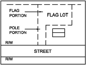
Figure 6.07.03(C). Illustration of a Flag Lot
D.
Access requirements.
1.
Each lot shall have frontage on and permanent access to an existing or proposed paved public street.
a.
Private streets are only allowed where an HOA is established in perpetuity.
b.
No streets will be accepted by the city for ownership or maintenance until the streets have met the standards for all streets as identified in the current edition of the Crestview Engineering Standards Manual.
2.
A subdivision plat shall include streets as established by transportation plans in the comprehensive plan, the Transportation Planning Organization, or other similar plan. The arrangement, character, extent, width, grade, and location of all streets shall conform to the plans of the state, Okaloosa County, and the city, respectively, and shall be considered in their relation to existing and planned streets, to topographical conditions, and to public convenience and safety.
3.
Alleys shall be provided to serve multifamily development, commercial development, and industrial development.
4.
All streets shall be designed and constructed in compliance with the standards of the city set forth in the Crestview Engineering Standards Manual. All costs shall be paid by the developer.
5.
Subdivisions shall include sidewalks and bicycle paths or lanes in compliance with the standards set forth in chapter 8 of this LDC and the Crestview Engineering Standards Manual.
E.
Easements. All lots within a subdivision shall provide easements for stormwater drainage, water systems, sanitary sewer systems, gas lines, electric lines, cables, telephone lines, and utility poles. Standards for such utility easements are set forth in the Crestview Engineering Standards Manual.
F.
Site improvements.
1.
All subdivisions shall be required to have underground utility service (electrical, cable television, telephone, water, and sewer) unless all lots within the subdivision front existing streets that currently are serviced above ground.
2.
If the subdivision plat proposes more than ten lots, recreation facilities assessment equal to five percent of the predevelopment land value according to the property appraiser shall be due prior to the issuance of a development order. In some cases, land can be deeded to the city, provided that land is deemed of sufficient size and quality to be utilized as a public city park. This shall be at the sole discretion of the director of the Crestview Recreation Enrichment Services Department.
3.
Land which is determined to be unsuitable for subdivision due to flooding, bad drainage, or other features likely to be harmful to the health, safety, and general welfare of future residents shall not be subdivided, unless adequate methods of correction and mitigation are formulated by the developer and approved by the city and any other agency having jurisdiction.
4.
All applicable standards set forth in chapter 5 of this LDC shall be met.
5.
All applicable standards set in the Crestview Engineering Standards Manual shall be met.
G.
The street and block layout.
1.
Streets. The street layout of the subdivision shall be in general conformity with a plan for the most advantageous development of adjoining areas and the entire neighborhood. This shall apply to all streets, including private streets.
a.
Where appropriate to the design, proposed streets shall be continuous and in alignment with existing, planned, or platted streets with which they are to connect.
b.
Proposed streets may be required to extend to the boundary lines of the tract to be subdivided where such an extension is required to connect with streets in an existing, platted, or planned subdivision. The extension or connection requirement by the city will be based upon traffic circulation or public safety issues and compatibility of adjacent land uses.
c.
If the proposed subdivision is adjacent to an undeveloped area, at least one proposed street shall terminate at a boundary line of the undeveloped area. A temporary turning circle shall be required at the end of that street with an outside diameter of 60 feet. This requirement may be waived if the traffic pattern of the subdivision contains more than one exit to a city or county road or if traffic circulation or public safety requirements do not dictate a street terminus at a boundary line of the undeveloped area.
d.
If an existing half-width public or private street or other right-of-way easement is parallel and contiguous with the boundary of a proposed subdivision, the other half-width right-of-way will be dedicated in the proposed subdivision and shall be the width necessary to create a right-of-way along the entire boundary of the proposed subdivision which meets minimum width requirements. If the additional right-of-way required to continue the existing dedicated road or other easement in a continuous, orderly manner is not in the proposed subdivision, the developer will prepare the agreement or easement for dedicating the additional right-of-way required and will attempt to obtain such right-of-way. However, the city may assist in acquisition of such right-of-way when in the public interest, where governmental action is necessary to acquire the property and the developer advances all costs and expenses incurred by the city in taking such action.
e.
A cul-de-sac or local dead-end street shall not exceed 1,320 feet in length.
f.
Street lighting shall be provided in accordance with section 6.06.01. The developer shall make arrangements with the power company and bear the cost of power during the warranty period. Then the streetlight electrical account shall transfer to the homeowners association serving the same.
H.
Subdivision landscaping requirements.
1.
Any subdivision landscaping or island must be in a platted common area, dedicated to the homeowners association.
(Ord. No. 1789, § 6.07.00, 2-8-2021; Ord. No. 1891, att. 1(6.07.10), 8-22-2022; Ord. No. 1915, att. 1(6.07.00), 1-23-2023)
Sec. 6.08.00. - Standards for landscape development.
6.08.01.
Intent. It is the intent of this section to:
A.
Establish minimum landscaping standards for all development within the city;
B.
Protect the public's health, safety, and welfare;
C.
Protect the natural environment, ecosystem, existing wetlands, and waterways;
D.
Improve the quality of appearance of the built environment by preserving natural elements where possible and incorporating new landscaped areas;
E.
Protect and improve property values;
F.
Establish an integrated system of landscaping and beautification of the city's corridors;
G.
Ensure visual accessibility to businesses;
H.
The City of Crestview encourages innovative water conservation planning, design and techniques, including xeriscape landscaping methods as defined in the Crestview Engineering Standards Manual.
6.08.02.
Definitions. Definitions of terms used in this chapter can be found in chapter 2 of this LDC.
6.08.03.
Applicability.
A.
This section applies to all new development.
1.
New development within an existing multi-use structure, nonresidential, or multifamily development shall be required to provide landscaping in conformance with this section only to the portions of the site containing the new development, unless subsection 6.08.03.C of this section applies.
B.
This section shall apply to existing development and redevelopment when any of the following occurs:
1.
When a change in use requires the construction of additional parking and/or vehicle use area.
2.
When any principal nonresidential structure or complex of structures is enlarged by 50 percent or more in gross floor area, the entire site shall conform to the requirements of this section.
3.
When any vehicle use area is constructed or established, or when an existing vehicle use area is enlarged by 50 percent or greater, the entire vehicle use area shall conform to the requirements of this section.
a.
When an existing vehicle use area is enlarged by less than 50 percent, that portion of the vehicle use area shall conform to the requirements of this section.
C.
The following development is exempted from the requirements of this section:
1.
Single-family detached dwellings.
2.
Duplex dwellings.
6.08.04.
Administrative modifications.
A.
The director of community development services, or designee, shall have the authority to modify the requirements of this section when he/she determines that it is impossible or impractical for a development to meet the requirements of this section.
1.
This determination shall be based upon the location, placement, or configuration of existing structures, site dimensions, site topography, underground and overhead utilities, and other physical characteristics of the development site itself.
2.
If it is determined that modifications are required, the director, or designee, may allow for the following only:
a.
Placement of required trees elsewhere on site;
b.
Grouping of required trees;
c.
Waiver of a portion of the requirements, provided that the requirements of this section are implemented to the fullest extent on those portions of the development site that can physically accommodate these requirements.
6.08.05.
Landscape plan required.
A.
To ensure compliance with the standards of this section, a landscape plan demonstrating how landscaping will be planted on a development site shall be included as a part of any application for any commercial development.
B.
No submittal for any development shall be deemed complete unless a landscape plan has been submitted.
C.
No development order or development permit shall be issued until a landscape plan has been submitted and approved as meeting the requirements of this section.
D.
Landscape plans shall include the following contents and information:
1.
Location of all protected trees that are on a development site, with their species (common name) and DBH identified.
2.
Denote protected trees to be removed and those to be saved.
3.
Locations of all landscaping improvements including species (common name) and DBH of trees and species of shrubs, grasses and ground cover.
4.
Total landscaped area, total impervious surface areas, and total project limits.
5.
Location of all proposed improvements to be constructed or installed within the required landscape areas.
6.
Any utilities, overhead or underground, in the vicinity of the landscape areas shall be shown. Acceptance of the landscape material by an affected utility company may be required, such as trees adjacent to an overhead power line.
7.
Location of any proposed irrigation system, if applicable.
8.
A statement indicating that the balance of all areas within the required landscape, outside of the trees and shrubs, shall be planted with turf grass and/or ground cover plants.
9.
A statement indicating that all disturbed areas outside of the planned improvements shall be sodded or seeded.
6.08.06.
Interior parking landscape areas.
A.
Portions of off-street parking facilities not specifically designed as parking or loading spaces and drive aisles shall not be paved for vehicle use. Said areas shall be planted and permanently maintained with trees and shrubs and finished with ground cover or other landscape material.
B.
Maximum number of continuous parking spaces. Landscaping areas shall be provided to break up rows containing more than 15 continuous spaces. These landscaped areas shall have a minimum dimension of nine feet and a total area of at least 171 square feet. Each area shall contain one tree that measures a minimum of 1.5 inches DBH.
C.
Termination of parking rows. Each row of interior parking spaces shall be terminated at each end by a landscaped area which shall be a minimum of 100 square feet with a minimum dimension of ten feet. These landscaped areas must have one tree that measures a minimum of 1.5 inches DBH.
D.
Vehicles may overhang no more than two feet into landscape areas.
6.08.07.
Right-of-way landscape buffers.
A.
Excluding driveways, there shall be a continuous landscaped area, a minimum of ten feet wide, abutting all rights-of-way.
1.
When parking areas abut ROW landscape buffers, wheel stops shall be provided to prevent more than two feet of overhang into the landscape area.
2.
Sidewalks shall not be located within the right-of-way landscape buffer.
B.
When a development's disturbed area or project area does not extend the full length of the right-of-way frontage of the property, the required ROW landscape buffer may be placed within the dedicated project area only, provided the landscape plan identifies that the area is to be maintained in a natural state.
1.
If this area is developed in the future, then it will be required to meet the requirements of this LDC.
C.
Right-of-way adjacent landscape areas shall provide vegetation in accordance with the following:
1.
One tree per 25 linear feet, or fraction thereof, of total right-of-way frontage with 50 percent of the trees being a shade species.
a.
Any required trees deemed to be within the visibility triangle will be required to be planted elsewhere.
b.
Any trees that would conflict with existing utilities, such as overhead power, shall be planted elsewhere.
c.
In no case will driveways, utilities, or other such conflicts result in a reduction of the required trees or landscape area. Such required landscape shall be moved elsewhere within the development.
2.
The balance of the landscaped area shall be planted with turf grass and other landscaping treatments.
6.08.08.
Adjacent use landscape buffers.
A.
Adjacent use landscape buffers shall extend inward from the property line the required width.
B.
Adjacent use landscape buffers shall be required between uses with different densities and/or intensities and between different zoning districts in accordance with the following:
Table 6.08.08. Adjacent Use Landscape Buffer Widths
C.
The buffer requirement may be satisfied by the placement of an eight-foot-tall privacy fence when a single-family dwelling is redeveloped for commercial use and when:
1.
The character of the single-family dwelling is preserved.
2.
There are ten or less required parking spaces.
D.
Buffer yard vegetation requirements.
1.
The intent of this subsection 6.08.08.D is that a visual and audible barrier or screen is created between dissimilar uses through the use of aesthetically appealing landscaping, fencing, walls, or other methods.
2.
All plants in the buffer shall be bushes and trees of an approved species that will reach a mature height of no less than six feet.
a.
Small shrubs will not be allowed unless coupled with a six-foot privacy fence.
3.
Buffer yard approved vegetation list. Vegetation not on this list must be approved by the community development services director, or designee:
a.
Japanese privet (Ligustrum japonicum).
b.
Azalea (Rhododendron spp.).
c.
Japanese cleyera (Cleyera japonica).
d.
Pampas grass (Cortaderia selloana).
e.
Silverthorn (Elaeagnus pungens).
f.
Cherry elaeagnus, Gumi (Elaeagnus multiflora).
g.
English holly (Ilex aquifolium).
h.
Chinese holly (Ilex cornuta).
i.
Japanese holly (Ilex crenata).
j.
Yaupon holly (Ilex vomitoria).
k.
Oleander (Nerium oleander).
l.
Chinese juniper (Juniperus chinensis).
m.
Savin juniper (Juniperus sabina).
n.
Rocky mountain juniper (Juniperus scopulorum).
o.
Bottlebrush buckeye (Aesculus parviflora).
4.
Bushes shall be planted sufficiently close so that, at full maturity, there will be no visual space between the bushes.
5.
Walls and fences may be allowed, provided they are constructed in such a manner as to create the intended visual and audible barrier.
a.
No wall or fence may be constructed less than six feet in height.
b.
All fences and walls will require approval from the building department.
6.08.09.
Protected trees.
A.
No person shall cut, remove or damage any protected tree in a manner which causes the tree to die within a period of two years without first obtaining a land clearing and protected tree removal permit, or without such removal being approved as part of a development order that provided a landscape plan as required by 6.08.05 of this section; a one-, two-, or three-family dwelling is exempt from the requirements of this subsection, except that they must replant a tree listed on the protected tree list or tree replant list, with such replacement tree measuring a minimum of 1.5 inches DBH.
B.
Protected tree list. The following types of species comprise the protected tree list (* denotes shade trees):
1.
Species type A: small, four-inch to seven-inch DBH.
a.
Dogwood (Cornus florida).
b.
Redbud (Cercis canadensis).
c.
Ashe's magnolia (Magnolia ashei).
2.
Species type B: medium, eight-inch to 13-inch DBH.
a.
American holly (Ilex opaca).
b.
Southern magnolia (Magnolia grandiflora).*
c.
Eastern (or Southern) red cedar (Juniperus virginiana).*
3.
Species type C: large, 14-inch and larger DBH.
a.
Live oak (Quercus virginiana).
b.
Laurel oak (Quercus laurifolia).*
c.
Sweet gum (Liquidambar styraciflua).*
d.
Sycamore (Platanus occidentalis).*
e.
Pecan (Carta illinoensis).*
f.
Water oak (Quercus nigra).*
g.
Red maple (Acer rubrum).*
C.
Trees identified by a certified arborist as diseased or dead shall not be required to be replaced.
D.
Every effort shall be made to save the trees on the protected tree list during any site development or clearing for any reason.
E.
Allowances to the site development may be provided to encourage retaining protected trees. The director of community development services, or designee, may review a plan submitted by the developer to determine the extent of such allowances. Those may include such allowances as reduced parking requirements, reduced landscape area requirements or other allowances.
F.
Trees on the protected tree list must be preserved based at a ratio of one tree for each 3,600 square feet of impervious surface area proposed by any site development.
G.
Where protected trees cannot be kept or relocated, they must be replaced by a species listed in the tree replant and protected trees list. Enough trees shall be planted to replace a minimum of 50 percent the diameter of the removed protected tree. Multiple trees shall be used to reach 50 percent, but in no case shall any of these replacement trees be less than two inches in diameter.
H.
On sites proposed for development where no existing protected trees are identified, the developer shall be required to plant one new tree from either the protected tree list or tree replant list per 3,600 square feet of proposed impervious surface area. One third of trees planted, or fraction thereof, shall each be of species type A, species type B, and species type C, respectively. The size of each new tree shall be no less than two inches in diameter.
I.
Tree replant list. In addition to the three categories of trees identified in subsection 6.08.09.B of this section, the following trees may be planted to meet the minimum tree replanting requirements. Trees not on this tree replant list may be used only if approved by the community development services director or designee (* denotes shade trees):
1.
Species type A: small.
a.
Dahoon holly (Ilex cassine).*
b.
Fringe tree (Chionanthus virginicus).
c.
Red bay (Persea borbonia).*
d.
Swamp bay (Persea palustris).*
e.
Sassafras (Sassafras albidum).
f.
Yaupon (Ilex vomitoria).
g.
Wild olive (Osmanthus americanus).
h.
Scrubby post oak (Quercus margarettae).
i.
Southern crabapple (Malus angustifolia).
j.
Eastern hophornbeam (Ostrya virginiana).
k.
Red buckeye (Aesculus pavia).
l.
Pindo palm (Butia capitata).
m.
Sago palm (Cycas revoluta).
2.
Species type B: medium.
a.
Cherry laurel (Prunus caroliniana).*
b.
Large-leafed magnolia (Magnolia macrophylla).*
c.
American hornbeam (Carpinus caroliniana).
d.
River birch (Betula nigra).*
e.
Florida maple (Acer barbatum).*
f.
Sweetbay (Magnolia virginiana).*
g.
Ginko (Ginko biloba).*
h.
Bradford pear (Pyrus calleryana 'Bradford').
i.
Ash (Fraxinus spp.).*
j.
London planetree (Platanus × acerifolia).*
k.
Sabal (cabbage) palm (Sabal palmetto).
3.
Species type C: large.
a.
Tulip tree (Liriodendron tulipifera).
b.
Willow oak (Quercus phellos).
c.
Black gum (Nyssa sylvatica).
d.
Southern red oak (Quercus falcata).*
e.
Shumard's red oak (Quercus shumardii).*
f.
Hackberry (Celtis laevigata).*
g.
White oak (Quercus alba).*
h.
Bald cypress (Taxodium distichum).
i.
Walnut (Juglans nigra).*
j.
Chinese elm (Ulmus parvifolia).*
k.
Hickory (Carya spp.).*
l.
Yellow buckeye (Aesculus flava).*
m.
Canary Island date palm (Phoenix canariensis).
J.
Prohibited tree list.
1.
The following prohibited species may not be used to meet any landscape requirement:
a.
Paper mulberry (Broussonetia papyrifera).
b.
Australian pine (Casuarina equisetifolia).
c.
Ear tree (Enterolobium cyclocarpum).
d.
Punk tree (Melaleuca spp.).
e.
Chinaberry (Melia azedarach).
f.
Brazilian pepper (Schinus terebinthifolius).
g.
Downy rose myrtle (Rhodomytrus tomentosa).
h.
Bishopwood (Bischofia javanica).
i.
Chinese tallow tree or popcorn tree (Triadica sebifera).
(Ord. No. 1789, § 6.08.00, 2-8-2021; Ord. No. 1830, att.(6.08.08), 9-13-2021; Ord. No. 1891, att. 1(6.08.00), 8-22-2022; Ord. No. 1915, att. 1(6.08.00), 1-23-2023)