
Cutler Bay City Zoning Code
ARTICLE IV
DISTRICTS AND DEVELOPMENT STANDARDS
Sec. 3-50.- Purpose.
The creation of districts and standards allow for classifying and regulating the use and development of the lands and waters of the town. These districts are established for the purpose of protecting, promoting, and improving the public health, safety, comfort, order, appearance, convenience, morals, and general welfare of the community. These districts control the location of uses and regulate the location, height, and bulk of buildings to be erected or structurally altered for such uses; to control population density and the intensity of use of lot areas; and to require adequate yards and other open spaces surrounding such buildings.
(Ord. No. 12-03, § 2(3-50), 6-20-2012)
Sec. 3-51. - Schedule of districts and official zoning district map.
In accordance with these land development regulations, the town is hereby divided into the following zoning districts:
(Ord. No. 12-03, § 2(3-51), 6-20-2012)
Sec. 3-52. - Relationship of zoning districts to land use categories.
Zoning categories shall implement the underline future land use map designation on the property.
(Ord. No. 12-03, § 2(3-52), 6-20-2012)
Sec. 3-53. - Prohibited uses and structures.
(a)
Any use that is specifically listed as a prohibited use shall be prohibited. Unless a use is specifically listed as a permitted or conditional use, it shall be prohibited.
(b)
No building shall be erected and no existing building shall be moved, altered, added to, or enlarged, nor shall any land or building be designed, used, or intended to be used for any purpose or in any manner other than as permitted in the district in which the building or land is located.
(c)
No building shall be erected, reconstructed, or structurally altered to exceed in height the limit designated in this article for the district in which the building is located, except where bonuses are allowed.
(d)
No building shall be erected and no existing buildings shall be moved, altered, enlarged, or rebuilt, nor shall any open space surrounding any building be encroached upon or reduced in any manner, except in conformity to the yard, lot area, and building location and bulk regulations designated in this article for the district in which the building or open space is located.
(e)
No yard or other open space or required off-street parking or off-street loading space provided around any building for the purpose of complying with the provisions of this article shall be considered as meeting the requirements for any other building, structure, or use, except where specific provision is made in the articles of this code.
(f)
The following uses shall be prohibited in any of the districts:
(1)
Bee hives or the breeding or raising of animals other than customary pets;
(2)
Keeping, breeding, or maintaining of horses, cattle or goats; and
(3)
The raising of poultry or fowl.
(Ord. No. 12-03, § 2(3-53), 6-20-2012)
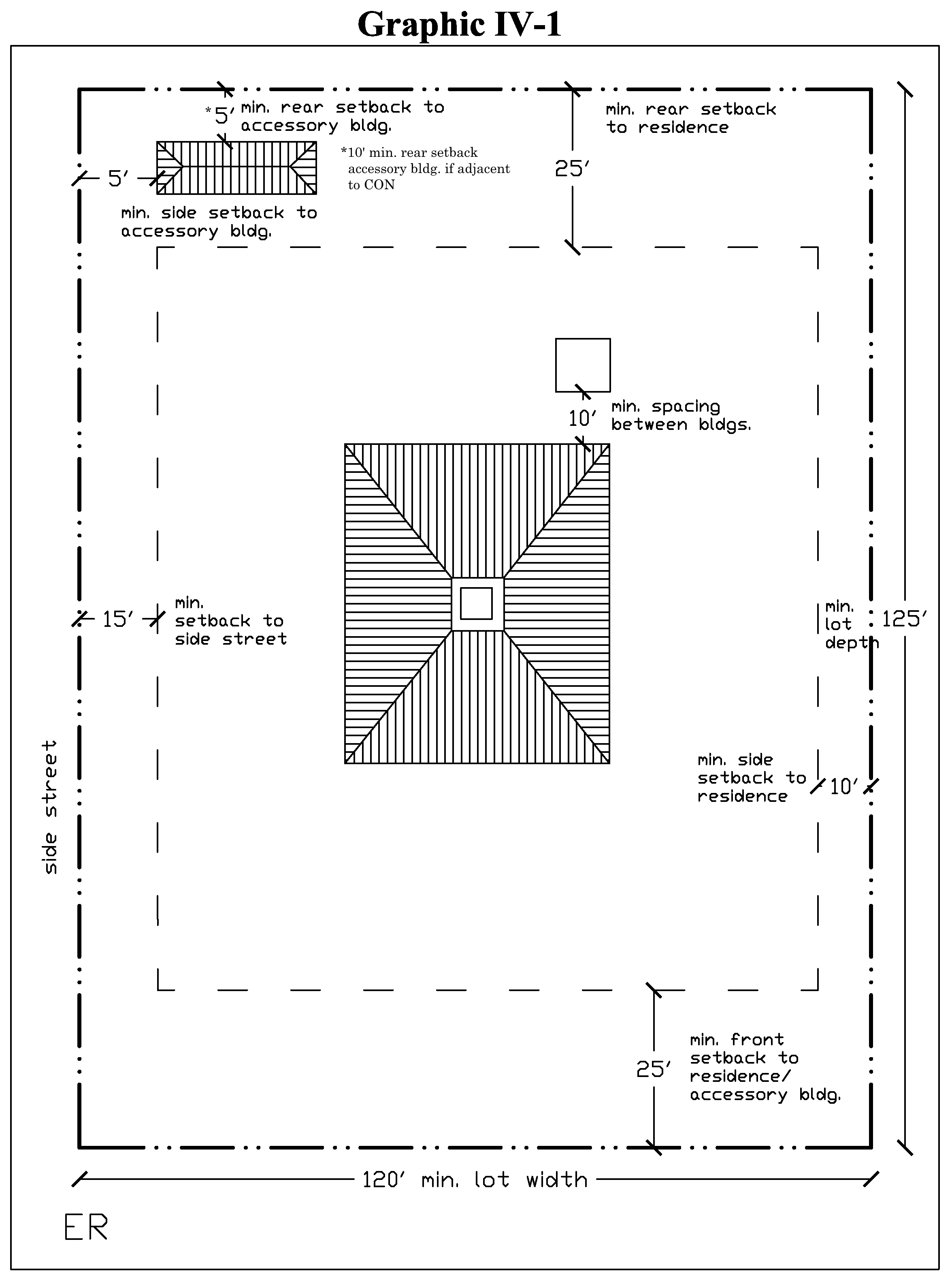
Sec. 3-54. - ER, estate residential district.
The estate residential district is coded to accommodate existing very low density residential development areas and to protect their associated natural vistas and landscape features. This district is established to protect these low density residential areas and their customary development patterns to prevent sacrificing environmentally sensitive landforms, natural vistas and scenic factors which provide definition to the town's design. The district may be expanded where practicable.
(1)
Permitted uses. The following uses are permitted in the ER, Estate Residential District:
a.
Detached single-family dwelling.
b.
Group home limited to six resident clients on the premises. (See supplemental regulations for additional requirements.)
c.
Family day care home.
(2)
Table of standards. The following are the standards for the ER, Estate Residential District:
(3)
Lots platted prior to article. Lots platted prior to the adoption of this article shall not be subdivided.
(4)
Maximum coverage; concrete, etc. No more than 25 percent of the frontage of a lot in the ER zoning district shall be covered by asphalt, concrete or pavers. The 25 percent includes the driveway, an entrance walkway from the edge of property line to the principal structure.
(5)
Typical ER, Estate Residential site plan.
(Ord. No. 12-03, § 2(3-54), 6-20-2012; Ord. No. 19-10, § 2, 6-19-2019)
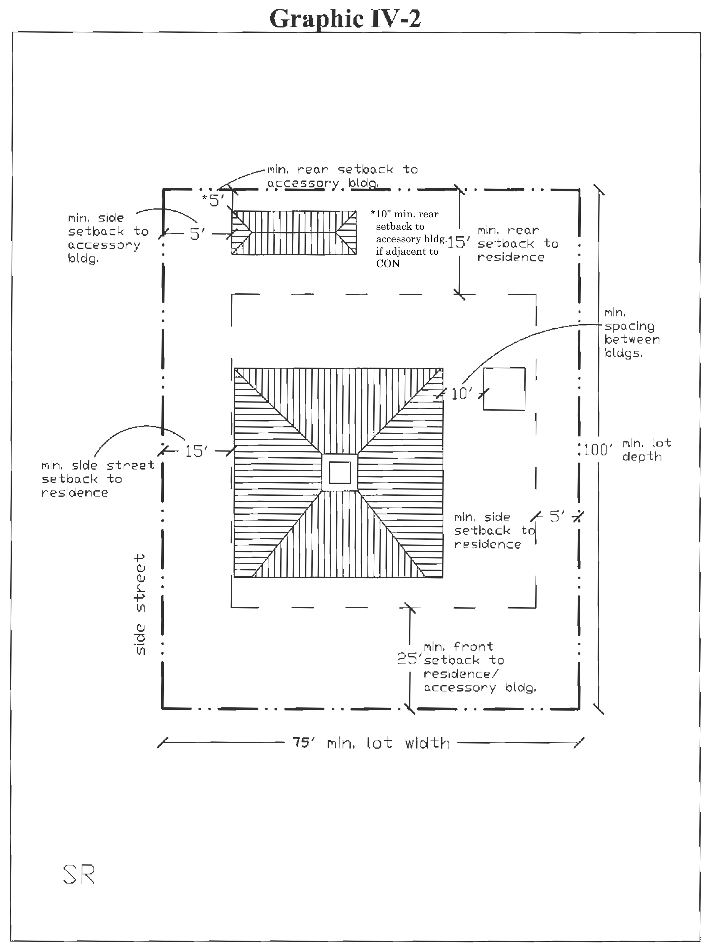
Sec. 3-55. - SR, single-family residential district.
The single-family residential district is coded to permit development of new or the completion of previously approved development of lands within the district and/or annexation of conventional single-family residential subdivisions existing or approved prior to the effective date of these regulations.
(1)
Permitted uses.
a.
Detached single-family dwelling.
b.
Group home limited to six resident clients on the premises. (See supplemental regulations for additional requirements.)
c.
Family day care home.
d.
Single-family zero lot line if based on a site plan approved prior to the adoption of this code.
(2)
Table of standards.
(3)
Maximum coverage; concrete, etc. No more than 40 percent of the frontage of a lot in the SR zoning district shall be covered by asphalt, concrete or pavers. The 40 percent includes the driveway, an entrance walkway from the edge of property line to the principal structure.
(4)
Typical SR site plan.
(Ord. No. 12-03, § 2(3-55), 6-20-2012; Ord. No. 19-10, § 2, 6-19-2019)
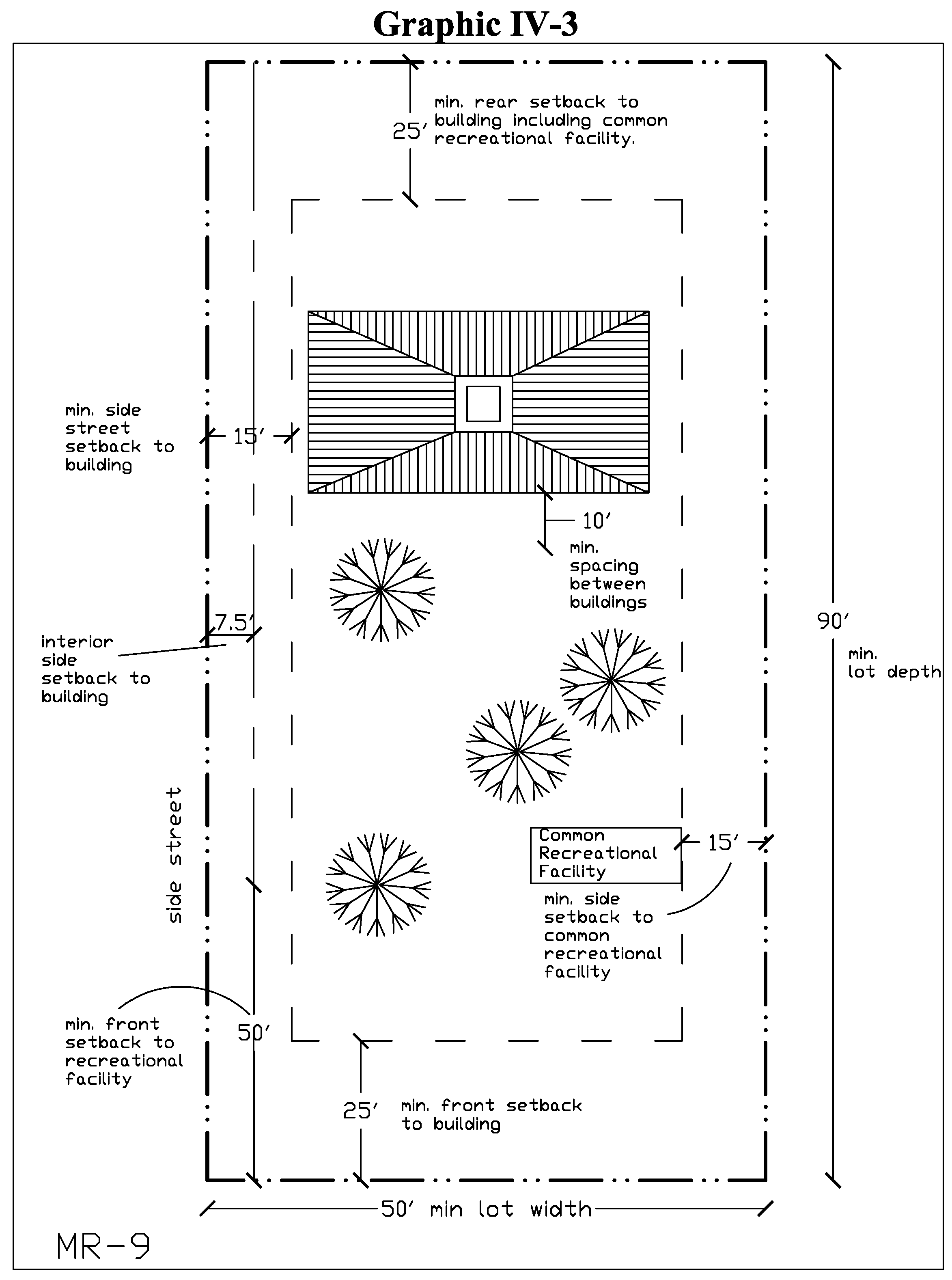
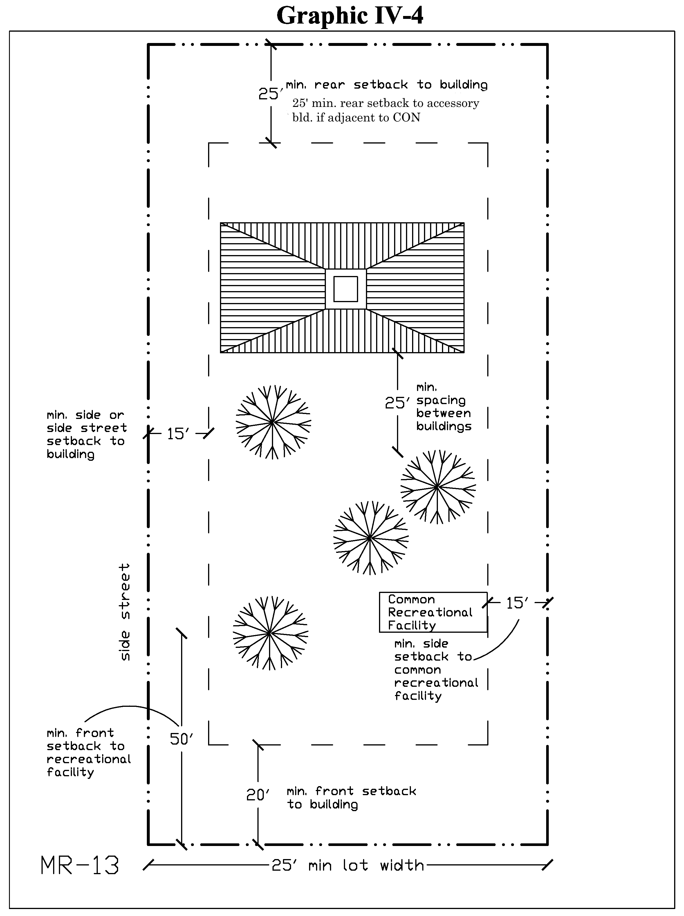
Sec. 3-56. - MR, multifamily residential district.
The multifamily residential district is coded to permit the completion and/or annexation of conventional multifamily residential development within the district. The district is intended to be townhouse, two-family to multifamily residential. The district is not intended to be expanded beyond the boundaries of existing MR areas.
(1)
Permitted uses.
a.
Multifamily dwelling.
b.
Townhouse dwelling.
c.
Two-family dwelling.
d.
Religious institutions.
(2)
Table of standards.
(3)
Green designation. Buildings that pursue a height bonus and which exceed one or three stories shall pursue green designation per the requirements of article V of this chapter.
(4)
Typical MR-9 site plan.
(5)
Typical MR-13 site plan.
(Ord. No. 12-03, § 2(3-56), 6-20-2012; Ord. No. 19-10, § 2, 6-19-2019)
Sec. 3-57. - NR, neighborhood residential district.
The neighborhood residential district provides for residential development surrounding mixed-use neighborhood commercial areas. The district preserves the traditional building pattern of mixed residential development, which historically forms a vibrant, active, and cohesive neighborhood unit. The district provides for medium density residential development within walking distance (generally one-half mile) of neighborhood centers or commercial corridors. The regulations detailed in this section are coded to permit the construction of detached single-family dwelling, attached, and apartment building types in proximity to each other to encourage a traditional, pedestrian friendly streetscape.
(1)
Permitted uses.
a.
Detached single-family dwelling.
b.
Townhouse dwelling.
c.
Two-family dwelling.
d.
Multi-family dwelling.
e.
Group home limited to six resident clients on the premises. (See supplemental regulation for additional requirements).
(2)
Table of standards.
(Ord. No. 12-03, § 2(3-57), 6-20-2012; Ord. No. 16-04, § 2, 5-18-2016)
Sec. 3-58. - NC, neighborhood center district.
The neighborhood center district provides for the location of pedestrian scaled shops, restaurants, services, small workplaces, and residential buildings central to a neighborhood (or grouping of neighborhoods) and within walking distance of dwellings.
The neighborhood center district shall be developed on an interconnected pattern of streets and typically limited to approximately one-fourth mile in radius. Uses in the district will have a primary market area of three miles and are intended to service the daily needs of the residents of the surrounding neighborhoods. The pedestrian is expected to be able to walk from one end of the district to the other in ten to 15 minutes.
(1)
Permitted uses.
a.
Commercial and retail (not exceeding 25,000 square feet as a single use).
b.
Office (requiring less than 50 parking spaces).
c.
Restaurant.
d.
Multifamily (within a vertical mixed use development).
e.
Townhouse (within a horizontal mixed use development).
f.
Medical.
g.
Civic (excluding educational facility/school).
h.
Park and open space.
i.
Place of public assembly (with a minimum distance of 1,000 feet between another place of public assembly).
j.
Outdoor dining (see supplemental standards for further regulations).
k.
Pharmacy (not exceeding 25,000 square feet as a single use; with a minimum distance of 275 feet from a medical marijuana dispensary or another pharmacy, measured nearest property line to nearest property line).
l.
Medical marijuana dispensary (not exceeding 25,000 square feet as a single use; with a minimum distance of 275 feet from a pharmacy or another medical marijuana dispensary, measured nearest property line to nearest property line).
m.
Personal service.
n.
Senior housing (55 years and older) and ancillary support services (within a mixed use development) in the neighborhood center 2 (NC-2) zoning district only.
(2)
Prohibited uses.
a.
Repair garage.
b.
Service station.
c.
Vehicle service center.
d.
Entertainment center.
e.
Kennel.
f.
Manufacturing and industrial.
g.
Outdoor storage.
h.
Self storage facility.
i.
Automobile, truck, equipment sale or rental.
j.
Funeral home.
k.
Donated goods store.
l.
Furniture store.
m.
Home improvement center.
n.
Pawn shop.
o.
Pain management clinic.
p.
Theater.
q.
Adult entertainment.
r.
Check cashing service.
(3)
Conditional uses.
a.
Conservatory, health and fitness, martial arts or dance studio.
b.
Educational facility/school.
c.
Office (with 50 or more parking spaces).
d.
Commercial and retail (exceeding 25,000 square feet but less than 55,000 square feet as a single use).
e.
Veterinarian office (including grooming and indoor boarding).
f.
Neighborhood convenience store.
g.
Bar and nightclub.
h.
Drive-thru.
i.
Pharmacy (exceeding 25,000 square feet but less than 55,000 square feet as a single use; with a minimum distance of 275 feet from a medical marijuana dispensary or another pharmacy, measured nearest property line to nearest property line).
j.
Medical marijuana dispensary (exceeding 25,000 square feet but less than 55,000 square feet as a single use; with a minimum distance of 275 feet from a pharmacy or another medical marijuana dispensary, measured nearest property line to nearest property line).
(4)
Site development standards.
a.
Story. Buildings shall be at least two stories. Office, commercial and retail, residential, civic or finished attic space, or facade design above the ground floor shall count as a second story when more than 50 percent of the building footprint is encompassed by the space. Each upper story shall be a minimum of eight feet in height.
b.
Mixed use. Buildings are encouraged to be vertically mixed use in design and character. Horizontal mixed use development is encouraged on a site that cannot otherwise accommodate vertical mixed use. Commercial and retail uses shall be located on the ground floor of a multi-story building. Office uses should be located on higher floors, while residential or senior housing may exist on any level. When residential or senior housing are part of the mix of uses, it can be no less than 20 percent or more than 80 percent, whether vertical or horizontal in form and function.
c.
Green designation. Buildings that pursue a height bonus and which exceed two stories shall pursue green designation per the requirements of article V of this chapter.
d.
Buildings fronting Old Cutler Road. Buildings which are located on Old Cutler Road shall be required to provide an outdoor plaza and/or an area for seating or cafe tables between the building and the right-of-way. No single tenant in a building fronting Old Cutler Road shall exceed 25,000 square feet in size.
(5)
Table of standards.
(Ord. No. 12-03, § 2(3-58), 6-20-2012; Ord. No. 13-08, § 2(3-58), 8-21-2013; Ord. No. 18-01, § 2, 3-21-2018; Ord. No. 18-05, § 2, 10-17-2018; Ord. No. 22-08, § 2, 10-19-2022; Ord. No. 23-05, § 2, 7-19-2023)
Sec. 3-59. - TRC, Transit corridor district.
The transit corridor district provides for the location of transit-oriented uses and uses having a market area extending beyond the scale of the corridor and surrounding neighborhoods. The intent of the district is to facilitate convenient access, minimize traffic congestion, and reduce visual clutter to create a development pattern which improves the aesthetic quality and character of the US 1 corridor within the town. Buildings are required to relate to the street with a pedestrian scale, rather than to parking lots. Site design criteria is required to facilitate ease of pedestrian access along the corridor and the bus way.
(1)
Permitted uses.
a.
Commercial and retail (not exceeding 55,000 square feet as a single use; 60,000 square feet for projects meeting green building program designation per article V of this chapter. Development bonuses shall not exceed the maximum permitted by the growth management plan).
b.
Multifamily (within a vertical mixed use development).
c.
Civic (excluding educational facility/school).
d.
Personal service.
e.
Office and institutional (excluding educational facility/school).
f.
Restaurants, including outdoor dining area.
g.
Hotel.
h.
Motel.
i.
Theater.
j.
Adult entertainment.
k.
Medical.
l.
Pharmacy (not exceeding 55,000 square feet as a single use; 60,000 square feet for projects meeting green building program designation per article V of this chapter. Development bonuses shall not exceed the maximum permitted by the growth management plan. Must be located a minimum of 275 feet from a medical marijuana dispensary or another pharmacy, measured nearest property line to nearest property line).
m.
Medical marijuana dispensary (not exceeding 55,000 square feet as a single use; 60,000 square feet for projects meeting green building program designation per article V of this chapter. Development bonuses shall not exceed the maximum permitted by the growth management plan. Must be located a minimum of 275 feet from a pharmacy or another medical marijuana dispensary, measured nearest property line to nearest property line).
(2)
Prohibited uses.
a.
Pawn shop.
b.
Outdoor storage.
c.
Self-storage facility.
d.
Donated goods store.
e.
Gun shop.
f.
Cash checking service.
(3)
Conditional uses.
a.
Amusement facility.
b.
Automotive/boat/truck sales, service and repair.
c.
Bar and nightclub.
d.
Gold buying.
e.
Telecommunication tower.
f.
Parking structure.
g.
Pain management clinic.
h.
Educational facility/school (with no residential component).
(4)
Site development standards.
a.
Story. Buildings shall be a minimum of two stories when located on a development site of three acres or larger. Office, commercial and retail, residential or finished attic space above the ground floor count as a second story when more than 50 percent of the building footprint is encompassed by the space. Each upper story shall be a minimum of eight feet in height.
b.
Mixed use. Buildings are encouraged to be vertically mixed use in design and character. Horizontal mixed use development is encouraged on a site that cannot otherwise accommodate vertical mixed use. Commercial and retail uses shall be located on the ground floor of a multi-story building. Office uses should be located on higher floors, while residential may exist on any level. When residential is part of the mix of uses, it can be no less than 20 percent or more than 80 percent, whether vertical or horizontal in form and function.
c.
Green designation. Buildings that pursue a height bonus and which exceed two stories shall pursue green designation per the requirements of article V of this chapter.
(5)
Table of standards.
Notes:
(1) The green bonuses for floor area ratio, maximum height, and number of stories are only available to those properties within the transit corridor (TRC) zoning district that are located west of US-1 and achieve the green building program designation pursuant to section 3-74 of the Town Code.
(Ord. No. 12-03, § 2(3-59), 6-20-2012; Ord. No. 13-08, § 2(3-59), 8-21-2013; Ord. No. 18-01, § 3, 3-21-2018; Ord. No. 18-05, § 3, 10-17-2018; Ord. No. 22-03, § 2, 4-20-2022)
Sec. 3-60. - TC, town center district.
The town center district is coded to accommodate the higher overall intensity of development required to support the town. It is expected that the district may be expanded over time to meet the growth in demand for downtown facilities and services. The town center district is provided to encourage the expansion and redevelopment of Southland Mall and adjoining areas zoned town center. A broad array of uses is expected in a pattern which integrates shops, restaurants, services, work places, civic, educational, and public assembly uses, and higher density housing in a compact, pedestrian-oriented environment. The town center district anchors the surrounding residential neighborhoods while also serving the broader community.
(1)
Permitted uses.
a.
Mixed use.
b.
Commercial and retail.
c.
Multifamily (within a mixed use development).
d.
Civic (excluding educational facility/school).
e.
Office.
f.
Hotel.
g.
Family entertainment center.
h.
Bar or nightclub.
i.
Medical marijuana dispensary (Minimum 275 feet from a pharmacy or another medical marijuana dispensary, measured nearest property line to nearest property line).
j.
Park.
k.
Pharmacy (Minimum 275 feet from a medical marijuana dispensary or another pharmacy, measured nearest property line to nearest property line).
l.
Professional service.
m.
Place of public assembly (minimum 1,000 feet between another place of public assembly).
n.
Recreational facility.
o.
Restaurant.
p.
Outdoor dining.
q.
Medical office.
r.
Personal service.
(2)
Prohibited uses.
a.
Kennel.
b.
Manufacturing.
c.
Outdoor storage.
d.
Self storage facility.
e.
Funeral home.
f.
Donated goods store.
g.
Adult entertainment.
h.
Motel.
i.
Pawn shop.
j.
Cash checking service.
(3)
Conditional uses.
a.
Drive-thru.
b.
Automotive/boat/truck sales, service and repair.
c.
Parking structure.
d.
Educational facility/school (with no residential component).
(4)
Table of standards.
(5)
Site development standards.
a.
Story. Buildings shall be a minimum of two stories, except that parcels with less than 25,000 square feet shall not be required to comply with the minimum height requirements. Office, commercial and retail, residential or finished attic space or facade design above the ground floor shall count as a second story when more than 50 percent of the building footprint is encompassed by the space. Each upper story shall be a minimum of eight feet in height.
b.
Mixed use. Buildings are encouraged to be vertically mixed use in design and character. Commercial and retail uses shall at a minimum be located on the ground floor of a multi-story building. Residential and office uses should be located on higher floors, while civic uses can be located on any floor.
c.
Residential. Residential, if constructed, shall not exceed 80 percent of total floor area developed on a site. Buildings more than two stories shall provide a minimum of 20 percent of total floor area for residential in a vertical mixed use environment. Horizontal mixed use development is encouraged on a site that cannot otherwise accommodate vertical mixed use.
d.
Green designation. Buildings that pursue a height bonus and which exceed two stories shall pursue green designation per the requirements of article V of this chapter.
e.
Open space. Common open space shall be provided at a at a minimum of ten percent to meet the anticipated open space needs of the residents of the proposed residential development. Recreation facilities, playgrounds, tennis courts, basketball courts, swimming pools, community buildings, etc., may be included to assist in fulfilling the requirement. All open space shall be included in the development schedule and constructed and fully improved by the developer at a rate equivalent to or greater than the construction of residential units.
f.
Medical office uses. If group transportation is provided, to or from a medical office use, the applicant shall provide a vehicular circulation and parking management plan for review and approval by the director, which demonstrates that there is adequate vehicular circulation and parking on the property.
(6)
General roadway standards in the TC district.
Streets, service roads and utilities. All streets and service roads shall comply with the street types parameters as set forth in this section.
a.
Typical minor street illustration.
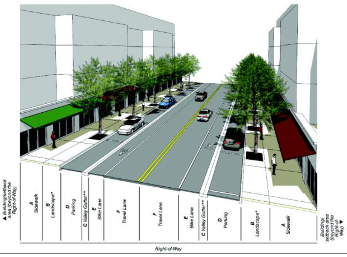
* Refer to column B in the street types table for required landscape elements.
** Curb and gutter between the sidewalk and parking/travel lanes may be utilized in place of the valley gutter illustrated.
b.
Typical two-lane boulevard street illustration.
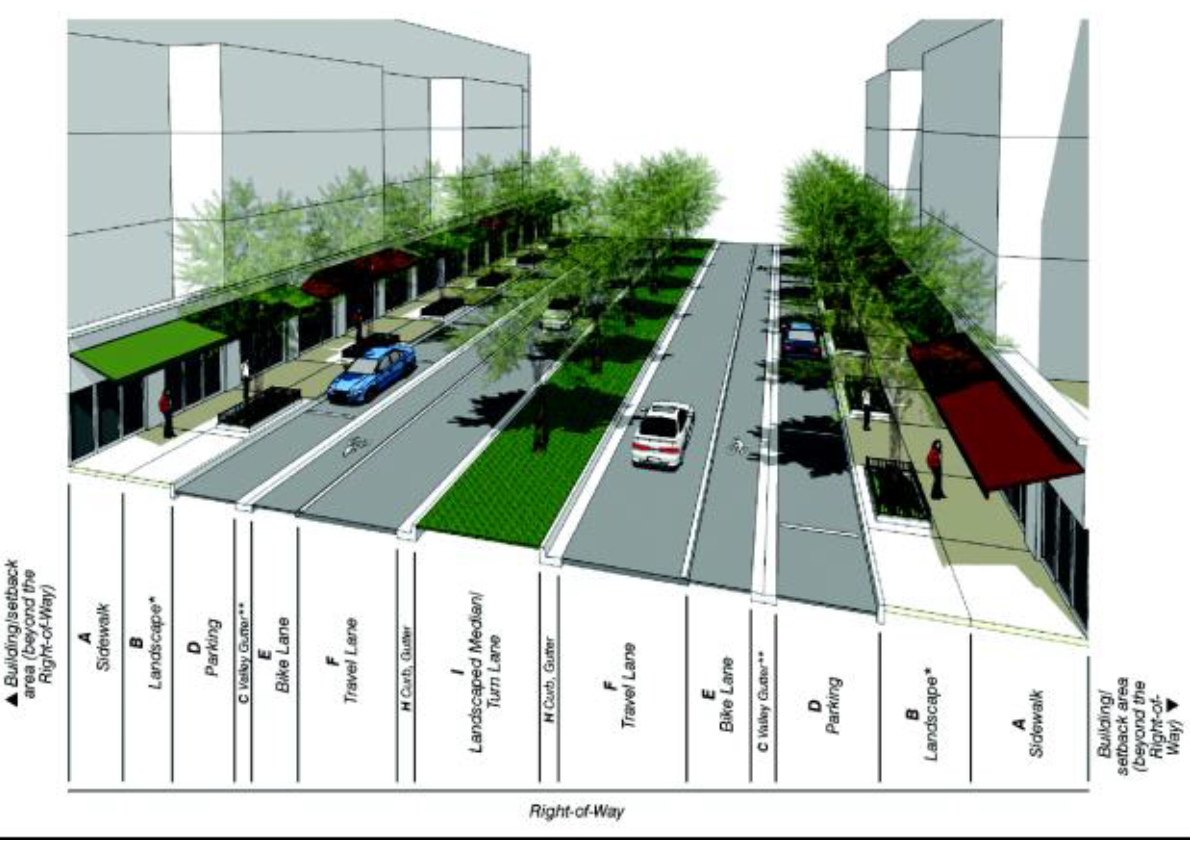
* Refer to column B in street types table for required landscape elements.
** Curb and gutter between the sidewalk and parking/travel lanes may be utilized in place of the valley gutter illustrated.
c.
Typical four-lane boulevard street illustration.
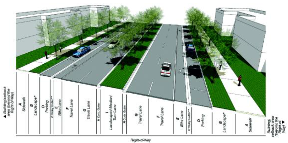
* Refer to column B in street types table for required landscape elements
** Curb and gutter between the sidewalk and parking/travel lanes may be utilized in place of the valley gutter illustrated.
d.
Street types development parameters.
e.
All streets shall be located according to the new streets plan.
1.
All new A streets shall be in the same general location shown on the new streets plan and may be modified with respect to alignment, provided that the final realignment does not compromise street connectivity. No new A streets shall be deleted.
2.
B streets and service roads shown on the new streets plan are encouraged to promote connectivity and to conform with block length requirements. New B streets and service roads may be modified or deleted as provided in paragraph 6., below.
3.
All streets shall allow general public access. Privately built streets shall provide an approved plat restriction to allow general public access. No gates that impede through traffic are permitted along A or B streets.
f.
Modification approval. The director shall approve the modification of A or B streets or service road or the deletion of a B street if the following conditions are satisfied:
1.
The modification/deletion has been approved by the director of the public works and waste management department who shall review the proposed modification for traffic and safety issues.
2.
The modification/deletion does not diminish the general size and location of an open space shown in the designated open space plan.
3.
The modification/deletion maintains connectivity to the surrounding area.
4.
The modification/deletion enhances pedestrian safety.
5.
The modification/deletion is compatible with the surrounding area.
6.
The modification/deletion allows for the appropriate use of private property.
g.
Design compliance. The design of new streets and modifications of existing streets shall comply with the following requirements:
1.
Streets shall be in accordance with the street types development parameters criteria set forth in this section.
2.
All streets and service roads shall connect to other streets or service roads. Dead-end streets and T-turnarounds shall only be permitted temporarily for new streets when the adjacent property is not platted, not developed, or both. When the adjacent property is platted or developed, a street shall connect to existing development and the dead-end street or T-turnaround removed.
3.
Culs-de-sac shall be prohibited, except that a cul-de-sac shall be permitted when:
A.
A street is interrupted by a natural barrier such as a river, protected land, or similar natural resource designated by the town or any government agency responsible for the protection of such natural resources; and
B.
Such agency prohibits the street to continue through said natural resource; and
C.
Existing development adjacent to or near the natural resource does not provide a means for the street to connect to the existing or proposed street network.
D.
The median of such a cul-de-sac shall be landscaped. The landscaped area shall be maintained by a special taxing district, homeowner's association or other mechanism acceptable to the department of public works and waste management to positively provide for the proper and continuous payment of maintenance without expense to general taxpayers.
4.
All sidewalks shall provide the following:
A.
Minimum width of six feet, unless a different width is required by the street types development parameters set forth in this section;
B.
Minimum unobstructed area of 60 inches;
C.
Where a colonnade is required, free and clear use of a continuous unobstructed area of at least 60 inches within the colonnade; and
D.
No utility poles, fire hydrants or any other temporary or permanent structures within the unobstructed area.
5.
Where on-street parking is provided, parking lanes shall be no closer than 25 feet from the intersection measured from the outermost corner of the nearest corner property line.
6.
Maximum curb radii at intersections shall not be larger than required for the safe travel of emergency and service vehicles.
7.
Curbs and gutters shall be provided as follows:
A.
All subdistricts: At all intersections and roadway edges of arterials, boulevards and Main Street.
B.
Core and center subdistricts: At all intersections and roadway edges of minor streets.
C.
Edge subdistrict: Not required, except when indicated by the urban center street type development parameters.
8.
Utilities other than fire hydrants shall run underground.
9.
Buildings placed at the end of a street vista may provide one additional story above that otherwise permitted by the building heights regulating plan; such additional story shall occupy up to 15 percent of the floor area of the story immediately below.
10.
Service roads may occur within buildings.
11.
Service road access from the front property line shall be limited to one point of access for every 250 feet of frontage.
(Ord. No. 12-03, § 2(3-60), 6-20-2012; Ord. No. 13-08, § 2(3-60), 8-21-2013; Ord. No. 17-05, § 2, 6-21-2017; Ord. No. 18-01, § 4, 3-21-2018; Ord. No. 18-05, § 4, 10-17-2018; Ord. No. 19-03, § 4, 3-20-2019; Ord. No. 19-15, § 2, 10-16-2019; Ord. No. 20-13, § 2, 9-16-2020; Ord. No. 23-03, § 2, 5-17-2023)
Sec. 3-61. - INT, institutional district.
The institutional district provides for the continued and future use, expansion, and new development of academic and religious campuses, as well as government and health related facilities. This district is coded to promote the many varied uses associated with such institutions while maintaining the overall design integrity of traditional town planning tenets.
(1)
Permitted uses.
a.
Government facility.
b.
Religious facility.
c.
Hospital.
d.
Congregate care and nursing home.
e.
Personal services when limited to the use of the residences within a senior age restricted community.
(2)
Conditional uses.
a.
Educational facility/school with no residential component.
b.
Telecommunication tower and associated equipment.
c.
Fraternal organization.
(3)
Table of standards.
(4)
Site development standards; height.
a.
Buildings may be a maximum of two stories, 35 feet in height.
b.
Projects receiving green incentive program designation per the requirements of article VI of this chapter may be constructed up to three stories, 40 feet in height.
(Ord. No. 12-03, § 2(3-61), 6-20-2012; Ord. No. 16-03, § 2(3-61), 4-20-2016)
Sec. 3-62. - PK, park district.
The park district is intended to apply to land owned by town, county, state, federal governments or their agencies and primarily used for parks and recreational purposes.
(1)
Permitted uses.
a.
Public park, open space and recreational facility.
b.
Wireless telecommunication facilities and associated equipment pursuant to article XIV of this chapter.
(2)
Site development standards;height. Building height shall be determined by town council.
(Ord. No. 12-03, § 2(3-62), 6-20-2012)
Sec. 3-63. - CON, conservation district.
The conservation district is composed of environmentally sensitive areas. It is intended to preserve and protect open spaces, park lands, wilderness areas, marshlands, watersheds and water recharge areas, scenic areas, beaches, and native flora and fauna. It is also intended to preserve areas for residents and visitors to view wildlife in their natural habitat as a passive recreational opportunity.
(1)
Permitted uses.
a.
Elevated walkway (with railing).
b.
Undeveloped passive park and open space.
c.
Scenic viewing tower.
d.
Recreational facility (limited to trail, interpretive centers, viewing areas and other recreation uses deemed to be of low intensity).
(2)
Site development standards. Site development standards are as approved by town council. Natural and nature-based features shall be required when shoreline stabilization is deemed necessary, unless an alternative method of shoreline stabilization is approved by the director.
(Ord. No. 12-03, § 2(3-63), 6-20-2012; Ord. No. 20-06, § 2(Exh. A) 7-15-2020)
Sec. 3-64. - WU, water use district.
The economy of the town depends in measure upon the protection and preservation of water areas within the jurisdiction of the town. All designated waters, including, but not limited to, basins, canals, lakes, waterways, and all public or privately owned submerged lands, are included in this district.
(1)
Permitted uses.
a.
Public and privately owned bodies of water, including ponds, lakes and canals.
b.
Boat ramp, dock and pier incidental to residential uses and marinas where such activities are permitted uses on upland property abutting a WU district. Site plan approval is required for all uses.
c.
Natural and nature-based features and alternative shoreline stabilization.
(2)
Site development standards. Ramps, docks, and piers shall be similar in design, height, and appearance to those on adjoining lots. They are limited to one per lot with a minimum width of four feet and extending no more than 20 feet waterward of the lot line for lakes and no more than six feet for canals. Structures shall be setback a minimum of ten feet from side property lines and 20 feet from adjoining docks. Natural and nature-based features shall be required when shoreline stabilization is deemed necessary, unless an alternative method of shoreline stabilization is approved by the director.
(Ord. No. 12-03, § 2(3-64), 6-20-2012; Ord. No. 20-06, § 2(Exh. A), 7-15-2020)