
Davis Junction City Zoning Code
ARTICLE XII
APPLICABILITY AND INTERPRETATION
12-105 - REPEAL OF PRIOR PROVISIONS
The Davis Junction Zoning Ordinance as adopted May 24, 2004, and as amended from time to time is hereby repealed in its entirety. Except as expressly provided in this Zoning Ordinance, such repeals will not affect or impair any act done, offense committed or right accruing, accrued or acquired, or liability, penalty, forfeiture, or punishment incurred prior to the time such repeal takes effect, but the same maybe enjoyed, asserted, enforced, prosecuted, or inflicted, as fully and the same extent as if such repeal had not been effected.
12-107 - EFFECTIVE DATE AND PUBLICATION
This Zoning Ordinance shall take effect immediately upon, and its effective date shall be the date of, its passage by a vote of two-thirds of the corporate authorities then holding office and its approval by the Village President, the corporate authorities hereby finding that the immediate implementation of this Zoning Ordinance is a matter of urgency; provided, however, that the following provisions of this Zoning Ordinance shall not take effect until one year following said effective date insofar as it requires buffering and screening of structures and uses existing on said effective date.
The Board of Trustees is hereby authorized and directed to publish this Zoning Ordinance in pamphlet form and to publish an appropriate notice of its adoption and availability in a newspaper published in the Village.
12-201 - PROVISIONS ARE MINIMUM REQUIREMENTS
In their interpretation and application, the provisions of this Zoning Ordinance shall be held to be the minimum requirements for the promotion of the public health, safety, comfort, morals, and general welfare, as set forth in the provisions hereof establishing the intent and purpose of this Zoning Ordinance in general and its various Sections in particular.
When the provisions of this Zoning Ordinance impose greater restrictions than those of any statute, other ordinance, or regulation, the provisions of this Zoning Ordinance shall be controlling. Where the provisions of any statute, other ordinance, or regulation impose greater restrictions than this Zoning Ordinance, the provisions of such statute, other ordinance, or regulation shall be controlling.
12-202 - PROVISIONS ARE CUMULATIVE
The provisions of this Zoning Ordinance shall be interpreted to be cumulative of, and to impose limitations in addition to, all other codes, laws, and ordinances in existence or which may be passed governing any subject matter of this Zoning Ordinance. The several provisions of this Zoning Ordinance shall also be interpreted to be cumulative of each other. To the greatest extent possible, the provisions of this Zoning Ordinance shall be construed to be consistent with, and not in conflict with, the provisions of such other codes, laws, and ordinances, and each other, to the end that all such provisions may be given their fullest application.
12-203 - PROVISIONS ARE NOT A CONSENT, LICENSE, OR PERMIT
The provisions of this Zoning Ordinance shall not be interpreted to be, or to grant, a consent, license, or permit to use any property or to establish, locate, construct, or maintain any structure or use, or to carry on any trade, industry, occupation, or activity.
12-204 - UNLAWFUL USES AND STRUCTURES NOT VALIDATED
This Zoning Ordinance shall not be interpreted to validate or make lawful any unlawful use or structure existing upon the effective date of this Zoning Ordinance. Any such unlawful use or structure shall remain unlawful to the extent that said use or structure is in conflict with the provisions of this Zoning Ordinance.
12-206 - DEFINITIONS
When used in this Zoning Ordinance, the following terms shall have the meanings herein ascribed to them:
A
ABUT. To touch, to lie immediately next to, to share a common wall or lot line, or to be separated by only a street, alley, or drainage course.
ACCESSORY BUILDING, STRUCTURE, OR USE. See Section 9-101 of this Zoning Ordinance.
ADJACENT. To lie near, close to, or in the vicinity.
AIRPORT. Any premises used for the landing and take-off of aircraft of any kind including appurtenant land and structures.
ALLEY. A public right-of-way that affords only a secondary means of vehicular access to abutting property.
ALTERATION. Any change in the size, shape, character, occupancy, or use of a structure.
AMENDMENT. See Section 11-601 of this Zoning Ordinance.
ANTENNA. Any structure designed for transmitting signals to a receiving station, or for receiving television, radio, data, or other signals from satellites or other sources.
ANTENNA, DIRECTIONAL. Radiates or receives greater power in specific directions allowing for increased performance and reduced interference from unwanted sources.
ANTENNA, OMNIDIRECTIONAL. Receiving signals from or transmitting in all directions.
ANTENNA, PANEL. A type of directional antenna, see 12-206 D that is usually one-directional, used to increase the range and capability of wireless Internet networks.
ANTENNA, PERSONAL WIRELESS SERVICES. An antenna used in connection with the provision of personal wireless services.
ANTENNA SUPPORT STRUCTURE. Any structure used for the principal purpose of supporting an antenna.
ANTENNA SURFACE AREA. An area determined by adding together the actual surface area of each solid element or part of an antenna or its support structure, where "solid" is defined to include all air spaces that are fully bounded by solid elements.
ANTENNA, WHIP. An antenna in the form of a long flexible wire or rod with a connection to one end.
APPEAL. See Section 11-502 of this Zoning Ordinance.
AREA, GROSS. The total land and water area included in a parcel that is the subject of an application filed pursuant to this Zoning Ordinance, excluding only property located in public rights-of-way or private easements of access or egress at the time of application.
AREA, NET. The gross area of a parcel less land and water areas required or proposed to be publicly dedicated or land to be devoted to private easements of access or egress. Both land and water areas not so publicly dedicated or devoted shall be included in the calculation of net area.
ATTENTION-GETTING DEVICE. See Subsection 8-106 E of this Zoning Ordinance.
AWNING. A roof-like covering, temporary in nature, that projects from the wall of a building.
B
BALCONY. A platform that projects from the exterior wall of a building and (i) is located a minimum of one story above grade, and (ii) is unenclosed and exposed to the open air, and (iii) has direct access to the interior of the building, and (iv) is not supported by posts or columns extending to the ground.
BASEMENT. A portion of a structure located partly underground but having less than half its clear floor to ceiling height over more than half of its floor area below grade.
BAY WINDOW. A window or windows cantilevered from the wall of a building above grade or resting on a building foundation and which forms an alcove within the building
BERM. A hill that acts as a visual barrier between a lot and adjacent properties, alleys, or streets.
BLOCK. A tract of land bounded by public streets or by a combination of public streets, public lands, railroad rights-of-way, waterways, or boundary lines of the Village.
BOARD OF TRUSTEES. The President and the Board of Trustees of the Village of Davis Junction.
BUFFERING. Any means of protecting a parcel from the visual or auditory effects of an adjacent use. Buffering may include, but is not limited to, berming, fencing, landscaping, setbacks open spaces.
BUILDING. Any structure designed or intended for the support, enclosure, shelter, or protection of persons, animals or property. References to "Building" shall in all cases be deemed to refer to both buildings and structures.
BUILDING, ACCESSORY. See Section 8-101 of this Zoning Ordinance.
BUILDING CODE. The Building Code of the Village of Davis Junction.
BUILDING COVERAGE. The percentage of a lot area covered by any building or structure. See also Subsection 12-206 L, "Lot Coverage," of this Section.
BUILDING DEPTH. The longest straight line that can be drawn through a structure substantially parallel to the side or corner side lot lines of the lot on which it is located.
BUILDING, DETACHED. A building surrounded entirely by open space.
BUILDING OR STRUCTURE FRONT. Except as provided in Subsection 12-206 H, "Height" of this Section, that exterior wall of a building or structure facing the front line of the lot on which it is located.
BUILDING HEIGHT. See Subsection 12-206 H of this Section.
BUILDING INSPECTOR. The officer or other designated authority charged with the administration and enforcement of the Davis Junction Building Code.
BUILDING, PRINCIPAL. A building in which is conducted the principal use of the lot on which said building is situated.
BUILDING WIDTH. The longest straight line that can be drawn through a structure parallel to the front lot line.
BULK AND SPACE REGULATIONS. The regulations of this Zoning Ordinance pertaining to the permissible or required height, volume, area, floor area, floor area ratio, and dimensions, building coverage, lot coverage, and usable open space applicable to uses and structures. The term does not include yard requirements.
C
CANOPY. A roof-like structure of a permanent nature that projects from the wall of a building.
CAPACITY. When parking spaces are required on the basis of capacity, capacity shall be determined based on the occupancy standards established by the Building Code.
CARRY-OUT EATING PLACE. See Subsection 12-206 E of this Section.
CELLAR. A portion of a structure located partly or wholly underground and having half or more than half its clear floor to ceiling height over half or more than half of its floor area below grade.
CERTIFICATE OF NONCONFORMITY. See Subsection 11-402 G of this Zoning Ordinance.
CERTIFICATE OF OCCUPANCY. See Section 11-402 of this Zoning Ordinance.
CERTIFICATE OF ZONING COMPLIANCE. See Section 11-401 of this Zoning Ordinance.
CIRCULATION AISLE. The means of access to a parking or loading space for a motor vehicle.
CIVIC USE OR PURPOSE. An undertaking in which citizens of a community, by their cooperative action and as their central goal, seek to promote the general welfare and common good of the community; in other words, a community movement to accomplish community goals.
CLASSIFICATION OR ZONING CLASSIFICATION. The district into which a parcel of land is placed, and the body of regulations to which it is subjected by this Zoning Ordinance and the Zoning Map.
COMMERCIAL BUILDING. A building the principal use of which is a commercial use.
COMMERCIAL DISTRICT. Any district whose designation begins with the letter "C," as set forth in Section 5-101 of this Zoning Ordinance.
COMMERCIAL USE OR PURPOSE. Any use permitted in a Commercial District.
COMMUNITY RESIDENCE. A group home or specialized residential care home, the residents of which do not constitute a family, that serves persons with disabilities, that is licensed, certified or accredited by appropriate governmental entities, and that does not serve as an alternative to incarceration for a criminal offense, persons whose primary reason for placement is substance or alcohol abuse or persons whose primary reason for placement is treatment of a communicable disease. For purposes of this definition, "disabilities" means any disability:
1.
Attributable to mental, intellectual or physical impairments or a combination thereof;
2.
Likely to continue for a significant amount of time or indefinitely;
3.
That results in functional limitations in three or more of the following areas of major life activities: self-care, receptive or expressive language, learning, mobility, self-direction, capacity for independent living, and economic self-sufficiency; and
4.
That reflects a person's need for a combination and sequence of interdisciplinary or generic care, treatment or other services which are of a life-long or extended duration.
COMPLETELY ENCLOSED BUILDING. A building separated on all sides from the adjacent open area, or from other buildings or structures, by a permanent roof and by exterior walls or party walls, pierced only by windows or doors normally provided for the accommodation of persons, goods, or vehicles. However, a parking structure that has less than 50 percent of its outer wall space open, but that does not allow any parked vehicle within said structure to be seen from the exterior thereof, shall be considered a completely enclosed building.
COMPREHENSIVE PLAN. See Subsection 11-201 B of this Zoning Ordinance.
CROP CULTIVATION, RESIDENTIAL. Use of a portion of a residential zoning lot to grow and harvest food crops and/or non-food crops primarily for personal or group use by residents of the zoning lot.
CUL-DE-SAC. A minor street having one end open and one end permanently terminated by a vehicular turnaround.
CURB LEVEL. The street curb height at the midpoint of a lot line. Where curb exists, the elevation of the crown of the street at the midpoint of the lot line shall be deemed to be the curb level.
D
DAY CARE. Daytime care or instruction, except elementary, secondary, and schools of higher education, of children or adults away from their own homes by a person other than a relative, whether or not for compensation or reward.
DAY CARE NURSERY. A place providing day care for not more than eight children, including family members, being operated as a home occupation, and retaining all necessary state and local licenses.
DAY CARE CENTER, CHILD. A place providing day care for children and not operated as a home occupation.
DECK. A platform or structure serving a principal structure at thirty inches or more above grade and not covered by any permanent structure.
DEDICATION. The designation of land for a public use by the owner thereof.
DENSITY. The number of persons, families, or dwelling units, or the amount of gross floor area in a building, on a lot or in a development.
DETENTION. Temporary storage of storm water to be released from the property at the same rate as it would be released from the property in its natural state, by means of a facility engineered for that purpose.
DEVELOPMENT. Any man-made change, other than maintenance of existing structures, paved areas or utilities, to improved or unimproved real estate, including, without limitation, the construction or installation of new, or enlargement of existing structures, streets, or utilities; dredging, filling, drilling, mining, grading, paving, or excavating operations; and open storage of materials.
DISPLAY SURFACE OR FACE. The area made available by a sign structure for the purpose of displaying the sign's message.
DISTRICT BOUNDARY LINE. A line on the Zoning Map separating one district from another. See also Subsection 2-103C of this Zoning Ordinance.
DRIVEWAY. A private access way that provides direct access from a street to not more than one lot or one principal building or use.
DRIVEWAY, PERMITTED. A private access way that provides direct access from a street to not more than one lot or one principal building or use, designed and constructed in accordance with the Subdivision and Development Ordinance, the Village Engineer's requirements, and any standards and specifications manuals adopted by the Village.
DWELLING. Any structure or portion thereof designed or used for habitation by one or more families.
DWELLING, MULTIPLE FAMILY. A dwelling, other than a single family attached dwelling, containing more than two dwelling units.
DWELLING, SINGLE FAMILY ATTACHED. See Subsection 12-206 D, "Dwelling, Townhouse."
DWELLING, SINGLE FAMILY DETACHED. A dwelling containing only one dwelling unit, situated on a separate subdivision lot or being a separate condominium unit capable of individual sale and completely surrounded by open space.
DWELLING, TOWNHOUSE. A dwelling composed of a row of two or more, but not more than eight adjoining dwelling units, each situated on a separate subdivision lot or being a separate condominium unit capable of individual sale and each of which is separated from the others by one or more unpierced walls extending from ground to roof.
DWELLING, TWO FAMILY. A dwelling, other than a single family attached dwelling, containing two dwelling units, each of which is totally separated from the other by an unpierced wall extending from ground to roof or an unpierced ceiling and floor extending from exterior wall to exterior wall.
DWELLING UNIT. Any room or group of rooms located within a dwelling forming a single habitable unit with facilities that are used or intended to be used for living, sleeping, cooking, eating, and sanitation by one family.
E
EASEMENT. Authorization by a property owner for the use by another, and for a specified purpose, of any designated area of his property. The term also refers to such a designated area.
EATING PLACE. An establishment where food is available to the general public primarily for consumption within a structure on the premises, where at least 50 percent of the gross floor area of the establishment is devoted to patron seating.
EATING PLACE, CARRY-OUT. An establishment which by design of physical facilities or by service or packaging procedures permits or encourages the purchase of prepared, ready-to-eat foods intended to be consumed off the premises.
EATING PLACE, DRIVE-IN. A drive-in establishment where food is prepared and served to persons in, or for consumption in motor vehicles.
EFFECTIVE DATE. See Section 12-107 of this Article.
ELEVATION CERTIFICATE. A form published by Federal Emergency Management Agency that is used to certify the elevation to which a building has been elevated.
ENLARGEMENT. An addition to the floor area of an existing building or an increase in the size of any other existing structure.
EROSION. The general process whereby soils are moved by flowing water or wave action.
EXTENSION. An increase in the amount of existing floor area used for an existing use within an existing structure or an increase in that portion of a tract of land occupied by an existing use.
EXTERIOR WALL. Any wall of a building or structure one side of which is exposed to the outdoors.
F
FAMILY. One or more persons related by blood, marriage, legal adoption, or guardianship, or not more than three persons not so related, together with gratuitous guests and domestic servants, living together as the functional equivalent of a traditional family and a single housekeeping unit.
FENCE. A barrier structure used as a boundary or as a means of protection, confinement, or screening.
FINAL PLAT OF SUBDIVISION. A map or plat of record of a subdivision, and any accompanying materials, prepared in accordance with Section 38-82 of the Davis Junction Subdivision and Development Ordinance.
FLOOR AREA RATIO (FAR). The gross floor area of a building divided by the total lot area of the zoning lot on which it is located. For planned developments, the FAR shall be determined by dividing the gross floor area of all principal buildings by the net area of the site.
FLOOR AREA, GROSS. (For determining maximum gross floor area for single family detached dwellings in single-family residential districts.) The sum of the gross horizontal areas of all floors of a building or of such area devoted to a specific use, measured from the exterior face of exterior walls or from the center line of walls separating two buildings or uses. Gross floor area shall include, without limitation, areas such as:
1.
Basement floors;
2.
Area devoted to off-street parking or loading, whether in attached or detached structures;
3.
Elevator shafts and stairwells at each floor;
4.
Floor spaces and shafts used for mechanical, electrical and plumbing equipment, except equipment located in a cellar or on the roof;
5.
Penthouses;
6.
Interior balconies and mezzanines;
7.
Enclosed porches;
8.
Floor space used for accessory uses; and
9.
Where any space has a floor to ceiling height of 14 feet or more, each 14 feet of height, or fraction thereof, shall constitute a separate floor provided, however, for spaces with a sloping or slanting ceiling, only that portion of such space with a floor to ceiling height of 14 feet or more shall be treated as a separate floor.
Gross floor area shall exclude the following specific areas:
1.
Cellar floors;
2.
Attic floors, regardless of the clear ceiling height;
3.
Decks and patios;
4.
Open, unenclosed porches, not exceeding eight feet in depth;
5.
Chimneys projecting not more than two feet from an exterior wall;
6.
Bay windows projecting not more than three feet from an exterior wall for a distance not more than one-third of the length of such wall provided that such projections shall come entirely within planes drawn from the main corners of the building at an interior angle of 45 degrees with the wall in question; and
7.
The first 200 square feet of accessory storage structures other than garages.
FLOOR AREA, GROSS. (For all purposes except determining maximum gross floor area for single family detached dwellings in single-family residential districts and off-street parking and loading requirements in all districts.) The sum of the gross horizontal areas of all floors of a building or of such area devoted to a specific use, measured from the exterior face of exterior walls or from the center line of walls separating two buildings or uses. Gross floor area shall include areas such as basement floors, but not cellar floors; elevator shafts and stairwells at each floor; floor spaces and shaft used for mechanical, electrical and plumbing equipment, except equipment located in a cellar or on the roof; penthouses; attic floors, except where the clear ceiling height is less than seven feet; interior balconies and mezzanines; enclosed porches and floor space used for accessory uses. It shall not include floor area devoted to off-street parking or loading. Where any space has a floor to ceiling height of more than 16 feet, only the first 16 feet of space shall constitute a floor for the purpose of calculating gross floor area.
FLOOR AREA, NET. (For determining off-street parking and loading requirements.) The gross floor area of a building minus floor space devoted to washrooms intended for general public use; elevator shafts and stairwells at each floor; floor space and shafts used for mechanical electrical, and plumbing equipment; basement and attic floor space used only for bulk storage.
FOOT CANDLE. The illumination at all points one foot distant from a uniform point source of one candle power.
FRONTAGE. All the property fronting on one side of a street, measured along such street, between an intersecting or intercepting street and another intersecting or intercepting street, a right-of-way in excess of 30 feet, an end of a dead-end street, a watercourse or a village boundary.
FRONTAGE, ZONING LOT. All of the property of a zoning lot fronting on a street, measured along the front and corner side lot lines.
G
GARAGE. A structure, or part thereof, designed or used for the parking and storage of vehicles at one or more levels.
GRADE. In all zoning districts other than single family residential districts and the Residential and Limited Commercial District, for structures more than 5 feet from any street line, the average level of the finished surface adjacent to the structure, and for structures any portion of which is located within 5 feet of a street line or lines, the curb level, or the average of the curb levels at such street line or lines.
In all single family residential districts and the Residential and Limited Commercial District, the normal contour of the land at the location of the proposed structure or development prior to the construction of such structure or development, as established by the Village Engineer; provided, however, that if no normal contour can be established, then grade shall mean (1) the curb level, or the average of the curb levels, adjacent to the street line or lines, or (2) where no curbs exist, the level of the center line of the street, or the average level of the center line of the street, adjacent to the street line or lines.
GRADING. Reshaping natural land contours using natural land materials.
H
HEIGHT. In all zoning districts other than single family residential districts and the Residential and Limited Commercial District, the vertical distance measured from grade at the front of a structure to the highest point of the roof for flat roofs, to the deck line for mansard roofs and to the mean height between eaves and ridge for gable, hip, and gambrel roofs or to the highest point of a structure without a roof. Where a parapet wall, penthouse, mechanical equipment or any similar structure is located on the roof of a building, building height shall be measured to the highest point of said structure if any part of it extends above the height as measured pursuant to the first sentence of this definition. Where a structure faces more than one street, the structure face with the greater height when measured as herein required shall be deemed to be the front of the structure for purposes of measuring structure height.
In all single family residential districts and the Residential and Limited Commercial District, the vertical distance measured from grade to the highest point of a structure. For the purposes of this definition in single family residential districts and the Residential and Limited Commercial District, "highest point of a structure" shall mean the point of said structure that is located at the highest vertical distance above grade. Chimneys of principal residential buildings shall not be included in determining the said highest point. Where a zoning lot has more than one grade at the location of the building or structure, the structure face with the greater height when measured as herein required shall be used for purposes of measuring structure height.
HOLIDAY DECORATIONS. See Subsection 8-106 E of this Zoning Ordinance.
HOME OCCUPATION. See Subsection 8-102B of this Zoning Ordinance.
I
IMPROVEMENT OR FACILITY, PUBLIC. A sanitary sewer, storm sewer, drainage appurtenance, water main, roadway, parkway, sidewalk, planting strip or other facility for which the Village or any other governmental agency may assume maintenance or operational responsibility.
INTERPRETATION. See Section 11-501 and Article XII, Part 2, of this Zoning Ordinance.
J
[RESERVED FOR FUTURE USE]
K
[RESERVED FOR FUTURE USE]
L
LANDBANKING. Setting aside land area for future use. See also Subsection 8-104E of this Zoning Ordinance.
LEGAL NONCONFORMING LOT OF RECORD. See Subsection 12-206 N of this Section.
LEGAL NONCONFORMING STRUCTURE. See Subsection 12-206 P, "Pre-Code Structure."
LOADING SPACE. An area used for the standing, loading or unloading of truck or trailer.
LOT. See "Lot of Record" and "Lot, Zoning," infra. Unless the context indicates otherwise, all references in this Zoning Ordinance to a "lot" shall be deemed to mean a "zoning lot."
LOT AREA, TOTAL. The total land and water area included within lot lines, excluding, however, areas subject to easements for public or private access or egress.
LOT AREA PER UNIT. That portion of the total lot area allocated for each dwelling unit located on a lot.
LOT, CORNER. A lot abutting upon two or more intersecting streets or a lot bounded on two sides by a curving street where it is possible to draw two intersecting tangents, one each commencing at each of the two points of intersection of the lot lines and street line, which intersect with each other to form an interior angle of less than 135 degrees.
LOT COVERAGE. The percentage of a lot's area covered by any building or structure or any impermeable surface other than streets, whether public or private, public sidewalks, private sidewalks under common ownership, or water bodies. See also Subsection 12-206 B, "Building Coverage" of this Section.
LOT DEPTH. The minimum straight line distance between the front and rear lot lines.
LOT, INTERIOR. A lot other than a corner lot.
LOT LINE, CORNER SIDE. Any street line of a corner lot other than its front lot line.
LOT LINE, FRONT. In the case of an interior lot abutting upon only one street, the line separating such lot from the right-of-way of such street; in the case of a through lot, each line separating such lot from the right-of-way of a street shall be considered a front lot line; in the case of a corner lot, the shorter lot line separating such lot from the right-of-way of a street shall be considered to be the front lot line.
LOT LINE, REAR. The rear lot line is the lot line or lot lines generally opposite or most nearly parallel to the front lot line. In the case of triangular shaped lots or a lot having a rear lot line less than ten feet in length, the rear lot line shall be deemed to be an imaginary line ten feet in length entirely within the lot, parallel to and at a maximum distance from the front line.
LOT LINE, SIDE. Any lot line other than a front, corner-side, or rear lot line.
LOT LINES. The property lines bounding a lot; provided, however, that where a lot includes land subject to a public right-of-way easement for street purposes, the line separating such right-of-way from the rest of the lot shall be deemed to be the lot line.
LOT, MINIMUM TOTAL AREA OF. The smallest lot on which a particular use or structure may be located in a particular district.
LOT OF RECORD. A lot that is part of a subdivision, the plat of which has been recorded in the office of the County Recorder of Deeds, or a parcel of land separately described in a recorded instrument.
LOT, THROUGH. A lot having frontages on two non-intersecting streets.
LOT, WIDTH OF. The shortest distance between side lot lines measured by a line passing through the center point of the required front yard line.
LOT, ZONING. A tract of land consisting of one or more lots of record, or parts thereof, under single fee simple title ownership or control, located entirely within a block and occupied by, or designated by its owner or developer at the time of filing for any zoning approval or building permit as a tract to be developed for, a principal building and its accessory buildings, or a principal use, together with such open spaces and yards as are designed and arranged, or required under this Zoning Ordinance, to be used with such building or use. Notwithstanding the foregoing, sale of individual lots of record underlying individual dwelling units in an attached or two family dwelling, following issuance of a Certificate of Occupancy for such dwelling, shall not prevent treatment of the tract of land underlying such dwelling as a zoning lot and all applicable bulk, space, and yard requirements shall be applied with respect to such dwelling and such zoning lot rather than with respect to individually-owned dwelling units and lots of record.
M
MANUFACTURING BUILDING. Any building the principal use of which is a manufacturing use.
MANUFACTURING USE OR PURPOSE. Any use permitted in an Industrial District.
MARQUEE OR CANOPY. A roof-like structure of a permanent nature that projects from the wall of a building.
MESSAGE CENTERS. Animated or moving signs that are visible from public right-of-way, including any moving, swinging, rotating, flashing, blinking, scrintillating, fluctuating, or otherwise animated light. See Subsection 8-106 O of this Zoning Ordinance.
MORE RESTRICTIVE DISTRICT. See Section 2-102 of this Zoning Ordinance.
N
NON-BEARING SIGN ELEMENT. A sign element that does not support the structure of the sign.
NONCONFORMING LOT OF RECORD. A lot of record that does not comply with the lot requirements for any permitted use in the district in which it is located.
NONCONFORMING LOT OF RECORD, LEGAL. A nonconforming lot of record that:
1.
Was created by a plat or deed recorded and came into ownership separate from adjoining tracts of land, at a time when the creation of a lot of such size, shape, depth and width at such location would not have been prohibited by any ordinance or other regulation; and
2.
Has remained in separate and individual ownership from adjoining tracts of land continuously during the entire time that the creation of such a lot has been prohibited by any applicable ordinance or other regulation.
NURSING AND PERSONAL CARE FACILITY. An establishment that provides full-time nursing and health related personal care, but not hospital services, with in-patient beds for three or more individuals who are not related by blood or marriage to the operator and who, by reason of advanced age, chronic illness or infirmity, are unable to care for themselves. No care for the acutely ill or surgical or obstetrical services shall be provided in such an establishment; a hospital shall not be construed to be included in this definition.
O
OFFICE BUILDING. Any building the principal use of which is an office use.
OFFICIAL COMPREHENSIVE PLAN. See Subsection 11-201 B of this Zoning Ordinance.
OFFICIAL MAP. See Section 11-202 B of this Zoning Ordinance.
OPEN SPACE AND USABLE OPEN SPACE. An area or areas of a lot, including required yards, that is:
1.
Open and unobstructed from ground to sky except by facilities specifically designed, arranged and intended for use in conjunction with passive or active outdoor recreation or relaxation;
2.
Located at least five feet from any structure arranged and intended for use in conjunction with passive or active outdoor recreation or relaxation;
3.
Landscaped, maintained, or otherwise treated to create a setting appropriate to recreation or relaxation; and
4.
Accessible and usable by the residents of all dwellings, or the users of all nonresidential buildings, it is intended or required to serve.
OPEN SPACE, COMMON. Open space held in private ownership, regularly available for use by the occupants of more than one dwelling or the users of more than one nonresidential building.
OPEN SPACE, PRIVATE. Open space held private ownership, the use of which is normally limited to the occupants of one dwelling or the users of one nonresidential building.
OPEN SPACE, PUBLIC. Open space dedicated to or owned by any government or governmental agency or authority.
OWNER. Includes the holder of legal title as well as holders of any equitable interest, such as trust beneficiaries, contract purchasers, option holders, lessees under leases having an unexpired term of at least ten years, and the like. Whenever a statement of ownership is required by this Zoning Ordinance, full disclosure of all legal and equitable interests in the property is required.
P
PARKING AREA. Any land area, not located in a garage, designed and used for the parking of not more than four vehicles.
PARKING LOT. Any land area designed or used for the parking, and associated circulation, of more than four vehicles.
PARKING SPACE. An area for the parking of a vehicle.
PARTICULATE MATTER. Material other than water that is suspended or discharged into the atmosphere in a finely divided form as a liquid or solid.
PERIMETER LANDSCAPED OPEN SPACE. A landscaped open space intended to enhance the appearance of, or screen from view, parking lots, and other outdoor aesthetically unpleasant uses or areas, or to create a transition between incompatible uses by means of appropriate buffering, landscaping, or screening primarily along lot lines.
PERSONAL WIRELESS SERVICES. A personal wireless service facility shall mean any facility of whatever kind or nature, except a small wireless facility, that receives, transmits or relays radio or microwave signals for cellular, PCS or other similar service. This shall include any installation or mounting structure or equipment and any appurtenant electronics necessary for the operation of the facility. This definition shall be inclusive of the definition of personal wireless service facility set forth in 47 USC 332(c)(7)(C), as amended now or in the future.
PLANNED DEVELOPMENT. See Section 11-603 of this Zoning Ordinance.
PLANNING AND ZONING COMMISSION. The Planning and Zoning Commission of the Village of Davis Junction.
PRE-CODE STRUCTURE. Any building or structure, other than a sign, lawfully existing on the effective date of this Code, or any amendment to it rendering such building or structure nonconforming, that:
1.
Does not comply with all of the regulations this Code, or any such amendment thereto, governing parking, loading or bulk and space requirements for the zoning district in which such building or structure is located; or
2.
Is located on a lot that does not, or is so located on a lot as not to, comply with the yard or setback requirements for the zoning district in which such building or structure is located; or
3.
Both 1. and 2.; except
4.
Any building containing more than one dwelling unit in addition to the number permitted by the district regulations in the district where it is located shall be deemed to be a nonconforming use rather than a pre-code structure.
PREMISES. A lot, plot, or parcel of land, together with the buildings and structures thereon.
PROPERTY LINE. See "Lot Line" at Subsection 12-206 L of this Section.
PRODUCE STAND, ROADSIDE. A place of business, located immediately adjacent to a regularly traveled highway, primarily engaged in the sale of produce directly to consumers. Such term shall not include retail grocery establishments which handle a broad line of general grocery items and whose volume of produce sales represents a minimal portion of total sales.
PUBLIC HEARING. A meeting conducted pursuant to the provisions of the Illinois Open Meetings Act at which members of the general public must be permitted to give testimony, evidence, or opinions relevant to the subject matter.
PUBLIC MEETING. A meeting conducted pursuant to the provisions of the Illinois Open Meetings Act where members of the general public, as opposed to members of the Board or Commission and as opposed to the applicant for relief, have no right (but may be given the opportunity) to offer testimony, evidence, or opinions.
PUBLIC UTILITY. Any person, firm, or corporation under public regulation furnishing franchised services such as cable television, electricity, gas, telephone, water, or sewage service.
Q
[RESERVED FOR FUTURE USE]
R
RECREATIONAL DEVICE. A structure or outdoor facility intended primarily for recreational use by children such as, but not limited to, a play house, a swing set, a trampoline, or a sand box.
RECREATIONAL FACILITY, RESIDENTIAL. An area, court, pool, or facility, other than a recreational device, intended for active recreational or athletic use such as game courts, swimming pools or ball fields established as an accessory use to a residential dwelling.
REDEVELOPMENT. The significant reconstruction, alteration, expansion, or other change in a structure or use, or the division of a parcel of land into additional parcels.
REGISTERED LAND SURVEYOR. A land surveyor registered in the State of Illinois, under The Illinois Land Surveyors Act 225 ILCS 330/1 et seq.
REPAIR. The reconstruction or renewal of any part of an existing building for the purpose of its maintenance.
RESIDENTIAL STRUCTURE. A structure containing one or more dwelling units.
RESIDENTIAL DISTRICT. Any district the designation of which begins with the letter "R" as set forth in Section 3-101 or 4-101 of this Zoning Ordinance.
RESIDENTIAL USE OR PURPOSE. Any use permitted in a Residential District.
RETENTION/DETENTION FACILITY. A retention facility stores stormwater runoff without a gravity release. A detention facility provides for storage of stormwater runoff and controlled release of this runoff during and after a flood or storm.
RIGHT-OF-WAY. A strip of land designated for use for vehicular or pedestrian access or passage, or for installation of railroad tracks, utility lines, or similar facilities.
RIGHT-OF-WAY, PRIVATE. A right-of-way that has not been dedicated to or accepted by any government agency.
RIGHT-OF-WAY, PUBLIC. A right-of-way that has been dedicated to and accepted by a government agency.
RIGHT-OF-WAY, RAILROAD. A strip of land with tracks and auxiliary facilities track operation, but not including freight depots or stations, loading platforms, train sheds, warehouses, car, or locomotive shops or car yards.
RUNOFF. The water derived from melting snow or rain falling on the land surface, flowing over the surface of the ground or collected in channels or conduits.
S
SCREENING. A structure erected or vegetation planted to conceal an area from view.
SEDIMENTATION. The processes that deposit soils, debris, and other materials either on other ground surfaces or in bodies of water or watercourses.
SENIOR CITIZEN HOUSING. A dwelling unit in a dwelling:
1.
Constructed, maintained, and operated for the exclusive occupancy by:
(a)
Persons who are at least 62 years of age;
(b)
Persons who are under a disability or are handicapped as determined by the regulations of the United States Department of Housing and Urban Development; or
(c)
2 or more persons, one of whom meets the occupancy criteria stated in (a) or (b); provided, however, that not more than one dwelling unit in such dwelling may be occupied by a resident manager who does not meet the aforesaid occupancy criteria; and
2.
Which complies with such special construction standards that may from time to time be imposed on dwellings constructed and maintained pursuant to the United States Housing Act of 1937 by federal statute or regulation and such additional special construction standards for Senior Citizen Housing as the Board of Trustees may, from time to time, approve by ordinance or resolution; and
3.
Which may provide communal eating facilities for the exclusive use of the aforesaid occupants and their occasional guests.
SETBACK. The required minimum horizontal distance between a property line, or other line, and a building.
SHOPPING CENTER. A building or group of buildings that are planned and managed as a single commercial property.
SIGHT TRIANGLE. A triangular area, described by the edge of pavement lines of two intersecting streets and a line connecting said edge of pavement lines, in which the height of structures and landscaping regulation is limited to a maximum of two and one-half feet above grade in order to promote visibility at street intersections. Any leg of such triangle lying along any street in a residential district or any street forming part of an intersection that is not controlled by a traffic signal or a stop sign shall be a minimum of 45 feet in length.
SIGN. Any object or device containing letters, figures, and/or other means of communication or part thereof, situated outdoors or indoors, of which the effect produced is to advertise, announce, communicate, identify, declare, demonstrate, direct, display, and/or instruct potential users of a use, product, and/or service.
SIGN, ANIMATED. Any sign, or any part thereof which changes physical position by means of movement, rotation or change in illumination to depict movement.
SIGN, AWNING. A sign that is mounted, painted, or attached to an awning or other window or door canopy. Any projecting canvas or other material over a structural framework used for a small amount of shelter or shade on a façade that has signage displayed on the visible surface.
SIGN, BLADE, OR SHINGLE. A sign which projects from a vertically oriented wall.
SIGN, BANNER. A temporary advertising sign which is not attached to a permanently mounted backing.
SIGN, DIRECTIONAL. Any sign on a lot that directs the movement or placement of pedestrian or vehicular traffic with or without reference to, or inclusion of, the name of a product sold or service performed on the lot or in a building, structure or business enterprise occupying the same.
SIGN, ELECTRONIC MESSAGE. A sign which exhibits changing and/or illuminated messages.
SIGN, KIOSK. A freestanding sign structure used for posting other signs or information.
SIGN, MARQUEE. Any sign made a part of marquee and designed to have changeable copy letters, either manually or electronically.
SIGN MESSAGE. The thought or idea conveyed or expressed by the words, letters, insignia, figures, designs, fixtures, colors, motion, illumination, sound or projecting images or any combination thereof.
SIGN MONUMENT. A freestanding sign, other than a pole sign, in which the entire bottom is in contact with or close to the ground.
SIGN, NEON. A sign consisting of glass tubing, bent to form letters, symbols, or other shapes and illuminated by neon or a similar gas through which an electrical voltage is discharged.
SIGN, NONCONFORMING. Any sign lawfully existing on the effective date of this Zoning Ordinance, or any amendment to it rendering such sign nonconforming, does not comply with all of the standards and regulations of this Zoning Ordinance or any such amendment hereto.
SIGN, OFF-PREMISE. A sign advertising a land use, business, product or service not located or available upon the premises whereon the sign is located.
SIGN, PARAPET. A sign placed upon a low wall or protective railing along the edge of a roof, balcony or terrace.
SIGN, PERMANENT. A sign constructed of durable material and affixed, lettered, attached to or placed upon a fixed, nonmovable, nonportable supporting structure.
SIGN, PORTABLE. A sign that is designed to be easily moved from one location to another, and when placed, is neither fastened to a permanent structure or building, nor mounted in the ground. Portable signs include signs mounted on trailers, wheeled carriers, or frames that are designed to be placed onto a surface without being secured to it.
SIGN ROOF. A sign upon or above the roofline or parapet of the building or structure.
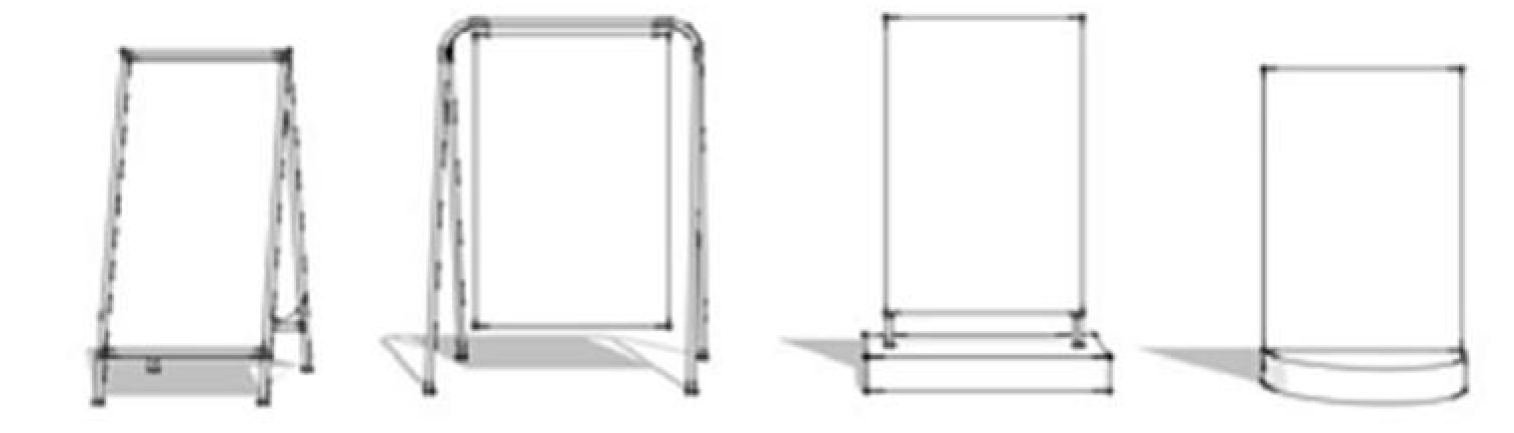
SIGN, SIDEWALK. A type of portable sign that is intended to be placed on a hard surface, most commonly a sidewalk. These signs include A-frame signs, signs that are suspended from the top member of an A-frame, signs with weighted bases, and comparable signs. See Illustrative Sidewalk Signs, below.
Illustrative Sidewalk Signs
SIGN, SITE. A temporary freestanding sign constructed of vinyl, plastic, wood or metal and designed or intended to be displayed for a short period of time.
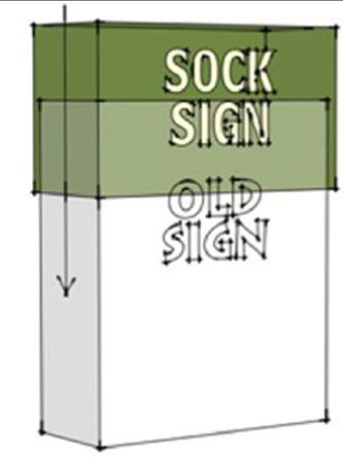
SIGN, SOCK. A temporary sign constructed of flexible material, designed to fit over a permanent sign face or mount. Sock signs are typically installed while a new permanent sign is being designed and fabricated.
Sock Sign
The sock sign below is not show fully installed in order to illustrate how it will
cover up the old sign when installation is complete.
SIGN STRUCTURE. A sign structure shall include, but not be limited to, the supports, uprights, braces, backing, sign board, and framework designed to contain a sign message. Sign structure is not meant to include the message conveyed by the sign.
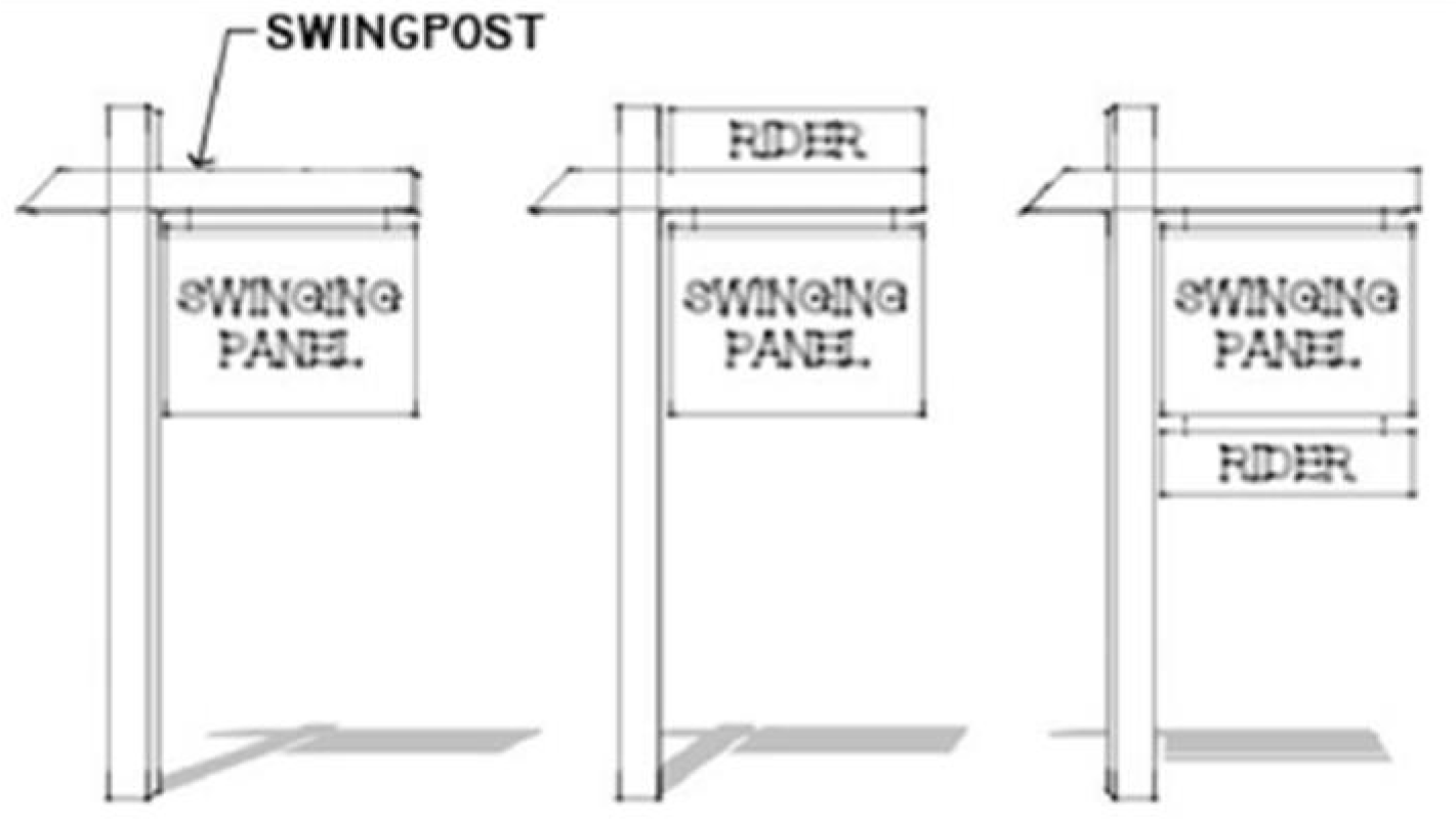
SIGN, SWING. A sign that is suspended from a horizontal support (a swingpost) that is attached to a vertical support mounted in the ground. A swing sign may also include riders. See Illustrative Swing Signs, below.
Illustrative Swing Signs
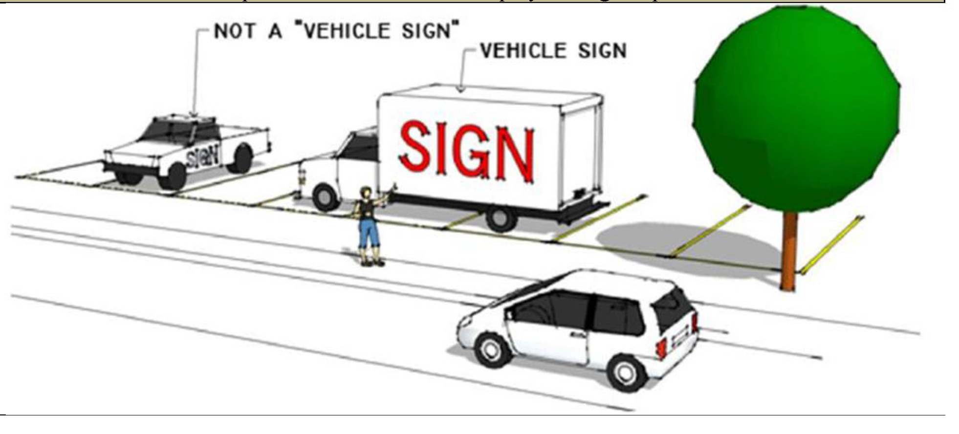
SIGN, VEHICLE. A sign attached to or printed on a vehicle parked and visible from the public right-of-way, unless said vehicle is used for transporting people or materials in the normal operations of business and it is properly parking in a designated parking space. Signs attached to trailers or inoperable vehicles are presumed to be vehicle signs if they are parked in plain view from the right-of-way. Bumper stickers are not vehicle signs.
Vehicle Sign
In the illustration below, the sign on the pickup truck is not a "vehicle sign," because
the pickup truck is in operable and properly parked in a parking space. The sign on
the delivery truck is a "vehicle sign" because the truck is parked across parking
spaces adjacent to the right-of-way, and the intent to use the position of the truck
to display the sign is presumed.
SIGN, WALL. A sign attached to, painted on, or erected against a wall of a building, whose display surface is parallel to the face of the building, structure, or fence, and whose height does not exceed the height of the wall, structure, or fence to which said sign is attached, painted upon, or against which said sign is erected.
SIGN, WINDOW. A sign which is applied or attached to the exterior of a window, or applied to, attached to, or located within one (1) foot of the interior of a window, which can be seen through the window from the exterior of the structure.
SIGN WITHOUT BACKING. Any word, letter, emblem, insignia, figure, or similar character or group thereof that is neither backed by, incorporated in, or otherwise made a part of any larger display area.
SIGN, YARD. A temporary portable sign constructed of paper, vinyl, plastic, wood, metal or other comparable material, and designed or intended to be displayed for a short period of time.
SITE PLAN REVIEW. See Section 11-604 of this Zoning Ordinance.
SMALL WIRLESS FACILITY. A wireless facility that meets both of the following qualifications: (i) each antenna is located inside an enclosure of no more than 6 cubic feet in volume or, in the case of an antenna that has exposed elements, the antenna and all of its exposed elements could fit within an imaginary enclosure of no more than 6 cubic feet; and (ii) all other wireless equipment attached directly to a utility pole associated with the facility is cumulatively no more than 25 cubic feet in volume. The following types of associated ancillary equipment are not included in the calculation of equipment volume: electric meter, concealment elements, telecommunications demarcation box, ground-based enclosures, grounding equipment, power transfer switch, cut-off switch, and vertical cable runs for the connection of power and other services.
SMOKE. Small gas-borne particles other than water that form a visible plume in the air.
SMOKE UNIT. The number obtained when the smoke density in a Ringelmann Number is multiplied by the time of emission in minutes. For the purpose of this calculation, a Ringelmann density reading shall be made at least once a minute during the period of observation; each reading is then multiplied by the time in minutes during which it was observed. The various products are then added together to give the total number of smoke units observed during the entire observation period.
STABLE, PRIVATE. A detached accessory structure for the keeping of horses for the private, noncommercial use of the occupants of the premises on which such structure is located.
STORY. That portion of a building, other than a cellar, included between the surface on any floor and the surface of the floor next above it, or if there is no floor above, then the space between the floor and ceiling next above it. The floor of a story may split levels provided that there is not more than four feet difference in elevation between the different levels of the floor. A basement shall be counted as a story; a cellar shall not be counted as a story. Any area in which the distance from one floor to the floor or ceiling above it is more than 16 feet shall be deemed to consist of one story for each 16 feet of height or major fraction thereof.
STREET. The paved portion of a right-of-way, other than a driveway, that affords the principal means of vehicular access to abutting property.
STREET LINE. A lot line separating a street right-of-way from other land.
STREET, PRIVATE. Any street other than a public street.
STREET, PUBLIC. A street that has been dedicated to and accepted by, or otherwise acquired by, a government agency.
STRUCTURAL ALTERATION. Any change, other than incidental repairs, that would prolong the life of the supporting members of a structure such as bearing walls, columns, beams, girders, or foundations, or that would alter the dimensions or configurations of the roof or exterior walls of a structure, or that would increase either the gross or net floor area of a structure.
STRUCTURE. Anything constructed or erected, the use of which requires more or less permanent location on the ground, or anything attached to something having a permanent location on the ground, but not including paving or surfacing of the ground. Structure shall in all cases be deemed to refer to both structures and buildings. See Subsection 12-206 B of this Zoning Ordinance.
STRUCTURE, ACCESSORY. See Section 8-101 of this Zoning Ordinance.
STRUCTURE, NONCONFORMING. See Subsection 12-206 P of this Section, "Pre-Code Structure."
STRUCTURE, PRINCIPAL. A structure or building on a zoning lot intended to be utilized for a principal use and to which any other structure on such lot must be accessory.
SUBDIVISION. A subdivision is (1) any change, rearrangement or resubdivision in the boundary or divisional lines of any parcel or parcels of real estate or any public thoroughfare; (2) the platting of a parcel or tract of land into a single numbered lot without alteration of its boundaries; (3) a planned development or planned unit development as now or hereafter defined in Chapter 38 of the Davis Junction Code of Ordinances, the zoning ordinance of the village or the zoning ordinance of the county; or (4) a development as now or hereafter defined in Chapter 38 of the Davis Junction Code of Ordinances.
SUBDIVISION AND DEVELOPMENT ORDINANCE. The subdivision and development regulations set forth in Chapter 38 of the Village of Davis Junction Code of Ordinances.
SUBSTATION, ELECTRICAL. A subsidiary station for the transmission of electrical current, consisting of transformers and other related safety and switching equipment that convert higher voltage electrical current received from incoming lines into lower voltage electrical current transmitted through other smaller lines.
T
TABLE. Any table specifically manufactured for the purpose of playing pool or billiards.
TEMPORARY USES. See Section 8-103 of this Zoning Ordinance.
TERRACE. A level plane, surfaced patio, platform, or structure serving a principal building at less than thirty inches above grade and not covered by any permanent structure.
TOWNHOUSE. See Subsection 12-206 D, "Dwelling, Townhouse."
TRANSITIONAL PARKING LOT OR GARAGE. A parking lot or garage accessory to a nonresidential use but located in a residential district pursuant to a special permit.
TRANSITIONAL SERVICE FACILITY. An authorized and licensed dwelling operated by a public or private agency duly authorized and licensed by any state agency having authority to license and approve said facility that houses individuals being cared for by the agency and deemed by the agency to be capable of living and functioning in the community and that provides continuous professional guidance.
TRANSITIONAL SERVICE FACILITY RESIDENT. A person receiving care or treatment at a transitional service facility.
U
USE. The purpose or activity for which a structure or land is designed, arranged, or intended, or for which it is occupied or maintained.
USE, ACCESSORY. See Section 8-101 of this Zoning Ordinance.
USE INTERPRETATION. An interpretation of the use lists established by this Zoning Ordinance for the purpose of allowing a use not expressly mentioned in those lists to be established in a zoning district found to be appropriate for such use by application of the standards established in Subsection 11-501 E of this Zoning Ordinance.
USE, LEGAL. Any use being made of any land, building, or structure, other than a sign, on or after the effective date of this Zoning Ordinance or any amendment thereof, that complies with all of the applicable regulations of this Zoning Ordinance and any amendment thereof and was legally and validly instituted.
USE, NONCONFORMING. Any use lawfully being made of any land, building or structure, other than a sign, on the effective date of this Zoning Ordinance, or any amendment to it rendering such use nonconforming, that does not comply with all of the regulations of this Zoning Ordinance, or any such amendment hereto, governing use for the zoning district in which such land, building, or structure is located.
USE, PERMITTED. A use that appears as a permitted use on the "Use List" list of a particular zoning district.
USE, PRINCIPAL. The use of a zoning lot, whether a permitted or specially permitted use, designated by the owner of such lot as the primary or main use of such lot and to which any other use on such lot must be accessory.
USE, SPECIAL PERMIT. A use that appears as a special permit use on the "Use List" of a particular zoning district. See Subsection 11-602 of this Zoning Ordinance.
USE, TEMPORARY. See Section 8-103 of this Zoning Ordinance.
V
VARIATION. See Section 11-503 of this Zoning Ordinance.
VEHICLE. Any device for carrying passengers, goods, or equipment including, but not limited to, passenger automobiles, vans, trucks, buses, recreational vehicles, commercial vehicles, and vehicles used for governmental purposes.
VEHICLE, COMMERCIAL. For purposes of this Zoning Ordinance, all commercial vehicles shall be classified as either a Class I or Class II commercial vehicle. Any trailer including, but not limited to, tar hoppers, generators, cement mixers, or any portable construction or maintenance equipment that is not a camper trailer, a travel trailer, or a recreational vehicle trailer, shall be deemed a commercial vehicle. Unless otherwise provided, any reference in this Zoning Ordinance to commercial vehicles shall be deemed to be made to both Class I and Class II commercial vehicles.
CLASS I. Any vehicle, other than a recreational vehicle, regardless of the use to which the vehicle is put or intended or designed to serve and regardless of any other classification system made applicable to vehicles by any other governmental body, that weighs in excess of 8,000 pounds in gross weight (including vehicle and maximum load).
CLASS II. Any vehicle that is not a recreational vehicle or a Class I commercial vehicle that is operated for the transportation of persons or property in the furtherance of any commercial or industrial enterprise, for-hire or not-for-hire, including, without limitation, the following:
1.
any van with no side windows other than those adjacent to the driver and passenger seats, sometimes known as panel vans; or
2.
any other vehicle with any commercial markings or any removable equipment or merchandise stored on the exterior of the vehicle.
VEHICLE, RECREATIONAL. Every vehicle or boat originally designed for living quarters, recreation, or human habitation and not used as a commercial vehicle, including, but not limited to, the following:
1.
Boat. Any vessel used for water travel. A boat mounted on a trailer shall be considered one vehicle.
2.
Camper Trailer. A folding or collapsible vehicle without its own motive power, designed as temporary living quarters for travel, camping, recreational, seasonal, or vacation use.
3.
Motorized Home. A temporary dwelling designed and constructed for travel, camping, recreational, seasonal, or vacation uses as an integral part of a self-propelled vehicle.
4.
Off-the-Road Vehicle. A vehicle intended primarily for recreational use off of roads where state vehicle licenses are required, such as a dune buggy, go-cart, or snowmobile.
5.
Racing Car or Cycle. A vehicle intended to be used in racing competition, such as a race car, stock car, or racing cycle.
6.
Travel Trailer. A vehicle without its own motive power, designed to be used as a temporary dwelling for travel, camping, recreational, or vacation uses.
7.
Truck Camper. A structure designed primarily to be mounted on a pickup or single truck chassis and designed to be used as a temporary dwelling for travel, camping, recreational, or vacation uses. When mounted on a truck, such a structure and the truck shall together be considered one vehicle.
8.
Van. A general term applied to a noncommercial motor vehicle licensed by the State of Illinois as a Recreational Vehicle.
9.
Vehicle Trailer. A vehicle without its own motive power that is designed to transport another vehicle, such as a boat, motorcycle, or snowmobile for recreational or vacation use and that is a eligible to be licensed or registered and insured for highway use. A vehicle trailer with another vehicle mounted on it shall be considered one vehicle.
W
[RESERVED FOR FUTURE USE]
X
[RESERVED FOR FUTURE USE]
Y
YARD. A required open space on a lot between a lot line and a yard line that is unoccupied and unobstructed from grade to the sky.
YARD, CORNER SIDE. A yard extending from the front yard line to the rear lot line between the corner side lot line of the lot and the corner side yard line.
YARD, FRONT. A yard extending across the entire front of a lot between the front lot line of the lot and the front yard line.
YARD LINE, CORNER SIDE. A line drawn parallel to a side lot line abutting a street right-of-way at a distance therefrom equal to the depth of the required corner side yard.
YARD LINE, FRONT. A line drawn parallel to a front lot line at a distance therefrom equal to the depth of the required front yard.
YARD LINE, REAR. A line drawn parallel to a rear lot line at a distance therefrom equal to the depth of the required rear yard.
YARD LINE, SIDE. A line drawn parallel to a side lot line at a distance therefrom equal to the depth of the required side yard.
YARD, PERIMETER. A yard within, and abutting the boundary of, a planned development.
YARD, REAR. A yard extending along the full length of the rear lot line between the side lot lines, except that in the case of a corner lot the rear yard shall extend from the inner side lot line to the corner side yard line.
YARD REQUIRED. The minimum yard depth designated in the regulations of this Zoning Ordinance establishing minimum front, corner side, side, and rear yard requirements for various uses, structures, and districts.
YARD, SIDE. A yard extending along a side lot line from the front yard to the rear yard between the side lot line and the side yard line.
Z
ZONING ADMINISTRATOR. The officer or other authority designated by the Village President and charged with the administration and enforcement of the Zoning Ordinance.
ZONING CLASSIFICATION. See Subsection 12-206 C of this Section.
ZONING ORDINANCE. The Davis Junction Zoning Ordinance; that is, this Zoning Ordinance. Unless the context specifically requires otherwise, all references to this Zoning Ordinance shall be deemed to refer to any certificate, permit, approval, resolution, or ordinance granted or adopted pursuant to this Zoning Ordinance.
ZONING DISTRICT. A part of the corporate area of the Village wherein regulations of this Zoning Code are uniform. See also Section 2-101 of this Zoning Ordinance.
ZONING DISTRICT MAP OR ZONING MAP. See Section 2-103 of this Zoning Ordinance.
Village of Davis Junction
Use Table
P = Permitted Use, S = Special Use
12-101A - Territorial Application.
This Zoning Ordinance shall apply to land, structures, and uses within the corporate limits of the Village.
12-101B - General Application.
All structures erected after adoption of this Zoning Ordinance, all uses of land or structures established hereafter, all structural alterations or relocation of existing structures occurring hereafter, and all enlargements and extensions of, additions to, changes in, and relocation of existing uses occurring hereafter will be subject to all regulations of this Zoning Ordinance applicable to the zoning districts in which the land, structures, or uses are located. Existing structures and uses that do not comply with the regulations of this Code will be subject to the provisions of Article IX of this Zoning Ordinance relating to nonconformities.
12-101C - General Prohibition.
No structure; no use of any structure or land; and no lot of record or zoning lot, now or hereafter existing, shall hereafter be established, enlarged, extended, altered, moved, divided, or maintained, in any manner, except as authorized by the provisions of this Zoning Ordinance and except in compliance with the regulations of this Zoning Ordinance.
Without limiting the foregoing, any such activity that would cause any existing structure not to comply with this Zoning Ordinance or that would create any parcel of land that could not be developed in compliance with this Zoning Ordinance shall be prohibited.
12-101D - Special Prohibition—Multiple Principal Structures on Same Zoning Lot.
No zoning lot in the Village of Davis Junction shall be used for more than one principal structure, except when authorized as part of a planned development approved pursuant to Section 11-603 of this Zoning Ordinance; or as a special permit in, non-residential zoning districts pursuant to Section 11-602 of this Zoning Ordinance; or when one or more of the principal structures is a personal wireless services antenna, with or without antenna support structures, and related electronic equipment and equipment structures which is authorized as a permitted or special permit use pursuant to the applicable District regulations of this Zoning Ordinance.
No structural group containing two or more upward projections shall be considered a single structure unless all such upward projections are joined by an element that:
1.
Is at least half as high as the tallest upward projection; and
2.
Is something other than a fence, canopy, freestanding wall, or other non-functional connection.
12-101E - Plat of Consolidation Required.
Whenever any application is submitted pursuant to this Zoning Ordinance for the erection or construction of any building or structure, other than a fence, or for the installation of any paving or surfacing of the ground, over, upon, or across one or more lot lines dividing or separating two or more lots of record, such application shall include an application for approval of a plat of consolidation of those lots of record into a single lot of record pursuant to the Davis Junction Subdivision and Development Ordinance, as the same has been and may, from time to time, be amended.
This Subsection shall not apply where an application for approval of a plat of subdivision or re-subdivision accompanies such an application under this Zoning Ordinance.
12-101F - Exempt Uses.
1.
Utility Lines. The following utility uses are exempt from the provisions of this Zoning Ordinance: poles, wires, cables, conduits, vaults, laterals, pipes, mains, and valves, but not including substations located on or above the surface of the ground for the distribution to consumers of telephone, cable television, or other communications, electricity, gas, or water, or for the collection of sewage or surface water, and also not including personal wireless services antenna, with or without antenna support structures, and related electronic equipment and equipment structures. All such uses shall, however, comply with the subdivision and other applicable ordinances of the Village.
2.
Railroad Right-of-Way Uses. All railroad rights-of-way, trackage, and passenger stations existing on the effective date of this Zoning Ordinance shall be exempt from its provisions. Any other railroad facilities or uses, or any change of such existing facility, shall, however, be subject to all of the provisions of this Zoning Ordinance.
12-101G - Private Agreements.
This Zoning Ordinance is not intended to abrogate, annul, or otherwise interfere with any platted building line, easement, covenant, or other private agreement or legal relationship; however, where the regulations of this Zoning Ordinance are more restrictive or impose higher standards or requirements than such platted building line, easement, covenant, or other private agreement or legal relationship, the regulations of this Zoning Ordinance shall govern.
12-102A - Existing Variations and Special Permits.
Any variation or special permit (sometimes, in prior codes, referred to as "special uses") lawfully issued prior to the effective date of this Zoning Ordinance, or any amendment thereof, shall be deemed to be and continue to be valid after such effective date, subject to any conditions placed thereon at the time of issuance.
Any structure or use lawfully authorized by any such variation or special permit that could not be so issued after the effective date of this Zoning Ordinance shall be subject to the provisions of Article IX of this Zoning Ordinance dealing with nonconformities.
12-102B./Existing Uses and Structures Newly Requiring Special Permit.
Any use or structure lawfully existing on the effective date of this Zoning Ordinance or any amendment thereof that did not, prior to such effective date, require a special permit but which, after such effective date, does require a special permit, may secure such a permit only pursuant to the standards and procedures made applicable to special permit uses by Section 11-602 of this Zoning Ordinance.
Unless and until such a permit is so secured, such use shall be subject to the provisions of Article IX of this Zoning Ordinance dealing with nonconformities.
12-103A - New Code Shall Apply.
Except as provided in Subsections B and C of this Section, no Certificate of Occupancy shall be issued following the effective date of this Zoning Ordinance or any amendment thereof unless the work, structure, or use for which the Certificate of Occupancy is sought is made to fully comply with the applicable provisions of this Zoning Ordinance or such amendment.
12-103B - Right to Complete Construction Pursuant to Approved Plans.
Nothing in this Zoning Ordinance, or any amendment to it, shall be deemed to require any change in the plans, construction, or designated use of any structure in the event that:
1.
A building permit for such structure was lawfully issued prior to the effective date of this Zoning Ordinance or any such amendment thereof, or such a permit is issued after such effective date based upon a complete and proper application for such permit filed prior to such effective date; and
2.
Such permit had not, by its own terms, expired prior to such effective date; and
3.
Such permit was lawfully and properly issued in accordance with the law prior to such effective date; and
4.
Construction pursuant to such permit is commenced prior to the expiration of such permit and within 180 days of such effective date and is thereafter diligently pursued to completion.
12-103C - Right to Occupy as Nonconformity.
Upon completion pursuant to Subsection B hereof, such structure may be occupied by, and a Certificate of Occupancy shall be issued for, the use designated on such permit, subject thereafter, to the extent applicable, to the provisions of Article IX of this Zoning Ordinance relating to nonconformities.
12-104A - New Zoning Ordinance Will Apply.
This Zoning Ordinance and any amendment to it will apply to any application pending on the effective date of this Zoning Ordinance or any amendment in the same manner as though such application was filed after the effective date.
12-104B - Duty of Village Officials.
Within twenty (20) days following the effective date of this Zoning Ordinance or any amendment thereof, any Village official, department, board or commission then having pending before it any application to which this Zoning Ordinance or any amendment of it applies pursuant to Subsection A of this Section will inform each applicant named on each application that the application is subject to the provisions of this Zoning Ordinance, as amended, and will be processed in accordance with this Zoning Ordinance or any amendment to it; that the applicant may within thirty (30) days following the mailing of the notice re-file, without additional fee, its application on the basis of this Zoning Ordinance, as amended; and that if the applicant does not so re-file, its application may be denied for noncompliance with the provisions of this Zoning Ordinance, as amended.
12-104C - Duty of Applicant.
Notwithstanding the provisions of Subsections B and C of this Section, it shall be the responsibility of each applicant having an application pending on the effective date of this Zoning Ordinance, or any amendment thereof, to modify such application in accordance with the terms and provisions of this Zoning Ordinance, as amended, and the failure to do so may, whether or not the procedures of said Subsections have been followed, result in denial of such application for failure to comply with this Zoning Ordinance, as amended. Any modification or re-filing of an application pending on such effective date in order to comply with the provisions of this Zoning Ordinance, as amended, shall be permitted at any time prior to the final disposition of such application and shall be permitted without payment of any additional fee.
12-104D - Processing of Pending Applications.
Upon the re-filing of any pending application as herein provided, or upon notification from the applicant that it will not re-file or modify its application, or upon the expiration of 60 days following effective date of this Zoning Ordinance or any amendment thereof, whichever occurs first, such pending application shall be processed in accordance with the terms of this Zoning Ordinance, as amended; provided, however, that the application requirements, hearing requirements, and procedural requirements set forth in Article XI, Part 3, and Subsections 11-601D, 11-602D, 11-603D and 11-604E of this Zoning Ordinance shall not apply to any such pending application and each such application shall be processed in accordance with the application, hearing, and procedural requirements that were in effect on the date such application was filed. Notwithstanding any other provision of this Section, the Board of Trustees and every Village official, department, board or commission then having pending before it shall have the authority to request additional data, information or documentation for pending applications when, in its judgment, such additional data, information or documentation is necessary or appropriate to a full and proper consideration and disposition of such pending application.
12-106A - Intent as to Severability.
The several provisions of this Zoning Ordinance shall be severable in accordance with the following rules:
1.
Provisions Declared Invalid. If any court of competent jurisdiction shall adjudge any provision of this Zoning Ordinance to be invalid, such judgment shall not affect any other provisions of this Zoning Ordinance.
2.
Applications Declared Invalid. If any court of competent jurisdiction shall adjudge invalid the application of any provision of this Zoning Ordinance to a particular parcel of land, a particular structure, or a particular use, such judgment shall not affect the application of said provisions to any other land, structure, or use.
3.
Applicable Regulations Following Declaration of Invalidity. Whenever the provisions of this Zoning Ordinance are declared invalid in their application to any particular parcel of land, the Zoning Map provided for in Section 2-103 of this Zoning Ordinance shall continue to show such parcel in the zoning district applicable to it pursuant to this Zoning Ordinance unless and until such district is changed by an amendment adopted by the Board of Trustees pursuant to Section 11-601 of this Zoning Ordinance; provided, however, that the parcel in question shall also be marked with a star or other distinctive marking to direct attention to the court decree affecting said parcel. The Village Clerk shall maintain a file of any such decrees. The provisions of any such decree shall be deemed to modify the otherwise applicable provisions of this Zoning Ordinance as they apply to said parcel to the extent provided in said decree but said parcel shall otherwise remain subject to the provisions of this Zoning Ordinance.
12-205A - Tense and Form.
Words used or defined in one tense or form shall include other tenses and derivative forms.
12-205B - Number.
Words in the singular number shall include the plural number, and words in the plural number shall include the singular number.
12-205C - Gender.
The masculine gender shall include the feminine and neuter. The feminine gender shall include the masculine and neuter. The neuter gender shall include the masculine and feminine.
12-205D - Time.
The time within which any act required by this Zoning Ordinance is to be performed shall be computed by excluding the first day and including the last day, unless the last day is a Saturday or Sunday or a holiday declared by the United States Congress or the Illinois General Assembly, in which event it shall also be excluded.
12-205E - Person.
The word "person" includes individuals, firms, partnerships, joint ventures, trusts, trustees, estates, corporations, associations, and any other similar entities.
12-205F - Used For.
The phrase "used for" shall include intended for, designed for, occupied for, maintained for, and arranged to be used or occupied for whenever that interpretation would result in the regulation being more restrictive in its application to any use or structure.
12-205G - Village.
The word "Village" means the Village of Davis Junction, Illinois.
12-205H - County.
The word "County" means the County of Ogle, Illinois.
12-205I - Undefined Terms.
Any word not defined in Section 12-206 of this Zoning Ordinance shall have the meaning given in any applicable Village code ordinance or, if none, in Webster's Third New International Dictionary, 1993, except for words employed to refer to the permitted uses and special permit uses of this Zoning Ordinance, which shall be interpreted, insofar as applicable, in accordance with the meaning established in the North American Industry Classification System, 2017 as amended through the effective date of this Zoning Ordinance and as further amended by the Village (see Appendix A).
12-205J - Captions, Illustrations and Tables.
In case of any difference of meaning or implication between the text of this Zoning Ordinance and any caption, illustration, or table, the text shall control.
12-205K - Article, Section and Paragraph Headings.
This Zoning Ordinance is divided into articles, sections, subsections, paragraphs, and subparagraphs that shall be numbered according to the following format:
1-101A1(a)(1)(i)
and that shall be referred to in accordance with the following example:
12-205 L - Delegation.
For purposes of this Zoning Ordinance, any reference to the Village President, Board of Trustees, Village Clerk, Planning and Zoning Commission, Zoning Administrator, or other Village body or official shall be construed to include any duly authorized designee of the referenced Village body or official.