
Dekalb County Unincorporated
City Zoning Code
City Zoning Code
ARTICLE 1
- GENERAL REQUIREMENTS
Sec. 1.1.1. - Short title.
This chapter shall be known and shall be cited as the Zoning Ordinance of DeKalb County, Georgia, and may be referred to herein as "this zoning ordinance" or "this chapter."
(Ord. No. 15-06, 8-25-2015)
Sec. 1.1.2. - Effective date.
This zoning ordinance was adopted on August 25, 2015, and became effective September 1, 2015 (the "effective date"), seven (7) days after the date of adoption. As of the effective date, the pre-existing DeKalb Zoning Ordinance, as amended, adopted on April 13, 1999, shall be repealed, except as set forth in the Enforcement Resolution dated January 2, 2015, adopted by the board of commissioners contemporaneously with this zoning ordinance, and incorporated herein by reference.
(Ord. No. 15-06, 8-25-2015)
Sec. 1.1.3. - Purpose and intent of Code.
This chapter is enacted by the DeKalb County Board of Commissioners in order to promote the public health, safety, morals and general welfare of the residents of DeKalb County, Georgia, and to implement the DeKalb County Comprehensive Plan. To these ends, this chapter is intended to achieve the following purposes:
A.
To guide and regulate the orderly growth, development, redevelopment and preservation of DeKalb County in accordance with a well-considered comprehensive plan and with long-term objectives, principles and standards deemed beneficial to the interest and welfare of the people;
B.
To protect the established character of both private and public property;
C.
To promote, in the public interest, the wise utilization of land;
D.
To provide for adequate light, air, convenience of access, and safety from fire, flood and other dangers;
E.
To reduce or prevent congestion in the public streets;
F.
To facilitate the creation of a convenient, attractive and harmonious community;
G.
To encourage an aesthetically attractive environment, both built and natural, and to provide for regulations that protect and enhance these aesthetic considerations;
H.
To expedite the provision of adequate police and fire protection, safety from crime, disaster evacuation, civil defense, transportation, water, sewerage, flood protection, schools, parks, forests, playgrounds, recreational facilities, airports and other public requirements;
I.
To protect against destruction of, or encroachment upon, historic areas;
J.
To protect against overcrowding of land, overcrowding of population in relation to the community facilities existing or available, obstruction of light and air, danger and congestion in travel and transportation, and loss of life or health or property from fire, flood, or other danger;
K.
To encourage economic development activities that provide desirable employment and enlarge the tax base;
L.
To promote the preservation of the unique natural and physical resources of the county including forested areas, riverbeds, stream beds, and archaeological sites;
M.
To achieve compliance with all applicable state and federal regulations;
N.
To protect the public welfare by protecting approach slopes and other safety areas of licensed airports;
O.
To provide for and promote housing for all income groups and all citizens within the county;
P.
To implement the authority, powers and duties of the planning commission and the zoning board of appeals pursuant to state and local law, including but not limited to Ga. Const. art. IX, section II, ¶ IV;
Q.
To reduce or eliminate the secondary effects of adult entertainment establishments and other establishments that create such secondary effects while protecting legitimate constitutional rights of said establishments; and
R.
To provide for protection of the constitutional rights and obligations of all citizens within the county.
(Ord. No. 15-06, 8-25-2015)
Sec. 1.1.4. - Minimum requirements.
In their interpretation and application, the provisions of this chapter shall be considered minimum requirements for the promotion of the public health, safety, morals and general welfare, as set forth in section 1.1.3 hereof establishing the intent and purpose of this chapter. Within each zoning district, the regulations set forth shall be minimum requirements and shall apply uniformly to each class or kind of building, structure or land, except as may be altered through conditions of zoning applied to specific properties or variances or waivers, as provided for in article 7.
(Ord. No. 15-06, 8-25-2015)
Sec. 1.1.5. - Authority.
This chapter is enacted pursuant to DeKalb County's authority to adopt plans and exercise the power of zoning granted by the Ga. Const. art. IX, section II, ¶ IV; DeKalb County's authority to enact regulations and exercise powers granted by the Ga. Const. art. IX, section II, ¶¶ I and III; authority granted by the State of Georgia, including but not limited to 1956 Ga. Laws, p. 3332, et seq., as amended; 1981 Ga. Laws p. 4304, et seq., as amended, including but not limited to Section 9A.(10); the Official Code of Georgia Annotated (O.C.G.A.) § 36-66-2B.; that authority set forth in appendix B to the Code of DeKalb County, as amended; the county's general police powers; and other powers and authority provided by federal, state and local laws applicable hereto.
(Ord. No. 15-06, 8-25-2015)
Sec. 1.1.6. - General applicability.
All buildings and structures erected hereafter, all uses of land, water, buildings or structures established hereafter, all structural alterations or relocations of existing buildings occurring hereafter, and all enlargements of, additions to, changes in and relocations of existing uses occurring hereafter shall be subject to all regulations of this chapter which are applicable to the zoning district or districts in which such buildings, structures, uses or land are located. Existing buildings, structures and uses which comply with the regulations of this chapter shall be subject to all regulations of this chapter. Existing buildings, structures and uses which do not comply with the regulations of this chapter shall be authorized to continue subject to the provisions of article 8 of this chapter relating to nonconformities.
(Ord. No. 15-06, 8-25-2015)
Sec. 1.1.7. - Applicability to all property.
The regulations in this chapter shall apply to all buildings, structures, land and uses within the unincorporated area of DeKalb County, Georgia.
(Ord. No. 15-06, 8-25-2015)
Sec. 1.1.8. - General prohibition.
No building or structure, and no use of any building, structure, land, or property, and no lot of record, now or hereafter existing, shall hereafter be established, constructed, expanded, altered, moved, diminished, divided, eliminated or maintained in any manner except in conformity with the provisions of this chapter. No use of any land, building, structure or property shall be permitted unless expressly and specifically authorized in the district or districts within which said use is located or by the supplemental regulations contained in article 4 of this chapter. When a use is not directly mentioned, the director of planning may determine that the proposed use is functionally similar to an allowed land use, as listed in Table 4.1, Use Regulations. The board of commissioners may subsequently amend the applicable definition(s) in article 9, pursuant to the amendment procedures in article 7.
(Ord. No. 15-06, 8-25-2015)
Sec. 1.1.9. - Interpretation and authority to administer.
The director of planning is designated to administer, interpret and enforce the provisions of this chapter for all proposed zoning, variances, comprehensive planning, and applications requiring zoning compliance, including but not limited to subdivisions, site plans, permits and zoning compliance certifications for licenses and occupational taxes.
Unless otherwise specified, where this zoning ordinance refers to "the director" or "the planning director," it shall mean the director of planning or his/her designee.
(Ord. No. 15-06, 8-25-2015)
Sec. 1.1.10. - Components of zoning ordinance.
This chapter and the official zoning map and official overlay district maps of the county on file and maintained by the planning department shall together constitute the zoning ordinance of DeKalb County.
(Ord. No. 15-06, 8-25-2015)
Sec. 1.1.11. - Transitional provisions.
A.
New development. Upon the effective date of this zoning ordinance or any subsequent amendment thereafter, any new building, structure or lot legally established shall be used, constructed or developed only in accordance with all applicable provisions of this zoning ordinance.
B.
Existing development. Any existing use, lot, building or other structure legally established prior to the effective date of this zoning ordinance that does not comply with all of the provisions of this zoning ordinance shall be subject to the provisions of article 8, nonconformities.
C.
Transition to new zoning districts. The zoning district names in effect prior to the effective date of this zoning ordinance are converted as shown in Table 1.1. To the extent other sections of the Code of DeKalb County, as Revised 1988, refer to such previous district names, unless and until such other sections are amended to reflect a new intent, any reference to such previous district names shall be deemed to refer to both the previous district name and the new district name to which it is converted in this zoning ordinance.
D.
Pre-existing violations. Any violation of the pre-existing zoning ordinance for which a citation has been issued as of the effective date of this zoning ordinance shall continue to be prosecuted subject to the penalties existing at the time of the issuance of the citation. If a violation of the pre-existing zoning ordinance existed as of the effective date of this zoning ordinance without a citation having been issued, and if the underlying activity that would have constituted a violation under the pre-existing zoning ordinance would not constitute a violation under this zoning ordinance, the violation shall be deemed to have been cured and no citation shall be issued.
E.
Completed applications prior to effective date of this zoning ordinance.
1.
Any proper and complete application (as defined in article 9) for a permit, license, rezoning, variance, or other approval that was submitted to and accepted by the DeKalb County planning department prior to the effective date of this zoning ordinance shall be evaluated based on the applicable law, rules, regulations and development standards in place at the time the application was submitted.
2.
Applicants who submitted an application prior to the effective date of this zoning ordinance but who wish to proceed under the standards of this zoning ordinance may withdraw their application and submit a new application in accordance with the standards in this zoning ordinance and pay any fee required under this zoning ordinance.
F.
Prior approvals.
1.
Zoning conditions.
a.
Any project that was approved prior to the effective date of this chapter may be developed according to the provisions of the previously approved development, program, or plan. Where conditions were attached to such prior approval and such conditions conflict with a standard or requirement of this zoning ordinance, the previously approved zoning condition shall apply. If a previously approved development, program, plan or condition does not address a particular development standard or requirement of this zoning ordinance, the new standard or requirement of this zoning ordinance shall apply.
b.
If an owner or applicant desires to have the standards and requirements of this chapter to apply instead of standards and requirements established by previously approved zoning conditions, the owner or applicant must apply for a zoning condition amendment, as provided in article 7.
c.
Notwithstanding subparagraphs A. and B. above, when no land disturbance or building permit has been issued on property located in an overlay district and on which a zoning condition was previously approved, and if the previously approved zoning condition is in conflict with the overlay district regulations, the overlay district regulations shall supersede the previously approved zoning condition.
2.
Development applications. Projects with valid approvals or permits issued prior to the effective date of this zoning ordinance may be developed in accordance with the applicable law, rules, regulations and development standards in effect at the time of the approval or permit issuance, provided the permit or approval is valid and has not lapsed. Any reapplication for an expired approval or permit shall meet the standards of this zoning ordinance.
3.
Special land use permits. Properties subject to a special land use permit that was approved prior to the effective date of this zoning ordinance shall continue to be subject to the terms of the special land use permit and previous zoning regulations even if the zoning district classification is amended to a new zoning district as part of the adoption of this zoning ordinance.
Table 1.1 Prior Zoning District Conversion to Established New Districts
(Ord. No. 15-06, 8-25-2015)
Sec. 1.1.12. - Relation to and conflict with other provisions.
The provisions of this chapter shall be interpreted and applied so as to constitute the minimum requirements for the promotion of the public health, safety, morals, and general welfare. Whenever any provision of this chapter imposes a greater requirement or a higher standard than is required by any federal or state law or other county ordinance, resolution or regulation, the provision of this chapter shall govern unless preempted by said federal or state law. Whenever any provision of any federal or state law or other county ordinance, resolution or regulation imposes a greater requirement or a higher standard than is required by this chapter, the provision of such state or federal statute or other county ordinance or regulation shall apply. Whenever any conflict arises between this chapter and chapter 14 of the Code of DeKalb County, as Revised 1988, the provisions of this zoning ordinance shall prevail, with the exception of chapter 14, article 2, environmental control. Compliance with the provisions of this chapter shall not be interpreted to obviate the requirements for compliance with any and all other provisions of federal or state law, or the Code, including but not limited to the requirements for licenses or permits of any kind.
(Ord. No. 15-06, 8-25-2015)
Sec. 1.1.13. - Relation to private agreements.
This chapter is not intended to abrogate, annul or otherwise interfere with any easement, covenant or other private agreement or legal relationship, provided that when the regulations of this chapter are more restrictive or impose higher standards or requirements than such easements, covenants, or other private agreements or legal relationships, the regulations of this chapter shall govern. Private restrictive covenants to which the county is not a party shall not be regulated or enforced by the county under this chapter.
(Ord. No. 15-06, 8-25-2015)
Sec. 1.1.14. - Zoning maps.
The county shall be divided into the zoning districts identified in articles 2 and 3 of this chapter, as depicted on the official zoning maps entitled "Zoning Maps, DeKalb County, Georgia" (the "official zoning maps"). The official zoning maps, to be adopted contemporaneously with this chapter, together with all explanatory information contained or referenced thereon, is hereby adopted by reference and declared to be a part of this chapter.
The official zoning maps shall be adopted contemporaneously with this chapter in digital format and contained on a compact disk to be maintained in its original, unedited and unaltered form by the clerk to the board of commissioners. A printed copy of the compact disk's contents depicting the official zoning maps on the date of its initial adoption shall also be maintained in its original, unedited and unaltered form by the clerk to the board of commissioners.
Any subsequent amendments made by the board of commissioners to the official zoning maps after the initial date of adoption with this chapter shall be indicated on the digital version of the official zoning maps by the director of planning. The director of the GIS department shall continuously maintain the digital version of the official zoning maps so that they accurately show all amendments made thereto by the board of commissioners since the initial date of adoption, indicating the dates of said amendments. A copy of the updated and current version of the official zoning maps in digital format, showing all amendments thereto since the date of initial adoption, shall be held in custody of the director of planning.
Any condition(s) of zoning related to any property, either existing at the time of initial adoption or subsequently imposed by the board of commissioners shall be on the official zoning maps, with reference to the applicable zoning case number. The clerk to the board of commissioners shall maintain custody of the minutes applicable to the referenced zoning case numbers, which state the zoning conditions. Uncertified copies of the official zoning maps may be provided to the public for informational purposes only.
Verifications of the current zoning status of property shall be the responsibility of the director of planning. To verify the current zoning status of a particular parcel, an individual may obtain a certified copy of the official zoning maps, or a portion thereof, from the director of planning. Certified copies of the official zoning maps, or portions thereof, shall be certified by the director of planning with his signature and the date on which the portions were certified. The director of planning shall be the final authority as to the current zoning status of all land, buildings and structures located in the county, except for: (1) amendments enacted by the board of commissioners but not yet depicted on the official zoning maps, and (2) uncertainties to be clarified by the board of commissioners as described in section 1.1.15. Any inaccuracy on the official zoning maps that is reasonably determined to be a scrivener's error may be corrected by the planning director.
(Ord. No. 15-06, 8-25-2015)
Sec. 1.1.15. - Interpretation of zoning maps.
Where uncertainty exists as to the boundaries of zoning districts as shown on the official zoning map, the following rules shall apply:
A.
Boundaries indicated as approximately following the centerlines of streets, highways, or alleys shall be construed to follow centerlines of rights-of-way or prescriptive easements. In case of closure of a street or alley, or vacation of any easement, the boundary shall be construed as remaining at its prior location unless ownership of the closure or vacated area is divided other than at the center, in which case the boundary shall be construed as moving to correspond with the ownership, but not beyond any previous right-of-way or easement line.
B.
Boundaries indicated as approximately following platted lot lines shall be construed as following such lot lines.
C.
Boundaries indicated as approximately following county limit lines shall be construed as following such county limits.
D.
Boundaries indicated as approximately following railroad lines shall be construed to be midway in the right-of-way.
E.
Boundaries indicated as approximately following shorelines of bodies of water shall be construed to follow such shorelines. Boundaries indicated as approximately following the centerlines of creeks, streams, rivers, or other predominantly linear bodies of water shall be construed to follow such centerlines.
F.
Boundaries indicated as parallel to or concentric with, or extensions of features indicated in paragraphs A. through E. above, shall be so construed. Distances and dimensions not specifically indicated on the official zoning map shall be determined from the official zoning map by the director of planning.
G.
Where areas appear to be unclassified on the official zoning map, and classification cannot be established by the above rules, such areas shall be considered to be classified Residential Estate (RE) until action is taken by the board of commissioners to amend the official zoning map.
H.
Where territory is added to the jurisdictional area, it shall be considered to be classified Residential Estate (RE) until action is taken by the board of commissioners to amend the official zoning map.
I.
Where uncertainties continue to exist or further interpretation is required beyond that provided for in the above paragraphs, the question shall be presented by the director of planning to the board of commissioners to enact a clarifying resolution and said action shall be recorded on the official zoning map as is provided herein.
(Ord. No. 15-06, 8-25-2015)
Sec. 1.1.16. - Rules applicable to parcels split into two or more zoning districts.
Where a parcel of land is split into two (2) or more zoning districts, each such portion of said parcel may only be used for purposes allowed within the zoning district to which each respective portion is classified. No principal or accessory use of land, buildings or structures, and no use or building or structure authorized by special administrative permit, special land use permit, or special exception, shall be authorized unless said use or building or structure is authorized or permitted within the applicable zoning district.
Where a parcel of land contains two (2) or more zoning classifications, the official zoning maps shall depict said parcel with a Multiple Zone ("MZ") designation. To verify the zoning status of respective portion(s) of a parcel containing multiple zoning classifications, an individual may obtain verification from the director of planning.
(Ord. No. 15-06, 8-25-2015)
Sec. 1.1.17. - Severability.
The several provisions of this chapter shall be separable in accordance with the following rules:
A.
Should any court of competent jurisdiction adjudge any section or provision of this chapter to be invalid, such judgment shall not affect the validity or continued application of this chapter as a whole or any section or provision thereof other than the section(s) or provision(s) specifically adjudged invalid.
B.
Should any court of competent jurisdiction adjudge invalid the application of any section or provision of this chapter to a particular property, building or structure, such judgment shall not affect the application of said section or provision to any other property, building or structure.
(Ord. No. 15-06, 8-25-2015)
Sec. 1.2.1. - Relationship to comprehensive plan.
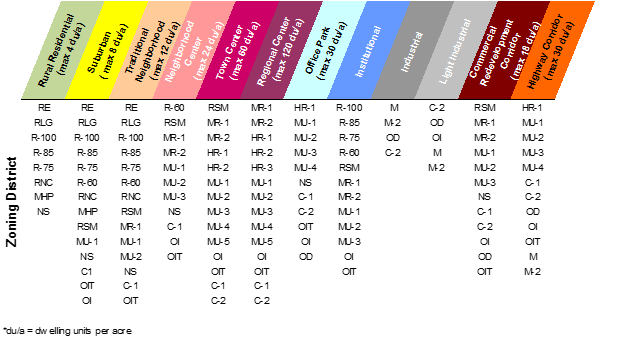
The comprehensive plan is hereby established as the official policy of the county concerning designated land uses and development types, under which the unincorporated areas of the county are divided into the following categories referred to as character areas:
A.
Rural Residential.
B.
Suburban.
C.
Traditional Neighborhood.
D.
Neighborhood Center.
E.
Town Center.
F.
Regional Center.
G.
Industrial.
H.
Light Industrial.
I.
Institutional.
J.
Office Park.
K.
Commercial Redevelopment Corridor.
L.
Scenic Corridor.
M.
Highway Corridor.
(Ord. No. 15-06, 8-25-2015)
Sec. 1.2.2. - Character areas (land use categories).
The boundaries of the various character areas (land use categories), as shown on the future development map and described within the policy narrative of the comprehensive plan, are made a part of this chapter. The official description of these character area boundaries shall be maintained by the director of planning. Where uncertainty regarding character area boundaries exists, the rules set forth in section 1.1.15 shall apply. All such maps and all notations, references and information shown thereon shall be as much a part of this chapter as if all the matter and information set forth by the maps were fully described herein. All other writings concerning the comprehensive plan, including technical documents and appendices adopted simultaneously with the comprehensive plan, are for guidance and information purposes only, and are not made a part of this chapter.
(Ord. No. 15-06, 8-25-2015)
Sec. 1.2.3. - Relationship between character areas and zoning districts.
The character area categories established in the adopted comprehensive plan and shown on the future development map are to be implemented by approving rezonings to zoning districts listed within the following categories in Table 1.2, except the Scenic Corridor character area in which any zoning district may be approved. The zoning districts that are permitted within each character area shall be restricted as provided by Table 1.2.
(Ord. No. 15-06, 8-25-2015)
Sec. 1.2.4. - Relationship between supplemental plans and zoning districts.
Section 5.7, Supplemental Plans of the comprehensive plan references all supplemental plans that focus on areas, situations, or issues of importance to DeKalb County. These plans include, but not limited to, redevelopment plans, neighborhood plans, county wide plans, corridor plans, or plans for conservation management. Where the board of commissioners has adopted a supplemental plan's policies and development standards, these policies and development standards will serve as specific guidelines to support the existing future development plan (Section 4.3 Future Development Plan) and character area policies (Section 5.4-13.1 Land Use Character Area Policies and Strategies).
Table 1.2: Character Areas and Permitted Zoning Districts
(Ord. No. 15-06, 8-25-2015)