
Dekalb County Unincorporated
City Zoning Code
City Zoning Code
ARTICLE 2
- DISTRICT REGULATIONS
Sec. 2.1.1.- Districts established.
DeKalb County establishes the following zoning districts listed in Table 2.1, which apply to property as illustrated on the official zoning map. See article 3 for overlay districts.
Table 2.1: Zoning Districts Established
(Ord. No. 15-06, 8-25-2015)
Sec. 2.1.2. - Prior district classifications and conversion.
The zoning district classifications established prior to the effective date of this zoning ordinance that are no longer active shall be treated as classifications as shown in article 1, Table 1.1.
(Ord. No. 15-06, 8-25-2015)
Sec. 2.1.3. - Additional regulations.
Additional regulations for a variety of development and building types can be found in article 4 (use regulations), article 5 (site development regulations), and article 6 (parking). Street type classifications for front setback requirements are set forth in section 14-190 of the Code.
(Ord. No. 15-06, 8-25-2015)
Sec. 2.1.4. - Appropriate zoning districts for character area designations.
The zoning districts compatible with and acceptable within the character areas set forth in the comprehensive plan are established in section 1.2.3 and Table 1.2 of this chapter.
(Ord. No. 15-06, 8-25-2015)
Sec. 2.1.5. - Permitted uses.
Permitted principal and accessory uses by zoning district, and whether a use is allowed by right or only with special approval, are set forth in Table 4.1. Table 4.1 also provides additional notation where supplemental regulations, also found in article 4, may apply.
(Ord. No. 15-06, 8-25-2015)
Sec. 2.2.1.- Dimensional requirements.
Dimensional requirements, such as overall site requirements, individual lot dimensions, and setbacks for residential zoning districts are established in Table 2.2, "Residential Zoning Districts Dimensional Requirements." Residential infill development may also be subject to compatibility regulations as specified in sections 5.2.3 and 5.2.4. (Amended 3/24/15).
Table 2.2 Residential Zoning Districts Dimensional Requirements
1 See division 10 of this article
2 See article 5, corner lots section for reduction eligibility
3 Open space requirement shall apply to new subdivisions if project is > 5 acres or
> 36 units (chapter 14)
4 100 feet if adjacent to property zoned or used for residential purposes
(Ord. No. 15-06, 8-25-2015; Ord. No. 2019-4123, Pt. I(Exh. I), 3-10-2020; Ord. No. 2022-2270, Pt. I, 12-12-2023)
Sec. 2.3.1.- Statement of purpose and intent.
The purpose and intent of the board of commissioners in establishing the RE (Residential Estate) District is as follows:
A.
To preserve rural and estate residential character and to provide for very low density rural residential uses.
B.
To provide for the protection of neighborhoods within the county where lots have a minimum area of one (1) acre;
C.
To provide protections for existing development as new subdivisions are created;
D.
To assure that the uses and structures authorized in the RE (Residential Estate) District are those uses and structures designed to serve the housing, recreational, educational, religious, and social needs of the neighborhood;
E.
To provide for appropriately sized accessible and useable open space in new developments for the health, recreational and social opportunities for county citizens;
F.
To provide areas for agricultural uses as appropriate;
G.
To implement the future development map of the county's most current comprehensive plan.
(Ord. No. 15-06, 8-25-2015)
Sec. 2.3.2. - Permitted and special land uses.
Permitted uses and uses requiring special land use permits shall be as provided in Table 4.1. In cases where a use is permitted but there are supplemental use regulations for that use specified in article 4, such regulations shall also apply.
(Ord. No. 15-06, 8-25-2015)
Sec. 2.3.3. - Dimensional requirements.
Dimensional requirements for the RE (Residential Estate) District shall be as provided in Table 2.2, "Residential Zoning Districts Dimensional Requirements."
(Ord. No. 15-06, 8-25-2015)
Sec. 2.3.4. - Site and building design standards.
Design standards and regulations to be applied in this zoning district shall be as provided in article 5, site design and building form standards.
(Ord. No. 15-06, 8-25-2015)
Sec. 2.4.1.- Statement of purpose and intent.
The purpose and intent of the board of commissioners in establishing the RLG (Residential Large Lot) District is as follows:
A.
To provide for the protection of neighborhoods within DeKalb County where lots have a minimum area of twenty thousand (20,000) square feet, but may have narrow lot widths;
B.
To provide for compatible infill development in neighborhoods;
C.
To provide protections for existing development as new subdivisions are created;
D.
To respond to existing site development conditions and patterns;
E.
To assure that the uses and structures authorized in the RLG (Residential Large Lot) District are those uses and structures designed to serve the housing, recreational, educational, religious, and social needs of the neighborhood;
F.
To provide for appropriately sized accessible and useable open space in new developments for health, recreational and social opportunities for county residents;
G.
To implement the future development map of the county's most current comprehensive plan.
(Ord. No. 15-06, 8-25-2015)
Sec. 2.4.2. - Permitted and special land uses.
Permitted uses and uses requiring special land use permits shall be as provided in Table 4.1. In cases where a use is permitted but there are supplemental use regulations for that use specified in article 4, such regulations shall also apply.
(Ord. No. 15-06, 8-25-2015)
Sec. 2.4.3. - Dimensional requirements.
Dimensional requirements for the R-LG District shall be as provided in Table 2.2, "Residential Zoning Districts Dimensional Requirements."
(Ord. No. 15-06, 8-25-2015)
Sec. 2.4.4. - Site and building design standards.
Design standards and regulations to be applied in this zoning district shall be as provided in article 5, site design and building form standards.
(Ord. No. 15-06, 8-25-2015)
Sec. 2.5.1.- Statement of purpose and intent.
The purpose and intent of the board of commissioners in establishing the R-100 (Residential Medium Lot-100) District is as follows:
A.
To provide for the protection of neighborhoods within the county where lots have a minimum area of fifteen thousand (15,000) square feet;
B.
To provide for compatible infill development in neighborhoods;
C.
To provide protections for existing development as new subdivisions are created;
D.
To provide flexibility in design on the interior of new development while protecting surrounding development;
E.
To assure that the uses and structures authorized in the R-100 (Residential Medium Lot-100) District are those uses and structures designed to serve the housing, recreational, educational, religious, and social needs of the neighborhood;
F.
To provide for appropriately sized accessible and useable open space in new developments for health, recreational and social opportunities for county residents; and
G.
To implement the future development map of the county's most current comprehensive plan.
(Ord. No. 15-06, 8-25-2015)
Sec. 2.5.2. - Permitted and special land uses.
Permitted uses and uses requiring special land use permits shall be as provided in Table 4.1. In cases where a use is permitted but there are supplemental use regulations for that use specified in article 4, such regulations shall also apply.
(Ord. No. 15-06, 8-25-2015)
Sec. 2.5.3. - Dimensional requirements.
Dimensional requirements for the R-100 (Residential Medium Lot-100) District shall be as provided in Table 2.2, "Residential Zoning Districts Dimensional Requirements."
(Ord. No. 15-06, 8-25-2015)
Sec. 2.5.4. - Site and building design standards.
Design standards and regulations to be applied in this zoning district shall be as provided in article 5, site design and building form standards.
(Ord. No. 15-06, 8-25-2015)
Sec. 2.6.1.- Statement of purpose and intent.
The purpose and intent of the board of commissioners in establishing the R-85 (Residential Medium Lot-85) District is as follows:
A.
To provide for the protection of neighborhoods within the county where lots have a minimum area of twelve thousand (12,000) square feet;
B.
To provide for compatible infill development in neighborhoods;
C.
To provide protections for existing development as new subdivisions are created;
D.
To provide flexibility in design on the interior of new development while protecting surrounding development;
E.
To assure that the uses and structures authorized in the R-85 (Residential Medium Lot-85) District are those uses and structures designed to serve the housing, recreational, educational, religious, and social needs of the neighborhood;
F.
To provide for appropriately sized accessible and useable open space in new developments for health, recreational and social opportunities for county residents;
G.
To implement the future development map of the county's most current comprehensive plan.
(Ord. No. 15-06, 8-25-2015)
Sec. 2.6.2. - Permitted and special land uses.
Permitted uses and uses requiring special land use permits shall be as provided in Table 4.1. In cases where a use is permitted but there are supplemental use regulations for that use specified in article 4, such regulations shall also apply.
(Ord. No. 15-06, 8-25-2015)
Sec. 2.6.3. - Dimensional requirements.
Dimensional requirements for the R-85 (Residential Medium Lot-85) District shall be as provided in Table 2.2, "Residential Zoning Districts Dimensional Requirements."
(Ord. No. 15-06, 8-25-2015)
Sec. 2.6.4. - Site and building design standards.
Design standards and regulations to be applied in this zoning district shall be as provided in article 5, site design and building form standards.
(Ord. No. 15-06, 8-25-2015)
Sec. 2.7.1.- Statement of purpose and intent.
The purpose and intent of the board of commissioners in establishing the R-75 (Residential Medium Lot-75) District is as follows:
A.
To provide for the protection of neighborhoods within the county where lots have a minimum area of ten thousand (10,000) square feet;
B.
To provide for compatible infill development in neighborhoods;
C.
To provide protections for existing development as new subdivisions are created;
D.
To provide flexibility in design on the interior of new development while protecting surrounding development;
E.
To assure that the uses and structures authorized in the R-75 (Residential Medium Lot-75) District are those uses and structures designed to serve the housing, recreational, educational, religious, and social needs of the neighborhood;
F.
To provide for appropriately sized accessible and useable open space in new developments for health, recreational and social opportunities for county residents;
G.
To implement the future development map of the county's most current comprehensive plan.
(Ord. No. 15-06, 8-25-2015)
Sec. 2.7.2. - Permitted and special land uses.
Permitted uses and uses requiring special land use permits shall be as provided in Table 4.1. In cases where a use is permitted but there are supplemental use regulations for that use specified in article 4, such regulations shall also apply.
(Ord. No. 15-06, 8-25-2015)
Sec. 2.7.3. - Dimensional requirements.
Dimensional requirements for the R-75 (Residential Medium Lot-75) District shall be as provided in Table 2.2, "Residential Zoning Districts Dimensional Requirements."
(Ord. No. 15-06, 8-25-2015)
Sec. 2.7.4. - Site and building design standards.
Design standards and regulations to be applied in this zoning district shall be as provided in article 5, site design and building form standards.
(Ord. No. 15-06, 8-25-2015)
Sec. 2.8.1.- Statement of purpose and intent.
The purpose and intent of the board of commissioners in establishing the R-60 (Residential Small Lot-60) District is as follows:
A.
To provide for the protection of neighborhoods within the county where lots have a minimum area of six thousand (6,000) square feet or three thousand five hundred (3,500) square feet if developed for cottage houses;
B.
To provide for compatible infill development in neighborhoods;
C.
To provide protections for existing development as new subdivisions are created;
D.
To provide flexibility in design within new development while protecting surrounding development;
E.
To assure that the uses and structures authorized in the R-60 (Residential Small Lot-60) District are designed to serve the housing, recreational, educational, religious, and social needs of the neighborhood;
F.
To provide for appropriately sized accessible and useable open space in new developments for the health, recreational and social opportunities for county residents;
G.
To implement the future development map of the county's most current comprehensive plan.
(Ord. No. 15-06, 8-25-2015)
Sec. 2.8.2. - Permitted and special land uses.
Permitted uses and uses requiring special land use permits shall be as provided in Table 4.1. In cases where a use is permitted but there are supplemental use regulations for that use specified in article 4, such regulations shall also apply.
(Ord. No. 15-06, 8-25-2015)
Sec. 2.8.3. - Dimensional requirements.
Dimensional requirements for the R-60 (Residential Small Lot-60) District shall be as provided in Table 2.2, "Residential Zoning Districts Dimensional Requirements."
(Ord. No. 15-06, 8-25-2015)
Sec. 2.8.4. - Site and building design standards.
Design standards and regulations to be applied in this zoning district shall be as provided in article 5, site design and building form standards.
(Ord. No. 15-06, 8-25-2015)
Sec. 2.9.1.- Statement of purpose and intent.
The purpose and intent of the board of commissioners in establishing the MHP (Mobile Home Park) District is as follows:
A.
To provide locations within the county for the location of mobile home parks.
B.
To provide for the development of accessory uses that are necessary in order to provide appropriate recreational and educational opportunities to residents.
(Ord. No. 15-06, 8-25-2015)
Sec. 2.9.2. - Permitted and special land uses.
Permitted uses and uses requiring special land use permits shall be as provided in Table 4.1. In cases where a use is permitted but there are supplemental use regulations for that use specified in article 4, such regulations shall also apply.
(Ord. No. 15-06, 8-25-2015)
Sec. 2.9.3. - Dimensional requirements.
Dimensional requirements for the MHP (Mobile Home Park) District shall be as provided in Table 2.2, "Residential Zoning Districts Dimensional Requirements."
(Ord. No. 15-06, 8-25-2015)
Sec. 2.9.4. - Site and building design standards.
Design standards and regulations to be applied in this zoning district shall be as provided in article 5, site design and building form standards.
(Ord. No. 15-06, 8-25-2015)
Sec. 2.9.5. - Transitional buffer zone requirement.
Where a lot in the MHP (Mobile Home Park) District is used for attached single-family dwellings and adjoins the boundary of any property in a Residential Single-Family District, except property on which is located a single-family attached development, a transitional buffer zone not less than fifty (50) feet in width shall be provided and maintained in a natural state. In addition, a screening fence not less than six (6) feet in height shall be erected and maintained either along the property line or within the transitional buffer zone separating the use from the adjoining single-family residential property.
(Ord. No. 15-06, 8-25-2015)
Sec. 2.10.1.- Scope of provisions.
The provisions contained within this division are the regulations of the RNC (Residential Neighborhood Conservation) District. This division establishes the procedures and the criteria that the board of commissioners shall utilize in making a decision on any application to amend the official zoning map so as to change any parcel of land to the RNC (Residential Neighborhood Conservation) District.
(Ord. No. 15-06, 8-25-2015)
Sec. 2.10.2. - Statement of purpose and intent.
The purpose and intent of the board of commissioners in the RNC (Residential Neighborhood Conservation) District is as follows:
A.
To encourage creative residential planning and development within the county that will preserve unique environmental features and be consistent with the comprehensive land use plan and the Green DeKalb Initiative that provides greenspace areas and preserves existing natural trees and vegetation;
B.
To conserve significant areas of useable greenspace within single-family neighborhoods in the Rural and Suburban character areas of the comprehensive plan;
C.
To provide a residential development that permits flexibility of design in order to promote environmentally sensitive and efficient use of land in compliance with the Code;
D.
To promote construction of accessible landscaped walking trails and bike paths both within subdivisions and, where possible, connected to neighboring communities, businesses, and facilities to reduce reliance on automobiles;
E.
To preserve natural features, specimen trees, historic buildings, archaeological sites and establish a sense of community;
F.
To improve water quality and reduce runoff and soil erosion by reducing the total amount of clearing, grading, and paving, within the total area of a development;
G.
To encourage efficient community design that reduces infrastructure maintenance and public service costs borne by the county; and
H.
To implement the future development map of the county's most current comprehensive plan.
(Ord. No. 15-06, 8-25-2015)
Sec. 2.10.3. - Permitted and special land uses.
Permitted uses and uses requiring special land use permits shall be as provided in Table 4.1. In cases where a use is permitted but there are supplemental use regulations for that use specified in article 4, such regulations shall also apply.
(Ord. No. 15-06, 8-25-2015)
Sec. 2.10.4. - Scaled site plan.
In addition to the information and materials required as part of any application to amend the official zoning map pursuant to this chapter, each applicant for RNC (Residential Neighborhood Conservation) District classification shall submit a scaled and dimensioned site plan, which, where applicable, shall contain the following information:
A.
Size of each lot proposed to be developed within the district;
B.
Housing types (e.g., single-family detached, single-family detached condominium);
C.
Amount of land in greenspace areas to be held in joint ownership, common ownership, or control in perpetuity;
D.
Connections between greenspaces within the project and to greenspace areas on adjacent properties where possible;
E.
Building envelopes for fee simple lots;
F.
Building and driveway footprint for each single-family detached condominium;
G.
Maximum lot coverage;
H.
All streams and water bodies, including state and county stream buffer limits;
I.
Vehicular and pedestrian circulation and connections within the project and to amenities and features on adjacent property;
J.
Any above-ground detention areas serving as an amenity feature;
K.
Underground detention facilities;
L.
Flood hazard areas, wetlands, springheads, and all environmentally sensitive areas, if any;
M.
Access to public sewer;
N.
All easements;
O.
Right-of-way intended to be dedicated;
P.
Amount of land area and nonbuildable areas as identified in subsection B.; and
Q.
Tree survey in compliance with section 14-39 of this Code.
(Ord. No. 15-06, 8-25-2015)
Sec. 2.10.5. - Calculation and design of greenspace.
The following standards shall govern the calculation and design of greenspace in the RNC (Residential Neighborhood Conservation) District:
A.
The allotted greenspace shall comprise at least thirty (30) percent of the total land area excluding the undevelopable areas as identified in subsection B. No part of any single-family detached residential lot, private street, private drive, or street right-of-way, front yard setback, nor any area utilized for side-to-side building separation except when used for a path or sidewalk connection to greenspace, shall count towards greenspace.
B.
Land containing any of the following features shall not be included for the purposes of calculating whether a site plan and any subsequent development meets the greenspace requirement:
1.
Streams and stream buffers;
2.
Wetlands;
3.
Rock outcroppings;
4.
Slopes steeper than 1:2 slope;
5.
Sites of archaeological significance;
6.
Floodplains; or
7.
Areas intended to be dedicated for right-of-way as shown on the scaled site plan submitted in compliance with section 2.10.4.
C.
For properties ten (10) acres or less, at least fifty (50) percent of the allotted greenspace shall be in an area or areas that each measure a minimum two hundred (200) square feet. For properties greater than ten (10) acres, at least fifty (50) percent of the allotted greenspace shall be contiguous and shall be a minimum width of fifty (50) feet. Paths, bike paths and trails do not have to comply with the minimum width requirements set forth in this subsection.
D.
Greenspace may consist of and be designed for the following uses only:
1.
Natural undisturbed areas;
2.
Active recreation areas;
3.
Community gathering places;
4.
Trails and greenways;
5.
Bikeways and paths;
6.
Asphalt or concrete bikeways and paths with a maximum width of eight (8) feet;
7.
Landscaped stormwater management facilities, which are constructed as part of an on-site stormwater mitigation site design feature and which are graded such that no safety fencing is required;
8.
Mature wooded areas; or
9.
Specimen trees as defined in chapter 14 of this Code.
E.
No impervious surface, except (1) areas used for active recreation, (2) historic building(s) or historic site(s), and (3) asphalt or concrete bike paths and paths with a maximum width of eight (8) feet, may be considered in the greenspace calculation. Paths that require grading must not damage critical root zones of specimen trees.
F.
Preserved historic buildings or sites may be included in greenspace if intended to be for the common use and benefit of all residents of the subdivision.
G.
All dwelling units shall be provided with safe, convenient access to all greenspaces throughout the development in the form of a pedestrian circulation system consisting of structurally improved pedestrian path(s) and/or sidewalk(s), which shall be a minimum width of five (5) feet and shall be connected so that there are no breaks in the walkable surface of the pedestrian circulation system, except where the path or sidewalk connects to a greenspace. All greenspaces shall have a minimum of two points of pedestrian access.
H.
Greenspace shall connect with other greenspace areas and trails on adjacent property where possible.
I.
Active recreation areas may be included in greenspace and shall be required in any RNC (Residential Neighborhood Conservation) District that contains one hundred (100) or more units. A conservation subdivision located in an RNC (Residential Neighborhood Conservation) District that contains between one hundred (100) and two hundred (200) units, inclusive, shall include an active recreation area of at least one (1) acre in size. A conservation subdivision located in an RNC (Residential Neighborhood Conservation) District that contains more than two hundred (200) units, shall include a minimum of either a single active recreation area of at least two (2) acres in size or two (2) active recreation areas that are each at least one (1) acre in size. No active recreation area may be located within any wetland, stream buffer, or rock outcropping.
(Ord. No. 15-06, 8-25-2015)
Sec. 2.10.6. - Development standards and permitted uses.
A.
Property within a RNC (Residential Neighborhood Conservation) District shall have a minimum of seven (7) acres.
B.
Specimen trees located outside of the buildable area of a lot shall be preserved subject to the review of the county arborist.
C.
Active recreation areas, greenspace, stormwater management facilities, trails, bikeways, and paths, as approved, shall be installed prior to the recording of the conservation subdivision final plat.
D.
There shall be no impervious surfaces within the seventy-five-foot stream buffer, except as provided for above in sections 2.10.5.D.4., 5., and 6. Such encroachments into the stream buffer shall only be permissible in accordance with variances as allowed by chapter 14 of this Code.
(Ord. No. 15-06, 8-25-2015)
Sec. 2.10.7. - Minimum lot width, minimum lot size, building setback, street width, and private drive width requirements.
A.
The following standards shall apply to all single-family detached dwellings, other than condominiums and fee simple condominiums, located in RNC (Residential Neighborhood Conservation) District and within the Suburban character area of the comprehensive plan:
1.
Maximum density: Eight (8) dwelling units per acre of total land area, excluding undevelopable areas as identified in section 2.10.5.B.
2.
Minimum lot width: At least sixty (60) feet as measured at the required front building setback line; except for a lot on a cul-de-sac, which lot shall have a minimum width of thirty-five (35) feet.
3.
Minimum lot area: Six thousand (6,000) square feet, except that each lot on the periphery of a development within property zoned RNC (Residential Neighborhood Conservation) District that abuts adjacent property zoned and used for single-family residential purposes shall contain a lot area that is at least eighty (80) percent of the minimum lot area required by the adjoining residential zoning.
4.
Minimum building setback adjacent to public or private street(s):
a.
From thoroughfares: Thirty (30) feet.
b.
From arterials: Thirty (30) feet.
c.
From collector streets: Thirty (30) feet.
d.
From local streets: Twenty (20) feet.
5.
Minimum interior lot side building setback: Seven and one-half (7.5) feet.
6.
Minimum periphery lot side building setback: Lots on the periphery of any RNC (Residential Neighborhood Conservation) District development shall maintain a minimum twenty-foot side yard setback from any adjacent parcel located outside of the boundary of such development.
7.
Minimum rear building setback: Twenty (20) feet.
B.
The following standards shall apply to single-family detached condominiums and fee simple condominiums located in RNC (Residential Neighborhood Conservation) District and within the Suburban character area of the comprehensive plan:
1.
Maximum density: Eight (8) dwelling units per acre on total land area, excluding undevelopable areas as identified in section 2.10.5.B.
2.
Minimum building setback from all peripheral property lines: Twenty (20) feet, except that when a peripheral property line adjoins a public or private streets, the building setback shall be as required in section 2.10.7.A.4.
3.
Minimum distance between building structures: Fifteen (15) feet.
4.
Minimum building setback from a private drive or private street: Ten (10) feet, except that where a garage door or carport entrance faces the street, in which case the minimum setback shall be twenty (20) feet. The building setback shall be measured from back of curb, or, where a sidewalk is provided, from back of sidewalk.
5.
Minimum travel lane width, private drive or private streets internal to the development: Twenty-four (24) feet. Where on-street parking is provided, it shall be provided in the form of a parking lane located between the travel lane and the curb, which lane shall be no less than ten (10) feet wide, measured from the edge of the travel lane to front of curb.
6.
Sidewalks shall be provided on both sides of private drive(s) or private street(s) that are internal to the development, as provided for in section 14-383 of this Code.
7.
Street tree species shall cause minimal interference with underground utilities, subject to approval by the county arborist.
8.
Driveways shall be a minimum of twenty (20) feet long, measured from back of curb or, where sidewalks are provided, from the back of sidewalk, in order to prevent vehicular encroachment on areas intended for vehicular or pedestrian circulation.
9.
A public access and utility easement for electric, gas, telephone, and cable television utilities, in the form of a joint utility trench, shall be located on each side of the internal private street(s) or internal private drive(s), and shall be a minimum width of six (6) feet, five (5) inches.
C.
The following standards shall apply to all single-family detached dwellings, other than condominiums and fee simple condominiums, located in RNC (Residential Neighborhood Conservation) District and within the Rural Residential character area of the comprehensive plan:
1.
Maximum density: Four (4) dwelling units per acre on total land area excluding undevelopable areas as identified in section 2.10.5.B.
2.
Minimum lot width: At least sixty (60) feet as measured at the required front building setback line, except for a lot on a cul-de-sac, which lot shall have a minimum width of thirty-five (35) feet.
3.
Minimum lot area: Eight thousand (8,000) square feet, except that each lot on the periphery of a development within property zoned RNC (Residential Neighborhood Conservation) District that abuts adjacent property zoned and used for single-family residential purposes shall contain a lot area that is at least eighty (80) percent of the minimum lot area required by the adjoining residential zoning.
4.
Minimum building setback adjacent to public or private street(s):
a.
From thoroughfares: Thirty (30) feet.
b.
From arterials: Thirty (30) feet.
c.
From collector streets: Thirty (30) feet.
d.
From local streets: Twenty (20) feet.
5.
Minimum interior lot side building setback: Seven and one-half (7.5) feet.
6.
Minimum periphery lot side building setback: Lots on the periphery of any RNC (Residential Neighborhood Conservation) District development shall maintain a minimum twenty-foot side yard setback from any adjacent parcel located outside of the boundary of such development.
7.
Minimum rear building setback: Forty (40) feet.
D.
The following standards shall apply to single-family detached condominiums and fee simple condominiums located in RNC (Residential Neighborhood Conservation) District and within the Rural Residential character area of the comprehensive plan:
1.
Maximum density: Four (4) dwelling units per acre on total land area excluding undevelopable areas as identified in section 2.10.5.B.
2.
Minimum building setback from all peripheral property lines: Twenty (20) feet, except that when a peripheral property line adjoins a public or private streets, the building setback shall be as required in section 2.10.7.A.4.
3.
Minimum distance between building structures: Fifteen (15) feet.
4.
Minimum building setback from a private drive or private street: Ten (10) feet, except that where a garage door or carport entrance faces the street, in which case the minimum setback shall be twenty (20) feet. The building setback shall be measured from back of curb, or, where a sidewalk is provided, from back of sidewalk.
5.
Minimum travel lane width, private drive or private streets internal to the development: Twenty-four (24) feet. Where on-street parking is provided, it shall be provided in the form of a parking lane located between the travel lane and the curb, which lane shall be no less than ten (10) feet wide, measured from the edge of the travel lane to front of curb.
6.
Sidewalks shall be provided on both sides of private drive(s) or private street(s) that are internal to the development, as provided for in section 14-383 of this Code.
7.
Street tree species shall cause minimal interference with underground utilities, subject to approval by the county arborist.
8.
Driveways shall be a minimum of twenty (20) feet long, measured from back of curb or, where sidewalks are provided, from the back of sidewalk, in order to prevent vehicular encroachment on areas intended for vehicular or pedestrian circulation.
9.
A public access and utility easement for electric, gas, telephone, and cable television utilities, in the form of a joint utility trench, shall be located on each side of the internal private street(s) or internal private drive(s), and shall be a minimum width of six (6) feet, five (5) inches.
(Ord. No. 15-06, 8-25-2015)
Sec. 2.10.8. - Maximum height of buildings.
No building in the RNC (Residential Neighborhood Conservation) District shall exceed a height of thirty-five (35) feet.
(Ord. No. 15-06, 8-25-2015)
Sec. 2.10.9. - Maximum lot coverage.
The lot coverage of each lot used for a single-family detached dwelling shall not exceed fifty (50) percent.
(Ord. No. 15-06, 8-25-2015)
Sec. 2.10.10. - Ownership, control, and maintenance of required greenspace.
A.
Unified control of parcel. Any applicant for rezoning or for issuance of a land disturbance permit for property within an RNC (Residential Neighborhood Conservation) District shall be required to provide evidence of a legal mechanism for unified control of the entire parcel to be developed for review and approval by the county attorney prior to the issuance of any land disturbance or building permit. During the development process, more than one (1) builder may participate in the development of the approved plan so long as each parcel of land remains subject to:
1.
Any zoning conditions imposed on the property; and
2.
Terms and conditions associated with any special land use permit or any special administrative permit.
B.
Maintenance and protection of land held in common. Prior to the issuance of any land disturbance permit, every applicant for development within an RNC (Residential Neighborhood Conservation) District must provide evidence of a legal mechanism under which all land to be held in common and used for greenspace purposes within the development shall be protected in perpetuity. Such legal mechanism may include deed restrictions, a homeowner association, common areas held in common ownership or control, or conservation easements held by a land trust meeting the requirements of state law, which assure in perpetuity each of the following mandatory requirements:
1.
That all land held in open space will remain undivided and shall not be subdivided or removed from joint access or benefit in perpetuity;
2.
That all subsequent property owners in the development will be placed on notice of this development restriction through the deed records filed with the Superior Court of DeKalb County;
3.
That all land held as greenspace will be properly maintained and that no liability or maintenance responsibilities for the land held as greenspace shall accrue to the county;
4.
That a legal entity exists for notice of deficiencies in maintenance of the land held as greenspace, correction of these deficiencies, and assessment of liens against the properties for the cost of the correction of these deficiencies by a third party or the county;
5.
That the legal mechanism will become effective and enforceable prior to or at the time of recording the final plat and the sale of any individual properties within the conservation district;
6.
That all requirements of the legal mechanism used to comply with the regulations of this section will be specified on the final plat to be recorded with the Clerk of Superior Court of DeKalb County.
C.
Homeowners' associations. When a homeowners' association is used as the legal mechanism to comply with the requirements of this section, the applicant for any land disturbance permit, in addition to meeting all of said requirements, shall provide for all of the following:
1.
Equal access and right of use to all greenspace by all homeowners;
2.
Mandatory and automatic membership in the homeowners' association for all homeowners and their successors;
3.
A fair and uniform method of assessment and collection/payment for dues, maintenance and related costs;
4.
Homeowners' association lien authority to ensure the collection of dues from all members;
5.
Perpetual and continued maintenance and liability by the homeowners' association of land held as greenspace; and
6.
Filing of all required covenants, declarations, and restrictions with the Clerk of the Superior Court of DeKalb County.
(Ord. No. 15-06, 8-25-2015)
Sec. 2.10.11. - Off-street parking requirements.
Minimum off-street parking requirements for uses and structures authorized and permitted in the RNC (Residential Neighborhood Conservation) District are as follows:
A.
Detached single-family dwelling: Three (3) spaces.
B.
Detached, single-family condominium or fee simple condominium dwelling: Three (3) spaces.
C.
Personal care home, group: Four (4) spaces.
D.
Child caring institution, group: Four (4) spaces.
E.
Adult day care facility: Three (3) spaces.
F.
Child day care facility: Three (3) spaces.
G.
Convent or monastery: One (1) space for each two hundred (200) square feet of floor area within the principal structure.
H.
Neighborhood recreation club: One (1) space for each five (5) club members but in no case less than ten (10) spaces.
I.
Place of worship: Where fixed seats are used, one (1) space for each three (3) seats in the largest assembly room used for public worship, or, where fixed seats are not utilized, one (1) space for each twenty-five (25) square feet of floor space in the largest assembly room used for public worship.
J.
Private elementary, middle and high school:
1.
Elementary and middle school: Two (2) spaces for each classroom.
2.
High school: Five (5) spaces for each classroom.
K.
Other uses: One (1) space for each two hundred (200) square feet of floor area within the principal structure.
(Ord. No. 15-06, 8-25-2015)
Sec. 2.10.12. - Relation of RNC (Residential Neighborhood Conservation) District regulations to subdivision or other regulations.
Where there are conflicts between these RNC (Residential Neighborhood Conservation) District regulations and land subdivision requirements contained in chapter 14 or other regulations within the Code, these RNC (Residential Neighborhood Conservation) District regulations shall apply.
(Ord. No. 15-06, 8-25-2015)
Sec. 2.11.1.- Medium and high density ranges.
The medium and high density residential zoning districts allow cottage housing, attached, multi-family and mixed residential developments at the densities illustrated in Table 2.3, below:
Table 2.3 Summary of Density Ranges for Medium and High Density
Residential Zoning Districts
(Ord. No. 15-06, 8-25-2015)
Sec. 2.11.2. - Dimensional requirements.
Dimensional requirements, including overall site requirements, individual lot dimensions, setbacks, and heights for Medium and High Density Residential Zoning Districts, are provided in Table 2.4, "Medium and High Density Residential Zoning Districts Dimensional Requirements." In addition, compatibility and transitional buffers as defined and required in article 5 may apply.
Table 2.4 Medium and High Density Residential Zoning Districts
Dimensional Requirements
1
Open space requirement shall apply to new subdivisions if project is > 5 acres or
≥ 36 units (see chapter 14). See article 5 for enhanced open space requirements.
2
Where two numbers are indicated, the first number is the standard and the second
number applies only to housing type that is indicated, e.g., cottage or townhome.
3
See article 5 for building separation and minimum multi-family unit size details; Urban-SF with
0' side setback must meet fire walls, sprinklers and any other fire code applicable
to attached townhouse dwellings.
4
Units funded by the Federal HUD 202 program for senior affordable housing are exempt
from the minimum unit sizes otherwise required, and shall comply with all government
funding requirements.
(Ord. No. 15-06, 8-25-2015; Ord. of 2019-3846, Pt. I, 7-23-2019; Ord. No. 2019-4123, Pt. I(Exh. I), 3-10-2020; Ord. No. 2020-1183, Pt. I, 12-8-2020; Ord. No. 2022-2270, Pt. I, 12-12-2023)
Sec. 2.12.1.- Statement of purpose and intent.
The purpose and intent of the board of commissioners in establishing the RSM (Small Lot Residential Mix) District is as follows:
A.
To provide for the creation of residential neighborhoods that allow a mix of single-family attached and detached housing options;
B.
To provide flexibility in design and product on the interior of new development while protecting surrounding neighborhoods;
C.
To implement the future development map of the county's most current comprehensive plan.
(Ord. No. 15-06, 8-25-2015)
Sec. 2.12.2. - Permitted and special land uses.
Permitted uses and uses requiring special land use permits shall be as provided in Table 4.1. In cases where a use is permitted but there are supplemental use regulations for that use specified in article 4, such regulations shall also apply.
(Ord. No. 15-06, 8-25-2015)
Sec. 2.12.3. - Dimensional requirements.
Dimensional requirements for the RSM (Small Lot Residential Mix) District shall be as provided in Table 2.4, "Medium and High Density Residential Zoning Districts Dimensional Requirements."
(Ord. No. 15-06, 8-25-2015)
Sec. 2.12.4. - Site and building design standards.
Site and building design standards and regulations to be applied in this zoning district shall be as provided in article 5, site design and building form standards.
(Ord. No. 15-06, 8-25-2015)
Sec. 2.12.5. - Density and location criteria.
A.
Use of bonuses shall permit a development to exceed the maximum base density established for the district in which the development property is located, provided that in no case shall a development exceed the maximum density allowed by the character area in which the property is located. Table 2.5 describes the maximum allowed dwelling unit density after application of any bonuses.
Table 2.5 R-SM Character Area and Bonus Residential Density Maximum
B.
Density determination of each RSM (Small Lot Residential Mix) property:
1.
Existing RSM properties: For existing properties converted to RSM (Small Lot Residential Mix) District classification at the effective date of this chapter:
a.
Where conditions of zoning regulating density have been attached to the property, maximum density shall remain as established in such conditions.
b.
Where no conditions of zoning regulating density have been attached to the property, maximum density shall be the "Base Max" described in Table 2.5 unless administratively reviewed and approved for bonus increases, according to the criteria set forth in subsection C. below.
2.
New RSM properties: For property rezoned to the RSM (Small Lot Residential Mix) District classification after the effective date of this chapter, density shall be established by the board of commissioners at the time of approval, based upon the criteria set forth in subsection C. below.
C.
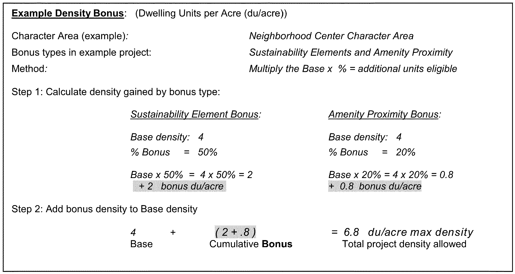
Density bonus eligibility and calculations. Density bonuses are allowed only for subdivisions as defined in this chapter and are expressly not allowed for individual infill lots. The maximum allowed density on RSM (Small Lot Residential Mix) District zoned property may be increased above the "Base Max" by application of density bonuses as indicated by Table 2.6, and may be accumulated if eligible. An example of how allowable density bonuses are calculated is shown in the example at the end of Table 2.6. In no case shall density exceed the bonus maximum established by Table 2.5.
Table 2.6 Residential Density Bonus Eligibility and Percent, with Example Calculation
(Ord. No. 15-06, 8-25-2015; Ord. No. 2023-0185, Pt. I, 8-22-2023)
Sec. 2.12.6. - Amenity proximity requirements.
For proposed development within one-quarter (0.25) mile of an existing public school, park, library, trail or greenway network, a pedestrian facility linking to the amenity shall be provided, or a stub-out for linking to a future amenity shall be provided. Measurement of distance to a qualifying amenity shall be taken from center point of the proposed drive of the principal entrance and follow the shortest street route to the center point of the closest existing drive to access the existing amenity.
(Ord. No. 15-06, 8-25-2015)
Sec. 2.12.7. - Bonus density qualifying standards.
The following standards shall be applied when considering whether bonus density may be allowed:
A.
Qualifying public improvements.
1.
Bus shelter. To qualify as eligible for bonus density, proposed bus shelter facilities shall include at a minimum a shelter structure, bench and paved access and be designed according to MARTA or GRTA standards, based upon ridership thresholds and as documented as acceptable by either agency.
2.
Park-n-ride and/or ride-share. To qualify as eligible for bonus density, proposed ride-share facilities shall provide for a minimum of one hundred (100) parking spaces, and park-n-ride amenities shall provide a minimum of three hundred (300) parking spaces, unless the station warrants fewer, as documented by MARTA or other transit service provider.
3.
Public art. To qualify for bonus density, a proposed work of art shall be subject to approval by the planning commission, be located on the development site or in a public place off site, and have a value of at least one-half of one percent (.005) of the total construction valuation of the building permit. The maximum required value shall not exceed two hundred fifty thousand dollars ($250,000.00).
a.
Options for providing public art are: Purchase an existing piece of art work or have a specific piece of art work commissioned.
b.
For commissioned work, a deposit with the planning department of one hundred fifteen (115) percent of the value of the public art is required prior to the issuance of a building permit.
c.
Public art or public works of art is defined as the creative application of skill and taste by artists to production of permanent tangible objects according to the aesthetic principles, including but not limited to:
• Paintings;
• Sculptures;
• Site specific installations;
• Engravings;
• Carvings;
• Frescos;
• Mobiles;
• Murals;
• Collages;
• Mosaics;
• Statutes; and
• Base-reliefs.
d.
Public art or public works of art shall also include the creative application of skill and taste by artists according to the aesthetic principals to the architectural embellishment of a building or structure. Architects and landscape architects are not considered artists under this definition.
e.
The following shall not be considered public art or public works of art:
• Reproductions or unlimited copies of original art work;
• Art objects which are mass produced;
• Works that are decorative, ornamental or functional elements of the architecture or landscape design, except when commissioned from an artist as an integral aspect of a structure or site; and
• Architectural rehabilitation or historical preservation.
4.
Structured parking. Developments that provide vertical, structured parking shall be eligible for the residential density bonus, provided:
a.
Parking decks not integrated into other buildings shall be located internal to the site.
b.
Structures are either at least two (2) stories above ground or greater; and/or
c.
Alternatively, at least one (1) story is underground.
d.
Parking decks visible from a public right-of-way shall incorporate similar architectural materials as the primary building(s).
5.
Trail with public access. Minimum length of new trail or multi-use path shall be one-quarter (0.25) mile and shall connect to a greenway/trail or sidewalk network external to the site.
B.
Qualifying amenity clarifications.
1.
Health or medical services: include clinics and offices for health, dental and/or medical services, as defined in article 9, including pharmacies with diagnostic services.
2.
Recreational facilities: include private or public exercise gymnasiums, fitness centers, sports fields, parks, and swim centers.
(Ord. No. 15-06, 8-25-2015)
Sec. 2.13.1.- Statement of purpose and intent.
The purpose and intent of the board of commissioners in establishing the MR-1 (Medium Density Residential-1) District is as follows:
A.
To encourage primarily residential, planned developments that allow accessory retail, office, institutional, and civic uses;
B.
To provide for residential neighborhoods with a mix of single-family and multi-family housing types that maintain harmony of scale, intensity, and design with surrounding development;
C.
To provide for connectivity of streets and communities and reduce the dependence on automobile use by increasing the ease of and opportunity for alternative modes of travel;
D.
To implement the future development map of the county's most current comprehensive plan.
(Ord. No. 15-06, 8-25-2015)
Sec. 2.13.2. - Permitted and special land uses.
Permitted uses and uses requiring special land use permits shall be as provided in Table 4.1. In cases where a use is permitted but there are supplemental use regulations for that use specified in article 4, such regulations shall also apply.
(Ord. No. 15-06, 8-25-2015)
Sec. 2.13.3. - Dimensional requirements.
Dimensional requirements for the MR-1 (Medium Density Residential-1) District shall be as provided in Table 2.4, "Medium and High Density Residential Zoning Districts Dimensional Requirements."
(Ord. No. 15-06, 8-25-2015)
Sec. 2.13.4. - Site and building design standards.
Site and building design standards and regulations to be applied in this zoning district shall be as provided in article 5, site design and building form standards.
(Ord. No. 15-06, 8-25-2015)
Sec. 2.13.5. - Density and location criteria.
A.
Use of bonuses shall permit a development to exceed the maximum base density established for the district in which the development property is located, provided that in no case shall a development exceed the maximum density allowed by the character area in which the property is located, according to the future development map adopted at the time of land disturbance permit application. Table 2.7 describes the maximum allowed dwelling unit density after application of any bonuses.
Table 2.7. MR-1 Character Area Base and Bonus Residential Density Maximum
B.
Density determination of each MR-1 (Medium Density Residential-1) property:
1.
Existing MR-1 properties: For existing properties converted to MR-1 (Medium Density Residential-1) District classification at the effective date of this chapter:
a.
Where conditions of zoning regulating density have been attached to the property, maximum density shall remain as established.
b.
Where no conditions of zoning regulating density have been attached to the property, maximum density shall be the "Base Max" described in Table 2.7, unless administratively reviewed and approved for bonus increases, according to the criteria set forth in subsection C. below.
2.
New MR-1 properties: For property rezoned to the MR-1 (Medium Density Residential-1) District classification after the effective date of this chapter, density shall be established by the board of commissioners at the time of approval, based upon the criteria set forth in subsection C. below.
C.
Density bonus eligibility and calculations. Density bonuses are intended for subdivisions as defined in this chapter, not for individual infill lots. The maximum allowed density on MR-1 (Medium Density Residential-1) District zoned property may be increased above the "base max" by application of density bonuses as indicated by Table 2.6, and may be accumulated if eligible. An example of how allowable density bonuses are calculated is shown in the example at the end of Table 2.6. In no case shall density exceed the bonus maximum established by Table 2.7.
(Ord. No. 15-06, 8-25-2015)
Sec. 2.14.1.- Statement of purpose and intent.
The purpose and intent of the board of commissioners in establishing the MR-2 (Medium Density Residential-2) District is as follows:
A.
To encourage primarily residential, planned developments that allow accessory retail, office, institutional, and civic uses;
B.
To provide for residential neighborhoods with a mix of single-family and multi-family housing types that maintain harmony of scale, intensity, and design with surrounding development;
C.
To provide for connectivity of streets and communities and reduce the dependence on automobile uses by increasing the ease of movement and opportunities for alternative modes of travel;
D.
To implement the future development map of the county's most current comprehensive plan;
E.
To provide districts that allow appropriate development transitions within the edges and transitional areas of the Town Center and Regional Center character areas.
(Ord. No. 15-06, 8-25-2015)
Sec. 2.14.2. - Permitted and special land uses.
Permitted uses and uses requiring special land use permits shall be as provided in Table 4.1. In cases where a use is permitted but there exist supplemental use regulations for that use specified in article 4, such regulations shall also apply.
(Ord. No. 15-06, 8-25-2015)
Sec. 2.14.3. - Dimensional requirements.
Dimensional requirements for the MR-2 (Medium Density Residential-2) District shall be as provided in Table 2.4, "Medium and High Density Residential Zoning Districts Dimensional Requirements."
(Ord. No. 15-06, 8-25-2015)
Sec. 2.14.4. - Site and building design standards.
Site and building design standards and regulations to be applied in this zoning district shall be as provided in article 5, site design and building form standards.
(Ord. No. 15-06, 8-25-2015)
Sec. 2.14.5. - Density and location criteria.
A.
Use of bonuses shall permit a development to exceed the maximum base density established for the district in which the development property is located, provided that in no case shall a development exceed the maximum density allowed by the character area in which the property is located, according to the future development map adopted at the time of land disturbance permit application. Table 2.8 describes the maximum allowed dwelling unit density after application of any bonuses.
Table 2.8. MR-2 Character Area Base and Bonus Residential Density Maximum
B.
Density determination of each MR-2 (Medium Density Residential-2) property:
1.
Existing MR-2 properties: For existing properties converted to MR-2 (Medium Density Residential-2) District classification at the effective date of this chapter:
a.
Where conditions of zoning regulating density have been attached to the property, maximum density shall remain as established.
b.
Where no conditions of zoning regulating density have been attached to the property, maximum density shall be the "Base Max" described in Table 2.8, unless administratively reviewed and approved for bonus increases according to the criteria set forth in subsection C. below.
2.
New MR-2 properties: For property rezoned to the MR-2 (Medium Density Residential-2) District classification after the effective date of this chapter density shall be established by the board of commissioners at the time of approval, based upon the criteria set forth in subsection C. below.
C.
Density bonus eligibility and calculations. Density bonuses are intended for subdivisions as defined in this chapter, not for individual infill lots. The maximum allowed density on MR-2 (Medium Density Residential-2) District zoned property may be increased above the "Base Max" by application of density bonuses, as indicated by Table 2.6, and may be accumulated if eligible. An example of how allowable density bonuses are calculated is shown in the example at the end of Table 2.6. In no case shall density of MR-2 (Medium Density Residential-2) zoned property exceed the bonus maximum established by Table 2.8.
(Ord. No. 15-06, 8-25-2015)
Sec. 2.14.6. - Building heights.
Maximum building heights shall meet character area intent by compliance with the transitional height and buffer standards of article 5 as well as proportional relationship of density to height as established in Table 2.9.
Table 2.9 MR-2 Building Height
* Whichever is less
(Ord. No. 15-06, 8-25-2015)
Sec. 2.15.1.- Statement of purpose and intent.
The purpose and intent of the board of commissioners in establishing the HR-1 (High Density Residential-1) District regulations is as follows:
A.
To encourage primarily residential, urban-scaled developments that allow accessory retail, office, institutional, and civic uses;
B.
To provide for high density, low-rise residential neighborhoods with a mix of single-family and multi-family housing types that maintain harmony of scale, intensity, and design with surrounding development;
C.
To provide for connectivity of streets and communities and reduce the dependence on automobile use by increasing the ease of movement and opportunities for alternative modes of travel;
D.
To implement the future development map of the county's most current comprehensive plan.
(Ord. No. 15-06, 8-25-2015)
Sec. 2.15.2. - Permitted and special land uses.
Permitted uses and uses requiring special land use permits shall be as provided in Table 4.1. In cases where a use is permitted but there are supplemental use regulations for that use specified in article 4, such regulations shall also apply.
(Ord. No. 15-06, 8-25-2015)
Sec. 2.15.3. - Dimensional requirements.
Dimensional requirements for the HR-1 (High Density Residential-1) District shall be as provided in Table 2.4, "Medium and High Density Residential Zoning Districts Dimensional Requirements."
(Ord. No. 15-06, 8-25-2015)
Sec. 2.15.4. - Site and building design standards.
Site and building design standards and regulations to be applied in this zoning district shall be as provided in article 5, site design and building form standards.
(Ord. No. 15-06, 8-25-2015)
Sec. 2.15.5. - Density and location criteria.
A.
Use of bonuses shall permit a development to exceed the maximum base density established for the district in which the development property is located, provided that in no case shall a development exceed the maximum density allowed by the character area in which the property is located, according to the future development map adopted at the time of land disturbance permit application. Table 2.10 describes the maximum allowed dwelling unit density after application of any bonuses.
Table 2.10 HR-1 Character Area Base and Bonus Residential Density Maximum
B.
Density determination of each HR-1 (High Density Residential-1) property:
1.
Existing HR-1 properties: For existing properties converted to the HR-1 (High Density Residential-1) District classification at the effective date of this chapter:
a.
Where conditions of zoning regulating density have been attached to the property, maximum density shall remain as established.
b.
Where no conditions of zoning regulating density have been attached to the property, maximum density shall be the "base max" described in Table 2.10, unless administratively reviewed and approved for bonus increases according to the criteria set forth in subsection C. below.
2.
New HR-1 properties: For property rezoned to the HR-1 (High Density Residential-1) District classification after the effective date of this chapter, density shall be established by the board of commissioners at the time of approval, based upon the criteria set forth in subsection C. below.
C.
Density bonus eligibility and calculations. Density bonuses are intended for subdivisions as defined in this chapter, not for individual infill lots. The maximum allowed density on HR-1 (High Density Residential-1) District zoned property may be increased above the "base max" by application of density bonuses, as indicated by Table 2.6, and may be accumulated if eligible. An example of how allowable density bonuses are calculated is shown in the example at the end of Table 2.6. In no case shall density exceed the bonus maximum established by Table 2.10.
(Ord. No. 15-06, 8-25-2015)
Sec. 2.15.6. - Building heights.
Maximum building heights shall meet character area intent by compliance with the transitional height and buffer standards of article 5 as well as proportional relationship of density to height as regulated by Table 2.11.
Table 2.11 HR-1 Building Height
* Whichever is less
(Ord. No. 15-06, 8-25-2015)
Sec. 2.16.1.- Statement of purpose and intent.
The purpose and intent of the board of commissioners in establishing the HR-2 (High Density Residential-2) District regulations is as follows:
A.
To encourage primarily residential, urban-scaled developments that allow accessory retail, office, institutional, and civic uses;
B.
To provide for high density, mid-rise residential neighborhoods with a mix of single-family and multi-family housing types that maintain harmony of scale, intensity, and design with surrounding development;
C.
To provide for connectivity of streets and communities and reduce the dependence on automobile use by increasing the ease of movement and opportunities for alternative modes of travel;
D.
To implement the future development map of the county's most current comprehensive plan.
(Ord. No. 15-06, 8-25-2015)
Sec. 2.16.2. - Permitted and special land uses.
Permitted uses and uses requiring special land use permits shall be as provided in Table 4.1. In cases where a use is permitted but there are supplemental use regulations for that use specified in article 4, such regulations shall also apply.
(Ord. No. 15-06, 8-25-2015)
Sec. 2.16.3. - Dimensional requirements.
Dimensional requirements for the HR-2 (High Density Residential-2) District shall be as provided in Table 2.4, "Medium and High Density Residential Zoning Districts Dimensional Requirements."
(Ord. No. 15-06, 8-25-2015)
Sec. 2.16.4. - Site and building design standards.
Site and building design standards and regulations to be applied in this zoning district shall be as provided in article 5, site design and building form standards.
(Ord. No. 15-06, 8-25-2015)
Sec. 2.16.5. - Density and location criteria.
A.
Use of bonuses shall permit a development to exceed the maximum base density established for the district in which the development property is located, provided that in no case shall a development exceed the maximum density allowed by the character area in which the property is located, according to the future development map adopted at the time of land disturbance permit application. Table 2.12 describes the maximum allowed dwelling unit density after application of any bonuses.
Table 2.12 HR-2 Character Area Base and Bonus Residential Density Maximum
B.
Density determination of each HR-2 (High Density Residential-2) property:
1.
Existing HR-2 properties: For properties converted to the HR-2 (High Density Residential-2) District classification at the effective date of this chapter:
a.
Where conditions of zoning regulating density have been attached to the property, maximum density shall remain as established.
b.
Where no conditions of zoning regulating density have been attached to the property, maximum density shall be the "base max" described in Table 2.12, unless administratively reviewed and approved for bonus increases according to the criteria set forth in subsection C. below.
2.
New HR-2 properties: For property rezoned to the HR-2 (High Density Residential-2) District classification after the effective date of this chapter, density shall be established by the board of commissioners at the time of approval, based upon the criteria set forth in subsection C. below.
C.
Density bonus eligibility and calculations. Density bonuses are intended for subdivisions as defined in this chapter, not for individual infill lots. The maximum allowed density on HR-2 (High Density Residential-2) District zoned property may be increased above the "base max" by application of density bonuses as indicated by Table 2.6, and may be accumulated if eligible. An example of how allowable density bonuses are calculated is shown in the example at the end of Table 2.6. In no case shall density exceed the bonus maximum established by Table 2.12.
(Ord. No. 15-06, 8-25-2015)
Sec. 2.16.6. - Building heights.
Maximum building heights shall meet character area intent by compliance with the transitional height and buffer standards of article 5 as well as proportional relationship of density to height as established by Table 2.13.
Table 2.13 HR-2 Building Height
* Whichever is less
(Ord. No. 15-06, 8-25-2015)
Sec. 2.17.1.- Statement of purpose and intent.
The purpose and intent of the board of commissioners in establishing the HR-3 (High Density Residential-3) District regulations is as follows:
A.
To encourage primarily residential, urban-scaled developments that allow accessory retail, office, institutional, and civic uses;
B.
To provide for high density, high-rise residential neighborhoods with a mix of single-family and multi-family housing types that maintain harmony of scale, intensity, and design with surrounding development;
C.
To provide for connectivity of streets and communities and reduce the dependence on automobile use by increasing the ease of movement and opportunities for alternative modes of travel;
D.
To implement the future development map of the county's most current comprehensive plan.
(Ord. No. 15-06, 8-25-2015)
Sec. 2.17.2. - Permitted and special land uses.
Permitted uses and uses requiring special land use permits shall be as provided in Table 4.1. In cases where a use is permitted but there exist supplemental use regulations for that use specified in article 4, such regulations shall also apply.
(Ord. No. 15-06, 8-25-2015)
Sec. 2.17.3. - Dimensional requirements.
Dimensional requirements for the HR-3 (High Density Residential-3) District shall be as provided in Table 2.4, "Medium and High Density Residential Zoning Districts Dimensional Requirements."
(Ord. No. 15-06, 8-25-2015)
Sec. 2.17.4. - Site and building design standards.
Site and building design standards and regulations to be applied in this zoning district shall be as provided in article 5, site design and building form standards.
(Ord. No. 15-06, 8-25-2015)
Sec. 2.17.5. - Density and location criteria.
A.
Use of bonuses shall permit a development to exceed the maximum base density established for the district in which the development property is located, provided that in no case shall a development exceed the maximum density allowed by the character area in which the property is located, according to the future development map adopted at the time of land disturbance permit application. Table 2.14 describes the maximum allowed dwelling unit density after application of any bonuses.
Table 2.14 HR-3 Character Area Base and Bonus Residential Density Maximum
B.
Density determination of each HR-3 (High Density Residential-3) property:
1.
Existing HR-3 properties: For existing properties converted to HR-3 (High Density Residential-3) District classification at the effective date of this chapter:
a.
Where conditions of zoning regulating density have been attached to the property, maximum density shall remain as established.
b.
Where no conditions of zoning regulating density have been attached to the property, maximum density shall be the "Base Max" described in Table 2.14, unless administratively reviewed and approved for bonus increases according to the criteria set forth in subsection C. below.
2.
New HR-3 properties: For property rezoned to the HR-3 (High Density Residential-3) District classification after the effective date of this chapter, density shall be established by the board of commissioners at the time of approval, based upon the criteria set forth in subsection C. below.
C.
Density bonus eligibility and calculations. Density bonuses are intended for subdivisions as defined in this chapter, not for individual infill lots. The maximum allowed density on HR-3 (High Density Residential-3) District zoned property may be increased above the "base max" by application of density bonuses as indicated by Table 2.6, and may be accumulated if eligible. An example of how allowable density bonuses are calculated is shown in the example at the end of Table 2.6. In no case shall density exceed the bonus maximum established by Table 2.14.
(Ord. No. 15-06, 8-25-2015)
Sec. 2.17.6. - Building heights.
Maximum building heights shall meet character area intent by compliance with the transitional height and buffer standards of article 5 as well as proportional relationship of density to height as regulated by Table 2.15.
Table 2.15 HR-3 Building Height for Density
* Whichever is less
(Ord. No. 15-06, 8-25-2015)
Sec. 2.18.1.- Statement of purpose and intent.
A.
The purpose and intent of the board of commissioners in establishing all districts designated as Mixed-Use (MU-1, MU-2, MU-3, MU-4 and MU-5) Zoning Districts are as follows:
1.
To encourage the development of master or comprehensively planned, mixed-use developments;
2.
To permit flexible and compatible arrangements of residential, commercial, office, institutional, and civic uses;
3.
To offer a variety of housing options, including multi-family residential and single-family attached housing of various densities, upper-floor residential units over non-residential space, or active adult and/or senior housing;
4.
To implement the future development map of the county's most current comprehensive plan;
5.
To maintain harmony of scale, intensity, and design of character areas with varying housing options;
6.
To accommodate and promote mixed-use buildings with amenities and services provided by a variety of non-residential uses, as appropriate in the activity centers established by the comprehensive plan;
7.
To promote the health and well-being of residents through the development of living environments that accommodate pedestrians and bicyclists;
8.
To encourage a sense of community through design that promotes social interaction; and
9.
To reduce automobile traffic and congestion and promote the use of transit by encouraging appropriate development densities.
(Ord. No. 15-06, 8-25-2015)
Sec. 2.18.2. - Mixed-use district densities.
A.
Table 2.16, which summarizes the allowed densities and eligible character areas for mixed-use zoning districts, is provided for the aid of the reader. Any conflict between Table 2.16 and any other provision of this chapter shall be resolved in favor of the other provision of this chapter.
Table 2.16 Summary of Mixed-Use Zoning District Densities
B.
Individual buildings in any mixed use district may exclusively consist of only residential uses, provided that they are part of a larger mixed-use development that meets the overall percentage mix of nonresidential to residential floor area established by Table 2.17.
(Ord. No. 15-06, 8-25-2015)
Sec. 2.18.3. - Mixed-Use dimensional requirements.
Dimensional requirements including overall site requirements, individual lot dimensions, setbacks, and heights for Mixed-Use Districts are provided in Table 2.17, "Mixed-Use Zoning Districts Dimensional Requirements." Compatibility rules and transitional buffers as defined and required in article 5 may apply.
Table 2.17 Mixed-Use Zoning Districts Dimensional Requirements
* See article 5 for enhanced open space requirements
** SFD Cottage type exempt; see article 5 for standards
*** See article 5 for building separation and minimum multi-family unit size details
(Ord. No. 15-06, 8-25-2015; Ord. No. 2019-4123, Pt. I(Exh. I), 3-10-2020; Ord. No. 2022-2270, Pt. I, 12-12-2023)
Sec. 2.19.1.- Dimensional requirements.
Dimensional requirements for the MU-1 (Mixed-Use Low Density) District shall be as provided in Table 2.17, "Mixed-Use Zoning Districts Dimensional Requirements." Dimensions are established in Table 2.17 for the overall development site (development parcel) and for individual lots intended for single-family detached or single-family attached housing types, when such lots include yards. A mixed-use development may be subject to both the overall development site dimensions and the individual lot dimensions, depending on the mixture of housing types that are proposed for the overall development.
(Ord. No. 15-06, 8-25-2015)
Sec. 2.19.2. - Site and building design standards.
Site and building design standards and regulations shall be as provided in Table 2.17 and article 5, site and building design standards.
(Ord. No. 15-06, 8-25-2015)
Sec. 2.19.3. - Rezoning to the MU-1 (Mixed-Use Low Density) District.
Properties within the Suburban, Traditional Neighborhood, Neighborhood Center, Town Center, Regional Center, Office Park, Institutional, Commercial Redevelopment Corridor and Highway Corridor character areas of the DeKalb County Comprehensive Plan Future Development Map are eligible to be rezoned to the MU-1 District.
(Ord. No. 15-06, 8-25-2015)
Sec. 2.19.4. - MU-1 (Mixed-Use Low Density) District rezoning submittal requirements.
The following standards only apply to rezoning applications initiated by the owner(s) of the subject property or the authorized agent of the owner(s). In the interest of economic development and to spur redevelopment, applications initiated by the county are not required to comply with the standards in this section.
Prior to the submittal of an application for a land disturbance permit or building permit, an applicant for development of a county-initiated MU-zoned property, shall comply with the following standards. The application will be reviewed administratively by the director, in consultation with the district and super-district commissioners.
A.
Pre-application meeting. Before submitting an application for rezoning to the MU-1 (Mixed-Use Low Density) District, the applicant shall confer with the director of planning to discuss the feasibility of the proposed plan and its relationship to the comprehensive plan and county ordinances.
B.
Submittal of master development plan. The submittal package for rezoning to the MU-1 (Mixed-Use Low Density) District shall include all items indicated by the application and instruction form established by the planning department. The master development plan shall include:
1.
Pre-application meeting minutes. Applicants shall provide documentation showing that the required pre-application meeting occurred.
2.
Master development plan. A master development plan shall illustrate the project showing the location of proposed uses identified by type, site functions, and internal vehicular and pedestrian circulation, along with proposed access points (note: prefer multi-modal access plan as specified in the overlays).
3.
Master development standards. An applicant for rezoning to the MU-1 (Mixed-Use Low Density) District shall submit the following with the rezoning application:
a.
A set of tables, matrices, and/or diagrams shall document the proposed standards that will regulate the permitted use, density, lot dimensions, setbacks, site and building form for each area identified in the master concept plan, and indicate all instances where proposed standards vary from this ordinance.
b.
Documentation regarding eligibility for density bonus(es) sought by the applicant (see section 2.19.6).
c.
A summary of the anticipated maintenance and ownership of streets and open spaces.
d.
Proposed gross and net non-residential floor area, maximum number of residential dwelling units by type and minimum lot size, and amount of enhanced open space.
4.
Master development plan architectural standards. An applicant for rezoning to the MU-1 (Mixed-Use Low Density) District shall include with the master development plan a set of binding and enforceable architectural standards that will be utilized by the developer to ensure aesthetic continuity throughout the life of the project.
a.
At a minimum, the architectural standards shall address lighting, signage, fences, landscaping, building materials, and other architectural features proposed to be included by the applicant.
b.
A master sign plan may be proposed for approval at the time of rezoning with dimensions that vary from the sign ordinance, provided that the proposed plan demonstrates pedestrian-oriented scale.
(Ord. No. 15-06, 8-25-2015)
Sec. 2.19.5. - Mixed-use building restrictions.
The following restrictions shall also apply to mixed-use buildings:
A.
All uses allowed in the MU-1 (Mixed-Use Low Density) District, as provided in Table 4.1, may occupy the ground level of a mixed-use building; however, any residential uses shall not occupy more than fifty (50) percent of the floor area of the ground level. All levels above ground level shall only be occupied by residential, professional office or service uses.
(Ord. No. 15-06, 8-25-2015)
Sec. 2.19.6. - Density and location criteria.
A.
Use of bonuses shall permit a development to exceed the maximum base density established for the district in which the development property is located, provided that in no case shall a development exceed the maximum density allowed by the character area in which the property is located, according to the future development map adopted at the time of land disturbance permit application. Table 2.18 describes the maximum allowed dwelling unit density after application of any bonuses.
Table 2.18 MU-1 Character Area and Bonus Residential Density Maximum
B.
Density determination of each MU-1 (Mixed-Use Low Density) property:
1.
Existing MU-1 properties: For properties converted to the MU-1 (Mixed-Use Low Density) District classification at the effective date of this chapter:
a.
Where conditions of zoning regulate density on the property, the maximum density shall remain as established in any conditions of zoning attached to the property.
b.
Where no conditions of zoning regulating density have been attached to the property, the maximum density shall be the "Base Max" described in Table 2.18 unless administratively reviewed and approved for bonus increases, according to the criteria set forth in subsection C. below.
2.
New MU-1 districts: For property rezoned to the MU-1 (Mixed-Use Low Density) District classification after the effective date of this chapter, density shall be established by the board of commissioners at the time of approval of the MU-1 District, based upon the criteria set forth in subsection C. below.
C.
Density bonus eligibility and calculations. Density bonuses are intended for subdivisions as defined in this chapter, not for individual infill lots. The maximum allowed density on MU-1 (Mixed-Use Low Density) zoned property may be increased above the "base max" by application of density bonuses as indicated by Table 2.19, and may be accumulated if eligible. An example of how allowable density bonuses are calculated is shown in the example at the end of Table 2.19. In no case shall density exceed the bonus maximum established by Table 2.18.
Table 2.19 Residential Density Bonus Eligibility and Percent, with Example Calculation
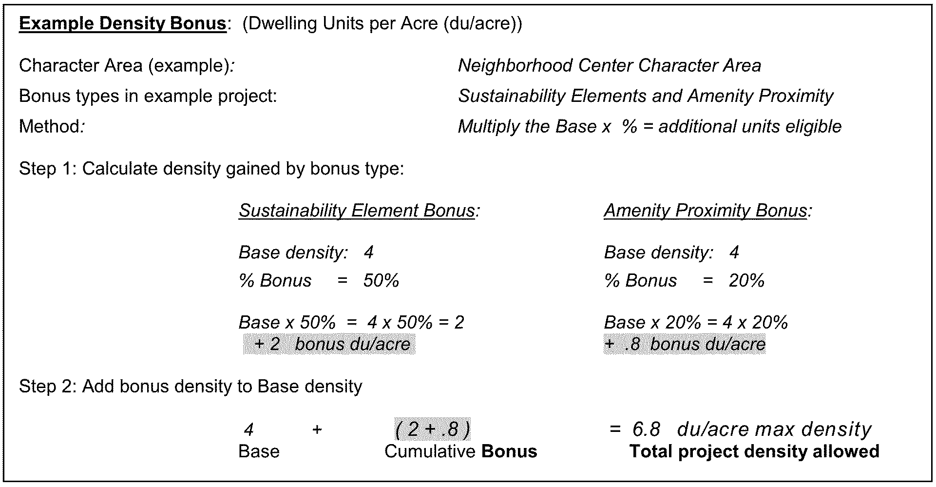
(Ord. No. 15-06, 8-25-2015)
Sec. 2.19.8. - MU-1 retail size restrictions.
Standalone retail or other uses shall not exceed forty thousand (40,000) square feet total floor area without a special land use permit, which may be issued based on the criteria provided in section 7.4.6.
(Ord. No. 15-06, 8-25-2015)
Sec. 2.20.1.- District requirements, standards and criteria.
All provisions found in the MU-1 (Mixed Use Low Density) District shall apply to the MU-2 (Mixed-Use Low-Medium Density) District, except that the reference to Table 2.19 for MU-1 density shall be to Table 2.20 for MU-2 density.
Table 2.20. MU-2 Character Area and Bonus Residential Density Maximum
(Ord. No. 15-06, 8-25-2015)
Sec. 2.21.1.- District requirements, standards and criteria.
All provisions found in the MU-2 (Mixed-Use Medium Density) District shall apply to the MU-3 (Mixed-Use Medium Density) District, except that:
A.
The reference to density shall be to Table 2.21 for MU-3 density.
Table 2.21. MU-3 Character Area and Bonus Residential Density Maximum
B.
Section 2.19.8 regarding retail size restrictions shall not apply.
C.
Height restrictions apply to the MU-3 (Mixed-Use Low-Medium Density) District based on a relationship of density, as achieved through bonuses, in accordance with Tables 2.9 or 2.11, as applicable.
(Ord. No. 15-06, 8-25-2015; Ord. No. 2019-4123, Pt. I(Exh. I), 3-10-2020)
Sec. 2.22.1.- District requirements, standards and criteria.
All provisions found in the MU-3 (Mixed-Use Medium Density) District shall also apply to the MU-4 (Mixed-Use High Density) District, except that:
A.
Density shall be to Table 2.22 for MU-4 density.
Table 2.22. MU-4 Character Area and Bonus Residential Density Maximum
B.
Height restrictions apply to the MU-4 (Mixed-Use High Density) District in accordance with Table 2.9, 2.11, or 2.13, as applicable.
(Ord. No. 15-06, 8-25-2015; Ord. No. 2019-4123, Pt. I(Exh. I), 3-10-2020)
Sec. 2.23.1.- District requirements, standards and criteria.
All provisions found in the MU-3 (Mixed-Use Medium Density) District shall also apply to the MU-5 (Mixed-Use Very High Density) District, except as identified below:
A.
Density shall be to Table 2.23 for MU-5 density.
Table 2.23. MU-5 Character Area and Bonus Residential Density Maximum
B.
Height restrictions apply to MU-5 in accordance with Table 2.13 and 2.15, as applicable.
(Ord. No. 15-06, 8-25-2015; Ord. No. 2019-4123, Pt. I(Exh. I), 3-10-2020)
Sec. 2.24.1.- Dimensional requirements.
Dimensional requirements including overall site requirements, lot dimensions, setbacks, and heights for Non-Residential Districts are provided in Table 2.24, "Non-Residential Zoning Districts Dimensional Requirements." Building setback, height and lot width may be tied to lot size compatibility, averaging as defined and required in article 5.
Table 2.24 Non-Residential Zoning Districts Dimensional Requirements
1 For existing O-I zoned properties in activity centers, existing, high-rise structures that have been vacant for longer than 3 years may be adaptively reused for residential development with a minimum dwelling unit size of no less than 400 square feet.
2 If located next to single-family residential and the building will exceed 35 feet in height, the transitional buffer adjacent to SF residential shall be increased 50%.
3 Fire department and rescue services must approve over 3 stories to assure adequacy of fire protection facilities.
4 5 story/70 feet if in an activity center, 35 feet outside an activity center, unless obtaining a SLUP for up to 70 feet.
5 A Special Land Use Permit (SLUP) is requried to exceed maximum height, unless otherwise indicated.
6 Enhanced open space is not required for commercial, office and industrial uses.
(Ord. No. 15-06, 8-25-2015; Ord. No. 2019-4123, Pt. I(Exh. I), 3-10-2020; Ord. No. 2022-2542, Pt. I, 1-26-2023)
Sec. 2.25.1.- Statement of purpose and intent.
The purpose and intent of the board of commissioners in establishing the NS (Neighborhood Shopping) District is as follows:
A.
To provide convenient neighborhood retail shopping and service areas within the county for all residents;
B.
To provide for the development of new Neighborhood Shopping Districts where so designated on the comprehensive plan especially for commercial uses in Suburban character areas;
C.
To assure that the size and scale of neighborhood shopping centers and individual uses within said centers are compatible with the scale of adjoining neighborhoods;
D.
To implement the future development map of the county's most current comprehensive plan.
(Ord. No. 15-06, 8-25-2015)
Sec. 2.25.2. - Intensity limitations.
In a building that contains more than one (1) business establishment, no single business establishment shall occupy more than fifteen thousand (15,000) square feet, whether owned or leased. No building occupied by a single business establishment shall exceed fifty thousand (50,000) square feet.
(Ord. No. 15-06, 8-25-2015)
Sec. 2.25.3. - Permitted and special land uses.
Permitted uses and uses requiring special land use permits shall be as provided in Table 4.1. In cases where a use is permitted but there are supplemental use regulations for that use specified in article 4, such regulations shall also apply and must be complied with.
(Ord. No. 15-06, 8-25-2015)
Sec. 2.25.4. - Dimensional requirements.
Dimensional requirements for the NS (Neighborhood Shopping) District shall be as provided in Table 2.24, "Non-Residential Zoning Districts Dimensional Requirements."
(Ord. No. 15-06, 8-25-2015)
Sec. 2.25.5. - Site and building design standards.
Site and building design standards and regulations to be applied in this zoning district shall be as provided in article 5, site design and building form standards.
(Ord. No. 15-06, 8-25-2015)
Sec. 2.26.1.- Statement of purpose and intent.
The purpose and intent of the board of commissioners in establishing the C-1 (Local Commercial) District is as follows:
A.
To provide convenient local retail shopping and service areas within the county for all residents;
B.
To provide for auto-oriented needs outside of the Neighborhood Center, Town Center and Regional Center character areas, but to focus on the pedestrian oriented development within these districts;
C.
To provide for quality control in development through materials and building placement;
D.
To assure that the uses authorized within the C-1 (Local Commercial) District are those uses which are designed to serve the convenience shopping and service needs of groups of neighborhoods;
E.
To implement the future development map of the county's most current comprehensive plan.
(Ord. No. 15-06, 8-25-2015)
Sec. 2.26.2. - Permitted and special land uses.
Permitted uses and uses requiring special land use permits shall be as provided in Table 4.1. In cases where a use is permitted, but there are supplemental use regulations for that use specified in article 4, such regulations shall also apply and must be complied with.
(Ord. No. 15-06, 8-25-2015)
Sec. 2.26.3. - Dimensional requirements.
Dimensional requirements for the C-1 (Local Commercial) District shall be as provided in Table 2.24, "Non-Residential Zoning Districts Dimensional Requirements."
(Ord. No. 15-06, 8-25-2015)
Sec. 2.26.4. - Site and building design standards.
Site and building design standards and regulations to be applied in this zoning district shall be as provided in article 5, site design and building form standards.
(Ord. No. 15-06, 8-25-2015)
Sec. 2.27.1.- Statement of purpose and intent.
The purpose and intent of the board of commissioners in establishing the C-2 (General Commercial) District is as follows:
A.
To provide convenient general business and commercial service areas within the county for all residents;
B.
To provide for the development of new general commercial districts where so designated on the comprehensive plan;
C.
To provide for auto-oriented needs outside of the Neighborhood Center, Town Center and Regional Center character areas, but to focus on the pedestrian oriented development which in these districts;
D.
To provide for quality control in development through materials and building placement;
E.
To assure that the uses authorized within the C-2 (General Commercial) District are those uses which are designed to serve the general business and commercial service needs of the county;
F.
To implement the future development map of the county's most current comprehensive plan.
(Ord. No. 15-06, 8-25-2015)
Sec. 2.27.2. - Permitted and special land uses.
Permitted uses and uses requiring special land use permits shall be as provided in Table 4.1. In cases where a use is permitted but there are supplemental use regulations for that use specified in article 4, such regulations shall also apply and must be complied with.
(Ord. No. 15-06, 8-25-2015)
Sec. 2.27.3. - Dimensional requirements.
Dimensional requirements for the C-2 (General Commercial) District shall be as provided in Table 2.24, "Non-Residential Zoning Districts Dimensional Requirements."
(Ord. No. 15-06, 8-25-2015)
Sec. 2.27.4. - Site and building design standards.
Site and building design standards and regulations to be applied in this zoning district shall be as provided in article 5, site design and building form standards.
(Ord. No. 15-06, 8-25-2015)
Sec. 2.28.1.- Statement of purpose and intent.
The purpose and intent of the board of commissioners in establishing the OD (Office-Distribution) District is as follows:
A.
To provide convenient areas within the county for the development of office and distribution establishments which are necessary for the residents and business practitioners within the county; and
B.
To implement the future development map of the county's most current comprehensive plan.
(Ord. No. 15-06, 8-25-2015)
Sec. 2.28.2. - Permitted and special land uses.
Permitted uses and uses requiring special land use permits shall be as provided in Table 4.1. In cases where a use is permitted but there exist supplemental use regulations for that use specified in article 4, such regulations shall also apply and must be complied with.
(Ord. No. 15-06, 8-25-2015)
Sec. 2.28.3. - Dimensional requirements.
Dimensional requirements for the OD (Office-Distribution) District shall be as provided in Table 2.24, "Non-Residential Zoning Districts Dimensional Requirements."
(Ord. No. 15-06, 8-25-2015)
Sec. 2.28.4. - Site and building design standards.
Site and building design standards and regulations to be applied in this zoning district shall be as provided in article 5, site design and building form standards.
(Ord. No. 15-06, 8-25-2015)
Sec. 2.29.1.- Statement of purpose and intent.
The purpose and intent of the board of commissioners in establishing the OI (Office-Institutional) District is as follows:
A.
To provide convenient areas within the county for the location of office and institutional uses which are necessary for the residents and business and professional practitioners within the county;
B.
To provide accessory commercial and residential uses to reduce auto dependence;
C.
To provide locations for the development of cultural, recreational, educational and health service facilities for the county;
D.
To promote compatible development, in size and scale, to surrounding development;
E.
To promote campus style developments;
F.
To promote pedestrian oriented compact design;
G.
To implement the future development map of the county's most current comprehensive plan.
(Ord. No. 15-06, 8-25-2015)
Sec. 2.29.2. - Permitted and special land uses.
Permitted uses and uses requiring special land use permits shall be as provided in Table 4.1. In cases where a use is permitted but there are supplemental use regulations for that use specified in article 4, such regulations shall also apply and must be complied with.
(Ord. No. 15-06, 8-25-2015)
Sec. 2.29.3. - Dimensional requirements.
Dimensional requirements for the OI (Office-Institutional) District shall be as provided in Table 2.24, "Non-Residential Zoning Districts Dimensional Requirements."
(Ord. No. 15-06, 8-25-2015)
Sec. 2.29.4. - Site and building design standards.
Site and building design standards and regulations to be applied in this zoning district shall be as provided in article 5, site design and building form standards.
(Ord. No. 15-06, 8-25-2015)
Sec. 2.30.1.- Statement of purpose and intent.
The purpose and intent of the board of commissioners in establishing the OIT (Office-Institutional-Transitional) District is as follows:
A.
To provide areas within the county for the location of office and institutional uses which are necessary for the residents, business practitioners, and professional practitioners in existing buildings no longer viable for residential uses;
B.
To limit said buildings' height to be compatible to those potential redevelopment parcels and structures;
C.
To provide for the transition from residential to office and associated commercial uses which do not generate large volumes of traffic, noise or other harmful effects, and which are compatible with residential uses in locations so designated in the comprehensive plan along Commercial Redevelopment Corridor character areas and along the edge of the Office Park and Institutional character areas.
(Ord. No. 15-06, 8-25-2015)
Sec. 2.30.2. - Permitted and special land uses.
Permitted uses and uses requiring special land use permits shall be as provided in Table 4.1. In cases where a use is permitted, but there are supplemental use regulations for that use specified in article 4, such regulations shall also apply and must be complied with.
(Ord. No. 15-06, 8-25-2015)
Sec. 2.30.3. - Dimensional requirements.
Dimensional requirements for the OIT (Office-Institutional-Transitional) District shall be as provided in Table 2.24, "Non-Residential Zoning Districts Dimensional Requirements."
(Ord. No. 15-06, 8-25-2015)
Sec. 2.30.4. - Site and building design standards.
Site and building design standards and regulations to be applied in this zoning district shall be as provided in article 5, site design and building form standards.
(Ord. No. 15-06, 8-25-2015)
Sec. 2.31.1.- Statement of purpose and intent.
The purpose and intent of the board of commissioners in establishing the M (Light Industrial) District is as follows:
A.
To provide areas for the establishment of businesses engaged in the manufacturing, processing, creating, repairing, renovating, painting, cleaning, or assembling of goods, merchandise, or equipment and the sale and distribution of such goods, merchandise or equipment in locations so designated in the comprehensive plan;
B.
To provide an environment for light industrial uses that produces no appreciable impact on adjacent properties and preserve the appeal and appearance of residential and commercial areas;
C.
To assure that all establishments located within the M (Light Industrial) District operate in compliance with the noise standards contained in this chapter and that any negative noise impact resulting from the use of land within the M (Light Industrial) District is contained within the boundaries of said district and does not create noise problems for adjoining residential, office or commercial districts;
D.
To provide an area within DeKalb County for recycling and green businesses to locate;
E.
To generate employment opportunities and economic development;
F.
To assure that M (Light Industrial) districts are so located that transportation access to thoroughfares and freeways is available;
G.
To allow for the conversion of industrial buildings which are fifty (50) years of age or older to multi-family dwellings so as to promote living and working space as well as historic preservation;
H.
To implement the future development map of the county's most current comprehensive plan.
(Ord. No. 15-06, 8-25-2015)
Sec. 2.31.2. - Permitted and special land uses.
Permitted uses and uses requiring special land use permits shall be as provided in Table 4.1. In cases where a use is permitted but there are supplemental use regulations for that use specified in article 4, such regulations shall also apply and must be complied with.
(Ord. No. 15-06, 8-25-2015)
Sec. 2.31.3. - Dimensional requirements.
Dimensional requirements for the M (Light Industrial) District shall be as provided in Table 2.24, "Non-Residential Zoning Districts Dimensional Requirements."
(Ord. No. 15-06, 8-25-2015)
Sec. 2.31.4. - Site and building design standards.
Site and building design standards and regulations to be applied in this zoning district shall be as provided in article 5, site design and building form standards.
(Ord. No. 15-06, 8-25-2015)
Sec. 2.31.5. - Multi-family use provisions for industrial conversion.
A.
The conversion of industrial buildings to residential use shall be permitted by a special land use permit. The following shall be considered:
1.
Whether the building is located on the interior or periphery of an established industrial park or area;
2.
Whether the building or area should no longer be used for industrial uses;
3.
Adequate parking is provided in accordance with article 6, for multi-family or live-work.
(Ord. No. 15-06, 8-25-2015)
Sec. 2.32.1.- Statement of purpose and intent.
The purpose and intent of the board of commissioners in establishing the M-2 (Heavy Industrial) District is as follows:
A.
To provide areas for manufacturing, warehousing and distribution facilities at locations so designated in the comprehensive plan;
B.
To provide for a location for intense industrial uses that do not require and may not be appropriate for a nuisance free environment;
C.
To provide for a location that allows nuisances such as noise, vibration and other impacts which cannot be contained on-site;
D.
To assure that all businesses located within the M-2 (Heavy Industrial) District operate in compliance with the noise standards contained in this chapter and that any negative noise impact resulting from the use of land within the M-2 (Heavy Industrial) District is contained within the boundaries of said district and does not create noise problems for adjoining residential, office or commercial districts;
E.
To assure that industrial districts are so located that transportation access to thoroughfares and freeways is available;
F.
To implement the future development map of the county's most current comprehensive plan.
(Ord. No. 15-06, 8-25-2015)
Sec. 2.32.2. - Permitted and special land uses.
Permitted uses and uses requiring special land use permits shall be as provided in Table 4.1. In cases where a use is permitted but there are supplemental use regulations for that use specified in article 4, such regulations shall also apply and must be complied with.
(Ord. No. 15-06, 8-25-2015)
Sec. 2-32.3. - Dimensional requirements.
Dimensional requirements for the M-2 (Heavy Industrial) District shall be as provided in Table 2.24, "Non-Residential Zoning Districts Dimensional Requirements."
(Ord. No. 15-06, 8-25-2015)
Sec. 2.32.4. - Site and building design standards.
Site and building design standards and regulations to be applied in this zoning district shall be as provided in article 5, site design and building form standards.
(Ord. No. 15-06, 8-25-2015)
Sec. 2.32.5. - Solid waste facility/landfill use provisions.
Any solid waste facility, solid waste handling facility, or landfill must obtain a special land use permit from the board of commissioners and a modification or addition of zoning conditions that specifically authorizes and identifies all necessary zoning requirements for each such facility. If granted, the zoning district classification for such property shall be identified as M-2 (Conditional Landfill).
(Ord. No. 15-06, 8-25-2015)