
Delhi Charter Township
City Zoning Code
City Zoning Code
ARTICLE VI
- SUPPLEMENTARY REGULATIONS
Section 6.1 - Miscellaneous regulations.
6.1.1 Prior building permits. Any building permit issued prior to the effective date of this Ordinance shall be valid, even though not conforming to the provisions of this Ordinance, provided that construction is commenced within ninety (90) days after the date of permit issuance and that the entire building shall be completed according to the plans filed with the permit application within one (1) year after the issuance of the building permit.
6.1.2 Access to a street. Any lot of record created after the effective date of this Ordinance shall have frontage on a public street, except in the case of an officially approved group housing development as provided in article V, section 5.7.6(2). Any one (1) lot of record created before the effective date of this Ordinance without any frontage on a public street shall not be occupied without access to a street provided by an easement or other right-of-way no less than twenty (20) feet wide. No more than one (1) lot may be served by such an access route.
6.1.2.1 Driveway surfaces. The entire width of new driveways, in all zoning districts, shall be paved with concrete, bituminous, or concrete unit pavers from the public right-of-way to a point fifty (50) feet from the rights-of-way line to which the driveway provides access. Further, driveways shall also be paved between the edge of the roadway and the right-of-way line in accordance with the requirements of a driveway permit to be obtained from the Ingham County Road Commission or other agency having jurisdiction for the public right-of-way.
6.1.2.2 Standards for all residential. The following minimum standards shall be required for every driveway that provides access to a residential structure within the R-1A, R-1B, R-1C, R-1D, R-1E and RM Districts. The driveway standards applicable in the A-1 Agricultural District are listed in section 5.21.6 of this Ordinance. The term "Driveway," as used in this section, shall mean that portion of the property utilized to provide a means of ingress and egress to a lot or parcel within the township to and from a public roadway for use by motor vehicles. "Driveway" shall not include a private road as defined by this Ordinance.
1.
Permits for construction of driveway: All persons constructing or contracting for the construction of a driveway within Delhi Charger Township shall obtain a driveway permit from the Ingham County Board of Road Commissioners (the "Road Commission") prior to commencement of construction.
2.
Plans submitted pursuant to section 3.1.2(2) of this Ordinance shall be reviewed by the Delhi Charter Township Fire Chief, or his/her designee, prior to issuance of a building permit. The purpose of this review shall be to provide an opportunity for the fire chief to review the proposed site layout and provide information to the property owner regarding the fire department's ability to provide emergency services to the structure(s) based on the site design proposed. Additionally, the fire chief may make recommendations regarding the site development that will permit access or improve access to the site in the event of an emergency. Recommendations will be made in writing to the owner prior to the issuance of a building permit. Any changes to the site design will require that a revised plot plan or drawing be submitted to the director of community development prior to approval of the building permit. Fire chief recommendations that are not complied with by the property owner shall be documented in writing by the fire chief and attached as a permanent part of any future certificate of occupancy that may be issued for the structure(s). If the property owner opts not to comply with the recommendations made as a result of this review the fire department and other emergency service providers may not be able to provide emergency services to the property.
6.1.3 Rear dwelling prohibited. Except in accordance with section 5.2.2(2) of this Ordinance, no building in the rear of and on the same lot with a principal building shall be used for residential purposes except for watchmen, caretakers and domestic employees whose employment functions are related to the functions of the principal building, provided that all other requirements of this Ordinance are satisfied.
6.1.3.1 Only one principal building permitted per parcel. No parcel in the A-1, R1-A, R1-B, R1-C, R1-D or R1-E District shall have more than one principal building unless specifically permitted elsewhere in this Ordinance.
6.1.4 Required water supply and sanitary sewerage facilities. After the effective date of this Ordinance, no structure for human occupancy shall be erected, altered or moved upon a lot or premises and used in whole or in part for dwelling, business, industrial or recreational purposes unless it shall be provided with a safe, sanitary and potable water supply and with a safe and effective means of collection, treatment and disposal of human excreta and domestic, commercial and industrial wastes. All such installations and facilities shall conform with the minimum requirements of the Ingham County Health Department and the State of Michigan Health Department.
6.1.5 Storage of refuse. All space required for the accumulation and outloading of garbage, trash, scrap, waste products and empty containers within residential and commercial districts shall be provided entirely within a building or in covered containers.
a)
Containers that can accommodate more than two (2) cubic yards of refuse shall be prohibited in all residential districts, except when being used in conjunction with a renovation or construction project in which case the limit is six (6) months and a maximum of two (2) such containers are permitted at any one time, must be located outside of any road right-of-way or public space, and must be located in such a manner that emergency access to all structures and proper sight distance from any drive, intersection and/or sidewalk is maintained.
6.1.5.1 Screening of external solid waste areas:
a)
Outside solid waste storage, loading and unloading areas, dumpsters, compactors, and disposal facilities, recycling collection bins, and other areas and structures located in zones C-1, C-2, C-3, TC, RM, IW, IR, IM and IP shall be completely screened by an opaque fence, wall and/or landscape screen which is not less than six (6) feet high. Such areas shall include opaque gates of a like material. Additionally, the ground surface of the area shall be concrete or other non-porous material.
b)
Outside solid waste storage, loading and unloading areas, dumpsters, compactors, and disposal facilities, recycling collection bins, and other similar areas and structures which are visible from residential zoning districts or public thorough fares shall be screened by an opaque fence, wall and/or landscape screen which is not less than six (6) feet high. Such areas shall include opaque gates of like material.
c)
Outside solid waste storage, loading and unloading areas, dumpsters, compactors, and disposal facilities, recycling collection bins and other similar areas and structures located in the C-1, C-2, C-3, TC, RM, IW, IR, IM and IP Districts shall not be located in the required front yard.
6.1.6 Basement or cellar living prohibited. No cellar or basement shall be used as a primary living area within the township unless the dwelling qualifies as an underground house. See subsection 5.21.4(17). No basement shall be used as a primary living area until second story is enclosed for occupancy.
6.1.7 Maximum setback from road right-of-way. Except for those properties zoned A-1, Agricultural, and unless soil conditions prohibit building within one hundred fifty (150) feet of the nearest approved public or private road right-of-way, no building constructed for human occupancy may be constructed more than one hundred fifty (150) feet from the nearest point of that road right-of-way.
6.1.8 All-season road construction required: Whenever a new public or private road is constructed that will or is intended to provide service to property zoned for industrial land uses, the road, at the developer's expense, shall be constructed as an "all-season" road and not subject to seasonal weight restrictions. Construction shall be completed in accordance with the current requirements of the Ingham County Road Commission for said road type at the time of construction.
(Ord. No. 39.51, 11-16-93; Ord. No. 39.82, § 1, 2-2-99; Ord. No. 39.92, § 1, 2-1-00; Ord. No. 39.123, 3-7-06; Ord. No. 39.134, 6-5-07; Ord. No. 39.153, § III, 7-5-09)
Section 6.2 - Supplementary use regulations.
6.2.1 Uses of structures for dwelling purposes. No structure shall be used for dwelling purposes that does not meet the minimum standards as defined in this Ordinance, the adopted building code, or the township adopted housing code.
6.2.2 Accessory buildings. Authorized accessory buildings may be erected as a part of the principal building or may be connected to it by a roofed-over porch, patio, breezeway or similar structure or they may be completely detached. If attached to the principal building, an accessory building shall be made structurally a part of it and applicable to the principal building. An accessory building not attached and not made a part of the principal building, as provided in the preceding statement, shall not be nearer than ten (10) feet from any other separate structure on the same lot.
1)
Accessory uses, fallout shelters: Fallout shelters are permitted uses and structures in any district, subject to the yard and lot coverage regulations of the district. Such shelters may contain or be contained in other structures or may be constructed separately, and in addition to shelter use may be used for any accessory use permitted in the district, subject to the district regulations for such use.
6.2.2.1 On-site use wind energy systems and anemometer tower. An on-site use wind energy system is an accessory structure which shall meet the following standards:
1)
Designed to primarily serve the needs of a home, farm or small business.
2)
Shall have a tower height of twenty (20) meters or less.
3)
Property setback: The distance between an on-site use wind energy system and the owner's property line shall be at least equal to the height of the wind energy system tower including the top of the blade in its vertical position. The distance between an anemometer tower and the owner's property lines shall be equal to the height of the tower. No part of the wind energy system structure, including guy wire anchors, may extend closer than ten (10) feet to the owner's property lines.
4)
Sound pressure level: On-site wind energy systems shall not exceed 55 dB(A) at the property line closest to the wind energy system. This sound pressure level may be exceeded during short-term events such as utility outages and/or severe windstorms.
5)
Construction codes, towers and interconnection standards: On-site use wind energy systems including towers shall comply with all applicable state construction and electrical codes and local building permit requirements. On-site use wind energy systems, including towers, shall comply with Federal Aviation Administration requirements, the Michigan Airport Zoning Act (Public Act 23 of 1950, MCL 259.431 et seq.), the Michigan Tall Structures Act (Public Act 259 of 1959, MCL 259.481 et seq.). An interconnected on-site use wind energy system shall comply with Michigan Public Service Commission and Federal Energy Regulatory Commission standards. It is the sole responsibility of the owner to ensure initial and continued compliance with this requirement. Off-grid systems are exempt from this requirement.
a)
Before a permit is issued for an on-site use wind energy system that will be erected on or otherwise connected to an existing building or structure, an engineering evaluation that demonstrates that the building or structure is sufficiently strong enough to support the on-site use wind energy system must be submitted to the director of community development.
6)
Safety: An on-site use wind energy system shall have automatic braking, governing, or a feathering system to prevent uncontrolled rotation or over speeding. All wind towers shall have lightning protection. If a tower is supported by guy wires, the wires shall be clearly visible to a height of at least six (6) feet above the guy wire anchors. The minimum vertical blade tip clearance from grade shall be twenty (20) feet for a wind energy system employing a horizontal axis rotor.
6.2.3 Excavation of soils and minerals. The excavation of peat, muck, sand, gravel, clay, shale or other natural mineral deposit, including the quarrying of rock minerals, but except crude oil, may be authorized in any district by special use permit upon the completion of the procedures required by this Ordinance for issuance of such permits. The planning commission may recommend and the township may impose such conditions and safeguards as may be appropriate pursuant to article VIII.
1)
Excavation of top soil: Top soil shall not be stripped, excavated or otherwise removed on any premises for sale or for any other use than on the premises on which the top soil was originally located, except when as a product of an authorized excavation of other soils as provided in this section, or as provided elsewhere in this Ordinance.
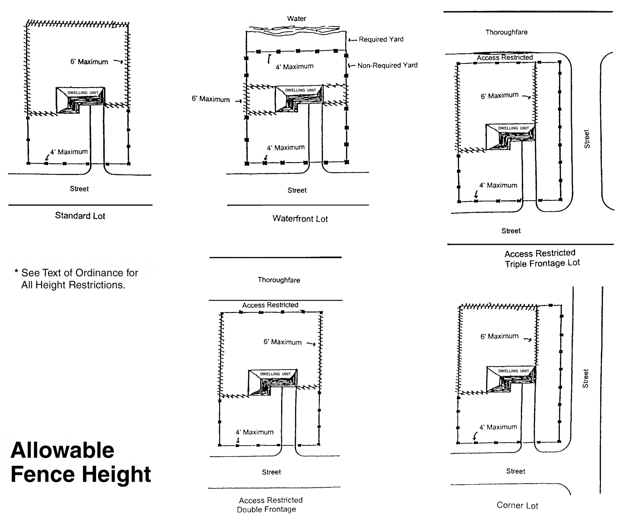
6.2.4 Fences, walls and screens. To protect the use and enjoyment of residential property by providing for the passage of air and light; to protect public welfare and safety by providing for the safe movement of motor vehicles and pedestrians, by ensuring that property is not adversely impacted by any fence or hedge and by ensuring that fences and hedges do not detract from the aesthetic enjoyment of the community and to facilitate police and fire fighting services, no person shall erect, construct, modify, maintain, plant or grow any fence or hedge in the R-1A, R-1B, R-1C, R-1D and R-1E Districts (or other area in the township being used as residential property) in violation of this chapter. Fence requirements for the remaining zoning districts are specified within the text of each district description.
1)
Definitions:
a)
"Corner lots" means all lots with a side property line that abuts a street are considered a corner lot. The street which is not the principal street shall be considered a secondary street and as such fencing adjacent to the secondary street shall comply with the requirements for a secondary front yard.
b)
"Dead space" is any space that is created by the installation of a fence that is not maintained or able to be accessed for purposes of maintenance.
c)
"Fence" means any wall (except a retaining wall), screen, partition, or similar structure existing on a yard, which either encloses or divides land into distinct areas, separates contiguous properties, obstructs the passage of light and air into adjacent land, or obstructs the vision of motorists or pedestrians on or near public roads.
d)
"Hedge" refers to a dense row of low branching trees, shrubs, vines, or other plant species which encloses land, divides land into distinct portions, separates contiguous properties, obstructs the passage of light and air onto adjacent land or obstructs the vision of motorists or pedestrians on or near public roads.
e)
"Height" shall be measured as the vertical distance from the highest point of the fence or hedge to the average grade of the ground immediately beneath the fence.
f)
"Major repair" refers to repairs made directly to the structural portion of the fence.
g)
"Minor repair" means repairs dealing primarily with nonstructural portions of the fence, as well as appearance.
h)
"Perimeter fence" means a fence that is intended to provide full or partial enclosure of a property along or near the property lines. A perimeter fence is not a fence that is intended only to provide limited screening of a specific element within the property or enclose a small portion of the property for a specific purpose, such as a garden or dog run.
i)
"Principal front yard" shall mean, for purposes of this section, the area between the principal street (right-of-way) and the front of the dwelling unit or in the event that there is no dwelling unit, the front yard shall be the property line that is parallel to the principal street (right-of-way).
j)
"Principal street" shall mean, for purposes of this section, the street on which the dwellings street address is located, or if there is no dwelling, it is the street that is most logically considered as providing the primary access to the property.
k)
"Secondary front yard" shall mean, for purposes of this section, the area between the secondary street (right-of-way) and the dwelling unit or in the event that there is no dwelling unit, the secondary front yard shall be the property line that is parallel to the secondary street (right-of-way).
l)
"Secondary street" shall mean, for purposes of this section, a street that abuts a property that also abuts a "principal street".
m)
"Solid" shall mean any fence, wall, screen, planting, hedging, or shrubbery which is of a continuous nature constructed of either natural or manufactured materials.
2)
Limitations:
a)
Within the limits of the principal front yard:
(1)
No solid fence or hedge shall exceed a height of three (3) feet, unless subsection 6.24(2)a)(2) below applies.
(2)
A fence may be erected or maintained to a height above three (3) feet, but not to exceed a height of four (4) feet, if the fence meets all of the following:
a)
The fence consists of open spaces uniformly distributed along its surface, or minimally above a height of three (3) feet, so that vision through the fence is not materially obstructed from any angle so as to obstruct the view of vehicular or pedestrian traffic on adjacent streets or public ways.
(3)
A hedge may be planted, grown or maintained to a height above three (3) feet if the hedge meets all of the following requirements:
(a)
The property owner prepares and submits to the community development department a drawing of the hedge indicating the location, height and type of plant material to be used.
(b)
The abutting road is a public collector or arterial street as defined by the Ingham County Road Commission.
(c)
All abutting property owners submit a written statement that they do not object to the plan.
(d)
The plan is approved by the director of community development or his/her designee.
b)
Within the limits of the secondary front yard:
(1)
No solid fence or hedge shall exceed a height of three (3) feet unless all of the following conditions are met, in which case the fence may be no greater than six (6) feet in height:
(a)
That the fence is setback a minimum of ten (10) feet from the street right-of-way; and
(b)
The area between the street right-of-way and the fence shall be landscaped as follows:
1.
One (1) evergreen tree for each thirty (30) lineal feet of frontage, or fraction thereof.
2.
Trees shall be spaced and located to provide the safest and most aesthetically pleasing arrangement for both the subject property and the public. In addition, no tree shall be planted closer than fifteen (15) feet to the side lot line and no tree shall be planted closer than twenty (20) feet in any direction of the intersection of the edge of a driveway and any street, and within twenty (20) feet of the intersection of any sidewalk or right-of-way line.
3.
One shrub shall be required for every ten (10) lineal feet or fraction thereof.
4.
Required shrubs shall be no smaller than a standard nursery three-gallon size.
5.
Required evergreens shall be no smaller than three (3) feet in height if they are spruce or fir and no smaller than four (4) feet in height if they are pine.
6.
Properly maintained turf, shredded bark, stone or groundcover plants shall be required between the fence and the right-of-way line. Mass wildflower plantings or weeds are not acceptable groundcover plants.
7.
The director of community development may, in the director's discretion, approve alternative spacing arrangements, alternate plant materials and alternative numbers of plant materials if the application of the ordinance as written would not accomplish the purpose of this Ordinance. Any deviation permitted by the community development director shall be written on the building permit for construction of the subject fence.
8.
The director of community development may, in the director's discretion, allow the reduction in the setback requirement of ten (10) feet from the right-of-way in the event that there are extenuating circumstances present on the site which, if enforced, would not accomplish the purpose of this Ordinance. Any deviation permitted by the community development director shall be written on the building permit for construction of the subject fence.
(2)
A fence may be erected or maintained to a height above three (3) feet, but not to exceed a height of four (4) feet, if the fence meets all of the following:
(a)
The fence consists of open spaces uniformly distributed along its surface, or minimally above a height of three (3) feet, so that vision through the fence is not materially obstructed from any angle so as to obstruct the view of vehicular or pedestrian traffic on adjacent streets or public ways.
c)
Within the limits of the required side or rear yard: No fence shall be erected which exceeds a height of six (6) feet above grade unless the following requirements are met:
(1)
All abutting property owners submit a written statement that they do not object to the plan.
(2)
The elevation of the subject property is generally one (1) or more feet lower than abutting properties, or the health and safety of the owner or occupant of the subject property is endangered by uses on any abutting property.
d)
General requirements:
(1)
Clear vision area. No solid fence or hedge shall obstruct vision between a height of three (3) and ten (10) feet within twenty (20) feet in any direction of the intersection of the edge of a driveway and any street or sidewalk.
(2)
Swimming pools. A fence must enclose any swimming pool that is twenty-four (24) inches or more in depth at any point. Such pool enclosure fences must be at least four (4) feet in height with self-closing latching gates.
(3)
Fence orientation. Fencing shall be installed with the structural members or framing directed inward toward the property.
(4)
Underground utilities. Property owners shall be responsible for locating all underground utilities prior to beginning construction by contacting MISS DIG or consulting other appropriate sources of utility location information.
(5)
Easements. Fencing and hedges shall not be placed within established property easements.
(6)
Surveys. It is strongly recommended that prior to the placement of a fence or hedge the owner obtain a certified survey of the property in order to ensure that the fence or hedge will be located entirely within the property boundaries.
a)
The issuance of a building permit by the community development department for the placement of a fence does not constitute verification that the fence is located within the property lines and Delhi Charter Township shall bear no responsibility if the fence or hedge is improperly located on adjacent property.
(7)
Permit required. No person shall erect, alter the location of, place or allow to be placed, any fence without first obtaining a building permit from the department of community development, except as otherwise noted in this section.
(8)
Fee required. A fee may be established by resolution of the township board and will be required to be paid to the community development department prior to the issuance of any building permit.
3)
Location requirements:
a)
It is property the owner's responsibility to verify that any fence (or hedge) is placed within their property lines.
b)
No part of any fence or hedge may extend into the public right-of-way or a permanent access or utility easement.
c)
No fence or hedge shall be located in a manner as to create "dead space" between an existing fence or building and the proposed fence or hedge.
4)
Materials:
a)
Fences shall be constructed of one (1) or more of the following: Chain link, wood, brick, concrete, plastic, vinyl or other material that is approved by the community development director or a designee.
b)
Materials such as, but not limited to, scrap wood, metal panels, extrusions, stampings, forging or other materials of a similar nature are not intended for use as fence and shall not be permitted.
5)
Barbed wire and electric current: No fence in one of the zoning districts listed in this chapter, or on a parcel being used as residential, shall utilize barbed wire, razor wire, or a similar type of wire, or carry an electrical current. This provision is not intended to limit the use of these types of fencing in the A-1 Agriculture District when the use of such materials is necessary to carry out farm operations including the keeping of livestock or animals.
6)
Maintenance requirements; unsafe or dangerous fences: Fencing shall be considered unsafe, dangerous, or not maintained if any of the following conditions are met:
a)
Whenever the fence area is in need of paint or other minor repair.
b)
Whenever any portion of the fence or hedge has been damaged by wind, flood, fire or other cause in such a manner that structural strength or stability is appreciably less than it was previous to such event.
c)
Whenever any portion or structural member of the fence is likely to fall or to become detached or dislodged, or to collapse and thereby injure persons or damage property.
d)
Whenever more than ten (10) percent of the fence area is in need of structural repair.
6.2.5 Temporary structures.
1)
The director of community development may administratively authorize construction trailers, etc. On a construction job site for housing materials, construction office use, or as a temporary housing for security personnel. Such structures must be removed upon completion of the construction, or if the work ceases for more than ninety (90) days. Said authorization shall be for one (1) year and is available for all zones.
2)
If a permanent commercial or industrial structure has been damaged by fire, wind or other cause, a temporary structure may be authorized by the director of community development for the duration of the rebuilding process. Said temporary structures may be used in any commercial or industrial zone and the authorization shall not exceed six (6) months.
3)
Temporary structures may be authorized by the director of community development for conducting business activities during the building of a permanent structure. This authorization shall be available in commercial zones only and shall not extend for more than one (1) year.
4)
Temporary structures incidental to religious activities may be allowed in any zone for a period to be determined by the director of community development for no more than two (2) weeks in any three hundred sixty-five-day period.
5)
The reasonable protection of health, safety and general welfare shall be demonstrated by the user for each temporary structure.
6.2.5.1 Temporary storage containers. Temporary storage containers that are typical of the type available from commercial sources and which do not exceed eight (8) feet in width by sixteen (16) feet in length and are not vehicles or trailers are permitted in the A-1, R1-A, R1-B, R1-C, R1-D and R1-E Districts for a period of time not to exceed one hundred eighty (180) days in any three hundred sixty-five-day period. A maximum of two (2) temporary storage containers are permitted at any one (1) time per parcel of property and must be located outside of any road right-of-way or public space and be located in such a manner that emergency access to all structures and proper sight distance from any drive, intersection and/or sidewalk is maintained. Temporary storage containers must be secured to prevent unauthorized entry at all times.
(Ord. No. 39.59, 6-6-95; Ord. No. 39.76, 9-1-98; Ord. No. 39.89, § 1, 1-18-00; Ord. No. 39.104, 1-20-04; Ord. No. 39.114, 12-20-05; Ord. No. 39.137, 6-5-07; Ord. No. 39.155, § XIII, 2-16-10)
Allowable Fence Height
Section 6.3 - Supplementary area regulations.
6.3.1 Exception to required lot area for residential districts. Any residential lot created and recorded prior to the effective date of this Ordinance may be used for any permitted use even though the lot area and/or dimensions are less than those required for the district in which the lot is located, provided:
1)
That the other requirements of the district are met.
2)
That no lot shall be so reduced in area that the required open spaces will be smaller than those established as a minimum for the district in which the lot is located.
3)
That any lot so excepted shall be no less than forty-four (44) feet in width.
6.3.2 Lot area can be allocated once. No portion of a lot can be used more than once in complying with the provisions for lot area and yard dimensions for the construction of a proposed or the alteration of an existing building.
6.3.3 Accessory building. An accessory building shall not occupy more than thirty (30) percent of the area of any rear yard.
Section 6.4 - Supplementary yard regulations.
6.4.1 Front yard reductions. Any front yard in an R-1A, R-1B, R-1C or R-1D or R-1E District may be reduced below the minimum required in accordance with the exceptions permitted in article V, subsection 5.3.4(4).
6.4.2 Rear yard reduction. When a lot of record in any residential district has a depth of less than one hundred fifteen (115) feet prior to the effective date of this Ordinance, the rear yard of such lot may be reduced one-fourth of the distance the lot depth is less than one hundred fifteen (115) feet, provided that no rear yard shall be less than twenty (20) feet in depth.
6.4.2.1 Corner lots. When a lot of record is a corner Lot, as defined by this Ordinance, there are two
(2) front yards, one (1) side yard and one (1) rear yard. On a corner lot, the rear
yard may be deemed the side yard and the side yard may be deemed the rear yard for
purposes of determining setbacks, provided that the deemed rear yard meets the rear
yard setback requirements specific to the zoning district.
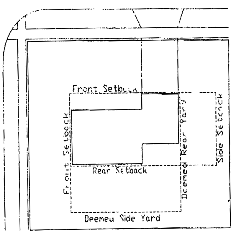
Corner Lots
6.4.3 Permitted yard encroachments:
1)
Paved terraces, patios, decks, uncovered porches and similar areas shall not be subject to yard requirements, provided:
a)
Such area is unroofed and without walls, or other forms of solid, continuous enclosure that link the area to the principal building. Such areas may have an open railing or fence not over three (3) feet high and may have noncontiguous windbreaks or visual screen fences or walls, not including the house or structure, not over six (6) feet high and not enclosing more than one-half the perimeter of the area.
b)
The highest finished elevation of the area is not over three (3) feet above the average surrounding finished ground grade.
c)
No portion of any area is closer than five (5) feet from any lot line or projects into any front yard setback area, unless the area is open on all sides and has no roof in which case it may project into a required front yard setback to a maximum of six (6) feet.
2)
Unenclosed porches, terraces, decks and similar areas that do not have roofs, may project into a required side or rear yard a distance not to exceed eight (8) feet, provided:
a)
The area is unenclosed, no higher than one-story, and is erected on piers.
b)
The area shall not be closer than eight (8) feet at any point to any side or rear lot line.
3)
Porches, patios, terraces, decks and similar areas, enclosed or unenclosed that have a permanent roof that covers more than one-half of the square footage of the porch, patio, terrace, deck or similar area, shall be considered an integral part of the building and shall be subject to all yard and area dimensional requirements established for principal buildings.
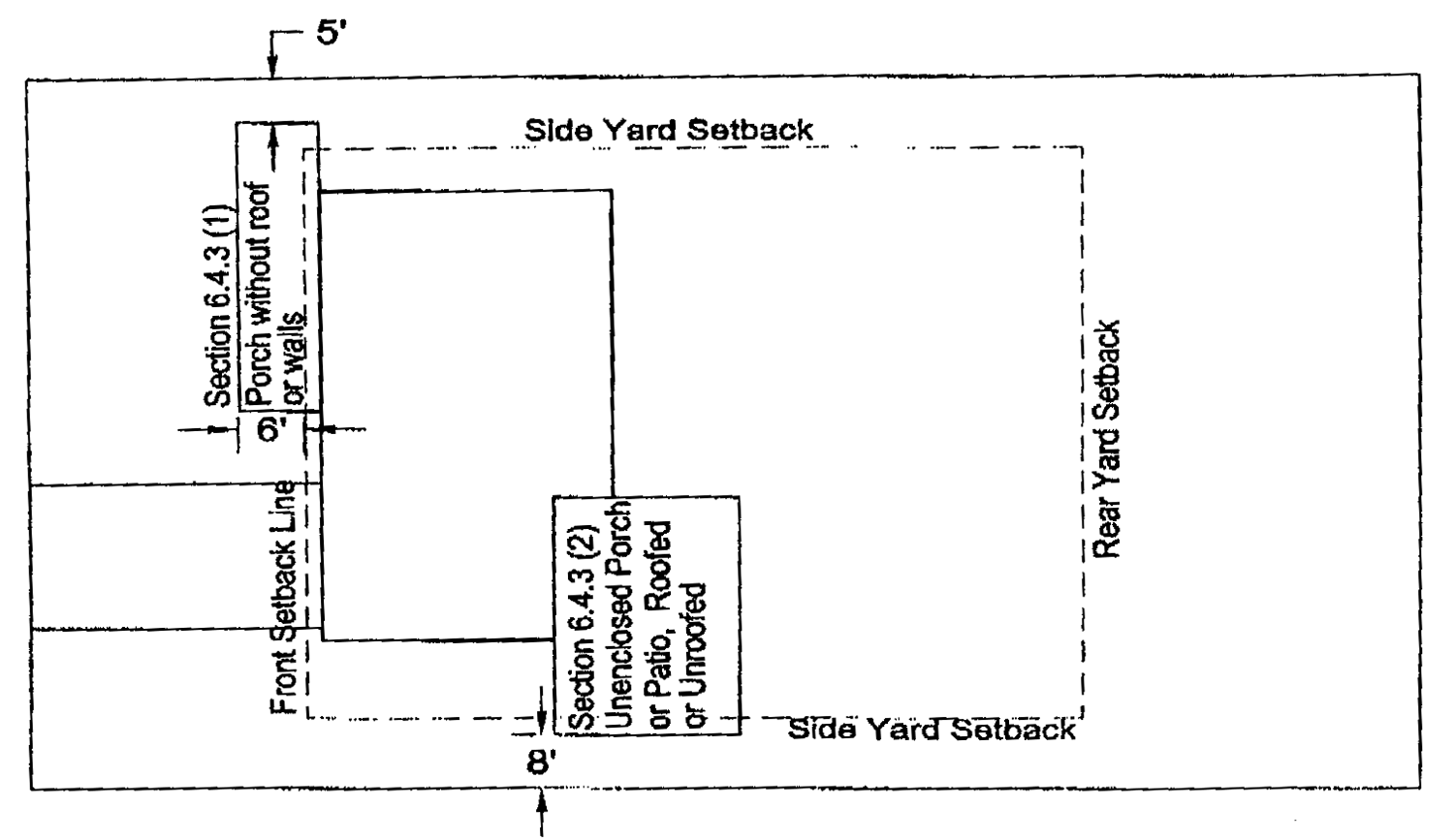
Enclosed porches, terraces, decks, etc.
4)
Special structural elements, such as cornices, sills, chimneys, trellis, eaves and similar structural features may project into the yard area up to a maximum of two and one-half (2½) feet.
5)
Fire escapes, outside stairways and balconies, if of open construction, may project into the yard area up to a maximum of five (5) feet.
6.4.4 Accessory buildings:
1)
In a front yard: No accessory building shall project into any front yard, except that properties containing five (5) or more acres may have an accessory building in the front yard provided it is setback at least two hundred (200) feet from the road right-of-way.
2)
In a rear yard: No accessory building, including detached garages, shall be closer than five (5) feet to any lot line.
3)
In a side yard: No accessory building, including garages, shall be erected closer to the side lot line than the permitted distance within that district for principal buildings except in a residential district where an accessory building is located ten (10) feet or more to the rear of the principal building; then the accessory building shall be no closer than three (3) feet to the side lot line.
4)
On a corner lot: No accessory building shall be closer to the side street lot line than the side yard setback of the principal building on the lot. Where the rear line of a corner lot coincides with the side line of an adjoining lot in a residential district, an accessory building shall not be closer than three (3) feet to the common lot line.
5)
Garage entrance: In no case shall the entrance to a garage be less than twenty-five (25) feet from a street right-of-way line.
6.4.5 Swimming pools.
1)
Inground and above ground swimming pools and related decks are subject to the same setback and lot coverage requirements as accessory buildings.
(Ord. No. 39.63, 1-2-96; Ord. No. 39.104, 1-20-04; Ord. No. 39.133, 6-5-07; Ord. No. 39.163, § II, 5-6-14)
Section 6.5 - Supplementary height regulations.
6.5.1 Permitted exceptions, structural appurtenances. The following kinds of structural appurtenances shall be permitted to exceed the height limitations for authorized uses:
1)
Ornamental in purpose, such as church spires, belfries, cupolas, domes, ornamental towers, flag poles and monuments.
2)
Appurtenances to mechanical or structural functions, such as chimneys and smoke stacks, water tanks, elevator and stairwell penthouses, ventilators, bulkheads, radio and television towers, aerials, television antennas, fire and hose towers and cooling towers.
3)
The foregoing permitted exceptions shall not be used for human occupancy.
6.5.2 Permitted exceptions, residential districts. There shall be no exceptions permitted for residential structures; certain nonresidential structures in residential districts may be permitted to exceed height limitations as specified in article VIII, section 8.2, "Special Uses Authorized by Special Use Permits, Nonresidential Uses in Residential Districts".
6.5.3 Permitted exceptions, commercial and industrial districts:
1)
In any commercial or industrial district, any principal building may be erected to a height in excess of that specified for the district, provided each front, side and rear yard is increased one (1) foot for each one (1) foot of such additional height above the maximum.
(Ord. No. 39.155, § XIV, 2-16-10)
Section 6.6 - Floodplain regulations.
6.6.1 Intent and purpose. The purpose of these regulations is to protect those areas of the township which are in the identified floodplain areas so that the reservoir capacity shall not be reduced or modified in a manner that would create danger to areas previously not endangered in time of high water, or to impede, retard, accelerate or change the direction of the flow or carrying capacity or to otherwise increase the possibility of flooding. All land included in the floodplain area shall be subject to the requirements specified herein, in addition to the normal zoning district requirements in which said land is located.
6.6.2 Floodplain areas. As designated by the U.S. Army Corp of Engineers, the Federal Emergency Management Agency - Flood Insurance Rate Maps or as authorized by the township engineer, the intermediate regional floodplain information shall be mapped and superimposed on the official zoning map entitled "Zoning Districts of Delhi Township, Ingham County, Michigan" so as to delineate flood areas as they relate to each district. Delineation of such flood areas shall be based upon reasonable flood expectancy, as determined by flood history, and shall be restricted as to use and occupancy so that human life is protected and future flood damage is minimized.
6.6.3 Permitted uses. Notwithstanding any other provisions of this Ordinance, no building or structure shall be erected, converted or structurally altered and no land and/or structure shall be used except for one (1) or more of the following uses:
1)
Open space uses, such as farms, nurseries, parks, playgrounds, golf courses, preserves, bridle trails, nature paths, private or commercial recreation, and other similar open uses.
2)
Off-street parking uses, provided that all parking shall be at preconstruction grade level and in conformance with the provisions of article VI.
3)
Utilities, roads, railroads, dams, rivers, structures and buildings for public or recreational uses, when designed so as not to increase the possibility of flood or be otherwise detrimental to the public health, safety or welfare.
4)
Yard and setback areas required for any district within the floodplain areas may be included within the floodplain areas.
6.6.4 Uses permitted by special use permit. The following use of land or structures may be permitted within the floodplain area by the issuance of a special use permit. Prior to the issuance of a special use permit, the township engineer must find that the requirements of this section have been satisfied. Further, applicants must furnish any and all engineering, design, topographic or other data necessary, relevant to the proposed use, as deemed necessary by the township engineer to make said finding:
1)
Dumping or backfilling in the floodplain areas with any material in any manner unless, through compensating excavation and shaping of the floodplain, provided the flow and natural impoundment capacity of the floodplain will be maintained or improved so that no significant or measurable change in flow or reduction in impoundment capacity of the floodplain would thereby result.
2)
The storage of materials or equipment, provided such elements shall not cause any significant obstruction to the flow or reduction in the water impoundment capacity of the floodplain.
3)
A structure intended for human occupancy as a place of residence, place of public gathering or employment, regardless of whether habitation is continuous or periodic in nature, subject to the following conditions:
a)
The proposed construction, including any basement, is elevated at least three (3) feet above the established floodplain elevation.
b)
The structure will not cause any significant obstruction to the flow or reduction in the water impoundment capacity of the floodplain.
c)
That the structure and its location have been approved by the Federal Emergency Management Agency (FEMA).
d)
Upon completion of a permitted structure, the owner shall submit to the director of community development an elevation certificate showing the final elevation of the lowest habitable floor level, the highest and lowest adjacent grade elevations and the elevation of the floodplain.
6.6.5 Data submission requirements for development adjacent to floodplain areas. Prior to the issuance of a building permit for structures adjacent to or in close proximity to floodplain areas the applicant shall submit topographic data, engineering studies, proposed site plan, or other data needed to determine the possible effects of flooding on a proposed structure and/or the effect of the structure on the flow of water. All such required data shall be prepared by a licensed professional qualified to perform such work.
(Ord. No. 39.64, 3-20-96; Ord. No. 39.104, 1-20-04; Ord. No. 39.158, § I, 4-3-12)
Section 6.7 - Nonconforming uses.
6.7.1 Intent and purpose. It is the intent of this Ordinance to permit the continuance of a lawful use of any building or land existing at the effective date of this Ordinance, although such use of land or structure may not conform with the provisions of this Ordinance.
Further, it is the intent of this Ordinance that nonconformities shall not be enlarged upon, expanded or extended, nor be used as grounds for adding other structures or uses prohibited elsewhere in the same districts. The continuance of all nonconforming uses and structures within Delhi Charter Township shall be subject to the conditions and requirements set forth in this section.
6.7.2 Structural changes or enlargement. The building or land use that is nonconforming shall not be structurally changed, altered or enlarged unless the resultant changed, altered or enlarged building or use conforms to the provisions of this Ordinance for the district in which it is located.
6.7.3 Repair of nonconforming buildings. Nothing in this Ordinance shall prohibit the repair, improvement or modernization of a lawful nonconforming building to correct deterioration, obsolescence, depreciation and wear.
6.7.4. Reconstruction and restoration. Any lawful nonconforming use damaged by fire, explosion, an act of God, or by other causes, may be restored, rebuilt or repaired, provided that the damage does not exceed more than eighty-five (85) percent of the real valuation of the building, exclusive of land and foundation, and provided that said use be the same or more nearly conforming with the provisions of the district in which it is located.
6.7.5 Discontinuance or abandonment. When any legal nonconforming use has been discontinued for the continuous period of one (1) year or for eighteen (18) months during any three-year period, such discontinuation shall be considered conclusive evidence of an intention to legally abandon the nonconforming use. At the end of this period of abandonment, the nonconforming use shall not be re-established, and any future use shall be in conformity with the provisions of this Ordinance. Prior to termination of a nonconforming use due to abandonment or discontinuation, the township shall provide written notice of its intent to terminate such nonconforming use to the property owner identified in the township's most recent property tax rolls, by personal delivery or by first class mail. Said notice shall provide the date, time and place where and when a public hearing will be held on the question of such abandonment or discontinuance. The public hearing shall be conducted by the township board with a final determination made by the same.
6.7.6 Changing uses. If no structural alterations are made, the board of appeals may authorize a change from one (1) nonconforming use to another nonconforming use, provided the proposed use would be more suitable to the zoning district in which it is located than the nonconforming use which is being replaced. Whenever a nonconforming use has been changed to a more nearly conforming use or to a conforming use, such use shall not revert use or be changed back to a nonconforming or less conforming use.
6.7.7 Prior construction approval. Nothing in this Ordinance shall prohibit the completion of construction and use of a nonconforming building for which a building permit has been issued prior to the effective date of this Ordinance, provided that construction is commenced within sixty (60) days after the date of issuance of the permit and that the entire building shall have been completed according to plans filed with the permit application within one (1) year after the issuance of the building permit.
6.7.8 Termination of nonconforming land uses. The nonconforming uses of land existing at the effective date of this Ordinance where no building is located may be continued, provided that the nonconforming land use shall be terminated and converted to conform with the provisions of the current Zoning Ordinance within three (3) years after the effective date of this Ordinance; and provided further that the nonconforming land use shall not in any way be expanded or extended during this three-year interval, either on the same property or adjoining property.
6.7.9 Illegal nonconforming uses. Nonconforming uses of buildings or land existing at the effective date of this Ordinance established without a building permit or not shown on the tax records as a nonconforming use prior to the last official assessment roll, or those nonconforming uses which cannot be approved conclusively as existing prior to the effective date of this Ordinance, shall be declared illegal nonconforming uses and shall be discontinued within a period of three (3) years following the effective date of this Ordinance.
6.7.10 District changes. Whenever the boundaries of a district shall be changed so as to transfer an area from one (1) district to another classification, the provisions of this section shall also apply to any existing uses that become nonconforming as a result of the boundary changes.
6.7.11 Marihuana/marijuana. No commercial medical marihuana facility nor commercial medical marihuana activity operating or purporting to operate prior to December 15, 2017, shall be deemed to have been a legally existing use nor shall the operation of such marihuana facility or use be deemed a legal nonconforming use under this Ordinance. The township may take all legal measures to abate such activity upon discovery of such activity.
6.7.12 No vested rights. A property owner shall not have vested rights or nonconforming use rights that would service as a basis for failing to comply with section 6.7.11 of this Ordinance or any amendment thereto.
(Ord. No. 39.104, 1-20-04; Ord. No. 39.152, § III, 5-31-09; Ord. No. 39.165, §§ III, IV, 5-16-17)
Section 6.8 - General exceptions.
6.8.1 Essential services. Essential services shall be permitted as authorized and regulated by law and other ordinances, it being the intent hereof to exempt such essential services from the application of this Ordinance.
Section 6.9 - Signs and advertising structures.[3]
6.9.1 Intent and purpose.
A.
The intent of this section is to regulate the location, size, construction, and manner of display of signs and outdoor advertising in order to minimize their harmful effects on the public health, safety and welfare. While this section recognizes that signs and outdoor advertising are necessary to promote commerce and public information, failure to regulate them may lead to poor identification of individual businesses, deterioration and blight of the business and residential areas of the township, conflicts between different types of land use, and reduction in traffic safety to pedestrians and motorists.
B.
The regulations contained in this section involve a recognition that the individual user's right to convey a message must be balanced against the public's right to be free of signs which unreasonably compete, distract drivers and pedestrians and produce confusion. In balancing the individual user's desire to attract attention with the citizens' right to be free of unreasonable distractions, it is recognized that sign regulations provide business with equal opportunity to attract the public. However, oversized, projecting or crowded signs can lead to pedestrian and driver confusion and distraction, and endanger the public health, safety and welfare.
C.
In addition to the above purposes:
1.
Signs should be able to reasonably convey their message;
2.
Users of property should have reasonable freedom to determine the placement, construction, size, and design of signs; and
3.
Sign needs may vary based on zoning districts.
D.
Regulations for signs, especially those related to number, size and placement, are desirable in order to:
1.
Prevent or limit traffic or pedestrian accidents, injuries, deaths, and property damages resulting from obstructed vision, distraction or confusion to the public or to emergency safety personnel;
2.
Minimize the risk of damage and injuries from signs that are dilapidated, wind blown, electric shock hazards, etc.;
3.
Achieve some uniformity in the size, number and placement of signs;
4.
Enhance the aesthetics of the community;
5.
Prevent blight;
6.
Encourage equality among business and property; and
7.
Otherwise protect the public health, safety, peace and general welfare.
6.9.2 Definitions. The following definitions pertain to signs that are either allowed or prohibited. Additional definitions related to this section may be found in article X.
A.
Awning: A retractable or fixed shelter constructed of nonrigid materials on a supporting framework that projects from the exterior wall of a building.
B.
Awning sign: A sign affixed flat against the surface of an awning.
C.
Balloon sign: A sign composed of a nonporous bag of material filled with air or gas.
D.
Banner sign: A fabric, plastic, or other sign made of nonrigid material without an enclosing structural framework.
E.
Billboard: A sign which relates to or advertises an establishment, product, merchandise, good, service or entertainment which is not located, sold, offered, produced, manufactured or furnished at the property on which the sign is located.
F.
Business center sign: Any three (3) or more businesses which meet at least one (1) of the following:
1.
Are located on a single parcel of property.
2.
Are connected by common walls, partitions, canopies, or other structural members to form a continuous building or group of buildings.
3.
Are under one (1) common ownership or management and have a common arrangement for the maintenance of the grounds.
4.
Share a common parking area.
5.
Otherwise present the appearance of a single, contiguous business area.
G.
Business event sign: A sign that relates to or advertises a special event sponsored by a retail, business, institutional or industrial establishment.
H.
Canopy: A freestanding roof-like structure built on one (1) or more support posts designed to offer protection from the weather.
I.
Canopy sign: A sign painted or attached directly to and parallel to the exterior face of a canopy roof.
J.
Construction sign: A sign that identifies the owners, financiers, contractors, architects, and/or engineers of a project under construction.
K.
Contractor sign: A sign that advertises a contractor performing work on site.
L.
Development entry sign: A permanent sign identifying or otherwise stating the name of a subdivision, site condominium development, apartment complex, manufactured housing community, business or industrial park, or other similar development.
M.
Directional sign: A permanent sign that gives directions, instructions, or facility information for the use on the lot on which the sign is located, such as a parking, or exit and entrance sign.
N.
Electronic changeable message sign: A sign capable of changing messages electronically by remote or automatic means.
O.
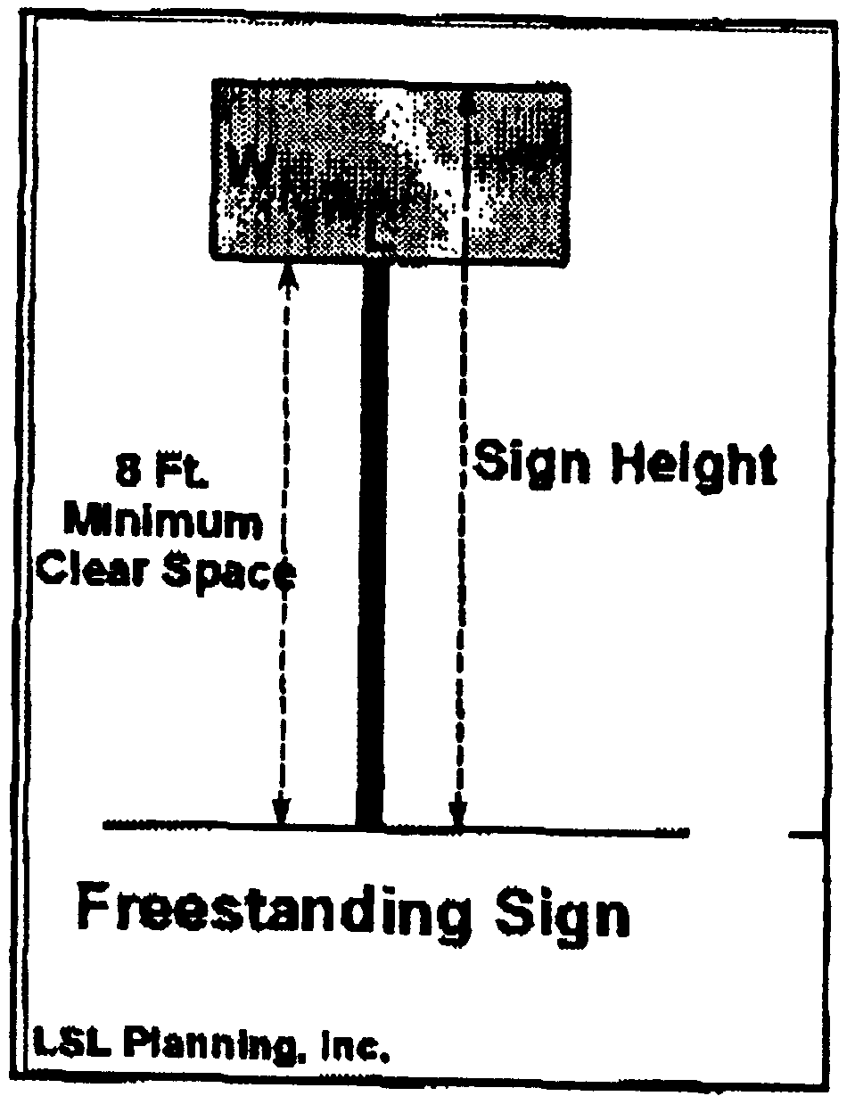
Freestanding sign: A sign supported on poles not attached to a building or wall.
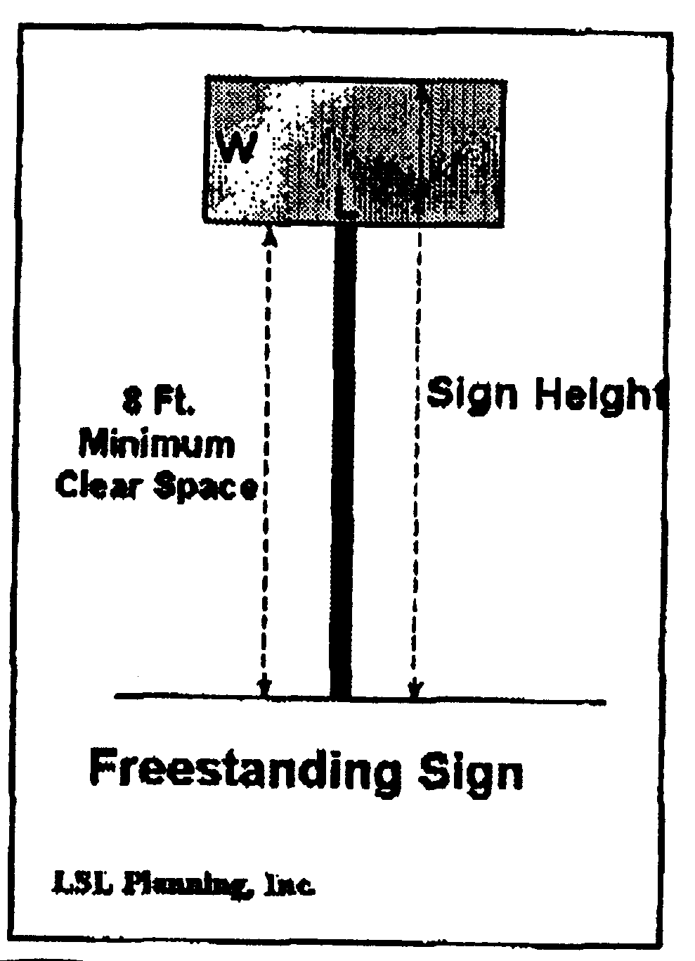
Freestanding Sign
P.
Government sign: A temporary or permanent sign erected by Delhi Charter Township, state or federal government or other appropriate governmental agencies.
Q.
Grand opening sign: A sign intended to advertise or draw attention to a business that is new to a particular location.
R.
Ground sign: A sign resting directly on the ground or supported by short poles not attached to a building or wall.
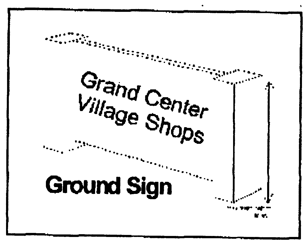
Ground Sign
S.
Identification sign: A sign located on-premises, giving the name or address, or both, of the owner or occupant of a building or premises.
T.
Incidental sign: A sign that identifies street address, entrances and exits, safety precautions, identifying logos without text, and other such incidental information, and which sets forth no other advertisement intended to be read from the street.
U.
Institutional sign: A sign upon which is displayed the name of a church, school, library, community center or similar public or quasi-public institution located on the property to announce its services, events or activities.
V.
Memorial sign: A nonilluminated sign, tablet, or plaque commemorating a historical or significant person, event, structure or site.
W.
Mural: A design or representation painted or drawn on a wall that does not advertise an establishment, product, service or activity.
X.
Placard: A sign, which provides notices of a public nature, such as "No Trespassing" or "No Hunting" signs.
Y.
Political sign: A temporary sign used in connection with an official city, village, township, school district, county, state or federal election, referendum, or public issue.
Z.
Portable sign: A sign designed to be moved easily and not permanently attached to the ground, a structure or a building.
AA.
Projecting sign: A double-faced sign attached to a building or wall that extends from the face of the building or wall.
Projecting Sign
BB.
Reader board: A portion of a sign on which copy is changed manually.
CC.
Real estate sign: A sign advertising the real estate upon which the sign is located as being for sale, rent or lease.
DD.
Roofline: The top edge of a roof or parapet wall, whichever is higher, but excluding any cupolas, chimneys, or other minor projections.
EE.
Roof sign: A sign erected above the roofline of a building.
FF.
Sign: A device, structure, fixture, or placard that may use graphics, symbols, and/or written copy designed specifically for the purpose of advertising or identifying an establishment, product, service or activity.
GG.
Sign frame: The structural members of a sign.
HH.
Special event sign: Temporary and portable signs containing public messages concerning special events sponsored and run solely by governmental agencies or nonprofit organizations.
II.
Subdivision signs: A temporary sign advertising a recorded residential subdivision, residential condominium or residential development.
JJ.
Temporary sign: A sign not permanently attached to the ground, a structure or a building. Temporary signs may include banners, portable signs, and any other sign displayed for a limited period of time.
KK.
Trailer mounted business event sign: A sign that is permanently affixed to a mechanism that is intended to provide mobility to the sign, typically to enable the sign to be towed by a vehicle from one (1) location to another. This sign may or may not have wheels, legs or stabilizers.
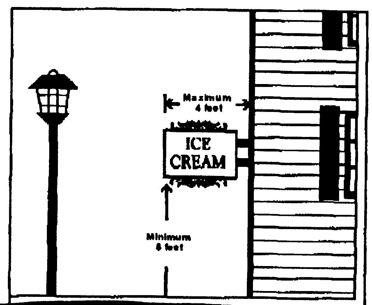
LL.
Wall signs: A sign painted on, or attached directly to an exterior wall, parallel to and extending no greater than twelve (12) inches from the face of the wall to which it is attached.
Wall Sign
MM.
Window sign: A sign affixed to a window and intended to be viewed from the outside.
6.9.3 General sign provisions.
A.
No person shall erect, alter, place or allow to be placed, or replace or any sign without first obtaining a building permit, except as otherwise noted in this section. Major repairs may also require a building permit if repair work is necessary on the sign structure/frame or electrical elements.
B.
Signs, sign supports, braces, guys and anchors shall be maintained free of peeling paint or paper, fading, staining, rust, or other conditions that impairs legibility or intelligibility or any condition that may cause a hazard. Broken or damaged signs or parts of signs shall be repaired or made safe immediately after the damage occurs.
C.
Illumination.
1.
Signs may be internally or externally illuminated, except for wall signs for home occupations and business event signs, which shall not be illuminated. Illumination shall be only by steady, stationary, shielded light sources using approved electrical devices directed solely at the sign, or internal to it. Use of glaring undiffused lights or bulbs shall be prohibited.
2.
Lights shall be directed, shaded and/or shielded downward so as not to project onto adjoining properties or streets.
3.
The provisions listed in subsections 6.9.3(C)(1) and (2) shall not be construed to prohibit the use of electronic changeable message signs, provided such signs meet the criteria of subsection 6.9.3(R).
4.
Sign illumination that could distract motorists or otherwise create a traffic hazard shall be prohibited.
5.
Illumination by bare bulbs or flames is prohibited.
6.
Underground wiring shall be required for all illuminated signs not attached to a building.
D.
No sign shall be erected, relocated or maintained so as to obstruct or prevent free access to any door, window or fire escape.
E.
No sign shall be placed in, upon or over any public right-of-way, or other public place, except as may be otherwise permitted by this section, or placed so as to interfere with the visibility or effectiveness of any official traffic sign or signal; driver vision at any access point or intersection; or, pedestrian movement on any public sidewalk.
F.
No light pole, utility pole, or other supporting member shall be used for the placement of any sign unless specifically designed and approved for that use.
G.
No sign shall be erected in any place where it may, by reason of its position, shape, color, or other characteristic, interfere with, obstruct the view of, or be confused with any authorized traffic sign, signal, or device, or constitute a nuisance per se.
H.
Vehicles, which, in the opinion of the director of community development, have the intended function of acting as signs, shall only be parked in approved parking areas in accordance with the requirements of article VII.
I.
Except as to electronic changeable message signs, no sign shall contain any moving or animated parts nor have the appearance of having any moving or animated parts. No sign shall employ any flashing, moving, oscillating, blinking, or variable intensity light. However, electronic changeable message signs may be permitted, provided that the requirements of subsection 6.9.3(R) are met.
J.
Wall signs.
1.
No wall sign shall be erected to extend above the top of the wall to which it is attached, nor extend beyond the ends of the wall to which it is attached.
2.
Signs erected on the vertical portion of a mansard roof are considered to be wall signs.
3.
All wall signs shall be safely and securely attached to the building by means of metal anchors, bolts, or expansion screws. In no case shall any wall sign be secured with wire, strips of wood or nails.
K.
No sign shall be erected above the roofline of a building.
L.
No obscene message, graphic or profanity, as determined by the director of community development, shall be displayed on any sign.
M.
Only temporary or permanent signs that direct attention to a business or profession conducted as an allowed use or to a principal commodity, service or entertainment sold or offered as an allowed use upon property where the sign is located are permitted, except where expressly provided otherwise in this Ordinance.
N.
Any sign not expressly permitted by this section is prohibited.
O.
Projecting signs.
i.
Projecting signs must clear sidewalks by at least eight (8) feet and project no more than four (4) feet from the building or one-third the width of the sidewalk, whichever is less.
ii.
Except for awnings or canopies, projecting signs must be pinned away from the wall at least six (6) inches.
iii.
Projecting signs are not permitted at the intersection of corners except at right angles to a building front. When a building faces two (2) streets, then one (1) sign per side may be allowed.
iv.
Projecting signs may extend to the bottom of the eaves of a building.
v.
Projecting signs may not extend above the second story.
vi.
No projecting sign may be displayed unless the building to which it is attached is twenty (20) feet or more in width and no projecting sign may be closer than fifty (50) feet to any other projecting sign.
vii.
Projecting signs must project at a ninety-degree angle to the building surface to which it is attached.
viii.
Projecting signs shall be attached directly to a building by means of building mounts or having a mast arm. These support members may also include decorative appurtenances, but external bracing such as guy wires and metal framework shall be prohibited.
Freestanding Sign
P.
Canopy signs shall be mounted flat against the canopy face used to calculate allowable area.
Q.
Electronic changeable message signs and reader boards shall conform to the following provisions:
1.
All ground, wall and freestanding signs may include an electronic changeable message sign or reader board.
2.
Except for governmental signs, the message which appears on the sign shall advertise only the activity conducted on the property where the sign is located.
3.
For electronic changeable message signs, the message shall change at a time interval that permits a person to view the entire message during the time available to do so compatible with safe motor vehicle operation.
4.
All electronic changeable message signs shall be equipped with a dimmer to reduce the amount of light emitted. Signs shall be dimmed from dusk to dawn.
5.
No graphics shall be displayed on the sign that replicate or are similar to the lights used by emergency vehicles, traffic control signals or any other words or graphics that in the sole discretion of the director of community development create a potential hazard to drivers, pedestrians or others.
6.
Size, height and location provisions shall be according to the provisions of section 6.9.9 for the sign type and zoning district.
6.9.4 Exempted signs. The following signs shall be exempt from the provisions of the Delhi Charter Township Zoning Ordinance.
A.
Flags or insignia of any nation, state, county, community organization, or educational institution (if not more than three (3) such flags are located on the same property), provided that the flags are displayed on a flag pole which does not exceed thirty-five (35) feet in height and is permanently anchored to the ground or a permanent structure.
B.
Government signs.
C.
Historical markers.
D.
Memorial signs, memorial flags or tablets.
E.
Murals.
F.
Placards.
G.
Signs for essential services.
H.
Signs not visible from any street or adjacent property.
I.
Signs on a residence with address, owner, or occupant name of up to two (2) square feet in area attached to a mailbox, light fixture or exterior wall.
J.
Window signs not visible from the street or adjacent property.
K.
Signs for garage, yard, basement, and estate sales, or other similar activities in residential districts, provided that any such signs shall not be placed in such a manner as to interfere with the visibility or effectiveness of any official traffic sign or signal; driver vision at any access point or intersection; or, pedestrian movement on any public sidewalk.
6.9.5 Prohibited signs. The following signs and devices shall be prohibited.
A.
Roof signs.
B.
Signs that display a message on road furniture, such as benches, pedestrian lights, and decorative trash receptacles.
C.
Banner signs (unless part of and counted toward the area and number of allowed permanent signs), flags (except as otherwise permitted by section 6.9.4), strings of lights and other similar decorations, unless part of a holiday decoration not associated with any commercial use. Holiday decorations may be displayed for a period not to exceed sixty (60) days.
D.
Balloon signs.
E.
Spotlights, searchlights, blinking lights, flashing lights and other similar lighting.
F.
Portable and/or temporary signs not otherwise permitted by section 6.9.
G.
Pennants, spinner, streamers and other similar devices.
H.
Any sign not expressly permitted by section 6.9.
6.9.6 Nonconforming signs, illegal signs, and signs accessory to nonconforming uses.
A.
Every permanent sign that does not conform to the height, size, area, or location requirements of this section as of the date of the adoption of this Ordinance, is hereby deemed to be nonconforming.
B.
Except as noted in subsection C, below, nonconforming signs may not be altered, expanded, enlarged or extended; however, nonconforming signs may be maintained and repaired so as to continue the useful life of the sign.
C.
A nonconforming sign may be altered without change to its nonconforming status, provided that the sign replacing the original nonconforming sign results in a sign with a size, setback or dimension that is at least thirty (30) percent less than the original amount of nonconformity of the sign when it became nonconforming.
D.
The copy of the sign may be amended or changed without jeopardizing the privilege of nonconforming sign as long as no part of the frame or other supporting structure is altered or replaced.
E.
Any nonconforming sign destroyed by fire or other casualty loss shall not be restored or rebuilt if reconstruction will constitute more than fifty (50) percent of the value of the sign on the date of loss.
F.
Any sign, including nonconforming signs, which for a period of six (6) months or more no longer advertises a bona fide business conducted or product sold shall be removed by the owner of the building, structure, or property upon which the sign is located.
6.9.7 Sign units of measurement.
A.
Area:
1.
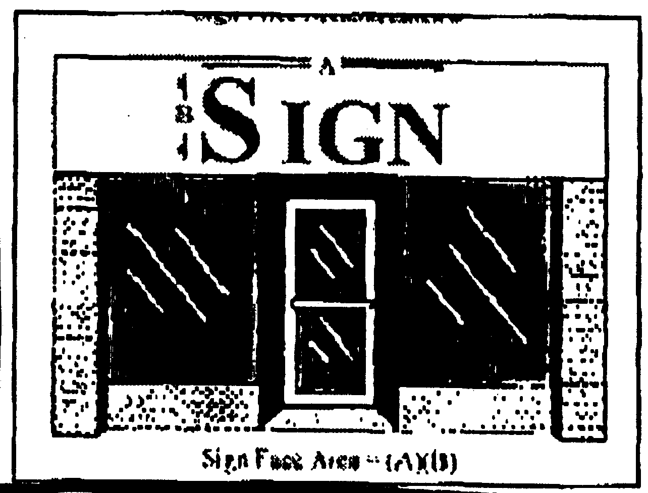
The area of a sign shall be expressed in square feet within a single continuous perimeter of straight lines enclosing the extreme limits of a single advertising message of writing, representations, emblems or figures of a similar character, together with all material or color forming an integral part of the display or used to differentiate the sign from the background against which it is placed.
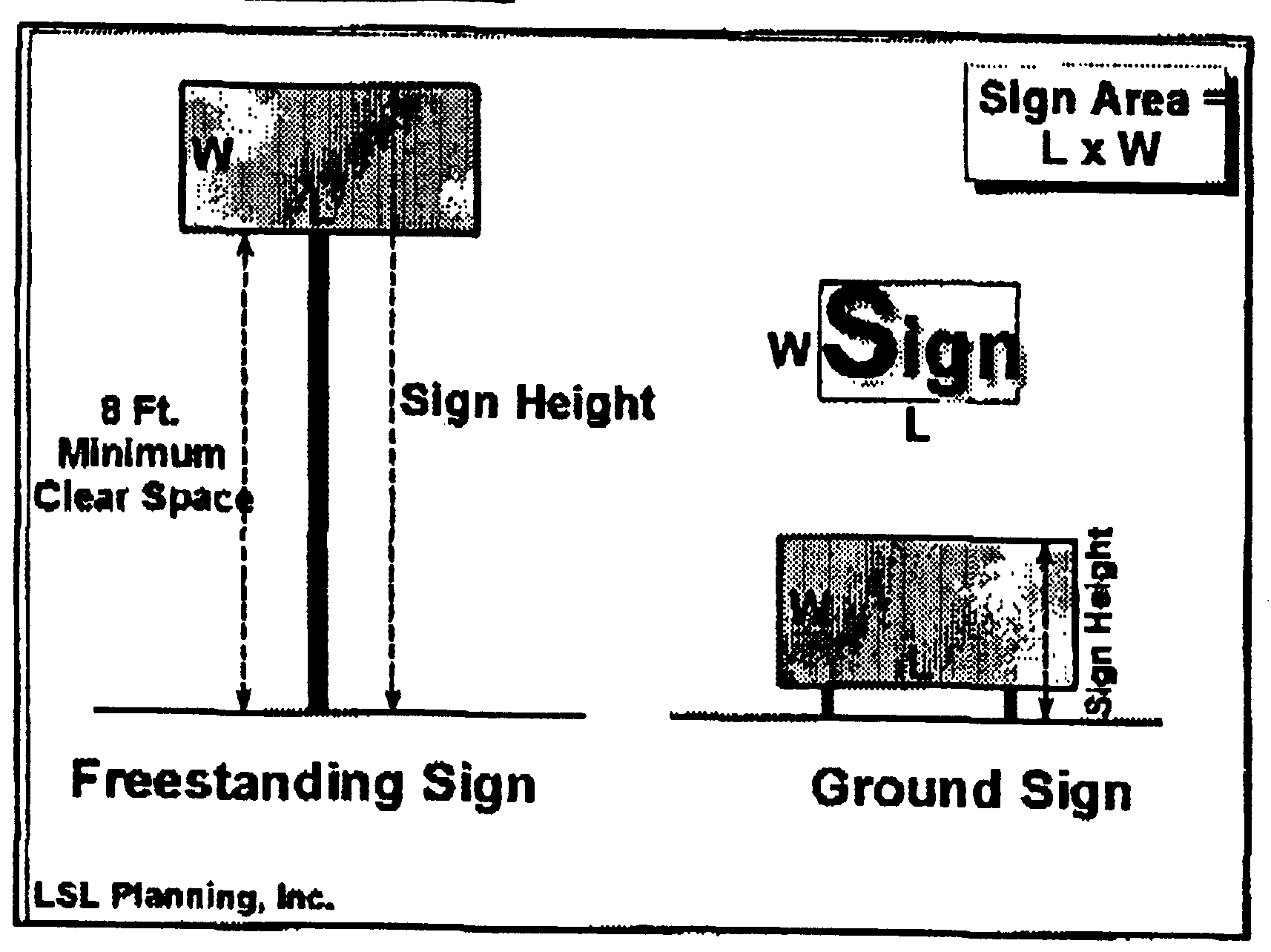
Sign Area
2.
If a sign has only one (1) exterior face, the surface display area of that face shall not exceed the specified maximum. If a sign has two (2) exterior faces, the surface display area of each face shall not exceed the specified maximum. If a sign has more than two (2) exterior faces, the sum of the surface area of all the faces shall not exceed twice the specified maximum.
3.
The supports, uprights or structure, including decorative elements, such as pillars, brick supports, and other similar structures on which any sign is supported shall not be included in determining the surface display area unless such supports, uprights, structure or decorative elements are designed in such a manner as to form an integral background of the display.
4.
The areas of lamps, neon tubing or artificial illumination on walls of any structure shall be counted as part of the total allowable sign area.
5.
Only the vertical, flat spaces of a canopy structure (excluding supports) shall be used to calculate total sign area permitted for canopy signs.
B.
Height:
1.
The height of a sign shall be measured as the vertical distance from the highest point of the sign to the grade of the adjacent street or the average grade of the ground immediately beneath the sign, whichever is lower.
2.
Berms or other supporting measures used to increase the height of the sign shall be included in the computation of sign height.
C.
Grades:
1.
For purposes of this section, average grade shall mean the ground elevation established for the purpose of regulating the height of the sign.
2.
The average grade shall be the level of the ground adjacent to the base of the sign if the finished grade is level or the grade of the adjacent street, whichever is lower. If the ground is not entirely level, the average grade shall be determined by averaging the elevation of the ground within ten (10) feet of the base of the sign.
D.
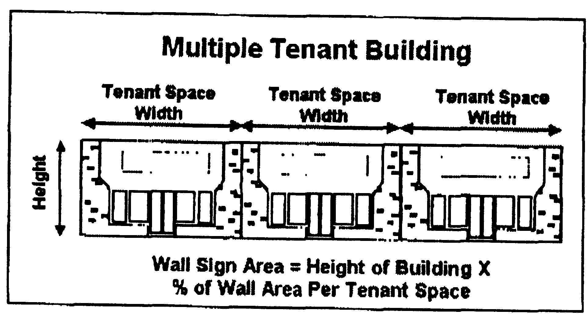
Multiple tenant buildings:
1.
For buildings with multiple tenants requiring individual signs, the sign areas for wall signs, projecting signs, and awning signs shall be determined by taking that portion of the front wall of the building, applicable to each tenant space, and computing sign requirements for that portion of the total wall.
2.
In the case of a corner lot, the wall area adjacent to the tenant space on the second street frontage shall be used to calculate the sign area for a second wall sign, awning sign, or projecting sign.
3.
Each sign shall be attached to the same wall used to determine its size.
6.9.8 Permits required.
A.
It shall be unlawful to display, erect, relocate, or alter any sign without obtaining a sign permit, except those signs as outlined in subsection 6.9.8(C) below. The department of community development shall issue a permit only if the proposed sign meets all requirements of the Ordinance.
B.
All signs shall be designed to comply with minimum wind pressure and other requirements set forth in the adopted building code. Signs with electrical connections shall comply with electrical code requirements, including the application, inspection, and approval of an electrical permit.
C.
The following signs shall not require a sign permit:
1.
Directional signs.
2.
Placards.
3.
Government signs.
4.
Political signs.
5.
Special event signs.
6.
Window signs.
D.
It shall be unlawful to change, modify, alter, or otherwise deviate from the terms or conditions of a sign permit issued by the township without prior approval of the department of community development. A written record of this approval shall be entered upon the original permit application and maintained in the files of the township.
E.
The owner or tenant of the property on which the sign is to be located, or his authorized agent, or a sign contractor shall make application for a sign permit. Applications shall be made in writing on forms furnished by the township and shall be signed by the applicant. The application shall be accompanied by the following plans and other information:
1.
The name, address and telephone number of the owner or persons entitled to possession of the sign and of the sign contractor or erector.
2.
The location by street address of the proposed sign structure.
3.
A site plan, elevation drawings and caption of the proposed sign.
4.
Plans indicating the scope and structural detail of the work to be done, including details of all connections, guy lines, supports and footings and materials.
5.
Application for, and required information for the application, an electrical permit for all signs requiring an electrical connection.
6.
A statement of valuation.
6.9.9 Signs permitted by zoning district.
6.9.10 Sign variances.
A.
The provisions of article IV, section 4.2 and subsection 4.4.3(3), Rules, apply to requests for sign variances.
B.
The zoning board of appeals shall not consider any request that would authorize any sign, sign structure, or other sign-related activity other than those permitted by this Ordinance.
C.
The zoning board of appeals shall not grant a variance related to any sign allowed by this section unless it makes findings based upon evidence presented to it that all of the following standards are satisfied or found not to be applicable:
1.
The particular physical surrounding shape, topographical, or location conditions of the specific property or structure involved results in an inability to comply with the Ordinance if the strict application of this section was carried out, as distinguished from a mere inconvenience;
2.
That any increased costs associated with maintaining compliance with the Ordinance are not considered as a basis for granting a variance;
3.
The need for the variance has not been created by any person having an interest in the sign, sign structure or property;
4.
Construction of a permitted sign would require removal or severe alteration to natural features on the parcel, such as but not limited to: Removal of trees, alteration of the natural topography, or obstruction of a natural drainage course.
D.
In addition to the required standards of subsection C, above, the zoning board of appeals may consider any of the following and make findings based upon evidence presented to it when reviewing a sign variance:
1.
The conditions upon which the petition for a variance is based would not be applicable, generally, to any other property, or structure in the same general area;
2.
The variance is the minimum variance that will make possible the reasonable use of the land, building or structure for sign purposes;
3.
The granting of the variance will not be detrimental to the public welfare or injurious to other property or improvements in the area which the sign is located or otherwise endanger the public safety, or substantially diminish or impair property values within the area;
4.
The permitted signs could not be easily seen by those for whom it is intended due to the configuration of existing buildings, trees or other obstructions;
5.
A sign that exceeds the allowable height or area requirements of the Ordinance would be more appropriate in scale because of the unusually large size or frontage of the premises or building.
(Ord. No. 39.67, 6-3-97; Ord. No. 39.72, 1-20-98; Ord. No. 39.84, 6-1-99; Ord No. 39.92, § 1, 2-1-00; Ord. No. 39.98, § 1, 5-16-01; Ord. No. 39.104, 1-20-04; Ord. No. 39.110, 2-15-05; Ord. No. 39.112, 5-4-05; Ord. No. 39.113, 11-1-05; Ord. No. 39.126, 6-5-07; Ord. No. 39.149, 5-20-08; Ord. No. 39.154, §§ I—III, 11-4-09)
Editor's note— It should be noted that this section shall take effect on November 13, 2005.
Section 6.10 - Landscape requirements.
6.10.1 Landscape standards
6.10.1.1 Intent. It is the intent of this section to require landscape buffers and screening to reduce negative effects between incompatible land uses; to provide landscaping within parking areas; and to enhance the aesthetic qualities, character, privacy and land values of Delhi Charter Township. Landscaping shall be considered as the organization of outdoor space and shall be treated as a design element as important as building placement and vehicular circulation.
6.10.1.2 Requirement. Landscaping shall be provided as a part of site plan and/or subdivision design. The landscape plan shall be designed to achieve the following purposes.
1)
To integrate the various elements of the site.
2)
To preserve and enhance the site.
3)
To improve and enhance the character of the site; to screen or filter views, where necessary; to help unify the various parts of the site; blend inharmonious land uses; and buffer incompatible uses.
4)
To define and articulate outdoor and architectural space.
5)
To control soil erosion; moderate harsh or unpleasant sounds; remove air pollutants; control glare and reflection; and slow the effects of erosive winds or water and promote stormwater retention, thereby helping to prevent flooding; and to block divert, or channel winds.
6)
To moderate the effects of climate and to create a more desirable microclimate.
6.10.1.3 Definitions. Landscaping may include plant materials such as trees, shrubs, groundcovers, perennial and annual plants; landscape elements such as rocks, water features, fences, walls, paving materials, and site lighting; and site furnishings such as benches, drinking fountains, trash receptacles and planters.
6.10.1.4 Green area. All parts of a site that will not be covered by buildings or other structures, streets, driveways, parking lots, or other paved areas are green areas. Green areas shall be stabilized with grass or ground covers, low growing shrubs, or mulch material. In cases of new construction, green area shall be installed within two (2) planting seasons, as defined by subsection 6.10.2.3.7) of this Ordinance, from issuance of the building permit or no more than one (1) year, whichever is less.
6.10.1.5 Buffer zones. Buffer zones shall be required between zoning districts. See Landscape Buffer Matrix at the end of section 6.10. Buffer zones shall meet the following standards:
1)
Minimum width shall be as follows:
a)
Type A shall be fifty (50) feet.
b)
Type B shall be thirty (30) feet.
c)
Type C shall be ten (10) feet.
2)
Buffer zones shall contain one (1) tree for each thirty (30) lineal feet, or fraction thereof, of the length of the buffer zone.
3)
Buffer zones. The buffer zone shall contain a screen comprised of shrubs, screen walls, fence, or a combination thereof based on the following criteria:
a)
When berms, screen walls, and/or screen fencing are used as a part of the screen for all or part of the required buffer zone, one (1) shrub shall be required for each ten (10) lineal feet or fraction thereof of the buffer zone with berm, screen walls, or screen fencing shrub shall be spaced and located to provide the fastest and most aesthetically pleasing arrangement for both the subject property and the public.
b)
When only plant materials are used for all or part of the required buffer zone, four (4) shrubs shall be required for each twenty (20) lineal feet or fraction thereof of the buffer zone.
4)
In no case shall buffer zones be considered as a part of the off-street parking area landscape requirement. All required buffer zones shall consist of green space, landscaping and shrubbery. No driveways, maneuvering lanes, parking spaces or other hard surface areas are permitted within any buffer zone except for shared access drives.
5)
The director of community development may recommend approval of alternative spacing arrangements and alternative numbers of plant materials if the intent of reducing negative effects between incompatible land uses is achieved.
6.10.1.6 Greenbelts. Greenbelts shall be required where a developed parcel abuts a public thoroughfare. Greenbelts shall meet the following standards:
1)
Greenbelts are to be constructed only on private property and are not a part of the public rights-of-way. Tree planting in the Greenbelts are to be planted and maintained in strict accordance with the requirements of the Ingham County Road Commission, Michigan Department of Transportation, or other unit of government having jurisdiction.
2)
The minimum width of a required Greenbelt shall be at least ten (10) feet.
3)
Greenbelts shall contain one (1) tree for each fifty (50) lineal feet of frontage, or fraction thereof, on a public thoroughfare. At least one-half of the required trees shall be canopy trees. Trees shall be spaced and located to provide the safest and most aesthetically pleasing arrangement for both the subject property and the public. In addition, no tree shall be planted closer than twenty-five (25) feet to the intersection of two (2) crossroads, measured from the point of intersecting curb lines or the edge of the pavement if there is no curb.
4)
Further, Greenbelts shall contain one (1) shrub for each ten (10) lineal feet, or fraction thereof, of frontage on a public thoroughfare. Shrubs shall be spaced and located to provide the safest and most aesthetically pleasing arrangement for both the subject property and the public.
5)
Deciduous trees, of a species that is approved by the Ingham County Road Commission, may be planted no closer than five (5) feet behind the curb, ten (10) feet in a cul-de-sac island. No evergreen tree, ornamental tree, fruit or nut bearing tree, or other trees not included in the approved list shall be planted closer than fifteen (15) feet behind the curb. No tree shall be planted closer than nineteen (19) feet from the near edge of the pavement if there is no curb.
6)
The minimum size of a tree to be planted shall be two and one-half (2½) inches in diameter, measured six (6) feet above the base of the tree.
7)
All trees shall be installed following accepted professional planting procedures as specified in the current Michigan Department of Transportation Standard Specification for Construction. At a minimum, balled and burlapped trees shall be backfilled with high quality top soil, planted in excavations that are two (2) times the diameter of the root ball or two-foot in diameter for every one-inch of diameter for bare root planting stock, one-foot deeper than the height of the root ball or root mass for bare root stock, staked, mulched and watered at the time of planting.
8)
Trees to be planted should be chosen from those species that are well adapted to the conditions in which they will be planted, are hardy, disease=resistant, long-lived and not prone to weakness. The director of community development shall retain the right to prohibit the use of any species of tree which, in the director's opinion, is not consistent with the requirements and goals of this section.
9)
All street tree plantings shall be included in the road construction plans, including variances from any of the standards above, and shall be approved by the Managing Director of the Ingham County Road Commission prior to planting.
10)
In no case shall Greenbelts be considered as a part of the off-street parking area landscape requirement.
11)
The director of community development may recommend approval of alternative spacing arrangements and alternative numbers of plant materials if the intent of reducing negative effects between incompatible land uses is achieved.
12)
Greenbelt plantings are required in residential subdivision. Subdivision greenbelts will not be required to provide shrubs as indicated in subsection 6.10.1.6. 4).
6.10.1.7 Off-street parking areas. Landscaping shall be required when six (6) or more parking spaces are required. The following landscape requirements shall be met:
1)
Required landscape areas shall be at least eight (8) feet wide and contain at least one hundred twenty (120) square feet.
2)
Required landscape areas shall be covered with turf, shredded bark, stone, or living groundcover plants.
3)
All landscape areas shall contain at least one (1) canopy tree. One (1) canopy tree and one hundred (100) square feet of landscaped area shall be required per ten (10) parking spaces. Trees shall be located to assure that no damage will occur to or from adjacent parked vehicles and shall be spaced and located to provide the safest and most aesthetically pleasing arrangement for both the subject property and the public. The location of the required landscaped areas shall be directed by subsection 6.10.7. 5).
4)
All landscaping shall be protected by a raised standard or rolled curb and gutter unless otherwise approved by the Delhi Charter Township Planning Commission.
5)
Delhi Charter Township shall approve the location of required off-street parking area landscaping using the following criteria:
a)
Landscaping shall be arranged throughout the parking lot in order to break up large expanses of parking area.
b)
The location of canopy trees and landscape material shall be designed so that they are reasonably dispersed throughout the parking area to screen from adjacent properties and from the public street, to provide for effective and efficient site maintenance, and to not impede vehicular and pedestrian circulation within the site.
c)
Landscaping shall be installed in such manner that when mature, the material will not obstruct traffic signs, fire hydrants, lighting, drainage patterns, or vision for reason of safety, ingress or egress.
d)
Alternative paving techniques that are designed to permit the percolation of stormwater into the area below the paving are used, and it is demonstrated that the placement of required landscaping within the parking area will limit the effectiveness or ability to maintain the alternative paving system, the planning commission may permit the placement of required landscaping in alternate locations on the site.
6.10.1.8 Landscape plans. Landscape plans shall provide the following information:
1)
Existing and proposed topography, by contours with an interval of no greater than two (2) feet, correlated with the grading plan.
2)
Location, type and size of existing plant material and the proposed means of protecting the plant material during construction.
3)
Location of proposed plant materials; a planting list of proposed materials, showing sizes, height, quantity, botanical and common names, spacing, and root type (bare root or balled and burlapped).
4)
Location of all proposed improvements, as shown on the site plan.
5)
Sections, elevations, plans and details of landscape elements such as berms, walls, ponds, retaining walls and tree wells.
6)
Proposed planting dates.
7)
Irrigation system plan if included for watering landscaped areas.
8)
Sub drainage systems for the drainage of landscape areas.
9)
Planting and staking details, in text or graphic form, explaining the method of installation type and depth of mulch, and any special planting requirements.
6.10.2 Plant materials
6.10.2.1 Installation. Plant materials shall be installed in a sound, workman-like manner, and according to acceptable planting procedure. All plant materials shall be maintained in a healthy and growing state. All landscape elements such as, but not limited to, fences, screens, walls, or lighting shall be kept in good repair. All landscaped areas shall be maintained by pruning, trimming, weeding, clearing of undergrowth, fertilizing, and watering at intervals necessary to promote optimum growth and health.
6.10.2.2 Maintenance. Materials that are unsightly, dead, dying, or that become unhealthy because of damage, neglect, drainage problems, disease, insect infestation, or other causes shall be replaced within the current planting period. Replacement materials shall meet all standards of the original installation. All landscaped areas shall be provided with a readily available and acceptable water supply. Newly planted materials shall be regularly watered until established. The property owner, tenant and their agent, if any, and any homeowners' or condominium association, if any, shall be jointly and severally responsible for maintenance of landscaped areas. Trees shall be maintained such that limbs over roadways will be at least thirteen (13) feet above the elevation of the street surface.
6.10.2.3 Plant material standards. Plant materials shall meet the following standards:
1)
Plant and grass materials shall be acceptable varieties and species, hardy in Ingham County, and shall conform to the current minimum standards of the American Association of Nurserymen, and shall have passed any inspections required under state and federal regulations.
2)
No plant materials used to satisfy these standards shall be comprised of nonliving materials, such as "plastic" plants.
3)
Canopy (deciduous) trees shall be species having an average mature crown spread greater than fifteen (15) feet and a mature height of forty (40) feet or more in Ingham County and having trunks that can be maintained with over five (5) feet clear stem if conditions of visibility require; except, however, at street intersections, where at least eight (8) feet stem clearance will be required. Deciduous tree species shall be a minimum of ten (10) feet overall height or a minimum caliper of two and one-half (2½) inches at planting.
4)
Evergreen trees shall be a minimum of six (6) feet high with a minimum spread of three (3) feet and a burlapped ball size at least ten (10) times the caliper at planting.
5)
Evergreen and deciduous shrubs that are balled and burlap or bare root shall be a minimum of two (2) feet high, measured at planting, or two (2) feet in spread if the plants are low growing spreading evergreens. Shrubs in landscape containers shall be a minimum of a #5 container size.
6)
Groundcovers shall be installed and maintained until such time that they present a finished appearance and reasonably complete coverage. Groundcovers shall be planted at a rate of at least three (3) plants per square foot.
7)
A "planting season" for required trees, shrubs, grass, groundcover and other plantings shall be the periods of April 1 to June 30 and September 1 to October 31.
8)
Lawn grass shall be planted in species grown as permanent lawns in Ingham County. Grass may be plugged, sprigged, seeded or sodded, except that rolled sod, erosion reducing net, or suitable mulch shall be used in swales or other areas subject to erosion and shall be staked where necessary for stabilization. When complete sodding or seeding is not used, nursegrass seed shall be sown and mulched for immediate protection until permanent coverage is achieved. Grass sod and seed shall be free of weeds and noxious pests or diseases.
9)
All plant materials shall be well formed, sound, vigorous, healthy and free from disease, sunscald, windburn, abrasion and harmful insects or insect eggs including root systems at the time of planting, and shall not be of a species that is known to carry or be a host to destructive pathogens or pests.
10)
The following plant materials are not permitted for planting in required buffer zones, Greenbelts, or the interior planting areas of parking lots due to their tendency to have wood that is brittle and breaks easily; their roots are known to clog drains and sewers; and they are known to be susceptible to disease or insect pests:
6.10.3 Landscape elements
6.10.3.1 Standards. Landscape elements shall meet the following standards:
1)
Berms. Berms shall be constructed with slopes no greater than one (1) foot vertical for each three (3) feet, with at least a two-foot wide generally flat top. Adequate protection against erosion shall be provided. Berms shall be designed and constructed to appear as natural features in the landscape in the vicinity. Uniform heights and shapes should be avoided. If a slope greater than one (1) (vertical) on three (3) (horizontal) is necessary, the surface shall be planted with a groundcover that is suitable for stabilizing the surface.
2)
Mulching material. Mulching material for planted trees, shrubs and vines shall be a minimum of four-inch deep shredded hardwood bark. Decorative materials, such as stonechips, woodchips, mulch, or cobblestones within planting beds and areas shall be placed on a permeable landscape fabric that allows passage of water and air to the soil below. Polyethylene or plastic films shall not be used for this purpose.
3)
Walls and fences. Walls shall be constructed of stone, brick or similar materials. Fences for landscaping purposes shall be constructed of wood. Chain link or other metal fences shall not be used for landscaping purposes. Walls and landscape fences shall be correlated with buildings, in terms of design and materials, and with the character of the site.
4)
Paving materials for walks, drives, and parking. Paving materials shall be installed in a manner that will either contrast with or complement the other landscape elements and plant materials.
6.10.3.2 Topsoil. Topsoil removed during construction shall be stockpiled in an appropriate manner to prevent erosion, and shall be redistributed on regarded surfaces to be landscaped, to provide a minimum of four (4) inches of even cover. The topsoil shall then be permanently stabilized by grass, groundcover or other plantings.
6.10.3.3 Landscape refuse. All stumps and other tree parts, litter, brush, weeds, excess or scrap construction materials, or other debris shall be removed from the site and deposited according to law. No tree stumps, or portions thereof, or tree limbs shall be buried on the site. Dead or dying trees, standing or fallen, shall be removed from the site. If trees and limbs are reduced to chips, they may be used on the site as a mulch, surface for paths, or similar purposes, only if the plants were free of disease prior to removal.
6.10.3.4 Existing plant materials. Healthy plant materials existing on a site prior to its development shall be incorporated into the landscape plan. Existing material shall conform to section 6.10.2.3 above. The planning commission may require that such existing materials be inspected by the township's consulting landscape architect and/or urban forester before accepting them as part of the landscape plan. The planning commission may require the saving of significant existing plant materials based upon their determination that a reasonable layout is possible incorporating those materials. Significant materials shall be defined as those not readily replaceable by virtue of their size, species, variety, shape; or location and may include significant wildlife habitats. For existing plant materials to be saved, the planning commission may require that approval of the township's consulting landscape architect be obtained before any limb removal, root pruning, or other work is done.
6.10.3.5 Detention and/or retention areas. Detention and/or retention areas shall be permitted within buffer zones provided that they do not hamper the screening intent of the buffer or jeopardize the health or survival of both existing and proposed plant materials.
6.10.3.6 Solid waste dumpsters. Solid waste dumpsters and recycling storage containers may be installed in buffer zones provided that they are screened by a continuous opaque screen at least six (6) feet high. Such screen shall be comprised of berms, plant material, screen walls, fencing or any combination of these elements.
6.10.3.7 Phased projects. If a project is to be constructed in phases, the landscape screen may also be constructed in phases. Delhi Charter Township shall determine the extent of each phase on:
1)
Adjacent land use.
2)
Distance between land uses.
3)
Operation characteristics on- and off-site.
4)
Height of structures.
5)
Physical characteristics of site such as topography, existing vegetation, and utilities and natural drainage.
6.10.3.8 Waiver of screen requirement. Delhi Charter Township determines that adequate existing screen on-site already exists or that such landscape screening shall not be required in a buffer or Greenbelt situation. The applicable zoning ordinance provision may be waived by Delhi Charter Township in whole or in part. Criteria considered in such waiver shall include, but not limited to:
1)
Topography.
2)
Existing on-site vegetation.
3)
Existing and proposed building location(s).
4)
Sight distances.
5)
Adjacent land use.
6)
Existing floodplain, wetland, and/or conditions.
6.10.3.9 Provision for installation and maintenance.
1)
Delhi Charter Township may require a financial guarantee of a sufficient amount to insure the proper installation of all required landscaping materials and elements.
2)
Further, Delhi Charter Township shall mandate that all landscaping shall be maintained in a healthy, neat and orderly state which is free from refuse and/or debris. All dead and/or diseased plant material shall be removed and replaced.
LANDSCAPE BUFFER REQUIREMENTS
ZONING OF ADJACENT PROPERTY
(Ord. No. 39.51, 11-16-93; Ord. No. 39.63, 1-2-96; Ord. No. 39.65, 5-21-96; Ord. No. 39.66, 10-1-96; Ord. No. 39.68, 8-19-97; Ord. No. 39.76, 9-1-98; Ord. No. 39.100, § 3, 8-8-02; Ord. No. 39.104, 1-20-04; Ord. No. 39.117, 2-7-06; Ord. No. 39.129, 6-19-07; Ord. No. 39.151, 1-20-09)
Section 6.11 - Towers and antennas.
6.11.1 Towers and antennas:
1)
Satellite dish antennas shall meet the location and development standards of section 6.11.2 and shall include:
a)
Satellite antennas for communication reception.
b)
Exceptions:
(1)
Personal dish receivers for television or satellite communications reception twenty-four (24) inches or less in diameter mounted on the roof of a residence.
2)
All other communication antennas and towers shall meet the location and development standards of section 6.11.3 and shall include:
a)
Communication towers and antennas for mobile equipment;
b)
Radio, television, and microwave towers and antennas;
c)
Similar vertical structures for wireless communication;
d)
Exceptions:
(1)
The township's fire, police or other public service facilities owned and operated by the township, state or federal government.
(2)
Towers and antennas that are for the exclusive use of schools.
(3)
Over-the-air reception devices including the reception antennas for direct broadcast satellites (DBS), multichannel multipoint distribution (wireless cable) providers (MMDS), television broadcast stations (TVBS) and other customer-end antennas primarily used for reception.
(4)
Facilities exclusively for private, noncommercial radio and television reception and private citizen's bands, licensed amateur radio and other similar noncommercial telecommunications.
(5)
Facilities exclusively for providing unlicensed spread spectrum technologies (such as IEE 802.11 a, b, g (Wi-Fi) and Bluetooth) where the facilities do not require a new tower.
6.11.2 Satellite dish antennas:
1.
Intent. It is the intent of this section to regulate the placement, size, height and installation of the satellite dish antennas in all zoning districts in order to preserve the character, scale and beauty of Delhi Charter Township.
2.
Location standards.
a)
Minimum required setbacks.
(1)
Front. No portion of a satellite dish antenna, including its concrete base, slab, or other structure, shall be located in the area extending the full lot width between the principal building and a street right-of-way.
(2)
Side. No portion of an antenna, including its concrete base, slab, or other structure, shall be located within the required setback area. In no case shall the antenna be located less than five (5) feet from a side lot line.
(3)
Rear. No portion of an antenna, including its concrete base, slab, or other substructure shall be located within five (5) feet of a rear property line.
b)
Maximum height. No portion of a satellite dish antenna shall exceed a height of eighteen (18) feet from ground level. Ground level shall be the average natural grade measured within twenty-five (25) feet of the base of the antenna. Satellite dish antenna height shall be measured vertically from the highest point of the antenna, when positioned for operation, to the bottom of the base which supports the antenna. Satellite dish antennas mounted to towers or poles shall not exceed the maximum height requirement.
c)
Maximum size. The diameter of a satellite dish antenna shall not exceed twelve (12) feet.
d)
Roof-mounted.
(1)
Satellite dish antennas mounted upon the roof of a primary or accessory structure shall not be attached or anchored to appurtenances such as chimneys or spires.
3.
General standards.
a)
In all districts except commercial and industrial, only one (1) satellite dish shall be located on the same lot or parcel as the principal building.
b)
In any commercial district, all satellite dish antennas shall be installed behind the front building line. Additionally, no such antenna shall be placed within any required setbacks.
c)
No advertising or name or message which is designed or intended to attract attention to an enterprise or activity shall be permitted on any portion of the satellite dish antenna.
6.11.3 Wireless communication towers and antennas:
1)
Purpose and legislative intent.
Facilities may pose concerns to the health, safety, public welfare, character and environment of the township. Wireless facilities can also be an economic development asset to the township and of significant benefit to residents. It is for these reasons that the township provides the single, comprehensive, wireless facilities application and permit process as outlined in this section.
The intent of this section is to minimize the potential for negative impacts that may be associated with wireless facilities by ensuring that the placement and construction and/or modification of wireless facilities is consistent with the township's land use policies. The establishment of a fair and efficient process for review and approval of applications assures an integrated, comprehensive review of potential environmental impacts, and protects the health, safety and welfare of the community while offering predicable and clear guidance to those seeking approval of said wireless facilities.
2)
Definitions. The defined terms, phrases, words, abbreviations, and their derivations shall have the following meaning:
A)
"Applicant" means any individual, corporation, estate, trust, partnership, joint stock company, association of two (2) or more persons having a joint common interest, or any other entity seeking approval for a wireless special use.
B)
"Wireless application", "application" or "completed application" means all necessary and appropriate documentation that an applicant submits to receive approval for a wireless facility.
C)
"Board" means the Board of the Charter Township of Delhi.
D)
"Collocate" means to place or install wireless communications equipment on an existing wireless communications support structure or in an existing equipment compound. "Collocation" has a corresponding meaning.
E)
"Commercial impracticability" or "commercially impracticable" means the inability to perform an act on terms that are reasonable in commerce; the cause or occurrence of which could not have been reasonably anticipated or foreseen and that jeopardizes the financial efficiency of the project. The inability to achieve a satisfactory financial return on investment or profit, standing alone, shall not deem a situation to be "commercial impracticable" and shall not render an act or the terms of an agreement "commercially impracticable".
F)
"Equipment compound" means an area surrounding or adjacent to the base of a wireless telecommuctions support structure and within which wireless communication equipment is located.
G)
"Height" means, when referring to a wireless communication support structure, the distance measured from the pre-existing grade level to the highest point on the tower or structure, including any antenna or lightning protection device.
H)
"Modification" or "modify" means, the addition, removal or change of any of the physical and visually discernible components or aspects of a wireless facility equipment compound, landscaping, fencing, changing the color or materials of any visually discernible components, vehicular access, parking and/or an upgrade or change out of wireless communication equipment for better or more modern equipment. Modification does not include the replacement of any components of a wireless facility that fall within the definition of "repair and maintenance".
I)
"Repair and maintenance" means the replacement of any component of a wireless facility where the replacement is identical to the component being replaced or for any matters that involve the normal repair and maintenance of a wireless facility without the addition, removal or change of any of the physical or visually discernible components or aspects of a wireless facility that will add to the visible appearance as originally permitted.
J)
"Stealth" or "Stealth technology" means to minimize adverse aesthetic and visual impacts on the land, property, buildings, and other facilities adjacent to, surrounding, and in generally the same area as the requested location of such wireless facilities, which shall mean using the least visually and physically intrusive facility that is not technologically or commercially impracticable under the facts and circumstances.
K)
"State" means the State of Michigan.
L)
"Telecommunications" means the transmission and/or reception of audio, video, data, and other information by wire, radio frequency, light, and other electronic or electromagnetic systems.
M)
"Temporary" means temporary in relation to all aspects of this Ordinance, something intended to, or that does not exist for more than ninety (90) days.
N)
"Wireless communication equipment" means the set of equipment and network components used in the provision of wireless communications services, including, but not limited to, antennas, transmitters, receivers, base stations, equipment shelters, cabinets, emergency generators, power supply cables, and coaxial and fiber optic cables, but excluding wireless communications support structures.
O)
"Wireless communications support structure" means a structure that is designed to support, or is capable of supporting, wireless communications equipment, including a monopole, self-supporting lattice tower, guyed tower, water tower, utility pole, or building.
P)
"Wireless special use permit" a special use permit pursuant to section 8.1 of this Ordinance issued by the township for the purpose of authorizing the construction of a wireless facility.
Q)
"Wireless facility" means and includes wireless communication equipment and/or wireless communications support structures.
3)
Requirements for township approval. In order to ensure that the placement and construction, of wireless facilities protects the health, safety, public welfare, environmental features, and character of Delhi Township the following apply to the review and approval of wireless facilities:
A)
The following are specifically exempt from the provisions of this Ordinance:
(1)
Wireless communications equipment to be collocated on an existing wireless communications support structure or in an existing equipment compound, provided that:
i.
The existing wireless communications support structure or existing equipment compound is in compliance with the Delhi Charter Township Zoning Ordinance or was previously approved by the township in accordance with the provisions of the zoning ordinance in effect at the time of approval.
ii.
The proposed collocation complies with the terms and conditions placed on any previous final approval, including but not limited to special use permit or site plan approval, granted by the township.
iii.
The proposed collocation will not do any of the following:
a)
Increase the overall height of the wireless communications support structure by more than twenty (20) feet or ten (10) percent of its original height, whichever is greater.
b)
Increase the width of the wireless communications support structure by more than the minimum amount necessary to permit the collocation.
c)
Increase the area of the equipment compound by more than two thousand five hundred (2,500) square feet.
B)
A replacement tower that is constructed on the same site as an existing tower will be considered a collocation as long as the new tower is no taller than the old tower, complies with subsection 6.11.3 3)A)(1)ii. above and the old tower is removed in a reasonably short time frame after the new tower is constructed.
C)
A wireless special use permit shall be required for any new installation of a wireless facility, except as pursuant to subsection 6.11.3 3)D) below.
D)
The following are considered "minor development projects" and shall be reviewed and approved administratively by the director of community development, using such qualified assistance as may be necessary, pursuant to section 3.3.3 of this Ordinance. An application for administrative approval shall be submitted and reviewed pursuant to this section for the following collocations:
(1)
Any non-exempt collocation, relocation or new wireless facilities located on industrially zoned property.
(2)
Any non-exempt collocation, relocation or new wireless facilities located on property owned by Delhi Charter Township.
(3)
Collocations that do not meet the criteria for specific exemption pursuant to subection 6.11.3 3)A) of this Ordinance.
4)
Requirements for all wireless facilities subject to township review.
A)
Priority: New wireless facilities shall be located in accordance with the following township priorities, one (1) being the highest priority and four (4) being the lowest priority.
(1)
Wireless facility on property zoned for industrial land uses.
(2)
Wireless facility on property zoned for commercial land uses.
(3)
Wireless facility on property zoned for agricultural land uses.
(4)
Wireless facility on property zoned for residential land uses.
B)
If a new wireless facility is not proposed for the highest priority listed above, a detailed explanation must be provided as to why a site of a higher priority was not selected. The applicant seeking such an exception must demonstrate, to the township's satisfaction, the reason or reasons why such a permit should be granted for the proposed site, and the hardship that would be incurred by the applicant if the permit were not granted for the proposed site.
C)
Notwithstanding the above, the township may approve any site, regardless of its priority level as listed above, provided that the township finds that the proposed site is in the best interest of the health, safety and welfare of the township and its inhabitants and will not have a harmful effect on the nature and character of the community and neighborhood. Examples of such harmful effects may include:
(1)
Conflict with safety and safety-related codes and requirements.
(2)
The use or construction of wireless facilities which is contrary to an already stated purpose of a specific zoning or land use designation.
(3)
The placement and location of wireless facilities which would create an identifiable and unacceptable risk, or the reasonable probability of such, to residents, the public, employees and agents of the township, or employees of the service provider or other service providers.
D)
Collocation: Wherever possible sharing and/or collocation of wireless facilities among service providers is required.
E)
Aesthetics and visual impact: Placement, height and quantity of wireless facilities shall be done in manner that minimizes any adverse aesthetic or visual impacts on the land, property, people or structures within one-fourth mile. This may include, but not be limited to, the use of stealth technology, or other methods. The wireless facility shall be constructed using the least visually and physically intrusive method that is not technologically or commercially impracticable.
F)
Utilities: All utilities at a wireless facility site shall be installed underground whenever possible and in compliance with all laws, ordinances, rules and regulations of the township, including specifically, but not limited to, the National Electrical Safety Code and the National Electrical Code where appropriate.
G)
Landscaping: The following requirements shall govern the landscaping surrounding towers:
(1)
Wireless facilities shall be landscaped with a Type C buffer as described in section 6.10.1.5 of this Ordinance.
(2)
In locations where the visual impact of the wireless facility would be minimal, the landscaping requirement may be reduced or waived by, and in the sole discretion of, the planning commission in the case of a wireless special use permit and by, and in the sole discretion of, the director of community development in the event of an administrative review pursuant to section 6.10.3.8.
(3)
Existing mature tree growth and natural land forms on the site shall be preserved to the maximum extent possible. In some cases, such as wireless facilities sited on large, wooded lots, natural growth around the property perimeter may be sufficient buffer.
H)
Access road: At a wireless facility, an access road, turn-around space and parking shall be provided to assure adequate emergency and service access. Maximum use of existing roads, whether public or private, shall be made to the extent practicable. Road construction shall at all times minimize ground disturbance and the cutting of vegetation.
I)
Compliance with all codes and regulations: All wireless facilities shall be constructed, operated, maintained, repaired, provided for removal of, modified or restored in strict compliance with all current applicable technical, safety and safety-related codes adopted by the township, state, or United States, including but not limited to the most recent editions of the ANSI Code, National Electrical Safety Code and the National Electrical Code, as well as accepted and responsible workmanlike industry practices and recommended practices of the National Association of Tower Erectors. The codes referred to include, but are not limited to, construction, building, electrical, fire, safety, health, and land use. In the event of a conflict between or among any of the preceding the more stringent shall apply.
J)
Permits and licenses: All applicants shall obtain, at its own expense, all permits and licenses required by applicable law, rule, regulation or code, and must maintain the same, in full force and effect, for as long as required by the township or other governmental entity or agency having jurisdiction over the applicant.
K)
Number of applications: An applicant shall submit to the township one (1) original and eleven (11) copies of all application materials, unless otherwise specified by the director of community development. Additional copies will be supplied by the applicant if requested by the township.
L)
Incomplete application, time for decision: The township may reject an application that is incomplete. However, written or electronic notice of rejection on that basis must be given to the applicant within fourteen (14) business days after the application is received. The notice shall also specify the information necessary to make the application complete, or if a required fee has not been paid the notice shall advise the applicant that a fee is required to accompany the application and has not been paid and the amount due. Upon receipt of a complete application, the township shall approve or deny the application within sixty (60) days after the application is considered to be administratively complete, if the township fails to provide notice of an incomplete application within fourteen (14) days of its receipt or if the township fails to approve or deny the complete application within sixty (60) days after the application is considered to be complete, the application will be considered to have been approved.
M)
Pre-approval required: No non-exempt wireless facilities shall be installed, constructed or modified until the application is reviewed and approved by the township, as required.
N)
Applicant representations: Any and all representations made by the applicant to the township during the application process, whether written or verbal, shall be deemed a part of the application and may be relied upon in good faith by the township.
O)
Signature of application: An application for a wireless facility shall be signed by the applicant with knowledge of the contents and representations made therein and attesting to the truth and completeness of the information. The individual preparing the and/or with responsibility of acting as the primary contact shall be specified in the application. The name, address, phone and fax numbers, e-mail address and any other contact information deemed necessary by the township must be supplied for the applicant, application preparer and primary contact person. If the owner of the wireless communications support structure is different than the applicant, contact information for the owner shall also be supplied.
P)
Authority of applicant: The applicant must provide documentation to verify it has the right to proceed as proposed in the application. This would require an executed copy of the lease with the landowner or landlord or a signed letter acknowledging authorization. If the applicant owns the site, a copy of the ownership record is required. All customary contact information shall be supplied for the property owner of record.
Q)
Written statements required in application: The applicant shall include the following written statements as a part of any application to the township:
(1)
That the applicant's proposed wireless facilities shall be maintained in a safe manner, and in compliance with all conditions of the approval, without exception, as well as all applicable and permissible local codes, ordinances, and regulations, including any and all applicable township, state and federal laws, rules, and regulations.
(2)
That the construction of the wireless facility is legally permissible, including, but not limited to the fact that the applicant is authorized to do business in the state, and that the presence of the wireless facility in the proposed location complies with all federal regulations.
R)
Certifications: Where a certification is called for in this Ordinance, such certification shall bear the signature and seal of a registered professional, licensed in the state, such as an engineer.
S)
Security of wireless facilities: All wireless facilities shall be located, fenced or otherwise secured in a manner that prevents unauthorized access.
(1)
All wireless facilities, including guy anchor points and wires, shall be made inaccessible to individuals and constructed or shielded in such a manner that they cannot be climbed and are unlikely to be collided with.
(2)
Wireless communications equipment and equipment compounds shall be installed in such a manner that they are readily accessible only to persons authorized to operate or service them.
T)
Signage: Wireless facilities shall contain required signs. No other signage, including advertising, shall be permitted. Required signage is as follows:
(1)
A sign no larger than four (4) square feet in order to provide adequate notification to persons in the immediate area of the presence of RF radiation or to control exposure to RF radiation within a given area. This will typically be located on the fence surrounding the equipment compound.
(2)
A sign of the same size to contain the name(s) of the owner(s) and operator(s) of the wireless facility as well as emergency phone number(s).
(3)
On tower sites, an FCC registration sign, as applicable, is also to be present.
(4)
Signs shall not be lighted, unless applicable law, rule or regulation requires it.
U)
Lot size and setbacks: All wireless facility structures shall be set back from abutting lots or parcels and recorded public rights-of-way by the greater of the following distances:
(1)
A distance equal to the height of any proposed wireless communication support structure plus five (5) percent of the height, or the existing setback requirement of the underlying zoning district, whichever is greater.
(2)
In the case of a wireless facility located on leased property, the lot lines of the entire parcel, not merely the leased area, shall be used for determining setbacks.
V)
Other application requirements: The following information must also be supplied to the township as a part of all applications:
(1)
Documentation that demonstrates the need for the wireless facility. Such documentation shall include propagation studies of the proposed site and all adjoining planned, proposed, in-service or existing sites that demonstrate a gap in coverage and/or if a capacity need.
(2)
Height:
i.
The applicant shall submit documentation justifying the total height of any wireless facility requested and the basis therefore.
(3)
Lighting:
i.
Wireless facilities shall not be artificially lighted or marked, except as may be required by state or federal law.
ii.
If lighting is required, the applicant shall provide a lighting plan that details sufficient lighting to comply with what is required while ensuring that the lighting is as unobtrusive as permissible.
(4)
The postal address and tax map parcel number of the property.
(5)
The number, type and model of the antenna(s) proposed with a copy of associated specification sheet(s).
(6)
The make, model, type and manufacturer of the wireless communication support structure and design plan stating the wireless communication support structure's capacity to accommodate multiple users.
(7)
A certified statement attesting that the proposed installation will not cause physical or RF interference with other telecommunications devices.
(8)
A copy of the FCC license applicable for the intended use of the wireless facility.
(9)
A copy of the geotechnical subsurface soils investigation, evaluation report and foundation recommendation, signed by a qualified professional, for a proposed or existing wireless facility.
(10)
The applicant will provide a written copy of an analysis, completed by a qualified individual or organization, to determine if the proposed new wireless communication support structure or existing structure intended to support wireless facilities is in compliance with Federal Aviation Administration Regulation Part 77 and if it requires lighting. This requirement shall also be for any existing structure or building where the proposal is to increase the height of the structure or building. If this analysis determines that an FAA determination is required, then all filings with the FAA, all responses from the FAA, and any related correspondence shall be provided with the application.
(11)
A site plan drawing demonstrating the following:
i.
A site plan describing the proposed wireless facility and all related fixtures, structures, appurtenances and apparatus, including height above pre-existing grade, materials, color and lighting.
ii.
The zoning district or designation in which the property is situated.
iii.
Size of the complete lot or parcel stated in square feet and acres, and a survey showing the location of all lot lines.
iv.
The location of nearest residential structure, with distance between it and the wireless facility identified.
v.
The location, size and height of all existing and proposed structures on the property which are the subject of the application.
vi.
The type, locations and dimensions of all proposed and existing landscaping, and fencing.
5)
Specific additional application requirements for new wireless communications support structures.
A)
The applicant shall be required to submit a written report demonstrating its efforts to secure shared use of existing wireless communications support structure. Copies of any written requests for collocation shall be provided to the township in the application, along with responses.
B)
The applicant shall submit a comprehensive report inventorying existing wireless communication support structures within two (2) miles of the location of the proposed site and demonstrate conclusively why an existing wireless communication support structure cannot be used.
C)
The wireless communication support structure shall be designed to accommodate at least four (4) additional antenna arrays equal to those of the applicant, and located as close to the applicant's antenna as possible without causing interference.
D)
The applicant shall provide certification with documentation (structural analysis) that the wireless communication support structure and foundation and attachments, rooftop support structure, water tank structure, and any other supporting structure as proposed to be utilized are designed and are or will be constructed to meet all local, township, state and federal structural requirements for loads, including wind and ice loads.
E)
Demonstration that the wireless facility will be sited so as to minimize visual intrusion as much as possible, given the facts and circumstances involved and will thereby have the least adverse visual effect on the environment and its character and on the residences in the area.
F)
Wireless communication support structures shall be galvanized and/or painted with a rust-preventive paint of an appropriate color to harmonize with the surroundings and shall be maintained in accordance with the requirements of this Ordinance. The selected color or treatments shall be demonstrated in the visual impact assessment.
G)
Applicant shall furnish a visual impact assessment, which shall include:
(1)
A computer generated "Zone of Visibility Map" at a minimum of one (1) mile radius from the proposed structure, with and without foliage shall be provided to illustrate locations from which the proposed installation may be seen.
(2)
Pictorial representations of "before and after" (photo simulations) views from key viewpoints both inside and outside of the township as may be appropriate, including but not limited to major roads; local parks; other public lands; and from any other location where the site is visible to a large number of visitors or residents. Guidance will be provided concerning the appropriate key sites. The applicant shall provide a map showing the locations of where the pictures were taken and distance from the proposed wireless facility.
(3)
The applicant shall prepare "street view" renderings demonstrating how it shall effectively screen from view the base and all related equipment and structures of the proposed wireless facility from abutting and adjacent property and streets as it relates to the need and/or appropriateness of proposed screening.
6)
Specific additional application requirements for collocations not exempt from the provisions of this Ordinance pursuant to subsection 6.11.3 3)A).
A)
The applicant shall provide signed documentation of the wireless communication support structures current condition such as an ANSI report as per Annex E, Tower Maintenance and Inspection Procedures, ANSI/TIA/EIA-222F or most recent version. The inspection report must be performed every three (3) years for a guyed tower and five (5) years for monopoles and self-supporting towers.
B)
Certification with documentation (structural analysis), including calculations, that demonstrates that the existing wireless communication support structure, foundation and attachments, rooftop support structure, water tank structure, and any other supporting structure as proposed to be utilized are designed for and will accommodate the proposed modification and meet all local, township, state and federal structural requirements for loads, including wind and ice loads.
C)
Documentation that demonstrates the intent of the existing owner to permit use of the existing wireless communication support structure by the applicant.
7)
Retention of expert assistance.
A)
The township may hire any consultant and/or expert necessary to assist the township in reviewing and evaluating the application, including the construction and modification of the site, once permitted, and any site inspections.
8)
Application fee. The fee for review of any wireless special use permit shall be one thousand dollars ($1,000.00) payable at the time of application submission.
9)
Action on the application for a wireless special use permit.
A)
Applications for wireless special use permit shall be reviewed and approved pursuant to the provisions of section 8.1 of this Ordinance, except that the "data required" provided under subsection 8.1.2(2) shall not be required and instead the application requirements detailed in this section (6.11.3) shall apply.
B)
Except for necessary building/trade permits, soil erosion and sedimentation control permits, and subsequent certificates of occupancy, no additional permits or approvals from the township, such as site plan or zoning approvals, shall be required by the township for the wireless facilities covered by the wireless special use permit.
10)
Reservation of authority to inspect wireless facilities. In order to verify that wireless facilities and any and all lessees, renters, and/or licensees of wireless facilities, place and construct such facilities, including wireless communication support structures, wireless communication equipment and equipment compounds, in accordance with all applicable technical, safety, fire, building, and zoning codes, laws, ordinances and regulations and other applicable requirements, the township or its agents may inspect the placement, construction, modification and maintenance of such facilities, including, but not limited to, towers, antennas and buildings or any other structures constructed or located on the permitted site from time to time.
11)
Liability insurance.
A)
Wireless facilities shall secure and at all times maintain public liability insurance for personal injuries, death and property damage, and umbrella insurance coverage, for as long as the wireless facility shall exist in amounts as set forth below:
(1)
Commercial general liability covering personal injuries, death and property damage: one hundred thousand dollars ($1,000,000.00) per occurrence/two hundred thousand dollars ($2,000,000.00) aggregate.
(2)
Automobile Coverage: one hundred thousand dollars ($1,000,000.00) per occurrence/two hundred thousand dollars ($2,000,000.00) aggregate.
(3)
Workers compensation and disability: Statutory amounts.
B)
For a wireless facility on township property, the commercial general liability insurance policy shall specifically include the township and its officers, board, employees, committee members, attorneys, agents and consultants as additionally insured parties.
C)
The insurance policies shall be issued by an agent or representative of an insurance company licensed to do business in the state and with a Best's rating of at least A.
D)
The insurance policies shall contain an endorsement obligating the insurance company to furnish the township with at least thirty (30) days prior written notice in advance of the cancellation of the insurance.
E)
Renewal or replacement policies or certificates shall be delivered to the township at least fifteen (15) days before the expiration of the insurance that such policies are to renew or replace.
F)
Before construction of a wireless facility is initiated a copy of each of the policies or certificates representing the insurance in the required amounts shall be delivered to the community development director.
12)
Removal of wireless facilities.
A)
Under the following circumstances, the township may determine that the health, safety, and welfare interests of the township warrant and require the removal of wireless facilities:
(1)
Wireless facilities have been abandoned (i.e., not used as wireless facilities) for a period exceeding ninety (90) consecutive days or a total of one hundred eighty (180) days in any three hundred sixty-five (365) day period, except for periods caused by force majeure or acts of God, in which case, repair, replacement or removal shall commence within ninety (90) days.
(2)
Permitted wireless facilities fall into such a state of disrepair that it creates a health or safety hazard.
(3)
Wireless facilities have been located or modified without first obtaining the necessary township approval as may be required pursuant to this Ordinance.
B)
If the township makes such a determination as noted in subsection A) of this section, then the township shall notify the owner of record as shown on the current assessment rolls for the wireless facilities within forty-eight (48) hours that said wireless facilities are to be removed, the township may approve an interim temporary use agreement/permit, such as to enable the sale of the wireless facilities.
C)
The holder of the wireless special use permit, or the owner of the wireless facility in the case of non-special use cases, or its successors or assigns, shall dismantle and remove such wireless facilities, and all associated structures and facilities, from the site and restore the site to as close to its original condition as is possible, such restoration being limited only by physical or commercial impracticability, within ninety (90) days of receipt of written notice from the township. However, if the owner of the property upon which the wireless facilities are located wishes to retain any access roadway to the wireless facilities, the owner may do so.
D)
If wireless facilities are not removed or substantial progress has not been made to remove the wireless facilities within ninety (90) days after notice was sent pursuant to subsection B) above, then the township may order officials or representatives of the township to remove the wireless facilities at the sole expense of the owner.
E)
The township may approve a temporary written agreement for the wireless facilities during which time a suitable plan for removal, conversion, or re-location of the affected wireless facilities shall be developed by the owner, subject to the approval of the township. If such a plan is not developed, approved and executed within the ninety (90) day time period, then the township may take possession of and dispose of the affected wireless facilities in the manner provided in this section.
F)
The township may initiate an action in a court of competent jurisdiction seeking an order requiring the removal of abandoned wireless communication facilities, including use, for that purpose, of the security on deposit with the township. Upon obtaining such an order and if the security for removal is inadequate, the township may dispose of said items by sale, and apply the proceeds to the cost of the action and removal.
13)
Adherence to state and/or federal rules and regulations.
A)
To the extent that the owner of a wireless facility has not received relief, or is otherwise exempt, from appropriate state and/or federal agency rules or regulations, then the owner shall adhere to, and comply with, all applicable rules, regulations, standards, and provisions of any state or federal agency, including, but not limited to, the FAA and the FCC.
B)
To the extent that applicable rules, regulations, standards, and provisions of any state or federal agency, including but not limited to, the FAA and the FCC, and specifically including any rules and regulations regarding height, lighting, and security are changed and/or are modified after the approval of a wireless facility, then the owner shall conform the wireless facility to the applicable change and/or modified rule, regulation, standard, or provision within a maximum of twenty-four (24) months of the effective date of the applicable change and/or modified rule, regulation, standard, or provision, or sooner as may be required by the issuing entity.
(Ord. No. 39.51, 11-16-93; Ord. No. 39.57, 12-6-94; Ord. No. 39.75, § 1, 9-1-98; Ord. No.39.96, §§ 1—6, 10-3-00; Ord. No. 39.99, §§ 1, 2, 8-8-02; Ord. No. 39.156, §§ II—IV, 8-2-11; Ord. No. 39.159, § I, 3-19-13)
Section 6.12 - Stormwater retention areas and lakes/ponds.
6.12.1 Stormwater retention areas:
1)
Retention areas. Methods of providing for the stormwater retention include, but are not limited to the following:
a)
Deep permanent lakes shall:
(1)
Be at least ten (10) feet deep over two-thirds the surface area or have mechanical aeration or supplemental well supply.
(2)
Have in-water slopes not steeper than one vertical on three horizontal (1:3).
(3)
Not be closer than twenty (20) feet from any structure at maximum elevation.
(4)
Have a discharge for either normal use or emergency use.
(5)
Have their retention calculated only above the outlet invert.
b)
Landscaped shallow dry retention ponds shall:
(1)
Have minimum bottom slopes of one (1) percent.
(2)
Discharge by gravity from the lowest elevation of the pond.
(3)
Have sodded or concreted channels to direct flow.
c)
Dished parking lot.
d)
Underground storage.
e)
Roof storage.
2)
Discharge from the developed site shall not exceed the maximum rate of discharge which occurred on the undeveloped site from a ten-year rainfall. For purposes of these standards, this storm event may be considered to be three and two-tenths (3.2) inches of rainfall on the entire site.
a)
For all methods of retention, other than deep permanent lakes, the discharge shall be at the lowest elevation of the pond. Discharge must be by gravity. Pumping will not be permitted. Adequate protection must be given to all inlets and outlets.
b)
The discharge shall be converted to sheet flow prior to reaching the property line of the development, unless it can flow directly into an acceptable storm sewer, drain, stream, or lake.
3)
Grading around and in retention basins shall meet the following minimum requirements:
a)
No building may be closer than twenty (20) feet from the 100-year high water elevation, measured horizontally.
b)
In the above-mentioned twenty (20) feet, the maximum slope away from the buildings shall be ten (10) percent.
c)
All slopes in the ponds shall be three horizontal on one vertical (3:1) or flatter.
d)
Various safety features for the prevention of vehicular and pedestrian entry into retention basins shall be required, where appropriate, such as:
—Large trees.
—Boulders.
—Berms.
—Restraining fences.
4)
Wetlands may be used as stormwater retention ponds. However, they must be preceded by sedimentation traps and/or basins. All activity in or discharge into defined wetlands must be approved by the Michigan Department of Natural Resources.
a)
It shall be generally unacceptable to provide stormwater retention in a required front yard setback or the setback required adjacent to a public or private street.
5)
Required submissions:
a)
Shop drawings shall be submitted by the underground contractor for all storm sewers and appurtenances that he or she will install. A minimum of six (6) copies of each shop drawing shall be submitted. Shop drawings will consist of letters of certification for the pipe and manufacturer's standard details or cut sheets for structures and appurtenances.
b)
"As-built" plans shall be submitted by the developer after construction is complete. These plans shall show the correct location and elevations of all storm sewers and appurtenances. The "as-built" plans shall be on reproducible mylar.
c)
Easements shall be provided to the appropriate authority for all storm sewers. These easements shall be prepared and recorded by the developer after township approval.
6.12.2 Lakes/ponds. [Also see section 8.6.3 7) for: Excavation of Soil and Minerals].
1)
Lakes and lake banks. Lake banks shall be fully landscaped and stabilized to prevent erosion; protect the health, safety and welfare of those utilizing the lake or lake bank; and to protect and maintain the aesthetics and value of the lake, adjoining property and neighboring properties. Site grading incorporated into the site development to safely and aesthetically enhance public views of a lake are encouraged.
2)
Gradients. Lake banks shall be graded and landscaped in a manner so as to provide a stable bank, and not be subject to erosion, will be easily maintained, and will minimize the risk of a person falling into the water and maximize the ability of a person in the water to safely get out. This may be done by a number of means. The owner and his/her designer shall be responsible for providing a safe and aesthetically pleasing design which considers variable water levels and specific site conditions.
a)
Natural earth grades shall not exceed a three-foot horizontal to one-foot vertical slope (3:1) to any point on a lake bank from the top crest of the bank to an elevation three (3) feet below the average water elevation of the lake. All earth or natural bank cover shall be fully landscaped with grass, groundcover and/or shrubs to provide one hundred (100) percent coverage within ninety (90) days in growing season.
b)
Decorative retaining walls and fencing may be utilized at the water's edge, and/or boardwalks or other walkways or platforms with decorative and sound railings may be utilized on the lake bank or embankment.
c)
Paving of lake banks for other than pedestrian use or the minimum practicable requirements for boat launch facilities shall be prohibited.
3)
Fences and barriers. Fences and barriers located on a lake or lake embankment, or within twenty (20) feet of a lake or top of a lake bank, shall be structurally sound and aesthetically pleasing when viewed from either side. No chain link, barbed wire, or other mesh or wire fencing shall be permitted at these locations.
4)
Landscape planting. Trees shall be planted and maintained for bank stabilization, beauty and natural habitat on lake banks or embankments. Planting shall be at the rate of one (1) minimum two-inch caliper large or medium size shade tree for every fifty (50) feet of lake bank on the property, as measured along the edge of water where water meets land, soil, walls or structures. Existing trees shall be maintained to the extent possible. Trees shall be interspersed upon the bank or embankment or within ten (10) feet of the bank in addition to requirements of any other landscaping requirement of these land development standards. Existing trees of healthy condition that are over two-inch caliper and are preserved within this location may be counted in meeting this tree planting requirement. For those properties not abutting a lake but having property lines within twenty (20) feet of a lake or top of a lake bank, tree planting requirements of this section shall be required as if the described property line were the edge of water. The required trees shall be planted within ten (10) feet of that property line or the top of bank.
5)
Vehicular use areas. Parking or other vehicular use areas shall not be permitted on any lake bank or within twenty (20) feet of the edge of water of any lake except for a drive as required to service a permitted boat launch facility.
6)
Applicability. All new developments will be required to comply with this section. Nonconforming uses, pavement conditions or structures which were existing prior to the effective date of the adoption of this section 6.12 may be maintained and kept in good repair; however, any further extension or expansion of existing nonconforming facilities or conditions shall comply fully with this section. The addition of any on-site structures, pavement or other facilities between a lake and the primary structure shall require that all nonconforming facilities and conditions on the site be removed, modified and/or otherwise made to comply with this section 6.12, including all landscape, tree planting and grading requirements.
(Ord. No. 39.51, 11-16-93)
Section 6.13 - Private roads.
Purpose: The intent of this section is to identify circumstances under which private roads are permitted and establish minimum standards for design and construction of private of private roads within Delhi Township. In addition, it provides Delhi Township with a means of ensuring that private roads will be maintained through a provision requiring road maintenance agreements and deed restrictions.
Private roads shall only be permitted when they serve condominiums. When private road development occurs in Delhi Township and is not subject to the standards established under the Subdivision Control Act, P.A. 288 of 1967, MCLA 560.101 et seq., the following minimum private road standards shall apply. No person, firm, or corporation shall hereafter divide any land without providing for public access through a right-of-way dedicated to the Ingham County Road Commission or the Township Planning Commission may allow for private ownership of a roadway at the time of site plan approval if the road is designed to Ingham County Road Commission standards, and the entire cost of construction of the private road is assured by a performance bond for public improvement as stated in section 3.1.4.
1)
Roadway required. Every structure hereinafter erected or moved shall be on a parcel abutting a public road an approved private road, with access to the road to provide safe, convenient access for serving fire protection and any off-street parking. No resultant lot from any land division shall have public frontage less than that required in the zone in which it is located.
2)
All private roads constructed in Delhi Charter Township shall be constructed in a good and workmanlike manner upon and, parallel to the centerline of a permanent right-of-way easement duly recorded with the Ingham County Register of Deeds. Rights-of-way or easements, while not required to be dedicated as public, will be reserved for possible future dedication and preclude any development within this designated area. All plans as submitted for approval must show the private road easement including a legal description, the grades for the roads, and any drainage facilities and structures.
3)
All private roads shall have names approved by the Delhi Charter Township Fire Department, Police Department, the Department of Community Development, and the Ingham County Road Commission. All addresses will be issued by Delhi Township.
4)
There shall be clear vision at corners of intersecting roads or road junctions. The clear vision zone is a triangular area defined by the point of intersection of the right-of-way lines and the two (2) points extended along such lines a distance of twenty-five (25) feet from the point of intersection. Within this clear vision triangle no obstruction to vision, excluding existing topography, shall be permitted from a height of two (2) feet to eight (8) feet above centerline elevation of abutting streets. However, not more than two (2) trees with trunks of not more than thirty (30) inches in diameter each, and clear of any branches as for such heights may be located within such area. This section shall not prohibit the requirement of a greater clear vision area where such is necessary in view of permitted traffic, anticipated traffic volumes, or geographic conditions.
5)
All private road easements shall meet the following requirements:
a)
Unless otherwise specified in this Ordinance, easements shall be a minimum of sixty (60) feet wide. Delhi Charter Township may require additional width to the right-of-way easement to insure for adequate construction in specific situations.
b)
The right-of-way easement width on curved portions of roads shall be the same as for tangent portions.
c)
The minimum distance between private road outlets on a single side of a public road shall be six hundred (600) feet.
d)
Shall be posted with speed limits of twenty-five (25) mile per hour or less.
e)
No private road in the township may be barricaded with a fence, wall, manual or electronic gate, or similar structures and devices so as to prevent continuous pedestrian and vehicular access to any portion of the private road.
6)
A drainage plan shall be submitted on a topographic map, indicating the manner in which surface drainage is to be dispersed. All drainage must be approved by the Ingham County Drain Commission and the Ingham County Road Commission. In no case shall runoff from a private road be diverted beyond the limits of that private road onto adjacent roads or property lines unless appropriate easements are provided.
7)
All roads constructed in Delhi Charter Township shall be constructed so as to sufficiently control stormwater runoff and permit effective stormwater drainage and prevent soil erosion and shall have all required stormwater and soil erosion permits. Private roads shall be laid out to the greatest extent feasible to achieve the following objectives (listed below in order of priority, as it is recognized that some may not exist or may conflict with others on a given site):
a)
Not on soils classified as "hydric" (wetland soils) by the USDA Soil Conservation Service.
b)
Along fence rows or the edges of the open fields or other open spaces adjacent to any woodlands.
c)
Within marginal areas of woodlands (note: marginal areas shall extend a maximum of two hundred (200) feet into the interior of said woodlands).
d)
On areas not considered prime or unique farmlands or in areas considered as prime forest land soils on a national or regional basis.
e)
In locations least likely to impact scenic vistas, as seen from public roadways or waters.
8)
Any private road in Delhi Township shall at a minimum meet the following standards:
a)
Shall be located on a right-of-way easements a minimum of sixty (60) feet wide containing thirty (30) feet of roadway pavement width measured between the face of both of the curbs. If more than fifty (50) homes are using the roadway, even if the homes are not necessarily located on it, then the right-of-way easement shall be a minimum of sixty-six (66) feet wide containing thirty-six (36) feet of pavement width. In any case, the easement shall extend fifteen (15) feet beyond the curb and gutter. An additional and separate utility easement may be deemed necessary as well.
b)
Have sand and gravel base of not less than twelve (12) inches in depth of which the top six (6) inches in depth shall be at least minimum road grade gravel.
c)
Be constructed over adequate culverts where necessary.
d)
Paving shall be required for all private roads. The roadway shall meet or exceed Ingham County Road Commission standards and specifications for materials, thickness, and roadbed construction. (Note: Grade shall be determined by calculating the differences in elevations at stations located at one hundred (100) feet intervals along the centerline of the final road grade).
9)
Construction permits from the county road commission are required for connection to county roads. Permits are required from the Ingham County Drain Commission under the Soil Erosion and Sedimentation Control Act, P.A. 347 of 1974, MCLA 282.101 et seq., when applicable. No building permit shall be issued on any private road until such private road is given approval by the Delhi Charter Township Engineer.
10)
Application for road construction shall be made at the same time as a land division occurs creating a lot(s) without frontage on an existing public road. Applicant shall prepare a general property development plan complying with the requirements of the Land Division Ordinance or the Condominium Ordinance. Prior to approval by the Delhi Charter Township Planning Commission, the applicant will prepare and provide three (3) sets of plans including the following:
a)
Engineered road construction plans.
b)
Drainage plan.
c)
Road maintenance agreement and deed restriction satisfactory to the Delhi Charter Township Attorney, signed by the applicant/owner, providing for:
(1)
A method of initiating and financing of such road and/or easements in order to keep the road in reasonably good and usable condition.
(2)
A workable method of apportioning the costs of maintenance and improvements to current and future users.
(3)
A notice that if repairs and maintenance are not made within six (6) months of the date of official notice from the Delhi Township Board, Delhi Township may bring the road up to county road commission design standards and assess owners of parcels on the private road for the cost of all improvements, plus an administrative fee in the amount of twenty-five (25) percent of total costs.
(4)
A notice that no public funds of Delhi Charter Township are to be used to initially build, thereafter repair, or maintain the private road.
(5)
Easements to the public for purposes of emergency and other public vehicles for whatever public services are necessary.
(6)
A provision that the owners of any and all property using the road shall refrain from prohibiting, restricting, limiting, or in any manner interfering with normal ingress and egress and use by any of the other owners. Normal ingress and egress and use shall include use by family, guests, invitees, vendors, trades persons, delivery persons, and others bound to or returning from any of the properties having a need to use the road.
11)
All private roads shall built to the specifications of the Ingham County Road Commission for a public road.
a)
The Delhi Charter Township Engineer shall review and approve plans of the private road and inspect and review the road during construction. Upon completion of construction of the road, a site inspection of the road will be made by the engineer who shall forward his/her recommendation to the department of community development who shall be responsible for granting final approval.
b)
All private roads shall be designated as such and have a sign and name adhering to county sign standards created by the property owner. Said signs shall be of a primary color. In addition to road identification, private.
c)
road signs shall also include the wording "Private Road" in a minimum of two (2) inch letters.
d)
An application fee is to be established by the Delhi Charter Township Board. Before final approval, the cost for review of plans and inspection by the Delhi Charter Township Engineer of the private road and drainage shall be paid for by the applicant/developer.
e)
All purchases of units where a private road provides access to the premises shall, prior to closing of the sale, receive from the seller a notice of easement, in recordable form, substantially conforming to the following:
"This parcel of land has private road access across a permanent _______ (insert size of easement) foot easement which is a matter of record and a part of the deed. This notice is to make the purchaser aware that this parcel of land has egress and ingress over this easement only."
f)
Neither the county nor Delhi Charter Township has any responsibility for maintenance or upkeep of any improvement across this easement. This is the responsibility of the owners of record. The United States mail service and the local school district are not required to traverse this private improvement and may provide service only to the closest public access. (Michigan P.A. 134 of 1972, as amended.)
(Ord. No. 39.70, 12-16-97; Ord. No. 39.76, 9-1-98; Ord. No. 39.79, § 1, 11-17-98; Ord. No. 39.104, 1-20-04; Ord. No. 39.118, 2-7-06)